

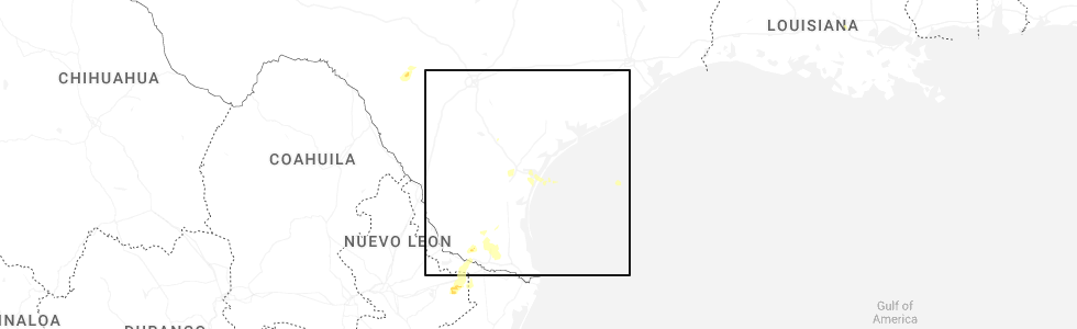
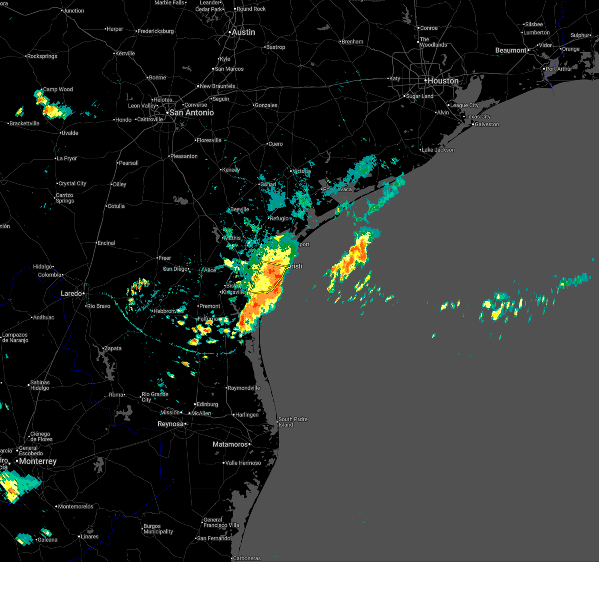
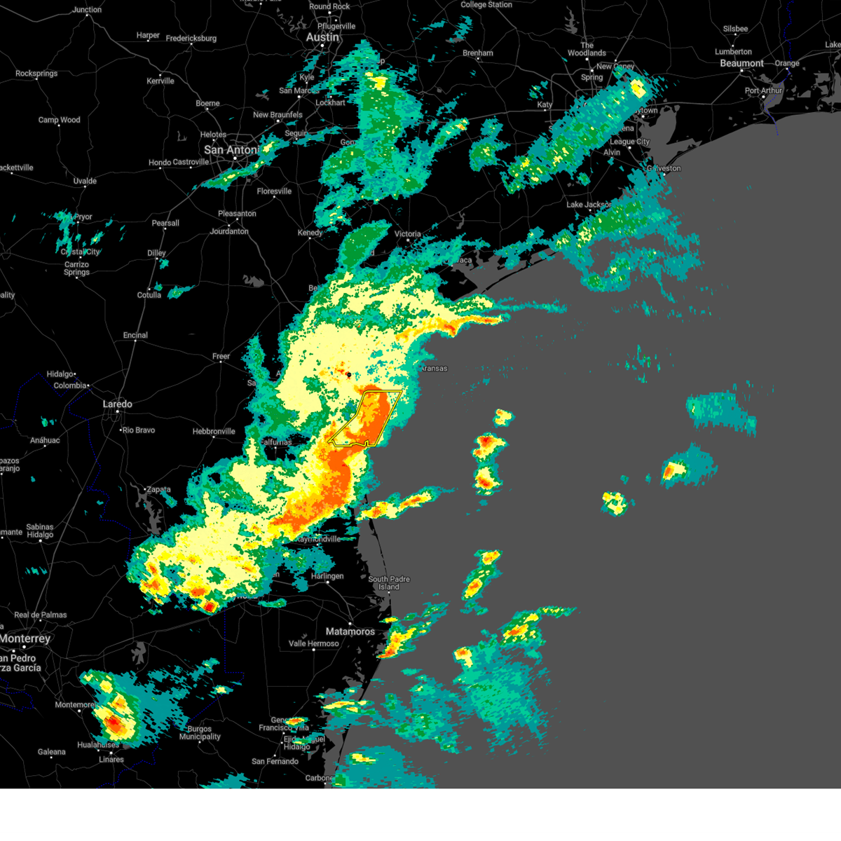
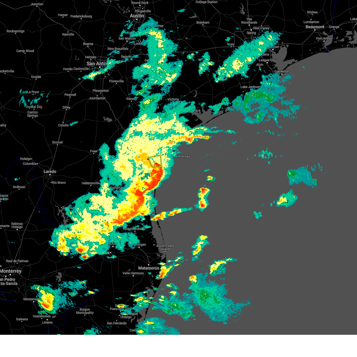
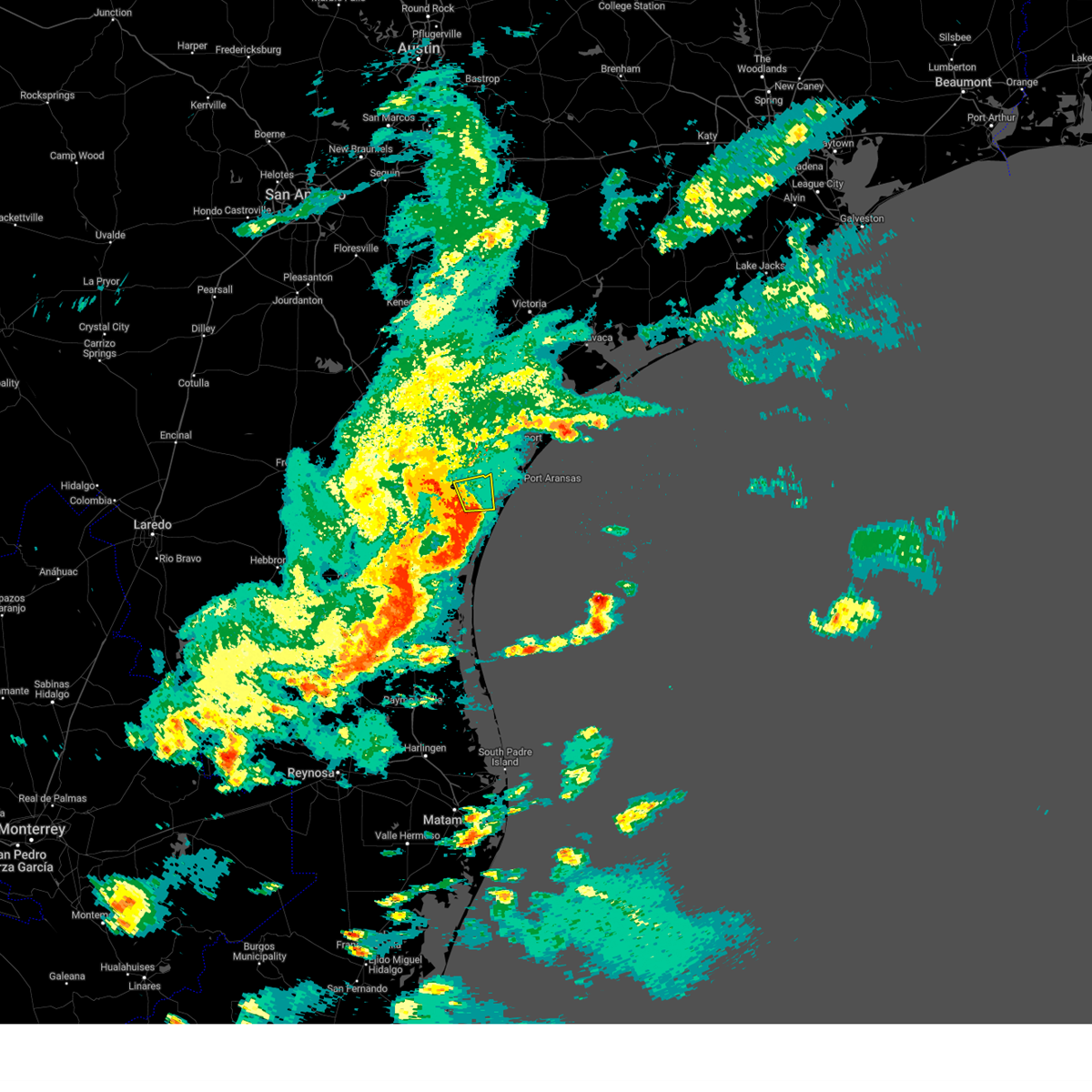
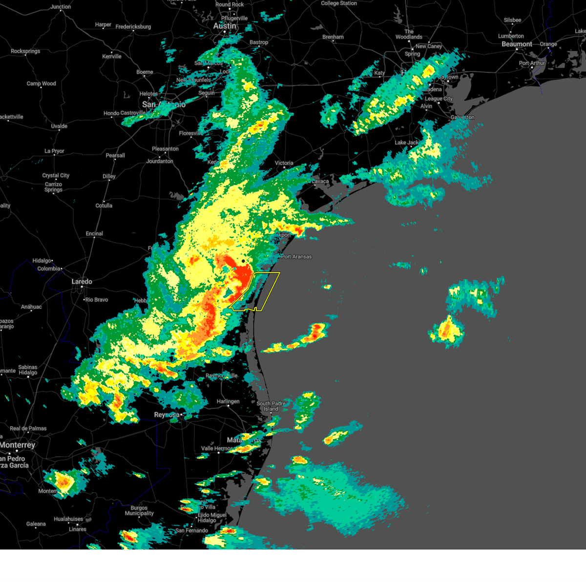
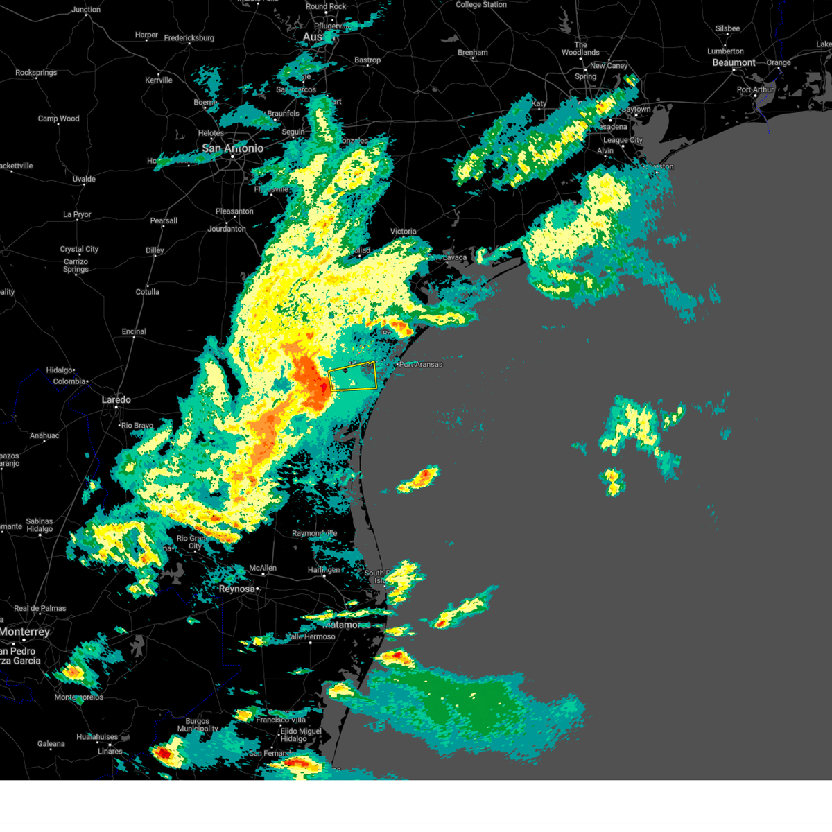
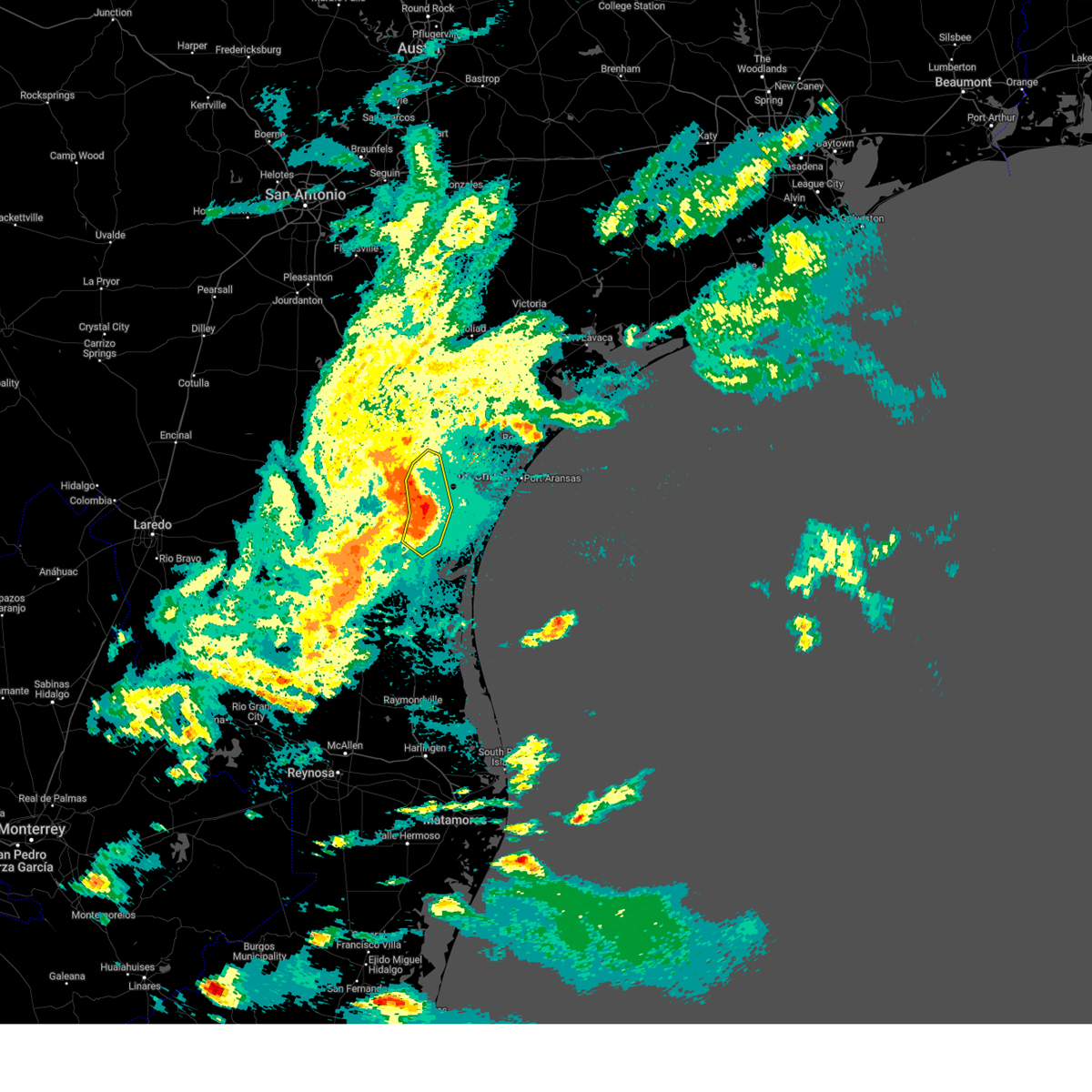
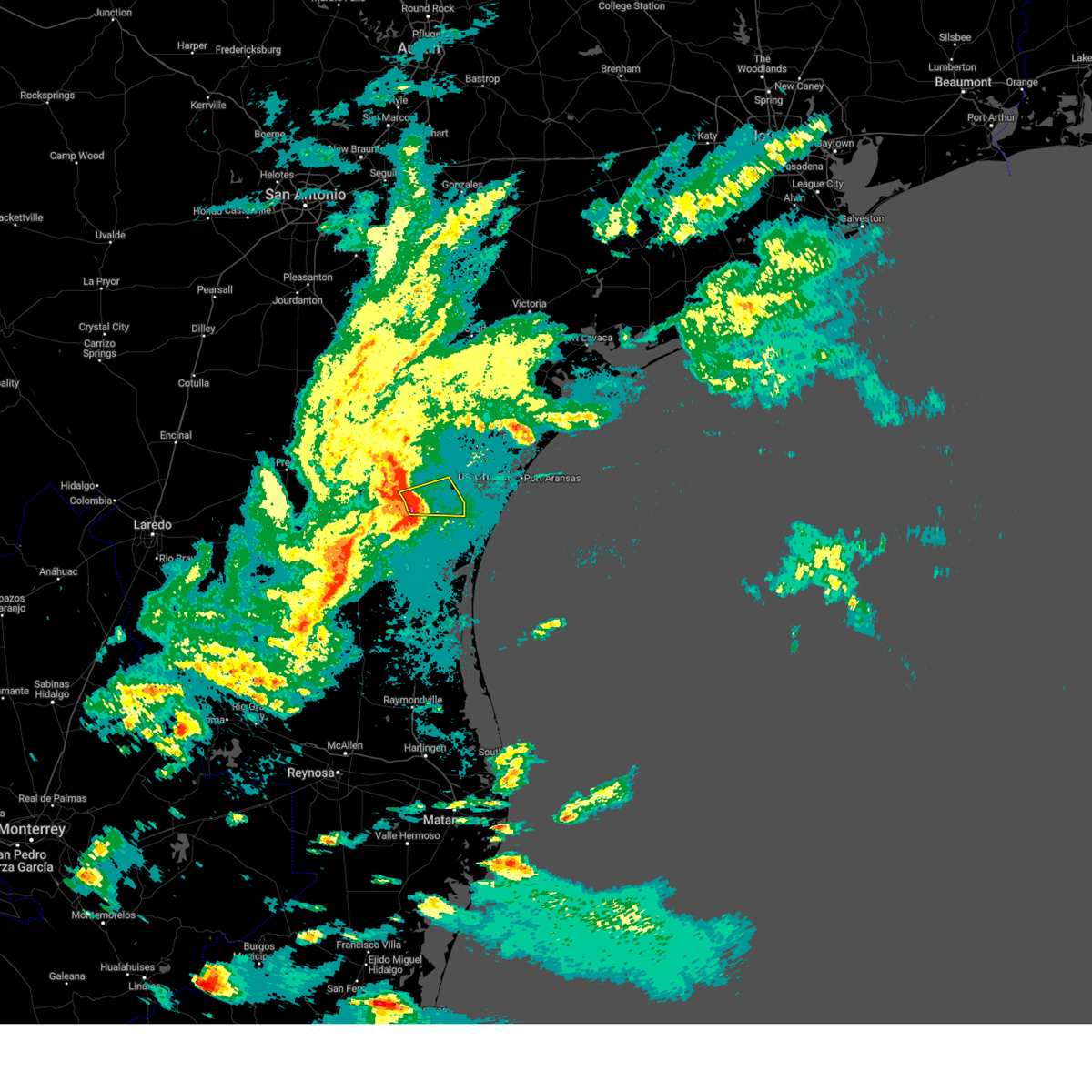
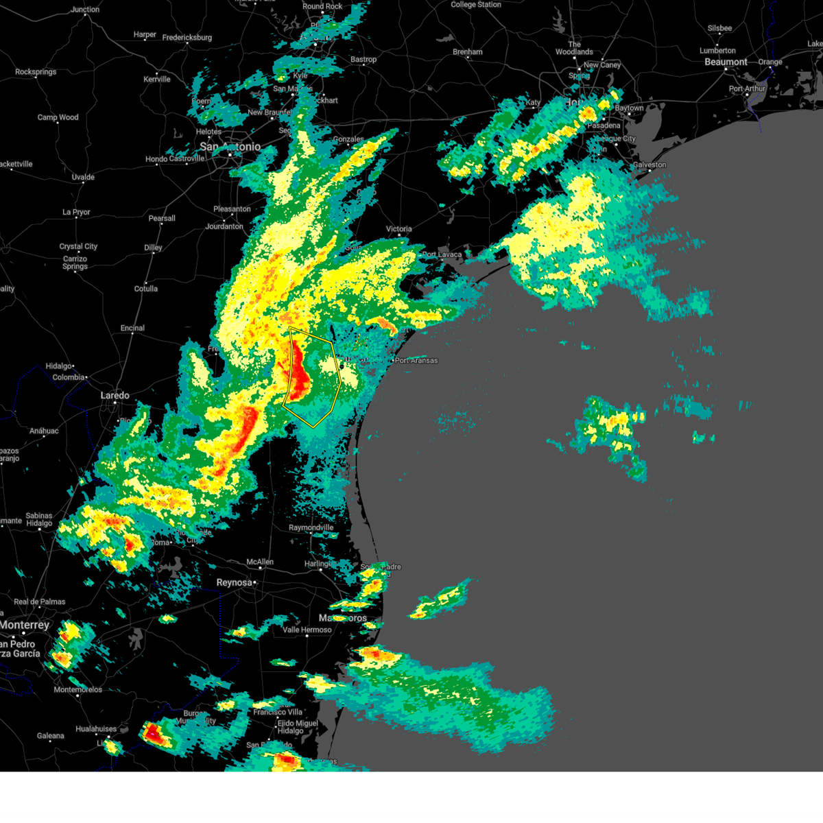
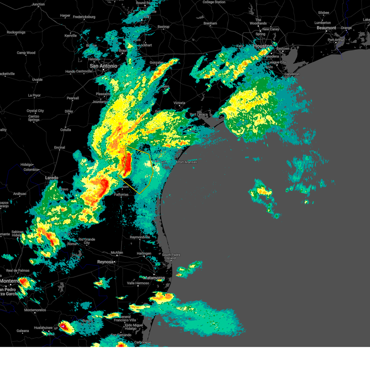
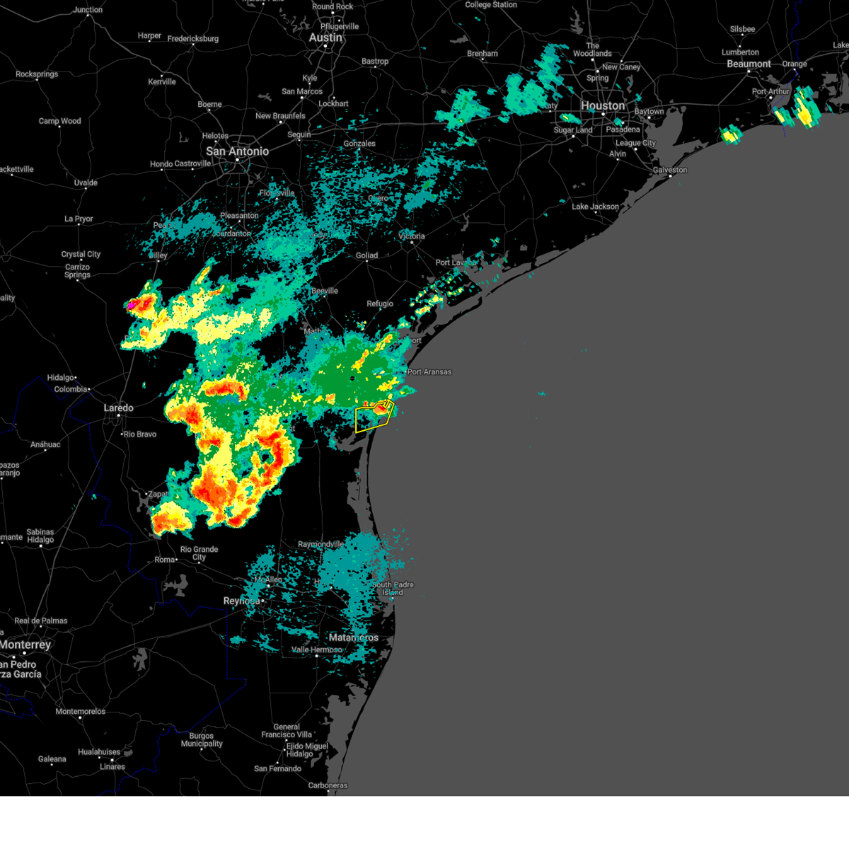
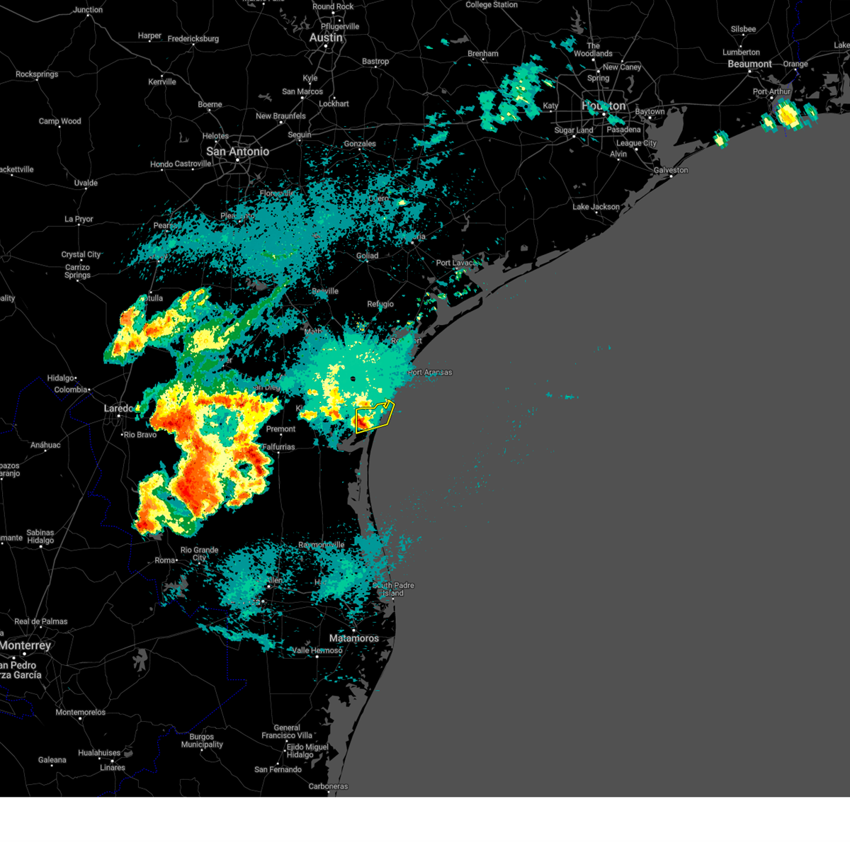
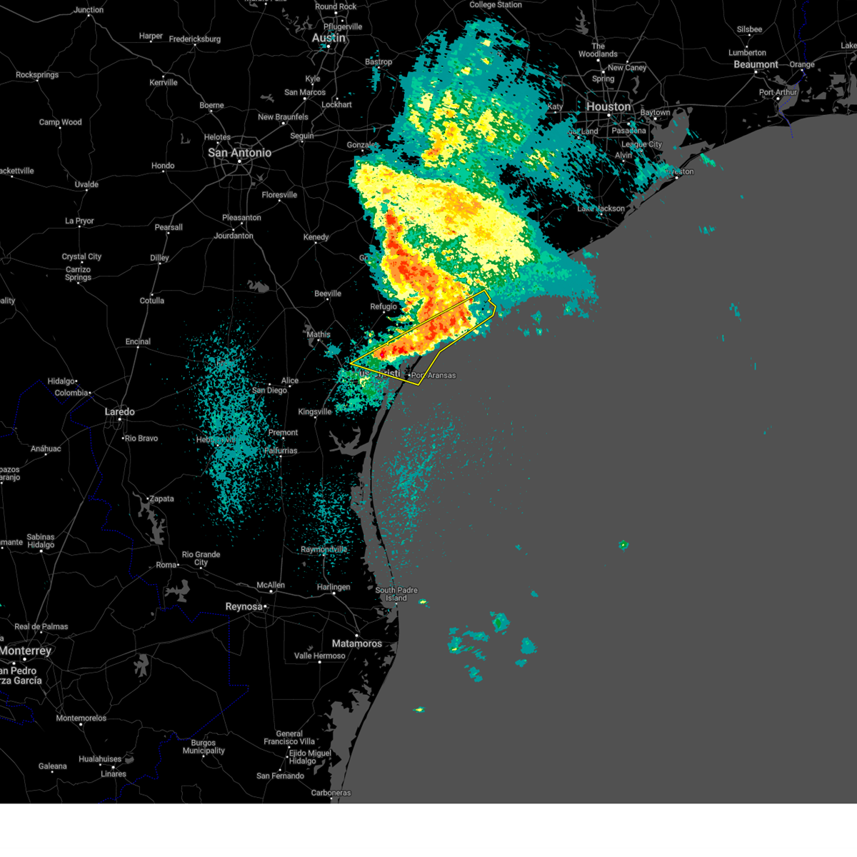
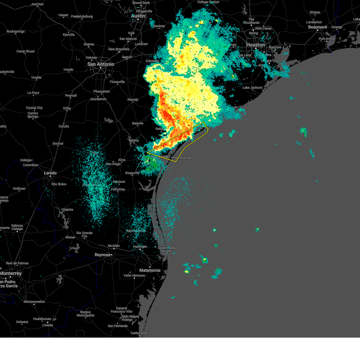
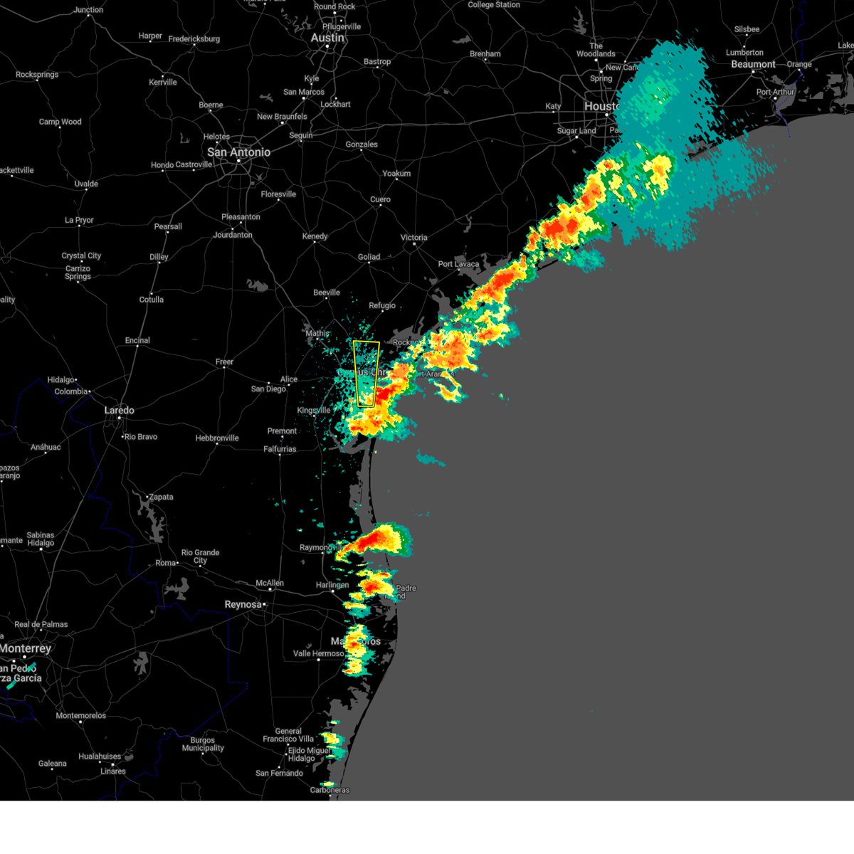
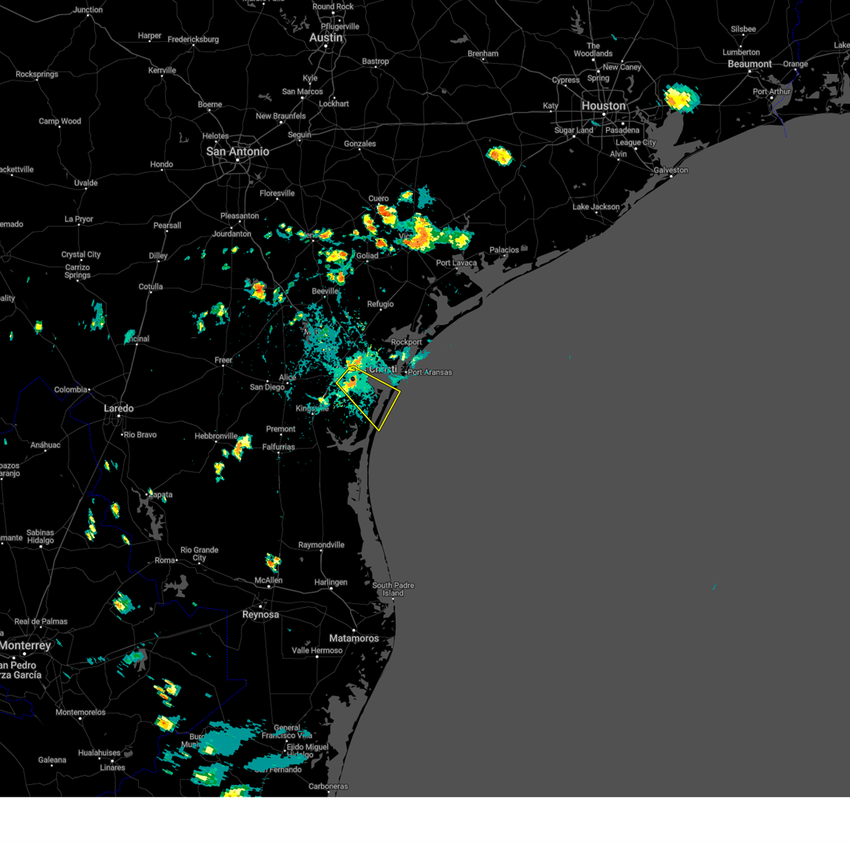
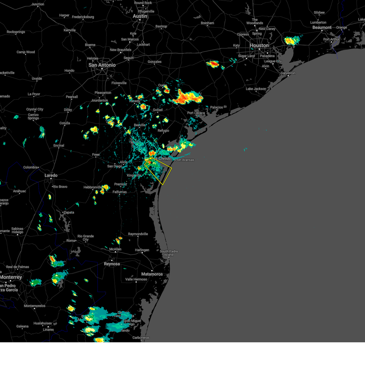
Hail Map for Corpus Christi, TX
The Corpus Christi, TX area has had 27 reports of on-the-ground hail by trained spotters, and has been under severe weather warnings 34 times during the past 12 months. Doppler radar has detected hail at or near Corpus Christi, TX on 77 occasions, including 3 occasions during the past year.
| Name: | Corpus Christi, TX |
| Where Located: | 4.3 miles WNW of Corpus Christi, TX |
| Map: | Google Map for Corpus Christi, TX |
| Population: | 305215 |
| Housing Units: | 125469 |
| More Info: | Search Google for Corpus Christi, TX |
1
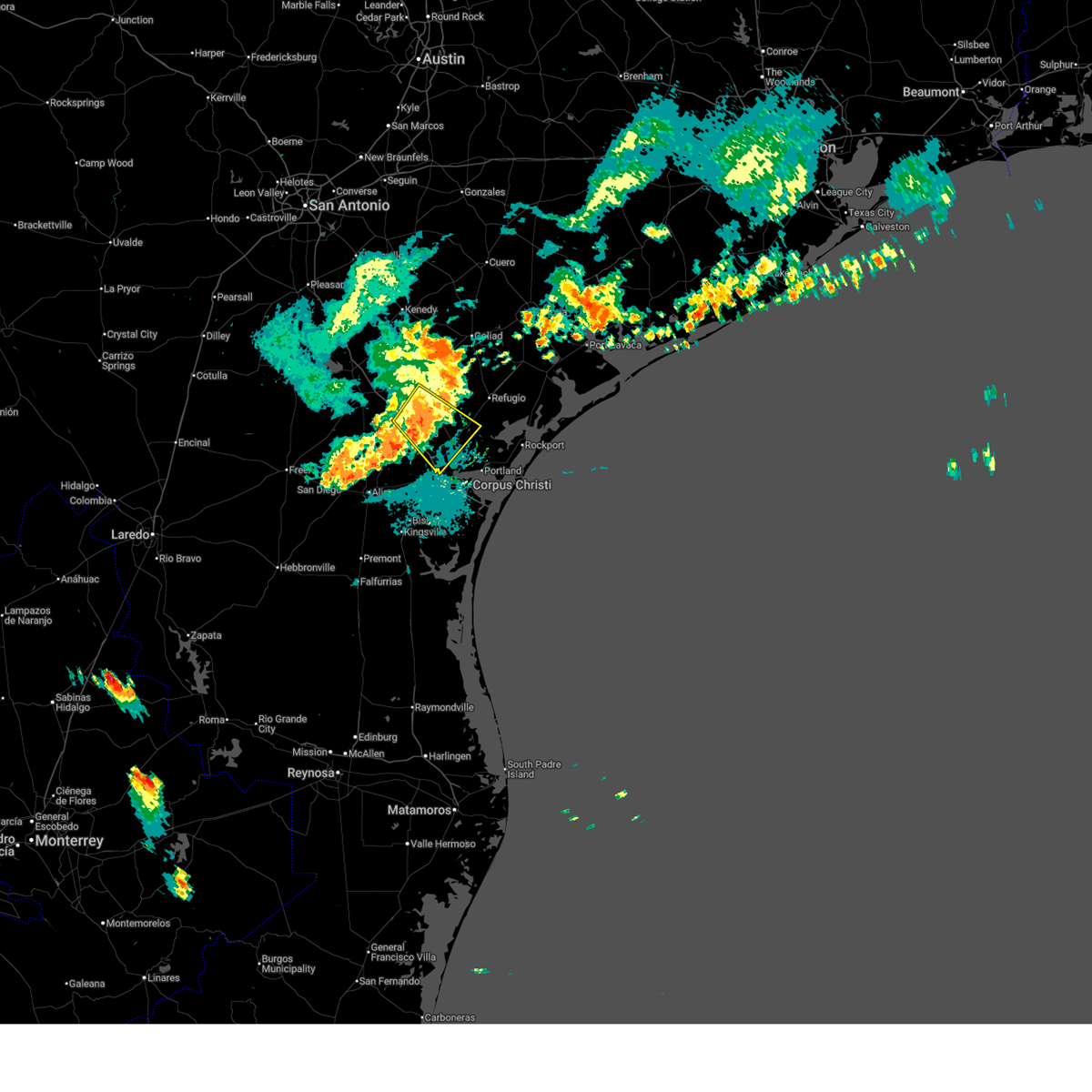
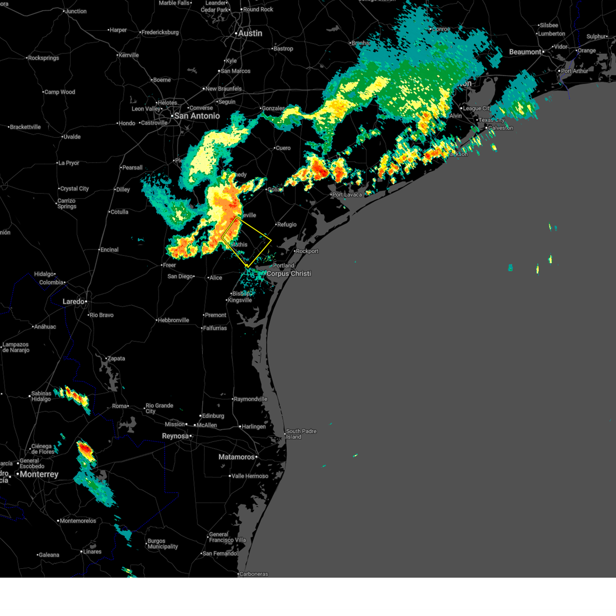
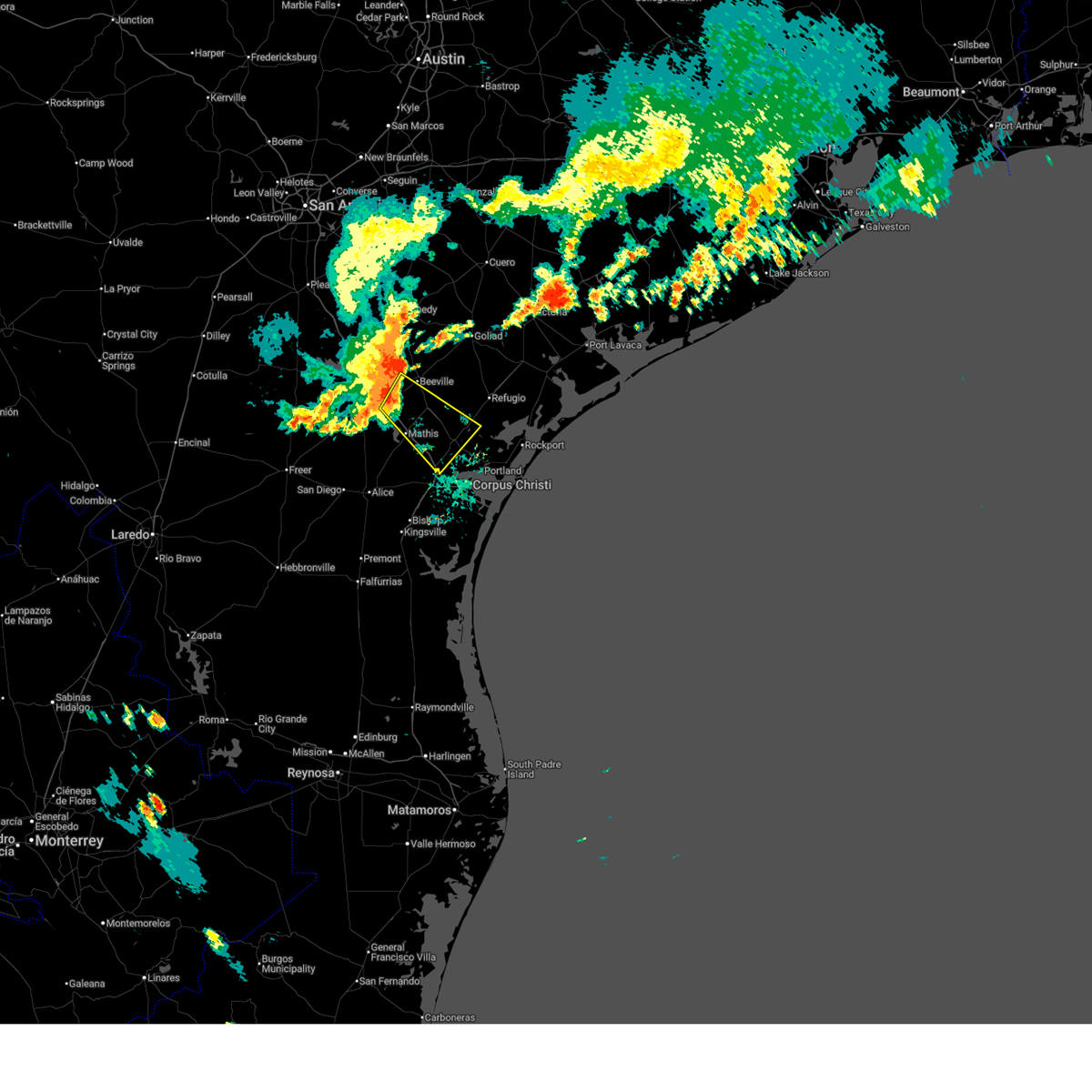
The Top Recent Hail Date for Corpus Christi, TX is Thursday, June 12, 2025 (10th out of 77)
Hail and Wind Damage Spotted near Corpus Christi, TX
| Date / Time | Report Details |
|---|---|
| 6/15/2025 9:15 PM CDT |
 the severe thunderstorm warning has been cancelled and is no longer in effect the severe thunderstorm warning has been cancelled and is no longer in effect
|
| 6/15/2025 8:49 PM CDT |
 At 848 pm cdt, a severe thunderstorm was located over tynan, or 7 miles southwest of skidmore, moving southeast at 30 mph (radar indicated). Hazards include 60 mph wind gusts. Expect damage to roofs, siding, and trees. locations impacted include, sinton, mathis, skidmore, odem, st. paul, west sinton, argenta, papalote, edroy, and tynan. this includes the following highways, interstate 37 between mile markers 16 and 43. us highway 181 between mile markers 596 and 624. Us highway 77 between mile markers 634 and 658. At 848 pm cdt, a severe thunderstorm was located over tynan, or 7 miles southwest of skidmore, moving southeast at 30 mph (radar indicated). Hazards include 60 mph wind gusts. Expect damage to roofs, siding, and trees. locations impacted include, sinton, mathis, skidmore, odem, st. paul, west sinton, argenta, papalote, edroy, and tynan. this includes the following highways, interstate 37 between mile markers 16 and 43. us highway 181 between mile markers 596 and 624. Us highway 77 between mile markers 634 and 658.
|
| 6/15/2025 8:33 PM CDT |
 Svrcrp the national weather service in corpus christi has issued a * severe thunderstorm warning for, western san patricio county in south central texas, southwestern refugio county in south central texas, southeastern live oak county in south central texas, southeastern bee county in south central texas, * until 930 pm cdt. * at 832 pm cdt, a severe thunderstorm was located near argenta, or 10 miles west of skidmore, moving southeast at 30 mph (radar indicated). Hazards include 60 mph wind gusts and penny size hail. expect damage to roofs, siding, and trees Svrcrp the national weather service in corpus christi has issued a * severe thunderstorm warning for, western san patricio county in south central texas, southwestern refugio county in south central texas, southeastern live oak county in south central texas, southeastern bee county in south central texas, * until 930 pm cdt. * at 832 pm cdt, a severe thunderstorm was located near argenta, or 10 miles west of skidmore, moving southeast at 30 mph (radar indicated). Hazards include 60 mph wind gusts and penny size hail. expect damage to roofs, siding, and trees
|
| 6/12/2025 4:57 PM CDT |
 The storms which prompted the warning have moved out of the area. therefore, the warning will be allowed to expire. however, gusty winds and heavy rain are still possible with these thunderstorms. to report severe weather, contact your nearest law enforcement agency. they will relay your report to the national weather service corpus christi. The storms which prompted the warning have moved out of the area. therefore, the warning will be allowed to expire. however, gusty winds and heavy rain are still possible with these thunderstorms. to report severe weather, contact your nearest law enforcement agency. they will relay your report to the national weather service corpus christi.
|
| 6/12/2025 4:43 PM CDT | Large 30 ft tree down at intersection of leonard and mayfield s in nueces county TX, 7.6 miles E of Corpus Christi, TX |
| 6/12/2025 4:42 PM CDT | Peak gust of 52 kts at buoy in baffin bay (babt2 in gmz231 county TX, 36.3 miles N of Corpus Christi, TX |
| 6/12/2025 4:40 PM CDT |
 At 439 pm cdt, severe thunderstorms were located along a line extending from portland to near driscoll childrens hospital to near south texas botanical gardens, moving east at 15 mph. at 4:30pm corpus christi naval air station station recorded a gust to 60 mph (radar indicated). Hazards include 60 mph wind gusts and quarter size hail. Hail damage to vehicles is expected. expect wind damage to roofs, siding, and trees. Locations impacted include, corpus christi, port aransas, flour bluff, corpus christi country club, packery channel, south texas botanical gardens, kings crossing subdivision, padre balli park, bay area medical center, mustang island state park, spohn hospital south, driscoll childrens hospital, texas a&m university corpus christi, waldron field, la palmera mall, chapman ranch, and corpus christi naval air station. At 439 pm cdt, severe thunderstorms were located along a line extending from portland to near driscoll childrens hospital to near south texas botanical gardens, moving east at 15 mph. at 4:30pm corpus christi naval air station station recorded a gust to 60 mph (radar indicated). Hazards include 60 mph wind gusts and quarter size hail. Hail damage to vehicles is expected. expect wind damage to roofs, siding, and trees. Locations impacted include, corpus christi, port aransas, flour bluff, corpus christi country club, packery channel, south texas botanical gardens, kings crossing subdivision, padre balli park, bay area medical center, mustang island state park, spohn hospital south, driscoll childrens hospital, texas a&m university corpus christi, waldron field, la palmera mall, chapman ranch, and corpus christi naval air station.
|
| 6/12/2025 4:36 PM CDT |
 At 436 pm cdt, severe thunderstorms were located along a line extending from portland to driscoll childrens hospital to near south texas botanical gardens, moving east at 15 mph (radar indicated). Hazards include 60 mph wind gusts and quarter size hail. Hail damage to vehicles is expected. expect wind damage to roofs, siding, and trees. Locations impacted include, corpus christi, port aransas, flour bluff, corpus christi country club, packery channel, south texas botanical gardens, kings crossing subdivision, padre balli park, bay area medical center, mustang island state park, spohn hospital south, driscoll childrens hospital, texas a&m university corpus christi, waldron field, la palmera mall, chapman ranch, and corpus christi naval air station. At 436 pm cdt, severe thunderstorms were located along a line extending from portland to driscoll childrens hospital to near south texas botanical gardens, moving east at 15 mph (radar indicated). Hazards include 60 mph wind gusts and quarter size hail. Hail damage to vehicles is expected. expect wind damage to roofs, siding, and trees. Locations impacted include, corpus christi, port aransas, flour bluff, corpus christi country club, packery channel, south texas botanical gardens, kings crossing subdivision, padre balli park, bay area medical center, mustang island state park, spohn hospital south, driscoll childrens hospital, texas a&m university corpus christi, waldron field, la palmera mall, chapman ranch, and corpus christi naval air station.
|
| 6/12/2025 4:30 PM CDT | Power pole blown down blocking the roadway at oso bridg in gmz232 county TX, 14.9 miles NNW of Corpus Christi, TX |
| 6/12/2025 4:30 PM CDT | Nas corpus christi aso in nueces county TX, 14.3 miles NW of Corpus Christi, TX |
| 6/12/2025 4:10 PM CDT |
 Svrcrp the national weather service in corpus christi has issued a * severe thunderstorm warning for, southeastern nueces county in south central texas, northeastern kleberg county in south central texas, * until 500 pm cdt. * at 408 pm cdt, severe thunderstorms were located along a line extending from near corpus christi north beach to near corpus christi international airport to 11 miles southeast of driscoll, moving east at 15 mph (radar indicated). Hazards include 60 mph wind gusts. expect damage to roofs, siding, and trees Svrcrp the national weather service in corpus christi has issued a * severe thunderstorm warning for, southeastern nueces county in south central texas, northeastern kleberg county in south central texas, * until 500 pm cdt. * at 408 pm cdt, severe thunderstorms were located along a line extending from near corpus christi north beach to near corpus christi international airport to 11 miles southeast of driscoll, moving east at 15 mph (radar indicated). Hazards include 60 mph wind gusts. expect damage to roofs, siding, and trees
|
| 6/12/2025 4:01 PM CDT |
 At 401 pm cdt, a severe thunderstorm was located over clarkwood, or near corpus christi international airport, moving east at 15 mph (radar indicated). Hazards include 60 mph wind gusts. Expect damage to roofs, siding, and trees. locations impacted include, corpus christi, robstown, corpus christi international airport, del mar college windward campus, corpus christi north beach, cabaniss field, cole park, del mar college heritage campus, clarkwood, annaville, calallen, downtown corpus christi, south texas botanical gardens, petronila, and tuloso. this includes the following highways, interstate 37 between mile markers 1 and 15. Us highway 181 between mile markers 646 and 648. At 401 pm cdt, a severe thunderstorm was located over clarkwood, or near corpus christi international airport, moving east at 15 mph (radar indicated). Hazards include 60 mph wind gusts. Expect damage to roofs, siding, and trees. locations impacted include, corpus christi, robstown, corpus christi international airport, del mar college windward campus, corpus christi north beach, cabaniss field, cole park, del mar college heritage campus, clarkwood, annaville, calallen, downtown corpus christi, south texas botanical gardens, petronila, and tuloso. this includes the following highways, interstate 37 between mile markers 1 and 15. Us highway 181 between mile markers 646 and 648.
|
| 6/12/2025 3:43 PM CDT | Corrects previous time from previous tstm wnd dmg report from corpus christi. large 30 ft tree down at intersection of leonard and mayfield s in nueces county TX, 7.6 miles E of Corpus Christi, TX |
| 6/12/2025 3:31 PM CDT |
 Svrcrp the national weather service in corpus christi has issued a * severe thunderstorm warning for, central nueces county in south central texas, * until 415 pm cdt. * at 331 pm cdt, a severe thunderstorm was located near robstown, moving east at 20 mph (radar indicated). Hazards include 60 mph wind gusts. expect damage to roofs, siding, and trees Svrcrp the national weather service in corpus christi has issued a * severe thunderstorm warning for, central nueces county in south central texas, * until 415 pm cdt. * at 331 pm cdt, a severe thunderstorm was located near robstown, moving east at 20 mph (radar indicated). Hazards include 60 mph wind gusts. expect damage to roofs, siding, and trees
|
| 5/27/2025 3:56 AM CDT | Awos station kngp c. christi na in nueces county TX, 15.6 miles NW of Corpus Christi, TX |
| 5/8/2025 10:55 PM CDT |
 The storms which prompted the warning have weakened below severe limits, and have exited the warned area. therefore, the warning will be allowed to expire. however, heavy rain is still possible with these thunderstorms. a severe thunderstorm watch remains in effect until midnight cdt for south central texas. The storms which prompted the warning have weakened below severe limits, and have exited the warned area. therefore, the warning will be allowed to expire. however, heavy rain is still possible with these thunderstorms. a severe thunderstorm watch remains in effect until midnight cdt for south central texas.
|
| 5/8/2025 10:48 PM CDT |
 the severe thunderstorm warning has been cancelled and is no longer in effect the severe thunderstorm warning has been cancelled and is no longer in effect
|
| 5/8/2025 10:30 PM CDT |
 At 1030 pm cdt, a severe thunderstorm was located over texas a&m university corpus christi, or 7 miles east of corpus christi, moving east at 30 mph (radar indicated). Hazards include 70 mph wind gusts. Expect considerable tree damage. damage is likely to mobile homes, roofs, and outbuildings. locations impacted include, corpus christi, del mar college windward campus, flour bluff, corpus christi country club, south texas botanical gardens, corpus christi north beach, cabaniss field, kings crossing subdivision, bay area medical center, cole park, spohn hospital south, driscoll childrens hospital, del mar college heritage campus, texas a&m university corpus christi, downtown corpus christi, la palmera mall, and corpus christi naval air station. this includes the following highways, interstate 37 between mile markers 1 and 6. Us highway 181 between mile markers 646 and 648. At 1030 pm cdt, a severe thunderstorm was located over texas a&m university corpus christi, or 7 miles east of corpus christi, moving east at 30 mph (radar indicated). Hazards include 70 mph wind gusts. Expect considerable tree damage. damage is likely to mobile homes, roofs, and outbuildings. locations impacted include, corpus christi, del mar college windward campus, flour bluff, corpus christi country club, south texas botanical gardens, corpus christi north beach, cabaniss field, kings crossing subdivision, bay area medical center, cole park, spohn hospital south, driscoll childrens hospital, del mar college heritage campus, texas a&m university corpus christi, downtown corpus christi, la palmera mall, and corpus christi naval air station. this includes the following highways, interstate 37 between mile markers 1 and 6. Us highway 181 between mile markers 646 and 648.
|
| 5/8/2025 10:22 PM CDT |
 Svrcrp the national weather service in corpus christi has issued a * severe thunderstorm warning for, southeastern nueces county in south central texas, eastern kleberg county in south central texas, * until 1100 pm cdt. * at 1022 pm cdt, severe thunderstorms were located along a line extending from kings crossing subdivision to near south texas botanical gardens to 9 miles northeast of riviera beach, moving northwest at 30 mph (radar indicated). Hazards include 60 mph wind gusts. expect damage to roofs, siding, and trees Svrcrp the national weather service in corpus christi has issued a * severe thunderstorm warning for, southeastern nueces county in south central texas, eastern kleberg county in south central texas, * until 1100 pm cdt. * at 1022 pm cdt, severe thunderstorms were located along a line extending from kings crossing subdivision to near south texas botanical gardens to 9 miles northeast of riviera beach, moving northwest at 30 mph (radar indicated). Hazards include 60 mph wind gusts. expect damage to roofs, siding, and trees
|
| 5/8/2025 10:11 PM CDT |
 Svrcrp the national weather service in corpus christi has issued a * severe thunderstorm warning for, southeastern nueces county in south central texas, * until 1100 pm cdt. * at 1010 pm cdt, a severe thunderstorm was located 7 miles south of clarkwood, or 8 miles southwest of corpus christi international airport, moving east at 30 mph. this is a destructive storm for eastern nueces county, including the city of corpus christi. seek shelter now (emergency management). Hazards include 90 mph wind gusts and penny size hail. You are in a life-threatening situation. flying debris may be deadly to those caught without shelter. mobile homes will be heavily damaged or destroyed. homes and businesses will have substantial roof and window damage. Expect extensive tree damage and power outages. Svrcrp the national weather service in corpus christi has issued a * severe thunderstorm warning for, southeastern nueces county in south central texas, * until 1100 pm cdt. * at 1010 pm cdt, a severe thunderstorm was located 7 miles south of clarkwood, or 8 miles southwest of corpus christi international airport, moving east at 30 mph. this is a destructive storm for eastern nueces county, including the city of corpus christi. seek shelter now (emergency management). Hazards include 90 mph wind gusts and penny size hail. You are in a life-threatening situation. flying debris may be deadly to those caught without shelter. mobile homes will be heavily damaged or destroyed. homes and businesses will have substantial roof and window damage. Expect extensive tree damage and power outages.
|
| 5/8/2025 10:07 PM CDT |
 At 1006 pm cdt, severe thunderstorms were located along a line extending from near robstown to near driscoll to near kingsville naval air station to ricardo, moving southeast at 35 mph (emergency management). Hazards include 70 mph wind gusts and nickel size hail. Expect considerable tree damage. damage is likely to mobile homes, roofs, and outbuildings. locations impacted include, corpus christi, kingsville, robstown, driscoll, bishop, odem, edroy, bluntzer, banquete, annaville, calallen, kingsville naval air station, petronila, and north san pedro. this includes the following highways, interstate 37 between mile markers 12 and 24. Us highway 77 between mile markers 656 and 688. At 1006 pm cdt, severe thunderstorms were located along a line extending from near robstown to near driscoll to near kingsville naval air station to ricardo, moving southeast at 35 mph (emergency management). Hazards include 70 mph wind gusts and nickel size hail. Expect considerable tree damage. damage is likely to mobile homes, roofs, and outbuildings. locations impacted include, corpus christi, kingsville, robstown, driscoll, bishop, odem, edroy, bluntzer, banquete, annaville, calallen, kingsville naval air station, petronila, and north san pedro. this includes the following highways, interstate 37 between mile markers 12 and 24. Us highway 77 between mile markers 656 and 688.
|
| 5/8/2025 10:07 PM CDT |
 the severe thunderstorm warning has been cancelled and is no longer in effect the severe thunderstorm warning has been cancelled and is no longer in effect
|
| 5/8/2025 10:03 PM CDT |
 At 1002 pm cdt, severe thunderstorms were located along a line extending from near robstown to 6 miles east of driscoll to 10 miles east of bishop, moving east at 50 mph. these are destructive storms for central nueces county (emergency management). Hazards include 90 mph wind gusts and penny size hail. You are in a life-threatening situation. flying debris may be deadly to those caught without shelter. mobile homes will be heavily damaged or destroyed. homes and businesses will have substantial roof and window damage. expect extensive tree damage and power outages. locations impacted include, corpus christi, robstown, corpus christi international airport, clarkwood, petronila, north san pedro, and tuloso. this includes the following highways, interstate 37 between mile markers 9 and 10. Us highway 77 between mile markers 672 and 676. At 1002 pm cdt, severe thunderstorms were located along a line extending from near robstown to 6 miles east of driscoll to 10 miles east of bishop, moving east at 50 mph. these are destructive storms for central nueces county (emergency management). Hazards include 90 mph wind gusts and penny size hail. You are in a life-threatening situation. flying debris may be deadly to those caught without shelter. mobile homes will be heavily damaged or destroyed. homes and businesses will have substantial roof and window damage. expect extensive tree damage and power outages. locations impacted include, corpus christi, robstown, corpus christi international airport, clarkwood, petronila, north san pedro, and tuloso. this includes the following highways, interstate 37 between mile markers 9 and 10. Us highway 77 between mile markers 672 and 676.
|
| 5/8/2025 9:54 PM CDT |
 Svrcrp the national weather service in corpus christi has issued a * severe thunderstorm warning for, southwestern nueces county in south central texas, * until 1030 pm cdt. * at 953 pm cdt, severe thunderstorms were located along a line extending from near banquete to driscoll to 10 miles north of kingsville naval air station to near bishop, moving east at 30 mph. these are destructive storms for central nueces county (emergency management). Hazards include 90 mph wind gusts. You are in a life-threatening situation. flying debris may be deadly to those caught without shelter. mobile homes will be heavily damaged or destroyed. homes and businesses will have substantial roof and window damage. Expect extensive tree damage and power outages. Svrcrp the national weather service in corpus christi has issued a * severe thunderstorm warning for, southwestern nueces county in south central texas, * until 1030 pm cdt. * at 953 pm cdt, severe thunderstorms were located along a line extending from near banquete to driscoll to 10 miles north of kingsville naval air station to near bishop, moving east at 30 mph. these are destructive storms for central nueces county (emergency management). Hazards include 90 mph wind gusts. You are in a life-threatening situation. flying debris may be deadly to those caught without shelter. mobile homes will be heavily damaged or destroyed. homes and businesses will have substantial roof and window damage. Expect extensive tree damage and power outages.
|
| 5/8/2025 9:46 PM CDT |
 At 945 pm cdt, severe thunderstorms were located along a line extending from near bluntzer to banquete to near bishop to 7 miles west of kingsville, moving southeast at 35 mph (emergency management). Hazards include 70 mph wind gusts and nickel size hail. Expect considerable tree damage. damage is likely to mobile homes, roofs, and outbuildings. locations impacted include, corpus christi, kingsville, robstown, driscoll, bishop, odem, orange grove, san patricio, ricardo, edroy, bluntzer, banquete, sandia, annaville, calallen, kingsville naval air station, alfred-south la paloma, agua dulce, petronila, and north san pedro. this includes the following highways, interstate 37 between mile markers 12 and 25. Us highway 77 between mile markers 656 and 702. At 945 pm cdt, severe thunderstorms were located along a line extending from near bluntzer to banquete to near bishop to 7 miles west of kingsville, moving southeast at 35 mph (emergency management). Hazards include 70 mph wind gusts and nickel size hail. Expect considerable tree damage. damage is likely to mobile homes, roofs, and outbuildings. locations impacted include, corpus christi, kingsville, robstown, driscoll, bishop, odem, orange grove, san patricio, ricardo, edroy, bluntzer, banquete, sandia, annaville, calallen, kingsville naval air station, alfred-south la paloma, agua dulce, petronila, and north san pedro. this includes the following highways, interstate 37 between mile markers 12 and 25. Us highway 77 between mile markers 656 and 702.
|
| 5/8/2025 9:25 PM CDT |
 Svrcrp the national weather service in corpus christi has issued a * severe thunderstorm warning for, nueces county in south central texas, southwestern san patricio county in south central texas, northern jim wells county in south central texas, southeastern live oak county in south central texas, western kleberg county in south central texas, * until 1015 pm cdt. * at 924 pm cdt, severe thunderstorms were located along a line extending from near westdale to alfred-south la paloma to near ben bolt to near palito blanco, moving southeast at 35 mph (radar indicated. wind observed by kali). Hazards include 70 mph wind gusts and quarter size hail. Hail damage to vehicles is expected. expect considerable tree damage. Wind damage is also likely to mobile homes, roofs, and outbuildings. Svrcrp the national weather service in corpus christi has issued a * severe thunderstorm warning for, nueces county in south central texas, southwestern san patricio county in south central texas, northern jim wells county in south central texas, southeastern live oak county in south central texas, western kleberg county in south central texas, * until 1015 pm cdt. * at 924 pm cdt, severe thunderstorms were located along a line extending from near westdale to alfred-south la paloma to near ben bolt to near palito blanco, moving southeast at 35 mph (radar indicated. wind observed by kali). Hazards include 70 mph wind gusts and quarter size hail. Hail damage to vehicles is expected. expect considerable tree damage. Wind damage is also likely to mobile homes, roofs, and outbuildings.
|
| 5/7/2025 3:48 AM CDT |
 the severe thunderstorm warning has been cancelled and is no longer in effect the severe thunderstorm warning has been cancelled and is no longer in effect
|
| 5/7/2025 3:34 AM CDT |
 Svrcrp the national weather service in corpus christi has issued a * severe thunderstorm warning for, northeastern kleberg county in south central texas, * until 415 am cdt. * at 333 am cdt, a severe thunderstorm was located near malaquite beach, or 19 miles south of corpus christi, moving northeast at 55 mph (radar indicated). Hazards include 60 mph wind gusts and quarter size hail. Hail damage to vehicles is expected. Expect wind damage to roofs, siding, and trees. Svrcrp the national weather service in corpus christi has issued a * severe thunderstorm warning for, northeastern kleberg county in south central texas, * until 415 am cdt. * at 333 am cdt, a severe thunderstorm was located near malaquite beach, or 19 miles south of corpus christi, moving northeast at 55 mph (radar indicated). Hazards include 60 mph wind gusts and quarter size hail. Hail damage to vehicles is expected. Expect wind damage to roofs, siding, and trees.
|
| 4/23/2025 7:52 AM CDT |
 The storms which prompted the warning have weakened below severe limits, and no longer pose an immediate threat to life or property. therefore, the warning will be allowed to expire. however, small hail is still possible with these thunderstorms. The storms which prompted the warning have weakened below severe limits, and no longer pose an immediate threat to life or property. therefore, the warning will be allowed to expire. however, small hail is still possible with these thunderstorms.
|
| 4/23/2025 7:42 AM CDT |
 At 741 am cdt, severe thunderstorms were located along a line extending from 12 miles east of port oconnor to near gregory, and are nearly stationary (radar indicated). Hazards include 60 mph wind gusts and nickel size hail. Expect damage to roofs, siding, and trees. locations impacted include, fulton, palm harbor, portland, ingleside, key allegro, taft southwest, port oconnor, gregory, copano village, lamar, port aransas, ingleside on the bay, rockport, holiday beach, taft, aransas pass, matagorda island state park, and bayside. This includes us highway 181 between mile markers 630 and 642. At 741 am cdt, severe thunderstorms were located along a line extending from 12 miles east of port oconnor to near gregory, and are nearly stationary (radar indicated). Hazards include 60 mph wind gusts and nickel size hail. Expect damage to roofs, siding, and trees. locations impacted include, fulton, palm harbor, portland, ingleside, key allegro, taft southwest, port oconnor, gregory, copano village, lamar, port aransas, ingleside on the bay, rockport, holiday beach, taft, aransas pass, matagorda island state park, and bayside. This includes us highway 181 between mile markers 630 and 642.
|
| 4/23/2025 7:35 AM CDT |
 At 735 am cdt, severe thunderstorms were located along a line extending from near port oconnor to near taft, and are nearly stationary (trained weather spotters). Hazards include tennis ball size hail and 60 mph wind gusts. People and animals outdoors will be injured. expect hail damage to roofs, siding, windows, and vehicles. expect wind damage to roofs, siding, and trees. locations impacted include, fulton, palm harbor, portland, ingleside, key allegro, taft southwest, port oconnor, gregory, copano village, lamar, port aransas, ingleside on the bay, rockport, holiday beach, taft, aransas pass, matagorda island state park, and bayside. This includes us highway 181 between mile markers 630 and 642. At 735 am cdt, severe thunderstorms were located along a line extending from near port oconnor to near taft, and are nearly stationary (trained weather spotters). Hazards include tennis ball size hail and 60 mph wind gusts. People and animals outdoors will be injured. expect hail damage to roofs, siding, windows, and vehicles. expect wind damage to roofs, siding, and trees. locations impacted include, fulton, palm harbor, portland, ingleside, key allegro, taft southwest, port oconnor, gregory, copano village, lamar, port aransas, ingleside on the bay, rockport, holiday beach, taft, aransas pass, matagorda island state park, and bayside. This includes us highway 181 between mile markers 630 and 642.
|
| 4/23/2025 7:19 AM CDT |
 Svrcrp the national weather service in corpus christi has issued a * severe thunderstorm warning for, aransas county in south central texas, southern calhoun county in south texas, eastern nueces county in south central texas, southeastern san patricio county in south central texas, * until 800 am cdt. * at 719 am cdt, severe thunderstorms were located along a line extending from port oconnor to near taft, moving east at 40 mph (trained weather spotters). Hazards include tennis ball size hail and 60 mph wind gusts. People and animals outdoors will be injured. expect hail damage to roofs, siding, windows, and vehicles. Expect wind damage to roofs, siding, and trees. Svrcrp the national weather service in corpus christi has issued a * severe thunderstorm warning for, aransas county in south central texas, southern calhoun county in south texas, eastern nueces county in south central texas, southeastern san patricio county in south central texas, * until 800 am cdt. * at 719 am cdt, severe thunderstorms were located along a line extending from port oconnor to near taft, moving east at 40 mph (trained weather spotters). Hazards include tennis ball size hail and 60 mph wind gusts. People and animals outdoors will be injured. expect hail damage to roofs, siding, windows, and vehicles. Expect wind damage to roofs, siding, and trees.
|
| 4/21/2025 10:50 AM CDT |
 The storm which prompted the warning has weakened below severe limits, and no longer poses an immediate threat to life or property. therefore, the warning will be allowed to expire. The storm which prompted the warning has weakened below severe limits, and no longer poses an immediate threat to life or property. therefore, the warning will be allowed to expire.
|
| 4/21/2025 10:38 AM CDT |
 At 1037 am cdt, a severe thunderstorm was located over downtown corpus christi, or near corpus christi, moving north at 30 mph (radar indicated). Hazards include 60 mph wind gusts and penny size hail. Expect damage to roofs, siding, and trees. locations impacted include, del mar college windward campus, corpus christi country club, south texas botanical gardens, portland, corpus christi north beach, sinton, taft southwest, cabaniss field, kings crossing subdivision, bay area medical center, cole park, spohn hospital south, driscoll childrens hospital, del mar college heritage campus, taft, downtown corpus christi, corpus christi, and la palmera mall. this includes the following highways, interstate 37 between mile markers 1 and 6. us highway 181 between mile markers 622 and 634, and between mile markers 642 and 648. Us highway 77 near mile marker 644. At 1037 am cdt, a severe thunderstorm was located over downtown corpus christi, or near corpus christi, moving north at 30 mph (radar indicated). Hazards include 60 mph wind gusts and penny size hail. Expect damage to roofs, siding, and trees. locations impacted include, del mar college windward campus, corpus christi country club, south texas botanical gardens, portland, corpus christi north beach, sinton, taft southwest, cabaniss field, kings crossing subdivision, bay area medical center, cole park, spohn hospital south, driscoll childrens hospital, del mar college heritage campus, taft, downtown corpus christi, corpus christi, and la palmera mall. this includes the following highways, interstate 37 between mile markers 1 and 6. us highway 181 between mile markers 622 and 634, and between mile markers 642 and 648. Us highway 77 near mile marker 644.
|
| 4/21/2025 10:38 AM CDT |
 the severe thunderstorm warning has been cancelled and is no longer in effect the severe thunderstorm warning has been cancelled and is no longer in effect
|
| 4/21/2025 10:23 AM CDT |
 At 1023 am cdt, a severe thunderstorm was located over cabaniss field, or near corpus christi, moving north at 30 mph (radar indicated). Hazards include 60 mph wind gusts and penny size hail. Expect damage to roofs, siding, and trees. locations impacted include, flour bluff, portland, chapman ranch, corpus christi north beach, sinton, corpus christi naval air station, kings crossing subdivision, bay area medical center, gregory, spohn hospital south, texas a&m university corpus christi, waldron field, corpus christi, la palmera mall, del mar college windward campus, corpus christi country club, south texas botanical gardens, taft southwest, cabaniss field, and cole park. this includes the following highways, interstate 37 between mile markers 1 and 6. us highway 181 between mile markers 622 and 648. Us highway 77 near mile marker 644. At 1023 am cdt, a severe thunderstorm was located over cabaniss field, or near corpus christi, moving north at 30 mph (radar indicated). Hazards include 60 mph wind gusts and penny size hail. Expect damage to roofs, siding, and trees. locations impacted include, flour bluff, portland, chapman ranch, corpus christi north beach, sinton, corpus christi naval air station, kings crossing subdivision, bay area medical center, gregory, spohn hospital south, texas a&m university corpus christi, waldron field, corpus christi, la palmera mall, del mar college windward campus, corpus christi country club, south texas botanical gardens, taft southwest, cabaniss field, and cole park. this includes the following highways, interstate 37 between mile markers 1 and 6. us highway 181 between mile markers 622 and 648. Us highway 77 near mile marker 644.
|
| 4/21/2025 10:03 AM CDT |
 Svrcrp the national weather service in corpus christi has issued a * severe thunderstorm warning for, south central nueces county in south central texas, southeastern san patricio county in south central texas, northeastern kleberg county in south central texas, * until 1100 am cdt. * at 1002 am cdt, a severe thunderstorm was located near waldron field, or 12 miles south of corpus christi, moving north at 30 mph (radar indicated). Hazards include 60 mph wind gusts and penny size hail. expect damage to roofs, siding, and trees Svrcrp the national weather service in corpus christi has issued a * severe thunderstorm warning for, south central nueces county in south central texas, southeastern san patricio county in south central texas, northeastern kleberg county in south central texas, * until 1100 am cdt. * at 1002 am cdt, a severe thunderstorm was located near waldron field, or 12 miles south of corpus christi, moving north at 30 mph (radar indicated). Hazards include 60 mph wind gusts and penny size hail. expect damage to roofs, siding, and trees
|
| 9/25/2024 5:43 PM CDT |
 the severe thunderstorm warning has been cancelled and is no longer in effect the severe thunderstorm warning has been cancelled and is no longer in effect
|
| 9/25/2024 5:31 PM CDT |
 At 531 pm cdt, a severe thunderstorm was located near corpus christi international airport, moving southeast at 15 mph (radar indicated). Hazards include 60 mph wind gusts. Expect damage to roofs, siding, and trees. locations impacted include, corpus christi, corpus christi international airport, flour bluff, kings crossing subdivision, padre balli park, bay area medical center, spohn hospital south, texas a&m university corpus christi, clarkwood, waldron field, la palmera mall, del mar college windward campus, corpus christi country club, packery channel, south texas botanical gardens, cabaniss field, cole park, mustang island state park, driscoll childrens hospital, and malaquite beach. this includes the following highways, interstate 37 between mile markers 1 and 10. Us highway 181 near mile marker 648. At 531 pm cdt, a severe thunderstorm was located near corpus christi international airport, moving southeast at 15 mph (radar indicated). Hazards include 60 mph wind gusts. Expect damage to roofs, siding, and trees. locations impacted include, corpus christi, corpus christi international airport, flour bluff, kings crossing subdivision, padre balli park, bay area medical center, spohn hospital south, texas a&m university corpus christi, clarkwood, waldron field, la palmera mall, del mar college windward campus, corpus christi country club, packery channel, south texas botanical gardens, cabaniss field, cole park, mustang island state park, driscoll childrens hospital, and malaquite beach. this includes the following highways, interstate 37 between mile markers 1 and 10. Us highway 181 near mile marker 648.
|
| 9/25/2024 5:20 PM CDT |
 Svrcrp the national weather service in corpus christi has issued a * severe thunderstorm warning for, southeastern nueces county in south central texas, northeastern kleberg county in south central texas, * until 600 pm cdt. * at 519 pm cdt, a severe thunderstorm was located over corpus christi international airport, moving southeast at 15 mph (radar indicated). Hazards include 60 mph wind gusts and quarter size hail. Hail damage to vehicles is expected. Expect wind damage to roofs, siding, and trees. Svrcrp the national weather service in corpus christi has issued a * severe thunderstorm warning for, southeastern nueces county in south central texas, northeastern kleberg county in south central texas, * until 600 pm cdt. * at 519 pm cdt, a severe thunderstorm was located over corpus christi international airport, moving southeast at 15 mph (radar indicated). Hazards include 60 mph wind gusts and quarter size hail. Hail damage to vehicles is expected. Expect wind damage to roofs, siding, and trees.
|
| 5/31/2024 9:36 AM CDT | Corrects previous non-tstm wnd gst report from 9 se aransas pass. mesonet station anpt2 9 se aransas pas in gmz255 county TX, 26.1 miles W of Corpus Christi, TX |
| 5/29/2024 2:18 AM CDT |
 the severe thunderstorm warning has been cancelled and is no longer in effect the severe thunderstorm warning has been cancelled and is no longer in effect
|
| 5/29/2024 2:03 AM CDT |
 Svrcrp the national weather service in corpus christi has issued a * severe thunderstorm warning for, aransas county in south central texas, southeastern san patricio county in south central texas, south central refugio county in south central texas, * until 245 am cdt. * at 202 am cdt, a severe thunderstorm was located near ingleside, or near portland, moving northeast at 30 mph (radar indicated). Hazards include 60 mph wind gusts. expect damage to roofs, siding, and trees Svrcrp the national weather service in corpus christi has issued a * severe thunderstorm warning for, aransas county in south central texas, southeastern san patricio county in south central texas, south central refugio county in south central texas, * until 245 am cdt. * at 202 am cdt, a severe thunderstorm was located near ingleside, or near portland, moving northeast at 30 mph (radar indicated). Hazards include 60 mph wind gusts. expect damage to roofs, siding, and trees
|
| 5/29/2024 1:18 AM CDT |
 the severe thunderstorm warning has been cancelled and is no longer in effect the severe thunderstorm warning has been cancelled and is no longer in effect
|
| 5/29/2024 1:09 AM CDT |
 At 108 am cdt, severe thunderstorms were located along a line extending from near dinero to lake city to 6 miles southeast of alfred-south la paloma, moving east at 30 mph (radar indicated). Hazards include 60 mph wind gusts. Expect damage to roofs, siding, and trees. these severe storms will be near, mathis, lake city, san patricio, sandia, and bluntzer around 115 am cdt. corpus christi around 120 am cdt. west sinton, tynan, and edroy around 125 am cdt. calallen around 135 am cdt. odem around 140 am cdt. other locations impacted by these severe thunderstorms include lake corpus christi, pernitas point, and lakeside. this includes the following highways, interstate 37 between mile markers 14 and 38. Us highway 77 between mile markers 656 and 658. At 108 am cdt, severe thunderstorms were located along a line extending from near dinero to lake city to 6 miles southeast of alfred-south la paloma, moving east at 30 mph (radar indicated). Hazards include 60 mph wind gusts. Expect damage to roofs, siding, and trees. these severe storms will be near, mathis, lake city, san patricio, sandia, and bluntzer around 115 am cdt. corpus christi around 120 am cdt. west sinton, tynan, and edroy around 125 am cdt. calallen around 135 am cdt. odem around 140 am cdt. other locations impacted by these severe thunderstorms include lake corpus christi, pernitas point, and lakeside. this includes the following highways, interstate 37 between mile markers 14 and 38. Us highway 77 between mile markers 656 and 658.
|
| 5/29/2024 1:05 AM CDT |
 At 105 am cdt, severe thunderstorms were located along a line extending from 7 miles west of dinero to near lake city to near alfred-south la paloma, moving east at 30 mph (radar indicated). Hazards include 60 mph wind gusts. Expect damage to roofs, siding, and trees. these severe storms will be near, mathis, lake city, san patricio, lagarto, mount lucas, dinero, and sandia around 110 am cdt. argenta and bluntzer around 115 am cdt. corpus christi and tynan around 120 am cdt. west sinton and edroy around 125 am cdt. odem and calallen around 135 am cdt. skidmore around 140 am cdt. other locations impacted by these severe thunderstorms include lake corpus christi, pernitas point, and lakeside. this includes the following highways, interstate 37 between mile markers 14 and 46. us highway 281 between mile markers 644 and 662. Us highway 77 between mile markers 656 and 658. At 105 am cdt, severe thunderstorms were located along a line extending from 7 miles west of dinero to near lake city to near alfred-south la paloma, moving east at 30 mph (radar indicated). Hazards include 60 mph wind gusts. Expect damage to roofs, siding, and trees. these severe storms will be near, mathis, lake city, san patricio, lagarto, mount lucas, dinero, and sandia around 110 am cdt. argenta and bluntzer around 115 am cdt. corpus christi and tynan around 120 am cdt. west sinton and edroy around 125 am cdt. odem and calallen around 135 am cdt. skidmore around 140 am cdt. other locations impacted by these severe thunderstorms include lake corpus christi, pernitas point, and lakeside. this includes the following highways, interstate 37 between mile markers 14 and 46. us highway 281 between mile markers 644 and 662. Us highway 77 between mile markers 656 and 658.
|
| 5/29/2024 1:05 AM CDT |
 the severe thunderstorm warning has been cancelled and is no longer in effect the severe thunderstorm warning has been cancelled and is no longer in effect
|
| 5/29/2024 12:57 AM CDT |
 Svrcrp the national weather service in corpus christi has issued a * severe thunderstorm warning for, northeastern duval county in south central texas, northwestern nueces county in south central texas, western san patricio county in south central texas, northern jim wells county in south central texas, southern live oak county in south central texas, south central bee county in south central texas, * until 145 am cdt. * at 1257 am cdt, severe thunderstorms were located along a line extending from 7 miles north of annarose to near lagarto to near alfred, moving east at 30 mph (radar indicated). Hazards include 70 mph wind gusts. Expect considerable tree damage. damage is likely to mobile homes, roofs, and outbuildings. severe thunderstorms will be near, orange grove, lake city, lagarto, sandia, and alfred-south la paloma around 100 am cdt. mathis and mount lucas around 105 am cdt. san patricio, dinero, and bluntzer around 110 am cdt. corpus christi and argenta around 115 am cdt. tynan around 120 am cdt. west sinton and edroy around 125 am cdt. calallen around 130 am cdt. odem around 135 am cdt. other locations impacted by these severe thunderstorms include lake corpus christi, pernitas point, and lakeside. this includes the following highways, interstate 37 between mile markers 14 and 46. us highway 281 between mile markers 644 and 664. Us highway 77 between mile markers 656 and 658. Svrcrp the national weather service in corpus christi has issued a * severe thunderstorm warning for, northeastern duval county in south central texas, northwestern nueces county in south central texas, western san patricio county in south central texas, northern jim wells county in south central texas, southern live oak county in south central texas, south central bee county in south central texas, * until 145 am cdt. * at 1257 am cdt, severe thunderstorms were located along a line extending from 7 miles north of annarose to near lagarto to near alfred, moving east at 30 mph (radar indicated). Hazards include 70 mph wind gusts. Expect considerable tree damage. damage is likely to mobile homes, roofs, and outbuildings. severe thunderstorms will be near, orange grove, lake city, lagarto, sandia, and alfred-south la paloma around 100 am cdt. mathis and mount lucas around 105 am cdt. san patricio, dinero, and bluntzer around 110 am cdt. corpus christi and argenta around 115 am cdt. tynan around 120 am cdt. west sinton and edroy around 125 am cdt. calallen around 130 am cdt. odem around 135 am cdt. other locations impacted by these severe thunderstorms include lake corpus christi, pernitas point, and lakeside. this includes the following highways, interstate 37 between mile markers 14 and 46. us highway 281 between mile markers 644 and 664. Us highway 77 between mile markers 656 and 658.
|
| 5/17/2024 12:02 PM CDT |
 At 1202 pm cdt, a severe thunderstorm was located 8 miles east of packery channel, or 15 miles south of port aransas, moving east at 35 mph (radar indicated). Hazards include quarter size hail. Damage to vehicles is expected. Locations impacted include, corpus christi, flour bluff, packery channel, kings crossing subdivision, padre balli park, waldron field, chapman ranch, and corpus christi naval air station. At 1202 pm cdt, a severe thunderstorm was located 8 miles east of packery channel, or 15 miles south of port aransas, moving east at 35 mph (radar indicated). Hazards include quarter size hail. Damage to vehicles is expected. Locations impacted include, corpus christi, flour bluff, packery channel, kings crossing subdivision, padre balli park, waldron field, chapman ranch, and corpus christi naval air station.
|
| 5/17/2024 11:45 AM CDT |
 At 1145 am cdt, a severe thunderstorm was located near padre balli park, or 17 miles southeast of corpus christi, moving east at 35 mph (radar indicated). Hazards include quarter size hail. Damage to vehicles is expected. Locations impacted include, corpus christi, flour bluff, kings crossing subdivision, padre balli park, waldron field, malaquite beach, chapman ranch, and corpus christi naval air station. At 1145 am cdt, a severe thunderstorm was located near padre balli park, or 17 miles southeast of corpus christi, moving east at 35 mph (radar indicated). Hazards include quarter size hail. Damage to vehicles is expected. Locations impacted include, corpus christi, flour bluff, kings crossing subdivision, padre balli park, waldron field, malaquite beach, chapman ranch, and corpus christi naval air station.
|
| 5/17/2024 11:32 AM CDT |
 At 1131 am cdt, a severe thunderstorm was located near malaquite beach, or 17 miles south of corpus christi, moving east at 35 mph (radar indicated). Hazards include quarter size hail. Damage to vehicles is expected. Locations impacted include, corpus christi, flour bluff, kings crossing subdivision, padre balli park, waldron field, malaquite beach, loyola beach, chapman ranch, and corpus christi naval air station. At 1131 am cdt, a severe thunderstorm was located near malaquite beach, or 17 miles south of corpus christi, moving east at 35 mph (radar indicated). Hazards include quarter size hail. Damage to vehicles is expected. Locations impacted include, corpus christi, flour bluff, kings crossing subdivision, padre balli park, waldron field, malaquite beach, loyola beach, chapman ranch, and corpus christi naval air station.
|
| 5/17/2024 11:14 AM CDT |
 Svrcrp the national weather service in corpus christi has issued a * severe thunderstorm warning for, southeastern nueces county in south central texas, central kleberg county in south central texas, * until 1215 pm cdt. * at 1114 am cdt, a severe thunderstorm was located near riviera, or 8 miles north of sarita, moving east at 35 mph (radar indicated). Hazards include quarter size hail. damage to vehicles is expected Svrcrp the national weather service in corpus christi has issued a * severe thunderstorm warning for, southeastern nueces county in south central texas, central kleberg county in south central texas, * until 1215 pm cdt. * at 1114 am cdt, a severe thunderstorm was located near riviera, or 8 miles north of sarita, moving east at 35 mph (radar indicated). Hazards include quarter size hail. damage to vehicles is expected
|
| 5/13/2024 6:27 PM CDT |
 The storm which prompted the warning has moved out of the area. therefore, the warning will be allowed to expire. a severe thunderstorm watch remains in effect until 700 pm cdt for south central texas. The storm which prompted the warning has moved out of the area. therefore, the warning will be allowed to expire. a severe thunderstorm watch remains in effect until 700 pm cdt for south central texas.
|
| 5/13/2024 6:24 PM CDT | Quarter sized hail reported 29.7 miles NNW of Corpus Christi, TX |
| 5/13/2024 6:10 PM CDT |
 At 610 pm cdt, a severe thunderstorm was located near malaquite beach, or 17 miles south of corpus christi, moving east at 35 mph (radar indicated). Hazards include 60 mph wind gusts and quarter size hail. Hail damage to vehicles is expected. expect wind damage to roofs, siding, and trees. Locations impacted include, corpus christi, padre balli park, malaquite beach, and chapman ranch. At 610 pm cdt, a severe thunderstorm was located near malaquite beach, or 17 miles south of corpus christi, moving east at 35 mph (radar indicated). Hazards include 60 mph wind gusts and quarter size hail. Hail damage to vehicles is expected. expect wind damage to roofs, siding, and trees. Locations impacted include, corpus christi, padre balli park, malaquite beach, and chapman ranch.
|
| 5/13/2024 5:51 PM CDT |
 Svrcrp the national weather service in corpus christi has issued a * severe thunderstorm warning for, southeastern nueces county in south central texas, northeastern kleberg county in south central texas, * until 630 pm cdt. * at 551 pm cdt, a severe thunderstorm was located 14 miles east of kingsville naval air station, or 15 miles southeast of driscoll, moving east at 30 mph (radar indicated). Hazards include 60 mph wind gusts and quarter size hail. Hail damage to vehicles is expected. Expect wind damage to roofs, siding, and trees. Svrcrp the national weather service in corpus christi has issued a * severe thunderstorm warning for, southeastern nueces county in south central texas, northeastern kleberg county in south central texas, * until 630 pm cdt. * at 551 pm cdt, a severe thunderstorm was located 14 miles east of kingsville naval air station, or 15 miles southeast of driscoll, moving east at 30 mph (radar indicated). Hazards include 60 mph wind gusts and quarter size hail. Hail damage to vehicles is expected. Expect wind damage to roofs, siding, and trees.
|
| 4/10/2024 1:48 AM CDT |
 Svrcrp the national weather service in corpus christi has issued a * severe thunderstorm warning for, southern aransas county in south central texas, southeastern nueces county in south central texas, southeastern san patricio county in south central texas, eastern kleberg county in south central texas, * until 215 am cdt. * at 147 am cdt, severe thunderstorms were located along a line extending from near bayside to 7 miles northeast of riviera beach, moving east at 55 mph (radar indicated). Hazards include 60 mph wind gusts. expect damage to roofs, siding, and trees Svrcrp the national weather service in corpus christi has issued a * severe thunderstorm warning for, southern aransas county in south central texas, southeastern nueces county in south central texas, southeastern san patricio county in south central texas, eastern kleberg county in south central texas, * until 215 am cdt. * at 147 am cdt, severe thunderstorms were located along a line extending from near bayside to 7 miles northeast of riviera beach, moving east at 55 mph (radar indicated). Hazards include 60 mph wind gusts. expect damage to roofs, siding, and trees
|
| 8/22/2023 11:23 AM CDT |
 At 1122 am cdt, a severe thunderstorm capable of producing a tornado was located over sinton, moving west at 55 mph (radar indicated rotation). Hazards include tornado. Flying debris will be dangerous to those caught without shelter. mobile homes will be damaged or destroyed. damage to roofs, windows, and vehicles will occur. tree damage is likely. this dangerous storm will be near, west sinton and edroy around 1135 am cdt. san patricio around 1140 am cdt. mathis and lake city around 1145 am cdt. sandia around 1150 am cdt. other locations impacted by this tornadic thunderstorm include lake corpus christi, pernitas point and lakeside. this includes the following highways, interstate 37 between mile markers 20 and 38. us highway 181 between mile markers 618 and 626. Us highway 77 between mile markers 642 and 652. At 1122 am cdt, a severe thunderstorm capable of producing a tornado was located over sinton, moving west at 55 mph (radar indicated rotation). Hazards include tornado. Flying debris will be dangerous to those caught without shelter. mobile homes will be damaged or destroyed. damage to roofs, windows, and vehicles will occur. tree damage is likely. this dangerous storm will be near, west sinton and edroy around 1135 am cdt. san patricio around 1140 am cdt. mathis and lake city around 1145 am cdt. sandia around 1150 am cdt. other locations impacted by this tornadic thunderstorm include lake corpus christi, pernitas point and lakeside. this includes the following highways, interstate 37 between mile markers 20 and 38. us highway 181 between mile markers 618 and 626. Us highway 77 between mile markers 642 and 652.
|
| 4/27/2023 10:46 AM CDT |
 At 1046 am cdt, a severe thunderstorm was located over palm harbor, or near rockport, moving northeast at 35 mph (radar indicated). Hazards include 60 mph wind gusts and half dollar size hail. Hail damage to vehicles is expected. Expect wind damage to roofs, siding, and trees. At 1046 am cdt, a severe thunderstorm was located over palm harbor, or near rockport, moving northeast at 35 mph (radar indicated). Hazards include 60 mph wind gusts and half dollar size hail. Hail damage to vehicles is expected. Expect wind damage to roofs, siding, and trees.
|
| 4/23/2023 11:36 AM CDT | Buoy station babt2 baffin bay... t in gmz231 county TX, 36.3 miles N of Corpus Christi, TX |
| 4/23/2023 11:04 AM CDT | Corpus christi nas asos reported peak wind of 51 kt in nueces county TX, 14.3 miles NW of Corpus Christi, TX |
| 4/23/2023 10:55 AM CDT |
 At 1055 am cdt, severe thunderstorms were located along a line extending from near key allegro to near port aransas to near south texas botanical gardens, moving east at 45 mph (trained weather spotters). Hazards include 60 mph wind gusts and half dollar size hail. Hail damage to vehicles is expected. expect wind damage to roofs, siding, and trees. locations impacted include, corpus christi, kingsville, portland, robstown, rockport, port aransas, driscoll, corpus christi international airport, ingleside, aransas pass, bishop, gregory, ingleside on the bay, flour bluff, palm harbor, corpus christi north beach, kings crossing subdivision, padre balli park, bay area medical center and spohn hospital south. this includes the following highways, interstate 37 between mile markers 1 and 15. us highway 181 between mile markers 636 and 648. us highway 77 between mile markers 672 and 694. hail threat, radar indicated max hail size, 1. 25 in wind threat, observed max wind gust, 60 mph. At 1055 am cdt, severe thunderstorms were located along a line extending from near key allegro to near port aransas to near south texas botanical gardens, moving east at 45 mph (trained weather spotters). Hazards include 60 mph wind gusts and half dollar size hail. Hail damage to vehicles is expected. expect wind damage to roofs, siding, and trees. locations impacted include, corpus christi, kingsville, portland, robstown, rockport, port aransas, driscoll, corpus christi international airport, ingleside, aransas pass, bishop, gregory, ingleside on the bay, flour bluff, palm harbor, corpus christi north beach, kings crossing subdivision, padre balli park, bay area medical center and spohn hospital south. this includes the following highways, interstate 37 between mile markers 1 and 15. us highway 181 between mile markers 636 and 648. us highway 77 between mile markers 672 and 694. hail threat, radar indicated max hail size, 1. 25 in wind threat, observed max wind gust, 60 mph.
|
| 4/23/2023 10:54 AM CDT | Mesonet station anpt2 9 se aransas pas in gmz255 county TX, 26.1 miles W of Corpus Christi, TX |
| 4/23/2023 10:42 AM CDT | Storm damage reported in nueces county TX, 12 miles NW of Corpus Christi, TX |
| 4/23/2023 10:33 AM CDT |
 At 1033 am cdt, severe thunderstorms were located along a line extending from near bayside to near ingleside on the bay to 7 miles southeast of driscoll, moving east at 45 mph (radar indicated). Hazards include 60 mph wind gusts and half dollar size hail. Hail damage to vehicles is expected. Expect wind damage to roofs, siding, and trees. At 1033 am cdt, severe thunderstorms were located along a line extending from near bayside to near ingleside on the bay to 7 miles southeast of driscoll, moving east at 45 mph (radar indicated). Hazards include 60 mph wind gusts and half dollar size hail. Hail damage to vehicles is expected. Expect wind damage to roofs, siding, and trees.
|
| 4/23/2023 9:29 AM CDT |
 At 929 am cdt, severe thunderstorms were located along a line extending from near beeville to near mount lucas to near midway, moving east at 40 mph (radar indicated). Hazards include quarter size hail. damage to vehicles is expected At 929 am cdt, severe thunderstorms were located along a line extending from near beeville to near mount lucas to near midway, moving east at 40 mph (radar indicated). Hazards include quarter size hail. damage to vehicles is expected
|
| 11/11/2022 7:41 PM CST |
 At 740 pm cst, a severe thunderstorm was located 12 miles north of riviera beach, or 15 miles east of kingsville, moving southeast at 25 mph (radar indicated). Hazards include 60 mph wind gusts and quarter size hail. Hail damage to vehicles is expected. Expect wind damage to roofs, siding, and trees. At 740 pm cst, a severe thunderstorm was located 12 miles north of riviera beach, or 15 miles east of kingsville, moving southeast at 25 mph (radar indicated). Hazards include 60 mph wind gusts and quarter size hail. Hail damage to vehicles is expected. Expect wind damage to roofs, siding, and trees.
|
| 9/9/2022 4:57 PM CDT |
 At 457 pm cdt, a severe thunderstorm was located near edroy, or 7 miles north of robstown, moving southwest at 15 mph (radar indicated). Hazards include quarter size hail. Damage to vehicles is expected. locations impacted include, robstown, sinton, odem, san patricio, edroy, bluntzer, banquete, west sinton, annaville, calallen, agua dulce, petronila and north san pedro. this includes the following highways, interstate 37 between mile markers 10 and 27. us highway 77 between mile markers 648 and 676. hail threat, radar indicated max hail size, 1. 00 in wind threat, radar indicated max wind gust, <50 mph. At 457 pm cdt, a severe thunderstorm was located near edroy, or 7 miles north of robstown, moving southwest at 15 mph (radar indicated). Hazards include quarter size hail. Damage to vehicles is expected. locations impacted include, robstown, sinton, odem, san patricio, edroy, bluntzer, banquete, west sinton, annaville, calallen, agua dulce, petronila and north san pedro. this includes the following highways, interstate 37 between mile markers 10 and 27. us highway 77 between mile markers 648 and 676. hail threat, radar indicated max hail size, 1. 00 in wind threat, radar indicated max wind gust, <50 mph.
|
| 9/9/2022 4:43 PM CDT |
 At 442 pm cdt, a severe thunderstorm was located over edroy, or 10 miles southwest of sinton, moving southwest at 15 mph (radar indicated). Hazards include half dollar size hail. damage to vehicles is expected At 442 pm cdt, a severe thunderstorm was located over edroy, or 10 miles southwest of sinton, moving southwest at 15 mph (radar indicated). Hazards include half dollar size hail. damage to vehicles is expected
|
| 9/8/2022 6:45 PM CDT |
 At 644 pm cdt, a severe thunderstorm was located near corpus christi north beach, or near portland, moving south at 15 mph (radar indicated). Hazards include 60 mph wind gusts and quarter size hail. Hail damage to vehicles is expected. expect wind damage to roofs, siding, and trees. locations impacted include, corpus christi, portland, corpus christi international airport, gregory, del mar college windward campus, corpus christi north beach, clarkwood, cole park, driscoll childrens hospital, downtown corpus christi, del mar college heritage campus and tuloso. this includes the following highways, interstate 37 between mile markers 1 and 9. us highway 181 between mile markers 636 and 648. hail threat, radar indicated max hail size, 1. 00 in wind threat, radar indicated max wind gust, 60 mph. At 644 pm cdt, a severe thunderstorm was located near corpus christi north beach, or near portland, moving south at 15 mph (radar indicated). Hazards include 60 mph wind gusts and quarter size hail. Hail damage to vehicles is expected. expect wind damage to roofs, siding, and trees. locations impacted include, corpus christi, portland, corpus christi international airport, gregory, del mar college windward campus, corpus christi north beach, clarkwood, cole park, driscoll childrens hospital, downtown corpus christi, del mar college heritage campus and tuloso. this includes the following highways, interstate 37 between mile markers 1 and 9. us highway 181 between mile markers 636 and 648. hail threat, radar indicated max hail size, 1. 00 in wind threat, radar indicated max wind gust, 60 mph.
|
| 9/8/2022 6:30 PM CDT |
 At 629 pm cdt, a severe thunderstorm was located near taft, moving south at 15 mph (radar indicated). Hazards include 60 mph wind gusts and quarter size hail. Hail damage to vehicles is expected. Expect wind damage to roofs, siding, and trees. At 629 pm cdt, a severe thunderstorm was located near taft, moving south at 15 mph (radar indicated). Hazards include 60 mph wind gusts and quarter size hail. Hail damage to vehicles is expected. Expect wind damage to roofs, siding, and trees.
|
| 9/8/2022 6:15 PM CDT |
 At 613 pm cdt, a severe thunderstorm was located near gregory, or near taft, moving south at 15 mph (radar indicated). Hazards include 60 mph wind gusts and quarter size hail. Hail damage to vehicles is expected. expect wind damage to roofs, siding, and trees. locations impacted include, portland, taft, ingleside, gregory and taft southwest. this includes us highway 181 between mile markers 628 and 640. hail threat, radar indicated max hail size, 1. 00 in wind threat, radar indicated max wind gust, 60 mph. At 613 pm cdt, a severe thunderstorm was located near gregory, or near taft, moving south at 15 mph (radar indicated). Hazards include 60 mph wind gusts and quarter size hail. Hail damage to vehicles is expected. expect wind damage to roofs, siding, and trees. locations impacted include, portland, taft, ingleside, gregory and taft southwest. this includes us highway 181 between mile markers 628 and 640. hail threat, radar indicated max hail size, 1. 00 in wind threat, radar indicated max wind gust, 60 mph.
|
| 9/8/2022 6:07 PM CDT |
 At 606 pm cdt, a severe thunderstorm was located near taft, moving south at 15 mph (radar indicated). Hazards include 60 mph wind gusts and quarter size hail. Hail damage to vehicles is expected. Expect wind damage to roofs, siding, and trees. At 606 pm cdt, a severe thunderstorm was located near taft, moving south at 15 mph (radar indicated). Hazards include 60 mph wind gusts and quarter size hail. Hail damage to vehicles is expected. Expect wind damage to roofs, siding, and trees.
|
| 5/25/2022 4:18 AM CDT | Power outage and traffic lights out. reported by corpus christi em. estimated time based on power company outage repor in nueces county TX, 9.3 miles NNW of Corpus Christi, TX |
| 12/18/2021 2:31 PM CST |
 At 231 pm cst, a severe thunderstorm was located over odem, or 7 miles southwest of sinton, moving east at 25 mph (radar indicated). Hazards include quarter size hail. damage to vehicles is expected At 231 pm cst, a severe thunderstorm was located over odem, or 7 miles southwest of sinton, moving east at 25 mph (radar indicated). Hazards include quarter size hail. damage to vehicles is expected
|
| 9/30/2021 3:48 PM CDT |
 At 347 pm cdt, a severe thunderstorm was located over clarkwood, or over corpus christi international airport, moving southeast at 5 mph (radar indicated). Hazards include 60 mph wind gusts and penny size hail. expect damage to roofs, siding, and trees At 347 pm cdt, a severe thunderstorm was located over clarkwood, or over corpus christi international airport, moving southeast at 5 mph (radar indicated). Hazards include 60 mph wind gusts and penny size hail. expect damage to roofs, siding, and trees
|
| 9/28/2021 6:59 PM CDT |
 At 637 pm cdt, a severe thunderstorm was located over calallen, or near robstown, and is nearly stationary (radar indicated). Hazards include 60 mph wind gusts and quarter size hail. Hail damage to vehicles is expected. Expect wind damage to roofs, siding, and trees. At 637 pm cdt, a severe thunderstorm was located over calallen, or near robstown, and is nearly stationary (radar indicated). Hazards include 60 mph wind gusts and quarter size hail. Hail damage to vehicles is expected. Expect wind damage to roofs, siding, and trees.
|
| 9/28/2021 6:37 PM CDT |
 At 637 pm cdt, a severe thunderstorm was located over calallen, or near robstown, and is nearly stationary (radar indicated). Hazards include 60 mph wind gusts and quarter size hail. Hail damage to vehicles is expected. Expect wind damage to roofs, siding, and trees. At 637 pm cdt, a severe thunderstorm was located over calallen, or near robstown, and is nearly stationary (radar indicated). Hazards include 60 mph wind gusts and quarter size hail. Hail damage to vehicles is expected. Expect wind damage to roofs, siding, and trees.
|
| 5/18/2021 2:40 AM CDT |
 At 240 am cdt, severe thunderstorms were located along a line extending from 7 miles east of beeville to 6 miles west of bonnie view to near gregory, moving east at 50 mph (radar indicated). Hazards include 60 mph wind gusts and penny size hail. Expect damage to roofs, siding, and trees. these severe thunderstorms will remain over mainly rural areas of northwestern nueces, san patricio, northeastern jim wells, southeastern live oak and south central bee counties, including the following locations, pernitas point, lake corpus christi, taft southwest and lakeside. this includes the following highways, interstate 37 between mile markers 11 and 49. us highway 281 between mile markers 644 and 646. us highway 181 between mile markers 600 and 630. Us highway 77 between mile markers 642 and 658. At 240 am cdt, severe thunderstorms were located along a line extending from 7 miles east of beeville to 6 miles west of bonnie view to near gregory, moving east at 50 mph (radar indicated). Hazards include 60 mph wind gusts and penny size hail. Expect damage to roofs, siding, and trees. these severe thunderstorms will remain over mainly rural areas of northwestern nueces, san patricio, northeastern jim wells, southeastern live oak and south central bee counties, including the following locations, pernitas point, lake corpus christi, taft southwest and lakeside. this includes the following highways, interstate 37 between mile markers 11 and 49. us highway 281 between mile markers 644 and 646. us highway 181 between mile markers 600 and 630. Us highway 77 between mile markers 642 and 658.
|
| 5/18/2021 2:16 AM CDT |
 At 216 am cdt, severe thunderstorms were located along a line extending from near dinero to west sinton to near annaville, moving northeast at 50 mph (radar indicated). Hazards include 60 mph wind gusts and penny size hail. Expect damage to roofs, siding, and trees. severe thunderstorms will be near, odem around 220 am cdt. st. paul, papalote and tynan around 225 am cdt. sinton, taft and skidmore around 230 am cdt. other locations impacted by these severe thunderstorms include pernitas point, lake corpus christi, north san pedro, taft southwest and lakeside. this includes the following highways, interstate 37 between mile markers 11 and 49. us highway 281 between mile markers 644 and 646. us highway 181 between mile markers 600 and 630. Us highway 77 between mile markers 642 and 658. At 216 am cdt, severe thunderstorms were located along a line extending from near dinero to west sinton to near annaville, moving northeast at 50 mph (radar indicated). Hazards include 60 mph wind gusts and penny size hail. Expect damage to roofs, siding, and trees. severe thunderstorms will be near, odem around 220 am cdt. st. paul, papalote and tynan around 225 am cdt. sinton, taft and skidmore around 230 am cdt. other locations impacted by these severe thunderstorms include pernitas point, lake corpus christi, north san pedro, taft southwest and lakeside. this includes the following highways, interstate 37 between mile markers 11 and 49. us highway 281 between mile markers 644 and 646. us highway 181 between mile markers 600 and 630. Us highway 77 between mile markers 642 and 658.
|
| 5/16/2021 11:20 AM CDT |
 The tornado warning for south central aransas and southeastern san patricio counties will expire at 1130 am cdt, the storm which prompted the warning has weakened below severe limits, and no longer appears capable of producing a tornado. therefore, the warning will be allowed to expire. The tornado warning for south central aransas and southeastern san patricio counties will expire at 1130 am cdt, the storm which prompted the warning has weakened below severe limits, and no longer appears capable of producing a tornado. therefore, the warning will be allowed to expire.
|
| 5/16/2021 11:09 AM CDT |
 At 1109 am cdt, a severe thunderstorm capable of producing a tornado was located near port aransas, moving northeast at 15 mph (radar indicated rotation). Hazards include tornado. Flying debris will be dangerous to those caught without shelter. mobile homes will be damaged or destroyed. damage to roofs, windows, and vehicles will occur. tree damage is likely. this dangerous storm will be near, aransas pass around 1115 am cdt. Port aransas around 1120 am cdt. At 1109 am cdt, a severe thunderstorm capable of producing a tornado was located near port aransas, moving northeast at 15 mph (radar indicated rotation). Hazards include tornado. Flying debris will be dangerous to those caught without shelter. mobile homes will be damaged or destroyed. damage to roofs, windows, and vehicles will occur. tree damage is likely. this dangerous storm will be near, aransas pass around 1115 am cdt. Port aransas around 1120 am cdt.
|
| 5/12/2021 12:12 AM CDT |
 At 1211 am cdt, a severe thunderstorm was located near corpus christi north beach, or near corpus christi international airport, moving southeast at 15 mph (radar indicated). Hazards include 60 mph wind gusts and penny size hail. Expect damage to roofs, siding, and trees. this severe storm will be near, corpus christi international airport around 1220 am cdt. corpus christi north beach around 1225 am cdt. downtown corpus christi and del mar college west campus around 1230 am cdt. cole park and del mar college east campus around 1240 am cdt. driscoll childrens hospital around 1245 am cdt. cabaniss field around 1250 am cdt. this includes the following highways, interstate 37 between mile markers 1 and 7. Us highway 181 between mile markers 646 and 648. At 1211 am cdt, a severe thunderstorm was located near corpus christi north beach, or near corpus christi international airport, moving southeast at 15 mph (radar indicated). Hazards include 60 mph wind gusts and penny size hail. Expect damage to roofs, siding, and trees. this severe storm will be near, corpus christi international airport around 1220 am cdt. corpus christi north beach around 1225 am cdt. downtown corpus christi and del mar college west campus around 1230 am cdt. cole park and del mar college east campus around 1240 am cdt. driscoll childrens hospital around 1245 am cdt. cabaniss field around 1250 am cdt. this includes the following highways, interstate 37 between mile markers 1 and 7. Us highway 181 between mile markers 646 and 648.
|
| 5/11/2021 11:56 PM CDT |
 At 1155 pm cdt, a severe thunderstorm was located near annaville, or 7 miles north of corpus christi international airport, moving southeast at 15 mph (radar indicated). Hazards include 60 mph wind gusts and penny size hail. Expect damage to roofs, siding, and trees. this severe thunderstorm will be near, corpus christi international airport around 1215 am cdt. corpus christi north beach around 1225 am cdt. downtown corpus christi and del mar college west campus around 1230 am cdt. cole park and del mar college east campus around 1235 am cdt. driscoll childrens hospital and cabaniss field around 1245 am cdt. this includes the following highways, interstate 37 between mile markers 1 and 8. Us highway 181 between mile markers 646 and 648. At 1155 pm cdt, a severe thunderstorm was located near annaville, or 7 miles north of corpus christi international airport, moving southeast at 15 mph (radar indicated). Hazards include 60 mph wind gusts and penny size hail. Expect damage to roofs, siding, and trees. this severe thunderstorm will be near, corpus christi international airport around 1215 am cdt. corpus christi north beach around 1225 am cdt. downtown corpus christi and del mar college west campus around 1230 am cdt. cole park and del mar college east campus around 1235 am cdt. driscoll childrens hospital and cabaniss field around 1245 am cdt. this includes the following highways, interstate 37 between mile markers 1 and 8. Us highway 181 between mile markers 646 and 648.
|
| 5/11/2021 11:45 PM CDT |
 At 1144 pm cdt, a severe thunderstorm was located near odem, or 7 miles southwest of taft, moving southeast at 20 mph (radar indicated). Hazards include 70 mph wind gusts and penny size hail. Expect considerable tree damage. damage is likely to mobile homes, roofs, and outbuildings. this severe thunderstorm will remain over mainly rural areas of central nueces and south central san patricio counties. This includes interstate 37 between mile markers 7 and 8. At 1144 pm cdt, a severe thunderstorm was located near odem, or 7 miles southwest of taft, moving southeast at 20 mph (radar indicated). Hazards include 70 mph wind gusts and penny size hail. Expect considerable tree damage. damage is likely to mobile homes, roofs, and outbuildings. this severe thunderstorm will remain over mainly rural areas of central nueces and south central san patricio counties. This includes interstate 37 between mile markers 7 and 8.
|
| 5/11/2021 11:32 PM CDT |
 At 1132 pm cdt, a severe thunderstorm was located near odem, or near sinton, moving southeast at 20 mph (radar indicated). Hazards include 60 mph wind gusts and penny size hail. Expect damage to roofs, siding, and trees. this severe thunderstorm will remain over mainly rural areas of central nueces and south central san patricio counties. this includes the following highways, interstate 37 between mile markers 7 and 8. Us highway 77 between mile markers 650 and 654. At 1132 pm cdt, a severe thunderstorm was located near odem, or near sinton, moving southeast at 20 mph (radar indicated). Hazards include 60 mph wind gusts and penny size hail. Expect damage to roofs, siding, and trees. this severe thunderstorm will remain over mainly rural areas of central nueces and south central san patricio counties. this includes the following highways, interstate 37 between mile markers 7 and 8. Us highway 77 between mile markers 650 and 654.
|
| 5/11/2021 9:08 PM CDT |
 At 908 pm cdt, a severe thunderstorm was located over westdale, or 14 miles southwest of mathis, moving east at 20 mph (radar indicated). Hazards include 60 mph wind gusts and quarter size hail. Hail damage to vehicles is expected. expect wind damage to roofs, siding, and trees. locations impacted include, alice, robstown, mathis, san diego, driscoll, orange grove, lake city, san patricio, midway, edroy, banquete, sandia, west sinton, tecalote, annarose, rancho de la parita, alfred-south la paloma, bluntzer, westdale and alice acres. this includes the following highways, interstate 37 between mile markers 21 and 35. us highway 281 between mile markers 648 and 678. Us highway 77 between mile markers 678 and 682. At 908 pm cdt, a severe thunderstorm was located over westdale, or 14 miles southwest of mathis, moving east at 20 mph (radar indicated). Hazards include 60 mph wind gusts and quarter size hail. Hail damage to vehicles is expected. expect wind damage to roofs, siding, and trees. locations impacted include, alice, robstown, mathis, san diego, driscoll, orange grove, lake city, san patricio, midway, edroy, banquete, sandia, west sinton, tecalote, annarose, rancho de la parita, alfred-south la paloma, bluntzer, westdale and alice acres. this includes the following highways, interstate 37 between mile markers 21 and 35. us highway 281 between mile markers 648 and 678. Us highway 77 between mile markers 678 and 682.
|
| 5/11/2021 8:52 PM CDT |
 At 851 pm cdt, a severe thunderstorm was located over midway, or 16 miles north of alice, moving east at 20 mph (radar indicated). Hazards include 60 mph wind gusts and quarter size hail. Hail damage to vehicles is expected. Expect wind damage to roofs, siding, and trees. At 851 pm cdt, a severe thunderstorm was located over midway, or 16 miles north of alice, moving east at 20 mph (radar indicated). Hazards include 60 mph wind gusts and quarter size hail. Hail damage to vehicles is expected. Expect wind damage to roofs, siding, and trees.
|
| 5/1/2021 12:02 AM CDT |
 At 1201 am cdt, a severe thunderstorm capable of producing a tornado was located over downtown corpus christi, or near corpus christi, moving northwest at 10 mph (radar indicated rotation). Hazards include tornado. Flying debris will be dangerous to those caught without shelter. mobile homes will be damaged or destroyed. damage to roofs, windows, and vehicles will occur. Tree damage is likely. At 1201 am cdt, a severe thunderstorm capable of producing a tornado was located over downtown corpus christi, or near corpus christi, moving northwest at 10 mph (radar indicated rotation). Hazards include tornado. Flying debris will be dangerous to those caught without shelter. mobile homes will be damaged or destroyed. damage to roofs, windows, and vehicles will occur. Tree damage is likely.
|
| 8/19/2020 4:35 PM CDT |
 At 435 pm cdt, a severe thunderstorm was located over portland, moving southwest at 10 mph (radar indicated). Hazards include 60 mph wind gusts and quarter size hail. Hail damage to vehicles is expected. expect wind damage to roofs, siding, and trees. Locations impacted include, corpus christi, portland, taft, ingleside, gregory, corpus christi north beach, corpus christi del mar west campus, cole park, driscoll childrens hospital, corpus christi del mar east campus, texas a&m university corpus christi, downtown corpus christi, taft southwest and tuloso. At 435 pm cdt, a severe thunderstorm was located over portland, moving southwest at 10 mph (radar indicated). Hazards include 60 mph wind gusts and quarter size hail. Hail damage to vehicles is expected. expect wind damage to roofs, siding, and trees. Locations impacted include, corpus christi, portland, taft, ingleside, gregory, corpus christi north beach, corpus christi del mar west campus, cole park, driscoll childrens hospital, corpus christi del mar east campus, texas a&m university corpus christi, downtown corpus christi, taft southwest and tuloso.
|
| 8/19/2020 4:13 PM CDT |
 At 413 pm cdt, a severe thunderstorm was located over gregory, or near portland, moving southwest at 10 mph (radar indicated). Hazards include 60 mph wind gusts and quarter size hail. Hail damage to vehicles is expected. Expect wind damage to roofs, siding, and trees. At 413 pm cdt, a severe thunderstorm was located over gregory, or near portland, moving southwest at 10 mph (radar indicated). Hazards include 60 mph wind gusts and quarter size hail. Hail damage to vehicles is expected. Expect wind damage to roofs, siding, and trees.
|
| 8/18/2020 6:00 PM CDT |
 At 600 pm cdt, severe thunderstorms were located along a line extending from near annaville to near clarkwood to near driscoll, moving south at 40 mph (radar indicated). Hazards include 60 mph wind gusts and quarter size hail. Hail damage to vehicles is expected. Expect wind damage to roofs, siding, and trees. At 600 pm cdt, severe thunderstorms were located along a line extending from near annaville to near clarkwood to near driscoll, moving south at 40 mph (radar indicated). Hazards include 60 mph wind gusts and quarter size hail. Hail damage to vehicles is expected. Expect wind damage to roofs, siding, and trees.
|
| 8/18/2020 5:28 PM CDT |
 The national weather service in corpus christi has issued a * severe thunderstorm warning for. western nueces county in south central texas. central san patricio county in south central texas. until 615 pm cdt. At 528 pm cdt, severe thunderstorms were located along a line. The national weather service in corpus christi has issued a * severe thunderstorm warning for. western nueces county in south central texas. central san patricio county in south central texas. until 615 pm cdt. At 528 pm cdt, severe thunderstorms were located along a line.
|
| 8/18/2020 5:18 PM CDT |
 At 518 pm cdt, severe thunderstorms were located along a line extending from near mathis to sinton, moving southwest at 10 mph (radar indicated). Hazards include 60 mph wind gusts and quarter size hail. Hail damage to vehicles is expected. expect wind damage to roofs, siding, and trees. locations impacted include, sinton, mathis, taft, odem, st. Paul, lake city, san patricio, edroy, tynan, sandia, west sinton, papalote, lakeside, lake corpus christi, taft southwest and pernitas point. At 518 pm cdt, severe thunderstorms were located along a line extending from near mathis to sinton, moving southwest at 10 mph (radar indicated). Hazards include 60 mph wind gusts and quarter size hail. Hail damage to vehicles is expected. expect wind damage to roofs, siding, and trees. locations impacted include, sinton, mathis, taft, odem, st. Paul, lake city, san patricio, edroy, tynan, sandia, west sinton, papalote, lakeside, lake corpus christi, taft southwest and pernitas point.
|
| 8/18/2020 4:52 PM CDT |
 At 451 pm cdt, severe thunderstorms were located along a line extending from tynan to near sinton, moving southwest at 10 mph (radar indicated). Hazards include 60 mph wind gusts and quarter size hail. Hail damage to vehicles is expected. Expect wind damage to roofs, siding, and trees. At 451 pm cdt, severe thunderstorms were located along a line extending from tynan to near sinton, moving southwest at 10 mph (radar indicated). Hazards include 60 mph wind gusts and quarter size hail. Hail damage to vehicles is expected. Expect wind damage to roofs, siding, and trees.
|
| 7/25/2020 9:30 PM CDT |
 At 929 pm cdt, a severe thunderstorm capable of producing a tornado was located over ingleside on the bay, or near port aransas, moving northwest at 50 mph (radar indicated rotation). Hazards include tornado. Flying debris will be dangerous to those caught without shelter. mobile homes will be damaged or destroyed. damage to roofs, windows, and vehicles will occur. tree damage is likely. this dangerous storm will be near, portland and gregory around 940 pm cdt. taft around 950 pm cdt. Other locations impacted by this tornadic thunderstorm include taft southwest. At 929 pm cdt, a severe thunderstorm capable of producing a tornado was located over ingleside on the bay, or near port aransas, moving northwest at 50 mph (radar indicated rotation). Hazards include tornado. Flying debris will be dangerous to those caught without shelter. mobile homes will be damaged or destroyed. damage to roofs, windows, and vehicles will occur. tree damage is likely. this dangerous storm will be near, portland and gregory around 940 pm cdt. taft around 950 pm cdt. Other locations impacted by this tornadic thunderstorm include taft southwest.
|
| 7/25/2020 9:10 PM CDT |
 At 909 pm cdt, a severe thunderstorm capable of producing a tornado was located over ingleside, or 7 miles east of portland, moving northwest at 40 mph (radar indicated rotation). Hazards include tornado. Flying debris will be dangerous to those caught without shelter. mobile homes will be damaged or destroyed. damage to roofs, windows, and vehicles will occur. tree damage is likely. this dangerous storm will be near, gregory around 915 pm cdt. portland around 920 pm cdt. taft around 930 pm cdt. sinton and odem around 940 pm cdt. Other locations impacted by this tornadic thunderstorm include taft southwest. At 909 pm cdt, a severe thunderstorm capable of producing a tornado was located over ingleside, or 7 miles east of portland, moving northwest at 40 mph (radar indicated rotation). Hazards include tornado. Flying debris will be dangerous to those caught without shelter. mobile homes will be damaged or destroyed. damage to roofs, windows, and vehicles will occur. tree damage is likely. this dangerous storm will be near, gregory around 915 pm cdt. portland around 920 pm cdt. taft around 930 pm cdt. sinton and odem around 940 pm cdt. Other locations impacted by this tornadic thunderstorm include taft southwest.
|
| 7/25/2020 7:54 PM CDT |
 At 753 pm cdt, a severe thunderstorm capable of producing a tornado was located over gregory, or near portland, moving west at 55 mph (radar indicated rotation). Hazards include tornado. Flying debris will be dangerous to those caught without shelter. mobile homes will be damaged or destroyed. damage to roofs, windows, and vehicles will occur. tree damage is likely. this dangerous storm will be near, taft around 805 pm cdt. sinton and odem around 815 pm cdt. st. paul around 820 pm cdt. Other locations impacted by this tornadic thunderstorm include taft southwest. At 753 pm cdt, a severe thunderstorm capable of producing a tornado was located over gregory, or near portland, moving west at 55 mph (radar indicated rotation). Hazards include tornado. Flying debris will be dangerous to those caught without shelter. mobile homes will be damaged or destroyed. damage to roofs, windows, and vehicles will occur. tree damage is likely. this dangerous storm will be near, taft around 805 pm cdt. sinton and odem around 815 pm cdt. st. paul around 820 pm cdt. Other locations impacted by this tornadic thunderstorm include taft southwest.
|
| 6/26/2020 5:08 AM CDT |
 At 507 am cdt, a severe thunderstorm capable of producing a tornado was located just south of sandia, or 8 miles south of mathis, moving north at 20 mph (radar indicated rotation). Hazards include tornado. Flying debris will be dangerous to those caught without shelter. mobile homes will be damaged or destroyed. damage to roofs, windows, and vehicles will occur. tree damage is likely. This dangerous storm will be near, sandia around 520 am cdt. At 507 am cdt, a severe thunderstorm capable of producing a tornado was located just south of sandia, or 8 miles south of mathis, moving north at 20 mph (radar indicated rotation). Hazards include tornado. Flying debris will be dangerous to those caught without shelter. mobile homes will be damaged or destroyed. damage to roofs, windows, and vehicles will occur. tree damage is likely. This dangerous storm will be near, sandia around 520 am cdt.
|
| 6/26/2020 4:57 AM CDT |
 At 457 am cdt, a severe thunderstorm capable of producing a tornado was located near bluntzer, or 11 miles south of mathis, moving north at 15 mph (radar indicated rotation). Hazards include tornado. Flying debris will be dangerous to those caught without shelter. mobile homes will be damaged or destroyed. damage to roofs, windows, and vehicles will occur. tree damage is likely. this dangerous storm will be near, orange grove and san patricio around 510 am cdt. Sandia around 525 am cdt. At 457 am cdt, a severe thunderstorm capable of producing a tornado was located near bluntzer, or 11 miles south of mathis, moving north at 15 mph (radar indicated rotation). Hazards include tornado. Flying debris will be dangerous to those caught without shelter. mobile homes will be damaged or destroyed. damage to roofs, windows, and vehicles will occur. tree damage is likely. this dangerous storm will be near, orange grove and san patricio around 510 am cdt. Sandia around 525 am cdt.
|
| 6/26/2020 4:45 AM CDT |
 At 445 am cdt, a severe thunderstorm capable of producing a tornado was located near bluntzer, or 12 miles northwest of robstown, moving north at 20 mph (radar indicated rotation). Hazards include tornado. Flying debris will be dangerous to those caught without shelter. mobile homes will be damaged or destroyed. damage to roofs, windows, and vehicles will occur. tree damage is likely. this dangerous storm will be near, orange grove around 505 am cdt. san patricio around 510 am cdt. Sandia around 515 am cdt. At 445 am cdt, a severe thunderstorm capable of producing a tornado was located near bluntzer, or 12 miles northwest of robstown, moving north at 20 mph (radar indicated rotation). Hazards include tornado. Flying debris will be dangerous to those caught without shelter. mobile homes will be damaged or destroyed. damage to roofs, windows, and vehicles will occur. tree damage is likely. this dangerous storm will be near, orange grove around 505 am cdt. san patricio around 510 am cdt. Sandia around 515 am cdt.
|
| 6/24/2020 11:50 AM CDT | Parking lot light pole blown over. time estimated from rada in nueces county TX, 15.8 miles NW of Corpus Christi, TX |
| 6/24/2020 11:50 AM CDT | Large tree uprooted near waldron road and don patricio road. time estimate in nueces county TX, 15.7 miles NW of Corpus Christi, TX |
| 5/28/2020 9:03 PM CDT |
 At 903 pm cdt, a severe thunderstorm was located over bluntzer, or 10 miles northwest of robstown, moving southwest at 20 mph (radar indicated). Hazards include 60 mph wind gusts and quarter size hail. Hail damage to vehicles is expected. expect wind damage to roofs, siding, and trees. Locations impacted include, corpus christi, portland, robstown, sinton, taft, corpus christi international airport, ingleside, aransas pass, odem, gregory, ingleside on the bay, san patricio, corpus christi north beach, edroy, banquete, clarkwood, annaville, calallen, alfred-south la paloma and corpus christi del mar west campus. At 903 pm cdt, a severe thunderstorm was located over bluntzer, or 10 miles northwest of robstown, moving southwest at 20 mph (radar indicated). Hazards include 60 mph wind gusts and quarter size hail. Hail damage to vehicles is expected. expect wind damage to roofs, siding, and trees. Locations impacted include, corpus christi, portland, robstown, sinton, taft, corpus christi international airport, ingleside, aransas pass, odem, gregory, ingleside on the bay, san patricio, corpus christi north beach, edroy, banquete, clarkwood, annaville, calallen, alfred-south la paloma and corpus christi del mar west campus.
|
| 5/28/2020 8:32 PM CDT |
 At 831 pm cdt, a line of severe thunderstorms was located from edroy, or 10 miles southeast of mathis, to rockport, moving southwest at 20 mph (radar indicated). Hazards include 60 mph wind gusts and quarter size hail. Hail damage to vehicles is expected. Expect wind damage to roofs, siding, and trees. At 831 pm cdt, a line of severe thunderstorms was located from edroy, or 10 miles southeast of mathis, to rockport, moving southwest at 20 mph (radar indicated). Hazards include 60 mph wind gusts and quarter size hail. Hail damage to vehicles is expected. Expect wind damage to roofs, siding, and trees.
|
| 5/28/2020 8:14 PM CDT |
 At 814 pm cdt, a severe thunderstorm was located over bayside, or 10 miles southeast of woodsboro, moving southwest at 25 mph (radar indicated). Hazards include 60 mph wind gusts and quarter size hail. Hail damage to vehicles is expected. expect wind damage to roofs, siding, and trees. Locations impacted include, rockport, sinton, taft, refugio, woodsboro, lamar, ingleside, aransas pass, bayside, quintana, palm harbor, key allegro, copano village, bonnie view, holiday beach, tivoli, aransas national wildlife refuge, fulton and austwell. At 814 pm cdt, a severe thunderstorm was located over bayside, or 10 miles southeast of woodsboro, moving southwest at 25 mph (radar indicated). Hazards include 60 mph wind gusts and quarter size hail. Hail damage to vehicles is expected. expect wind damage to roofs, siding, and trees. Locations impacted include, rockport, sinton, taft, refugio, woodsboro, lamar, ingleside, aransas pass, bayside, quintana, palm harbor, key allegro, copano village, bonnie view, holiday beach, tivoli, aransas national wildlife refuge, fulton and austwell.
|
| 5/28/2020 7:57 PM CDT |
 At 756 pm cdt, a severe thunderstorm was located near bayside, or 8 miles northwest of rockport, moving south at 25 mph (radar indicated). Hazards include 60 mph wind gusts and quarter size hail. Hail damage to vehicles is expected. Expect wind damage to roofs, siding, and trees. At 756 pm cdt, a severe thunderstorm was located near bayside, or 8 miles northwest of rockport, moving south at 25 mph (radar indicated). Hazards include 60 mph wind gusts and quarter size hail. Hail damage to vehicles is expected. Expect wind damage to roofs, siding, and trees.
|
| 5/25/2020 12:53 AM CDT |
 The severe thunderstorm warning for southeastern nueces, southeastern san patricio and northeastern kleberg counties will expire at 100 am cdt, the storms which prompted the warning have moved out of the area. therefore, the warning will be allowed to expire. a severe thunderstorm watch remains in effect until 400 am cdt for south central texas. The severe thunderstorm warning for southeastern nueces, southeastern san patricio and northeastern kleberg counties will expire at 100 am cdt, the storms which prompted the warning have moved out of the area. therefore, the warning will be allowed to expire. a severe thunderstorm watch remains in effect until 400 am cdt for south central texas.
|
| 5/25/2020 12:32 AM CDT |
 At 1232 am cdt, severe thunderstorms were located along a line extending from near aransas pass to near mustang island state park to near malaquite beach, moving east at 40 mph (radar indicated). Hazards include 60 mph wind gusts. Expect damage to roofs, siding, and trees. Locations impacted include, corpus christi, port aransas, ingleside, ingleside on the bay, flour bluff, corpus christi country club, christus spohn hospital south, padre balli park, bay area medical center, cole park, mustang island state park, driscoll childrens hospital, malaquite beach, padre isles country club, texas a&m university corpus christi, waldron field, kings crossing golf course and corpus christi naval air station. At 1232 am cdt, severe thunderstorms were located along a line extending from near aransas pass to near mustang island state park to near malaquite beach, moving east at 40 mph (radar indicated). Hazards include 60 mph wind gusts. Expect damage to roofs, siding, and trees. Locations impacted include, corpus christi, port aransas, ingleside, ingleside on the bay, flour bluff, corpus christi country club, christus spohn hospital south, padre balli park, bay area medical center, cole park, mustang island state park, driscoll childrens hospital, malaquite beach, padre isles country club, texas a&m university corpus christi, waldron field, kings crossing golf course and corpus christi naval air station.
|
| 5/25/2020 12:30 AM CDT | Multiple reports of tree damage across corpus christi. one tree fell on the hood of a ca in nueces county TX, 7.4 miles NNW of Corpus Christi, TX |
| 5/25/2020 12:10 AM CDT |
 At 1209 am cdt, severe thunderstorms were located along a line extending from near taft to near bay area medical center to 10 miles southwest of kings crossing golf course, moving east at 45 mph (radar indicated). Hazards include 60 mph wind gusts. expect damage to roofs, siding, and trees At 1209 am cdt, severe thunderstorms were located along a line extending from near taft to near bay area medical center to 10 miles southwest of kings crossing golf course, moving east at 45 mph (radar indicated). Hazards include 60 mph wind gusts. expect damage to roofs, siding, and trees
|
| 5/24/2020 11:59 PM CDT |
 At 1159 pm cdt, severe thunderstorms were located along a line extending from near sinton to corpus christi international airport to 9 miles east of driscoll, moving east at 35 mph (radar indicated). Hazards include 60 mph wind gusts. Expect damage to roofs, siding, and trees. Locations impacted include, corpus christi, portland, robstown, taft, driscoll, corpus christi international airport, ingleside, odem, gregory, ingleside on the bay, flour bluff, christus spohn hospital south, corpus christi north beach, edroy, bay area medical center, corpus christi del mar east campus, texas a&m university corpus christi, clarkwood, annaville and waldron field. At 1159 pm cdt, severe thunderstorms were located along a line extending from near sinton to corpus christi international airport to 9 miles east of driscoll, moving east at 35 mph (radar indicated). Hazards include 60 mph wind gusts. Expect damage to roofs, siding, and trees. Locations impacted include, corpus christi, portland, robstown, taft, driscoll, corpus christi international airport, ingleside, odem, gregory, ingleside on the bay, flour bluff, christus spohn hospital south, corpus christi north beach, edroy, bay area medical center, corpus christi del mar east campus, texas a&m university corpus christi, clarkwood, annaville and waldron field.
|
| 5/24/2020 11:36 PM CDT |
 At 1135 pm cdt, severe thunderstorms were located along a line extending from near san patricio to near bluntzer to near driscoll, moving east at 35 mph (radar indicated). Hazards include 60 mph wind gusts. expect damage to roofs, siding, and trees At 1135 pm cdt, severe thunderstorms were located along a line extending from near san patricio to near bluntzer to near driscoll, moving east at 35 mph (radar indicated). Hazards include 60 mph wind gusts. expect damage to roofs, siding, and trees
|
| 5/16/2020 1:37 AM CDT |
 At 137 am cdt, severe thunderstorms were located along a line extending from 6 miles southwest of woodsboro to near kingsville, moving east at 45 mph (radar indicated). Hazards include 60 mph wind gusts and penny size hail. expect damage to roofs, siding, and trees At 137 am cdt, severe thunderstorms were located along a line extending from 6 miles southwest of woodsboro to near kingsville, moving east at 45 mph (radar indicated). Hazards include 60 mph wind gusts and penny size hail. expect damage to roofs, siding, and trees
|
| 5/16/2020 1:22 AM CDT |
 At 121 am cdt, severe thunderstorms were located along a line extending from near westdale to near benavides, moving east at 50 mph (radar indicated). Hazards include 60 mph wind gusts and penny size hail. Expect damage to roofs, siding, and trees. Locations impacted include, alice, mathis, san diego, benavides, orange grove, lake city, san patricio, midway, tynan, san jose, sandia, west sinton, tecalote, annarose, argenta, rancho de la parita, rosita, lagarto, alfred-south la paloma and bluntzer. At 121 am cdt, severe thunderstorms were located along a line extending from near westdale to near benavides, moving east at 50 mph (radar indicated). Hazards include 60 mph wind gusts and penny size hail. Expect damage to roofs, siding, and trees. Locations impacted include, alice, mathis, san diego, benavides, orange grove, lake city, san patricio, midway, tynan, san jose, sandia, west sinton, tecalote, annarose, argenta, rancho de la parita, rosita, lagarto, alfred-south la paloma and bluntzer.
|
| 5/16/2020 12:54 AM CDT |
 At 1254 am cdt, severe thunderstorms were located along a line extending from 9 miles east of seven sisters to 7 miles northeast of bruni, moving east at 50 mph (radar indicated). Hazards include 60 mph wind gusts and penny size hail. expect damage to roofs, siding, and trees At 1254 am cdt, severe thunderstorms were located along a line extending from 9 miles east of seven sisters to 7 miles northeast of bruni, moving east at 50 mph (radar indicated). Hazards include 60 mph wind gusts and penny size hail. expect damage to roofs, siding, and trees
|
| 3/21/2020 2:21 PM CDT |
 At 221 pm cdt, a severe thunderstorm was located near corpus christi del mar west campus, or near corpus christi international airport, moving east at 30 mph (radar indicated). Hazards include quarter size hail. damage to vehicles is expected At 221 pm cdt, a severe thunderstorm was located near corpus christi del mar west campus, or near corpus christi international airport, moving east at 30 mph (radar indicated). Hazards include quarter size hail. damage to vehicles is expected
|
| 6/6/2019 7:39 PM CDT |
 At 738 pm cdt, a severe thunderstorm was located 12 miles southwest of kings crossing golf course, or 12 miles southeast of driscoll, moving east at 25 mph. this is a very dangerous storm (radar indicated). Hazards include 80 mph wind gusts and ping pong ball size hail. Flying debris will be dangerous to those caught without shelter. mobile homes will be heavily damaged. expect considerable damage to roofs, windows, and vehicles. extensive tree damage and power outages are likely. Locations impacted include, corpus christi, kingsville, driscoll, bishop, riviera beach, ricardo, malaquite beach, kingsville naval air station, petronila, loyola beach and chapman ranch. At 738 pm cdt, a severe thunderstorm was located 12 miles southwest of kings crossing golf course, or 12 miles southeast of driscoll, moving east at 25 mph. this is a very dangerous storm (radar indicated). Hazards include 80 mph wind gusts and ping pong ball size hail. Flying debris will be dangerous to those caught without shelter. mobile homes will be heavily damaged. expect considerable damage to roofs, windows, and vehicles. extensive tree damage and power outages are likely. Locations impacted include, corpus christi, kingsville, driscoll, bishop, riviera beach, ricardo, malaquite beach, kingsville naval air station, petronila, loyola beach and chapman ranch.
|
| 6/6/2019 7:26 PM CDT |
 At 725 pm cdt, a severe thunderstorm was located 7 miles southeast of driscoll, moving east at 25 mph (radar indicated). Hazards include ping pong ball size hail and 60 mph wind gusts. People and animals outdoors will be injured. expect hail damage to roofs, siding, windows, and vehicles. expect wind damage to roofs, siding, and trees. Locations impacted include, corpus christi, kingsville, driscoll, bishop, riviera beach, ricardo, malaquite beach, kingsville naval air station, petronila, loyola beach and chapman ranch. At 725 pm cdt, a severe thunderstorm was located 7 miles southeast of driscoll, moving east at 25 mph (radar indicated). Hazards include ping pong ball size hail and 60 mph wind gusts. People and animals outdoors will be injured. expect hail damage to roofs, siding, windows, and vehicles. expect wind damage to roofs, siding, and trees. Locations impacted include, corpus christi, kingsville, driscoll, bishop, riviera beach, ricardo, malaquite beach, kingsville naval air station, petronila, loyola beach and chapman ranch.
|
| 6/6/2019 7:13 PM CDT |
 At 712 pm cdt, a severe thunderstorm was located near driscoll, moving east at 25 mph (radar indicated). Hazards include 60 mph wind gusts and quarter size hail. Hail damage to vehicles is expected. Expect wind damage to roofs, siding, and trees. At 712 pm cdt, a severe thunderstorm was located near driscoll, moving east at 25 mph (radar indicated). Hazards include 60 mph wind gusts and quarter size hail. Hail damage to vehicles is expected. Expect wind damage to roofs, siding, and trees.
|
| 6/6/2019 6:26 PM CDT |
 At 625 pm cdt, a severe thunderstorm was located near alfred-south la paloma, or 13 miles northeast of alice, moving east at 35 mph (radar indicated). Hazards include 70 mph wind gusts and quarter size hail. Hail damage to vehicles is expected. expect considerable tree damage. Wind damage is also likely to mobile homes, roofs, and outbuildings. At 625 pm cdt, a severe thunderstorm was located near alfred-south la paloma, or 13 miles northeast of alice, moving east at 35 mph (radar indicated). Hazards include 70 mph wind gusts and quarter size hail. Hail damage to vehicles is expected. expect considerable tree damage. Wind damage is also likely to mobile homes, roofs, and outbuildings.
|
| 5/10/2019 12:11 AM CDT |
 At 1210 am cdt, severe thunderstorms were located along a line extending from near ganado to 23 miles south of matagorda island state park, moving east at 35 mph (radar indicated). Hazards include 60 mph wind gusts and penny size hail. Expect damage to roofs, siding, and trees. Locations impacted include, port lavaca, rockport, seadrift, port oconnor, lamar, point comfort, alamo beach, key allegro, indianola, magnolia beach, olivia, aransas national wildlife refuge, matagorda island state park and fulton. At 1210 am cdt, severe thunderstorms were located along a line extending from near ganado to 23 miles south of matagorda island state park, moving east at 35 mph (radar indicated). Hazards include 60 mph wind gusts and penny size hail. Expect damage to roofs, siding, and trees. Locations impacted include, port lavaca, rockport, seadrift, port oconnor, lamar, point comfort, alamo beach, key allegro, indianola, magnolia beach, olivia, aransas national wildlife refuge, matagorda island state park and fulton.
|
| 5/9/2019 11:41 PM CDT |
 At 1140 pm cdt, severe thunderstorms were located along a line extending from 8 miles northeast of salem to 18 miles east of key allegro, moving east at 35 mph (radar indicated). Hazards include 60 mph wind gusts and penny size hail. expect damage to roofs, siding, and trees At 1140 pm cdt, severe thunderstorms were located along a line extending from 8 miles northeast of salem to 18 miles east of key allegro, moving east at 35 mph (radar indicated). Hazards include 60 mph wind gusts and penny size hail. expect damage to roofs, siding, and trees
|
| 5/9/2019 11:21 PM CDT |
 At 1121 pm cdt, a severe thunderstorm was located over rockport, moving north at 20 mph (radar indicated). Hazards include 60 mph wind gusts and quarter size hail. Hail damage to vehicles is expected. Expect wind damage to roofs, siding, and trees. At 1121 pm cdt, a severe thunderstorm was located over rockport, moving north at 20 mph (radar indicated). Hazards include 60 mph wind gusts and quarter size hail. Hail damage to vehicles is expected. Expect wind damage to roofs, siding, and trees.
|
| 5/6/2019 12:50 PM CDT |
 At 1250 pm cdt, severe thunderstorms were located along a line extending from near edroy to near odem to corpus christi, moving northeast at 40 mph (radar indicated). Hazards include 60 mph wind gusts and penny size hail. Expect damage to roofs, siding, and trees. locations impacted include, corpus christi, portland, robstown, sinton, mathis, taft, corpus christi international airport, ingleside, odem, gregory, st. Paul, ingleside on the bay, san patricio, christus spohn hospital south, corpus christi north beach, edroy, bay area medical center, banquete, west sinton and corpus christi del mar east campus. At 1250 pm cdt, severe thunderstorms were located along a line extending from near edroy to near odem to corpus christi, moving northeast at 40 mph (radar indicated). Hazards include 60 mph wind gusts and penny size hail. Expect damage to roofs, siding, and trees. locations impacted include, corpus christi, portland, robstown, sinton, mathis, taft, corpus christi international airport, ingleside, odem, gregory, st. Paul, ingleside on the bay, san patricio, christus spohn hospital south, corpus christi north beach, edroy, bay area medical center, banquete, west sinton and corpus christi del mar east campus.
|
| 5/6/2019 12:35 PM CDT |
 At 1234 pm cdt, a severe thunderstorm capable of producing a tornado was located near robstown, moving north at 30 mph (radar indicated rotation). Hazards include tornado. Flying debris will be dangerous to those caught without shelter. mobile homes will be damaged or destroyed. damage to roofs, windows, and vehicles will occur. tree damage is likely. this dangerous storm will be near, calallen and bluntzer around 1240 pm cdt. Other locations impacted by this tornadic thunderstorm include north san pedro. At 1234 pm cdt, a severe thunderstorm capable of producing a tornado was located near robstown, moving north at 30 mph (radar indicated rotation). Hazards include tornado. Flying debris will be dangerous to those caught without shelter. mobile homes will be damaged or destroyed. damage to roofs, windows, and vehicles will occur. tree damage is likely. this dangerous storm will be near, calallen and bluntzer around 1240 pm cdt. Other locations impacted by this tornadic thunderstorm include north san pedro.
|
| 5/6/2019 12:27 PM CDT |
 The severe thunderstorm warning for southern nueces, south central jim wells and kleberg counties will expire at 1230 pm cdt, the storms which prompted the warning have weakened below severe limits, and have exited the warned area. therefore, the warning will be allowed to expire. however gusty winds are still possible with these thunderstorms. remember, a severe thunderstorm warning still remains in effect for nueces and san patricio counties. The severe thunderstorm warning for southern nueces, south central jim wells and kleberg counties will expire at 1230 pm cdt, the storms which prompted the warning have weakened below severe limits, and have exited the warned area. therefore, the warning will be allowed to expire. however gusty winds are still possible with these thunderstorms. remember, a severe thunderstorm warning still remains in effect for nueces and san patricio counties.
|
| 5/6/2019 12:24 PM CDT |
 At 1224 pm cdt, a severe thunderstorm capable of producing a tornado was located near banquete, or near driscoll, moving north at 30 mph (radar indicated rotation). Hazards include tornado. Flying debris will be dangerous to those caught without shelter. mobile homes will be damaged or destroyed. damage to roofs, windows, and vehicles will occur. tree damage is likely. this dangerous storm will be near, robstown around 1230 pm cdt. bluntzer around 1240 pm cdt. calallen around 1245 pm cdt. Other locations impacted by this tornadic thunderstorm include north san pedro. At 1224 pm cdt, a severe thunderstorm capable of producing a tornado was located near banquete, or near driscoll, moving north at 30 mph (radar indicated rotation). Hazards include tornado. Flying debris will be dangerous to those caught without shelter. mobile homes will be damaged or destroyed. damage to roofs, windows, and vehicles will occur. tree damage is likely. this dangerous storm will be near, robstown around 1230 pm cdt. bluntzer around 1240 pm cdt. calallen around 1245 pm cdt. Other locations impacted by this tornadic thunderstorm include north san pedro.
|
| 5/6/2019 12:16 PM CDT |
 At 1216 pm cdt, severe thunderstorms were located along a line extending from 6 miles south of banquete to near driscoll to 10 miles east of kingsville naval air station, moving northeast at 40 mph (radar indicated). Hazards include 60 mph wind gusts and penny size hail. expect damage to roofs, siding, and trees At 1216 pm cdt, severe thunderstorms were located along a line extending from 6 miles south of banquete to near driscoll to 10 miles east of kingsville naval air station, moving northeast at 40 mph (radar indicated). Hazards include 60 mph wind gusts and penny size hail. expect damage to roofs, siding, and trees
|
| 5/6/2019 11:50 AM CDT |
 At 1150 am cdt, severe thunderstorms were located along a line extending from near ben bolt to ricardo to 8 miles southwest of sarita, moving east at 40 mph (radar indicated). Hazards include 60 mph wind gusts and penny size hail. expect damage to roofs, siding, and trees At 1150 am cdt, severe thunderstorms were located along a line extending from near ben bolt to ricardo to 8 miles southwest of sarita, moving east at 40 mph (radar indicated). Hazards include 60 mph wind gusts and penny size hail. expect damage to roofs, siding, and trees
|
| 5/3/2019 10:21 AM CDT |
 The severe thunderstorm warning for aransas, southwestern calhoun, eastern san patricio and southeastern refugio counties will expire at 1030 am cdt, the storm which prompted the warning has weakened below severe limits, and has exited the warned area. therefore, the warning will be allowed to expire. however gusty winds are still possible with this thunderstorm. a severe thunderstorm watch remains in effect until 100 pm cdt for south central texas. to report severe weather, contact your nearest law enforcement agency. they will relay your report to the national weather service corpus christi. The severe thunderstorm warning for aransas, southwestern calhoun, eastern san patricio and southeastern refugio counties will expire at 1030 am cdt, the storm which prompted the warning has weakened below severe limits, and has exited the warned area. therefore, the warning will be allowed to expire. however gusty winds are still possible with this thunderstorm. a severe thunderstorm watch remains in effect until 100 pm cdt for south central texas. to report severe weather, contact your nearest law enforcement agency. they will relay your report to the national weather service corpus christi.
|
| 5/3/2019 9:39 AM CDT |
 At 939 am cdt, a severe thunderstorm was located over bayside, or 9 miles west of rockport, moving northeast at 30 mph (radar indicated). Hazards include 60 mph wind gusts. expect damage to roofs, siding, and trees At 939 am cdt, a severe thunderstorm was located over bayside, or 9 miles west of rockport, moving northeast at 30 mph (radar indicated). Hazards include 60 mph wind gusts. expect damage to roofs, siding, and trees
|
| 5/3/2019 9:25 AM CDT |
 The severe thunderstorm warning for nueces, san patricio and northeastern jim wells counties will expire at 930 am cdt, the storm which prompted the warning has weakened below severe limits, and no longer poses an immediate threat to life or property. therefore, the warning will be allowed to expire. however gusty winds are still possible. a severe thunderstorm watch remains in effect until 100 pm cdt for south central texas. The severe thunderstorm warning for nueces, san patricio and northeastern jim wells counties will expire at 930 am cdt, the storm which prompted the warning has weakened below severe limits, and no longer poses an immediate threat to life or property. therefore, the warning will be allowed to expire. however gusty winds are still possible. a severe thunderstorm watch remains in effect until 100 pm cdt for south central texas.
|
| 5/3/2019 9:14 AM CDT |
 At 914 am cdt, a severe thunderstorm was located 7 miles northwest of corpus christi north beach, or 7 miles southwest of taft, moving northeast at 40 mph (radar indicated). Hazards include 60 mph wind gusts. Expect damage to roofs, siding, and trees. locations impacted include, corpus christi, portland, robstown, sinton, mathis, port aransas, taft, driscoll, corpus christi international airport, ingleside, aransas pass, bishop, odem, gregory, orange grove, st. Paul, ingleside on the bay, san patricio, christus spohn hospital south and corpus christi north beach. At 914 am cdt, a severe thunderstorm was located 7 miles northwest of corpus christi north beach, or 7 miles southwest of taft, moving northeast at 40 mph (radar indicated). Hazards include 60 mph wind gusts. Expect damage to roofs, siding, and trees. locations impacted include, corpus christi, portland, robstown, sinton, mathis, port aransas, taft, driscoll, corpus christi international airport, ingleside, aransas pass, bishop, odem, gregory, orange grove, st. Paul, ingleside on the bay, san patricio, christus spohn hospital south and corpus christi north beach.
|
| 5/3/2019 9:02 AM CDT |
 At 902 am cdt, a severe thunderstorm was located over annaville, or near robstown, moving northeast at 40 mph (radar indicated). Hazards include 70 mph wind gusts. Expect considerable tree damage. damage is likely to mobile homes, roofs, and outbuildings. locations impacted include, corpus christi, kingsville, alice, portland, robstown, sinton, mathis, port aransas, taft, driscoll, corpus christi international airport, skidmore, ingleside, aransas pass, bishop, odem, gregory, orange grove, st. Paul and ingleside on the bay. At 902 am cdt, a severe thunderstorm was located over annaville, or near robstown, moving northeast at 40 mph (radar indicated). Hazards include 70 mph wind gusts. Expect considerable tree damage. damage is likely to mobile homes, roofs, and outbuildings. locations impacted include, corpus christi, kingsville, alice, portland, robstown, sinton, mathis, port aransas, taft, driscoll, corpus christi international airport, skidmore, ingleside, aransas pass, bishop, odem, gregory, orange grove, st. Paul and ingleside on the bay.
|
| 5/3/2019 8:26 AM CDT |
 At 825 am cdt, a severe thunderstorm was located 8 miles southeast of alice, moving northeast at 40 mph. this is a very dangerous storm (radar indicated). Hazards include 80 mph wind gusts. Flying debris will be dangerous to those caught without shelter. mobile homes will be heavily damaged. expect considerable damage to roofs, windows, and vehicles. Extensive tree damage and power outages are likely. At 825 am cdt, a severe thunderstorm was located 8 miles southeast of alice, moving northeast at 40 mph. this is a very dangerous storm (radar indicated). Hazards include 80 mph wind gusts. Flying debris will be dangerous to those caught without shelter. mobile homes will be heavily damaged. expect considerable damage to roofs, windows, and vehicles. Extensive tree damage and power outages are likely.
|
| 4/24/2019 7:27 PM CDT |
 The severe thunderstorm warning for northwestern nueces and northeastern jim wells counties will expire at 730 pm cdt, the storm which prompted the warning has weakened below severe limits, and no longer poses an immediate threat to life or property. therefore, the warning will be allowed to expire. however gusty winds are still possible with this thunderstorm. The severe thunderstorm warning for northwestern nueces and northeastern jim wells counties will expire at 730 pm cdt, the storm which prompted the warning has weakened below severe limits, and no longer poses an immediate threat to life or property. therefore, the warning will be allowed to expire. however gusty winds are still possible with this thunderstorm.
|
| 4/24/2019 7:16 PM CDT |
 At 716 pm cdt, a severe thunderstorm was located over bluntzer, or 9 miles northwest of robstown, moving east at 35 mph (radar indicated). Hazards include 60 mph wind gusts and penny size hail. Expect damage to roofs, siding, and trees. Locations impacted include, robstown, bluntzer, banquete, agua dulce and north san pedro. At 716 pm cdt, a severe thunderstorm was located over bluntzer, or 9 miles northwest of robstown, moving east at 35 mph (radar indicated). Hazards include 60 mph wind gusts and penny size hail. Expect damage to roofs, siding, and trees. Locations impacted include, robstown, bluntzer, banquete, agua dulce and north san pedro.
|
| 4/24/2019 7:02 PM CDT |
 At 701 pm cdt, a severe thunderstorm was located near alfred-south la paloma, or 9 miles northeast of alice, moving east at 35 mph (radar indicated). Hazards include 60 mph wind gusts and quarter size hail. Hail damage to vehicles is expected. expect wind damage to roofs, siding, and trees. Locations impacted include, alice, robstown, alfred-south la paloma, alfred, bluntzer, banquete, agua dulce, north san pedro and lake alice. At 701 pm cdt, a severe thunderstorm was located near alfred-south la paloma, or 9 miles northeast of alice, moving east at 35 mph (radar indicated). Hazards include 60 mph wind gusts and quarter size hail. Hail damage to vehicles is expected. expect wind damage to roofs, siding, and trees. Locations impacted include, alice, robstown, alfred-south la paloma, alfred, bluntzer, banquete, agua dulce, north san pedro and lake alice.
|
| 4/24/2019 6:49 PM CDT |
 At 648 pm cdt, a severe thunderstorm was located near alice, moving east at 35 mph (radar indicated). Hazards include 60 mph wind gusts and nickel size hail. expect damage to roofs, siding, and trees At 648 pm cdt, a severe thunderstorm was located near alice, moving east at 35 mph (radar indicated). Hazards include 60 mph wind gusts and nickel size hail. expect damage to roofs, siding, and trees
|
| 4/24/2019 6:35 PM CDT |
 At 633 pm cdt, severe thunderstorms were located along a line extending from near beeville to near tecalote, moving east at 35 mph (radar indicated). Hazards include 70 mph wind gusts and quarter size hail. Hail damage to vehicles is expected. expect considerable tree damage. Wind damage is also likely to mobile homes, roofs, and outbuildings. At 633 pm cdt, severe thunderstorms were located along a line extending from near beeville to near tecalote, moving east at 35 mph (radar indicated). Hazards include 70 mph wind gusts and quarter size hail. Hail damage to vehicles is expected. expect considerable tree damage. Wind damage is also likely to mobile homes, roofs, and outbuildings.
|
| 4/18/2019 5:43 AM CDT |
 The severe thunderstorm warning for southeastern nueces. southeastern san patricio and northeastern kleberg counties will expire at 545 am cdt. the storms which prompted the warning have weakened below severe limits, and no longer pose an immediate threat to life or property. therefore, the warning will be allowed to expire. However gusty. The severe thunderstorm warning for southeastern nueces. southeastern san patricio and northeastern kleberg counties will expire at 545 am cdt. the storms which prompted the warning have weakened below severe limits, and no longer pose an immediate threat to life or property. therefore, the warning will be allowed to expire. However gusty.
|
| 4/18/2019 5:27 AM CDT |
 At 527 am cdt, severe thunderstorms were located along a line extending from near annaville to flour bluff to 8 miles southwest of malaquite beach, moving east at 35 mph (radar indicated). Hazards include 60 mph wind gusts and penny size hail. Expect damage to roofs, siding, and trees. Locations impacted include, corpus christi, portland, port aransas, corpus christi international airport, ingleside, aransas pass, gregory, ingleside on the bay, flour bluff, christus spohn hospital south, corpus christi north beach, padre balli park, bay area medical center, padre isles country club, corpus christi del mar east campus, texas a&m university corpus christi, clarkwood, waldron field, kings crossing golf course and corpus christi country club. At 527 am cdt, severe thunderstorms were located along a line extending from near annaville to flour bluff to 8 miles southwest of malaquite beach, moving east at 35 mph (radar indicated). Hazards include 60 mph wind gusts and penny size hail. Expect damage to roofs, siding, and trees. Locations impacted include, corpus christi, portland, port aransas, corpus christi international airport, ingleside, aransas pass, gregory, ingleside on the bay, flour bluff, christus spohn hospital south, corpus christi north beach, padre balli park, bay area medical center, padre isles country club, corpus christi del mar east campus, texas a&m university corpus christi, clarkwood, waldron field, kings crossing golf course and corpus christi country club.
|
| 4/18/2019 5:03 AM CDT |
 At 502 am cdt, severe thunderstorms were located along a line extending from near annaville to 11 miles northeast of riviera beach, moving east at 30 mph (radar indicated). Hazards include 60 mph wind gusts and penny size hail. expect damage to roofs, siding, and trees At 502 am cdt, severe thunderstorms were located along a line extending from near annaville to 11 miles northeast of riviera beach, moving east at 30 mph (radar indicated). Hazards include 60 mph wind gusts and penny size hail. expect damage to roofs, siding, and trees
|
| 4/7/2019 8:55 AM CDT | Mping report of broken tree limbs at the padre isles country clu in nueces county TX, 20.2 miles NW of Corpus Christi, TX |
| 4/7/2019 8:23 AM CDT |
 At 823 am cdt, severe thunderstorms were located along a line extending from naval air station cabaniss field to near malaquite beach to 11 miles north of kenedy county wind farms, moving east at 35 mph (radar indicated). Hazards include 70 mph wind gusts and penny size hail. Expect considerable tree damage. Damage is likely to mobile homes, roofs, and outbuildings. At 823 am cdt, severe thunderstorms were located along a line extending from naval air station cabaniss field to near malaquite beach to 11 miles north of kenedy county wind farms, moving east at 35 mph (radar indicated). Hazards include 70 mph wind gusts and penny size hail. Expect considerable tree damage. Damage is likely to mobile homes, roofs, and outbuildings.
|
| 4/7/2019 8:15 AM CDT |
 At 814 am cdt, severe thunderstorms were located along a line extending from 6 miles southeast of charco to near refugio to near taft to near naval air station cabaniss field, moving east at 40 mph (radar indicated). Hazards include 60 mph wind gusts and penny size hail. expect damage to roofs, siding, and trees At 814 am cdt, severe thunderstorms were located along a line extending from 6 miles southeast of charco to near refugio to near taft to near naval air station cabaniss field, moving east at 40 mph (radar indicated). Hazards include 60 mph wind gusts and penny size hail. expect damage to roofs, siding, and trees
|
| 4/7/2019 7:46 AM CDT |
 At 746 am cdt, severe thunderstorms were located along a line extending from 6 miles east of tuleta to 9 miles northeast of skidmore to st. paul to near robstown, moving east at 35 mph (radar indicated). Hazards include 60 mph wind gusts and quarter size hail. Hail damage to vehicles is expected. expect wind damage to roofs, siding, and trees. locations impacted include, corpus christi, portland, beeville, robstown, sinton, taft, refugio, goliad, woodsboro, corpus christi international airport, skidmore, odem, gregory, st. Paul, san patricio, corpus christi north beach, edroy, banquete, tynan and west sinton. At 746 am cdt, severe thunderstorms were located along a line extending from 6 miles east of tuleta to 9 miles northeast of skidmore to st. paul to near robstown, moving east at 35 mph (radar indicated). Hazards include 60 mph wind gusts and quarter size hail. Hail damage to vehicles is expected. expect wind damage to roofs, siding, and trees. locations impacted include, corpus christi, portland, beeville, robstown, sinton, taft, refugio, goliad, woodsboro, corpus christi international airport, skidmore, odem, gregory, st. Paul, san patricio, corpus christi north beach, edroy, banquete, tynan and west sinton.
|
| 4/7/2019 7:27 AM CDT |
 At 727 am cdt, severe thunderstorms were located along a line extending from near tuleta to near skidmore to near west sinton to near banquete, moving east at 35 mph (radar indicated). Hazards include 60 mph wind gusts and quarter size hail. Hail damage to vehicles is expected. Expect wind damage to roofs, siding, and trees. At 727 am cdt, severe thunderstorms were located along a line extending from near tuleta to near skidmore to near west sinton to near banquete, moving east at 35 mph (radar indicated). Hazards include 60 mph wind gusts and quarter size hail. Hail damage to vehicles is expected. Expect wind damage to roofs, siding, and trees.
|
| 4/7/2019 7:14 AM CDT |
 At 713 am cdt, severe thunderstorms were located along a line extending from argenta to 6 miles east of alice to premont, moving east at 40 mph (radar indicated). Hazards include 70 mph wind gusts and quarter size hail. Hail damage to vehicles is expected. expect considerable tree damage. wind damage is also likely to mobile homes, roofs, and outbuildings. Locations impacted include, kingsville, alice, robstown, mathis, san diego, premont, george west, driscoll, skidmore, bishop, orange grove, lake city, san patricio, midway, edroy, river creek acres, banquete, tynan, san jose and sandia. At 713 am cdt, severe thunderstorms were located along a line extending from argenta to 6 miles east of alice to premont, moving east at 40 mph (radar indicated). Hazards include 70 mph wind gusts and quarter size hail. Hail damage to vehicles is expected. expect considerable tree damage. wind damage is also likely to mobile homes, roofs, and outbuildings. Locations impacted include, kingsville, alice, robstown, mathis, san diego, premont, george west, driscoll, skidmore, bishop, orange grove, lake city, san patricio, midway, edroy, river creek acres, banquete, tynan, san jose and sandia.
|
| 4/7/2019 6:51 AM CDT |
 At 650 am cdt, severe thunderstorms were located along a line extending from near river creek acres to near tecalote to rios, moving east at 45 mph (radar indicated). Hazards include 60 mph wind gusts and nickel size hail. expect damage to roofs, siding, and trees At 650 am cdt, severe thunderstorms were located along a line extending from near river creek acres to near tecalote to rios, moving east at 45 mph (radar indicated). Hazards include 60 mph wind gusts and nickel size hail. expect damage to roofs, siding, and trees
|
| 9/26/2018 7:51 PM CDT |
 At 719 pm cdt, a severe thunderstorm was located near banquete, or 10 miles northwest of driscoll, moving east at 5 mph (radar indicated). Hazards include quarter size hail. damage to vehicles is expected At 719 pm cdt, a severe thunderstorm was located near banquete, or 10 miles northwest of driscoll, moving east at 5 mph (radar indicated). Hazards include quarter size hail. damage to vehicles is expected
|
| 9/26/2018 7:20 PM CDT |
 At 719 pm cdt, a severe thunderstorm was located near banquete, or 10 miles northwest of driscoll, moving east at 5 mph (radar indicated). Hazards include quarter size hail. damage to vehicles is expected At 719 pm cdt, a severe thunderstorm was located near banquete, or 10 miles northwest of driscoll, moving east at 5 mph (radar indicated). Hazards include quarter size hail. damage to vehicles is expected
|
| 9/15/2018 1:38 PM CDT |
 The tornado warning for southwestern aransas and southeastern san patricio counties will expire at 145 pm cdt, the storm which prompted the warning has weakened below severe limits, and no longer appears capable of producing a tornado. therefore, the warning will be allowed to expire. however heavy rain is still possible with this storm. The tornado warning for southwestern aransas and southeastern san patricio counties will expire at 145 pm cdt, the storm which prompted the warning has weakened below severe limits, and no longer appears capable of producing a tornado. therefore, the warning will be allowed to expire. however heavy rain is still possible with this storm.
|
| 9/15/2018 1:24 PM CDT |
 At 124 pm cdt, a strong thunderstorm capable of producing a tornado was located over ingleside, or near portland, moving north at 20 mph (radar indicated rotation). Hazards include tornado. Expect damage to mobile homes, roofs, and vehicles. This dangerous storm will be near, gregory around 135 pm cdt. At 124 pm cdt, a strong thunderstorm capable of producing a tornado was located over ingleside, or near portland, moving north at 20 mph (radar indicated rotation). Hazards include tornado. Expect damage to mobile homes, roofs, and vehicles. This dangerous storm will be near, gregory around 135 pm cdt.
|
| 9/15/2018 1:14 PM CDT |
 At 113 pm cdt, a strong thunderstorm capable of producing a tornado was located over ingleside on the bay, or 8 miles southeast of portland, moving north at 20 mph (radar indicated rotation). Hazards include tornado. Expect damage to mobile homes, roofs, and vehicles. this dangerous storm will be near, aransas pass around 120 pm cdt. portland and ingleside around 135 pm cdt. Gregory around 140 pm cdt. At 113 pm cdt, a strong thunderstorm capable of producing a tornado was located over ingleside on the bay, or 8 miles southeast of portland, moving north at 20 mph (radar indicated rotation). Hazards include tornado. Expect damage to mobile homes, roofs, and vehicles. this dangerous storm will be near, aransas pass around 120 pm cdt. portland and ingleside around 135 pm cdt. Gregory around 140 pm cdt.
|
| 7/6/2018 2:21 PM CDT |
 At 221 pm cdt, a severe thunderstorm was located near refugio, moving west at 20 mph (radar indicated). Hazards include 60 mph wind gusts and quarter size hail. Hail damage to vehicles is expected. Expect wind damage to roofs, siding, and trees. At 221 pm cdt, a severe thunderstorm was located near refugio, moving west at 20 mph (radar indicated). Hazards include 60 mph wind gusts and quarter size hail. Hail damage to vehicles is expected. Expect wind damage to roofs, siding, and trees.
|
| 4/14/2018 2:50 AM CDT |
 At 250 am cdt, severe thunderstorms were located along a line extending from near port aransas to 11 miles northeast of riviera beach, moving southeast at 45 mph (radar indicated). Hazards include 60 mph wind gusts. Expect damage to roofs, siding, and trees. Locations impacted include, corpus christi, portland, rockport, port aransas, corpus christi international airport, ingleside, aransas pass, gregory, ingleside on the bay, bayside, flour bluff, palm harbor, christus spohn hospital south, corpus christi north beach, padre balli park, bay area medical center, padre isles country club, corpus christi del mar east campus, clarkwood and texas a&m university corpus christi. At 250 am cdt, severe thunderstorms were located along a line extending from near port aransas to 11 miles northeast of riviera beach, moving southeast at 45 mph (radar indicated). Hazards include 60 mph wind gusts. Expect damage to roofs, siding, and trees. Locations impacted include, corpus christi, portland, rockport, port aransas, corpus christi international airport, ingleside, aransas pass, gregory, ingleside on the bay, bayside, flour bluff, palm harbor, christus spohn hospital south, corpus christi north beach, padre balli park, bay area medical center, padre isles country club, corpus christi del mar east campus, clarkwood and texas a&m university corpus christi.
|
| 4/14/2018 2:29 AM CDT |
 At 226 am cdt, severe thunderstorms were located along a line extending from near bayside to near driscoll, moving southeast at 45 mph (radar indicated). Hazards include 60 mph wind gusts. expect damage to roofs, siding, and trees At 226 am cdt, severe thunderstorms were located along a line extending from near bayside to near driscoll, moving southeast at 45 mph (radar indicated). Hazards include 60 mph wind gusts. expect damage to roofs, siding, and trees
|
| 4/14/2018 2:09 AM CDT |
 At 208 am cdt, severe thunderstorms were located along a line extending from edroy to near ben bolt, moving southeast at 50 mph (radar indicated). Hazards include 60 mph wind gusts. Expect damage to roofs, siding, and trees. Locations impacted include, corpus christi, kingsville, alice, portland, robstown, mathis, port aransas, driscoll, corpus christi international airport, ingleside, aransas pass, bishop, odem, gregory, orange grove, ingleside on the bay, san patricio, christus spohn hospital south, corpus christi north beach and bay area medical center. At 208 am cdt, severe thunderstorms were located along a line extending from edroy to near ben bolt, moving southeast at 50 mph (radar indicated). Hazards include 60 mph wind gusts. Expect damage to roofs, siding, and trees. Locations impacted include, corpus christi, kingsville, alice, portland, robstown, mathis, port aransas, driscoll, corpus christi international airport, ingleside, aransas pass, bishop, odem, gregory, orange grove, ingleside on the bay, san patricio, christus spohn hospital south, corpus christi north beach and bay area medical center.
|
| 4/14/2018 1:58 AM CDT |
 At 157 am cdt, severe thunderstorms were located along a line extending from near west sinton to near alice acres, moving southeast at 50 mph (radar indicated). Hazards include 60 mph wind gusts. expect damage to roofs, siding, and trees At 157 am cdt, severe thunderstorms were located along a line extending from near west sinton to near alice acres, moving southeast at 50 mph (radar indicated). Hazards include 60 mph wind gusts. expect damage to roofs, siding, and trees
|
| 3/29/2018 1:41 AM CDT |
 The severe thunderstorm warning for aransas, southeastern nueces, eastern san patricio, eastern refugio and northeastern kleberg counties will expire at 145 am cdt, the severe portion of the storms which prompted the warning are pushing offshore.therefore the warning will be allowed to expire. however small hail, gusty winds and heavy rain are still possible with the remaining thunderstorms. a severe thunderstorm watch remains in effect until 300 am cdt for south central and south texas. to report severe weather, contact your nearest law enforcement agency. they will relay your report to the national weather service corpus christi. The severe thunderstorm warning for aransas, southeastern nueces, eastern san patricio, eastern refugio and northeastern kleberg counties will expire at 145 am cdt, the severe portion of the storms which prompted the warning are pushing offshore.therefore the warning will be allowed to expire. however small hail, gusty winds and heavy rain are still possible with the remaining thunderstorms. a severe thunderstorm watch remains in effect until 300 am cdt for south central and south texas. to report severe weather, contact your nearest law enforcement agency. they will relay your report to the national weather service corpus christi.
|
| 3/29/2018 1:41 AM CDT |
 The tornado warning for southwestern aransas and east central san patricio counties will expire at 145 am cdt, the storm which prompted the warning has weakened below severe limits, and has exited the warned area. therefore, the warning will be allowed to expire. a severe thunderstorm watch remains in effect until 300 am cdt for south central texas. The tornado warning for southwestern aransas and east central san patricio counties will expire at 145 am cdt, the storm which prompted the warning has weakened below severe limits, and has exited the warned area. therefore, the warning will be allowed to expire. a severe thunderstorm watch remains in effect until 300 am cdt for south central texas.
|
| 3/29/2018 1:37 AM CDT |
 The tornado warning for southeastern nueces county will expire at 145 am cdt, the storm which prompted the warning no longer appears capable of producing a tornado. therefore the warning will be allowed to expire. a severe thunderstorm watch remains in effect until 300 am cdt for south central texas. The tornado warning for southeastern nueces county will expire at 145 am cdt, the storm which prompted the warning no longer appears capable of producing a tornado. therefore the warning will be allowed to expire. a severe thunderstorm watch remains in effect until 300 am cdt for south central texas.
|
| 3/29/2018 1:27 AM CDT |
 At 126 am cdt, a severe thunderstorm capable of producing a tornado was located near texas a&m university corpus christi, moving east at 35 mph (radar indicated rotation). Hazards include tornado. Flying debris will be dangerous to those caught without shelter. mobile homes will be damaged or destroyed. damage to roofs, windows, and vehicles will occur. tree damage is likely. Locations impacted include, corpus christi, port aransas, padre isles country club, texas a&m university corpus christi, mustang island state park, padre balli park and corpus christi naval air station. At 126 am cdt, a severe thunderstorm capable of producing a tornado was located near texas a&m university corpus christi, moving east at 35 mph (radar indicated rotation). Hazards include tornado. Flying debris will be dangerous to those caught without shelter. mobile homes will be damaged or destroyed. damage to roofs, windows, and vehicles will occur. tree damage is likely. Locations impacted include, corpus christi, port aransas, padre isles country club, texas a&m university corpus christi, mustang island state park, padre balli park and corpus christi naval air station.
|
| 3/29/2018 1:19 AM CDT |
 At 118 am cdt, severe thunderstorms were located along a line extending from near wood hi to near bayside to 7 miles south of clarkwood, moving east at 45 mph (radar indicated). Hazards include 60 mph wind gusts and penny size hail. Expect damage to roofs, siding, and trees. Locations impacted include, corpus christi, portland, robstown, rockport, port aransas, taft, corpus christi international airport, lamar, ingleside, aransas pass, gregory, ingleside on the bay, bayside, flour bluff, palm harbor, christus spohn hospital south, corpus christi north beach, padre balli park, bay area medical center and padre isles country club. At 118 am cdt, severe thunderstorms were located along a line extending from near wood hi to near bayside to 7 miles south of clarkwood, moving east at 45 mph (radar indicated). Hazards include 60 mph wind gusts and penny size hail. Expect damage to roofs, siding, and trees. Locations impacted include, corpus christi, portland, robstown, rockport, port aransas, taft, corpus christi international airport, lamar, ingleside, aransas pass, gregory, ingleside on the bay, bayside, flour bluff, palm harbor, christus spohn hospital south, corpus christi north beach, padre balli park, bay area medical center and padre isles country club.
|
| 3/29/2018 1:17 AM CDT |
 At 116 am cdt, a severe thunderstorm capable of producing a tornado was located near aransas pass, or 9 miles southwest of rockport, moving east at 40 mph (radar indicated rotation). Hazards include tornado. Flying debris will be dangerous to those caught without shelter. mobile homes will be damaged or destroyed. damage to roofs, windows, and vehicles will occur. tree damage is likely. this dangerous storm will be near, aransas pass around 120 am cdt. palm harbor around 125 am cdt. Port aransas around 135 am cdt. At 116 am cdt, a severe thunderstorm capable of producing a tornado was located near aransas pass, or 9 miles southwest of rockport, moving east at 40 mph (radar indicated rotation). Hazards include tornado. Flying debris will be dangerous to those caught without shelter. mobile homes will be damaged or destroyed. damage to roofs, windows, and vehicles will occur. tree damage is likely. this dangerous storm will be near, aransas pass around 120 am cdt. palm harbor around 125 am cdt. Port aransas around 135 am cdt.
|
| 3/29/2018 1:13 AM CDT |
 At 113 am cdt, severe thunderstorms capable of producing both tornadoes and extensive straight line wind damage were located over corpus christi, moving east at 45 mph (radar indicated rotation). Hazards include tornado. Flying debris will be dangerous to those caught without shelter. mobile homes will be damaged or destroyed. damage to roofs, windows, and vehicles will occur. Tree damage is likely. At 113 am cdt, severe thunderstorms capable of producing both tornadoes and extensive straight line wind damage were located over corpus christi, moving east at 45 mph (radar indicated rotation). Hazards include tornado. Flying debris will be dangerous to those caught without shelter. mobile homes will be damaged or destroyed. damage to roofs, windows, and vehicles will occur. Tree damage is likely.
|
| 3/29/2018 1:11 AM CDT | Trees down on cars on chaparral st in nueces county TX, 5 miles WNW of Corpus Christi, TX |
| 3/29/2018 1:04 AM CDT |
 At 102 am cdt, a severe thunderstorm capable of producing a tornado was located over clarkwood, or near corpus christi international airport, moving east at 35 mph. an additional tornado may be along northwest nueces bay`s shore to the west of portland (radar indicated rotation). Hazards include tornado. Flying debris will be dangerous to those caught without shelter. mobile homes will be damaged or destroyed. damage to roofs, windows, and vehicles will occur. tree damage is likely. this dangerous storm will be near, corpus christi del mar east campus, naval air station cabaniss field, corpus christi del mar west campus, driscoll childrens hospital, cole park, corpus christi country club, downtown corpus christi, christus spohn hospital south, bay area medical center and kings crossing golf course around 115 am cdt. Other locations impacted by this tornadic thunderstorm include tuloso, taft southwest and corpus christi naval air station. At 102 am cdt, a severe thunderstorm capable of producing a tornado was located over clarkwood, or near corpus christi international airport, moving east at 35 mph. an additional tornado may be along northwest nueces bay`s shore to the west of portland (radar indicated rotation). Hazards include tornado. Flying debris will be dangerous to those caught without shelter. mobile homes will be damaged or destroyed. damage to roofs, windows, and vehicles will occur. tree damage is likely. this dangerous storm will be near, corpus christi del mar east campus, naval air station cabaniss field, corpus christi del mar west campus, driscoll childrens hospital, cole park, corpus christi country club, downtown corpus christi, christus spohn hospital south, bay area medical center and kings crossing golf course around 115 am cdt. Other locations impacted by this tornadic thunderstorm include tuloso, taft southwest and corpus christi naval air station.
|
| 3/29/2018 12:59 AM CDT | Powerlines down on rand morgan roa in nueces county TX, 5.2 miles ENE of Corpus Christi, TX |
| 3/29/2018 12:56 AM CDT |
 At 1255 am cdt, severe thunderstorms were located along a line extending from near oak village to near sinton to near driscoll, moving east at 45 mph (radar indicated). Hazards include 70 mph wind gusts and penny size hail. Expect considerable tree damage. Damage is likely to mobile homes, roofs, and outbuildings. At 1255 am cdt, severe thunderstorms were located along a line extending from near oak village to near sinton to near driscoll, moving east at 45 mph (radar indicated). Hazards include 70 mph wind gusts and penny size hail. Expect considerable tree damage. Damage is likely to mobile homes, roofs, and outbuildings.
|
| 3/29/2018 12:52 AM CDT |
 At 1251 am cdt, a severe thunderstorm capable of producing a tornadoes near robtown, anaville, and odem moving east at 35 mph (radar indicated rotation). Hazards include tornado. Flying debris will be dangerous to those caught without shelter. mobile homes will be damaged or destroyed. damage to roofs, windows, and vehicles will occur. tree damage is likely. this dangerous storm will be near, annaville around 100 am cdt. clarkwood around 105 am cdt. corpus christi international airport around 110 am cdt. corpus christi del mar west campus, corpus christi del mar east campus, naval air station cabaniss field, cole park, driscoll childrens hospital, corpus christi country club, downtown corpus christi, christus spohn hospital south, corpus christi north beach and bay area medical center around 115 am cdt. Other locations impacted by this tornadic thunderstorm include tuloso, north san pedro, taft southwest and corpus christi naval air station. At 1251 am cdt, a severe thunderstorm capable of producing a tornadoes near robtown, anaville, and odem moving east at 35 mph (radar indicated rotation). Hazards include tornado. Flying debris will be dangerous to those caught without shelter. mobile homes will be damaged or destroyed. damage to roofs, windows, and vehicles will occur. tree damage is likely. this dangerous storm will be near, annaville around 100 am cdt. clarkwood around 105 am cdt. corpus christi international airport around 110 am cdt. corpus christi del mar west campus, corpus christi del mar east campus, naval air station cabaniss field, cole park, driscoll childrens hospital, corpus christi country club, downtown corpus christi, christus spohn hospital south, corpus christi north beach and bay area medical center around 115 am cdt. Other locations impacted by this tornadic thunderstorm include tuloso, north san pedro, taft southwest and corpus christi naval air station.
|
| 3/29/2018 12:47 AM CDT |
 At 1247 am cdt, severe thunderstorms were located along a line extending from near schroeder to sinton to 9 miles east of ben bolt, moving east at 45 mph (radar indicated). Hazards include 70 mph wind gusts and penny size hail. Expect considerable tree damage. damage is likely to mobile homes, roofs, and outbuildings. Locations impacted include, corpus christi, victoria, portland, robstown, sinton, mathis, taft, refugio, goliad, woodsboro, driscoll, mcfaddin, corpus christi international airport, skidmore, guadalupe, fannin, bishop, odem, gregory and orange grove. At 1247 am cdt, severe thunderstorms were located along a line extending from near schroeder to sinton to 9 miles east of ben bolt, moving east at 45 mph (radar indicated). Hazards include 70 mph wind gusts and penny size hail. Expect considerable tree damage. damage is likely to mobile homes, roofs, and outbuildings. Locations impacted include, corpus christi, victoria, portland, robstown, sinton, mathis, taft, refugio, goliad, woodsboro, driscoll, mcfaddin, corpus christi international airport, skidmore, guadalupe, fannin, bishop, odem, gregory and orange grove.
|
| 3/29/2018 12:33 AM CDT |
 At 1232 am cdt, severe thunderstorms were located along a line extending from near weesatche to near west sinton to near alice acres, moving east at 45 mph (radar indicated). Hazards include 70 mph wind gusts and penny size hail. Expect considerable tree damage. damage is likely to mobile homes, roofs, and outbuildings. Locations impacted include, corpus christi, victoria, alice, portland, beeville, robstown, sinton, mathis, san diego, taft, refugio, george west, goliad, woodsboro, driscoll, mcfaddin, corpus christi international airport, skidmore, guadalupe and fannin. At 1232 am cdt, severe thunderstorms were located along a line extending from near weesatche to near west sinton to near alice acres, moving east at 45 mph (radar indicated). Hazards include 70 mph wind gusts and penny size hail. Expect considerable tree damage. damage is likely to mobile homes, roofs, and outbuildings. Locations impacted include, corpus christi, victoria, alice, portland, beeville, robstown, sinton, mathis, san diego, taft, refugio, george west, goliad, woodsboro, driscoll, mcfaddin, corpus christi international airport, skidmore, guadalupe and fannin.
|
| 3/29/2018 12:14 AM CDT |
 At 1213 am cdt, severe thunderstorms were located along a line extending from near charco to near sandia to near benavides, moving east at 45 mph (radar indicated). Hazards include 70 mph wind gusts. Expect considerable tree damage. Damage is likely to mobile homes, roofs, and outbuildings. At 1213 am cdt, severe thunderstorms were located along a line extending from near charco to near sandia to near benavides, moving east at 45 mph (radar indicated). Hazards include 70 mph wind gusts. Expect considerable tree damage. Damage is likely to mobile homes, roofs, and outbuildings.
|
| 6/5/2017 7:33 PM CDT |
 At 731 pm cdt, a severe thunderstorm was located 7 miles northeast of bonnie view, or 8 miles southeast of refugio, moving south at 30 mph (law enforcement reported report quarter size hail near refugio). Hazards include 60 mph wind gusts and quarter size hail. Hail damage to vehicles is expected. expect wind damage to roofs, siding, and trees. Locations impacted include, portland, rockport, refugio, woodsboro, ingleside, aransas pass, bayside, quintana, palm harbor, bonnie view, copano village and fulton. At 731 pm cdt, a severe thunderstorm was located 7 miles northeast of bonnie view, or 8 miles southeast of refugio, moving south at 30 mph (law enforcement reported report quarter size hail near refugio). Hazards include 60 mph wind gusts and quarter size hail. Hail damage to vehicles is expected. expect wind damage to roofs, siding, and trees. Locations impacted include, portland, rockport, refugio, woodsboro, ingleside, aransas pass, bayside, quintana, palm harbor, bonnie view, copano village and fulton.
|
| 6/5/2017 7:23 PM CDT |
 At 722 pm cdt, a severe thunderstorm was located over lamar, or near rockport, moving south at 20 mph. this storm still has the potential for large hail and damaging winds (radar indicated). Hazards include 60 mph wind gusts and quarter size hail. Hail damage to vehicles is expected. expect wind damage to roofs, siding, and trees. Locations impacted include, rockport, lamar, holiday beach, key allegro, copano village and fulton. At 722 pm cdt, a severe thunderstorm was located over lamar, or near rockport, moving south at 20 mph. this storm still has the potential for large hail and damaging winds (radar indicated). Hazards include 60 mph wind gusts and quarter size hail. Hail damage to vehicles is expected. expect wind damage to roofs, siding, and trees. Locations impacted include, rockport, lamar, holiday beach, key allegro, copano village and fulton.
|
| 6/5/2017 7:22 PM CDT |
 At 722 pm cdt, a severe thunderstorm was located near refugio, moving south at 30 mph (radar indicated). Hazards include 60 mph wind gusts and half dollar size hail. Hail damage to vehicles is expected. Expect wind damage to roofs, siding, and trees. At 722 pm cdt, a severe thunderstorm was located near refugio, moving south at 30 mph (radar indicated). Hazards include 60 mph wind gusts and half dollar size hail. Hail damage to vehicles is expected. Expect wind damage to roofs, siding, and trees.
|
| 6/5/2017 7:00 PM CDT |
 At 700 pm cdt, a severe thunderstorm was located over holiday beach, or 11 miles north of rockport, moving south at 25 mph (radar indicated). Hazards include 60 mph wind gusts and quarter size hail. Hail damage to vehicles is expected. Expect wind damage to roofs, siding, and trees. At 700 pm cdt, a severe thunderstorm was located over holiday beach, or 11 miles north of rockport, moving south at 25 mph (radar indicated). Hazards include 60 mph wind gusts and quarter size hail. Hail damage to vehicles is expected. Expect wind damage to roofs, siding, and trees.
|
| 6/5/2017 3:43 PM CDT |
 At 328 pm cdt, a severe thunderstorm was located near kings crossing golf course, or 10 miles south of corpus christi, moving southeast at 25 mph (radar indicated). Hazards include 60 mph wind gusts and half dollar size hail. Hail damage to vehicles is expected. expect wind damage to roofs, siding, and trees. Locations impacted include, corpus christi, flour bluff, corpus christi country club, christus spohn hospital south, padre balli park, bay area medical center, mustang island state park, padre isles country club, naval air station cabaniss field, texas a&m university corpus christi, waldron field, kings crossing golf course, chapman ranch and corpus christi naval air station. At 328 pm cdt, a severe thunderstorm was located near kings crossing golf course, or 10 miles south of corpus christi, moving southeast at 25 mph (radar indicated). Hazards include 60 mph wind gusts and half dollar size hail. Hail damage to vehicles is expected. expect wind damage to roofs, siding, and trees. Locations impacted include, corpus christi, flour bluff, corpus christi country club, christus spohn hospital south, padre balli park, bay area medical center, mustang island state park, padre isles country club, naval air station cabaniss field, texas a&m university corpus christi, waldron field, kings crossing golf course, chapman ranch and corpus christi naval air station.
|
| 6/5/2017 3:29 PM CDT |
 At 328 pm cdt, a severe thunderstorm was located near kings crossing golf course, or 10 miles south of corpus christi, moving southeast at 25 mph (radar indicated). Hazards include 60 mph wind gusts and half dollar size hail. Hail damage to vehicles is expected. expect wind damage to roofs, siding, and trees. Locations impacted include, corpus christi, flour bluff, corpus christi country club, christus spohn hospital south, padre balli park, bay area medical center, mustang island state park, padre isles country club, naval air station cabaniss field, texas a&m university corpus christi, waldron field, kings crossing golf course, chapman ranch and corpus christi naval air station. At 328 pm cdt, a severe thunderstorm was located near kings crossing golf course, or 10 miles south of corpus christi, moving southeast at 25 mph (radar indicated). Hazards include 60 mph wind gusts and half dollar size hail. Hail damage to vehicles is expected. expect wind damage to roofs, siding, and trees. Locations impacted include, corpus christi, flour bluff, corpus christi country club, christus spohn hospital south, padre balli park, bay area medical center, mustang island state park, padre isles country club, naval air station cabaniss field, texas a&m university corpus christi, waldron field, kings crossing golf course, chapman ranch and corpus christi naval air station.
|
| 6/5/2017 3:04 PM CDT |
 At 303 pm cdt, a severe thunderstorm was located near clarkwood, or 7 miles southwest of corpus christi international airport, moving east at 20 mph (radar indicated). Hazards include 60 mph wind gusts and half dollar size hail. Hail damage to vehicles is expected. Expect wind damage to roofs, siding, and trees. At 303 pm cdt, a severe thunderstorm was located near clarkwood, or 7 miles southwest of corpus christi international airport, moving east at 20 mph (radar indicated). Hazards include 60 mph wind gusts and half dollar size hail. Hail damage to vehicles is expected. Expect wind damage to roofs, siding, and trees.
|
| 6/5/2017 2:55 PM CDT |
 At 255 pm cdt, a severe thunderstorm was located 7 miles east of driscoll, moving east at 20 mph (radar indicated). Hazards include golf ball size hail and 70 mph wind gusts. People and animals outdoors will be injured. expect hail damage to roofs, siding, windows, and vehicles. expect considerable tree damage. wind damage is also likely to mobile homes, roofs, and outbuildings. Locations impacted include, robstown, driscoll, bishop and petronila. At 255 pm cdt, a severe thunderstorm was located 7 miles east of driscoll, moving east at 20 mph (radar indicated). Hazards include golf ball size hail and 70 mph wind gusts. People and animals outdoors will be injured. expect hail damage to roofs, siding, windows, and vehicles. expect considerable tree damage. wind damage is also likely to mobile homes, roofs, and outbuildings. Locations impacted include, robstown, driscoll, bishop and petronila.
|
| 6/5/2017 2:42 PM CDT |
 At 242 pm cdt, a severe thunderstorm was located over driscoll, moving east at 20 mph (radar indicated). Hazards include golf ball size hail and 70 mph wind gusts. People and animals outdoors will be injured. expect hail damage to roofs, siding, windows, and vehicles. expect considerable tree damage. wind damage is also likely to mobile homes, roofs, and outbuildings. Locations impacted include, driscoll, bishop and petronila. At 242 pm cdt, a severe thunderstorm was located over driscoll, moving east at 20 mph (radar indicated). Hazards include golf ball size hail and 70 mph wind gusts. People and animals outdoors will be injured. expect hail damage to roofs, siding, windows, and vehicles. expect considerable tree damage. wind damage is also likely to mobile homes, roofs, and outbuildings. Locations impacted include, driscoll, bishop and petronila.
|
| 6/5/2017 2:34 PM CDT |
 At 234 pm cdt, a severe thunderstorm was located over driscoll, moving east at 20 mph (radar indicated). Hazards include 60 mph wind gusts and quarter size hail. Hail damage to vehicles is expected. Expect wind damage to roofs, siding, and trees. At 234 pm cdt, a severe thunderstorm was located over driscoll, moving east at 20 mph (radar indicated). Hazards include 60 mph wind gusts and quarter size hail. Hail damage to vehicles is expected. Expect wind damage to roofs, siding, and trees.
|
| 6/4/2017 10:14 PM CDT |
 A severe thunderstorm warning remains in effect until 1030 pm cdt for south central aransas county. at 1013 pm cdt, a severe thunderstorm was located over aransas pass, or 7 miles northwest of port aransas, moving south at 25 mph. hazard. 60 mph wind gusts and quarter size hail. source. Radar indicated. A severe thunderstorm warning remains in effect until 1030 pm cdt for south central aransas county. at 1013 pm cdt, a severe thunderstorm was located over aransas pass, or 7 miles northwest of port aransas, moving south at 25 mph. hazard. 60 mph wind gusts and quarter size hail. source. Radar indicated.
|
| 6/4/2017 9:52 PM CDT |
 At 952 pm cdt, a severe thunderstorm was located near copano village, or near rockport, moving south at 25 mph (radar indicated). Hazards include 60 mph wind gusts and quarter size hail. Hail damage to vehicles is expected. Expect wind damage to roofs, siding, and trees. At 952 pm cdt, a severe thunderstorm was located near copano village, or near rockport, moving south at 25 mph (radar indicated). Hazards include 60 mph wind gusts and quarter size hail. Hail damage to vehicles is expected. Expect wind damage to roofs, siding, and trees.
|
| 6/4/2017 9:28 PM CDT |
 At 928 pm cdt, a severe thunderstorm was located near gregory, or near taft, moving east at 30 mph (radar indicated). Hazards include 60 mph wind gusts and quarter size hail. Hail damage to vehicles is expected. expect wind damage to roofs, siding, and trees. Locations impacted include, portland, rockport, sinton, taft, ingleside, aransas pass, gregory, ingleside on the bay, palm harbor and taft southwest. At 928 pm cdt, a severe thunderstorm was located near gregory, or near taft, moving east at 30 mph (radar indicated). Hazards include 60 mph wind gusts and quarter size hail. Hail damage to vehicles is expected. expect wind damage to roofs, siding, and trees. Locations impacted include, portland, rockport, sinton, taft, ingleside, aransas pass, gregory, ingleside on the bay, palm harbor and taft southwest.
|
| 6/4/2017 9:12 PM CDT |
 At 912 pm cdt, a severe thunderstorm was located near sinton, moving east at 30 mph (radar indicated). Hazards include 60 mph wind gusts and quarter size hail. Hail damage to vehicles is expected. Expect wind damage to roofs, siding, and trees. At 912 pm cdt, a severe thunderstorm was located near sinton, moving east at 30 mph (radar indicated). Hazards include 60 mph wind gusts and quarter size hail. Hail damage to vehicles is expected. Expect wind damage to roofs, siding, and trees.
|
| 6/4/2017 9:01 PM CDT |
 A severe thunderstorm warning remains in effect until 915 pm cdt for central san patricio county. at 900 pm cdt, a severe thunderstorm was located over odem, or 7 miles southwest of sinton, moving southeast at 25 mph. hazard. 60 mph wind gusts and quarter size hail. source. Radar indicated. A severe thunderstorm warning remains in effect until 915 pm cdt for central san patricio county. at 900 pm cdt, a severe thunderstorm was located over odem, or 7 miles southwest of sinton, moving southeast at 25 mph. hazard. 60 mph wind gusts and quarter size hail. source. Radar indicated.
|
| 6/4/2017 8:49 PM CDT |
 At 847 pm cdt, a severe thunderstorm was located over west sinton, or 9 miles west of sinton, moving southeast at 25 mph (radar indicated). Hazards include 60 mph wind gusts and quarter size hail. Hail damage to vehicles is expected. expect wind damage to roofs, siding, and trees. Locations impacted include, sinton, mathis, odem, san patricio, west sinton, edroy, tynan, lakeside and lake corpus christi. At 847 pm cdt, a severe thunderstorm was located over west sinton, or 9 miles west of sinton, moving southeast at 25 mph (radar indicated). Hazards include 60 mph wind gusts and quarter size hail. Hail damage to vehicles is expected. expect wind damage to roofs, siding, and trees. Locations impacted include, sinton, mathis, odem, san patricio, west sinton, edroy, tynan, lakeside and lake corpus christi.
|
| 6/4/2017 8:26 PM CDT |
 At 825 pm cdt, a severe thunderstorm was located over tynan, or near mathis, moving southeast at 25 mph (radar indicated). Hazards include 60 mph wind gusts and quarter size hail. Hail damage to vehicles is expected. Expect wind damage to roofs, siding, and trees. At 825 pm cdt, a severe thunderstorm was located over tynan, or near mathis, moving southeast at 25 mph (radar indicated). Hazards include 60 mph wind gusts and quarter size hail. Hail damage to vehicles is expected. Expect wind damage to roofs, siding, and trees.
|
| 6/4/2017 7:01 PM CDT |
 At 641 pm cdt, a severe thunderstorm was located 7 miles west of naval air station cabaniss field, or 7 miles south of corpus christi international airport, moving southeast at 20 mph (radar indicated). Hazards include 60 mph wind gusts and quarter size hail. Hail damage to vehicles is expected. Expect wind damage to roofs, siding, and trees. At 641 pm cdt, a severe thunderstorm was located 7 miles west of naval air station cabaniss field, or 7 miles south of corpus christi international airport, moving southeast at 20 mph (radar indicated). Hazards include 60 mph wind gusts and quarter size hail. Hail damage to vehicles is expected. Expect wind damage to roofs, siding, and trees.
|
| 6/4/2017 6:42 PM CDT |
 At 641 pm cdt, a severe thunderstorm was located 7 miles west of naval air station cabaniss field, or 7 miles south of corpus christi international airport, moving southeast at 20 mph (radar indicated). Hazards include 60 mph wind gusts and quarter size hail. Hail damage to vehicles is expected. Expect wind damage to roofs, siding, and trees. At 641 pm cdt, a severe thunderstorm was located 7 miles west of naval air station cabaniss field, or 7 miles south of corpus christi international airport, moving southeast at 20 mph (radar indicated). Hazards include 60 mph wind gusts and quarter size hail. Hail damage to vehicles is expected. Expect wind damage to roofs, siding, and trees.
|
| 6/4/2017 6:18 PM CDT |
 At 618 pm cdt, a severe thunderstorm was located over robstown, moving east at 15 mph (radar indicated). Hazards include 60 mph wind gusts and quarter size hail. Hail damage to vehicles is expected. expect wind damage to roofs, siding, and trees. Locations impacted include, corpus christi, robstown, corpus christi international airport, corpus christi del mar west campus, naval air station cabaniss field, corpus christi del mar east campus, clarkwood, annaville, calallen, downtown corpus christi, petronila, north san pedro and tuloso. At 618 pm cdt, a severe thunderstorm was located over robstown, moving east at 15 mph (radar indicated). Hazards include 60 mph wind gusts and quarter size hail. Hail damage to vehicles is expected. expect wind damage to roofs, siding, and trees. Locations impacted include, corpus christi, robstown, corpus christi international airport, corpus christi del mar west campus, naval air station cabaniss field, corpus christi del mar east campus, clarkwood, annaville, calallen, downtown corpus christi, petronila, north san pedro and tuloso.
|
| 6/4/2017 6:06 PM CDT | Quarter sized hail reported 5.9 miles NNW of Corpus Christi, TX, near alameda and everhart street |
| 6/4/2017 6:06 PM CDT | Golf Ball sized hail reported 5.9 miles NNW of Corpus Christi, TX, alameda and airline intersection |
| 6/4/2017 6:04 PM CDT |
 The national weather service in corpus christi has issued a * severe thunderstorm warning for. central nueces county in south central texas. Until 645 pm cdt * at 604 pm cdt, a severe thunderstorm was located near robstown, moving east at 15 mph. The national weather service in corpus christi has issued a * severe thunderstorm warning for. central nueces county in south central texas. Until 645 pm cdt * at 604 pm cdt, a severe thunderstorm was located near robstown, moving east at 15 mph.
|
| 6/4/2017 5:57 PM CDT |
 At 557 pm cdt, a severe thunderstorm was located over texas a&m university corpus christi, or near corpus christi, moving southeast at 10 mph (radar indicated). Hazards include 60 mph wind gusts and quarter size hail. Hail damage to vehicles is expected. expect wind damage to roofs, siding, and trees. Locations impacted include, corpus christi, portland, flour bluff, corpus christi country club, christus spohn hospital south, corpus christi north beach, padre balli park, bay area medical center, corpus christi del mar west campus, cole park, driscoll childrens hospital, mustang island state park, padre isles country club, naval air station cabaniss field, corpus christi del mar east campus, texas a&m university corpus christi, waldron field, downtown corpus christi, kings crossing golf course and corpus christi naval air station. At 557 pm cdt, a severe thunderstorm was located over texas a&m university corpus christi, or near corpus christi, moving southeast at 10 mph (radar indicated). Hazards include 60 mph wind gusts and quarter size hail. Hail damage to vehicles is expected. expect wind damage to roofs, siding, and trees. Locations impacted include, corpus christi, portland, flour bluff, corpus christi country club, christus spohn hospital south, corpus christi north beach, padre balli park, bay area medical center, corpus christi del mar west campus, cole park, driscoll childrens hospital, mustang island state park, padre isles country club, naval air station cabaniss field, corpus christi del mar east campus, texas a&m university corpus christi, waldron field, downtown corpus christi, kings crossing golf course and corpus christi naval air station.
|
| 6/4/2017 5:54 PM CDT |
 At 553 pm cdt, a severe thunderstorm was located over edroy, or 9 miles north of robstown, moving east at 25 mph (radar indicated). Hazards include 60 mph wind gusts and quarter size hail. Hail damage to vehicles is expected. expect wind damage to roofs, siding, and trees. Locations impacted include, corpus christi, sinton, taft, odem, san patricio, west sinton, edroy, annaville, calallen, bluntzer and taft southwest. At 553 pm cdt, a severe thunderstorm was located over edroy, or 9 miles north of robstown, moving east at 25 mph (radar indicated). Hazards include 60 mph wind gusts and quarter size hail. Hail damage to vehicles is expected. expect wind damage to roofs, siding, and trees. Locations impacted include, corpus christi, sinton, taft, odem, san patricio, west sinton, edroy, annaville, calallen, bluntzer and taft southwest.
|
| 6/4/2017 5:41 PM CDT |
 At 540 pm cdt, a severe thunderstorm was located over cole park, or near corpus christi, moving southeast at 10 mph (radar indicated). Hazards include 60 mph wind gusts and quarter size hail. Hail damage to vehicles is expected. Expect wind damage to roofs, siding, and trees. At 540 pm cdt, a severe thunderstorm was located over cole park, or near corpus christi, moving southeast at 10 mph (radar indicated). Hazards include 60 mph wind gusts and quarter size hail. Hail damage to vehicles is expected. Expect wind damage to roofs, siding, and trees.
|
| 6/4/2017 5:34 PM CDT |
 At 534 pm cdt, a severe thunderstorm was located over bluntzer, or 11 miles south of mathis, moving east at 25 mph (radar indicated). Hazards include 60 mph wind gusts and quarter size hail. Hail damage to vehicles is expected. Expect wind damage to roofs, siding, and trees. At 534 pm cdt, a severe thunderstorm was located over bluntzer, or 11 miles south of mathis, moving east at 25 mph (radar indicated). Hazards include 60 mph wind gusts and quarter size hail. Hail damage to vehicles is expected. Expect wind damage to roofs, siding, and trees.
|
| 6/4/2017 5:23 PM CDT | Storm damage reported in nueces county TX, 5.9 miles NNW of Corpus Christi, TX |
| 6/4/2017 5:20 PM CDT |
 At 519 pm cdt, a severe thunderstorm was located over corpus christi north beach, or near corpus christi, moving southeast at 15 mph (radar indicated). Hazards include 60 mph wind gusts and quarter size hail. Hail damage to vehicles is expected. expect wind damage to roofs, siding, and trees. Locations impacted include, corpus christi, portland, flour bluff, corpus christi country club, christus spohn hospital south, corpus christi north beach, bay area medical center, corpus christi del mar west campus, cole park, driscoll childrens hospital, mustang island state park, naval air station cabaniss field, corpus christi del mar east campus, texas a&m university corpus christi, waldron field, downtown corpus christi, kings crossing golf course and corpus christi naval air station. At 519 pm cdt, a severe thunderstorm was located over corpus christi north beach, or near corpus christi, moving southeast at 15 mph (radar indicated). Hazards include 60 mph wind gusts and quarter size hail. Hail damage to vehicles is expected. expect wind damage to roofs, siding, and trees. Locations impacted include, corpus christi, portland, flour bluff, corpus christi country club, christus spohn hospital south, corpus christi north beach, bay area medical center, corpus christi del mar west campus, cole park, driscoll childrens hospital, mustang island state park, naval air station cabaniss field, corpus christi del mar east campus, texas a&m university corpus christi, waldron field, downtown corpus christi, kings crossing golf course and corpus christi naval air station.
|
| 6/4/2017 5:02 PM CDT |
 At 502 pm cdt, a severe thunderstorm was located over corpus christi north beach, or near portland, moving southeast at 15 mph (radar indicated). Hazards include 60 mph wind gusts and quarter size hail. Hail damage to vehicles is expected. Expect wind damage to roofs, siding, and trees. At 502 pm cdt, a severe thunderstorm was located over corpus christi north beach, or near portland, moving southeast at 15 mph (radar indicated). Hazards include 60 mph wind gusts and quarter size hail. Hail damage to vehicles is expected. Expect wind damage to roofs, siding, and trees.
|
| 5/29/2017 3:48 AM CDT | Bob hall pier measured gust of 60 mph with sustained speed of 52 mp in gmz250 county TX, 22.6 miles NW of Corpus Christi, TX |
| 5/29/2017 3:44 AM CDT |
 At 343 am cdt, severe thunderstorms were located along a line extending from near ingleside on the bay to near padre balli park, moving southeast at 25 mph (radar indicated). Hazards include 60 mph wind gusts. Expect damage to roofs, siding, and trees. Locations impacted include, corpus christi, port aransas, ingleside, aransas pass, ingleside on the bay, flour bluff, padre balli park, bay area medical center, mustang island state park, malaquite beach, padre isles country club, texas a&m university corpus christi, waldron field and corpus christi naval air station. At 343 am cdt, severe thunderstorms were located along a line extending from near ingleside on the bay to near padre balli park, moving southeast at 25 mph (radar indicated). Hazards include 60 mph wind gusts. Expect damage to roofs, siding, and trees. Locations impacted include, corpus christi, port aransas, ingleside, aransas pass, ingleside on the bay, flour bluff, padre balli park, bay area medical center, mustang island state park, malaquite beach, padre isles country club, texas a&m university corpus christi, waldron field and corpus christi naval air station.
|
| 5/29/2017 3:41 AM CDT |
 The tornado warning for east central kleberg county will expire at 345 am cdt, the storm which prompted the warning has moved out of the area. therefore the warning will be allowed to expire. a severe thunderstorm watch remains in effect until 400 am cdt for south central texas. The tornado warning for east central kleberg county will expire at 345 am cdt, the storm which prompted the warning has moved out of the area. therefore the warning will be allowed to expire. a severe thunderstorm watch remains in effect until 400 am cdt for south central texas.
|
| 5/29/2017 3:18 AM CDT | Nueces bay tcoon site measured tstm gust of 52 kts in gmz230 county TX, 1.5 miles ESE of Corpus Christi, TX |
| 5/29/2017 3:18 AM CDT |
 At 317 am cdt, a severe thunderstorm capable of producing a tornado was located near malaquite beach, or 19 miles southeast of corpus christi, moving northeast at 15 mph (radar indicated rotation). Hazards include tornado. Flying debris will be dangerous to those caught without shelter. mobile homes will be damaged or destroyed. damage to roofs, windows, and vehicles will occur. tree damage is likely. This tornadic thunderstorm will remain over mainly rural areas of east central kleberg county. At 317 am cdt, a severe thunderstorm capable of producing a tornado was located near malaquite beach, or 19 miles southeast of corpus christi, moving northeast at 15 mph (radar indicated rotation). Hazards include tornado. Flying debris will be dangerous to those caught without shelter. mobile homes will be damaged or destroyed. damage to roofs, windows, and vehicles will occur. tree damage is likely. This tornadic thunderstorm will remain over mainly rural areas of east central kleberg county.
|
| 5/29/2017 3:15 AM CDT |
 At 314 am cdt, a severe thunderstorm was located near corpus christi north beach, or 7 miles northeast of corpus christi international airport, moving east at 20 mph (radar indicated). Hazards include 60 mph wind gusts. expect damage to roofs, siding, and trees At 314 am cdt, a severe thunderstorm was located near corpus christi north beach, or 7 miles northeast of corpus christi international airport, moving east at 20 mph (radar indicated). Hazards include 60 mph wind gusts. expect damage to roofs, siding, and trees
|
| 5/29/2017 2:44 AM CDT |
 At 243 am cdt, a severe thunderstorm was located near edroy, or 8 miles north of robstown, moving northeast at 50 mph (radar indicated). Hazards include 70 mph wind gusts. Expect considerable tree damage. damage is likely to mobile homes, roofs, and outbuildings. Locations impacted include, kingsville, alice, robstown, driscoll, bishop, riviera beach, ricardo, alfred-south la paloma, bluntzer, banquete, ben bolt, riviera, tecalote, alice acres, alfred, kingsville naval air station, agua dulce, petronila, loyola beach and north san pedro. At 243 am cdt, a severe thunderstorm was located near edroy, or 8 miles north of robstown, moving northeast at 50 mph (radar indicated). Hazards include 70 mph wind gusts. Expect considerable tree damage. damage is likely to mobile homes, roofs, and outbuildings. Locations impacted include, kingsville, alice, robstown, driscoll, bishop, riviera beach, ricardo, alfred-south la paloma, bluntzer, banquete, ben bolt, riviera, tecalote, alice acres, alfred, kingsville naval air station, agua dulce, petronila, loyola beach and north san pedro.
|
| 5/29/2017 2:34 AM CDT |
 At 233 am cdt, a severe thunderstorm was located over annaville, or near robstown, moving south at 5 mph (radar indicated). Hazards include 60 mph wind gusts and nickel size hail. expect damage to roofs, siding, and trees At 233 am cdt, a severe thunderstorm was located over annaville, or near robstown, moving south at 5 mph (radar indicated). Hazards include 60 mph wind gusts and nickel size hail. expect damage to roofs, siding, and trees
|
| 5/29/2017 2:19 AM CDT |
 At 218 am cdt, a severe thunderstorm was located near alfred, or near alice, moving northeast at 50 mph (radar indicated). Hazards include 70 mph wind gusts. Expect considerable tree damage. Damage is likely to mobile homes, roofs, and outbuildings. At 218 am cdt, a severe thunderstorm was located near alfred, or near alice, moving northeast at 50 mph (radar indicated). Hazards include 70 mph wind gusts. Expect considerable tree damage. Damage is likely to mobile homes, roofs, and outbuildings.
|
| 5/23/2017 8:22 PM CDT |
 At 821 pm cdt, the leading edge of a severe thunderstorm was approaching aransas pass and port aransas, moving southeast at 50 mph (radar indicated). Hazards include two inch hail and 70 mph wind gusts. People and animals outdoors will be injured. expect hail damage to roofs, siding, windows, and vehicles. expect considerable tree damage. wind damage is also likely to mobile homes, roofs, and outbuildings. Locations impacted include, portland, rockport, sinton, port aransas, taft, ingleside, aransas pass, gregory, ingleside on the bay, bayside, palm harbor, corpus christi north beach, key allegro and taft southwest. At 821 pm cdt, the leading edge of a severe thunderstorm was approaching aransas pass and port aransas, moving southeast at 50 mph (radar indicated). Hazards include two inch hail and 70 mph wind gusts. People and animals outdoors will be injured. expect hail damage to roofs, siding, windows, and vehicles. expect considerable tree damage. wind damage is also likely to mobile homes, roofs, and outbuildings. Locations impacted include, portland, rockport, sinton, port aransas, taft, ingleside, aransas pass, gregory, ingleside on the bay, bayside, palm harbor, corpus christi north beach, key allegro and taft southwest.
|
| 5/23/2017 8:19 PM CDT |
 At 818 pm cdt, the leading edge of a severe thunderstorm was approaching corpus christi, moving southeast at 50 mph (radar indicated). Hazards include 60 mph wind gusts and quarter size hail. Hail damage to vehicles is expected. expect wind damage to roofs, siding, and trees. Locations impacted include, corpus christi, robstown, port aransas, corpus christi international airport, odem, flour bluff, christus spohn hospital south, corpus christi north beach, padre balli park, bay area medical center, padre isles country club, corpus christi del mar east campus, clarkwood, texas a&m university corpus christi, annaville, waldron field, calallen, kings crossing golf course, corpus christi country club and corpus christi del mar west campus. At 818 pm cdt, the leading edge of a severe thunderstorm was approaching corpus christi, moving southeast at 50 mph (radar indicated). Hazards include 60 mph wind gusts and quarter size hail. Hail damage to vehicles is expected. expect wind damage to roofs, siding, and trees. Locations impacted include, corpus christi, robstown, port aransas, corpus christi international airport, odem, flour bluff, christus spohn hospital south, corpus christi north beach, padre balli park, bay area medical center, padre isles country club, corpus christi del mar east campus, clarkwood, texas a&m university corpus christi, annaville, waldron field, calallen, kings crossing golf course, corpus christi country club and corpus christi del mar west campus.
|
| 5/23/2017 8:06 PM CDT |
 At 805 pm cdt, a severe thunderstorm was located over gregory, or near portland, moving southeast at 55 mph (radar indicated). Hazards include 70 mph wind gusts and quarter size hail. Hail damage to vehicles is expected. expect considerable tree damage. wind damage is also likely to mobile homes, roofs, and outbuildings. locations impacted include, portland, rockport, sinton, port aransas, taft, woodsboro, ingleside, aransas pass, gregory, st. Paul, ingleside on the bay, bayside, palm harbor, corpus christi north beach, west sinton, bonnie view and taft southwest. At 805 pm cdt, a severe thunderstorm was located over gregory, or near portland, moving southeast at 55 mph (radar indicated). Hazards include 70 mph wind gusts and quarter size hail. Hail damage to vehicles is expected. expect considerable tree damage. wind damage is also likely to mobile homes, roofs, and outbuildings. locations impacted include, portland, rockport, sinton, port aransas, taft, woodsboro, ingleside, aransas pass, gregory, st. Paul, ingleside on the bay, bayside, palm harbor, corpus christi north beach, west sinton, bonnie view and taft southwest.
|
| 5/23/2017 7:59 PM CDT |
 At 758 pm cdt, a severe thunderstorm was located over edroy, or 10 miles north of robstown, moving southeast at 55 mph (radar indicated). Hazards include 70 mph wind gusts and half dollar size hail. Hail damage to vehicles is expected. expect considerable tree damage. Wind damage is also likely to mobile homes, roofs, and outbuildings. At 758 pm cdt, a severe thunderstorm was located over edroy, or 10 miles north of robstown, moving southeast at 55 mph (radar indicated). Hazards include 70 mph wind gusts and half dollar size hail. Hail damage to vehicles is expected. expect considerable tree damage. Wind damage is also likely to mobile homes, roofs, and outbuildings.
|
| 5/23/2017 7:48 PM CDT |
 At 747 pm cdt, a severe thunderstorm was located near st. paul, or near sinton, moving southeast at 55 mph. this is a very dangerous storm (radar indicated). Hazards include 80 mph wind gusts and golf ball size hail. Flying debris will be dangerous to those caught without shelter. mobile homes will be heavily damaged. expect considerable damage to roofs, windows, and vehicles. Extensive tree damage and power outages are likely. At 747 pm cdt, a severe thunderstorm was located near st. paul, or near sinton, moving southeast at 55 mph. this is a very dangerous storm (radar indicated). Hazards include 80 mph wind gusts and golf ball size hail. Flying debris will be dangerous to those caught without shelter. mobile homes will be heavily damaged. expect considerable damage to roofs, windows, and vehicles. Extensive tree damage and power outages are likely.
|
| 4/30/2017 1:12 AM CDT | Storm damage reported in gmz230 county TX, 36.4 miles N of Corpus Christi, TX |
| 2/14/2017 8:12 AM CST |
 At 811 am cst, a line of strong thunderstorms capable of producing brief tornadoes was located along a line extending from near seadrift to near port aransas, moving east at 40 mph (radar indicated rotation). Hazards include tornado. Flying debris will be dangerous to those caught without shelter. mobile homes will be damaged or destroyed. damage to roofs, windows, and vehicles will occur. tree damage is likely. these dangerous storms will be near, seadrift around 815 am cst. Indianola and magnolia beach around 825 am cst. At 811 am cst, a line of strong thunderstorms capable of producing brief tornadoes was located along a line extending from near seadrift to near port aransas, moving east at 40 mph (radar indicated rotation). Hazards include tornado. Flying debris will be dangerous to those caught without shelter. mobile homes will be damaged or destroyed. damage to roofs, windows, and vehicles will occur. tree damage is likely. these dangerous storms will be near, seadrift around 815 am cst. Indianola and magnolia beach around 825 am cst.
|
| 11/18/2016 10:44 AM CST |
 At 1041 am cst, a severe thunderstorm with heavy rain was located near taft, moving north at 25 mph (radar indicated). Hazards include 60 mph wind gusts and penny size hail. Expect damage to roofs. siding. and trees. Locations impacted include, sinton, taft and taft southwest. At 1041 am cst, a severe thunderstorm with heavy rain was located near taft, moving north at 25 mph (radar indicated). Hazards include 60 mph wind gusts and penny size hail. Expect damage to roofs. siding. and trees. Locations impacted include, sinton, taft and taft southwest.
|
| 11/18/2016 10:23 AM CST |
 At 1023 am cst, a severe thunderstorm was located near annaville, or 8 miles north of corpus christi international airport, moving north at 25 mph (radar indicated). Hazards include 60 mph wind gusts. Expect damage to roofs. siding. And trees. At 1023 am cst, a severe thunderstorm was located near annaville, or 8 miles north of corpus christi international airport, moving north at 25 mph (radar indicated). Hazards include 60 mph wind gusts. Expect damage to roofs. siding. And trees.
|
| 7/19/2016 9:22 AM CDT |
 The tornado warning for southeastern nueces county will expire at 930 am cdt, the storm which prompted the warning has weakened below severe limits, and no longer appears capable of producing a tornado. therefore, the warning will be allowed to expire. The tornado warning for southeastern nueces county will expire at 930 am cdt, the storm which prompted the warning has weakened below severe limits, and no longer appears capable of producing a tornado. therefore, the warning will be allowed to expire.
|
| 7/19/2016 8:57 AM CDT |
 At 855 am cdt, a confirmed water spout was located near oso bay moving toward land, or near corpus christi, moving northwest at 15 mph (weather spotters confirmed tornado). Hazards include damaging tornado. Flying debris will be dangerous to those caught without shelter. mobile homes will be damaged or destroyed. damage to roofs, windows, and vehicles will occur. tree damage is likely. the tornado will be near, christus spohn hospital south around 905 am cdt. Other locations impacted by this tornadic thunderstorm include cc nas. At 855 am cdt, a confirmed water spout was located near oso bay moving toward land, or near corpus christi, moving northwest at 15 mph (weather spotters confirmed tornado). Hazards include damaging tornado. Flying debris will be dangerous to those caught without shelter. mobile homes will be damaged or destroyed. damage to roofs, windows, and vehicles will occur. tree damage is likely. the tornado will be near, christus spohn hospital south around 905 am cdt. Other locations impacted by this tornadic thunderstorm include cc nas.
|
| 4/24/2016 6:06 PM CDT |
 The severe thunderstorm warning for south central san patricio and central nueces counties will expire at 615 pm cdt, the storm which prompted the warning has weakened below severe limits, and no longer pose an immediate threat to life or property. therefore the warning will be allowed to expire. however small. The severe thunderstorm warning for south central san patricio and central nueces counties will expire at 615 pm cdt, the storm which prompted the warning has weakened below severe limits, and no longer pose an immediate threat to life or property. therefore the warning will be allowed to expire. however small.
|
| 4/24/2016 6:01 PM CDT |
 At 559 pm cdt, a severe thunderstorm was located over corpus christi international airport, moving south to southeast at 15 mph. the strongest part of the storm is expected to move south of corpus christi and move closer toward petronia (radar indicated). Hazards include 60 mph wind gusts and quarter size hail. Hail damage to vehicles is expected. expect wind damage to roofs, siding, and trees. Locations impacted include, corpus christi, robstown, corpus christi international airport, odem, calallen, downtown corpus christi, corpus christi del mar west campus, annaville, la palmera mall, corpus christi country club, naval air station cabaniss field, corpus christi del mar east campus, clarkwood, driscoll childrens hospital, corpus christi north beach, cole park, north san pedro and tuloso. At 559 pm cdt, a severe thunderstorm was located over corpus christi international airport, moving south to southeast at 15 mph. the strongest part of the storm is expected to move south of corpus christi and move closer toward petronia (radar indicated). Hazards include 60 mph wind gusts and quarter size hail. Hail damage to vehicles is expected. expect wind damage to roofs, siding, and trees. Locations impacted include, corpus christi, robstown, corpus christi international airport, odem, calallen, downtown corpus christi, corpus christi del mar west campus, annaville, la palmera mall, corpus christi country club, naval air station cabaniss field, corpus christi del mar east campus, clarkwood, driscoll childrens hospital, corpus christi north beach, cole park, north san pedro and tuloso.
|
| 4/24/2016 5:30 PM CDT |
 At 529 pm cdt, a severe thunderstorm was located over calallen, or over robstown, moving southeast at 20 mph (radar indicated). Hazards include two inch hail and 60 mph wind gusts. People and animals outdoors will be injured. expect hail damage to roofs, siding, windows, and vehicles. Expect wind damage to roofs, siding, and trees. At 529 pm cdt, a severe thunderstorm was located over calallen, or over robstown, moving southeast at 20 mph (radar indicated). Hazards include two inch hail and 60 mph wind gusts. People and animals outdoors will be injured. expect hail damage to roofs, siding, windows, and vehicles. Expect wind damage to roofs, siding, and trees.
|
| 4/24/2016 5:20 PM CDT | Quarter sized hail reported 12.3 miles ESE of Corpus Christi, TX, quarter sized hail in calallen. |
| 4/24/2016 5:19 PM CDT | Quarter sized hail reported 12.1 miles ESE of Corpus Christi, TX, quarter-sized hail north of robstown reported by spotter. |
| 4/24/2016 5:07 PM CDT |
 At 507 pm cdt, a severe thunderstorm was located near bluntzer, or 8 miles northwest of robstown, moving southeast at 20 mph (radar indicated). Hazards include 60 mph wind gusts and half dollar size hail. Hail damage to vehicles is expected. Expect wind damage to roofs, siding, and trees. At 507 pm cdt, a severe thunderstorm was located near bluntzer, or 8 miles northwest of robstown, moving southeast at 20 mph (radar indicated). Hazards include 60 mph wind gusts and half dollar size hail. Hail damage to vehicles is expected. Expect wind damage to roofs, siding, and trees.
|
| 4/24/2016 4:55 PM CDT |
 At 455 pm cdt, a severe thunderstorm was located near edroy, or 10 miles north of robstown, moving southeast at 15 mph (radar indicated). Hazards include 60 mph wind gusts and quarter size hail. Hail damage to vehicles is expected. expect wind damage to roofs, siding, and trees. Locations impacted include, corpus christi, robstown, odem, san patricio, calallen, edroy, bluntzer, west sinton, annaville, tuloso and north san pedro. At 455 pm cdt, a severe thunderstorm was located near edroy, or 10 miles north of robstown, moving southeast at 15 mph (radar indicated). Hazards include 60 mph wind gusts and quarter size hail. Hail damage to vehicles is expected. expect wind damage to roofs, siding, and trees. Locations impacted include, corpus christi, robstown, odem, san patricio, calallen, edroy, bluntzer, west sinton, annaville, tuloso and north san pedro.
|
| 4/24/2016 4:40 PM CDT |
 At 440 pm cdt, a severe thunderstorm was located over san patricio, or 9 miles south of mathis, moving southeast at 15 mph (radar indicated). Hazards include 60 mph wind gusts and quarter size hail. Hail damage to vehicles is expected. Expect wind damage to roofs, siding, and trees. At 440 pm cdt, a severe thunderstorm was located over san patricio, or 9 miles south of mathis, moving southeast at 15 mph (radar indicated). Hazards include 60 mph wind gusts and quarter size hail. Hail damage to vehicles is expected. Expect wind damage to roofs, siding, and trees.
|
| 3/19/2016 1:51 AM CDT |
 At 149 am cdt, strong to severe thunderstorm was over much of the area. most of the wind gusts in aransas county have been less than 50 mph. if conditions continue, then the warning will be allowed to expire at 2 am (radar indicated). Hazards include 50 to 60 mph wind gusts. Expect damage to roofs. siding. and trees. Locations impacted include, rockport, lamar, ingleside, aransas pass, gregory, key allegro, palm harbor, aransas nwr, copano village, ingleside--aransas pass, holiday beach and fulton. At 149 am cdt, strong to severe thunderstorm was over much of the area. most of the wind gusts in aransas county have been less than 50 mph. if conditions continue, then the warning will be allowed to expire at 2 am (radar indicated). Hazards include 50 to 60 mph wind gusts. Expect damage to roofs. siding. and trees. Locations impacted include, rockport, lamar, ingleside, aransas pass, gregory, key allegro, palm harbor, aransas nwr, copano village, ingleside--aransas pass, holiday beach and fulton.
|
| 3/19/2016 1:31 AM CDT | Nas corpus christi 60 mph gusts at 131 a in nueces county TX, 5.9 miles NNW of Corpus Christi, TX |
| 3/19/2016 1:25 AM CDT |
 At 124 am cdt, severe thunderstorms were located along a line extending from near corpus christi north beach to near padre balli park, moving east at 45 mph (radar indicated). Hazards include 70 mph wind gusts. Expect considerable tree damage. Damage is likely to mobile homes, roofs, and outbuildings. At 124 am cdt, severe thunderstorms were located along a line extending from near corpus christi north beach to near padre balli park, moving east at 45 mph (radar indicated). Hazards include 70 mph wind gusts. Expect considerable tree damage. Damage is likely to mobile homes, roofs, and outbuildings.
|
| 3/19/2016 1:10 AM CDT |
 At 109 am cdt, a severe thunderstorm was located near gregory, or 8 miles northeast of portland, moving northeast at 35 mph. these storms have a history of producing winds of 60 to 70 mph (radar indicated). Hazards include 60 to 70 mph wind gusts. Expect damage to roofs. siding. And trees. At 109 am cdt, a severe thunderstorm was located near gregory, or 8 miles northeast of portland, moving northeast at 35 mph. these storms have a history of producing winds of 60 to 70 mph (radar indicated). Hazards include 60 to 70 mph wind gusts. Expect damage to roofs. siding. And trees.
|
| 3/19/2016 1:03 AM CDT | Kngp asas in nueces county TX, 14.8 miles NW of Corpus Christi, TX |
| 3/19/2016 12:56 AM CDT | Storm damage reported in nueces county TX, 14.8 miles NW of Corpus Christi, TX |
| 3/19/2016 12:55 AM CDT | Kngp asos in nueces county TX, 14.8 miles NW of Corpus Christi, TX |
| 3/19/2016 12:50 AM CDT | Kngp asos in nueces county TX, 14.8 miles NW of Corpus Christi, TX |
| 3/19/2016 12:45 AM CDT |
 At 1244 am cdt, severe thunderstorms were located along a line extending from clarkwood to naval air station cabaniss field to 12 miles northeast of riviera beach, moving east at 40 mph. this storm produced 68 mph winds as it moved into corpus christi airport (radar indicated). Hazards include 70 mph wind gusts and quarter size hail. Hail damage to vehicles is expected. expect considerable tree damage. Wind damage is also likely to mobile homes, roofs, and outbuildings. At 1244 am cdt, severe thunderstorms were located along a line extending from clarkwood to naval air station cabaniss field to 12 miles northeast of riviera beach, moving east at 40 mph. this storm produced 68 mph winds as it moved into corpus christi airport (radar indicated). Hazards include 70 mph wind gusts and quarter size hail. Hail damage to vehicles is expected. expect considerable tree damage. Wind damage is also likely to mobile homes, roofs, and outbuildings.
|
| 3/19/2016 12:42 AM CDT | Storm damage reported in nueces county TX, 5.9 miles NNW of Corpus Christi, TX |
| 3/19/2016 12:04 AM CDT |
 At 1203 am cdt, severe thunderstorms were located along a line extending from near alfred to 8 miles west of ricardo, moving east at 45 mph (radar indicated). Hazards include 60 mph wind gusts and quarter size hail. Hail damage to vehicles is expected. Expect wind damage to roofs, siding, and trees. At 1203 am cdt, severe thunderstorms were located along a line extending from near alfred to 8 miles west of ricardo, moving east at 45 mph (radar indicated). Hazards include 60 mph wind gusts and quarter size hail. Hail damage to vehicles is expected. Expect wind damage to roofs, siding, and trees.
|
| 3/9/2016 7:58 AM CST |
 At 758 am cst, a severe thunderstorm was located over gregory, or near portland, moving northeast at 40 mph (radar indicated). Hazards include 60 mph wind gusts and penny size hail. Expect damage to roofs. siding. And trees. At 758 am cst, a severe thunderstorm was located over gregory, or near portland, moving northeast at 40 mph (radar indicated). Hazards include 60 mph wind gusts and penny size hail. Expect damage to roofs. siding. And trees.
|
| 3/9/2016 7:38 AM CST |
 At 736 am cst, a severe thunderstorm was located near corpus christi, moving north at 45 mph. an additional severe thunderstorm was moving north across kleberg county (radar indicated). Hazards include 60 mph wind gusts and penny size hail. Expect damage to roofs. siding. and trees. Locations impacted include, corpus christi, robstown, corpus christi international airport, flour bluff, corpus christi del mar west campus, la palmera mall, bay area medical center, corpus christi country club, waldron field, riviera beach, naval air station cabaniss field, kings crossing golf course, corpus christi del mar east campus, clarkwood, christus spohn hospital south, texas a&m university corpus christi, driscoll childrens hospital, cole park, riviera and petronila. At 736 am cst, a severe thunderstorm was located near corpus christi, moving north at 45 mph. an additional severe thunderstorm was moving north across kleberg county (radar indicated). Hazards include 60 mph wind gusts and penny size hail. Expect damage to roofs. siding. and trees. Locations impacted include, corpus christi, robstown, corpus christi international airport, flour bluff, corpus christi del mar west campus, la palmera mall, bay area medical center, corpus christi country club, waldron field, riviera beach, naval air station cabaniss field, kings crossing golf course, corpus christi del mar east campus, clarkwood, christus spohn hospital south, texas a&m university corpus christi, driscoll childrens hospital, cole park, riviera and petronila.
|
| 3/9/2016 7:22 AM CST |
 At 721 am cst, a severe thunderstorm was located near clarkwood, or near robstown, moving north at 45 mph (radar indicated). Hazards include 60 mph wind gusts and nickel size hail. Expect damage to roofs. siding. And trees. At 721 am cst, a severe thunderstorm was located near clarkwood, or near robstown, moving north at 45 mph (radar indicated). Hazards include 60 mph wind gusts and nickel size hail. Expect damage to roofs. siding. And trees.
|
| 3/9/2016 7:11 AM CST |
 At 710 am cst, a severe thunderstorm was located 10 miles north of riviera beach, or 14 miles east of kingsville, moving north at 45 mph (radar indicated). Hazards include 60 mph wind gusts and quarter size hail. Hail damage to vehicles is expected. Expect wind damage to roofs, siding, and trees. At 710 am cst, a severe thunderstorm was located 10 miles north of riviera beach, or 14 miles east of kingsville, moving north at 45 mph (radar indicated). Hazards include 60 mph wind gusts and quarter size hail. Hail damage to vehicles is expected. Expect wind damage to roofs, siding, and trees.
|
| 10/24/2015 4:01 PM CDT |
 At 401 pm cdt, a severe thunderstorm capable of producing a tornado was located over aransas pass, or 8 miles northwest of port aransas, moving northeast at 25 mph (radar indicated rotation). Hazards include tornado. Flying debris will be dangerous to those caught without shelter. mobile homes will be damaged or destroyed. damage to roofs, windows and vehicles will occur. tree damage is likely. Locations impacted include, rockport, ingleside, aransas pass, ingleside on the bay, ingleside--aransas pass and palm harbor. At 401 pm cdt, a severe thunderstorm capable of producing a tornado was located over aransas pass, or 8 miles northwest of port aransas, moving northeast at 25 mph (radar indicated rotation). Hazards include tornado. Flying debris will be dangerous to those caught without shelter. mobile homes will be damaged or destroyed. damage to roofs, windows and vehicles will occur. tree damage is likely. Locations impacted include, rockport, ingleside, aransas pass, ingleside on the bay, ingleside--aransas pass and palm harbor.
|
| 10/24/2015 3:44 PM CDT |
 At 344 pm cdt, a severe thunderstorm capable of producing a tornado was located over ingleside on the bay, moving northeast at 25 mph (radar indicated rotation). Hazards include tornado. Flying debris will be dangerous to those caught without shelter. mobile homes will be damaged or destroyed. damage to roofs, windows and vehicles will occur. Tree damage is likely. At 344 pm cdt, a severe thunderstorm capable of producing a tornado was located over ingleside on the bay, moving northeast at 25 mph (radar indicated rotation). Hazards include tornado. Flying debris will be dangerous to those caught without shelter. mobile homes will be damaged or destroyed. damage to roofs, windows and vehicles will occur. Tree damage is likely.
|
| 10/24/2015 3:32 PM CDT |
 At 332 pm cdt, a severe thunderstorm capable of producing a tornado was located over flour bluff, or 8 miles southeast of corpus christi, moving northeast at 30 mph (radar indicated rotation). Hazards include tornado. Flying debris will be dangerous to those caught without shelter. mobile homes will be damaged or destroyed. damage to roofs, windows and vehicles will occur. tree damage is likely. This tornadic thunderstorm may impact the following locations, cc nas. At 332 pm cdt, a severe thunderstorm capable of producing a tornado was located over flour bluff, or 8 miles southeast of corpus christi, moving northeast at 30 mph (radar indicated rotation). Hazards include tornado. Flying debris will be dangerous to those caught without shelter. mobile homes will be damaged or destroyed. damage to roofs, windows and vehicles will occur. tree damage is likely. This tornadic thunderstorm may impact the following locations, cc nas.
|
| 10/24/2015 12:55 PM CDT |
 At 1252 pm cdt, severe thunderstorms were located along a line extending from near alfred to near aguilares, moving south at 25 mph (trained weather spotters). Hazards include 60 mph wind gusts. Expect damage to roofs. Siding and trees. At 1252 pm cdt, severe thunderstorms were located along a line extending from near alfred to near aguilares, moving south at 25 mph (trained weather spotters). Hazards include 60 mph wind gusts. Expect damage to roofs. Siding and trees.
|
| 10/24/2015 12:48 PM CDT |
 At 1247 pm cdt, severe thunderstorms were located along a line extending from near skidmore to near alfred, moving east at 25 mph (radar indicated). Hazards include 60 mph wind gusts. Expect damage to roofs. Siding and trees. At 1247 pm cdt, severe thunderstorms were located along a line extending from near skidmore to near alfred, moving east at 25 mph (radar indicated). Hazards include 60 mph wind gusts. Expect damage to roofs. Siding and trees.
|
| 7/31/2015 6:44 PM CDT |
 At 643 pm cdt, doppler radar indicated a severe thunderstorm capable of producing damaging winds in excess of 60 mph. this storm was approaching corpus christi north beach, or near corpus christi, moving southwest at 30 mph. in addition to the storm, very strong outflow winds will occur well ahead of the main storm. these outflow winds will kick up dirt and dust which may lead to greatly reduced visibilities. locations impacted include, corpus christi, portland, corpus christi international airport, ingleside on the bay, downtown corpus christi, corpus christi del mar west campus, la palmera mall, bay area medical center, corpus christi country club, naval air station cabaniss field, kings crossing golf course, corpus christi del mar east campus, clarkwood, christus spohn hospital south, texas a&m university corpus christi, driscoll childrens hospital, corpus christi north beach, cole park, ingleside--aransas pass and tuloso. At 643 pm cdt, doppler radar indicated a severe thunderstorm capable of producing damaging winds in excess of 60 mph. this storm was approaching corpus christi north beach, or near corpus christi, moving southwest at 30 mph. in addition to the storm, very strong outflow winds will occur well ahead of the main storm. these outflow winds will kick up dirt and dust which may lead to greatly reduced visibilities. locations impacted include, corpus christi, portland, corpus christi international airport, ingleside on the bay, downtown corpus christi, corpus christi del mar west campus, la palmera mall, bay area medical center, corpus christi country club, naval air station cabaniss field, kings crossing golf course, corpus christi del mar east campus, clarkwood, christus spohn hospital south, texas a&m university corpus christi, driscoll childrens hospital, corpus christi north beach, cole park, ingleside--aransas pass and tuloso.
|
| 7/31/2015 6:41 PM CDT | Large carport blown onto power lines and power poles blown onto road near intersection of staples and ayers. time estimated from rada in nueces county TX, 5.6 miles NW of Corpus Christi, TX |
| 7/31/2015 6:25 PM CDT |
 At 624 pm cdt, doppler radar indicated a severe thunderstorm capable of producing damaging winds in excess of 60 mph. this storm was located over gregory, or over portland, and moving southwest at 30 mph. At 624 pm cdt, doppler radar indicated a severe thunderstorm capable of producing damaging winds in excess of 60 mph. this storm was located over gregory, or over portland, and moving southwest at 30 mph.
|
| 5/29/2015 5:17 AM CDT | At 516 am cdt, doppler radar indicated a line of severe thunderstorms capable of producing damaging winds in excess of 60 mph. these storms were located along a line extending from near mustang island state park to near ricardo, moving southeast at 30 mph. locations impacted include, corpus christi, kingsville, port aransas, driscoll, corpus christi international airport, ingleside, aransas pass, bishop, ingleside on the bay, flour bluff, ingleside--aransas pass, corpus christi country club, riviera beach, kings crossing golf course, christus spohn hospital south, mustang island state park, driscoll childrens hospital, corpus christi north beach, cole park and downtown corpus christi. |
| 5/29/2015 4:57 AM CDT | At 456 am cdt, doppler radar indicated a line of severe thunderstorms capable of producing damaging winds in excess of 60 mph. these storms were located along a line extending from near palm harbor to near bishop, and moving southeast at 30 mph. |
| 5/24/2015 2:28 AM CDT | At 227 am cdt, doppler radar indicated a line of severe thunderstorms capable of producing destructive winds in excess of 70 mph. these storms were located along a line extending from 7 miles northwest of quintana to 7 miles north of holiday beach to near port aransas, and moving northeast at 50 mph. |
| 5/24/2015 2:17 AM CDT | At 216 am cdt, doppler radar indicated a line of severe thunderstorms producing destructive winds in excess of 70 mph. these storms were located along a line extending from near blanconia to 6 miles northwest of holiday beach to palm harbor, moving northeast at 50 mph. locations impacted include, rockport, refugio, woodsboro, lamar, ingleside, aransas pass, ingleside on the bay, bayside, quintana, palm harbor, copano village, ingleside--aransas pass, holiday beach, key allegro, tivoli, bonnie view and fulton. |
| 5/24/2015 1:57 AM CDT | At 156 am cdt, doppler radar indicated a line of severe thunderstorms capable of producing destructive winds in excess of 70 mph. these storms were located along a line extending from 6 miles northeast of st. paul to near gregory to near mustang island state park, moving northeast at 40 mph. this line of storms produced damage in corpus christi and gregory. locations impacted include, rockport, taft, refugio, woodsboro, lamar, ingleside, aransas pass, gregory, ingleside on the bay, bayside, quintana, palm harbor, copano village, ingleside--aransas pass, holiday beach, key allegro, tivoli, bonnie view and fulton. |
| 5/24/2015 1:49 AM CDT | At 148 am cdt, doppler radar indicated a line of severe thunderstorms capable of producing damaging winds in excess of 60 mph. these storms were located along a line extending from near st. paul to gregory to near flour bluff, and moving northeast at 40 mph. |
| 5/24/2015 1:29 AM CDT | Damage in area of tarleton... sarita... and soledad. heb store suffered some damag in nueces county TX, 4.7 miles NW of Corpus Christi, TX |
| 5/24/2015 1:11 AM CDT | At 111 am cdt, doppler radar indicated a severe thunderstorm capable of producing damaging winds in excess of 60 mph. this storm was located 7 miles east of driscoll, and moving northeast at 35 mph. |
| 5/15/2015 1:51 PM CDT | At 150 pm cdt, doppler radar indicated a severe thunderstorm capable of producing a tornado. this dangerous storm was located near rockport, and moving northeast at 30 mph. |
| 5/15/2015 1:29 PM CDT | At 129 pm cdt, doppler radar indicated a severe thunderstorm capable of producing a tornado. this dangerous storm was located near ingleside on the bay, or 7 miles southwest of port aransas, and moving northeast at 20 mph. |
| 5/15/2015 1:25 PM CDT | Building blown down... trees and powerlines down near yorktown and rodd field. also street floodin in nueces county TX, 13.4 miles NNW of Corpus Christi, TX |
| 5/15/2015 1:12 PM CDT | At 111 pm cdt, doppler radar indicated a line of severe thunderstorms capable of producing damaging winds in excess of 60 mph. these storms were located along a line extending from nursery to portland, and moving east at 40 mph. |
| 5/15/2015 1:02 PM CDT | Media facebook page showed large tree limbs broken in front of kiii news statio in nueces county TX, 9.5 miles NNW of Corpus Christi, TX |
| 5/15/2015 1:02 PM CDT | Media facebook page showed large tree limbs broken in front of kiii news statio in nueces county TX, 13.4 miles NW of Corpus Christi, TX |
| 5/15/2015 1:00 PM CDT | Large tree limbs down near kostoryz road and saratoga blv in nueces county TX, 13.4 miles NW of Corpus Christi, TX |
| 5/15/2015 1:00 PM CDT | Large tree limbs down near kostoryz road and saratoga blv in nueces county TX, 8.2 miles NNW of Corpus Christi, TX |
| 5/15/2015 1:00 PM CDT | At 100 pm cdt, doppler radar indicated a severe thunderstorm capable of producing a tornado. this dangerous storm was located over driscoll childrens hospital, or over corpus christi, and moving east at 35 mph. |
| 5/15/2015 12:56 PM CDT | At 1254 pm cdt, doppler radar was tracking a confirmed tornado. this tornado located over corpus christi north beach, or near corpus christi, moving east at 30 mph. at 1254 pm, a tornado was spotted by the weather observers at the corpus christi international airport. the tornado was 1 1/2 miles southeast of the airport, and moving east. residents should take cover now! locations impacted include, corpus christi, corpus christi international airport, corpus christi del mar east campus, clarkwood, downtown corpus christi, driscoll childrens hospital, corpus christi del mar west campus, cole park and tuloso. |
| 5/15/2015 12:48 PM CDT | At 1247 pm cdt, doppler radar indicated a severe thunderstorm capable of producing damaging winds in excess of 60 mph. this storm was located 9 miles north of riviera beach, or 12 miles southeast of kingsville, and moving east at 55 mph. |
| 5/15/2015 12:42 PM CDT | At 1241 pm cdt, emergency management reported a tornado over clarkwood, or near corpus christi international airport. doppler radar showed this tornado moving east at 30 mph. |
| 5/15/2015 12:33 PM CDT | At 1233 pm cdt, doppler radar indicated a line of severe thunderstorms capable of producing destructive winds in excess of 70 mph. these storms were located along a line extending from near st. paul to 13 miles southeast of driscoll, and moving east at 45 mph. |
| 5/15/2015 12:02 PM CDT | At 1202 pm cdt, doppler radar indicated a line of severe thunderstorms capable of producing damaging winds in excess of 60 mph. these storms were located along a line extending from near mount lucas to near alfred to near alice, and moving northeast at 50 mph. |
| 5/15/2015 12:02 PM CDT | At 1202 pm cdt, doppler radar indicated a line of severe thunderstorms capable of producing damaging winds in excess of 60 mph. these storms were located along a line extending from near mount lucas to near alfred to near alice, and moving northeast at 50 mph. |
| 5/15/2015 12:02 PM CDT | At 1202 pm cdt, doppler radar indicated a line of severe thunderstorms capable of producing damaging winds in excess of 60 mph. these storms were located along a line extending from near mount lucas to near alfred to near alice, and moving northeast at 50 mph. |
| 5/13/2015 6:29 AM CDT | At 626 am cdt, doppler radar indicated a severe thunderstorm capable of producing a tornado. this dangerous storm was located near mustang island state park, or 8 miles south of port aransas, and moving northwest at 15 mph. * this tornadic thunderstorm will remain over mainly rural areas south of port aransas. |
| 5/12/2015 3:28 AM CDT | At 328 am cdt, doppler radar indicated a severe thunderstorm capable of producing damaging winds in excess of 60 mph. this storm was located over flour bluff, or 8 miles southeast of corpus christi, and moving east at 25 mph. |
| 5/12/2015 2:09 AM CDT | Storm damage reported in nueces county TX, 4.3 miles NNE of Corpus Christi, TX |
| 5/12/2015 2:07 AM CDT | 59 mph wind gust at corpus christi international airpor in nueces county TX, 4.3 miles NNE of Corpus Christi, TX |
| 5/12/2015 2:07 AM CDT | At 207 am cdt, doppler radar indicated a severe thunderstorm capable of producing winds of 60 to 70 mph. this storm was located over corpus christi international airport, and moving southeast at 25 mph. |
| 4/22/2015 2:18 PM CDT | At 217 pm cdt, doppler radar indicated a severe thunderstorm capable of producing quarter size hail and damaging winds in excess of 60 mph. this storm was located near padre balli park, or 18 miles southeast of corpus christi, and moving east at 35 mph. |
| 4/22/2015 2:05 PM CDT | At 205 pm cdt, doppler radar indicated a severe thunderstorm capable of producing quarter size hail and damaging winds in excess of 60 mph. this storm was located near padre balli park, or 15 miles southeast of corpus christi, moving east at 35 mph. locations impacted include, corpus christi, padre isles country club, flour bluff, la palmera mall, waldron field, corpus christi country club, bay area medical center, naval air station cabaniss field, kings crossing golf course, christus spohn hospital south, padre balli park, chapman ranch and cc nas. a tornado watch remains in effect until 500 pm cdt for south texas. |
| 4/22/2015 2:04 PM CDT | Few large trees down in nueces county TX, 15.8 miles NW of Corpus Christi, TX |
| 4/22/2015 1:45 PM CDT | At 144 pm cdt, doppler radar indicated a severe thunderstorm capable of producing quarter size hail and damaging winds in excess of 60 mph. this storm was located near kings crossing golf course, or 7 miles south of corpus christi, and moving east at 40 mph. |
| 4/22/2015 1:35 PM CDT | At 134 pm cdt, doppler radar indicated a severe thunderstorm capable of producing large hail up to ping pong ball size and damaging winds in excess of 60 mph. this storm was located near naval air station cabaniss field, or 7 miles south of corpus christi international airport, moving east at 35 mph. locations impacted include, corpus christi, naval air station cabaniss field, kings crossing golf course, christus spohn hospital south, flour bluff, corpus christi country club, waldron field, petronila and chapman ranch. a tornado watch remains in effect until 500 pm cdt for south central texas. |
| 4/22/2015 1:32 PM CDT | Golf Ball sized hail reported 12.1 miles N of Corpus Christi, TX, reported along chapman ranch road before staples. time est from radar. |
| 4/22/2015 1:30 PM CDT | Quarter sized hail reported 9.3 miles N of Corpus Christi, TX, quarter inch hail at london elementary school |
| 4/22/2015 1:17 PM CDT | At 116 pm cdt, doppler radar indicated a severe thunderstorm capable of producing large damaging hail up to golf ball size. this storm was located near robstown, moving east at 40 mph. locations impacted include, corpus christi, robstown, driscoll, corpus christi international airport, calallen, bluntzer, flour bluff, corpus christi country club, kings crossing golf course, clarkwood, christus spohn hospital south, driscoll childrens hospital, cole park, banquete, corpus christi del mar west campus, annaville, la palmera mall, bay area medical center, waldron field and naval air station cabaniss field. a tornado watch remains in effect until 500 pm cdt for south texas. |
| 4/22/2015 12:59 PM CDT | At 1258 pm cdt, doppler radar indicated a severe thunderstorm capable of producing half dollar size hail and damaging winds in excess of 60 mph. this storm was located over banquete, or 7 miles north of driscoll, and moving east at 40 mph. |
| 4/22/2015 12:46 PM CDT | At 1246 pm cdt, doppler radar indicated a severe thunderstorm capable of producing half dollar size hail and damaging winds in excess of 60 mph. this storm was located over banquete, or 10 miles northwest of driscoll. this storm was moving east-southeast at 45 mph. locations impacted include, corpus christi, alice, robstown, odem, orange grove, san patricio, calallen, edroy, banquete, bluntzer, west sinton, annaville, clarkwood, alfred, sandia, agua dulce, north san pedro and tuloso. a tornado watch remains in effect until 500 pm cdt for south texas. |
| 4/22/2015 12:27 PM CDT | At 1226 pm cdt, doppler radar indicated a severe thunderstorm capable of producing half dollar size hail and damaging winds in excess of 60 mph. this storm was located near alfred, or near alice, and moving east at 50 mph. |
| 4/17/2015 10:27 PM CDT | A tornado warning remains in effect until 1045 pm cdt for southeastern san patricio county. at 1027 pm cdt. doppler radar indicated a severe thunderstorm capable of producing a tornado. this dangerous storm was located over ingleside on the bay. or 7 miles west of port aransas. Moving east at 35 mph. |
| 4/17/2015 10:17 PM CDT | The national weather service in corpus christi has issued a * tornado warning for. southeastern san patricio county in south central texas. until 1045 pm cdt * at 1016 pm cdt. doppler radar indicated a severe thunderstorm capable of producing a tornado. This dangerous storm was located. |
| 4/17/2015 10:12 PM CDT | At 1011 pm cdt, doppler radar indicated a line of severe thunderstorms capable of producing quarter size hail and damaging winds in excess of 60 mph. these storms were located along a line extending from near bayside to near naval air station cabaniss field, and moving east at 15 mph. |
| 4/17/2015 10:08 PM CDT | At 1007 pm cdt, doppler radar indicated a line of severe thunderstorms capable of producing quarter size hail and damaging winds in excess of 60 mph. these storms were located along a line extending from near bayside to 6 miles west of naval air station cabaniss field, and moving east at 15 mph. |
| 4/17/2015 10:00 PM CDT | At 959 pm cdt, doppler radar indicated a severe thunderstorm capable of producing quarter size hail and damaging winds in excess of 60 mph. this storm was located over corpus christi international airport, moving east at 20 mph. locations impacted include, corpus christi, portland, robstown, corpus christi international airport, calallen, flour bluff, corpus christi country club, kings crossing golf course, clarkwood, christus spohn hospital south, driscoll childrens hospital, corpus christi north beach, cole park, downtown corpus christi, corpus christi del mar west campus, annaville, la palmera mall, bay area medical center, waldron field and naval air station cabaniss field. a tornado watch remains in effect until 200 am cdt for south central texas. |
| 4/17/2015 9:44 PM CDT | Quarter sized hail reported 13.4 miles NW of Corpus Christi, TX, quarter sized hail in calallen. |
| 4/17/2015 9:41 PM CDT | At 941 pm cdt, doppler radar indicated a severe thunderstorm capable of producing quarter size hail and damaging winds in excess of 60 mph. this storm was located over clarkwood, or near corpus christi international airport, and moving east at 20 mph. |
| 4/17/2015 9:35 PM CDT | A tornado warning remains in effect until 945 pm cdt for southwestern nueces county. at 934 pm cdt. doppler radar indicated a severe thunderstorm capable of producing a tornado. this dangerous storm was located 3 miles south of robstown. moving east at 15 mph. Locations impacted include. |
| 4/17/2015 9:14 PM CDT | The national weather service in corpus christi has issued a * tornado warning for. central nueces county in south central texas. until 945 pm cdt * at 912 pm cdt. trained weather spotters reported a funnel cloud south of banquete. or 5 miles southwest of robstown. A tornado. |
| 4/17/2015 9:01 PM CDT | A tornado warning remains in effect until 915 pm cdt for southwestern nueces county. at 901 pm cdt. doppler radar indicated a severe thunderstorm capable of producing a tornado. this dangerous storm was located over banquete. or 7 miles northwest of driscoll. Moving east-southeast at 30 mph. |
| 4/17/2015 8:44 PM CDT | The national weather service in corpus christi has issued a * tornado warning for. western nueces county in south central texas. until 915 pm cdt * at 842 pm cdt. trained weather spotters reported a tornado just east of alice. Doppler radar showed this tornado moving to the. |
| 4/14/2015 7:36 AM CDT | Measured at bob hall pie in nueces county TX, 22.6 miles NW of Corpus Christi, TX |
| 4/14/2015 7:29 AM CDT | Measured at the packery channel tcon sit in nueces county TX, 18.8 miles NW of Corpus Christi, TX |
| 4/14/2015 7:08 AM CDT | The national weather service in corpus christi has issued a * severe thunderstorm warning for. southeastern nueces county in south central texas. southeastern san patricio county in south central texas. southwestern aransas county in south central texas. Until 730 am cdt. |
| 4/14/2015 7:00 AM CDT | Gas station island cover topple in nueces county TX, 5.9 miles NNW of Corpus Christi, TX |
| 4/14/2015 7:00 AM CDT | At the cc bay tcoon platfor in gmz230 county TX, 7.3 miles WNW of Corpus Christi, TX |
| 4/14/2015 6:40 AM CDT | The national weather service in corpus christi has issued a * severe thunderstorm warning for. south central nueces county in south central texas. kleberg county in south central texas. until 715 am cdt * at 639 am cdt. Doppler radar indicated a line of severe. |
| 4/14/2015 6:32 AM CDT | The national weather service in corpus christi has issued a * severe thunderstorm warning for. southwestern nueces county in south central texas. until 715 am cdt * at 631 am cdt. doppler radar indicated a severe thunderstorm capable of producing damaging winds in excess of 60 mph. This storm. |
| 4/14/2015 6:17 AM CDT | The national weather service in corpus christi has issued a * severe thunderstorm warning for. northern nueces county in south central texas. southern san patricio county in south central texas. until 715 am cdt * at 616 am cdt. Doppler radar indicated a severe thunderstorm. |
| 4/12/2015 11:51 PM CDT | The national weather service in corpus christi has issued a * severe thunderstorm warning for. central nueces county in south central texas. san patricio county in south central texas. southwestern aransas county in south central texas. Northeastern jim wells county in south central texas. |
| 4/12/2015 11:18 PM CDT | The national weather service in corpus christi has issued a * severe thunderstorm warning for. nueces county in south central texas. central san patricio county in south central texas. southwestern aransas county in south central texas. Northern jim wells county in south central texas. |
| 4/4/2014 5:05 AM CDT | Quarter sized hail reported 5.3 miles WNW of Corpus Christi, TX, the event actually took place in the community of calallen...8 nw of crp airport |
| 6/30/2013 6:49 AM CDT | Recorded by crp asos in nueces county TX, 4.7 miles NE of Corpus Christi, TX |
| 6/7/2013 5:26 PM CDT | Trees blown down and blocking santa fe. time est from rada in nueces county TX, 6 miles NW of Corpus Christi, TX |
| 11/3/2012 10:20 PM CDT | Measured at kng in nueces county TX, 15.2 miles NW of Corpus Christi, TX |
| 11/3/2012 10:20 PM CDT | Corpus christi police department confirms power poles down on the jfk causeway. all westbound traffic from the island is blocke in nueces county TX, 15.6 miles NW of Corpus Christi, TX |
| 11/3/2012 10:20 PM CDT | Corpus christi police department confirms power poles down on the jfk causeway. several vehicle accidents also reported. all westbound traffic from the island is blocke in nueces county TX, 15.6 miles NW of Corpus Christi, TX |
| 11/3/2012 10:14 PM CDT | Measured at kng in nueces county TX, 15.2 miles NW of Corpus Christi, TX |
| 11/3/2012 10:00 PM CDT | Measured by cc bay platform tcoo in gmz230 county TX, 10.3 miles W of Corpus Christi, TX |
| 5/10/2012 10:44 PM CDT | Tops of trees snapped off near old brownsville road and highway 35 in nueces county TX, 13.4 miles NW of Corpus Christi, TX |
| 5/10/2012 10:40 PM CDT | Reported from residence near yorktown and saratoga street in nueces county TX, 19.9 miles NW of Corpus Christi, TX |
| 5/10/2012 10:40 PM CDT | Measured from an anemometer from a storm spotter car at hwy 358 and staple in nueces county TX, 13.4 miles NW of Corpus Christi, TX |
| 5/10/2012 10:32 PM CDT | Measured gust at crp aso in nueces county TX, 12.4 miles NW of Corpus Christi, TX |
| 5/10/2012 10:30 PM CDT | Nueces delta measured wind gust in san patricio county TX, 10.7 miles ESE of Corpus Christi, TX |
| 5/10/2012 10:27 PM CDT | Quarter sized hail reported 5 miles NE of Corpus Christi, TX, quarter size hail falling at nws office. |
| 5/10/2012 10:18 PM CDT | Heavy damage to the roof of a storage place in nueces county TX, 6.4 miles E of Corpus Christi, TX |
| 5/10/2012 10:18 PM CDT | Numerous trees and power poles damaged in the annaville communit in nueces county TX, 5.3 miles WNW of Corpus Christi, TX |
| 5/10/2012 10:15 PM CDT | Easily 70 mph and splitting trees in the calallen area in nueces county TX, 8.4 miles ESE of Corpus Christi, TX |
| 5/10/2012 10:13 PM CDT | 18 wheeler blown over on interstate 37 in nueces county TX, 5.3 miles WNW of Corpus Christi, TX |
| 5/10/2012 9:55 PM CDT | Straightline winds of approx 80 mph across eastern nueces and eastern san patricio counties including cal in nueces county TX, 9.7 miles ESE of Corpus Christi, TX |
| 5/10/2012 3:24 PM CDT | Half Dollar sized hail reported 20 miles WNW of Corpus Christi, TX, larger hail now at mustang island state park. |
| 5/10/2012 3:24 PM CDT | Half Dollar sized hail reported 21.3 miles NW of Corpus Christi, TX, larger hail now at mustang island state park. |
| 5/10/2012 3:12 PM CDT | Quarter sized hail reported 20 miles WNW of Corpus Christi, TX, at mustang island state park |
| 5/10/2012 2:57 PM CDT | Quarter sized hail reported 14.3 miles NW of Corpus Christi, TX, hail at the corpus christi naval air station |
| 5/10/2012 2:57 PM CDT | Quarter sized hail reported 24.6 miles WNW of Corpus Christi, TX, hail at the corpus christi naval air station |
| 5/10/2012 2:57 PM CDT | Quarter sized hail reported 23.3 miles WNW of Corpus Christi, TX, hail at the corpus christi naval air station |
| 5/10/2012 2:53 PM CDT | Storm damage reported in nueces county TX, 14.3 miles NW of Corpus Christi, TX |
| 5/10/2012 2:53 PM CDT | Power outages near saratoga and roddfield streets in nueces county TX, 13.4 miles NW of Corpus Christi, TX |
| 5/10/2012 2:29 PM CDT | Half Dollar sized hail reported 20.8 miles NW of Corpus Christi, TX, reported by the nws crp mic. |
| 5/10/2012 2:16 PM CDT | Golf Ball sized hail reported 14.9 miles N of Corpus Christi, TX |
| 5/10/2012 2:06 PM CDT | Quarter sized hail reported 16.9 miles N of Corpus Christi, TX |
| 5/8/2012 2:52 PM CDT | Quarter sized hail reported 12.1 miles ESE of Corpus Christi, TX |
| 4/20/2012 5:29 PM CDT | Quarter sized hail reported 26.4 miles NNW of Corpus Christi, TX |
| 4/20/2012 5:03 PM CDT | Quarter sized hail reported 20.9 miles WNW of Corpus Christi, TX, quarter size hail now falling at mustang island state park |
| 4/16/2012 12:27 PM CDT | Ping Pong Ball sized hail reported 22.1 miles NW of Corpus Christi, TX, fell on the beach at the holiday inn on north padre island |
| 4/16/2012 12:11 PM CDT | Half Dollar sized hail reported 21.6 miles NW of Corpus Christi, TX, hail broke flood lights at the island italian restaurant on north padre island |
| 4/16/2012 12:54 AM CDT | Half Dollar sized hail reported 21.6 miles NW of Corpus Christi, TX, hail broke flood lights at the island italian restaurant on north padre island |
| 4/2/2012 3:45 AM CDT | Power outages - power lines down near oso ba in nueces county TX, 12.5 miles NW of Corpus Christi, TX |
| 3/29/2012 4:23 PM CDT | Quarter sized hail reported 9.3 miles NW of Corpus Christi, TX, reported from stripes convenience store. |
| 3/29/2012 4:23 PM CDT | Quarter sized hail reported 5.1 miles E of Corpus Christi, TX, reported from stripes convenience store. corr for lat/long. |
| 1/1/0001 12:00 AM | Mile marker 22 on i37...highway sign blown down. large plastic drum blown across interstate. estimated wind gusts to 60mp in nueces county TX, 13.5 miles ESE of Corpus Christi, TX |
| 1/1/0001 12:00 AM | Numerous wires down and one power pole down near cr 44 and cr 8 in nueces county TX, 16.3 miles E of Corpus Christi, TX |
| 1/1/0001 12:00 AM | Large tree down and laying across roadway at cr 73 near calalle in nueces county TX, 12.3 miles ESE of Corpus Christi, TX |
| 1/1/0001 12:00 AM | 59 mph gust recorded at corpus christi aso in nueces county TX, 13.4 miles NW of Corpus Christi, TX |
| 1/1/0001 12:00 AM | 59 mph gust recorded at corpus christi asos. correceted for lat/lon in nueces county TX, 5 miles NE of Corpus Christi, TX |
| 1/1/0001 12:00 AM | 59 mph wind measured in corpus christi along south padre island driv in nueces county TX, 13.4 miles NW of Corpus Christi, TX |
| 1/1/0001 12:00 AM | Asos at corpus christi airport reporting 69 mph wind in nueces county TX, 13.4 miles NW of Corpus Christi, TX |
| 1/1/0001 12:00 AM | Semi truck flipped near the 5 points walmart in calallen. street signs down. shopping carts blown onto highwa in nueces county TX, 3.4 miles NNE of Corpus Christi, TX |
| 1/1/0001 12:00 AM | Semi truck flipped near the 5 points walmart in calallen. street signs down. shopping carts blown onto highwa in nueces county TX, 3.4 miles NNE of Corpus Christi, TX |
Hail Maps for Corpus Christi, TX
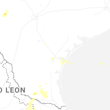


Connect with Interactive Hail Maps