

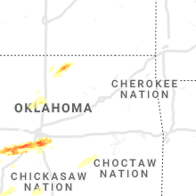
Hail Map for Sunday, October 10, 2021

Number of Impacted Households on 10/10/2021
0
Impacted by 1" or Larger Hail
0
Impacted by 1.75" or Larger Hail
0
Impacted by 2.5" or Larger Hail
Square Miles of Populated Area Impacted on 10/10/2021
0
Impacted by 1" or Larger Hail
0
Impacted by 1.75" or Larger Hail
0
Impacted by 2.5" or Larger Hail


Cities Most Affected by Hail Storms of 10/10/2021
| Hail Size | Demographics of Zip Codes Affected | ||||||
|---|---|---|---|---|---|---|---|
| City | Count | Average | Largest | Pop Density | House Value | Income | Age |
| Norman, OK | 3 | 2.58 | 3.00 | 512 | $85k | $38.2k | 34.2 |
| Ponca City, OK | 1 | 2.00 | 2.00 | 93 | $87k | $48.8k | 48.1 |
| Newcastle, OK | 1 | 1.75 | 1.75 | 131 | $92k | $48.7k | 39.0 |
| Grand Marais, MN | 1 | 1.75 | 1.75 | 3 | $104k | $35.8k | 50.3 |
| Waverly, KS | 1 | 1.75 | 1.75 | 7 | $56k | $36.0k | 44.7 |
Hail and Wind Damage Spotted on 10/10/2021
Filter by Report Type:Hail ReportsWind Reports
Illinois
| Local Time | Report Details |
|---|---|
| 7:04 AM CDT | Brief strong wind gust reported on equipmen in jo daviess county IL, 55.7 miles SSW of Madison, WI |
Oklahoma
| Local Time | Report Details |
|---|---|
| 11:44 AM CDT | Media reports trees down along highway 10a near the sequoyah and muskogee county line. time estimated from radar. may be associated with a possible tornad in sequoyah county OK, 42.1 miles WNW of Fort Smith, AR |
| 5:27 PM CDT | Quarter sized hail reported near Altus, OK, 54.9 miles ENE of Childress, TX |
| 5:45 PM CDT | Storm damage reported in jackson county OK, 51.5 miles ENE of Childress, TX |
| 5:59 PM CDT | Klt in jackson county OK, 56.4 miles ENE of Childress, TX |
| 6:49 PM CDT | Hen Egg sized hail reported near Ponca City, OK, 68.5 miles WNW of Tulsa, OK, 2 inch hail reported se of ponca city. |
| 6:50 PM CDT | Oklahoma mesonet report in tillman county OK, 26.1 miles NNW of Wichita Falls, TX |
| 7:00 PM CDT | Storm damage reported in caddo county OK, 57.8 miles SW of Oklahoma City, OK |
| 7:00 PM CDT | Storm damage reported in grady county OK, 38.4 miles SW of Oklahoma City, OK |
| 7:15 PM CDT | Storm damage reported in canadian county OK, 27.6 miles W of Oklahoma City, OK |
| 7:15 PM CDT | Storm damage reported in grady county OK, 39.7 miles SW of Oklahoma City, OK |
| 7:35 PM CDT | Storm damage reported in grady county OK, 38.4 miles SW of Oklahoma City, OK |
| 7:40 PM CDT | Ping Pong Ball sized hail reported near Blanchard, OK, 30.7 miles SSW of Oklahoma City, OK |
| 7:40 PM CDT | Golf Ball sized hail reported near Newcastle, OK, 20.1 miles SSW of Oklahoma City, OK |
| 7:51 PM CDT | Quarter sized hail reported near Washington, OK, 22.3 miles S of Oklahoma City, OK |
| 7:54 PM CDT | 64 mph wind gust measured at sundance airport in canadian county OK, 13.4 miles NW of Oklahoma City, OK |
| 7:54 PM CDT | 66 mph wind gust measured at wiley post airport in oklahoma county OK, 8.5 miles WNW of Oklahoma City, OK |
| 7:57 PM CDT | Quarter sized hail reported near Noble, OK, 23.4 miles SSE of Oklahoma City, OK |
| 8:04 PM CDT | Tea Cup sized hail reported near Norman, OK, 18.5 miles SSE of Oklahoma City, OK |
| 8:05 PM CDT | Hen Egg sized hail reported near Norman, OK, 16.4 miles SSE of Oklahoma City, OK |
| 8:06 PM CDT | Baseball sized hail reported near Norman, OK, 16.9 miles SSE of Oklahoma City, OK |
| 9:25 PM CDT | Power pole damage at old highway 99 and cr 1510. law enforcement reports 30 feet of wall removed from a business and found on state highway 3w. another damaged building in pontotoc county OK, 44.3 miles NW of Atoka, OK |
| 9:35 PM CDT | Residential roof blown off... damage to two barns and other outbuilding in pontotoc county OK, 44.2 miles NW of Atoka, OK |
| 9:47 PM CDT | Storm damage reported in creek county OK, 34.9 miles SW of Tulsa, OK |
| 10:00 PM CDT | Reports of damage on highway 70 two miles west of durant. power lines also reported downed in the durant area. time estimate in bryan county OK, 32.9 miles SSW of Atoka, OK |
| 10:00 PM CDT | Trees down... fence gone... back of barn gone... and carport destroye in bryan county OK, 33.4 miles SW of Atoka, OK |
| 10:00 PM CDT | Trees down on house in bryan county OK, 29.1 miles SW of Atoka, OK |
| 10:25 PM CDT | Corrects previous non-tstm wnd gst report from beggs. 73 mph wind gust reported... with power lines down near begg in okmulgee county OK, 28.6 miles S of Tulsa, OK |
| 11:45 PM CDT | Webbers fall mesonet measured a gust to 61mp in muskogee county OK, 42.2 miles WNW of Fort Smith, AR |
| 12:20 AM CDT | Trees down on vehicle 3 miles west of broken bow on hwy in mccurtain county OK, 54.6 miles W of Nashville, AR |
| 12:24 AM CDT | Tree reported down east of idabe in mccurtain county OK, 59.4 miles W of Nashville, AR |
| 12:40 AM CDT | Tree reported down on 6th stree in mccurtain county OK, 46.6 miles W of Nashville, AR |
Texas
| Local Time | Report Details |
|---|---|
| 2:59 PM CDT | Measured by the west texas mesonet. strong winds were enhanced by a passing thunderstor in lamb county TX, 57.7 miles NW of Lubbock, TX |
| 3:08 PM CDT | 73 mph wind gust measured by west texas mesonet. strong winds enhanced by a nearby thunderstor in lamb county TX, 43 miles NW of Lubbock, TX |
| 6:01 PM CDT | Stamford (5 ese) mesonet recorded a 65 mph wind gus in jones county TX, 32.5 miles N of Abilene, TX |
| 6:13 PM CDT | A 61 mph wind gust was recorded by asos at the abilene regional airpor in taylor county TX, 3.6 miles SE of Abilene, TX |
| 7:39 PM CDT | Large tree down on vine street in bangs... tx. time estimated on rada in brown county TX, 62.3 miles SE of Abilene, TX |
| 7:47 PM CDT | Large tree down on power lines on county road 382 in early tx. time estimated on rada in brown county TX, 65.5 miles SE of Abilene, TX |
| 7:48 PM CDT | Measured by a cwop statio in jack county TX, 36.4 miles SSE of Wichita Falls, TX |
| 8:10 PM CDT | 60 mph wind gust reported on hwy 8 in montague county TX, 41.2 miles ESE of Wichita Falls, TX |
| 8:20 PM CDT | Mineral wells asos reported 60 mph winds at 8:20p in palo pinto county TX, 74.8 miles W of Dallas, TX |
| 9:03 PM CDT | 60 mph gusts reported in annetta sout in parker county TX, 51.5 miles W of Dallas, TX |
| 9:10 PM CDT | 60 mph winds reported in ponder by weather spotte in denton county TX, 39.9 miles NW of Dallas, TX |
| 9:10 PM CDT | Measured by a weatherstem station at texas motor speedwa in denton county TX, 33.5 miles WNW of Dallas, TX |
| 9:24 PM CDT | Delayed report: social media reports several broken large tree branches in denton... t in denton county TX, 36.1 miles NNW of Dallas, TX |
| 9:35 PM CDT | Power poles snapped east of 289 on fm121 in gunte in grayson county TX, 46.4 miles N of Dallas, TX |
Minnesota
| Local Time | Report Details |
|---|---|
| 3:43 PM CDT | Report of tree down on powerline at or near kabetogama visitor center. time estimated from rada in st. louis county MN, 20.5 miles ESE of International Falls, MN |
| 5:29 PM CDT | Trees down on roa in cook county MN, 105.4 miles NE of Duluth, MN |
| 5:37 PM CDT | Trees down along ball club road. location estimated by rada in cook county MN, 108.3 miles NE of Duluth, MN |
| 5:41 PM CDT | Golf Ball sized hail reported near Grand Marais, MN, 105.5 miles NE of Duluth, MN, search and rescue crew had to take cover while near eagle mountain. |
Kansas
| Local Time | Report Details |
|---|---|
| 7:35 PM CDT | Golf Ball sized hail reported near Waverly, KS, 41.8 miles NNW of Chanute, KS, time estimated from radar. spotter reported brief hail up to golf-ball size. |
Connect with Interactive Hail Maps