

Hail Map for Sunday, October 11, 2020

Number of Impacted Households on 10/11/2020
0
Impacted by 1" or Larger Hail
0
Impacted by 1.75" or Larger Hail
0
Impacted by 2.5" or Larger Hail
Square Miles of Populated Area Impacted on 10/11/2020
0
Impacted by 1" or Larger Hail
0
Impacted by 1.75" or Larger Hail
0
Impacted by 2.5" or Larger Hail


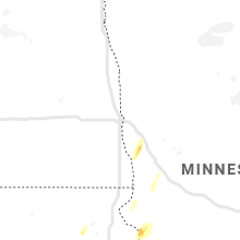


Cities Most Affected by Hail Storms of 10/11/2020
| Hail Size | Demographics of Zip Codes Affected | ||||||
|---|---|---|---|---|---|---|---|
| City | Count | Average | Largest | Pop Density | House Value | Income | Age |
| Leigh, NE | 2 | 1.75 | 1.75 | 6 | $51k | $32.4k | 45.2 |
| Madison, NE | 1 | 2.75 | 2.75 | 9 | $56k | $36.6k | 34.8 |
| Hudson, SD | 1 | 1.75 | 1.75 | 6 | $44k | $34.7k | 44.4 |
Hail and Wind Damage Spotted on 10/11/2020
Filter by Report Type:Hail ReportsWind Reports
South Carolina
| Local Time | Report Details |
|---|---|
| 10:15 AM EDT | Emergency mngr reported trees blown down on riverfork r in laurens county SC, 45.8 miles SE of Greenville, SC |
| 10:15 AM EDT | Emergency mngr reported trees down on arnold l in laurens county SC, 40.7 miles SE of Greenville, SC |
| 4:20 PM EDT | *** 1 inj *** multiple structures damaged. significant damage done to home on oak st... between 4 mile rd and cultra rd. possible tornado. one person suffered minor inj in horry county SC, 69 miles WSW of Wilmington, NC |
Nebraska
| Local Time | Report Details |
|---|---|
| 5:27 PM CDT | Half Dollar sized hail reported near Madison, NE, 74.3 miles ESE of Oneill, NE |
| 5:35 PM CDT | Baseball sized hail reported near Madison, NE, 74.9 miles ESE of Oneill, NE, public report of hailstones ranging from half-dollar to baseball in size. broke his wind shield while on highway 81. |
| 6:17 PM CDT | Half Dollar sized hail reported near Creston, NE, 71.6 miles NE of Grand Island, NE, time estimated based on radar. |
| 6:40 PM CDT | Golf Ball sized hail reported near Leigh, NE, 74.4 miles WNW of Omaha, NE |
| 6:45 PM CDT | Golf Ball sized hail reported near Leigh, NE, 73.9 miles WNW of Omaha, NE |
| 6:51 PM CDT | Storm damage reported in colfax county NE, 69.8 miles WNW of Omaha, NE |
| 7:39 PM CDT | Half Dollar sized hail reported near Dodge, NE, 58.1 miles WNW of Omaha, NE |
| 7:43 PM CDT | Quarter sized hail reported near West Point, NE, 56.5 miles NW of Omaha, NE, reported at west point... ne. |
| 7:56 PM CDT | Ping Pong Ball sized hail reported near West Point, NE, 54.3 miles NW of Omaha, NE, report from mping. |
| 7:57 PM CDT | Ping Pong Ball sized hail reported near West Point, NE, 54.3 miles NW of Omaha, NE, reported at 1428 a road... west point. |
| 8:19 PM CDT | Quarter sized hail reported near Harvard, NE, 24.5 miles SSE of Grand Island, NE, relayed by em. time estimated from radar. |
| 9:10 PM CDT | Empty 500 gallon water tank blown into main street of bruning. 3 to 4 inch branches broken. one rotten treen blown down. time estimated from surrounding observation in thayer county NE, 57.5 miles SE of Grand Island, NE |
| 9:15 PM CDT | Mesonet wind gust of 60 mph. reported at 40.9027 -97.331 in seward county NE, 52.9 miles E of Grand Island, NE |
| 9:19 PM CDT | Mesonet wind report of 58 mph. reported at 40.6582 -97.218 in saline county NE, 61.5 miles ESE of Grand Island, NE |
| 9:30 PM CDT | Mesonet wind report of 62 mph. reported at 40.867 -96.8 in lancaster county NE, 56 miles WSW of Omaha, NE |
| 9:30 PM CDT | Mesonet wind of 63 mph. reported at 40.6222 -96.928 in saline county NE, 68.1 miles SW of Omaha, NE |
| 9:32 PM CDT | Empty grain bins blown ove in fillmore county NE, 42.6 miles ESE of Grand Island, NE |
| 9:35 PM CDT | Storm damage reported in seward county NE, 64.5 miles WSW of Omaha, NE |
| 9:35 PM CDT | Reported at klnk... lincoln airport... 76 mp in lancaster county NE, 51.3 miles WSW of Omaha, NE |
| 9:45 PM CDT | Report from mping: 3-inch tree limbs broken; power poles broke in lancaster county NE, 49.8 miles SW of Omaha, NE |
| 9:46 PM CDT | Report from mping: 3-inch tree limbs broken; power poles broke in lancaster county NE, 50.3 miles SW of Omaha, NE |
| 9:51 PM CDT | Report from mping: 1-inch tree limbs broken; shingles blown of in lancaster county NE, 50.4 miles SW of Omaha, NE |
| 9:53 PM CDT | Mesonet wind report... 58 mph. reported at 40.4448 -96.704 in gage county NE, 69.2 miles SW of Omaha, NE |
| 9:54 PM CDT | Report from mping: 1-inch tree limbs broken; shingles blown of in lancaster county NE, 50.5 miles SW of Omaha, NE |
| 9:55 PM CDT | Awos station kbie beatrice munici in gage county NE, 76.6 miles N of Manhattan, KS |
| 9:55 PM CDT | Report from mping: 3-inch tree limbs broken; power poles broke in saunders county NE, 36.1 miles WSW of Omaha, NE |
| 9:57 PM CDT | Report from mping: 1-inch tree limbs broken; shingles blown of in gage county NE, 69 miles SW of Omaha, NE |
| 9:58 PM CDT | Report from mping: 1-inch tree limbs broken; shingles blown of in gage county NE, 69 miles SW of Omaha, NE |
| 10:02 PM CDT | Reported at koma... omaha eppley... 60 mp in douglas county NE, 3.8 miles NE of Omaha, NE |
| 10:02 PM CDT | Power outage. time estimated based on rada in jefferson county NE, 81.3 miles NNW of Manhattan, KS |
| 10:04 PM CDT | Reported at 41.1365 -96.0585... 68 mph... mesone in sarpy county NE, 10.4 miles SW of Omaha, NE |
| 10:04 PM CDT | Relayed by emergency managemen in lancaster county NE, 61.1 miles SW of Omaha, NE |
| 10:15 PM CDT | Storm damage reported in gage county NE, 76.6 miles N of Manhattan, KS |
| 10:23 PM CDT | Storm damage reported in otoe county NE, 43.3 miles SSW of Omaha, NE |
| 10:25 PM CDT | Tree down on main stree in johnson county NE, 59.9 miles SSW of Omaha, NE |
| 10:42 PM CDT | Mesonet wind report. 62 mph. reported at 40.41 -95.99 in nemaha county NE, 58.8 miles S of Omaha, NE |
| 10:49 PM CDT | Nebraska city airport awo in otoe county NE, 45.1 miles S of Omaha, NE |
| 11:24 PM CDT | Reported at kfnb... 69 mph gus in richardson county NE, 81 miles NE of Manhattan, KS |
| 11:24 PM CDT | An 80-ft tall x 30-inch diameter tree uprooted with other minor tree damage around tow in richardson county NE, 79.6 miles NE of Manhattan, KS |
| 11:25 PM CDT | Reported at kfnb... 60 mp in richardson county NE, 81 miles NE of Manhattan, KS |
Minnesota
| Local Time | Report Details |
|---|---|
| 5:40 PM CDT | Quarter sized hail reported near Ortonville, MN, 42.3 miles NW of Montevideo, MN |
| 5:45 PM CDT | Half Dollar sized hail reported near Ortonville, MN, 41.9 miles NW of Montevideo, MN |
| 6:55 PM CDT | Awos station kcnb canby a in yellow medicine county MN, 31.2 miles WSW of Montevideo, MN |
| 6:55 PM CDT | Few power poles down in canb in yellow medicine county MN, 31.9 miles WSW of Montevideo, MN |
| 7:21 PM CDT | Storm damage reported in douglas county MN, 68.2 miles N of Montevideo, MN |
| 7:35 PM CDT | Mahnomen asos reports 51kt or 58.7mph wind gus in mahnomen county MN, 47 miles NE of Fargo, ND |
South Dakota
| Local Time | Report Details |
|---|---|
| 5:45 PM CDT | Quarter sized hail reported near Revillo, SD, 42 miles W of Montevideo, MN |
| 5:54 PM CDT | Golf Ball sized hail reported near Hudson, SD, 31.7 miles SSE of Sioux Falls, SD, report via social media. location estimated via radar. |
Iowa
| Local Time | Report Details |
|---|---|
| 6:14 PM CDT | Personal weather station measured wind gus in sioux county IA, 32.2 miles SE of Sioux Falls, SD |
| 6:59 PM CDT | Personal weather station measured gus in woodbury county IA, 61.6 miles W of Storm Lake, IA |
| 10:45 PM CDT | Mesonet report. 59 mph. reported at 40.9228 -95.671 in mills county IA, 27.4 miles SSE of Omaha, NE |
| 10:52 PM CDT | Iowa dot sit in fremont county IA, 40.3 miles SSE of Omaha, NE |
| 10:57 PM CDT | Report from mping: 1-inch tree limbs broken; in mills county IA, 15.1 miles SSE of Omaha, NE |
| 11:10 PM CDT | Multiple trees... tree branches and power lines dow in montgomery county IA, 41.4 miles ESE of Omaha, NE |
| 11:11 PM CDT | Report from mping: 3-inch tree limbs broken; in page county IA, 44.4 miles SE of Omaha, NE |
| 11:15 PM CDT | Storm damage reported in fremont county IA, 40.8 miles SE of Omaha, NE |
| 11:39 PM CDT | Measured at clarinda airpor in page county IA, 55.6 miles ESE of Omaha, NE |
| 11:46 PM CDT | 1ft diameter tree limb dow in carroll county IA, 43.3 miles SSE of Storm Lake, IA |
| 12:10 AM CDT | Rwi in taylor county IA, 75.7 miles ESE of Omaha, NE |
| 1:51 AM CDT | Storm damage reported in cerro gordo county IA, 6.6 miles W of Mason City, IA |
| 2:00 AM CDT | Storm damage reported in cerro gordo county IA, 7.1 miles W of Mason City, IA |
Kansas
| Local Time | Report Details |
|---|---|
| 10:51 PM CDT | Storm damage reported in russell county KS, 26 miles E of Hays, KS |
Missouri
| Local Time | Report Details |
|---|---|
| 11:17 PM CDT | Report came from a gas station on the southwest corner of the i-29 and hwy 136 interchang in atchison county MO, 62 miles SSE of Omaha, NE |
Connect with Interactive Hail Maps