

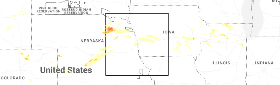
Hail Map for Dodge, NE
The Dodge, NE area has had 4 reports of on-the-ground hail by trained spotters, and has been under severe weather warnings 12 times during the past 12 months. Doppler radar has detected hail at or near Dodge, NE on 98 occasions, including 5 occasions during the past year.
| Name: | Dodge, NE |
| Where Located: | 58.2 miles WNW of Omaha, NE |
| Map: | Google Map for Dodge, NE |
| Population: | 612 |
| Housing Units: | 289 |
| More Info: | Search Google for Dodge, NE |
2
The Top Recent Hail Date for Dodge, NE is Thursday, July 10, 2025 (26th out of 98)
Hail and Wind Damage Spotted near Dodge, NE
| Date / Time | Report Details |
|---|---|
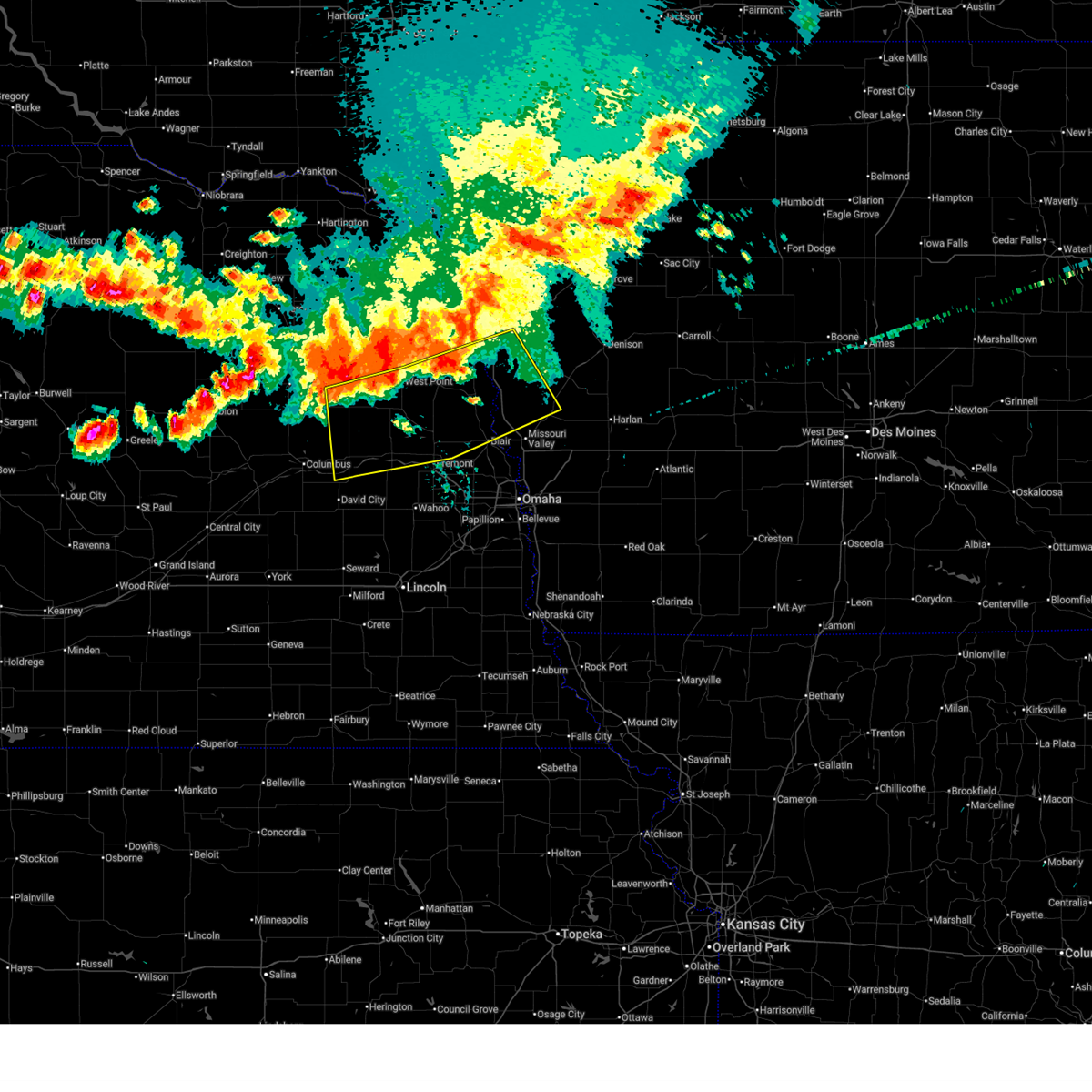
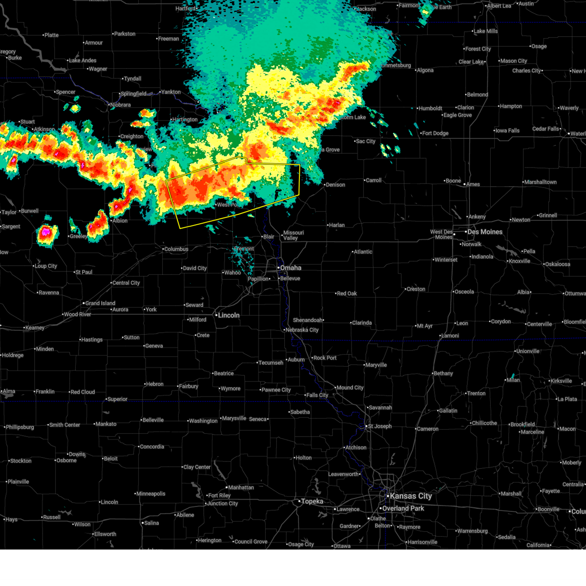
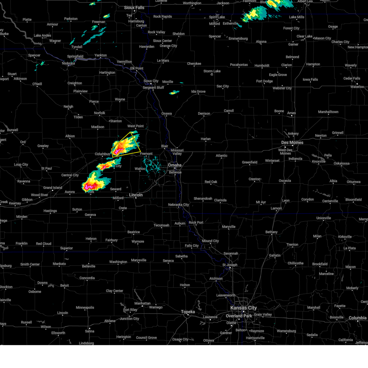
| 7/7/2025 9:22 PM CDT |
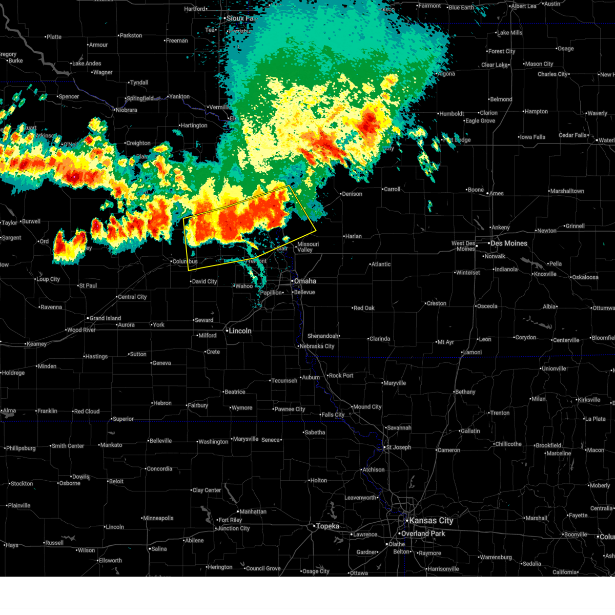 At 921 pm cdt, severe thunderstorms were located along a line extending from 4 miles east of pisgah to 2 miles east of hooper to 4 miles north of schuyler, moving southeast at 40 mph (weather instrument measurement. at 916 pm, 60 mph winds were reported in tekamah). Hazards include 60 mph wind gusts and quarter size hail. Hail damage to vehicles is expected. expect wind damage to roofs, siding, and trees. these severe storms will be near, schuyler, north bend, hooper, mondamin, nickerson, and herman around 925 pm cdt. Other locations in the path of these severe thunderstorms include fremont, woodbine, modale, magnolia, morse bluff, linwood, blair and logan. At 921 pm cdt, severe thunderstorms were located along a line extending from 4 miles east of pisgah to 2 miles east of hooper to 4 miles north of schuyler, moving southeast at 40 mph (weather instrument measurement. at 916 pm, 60 mph winds were reported in tekamah). Hazards include 60 mph wind gusts and quarter size hail. Hail damage to vehicles is expected. expect wind damage to roofs, siding, and trees. these severe storms will be near, schuyler, north bend, hooper, mondamin, nickerson, and herman around 925 pm cdt. Other locations in the path of these severe thunderstorms include fremont, woodbine, modale, magnolia, morse bluff, linwood, blair and logan.
|
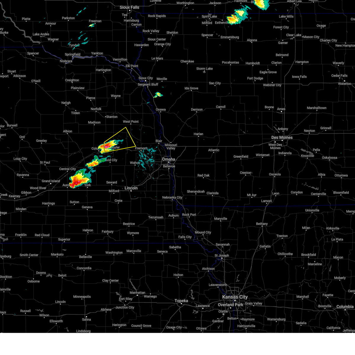
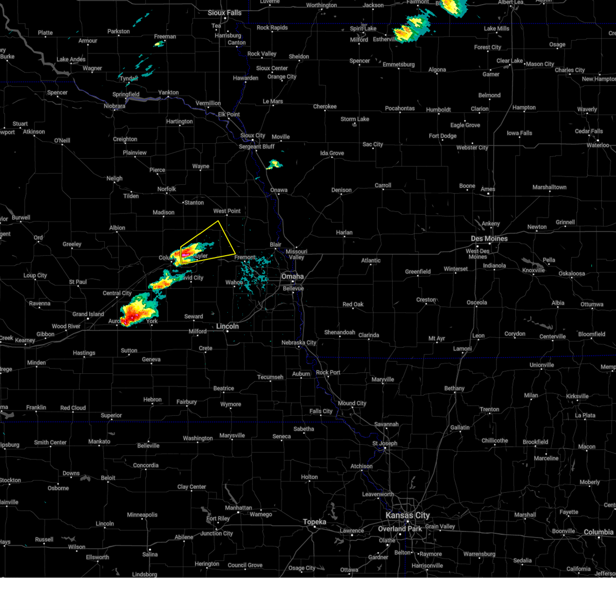
| 7/7/2025 9:07 PM CDT |
 Svroax the national weather service in omaha has issued a * severe thunderstorm warning for, southwestern monona county in west central iowa, western harrison county in southwestern iowa, burt county in east central nebraska, southern cuming county in northeastern nebraska, colfax county in northeastern nebraska, northwestern washington county in east central nebraska, dodge county in east central nebraska, northeastern butler county in east central nebraska, northwestern saunders county in east central nebraska, southeastern stanton county in northeastern nebraska, * until 945 pm cdt. * at 906 pm cdt, severe thunderstorms were located along a line extending from 6 miles south of castana to 5 miles west of uehling to 4 miles southeast of leigh, moving southeast at 35 mph (radar indicated). Hazards include 60 mph wind gusts and quarter size hail. Hail damage to vehicles is expected. expect wind damage to roofs, siding, and trees. severe thunderstorms will be near, tekamah, scribner, snyder, uehling, moorhead, blencoe, and craig around 910 pm cdt. hooper, pisgah, and little sioux around 915 pm cdt. schuyler, mondamin, and herman around 925 pm cdt. other locations in the path of these severe thunderstorms include north bend, nickerson, woodbine, modale, magnolia, morse bluff and linwood. This includes interstate 29 between mile markers 82 and 112. Svroax the national weather service in omaha has issued a * severe thunderstorm warning for, southwestern monona county in west central iowa, western harrison county in southwestern iowa, burt county in east central nebraska, southern cuming county in northeastern nebraska, colfax county in northeastern nebraska, northwestern washington county in east central nebraska, dodge county in east central nebraska, northeastern butler county in east central nebraska, northwestern saunders county in east central nebraska, southeastern stanton county in northeastern nebraska, * until 945 pm cdt. * at 906 pm cdt, severe thunderstorms were located along a line extending from 6 miles south of castana to 5 miles west of uehling to 4 miles southeast of leigh, moving southeast at 35 mph (radar indicated). Hazards include 60 mph wind gusts and quarter size hail. Hail damage to vehicles is expected. expect wind damage to roofs, siding, and trees. severe thunderstorms will be near, tekamah, scribner, snyder, uehling, moorhead, blencoe, and craig around 910 pm cdt. hooper, pisgah, and little sioux around 915 pm cdt. schuyler, mondamin, and herman around 925 pm cdt. other locations in the path of these severe thunderstorms include north bend, nickerson, woodbine, modale, magnolia, morse bluff and linwood. This includes interstate 29 between mile markers 82 and 112.
|
| 7/7/2025 8:54 PM CDT |
 At 853 pm cdt, severe thunderstorms were located along a line extending from 5 miles south of smithland to 4 miles west of lyons to 6 miles north of clarkson, moving southeast at 30 mph (radar indicated). Hazards include 60 mph wind gusts and quarter size hail. Hail damage to vehicles is expected. expect wind damage to roofs, siding, and trees. Locations impacted include, west point, onawa, oakland, lyons, clarkson, howells, decatur, castana, dodge, blencoe, snyder, craig, soldier, uehling and moorhead. At 853 pm cdt, severe thunderstorms were located along a line extending from 5 miles south of smithland to 4 miles west of lyons to 6 miles north of clarkson, moving southeast at 30 mph (radar indicated). Hazards include 60 mph wind gusts and quarter size hail. Hail damage to vehicles is expected. expect wind damage to roofs, siding, and trees. Locations impacted include, west point, onawa, oakland, lyons, clarkson, howells, decatur, castana, dodge, blencoe, snyder, craig, soldier, uehling and moorhead.
|
| 7/7/2025 8:36 PM CDT |
 Svroax the national weather service in omaha has issued a * severe thunderstorm warning for, monona county in west central iowa, northwestern harrison county in southwestern iowa, burt county in east central nebraska, cuming county in northeastern nebraska, southern wayne county in northeastern nebraska, northeastern colfax county in northeastern nebraska, northwestern dodge county in east central nebraska, thurston county in northeastern nebraska, stanton county in northeastern nebraska, * until 915 pm cdt. * at 836 pm cdt, severe thunderstorms were located along a line extending from 5 miles northwest of smithland to 4 miles southeast of pender to 3 miles west of stanton, moving southeast at 30 mph (radar indicated). Hazards include 60 mph wind gusts and quarter size hail. Hail damage to vehicles is expected. expect wind damage to roofs, siding, and trees. severe thunderstorms will be near, wisner, whiting, beemer, bancroft, rosalie, and macy around 840 pm cdt. lyons and decatur around 850 pm cdt. west point and onawa around 855 pm cdt. other locations in the path of these severe thunderstorms include clarkson, castana, oakland and howells. This includes interstate 29 between mile markers 99 and 125. Svroax the national weather service in omaha has issued a * severe thunderstorm warning for, monona county in west central iowa, northwestern harrison county in southwestern iowa, burt county in east central nebraska, cuming county in northeastern nebraska, southern wayne county in northeastern nebraska, northeastern colfax county in northeastern nebraska, northwestern dodge county in east central nebraska, thurston county in northeastern nebraska, stanton county in northeastern nebraska, * until 915 pm cdt. * at 836 pm cdt, severe thunderstorms were located along a line extending from 5 miles northwest of smithland to 4 miles southeast of pender to 3 miles west of stanton, moving southeast at 30 mph (radar indicated). Hazards include 60 mph wind gusts and quarter size hail. Hail damage to vehicles is expected. expect wind damage to roofs, siding, and trees. severe thunderstorms will be near, wisner, whiting, beemer, bancroft, rosalie, and macy around 840 pm cdt. lyons and decatur around 850 pm cdt. west point and onawa around 855 pm cdt. other locations in the path of these severe thunderstorms include clarkson, castana, oakland and howells. This includes interstate 29 between mile markers 99 and 125.
|
| 6/19/2025 11:55 PM CDT |
 The strong winds which prompted the warning have weakened below severe limits, and the storm has exited the warned area. therefore, the warning will be allowed to expire. however, gusty winds up to 40 mph are still possible. The strong winds which prompted the warning have weakened below severe limits, and the storm has exited the warned area. therefore, the warning will be allowed to expire. however, gusty winds up to 40 mph are still possible.
|
| 6/19/2025 11:14 PM CDT |
 Svroax the national weather service in omaha has issued a * severe thunderstorm warning for, northwestern mills county in southwestern iowa, western pottawattamie county in southwestern iowa, southwestern harrison county in southwestern iowa, south central burt county in east central nebraska, colfax county in northeastern nebraska, douglas county in east central nebraska, northern saunders county in east central nebraska, northeastern sarpy county in east central nebraska, southwestern cuming county in northeastern nebraska, washington county in east central nebraska, dodge county in east central nebraska, northeastern butler county in east central nebraska, southeastern stanton county in northeastern nebraska, * until midnight cdt. * at 1111 pm cdt, showers and thunderstorms producing damaging winds up to 60 mph were located across southern dodge, northern saunders, and into washington and douglas counties, moving east at 20 mph (radar indicated). Hazards include 60 mph wind gusts. Expect damage to roofs, siding, and trees. this severe thunderstorm will be near, fremont and cedar bluffs around 1115 pm cdt. inglewood around 1125 pm cdt. woodcliff around 1130 pm cdt. other locations in the path of this severe thunderstorm include arlington. people attending charles schwab field should seek safe shelter immediately! this includes the following highways, interstate 29 between mile markers 42 and 84. interstate 80 in iowa between mile markers 1 and 14. Interstate 80 in nebraska between mile markers 443 and 454. Svroax the national weather service in omaha has issued a * severe thunderstorm warning for, northwestern mills county in southwestern iowa, western pottawattamie county in southwestern iowa, southwestern harrison county in southwestern iowa, south central burt county in east central nebraska, colfax county in northeastern nebraska, douglas county in east central nebraska, northern saunders county in east central nebraska, northeastern sarpy county in east central nebraska, southwestern cuming county in northeastern nebraska, washington county in east central nebraska, dodge county in east central nebraska, northeastern butler county in east central nebraska, southeastern stanton county in northeastern nebraska, * until midnight cdt. * at 1111 pm cdt, showers and thunderstorms producing damaging winds up to 60 mph were located across southern dodge, northern saunders, and into washington and douglas counties, moving east at 20 mph (radar indicated). Hazards include 60 mph wind gusts. Expect damage to roofs, siding, and trees. this severe thunderstorm will be near, fremont and cedar bluffs around 1115 pm cdt. inglewood around 1125 pm cdt. woodcliff around 1130 pm cdt. other locations in the path of this severe thunderstorm include arlington. people attending charles schwab field should seek safe shelter immediately! this includes the following highways, interstate 29 between mile markers 42 and 84. interstate 80 in iowa between mile markers 1 and 14. Interstate 80 in nebraska between mile markers 443 and 454.
|
| 4/17/2025 5:45 PM CDT |
 the severe thunderstorm warning has been cancelled and is no longer in effect the severe thunderstorm warning has been cancelled and is no longer in effect
|
| 4/17/2025 5:45 PM CDT |
 At 545 pm cdt, a severe thunderstorm was located 8 miles south of howells, or 21 miles northeast of columbus, moving northeast at 30 mph (radar indicated). Hazards include two inch hail and 60 mph wind gusts. People and animals outdoors will be injured. expect hail damage to roofs, siding, windows, and vehicles. expect wind damage to roofs, siding, and trees. Locations impacted include, schuyler, dodge, snyder, rogers, and fishers elementary. At 545 pm cdt, a severe thunderstorm was located 8 miles south of howells, or 21 miles northeast of columbus, moving northeast at 30 mph (radar indicated). Hazards include two inch hail and 60 mph wind gusts. People and animals outdoors will be injured. expect hail damage to roofs, siding, windows, and vehicles. expect wind damage to roofs, siding, and trees. Locations impacted include, schuyler, dodge, snyder, rogers, and fishers elementary.
|
| 4/17/2025 5:42 PM CDT |
 At 541 pm cdt, a severe thunderstorm was located 9 miles north of schuyler, or 18 miles northeast of columbus, moving northeast at 30 mph (radar indicated). Hazards include golf ball size hail and 60 mph wind gusts. People and animals outdoors will be injured. expect hail damage to roofs, siding, windows, and vehicles. expect wind damage to roofs, siding, and trees. Locations impacted include, schuyler, dodge, snyder, rogers, and fishers elementary. At 541 pm cdt, a severe thunderstorm was located 9 miles north of schuyler, or 18 miles northeast of columbus, moving northeast at 30 mph (radar indicated). Hazards include golf ball size hail and 60 mph wind gusts. People and animals outdoors will be injured. expect hail damage to roofs, siding, windows, and vehicles. expect wind damage to roofs, siding, and trees. Locations impacted include, schuyler, dodge, snyder, rogers, and fishers elementary.
|
| 4/17/2025 5:30 PM CDT |
 At 529 pm cdt, a severe thunderstorm was located 7 miles northeast of richland, or 12 miles northeast of columbus, moving northeast at 30 mph (radar indicated). Hazards include ping pong ball size hail and 60 mph wind gusts. People and animals outdoors will be injured. expect hail damage to roofs, siding, windows, and vehicles. expect wind damage to roofs, siding, and trees. Locations impacted include, schuyler, dodge, snyder, richland, rogers, fishers elementary, and camp luther. At 529 pm cdt, a severe thunderstorm was located 7 miles northeast of richland, or 12 miles northeast of columbus, moving northeast at 30 mph (radar indicated). Hazards include ping pong ball size hail and 60 mph wind gusts. People and animals outdoors will be injured. expect hail damage to roofs, siding, windows, and vehicles. expect wind damage to roofs, siding, and trees. Locations impacted include, schuyler, dodge, snyder, richland, rogers, fishers elementary, and camp luther.
|
| 4/17/2025 5:30 PM CDT |
 the severe thunderstorm warning has been cancelled and is no longer in effect the severe thunderstorm warning has been cancelled and is no longer in effect
|
| 4/17/2025 5:25 PM CDT |
 Svroax the national weather service in omaha has issued a * severe thunderstorm warning for, southern cuming county in northeastern nebraska, colfax county in northeastern nebraska, east central platte county in northeastern nebraska, western dodge county in east central nebraska, * until 615 pm cdt. * at 525 pm cdt, a severe thunderstorm was located 5 miles north of richland, or 10 miles northeast of columbus, moving northeast at 30 mph (radar indicated). Hazards include 60 mph wind gusts and quarter size hail. Hail damage to vehicles is expected. Expect wind damage to roofs, siding, and trees. Svroax the national weather service in omaha has issued a * severe thunderstorm warning for, southern cuming county in northeastern nebraska, colfax county in northeastern nebraska, east central platte county in northeastern nebraska, western dodge county in east central nebraska, * until 615 pm cdt. * at 525 pm cdt, a severe thunderstorm was located 5 miles north of richland, or 10 miles northeast of columbus, moving northeast at 30 mph (radar indicated). Hazards include 60 mph wind gusts and quarter size hail. Hail damage to vehicles is expected. Expect wind damage to roofs, siding, and trees.
|
| 5/24/2024 2:11 AM CDT |
 At 211 am cdt, severe thunderstorms were located along a line extending from 4 miles northwest of winnebago to 2 miles southeast of bancroft to 5 miles north of scribner, moving east at 35 mph (radar indicated). Hazards include 70 mph wind gusts and quarter size hail. Hail damage to vehicles is expected. expect considerable tree damage. wind damage is also likely to mobile homes, roofs, and outbuildings. Locations impacted include, west point, tekamah, onawa, oakland, pender, lyons, emerson, walthill, winnebago, whiting, dodge, bancroft, decatur, pisgah, uehling, blencoe, craig, little sioux, rosalie, and castana. At 211 am cdt, severe thunderstorms were located along a line extending from 4 miles northwest of winnebago to 2 miles southeast of bancroft to 5 miles north of scribner, moving east at 35 mph (radar indicated). Hazards include 70 mph wind gusts and quarter size hail. Hail damage to vehicles is expected. expect considerable tree damage. wind damage is also likely to mobile homes, roofs, and outbuildings. Locations impacted include, west point, tekamah, onawa, oakland, pender, lyons, emerson, walthill, winnebago, whiting, dodge, bancroft, decatur, pisgah, uehling, blencoe, craig, little sioux, rosalie, and castana.
|
| 5/24/2024 1:57 AM CDT |
 Svroax the national weather service in omaha has issued a * severe thunderstorm warning for, monona county in west central iowa, northwestern harrison county in southwestern iowa, burt county in east central nebraska, eastern cuming county in northeastern nebraska, northwestern dodge county in east central nebraska, thurston county in northeastern nebraska, * until 245 am cdt. * at 157 am cdt, severe thunderstorms were located along a line extending from 2 miles east of emerson to 5 miles southwest of bancroft to 3 miles northwest of snyder, moving east at 35 mph (radar indicated). Hazards include 60 mph wind gusts and quarter size hail. Hail damage to vehicles is expected. Expect wind damage to roofs, siding, and trees. Svroax the national weather service in omaha has issued a * severe thunderstorm warning for, monona county in west central iowa, northwestern harrison county in southwestern iowa, burt county in east central nebraska, eastern cuming county in northeastern nebraska, northwestern dodge county in east central nebraska, thurston county in northeastern nebraska, * until 245 am cdt. * at 157 am cdt, severe thunderstorms were located along a line extending from 2 miles east of emerson to 5 miles southwest of bancroft to 3 miles northwest of snyder, moving east at 35 mph (radar indicated). Hazards include 60 mph wind gusts and quarter size hail. Hail damage to vehicles is expected. Expect wind damage to roofs, siding, and trees.
|
| 5/24/2024 1:53 AM CDT |
 Svroax the national weather service in omaha has issued a * severe thunderstorm warning for, western pottawattamie county in southwestern iowa, southwestern harrison county in southwestern iowa, southern burt county in east central nebraska, northeastern colfax county in northeastern nebraska, lancaster county in southeastern nebraska, eastern seward county in southeastern nebraska, douglas county in east central nebraska, saunders county in east central nebraska, sarpy county in east central nebraska, washington county in east central nebraska, dodge county in east central nebraska, northwestern otoe county in southeastern nebraska, southeastern butler county in east central nebraska, cass county in southeastern nebraska, * until 245 am cdt. * at 153 am cdt, severe thunderstorms were located along a line extending from 4 miles northeast of snyder to 2 miles west of cedar bluffs to near pleasant dale, moving east at 55 mph (radar indicated). Hazards include 70 mph wind gusts and quarter size hail. Hail damage to vehicles is expected. expect considerable tree damage. Wind damage is also likely to mobile homes, roofs, and outbuildings. Svroax the national weather service in omaha has issued a * severe thunderstorm warning for, western pottawattamie county in southwestern iowa, southwestern harrison county in southwestern iowa, southern burt county in east central nebraska, northeastern colfax county in northeastern nebraska, lancaster county in southeastern nebraska, eastern seward county in southeastern nebraska, douglas county in east central nebraska, saunders county in east central nebraska, sarpy county in east central nebraska, washington county in east central nebraska, dodge county in east central nebraska, northwestern otoe county in southeastern nebraska, southeastern butler county in east central nebraska, cass county in southeastern nebraska, * until 245 am cdt. * at 153 am cdt, severe thunderstorms were located along a line extending from 4 miles northeast of snyder to 2 miles west of cedar bluffs to near pleasant dale, moving east at 55 mph (radar indicated). Hazards include 70 mph wind gusts and quarter size hail. Hail damage to vehicles is expected. expect considerable tree damage. Wind damage is also likely to mobile homes, roofs, and outbuildings.
|
| 5/24/2024 1:50 AM CDT |
 At 149 am cdt, a confirmed tornado was located 5 miles south of snyder, or 14 miles south of west point, moving east at 50 mph (radar confirmed tornado). Hazards include damaging tornado. Flying debris will be dangerous to those caught without shelter. mobile homes will be damaged or destroyed. damage to roofs, windows, and vehicles will occur. tree damage is likely. This tornado will be near, scribner around 155 am cdt. At 149 am cdt, a confirmed tornado was located 5 miles south of snyder, or 14 miles south of west point, moving east at 50 mph (radar confirmed tornado). Hazards include damaging tornado. Flying debris will be dangerous to those caught without shelter. mobile homes will be damaged or destroyed. damage to roofs, windows, and vehicles will occur. tree damage is likely. This tornado will be near, scribner around 155 am cdt.
|
| 5/24/2024 1:50 AM CDT |
 the tornado warning has been cancelled and is no longer in effect the tornado warning has been cancelled and is no longer in effect
|
| 5/24/2024 1:42 AM CDT |
 the tornado warning has been cancelled and is no longer in effect the tornado warning has been cancelled and is no longer in effect
|
| 5/24/2024 1:42 AM CDT |
 At 141 am cdt, a severe thunderstorm capable of producing a tornado was located 3 miles south of dodge, or 14 miles southwest of west point, moving east at 55 mph (radar indicated rotation). Hazards include tornado. Flying debris will be dangerous to those caught without shelter. mobile homes will be damaged or destroyed. damage to roofs, windows, and vehicles will occur. tree damage is likely. this dangerous storm will be near, dodge and snyder around 145 am cdt. scribner around 150 am cdt. Other locations in the path of this tornadic thunderstorm include uehling. At 141 am cdt, a severe thunderstorm capable of producing a tornado was located 3 miles south of dodge, or 14 miles southwest of west point, moving east at 55 mph (radar indicated rotation). Hazards include tornado. Flying debris will be dangerous to those caught without shelter. mobile homes will be damaged or destroyed. damage to roofs, windows, and vehicles will occur. tree damage is likely. this dangerous storm will be near, dodge and snyder around 145 am cdt. scribner around 150 am cdt. Other locations in the path of this tornadic thunderstorm include uehling.
|
| 5/24/2024 1:31 AM CDT |
 At 131 am cdt, a severe thunderstorm capable of producing a tornado was located 4 miles southwest of howells, or 21 miles southwest of west point, moving east at 55 mph (radar indicated rotation). Hazards include tornado. Flying debris will be dangerous to those caught without shelter. mobile homes will be damaged or destroyed. damage to roofs, windows, and vehicles will occur. tree damage is likely. this dangerous storm will be near, howells around 135 am cdt. dodge around 140 am cdt. Other locations in the path of this tornadic thunderstorm include snyder, scribner and uehling. At 131 am cdt, a severe thunderstorm capable of producing a tornado was located 4 miles southwest of howells, or 21 miles southwest of west point, moving east at 55 mph (radar indicated rotation). Hazards include tornado. Flying debris will be dangerous to those caught without shelter. mobile homes will be damaged or destroyed. damage to roofs, windows, and vehicles will occur. tree damage is likely. this dangerous storm will be near, howells around 135 am cdt. dodge around 140 am cdt. Other locations in the path of this tornadic thunderstorm include snyder, scribner and uehling.
|
| 5/24/2024 1:31 AM CDT |
 the tornado warning has been cancelled and is no longer in effect the tornado warning has been cancelled and is no longer in effect
|
| 5/24/2024 1:23 AM CDT |
 Toroax the national weather service in omaha has issued a * tornado warning for, southwestern burt county in east central nebraska, southern cuming county in northeastern nebraska, northern colfax county in northeastern nebraska, northeastern platte county in northeastern nebraska, northern dodge county in east central nebraska, southeastern stanton county in northeastern nebraska, * until 215 am cdt. * at 122 am cdt, a severe thunderstorm capable of producing a tornado was located 4 miles south of leigh, or 16 miles northeast of columbus, moving east at 50 mph (radar indicated rotation). Hazards include tornado. Flying debris will be dangerous to those caught without shelter. mobile homes will be damaged or destroyed. damage to roofs, windows, and vehicles will occur. tree damage is likely. this dangerous storm will be near, clarkson around 130 am cdt. howells around 135 am cdt. dodge around 140 am cdt. Other locations in the path of this tornadic thunderstorm include snyder and uehling. Toroax the national weather service in omaha has issued a * tornado warning for, southwestern burt county in east central nebraska, southern cuming county in northeastern nebraska, northern colfax county in northeastern nebraska, northeastern platte county in northeastern nebraska, northern dodge county in east central nebraska, southeastern stanton county in northeastern nebraska, * until 215 am cdt. * at 122 am cdt, a severe thunderstorm capable of producing a tornado was located 4 miles south of leigh, or 16 miles northeast of columbus, moving east at 50 mph (radar indicated rotation). Hazards include tornado. Flying debris will be dangerous to those caught without shelter. mobile homes will be damaged or destroyed. damage to roofs, windows, and vehicles will occur. tree damage is likely. this dangerous storm will be near, clarkson around 130 am cdt. howells around 135 am cdt. dodge around 140 am cdt. Other locations in the path of this tornadic thunderstorm include snyder and uehling.
|
| 5/24/2024 1:17 AM CDT |
 Svroax the national weather service in omaha has issued a * severe thunderstorm warning for, southwestern burt county in east central nebraska, southern cuming county in northeastern nebraska, colfax county in northeastern nebraska, eastern platte county in northeastern nebraska, dodge county in east central nebraska, northern butler county in east central nebraska, northern saunders county in east central nebraska, southeastern stanton county in northeastern nebraska, * until 200 am cdt. * at 117 am cdt, severe thunderstorms were located along a line extending from 2 miles north of leigh to 5 miles south of bellwood, moving east at 65 mph (radar indicated). Hazards include 70 mph wind gusts and quarter size hail. Hail damage to vehicles is expected. expect considerable tree damage. Wind damage is also likely to mobile homes, roofs, and outbuildings. Svroax the national weather service in omaha has issued a * severe thunderstorm warning for, southwestern burt county in east central nebraska, southern cuming county in northeastern nebraska, colfax county in northeastern nebraska, eastern platte county in northeastern nebraska, dodge county in east central nebraska, northern butler county in east central nebraska, northern saunders county in east central nebraska, southeastern stanton county in northeastern nebraska, * until 200 am cdt. * at 117 am cdt, severe thunderstorms were located along a line extending from 2 miles north of leigh to 5 miles south of bellwood, moving east at 65 mph (radar indicated). Hazards include 70 mph wind gusts and quarter size hail. Hail damage to vehicles is expected. expect considerable tree damage. Wind damage is also likely to mobile homes, roofs, and outbuildings.
|
| 5/21/2024 5:35 AM CDT |
 At 534 am cdt, severe thunderstorms were located along a line extending from 2 miles west of dodge to 8 miles north of north bend to 3 miles east of linwood, moving northeast at 60 mph. these are destructive storms for snyder, scribner, and north bend (weather instrument measurement). Hazards include 80 mph wind gusts and penny size hail. Flying debris will be dangerous to those caught without shelter. mobile homes will be heavily damaged. expect considerable damage to roofs, windows, and vehicles. extensive tree damage and power outages are likely. Locations impacted include, west point, david city, schuyler, north bend, scribner, dodge, howells, snyder, morse bluff, octavia, bruno, linwood, abie, rogers, dead timber state recreation area, fishers elementary, and czechland lake. At 534 am cdt, severe thunderstorms were located along a line extending from 2 miles west of dodge to 8 miles north of north bend to 3 miles east of linwood, moving northeast at 60 mph. these are destructive storms for snyder, scribner, and north bend (weather instrument measurement). Hazards include 80 mph wind gusts and penny size hail. Flying debris will be dangerous to those caught without shelter. mobile homes will be heavily damaged. expect considerable damage to roofs, windows, and vehicles. extensive tree damage and power outages are likely. Locations impacted include, west point, david city, schuyler, north bend, scribner, dodge, howells, snyder, morse bluff, octavia, bruno, linwood, abie, rogers, dead timber state recreation area, fishers elementary, and czechland lake.
|
| 5/21/2024 5:23 AM CDT |
 the severe thunderstorm warning has been cancelled and is no longer in effect the severe thunderstorm warning has been cancelled and is no longer in effect
|
| 5/21/2024 5:23 AM CDT |
 At 522 am cdt, severe thunderstorms were located along a line extending from 6 miles south of clarkson to 4 miles northeast of schuyler to near octavia, moving northeast at 60 mph (weather instrument measurement. at 505 am, a 63 mph wind gust was reported at the columbus awos). Hazards include 70 mph wind gusts and penny size hail. Expect considerable tree damage. damage is likely to mobile homes, roofs, and outbuildings. Locations impacted include, west point, david city, schuyler, north bend, scribner, dodge, howells, snyder, morse bluff, octavia, bruno, linwood, abie, rogers, dead timber state recreation area, fishers elementary, and czechland lake. At 522 am cdt, severe thunderstorms were located along a line extending from 6 miles south of clarkson to 4 miles northeast of schuyler to near octavia, moving northeast at 60 mph (weather instrument measurement. at 505 am, a 63 mph wind gust was reported at the columbus awos). Hazards include 70 mph wind gusts and penny size hail. Expect considerable tree damage. damage is likely to mobile homes, roofs, and outbuildings. Locations impacted include, west point, david city, schuyler, north bend, scribner, dodge, howells, snyder, morse bluff, octavia, bruno, linwood, abie, rogers, dead timber state recreation area, fishers elementary, and czechland lake.
|
| 5/21/2024 5:16 AM CDT |
 At 516 am cdt, severe thunderstorms were located along a line extending from 7 miles south of leigh to 2 miles west of schuyler to near david city, moving northeast at 55 mph (public. at 503 am, a 63 mph wind gust was reported in columbus). Hazards include 70 mph wind gusts and penny size hail. Expect considerable tree damage. damage is likely to mobile homes, roofs, and outbuildings. Locations impacted include, west point, david city, schuyler, north bend, scribner, dodge, howells, bellwood, snyder, morse bluff, octavia, bruno, linwood, richland, abie, rogers, dead timber state recreation area, fishers elementary, camp luther, and czechland lake. At 516 am cdt, severe thunderstorms were located along a line extending from 7 miles south of leigh to 2 miles west of schuyler to near david city, moving northeast at 55 mph (public. at 503 am, a 63 mph wind gust was reported in columbus). Hazards include 70 mph wind gusts and penny size hail. Expect considerable tree damage. damage is likely to mobile homes, roofs, and outbuildings. Locations impacted include, west point, david city, schuyler, north bend, scribner, dodge, howells, bellwood, snyder, morse bluff, octavia, bruno, linwood, richland, abie, rogers, dead timber state recreation area, fishers elementary, camp luther, and czechland lake.
|
| 5/21/2024 5:00 AM CDT |
 Svroax the national weather service in omaha has issued a * severe thunderstorm warning for, southwestern cuming county in northeastern nebraska, colfax county in northeastern nebraska, southeastern platte county in northeastern nebraska, western dodge county in east central nebraska, central butler county in east central nebraska, northwestern saunders county in east central nebraska, * until 545 am cdt. * at 500 am cdt, severe thunderstorms were located along a line extending from 2 miles north of duncan to 7 miles west of bellwood to 3 miles south of shelby, moving northeast at 60 mph. Hazards include 70 mph wind gusts and penny size hail. Expect considerable tree damage. Damage is likely to mobile homes, roofs, and outbuildings. Svroax the national weather service in omaha has issued a * severe thunderstorm warning for, southwestern cuming county in northeastern nebraska, colfax county in northeastern nebraska, southeastern platte county in northeastern nebraska, western dodge county in east central nebraska, central butler county in east central nebraska, northwestern saunders county in east central nebraska, * until 545 am cdt. * at 500 am cdt, severe thunderstorms were located along a line extending from 2 miles north of duncan to 7 miles west of bellwood to 3 miles south of shelby, moving northeast at 60 mph. Hazards include 70 mph wind gusts and penny size hail. Expect considerable tree damage. Damage is likely to mobile homes, roofs, and outbuildings.
|
| 4/16/2024 2:06 PM CDT |
 the tornado warning has been cancelled and is no longer in effect the tornado warning has been cancelled and is no longer in effect
|
| 4/16/2024 2:00 PM CDT |
 At 159 pm cdt, a confirmed tornado was located over dodge, or 12 miles southwest of west point, moving northeast at 20 mph (weather spotters confirmed tornado). Hazards include damaging tornado. Flying debris will be dangerous to those caught without shelter. mobile homes will be damaged or destroyed. damage to roofs, windows, and vehicles will occur. tree damage is likely. This tornadic thunderstorm will remain over mainly rural areas of south central cuming, northeastern colfax and northwestern dodge counties, including the following locations, aloys. At 159 pm cdt, a confirmed tornado was located over dodge, or 12 miles southwest of west point, moving northeast at 20 mph (weather spotters confirmed tornado). Hazards include damaging tornado. Flying debris will be dangerous to those caught without shelter. mobile homes will be damaged or destroyed. damage to roofs, windows, and vehicles will occur. tree damage is likely. This tornadic thunderstorm will remain over mainly rural areas of south central cuming, northeastern colfax and northwestern dodge counties, including the following locations, aloys.
|
| 4/16/2024 1:44 PM CDT |
 Toroax the national weather service in omaha has issued a * tornado warning for, south central cuming county in northeastern nebraska, northern colfax county in northeastern nebraska, northwestern dodge county in east central nebraska, * until 230 pm cdt. * at 144 pm cdt, a confirmed tornado was located near county road l and county road 3 in west central colfax county. a second possible tornado was located 4 miles south of howells, or 19 miles southwest of west point, moving northeast at 20 mph (weather spotters confirmed tornado). Hazards include damaging tornado. Flying debris will be dangerous to those caught without shelter. mobile homes will be damaged or destroyed. damage to roofs, windows, and vehicles will occur. tree damage is likely. the tornado will be near, howells around 150 pm cdt. Dodge around 155 pm cdt. Toroax the national weather service in omaha has issued a * tornado warning for, south central cuming county in northeastern nebraska, northern colfax county in northeastern nebraska, northwestern dodge county in east central nebraska, * until 230 pm cdt. * at 144 pm cdt, a confirmed tornado was located near county road l and county road 3 in west central colfax county. a second possible tornado was located 4 miles south of howells, or 19 miles southwest of west point, moving northeast at 20 mph (weather spotters confirmed tornado). Hazards include damaging tornado. Flying debris will be dangerous to those caught without shelter. mobile homes will be damaged or destroyed. damage to roofs, windows, and vehicles will occur. tree damage is likely. the tornado will be near, howells around 150 pm cdt. Dodge around 155 pm cdt.
|
| 4/16/2024 5:54 AM CDT | Measured on personal weather station during the time between 545 and 600 am. time estimated based on rada in colfax county NE, 7.7 miles NNE of Dodge, NE |
| 10/3/2023 7:36 PM CDT |
 At 734 pm cdt, severe thunderstorms were located along a line extending from 7 miles north of clarkson to 5 miles south of dodge to 2 miles northeast of dwight, moving northeast at 75 mph (trained weather spotters reported widespread severe winds with this storm as it moved through columbus and the surrounding area). Hazards include 70 mph wind gusts and penny size hail. Expect considerable tree damage. damage is likely to mobile homes, roofs, and outbuildings. locations impacted include, clarkson, dodge, valparaiso, howells, brainard, prague, dwight, bruno, linwood, abie, rogers, the highway 15 and 32 junction, the highway 57 and 32 junction, and czechland lake. thunderstorm damage threat, considerable hail threat, radar indicated max hail size, 0. 75 in wind threat, observed max wind gust, 70 mph. At 734 pm cdt, severe thunderstorms were located along a line extending from 7 miles north of clarkson to 5 miles south of dodge to 2 miles northeast of dwight, moving northeast at 75 mph (trained weather spotters reported widespread severe winds with this storm as it moved through columbus and the surrounding area). Hazards include 70 mph wind gusts and penny size hail. Expect considerable tree damage. damage is likely to mobile homes, roofs, and outbuildings. locations impacted include, clarkson, dodge, valparaiso, howells, brainard, prague, dwight, bruno, linwood, abie, rogers, the highway 15 and 32 junction, the highway 57 and 32 junction, and czechland lake. thunderstorm damage threat, considerable hail threat, radar indicated max hail size, 0. 75 in wind threat, observed max wind gust, 70 mph.
|
| 10/3/2023 7:36 PM CDT |
 At 736 pm cdt, severe thunderstorms were located along a line extending from 5 miles north of clarkson to 6 miles southeast of howells to near dwight, moving northeast at 65 mph (radar indicated). Hazards include 70 mph wind gusts. Expect considerable tree damage. Damage is likely to mobile homes, roofs, and outbuildings. At 736 pm cdt, severe thunderstorms were located along a line extending from 5 miles north of clarkson to 6 miles southeast of howells to near dwight, moving northeast at 65 mph (radar indicated). Hazards include 70 mph wind gusts. Expect considerable tree damage. Damage is likely to mobile homes, roofs, and outbuildings.
|
| 10/3/2023 7:31 PM CDT |
 At 731 pm cdt, severe thunderstorms were located along a line extending from 4 miles south of clarkson to 3 miles north of linwood, moving northeast at 75 mph (trained weather spotters reported 60 to 75 mph winds in and near columbus). Hazards include 70 mph wind gusts and penny size hail. Expect considerable tree damage. damage is likely to mobile homes, roofs, and outbuildings. locations impacted include, clarkson, dodge, howells, the highway 15 and 32 junction, and fishers elementary. thunderstorm damage threat, considerable hail threat, radar indicated max hail size, 0. 75 in wind threat, observed max wind gust, 70 mph. At 731 pm cdt, severe thunderstorms were located along a line extending from 4 miles south of clarkson to 3 miles north of linwood, moving northeast at 75 mph (trained weather spotters reported 60 to 75 mph winds in and near columbus). Hazards include 70 mph wind gusts and penny size hail. Expect considerable tree damage. damage is likely to mobile homes, roofs, and outbuildings. locations impacted include, clarkson, dodge, howells, the highway 15 and 32 junction, and fishers elementary. thunderstorm damage threat, considerable hail threat, radar indicated max hail size, 0. 75 in wind threat, observed max wind gust, 70 mph.
|
| 10/3/2023 7:25 PM CDT |
 At 725 pm cdt, severe thunderstorms were located along a line extending from 4 miles northeast of creston to 4 miles south of clarkson to near octavia, moving northeast at 80 mph (radar indicated). Hazards include 70 mph wind gusts and penny size hail. Expect considerable tree damage. damage is likely to mobile homes, roofs, and outbuildings. locations impacted include, david city, schuyler, madison, humphrey, clarkson, dodge, valparaiso, howells, bellwood, leigh, brainard, prague, dwight, creston, ulysses, octavia, bruno, linwood, richland, and abie. thunderstorm damage threat, considerable hail threat, radar indicated max hail size, 0. 75 in wind threat, observed max wind gust, 70 mph. At 725 pm cdt, severe thunderstorms were located along a line extending from 4 miles northeast of creston to 4 miles south of clarkson to near octavia, moving northeast at 80 mph (radar indicated). Hazards include 70 mph wind gusts and penny size hail. Expect considerable tree damage. damage is likely to mobile homes, roofs, and outbuildings. locations impacted include, david city, schuyler, madison, humphrey, clarkson, dodge, valparaiso, howells, bellwood, leigh, brainard, prague, dwight, creston, ulysses, octavia, bruno, linwood, richland, and abie. thunderstorm damage threat, considerable hail threat, radar indicated max hail size, 0. 75 in wind threat, observed max wind gust, 70 mph.
|
| 10/3/2023 7:24 PM CDT |
 At 723 pm cdt, severe thunderstorms were located along a line extending from 4 miles north of leigh to 8 miles northeast of schuyler to 2 miles southwest of abie, moving northeast at 80 mph. these are destructive storms for areas near colfax county (radar indicated). Hazards include 80 mph wind gusts and penny size hail. Flying debris will be dangerous to those caught without shelter. mobile homes will be heavily damaged. expect considerable damage to roofs, windows, and vehicles. extensive tree damage and power outages are likely. locations impacted include, schuyler, clarkson, dodge, howells, richland, the highway 15 and 32 junction, fishers elementary, and camp luther. thunderstorm damage threat, destructive hail threat, radar indicated max hail size, 0. 75 in wind threat, observed max wind gust, 80 mph. At 723 pm cdt, severe thunderstorms were located along a line extending from 4 miles north of leigh to 8 miles northeast of schuyler to 2 miles southwest of abie, moving northeast at 80 mph. these are destructive storms for areas near colfax county (radar indicated). Hazards include 80 mph wind gusts and penny size hail. Flying debris will be dangerous to those caught without shelter. mobile homes will be heavily damaged. expect considerable damage to roofs, windows, and vehicles. extensive tree damage and power outages are likely. locations impacted include, schuyler, clarkson, dodge, howells, richland, the highway 15 and 32 junction, fishers elementary, and camp luther. thunderstorm damage threat, destructive hail threat, radar indicated max hail size, 0. 75 in wind threat, observed max wind gust, 80 mph.
|
| 10/3/2023 7:06 PM CDT |
 At 705 pm cdt, severe thunderstorms were located along a line extending from 3 miles west of platte center to 4 miles west of bellwood to near surprise, moving northeast at 80 mph. these are destructive storms for columbus and nearby areas (radar indicated). Hazards include 80 mph wind gusts and penny size hail. Flying debris will be dangerous to those caught without shelter. mobile homes will be heavily damaged. expect considerable damage to roofs, windows, and vehicles. Extensive tree damage and power outages are likely. At 705 pm cdt, severe thunderstorms were located along a line extending from 3 miles west of platte center to 4 miles west of bellwood to near surprise, moving northeast at 80 mph. these are destructive storms for columbus and nearby areas (radar indicated). Hazards include 80 mph wind gusts and penny size hail. Flying debris will be dangerous to those caught without shelter. mobile homes will be heavily damaged. expect considerable damage to roofs, windows, and vehicles. Extensive tree damage and power outages are likely.
|
| 10/3/2023 6:54 PM CDT |
 At 654 pm cdt, severe thunderstorms were located along a line extending from 6 miles north of clarks to 5 miles northwest of osceola to 3 miles northeast of york, moving northeast at 80 mph (radar indicated). Hazards include 70 mph wind gusts and penny size hail. Expect considerable tree damage. Damage is likely to mobile homes, roofs, and outbuildings. At 654 pm cdt, severe thunderstorms were located along a line extending from 6 miles north of clarks to 5 miles northwest of osceola to 3 miles northeast of york, moving northeast at 80 mph (radar indicated). Hazards include 70 mph wind gusts and penny size hail. Expect considerable tree damage. Damage is likely to mobile homes, roofs, and outbuildings.
|
| 9/23/2023 9:58 AM CDT |
 The severe thunderstorm warning for south central cuming, northeastern colfax and northwestern dodge counties will expire at 1000 am cdt, the storm which prompted the warning has moved out of the area. therefore, the warning will be allowed to expire. remember, a severe thunderstorm warning still remains in effect for north central dodge county until 1030 am. The severe thunderstorm warning for south central cuming, northeastern colfax and northwestern dodge counties will expire at 1000 am cdt, the storm which prompted the warning has moved out of the area. therefore, the warning will be allowed to expire. remember, a severe thunderstorm warning still remains in effect for north central dodge county until 1030 am.
|
| 9/23/2023 9:44 AM CDT |
 At 944 am cdt, a severe thunderstorm was located over dodge, or 11 miles southwest of west point, moving east at 30 mph (radar indicated). Hazards include 60 mph wind gusts and quarter size hail. Hail damage to vehicles is expected. expect wind damage to roofs, siding, and trees. locations impacted include, dodge. hail threat, radar indicated max hail size, 1. 00 in wind threat, radar indicated max wind gust, 60 mph. At 944 am cdt, a severe thunderstorm was located over dodge, or 11 miles southwest of west point, moving east at 30 mph (radar indicated). Hazards include 60 mph wind gusts and quarter size hail. Hail damage to vehicles is expected. expect wind damage to roofs, siding, and trees. locations impacted include, dodge. hail threat, radar indicated max hail size, 1. 00 in wind threat, radar indicated max wind gust, 60 mph.
|
| 9/23/2023 9:43 AM CDT |
 At 942 am cdt, a severe thunderstorm was located 3 miles southeast of dodge, or 13 miles southwest of west point, moving east at 35 mph (radar indicated). Hazards include 60 mph wind gusts and quarter size hail. Hail damage to vehicles is expected. Expect wind damage to roofs, siding, and trees. At 942 am cdt, a severe thunderstorm was located 3 miles southeast of dodge, or 13 miles southwest of west point, moving east at 35 mph (radar indicated). Hazards include 60 mph wind gusts and quarter size hail. Hail damage to vehicles is expected. Expect wind damage to roofs, siding, and trees.
|
| 9/23/2023 9:32 AM CDT |
 At 932 am cdt, a severe thunderstorm was located near howells, or 16 miles southwest of west point, moving east at 30 mph (radar indicated). Hazards include 60 mph wind gusts. Expect damage to roofs, siding, and trees. locations impacted include, dodge and howells. hail threat, radar indicated max hail size, <. 75 in wind threat, radar indicated max wind gust, 60 mph. At 932 am cdt, a severe thunderstorm was located near howells, or 16 miles southwest of west point, moving east at 30 mph (radar indicated). Hazards include 60 mph wind gusts. Expect damage to roofs, siding, and trees. locations impacted include, dodge and howells. hail threat, radar indicated max hail size, <. 75 in wind threat, radar indicated max wind gust, 60 mph.
|
| 9/23/2023 9:11 AM CDT |
 At 910 am cdt, a severe thunderstorm was located 3 miles southeast of leigh, or 18 miles northeast of columbus, moving east at 30 mph (radar indicated). Hazards include 60 mph wind gusts. expect damage to roofs, siding, and trees At 910 am cdt, a severe thunderstorm was located 3 miles southeast of leigh, or 18 miles northeast of columbus, moving east at 30 mph (radar indicated). Hazards include 60 mph wind gusts. expect damage to roofs, siding, and trees
|
| 7/30/2023 4:11 PM CDT |
 At 411 pm cdt, a severe thunderstorm was located 3 miles southwest of clarkson, or 19 miles northeast of columbus, moving east at 20 mph (radar indicated). Hazards include 60 mph wind gusts and quarter size hail. Hail damage to vehicles is expected. Expect wind damage to roofs, siding, and trees. At 411 pm cdt, a severe thunderstorm was located 3 miles southwest of clarkson, or 19 miles northeast of columbus, moving east at 20 mph (radar indicated). Hazards include 60 mph wind gusts and quarter size hail. Hail damage to vehicles is expected. Expect wind damage to roofs, siding, and trees.
|
| 7/24/2023 4:05 AM CDT |
 At 404 am cdt, a severe thunderstorm was located 5 miles north of dodge, or 7 miles west of west point, moving southeast at 30 mph (radar indicated). Hazards include 60 mph wind gusts and quarter size hail. Hail damage to vehicles is expected. expect wind damage to roofs, siding, and trees. this severe thunderstorm will be near, west point around 410 am cdt. snyder around 420 am cdt. other locations in the path of this severe thunderstorm include scribner and hooper. hail threat, radar indicated max hail size, 1. 00 in wind threat, radar indicated max wind gust, 60 mph. At 404 am cdt, a severe thunderstorm was located 5 miles north of dodge, or 7 miles west of west point, moving southeast at 30 mph (radar indicated). Hazards include 60 mph wind gusts and quarter size hail. Hail damage to vehicles is expected. expect wind damage to roofs, siding, and trees. this severe thunderstorm will be near, west point around 410 am cdt. snyder around 420 am cdt. other locations in the path of this severe thunderstorm include scribner and hooper. hail threat, radar indicated max hail size, 1. 00 in wind threat, radar indicated max wind gust, 60 mph.
|
| 7/24/2023 3:57 AM CDT |
 The severe thunderstorm warning for southwestern cuming, northwestern dodge and east central stanton counties will expire at 400 am cdt, the storm which prompted the warning has weakened below severe limits, and no longer poses an immediate threat to life or property. therefore, the warning will be allowed to expire. a severe thunderstorm watch remains in effect until 900 am cdt for northeastern and east central nebraska. The severe thunderstorm warning for southwestern cuming, northwestern dodge and east central stanton counties will expire at 400 am cdt, the storm which prompted the warning has weakened below severe limits, and no longer poses an immediate threat to life or property. therefore, the warning will be allowed to expire. a severe thunderstorm watch remains in effect until 900 am cdt for northeastern and east central nebraska.
|
| 7/24/2023 3:35 AM CDT |
 At 335 am cdt, a severe thunderstorm was located 4 miles southwest of beemer, or 10 miles west of west point, moving southeast at 30 mph (emergency management). Hazards include quarter size hail. Damage to vehicles is expected. locations impacted include, west point, dodge and snyder. hail threat, radar indicated max hail size, 1. 00 in wind threat, radar indicated max wind gust, <50 mph. At 335 am cdt, a severe thunderstorm was located 4 miles southwest of beemer, or 10 miles west of west point, moving southeast at 30 mph (emergency management). Hazards include quarter size hail. Damage to vehicles is expected. locations impacted include, west point, dodge and snyder. hail threat, radar indicated max hail size, 1. 00 in wind threat, radar indicated max wind gust, <50 mph.
|
| 7/24/2023 3:17 AM CDT |
 At 317 am cdt, a severe thunderstorm was located near pilger, or 17 miles south of wayne, moving southeast at 30 mph (radar indicated). Hazards include quarter size hail. Damage to vehicles is expected. this severe thunderstorm will be near, wisner around 325 am cdt. other locations in the path of this severe thunderstorm include beemer, west point, dodge and snyder. hail threat, radar indicated max hail size, 1. 00 in wind threat, radar indicated max wind gust, <50 mph. At 317 am cdt, a severe thunderstorm was located near pilger, or 17 miles south of wayne, moving southeast at 30 mph (radar indicated). Hazards include quarter size hail. Damage to vehicles is expected. this severe thunderstorm will be near, wisner around 325 am cdt. other locations in the path of this severe thunderstorm include beemer, west point, dodge and snyder. hail threat, radar indicated max hail size, 1. 00 in wind threat, radar indicated max wind gust, <50 mph.
|
| 7/17/2023 7:12 AM CDT |
 At 711 am cdt, a severe thunderstorm was located 5 miles southwest of howells, or 21 miles southwest of west point, moving east at 55 mph (public reported golf ball size hail in leigh). Hazards include golf ball size hail. People and animals outdoors will be injured. expect damage to roofs, siding, windows, and vehicles. locations impacted include, dodge and howells. thunderstorm damage threat, considerable hail threat, observed max hail size, 1. 75 in wind threat, radar indicated max wind gust, <50 mph. At 711 am cdt, a severe thunderstorm was located 5 miles southwest of howells, or 21 miles southwest of west point, moving east at 55 mph (public reported golf ball size hail in leigh). Hazards include golf ball size hail. People and animals outdoors will be injured. expect damage to roofs, siding, windows, and vehicles. locations impacted include, dodge and howells. thunderstorm damage threat, considerable hail threat, observed max hail size, 1. 75 in wind threat, radar indicated max wind gust, <50 mph.
|
| 7/12/2023 5:18 AM CDT |
 At 518 am cdt, severe thunderstorms were located along a line extending from 5 miles west of winnebago to 4 miles north of snyder to 2 miles northeast of platte center, moving southeast at 80 mph (radar indicated). Hazards include 70 mph wind gusts and penny size hail. Expect considerable tree damage. damage is likely to mobile homes, roofs, and outbuildings. severe thunderstorms will be near, scribner, snyder and macy around 525 am cdt. hooper around 530 am cdt. decatur and nickerson around 535 am cdt. other locations in the path of these severe thunderstorms include fremont, arlington, inglewood, octavia, abie, valley, kennard, blencoe, bruno, bennington, elkhorn, waterloo, pisgah, little sioux, omaha, boys town, millard, valparaiso, mondamin, weston, standing bear lake, flanagan lake, zorinsky lake, ralston, la vista, carter lake, logan, woodbine, ceresco, magnolia, davey, aksarben and midtown. people attending westfair amphitheater should seek safe shelter immediately! this includes the following highways, interstate 29 between mile markers 32 and 125. interstate 80 in iowa between mile markers 1 and 31. interstate 80 in nebraska between mile markers 409 and 454. thunderstorm damage threat, considerable hail threat, radar indicated max hail size, 0. 75 in wind threat, observed max wind gust, 70 mph. At 518 am cdt, severe thunderstorms were located along a line extending from 5 miles west of winnebago to 4 miles north of snyder to 2 miles northeast of platte center, moving southeast at 80 mph (radar indicated). Hazards include 70 mph wind gusts and penny size hail. Expect considerable tree damage. damage is likely to mobile homes, roofs, and outbuildings. severe thunderstorms will be near, scribner, snyder and macy around 525 am cdt. hooper around 530 am cdt. decatur and nickerson around 535 am cdt. other locations in the path of these severe thunderstorms include fremont, arlington, inglewood, octavia, abie, valley, kennard, blencoe, bruno, bennington, elkhorn, waterloo, pisgah, little sioux, omaha, boys town, millard, valparaiso, mondamin, weston, standing bear lake, flanagan lake, zorinsky lake, ralston, la vista, carter lake, logan, woodbine, ceresco, magnolia, davey, aksarben and midtown. people attending westfair amphitheater should seek safe shelter immediately! this includes the following highways, interstate 29 between mile markers 32 and 125. interstate 80 in iowa between mile markers 1 and 31. interstate 80 in nebraska between mile markers 409 and 454. thunderstorm damage threat, considerable hail threat, radar indicated max hail size, 0. 75 in wind threat, observed max wind gust, 70 mph.
|
| 7/12/2023 5:10 AM CDT |
 At 510 am cdt, severe thunderstorms were located along a line extending from emerson to 7 miles southwest of beemer to 4 miles south of lindsay, moving southeast at 70 mph (at 508 am, a private weather station in wisner, nebraska recorded a 66 mph wind gust). Hazards include 70 mph wind gusts and penny size hail. Expect considerable tree damage. damage is likely to mobile homes, roofs, and outbuildings. locations impacted include, dodge, thurston, west point, walthill, winnebago, snyder, scribner, duncan, rosalie, lakeview, columbus and richland. people attending madison county fairgrounds should seek safe shelter immediately! thunderstorm damage threat, considerable hail threat, radar indicated max hail size, 0. 75 in wind threat, observed max wind gust, 70 mph. At 510 am cdt, severe thunderstorms were located along a line extending from emerson to 7 miles southwest of beemer to 4 miles south of lindsay, moving southeast at 70 mph (at 508 am, a private weather station in wisner, nebraska recorded a 66 mph wind gust). Hazards include 70 mph wind gusts and penny size hail. Expect considerable tree damage. damage is likely to mobile homes, roofs, and outbuildings. locations impacted include, dodge, thurston, west point, walthill, winnebago, snyder, scribner, duncan, rosalie, lakeview, columbus and richland. people attending madison county fairgrounds should seek safe shelter immediately! thunderstorm damage threat, considerable hail threat, radar indicated max hail size, 0. 75 in wind threat, observed max wind gust, 70 mph.
|
| 7/12/2023 4:45 AM CDT |
 At 444 am cdt, severe thunderstorms were located along a line extending from near coleridge to 3 miles west of hoskins to 2 miles west of petersburg, moving southeast at 75 mph (radar indicated). Hazards include 70 mph wind gusts and penny size hail. Expect considerable tree damage. damage is likely to mobile homes, roofs, and outbuildings. severe thunderstorms will be near, stanton around 455 am cdt. newman grove and pilger around 500 am cdt. other locations in the path of these severe thunderstorms include wakefield, st. edward, lindsay, howells, thurston, pender, dodge, platte center, snyder, monroe, scribner, walthill, bancroft, duncan, rosalie, columbus and lyons. people attending madison county fairgrounds should seek safe shelter immediately! thunderstorm damage threat, considerable hail threat, radar indicated max hail size, 0. 75 in wind threat, observed max wind gust, 70 mph. At 444 am cdt, severe thunderstorms were located along a line extending from near coleridge to 3 miles west of hoskins to 2 miles west of petersburg, moving southeast at 75 mph (radar indicated). Hazards include 70 mph wind gusts and penny size hail. Expect considerable tree damage. damage is likely to mobile homes, roofs, and outbuildings. severe thunderstorms will be near, stanton around 455 am cdt. newman grove and pilger around 500 am cdt. other locations in the path of these severe thunderstorms include wakefield, st. edward, lindsay, howells, thurston, pender, dodge, platte center, snyder, monroe, scribner, walthill, bancroft, duncan, rosalie, columbus and lyons. people attending madison county fairgrounds should seek safe shelter immediately! thunderstorm damage threat, considerable hail threat, radar indicated max hail size, 0. 75 in wind threat, observed max wind gust, 70 mph.
|
| 5/12/2023 6:42 PM CDT |
 The severe thunderstorm warning for southeastern cuming, western dodge and northwestern saunders counties will expire at 645 pm cdt, the storm which prompted the warning has weakened below severe limits, and no longer poses an immediate threat to life or property. therefore, the warning will be allowed to expire. a tornado watch remains in effect until 900 pm cdt for northeastern and east central nebraska. remember, a tornado warning still remains in effect for other storms in portions of dodge, saunders, and cuming counties. The severe thunderstorm warning for southeastern cuming, western dodge and northwestern saunders counties will expire at 645 pm cdt, the storm which prompted the warning has weakened below severe limits, and no longer poses an immediate threat to life or property. therefore, the warning will be allowed to expire. a tornado watch remains in effect until 900 pm cdt for northeastern and east central nebraska. remember, a tornado warning still remains in effect for other storms in portions of dodge, saunders, and cuming counties.
|
| 5/12/2023 6:32 PM CDT |
 At 631 pm cdt, a severe thunderstorm was located 3 miles south of snyder, or 13 miles south of west point, moving north at 25 mph (radar indicated). Hazards include golf ball size hail and 60 mph wind gusts. People and animals outdoors will be injured. expect hail damage to roofs, siding, windows, and vehicles. expect wind damage to roofs, siding, and trees. locations impacted include, scribner, snyder, dodge, west point and beemer. thunderstorm damage threat, considerable hail threat, radar indicated max hail size, 1. 75 in wind threat, radar indicated max wind gust, 60 mph. At 631 pm cdt, a severe thunderstorm was located 3 miles south of snyder, or 13 miles south of west point, moving north at 25 mph (radar indicated). Hazards include golf ball size hail and 60 mph wind gusts. People and animals outdoors will be injured. expect hail damage to roofs, siding, windows, and vehicles. expect wind damage to roofs, siding, and trees. locations impacted include, scribner, snyder, dodge, west point and beemer. thunderstorm damage threat, considerable hail threat, radar indicated max hail size, 1. 75 in wind threat, radar indicated max wind gust, 60 mph.
|
| 5/12/2023 6:07 PM CDT |
 At 606 pm cdt, a severe thunderstorm was located 7 miles northwest of north bend, or 21 miles west of fremont, moving north at 40 mph. a second severe storm was located 5 miles southwest of morse bluff (radar indicated). Hazards include golf ball size hail and 60 mph wind gusts. People and animals outdoors will be injured. expect hail damage to roofs, siding, windows, and vehicles. expect wind damage to roofs, siding, and trees. this severe thunderstorm will be near, morse bluff around 615 pm cdt. dodge and snyder around 625 pm cdt. other locations in the path of this severe thunderstorm include west point and beemer. thunderstorm damage threat, considerable hail threat, radar indicated max hail size, 1. 75 in wind threat, radar indicated max wind gust, 60 mph. At 606 pm cdt, a severe thunderstorm was located 7 miles northwest of north bend, or 21 miles west of fremont, moving north at 40 mph. a second severe storm was located 5 miles southwest of morse bluff (radar indicated). Hazards include golf ball size hail and 60 mph wind gusts. People and animals outdoors will be injured. expect hail damage to roofs, siding, windows, and vehicles. expect wind damage to roofs, siding, and trees. this severe thunderstorm will be near, morse bluff around 615 pm cdt. dodge and snyder around 625 pm cdt. other locations in the path of this severe thunderstorm include west point and beemer. thunderstorm damage threat, considerable hail threat, radar indicated max hail size, 1. 75 in wind threat, radar indicated max wind gust, 60 mph.
|
| 7/23/2022 8:09 PM CDT |
 The severe thunderstorm warning for southwestern burt, southeastern cuming, western washington and dodge counties will expire at 815 pm cdt, the storms which prompted the warning have weakened below severe limits, and no longer pose an immediate threat to life or property. therefore, the warning will be allowed to expire. however gusty winds are still possible with these thunderstorms. a severe thunderstorm watch remains in effect until 1000 pm cdt for northeastern and east central nebraska. The severe thunderstorm warning for southwestern burt, southeastern cuming, western washington and dodge counties will expire at 815 pm cdt, the storms which prompted the warning have weakened below severe limits, and no longer pose an immediate threat to life or property. therefore, the warning will be allowed to expire. however gusty winds are still possible with these thunderstorms. a severe thunderstorm watch remains in effect until 1000 pm cdt for northeastern and east central nebraska.
|
| 7/23/2022 7:54 PM CDT |
 At 754 pm cdt, severe thunderstorms were located along a line extending from near uehling to 2 miles southeast of hooper to near fremont, moving east at 55 mph (radar indicated). Hazards include 60 mph wind gusts. Expect damage to roofs, siding, and trees. locations impacted include, arlington and craig. hail threat, radar indicated max hail size, <. 75 in wind threat, radar indicated max wind gust, 60 mph. At 754 pm cdt, severe thunderstorms were located along a line extending from near uehling to 2 miles southeast of hooper to near fremont, moving east at 55 mph (radar indicated). Hazards include 60 mph wind gusts. Expect damage to roofs, siding, and trees. locations impacted include, arlington and craig. hail threat, radar indicated max hail size, <. 75 in wind threat, radar indicated max wind gust, 60 mph.
|
| 7/23/2022 7:29 PM CDT |
 At 729 pm cdt, a severe thunderstorm was located 6 miles south of dodge, or 18 miles southwest of west point, moving east at 55 mph (radar indicated). Hazards include 60 mph wind gusts and quarter size hail. Hail damage to vehicles is expected. expect wind damage to roofs, siding, and trees. this severe thunderstorm will be near, snyder around 735 pm cdt. scribner around 745 pm cdt. other locations in the path of this severe thunderstorm include hooper, nickerson and arlington. hail threat, radar indicated max hail size, 1. 00 in wind threat, radar indicated max wind gust, 60 mph. At 729 pm cdt, a severe thunderstorm was located 6 miles south of dodge, or 18 miles southwest of west point, moving east at 55 mph (radar indicated). Hazards include 60 mph wind gusts and quarter size hail. Hail damage to vehicles is expected. expect wind damage to roofs, siding, and trees. this severe thunderstorm will be near, snyder around 735 pm cdt. scribner around 745 pm cdt. other locations in the path of this severe thunderstorm include hooper, nickerson and arlington. hail threat, radar indicated max hail size, 1. 00 in wind threat, radar indicated max wind gust, 60 mph.
|
| 7/11/2022 1:58 AM CDT |
 At 158 am cdt, severe thunderstorms were located along a line extending from 5 miles south of wisner to 5 miles south of snyder to near octavia, moving east at 60 mph (radar indicated). Hazards include 70 mph wind gusts. Expect considerable tree damage. damage is likely to mobile homes, roofs, and outbuildings. locations impacted include, scribner, west point, hooper, nickerson, cedar bluffs, oakland, lyons, craig, woodcliff and tekamah. thunderstorm damage threat, considerable hail threat, radar indicated max hail size, <. 75 in wind threat, radar indicated max wind gust, 70 mph. At 158 am cdt, severe thunderstorms were located along a line extending from 5 miles south of wisner to 5 miles south of snyder to near octavia, moving east at 60 mph (radar indicated). Hazards include 70 mph wind gusts. Expect considerable tree damage. damage is likely to mobile homes, roofs, and outbuildings. locations impacted include, scribner, west point, hooper, nickerson, cedar bluffs, oakland, lyons, craig, woodcliff and tekamah. thunderstorm damage threat, considerable hail threat, radar indicated max hail size, <. 75 in wind threat, radar indicated max wind gust, 70 mph.
|
| 7/11/2022 1:42 AM CDT |
 At 141 am cdt, severe thunderstorms were located along a line extending from 2 miles north of stanton to 3 miles southeast of clarkson to 3 miles southeast of columbus, moving east at 60 mph (radar indicated). Hazards include 70 mph wind gusts. Expect considerable tree damage. damage is likely to mobile homes, roofs, and outbuildings. severe thunderstorms will be near, howells around 145 am cdt. dodge and pilger around 150 am cdt. schuyler, wisner and snyder around 155 am cdt. scribner, beemer and linwood around 200 am cdt. other locations in the path of these severe thunderstorms include north bend, uehling, morse bluff, oakland, bancroft, craig, rosalie, lyons, cedar bluffs, fremont, tekamah, nickerson, inglewood and woodcliff. thunderstorm damage threat, considerable hail threat, radar indicated max hail size, <. 75 in wind threat, radar indicated max wind gust, 70 mph. At 141 am cdt, severe thunderstorms were located along a line extending from 2 miles north of stanton to 3 miles southeast of clarkson to 3 miles southeast of columbus, moving east at 60 mph (radar indicated). Hazards include 70 mph wind gusts. Expect considerable tree damage. damage is likely to mobile homes, roofs, and outbuildings. severe thunderstorms will be near, howells around 145 am cdt. dodge and pilger around 150 am cdt. schuyler, wisner and snyder around 155 am cdt. scribner, beemer and linwood around 200 am cdt. other locations in the path of these severe thunderstorms include north bend, uehling, morse bluff, oakland, bancroft, craig, rosalie, lyons, cedar bluffs, fremont, tekamah, nickerson, inglewood and woodcliff. thunderstorm damage threat, considerable hail threat, radar indicated max hail size, <. 75 in wind threat, radar indicated max wind gust, 70 mph.
|
| 7/11/2022 1:26 AM CDT |
 At 126 am cdt, severe thunderstorms were located along a line extending from 2 miles south of norfolk to near creston to 3 miles northeast of monroe, moving east at 55 mph (radar indicated). Hazards include 70 mph wind gusts. Expect considerable tree damage. damage is likely to mobile homes, roofs, and outbuildings. locations impacted include, norfolk, columbus, schuyler, madison, stanton, wisner, humphrey, clarkson, dodge, howells, leigh, pilger, duncan, platte center, monroe, lindsay, creston, linwood, richland and lakeview. people attending madison county fairgrounds should seek safe shelter immediately! thunderstorm damage threat, considerable hail threat, radar indicated max hail size, <. 75 in wind threat, radar indicated max wind gust, 70 mph. At 126 am cdt, severe thunderstorms were located along a line extending from 2 miles south of norfolk to near creston to 3 miles northeast of monroe, moving east at 55 mph (radar indicated). Hazards include 70 mph wind gusts. Expect considerable tree damage. damage is likely to mobile homes, roofs, and outbuildings. locations impacted include, norfolk, columbus, schuyler, madison, stanton, wisner, humphrey, clarkson, dodge, howells, leigh, pilger, duncan, platte center, monroe, lindsay, creston, linwood, richland and lakeview. people attending madison county fairgrounds should seek safe shelter immediately! thunderstorm damage threat, considerable hail threat, radar indicated max hail size, <. 75 in wind threat, radar indicated max wind gust, 70 mph.
|
| 7/11/2022 1:17 AM CDT |
 At 117 am cdt, severe thunderstorms were located along a line extending from battle creek to 4 miles northwest of humphrey to 4 miles north of genoa, moving east at 55 mph (radar indicated). Hazards include 60 mph wind gusts. Expect damage to roofs, siding, and trees. locations impacted include, battle creek, humphrey, norfolk, madison, creston, platte center, leigh, lakeview, clarkson, pilger, dodge and howells. people attending madison county fairgrounds should seek safe shelter immediately! hail threat, radar indicated max hail size, <. 75 in wind threat, radar indicated max wind gust, 60 mph. At 117 am cdt, severe thunderstorms were located along a line extending from battle creek to 4 miles northwest of humphrey to 4 miles north of genoa, moving east at 55 mph (radar indicated). Hazards include 60 mph wind gusts. Expect damage to roofs, siding, and trees. locations impacted include, battle creek, humphrey, norfolk, madison, creston, platte center, leigh, lakeview, clarkson, pilger, dodge and howells. people attending madison county fairgrounds should seek safe shelter immediately! hail threat, radar indicated max hail size, <. 75 in wind threat, radar indicated max wind gust, 60 mph.
|
| 7/11/2022 12:59 AM CDT |
 At 1259 am cdt, severe thunderstorms were located along a line extending from 9 miles north of newman grove to 3 miles south of genoa, moving east at 55 mph (radar indicated). Hazards include 60 mph wind gusts. Expect damage to roofs, siding, and trees. severe thunderstorms will be near, monroe around 105 am cdt. battle creek and duncan around 110 am cdt. madison and lakeview around 115 am cdt. other locations in the path of these severe thunderstorms include columbus, stanton, richland, schuyler, pilger, linwood and wisner. people attending madison county fairgrounds should seek safe shelter immediately! hail threat, radar indicated max hail size, <. 75 in wind threat, radar indicated max wind gust, 60 mph. At 1259 am cdt, severe thunderstorms were located along a line extending from 9 miles north of newman grove to 3 miles south of genoa, moving east at 55 mph (radar indicated). Hazards include 60 mph wind gusts. Expect damage to roofs, siding, and trees. severe thunderstorms will be near, monroe around 105 am cdt. battle creek and duncan around 110 am cdt. madison and lakeview around 115 am cdt. other locations in the path of these severe thunderstorms include columbus, stanton, richland, schuyler, pilger, linwood and wisner. people attending madison county fairgrounds should seek safe shelter immediately! hail threat, radar indicated max hail size, <. 75 in wind threat, radar indicated max wind gust, 60 mph.
|
| 6/4/2022 7:15 PM CDT |
 At 715 pm cdt, a severe thunderstorm was located 3 miles northeast of howells, or 14 miles west of west point, moving southeast at 15 mph (radar indicated). Hazards include ping pong ball size hail and 60 mph wind gusts. People and animals outdoors will be injured. expect hail damage to roofs, siding, windows, and vehicles. expect wind damage to roofs, siding, and trees. locations impacted include, clarkson, dodge, howells and the highway 15 and 32 junction. hail threat, radar indicated max hail size, 1. 50 in wind threat, radar indicated max wind gust, 60 mph. At 715 pm cdt, a severe thunderstorm was located 3 miles northeast of howells, or 14 miles west of west point, moving southeast at 15 mph (radar indicated). Hazards include ping pong ball size hail and 60 mph wind gusts. People and animals outdoors will be injured. expect hail damage to roofs, siding, windows, and vehicles. expect wind damage to roofs, siding, and trees. locations impacted include, clarkson, dodge, howells and the highway 15 and 32 junction. hail threat, radar indicated max hail size, 1. 50 in wind threat, radar indicated max wind gust, 60 mph.
|
| 6/4/2022 6:59 PM CDT |
 At 659 pm cdt, a severe thunderstorm was located 5 miles north of howells, or 17 miles west of west point, moving southeast at 15 mph (radar indicated). Hazards include ping pong ball size hail and 60 mph wind gusts. People and animals outdoors will be injured. expect hail damage to roofs, siding, windows, and vehicles. expect wind damage to roofs, siding, and trees. locations impacted include, clarkson, dodge, howells and the highway 15 and 32 junction. hail threat, radar indicated max hail size, 1. 50 in wind threat, radar indicated max wind gust, 60 mph. At 659 pm cdt, a severe thunderstorm was located 5 miles north of howells, or 17 miles west of west point, moving southeast at 15 mph (radar indicated). Hazards include ping pong ball size hail and 60 mph wind gusts. People and animals outdoors will be injured. expect hail damage to roofs, siding, windows, and vehicles. expect wind damage to roofs, siding, and trees. locations impacted include, clarkson, dodge, howells and the highway 15 and 32 junction. hail threat, radar indicated max hail size, 1. 50 in wind threat, radar indicated max wind gust, 60 mph.
|
| 6/4/2022 6:55 PM CDT |
 At 654 pm cdt, a severe thunderstorm was located 6 miles northeast of clarkson, or 18 miles west of west point, moving southeast at 15 mph (radar indicated). Hazards include ping pong ball size hail and 60 mph wind gusts. People and animals outdoors will be injured. expect hail damage to roofs, siding, windows, and vehicles. Expect wind damage to roofs, siding, and trees. At 654 pm cdt, a severe thunderstorm was located 6 miles northeast of clarkson, or 18 miles west of west point, moving southeast at 15 mph (radar indicated). Hazards include ping pong ball size hail and 60 mph wind gusts. People and animals outdoors will be injured. expect hail damage to roofs, siding, windows, and vehicles. Expect wind damage to roofs, siding, and trees.
|
| 5/12/2022 6:02 PM CDT |
 At 601 pm cdt, a severe thunderstorm was located 5 miles northeast of schuyler, or 18 miles east of columbus, moving north at 60 mph (radar indicated). Hazards include 70 mph wind gusts, quarter size hail, and blowing dust. Hail damage to vehicles is expected. expect considerable tree damage. wind damage is also likely to mobile homes, roofs, and outbuildings. this severe thunderstorm will be near, dodge and snyder around 620 pm cdt. other locations in the path of this severe thunderstorm include west point. thunderstorm damage threat, considerable hail threat, radar indicated max hail size, 1. 00 in wind threat, radar indicated max wind gust, 70 mph. At 601 pm cdt, a severe thunderstorm was located 5 miles northeast of schuyler, or 18 miles east of columbus, moving north at 60 mph (radar indicated). Hazards include 70 mph wind gusts, quarter size hail, and blowing dust. Hail damage to vehicles is expected. expect considerable tree damage. wind damage is also likely to mobile homes, roofs, and outbuildings. this severe thunderstorm will be near, dodge and snyder around 620 pm cdt. other locations in the path of this severe thunderstorm include west point. thunderstorm damage threat, considerable hail threat, radar indicated max hail size, 1. 00 in wind threat, radar indicated max wind gust, 70 mph.
|
| 4/29/2022 8:26 PM CDT |
 The severe thunderstorm warning for western cuming, northeastern colfax, northwestern dodge and eastern stanton counties will expire at 830 pm cdt, the storm which prompted the warning has weakened below severe limits, and no longer poses an immediate threat to life or property. therefore, the warning will be allowed to expire. a severe thunderstorm watch remains in effect until midnight cdt for northeastern and east central nebraska. to report severe weather, contact your nearest law enforcement agency. they will relay your report to the national weather service omaha. The severe thunderstorm warning for western cuming, northeastern colfax, northwestern dodge and eastern stanton counties will expire at 830 pm cdt, the storm which prompted the warning has weakened below severe limits, and no longer poses an immediate threat to life or property. therefore, the warning will be allowed to expire. a severe thunderstorm watch remains in effect until midnight cdt for northeastern and east central nebraska. to report severe weather, contact your nearest law enforcement agency. they will relay your report to the national weather service omaha.
|
| 4/29/2022 8:16 PM CDT |
 At 816 pm cdt, a severe thunderstorm was located 7 miles northwest of north bend, or 24 miles east of columbus, moving east at 40 mph (radar indicated). Hazards include 60 mph wind gusts. Expect damage to roofs, siding, and trees. locations impacted include, north bend. hail threat, radar indicated max hail size, <. 75 in wind threat, radar indicated max wind gust, 60 mph. At 816 pm cdt, a severe thunderstorm was located 7 miles northwest of north bend, or 24 miles east of columbus, moving east at 40 mph (radar indicated). Hazards include 60 mph wind gusts. Expect damage to roofs, siding, and trees. locations impacted include, north bend. hail threat, radar indicated max hail size, <. 75 in wind threat, radar indicated max wind gust, 60 mph.
|
| 4/29/2022 8:02 PM CDT |
 At 802 pm cdt, a severe thunderstorm was located over howells, or 25 miles northeast of columbus, moving north at 30 mph (radar indicated). Hazards include ping pong ball size hail and 60 mph wind gusts. People and animals outdoors will be injured. expect hail damage to roofs, siding, windows, and vehicles. Expect wind damage to roofs, siding, and trees. At 802 pm cdt, a severe thunderstorm was located over howells, or 25 miles northeast of columbus, moving north at 30 mph (radar indicated). Hazards include ping pong ball size hail and 60 mph wind gusts. People and animals outdoors will be injured. expect hail damage to roofs, siding, windows, and vehicles. Expect wind damage to roofs, siding, and trees.
|
| 4/29/2022 7:41 PM CDT |
 At 740 pm cdt, a severe thunderstorm was located near columbus, moving east at 55 mph (radar indicated). Hazards include 60 mph wind gusts. Expect damage to roofs, siding, and trees. this severe thunderstorm will be near, schuyler around 755 pm cdt. other locations in the path of this severe thunderstorm include north bend. hail threat, radar indicated max hail size, <. 75 in wind threat, radar indicated max wind gust, 60 mph. At 740 pm cdt, a severe thunderstorm was located near columbus, moving east at 55 mph (radar indicated). Hazards include 60 mph wind gusts. Expect damage to roofs, siding, and trees. this severe thunderstorm will be near, schuyler around 755 pm cdt. other locations in the path of this severe thunderstorm include north bend. hail threat, radar indicated max hail size, <. 75 in wind threat, radar indicated max wind gust, 60 mph.
|
| 4/12/2022 6:55 PM CDT |
 The severe thunderstorm warning for south central cuming, northeastern colfax and northwestern dodge counties will expire at 700 pm cdt, the severe thunderstorm which prompted the warning has moved out of the warned area. therefore, the warning will be allowed to expire. a tornado watch remains in effect until 1000 pm cdt for northeastern nebraska. a severe thunderstorm watch remains in effect until 100 am cdt for east central nebraska. remember, a severe thunderstorm warning still remains in effect for parts of the area. The severe thunderstorm warning for south central cuming, northeastern colfax and northwestern dodge counties will expire at 700 pm cdt, the severe thunderstorm which prompted the warning has moved out of the warned area. therefore, the warning will be allowed to expire. a tornado watch remains in effect until 1000 pm cdt for northeastern nebraska. a severe thunderstorm watch remains in effect until 100 am cdt for east central nebraska. remember, a severe thunderstorm warning still remains in effect for parts of the area.
|
| 4/12/2022 6:38 PM CDT |
 At 638 pm cdt, a severe thunderstorm was located 6 miles south of dodge, or 28 miles northeast of columbus, moving northeast at 50 mph (radar indicated). Hazards include 60 mph wind gusts and half dollar size hail. Hail damage to vehicles is expected. expect wind damage to roofs, siding, and trees. this severe thunderstorm will be near, snyder around 645 pm cdt. hail threat, radar indicated max hail size, 1. 25 in wind threat, radar indicated max wind gust, 60 mph. At 638 pm cdt, a severe thunderstorm was located 6 miles south of dodge, or 28 miles northeast of columbus, moving northeast at 50 mph (radar indicated). Hazards include 60 mph wind gusts and half dollar size hail. Hail damage to vehicles is expected. expect wind damage to roofs, siding, and trees. this severe thunderstorm will be near, snyder around 645 pm cdt. hail threat, radar indicated max hail size, 1. 25 in wind threat, radar indicated max wind gust, 60 mph.
|
| 3/29/2022 7:47 PM CDT |
 At 746 pm cdt, a severe thunderstorm was located 7 miles southwest of beemer, or 31 miles southeast of norfolk, moving north at 55 mph (radar indicated). Hazards include 60 mph wind gusts and quarter size hail. Hail damage to vehicles is expected. expect wind damage to roofs, siding, and trees. this severe storm will be near, west point around 750 pm cdt. hail threat, radar indicated max hail size, 1. 00 in wind threat, radar indicated max wind gust, 60 mph. At 746 pm cdt, a severe thunderstorm was located 7 miles southwest of beemer, or 31 miles southeast of norfolk, moving north at 55 mph (radar indicated). Hazards include 60 mph wind gusts and quarter size hail. Hail damage to vehicles is expected. expect wind damage to roofs, siding, and trees. this severe storm will be near, west point around 750 pm cdt. hail threat, radar indicated max hail size, 1. 00 in wind threat, radar indicated max wind gust, 60 mph.
|
| 3/29/2022 7:41 PM CDT |
 At 740 pm cdt, a severe thunderstorm was located over dodge, or 31 miles northeast of columbus, moving north at 55 mph (radar indicated). Hazards include 60 mph wind gusts and quarter size hail. Hail damage to vehicles is expected. expect wind damage to roofs, siding, and trees. this severe storm will be near, west point around 750 pm cdt. hail threat, radar indicated max hail size, 1. 00 in wind threat, radar indicated max wind gust, 60 mph. At 740 pm cdt, a severe thunderstorm was located over dodge, or 31 miles northeast of columbus, moving north at 55 mph (radar indicated). Hazards include 60 mph wind gusts and quarter size hail. Hail damage to vehicles is expected. expect wind damage to roofs, siding, and trees. this severe storm will be near, west point around 750 pm cdt. hail threat, radar indicated max hail size, 1. 00 in wind threat, radar indicated max wind gust, 60 mph.
|
| 3/29/2022 7:31 PM CDT |
 At 731 pm cdt, a severe thunderstorm was located 5 miles southeast of howells, or 25 miles northeast of columbus, moving north at 55 mph (radar indicated). Hazards include 60 mph wind gusts and quarter size hail. Hail damage to vehicles is expected. expect wind damage to roofs, siding, and trees. this severe storm will be near, dodge and snyder around 740 pm cdt. other locations in the path of this severe thunderstorm include west point. hail threat, radar indicated max hail size, 1. 00 in wind threat, radar indicated max wind gust, 60 mph. At 731 pm cdt, a severe thunderstorm was located 5 miles southeast of howells, or 25 miles northeast of columbus, moving north at 55 mph (radar indicated). Hazards include 60 mph wind gusts and quarter size hail. Hail damage to vehicles is expected. expect wind damage to roofs, siding, and trees. this severe storm will be near, dodge and snyder around 740 pm cdt. other locations in the path of this severe thunderstorm include west point. hail threat, radar indicated max hail size, 1. 00 in wind threat, radar indicated max wind gust, 60 mph.
|
| 3/29/2022 7:22 PM CDT |
 At 722 pm cdt, a severe thunderstorm was located 6 miles north of schuyler, or 18 miles northeast of columbus, moving north at 55 mph (radar indicated). Hazards include 60 mph wind gusts and quarter size hail. Hail damage to vehicles is expected. expect wind damage to roofs, siding, and trees. this severe thunderstorm will be near, dodge and snyder around 740 pm cdt. other locations in the path of this severe thunderstorm include west point. hail threat, radar indicated max hail size, 1. 00 in wind threat, radar indicated max wind gust, 60 mph. At 722 pm cdt, a severe thunderstorm was located 6 miles north of schuyler, or 18 miles northeast of columbus, moving north at 55 mph (radar indicated). Hazards include 60 mph wind gusts and quarter size hail. Hail damage to vehicles is expected. expect wind damage to roofs, siding, and trees. this severe thunderstorm will be near, dodge and snyder around 740 pm cdt. other locations in the path of this severe thunderstorm include west point. hail threat, radar indicated max hail size, 1. 00 in wind threat, radar indicated max wind gust, 60 mph.
|
| 8/31/2021 12:19 AM CDT |
 At 1219 am cdt, a severe thunderstorm was located near dodge, or 32 miles southeast of norfolk, moving southeast at 30 mph (radar indicated). Hazards include 60 mph wind gusts and quarter size hail. Hail damage to vehicles is expected. expect wind damage to roofs, siding, and trees. locations impacted include, west point, clarkson, dodge, howells, snyder, dead timber state recreation area, 9 miles north of schuyler, the highway 15 and 32 junction and 10 miles west of west point. hail threat, radar indicated max hail size, 1. 00 in wind threat, radar indicated max wind gust, 60 mph. At 1219 am cdt, a severe thunderstorm was located near dodge, or 32 miles southeast of norfolk, moving southeast at 30 mph (radar indicated). Hazards include 60 mph wind gusts and quarter size hail. Hail damage to vehicles is expected. expect wind damage to roofs, siding, and trees. locations impacted include, west point, clarkson, dodge, howells, snyder, dead timber state recreation area, 9 miles north of schuyler, the highway 15 and 32 junction and 10 miles west of west point. hail threat, radar indicated max hail size, 1. 00 in wind threat, radar indicated max wind gust, 60 mph.
|
| 8/31/2021 12:00 AM CDT |
 At 1200 am cdt, a severe thunderstorm was located 8 miles southwest of wisner, or 23 miles southeast of norfolk, moving southeast at 20 mph (radar indicated). Hazards include ping pong ball size hail and 60 mph wind gusts. People and animals outdoors will be injured. expect hail damage to roofs, siding, windows, and vehicles. Expect wind damage to roofs, siding, and trees. At 1200 am cdt, a severe thunderstorm was located 8 miles southwest of wisner, or 23 miles southeast of norfolk, moving southeast at 20 mph (radar indicated). Hazards include ping pong ball size hail and 60 mph wind gusts. People and animals outdoors will be injured. expect hail damage to roofs, siding, windows, and vehicles. Expect wind damage to roofs, siding, and trees.
|
| 8/28/2021 10:24 PM CDT |
 At 1024 pm cdt, severe thunderstorms were located along a line extending from west point to near hooper to near north bend, moving east at 35 mph (radar indicated). Hazards include 60 mph wind gusts. Expect damage to roofs, siding, and trees. locations impacted include, fremont, north bend, scribner, hooper, dodge, nickerson, inglewood, snyder, uehling, morse bluff, winslow, dead timber state recreation area, 7 miles north of north bend, fremont lakes state recreation area, camp eagle and camp cedars. hail threat, radar indicated max hail size, <. 75 in wind threat, radar indicated max wind gust, 60 mph. At 1024 pm cdt, severe thunderstorms were located along a line extending from west point to near hooper to near north bend, moving east at 35 mph (radar indicated). Hazards include 60 mph wind gusts. Expect damage to roofs, siding, and trees. locations impacted include, fremont, north bend, scribner, hooper, dodge, nickerson, inglewood, snyder, uehling, morse bluff, winslow, dead timber state recreation area, 7 miles north of north bend, fremont lakes state recreation area, camp eagle and camp cedars. hail threat, radar indicated max hail size, <. 75 in wind threat, radar indicated max wind gust, 60 mph.
|
| 8/28/2021 10:15 PM CDT |
 At 1015 pm cdt, severe thunderstorms were located along a line extending from 4 miles west of west point to near scribner to 7 miles east of schuyler, moving east at 40 mph (radar indicated). Hazards include 60 mph wind gusts. Expect damage to roofs, siding, and trees. locations impacted include, fremont, schuyler, west point, north bend, scribner, hooper, dodge, nickerson, inglewood, snyder, uehling, oakland, morse bluff, winslow, rogers, linwood, dead timber state recreation area, 7 miles north of north bend, fremont lakes state recreation area and 10 miles west of west point. hail threat, radar indicated max hail size, <. 75 in wind threat, radar indicated max wind gust, 60 mph. At 1015 pm cdt, severe thunderstorms were located along a line extending from 4 miles west of west point to near scribner to 7 miles east of schuyler, moving east at 40 mph (radar indicated). Hazards include 60 mph wind gusts. Expect damage to roofs, siding, and trees. locations impacted include, fremont, schuyler, west point, north bend, scribner, hooper, dodge, nickerson, inglewood, snyder, uehling, oakland, morse bluff, winslow, rogers, linwood, dead timber state recreation area, 7 miles north of north bend, fremont lakes state recreation area and 10 miles west of west point. hail threat, radar indicated max hail size, <. 75 in wind threat, radar indicated max wind gust, 60 mph.
|
| 8/28/2021 10:13 PM CDT |
 At 1012 pm cdt, severe thunderstorms were located along a line extending from 5 miles west of west point to near snyder to 5 miles west of north bend, moving east at 30 mph (radar indicated). Hazards include 60 mph wind gusts. Expect damage to roofs, siding, and trees. locations impacted include, west point, scribner, hooper, uehling, fremont, nickerson and inglewood. hail threat, radar indicated max hail size, <. 75 in wind threat, radar indicated max wind gust, 60 mph. At 1012 pm cdt, severe thunderstorms were located along a line extending from 5 miles west of west point to near snyder to 5 miles west of north bend, moving east at 30 mph (radar indicated). Hazards include 60 mph wind gusts. Expect damage to roofs, siding, and trees. locations impacted include, west point, scribner, hooper, uehling, fremont, nickerson and inglewood. hail threat, radar indicated max hail size, <. 75 in wind threat, radar indicated max wind gust, 60 mph.
|
| 8/28/2021 9:53 PM CDT |
 At 952 pm cdt, severe thunderstorms were located along a line extending from 9 miles south of wisner to near howells to 4 miles north of schuyler, moving east at 35 mph (radar indicated). Hazards include 60 mph wind gusts. Expect damage to roofs, siding, and trees. severe thunderstorms will be near, dodge around 1000 pm cdt. beemer and snyder around 1005 pm cdt. other locations in the path of these severe thunderstorms include west point, north bend, scribner, hooper, uehling, lyons, fremont, nickerson and inglewood. hail threat, radar indicated max hail size, <. 75 in wind threat, radar indicated max wind gust, 60 mph. At 952 pm cdt, severe thunderstorms were located along a line extending from 9 miles south of wisner to near howells to 4 miles north of schuyler, moving east at 35 mph (radar indicated). Hazards include 60 mph wind gusts. Expect damage to roofs, siding, and trees. severe thunderstorms will be near, dodge around 1000 pm cdt. beemer and snyder around 1005 pm cdt. other locations in the path of these severe thunderstorms include west point, north bend, scribner, hooper, uehling, lyons, fremont, nickerson and inglewood. hail threat, radar indicated max hail size, <. 75 in wind threat, radar indicated max wind gust, 60 mph.
|
| 7/9/2021 11:53 PM CDT |
 At 1153 pm cdt, severe thunderstorms were located along a line extending from scribner to near schuyler, moving southeast at 45 mph (radar indicated). Hazards include 70 mph wind gusts and penny size hail. Expect considerable tree damage. damage is likely to mobile homes, roofs, and outbuildings. these severe storms will be near, hooper around 1200 am cdt. Other locations in the path of these severe thunderstorms include nickerson, prague, fremont, weston, wahoo and mead. At 1153 pm cdt, severe thunderstorms were located along a line extending from scribner to near schuyler, moving southeast at 45 mph (radar indicated). Hazards include 70 mph wind gusts and penny size hail. Expect considerable tree damage. damage is likely to mobile homes, roofs, and outbuildings. these severe storms will be near, hooper around 1200 am cdt. Other locations in the path of these severe thunderstorms include nickerson, prague, fremont, weston, wahoo and mead.
|
| 7/9/2021 11:41 PM CDT |
 At 1140 pm cdt, severe thunderstorms were located along a line extending from near snyder to 5 miles northwest of schuyler, moving southeast at 45 mph (radar indicated). Hazards include 70 mph wind gusts and penny size hail. Expect considerable tree damage. damage is likely to mobile homes, roofs, and outbuildings. severe thunderstorms will be near, snyder around 1145 pm cdt. scribner around 1150 pm cdt. hooper around 1200 am cdt. Other locations in the path of these severe thunderstorms include nickerson, prague, fremont, weston and wahoo. At 1140 pm cdt, severe thunderstorms were located along a line extending from near snyder to 5 miles northwest of schuyler, moving southeast at 45 mph (radar indicated). Hazards include 70 mph wind gusts and penny size hail. Expect considerable tree damage. damage is likely to mobile homes, roofs, and outbuildings. severe thunderstorms will be near, snyder around 1145 pm cdt. scribner around 1150 pm cdt. hooper around 1200 am cdt. Other locations in the path of these severe thunderstorms include nickerson, prague, fremont, weston and wahoo.
|
| 7/9/2021 11:11 PM CDT |
 At 1111 pm cdt, severe thunderstorms were located along a line extending from near scribner to 4 miles north of rising city, moving east at 40 mph (radar indicated). Hazards include 65 mph wind gusts and penny size hail. Expect damage to roofs, siding, and trees. Locations impacted include, columbus, fremont, schuyler, david city, north bend, scribner, hooper, dodge, cedar bluffs, bellwood, rising city, nickerson, duncan, prague, snyder, uehling, morse bluff, octavia, malmo and winslow. At 1111 pm cdt, severe thunderstorms were located along a line extending from near scribner to 4 miles north of rising city, moving east at 40 mph (radar indicated). Hazards include 65 mph wind gusts and penny size hail. Expect damage to roofs, siding, and trees. Locations impacted include, columbus, fremont, schuyler, david city, north bend, scribner, hooper, dodge, cedar bluffs, bellwood, rising city, nickerson, duncan, prague, snyder, uehling, morse bluff, octavia, malmo and winslow.
|
| 7/9/2021 10:56 PM CDT |
 At 1055 pm cdt, severe thunderstorms were located along a line extending from 4 miles southwest of snyder to 5 miles south of columbus, moving east at 45 mph (radar indicated). Hazards include 65 mph wind gusts and penny size hail. Expect damage to roofs, siding, and trees. severe thunderstorms will be near, dodge and snyder around 1100 pm cdt. david city and scribner around 1110 pm cdt. schuyler and hooper around 1115 pm cdt. Other locations in the path of these severe thunderstorms include nickerson, uehling, north bend, prague, cedar bluffs and fremont. At 1055 pm cdt, severe thunderstorms were located along a line extending from 4 miles southwest of snyder to 5 miles south of columbus, moving east at 45 mph (radar indicated). Hazards include 65 mph wind gusts and penny size hail. Expect damage to roofs, siding, and trees. severe thunderstorms will be near, dodge and snyder around 1100 pm cdt. david city and scribner around 1110 pm cdt. schuyler and hooper around 1115 pm cdt. Other locations in the path of these severe thunderstorms include nickerson, uehling, north bend, prague, cedar bluffs and fremont.
|
| 6/24/2021 2:06 AM CDT |
 The tornado warning for southeastern cuming and northwestern dodge counties will expire at 215 am cdt, the tornado threat has diminished and the tornado warning will be allowed to expire. however, hail and damaging winds remain likely and a severe thunderstorm warning remains in effect for the area. a severe thunderstorm watch remains in effect until 500 am cdt for northeastern and east central nebraska. The tornado warning for southeastern cuming and northwestern dodge counties will expire at 215 am cdt, the tornado threat has diminished and the tornado warning will be allowed to expire. however, hail and damaging winds remain likely and a severe thunderstorm warning remains in effect for the area. a severe thunderstorm watch remains in effect until 500 am cdt for northeastern and east central nebraska.
|
| 6/24/2021 2:06 AM CDT |
 At 204 am cdt, severe thunderstorms were located along a line extending from 4 miles northeast of bancroft to near wahoo, moving east at 65 mph. these are very dangerous storms (doppler radar. trained weather spotters recorded a gust of 71 mph in howells, ne at 1:55am). Hazards include 80 mph wind gusts. Flying debris will be dangerous to those caught without shelter. mobile homes will be heavily damaged. expect considerable damage to roofs, windows, and vehicles. extensive tree damage and power outages are likely. these severe storms will be near, macy around 210 am cdt. Other locations in the path of these severe thunderstorms include decatur, whiting and onawa. At 204 am cdt, severe thunderstorms were located along a line extending from 4 miles northeast of bancroft to near wahoo, moving east at 65 mph. these are very dangerous storms (doppler radar. trained weather spotters recorded a gust of 71 mph in howells, ne at 1:55am). Hazards include 80 mph wind gusts. Flying debris will be dangerous to those caught without shelter. mobile homes will be heavily damaged. expect considerable damage to roofs, windows, and vehicles. extensive tree damage and power outages are likely. these severe storms will be near, macy around 210 am cdt. Other locations in the path of these severe thunderstorms include decatur, whiting and onawa.
|
| 6/24/2021 1:51 AM CDT |
 At 150 am cdt, severe thunderstorms were located along a line extending from near pender to near prague, moving east at 65 mph. these are very dangerous storms (radar indicated. the columbus airport recorded a 61mph gust at 1:48am. this storm has a history of producing gusts over 80mph and uprooting large trees). Hazards include 80 mph wind gusts. Flying debris will be dangerous to those caught without shelter. mobile homes will be heavily damaged. expect considerable damage to roofs, windows, and vehicles. extensive tree damage and power outages are likely. these severe storms will be near, bancroft around 200 am cdt. Other locations in the path of these severe thunderstorms include walthill, macy, decatur, whiting and onawa. At 150 am cdt, severe thunderstorms were located along a line extending from near pender to near prague, moving east at 65 mph. these are very dangerous storms (radar indicated. the columbus airport recorded a 61mph gust at 1:48am. this storm has a history of producing gusts over 80mph and uprooting large trees). Hazards include 80 mph wind gusts. Flying debris will be dangerous to those caught without shelter. mobile homes will be heavily damaged. expect considerable damage to roofs, windows, and vehicles. extensive tree damage and power outages are likely. these severe storms will be near, bancroft around 200 am cdt. Other locations in the path of these severe thunderstorms include walthill, macy, decatur, whiting and onawa.
|
| 6/24/2021 1:50 AM CDT |
 At 150 am cdt, a severe thunderstorm capable of producing a tornado was located over dodge, or 32 miles northeast of columbus, moving east at 50 mph (radar indicated rotation). Hazards include tornado. Flying debris will be dangerous to those caught without shelter. mobile homes will be damaged or destroyed. damage to roofs, windows, and vehicles will occur. tree damage is likely. this dangerous storm will be near, snyder around 155 am cdt. Other locations in the path of this tornadic thunderstorm include scribner. At 150 am cdt, a severe thunderstorm capable of producing a tornado was located over dodge, or 32 miles northeast of columbus, moving east at 50 mph (radar indicated rotation). Hazards include tornado. Flying debris will be dangerous to those caught without shelter. mobile homes will be damaged or destroyed. damage to roofs, windows, and vehicles will occur. tree damage is likely. this dangerous storm will be near, snyder around 155 am cdt. Other locations in the path of this tornadic thunderstorm include scribner.
|
| 6/24/2021 1:43 AM CDT |
 At 142 am cdt, severe thunderstorms were located along a line extending from 7 miles north of wisner to 6 miles north of brainard, moving east at 65 mph. these are very dangerous storms (radar indicated. this storm has a history of producing 80mph gusts and uprooting large trees). Hazards include 80 mph wind gusts and penny size hail. Flying debris will be dangerous to those caught without shelter. mobile homes will be heavily damaged. expect considerable damage to roofs, windows, and vehicles. extensive tree damage and power outages are likely. severe thunderstorms will be near, pender around 150 am cdt. walthill and bancroft around 200 am cdt. other locations in the path of these severe thunderstorms include lyons, macy, decatur and onawa. This includes interstate 29 between mile markers 109 and 125. At 142 am cdt, severe thunderstorms were located along a line extending from 7 miles north of wisner to 6 miles north of brainard, moving east at 65 mph. these are very dangerous storms (radar indicated. this storm has a history of producing 80mph gusts and uprooting large trees). Hazards include 80 mph wind gusts and penny size hail. Flying debris will be dangerous to those caught without shelter. mobile homes will be heavily damaged. expect considerable damage to roofs, windows, and vehicles. extensive tree damage and power outages are likely. severe thunderstorms will be near, pender around 150 am cdt. walthill and bancroft around 200 am cdt. other locations in the path of these severe thunderstorms include lyons, macy, decatur and onawa. This includes interstate 29 between mile markers 109 and 125.
|
| 6/24/2021 1:41 AM CDT |
 At 141 am cdt, a severe thunderstorm capable of producing a tornado was located over howells, or 27 miles northeast of columbus, moving east at 50 mph (radar indicated rotation). Hazards include tornado. Flying debris will be dangerous to those caught without shelter. mobile homes will be damaged or destroyed. damage to roofs, windows, and vehicles will occur. tree damage is likely. this dangerous storm will be near, dodge around 150 am cdt. snyder around 155 am cdt. Other locations in the path of this tornadic thunderstorm include scribner. At 141 am cdt, a severe thunderstorm capable of producing a tornado was located over howells, or 27 miles northeast of columbus, moving east at 50 mph (radar indicated rotation). Hazards include tornado. Flying debris will be dangerous to those caught without shelter. mobile homes will be damaged or destroyed. damage to roofs, windows, and vehicles will occur. tree damage is likely. this dangerous storm will be near, dodge around 150 am cdt. snyder around 155 am cdt. Other locations in the path of this tornadic thunderstorm include scribner.
|
| 6/24/2021 1:34 AM CDT |
 At 132 am cdt, doppler radar indicated storms located along a line extending from 4 miles southeast of winside to near columbus, moving east at 75 mph. these are very dangerous storms (doppler radar. this storm has a history of producing 80 mph gusts and uprooting trees). Hazards include 80 mph wind gusts and penny size hail. Flying debris will be dangerous to those caught without shelter. mobile homes will be heavily damaged. expect considerable damage to roofs, windows, and vehicles. extensive tree damage and power outages are likely. these severe storms will be near, wisner around 140 am cdt. Other locations in the path of these severe thunderstorms include schuyler, david city, pender, bancroft, prague, walthill and cedar bluffs. At 132 am cdt, doppler radar indicated storms located along a line extending from 4 miles southeast of winside to near columbus, moving east at 75 mph. these are very dangerous storms (doppler radar. this storm has a history of producing 80 mph gusts and uprooting trees). Hazards include 80 mph wind gusts and penny size hail. Flying debris will be dangerous to those caught without shelter. mobile homes will be heavily damaged. expect considerable damage to roofs, windows, and vehicles. extensive tree damage and power outages are likely. these severe storms will be near, wisner around 140 am cdt. Other locations in the path of these severe thunderstorms include schuyler, david city, pender, bancroft, prague, walthill and cedar bluffs.
|
| 6/24/2021 1:22 AM CDT |
 At 121 am cdt, severe thunderstorms were located along a line extending from near hoskins to 4 miles south of monroe, moving east at 75 mph. these are very dangerous storms (this line of storms has a history of producing wind gusts over 80 mph). Hazards include 80 mph wind gusts and penny size hail. Flying debris will be dangerous to those caught without shelter. mobile homes will be heavily damaged. expect considerable damage to roofs, windows, and vehicles. extensive tree damage and power outages are likely. severe thunderstorms will be near, columbus around 130 am cdt. bellwood and pilger around 135 am cdt. david city and wisner around 140 am cdt. Other locations in the path of these severe thunderstorms include schuyler and pender. At 121 am cdt, severe thunderstorms were located along a line extending from near hoskins to 4 miles south of monroe, moving east at 75 mph. these are very dangerous storms (this line of storms has a history of producing wind gusts over 80 mph). Hazards include 80 mph wind gusts and penny size hail. Flying debris will be dangerous to those caught without shelter. mobile homes will be heavily damaged. expect considerable damage to roofs, windows, and vehicles. extensive tree damage and power outages are likely. severe thunderstorms will be near, columbus around 130 am cdt. bellwood and pilger around 135 am cdt. david city and wisner around 140 am cdt. Other locations in the path of these severe thunderstorms include schuyler and pender.
|
| 6/11/2021 7:58 AM CDT |
 The severe thunderstorm warning for western monona, burt, southeastern cuming, northern dodge and southeastern thurston counties will expire at 800 am cdt, the storms which prompted the warning have moved out of the area. therefore, the warning will be allowed to expire. however gusty winds are still possible with these thunderstorms. a severe thunderstorm watch remains in effect until 1100 am cdt for southwestern and west central iowa, and northeastern and east central nebraska. remember, a severe thunderstorm warning still remains in effect for portions of monona and burt counties until 830 am. The severe thunderstorm warning for western monona, burt, southeastern cuming, northern dodge and southeastern thurston counties will expire at 800 am cdt, the storms which prompted the warning have moved out of the area. therefore, the warning will be allowed to expire. however gusty winds are still possible with these thunderstorms. a severe thunderstorm watch remains in effect until 1100 am cdt for southwestern and west central iowa, and northeastern and east central nebraska. remember, a severe thunderstorm warning still remains in effect for portions of monona and burt counties until 830 am.
|
| 6/11/2021 7:34 AM CDT |
 At 733 am cdt, severe thunderstorms were located along a line extending from near sloan to 4 miles west of decatur to near dodge, moving southeast at 35 mph (radar indicated). Hazards include 60 mph wind gusts. Expect damage to roofs, siding, and trees. severe thunderstorms will be near, decatur around 740 am cdt. scribner around 750 am cdt. other locations in the path of these severe thunderstorms include onawa and tekamah. This includes interstate 29 between mile markers 101 and 125. At 733 am cdt, severe thunderstorms were located along a line extending from near sloan to 4 miles west of decatur to near dodge, moving southeast at 35 mph (radar indicated). Hazards include 60 mph wind gusts. Expect damage to roofs, siding, and trees. severe thunderstorms will be near, decatur around 740 am cdt. scribner around 750 am cdt. other locations in the path of these severe thunderstorms include onawa and tekamah. This includes interstate 29 between mile markers 101 and 125.
|
| 10/11/2020 7:56 PM CDT |
 The severe thunderstorm warning for south central cuming, northern colfax and northwestern dodge counties will expire at 800 pm cdt, the storms which prompted the warning have moved out of the area. therefore, the warning will be allowed to expire. however small hail and gusty winds are still possible with these thunderstorms. a severe thunderstorm watch remains in effect until midnight cdt for northeastern and east central nebraska. remember, a severe thunderstorm warning still remains in effect for parts of cuming and dodge counties until 815 pm. The severe thunderstorm warning for south central cuming, northern colfax and northwestern dodge counties will expire at 800 pm cdt, the storms which prompted the warning have moved out of the area. therefore, the warning will be allowed to expire. however small hail and gusty winds are still possible with these thunderstorms. a severe thunderstorm watch remains in effect until midnight cdt for northeastern and east central nebraska. remember, a severe thunderstorm warning still remains in effect for parts of cuming and dodge counties until 815 pm.
|
| 10/11/2020 7:51 PM CDT |
 At 750 pm cdt, severe thunderstorms were located along a line extending from 4 miles southwest of west point to 8 miles north of schuyler, moving east at 25 mph (radar indicated). Hazards include 60 mph wind gusts and quarter size hail. Hail damage to vehicles is expected. expect wind damage to roofs, siding, and trees. Locations impacted include, dodge, howells, snyder, 9 miles north of schuyler and camp luther. At 750 pm cdt, severe thunderstorms were located along a line extending from 4 miles southwest of west point to 8 miles north of schuyler, moving east at 25 mph (radar indicated). Hazards include 60 mph wind gusts and quarter size hail. Hail damage to vehicles is expected. expect wind damage to roofs, siding, and trees. Locations impacted include, dodge, howells, snyder, 9 miles north of schuyler and camp luther.
|
| 10/11/2020 7:39 PM CDT | Half Dollar sized hail reported 0.2 miles NNE of Dodge, NE |
| 10/11/2020 7:22 PM CDT |
 At 722 pm cdt, severe thunderstorms were located along a line extending from 8 miles north of howells to 9 miles south of leigh, moving northeast at 30 mph (radar indicated). Hazards include 60 mph wind gusts and quarter size hail. Hail damage to vehicles is expected. Expect wind damage to roofs, siding, and trees. At 722 pm cdt, severe thunderstorms were located along a line extending from 8 miles north of howells to 9 miles south of leigh, moving northeast at 30 mph (radar indicated). Hazards include 60 mph wind gusts and quarter size hail. Hail damage to vehicles is expected. Expect wind damage to roofs, siding, and trees.
|
| 8/16/2020 3:55 PM CDT |
 At 355 pm cdt, a severe thunderstorm was located near scribner, or 34 miles northeast of columbus, moving southeast at 30 mph (radar indicated). Hazards include ping pong ball size hail and 60 mph wind gusts. People and animals outdoors will be injured. expect hail damage to roofs, siding, windows, and vehicles. Expect wind damage to roofs, siding, and trees. At 355 pm cdt, a severe thunderstorm was located near scribner, or 34 miles northeast of columbus, moving southeast at 30 mph (radar indicated). Hazards include ping pong ball size hail and 60 mph wind gusts. People and animals outdoors will be injured. expect hail damage to roofs, siding, windows, and vehicles. Expect wind damage to roofs, siding, and trees.
|
| 8/16/2020 3:32 PM CDT |
 At 332 pm cdt, a severe thunderstorm was located near snyder, or 37 miles southeast of norfolk, moving southeast at 25 mph (radar indicated). Hazards include 60 mph wind gusts and quarter size hail. Hail damage to vehicles is expected. Expect wind damage to roofs, siding, and trees. At 332 pm cdt, a severe thunderstorm was located near snyder, or 37 miles southeast of norfolk, moving southeast at 25 mph (radar indicated). Hazards include 60 mph wind gusts and quarter size hail. Hail damage to vehicles is expected. Expect wind damage to roofs, siding, and trees.
|
| 7/11/2020 1:11 AM CDT |
 The severe thunderstorm warning for northwestern burt, cuming, northwestern dodge and southern thurston counties will expire at 115 am cdt, the storm which prompted the warning has moved out of the area. therefore, the warning will be allowed to expire. however gusty winds are still possible with this thunderstorm as it exits to the east. this storm produced wind gusts around 60 mph at a few locations within the last hour hour. The severe thunderstorm warning for northwestern burt, cuming, northwestern dodge and southern thurston counties will expire at 115 am cdt, the storm which prompted the warning has moved out of the area. therefore, the warning will be allowed to expire. however gusty winds are still possible with this thunderstorm as it exits to the east. this storm produced wind gusts around 60 mph at a few locations within the last hour hour.
|
| 7/11/2020 12:59 AM CDT |
 At 1257 am cdt, a severe thunderstorm was located over lyons, or 41 miles south of sioux city, moving east at 45 mph (radar indicated). Hazards include 60 mph wind gusts and penny size hail. Expect damage to roofs, siding, and trees. winds have gusted to 61 mph south of pender, and to 60 mph north of beemer with this thunderstorm. Locations impacted include, west point, pender, scribner, lyons, beemer, dodge, bancroft, snyder, uehling, oakland, rosalie, dead timber state recreation area, 7 miles north of north bend and the highway 9 and 51 junction. At 1257 am cdt, a severe thunderstorm was located over lyons, or 41 miles south of sioux city, moving east at 45 mph (radar indicated). Hazards include 60 mph wind gusts and penny size hail. Expect damage to roofs, siding, and trees. winds have gusted to 61 mph south of pender, and to 60 mph north of beemer with this thunderstorm. Locations impacted include, west point, pender, scribner, lyons, beemer, dodge, bancroft, snyder, uehling, oakland, rosalie, dead timber state recreation area, 7 miles north of north bend and the highway 9 and 51 junction.
|
| 7/11/2020 12:43 AM CDT |
 At 1242 am cdt, a severe thunderstorm was located 5 miles northeast of beemer, or 36 miles east of norfolk, moving east at 45 mph (radar indicated). Hazards include 60 mph wind gusts and quarter size hail. Hail damage to vehicles is expected. expect wind damage to roofs, siding, and trees. locations impacted include, west point, pender, scribner, lyons, beemer, dodge, howells, bancroft, snyder, uehling, oakland, rosalie, dead timber state recreation area, 7 miles north of north bend, 10 miles west of west point, 9 miles north of schuyler and the highway 9 and 51 junction. This storm produced a 60 mph wind gust north of beemer, and also has a history of producing tree damage in wisner. At 1242 am cdt, a severe thunderstorm was located 5 miles northeast of beemer, or 36 miles east of norfolk, moving east at 45 mph (radar indicated). Hazards include 60 mph wind gusts and quarter size hail. Hail damage to vehicles is expected. expect wind damage to roofs, siding, and trees. locations impacted include, west point, pender, scribner, lyons, beemer, dodge, howells, bancroft, snyder, uehling, oakland, rosalie, dead timber state recreation area, 7 miles north of north bend, 10 miles west of west point, 9 miles north of schuyler and the highway 9 and 51 junction. This storm produced a 60 mph wind gust north of beemer, and also has a history of producing tree damage in wisner.
|
| 7/11/2020 12:31 AM CDT |
 At 1231 am cdt, a severe thunderstorm was located over wisner, or 28 miles east of norfolk, moving east at 45 mph (radar indicated). Hazards include 60 mph wind gusts and quarter size hail. Hail damage to vehicles is expected. expect wind damage to roofs, siding, and trees. Locations impacted include, west point, pender, scribner, lyons, beemer, clarkson, dodge, howells, bancroft, snyder, uehling, oakland, rosalie, dead timber state recreation area, 7 miles north of north bend, 10 miles west of west point, 9 miles north of schuyler and the highway 9 and 51 junction. At 1231 am cdt, a severe thunderstorm was located over wisner, or 28 miles east of norfolk, moving east at 45 mph (radar indicated). Hazards include 60 mph wind gusts and quarter size hail. Hail damage to vehicles is expected. expect wind damage to roofs, siding, and trees. Locations impacted include, west point, pender, scribner, lyons, beemer, clarkson, dodge, howells, bancroft, snyder, uehling, oakland, rosalie, dead timber state recreation area, 7 miles north of north bend, 10 miles west of west point, 9 miles north of schuyler and the highway 9 and 51 junction.
|
| 7/11/2020 12:24 AM CDT |
 At 1223 am cdt, a severe thunderstorm was located near wisner, or 22 miles east of norfolk, moving east at 40 mph (radar indicated). Hazards include 60 mph wind gusts. expect damage to roofs, siding, and trees At 1223 am cdt, a severe thunderstorm was located near wisner, or 22 miles east of norfolk, moving east at 40 mph (radar indicated). Hazards include 60 mph wind gusts. expect damage to roofs, siding, and trees
|
| 6/22/2020 4:27 PM CDT |
 At 426 pm cdt, a severe thunderstorm was located near scribner, or 35 miles northeast of columbus, moving southeast at 40 mph (trained weather spotters in howells, nebraska reported wind gusting to 60 mph). Hazards include 60 mph wind gusts. Expect damage to roofs, siding, and trees. Locations impacted include, fremont, north bend, scribner, hooper, dodge, cedar bluffs, nickerson, snyder, uehling, morse bluff, winslow, rogers, dead timber state recreation area, 7 miles north of north bend, fremont lakes state recreation area, camp eagle and camp cedars. At 426 pm cdt, a severe thunderstorm was located near scribner, or 35 miles northeast of columbus, moving southeast at 40 mph (trained weather spotters in howells, nebraska reported wind gusting to 60 mph). Hazards include 60 mph wind gusts. Expect damage to roofs, siding, and trees. Locations impacted include, fremont, north bend, scribner, hooper, dodge, cedar bluffs, nickerson, snyder, uehling, morse bluff, winslow, rogers, dead timber state recreation area, 7 miles north of north bend, fremont lakes state recreation area, camp eagle and camp cedars.
|
| 6/22/2020 4:12 PM CDT |
 At 411 pm cdt, a severe thunderstorm was located over dodge, or 31 miles northeast of columbus, moving southeast at 40 mph (radar indicated). Hazards include 60 mph wind gusts. expect damage to roofs, siding, and trees At 411 pm cdt, a severe thunderstorm was located over dodge, or 31 miles northeast of columbus, moving southeast at 40 mph (radar indicated). Hazards include 60 mph wind gusts. expect damage to roofs, siding, and trees
|
| 6/22/2020 4:07 PM CDT |
 At 407 pm cdt, a severe thunderstorm was located near dodge, or 28 miles northeast of columbus, moving southeast at 45 mph (radar indicated). Hazards include 60 mph wind gusts. Expect damage to roofs, siding, and trees. Locations impacted include, clarkson, dodge, howells, snyder, rogers, dead timber state recreation area, 9 miles north of schuyler, the highway 15 and 32 junction and 10 miles west of west point. At 407 pm cdt, a severe thunderstorm was located near dodge, or 28 miles northeast of columbus, moving southeast at 45 mph (radar indicated). Hazards include 60 mph wind gusts. Expect damage to roofs, siding, and trees. Locations impacted include, clarkson, dodge, howells, snyder, rogers, dead timber state recreation area, 9 miles north of schuyler, the highway 15 and 32 junction and 10 miles west of west point.
|
| 6/22/2020 3:48 PM CDT |
 At 348 pm cdt, a severe thunderstorm was located 5 miles north of clarkson, or 22 miles southeast of norfolk, moving southeast at 45 mph (radar indicated). Hazards include 60 mph wind gusts. expect damage to roofs, siding, and trees At 348 pm cdt, a severe thunderstorm was located 5 miles north of clarkson, or 22 miles southeast of norfolk, moving southeast at 45 mph (radar indicated). Hazards include 60 mph wind gusts. expect damage to roofs, siding, and trees
|
| 5/24/2020 3:53 AM CDT |
 At 353 am cdt, severe thunderstorms were located along a line extending from 7 miles south of wakefield to near west point to near schuyler, moving east at 50 mph (radar indicated). Hazards include 70 mph wind gusts. Expect considerable tree damage. damage is likely to mobile homes, roofs, and outbuildings. Locations impacted include, columbus, schuyler, stanton, wisner, beemer, clarkson, dodge, howells, bellwood, leigh, pilger, snyder, octavia, rogers, linwood, richland, abie, the highway 15 and 32 junction, college view trailer park and camp pawnee. At 353 am cdt, severe thunderstorms were located along a line extending from 7 miles south of wakefield to near west point to near schuyler, moving east at 50 mph (radar indicated). Hazards include 70 mph wind gusts. Expect considerable tree damage. damage is likely to mobile homes, roofs, and outbuildings. Locations impacted include, columbus, schuyler, stanton, wisner, beemer, clarkson, dodge, howells, bellwood, leigh, pilger, snyder, octavia, rogers, linwood, richland, abie, the highway 15 and 32 junction, college view trailer park and camp pawnee.
|
| 5/24/2020 3:47 AM CDT |
 At 346 am cdt, severe thunderstorms were located along a line extending from 6 miles southeast of wayne to 6 miles west of west point to 4 miles south of schuyler, moving east at 40 mph (radar indicated). Hazards include 70 mph wind gusts. Expect considerable tree damage. Damage is likely to mobile homes, roofs, and outbuildings. At 346 am cdt, severe thunderstorms were located along a line extending from 6 miles southeast of wayne to 6 miles west of west point to 4 miles south of schuyler, moving east at 40 mph (radar indicated). Hazards include 70 mph wind gusts. Expect considerable tree damage. Damage is likely to mobile homes, roofs, and outbuildings.
|
| 5/24/2020 3:39 AM CDT |
 At 315 am cdt, severe thunderstorms were located along a line extending from 6 miles north of hoskins to 5 miles south of stanton to near duncan, moving east at 50 mph (this line of storms has a history of producing wind gusts to 75 mph). Hazards include 75 mph wind gusts and penny size hail. Expect considerable tree damage. Damage is likely to mobile homes, roofs, and outbuildings. At 315 am cdt, severe thunderstorms were located along a line extending from 6 miles north of hoskins to 5 miles south of stanton to near duncan, moving east at 50 mph (this line of storms has a history of producing wind gusts to 75 mph). Hazards include 75 mph wind gusts and penny size hail. Expect considerable tree damage. Damage is likely to mobile homes, roofs, and outbuildings.
|
| 5/24/2020 3:15 AM CDT |
 At 315 am cdt, severe thunderstorms were located along a line extending from 6 miles north of hoskins to 5 miles south of stanton to near duncan, moving east at 50 mph (this line of storms has a history of producing wind gusts to 75 mph). Hazards include 75 mph wind gusts and penny size hail. Expect considerable tree damage. Damage is likely to mobile homes, roofs, and outbuildings. At 315 am cdt, severe thunderstorms were located along a line extending from 6 miles north of hoskins to 5 miles south of stanton to near duncan, moving east at 50 mph (this line of storms has a history of producing wind gusts to 75 mph). Hazards include 75 mph wind gusts and penny size hail. Expect considerable tree damage. Damage is likely to mobile homes, roofs, and outbuildings.
|
| 9/18/2019 9:39 PM CDT |
 At 927 pm cdt, a severe thunderstorm was located near snyder, or 37 miles northeast of columbus, moving northeast at 30 mph (radar indicated). Hazards include quarter size hail. Damage to vehicles is expected. Locations impacted include, west point, scribner, dodge, snyder and dead timber state recreation area. At 927 pm cdt, a severe thunderstorm was located near snyder, or 37 miles northeast of columbus, moving northeast at 30 mph (radar indicated). Hazards include quarter size hail. Damage to vehicles is expected. Locations impacted include, west point, scribner, dodge, snyder and dead timber state recreation area.
|
| 9/18/2019 9:29 PM CDT |
 At 927 pm cdt, a severe thunderstorm was located near snyder, or 37 miles northeast of columbus, moving northeast at 30 mph (radar indicated). Hazards include quarter size hail. Damage to vehicles is expected. Locations impacted include, west point, scribner, dodge, snyder and dead timber state recreation area. At 927 pm cdt, a severe thunderstorm was located near snyder, or 37 miles northeast of columbus, moving northeast at 30 mph (radar indicated). Hazards include quarter size hail. Damage to vehicles is expected. Locations impacted include, west point, scribner, dodge, snyder and dead timber state recreation area.
|
| 9/18/2019 9:15 PM CDT |
 At 914 pm cdt, a severe thunderstorm was located near snyder, or 31 miles northeast of columbus, moving northeast at 30 mph (radar indicated). Hazards include quarter size hail. damage to vehicles is expected At 914 pm cdt, a severe thunderstorm was located near snyder, or 31 miles northeast of columbus, moving northeast at 30 mph (radar indicated). Hazards include quarter size hail. damage to vehicles is expected
|
| 6/28/2018 8:58 AM CDT |
 At 857 am cdt, severe thunderstorms were located along a line extending from 3 miles west of bancroft to near snyder, moving east at 50 mph (radar indicated). Hazards include 60 mph wind gusts and nickel size hail. Expect damage to roofs, siding, and trees. Locations impacted include, west point, wisner, scribner, lyons, hooper, beemer, dodge, bancroft, decatur, snyder, uehling, craig, oakland, winslow, dead timber state recreation area, summit lake state recreation area and the highway 9 and 51 junction. At 857 am cdt, severe thunderstorms were located along a line extending from 3 miles west of bancroft to near snyder, moving east at 50 mph (radar indicated). Hazards include 60 mph wind gusts and nickel size hail. Expect damage to roofs, siding, and trees. Locations impacted include, west point, wisner, scribner, lyons, hooper, beemer, dodge, bancroft, decatur, snyder, uehling, craig, oakland, winslow, dead timber state recreation area, summit lake state recreation area and the highway 9 and 51 junction.
|
| 6/28/2018 8:42 AM CDT |
 At 842 am cdt, severe thunderstorms were located along a line extending from 4 miles north of wisner to 5 miles south of howells, moving east at 50 mph (radar indicated). Hazards include 60 mph wind gusts and nickel size hail. expect damage to roofs, siding, and trees At 842 am cdt, severe thunderstorms were located along a line extending from 4 miles north of wisner to 5 miles south of howells, moving east at 50 mph (radar indicated). Hazards include 60 mph wind gusts and nickel size hail. expect damage to roofs, siding, and trees
|
| 6/24/2018 7:05 PM CDT | Quarter sized hail reported 10.6 miles N of Dodge, NE, mostly small hail stones but occasionally a few quarter size would fall. |
| 6/23/2018 7:50 PM CDT |
 At 749 pm cdt, a severe thunderstorm was located near dodge, or 28 miles northeast of columbus, moving southeast at 25 mph (radar indicated. this storm has a history of producing ping pong ball size hail at 720 pm). Hazards include quarter size hail. Damage to vehicles is expected. Locations impacted include, dodge, howells and snyder. At 749 pm cdt, a severe thunderstorm was located near dodge, or 28 miles northeast of columbus, moving southeast at 25 mph (radar indicated. this storm has a history of producing ping pong ball size hail at 720 pm). Hazards include quarter size hail. Damage to vehicles is expected. Locations impacted include, dodge, howells and snyder.
|
| 6/23/2018 7:35 PM CDT |
 At 734 pm cdt, a severe thunderstorm was located 4 miles northeast of howells, or 29 miles southeast of norfolk, moving southeast at 25 mph (trained weather spotters reported ping pong ball size hail 9 miles north northwest of howells at 720 pm with this storm). Hazards include ping pong ball size hail. People and animals outdoors will be injured. expect damage to roofs, siding, windows, and vehicles. Locations impacted include, dodge, howells and snyder. At 734 pm cdt, a severe thunderstorm was located 4 miles northeast of howells, or 29 miles southeast of norfolk, moving southeast at 25 mph (trained weather spotters reported ping pong ball size hail 9 miles north northwest of howells at 720 pm with this storm). Hazards include ping pong ball size hail. People and animals outdoors will be injured. expect damage to roofs, siding, windows, and vehicles. Locations impacted include, dodge, howells and snyder.
|
| 6/23/2018 7:28 PM CDT |
 At 727 pm cdt, a severe thunderstorm was located 5 miles north of howells, or 26 miles southeast of norfolk, moving southeast at 25 mph (emergency management reported half dollar size hail 1 mile north northeast of the highway 15 and highway 32 junction at 722 pm). Hazards include ping pong ball size hail. People and animals outdoors will be injured. Expect damage to roofs, siding, windows, and vehicles. At 727 pm cdt, a severe thunderstorm was located 5 miles north of howells, or 26 miles southeast of norfolk, moving southeast at 25 mph (emergency management reported half dollar size hail 1 mile north northeast of the highway 15 and highway 32 junction at 722 pm). Hazards include ping pong ball size hail. People and animals outdoors will be injured. Expect damage to roofs, siding, windows, and vehicles.
|
| 6/11/2018 4:48 PM CDT |
 At 447 pm cdt, severe thunderstorms were located along a line extending from near dodge to 3 miles west of nickerson, moving northeast at 25 mph (radar indicated). Hazards include 60 mph wind gusts and quarter size hail. Hail damage to vehicles is expected. expect wind damage to roofs, siding, and trees. locations impacted include, west point, scribner, hooper, dodge, snyder, uehling, winslow and dead timber state recreation area. A tornado watch remains in effect until 1100 pm cdt for northeastern and east central nebraska. At 447 pm cdt, severe thunderstorms were located along a line extending from near dodge to 3 miles west of nickerson, moving northeast at 25 mph (radar indicated). Hazards include 60 mph wind gusts and quarter size hail. Hail damage to vehicles is expected. expect wind damage to roofs, siding, and trees. locations impacted include, west point, scribner, hooper, dodge, snyder, uehling, winslow and dead timber state recreation area. A tornado watch remains in effect until 1100 pm cdt for northeastern and east central nebraska.
|
| 6/11/2018 4:31 PM CDT |
 At 431 pm cdt, severe thunderstorms were located along a line extending from 4 miles southwest of dodge to 6 miles north of cedar bluffs, moving northeast at 25 mph (radar indicated). Hazards include 60 mph wind gusts and quarter size hail. Hail damage to vehicles is expected. Expect wind damage to roofs, siding, and trees. At 431 pm cdt, severe thunderstorms were located along a line extending from 4 miles southwest of dodge to 6 miles north of cedar bluffs, moving northeast at 25 mph (radar indicated). Hazards include 60 mph wind gusts and quarter size hail. Hail damage to vehicles is expected. Expect wind damage to roofs, siding, and trees.
|
| 6/6/2018 6:45 PM CDT |
 At 644 pm cdt, a severe thunderstorm was located over snyder, or 34 miles northeast of columbus, moving south at 20 mph (radar indicated). Hazards include tennis ball size hail and 60 mph wind gusts. People and animals outdoors will be injured. expect hail damage to roofs, siding, windows, and vehicles. Expect wind damage to roofs, siding, and trees. At 644 pm cdt, a severe thunderstorm was located over snyder, or 34 miles northeast of columbus, moving south at 20 mph (radar indicated). Hazards include tennis ball size hail and 60 mph wind gusts. People and animals outdoors will be injured. expect hail damage to roofs, siding, windows, and vehicles. Expect wind damage to roofs, siding, and trees.
|
| 6/6/2018 6:26 PM CDT |
 At 624 pm cdt, outflow containing severe wind gusts ahead of severe thunderstorms was located along a line extending from 7 miles northeast of clarkson to howells to 6 miles southwest of snyder to near scribner, moving southwest at 30 mph (radar indicated). Hazards include 60 mph wind gusts. expect damage to roofs, siding, and trees At 624 pm cdt, outflow containing severe wind gusts ahead of severe thunderstorms was located along a line extending from 7 miles northeast of clarkson to howells to 6 miles southwest of snyder to near scribner, moving southwest at 30 mph (radar indicated). Hazards include 60 mph wind gusts. expect damage to roofs, siding, and trees
|
| 6/6/2018 6:16 PM CDT |
 At 615 pm cdt, a severe thunderstorm was located near snyder, or 40 miles northeast of columbus, moving southwest at 10 mph (radar indicated and tennis ball size hail observed). Hazards include tennis ball size hail and 70 mph wind gusts. People and animals outdoors will be injured. expect hail damage to roofs, siding, windows, and vehicles. expect considerable tree damage. wind damage is also likely to mobile homes, roofs, and outbuildings. Locations impacted include, west point, scribner, hooper, dodge, nickerson, snyder, and dead timber state recreation area. At 615 pm cdt, a severe thunderstorm was located near snyder, or 40 miles northeast of columbus, moving southwest at 10 mph (radar indicated and tennis ball size hail observed). Hazards include tennis ball size hail and 70 mph wind gusts. People and animals outdoors will be injured. expect hail damage to roofs, siding, windows, and vehicles. expect considerable tree damage. wind damage is also likely to mobile homes, roofs, and outbuildings. Locations impacted include, west point, scribner, hooper, dodge, nickerson, snyder, and dead timber state recreation area.
|
| 6/6/2018 5:59 PM CDT |
 At 558 pm cdt, severe thunderstorms were located along a line extending from near dodge to 9 miles northeast of nickerson, moving southwest at 10 mph (radar indicated). Hazards include tennis ball size hail and 70 mph wind gusts. People and animals outdoors will be injured. expect hail damage to roofs, siding, windows, and vehicles. expect considerable tree damage. Wind damage is also likely to mobile homes, roofs, and outbuildings. At 558 pm cdt, severe thunderstorms were located along a line extending from near dodge to 9 miles northeast of nickerson, moving southwest at 10 mph (radar indicated). Hazards include tennis ball size hail and 70 mph wind gusts. People and animals outdoors will be injured. expect hail damage to roofs, siding, windows, and vehicles. expect considerable tree damage. Wind damage is also likely to mobile homes, roofs, and outbuildings.
|
| 6/1/2018 11:09 PM CDT |
 At 1107 pm cdt, the leading edge of severe thunderstorms was located along a line extending from near scribner to 3 miles west of cedar bluffs to 5 miles south of david city, moving east at 50 mph. damaging winds continue well behind the leading edge of the storms as well (trained weather spotters reported power lines down in clarkson. additional wind damage has been reported along this entire line of storms). Hazards include 70 mph wind gusts and quarter size hail. Hail damage to vehicles is expected. expect considerable tree damage. wind damage is also likely to mobile homes, roofs, and outbuildings. Locations impacted include, fremont, wahoo, david city, north bend, scribner, hooper, dodge, cedar bluffs, valparaiso, bellwood, rising city, nickerson, brainard, inglewood, weston, prague, snyder, uehling, dwight and ulysses. At 1107 pm cdt, the leading edge of severe thunderstorms was located along a line extending from near scribner to 3 miles west of cedar bluffs to 5 miles south of david city, moving east at 50 mph. damaging winds continue well behind the leading edge of the storms as well (trained weather spotters reported power lines down in clarkson. additional wind damage has been reported along this entire line of storms). Hazards include 70 mph wind gusts and quarter size hail. Hail damage to vehicles is expected. expect considerable tree damage. wind damage is also likely to mobile homes, roofs, and outbuildings. Locations impacted include, fremont, wahoo, david city, north bend, scribner, hooper, dodge, cedar bluffs, valparaiso, bellwood, rising city, nickerson, brainard, inglewood, weston, prague, snyder, uehling, dwight and ulysses.
|
| 6/1/2018 11:05 PM CDT | Storm damage reported in dodge county NE, 0.2 miles NNE of Dodge, NE |
| 6/1/2018 10:44 PM CDT |
 At 1043 pm cdt, severe thunderstorms were located along a line extending from near howells to 6 miles north of schuyler to 6 miles south of duncan, moving east at 40 mph. this is the leading edge of an area of damaging thunderstorm winds (trained weather spotters reported wind damage across platte county and the columbus airport measured 63 mph wind gust at 1042 pm). Hazards include 70 mph wind gusts and half dollar size hail. Hail damage to vehicles is expected. expect considerable tree damage. Wind damage is also likely to mobile homes, roofs, and outbuildings. At 1043 pm cdt, severe thunderstorms were located along a line extending from near howells to 6 miles north of schuyler to 6 miles south of duncan, moving east at 40 mph. this is the leading edge of an area of damaging thunderstorm winds (trained weather spotters reported wind damage across platte county and the columbus airport measured 63 mph wind gust at 1042 pm). Hazards include 70 mph wind gusts and half dollar size hail. Hail damage to vehicles is expected. expect considerable tree damage. Wind damage is also likely to mobile homes, roofs, and outbuildings.
|
| 5/1/2018 5:11 PM CDT |
 At 510 pm cdt, a severe thunderstorm was located over scribner, or 37 miles northeast of columbus, moving northeast at 25 mph. a second storm capable of producing hail was located near uehling (radar indicated). Hazards include quarter size hail. Damage to vehicles is expected. locations impacted include, west point, scribner, dodge, snyder, uehling, craig, oakland and dead timber state recreation area. this includes the following highways, highway 275 in nebraska between mile markers 120 and 135. highway 77 in nebraska between mile markers 132 and 145. A tornado watch remains in effect until 1000 pm cdt for northeastern and east central nebraska. At 510 pm cdt, a severe thunderstorm was located over scribner, or 37 miles northeast of columbus, moving northeast at 25 mph. a second storm capable of producing hail was located near uehling (radar indicated). Hazards include quarter size hail. Damage to vehicles is expected. locations impacted include, west point, scribner, dodge, snyder, uehling, craig, oakland and dead timber state recreation area. this includes the following highways, highway 275 in nebraska between mile markers 120 and 135. highway 77 in nebraska between mile markers 132 and 145. A tornado watch remains in effect until 1000 pm cdt for northeastern and east central nebraska.
|
| 5/1/2018 5:05 PM CDT |
 At 504 pm cdt, a severe thunderstorm was located near uehling, or 41 miles northwest of omaha, moving northeast at 25 mph. a second storm capable of producing one inch hail was about 5 miles southwest of scribner, moving northeast at 30 mph (radar indicated). Hazards include half dollar size hail. Damage to vehicles is expected. locations impacted include, west point, scribner, dodge, snyder, uehling, craig, oakland and dead timber state recreation area. this includes the following highways, highway 275 in nebraska between mile markers 120 and 135. highway 77 in nebraska between mile markers 132 and 145. A tornado watch remains in effect until 1000 pm cdt for northeastern and east central nebraska. At 504 pm cdt, a severe thunderstorm was located near uehling, or 41 miles northwest of omaha, moving northeast at 25 mph. a second storm capable of producing one inch hail was about 5 miles southwest of scribner, moving northeast at 30 mph (radar indicated). Hazards include half dollar size hail. Damage to vehicles is expected. locations impacted include, west point, scribner, dodge, snyder, uehling, craig, oakland and dead timber state recreation area. this includes the following highways, highway 275 in nebraska between mile markers 120 and 135. highway 77 in nebraska between mile markers 132 and 145. A tornado watch remains in effect until 1000 pm cdt for northeastern and east central nebraska.
|
| 5/1/2018 4:53 PM CDT |
 At 453 pm cdt, a severe thunderstorm was located near uehling, or 43 miles northwest of omaha, moving northeast at 35 mph. this storm has temporarily weakened, but could strengthen (radar indicated). Hazards include 60 mph wind gusts and penny size hail. Expect damage to roofs, siding, and trees. locations impacted include, west point, scribner, dodge, snyder, uehling, craig, oakland and dead timber state recreation area. this includes the following highways, highway 275 in nebraska between mile markers 120 and 135. highway 77 in nebraska between mile markers 132 and 145. A tornado watch remains in effect until 1000 pm cdt for northeastern and east central nebraska. At 453 pm cdt, a severe thunderstorm was located near uehling, or 43 miles northwest of omaha, moving northeast at 35 mph. this storm has temporarily weakened, but could strengthen (radar indicated). Hazards include 60 mph wind gusts and penny size hail. Expect damage to roofs, siding, and trees. locations impacted include, west point, scribner, dodge, snyder, uehling, craig, oakland and dead timber state recreation area. this includes the following highways, highway 275 in nebraska between mile markers 120 and 135. highway 77 in nebraska between mile markers 132 and 145. A tornado watch remains in effect until 1000 pm cdt for northeastern and east central nebraska.
|
| 5/1/2018 4:44 PM CDT |
 At 443 pm cdt, a severe thunderstorm was located near snyder, or 37 miles northeast of columbus, moving northeast at 25 mph (radar indicated). Hazards include 60 mph wind gusts and half dollar size hail. Hail damage to vehicles is expected. expect wind damage to roofs, siding, and trees. locations impacted include, west point, scribner, dodge, snyder, uehling, craig, oakland and dead timber state recreation area. this includes the following highways, highway 275 in nebraska between mile markers 120 and 135. highway 77 in nebraska between mile markers 132 and 145. A tornado watch remains in effect until 1000 pm cdt for northeastern and east central nebraska. At 443 pm cdt, a severe thunderstorm was located near snyder, or 37 miles northeast of columbus, moving northeast at 25 mph (radar indicated). Hazards include 60 mph wind gusts and half dollar size hail. Hail damage to vehicles is expected. expect wind damage to roofs, siding, and trees. locations impacted include, west point, scribner, dodge, snyder, uehling, craig, oakland and dead timber state recreation area. this includes the following highways, highway 275 in nebraska between mile markers 120 and 135. highway 77 in nebraska between mile markers 132 and 145. A tornado watch remains in effect until 1000 pm cdt for northeastern and east central nebraska.
|
| 5/1/2018 4:38 PM CDT |
 At 438 pm cdt, a severe thunderstorm was located near snyder, or 34 miles northeast of columbus, moving northeast at 25 mph (radar indicated). Hazards include 60 mph wind gusts and half dollar size hail. Hail damage to vehicles is expected. Expect wind damage to roofs, siding, and trees. At 438 pm cdt, a severe thunderstorm was located near snyder, or 34 miles northeast of columbus, moving northeast at 25 mph (radar indicated). Hazards include 60 mph wind gusts and half dollar size hail. Hail damage to vehicles is expected. Expect wind damage to roofs, siding, and trees.
|
| 5/1/2018 4:26 PM CDT |
 The severe thunderstorm warning for southwestern cuming, northeastern colfax and northwestern dodge counties will expire at 430 pm cdt, the storm which prompted the warning has weakened below severe limits, and no longer poses an immediate threat to life or property. therefore the warning will be allowed to expire. a tornado watch remains in effect until 1000 pm cdt for northeastern and east central nebraska. remember, a severe thunderstorm warning still remains in effect for parts of colfax and dodge counties from a separate storm north of schuyler that is moving northeast. The severe thunderstorm warning for southwestern cuming, northeastern colfax and northwestern dodge counties will expire at 430 pm cdt, the storm which prompted the warning has weakened below severe limits, and no longer poses an immediate threat to life or property. therefore the warning will be allowed to expire. a tornado watch remains in effect until 1000 pm cdt for northeastern and east central nebraska. remember, a severe thunderstorm warning still remains in effect for parts of colfax and dodge counties from a separate storm north of schuyler that is moving northeast.
|
| 5/1/2018 4:21 PM CDT |
 At 420 pm cdt, a severe thunderstorm was located over dodge, or 30 miles northeast of columbus, moving northeast at 40 mph (radar indicated). Hazards include quarter size hail. Damage to vehicles is expected. locations impacted include, dodge and howells. A tornado watch remains in effect until 1000 pm cdt for northeastern and east central nebraska. At 420 pm cdt, a severe thunderstorm was located over dodge, or 30 miles northeast of columbus, moving northeast at 40 mph (radar indicated). Hazards include quarter size hail. Damage to vehicles is expected. locations impacted include, dodge and howells. A tornado watch remains in effect until 1000 pm cdt for northeastern and east central nebraska.
|
| 5/1/2018 4:12 PM CDT |
 At 412 pm cdt, a severe thunderstorm was located 4 miles south of howells, or 24 miles northeast of columbus, moving northeast at 40 mph (radar indicated). Hazards include 60 mph wind gusts and half dollar size hail. Hail damage to vehicles is expected. expect wind damage to roofs, siding, and trees. locations impacted include, dodge, howells and 9 miles north of schuyler. A tornado watch remains in effect until 1000 pm cdt for northeastern and east central nebraska. At 412 pm cdt, a severe thunderstorm was located 4 miles south of howells, or 24 miles northeast of columbus, moving northeast at 40 mph (radar indicated). Hazards include 60 mph wind gusts and half dollar size hail. Hail damage to vehicles is expected. expect wind damage to roofs, siding, and trees. locations impacted include, dodge, howells and 9 miles north of schuyler. A tornado watch remains in effect until 1000 pm cdt for northeastern and east central nebraska.
|
| 5/1/2018 4:07 PM CDT |
 At 406 pm cdt, a severe thunderstorm was located 7 miles south of howells, or 20 miles northeast of columbus, moving northeast at 35 mph (radar indicated). Hazards include 60 mph wind gusts and half dollar size hail. Hail damage to vehicles is expected. expect wind damage to roofs, siding, and trees. locations impacted include, dodge, howells and 9 miles north of schuyler. A tornado watch remains in effect until 1000 pm cdt for northeastern and east central nebraska. At 406 pm cdt, a severe thunderstorm was located 7 miles south of howells, or 20 miles northeast of columbus, moving northeast at 35 mph (radar indicated). Hazards include 60 mph wind gusts and half dollar size hail. Hail damage to vehicles is expected. expect wind damage to roofs, siding, and trees. locations impacted include, dodge, howells and 9 miles north of schuyler. A tornado watch remains in effect until 1000 pm cdt for northeastern and east central nebraska.
|
| 5/1/2018 3:59 PM CDT |
 At 358 pm cdt, a severe thunderstorm was located 8 miles south of clarkson, or 16 miles northeast of columbus, moving northeast at 40 mph (radar indicated). Hazards include 60 mph wind gusts and half dollar size hail. Hail damage to vehicles is expected. expect wind damage to roofs, siding, and trees. locations impacted include, clarkson, dodge, howells, 9 miles north of schuyler and camp luther. this includes highway 30 in nebraska between mile markers 390 and 396. A tornado watch remains in effect until 1000 pm cdt for northeastern and east central nebraska. At 358 pm cdt, a severe thunderstorm was located 8 miles south of clarkson, or 16 miles northeast of columbus, moving northeast at 40 mph (radar indicated). Hazards include 60 mph wind gusts and half dollar size hail. Hail damage to vehicles is expected. expect wind damage to roofs, siding, and trees. locations impacted include, clarkson, dodge, howells, 9 miles north of schuyler and camp luther. this includes highway 30 in nebraska between mile markers 390 and 396. A tornado watch remains in effect until 1000 pm cdt for northeastern and east central nebraska.
|
| 5/1/2018 3:53 PM CDT |
 At 353 pm cdt, a severe thunderstorm was located 9 miles northwest of schuyler, or 12 miles northeast of columbus, moving northeast at 40 mph (radar indicated). Hazards include 60 mph wind gusts and half dollar size hail. Hail damage to vehicles is expected. expect wind damage to roofs, siding, and trees. locations impacted include, clarkson, dodge, howells, richland, 9 miles north of schuyler and camp luther. this includes highway 30 in nebraska between mile markers 387 and 396. A tornado watch remains in effect until 1000 pm cdt for northeastern and east central nebraska. At 353 pm cdt, a severe thunderstorm was located 9 miles northwest of schuyler, or 12 miles northeast of columbus, moving northeast at 40 mph (radar indicated). Hazards include 60 mph wind gusts and half dollar size hail. Hail damage to vehicles is expected. expect wind damage to roofs, siding, and trees. locations impacted include, clarkson, dodge, howells, richland, 9 miles north of schuyler and camp luther. this includes highway 30 in nebraska between mile markers 387 and 396. A tornado watch remains in effect until 1000 pm cdt for northeastern and east central nebraska.
|
| 5/1/2018 3:47 PM CDT |
 At 346 pm cdt, a severe thunderstorm was located 7 miles northeast of columbus, moving northeast at 40 mph (radar indicated). Hazards include half dollar size hail. damage to vehicles is expected At 346 pm cdt, a severe thunderstorm was located 7 miles northeast of columbus, moving northeast at 40 mph (radar indicated). Hazards include half dollar size hail. damage to vehicles is expected
|
| 6/29/2017 3:00 PM CDT |
 At 800 pm cdt, a severe thunderstorm was located 4 miles east of west point, or 43 miles east of norfolk, moving east at 30 mph (trained weather spotters). Hazards include ping pong ball size hail and 60 mph wind gusts. People and animals outdoors will be injured. expect hail damage to roofs, siding, windows, and vehicles. expect wind damage to roofs, siding, and trees. locations impacted include, west point, dodge, howells, snyder and dead timber state recreation area. this includes the following highways, highway 275 in nebraska between mile markers 117 and 127. Highway 77 in nebraska between mile markers 145 and 147. At 800 pm cdt, a severe thunderstorm was located 4 miles east of west point, or 43 miles east of norfolk, moving east at 30 mph (trained weather spotters). Hazards include ping pong ball size hail and 60 mph wind gusts. People and animals outdoors will be injured. expect hail damage to roofs, siding, windows, and vehicles. expect wind damage to roofs, siding, and trees. locations impacted include, west point, dodge, howells, snyder and dead timber state recreation area. this includes the following highways, highway 275 in nebraska between mile markers 117 and 127. Highway 77 in nebraska between mile markers 145 and 147.
|
| 6/29/2017 2:52 PM CDT |
 At 751 pm cdt, a severe thunderstorm was located over west point, or 39 miles east of norfolk, moving east at 30 mph (trained weather spotters). Hazards include ping pong ball size hail and 60 mph wind gusts. People and animals outdoors will be injured. expect hail damage to roofs, siding, windows, and vehicles. expect wind damage to roofs, siding, and trees. locations impacted include, west point, lyons, dodge, howells, snyder, dead timber state recreation area and 10 miles west of west point. this includes the following highways, highway 275 in nebraska between mile markers 113 and 127. Highway 77 in nebraska between mile markers 145 and 147. At 751 pm cdt, a severe thunderstorm was located over west point, or 39 miles east of norfolk, moving east at 30 mph (trained weather spotters). Hazards include ping pong ball size hail and 60 mph wind gusts. People and animals outdoors will be injured. expect hail damage to roofs, siding, windows, and vehicles. expect wind damage to roofs, siding, and trees. locations impacted include, west point, lyons, dodge, howells, snyder, dead timber state recreation area and 10 miles west of west point. this includes the following highways, highway 275 in nebraska between mile markers 113 and 127. Highway 77 in nebraska between mile markers 145 and 147.
|
| 6/29/2017 2:39 PM CDT |
 At 738 pm cdt, a severe thunderstorm was located 6 miles west of west point, or 33 miles southeast of norfolk, moving east at 30 mph (radar indicated). Hazards include 60 mph wind gusts and quarter size hail. Hail damage to vehicles is expected. Expect wind damage to roofs, siding, and trees. At 738 pm cdt, a severe thunderstorm was located 6 miles west of west point, or 33 miles southeast of norfolk, moving east at 30 mph (radar indicated). Hazards include 60 mph wind gusts and quarter size hail. Hail damage to vehicles is expected. Expect wind damage to roofs, siding, and trees.
|
| 6/29/2017 2:31 PM CDT |
 At 731 pm cdt, a severe thunderstorm was located 5 miles northwest of dodge, or 30 miles southeast of norfolk, moving east at 30 mph (radar indicated). Hazards include 60 mph wind gusts and quarter size hail. Hail damage to vehicles is expected. expect wind damage to roofs, siding, and trees. locations impacted include, clarkson, dodge, howells, the highway 15 and 32 junction and 10 miles west of west point. This includes highway 275 in nebraska near mile marker 113. At 731 pm cdt, a severe thunderstorm was located 5 miles northwest of dodge, or 30 miles southeast of norfolk, moving east at 30 mph (radar indicated). Hazards include 60 mph wind gusts and quarter size hail. Hail damage to vehicles is expected. expect wind damage to roofs, siding, and trees. locations impacted include, clarkson, dodge, howells, the highway 15 and 32 junction and 10 miles west of west point. This includes highway 275 in nebraska near mile marker 113.
|
| 6/29/2017 2:11 PM CDT |
 At 710 pm cdt, a severe thunderstorm was located 8 miles southeast of stanton, or 19 miles southeast of norfolk, moving southeast at 35 mph (radar indicated). Hazards include 60 mph wind gusts and quarter size hail. Hail damage to vehicles is expected. Expect wind damage to roofs, siding, and trees. At 710 pm cdt, a severe thunderstorm was located 8 miles southeast of stanton, or 19 miles southeast of norfolk, moving southeast at 35 mph (radar indicated). Hazards include 60 mph wind gusts and quarter size hail. Hail damage to vehicles is expected. Expect wind damage to roofs, siding, and trees.
|
| 6/16/2017 6:13 PM CDT |
 At 613 pm cdt, a severe thunderstorm was located 5 miles north of leigh, or 19 miles southeast of norfolk, moving southeast at 35 mph (radar indicated). Hazards include 60 mph wind gusts and half dollar size hail. Hail damage to vehicles is expected. Expect wind damage to roofs, siding, and trees. At 613 pm cdt, a severe thunderstorm was located 5 miles north of leigh, or 19 miles southeast of norfolk, moving southeast at 35 mph (radar indicated). Hazards include 60 mph wind gusts and half dollar size hail. Hail damage to vehicles is expected. Expect wind damage to roofs, siding, and trees.
|
| 6/13/2017 9:13 PM CDT |
 At 912 pm cdt, severe thunderstorms were located along a line extending from 3 miles southwest of dakota city to 3 miles northwest of macy to 3 miles west of uehling, moving east at 45 mph (radar indicated). Hazards include 60 mph wind gusts. Expect damage to roofs, siding, and trees. locations impacted include, west point, onawa, tekamah, pender, scribner, lyons, walthill, winnebago, whiting, beemer, dodge, bancroft, decatur, snyder, uehling, craig, macy, oakland, herman and blencoe. this includes the following highways, highway 275 in nebraska between mile markers 109 and 132. highway 75 in nebraska between mile markers 123 and 171. highway 77 in nebraska between mile markers 129 and 169. Interstate 29 between mile markers 89 and 125. At 912 pm cdt, severe thunderstorms were located along a line extending from 3 miles southwest of dakota city to 3 miles northwest of macy to 3 miles west of uehling, moving east at 45 mph (radar indicated). Hazards include 60 mph wind gusts. Expect damage to roofs, siding, and trees. locations impacted include, west point, onawa, tekamah, pender, scribner, lyons, walthill, winnebago, whiting, beemer, dodge, bancroft, decatur, snyder, uehling, craig, macy, oakland, herman and blencoe. this includes the following highways, highway 275 in nebraska between mile markers 109 and 132. highway 75 in nebraska between mile markers 123 and 171. highway 77 in nebraska between mile markers 129 and 169. Interstate 29 between mile markers 89 and 125.
|
| 6/13/2017 8:59 PM CDT |
 At 859 pm cdt, severe thunderstorms were located along a line extending from 4 miles east of scribner to 3 miles south of inglewood to 5 miles south of valparaiso, moving east at 45 mph (radar indicated). Hazards include 60 mph wind gusts. Expect damage to roofs, siding, and trees. locations impacted include, fremont, schuyler, wahoo, david city, north bend, scribner, hooper, clarkson, dodge, cedar bluffs, valparaiso, howells, bellwood, rising city, nickerson, brainard, inglewood, weston, prague and snyder. this includes the following highways, highway 275 in nebraska between mile markers 124 and 156. highway 30 in nebraska between mile markers 387 and 426. highway 77 in nebraska between mile markers 90 and 93, and between mile markers 108 and 135. Highway 92 in nebraska between mile markers 409 and 446. At 859 pm cdt, severe thunderstorms were located along a line extending from 4 miles east of scribner to 3 miles south of inglewood to 5 miles south of valparaiso, moving east at 45 mph (radar indicated). Hazards include 60 mph wind gusts. Expect damage to roofs, siding, and trees. locations impacted include, fremont, schuyler, wahoo, david city, north bend, scribner, hooper, clarkson, dodge, cedar bluffs, valparaiso, howells, bellwood, rising city, nickerson, brainard, inglewood, weston, prague and snyder. this includes the following highways, highway 275 in nebraska between mile markers 124 and 156. highway 30 in nebraska between mile markers 387 and 426. highway 77 in nebraska between mile markers 90 and 93, and between mile markers 108 and 135. Highway 92 in nebraska between mile markers 409 and 446.
|
| 6/13/2017 8:58 PM CDT |
 At 857 pm cdt, severe thunderstorms were located along a line extending from 5 miles south of hubbard to 4 miles north of bancroft to near hooper, moving east at 45 mph (radar indicated). Hazards include 60 mph wind gusts. expect damage to roofs, siding, and trees At 857 pm cdt, severe thunderstorms were located along a line extending from 5 miles south of hubbard to 4 miles north of bancroft to near hooper, moving east at 45 mph (radar indicated). Hazards include 60 mph wind gusts. expect damage to roofs, siding, and trees
|
| 6/13/2017 8:42 PM CDT |
 At 840 pm cdt, severe thunderstorms were located along a line extending from dodge to near north bend to 3 miles southeast of ulysses, moving east at 45 mph. another line of storms was moving across southern platte and into western butler counties, also moving east at 45 mph (radar indicated). Hazards include 60 mph wind gusts. expect damage to roofs, siding, and trees At 840 pm cdt, severe thunderstorms were located along a line extending from dodge to near north bend to 3 miles southeast of ulysses, moving east at 45 mph. another line of storms was moving across southern platte and into western butler counties, also moving east at 45 mph (radar indicated). Hazards include 60 mph wind gusts. expect damage to roofs, siding, and trees
|
| 6/13/2017 8:32 PM CDT |
 At 831 pm cdt, severe thunderstorms were located along a line extending from near howells to 6 miles northeast of schuyler to 4 miles south of david city, moving east at 50 mph (radar indicated). Hazards include 70 mph wind gusts and nickel size hail. Expect considerable tree damage. damage is likely to mobile homes, roofs, and outbuildings. locations impacted include, schuyler, wahoo, david city, north bend, scribner, clarkson, dodge, cedar bluffs, valparaiso, howells, bellwood, rising city, brainard, weston, prague, snyder, dwight, ulysses, morse bluff and octavia. this includes the following highways, highway 275 in nebraska between mile markers 127 and 132. highway 30 in nebraska between mile markers 387 and 420. highway 77 in nebraska between mile markers 85 and 93. Highway 92 in nebraska between mile markers 409 and 446. At 831 pm cdt, severe thunderstorms were located along a line extending from near howells to 6 miles northeast of schuyler to 4 miles south of david city, moving east at 50 mph (radar indicated). Hazards include 70 mph wind gusts and nickel size hail. Expect considerable tree damage. damage is likely to mobile homes, roofs, and outbuildings. locations impacted include, schuyler, wahoo, david city, north bend, scribner, clarkson, dodge, cedar bluffs, valparaiso, howells, bellwood, rising city, brainard, weston, prague, snyder, dwight, ulysses, morse bluff and octavia. this includes the following highways, highway 275 in nebraska between mile markers 127 and 132. highway 30 in nebraska between mile markers 387 and 420. highway 77 in nebraska between mile markers 85 and 93. Highway 92 in nebraska between mile markers 409 and 446.
|
| 6/13/2017 8:21 PM CDT |
 At 821 pm cdt, severe thunderstorms were located along a line extending from 3 miles southwest of clarkson to 3 miles west of schuyler to 3 miles northeast of ulysses, moving east at 50 mph (trained weather spotters). Hazards include 70 mph wind gusts and nickel size hail. Expect considerable tree damage. Damage is likely to mobile homes, roofs, and outbuildings. At 821 pm cdt, severe thunderstorms were located along a line extending from 3 miles southwest of clarkson to 3 miles west of schuyler to 3 miles northeast of ulysses, moving east at 50 mph (trained weather spotters). Hazards include 70 mph wind gusts and nickel size hail. Expect considerable tree damage. Damage is likely to mobile homes, roofs, and outbuildings.
|
| 9/15/2016 4:04 PM CDT |
 At 404 pm cdt, a severe thunderstorm capable of producing a tornado was located near howells, or 28 miles southeast of norfolk, moving northeast at 15 mph (radar indicated rotation). Hazards include tornado and half dollar size hail. Flying debris will be dangerous to those caught without shelter. mobile homes will be damaged or destroyed. damage to roofs, windows, and vehicles will occur. tree damage is likely. this dangerous storm will be near, dodge around 415 pm cdt. other locations impacted by this tornadic thunderstorm include 10 miles west of west point. This includes highway 275 in nebraska between mile markers 123 and 124. At 404 pm cdt, a severe thunderstorm capable of producing a tornado was located near howells, or 28 miles southeast of norfolk, moving northeast at 15 mph (radar indicated rotation). Hazards include tornado and half dollar size hail. Flying debris will be dangerous to those caught without shelter. mobile homes will be damaged or destroyed. damage to roofs, windows, and vehicles will occur. tree damage is likely. this dangerous storm will be near, dodge around 415 pm cdt. other locations impacted by this tornadic thunderstorm include 10 miles west of west point. This includes highway 275 in nebraska between mile markers 123 and 124.
|
| 9/15/2016 3:56 PM CDT |
 At 356 pm cdt, a severe thunderstorm capable of producing a tornado was located over howells, or 27 miles northeast of columbus, moving northeast at 15 mph (radar indicated rotation). Hazards include tornado and quarter size hail. Flying debris will be dangerous to those caught without shelter. mobile homes will be damaged or destroyed. damage to roofs, windows, and vehicles will occur. tree damage is likely. this dangerous storm will be near, dodge around 415 pm cdt. other locations impacted by this tornadic thunderstorm include 10 miles west of west point. This includes highway 275 in nebraska between mile markers 123 and 124. At 356 pm cdt, a severe thunderstorm capable of producing a tornado was located over howells, or 27 miles northeast of columbus, moving northeast at 15 mph (radar indicated rotation). Hazards include tornado and quarter size hail. Flying debris will be dangerous to those caught without shelter. mobile homes will be damaged or destroyed. damage to roofs, windows, and vehicles will occur. tree damage is likely. this dangerous storm will be near, dodge around 415 pm cdt. other locations impacted by this tornadic thunderstorm include 10 miles west of west point. This includes highway 275 in nebraska between mile markers 123 and 124.
|
| 7/7/2016 12:28 AM CDT | The severe thunderstorm warning for southeastern stanton. northwestern dodge. southwestern cuming and northeastern colfax counties will expire at 1230 am cdt. the storm which prompted the warning has weakened and has exited the warned area. therefore. the warning will be allowed to expire. However gusty winds are still possible with this thunderstorm. |
| 7/7/2016 12:16 AM CDT |
 At 1215 am cdt, a severe thunderstorm was located near dodge, or 32 miles northeast of columbus, moving east at 50 mph (radar indicated). Hazards include 60 mph wind gusts. Expect damage to roofs. siding and trees. Locations impacted include, dodge, howells, snyder, 10 miles west of west point and the highway 15 and 32 junction. At 1215 am cdt, a severe thunderstorm was located near dodge, or 32 miles northeast of columbus, moving east at 50 mph (radar indicated). Hazards include 60 mph wind gusts. Expect damage to roofs. siding and trees. Locations impacted include, dodge, howells, snyder, 10 miles west of west point and the highway 15 and 32 junction.
|
| 7/7/2016 12:06 AM CDT |
 At 1205 am cdt, a severe thunderstorm was located over clarkson, or 22 miles northeast of columbus, moving east at 55 mph. 60 mph winds were reported within the line ot thunderstorms at columbus at 1155 pm (radar indicated). Hazards include 60 mph wind gusts. Expect damage to roofs. siding and trees. Locations impacted include, clarkson, dodge, howells, leigh, snyder, the highway 15 and 32 junction, 8 miles south of stanton and 10 miles west of west point. At 1205 am cdt, a severe thunderstorm was located over clarkson, or 22 miles northeast of columbus, moving east at 55 mph. 60 mph winds were reported within the line ot thunderstorms at columbus at 1155 pm (radar indicated). Hazards include 60 mph wind gusts. Expect damage to roofs. siding and trees. Locations impacted include, clarkson, dodge, howells, leigh, snyder, the highway 15 and 32 junction, 8 miles south of stanton and 10 miles west of west point.
|
| 7/6/2016 11:59 PM CDT |
 At 1159 pm cdt, a severe thunderstorm was located over leigh, or 19 miles north of columbus, moving east at 55 mph (radar indicated). Hazards include 60 mph wind gusts. Expect damage to roofs. Siding and trees. At 1159 pm cdt, a severe thunderstorm was located over leigh, or 19 miles north of columbus, moving east at 55 mph (radar indicated). Hazards include 60 mph wind gusts. Expect damage to roofs. Siding and trees.
|
| 6/20/2016 4:28 PM CDT |
 At 428 pm cdt, a severe thunderstorm was located 6 miles west of west point, or 33 miles southeast of norfolk, moving southeast at 30 mph (radar indicated). Hazards include 60 mph wind gusts and quarter size hail. Hail damage to vehicles is expected. Expect wind damage to roofs, siding and trees. At 428 pm cdt, a severe thunderstorm was located 6 miles west of west point, or 33 miles southeast of norfolk, moving southeast at 30 mph (radar indicated). Hazards include 60 mph wind gusts and quarter size hail. Hail damage to vehicles is expected. Expect wind damage to roofs, siding and trees.
|
| 6/18/2016 12:01 AM CDT |
 At 1201 am cdt, severe thunderstorms were located along a line extending from 9 miles west of petersburg to 3 miles south of nickerson, moving south at 15 mph (radar indicated). Hazards include 60 mph wind gusts. Expect damage to roofs. Siding and trees. At 1201 am cdt, severe thunderstorms were located along a line extending from 9 miles west of petersburg to 3 miles south of nickerson, moving south at 15 mph (radar indicated). Hazards include 60 mph wind gusts. Expect damage to roofs. Siding and trees.
|
| 6/17/2016 11:28 PM CDT |
 At 1128 pm cdt, severe thunderstorms were located along a line extending from 5 miles east of hoskins to 4 miles northeast of macy, moving southeast at 25 mph (radar indicated). Hazards include 60 mph wind gusts. Expect damage to roofs. Siding and trees. At 1128 pm cdt, severe thunderstorms were located along a line extending from 5 miles east of hoskins to 4 miles northeast of macy, moving southeast at 25 mph (radar indicated). Hazards include 60 mph wind gusts. Expect damage to roofs. Siding and trees.
|
| 7/31/2015 5:26 PM CDT |
 At 525 pm cdt, a severe thunderstorm was located near west point, or 35 miles southeast of norfolk, moving east at 35 mph (radar indicated). Hazards include quarter size hail. damage to vehicles is expected At 525 pm cdt, a severe thunderstorm was located near west point, or 35 miles southeast of norfolk, moving east at 35 mph (radar indicated). Hazards include quarter size hail. damage to vehicles is expected
|
| 7/31/2015 5:21 PM CDT |
 At 519 pm cdt, a severe thunderstorm was located over snyder, or 36 miles northeast of columbus, moving east at 35 mph (trained weather spotters reported 2 inch hail earlier in stanton county). Hazards include quarter size hail. Damage to vehicles is expected. Locations impacted include, dodge, snyder and 10 miles west of west point. At 519 pm cdt, a severe thunderstorm was located over snyder, or 36 miles northeast of columbus, moving east at 35 mph (trained weather spotters reported 2 inch hail earlier in stanton county). Hazards include quarter size hail. Damage to vehicles is expected. Locations impacted include, dodge, snyder and 10 miles west of west point.
|
| 7/31/2015 5:10 PM CDT |
 At 510 pm cdt, a severe thunderstorm was located over dodge, or 33 miles northeast of columbus, moving east at 35 mph (radar indicated). Hazards include quarter size hail. Damage to vehicles is expected. Locations impacted include, dodge, howells, snyder and 10 miles west of west point. At 510 pm cdt, a severe thunderstorm was located over dodge, or 33 miles northeast of columbus, moving east at 35 mph (radar indicated). Hazards include quarter size hail. Damage to vehicles is expected. Locations impacted include, dodge, howells, snyder and 10 miles west of west point.
|
| 7/31/2015 5:03 PM CDT |
 At 502 pm cdt, a severe thunderstorm was located near howells, or 29 miles southeast of norfolk, moving east at 35 mph (radar indicated). Hazards include quarter size hail. Damage to vehicles is expected. Locations impacted include, dodge, howells, snyder, 10 miles west of west point and the highway 15 and 32 junction. At 502 pm cdt, a severe thunderstorm was located near howells, or 29 miles southeast of norfolk, moving east at 35 mph (radar indicated). Hazards include quarter size hail. Damage to vehicles is expected. Locations impacted include, dodge, howells, snyder, 10 miles west of west point and the highway 15 and 32 junction.
|
| 7/31/2015 4:51 PM CDT |
 At 451 pm cdt, a severe thunderstorm was located near clarkson, or 23 miles southeast of norfolk, moving east at 35 mph (radar indicated). Hazards include quarter size hail. damage to vehicles is expected At 451 pm cdt, a severe thunderstorm was located near clarkson, or 23 miles southeast of norfolk, moving east at 35 mph (radar indicated). Hazards include quarter size hail. damage to vehicles is expected
|
| 6/6/2015 11:05 PM CDT | At 1103 pm cdt, severe thunderstorms were located along a line extending from near decatur to near lyons to near dodge, moving east at 40 mph (trained weather spotters reported winds to 60 mph 2 south of pilger, and winds to near 70 mph 3 miles west of wisner). Hazards include 60 mph wind gusts. Expect damage to roofs. siding and trees. locations impacted include, west point, onawa, tekamah, wisner, lyons, beemer, dodge, bancroft, decatur, snyder, uehling, craig, macy, oakland, blencoe, rosalie, turin, the highway 15 and 32 junction, 10 miles west of west point and lewis and clark state park. this includes the following highways, highway 275 in nebraska between mile markers 106 and 127. highway 75 in nebraska between mile markers 135 and 159. highway 77 in nebraska between milemarkers 135 and 159. interstate 29 between mile markers 100 and 118. A tornado watch remains in effect until 300 am cdt for west central iowa and northeastern nebraska. |
| 6/6/2015 11:05 PM CDT | At 1103 pm cdt, severe thunderstorms were located along a line extending from near decatur to near lyons to near dodge, moving east at 40 mph (trained weather spotters reported winds to 60 mph 2 south of pilger, and winds to near 70 mph 3 miles west of wisner). Hazards include 60 mph wind gusts. Expect damage to roofs. siding and trees. locations impacted include, west point, onawa, tekamah, wisner, lyons, beemer, dodge, bancroft, decatur, snyder, uehling, craig, macy, oakland, blencoe, rosalie, turin, the highway 15 and 32 junction, 10 miles west of west point and lewis and clark state park. this includes the following highways, highway 275 in nebraska between mile markers 106 and 127. highway 75 in nebraska between mile markers 135 and 159. highway 77 in nebraska between milemarkers 135 and 159. interstate 29 between mile markers 100 and 118. A tornado watch remains in effect until 300 am cdt for west central iowa and northeastern nebraska. |
| 6/6/2015 10:51 PM CDT | At 1051 pm cdt, severe thunderstorms were located along a line extending from near decatur to near lyons to near howells, moving east at 45 mph (radar indicated). Hazards include 60 mph wind gusts. Expect damage to roofs. Siding and trees. |
| 6/6/2015 10:51 PM CDT | At 1051 pm cdt, severe thunderstorms were located along a line extending from near decatur to near lyons to near howells, moving east at 45 mph (radar indicated). Hazards include 60 mph wind gusts. Expect damage to roofs. Siding and trees. |
| 5/2/2015 11:48 PM CDT | At 1147 pm cdt, a severe thunderstorm was located over clarkson, or 25 miles northeast of columbus, moving east at 30 mph (radar indicated). Hazards include quarter size hail. Damage to vehicles is expected. locations impacted include, clarkson, dodge, howells and 10 miles west of west point. 1. 00in. |
| 5/2/2015 11:31 PM CDT | At 1130 pm cdt, a severe thunderstorm was located near leigh, or 21 miles southeast of norfolk, moving east at 30 mph (radar indicated). Hazards include quarter size hail. damage to vehicles is expected |
| 5/2/2015 9:46 PM CDT | At 946 pm cdt, a severe thunderstorm was located over snyder, or 35 miles northeast of columbus, moving east at 35 mph (radar indicated). Hazards include quarter size hail. Damage to vehicles is expected. locations impacted include, west point, scribner, dodge, snyder and dead timber state recreation area. this includes highway 275 in nebraska between mile markers 117 and 132. 1. 00in. |
| 5/2/2015 9:24 PM CDT | At 923 pm cdt, a severe thunderstorm was located near howells, or 23 miles northeast of columbus, moving east at 35 mph (radar indicated). Hazards include quarter size hail. damage to vehicles is expected |
| 7/25/2012 6:00 PM CDT | Quarter sized hail reported 4.3 miles N of Dodge, NE |
| 7/25/2012 6:00 PM CDT | Tree branches down. some crops flattened. estimated near 60 mp in dodge county NE, 4.3 miles N of Dodge, NE |
| 5/23/2012 5:30 PM CDT | Quarter sized hail reported 10.7 miles N of Dodge, NE |
Hail Maps for Dodge, NE
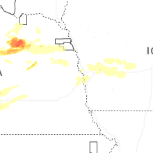

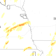


Connect with Interactive Hail Maps