

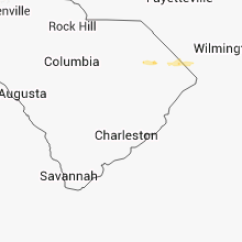
Hail Map for Monday, October 15, 2012

Number of Impacted Households on 10/15/2012
0
Impacted by 1" or Larger Hail
0
Impacted by 1.75" or Larger Hail
0
Impacted by 2.5" or Larger Hail
Square Miles of Populated Area Impacted on 10/15/2012
0
Impacted by 1" or Larger Hail
0
Impacted by 1.75" or Larger Hail
0
Impacted by 2.5" or Larger Hail


Cities Most Affected by Hail Storms of 10/15/2012
| Hail Size | Demographics of Zip Codes Affected | ||||||
|---|---|---|---|---|---|---|---|
| City | Count | Average | Largest | Pop Density | House Value | Income | Age |
Hail and Wind Damage Spotted on 10/15/2012
Filter by Report Type:Hail ReportsWind Reports
North Carolina
| Local Time | Report Details |
|---|---|
| 4:22 PM EDT | Tree blown down just north of nashville. time estimate in nash county NC, 40.8 miles ENE of Raleigh, NC |
| 4:30 PM EDT | One tree blown down near interstate 95 and mile marker 144. time estimate in nash county NC, 49.1 miles ENE of Raleigh, NC |
South Carolina
| Local Time | Report Details |
|---|---|
| 5:30 PM EDT | Quarter sized hail reported near Marion, SC, 75.2 miles NNE of Charleston, SC, quarter size hail. |
Washington
| Local Time | Report Details |
|---|---|
| 4:00 AM PDT | The wind gust was measured at dirty face mou in chelan county WA, 70.5 miles WSW of Omak, WA |
Connect with Interactive Hail Maps