

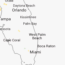
Hail Map for Sunday, September 15, 2013

Number of Impacted Households on 9/15/2013
0
Impacted by 1" or Larger Hail
0
Impacted by 1.75" or Larger Hail
0
Impacted by 2.5" or Larger Hail
Square Miles of Populated Area Impacted on 9/15/2013
0
Impacted by 1" or Larger Hail
0
Impacted by 1.75" or Larger Hail
0
Impacted by 2.5" or Larger Hail


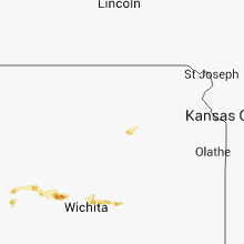
Cities Most Affected by Hail Storms of 9/15/2013
| Hail Size | Demographics of Zip Codes Affected | ||||||
|---|---|---|---|---|---|---|---|
| City | Count | Average | Largest | Pop Density | House Value | Income | Age |
| Hutchinson, KS | 1 | 1.75 | 1.75 | 138 | $46k | $29.0k | 33.5 |
Hail and Wind Damage Spotted on 9/15/2013
Filter by Report Type:Hail ReportsWind Reports
Florida
| Local Time | Report Details |
|---|---|
| 11:38 AM EDT | Fowey rocks c-man station recorded an east wind gust of 51 kts...or 59 mph...at 1138 am edt. note... this anemometer is at an elevation of 144 feet...or 43.9 meters...a in amz651 county FL, 12.8 miles SE of Miami, FL |
| 11:40 AM EDT | A member of the public measured a 58 mph wind gust near the intersection of w flagler st and sw 32nd ave. report relayed via social medi in miami-dade county FL, 2.9 miles NNW of Miami, FL |
| 11:45 AM EDT | Small branches down with minor street flooding on nw 27th avenu in miami-dade county FL, 8.3 miles N of Miami, FL |
| 12:03 PM EDT | Big tree down 1 mile north of sw 40th street and 92nd ave in miami-dade county FL, 10.8 miles W of Miami, FL |
| 3:00 PM EDT | Highlands county 911 reported railroad crossing gates downed onto road due to the stor in highlands county FL, 62 miles W of Port Saint Lucie, FL |
| 3:42 PM EDT | Hardee county 911 relayed a report of a snapped power pole in zolfo springs. time estimated from rada in hardee county FL, 48.4 miles E of Bradenton, FL |
| 3:45 PM EDT | Tree damaged occurred in rainbow lakes state park. one tree was blown down over the road. the time of damage was based on rada in marion county FL, 73.1 miles WNW of Orlando, FL |
| 4:30 PM EDT | Florida highway patrol based in ocala reported a tree downed by thunderstorm wind gusts in the vicinity of romeo. time of damage based on radar dat in marion county FL, 79.3 miles NW of Orlando, FL |
| 5:49 PM EDT | Overhead traffic signals blown down at bryan dairy road and starkey roa in pinellas county FL, 28.1 miles NNW of Bradenton, FL |
Kansas
| Local Time | Report Details |
|---|---|
| 4:47 PM CDT | Golf Ball sized hail reported near Hutchinson, KS, 33.4 miles NW of Wichita, KS, trained spotter reports lots of golf ball sized hail and 40 mph winds. |
| 4:54 PM CDT | Quarter sized hail reported near Hutchinson, KS, 31.5 miles NW of Wichita, KS, amateur radio operator reports quarter size hail on united states highway 50. |
| 5:00 PM CDT | Law enforcement reports a telephone pole was snapped as well as damage to signs just north of burrton. time is estimated based on rada in harvey county KS, 30.4 miles NW of Wichita, KS |
| 6:52 PM CDT | Storm damage reported in comanche county KS, 60.4 miles N of Woodward, OK |
Oregon
| Local Time | Report Details |
|---|---|
| 4:30 PM PDT | Quarter sized hail reported near Ione, OR, 82.4 miles WSW of Walla Walla, WA, quarter sized hail and brief heavy rain. |
| 5:33 PM PDT | Estimated wind gusts to 80 mp in morrow county OR, 65.5 miles WSW of Walla Walla, WA |
| 5:40 PM PDT | 28 power poles downe in umatilla county OR, 61.5 miles WSW of Walla Walla, WA |
| 5:45 PM PDT | Several powerpoles dow in morrow county OR, 66.3 miles WSW of Walla Walla, WA |
| 5:45 PM PDT | Several power poles dow in morrow county OR, 66.3 miles WSW of Walla Walla, WA |
| 5:48 PM PDT | 2 ft diamter tree downed by high wind gust in benton county OR, 56.5 miles WSW of Walla Walla, WA |
| 5:48 PM PDT | 6 to 12 inch diamter tree down and power outag in benton county OR, 56.5 miles WSW of Walla Walla, WA |
| 5:48 PM PDT | 2 ft diamter tree downed by high wind gust in morrow county OR, 56.5 miles WSW of Walla Walla, WA |
| 5:48 PM PDT | 6 to 12 inch diamter tree down and power outag in morrow county OR, 56.5 miles WSW of Walla Walla, WA |
| 5:50 PM PDT | Half a barn roof blown off. reported on social medi in morrow county OR, 56.5 miles WSW of Walla Walla, WA |
| 5:52 PM PDT | Wind gust to 66 mph...also several wind gusts to 64 mph and blowing dus in umatilla county OR, 49.3 miles WSW of Walla Walla, WA |
| 5:55 PM PDT | Employee of hermiston bowling alley reported semi truck trailer without cab flipped onto its side from high winds. also power outage at his locatio in umatilla county OR, 48.1 miles WSW of Walla Walla, WA |
| 6:00 PM PDT | Lots of limbs and part of tree down.reported on social medi in umatilla county OR, 47.1 miles SSW of Walla Walla, WA |
| 6:09 PM PDT | Gust 64 mph at nws pendleton office davis weather statio in umatilla county OR, 36 miles SW of Walla Walla, WA |
| 6:11 PM PDT | Wind gust to 60 mph and very heavy rain with dime sized hail. power outag in umatilla county OR, 36.1 miles SW of Walla Walla, WA |
| 6:11 PM PDT | Pendleton airport asos recorded wind gusts of 70 mph at 611 pm and again at 615 p in umatilla county OR, 34.8 miles SW of Walla Walla, WA |
| 6:15 PM PDT | 3 ft diameter tree split from high winds...part of tree fell onto pickup truck be in umatilla county OR, 36 miles SW of Walla Walla, WA |
| 6:23 PM PDT | 8 to 15 inch diameter tree limbs downed by high wind gust in umatilla county OR, 36.6 miles SSW of Walla Walla, WA |
| 6:25 PM PDT | Estimated wind gust to 60 mph downed 6 to 8 inch diameter tree limb in umatilla county OR, 21.6 miles SW of Walla Walla, WA |
| 6:30 PM PDT | Also visibility reduced to 1/8th of a mile in blowing dus in umatilla county OR, 10.6 miles SW of Walla Walla, WA |
Washington
| Local Time | Report Details |
|---|---|
| 6:00 PM PDT | Multiple highway signs blown down...along interstate 82 between coffin road and oregon state lin in benton county WA, 42.8 miles W of Walla Walla, WA |
| 6:30 PM PDT | Vista field in benton county WA, 40.8 miles WNW of Walla Walla, WA |
| 6:30 PM PDT | Hanford mesonet in benton county WA, 49.7 miles WNW of Walla Walla, WA |
| 6:33 PM PDT | 4 inch tree limbs down from estimated wind gusts to 50 mph. blowing dust restricting visibilit in benton county WA, 47.9 miles WNW of Walla Walla, WA |
| 6:45 PM PDT | Hanford mesonet in franklin county WA, 49.3 miles WNW of Walla Walla, WA |
| 6:45 PM PDT | At in benton county WA, 54.7 miles WNW of Walla Walla, WA |
| 6:45 PM PDT | At in benton county WA, 54.7 miles WNW of Walla Walla, WA |
| 6:52 PM PDT | Storm damage reported in walla walla county WA, 0.1 miles ESE of Walla Walla, WA |
| 6:53 PM PDT | Weather station recorded sustained winds 45 mph gusting to 60 mp in franklin county WA, 48.3 miles WNW of Walla Walla, WA |
| 7:00 PM PDT | Spotter called to update that trees are down and they are least 12 inches in diamete in franklin county WA, 54.8 miles NW of Walla Walla, WA |
| 7:15 PM PDT | Estimated 60 mph wind. 10 inch diameter tree blown dow in franklin county WA, 54.8 miles NW of Walla Walla, WA |
| 7:18 PM PDT | Weather station measured a wind gust of 62 mph at 718 pm. power went out at 715 pm. measured 0.52 inches of rain in 20 minutes. wind blew down tree limbs 4-5 inches in in benton county WA, 40.8 miles WNW of Walla Walla, WA |
| 7:23 PM PDT | Numerous trees and power lines down. trees down on homes and fences. estimated 40 power poles snapped of in adams county WA, 65.1 miles NW of Walla Walla, WA |
| 7:25 PM PDT | Portable shelter blown 50 to 60 ft. visibility reduced to less than a quarter mile in blowing dus in adams county WA, 65.1 miles NW of Walla Walla, WA |
| 7:30 PM PDT | Visibility reduced to 50 ft in blowing dust in grant county WA, 70.7 miles NNW of Walla Walla, WA |
| 7:39 PM PDT | Trees down and power out. measured winds sustained of 30 to 35 mph with gusts to 58 mph. diameter of trees unknown at this tim in grant county WA, 70.7 miles NNW of Walla Walla, WA |
| 7:44 PM PDT | Power out to 44 customers in adams county WA, 74.1 miles NNW of Walla Walla, WA |
| 7:45 PM PDT | Numerous trees and power lines were blown down. some trees fell on houses and vehicle in grant county WA, 67.8 miles ENE of Yakima, WA |
| 7:52 PM PDT | Power outage affecting 139 customers in whitman county WA, 55.6 miles NNE of Walla Walla, WA |
| 7:53 PM PDT | Power outage affecting 40 customers. combine shed was destroyed. uprooted 5 trees. roof blown off of a bar in adams county WA, 47 miles N of Walla Walla, WA |
| 7:56 PM PDT | Large tree limb down. estimated 10 to 12 inches in diameter. numerous other 3 to 4 inch diameter branches down along route from home to downtown. measured 47 mph on hom in lincoln county WA, 43.5 miles SE of Omak, WA |
| 8:00 PM PDT | Numerous trees and power lines downed. some trees fell on houses and outdoor equipmen in adams county WA, 58.2 miles SW of Spokane, WA |
| 8:00 PM PDT | Outbuilding destroyed. fence damaged by flying debri in grant county WA, 81.4 miles ENE of Yakima, WA |
| 8:15 PM PDT | Odessa agrimet station measured 59 mph wind gus in lincoln county WA, 64 miles WSW of Spokane, WA |
| 8:15 PM PDT | At least 6 power poles were snapped of in grant county WA, 65.8 miles S of Omak, WA |
| 8:31 PM PDT | Power outage affecting 67 customers in lincoln county WA, 55.6 miles SSE of Omak, WA |
| 8:32 PM PDT | Several power outage affecting 284 customers in lincoln county WA, 64 miles WSW of Spokane, WA |
| 8:45 PM PDT | Roof blown off of a barn. time is estimated from rada in lincoln county WA, 38 miles WSW of Spokane, WA |
| 8:54 PM PDT | Power outages affecting 25 customers in lincoln county WA, 41.1 miles WSW of Spokane, WA |
| 9:00 PM PDT | Trees on power lines affecting 743 customers in spokane county WA, 14 miles SW of Spokane, WA |
| 9:10 PM PDT | 60 mph wind gust at nws offic in spokane county WA, 8.2 miles WNW of Spokane, WA |
| 9:15 PM PDT | Large tree down at 21st and high driv in spokane county WA, 1.5 miles SW of Spokane, WA |
| 9:20 PM PDT | Several tents at the spokane fairgrounds were damaged and flipped due to high winds from thunderstorms between 915 and 945 pm pd in spokane county WA, 3.4 miles E of Spokane, WA |
| 9:25 PM PDT | Trees down and into power lines at bessie/upriver and regal/lincoln in spokane county WA, 0.9 miles N of Spokane, WA |
| 9:25 PM PDT | Person reported shop doors blown off and shop blown down and power poles down on wheeler rd in grant county WA, 81.4 miles ENE of Yakima, WA |
| 9:28 PM PDT | Storm damage reported in stevens county WA, 13.7 miles NW of Spokane, WA |
| 9:28 PM PDT | Tree on power line affecting 391 customers in spokane county WA, 9.8 miles NW of Spokane, WA |
| 9:30 PM PDT | Trees on power lines affecting 35 customer in stevens county WA, 24 miles NNW of Spokane, WA |
| 9:30 PM PDT | Trees on power lines affecting 33 customers in spokane county WA, 11.7 miles NNE of Spokane, WA |
| 9:30 PM PDT | Tree on power in whitman county WA, 40 miles SSW of Spokane, WA |
| 9:34 PM PDT | Tree on wire affecting 105 customers in stevens county WA, 24.6 miles NW of Spokane, WA |
| 10:10 PM PDT | Power out to 114 customers in stevens county WA, 63 miles NNW of Spokane, WA |
| 10:14 PM PDT | Power outages affecting 206 customers in stevens county WA, 51.6 miles NNW of Spokane, WA |
Texas
| Local Time | Report Details |
|---|---|
| 10:10 PM CDT | Storm damage reported in donley county TX, 53.1 miles NW of Childress, TX |
| 11:20 PM CDT | Measured by west tx mesonet in hall county TX, 28.1 miles NW of Childress, TX |
Idaho
| Local Time | Report Details |
|---|---|
| 10:15 PM PDT | Tree on power line affecting 37 customers in bonner county ID, 32.1 miles NE of Spokane, WA |
| 10:49 PM PDT | The wind gust was measured at the corral creek raws station and likely occurred during the previous hou in nez perce county ID, 47.1 miles NW of Grangeville, ID |
| 10:50 PM PDT | Law enforcement stated several power lines down across areas of southwestern bonner county. exact locations unknown at time of report and not sure if it was from downed in bonner county ID, 43.6 miles NNE of Spokane, WA |
| 11:03 PM PDT | The wind gust was measured at the mission creek raws station and likely occurred during the previous hou in lewis county ID, 36.4 miles NW of Grangeville, ID |
| 11:18 PM PDT | Tree on power wire affecting 115 customers in lewis county ID, 21.8 miles NNW of Grangeville, ID |
Connect with Interactive Hail Maps