

Hail Map for Wednesday, September 19, 2018

Number of Impacted Households on 9/19/2018
0
Impacted by 1" or Larger Hail
0
Impacted by 1.75" or Larger Hail
0
Impacted by 2.5" or Larger Hail
Square Miles of Populated Area Impacted on 9/19/2018
0
Impacted by 1" or Larger Hail
0
Impacted by 1.75" or Larger Hail
0
Impacted by 2.5" or Larger Hail


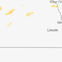


Cities Most Affected by Hail Storms of 9/19/2018
| Hail Size | Demographics of Zip Codes Affected | ||||||
|---|---|---|---|---|---|---|---|
| City | Count | Average | Largest | Pop Density | House Value | Income | Age |
| Greenville, IA | 1 | 1.75 | 1.75 | 11 | $35k | $33.4k | 44.5 |
Hail and Wind Damage Spotted on 9/19/2018
Filter by Report Type:Hail ReportsWind Reports
Virginia
| Local Time | Report Details |
|---|---|
| 4:27 PM EDT | Tree down on wires on watts passage blocking the entire roadway near sylvan lan in albemarle county VA, 60.7 miles NW of Richmond, VA |
| 4:31 PM EDT | Quarter sized hail reported near Barboursville, VA, 58.9 miles NW of Richmond, VA, nickel to quarter size hail |
| 4:35 PM EDT | Multiple large trees down in the 4400 block of turkey sag roa in albemarle county VA, 57.2 miles NW of Richmond, VA |
| 6:27 PM EDT | One tree down on pattie road. time estimate in buckingham county VA, 53.2 miles W of Richmond, VA |
Kansas
| Local Time | Report Details |
|---|---|
| 5:53 PM MDT | Pea-sized hail and tree branches down 4 inches in diameter. 7640 rd in sherman county KS, 47.3 miles W of Colby, KS |
Iowa
| Local Time | Report Details |
|---|---|
| 8:44 PM CDT | Golf Ball sized hail reported near Greenville, IA, 26.3 miles NNE of Storm Lake, IA |
Connect with Interactive Hail Maps