

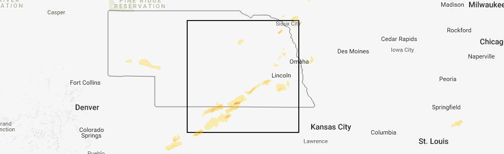
Hail Map for Thursday, September 20, 2018
Number of Impacted Households on 9/20/2018
0
Impacted by 1" or Larger Hail
0
Impacted by 1.75" or Larger Hail
0
Impacted by 2.5" or Larger Hail
Square Miles of Populated Area Impacted on 9/20/2018
0
Impacted by 1" or Larger Hail
0
Impacted by 1.75" or Larger Hail
0
Impacted by 2.5" or Larger Hail


Cities Most Affected by Hail Storms of 9/20/2018
| Hail Size | Demographics of Zip Codes Affected | ||||||
|---|---|---|---|---|---|---|---|
| City | Count | Average | Largest | Pop Density | House Value | Income | Age |
| Red Cloud, NE | 2 | 2.13 | 2.50 | 9 | $36k | $29.2k | 51.1 |
| Blue Hill, NE | 1 | 1.75 | 1.75 | 6 | $59k | $32.8k | 43.2 |
Hail and Wind Damage Spotted on 9/20/2018
Filter by Report Type:Hail ReportsWind Reports
States Impacted
Ohio, Texas, Florida, Indiana, Missouri, Iowa, Kansas, Nebraska, Michigan, Minnesota, Arkansas, WisconsinOhio
| Local Time | Report Details |
|---|---|
| 1:58 PM EDT | Tree down by thunderstorm wind in geauga county OH, 25.5 miles ENE of Cleveland, OH |
| 2:23 PM EDT | Numerous trees down on prinston r in geauga county OH, 30.6 miles E of Cleveland, OH |
| 2:25 PM EDT | Numerous trees down in tow in geauga county OH, 31.8 miles E of Cleveland, OH |
| 2:25 PM EDT | Building under construction was destroyed. possible tornad in geauga county OH, 31.8 miles E of Cleveland, OH |
| 2:27 PM EDT | A roof of a structure on kinsman road. trees and wires down on nauvoo road. possible tornad in geauga county OH, 31.8 miles E of Cleveland, OH |
| 2:27 PM EDT | Numerous trees and power lines down nauvoo r in geauga county OH, 33.3 miles E of Cleveland, OH |
| 2:27 PM EDT | A roof of a mobile home... intersection of kinsman rd and bundysburg rd. possible tornad in geauga county OH, 34.9 miles E of Cleveland, OH |
| 2:41 PM EDT | Tree down by thunderstorm winds in mesopotami in trumbull county OH, 37.5 miles E of Cleveland, OH |
| 2:51 PM EDT | Numerous trees down by thunderstorm winds. possible tornado. time estimate in trumbull county OH, 36.8 miles E of Cleveland, OH |
| 2:54 PM EDT | Tree down by thunderstorm winds in trumbull county OH, 39.3 miles ESE of Cleveland, OH |
| 2:59 PM EDT | Branches on wires... time correcte in cuyahoga county OH, 15.9 miles SSW of Cleveland, OH |
| 3:04 PM EDT | Tree snapped off at base in the brecksville reservatio in cuyahoga county OH, 14.2 miles SSE of Cleveland, OH |
| 3:30 PM EDT | Several trees down by thunderstorm winds in champion in trumbull county OH, 45.5 miles ESE of Cleveland, OH |
| 3:59 PM EDT | Branches on wires in cuyahoga county OH, 15.9 miles SSW of Cleveland, OH |
| 6:20 PM EDT | Numerous trees dow in trumbull county OH, 37.9 miles E of Cleveland, OH |
Texas
| Local Time | Report Details |
|---|---|
| 1:25 PM CDT | Carwash roof blown over onto car in montgomery county TX, 39 miles N of Houston, TX |
| 6:40 PM CDT | Trees and powerlines downed. reports of roof damage as wel in wichita county TX, 13 miles NNW of Wichita Falls, TX |
Florida
| Local Time | Report Details |
|---|---|
| 3:05 PM EDT | Trained spotter near the intersection of coral ridge drive and southgate bvld reported pea sized hail and winds strong enough to move some metal sheeting in backyard. r in broward county FL, 34.5 miles N of Miami, FL |
| 3:25 PM EDT | Quarter sized hail reported near Fort Lauderdale, FL, 30.2 miles N of Miami, FL, members of the public and photos on social media suggest quater sized hail fell near bb&t center. |
Indiana
| Local Time | Report Details |
|---|---|
| 4:55 PM EDT | Two small sheds blown over/lost to storm at a box chain hardware stor in st. joseph county IN, 71.5 miles WNW of Fort Wayne, IN |
| 5:03 PM EDT | Storm damage reported in st. joseph county IN, 68.8 miles E of Chicago, IL |
| 5:08 PM EDT | Trees down and uprooted in river par in st. joseph county IN, 70 miles NW of Fort Wayne, IN |
| 5:08 PM EDT | Part of tree down on home 800 block 27th stree in st. joseph county IN, 70.8 miles NW of Fort Wayne, IN |
| 5:12 PM EDT | Part of tree down on fence and vehicl in st. joseph county IN, 69.1 miles NW of Fort Wayne, IN |
| 6:01 PM EDT | Tree down north of sr 120 off of old us27/i-69 area. also tree down in crooked lake area near orland r in steuben county IN, 45.5 miles N of Fort Wayne, IN |
Missouri
| Local Time | Report Details |
|---|---|
| 4:18 PM CDT | Pictures relayed via social media of a 6-8 inch diameter tree branch broken off near the intersection of knight st. and howard st. in willard. timing estimated from rad in greene county MO, 9.9 miles NW of Springfield, MO |
| 9:55 PM CDT | Storm damage reported in nodaway county MO, 82.2 miles SE of Omaha, NE |
Iowa
| Local Time | Report Details |
|---|---|
| 4:56 PM CDT | Large limbs down with some building damage on the south side of hartle in o'brien county IA, 39.4 miles NNW of Storm Lake, IA |
| 5:15 PM CDT | Large tree down... report via social medi in clay county IA, 23 miles NNE of Storm Lake, IA |
| 5:15 PM CDT | Storm damage reported in clay county IA, 34.8 miles N of Storm Lake, IA |
| 5:15 PM CDT | Corrects previous tstm wnd dmg report from ida grove. several large trees down around tow in ida county IA, 25.3 miles SSW of Storm Lake, IA |
| 5:20 PM CDT | Roof blown off vfw. large tree broke in half. reported via social medi in dickinson county IA, 47.2 miles NNE of Storm Lake, IA |
| 5:21 PM CDT | Large tree down blocking southbound lane of highway 7 in dickinson county IA, 47.2 miles N of Storm Lake, IA |
| 5:22 PM CDT | 8 to 10 inch limbs dow in dickinson county IA, 47.3 miles N of Storm Lake, IA |
| 5:26 PM CDT | Some tree limbs dow in clay county IA, 28.1 miles NNE of Storm Lake, IA |
| 5:30 PM CDT | Delayed report... time estimated by radar: bowling alley experienced partial roof destruction - via social medi in emmet county IA, 55.4 miles NNE of Storm Lake, IA |
| 5:30 PM CDT | Delayed report... time estimated by radar: tree uproote in emmet county IA, 56.1 miles NNE of Storm Lake, IA |
| 5:30 PM CDT | Delayed report... time estimated by radar: large tree uprooted - via social medi in emmet county IA, 55.2 miles NNE of Storm Lake, IA |
| 5:32 PM CDT | Asos station est... estherville municipal airpor in emmet county IA, 57.4 miles NNE of Storm Lake, IA |
| 5:40 PM CDT | Several large trees down around tow in ida county IA, 25.3 miles SSW of Storm Lake, IA |
| 5:50 PM CDT | Power line down in town - via social medi in palo alto county IA, 41.5 miles NE of Storm Lake, IA |
| 5:52 PM CDT | Trees down on power lines. reported at along dean ave. time estimate in sac county IA, 9.9 miles SSW of Storm Lake, IA |
| 5:52 PM CDT | Measured by anemomete in palo alto county IA, 42.8 miles NE of Storm Lake, IA |
| 6:08 PM CDT | Sustained winds of 50 with gusts up to 65. small tree limbs dow in harrison county IA, 27.3 miles NNE of Omaha, NE |
| 6:15 PM CDT | Trees and power lines down through tow in kossuth county IA, 52.3 miles W of Mason City, IA |
| 6:15 PM CDT | Awos station axa... algona airpor in kossuth county IA, 54.3 miles W of Mason City, IA |
| 6:30 PM CDT | Rwis station rrwi in calhoun county IA, 33.8 miles ESE of Storm Lake, IA |
| 6:31 PM CDT | Estimated winds of 60-70 mph while drivin in calhoun county IA, 27 miles SE of Storm Lake, IA |
| 6:40 PM CDT | Branches down - up to 10 inch in diamete in calhoun county IA, 33.8 miles ESE of Storm Lake, IA |
| 6:50 PM CDT | Report of tree down blocking a road in brit in hancock county IA, 30.5 miles W of Mason City, IA |
| 8:01 PM CDT | Delayed report... time and location estimated: car wash roof completely removed and destroyed - picture via social medi in emmet county IA, 55.2 miles NNE of Storm Lake, IA |
| 1:30 AM CDT | Roof blown off home with trees and powerlines down in vicinity. time approximate. relayed by assistant fire chie in jackson county IA, 64 miles ENE of Cedar Rapids, IA |
Kansas
| Local Time | Report Details |
|---|---|
| 4:59 PM CDT | Storm damage reported in rooks county KS, 35.2 miles N of Hays, KS |
| 5:10 PM CDT | Power lines down in tow in rooks county KS, 39.4 miles N of Hays, KS |
| 5:10 PM CDT | Corrects previous tstm wnd dmg report from 3 ssw stockton. adjusted time. power line dow in rooks county KS, 35.9 miles N of Hays, KS |
| 5:12 PM CDT | Trees down across roadway. time estimated from rada in rooks county KS, 43.8 miles NNE of Hays, KS |
| 5:20 PM CDT | Power line dow in rooks county KS, 35.9 miles N of Hays, KS |
| 5:40 PM CDT | Quarter sized hail reported near Cedar, KS, 55.6 miles NNE of Hays, KS |
| 6:07 PM CDT | Storm damage reported in russell county KS, 27.6 miles E of Hays, KS |
| 6:45 PM CDT | Storm damage reported in cloud county KS, 75.3 miles WNW of Manhattan, KS |
| 6:47 PM CDT | Storm damage reported in republic county KS, 74.5 miles SSE of Grand Island, NE |
| 6:47 PM CDT | Storm damage reported in republic county KS, 74.5 miles SSE of Grand Island, NE |
| 7:25 PM CDT | Storm damage reported in ottawa county KS, 71.8 miles W of Manhattan, KS |
| 7:25 PM CDT | Storm damage reported in republic county KS, 73.1 miles NW of Manhattan, KS |
| 8:13 PM CDT | Tree blown dow in dickinson county KS, 39.2 miles WSW of Manhattan, KS |
| 8:35 PM CDT | Large tree limb blown dow in marshall county KS, 45.9 miles N of Manhattan, KS |
Nebraska
| Local Time | Report Details |
|---|---|
| 5:10 PM CDT | Storm damage reported in burt county NE, 36.6 miles NNW of Omaha, NE |
| 5:21 PM CDT | Estimated 60-65mph win in washington county NE, 21.9 miles NNW of Omaha, NE |
| 5:50 PM CDT | Golf Ball sized hail reported near Red Cloud, NE, 58.4 miles S of Grand Island, NE, estimated winds around 40mph. |
| 5:58 PM CDT | Tennis Ball sized hail reported near Red Cloud, NE, 58.4 miles S of Grand Island, NE, hail ongoing. mostly golf balls... but some just under the size of baseballs. |
| 6:05 PM CDT | Half Dollar sized hail reported near Beaver Crossing, NE, 52.7 miles E of Grand Island, NE |
| 6:05 PM CDT | Small tree limbs down and 65 mph wind estimate in seward county NE, 52.7 miles E of Grand Island, NE |
| 6:09 PM CDT | Golf Ball sized hail reported near Blue Hill, NE, 52.4 miles S of Grand Island, NE, ping pong to golf ball size hail was reported via facebook. |
| 6:24 PM CDT | Storm damage reported in nuckolls county NE, 54.9 miles S of Grand Island, NE |
| 6:32 PM CDT | Storm damage reported in nuckolls county NE, 52 miles SSE of Grand Island, NE |
| 6:54 PM CDT | Storm damage reported in thayer county NE, 50.7 miles SSE of Grand Island, NE |
| 6:57 PM CDT | Tree down on power line at 5th and duffield and a 2nd down on 8th and jefferson. time of damage estimated from rada in thayer county NE, 65.3 miles SE of Grand Island, NE |
| 7:00 PM CDT | Large tree limbs down 2 blocks north of main stree in thayer county NE, 57.5 miles SE of Grand Island, NE |
| 7:34 PM CDT | Storm damage reported in douglas county NE, 9.3 miles WNW of Omaha, NE |
| 7:55 PM CDT | Storm damage reported in gage county NE, 78 miles N of Manhattan, KS |
| 7:55 PM CDT | Trees down over power line in jefferson county NE, 74.7 miles NNW of Manhattan, KS |
| 8:00 PM CDT | Storm damage reported in lancaster county NE, 60.5 miles SW of Omaha, NE |
Michigan
| Local Time | Report Details |
|---|---|
| 6:37 PM EDT | Several trees down in lake diane vicinity near territorial road. size of trees unknown. time estimated from rada in hillsdale county MI, 49.6 miles NNE of Fort Wayne, IN |
| 3:35 AM EDT | Awos station mcd... mackinac islan in mackinac county MI, 45.2 miles SSW of Sault Sainte Marie, MI |
| 3:40 AM EDT | Trees down in north and west portions of antrim county around central lake... bellaire... torch lake and echo township... as line of storms moved through early in the m in antrim county MI, 27.6 miles NE of Traverse City, MI |
Minnesota
| Local Time | Report Details |
|---|---|
| 5:38 PM CDT | Numerous trees dow in martin county MN, 67.4 miles NNE of Storm Lake, IA |
| 5:44 PM CDT | Numerous large branches dow in martin county MN, 76.5 miles NNE of Storm Lake, IA |
| 5:49 PM CDT | Photos relayed via twitter of large broken tree branches... trees down... and an outbuilding destroye in martin county MN, 68.1 miles NNE of Storm Lake, IA |
| 5:50 PM CDT | House pushed off foundation. trees dow in martin county MN, 68.9 miles NW of Mason City, IA |
| 6:05 PM CDT | Tree down on propane tan in blue earth county MN, 71.4 miles SW of Minneapolis, MN |
| 6:05 PM CDT | Tree dow in martin county MN, 72.3 miles WNW of Mason City, IA |
| 6:10 PM CDT | Mesonet station as022... skyline 2 in blue earth county MN, 68.7 miles SSW of Minneapolis, MN |
| 6:14 PM CDT | Corrects previous tstm wnd dmg report from 4 sse winnebago. faribault county em called in to report numerous trees snapped and down at golf cours in faribault county MN, 61.2 miles NW of Mason City, IA |
| 6:15 PM CDT | Few trees and power lines down.. in blue earth county MN, 59.5 miles SSW of Minneapolis, MN |
| 6:15 PM CDT | Trees and power lines dow in blue earth county MN, 59.5 miles SSW of Minneapolis, MN |
| 6:15 PM CDT | Few trees and power lines dow in blue earth county MN, 65.3 miles SSW of Minneapolis, MN |
| 6:17 PM CDT | Awos station mkt... mankato a in blue earth county MN, 61.6 miles SSW of Minneapolis, MN |
| 6:23 PM CDT | One half of a tree snapped. no diameter or photo provide in le sueur county MN, 57.6 miles SSW of Minneapolis, MN |
| 6:24 PM CDT | Relayed by e in hennepin county MN, 19.1 miles W of Minneapolis, MN |
| 6:26 PM CDT | Storm chaser called to report multiple 6-12 inch tree branches down. power pole and 18 inch pine tree also snapped. no photos provide in waseca county MN, 62 miles NNW of Mason City, IA |
| 6:26 PM CDT | Phone call to relay that a house was destroyed. no photo provide in waseca county MN, 62 miles SSW of Minneapolis, MN |
| 6:28 PM CDT | Corrects time - easton. faribault county em called to report numerous trees and power lines dow in faribault county MN, 55.9 miles NW of Mason City, IA |
| 6:28 PM CDT | Corrects time - easton. faribault county em called to report numerous trees and power lines dow in faribault county MN, 55.9 miles NW of Mason City, IA |
| 6:30 PM CDT | Multiple trees and power lines down. roofs off outbuildings. time approximat in freeborn county MN, 43.8 miles NNW of Mason City, IA |
| 6:30 PM CDT | Photo relayed via twitter of trees and power lines down across roa in le sueur county MN, 54.4 miles SSW of Minneapolis, MN |
| 6:30 PM CDT | Numerous trees down around watervill in le sueur county MN, 54.5 miles SSW of Minneapolis, MN |
| 6:34 PM CDT | Relayed by e in hennepin county MN, 9.9 miles WSW of Minneapolis, MN |
| 6:35 PM CDT | Numerous trees down from morristown to watervill in rice county MN, 52.4 miles S of Minneapolis, MN |
| 6:35 PM CDT | Awos station acq... waseca a in waseca county MN, 64.3 miles SSW of Minneapolis, MN |
| 6:39 PM CDT | Public report of trees uprooted and snapped at the base in medfor in steele county MN, 55.2 miles S of Minneapolis, MN |
| 6:43 PM CDT | Tweet with photos of structural damage to metcon building and significant tree damage nearb in rice county MN, 46.2 miles S of Minneapolis, MN |
| 6:44 PM CDT | Corrects previous tstm wnd dmg report from faribault. public report of numerous trees down in faribault. maximum diameter estimated to be 2 feet. no photos provide in rice county MN, 46.9 miles S of Minneapolis, MN |
| 6:45 PM CDT | Significant damage at faribault airport. planes flipped. other damage reports just coming in to rice county e in rice county MN, 44.9 miles S of Minneapolis, MN |
| 6:50 PM CDT | Several trees down per skywarn group on social medi in steele county MN, 62.1 miles S of Minneapolis, MN |
| 6:50 PM CDT | Trees and power lines dow in dakota county MN, 24.2 miles SSE of Minneapolis, MN |
| 6:50 PM CDT | From facebook... nws employee relayed photo of destroyed red barn pizza plac in rice county MN, 38.4 miles S of Minneapolis, MN |
| 6:51 PM CDT | Trees and power lines dow in dakota county MN, 30.9 miles SSE of Minneapolis, MN |
| 6:52 PM CDT | From facebook... nws employee relayed from relatives that a large grain leg was down and bins were damage in rice county MN, 36.1 miles SSE of Minneapolis, MN |
| 6:52 PM CDT | From facebook... nws employee relayed from relatives that many large pine trees were down and a camper was move in rice county MN, 40.6 miles S of Minneapolis, MN |
| 6:52 PM CDT | From facebook... nws employee relayed from relatives that a shed had blown and large trees had been blown dow in rice county MN, 37.6 miles SSE of Minneapolis, MN |
| 6:53 PM CDT | Trees dow in dakota county MN, 10.2 miles ESE of Minneapolis, MN |
| 6:54 PM CDT | Relayed report via nwschat of several trees snapped and cement stave style silo blown down on farm. no photos provide in goodhue county MN, 38.8 miles SSE of Minneapolis, MN |
| 6:55 PM CDT | Corrects time - report from 1 nnw owatonna. steele county em called to report numerous 6-12 inch trees snapped and down in owatonn in steele county MN, 60.7 miles S of Minneapolis, MN |
| 6:58 PM CDT | Trees blown down in dodge county MN, 59.4 miles SSE of Minneapolis, MN |
| 6:59 PM CDT | Reported by west concord fire dept in dodge county MN, 57.1 miles SSE of Minneapolis, MN |
| 6:59 PM CDT | Trees and power lines dow in dakota county MN, 33.3 miles SSE of Minneapolis, MN |
| 7:00 PM CDT | Trees and power lines dow in dakota county MN, 28.6 miles SSE of Minneapolis, MN |
| 7:02 PM CDT | Corrects previous tstm wnd dmg report from cannon falls. photos of large... healthy trees uprooted and significant damage to outbuildings. relayed via twitter by tv met in goodhue county MN, 36.8 miles SSE of Minneapolis, MN |
| 7:03 PM CDT | Many trees and power lines down. possibly a continuation of the tornado to the southwes in goodhue county MN, 36.8 miles SSE of Minneapolis, MN |
| 7:05 PM CDT | Numerous trees down. power out in cannon fall in goodhue county MN, 37 miles SSE of Minneapolis, MN |
| 7:15 PM CDT | A few trees and power lines dow in goodhue county MN, 45.9 miles SE of Minneapolis, MN |
| 7:15 PM CDT | Some trees and power lines down around prairie island indian communit in goodhue county MN, 38.7 miles SE of Minneapolis, MN |
| 7:20 PM CDT | Mesonet station mn047... red wing 4 in goodhue county MN, 38.2 miles SE of Minneapolis, MN |
| 7:27 PM CDT | Faribault county em called in to report numerous trees snapped and down at golf cours in faribault county MN, 61.2 miles NW of Mason City, IA |
| 7:28 PM CDT | Faribault county em called to report numerous trees and power lines dow in faribault county MN, 55.9 miles NW of Mason City, IA |
| 7:29 PM CDT | Trees blown down in town in wabasha county MN, 60.7 miles SE of Minneapolis, MN |
| 7:40 PM CDT | Public report of numerous trees down in faribault. maximum diameter estimated to be 2 feet. no photos provide in rice county MN, 46.9 miles S of Minneapolis, MN |
| 7:55 PM CDT | Steele county em called to report numerous 6-12 inch trees snapped and down in owatonn in steele county MN, 60.7 miles S of Minneapolis, MN |
| 8:04 PM CDT | Photos of large... healthy trees uprooted and significant damage to outbuildings. relayed via twitter by tv meteorologis in goodhue county MN, 36.8 miles SSE of Minneapolis, MN |
Arkansas
| Local Time | Report Details |
|---|---|
| 5:58 PM CDT | Winds knocked power lines down in and around alm in crawford county AR, 13.1 miles ENE of Fort Smith, AR |
Wisconsin
| Local Time | Report Details |
|---|---|
| 7:14 PM CDT | Called in to report trees down over hwy 53. estimated maximum diameter was 10 inche in eau claire county WI, 61.5 miles N of La Crosse, WI |
| 7:25 PM CDT | Few trees and power lines down. time approximat in pierce county WI, 41.8 miles ESE of Minneapolis, MN |
| 7:28 PM CDT | Corrects time - tstm wnd dmg report from 2 n stockholm. report via nwschat of tree down over hwy 35 south of stockholm. also... a downed power line started a fire in a in pepin county WI, 59.1 miles ESE of Minneapolis, MN |
| 7:30 PM CDT | Few trees and power lines dow in pepin county WI, 60.7 miles SE of Minneapolis, MN |
| 7:34 PM CDT | Called in to report damage to spring valley high school. no photos provide in pierce county WI, 51.1 miles E of Minneapolis, MN |
| 7:53 PM CDT | Trees blown down in buffalo county WI, 48.8 miles NW of La Crosse, WI |
| 7:57 PM CDT | Report via nwschat of tree down over hwy 35 south of stockholm. also... a downed power line started a fire in a wood in pepin county WI, 59.1 miles ESE of Minneapolis, MN |
| 8:02 PM CDT | Few trees and power lines down. time approximat in pierce county WI, 32.9 miles ESE of Minneapolis, MN |
| 8:13 PM CDT | Multiple trees and power lines dow in eau claire county WI, 69.4 miles N of La Crosse, WI |
| 8:58 PM CDT | Trees down along highway 73 in clark county WI, 75.4 miles NNE of La Crosse, WI |
| 9:15 PM CDT | Powerlines close to being down in the township of hull. time estimated by rada in marathon county WI, 66.4 miles SW of Rhinelander, WI |
| 9:55 PM CDT | Thunderstorms downed trees and power lines... blocking buck trail road in northern marathon count in marathon county WI, 40.9 miles SSW of Rhinelander, WI |
| 10:15 PM CDT | Some trees and power lines down. time estimated by rada in langlade county WI, 36 miles SSE of Rhinelander, WI |
| 2:59 AM CDT | Several large tree branches down on front street. time estimated from rada in jefferson county WI, 40.6 miles E of Madison, WI |
Connect with Interactive Hail Maps