

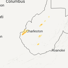
Hail Map for Monday, September 26, 2011

Number of Impacted Households on 9/26/2011
0
Impacted by 1" or Larger Hail
0
Impacted by 1.75" or Larger Hail
0
Impacted by 2.5" or Larger Hail
Square Miles of Populated Area Impacted on 9/26/2011
0
Impacted by 1" or Larger Hail
0
Impacted by 1.75" or Larger Hail
0
Impacted by 2.5" or Larger Hail


Cities Most Affected by Hail Storms of 9/26/2011
| Hail Size | Demographics of Zip Codes Affected | ||||||
|---|---|---|---|---|---|---|---|
| City | Count | Average | Largest | Pop Density | House Value | Income | Age |
| Gatesville, TX | 1 | 1.75 | 1.75 | 32 | $59k | $34.7k | 38.7 |
| Pierpont, OH | 1 | 1.75 | 1.75 | 46 | $84k | $36.1k | 38.4 |
Hail and Wind Damage Spotted on 9/26/2011
Filter by Report Type:Hail ReportsWind Reports
Kentucky
| Local Time | Report Details |
|---|---|
| 1:40 PM UTC | Tree limbs across hwy 421. highway dept. called out to remov in jackson county KY, 17.5 miles SW of Irvine, KY |
West Virginia
| Local Time | Report Details |
|---|---|
| 1:15 PM EDT | Quarter sized hail reported near Huntington, WV, 43.1 miles W of Charleston, WV, mostly dime size hail with quarter size mix in. very heavy rain and very gusty winds. cars had to pull off side of i-64 some cars in the median. between 115pm - 120pm |
| 1:24 PM EDT | Quarter sized hail reported near Barboursville, WV, 37.2 miles W of Charleston, WV |
| 1:45 PM EDT | Quarter sized hail reported near Huntington, WV, 43.1 miles W of Charleston, WV, mostly dime size hail with quarter size mix in. very heavy rain and very gusty winds. cars had to pull off side of i-64 some cars in the median. |
| 8:55 PM UTC | Tree down along county rt 18 in calhoun county WV, 41.2 miles NE of Charleston, WV |
| 8:56 PM UTC | Tree down along wv st rt 5 in calhoun county WV, 49 miles NE of Charleston, WV |
| 5:01 PM EDT | Quarter sized hail reported near Fairdale, WV, 40.8 miles SSE of Charleston, WV |
| 5:05 PM EDT | Quarter sized hail reported near Fairdale, WV, 41.3 miles SSE of Charleston, WV |
| 9:07 PM UTC | Tree down along rt 8 se of community of nob in calhoun county WV, 55 miles NE of Charleston, WV |
Georgia
| Local Time | Report Details |
|---|---|
| 8:55 PM UTC | Trees were down along walter griffis roa in wayne county GA, 53 miles ENE of Douglas, GA |
| 9:15 PM UTC | Trees were blown down along pine forest driv in wayne county GA, 56.8 miles E of Douglas, GA |
Florida
| Local Time | Report Details |
|---|---|
| 9:00 PM UTC | Trees were down on power lines causing power outages. the time of damage was based on radar imager in duval county FL, 7.6 miles E of Jacksonville, FL |
| 9:00 PM UTC | The post office reported trees down near tarpon street. the time given was based on rada in nassau county FL, 26.9 miles NNE of Jacksonville, FL |
| 9:00 PM UTC | Tree damage occurred on mccormick roa in duval county FL, 9.5 miles ENE of Jacksonville, FL |
Ohio
| Local Time | Report Details |
|---|---|
| 6:30 PM EDT | Golf Ball sized hail reported near Pierpont, OH, 60.3 miles ENE of Cleveland, OH |
| 6:35 PM EDT | Quarter sized hail reported near Pierpont, OH, 61.5 miles ENE of Cleveland, OH |
Texas
| Local Time | Report Details |
|---|---|
| 6:44 PM CDT | Golf Ball sized hail reported near Gatesville, TX, 22 miles N of Killeen, TX, hail fell along highway 84 about 3 miles west of gatesville. |
| 12:59 AM UTC | Power flashes also in bell county TX, 15.6 miles ESE of Killeen, TX |
| 1:02 AM UTC | Several downed trees in belton in bell county TX, 15.6 miles ESE of Killeen, TX |
| 1:12 AM UTC | Estimated 60 to 65 mph wind gusts in bell county TX, 22.4 miles E of Killeen, TX |
| 1:12 AM UTC | Trees down and power flashes in temple in bell county TX, 22.4 miles E of Killeen, TX |
| 1:15 AM UTC | Ktpl in bell county TX, 18.9 miles E of Killeen, TX |
| 1:30 AM UTC | Powerlines down along ranch road 233 in williamson county TX, 25 miles SSW of Killeen, TX |
| 8:51 PM CDT | Quarter sized hail reported near Clifton, TX, 54.7 miles NNE of Killeen, TX |
| 3:42 AM UTC | Kcrs asos in navarro county TX, 50.5 miles SSE of Dallas, TX |
Virginia
| Local Time | Report Details |
|---|---|
| 2:27 AM UTC | Trees down on ferrum mountain roa in franklin county VA, 22.2 miles SSW of Roanoke, VA |
Pennsylvania
| Local Time | Report Details |
|---|---|
| 10:21 AM UTC | A few trees down on wires with power outage in blair county PA, 34.4 miles SW of State College, PA |
Connect with Interactive Hail Maps