

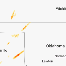
Hail Map for Friday, September 27, 2013

Number of Impacted Households on 9/27/2013
0
Impacted by 1" or Larger Hail
0
Impacted by 1.75" or Larger Hail
0
Impacted by 2.5" or Larger Hail
Square Miles of Populated Area Impacted on 9/27/2013
0
Impacted by 1" or Larger Hail
0
Impacted by 1.75" or Larger Hail
0
Impacted by 2.5" or Larger Hail


Cities Most Affected by Hail Storms of 9/27/2013
| Hail Size | Demographics of Zip Codes Affected | ||||||
|---|---|---|---|---|---|---|---|
| City | Count | Average | Largest | Pop Density | House Value | Income | Age |
Hail and Wind Damage Spotted on 9/27/2013
Filter by Report Type:Hail ReportsWind Reports
Texas
| Local Time | Report Details |
|---|---|
| 5:09 PM CDT | Storm damage reported in swisher county TX, 39.8 miles S of Amarillo, TX |
| 5:20 PM CDT | Numerous power poles down along and near interstate 27 in swisher county TX, 38.4 miles S of Amarillo, TX |
| 5:41 PM CDT | Storm damage reported in armstrong county TX, 31.5 miles SE of Amarillo, TX |
| 5:50 PM CDT | Storm damage reported in swisher county TX, 39.8 miles S of Amarillo, TX |
| 6:10 PM CDT | West texas meosnet report in swisher county TX, 45.6 miles S of Amarillo, TX |
| 7:50 PM CDT | Storm damage reported in donley county TX, 53.1 miles NW of Childress, TX |
| 7:59 PM CDT | Large tree blocking the road for the ramp to interstate 4 in gray county TX, 61.4 miles NNW of Childress, TX |
| 10:11 PM CDT | Tree down on highway 83 in wheeler county TX, 62.8 miles N of Childress, TX |
Nebraska
| Local Time | Report Details |
|---|---|
| 5:58 PM CDT | 50 to 60 mph winds. tree branches up to 5 inches in diameter blown down...and a roof blown off a small metal buildin in furnas county NE, 82.5 miles NE of Colby, KS |
| 6:13 PM CDT | 10 to 12 inch diameter tree blown down on va in furnas county NE, 82.4 miles SE of North Platte, NE |
| 6:13 PM CDT | An irrigation pivot was blown over on highway 34 near road 436. this was reported by a spotter that called wfo goodland kansas and was then relayed to wfo hastings nebr in furnas county NE, 81.3 miles SE of North Platte, NE |
| 10:06 PM CDT | 4 to 6 inch diameter tree branches blown down. estimated 60 mph wind in dawson county NE, 63.5 miles W of Grand Island, NE |
| 12:30 AM CDT | 12 healthy trees blown down on property. flipped over boat. shingles blown off hous in madison county NE, 59.4 miles ESE of Oneill, NE |
Kansas
| Local Time | Report Details |
|---|---|
| 7:15 PM CDT | Power poles were blown dow in haskell county KS, 39.1 miles S of Garden City, KS |
| 7:15 PM CDT | Quarter sized hail reported near Satanta, KS, 37 miles S of Garden City, KS |
| 6:23 PM MDT | Blowing dust reduced visibility to a quarter mile. this occurred as the outflow boundary passe in sherman county KS, 29.1 miles WNW of Colby, KS |
| 2:00 AM CDT | Delayed report of a camping trailer overturned at otoe park in russell county KS, 45.6 miles E of Hays, KS |
| 2:10 AM CDT | Several tree limbs down...some with diameter 6 to possibly 8 inches. winds estimated around 60 mph. confirmed report with mitchell cty dispatch who also mentioned power in mitchell county KS, 65.5 miles NE of Hays, KS |
Oklahoma
| Local Time | Report Details |
|---|---|
| 9:00 PM CDT | Oil field tanks blown onto a county road. time estimate in beaver county OK, 42.4 miles NW of Woodward, OK |
| 12:50 AM CDT | Storm damage reported in woods county OK, 43.7 miles NNE of Woodward, OK |
Connect with Interactive Hail Maps