

Hail Map for Sunday, September 30, 2018

Number of Impacted Households on 9/30/2018
0
Impacted by 1" or Larger Hail
0
Impacted by 1.75" or Larger Hail
0
Impacted by 2.5" or Larger Hail
Square Miles of Populated Area Impacted on 9/30/2018
0
Impacted by 1" or Larger Hail
0
Impacted by 1.75" or Larger Hail
0
Impacted by 2.5" or Larger Hail

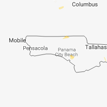


Cities Most Affected by Hail Storms of 9/30/2018
| Hail Size | Demographics of Zip Codes Affected | ||||||
|---|---|---|---|---|---|---|---|
| City | Count | Average | Largest | Pop Density | House Value | Income | Age |
Hail and Wind Damage Spotted on 9/30/2018
Filter by Report Type:Hail ReportsWind Reports
Florida
| Local Time | Report Details |
|---|---|
| 3:07 PM CDT | 6 trees down on a property off john pitts road in the bayou george area. report via social media with vide in bay county FL, 49.8 miles E of Miramar Beach, FL |
| 3:14 PM CDT | Several trees down in panama city. multiple power lines down. time estimated by radar. nickel size hail also reported north of downtown on us-23 in bay county FL, 44 miles ESE of Miramar Beach, FL |
Alabama
| Local Time | Report Details |
|---|---|
| 4:44 PM CDT | A couple of trees down in geneva. time estimated by radar. report relayed through social medi in geneva county AL, 54.3 miles NNE of Miramar Beach, FL |
California
| Local Time | Report Details |
|---|---|
| 5:13 PM PDT | Large ~4 in. tree branches on the highway in seeley ca with 0 mi. vsby. in heavy rai in imperial county CA, 61.9 miles W of Yuma, AZ |
Connect with Interactive Hail Maps