

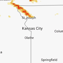
Hail Map for Tuesday, September 9, 2014

Number of Impacted Households on 9/9/2014
0
Impacted by 1" or Larger Hail
0
Impacted by 1.75" or Larger Hail
0
Impacted by 2.5" or Larger Hail
Square Miles of Populated Area Impacted on 9/9/2014
0
Impacted by 1" or Larger Hail
0
Impacted by 1.75" or Larger Hail
0
Impacted by 2.5" or Larger Hail


Cities Most Affected by Hail Storms of 9/9/2014
| Hail Size | Demographics of Zip Codes Affected | ||||||
|---|---|---|---|---|---|---|---|
| City | Count | Average | Largest | Pop Density | House Value | Income | Age |
| Lenox, IA | 2 | 1.88 | 2.00 | 16 | $48k | $31.5k | 43.0 |
| Rosendale, MO | 1 | 2.50 | 2.50 | 19 | $46k | $34.3k | 36.9 |
| Corning, IA | 1 | 2.00 | 2.00 | 12 | $52k | $29.9k | 46.8 |
| Hamburg, IA | 1 | 1.75 | 1.75 | 13 | $0k | $31.5k | 44.1 |
| Tarkio, MO | 1 | 1.75 | 1.75 | 17 | $49k | $30.0k | 46.1 |
| Nebraska City, NE | 1 | 1.75 | 1.75 | 56 | $77k | $35.5k | 41.5 |
Hail and Wind Damage Spotted on 9/9/2014
Filter by Report Type:Hail ReportsWind Reports
Illinois
| Local Time | Report Details |
|---|---|
| 8:40 AM CDT | Quarter sized hail reported near Quincy, IL, 38.1 miles SSE of Kahoka, MO |
Nebraska
| Local Time | Report Details |
|---|---|
| 4:30 PM CDT | Golf Ball sized hail reported near Nebraska City, NE, 40.1 miles S of Omaha, NE |
| 4:34 PM CDT | Quarter sized hail reported near Nebraska City, NE, 40.1 miles S of Omaha, NE |
| 5:06 PM CDT | Quarter sized hail reported near Chester, NE, 73.6 miles SSE of Grand Island, NE, nickle size hail with a few to the size of quarters in chester. |
| 5:10 PM CDT | Quarter sized hail reported near Chester, NE, 74.2 miles SE of Grand Island, NE, quarter size hail and estimated 60 mph winds. |
| 5:33 PM CDT | Quarter sized hail reported near Hubbell, NE, 75.1 miles NW of Manhattan, KS, hail up to the size of quarters. |
| 5:45 PM CDT | Half Dollar sized hail reported near Fairbury, NE, 70.7 miles NNW of Manhattan, KS, between quarter size and half dollar size. |
| 6:52 PM CDT | Quarter sized hail reported near Benedict, NE, 39 miles ENE of Grand Island, NE, quarter size hail reported. |
| 7:02 PM CDT | Quarter sized hail reported near Gresham, NE, 46.6 miles E of Grand Island, NE, estimated 40 to 50 mph winds and hail to the size of quarters. |
| 7:14 PM CDT | Nickel size hail also reported in seward county NE, 51.9 miles E of Grand Island, NE |
Iowa
| Local Time | Report Details |
|---|---|
| 4:40 PM CDT | Hen Egg sized hail reported near Corning, IA, 67.9 miles ESE of Omaha, NE, mostly golf ball size hail with a few larger stones. |
| 4:54 PM CDT | Golf Ball sized hail reported near Hamburg, IA, 46.8 miles SSE of Omaha, NE |
| 5:05 PM CDT | Hen Egg sized hail reported near Lenox, IA, 69.4 miles SW of Des Moines, IA, social media photo. time estimated from radar. |
| 5:10 PM CDT | Golf Ball sized hail reported near Lenox, IA, 67.5 miles SW of Des Moines, IA |
| 5:10 PM CDT | Heavy damage to a machine shed and trees damaged by strong straight line wind in adams county IA, 66.4 miles WSW of Des Moines, IA |
| 5:20 PM CDT | Quarter sized hail reported near Lenox, IA, 70.4 miles SW of Des Moines, IA, reported via social media. |
Missouri
| Local Time | Report Details |
|---|---|
| 4:40 PM CDT | Tree blown down onto powerline near intersection of highway j and highway m. fire reported starte in phelps county MO, 27.4 miles WNW of Salem, MO |
| 4:48 PM CDT | Quarter sized hail reported near Perry, MO, 47.6 miles NE of Columbia, MO |
| 5:00 PM CDT | Tree fell on motor vehicle. estimated winds 40-50 mp in cole county MO, 27.5 miles SSE of Columbia, MO |
| 5:00 PM CDT | Trees down. power out for two hours. report via social medi in ozark county MO, 62.6 miles ESE of Springfield, MO |
| 5:12 PM CDT | Scanner traffic report. tree has fallen on hous in phelps county MO, 25.1 miles NNW of Salem, MO |
| 5:17 PM CDT | Storm damage reported in atchison county MO, 54.5 miles SSE of Omaha, NE |
| 5:17 PM CDT | Half Dollar sized hail reported near Watson, MO, 54.5 miles SSE of Omaha, NE |
| 5:40 PM CDT | Quarter sized hail reported near Rock Port, MO, 62 miles SSE of Omaha, NE |
| 5:43 PM CDT | Quarter sized hail reported near Rock Port, MO, 60.5 miles SSE of Omaha, NE |
| 5:44 PM CDT | Golf Ball sized hail reported near Tarkio, MO, 62.9 miles SSE of Omaha, NE, golf ball size hail/70mph winds 2miles west of tarkio. penny size hail reported now in tarkio. |
| 5:50 PM CDT | Half Dollar sized hail reported near Tarkio, MO, 62 miles SSE of Omaha, NE |
| 5:57 PM CDT | 70 mph winds sustained for 5 to 7 minutes in the city of tarkio. city without power. nickel size hail up to golf ball size hail reported at 552pm. nickel size hail fall in atchison county MO, 63.8 miles SSE of Omaha, NE |
| 6:15 PM CDT | Storm damage reported in atchison county MO, 69.4 miles SSE of Omaha, NE |
| 6:21 PM CDT | Several large trees down across town. power out across tow in atchison county MO, 63.8 miles SSE of Omaha, NE |
| 7:08 PM CDT | Multiple trees snapped near intersection of west highway d and sneak roa in st. charles county MO, 37.7 miles W of Saint Louis, MO |
| 7:20 PM CDT | Trees and power lines down in holt county MO, 80 miles NNW of Kansas City, MO |
| 8:20 PM CDT | Ping Pong Ball sized hail reported near Rosendale, MO, 68 miles NNW of Kansas City, MO, quarter to ping pong sized hail... heavy rain... winds est 40 to 45 mph. |
| 8:22 PM CDT | Tennis Ball sized hail reported near Rosendale, MO, 65.9 miles N of Kansas City, MO, public reported tennis ball size hail. |
| 8:51 PM CDT | Half Dollar sized hail reported near Savannah, MO, 60.6 miles NNW of Kansas City, MO, light rain... with hail up to half dollar. earlier had pea size hail. |
| 9:10 PM CDT | Window blown out of a residence along with shingles off of a roof. also multiple trees and fences dow in st. charles county MO, 24.5 miles WNW of Saint Louis, MO |
| 9:10 PM CDT | Window blown out of a residence along with shingles off of a roof. also multiple trees and fences dow in st. charles county MO, 24.5 miles WNW of Saint Louis, MO |
| 10:25 PM CDT | Delayed report. time estimated by fire dept and radar. several trees down in the city of fairport. several of these trees landed on houses. at least one other residence in dekalb county MO, 61.8 miles NNE of Kansas City, MO |
| 3:00 AM CDT | At least 5 power poles snapped and numerous trees snapped through the center part of the cit in adair county MO, 48.2 miles WSW of Kahoka, MO |
Kansas
| Local Time | Report Details |
|---|---|
| 5:12 PM CDT | Empty tanks blown around and a hanger door was popped of its trac in russell county KS, 27.6 miles E of Hays, KS |
| 5:13 PM CDT | Storm damage reported in russell county KS, 27.6 miles E of Hays, KS |
| 5:27 PM CDT | Measured at the reisig seeds elevato in russell county KS, 28.4 miles E of Hays, KS |
| 5:55 PM CDT | Storm damage reported in lincoln county KS, 51.7 miles E of Hays, KS |
| 6:02 PM CDT | Quarter sized hail reported near Esbon, KS, 64.9 miles S of Grand Island, NE, hail from dime to quarter size. |
| 6:56 PM CDT | Estimated wind gusts to around 65 mph blew down some branches. also accompanied by hail up to quarter siz in jewell county KS, 74.4 miles SSE of Grand Island, NE |
| 7:20 PM CDT | Estimated wind of 60 mph with two inch diameter healthy tree branches down and heavy rain with low visibility probably 1/4 mil in republic county KS, 75.6 miles SSE of Grand Island, NE |
| 8:00 PM CDT | Storm damage reported in ellis county KS, 2.5 miles SW of Hays, KS |
| 8:07 PM CDT | 10 inch tree limbs down from strong thunderstorm wind in scott county KS, 28.8 miles N of Garden City, KS |
| 8:40 PM CDT | Metal building...20 by 10 storage shed...and carport destroyed. cedar tree snapped. 7 by 20 trailer moved approximately 100 feet. time estimated by rada in logan county KS, 26.2 miles SSE of Colby, KS |
| 9:00 PM CDT | Storm damage reported in rush county KS, 17.3 miles SSE of Hays, KS |
| 9:05 PM CDT | Storm damage reported in ness county KS, 50.8 miles ENE of Garden City, KS |
| 9:20 PM CDT | Rush county sheriffs office reports uprooted trees... two sheds destroyed... power lines down and propane tanks rolled at this locatio in rush county KS, 20.5 miles SE of Hays, KS |
| 9:24 PM CDT | Storm damage reported in gove county KS, 47.3 miles SE of Colby, KS |
| 9:50 PM CDT | Law enforcement report power lines and trees dow in barton county KS, 26.2 miles SE of Hays, KS |
| 9:50 PM CDT | Storm damage reported in trego county KS, 42.3 miles W of Hays, KS |
| 9:50 PM CDT | Powerlines were blown dow in barton county KS, 32.7 miles SSE of Hays, KS |
| 9:50 PM CDT | Powerlines were blown dow in barton county KS, 32.7 miles SSE of Hays, KS |
| 10:15 PM CDT | Right on the barton/russell county line. powerpoles down. time is approximate in russell county KS, 23.3 miles ESE of Hays, KS |
| 4:15 AM CDT | Large tree down on a car in prairie villag in johnson county KS, 8.4 miles SSW of Kansas City, MO |
Connect with Interactive Hail Maps