

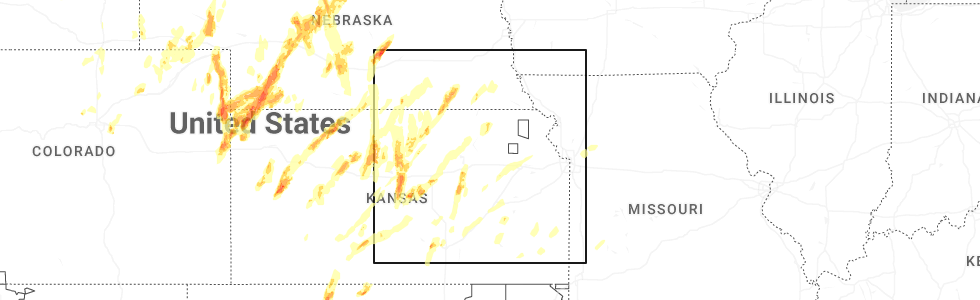
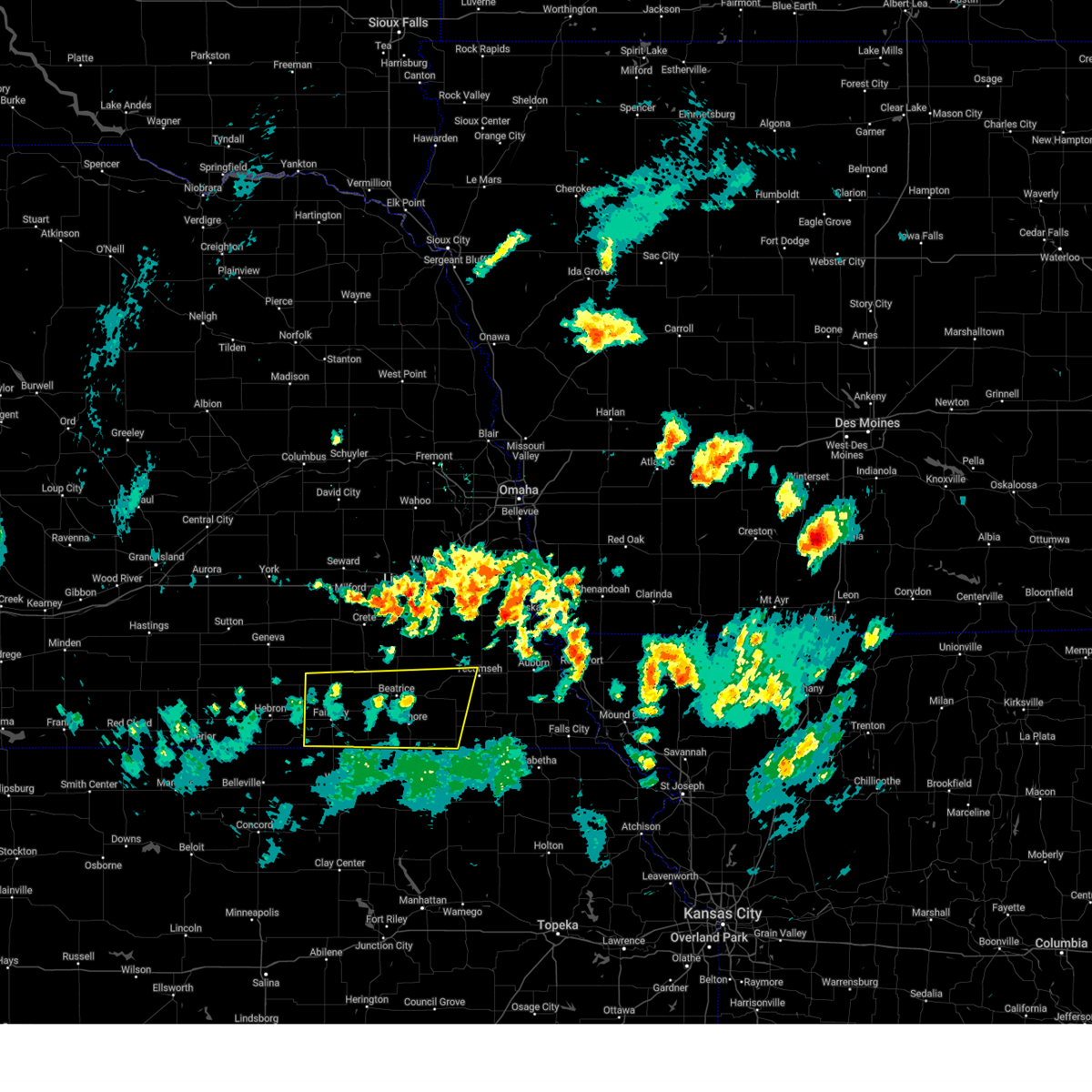
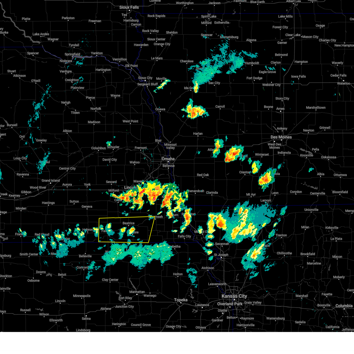
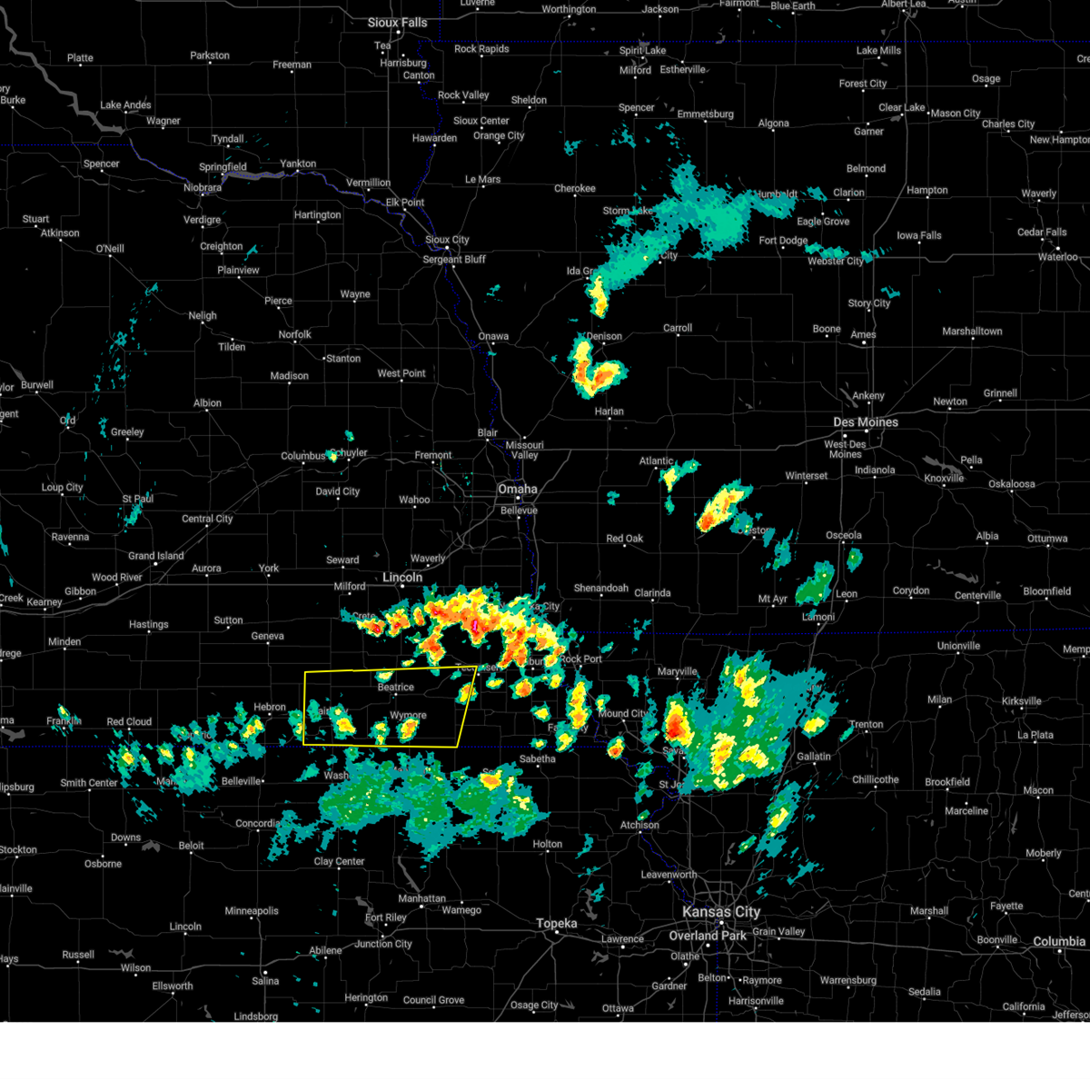
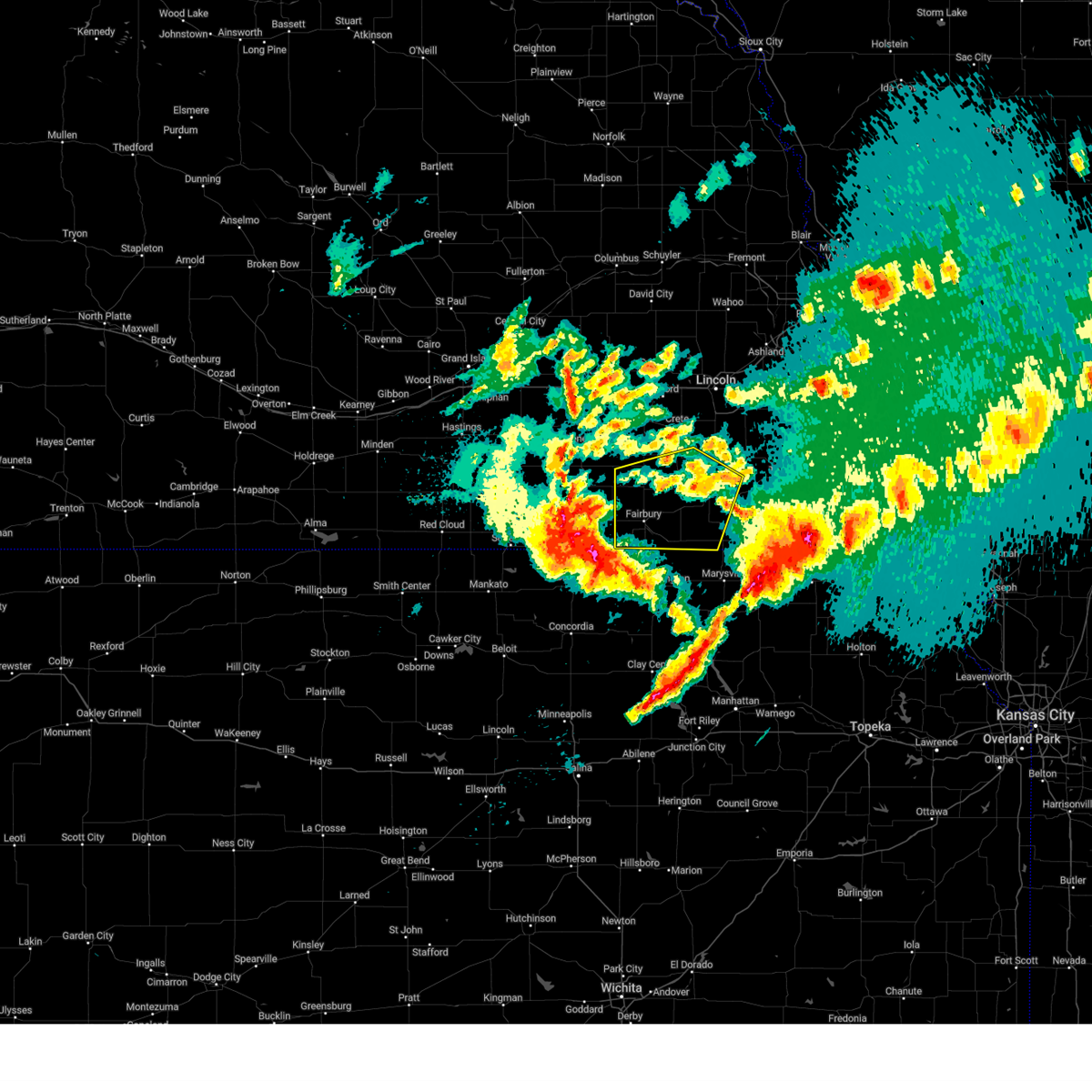
Hail Map for Fairbury, NE
The Fairbury, NE area has had 40 reports of on-the-ground hail by trained spotters, and has been under severe weather warnings 14 times during the past 12 months. Doppler radar has detected hail at or near Fairbury, NE on 107 occasions, including 1 occasion during the past year.
| Name: | Fairbury, NE |
| Where Located: | 74.2 miles NNW of Manhattan, KS |
| Map: | Google Map for Fairbury, NE |
| Population: | 3942 |
| Housing Units: | 2145 |
| More Info: | Search Google for Fairbury, NE |
1
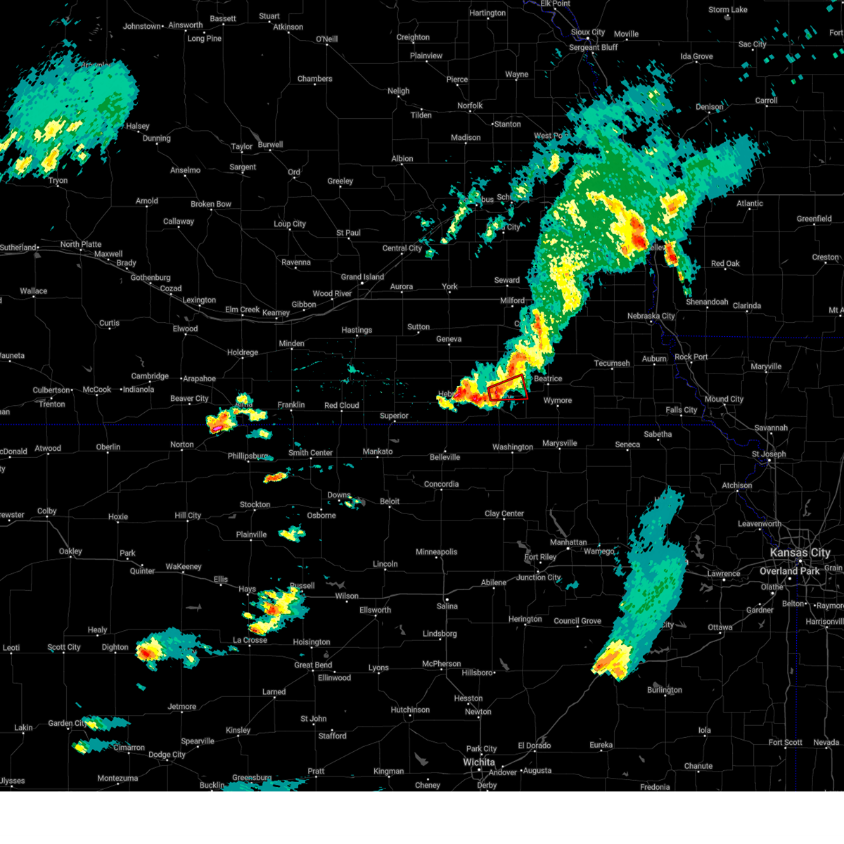
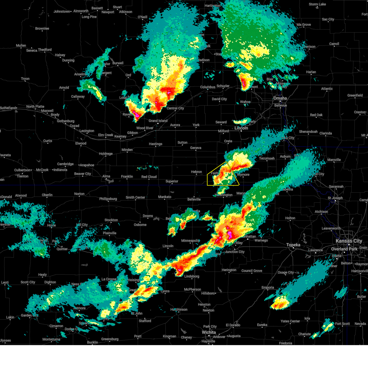
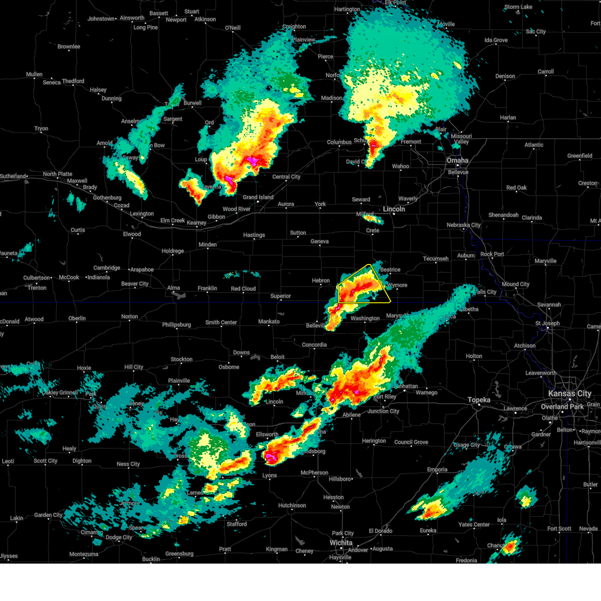
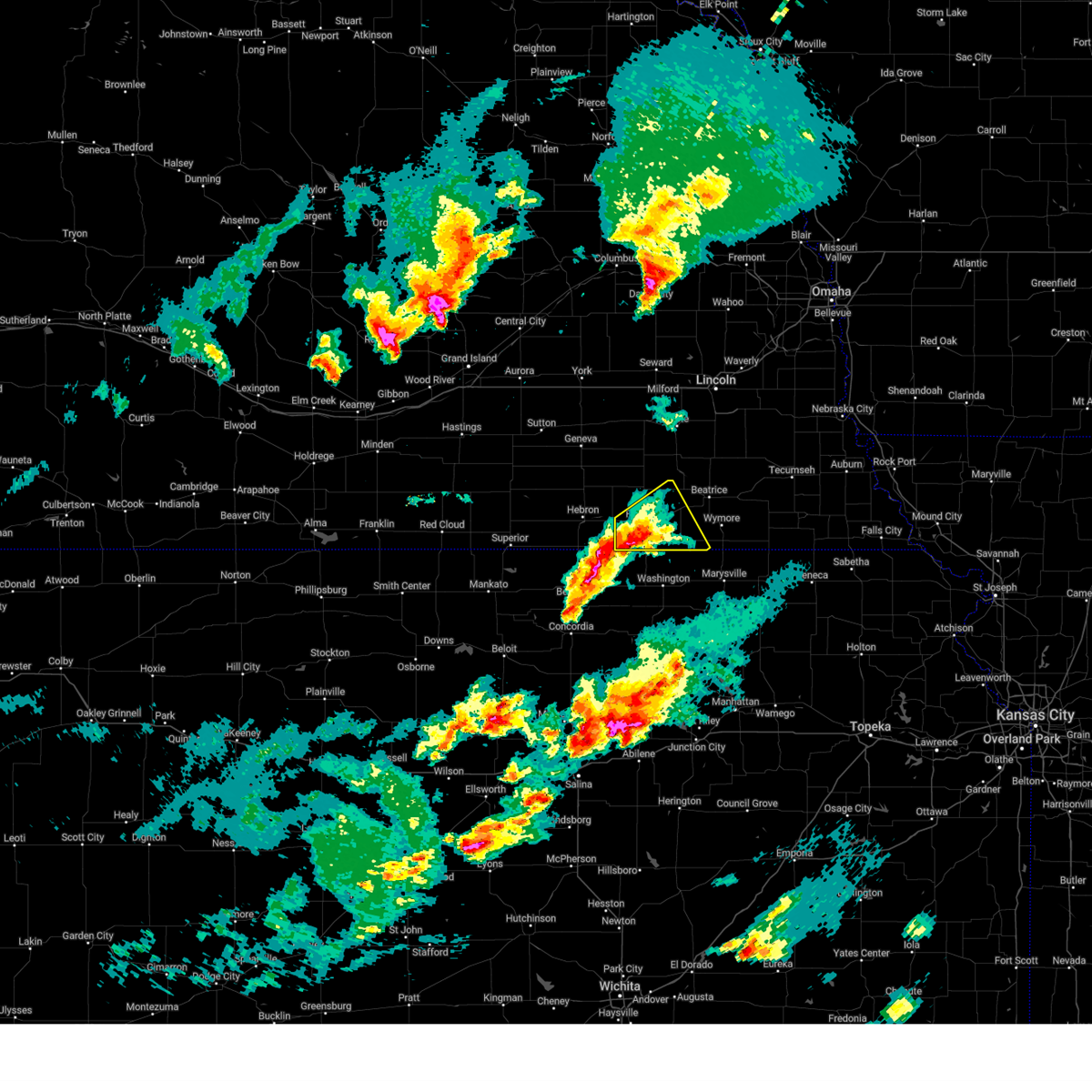
The Top Recent Hail Date for Fairbury, NE is Sunday, May 18, 2025 (46th out of 107)
Hail and Wind Damage Spotted near Fairbury, NE
| Date / Time | Report Details |
|---|---|
| 5/18/2025 9:44 PM CDT | The storm which prompted the warning has moved out of the area. therefore, the warning will be allowed to expire. remember, a severe thunderstorm warning still remains in effect for northeast jefferson county until 10:30 pm. |
| 5/18/2025 9:42 PM CDT |
 At 942 pm cdt, a severe thunderstorm was located near swanton, or 14 miles north of fairbury, moving northeast at 35 mph (radar indicated). Hazards include ping pong ball size hail and 60 mph wind gusts. People and animals outdoors will be injured. expect hail damage to roofs, siding, windows, and vehicles. expect wind damage to roofs, siding, and trees. this severe storm will be near, swanton around 950 pm cdt. wilber around 955 pm cdt. Other locations in the path of this severe thunderstorm include crete. At 942 pm cdt, a severe thunderstorm was located near swanton, or 14 miles north of fairbury, moving northeast at 35 mph (radar indicated). Hazards include ping pong ball size hail and 60 mph wind gusts. People and animals outdoors will be injured. expect hail damage to roofs, siding, windows, and vehicles. expect wind damage to roofs, siding, and trees. this severe storm will be near, swanton around 950 pm cdt. wilber around 955 pm cdt. Other locations in the path of this severe thunderstorm include crete.
|
| 5/18/2025 9:37 PM CDT | Svroax the national weather service in omaha has issued a * severe thunderstorm warning for, southwestern lancaster county in southeastern nebraska, northwestern jefferson county in southeastern nebraska, eastern saline county in southeastern nebraska, northwestern gage county in southeastern nebraska, * until 1030 pm cdt. * at 937 pm cdt, a severe thunderstorm was located 5 miles southwest of swanton, or 11 miles north of fairbury, moving northeast at 35 mph (radar indicated). Hazards include ping pong ball size hail and 60 mph wind gusts. People and animals outdoors will be injured. expect hail damage to roofs, siding, windows, and vehicles. expect wind damage to roofs, siding, and trees. this severe thunderstorm will be near, swanton around 945 pm cdt. wilber around 955 pm cdt. Other locations in the path of this severe thunderstorm include crete. |
| 5/18/2025 9:35 PM CDT | At 935 pm cdt, a severe thunderstorm was located 5 miles northwest of jansen, or 6 miles north of fairbury, moving northeast at 30 mph (radar indicated). Hazards include ping pong ball size hail and 60 mph wind gusts. People and animals outdoors will be injured. expect hail damage to roofs, siding, windows, and vehicles. expect wind damage to roofs, siding, and trees. This severe thunderstorm will remain over mainly rural areas of central jefferson county, including the following locations, gladstone, cub creek recreational area, crystal springs campground, and alexandria state recreation area. |
| 5/18/2025 9:03 PM CDT |
 At 903 pm cdt, a severe thunderstorm was located near reynolds, or 10 miles southwest of fairbury, moving northeast at 30 mph (radar indicated). Hazards include ping pong ball size hail and 60 mph wind gusts. People and animals outdoors will be injured. expect hail damage to roofs, siding, windows, and vehicles. expect wind damage to roofs, siding, and trees. This severe storm will be near, fairbury around 915 pm cdt. At 903 pm cdt, a severe thunderstorm was located near reynolds, or 10 miles southwest of fairbury, moving northeast at 30 mph (radar indicated). Hazards include ping pong ball size hail and 60 mph wind gusts. People and animals outdoors will be injured. expect hail damage to roofs, siding, windows, and vehicles. expect wind damage to roofs, siding, and trees. This severe storm will be near, fairbury around 915 pm cdt.
|
| 5/18/2025 8:55 PM CDT | Svroax the national weather service in omaha has issued a * severe thunderstorm warning for, jefferson county in southeastern nebraska, * until 945 pm cdt. * at 855 pm cdt, a severe thunderstorm was located over mahaska, or 14 miles southwest of fairbury, moving northeast at 30 mph (radar indicated). Hazards include 60 mph wind gusts and quarter size hail. Hail damage to vehicles is expected. expect wind damage to roofs, siding, and trees. this severe thunderstorm will be near, reynolds around 900 pm cdt. Fairbury around 915 pm cdt. |
| 4/24/2025 5:46 PM CDT |
 At 546 pm cdt, a severe thunderstorm capable of producing a tornado was located near jansen, or 5 miles northeast of fairbury, moving east at 15 mph (radar indicated rotation). Hazards include tornado. Flying debris will be dangerous to those caught without shelter. mobile homes will be damaged or destroyed. damage to roofs, windows, and vehicles will occur. tree damage is likely. this dangerous storm will be near, jansen around 550 pm cdt. Other locations in the path of this tornadic thunderstorm include harbine. At 546 pm cdt, a severe thunderstorm capable of producing a tornado was located near jansen, or 5 miles northeast of fairbury, moving east at 15 mph (radar indicated rotation). Hazards include tornado. Flying debris will be dangerous to those caught without shelter. mobile homes will be damaged or destroyed. damage to roofs, windows, and vehicles will occur. tree damage is likely. this dangerous storm will be near, jansen around 550 pm cdt. Other locations in the path of this tornadic thunderstorm include harbine.
|
| 4/24/2025 5:38 PM CDT |
 Toroax the national weather service in omaha has issued a * tornado warning for, northeastern jefferson county in southeastern nebraska, * until 630 pm cdt. * at 538 pm cdt, a severe thunderstorm capable of producing a tornado was located 5 miles north of fairbury, moving east at 15 mph (radar indicated rotation). Hazards include tornado. Flying debris will be dangerous to those caught without shelter. mobile homes will be damaged or destroyed. damage to roofs, windows, and vehicles will occur. tree damage is likely. this dangerous storm will be near, jansen around 545 pm cdt. Other locations in the path of this tornadic thunderstorm include plymouth and harbine. Toroax the national weather service in omaha has issued a * tornado warning for, northeastern jefferson county in southeastern nebraska, * until 630 pm cdt. * at 538 pm cdt, a severe thunderstorm capable of producing a tornado was located 5 miles north of fairbury, moving east at 15 mph (radar indicated rotation). Hazards include tornado. Flying debris will be dangerous to those caught without shelter. mobile homes will be damaged or destroyed. damage to roofs, windows, and vehicles will occur. tree damage is likely. this dangerous storm will be near, jansen around 545 pm cdt. Other locations in the path of this tornadic thunderstorm include plymouth and harbine.
|
| 4/1/2025 9:52 PM CDT |
 The storm which prompted the warning has weakened below severe limits, and no longer poses an immediate threat to life or property. therefore, the warning will be allowed to expire. however, gusty winds are still possible with this thunderstorm. a severe thunderstorm watch remains in effect until 300 am cdt for southeastern nebraska. The storm which prompted the warning has weakened below severe limits, and no longer poses an immediate threat to life or property. therefore, the warning will be allowed to expire. however, gusty winds are still possible with this thunderstorm. a severe thunderstorm watch remains in effect until 300 am cdt for southeastern nebraska.
|
| 4/1/2025 9:32 PM CDT |
 At 932 pm cdt, a severe thunderstorm was located over mahaska, or 14 miles southwest of fairbury, moving northeast at 35 mph (radar indicated). Hazards include 60 mph wind gusts and quarter size hail. Hail damage to vehicles is expected. expect wind damage to roofs, siding, and trees. Locations impacted include, endicott, reynolds, plymouth, rock creek station state historical park, cub creek recreational area, harbine, fairbury, steele city, diller, crystal springs campground, buckley creek recreational area, jansen, camp jefferson, odell, and gladstone. At 932 pm cdt, a severe thunderstorm was located over mahaska, or 14 miles southwest of fairbury, moving northeast at 35 mph (radar indicated). Hazards include 60 mph wind gusts and quarter size hail. Hail damage to vehicles is expected. expect wind damage to roofs, siding, and trees. Locations impacted include, endicott, reynolds, plymouth, rock creek station state historical park, cub creek recreational area, harbine, fairbury, steele city, diller, crystal springs campground, buckley creek recreational area, jansen, camp jefferson, odell, and gladstone.
|
| 4/1/2025 9:21 PM CDT |
 Svroax the national weather service in omaha has issued a * severe thunderstorm warning for, jefferson county in southeastern nebraska, southwestern gage county in southeastern nebraska, * until 1000 pm cdt. * at 921 pm cdt, a severe thunderstorm was located 3 miles southwest of narka, or 11 miles northeast of belleville, moving northeast at 35 mph (radar indicated). Hazards include 60 mph wind gusts and half dollar size hail. Hail damage to vehicles is expected. Expect wind damage to roofs, siding, and trees. Svroax the national weather service in omaha has issued a * severe thunderstorm warning for, jefferson county in southeastern nebraska, southwestern gage county in southeastern nebraska, * until 1000 pm cdt. * at 921 pm cdt, a severe thunderstorm was located 3 miles southwest of narka, or 11 miles northeast of belleville, moving northeast at 35 mph (radar indicated). Hazards include 60 mph wind gusts and half dollar size hail. Hail damage to vehicles is expected. Expect wind damage to roofs, siding, and trees.
|
| 3/14/2025 4:19 PM CDT |
 the severe thunderstorm warning has been cancelled and is no longer in effect the severe thunderstorm warning has been cancelled and is no longer in effect
|
| 3/14/2025 4:11 PM CDT |
 At 410 pm cdt, severe thunderstorms were located along a line extending from 5 miles southeast of alexandria to 3 miles northeast of burchard, moving east at 30 mph (public. at 4:05 pm, a 66 mph wind gust was reported 2 miles east of pymouth). Hazards include 70 mph wind gusts and nickel size hail. Expect considerable tree damage. damage is likely to mobile homes, roofs, and outbuildings. Locations impacted include, crab orchard, swanton, endicott, wymore, alexandria state recreation area, homestead national historical park, harbine, liberty, daykin, ellis, holmesville, diller, crystal springs campground, buckley creek recreational area, jansen, lewiston, odell, gladstone, vesta, and barneston. At 410 pm cdt, severe thunderstorms were located along a line extending from 5 miles southeast of alexandria to 3 miles northeast of burchard, moving east at 30 mph (public. at 4:05 pm, a 66 mph wind gust was reported 2 miles east of pymouth). Hazards include 70 mph wind gusts and nickel size hail. Expect considerable tree damage. damage is likely to mobile homes, roofs, and outbuildings. Locations impacted include, crab orchard, swanton, endicott, wymore, alexandria state recreation area, homestead national historical park, harbine, liberty, daykin, ellis, holmesville, diller, crystal springs campground, buckley creek recreational area, jansen, lewiston, odell, gladstone, vesta, and barneston.
|
| 3/14/2025 3:55 PM CDT |
 Svroax the national weather service in omaha has issued a * severe thunderstorm warning for, southwestern johnson county in southeastern nebraska, jefferson county in southeastern nebraska, southern saline county in southeastern nebraska, western pawnee county in southeastern nebraska, gage county in southeastern nebraska, * until 445 pm cdt. * at 355 pm cdt, severe thunderstorms were located along a line extending from near reynolds to 4 miles north of summerfield, moving north at 40 mph (radar indicated). Hazards include 70 mph wind gusts and nickel size hail. Expect considerable tree damage. Damage is likely to mobile homes, roofs, and outbuildings. Svroax the national weather service in omaha has issued a * severe thunderstorm warning for, southwestern johnson county in southeastern nebraska, jefferson county in southeastern nebraska, southern saline county in southeastern nebraska, western pawnee county in southeastern nebraska, gage county in southeastern nebraska, * until 445 pm cdt. * at 355 pm cdt, severe thunderstorms were located along a line extending from near reynolds to 4 miles north of summerfield, moving north at 40 mph (radar indicated). Hazards include 70 mph wind gusts and nickel size hail. Expect considerable tree damage. Damage is likely to mobile homes, roofs, and outbuildings.
|
| 3/14/2025 3:52 PM CDT | Storm damage reported in jefferson county NE, 1.1 miles NNE of Fairbury, NE |
| 7/6/2024 6:43 PM CDT |
 The storms which prompted the warning have moved out of the area. therefore, the warning will be allowed to expire. however, gusty winds and heavy rain are still possible with these thunderstorms. a severe thunderstorm watch remains in effect until midnight cdt for southeastern nebraska. The storms which prompted the warning have moved out of the area. therefore, the warning will be allowed to expire. however, gusty winds and heavy rain are still possible with these thunderstorms. a severe thunderstorm watch remains in effect until midnight cdt for southeastern nebraska.
|
| 7/6/2024 6:27 PM CDT |
 At 626 pm cdt, severe thunderstorms were located along a line extending from 3 miles northwest of dorchester to 2 miles southeast of swanton to 6 miles southwest of endicott, moving east at 35 mph (radar indicated). Hazards include 60 mph wind gusts and quarter size hail. Hail damage to vehicles is expected. expect wind damage to roofs, siding, and trees. Locations impacted include, fairbury, milford, friend, dorchester, western, endicott, jansen, swanton, swan creek reservoir number 2, the highway 41 and 15 south junction, swan creek wildlife management area, blue river state recreation area, crystal springs campground, camp jefferson, and willard meyer recreation area. At 626 pm cdt, severe thunderstorms were located along a line extending from 3 miles northwest of dorchester to 2 miles southeast of swanton to 6 miles southwest of endicott, moving east at 35 mph (radar indicated). Hazards include 60 mph wind gusts and quarter size hail. Hail damage to vehicles is expected. expect wind damage to roofs, siding, and trees. Locations impacted include, fairbury, milford, friend, dorchester, western, endicott, jansen, swanton, swan creek reservoir number 2, the highway 41 and 15 south junction, swan creek wildlife management area, blue river state recreation area, crystal springs campground, camp jefferson, and willard meyer recreation area.
|
| 7/6/2024 6:06 PM CDT |
 At 606 pm cdt, severe thunderstorms were located along a line extending from 2 miles west of cordova to 2 miles southeast of tobias to 3 miles southwest of reynolds, moving east at 50 mph (radar indicated). Hazards include ping pong ball size hail and 60 mph wind gusts. People and animals outdoors will be injured. expect hail damage to roofs, siding, windows, and vehicles. expect wind damage to roofs, siding, and trees. Locations impacted include, fairbury, milford, friend, dorchester, western, daykin, cordova, endicott, jansen, tobias, swanton, reynolds, swan creek reservoir number 2, the highway 41 and 15 south junction, swan creek wildlife management area, alexandria state recreation area, blue river state recreation area, crystal springs campground, buckley creek recreational area, and camp jefferson. At 606 pm cdt, severe thunderstorms were located along a line extending from 2 miles west of cordova to 2 miles southeast of tobias to 3 miles southwest of reynolds, moving east at 50 mph (radar indicated). Hazards include ping pong ball size hail and 60 mph wind gusts. People and animals outdoors will be injured. expect hail damage to roofs, siding, windows, and vehicles. expect wind damage to roofs, siding, and trees. Locations impacted include, fairbury, milford, friend, dorchester, western, daykin, cordova, endicott, jansen, tobias, swanton, reynolds, swan creek reservoir number 2, the highway 41 and 15 south junction, swan creek wildlife management area, alexandria state recreation area, blue river state recreation area, crystal springs campground, buckley creek recreational area, and camp jefferson.
|
| 7/6/2024 5:49 PM CDT |
 Svroax the national weather service in omaha has issued a * severe thunderstorm warning for, jefferson county in southeastern nebraska, southwestern seward county in southeastern nebraska, saline county in southeastern nebraska, * until 645 pm cdt. * at 549 pm cdt, severe thunderstorms were located along a line extending from 3 miles southeast of lushton to 2 miles north of bruning to 3 miles west of chester, moving east at 25 mph (radar indicated). Hazards include ping pong ball size hail and 60 mph wind gusts. People and animals outdoors will be injured. expect hail damage to roofs, siding, windows, and vehicles. Expect wind damage to roofs, siding, and trees. Svroax the national weather service in omaha has issued a * severe thunderstorm warning for, jefferson county in southeastern nebraska, southwestern seward county in southeastern nebraska, saline county in southeastern nebraska, * until 645 pm cdt. * at 549 pm cdt, severe thunderstorms were located along a line extending from 3 miles southeast of lushton to 2 miles north of bruning to 3 miles west of chester, moving east at 25 mph (radar indicated). Hazards include ping pong ball size hail and 60 mph wind gusts. People and animals outdoors will be injured. expect hail damage to roofs, siding, windows, and vehicles. Expect wind damage to roofs, siding, and trees.
|
| 6/26/2024 1:55 AM CDT | Storm damage reported in jefferson county NE, 0.4 miles NE of Fairbury, NE |
| 6/26/2024 1:55 AM CDT |
 the severe thunderstorm warning has been cancelled and is no longer in effect the severe thunderstorm warning has been cancelled and is no longer in effect
|
| 6/26/2024 1:55 AM CDT |
 At 155 am cdt, severe thunderstorms were located along a line extending from 5 miles southeast of panama to 4 miles southwest of virginia to 6 miles west of hollenberg, moving southeast at 70 mph (weather instruments at the beatrice airport measured a 66 mph wind gust with this storm). Hazards include 70 mph wind gusts. Expect considerable tree damage. damage is likely to mobile homes, roofs, and outbuildings. Locations impacted include, beatrice, fairbury, hickman, wymore, firth, adams, blue springs, odell, diller, panama, endicott, filley, jansen, barneston, liberty, reynolds, steele city, virginia, harbine, and holmesville. At 155 am cdt, severe thunderstorms were located along a line extending from 5 miles southeast of panama to 4 miles southwest of virginia to 6 miles west of hollenberg, moving southeast at 70 mph (weather instruments at the beatrice airport measured a 66 mph wind gust with this storm). Hazards include 70 mph wind gusts. Expect considerable tree damage. damage is likely to mobile homes, roofs, and outbuildings. Locations impacted include, beatrice, fairbury, hickman, wymore, firth, adams, blue springs, odell, diller, panama, endicott, filley, jansen, barneston, liberty, reynolds, steele city, virginia, harbine, and holmesville.
|
| 6/26/2024 1:50 AM CDT |
 At 149 am cdt, severe thunderstorms were located along a line extending from 2 miles west of panama to 3 miles east of beatrice to 6 miles east of reynolds, moving southeast at 70 mph (public weather stations measured 55 to 65 mph winds at multiple locations in seward, saline, southern lancaster and northwest gage counties with these storms). Hazards include 60 mph wind gusts. Expect damage to roofs, siding, and trees. Locations impacted include, beatrice, fairbury, hickman, wymore, firth, adams, de witt, cortland, plymouth, blue springs, odell, diller, panama, clatonia, roca, hallam, pickrell, sprague, endicott, and filley. At 149 am cdt, severe thunderstorms were located along a line extending from 2 miles west of panama to 3 miles east of beatrice to 6 miles east of reynolds, moving southeast at 70 mph (public weather stations measured 55 to 65 mph winds at multiple locations in seward, saline, southern lancaster and northwest gage counties with these storms). Hazards include 60 mph wind gusts. Expect damage to roofs, siding, and trees. Locations impacted include, beatrice, fairbury, hickman, wymore, firth, adams, de witt, cortland, plymouth, blue springs, odell, diller, panama, clatonia, roca, hallam, pickrell, sprague, endicott, and filley.
|
| 6/26/2024 1:34 AM CDT |
 Svroax the national weather service in omaha has issued a * severe thunderstorm warning for, southern lancaster county in southeastern nebraska, jefferson county in southeastern nebraska, southeastern saline county in southeastern nebraska, gage county in southeastern nebraska, * until 215 am cdt. * at 133 am cdt, severe thunderstorms were located along a line extending from 5 miles northwest of sprague to 3 miles northeast of alexandria, moving southeast at 65 mph (public weather stations measured 55 to 65 mph winds at multiple locations in seward and saline counties with these storms). Hazards include 60 mph wind gusts. expect damage to roofs, siding, and trees Svroax the national weather service in omaha has issued a * severe thunderstorm warning for, southern lancaster county in southeastern nebraska, jefferson county in southeastern nebraska, southeastern saline county in southeastern nebraska, gage county in southeastern nebraska, * until 215 am cdt. * at 133 am cdt, severe thunderstorms were located along a line extending from 5 miles northwest of sprague to 3 miles northeast of alexandria, moving southeast at 65 mph (public weather stations measured 55 to 65 mph winds at multiple locations in seward and saline counties with these storms). Hazards include 60 mph wind gusts. expect damage to roofs, siding, and trees
|
| 6/15/2024 4:45 PM CDT |
 Svroax the national weather service in omaha has issued a * severe thunderstorm warning for, northwestern jefferson county in southeastern nebraska, southwestern saline county in southeastern nebraska, * until 530 pm cdt. * at 444 pm cdt, severe thunderstorms were located along a line extending from 3 miles south of tobias to near reynolds, moving northeast at 20 mph (radar indicated). Hazards include 60 mph wind gusts and quarter size hail. Hail damage to vehicles is expected. Expect wind damage to roofs, siding, and trees. Svroax the national weather service in omaha has issued a * severe thunderstorm warning for, northwestern jefferson county in southeastern nebraska, southwestern saline county in southeastern nebraska, * until 530 pm cdt. * at 444 pm cdt, severe thunderstorms were located along a line extending from 3 miles south of tobias to near reynolds, moving northeast at 20 mph (radar indicated). Hazards include 60 mph wind gusts and quarter size hail. Hail damage to vehicles is expected. Expect wind damage to roofs, siding, and trees.
|
| 6/7/2024 10:40 PM CDT |
 Svroax the national weather service in omaha has issued a * severe thunderstorm warning for, eastern jefferson county in southeastern nebraska, southwestern gage county in southeastern nebraska, * until 1115 pm cdt. * at 1040 pm cdt, a severe thunderstorm was located near endicott, or 3 miles southeast of fairbury, moving southeast at 55 mph (emergency management). Hazards include 60 mph wind gusts and penny size hail. expect damage to roofs, siding, and trees Svroax the national weather service in omaha has issued a * severe thunderstorm warning for, eastern jefferson county in southeastern nebraska, southwestern gage county in southeastern nebraska, * until 1115 pm cdt. * at 1040 pm cdt, a severe thunderstorm was located near endicott, or 3 miles southeast of fairbury, moving southeast at 55 mph (emergency management). Hazards include 60 mph wind gusts and penny size hail. expect damage to roofs, siding, and trees
|
| 6/7/2024 10:39 PM CDT | Storm damage reported in jefferson county NE, 2.1 miles ENE of Fairbury, NE |
| 6/2/2024 3:08 AM CDT |
 The storm which prompted the warning has weakened below severe limits, and no longer poses an immediate threat to life or property. therefore, the warning will be allowed to expire. remember, another severe thunderstorm warning still remains in effect for southern jefferson county until 3:30 am. The storm which prompted the warning has weakened below severe limits, and no longer poses an immediate threat to life or property. therefore, the warning will be allowed to expire. remember, another severe thunderstorm warning still remains in effect for southern jefferson county until 3:30 am.
|
| 6/2/2024 2:56 AM CDT |
 At 255 am cdt, a severe thunderstorm was located 6 miles south of daykin, or 7 miles northwest of fairbury, moving northeast at 25 mph (radar indicated). Hazards include 60 mph wind gusts and quarter size hail. Hail damage to vehicles is expected. expect wind damage to roofs, siding, and trees. Locations impacted include, fairbury, daykin, jansen, gladstone, crystal springs campground, and alexandria state recreation area. At 255 am cdt, a severe thunderstorm was located 6 miles south of daykin, or 7 miles northwest of fairbury, moving northeast at 25 mph (radar indicated). Hazards include 60 mph wind gusts and quarter size hail. Hail damage to vehicles is expected. expect wind damage to roofs, siding, and trees. Locations impacted include, fairbury, daykin, jansen, gladstone, crystal springs campground, and alexandria state recreation area.
|
| 6/2/2024 2:52 AM CDT |
 Svroax the national weather service in omaha has issued a * severe thunderstorm warning for, southern jefferson county in southeastern nebraska, * until 330 am cdt. * at 251 am cdt, a severe thunderstorm was located 5 miles southwest of endicott, or 7 miles south of fairbury, moving northeast at 25 mph (radar indicated). Hazards include 60 mph wind gusts and quarter size hail. Hail damage to vehicles is expected. Expect wind damage to roofs, siding, and trees. Svroax the national weather service in omaha has issued a * severe thunderstorm warning for, southern jefferson county in southeastern nebraska, * until 330 am cdt. * at 251 am cdt, a severe thunderstorm was located 5 miles southwest of endicott, or 7 miles south of fairbury, moving northeast at 25 mph (radar indicated). Hazards include 60 mph wind gusts and quarter size hail. Hail damage to vehicles is expected. Expect wind damage to roofs, siding, and trees.
|
| 6/2/2024 2:35 AM CDT |
 Svroax the national weather service in omaha has issued a * severe thunderstorm warning for, western jefferson county in southeastern nebraska, southwestern saline county in southeastern nebraska, * until 315 am cdt. * at 234 am cdt, a severe thunderstorm was located over gilead, or 10 miles west of fairbury, moving northeast at 25 mph (radar indicated). Hazards include 60 mph wind gusts and quarter size hail. Hail damage to vehicles is expected. Expect wind damage to roofs, siding, and trees. Svroax the national weather service in omaha has issued a * severe thunderstorm warning for, western jefferson county in southeastern nebraska, southwestern saline county in southeastern nebraska, * until 315 am cdt. * at 234 am cdt, a severe thunderstorm was located over gilead, or 10 miles west of fairbury, moving northeast at 25 mph (radar indicated). Hazards include 60 mph wind gusts and quarter size hail. Hail damage to vehicles is expected. Expect wind damage to roofs, siding, and trees.
|
| 5/24/2024 2:39 AM CDT |
 At 239 am cdt, severe thunderstorms were located along a line extending from 4 miles northeast of palmyra to 4 miles southwest of cook to 2 miles east of barneston, moving east at 60 mph (radar indicated). Hazards include 60 mph wind gusts and quarter size hail. Hail damage to vehicles is expected. expect wind damage to roofs, siding, and trees. Locations impacted include, beatrice, fairbury, tecumseh, pawnee city, crete, syracuse, wilber, hickman, wymore, bennet, firth, adams, palmyra, de witt, cortland, sterling, plymouth, blue springs, cook, and unadilla. At 239 am cdt, severe thunderstorms were located along a line extending from 4 miles northeast of palmyra to 4 miles southwest of cook to 2 miles east of barneston, moving east at 60 mph (radar indicated). Hazards include 60 mph wind gusts and quarter size hail. Hail damage to vehicles is expected. expect wind damage to roofs, siding, and trees. Locations impacted include, beatrice, fairbury, tecumseh, pawnee city, crete, syracuse, wilber, hickman, wymore, bennet, firth, adams, palmyra, de witt, cortland, sterling, plymouth, blue springs, cook, and unadilla.
|
| 5/24/2024 1:54 AM CDT |
 Svroax the national weather service in omaha has issued a * severe thunderstorm warning for, southern lancaster county in southeastern nebraska, johnson county in southeastern nebraska, jefferson county in southeastern nebraska, southern seward county in southeastern nebraska, southwestern otoe county in southeastern nebraska, saline county in southeastern nebraska, pawnee county in southeastern nebraska, gage county in southeastern nebraska, * until 245 am cdt. * at 154 am cdt, severe thunderstorms were located along a line extending from 4 miles northwest of dorchester to 2 miles north of swanton to near mahaska, moving east at 60 mph (radar indicated). Hazards include 60 mph wind gusts and quarter size hail. Hail damage to vehicles is expected. Expect wind damage to roofs, siding, and trees. Svroax the national weather service in omaha has issued a * severe thunderstorm warning for, southern lancaster county in southeastern nebraska, johnson county in southeastern nebraska, jefferson county in southeastern nebraska, southern seward county in southeastern nebraska, southwestern otoe county in southeastern nebraska, saline county in southeastern nebraska, pawnee county in southeastern nebraska, gage county in southeastern nebraska, * until 245 am cdt. * at 154 am cdt, severe thunderstorms were located along a line extending from 4 miles northwest of dorchester to 2 miles north of swanton to near mahaska, moving east at 60 mph (radar indicated). Hazards include 60 mph wind gusts and quarter size hail. Hail damage to vehicles is expected. Expect wind damage to roofs, siding, and trees.
|
| 5/24/2024 1:21 AM CDT |
 Svroax the national weather service in omaha has issued a * severe thunderstorm warning for, lancaster county in southeastern nebraska, jefferson county in southeastern nebraska, seward county in southeastern nebraska, saline county in southeastern nebraska, southern butler county in east central nebraska, southwestern saunders county in east central nebraska, western gage county in southeastern nebraska, * until 200 am cdt. * at 121 am cdt, severe thunderstorms were located along a line extending from 3 miles northeast of gresham to 4 miles northwest of hebron, moving east at 55 mph (radar indicated). Hazards include 70 mph wind gusts and quarter size hail. Hail damage to vehicles is expected. expect considerable tree damage. Wind damage is also likely to mobile homes, roofs, and outbuildings. Svroax the national weather service in omaha has issued a * severe thunderstorm warning for, lancaster county in southeastern nebraska, jefferson county in southeastern nebraska, seward county in southeastern nebraska, saline county in southeastern nebraska, southern butler county in east central nebraska, southwestern saunders county in east central nebraska, western gage county in southeastern nebraska, * until 200 am cdt. * at 121 am cdt, severe thunderstorms were located along a line extending from 3 miles northeast of gresham to 4 miles northwest of hebron, moving east at 55 mph (radar indicated). Hazards include 70 mph wind gusts and quarter size hail. Hail damage to vehicles is expected. expect considerable tree damage. Wind damage is also likely to mobile homes, roofs, and outbuildings.
|
| 5/4/2024 12:19 AM CDT |
 At 1219 am cdt, severe thunderstorms were located along a line extending from near beaver crossing to 3 miles northwest of plymouth to near mahaska, moving east at 45 mph (radar indicated). Hazards include 60 mph wind gusts and quarter size hail. Hail damage to vehicles is expected. expect wind damage to roofs, siding, and trees. Locations impacted include, fairbury, crete, milford, wilber, friend, dorchester, de witt, plymouth, beaver crossing, diller, western, clatonia, pleasant dale, daykin, goehner, cordova, endicott, jansen, tobias, and swanton. At 1219 am cdt, severe thunderstorms were located along a line extending from near beaver crossing to 3 miles northwest of plymouth to near mahaska, moving east at 45 mph (radar indicated). Hazards include 60 mph wind gusts and quarter size hail. Hail damage to vehicles is expected. expect wind damage to roofs, siding, and trees. Locations impacted include, fairbury, crete, milford, wilber, friend, dorchester, de witt, plymouth, beaver crossing, diller, western, clatonia, pleasant dale, daykin, goehner, cordova, endicott, jansen, tobias, and swanton.
|
| 5/4/2024 12:05 AM CDT |
 At 1204 am cdt, severe thunderstorms were located along a line extending from 6 miles northeast of mccool junction to 3 miles south of western to mahaska, moving east at 45 mph (radar indicated). Hazards include 60 mph wind gusts and quarter size hail. Hail damage to vehicles is expected. expect wind damage to roofs, siding, and trees. Locations impacted include, fairbury, crete, milford, wilber, friend, dorchester, de witt, plymouth, beaver crossing, diller, western, clatonia, pleasant dale, daykin, goehner, cordova, endicott, jansen, tobias, and swanton. At 1204 am cdt, severe thunderstorms were located along a line extending from 6 miles northeast of mccool junction to 3 miles south of western to mahaska, moving east at 45 mph (radar indicated). Hazards include 60 mph wind gusts and quarter size hail. Hail damage to vehicles is expected. expect wind damage to roofs, siding, and trees. Locations impacted include, fairbury, crete, milford, wilber, friend, dorchester, de witt, plymouth, beaver crossing, diller, western, clatonia, pleasant dale, daykin, goehner, cordova, endicott, jansen, tobias, and swanton.
|
| 5/3/2024 11:50 PM CDT |
 Svroax the national weather service in omaha has issued a * severe thunderstorm warning for, southwestern lancaster county in southeastern nebraska, jefferson county in southeastern nebraska, southern seward county in southeastern nebraska, saline county in southeastern nebraska, western gage county in southeastern nebraska, * until 1230 am cdt. * at 1149 pm cdt, severe thunderstorms were located along a line extending from 5 miles north of lushton to 5 miles northwest of daykin to 2 miles east of hubbell, moving east at 50 mph (radar indicated). Hazards include 60 mph wind gusts and quarter size hail. Hail damage to vehicles is expected. Expect wind damage to roofs, siding, and trees. Svroax the national weather service in omaha has issued a * severe thunderstorm warning for, southwestern lancaster county in southeastern nebraska, jefferson county in southeastern nebraska, southern seward county in southeastern nebraska, saline county in southeastern nebraska, western gage county in southeastern nebraska, * until 1230 am cdt. * at 1149 pm cdt, severe thunderstorms were located along a line extending from 5 miles north of lushton to 5 miles northwest of daykin to 2 miles east of hubbell, moving east at 50 mph (radar indicated). Hazards include 60 mph wind gusts and quarter size hail. Hail damage to vehicles is expected. Expect wind damage to roofs, siding, and trees.
|
| 5/2/2024 2:34 AM CDT |
 At 234 am cdt, severe thunderstorms were located along a line extending from 3 miles southeast of pleasant dale to 2 miles southwest of sprague to 2 miles west of steele city, moving east at 45 mph (radar indicated). Hazards include 60 mph wind gusts and quarter size hail. Hail damage to vehicles is expected. expect wind damage to roofs, siding, and trees. Locations impacted include, lincoln, beatrice, fairbury, crete, milford, wilber, hickman, wymore, bennet, firth, dorchester, adams, de witt, cortland, plymouth, blue springs, odell, diller, panama, and clatonia. At 234 am cdt, severe thunderstorms were located along a line extending from 3 miles southeast of pleasant dale to 2 miles southwest of sprague to 2 miles west of steele city, moving east at 45 mph (radar indicated). Hazards include 60 mph wind gusts and quarter size hail. Hail damage to vehicles is expected. expect wind damage to roofs, siding, and trees. Locations impacted include, lincoln, beatrice, fairbury, crete, milford, wilber, hickman, wymore, bennet, firth, dorchester, adams, de witt, cortland, plymouth, blue springs, odell, diller, panama, and clatonia.
|
| 5/2/2024 2:23 AM CDT |
 Svroax the national weather service in omaha has issued a * severe thunderstorm warning for, southern lancaster county in southeastern nebraska, jefferson county in southeastern nebraska, southeastern seward county in southeastern nebraska, eastern saline county in southeastern nebraska, gage county in southeastern nebraska, * until 315 am cdt. * at 223 am cdt, severe thunderstorms were located along a line extending from 3 miles southwest of milford to 4 miles south of crete to 4 miles south of endicott, moving east at 45 mph (radar indicated). Hazards include 60 mph wind gusts and quarter size hail. Hail damage to vehicles is expected. Expect wind damage to roofs, siding, and trees. Svroax the national weather service in omaha has issued a * severe thunderstorm warning for, southern lancaster county in southeastern nebraska, jefferson county in southeastern nebraska, southeastern seward county in southeastern nebraska, eastern saline county in southeastern nebraska, gage county in southeastern nebraska, * until 315 am cdt. * at 223 am cdt, severe thunderstorms were located along a line extending from 3 miles southwest of milford to 4 miles south of crete to 4 miles south of endicott, moving east at 45 mph (radar indicated). Hazards include 60 mph wind gusts and quarter size hail. Hail damage to vehicles is expected. Expect wind damage to roofs, siding, and trees.
|
| 5/2/2024 2:16 AM CDT |
 At 215 am cdt, severe thunderstorms were located along a line extending from 5 miles northeast of friend to 3 miles northwest of swanton to 6 miles southeast of reynolds, moving east at 50 mph (public). Hazards include 60 mph wind gusts and quarter size hail. Hail damage to vehicles is expected. expect wind damage to roofs, siding, and trees. Locations impacted include, fairbury, crete, wilber, friend, dorchester, de witt, plymouth, diller, western, daykin, endicott, jansen, tobias, swanton, reynolds, steele city, harbine, swan creek reservoir number 2, swan creek wildlife management area, and alexandria state recreation area. At 215 am cdt, severe thunderstorms were located along a line extending from 5 miles northeast of friend to 3 miles northwest of swanton to 6 miles southeast of reynolds, moving east at 50 mph (public). Hazards include 60 mph wind gusts and quarter size hail. Hail damage to vehicles is expected. expect wind damage to roofs, siding, and trees. Locations impacted include, fairbury, crete, wilber, friend, dorchester, de witt, plymouth, diller, western, daykin, endicott, jansen, tobias, swanton, reynolds, steele city, harbine, swan creek reservoir number 2, swan creek wildlife management area, and alexandria state recreation area.
|
| 5/2/2024 2:03 AM CDT |
 At 202 am cdt, severe thunderstorms were located along a line extending from 3 miles south of cordova to 2 miles south of tobias to 2 miles north of mahaska, moving east at 45 mph (radar indicated). Hazards include 60 mph wind gusts and quarter size hail. Hail damage to vehicles is expected. expect wind damage to roofs, siding, and trees. Locations impacted include, fairbury, crete, wilber, friend, dorchester, de witt, plymouth, diller, western, daykin, endicott, jansen, tobias, swanton, reynolds, steele city, harbine, swan creek reservoir number 2, swan creek wildlife management area, and alexandria state recreation area. At 202 am cdt, severe thunderstorms were located along a line extending from 3 miles south of cordova to 2 miles south of tobias to 2 miles north of mahaska, moving east at 45 mph (radar indicated). Hazards include 60 mph wind gusts and quarter size hail. Hail damage to vehicles is expected. expect wind damage to roofs, siding, and trees. Locations impacted include, fairbury, crete, wilber, friend, dorchester, de witt, plymouth, diller, western, daykin, endicott, jansen, tobias, swanton, reynolds, steele city, harbine, swan creek reservoir number 2, swan creek wildlife management area, and alexandria state recreation area.
|
| 5/2/2024 1:48 AM CDT |
 Svroax the national weather service in omaha has issued a * severe thunderstorm warning for, jefferson county in southeastern nebraska, saline county in southeastern nebraska, northwestern gage county in southeastern nebraska, * until 230 am cdt. * at 148 am cdt, severe thunderstorms were located along a line extending from 2 miles east of fairmont to 4 miles south of ohiowa to near hubbell, moving east at 50 mph (radar indicated). Hazards include 60 mph wind gusts and quarter size hail. Hail damage to vehicles is expected. Expect wind damage to roofs, siding, and trees. Svroax the national weather service in omaha has issued a * severe thunderstorm warning for, jefferson county in southeastern nebraska, saline county in southeastern nebraska, northwestern gage county in southeastern nebraska, * until 230 am cdt. * at 148 am cdt, severe thunderstorms were located along a line extending from 2 miles east of fairmont to 4 miles south of ohiowa to near hubbell, moving east at 50 mph (radar indicated). Hazards include 60 mph wind gusts and quarter size hail. Hail damage to vehicles is expected. Expect wind damage to roofs, siding, and trees.
|
| 4/26/2024 1:55 PM CDT |
 The storm which prompted the warning has moved out of the area. therefore, the warning will be allowed to expire. a tornado watch remains in effect until 700 pm cdt for southeastern nebraska. The storm which prompted the warning has moved out of the area. therefore, the warning will be allowed to expire. a tornado watch remains in effect until 700 pm cdt for southeastern nebraska.
|
| 4/26/2024 1:31 PM CDT |
 At 131 pm cdt, a severe thunderstorm was located 4 miles northwest of jansen, or 5 miles north of fairbury, moving northeast at 20 mph (radar indicated). Hazards include 60 mph wind gusts and half dollar size hail. Hail damage to vehicles is expected. expect wind damage to roofs, siding, and trees. Locations impacted include, fairbury. At 131 pm cdt, a severe thunderstorm was located 4 miles northwest of jansen, or 5 miles north of fairbury, moving northeast at 20 mph (radar indicated). Hazards include 60 mph wind gusts and half dollar size hail. Hail damage to vehicles is expected. expect wind damage to roofs, siding, and trees. Locations impacted include, fairbury.
|
| 4/26/2024 1:30 PM CDT | Quarter sized hail reported 11.4 miles S of Fairbury, NE |
| 4/26/2024 1:22 PM CDT |
 At 121 pm cdt, a severe thunderstorm was located 3 miles northwest of fairbury, moving northeast at 25 mph (radar indicated). Hazards include 60 mph wind gusts and half dollar size hail. Hail damage to vehicles is expected. expect wind damage to roofs, siding, and trees. Locations impacted include, fairbury, daykin, and crystal springs campground. At 121 pm cdt, a severe thunderstorm was located 3 miles northwest of fairbury, moving northeast at 25 mph (radar indicated). Hazards include 60 mph wind gusts and half dollar size hail. Hail damage to vehicles is expected. expect wind damage to roofs, siding, and trees. Locations impacted include, fairbury, daykin, and crystal springs campground.
|
| 4/26/2024 1:15 PM CDT |
 At 114 pm cdt, a severe thunderstorm was located 4 miles northeast of reynolds, or 5 miles southwest of fairbury, moving northeast at 20 mph (radar indicated). Hazards include ping pong ball size hail and 60 mph wind gusts. People and animals outdoors will be injured. expect hail damage to roofs, siding, windows, and vehicles. expect wind damage to roofs, siding, and trees. Locations impacted include, fairbury, daykin, gladstone, crystal springs campground, buckley creek recreational area, and alexandria state recreation area. At 114 pm cdt, a severe thunderstorm was located 4 miles northeast of reynolds, or 5 miles southwest of fairbury, moving northeast at 20 mph (radar indicated). Hazards include ping pong ball size hail and 60 mph wind gusts. People and animals outdoors will be injured. expect hail damage to roofs, siding, windows, and vehicles. expect wind damage to roofs, siding, and trees. Locations impacted include, fairbury, daykin, gladstone, crystal springs campground, buckley creek recreational area, and alexandria state recreation area.
|
| 4/26/2024 1:06 PM CDT |
 At 106 pm cdt, a severe thunderstorm was located over reynolds, or 8 miles southwest of fairbury, moving northeast at 35 mph (radar indicated). Hazards include 60 mph wind gusts and half dollar size hail. Hail damage to vehicles is expected. expect wind damage to roofs, siding, and trees. Locations impacted include, fairbury, daykin, reynolds, crystal springs campground, buckley creek recreational area, alexandria state recreation area, and gladstone. At 106 pm cdt, a severe thunderstorm was located over reynolds, or 8 miles southwest of fairbury, moving northeast at 35 mph (radar indicated). Hazards include 60 mph wind gusts and half dollar size hail. Hail damage to vehicles is expected. expect wind damage to roofs, siding, and trees. Locations impacted include, fairbury, daykin, reynolds, crystal springs campground, buckley creek recreational area, alexandria state recreation area, and gladstone.
|
| 4/26/2024 12:59 PM CDT |
 Svroax the national weather service in omaha has issued a * severe thunderstorm warning for, western jefferson county in southeastern nebraska, * until 200 pm cdt. * at 1258 pm cdt, a severe thunderstorm was located over reynolds, or 11 miles southwest of fairbury, moving northeast at 20 mph (radar indicated). Hazards include 60 mph wind gusts and quarter size hail. Hail damage to vehicles is expected. Expect wind damage to roofs, siding, and trees. Svroax the national weather service in omaha has issued a * severe thunderstorm warning for, western jefferson county in southeastern nebraska, * until 200 pm cdt. * at 1258 pm cdt, a severe thunderstorm was located over reynolds, or 11 miles southwest of fairbury, moving northeast at 20 mph (radar indicated). Hazards include 60 mph wind gusts and quarter size hail. Hail damage to vehicles is expected. Expect wind damage to roofs, siding, and trees.
|
| 4/6/2024 5:49 PM CDT |
 Svroax the national weather service in omaha has issued a * severe thunderstorm warning for, southwestern lancaster county in southeastern nebraska, jefferson county in southeastern nebraska, seward county in southeastern nebraska, saline county in southeastern nebraska, butler county in east central nebraska, western gage county in southeastern nebraska, * until 630 pm cdt. * at 549 pm cdt, severe thunderstorms were located along a line extending from 3 miles west of cordova to 3 miles southeast of western to 2 miles southeast of endicott, moving north at 70 mph (radar indicated). Hazards include 60 mph wind gusts. expect damage to roofs, siding, and trees Svroax the national weather service in omaha has issued a * severe thunderstorm warning for, southwestern lancaster county in southeastern nebraska, jefferson county in southeastern nebraska, seward county in southeastern nebraska, saline county in southeastern nebraska, butler county in east central nebraska, western gage county in southeastern nebraska, * until 630 pm cdt. * at 549 pm cdt, severe thunderstorms were located along a line extending from 3 miles west of cordova to 3 miles southeast of western to 2 miles southeast of endicott, moving north at 70 mph (radar indicated). Hazards include 60 mph wind gusts. expect damage to roofs, siding, and trees
|
| 4/6/2024 5:29 PM CDT |
 At 528 pm cdt, severe thunderstorms were located along a line extending from near ohiowa to near reynolds, moving north at 60 mph (radar indicated). Hazards include 70 mph wind gusts and penny size hail. Expect considerable tree damage. damage is likely to mobile homes, roofs, and outbuildings. Locations impacted include, fairbury, western, daykin, endicott, jansen, tobias, swanton, reynolds, swan creek reservoir number 2, the highway 41 and 15 south junction, swan creek wildlife management area, alexandria state recreation area, crystal springs campground, buckley creek recreational area, camp jefferson, gladstone, and willard meyer recreation area. At 528 pm cdt, severe thunderstorms were located along a line extending from near ohiowa to near reynolds, moving north at 60 mph (radar indicated). Hazards include 70 mph wind gusts and penny size hail. Expect considerable tree damage. damage is likely to mobile homes, roofs, and outbuildings. Locations impacted include, fairbury, western, daykin, endicott, jansen, tobias, swanton, reynolds, swan creek reservoir number 2, the highway 41 and 15 south junction, swan creek wildlife management area, alexandria state recreation area, crystal springs campground, buckley creek recreational area, camp jefferson, gladstone, and willard meyer recreation area.
|
| 4/6/2024 5:11 PM CDT |
 Svroax the national weather service in omaha has issued a * severe thunderstorm warning for, jefferson county in southeastern nebraska, western saline county in southeastern nebraska, * until 600 pm cdt. * at 511 pm cdt, severe thunderstorms were located along a line extending from 4 miles north of hubbell to 3 miles northeast of cuba, moving north at 60 mph (radar indicated). Hazards include 70 mph wind gusts and penny size hail. Expect considerable tree damage. Damage is likely to mobile homes, roofs, and outbuildings. Svroax the national weather service in omaha has issued a * severe thunderstorm warning for, jefferson county in southeastern nebraska, western saline county in southeastern nebraska, * until 600 pm cdt. * at 511 pm cdt, severe thunderstorms were located along a line extending from 4 miles north of hubbell to 3 miles northeast of cuba, moving north at 60 mph (radar indicated). Hazards include 70 mph wind gusts and penny size hail. Expect considerable tree damage. Damage is likely to mobile homes, roofs, and outbuildings.
|
| 10/3/2023 8:21 PM CDT |
 At 820 pm cdt, severe thunderstorms were located along a line extending from 4 miles west of wilber to near plymouth to 4 miles southeast of jansen, moving northeast at 60 mph. these are destructive storms for jefferson, saline, and gage counties (emergency management. at 819 pm, numerous trees were reported downed over roads in and near fairbury). Hazards include 80 mph wind gusts and quarter size hail. Flying debris will be dangerous to those caught without shelter. mobile homes will be heavily damaged. expect considerable damage to roofs, windows, and vehicles. extensive tree damage and power outages are likely. these severe storms will be near, wilber, de witt, plymouth, clatonia, and harbine around 825 pm cdt. other locations impacted by these severe thunderstorms include cub creek recreational area, ellis, homestead national historical park, and swan creek wildlife management area. thunderstorm damage threat, destructive hail threat, radar indicated max hail size, 1. 00 in wind threat, observed max wind gust, 80 mph. At 820 pm cdt, severe thunderstorms were located along a line extending from 4 miles west of wilber to near plymouth to 4 miles southeast of jansen, moving northeast at 60 mph. these are destructive storms for jefferson, saline, and gage counties (emergency management. at 819 pm, numerous trees were reported downed over roads in and near fairbury). Hazards include 80 mph wind gusts and quarter size hail. Flying debris will be dangerous to those caught without shelter. mobile homes will be heavily damaged. expect considerable damage to roofs, windows, and vehicles. extensive tree damage and power outages are likely. these severe storms will be near, wilber, de witt, plymouth, clatonia, and harbine around 825 pm cdt. other locations impacted by these severe thunderstorms include cub creek recreational area, ellis, homestead national historical park, and swan creek wildlife management area. thunderstorm damage threat, destructive hail threat, radar indicated max hail size, 1. 00 in wind threat, observed max wind gust, 80 mph.
|
| 10/3/2023 8:13 PM CDT |
 At 812 pm cdt, severe thunderstorms were located along a line extending from 2 miles east of western to 4 miles northwest of jansen to 5 miles southwest of endicott, moving northeast at 55 mph. these are destructive storms for jefferson, saline, and gage counties (emergency management. at 810 pm, this storm produced an 82 mph wind gust in fairbury). Hazards include 80 mph wind gusts and quarter size hail. Flying debris will be dangerous to those caught without shelter. mobile homes will be heavily damaged. expect considerable damage to roofs, windows, and vehicles. Extensive tree damage and power outages are likely. At 812 pm cdt, severe thunderstorms were located along a line extending from 2 miles east of western to 4 miles northwest of jansen to 5 miles southwest of endicott, moving northeast at 55 mph. these are destructive storms for jefferson, saline, and gage counties (emergency management. at 810 pm, this storm produced an 82 mph wind gust in fairbury). Hazards include 80 mph wind gusts and quarter size hail. Flying debris will be dangerous to those caught without shelter. mobile homes will be heavily damaged. expect considerable damage to roofs, windows, and vehicles. Extensive tree damage and power outages are likely.
|
| 10/3/2023 8:10 PM CDT | Measured by e in jefferson county NE, 0.4 miles SE of Fairbury, NE |
| 10/3/2023 8:10 PM CDT | Law enforcement reports widespread trees across roads in fairbury. time estimated from rada in jefferson county NE, 0.4 miles NE of Fairbury, NE |
| 10/3/2023 7:58 PM CDT |
 At 757 pm cdt, severe thunderstorms were located along a line extending from near daykin to 3 miles south of gilead to 2 miles west of narka, moving northeast at 50 mph (radar indicated). Hazards include 60 mph wind gusts and quarter size hail. Hail damage to vehicles is expected. Expect wind damage to roofs, siding, and trees. At 757 pm cdt, severe thunderstorms were located along a line extending from near daykin to 3 miles south of gilead to 2 miles west of narka, moving northeast at 50 mph (radar indicated). Hazards include 60 mph wind gusts and quarter size hail. Hail damage to vehicles is expected. Expect wind damage to roofs, siding, and trees.
|
| 8/25/2023 11:15 PM CDT | Emergency management reported a peak wind gust of 68 mp in jefferson county NE, 0.4 miles NE of Fairbury, NE |
| 8/9/2023 12:52 AM CDT |
 At 1251 am cdt, a severe thunderstorm was located over endicott, or 5 miles southeast of fairbury, moving east at 30 mph (radar indicated). Hazards include up to ping pong ball size hail and 60 mph wind gusts. People and animals outdoors will be injured. expect hail damage to roofs, siding, windows, and vehicles. expect wind damage to roofs, siding, and trees. locations impacted include, fairbury, diller, endicott, steele city, rock creek station state historical park, and camp jefferson. hail threat, radar indicated max hail size, 1. 50 in wind threat, radar indicated max wind gust, 60 mph. At 1251 am cdt, a severe thunderstorm was located over endicott, or 5 miles southeast of fairbury, moving east at 30 mph (radar indicated). Hazards include up to ping pong ball size hail and 60 mph wind gusts. People and animals outdoors will be injured. expect hail damage to roofs, siding, windows, and vehicles. expect wind damage to roofs, siding, and trees. locations impacted include, fairbury, diller, endicott, steele city, rock creek station state historical park, and camp jefferson. hail threat, radar indicated max hail size, 1. 50 in wind threat, radar indicated max wind gust, 60 mph.
|
| 8/9/2023 12:44 AM CDT |
 At 1244 am cdt, a severe thunderstorm was located 4 miles south of fairbury, moving east at 25 mph (radar indicated). Hazards include 60 mph wind gusts and quarter size hail. Hail damage to vehicles is expected. Expect wind damage to roofs, siding, and trees. At 1244 am cdt, a severe thunderstorm was located 4 miles south of fairbury, moving east at 25 mph (radar indicated). Hazards include 60 mph wind gusts and quarter size hail. Hail damage to vehicles is expected. Expect wind damage to roofs, siding, and trees.
|
| 7/29/2023 8:08 AM CDT |
 At 808 am cdt, severe thunderstorms were located along a line extending from near staplehurst to near clatonia to near fairbury, moving east at 40 mph (public). Hazards include 70 mph wind gusts and quarter size hail. Hail damage to vehicles is expected. expect considerable tree damage. wind damage is also likely to mobile homes, roofs, and outbuildings. locations impacted include, seward, fairbury, crete, milford, friend, utica, dorchester, plymouth, beaver crossing, staplehurst, western, garland, dwight, bee, ulysses, daykin, goehner, cordova, endicott, and jansen. thunderstorm damage threat, considerable hail threat, radar indicated max hail size, 1. 00 in wind threat, observed max wind gust, 70 mph. At 808 am cdt, severe thunderstorms were located along a line extending from near staplehurst to near clatonia to near fairbury, moving east at 40 mph (public). Hazards include 70 mph wind gusts and quarter size hail. Hail damage to vehicles is expected. expect considerable tree damage. wind damage is also likely to mobile homes, roofs, and outbuildings. locations impacted include, seward, fairbury, crete, milford, friend, utica, dorchester, plymouth, beaver crossing, staplehurst, western, garland, dwight, bee, ulysses, daykin, goehner, cordova, endicott, and jansen. thunderstorm damage threat, considerable hail threat, radar indicated max hail size, 1. 00 in wind threat, observed max wind gust, 70 mph.
|
| 7/29/2023 7:47 AM CDT |
 At 747 am cdt, severe thunderstorms were located along a line extending from near gresham to 8 miles north of western to 2 miles northeast of gilead, moving east at 40 mph (radar indicated). Hazards include 70 mph wind gusts and quarter size hail. Hail damage to vehicles is expected. expect considerable tree damage. wind damage is also likely to mobile homes, roofs, and outbuildings. locations impacted include, seward, fairbury, crete, milford, friend, utica, dorchester, plymouth, beaver crossing, staplehurst, western, garland, dwight, bee, ulysses, daykin, goehner, cordova, endicott, and jansen. thunderstorm damage threat, considerable hail threat, radar indicated max hail size, 1. 00 in wind threat, radar indicated max wind gust, 70 mph. At 747 am cdt, severe thunderstorms were located along a line extending from near gresham to 8 miles north of western to 2 miles northeast of gilead, moving east at 40 mph (radar indicated). Hazards include 70 mph wind gusts and quarter size hail. Hail damage to vehicles is expected. expect considerable tree damage. wind damage is also likely to mobile homes, roofs, and outbuildings. locations impacted include, seward, fairbury, crete, milford, friend, utica, dorchester, plymouth, beaver crossing, staplehurst, western, garland, dwight, bee, ulysses, daykin, goehner, cordova, endicott, and jansen. thunderstorm damage threat, considerable hail threat, radar indicated max hail size, 1. 00 in wind threat, radar indicated max wind gust, 70 mph.
|
| 7/29/2023 7:25 AM CDT |
 At 725 am cdt, severe thunderstorms were located along a line extending from stromsburg to near bruning, moving east at 30 mph (radar indicated). Hazards include 70 mph wind gusts and quarter size hail. Hail damage to vehicles is expected. expect considerable tree damage. Wind damage is also likely to mobile homes, roofs, and outbuildings. At 725 am cdt, severe thunderstorms were located along a line extending from stromsburg to near bruning, moving east at 30 mph (radar indicated). Hazards include 70 mph wind gusts and quarter size hail. Hail damage to vehicles is expected. expect considerable tree damage. Wind damage is also likely to mobile homes, roofs, and outbuildings.
|
| 7/12/2023 6:48 AM CDT |
 At 648 am cdt, severe thunderstorms were located along a line extending from 7 miles southwest of dorchester to 4 miles southeast of sprague, moving south at 45 mph (public). Hazards include 70 mph wind gusts. Expect considerable tree damage. damage is likely to mobile homes, roofs, and outbuildings. severe thunderstorms will be near, cortland around 655 am cdt. pickrell and swanton around 705 am cdt. other locations in the path of these severe thunderstorms include beatrice, plymouth, filley, virginia, holmesville, jansen, harbine, wymore, blue springs, endicott, barneston, liberty and steele city. thunderstorm damage threat, considerable hail threat, radar indicated max hail size, <. 75 in wind threat, radar indicated max wind gust, 70 mph. At 648 am cdt, severe thunderstorms were located along a line extending from 7 miles southwest of dorchester to 4 miles southeast of sprague, moving south at 45 mph (public). Hazards include 70 mph wind gusts. Expect considerable tree damage. damage is likely to mobile homes, roofs, and outbuildings. severe thunderstorms will be near, cortland around 655 am cdt. pickrell and swanton around 705 am cdt. other locations in the path of these severe thunderstorms include beatrice, plymouth, filley, virginia, holmesville, jansen, harbine, wymore, blue springs, endicott, barneston, liberty and steele city. thunderstorm damage threat, considerable hail threat, radar indicated max hail size, <. 75 in wind threat, radar indicated max wind gust, 70 mph.
|
| 6/29/2023 4:58 AM CDT | Tennis Ball sized hail reported 1.4 miles ESE of Fairbury, NE |
| 6/29/2023 4:57 AM CDT | Quarter sized hail reported 0.9 miles ESE of Fairbury, NE |
| 6/29/2023 4:56 AM CDT |
 At 456 am cdt, a severe thunderstorm was located near jansen, or 6 miles northeast of fairbury, moving east at 35 mph (emergency management). Hazards include tennis ball size hail and 60 mph wind gusts. People and animals outdoors will be injured. expect hail damage to roofs, siding, windows, and vehicles. expect wind damage to roofs, siding, and trees. this severe thunderstorm will be near, harbine around 505 am cdt. plymouth around 510 am cdt. other locations in the path of this severe thunderstorm include beatrice and pickrell. thunderstorm damage threat, considerable hail threat, radar indicated max hail size, 2. 50 in wind threat, radar indicated max wind gust, 60 mph. At 456 am cdt, a severe thunderstorm was located near jansen, or 6 miles northeast of fairbury, moving east at 35 mph (emergency management). Hazards include tennis ball size hail and 60 mph wind gusts. People and animals outdoors will be injured. expect hail damage to roofs, siding, windows, and vehicles. expect wind damage to roofs, siding, and trees. this severe thunderstorm will be near, harbine around 505 am cdt. plymouth around 510 am cdt. other locations in the path of this severe thunderstorm include beatrice and pickrell. thunderstorm damage threat, considerable hail threat, radar indicated max hail size, 2. 50 in wind threat, radar indicated max wind gust, 60 mph.
|
| 6/29/2023 4:55 AM CDT | Hen Egg sized hail reported 0.4 miles SE of Fairbury, NE |
| 6/29/2023 4:48 AM CDT |
 At 448 am cdt, a severe thunderstorm was located near swanton, or 17 miles north of fairbury, moving northeast at 35 mph (radar indicated). Hazards include 60 mph wind gusts and half dollar size hail. Hail damage to vehicles is expected. expect wind damage to roofs, siding, and trees. locations impacted include, fairbury, wilber, de witt, plymouth, diller, western, clatonia, daykin, endicott, jansen, tobias, swanton, harbine, swan creek reservoir number 2, swan creek wildlife management area, alexandria state recreation area, homestead national historical park, ellis, crystal springs campground and gladstone. hail threat, radar indicated max hail size, 1. 25 in wind threat, radar indicated max wind gust, 60 mph. At 448 am cdt, a severe thunderstorm was located near swanton, or 17 miles north of fairbury, moving northeast at 35 mph (radar indicated). Hazards include 60 mph wind gusts and half dollar size hail. Hail damage to vehicles is expected. expect wind damage to roofs, siding, and trees. locations impacted include, fairbury, wilber, de witt, plymouth, diller, western, clatonia, daykin, endicott, jansen, tobias, swanton, harbine, swan creek reservoir number 2, swan creek wildlife management area, alexandria state recreation area, homestead national historical park, ellis, crystal springs campground and gladstone. hail threat, radar indicated max hail size, 1. 25 in wind threat, radar indicated max wind gust, 60 mph.
|
| 6/29/2023 4:40 AM CDT |
 At 439 am cdt, a severe thunderstorm was located 4 miles south of western, or 12 miles north of fairbury, moving northeast at 35 mph (radar indicated). Hazards include 60 mph wind gusts and quarter size hail. Hail damage to vehicles is expected. expect wind damage to roofs, siding, and trees. locations impacted include, swanton and wilber. hail threat, radar indicated max hail size, 1. 00 in wind threat, radar indicated max wind gust, 60 mph. At 439 am cdt, a severe thunderstorm was located 4 miles south of western, or 12 miles north of fairbury, moving northeast at 35 mph (radar indicated). Hazards include 60 mph wind gusts and quarter size hail. Hail damage to vehicles is expected. expect wind damage to roofs, siding, and trees. locations impacted include, swanton and wilber. hail threat, radar indicated max hail size, 1. 00 in wind threat, radar indicated max wind gust, 60 mph.
|
| 6/29/2023 4:27 AM CDT |
 At 427 am cdt, a severe thunderstorm was located 6 miles southeast of daykin, or 7 miles northwest of fairbury, moving northeast at 30 mph (radar indicated). Hazards include 60 mph wind gusts and quarter size hail. Hail damage to vehicles is expected. expect wind damage to roofs, siding, and trees. this severe thunderstorm will be near, daykin around 435 am cdt. western around 445 am cdt. other locations in the path of this severe thunderstorm include swanton and wilber. hail threat, radar indicated max hail size, 1. 00 in wind threat, radar indicated max wind gust, 60 mph. At 427 am cdt, a severe thunderstorm was located 6 miles southeast of daykin, or 7 miles northwest of fairbury, moving northeast at 30 mph (radar indicated). Hazards include 60 mph wind gusts and quarter size hail. Hail damage to vehicles is expected. expect wind damage to roofs, siding, and trees. this severe thunderstorm will be near, daykin around 435 am cdt. western around 445 am cdt. other locations in the path of this severe thunderstorm include swanton and wilber. hail threat, radar indicated max hail size, 1. 00 in wind threat, radar indicated max wind gust, 60 mph.
|
| 5/7/2023 10:58 PM CDT |
 The severe thunderstorm warning for jefferson, southern saline and gage counties will expire at 1100 pm cdt, the storms which prompted the warning have moved out of the area. therefore, the warning will be allowed to expire. however gusty winds are still possible with these thunderstorms. a severe thunderstorm watch remains in effect until 100 am cdt for southeastern nebraska. The severe thunderstorm warning for jefferson, southern saline and gage counties will expire at 1100 pm cdt, the storms which prompted the warning have moved out of the area. therefore, the warning will be allowed to expire. however gusty winds are still possible with these thunderstorms. a severe thunderstorm watch remains in effect until 100 am cdt for southeastern nebraska.
|
| 5/7/2023 10:43 PM CDT |
 At 1043 pm cdt, severe thunderstorms were located along a line extending from near swanton to 6 miles west of beatrice to 2 miles east of wymore, moving northeast at 40 mph (emergency management). Hazards include 70 mph wind gusts and quarter size hail. Hail damage to vehicles is expected. expect considerable tree damage. wind damage is also likely to mobile homes, roofs, and outbuildings. these severe storms will be near, wymore, blue springs and holmesville around 1050 pm cdt. beatrice around 1055 pm cdt. pickrell around 1100 pm cdt. clatonia around 1105 pm cdt. other locations impacted by these severe thunderstorms include ellis, crystal springs campground, buckley creek recreational area, camp jefferson, swan creek wildlife management area, alexandria state recreation area, rockford, rock creek station state historical park, cub creek recreational area and homestead national historical park. thunderstorm damage threat, considerable hail threat, radar indicated max hail size, 1. 00 in wind threat, observed max wind gust, 70 mph. At 1043 pm cdt, severe thunderstorms were located along a line extending from near swanton to 6 miles west of beatrice to 2 miles east of wymore, moving northeast at 40 mph (emergency management). Hazards include 70 mph wind gusts and quarter size hail. Hail damage to vehicles is expected. expect considerable tree damage. wind damage is also likely to mobile homes, roofs, and outbuildings. these severe storms will be near, wymore, blue springs and holmesville around 1050 pm cdt. beatrice around 1055 pm cdt. pickrell around 1100 pm cdt. clatonia around 1105 pm cdt. other locations impacted by these severe thunderstorms include ellis, crystal springs campground, buckley creek recreational area, camp jefferson, swan creek wildlife management area, alexandria state recreation area, rockford, rock creek station state historical park, cub creek recreational area and homestead national historical park. thunderstorm damage threat, considerable hail threat, radar indicated max hail size, 1. 00 in wind threat, observed max wind gust, 70 mph.
|
| 5/7/2023 10:27 PM CDT |
 At 1026 pm cdt, a line of severe thunderstorms were located 3 miles northwest of harbine, or 11 miles northeast of fairbury, moving east at 60 mph (emergency management). Hazards include 70 mph wind gusts and quarter size hail. Hail damage to vehicles is expected. expect considerable tree damage. wind damage is also likely to mobile homes, roofs, and outbuildings. locations impacted include, beatrice, fairbury, wilber, wymore, de witt, plymouth, blue springs, odell, diller, western, clatonia, pickrell, daykin, endicott, jansen, tobias, swanton, reynolds, steele city and harbine. thunderstorm damage threat, considerable hail threat, radar indicated max hail size, 1. 00 in wind threat, observed max wind gust, 70 mph. At 1026 pm cdt, a line of severe thunderstorms were located 3 miles northwest of harbine, or 11 miles northeast of fairbury, moving east at 60 mph (emergency management). Hazards include 70 mph wind gusts and quarter size hail. Hail damage to vehicles is expected. expect considerable tree damage. wind damage is also likely to mobile homes, roofs, and outbuildings. locations impacted include, beatrice, fairbury, wilber, wymore, de witt, plymouth, blue springs, odell, diller, western, clatonia, pickrell, daykin, endicott, jansen, tobias, swanton, reynolds, steele city and harbine. thunderstorm damage threat, considerable hail threat, radar indicated max hail size, 1. 00 in wind threat, observed max wind gust, 70 mph.
|
| 5/7/2023 10:25 PM CDT | Storm damage reported in jefferson county NE, 0.9 miles ESE of Fairbury, NE |
| 5/7/2023 10:25 PM CDT | Storm damage reported in jefferson county NE, 0.4 miles NE of Fairbury, NE |
| 5/7/2023 10:13 PM CDT |
 At 1012 pm cdt, severe thunderstorms were located along a line extending from 2 miles northeast of goehner to 7 miles north of morrowville, moving east at 45 mph (automated weather station. a few stations have reported wind speeds of 55 to 60 mph). Hazards include 60 mph wind gusts and quarter size hail. Hail damage to vehicles is expected. Expect wind damage to roofs, siding, and trees. At 1012 pm cdt, severe thunderstorms were located along a line extending from 2 miles northeast of goehner to 7 miles north of morrowville, moving east at 45 mph (automated weather station. a few stations have reported wind speeds of 55 to 60 mph). Hazards include 60 mph wind gusts and quarter size hail. Hail damage to vehicles is expected. Expect wind damage to roofs, siding, and trees.
|
| 5/7/2023 10:04 PM CDT |
 At 1003 pm cdt, severe thunderstorms were located along a line extending from 3 miles northwest of goehner to 5 miles southeast of mahaska, moving east at 40 mph (automated weather station. a few stations have reported wind speeds of 55 to 60 mph). Hazards include 60 mph wind gusts and nickel size hail. expect damage to roofs, siding, and trees At 1003 pm cdt, severe thunderstorms were located along a line extending from 3 miles northwest of goehner to 5 miles southeast of mahaska, moving east at 40 mph (automated weather station. a few stations have reported wind speeds of 55 to 60 mph). Hazards include 60 mph wind gusts and nickel size hail. expect damage to roofs, siding, and trees
|
| 5/7/2023 8:36 PM CDT |
 At 836 pm cdt, a severe thunderstorm was located near holmesville, or 5 miles south of beatrice, moving northeast at 60 mph (radar indicated). Hazards include quarter size hail. Damage to vehicles is expected. locations impacted include, filley, lewiston, virginia and crab orchard. hail threat, radar indicated max hail size, 1. 00 in wind threat, radar indicated max wind gust, <50 mph. At 836 pm cdt, a severe thunderstorm was located near holmesville, or 5 miles south of beatrice, moving northeast at 60 mph (radar indicated). Hazards include quarter size hail. Damage to vehicles is expected. locations impacted include, filley, lewiston, virginia and crab orchard. hail threat, radar indicated max hail size, 1. 00 in wind threat, radar indicated max wind gust, <50 mph.
|
| 5/7/2023 8:16 PM CDT |
 At 816 pm cdt, a severe thunderstorm was located near endicott, or 7 miles southeast of fairbury, moving northeast at 35 mph (radar indicated). Hazards include quarter size hail. Damage to vehicles is expected. this severe thunderstorm will be near, diller and harbine around 825 pm cdt. odell around 830 pm cdt. wymore and blue springs around 835 pm cdt. other locations in the path of this severe thunderstorm include holmesville, filley, lewiston, virginia and crab orchard. hail threat, radar indicated max hail size, 1. 00 in wind threat, radar indicated max wind gust, <50 mph. At 816 pm cdt, a severe thunderstorm was located near endicott, or 7 miles southeast of fairbury, moving northeast at 35 mph (radar indicated). Hazards include quarter size hail. Damage to vehicles is expected. this severe thunderstorm will be near, diller and harbine around 825 pm cdt. odell around 830 pm cdt. wymore and blue springs around 835 pm cdt. other locations in the path of this severe thunderstorm include holmesville, filley, lewiston, virginia and crab orchard. hail threat, radar indicated max hail size, 1. 00 in wind threat, radar indicated max wind gust, <50 mph.
|
| 5/7/2023 7:04 PM CDT |
 At 703 pm cdt, a severe thunderstorm was located over gilead, or 13 miles west of fairbury, moving northeast at 20 mph (radar indicated). Hazards include 60 mph wind gusts and quarter size hail. Hail damage to vehicles is expected. expect wind damage to roofs, siding, and trees. locations impacted include, fairbury, western, daykin, jansen, swan creek wildlife management area, alexandria state recreation area, cub creek recreational area and gladstone. hail threat, radar indicated max hail size, 1. 00 in wind threat, radar indicated max wind gust, 60 mph. At 703 pm cdt, a severe thunderstorm was located over gilead, or 13 miles west of fairbury, moving northeast at 20 mph (radar indicated). Hazards include 60 mph wind gusts and quarter size hail. Hail damage to vehicles is expected. expect wind damage to roofs, siding, and trees. locations impacted include, fairbury, western, daykin, jansen, swan creek wildlife management area, alexandria state recreation area, cub creek recreational area and gladstone. hail threat, radar indicated max hail size, 1. 00 in wind threat, radar indicated max wind gust, 60 mph.
|
| 5/7/2023 6:46 PM CDT |
 At 645 pm cdt, a severe thunderstorm was located 4 miles southeast of hebron, or 18 miles west of fairbury, moving northeast at 30 mph (radar indicated). Hazards include 60 mph wind gusts and quarter size hail. Hail damage to vehicles is expected. Expect wind damage to roofs, siding, and trees. At 645 pm cdt, a severe thunderstorm was located 4 miles southeast of hebron, or 18 miles west of fairbury, moving northeast at 30 mph (radar indicated). Hazards include 60 mph wind gusts and quarter size hail. Hail damage to vehicles is expected. Expect wind damage to roofs, siding, and trees.
|
| 5/6/2023 9:40 PM CDT |
 The severe thunderstorm warning for southern jefferson county will expire at 945 pm cdt, the storm which prompted the warning has weakened below severe limits, and no longer poses an immediate threat to life or property. therefore, the warning will be allowed to expire. The severe thunderstorm warning for southern jefferson county will expire at 945 pm cdt, the storm which prompted the warning has weakened below severe limits, and no longer poses an immediate threat to life or property. therefore, the warning will be allowed to expire.
|
| 5/6/2023 9:21 PM CDT |
 At 920 pm cdt, a severe thunderstorm was located near gilead, or 10 miles west of fairbury, moving east at 45 mph (radar indicated). Hazards include ping pong ball size hail, 60 mph wind gusts, and blowing dust. People and animals outdoors will be injured. expect hail damage to roofs, siding, windows, and vehicles. expect wind damage to roofs, siding, and trees. locations impacted include, fairbury, endicott, jansen, reynolds, steele city, harbine, crystal springs campground, buckley creek recreational area, camp jefferson, alexandria state recreation area, rock creek station state historical park and gladstone. hail threat, radar indicated max hail size, 1. 50 in wind threat, radar indicated max wind gust, 60 mph. At 920 pm cdt, a severe thunderstorm was located near gilead, or 10 miles west of fairbury, moving east at 45 mph (radar indicated). Hazards include ping pong ball size hail, 60 mph wind gusts, and blowing dust. People and animals outdoors will be injured. expect hail damage to roofs, siding, windows, and vehicles. expect wind damage to roofs, siding, and trees. locations impacted include, fairbury, endicott, jansen, reynolds, steele city, harbine, crystal springs campground, buckley creek recreational area, camp jefferson, alexandria state recreation area, rock creek station state historical park and gladstone. hail threat, radar indicated max hail size, 1. 50 in wind threat, radar indicated max wind gust, 60 mph.
|
| 5/6/2023 9:02 PM CDT |
 At 902 pm cdt, a severe thunderstorm was located 3 miles west of belvidere, or 25 miles west of fairbury, moving east at 45 mph (radar indicated). Hazards include two inch hail, 60 mph wind gusts, and blowing dust. People and animals outdoors will be injured. expect hail damage to roofs, siding, windows, and vehicles. Expect wind damage to roofs, siding, and trees. At 902 pm cdt, a severe thunderstorm was located 3 miles west of belvidere, or 25 miles west of fairbury, moving east at 45 mph (radar indicated). Hazards include two inch hail, 60 mph wind gusts, and blowing dust. People and animals outdoors will be injured. expect hail damage to roofs, siding, windows, and vehicles. Expect wind damage to roofs, siding, and trees.
|
| 4/20/2023 2:57 AM CDT |
 The severe thunderstorm warning for southeastern jefferson county will expire at 300 am cdt, the storm which prompted the warning has weakened below severe limits, and no longer poses an immediate threat to life or property. therefore, the warning will be allowed to expire. however gusty winds are still possible with this thunderstorm. a severe thunderstorm watch remains in effect until 700 am cdt for southeastern nebraska. The severe thunderstorm warning for southeastern jefferson county will expire at 300 am cdt, the storm which prompted the warning has weakened below severe limits, and no longer poses an immediate threat to life or property. therefore, the warning will be allowed to expire. however gusty winds are still possible with this thunderstorm. a severe thunderstorm watch remains in effect until 700 am cdt for southeastern nebraska.
|
| 4/20/2023 2:40 AM CDT |
 At 239 am cdt, a severe thunderstorm was located near jansen, or 4 miles northeast of fairbury, moving northeast at 40 mph (radar indicated). Hazards include 60 mph wind gusts and quarter size hail. Hail damage to vehicles is expected. expect wind damage to roofs, siding, and trees. locations impacted include, fairbury, endicott, jansen, rock creek station state historical park, crystal springs campground and camp jefferson. hail threat, radar indicated max hail size, 1. 00 in wind threat, radar indicated max wind gust, 60 mph. At 239 am cdt, a severe thunderstorm was located near jansen, or 4 miles northeast of fairbury, moving northeast at 40 mph (radar indicated). Hazards include 60 mph wind gusts and quarter size hail. Hail damage to vehicles is expected. expect wind damage to roofs, siding, and trees. locations impacted include, fairbury, endicott, jansen, rock creek station state historical park, crystal springs campground and camp jefferson. hail threat, radar indicated max hail size, 1. 00 in wind threat, radar indicated max wind gust, 60 mph.
|
| 4/20/2023 2:24 AM CDT |
 At 224 am cdt, a severe thunderstorm was located 3 miles east of reynolds, or 7 miles southwest of fairbury, moving northeast at 35 mph (radar indicated). Hazards include 60 mph wind gusts and quarter size hail. Hail damage to vehicles is expected. expect wind damage to roofs, siding, and trees. locations impacted include, endicott, fairbury, jansen and harbine. hail threat, radar indicated max hail size, 1. 00 in wind threat, radar indicated max wind gust, 60 mph. At 224 am cdt, a severe thunderstorm was located 3 miles east of reynolds, or 7 miles southwest of fairbury, moving northeast at 35 mph (radar indicated). Hazards include 60 mph wind gusts and quarter size hail. Hail damage to vehicles is expected. expect wind damage to roofs, siding, and trees. locations impacted include, endicott, fairbury, jansen and harbine. hail threat, radar indicated max hail size, 1. 00 in wind threat, radar indicated max wind gust, 60 mph.
|
| 4/20/2023 2:09 AM CDT |
 At 208 am cdt, a severe thunderstorm was located near mahaska, or 14 miles southwest of fairbury, moving northeast at 45 mph (radar indicated). Hazards include 60 mph wind gusts and quarter size hail. Hail damage to vehicles is expected. expect wind damage to roofs, siding, and trees. this severe thunderstorm will be near, reynolds around 215 am cdt. other locations in the path of this severe thunderstorm include fairbury, endicott, jansen and harbine. hail threat, radar indicated max hail size, 1. 00 in wind threat, radar indicated max wind gust, 60 mph. At 208 am cdt, a severe thunderstorm was located near mahaska, or 14 miles southwest of fairbury, moving northeast at 45 mph (radar indicated). Hazards include 60 mph wind gusts and quarter size hail. Hail damage to vehicles is expected. expect wind damage to roofs, siding, and trees. this severe thunderstorm will be near, reynolds around 215 am cdt. other locations in the path of this severe thunderstorm include fairbury, endicott, jansen and harbine. hail threat, radar indicated max hail size, 1. 00 in wind threat, radar indicated max wind gust, 60 mph.
|
| 10/11/2022 11:03 PM CDT |
 At 1103 pm cdt, severe thunderstorms were located along a line extending from 2 miles west of hallam to 4 miles southwest of endicott, moving east at 40 mph (trained weather spotters). Hazards include 70 mph wind gusts. Expect considerable tree damage. damage is likely to mobile homes, roofs, and outbuildings. locations impacted include, clatonia, hallam, sprague, cortland, hickman, diller, firth, adams, odell, panama, wymore, blue springs and barneston. thunderstorm damage threat, considerable hail threat, radar indicated max hail size, <. 75 in wind threat, radar indicated max wind gust, 70 mph. At 1103 pm cdt, severe thunderstorms were located along a line extending from 2 miles west of hallam to 4 miles southwest of endicott, moving east at 40 mph (trained weather spotters). Hazards include 70 mph wind gusts. Expect considerable tree damage. damage is likely to mobile homes, roofs, and outbuildings. locations impacted include, clatonia, hallam, sprague, cortland, hickman, diller, firth, adams, odell, panama, wymore, blue springs and barneston. thunderstorm damage threat, considerable hail threat, radar indicated max hail size, <. 75 in wind threat, radar indicated max wind gust, 70 mph.
|
| 10/11/2022 10:48 PM CDT |
 At 1048 pm cdt, severe thunderstorms were located along a line extending from 3 miles north of wilber to 3 miles southeast of reynolds, moving east at 40 mph (radar indicated). Hazards include 70 mph wind gusts. Expect considerable tree damage. damage is likely to mobile homes, roofs, and outbuildings. severe thunderstorms will be near, crete and wilber around 1055 pm cdt. clatonia around 1100 pm cdt. hallam around 1105 pm cdt. other locations in the path of these severe thunderstorms include cortland, sprague, steele city, hickman, firth, diller, panama, adams and odell. thunderstorm damage threat, considerable hail threat, radar indicated max hail size, <. 75 in wind threat, radar indicated max wind gust, 70 mph. At 1048 pm cdt, severe thunderstorms were located along a line extending from 3 miles north of wilber to 3 miles southeast of reynolds, moving east at 40 mph (radar indicated). Hazards include 70 mph wind gusts. Expect considerable tree damage. damage is likely to mobile homes, roofs, and outbuildings. severe thunderstorms will be near, crete and wilber around 1055 pm cdt. clatonia around 1100 pm cdt. hallam around 1105 pm cdt. other locations in the path of these severe thunderstorms include cortland, sprague, steele city, hickman, firth, diller, panama, adams and odell. thunderstorm damage threat, considerable hail threat, radar indicated max hail size, <. 75 in wind threat, radar indicated max wind gust, 70 mph.
|
| 6/12/2022 7:49 AM CDT |
 At 749 am cdt, a severe thunderstorm was located over diller, or 12 miles east of fairbury, moving east at 40 mph (radar indicated). Hazards include ping pong ball size hail and 60 mph wind gusts. People and animals outdoors will be injured. expect hail damage to roofs, siding, windows, and vehicles. expect wind damage to roofs, siding, and trees. locations impacted include, beatrice, fairbury, wymore, plymouth, blue springs, odell, diller, endicott, jansen, steele city, harbine, holmesville, rock creek station state historical park, cub creek recreational area, ellis, crystal springs campground and camp jefferson. hail threat, radar indicated max hail size, 1. 50 in wind threat, radar indicated max wind gust, 60 mph. At 749 am cdt, a severe thunderstorm was located over diller, or 12 miles east of fairbury, moving east at 40 mph (radar indicated). Hazards include ping pong ball size hail and 60 mph wind gusts. People and animals outdoors will be injured. expect hail damage to roofs, siding, windows, and vehicles. expect wind damage to roofs, siding, and trees. locations impacted include, beatrice, fairbury, wymore, plymouth, blue springs, odell, diller, endicott, jansen, steele city, harbine, holmesville, rock creek station state historical park, cub creek recreational area, ellis, crystal springs campground and camp jefferson. hail threat, radar indicated max hail size, 1. 50 in wind threat, radar indicated max wind gust, 60 mph.
|
| 6/12/2022 7:40 AM CDT |
 At 740 am cdt, a severe thunderstorm was located 3 miles southeast of jansen, or 6 miles east of fairbury, moving east at 50 mph (trained weather spotters). Hazards include ping pong ball size hail and 60 mph wind gusts. People and animals outdoors will be injured. expect hail damage to roofs, siding, windows, and vehicles. expect wind damage to roofs, siding, and trees. locations impacted include, beatrice, fairbury, wymore, plymouth, blue springs, odell, diller, daykin, endicott, jansen, reynolds, steele city, harbine, holmesville, alexandria state recreation area, rock creek station state historical park, cub creek recreational area, ellis, crystal springs campground and buckley creek recreational area. hail threat, radar indicated max hail size, 1. 50 in wind threat, radar indicated max wind gust, 60 mph. At 740 am cdt, a severe thunderstorm was located 3 miles southeast of jansen, or 6 miles east of fairbury, moving east at 50 mph (trained weather spotters). Hazards include ping pong ball size hail and 60 mph wind gusts. People and animals outdoors will be injured. expect hail damage to roofs, siding, windows, and vehicles. expect wind damage to roofs, siding, and trees. locations impacted include, beatrice, fairbury, wymore, plymouth, blue springs, odell, diller, daykin, endicott, jansen, reynolds, steele city, harbine, holmesville, alexandria state recreation area, rock creek station state historical park, cub creek recreational area, ellis, crystal springs campground and buckley creek recreational area. hail threat, radar indicated max hail size, 1. 50 in wind threat, radar indicated max wind gust, 60 mph.
|
| 6/12/2022 7:24 AM CDT |
 At 724 am cdt, a severe thunderstorm was located 5 miles southeast of alexandria, or 8 miles northwest of fairbury, moving east at 40 mph (trained weather spotters). Hazards include ping pong ball size hail and 60 mph wind gusts. People and animals outdoors will be injured. expect hail damage to roofs, siding, windows, and vehicles. expect wind damage to roofs, siding, and trees. locations impacted include, beatrice, fairbury, wymore, plymouth, blue springs, odell, diller, daykin, endicott, jansen, reynolds, steele city, harbine, holmesville, alexandria state recreation area, rock creek station state historical park, cub creek recreational area, ellis, crystal springs campground and buckley creek recreational area. hail threat, radar indicated max hail size, 1. 50 in wind threat, radar indicated max wind gust, 60 mph. At 724 am cdt, a severe thunderstorm was located 5 miles southeast of alexandria, or 8 miles northwest of fairbury, moving east at 40 mph (trained weather spotters). Hazards include ping pong ball size hail and 60 mph wind gusts. People and animals outdoors will be injured. expect hail damage to roofs, siding, windows, and vehicles. expect wind damage to roofs, siding, and trees. locations impacted include, beatrice, fairbury, wymore, plymouth, blue springs, odell, diller, daykin, endicott, jansen, reynolds, steele city, harbine, holmesville, alexandria state recreation area, rock creek station state historical park, cub creek recreational area, ellis, crystal springs campground and buckley creek recreational area. hail threat, radar indicated max hail size, 1. 50 in wind threat, radar indicated max wind gust, 60 mph.
|
| 6/12/2022 7:10 AM CDT |
 At 710 am cdt, a severe thunderstorm was located near belvidere, or 19 miles northwest of fairbury, moving east at 40 mph (radar indicated). Hazards include 60 mph wind gusts and quarter size hail. Hail damage to vehicles is expected. expect wind damage to roofs, siding, and trees. this severe thunderstorm will be near, daykin around 720 am cdt. other locations in the path of this severe thunderstorm include fairbury, endicott, jansen, steele city, harbine, diller and odell. hail threat, radar indicated max hail size, 1. 00 in wind threat, radar indicated max wind gust, 60 mph. At 710 am cdt, a severe thunderstorm was located near belvidere, or 19 miles northwest of fairbury, moving east at 40 mph (radar indicated). Hazards include 60 mph wind gusts and quarter size hail. Hail damage to vehicles is expected. expect wind damage to roofs, siding, and trees. this severe thunderstorm will be near, daykin around 720 am cdt. other locations in the path of this severe thunderstorm include fairbury, endicott, jansen, steele city, harbine, diller and odell. hail threat, radar indicated max hail size, 1. 00 in wind threat, radar indicated max wind gust, 60 mph.
|
| 4/29/2022 6:21 PM CDT |
 At 620 pm cdt, a severe thunderstorm was located near plymouth, or 9 miles west of beatrice, moving northeast at 45 mph (trained weather spotters. at 613 pm, quarter sized hail was reported in diller). Hazards include 60 mph wind gusts and half dollar size hail. Hail damage to vehicles is expected. expect wind damage to roofs, siding, and trees. locations impacted include, beatrice, de witt, pickrell, clatonia and cortland. hail threat, observed max hail size, 1. 25 in wind threat, radar indicated max wind gust, 60 mph. At 620 pm cdt, a severe thunderstorm was located near plymouth, or 9 miles west of beatrice, moving northeast at 45 mph (trained weather spotters. at 613 pm, quarter sized hail was reported in diller). Hazards include 60 mph wind gusts and half dollar size hail. Hail damage to vehicles is expected. expect wind damage to roofs, siding, and trees. locations impacted include, beatrice, de witt, pickrell, clatonia and cortland. hail threat, observed max hail size, 1. 25 in wind threat, radar indicated max wind gust, 60 mph.
|
| 4/29/2022 6:09 PM CDT |
 At 609 pm cdt, a severe thunderstorm was located near diller, or 14 miles southwest of beatrice, moving northeast at 45 mph (radar indicated). Hazards include 60 mph wind gusts and half dollar size hail. Hail damage to vehicles is expected. expect wind damage to roofs, siding, and trees. this severe thunderstorm will be near, plymouth around 620 pm cdt. other locations in the path of this severe thunderstorm include beatrice, de witt, pickrell, clatonia and cortland. hail threat, radar indicated max hail size, 1. 25 in wind threat, radar indicated max wind gust, 60 mph. At 609 pm cdt, a severe thunderstorm was located near diller, or 14 miles southwest of beatrice, moving northeast at 45 mph (radar indicated). Hazards include 60 mph wind gusts and half dollar size hail. Hail damage to vehicles is expected. expect wind damage to roofs, siding, and trees. this severe thunderstorm will be near, plymouth around 620 pm cdt. other locations in the path of this severe thunderstorm include beatrice, de witt, pickrell, clatonia and cortland. hail threat, radar indicated max hail size, 1. 25 in wind threat, radar indicated max wind gust, 60 mph.
|
| 4/29/2022 5:44 PM CDT | Quarter sized hail reported 6.3 miles WNW of Fairbury, NE, at rock creek station... ne. |
| 4/12/2022 7:55 PM CDT |
 The severe thunderstorm warning for jefferson, southeastern saline and southwestern gage counties will expire at 800 pm cdt, the storms which prompted the warning have weakened below severe limits, and no longer pose an immediate threat to life or property. therefore, the warning will be allowed to expire. however small hail and gusty winds are still possible with these thunderstorms. a severe thunderstorm watch remains in effect until 100 am cdt for southeastern nebraska. The severe thunderstorm warning for jefferson, southeastern saline and southwestern gage counties will expire at 800 pm cdt, the storms which prompted the warning have weakened below severe limits, and no longer pose an immediate threat to life or property. therefore, the warning will be allowed to expire. however small hail and gusty winds are still possible with these thunderstorms. a severe thunderstorm watch remains in effect until 100 am cdt for southeastern nebraska.
|
| 4/12/2022 7:30 PM CDT |
 At 729 pm cdt, severe thunderstorms were located along a line extending from 5 miles east of western to 5 miles east of mahaska, moving east at 35 mph (radar indicated). Hazards include 60 mph wind gusts and quarter size hail. Hail damage to vehicles is expected. expect wind damage to roofs, siding, and trees. locations impacted include, fairbury, plymouth, odell, diller, daykin, endicott, jansen, reynolds, steele city, harbine, alexandria state recreation area, rock creek station state historical park, cub creek recreational area, crystal springs campground, buckley creek recreational area and camp jefferson. hail threat, radar indicated max hail size, 1. 00 in wind threat, radar indicated max wind gust, 60 mph. At 729 pm cdt, severe thunderstorms were located along a line extending from 5 miles east of western to 5 miles east of mahaska, moving east at 35 mph (radar indicated). Hazards include 60 mph wind gusts and quarter size hail. Hail damage to vehicles is expected. expect wind damage to roofs, siding, and trees. locations impacted include, fairbury, plymouth, odell, diller, daykin, endicott, jansen, reynolds, steele city, harbine, alexandria state recreation area, rock creek station state historical park, cub creek recreational area, crystal springs campground, buckley creek recreational area and camp jefferson. hail threat, radar indicated max hail size, 1. 00 in wind threat, radar indicated max wind gust, 60 mph.
|
| 4/12/2022 7:16 PM CDT |
 At 716 pm cdt, severe thunderstorms were located along a line extending from 5 miles southwest of western to mahaska, moving east at 35 mph (radar indicated). Hazards include 60 mph wind gusts and quarter size hail. Hail damage to vehicles is expected. Expect wind damage to roofs, siding, and trees. At 716 pm cdt, severe thunderstorms were located along a line extending from 5 miles southwest of western to mahaska, moving east at 35 mph (radar indicated). Hazards include 60 mph wind gusts and quarter size hail. Hail damage to vehicles is expected. Expect wind damage to roofs, siding, and trees.
|
| 12/15/2021 3:09 PM CST | Power line dow in jefferson county NE, 7.2 miles E of Fairbury, NE |
| 12/15/2021 3:02 PM CST | Delayed report. numerous pivots overturned throughout the count in jefferson county NE, 0.4 miles NE of Fairbury, NE |
| 12/15/2021 3:00 PM CST | Storm damage reported in jefferson county NE, 2.1 miles ENE of Fairbury, NE |
| 12/15/2021 2:59 PM CST | Mesonet station ur416 hedri in jefferson county NE, 6 miles SE of Fairbury, NE |
| 12/15/2021 2:59 PM CST | Mesonet station at fairbur in jefferson county NE, 2.1 miles ENE of Fairbury, NE |
| 12/15/2021 2:56 PM CST | Semi truck blown over on highway 13 in jefferson county NE, 9.8 miles E of Fairbury, NE |
| 12/15/2021 2:55 PM CST | Power lines blown dow in jefferson county NE, 0.4 miles NE of Fairbury, NE |
| 12/15/2021 2:55 PM CST | Semi blown ove in jefferson county NE, 5 miles E of Fairbury, NE |
| 8/31/2021 7:36 AM CDT |
 At 735 am cdt, severe thunderstorms were located along a line extending from near rockport to 6 miles southeast of wymore, moving southeast at 40 mph (radar indicated). Hazards include 60 mph wind gusts. Expect damage to roofs, siding, and trees. locations impacted include, pawnee city, table rock, humboldt, verdon and falls city. hail threat, radar indicated max hail size, <. 75 in wind threat, radar indicated max wind gust, 60 mph. At 735 am cdt, severe thunderstorms were located along a line extending from near rockport to 6 miles southeast of wymore, moving southeast at 40 mph (radar indicated). Hazards include 60 mph wind gusts. Expect damage to roofs, siding, and trees. locations impacted include, pawnee city, table rock, humboldt, verdon and falls city. hail threat, radar indicated max hail size, <. 75 in wind threat, radar indicated max wind gust, 60 mph.
|
| 8/31/2021 7:25 AM CDT |
 At 724 am cdt, severe thunderstorms were located along a line extending from peru to odell, moving southeast at 40 mph (radar indicated). Hazards include 60 mph wind gusts. Expect damage to roofs, siding, and trees. these severe storms will be near, peru around 730 am cdt. other locations in the path of these severe thunderstorms include pawnee city, table rock, humboldt, verdon and falls city. hail threat, radar indicated max hail size, <. 75 in wind threat, radar indicated max wind gust, 60 mph. At 724 am cdt, severe thunderstorms were located along a line extending from peru to odell, moving southeast at 40 mph (radar indicated). Hazards include 60 mph wind gusts. Expect damage to roofs, siding, and trees. these severe storms will be near, peru around 730 am cdt. other locations in the path of these severe thunderstorms include pawnee city, table rock, humboldt, verdon and falls city. hail threat, radar indicated max hail size, <. 75 in wind threat, radar indicated max wind gust, 60 mph.
|
| 8/31/2021 7:12 AM CDT |
 At 712 am cdt, severe thunderstorms were located along a line extending from talmage to 5 miles east of fairbury, moving southeast at 75 mph (radar indicated). Hazards include 65 mph wind gusts. Expect damage to roofs, siding, and trees. severe thunderstorms will be near, johnson, talmage and lorton around 715 am cdt. auburn around 720 am cdt. peru and odell around 725 am cdt. hail threat, radar indicated max hail size, <. 75 in wind threat, radar indicated max wind gust, 60 mph. At 712 am cdt, severe thunderstorms were located along a line extending from talmage to 5 miles east of fairbury, moving southeast at 75 mph (radar indicated). Hazards include 65 mph wind gusts. Expect damage to roofs, siding, and trees. severe thunderstorms will be near, johnson, talmage and lorton around 715 am cdt. auburn around 720 am cdt. peru and odell around 725 am cdt. hail threat, radar indicated max hail size, <. 75 in wind threat, radar indicated max wind gust, 60 mph.
|
| 8/20/2021 6:10 PM CDT |
 The tornado warning for southwestern jefferson county will expire at 615 pm cdt, the tornado threat has diminished and the tornado warning has been cancelled. however, large hail and damaging winds remain likely and a severe thunderstorm warning remains in effect for the area. a severe thunderstorm watch remains in effect until 1100 pm cdt for southeastern nebraska. remember, a severe thunderstorm warning still remains in effect for parts of jefferson county until 645 pm cdt. The tornado warning for southwestern jefferson county will expire at 615 pm cdt, the tornado threat has diminished and the tornado warning has been cancelled. however, large hail and damaging winds remain likely and a severe thunderstorm warning remains in effect for the area. a severe thunderstorm watch remains in effect until 1100 pm cdt for southeastern nebraska. remember, a severe thunderstorm warning still remains in effect for parts of jefferson county until 645 pm cdt.
|
| 8/20/2021 6:08 PM CDT |
 At 608 pm cdt, severe thunderstorms were located along a line extending from 7 miles north of fairbury to mahaska, moving east at 25 mph (radar indicated). Hazards include 60 mph wind gusts and quarter size hail. Hail damage to vehicles is expected. Expect wind damage to roofs, siding, and trees. At 608 pm cdt, severe thunderstorms were located along a line extending from 7 miles north of fairbury to mahaska, moving east at 25 mph (radar indicated). Hazards include 60 mph wind gusts and quarter size hail. Hail damage to vehicles is expected. Expect wind damage to roofs, siding, and trees.
|
| 8/20/2021 5:54 PM CDT |
 At 554 pm cdt, a severe thunderstorm capable of producing a tornado was located over fairbury, or 24 miles northwest of washington, moving east at 20 mph (radar indicated rotation). Hazards include tornado and golf ball size hail. Flying debris will be dangerous to those caught without shelter. mobile homes will be damaged or destroyed. damage to roofs, windows, and vehicles will occur. tree damage is likely. Locations impacted include, fairbury, endicott, jansen, reynolds, crystal springs campground, buckley creek recreational area, camp jefferson, alexandria state recreation area and rock creek station state historical park. At 554 pm cdt, a severe thunderstorm capable of producing a tornado was located over fairbury, or 24 miles northwest of washington, moving east at 20 mph (radar indicated rotation). Hazards include tornado and golf ball size hail. Flying debris will be dangerous to those caught without shelter. mobile homes will be damaged or destroyed. damage to roofs, windows, and vehicles will occur. tree damage is likely. Locations impacted include, fairbury, endicott, jansen, reynolds, crystal springs campground, buckley creek recreational area, camp jefferson, alexandria state recreation area and rock creek station state historical park.
|
| 8/20/2021 5:41 PM CDT |
 At 540 pm cdt, a severe thunderstorm capable of producing a tornado was located near gilead, or 27 miles northwest of washington, moving east at 20 mph (radar indicated rotation). Hazards include tornado. Flying debris will be dangerous to those caught without shelter. mobile homes will be damaged or destroyed. damage to roofs, windows, and vehicles will occur. tree damage is likely. This dangerous storm will be near, fairbury around 555 pm cdt. At 540 pm cdt, a severe thunderstorm capable of producing a tornado was located near gilead, or 27 miles northwest of washington, moving east at 20 mph (radar indicated rotation). Hazards include tornado. Flying debris will be dangerous to those caught without shelter. mobile homes will be damaged or destroyed. damage to roofs, windows, and vehicles will occur. tree damage is likely. This dangerous storm will be near, fairbury around 555 pm cdt.
|
| 8/7/2021 9:49 PM CDT |
 At 948 pm cdt, severe thunderstorms were located along a line extending from 7 miles southwest of plymouth to near odell to 5 miles north of waterville, moving east at 35 mph (radar indicated). Hazards include 60 mph wind gusts and nickel size hail. Expect damage to roofs, siding, and trees. severe thunderstorms will be near, wymore around 1000 pm cdt. blue springs around 1005 pm cdt. beatrice around 1020 pm cdt. other locations impacted by these severe thunderstorms include rock creek station state historical park, cub creek recreational area, harbine, liberty, steele city, jansen, rockford state recreation area, lewiston, filley and barneston. hail threat, radar indicated max hail size, 0. 88 in wind threat, radar indicated max wind gust, 60 mph. At 948 pm cdt, severe thunderstorms were located along a line extending from 7 miles southwest of plymouth to near odell to 5 miles north of waterville, moving east at 35 mph (radar indicated). Hazards include 60 mph wind gusts and nickel size hail. Expect damage to roofs, siding, and trees. severe thunderstorms will be near, wymore around 1000 pm cdt. blue springs around 1005 pm cdt. beatrice around 1020 pm cdt. other locations impacted by these severe thunderstorms include rock creek station state historical park, cub creek recreational area, harbine, liberty, steele city, jansen, rockford state recreation area, lewiston, filley and barneston. hail threat, radar indicated max hail size, 0. 88 in wind threat, radar indicated max wind gust, 60 mph.
|
| 8/7/2021 9:24 PM CDT |
 At 923 pm cdt, severe thunderstorms were located along a line extending from alexandria to fairbury to 4 miles northeast of washington, moving northeast at 45 mph (emergency management reported trees down in fairbury along with winds measured up to 53 mph). Hazards include 60 mph wind gusts and nickel size hail. Expect damage to roofs, siding, and trees. locations impacted include, fairbury, plymouth, odell, diller, western, daykin, endicott, jansen, swanton, reynolds, steele city, harbine, alexandria state recreation area, rock creek station state historical park, cub creek recreational area, crystal springs campground, buckley creek recreational area and camp jefferson. hail threat, radar indicated max hail size, 0. 88 in wind threat, observed max wind gust, 60 mph. At 923 pm cdt, severe thunderstorms were located along a line extending from alexandria to fairbury to 4 miles northeast of washington, moving northeast at 45 mph (emergency management reported trees down in fairbury along with winds measured up to 53 mph). Hazards include 60 mph wind gusts and nickel size hail. Expect damage to roofs, siding, and trees. locations impacted include, fairbury, plymouth, odell, diller, western, daykin, endicott, jansen, swanton, reynolds, steele city, harbine, alexandria state recreation area, rock creek station state historical park, cub creek recreational area, crystal springs campground, buckley creek recreational area and camp jefferson. hail threat, radar indicated max hail size, 0. 88 in wind threat, observed max wind gust, 60 mph.
|
| 8/7/2021 9:23 PM CDT | Numerous trees down. peak wind of 53 mph so fa in jefferson county NE, 0.4 miles NE of Fairbury, NE |
| 8/7/2021 9:09 PM CDT |
 At 909 pm cdt, a severe thunderstorm was located over mahaska, or 20 miles northwest of washington, moving northeast at 40 mph (radar indicated). Hazards include 60 mph wind gusts and nickel size hail. expect damage to roofs, siding, and trees At 909 pm cdt, a severe thunderstorm was located over mahaska, or 20 miles northwest of washington, moving northeast at 40 mph (radar indicated). Hazards include 60 mph wind gusts and nickel size hail. expect damage to roofs, siding, and trees
|
| 7/10/2021 12:14 AM CDT |
 At 1213 am cdt, severe thunderstorms were located along a line extending from near de witt to 5 miles west of hollenberg, moving east at 60 mph (radar indicated). Hazards include 75 mph wind gusts and penny size hail. Expect considerable tree damage. damage is likely to mobile homes, roofs, and outbuildings. locations impacted include, fairbury, plymouth, diller, daykin, endicott, jansen, reynolds, steele city, harbine, rock creek station state historical park, cub creek recreational area, crystal springs campground, buckley creek recreational area and camp jefferson. People attending town of jansen should seek safe shelter immediately!. At 1213 am cdt, severe thunderstorms were located along a line extending from near de witt to 5 miles west of hollenberg, moving east at 60 mph (radar indicated). Hazards include 75 mph wind gusts and penny size hail. Expect considerable tree damage. damage is likely to mobile homes, roofs, and outbuildings. locations impacted include, fairbury, plymouth, diller, daykin, endicott, jansen, reynolds, steele city, harbine, rock creek station state historical park, cub creek recreational area, crystal springs campground, buckley creek recreational area and camp jefferson. People attending town of jansen should seek safe shelter immediately!.
|
| 7/9/2021 11:46 PM CDT |
 At 1145 pm cdt, severe thunderstorms were located along a line extending from 6 miles southeast of ohiowa to hubbell, moving east at 70 mph (radar indicated). Hazards include 75 mph wind gusts and penny size hail. Expect considerable tree damage. Damage is likely to mobile homes, roofs, and outbuildings. At 1145 pm cdt, severe thunderstorms were located along a line extending from 6 miles southeast of ohiowa to hubbell, moving east at 70 mph (radar indicated). Hazards include 75 mph wind gusts and penny size hail. Expect considerable tree damage. Damage is likely to mobile homes, roofs, and outbuildings.
|
| 6/20/2021 12:19 AM CDT |
 At 1219 am cdt, severe thunderstorms were located along a line extending from near mccool junction to western to 5 miles northeast of haddam, moving east at 45 mph (radar indicated). Hazards include 60 mph wind gusts and penny size hail. Expect damage to roofs, siding, and trees. Locations impacted include, western, beaver crossing, wilber, de witt, milford and pleasant dale. At 1219 am cdt, severe thunderstorms were located along a line extending from near mccool junction to western to 5 miles northeast of haddam, moving east at 45 mph (radar indicated). Hazards include 60 mph wind gusts and penny size hail. Expect damage to roofs, siding, and trees. Locations impacted include, western, beaver crossing, wilber, de witt, milford and pleasant dale.
|
| 6/20/2021 12:01 AM CDT |
 At 1200 am cdt, severe thunderstorms were located along a line extending from near lushton to 4 miles east of bruning to near munden, moving east at 45 mph (radar indicated). Hazards include 60 mph wind gusts and penny size hail. Expect damage to roofs, siding, and trees. severe thunderstorms will be near, western around 1220 am cdt. other locations in the path of these severe thunderstorms include friend, plymouth, beaver crossing, wilber, de witt and milford. This includes interstate 80 in nebraska between mile markers 366 and 388. At 1200 am cdt, severe thunderstorms were located along a line extending from near lushton to 4 miles east of bruning to near munden, moving east at 45 mph (radar indicated). Hazards include 60 mph wind gusts and penny size hail. Expect damage to roofs, siding, and trees. severe thunderstorms will be near, western around 1220 am cdt. other locations in the path of these severe thunderstorms include friend, plymouth, beaver crossing, wilber, de witt and milford. This includes interstate 80 in nebraska between mile markers 366 and 388.
|
| 5/8/2021 8:16 PM CDT |
 At 816 pm cdt, a severe thunderstorm was located 5 miles northeast of mahaska, or 19 miles northwest of washington, moving east at 35 mph (radar indicated). Hazards include ping pong ball size hail and 60 mph wind gusts. People and animals outdoors will be injured. expect hail damage to roofs, siding, windows, and vehicles. expect wind damage to roofs, siding, and trees. Locations impacted include, fairbury, diller, endicott, reynolds, steele city, crystal springs campground, buckley creek recreational area, camp jefferson and rock creek station state historical park. At 816 pm cdt, a severe thunderstorm was located 5 miles northeast of mahaska, or 19 miles northwest of washington, moving east at 35 mph (radar indicated). Hazards include ping pong ball size hail and 60 mph wind gusts. People and animals outdoors will be injured. expect hail damage to roofs, siding, windows, and vehicles. expect wind damage to roofs, siding, and trees. Locations impacted include, fairbury, diller, endicott, reynolds, steele city, crystal springs campground, buckley creek recreational area, camp jefferson and rock creek station state historical park.
|
| 5/8/2021 8:12 PM CDT | Quarter sized hail reported 9.8 miles ENE of Fairbury, NE, delayed report via social media. time estimated from radar. |
| 5/8/2021 7:58 PM CDT |
 At 758 pm cdt, a severe thunderstorm was located near hubbell, or 18 miles northeast of belleville, moving east at 35 mph (radar indicated). Hazards include ping pong ball size hail and 60 mph wind gusts. People and animals outdoors will be injured. expect hail damage to roofs, siding, windows, and vehicles. Expect wind damage to roofs, siding, and trees. At 758 pm cdt, a severe thunderstorm was located near hubbell, or 18 miles northeast of belleville, moving east at 35 mph (radar indicated). Hazards include ping pong ball size hail and 60 mph wind gusts. People and animals outdoors will be injured. expect hail damage to roofs, siding, windows, and vehicles. Expect wind damage to roofs, siding, and trees.
|
| 10/11/2020 9:57 PM CDT |
 At 957 pm cdt, severe thunderstorms were located along a line extending from 6 miles north of hickman to 6 miles south of fairbury, moving east at 50 mph (radar indicated). Hazards include 65 mph wind gusts. Expect damage to roofs, siding, and trees. Locations impacted include, beatrice, crete, fairbury, wilber, hickman, friend, bennet, firth, dorchester, de witt, cortland, plymouth, diller, panama, western, clatonia, hallam, pickrell, roca and daykin. At 957 pm cdt, severe thunderstorms were located along a line extending from 6 miles north of hickman to 6 miles south of fairbury, moving east at 50 mph (radar indicated). Hazards include 65 mph wind gusts. Expect damage to roofs, siding, and trees. Locations impacted include, beatrice, crete, fairbury, wilber, hickman, friend, bennet, firth, dorchester, de witt, cortland, plymouth, diller, panama, western, clatonia, hallam, pickrell, roca and daykin.
|
| 10/11/2020 9:57 PM CDT |
 A severe thunderstorm warning remains in effect until 1015 pm cdt for southern lancaster. jefferson. saline and western gage counties. At 957 pm cdt, severe thunderstorms were located along a line extending from 6 miles north of hickman to 6 miles south of fairbury, moving east at 50 mph. A severe thunderstorm warning remains in effect until 1015 pm cdt for southern lancaster. jefferson. saline and western gage counties. At 957 pm cdt, severe thunderstorms were located along a line extending from 6 miles north of hickman to 6 miles south of fairbury, moving east at 50 mph.
|
| 10/11/2020 9:57 PM CDT |
 At 957 pm cdt, severe thunderstorms were located along a line extending from 6 miles north of hickman to 6 miles south of fairbury, moving east at 50 mph (radar indicated). Hazards include 65 mph wind gusts. Expect damage to roofs, siding, and trees. Locations impacted include, beatrice, crete, fairbury, wilber, hickman, friend, bennet, firth, dorchester, de witt, cortland, plymouth, diller, panama, western, clatonia, hallam, pickrell, roca and daykin. At 957 pm cdt, severe thunderstorms were located along a line extending from 6 miles north of hickman to 6 miles south of fairbury, moving east at 50 mph (radar indicated). Hazards include 65 mph wind gusts. Expect damage to roofs, siding, and trees. Locations impacted include, beatrice, crete, fairbury, wilber, hickman, friend, bennet, firth, dorchester, de witt, cortland, plymouth, diller, panama, western, clatonia, hallam, pickrell, roca and daykin.
|
| 10/11/2020 9:38 PM CDT |
 At 938 pm cdt, severe thunderstorms were located along a line extending from 4 miles north of crete to hubbell, moving east at 50 mph (radar indicated). Hazards include 65 mph wind gusts. expect damage to roofs, siding, and trees At 938 pm cdt, severe thunderstorms were located along a line extending from 4 miles north of crete to hubbell, moving east at 50 mph (radar indicated). Hazards include 65 mph wind gusts. expect damage to roofs, siding, and trees
|
| 10/11/2020 9:15 PM CDT |
 At 915 pm cdt, severe thunderstorms were located along a line extending from near staplehurst to 4 miles north of milligan to near carleton, moving east at 45 mph (radar indicated). Hazards include 65 mph wind gusts. expect damage to roofs, siding, and trees At 915 pm cdt, severe thunderstorms were located along a line extending from near staplehurst to 4 miles north of milligan to near carleton, moving east at 45 mph (radar indicated). Hazards include 65 mph wind gusts. expect damage to roofs, siding, and trees
|
| 8/16/2020 8:12 PM CDT |
 The severe thunderstorm warning for jefferson county will expire at 815 pm cdt, the storm which prompted the warning has weakened and no longer poses an immediate threat to life or property. therefore, the warning will be allowed to expire. however gusty winds and heavy rain are still possible with this thunderstorm. a severe thunderstorm watch remains in effect until 900 pm cdt for southeastern nebraska. to report severe weather, contact your nearest law enforcement agency. they will relay your report to the national weather service omaha. The severe thunderstorm warning for jefferson county will expire at 815 pm cdt, the storm which prompted the warning has weakened and no longer poses an immediate threat to life or property. therefore, the warning will be allowed to expire. however gusty winds and heavy rain are still possible with this thunderstorm. a severe thunderstorm watch remains in effect until 900 pm cdt for southeastern nebraska. to report severe weather, contact your nearest law enforcement agency. they will relay your report to the national weather service omaha.
|
| 8/16/2020 8:04 PM CDT |
 At 804 pm cdt, a severe thunderstorm was located over fairbury, or 20 miles north of washington, moving southeast at 55 mph (radar indicated). Hazards include 60 mph wind gusts and half dollar size hail. Hail damage to vehicles is expected. expect wind damage to roofs, siding, and trees. Locations impacted include, fairbury, endicott, jansen, reynolds, steele city, harbine, crystal springs campground, buckley creek recreational area, camp jefferson, alexandria state recreation area, rock creek station state historical park and cub creek recreational area. At 804 pm cdt, a severe thunderstorm was located over fairbury, or 20 miles north of washington, moving southeast at 55 mph (radar indicated). Hazards include 60 mph wind gusts and half dollar size hail. Hail damage to vehicles is expected. expect wind damage to roofs, siding, and trees. Locations impacted include, fairbury, endicott, jansen, reynolds, steele city, harbine, crystal springs campground, buckley creek recreational area, camp jefferson, alexandria state recreation area, rock creek station state historical park and cub creek recreational area.
|
| 8/16/2020 7:48 PM CDT |
 At 748 pm cdt, a severe thunderstorm was located 6 miles northeast of alexandria, or 27 miles west of beatrice, moving southeast at 50 mph (radar indicated). Hazards include 60 mph wind gusts and half dollar size hail. Hail damage to vehicles is expected. Expect wind damage to roofs, siding, and trees. At 748 pm cdt, a severe thunderstorm was located 6 miles northeast of alexandria, or 27 miles west of beatrice, moving southeast at 50 mph (radar indicated). Hazards include 60 mph wind gusts and half dollar size hail. Hail damage to vehicles is expected. Expect wind damage to roofs, siding, and trees.
|
| 7/9/2020 1:37 AM CDT |
 The severe thunderstorm warning for eastern jefferson, southeastern saline and gage counties will expire at 145 am cdt, the storms which prompted the warning have mostly moved east. the warning will be allowed to expired. winds of 50 to 55 mph will still be possible through around 2 am cdt. a severe thunderstorm watch remains in effect until 500 am cdt for southeastern nebraska. The severe thunderstorm warning for eastern jefferson, southeastern saline and gage counties will expire at 145 am cdt, the storms which prompted the warning have mostly moved east. the warning will be allowed to expired. winds of 50 to 55 mph will still be possible through around 2 am cdt. a severe thunderstorm watch remains in effect until 500 am cdt for southeastern nebraska.
|
| 7/9/2020 1:29 AM CDT |
 At 128 am cdt, the leading edge of a line of severe thunderstorms was located from 5 miles west of cook to 6 miles northeast of oketo, moving east at 55 mph. winds of over 50 or more are still likley occur back behind the main line (radar indicated). Hazards include 75 mph wind gusts. Expect considerable tree damage. damage is likely to mobile homes, roofs, and outbuildings. Locations impacted include, beatrice, fairbury, wilber, wymore, de witt, cortland, plymouth, blue springs, odell, diller, clatonia, pickrell, adams, endicott, filley, jansen, barneston, swanton, liberty and steele city. At 128 am cdt, the leading edge of a line of severe thunderstorms was located from 5 miles west of cook to 6 miles northeast of oketo, moving east at 55 mph. winds of over 50 or more are still likley occur back behind the main line (radar indicated). Hazards include 75 mph wind gusts. Expect considerable tree damage. damage is likely to mobile homes, roofs, and outbuildings. Locations impacted include, beatrice, fairbury, wilber, wymore, de witt, cortland, plymouth, blue springs, odell, diller, clatonia, pickrell, adams, endicott, filley, jansen, barneston, swanton, liberty and steele city.
|
| 7/9/2020 1:14 AM CDT |
 At 114 am cdt, severe thunderstorms were located along a line extending from 4 miles east of firth to 4 miles southeast of odell, moving east at 55 mph (radar indicated). Hazards include 75 mph wind gusts. Expect considerable tree damage. damage is likely to mobile homes, roofs, and outbuildings. Locations impacted include, beatrice, fairbury, wilber, wymore, de witt, cortland, plymouth, blue springs, odell, diller, clatonia, pickrell, adams, endicott, filley, jansen, barneston, swanton, liberty and steele city. At 114 am cdt, severe thunderstorms were located along a line extending from 4 miles east of firth to 4 miles southeast of odell, moving east at 55 mph (radar indicated). Hazards include 75 mph wind gusts. Expect considerable tree damage. damage is likely to mobile homes, roofs, and outbuildings. Locations impacted include, beatrice, fairbury, wilber, wymore, de witt, cortland, plymouth, blue springs, odell, diller, clatonia, pickrell, adams, endicott, filley, jansen, barneston, swanton, liberty and steele city.
|
| 7/9/2020 1:06 AM CDT |
 At 105 am cdt, severe thunderstorms were located along a line extending from near cortland to 4 miles southwest of odell, moving east at 50 mph (radar indicated). Hazards include 75 mph wind gusts. Expect considerable tree damage. damage is likely to mobile homes, roofs, and outbuildings. Locations impacted include, beatrice, fairbury, wilber, wymore, de witt, cortland, plymouth, blue springs, odell, diller, western, clatonia, pickrell, adams, daykin, endicott, filley, jansen, barneston and swanton. At 105 am cdt, severe thunderstorms were located along a line extending from near cortland to 4 miles southwest of odell, moving east at 50 mph (radar indicated). Hazards include 75 mph wind gusts. Expect considerable tree damage. damage is likely to mobile homes, roofs, and outbuildings. Locations impacted include, beatrice, fairbury, wilber, wymore, de witt, cortland, plymouth, blue springs, odell, diller, western, clatonia, pickrell, adams, daykin, endicott, filley, jansen, barneston and swanton.
|
| 7/9/2020 1:01 AM CDT |
 At 1259 am cdt, severe thunderstorms were located along a line extending from hallam to near hollenberg, moving east at 50 mph. winds of 60 to 75 mph may occur for 15 to 20 minutes or possibly longer (radar indicated). Hazards include 75 mph wind gusts. Expect considerable tree damage. damage is likely to mobile homes, roofs, and outbuildings. Locations impacted include, beatrice, fairbury, wilber, wymore, de witt, cortland, plymouth, blue springs, odell, diller, western, clatonia, pickrell, adams, daykin, endicott, filley, jansen, barneston and swanton. At 1259 am cdt, severe thunderstorms were located along a line extending from hallam to near hollenberg, moving east at 50 mph. winds of 60 to 75 mph may occur for 15 to 20 minutes or possibly longer (radar indicated). Hazards include 75 mph wind gusts. Expect considerable tree damage. damage is likely to mobile homes, roofs, and outbuildings. Locations impacted include, beatrice, fairbury, wilber, wymore, de witt, cortland, plymouth, blue springs, odell, diller, western, clatonia, pickrell, adams, daykin, endicott, filley, jansen, barneston and swanton.
|
| 7/9/2020 12:57 AM CDT | Multiple trees and parts of roofs in the street. town is without powe in jefferson county NE, 0.4 miles NE of Fairbury, NE |
| 7/9/2020 12:55 AM CDT |
 The severe thunderstorm warning for seward, jefferson and saline counties will expire at 100 am cdt, the storms which prompted the warning continue to move eastward, and new warnings have been issued for parts of saline, jefferson and seward counties. a severe thunderstorm watch remains in effect until 500 am cdt for southeastern and east central nebraska. The severe thunderstorm warning for seward, jefferson and saline counties will expire at 100 am cdt, the storms which prompted the warning continue to move eastward, and new warnings have been issued for parts of saline, jefferson and seward counties. a severe thunderstorm watch remains in effect until 500 am cdt for southeastern and east central nebraska.
|
| 7/9/2020 12:53 AM CDT |
 At 1252 am cdt, severe thunderstorms were located along a line extending from 4 miles northeast of wilber to 5 miles northwest of hollenberg, moving east at 50 mph (radar indicated). Hazards include 75 mph wind gusts. Expect considerable tree damage. Damage is likely to mobile homes, roofs, and outbuildings. At 1252 am cdt, severe thunderstorms were located along a line extending from 4 miles northeast of wilber to 5 miles northwest of hollenberg, moving east at 50 mph (radar indicated). Hazards include 75 mph wind gusts. Expect considerable tree damage. Damage is likely to mobile homes, roofs, and outbuildings.
|
| 7/9/2020 12:49 AM CDT | Power lines and trees dow in jefferson county NE, 0.4 miles NE of Fairbury, NE |
| 7/9/2020 12:44 AM CDT |
 At 1243 am cdt, severe thunderstorms were located along a line extending from near dwight to 6 miles northwest of wilber to 7 miles east of mahaska, moving east at 50 mph (radar indicated). Hazards include 75 mph wind gusts. Expect considerable tree damage. damage is likely to mobile homes, roofs, and outbuildings. locations impacted include, seward, crete, fairbury, milford, wilber, friend, utica, dorchester, de witt, plymouth, beaver crossing, diller, staplehurst, western, garland, pleasant dale, bee, daykin, goehner and cordova. This includes interstate 80 in nebraska between mile markers 366 and 388. At 1243 am cdt, severe thunderstorms were located along a line extending from near dwight to 6 miles northwest of wilber to 7 miles east of mahaska, moving east at 50 mph (radar indicated). Hazards include 75 mph wind gusts. Expect considerable tree damage. damage is likely to mobile homes, roofs, and outbuildings. locations impacted include, seward, crete, fairbury, milford, wilber, friend, utica, dorchester, de witt, plymouth, beaver crossing, diller, staplehurst, western, garland, pleasant dale, bee, daykin, goehner and cordova. This includes interstate 80 in nebraska between mile markers 366 and 388.
|
| 7/9/2020 12:37 AM CDT |
 At 1237 am cdt, severe thunderstorms were located along a line extending from near bee to near mahaska, moving east at 50 mph (radar indicated). Hazards include 70 mph wind gusts. Expect considerable tree damage. damage is likely to mobile homes, roofs, and outbuildings. locations impacted include, seward, crete, fairbury, milford, wilber, friend, utica, dorchester, de witt, plymouth, beaver crossing, diller, staplehurst, western, garland, pleasant dale, bee, daykin, goehner and cordova. This includes interstate 80 in nebraska between mile markers 366 and 388. At 1237 am cdt, severe thunderstorms were located along a line extending from near bee to near mahaska, moving east at 50 mph (radar indicated). Hazards include 70 mph wind gusts. Expect considerable tree damage. damage is likely to mobile homes, roofs, and outbuildings. locations impacted include, seward, crete, fairbury, milford, wilber, friend, utica, dorchester, de witt, plymouth, beaver crossing, diller, staplehurst, western, garland, pleasant dale, bee, daykin, goehner and cordova. This includes interstate 80 in nebraska between mile markers 366 and 388.
|
| 7/9/2020 12:26 AM CDT |
 At 1225 am cdt, severe thunderstorms were located along a line extending from near ulysses to hubbell, moving east at 50 mph (radar indicated). Hazards include 70 mph wind gusts. Expect considerable tree damage. damage is likely to mobile homes, roofs, and outbuildings. locations impacted include, seward, crete, fairbury, milford, wilber, friend, utica, dorchester, de witt, plymouth, beaver crossing, diller, staplehurst, western, garland, pleasant dale, bee, daykin, goehner and cordova. This includes interstate 80 in nebraska between mile markers 366 and 388. At 1225 am cdt, severe thunderstorms were located along a line extending from near ulysses to hubbell, moving east at 50 mph (radar indicated). Hazards include 70 mph wind gusts. Expect considerable tree damage. damage is likely to mobile homes, roofs, and outbuildings. locations impacted include, seward, crete, fairbury, milford, wilber, friend, utica, dorchester, de witt, plymouth, beaver crossing, diller, staplehurst, western, garland, pleasant dale, bee, daykin, goehner and cordova. This includes interstate 80 in nebraska between mile markers 366 and 388.
|
| 7/9/2020 12:17 AM CDT |
 At 1216 am cdt, severe thunderstorms were located along a line extending from gresham to chester, moving east at 50 mph. the strongest winds are currently expected across jefferson county but winds of 60 to 70 mph are expected for most of the warned area (radar indicated). Hazards include 70 mph wind gusts. Expect considerable tree damage. damage is likely to mobile homes, roofs, and outbuildings. locations impacted include, seward, crete, fairbury, milford, wilber, friend, utica, dorchester, de witt, plymouth, beaver crossing, diller, staplehurst, western, garland, pleasant dale, bee, daykin, goehner and cordova. This includes interstate 80 in nebraska between mile markers 366 and 388. At 1216 am cdt, severe thunderstorms were located along a line extending from gresham to chester, moving east at 50 mph. the strongest winds are currently expected across jefferson county but winds of 60 to 70 mph are expected for most of the warned area (radar indicated). Hazards include 70 mph wind gusts. Expect considerable tree damage. damage is likely to mobile homes, roofs, and outbuildings. locations impacted include, seward, crete, fairbury, milford, wilber, friend, utica, dorchester, de witt, plymouth, beaver crossing, diller, staplehurst, western, garland, pleasant dale, bee, daykin, goehner and cordova. This includes interstate 80 in nebraska between mile markers 366 and 388.
|
| 7/9/2020 12:07 AM CDT |
 At 1206 am cdt, severe thunderstorms were located along a line extending from near benedict to near byron, moving east at 50 mph (radar indicated). Hazards include 70 mph wind gusts. Expect considerable tree damage. Damage is likely to mobile homes, roofs, and outbuildings. At 1206 am cdt, severe thunderstorms were located along a line extending from near benedict to near byron, moving east at 50 mph (radar indicated). Hazards include 70 mph wind gusts. Expect considerable tree damage. Damage is likely to mobile homes, roofs, and outbuildings.
|
| 6/28/2020 3:07 AM CDT |
 The severe thunderstorm warning for jefferson, saline and western gage counties will expire at 315 am cdt, the storms which prompted the warning have moved out of the warned area. another warning is in effect for areas to the east. The severe thunderstorm warning for jefferson, saline and western gage counties will expire at 315 am cdt, the storms which prompted the warning have moved out of the warned area. another warning is in effect for areas to the east.
|
| 6/28/2020 3:00 AM CDT |
 At 259 am cdt, severe thunderstorms were located along a line extending from crete to near odell, moving east at 45 mph (radar indicated). Hazards include 70 mph wind gusts and quarter size hail. Hail damage to vehicles is expected. expect considerable tree damage. wind damage is also likely to mobile homes, roofs, and outbuildings. Locations impacted include, crete, fairbury, wilber, de witt, plymouth, diller, western, daykin, endicott, jansen, swanton, steele city, harbine, swan creek reservoir number 2, swan creek wildlife management area, rock creek station state historical park, cub creek recreational area, 11 miles west of wilber, crystal springs campground and camp jefferson. At 259 am cdt, severe thunderstorms were located along a line extending from crete to near odell, moving east at 45 mph (radar indicated). Hazards include 70 mph wind gusts and quarter size hail. Hail damage to vehicles is expected. expect considerable tree damage. wind damage is also likely to mobile homes, roofs, and outbuildings. Locations impacted include, crete, fairbury, wilber, de witt, plymouth, diller, western, daykin, endicott, jansen, swanton, steele city, harbine, swan creek reservoir number 2, swan creek wildlife management area, rock creek station state historical park, cub creek recreational area, 11 miles west of wilber, crystal springs campground and camp jefferson.
|
| 6/28/2020 2:53 AM CDT |
 At 252 am cdt, severe thunderstorms were located along a line extending from near crete to 4 miles southwest of odell, moving east at 50 mph. small circulations are developing along the leading edge of the line and a very brief tornado could occur (radar indicated). Hazards include 70 mph wind gusts and quarter size hail. Hail damage to vehicles is expected. expect considerable tree damage. wind damage is also likely to mobile homes, roofs, and outbuildings. Locations impacted include, crete, fairbury, wilber, friend, dorchester, de witt, plymouth, diller, western, daykin, endicott, jansen, tobias, swanton, reynolds, steele city, harbine, swan creek reservoir number 2, swan creek wildlife management area and alexandria state recreation area. At 252 am cdt, severe thunderstorms were located along a line extending from near crete to 4 miles southwest of odell, moving east at 50 mph. small circulations are developing along the leading edge of the line and a very brief tornado could occur (radar indicated). Hazards include 70 mph wind gusts and quarter size hail. Hail damage to vehicles is expected. expect considerable tree damage. wind damage is also likely to mobile homes, roofs, and outbuildings. Locations impacted include, crete, fairbury, wilber, friend, dorchester, de witt, plymouth, diller, western, daykin, endicott, jansen, tobias, swanton, reynolds, steele city, harbine, swan creek reservoir number 2, swan creek wildlife management area and alexandria state recreation area.
|
| 6/28/2020 2:49 AM CDT |
 At 248 am cdt, severe thunderstorms were located along a line extending from near dorchester to 4 miles northeast of hollenberg, moving east at 50 mph. these storms have produced measured winds of over 60 mph (radar indicated). Hazards include 65 mph wind gusts and quarter size hail. Hail damage to vehicles is expected. expect wind damage to roofs, siding, and trees. Locations impacted include, crete, fairbury, wilber, friend, dorchester, de witt, plymouth, diller, western, daykin, endicott, jansen, tobias, swanton, reynolds, steele city, harbine, swan creek reservoir number 2, swan creek wildlife management area and alexandria state recreation area. At 248 am cdt, severe thunderstorms were located along a line extending from near dorchester to 4 miles northeast of hollenberg, moving east at 50 mph. these storms have produced measured winds of over 60 mph (radar indicated). Hazards include 65 mph wind gusts and quarter size hail. Hail damage to vehicles is expected. expect wind damage to roofs, siding, and trees. Locations impacted include, crete, fairbury, wilber, friend, dorchester, de witt, plymouth, diller, western, daykin, endicott, jansen, tobias, swanton, reynolds, steele city, harbine, swan creek reservoir number 2, swan creek wildlife management area and alexandria state recreation area.
|
| 6/28/2020 2:40 AM CDT |
 At 239 am cdt, severe thunderstorms were located along a line extending from near friend to 5 miles west of hollenberg, moving east at 50 mph. the main threat for hail is in western saline county. the wind threat is for the whole warning area but especially southern saline and northern jefferson county (radar indicated). Hazards include 65 mph wind gusts and quarter size hail. Hail damage to vehicles is expected. expect wind damage to roofs, siding, and trees. Locations impacted include, crete, fairbury, wilber, friend, dorchester, de witt, plymouth, diller, western, daykin, endicott, jansen, tobias, swanton, reynolds, steele city, harbine, swan creek reservoir number 2, swan creek wildlife management area and alexandria state recreation area. At 239 am cdt, severe thunderstorms were located along a line extending from near friend to 5 miles west of hollenberg, moving east at 50 mph. the main threat for hail is in western saline county. the wind threat is for the whole warning area but especially southern saline and northern jefferson county (radar indicated). Hazards include 65 mph wind gusts and quarter size hail. Hail damage to vehicles is expected. expect wind damage to roofs, siding, and trees. Locations impacted include, crete, fairbury, wilber, friend, dorchester, de witt, plymouth, diller, western, daykin, endicott, jansen, tobias, swanton, reynolds, steele city, harbine, swan creek reservoir number 2, swan creek wildlife management area and alexandria state recreation area.
|
| 6/28/2020 2:34 AM CDT |
 At 234 am cdt, severe thunderstorms were located along a line extending from 5 miles south of friend to 5 miles north of morrowville, moving east at 45 mph. another storm ahead of the line was near wilber and could be producing one inch hail (radar indicated). Hazards include 65 mph wind gusts and half dollar size hail. Hail damage to vehicles is expected. expect wind damage to roofs, siding, and trees. Locations impacted include, crete, fairbury, wilber, friend, dorchester, de witt, plymouth, diller, western, daykin, endicott, jansen, tobias, swanton, reynolds, steele city, harbine, swan creek reservoir number 2, swan creek wildlife management area and alexandria state recreation area. At 234 am cdt, severe thunderstorms were located along a line extending from 5 miles south of friend to 5 miles north of morrowville, moving east at 45 mph. another storm ahead of the line was near wilber and could be producing one inch hail (radar indicated). Hazards include 65 mph wind gusts and half dollar size hail. Hail damage to vehicles is expected. expect wind damage to roofs, siding, and trees. Locations impacted include, crete, fairbury, wilber, friend, dorchester, de witt, plymouth, diller, western, daykin, endicott, jansen, tobias, swanton, reynolds, steele city, harbine, swan creek reservoir number 2, swan creek wildlife management area and alexandria state recreation area.
|
| 6/28/2020 2:26 AM CDT |
 At 225 am cdt, severe thunderstorms were located along a line extending from near milligan to 5 miles north of haddam, moving east at 40 mph (radar indicated). Hazards include 65 mph wind gusts and half dollar size hail. Hail damage to vehicles is expected. Expect wind damage to roofs, siding, and trees. At 225 am cdt, severe thunderstorms were located along a line extending from near milligan to 5 miles north of haddam, moving east at 40 mph (radar indicated). Hazards include 65 mph wind gusts and half dollar size hail. Hail damage to vehicles is expected. Expect wind damage to roofs, siding, and trees.
|
| 6/28/2020 1:22 AM CDT |
 The severe thunderstorm warning for jefferson, saline and west central gage counties will expire at 130 am cdt, the storms which prompted the warning have weakened below severe limits, and no longer pose an immediate threat to life or property. therefore, the warning will be allowed to expire. however gusty winds and heavy rain are still possible with these thunderstorms. other storms are possible the next hour or two. the strongest storms as of 120 am cdt were in thayer county, northwest of alexandria. The severe thunderstorm warning for jefferson, saline and west central gage counties will expire at 130 am cdt, the storms which prompted the warning have weakened below severe limits, and no longer pose an immediate threat to life or property. therefore, the warning will be allowed to expire. however gusty winds and heavy rain are still possible with these thunderstorms. other storms are possible the next hour or two. the strongest storms as of 120 am cdt were in thayer county, northwest of alexandria.
|
| 6/28/2020 1:11 AM CDT |
 At 110 am cdt, severe thunderstorms were located along a line extending from 7 miles east of alexandria to 6 miles southeast of fairbury, moving northeast at 35 mph. the storms had weakened a little since 1 am cdt (radar indicated). Hazards include 60 mph wind gusts and nickel size hail. Expect damage to roofs, siding, and trees. Locations impacted include, fairbury, wilber, de witt, plymouth, diller, western, daykin, endicott, jansen, tobias, swanton, reynolds, harbine, swan creek reservoir number 2, swan creek wildlife management area, alexandria state recreation area, rock creek station state historical park, cub creek recreational area, 11 miles west of wilber and crystal springs campground. At 110 am cdt, severe thunderstorms were located along a line extending from 7 miles east of alexandria to 6 miles southeast of fairbury, moving northeast at 35 mph. the storms had weakened a little since 1 am cdt (radar indicated). Hazards include 60 mph wind gusts and nickel size hail. Expect damage to roofs, siding, and trees. Locations impacted include, fairbury, wilber, de witt, plymouth, diller, western, daykin, endicott, jansen, tobias, swanton, reynolds, harbine, swan creek reservoir number 2, swan creek wildlife management area, alexandria state recreation area, rock creek station state historical park, cub creek recreational area, 11 miles west of wilber and crystal springs campground.
|
| 6/28/2020 1:02 AM CDT |
 At 102 am cdt, severe thunderstorms were located along a line extending from 5 miles east of alexandria to near fairbury, moving northeast at 20 mph (radar indicated). Hazards include 60 mph wind gusts and quarter size hail. Hail damage to vehicles is expected. expect wind damage to roofs, siding, and trees. Locations impacted include, fairbury, wilber, de witt, plymouth, diller, western, daykin, endicott, jansen, tobias, swanton, reynolds, harbine, swan creek reservoir number 2, swan creek wildlife management area, alexandria state recreation area, rock creek station state historical park, cub creek recreational area, 11 miles west of wilber and crystal springs campground. At 102 am cdt, severe thunderstorms were located along a line extending from 5 miles east of alexandria to near fairbury, moving northeast at 20 mph (radar indicated). Hazards include 60 mph wind gusts and quarter size hail. Hail damage to vehicles is expected. expect wind damage to roofs, siding, and trees. Locations impacted include, fairbury, wilber, de witt, plymouth, diller, western, daykin, endicott, jansen, tobias, swanton, reynolds, harbine, swan creek reservoir number 2, swan creek wildlife management area, alexandria state recreation area, rock creek station state historical park, cub creek recreational area, 11 miles west of wilber and crystal springs campground.
|
| 6/28/2020 12:52 AM CDT |
 At 1252 am cdt, severe thunderstorms were located along a line extending from 4 miles east of alexandria to 4 miles southwest of fairbury, moving northeast at 35 mph (radar indicated). Hazards include 60 mph wind gusts and quarter size hail. Hail damage to vehicles is expected. expect wind damage to roofs, siding, and trees. Locations impacted include, fairbury, wilber, de witt, plymouth, diller, western, daykin, endicott, jansen, tobias, swanton, reynolds, harbine, swan creek reservoir number 2, swan creek wildlife management area, alexandria state recreation area, rock creek station state historical park, cub creek recreational area, 11 miles west of wilber and crystal springs campground. At 1252 am cdt, severe thunderstorms were located along a line extending from 4 miles east of alexandria to 4 miles southwest of fairbury, moving northeast at 35 mph (radar indicated). Hazards include 60 mph wind gusts and quarter size hail. Hail damage to vehicles is expected. expect wind damage to roofs, siding, and trees. Locations impacted include, fairbury, wilber, de witt, plymouth, diller, western, daykin, endicott, jansen, tobias, swanton, reynolds, harbine, swan creek reservoir number 2, swan creek wildlife management area, alexandria state recreation area, rock creek station state historical park, cub creek recreational area, 11 miles west of wilber and crystal springs campground.
|
| 6/28/2020 12:42 AM CDT |
 At 1242 am cdt, a severe thunderstorm was located over gilead, or 27 miles northeast of belleville, moving northeast at 35 mph (radar indicated). Hazards include 60 mph wind gusts and quarter size hail. Hail damage to vehicles is expected. Expect wind damage to roofs, siding, and trees. At 1242 am cdt, a severe thunderstorm was located over gilead, or 27 miles northeast of belleville, moving northeast at 35 mph (radar indicated). Hazards include 60 mph wind gusts and quarter size hail. Hail damage to vehicles is expected. Expect wind damage to roofs, siding, and trees.
|
| 6/18/2020 6:15 PM CDT | Quarter sized hail reported 3.1 miles S of Fairbury, NE |
| 6/18/2020 6:03 PM CDT |
 At 603 pm cdt, a severe thunderstorm was located over fairbury, or 25 miles west of beatrice, moving northeast at 25 mph (radar indicated). Hazards include 60 mph wind gusts and quarter size hail. Hail damage to vehicles is expected. Expect wind damage to roofs, siding, and trees. At 603 pm cdt, a severe thunderstorm was located over fairbury, or 25 miles west of beatrice, moving northeast at 25 mph (radar indicated). Hazards include 60 mph wind gusts and quarter size hail. Hail damage to vehicles is expected. Expect wind damage to roofs, siding, and trees.
|
| 6/9/2020 6:30 PM CDT | Public sent in picture on social media of large limb down from tre in jefferson county NE, 0.9 miles ENE of Fairbury, NE |
| 6/9/2020 6:27 PM CDT |
 At 627 pm cdt, a severe thunderstorm was located 7 miles southwest of plymouth, or 19 miles west of beatrice, moving north at 45 mph (emergency management). Hazards include 70 mph winds gusts were reported 2 miles north of diller and quarter size hail was reported in fairbury. Hail damage to vehicles is expected. expect considerable tree damage. wind damage is also likely to mobile homes, roofs, and outbuildings. Locations impacted include, fairbury, plymouth, diller, endicott, jansen, swanton, harbine, crystal springs campground, camp jefferson, rock creek station state historical park and cub creek recreational area. At 627 pm cdt, a severe thunderstorm was located 7 miles southwest of plymouth, or 19 miles west of beatrice, moving north at 45 mph (emergency management). Hazards include 70 mph winds gusts were reported 2 miles north of diller and quarter size hail was reported in fairbury. Hail damage to vehicles is expected. expect considerable tree damage. wind damage is also likely to mobile homes, roofs, and outbuildings. Locations impacted include, fairbury, plymouth, diller, endicott, jansen, swanton, harbine, crystal springs campground, camp jefferson, rock creek station state historical park and cub creek recreational area.
|
| 6/9/2020 6:23 PM CDT | Quarter sized hail reported 0.4 miles SW of Fairbury, NE |
| 6/9/2020 6:16 PM CDT |
 At 616 pm cdt, a severe thunderstorm capable of producing a tornado was located 5 miles north of fairbury, or 21 miles west of beatrice, moving northeast at 30 mph (radar indicated rotation). Hazards include tornado and golf ball size hail. Flying debris will be dangerous to those caught without shelter. mobile homes will be damaged or destroyed. damage to roofs, windows, and vehicles will occur. tree damage is likely. this dangerous storm will be near, plymouth around 635 pm cdt. Other locations impacted by this tornadic thunderstorm include cub creek recreational area, jansen and swanton. At 616 pm cdt, a severe thunderstorm capable of producing a tornado was located 5 miles north of fairbury, or 21 miles west of beatrice, moving northeast at 30 mph (radar indicated rotation). Hazards include tornado and golf ball size hail. Flying debris will be dangerous to those caught without shelter. mobile homes will be damaged or destroyed. damage to roofs, windows, and vehicles will occur. tree damage is likely. this dangerous storm will be near, plymouth around 635 pm cdt. Other locations impacted by this tornadic thunderstorm include cub creek recreational area, jansen and swanton.
|
| 6/9/2020 6:13 PM CDT |
 At 612 pm cdt, a severe thunderstorm was located near fairbury, or 19 miles north of washington, moving north at 45 mph (radar indicated). Hazards include 60 mph wind gusts and quarter size hail. Hail damage to vehicles is expected. Expect wind damage to roofs, siding, and trees. At 612 pm cdt, a severe thunderstorm was located near fairbury, or 19 miles north of washington, moving north at 45 mph (radar indicated). Hazards include 60 mph wind gusts and quarter size hail. Hail damage to vehicles is expected. Expect wind damage to roofs, siding, and trees.
|
| 6/9/2020 6:07 PM CDT | Emergency management reports that 91 mph wind gusts was measured at fairbury airport. a hangar door was blown out. time estimated based on rada in jefferson county NE, 2.4 miles S of Fairbury, NE |
| 6/9/2020 6:07 PM CDT |
 At 605 pm cdt, a confirmed tornado was located 7 miles east of alexandria, or 26 miles west of beatrice, moving north at 50 mph (weather spotters confirmed tornado just west of fairbury). Hazards include damaging tornado and golf ball size hail. Flying debris will be dangerous to those caught without shelter. mobile homes will be damaged or destroyed. damage to roofs, windows, and vehicles will occur. tree damage is likely. Locations impacted include, fairbury. At 605 pm cdt, a confirmed tornado was located 7 miles east of alexandria, or 26 miles west of beatrice, moving north at 50 mph (weather spotters confirmed tornado just west of fairbury). Hazards include damaging tornado and golf ball size hail. Flying debris will be dangerous to those caught without shelter. mobile homes will be damaged or destroyed. damage to roofs, windows, and vehicles will occur. tree damage is likely. Locations impacted include, fairbury.
|
| 6/9/2020 6:06 PM CDT | Several limbs down due to thunderstorm wind in jefferson county NE, 0.4 miles NE of Fairbury, NE |
| 6/9/2020 6:05 PM CDT | Corrects previous tstm wnd dmg report from fairbury. uprooted trees. limbs up to 4 inches broken off. building damage from trees. numerous power outages in the fairbury in jefferson county NE, 0.4 miles NE of Fairbury, NE |
| 6/9/2020 5:57 PM CDT |
 At 557 pm cdt, a severe thunderstorm capable of producing a tornado was located 5 miles west of fairbury, or 25 miles northwest of washington, moving north at 50 mph (radar indicated rotation). Hazards include tornado and golf ball size hail. Flying debris will be dangerous to those caught without shelter. mobile homes will be damaged or destroyed. damage to roofs, windows, and vehicles will occur. tree damage is likely. This tornadic thunderstorm will remain over mainly rural areas of western jefferson county, including the following locations, crystal springs campground, buckley creek recreational area, daykin, reynolds and alexandria state recreation area. At 557 pm cdt, a severe thunderstorm capable of producing a tornado was located 5 miles west of fairbury, or 25 miles northwest of washington, moving north at 50 mph (radar indicated rotation). Hazards include tornado and golf ball size hail. Flying debris will be dangerous to those caught without shelter. mobile homes will be damaged or destroyed. damage to roofs, windows, and vehicles will occur. tree damage is likely. This tornadic thunderstorm will remain over mainly rural areas of western jefferson county, including the following locations, crystal springs campground, buckley creek recreational area, daykin, reynolds and alexandria state recreation area.
|
| 6/9/2020 5:53 PM CDT |
 At 551 pm cdt, a severe thunderstorm was located 6 miles northwest of fairbury, or 28 miles northwest of washington, moving northeast at 55 mph (radar indicated). Hazards include 60 mph wind gusts and quarter size hail. Hail damage to vehicles is expected. Expect wind damage to roofs, siding, and trees. At 551 pm cdt, a severe thunderstorm was located 6 miles northwest of fairbury, or 28 miles northwest of washington, moving northeast at 55 mph (radar indicated). Hazards include 60 mph wind gusts and quarter size hail. Hail damage to vehicles is expected. Expect wind damage to roofs, siding, and trees.
|
| 6/5/2020 12:06 AM CDT |
 At 1206 am cdt, a severe thunderstorm was located 6 miles west of fairbury, or 24 miles northwest of washington, moving east at 30 mph. a second severe storm was located 5 miles northwest of alexandria, moving southeast at 25 mph (radar indicated). Hazards include 60 mph wind gusts and quarter size hail. Hail damage to vehicles is expected. expect wind damage to roofs, siding, and trees. Locations impacted include, fairbury, diller, daykin, endicott, jansen, reynolds, steele city, harbine, alexandria state recreation area, rock creek station state historical park, cub creek recreational area, crystal springs campground, buckley creek recreational area and camp jefferson. At 1206 am cdt, a severe thunderstorm was located 6 miles west of fairbury, or 24 miles northwest of washington, moving east at 30 mph. a second severe storm was located 5 miles northwest of alexandria, moving southeast at 25 mph (radar indicated). Hazards include 60 mph wind gusts and quarter size hail. Hail damage to vehicles is expected. expect wind damage to roofs, siding, and trees. Locations impacted include, fairbury, diller, daykin, endicott, jansen, reynolds, steele city, harbine, alexandria state recreation area, rock creek station state historical park, cub creek recreational area, crystal springs campground, buckley creek recreational area and camp jefferson.
|
| 6/4/2020 11:43 PM CDT |
 At 1143 pm cdt, a severe thunderstorm was located 5 miles south of ohiowa, or 35 miles west of beatrice, moving southeast at 25 mph. a second severe storm was located 3 miles northeast of gilead, and a third severe storm was located 4 miles north of hubbell, also moving southeast at 25 mph (radar indicated). Hazards include 60 mph wind gusts and quarter size hail. Hail damage to vehicles is expected. Expect wind damage to roofs, siding, and trees. At 1143 pm cdt, a severe thunderstorm was located 5 miles south of ohiowa, or 35 miles west of beatrice, moving southeast at 25 mph. a second severe storm was located 3 miles northeast of gilead, and a third severe storm was located 4 miles north of hubbell, also moving southeast at 25 mph (radar indicated). Hazards include 60 mph wind gusts and quarter size hail. Hail damage to vehicles is expected. Expect wind damage to roofs, siding, and trees.
|
| 6/3/2020 11:50 PM CDT |
 The severe thunderstorm warning for southern jefferson and southwestern gage counties will expire at midnight cdt, the storm which prompted the warning has moved out of the area. therefore, the warning will be allowed to expire. a severe thunderstorm watch remains in effect until 300 am cdt for southeastern nebraska. The severe thunderstorm warning for southern jefferson and southwestern gage counties will expire at midnight cdt, the storm which prompted the warning has moved out of the area. therefore, the warning will be allowed to expire. a severe thunderstorm watch remains in effect until 300 am cdt for southeastern nebraska.
|
| 6/3/2020 11:34 PM CDT |
 At 1134 pm cdt, a severe thunderstorm was located near diller, or 18 miles north of washington, moving southeast at 40 mph (radar indicated). Hazards include 65 mph wind gusts and penny size hail. Expect damage to roofs, siding, and trees. Locations impacted include, fairbury, diller, endicott, jansen, steele city, harbine, crystal springs campground, buckley creek recreational area, camp jefferson, rock creek station state historical park and cub creek recreational area. At 1134 pm cdt, a severe thunderstorm was located near diller, or 18 miles north of washington, moving southeast at 40 mph (radar indicated). Hazards include 65 mph wind gusts and penny size hail. Expect damage to roofs, siding, and trees. Locations impacted include, fairbury, diller, endicott, jansen, steele city, harbine, crystal springs campground, buckley creek recreational area, camp jefferson, rock creek station state historical park and cub creek recreational area.
|
| 6/3/2020 11:27 PM CDT |
 The severe thunderstorm warning for southern lancaster, southeastern seward, jefferson, eastern saline and northwestern gage counties will expire at 1130 pm cdt, the storms which prompted the warning have moved out of the area. therefore, the warning will be allowed to expire. however gusty winds are still possible with these thunderstorms. a severe thunderstorm watch remains in effect until 300 am cdt for southeastern nebraska. The severe thunderstorm warning for southern lancaster, southeastern seward, jefferson, eastern saline and northwestern gage counties will expire at 1130 pm cdt, the storms which prompted the warning have moved out of the area. therefore, the warning will be allowed to expire. however gusty winds are still possible with these thunderstorms. a severe thunderstorm watch remains in effect until 300 am cdt for southeastern nebraska.
|
| 6/3/2020 11:18 PM CDT |
 At 1118 pm cdt, a severe thunderstorm was located over fairbury, or 24 miles north of washington, moving southeast at 40 mph (radar indicated). Hazards include 65 mph wind gusts and penny size hail. expect damage to roofs, siding, and trees At 1118 pm cdt, a severe thunderstorm was located over fairbury, or 24 miles north of washington, moving southeast at 40 mph (radar indicated). Hazards include 65 mph wind gusts and penny size hail. expect damage to roofs, siding, and trees
|
| 6/3/2020 10:56 PM CDT |
 At 1056 pm cdt, severe thunderstorms were located along a line extending from 7 miles east of crete to near de witt to 6 miles southwest of fairbury, moving southeast at 45 mph (radar indicated). Hazards include 65 mph wind gusts. Expect damage to roofs, siding, and trees. locations impacted include, southern lincoln, beatrice, crete, fairbury, wilber, hickman, firth, de witt, cortland, plymouth, diller, panama, western, clatonia, hallam, pleasant dale, pickrell, roca, denton and daykin. This includes interstate 80 in nebraska near mile marker 385. At 1056 pm cdt, severe thunderstorms were located along a line extending from 7 miles east of crete to near de witt to 6 miles southwest of fairbury, moving southeast at 45 mph (radar indicated). Hazards include 65 mph wind gusts. Expect damage to roofs, siding, and trees. locations impacted include, southern lincoln, beatrice, crete, fairbury, wilber, hickman, firth, de witt, cortland, plymouth, diller, panama, western, clatonia, hallam, pleasant dale, pickrell, roca, denton and daykin. This includes interstate 80 in nebraska near mile marker 385.
|
| 6/3/2020 10:40 PM CDT |
 At 1038 pm cdt, severe thunderstorms were located along a line extending from near pleasant dale to 4 miles west of wilber to near alexandria, moving southeast at 45 mph (radar indicated). Hazards include 65 mph wind gusts. expect damage to roofs, siding, and trees At 1038 pm cdt, severe thunderstorms were located along a line extending from near pleasant dale to 4 miles west of wilber to near alexandria, moving southeast at 45 mph (radar indicated). Hazards include 65 mph wind gusts. expect damage to roofs, siding, and trees
|
| 9/7/2019 10:09 PM CDT |
 The severe thunderstorm warning for jefferson and southwestern gage counties will expire at 1015 pm cdt, the storm which prompted the warning has weakened below severe limits, and no longer poses an immediate threat to life or property. therefore, the warning will be allowed to expire. however heavy rain is still possible with this thunderstorm. The severe thunderstorm warning for jefferson and southwestern gage counties will expire at 1015 pm cdt, the storm which prompted the warning has weakened below severe limits, and no longer poses an immediate threat to life or property. therefore, the warning will be allowed to expire. however heavy rain is still possible with this thunderstorm.
|
| 9/7/2019 9:59 PM CDT |
 At 959 pm cdt, a severe thunderstorm was located near plymouth, or 12 miles west of beatrice, moving east at 25 mph (radar indicated). Hazards include 60 mph wind gusts and nickel size hail. Expect damage to roofs, siding, and trees. Locations impacted include, fairbury, plymouth, diller, daykin, endicott, jansen, reynolds, steele city, harbine, alexandria state recreation area, rock creek station state historical park, cub creek recreational area, crystal springs campground, buckley creek recreational area and camp jefferson. At 959 pm cdt, a severe thunderstorm was located near plymouth, or 12 miles west of beatrice, moving east at 25 mph (radar indicated). Hazards include 60 mph wind gusts and nickel size hail. Expect damage to roofs, siding, and trees. Locations impacted include, fairbury, plymouth, diller, daykin, endicott, jansen, reynolds, steele city, harbine, alexandria state recreation area, rock creek station state historical park, cub creek recreational area, crystal springs campground, buckley creek recreational area and camp jefferson.
|
| 9/7/2019 9:47 PM CDT |
 At 947 pm cdt, a severe thunderstorm was located 5 miles southwest of plymouth, or 17 miles west of beatrice, moving east at 25 mph (radar indicated). Hazards include 60 mph wind gusts and quarter size hail. Hail damage to vehicles is expected. expect wind damage to roofs, siding, and trees. Locations impacted include, fairbury, plymouth, diller, daykin, endicott, jansen, reynolds, steele city, harbine, alexandria state recreation area, rock creek station state historical park, cub creek recreational area, crystal springs campground, buckley creek recreational area and camp jefferson. At 947 pm cdt, a severe thunderstorm was located 5 miles southwest of plymouth, or 17 miles west of beatrice, moving east at 25 mph (radar indicated). Hazards include 60 mph wind gusts and quarter size hail. Hail damage to vehicles is expected. expect wind damage to roofs, siding, and trees. Locations impacted include, fairbury, plymouth, diller, daykin, endicott, jansen, reynolds, steele city, harbine, alexandria state recreation area, rock creek station state historical park, cub creek recreational area, crystal springs campground, buckley creek recreational area and camp jefferson.
|
| 9/7/2019 9:26 PM CDT |
 At 925 pm cdt, a severe thunderstorm was located 7 miles south of western, or 26 miles west of beatrice, moving east at 25 mph (radar indicated). Hazards include 60 mph wind gusts and quarter size hail. Hail damage to vehicles is expected. Expect wind damage to roofs, siding, and trees. At 925 pm cdt, a severe thunderstorm was located 7 miles south of western, or 26 miles west of beatrice, moving east at 25 mph (radar indicated). Hazards include 60 mph wind gusts and quarter size hail. Hail damage to vehicles is expected. Expect wind damage to roofs, siding, and trees.
|
| 9/7/2019 9:19 PM CDT |
 At 919 pm cdt, a severe thunderstorm was located 6 miles northeast of alexandria, or 29 miles west of beatrice, moving east at 25 mph (radar indicated). Hazards include ping pong ball size hail and 60 mph wind gusts. People and animals outdoors will be injured. expect hail damage to roofs, siding, windows, and vehicles. expect wind damage to roofs, siding, and trees. Locations impacted include, fairbury, plymouth, western, daykin, endicott, jansen, tobias, alexandria state recreation area and cub creek recreational area. At 919 pm cdt, a severe thunderstorm was located 6 miles northeast of alexandria, or 29 miles west of beatrice, moving east at 25 mph (radar indicated). Hazards include ping pong ball size hail and 60 mph wind gusts. People and animals outdoors will be injured. expect hail damage to roofs, siding, windows, and vehicles. expect wind damage to roofs, siding, and trees. Locations impacted include, fairbury, plymouth, western, daykin, endicott, jansen, tobias, alexandria state recreation area and cub creek recreational area.
|
| 9/7/2019 9:06 PM CDT |
 At 906 pm cdt, a severe thunderstorm was located 5 miles north of alexandria, or 32 miles west of beatrice, moving east at 25 mph (radar indicated). Hazards include golf ball size hail and 60 mph wind gusts. People and animals outdoors will be injured. expect hail damage to roofs, siding, windows, and vehicles. Expect wind damage to roofs, siding, and trees. At 906 pm cdt, a severe thunderstorm was located 5 miles north of alexandria, or 32 miles west of beatrice, moving east at 25 mph (radar indicated). Hazards include golf ball size hail and 60 mph wind gusts. People and animals outdoors will be injured. expect hail damage to roofs, siding, windows, and vehicles. Expect wind damage to roofs, siding, and trees.
|
| 8/26/2019 8:26 AM CDT |
 The severe thunderstorm warning for jefferson county will expire at 830 am cdt, the storms which prompted the warning continue to move southeast. a new warning has been issued for these storms. that new warning includes the eastern parts of jefferson county and parts of gage county. The severe thunderstorm warning for jefferson county will expire at 830 am cdt, the storms which prompted the warning continue to move southeast. a new warning has been issued for these storms. that new warning includes the eastern parts of jefferson county and parts of gage county.
|
| 8/26/2019 8:20 AM CDT | Quarter sized hail reported 6.1 miles WNW of Fairbury, NE |
| 8/26/2019 8:19 AM CDT |
 A severe thunderstorm warning remains in effect until 830 am cdt for jefferson county. at 818 am cdt, severe thunderstorms were located along a line extending from near de witt to 5 miles southeast of fairbury, moving southeast at 45 mph. hazard. Ping pong ball size hail and 60 mph wind gusts. A severe thunderstorm warning remains in effect until 830 am cdt for jefferson county. at 818 am cdt, severe thunderstorms were located along a line extending from near de witt to 5 miles southeast of fairbury, moving southeast at 45 mph. hazard. Ping pong ball size hail and 60 mph wind gusts.
|
| 8/26/2019 8:15 AM CDT |
 At 814 am cdt, severe thunderstorms were located along a line extending from near de witt to near fairbury, moving southeast at 45 mph (radar indicated). Hazards include 60 mph wind gusts and quarter size hail. Hail damage to vehicles is expected. expect wind damage to roofs, siding, and trees. Locations impacted include, fairbury, plymouth, diller, western, endicott, jansen, swanton, steele city, harbine, swan creek wildlife management area, rock creek station state historical park, cub creek recreational area, crystal springs campground and camp jefferson. At 814 am cdt, severe thunderstorms were located along a line extending from near de witt to near fairbury, moving southeast at 45 mph (radar indicated). Hazards include 60 mph wind gusts and quarter size hail. Hail damage to vehicles is expected. expect wind damage to roofs, siding, and trees. Locations impacted include, fairbury, plymouth, diller, western, endicott, jansen, swanton, steele city, harbine, swan creek wildlife management area, rock creek station state historical park, cub creek recreational area, crystal springs campground and camp jefferson.
|
| 8/26/2019 8:08 AM CDT |
 At 807 am cdt, there was an area of severe thunderstorms located along a line extending from 6 miles east of western to near fairbury, moving southeast at 50 mph (radar indicated). Hazards include 60 mph wind gusts and quarter size hail. Hail damage to vehicles is expected. expect wind damage to roofs, siding, and trees. Locations impacted include, fairbury, plymouth, diller, western, daykin, endicott, jansen, tobias, swanton, steele city, harbine, swan creek wildlife management area, alexandria state recreation area, rock creek station state historical park, cub creek recreational area, crystal springs campground, camp jefferson and willard meyer recreation area. At 807 am cdt, there was an area of severe thunderstorms located along a line extending from 6 miles east of western to near fairbury, moving southeast at 50 mph (radar indicated). Hazards include 60 mph wind gusts and quarter size hail. Hail damage to vehicles is expected. expect wind damage to roofs, siding, and trees. Locations impacted include, fairbury, plymouth, diller, western, daykin, endicott, jansen, tobias, swanton, steele city, harbine, swan creek wildlife management area, alexandria state recreation area, rock creek station state historical park, cub creek recreational area, crystal springs campground, camp jefferson and willard meyer recreation area.
|
| 8/26/2019 8:03 AM CDT |
 At 803 am cdt, a severe thunderstorm was located 7 miles south of western, or 23 miles west of beatrice, moving southeast at 45 mph (radar indicated). Hazards include 60 mph wind gusts and quarter size hail. Hail damage to vehicles is expected. expect wind damage to roofs, siding, and trees. Locations impacted include, fairbury, plymouth, diller, western, daykin, endicott, jansen, tobias, swanton, steele city, harbine, swan creek wildlife management area, alexandria state recreation area, rock creek station state historical park, cub creek recreational area, crystal springs campground, camp jefferson and willard meyer recreation area. At 803 am cdt, a severe thunderstorm was located 7 miles south of western, or 23 miles west of beatrice, moving southeast at 45 mph (radar indicated). Hazards include 60 mph wind gusts and quarter size hail. Hail damage to vehicles is expected. expect wind damage to roofs, siding, and trees. Locations impacted include, fairbury, plymouth, diller, western, daykin, endicott, jansen, tobias, swanton, steele city, harbine, swan creek wildlife management area, alexandria state recreation area, rock creek station state historical park, cub creek recreational area, crystal springs campground, camp jefferson and willard meyer recreation area.
|
| 8/26/2019 7:57 AM CDT |
 The national weather service in omaha has issued a * severe thunderstorm warning for. jefferson county in southeastern nebraska. southern saline county in southeastern nebraska. until 830 am cdt. At 757 am cdt, a severe thunderstorm was located 6 miles southwest. The national weather service in omaha has issued a * severe thunderstorm warning for. jefferson county in southeastern nebraska. southern saline county in southeastern nebraska. until 830 am cdt. At 757 am cdt, a severe thunderstorm was located 6 miles southwest.
|
| 8/12/2019 2:08 AM CDT |
 The severe thunderstorm warning for lancaster, seward, jefferson, saline and gage counties will expire at 215 am cdt, the storms which prompted the warning have weakened below severe limits, and no longer pose an immediate threat to life or property. therefore, the warning will be allowed to expire. however gusty winds and heavy rain are still possible with these thunderstorms. a severe thunderstorm watch remains in effect until 500 am cdt for southeastern nebraska. The severe thunderstorm warning for lancaster, seward, jefferson, saline and gage counties will expire at 215 am cdt, the storms which prompted the warning have weakened below severe limits, and no longer pose an immediate threat to life or property. therefore, the warning will be allowed to expire. however gusty winds and heavy rain are still possible with these thunderstorms. a severe thunderstorm watch remains in effect until 500 am cdt for southeastern nebraska.
|
| 8/12/2019 2:03 AM CDT |
 At 202 am cdt, severe thunderstorms were located along a line extending from 4 miles northeast of beaver crossing to 4 miles northeast of wilber to near diller, moving east at 50 mph (radar indicated). Hazards include 60 mph wind gusts. Expect damage to roofs, siding, and trees. locations impacted include, lincoln, beatrice, seward, crete, fairbury, milford, wilber, hickman, wymore, friend, utica, firth, dorchester, de witt, cortland, plymouth, beaver crossing, blue springs, odell and diller. This includes interstate 80 in nebraska between mile markers 366 and 407. At 202 am cdt, severe thunderstorms were located along a line extending from 4 miles northeast of beaver crossing to 4 miles northeast of wilber to near diller, moving east at 50 mph (radar indicated). Hazards include 60 mph wind gusts. Expect damage to roofs, siding, and trees. locations impacted include, lincoln, beatrice, seward, crete, fairbury, milford, wilber, hickman, wymore, friend, utica, firth, dorchester, de witt, cortland, plymouth, beaver crossing, blue springs, odell and diller. This includes interstate 80 in nebraska between mile markers 366 and 407.
|
| 8/12/2019 1:46 AM CDT |
 At 146 am cdt, severe thunderstorms were located along a line extending from 5 miles west of beaver crossing to 6 miles north of western to 6 miles east of mahaska, moving east at 45 mph (radar indicated). Hazards include 60 mph wind gusts. Expect damage to roofs, siding, and trees. locations impacted include, lincoln, beatrice, seward, crete, fairbury, milford, wilber, hickman, wymore, friend, utica, firth, dorchester, de witt, cortland, plymouth, beaver crossing, blue springs, odell and diller. This includes interstate 80 in nebraska between mile markers 366 and 407. At 146 am cdt, severe thunderstorms were located along a line extending from 5 miles west of beaver crossing to 6 miles north of western to 6 miles east of mahaska, moving east at 45 mph (radar indicated). Hazards include 60 mph wind gusts. Expect damage to roofs, siding, and trees. locations impacted include, lincoln, beatrice, seward, crete, fairbury, milford, wilber, hickman, wymore, friend, utica, firth, dorchester, de witt, cortland, plymouth, beaver crossing, blue springs, odell and diller. This includes interstate 80 in nebraska between mile markers 366 and 407.
|
| 8/12/2019 1:19 AM CDT |
 The national weather service in omaha has issued a * severe thunderstorm warning for. lancaster county in southeastern nebraska. seward county in southeastern nebraska. jefferson county in southeastern nebraska. Saline county in southeastern nebraska. The national weather service in omaha has issued a * severe thunderstorm warning for. lancaster county in southeastern nebraska. seward county in southeastern nebraska. jefferson county in southeastern nebraska. Saline county in southeastern nebraska.
|
| 7/10/2019 6:05 AM CDT |
 At 605 am cdt, a severe thunderstorm was located 8 miles east of mahaska, or 16 miles northwest of washington, moving southeast at 25 mph (radar indicated). Hazards include two inch hail and 60 mph wind gusts. People and animals outdoors will be injured. expect hail damage to roofs, siding, windows, and vehicles. expect wind damage to roofs, siding, and trees. Locations impacted include, fairbury, endicott, reynolds, steele city, crystal springs campground, buckley creek recreational area and camp jefferson. At 605 am cdt, a severe thunderstorm was located 8 miles east of mahaska, or 16 miles northwest of washington, moving southeast at 25 mph (radar indicated). Hazards include two inch hail and 60 mph wind gusts. People and animals outdoors will be injured. expect hail damage to roofs, siding, windows, and vehicles. expect wind damage to roofs, siding, and trees. Locations impacted include, fairbury, endicott, reynolds, steele city, crystal springs campground, buckley creek recreational area and camp jefferson.
|
| 7/10/2019 5:59 AM CDT |
 The national weather service in omaha has issued a * severe thunderstorm warning for. southern jefferson county in southeastern nebraska. until 630 am cdt. At 559 am cdt, a severe thunderstorm was located 7 miles northeast of mahaska, or 20 miles northwest of washington, moving southeast. The national weather service in omaha has issued a * severe thunderstorm warning for. southern jefferson county in southeastern nebraska. until 630 am cdt. At 559 am cdt, a severe thunderstorm was located 7 miles northeast of mahaska, or 20 miles northwest of washington, moving southeast.
|
| 7/10/2019 5:47 AM CDT |
 At 542 am cdt, a severe thunderstorm was located 5 miles north of mahaska, or 22 miles northwest of washington, moving southeast at 25 mph (radar indicated). Hazards include ping pong ball size hail and 60 mph wind gusts. People and animals outdoors will be injured. expect hail damage to roofs, siding, windows, and vehicles. expect wind damage to roofs, siding, and trees. Locations impacted include, fairbury, endicott, reynolds, steele city, crystal springs campground, buckley creek recreational area and camp jefferson. At 542 am cdt, a severe thunderstorm was located 5 miles north of mahaska, or 22 miles northwest of washington, moving southeast at 25 mph (radar indicated). Hazards include ping pong ball size hail and 60 mph wind gusts. People and animals outdoors will be injured. expect hail damage to roofs, siding, windows, and vehicles. expect wind damage to roofs, siding, and trees. Locations impacted include, fairbury, endicott, reynolds, steele city, crystal springs campground, buckley creek recreational area and camp jefferson.
|
| 7/10/2019 5:42 AM CDT |
 At 542 am cdt, a severe thunderstorm was located 5 miles north of mahaska, or 22 miles northwest of washington, moving southeast at 25 mph (radar indicated). Hazards include ping pong ball size hail and 60 mph wind gusts. People and animals outdoors will be injured. expect hail damage to roofs, siding, windows, and vehicles. expect wind damage to roofs, siding, and trees. Locations impacted include, fairbury, endicott, reynolds, steele city, crystal springs campground, buckley creek recreational area and camp jefferson. At 542 am cdt, a severe thunderstorm was located 5 miles north of mahaska, or 22 miles northwest of washington, moving southeast at 25 mph (radar indicated). Hazards include ping pong ball size hail and 60 mph wind gusts. People and animals outdoors will be injured. expect hail damage to roofs, siding, windows, and vehicles. expect wind damage to roofs, siding, and trees. Locations impacted include, fairbury, endicott, reynolds, steele city, crystal springs campground, buckley creek recreational area and camp jefferson.
|
| 7/10/2019 5:33 AM CDT |
 At 532 am cdt, a severe thunderstorm was located near gilead, or 23 miles northeast of belleville, moving southeast at 25 mph (radar indicated). Hazards include ping pong ball size hail and 60 mph wind gusts. People and animals outdoors will be injured. expect hail damage to roofs, siding, windows, and vehicles. Expect wind damage to roofs, siding, and trees. At 532 am cdt, a severe thunderstorm was located near gilead, or 23 miles northeast of belleville, moving southeast at 25 mph (radar indicated). Hazards include ping pong ball size hail and 60 mph wind gusts. People and animals outdoors will be injured. expect hail damage to roofs, siding, windows, and vehicles. Expect wind damage to roofs, siding, and trees.
|
| 6/26/2019 7:09 AM CDT |
 At 709 am cdt, a severe thunderstorm was located 6 miles south of plymouth, or 13 miles west of beatrice, moving southeast at 25 mph (radar indicated). Hazards include 60 mph wind gusts and penny size hail. Expect damage to roofs, siding, and trees. Locations impacted include, beatrice, fairbury, de witt, plymouth, diller, endicott, jansen, harbine, camp jefferson, rock creek station state historical park and cub creek recreational area. At 709 am cdt, a severe thunderstorm was located 6 miles south of plymouth, or 13 miles west of beatrice, moving southeast at 25 mph (radar indicated). Hazards include 60 mph wind gusts and penny size hail. Expect damage to roofs, siding, and trees. Locations impacted include, beatrice, fairbury, de witt, plymouth, diller, endicott, jansen, harbine, camp jefferson, rock creek station state historical park and cub creek recreational area.
|
| 6/26/2019 6:38 AM CDT |
 At 638 am cdt, a severe thunderstorm was located over western, or 22 miles west of beatrice, moving southeast at 30 mph (radar indicated). Hazards include 60 mph wind gusts and penny size hail. expect damage to roofs, siding, and trees At 638 am cdt, a severe thunderstorm was located over western, or 22 miles west of beatrice, moving southeast at 30 mph (radar indicated). Hazards include 60 mph wind gusts and penny size hail. expect damage to roofs, siding, and trees
|
| 6/21/2019 7:06 AM CDT |
 The severe thunderstorm warning for jefferson, southeastern saline and northwestern gage counties will expire at 715 am cdt, the storm which prompted the warning has moved out of the area. therefore, the warning will be allowed to expire. a severe thunderstorm watch remains in effect until 1000 am cdt for southeastern nebraska. The severe thunderstorm warning for jefferson, southeastern saline and northwestern gage counties will expire at 715 am cdt, the storm which prompted the warning has moved out of the area. therefore, the warning will be allowed to expire. a severe thunderstorm watch remains in effect until 1000 am cdt for southeastern nebraska.
|
| 6/21/2019 6:54 AM CDT |
 At 653 am cdt, a severe thunderstorm was located 5 miles southeast of plymouth, or 9 miles west of beatrice, moving east at 50 mph (public reported a wind gust to 60 mph in fairbury at 650 am). Hazards include 60 mph wind gusts. Expect damage to roofs, siding, and trees. Locations impacted include, beatrice, fairbury, wilber, de witt, plymouth, diller, western, clatonia, pickrell, endicott, jansen, swanton, reynolds, steele city, harbine, swan creek wildlife management area, rock creek station state historical park, cub creek recreational area, 11 miles west of wilber and crystal springs campground. At 653 am cdt, a severe thunderstorm was located 5 miles southeast of plymouth, or 9 miles west of beatrice, moving east at 50 mph (public reported a wind gust to 60 mph in fairbury at 650 am). Hazards include 60 mph wind gusts. Expect damage to roofs, siding, and trees. Locations impacted include, beatrice, fairbury, wilber, de witt, plymouth, diller, western, clatonia, pickrell, endicott, jansen, swanton, reynolds, steele city, harbine, swan creek wildlife management area, rock creek station state historical park, cub creek recreational area, 11 miles west of wilber and crystal springs campground.
|
| 6/21/2019 6:52 AM CDT | Storm damage reported in jefferson county NE, 0.4 miles NE of Fairbury, NE |
| 6/21/2019 6:43 AM CDT |
 At 640 am cdt, a severe thunderstorm was located 6 miles north of fairbury, or 21 miles west of beatrice, moving east at 50 mph (radar indicated). Hazards include 60 mph wind gusts. expect damage to roofs, siding, and trees At 640 am cdt, a severe thunderstorm was located 6 miles north of fairbury, or 21 miles west of beatrice, moving east at 50 mph (radar indicated). Hazards include 60 mph wind gusts. expect damage to roofs, siding, and trees
|
| 6/21/2019 6:16 AM CDT |
 At 615 am cdt, a severe thunderstorm was located over belvidere, or 31 miles north of belleville, moving east at 55 mph (radar indicated). Hazards include 60 mph wind gusts and penny size hail. expect damage to roofs, siding, and trees At 615 am cdt, a severe thunderstorm was located over belvidere, or 31 miles north of belleville, moving east at 55 mph (radar indicated). Hazards include 60 mph wind gusts and penny size hail. expect damage to roofs, siding, and trees
|
| 5/28/2019 7:53 PM CDT |
 At 753 pm cdt, a severe thunderstorm was located 6 miles northwest of hollenberg, or 15 miles north of washington, moving northeast at 35 mph (radar indicated). Hazards include two inch hail and 65 mph wind gusts. People and animals outdoors will be injured. expect hail damage to roofs, siding, windows, and vehicles. Expect wind damage to roofs, siding, and trees. At 753 pm cdt, a severe thunderstorm was located 6 miles northwest of hollenberg, or 15 miles north of washington, moving northeast at 35 mph (radar indicated). Hazards include two inch hail and 65 mph wind gusts. People and animals outdoors will be injured. expect hail damage to roofs, siding, windows, and vehicles. Expect wind damage to roofs, siding, and trees.
|
| 5/28/2019 7:05 PM CDT |
 At 703 pm cdt, a severe thunderstorm was located over cuba, or 8 miles east of belleville, moving east at 40 mph. this is a very dangerous storm (radar indicated. this storm has a history of producing very large hail). Hazards include baseball size hail and 65 mph wind gusts. People and animals outdoors will be severely injured. Expect shattered windows, extensive damage to roofs, siding, and vehicles. At 703 pm cdt, a severe thunderstorm was located over cuba, or 8 miles east of belleville, moving east at 40 mph. this is a very dangerous storm (radar indicated. this storm has a history of producing very large hail). Hazards include baseball size hail and 65 mph wind gusts. People and animals outdoors will be severely injured. Expect shattered windows, extensive damage to roofs, siding, and vehicles.
|
| 5/28/2019 12:31 AM CDT |
 At 1230 am cdt, severe thunderstorms were located along a line extending from 5 miles southeast of pleasant dale to near de witt to near fairbury, moving east at 35 mph (radar indicated). Hazards include 65 mph wind gusts and quarter size hail. Hail damage to vehicles is expected. expect wind damage to roofs, siding, and trees. Locations impacted include, beatrice, crete, fairbury, wilber, hickman, wymore, firth, de witt, cortland, plymouth, blue springs, diller, panama, clatonia, hallam, pickrell, adams, sprague, filley and jansen. At 1230 am cdt, severe thunderstorms were located along a line extending from 5 miles southeast of pleasant dale to near de witt to near fairbury, moving east at 35 mph (radar indicated). Hazards include 65 mph wind gusts and quarter size hail. Hail damage to vehicles is expected. expect wind damage to roofs, siding, and trees. Locations impacted include, beatrice, crete, fairbury, wilber, hickman, wymore, firth, de witt, cortland, plymouth, blue springs, diller, panama, clatonia, hallam, pickrell, adams, sprague, filley and jansen.
|
| 5/28/2019 12:25 AM CDT |
 The severe thunderstorm warning for jefferson, southeastern saline and west central gage counties will expire at 1230 am cdt, the storm which prompted the warning has moved out of the area. therefore, the warning will be allowed to expire. however gusty winds are still possible with this thunderstorm. a severe thunderstorm watch remains in effect until 400 am cdt for southeastern nebraska. The severe thunderstorm warning for jefferson, southeastern saline and west central gage counties will expire at 1230 am cdt, the storm which prompted the warning has moved out of the area. therefore, the warning will be allowed to expire. however gusty winds are still possible with this thunderstorm. a severe thunderstorm watch remains in effect until 400 am cdt for southeastern nebraska.
|
| 5/28/2019 12:22 AM CDT |
 At 1221 am cdt, severe thunderstorms were located along a line extending from near pleasant dale to near plymouth to fairbury, moving east at 35 mph (radar indicated). Hazards include 65 mph wind gusts and quarter size hail. Hail damage to vehicles is expected. Expect wind damage to roofs, siding, and trees. At 1221 am cdt, severe thunderstorms were located along a line extending from near pleasant dale to near plymouth to fairbury, moving east at 35 mph (radar indicated). Hazards include 65 mph wind gusts and quarter size hail. Hail damage to vehicles is expected. Expect wind damage to roofs, siding, and trees.
|
| 5/28/2019 12:10 AM CDT |
 At 1210 am cdt, a severe thunderstorm was located 7 miles southeast of western, or 20 miles west of beatrice, moving northeast at 50 mph (radar indicated). Hazards include 65 mph wind gusts and quarter size hail. Hail damage to vehicles is expected. expect wind damage to roofs, siding, and trees. Locations impacted include, crete, fairbury, wilber, de witt, plymouth, western, daykin, jansen, swanton, reynolds, harbine, swan creek wildlife management area, alexandria state recreation area, cub creek recreational area, 11 miles west of wilber, crystal springs campground, buckley creek recreational area and walnut creek recreation area. At 1210 am cdt, a severe thunderstorm was located 7 miles southeast of western, or 20 miles west of beatrice, moving northeast at 50 mph (radar indicated). Hazards include 65 mph wind gusts and quarter size hail. Hail damage to vehicles is expected. expect wind damage to roofs, siding, and trees. Locations impacted include, crete, fairbury, wilber, de witt, plymouth, western, daykin, jansen, swanton, reynolds, harbine, swan creek wildlife management area, alexandria state recreation area, cub creek recreational area, 11 miles west of wilber, crystal springs campground, buckley creek recreational area and walnut creek recreation area.
|
| 5/27/2019 11:48 PM CDT |
 At 1148 pm cdt, a severe thunderstorm was located over gilead, or 24 miles northeast of belleville, moving northeast at 35 mph (radar indicated). Hazards include 65 mph wind gusts and quarter size hail. Hail damage to vehicles is expected. Expect wind damage to roofs, siding, and trees. At 1148 pm cdt, a severe thunderstorm was located over gilead, or 24 miles northeast of belleville, moving northeast at 35 mph (radar indicated). Hazards include 65 mph wind gusts and quarter size hail. Hail damage to vehicles is expected. Expect wind damage to roofs, siding, and trees.
|
| 5/6/2019 2:25 PM CDT |
 At 224 pm cdt, a severe thunderstorm was located near gilead, or 20 miles northeast of belleville, moving northeast at 40 mph (radar indicated). Hazards include quarter size hail. damage to vehicles is expected At 224 pm cdt, a severe thunderstorm was located near gilead, or 20 miles northeast of belleville, moving northeast at 40 mph (radar indicated). Hazards include quarter size hail. damage to vehicles is expected
|
| 4/10/2019 8:49 PM CDT |
 At 821 pm cdt, severe thunderstorms were located along a line extending from 7 miles west of blue springs to near haddam, moving northeast at 40 mph (radar indicated). Hazards include golf ball size hail and 60 mph wind gusts. People and animals outdoors will be injured. expect hail damage to roofs, siding, windows, and vehicles. Expect wind damage to roofs, siding, and trees. At 821 pm cdt, severe thunderstorms were located along a line extending from 7 miles west of blue springs to near haddam, moving northeast at 40 mph (radar indicated). Hazards include golf ball size hail and 60 mph wind gusts. People and animals outdoors will be injured. expect hail damage to roofs, siding, windows, and vehicles. Expect wind damage to roofs, siding, and trees.
|
| 4/10/2019 8:21 PM CDT |
 At 821 pm cdt, severe thunderstorms were located along a line extending from 7 miles west of blue springs to near haddam, moving northeast at 40 mph (radar indicated). Hazards include golf ball size hail and 60 mph wind gusts. People and animals outdoors will be injured. expect hail damage to roofs, siding, windows, and vehicles. Expect wind damage to roofs, siding, and trees. At 821 pm cdt, severe thunderstorms were located along a line extending from 7 miles west of blue springs to near haddam, moving northeast at 40 mph (radar indicated). Hazards include golf ball size hail and 60 mph wind gusts. People and animals outdoors will be injured. expect hail damage to roofs, siding, windows, and vehicles. Expect wind damage to roofs, siding, and trees.
|
| 10/5/2018 9:08 AM CDT | Half Dollar sized hail reported 0.4 miles NE of Fairbury, NE |
| 10/5/2018 9:08 AM CDT | Half Dollar sized hail reported 8 miles NE of Fairbury, NE, corrects latitude and longitude of previous hail report from 10 sw fairbury. |
| 10/5/2018 9:00 AM CDT |
 At 859 am cdt, a severe thunderstorm was located over narka, or 14 miles northeast of belleville, moving northeast at 40 mph (radar indicated). Hazards include 60 mph wind gusts and quarter size hail. Hail damage to vehicles is expected. Expect wind damage to roofs, siding, and trees. At 859 am cdt, a severe thunderstorm was located over narka, or 14 miles northeast of belleville, moving northeast at 40 mph (radar indicated). Hazards include 60 mph wind gusts and quarter size hail. Hail damage to vehicles is expected. Expect wind damage to roofs, siding, and trees.
|
| 9/20/2018 7:55 PM CDT | Trees down over power line in jefferson county NE, 0.4 miles SE of Fairbury, NE |
| 9/20/2018 7:25 PM CDT |
 At 725 pm cdt, severe thunderstorms were located along a line extending from 3 miles south of friend to 3 miles southeast of western to 6 miles south of fairbury, moving east at 45 mph (radar indicated). Hazards include 60 mph wind gusts. Expect damage to roofs, siding, and trees. Locations impacted include, crete, fairbury, wilber, de witt, plymouth, diller, western, daykin, endicott, jansen, tobias, swanton, reynolds, steele city, harbine, swan creek reservoir number 2, swan creek wildlife management area, alexandria state recreation area, 11 miles west of wilber and crystal springs campground. At 725 pm cdt, severe thunderstorms were located along a line extending from 3 miles south of friend to 3 miles southeast of western to 6 miles south of fairbury, moving east at 45 mph (radar indicated). Hazards include 60 mph wind gusts. Expect damage to roofs, siding, and trees. Locations impacted include, crete, fairbury, wilber, de witt, plymouth, diller, western, daykin, endicott, jansen, tobias, swanton, reynolds, steele city, harbine, swan creek reservoir number 2, swan creek wildlife management area, alexandria state recreation area, 11 miles west of wilber and crystal springs campground.
|
| 9/20/2018 7:10 PM CDT |
 The national weather service in omaha has issued a * severe thunderstorm warning for. jefferson county in southeastern nebraska. saline county in southeastern nebraska. until 745 pm cdt. At 710 pm cdt, severe thunderstorms were located along a line. The national weather service in omaha has issued a * severe thunderstorm warning for. jefferson county in southeastern nebraska. saline county in southeastern nebraska. until 745 pm cdt. At 710 pm cdt, severe thunderstorms were located along a line.
|
| 9/1/2018 8:33 PM CDT |
 At 833 pm cdt, severe thunderstorms were located along a line extending from near western to near diller to 5 miles north of washington, moving east at 40 mph. these are very dangerous storms (trained weather spotters reported wind gusts over 80 mph with this line of storms in fairbury between 810 pm and 815 pm). Hazards include 80 mph wind gusts and quarter size hail. Flying debris will be dangerous to those caught without shelter. mobile homes will be heavily damaged. expect considerable damage to roofs, windows, and vehicles. Extensive tree damage and power outages are likely. At 833 pm cdt, severe thunderstorms were located along a line extending from near western to near diller to 5 miles north of washington, moving east at 40 mph. these are very dangerous storms (trained weather spotters reported wind gusts over 80 mph with this line of storms in fairbury between 810 pm and 815 pm). Hazards include 80 mph wind gusts and quarter size hail. Flying debris will be dangerous to those caught without shelter. mobile homes will be heavily damaged. expect considerable damage to roofs, windows, and vehicles. Extensive tree damage and power outages are likely.
|
| 9/1/2018 8:14 PM CDT | An additional 83 mph wind gust was measured at 8:14 p in jefferson county NE, 0.9 miles ESE of Fairbury, NE |
| 9/1/2018 8:14 PM CDT |
 At 814 pm cdt, severe thunderstorms were located along a line extending from 5 miles north of alexandria to fairbury to 5 miles north of morrowville to 5 miles northwest of linn, moving northeast at 40 mph. these are very dangerous storms (trained weather spotters reported an 83 mph wind gust in fairbury at 805 pm). Hazards include 80 mph wind gusts and quarter size hail. Flying debris will be dangerous to those caught without shelter. mobile homes will be heavily damaged. expect considerable damage to roofs, windows, and vehicles. extensive tree damage and power outages are likely. Locations impacted include, fairbury, de witt, plymouth, diller, western, daykin, endicott, jansen, swanton, reynolds, steele city, harbine, swan creek wildlife management area, alexandria state recreation area, rock creek station state historical park, cub creek recreational area, crystal springs campground, buckley creek recreational area and camp jefferson. At 814 pm cdt, severe thunderstorms were located along a line extending from 5 miles north of alexandria to fairbury to 5 miles north of morrowville to 5 miles northwest of linn, moving northeast at 40 mph. these are very dangerous storms (trained weather spotters reported an 83 mph wind gust in fairbury at 805 pm). Hazards include 80 mph wind gusts and quarter size hail. Flying debris will be dangerous to those caught without shelter. mobile homes will be heavily damaged. expect considerable damage to roofs, windows, and vehicles. extensive tree damage and power outages are likely. Locations impacted include, fairbury, de witt, plymouth, diller, western, daykin, endicott, jansen, swanton, reynolds, steele city, harbine, swan creek wildlife management area, alexandria state recreation area, rock creek station state historical park, cub creek recreational area, crystal springs campground, buckley creek recreational area and camp jefferson.
|
| 9/1/2018 8:07 PM CDT |
 At 807 pm cdt, severe thunderstorms were located along a line extending from 4 miles southeast of bruning to 5 miles south of fairbury to 4 miles northwest of morrowville to 7 miles northwest of palmer, moving northeast at 25 mph (radar indicated). Hazards include 60 mph wind gusts and quarter size hail. Hail damage to vehicles is expected. expect wind damage to roofs, siding, and trees. Locations impacted include, fairbury, de witt, plymouth, diller, western, daykin, endicott, jansen, swanton, reynolds, steele city, harbine, swan creek wildlife management area, alexandria state recreation area, rock creek station state historical park, cub creek recreational area, crystal springs campground, buckley creek recreational area and camp jefferson. At 807 pm cdt, severe thunderstorms were located along a line extending from 4 miles southeast of bruning to 5 miles south of fairbury to 4 miles northwest of morrowville to 7 miles northwest of palmer, moving northeast at 25 mph (radar indicated). Hazards include 60 mph wind gusts and quarter size hail. Hail damage to vehicles is expected. expect wind damage to roofs, siding, and trees. Locations impacted include, fairbury, de witt, plymouth, diller, western, daykin, endicott, jansen, swanton, reynolds, steele city, harbine, swan creek wildlife management area, alexandria state recreation area, rock creek station state historical park, cub creek recreational area, crystal springs campground, buckley creek recreational area and camp jefferson.
|
| 9/1/2018 8:05 PM CDT | 83 mph measured at a personal weather statio in jefferson county NE, 0.9 miles ESE of Fairbury, NE |
| 9/1/2018 7:49 PM CDT |
 At 749 pm cdt, severe thunderstorms were located along a line extending from 4 miles east of bruning to 5 miles east of mahaska to near haddam to 4 miles north of clifton, moving east at 40 mph (radar indicated). Hazards include 60 mph wind gusts and quarter size hail. Hail damage to vehicles is expected. Expect wind damage to roofs, siding, and trees. At 749 pm cdt, severe thunderstorms were located along a line extending from 4 miles east of bruning to 5 miles east of mahaska to near haddam to 4 miles north of clifton, moving east at 40 mph (radar indicated). Hazards include 60 mph wind gusts and quarter size hail. Hail damage to vehicles is expected. Expect wind damage to roofs, siding, and trees.
|
| 7/1/2018 12:29 AM CDT |
 At 1228 am cdt, a severe thunderstorm was located 4 miles west of de witt, or 16 miles northwest of beatrice, moving east at 55 mph (radar indicated). Hazards include 60 mph wind gusts. expect damage to roofs, siding, and trees At 1228 am cdt, a severe thunderstorm was located 4 miles west of de witt, or 16 miles northwest of beatrice, moving east at 55 mph (radar indicated). Hazards include 60 mph wind gusts. expect damage to roofs, siding, and trees
|
| 7/1/2018 12:20 AM CDT |
 At 1219 am cdt, a severe thunderstorm was located near western, or 22 miles northwest of beatrice, moving east at 50 mph (radar indicated). Hazards include 60 mph wind gusts. Expect damage to roofs, siding, and trees. Locations impacted include, crete, fairbury, wilber, friend, dorchester, de witt, plymouth, western, daykin, jansen, tobias, swanton, harbine, swan creek reservoir number 2, swan creek wildlife management area, alexandria state recreation area, cub creek recreational area, blue river state recreation area, 11 miles west of wilber and walnut creek recreation area. At 1219 am cdt, a severe thunderstorm was located near western, or 22 miles northwest of beatrice, moving east at 50 mph (radar indicated). Hazards include 60 mph wind gusts. Expect damage to roofs, siding, and trees. Locations impacted include, crete, fairbury, wilber, friend, dorchester, de witt, plymouth, western, daykin, jansen, tobias, swanton, harbine, swan creek reservoir number 2, swan creek wildlife management area, alexandria state recreation area, cub creek recreational area, blue river state recreation area, 11 miles west of wilber and walnut creek recreation area.
|
| 7/1/2018 12:06 AM CDT |
 At 1206 am cdt, a severe thunderstorm was located near ohiowa, or 33 miles south of york, moving east at 50 mph (radar indicated). Hazards include 60 mph wind gusts. expect damage to roofs, siding, and trees At 1206 am cdt, a severe thunderstorm was located near ohiowa, or 33 miles south of york, moving east at 50 mph (radar indicated). Hazards include 60 mph wind gusts. expect damage to roofs, siding, and trees
|
| 6/19/2018 5:20 PM CDT |
 At 459 pm cdt, a severe thunderstorm was located 6 miles northwest of fairbury, or 27 miles northwest of washington, moving northeast at 10 mph (radar indicated). Hazards include 60 mph wind gusts and quarter size hail. Hail damage to vehicles is expected. Expect wind damage to roofs, siding, and trees. At 459 pm cdt, a severe thunderstorm was located 6 miles northwest of fairbury, or 27 miles northwest of washington, moving northeast at 10 mph (radar indicated). Hazards include 60 mph wind gusts and quarter size hail. Hail damage to vehicles is expected. Expect wind damage to roofs, siding, and trees.
|
| 6/19/2018 5:00 PM CDT |
 At 459 pm cdt, a severe thunderstorm was located 6 miles northwest of fairbury, or 27 miles northwest of washington, moving northeast at 10 mph (radar indicated). Hazards include 60 mph wind gusts and quarter size hail. Hail damage to vehicles is expected. Expect wind damage to roofs, siding, and trees. At 459 pm cdt, a severe thunderstorm was located 6 miles northwest of fairbury, or 27 miles northwest of washington, moving northeast at 10 mph (radar indicated). Hazards include 60 mph wind gusts and quarter size hail. Hail damage to vehicles is expected. Expect wind damage to roofs, siding, and trees.
|
| 6/19/2018 4:34 PM CDT |
 At 434 pm cdt, a severe thunderstorm was located near gilead, or 26 miles northeast of belleville, moving northeast at 20 mph (radar indicated). Hazards include 60 mph wind gusts and quarter size hail. Hail damage to vehicles is expected. expect wind damage to roofs, siding, and trees. Locations impacted include, western, daykin, tobias, swanton, swan creek reservoir number 2, swan creek wildlife management area, alexandria state recreation area, 11 miles west of wilber and willard meyer recreation area. At 434 pm cdt, a severe thunderstorm was located near gilead, or 26 miles northeast of belleville, moving northeast at 20 mph (radar indicated). Hazards include 60 mph wind gusts and quarter size hail. Hail damage to vehicles is expected. expect wind damage to roofs, siding, and trees. Locations impacted include, western, daykin, tobias, swanton, swan creek reservoir number 2, swan creek wildlife management area, alexandria state recreation area, 11 miles west of wilber and willard meyer recreation area.
|
| 6/19/2018 4:24 PM CDT |
 At 424 pm cdt, a severe thunderstorm was located near western, or 28 miles west of beatrice, moving northeast at 25 mph (radar indicated). Hazards include 60 mph wind gusts and quarter size hail. Hail damage to vehicles is expected. expect wind damage to roofs, siding, and trees. Locations impacted include, western, daykin, tobias, swanton, reynolds, swan creek reservoir number 2, buckley creek recreational area, swan creek wildlife management area, alexandria state recreation area, 11 miles west of wilber and willard meyer recreation area. At 424 pm cdt, a severe thunderstorm was located near western, or 28 miles west of beatrice, moving northeast at 25 mph (radar indicated). Hazards include 60 mph wind gusts and quarter size hail. Hail damage to vehicles is expected. expect wind damage to roofs, siding, and trees. Locations impacted include, western, daykin, tobias, swanton, reynolds, swan creek reservoir number 2, buckley creek recreational area, swan creek wildlife management area, alexandria state recreation area, 11 miles west of wilber and willard meyer recreation area.
|
| 6/19/2018 4:08 PM CDT |
 At 407 pm cdt, a severe thunderstorm was located 4 miles northeast of alexandria, or 31 miles west of beatrice, moving northeast at 20 mph (radar indicated). Hazards include 60 mph wind gusts and quarter size hail. Hail damage to vehicles is expected. expect wind damage to roofs, siding, and trees. Locations impacted include, western, daykin, tobias, swanton, reynolds, swan creek reservoir number 2, buckley creek recreational area, swan creek wildlife management area, alexandria state recreation area, 11 miles west of wilber and willard meyer recreation area. At 407 pm cdt, a severe thunderstorm was located 4 miles northeast of alexandria, or 31 miles west of beatrice, moving northeast at 20 mph (radar indicated). Hazards include 60 mph wind gusts and quarter size hail. Hail damage to vehicles is expected. expect wind damage to roofs, siding, and trees. Locations impacted include, western, daykin, tobias, swanton, reynolds, swan creek reservoir number 2, buckley creek recreational area, swan creek wildlife management area, alexandria state recreation area, 11 miles west of wilber and willard meyer recreation area.
|
| 6/19/2018 3:55 PM CDT |
 At 355 pm cdt, a severe thunderstorm was located 4 miles north of alexandria, or 33 miles west of beatrice, moving northeast at 25 mph (radar indicated). Hazards include 60 mph wind gusts and quarter size hail. Hail damage to vehicles is expected. Expect wind damage to roofs, siding, and trees. At 355 pm cdt, a severe thunderstorm was located 4 miles north of alexandria, or 33 miles west of beatrice, moving northeast at 25 mph (radar indicated). Hazards include 60 mph wind gusts and quarter size hail. Hail damage to vehicles is expected. Expect wind damage to roofs, siding, and trees.
|
| 6/9/2018 4:12 AM CDT |
 The severe thunderstorm warning for northwestern mills. western pottawattamie. southwestern harrison. southeastern burt. lancaster. western johnson. jefferson. douglas. southeastern saline. eastern saunders. sarpy. washington. eastern dodge. otoe. gage and cass counties will expire at 415 am cdt. The storms which prompted the warning have weakened below severe. The severe thunderstorm warning for northwestern mills. western pottawattamie. southwestern harrison. southeastern burt. lancaster. western johnson. jefferson. douglas. southeastern saline. eastern saunders. sarpy. washington. eastern dodge. otoe. gage and cass counties will expire at 415 am cdt. The storms which prompted the warning have weakened below severe.
|
| 6/9/2018 3:41 AM CDT |
 At 338 am cdt, severe thunderstorms were located along a line extending from 6 miles south of tekamah to 3 miles southwest of gretna to near firth to 4 miles northeast of mahaska, moving east at 50 mph (radar indicated. wind gusts of 50 to 70 mph have been reported with the outflow preceeding the line of storms). Hazards include 70 mph wind gusts. Expect considerable tree damage. damage is likely to mobile homes, roofs, and outbuildings. locations impacted include, omaha, lincoln, beatrice, council bluffs, bellevue, fremont, papillion, la vista, blair, plattsmouth, ralston, gretna, fairbury, waverly, missouri valley, ashland, syracuse, valley, wilber and tekamah. this includes the following highways, interstate 29 between mile markers 42 and 92. interstate 80 in iowa between mile markers 1 and 5. Interstate 80 in nebraska between mile markers 399 and 454. At 338 am cdt, severe thunderstorms were located along a line extending from 6 miles south of tekamah to 3 miles southwest of gretna to near firth to 4 miles northeast of mahaska, moving east at 50 mph (radar indicated. wind gusts of 50 to 70 mph have been reported with the outflow preceeding the line of storms). Hazards include 70 mph wind gusts. Expect considerable tree damage. damage is likely to mobile homes, roofs, and outbuildings. locations impacted include, omaha, lincoln, beatrice, council bluffs, bellevue, fremont, papillion, la vista, blair, plattsmouth, ralston, gretna, fairbury, waverly, missouri valley, ashland, syracuse, valley, wilber and tekamah. this includes the following highways, interstate 29 between mile markers 42 and 92. interstate 80 in iowa between mile markers 1 and 5. Interstate 80 in nebraska between mile markers 399 and 454.
|
| 6/9/2018 3:25 AM CDT |
 At 324 am cdt, severe thunderstorms were located along a line extending from 5 miles south of craig to 5 miles south of mead to near hallam to near hubbell, moving east at 40 mph (radar indicated). Hazards include 70 mph wind gusts. Expect considerable tree damage. Damage is likely to mobile homes, roofs, and outbuildings. At 324 am cdt, severe thunderstorms were located along a line extending from 5 miles south of craig to 5 miles south of mead to near hallam to near hubbell, moving east at 40 mph (radar indicated). Hazards include 70 mph wind gusts. Expect considerable tree damage. Damage is likely to mobile homes, roofs, and outbuildings.
|
| 5/29/2018 9:15 PM CDT |
 At 914 pm cdt, severe thunderstorms were located along a line extending from 6 miles southwest of western to 5 miles southwest of plymouth to near diller, moving northeast at 50 mph (radar indicated). Hazards include 60 mph wind gusts. Expect damage to roofs, siding, and trees. locations impacted include, fairbury, plymouth, daykin, endicott, jansen, steele city, harbine, crystal springs campground, camp jefferson, rock creek station state historical park, cub creek recreational area and alexandria state recreation area. This includes highway 136 in nebraska between mile markers 144 and 162. At 914 pm cdt, severe thunderstorms were located along a line extending from 6 miles southwest of western to 5 miles southwest of plymouth to near diller, moving northeast at 50 mph (radar indicated). Hazards include 60 mph wind gusts. Expect damage to roofs, siding, and trees. locations impacted include, fairbury, plymouth, daykin, endicott, jansen, steele city, harbine, crystal springs campground, camp jefferson, rock creek station state historical park, cub creek recreational area and alexandria state recreation area. This includes highway 136 in nebraska between mile markers 144 and 162.
|
| 5/29/2018 9:01 PM CDT |
 At 901 pm cdt, severe thunderstorms were located along a line extending from near alexandria to 3 miles northeast of fairbury to near hollenberg, moving northeast at 40 mph (radar indicated). Hazards include 60 mph wind gusts. Expect damage to roofs, siding, and trees. locations impacted include, fairbury, plymouth, daykin, endicott, jansen, reynolds, steele city, harbine, alexandria state recreation area, rock creek station state historical park, cub creek recreational area, crystal springs campground, buckley creek recreational area and camp jefferson. This includes highway 136 in nebraska between mile markers 141 and 162. At 901 pm cdt, severe thunderstorms were located along a line extending from near alexandria to 3 miles northeast of fairbury to near hollenberg, moving northeast at 40 mph (radar indicated). Hazards include 60 mph wind gusts. Expect damage to roofs, siding, and trees. locations impacted include, fairbury, plymouth, daykin, endicott, jansen, reynolds, steele city, harbine, alexandria state recreation area, rock creek station state historical park, cub creek recreational area, crystal springs campground, buckley creek recreational area and camp jefferson. This includes highway 136 in nebraska between mile markers 141 and 162.
|
| 5/29/2018 8:51 PM CDT |
 At 851 pm cdt, a severe thunderstorm was located near fairbury, or 23 miles northwest of washington, moving northeast at 40 mph (radar indicated). Hazards include 60 mph wind gusts. Expect damage to roofs, siding, and trees. locations impacted include, fairbury, plymouth, daykin, endicott, jansen, reynolds, steele city, harbine, alexandria state recreation area, rock creek station state historical park, cub creek recreational area, crystal springs campground, buckley creek recreational area and camp jefferson. This includes highway 136 in nebraska between mile markers 141 and 162. At 851 pm cdt, a severe thunderstorm was located near fairbury, or 23 miles northwest of washington, moving northeast at 40 mph (radar indicated). Hazards include 60 mph wind gusts. Expect damage to roofs, siding, and trees. locations impacted include, fairbury, plymouth, daykin, endicott, jansen, reynolds, steele city, harbine, alexandria state recreation area, rock creek station state historical park, cub creek recreational area, crystal springs campground, buckley creek recreational area and camp jefferson. This includes highway 136 in nebraska between mile markers 141 and 162.
|
| 5/29/2018 8:41 PM CDT |
 At 841 pm cdt, a severe thunderstorm was located near hubbell, or 16 miles northeast of belleville, moving northeast at 40 mph (radar indicated). Hazards include 60 mph wind gusts. Expect damage to roofs, siding, and trees. locations impacted include, fairbury, plymouth, daykin, endicott, jansen, reynolds, steele city, harbine, alexandria state recreation area, rock creek station state historical park, cub creek recreational area, crystal springs campground, buckley creek recreational area and camp jefferson. This includes highway 136 in nebraska between mile markers 141 and 162. At 841 pm cdt, a severe thunderstorm was located near hubbell, or 16 miles northeast of belleville, moving northeast at 40 mph (radar indicated). Hazards include 60 mph wind gusts. Expect damage to roofs, siding, and trees. locations impacted include, fairbury, plymouth, daykin, endicott, jansen, reynolds, steele city, harbine, alexandria state recreation area, rock creek station state historical park, cub creek recreational area, crystal springs campground, buckley creek recreational area and camp jefferson. This includes highway 136 in nebraska between mile markers 141 and 162.
|
| 5/29/2018 8:32 PM CDT |
 At 832 pm cdt, a severe thunderstorm was located near hubbell, or 11 miles northeast of belleville, moving northeast at 65 mph (radar indicated). Hazards include 60 mph wind gusts and quarter size hail. Hail damage to vehicles is expected. Expect wind damage to roofs, siding, and trees. At 832 pm cdt, a severe thunderstorm was located near hubbell, or 11 miles northeast of belleville, moving northeast at 65 mph (radar indicated). Hazards include 60 mph wind gusts and quarter size hail. Hail damage to vehicles is expected. Expect wind damage to roofs, siding, and trees.
|
| 5/11/2018 3:46 AM CDT |
 At 345 am cdt, a severe thunderstorm was located 6 miles east of western, or 20 miles northwest of beatrice, moving northeast at 45 mph (radar indicated). Hazards include 60 mph wind gusts and quarter size hail. Hail damage to vehicles is expected. expect wind damage to roofs, siding, and trees. locations impacted include, western lincoln, beatrice, seward, crete, fairbury, milford, wilber, friend, firth, dorchester, de witt, cortland, plymouth, beaver crossing, western, clatonia, garland, hallam, pleasant dale and pickrell. this includes the following highways, highway 136 in nebraska between mile markers 147 and 191. highway 77 in nebraska between mile markers 19 and 57, and near mile marker 63. Interstate 80 in nebraska between mile markers 373 and 397. At 345 am cdt, a severe thunderstorm was located 6 miles east of western, or 20 miles northwest of beatrice, moving northeast at 45 mph (radar indicated). Hazards include 60 mph wind gusts and quarter size hail. Hail damage to vehicles is expected. expect wind damage to roofs, siding, and trees. locations impacted include, western lincoln, beatrice, seward, crete, fairbury, milford, wilber, friend, firth, dorchester, de witt, cortland, plymouth, beaver crossing, western, clatonia, garland, hallam, pleasant dale and pickrell. this includes the following highways, highway 136 in nebraska between mile markers 147 and 191. highway 77 in nebraska between mile markers 19 and 57, and near mile marker 63. Interstate 80 in nebraska between mile markers 373 and 397.
|
| 5/11/2018 3:34 AM CDT |
 At 333 am cdt, a severe thunderstorm was located 7 miles north of fairbury, or 24 miles west of beatrice, moving northeast at 45 mph (radar indicated). Hazards include 60 mph wind gusts and quarter size hail. Hail damage to vehicles is expected. Expect wind damage to roofs, siding, and trees. At 333 am cdt, a severe thunderstorm was located 7 miles north of fairbury, or 24 miles west of beatrice, moving northeast at 45 mph (radar indicated). Hazards include 60 mph wind gusts and quarter size hail. Hail damage to vehicles is expected. Expect wind damage to roofs, siding, and trees.
|
| 5/11/2018 2:14 AM CDT |
 At 214 am cdt, severe thunderstorms were located along a line extending from 6 miles west of brainard to 4 miles east of beaver crossing to near gilead, moving east at 45 mph (radar indicated). Hazards include 60 mph wind gusts. Expect damage to roofs, siding, and trees. locations impacted include, northwestern lincoln, seward, crete, fairbury, milford, wilber, friend, utica, dorchester, valparaiso, de witt, plymouth, beaver crossing, staplehurst, western, garland, pleasant dale, dwight, bee and ulysses. this includes the following highways, highway 136 in nebraska between mile markers 144 and 162. highway 92 in nebraska near mile marker 409. Interstate 80 in nebraska between mile markers 366 and 395. At 214 am cdt, severe thunderstorms were located along a line extending from 6 miles west of brainard to 4 miles east of beaver crossing to near gilead, moving east at 45 mph (radar indicated). Hazards include 60 mph wind gusts. Expect damage to roofs, siding, and trees. locations impacted include, northwestern lincoln, seward, crete, fairbury, milford, wilber, friend, utica, dorchester, valparaiso, de witt, plymouth, beaver crossing, staplehurst, western, garland, pleasant dale, dwight, bee and ulysses. this includes the following highways, highway 136 in nebraska between mile markers 144 and 162. highway 92 in nebraska near mile marker 409. Interstate 80 in nebraska between mile markers 366 and 395.
|
| 5/11/2018 1:57 AM CDT |
 At 155 am cdt, severe thunderstorms were located along a line extending from 3 miles west of bellwood to 4 miles south of waco to near deshler, moving east at 45 mph (radar indicated. strongest winds of 60 mph have been reported with this line of storms with near zero visibility in blowing dust along the thunderstorm gust front out ahead of the thunderstorms). Hazards include 60 mph wind gusts. expect damage to roofs, siding, and trees At 155 am cdt, severe thunderstorms were located along a line extending from 3 miles west of bellwood to 4 miles south of waco to near deshler, moving east at 45 mph (radar indicated. strongest winds of 60 mph have been reported with this line of storms with near zero visibility in blowing dust along the thunderstorm gust front out ahead of the thunderstorms). Hazards include 60 mph wind gusts. expect damage to roofs, siding, and trees
|
| 5/1/2018 6:49 PM CDT |
 At 648 pm cdt, a confirmed tornado was located 6 miles southeast of fairbury, or 17 miles north of washington, moving east at 35 mph (weather spotters confirmed tornado). Hazards include damaging tornado and golf ball size hail. Flying debris will be dangerous to those caught without shelter. mobile homes will be damaged or destroyed. damage to roofs, windows, and vehicles will occur. tree damage is likely. this tornado will be near, diller around 700 pm cdt. other locations impacted by this tornadic thunderstorm include steele city, crystal springs campground, buckley creek recreational area, endicott, jansen, camp jefferson, rock creek station state historical park and harbine. This includes highway 136 in nebraska between mile markers 144 and 162. At 648 pm cdt, a confirmed tornado was located 6 miles southeast of fairbury, or 17 miles north of washington, moving east at 35 mph (weather spotters confirmed tornado). Hazards include damaging tornado and golf ball size hail. Flying debris will be dangerous to those caught without shelter. mobile homes will be damaged or destroyed. damage to roofs, windows, and vehicles will occur. tree damage is likely. this tornado will be near, diller around 700 pm cdt. other locations impacted by this tornadic thunderstorm include steele city, crystal springs campground, buckley creek recreational area, endicott, jansen, camp jefferson, rock creek station state historical park and harbine. This includes highway 136 in nebraska between mile markers 144 and 162.
|
| 5/1/2018 6:48 PM CDT | Quarter sized hail reported 4.5 miles N of Fairbury, NE |
| 5/1/2018 6:43 PM CDT |
 At 643 pm cdt, a severe thunderstorm capable of producing a tornado was located 6 miles south of fairbury, or 17 miles northwest of washington, moving east at 35 mph (radar indicated rotation). Hazards include tornado and ping pong ball size hail. Flying debris will be dangerous to those caught without shelter. mobile homes will be damaged or destroyed. damage to roofs, windows, and vehicles will occur. tree damage is likely. this dangerous storm will be near, diller around 700 pm cdt. other locations impacted by this tornadic thunderstorm include steele city, crystal springs campground, buckley creek recreational area, endicott, jansen, camp jefferson, rock creek station state historical park and harbine. This includes highway 136 in nebraska between mile markers 144 and 162. At 643 pm cdt, a severe thunderstorm capable of producing a tornado was located 6 miles south of fairbury, or 17 miles northwest of washington, moving east at 35 mph (radar indicated rotation). Hazards include tornado and ping pong ball size hail. Flying debris will be dangerous to those caught without shelter. mobile homes will be damaged or destroyed. damage to roofs, windows, and vehicles will occur. tree damage is likely. this dangerous storm will be near, diller around 700 pm cdt. other locations impacted by this tornadic thunderstorm include steele city, crystal springs campground, buckley creek recreational area, endicott, jansen, camp jefferson, rock creek station state historical park and harbine. This includes highway 136 in nebraska between mile markers 144 and 162.
|
| 5/1/2018 6:41 PM CDT | Quarter sized hail reported 1.1 miles NNW of Fairbury, NE |
| 5/1/2018 6:30 PM CDT | Tree down across roa in jefferson county NE, 6.8 miles NNE of Fairbury, NE |
| 5/1/2018 6:28 PM CDT |
 At 628 pm cdt, a severe thunderstorm capable of producing a tornado was located 5 miles south of fairbury, or 18 miles northwest of washington, moving east at 35 mph (radar indicated rotation). Hazards include tornado and ping pong ball size hail. Flying debris will be dangerous to those caught without shelter. mobile homes will be damaged or destroyed. damage to roofs, windows, and vehicles will occur. tree damage is likely. this dangerous storm will be near, diller around 650 pm cdt. other locations impacted by this tornadic thunderstorm include steele city, crystal springs campground, buckley creek recreational area, endicott, jansen, camp jefferson, reynolds, rock creek station state historical park and harbine. This includes highway 136 in nebraska between mile markers 141 and 162. At 628 pm cdt, a severe thunderstorm capable of producing a tornado was located 5 miles south of fairbury, or 18 miles northwest of washington, moving east at 35 mph (radar indicated rotation). Hazards include tornado and ping pong ball size hail. Flying debris will be dangerous to those caught without shelter. mobile homes will be damaged or destroyed. damage to roofs, windows, and vehicles will occur. tree damage is likely. this dangerous storm will be near, diller around 650 pm cdt. other locations impacted by this tornadic thunderstorm include steele city, crystal springs campground, buckley creek recreational area, endicott, jansen, camp jefferson, reynolds, rock creek station state historical park and harbine. This includes highway 136 in nebraska between mile markers 141 and 162.
|
| 5/1/2018 6:18 PM CDT |
 At 618 pm cdt, a severe thunderstorm capable of producing a tornado was located 4 miles north of mahaska, or 21 miles northeast of belleville, moving east at 35 mph (radar indicated rotation). Hazards include tornado and golf ball size hail. Flying debris will be dangerous to those caught without shelter. mobile homes will be damaged or destroyed. damage to roofs, windows, and vehicles will occur. tree damage is likely. this dangerous storm will be near, fairbury around 630 pm cdt. other locations impacted by this tornadic thunderstorm include crystal springs campground, buckley creek recreational area, endicott, camp jefferson, reynolds and alexandria state recreation area. This includes highway 136 in nebraska between mile markers 141 and 154. At 618 pm cdt, a severe thunderstorm capable of producing a tornado was located 4 miles north of mahaska, or 21 miles northeast of belleville, moving east at 35 mph (radar indicated rotation). Hazards include tornado and golf ball size hail. Flying debris will be dangerous to those caught without shelter. mobile homes will be damaged or destroyed. damage to roofs, windows, and vehicles will occur. tree damage is likely. this dangerous storm will be near, fairbury around 630 pm cdt. other locations impacted by this tornadic thunderstorm include crystal springs campground, buckley creek recreational area, endicott, camp jefferson, reynolds and alexandria state recreation area. This includes highway 136 in nebraska between mile markers 141 and 154.
|
| 5/1/2018 6:06 PM CDT |
 The national weather service in omaha has issued a * tornado warning for. western jefferson county in southeastern nebraska. Until 630 pm cdt * at 605 pm cdt, a confirmed tornado was located 5 miles southwest of gilead, or 19 miles northeast of belleville, moving northeast at 40. The national weather service in omaha has issued a * tornado warning for. western jefferson county in southeastern nebraska. Until 630 pm cdt * at 605 pm cdt, a confirmed tornado was located 5 miles southwest of gilead, or 19 miles northeast of belleville, moving northeast at 40.
|
| 9/16/2017 11:21 PM CDT |
 At 1120 pm cdt, a severe thunderstorm was located 7 miles southwest of fairbury, or 20 miles northwest of washington, moving northeast at 20 mph. this storm has been weakening over the past 10 minutes (radar indicated). Hazards include quarter size hail. Damage to vehicles is expected. locations impacted include, fairbury, endicott, jansen, reynolds, crystal springs campground, buckley creek recreational area, camp jefferson and rock creek station state historical park. This includes highway 136 in nebraska between mile markers 144 and 157. At 1120 pm cdt, a severe thunderstorm was located 7 miles southwest of fairbury, or 20 miles northwest of washington, moving northeast at 20 mph. this storm has been weakening over the past 10 minutes (radar indicated). Hazards include quarter size hail. Damage to vehicles is expected. locations impacted include, fairbury, endicott, jansen, reynolds, crystal springs campground, buckley creek recreational area, camp jefferson and rock creek station state historical park. This includes highway 136 in nebraska between mile markers 144 and 157.
|
| 9/16/2017 11:16 PM CDT |
 At 1115 pm cdt, a severe thunderstorm was located just east of reynolds, or about 10 miles southwest of fairbury, moving northeast at 20 mph (radar indicated). Hazards include 60 mph wind gusts and quarter size hail. Hail damage to vehicles is expected. expect wind damage to roofs, siding, and trees. locations impacted include, fairbury, endicott, jansen, reynolds, crystal springs campground, buckley creek recreational area, camp jefferson and rock creek station state historical park. This includes highway 136 in nebraska between mile markers 144 and 157. At 1115 pm cdt, a severe thunderstorm was located just east of reynolds, or about 10 miles southwest of fairbury, moving northeast at 20 mph (radar indicated). Hazards include 60 mph wind gusts and quarter size hail. Hail damage to vehicles is expected. expect wind damage to roofs, siding, and trees. locations impacted include, fairbury, endicott, jansen, reynolds, crystal springs campground, buckley creek recreational area, camp jefferson and rock creek station state historical park. This includes highway 136 in nebraska between mile markers 144 and 157.
|
| 9/16/2017 11:07 PM CDT |
 At 1106 pm cdt, a severe thunderstorm was located 5 miles northeast of mahaska, or 19 miles northwest of washington, moving northeast at 30 mph (radar indicated). Hazards include half dollar size hail. Damage to vehicles is expected. locations impacted include, fairbury, endicott, jansen, reynolds, steele city, harbine, crystal springs campground, buckley creek recreational area, camp jefferson, rock creek station state historical park and cub creek recreational area. This includes highway 136 in nebraska between mile markers 141 and 162. At 1106 pm cdt, a severe thunderstorm was located 5 miles northeast of mahaska, or 19 miles northwest of washington, moving northeast at 30 mph (radar indicated). Hazards include half dollar size hail. Damage to vehicles is expected. locations impacted include, fairbury, endicott, jansen, reynolds, steele city, harbine, crystal springs campground, buckley creek recreational area, camp jefferson, rock creek station state historical park and cub creek recreational area. This includes highway 136 in nebraska between mile markers 141 and 162.
|
| 9/16/2017 10:59 PM CDT |
 At 1059 pm cdt, a severe thunderstorm was located over mahaska, or 19 miles northwest of washington, moving northeast at 30 mph (radar indicated). Hazards include half dollar size hail. damage to vehicles is expected At 1059 pm cdt, a severe thunderstorm was located over mahaska, or 19 miles northwest of washington, moving northeast at 30 mph (radar indicated). Hazards include half dollar size hail. damage to vehicles is expected
|
| 6/16/2017 10:45 PM CDT | Baseball sized hail reported 10.5 miles NE of Fairbury, NE, golf ball to baseball size hail. |
| 6/16/2017 10:44 PM CDT |
 At 1044 pm cdt, severe thunderstorms were located along a line extending from 7 miles east of falls city to 4 miles northeast of mahaska, moving south at 25 mph (radar indicated). Hazards include 60 mph wind gusts and half dollar size hail. Hail damage to vehicles is expected. expect wind damage to roofs, siding, and trees. locations impacted include, beatrice, falls city, fairbury, wymore, pawnee city, humboldt, plymouth, blue springs, odell, table rock, diller, verdon, stella, shubert, rulo, nemaha, du bois, dawson, endicott and filley. this includes the following highways, highway 136 in nebraska between mile markers 141 and 195. highway 75 in nebraska between mile markers 1 and 23. Highway 77 in nebraska between mile markers 1 and 26. At 1044 pm cdt, severe thunderstorms were located along a line extending from 7 miles east of falls city to 4 miles northeast of mahaska, moving south at 25 mph (radar indicated). Hazards include 60 mph wind gusts and half dollar size hail. Hail damage to vehicles is expected. expect wind damage to roofs, siding, and trees. locations impacted include, beatrice, falls city, fairbury, wymore, pawnee city, humboldt, plymouth, blue springs, odell, table rock, diller, verdon, stella, shubert, rulo, nemaha, du bois, dawson, endicott and filley. this includes the following highways, highway 136 in nebraska between mile markers 141 and 195. highway 75 in nebraska between mile markers 1 and 23. Highway 77 in nebraska between mile markers 1 and 26.
|
| 6/16/2017 10:27 PM CDT | Crystal springs weather statio in jefferson county NE, 2.2 miles NE of Fairbury, NE |
| 6/16/2017 10:26 PM CDT | Golf Ball sized hail reported 4 miles E of Fairbury, NE |
| 6/16/2017 10:21 PM CDT | Quarter sized hail reported 6.1 miles E of Fairbury, NE |
| 6/16/2017 10:19 PM CDT | Golf Ball sized hail reported 5.9 miles SE of Fairbury, NE |
| 6/16/2017 10:14 PM CDT |
 At 1013 pm cdt, severe thunderstorms were located along a line extending from 6 miles southwest of rock port to near alexandria, moving southeast at 40 mph. these are very dangerous storms (radar indicated). Hazards include 80 mph wind gusts and quarter size hail. Flying debris will be dangerous to those caught without shelter. mobile homes will be heavily damaged. expect considerable damage to roofs, windows, and vehicles. Extensive tree damage and power outages are likely. At 1013 pm cdt, severe thunderstorms were located along a line extending from 6 miles southwest of rock port to near alexandria, moving southeast at 40 mph. these are very dangerous storms (radar indicated). Hazards include 80 mph wind gusts and quarter size hail. Flying debris will be dangerous to those caught without shelter. mobile homes will be heavily damaged. expect considerable damage to roofs, windows, and vehicles. Extensive tree damage and power outages are likely.
|
| 6/16/2017 10:11 PM CDT | Golf Ball sized hail reported 10.9 miles SE of Fairbury, NE |
| 6/16/2017 10:02 PM CDT |
 At 1001 pm cdt, severe thunderstorms were located along a line extending from 6 miles northeast of shubert to 6 miles southeast of alexandria, moving south at 40 mph. these are very dangerous storms (radar indicated). Hazards include 80 mph wind gusts and quarter size hail. Flying debris will be dangerous to those caught without shelter. mobile homes will be heavily damaged. expect considerable damage to roofs, windows, and vehicles. extensive tree damage and power outages are likely. locations impacted include, beatrice, falls city, fairbury, auburn, tecumseh, wymore, pawnee city, humboldt, peru, de witt, sterling, plymouth, blue springs, johnson, odell, table rock, diller, western, pickrell and verdon. this includes the following highways, highway 136 in nebraska between mile markers 141 and 238. highway 75 in nebraska between mile markers 1 and 33. Highway 77 in nebraska between mile markers 1 and 32. At 1001 pm cdt, severe thunderstorms were located along a line extending from 6 miles northeast of shubert to 6 miles southeast of alexandria, moving south at 40 mph. these are very dangerous storms (radar indicated). Hazards include 80 mph wind gusts and quarter size hail. Flying debris will be dangerous to those caught without shelter. mobile homes will be heavily damaged. expect considerable damage to roofs, windows, and vehicles. extensive tree damage and power outages are likely. locations impacted include, beatrice, falls city, fairbury, auburn, tecumseh, wymore, pawnee city, humboldt, peru, de witt, sterling, plymouth, blue springs, johnson, odell, table rock, diller, western, pickrell and verdon. this includes the following highways, highway 136 in nebraska between mile markers 141 and 238. highway 75 in nebraska between mile markers 1 and 33. Highway 77 in nebraska between mile markers 1 and 32.
|
| 6/16/2017 9:42 PM CDT |
 At 940 pm cdt, severe thunderstorms were located along a line extending from 6 miles north of auburn to 6 miles southeast of western, moving southeast at 35 mph. these are very dangerous storms (trained weather spotters). Hazards include winds were estimated at near 100 mph 6 miles northwest of beatrice at 937 pm cdt. Flying debris will be dangerous to those caught without shelter. mobile homes will be heavily damaged. expect considerable damage to roofs, windows, and vehicles. extensive tree damage and power outages are likely. locations impacted include, beatrice, falls city, nebraska city, fairbury, auburn, syracuse, wilber, tecumseh, hickman, wymore, pawnee city, humboldt, peru, firth, de witt, cortland, sterling, plymouth, blue springs and johnson. this includes the following highways, highway 136 in nebraska between mile markers 141 and 238. highway 2 in nebraska between mile markers 484 and 508. highway 75 in nebraska between mile markers 1 and 51. Highway 77 in nebraska between mile markers 1 and 48. At 940 pm cdt, severe thunderstorms were located along a line extending from 6 miles north of auburn to 6 miles southeast of western, moving southeast at 35 mph. these are very dangerous storms (trained weather spotters). Hazards include winds were estimated at near 100 mph 6 miles northwest of beatrice at 937 pm cdt. Flying debris will be dangerous to those caught without shelter. mobile homes will be heavily damaged. expect considerable damage to roofs, windows, and vehicles. extensive tree damage and power outages are likely. locations impacted include, beatrice, falls city, nebraska city, fairbury, auburn, syracuse, wilber, tecumseh, hickman, wymore, pawnee city, humboldt, peru, firth, de witt, cortland, sterling, plymouth, blue springs and johnson. this includes the following highways, highway 136 in nebraska between mile markers 141 and 238. highway 2 in nebraska between mile markers 484 and 508. highway 75 in nebraska between mile markers 1 and 51. Highway 77 in nebraska between mile markers 1 and 48.
|
| 6/16/2017 9:27 PM CDT |
 At 927 pm cdt, severe thunderstorms were located along a line extending from 4 miles northwest of lorton to 3 miles east of milligan, moving southeast at 40 mph (radar indicated). Hazards include 70 mph wind gusts and quarter size hail. Hail damage to vehicles is expected. expect considerable tree damage. Wind damage is also likely to mobile homes, roofs, and outbuildings. At 927 pm cdt, severe thunderstorms were located along a line extending from 4 miles northwest of lorton to 3 miles east of milligan, moving southeast at 40 mph (radar indicated). Hazards include 70 mph wind gusts and quarter size hail. Hail damage to vehicles is expected. expect considerable tree damage. Wind damage is also likely to mobile homes, roofs, and outbuildings.
|
| 6/16/2017 8:51 PM CDT |
 At 850 pm cdt, severe thunderstorms were located along a line extending from near elmwood to 6 miles west of hickman to 4 miles northwest of friend, moving southeast at 45 mph (radar indicated). Hazards include 70 mph wind gusts. Expect considerable tree damage. Damage is likely to mobile homes, roofs, and outbuildings. At 850 pm cdt, severe thunderstorms were located along a line extending from near elmwood to 6 miles west of hickman to 4 miles northwest of friend, moving southeast at 45 mph (radar indicated). Hazards include 70 mph wind gusts. Expect considerable tree damage. Damage is likely to mobile homes, roofs, and outbuildings.
|
| 5/16/2017 8:02 PM CDT |
 At 801 pm cdt, a severe thunderstorm was located 5 miles northeast of fairbury, or 20 miles west of beatrice, moving northeast at 45 mph (radar indicated). Hazards include 60 mph wind gusts. Expect damage to roofs, siding, and trees. locations impacted include, fairbury, daykin, endicott, jansen, harbine, crystal springs campground, buckley creek recreational area, camp jefferson, alexandria state recreation area, rock creek station state historical park and cub creek recreational area. This includes highway 136 in nebraska between mile markers 141 and 166. At 801 pm cdt, a severe thunderstorm was located 5 miles northeast of fairbury, or 20 miles west of beatrice, moving northeast at 45 mph (radar indicated). Hazards include 60 mph wind gusts. Expect damage to roofs, siding, and trees. locations impacted include, fairbury, daykin, endicott, jansen, harbine, crystal springs campground, buckley creek recreational area, camp jefferson, alexandria state recreation area, rock creek station state historical park and cub creek recreational area. This includes highway 136 in nebraska between mile markers 141 and 166.
|
| 5/16/2017 7:49 PM CDT |
 At 749 pm cdt, a severe thunderstorm was located 5 miles southwest of fairbury, or 22 miles northwest of washington, moving northeast at 45 mph (radar indicated). Hazards include 60 mph wind gusts. expect damage to roofs, siding, and trees At 749 pm cdt, a severe thunderstorm was located 5 miles southwest of fairbury, or 22 miles northwest of washington, moving northeast at 45 mph (radar indicated). Hazards include 60 mph wind gusts. expect damage to roofs, siding, and trees
|
| 4/19/2017 5:50 PM CDT | Golf Ball sized hail reported 10 miles S of Fairbury, NE |
| 10/6/2016 4:28 PM CDT | Half Dollar sized hail reported 6.1 miles E of Fairbury, NE |
| 8/11/2016 7:39 PM CDT |
 At 739 pm cdt, a severe thunderstorm was located 5 miles southeast of western, or 20 miles west of beatrice, moving east at 50 mph (radar indicated). Hazards include 60 mph wind gusts. Expect damage to roofs. siding. and trees. locations impacted include, fairbury, wilber, de witt, plymouth, diller, western, daykin, jansen, tobias, swanton, harbine, crystal springs campground, willard meyer recreation area, 11 miles west of wilber, cub creek recreational area, alexandria state recreation area and swan creek wildlife management area. This includes highway 136 in nebraska between mile markers 141 and 162. At 739 pm cdt, a severe thunderstorm was located 5 miles southeast of western, or 20 miles west of beatrice, moving east at 50 mph (radar indicated). Hazards include 60 mph wind gusts. Expect damage to roofs. siding. and trees. locations impacted include, fairbury, wilber, de witt, plymouth, diller, western, daykin, jansen, tobias, swanton, harbine, crystal springs campground, willard meyer recreation area, 11 miles west of wilber, cub creek recreational area, alexandria state recreation area and swan creek wildlife management area. This includes highway 136 in nebraska between mile markers 141 and 162.
|
| 8/11/2016 7:30 PM CDT | Tree down on transformer. 44mph measured wind gust in jefferson county NE, 0.4 miles NE of Fairbury, NE |
| 8/11/2016 7:29 PM CDT |
 At 729 pm cdt, a severe thunderstorm was located 4 miles east of alexandria, or 29 miles west of beatrice, moving east at 45 mph (radar indicated). Hazards include 60 mph wind gusts. Expect damage to roofs. siding. And trees. At 729 pm cdt, a severe thunderstorm was located 4 miles east of alexandria, or 29 miles west of beatrice, moving east at 45 mph (radar indicated). Hazards include 60 mph wind gusts. Expect damage to roofs. siding. And trees.
|
| 5/9/2016 6:57 PM CDT | Quarter sized hail reported 2.9 miles E of Fairbury, NE |
| 5/8/2016 11:39 PM CDT | The severe thunderstorm warning for southern saline and northwestern jefferson counties will expire at 1145 pm cdt, the storm which prompted the warning has weakened below severe limits, and no longer poses an immediate threat to life or property. therefore the warning will be allowed to expire. however small hail and gusty winds are still possible with this thunderstorm. a severe thunderstorm watch remains in effect until 100 am cdt for southeastern nebraska. |
| 5/8/2016 11:33 PM CDT | At 1132 pm cdt, a severe thunderstorm was located near western, or 25 miles northwest of beatrice, moving north at 40 mph (radar indicated). Hazards include 60 mph wind gusts and quarter size hail. Hail damage to vehicles is expected. expect wind damage to roofs, siding and trees. Locations impacted include, fairbury, wilber, de witt, western, daykin, swanton, 11 miles west of wilber and swan creek wildlife management area. |
| 5/8/2016 11:20 PM CDT |
 At 1119 pm cdt, a severe thunderstorm was located 8 miles north of fairbury, or 25 miles west of beatrice, moving northeast at 35 mph (radar indicated). Hazards include 60 mph wind gusts and quarter size hail. Hail damage to vehicles is expected. Expect wind damage to roofs, siding and trees. At 1119 pm cdt, a severe thunderstorm was located 8 miles north of fairbury, or 25 miles west of beatrice, moving northeast at 35 mph (radar indicated). Hazards include 60 mph wind gusts and quarter size hail. Hail damage to vehicles is expected. Expect wind damage to roofs, siding and trees.
|
| 4/26/2016 5:15 PM CDT |
 At 515 pm cdt, a severe thunderstorm was located near odell, or 15 miles southwest of beatrice, moving north at 30 mph (radar indicated). Hazards include 60 mph wind gusts and half dollar size hail. Hail damage to vehicles is expected. expect wind damage to roofs, siding and trees. locations impacted include, beatrice, fairbury, wymore, plymouth, blue springs, odell, diller, filley, endicott, jansen, barneston, liberty, steele city, virginia, harbine, camp jefferson, crystal springs campground, cub creek recreational area, rock creek station state historical park and rockford state recreation area. this includes the following highways, highway 136 in nebraska between mile markers 151 and 194. highway 77 in nebraska between milemarkers 1 and 24. A tornado watch remains in effect until 900 pm cdt for southeastern nebraska. At 515 pm cdt, a severe thunderstorm was located near odell, or 15 miles southwest of beatrice, moving north at 30 mph (radar indicated). Hazards include 60 mph wind gusts and half dollar size hail. Hail damage to vehicles is expected. expect wind damage to roofs, siding and trees. locations impacted include, beatrice, fairbury, wymore, plymouth, blue springs, odell, diller, filley, endicott, jansen, barneston, liberty, steele city, virginia, harbine, camp jefferson, crystal springs campground, cub creek recreational area, rock creek station state historical park and rockford state recreation area. this includes the following highways, highway 136 in nebraska between mile markers 151 and 194. highway 77 in nebraska between milemarkers 1 and 24. A tornado watch remains in effect until 900 pm cdt for southeastern nebraska.
|
| 4/26/2016 4:57 PM CDT |
 At 456 pm cdt, a severe thunderstorm was located 4 miles northeast of bremen, or 7 miles northwest of marysville, moving north at 45 mph (radar indicated). Hazards include two inch hail and 60 mph wind gusts. People and animals outdoors will be injured. expect hail damage to roofs, siding, windows and vehicles. Expect wind damage to roofs, siding and trees. At 456 pm cdt, a severe thunderstorm was located 4 miles northeast of bremen, or 7 miles northwest of marysville, moving north at 45 mph (radar indicated). Hazards include two inch hail and 60 mph wind gusts. People and animals outdoors will be injured. expect hail damage to roofs, siding, windows and vehicles. Expect wind damage to roofs, siding and trees.
|
| 4/24/2016 7:31 PM CDT |
 At 731 pm cdt, a severe thunderstorm was located 6 miles southeast of fairbury, or 17 miles north of washington, moving east at 60 mph (radar indicated). Hazards include 60 mph wind gusts and nickel size hail. Expect damage to roofs. siding and trees. locations impacted include, fairbury, diller, endicott, jansen, steele city, harbine, camp jefferson, rock creek station state historical park and crystal springs campground. This includes highway 136 in nebraska between mile markers 147 and 162. At 731 pm cdt, a severe thunderstorm was located 6 miles southeast of fairbury, or 17 miles north of washington, moving east at 60 mph (radar indicated). Hazards include 60 mph wind gusts and nickel size hail. Expect damage to roofs. siding and trees. locations impacted include, fairbury, diller, endicott, jansen, steele city, harbine, camp jefferson, rock creek station state historical park and crystal springs campground. This includes highway 136 in nebraska between mile markers 147 and 162.
|
| 4/24/2016 7:21 PM CDT |
 At 721 pm cdt, a severe thunderstorm was located near mahaska, or 19 miles northwest of washington, moving northeast at 50 mph (radar indicated). Hazards include 70 mph wind gusts and quarter size hail. Hail damage to vehicles is expected. expect considerable tree damage. Wind damage is also likely to mobile homes, roofs and outbuildings. At 721 pm cdt, a severe thunderstorm was located near mahaska, or 19 miles northwest of washington, moving northeast at 50 mph (radar indicated). Hazards include 70 mph wind gusts and quarter size hail. Hail damage to vehicles is expected. expect considerable tree damage. Wind damage is also likely to mobile homes, roofs and outbuildings.
|
| 9/10/2015 1:04 AM CDT |
 At 104 am cdt, a severe thunderstorm was located near gilead, or 21 miles northeast of belleville, moving southeast at 30 mph (radar indicated). Hazards include quarter size hail. damage to vehicles is expected At 104 am cdt, a severe thunderstorm was located near gilead, or 21 miles northeast of belleville, moving southeast at 30 mph (radar indicated). Hazards include quarter size hail. damage to vehicles is expected
|
| 9/7/2015 3:51 PM CDT | Quarter sized hail reported 6.5 miles WNW of Fairbury, NE |
| 9/7/2015 3:49 PM CDT |
 At 347 pm cdt, a severe thunderstorm was located near fairbury, or 18 miles north of washington, moving southeast at 30 mph (radar indicated). Hazards include two inch hail and 60 mph wind gusts. People and animals outdoors will be injured. expect hail damage to roofs, siding, windows and vehicles. expect wind damage to roofs, siding and trees. very large hail and damaging winds have been reported with this thunderstorm. a tornado warning remains in effect for southeast jefferson county and extreme southwest gage county. locations impacted include, fairbury, plymouth, diller, endicott, jansen, steele city, harbine, cub creek recreational area, camp jefferson, rock creek station state historical park and crystal springs campground. This includes highway 136 in nebraska between mile markers 151 and 162. At 347 pm cdt, a severe thunderstorm was located near fairbury, or 18 miles north of washington, moving southeast at 30 mph (radar indicated). Hazards include two inch hail and 60 mph wind gusts. People and animals outdoors will be injured. expect hail damage to roofs, siding, windows and vehicles. expect wind damage to roofs, siding and trees. very large hail and damaging winds have been reported with this thunderstorm. a tornado warning remains in effect for southeast jefferson county and extreme southwest gage county. locations impacted include, fairbury, plymouth, diller, endicott, jansen, steele city, harbine, cub creek recreational area, camp jefferson, rock creek station state historical park and crystal springs campground. This includes highway 136 in nebraska between mile markers 151 and 162.
|
| 9/7/2015 3:45 PM CDT | Power out throughout fairbur in jefferson county NE, 0.4 miles NE of Fairbury, NE |
| 9/7/2015 3:42 PM CDT | Golf Ball sized hail reported 1.1 miles NNW of Fairbury, NE, at highway 8 and highway 15. |
| 9/7/2015 3:38 PM CDT |
 At 337 pm cdt, a severe thunderstorm was located over fairbury, or 22 miles north of washington, moving east at 30 mph (emergency management). Hazards include 60 mph wind gusts and half dollar size hail. Hail damage to vehicles is expected. expect wind damage to roofs, siding and trees. this storm is capapble of producing hail up to tennis ball size and 70 mph winds. a tornado has also been observed about 5 miles south of fairbury. seek shelter now! locations impacted include, fairbury, de witt, plymouth, diller, western, endicott, jansen, swanton, steele city, harbine, camp jefferson, crystal springs campground, cub creek recreational area, rock creek station state historical park and buckley creek recreational area. This includes highway 136 in nebraska between mile markers 147 and 162. At 337 pm cdt, a severe thunderstorm was located over fairbury, or 22 miles north of washington, moving east at 30 mph (emergency management). Hazards include 60 mph wind gusts and half dollar size hail. Hail damage to vehicles is expected. expect wind damage to roofs, siding and trees. this storm is capapble of producing hail up to tennis ball size and 70 mph winds. a tornado has also been observed about 5 miles south of fairbury. seek shelter now! locations impacted include, fairbury, de witt, plymouth, diller, western, endicott, jansen, swanton, steele city, harbine, camp jefferson, crystal springs campground, cub creek recreational area, rock creek station state historical park and buckley creek recreational area. This includes highway 136 in nebraska between mile markers 147 and 162.
|
| 9/7/2015 3:35 PM CDT |
 At 333 pm cdt, a confirmed tornado was located about 6 miles south of fairbury, moving east/southeast at 30 mph. the tornado was moving toward the endicott and steele city areas (weather spotters confirmed tornado). Hazards include damaging tornado and tennis ball size hail. Flying debris will be dangerous to those caught without shelter. mobile homes will be damaged or destroyed. damage to roofs, windows and vehicles will occur. tree damage is likely. locations impacted include, fairbury, endicott, jansen, reynolds, steele city, camp jefferson, rock creek station state historical park, crystal springs campground and buckley creek recreational area. This includes highway 136 in nebraska between mile markers 141 and 154. At 333 pm cdt, a confirmed tornado was located about 6 miles south of fairbury, moving east/southeast at 30 mph. the tornado was moving toward the endicott and steele city areas (weather spotters confirmed tornado). Hazards include damaging tornado and tennis ball size hail. Flying debris will be dangerous to those caught without shelter. mobile homes will be damaged or destroyed. damage to roofs, windows and vehicles will occur. tree damage is likely. locations impacted include, fairbury, endicott, jansen, reynolds, steele city, camp jefferson, rock creek station state historical park, crystal springs campground and buckley creek recreational area. This includes highway 136 in nebraska between mile markers 141 and 154.
|
| 9/7/2015 3:34 PM CDT | Half Dollar sized hail reported 0.4 miles NE of Fairbury, NE |
| 9/7/2015 3:32 PM CDT | Storm damage reported in jefferson county NE, 0.4 miles NE of Fairbury, NE |
| 9/7/2015 3:30 PM CDT |
 At 329 pm cdt, a severe thunderstorm capable of producing a tornado was located over fairbury, or 20 miles north of washington, moving east at 25 mph. a deputy reported a rotating funnel cloud about 1 mile south of fairbury (radar indicated rotation). Hazards include tornado and tennis ball size hail. Flying debris will be dangerous to those caught without shelter. mobile homes will be damaged or destroyed. damage to roofs, windows and vehicles will occur. tree damage is likely. locations impacted include, fairbury, endicott, jansen, reynolds, steele city, camp jefferson, rock creek station state historical park, crystal springs campground and buckley creek recreational area. This includes highway 136 in nebraska between mile markers 141 and 154. At 329 pm cdt, a severe thunderstorm capable of producing a tornado was located over fairbury, or 20 miles north of washington, moving east at 25 mph. a deputy reported a rotating funnel cloud about 1 mile south of fairbury (radar indicated rotation). Hazards include tornado and tennis ball size hail. Flying debris will be dangerous to those caught without shelter. mobile homes will be damaged or destroyed. damage to roofs, windows and vehicles will occur. tree damage is likely. locations impacted include, fairbury, endicott, jansen, reynolds, steele city, camp jefferson, rock creek station state historical park, crystal springs campground and buckley creek recreational area. This includes highway 136 in nebraska between mile markers 141 and 154.
|
| 9/7/2015 3:26 PM CDT |
 At 325 pm cdt, a severe thunderstorm was located near fairbury, or 26 miles northwest of washington, moving east at 30 mph (radar indicated). Hazards include tennis ball size hail and 70 mph wind gusts. People and animals outdoors will be injured. expect hail damage to roofs, siding, windows and vehicles. expect considerable tree damage. wind damage is also likely to mobile homes, roofs and outbuildings. two inch diameter hail was observed about 6 miles west of fairbury with this storm. a tornado warning is also in effect for southern jefferson county. a tornado was observed near reynolds. locations impacted include, fairbury, de witt, plymouth, diller, western, daykin, endicott, jansen, tobias, swanton, reynolds, steele city, harbine, camp jefferson, crystal springs campground, cub creek recreational area, rock creek station state historical park, swan creek wildlife management area, alexandria state recreation area and buckley creek recreational area. This includes highway 136 in nebraska between mile markers 141 and 162. At 325 pm cdt, a severe thunderstorm was located near fairbury, or 26 miles northwest of washington, moving east at 30 mph (radar indicated). Hazards include tennis ball size hail and 70 mph wind gusts. People and animals outdoors will be injured. expect hail damage to roofs, siding, windows and vehicles. expect considerable tree damage. wind damage is also likely to mobile homes, roofs and outbuildings. two inch diameter hail was observed about 6 miles west of fairbury with this storm. a tornado warning is also in effect for southern jefferson county. a tornado was observed near reynolds. locations impacted include, fairbury, de witt, plymouth, diller, western, daykin, endicott, jansen, tobias, swanton, reynolds, steele city, harbine, camp jefferson, crystal springs campground, cub creek recreational area, rock creek station state historical park, swan creek wildlife management area, alexandria state recreation area and buckley creek recreational area. This includes highway 136 in nebraska between mile markers 141 and 162.
|
| 9/7/2015 3:25 PM CDT | Tennis Ball sized hail reported 4.8 miles ESE of Fairbury, NE, up to tennis ball size hail. damage to roof and windows broken in house. also crop damage. |
| 9/7/2015 3:24 PM CDT |
 At 322 pm cdt, a severe thunderstorm capable of producing a tornado was located about 3 miles southwest of fairbury, or 20 miles northwest of washington, moving east at 20 mph. there was an unconfirmed public report of a small tornado about 4 miles northeast of reynolds at 315 pm (radar indicated rotation). Hazards include tornado and tennis ball size hail. Flying debris will be dangerous to those caught without shelter. mobile homes will be damaged or destroyed. damage to roofs, windows and vehicles will occur. tree damage is likely. this tornadic thunderstorm will remain over mainly rural areas of southern jefferson county, including the following locations, jansen, reynolds, camp jefferson, endicott, rock creek station state historical park, crystal springs campground, steele city and buckley creek recreational area. This includes highway 136 in nebraska between mile markers 141 and 154. At 322 pm cdt, a severe thunderstorm capable of producing a tornado was located about 3 miles southwest of fairbury, or 20 miles northwest of washington, moving east at 20 mph. there was an unconfirmed public report of a small tornado about 4 miles northeast of reynolds at 315 pm (radar indicated rotation). Hazards include tornado and tennis ball size hail. Flying debris will be dangerous to those caught without shelter. mobile homes will be damaged or destroyed. damage to roofs, windows and vehicles will occur. tree damage is likely. this tornadic thunderstorm will remain over mainly rural areas of southern jefferson county, including the following locations, jansen, reynolds, camp jefferson, endicott, rock creek station state historical park, crystal springs campground, steele city and buckley creek recreational area. This includes highway 136 in nebraska between mile markers 141 and 154.
|
| 9/7/2015 3:23 PM CDT | Hen Egg sized hail reported 2.4 miles E of Fairbury, NE |
| 9/7/2015 3:18 PM CDT |
 At 316 pm cdt, a severe thunderstorm capable of producing a tornado was located 7 miles southwest of fairbury, or 22 miles northwest of washington, moving east at 30 mph. the tornadic part of this storm may stay just south of fairbury but is being monitored closely (radar indicated rotation). Hazards include tornado and tennis ball size hail. Flying debris will be dangerous to those caught without shelter. mobile homes will be damaged or destroyed. damage to roofs, windows and vehicles will occur. tree damage is likely. this dangerous storm will be near, fairbury around 325 pm cdt. other locations impacted by this tornadic thunderstorm include jansen, reynolds, camp jefferson, endicott, rock creek station state historical park, crystal springs campground, steele city and buckley creek recreational area. This includes highway 136 in nebraska between mile markers 141 and 154. At 316 pm cdt, a severe thunderstorm capable of producing a tornado was located 7 miles southwest of fairbury, or 22 miles northwest of washington, moving east at 30 mph. the tornadic part of this storm may stay just south of fairbury but is being monitored closely (radar indicated rotation). Hazards include tornado and tennis ball size hail. Flying debris will be dangerous to those caught without shelter. mobile homes will be damaged or destroyed. damage to roofs, windows and vehicles will occur. tree damage is likely. this dangerous storm will be near, fairbury around 325 pm cdt. other locations impacted by this tornadic thunderstorm include jansen, reynolds, camp jefferson, endicott, rock creek station state historical park, crystal springs campground, steele city and buckley creek recreational area. This includes highway 136 in nebraska between mile markers 141 and 154.
|
| 9/7/2015 3:13 PM CDT |
 At 312 pm cdt, a severe thunderstorm was located over gilead, or 27 miles northeast of belleville, moving east at 30 mph (radar indicated). Hazards include tennis ball size hail and 70 mph wind gusts. People and animals outdoors will be injured. expect hail damage to roofs, siding, windows and vehicles. expect considerable tree damage. wind damage is also likely to mobile homes, roofs and outbuildings. a tornado warning is also in effect for southern jefferson county. locations impacted include, fairbury, de witt, plymouth, diller, western, daykin, endicott, jansen, tobias, swanton, reynolds, steele city, harbine, camp jefferson, crystal springs campground, cub creek recreational area, rock creek station state historical park, swan creek wildlife management area, alexandria state recreation area and buckley creek recreational area. This includes highway 136 in nebraska between mile markers 141 and 162. At 312 pm cdt, a severe thunderstorm was located over gilead, or 27 miles northeast of belleville, moving east at 30 mph (radar indicated). Hazards include tennis ball size hail and 70 mph wind gusts. People and animals outdoors will be injured. expect hail damage to roofs, siding, windows and vehicles. expect considerable tree damage. wind damage is also likely to mobile homes, roofs and outbuildings. a tornado warning is also in effect for southern jefferson county. locations impacted include, fairbury, de witt, plymouth, diller, western, daykin, endicott, jansen, tobias, swanton, reynolds, steele city, harbine, camp jefferson, crystal springs campground, cub creek recreational area, rock creek station state historical park, swan creek wildlife management area, alexandria state recreation area and buckley creek recreational area. This includes highway 136 in nebraska between mile markers 141 and 162.
|
| 9/7/2015 3:10 PM CDT |
 At 309 pm cdt, a severe thunderstorm capable of producing a tornado was located over gilead, or 23 miles northeast of belleville, moving east at 20 mph (weather spotters reported a rotating wall cloud). Hazards include tornado and baseball size hail. Flying debris will be dangerous to those caught without shelter. mobile homes will be damaged or destroyed. damage to roofs, windows and vehicles will occur. tree damage is likely. this dangerous storm will be near, fairbury around 340 pm cdt. other locations impacted by this tornadic thunderstorm include jansen, reynolds, camp jefferson, endicott, rock creek station state historical park, crystal springs campground, steele city and buckley creek recreational area. This includes highway 136 in nebraska between mile markers 141 and 154. At 309 pm cdt, a severe thunderstorm capable of producing a tornado was located over gilead, or 23 miles northeast of belleville, moving east at 20 mph (weather spotters reported a rotating wall cloud). Hazards include tornado and baseball size hail. Flying debris will be dangerous to those caught without shelter. mobile homes will be damaged or destroyed. damage to roofs, windows and vehicles will occur. tree damage is likely. this dangerous storm will be near, fairbury around 340 pm cdt. other locations impacted by this tornadic thunderstorm include jansen, reynolds, camp jefferson, endicott, rock creek station state historical park, crystal springs campground, steele city and buckley creek recreational area. This includes highway 136 in nebraska between mile markers 141 and 154.
|
| 9/7/2015 2:56 PM CDT |
 At 256 pm cdt, a severe thunderstorm was located over belvidere, or 28 miles north of belleville, moving east at 35 mph (radar indicated). Hazards include tennis ball size hail and 70 mph wind gusts. People and animals outdoors will be injured. expect hail damage to roofs, siding, windows and vehicles. expect considerable tree damage. Wind damage is also likely to mobile homes, roofs and outbuildings. At 256 pm cdt, a severe thunderstorm was located over belvidere, or 28 miles north of belleville, moving east at 35 mph (radar indicated). Hazards include tennis ball size hail and 70 mph wind gusts. People and animals outdoors will be injured. expect hail damage to roofs, siding, windows and vehicles. expect considerable tree damage. Wind damage is also likely to mobile homes, roofs and outbuildings.
|
| 7/15/2015 10:05 PM CDT |
 At 1005 pm cdt, a severe thunderstorm was located near diller, or 19 miles north of washington, moving northeast at 35 mph (radar indicated). Hazards include 60 mph wind gusts and nickel size hail. Expect damage to roofs. siding and trees. locations impacted include, fairbury, diller, endicott, jansen, reynolds, steele city, harbine, cub creek recreational area, camp jefferson, rock creek station state historical park, crystal springs campground and buckley creek recreational area. This includes highway 136 in nebraska between mile markers 147 and 162. At 1005 pm cdt, a severe thunderstorm was located near diller, or 19 miles north of washington, moving northeast at 35 mph (radar indicated). Hazards include 60 mph wind gusts and nickel size hail. Expect damage to roofs. siding and trees. locations impacted include, fairbury, diller, endicott, jansen, reynolds, steele city, harbine, cub creek recreational area, camp jefferson, rock creek station state historical park, crystal springs campground and buckley creek recreational area. This includes highway 136 in nebraska between mile markers 147 and 162.
|
| 7/15/2015 9:51 PM CDT |
 At 950 pm cdt, a severe thunderstorm was located 7 miles south of fairbury, or 17 miles northwest of washington, moving northeast at 40 mph (radar indicated). Hazards include 60 mph wind gusts and nickel size hail. Expect damage to roofs. siding and trees. locations impacted include, fairbury, diller, endicott, jansen, reynolds, steele city, harbine, cub creek recreational area, camp jefferson, rock creek station state historical park, crystal springs campground and buckley creek recreational area. This includes highway 136 in nebraska between mile markers 147 and 162. At 950 pm cdt, a severe thunderstorm was located 7 miles south of fairbury, or 17 miles northwest of washington, moving northeast at 40 mph (radar indicated). Hazards include 60 mph wind gusts and nickel size hail. Expect damage to roofs. siding and trees. locations impacted include, fairbury, diller, endicott, jansen, reynolds, steele city, harbine, cub creek recreational area, camp jefferson, rock creek station state historical park, crystal springs campground and buckley creek recreational area. This includes highway 136 in nebraska between mile markers 147 and 162.
|
| 7/15/2015 9:41 PM CDT |
 At 941 pm cdt, a severe thunderstorm was located over mahaska, or 17 miles northwest of washington, moving northeast at 40 mph (radar indicated). Hazards include 60 mph wind gusts and nickel size hail. Expect damage to roofs. Siding and trees. At 941 pm cdt, a severe thunderstorm was located over mahaska, or 17 miles northwest of washington, moving northeast at 40 mph (radar indicated). Hazards include 60 mph wind gusts and nickel size hail. Expect damage to roofs. Siding and trees.
|
| 6/23/2015 12:42 PM CDT |
 At 1242 pm cdt, a severe thunderstorm was located near diller, or 16 miles north of washington, moving east at 35 mph (radar indicated). Hazards include tennis ball size hail. People and animals outdoors will be injured. Expect damage to roofs, siding, windows and vehicles. At 1242 pm cdt, a severe thunderstorm was located near diller, or 16 miles north of washington, moving east at 35 mph (radar indicated). Hazards include tennis ball size hail. People and animals outdoors will be injured. Expect damage to roofs, siding, windows and vehicles.
|
| 6/23/2015 12:27 PM CDT |
 At 1227 pm cdt, a severe thunderstorm was located near diller, or 16 miles north of washington, moving east at 35 mph (trained weather spotters reported golfball sized hail with this storm 4 miles northeast of reynolds). Hazards include two inch hail. People and animals outdoors will be injured. expect damage to roofs, siding, windows and vehicles. locations impacted include, fairbury, odell, diller, endicott, jansen, reynolds, steele city, harbine, camp jefferson, crystal springs campground, rock creek station state historical park, alexandria state recreation area and buckley creek recreational area. this includes the following highways, highway 136 in nebraska between mile markers 141 and 162. Highway 77 in nebraska near milemarker 14. At 1227 pm cdt, a severe thunderstorm was located near diller, or 16 miles north of washington, moving east at 35 mph (trained weather spotters reported golfball sized hail with this storm 4 miles northeast of reynolds). Hazards include two inch hail. People and animals outdoors will be injured. expect damage to roofs, siding, windows and vehicles. locations impacted include, fairbury, odell, diller, endicott, jansen, reynolds, steele city, harbine, camp jefferson, crystal springs campground, rock creek station state historical park, alexandria state recreation area and buckley creek recreational area. this includes the following highways, highway 136 in nebraska between mile markers 141 and 162. Highway 77 in nebraska near milemarker 14.
|
| 6/23/2015 12:15 PM CDT | Tennis Ball sized hail reported 5.2 miles N of Fairbury, NE, hail lasted for 10 minutes. also 2.94 of rain since 7 am. late report. |
| 6/23/2015 12:15 PM CDT |
 At 1215 pm cdt, a severe thunderstorm was located near fairbury, or 18 miles north of washington, moving east at 30 mph (radar indicated). Hazards include two inch hail and 60 mph wind gusts. People and animals outdoors will be injured. expect hail damage to roofs, siding, windows and vehicles. expect wind damage to roofs, siding and trees. locations impacted include, fairbury, odell, diller, endicott, jansen, reynolds, steele city, harbine, camp jefferson, crystal springs campground, rock creek station state historical park, alexandria state recreation area and buckley creek recreational area. this includes the following highways, highway 136 in nebraska between mile markers 141 and 162. Highway 77 in nebraska near milemarker 14. At 1215 pm cdt, a severe thunderstorm was located near fairbury, or 18 miles north of washington, moving east at 30 mph (radar indicated). Hazards include two inch hail and 60 mph wind gusts. People and animals outdoors will be injured. expect hail damage to roofs, siding, windows and vehicles. expect wind damage to roofs, siding and trees. locations impacted include, fairbury, odell, diller, endicott, jansen, reynolds, steele city, harbine, camp jefferson, crystal springs campground, rock creek station state historical park, alexandria state recreation area and buckley creek recreational area. this includes the following highways, highway 136 in nebraska between mile markers 141 and 162. Highway 77 in nebraska near milemarker 14.
|
| 6/23/2015 12:03 PM CDT | Golf Ball sized hail reported 6.4 miles ENE of Fairbury, NE |
| 6/23/2015 12:03 PM CDT |
 At 1202 pm cdt, a severe thunderstorm was located near fairbury, or 19 miles northwest of washington, moving east at 35 mph (radar indicated). Hazards include two inch hail and 60 mph wind gusts. People and animals outdoors will be injured. expect hail damage to roofs, siding, windows and vehicles. expect wind damage to roofs, siding and trees. locations impacted include, fairbury, odell, diller, endicott, jansen, reynolds, steele city, harbine, camp jefferson, crystal springs campground, rock creek station state historical park, alexandria state recreation area and buckley creek recreational area. this includes the following highways, highway 136 in nebraska between mile markers 141 and 162. Highway 77 in nebraska near milemarker 14. At 1202 pm cdt, a severe thunderstorm was located near fairbury, or 19 miles northwest of washington, moving east at 35 mph (radar indicated). Hazards include two inch hail and 60 mph wind gusts. People and animals outdoors will be injured. expect hail damage to roofs, siding, windows and vehicles. expect wind damage to roofs, siding and trees. locations impacted include, fairbury, odell, diller, endicott, jansen, reynolds, steele city, harbine, camp jefferson, crystal springs campground, rock creek station state historical park, alexandria state recreation area and buckley creek recreational area. this includes the following highways, highway 136 in nebraska between mile markers 141 and 162. Highway 77 in nebraska near milemarker 14.
|
| 6/23/2015 11:59 AM CDT |
 At 1159 am cdt, a severe thunderstorm was located near fairbury, or 19 miles north of washington, moving east at 35 mph (radar indicated). Hazards include 60 mph wind gusts and half dollar size hail. Hail damage to vehicles is expected. Expect wind damage to roofs, siding and trees. At 1159 am cdt, a severe thunderstorm was located near fairbury, or 19 miles north of washington, moving east at 35 mph (radar indicated). Hazards include 60 mph wind gusts and half dollar size hail. Hail damage to vehicles is expected. Expect wind damage to roofs, siding and trees.
|
| 6/23/2015 11:41 AM CDT |
 At 1141 am cdt, a severe thunderstorm was located near fairbury, or 19 miles southwest of beatrice, moving east at 40 mph (trained weather spotters). Hazards include ping pong ball size hail. People and animals outdoors will be injured. expect damage to roofs, siding, windows and vehicles. locations impacted include, fairbury, diller, daykin, endicott, jansen, reynolds, steele city, harbine, camp jefferson, crystal springs campground, cub creek recreational area, rock creek station state historical park, alexandria state recreation area and buckley creek recreational area. This includes highway 136 in nebraska between mile markers 141 and 162. At 1141 am cdt, a severe thunderstorm was located near fairbury, or 19 miles southwest of beatrice, moving east at 40 mph (trained weather spotters). Hazards include ping pong ball size hail. People and animals outdoors will be injured. expect damage to roofs, siding, windows and vehicles. locations impacted include, fairbury, diller, daykin, endicott, jansen, reynolds, steele city, harbine, camp jefferson, crystal springs campground, cub creek recreational area, rock creek station state historical park, alexandria state recreation area and buckley creek recreational area. This includes highway 136 in nebraska between mile markers 141 and 162.
|
| 6/23/2015 11:40 AM CDT | Ping Pong Ball sized hail reported 0.4 miles NE of Fairbury, NE |
| 6/23/2015 11:33 AM CDT |
 At 1133 am cdt, a severe thunderstorm was located over fairbury, or 23 miles north of washington, moving east at 50 mph (trained weather spotters). Hazards include half dollar size hail. Damage to vehicles is expected. locations impacted include, fairbury, diller, daykin, endicott, jansen, reynolds, steele city, harbine, camp jefferson, crystal springs campground, cub creek recreational area, rock creek station state historical park, alexandria state recreation area and buckley creek recreational area. This includes highway 136 in nebraska between mile markers 141 and 162. At 1133 am cdt, a severe thunderstorm was located over fairbury, or 23 miles north of washington, moving east at 50 mph (trained weather spotters). Hazards include half dollar size hail. Damage to vehicles is expected. locations impacted include, fairbury, diller, daykin, endicott, jansen, reynolds, steele city, harbine, camp jefferson, crystal springs campground, cub creek recreational area, rock creek station state historical park, alexandria state recreation area and buckley creek recreational area. This includes highway 136 in nebraska between mile markers 141 and 162.
|
| 6/23/2015 11:29 AM CDT | Half Dollar sized hail reported 6.1 miles E of Fairbury, NE |
| 6/23/2015 11:29 AM CDT |
 At 1127 am cdt, a severe thunderstorm was located near fairbury, or 25 miles northwest of washington, moving east at 45 mph (trained weather spotters reported quarter sized hail 6 west of fairbury at 1125 am cdt). Hazards include quarter size hail. Damage to vehicles is expected. locations impacted include, fairbury, diller, daykin, endicott, jansen, reynolds, steele city, harbine, camp jefferson, crystal springs campground, cub creek recreational area, rock creek station state historical park, alexandria state recreation area and buckley creek recreational area. This includes highway 136 in nebraska between mile markers 141 and 162. At 1127 am cdt, a severe thunderstorm was located near fairbury, or 25 miles northwest of washington, moving east at 45 mph (trained weather spotters reported quarter sized hail 6 west of fairbury at 1125 am cdt). Hazards include quarter size hail. Damage to vehicles is expected. locations impacted include, fairbury, diller, daykin, endicott, jansen, reynolds, steele city, harbine, camp jefferson, crystal springs campground, cub creek recreational area, rock creek station state historical park, alexandria state recreation area and buckley creek recreational area. This includes highway 136 in nebraska between mile markers 141 and 162.
|
| 6/23/2015 11:25 AM CDT | Quarter sized hail reported 6.1 miles E of Fairbury, NE |
| 6/23/2015 11:19 AM CDT |
 At 1119 am cdt, a severe thunderstorm was located near gilead, or 26 miles northwest of washington, moving east at 40 mph (radar indicated). Hazards include quarter size hail. damage to vehicles is expected At 1119 am cdt, a severe thunderstorm was located near gilead, or 26 miles northwest of washington, moving east at 40 mph (radar indicated). Hazards include quarter size hail. damage to vehicles is expected
|
| 6/23/2015 11:12 AM CDT | The severe thunderstorm warning for southern jefferson county will expire at 1115 am cdt, the storm which prompted the warning has weakened below severe limits, and no longer poses an immediate threat to life or property. therefore the warning will be allowed to expire. however small hail and heavy rain are still possible. |
| 6/23/2015 11:07 AM CDT |
 At 1107 am cdt, a severe thunderstorm was located near fairbury, or 17 miles northwest of washington, moving east at 35 mph (radar indicated). Hazards include quarter size hail. Damage to vehicles is expected. locations impacted include, fairbury, diller, endicott, reynolds, steele city, camp jefferson, rock creek station state historical park, crystal springs campground and buckley creek recreational area. This includes highway 136 in nebraska between mile markers 141 and 151. At 1107 am cdt, a severe thunderstorm was located near fairbury, or 17 miles northwest of washington, moving east at 35 mph (radar indicated). Hazards include quarter size hail. Damage to vehicles is expected. locations impacted include, fairbury, diller, endicott, reynolds, steele city, camp jefferson, rock creek station state historical park, crystal springs campground and buckley creek recreational area. This includes highway 136 in nebraska between mile markers 141 and 151.
|
| 6/23/2015 10:50 AM CDT | Quarter sized hail reported 11 miles ENE of Fairbury, NE |
| 6/23/2015 10:48 AM CDT |
 At 1048 am cdt, a severe thunderstorm was located near mahaska, or 23 miles northwest of washington, moving east at 40 mph (radar indicated). Hazards include quarter size hail. damage to vehicles is expected At 1048 am cdt, a severe thunderstorm was located near mahaska, or 23 miles northwest of washington, moving east at 40 mph (radar indicated). Hazards include quarter size hail. damage to vehicles is expected
|
| 6/4/2015 11:20 PM CDT | The severe thunderstorm warning for southern jefferson and southwestern gage counties will expire at 1130 pm cdt, the storm which prompted the warning has weakened below severe limits and exited the warned area. therefore the warning will be allowed to expire. however heavy rain is still possible with this thunderstorm. |
| 6/4/2015 11:15 PM CDT | At 1114 pm cdt, a severe thunderstorm was located over hollenberg, or 13 miles north of washington, moving southeast at 20 mph (radar indicated). Hazards include 60 mph wind gusts and penny size hail. Expect damage to roofs. siding and trees. locations impacted include, fairbury, diller, endicott, steele city, camp jefferson, rock creek station state historical park and crystal springs campground. This includes highway 136 in nebraska between mile markers 147 and 151. |
| 6/4/2015 11:00 PM CDT | At 1059 pm cdt, a severe thunderstorm was located near hollenberg, or 17 miles north of washington, moving southeast at 20 mph (emergency manager). Hazards include 60 mph wind gusts and penny size hail. Expect damage to roofs. siding and trees. locations impacted include, fairbury, diller, endicott, jansen, steele city, harbine, cub creek recreational area, camp jefferson, rock creek station state historical park and crystal springs campground. this includes highway 136 in nebraska between mile markers 147 and 166. At 1050 pm, an emergency manager reported 65 mph winds and dime size hail in fairbury, along with power outages. |
| 6/4/2015 10:55 PM CDT | Power outages in fairbury. also 8 inch limbs blown dow in jefferson county NE, 0.4 miles NE of Fairbury, NE |
| 6/4/2015 10:54 PM CDT | At 1053 pm cdt, a severe thunderstorm was located near fairbury, or 19 miles north of washington, moving southeast at 20 mph (emergency management). Hazards include 60 mph wind gusts and penny size hail. Expect damage to roofs. Siding and trees. |
| 6/4/2015 10:50 PM CDT | Also pea to dime size hai in jefferson county NE, 0.4 miles NE of Fairbury, NE |
| 6/4/2015 6:11 AM CDT | At 611 am cdt, severe thunderstorms were located along a line extending from near wilber to near alexandria, moving southeast at 30 mph (radar indicated). Hazards include 60 mph wind gusts and nickel size hail. Expect damage to roofs. siding and trees. locations impacted include, crete, fairbury, wilber, plymouth, western, daykin, jansen, tobias, swanton, crystal springs campground, swan creek reservoir number 2, willard meyer recreation area, 11 miles west of wilber, cub creek recreational area, alexandria state recreation area and swan creek wildlife management area. This includes highway 136 in nebraska between mile markers 141 and 154. |
| 6/4/2015 6:04 AM CDT | At 603 am cdt, severe thunderstorms were located along a line extending from near dorchester to near alexandria, moving east at 30 mph (trained weather spotters. wind gusts greater than 60 mph were reported by spotters 7 miles south of friend). Hazards include 60 mph wind gusts. Expect damage to roofs. siding and trees. locations impacted include, crete, fairbury, wilber, plymouth, western, daykin, jansen, tobias, swanton, crystal springs campground, swan creek reservoir number 2, willard meyer recreation area, 11 miles west of wilber, cub creek recreational area, alexandria state recreation area and swan creek wildlife management area. This includes highway 136 in nebraska between mile markers 141 and 154. |
| 6/4/2015 5:54 AM CDT | At 554 am cdt, severe thunderstorms were located along a line extending from near dorchester to near alexandria, moving east at 20 mph (radar indicated). Hazards include 60 mph wind gusts and nickel size hail. Expect damage to roofs. Siding and trees. |
| 5/6/2015 9:01 PM CDT | At 901 pm cdt, a severe thunderstorm was located 8 miles south of western, or 24 miles west of beatrice, moving northeast at 30 mph (radar indicated). Hazards include 60 mph wind gusts and half dollar size hail. Hail damage to vehicles is expected. expect wind damage to roofs, siding and trees. locations impacted include, plymouth, western, daykin, swanton, 11 miles west of wilber, alexandria state recreation area and swan creek wildlife management area. this includes highway 136 in nebraska between mile markers 144 and 147. a tornado watch remains in effect until 200 am cdt for southeastern nebraska. 1. 25in. |
| 5/6/2015 8:54 PM CDT | At 854 pm cdt, a severe thunderstorm was located 7 miles east of alexandria, or 26 miles west of beatrice, moving northeast at 30 mph (radar indicated). Hazards include 60 mph wind gusts and half dollar size hail. Hail damage to vehicles is expected. expect wind damage to roofs, siding and trees. locations impacted include, fairbury, plymouth, western, daykin, swanton, 11 miles west of wilber, crystal springs campground, alexandria state recreation area and swan creek wildlife management area. this includes highway 136 in nebraska between mile markers 141 and 147. a tornado watch remains in effect until 200 am cdt for southeastern nebraska. 1. 25in. |
| 5/6/2015 8:46 PM CDT | At 845 pm cdt, a severe thunderstorm was located near gilead, or 27 miles northwest of washington, moving northeast at 30 mph (radar indicated). Hazards include 60 mph wind gusts and quarter size hail. Hail damage to vehicles is expected. Expect wind damage to roofs, siding and trees. |
| 5/6/2015 8:04 PM CDT | 4 to 6 inch tree limbs blown dow in jefferson county NE, 6.1 miles E of Fairbury, NE |
| 9/9/2014 5:45 PM CDT | Half Dollar sized hail reported 10.3 miles NE of Fairbury, NE, between quarter size and half dollar size. |
| 7/7/2014 9:05 PM CDT | Quarter sized hail reported 8 miles SE of Fairbury, NE |
| 7/7/2014 9:04 PM CDT | Spotter estimated wind speeds greater than 60 mp in jefferson county NE, 4.6 miles SE of Fairbury, NE |
| 6/15/2014 12:45 AM CDT | 4 to 8 inch limbs blown down. a couple of streets block. entrance to crystal springs south of town blocke in jefferson county NE, 0.4 miles NE of Fairbury, NE |
| 6/4/2014 12:25 AM CDT | Storm damage reported in jefferson county NE, 0.4 miles NE of Fairbury, NE |
| 6/1/2014 6:25 PM CDT | Large three foot diameter tree snapped seven feet up and fell on a hous in jefferson county NE, 0.4 miles NE of Fairbury, NE |
| 6/27/2013 12:55 PM CDT | Quarter sized hail reported 12.3 miles S of Fairbury, NE |
| 5/18/2013 11:31 PM CDT | Quarter sized hail reported 0.4 miles NE of Fairbury, NE |
| 4/14/2012 2:14 PM CDT | Quarter sized hail reported 7.2 miles E of Fairbury, NE, lasted about one minute. |
| 1/1/0001 12:00 AM | Wind from mesonet site near crystal springs campgroun in jefferson county NE, 1.3 miles NE of Fairbury, NE |
| 1/1/0001 12:00 AM | Semi blown off of highway 8. downed trees/limbs caused power pole/transformer damage...especially across the southern part of the county with power still out in areas a in jefferson county NE, 5.1 miles NE of Fairbury, NE |
| 1/1/0001 12:00 AM | Wind from mesonet site near crystal springs campground. time estimated. power out in parts of fairbury in jefferson county NE, 1.3 miles NE of Fairbury, NE |
| 1/1/0001 12:00 AM | Lots of limbs and some trees down in fairbury. first severe winds were around 656 to 700 pm with a second blast around 715 p in jefferson county NE, 0.4 miles NE of Fairbury, NE |
| 1/1/0001 12:00 AM | Half Dollar sized hail reported 5.1 miles NW of Fairbury, NE, hail covered the ground. |
| 1/1/0001 12:00 AM | Quarter sized hail reported 0.4 miles NE of Fairbury, NE |
| 1/1/0001 12:00 AM | Quarter sized hail reported 6.7 miles SE of Fairbury, NE |
Hail Maps for Fairbury, NE
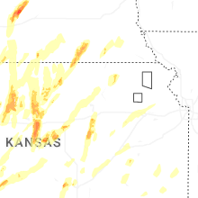


Connect with Interactive Hail Maps