

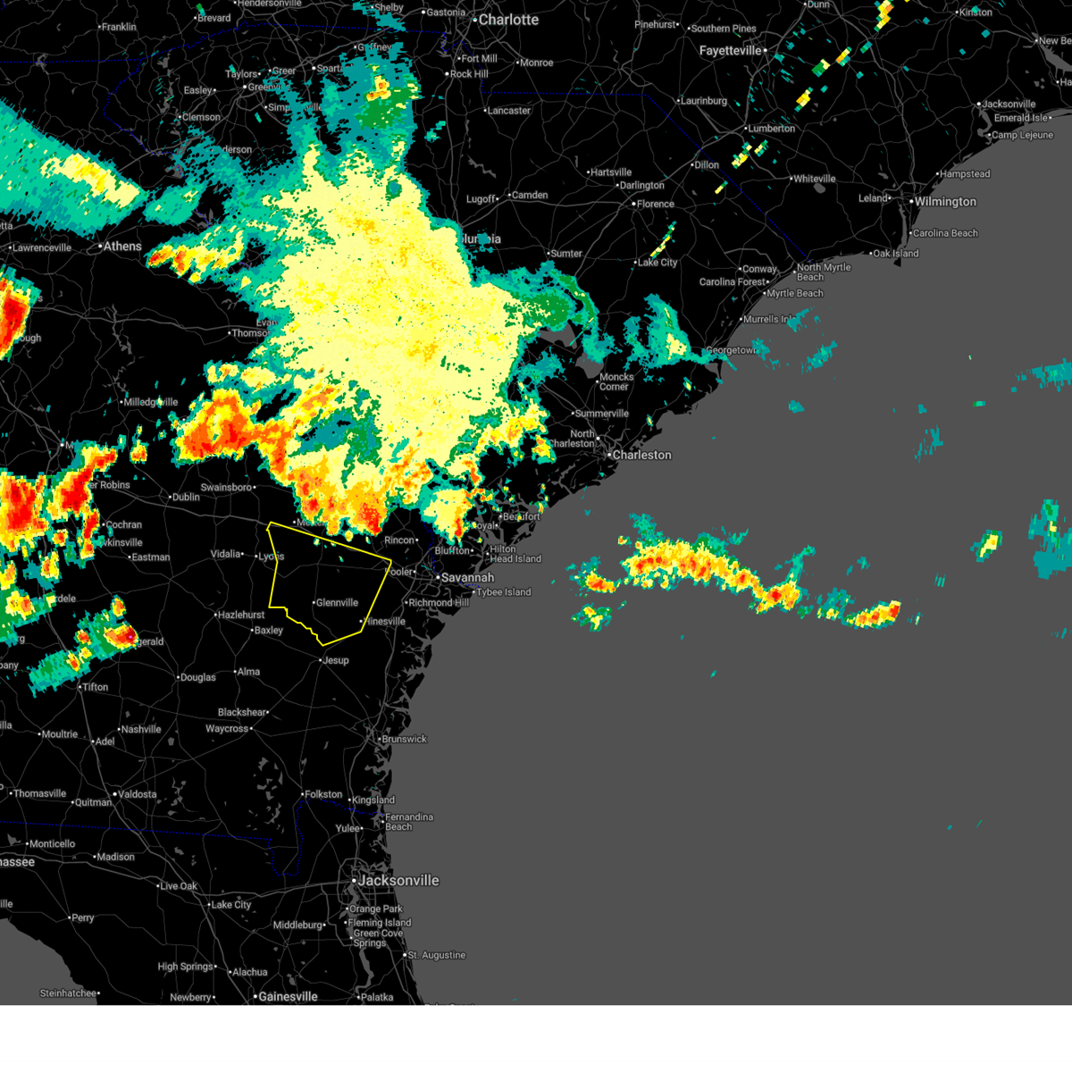
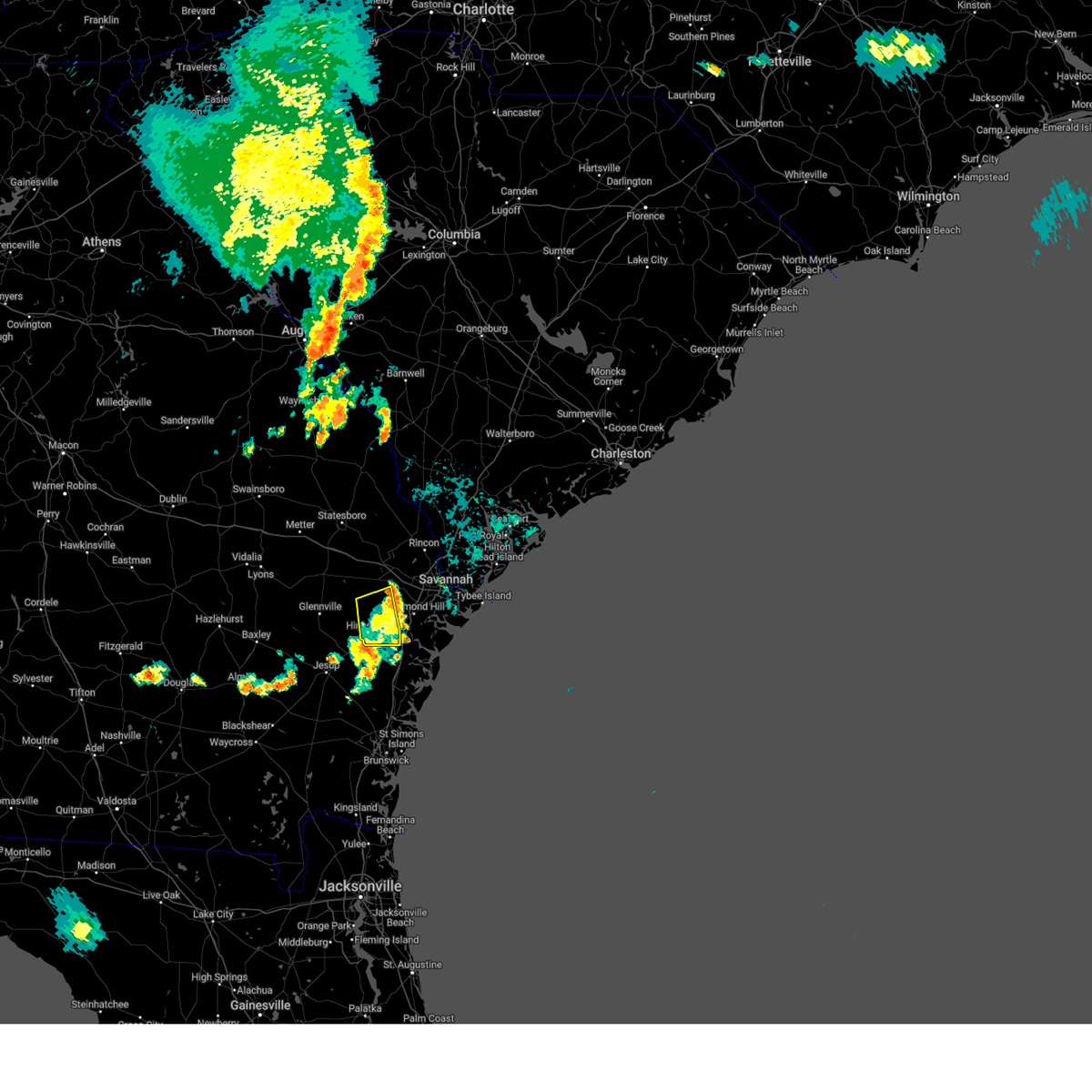
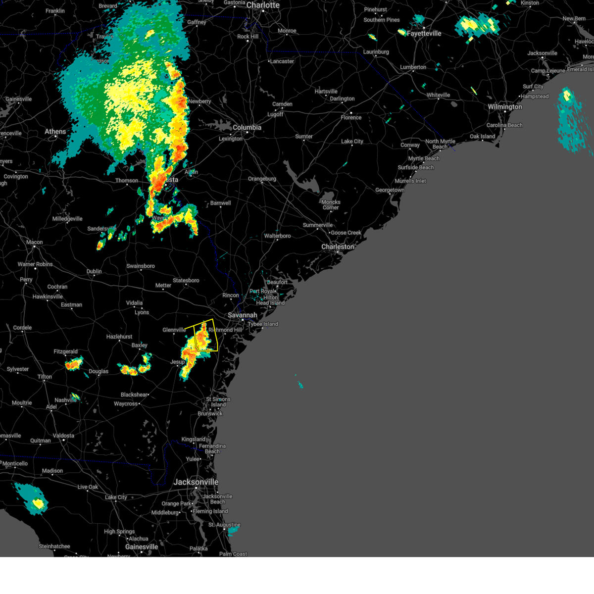
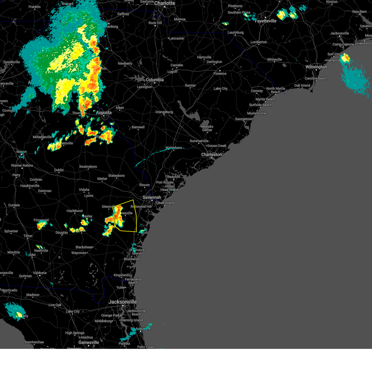
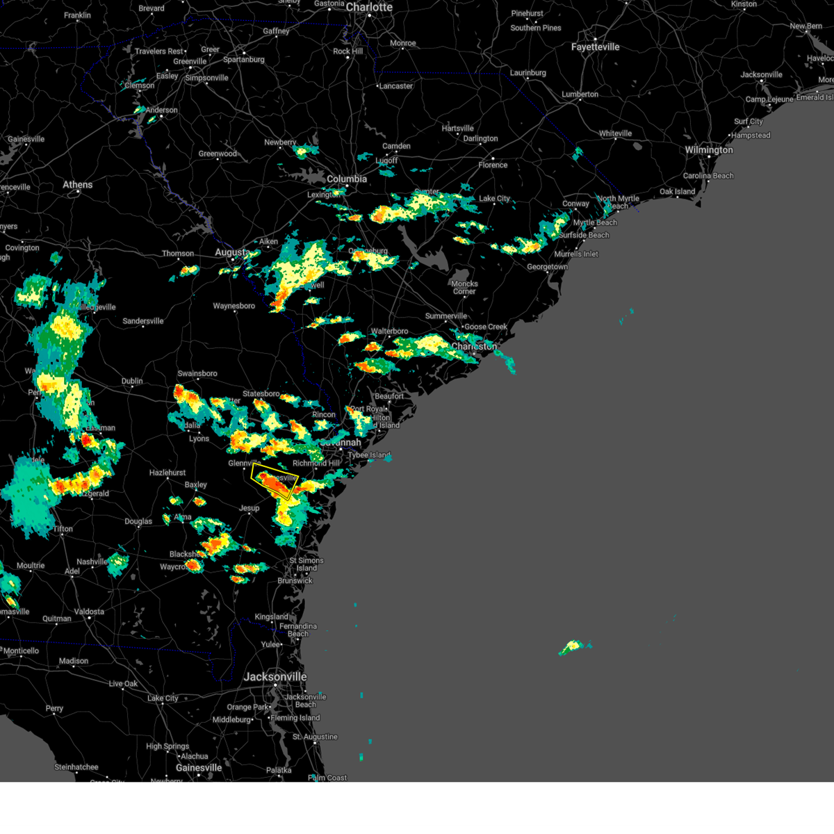
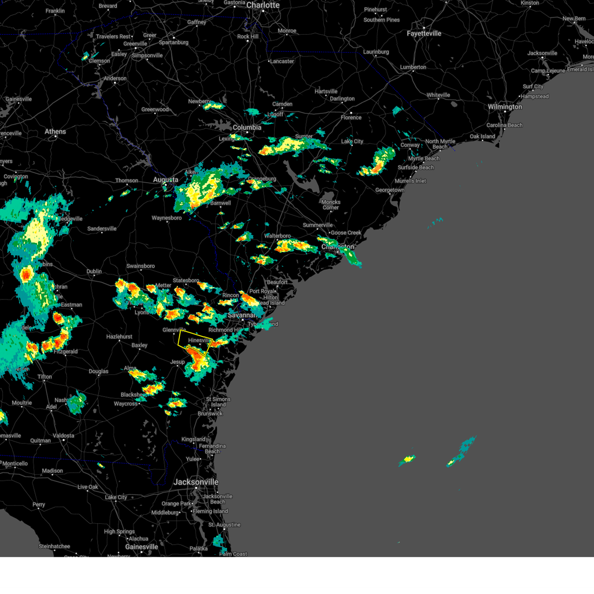
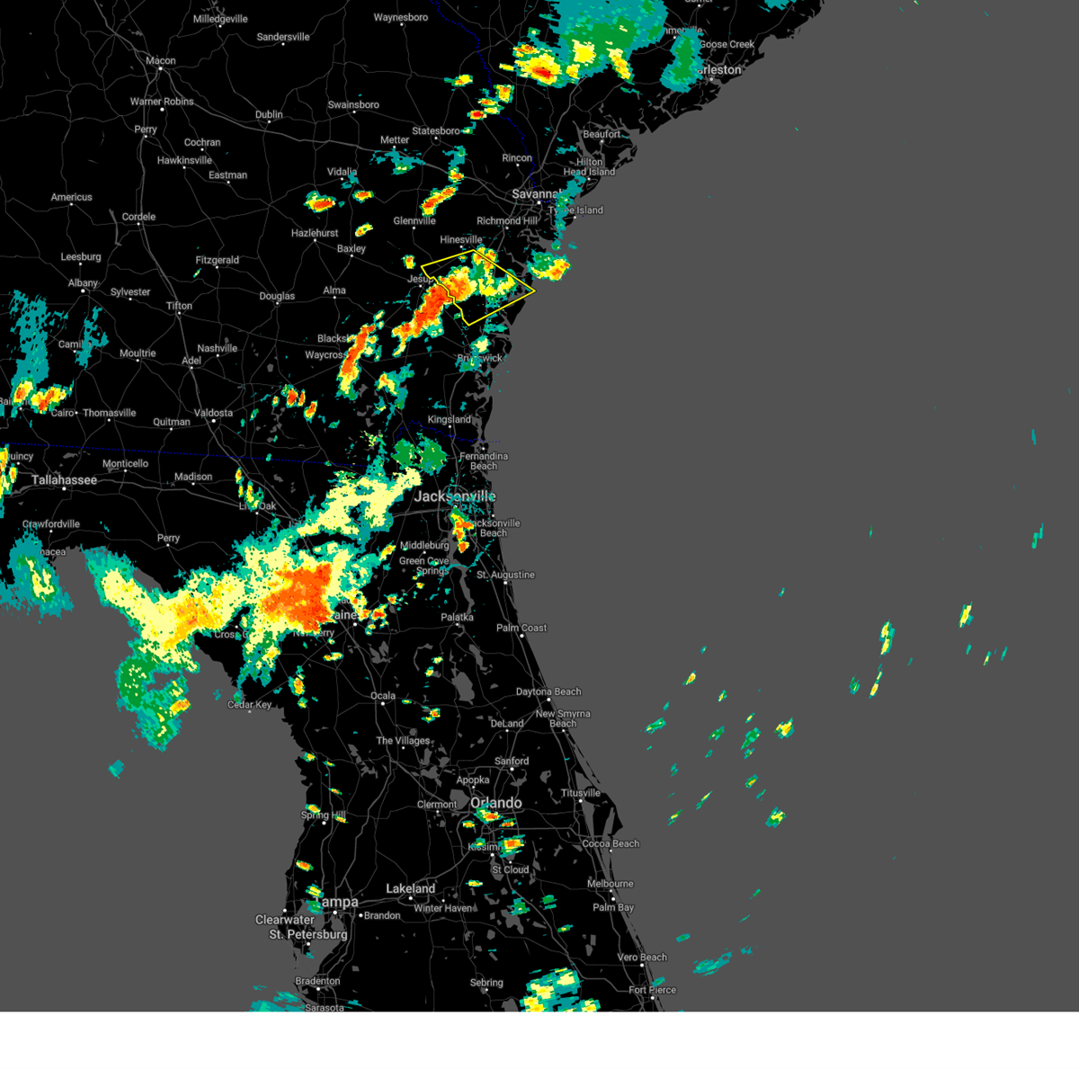
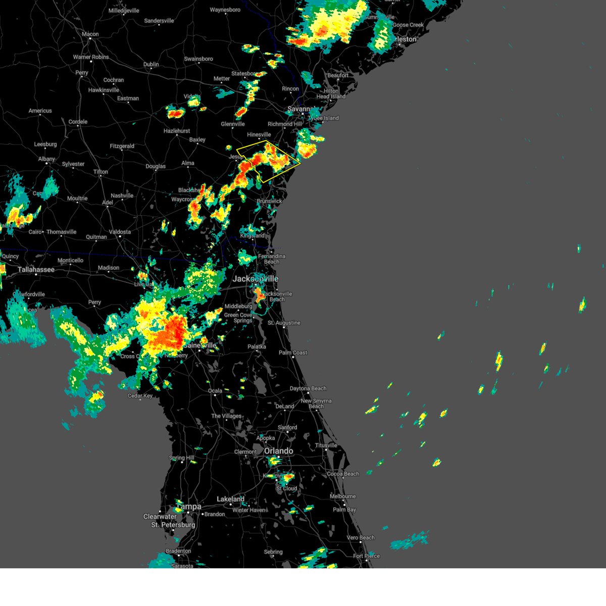
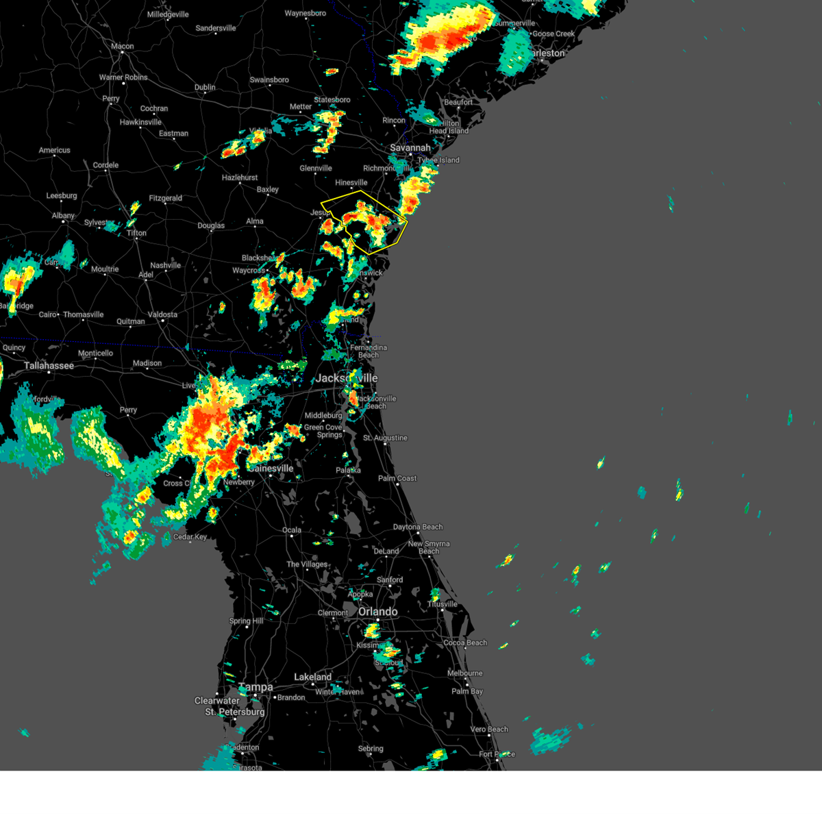
Hail Map for Allenhurst, GA
The Allenhurst, GA area has had 0 reports of on-the-ground hail by trained spotters, and has been under severe weather warnings 12 times during the past 12 months. Doppler radar has detected hail at or near Allenhurst, GA on 58 occasions.
| Name: | Allenhurst, GA |
| Where Located: | 36.6 miles SW of Savannah, GA |
| Map: | Google Map for Allenhurst, GA |
| Population: | 695 |
| Housing Units: | 294 |
| More Info: | Search Google for Allenhurst, GA |
2
The Top Recent Hail Date for Allenhurst, GA is Thursday, May 9, 2024 (9th out of 58)

Hail and Wind Damage Spotted near Allenhurst, GA
| Date / Time | Report Details |
|---|---|
| 6/26/2025 12:05 AM EDT |
 Svrchs the national weather service in charleston has issued a * severe thunderstorm warning for portions of, bryan county in southeastern georgia, bulloch county in southeastern georgia, candler county in southeastern georgia, evans county in southeastern georgia, liberty county in southeastern georgia, long county in southeastern georgia, tattnall county in southeastern georgia, * until 100 am edt. * at 1205 am edt, severe thunderstorms were located along a line from near bay to near metter, moving south at 30 mph (emergency management reported. this line of storms has a history of producing wind damage). Hazards include 60 mph wind gusts. expect damage to roofs, siding, and trees Svrchs the national weather service in charleston has issued a * severe thunderstorm warning for portions of, bryan county in southeastern georgia, bulloch county in southeastern georgia, candler county in southeastern georgia, evans county in southeastern georgia, liberty county in southeastern georgia, long county in southeastern georgia, tattnall county in southeastern georgia, * until 100 am edt. * at 1205 am edt, severe thunderstorms were located along a line from near bay to near metter, moving south at 30 mph (emergency management reported. this line of storms has a history of producing wind damage). Hazards include 60 mph wind gusts. expect damage to roofs, siding, and trees
|
| 6/7/2025 8:44 PM EDT |
 The storms which prompted the warning have weakened below severe limits, and no longer pose an immediate threat to life or property. therefore, the warning will be allowed to expire. however, gusty winds are still possible with these thunderstorms. The storms which prompted the warning have weakened below severe limits, and no longer pose an immediate threat to life or property. therefore, the warning will be allowed to expire. however, gusty winds are still possible with these thunderstorms.
|
| 6/7/2025 8:31 PM EDT |
 the severe thunderstorm warning has been cancelled and is no longer in effect the severe thunderstorm warning has been cancelled and is no longer in effect
|
| 6/7/2025 8:31 PM EDT |
 At 831 pm edt, severe thunderstorms were located along a line from 9 miles south of lanier to near riceboro, moving east at 25 mph (radar indicated). Hazards include 60 mph wind gusts and small hail. Expect damage to roofs, siding, and trees. Locations impacted include, hinesville, fort stewart, mcintosh, walthourville, midway, flemington, allenhurst, trinity, liberty regional medical center and mill creek. At 831 pm edt, severe thunderstorms were located along a line from 9 miles south of lanier to near riceboro, moving east at 25 mph (radar indicated). Hazards include 60 mph wind gusts and small hail. Expect damage to roofs, siding, and trees. Locations impacted include, hinesville, fort stewart, mcintosh, walthourville, midway, flemington, allenhurst, trinity, liberty regional medical center and mill creek.
|
| 6/7/2025 8:31 PM EDT |
 At 831 pm edt, severe thunderstorms were located along a line from 9 miles south of ellabell to near riceboro, moving east at 25 mph (radar indicated). Hazards include 60 mph wind gusts and small hail. Expect damage to roofs, siding, and trees. Locations impacted include, hinesville, fort stewart, mcintosh, walthourville, midway, flemington, allenhurst, trinity, liberty regional medical center and mill creek. At 831 pm edt, severe thunderstorms were located along a line from 9 miles south of ellabell to near riceboro, moving east at 25 mph (radar indicated). Hazards include 60 mph wind gusts and small hail. Expect damage to roofs, siding, and trees. Locations impacted include, hinesville, fort stewart, mcintosh, walthourville, midway, flemington, allenhurst, trinity, liberty regional medical center and mill creek.
|
| 6/7/2025 8:06 PM EDT |
 Svrchs the national weather service in charleston has issued a * severe thunderstorm warning for portions of, bryan county in southeastern georgia, liberty county in southeastern georgia, long county in southeastern georgia, mcintosh county in southeastern georgia, * until 845 pm edt. * at 806 pm edt, severe thunderstorms were located along a line from 10 miles northwest of fort stewart to near tibet, moving east at 25 mph (radar indicated). Hazards include 60 mph wind gusts and small hail. expect damage to roofs, siding, and trees Svrchs the national weather service in charleston has issued a * severe thunderstorm warning for portions of, bryan county in southeastern georgia, liberty county in southeastern georgia, long county in southeastern georgia, mcintosh county in southeastern georgia, * until 845 pm edt. * at 806 pm edt, severe thunderstorms were located along a line from 10 miles northwest of fort stewart to near tibet, moving east at 25 mph (radar indicated). Hazards include 60 mph wind gusts and small hail. expect damage to roofs, siding, and trees
|
| 5/26/2025 6:51 PM EDT |
 The storms which prompted the warning have weakened below severe limits, and no longer pose an immediate threat to life or property. therefore, the warning will be allowed to expire. however, gusty winds and heavy rain are still possible with these thunderstorms. to report severe weather, contact your nearest law enforcement agency. they will send your report to the national weather service office. The storms which prompted the warning have weakened below severe limits, and no longer pose an immediate threat to life or property. therefore, the warning will be allowed to expire. however, gusty winds and heavy rain are still possible with these thunderstorms. to report severe weather, contact your nearest law enforcement agency. they will send your report to the national weather service office.
|
| 5/26/2025 6:33 PM EDT |
 At 633 pm edt, severe thunderstorms were located along a line from 7 miles northeast of donald to over allenhurst, moving north at 15 mph (radar indicated). Hazards include 60 mph wind gusts and small hail. Expect damage to roofs, siding, and trees. Locations impacted include, walthourville, hinesville, allenhurst, gumbranch, gum branch, creek island, mill creek, fort stewart, mcintosh and flemington. At 633 pm edt, severe thunderstorms were located along a line from 7 miles northeast of donald to over allenhurst, moving north at 15 mph (radar indicated). Hazards include 60 mph wind gusts and small hail. Expect damage to roofs, siding, and trees. Locations impacted include, walthourville, hinesville, allenhurst, gumbranch, gum branch, creek island, mill creek, fort stewart, mcintosh and flemington.
|
| 5/26/2025 6:15 PM EDT |
 Svrchs the national weather service in charleston has issued a * severe thunderstorm warning for portions of, liberty county in southeastern georgia, long county in southeastern georgia, * until 700 pm edt. * at 615 pm edt, severe thunderstorms were located along a line from near gum branch to over walthourville, moving north at 15 mph (radar indicated). Hazards include 60 mph wind gusts and small hail. expect damage to roofs, siding, and trees Svrchs the national weather service in charleston has issued a * severe thunderstorm warning for portions of, liberty county in southeastern georgia, long county in southeastern georgia, * until 700 pm edt. * at 615 pm edt, severe thunderstorms were located along a line from near gum branch to over walthourville, moving north at 15 mph (radar indicated). Hazards include 60 mph wind gusts and small hail. expect damage to roofs, siding, and trees
|
| 8/2/2024 3:53 PM EDT |
 the severe thunderstorm warning has been cancelled and is no longer in effect the severe thunderstorm warning has been cancelled and is no longer in effect
|
| 8/2/2024 3:44 PM EDT |
 At 344 pm edt, severe thunderstorms were located along a line extending from near tibet to near shellman bluff, moving east at 5 mph (radar indicated). Hazards include 60 mph wind gusts. Expect damage to trees and powerlines. locations impacted include: ludowici, tibet, jones, walthourville, riceboro, allenhurst, harris neck, eulonia, south newport, cox, townsend, crescent, shellman bluff, retreat, and pine harbor. This warning includes i-95 in georgia between mile markers 53 and 73. At 344 pm edt, severe thunderstorms were located along a line extending from near tibet to near shellman bluff, moving east at 5 mph (radar indicated). Hazards include 60 mph wind gusts. Expect damage to trees and powerlines. locations impacted include: ludowici, tibet, jones, walthourville, riceboro, allenhurst, harris neck, eulonia, south newport, cox, townsend, crescent, shellman bluff, retreat, and pine harbor. This warning includes i-95 in georgia between mile markers 53 and 73.
|
| 8/2/2024 3:25 PM EDT |
 Svrchs the national weather service in charleston has issued a * severe thunderstorm warning for portions of, liberty county in southeastern georgia, mcintosh county in southeastern georgia, long county in southeastern georgia, * until 430 pm edt. * at 325 pm edt, severe thunderstorms were located along a line extending from near tibet to shellman bluff, moving southeast at 15 mph (radar indicated). Hazards include 60 mph wind gusts and quarter size hail. Minor hail damage to vehicles is possible. expect wind damage to trees and powerlines. locations impacted include: darien, ludowici, tibet, jones, walthourville, riceboro, allenhurst, harris neck, eulonia, valona, south newport, cox, meridian, townsend, and crescent. This warning includes i-95 in georgia between mile markers 50 and 73. Svrchs the national weather service in charleston has issued a * severe thunderstorm warning for portions of, liberty county in southeastern georgia, mcintosh county in southeastern georgia, long county in southeastern georgia, * until 430 pm edt. * at 325 pm edt, severe thunderstorms were located along a line extending from near tibet to shellman bluff, moving southeast at 15 mph (radar indicated). Hazards include 60 mph wind gusts and quarter size hail. Minor hail damage to vehicles is possible. expect wind damage to trees and powerlines. locations impacted include: darien, ludowici, tibet, jones, walthourville, riceboro, allenhurst, harris neck, eulonia, valona, south newport, cox, meridian, townsend, and crescent. This warning includes i-95 in georgia between mile markers 50 and 73.
|
| 6/10/2024 4:29 PM EDT |
 the severe thunderstorm warning has been cancelled and is no longer in effect the severe thunderstorm warning has been cancelled and is no longer in effect
|
| 6/10/2024 4:29 PM EDT |
 At 428 pm edt, a severe thunderstorm was located over mcintosh, moving east at 35 mph (radar indicated). Hazards include 60 mph wind gusts and quarter size hail. Minor hail damage to vehicles is possible. expect wind damage to trees and powerlines. Locations impacted include: hinesville, ludowici, fort stewart, mcintosh, walthourville, midway, riceboro, flemington, allenhurst, gumbranch, gum branch, and retreat. At 428 pm edt, a severe thunderstorm was located over mcintosh, moving east at 35 mph (radar indicated). Hazards include 60 mph wind gusts and quarter size hail. Minor hail damage to vehicles is possible. expect wind damage to trees and powerlines. Locations impacted include: hinesville, ludowici, fort stewart, mcintosh, walthourville, midway, riceboro, flemington, allenhurst, gumbranch, gum branch, and retreat.
|
| 6/10/2024 4:13 PM EDT |
 At 413 pm edt, a severe thunderstorm was located over fort stewart, moving east at 35 mph (radar indicated). Hazards include 60 mph wind gusts and half dollar size hail. Minor hail damage to vehicles is possible. expect wind damage to trees and powerlines. Locations impacted include: hinesville, ludowici, fort stewart, mcintosh, walthourville, midway, riceboro, flemington, allenhurst, gumbranch, gum branch, donald, and retreat. At 413 pm edt, a severe thunderstorm was located over fort stewart, moving east at 35 mph (radar indicated). Hazards include 60 mph wind gusts and half dollar size hail. Minor hail damage to vehicles is possible. expect wind damage to trees and powerlines. Locations impacted include: hinesville, ludowici, fort stewart, mcintosh, walthourville, midway, riceboro, flemington, allenhurst, gumbranch, gum branch, donald, and retreat.
|
| 6/10/2024 3:58 PM EDT |
 At 357 pm edt, a severe thunderstorm was located near donald, moving east at 35 mph (radar indicated). Hazards include two inch hail and 60 mph wind gusts. People and animals outdoors will be injured. expect hail damage to roofs, siding, windows, and vehicles. expect wind damage to trees and powerlines. Locations impacted include: hinesville, glennville, ludowici, fort stewart, mcintosh, walthourville, midway, riceboro, flemington, allenhurst, gumbranch, gum branch, donald, retreat, and mendes. At 357 pm edt, a severe thunderstorm was located near donald, moving east at 35 mph (radar indicated). Hazards include two inch hail and 60 mph wind gusts. People and animals outdoors will be injured. expect hail damage to roofs, siding, windows, and vehicles. expect wind damage to trees and powerlines. Locations impacted include: hinesville, glennville, ludowici, fort stewart, mcintosh, walthourville, midway, riceboro, flemington, allenhurst, gumbranch, gum branch, donald, retreat, and mendes.
|
| 6/10/2024 3:41 PM EDT |
 Svrchs the national weather service in charleston has issued a * severe thunderstorm warning for portions of, bryan county in southeastern georgia, liberty county in southeastern georgia, long county in southeastern georgia, tattnall county in southeastern georgia, * until 445 pm edt. * at 340 pm edt, a severe thunderstorm was located over glennville, moving east at 35 mph (radar indicated). Hazards include two inch hail and 60 mph wind gusts. People and animals outdoors will be injured. expect hail damage to roofs, siding, windows, and vehicles. expect wind damage to trees and powerlines. Locations impacted include: hinesville, glennville, ludowici, fort stewart, mcintosh, walthourville, midway, riceboro, flemington, allenhurst, gumbranch, gum branch, donald, retreat, and mendes. Svrchs the national weather service in charleston has issued a * severe thunderstorm warning for portions of, bryan county in southeastern georgia, liberty county in southeastern georgia, long county in southeastern georgia, tattnall county in southeastern georgia, * until 445 pm edt. * at 340 pm edt, a severe thunderstorm was located over glennville, moving east at 35 mph (radar indicated). Hazards include two inch hail and 60 mph wind gusts. People and animals outdoors will be injured. expect hail damage to roofs, siding, windows, and vehicles. expect wind damage to trees and powerlines. Locations impacted include: hinesville, glennville, ludowici, fort stewart, mcintosh, walthourville, midway, riceboro, flemington, allenhurst, gumbranch, gum branch, donald, retreat, and mendes.
|
| 5/9/2024 3:33 PM EDT |
 At 332 pm edt, severe thunderstorms were located along a line extending from midway to near tibet, moving east at 55 mph (law enforcement). Hazards include 60 mph wind gusts and penny size hail. at 331 pm, law enforcement reported trees blown down across long county. Expect damage to trees and powerlines. locations impacted include: hinesville, darien, ludowici, tibet, fort stewart, jones, mcintosh, walthourville, midway, riceboro, flemington, allenhurst, gumbranch, harris neck, and eulonia. This warning includes i-95 in georgia between mile markers 47 and 80. At 332 pm edt, severe thunderstorms were located along a line extending from midway to near tibet, moving east at 55 mph (law enforcement). Hazards include 60 mph wind gusts and penny size hail. at 331 pm, law enforcement reported trees blown down across long county. Expect damage to trees and powerlines. locations impacted include: hinesville, darien, ludowici, tibet, fort stewart, jones, mcintosh, walthourville, midway, riceboro, flemington, allenhurst, gumbranch, harris neck, and eulonia. This warning includes i-95 in georgia between mile markers 47 and 80.
|
| 5/9/2024 3:24 PM EDT |
 At 324 pm edt, severe thunderstorms were located along a line extending from mcintosh to near doctortown, moving east at 50 mph (radar indicated). Hazards include 60 mph wind gusts and nickel size hail. Expect damage to trees and powerlines. locations impacted include: hinesville, darien, ludowici, tibet, fort stewart, jones, mcintosh, walthourville, midway, riceboro, flemington, allenhurst, gumbranch, gum branch, and harris neck. This warning includes i-95 in georgia between mile markers 50 and 80. At 324 pm edt, severe thunderstorms were located along a line extending from mcintosh to near doctortown, moving east at 50 mph (radar indicated). Hazards include 60 mph wind gusts and nickel size hail. Expect damage to trees and powerlines. locations impacted include: hinesville, darien, ludowici, tibet, fort stewart, jones, mcintosh, walthourville, midway, riceboro, flemington, allenhurst, gumbranch, gum branch, and harris neck. This warning includes i-95 in georgia between mile markers 50 and 80.
|
| 5/9/2024 3:04 PM EDT |
 Svrchs the national weather service in charleston has issued a * severe thunderstorm warning for portions of, bryan county in southeastern georgia, liberty county in southeastern georgia, mcintosh county in southeastern georgia, long county in southeastern georgia, * until 400 pm edt. * at 303 pm edt, severe thunderstorms were located along a line extending from near donald to near surrency, moving east at 45 mph (radar indicated). Hazards include 60 mph wind gusts and nickel size hail. Expect damage to trees and powerlines. locations impacted include: hinesville, darien, ludowici, tibet, fort stewart, jones, mcintosh, walthourville, midway, riceboro, flemington, allenhurst, gumbranch, gum branch, and harris neck. This warning includes i-95 in georgia between mile markers 50 and 80. Svrchs the national weather service in charleston has issued a * severe thunderstorm warning for portions of, bryan county in southeastern georgia, liberty county in southeastern georgia, mcintosh county in southeastern georgia, long county in southeastern georgia, * until 400 pm edt. * at 303 pm edt, severe thunderstorms were located along a line extending from near donald to near surrency, moving east at 45 mph (radar indicated). Hazards include 60 mph wind gusts and nickel size hail. Expect damage to trees and powerlines. locations impacted include: hinesville, darien, ludowici, tibet, fort stewart, jones, mcintosh, walthourville, midway, riceboro, flemington, allenhurst, gumbranch, gum branch, and harris neck. This warning includes i-95 in georgia between mile markers 50 and 80.
|
| 5/9/2024 3:03 PM EDT |
 Svrchs the national weather service in charleston has issued a * severe thunderstorm warning for portions of, bryan county in southeastern georgia, liberty county in southeastern georgia, mcintosh county in southeastern georgia, chatham county in southeastern georgia, long county in southeastern georgia, * until 400 pm edt. * at 303 pm edt, severe thunderstorms were located along a line extending from near donald to near surrency, moving east at 45 mph (radar indicated). Hazards include 60 mph wind gusts and nickel size hail. Expect damage to trees and powerlines. locations impacted include: hinesville, darien, ludowici, tibet, fort stewart, jones, mcintosh, walthourville, midway, riceboro, flemington, allenhurst, gumbranch, gum branch, and harris neck. This warning includes i-95 in georgia between mile markers 50 and 80. Svrchs the national weather service in charleston has issued a * severe thunderstorm warning for portions of, bryan county in southeastern georgia, liberty county in southeastern georgia, mcintosh county in southeastern georgia, chatham county in southeastern georgia, long county in southeastern georgia, * until 400 pm edt. * at 303 pm edt, severe thunderstorms were located along a line extending from near donald to near surrency, moving east at 45 mph (radar indicated). Hazards include 60 mph wind gusts and nickel size hail. Expect damage to trees and powerlines. locations impacted include: hinesville, darien, ludowici, tibet, fort stewart, jones, mcintosh, walthourville, midway, riceboro, flemington, allenhurst, gumbranch, gum branch, and harris neck. This warning includes i-95 in georgia between mile markers 50 and 80.
|
| 1/9/2024 2:51 PM EST |
 The tornado warning for portions of liberty and long counties will expire at 300 pm est, the storm which prompted the warning has weakened below severe limits, and no longer appears capable of producing a tornado. therefore, the warning will be allowed to expire. a tornado watch remains in effect until 600 pm est for southeastern georgia. remember, a severe thunderstorm warning still remains in effect for portions of liberty and long county. The tornado warning for portions of liberty and long counties will expire at 300 pm est, the storm which prompted the warning has weakened below severe limits, and no longer appears capable of producing a tornado. therefore, the warning will be allowed to expire. a tornado watch remains in effect until 600 pm est for southeastern georgia. remember, a severe thunderstorm warning still remains in effect for portions of liberty and long county.
|
| 1/9/2024 2:42 PM EST |
 At 242 pm est, severe thunderstorms were located along a line extending from near shawnee to allenhurst, moving northeast at 55 mph (radar indicated). Hazards include 60 mph wind gusts. Expect damage to trees and powerlines. locations impacted include: hilton head island, hinesville, pooler, bluffton, richmond hill, ridgeland, tybee island, springfield, darien, tibet, bellinger hill area, savannah international airport, fort stewart, wilmington island, and fort pulaski national monument. this warning includes the following interstates: i-16 between mile markers 139 and 168. i-516 between mile markers 3 and 9. i-95 in south carolina between mile markers 2 and 22. i-95 in georgia between mile markers 50 and 112. hail threat, radar indicated max hail size, <. 75 in wind threat, radar indicated max wind gust, 60 mph. At 242 pm est, severe thunderstorms were located along a line extending from near shawnee to allenhurst, moving northeast at 55 mph (radar indicated). Hazards include 60 mph wind gusts. Expect damage to trees and powerlines. locations impacted include: hilton head island, hinesville, pooler, bluffton, richmond hill, ridgeland, tybee island, springfield, darien, tibet, bellinger hill area, savannah international airport, fort stewart, wilmington island, and fort pulaski national monument. this warning includes the following interstates: i-16 between mile markers 139 and 168. i-516 between mile markers 3 and 9. i-95 in south carolina between mile markers 2 and 22. i-95 in georgia between mile markers 50 and 112. hail threat, radar indicated max hail size, <. 75 in wind threat, radar indicated max wind gust, 60 mph.
|
| 1/9/2024 2:23 PM EST |
 At 223 pm est, a severe thunderstorm capable of producing a tornado was located near doctortown, moving northeast at 55 mph (radar indicated rotation). Hazards include tornado. Flying debris will be dangerous to those caught without shelter. mobile homes will be damaged or destroyed. damage to roofs, windows, and vehicles will occur. tree damage is likely. Locations impacted include: hinesville, ludowici, fort stewart, mcintosh, walthourville, midway, riceboro, flemington, allenhurst, gumbranch, and gum branch. At 223 pm est, a severe thunderstorm capable of producing a tornado was located near doctortown, moving northeast at 55 mph (radar indicated rotation). Hazards include tornado. Flying debris will be dangerous to those caught without shelter. mobile homes will be damaged or destroyed. damage to roofs, windows, and vehicles will occur. tree damage is likely. Locations impacted include: hinesville, ludowici, fort stewart, mcintosh, walthourville, midway, riceboro, flemington, allenhurst, gumbranch, and gum branch.
|
| 1/9/2024 1:57 PM EST |
 At 156 pm est, severe thunderstorms were located along a line extending from near georgia southern to near glennville, moving northeast at 65 mph (radar indicated). Hazards include 70 mph wind gusts. Expect considerable tree damage. damage is likely to mobile homes, roofs, and outbuildings. locations impacted include: hinesville, statesboro, richmond hill, pembroke, ludowici, tibet, fort stewart, mcintosh, lanier, walthourville, midway, guyton, brooklet, riceboro, and flemington. this warning includes the following interstates: i-16 between mile markers 121 and 149. I-95 in georgia between mile markers 74 and 93. At 156 pm est, severe thunderstorms were located along a line extending from near georgia southern to near glennville, moving northeast at 65 mph (radar indicated). Hazards include 70 mph wind gusts. Expect considerable tree damage. damage is likely to mobile homes, roofs, and outbuildings. locations impacted include: hinesville, statesboro, richmond hill, pembroke, ludowici, tibet, fort stewart, mcintosh, lanier, walthourville, midway, guyton, brooklet, riceboro, and flemington. this warning includes the following interstates: i-16 between mile markers 121 and 149. I-95 in georgia between mile markers 74 and 93.
|
| 10/20/2023 4:45 PM EDT |
 At 445 pm edt, a severe thunderstorm was located over sunbury, moving east at 40 mph (radar indicated). Hazards include 60 mph wind gusts and quarter size hail. Minor hail damage to vehicles is possible. expect wind damage to trees and powerlines. locations impacted include: hinesville, jones, mcintosh, walthourville, midway, riceboro, flemington, and allenhurst. hail threat, radar indicated max hail size, 1. 00 in wind threat, radar indicated max wind gust, 60 mph. At 445 pm edt, a severe thunderstorm was located over sunbury, moving east at 40 mph (radar indicated). Hazards include 60 mph wind gusts and quarter size hail. Minor hail damage to vehicles is possible. expect wind damage to trees and powerlines. locations impacted include: hinesville, jones, mcintosh, walthourville, midway, riceboro, flemington, and allenhurst. hail threat, radar indicated max hail size, 1. 00 in wind threat, radar indicated max wind gust, 60 mph.
|
| 10/20/2023 4:29 PM EDT |
 At 428 pm edt, a severe thunderstorm was located over mcintosh, moving east at 35 mph (radar indicated). Hazards include 60 mph wind gusts and quarter size hail. Minor hail damage to vehicles is possible. expect wind damage to trees and powerlines. Locations impacted include: hinesville, fort stewart, jones, mcintosh, walthourville, midway, riceboro, flemington, allenhurst, gumbranch, and gum branch. At 428 pm edt, a severe thunderstorm was located over mcintosh, moving east at 35 mph (radar indicated). Hazards include 60 mph wind gusts and quarter size hail. Minor hail damage to vehicles is possible. expect wind damage to trees and powerlines. Locations impacted include: hinesville, fort stewart, jones, mcintosh, walthourville, midway, riceboro, flemington, allenhurst, gumbranch, and gum branch.
|
| 10/20/2023 4:26 PM EDT |
 At 426 pm edt, a severe thunderstorm was located near mcintosh, moving east at 40 mph (radar indicated). Hazards include 60 mph wind gusts and quarter size hail. Minor hail damage to vehicles is possible. expect wind damage to trees and powerlines. locations impacted include: hinesville, jones, mcintosh, walthourville, midway, riceboro, flemington, allenhurst, harris neck, st. catherines island, south newport, sunbury, belfast, halfmoon landing, and shellman bluff. This warning includes i-95 in georgia between mile markers 65 and 84. At 426 pm edt, a severe thunderstorm was located near mcintosh, moving east at 40 mph (radar indicated). Hazards include 60 mph wind gusts and quarter size hail. Minor hail damage to vehicles is possible. expect wind damage to trees and powerlines. locations impacted include: hinesville, jones, mcintosh, walthourville, midway, riceboro, flemington, allenhurst, harris neck, st. catherines island, south newport, sunbury, belfast, halfmoon landing, and shellman bluff. This warning includes i-95 in georgia between mile markers 65 and 84.
|
| 10/20/2023 4:14 PM EDT |
 At 413 pm edt, a severe thunderstorm was located over hinesville, moving east at 45 mph (radar indicated). Hazards include 60 mph wind gusts and quarter size hail. Minor hail damage to vehicles is possible. expect wind damage to trees and powerlines. Locations impacted include: hinesville, fort stewart, jones, mcintosh, walthourville, midway, riceboro, flemington, allenhurst, gumbranch, gum branch, and donald. At 413 pm edt, a severe thunderstorm was located over hinesville, moving east at 45 mph (radar indicated). Hazards include 60 mph wind gusts and quarter size hail. Minor hail damage to vehicles is possible. expect wind damage to trees and powerlines. Locations impacted include: hinesville, fort stewart, jones, mcintosh, walthourville, midway, riceboro, flemington, allenhurst, gumbranch, gum branch, and donald.
|
| 10/20/2023 4:01 PM EDT |
 At 401 pm edt, a severe thunderstorm was located near donald, moving east at 40 mph (radar indicated). Hazards include 60 mph wind gusts and quarter size hail. Minor hail damage to vehicles is possible. expect wind damage to trees and powerlines. locations impacted include: hinesville, fort stewart, jones, mcintosh, walthourville, midway, riceboro, flemington, allenhurst, gumbranch, gum branch, and donald. hail threat, radar indicated max hail size, 1. 00 in wind threat, radar indicated max wind gust, 60 mph. At 401 pm edt, a severe thunderstorm was located near donald, moving east at 40 mph (radar indicated). Hazards include 60 mph wind gusts and quarter size hail. Minor hail damage to vehicles is possible. expect wind damage to trees and powerlines. locations impacted include: hinesville, fort stewart, jones, mcintosh, walthourville, midway, riceboro, flemington, allenhurst, gumbranch, gum branch, and donald. hail threat, radar indicated max hail size, 1. 00 in wind threat, radar indicated max wind gust, 60 mph.
|
| 8/8/2023 7:23 PM EDT |
 At 723 pm edt, a severe thunderstorm was located near ludowici, moving east at 20 mph (radar indicated). Hazards include 60 mph wind gusts. Expect damage to trees and powerlines. locations impacted include: hinesville, darien, ludowici, tibet, fort stewart, jones, mcintosh, walthourville, midway, riceboro, flemington, allenhurst, gumbranch, gum branch, and harris neck. this warning includes i-95 in georgia between mile markers 50 and 84. hail threat, radar indicated max hail size, <. 75 in wind threat, radar indicated max wind gust, 60 mph. At 723 pm edt, a severe thunderstorm was located near ludowici, moving east at 20 mph (radar indicated). Hazards include 60 mph wind gusts. Expect damage to trees and powerlines. locations impacted include: hinesville, darien, ludowici, tibet, fort stewart, jones, mcintosh, walthourville, midway, riceboro, flemington, allenhurst, gumbranch, gum branch, and harris neck. this warning includes i-95 in georgia between mile markers 50 and 84. hail threat, radar indicated max hail size, <. 75 in wind threat, radar indicated max wind gust, 60 mph.
|
| 6/13/2023 6:15 PM EDT | A 911 call center reported numerous downed power lines in and around the town of walthourvill in liberty county GA, 1.7 miles NE of Allenhurst, GA |
| 6/13/2023 6:13 PM EDT | A 911 call center relayed a report of a large tree branch down on a car on talmadge rd near busbee rd. there were no injuries. time was estimated via radar dat in liberty county GA, 1.7 miles NE of Allenhurst, GA |
| 6/13/2023 6:12 PM EDT | A 911 call center relayed a report of tree down on a car along e b cooper hwy. no injuries were reported. time was estimated via radar dat in liberty county GA, 2 miles NNW of Allenhurst, GA |
| 4/29/2023 5:28 PM EDT | The severe thunderstorm warning for portions of liberty and long counties will expire at 530 pm edt, the storm which prompted the warning has weakened below severe limits, and no longer poses an immediate threat to life or property. therefore, the warning will be allowed to expire. however, small hail and gusty winds are still possible with this thunderstorm. |
| 4/29/2023 5:20 PM EDT |
 At 520 pm edt, a severe thunderstorm was located over walthourville, moving northeast at 45 mph (radar indicated). Hazards include 60 mph wind gusts and quarter size hail. Minor hail damage to vehicles is possible. expect wind damage to trees and powerlines. locations impacted include: hinesville, ludowici, walthourville, allenhurst, gumbranch, and gum branch. hail threat, radar indicated max hail size, 1. 00 in wind threat, radar indicated max wind gust, 60 mph. At 520 pm edt, a severe thunderstorm was located over walthourville, moving northeast at 45 mph (radar indicated). Hazards include 60 mph wind gusts and quarter size hail. Minor hail damage to vehicles is possible. expect wind damage to trees and powerlines. locations impacted include: hinesville, ludowici, walthourville, allenhurst, gumbranch, and gum branch. hail threat, radar indicated max hail size, 1. 00 in wind threat, radar indicated max wind gust, 60 mph.
|
| 4/29/2023 5:01 PM EDT |
 At 500 pm edt, a severe thunderstorm was located near doctortown, moving northeast at 25 mph (radar indicated). Hazards include ping pong ball size hail and 60 mph wind gusts. People and animals outdoors will be injured. expect hail damage to roofs, siding, windows, and vehicles. expect wind damage to trees and powerlines. locations impacted include: hinesville, ludowici, walthourville, allenhurst, gumbranch, and gum branch. hail threat, radar indicated max hail size, 1. 50 in wind threat, radar indicated max wind gust, 60 mph. At 500 pm edt, a severe thunderstorm was located near doctortown, moving northeast at 25 mph (radar indicated). Hazards include ping pong ball size hail and 60 mph wind gusts. People and animals outdoors will be injured. expect hail damage to roofs, siding, windows, and vehicles. expect wind damage to trees and powerlines. locations impacted include: hinesville, ludowici, walthourville, allenhurst, gumbranch, and gum branch. hail threat, radar indicated max hail size, 1. 50 in wind threat, radar indicated max wind gust, 60 mph.
|
| 4/29/2023 4:51 PM EDT |
 At 450 pm edt, a severe thunderstorm was located over doctortown, moving northeast at 30 mph (radar indicated). Hazards include 60 mph wind gusts and half dollar size hail. Minor hail damage to vehicles is possible. expect wind damage to trees and powerlines. locations impacted include: hinesville, ludowici, walthourville, allenhurst, gumbranch, gum branch, and donald. hail threat, radar indicated max hail size, 1. 25 in wind threat, radar indicated max wind gust, 60 mph. At 450 pm edt, a severe thunderstorm was located over doctortown, moving northeast at 30 mph (radar indicated). Hazards include 60 mph wind gusts and half dollar size hail. Minor hail damage to vehicles is possible. expect wind damage to trees and powerlines. locations impacted include: hinesville, ludowici, walthourville, allenhurst, gumbranch, gum branch, and donald. hail threat, radar indicated max hail size, 1. 25 in wind threat, radar indicated max wind gust, 60 mph.
|
| 1/22/2023 7:32 PM EST |
 At 732 pm est, a severe thunderstorm was located over flemington, moving east at 55 mph (radar indicated). Hazards include 60 mph wind gusts. Expect damage to trees and powerlines. locations impacted include: hinesville, ludowici, fort stewart, mcintosh, walthourville, midway, riceboro, flemington, allenhurst, gumbranch and gum branch. this warning includes i-95 in georgia near mile marker 76. hail threat, radar indicated max hail size, <. 75 in wind threat, radar indicated max wind gust, 60 mph. At 732 pm est, a severe thunderstorm was located over flemington, moving east at 55 mph (radar indicated). Hazards include 60 mph wind gusts. Expect damage to trees and powerlines. locations impacted include: hinesville, ludowici, fort stewart, mcintosh, walthourville, midway, riceboro, flemington, allenhurst, gumbranch and gum branch. this warning includes i-95 in georgia near mile marker 76. hail threat, radar indicated max hail size, <. 75 in wind threat, radar indicated max wind gust, 60 mph.
|
| 1/22/2023 7:18 PM EST |
 At 717 pm est, a severe thunderstorm was located near gumbranch, moving northeast at 40 mph (radar indicated). Hazards include 60 mph wind gusts. Expect damage to trees and powerlines. locations impacted include: hinesville, glennville, ludowici, fort stewart, mcintosh, walthourville, midway, riceboro, flemington, allenhurst, gum branch and donald. this warning includes i-95 in georgia near mile marker 76. hail threat, radar indicated max hail size, <. 75 in wind threat, radar indicated max wind gust, 60 mph. At 717 pm est, a severe thunderstorm was located near gumbranch, moving northeast at 40 mph (radar indicated). Hazards include 60 mph wind gusts. Expect damage to trees and powerlines. locations impacted include: hinesville, glennville, ludowici, fort stewart, mcintosh, walthourville, midway, riceboro, flemington, allenhurst, gum branch and donald. this warning includes i-95 in georgia near mile marker 76. hail threat, radar indicated max hail size, <. 75 in wind threat, radar indicated max wind gust, 60 mph.
|
| 1/22/2023 6:55 PM EST |
 At 654 pm est, a severe thunderstorm was located 8 miles north of odum, moving east at 65 mph (radar indicated). Hazards include 60 mph wind gusts. Expect damage to trees and powerlines. locations impacted include: hinesville, glennville, ludowici, fort stewart, mcintosh, walthourville, midway, riceboro, flemington, allenhurst, gumbranch, gum branch, donald and mendes. this warning includes i-95 in georgia near mile marker 76. hail threat, radar indicated max hail size, <. 75 in wind threat, radar indicated max wind gust, 60 mph. At 654 pm est, a severe thunderstorm was located 8 miles north of odum, moving east at 65 mph (radar indicated). Hazards include 60 mph wind gusts. Expect damage to trees and powerlines. locations impacted include: hinesville, glennville, ludowici, fort stewart, mcintosh, walthourville, midway, riceboro, flemington, allenhurst, gumbranch, gum branch, donald and mendes. this warning includes i-95 in georgia near mile marker 76. hail threat, radar indicated max hail size, <. 75 in wind threat, radar indicated max wind gust, 60 mph.
|
| 1/4/2023 2:04 PM EST |
 At 204 pm est, severe thunderstorms were located along a line extending from near midway to near darien, moving northeast at 50 mph (radar indicated). Hazards include 60 mph wind gusts. Expect damage to trees and powerlines. locations impacted include: hinesville, darien, jones, mcintosh, walthourville, midway, riceboro, flemington, allenhurst, harris neck, eulonia, valona, south newport, sunbury and belfast. this warning includes i-95 in georgia between mile markers 50 and 84. hail threat, radar indicated max hail size, <. 75 in wind threat, radar indicated max wind gust, 60 mph. At 204 pm est, severe thunderstorms were located along a line extending from near midway to near darien, moving northeast at 50 mph (radar indicated). Hazards include 60 mph wind gusts. Expect damage to trees and powerlines. locations impacted include: hinesville, darien, jones, mcintosh, walthourville, midway, riceboro, flemington, allenhurst, harris neck, eulonia, valona, south newport, sunbury and belfast. this warning includes i-95 in georgia between mile markers 50 and 84. hail threat, radar indicated max hail size, <. 75 in wind threat, radar indicated max wind gust, 60 mph.
|
| 1/4/2023 1:57 PM EST |
 At 156 pm est, severe thunderstorms were located along a line extending from near allenhurst to 7 miles north of dock junction, moving northeast at 50 mph (radar indicated). Hazards include 60 mph wind gusts. Expect damage to trees and powerlines. locations impacted include: hinesville, darien, ludowici, tibet, jones, mcintosh, walthourville, midway, riceboro, flemington, allenhurst, harris neck, eulonia, valona and south newport. this warning includes i-95 in georgia between mile markers 50 and 84. hail threat, radar indicated max hail size, <. 75 in wind threat, radar indicated max wind gust, 60 mph. At 156 pm est, severe thunderstorms were located along a line extending from near allenhurst to 7 miles north of dock junction, moving northeast at 50 mph (radar indicated). Hazards include 60 mph wind gusts. Expect damage to trees and powerlines. locations impacted include: hinesville, darien, ludowici, tibet, jones, mcintosh, walthourville, midway, riceboro, flemington, allenhurst, harris neck, eulonia, valona and south newport. this warning includes i-95 in georgia between mile markers 50 and 84. hail threat, radar indicated max hail size, <. 75 in wind threat, radar indicated max wind gust, 60 mph.
|
| 1/4/2023 1:43 PM EST |
 At 143 pm est, severe thunderstorms were located along a line extending from near ludowici to near thalmann, moving northeast at 50 mph (radar indicated). Hazards include 60 mph wind gusts. Expect damage to trees and powerlines. locations impacted include: hinesville, darien, ludowici, tibet, jones, mcintosh, walthourville, midway, riceboro, flemington, allenhurst, harris neck, eulonia, valona and south newport. this warning includes i-95 in georgia between mile markers 50 and 84. hail threat, radar indicated max hail size, <. 75 in wind threat, radar indicated max wind gust, 60 mph. At 143 pm est, severe thunderstorms were located along a line extending from near ludowici to near thalmann, moving northeast at 50 mph (radar indicated). Hazards include 60 mph wind gusts. Expect damage to trees and powerlines. locations impacted include: hinesville, darien, ludowici, tibet, jones, mcintosh, walthourville, midway, riceboro, flemington, allenhurst, harris neck, eulonia, valona and south newport. this warning includes i-95 in georgia between mile markers 50 and 84. hail threat, radar indicated max hail size, <. 75 in wind threat, radar indicated max wind gust, 60 mph.
|
| 1/4/2023 1:18 PM EST |
 At 117 pm est, severe thunderstorms were located along a line extending from near screven to hickox, moving northeast at 50 mph (radar indicated). Hazards include 60 mph wind gusts. Expect damage to trees and powerlines. locations impacted include: hinesville, darien, ludowici, tibet, jones, mcintosh, walthourville, midway, riceboro, flemington, allenhurst, harris neck, eulonia, valona and south newport. this warning includes i-95 in georgia between mile markers 50 and 84. hail threat, radar indicated max hail size, <. 75 in wind threat, radar indicated max wind gust, 60 mph. At 117 pm est, severe thunderstorms were located along a line extending from near screven to hickox, moving northeast at 50 mph (radar indicated). Hazards include 60 mph wind gusts. Expect damage to trees and powerlines. locations impacted include: hinesville, darien, ludowici, tibet, jones, mcintosh, walthourville, midway, riceboro, flemington, allenhurst, harris neck, eulonia, valona and south newport. this warning includes i-95 in georgia between mile markers 50 and 84. hail threat, radar indicated max hail size, <. 75 in wind threat, radar indicated max wind gust, 60 mph.
|
| 6/17/2022 10:44 PM EDT |
 At 1044 pm edt, severe thunderstorms were located along a line extending from near skidaway island to near gardi, moving south at 25 mph (radar indicated). Hazards include 60 mph wind gusts and penny size hail. Expect damage to trees and powerlines. locations impacted include: hinesville, richmond hill, darien, ludowici, tibet, coffee bluff, fort stewart, windsor forest, jones, mcintosh, montgomery, walthourville, midway, riceboro and flemington. this warning includes i-95 in georgia between mile markers 50 and 93. hail threat, radar indicated max hail size, 0. 75 in wind threat, radar indicated max wind gust, 60 mph. At 1044 pm edt, severe thunderstorms were located along a line extending from near skidaway island to near gardi, moving south at 25 mph (radar indicated). Hazards include 60 mph wind gusts and penny size hail. Expect damage to trees and powerlines. locations impacted include: hinesville, richmond hill, darien, ludowici, tibet, coffee bluff, fort stewart, windsor forest, jones, mcintosh, montgomery, walthourville, midway, riceboro and flemington. this warning includes i-95 in georgia between mile markers 50 and 93. hail threat, radar indicated max hail size, 0. 75 in wind threat, radar indicated max wind gust, 60 mph.
|
| 6/17/2022 10:32 PM EDT |
 At 1031 pm edt, severe thunderstorms were located along a line extending from near montgomery to near gardi, moving southeast at 30 mph (radar indicated). Hazards include 60 mph wind gusts and nickel size hail. Expect damage to trees and powerlines. locations impacted include: hinesville, pooler, richmond hill, darien, ludowici, tibet, coffee bluff, fort stewart, windsor forest, jones, mcintosh, montgomery, walthourville, bloomingdale and midway. this warning includes the following interstates: i-16 between mile markers 149 and 154. i-95 in georgia between mile markers 50 and 98. hail threat, radar indicated max hail size, 0. 88 in wind threat, radar indicated max wind gust, 60 mph. At 1031 pm edt, severe thunderstorms were located along a line extending from near montgomery to near gardi, moving southeast at 30 mph (radar indicated). Hazards include 60 mph wind gusts and nickel size hail. Expect damage to trees and powerlines. locations impacted include: hinesville, pooler, richmond hill, darien, ludowici, tibet, coffee bluff, fort stewart, windsor forest, jones, mcintosh, montgomery, walthourville, bloomingdale and midway. this warning includes the following interstates: i-16 between mile markers 149 and 154. i-95 in georgia between mile markers 50 and 98. hail threat, radar indicated max hail size, 0. 88 in wind threat, radar indicated max wind gust, 60 mph.
|
| 6/17/2022 10:04 PM EDT |
 At 1004 pm edt, severe thunderstorms were located along a line extending from windsor forest to jesup, moving southeast at 40 mph (radar indicated). Hazards include 60 mph wind gusts and nickel size hail. Expect damage to trees and powerlines. locations impacted include: hinesville, pooler, richmond hill, darien, ludowici, tibet, coffee bluff, fort stewart, windsor forest, jones, mcintosh, montgomery, walthourville, bloomingdale and midway. this warning includes the following interstates: i-16 between mile markers 149 and 154. i-95 in georgia between mile markers 50 and 98. hail threat, radar indicated max hail size, 0. 88 in wind threat, radar indicated max wind gust, 60 mph. At 1004 pm edt, severe thunderstorms were located along a line extending from windsor forest to jesup, moving southeast at 40 mph (radar indicated). Hazards include 60 mph wind gusts and nickel size hail. Expect damage to trees and powerlines. locations impacted include: hinesville, pooler, richmond hill, darien, ludowici, tibet, coffee bluff, fort stewart, windsor forest, jones, mcintosh, montgomery, walthourville, bloomingdale and midway. this warning includes the following interstates: i-16 between mile markers 149 and 154. i-95 in georgia between mile markers 50 and 98. hail threat, radar indicated max hail size, 0. 88 in wind threat, radar indicated max wind gust, 60 mph.
|
| 6/14/2022 2:53 PM EDT |
 The severe thunderstorm warning for portions of bryan, liberty, chatham, beaufort and jasper counties will expire at 300 pm edt, the storm which prompted the warning has moved out of the area. therefore, the warning will be allowed to expire. however, gusty winds are still possible with this thunderstorm. The severe thunderstorm warning for portions of bryan, liberty, chatham, beaufort and jasper counties will expire at 300 pm edt, the storm which prompted the warning has moved out of the area. therefore, the warning will be allowed to expire. however, gusty winds are still possible with this thunderstorm.
|
| 6/14/2022 2:34 PM EDT |
 At 233 pm edt, a severe thunderstorm was located over downtown savannah, moving east at 35 mph (radar indicated). Hazards include 60 mph wind gusts. Expect damage to trees and powerlines. locations impacted include: hilton head island, hinesville, pooler, bluffton, richmond hill, bellinger hill area, downtown savannah, savannah international airport, windsor forest, fort stewart, i-16/i-95 interchange, hunter army airfield, midtown savannah, mcintosh and garden city. this warning includes the following interstates: i-16 between mile markers 153 and 168. i-516 between mile markers 3 and 9. i-95 in georgia between mile markers 86 and 105. hail threat, radar indicated max hail size, <. 75 in wind threat, radar indicated max wind gust, 60 mph. At 233 pm edt, a severe thunderstorm was located over downtown savannah, moving east at 35 mph (radar indicated). Hazards include 60 mph wind gusts. Expect damage to trees and powerlines. locations impacted include: hilton head island, hinesville, pooler, bluffton, richmond hill, bellinger hill area, downtown savannah, savannah international airport, windsor forest, fort stewart, i-16/i-95 interchange, hunter army airfield, midtown savannah, mcintosh and garden city. this warning includes the following interstates: i-16 between mile markers 153 and 168. i-516 between mile markers 3 and 9. i-95 in georgia between mile markers 86 and 105. hail threat, radar indicated max hail size, <. 75 in wind threat, radar indicated max wind gust, 60 mph.
|
| 6/14/2022 2:31 PM EDT |
 At 231 pm edt, severe thunderstorms were located along a line extending from thunderbolt to near doctortown, moving southeast at 10 mph (radar indicated). Hazards include 60 mph wind gusts. Expect damage to trees and powerlines. locations impacted include: hinesville, richmond hill, tybee island, darien, ludowici, tibet, wilmington island, fort pulaski national monument, midtown savannah, coffee bluff, hunter army airfield, downtown savannah, jones, mcintosh and montgomery. this warning includes i-95 in georgia between mile markers 50 and 89. hail threat, radar indicated max hail size, <. 75 in wind threat, radar indicated max wind gust, 60 mph. At 231 pm edt, severe thunderstorms were located along a line extending from thunderbolt to near doctortown, moving southeast at 10 mph (radar indicated). Hazards include 60 mph wind gusts. Expect damage to trees and powerlines. locations impacted include: hinesville, richmond hill, tybee island, darien, ludowici, tibet, wilmington island, fort pulaski national monument, midtown savannah, coffee bluff, hunter army airfield, downtown savannah, jones, mcintosh and montgomery. this warning includes i-95 in georgia between mile markers 50 and 89. hail threat, radar indicated max hail size, <. 75 in wind threat, radar indicated max wind gust, 60 mph.
|
| 6/14/2022 2:23 PM EDT |
 At 221 pm edt, severe thunderstorms were located along a line extending from bluffton to 9 miles northwest of fort stewart, moving southeast at 30 mph (radar indicated). Hazards include 60 mph wind gusts. Expect damage to trees and powerlines. locations impacted include: hilton head island, hinesville, pooler, bluffton, richmond hill, pembroke, bellinger hill area, downtown savannah, savannah international airport, windsor forest, fort stewart, i-16/i-95 interchange, hunter army airfield, godley station and midtown savannah. this warning includes the following interstates: i-16 between mile markers 143 and 168. i-516 between mile markers 3 and 9. i-95 in south carolina between mile markers 2 and 10. i-95 in georgia between mile markers 86 and 112. hail threat, radar indicated max hail size, <. 75 in wind threat, radar indicated max wind gust, 60 mph. At 221 pm edt, severe thunderstorms were located along a line extending from bluffton to 9 miles northwest of fort stewart, moving southeast at 30 mph (radar indicated). Hazards include 60 mph wind gusts. Expect damage to trees and powerlines. locations impacted include: hilton head island, hinesville, pooler, bluffton, richmond hill, pembroke, bellinger hill area, downtown savannah, savannah international airport, windsor forest, fort stewart, i-16/i-95 interchange, hunter army airfield, godley station and midtown savannah. this warning includes the following interstates: i-16 between mile markers 143 and 168. i-516 between mile markers 3 and 9. i-95 in south carolina between mile markers 2 and 10. i-95 in georgia between mile markers 86 and 112. hail threat, radar indicated max hail size, <. 75 in wind threat, radar indicated max wind gust, 60 mph.
|
| 6/14/2022 1:56 PM EDT |
 At 156 pm edt, severe thunderstorms were located along a line extending from hardeeville to near daisy, moving southeast at 20 mph (radar indicated). Hazards include 60 mph wind gusts and quarter size hail. Minor hail damage to vehicles is possible. expect wind damage to trees and powerlines. locations impacted include: hilton head island, hinesville, pooler, bluffton, richmond hill, pembroke, bellinger hill area, downtown savannah, savannah international airport, windsor forest, fort stewart, i-16/i-95 interchange, hunter army airfield, godley station and midtown savannah. this warning includes the following interstates: i-16 between mile markers 135 and 168. i-516 between mile markers 3 and 9. i-95 in south carolina between mile markers 2 and 14. i-95 in georgia between mile markers 86 and 112. hail threat, radar indicated max hail size, 1. 00 in wind threat, radar indicated max wind gust, 60 mph. At 156 pm edt, severe thunderstorms were located along a line extending from hardeeville to near daisy, moving southeast at 20 mph (radar indicated). Hazards include 60 mph wind gusts and quarter size hail. Minor hail damage to vehicles is possible. expect wind damage to trees and powerlines. locations impacted include: hilton head island, hinesville, pooler, bluffton, richmond hill, pembroke, bellinger hill area, downtown savannah, savannah international airport, windsor forest, fort stewart, i-16/i-95 interchange, hunter army airfield, godley station and midtown savannah. this warning includes the following interstates: i-16 between mile markers 135 and 168. i-516 between mile markers 3 and 9. i-95 in south carolina between mile markers 2 and 14. i-95 in georgia between mile markers 86 and 112. hail threat, radar indicated max hail size, 1. 00 in wind threat, radar indicated max wind gust, 60 mph.
|
| 5/23/2022 6:06 PM EDT |
 At 605 pm edt, severe thunderstorms were located along a line extending from near ellabell to mcintosh to near tibet, moving northeast at 40 mph (radar indicated). Hazards include 60 mph wind gusts and penny size hail. Expect damage to trees and powerlines. locations impacted include: hinesville, pooler, bluffton, richmond hill, tybee island, darien, tibet, bellinger hill area, savannah international airport, fort stewart, wilmington island, fort pulaski national monument, midtown savannah, downtown savannah and coffee bluff. this warning includes the following interstates: i-16 between mile markers 147 and 168. i-516 between mile markers 3 and 9. i-95 in south carolina between mile markers 2 and 10. i-95 in georgia between mile markers 50 and 112. hail threat, radar indicated max hail size, 0. 75 in wind threat, radar indicated max wind gust, 60 mph. At 605 pm edt, severe thunderstorms were located along a line extending from near ellabell to mcintosh to near tibet, moving northeast at 40 mph (radar indicated). Hazards include 60 mph wind gusts and penny size hail. Expect damage to trees and powerlines. locations impacted include: hinesville, pooler, bluffton, richmond hill, tybee island, darien, tibet, bellinger hill area, savannah international airport, fort stewart, wilmington island, fort pulaski national monument, midtown savannah, downtown savannah and coffee bluff. this warning includes the following interstates: i-16 between mile markers 147 and 168. i-516 between mile markers 3 and 9. i-95 in south carolina between mile markers 2 and 10. i-95 in georgia between mile markers 50 and 112. hail threat, radar indicated max hail size, 0. 75 in wind threat, radar indicated max wind gust, 60 mph.
|
| 5/15/2022 4:23 PM EDT |
 At 422 pm edt, a severe thunderstorm was located near ellabell, moving northeast at 15 mph (radar indicated). Hazards include 60 mph wind gusts and quarter size hail. Minor hail damage to vehicles is possible. expect wind damage to trees and powerlines. locations impacted include: hinesville, fort stewart, mcintosh, walthourville, flemington, allenhurst, gumbranch and gum branch. hail threat, radar indicated max hail size, 1. 00 in wind threat, radar indicated max wind gust, 60 mph. At 422 pm edt, a severe thunderstorm was located near ellabell, moving northeast at 15 mph (radar indicated). Hazards include 60 mph wind gusts and quarter size hail. Minor hail damage to vehicles is possible. expect wind damage to trees and powerlines. locations impacted include: hinesville, fort stewart, mcintosh, walthourville, flemington, allenhurst, gumbranch and gum branch. hail threat, radar indicated max hail size, 1. 00 in wind threat, radar indicated max wind gust, 60 mph.
|
| 5/15/2022 4:03 PM EDT |
 At 401 pm edt, a severe thunderstorm was located over fort stewart, moving northeast at 15 mph. additional thunderstorms extend back down through long county (radar indicated). Hazards include 60 mph wind gusts and quarter size hail. Minor hail damage to vehicles is possible. expect wind damage to trees and powerlines. locations impacted include: hinesville, ludowici, fort stewart, mcintosh, walthourville, flemington, allenhurst, gumbranch and gum branch. hail threat, radar indicated max hail size, 1. 00 in wind threat, radar indicated max wind gust, 60 mph. At 401 pm edt, a severe thunderstorm was located over fort stewart, moving northeast at 15 mph. additional thunderstorms extend back down through long county (radar indicated). Hazards include 60 mph wind gusts and quarter size hail. Minor hail damage to vehicles is possible. expect wind damage to trees and powerlines. locations impacted include: hinesville, ludowici, fort stewart, mcintosh, walthourville, flemington, allenhurst, gumbranch and gum branch. hail threat, radar indicated max hail size, 1. 00 in wind threat, radar indicated max wind gust, 60 mph.
|
| 5/15/2022 3:43 PM EDT |
 At 342 pm edt, a severe thunderstorm was located near walthourville, moving northeast at 30 mph (radar indicated). Hazards include 60 mph wind gusts and quarter size hail. Minor hail damage to vehicles is possible. expect wind damage to trees and powerlines. locations impacted include: hinesville, ludowici, fort stewart, mcintosh, walthourville, flemington, allenhurst, gumbranch and gum branch. hail threat, radar indicated max hail size, 1. 00 in wind threat, radar indicated max wind gust, 60 mph. At 342 pm edt, a severe thunderstorm was located near walthourville, moving northeast at 30 mph (radar indicated). Hazards include 60 mph wind gusts and quarter size hail. Minor hail damage to vehicles is possible. expect wind damage to trees and powerlines. locations impacted include: hinesville, ludowici, fort stewart, mcintosh, walthourville, flemington, allenhurst, gumbranch and gum branch. hail threat, radar indicated max hail size, 1. 00 in wind threat, radar indicated max wind gust, 60 mph.
|
| 4/5/2022 5:37 PM EDT |
 At 537 pm edt, severe thunderstorms were located along a line extending from near allenhurst to eulonia, moving east at 70 mph (radar indicated). Hazards include 60 mph wind gusts and penny size hail. Expect damage to trees and powerlines. locations impacted include: hinesville, richmond hill, tybee island, darien, ludowici, tibet, fort stewart, wilmington island, fort pulaski national monument, midtown savannah, downtown savannah, coffee bluff, hunter army airfield, jones and mcintosh. this warning includes the following interstates: i-516 between mile markers 3 and 4. I-95 in georgia between mile markers 48 and 97. At 537 pm edt, severe thunderstorms were located along a line extending from near allenhurst to eulonia, moving east at 70 mph (radar indicated). Hazards include 60 mph wind gusts and penny size hail. Expect damage to trees and powerlines. locations impacted include: hinesville, richmond hill, tybee island, darien, ludowici, tibet, fort stewart, wilmington island, fort pulaski national monument, midtown savannah, downtown savannah, coffee bluff, hunter army airfield, jones and mcintosh. this warning includes the following interstates: i-516 between mile markers 3 and 4. I-95 in georgia between mile markers 48 and 97.
|
| 4/5/2022 5:21 PM EDT |
 At 521 pm edt, severe thunderstorms were located along a line extending from doctortown to near everett, moving east at 80 mph (radar indicated). Hazards include 60 mph wind gusts and penny size hail. Expect damage to trees and powerlines. locations impacted include: hinesville, pooler, richmond hill, tybee island, darien, ludowici, tibet, fort stewart, wilmington island, fort pulaski national monument, midtown savannah, downtown savannah, coffee bluff, hunter army airfield and jones. this warning includes the following interstates: i-16 between mile markers 159 and 168. i-516 between mile markers 3 and 6. i-95 in georgia between mile markers 50 and 100. hail threat, radar indicated max hail size, 0. 75 in wind threat, radar indicated max wind gust, 60 mph. At 521 pm edt, severe thunderstorms were located along a line extending from doctortown to near everett, moving east at 80 mph (radar indicated). Hazards include 60 mph wind gusts and penny size hail. Expect damage to trees and powerlines. locations impacted include: hinesville, pooler, richmond hill, tybee island, darien, ludowici, tibet, fort stewart, wilmington island, fort pulaski national monument, midtown savannah, downtown savannah, coffee bluff, hunter army airfield and jones. this warning includes the following interstates: i-16 between mile markers 159 and 168. i-516 between mile markers 3 and 6. i-95 in georgia between mile markers 50 and 100. hail threat, radar indicated max hail size, 0. 75 in wind threat, radar indicated max wind gust, 60 mph.
|
| 4/24/2021 9:33 PM EDT |
 At 932 pm edt, a severe thunderstorm was located near doctortown, moving east at 50 mph (radar indicated). Hazards include 60 mph wind gusts and quarter size hail. Minor hail damage to vehicles is possible. Expect wind damage to trees and powerlines. At 932 pm edt, a severe thunderstorm was located near doctortown, moving east at 50 mph (radar indicated). Hazards include 60 mph wind gusts and quarter size hail. Minor hail damage to vehicles is possible. Expect wind damage to trees and powerlines.
|
| 4/24/2021 1:38 PM EDT |
 The severe thunderstorm warning for liberty, mcintosh and long counties will expire at 145 pm edt, the storm which prompted the warning has moved out of the area. therefore the warning will be allowed to expire. The severe thunderstorm warning for liberty, mcintosh and long counties will expire at 145 pm edt, the storm which prompted the warning has moved out of the area. therefore the warning will be allowed to expire.
|
| 4/24/2021 1:08 PM EDT |
 At 107 pm edt, a severe thunderstorm was located near ludowici, moving east at 35 mph (radar indicated). Hazards include 60 mph wind gusts and penny size hail. Expect damage to trees and powerlines. locations impacted include, hinesville, ludowici, tibet, fort stewart, jones, mcintosh, walthourville, midway, riceboro, flemington, allenhurst, townsend and retreat. This warning includes i-95 in georgia between mile markers 71 and 79. At 107 pm edt, a severe thunderstorm was located near ludowici, moving east at 35 mph (radar indicated). Hazards include 60 mph wind gusts and penny size hail. Expect damage to trees and powerlines. locations impacted include, hinesville, ludowici, tibet, fort stewart, jones, mcintosh, walthourville, midway, riceboro, flemington, allenhurst, townsend and retreat. This warning includes i-95 in georgia between mile markers 71 and 79.
|
| 4/24/2021 12:44 PM EDT |
 At 1243 pm edt, a severe thunderstorm was located near jesup, moving northeast at 40 mph (radar indicated). Hazards include 60 mph wind gusts and penny size hail. expect damage to trees and powerlines At 1243 pm edt, a severe thunderstorm was located near jesup, moving northeast at 40 mph (radar indicated). Hazards include 60 mph wind gusts and penny size hail. expect damage to trees and powerlines
|
| 11/30/2020 6:06 AM EST |
 At 606 am est, a severe thunderstorm was located over midway, moving northeast at 55 mph (radar indicated). Hazards include 60 mph wind gusts. expect damage to trees and powerlines At 606 am est, a severe thunderstorm was located over midway, moving northeast at 55 mph (radar indicated). Hazards include 60 mph wind gusts. expect damage to trees and powerlines
|
| 8/18/2020 6:00 PM EDT |
 At 600 pm edt, a severe thunderstorm was located over gum branch, moving south at 10 mph (radar indicated). Hazards include 60 mph wind gusts and quarter size hail. Minor hail damage to vehicles is possible. expect wind damage to trees and powerlines. Locations impacted include, hinesville, ludowici, fort stewart, mcintosh, walthourville, flemington, allenhurst, gumbranch, gum branch and donald. At 600 pm edt, a severe thunderstorm was located over gum branch, moving south at 10 mph (radar indicated). Hazards include 60 mph wind gusts and quarter size hail. Minor hail damage to vehicles is possible. expect wind damage to trees and powerlines. Locations impacted include, hinesville, ludowici, fort stewart, mcintosh, walthourville, flemington, allenhurst, gumbranch, gum branch and donald.
|
| 8/18/2020 5:50 PM EDT |
 At 550 pm edt, a severe thunderstorm was located over gum branch, moving south at 15 mph (radar indicated). Hazards include 60 mph wind gusts and quarter size hail. Minor hail damage to vehicles is possible. expect wind damage to trees and powerlines. Locations impacted include, hinesville, ludowici, fort stewart, mcintosh, walthourville, flemington, allenhurst, gumbranch, gum branch and donald. At 550 pm edt, a severe thunderstorm was located over gum branch, moving south at 15 mph (radar indicated). Hazards include 60 mph wind gusts and quarter size hail. Minor hail damage to vehicles is possible. expect wind damage to trees and powerlines. Locations impacted include, hinesville, ludowici, fort stewart, mcintosh, walthourville, flemington, allenhurst, gumbranch, gum branch and donald.
|
| 8/18/2020 5:28 PM EDT |
 At 527 pm edt, a severe thunderstorm was located near gumbranch, moving south at 10 mph (radar indicated). Hazards include 60 mph wind gusts and quarter size hail. Minor hail damage to vehicles is possible. Expect wind damage to trees and powerlines. At 527 pm edt, a severe thunderstorm was located near gumbranch, moving south at 10 mph (radar indicated). Hazards include 60 mph wind gusts and quarter size hail. Minor hail damage to vehicles is possible. Expect wind damage to trees and powerlines.
|
| 8/11/2020 8:16 PM EDT |
 At 816 pm edt, a severe thunderstorm was located over allenhurst, moving southwest at 10 mph (radar indicated). Hazards include 60 mph wind gusts. Expect damage to trees and powerlines. Locations impacted include, hinesville, fort stewart, walthourville, allenhurst, gumbranch and gum branch. At 816 pm edt, a severe thunderstorm was located over allenhurst, moving southwest at 10 mph (radar indicated). Hazards include 60 mph wind gusts. Expect damage to trees and powerlines. Locations impacted include, hinesville, fort stewart, walthourville, allenhurst, gumbranch and gum branch.
|
| 8/11/2020 8:04 PM EDT |
 At 804 pm edt, a severe thunderstorm was located over hinesville, moving southwest at 15 mph (radar indicated). Hazards include 60 mph wind gusts. Expect damage to trees and powerlines. Locations impacted include, hinesville, fort stewart, mcintosh, walthourville, flemington, allenhurst, gumbranch and gum branch. At 804 pm edt, a severe thunderstorm was located over hinesville, moving southwest at 15 mph (radar indicated). Hazards include 60 mph wind gusts. Expect damage to trees and powerlines. Locations impacted include, hinesville, fort stewart, mcintosh, walthourville, flemington, allenhurst, gumbranch and gum branch.
|
| 8/11/2020 7:33 PM EDT |
 At 733 pm edt, a severe thunderstorm was located near mcintosh, moving southwest at 5 mph (radar indicated). Hazards include 60 mph wind gusts and quarter size hail. Minor hail damage to vehicles is possible. Expect wind damage to trees and powerlines. At 733 pm edt, a severe thunderstorm was located near mcintosh, moving southwest at 5 mph (radar indicated). Hazards include 60 mph wind gusts and quarter size hail. Minor hail damage to vehicles is possible. Expect wind damage to trees and powerlines.
|
| 5/20/2020 7:18 PM EDT |
 At 717 pm edt, a severe thunderstorm was located near gumbranch, moving northeast at 20 mph (radar indicated). Hazards include 60 mph wind gusts and quarter size hail. Minor hail damage to vehicles is possible. expect wind damage to trees and powerlines. locations impacted include, hinesville, richmond hill, fort stewart, mcintosh, walthourville, midway, flemington, allenhurst, gumbranch, gum branch, keller and ellabell. This warning includes i-95 in georgia between mile markers 81 and 92. At 717 pm edt, a severe thunderstorm was located near gumbranch, moving northeast at 20 mph (radar indicated). Hazards include 60 mph wind gusts and quarter size hail. Minor hail damage to vehicles is possible. expect wind damage to trees and powerlines. locations impacted include, hinesville, richmond hill, fort stewart, mcintosh, walthourville, midway, flemington, allenhurst, gumbranch, gum branch, keller and ellabell. This warning includes i-95 in georgia between mile markers 81 and 92.
|
| 5/20/2020 7:03 PM EDT |
 At 702 pm edt, a severe thunderstorm was located near gum branch, moving northeast at 20 mph (radar indicated). Hazards include 60 mph wind gusts and quarter size hail. Minor hail damage to vehicles is possible. Expect wind damage to trees and powerlines. At 702 pm edt, a severe thunderstorm was located near gum branch, moving northeast at 20 mph (radar indicated). Hazards include 60 mph wind gusts and quarter size hail. Minor hail damage to vehicles is possible. Expect wind damage to trees and powerlines.
|
| 4/20/2020 3:50 AM EDT |
 At 350 am edt, a severe thunderstorm was located over jesup, moving northeast at 65 mph (radar indicated). Hazards include 60 mph wind gusts and penny size hail. expect damage to trees and powerlines At 350 am edt, a severe thunderstorm was located over jesup, moving northeast at 65 mph (radar indicated). Hazards include 60 mph wind gusts and penny size hail. expect damage to trees and powerlines
|
| 4/13/2020 7:57 AM EDT |
 At 757 am edt, a severe thunderstorm capable of producing a tornado was located near allenhurst, moving east at 45 mph (radar indicated rotation). Hazards include tornado. Flying debris will be dangerous to those caught without shelter. mobile homes will be damaged or destroyed. damage to roofs, windows, and vehicles will occur. Tree damage is likely. At 757 am edt, a severe thunderstorm capable of producing a tornado was located near allenhurst, moving east at 45 mph (radar indicated rotation). Hazards include tornado. Flying debris will be dangerous to those caught without shelter. mobile homes will be damaged or destroyed. damage to roofs, windows, and vehicles will occur. Tree damage is likely.
|
| 4/13/2020 7:42 AM EDT |
 At 742 am edt, an extremely dangerous tornado was located 2 miles west of ludowici, moving east at 50 mph. this is a particularly dangerous situation. take cover now! (radar indicated rotation). Hazards include damaging tornado. You are in a life-threatening situation. flying debris may be deadly to those caught without shelter. mobile homes will be destroyed. considerable damage to homes, businesses, and vehicles is likely and complete destruction is possible. Locations impacted include, hinesville, ludowici, mcintosh, walthourville, riceboro, flemington and allenhurst. At 742 am edt, an extremely dangerous tornado was located 2 miles west of ludowici, moving east at 50 mph. this is a particularly dangerous situation. take cover now! (radar indicated rotation). Hazards include damaging tornado. You are in a life-threatening situation. flying debris may be deadly to those caught without shelter. mobile homes will be destroyed. considerable damage to homes, businesses, and vehicles is likely and complete destruction is possible. Locations impacted include, hinesville, ludowici, mcintosh, walthourville, riceboro, flemington and allenhurst.
|
| 4/13/2020 7:33 AM EDT |
 At 733 am edt, a severe thunderstorm capable of producing a tornado was located near doctortown, moving east at 50 mph (radar indicated rotation). Hazards include tornado. Flying debris will be dangerous to those caught without shelter. mobile homes will be damaged or destroyed. damage to roofs, windows, and vehicles will occur. Tree damage is likely. At 733 am edt, a severe thunderstorm capable of producing a tornado was located near doctortown, moving east at 50 mph (radar indicated rotation). Hazards include tornado. Flying debris will be dangerous to those caught without shelter. mobile homes will be damaged or destroyed. damage to roofs, windows, and vehicles will occur. Tree damage is likely.
|
| 4/13/2020 7:15 AM EDT |
 At 714 am edt, severe thunderstorms were located along a line extending from blitchton to near odum, moving east at 40 mph (radar indicated). Hazards include 70 mph wind gusts and penny size hail. Expect considerable tree damage. Damage is likely to mobile homes, roofs, and outbuildings. At 714 am edt, severe thunderstorms were located along a line extending from blitchton to near odum, moving east at 40 mph (radar indicated). Hazards include 70 mph wind gusts and penny size hail. Expect considerable tree damage. Damage is likely to mobile homes, roofs, and outbuildings.
|
| 6/22/2019 6:51 AM EDT |
 The severe thunderstorm warning for bryan, evans, liberty, chatham, long and tattnall counties will expire at 700 am edt, the storms which prompted the warning have weakened below severe limits, and no longer pose an immediate threat to life or property. therefore the warning will be allowed to expire. however heavy rain is still possible with these thunderstorms. The severe thunderstorm warning for bryan, evans, liberty, chatham, long and tattnall counties will expire at 700 am edt, the storms which prompted the warning have weakened below severe limits, and no longer pose an immediate threat to life or property. therefore the warning will be allowed to expire. however heavy rain is still possible with these thunderstorms.
|
| 6/22/2019 5:56 AM EDT |
 At 556 am edt, severe thunderstorms were located along a line extending from 8 miles south of springfield to near pembroke to 9 miles north of reidsville, moving southeast at 55 mph (radar indicated). Hazards include 60 mph wind gusts and quarter size hail. Minor hail damage to vehicles is possible. Expect wind damage to trees and powerlines. At 556 am edt, severe thunderstorms were located along a line extending from 8 miles south of springfield to near pembroke to 9 miles north of reidsville, moving southeast at 55 mph (radar indicated). Hazards include 60 mph wind gusts and quarter size hail. Minor hail damage to vehicles is possible. Expect wind damage to trees and powerlines.
|
| 6/5/2019 6:32 PM EDT |
 At 631 pm edt, severe thunderstorms were located along a line extending from 9 miles southeast of pembroke to 6 miles northwest of ludowici, moving southeast at 15 mph (radar indicated). Hazards include 60 mph wind gusts and quarter size hail. Minor hail damage to vehicles is possible. Expect wind damage to trees and powerlines. At 631 pm edt, severe thunderstorms were located along a line extending from 9 miles southeast of pembroke to 6 miles northwest of ludowici, moving southeast at 15 mph (radar indicated). Hazards include 60 mph wind gusts and quarter size hail. Minor hail damage to vehicles is possible. Expect wind damage to trees and powerlines.
|
| 5/12/2019 3:12 PM EDT |
 At 312 pm edt, severe thunderstorms were located along a line extending from 7 miles south of richmond hill to near tibet, moving northeast at 20 mph (radar indicated). Hazards include 60 mph wind gusts and penny size hail. expect damage to trees and powerlines At 312 pm edt, severe thunderstorms were located along a line extending from 7 miles south of richmond hill to near tibet, moving northeast at 20 mph (radar indicated). Hazards include 60 mph wind gusts and penny size hail. expect damage to trees and powerlines
|
| 4/19/2019 12:27 PM EDT |
 At 1225 pm edt, severe thunderstorms were located along a line extending from near bay to 10 miles east of hinesville to near dock junction, moving northeast at 45 mph (radar indicated). Hazards include 60 mph wind gusts. Expect damage to trees and powerlines. locations impacted include, savannah, hinesville, statesboro, pooler, richmond hill, sylvania, springfield and pembroke. this warning includes, i-16 between mile markers 119 and 168. i-516 between mile markers 3 and 9. I-95 in georgia between mile markers 50 and 112. At 1225 pm edt, severe thunderstorms were located along a line extending from near bay to 10 miles east of hinesville to near dock junction, moving northeast at 45 mph (radar indicated). Hazards include 60 mph wind gusts. Expect damage to trees and powerlines. locations impacted include, savannah, hinesville, statesboro, pooler, richmond hill, sylvania, springfield and pembroke. this warning includes, i-16 between mile markers 119 and 168. i-516 between mile markers 3 and 9. I-95 in georgia between mile markers 50 and 112.
|
| 4/19/2019 12:09 PM EDT |
 At 1208 pm edt, severe thunderstorms were located along a line extending from 6 miles west of pembroke to near tibet to 12 miles east of nahunta, moving northeast at 45 mph (radar indicated). Hazards include 60 mph wind gusts. expect damage to trees and powerlines At 1208 pm edt, severe thunderstorms were located along a line extending from 6 miles west of pembroke to near tibet to 12 miles east of nahunta, moving northeast at 45 mph (radar indicated). Hazards include 60 mph wind gusts. expect damage to trees and powerlines
|
| 4/19/2019 12:06 PM EDT | The county warning point reports a tree down on godfrey roa in long county GA, 2.8 miles NNE of Allenhurst, GA |
| 4/19/2019 11:48 AM EDT |
 At 1148 am edt, severe thunderstorms were located along a line extending from 8 miles southeast of metter to near gardi, moving northeast at 55 mph (radar indicated). Hazards include 60 mph wind gusts. Expect damage to trees and powerlines. locations impacted include, hinesville, statesboro, reidsville, metter, millen, sylvania, claxton and pembroke. This warning includes i-16 between mile markers 96 and 139. At 1148 am edt, severe thunderstorms were located along a line extending from 8 miles southeast of metter to near gardi, moving northeast at 55 mph (radar indicated). Hazards include 60 mph wind gusts. Expect damage to trees and powerlines. locations impacted include, hinesville, statesboro, reidsville, metter, millen, sylvania, claxton and pembroke. This warning includes i-16 between mile markers 96 and 139.
|
| 4/19/2019 11:32 AM EDT |
 At 1131 am edt, severe thunderstorms were located along a line extending from 8 miles north of reidsville to 7 miles southeast of patterson, moving northeast at 50 mph (radar indicated). Hazards include 60 mph wind gusts. Expect damage to trees and powerlines. locations impacted include, hinesville, statesboro, reidsville, metter, millen, sylvania, claxton and pembroke. This warning includes i-16 between mile markers 96 and 139. At 1131 am edt, severe thunderstorms were located along a line extending from 8 miles north of reidsville to 7 miles southeast of patterson, moving northeast at 50 mph (radar indicated). Hazards include 60 mph wind gusts. Expect damage to trees and powerlines. locations impacted include, hinesville, statesboro, reidsville, metter, millen, sylvania, claxton and pembroke. This warning includes i-16 between mile markers 96 and 139.
|
| 4/19/2019 11:14 AM EDT |
 At 1111 am edt, severe thunderstorms were located along a line extending from 9 miles south of lyons to 6 miles south of blackshear, moving northeast at 55 mph (radar indicated). Hazards include 60 mph wind gusts. expect damage to trees and powerlines At 1111 am edt, severe thunderstorms were located along a line extending from 9 miles south of lyons to 6 miles south of blackshear, moving northeast at 55 mph (radar indicated). Hazards include 60 mph wind gusts. expect damage to trees and powerlines
|
| 3/3/2019 6:54 PM EST |
 At 652 pm est, a severe thunderstorm was located 9 miles southeast of hinesville, moving east at 50 mph (radar indicated). Hazards include 60 mph wind gusts and quarter size hail. Minor hail damage to vehicles is possible. expect wind damage to trees and powerlines. locations impacted include, jones, mcintosh, walthourville, riceboro, flemington, allenhurst, halfmoon landing and retreat. This warning includes i-95 in georgia between mile markers 67 and 79. At 652 pm est, a severe thunderstorm was located 9 miles southeast of hinesville, moving east at 50 mph (radar indicated). Hazards include 60 mph wind gusts and quarter size hail. Minor hail damage to vehicles is possible. expect wind damage to trees and powerlines. locations impacted include, jones, mcintosh, walthourville, riceboro, flemington, allenhurst, halfmoon landing and retreat. This warning includes i-95 in georgia between mile markers 67 and 79.
|
| 3/3/2019 6:21 PM EST |
 At 621 pm est, a severe thunderstorm was located near jesup, moving east at 40 mph (radar indicated). Hazards include 60 mph wind gusts and quarter size hail. Minor hail damage to vehicles is possible. Expect wind damage to trees and powerlines. At 621 pm est, a severe thunderstorm was located near jesup, moving east at 40 mph (radar indicated). Hazards include 60 mph wind gusts and quarter size hail. Minor hail damage to vehicles is possible. Expect wind damage to trees and powerlines.
|
| 8/13/2018 4:11 PM EDT |
 At 410 pm edt, severe thunderstorms were located along a line extending from 9 miles east of hinesville to near tibet, moving southeast at 15 mph (both liberty and long county warning points reported trees down with these storms). Hazards include 60 mph wind gusts. Expect damage to trees and powerlines. locations impacted include, hinesville, ludowici, tibet, fort stewart, mcintosh, walthourville, riceboro and flemington. This warning includes i-95 in georgia between mile markers 72 and 78. At 410 pm edt, severe thunderstorms were located along a line extending from 9 miles east of hinesville to near tibet, moving southeast at 15 mph (both liberty and long county warning points reported trees down with these storms). Hazards include 60 mph wind gusts. Expect damage to trees and powerlines. locations impacted include, hinesville, ludowici, tibet, fort stewart, mcintosh, walthourville, riceboro and flemington. This warning includes i-95 in georgia between mile markers 72 and 78.
|
| 8/13/2018 3:50 PM EDT |
 At 349 pm edt, severe thunderstorms were located along a line extending from near hinesville to near ludowici, moving east at 20 mph (liberty county warning point reported trees down in walthourville and hinesville with these storms). Hazards include 60 mph wind gusts and penny size hail. Expect damage to trees and powerlines. locations impacted include, hinesville, ludowici, tibet, fort stewart, mcintosh, walthourville, midway and riceboro. This warning includes i-95 in georgia between mile markers 72 and 78. At 349 pm edt, severe thunderstorms were located along a line extending from near hinesville to near ludowici, moving east at 20 mph (liberty county warning point reported trees down in walthourville and hinesville with these storms). Hazards include 60 mph wind gusts and penny size hail. Expect damage to trees and powerlines. locations impacted include, hinesville, ludowici, tibet, fort stewart, mcintosh, walthourville, midway and riceboro. This warning includes i-95 in georgia between mile markers 72 and 78.
|
| 8/13/2018 3:35 PM EDT | Warning point reported powerlines down on sandy run roa in long county GA, 2.4 miles N of Allenhurst, GA |
| 8/13/2018 3:29 PM EDT |
 At 329 pm edt, severe thunderstorms were located along a line extending from fort stewart to near ludowici, moving east at 15 mph (radar indicated). Hazards include 60 mph wind gusts and penny size hail. expect damage to trees and powerlines At 329 pm edt, severe thunderstorms were located along a line extending from fort stewart to near ludowici, moving east at 15 mph (radar indicated). Hazards include 60 mph wind gusts and penny size hail. expect damage to trees and powerlines
|
| 6/2/2018 2:27 PM EDT |
 At 227 pm edt, a severe thunderstorm was located 10 miles northwest of ludowici, moving southeast at 20 mph (radar indicated). Hazards include 60 mph wind gusts and quarter size hail. Minor hail damage to vehicles is possible. Expect wind damage to trees and powerlines. At 227 pm edt, a severe thunderstorm was located 10 miles northwest of ludowici, moving southeast at 20 mph (radar indicated). Hazards include 60 mph wind gusts and quarter size hail. Minor hail damage to vehicles is possible. Expect wind damage to trees and powerlines.
|
| 4/15/2018 3:08 PM EDT |
 The severe thunderstorm warning for bryan, liberty, mcintosh and long counties will expire at 315 pm edt, the storm which prompted the warning has weakened below severe limits, and no longer pose an immediate threat to life or property. therefore the warning will be allowed to expire. however gusty winds between 40 and 50 mph are still possible with this thunderstorm. The severe thunderstorm warning for bryan, liberty, mcintosh and long counties will expire at 315 pm edt, the storm which prompted the warning has weakened below severe limits, and no longer pose an immediate threat to life or property. therefore the warning will be allowed to expire. however gusty winds between 40 and 50 mph are still possible with this thunderstorm.
|
| 4/15/2018 2:46 PM EDT |
 At 245 pm edt, a severe thunderstorm was located 8 miles northeast of tibet, moving northeast at 50 mph (radar indicated). Hazards include 60 mph wind gusts. Expect damage to trees and powerlines. locations impacted include, hinesville, richmond hill, tibet, fort stewart, jones, mcintosh, walthourville and riceboro. This warning includes i-95 in georgia between mile markers 63 and 92. At 245 pm edt, a severe thunderstorm was located 8 miles northeast of tibet, moving northeast at 50 mph (radar indicated). Hazards include 60 mph wind gusts. Expect damage to trees and powerlines. locations impacted include, hinesville, richmond hill, tibet, fort stewart, jones, mcintosh, walthourville and riceboro. This warning includes i-95 in georgia between mile markers 63 and 92.
|
| 4/15/2018 2:26 PM EDT |
 At 226 pm edt, a severe thunderstorm was located 7 miles east of gardi, moving northeast at 50 mph (radar indicated). Hazards include 60 mph wind gusts and nickel size hail. expect damage to trees and powerlines At 226 pm edt, a severe thunderstorm was located 7 miles east of gardi, moving northeast at 50 mph (radar indicated). Hazards include 60 mph wind gusts and nickel size hail. expect damage to trees and powerlines
|
| 7/5/2017 8:37 PM EDT |
 At 836 pm edt, a severe thunderstorm was located 7 miles north of fort stewart, moving northeast at 10 mph (radar indicated). Hazards include 60 mph wind gusts and quarter size hail. Minor hail damage to vehicles is possible. expect wind damage to trees and powerlines. Locations impacted include, hinesville, fort stewart, mcintosh, walthourville, flemington, allenhurst, gumbranch and gum branch. At 836 pm edt, a severe thunderstorm was located 7 miles north of fort stewart, moving northeast at 10 mph (radar indicated). Hazards include 60 mph wind gusts and quarter size hail. Minor hail damage to vehicles is possible. expect wind damage to trees and powerlines. Locations impacted include, hinesville, fort stewart, mcintosh, walthourville, flemington, allenhurst, gumbranch and gum branch.
|
| 7/5/2017 8:14 PM EDT |
 The national weather service in charleston has issued a * severe thunderstorm warning for portions of. bryan county in southeastern georgia. liberty county in southeastern georgia. long county in southeastern georgia. Until 915 pm edt. The national weather service in charleston has issued a * severe thunderstorm warning for portions of. bryan county in southeastern georgia. liberty county in southeastern georgia. long county in southeastern georgia. Until 915 pm edt.
|
| 5/23/2017 8:22 PM EDT |
 At 821 pm edt, a confirmed tornado was located 7 miles north of tibet, moving east at 40 mph (public reported tornado). Hazards include damaging tornado. Flying debris will be dangerous to those caught without shelter. mobile homes will be damaged or destroyed. damage to roofs, windows, and vehicles will occur. tree damage is likely. locations impacted include, hinesville, ludowici, jones, walthourville, riceboro, allenhurst and south newport. This warning includes i-95 in georgia between mile markers 67 and 68. At 821 pm edt, a confirmed tornado was located 7 miles north of tibet, moving east at 40 mph (public reported tornado). Hazards include damaging tornado. Flying debris will be dangerous to those caught without shelter. mobile homes will be damaged or destroyed. damage to roofs, windows, and vehicles will occur. tree damage is likely. locations impacted include, hinesville, ludowici, jones, walthourville, riceboro, allenhurst and south newport. This warning includes i-95 in georgia between mile markers 67 and 68.
|
| 5/23/2017 8:07 PM EDT |
 At 807 pm edt, a severe thunderstorm capable of producing a tornado was located over ludowici, moving east at 30 mph (radar indicated rotation). Hazards include tornado. Flying debris will be dangerous to those caught without shelter. mobile homes will be damaged or destroyed. damage to roofs, windows, and vehicles will occur. tree damage is likely. locations impacted include, hinesville, ludowici, jones, walthourville, riceboro, allenhurst and south newport. This warning includes i-95 in georgia between mile markers 67 and 68. At 807 pm edt, a severe thunderstorm capable of producing a tornado was located over ludowici, moving east at 30 mph (radar indicated rotation). Hazards include tornado. Flying debris will be dangerous to those caught without shelter. mobile homes will be damaged or destroyed. damage to roofs, windows, and vehicles will occur. tree damage is likely. locations impacted include, hinesville, ludowici, jones, walthourville, riceboro, allenhurst and south newport. This warning includes i-95 in georgia between mile markers 67 and 68.
|
| 5/23/2017 7:52 PM EDT |
 At 752 pm edt, a severe thunderstorm capable of producing a tornado was located near jesup, moving east at 40 mph (radar indicated rotation). Hazards include tornado. Flying debris will be dangerous to those caught without shelter. mobile homes will be damaged or destroyed. damage to roofs, windows, and vehicles will occur. Tree damage is likely. At 752 pm edt, a severe thunderstorm capable of producing a tornado was located near jesup, moving east at 40 mph (radar indicated rotation). Hazards include tornado. Flying debris will be dangerous to those caught without shelter. mobile homes will be damaged or destroyed. damage to roofs, windows, and vehicles will occur. Tree damage is likely.
|
| 5/23/2017 4:56 PM EDT |
 At 456 pm edt, a severe thunderstorm capable of producing a tornado was located over hinesville, moving east at 35 mph (radar indicated rotation). Hazards include tornado. Flying debris will be dangerous to those caught without shelter. mobile homes will be damaged or destroyed. damage to roofs, windows, and vehicles will occur. tree damage is likely. locations impacted include, hinesville, fort stewart, mcintosh, walthourville, flemington, allenhurst, gumbranch and gum branch. This warning includes i-95 in georgia between mile markers 77 and 81. At 456 pm edt, a severe thunderstorm capable of producing a tornado was located over hinesville, moving east at 35 mph (radar indicated rotation). Hazards include tornado. Flying debris will be dangerous to those caught without shelter. mobile homes will be damaged or destroyed. damage to roofs, windows, and vehicles will occur. tree damage is likely. locations impacted include, hinesville, fort stewart, mcintosh, walthourville, flemington, allenhurst, gumbranch and gum branch. This warning includes i-95 in georgia between mile markers 77 and 81.
|
| 5/23/2017 4:55 PM EDT |
 The severe thunderstorm warning for liberty and long counties will expire at 500 pm edt, the storm which prompted the warning has moved out of the area. therefore the warning will be allowed to expire. however a tornado watch and flash flood watch remain in effect, and additional very heavy rain and isolated tornadoes are possible this evening. The severe thunderstorm warning for liberty and long counties will expire at 500 pm edt, the storm which prompted the warning has moved out of the area. therefore the warning will be allowed to expire. however a tornado watch and flash flood watch remain in effect, and additional very heavy rain and isolated tornadoes are possible this evening.
|
| 5/23/2017 4:47 PM EDT |
 At 446 pm edt, a severe thunderstorm capable of producing a tornado was located near ludowici, moving east at 35 mph (radar indicated rotation). Hazards include tornado. Flying debris will be dangerous to those caught without shelter. mobile homes will be damaged or destroyed. damage to roofs, windows, and vehicles will occur. Tree damage is likely. At 446 pm edt, a severe thunderstorm capable of producing a tornado was located near ludowici, moving east at 35 mph (radar indicated rotation). Hazards include tornado. Flying debris will be dangerous to those caught without shelter. mobile homes will be damaged or destroyed. damage to roofs, windows, and vehicles will occur. Tree damage is likely.
|
| 5/23/2017 4:29 PM EDT |
 At 429 pm edt, a severe thunderstorm was located 9 miles northwest of ludowici, moving northeast at 55 mph (radar indicated). Hazards include 60 mph wind gusts. expect damage to trees and powerlines At 429 pm edt, a severe thunderstorm was located 9 miles northwest of ludowici, moving northeast at 55 mph (radar indicated). Hazards include 60 mph wind gusts. expect damage to trees and powerlines
|
| 5/13/2017 2:45 PM EDT |
 At 245 pm edt, a severe thunderstorm was located near hinesville, moving east at 35 mph (radar indicated). Hazards include 60 mph wind gusts and nickel size hail. Expect damage to trees and powerlines. locations impacted include, hinesville, richmond hill, fort stewart, mcintosh, walthourville, riceboro, flemington and allenhurst. This warning includes i-95 in georgia between mile markers 72 and 92. At 245 pm edt, a severe thunderstorm was located near hinesville, moving east at 35 mph (radar indicated). Hazards include 60 mph wind gusts and nickel size hail. Expect damage to trees and powerlines. locations impacted include, hinesville, richmond hill, fort stewart, mcintosh, walthourville, riceboro, flemington and allenhurst. This warning includes i-95 in georgia between mile markers 72 and 92.
|
| 5/13/2017 2:35 PM EDT |
 At 235 pm edt, a severe thunderstorm was located near hinesville, moving east at 40 mph (radar indicated). Hazards include 60 mph wind gusts and quarter size hail. Minor hail damage to vehicles is possible. Expect wind damage to trees and powerlines. At 235 pm edt, a severe thunderstorm was located near hinesville, moving east at 40 mph (radar indicated). Hazards include 60 mph wind gusts and quarter size hail. Minor hail damage to vehicles is possible. Expect wind damage to trees and powerlines.
|
| 4/3/2017 3:46 PM EDT |
 At 346 pm edt, a severe thunderstorm was located 8 miles east of hinesville, moving northeast at 25 mph (radar indicated). Hazards include 60 mph wind gusts and quarter size hail. Hail damage to vehicles is expected. expect wind damage to roofs, siding, and trees. locations impacted include, hinesville, fort stewart, mcintosh, walthourville, riceboro, flemington and allenhurst. A tornado watch remains in effect until 900 pm edt for southeastern georgia. At 346 pm edt, a severe thunderstorm was located 8 miles east of hinesville, moving northeast at 25 mph (radar indicated). Hazards include 60 mph wind gusts and quarter size hail. Hail damage to vehicles is expected. expect wind damage to roofs, siding, and trees. locations impacted include, hinesville, fort stewart, mcintosh, walthourville, riceboro, flemington and allenhurst. A tornado watch remains in effect until 900 pm edt for southeastern georgia.
|
| 4/3/2017 3:35 PM EDT |
 At 335 pm edt, a severe thunderstorm was located near hinesville, moving east at 40 mph (radar indicated). Hazards include 60 mph wind gusts and quarter size hail. Hail damage to vehicles is expected. expect wind damage to roofs, siding, and trees. locations impacted include, hinesville, fort stewart, mcintosh, walthourville, riceboro, flemington and allenhurst. A tornado watch remains in effect until 900 pm edt for southeastern georgia. At 335 pm edt, a severe thunderstorm was located near hinesville, moving east at 40 mph (radar indicated). Hazards include 60 mph wind gusts and quarter size hail. Hail damage to vehicles is expected. expect wind damage to roofs, siding, and trees. locations impacted include, hinesville, fort stewart, mcintosh, walthourville, riceboro, flemington and allenhurst. A tornado watch remains in effect until 900 pm edt for southeastern georgia.
|
| 4/3/2017 3:18 PM EDT |
 At 318 pm edt, a severe thunderstorm was located near hinesville, moving northeast at 35 mph (radar indicated). Hazards include 60 mph wind gusts and half dollar size hail. Hail damage to vehicles is expected. expect wind damage to roofs, siding, and trees. locations impacted include, hinesville, ludowici, fort stewart, mcintosh, walthourville, riceboro, flemington and allenhurst. A tornado watch remains in effect until 900 pm edt for southeastern georgia. At 318 pm edt, a severe thunderstorm was located near hinesville, moving northeast at 35 mph (radar indicated). Hazards include 60 mph wind gusts and half dollar size hail. Hail damage to vehicles is expected. expect wind damage to roofs, siding, and trees. locations impacted include, hinesville, ludowici, fort stewart, mcintosh, walthourville, riceboro, flemington and allenhurst. A tornado watch remains in effect until 900 pm edt for southeastern georgia.
|
| 4/3/2017 3:07 PM EDT |
 At 307 pm edt, a severe thunderstorm was located over ludowici, moving northeast at 25 mph (radar indicated). Hazards include 60 mph wind gusts and quarter size hail. Hail damage to vehicles is expected. Expect wind damage to roofs, siding, and trees. At 307 pm edt, a severe thunderstorm was located over ludowici, moving northeast at 25 mph (radar indicated). Hazards include 60 mph wind gusts and quarter size hail. Hail damage to vehicles is expected. Expect wind damage to roofs, siding, and trees.
|
| 1/22/2017 6:35 AM EST |
 At 635 am est, severe thunderstorms were located along a line extending from 10 miles west of springfield to 6 miles northwest of ludowici, moving east at 55 mph (radar indicated). Hazards include 60 mph wind gusts and quarter size hail. Hail damage to vehicles is expected. Expect wind damage to roofs, siding, and trees. At 635 am est, severe thunderstorms were located along a line extending from 10 miles west of springfield to 6 miles northwest of ludowici, moving east at 55 mph (radar indicated). Hazards include 60 mph wind gusts and quarter size hail. Hail damage to vehicles is expected. Expect wind damage to roofs, siding, and trees.
|
| 1/21/2017 3:31 PM EST |
 At 330 pm est, severe thunderstorms were located along a line extending from 14 miles northeast of hampton to near ridgeland to 7 miles east of hinesville, moving east at 65 mph (radar indicated). Hazards include 60 mph wind gusts and penny size hail. Expect damage to roofs, siding, and trees. locations impacted include, hinesville, ridgeland, allendale, springfield, hampton, pembroke, ludowici and yemassee. A tornado watch remains in effect until 700 pm est for southeastern georgia, and southeastern south carolina. At 330 pm est, severe thunderstorms were located along a line extending from 14 miles northeast of hampton to near ridgeland to 7 miles east of hinesville, moving east at 65 mph (radar indicated). Hazards include 60 mph wind gusts and penny size hail. Expect damage to roofs, siding, and trees. locations impacted include, hinesville, ridgeland, allendale, springfield, hampton, pembroke, ludowici and yemassee. A tornado watch remains in effect until 700 pm est for southeastern georgia, and southeastern south carolina.
|
| 1/21/2017 3:06 PM EST |
 At 304 pm est, severe thunderstorms were located along a line extending from 9 miles west of allendale to 12 miles northwest of springfield to 14 miles northwest of ludowici, moving east at 65 mph (radar indicated). Hazards include 60 mph wind gusts and penny size hail. expect damage to roofs, siding, and trees At 304 pm est, severe thunderstorms were located along a line extending from 9 miles west of allendale to 12 miles northwest of springfield to 14 miles northwest of ludowici, moving east at 65 mph (radar indicated). Hazards include 60 mph wind gusts and penny size hail. expect damage to roofs, siding, and trees
|
| 9/2/2016 3:39 AM EDT |
 At 338 am edt, a severe thunderstorm capable of producing a tornado was located 9 miles southeast of hinesville, moving north at 30 mph (radar indicated rotation). Hazards include tornado. Flying debris will be dangerous to those caught without shelter. mobile homes will be damaged or destroyed. damage to roofs, windows, and vehicles will occur. tree damage is likely. Locations impacted include, hinesville, fort stewart, jones, mcintosh, walthourville, riceboro, flemington and allenhurst. At 338 am edt, a severe thunderstorm capable of producing a tornado was located 9 miles southeast of hinesville, moving north at 30 mph (radar indicated rotation). Hazards include tornado. Flying debris will be dangerous to those caught without shelter. mobile homes will be damaged or destroyed. damage to roofs, windows, and vehicles will occur. tree damage is likely. Locations impacted include, hinesville, fort stewart, jones, mcintosh, walthourville, riceboro, flemington and allenhurst.
|
| 9/2/2016 3:23 AM EDT |
 At 323 am edt, a severe thunderstorm capable of producing a tornado was located near tibet, moving north at 35 mph (radar indicated rotation). Hazards include tornado. Flying debris will be dangerous to those caught without shelter. mobile homes will be damaged or destroyed. damage to roofs, windows, and vehicles will occur. Tree damage is likely. At 323 am edt, a severe thunderstorm capable of producing a tornado was located near tibet, moving north at 35 mph (radar indicated rotation). Hazards include tornado. Flying debris will be dangerous to those caught without shelter. mobile homes will be damaged or destroyed. damage to roofs, windows, and vehicles will occur. Tree damage is likely.
|
| 7/20/2016 6:10 PM EDT |
 The severe thunderstorm warning for liberty county will expire at 615 pm edt, the storms which prompted the warning have weakened below severe limits, and no longer pose an immediate threat to life or property. therefore the warning will be allowed to expire. however gusty winds are still possible with these thunderstorms. to report severe weather, contact your nearest law enforcement agency. they will relay your report to the national weather service charleston. The severe thunderstorm warning for liberty county will expire at 615 pm edt, the storms which prompted the warning have weakened below severe limits, and no longer pose an immediate threat to life or property. therefore the warning will be allowed to expire. however gusty winds are still possible with these thunderstorms. to report severe weather, contact your nearest law enforcement agency. they will relay your report to the national weather service charleston.
|
| 7/20/2016 5:52 PM EDT |
 At 552 pm edt, severe thunderstorms were located along a line extending from near fort stewart to near hinesville, moving southwest at 20 mph (radar indicated). Hazards include 60 mph wind gusts. Expect damage to roofs. siding. and trees. Locations impacted include, hinesville, fort stewart, mcintosh, walthourville, flemington, allenhurst, gumbranch and gum branch. At 552 pm edt, severe thunderstorms were located along a line extending from near fort stewart to near hinesville, moving southwest at 20 mph (radar indicated). Hazards include 60 mph wind gusts. Expect damage to roofs. siding. and trees. Locations impacted include, hinesville, fort stewart, mcintosh, walthourville, flemington, allenhurst, gumbranch and gum branch.
|
| 7/20/2016 5:41 PM EDT |
 At 541 pm edt, severe thunderstorms were located along a line extending from 9 miles west of richmond hill to near hinesville, moving west at 15 mph (radar indicated). Hazards include 60 mph wind gusts. Expect damage to roofs. siding. and trees. Locations impacted include, hinesville, fort stewart, mcintosh, walthourville, flemington, allenhurst, gumbranch and gum branch. At 541 pm edt, severe thunderstorms were located along a line extending from 9 miles west of richmond hill to near hinesville, moving west at 15 mph (radar indicated). Hazards include 60 mph wind gusts. Expect damage to roofs. siding. and trees. Locations impacted include, hinesville, fort stewart, mcintosh, walthourville, flemington, allenhurst, gumbranch and gum branch.
|
| 7/20/2016 5:13 PM EDT |
 At 513 pm edt, severe thunderstorms were located along a line extending from near richmond hill to 11 miles east of hinesville, moving southwest at 10 mph (radar indicated). Hazards include 60 mph wind gusts. Expect damage to roofs. siding. And trees. At 513 pm edt, severe thunderstorms were located along a line extending from near richmond hill to 11 miles east of hinesville, moving southwest at 10 mph (radar indicated). Hazards include 60 mph wind gusts. Expect damage to roofs. siding. And trees.
|
| 7/14/2016 2:57 PM EDT |
 The severe thunderstorm warning for liberty county will expire at 300 pm edt, the storm which prompted the warning has moved out of the area. therefore the warning will be allowed to expire. to report severe weather, contact your nearest law enforcement agency. they will relay your report to the national weather service charleston. The severe thunderstorm warning for liberty county will expire at 300 pm edt, the storm which prompted the warning has moved out of the area. therefore the warning will be allowed to expire. to report severe weather, contact your nearest law enforcement agency. they will relay your report to the national weather service charleston.
|
| 7/14/2016 2:17 PM EDT |
 At 217 pm edt, a severe thunderstorm was located 13 miles south of richmond hill, moving east at 15 mph (radar indicated). Hazards include 60 mph wind gusts and quarter size hail. Hail damage to vehicles is expected. expect wind damage to roofs, siding, and trees. Locations impacted include, hinesville, mcintosh, walthourville, riceboro, flemington, allenhurst, sunbury and retreat. At 217 pm edt, a severe thunderstorm was located 13 miles south of richmond hill, moving east at 15 mph (radar indicated). Hazards include 60 mph wind gusts and quarter size hail. Hail damage to vehicles is expected. expect wind damage to roofs, siding, and trees. Locations impacted include, hinesville, mcintosh, walthourville, riceboro, flemington, allenhurst, sunbury and retreat.
|
| 7/14/2016 1:53 PM EDT |
 At 152 pm edt, a severe thunderstorm was located 7 miles south of hinesville, moving northeast at 25 mph (radar indicated). Hazards include 60 mph wind gusts and quarter size hail. Hail damage to vehicles is expected. Expect wind damage to roofs, siding, and trees. At 152 pm edt, a severe thunderstorm was located 7 miles south of hinesville, moving northeast at 25 mph (radar indicated). Hazards include 60 mph wind gusts and quarter size hail. Hail damage to vehicles is expected. Expect wind damage to roofs, siding, and trees.
|
| 6/17/2016 7:29 PM EDT |
 At 728 pm edt, severe thunderstorms were located along a line extending from ludowici to 13 miles south of wilmington island, moving south at 25 mph (radar indicated). Hazards include 60 mph wind gusts. Expect damage to roofs. siding. and trees. Locations impacted include, hinesville, ludowici, mcintosh, walthourville, riceboro, flemington, allenhurst and gumbranch. At 728 pm edt, severe thunderstorms were located along a line extending from ludowici to 13 miles south of wilmington island, moving south at 25 mph (radar indicated). Hazards include 60 mph wind gusts. Expect damage to roofs. siding. and trees. Locations impacted include, hinesville, ludowici, mcintosh, walthourville, riceboro, flemington, allenhurst and gumbranch.
|
| 6/17/2016 7:19 PM EDT |
 At 718 pm edt, severe thunderstorms were located along a line extending from near ludowici to 10 miles south of wilmington island, moving east at 25 mph (radar indicated). Hazards include 60 mph wind gusts. Expect damage to roofs. siding. and trees. Locations impacted include, hinesville, richmond hill, ludowici, fort stewart, wilmington island, mcintosh and montgomery. At 718 pm edt, severe thunderstorms were located along a line extending from near ludowici to 10 miles south of wilmington island, moving east at 25 mph (radar indicated). Hazards include 60 mph wind gusts. Expect damage to roofs. siding. and trees. Locations impacted include, hinesville, richmond hill, ludowici, fort stewart, wilmington island, mcintosh and montgomery.
|
| 6/17/2016 6:54 PM EDT |
 At 653 pm edt, severe thunderstorms were located along a line extending from 15 miles northwest of ludowici to near wilmington island, moving southeast at 35 mph (radar indicated). Hazards include 70 mph wind gusts. Expect considerable tree damage. damage is likely to mobile homes, roofs, and outbuildings. Locations impacted include, savannah, hinesville, pooler, richmond hill, ludowici, wilmington island, fort stewart and fort pulaski national monument. At 653 pm edt, severe thunderstorms were located along a line extending from 15 miles northwest of ludowici to near wilmington island, moving southeast at 35 mph (radar indicated). Hazards include 70 mph wind gusts. Expect considerable tree damage. damage is likely to mobile homes, roofs, and outbuildings. Locations impacted include, savannah, hinesville, pooler, richmond hill, ludowici, wilmington island, fort stewart and fort pulaski national monument.
|
| 6/17/2016 6:41 PM EDT |
 At 640 pm edt, severe thunderstorms were located along a line extending from 11 miles southeast of claxton to near wilmington island, moving south at 25 mph (radar indicated). Hazards include 60 mph wind gusts. Expect damage to roofs. siding. And trees. At 640 pm edt, severe thunderstorms were located along a line extending from 11 miles southeast of claxton to near wilmington island, moving south at 25 mph (radar indicated). Hazards include 60 mph wind gusts. Expect damage to roofs. siding. And trees.
|
| 6/14/2016 3:06 PM EDT |
 At 306 pm edt, a severe thunderstorm was located over hinesville, moving northeast at 30 mph (radar indicated). Hazards include 60 mph wind gusts. Expect damage to roofs. siding. and trees. Locations impacted include, hinesville, fort stewart, tibet, jones, mcintosh, walthourville, riceboro and flemington. At 306 pm edt, a severe thunderstorm was located over hinesville, moving northeast at 30 mph (radar indicated). Hazards include 60 mph wind gusts. Expect damage to roofs. siding. and trees. Locations impacted include, hinesville, fort stewart, tibet, jones, mcintosh, walthourville, riceboro and flemington.
|
| 6/14/2016 2:42 PM EDT |
 At 241 pm edt, a severe thunderstorm was located near tibet, moving northeast at 20 mph. another severe storm was near south newport, moving northeast around 20 mph (radar indicated). Hazards include 60 mph wind gusts. Expect damage to roofs. siding. and trees. Locations impacted include, hinesville, ludowici, fort stewart, tibet, jones, mcintosh, walthourville and riceboro. At 241 pm edt, a severe thunderstorm was located near tibet, moving northeast at 20 mph. another severe storm was near south newport, moving northeast around 20 mph (radar indicated). Hazards include 60 mph wind gusts. Expect damage to roofs. siding. and trees. Locations impacted include, hinesville, ludowici, fort stewart, tibet, jones, mcintosh, walthourville and riceboro.
|
| 6/14/2016 2:19 PM EDT |
 At 219 pm edt, a severe thunderstorm was located near tibet, moving northeast at 25 mph (radar indicated). Hazards include 60 mph wind gusts. Expect damage to roofs. siding. And trees. At 219 pm edt, a severe thunderstorm was located near tibet, moving northeast at 25 mph (radar indicated). Hazards include 60 mph wind gusts. Expect damage to roofs. siding. And trees.
|
| 8/22/2015 6:35 PM EDT |
 At 635 pm edt, severe thunderstorms were located along a line extending from 7 miles south of savannah to near hinesville, moving east at 35 mph (radar indicated). Hazards include 60 mph wind gusts. Expect damage to roofs. Siding and trees. At 635 pm edt, severe thunderstorms were located along a line extending from 7 miles south of savannah to near hinesville, moving east at 35 mph (radar indicated). Hazards include 60 mph wind gusts. Expect damage to roofs. Siding and trees.
|
| 7/15/2015 7:11 PM EDT |
 The severe thunderstorm warning for mcintosh, liberty and long counties will expire at 715 pm edt, the storms which prompted the warning have weakened below severe limits, and no longer pose an immediate threat to life or property. therefore the warning will be allowed to expire. however, frequent lightning and heavy rain is still possible with these thunderstorms. The severe thunderstorm warning for mcintosh, liberty and long counties will expire at 715 pm edt, the storms which prompted the warning have weakened below severe limits, and no longer pose an immediate threat to life or property. therefore the warning will be allowed to expire. however, frequent lightning and heavy rain is still possible with these thunderstorms.
|
| 7/15/2015 7:00 PM EDT |
 At 700 pm edt, severe thunderstorms were located along a line extending from near sunbury to near jones to near donald, moving southeast at 25 mph (radar indicated). Hazards include 60 mph wind gusts. Expect damage to roofs. siding and trees. locations impacted include, hinesville, ludowici and tibet. Several trees are reported down across liberty county. At 700 pm edt, severe thunderstorms were located along a line extending from near sunbury to near jones to near donald, moving southeast at 25 mph (radar indicated). Hazards include 60 mph wind gusts. Expect damage to roofs. siding and trees. locations impacted include, hinesville, ludowici and tibet. Several trees are reported down across liberty county.
|
| 7/15/2015 6:49 PM EDT |
 At 649 pm edt, severe thunderstorms were located along a line extending from near sunbury to near jones to near donald, moving southeast at 25 mph (radar indicated). Hazards include 60 mph wind gusts and nickel size hail. Expect damage to roofs. siding and trees. Locations impacted include, hinesville, ludowici and tibet. At 649 pm edt, severe thunderstorms were located along a line extending from near sunbury to near jones to near donald, moving southeast at 25 mph (radar indicated). Hazards include 60 mph wind gusts and nickel size hail. Expect damage to roofs. siding and trees. Locations impacted include, hinesville, ludowici and tibet.
|
| 7/15/2015 6:36 PM EDT |
 At 635 pm edt, severe thunderstorms were located along a line extending from near mcintosh to near walthourville to near doctortown, moving southeast at 25 mph (radar indicated). Hazards include 60 mph wind gusts and nickel size hail. Expect damage to roofs. siding and trees. Locations impacted include, hinesville, ludowici, tibet and fort stewart. At 635 pm edt, severe thunderstorms were located along a line extending from near mcintosh to near walthourville to near doctortown, moving southeast at 25 mph (radar indicated). Hazards include 60 mph wind gusts and nickel size hail. Expect damage to roofs. siding and trees. Locations impacted include, hinesville, ludowici, tibet and fort stewart.
|
| 7/15/2015 6:20 PM EDT |
 At 619 pm edt, severe thunderstorms were located along a line extending from near flemington to walthourville to 6 miles southwest of donald, moving southeast at 25 mph (radar indicated). Hazards include 60 mph wind gusts and quarter size hail. Hail damage to vehicles is expected. Expect wind damage to roofs, siding and trees. At 619 pm edt, severe thunderstorms were located along a line extending from near flemington to walthourville to 6 miles southwest of donald, moving southeast at 25 mph (radar indicated). Hazards include 60 mph wind gusts and quarter size hail. Hail damage to vehicles is expected. Expect wind damage to roofs, siding and trees.
|
| 7/10/2015 4:40 PM EDT |
 At 439 pm edt, a severe thunderstorm was located over mcintosh, or over hinesville, and is nearly stationary (radar indicated). Hazards include 60 mph wind gusts and penny size hail. Expect damage to roofs. Siding and trees. At 439 pm edt, a severe thunderstorm was located over mcintosh, or over hinesville, and is nearly stationary (radar indicated). Hazards include 60 mph wind gusts and penny size hail. Expect damage to roofs. Siding and trees.
|
| 7/2/2015 7:02 PM EDT |
 At 702 pm edt, severe thunderstorms were located along a line extending from near bay to near ludowici, moving east at 20 mph (radar indicated). Hazards include 60 mph wind gusts. Expect damage to roofs. siding and trees. Locations impacted include, hinesville, pembroke, ludowici, fort stewart and tibet. At 702 pm edt, severe thunderstorms were located along a line extending from near bay to near ludowici, moving east at 20 mph (radar indicated). Hazards include 60 mph wind gusts. Expect damage to roofs. siding and trees. Locations impacted include, hinesville, pembroke, ludowici, fort stewart and tibet.
|
| 7/2/2015 6:45 PM EDT |
 At 645 pm edt, severe thunderstorms were located along a line extending from near bay to near doctortown, moving east at 20 mph (radar indicated). Hazards include 60 mph wind gusts. Expect damage to roofs. siding and trees. Locations impacted include, hinesville, pembroke, ludowici, fort stewart and tibet. At 645 pm edt, severe thunderstorms were located along a line extending from near bay to near doctortown, moving east at 20 mph (radar indicated). Hazards include 60 mph wind gusts. Expect damage to roofs. siding and trees. Locations impacted include, hinesville, pembroke, ludowici, fort stewart and tibet.
|
| 7/2/2015 6:24 PM EDT |
 At 623 pm edt, severe thunderstorms were located along a line extending from near groveland to near odum, moving east at 20 mph (radar indicated). Hazards include 60 mph wind gusts. Expect damage to roofs. Siding and trees. At 623 pm edt, severe thunderstorms were located along a line extending from near groveland to near odum, moving east at 20 mph (radar indicated). Hazards include 60 mph wind gusts. Expect damage to roofs. Siding and trees.
|
| 6/22/2015 7:58 PM EDT | The severe thunderstorm warning for mcintosh, liberty and long counties will expire at 800 pm edt, the storm which prompted the warning has weakened below severe limits, and no longer pose an immediate threat to life or property. therefore the warning will be allowed to expire. however gusty winds are still possible with this thunderstorm. |
| 6/22/2015 7:07 PM EDT |
 At 706 pm edt, a severe thunderstorm was located over riceboro, or 13 miles southeast of hinesville, moving southeast at 15 mph (radar indicated). Hazards include 60 mph wind gusts and quarter size hail. Hail damage to vehicles is expected. Expect wind damage to roofs, siding and trees. At 706 pm edt, a severe thunderstorm was located over riceboro, or 13 miles southeast of hinesville, moving southeast at 15 mph (radar indicated). Hazards include 60 mph wind gusts and quarter size hail. Hail damage to vehicles is expected. Expect wind damage to roofs, siding and trees.
|
| 4/25/2015 9:19 PM EDT | At 919 pm edt, severe thunderstorms were located along a line extending from 6 miles southwest of richmond hill to near jesup, moving east at 40 mph (radar indicated). Hazards include quarter size hail and 60 mph wind gusts. Hail damage to vehicles is expected. Expect wind damage to roofs, siding and trees. |
| 4/25/2015 8:59 PM EDT | At 857 pm edt, severe thunderstorms were located along a line extending from near ellabell to near alma, moving southeast at 35 mph (radar indicated). Hazards include 60 mph wind gusts and nickel size hail. Expect damage to roofs. siding and trees. locations impacted include, hinesville, ludowici, fort stewart and tibet. 0. 88in. |
| 4/25/2015 8:29 PM EDT | At 828 pm edt, severe thunderstorms were located along a line extending from near denmark to near west green, moving southeast at 35 mph (radar indicated). Hazards include quarter size hail and 60 mph wind gusts. Hail damage to vehicles is expected. Expect wind damage to roofs, siding and trees. |
| 4/25/2015 12:00 PM EDT | At 1159 am edt, severe thunderstorms were located along a line extending from near richmond hill to hinesville to near gum branch to 7 miles northeast of odum, moving southeast at 45 mph (radar indicated). Hazards include 60 mph wind gusts. Expect damage to roofs. Siding and trees. |
| 4/19/2015 3:48 PM EDT | At 345 pm edt, severe thunderstorms were located along a line extending from 7 miles south of groveland to 6 miles northwest of everett to near country club estates, moving northeast at 35 mph (radar indicated. reported, at 333 pm, several trees were reported down on route 84 near walthourville). Hazards include 70 mph wind gusts. Expect considerable tree damage. damage is likely to mobile homes, roofs and outbuildings. locations impacted include, hinesville, pembroke, darien, ludowici, fort stewart and tibet. a tornado watch remains in effect until 800 pm edt for southeastern georgia. 75in. |
| 4/19/2015 3:31 PM EDT | At 328 pm edt, severe thunderstorms were located along a line extending from donald to 8 miles south of gardi to near dock junction, moving northeast at 35 mph (radar indicated. reported, at 323 pm, law enforcement reported a tree down near wefanie). Hazards include 60 mph wind gusts. Expect damage to roofs. siding and trees. locations impacted include, hinesville, pembroke, darien, ludowici, fort stewart and tibet. a tornado watch remains in effect until 800 pm edt for southeastern georgia. 75in. |
| 4/19/2015 3:21 PM EDT | At 320 pm edt, severe thunderstorms were located along a line extending from near donald to 10 miles southeast of screven to 7 miles west of dock junction, moving northeast at 35 mph (radar indicated). Hazards include 60 mph wind gusts. Expect damage to roofs. Siding and trees. |
| 8/17/2012 1:07 PM EDT | Law enforcement reported a power line down along dunlevie roa in liberty county GA, 0.4 miles NNE of Allenhurst, GA |
Hail Maps for Allenhurst, GA


Connect with Interactive Hail Maps