

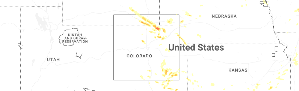
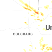
Hail Map for Altona, CO
The Altona, CO area has had 0 reports of on-the-ground hail by trained spotters, and has been under severe weather warnings 3 times during the past 12 months. Doppler radar has detected hail at or near Altona, CO on 38 occasions, including 2 occasions during the past year.
| Name: | Altona, CO |
| Where Located: | 31 miles NNW of Denver, CO |
| Map: | Google Map for Altona, CO |
| Population: | 501 |
| Housing Units: | 234 |
| More Info: | Search Google for Altona, CO |
5
The Top Recent Hail Date for Altona, CO is Friday, July 11, 2025 (1st out of 38)
Hail and Wind Damage Spotted near Altona, CO
| Date / Time | Report Details |
|---|---|
| 7/11/2025 5:46 PM MDT | Svrbou the national weather service in denver has issued a * severe thunderstorm warning for, southeastern boulder county in northeastern colorado, * until 615 pm mdt. * at 546 pm mdt, a severe thunderstorm was located near sunshine, or 33 miles south of fort collins, moving southeast at 10 mph (radar indicated). Hazards include half dollar size hail. damage to vehicles is expected |
| 7/20/2024 7:52 PM MDT |
 At 751 pm mdt, a severe thunderstorm was located near berthoud, or 19 miles south of fort collins, moving south at 25 mph (radar indicated). Hazards include ping pong ball size hail and 60 mph wind gusts. Expect damage to roofs, siding, and trees. people and animals outdoors will be injured. expect hail damage to roofs, siding, windows, and vehicles. Locations impacted include, northern boulder, longmont, southern loveland, erie, firestone, johnstown, frederick, milliken, berthoud, dacono, mead, lyons, carter lake, and niwot. At 751 pm mdt, a severe thunderstorm was located near berthoud, or 19 miles south of fort collins, moving south at 25 mph (radar indicated). Hazards include ping pong ball size hail and 60 mph wind gusts. Expect damage to roofs, siding, and trees. people and animals outdoors will be injured. expect hail damage to roofs, siding, windows, and vehicles. Locations impacted include, northern boulder, longmont, southern loveland, erie, firestone, johnstown, frederick, milliken, berthoud, dacono, mead, lyons, carter lake, and niwot.
|
| 7/20/2024 7:43 PM MDT |
 Svrbou the national weather service in denver colorado has issued a * severe thunderstorm warning for, southwestern weld county in northeastern colorado, southeastern larimer county in north central colorado, northeastern boulder county in northeastern colorado, * until 830 pm mdt. * at 743 pm mdt, a severe thunderstorm was located 4 miles northwest of berthoud, or 15 miles south of fort collins, moving south at 25 mph (radar indicated). Hazards include 60 mph wind gusts and half dollar size hail. Expect damage to roofs, siding, and trees. Hail damage to vehicles is expected. Svrbou the national weather service in denver colorado has issued a * severe thunderstorm warning for, southwestern weld county in northeastern colorado, southeastern larimer county in north central colorado, northeastern boulder county in northeastern colorado, * until 830 pm mdt. * at 743 pm mdt, a severe thunderstorm was located 4 miles northwest of berthoud, or 15 miles south of fort collins, moving south at 25 mph (radar indicated). Hazards include 60 mph wind gusts and half dollar size hail. Expect damage to roofs, siding, and trees. Hail damage to vehicles is expected.
|
| 7/28/2023 4:15 PM MDT |
 At 415 pm mdt, a severe thunderstorm was located near crisman, or 29 miles northwest of denver, moving northeast at 20 mph (radar indicated). Hazards include 60 mph wind gusts and quarter size hail. Expect damage to roofs, siding, and trees. hail damage to vehicles is expected. locations impacted include, niwot, southwestern longmont and lyons. hail threat, radar indicated max hail size, 1. 00 in wind threat, radar indicated max wind gust, 60 mph. At 415 pm mdt, a severe thunderstorm was located near crisman, or 29 miles northwest of denver, moving northeast at 20 mph (radar indicated). Hazards include 60 mph wind gusts and quarter size hail. Expect damage to roofs, siding, and trees. hail damage to vehicles is expected. locations impacted include, niwot, southwestern longmont and lyons. hail threat, radar indicated max hail size, 1. 00 in wind threat, radar indicated max wind gust, 60 mph.
|
| 7/28/2023 3:59 PM MDT |
 At 359 pm mdt, a severe thunderstorm was located 4 miles south of wallstreet, or 28 miles northwest of denver, moving northeast at 20 mph (radar indicated). Hazards include 60 mph wind gusts and quarter size hail. Expect damage to roofs, siding, and trees. hail damage to vehicles is expected. this severe thunderstorm will be near, crisman, salina, sunshine, summerville and eldorado springs around 410 pm mdt. other locations in the path of this severe thunderstorm include boulder, jamestown and niwot. hail threat, radar indicated max hail size, 1. 00 in wind threat, radar indicated max wind gust, 60 mph. At 359 pm mdt, a severe thunderstorm was located 4 miles south of wallstreet, or 28 miles northwest of denver, moving northeast at 20 mph (radar indicated). Hazards include 60 mph wind gusts and quarter size hail. Expect damage to roofs, siding, and trees. hail damage to vehicles is expected. this severe thunderstorm will be near, crisman, salina, sunshine, summerville and eldorado springs around 410 pm mdt. other locations in the path of this severe thunderstorm include boulder, jamestown and niwot. hail threat, radar indicated max hail size, 1. 00 in wind threat, radar indicated max wind gust, 60 mph.
|
| 6/22/2023 3:04 PM MDT |
 At 304 pm mdt, a severe thunderstorm was located 6 miles east of jamestown, or 31 miles south of fort collins, moving east at 10 mph (radar indicated). Hazards include half dollar size hail. damage to vehicles is expected At 304 pm mdt, a severe thunderstorm was located 6 miles east of jamestown, or 31 miles south of fort collins, moving east at 10 mph (radar indicated). Hazards include half dollar size hail. damage to vehicles is expected
|
| 6/12/2023 12:45 PM MDT |
 At 1244 pm mdt, a severe thunderstorm was located over southwestern boulder, or 26 miles northwest of denver, moving east at 10 mph (trained weather spotters reported quarter sized hail in cu boulder campus). Hazards include 60 mph wind gusts and quarter size hail. Expect damage to roofs, siding, and trees. Hail damage to vehicles is expected. At 1244 pm mdt, a severe thunderstorm was located over southwestern boulder, or 26 miles northwest of denver, moving east at 10 mph (trained weather spotters reported quarter sized hail in cu boulder campus). Hazards include 60 mph wind gusts and quarter size hail. Expect damage to roofs, siding, and trees. Hail damage to vehicles is expected.
|
| 5/9/2023 11:12 PM MDT |
 The severe thunderstorm warning for southwestern weld and southeastern boulder counties will expire at 1115 pm mdt, the storm which prompted the warning has moved out of the area. therefore, the warning will be allowed to expire. however heavy rain is still possible with this thunderstorm. remember, a severe thunderstorm warning still remains in effect for parts of weld, boulder, and larimer counties. The severe thunderstorm warning for southwestern weld and southeastern boulder counties will expire at 1115 pm mdt, the storm which prompted the warning has moved out of the area. therefore, the warning will be allowed to expire. however heavy rain is still possible with this thunderstorm. remember, a severe thunderstorm warning still remains in effect for parts of weld, boulder, and larimer counties.
|
| 5/9/2023 10:34 PM MDT |
 At 1034 pm mdt, a severe thunderstorm was located over southwestern longmont, or 28 miles southwest of greeley, moving northeast at 35 mph (trained weather spotters). Hazards include two inch hail and 60 mph wind gusts. Expect damage to roofs, siding, and trees. people and animals outdoors will be injured. expect hail damage to roofs, siding, windows, and vehicles. this severe storm will be near, frederick around 1045 pm mdt. other locations in the path of this severe thunderstorm include berthoud and mead. thunderstorm damage threat, considerable hail threat, observed max hail size, 2. 00 in wind threat, radar indicated max wind gust, 60 mph. At 1034 pm mdt, a severe thunderstorm was located over southwestern longmont, or 28 miles southwest of greeley, moving northeast at 35 mph (trained weather spotters). Hazards include two inch hail and 60 mph wind gusts. Expect damage to roofs, siding, and trees. people and animals outdoors will be injured. expect hail damage to roofs, siding, windows, and vehicles. this severe storm will be near, frederick around 1045 pm mdt. other locations in the path of this severe thunderstorm include berthoud and mead. thunderstorm damage threat, considerable hail threat, observed max hail size, 2. 00 in wind threat, radar indicated max wind gust, 60 mph.
|
| 5/9/2023 10:28 PM MDT |
 At 1028 pm mdt, a severe thunderstorm was located near niwot, or 28 miles northwest of denver, moving northeast at 35 mph (radar indicated). Hazards include 60 mph wind gusts and quarter size hail. Expect damage to roofs, siding, and trees. hail damage to vehicles is expected. this severe thunderstorm will be near, longmont around 1040 pm mdt. firestone and frederick around 1045 pm mdt. other locations in the path of this severe thunderstorm include berthoud and mead. hail threat, radar indicated max hail size, 1. 00 in wind threat, radar indicated max wind gust, 60 mph. At 1028 pm mdt, a severe thunderstorm was located near niwot, or 28 miles northwest of denver, moving northeast at 35 mph (radar indicated). Hazards include 60 mph wind gusts and quarter size hail. Expect damage to roofs, siding, and trees. hail damage to vehicles is expected. this severe thunderstorm will be near, longmont around 1040 pm mdt. firestone and frederick around 1045 pm mdt. other locations in the path of this severe thunderstorm include berthoud and mead. hail threat, radar indicated max hail size, 1. 00 in wind threat, radar indicated max wind gust, 60 mph.
|
| 7/27/2022 9:39 PM MDT |
 At 939 pm mdt, a severe thunderstorm was located over crisman, or 29 miles northwest of denver, moving southeast at 20 mph (radar indicated). Hazards include quarter size hail. damage to vehicles is expected At 939 pm mdt, a severe thunderstorm was located over crisman, or 29 miles northwest of denver, moving southeast at 20 mph (radar indicated). Hazards include quarter size hail. damage to vehicles is expected
|
| 6/25/2021 2:37 PM MDT |
 The severe thunderstorm warning for north central jefferson and southeastern boulder counties will expire at 245 pm mdt, the storm which prompted the warning has weakened below severe limits, and has exited the warned area. therefore, the warning will be allowed to expire. however small hail and heavy rain are still possible with this thunderstorm. The severe thunderstorm warning for north central jefferson and southeastern boulder counties will expire at 245 pm mdt, the storm which prompted the warning has weakened below severe limits, and has exited the warned area. therefore, the warning will be allowed to expire. however small hail and heavy rain are still possible with this thunderstorm.
|
| 6/25/2021 1:59 PM MDT |
 At 159 pm mdt, a severe thunderstorm was located near boulder, or 29 miles northwest of denver, moving southeast at 15 mph (radar indicated). Hazards include quarter size hail. damage to vehicles is expected At 159 pm mdt, a severe thunderstorm was located near boulder, or 29 miles northwest of denver, moving southeast at 15 mph (radar indicated). Hazards include quarter size hail. damage to vehicles is expected
|
| 7/31/2020 5:34 PM MDT |
 At 534 pm mdt, a severe thunderstorm was located over niwot, or 29 miles northwest of denver, moving southeast at 30 mph (trained weather spotters). Hazards include quarter size hail. damage to vehicles is expected At 534 pm mdt, a severe thunderstorm was located over niwot, or 29 miles northwest of denver, moving southeast at 30 mph (trained weather spotters). Hazards include quarter size hail. damage to vehicles is expected
|
| 6/6/2020 3:46 PM MDT |
 At 342 pm mdt, severe thunderstorms were located along a line extending from 3 miles north of drake to near aspen springs to 7 miles west of elevenmile canyon reservoir, or along a line extending from 15 miles west of fort collins to 28 miles west of denver to 39 miles north of hayden pass burn scar, the storms are moving northeast at 60 mph. these are very dangerous storms (an automated weather station in lakewood recorded a peak wind gust to 70 mph at bear creek golf club in southwest lakewood). Hazards include 75 mph wind gusts. Flying debris will be dangerous to those caught without shelter. mobile homes will be heavily damaged. expect considerable damage to roofs, windows, and vehicles. extensive tree damage and power outages are likely. Locations impacted include, denver, fort collins, greeley, aurora, lakewood, thornton, arvada, westminster, centennial, boulder, longmont, loveland, broomfield, highlands ranch, castle rock, commerce city, parker, littleton, northglenn and brighton. At 342 pm mdt, severe thunderstorms were located along a line extending from 3 miles north of drake to near aspen springs to 7 miles west of elevenmile canyon reservoir, or along a line extending from 15 miles west of fort collins to 28 miles west of denver to 39 miles north of hayden pass burn scar, the storms are moving northeast at 60 mph. these are very dangerous storms (an automated weather station in lakewood recorded a peak wind gust to 70 mph at bear creek golf club in southwest lakewood). Hazards include 75 mph wind gusts. Flying debris will be dangerous to those caught without shelter. mobile homes will be heavily damaged. expect considerable damage to roofs, windows, and vehicles. extensive tree damage and power outages are likely. Locations impacted include, denver, fort collins, greeley, aurora, lakewood, thornton, arvada, westminster, centennial, boulder, longmont, loveland, broomfield, highlands ranch, castle rock, commerce city, parker, littleton, northglenn and brighton.
|
| 6/6/2020 3:03 PM MDT |
 At 303 pm mdt, severe thunderstorms were located along a line extending from 3 miles north of drake to near aspen springs to 8 miles west of elevenmile canyon reservoir, or along a line extending from 15 miles west of fort collins to 28 miles west of denver to 39 miles north of hayden pass burn scar, moving northeast at 65 mph. these are very dangerous storms (radar indicated). Hazards include 80 mph wind gusts. Flying debris will be dangerous to those caught without shelter. mobile homes will be heavily damaged. expect considerable damage to roofs, windows, and vehicles. Extensive tree damage and power outages are likely. At 303 pm mdt, severe thunderstorms were located along a line extending from 3 miles north of drake to near aspen springs to 8 miles west of elevenmile canyon reservoir, or along a line extending from 15 miles west of fort collins to 28 miles west of denver to 39 miles north of hayden pass burn scar, moving northeast at 65 mph. these are very dangerous storms (radar indicated). Hazards include 80 mph wind gusts. Flying debris will be dangerous to those caught without shelter. mobile homes will be heavily damaged. expect considerable damage to roofs, windows, and vehicles. Extensive tree damage and power outages are likely.
|
| 7/20/2019 3:27 PM MDT |
 At 327 pm mdt, a severe thunderstorm was located 5 miles northeast of sunshine, or 30 miles northwest of denver, moving east at 10 mph (radar indicated). Hazards include quarter size hail. Damage to vehicles is expected. Locations impacted include, northern boulder and niwot. At 327 pm mdt, a severe thunderstorm was located 5 miles northeast of sunshine, or 30 miles northwest of denver, moving east at 10 mph (radar indicated). Hazards include quarter size hail. Damage to vehicles is expected. Locations impacted include, northern boulder and niwot.
|
| 7/20/2019 3:13 PM MDT |
 At 312 pm mdt, a severe thunderstorm was located near jamestown, or 31 miles northwest of denver, moving southeast at 5 mph (radar indicated). Hazards include ping pong ball size hail and 60 mph wind gusts. Expect damage to roofs, siding, and trees. people and animals outdoors will be injured. Expect hail damage to roofs, siding, windows, and vehicles. At 312 pm mdt, a severe thunderstorm was located near jamestown, or 31 miles northwest of denver, moving southeast at 5 mph (radar indicated). Hazards include ping pong ball size hail and 60 mph wind gusts. Expect damage to roofs, siding, and trees. people and animals outdoors will be injured. Expect hail damage to roofs, siding, windows, and vehicles.
|
| 7/20/2019 2:58 PM MDT |
 At 258 pm mdt, a severe thunderstorm was located near jamestown, or 32 miles southwest of fort collins, moving southeast at 5 mph (radar indicated). Hazards include 60 mph wind gusts and half dollar size hail. Expect damage to roofs, siding, and trees. hail damage to vehicles is expected. Locations impacted include, boulder, jamestown, wallstreet, salina, crisman, sunshine, summerville and niwot. At 258 pm mdt, a severe thunderstorm was located near jamestown, or 32 miles southwest of fort collins, moving southeast at 5 mph (radar indicated). Hazards include 60 mph wind gusts and half dollar size hail. Expect damage to roofs, siding, and trees. hail damage to vehicles is expected. Locations impacted include, boulder, jamestown, wallstreet, salina, crisman, sunshine, summerville and niwot.
|
| 7/20/2019 2:36 PM MDT |
 At 236 pm mdt, a severe thunderstorm was located near jamestown, or 32 miles southwest of fort collins, moving southeast at 10 mph (radar indicated). Hazards include 60 mph wind gusts and half dollar size hail. Expect damage to roofs, siding, and trees. Hail damage to vehicles is expected. At 236 pm mdt, a severe thunderstorm was located near jamestown, or 32 miles southwest of fort collins, moving southeast at 10 mph (radar indicated). Hazards include 60 mph wind gusts and half dollar size hail. Expect damage to roofs, siding, and trees. Hail damage to vehicles is expected.
|
| 8/3/2018 8:39 PM MDT |
 At 839 pm mdt, doppler radar showed thunderstorms dissipating over the foothills northwest of denver. wind gusts of 60 to 65 mph will be possible with this activity as it pushes through the denver metro area (radar indicated). Hazards include 60 mph wind gusts. expect damage to roofs, siding, and trees At 839 pm mdt, doppler radar showed thunderstorms dissipating over the foothills northwest of denver. wind gusts of 60 to 65 mph will be possible with this activity as it pushes through the denver metro area (radar indicated). Hazards include 60 mph wind gusts. expect damage to roofs, siding, and trees
|
| 6/19/2018 12:16 PM MDT |
 At 1216 pm mdt, a severe thunderstorm was located over north boulder, moving east at 20 mph (radar indicated). Hazards include quarter size hail. Damage to vehicles is expected. Locations impacted include, boulder, longmont, lafayette, erie and niwot. At 1216 pm mdt, a severe thunderstorm was located over north boulder, moving east at 20 mph (radar indicated). Hazards include quarter size hail. Damage to vehicles is expected. Locations impacted include, boulder, longmont, lafayette, erie and niwot.
|
| 6/19/2018 12:06 PM MDT |
 At 1205 pm mdt, a severe thunderstorm was located 6 miles west of boulder, moving east at 25 mph (radar indicated). Hazards include quarter size hail. damage to vehicles is possible At 1205 pm mdt, a severe thunderstorm was located 6 miles west of boulder, moving east at 25 mph (radar indicated). Hazards include quarter size hail. damage to vehicles is possible
|
| 6/18/2018 6:12 PM MDT |
 At 611 pm mdt, a severe thunderstorm was located near boulder, or 24 miles northwest of denver, moving east at 30 mph. another servere thunderstorm was located over mead, moving east at 30 mph (trained weather spotters). Hazards include half dollar size hail. damage to vehicles is expected At 611 pm mdt, a severe thunderstorm was located near boulder, or 24 miles northwest of denver, moving east at 30 mph. another servere thunderstorm was located over mead, moving east at 30 mph (trained weather spotters). Hazards include half dollar size hail. damage to vehicles is expected
|
| 6/18/2018 6:02 PM MDT |
 At 601 pm mdt, a severe thunderstorm was located over northwestern boulder, moving northeast at 20 mph (trained spotters reported quarter size hail at 555 pm mdt). Hazards include quarter size hail. Damage to vehicles is expected. Locations impacted include, boulder, western longmont, northern broomfield, lafayette, louisville, erie, crisman, and niwot. At 601 pm mdt, a severe thunderstorm was located over northwestern boulder, moving northeast at 20 mph (trained spotters reported quarter size hail at 555 pm mdt). Hazards include quarter size hail. Damage to vehicles is expected. Locations impacted include, boulder, western longmont, northern broomfield, lafayette, louisville, erie, crisman, and niwot.
|
| 6/18/2018 5:44 PM MDT |
 At 544 pm mdt, a severe thunderstorm was located just east of nederland, or 10 miles southwest of boulder, moving northeast at 20 mph (radar indicated). Hazards include quarter size hail. damage to vehicles is expected At 544 pm mdt, a severe thunderstorm was located just east of nederland, or 10 miles southwest of boulder, moving northeast at 20 mph (radar indicated). Hazards include quarter size hail. damage to vehicles is expected
|
| 7/19/2016 6:36 PM MDT |
 At 635 pm mdt, a severe thunderstorm was located near sunshine, or 31 miles northwest of denver, moving northeast at 20 mph (radar indicated). Hazards include 60 mph wind gusts and quarter size hail. Hail damage to vehicles is expected. Expect wind damage to roofs, siding, and trees. At 635 pm mdt, a severe thunderstorm was located near sunshine, or 31 miles northwest of denver, moving northeast at 20 mph (radar indicated). Hazards include 60 mph wind gusts and quarter size hail. Hail damage to vehicles is expected. Expect wind damage to roofs, siding, and trees.
|
| 6/6/2016 3:57 PM MDT |
 At 357 pm mdt, a severe thunderstorm was located 4 miles northeast of sunshine, or 30 miles northwest of denver, moving southeast at 15 mph (radar indicated). Hazards include quarter size hail. damage to vehicles is expected At 357 pm mdt, a severe thunderstorm was located 4 miles northeast of sunshine, or 30 miles northwest of denver, moving southeast at 15 mph (radar indicated). Hazards include quarter size hail. damage to vehicles is expected
|
| 6/4/2015 9:17 PM MDT | At 915 pm mdt, a severe thunderstorm was located near longmont, or 26 miles south of fort collins, moving east at 10 mph. another developing thunderstorm was located over broomfield, also moving east at 10 mph (radar indicated). Hazards include quarter size hail. damage to vehicles is expected |
| 6/4/2015 8:09 PM MDT | At 807 pm mdt, a severe thunderstorm was located 4 miles south of lyons, or 29 miles south of fort collins, moving south at 15 mph. spotters in the berthoud area have been reporting brief funnel clouds and possible brief tornado touchdowns. heavy rains in the area will also produce flash flooding problems through this evening (radar indicated). Hazards include half dollar size hail. Damage to vehicles is expected. locations impacted include, longmont and lyons. A tornado watch remains in effect until 1000 pm mdt for central colorado. |
| 6/4/2015 7:54 PM MDT | At 753 pm mdt, a severe thunderstorm was located over lyons, or 27 miles southwest of fort collins, moving southwest at 20 mph (radar indicated). Hazards include half dollar size hail. damage to vehicles is expected |
Hail Maps for Altona, CO


Connect with Interactive Hail Maps