

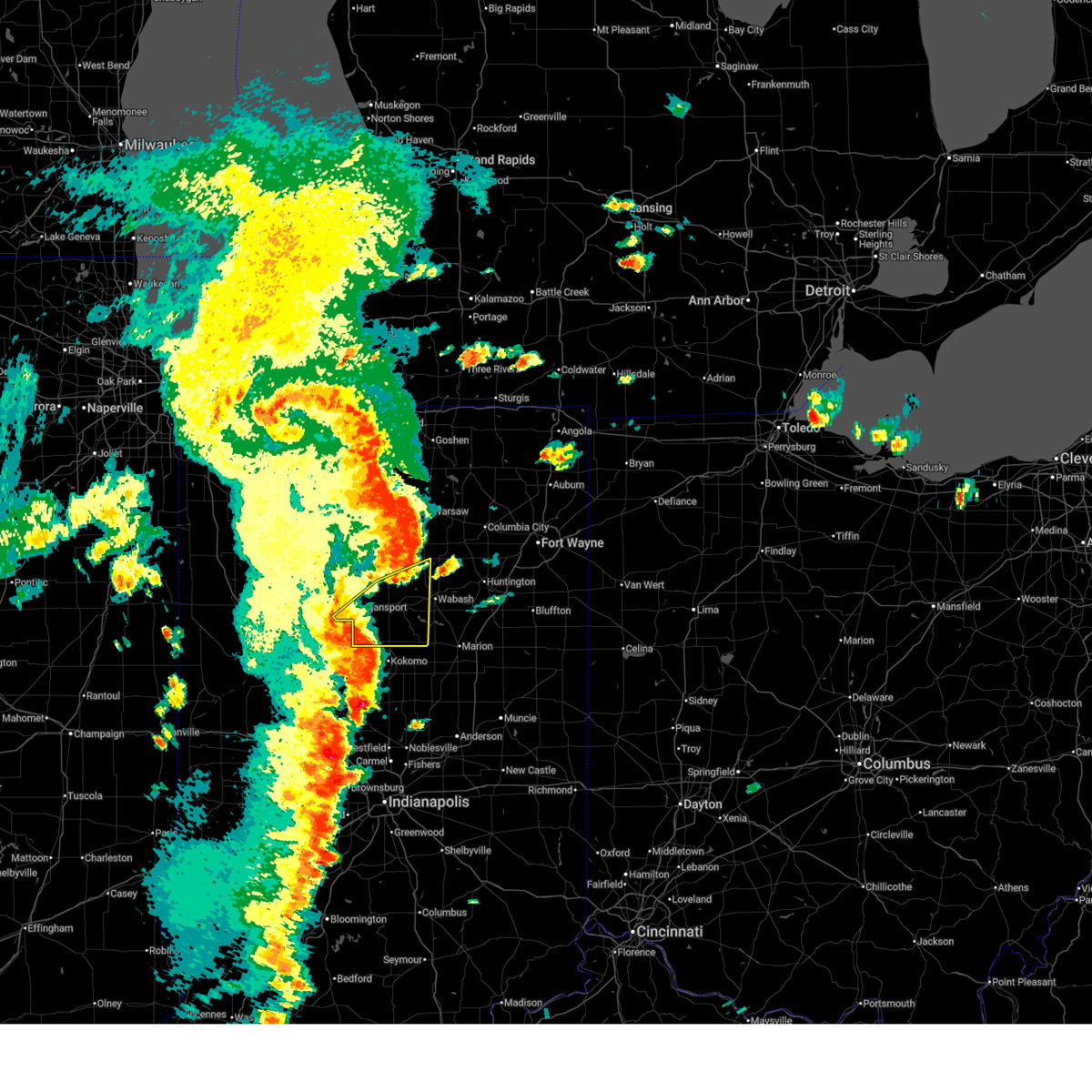
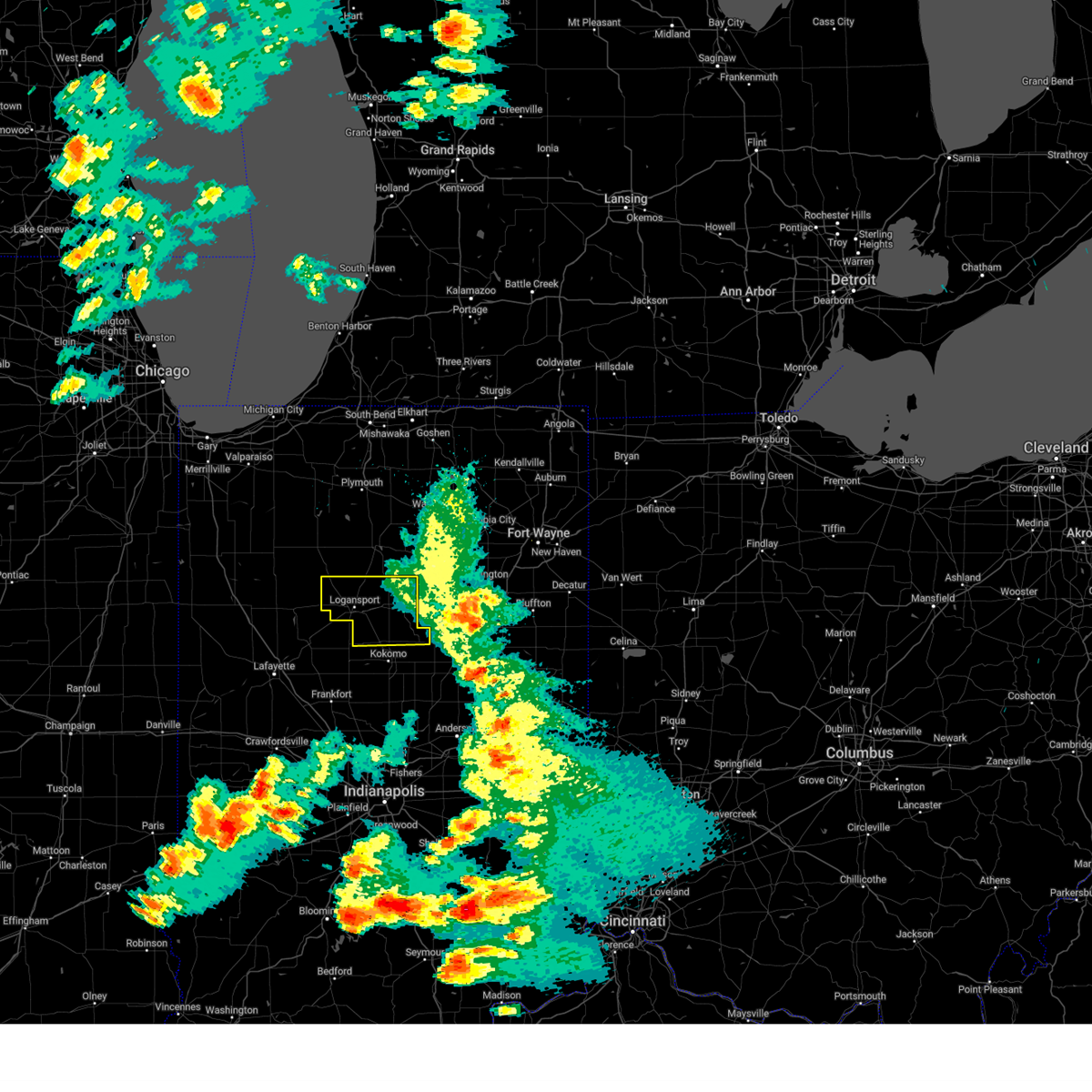
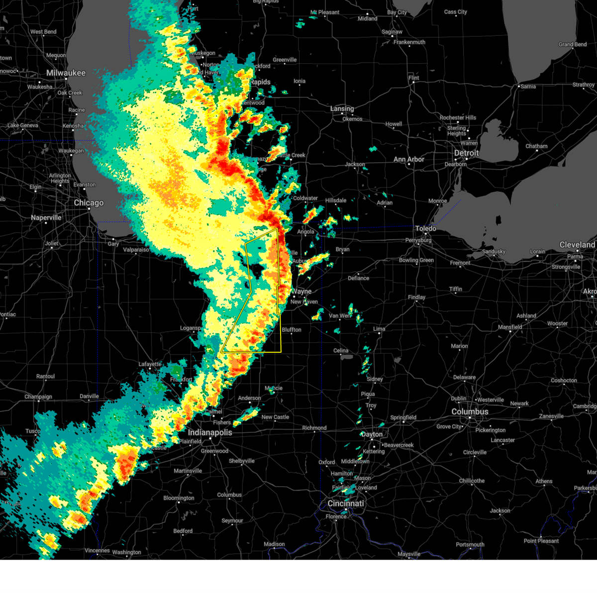
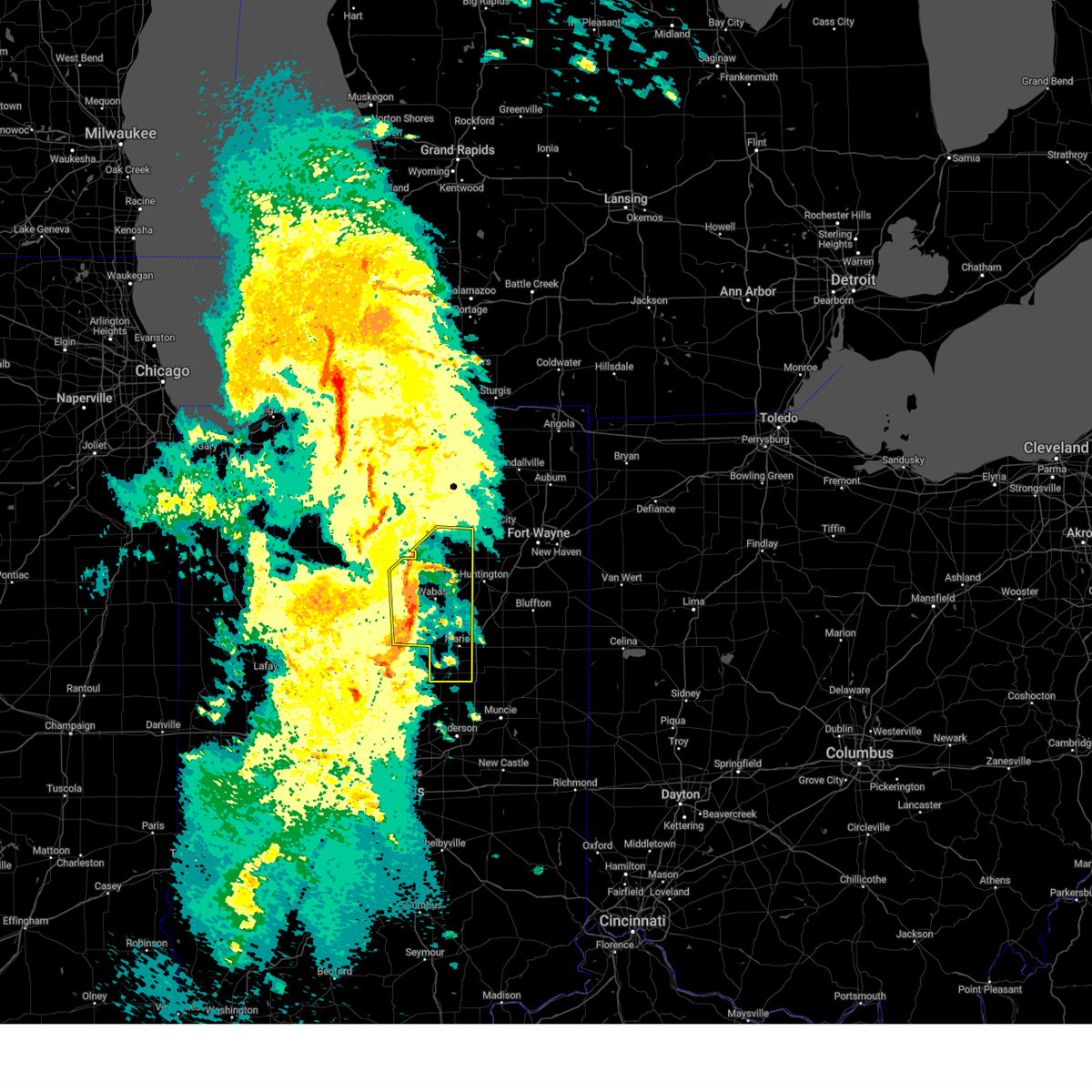
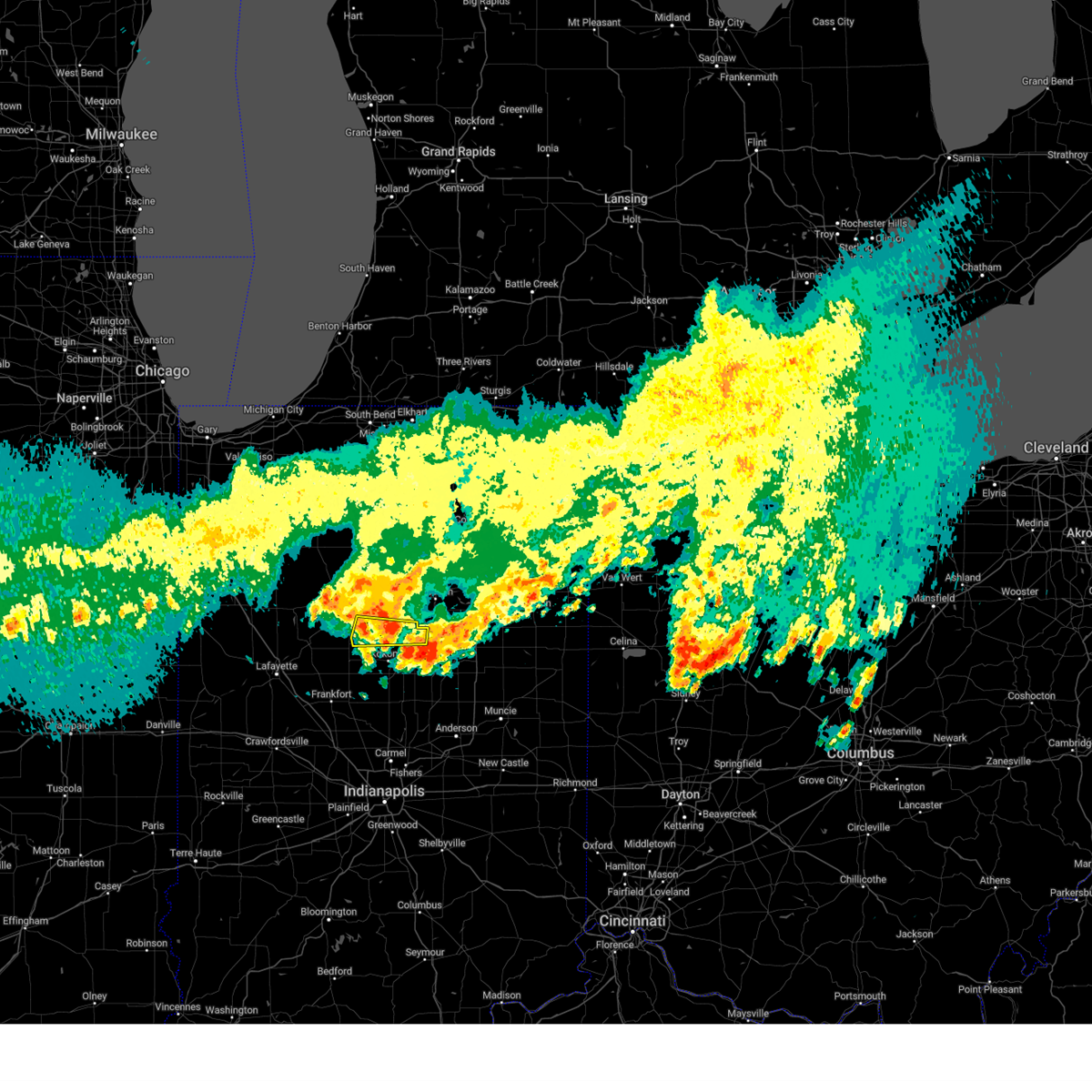
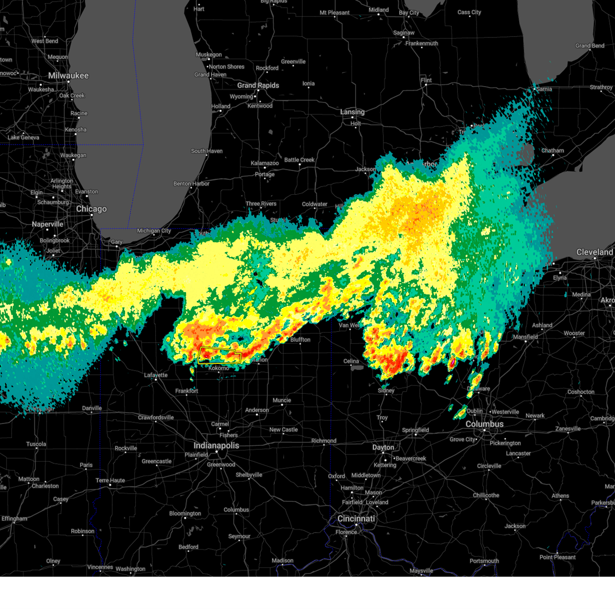
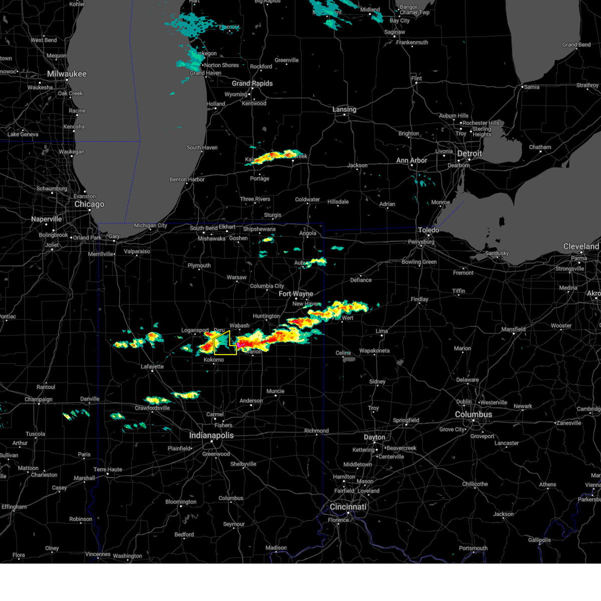
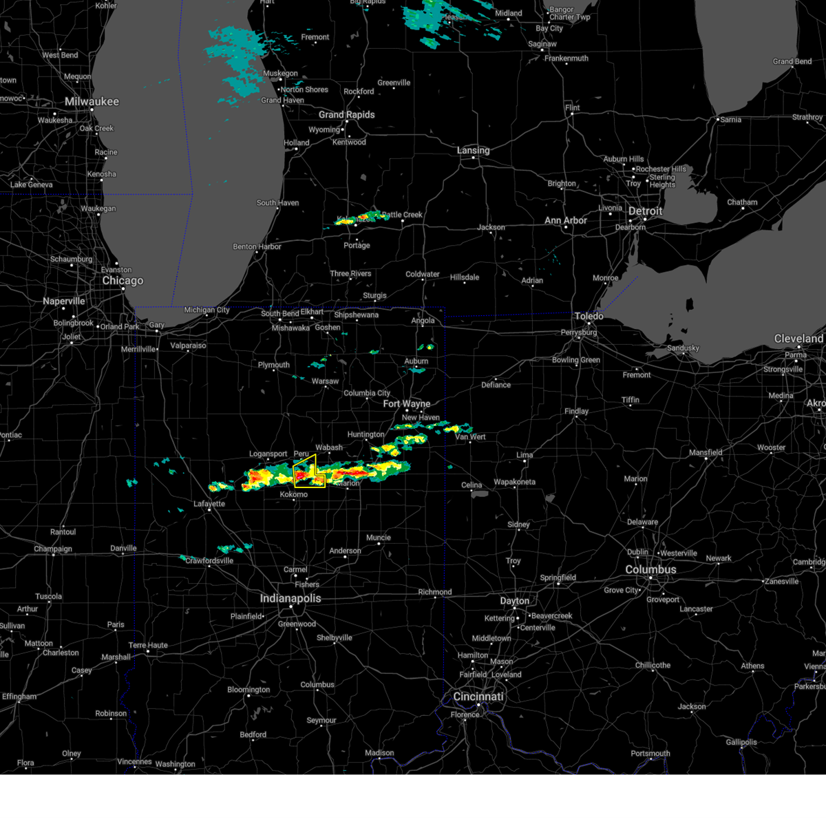
Hail Map for Amboy, IN
The Amboy, IN area has had 1 report of on-the-ground hail by trained spotters, and has been under severe weather warnings 16 times during the past 12 months. Doppler radar has detected hail at or near Amboy, IN on 34 occasions, including 1 occasion during the past year.
| Name: | Amboy, IN |
| Where Located: | 54.3 miles SW of Fort Wayne, IN |
| Map: | Google Map for Amboy, IN |
| Population: | 384 |
| Housing Units: | 169 |
| More Info: | Search Google for Amboy, IN |
3
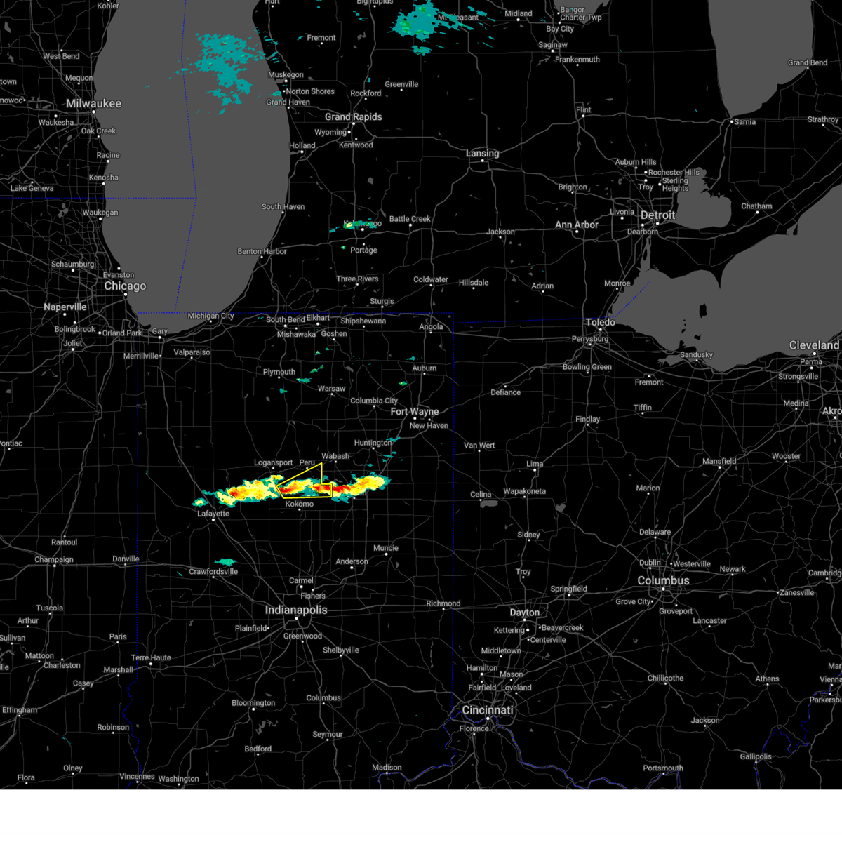
The Top Recent Hail Date for Amboy, IN is Friday, August 2, 2024 (10th out of 34)

Hail and Wind Damage Spotted near Amboy, IN
| Date / Time | Report Details |
|---|---|
| 6/18/2025 4:22 PM EDT |
 Svriwx the national weather service in northern indiana has issued a * severe thunderstorm warning for, western wabash county in north central indiana, southeastern cass county in north central indiana, miami county in north central indiana, * until 500 pm edt. * at 422 pm edt, a severe thunderstorm was located over walton, or near grissom afb, moving northeast at 60 mph (radar indicated). Hazards include 60 mph wind gusts. expect damage to roofs, siding, and trees Svriwx the national weather service in northern indiana has issued a * severe thunderstorm warning for, western wabash county in north central indiana, southeastern cass county in north central indiana, miami county in north central indiana, * until 500 pm edt. * at 422 pm edt, a severe thunderstorm was located over walton, or near grissom afb, moving northeast at 60 mph (radar indicated). Hazards include 60 mph wind gusts. expect damage to roofs, siding, and trees
|
| 5/16/2025 7:42 PM EDT |
 The storm which prompted the warning has weakened below severe limits, and has exited the warned area. therefore, the warning will be allowed to expire. however, gusty winds are still possible with this thunderstorm. a severe thunderstorm watch remains in effect until midnight edt for central, north central and northwestern indiana. to report severe weather, contact your nearest law enforcement agency. they will relay your report to the national weather service northern indiana. The storm which prompted the warning has weakened below severe limits, and has exited the warned area. therefore, the warning will be allowed to expire. however, gusty winds are still possible with this thunderstorm. a severe thunderstorm watch remains in effect until midnight edt for central, north central and northwestern indiana. to report severe weather, contact your nearest law enforcement agency. they will relay your report to the national weather service northern indiana.
|
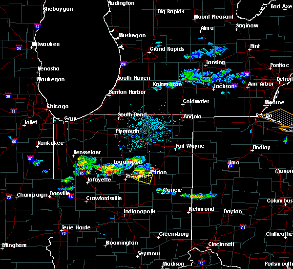
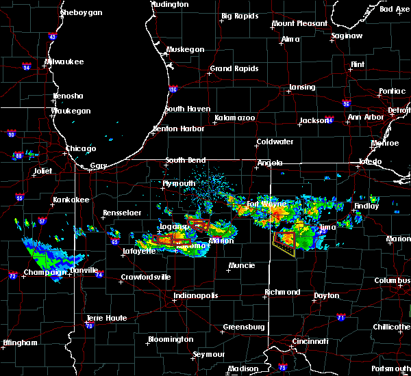
| 5/16/2025 7:17 PM EDT | At 716 pm edt, a severe thunderstorm was located near bunker hill, or near peru, moving northeast at 50 mph (radar indicated). Hazards include 60 mph wind gusts. these winds may exist well outside of the main storm. Expect damage to roofs, siding, and trees. Locations impacted include, logansport, peru, grissom afb, walton, bunker hill, royal center, mexico, lincoln, wells, galveston, miami, converse, erie, denver, amboy, onward, clymers, bennetts switch, leases corner, and deedsville. |
| 5/16/2025 6:46 PM EDT | Svriwx the national weather service in northern indiana has issued a * severe thunderstorm warning for, cass county in north central indiana, miami county in north central indiana, * until 745 pm edt. * at 646 pm edt, severe thunderstorms were located along a line extending from near brookston to 12 miles north of frankfort, moving northeast at 55 mph (radar indicated). Hazards include 60 mph wind gusts. expect damage to roofs, siding, and trees |
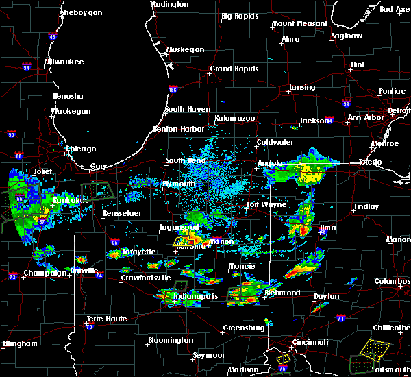
| 3/30/2025 5:21 PM EDT |
 The storms which prompted the warning have moved out of the area. therefore, the warning will be allowed to expire. however, gusty winds are still possible with these thunderstorms. a tornado watch remains in effect until 800 pm edt for central, north central and northeastern indiana. remember, a severe thunderstorm warning still remains in effect for whitley, huntington, and allen counties until 6 pm edt. The storms which prompted the warning have moved out of the area. therefore, the warning will be allowed to expire. however, gusty winds are still possible with these thunderstorms. a tornado watch remains in effect until 800 pm edt for central, north central and northeastern indiana. remember, a severe thunderstorm warning still remains in effect for whitley, huntington, and allen counties until 6 pm edt.
|
| 3/30/2025 5:12 PM EDT | At 511 pm edt, severe thunderstorms were located along a line extending from near middlebury to near andrews, moving east at 65 mph. damage was reported in etna green around 5 pm, including trees and powerlines down (public). Hazards include 70 mph wind gusts and nickel size hail. Expect considerable tree damage. damage is likely to mobile homes, roofs, and outbuildings. locations impacted include, mcnatts, topeka, honeyville, landess, blue lake, la fontaine, tri-lakes, buckeye, larwill, lake wawasee, bippus, luther, bowerstown, south whitley, servia, coesse, goose lake, knapp lake, jalapa, and loon lake. This includes interstate 69 in indiana between mile markers 266 and 293. |
| 3/30/2025 5:12 PM EDT | the severe thunderstorm warning has been cancelled and is no longer in effect |
| 3/30/2025 4:50 PM EDT | At 450 pm edt, severe thunderstorms were located along a line extending from near nappanee to near peru, moving northeast at 65 mph (radar indicated). Hazards include 70 mph wind gusts and nickel size hail. Expect considerable tree damage. damage is likely to mobile homes, roofs, and outbuildings. locations impacted include, mcnatts, honeyville, atwood, la fontaine, macy, tri-lakes, locke, syracuse, bippus, luther, nead, bowerstown, little chapman lake, warsaw, james lake, goose lake, knapp lake, jalapa, new paris, and loon lake. This includes interstate 69 in indiana between mile markers 266 and 293. |
| 3/30/2025 4:50 PM EDT | the severe thunderstorm warning has been cancelled and is no longer in effect |
| 3/30/2025 4:33 PM EDT |
 Svriwx the national weather service in northern indiana has issued a * severe thunderstorm warning for, southern elkhart county in north central indiana, wabash county in north central indiana, noble county in northeastern indiana, northern grant county in central indiana, whitley county in northeastern indiana, huntington county in northeastern indiana, kosciusko county in north central indiana, cass county in north central indiana, southwestern lagrange county in northeastern indiana, fulton county in north central indiana, western wells county in northeastern indiana, miami county in north central indiana, marshall county in north central indiana, * until 530 pm edt. * at 433 pm edt, severe thunderstorms were located along a line extending from plymouth to near walton, moving northeast at 65 mph (radar indicated). Hazards include 70 mph wind gusts and nickel size hail. Expect considerable tree damage. Damage is likely to mobile homes, roofs, and outbuildings. Svriwx the national weather service in northern indiana has issued a * severe thunderstorm warning for, southern elkhart county in north central indiana, wabash county in north central indiana, noble county in northeastern indiana, northern grant county in central indiana, whitley county in northeastern indiana, huntington county in northeastern indiana, kosciusko county in north central indiana, cass county in north central indiana, southwestern lagrange county in northeastern indiana, fulton county in north central indiana, western wells county in northeastern indiana, miami county in north central indiana, marshall county in north central indiana, * until 530 pm edt. * at 433 pm edt, severe thunderstorms were located along a line extending from plymouth to near walton, moving northeast at 65 mph (radar indicated). Hazards include 70 mph wind gusts and nickel size hail. Expect considerable tree damage. Damage is likely to mobile homes, roofs, and outbuildings.
|
| 3/15/2025 4:11 AM EDT | The storms which prompted the warning have weakened below severe limits, and no longer pose an immediate threat to life or property. therefore, the warning will be allowed to expire. however, gusty winds are still possible with these thunderstorms. a severe thunderstorm watch remains in effect until 900 am edt for central, north central and northeastern indiana. to report severe weather, contact your nearest law enforcement agency. they will relay your report to the national weather service northern indiana. |
| 3/15/2025 4:00 AM EDT | At 400 am edt, severe thunderstorms were located along a line extending from 6 miles east of akron to wabash to 8 miles northeast of kokomo, moving northeast at 55 mph (radar indicated). Hazards include 60 mph wind gusts. Expect damage to roofs, siding, and trees. Locations impacted include, richvalley, gas city, wabash, amboy, collamer, liberty mills, north manchester, la fontaine, mier, herbst, wawpecong, roann, point isabel, jonesboro, banquo, peoria, roseburg, bippus, swayzee, and luther. |
| 3/15/2025 3:48 AM EDT |
 Svriwx the national weather service in northern indiana has issued a * severe thunderstorm warning for, wabash county in north central indiana, grant county in central indiana, southwestern whitley county in northeastern indiana, western huntington county in northeastern indiana, southeastern kosciusko county in north central indiana, miami county in north central indiana, * until 415 am edt. * at 348 am edt, severe thunderstorms were located along a line extending from 8 miles south of akron to near peru to near kokomo, moving northeast at 60 mph (radar indicated). Hazards include 60 mph wind gusts. expect damage to roofs, siding, and trees Svriwx the national weather service in northern indiana has issued a * severe thunderstorm warning for, wabash county in north central indiana, grant county in central indiana, southwestern whitley county in northeastern indiana, western huntington county in northeastern indiana, southeastern kosciusko county in north central indiana, miami county in north central indiana, * until 415 am edt. * at 348 am edt, severe thunderstorms were located along a line extending from 8 miles south of akron to near peru to near kokomo, moving northeast at 60 mph (radar indicated). Hazards include 60 mph wind gusts. expect damage to roofs, siding, and trees
|
| 7/16/2024 12:52 AM EDT |
 The storms which prompted the warning have moved out of the area. therefore, the warning will be allowed to expire. however, gusty winds are still possible with these thunderstorms. a tornado watch remains in effect until 200 am edt for north central and northeastern indiana. a severe thunderstorm watch remains in effect until 500 am edt for central indiana. The storms which prompted the warning have moved out of the area. therefore, the warning will be allowed to expire. however, gusty winds are still possible with these thunderstorms. a tornado watch remains in effect until 200 am edt for north central and northeastern indiana. a severe thunderstorm watch remains in effect until 500 am edt for central indiana.
|
| 7/16/2024 12:39 AM EDT |
 At 1239 am edt, severe thunderstorms were located along a line extending from near wabash to 6 miles northeast of kokomo, moving east at 60 mph (radar indicated). Hazards include 60 mph wind gusts. Expect damage to roofs, siding, and trees. Locations impacted include, marion, peru, wabash, grissom afb, sweetser, swayzee, bunker hill, la fontaine, lincoln, wells, sims, galveston, miami, converse, erie, lagro, amboy, richvalley, bennetts switch, and mier. At 1239 am edt, severe thunderstorms were located along a line extending from near wabash to 6 miles northeast of kokomo, moving east at 60 mph (radar indicated). Hazards include 60 mph wind gusts. Expect damage to roofs, siding, and trees. Locations impacted include, marion, peru, wabash, grissom afb, sweetser, swayzee, bunker hill, la fontaine, lincoln, wells, sims, galveston, miami, converse, erie, lagro, amboy, richvalley, bennetts switch, and mier.
|
| 7/16/2024 12:10 AM EDT |
 Svriwx the national weather service in northern indiana has issued a * severe thunderstorm warning for, southern wabash county in north central indiana, western grant county in central indiana, cass county in north central indiana, miami county in north central indiana, * until 100 am edt. * at 1210 am edt, severe thunderstorms were located along a line extending from 6 miles east of royal center to 7 miles southeast of delphi, moving east at 55 mph (radar indicated). Hazards include 70 mph wind gusts. Expect considerable tree damage. Damage is likely to mobile homes, roofs, and outbuildings. Svriwx the national weather service in northern indiana has issued a * severe thunderstorm warning for, southern wabash county in north central indiana, western grant county in central indiana, cass county in north central indiana, miami county in north central indiana, * until 100 am edt. * at 1210 am edt, severe thunderstorms were located along a line extending from 6 miles east of royal center to 7 miles southeast of delphi, moving east at 55 mph (radar indicated). Hazards include 70 mph wind gusts. Expect considerable tree damage. Damage is likely to mobile homes, roofs, and outbuildings.
|
| 6/25/2024 11:32 AM EDT |
 the severe thunderstorm warning has been cancelled and is no longer in effect the severe thunderstorm warning has been cancelled and is no longer in effect
|
| 6/25/2024 11:19 AM EDT |
 Svriwx the national weather service in northern indiana has issued a * severe thunderstorm warning for, southeastern cass county in north central indiana, southern miami county in north central indiana, * until 1145 am edt. * at 1118 am edt, a severe thunderstorm was located over walton, or near grissom afb, moving east at 30 mph (radar indicated). Hazards include 60 mph wind gusts and quarter size hail. Hail damage to vehicles is expected. Expect wind damage to roofs, siding, and trees. Svriwx the national weather service in northern indiana has issued a * severe thunderstorm warning for, southeastern cass county in north central indiana, southern miami county in north central indiana, * until 1145 am edt. * at 1118 am edt, a severe thunderstorm was located over walton, or near grissom afb, moving east at 30 mph (radar indicated). Hazards include 60 mph wind gusts and quarter size hail. Hail damage to vehicles is expected. Expect wind damage to roofs, siding, and trees.
|
| 3/14/2024 5:52 PM EDT |
 the severe thunderstorm warning has been cancelled and is no longer in effect the severe thunderstorm warning has been cancelled and is no longer in effect
|
| 3/14/2024 5:52 PM EDT |
 At 552 pm edt, a severe thunderstorm was located 7 miles east of bunker hill, or 9 miles southeast of peru, moving east at 55 mph (radar indicated). Hazards include 60 mph wind gusts and quarter size hail. Hail damage to vehicles is expected. expect wind damage to roofs, siding, and trees. Locations impacted include, wabash, sweetser, converse, amboy, santa fe, wawpecong, peoria, mier, and somerset. At 552 pm edt, a severe thunderstorm was located 7 miles east of bunker hill, or 9 miles southeast of peru, moving east at 55 mph (radar indicated). Hazards include 60 mph wind gusts and quarter size hail. Hail damage to vehicles is expected. expect wind damage to roofs, siding, and trees. Locations impacted include, wabash, sweetser, converse, amboy, santa fe, wawpecong, peoria, mier, and somerset.
|
| 3/14/2024 5:46 PM EDT |
 Svriwx the national weather service in northern indiana has issued a * severe thunderstorm warning for, southwestern wabash county in north central indiana, northwestern grant county in central indiana, southeastern cass county in north central indiana, southern miami county in north central indiana, * until 615 pm edt. * at 546 pm edt, a severe thunderstorm was located over bunker hill, or near grissom afb, moving east at 55 mph (radar indicated). Hazards include 60 mph wind gusts and quarter size hail. Hail damage to vehicles is expected. Expect wind damage to roofs, siding, and trees. Svriwx the national weather service in northern indiana has issued a * severe thunderstorm warning for, southwestern wabash county in north central indiana, northwestern grant county in central indiana, southeastern cass county in north central indiana, southern miami county in north central indiana, * until 615 pm edt. * at 546 pm edt, a severe thunderstorm was located over bunker hill, or near grissom afb, moving east at 55 mph (radar indicated). Hazards include 60 mph wind gusts and quarter size hail. Hail damage to vehicles is expected. Expect wind damage to roofs, siding, and trees.
|
| 3/14/2024 5:40 PM EDT |
 The severe thunderstorm which prompted the warning has moved out of the warned area. therefore, the warning will be allowed to expire. a tornado watch remains in effect until midnight edt for central and north central indiana. The severe thunderstorm which prompted the warning has moved out of the warned area. therefore, the warning will be allowed to expire. a tornado watch remains in effect until midnight edt for central and north central indiana.
|
| 3/14/2024 5:31 PM EDT |
 Svriwx the national weather service in northern indiana has issued a * severe thunderstorm warning for, southern wabash county in north central indiana, northwestern grant county in central indiana, southeastern miami county in north central indiana, * until 600 pm edt. * at 531 pm edt, a severe thunderstorm was located 7 miles east of bunker hill, or 9 miles southeast of peru, moving east at 50 mph (radar indicated). Hazards include 60 mph wind gusts and quarter size hail. Hail damage to vehicles is expected. Expect wind damage to roofs, siding, and trees. Svriwx the national weather service in northern indiana has issued a * severe thunderstorm warning for, southern wabash county in north central indiana, northwestern grant county in central indiana, southeastern miami county in north central indiana, * until 600 pm edt. * at 531 pm edt, a severe thunderstorm was located 7 miles east of bunker hill, or 9 miles southeast of peru, moving east at 50 mph (radar indicated). Hazards include 60 mph wind gusts and quarter size hail. Hail damage to vehicles is expected. Expect wind damage to roofs, siding, and trees.
|
| 3/14/2024 5:28 PM EDT |
 At 527 pm edt, a severe thunderstorm was located near bunker hill, or near grissom afb, moving east at 45 mph (radar indicated). Hazards include 60 mph wind gusts and quarter size hail. Hail damage to vehicles is expected. expect wind damage to roofs, siding, and trees. Locations impacted include, peru, grissom afb, bunker hill, miami, converse, amboy, santa fe, wawpecong, bennetts switch, peoria, and nead. At 527 pm edt, a severe thunderstorm was located near bunker hill, or near grissom afb, moving east at 45 mph (radar indicated). Hazards include 60 mph wind gusts and quarter size hail. Hail damage to vehicles is expected. expect wind damage to roofs, siding, and trees. Locations impacted include, peru, grissom afb, bunker hill, miami, converse, amboy, santa fe, wawpecong, bennetts switch, peoria, and nead.
|
| 3/14/2024 5:28 PM EDT |
 the severe thunderstorm warning has been cancelled and is no longer in effect the severe thunderstorm warning has been cancelled and is no longer in effect
|
| 3/14/2024 5:16 PM EDT |
 Svriwx the national weather service in northern indiana has issued a * severe thunderstorm warning for, southeastern cass county in north central indiana, southern miami county in north central indiana, * until 545 pm edt. * at 515 pm edt, a severe thunderstorm was located near walton, or near grissom afb, moving east at 45 mph (radar indicated). Hazards include 60 mph wind gusts and quarter size hail. Hail damage to vehicles is expected. Expect wind damage to roofs, siding, and trees. Svriwx the national weather service in northern indiana has issued a * severe thunderstorm warning for, southeastern cass county in north central indiana, southern miami county in north central indiana, * until 545 pm edt. * at 515 pm edt, a severe thunderstorm was located near walton, or near grissom afb, moving east at 45 mph (radar indicated). Hazards include 60 mph wind gusts and quarter size hail. Hail damage to vehicles is expected. Expect wind damage to roofs, siding, and trees.
|
| 7/29/2023 2:27 AM EDT |
 At 226 am edt, severe thunderstorms were located along a line extending from near wabash to 11 miles southwest of kokomo, moving east at 55 mph (radar indicated). Hazards include 60 mph wind gusts. expect damage to roofs, siding, and trees At 226 am edt, severe thunderstorms were located along a line extending from near wabash to 11 miles southwest of kokomo, moving east at 55 mph (radar indicated). Hazards include 60 mph wind gusts. expect damage to roofs, siding, and trees
|
| 7/23/2022 9:04 AM EDT |
 At 904 am edt, severe thunderstorms were located along a line extending from near andrews to near la fontaine to near kokomo, moving south at 40 mph (radar indicated). Hazards include 70 mph wind gusts. Expect considerable tree damage. Damage is likely to mobile homes, roofs, and outbuildings. At 904 am edt, severe thunderstorms were located along a line extending from near andrews to near la fontaine to near kokomo, moving south at 40 mph (radar indicated). Hazards include 70 mph wind gusts. Expect considerable tree damage. Damage is likely to mobile homes, roofs, and outbuildings.
|
| 3/6/2022 2:43 AM EST |
 At 243 am est, severe thunderstorms were located along a line extending from near winona lake to 6 miles northwest of wabash to 6 miles northeast of kokomo, moving east at 65 mph (radar indicated). Hazards include 60 mph wind gusts. expect damage to roofs, siding, and trees At 243 am est, severe thunderstorms were located along a line extending from near winona lake to 6 miles northwest of wabash to 6 miles northeast of kokomo, moving east at 65 mph (radar indicated). Hazards include 60 mph wind gusts. expect damage to roofs, siding, and trees
|
| 7/19/2020 2:12 PM EDT |
 At 212 pm edt, severe thunderstorms were located along a line extending from north manchester to 6 miles north of la fontaine to near windfall city, moving east at 60 mph (radar indicated). Hazards include 60 mph wind gusts. Expect damage to roofs, siding, and trees. Locations impacted include, fort wayne, marion, huntington, new haven, wabash, bluffton, hartford city, north manchester, gas city, berne, upland, ossian, fairmount, dunkirk, montpelier, jonesboro, redkey, geneva, sweetser and andrews. At 212 pm edt, severe thunderstorms were located along a line extending from north manchester to 6 miles north of la fontaine to near windfall city, moving east at 60 mph (radar indicated). Hazards include 60 mph wind gusts. Expect damage to roofs, siding, and trees. Locations impacted include, fort wayne, marion, huntington, new haven, wabash, bluffton, hartford city, north manchester, gas city, berne, upland, ossian, fairmount, dunkirk, montpelier, jonesboro, redkey, geneva, sweetser and andrews.
|
| 7/19/2020 1:58 PM EDT |
 At 158 pm edt, severe thunderstorms were located along a line extending from near akron to near wabash to 6 miles west of windfall city, moving east at 60 mph (radar indicated). Hazards include 60 mph wind gusts. expect damage to roofs, siding, and trees At 158 pm edt, severe thunderstorms were located along a line extending from near akron to near wabash to 6 miles west of windfall city, moving east at 60 mph (radar indicated). Hazards include 60 mph wind gusts. expect damage to roofs, siding, and trees
|
| 6/10/2020 2:13 PM EDT |
 At 213 pm edt, a severe thunderstorm was located near andrews, or 7 miles west of huntington, moving northeast at 70 mph (radar indicated). Hazards include golf ball size hail and 70 mph wind gusts. People and animals outdoors will be injured. expect hail damage to roofs, siding, windows, and vehicles. expect considerable tree damage. Wind damage is also likely to mobile homes, roofs, and outbuildings. At 213 pm edt, a severe thunderstorm was located near andrews, or 7 miles west of huntington, moving northeast at 70 mph (radar indicated). Hazards include golf ball size hail and 70 mph wind gusts. People and animals outdoors will be injured. expect hail damage to roofs, siding, windows, and vehicles. expect considerable tree damage. Wind damage is also likely to mobile homes, roofs, and outbuildings.
|
| 6/10/2020 1:55 PM EDT |
 At 154 pm edt, a severe thunderstorm was located 7 miles northwest of sweetser, or 10 miles south of wabash, moving northeast at 70 mph. golf ball size hail was reported with this storm near the miami and howard county line (trained weather spotters). Hazards include golf ball size hail and 70 mph wind gusts. People and animals outdoors will be injured. expect hail damage to roofs, siding, windows, and vehicles. expect considerable tree damage. wind damage is also likely to mobile homes, roofs, and outbuildings. Locations impacted include, marion, huntington, wabash, north manchester, gas city, sweetser, andrews, swayzee, la fontaine, sims, converse, lagro, amboy, mount etna, mier, herbst, point isabel, banquo, roseburg and bippus. At 154 pm edt, a severe thunderstorm was located 7 miles northwest of sweetser, or 10 miles south of wabash, moving northeast at 70 mph. golf ball size hail was reported with this storm near the miami and howard county line (trained weather spotters). Hazards include golf ball size hail and 70 mph wind gusts. People and animals outdoors will be injured. expect hail damage to roofs, siding, windows, and vehicles. expect considerable tree damage. wind damage is also likely to mobile homes, roofs, and outbuildings. Locations impacted include, marion, huntington, wabash, north manchester, gas city, sweetser, andrews, swayzee, la fontaine, sims, converse, lagro, amboy, mount etna, mier, herbst, point isabel, banquo, roseburg and bippus.
|
| 6/10/2020 1:50 PM EDT | Golf Ball sized hail reported 0.5 miles WNW of Amboy, IN |
| 6/10/2020 1:47 PM EDT |
 At 146 pm edt, a severe thunderstorm was located near swayzee, or 12 miles northeast of kokomo, moving northeast at 75 mph (radar indicated). Hazards include 70 mph wind gusts and ping pong ball size hail. People and animals outdoors will be injured. expect hail damage to roofs, siding, windows, and vehicles. expect considerable tree damage. Wind damage is also likely to mobile homes, roofs, and outbuildings. At 146 pm edt, a severe thunderstorm was located near swayzee, or 12 miles northeast of kokomo, moving northeast at 75 mph (radar indicated). Hazards include 70 mph wind gusts and ping pong ball size hail. People and animals outdoors will be injured. expect hail damage to roofs, siding, windows, and vehicles. expect considerable tree damage. Wind damage is also likely to mobile homes, roofs, and outbuildings.
|
| 5/30/2019 4:20 PM EDT |
 At 419 pm edt, a severe thunderstorm was located near sweetser, or 9 miles west of marion, moving east at 30 mph (radar indicated). Hazards include 60 mph wind gusts and quarter size hail. Hail damage to vehicles is expected. expect wind damage to roofs, siding, and trees. Locations impacted include, marion, gas city, fairmount, jonesboro, sweetser, swayzee, sims, converse, amboy, home corner, michaelsville, normal, mier, jalapa, herbst, hanfield, hackleman, radley and roseburg. At 419 pm edt, a severe thunderstorm was located near sweetser, or 9 miles west of marion, moving east at 30 mph (radar indicated). Hazards include 60 mph wind gusts and quarter size hail. Hail damage to vehicles is expected. expect wind damage to roofs, siding, and trees. Locations impacted include, marion, gas city, fairmount, jonesboro, sweetser, swayzee, sims, converse, amboy, home corner, michaelsville, normal, mier, jalapa, herbst, hanfield, hackleman, radley and roseburg.
|
| 5/30/2019 4:04 PM EDT |
 At 404 pm edt, a severe thunderstorm was located 8 miles southeast of bunker hill, or 10 miles southeast of grissom afb, moving east at 30 mph (radar indicated). Hazards include 60 mph wind gusts and half dollar size hail. Hail damage to vehicles is expected. Expect wind damage to roofs, siding, and trees. At 404 pm edt, a severe thunderstorm was located 8 miles southeast of bunker hill, or 10 miles southeast of grissom afb, moving east at 30 mph (radar indicated). Hazards include 60 mph wind gusts and half dollar size hail. Hail damage to vehicles is expected. Expect wind damage to roofs, siding, and trees.
|
| 5/27/2019 8:37 PM EDT |
 At 837 pm edt, a severe thunderstorm was located near swayzee, or 11 miles west of marion, moving east at 35 mph (radar indicated). Hazards include 60 mph wind gusts and quarter size hail. Hail damage to vehicles is expected. Expect wind damage to roofs, siding, and trees. At 837 pm edt, a severe thunderstorm was located near swayzee, or 11 miles west of marion, moving east at 35 mph (radar indicated). Hazards include 60 mph wind gusts and quarter size hail. Hail damage to vehicles is expected. Expect wind damage to roofs, siding, and trees.
|
| 5/27/2019 8:11 PM EDT |
 A severe thunderstorm warning remains in effect until 830 pm edt for southern wabash. northwestern grant. southwestern huntington and southeastern miami counties. at 810 pm edt, a severe thunderstorm was located near la fontaine, or near wabash, moving east at 35 mph. hazard. Ping pong ball size hail and 60 mph wind gusts. A severe thunderstorm warning remains in effect until 830 pm edt for southern wabash. northwestern grant. southwestern huntington and southeastern miami counties. at 810 pm edt, a severe thunderstorm was located near la fontaine, or near wabash, moving east at 35 mph. hazard. Ping pong ball size hail and 60 mph wind gusts.
|
| 5/27/2019 7:59 PM EDT |
 At 759 pm edt, a severe thunderstorm capable of producing a tornado was located 7 miles east of bunker hill, or 9 miles southeast of peru, moving east at 40 mph (radar indicated rotation). Hazards include tornado and quarter size hail. Flying debris will be dangerous to those caught without shelter. mobile homes will be damaged or destroyed. damage to roofs, windows, and vehicles will occur. tree damage is likely. this dangerous storm will be near, la fontaine around 815 pm edt. Other locations impacted by this tornadic thunderstorm include santa fe, treaty, jalapa, somerset and amboy. At 759 pm edt, a severe thunderstorm capable of producing a tornado was located 7 miles east of bunker hill, or 9 miles southeast of peru, moving east at 40 mph (radar indicated rotation). Hazards include tornado and quarter size hail. Flying debris will be dangerous to those caught without shelter. mobile homes will be damaged or destroyed. damage to roofs, windows, and vehicles will occur. tree damage is likely. this dangerous storm will be near, la fontaine around 815 pm edt. Other locations impacted by this tornadic thunderstorm include santa fe, treaty, jalapa, somerset and amboy.
|
| 5/27/2019 7:44 PM EDT |
 At 743 pm edt, a severe thunderstorm was located over bunker hill, or near grissom afb, moving east at 35 mph (radar indicated). Hazards include ping pong ball size hail. People and animals outdoors will be injured. expect damage to roofs, siding, windows, and vehicles. this severe thunderstorm will be near, la fontaine around 815 pm edt. other locations impacted by this severe thunderstorm include bennetts switch, landess, amboy, servia, lincolnville, jalapa, miami, galveston, onward and santa fe. this includes interstate 69 in indiana near mile marker 268. A tornado watch remains in effect until 1000 pm edt for central, north central and northeastern indiana. At 743 pm edt, a severe thunderstorm was located over bunker hill, or near grissom afb, moving east at 35 mph (radar indicated). Hazards include ping pong ball size hail. People and animals outdoors will be injured. expect damage to roofs, siding, windows, and vehicles. this severe thunderstorm will be near, la fontaine around 815 pm edt. other locations impacted by this severe thunderstorm include bennetts switch, landess, amboy, servia, lincolnville, jalapa, miami, galveston, onward and santa fe. this includes interstate 69 in indiana near mile marker 268. A tornado watch remains in effect until 1000 pm edt for central, north central and northeastern indiana.
|
| 5/26/2019 4:47 AM EDT |
 At 447 am edt, severe thunderstorms were located along a line extending from peru to near bunker hill to 7 miles northeast of kokomo, moving east at 40 mph (radar indicated). Hazards include 60 mph wind gusts and penny size hail. Expect damage to roofs, siding, and trees. Locations impacted include, peru, bunker hill, converse, amboy, santa fe, wawpecong and peoria. At 447 am edt, severe thunderstorms were located along a line extending from peru to near bunker hill to 7 miles northeast of kokomo, moving east at 40 mph (radar indicated). Hazards include 60 mph wind gusts and penny size hail. Expect damage to roofs, siding, and trees. Locations impacted include, peru, bunker hill, converse, amboy, santa fe, wawpecong and peoria.
|
| 5/26/2019 4:34 AM EDT |
 At 433 am edt, severe thunderstorms were located along a line extending from 6 miles east of logansport to near walton to 6 miles northwest of kokomo, moving east at 35 mph. the cass county airport in logansport recorded a 52 mph wind gust with this line of storms (radar indicated). Hazards include 60 mph wind gusts and penny size hail. expect damage to roofs, siding, and trees At 433 am edt, severe thunderstorms were located along a line extending from 6 miles east of logansport to near walton to 6 miles northwest of kokomo, moving east at 35 mph. the cass county airport in logansport recorded a 52 mph wind gust with this line of storms (radar indicated). Hazards include 60 mph wind gusts and penny size hail. expect damage to roofs, siding, and trees
|
| 5/23/2019 4:56 AM EDT |
 At 456 am edt, severe thunderstorms were located along a line extending from near albion to near south whitley to 6 miles west of swayzee, moving east at 45 mph (radar indicated). Hazards include 70 mph wind gusts. Expect considerable tree damage. damage is likely to mobile homes, roofs, and outbuildings. locations impacted include, marion, huntington, warsaw, peru, wabash, columbia city, north manchester, winona lake, tri-lakes, grissom afb, south whitley, sweetser, andrews, pierceton, swayzee, bunker hill, la fontaine, sims, etna and miami. This is a dangerous line of storms with a history of producing wind gusts of 60 to 70 mph. At 456 am edt, severe thunderstorms were located along a line extending from near albion to near south whitley to 6 miles west of swayzee, moving east at 45 mph (radar indicated). Hazards include 70 mph wind gusts. Expect considerable tree damage. damage is likely to mobile homes, roofs, and outbuildings. locations impacted include, marion, huntington, warsaw, peru, wabash, columbia city, north manchester, winona lake, tri-lakes, grissom afb, south whitley, sweetser, andrews, pierceton, swayzee, bunker hill, la fontaine, sims, etna and miami. This is a dangerous line of storms with a history of producing wind gusts of 60 to 70 mph.
|
| 5/23/2019 4:37 AM EDT |
 At 436 am edt, severe thunderstorms were located along a line extending from near warsaw to 6 miles northwest of north manchester to 11 miles east of frankfort, moving east at 65 mph (radar indicated). Hazards include 60 mph wind gusts. Expect damage to roofs, siding, and trees. Locations impacted include, marion, logansport, huntington, warsaw, peru, wabash, columbia city, rochester, north manchester, winona lake, tri-lakes, grissom afb, south whitley, sweetser, akron, andrews, walton, pierceton, mentone and swayzee. At 436 am edt, severe thunderstorms were located along a line extending from near warsaw to 6 miles northwest of north manchester to 11 miles east of frankfort, moving east at 65 mph (radar indicated). Hazards include 60 mph wind gusts. Expect damage to roofs, siding, and trees. Locations impacted include, marion, logansport, huntington, warsaw, peru, wabash, columbia city, rochester, north manchester, winona lake, tri-lakes, grissom afb, south whitley, sweetser, akron, andrews, walton, pierceton, mentone and swayzee.
|
| 5/23/2019 4:09 AM EDT |
 At 407 am edt, severe thunderstorms were located along a line extending from near culver to 9 miles northeast of royal center to 8 miles north of crawfordsville, moving east at 65 mph (radar indicated). Hazards include 70 mph wind gusts. Expect considerable tree damage. Damage is likely to mobile homes, roofs, and outbuildings. At 407 am edt, severe thunderstorms were located along a line extending from near culver to 9 miles northeast of royal center to 8 miles north of crawfordsville, moving east at 65 mph (radar indicated). Hazards include 70 mph wind gusts. Expect considerable tree damage. Damage is likely to mobile homes, roofs, and outbuildings.
|
| 5/19/2019 5:36 PM EDT |
 At 535 pm edt, severe thunderstorms were located along a line extending from near akron to 7 miles east of mexico to 6 miles northwest of kokomo, moving northeast at 55 mph. sporadic reports of tree damage as well as wind gusts as high as 57 mph have been recorded in logansport, denver and walton (radar indicated). Hazards include 60 mph wind gusts and penny size hail. expect damage to roofs, siding, and trees At 535 pm edt, severe thunderstorms were located along a line extending from near akron to 7 miles east of mexico to 6 miles northwest of kokomo, moving northeast at 55 mph. sporadic reports of tree damage as well as wind gusts as high as 57 mph have been recorded in logansport, denver and walton (radar indicated). Hazards include 60 mph wind gusts and penny size hail. expect damage to roofs, siding, and trees
|
| 4/7/2019 10:50 PM EDT |
 At 1049 pm edt, severe thunderstorms were located along a line extending from 7 miles south of wabash to 6 miles northwest of swayzee to near kokomo, moving southeast at 30 mph (radar indicated). Hazards include 60 mph wind gusts. expect damage to roofs, siding, and trees At 1049 pm edt, severe thunderstorms were located along a line extending from 7 miles south of wabash to 6 miles northwest of swayzee to near kokomo, moving southeast at 30 mph (radar indicated). Hazards include 60 mph wind gusts. expect damage to roofs, siding, and trees
|
| 8/20/2018 2:58 PM EDT |
 At 258 pm edt, a severe thunderstorm was located 9 miles east of bunker hill, or 10 miles southeast of peru, moving northeast at 25 mph (radar indicated). Hazards include 60 mph wind gusts. Expect damage to roofs, siding, and trees. Locations impacted include, wabash, la fontaine, converse, amboy, santa fe, treaty, peoria, mier, jalapa and somerset. At 258 pm edt, a severe thunderstorm was located 9 miles east of bunker hill, or 10 miles southeast of peru, moving northeast at 25 mph (radar indicated). Hazards include 60 mph wind gusts. Expect damage to roofs, siding, and trees. Locations impacted include, wabash, la fontaine, converse, amboy, santa fe, treaty, peoria, mier, jalapa and somerset.
|
| 8/20/2018 2:38 PM EDT |
 At 238 pm edt, a severe thunderstorm was located near bunker hill, or 7 miles southeast of grissom afb, moving northeast at 25 mph (radar indicated). Hazards include 60 mph wind gusts. expect damage to roofs, siding, and trees At 238 pm edt, a severe thunderstorm was located near bunker hill, or 7 miles southeast of grissom afb, moving northeast at 25 mph (radar indicated). Hazards include 60 mph wind gusts. expect damage to roofs, siding, and trees
|
| 7/10/2017 8:41 PM EDT |
 At 841 pm edt, a confirmed tornado was located near bunker hill, or near grissom afb, moving east at 35 mph (weather spotters confirmed tornado). Hazards include damaging tornado. Flying debris will be dangerous to those caught without shelter. mobile homes will be damaged or destroyed. damage to roofs, windows, and vehicles will occur. tree damage is likely. Locations impacted include, miami, amboy, wawpecong and bennetts switch. At 841 pm edt, a confirmed tornado was located near bunker hill, or near grissom afb, moving east at 35 mph (weather spotters confirmed tornado). Hazards include damaging tornado. Flying debris will be dangerous to those caught without shelter. mobile homes will be damaged or destroyed. damage to roofs, windows, and vehicles will occur. tree damage is likely. Locations impacted include, miami, amboy, wawpecong and bennetts switch.
|
| 7/10/2017 8:34 PM EDT |
 At 833 pm edt, a severe thunderstorm capable of producing a tornado was located near grissom afb, moving east at 20 mph (weather spotters reported funnel cloud). Hazards include tornado. Flying debris will be dangerous to those caught without shelter. mobile homes will be damaged or destroyed. damage to roofs, windows, and vehicles will occur. tree damage is likely. This tornadic thunderstorm will remain over mainly rural areas of southern miami county, including the following locations: wawpecong, bennetts switch, amboy and miami. At 833 pm edt, a severe thunderstorm capable of producing a tornado was located near grissom afb, moving east at 20 mph (weather spotters reported funnel cloud). Hazards include tornado. Flying debris will be dangerous to those caught without shelter. mobile homes will be damaged or destroyed. damage to roofs, windows, and vehicles will occur. tree damage is likely. This tornadic thunderstorm will remain over mainly rural areas of southern miami county, including the following locations: wawpecong, bennetts switch, amboy and miami.
|
| 7/7/2017 1:44 PM EDT |
 At 143 pm edt, a severe thunderstorm was located near bunker hill, or 7 miles southeast of grissom afb, moving southeast at 55 mph (radar indicated). Hazards include 70 mph wind gusts and half dollar size hail. Hail damage to vehicles is expected. expect considerable tree damage. Wind damage is also likely to mobile homes, roofs, and outbuildings. At 143 pm edt, a severe thunderstorm was located near bunker hill, or 7 miles southeast of grissom afb, moving southeast at 55 mph (radar indicated). Hazards include 70 mph wind gusts and half dollar size hail. Hail damage to vehicles is expected. expect considerable tree damage. Wind damage is also likely to mobile homes, roofs, and outbuildings.
|
| 5/19/2017 12:00 AM EDT |
 At 1200 am edt, a severe thunderstorm was located 7 miles east of bunker hill, or 10 miles southeast of peru, moving east at 30 mph (radar indicated). Hazards include 60 mph wind gusts and quarter size hail. Hail damage to vehicles is expected. expect wind damage to roofs, siding, and trees. Locations impacted include, marion, sweetser, bunker hill, la fontaine, converse, amboy, santa fe, wawpecong, mier, jalapa and somerset. At 1200 am edt, a severe thunderstorm was located 7 miles east of bunker hill, or 10 miles southeast of peru, moving east at 30 mph (radar indicated). Hazards include 60 mph wind gusts and quarter size hail. Hail damage to vehicles is expected. expect wind damage to roofs, siding, and trees. Locations impacted include, marion, sweetser, bunker hill, la fontaine, converse, amboy, santa fe, wawpecong, mier, jalapa and somerset.
|
| 5/18/2017 11:52 PM EDT |
 At 1152 pm edt, a severe thunderstorm was located near bunker hill, or near grissom afb, moving east at 30 mph (radar indicated). Hazards include 60 mph wind gusts and penny size hail. expect damage to roofs, siding, and trees At 1152 pm edt, a severe thunderstorm was located near bunker hill, or near grissom afb, moving east at 30 mph (radar indicated). Hazards include 60 mph wind gusts and penny size hail. expect damage to roofs, siding, and trees
|
| 4/26/2017 7:46 PM EDT |
 At 746 pm edt, a severe thunderstorm was located over kokomo, moving northeast at 55 mph (radar indicated). Hazards include ping pong ball size hail. People and animals outdoors will be injured. Expect damage to roofs, siding, windows, and vehicles. At 746 pm edt, a severe thunderstorm was located over kokomo, moving northeast at 55 mph (radar indicated). Hazards include ping pong ball size hail. People and animals outdoors will be injured. Expect damage to roofs, siding, windows, and vehicles.
|
| 8/28/2016 6:38 PM EDT |
 The severe thunderstorm warning for southern miami county will expire at 645 pm edt, the storm which prompted the warning has weakened below severe limits, and has exited the warned area. therefore, the warning will be allowed to expire. The severe thunderstorm warning for southern miami county will expire at 645 pm edt, the storm which prompted the warning has weakened below severe limits, and has exited the warned area. therefore, the warning will be allowed to expire.
|
| 8/28/2016 6:24 PM EDT |
 At 623 pm edt, a severe thunderstorm was located 8 miles southeast of bunker hill, or 10 miles east of grissom afb, moving southeast at 30 mph (radar indicated). Hazards include 60 mph wind gusts and quarter size hail. Hail damage to vehicles is expected. expect wind damage to roofs, siding, and trees. Locations impacted include, bunker hill, miami, converse, amboy, bennetts switch, santa fe and wawpecong. At 623 pm edt, a severe thunderstorm was located 8 miles southeast of bunker hill, or 10 miles east of grissom afb, moving southeast at 30 mph (radar indicated). Hazards include 60 mph wind gusts and quarter size hail. Hail damage to vehicles is expected. expect wind damage to roofs, siding, and trees. Locations impacted include, bunker hill, miami, converse, amboy, bennetts switch, santa fe and wawpecong.
|
| 8/28/2016 6:00 PM EDT |
 At 600 pm edt, a severe thunderstorm was located over bunker hill, or near grissom afb, moving southeast at 30 mph (radar indicated). Hazards include 60 mph wind gusts and quarter size hail. Hail damage to vehicles is expected. Expect wind damage to roofs, siding, and trees. At 600 pm edt, a severe thunderstorm was located over bunker hill, or near grissom afb, moving southeast at 30 mph (radar indicated). Hazards include 60 mph wind gusts and quarter size hail. Hail damage to vehicles is expected. Expect wind damage to roofs, siding, and trees.
|
| 8/24/2016 6:41 PM EDT |
 At 640 pm edt, a severe thunderstorm capable of producing a tornado was located 8 miles northwest of swayzee, or 11 miles northeast of kokomo, moving east at 25 mph (radar indicated rotation). Hazards include tornado. Flying debris will be dangerous to those caught without shelter. mobile homes will be damaged or destroyed. damage to roofs, windows, and vehicles will occur. tree damage is likely. this dangerous storm will be near, swayzee around 655 pm edt. sweetser around 705 pm edt. marion around 710 pm edt. Other locations impacted by this tornadic thunderstorm include roseburg, amboy, sims, home corner, jalapa, converse, mier and herbst. At 640 pm edt, a severe thunderstorm capable of producing a tornado was located 8 miles northwest of swayzee, or 11 miles northeast of kokomo, moving east at 25 mph (radar indicated rotation). Hazards include tornado. Flying debris will be dangerous to those caught without shelter. mobile homes will be damaged or destroyed. damage to roofs, windows, and vehicles will occur. tree damage is likely. this dangerous storm will be near, swayzee around 655 pm edt. sweetser around 705 pm edt. marion around 710 pm edt. Other locations impacted by this tornadic thunderstorm include roseburg, amboy, sims, home corner, jalapa, converse, mier and herbst.
|
| 8/24/2016 6:29 PM EDT |
 At 628 pm edt, a confirmed tornado was located 7 miles southeast of bunker hill, or 8 miles northeast of kokomo, moving east at 25 mph (emergency management confirmed tornado). Hazards include damaging tornado. Flying debris will be dangerous to those caught without shelter. mobile homes will be damaged or destroyed. damage to roofs, windows, and vehicles will occur. tree damage is likely. Locations impacted include, miami, converse, amboy, wawpecong and bennetts switch. At 628 pm edt, a confirmed tornado was located 7 miles southeast of bunker hill, or 8 miles northeast of kokomo, moving east at 25 mph (emergency management confirmed tornado). Hazards include damaging tornado. Flying debris will be dangerous to those caught without shelter. mobile homes will be damaged or destroyed. damage to roofs, windows, and vehicles will occur. tree damage is likely. Locations impacted include, miami, converse, amboy, wawpecong and bennetts switch.
|
| 8/24/2016 6:11 PM EDT |
 At 611 pm edt, a severe thunderstorm capable of producing a tornado was located near galveston, moving east at 25 mph (radar indicated rotation). Hazards include tornado. Flying debris will be dangerous to those caught without shelter. mobile homes will be damaged or destroyed. damage to roofs, windows, and vehicles will occur. tree damage is likely. This tornadic thunderstorm will remain over mainly rural areas of southern miami county, including the following locations: wawpecong, miami, bennetts switch, converse and amboy. At 611 pm edt, a severe thunderstorm capable of producing a tornado was located near galveston, moving east at 25 mph (radar indicated rotation). Hazards include tornado. Flying debris will be dangerous to those caught without shelter. mobile homes will be damaged or destroyed. damage to roofs, windows, and vehicles will occur. tree damage is likely. This tornadic thunderstorm will remain over mainly rural areas of southern miami county, including the following locations: wawpecong, miami, bennetts switch, converse and amboy.
|
| 8/24/2016 3:51 PM EDT |
 At 350 pm edt, a severe thunderstorm capable of producing a tornado was located near swayzee, or 12 miles west of marion, moving east at 25 mph (radar indicated rotation. this storm has a history of producing a damaging tornado in kokomo). Hazards include tornado. Flying debris will be dangerous to those caught without shelter. mobile homes will be damaged or destroyed. damage to roofs, windows, and vehicles will occur. tree damage is likely. this dangerous storm will be near, swayzee around 355 pm edt. sweetser around 400 pm edt. Other locations impacted by this tornadic thunderstorm include roseburg, michaelsville, amboy, sims, normal, home corner, jalapa, converse, mier and herbst. At 350 pm edt, a severe thunderstorm capable of producing a tornado was located near swayzee, or 12 miles west of marion, moving east at 25 mph (radar indicated rotation. this storm has a history of producing a damaging tornado in kokomo). Hazards include tornado. Flying debris will be dangerous to those caught without shelter. mobile homes will be damaged or destroyed. damage to roofs, windows, and vehicles will occur. tree damage is likely. this dangerous storm will be near, swayzee around 355 pm edt. sweetser around 400 pm edt. Other locations impacted by this tornadic thunderstorm include roseburg, michaelsville, amboy, sims, normal, home corner, jalapa, converse, mier and herbst.
|
| 8/24/2016 3:46 PM EDT |
 At 345 pm edt, a confirmed large and extremely dangerous tornado was located near greentown, or 11 miles east of kokomo, moving east at 25 mph. this is a particularly dangerous situation. take cover now! (weather spotters confirmed tornado). Hazards include damaging tornado. You are in a life-threatening situation. flying debris may be deadly to those caught without shelter. mobile homes will be destroyed. considerable damage to homes, businesses, and vehicles is likely and complete destruction is possible. the tornado will be near, swayzee around 355 pm edt. marion and sweetser around 400 pm edt. Other locations impacted by this tornadic thunderstorm include roseburg, michaelsville, amboy, sims, normal, home corner, jalapa, converse, mier and herbst. At 345 pm edt, a confirmed large and extremely dangerous tornado was located near greentown, or 11 miles east of kokomo, moving east at 25 mph. this is a particularly dangerous situation. take cover now! (weather spotters confirmed tornado). Hazards include damaging tornado. You are in a life-threatening situation. flying debris may be deadly to those caught without shelter. mobile homes will be destroyed. considerable damage to homes, businesses, and vehicles is likely and complete destruction is possible. the tornado will be near, swayzee around 355 pm edt. marion and sweetser around 400 pm edt. Other locations impacted by this tornadic thunderstorm include roseburg, michaelsville, amboy, sims, normal, home corner, jalapa, converse, mier and herbst.
|
| 8/24/2016 3:34 PM EDT |
 At 334 pm edt, a confirmed large and extremely dangerous tornado was located near kokomo, moving east at 30 mph. this is a particularly dangerous situation. take cover now! (radar and spotter confirmed tornado). Hazards include damaging tornado. You are in a life-threatening situation. flying debris may be deadly to those caught without shelter. mobile homes will be destroyed. considerable damage to homes, businesses, and vehicles is likely and complete destruction is possible. the tornado will be near, swayzee around 355 pm edt. marion and sweetser around 400 pm edt. Other locations impacted by this tornadic thunderstorm include roseburg, hackleman, michaelsville, sims, jalapa, herbst, radle y, amboy, home corner and normal. At 334 pm edt, a confirmed large and extremely dangerous tornado was located near kokomo, moving east at 30 mph. this is a particularly dangerous situation. take cover now! (radar and spotter confirmed tornado). Hazards include damaging tornado. You are in a life-threatening situation. flying debris may be deadly to those caught without shelter. mobile homes will be destroyed. considerable damage to homes, businesses, and vehicles is likely and complete destruction is possible. the tornado will be near, swayzee around 355 pm edt. marion and sweetser around 400 pm edt. Other locations impacted by this tornadic thunderstorm include roseburg, hackleman, michaelsville, sims, jalapa, herbst, radle y, amboy, home corner and normal.
|
| 6/29/2012 2:45 PM EDT | Tree branches down blocking secondary roads in the town of amboy in miami county IN, 0.2 miles NNE of Amboy, IN |
| 1/1/0001 12:00 AM | Estimated 50 to 60 mph wind gust in miami county IN, 2.2 miles ESE of Amboy, IN |
Hail Maps for Amboy, IN


Connect with Interactive Hail Maps