

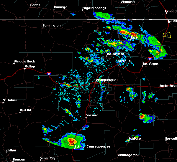
Hail Map for Arroyo Seco, NM
The Arroyo Seco, NM area has had 0 reports of on-the-ground hail by trained spotters, and has been under severe weather warnings 6 times during the past 12 months. Doppler radar has detected hail at or near Arroyo Seco, NM on 12 occasions, including 2 occasions during the past year.
| Name: | Arroyo Seco, NM |
| Where Located: | 7.6 miles N of Taos, NM |
| Map: | Google Map for Arroyo Seco, NM |
| Population: | 1785 |
| Housing Units: | 1118 |
| More Info: | Search Google for Arroyo Seco, NM |
0
The Top Recent Hail Date for Arroyo Seco, NM is Tuesday, September 17, 2024 (12th out of 12)

Hail and Wind Damage Spotted near Arroyo Seco, NM
| Date / Time | Report Details |
|---|---|
| 9/17/2024 3:52 PM MDT |
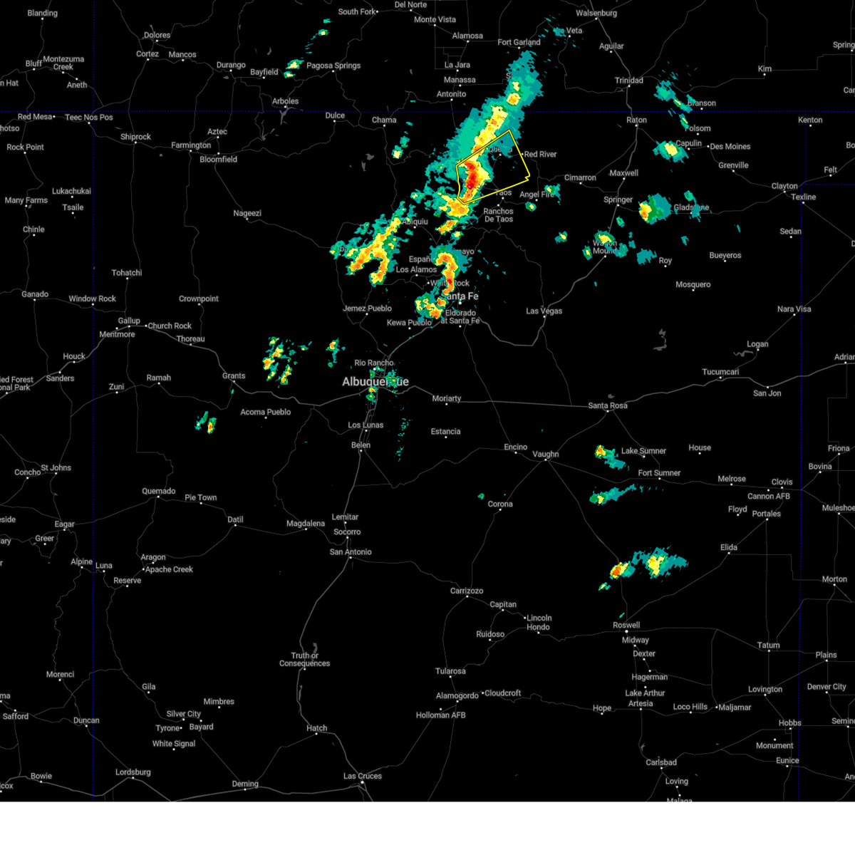
 The storm which prompted the warning has weakened below severe limits, and no longer poses an immediate threat to life or property. therefore, the warning will be allowed to expire. however, gusty winds are still possible with this thunderstorm. a severe thunderstorm watch remains in effect until 700 pm mdt for north central and northeastern new mexico. The storm which prompted the warning has weakened below severe limits, and no longer poses an immediate threat to life or property. therefore, the warning will be allowed to expire. however, gusty winds are still possible with this thunderstorm. a severe thunderstorm watch remains in effect until 700 pm mdt for north central and northeastern new mexico.
|
| 9/17/2024 3:29 PM MDT |
 the severe thunderstorm warning has been cancelled and is no longer in effect the severe thunderstorm warning has been cancelled and is no longer in effect
|
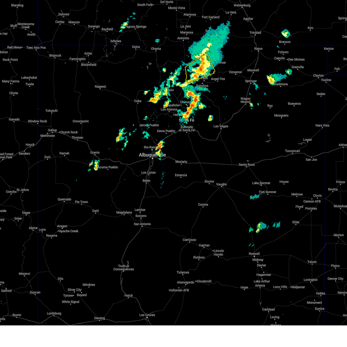
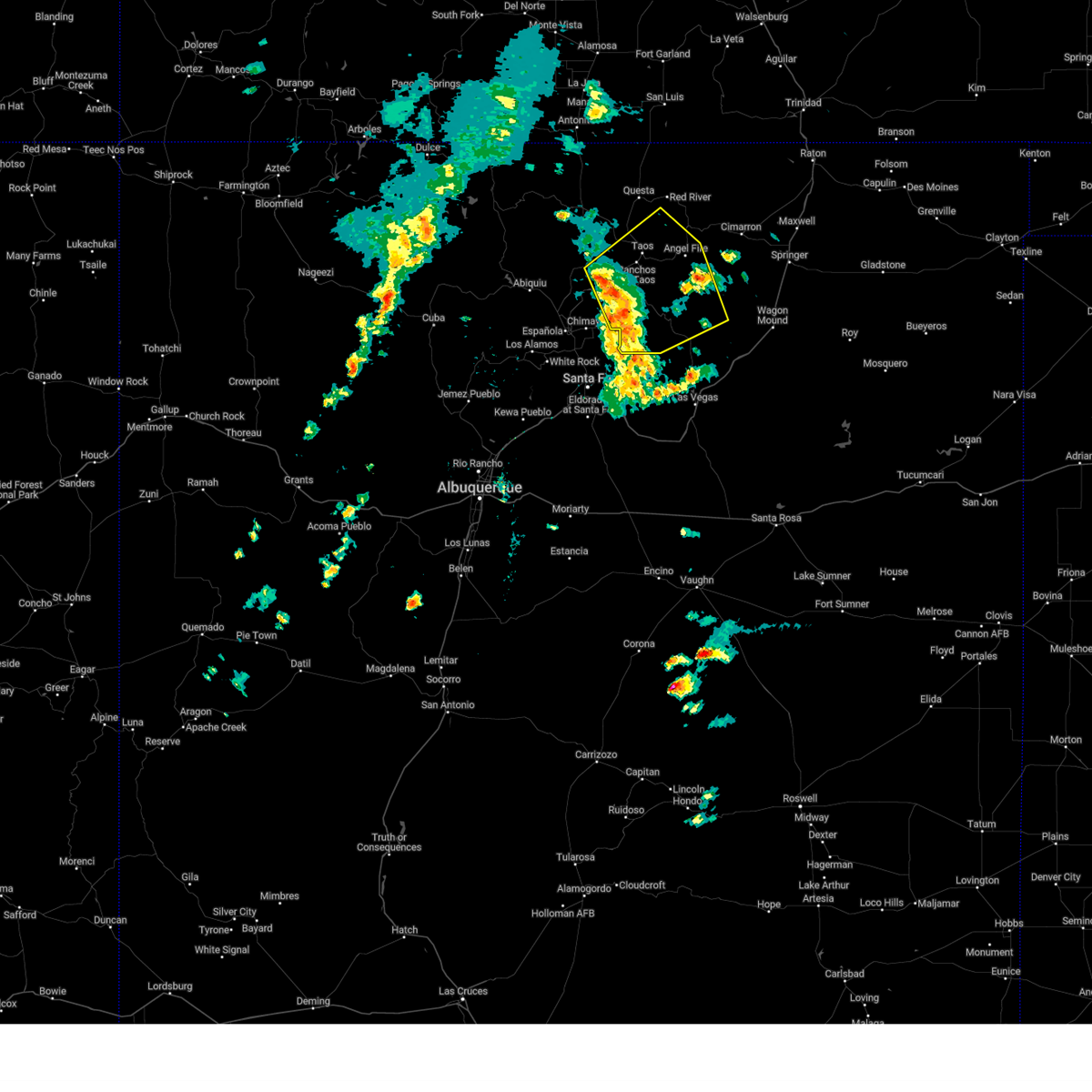
| 9/17/2024 3:29 PM MDT |
 At 328 pm mdt, a severe thunderstorm was located near arroyo hondo, or 14 miles northwest of taos, moving northeast at 45 mph (radar indicated). Hazards include 60 mph wind gusts and quarter size hail. Hail damage to vehicles is expected. expect wind damage to roofs, siding, and trees. locations impacted include, questa, red river, taos ski valley, arroyo hondo, arroyo seco, taos pueblo, valdez, cerro, san cristobal, and lama. this includes the following highways, highway 285 between mile markers 365 and 381, and near mile marker 383. Highway 64 between mile markers 224 and 248. At 328 pm mdt, a severe thunderstorm was located near arroyo hondo, or 14 miles northwest of taos, moving northeast at 45 mph (radar indicated). Hazards include 60 mph wind gusts and quarter size hail. Hail damage to vehicles is expected. expect wind damage to roofs, siding, and trees. locations impacted include, questa, red river, taos ski valley, arroyo hondo, arroyo seco, taos pueblo, valdez, cerro, san cristobal, and lama. this includes the following highways, highway 285 between mile markers 365 and 381, and near mile marker 383. Highway 64 between mile markers 224 and 248.
|
| 9/17/2024 3:15 PM MDT |
 Svrabq the national weather service in albuquerque has issued a * severe thunderstorm warning for, central taos county in north central new mexico, east central rio arriba county in north central new mexico, * until 400 pm mdt. * at 315 pm mdt, a severe thunderstorm was located near petaca, or 19 miles west of taos, moving northeast at 45 mph (radar indicated). Hazards include 60 mph wind gusts and quarter size hail. Hail damage to vehicles is expected. Expect wind damage to roofs, siding, and trees. Svrabq the national weather service in albuquerque has issued a * severe thunderstorm warning for, central taos county in north central new mexico, east central rio arriba county in north central new mexico, * until 400 pm mdt. * at 315 pm mdt, a severe thunderstorm was located near petaca, or 19 miles west of taos, moving northeast at 45 mph (radar indicated). Hazards include 60 mph wind gusts and quarter size hail. Hail damage to vehicles is expected. Expect wind damage to roofs, siding, and trees.
|
| 9/17/2024 1:49 PM MDT |
 the severe thunderstorm warning has been cancelled and is no longer in effect the severe thunderstorm warning has been cancelled and is no longer in effect
|
| 9/17/2024 12:53 PM MDT |
 Svrabq the national weather service in albuquerque has issued a * severe thunderstorm warning for, southern taos county in north central new mexico, southeastern rio arriba county in north central new mexico, northwestern mora county in northeastern new mexico, southwestern colfax county in northeastern new mexico, * until 200 pm mdt. * at 1253 pm mdt, severe thunderstorms were located along a line extending from 6 miles north of dixon to cowles, moving northeast at 45 mph (radar indicated). Hazards include 60 mph wind gusts. expect damage to roofs, siding, and trees Svrabq the national weather service in albuquerque has issued a * severe thunderstorm warning for, southern taos county in north central new mexico, southeastern rio arriba county in north central new mexico, northwestern mora county in northeastern new mexico, southwestern colfax county in northeastern new mexico, * until 200 pm mdt. * at 1253 pm mdt, severe thunderstorms were located along a line extending from 6 miles north of dixon to cowles, moving northeast at 45 mph (radar indicated). Hazards include 60 mph wind gusts. expect damage to roofs, siding, and trees
|
| 8/6/2019 1:55 PM MDT |
 At 155 pm mdt, a severe thunderstorm was located near pilar, or 11 miles west of taos, moving east at 10 mph (radar indicated). Hazards include 60 mph wind gusts and half dollar size hail. Hail damage to vehicles is expected. Expect wind damage to roofs, siding, and trees. At 155 pm mdt, a severe thunderstorm was located near pilar, or 11 miles west of taos, moving east at 10 mph (radar indicated). Hazards include 60 mph wind gusts and half dollar size hail. Hail damage to vehicles is expected. Expect wind damage to roofs, siding, and trees.
|
| 8/18/2018 1:59 PM MDT |
 The national weather service in albuquerque has issued a * severe thunderstorm warning for. east central taos county in north central new mexico. southwestern colfax county in northeastern new mexico. until 245 pm mdt. At 159 pm mdt, a severe thunderstorm was located near questa,. The national weather service in albuquerque has issued a * severe thunderstorm warning for. east central taos county in north central new mexico. southwestern colfax county in northeastern new mexico. until 245 pm mdt. At 159 pm mdt, a severe thunderstorm was located near questa,.
|
| 6/5/2016 5:36 PM MDT |
 The severe thunderstorm warning for central taos county will expire at 545 pm mdt, the storm which prompted the warning has weakened below severe limits, and no longer pose an immediate threat to life or property. therefore the warning will be allowed to expire. to report severe weather, contact your nearest law enforcement agency. they will relay your report to the national weather service albuquerque. The severe thunderstorm warning for central taos county will expire at 545 pm mdt, the storm which prompted the warning has weakened below severe limits, and no longer pose an immediate threat to life or property. therefore the warning will be allowed to expire. to report severe weather, contact your nearest law enforcement agency. they will relay your report to the national weather service albuquerque.
|
| 6/5/2016 5:11 PM MDT |
 At 511 pm mdt, a severe thunderstorm was located near taos ski valley, or 10 miles northeast of taos, moving southeast at 15 mph (radar indicated). Hazards include 60 mph wind gusts and penny size hail. Expect damage to roofs. siding. and trees. This severe thunderstorm will remain over mainly rural areas of central taos county. At 511 pm mdt, a severe thunderstorm was located near taos ski valley, or 10 miles northeast of taos, moving southeast at 15 mph (radar indicated). Hazards include 60 mph wind gusts and penny size hail. Expect damage to roofs. siding. and trees. This severe thunderstorm will remain over mainly rural areas of central taos county.
|
| 6/5/2016 4:53 PM MDT |
 At 453 pm mdt, a severe thunderstorm was located near taos ski valley, or 11 miles southeast of questa, moving east at 10 mph (radar indicated). Hazards include half dollar size hail and 60 mph wind gusts. Hail damage to vehicles is expected. Expect wind damage to roofs, siding, and trees. At 453 pm mdt, a severe thunderstorm was located near taos ski valley, or 11 miles southeast of questa, moving east at 10 mph (radar indicated). Hazards include half dollar size hail and 60 mph wind gusts. Hail damage to vehicles is expected. Expect wind damage to roofs, siding, and trees.
|
| 8/17/2015 12:39 PM MDT |
 At 1238 pm mdt, a severe thunderstorm was located near petaca, or 22 miles southwest of questa, moving southeast at 15 mph (radar indicated). Hazards include 60 mph wind gusts and quarter size hail. Hail damage to vehicles is expected. expect wind damage to roofs, siding and trees. this severe thunderstorm will remain over mainly rural areas of west central taos and east central rio arriba counties, including the following locations, las tablas. other locations affected include the following locations high bridge overlook, john dunn bridge river access, and rio grande gorge visitor center. This includes highway 285 between mile markers 365 and 387. At 1238 pm mdt, a severe thunderstorm was located near petaca, or 22 miles southwest of questa, moving southeast at 15 mph (radar indicated). Hazards include 60 mph wind gusts and quarter size hail. Hail damage to vehicles is expected. expect wind damage to roofs, siding and trees. this severe thunderstorm will remain over mainly rural areas of west central taos and east central rio arriba counties, including the following locations, las tablas. other locations affected include the following locations high bridge overlook, john dunn bridge river access, and rio grande gorge visitor center. This includes highway 285 between mile markers 365 and 387.
|
| 8/17/2015 12:17 PM MDT |
 At 1216 pm mdt, a severe thunderstorm was located near tres piedras, or 23 miles west of questa, moving southeast at 35 mph (radar indicated). Hazards include quarter size hail and 60 mph wind gusts. Hail damage to vehicles is expected. Expect wind damage to roofs, siding and trees. At 1216 pm mdt, a severe thunderstorm was located near tres piedras, or 23 miles west of questa, moving southeast at 35 mph (radar indicated). Hazards include quarter size hail and 60 mph wind gusts. Hail damage to vehicles is expected. Expect wind damage to roofs, siding and trees.
|
| 6/16/2015 4:05 PM MDT |
 At 404 pm mdt, a line of severe thunderstorms was stretching from 10 miles west of arroyo seco to 8 miles east of arroyo seco. this line was moving southeast at 15 mph (radar indicated). Hazards include quarter size hail and 60 mph wind gusts. Hail damage to vehicles is expected. Expect wind damage to roofs, siding and trees. At 404 pm mdt, a line of severe thunderstorms was stretching from 10 miles west of arroyo seco to 8 miles east of arroyo seco. this line was moving southeast at 15 mph (radar indicated). Hazards include quarter size hail and 60 mph wind gusts. Hail damage to vehicles is expected. Expect wind damage to roofs, siding and trees.
|
Hail Maps for Arroyo Seco, NM


Connect with Interactive Hail Maps