

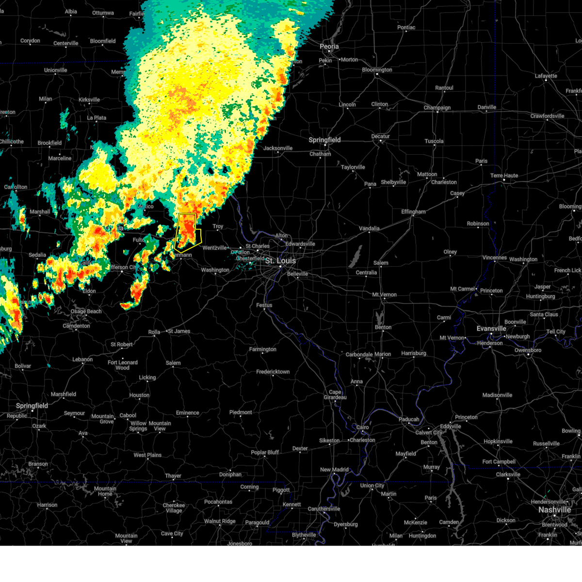
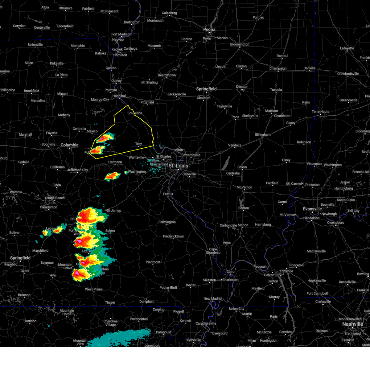
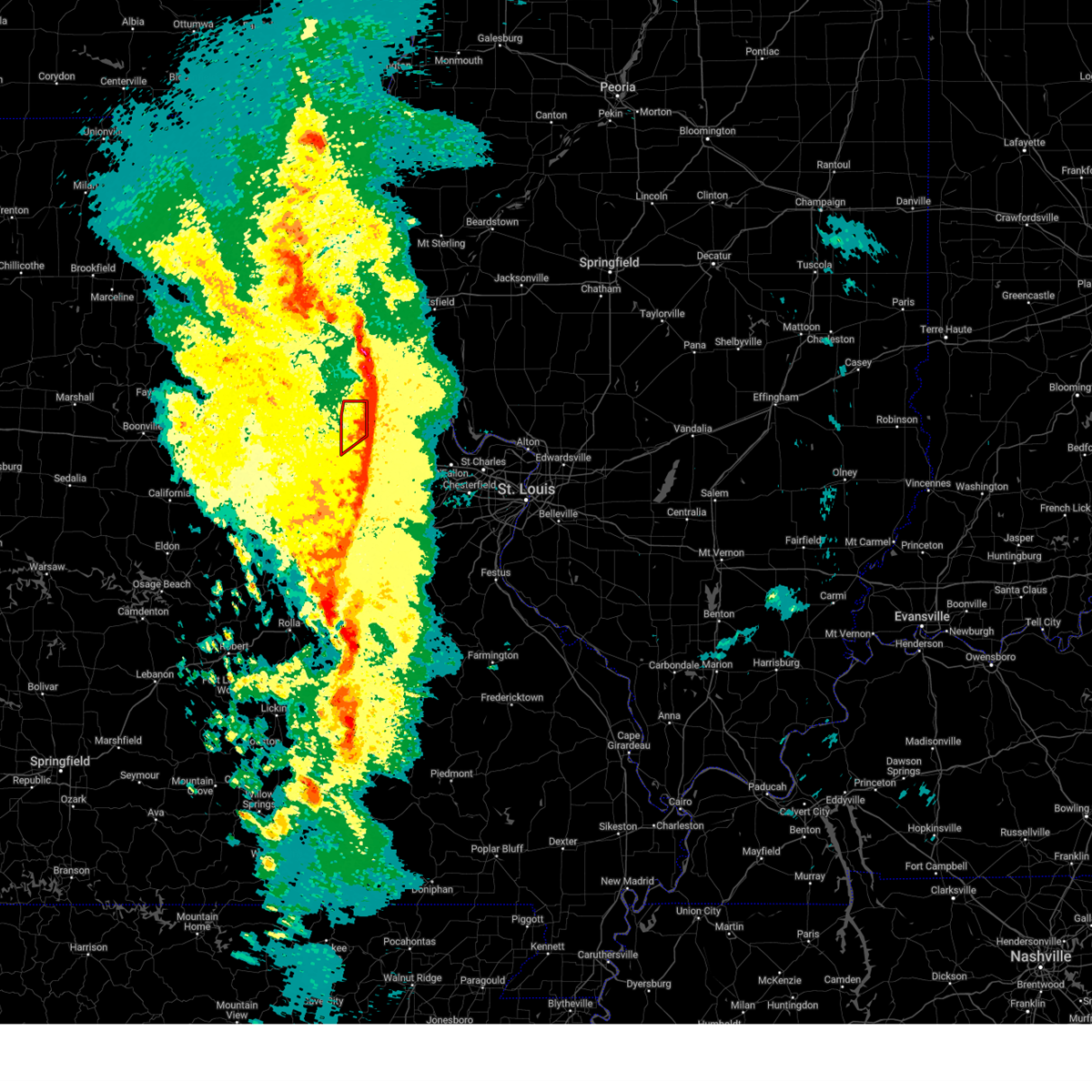
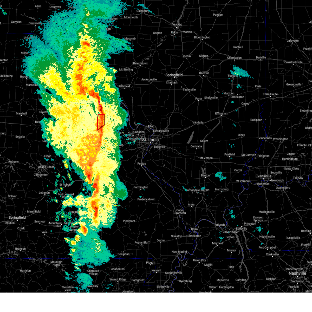
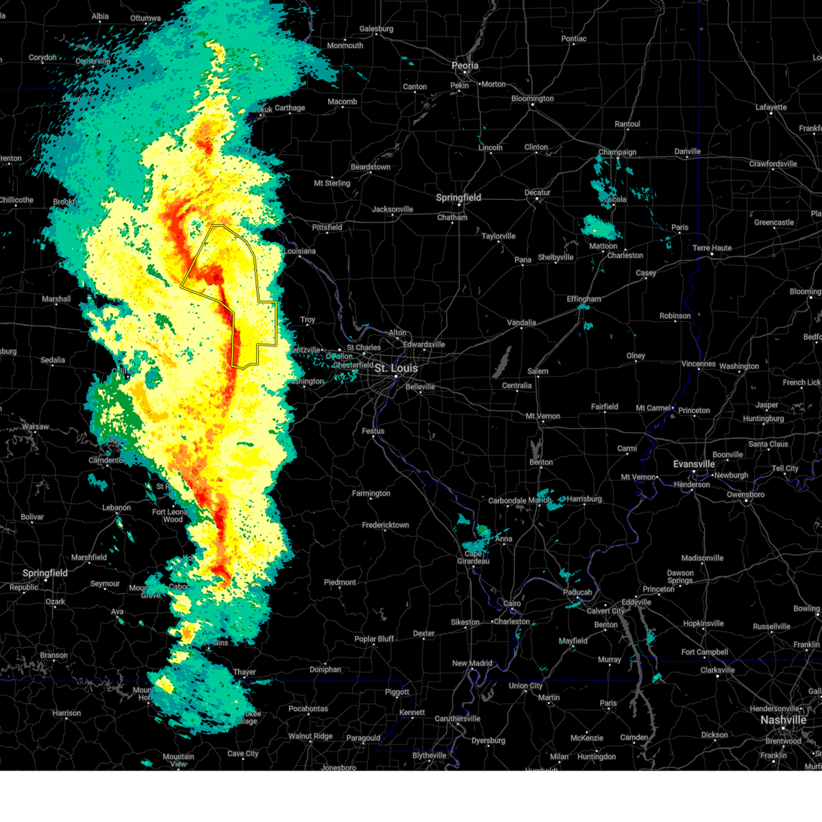
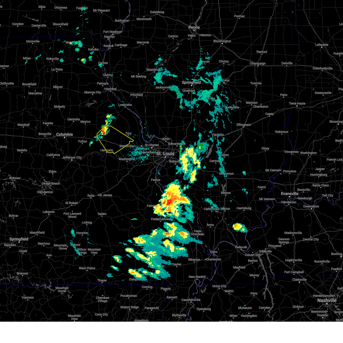
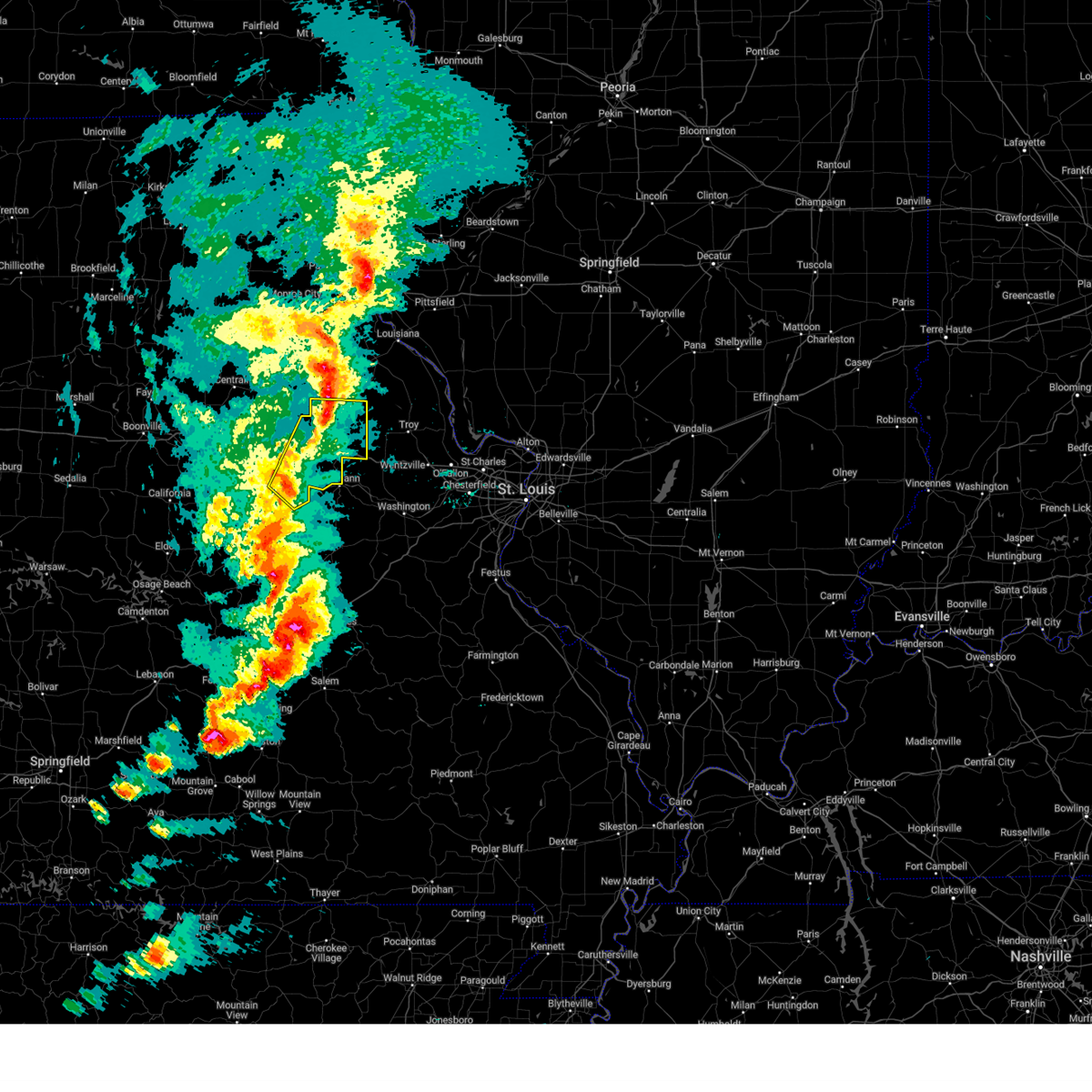
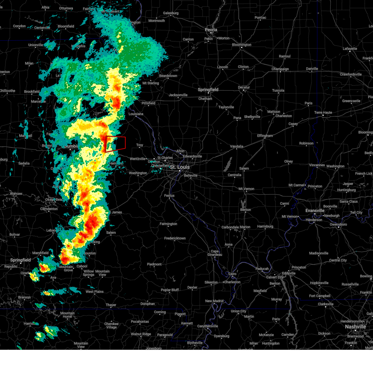
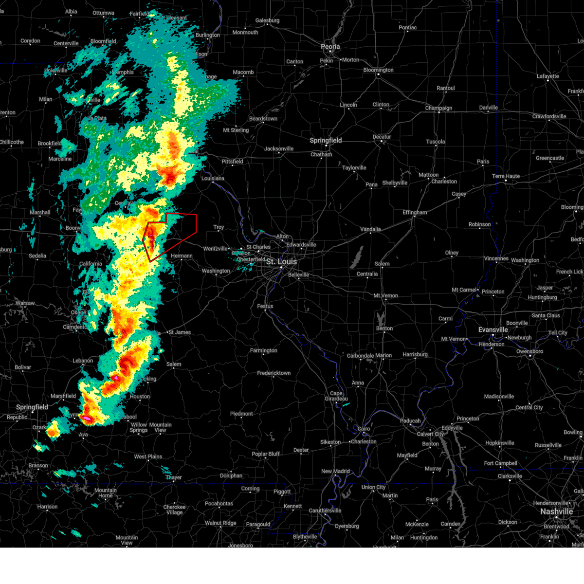
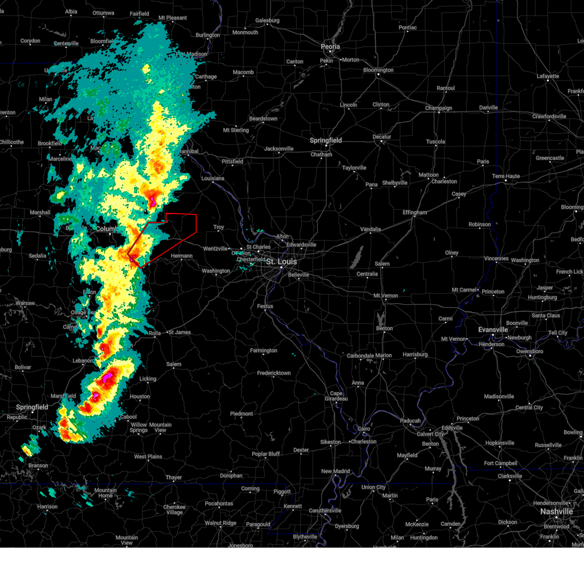
Hail Map for Bellflower, MO
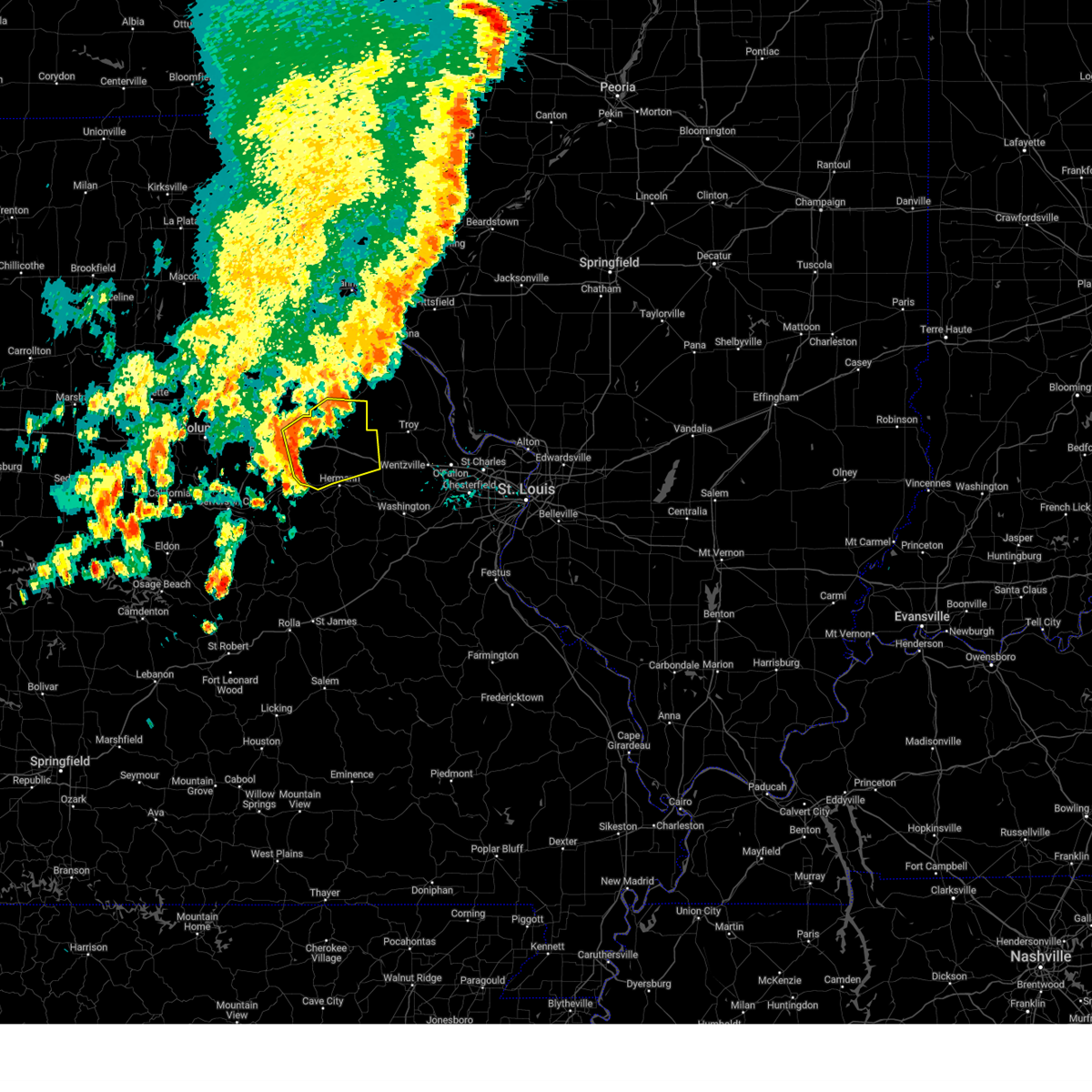
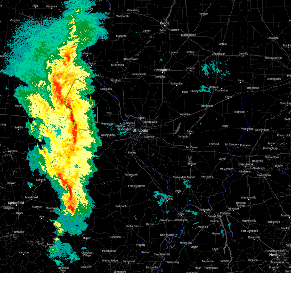
The Bellflower, MO area has had 3 reports of on-the-ground hail by trained spotters, and has been under severe weather warnings 33 times during the past 12 months. Doppler radar has detected hail at or near Bellflower, MO on 55 occasions, including 1 occasion during the past year.
| Name: | Bellflower, MO |
| Where Located: | 53 miles E of Columbia, MO |
| Map: | Google Map for Bellflower, MO |
| Population: | 393 |
| Housing Units: | 187 |
| More Info: | Search Google for Bellflower, MO |
2
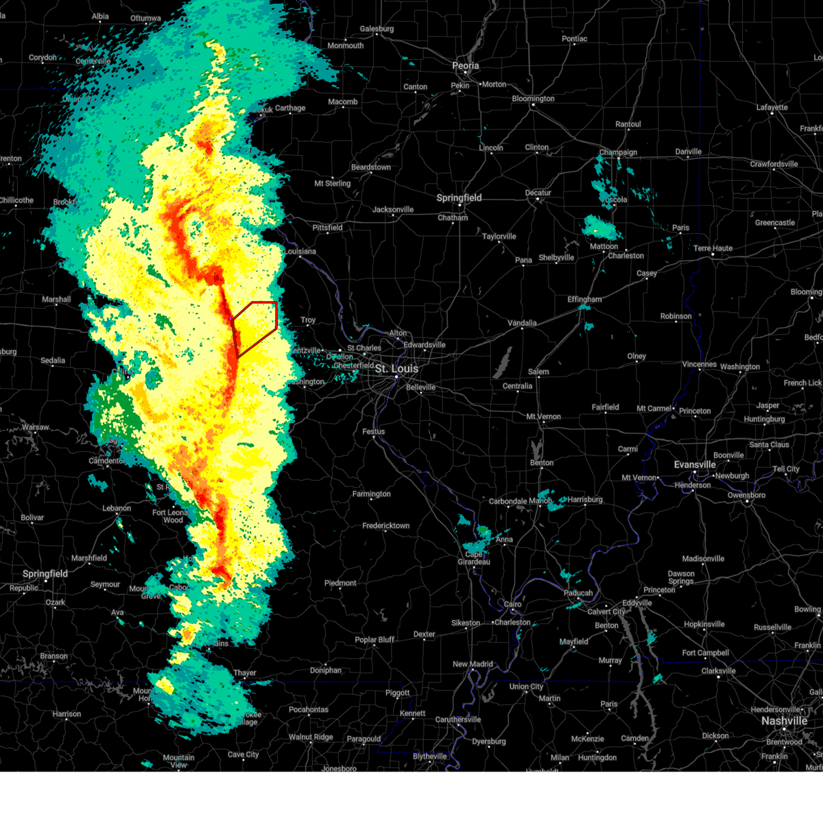
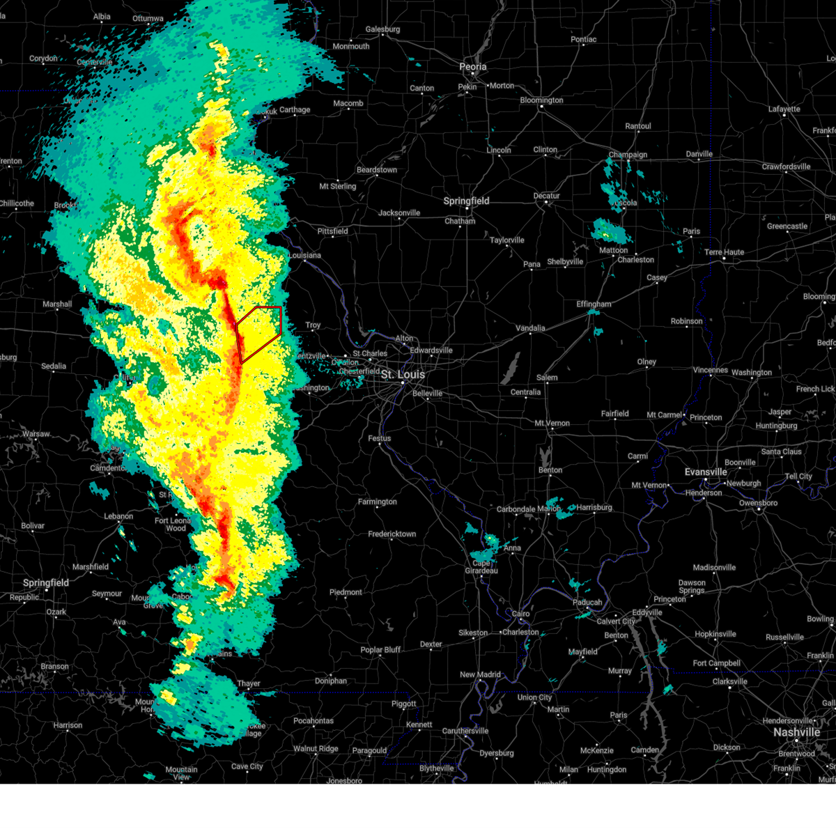
The Top Recent Hail Date for Bellflower, MO is Friday, May 16, 2025 (22nd out of 55)

Hail and Wind Damage Spotted near Bellflower, MO
| Date / Time | Report Details |
|---|---|
| 6/3/2025 7:50 PM CDT |
 The storms which prompted the warning have weakened below severe limits, and no longer pose an immediate threat to life or property. therefore, the warning will be allowed to expire. however, gusty winds are still possible with these thunderstorms. a severe thunderstorm watch remains in effect until 1100 pm cdt for a portion of east central missouri. The storms which prompted the warning have weakened below severe limits, and no longer pose an immediate threat to life or property. therefore, the warning will be allowed to expire. however, gusty winds are still possible with these thunderstorms. a severe thunderstorm watch remains in effect until 1100 pm cdt for a portion of east central missouri.
|
| 6/3/2025 7:40 PM CDT |
 At 740 pm cdt, severe thunderstorms were located along a line from near bellflower to near big spring, or along a line from 10 miles northeast of montgomery city to 6 miles north of hermann, moving northeast at 35 mph (radar indicated). Hazards include 60 mph wind gusts and small hail. Expect damage to roofs, siding, and trees. this severe thunderstorm will be near, montgomery city around 725 pm cdt. other locations impacted by the severe thunderstorm include high hill and middletown. This includes interstate 70 in missouri between exits 175 and 183. At 740 pm cdt, severe thunderstorms were located along a line from near bellflower to near big spring, or along a line from 10 miles northeast of montgomery city to 6 miles north of hermann, moving northeast at 35 mph (radar indicated). Hazards include 60 mph wind gusts and small hail. Expect damage to roofs, siding, and trees. this severe thunderstorm will be near, montgomery city around 725 pm cdt. other locations impacted by the severe thunderstorm include high hill and middletown. This includes interstate 70 in missouri between exits 175 and 183.
|
| 6/3/2025 7:22 PM CDT |
 At 722 pm cdt, severe thunderstorms were located along a line from over montgomery city to near big spring, or along a line from over montgomery city to 5 miles northwest of hermann, moving northeast at 35 mph (radar indicated). Hazards include 60 mph wind gusts and small hail. Expect damage to roofs, siding, and trees. this severe thunderstorm will be near, mineola around 720 pm cdt. other locations impacted by the severe thunderstorm include americus, rhineland, danville, mckittrick, high hill and middletown. this includes the following state parks, graham cave state park. This includes interstate 70 in missouri between exits 170 and 188. At 722 pm cdt, severe thunderstorms were located along a line from over montgomery city to near big spring, or along a line from over montgomery city to 5 miles northwest of hermann, moving northeast at 35 mph (radar indicated). Hazards include 60 mph wind gusts and small hail. Expect damage to roofs, siding, and trees. this severe thunderstorm will be near, mineola around 720 pm cdt. other locations impacted by the severe thunderstorm include americus, rhineland, danville, mckittrick, high hill and middletown. this includes the following state parks, graham cave state park. This includes interstate 70 in missouri between exits 170 and 188.
|
| 6/3/2025 7:22 PM CDT |
 the severe thunderstorm warning has been cancelled and is no longer in effect the severe thunderstorm warning has been cancelled and is no longer in effect
|
| 6/3/2025 7:12 PM CDT |
 Svrlsx the national weather service in st louis has issued a * severe thunderstorm warning for, northeastern callaway county in central missouri, montgomery county in east central missouri, northwestern warren county in east central missouri, * until 800 pm cdt. * at 712 pm cdt, severe thunderstorms were located along a line from over williamsburg to 8 miles east of chamois, or along a line from 10 miles west of montgomery city to 10 miles west of hermann, moving northeast at 35 mph (radar indicated). Hazards include 60 mph wind gusts. Expect damage to roofs, siding, and trees. this severe thunderstorm will be near, williamsburg and shamrock around 715 pm cdt. mineola around 720 pm cdt. other locations impacted by the severe thunderstorm include americus, rhineland, danville, mckittrick, high hill and middletown. this includes the following state parks, graham cave state park. This includes interstate 70 in missouri between exits 161 and 188. Svrlsx the national weather service in st louis has issued a * severe thunderstorm warning for, northeastern callaway county in central missouri, montgomery county in east central missouri, northwestern warren county in east central missouri, * until 800 pm cdt. * at 712 pm cdt, severe thunderstorms were located along a line from over williamsburg to 8 miles east of chamois, or along a line from 10 miles west of montgomery city to 10 miles west of hermann, moving northeast at 35 mph (radar indicated). Hazards include 60 mph wind gusts. Expect damage to roofs, siding, and trees. this severe thunderstorm will be near, williamsburg and shamrock around 715 pm cdt. mineola around 720 pm cdt. other locations impacted by the severe thunderstorm include americus, rhineland, danville, mckittrick, high hill and middletown. this includes the following state parks, graham cave state park. This includes interstate 70 in missouri between exits 161 and 188.
|
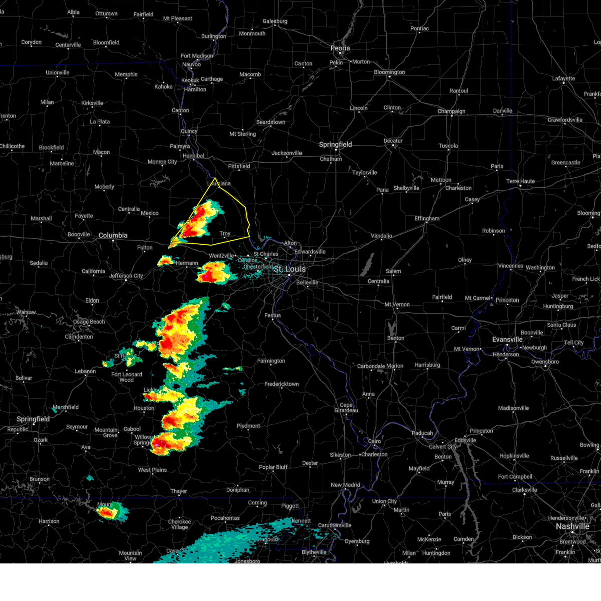
| 5/16/2025 1:45 PM CDT | Hen Egg sized hail reported 0.3 miles NW of Bellflower, MO, emergency management relayed a photo of large hail. time estimated by radar. |
| 5/16/2025 1:43 PM CDT |
 the severe thunderstorm warning has been cancelled and is no longer in effect the severe thunderstorm warning has been cancelled and is no longer in effect
|
| 5/16/2025 1:43 PM CDT |
 At 143 pm cdt, a severe thunderstorm was located over bellflower, or 9 miles northeast of montgomery city, moving east at 60 mph (radar indicated). Hazards include golf ball size hail and 60 mph wind gusts. People and animals outdoors will be injured. expect hail damage to roofs, siding, windows, and vehicles. expect wind damage to roofs, siding, and trees. locations impacted include, troy, bowling green, louisiana, montgomery city, elsberry, moscow mills, winfield, davis, hawk point, eolia, clarksville, bellflower, fountain n' lakes, new hartford, tarrants, buell, silex, middletown, foley and truxton. This includes the following state parks, cuivre river state park. At 143 pm cdt, a severe thunderstorm was located over bellflower, or 9 miles northeast of montgomery city, moving east at 60 mph (radar indicated). Hazards include golf ball size hail and 60 mph wind gusts. People and animals outdoors will be injured. expect hail damage to roofs, siding, windows, and vehicles. expect wind damage to roofs, siding, and trees. locations impacted include, troy, bowling green, louisiana, montgomery city, elsberry, moscow mills, winfield, davis, hawk point, eolia, clarksville, bellflower, fountain n' lakes, new hartford, tarrants, buell, silex, middletown, foley and truxton. This includes the following state parks, cuivre river state park.
|
| 5/16/2025 1:36 PM CDT |
 At 136 pm cdt, a severe thunderstorm was located 6 miles west of new hartford, or 11 miles southeast of vandalia, moving east at 50 mph (radar indicated). Hazards include golf ball size hail and 60 mph wind gusts. People and animals outdoors will be injured. expect hail damage to roofs, siding, windows, and vehicles. expect wind damage to roofs, siding, and trees. locations impacted include, troy, bowling green, louisiana, montgomery city, elsberry, wellsville, moscow mills, winfield, davis, hawk point, eolia, clarksville, bellflower, curryville, fountain n' lakes, new hartford, tarrants, buell, silex and middletown. This includes the following state parks, cuivre river state park. At 136 pm cdt, a severe thunderstorm was located 6 miles west of new hartford, or 11 miles southeast of vandalia, moving east at 50 mph (radar indicated). Hazards include golf ball size hail and 60 mph wind gusts. People and animals outdoors will be injured. expect hail damage to roofs, siding, windows, and vehicles. expect wind damage to roofs, siding, and trees. locations impacted include, troy, bowling green, louisiana, montgomery city, elsberry, wellsville, moscow mills, winfield, davis, hawk point, eolia, clarksville, bellflower, curryville, fountain n' lakes, new hartford, tarrants, buell, silex and middletown. This includes the following state parks, cuivre river state park.
|
| 5/16/2025 1:36 PM CDT |
 the severe thunderstorm warning has been cancelled and is no longer in effect the severe thunderstorm warning has been cancelled and is no longer in effect
|
| 5/16/2025 1:26 PM CDT |
 At 126 pm cdt, a severe thunderstorm was located near wellsville, moving east at 50 mph (radar indicated). Hazards include golf ball size hail and 60 mph wind gusts. People and animals outdoors will be injured. expect hail damage to roofs, siding, windows, and vehicles. expect wind damage to roofs, siding, and trees. locations impacted include, troy, bowling green, louisiana, montgomery city, elsberry, wellsville, moscow mills, winfield, davis, new florence, hawk point, eolia, clarksville, bellflower, frankford, martinsburg, curryville, fountain n' lakes, new hartford and tarrants. this includes the following state parks, cuivre river state park and graham cave state park. This includes interstate 70 in missouri between exits 155 and 179. At 126 pm cdt, a severe thunderstorm was located near wellsville, moving east at 50 mph (radar indicated). Hazards include golf ball size hail and 60 mph wind gusts. People and animals outdoors will be injured. expect hail damage to roofs, siding, windows, and vehicles. expect wind damage to roofs, siding, and trees. locations impacted include, troy, bowling green, louisiana, montgomery city, elsberry, wellsville, moscow mills, winfield, davis, new florence, hawk point, eolia, clarksville, bellflower, frankford, martinsburg, curryville, fountain n' lakes, new hartford and tarrants. this includes the following state parks, cuivre river state park and graham cave state park. This includes interstate 70 in missouri between exits 155 and 179.
|
| 5/16/2025 1:17 PM CDT |
 Svrlsx the national weather service in st louis has issued a * severe thunderstorm warning for, southeastern audrain county in central missouri, northeastern callaway county in central missouri, lincoln county in east central missouri, montgomery county in east central missouri, north central warren county in east central missouri, pike county in northeastern missouri, * until 230 pm cdt. * at 117 pm cdt, a severe thunderstorm was located over martinsburg, or 6 miles west of wellsville, moving northeast at 50 mph (radar indicated). Hazards include 60 mph wind gusts and half dollar size hail. Hail damage to vehicles is expected. Expect wind damage to roofs, siding, and trees. Svrlsx the national weather service in st louis has issued a * severe thunderstorm warning for, southeastern audrain county in central missouri, northeastern callaway county in central missouri, lincoln county in east central missouri, montgomery county in east central missouri, north central warren county in east central missouri, pike county in northeastern missouri, * until 230 pm cdt. * at 117 pm cdt, a severe thunderstorm was located over martinsburg, or 6 miles west of wellsville, moving northeast at 50 mph (radar indicated). Hazards include 60 mph wind gusts and half dollar size hail. Hail damage to vehicles is expected. Expect wind damage to roofs, siding, and trees.
|
| 4/20/2025 6:27 PM CDT |
 The storm which prompted the warning has moved out of the area. therefore, the warning will be allowed to expire. however, gusty winds are still possible with this thunderstorm. a tornado watch remains in effect until 1100 pm cdt for a portion of east central missouri. The storm which prompted the warning has moved out of the area. therefore, the warning will be allowed to expire. however, gusty winds are still possible with this thunderstorm. a tornado watch remains in effect until 1100 pm cdt for a portion of east central missouri.
|
| 4/20/2025 6:19 PM CDT |
 At 619 pm cdt, a severe thunderstorm capable of producing a tornado was located near new hartford, or 14 miles south of bowling green, moving northeast at 50 mph (radar indicated rotation). Hazards include tornado and quarter size hail. Flying debris will be dangerous to those caught without shelter. mobile homes will be damaged or destroyed. damage to roofs, windows and vehicles will occur. tree damage is likely. Other locations impacted by the tornado include middletown. At 619 pm cdt, a severe thunderstorm capable of producing a tornado was located near new hartford, or 14 miles south of bowling green, moving northeast at 50 mph (radar indicated rotation). Hazards include tornado and quarter size hail. Flying debris will be dangerous to those caught without shelter. mobile homes will be damaged or destroyed. damage to roofs, windows and vehicles will occur. tree damage is likely. Other locations impacted by the tornado include middletown.
|
| 4/20/2025 5:59 PM CDT |
 At 559 pm cdt, severe thunderstorms were located along a line from 5 miles east of paris to over mineola, or along a line from 5 miles east of paris to 7 miles south of montgomery city, moving northeast at 60 mph (radar indicated). Hazards include 70 mph wind gusts. Expect considerable tree damage. damage is likely to mobile homes, roofs, and outbuildings. this severe thunderstorm will be near, mexico around 535 pm cdt. other locations impacted by the severe thunderstorm include rush hill, americus, danville, florida, stoutsville, high hill, middletown, the landing and indian creek. this includes the following state parks, graham cave state park and mark twain lake recreational area. This includes interstate 70 in missouri between exits 170 and 183. At 559 pm cdt, severe thunderstorms were located along a line from 5 miles east of paris to over mineola, or along a line from 5 miles east of paris to 7 miles south of montgomery city, moving northeast at 60 mph (radar indicated). Hazards include 70 mph wind gusts. Expect considerable tree damage. damage is likely to mobile homes, roofs, and outbuildings. this severe thunderstorm will be near, mexico around 535 pm cdt. other locations impacted by the severe thunderstorm include rush hill, americus, danville, florida, stoutsville, high hill, middletown, the landing and indian creek. this includes the following state parks, graham cave state park and mark twain lake recreational area. This includes interstate 70 in missouri between exits 170 and 183.
|
| 4/20/2025 5:59 PM CDT |
 the severe thunderstorm warning has been cancelled and is no longer in effect the severe thunderstorm warning has been cancelled and is no longer in effect
|
| 4/20/2025 5:55 PM CDT |
 At 555 pm cdt, a severe thunderstorm capable of producing a tornado was located over montgomery city, moving northeast at 65 mph. another potential tornado was also located 2 miles northeast of shamrock (radar indicated rotation). Hazards include tornado and quarter size hail. Flying debris will be dangerous to those caught without shelter. mobile homes will be damaged or destroyed. damage to roofs, windows and vehicles will occur. tree damage is likely. this tornado will be near, mineola around 550 pm cdt. other locations impacted by the tornado include danville and middletown. this includes the following state parks, graham cave state park. This includes interstate 70 in missouri between exits 170 and 175. At 555 pm cdt, a severe thunderstorm capable of producing a tornado was located over montgomery city, moving northeast at 65 mph. another potential tornado was also located 2 miles northeast of shamrock (radar indicated rotation). Hazards include tornado and quarter size hail. Flying debris will be dangerous to those caught without shelter. mobile homes will be damaged or destroyed. damage to roofs, windows and vehicles will occur. tree damage is likely. this tornado will be near, mineola around 550 pm cdt. other locations impacted by the tornado include danville and middletown. this includes the following state parks, graham cave state park. This includes interstate 70 in missouri between exits 170 and 175.
|
| 4/20/2025 5:55 PM CDT |
 the tornado warning has been cancelled and is no longer in effect the tornado warning has been cancelled and is no longer in effect
|
| 4/20/2025 5:47 PM CDT |
 At 547 pm cdt, severe thunderstorms were located along a line from 9 miles southwest of paris to 6 miles northeast of chamois, or along a line from 9 miles southwest of paris to 14 miles southeast of fulton, moving northeast at 60 mph (radar indicated). Hazards include 70 mph wind gusts. Expect considerable tree damage. damage is likely to mobile homes, roofs, and outbuildings. this severe thunderstorm will be near, mexico around 535 pm cdt. chamois around 540 pm cdt. other locations impacted by the severe thunderstorm include thompson, reform, vandiver, portland, rush hill, benton city, americus, danville, florida and stoutsville. this includes the following state parks, graham cave state park and mark twain lake recreational area. This includes interstate 70 in missouri between exits 155 and 183. At 547 pm cdt, severe thunderstorms were located along a line from 9 miles southwest of paris to 6 miles northeast of chamois, or along a line from 9 miles southwest of paris to 14 miles southeast of fulton, moving northeast at 60 mph (radar indicated). Hazards include 70 mph wind gusts. Expect considerable tree damage. damage is likely to mobile homes, roofs, and outbuildings. this severe thunderstorm will be near, mexico around 535 pm cdt. chamois around 540 pm cdt. other locations impacted by the severe thunderstorm include thompson, reform, vandiver, portland, rush hill, benton city, americus, danville, florida and stoutsville. this includes the following state parks, graham cave state park and mark twain lake recreational area. This includes interstate 70 in missouri between exits 155 and 183.
|
| 4/20/2025 5:47 PM CDT |
 the severe thunderstorm warning has been cancelled and is no longer in effect the severe thunderstorm warning has been cancelled and is no longer in effect
|
| 4/20/2025 5:44 PM CDT |
 Torlsx the national weather service in st louis has issued a * tornado warning for, east central callaway county in central missouri, montgomery county in east central missouri, * until 630 pm cdt. * at 544 pm cdt, a severe thunderstorm capable of producing a tornado was located 7 miles south of williamsburg, or 11 miles east of fulton, moving northeast at 55 mph (radar indicated rotation). Hazards include tornado and quarter size hail. Flying debris will be dangerous to those caught without shelter. mobile homes will be damaged or destroyed. damage to roofs, windows and vehicles will occur. tree damage is likely. this tornado will be near, williamsburg around 550 pm cdt. other locations impacted by the tornado include danville and middletown. this includes the following state parks, graham cave state park. This includes interstate 70 in missouri between exits 161 and 175. Torlsx the national weather service in st louis has issued a * tornado warning for, east central callaway county in central missouri, montgomery county in east central missouri, * until 630 pm cdt. * at 544 pm cdt, a severe thunderstorm capable of producing a tornado was located 7 miles south of williamsburg, or 11 miles east of fulton, moving northeast at 55 mph (radar indicated rotation). Hazards include tornado and quarter size hail. Flying debris will be dangerous to those caught without shelter. mobile homes will be damaged or destroyed. damage to roofs, windows and vehicles will occur. tree damage is likely. this tornado will be near, williamsburg around 550 pm cdt. other locations impacted by the tornado include danville and middletown. this includes the following state parks, graham cave state park. This includes interstate 70 in missouri between exits 161 and 175.
|
| 4/20/2025 5:30 PM CDT | Svrlsx the national weather service in st louis has issued a * severe thunderstorm warning for, audrain county in central missouri, northeastern boone county in central missouri, eastern callaway county in central missouri, montgomery county in east central missouri, eastern monroe county in northeastern missouri, southwestern ralls county in northeastern missouri, * until 615 pm cdt. * at 530 pm cdt, severe thunderstorms were located along a line from near sturgeon to 10 miles northwest of linn, or along a line from 10 miles west of centralia to 10 miles northwest of linn, moving northeast at 60 mph (trained spotters reported. at 5:26 pm a 66 mph wind gust was observed at jefferson city). Hazards include 70 mph wind gusts. Expect considerable tree damage. damage is likely to mobile homes, roofs, and outbuildings. this severe thunderstorm will be near, centralia and mexico around 535 pm cdt. auxvasse and chamois around 540 pm cdt. other locations impacted by the severe thunderstorm include mokane, steedman, thompson, reform, vandiver, portland, rush hill, benton city, americus and danville. this includes the following state parks, graham cave state park and mark twain lake recreational area. This includes interstate 70 in missouri between exits 155 and 183. |
| 4/10/2025 1:14 PM CDT |
 At 114 pm cdt, a severe thunderstorm was located over jonesburg, moving southeast at 35 mph (radar indicated). Hazards include 60 mph wind gusts and quarter size hail. Hail damage to vehicles is expected. expect wind damage to roofs, siding, and trees. locations impacted include, warrenton, high hill, olney, truesdale, jonesburg, new florence, mckittrick, big spring, truxton, hawk point, wright city, bellflower, moscow mills, and foristell. This includes interstate 70 in missouri between exits 175 and 200. At 114 pm cdt, a severe thunderstorm was located over jonesburg, moving southeast at 35 mph (radar indicated). Hazards include 60 mph wind gusts and quarter size hail. Hail damage to vehicles is expected. expect wind damage to roofs, siding, and trees. locations impacted include, warrenton, high hill, olney, truesdale, jonesburg, new florence, mckittrick, big spring, truxton, hawk point, wright city, bellflower, moscow mills, and foristell. This includes interstate 70 in missouri between exits 175 and 200.
|
| 4/10/2025 12:58 PM CDT |
 Svrlsx the national weather service in st louis has issued a * severe thunderstorm warning for, southwestern lincoln county in east central missouri, montgomery county in east central missouri, central warren county in east central missouri, * until 145 pm cdt. * at 1258 pm cdt, a severe thunderstorm was located near new florence, moving southeast at 35 mph (radar indicated). Hazards include 60 mph wind gusts and quarter size hail. Hail damage to vehicles is expected. Expect wind damage to roofs, siding, and trees. Svrlsx the national weather service in st louis has issued a * severe thunderstorm warning for, southwestern lincoln county in east central missouri, montgomery county in east central missouri, central warren county in east central missouri, * until 145 pm cdt. * at 1258 pm cdt, a severe thunderstorm was located near new florence, moving southeast at 35 mph (radar indicated). Hazards include 60 mph wind gusts and quarter size hail. Hail damage to vehicles is expected. Expect wind damage to roofs, siding, and trees.
|
| 3/14/2025 8:53 PM CDT |
 The storm which prompted the warning has moved out of the area. therefore, the warning will be allowed to expire. however, gusty winds are still possible with this thunderstorm. a tornado watch remains in effect until 1100 pm cdt for a portion of east central missouri. The storm which prompted the warning has moved out of the area. therefore, the warning will be allowed to expire. however, gusty winds are still possible with this thunderstorm. a tornado watch remains in effect until 1100 pm cdt for a portion of east central missouri.
|
| 3/14/2025 8:37 PM CDT |
 At 837 pm cdt, a severe thunderstorm was located near bellflower, or 10 miles east of montgomery city, moving northeast at 75 mph (radar indicated). Hazards include 60 mph wind gusts and small hail. Expect damage to roofs, siding, and trees. other locations impacted by the severe thunderstorm include high hill. This includes interstate 70 in missouri between exits 179 and 183. At 837 pm cdt, a severe thunderstorm was located near bellflower, or 10 miles east of montgomery city, moving northeast at 75 mph (radar indicated). Hazards include 60 mph wind gusts and small hail. Expect damage to roofs, siding, and trees. other locations impacted by the severe thunderstorm include high hill. This includes interstate 70 in missouri between exits 179 and 183.
|
| 3/14/2025 8:09 PM CDT | At 809 pm cdt, a severe thunderstorm was located over montgomery city, moving northeast at 75 mph (radar indicated). Hazards include 70 mph wind gusts. Expect considerable tree damage. damage is likely to mobile homes, roofs, and outbuildings. this severe thunderstorm will be near, mineola and big spring around 805 pm cdt. other locations impacted by the severe thunderstorm include americus, danville and middletown. this includes the following state parks, graham cave state park. This includes interstate 70 in missouri between exits 170 and 183. |
| 3/14/2025 8:09 PM CDT | the severe thunderstorm warning has been cancelled and is no longer in effect |
| 3/14/2025 7:57 PM CDT |
 The tornado threat has diminished and the tornado warning has been cancelled. however, large hail and damaging winds remain likely and a severe thunderstorm warning remains in effect for the area. a tornado watch remains in effect until 1100 pm cdt friday for a portion of east central missouri. The tornado threat has diminished and the tornado warning has been cancelled. however, large hail and damaging winds remain likely and a severe thunderstorm warning remains in effect for the area. a tornado watch remains in effect until 1100 pm cdt friday for a portion of east central missouri.
|
| 3/14/2025 7:54 PM CDT |
 Svrlsx the national weather service in st louis has issued a * severe thunderstorm warning for, eastern callaway county in central missouri, northeastern osage county in central missouri, montgomery county in east central missouri, * until 900 pm cdt. * at 754 pm cdt, a severe thunderstorm was located over chamois, or 15 miles southeast of fulton, moving northeast at 55 mph (radar indicated). Hazards include 70 mph wind gusts. Expect considerable tree damage. damage is likely to mobile homes, roofs, and outbuildings. this severe thunderstorm will be near, chamois around 755 pm cdt. other locations impacted by the severe thunderstorm include portland, steedman, reform, mokane, morrison, americus, danville, high hill and middletown. this includes the following state parks, graham cave state park. This includes interstate 70 in missouri between exits 161 and 183. Svrlsx the national weather service in st louis has issued a * severe thunderstorm warning for, eastern callaway county in central missouri, northeastern osage county in central missouri, montgomery county in east central missouri, * until 900 pm cdt. * at 754 pm cdt, a severe thunderstorm was located over chamois, or 15 miles southeast of fulton, moving northeast at 55 mph (radar indicated). Hazards include 70 mph wind gusts. Expect considerable tree damage. damage is likely to mobile homes, roofs, and outbuildings. this severe thunderstorm will be near, chamois around 755 pm cdt. other locations impacted by the severe thunderstorm include portland, steedman, reform, mokane, morrison, americus, danville, high hill and middletown. this includes the following state parks, graham cave state park. This includes interstate 70 in missouri between exits 161 and 183.
|
| 3/14/2025 7:46 PM CDT |
 the tornado warning has been cancelled and is no longer in effect the tornado warning has been cancelled and is no longer in effect
|
| 3/14/2025 7:46 PM CDT |
 At 746 pm cdt, a severe thunderstorm capable of producing a tornado was located near wellsville, moving northeast at 50 mph (radar indicated rotation). Hazards include tornado and quarter size hail. Flying debris will be dangerous to those caught without shelter. mobile homes will be damaged or destroyed. damage to roofs, windows and vehicles will occur. tree damage is likely. Other locations impacted by the tornado include middletown. At 746 pm cdt, a severe thunderstorm capable of producing a tornado was located near wellsville, moving northeast at 50 mph (radar indicated rotation). Hazards include tornado and quarter size hail. Flying debris will be dangerous to those caught without shelter. mobile homes will be damaged or destroyed. damage to roofs, windows and vehicles will occur. tree damage is likely. Other locations impacted by the tornado include middletown.
|
| 3/14/2025 7:30 PM CDT |
 At 730 pm cdt, a severe thunderstorm capable of producing a tornado was located near williamsburg, or 12 miles southwest of wellsville, moving northeast at 75 mph (radar indicated rotation). Hazards include tornado and quarter size hail. Flying debris will be dangerous to those caught without shelter. mobile homes will be damaged or destroyed. damage to roofs, windows and vehicles will occur. tree damage is likely. this tornado will be near, williamsburg around 730 pm cdt. other locations impacted by the tornado include reform and middletown. this includes the following state parks, graham cave state park. This includes interstate 70 in missouri between exits 155 and 175. At 730 pm cdt, a severe thunderstorm capable of producing a tornado was located near williamsburg, or 12 miles southwest of wellsville, moving northeast at 75 mph (radar indicated rotation). Hazards include tornado and quarter size hail. Flying debris will be dangerous to those caught without shelter. mobile homes will be damaged or destroyed. damage to roofs, windows and vehicles will occur. tree damage is likely. this tornado will be near, williamsburg around 730 pm cdt. other locations impacted by the tornado include reform and middletown. this includes the following state parks, graham cave state park. This includes interstate 70 in missouri between exits 155 and 175.
|
| 3/14/2025 7:15 PM CDT |
 Torlsx the national weather service in st louis has issued a * tornado warning for, southeastern callaway county in central missouri, montgomery county in east central missouri, * until 800 pm cdt. * at 715 pm cdt, a severe thunderstorm capable of producing a tornado was located 8 miles south of fulton, moving northeast at 60 mph (radar indicated rotation). Hazards include tornado. Flying debris will be dangerous to those caught without shelter. mobile homes will be damaged or destroyed. damage to roofs, windows and vehicles will occur. tree damage is likely. this tornado will be near, new bloomfield around 715 pm cdt. fulton around 720 pm cdt. other locations impacted by the tornado include mokane, steedman, reform, danville and middletown. this includes the following state parks, graham cave state park. This includes interstate 70 in missouri between exits 148 and 175. Torlsx the national weather service in st louis has issued a * tornado warning for, southeastern callaway county in central missouri, montgomery county in east central missouri, * until 800 pm cdt. * at 715 pm cdt, a severe thunderstorm capable of producing a tornado was located 8 miles south of fulton, moving northeast at 60 mph (radar indicated rotation). Hazards include tornado. Flying debris will be dangerous to those caught without shelter. mobile homes will be damaged or destroyed. damage to roofs, windows and vehicles will occur. tree damage is likely. this tornado will be near, new bloomfield around 715 pm cdt. fulton around 720 pm cdt. other locations impacted by the tornado include mokane, steedman, reform, danville and middletown. this includes the following state parks, graham cave state park. This includes interstate 70 in missouri between exits 148 and 175.
|
| 6/25/2024 6:23 PM CDT |
 The storm which prompted the warning has weakened below severe limits, and no longer poses an immediate threat to life or property. therefore, the warning will be allowed to expire. however, heavy rain is still possible with this thunderstorm. The storm which prompted the warning has weakened below severe limits, and no longer poses an immediate threat to life or property. therefore, the warning will be allowed to expire. however, heavy rain is still possible with this thunderstorm.
|
| 6/25/2024 5:46 PM CDT |
 The storms which prompted the warning have moved out of ralls, pike, and audrain counties. the area impacting lincoln county has weakened. a new warning has been issued for northern montgomery county. therefore, the original warning will be allowed to expire. The storms which prompted the warning have moved out of ralls, pike, and audrain counties. the area impacting lincoln county has weakened. a new warning has been issued for northern montgomery county. therefore, the original warning will be allowed to expire.
|
| 6/25/2024 5:44 PM CDT |
 Svrlsx the national weather service in st louis has issued a * severe thunderstorm warning for, montgomery county in east central missouri, * until 630 pm cdt. * at 543 pm cdt, a severe thunderstorm was located near buell, moving southeast at 25 mph (radar indicated). Hazards include 60 mph wind gusts. expect damage to roofs, siding, and trees Svrlsx the national weather service in st louis has issued a * severe thunderstorm warning for, montgomery county in east central missouri, * until 630 pm cdt. * at 543 pm cdt, a severe thunderstorm was located near buell, moving southeast at 25 mph (radar indicated). Hazards include 60 mph wind gusts. expect damage to roofs, siding, and trees
|
| 6/25/2024 5:29 PM CDT |
 the severe thunderstorm warning has been cancelled and is no longer in effect the severe thunderstorm warning has been cancelled and is no longer in effect
|
| 6/25/2024 5:29 PM CDT |
 At 529 pm cdt, severe thunderstorms were located along a line extending from near bowling green to near laddonia, moving southeast at 20 mph (radar indicated). Hazards include 60 mph wind gusts. Expect damage to roofs, siding, and trees. Locations impacted include, new hartford and eolia. At 529 pm cdt, severe thunderstorms were located along a line extending from near bowling green to near laddonia, moving southeast at 20 mph (radar indicated). Hazards include 60 mph wind gusts. Expect damage to roofs, siding, and trees. Locations impacted include, new hartford and eolia.
|
| 6/25/2024 4:53 PM CDT |
 Svrlsx the national weather service in st louis has issued a * severe thunderstorm warning for, southern ralls county in northeastern missouri, northern lincoln county in east central missouri, eastern audrain county in central missouri, northern montgomery county in east central missouri, southeastern monroe county in northeastern missouri, pike county in northeastern missouri, * until 545 pm cdt. * at 453 pm cdt, severe thunderstorms were located over mainly rural areas of ralls and pike counties0 , moving southeast at 45 mph (radar indicated). Hazards include 60 mph wind gusts. Expect damage to roofs, siding, and trees. severe thunderstorms will be near, laddonia and new hartford around 500 pm cdt. eolia around 505 pm cdt. Other locations in the path of these severe thunderstorms include buell, davis and bellflower. Svrlsx the national weather service in st louis has issued a * severe thunderstorm warning for, southern ralls county in northeastern missouri, northern lincoln county in east central missouri, eastern audrain county in central missouri, northern montgomery county in east central missouri, southeastern monroe county in northeastern missouri, pike county in northeastern missouri, * until 545 pm cdt. * at 453 pm cdt, severe thunderstorms were located over mainly rural areas of ralls and pike counties0 , moving southeast at 45 mph (radar indicated). Hazards include 60 mph wind gusts. Expect damage to roofs, siding, and trees. severe thunderstorms will be near, laddonia and new hartford around 500 pm cdt. eolia around 505 pm cdt. Other locations in the path of these severe thunderstorms include buell, davis and bellflower.
|
| 5/7/2024 3:37 AM CDT |
 The storms which prompted the warning have moved out of the area. therefore, the warning will be allowed to expire. however, heavy rain is still possible with these thunderstorms. a tornado watch remains in effect until 800 am cdt for central, northeastern and east central missouri. The storms which prompted the warning have moved out of the area. therefore, the warning will be allowed to expire. however, heavy rain is still possible with these thunderstorms. a tornado watch remains in effect until 800 am cdt for central, northeastern and east central missouri.
|
| 5/7/2024 3:12 AM CDT |
 At 312 am cdt, severe thunderstorms were located along a line extending from 7 miles south of vandalia to near hermann, moving east at 35 mph (radar indicated). Hazards include 60 mph wind gusts. Expect damage to roofs, siding, and trees. locations impacted include, vandalia, montgomery city, wellsville, new florence, jonesburg, laddonia, bellflower, farber, martinsburg, buell, big spring, mineola, high hill, middletown, rhineland, mckittrick, danville, and americus. this also includes graham cave state park. This includes interstate 70 in missouri between exits 170 and 183. At 312 am cdt, severe thunderstorms were located along a line extending from 7 miles south of vandalia to near hermann, moving east at 35 mph (radar indicated). Hazards include 60 mph wind gusts. Expect damage to roofs, siding, and trees. locations impacted include, vandalia, montgomery city, wellsville, new florence, jonesburg, laddonia, bellflower, farber, martinsburg, buell, big spring, mineola, high hill, middletown, rhineland, mckittrick, danville, and americus. this also includes graham cave state park. This includes interstate 70 in missouri between exits 170 and 183.
|
| 5/7/2024 3:12 AM CDT |
 the severe thunderstorm warning has been cancelled and is no longer in effect the severe thunderstorm warning has been cancelled and is no longer in effect
|
| 5/7/2024 2:41 AM CDT |
 Svrlsx the national weather service in st louis has issued a * severe thunderstorm warning for, audrain county in central missouri, montgomery county in east central missouri, eastern callaway county in central missouri, * until 345 am cdt. * at 241 am cdt, severe thunderstorms were located along a line extending from near mexico to 6 miles southwest of chamois, moving east at 40 mph (radar indicated). Hazards include 60 mph wind gusts. expect damage to roofs, siding, and trees Svrlsx the national weather service in st louis has issued a * severe thunderstorm warning for, audrain county in central missouri, montgomery county in east central missouri, eastern callaway county in central missouri, * until 345 am cdt. * at 241 am cdt, severe thunderstorms were located along a line extending from near mexico to 6 miles southwest of chamois, moving east at 40 mph (radar indicated). Hazards include 60 mph wind gusts. expect damage to roofs, siding, and trees
|
| 4/18/2024 4:09 PM CDT |
 Svrlsx the national weather service in st louis has issued a * severe thunderstorm warning for, southwestern lincoln county in east central missouri, northeastern montgomery county in east central missouri, northeastern warren county in east central missouri, * until 500 pm cdt. * at 408 pm cdt, a severe thunderstorm was located near new florence, moving east at 35 mph (radar indicated). Hazards include 60 mph wind gusts and quarter size hail. Hail damage to vehicles is expected. Expect wind damage to roofs, siding, and trees. Svrlsx the national weather service in st louis has issued a * severe thunderstorm warning for, southwestern lincoln county in east central missouri, northeastern montgomery county in east central missouri, northeastern warren county in east central missouri, * until 500 pm cdt. * at 408 pm cdt, a severe thunderstorm was located near new florence, moving east at 35 mph (radar indicated). Hazards include 60 mph wind gusts and quarter size hail. Hail damage to vehicles is expected. Expect wind damage to roofs, siding, and trees.
|
| 4/16/2024 1:51 PM CDT |
 At 150 pm cdt, a severe thunderstorm was located over jonesburg, moving northeast at 70 mph (radar indicated). Hazards include 60 mph wind gusts and half dollar size hail. Hail damage to vehicles is expected. expect wind damage to roofs, siding, and trees. locations impacted include, troy, davis, new florence, jonesburg, hawk point, bellflower, high hill, truxton, cave, and olney. this also includes cuivre river state park. This includes interstate 70 in missouri between exits 179 and 188. At 150 pm cdt, a severe thunderstorm was located over jonesburg, moving northeast at 70 mph (radar indicated). Hazards include 60 mph wind gusts and half dollar size hail. Hail damage to vehicles is expected. expect wind damage to roofs, siding, and trees. locations impacted include, troy, davis, new florence, jonesburg, hawk point, bellflower, high hill, truxton, cave, and olney. this also includes cuivre river state park. This includes interstate 70 in missouri between exits 179 and 188.
|
| 4/16/2024 1:39 PM CDT |
 At 138 pm cdt, a severe thunderstorm was located near big spring, moving northeast at 70 mph (radar indicated). Hazards include 60 mph wind gusts and half dollar size hail. Hail damage to vehicles is expected. expect wind damage to roofs, siding, and trees. locations impacted include, troy, davis, new florence, jonesburg, hawk point, bellflower, big spring, high hill, rhineland, truxton, mckittrick, cave, olney, and americus. this also includes cuivre river state park. This includes interstate 70 in missouri between exits 175 and 188. At 138 pm cdt, a severe thunderstorm was located near big spring, moving northeast at 70 mph (radar indicated). Hazards include 60 mph wind gusts and half dollar size hail. Hail damage to vehicles is expected. expect wind damage to roofs, siding, and trees. locations impacted include, troy, davis, new florence, jonesburg, hawk point, bellflower, big spring, high hill, rhineland, truxton, mckittrick, cave, olney, and americus. this also includes cuivre river state park. This includes interstate 70 in missouri between exits 175 and 188.
|
| 4/16/2024 1:39 PM CDT |
 the severe thunderstorm warning has been cancelled and is no longer in effect the severe thunderstorm warning has been cancelled and is no longer in effect
|
| 4/16/2024 1:31 PM CDT |
 Svrlsx the national weather service in st louis has issued a * severe thunderstorm warning for, southwestern lincoln county in east central missouri, central montgomery county in east central missouri, northeastern osage county in central missouri, northwestern warren county in east central missouri, northern gasconade county in east central missouri, * until 215 pm cdt. * at 131 pm cdt, a severe thunderstorm was located 7 miles east of chamois, moving northeast at 70 mph (radar indicated). Hazards include 60 mph wind gusts and quarter size hail. Hail damage to vehicles is expected. Expect wind damage to roofs, siding, and trees. Svrlsx the national weather service in st louis has issued a * severe thunderstorm warning for, southwestern lincoln county in east central missouri, central montgomery county in east central missouri, northeastern osage county in central missouri, northwestern warren county in east central missouri, northern gasconade county in east central missouri, * until 215 pm cdt. * at 131 pm cdt, a severe thunderstorm was located 7 miles east of chamois, moving northeast at 70 mph (radar indicated). Hazards include 60 mph wind gusts and quarter size hail. Hail damage to vehicles is expected. Expect wind damage to roofs, siding, and trees.
|
| 3/14/2024 5:13 PM CDT |
 Svrlsx the national weather service in st louis has issued a * severe thunderstorm warning for, northwestern st. charles county in east central missouri, southern lincoln county in east central missouri, central montgomery county in east central missouri, northern warren county in east central missouri, * until 600 pm cdt. * at 513 pm cdt, a severe thunderstorm was located over new florence, moving east at 55 mph (radar indicated). Hazards include 60 mph wind gusts and quarter size hail. Hail damage to vehicles is expected. Expect wind damage to roofs, siding, and trees. Svrlsx the national weather service in st louis has issued a * severe thunderstorm warning for, northwestern st. charles county in east central missouri, southern lincoln county in east central missouri, central montgomery county in east central missouri, northern warren county in east central missouri, * until 600 pm cdt. * at 513 pm cdt, a severe thunderstorm was located over new florence, moving east at 55 mph (radar indicated). Hazards include 60 mph wind gusts and quarter size hail. Hail damage to vehicles is expected. Expect wind damage to roofs, siding, and trees.
|
| 3/14/2024 3:56 PM CDT |
 the severe thunderstorm warning has been cancelled and is no longer in effect the severe thunderstorm warning has been cancelled and is no longer in effect
|
| 3/14/2024 3:56 PM CDT |
 At 356 pm cdt, a severe thunderstorm was located near montgomery city, moving east at 45 mph (radar indicated). Hazards include 60 mph wind gusts and quarter size hail. Hail damage to vehicles is expected. expect wind damage to roofs, siding, and trees. locations impacted include, montgomery city, new florence, bellflower, buell, and danville. this also includes graham cave state park. This includes interstate 70 in missouri between exits 170 and 175. At 356 pm cdt, a severe thunderstorm was located near montgomery city, moving east at 45 mph (radar indicated). Hazards include 60 mph wind gusts and quarter size hail. Hail damage to vehicles is expected. expect wind damage to roofs, siding, and trees. locations impacted include, montgomery city, new florence, bellflower, buell, and danville. this also includes graham cave state park. This includes interstate 70 in missouri between exits 170 and 175.
|
| 3/14/2024 3:47 PM CDT |
 Svrlsx the national weather service in st louis has issued a * severe thunderstorm warning for, northern montgomery county in east central missouri, northeastern callaway county in central missouri, * until 430 pm cdt. * at 347 pm cdt, a severe thunderstorm was located over williamsburg, moving east at 45 mph (radar indicated). Hazards include 60 mph wind gusts and quarter size hail. Hail damage to vehicles is expected. Expect wind damage to roofs, siding, and trees. Svrlsx the national weather service in st louis has issued a * severe thunderstorm warning for, northern montgomery county in east central missouri, northeastern callaway county in central missouri, * until 430 pm cdt. * at 347 pm cdt, a severe thunderstorm was located over williamsburg, moving east at 45 mph (radar indicated). Hazards include 60 mph wind gusts and quarter size hail. Hail damage to vehicles is expected. Expect wind damage to roofs, siding, and trees.
|
| 3/14/2024 3:07 PM CDT |
 At 307 pm cdt, a severe thunderstorm was located near big spring, moving east at 40 mph (radar indicated). Hazards include ping pong ball size hail and 60 mph wind gusts. People and animals outdoors will be injured. expect hail damage to roofs, siding, windows, and vehicles. expect wind damage to roofs, siding, and trees. locations impacted include, hermann, new haven, new florence, jonesburg, bellflower, big spring, treloar, mineola, gasconade, berger, high hill, rhineland, morrison, mckittrick, danville, and americus. this also includes deutschheim historic site. This includes interstate 70 in missouri between exits 170 and 188. At 307 pm cdt, a severe thunderstorm was located near big spring, moving east at 40 mph (radar indicated). Hazards include ping pong ball size hail and 60 mph wind gusts. People and animals outdoors will be injured. expect hail damage to roofs, siding, windows, and vehicles. expect wind damage to roofs, siding, and trees. locations impacted include, hermann, new haven, new florence, jonesburg, bellflower, big spring, treloar, mineola, gasconade, berger, high hill, rhineland, morrison, mckittrick, danville, and americus. this also includes deutschheim historic site. This includes interstate 70 in missouri between exits 170 and 188.
|
| 3/14/2024 3:07 PM CDT |
 the severe thunderstorm warning has been cancelled and is no longer in effect the severe thunderstorm warning has been cancelled and is no longer in effect
|
| 3/14/2024 2:58 PM CDT |
 Svrlsx the national weather service in st louis has issued a * severe thunderstorm warning for, southern montgomery county in east central missouri, east central callaway county in central missouri, northwestern franklin county in east central missouri, northeastern osage county in central missouri, western warren county in east central missouri, northern gasconade county in east central missouri, * until 345 pm cdt. * at 258 pm cdt, a severe thunderstorm was located near chamois, moving east at 40 mph (radar indicated). Hazards include 60 mph wind gusts and quarter size hail. Hail damage to vehicles is expected. Expect wind damage to roofs, siding, and trees. Svrlsx the national weather service in st louis has issued a * severe thunderstorm warning for, southern montgomery county in east central missouri, east central callaway county in central missouri, northwestern franklin county in east central missouri, northeastern osage county in central missouri, western warren county in east central missouri, northern gasconade county in east central missouri, * until 345 pm cdt. * at 258 pm cdt, a severe thunderstorm was located near chamois, moving east at 40 mph (radar indicated). Hazards include 60 mph wind gusts and quarter size hail. Hail damage to vehicles is expected. Expect wind damage to roofs, siding, and trees.
|
| 8/26/2023 8:25 AM CDT |
 At 824 am cdt, a severe thunderstorm was located near new hartford, moving southeast at 45 mph (radar indicated). Hazards include 60 mph wind gusts. expect damage to roofs, siding, and trees At 824 am cdt, a severe thunderstorm was located near new hartford, moving southeast at 45 mph (radar indicated). Hazards include 60 mph wind gusts. expect damage to roofs, siding, and trees
|
| 8/12/2023 3:49 AM CDT |
 At 349 am cdt, severe thunderstorms were located along a line extending from near new hartford to bellflower to near new florence, moving east at 45 mph (radar indicated). Hazards include 70 mph wind gusts. Expect considerable tree damage. Damage is likely to mobile homes, roofs, and outbuildings. At 349 am cdt, severe thunderstorms were located along a line extending from near new hartford to bellflower to near new florence, moving east at 45 mph (radar indicated). Hazards include 70 mph wind gusts. Expect considerable tree damage. Damage is likely to mobile homes, roofs, and outbuildings.
|
| 8/12/2023 3:45 AM CDT |
 At 344 am cdt, a severe squall line capable of producing both tornadoes and extensive straight line wind damage was located over bellflower, moving east at 45 mph (radar indicated rotation). Hazards include tornado. Flying debris will be dangerous to those caught without shelter. mobile homes will be damaged or destroyed. damage to roofs, windows, and vehicles will occur. tree damage is likely. These dangerous storms will be near, bellflower around 350 am cdt. At 344 am cdt, a severe squall line capable of producing both tornadoes and extensive straight line wind damage was located over bellflower, moving east at 45 mph (radar indicated rotation). Hazards include tornado. Flying debris will be dangerous to those caught without shelter. mobile homes will be damaged or destroyed. damage to roofs, windows, and vehicles will occur. tree damage is likely. These dangerous storms will be near, bellflower around 350 am cdt.
|
| 8/12/2023 3:36 AM CDT |
 At 336 am cdt, severe thunderstorms capable of producing both tornadoes and extensive straight line wind damage were located near buell, moving east at 40 mph (radar indicated rotation). Hazards include tornado. Flying debris will be dangerous to those caught without shelter. mobile homes will be damaged or destroyed. damage to roofs, windows, and vehicles will occur. tree damage is likely. these dangerous storms will be near, buell around 340 am cdt. Bellflower around 345 am cdt. At 336 am cdt, severe thunderstorms capable of producing both tornadoes and extensive straight line wind damage were located near buell, moving east at 40 mph (radar indicated rotation). Hazards include tornado. Flying debris will be dangerous to those caught without shelter. mobile homes will be damaged or destroyed. damage to roofs, windows, and vehicles will occur. tree damage is likely. these dangerous storms will be near, buell around 340 am cdt. Bellflower around 345 am cdt.
|
| 8/12/2023 3:21 AM CDT |
 At 320 am cdt, severe thunderstorms were located along a line extending from near perry to near laddonia to near shamrock to near auxvasse, moving east at 45 mph (radar indicated. at a measured wind gust of 61 mph was reported at 316 am at the mexico airport). Hazards include 70 mph wind gusts and penny size hail. Expect considerable tree damage. Damage is likely to mobile homes, roofs, and outbuildings. At 320 am cdt, severe thunderstorms were located along a line extending from near perry to near laddonia to near shamrock to near auxvasse, moving east at 45 mph (radar indicated. at a measured wind gust of 61 mph was reported at 316 am at the mexico airport). Hazards include 70 mph wind gusts and penny size hail. Expect considerable tree damage. Damage is likely to mobile homes, roofs, and outbuildings.
|
| 7/29/2023 2:20 PM CDT |
 At 219 pm cdt, severe thunderstorms were located along a line extending from 6 miles west of spencerburg to 6 miles southeast of vandalia to near big spring to 6 miles northeast of linn, moving east at 40 mph (radar indicated. at 211 pm, tree damage was reported in wellsville). Hazards include 60 mph wind gusts and quarter size hail. Hail damage to vehicles is expected. expect wind damage to roofs, siding, and trees. these severe storms will be near, hermann, jonesburg, bellflower, curryville, new hartford, and spencerburg around 225 pm cdt. mount sterling and swiss around 230 pm cdt. other locations in the path of these severe thunderstorms include warrenton, bowling green, truesdale, hawk point, tarrants, drake, wright city, new haven, davis, innsbrook, eolia, treloar, troy and louisiana. this also includes deutschheim historic site and cuivre river state park. this includes interstate 70 in missouri between exits 170 and 200. hail threat, radar indicated max hail size, 1. 00 in wind threat, observed max wind gust, 60 mph. At 219 pm cdt, severe thunderstorms were located along a line extending from 6 miles west of spencerburg to 6 miles southeast of vandalia to near big spring to 6 miles northeast of linn, moving east at 40 mph (radar indicated. at 211 pm, tree damage was reported in wellsville). Hazards include 60 mph wind gusts and quarter size hail. Hail damage to vehicles is expected. expect wind damage to roofs, siding, and trees. these severe storms will be near, hermann, jonesburg, bellflower, curryville, new hartford, and spencerburg around 225 pm cdt. mount sterling and swiss around 230 pm cdt. other locations in the path of these severe thunderstorms include warrenton, bowling green, truesdale, hawk point, tarrants, drake, wright city, new haven, davis, innsbrook, eolia, treloar, troy and louisiana. this also includes deutschheim historic site and cuivre river state park. this includes interstate 70 in missouri between exits 170 and 200. hail threat, radar indicated max hail size, 1. 00 in wind threat, observed max wind gust, 60 mph.
|
| 7/29/2023 2:12 PM CDT |
 At 212 pm cdt, severe thunderstorms were located along a line extending from near perry to near farber to near mineola to near linn, moving east at 40 mph (radar indicated). Hazards include 60 mph wind gusts and quarter size hail. Hail damage to vehicles is expected. expect wind damage to roofs, siding, and trees. severe thunderstorms will be near, vandalia, montgomery city, new florence, buell, and big spring around 215 pm cdt. bellflower around 220 pm cdt. hermann, jonesburg, curryville, new hartford, spencerburg, and mount sterling around 225 pm cdt. swiss around 230 pm cdt. other locations in the path of these severe thunderstorms include warrenton, bowling green, hawk point, drake, truesdale, tarrants, wright city, new haven, davis, innsbrook, eolia, treloar and troy. this includes interstate 70 in missouri between exits 170 and 200. this also includes deutschheim historic site and cuivre river state park. hail threat, radar indicated max hail size, 1. 00 in wind threat, radar indicated max wind gust, 60 mph. At 212 pm cdt, severe thunderstorms were located along a line extending from near perry to near farber to near mineola to near linn, moving east at 40 mph (radar indicated). Hazards include 60 mph wind gusts and quarter size hail. Hail damage to vehicles is expected. expect wind damage to roofs, siding, and trees. severe thunderstorms will be near, vandalia, montgomery city, new florence, buell, and big spring around 215 pm cdt. bellflower around 220 pm cdt. hermann, jonesburg, curryville, new hartford, spencerburg, and mount sterling around 225 pm cdt. swiss around 230 pm cdt. other locations in the path of these severe thunderstorms include warrenton, bowling green, hawk point, drake, truesdale, tarrants, wright city, new haven, davis, innsbrook, eolia, treloar and troy. this includes interstate 70 in missouri between exits 170 and 200. this also includes deutschheim historic site and cuivre river state park. hail threat, radar indicated max hail size, 1. 00 in wind threat, radar indicated max wind gust, 60 mph.
|
| 7/29/2023 2:05 PM CDT |
 At 205 pm cdt, severe thunderstorms were located along a line extending from near wellsville to 7 miles southwest of chamois, moving east at 40 mph (radar indicated). Hazards include 70 mph wind gusts and quarter size hail. Hail damage to vehicles is expected. expect considerable tree damage. wind damage is also likely to mobile homes, roofs, and outbuildings. these severe storms will be near, montgomery city, new florence, buell, and mineola around 210 pm cdt. other locations in the path of these severe thunderstorms include bellflower, big spring, hermann, jonesburg, mount sterling, swiss and drake. this also includes deutschheim historic site and graham cave state park. this includes interstate 70 in missouri between exits 148 and 183. thunderstorm damage threat, considerable hail threat, radar indicated max hail size, 1. 00 in wind threat, radar indicated max wind gust, 70 mph. At 205 pm cdt, severe thunderstorms were located along a line extending from near wellsville to 7 miles southwest of chamois, moving east at 40 mph (radar indicated). Hazards include 70 mph wind gusts and quarter size hail. Hail damage to vehicles is expected. expect considerable tree damage. wind damage is also likely to mobile homes, roofs, and outbuildings. these severe storms will be near, montgomery city, new florence, buell, and mineola around 210 pm cdt. other locations in the path of these severe thunderstorms include bellflower, big spring, hermann, jonesburg, mount sterling, swiss and drake. this also includes deutschheim historic site and graham cave state park. this includes interstate 70 in missouri between exits 148 and 183. thunderstorm damage threat, considerable hail threat, radar indicated max hail size, 1. 00 in wind threat, radar indicated max wind gust, 70 mph.
|
| 7/29/2023 1:53 PM CDT |
 At 152 pm cdt, severe thunderstorms were located along a line extending from near martinsburg to 8 miles northwest of linn, moving east at 50 mph (trained weather spotters. at 150 pm estimated wind gusts of 60 mph were reported in mexico). Hazards include 70 mph wind gusts. Expect considerable tree damage. damage is likely to mobile homes, roofs, and outbuildings. locations impacted include, montgomery city, wellsville, chamois, mineola, new florence, buell, bellflower, big spring, hermann, jonesburg and swiss. this also includes deutschheim historic site and graham cave state park. this includes interstate 70 in missouri between exits 148 and 183. thunderstorm damage threat, considerable hail threat, radar indicated max hail size, <. 75 in wind threat, observed max wind gust, 70 mph. At 152 pm cdt, severe thunderstorms were located along a line extending from near martinsburg to 8 miles northwest of linn, moving east at 50 mph (trained weather spotters. at 150 pm estimated wind gusts of 60 mph were reported in mexico). Hazards include 70 mph wind gusts. Expect considerable tree damage. damage is likely to mobile homes, roofs, and outbuildings. locations impacted include, montgomery city, wellsville, chamois, mineola, new florence, buell, bellflower, big spring, hermann, jonesburg and swiss. this also includes deutschheim historic site and graham cave state park. this includes interstate 70 in missouri between exits 148 and 183. thunderstorm damage threat, considerable hail threat, radar indicated max hail size, <. 75 in wind threat, observed max wind gust, 70 mph.
|
| 7/29/2023 1:36 PM CDT |
 At 136 pm cdt, severe thunderstorms were located along a line extending from near mexico to holts summit, moving southeast at 50 mph (radar indicated). Hazards include 70 mph wind gusts. Expect considerable tree damage. damage is likely to mobile homes, roofs, and outbuildings. severe thunderstorms will be near, fulton, mexico, and auxvasse around 140 pm cdt. martinsburg, williamsburg, and shamrock around 150 pm cdt. wellsville and chamois around 155 pm cdt. other locations in the path of these severe thunderstorms include montgomery city, mineola, new florence, buell and big spring. this includes interstate 70 in missouri between exits 148 and 183. this also includes deutschheim historic site and graham cave state park. thunderstorm damage threat, considerable hail threat, radar indicated max hail size, <. 75 in wind threat, radar indicated max wind gust, 70 mph. At 136 pm cdt, severe thunderstorms were located along a line extending from near mexico to holts summit, moving southeast at 50 mph (radar indicated). Hazards include 70 mph wind gusts. Expect considerable tree damage. damage is likely to mobile homes, roofs, and outbuildings. severe thunderstorms will be near, fulton, mexico, and auxvasse around 140 pm cdt. martinsburg, williamsburg, and shamrock around 150 pm cdt. wellsville and chamois around 155 pm cdt. other locations in the path of these severe thunderstorms include montgomery city, mineola, new florence, buell and big spring. this includes interstate 70 in missouri between exits 148 and 183. this also includes deutschheim historic site and graham cave state park. thunderstorm damage threat, considerable hail threat, radar indicated max hail size, <. 75 in wind threat, radar indicated max wind gust, 70 mph.
|
| 7/1/2023 3:30 AM CDT |
 At 329 am cdt, a severe thunderstorm was located near bellflower, moving east at 40 mph (radar indicated). Hazards include 60 mph wind gusts and half dollar size hail. Hail damage to vehicles is expected. expect wind damage to roofs, siding, and trees. locations impacted include, troy, moscow mills, davis, hawk point, bellflower, silex, truxton, cave, and olney. this also includes cuivre river state park. hail threat, radar indicated max hail size, 1. 25 in wind threat, radar indicated max wind gust, 60 mph. At 329 am cdt, a severe thunderstorm was located near bellflower, moving east at 40 mph (radar indicated). Hazards include 60 mph wind gusts and half dollar size hail. Hail damage to vehicles is expected. expect wind damage to roofs, siding, and trees. locations impacted include, troy, moscow mills, davis, hawk point, bellflower, silex, truxton, cave, and olney. this also includes cuivre river state park. hail threat, radar indicated max hail size, 1. 25 in wind threat, radar indicated max wind gust, 60 mph.
|
| 7/1/2023 3:18 AM CDT |
 At 318 am cdt, a severe thunderstorm was located over buell, moving east at 40 mph (radar indicated). Hazards include 60 mph wind gusts and half dollar size hail. Hail damage to vehicles is expected. Expect wind damage to roofs, siding, and trees. At 318 am cdt, a severe thunderstorm was located over buell, moving east at 40 mph (radar indicated). Hazards include 60 mph wind gusts and half dollar size hail. Hail damage to vehicles is expected. Expect wind damage to roofs, siding, and trees.
|
| 6/30/2023 7:40 PM CDT |
 At 740 pm cdt, a severe thunderstorm was located 7 miles northeast of bellflower, moving east at 25 mph (trained weather spotters). Hazards include golf ball size hail and 60 mph wind gusts. People and animals outdoors will be injured. expect hail damage to roofs, siding, windows, and vehicles. expect wind damage to roofs, siding, and trees. locations impacted include, davis, bellflower, silex, truxton, cave, and olney. thunderstorm damage threat, considerable hail threat, radar indicated max hail size, 1. 75 in wind threat, radar indicated max wind gust, 60 mph. At 740 pm cdt, a severe thunderstorm was located 7 miles northeast of bellflower, moving east at 25 mph (trained weather spotters). Hazards include golf ball size hail and 60 mph wind gusts. People and animals outdoors will be injured. expect hail damage to roofs, siding, windows, and vehicles. expect wind damage to roofs, siding, and trees. locations impacted include, davis, bellflower, silex, truxton, cave, and olney. thunderstorm damage threat, considerable hail threat, radar indicated max hail size, 1. 75 in wind threat, radar indicated max wind gust, 60 mph.
|
| 6/30/2023 7:31 PM CDT |
 At 730 pm cdt, a severe thunderstorm was located near bellflower, moving east at 25 mph (trained weather spotters provided multiple reports of ping pong ball sized hail near middletown). Hazards include golf ball size hail and 60 mph wind gusts. People and animals outdoors will be injured. expect hail damage to roofs, siding, windows, and vehicles. expect wind damage to roofs, siding, and trees. locations impacted include, davis, bellflower, buell, new hartford, silex, middletown, truxton, whiteside, cave, olney, and ashley. thunderstorm damage threat, considerable hail threat, radar indicated max hail size, 1. 75 in wind threat, radar indicated max wind gust, 60 mph. At 730 pm cdt, a severe thunderstorm was located near bellflower, moving east at 25 mph (trained weather spotters provided multiple reports of ping pong ball sized hail near middletown). Hazards include golf ball size hail and 60 mph wind gusts. People and animals outdoors will be injured. expect hail damage to roofs, siding, windows, and vehicles. expect wind damage to roofs, siding, and trees. locations impacted include, davis, bellflower, buell, new hartford, silex, middletown, truxton, whiteside, cave, olney, and ashley. thunderstorm damage threat, considerable hail threat, radar indicated max hail size, 1. 75 in wind threat, radar indicated max wind gust, 60 mph.
|
| 6/30/2023 7:22 PM CDT |
 At 722 pm cdt, a severe thunderstorm was located near buell, moving east at 25 mph (trained weather spotters reported ping pong ball sized hail south of middletown). Hazards include ping pong ball size hail and 60 mph wind gusts. People and animals outdoors will be injured. expect hail damage to roofs, siding, windows, and vehicles. expect wind damage to roofs, siding, and trees. locations impacted include, vandalia, davis, bellflower, buell, new hartford, silex, middletown, truxton, whiteside, cave, olney, and ashley. hail threat, radar indicated max hail size, 1. 50 in wind threat, radar indicated max wind gust, 60 mph. At 722 pm cdt, a severe thunderstorm was located near buell, moving east at 25 mph (trained weather spotters reported ping pong ball sized hail south of middletown). Hazards include ping pong ball size hail and 60 mph wind gusts. People and animals outdoors will be injured. expect hail damage to roofs, siding, windows, and vehicles. expect wind damage to roofs, siding, and trees. locations impacted include, vandalia, davis, bellflower, buell, new hartford, silex, middletown, truxton, whiteside, cave, olney, and ashley. hail threat, radar indicated max hail size, 1. 50 in wind threat, radar indicated max wind gust, 60 mph.
|
| 6/30/2023 7:14 PM CDT |
 At 714 pm cdt, a severe thunderstorm was located near buell, moving east at 25 mph (radar indicated). Hazards include 60 mph wind gusts and half dollar size hail. Hail damage to vehicles is expected. Expect wind damage to roofs, siding, and trees. At 714 pm cdt, a severe thunderstorm was located near buell, moving east at 25 mph (radar indicated). Hazards include 60 mph wind gusts and half dollar size hail. Hail damage to vehicles is expected. Expect wind damage to roofs, siding, and trees.
|
| 5/14/2023 3:22 PM CDT |
 At 322 pm cdt, a severe thunderstorm was located over montgomery city, moving east at 15 mph (radar indicated). Hazards include 60 mph wind gusts and quarter size hail. Hail damage to vehicles is expected. Expect wind damage to roofs, siding, and trees. At 322 pm cdt, a severe thunderstorm was located over montgomery city, moving east at 15 mph (radar indicated). Hazards include 60 mph wind gusts and quarter size hail. Hail damage to vehicles is expected. Expect wind damage to roofs, siding, and trees.
|
| 5/8/2023 3:57 AM CDT |
 The severe thunderstorm warning for northeastern montgomery county in east central missouri and southwestern pike counties in northeastern missouri will expire at 400 am cdt, the storm which prompted the warning has moved out of the area. therefore, the warning will be allowed to expire. a severe thunderstorm watch remains in effect until 500 am cdt for central and northeastern missouri. The severe thunderstorm warning for northeastern montgomery county in east central missouri and southwestern pike counties in northeastern missouri will expire at 400 am cdt, the storm which prompted the warning has moved out of the area. therefore, the warning will be allowed to expire. a severe thunderstorm watch remains in effect until 500 am cdt for central and northeastern missouri.
|
| 5/8/2023 3:50 AM CDT |
 At 349 am cdt, a severe thunderstorm was located near bellflower, moving southeast at 40 mph (radar indicated). Hazards include 60 mph wind gusts and penny size hail. Expect damage to roofs, siding, and trees. locations impacted include, bellflower, buell, new hartford, middletown, and ashley. hail threat, radar indicated max hail size, 0. 75 in wind threat, observed max wind gust, 60 mph. At 349 am cdt, a severe thunderstorm was located near bellflower, moving southeast at 40 mph (radar indicated). Hazards include 60 mph wind gusts and penny size hail. Expect damage to roofs, siding, and trees. locations impacted include, bellflower, buell, new hartford, middletown, and ashley. hail threat, radar indicated max hail size, 0. 75 in wind threat, observed max wind gust, 60 mph.
|
| 5/8/2023 3:40 AM CDT |
 At 340 am cdt, a severe thunderstorm was located near new hartford, moving east at 40 mph (radar indicated). Hazards include 60 mph wind gusts and penny size hail. expect damage to roofs, siding, and trees At 340 am cdt, a severe thunderstorm was located near new hartford, moving east at 40 mph (radar indicated). Hazards include 60 mph wind gusts and penny size hail. expect damage to roofs, siding, and trees
|
| 5/8/2023 3:28 AM CDT |
 At 327 am cdt, a severe thunderstorm was located over wellsville, moving southeast at 45 mph (radar indicated. at 315 am a 58 mph wind gust was reported at mexico memorial airport). Hazards include 60 mph wind gusts and penny size hail. Expect damage to roofs, siding, and trees. locations impacted include, vandalia, wellsville, laddonia, bellflower, farber, martinsburg, buell, new hartford, middletown, and ashley. hail threat, radar indicated max hail size, 0. 75 in wind threat, observed max wind gust, 60 mph. At 327 am cdt, a severe thunderstorm was located over wellsville, moving southeast at 45 mph (radar indicated. at 315 am a 58 mph wind gust was reported at mexico memorial airport). Hazards include 60 mph wind gusts and penny size hail. Expect damage to roofs, siding, and trees. locations impacted include, vandalia, wellsville, laddonia, bellflower, farber, martinsburg, buell, new hartford, middletown, and ashley. hail threat, radar indicated max hail size, 0. 75 in wind threat, observed max wind gust, 60 mph.
|
| 5/8/2023 3:13 AM CDT |
 At 313 am cdt, a severe thunderstorm was located over laddonia, moving southeast at 40 mph (radar indicated). Hazards include 60 mph wind gusts and penny size hail. expect damage to roofs, siding, and trees At 313 am cdt, a severe thunderstorm was located over laddonia, moving southeast at 40 mph (radar indicated). Hazards include 60 mph wind gusts and penny size hail. expect damage to roofs, siding, and trees
|
| 2/27/2023 4:40 AM CST |
 The severe thunderstorm warning for northern montgomery county will expire at 445 am cst, the storm which prompted the warning has moved out of the area. therefore, the warning will be allowed to expire. The severe thunderstorm warning for northern montgomery county will expire at 445 am cst, the storm which prompted the warning has moved out of the area. therefore, the warning will be allowed to expire.
|
| 2/27/2023 4:20 AM CST |
 At 420 am cst, a severe thunderstorm was located over montgomery city, moving northeast at 60 mph (radar indicated). Hazards include 60 mph wind gusts. Expect damage to roofs, siding, and trees. locations impacted include, buell and bellflower. this also includes graham cave state park. This includes interstate 70 in missouri near exit 170. At 420 am cst, a severe thunderstorm was located over montgomery city, moving northeast at 60 mph (radar indicated). Hazards include 60 mph wind gusts. Expect damage to roofs, siding, and trees. locations impacted include, buell and bellflower. this also includes graham cave state park. This includes interstate 70 in missouri near exit 170.
|
| 2/27/2023 3:57 AM CST |
 At 357 am cst, a severe thunderstorm was located near chamois, moving northeast at 60 mph (radar indicated). Hazards include 60 mph wind gusts. Expect damage to roofs, siding, and trees. this severe thunderstorm will be near, williamsburg around 410 am cst. mineola and shamrock around 415 am cst. other locations in the path of this severe thunderstorm include montgomery city, new florence, wellsville, buell and bellflower. this includes interstate 70 in missouri between exits 155 and 175. This also includes graham cave state park. At 357 am cst, a severe thunderstorm was located near chamois, moving northeast at 60 mph (radar indicated). Hazards include 60 mph wind gusts. Expect damage to roofs, siding, and trees. this severe thunderstorm will be near, williamsburg around 410 am cst. mineola and shamrock around 415 am cst. other locations in the path of this severe thunderstorm include montgomery city, new florence, wellsville, buell and bellflower. this includes interstate 70 in missouri between exits 155 and 175. This also includes graham cave state park.
|
| 2/22/2023 12:34 PM CST |
 At 1234 pm cst, severe thunderstorms were located along a line extending from near bowling green to near warrenton to near gerald, moving northeast at 60 mph (radar indicated). Hazards include 60 mph wind gusts. Expect damage to roofs, siding, and trees. locations impacted include, washington, troy, union, warrenton, bowling green, louisiana, wright city, new haven, gerald, davis, marthasville, jonesburg, truesdale, hawk point, innsbrook, eolia, bellflower, new hartford, tarrants and beaufort. This includes interstate 70 in missouri between exits 179 and 200. At 1234 pm cst, severe thunderstorms were located along a line extending from near bowling green to near warrenton to near gerald, moving northeast at 60 mph (radar indicated). Hazards include 60 mph wind gusts. Expect damage to roofs, siding, and trees. locations impacted include, washington, troy, union, warrenton, bowling green, louisiana, wright city, new haven, gerald, davis, marthasville, jonesburg, truesdale, hawk point, innsbrook, eolia, bellflower, new hartford, tarrants and beaufort. This includes interstate 70 in missouri between exits 179 and 200.
|
| 2/22/2023 12:14 PM CST |
 At 1213 pm cst, severe thunderstorms were located along a line extending from wellsville to near hermann to near bland, moving northeast at 45 mph (radar indicated). Hazards include 60 mph wind gusts. Expect damage to roofs, siding, and trees. locations impacted include, hermann, wellsville, buell, new haven, rosebud, treloar, gerald, new hartford, warrenton, bowling green, truesdale, beaufort, wright city, innsbrook, tarrants, eolia and union. this also includes deutschheim historic site and graham cave state park. This includes interstate 70 in missouri between exits 170 and 200. At 1213 pm cst, severe thunderstorms were located along a line extending from wellsville to near hermann to near bland, moving northeast at 45 mph (radar indicated). Hazards include 60 mph wind gusts. Expect damage to roofs, siding, and trees. locations impacted include, hermann, wellsville, buell, new haven, rosebud, treloar, gerald, new hartford, warrenton, bowling green, truesdale, beaufort, wright city, innsbrook, tarrants, eolia and union. this also includes deutschheim historic site and graham cave state park. This includes interstate 70 in missouri between exits 170 and 200.
|
| 2/22/2023 11:58 AM CST |
 At 1157 am cst, severe thunderstorms were located along a line extending from near williamsburg to 7 miles east of chamois to near belle, moving northeast at 60 mph (radar indicated). Hazards include 60 mph wind gusts. Expect damage to roofs, siding, and trees. severe thunderstorms will be near, shamrock around 1205 pm cst. montgomery city, hermann, wellsville, martinsburg and big spring around 1210 pm cst. new florence, rosebud, buell and drake around 1215 pm cst. other locations in the path of these severe thunderstorms include gerald, jonesburg, new hartford, beaufort, hawk point, bowling green, new haven, treloar, washington, troy, davis, marthasville and tarrants. this includes interstate 70 in missouri between exits 155 and 200. This also includes deutschheim historic site and graham cave state park. At 1157 am cst, severe thunderstorms were located along a line extending from near williamsburg to 7 miles east of chamois to near belle, moving northeast at 60 mph (radar indicated). Hazards include 60 mph wind gusts. Expect damage to roofs, siding, and trees. severe thunderstorms will be near, shamrock around 1205 pm cst. montgomery city, hermann, wellsville, martinsburg and big spring around 1210 pm cst. new florence, rosebud, buell and drake around 1215 pm cst. other locations in the path of these severe thunderstorms include gerald, jonesburg, new hartford, beaufort, hawk point, bowling green, new haven, treloar, washington, troy, davis, marthasville and tarrants. this includes interstate 70 in missouri between exits 155 and 200. This also includes deutschheim historic site and graham cave state park.
|
| 6/25/2022 7:22 PM CDT |
 At 721 pm cdt, a severe thunderstorm was located over buell, moving east at 15 mph (radar indicated). Hazards include 60 mph wind gusts and half dollar size hail. Hail damage to vehicles is expected. expect wind damage to roofs, siding, and trees. locations impacted include, bellflower. hail threat, radar indicated max hail size, 1. 25 in wind threat, radar indicated max wind gust, 60 mph. At 721 pm cdt, a severe thunderstorm was located over buell, moving east at 15 mph (radar indicated). Hazards include 60 mph wind gusts and half dollar size hail. Hail damage to vehicles is expected. expect wind damage to roofs, siding, and trees. locations impacted include, bellflower. hail threat, radar indicated max hail size, 1. 25 in wind threat, radar indicated max wind gust, 60 mph.
|
| 6/25/2022 7:11 PM CDT |
 At 711 pm cdt, a severe thunderstorm was located near buell, moving east at 20 mph (radar indicated). Hazards include 60 mph wind gusts and quarter size hail. Hail damage to vehicles is expected. expect wind damage to roofs, siding, and trees. this severe thunderstorm will be near, buell around 720 pm cdt. bellflower around 730 pm cdt. hail threat, radar indicated max hail size, 1. 00 in wind threat, radar indicated max wind gust, 60 mph. At 711 pm cdt, a severe thunderstorm was located near buell, moving east at 20 mph (radar indicated). Hazards include 60 mph wind gusts and quarter size hail. Hail damage to vehicles is expected. expect wind damage to roofs, siding, and trees. this severe thunderstorm will be near, buell around 720 pm cdt. bellflower around 730 pm cdt. hail threat, radar indicated max hail size, 1. 00 in wind threat, radar indicated max wind gust, 60 mph.
|
| 6/17/2022 4:19 AM CDT |
 At 419 am cdt, severe thunderstorms were located along a line extending from near hardin to near fountain n` lakes to 6 miles east of big spring, moving east at 65 mph (radar indicated). Hazards include 60 mph wind gusts and nickel size hail. Expect damage to roofs, siding, and trees. locations impacted include, winfield, hardin, fountain n` lakes, chain of rocks, warrenton, st. paul, truesdale, treloar, marthasville, innsbrook, st. charles, jerseyville, dutzow, grafton, elsah, new melle, portage des sioux, augusta, orchard farms, kemper, hazelwood, bridgeton, brighton, west alton, defiance and weldon spring heights. this also includes deutschheim historic site, cuivre river state park, graham cave state park, first missouri state capitol historic site, and pere marquette state park. this includes interstate 70 in missouri between exits 170 and 229. hail threat, radar indicated max hail size, 0. 88 in wind threat, radar indicated max wind gust, 60 mph. At 419 am cdt, severe thunderstorms were located along a line extending from near hardin to near fountain n` lakes to 6 miles east of big spring, moving east at 65 mph (radar indicated). Hazards include 60 mph wind gusts and nickel size hail. Expect damage to roofs, siding, and trees. locations impacted include, winfield, hardin, fountain n` lakes, chain of rocks, warrenton, st. paul, truesdale, treloar, marthasville, innsbrook, st. charles, jerseyville, dutzow, grafton, elsah, new melle, portage des sioux, augusta, orchard farms, kemper, hazelwood, bridgeton, brighton, west alton, defiance and weldon spring heights. this also includes deutschheim historic site, cuivre river state park, graham cave state park, first missouri state capitol historic site, and pere marquette state park. this includes interstate 70 in missouri between exits 170 and 229. hail threat, radar indicated max hail size, 0. 88 in wind threat, radar indicated max wind gust, 60 mph.
|
| 6/17/2022 3:59 AM CDT |
 At 358 am cdt, severe thunderstorms were located along a line extending from near eolia to 6 miles northeast of bellflower to near williamsburg, moving east at 80 mph (radar indicated). Hazards include 60 mph wind gusts and penny size hail. Expect damage to roofs, siding, and trees. severe thunderstorms will be near, hawk point and eolia around 405 am cdt. elsberry, davis and new florence around 410 am cdt. troy, hermann, moscow mills, jonesburg and fountain n` lakes around 415 am cdt. other locations in the path of these severe thunderstorms include st. paul, winfield, hardin, chain of rocks, warrenton, new haven, truesdale, treloar, st. charles, washington, jerseyville, marthasville, innsbrook, dutzow, maryland heights, bridgeton, elsah, new melle, portage des sioux, augusta, orchard farms, hazelwood, brighton, west alton and defiance. this includes interstate 70 in missouri between exits 155 and 229. this also includes deutschheim historic site, cuivre river state park, clarks hill/norton historic site, graham cave state park, first missouri state capitol historic site, and pere marquette state park. hail threat, radar indicated max hail size, 0. 75 in wind threat, radar indicated max wind gust, 60 mph. At 358 am cdt, severe thunderstorms were located along a line extending from near eolia to 6 miles northeast of bellflower to near williamsburg, moving east at 80 mph (radar indicated). Hazards include 60 mph wind gusts and penny size hail. Expect damage to roofs, siding, and trees. severe thunderstorms will be near, hawk point and eolia around 405 am cdt. elsberry, davis and new florence around 410 am cdt. troy, hermann, moscow mills, jonesburg and fountain n` lakes around 415 am cdt. other locations in the path of these severe thunderstorms include st. paul, winfield, hardin, chain of rocks, warrenton, new haven, truesdale, treloar, st. charles, washington, jerseyville, marthasville, innsbrook, dutzow, maryland heights, bridgeton, elsah, new melle, portage des sioux, augusta, orchard farms, hazelwood, brighton, west alton and defiance. this includes interstate 70 in missouri between exits 155 and 229. this also includes deutschheim historic site, cuivre river state park, clarks hill/norton historic site, graham cave state park, first missouri state capitol historic site, and pere marquette state park. hail threat, radar indicated max hail size, 0. 75 in wind threat, radar indicated max wind gust, 60 mph.
|
| 6/8/2022 4:24 AM CDT |
 At 423 am cdt, severe thunderstorms were located along a line extending from wellsville to 8 miles east of chamois, moving east at 65 mph (radar indicated). Hazards include 60 mph wind gusts. Expect damage to roofs, siding, and trees. locations impacted include, montgomery city, hermann, wellsville, new florence, jonesburg, bellflower, buell, big spring, mineola, gasconade, high hill, middletown, rhineland, morrison, mckittrick, danville and americus. this also includes deutschheim historic site and graham cave state park. this includes interstate 70 in missouri between exits 170 and 183. hail threat, radar indicated max hail size, <. 75 in wind threat, radar indicated max wind gust, 60 mph. At 423 am cdt, severe thunderstorms were located along a line extending from wellsville to 8 miles east of chamois, moving east at 65 mph (radar indicated). Hazards include 60 mph wind gusts. Expect damage to roofs, siding, and trees. locations impacted include, montgomery city, hermann, wellsville, new florence, jonesburg, bellflower, buell, big spring, mineola, gasconade, high hill, middletown, rhineland, morrison, mckittrick, danville and americus. this also includes deutschheim historic site and graham cave state park. this includes interstate 70 in missouri between exits 170 and 183. hail threat, radar indicated max hail size, <. 75 in wind threat, radar indicated max wind gust, 60 mph.
|
| 6/8/2022 4:13 AM CDT |
 At 413 am cdt, severe thunderstorms were located along a line extending from near shamrock to chamois, moving east at 65 mph (radar indicated). Hazards include 60 mph wind gusts. Expect damage to roofs, siding, and trees. locations impacted include, martinsburg, montgomery city, wellsville, hermann, bellflower, buell, big spring and jonesburg. this also includes deutschheim historic site and graham cave state park. this includes interstate 70 in missouri between exits 155 and 183. hail threat, radar indicated max hail size, <. 75 in wind threat, radar indicated max wind gust, 60 mph. At 413 am cdt, severe thunderstorms were located along a line extending from near shamrock to chamois, moving east at 65 mph (radar indicated). Hazards include 60 mph wind gusts. Expect damage to roofs, siding, and trees. locations impacted include, martinsburg, montgomery city, wellsville, hermann, bellflower, buell, big spring and jonesburg. this also includes deutschheim historic site and graham cave state park. this includes interstate 70 in missouri between exits 155 and 183. hail threat, radar indicated max hail size, <. 75 in wind threat, radar indicated max wind gust, 60 mph.
|
| 6/8/2022 3:58 AM CDT |
 At 358 am cdt, severe thunderstorms were located along a line extending from 6 miles southwest of auxvasse to near holts summit, moving east at 65 mph (radar indicated). Hazards include 60 mph wind gusts. Expect damage to roofs, siding, and trees. severe thunderstorms will be near, auxvasse around 405 am cdt. chamois around 410 am cdt. shamrock around 415 am cdt. other locations in the path of these severe thunderstorms include wellsville, martinsburg, montgomery city, buell, hermann, bellflower, big spring and jonesburg. this includes interstate 70 in missouri between exits 144 and 183. this also includes deutschheim historic site and graham cave state park. hail threat, radar indicated max hail size, <. 75 in wind threat, radar indicated max wind gust, 60 mph. At 358 am cdt, severe thunderstorms were located along a line extending from 6 miles southwest of auxvasse to near holts summit, moving east at 65 mph (radar indicated). Hazards include 60 mph wind gusts. Expect damage to roofs, siding, and trees. severe thunderstorms will be near, auxvasse around 405 am cdt. chamois around 410 am cdt. shamrock around 415 am cdt. other locations in the path of these severe thunderstorms include wellsville, martinsburg, montgomery city, buell, hermann, bellflower, big spring and jonesburg. this includes interstate 70 in missouri between exits 144 and 183. this also includes deutschheim historic site and graham cave state park. hail threat, radar indicated max hail size, <. 75 in wind threat, radar indicated max wind gust, 60 mph.
|
| 5/13/2022 7:51 PM CDT |
 The severe thunderstorm warning for east central montgomery county will expire at 800 pm cdt, the storm which prompted the warning has weakened below severe limits, and no longer poses an immediate threat to life or property. therefore, the warning will be allowed to expire. however small hail is still possible with this thunderstorm. The severe thunderstorm warning for east central montgomery county will expire at 800 pm cdt, the storm which prompted the warning has weakened below severe limits, and no longer poses an immediate threat to life or property. therefore, the warning will be allowed to expire. however small hail is still possible with this thunderstorm.
|
| 5/13/2022 7:29 PM CDT |
 At 728 pm cdt, a severe thunderstorm was located near jonesburg, and is nearly stationary (radar indicated). Hazards include 60 mph wind gusts and quarter size hail. Hail damage to vehicles is expected. Expect wind damage to roofs, siding, and trees. At 728 pm cdt, a severe thunderstorm was located near jonesburg, and is nearly stationary (radar indicated). Hazards include 60 mph wind gusts and quarter size hail. Hail damage to vehicles is expected. Expect wind damage to roofs, siding, and trees.
|
| 5/13/2022 7:13 PM CDT |
 At 712 pm cdt, a severe thunderstorm was located near jonesburg, moving north at 5 mph (radar indicated). Hazards include ping pong ball size hail and 60 mph wind gusts. People and animals outdoors will be injured. expect hail damage to roofs, siding, windows, and vehicles. expect wind damage to roofs, siding, and trees. locations impacted include, new florence, jonesburg, bellflower and high hill. this includes interstate 70 in missouri between exits 175 and 183. hail threat, radar indicated max hail size, 1. 50 in wind threat, radar indicated max wind gust, 60 mph. At 712 pm cdt, a severe thunderstorm was located near jonesburg, moving north at 5 mph (radar indicated). Hazards include ping pong ball size hail and 60 mph wind gusts. People and animals outdoors will be injured. expect hail damage to roofs, siding, windows, and vehicles. expect wind damage to roofs, siding, and trees. locations impacted include, new florence, jonesburg, bellflower and high hill. this includes interstate 70 in missouri between exits 175 and 183. hail threat, radar indicated max hail size, 1. 50 in wind threat, radar indicated max wind gust, 60 mph.
|
| 5/13/2022 6:55 PM CDT |
 At 654 pm cdt, severe thunderstorms were located along a line extending from near new hartford to near jonesburg, moving northeast at 5 mph (radar indicated). Hazards include ping pong ball size hail and 60 mph wind gusts. People and animals outdoors will be injured. expect hail damage to roofs, siding, windows, and vehicles. Expect wind damage to roofs, siding, and trees. At 654 pm cdt, severe thunderstorms were located along a line extending from near new hartford to near jonesburg, moving northeast at 5 mph (radar indicated). Hazards include ping pong ball size hail and 60 mph wind gusts. People and animals outdoors will be injured. expect hail damage to roofs, siding, windows, and vehicles. Expect wind damage to roofs, siding, and trees.
|
| 5/13/2022 6:16 PM CDT |
 At 616 pm cdt, a severe thunderstorm was located near jonesburg, moving east at 10 mph (radar indicated). Hazards include 60 mph wind gusts and quarter size hail. Hail damage to vehicles is expected. Expect wind damage to roofs, siding, and trees. At 616 pm cdt, a severe thunderstorm was located near jonesburg, moving east at 10 mph (radar indicated). Hazards include 60 mph wind gusts and quarter size hail. Hail damage to vehicles is expected. Expect wind damage to roofs, siding, and trees.
|
| 5/13/2022 6:05 PM CDT | Quarter sized hail reported 0.7 miles WNW of Bellflower, MO |
| 5/13/2022 5:52 PM CDT |
 At 552 pm cdt, a severe thunderstorm was located near bellflower, and is nearly stationary (radar indicated). Hazards include 60 mph wind gusts and quarter size hail. Hail damage to vehicles is expected. Expect wind damage to roofs, siding, and trees. At 552 pm cdt, a severe thunderstorm was located near bellflower, and is nearly stationary (radar indicated). Hazards include 60 mph wind gusts and quarter size hail. Hail damage to vehicles is expected. Expect wind damage to roofs, siding, and trees.
|
| 12/15/2021 10:24 PM CST |
 The severe thunderstorm warning for northwestern calhoun county in southwestern illinois, pike and brown counties in west central illinois, northwestern lincoln, northeastern montgomery counties in east central missouri and pike counties in northeastern missouri will expire at 1030 pm cst, the storms which prompted the warning have weakened below severe limits, and no longer pose an immediate threat to life or property. therefore, the warning will be allowed to expire. however gusty winds are still possible with these thunderstorms. a severe thunderstorm watch remains in effect until midnight cst for southwestern and west central illinois, and northeastern and east central missouri. The severe thunderstorm warning for northwestern calhoun county in southwestern illinois, pike and brown counties in west central illinois, northwestern lincoln, northeastern montgomery counties in east central missouri and pike counties in northeastern missouri will expire at 1030 pm cst, the storms which prompted the warning have weakened below severe limits, and no longer pose an immediate threat to life or property. therefore, the warning will be allowed to expire. however gusty winds are still possible with these thunderstorms. a severe thunderstorm watch remains in effect until midnight cst for southwestern and west central illinois, and northeastern and east central missouri.
|
| 10/24/2021 7:38 PM CDT |
 The severe thunderstorm warning for southwestern lincoln, northern montgomery and northwestern warren counties will expire at 745 pm cdt, the severe thunderstorm which prompted the warning has weakened. therefore, the warning will be allowed to expire. a tornado watch remains in effect until 1000 pm cdt for east central missouri. The severe thunderstorm warning for southwestern lincoln, northern montgomery and northwestern warren counties will expire at 745 pm cdt, the severe thunderstorm which prompted the warning has weakened. therefore, the warning will be allowed to expire. a tornado watch remains in effect until 1000 pm cdt for east central missouri.
|
| 10/24/2021 7:27 PM CDT |
 At 727 pm cdt, a severe thunderstorm was located over bellflower, moving northeast at 50 mph (radar indicated). Hazards include 60 mph wind gusts and penny size hail. Expect damage to roofs, siding, and trees. locations impacted include, hawk point. This includes interstate 70 in missouri between exits 175 and 183. At 727 pm cdt, a severe thunderstorm was located over bellflower, moving northeast at 50 mph (radar indicated). Hazards include 60 mph wind gusts and penny size hail. Expect damage to roofs, siding, and trees. locations impacted include, hawk point. This includes interstate 70 in missouri between exits 175 and 183.
|
| 10/24/2021 7:03 PM CDT |
 At 703 pm cdt, a severe thunderstorm was located near mineola, moving east at 45 mph (radar indicated). Hazards include 60 mph wind gusts and penny size hail. Expect damage to roofs, siding, and trees. this severe thunderstorm will be near, montgomery city and new florence around 715 pm cdt. other locations in the path of this severe thunderstorm include jonesburg, bellflower and hawk point. this includes interstate 70 in missouri between exits 170 and 183. This also includes graham cave state park. At 703 pm cdt, a severe thunderstorm was located near mineola, moving east at 45 mph (radar indicated). Hazards include 60 mph wind gusts and penny size hail. Expect damage to roofs, siding, and trees. this severe thunderstorm will be near, montgomery city and new florence around 715 pm cdt. other locations in the path of this severe thunderstorm include jonesburg, bellflower and hawk point. this includes interstate 70 in missouri between exits 170 and 183. This also includes graham cave state park.
|
| 8/12/2021 5:43 PM CDT |
 At 542 pm cdt, severe thunderstorms were located along a line extending from pike to 7 miles east of new hartford to near bellflower, moving east at 35 mph (this storm has a history of wind damage). Hazards include 60 mph wind gusts and penny size hail. Expect damage to roofs, siding, and trees. locations impacted include, louisiana, atlas, clarksville, pike, pleasant hill, eolia, hawk point, belleview, elsberry, davis, troy, moscow mills, hardin and fountain n` lakes. this also includes cuivre river state park. hail threat, radar indicated max hail size, 0. 75 in wind threat, radar indicated max wind gust, 60 mph. At 542 pm cdt, severe thunderstorms were located along a line extending from pike to 7 miles east of new hartford to near bellflower, moving east at 35 mph (this storm has a history of wind damage). Hazards include 60 mph wind gusts and penny size hail. Expect damage to roofs, siding, and trees. locations impacted include, louisiana, atlas, clarksville, pike, pleasant hill, eolia, hawk point, belleview, elsberry, davis, troy, moscow mills, hardin and fountain n` lakes. this also includes cuivre river state park. hail threat, radar indicated max hail size, 0. 75 in wind threat, radar indicated max wind gust, 60 mph.
|
| 8/12/2021 5:27 PM CDT |
 At 526 pm cdt, severe thunderstorms were located along a line extending from near louisiana to near new hartford to near wellsville, moving east at 35 mph (this line of storms has a history of wind damage). Hazards include 60 mph wind gusts and penny size hail. Expect damage to roofs, siding, and trees. severe thunderstorms will be near, bowling green and new hartford around 530 pm cdt. louisiana around 535 pm cdt. atlas and pike around 540 pm cdt. bellflower around 545 pm cdt. other locations in the path of these severe thunderstorms include clarksville, pleasant hill, eolia, hawk point, belleview and davis. this also includes cuivre river state park. hail threat, radar indicated max hail size, 0. 75 in wind threat, radar indicated max wind gust, 60 mph. At 526 pm cdt, severe thunderstorms were located along a line extending from near louisiana to near new hartford to near wellsville, moving east at 35 mph (this line of storms has a history of wind damage). Hazards include 60 mph wind gusts and penny size hail. Expect damage to roofs, siding, and trees. severe thunderstorms will be near, bowling green and new hartford around 530 pm cdt. louisiana around 535 pm cdt. atlas and pike around 540 pm cdt. bellflower around 545 pm cdt. other locations in the path of these severe thunderstorms include clarksville, pleasant hill, eolia, hawk point, belleview and davis. this also includes cuivre river state park. hail threat, radar indicated max hail size, 0. 75 in wind threat, radar indicated max wind gust, 60 mph.
|
| 8/12/2021 5:02 PM CDT |
 At 501 pm cdt, severe thunderstorms were located along a line extending from near center to near farber to near mexico, moving east at 45 mph (mexico awos reported 62 mph winds with these storms). Hazards include 60 mph wind gusts and penny size hail. Expect damage to roofs, siding, and trees. these severe storms will be near, center and farber around 505 pm cdt. vandalia and martinsburg around 510 pm cdt. other locations in the path of these severe thunderstorms include wellsville, curryville, spencerburg, montgomery city, frankford, buell, new hartford, bowling green, bellflower, tarrants, louisiana, eolia and pike. this also includes mark twain lake recreational area. hail threat, radar indicated max hail size, 0. 75 in wind threat, radar indicated max wind gust, 60 mph. At 501 pm cdt, severe thunderstorms were located along a line extending from near center to near farber to near mexico, moving east at 45 mph (mexico awos reported 62 mph winds with these storms). Hazards include 60 mph wind gusts and penny size hail. Expect damage to roofs, siding, and trees. these severe storms will be near, center and farber around 505 pm cdt. vandalia and martinsburg around 510 pm cdt. other locations in the path of these severe thunderstorms include wellsville, curryville, spencerburg, montgomery city, frankford, buell, new hartford, bowling green, bellflower, tarrants, louisiana, eolia and pike. this also includes mark twain lake recreational area. hail threat, radar indicated max hail size, 0. 75 in wind threat, radar indicated max wind gust, 60 mph.
|
| 8/12/2021 4:50 PM CDT |
 At 450 pm cdt, severe thunderstorms were located along a line extending from 7 miles northwest of perry to near santa fe to near mexico, moving east at 45 mph (radar indicated). Hazards include 60 mph wind gusts and penny size hail. Expect damage to roofs, siding, and trees. severe thunderstorms will be near, perry around 455 pm cdt. laddonia around 500 pm cdt. center and farber around 505 pm cdt. vandalia and martinsburg around 510 pm cdt. other locations in the path of these severe thunderstorms include wellsville, frankford, curryville, spencerburg, montgomery city, buell, new hartford, bowling green, bellflower and tarrants. this also includes mark twain lake recreational area. hail threat, radar indicated max hail size, 0. 75 in wind threat, radar indicated max wind gust, 60 mph. At 450 pm cdt, severe thunderstorms were located along a line extending from 7 miles northwest of perry to near santa fe to near mexico, moving east at 45 mph (radar indicated). Hazards include 60 mph wind gusts and penny size hail. Expect damage to roofs, siding, and trees. severe thunderstorms will be near, perry around 455 pm cdt. laddonia around 500 pm cdt. center and farber around 505 pm cdt. vandalia and martinsburg around 510 pm cdt. other locations in the path of these severe thunderstorms include wellsville, frankford, curryville, spencerburg, montgomery city, buell, new hartford, bowling green, bellflower and tarrants. this also includes mark twain lake recreational area. hail threat, radar indicated max hail size, 0. 75 in wind threat, radar indicated max wind gust, 60 mph.
|
| 7/9/2021 11:28 PM CDT |
 At 1128 pm cdt, severe thunderstorms were located along a line extending from hardin to near elsberry to near davis, moving south at 25 mph (radar indicated). Hazards include 60 mph wind gusts. Expect damage to roofs, siding, and trees. severe thunderstorms will be near, winfield around 1145 pm cdt. other locations in the path of these severe thunderstorms include troy, moscow mills, fountain n` lakes, chain of rocks, grafton, st. paul, elsah, wright city, josephville, o`fallon, st. charles, st. peters, florissant, wentzville, maryland heights, hazelwood, lake st. louis, bridgeton and dardenne prairie. this includes interstate 70 in missouri between exits 175 and 183, and between exits 203 and 229. This also includes cuivre river state park, first missouri state capitol historic site, and pere marquette state park. At 1128 pm cdt, severe thunderstorms were located along a line extending from hardin to near elsberry to near davis, moving south at 25 mph (radar indicated). Hazards include 60 mph wind gusts. Expect damage to roofs, siding, and trees. severe thunderstorms will be near, winfield around 1145 pm cdt. other locations in the path of these severe thunderstorms include troy, moscow mills, fountain n` lakes, chain of rocks, grafton, st. paul, elsah, wright city, josephville, o`fallon, st. charles, st. peters, florissant, wentzville, maryland heights, hazelwood, lake st. louis, bridgeton and dardenne prairie. this includes interstate 70 in missouri between exits 175 and 183, and between exits 203 and 229. This also includes cuivre river state park, first missouri state capitol historic site, and pere marquette state park.
|
| 7/9/2021 11:09 PM CDT |
 At 1109 pm cdt, a severe thunderstorm was located over new florence, moving southeast at 40 mph (trained weather spotters). Hazards include 60 mph wind gusts and nickel size hail. Expect damage to roofs, siding, and trees. locations impacted include, jonesburg. this also includes graham cave state park. This includes interstate 70 in missouri between exits 148 and 183. At 1109 pm cdt, a severe thunderstorm was located over new florence, moving southeast at 40 mph (trained weather spotters). Hazards include 60 mph wind gusts and nickel size hail. Expect damage to roofs, siding, and trees. locations impacted include, jonesburg. this also includes graham cave state park. This includes interstate 70 in missouri between exits 148 and 183.
|
| 7/9/2021 10:45 PM CDT |
 At 1044 pm cdt, a severe thunderstorm was located near martinsburg, moving southeast at 40 mph (trained weather spotters have reported wind damage with this storm). Hazards include 70 mph wind gusts and quarter size hail. Expect considerable tree damage. wind damage is also likely to mobile homes, roofs, and outbuildings. this severe thunderstorm will be near, wellsville around 1055 pm cdt. buell around 1100 pm cdt. other locations in the path of this severe thunderstorm include montgomery city, bellflower, mineola, new florence and jonesburg. this includes interstate 70 in missouri between exits 148 and 183. This also includes graham cave state park. At 1044 pm cdt, a severe thunderstorm was located near martinsburg, moving southeast at 40 mph (trained weather spotters have reported wind damage with this storm). Hazards include 70 mph wind gusts and quarter size hail. Expect considerable tree damage. wind damage is also likely to mobile homes, roofs, and outbuildings. this severe thunderstorm will be near, wellsville around 1055 pm cdt. buell around 1100 pm cdt. other locations in the path of this severe thunderstorm include montgomery city, bellflower, mineola, new florence and jonesburg. this includes interstate 70 in missouri between exits 148 and 183. This also includes graham cave state park.
|
| 6/25/2021 7:23 PM CDT |
 At 722 pm cdt, a severe thunderstorm was located over montgomery city, moving northeast at 30 mph (radar indicated). Hazards include 60 mph wind gusts and quarter size hail. Hail damage to vehicles is expected. expect wind damage to roofs, siding, and trees. locations impacted include, new florence, jonesburg, bellflower, buell, high hill and truxton. This includes interstate 70 in missouri between exits 175 and 188. At 722 pm cdt, a severe thunderstorm was located over montgomery city, moving northeast at 30 mph (radar indicated). Hazards include 60 mph wind gusts and quarter size hail. Hail damage to vehicles is expected. expect wind damage to roofs, siding, and trees. locations impacted include, new florence, jonesburg, bellflower, buell, high hill and truxton. This includes interstate 70 in missouri between exits 175 and 188.
|
| 6/25/2021 6:48 PM CDT |
 At 647 pm cdt, a severe thunderstorm was located near big spring, moving northeast at 20 mph (radar indicated). Hazards include 60 mph wind gusts and quarter size hail. Hail damage to vehicles is expected. Expect wind damage to roofs, siding, and trees. At 647 pm cdt, a severe thunderstorm was located near big spring, moving northeast at 20 mph (radar indicated). Hazards include 60 mph wind gusts and quarter size hail. Hail damage to vehicles is expected. Expect wind damage to roofs, siding, and trees.
|
| 6/20/2021 11:44 PM CDT |
 At 1144 pm cdt, severe thunderstorms were located along a line extending from near new melle to near marthasville to rich fountain, moving east at 65 mph (radar indicated). Hazards include 60 mph wind gusts. Expect damage to roofs, siding, and trees. locations impacted include, marthasville, mount sterling and drake. this also includes deutschheim historic site, clarks hill/norton historic site, and graham cave state park. This includes interstate 70 in missouri between exits 170 and 200. At 1144 pm cdt, severe thunderstorms were located along a line extending from near new melle to near marthasville to rich fountain, moving east at 65 mph (radar indicated). Hazards include 60 mph wind gusts. Expect damage to roofs, siding, and trees. locations impacted include, marthasville, mount sterling and drake. this also includes deutschheim historic site, clarks hill/norton historic site, and graham cave state park. This includes interstate 70 in missouri between exits 170 and 200.
|
| 6/20/2021 11:29 PM CDT |
 At 1129 pm cdt, severe thunderstorms were located along a line extending from near hawk point to 6 miles east of hermann to near linn, moving east at 50 mph (radar indicated). Hazards include 60 mph wind gusts. Expect damage to roofs, siding, and trees. severe thunderstorms will be near, hawk point around 1135 pm cdt. troy, new haven and treloar around 1140 pm cdt. washington, marthasville and innsbrook around 1145 pm cdt. other locations in the path of these severe thunderstorms include mount sterling and drake. this includes interstate 70 in missouri between exits 155 and 200. This also includes deutschheim historic site, clarks hill/norton historic site, jefferson landing historic site, and graham cave state park. At 1129 pm cdt, severe thunderstorms were located along a line extending from near hawk point to 6 miles east of hermann to near linn, moving east at 50 mph (radar indicated). Hazards include 60 mph wind gusts. Expect damage to roofs, siding, and trees. severe thunderstorms will be near, hawk point around 1135 pm cdt. troy, new haven and treloar around 1140 pm cdt. washington, marthasville and innsbrook around 1145 pm cdt. other locations in the path of these severe thunderstorms include mount sterling and drake. this includes interstate 70 in missouri between exits 155 and 200. This also includes deutschheim historic site, clarks hill/norton historic site, jefferson landing historic site, and graham cave state park.
|
| 6/20/2021 11:09 PM CDT |
 At 1108 pm cdt, severe thunderstorms were located along a line extending from buell to near chamois, moving east at 55 mph (trained weather spotters). Hazards include 70 mph wind gusts and quarter size hail. Hail damage to vehicles is expected. expect considerable tree damage. wind damage is also likely to mobile homes, roofs, and outbuildings. these severe storms will be near, bellflower and buell around 1115 pm cdt. this also includes graham cave state park. This includes interstate 70 in missouri between exits 144 and 183. At 1108 pm cdt, severe thunderstorms were located along a line extending from buell to near chamois, moving east at 55 mph (trained weather spotters). Hazards include 70 mph wind gusts and quarter size hail. Hail damage to vehicles is expected. expect considerable tree damage. wind damage is also likely to mobile homes, roofs, and outbuildings. these severe storms will be near, bellflower and buell around 1115 pm cdt. this also includes graham cave state park. This includes interstate 70 in missouri between exits 144 and 183.
|
| 6/20/2021 10:55 PM CDT |
 At 1054 pm cdt, severe thunderstorms were located along a line extending from martinsburg to 6 miles south of fulton, moving east at 55 mph (trained weather spotters. at 10:25 pm multiple trees and power lines were reported to be blown down in columbia, mo). Hazards include 70 mph wind gusts and quarter size hail. Hail damage to vehicles is expected. expect considerable tree damage. wind damage is also likely to mobile homes, roofs, and outbuildings. severe thunderstorms will be near, wellsville and martinsburg around 1100 pm cdt. montgomery city around 1105 pm cdt. buell around 1110 pm cdt. other locations in the path of these severe thunderstorms include bellflower. this includes interstate 70 in missouri between exits 121 and 183. This also includes rock bridge state park, jewell cemetery historic site, and graham cave state park. At 1054 pm cdt, severe thunderstorms were located along a line extending from martinsburg to 6 miles south of fulton, moving east at 55 mph (trained weather spotters. at 10:25 pm multiple trees and power lines were reported to be blown down in columbia, mo). Hazards include 70 mph wind gusts and quarter size hail. Hail damage to vehicles is expected. expect considerable tree damage. wind damage is also likely to mobile homes, roofs, and outbuildings. severe thunderstorms will be near, wellsville and martinsburg around 1100 pm cdt. montgomery city around 1105 pm cdt. buell around 1110 pm cdt. other locations in the path of these severe thunderstorms include bellflower. this includes interstate 70 in missouri between exits 121 and 183. This also includes rock bridge state park, jewell cemetery historic site, and graham cave state park.
|
| 8/10/2020 4:22 PM CDT | Two inch tree limbs dow in montgomery county MO, 0.3 miles NW of Bellflower, MO |
| 3/27/2020 1:53 AM CDT |
 At 153 am cdt, a severe thunderstorm was located near big spring, moving east at 55 mph (public). Hazards include quarter size hail. Damage to vehicles is expected. locations impacted include, troy, warrenton, wright city, montgomery city, marthasville, new florence, jonesburg, truesdale, hawk point, innsbrook, bellflower, big spring, mineola, foristell, high hill, rhineland, truxton, mckittrick, cave and danville. this also includes graham cave state park. This includes interstate 70 in missouri between exits 170 and 200. At 153 am cdt, a severe thunderstorm was located near big spring, moving east at 55 mph (public). Hazards include quarter size hail. Damage to vehicles is expected. locations impacted include, troy, warrenton, wright city, montgomery city, marthasville, new florence, jonesburg, truesdale, hawk point, innsbrook, bellflower, big spring, mineola, foristell, high hill, rhineland, truxton, mckittrick, cave and danville. this also includes graham cave state park. This includes interstate 70 in missouri between exits 170 and 200.
|
| 3/27/2020 1:41 AM CDT |
 At 141 am cdt, a severe thunderstorm was located near williamsburg, moving east at 60 mph (public). Hazards include quarter size hail. damage to vehicles is expected At 141 am cdt, a severe thunderstorm was located near williamsburg, moving east at 60 mph (public). Hazards include quarter size hail. damage to vehicles is expected
|
| 1/10/2020 6:35 PM CST |
 At 635 pm cst, severe thunderstorms capable of producing tornadoes were located along a line extending from near bellflower to near jonesburg to treloar, moving northeast at 60 mph (radar indicated rotation). Hazards include tornado. Flying debris will be dangerous to those caught without shelter. mobile homes will be damaged or destroyed. damage to roofs, windows, and vehicles will occur. tree damage is likely. these dangerous storms will be near, warrenton and truesdale around 640 pm cst. wright city, hawk point and innsbrook around 650 pm cst. troy, moscow mills and davis around 655 pm cst. wentzville, lake st. louis, eolia and josephville around 700 pm cst. st. paul, fountain n` lakes and chain of rocks around 705 pm cst. elsberry, winfield and clarksville around 710 pm cst. hardin and belleview around 715 pm cst. other locations impacted by these tornadic storms include nebo, whiteside, brussels, mozier, batchtown, high hill, meppen, olney, hamburg and silex. this also includes cuivre river state park. This includes interstate 70 in missouri between exits 179 and 219. At 635 pm cst, severe thunderstorms capable of producing tornadoes were located along a line extending from near bellflower to near jonesburg to treloar, moving northeast at 60 mph (radar indicated rotation). Hazards include tornado. Flying debris will be dangerous to those caught without shelter. mobile homes will be damaged or destroyed. damage to roofs, windows, and vehicles will occur. tree damage is likely. these dangerous storms will be near, warrenton and truesdale around 640 pm cst. wright city, hawk point and innsbrook around 650 pm cst. troy, moscow mills and davis around 655 pm cst. wentzville, lake st. louis, eolia and josephville around 700 pm cst. st. paul, fountain n` lakes and chain of rocks around 705 pm cst. elsberry, winfield and clarksville around 710 pm cst. hardin and belleview around 715 pm cst. other locations impacted by these tornadic storms include nebo, whiteside, brussels, mozier, batchtown, high hill, meppen, olney, hamburg and silex. this also includes cuivre river state park. This includes interstate 70 in missouri between exits 179 and 219.
|
| 9/8/2019 6:46 AM CDT |
 At 646 am cdt, severe thunderstorms were located along a line extending from bellflower to jonesburg to near hermann, moving east at 40 mph (radar indicated). Hazards include 60 mph wind gusts and quarter size hail. Hail damage to vehicles is expected. Expect wind damage to roofs, siding, and trees. At 646 am cdt, severe thunderstorms were located along a line extending from bellflower to jonesburg to near hermann, moving east at 40 mph (radar indicated). Hazards include 60 mph wind gusts and quarter size hail. Hail damage to vehicles is expected. Expect wind damage to roofs, siding, and trees.
|
| 6/21/2019 10:39 AM CDT |
 At 1039 am cdt, severe thunderstorms were located along a line extending from near bowling green to near buell, moving southeast at 50 mph (radar indicated). Hazards include 60 mph wind gusts and nickel size hail. expect damage to roofs, siding, and trees At 1039 am cdt, severe thunderstorms were located along a line extending from near bowling green to near buell, moving southeast at 50 mph (radar indicated). Hazards include 60 mph wind gusts and nickel size hail. expect damage to roofs, siding, and trees
|
| 6/21/2019 10:22 AM CDT |
 A severe thunderstorm warning remains in effect until 1045 am cdt for southeastern boone and southeastern audrain counties in central missouri. montgomery county in east central missouri. callaway county in central missouri and southwestern pike counties in northeastern missouri. At 1022 am cdt, severe thunderstorms were located along a line. A severe thunderstorm warning remains in effect until 1045 am cdt for southeastern boone and southeastern audrain counties in central missouri. montgomery county in east central missouri. callaway county in central missouri and southwestern pike counties in northeastern missouri. At 1022 am cdt, severe thunderstorms were located along a line.
|
| 6/21/2019 10:06 AM CDT |
 At 1005 am cdt, severe thunderstorms were located along a line extending from near laddonia to near easley, moving east at 40 mph (trained weather spotters reported trees down in columbia and quarter size hail in rocheport). Hazards include 60 mph wind gusts and quarter size hail. Hail damage to vehicles is expected. expect wind damage to roofs, siding, and trees. locations impacted include, columbia, jefferson city, fulton, mexico, vandalia, ashland, holts summit, montgomery city, wellsville, columbia regional airport, wardsville, hallsville, st. martins, auxvasse, taos, new florence, new bloomfield, laddonia, bellflower and jamestown. this also includes rock bridge state park, clarks hill/norton historic site, jewell cemetery historic site, jefferson landing historic site, and graham cave state park. This includes interstate 70 in missouri between exits 124 and 175. At 1005 am cdt, severe thunderstorms were located along a line extending from near laddonia to near easley, moving east at 40 mph (trained weather spotters reported trees down in columbia and quarter size hail in rocheport). Hazards include 60 mph wind gusts and quarter size hail. Hail damage to vehicles is expected. expect wind damage to roofs, siding, and trees. locations impacted include, columbia, jefferson city, fulton, mexico, vandalia, ashland, holts summit, montgomery city, wellsville, columbia regional airport, wardsville, hallsville, st. martins, auxvasse, taos, new florence, new bloomfield, laddonia, bellflower and jamestown. this also includes rock bridge state park, clarks hill/norton historic site, jewell cemetery historic site, jefferson landing historic site, and graham cave state park. This includes interstate 70 in missouri between exits 124 and 175.
|
| 6/21/2019 9:43 AM CDT |
 At 943 am cdt, severe thunderstorms were located along a line extending from 9 miles west of santa fe to 8 miles east of bunceton, moving east at 55 mph (radar indicated). Hazards include 60 mph wind gusts and quarter size hail. Hail damage to vehicles is expected. Expect wind damage to roofs, siding, and trees. At 943 am cdt, severe thunderstorms were located along a line extending from 9 miles west of santa fe to 8 miles east of bunceton, moving east at 55 mph (radar indicated). Hazards include 60 mph wind gusts and quarter size hail. Hail damage to vehicles is expected. Expect wind damage to roofs, siding, and trees.
|
| 5/23/2019 12:32 AM CDT |
 At 1232 am cdt, a severe thunderstorm was located near chamois, moving northeast at 45 mph (radar indicated). Hazards include 60 mph wind gusts and nickel size hail. expect damage to roofs, siding, and trees At 1232 am cdt, a severe thunderstorm was located near chamois, moving northeast at 45 mph (radar indicated). Hazards include 60 mph wind gusts and nickel size hail. expect damage to roofs, siding, and trees
|
| 5/22/2019 11:21 PM CDT |
 At 1121 pm cdt, severe thunderstorms were located along a line extending from near new hartford to near jonesburg, moving east at 60 mph (radar indicated). Hazards include 60 mph wind gusts. Expect damage to roofs, siding, and trees. locations impacted include, troy, warrenton, wright city, davis, jonesburg, truesdale, hawk point, innsbrook, eolia, bellflower, new hartford, high hill, silex, truxton, paynesville, whiteside, cave, edgewood, olney and cyrene. This includes interstate 70 in missouri between exits 179 and 200. At 1121 pm cdt, severe thunderstorms were located along a line extending from near new hartford to near jonesburg, moving east at 60 mph (radar indicated). Hazards include 60 mph wind gusts. Expect damage to roofs, siding, and trees. locations impacted include, troy, warrenton, wright city, davis, jonesburg, truesdale, hawk point, innsbrook, eolia, bellflower, new hartford, high hill, silex, truxton, paynesville, whiteside, cave, edgewood, olney and cyrene. This includes interstate 70 in missouri between exits 179 and 200.
|
| 5/22/2019 10:55 PM CDT |
 At 1054 pm cdt, severe thunderstorms were located along a line extending from near martinsburg to near chamois, moving east at 45 mph (emergency management). Hazards include 60 mph wind gusts. expect damage to roofs, siding, and trees At 1054 pm cdt, severe thunderstorms were located along a line extending from near martinsburg to near chamois, moving east at 45 mph (emergency management). Hazards include 60 mph wind gusts. expect damage to roofs, siding, and trees
|
| 5/22/2019 10:40 PM CDT |
 At 1040 pm cdt, a severe thunderstorm was located near wellsville, moving east at 60 mph (radar indicated). Hazards include 60 mph wind gusts and quarter size hail. Hail damage to vehicles is expected. expect wind damage to roofs, siding, and trees. locations impacted include, fulton, mexico, montgomery city, wellsville, auxvasse, new florence, jonesburg, bellflower, martinsburg, shamrock, buell, new hartford, williamsburg, mineola, high hill, middletown, kingdom city, benton city, vandiver and danville. this also includes graham cave state park. This includes interstate 70 in missouri between exits 148 and 183. At 1040 pm cdt, a severe thunderstorm was located near wellsville, moving east at 60 mph (radar indicated). Hazards include 60 mph wind gusts and quarter size hail. Hail damage to vehicles is expected. expect wind damage to roofs, siding, and trees. locations impacted include, fulton, mexico, montgomery city, wellsville, auxvasse, new florence, jonesburg, bellflower, martinsburg, shamrock, buell, new hartford, williamsburg, mineola, high hill, middletown, kingdom city, benton city, vandiver and danville. this also includes graham cave state park. This includes interstate 70 in missouri between exits 148 and 183.
|
| 5/22/2019 10:17 PM CDT |
 At 1017 pm cdt, a severe thunderstorm was located over auxvasse, moving east at 45 mph (radar indicated). Hazards include 60 mph wind gusts and quarter size hail. Hail damage to vehicles is expected. Expect wind damage to roofs, siding, and trees. At 1017 pm cdt, a severe thunderstorm was located over auxvasse, moving east at 45 mph (radar indicated). Hazards include 60 mph wind gusts and quarter size hail. Hail damage to vehicles is expected. Expect wind damage to roofs, siding, and trees.
|
| 5/21/2019 5:27 PM CDT |
 A tornado warning remains in effect until 600 pm cdt for western lincoln county in east central missouri. eastern audrain county in central missouri. montgomery. central warren counties in east central missouri and southwestern pike counties in northeastern missouri. At 527 pm cdt, severe thunderstorms capable of producing tornadoes. A tornado warning remains in effect until 600 pm cdt for western lincoln county in east central missouri. eastern audrain county in central missouri. montgomery. central warren counties in east central missouri and southwestern pike counties in northeastern missouri. At 527 pm cdt, severe thunderstorms capable of producing tornadoes.
|
| 5/21/2019 5:12 PM CDT |
 The national weather service in st louis has issued a * tornado warning for. western lincoln county in east central missouri. eastern audrain county in central missouri. montgomery county in east central missouri. Northeastern callaway county in central missouri. The national weather service in st louis has issued a * tornado warning for. western lincoln county in east central missouri. eastern audrain county in central missouri. montgomery county in east central missouri. Northeastern callaway county in central missouri.
|
| 5/21/2019 12:42 PM CDT |
 A tornado warning remains in effect until 600 pm cdt for southwestern lincoln. northeastern montgomery and northeastern warren counties. At 542 pm cdt, severe thunderstorms capable of producing tornadoes were located along a line extending from near farber to 6 miles south of new hartford to near warrenton, moving northeast at 45 mph. A tornado warning remains in effect until 600 pm cdt for southwestern lincoln. northeastern montgomery and northeastern warren counties. At 542 pm cdt, severe thunderstorms capable of producing tornadoes were located along a line extending from near farber to 6 miles south of new hartford to near warrenton, moving northeast at 45 mph.
|
| 5/18/2019 6:30 PM CDT |
 At 628 pm cdt, severe thunderstorms were located along a line extending from auxvasse to near rosebud, moving east at 45 mph (trained weather spotters reported wind gusts to 62 mph earlier this evening near jefferson city). Hazards include 60 mph wind gusts. Expect damage to roofs, siding, and trees. locations impacted include, mexico, centralia, vandalia, montgomery city, hermann, wellsville, auxvasse, sturgeon, new florence, jonesburg, laddonia, bellflower, farber, martinsburg, shamrock, buell, swiss, big spring, williamsburg and mineola. this also includes deutschheim historic site and graham cave state park. This includes interstate 70 in missouri between exits 148 and 183. At 628 pm cdt, severe thunderstorms were located along a line extending from auxvasse to near rosebud, moving east at 45 mph (trained weather spotters reported wind gusts to 62 mph earlier this evening near jefferson city). Hazards include 60 mph wind gusts. Expect damage to roofs, siding, and trees. locations impacted include, mexico, centralia, vandalia, montgomery city, hermann, wellsville, auxvasse, sturgeon, new florence, jonesburg, laddonia, bellflower, farber, martinsburg, shamrock, buell, swiss, big spring, williamsburg and mineola. this also includes deutschheim historic site and graham cave state park. This includes interstate 70 in missouri between exits 148 and 183.
|
| 5/18/2019 6:05 PM CDT |
 The national weather service in st louis has issued a * severe thunderstorm warning for. northeastern boone county in central missouri. audrain county in central missouri. montgomery county in east central missouri. Callaway county in central missouri. The national weather service in st louis has issued a * severe thunderstorm warning for. northeastern boone county in central missouri. audrain county in central missouri. montgomery county in east central missouri. Callaway county in central missouri.
|
| 10/7/2018 2:50 PM CDT |
 At 250 pm cdt, a severe thunderstorm was located near big spring, moving northeast at 20 mph (radar indicated). Hazards include 60 mph wind gusts and quarter size hail. Hail damage to vehicles is expected. expect wind damage to roofs, siding, and trees. locations impacted include, warrenton, new florence, jonesburg, bellflower, mineola, big spring, high hill and danville. This includes interstate 70 in missouri between exits 170 and 188. At 250 pm cdt, a severe thunderstorm was located near big spring, moving northeast at 20 mph (radar indicated). Hazards include 60 mph wind gusts and quarter size hail. Hail damage to vehicles is expected. expect wind damage to roofs, siding, and trees. locations impacted include, warrenton, new florence, jonesburg, bellflower, mineola, big spring, high hill and danville. This includes interstate 70 in missouri between exits 170 and 188.
|
| 10/7/2018 2:34 PM CDT |
 At 234 pm cdt, a severe thunderstorm was located near big spring, moving northeast at 20 mph (radar indicated). Hazards include ping pong ball size hail and 60 mph wind gusts. People and animals outdoors will be injured. expect hail damage to roofs, siding, windows, and vehicles. expect wind damage to roofs, siding, and trees. locations impacted include, warrenton, montgomery city, new florence, jonesburg, bellflower, mineola, big spring, high hill, danville and americus. this also includes graham cave state park. This includes interstate 70 in missouri between exits 170 and 188. At 234 pm cdt, a severe thunderstorm was located near big spring, moving northeast at 20 mph (radar indicated). Hazards include ping pong ball size hail and 60 mph wind gusts. People and animals outdoors will be injured. expect hail damage to roofs, siding, windows, and vehicles. expect wind damage to roofs, siding, and trees. locations impacted include, warrenton, montgomery city, new florence, jonesburg, bellflower, mineola, big spring, high hill, danville and americus. this also includes graham cave state park. This includes interstate 70 in missouri between exits 170 and 188.
|
| 10/7/2018 2:24 PM CDT |
 At 224 pm cdt, a severe thunderstorm was located near big spring, moving northeast at 20 mph (radar indicated). Hazards include 60 mph wind gusts and quarter size hail. Hail damage to vehicles is expected. Expect wind damage to roofs, siding, and trees. At 224 pm cdt, a severe thunderstorm was located near big spring, moving northeast at 20 mph (radar indicated). Hazards include 60 mph wind gusts and quarter size hail. Hail damage to vehicles is expected. Expect wind damage to roofs, siding, and trees.
|
| 8/7/2018 12:47 AM CDT |
 At 1246 am cdt, a severe thunderstorm was located 8 miles north of buell, moving east at 50 mph (law enforcement). Hazards include 70 mph wind gusts and penny size hail. Expect considerable tree damage. Damage is likely to mobile homes, roofs, and outbuildings. At 1246 am cdt, a severe thunderstorm was located 8 miles north of buell, moving east at 50 mph (law enforcement). Hazards include 70 mph wind gusts and penny size hail. Expect considerable tree damage. Damage is likely to mobile homes, roofs, and outbuildings.
|
| 6/14/2018 4:27 PM CDT |
 The severe thunderstorm warning for northern montgomery and east central callaway counties will expire at 430 pm cdt, the storm which prompted the warning has weakened below severe limits, and has exited the warned area. therefore, the warning will be allowed to expire. however small hail and heavy rain are still possible with this thunderstorm. The severe thunderstorm warning for northern montgomery and east central callaway counties will expire at 430 pm cdt, the storm which prompted the warning has weakened below severe limits, and has exited the warned area. therefore, the warning will be allowed to expire. however small hail and heavy rain are still possible with this thunderstorm.
|
| 6/14/2018 4:13 PM CDT |
 At 413 pm cdt, a severe thunderstorm was located over montgomery city, moving southeast at 15 mph (radar indicated). Hazards include 60 mph wind gusts and quarter size hail. Hail damage to vehicles is expected. expect wind damage to roofs, siding, and trees. locations impacted include, montgomery city, new florence, buell, mineola and danville. this also includes graham cave state park. This includes interstate 70 in missouri near exit 170. At 413 pm cdt, a severe thunderstorm was located over montgomery city, moving southeast at 15 mph (radar indicated). Hazards include 60 mph wind gusts and quarter size hail. Hail damage to vehicles is expected. expect wind damage to roofs, siding, and trees. locations impacted include, montgomery city, new florence, buell, mineola and danville. this also includes graham cave state park. This includes interstate 70 in missouri near exit 170.
|
| 6/14/2018 3:44 PM CDT |
 At 344 pm cdt, a severe thunderstorm was located near shamrock, moving southeast at 10 mph (radar indicated). Hazards include 60 mph wind gusts and quarter size hail. Hail damage to vehicles is expected. Expect wind damage to roofs, siding, and trees. At 344 pm cdt, a severe thunderstorm was located near shamrock, moving southeast at 10 mph (radar indicated). Hazards include 60 mph wind gusts and quarter size hail. Hail damage to vehicles is expected. Expect wind damage to roofs, siding, and trees.
|
| 5/27/2018 6:08 PM CDT |
 The severe thunderstorm warning for central montgomery and west central warren counties will expire at 615 pm cdt, the storm which prompted the warning has weakened below severe limits, and no longer poses an immediate threat to life or property. therefore, the warning will be allowed to expire. however gusty winds and heavy rain are still possible with this thunderstorm. The severe thunderstorm warning for central montgomery and west central warren counties will expire at 615 pm cdt, the storm which prompted the warning has weakened below severe limits, and no longer poses an immediate threat to life or property. therefore, the warning will be allowed to expire. however gusty winds and heavy rain are still possible with this thunderstorm.
|
| 5/27/2018 5:30 PM CDT |
 At 530 pm cdt, a severe thunderstorm was located over new florence, and is nearly stationary (trained weather spotters reported quarter size hail located 2 miles southeast of new florence). Hazards include 60 mph wind gusts and quarter size hail. Hail damage to vehicles is expected. expect wind damage to roofs, siding, and trees. locations impacted include, montgomery city, new florence, jonesburg, bellflower, mineola, big spring, high hill and danville. this also includes graham cave state park. This includes interstate 70 in missouri between exits 170 and 183. At 530 pm cdt, a severe thunderstorm was located over new florence, and is nearly stationary (trained weather spotters reported quarter size hail located 2 miles southeast of new florence). Hazards include 60 mph wind gusts and quarter size hail. Hail damage to vehicles is expected. expect wind damage to roofs, siding, and trees. locations impacted include, montgomery city, new florence, jonesburg, bellflower, mineola, big spring, high hill and danville. this also includes graham cave state park. This includes interstate 70 in missouri between exits 170 and 183.
|
| 5/27/2018 5:22 PM CDT |
 The national weather service in st louis has issued a * severe thunderstorm warning for. central montgomery county in east central missouri. west central warren county in east central missouri. until 615 pm cdt. At 522 pm cdt, a severe thunderstorm was located over new florence,. The national weather service in st louis has issued a * severe thunderstorm warning for. central montgomery county in east central missouri. west central warren county in east central missouri. until 615 pm cdt. At 522 pm cdt, a severe thunderstorm was located over new florence,.
|
| 5/14/2018 5:10 PM CDT |
 A severe thunderstorm warning remains in effect until 530 pm cdt for western lincoln. eastern montgomery. warren counties in east central missouri and southwestern pike counties in northeastern missouri. At 508 pm cdt, severe thunderstorms were located along a line extending from near eolia to near hawk point, moving east at 50 mph. A severe thunderstorm warning remains in effect until 530 pm cdt for western lincoln. eastern montgomery. warren counties in east central missouri and southwestern pike counties in northeastern missouri. At 508 pm cdt, severe thunderstorms were located along a line extending from near eolia to near hawk point, moving east at 50 mph.
|
| 5/14/2018 4:41 PM CDT | Trees blown down as well as power lines. pole barn blown down and some roof damag in montgomery county MO, 0.3 miles NW of Bellflower, MO |
| 5/14/2018 4:16 PM CDT |
 At 415 pm cdt, severe thunderstorms were located along a line extending from near laddonia to near williamsburg, moving east at 40 mph (trained weather spotters). Hazards include 70 mph wind gusts and half dollar size hail. Hail damage to vehicles is expected. expect considerable tree damage. Wind damage is also likely to mobile homes, roofs, and outbuildings. At 415 pm cdt, severe thunderstorms were located along a line extending from near laddonia to near williamsburg, moving east at 40 mph (trained weather spotters). Hazards include 70 mph wind gusts and half dollar size hail. Hail damage to vehicles is expected. expect considerable tree damage. Wind damage is also likely to mobile homes, roofs, and outbuildings.
|
| 5/3/2018 1:48 AM CDT |
 At 148 am cdt, severe thunderstorms were located along a line extending from near bowling green to near bellflower, moving east at 35 mph (radar indicated). Hazards include 60 mph wind gusts and penny size hail. Expect damage to roofs, siding, and trees. Locations impacted include, bellflower, curryville, new hartford and middletown. At 148 am cdt, severe thunderstorms were located along a line extending from near bowling green to near bellflower, moving east at 35 mph (radar indicated). Hazards include 60 mph wind gusts and penny size hail. Expect damage to roofs, siding, and trees. Locations impacted include, bellflower, curryville, new hartford and middletown.
|
| 5/3/2018 1:28 AM CDT |
 At 127 am cdt, severe thunderstorms were located along a line extending from farber to near montgomery city, moving east at 40 mph (radar indicated). Hazards include 60 mph wind gusts and penny size hail. Expect damage to roofs, siding, and trees. Locations impacted include, vandalia, montgomery city, wellsville, bellflower, farber, curryville, buell, new hartford and middletown. At 127 am cdt, severe thunderstorms were located along a line extending from farber to near montgomery city, moving east at 40 mph (radar indicated). Hazards include 60 mph wind gusts and penny size hail. Expect damage to roofs, siding, and trees. Locations impacted include, vandalia, montgomery city, wellsville, bellflower, farber, curryville, buell, new hartford and middletown.
|
| 5/3/2018 1:10 AM CDT |
 At 109 am cdt, severe thunderstorms were located along a line extending from 7 miles south of santa fe to near shamrock, moving east at 40 mph (radar indicated). Hazards include 60 mph wind gusts and penny size hail. expect damage to roofs, siding, and trees At 109 am cdt, severe thunderstorms were located along a line extending from 7 miles south of santa fe to near shamrock, moving east at 40 mph (radar indicated). Hazards include 60 mph wind gusts and penny size hail. expect damage to roofs, siding, and trees
|
| 10/14/2017 10:36 PM CDT |
 The severe thunderstorm warning for central cole, southeastern boone, south central audrain, montgomery, callaway, northeastern osage, southeastern moniteau and northwestern gasconade counties will expire at 1045 pm cdt, the storms which prompted the warning have weakened below severe limits, and no longer pose an immediate threat to life or property. therefore the warning will be allowed to expire. however gusty winds are still possible with these thunderstorms. a tornado watch remains in effect until 100 am cdt for central missouri. The severe thunderstorm warning for central cole, southeastern boone, south central audrain, montgomery, callaway, northeastern osage, southeastern moniteau and northwestern gasconade counties will expire at 1045 pm cdt, the storms which prompted the warning have weakened below severe limits, and no longer pose an immediate threat to life or property. therefore the warning will be allowed to expire. however gusty winds are still possible with these thunderstorms. a tornado watch remains in effect until 100 am cdt for central missouri.
|
| 10/14/2017 9:59 PM CDT |
 At 959 pm cdt, severe thunderstorms were located along a line extending from 7 miles west of auxvasse to near new bloomfield to near russellville, moving east at 50 mph (radar indicated). Hazards include 60 mph wind gusts. expect damage to roofs, siding, and trees At 959 pm cdt, severe thunderstorms were located along a line extending from 7 miles west of auxvasse to near new bloomfield to near russellville, moving east at 50 mph (radar indicated). Hazards include 60 mph wind gusts. expect damage to roofs, siding, and trees
|
| 7/23/2017 1:49 AM CDT |
 At 149 am cdt, severe thunderstorms were located along a line extending from 8 miles south of monroe city to near martinsburg, moving east at 40 mph (radar indicated). Hazards include 60 mph wind gusts and quarter size hail. Hail damage to vehicles is expected. Expect wind damage to roofs, siding, and trees. At 149 am cdt, severe thunderstorms were located along a line extending from 8 miles south of monroe city to near martinsburg, moving east at 40 mph (radar indicated). Hazards include 60 mph wind gusts and quarter size hail. Hail damage to vehicles is expected. Expect wind damage to roofs, siding, and trees.
|
| 5/19/2017 7:44 PM CDT |
 At 743 pm cdt, severe thunderstorms were located along a line extending from bellflower to near treloar to near gerald, moving east at 45 mph (radar indicated). Hazards include 60 mph wind gusts and penny size hail. Expect damage to roofs, siding, and trees. locations impacted include, washington, troy, union, warrenton, sullivan, st. clair, wright city, new haven, gerald, marthasville, jonesburg, truesdale, hawk point, innsbrook, parkway, bellflower, miramiguoa park, beaufort, treloar and dutzow. this also includes meramec state park. this includes the following highways, interstate 44 in missouri between exits 225 and 240. interstate 70 in missouri between exits 179 and 200. A tornado watch remains in effect until 1000 pm cdt for east central missouri. At 743 pm cdt, severe thunderstorms were located along a line extending from bellflower to near treloar to near gerald, moving east at 45 mph (radar indicated). Hazards include 60 mph wind gusts and penny size hail. Expect damage to roofs, siding, and trees. locations impacted include, washington, troy, union, warrenton, sullivan, st. clair, wright city, new haven, gerald, marthasville, jonesburg, truesdale, hawk point, innsbrook, parkway, bellflower, miramiguoa park, beaufort, treloar and dutzow. this also includes meramec state park. this includes the following highways, interstate 44 in missouri between exits 225 and 240. interstate 70 in missouri between exits 179 and 200. A tornado watch remains in effect until 1000 pm cdt for east central missouri.
|
| 5/19/2017 7:23 PM CDT |
 At 723 pm cdt, severe thunderstorms were located along a line extending from near williamsburg to near swiss to 8 miles southeast of bland, moving east at 50 mph (radar indicated). Hazards include 60 mph wind gusts. expect damage to roofs, siding, and trees At 723 pm cdt, severe thunderstorms were located along a line extending from near williamsburg to near swiss to 8 miles southeast of bland, moving east at 50 mph (radar indicated). Hazards include 60 mph wind gusts. expect damage to roofs, siding, and trees
|
| 5/19/2017 4:34 AM CDT |
 At 433 am cdt, a severe thunderstorm capable of producing multiple tornadoes was located over bellflower, moving northeast at 55 mph (radar indicated rotation). Hazards include tornado. Flying debris will be dangerous to those caught without shelter. mobile homes will be damaged or destroyed. damage to roofs, windows, and vehicles will occur. tree damage is likely. this tornadic thunderstorm will remain over mainly rural areas of montgomery and north central warren counties, including the following locations: danville, middletown and high hill. this also includes graham cave state park. This includes interstate 70 in missouri between exits 170 and 179. At 433 am cdt, a severe thunderstorm capable of producing multiple tornadoes was located over bellflower, moving northeast at 55 mph (radar indicated rotation). Hazards include tornado. Flying debris will be dangerous to those caught without shelter. mobile homes will be damaged or destroyed. damage to roofs, windows, and vehicles will occur. tree damage is likely. this tornadic thunderstorm will remain over mainly rural areas of montgomery and north central warren counties, including the following locations: danville, middletown and high hill. this also includes graham cave state park. This includes interstate 70 in missouri between exits 170 and 179.
|
| 5/19/2017 4:20 AM CDT |
 At 420 am cdt, a severe thunderstorm capable of producing a tornado was located over mineola, moving northeast at 55 mph (radar indicated rotation). Hazards include tornado. Flying debris will be dangerous to those caught without shelter. mobile homes will be damaged or destroyed. damage to roofs, windows, and vehicles will occur. tree damage is likely. this dangerous storm will be near, new florence around 425 am cdt. buell around 430 am cdt. bellflower around 435 am cdt. other locations impacted by this tornadic thunderstorm include danville, middletown and high hill. this also includes graham cave state park. This includes interstate 70 in missouri between exits 161 and 179. At 420 am cdt, a severe thunderstorm capable of producing a tornado was located over mineola, moving northeast at 55 mph (radar indicated rotation). Hazards include tornado. Flying debris will be dangerous to those caught without shelter. mobile homes will be damaged or destroyed. damage to roofs, windows, and vehicles will occur. tree damage is likely. this dangerous storm will be near, new florence around 425 am cdt. buell around 430 am cdt. bellflower around 435 am cdt. other locations impacted by this tornadic thunderstorm include danville, middletown and high hill. this also includes graham cave state park. This includes interstate 70 in missouri between exits 161 and 179.
|
| 5/19/2017 4:12 AM CDT |
 At 412 am cdt, severe thunderstorms were located along a line extending from near shamrock to 7 miles west of big spring, moving east at 50 mph (radar indicated). Hazards include 60 mph wind gusts. expect damage to roofs, siding, and trees At 412 am cdt, severe thunderstorms were located along a line extending from near shamrock to 7 miles west of big spring, moving east at 50 mph (radar indicated). Hazards include 60 mph wind gusts. expect damage to roofs, siding, and trees
|
| 3/6/2017 11:41 PM CST |
 The severe thunderstorm warning for southwestern pike county in west central illinois, western lincoln county in east central missouri, east central audrain county in central missouri, montgomery county in east central missouri, southeastern callaway county in central missouri, western franklin county in east central missouri, osage county in central missouri, warren county in east central missouri, pike county in northeastern missouri and gasconade counties in east central missouri will expire at 1145 pm cst, the storms which prompted the warning have weakened below severe limits, and no longer poses an immediate threat to life or property. therefore, the warning will be allowed to expire. a tornado watch remains in effect until 400 am cst for southwestern and west central illinois, and central, northeastern and east central missouri. The severe thunderstorm warning for southwestern pike county in west central illinois, western lincoln county in east central missouri, east central audrain county in central missouri, montgomery county in east central missouri, southeastern callaway county in central missouri, western franklin county in east central missouri, osage county in central missouri, warren county in east central missouri, pike county in northeastern missouri and gasconade counties in east central missouri will expire at 1145 pm cst, the storms which prompted the warning have weakened below severe limits, and no longer poses an immediate threat to life or property. therefore, the warning will be allowed to expire. a tornado watch remains in effect until 400 am cst for southwestern and west central illinois, and central, northeastern and east central missouri.
|
| 3/6/2017 11:27 PM CST |
 At 1127 pm cst, severe thunderstorms were located along a line extending from near pleasant hill to near bellflower to 6 miles northwest of bland, moving east at 50 mph (radar indicated). Hazards include 60 mph wind gusts and quarter size hail. Hail damage to vehicles is expected. expect wind damage to roofs, siding, and trees. locations impacted include, washington, troy, warrenton, bowling green, louisiana, wright city, montgomery city, owensville, hermann, new haven, linn, wellsville, belle, gerald, davis, marthasville, new florence, jonesburg, truesdale and hawk point. this also includes deutschheim historic site, cuivre river state park, and graham cave state park. this includes interstate 70 in missouri between exits 161 and 200. A tornado watch remains in effect until 400 am cst for southwestern and west central illinois, and central, northeastern and east central missouri. At 1127 pm cst, severe thunderstorms were located along a line extending from near pleasant hill to near bellflower to 6 miles northwest of bland, moving east at 50 mph (radar indicated). Hazards include 60 mph wind gusts and quarter size hail. Hail damage to vehicles is expected. expect wind damage to roofs, siding, and trees. locations impacted include, washington, troy, warrenton, bowling green, louisiana, wright city, montgomery city, owensville, hermann, new haven, linn, wellsville, belle, gerald, davis, marthasville, new florence, jonesburg, truesdale and hawk point. this also includes deutschheim historic site, cuivre river state park, and graham cave state park. this includes interstate 70 in missouri between exits 161 and 200. A tornado watch remains in effect until 400 am cst for southwestern and west central illinois, and central, northeastern and east central missouri.
|
| 3/6/2017 11:11 PM CST |
 At 1111 pm cst, severe thunderstorms were located along a line extending from 6 miles north of tarrants to near wellsville to near rich fountain, moving east at 60 mph (radar indicated). Hazards include 60 mph wind gusts and quarter size hail. Hail damage to vehicles is expected. expect wind damage to roofs, siding, and trees. locations impacted include, jefferson city, washington, fulton, troy, warrenton, bowling green, vandalia, louisiana, holts summit, wright city, montgomery city, owensville, hermann, new haven, linn, wellsville, belle, gerald, davis and marthasville. this also includes deutschheim historic site, clarks hill/norton historic site, and graham cave state park. this includes interstate 70 in missouri between exits 155 and 200. A tornado watch remains in effect until 400 am cst for southwestern and west central illinois, and central, northeastern and east central missouri. At 1111 pm cst, severe thunderstorms were located along a line extending from 6 miles north of tarrants to near wellsville to near rich fountain, moving east at 60 mph (radar indicated). Hazards include 60 mph wind gusts and quarter size hail. Hail damage to vehicles is expected. expect wind damage to roofs, siding, and trees. locations impacted include, jefferson city, washington, fulton, troy, warrenton, bowling green, vandalia, louisiana, holts summit, wright city, montgomery city, owensville, hermann, new haven, linn, wellsville, belle, gerald, davis and marthasville. this also includes deutschheim historic site, clarks hill/norton historic site, and graham cave state park. this includes interstate 70 in missouri between exits 155 and 200. A tornado watch remains in effect until 400 am cst for southwestern and west central illinois, and central, northeastern and east central missouri.
|
| 3/6/2017 10:55 PM CST |
 At 1054 pm cst, severe thunderstorms were located along a line extending from vandalia to 7 miles northwest of chamois to near st. thomas, moving east at 80 mph (radar indicated). Hazards include 60 mph wind gusts and quarter size hail. Hail damage to vehicles is expected. Expect wind damage to roofs, siding, and trees. At 1054 pm cst, severe thunderstorms were located along a line extending from vandalia to 7 miles northwest of chamois to near st. thomas, moving east at 80 mph (radar indicated). Hazards include 60 mph wind gusts and quarter size hail. Hail damage to vehicles is expected. Expect wind damage to roofs, siding, and trees.
|
| 7/13/2016 2:20 PM CDT | Transmitter down in montgomery county MO, 0.3 miles NW of Bellflower, MO |
| 7/13/2016 1:48 PM CDT |
 At 148 pm cdt, severe thunderstorms were located along a line extending from near rensselaer to near williamsburg to st. thomas, moving east at 50 mph (trained weather spotters). Hazards include 60 mph wind gusts. Expect damage to roofs. siding. and trees. locations impacted include, jefferson city, hannibal, fulton, mexico, bowling green, vandalia, ashland, holts summit, montgomery city, owensville, monroe city, hermann, linn, wellsville, santa fe, belle, wardsville, gerald, st. martins and auxvasse. this also includes deutschheim historic site, clarks hill/norton historic site, jefferson landing historic site, graham cave state park, and mark twain lake recreational area. this includes the following highways, interstate 72 near exit 10. Interstate 70 in missouri between exits 133 and 183. At 148 pm cdt, severe thunderstorms were located along a line extending from near rensselaer to near williamsburg to st. thomas, moving east at 50 mph (trained weather spotters). Hazards include 60 mph wind gusts. Expect damage to roofs. siding. and trees. locations impacted include, jefferson city, hannibal, fulton, mexico, bowling green, vandalia, ashland, holts summit, montgomery city, owensville, monroe city, hermann, linn, wellsville, santa fe, belle, wardsville, gerald, st. martins and auxvasse. this also includes deutschheim historic site, clarks hill/norton historic site, jefferson landing historic site, graham cave state park, and mark twain lake recreational area. this includes the following highways, interstate 72 near exit 10. Interstate 70 in missouri between exits 133 and 183.
|
| 7/13/2016 1:40 PM CDT |
 At 139 pm cdt, severe thunderstorms were located along a line extending from near monroe city to near fulton to hickory hill, moving east at 45 mph (trained weather spotters. numerous reports of trees and tree limbs down and power lines down). Hazards include 60 mph wind gusts. Expect damage to roofs. siding. And trees. At 139 pm cdt, severe thunderstorms were located along a line extending from near monroe city to near fulton to hickory hill, moving east at 45 mph (trained weather spotters. numerous reports of trees and tree limbs down and power lines down). Hazards include 60 mph wind gusts. Expect damage to roofs. siding. And trees.
|
| 7/7/2016 8:11 AM CDT |
 At 811 am cdt, severe thunderstorms were located along a line extending from 6 miles southwest of barry to warrenton to 8 miles southeast of owensville, moving east at 40 mph (radar indicated). Hazards include 70 mph wind gusts. Expect considerable tree damage. damage is likely to mobile homes, roofs, and outbuildings. locations impacted include, o`fallon, st. charles, st. peters, florissant, chesterfield, wildwood, university city, ballwin, wentzville, kirkwood, maryland heights, hazelwood, webster groves, ferguson, arnold, manchester, godfrey, creve coeur, overland and clayton. this also includes babler memorial state park, washington state park, route 66 state park, onondaga cave state park, deutschheim historic site, cuivre river state park, castlewood state park, mastodon historic site, sandy creek covered bridge historic site, first missouri state capitol historic site, robertsville state park, meramec state park, and pere marquette state park. this includes the following highways, interstate 44 in missouri between exits 203 and 277. interstate 55 in missouri between exits 175 and 191. Interstate 70 in missouri between exits 175 and 231. At 811 am cdt, severe thunderstorms were located along a line extending from 6 miles southwest of barry to warrenton to 8 miles southeast of owensville, moving east at 40 mph (radar indicated). Hazards include 70 mph wind gusts. Expect considerable tree damage. damage is likely to mobile homes, roofs, and outbuildings. locations impacted include, o`fallon, st. charles, st. peters, florissant, chesterfield, wildwood, university city, ballwin, wentzville, kirkwood, maryland heights, hazelwood, webster groves, ferguson, arnold, manchester, godfrey, creve coeur, overland and clayton. this also includes babler memorial state park, washington state park, route 66 state park, onondaga cave state park, deutschheim historic site, cuivre river state park, castlewood state park, mastodon historic site, sandy creek covered bridge historic site, first missouri state capitol historic site, robertsville state park, meramec state park, and pere marquette state park. this includes the following highways, interstate 44 in missouri between exits 203 and 277. interstate 55 in missouri between exits 175 and 191. Interstate 70 in missouri between exits 175 and 231.
|
| 7/7/2016 7:59 AM CDT |
 At 758 am cdt, severe thunderstorms were located along a line extending from 9 miles southeast of hannibal to jonesburg to near bland, moving east at 65 mph (radar indicated). Hazards include 70 mph wind gusts. Expect considerable tree damage. Damage is likely to mobile homes, roofs, and outbuildings. At 758 am cdt, severe thunderstorms were located along a line extending from 9 miles southeast of hannibal to jonesburg to near bland, moving east at 65 mph (radar indicated). Hazards include 70 mph wind gusts. Expect considerable tree damage. Damage is likely to mobile homes, roofs, and outbuildings.
|
| 7/7/2016 7:52 AM CDT |
 At 752 am cdt, severe thunderstorms were located along a line extending from near frankford to near jonesburg to 7 miles southwest of mount sterling, moving east at 35 mph (radar indicated). Hazards include 70 mph wind gusts. Expect considerable tree damage. damage is likely to mobile homes, roofs, and outbuildings. locations impacted include, hannibal, washington, troy, warrenton, bowling green, vandalia, louisiana, wright city, montgomery city, owensville, monroe city, hermann, new haven, linn, wellsville, belle, gerald, davis, marthasville and new london. this also includes deutschheim historic site, clarks hill/norton historic site, and graham cave state park. This includes interstate 70 in missouri between exits 161 and 200. At 752 am cdt, severe thunderstorms were located along a line extending from near frankford to near jonesburg to 7 miles southwest of mount sterling, moving east at 35 mph (radar indicated). Hazards include 70 mph wind gusts. Expect considerable tree damage. damage is likely to mobile homes, roofs, and outbuildings. locations impacted include, hannibal, washington, troy, warrenton, bowling green, vandalia, louisiana, wright city, montgomery city, owensville, monroe city, hermann, new haven, linn, wellsville, belle, gerald, davis, marthasville and new london. this also includes deutschheim historic site, clarks hill/norton historic site, and graham cave state park. This includes interstate 70 in missouri between exits 161 and 200.
|
| 7/7/2016 7:29 AM CDT |
 At 728 am cdt, severe thunderstorms were located along a line extending from near perry to near williamsburg to near westphalia, moving east at 60 mph (radar indicated). Hazards include 70 mph wind gusts. Expect considerable tree damage. damage is likely to mobile homes, roofs, and outbuildings. locations impacted include, hannibal, washington, troy, warrenton, bowling green, vandalia, louisiana, wright city, montgomery city, owensville, monroe city, hermann, new haven, linn, wellsville, belle, gerald, davis, marthasville and new london. this also includes deutschheim historic site and graham cave state park. This includes interstate 70 in missouri between exits 155 and 200. At 728 am cdt, severe thunderstorms were located along a line extending from near perry to near williamsburg to near westphalia, moving east at 60 mph (radar indicated). Hazards include 70 mph wind gusts. Expect considerable tree damage. damage is likely to mobile homes, roofs, and outbuildings. locations impacted include, hannibal, washington, troy, warrenton, bowling green, vandalia, louisiana, wright city, montgomery city, owensville, monroe city, hermann, new haven, linn, wellsville, belle, gerald, davis, marthasville and new london. this also includes deutschheim historic site and graham cave state park. This includes interstate 70 in missouri between exits 155 and 200.
|
| 7/7/2016 7:06 AM CDT |
 At 705 am cdt, severe thunderstorms were located along a line extending from near granville to 8 miles northwest of fulton to near russellville, moving east at 60 mph (public reported damage in northern boone county). Hazards include 60 mph wind gusts. Expect damage to roofs. siding. And trees. At 705 am cdt, severe thunderstorms were located along a line extending from near granville to 8 miles northwest of fulton to near russellville, moving east at 60 mph (public reported damage in northern boone county). Hazards include 60 mph wind gusts. Expect damage to roofs. siding. And trees.
|
| 5/11/2016 10:54 PM CDT |
 The severe thunderstorm warning for northeastern callaway, montgomery and northwestern warren counties will expire at 1100 pm cdt, the storm which prompted the warning has weakened below severe limits, and no longer poses an immediate threat to life or property. therefore the warning will be allowed to expire. a severe thunderstorm watch remains in effect until midnight cdt for east central missouri. to report severe weather, contact your nearest law enforcement agency. they will relay your report to the national weather service st louis. The severe thunderstorm warning for northeastern callaway, montgomery and northwestern warren counties will expire at 1100 pm cdt, the storm which prompted the warning has weakened below severe limits, and no longer poses an immediate threat to life or property. therefore the warning will be allowed to expire. a severe thunderstorm watch remains in effect until midnight cdt for east central missouri. to report severe weather, contact your nearest law enforcement agency. they will relay your report to the national weather service st louis.
|
| 5/11/2016 10:14 PM CDT |
 At 1014 pm cdt, a severe thunderstorm was located near williamsburg, moving east at 35 mph (radar indicated). Hazards include quarter size hail. damage to vehicles is expected At 1014 pm cdt, a severe thunderstorm was located near williamsburg, moving east at 35 mph (radar indicated). Hazards include quarter size hail. damage to vehicles is expected
|
| 5/11/2016 6:46 PM CDT |
 At 646 pm cdt, a severe thunderstorm was located over hawk point, moving east at 50 mph (trained weather spotters). Hazards include 60 mph wind gusts and quarter size hail. Hail damage to vehicles is expected. expect wind damage to roofs, siding, and trees. locations impacted include, warrenton, montgomery city, new florence, jonesburg, truesdale, hawk point, bellflower, mineola, big spring, buell, high hill, truxton and danville. this also includes graham cave state park. This includes interstate 70 in missouri between exits 170 and 193. At 646 pm cdt, a severe thunderstorm was located over hawk point, moving east at 50 mph (trained weather spotters). Hazards include 60 mph wind gusts and quarter size hail. Hail damage to vehicles is expected. expect wind damage to roofs, siding, and trees. locations impacted include, warrenton, montgomery city, new florence, jonesburg, truesdale, hawk point, bellflower, mineola, big spring, buell, high hill, truxton and danville. this also includes graham cave state park. This includes interstate 70 in missouri between exits 170 and 193.
|
| 5/11/2016 6:30 PM CDT |
 At 630 pm cdt, a severe thunderstorm was located near montgomery city, moving east at 35 mph (trained weather spotters). Hazards include 60 mph wind gusts and half dollar size hail. Hail damage to vehicles is expected. expect wind damage to roofs, siding, and trees. locations impacted include, warrenton, montgomery city, new florence, jonesburg, truesdale, hawk point, bellflower, mineola, big spring, shamrock, buell, williamsburg, high hill, truxton and danville. this also includes graham cave state park. This includes interstate 70 in missouri between exits 161 and 193. At 630 pm cdt, a severe thunderstorm was located near montgomery city, moving east at 35 mph (trained weather spotters). Hazards include 60 mph wind gusts and half dollar size hail. Hail damage to vehicles is expected. expect wind damage to roofs, siding, and trees. locations impacted include, warrenton, montgomery city, new florence, jonesburg, truesdale, hawk point, bellflower, mineola, big spring, shamrock, buell, williamsburg, high hill, truxton and danville. this also includes graham cave state park. This includes interstate 70 in missouri between exits 161 and 193.
|
| 5/11/2016 6:12 PM CDT |
 At 612 pm cdt, a severe thunderstorm was located over williamsburg, moving east at 40 mph (radar indicated). Hazards include 60 mph wind gusts and half dollar size hail. Hail damage to vehicles is expected. Expect wind damage to roofs, siding, and trees. At 612 pm cdt, a severe thunderstorm was located over williamsburg, moving east at 40 mph (radar indicated). Hazards include 60 mph wind gusts and half dollar size hail. Hail damage to vehicles is expected. Expect wind damage to roofs, siding, and trees.
|
| 5/11/2016 11:24 AM CDT |
 At 1124 am cdt, severe thunderstorms were located along a line extending from near curryville to near bellflower, moving east at 50 mph (radar indicated). Hazards include 60 mph wind gusts and quarter size hail. Hail damage to vehicles is expected. Expect wind damage to roofs, siding, and trees. At 1124 am cdt, severe thunderstorms were located along a line extending from near curryville to near bellflower, moving east at 50 mph (radar indicated). Hazards include 60 mph wind gusts and quarter size hail. Hail damage to vehicles is expected. Expect wind damage to roofs, siding, and trees.
|
| 5/11/2016 11:17 AM CDT |
 At 1117 am cdt, a severe thunderstorm was located near buell, moving east at 30 mph (trained weather spotters). Hazards include 60 mph wind gusts and half dollar size hail. Hail damage to vehicles is expected. expect wind damage to roofs, siding, and trees. Locations impacted include, vandalia, wellsville, bellflower, farber, buell, new hartford and middletown. At 1117 am cdt, a severe thunderstorm was located near buell, moving east at 30 mph (trained weather spotters). Hazards include 60 mph wind gusts and half dollar size hail. Hail damage to vehicles is expected. expect wind damage to roofs, siding, and trees. Locations impacted include, vandalia, wellsville, bellflower, farber, buell, new hartford and middletown.
|
| 5/11/2016 10:52 AM CDT |
 At 1051 am cdt, a severe thunderstorm was located near martinsburg, moving east at 30 mph (trained weather spotters reported quarter size hail with this storm). Hazards include 60 mph wind gusts and half dollar size hail. Hail damage to vehicles is expected. Expect wind damage to roofs, siding, and trees. At 1051 am cdt, a severe thunderstorm was located near martinsburg, moving east at 30 mph (trained weather spotters reported quarter size hail with this storm). Hazards include 60 mph wind gusts and half dollar size hail. Hail damage to vehicles is expected. Expect wind damage to roofs, siding, and trees.
|
| 4/26/2016 1:10 PM CDT |
 The severe thunderstorm warning for central montgomery, gasconade, western franklin, southwestern lincoln and central warren counties will expire at 115 pm cdt, the storms which prompted the warning have moved out of the area. therefore the warning will be allowed to expire. however a severe thunderstorm warning remains in effect for portions of franklin, warren, and gasconade counties. a severe thunderstorm watch remains in effect until 700 pm cdt for east central missouri. remember, a severe thunderstorm warning still remains in effect for portions of franklin, warren, and gasconade counties. The severe thunderstorm warning for central montgomery, gasconade, western franklin, southwestern lincoln and central warren counties will expire at 115 pm cdt, the storms which prompted the warning have moved out of the area. therefore the warning will be allowed to expire. however a severe thunderstorm warning remains in effect for portions of franklin, warren, and gasconade counties. a severe thunderstorm watch remains in effect until 700 pm cdt for east central missouri. remember, a severe thunderstorm warning still remains in effect for portions of franklin, warren, and gasconade counties.
|
| 4/26/2016 1:03 PM CDT |
 At 103 pm cdt, severe thunderstorms were located along a line extending from near buell to gerald to 9 miles southeast of vienna, moving east at 45 mph (trained weather spotters). Hazards include golf ball size hail and 60 mph wind gusts. People and animals outdoors will be injured. expect hail damage to roofs, siding, windows, and vehicles. expect wind damage to roofs, siding, and trees. locations impacted include, warrenton, montgomery city, owensville, hermann, new haven, wellsville, gerald, new florence, jonesburg, truesdale, rosebud, bellflower, big spring, beaufort, treloar, swiss, drake, buell, berger and high hill. this also includes deutschheim historic site. This includes interstate 70 in missouri between exits 175 and 193. At 103 pm cdt, severe thunderstorms were located along a line extending from near buell to gerald to 9 miles southeast of vienna, moving east at 45 mph (trained weather spotters). Hazards include golf ball size hail and 60 mph wind gusts. People and animals outdoors will be injured. expect hail damage to roofs, siding, windows, and vehicles. expect wind damage to roofs, siding, and trees. locations impacted include, warrenton, montgomery city, owensville, hermann, new haven, wellsville, gerald, new florence, jonesburg, truesdale, rosebud, bellflower, big spring, beaufort, treloar, swiss, drake, buell, berger and high hill. this also includes deutschheim historic site. This includes interstate 70 in missouri between exits 175 and 193.
|
| 4/26/2016 12:55 PM CDT | Several trees blown down...between 15 and 25 feet tal in montgomery county MO, 0.3 miles NW of Bellflower, MO |
| 4/26/2016 12:50 PM CDT |
 At 1249 pm cdt, severe thunderstorms were located along a line extending from near wellsville to near drake to near vienna, moving southeast at 45 mph (trained weather spotters reported golf ball size hail near bland). Hazards include golf ball size hail and 60 mph wind gusts. People and animals outdoors will be injured. expect hail damage to roofs, siding, windows, and vehicles. expect wind damage to roofs, siding, and trees. locations impacted include, warrenton, montgomery city, owensville, hermann, new haven, wellsville, belle, gerald, new florence, jonesburg, truesdale, bland, rosebud, bellflower, big spring, mount sterling, beaufort, treloar, mineola and swiss. this also includes deutschheim historic site and graham cave state park. This includes interstate 70 in missouri between exits 170 and 193. At 1249 pm cdt, severe thunderstorms were located along a line extending from near wellsville to near drake to near vienna, moving southeast at 45 mph (trained weather spotters reported golf ball size hail near bland). Hazards include golf ball size hail and 60 mph wind gusts. People and animals outdoors will be injured. expect hail damage to roofs, siding, windows, and vehicles. expect wind damage to roofs, siding, and trees. locations impacted include, warrenton, montgomery city, owensville, hermann, new haven, wellsville, belle, gerald, new florence, jonesburg, truesdale, bland, rosebud, bellflower, big spring, mount sterling, beaufort, treloar, mineola and swiss. this also includes deutschheim historic site and graham cave state park. This includes interstate 70 in missouri between exits 170 and 193.
|
| 4/26/2016 12:38 PM CDT |
 At 1238 pm cdt, severe thunderstorms were located along a line extending from near martinsburg to mount sterling to 8 miles west of vienna, moving southeast at 45 mph (law enforcement reported multiple trees down across osage county). Hazards include 60 mph wind gusts and half dollar size hail. Hail damage to vehicles is expected. expect wind damage to roofs, siding, and trees. locations impacted include, warrenton, montgomery city, owensville, hermann, new haven, linn, wellsville, belle, gerald, new florence, jonesburg, truesdale, bland, freeburg, rosebud, chamois, bellflower, big spring, mount sterling and beaufort. this also includes deutschheim historic site and graham cave state park. This includes interstate 70 in missouri between exits 161 and 193. At 1238 pm cdt, severe thunderstorms were located along a line extending from near martinsburg to mount sterling to 8 miles west of vienna, moving southeast at 45 mph (law enforcement reported multiple trees down across osage county). Hazards include 60 mph wind gusts and half dollar size hail. Hail damage to vehicles is expected. expect wind damage to roofs, siding, and trees. locations impacted include, warrenton, montgomery city, owensville, hermann, new haven, linn, wellsville, belle, gerald, new florence, jonesburg, truesdale, bland, freeburg, rosebud, chamois, bellflower, big spring, mount sterling and beaufort. this also includes deutschheim historic site and graham cave state park. This includes interstate 70 in missouri between exits 161 and 193.
|
| 4/26/2016 12:17 PM CDT |
 At 1216 pm cdt, severe thunderstorms were located along a line extending from near mexico to near linn to 9 miles north of iberia, moving southeast at 45 mph (trained weather spotters have reported hail larger than quarters as well as damaging wind gusts in mokane). Hazards include 60 mph wind gusts and half dollar size hail. Hail damage to vehicles is expected. Expect wind damage to roofs, siding, and trees. At 1216 pm cdt, severe thunderstorms were located along a line extending from near mexico to near linn to 9 miles north of iberia, moving southeast at 45 mph (trained weather spotters have reported hail larger than quarters as well as damaging wind gusts in mokane). Hazards include 60 mph wind gusts and half dollar size hail. Hail damage to vehicles is expected. Expect wind damage to roofs, siding, and trees.
|
| 7/19/2015 5:05 AM CDT |
 At 505 am cdt, severe thunderstorms were located along a line extending from near curryville to 7 miles northeast of wellsville to near shamrock, moving southeast at 45 mph (radar indicated). Hazards include 60 mph wind gusts and quarter size hail. Hail damage to vehicles is expected. Expect wind damage to roofs, siding and trees. At 505 am cdt, severe thunderstorms were located along a line extending from near curryville to 7 miles northeast of wellsville to near shamrock, moving southeast at 45 mph (radar indicated). Hazards include 60 mph wind gusts and quarter size hail. Hail damage to vehicles is expected. Expect wind damage to roofs, siding and trees.
|
| 6/28/2015 5:30 PM CDT |
 At 528 pm cdt, a severe thunderstorm was located near shamrock, and moving southeast at 45 mph (radar indicated). Hazards include 60 mph wind gusts and quarter size hail. Hail damage to vehicles is expected. Expect wind damage to roofs, siding and trees. At 528 pm cdt, a severe thunderstorm was located near shamrock, and moving southeast at 45 mph (radar indicated). Hazards include 60 mph wind gusts and quarter size hail. Hail damage to vehicles is expected. Expect wind damage to roofs, siding and trees.
|
| 6/25/2015 8:20 PM CDT |
 At 817 pm cdt, severe thunderstorms were located along a line extending from new hartford to montgomery city, and moving east at 50 mph (radar indicated). Hazards include 60 mph wind gusts. Expect damage to roofs. Siding and trees. At 817 pm cdt, severe thunderstorms were located along a line extending from new hartford to montgomery city, and moving east at 50 mph (radar indicated). Hazards include 60 mph wind gusts. Expect damage to roofs. Siding and trees.
|
| 6/21/2015 11:16 AM CDT |
 At 1113 am cdt, a severe thunderstorm was located near laddonia, and moving east at 30 mph (radar indicated). Hazards include 60 mph wind gusts and quarter size hail. Hail damage to vehicles is expected. expect wind damage to roofs, siding and trees. Locations impacted include, vandalia, buell, bellflower, new hartford and middletown. At 1113 am cdt, a severe thunderstorm was located near laddonia, and moving east at 30 mph (radar indicated). Hazards include 60 mph wind gusts and quarter size hail. Hail damage to vehicles is expected. expect wind damage to roofs, siding and trees. Locations impacted include, vandalia, buell, bellflower, new hartford and middletown.
|
| 6/21/2015 10:56 AM CDT |
 At 1051 am cdt, a severe thunderstorm was located 7 miles north of mexico, and moving east at 35 mph (radar indicated). Hazards include 60 mph wind gusts and quarter size hail. Hail damage to vehicles is expected. Expect wind damage to roofs, siding and trees. At 1051 am cdt, a severe thunderstorm was located 7 miles north of mexico, and moving east at 35 mph (radar indicated). Hazards include 60 mph wind gusts and quarter size hail. Hail damage to vehicles is expected. Expect wind damage to roofs, siding and trees.
|
| 6/21/2015 10:26 AM CDT |
 The severe thunderstorm warning for southeastern audrain, montgomery and northeastern callaway counties will expire at 1030 am cdt, the storm which prompted the warning has weakened below severe limits, and no longer poses an immediate threat to life or property. The severe thunderstorm warning for southeastern audrain, montgomery and northeastern callaway counties will expire at 1030 am cdt, the storm which prompted the warning has weakened below severe limits, and no longer poses an immediate threat to life or property.
|
| 6/21/2015 10:11 AM CDT |
 At 1009 am cdt, a severe thunderstorm was located near martinsburg, and moving east at 25 mph (radar indicated). Hazards include 60 mph wind gusts and quarter size hail. Hail damage to vehicles is expected. expect wind damage to roofs, siding and trees. Locations impacted include, wellsville, montgomery city, buell, bellflower and middletown. At 1009 am cdt, a severe thunderstorm was located near martinsburg, and moving east at 25 mph (radar indicated). Hazards include 60 mph wind gusts and quarter size hail. Hail damage to vehicles is expected. expect wind damage to roofs, siding and trees. Locations impacted include, wellsville, montgomery city, buell, bellflower and middletown.
|
| 6/21/2015 9:48 AM CDT |
 At 945 am cdt, a severe thunderstorm was located near mexico, and moving east at 25 mph (radar indicated). Hazards include 60 mph wind gusts and quarter size hail. Hail damage to vehicles is expected. Expect wind damage to roofs, siding and trees. At 945 am cdt, a severe thunderstorm was located near mexico, and moving east at 25 mph (radar indicated). Hazards include 60 mph wind gusts and quarter size hail. Hail damage to vehicles is expected. Expect wind damage to roofs, siding and trees.
|
| 6/8/2015 6:22 PM CDT | At 619 pm cdt, a severe thunderstorm was located near new hartford, and moving southeast at 30 mph (radar indicated). Hazards include quarter size hail. Damage to vehicles is expected. Locations impacted include, new hartford, bellflower and olney. |
| 6/8/2015 6:08 PM CDT | At 606 pm cdt, a severe thunderstorm was located near vandalia, and moving southeast at 30 mph (radar indicated). Hazards include quarter size hail. damage to vehicles is expected |
| 4/9/2015 5:23 PM CDT | A severe thunderstorm warning remains in effect for northern warren. montgomery and southwestern lincoln counties until 545 pm cdt. at 519 pm cdt. a severe thunderstorm was located near new florence. and moving east at 50 mph. hazard. 60 mph wind gusts and half dollar size hail. |
| 4/9/2015 5:14 PM CDT | A severe thunderstorm warning remains in effect for northern warren. montgomery and southwestern lincoln counties until 545 pm cdt. at 511 pm cdt. a severe thunderstorm was located near big spring. and moving east at 50 mph. hazard. 60 mph wind gusts and quarter size hail. |
| 4/9/2015 5:07 PM CDT | The national weather service in st louis has issued a * severe thunderstorm warning for. east central callaway county in central missouri. southwestern lincoln county in east central missouri. montgomery county in east central missouri. Northern warren county in east central missouri. |
| 7/8/2014 12:05 AM CDT | Tree down blocking road at highway 161 and route v in montgomery county MO, 3.5 miles ENE of Bellflower, MO |
| 1/1/0001 12:00 AM | Golf Ball sized hail reported 2.8 miles SSW of Bellflower, MO, at intersection of cc and e. |
Hail Maps for Bellflower, MO


Connect with Interactive Hail Maps