

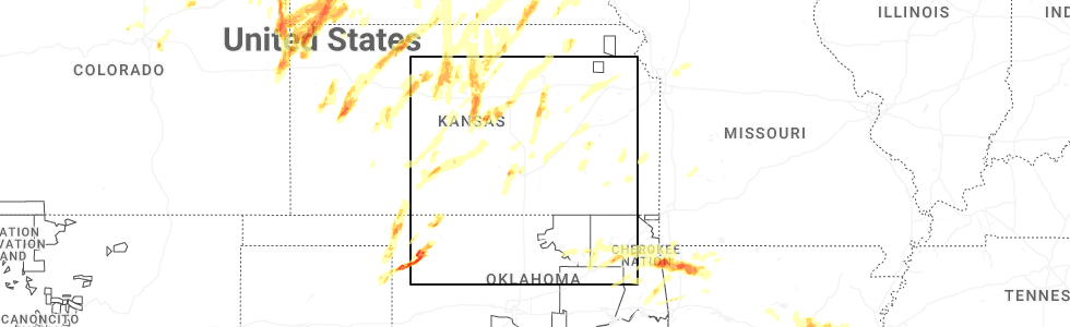
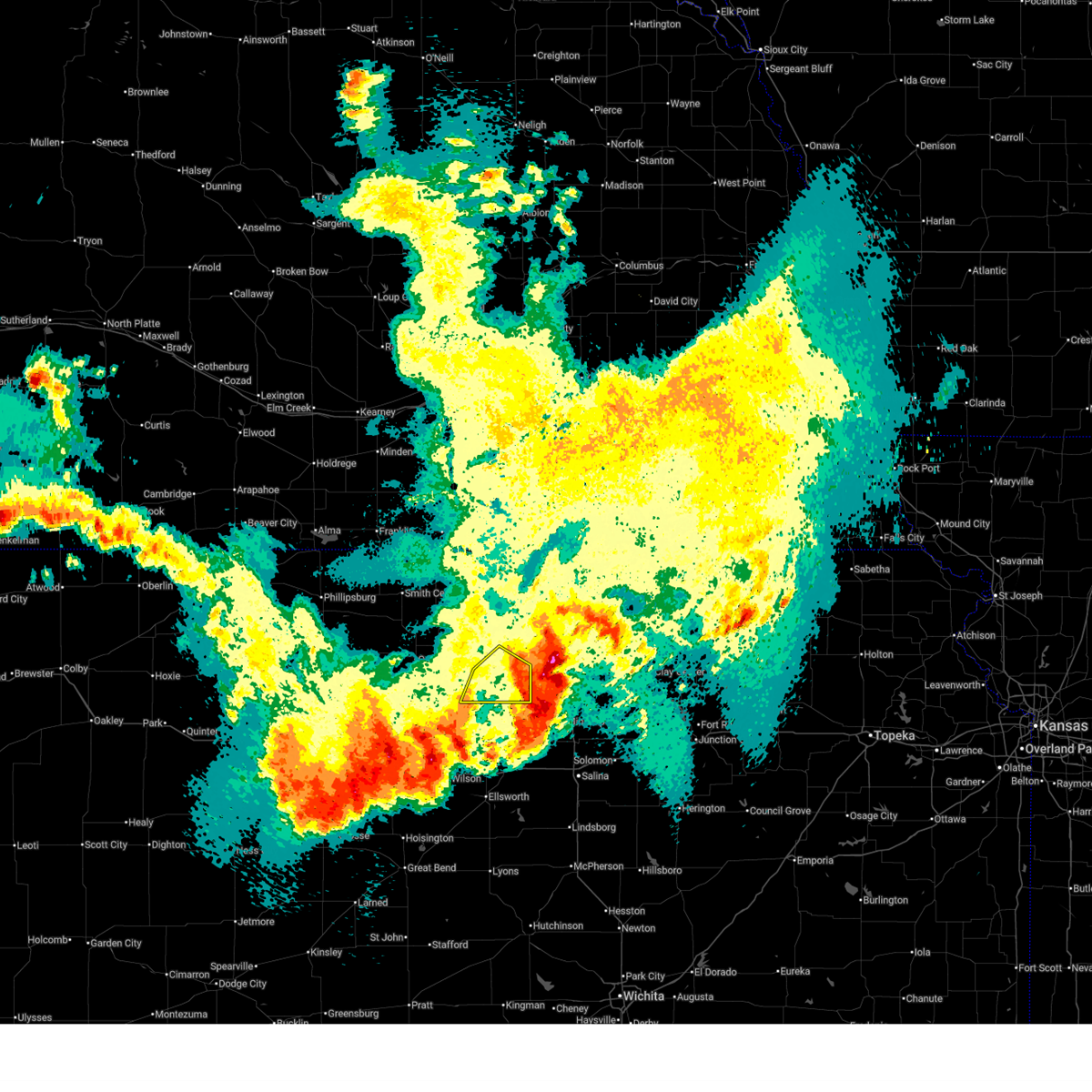
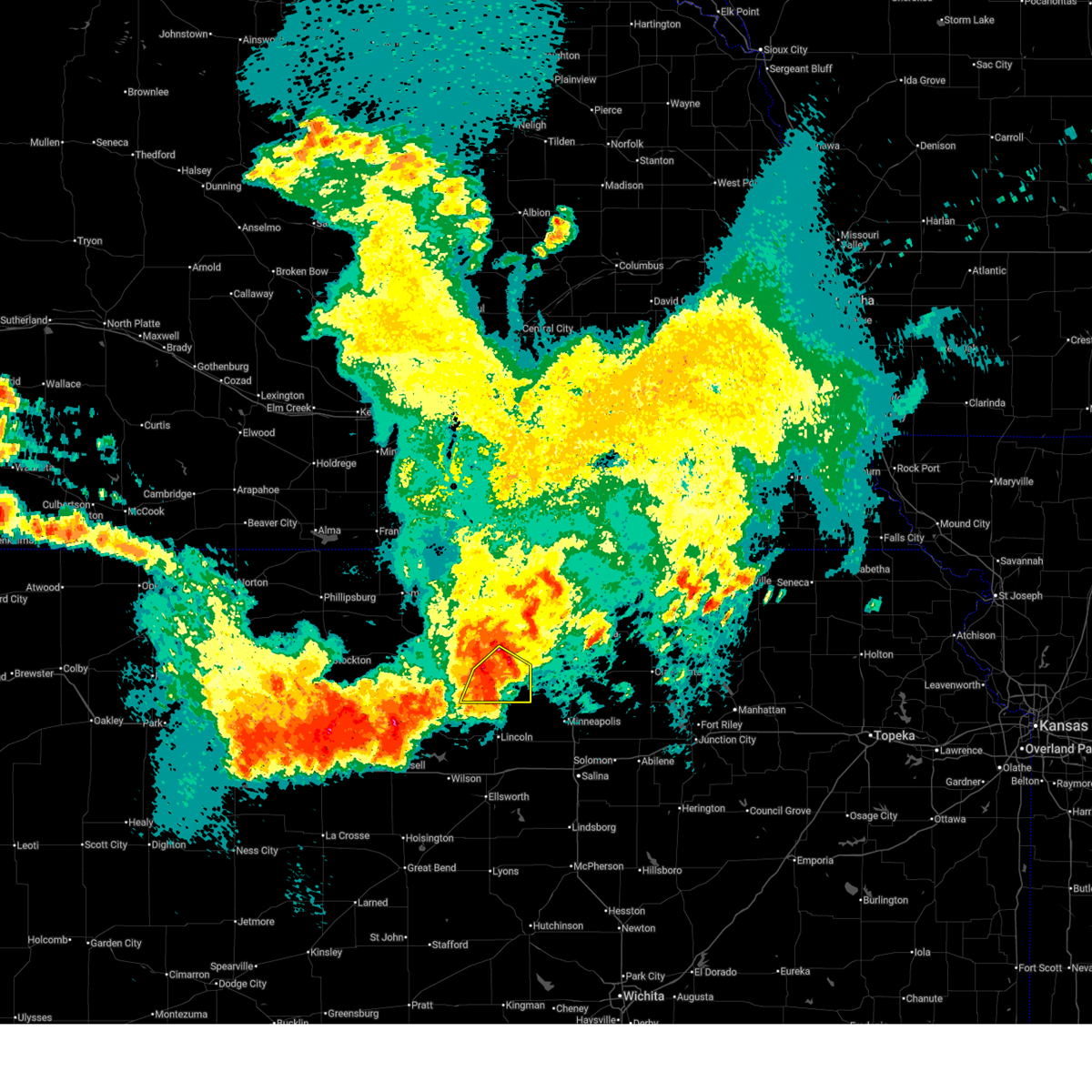
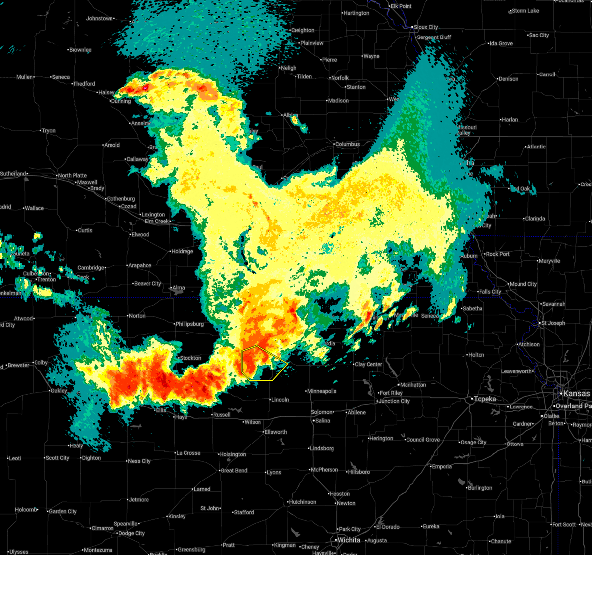
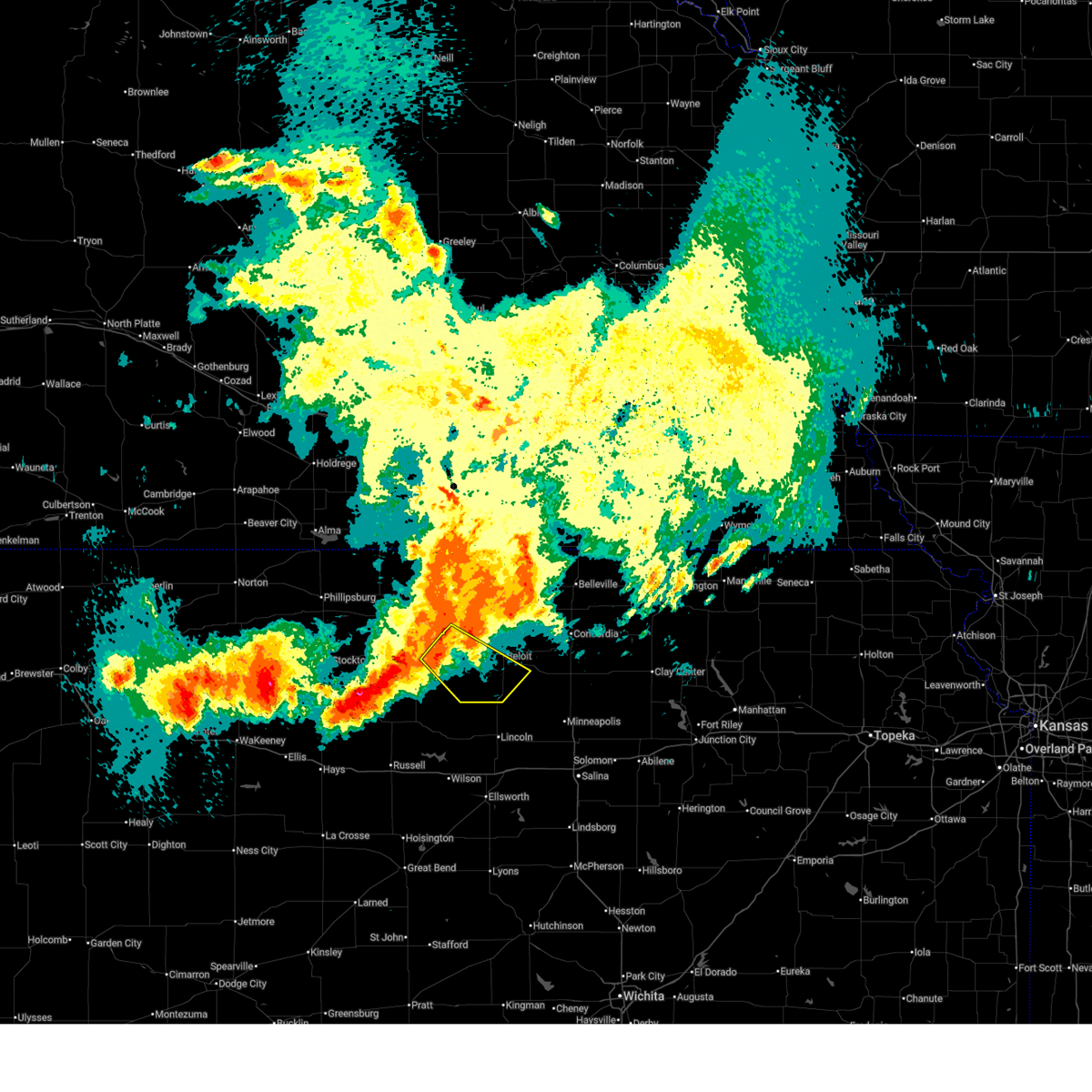
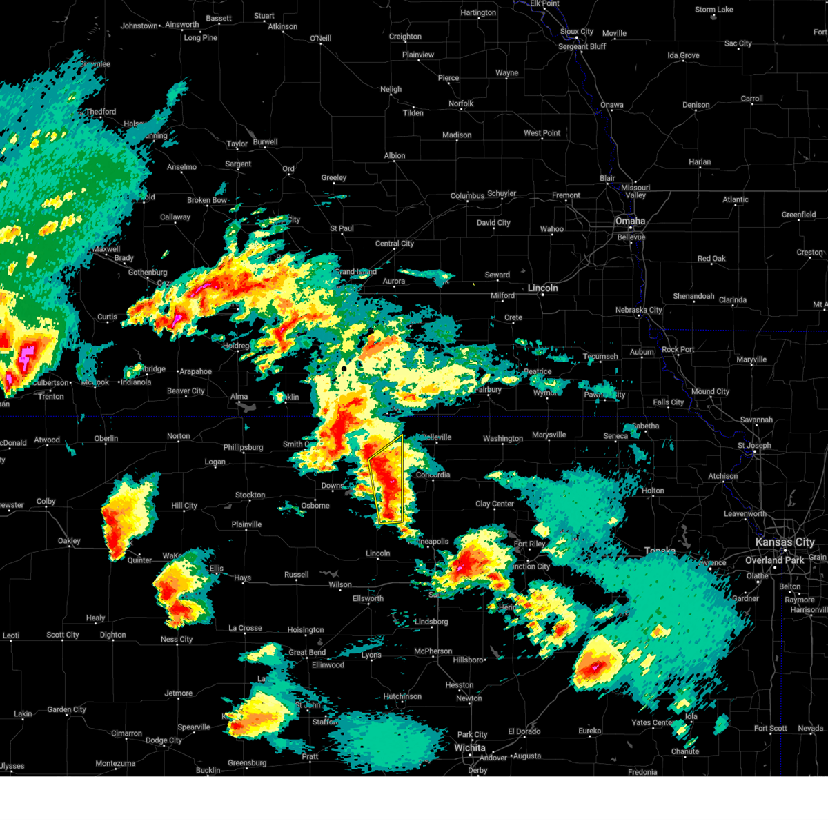
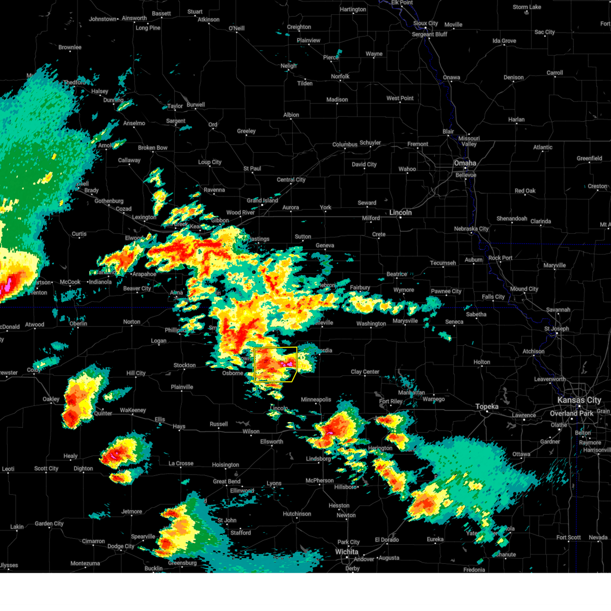
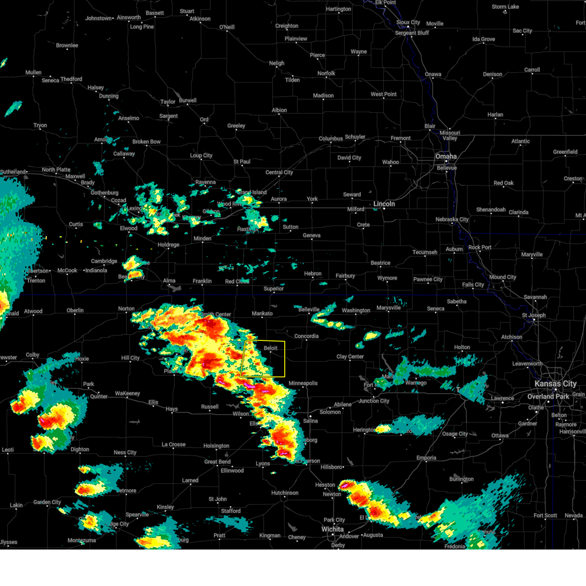
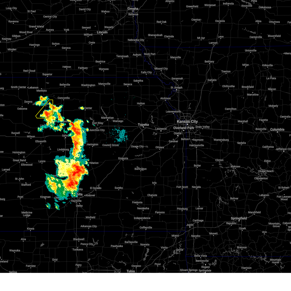
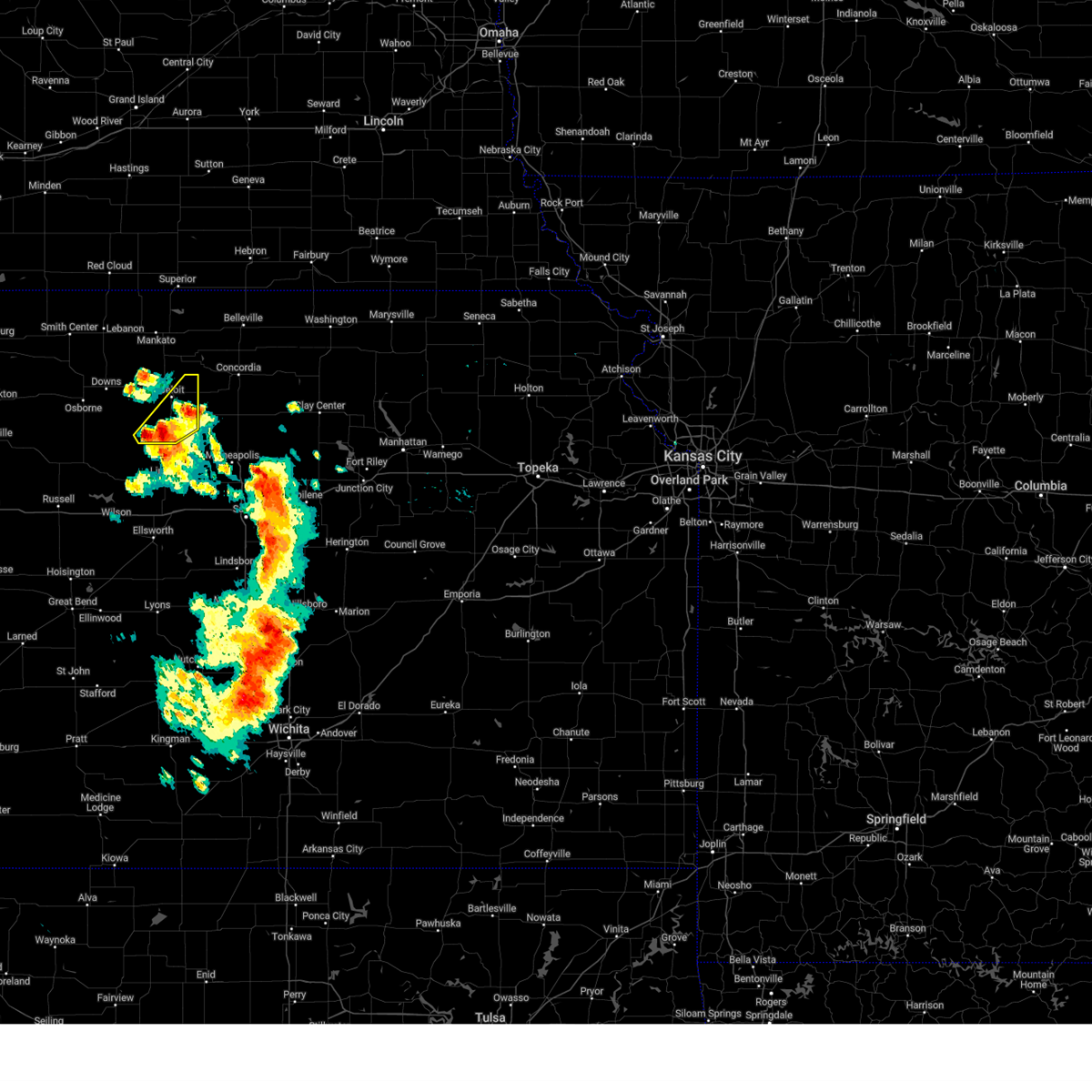
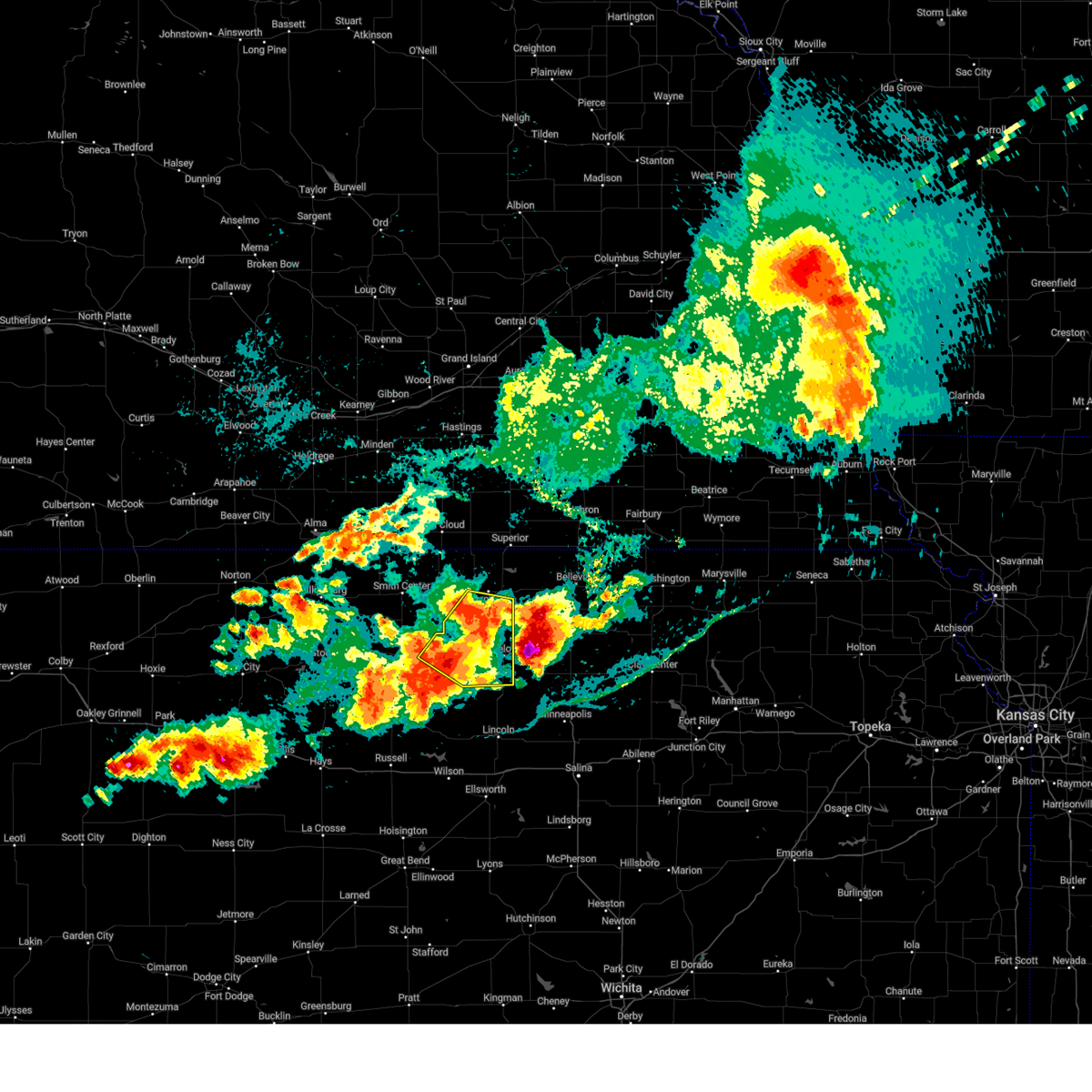
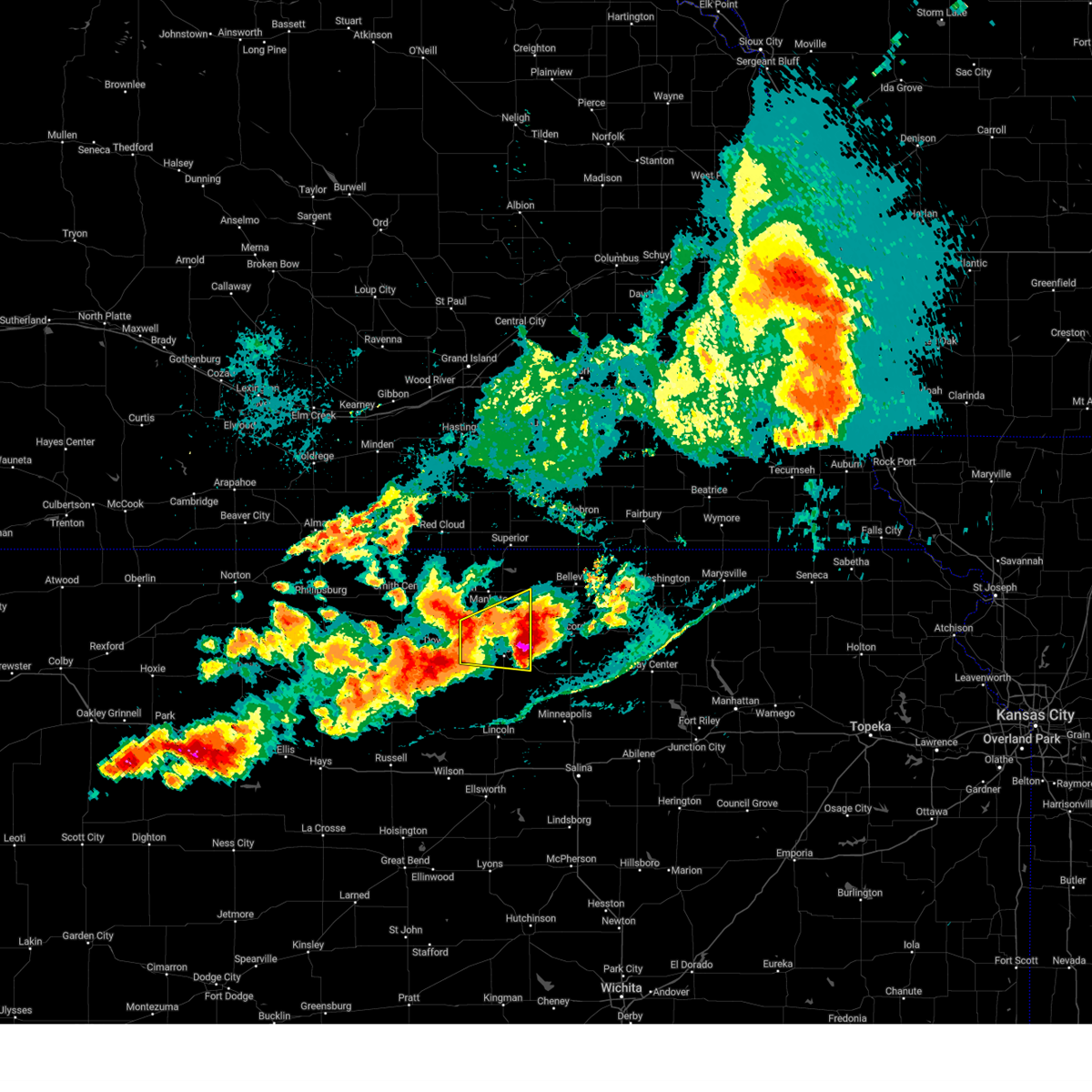
Hail Map for Beloit, KS
The Beloit, KS area has had 53 reports of on-the-ground hail by trained spotters, and has been under severe weather warnings 22 times during the past 12 months. Doppler radar has detected hail at or near Beloit, KS on 116 occasions, including 3 occasions during the past year.
| Name: | Beloit, KS |
| Where Located: | 77.3 miles ENE of Hays, KS |
| Map: | Google Map for Beloit, KS |
| Population: | 3835 |
| Housing Units: | 1842 |
| More Info: | Search Google for Beloit, KS |
4
The Top Recent Hail Date for Beloit, KS is Sunday, May 18, 2025 (4th out of 116)
Hail and Wind Damage Spotted near Beloit, KS
| Date / Time | Report Details |
|---|---|
| 6/17/2025 1:46 AM CDT |
 The storm which prompted the warning has moved out of the area. therefore, the warning has been allowed to expire. however, gusty winds and heavy rain are still possible with this thunderstorm. a severe thunderstorm watch remains in effect until 200 am cdt for north central kansas. to report severe weather, contact your nearest law enforcement agency. they will relay your report to the national weather service hastings. The storm which prompted the warning has moved out of the area. therefore, the warning has been allowed to expire. however, gusty winds and heavy rain are still possible with this thunderstorm. a severe thunderstorm watch remains in effect until 200 am cdt for north central kansas. to report severe weather, contact your nearest law enforcement agency. they will relay your report to the national weather service hastings.
|
| 6/17/2025 1:11 AM CDT |
 Svrgid the national weather service in hastings has issued a * severe thunderstorm warning for, eastern mitchell county in north central kansas, * until 145 am cdt. * at 110 am cdt, a severe thunderstorm was located near victor, or 12 miles south of beloit, moving southeast at 35 mph (automated weather station). Hazards include 60 mph wind gusts. Expect damage to roofs, siding, and trees. This severe thunderstorm will remain over mainly rural areas of eastern mitchell county, south and east of beloit. Svrgid the national weather service in hastings has issued a * severe thunderstorm warning for, eastern mitchell county in north central kansas, * until 145 am cdt. * at 110 am cdt, a severe thunderstorm was located near victor, or 12 miles south of beloit, moving southeast at 35 mph (automated weather station). Hazards include 60 mph wind gusts. Expect damage to roofs, siding, and trees. This severe thunderstorm will remain over mainly rural areas of eastern mitchell county, south and east of beloit.
|
| 6/17/2025 1:02 AM CDT |
 At 101 am cdt, a severe thunderstorm was located near victor, or 14 miles southwest of beloit, moving southeast at 35 mph (automated weather station. at 1248 am cdt, a 65 mph wind gust was reported 6 miles wsw of beloit). Hazards include 60 mph wind gusts. Expect damage to roofs, siding, and trees. This severe storm will be near, victor around 105 am cdt. At 101 am cdt, a severe thunderstorm was located near victor, or 14 miles southwest of beloit, moving southeast at 35 mph (automated weather station. at 1248 am cdt, a 65 mph wind gust was reported 6 miles wsw of beloit). Hazards include 60 mph wind gusts. Expect damage to roofs, siding, and trees. This severe storm will be near, victor around 105 am cdt.
|
| 6/17/2025 12:55 AM CDT |
 At 1254 am cdt, a severe thunderstorm was located near tipton, or 15 miles southwest of beloit, moving southeast at 35 mph (radar indicated). Hazards include 60 mph wind gusts. Expect damage to roofs, siding, and trees. This severe storm will be near, victor around 105 am cdt. At 1254 am cdt, a severe thunderstorm was located near tipton, or 15 miles southwest of beloit, moving southeast at 35 mph (radar indicated). Hazards include 60 mph wind gusts. Expect damage to roofs, siding, and trees. This severe storm will be near, victor around 105 am cdt.
|
| 6/17/2025 12:55 AM CDT |
 the severe thunderstorm warning has been cancelled and is no longer in effect the severe thunderstorm warning has been cancelled and is no longer in effect
|
| 6/17/2025 12:48 AM CDT | Ksu mesone in mitchell county KS, 5.5 miles ENE of Beloit, KS |
| 6/17/2025 12:36 AM CDT |
 Svrgid the national weather service in hastings has issued a * severe thunderstorm warning for, mitchell county in north central kansas, southwestern jewell county in north central kansas, northeastern osborne county in north central kansas, * until 115 am cdt. * at 1234 am cdt, a severe thunderstorm was located over downs, or 20 miles west of beloit, moving southeast at 35 mph (radar indicated. at 1228 am cdt, a 55 mph wind gust was reported 2 miles north of cawker city). Hazards include 60 mph wind gusts. Expect damage to roofs, siding, and trees. This severe thunderstorm will be near, cawker city around 1240 am cdt. Svrgid the national weather service in hastings has issued a * severe thunderstorm warning for, mitchell county in north central kansas, southwestern jewell county in north central kansas, northeastern osborne county in north central kansas, * until 115 am cdt. * at 1234 am cdt, a severe thunderstorm was located over downs, or 20 miles west of beloit, moving southeast at 35 mph (radar indicated. at 1228 am cdt, a 55 mph wind gust was reported 2 miles north of cawker city). Hazards include 60 mph wind gusts. Expect damage to roofs, siding, and trees. This severe thunderstorm will be near, cawker city around 1240 am cdt.
|
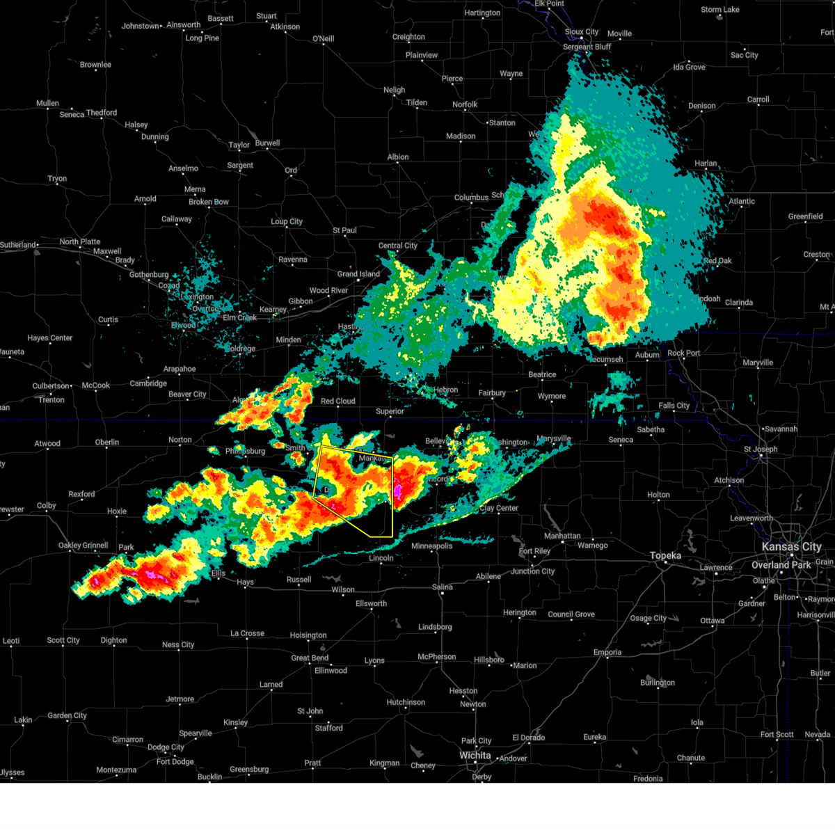
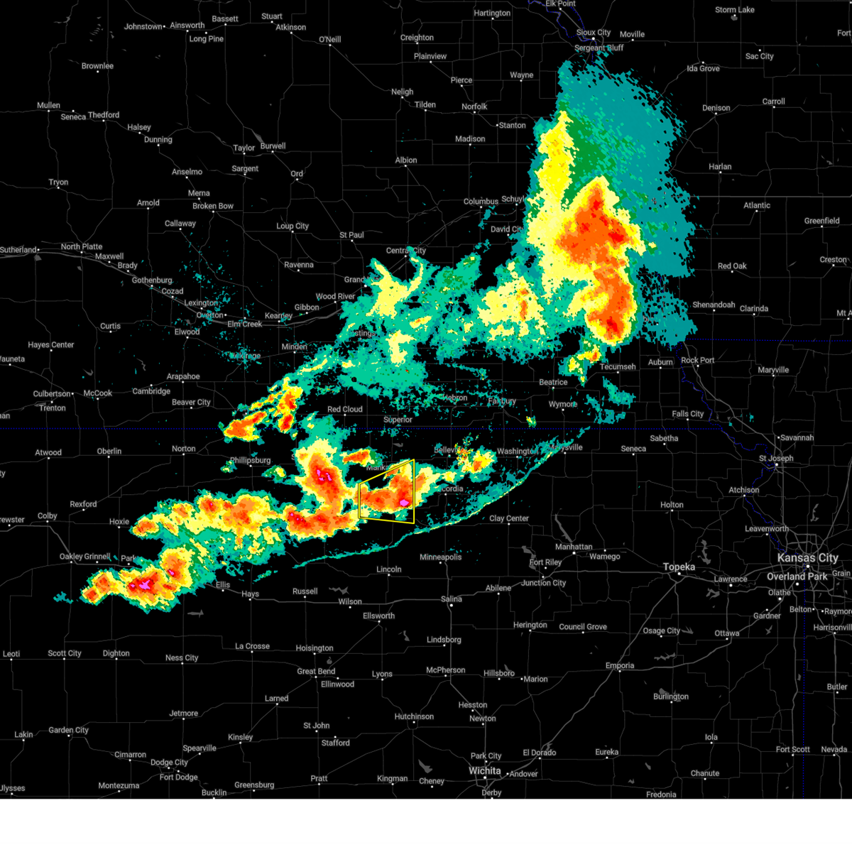
| 5/18/2025 7:34 PM CDT | Quarter sized hail reported 9.9 miles WSW of Beloit, KS, dime to quarter size hail. |
| 5/18/2025 7:19 PM CDT |
 Svrgid the national weather service in hastings has issued a * severe thunderstorm warning for, eastern mitchell county in north central kansas, southeastern jewell county in north central kansas, * until 745 pm cdt. * at 718 pm cdt, a severe thunderstorm was located near randall, or 10 miles northeast of beloit, moving northeast at 80 mph (radar indicated). Hazards include half dollar size hail. Damage to vehicles is expected. This severe thunderstorm will remain over mainly rural areas of eastern mitchell and southeastern jewell counties. Svrgid the national weather service in hastings has issued a * severe thunderstorm warning for, eastern mitchell county in north central kansas, southeastern jewell county in north central kansas, * until 745 pm cdt. * at 718 pm cdt, a severe thunderstorm was located near randall, or 10 miles northeast of beloit, moving northeast at 80 mph (radar indicated). Hazards include half dollar size hail. Damage to vehicles is expected. This severe thunderstorm will remain over mainly rural areas of eastern mitchell and southeastern jewell counties.
|
| 5/18/2025 7:05 PM CDT | Ping Pong Ball sized hail reported 0.5 miles S of Beloit, KS, report on social media of ping pong ball sized hail in beloit. |
| 5/18/2025 7:02 PM CDT |
 At 701 pm cdt, a severe thunderstorm was located over scottsville, or 10 miles northeast of beloit, moving east at 50 mph (radar indicated). Hazards include ping pong ball size hail. People and animals outdoors will be injured. expect damage to roofs, siding, windows, and vehicles. This severe storm will be near, scottsville around 705 pm cdt. At 701 pm cdt, a severe thunderstorm was located over scottsville, or 10 miles northeast of beloit, moving east at 50 mph (radar indicated). Hazards include ping pong ball size hail. People and animals outdoors will be injured. expect damage to roofs, siding, windows, and vehicles. This severe storm will be near, scottsville around 705 pm cdt.
|
| 5/18/2025 6:52 PM CDT | Ping Pong Ball sized hail reported 0.2 miles N of Beloit, KS |
| 5/18/2025 6:51 PM CDT | Ping Pong Ball sized hail reported 0.2 miles N of Beloit, KS, report on social media of ping pong ball size hail in beloit. |
| 5/18/2025 6:32 PM CDT | Svrgid the national weather service in hastings has issued a * severe thunderstorm warning for, mitchell county in north central kansas, southern jewell county in north central kansas, * until 715 pm cdt. * at 632 pm cdt, a severe thunderstorm was located 8 miles northeast of victor, or 11 miles south of beloit, moving north at 50 mph (radar indicated). Hazards include half dollar size hail. Damage to vehicles is expected. this severe thunderstorm will be near, beloit around 640 pm cdt. Other locations in the path of this severe thunderstorm include randall. |
| 5/18/2025 6:27 PM CDT | The storms which prompted the warning have moved out of the area. therefore, the warning will be allowed to expire. however, small hail is still possible with these thunderstorms. a severe thunderstorm watch remains in effect until midnight cdt for north central kansas. |
| 5/18/2025 6:20 PM CDT | At 620 pm cdt, severe thunderstorms were located along a line extending from near simpson to 8 miles south of glen elder, moving north at 60 mph (radar indicated). Hazards include 60 mph wind gusts and quarter size hail. Hail damage to vehicles is expected. expect wind damage to roofs, siding, and trees. these severe storms will be near, beloit around 625 pm cdt. Scottsville around 630 pm cdt. |
| 5/18/2025 5:53 PM CDT |
 Svrgid the national weather service in hastings has issued a * severe thunderstorm warning for, mitchell county in north central kansas, * until 630 pm cdt. * at 553 pm cdt, severe thunderstorms were located along a line extending from near lincoln to 6 miles north of sylvan grove, moving north at 60 mph (radar indicated). Hazards include 60 mph wind gusts and quarter size hail. Hail damage to vehicles is expected. expect wind damage to roofs, siding, and trees. severe thunderstorms will be near, hunter and victor around 600 pm cdt. Other locations in the path of these severe thunderstorms include beloit, asherville and simpson. Svrgid the national weather service in hastings has issued a * severe thunderstorm warning for, mitchell county in north central kansas, * until 630 pm cdt. * at 553 pm cdt, severe thunderstorms were located along a line extending from near lincoln to 6 miles north of sylvan grove, moving north at 60 mph (radar indicated). Hazards include 60 mph wind gusts and quarter size hail. Hail damage to vehicles is expected. expect wind damage to roofs, siding, and trees. severe thunderstorms will be near, hunter and victor around 600 pm cdt. Other locations in the path of these severe thunderstorms include beloit, asherville and simpson.
|
| 9/20/2024 7:34 PM CDT |
 the severe thunderstorm warning has been cancelled and is no longer in effect the severe thunderstorm warning has been cancelled and is no longer in effect
|
| 9/20/2024 7:27 PM CDT |
 Svrgid the national weather service in hastings has issued a * severe thunderstorm warning for, eastern mitchell county in north central kansas, * until 800 pm cdt. * at 727 pm cdt, a severe thunderstorm was located 8 miles northeast of victor, or 10 miles south of beloit, moving northeast at 35 mph (radar indicated). Hazards include 60 mph wind gusts and quarter size hail. Hail damage to vehicles is expected. expect wind damage to roofs, siding, and trees. this severe thunderstorm will be near, asherville around 740 pm cdt. Simpson around 745 pm cdt. Svrgid the national weather service in hastings has issued a * severe thunderstorm warning for, eastern mitchell county in north central kansas, * until 800 pm cdt. * at 727 pm cdt, a severe thunderstorm was located 8 miles northeast of victor, or 10 miles south of beloit, moving northeast at 35 mph (radar indicated). Hazards include 60 mph wind gusts and quarter size hail. Hail damage to vehicles is expected. expect wind damage to roofs, siding, and trees. this severe thunderstorm will be near, asherville around 740 pm cdt. Simpson around 745 pm cdt.
|
| 7/31/2024 6:26 PM CDT | The storm which prompted the warning has weakened below severe limits, and has exited the warned area. therefore, the warning will be allowed to expire. a severe thunderstorm watch remains in effect until 1000 pm cdt for north central kansas. |
| 7/31/2024 6:09 PM CDT |
 the severe thunderstorm warning has been cancelled and is no longer in effect the severe thunderstorm warning has been cancelled and is no longer in effect
|
| 7/31/2024 6:07 PM CDT |
 the severe thunderstorm warning has been cancelled and is no longer in effect the severe thunderstorm warning has been cancelled and is no longer in effect
|
| 7/31/2024 6:07 PM CDT |
 At 606 pm cdt, severe thunderstorms were located along a line extending from near ionia to near tipton, moving east at 30 mph (radar indicated). Hazards include 60 mph wind gusts and quarter size hail. Hail damage to vehicles is expected. expect wind damage to roofs, siding, and trees. these severe storms will be near, glen elder and jewell around 610 pm cdt. Beloit around 620 pm cdt. At 606 pm cdt, severe thunderstorms were located along a line extending from near ionia to near tipton, moving east at 30 mph (radar indicated). Hazards include 60 mph wind gusts and quarter size hail. Hail damage to vehicles is expected. expect wind damage to roofs, siding, and trees. these severe storms will be near, glen elder and jewell around 610 pm cdt. Beloit around 620 pm cdt.
|
| 7/31/2024 6:01 PM CDT |
 At 600 pm cdt, a severe thunderstorm was located over scottsville, or 8 miles east of beloit, moving east at 10 mph (radar indicated). Hazards include 60 mph wind gusts and quarter size hail. Hail damage to vehicles is expected. expect wind damage to roofs, siding, and trees. This severe storm will be near, scottsville around 605 pm cdt. At 600 pm cdt, a severe thunderstorm was located over scottsville, or 8 miles east of beloit, moving east at 10 mph (radar indicated). Hazards include 60 mph wind gusts and quarter size hail. Hail damage to vehicles is expected. expect wind damage to roofs, siding, and trees. This severe storm will be near, scottsville around 605 pm cdt.
|
| 7/31/2024 5:55 PM CDT |
 At 555 pm cdt, severe thunderstorms were located along a line extending from 7 miles northwest of ionia to near cawker city, moving southeast at 45 mph (radar indicated). Hazards include 60 mph wind gusts and half dollar size hail. Hail damage to vehicles is expected. expect wind damage to roofs, siding, and trees. these severe storms will be near, cawker city, glen elder, and ionia around 600 pm cdt. Beloit around 615 pm cdt. At 555 pm cdt, severe thunderstorms were located along a line extending from 7 miles northwest of ionia to near cawker city, moving southeast at 45 mph (radar indicated). Hazards include 60 mph wind gusts and half dollar size hail. Hail damage to vehicles is expected. expect wind damage to roofs, siding, and trees. these severe storms will be near, cawker city, glen elder, and ionia around 600 pm cdt. Beloit around 615 pm cdt.
|
| 7/31/2024 5:45 PM CDT | Golf Ball sized hail reported 3.5 miles WSW of Beloit, KS |
| 7/31/2024 5:41 PM CDT |
 Svrgid the national weather service in hastings has issued a * severe thunderstorm warning for, mitchell county in north central kansas, southern jewell county in north central kansas, southeastern smith county in north central kansas, northeastern osborne county in north central kansas, * until 630 pm cdt. * at 540 pm cdt, severe thunderstorms were located along a line extending from near lebanon to near downs, moving southeast at 40 mph. these are destructive storms for harlan, portis, downs, cawker city, glen elder, and beloit (radar indicated). Hazards include baseball size hail and 60 mph wind gusts. People and animals outdoors will be severely injured. expect shattered windows, extensive damage to roofs, siding, and vehicles. severe thunderstorms will be near, downs around 545 pm cdt. cawker city around 550 pm cdt. ionia around 555 pm cdt. glen elder around 600 pm cdt. Other locations in the path of these severe thunderstorms include beloit. Svrgid the national weather service in hastings has issued a * severe thunderstorm warning for, mitchell county in north central kansas, southern jewell county in north central kansas, southeastern smith county in north central kansas, northeastern osborne county in north central kansas, * until 630 pm cdt. * at 540 pm cdt, severe thunderstorms were located along a line extending from near lebanon to near downs, moving southeast at 40 mph. these are destructive storms for harlan, portis, downs, cawker city, glen elder, and beloit (radar indicated). Hazards include baseball size hail and 60 mph wind gusts. People and animals outdoors will be severely injured. expect shattered windows, extensive damage to roofs, siding, and vehicles. severe thunderstorms will be near, downs around 545 pm cdt. cawker city around 550 pm cdt. ionia around 555 pm cdt. glen elder around 600 pm cdt. Other locations in the path of these severe thunderstorms include beloit.
|
| 7/31/2024 5:39 PM CDT |
 Svrgid the national weather service in hastings has issued a * severe thunderstorm warning for, northern mitchell county in north central kansas, southeastern jewell county in north central kansas, * until 630 pm cdt. * at 538 pm cdt, a severe thunderstorm was located near scottsville, or near beloit, moving east at 15 mph (radar indicated). Hazards include 60 mph wind gusts and quarter size hail. Hail damage to vehicles is expected. expect wind damage to roofs, siding, and trees. This severe thunderstorm will be near, scottsville around 545 pm cdt. Svrgid the national weather service in hastings has issued a * severe thunderstorm warning for, northern mitchell county in north central kansas, southeastern jewell county in north central kansas, * until 630 pm cdt. * at 538 pm cdt, a severe thunderstorm was located near scottsville, or near beloit, moving east at 15 mph (radar indicated). Hazards include 60 mph wind gusts and quarter size hail. Hail damage to vehicles is expected. expect wind damage to roofs, siding, and trees. This severe thunderstorm will be near, scottsville around 545 pm cdt.
|
| 6/4/2024 2:29 PM CDT |
 The storms which prompted the warning have weakened just below severe limits, and no longer pose an immediate threat to life or property. therefore, the warning will be allowed to expire. however, small hail and gusty winds are still possible with these thunderstorms. The storms which prompted the warning have weakened just below severe limits, and no longer pose an immediate threat to life or property. therefore, the warning will be allowed to expire. however, small hail and gusty winds are still possible with these thunderstorms.
|
| 6/4/2024 2:10 PM CDT |
 At 209 pm cdt, severe thunderstorms were located along a line extending from near beloit to 6 miles northwest of barnard, moving east at 20 mph (radar indicated. in addition, at 203 pm cdt, a trained spotter reported nickel size hail 4 miles south of beloit). Hazards include 60 mph wind gusts and quarter size hail. Hail damage to vehicles is expected. expect wind damage to roofs, siding, and trees. these severe storms will be near, asherville and scottsville around 215 pm cdt. Simpson around 220 pm cdt. At 209 pm cdt, severe thunderstorms were located along a line extending from near beloit to 6 miles northwest of barnard, moving east at 20 mph (radar indicated. in addition, at 203 pm cdt, a trained spotter reported nickel size hail 4 miles south of beloit). Hazards include 60 mph wind gusts and quarter size hail. Hail damage to vehicles is expected. expect wind damage to roofs, siding, and trees. these severe storms will be near, asherville and scottsville around 215 pm cdt. Simpson around 220 pm cdt.
|
| 6/4/2024 1:54 PM CDT |
 Svrgid the national weather service in hastings has issued a * severe thunderstorm warning for, eastern mitchell county in north central kansas, * until 230 pm cdt. * at 154 pm cdt, severe thunderstorms were located along a line extending from beloit to near victor, moving east at 30 mph (radar indicated). Hazards include 60 mph wind gusts and quarter size hail. Hail damage to vehicles is expected. expect wind damage to roofs, siding, and trees. severe thunderstorms will be near, beloit around 200 pm cdt. asherville around 205 pm cdt. Simpson around 210 pm cdt. Svrgid the national weather service in hastings has issued a * severe thunderstorm warning for, eastern mitchell county in north central kansas, * until 230 pm cdt. * at 154 pm cdt, severe thunderstorms were located along a line extending from beloit to near victor, moving east at 30 mph (radar indicated). Hazards include 60 mph wind gusts and quarter size hail. Hail damage to vehicles is expected. expect wind damage to roofs, siding, and trees. severe thunderstorms will be near, beloit around 200 pm cdt. asherville around 205 pm cdt. Simpson around 210 pm cdt.
|
| 5/25/2024 9:08 PM CDT |
 At 907 pm cdt, a severe thunderstorm was located near randall, or near beloit, moving east at 35 mph (radar indicated). Hazards include ping pong ball size hail and 60 mph wind gusts. People and animals outdoors will be injured. expect hail damage to roofs, siding, windows, and vehicles. expect wind damage to roofs, siding, and trees. This severe storm will be near, scottsville around 915 pm cdt. At 907 pm cdt, a severe thunderstorm was located near randall, or near beloit, moving east at 35 mph (radar indicated). Hazards include ping pong ball size hail and 60 mph wind gusts. People and animals outdoors will be injured. expect hail damage to roofs, siding, windows, and vehicles. expect wind damage to roofs, siding, and trees. This severe storm will be near, scottsville around 915 pm cdt.
|
| 5/25/2024 8:57 PM CDT |
 At 857 pm cdt, a severe thunderstorm was located near glen elder, or 8 miles northwest of beloit, moving east at 35 mph (radar indicated). Hazards include two inch hail and 60 mph wind gusts. People and animals outdoors will be injured. expect hail damage to roofs, siding, windows, and vehicles. expect wind damage to roofs, siding, and trees. This severe storm will be near, scottsville around 915 pm cdt. At 857 pm cdt, a severe thunderstorm was located near glen elder, or 8 miles northwest of beloit, moving east at 35 mph (radar indicated). Hazards include two inch hail and 60 mph wind gusts. People and animals outdoors will be injured. expect hail damage to roofs, siding, windows, and vehicles. expect wind damage to roofs, siding, and trees. This severe storm will be near, scottsville around 915 pm cdt.
|
| 5/25/2024 8:52 PM CDT |
 The storm which prompted the warning has moved out of the area. therefore, this warning will be allowed to expire. however, this area is now included in a new severe thunderstorm warning for a storm approaching from the west, valid until 930 pm cdt. a tornado watch remains in effect until 100 am cdt for north central kansas. The storm which prompted the warning has moved out of the area. therefore, this warning will be allowed to expire. however, this area is now included in a new severe thunderstorm warning for a storm approaching from the west, valid until 930 pm cdt. a tornado watch remains in effect until 100 am cdt for north central kansas.
|
| 5/25/2024 8:50 PM CDT |
 Svrgid the national weather service in hastings has issued a * severe thunderstorm warning for, northern mitchell county in north central kansas, southern jewell county in north central kansas, * until 930 pm cdt. * at 850 pm cdt, severe thunderstorms were located along a line extending from near ionia to 7 miles south of glen elder, moving east at 35 mph (radar indicated). Hazards include golf ball size hail and 60 mph wind gusts. People and animals outdoors will be injured. expect hail damage to roofs, siding, windows, and vehicles. expect wind damage to roofs, siding, and trees. severe thunderstorms will be near, beloit and jewell around 855 pm cdt. randall around 905 pm cdt. asherville around 910 pm cdt. Other locations in the path of these severe thunderstorms include simpson and scottsville. Svrgid the national weather service in hastings has issued a * severe thunderstorm warning for, northern mitchell county in north central kansas, southern jewell county in north central kansas, * until 930 pm cdt. * at 850 pm cdt, severe thunderstorms were located along a line extending from near ionia to 7 miles south of glen elder, moving east at 35 mph (radar indicated). Hazards include golf ball size hail and 60 mph wind gusts. People and animals outdoors will be injured. expect hail damage to roofs, siding, windows, and vehicles. expect wind damage to roofs, siding, and trees. severe thunderstorms will be near, beloit and jewell around 855 pm cdt. randall around 905 pm cdt. asherville around 910 pm cdt. Other locations in the path of these severe thunderstorms include simpson and scottsville.
|
| 5/25/2024 8:38 PM CDT |
 At 838 pm cdt, a severe thunderstorm was located over scottsville, or 7 miles northeast of beloit, moving east at 25 mph (radar indicated). Hazards include 60 mph wind gusts and half dollar size hail. Hail damage to vehicles is expected. expect wind damage to roofs, siding, and trees. Locations impacted include, beloit and scottsville. At 838 pm cdt, a severe thunderstorm was located over scottsville, or 7 miles northeast of beloit, moving east at 25 mph (radar indicated). Hazards include 60 mph wind gusts and half dollar size hail. Hail damage to vehicles is expected. expect wind damage to roofs, siding, and trees. Locations impacted include, beloit and scottsville.
|
| 5/25/2024 8:26 PM CDT |
 At 825 pm cdt, a severe thunderstorm was centered a few miles north of beloit, moving east at 30 mph (radar indicated). Hazards include ping pong ball size hail and 60 mph wind gusts. People and animals outdoors will be injured. expect hail damage to roofs, siding, windows, and vehicles. expect wind damage to roofs, siding, and trees. Locations impacted include, beloit and scottsville. At 825 pm cdt, a severe thunderstorm was centered a few miles north of beloit, moving east at 30 mph (radar indicated). Hazards include ping pong ball size hail and 60 mph wind gusts. People and animals outdoors will be injured. expect hail damage to roofs, siding, windows, and vehicles. expect wind damage to roofs, siding, and trees. Locations impacted include, beloit and scottsville.
|
| 5/25/2024 8:14 PM CDT | Quarter sized hail reported 7.9 miles SE of Beloit, KS |
| 5/25/2024 8:12 PM CDT |
 Svrgid the national weather service in hastings has issued a * severe thunderstorm warning for, northeastern mitchell county in north central kansas, southeastern jewell county in north central kansas, * until 900 pm cdt. * at 812 pm cdt, a severe thunderstorm was located near beloit, moving east at 30 mph (radar indicated). Hazards include two inch hail and 60 mph wind gusts. People and animals outdoors will be injured. expect hail damage to roofs, siding, windows, and vehicles. expect wind damage to roofs, siding, and trees. this severe thunderstorm will be near, beloit around 815 pm cdt. Scottsville around 825 pm cdt. Svrgid the national weather service in hastings has issued a * severe thunderstorm warning for, northeastern mitchell county in north central kansas, southeastern jewell county in north central kansas, * until 900 pm cdt. * at 812 pm cdt, a severe thunderstorm was located near beloit, moving east at 30 mph (radar indicated). Hazards include two inch hail and 60 mph wind gusts. People and animals outdoors will be injured. expect hail damage to roofs, siding, windows, and vehicles. expect wind damage to roofs, siding, and trees. this severe thunderstorm will be near, beloit around 815 pm cdt. Scottsville around 825 pm cdt.
|
| 5/25/2024 8:08 PM CDT |
 At 807 pm cdt, a severe thunderstorm was located near glen elder, or near beloit, moving northeast at 30 mph (trained weather spotters. at 755 pm cdt, ping pong ball size hail was reported in cawker city). Hazards include two inch hail and 60 mph wind gusts. People and animals outdoors will be injured. expect hail damage to roofs, siding, windows, and vehicles. expect wind damage to roofs, siding, and trees. This severe storm will be near, randall around 825 pm cdt. At 807 pm cdt, a severe thunderstorm was located near glen elder, or near beloit, moving northeast at 30 mph (trained weather spotters. at 755 pm cdt, ping pong ball size hail was reported in cawker city). Hazards include two inch hail and 60 mph wind gusts. People and animals outdoors will be injured. expect hail damage to roofs, siding, windows, and vehicles. expect wind damage to roofs, siding, and trees. This severe storm will be near, randall around 825 pm cdt.
|
| 5/25/2024 8:00 PM CDT | Quarter sized hail reported 1.3 miles SSE of Beloit, KS, photo on social media of hail of varying sizes compared. largest hailstone was comparable to a quarter. |
| 5/25/2024 7:49 PM CDT |
 At 748 pm cdt, a severe thunderstorm was located near glen elder, or 13 miles west of beloit, moving northeast at 30 mph (radar indicated). Hazards include two inch hail and 60 mph wind gusts. People and animals outdoors will be injured. expect hail damage to roofs, siding, windows, and vehicles. expect wind damage to roofs, siding, and trees. this severe storm will be near, glen elder around 755 pm cdt. Randall around 825 pm cdt. At 748 pm cdt, a severe thunderstorm was located near glen elder, or 13 miles west of beloit, moving northeast at 30 mph (radar indicated). Hazards include two inch hail and 60 mph wind gusts. People and animals outdoors will be injured. expect hail damage to roofs, siding, windows, and vehicles. expect wind damage to roofs, siding, and trees. this severe storm will be near, glen elder around 755 pm cdt. Randall around 825 pm cdt.
|
| 5/25/2024 7:49 PM CDT |
 the severe thunderstorm warning has been cancelled and is no longer in effect the severe thunderstorm warning has been cancelled and is no longer in effect
|
| 5/25/2024 7:42 PM CDT |
 At 741 pm cdt, a severe thunderstorm was located along the south side of waconda lake south of cawker city, or 17 miles west of beloit, moving northeast at 25 mph (radar indicated). Hazards include golf ball size hail and 60 mph wind gusts. People and animals outdoors will be injured. expect hail damage to roofs, siding, windows, and vehicles. expect wind damage to roofs, siding, and trees. this severe storm will be near, cawker city around 745 pm cdt. Glen elder around 755 pm cdt. At 741 pm cdt, a severe thunderstorm was located along the south side of waconda lake south of cawker city, or 17 miles west of beloit, moving northeast at 25 mph (radar indicated). Hazards include golf ball size hail and 60 mph wind gusts. People and animals outdoors will be injured. expect hail damage to roofs, siding, windows, and vehicles. expect wind damage to roofs, siding, and trees. this severe storm will be near, cawker city around 745 pm cdt. Glen elder around 755 pm cdt.
|
| 5/25/2024 7:29 PM CDT |
 Svrgid the national weather service in hastings has issued a * severe thunderstorm warning for, northern mitchell county in north central kansas, southeastern jewell county in north central kansas, northeastern osborne county in north central kansas, * until 815 pm cdt. * at 729 pm cdt, a severe thunderstorm was located a few miles north of tipton, or 20 miles west of beloit, moving northeast at 30 mph (radar indicated). Hazards include ping pong ball size hail and 60 mph wind gusts. People and animals outdoors will be injured. expect hail damage to roofs, siding, windows, and vehicles. expect wind damage to roofs, siding, and trees. this severe thunderstorm will be near, cawker city around 735 pm cdt. Glen elder around 740 pm cdt. Svrgid the national weather service in hastings has issued a * severe thunderstorm warning for, northern mitchell county in north central kansas, southeastern jewell county in north central kansas, northeastern osborne county in north central kansas, * until 815 pm cdt. * at 729 pm cdt, a severe thunderstorm was located a few miles north of tipton, or 20 miles west of beloit, moving northeast at 30 mph (radar indicated). Hazards include ping pong ball size hail and 60 mph wind gusts. People and animals outdoors will be injured. expect hail damage to roofs, siding, windows, and vehicles. expect wind damage to roofs, siding, and trees. this severe thunderstorm will be near, cawker city around 735 pm cdt. Glen elder around 740 pm cdt.
|
| 5/2/2024 1:57 AM CDT |
 The storms which prompted the warning have weakened below severe limits, and no longer pose an immediate threat to life or property. therefore, the warning will be allowed to expire. however, gusty winds are still possible with these thunderstorms. a severe thunderstorm watch remains in effect until 200 am cdt for north central kansas. to report severe weather, contact your nearest law enforcement agency. they will relay your report to the national weather service hastings. The storms which prompted the warning have weakened below severe limits, and no longer pose an immediate threat to life or property. therefore, the warning will be allowed to expire. however, gusty winds are still possible with these thunderstorms. a severe thunderstorm watch remains in effect until 200 am cdt for north central kansas. to report severe weather, contact your nearest law enforcement agency. they will relay your report to the national weather service hastings.
|
| 5/2/2024 1:53 AM CDT |
 At 153 am cdt, severe thunderstorms were located along a line extending from near randall to near beloit to near sylvan grove, moving east at 45 mph (radar indicated). Hazards include 60 mph wind gusts. Expect damage to roofs, siding, and trees. These severe storms will be near, asherville and scottsville around 200 am cdt. At 153 am cdt, severe thunderstorms were located along a line extending from near randall to near beloit to near sylvan grove, moving east at 45 mph (radar indicated). Hazards include 60 mph wind gusts. Expect damage to roofs, siding, and trees. These severe storms will be near, asherville and scottsville around 200 am cdt.
|
| 5/2/2024 1:39 AM CDT |
 At 138 am cdt, severe thunderstorms were located along a line extending from near glen elder to 8 miles southwest of beloit to lucas, moving east at 45 mph (radar indicated). Hazards include 60 mph wind gusts. Expect damage to roofs, siding, and trees. these severe storms will be near, beloit and victor around 145 am cdt. asherville around 155 am cdt. Scottsville around 200 am cdt. At 138 am cdt, severe thunderstorms were located along a line extending from near glen elder to 8 miles southwest of beloit to lucas, moving east at 45 mph (radar indicated). Hazards include 60 mph wind gusts. Expect damage to roofs, siding, and trees. these severe storms will be near, beloit and victor around 145 am cdt. asherville around 155 am cdt. Scottsville around 200 am cdt.
|
| 5/2/2024 1:39 AM CDT |
 the severe thunderstorm warning has been cancelled and is no longer in effect the severe thunderstorm warning has been cancelled and is no longer in effect
|
| 5/2/2024 1:14 AM CDT |
 At 114 am cdt, severe thunderstorms were located along a line extending from portis to near tipton to 7 miles north of russell, moving east at 45 mph (radar indicated). Hazards include 60 mph wind gusts. Expect damage to roofs, siding, and trees. these severe storms will be near, downs, cawker city, and tipton around 120 am cdt. glen elder and hunter around 130 am cdt. beloit and victor around 140 am cdt. Asherville and scottsville around 155 am cdt. At 114 am cdt, severe thunderstorms were located along a line extending from portis to near tipton to 7 miles north of russell, moving east at 45 mph (radar indicated). Hazards include 60 mph wind gusts. Expect damage to roofs, siding, and trees. these severe storms will be near, downs, cawker city, and tipton around 120 am cdt. glen elder and hunter around 130 am cdt. beloit and victor around 140 am cdt. Asherville and scottsville around 155 am cdt.
|
| 5/2/2024 1:00 AM CDT |
 Svrgid the national weather service in hastings has issued a * severe thunderstorm warning for, mitchell county in north central kansas, osborne county in north central kansas, * until 200 am cdt. * at 100 am cdt, severe thunderstorms were located along a line extending from 6 miles southwest of harlan to near osborne to near gorham, moving east at 45 mph (radar indicated). Hazards include 60 mph wind gusts and penny size hail. Expect damage to roofs, siding, and trees. severe thunderstorms will be near, osborne and portis around 105 am cdt. downs around 110 am cdt. tipton around 115 am cdt. cawker city around 120 am cdt. Other locations in the path of these severe thunderstorms include glen elder, hunter, beloit and victor. Svrgid the national weather service in hastings has issued a * severe thunderstorm warning for, mitchell county in north central kansas, osborne county in north central kansas, * until 200 am cdt. * at 100 am cdt, severe thunderstorms were located along a line extending from 6 miles southwest of harlan to near osborne to near gorham, moving east at 45 mph (radar indicated). Hazards include 60 mph wind gusts and penny size hail. Expect damage to roofs, siding, and trees. severe thunderstorms will be near, osborne and portis around 105 am cdt. downs around 110 am cdt. tipton around 115 am cdt. cawker city around 120 am cdt. Other locations in the path of these severe thunderstorms include glen elder, hunter, beloit and victor.
|
| 4/25/2024 7:50 AM CDT |
 At 750 am cdt, a severe thunderstorm was located over scottsville, or 9 miles northeast of beloit, moving east at 35 mph (radar indicated). Hazards include 60 mph wind gusts and half dollar size hail. Hail damage to vehicles is expected. expect wind damage to roofs, siding, and trees. Locations impacted include, beloit, randall, and scottsville. At 750 am cdt, a severe thunderstorm was located over scottsville, or 9 miles northeast of beloit, moving east at 35 mph (radar indicated). Hazards include 60 mph wind gusts and half dollar size hail. Hail damage to vehicles is expected. expect wind damage to roofs, siding, and trees. Locations impacted include, beloit, randall, and scottsville.
|
| 4/25/2024 7:39 AM CDT |
 At 739 am cdt, a severe thunderstorm was located near beloit, moving east at 30 mph (radar indicated). Hazards include 60 mph wind gusts and half dollar size hail. Hail damage to vehicles is expected. expect wind damage to roofs, siding, and trees. Locations impacted include, beloit, glen elder, randall, and scottsville. At 739 am cdt, a severe thunderstorm was located near beloit, moving east at 30 mph (radar indicated). Hazards include 60 mph wind gusts and half dollar size hail. Hail damage to vehicles is expected. expect wind damage to roofs, siding, and trees. Locations impacted include, beloit, glen elder, randall, and scottsville.
|
| 4/25/2024 7:22 AM CDT |
 At 721 am cdt, a severe thunderstorm was located near glen elder, or 7 miles northwest of beloit, moving east at 35 mph (radar indicated). Hazards include ping pong ball size hail and 60 mph wind gusts. People and animals outdoors will be injured. expect hail damage to roofs, siding, windows, and vehicles. expect wind damage to roofs, siding, and trees. Locations impacted include, beloit, glen elder, randall, and scottsville. At 721 am cdt, a severe thunderstorm was located near glen elder, or 7 miles northwest of beloit, moving east at 35 mph (radar indicated). Hazards include ping pong ball size hail and 60 mph wind gusts. People and animals outdoors will be injured. expect hail damage to roofs, siding, windows, and vehicles. expect wind damage to roofs, siding, and trees. Locations impacted include, beloit, glen elder, randall, and scottsville.
|
| 4/25/2024 7:13 AM CDT |
 Svrgid the national weather service in hastings has issued a * severe thunderstorm warning for, northern mitchell county in north central kansas, southeastern jewell county in north central kansas, * until 800 am cdt. * at 713 am cdt, a severe thunderstorm was located near glen elder, or 11 miles northwest of beloit, moving east at 35 mph (radar indicated). Hazards include golf ball size hail and 60 mph wind gusts. People and animals outdoors will be injured. expect hail damage to roofs, siding, windows, and vehicles. Expect wind damage to roofs, siding, and trees. Svrgid the national weather service in hastings has issued a * severe thunderstorm warning for, northern mitchell county in north central kansas, southeastern jewell county in north central kansas, * until 800 am cdt. * at 713 am cdt, a severe thunderstorm was located near glen elder, or 11 miles northwest of beloit, moving east at 35 mph (radar indicated). Hazards include golf ball size hail and 60 mph wind gusts. People and animals outdoors will be injured. expect hail damage to roofs, siding, windows, and vehicles. Expect wind damage to roofs, siding, and trees.
|
| 4/25/2024 7:03 AM CDT |
 At 703 am cdt, a severe thunderstorm was located near glen elder, or 14 miles west of beloit, moving east at 35 mph (radar indicated). Hazards include golf ball size hail and 60 mph wind gusts. People and animals outdoors will be injured. expect hail damage to roofs, siding, windows, and vehicles. expect wind damage to roofs, siding, and trees. Locations impacted include, beloit, cawker city, glen elder, and jewell. At 703 am cdt, a severe thunderstorm was located near glen elder, or 14 miles west of beloit, moving east at 35 mph (radar indicated). Hazards include golf ball size hail and 60 mph wind gusts. People and animals outdoors will be injured. expect hail damage to roofs, siding, windows, and vehicles. expect wind damage to roofs, siding, and trees. Locations impacted include, beloit, cawker city, glen elder, and jewell.
|
| 4/25/2024 7:03 AM CDT |
 the severe thunderstorm warning has been cancelled and is no longer in effect the severe thunderstorm warning has been cancelled and is no longer in effect
|
| 4/25/2024 6:54 AM CDT |
 At 654 am cdt, a severe thunderstorm was located near cawker city, or 19 miles west of beloit, moving east at 35 mph (radar indicated). Hazards include golf ball size hail. People and animals outdoors will be injured. expect damage to roofs, siding, windows, and vehicles. This severe thunderstorm will remain over mainly rural areas of northern mitchell, southwestern jewell, southeastern smith and northeastern osborne counties. At 654 am cdt, a severe thunderstorm was located near cawker city, or 19 miles west of beloit, moving east at 35 mph (radar indicated). Hazards include golf ball size hail. People and animals outdoors will be injured. expect damage to roofs, siding, windows, and vehicles. This severe thunderstorm will remain over mainly rural areas of northern mitchell, southwestern jewell, southeastern smith and northeastern osborne counties.
|
| 4/25/2024 6:49 AM CDT |
 At 649 am cdt, a severe thunderstorm was located near downs, or 22 miles west of beloit, moving east at 30 mph (radar indicated). Hazards include half dollar size hail. Damage to vehicles is expected. This severe storm will be near, jewell around 725 am cdt. At 649 am cdt, a severe thunderstorm was located near downs, or 22 miles west of beloit, moving east at 30 mph (radar indicated). Hazards include half dollar size hail. Damage to vehicles is expected. This severe storm will be near, jewell around 725 am cdt.
|
| 4/25/2024 6:29 AM CDT |
 Svrgid the national weather service in hastings has issued a * severe thunderstorm warning for, northern mitchell county in north central kansas, southwestern jewell county in north central kansas, southeastern smith county in north central kansas, northeastern osborne county in north central kansas, * until 715 am cdt. * at 629 am cdt, a severe thunderstorm was located over portis, or 29 miles west of beloit, moving east at 40 mph (radar indicated). Hazards include quarter size hail. Damage to vehicles is expected. this severe thunderstorm will be near, downs around 635 am cdt. Other locations in the path of this severe thunderstorm include jewell. Svrgid the national weather service in hastings has issued a * severe thunderstorm warning for, northern mitchell county in north central kansas, southwestern jewell county in north central kansas, southeastern smith county in north central kansas, northeastern osborne county in north central kansas, * until 715 am cdt. * at 629 am cdt, a severe thunderstorm was located over portis, or 29 miles west of beloit, moving east at 40 mph (radar indicated). Hazards include quarter size hail. Damage to vehicles is expected. this severe thunderstorm will be near, downs around 635 am cdt. Other locations in the path of this severe thunderstorm include jewell.
|
| 4/6/2024 4:04 PM CDT |
 At 404 pm cdt, severe thunderstorms were located along a line extending from near kenesaw to near lawrence to near montrose, moving north at 45 mph (radar indicated). Hazards include 70 mph wind gusts. Expect considerable tree damage. damage is likely to mobile homes, roofs, and outbuildings. these severe storms will be near, hastings, superior, kenesaw, juniata, lawrence, prosser, webber, lovewell state park, and bostwick around 410 pm cdt. nelson, glenvil, and deweese around 415 pm cdt. fairfield, trumbull, inland, nora, and hansen around 425 pm cdt. Harvard and clay center around 435 pm cdt. At 404 pm cdt, severe thunderstorms were located along a line extending from near kenesaw to near lawrence to near montrose, moving north at 45 mph (radar indicated). Hazards include 70 mph wind gusts. Expect considerable tree damage. damage is likely to mobile homes, roofs, and outbuildings. these severe storms will be near, hastings, superior, kenesaw, juniata, lawrence, prosser, webber, lovewell state park, and bostwick around 410 pm cdt. nelson, glenvil, and deweese around 415 pm cdt. fairfield, trumbull, inland, nora, and hansen around 425 pm cdt. Harvard and clay center around 435 pm cdt.
|
| 4/6/2024 3:51 PM CDT |
 Svrgid the national weather service in hastings has issued a * severe thunderstorm warning for, mitchell county in north central kansas, jewell county in north central kansas, eastern smith county in north central kansas, clay county in south central nebraska, eastern franklin county in south central nebraska, nuckolls county in south central nebraska, webster county in south central nebraska, adams county in south central nebraska, southeastern kearney county in south central nebraska, * until 430 pm cdt. * at 351 pm cdt, severe thunderstorms were located along a line extending from near holstein to near rosemont to near jewell, moving north at 45 mph (radar indicated). Hazards include 70 mph wind gusts. Expect considerable tree damage. damage is likely to mobile homes, roofs, and outbuildings. severe thunderstorms will be near, blue hill, lawrence, roseland, holstein, montrose, rosemont, and bostwick around 355 pm cdt. ayr around 400 pm cdt. superior, kenesaw, juniata, webber, and lovewell state park around 405 pm cdt. hastings and prosser around 410 pm cdt. Other locations in the path of these severe thunderstorms include nelson, glenvil, deweese, fairfield, inland and hansen. Svrgid the national weather service in hastings has issued a * severe thunderstorm warning for, mitchell county in north central kansas, jewell county in north central kansas, eastern smith county in north central kansas, clay county in south central nebraska, eastern franklin county in south central nebraska, nuckolls county in south central nebraska, webster county in south central nebraska, adams county in south central nebraska, southeastern kearney county in south central nebraska, * until 430 pm cdt. * at 351 pm cdt, severe thunderstorms were located along a line extending from near holstein to near rosemont to near jewell, moving north at 45 mph (radar indicated). Hazards include 70 mph wind gusts. Expect considerable tree damage. damage is likely to mobile homes, roofs, and outbuildings. severe thunderstorms will be near, blue hill, lawrence, roseland, holstein, montrose, rosemont, and bostwick around 355 pm cdt. ayr around 400 pm cdt. superior, kenesaw, juniata, webber, and lovewell state park around 405 pm cdt. hastings and prosser around 410 pm cdt. Other locations in the path of these severe thunderstorms include nelson, glenvil, deweese, fairfield, inland and hansen.
|
| 4/6/2024 3:31 PM CDT |
 At 330 pm cdt, severe thunderstorms were located along a line extending from 7 miles northwest of riverton to near esbon to 6 miles west of beloit, moving north at 45 mph (radar indicated). Hazards include 70 mph wind gusts. Expect considerable tree damage. damage is likely to mobile homes, roofs, and outbuildings. these severe storms will be near, red cloud, burr oak, and inavale around 335 pm cdt. mankato, jewell, and campbell around 340 pm cdt. bladen, guide rock, and cowles around 345 pm cdt. montrose around 355 pm cdt. rosemont and bostwick around 400 pm cdt. Lawrence around 405 pm cdt. At 330 pm cdt, severe thunderstorms were located along a line extending from 7 miles northwest of riverton to near esbon to 6 miles west of beloit, moving north at 45 mph (radar indicated). Hazards include 70 mph wind gusts. Expect considerable tree damage. damage is likely to mobile homes, roofs, and outbuildings. these severe storms will be near, red cloud, burr oak, and inavale around 335 pm cdt. mankato, jewell, and campbell around 340 pm cdt. bladen, guide rock, and cowles around 345 pm cdt. montrose around 355 pm cdt. rosemont and bostwick around 400 pm cdt. Lawrence around 405 pm cdt.
|
| 4/6/2024 3:15 PM CDT |
 Svrgid the national weather service in hastings has issued a * severe thunderstorm warning for, mitchell county in north central kansas, jewell county in north central kansas, smith county in north central kansas, osborne county in north central kansas, eastern franklin county in south central nebraska, nuckolls county in south central nebraska, webster county in south central nebraska, * until 400 pm cdt. * at 315 pm cdt, severe thunderstorms were located along a line extending from 6 miles southeast of franklin to 6 miles west of ionia to victor, moving north at 45 mph (radar indicated). Hazards include 70 mph wind gusts. Expect considerable tree damage. damage is likely to mobile homes, roofs, and outbuildings. severe thunderstorms will be near, glen elder, lebanon, esbon, riverton, and ionia around 320 pm cdt. beloit, burr oak, and inavale around 330 pm cdt. red cloud and campbell around 335 pm cdt. Other locations in the path of these severe thunderstorms include mankato, jewell, bladen, guide rock and cowles. Svrgid the national weather service in hastings has issued a * severe thunderstorm warning for, mitchell county in north central kansas, jewell county in north central kansas, smith county in north central kansas, osborne county in north central kansas, eastern franklin county in south central nebraska, nuckolls county in south central nebraska, webster county in south central nebraska, * until 400 pm cdt. * at 315 pm cdt, severe thunderstorms were located along a line extending from 6 miles southeast of franklin to 6 miles west of ionia to victor, moving north at 45 mph (radar indicated). Hazards include 70 mph wind gusts. Expect considerable tree damage. damage is likely to mobile homes, roofs, and outbuildings. severe thunderstorms will be near, glen elder, lebanon, esbon, riverton, and ionia around 320 pm cdt. beloit, burr oak, and inavale around 330 pm cdt. red cloud and campbell around 335 pm cdt. Other locations in the path of these severe thunderstorms include mankato, jewell, bladen, guide rock and cowles.
|
| 3/13/2024 11:05 PM CDT |
 The storm which prompted the warning has weakened below severe limits, and has exited the warned area. therefore, the warning will be allowed to expire. however, small hail is still possible with this thunderstorm. a severe thunderstorm watch remains in effect until midnight cdt for north central kansas. The storm which prompted the warning has weakened below severe limits, and has exited the warned area. therefore, the warning will be allowed to expire. however, small hail is still possible with this thunderstorm. a severe thunderstorm watch remains in effect until midnight cdt for north central kansas.
|
| 3/13/2024 10:44 PM CDT |
 Svrgid the national weather service in hastings has issued a * severe thunderstorm warning for, eastern mitchell county in north central kansas, * until 1115 pm cdt. * at 1043 pm cdt, a severe thunderstorm was located 7 miles southwest of asherville, or 9 miles south of beloit, moving northeast at 35 mph (radar indicated). Hazards include half dollar size hail. Damage to vehicles is expected. This severe thunderstorm will be near, asherville and simpson around 1050 pm cdt. Svrgid the national weather service in hastings has issued a * severe thunderstorm warning for, eastern mitchell county in north central kansas, * until 1115 pm cdt. * at 1043 pm cdt, a severe thunderstorm was located 7 miles southwest of asherville, or 9 miles south of beloit, moving northeast at 35 mph (radar indicated). Hazards include half dollar size hail. Damage to vehicles is expected. This severe thunderstorm will be near, asherville and simpson around 1050 pm cdt.
|
| 10/3/2023 7:55 PM CDT |
 The severe thunderstorm warning for mitchell county will expire at 800 pm cdt, the storms which prompted the warning have weakened below severe limits, and have exited the warned area. therefore, the warning will be allowed to expire. however, gusty winds and small hail are still possible with these thunderstorms. a severe thunderstorm watch remains in effect until 1100 pm cdt for north central kansas. to report severe weather, contact your nearest law enforcement agency. they will relay your report to the national weather service hastings. The severe thunderstorm warning for mitchell county will expire at 800 pm cdt, the storms which prompted the warning have weakened below severe limits, and have exited the warned area. therefore, the warning will be allowed to expire. however, gusty winds and small hail are still possible with these thunderstorms. a severe thunderstorm watch remains in effect until 1100 pm cdt for north central kansas. to report severe weather, contact your nearest law enforcement agency. they will relay your report to the national weather service hastings.
|
| 10/3/2023 7:41 PM CDT |
 At 741 pm cdt, severe thunderstorms were located along a line extending from scandia to near simpson to near barnard, moving northeast at 55 mph (radar indicated). Hazards include 60 mph wind gusts and penny size hail. Expect damage to roofs, siding, and trees. these severe storms will be near, simpson around 745 pm cdt. hail threat, radar indicated max hail size, 0. 75 in wind threat, radar indicated max wind gust, 60 mph. At 741 pm cdt, severe thunderstorms were located along a line extending from scandia to near simpson to near barnard, moving northeast at 55 mph (radar indicated). Hazards include 60 mph wind gusts and penny size hail. Expect damage to roofs, siding, and trees. these severe storms will be near, simpson around 745 pm cdt. hail threat, radar indicated max hail size, 0. 75 in wind threat, radar indicated max wind gust, 60 mph.
|
| 10/3/2023 7:31 PM CDT |
 At 731 pm cdt, severe thunderstorms were located along a line extending from near courtland to near asherville to 7 miles northwest of lincoln, moving northeast at 55 mph (radar indicated). Hazards include 70 mph wind gusts and penny size hail. Expect considerable tree damage. damage is likely to mobile homes, roofs, and outbuildings. Severe thunderstorms will be near, asherville, simpson, and scottsville around 735 pm cdt. At 731 pm cdt, severe thunderstorms were located along a line extending from near courtland to near asherville to 7 miles northwest of lincoln, moving northeast at 55 mph (radar indicated). Hazards include 70 mph wind gusts and penny size hail. Expect considerable tree damage. damage is likely to mobile homes, roofs, and outbuildings. Severe thunderstorms will be near, asherville, simpson, and scottsville around 735 pm cdt.
|
| 7/28/2023 6:54 PM CDT |
 At 654 pm cdt, severe thunderstorms were located along a line extending from simpson to near barnard, moving southeast at 20 mph (radar indicated). Hazards include 60 mph wind gusts and quarter size hail. Hail damage to vehicles is expected. expect wind damage to roofs, siding, and trees. locations impacted include, asherville and simpson. hail threat, radar indicated max hail size, 1. 00 in wind threat, radar indicated max wind gust, 60 mph. At 654 pm cdt, severe thunderstorms were located along a line extending from simpson to near barnard, moving southeast at 20 mph (radar indicated). Hazards include 60 mph wind gusts and quarter size hail. Hail damage to vehicles is expected. expect wind damage to roofs, siding, and trees. locations impacted include, asherville and simpson. hail threat, radar indicated max hail size, 1. 00 in wind threat, radar indicated max wind gust, 60 mph.
|
| 7/28/2023 6:42 PM CDT | Quarter sized hail reported 10.1 miles NNW of Beloit, KS, widespread crop damage to corn... soy and milo. full grown milo cut down to 3 inches. 3 mile wide swath near 350/q roads. severe winds also likely contributed. time est |
| 7/28/2023 6:38 PM CDT |
 At 638 pm cdt, severe thunderstorms were located along a line extending from near asherville to 7 miles northwest of barnard, moving southeast at 20 mph (radar indicated). Hazards include 60 mph wind gusts and quarter size hail. Hail damage to vehicles is expected. expect wind damage to roofs, siding, and trees. locations impacted include, beloit, asherville, simpson and scottsville. hail threat, radar indicated max hail size, 1. 00 in wind threat, radar indicated max wind gust, 60 mph. At 638 pm cdt, severe thunderstorms were located along a line extending from near asherville to 7 miles northwest of barnard, moving southeast at 20 mph (radar indicated). Hazards include 60 mph wind gusts and quarter size hail. Hail damage to vehicles is expected. expect wind damage to roofs, siding, and trees. locations impacted include, beloit, asherville, simpson and scottsville. hail threat, radar indicated max hail size, 1. 00 in wind threat, radar indicated max wind gust, 60 mph.
|
| 7/28/2023 6:19 PM CDT |
 At 613 pm cdt, severe thunderstorms were located along a line extending from near scottsville to 7 miles southwest of beloit, moving southeast at 20 mph (radar indicated). Hazards include 60 mph wind gusts and quarter size hail. Hail damage to vehicles is expected. Expect wind damage to roofs, siding, and trees. At 613 pm cdt, severe thunderstorms were located along a line extending from near scottsville to 7 miles southwest of beloit, moving southeast at 20 mph (radar indicated). Hazards include 60 mph wind gusts and quarter size hail. Hail damage to vehicles is expected. Expect wind damage to roofs, siding, and trees.
|
| 7/28/2023 6:00 PM CDT | Quarter sized hail reported 6.6 miles W of Beloit, KS, crop damage to corn from hail. time estimated from radar. |
| 7/10/2023 11:42 PM CDT |
 The severe thunderstorm warning for mitchell and jewell counties will expire at 1145 pm cdt, the storms which prompted the warning have weakened below severe limits, and no longer pose an immediate threat to life or property. therefore, the warning will be allowed to expire. however gusty winds are still possible with these thunderstorms. a severe thunderstorm watch remains in effect until 200 am cdt for north central kansas. The severe thunderstorm warning for mitchell and jewell counties will expire at 1145 pm cdt, the storms which prompted the warning have weakened below severe limits, and no longer pose an immediate threat to life or property. therefore, the warning will be allowed to expire. however gusty winds are still possible with these thunderstorms. a severe thunderstorm watch remains in effect until 200 am cdt for north central kansas.
|
| 7/10/2023 11:25 PM CDT |
 At 1124 pm cdt, severe thunderstorms were located along a line extending from near lovewell state park to 6 miles south of jewell to 6 miles south of victor, moving east at 30 mph (radar indicated). Hazards include 60 mph wind gusts. Expect damage to roofs, siding, and trees. these severe storms will be near, beloit, webber, lovewell state park and montrose around 1130 pm cdt. formoso around 1135 pm cdt. randall around 1140 pm cdt. scottsville around 1150 pm cdt. hail threat, radar indicated max hail size, <. 75 in wind threat, radar indicated max wind gust, 60 mph. At 1124 pm cdt, severe thunderstorms were located along a line extending from near lovewell state park to 6 miles south of jewell to 6 miles south of victor, moving east at 30 mph (radar indicated). Hazards include 60 mph wind gusts. Expect damage to roofs, siding, and trees. these severe storms will be near, beloit, webber, lovewell state park and montrose around 1130 pm cdt. formoso around 1135 pm cdt. randall around 1140 pm cdt. scottsville around 1150 pm cdt. hail threat, radar indicated max hail size, <. 75 in wind threat, radar indicated max wind gust, 60 mph.
|
| 7/10/2023 10:59 PM CDT |
 At 1059 pm cdt, severe thunderstorms were located along a line extending from near burr oak to near cawker city to 7 miles north of lucas, moving east at 30 mph (radar indicated). Hazards include 60 mph wind gusts. Expect damage to roofs, siding, and trees. severe thunderstorms will be near, burr oak and ionia around 1105 pm cdt. glen elder and hunter around 1110 pm cdt. mankato around 1115 pm cdt. other locations in the path of these severe thunderstorms include victor, jewell, montrose, beloit, webber, lovewell state park, formoso, randall and scottsville. hail threat, radar indicated max hail size, <. 75 in wind threat, radar indicated max wind gust, 60 mph. At 1059 pm cdt, severe thunderstorms were located along a line extending from near burr oak to near cawker city to 7 miles north of lucas, moving east at 30 mph (radar indicated). Hazards include 60 mph wind gusts. Expect damage to roofs, siding, and trees. severe thunderstorms will be near, burr oak and ionia around 1105 pm cdt. glen elder and hunter around 1110 pm cdt. mankato around 1115 pm cdt. other locations in the path of these severe thunderstorms include victor, jewell, montrose, beloit, webber, lovewell state park, formoso, randall and scottsville. hail threat, radar indicated max hail size, <. 75 in wind threat, radar indicated max wind gust, 60 mph.
|
| 5/9/2023 12:34 PM CDT | Quarter sized hail reported 12 miles NW of Beloit, KS |
| 5/9/2023 12:27 PM CDT |
 At 1226 pm cdt, severe thunderstorms were located along a line extending from near formoso to asherville to near luray, moving east at 30 mph (trained weather spotters). Hazards include 70 mph wind gusts and half dollar size hail. Hail damage to vehicles is expected. expect considerable tree damage. wind damage is also likely to mobile homes, roofs, and outbuildings. these severe storms will be near, asherville, formoso, simpson and randall around 1230 pm cdt. hunter around 100 pm cdt. Victor around 110 pm cdt. At 1226 pm cdt, severe thunderstorms were located along a line extending from near formoso to asherville to near luray, moving east at 30 mph (trained weather spotters). Hazards include 70 mph wind gusts and half dollar size hail. Hail damage to vehicles is expected. expect considerable tree damage. wind damage is also likely to mobile homes, roofs, and outbuildings. these severe storms will be near, asherville, formoso, simpson and randall around 1230 pm cdt. hunter around 100 pm cdt. Victor around 110 pm cdt.
|
| 5/9/2023 12:20 PM CDT | Davis weatherlink station. time estimated from rada in mitchell county KS, 4.3 miles ENE of Beloit, KS |
| 5/9/2023 12:20 PM CDT |
 At 1219 pm cdt, severe thunderstorms were located along a line extending from near lovewell state park to near scottsville to near luray, moving east at 35 mph (automated weather station reported a 70 mph wind gust near beloit). Hazards include 70 mph wind gusts and half dollar size hail. Hail damage to vehicles is expected. expect considerable tree damage. wind damage is also likely to mobile homes, roofs, and outbuildings. these severe storms will be near, asherville, webber, scottsville and lovewell state park around 1225 pm cdt. formoso and simpson around 1230 pm cdt. Hunter around 1255 pm cdt. At 1219 pm cdt, severe thunderstorms were located along a line extending from near lovewell state park to near scottsville to near luray, moving east at 35 mph (automated weather station reported a 70 mph wind gust near beloit). Hazards include 70 mph wind gusts and half dollar size hail. Hail damage to vehicles is expected. expect considerable tree damage. wind damage is also likely to mobile homes, roofs, and outbuildings. these severe storms will be near, asherville, webber, scottsville and lovewell state park around 1225 pm cdt. formoso and simpson around 1230 pm cdt. Hunter around 1255 pm cdt.
|
| 5/9/2023 12:06 PM CDT |
 At 1206 pm cdt, severe thunderstorms were located along a line extending from near webber to near glen elder to near natoma, moving east at 30 mph (radar indicated). Hazards include golf ball size hail and 70 mph wind gusts. People and animals outdoors will be injured. expect hail damage to roofs, siding, windows, and vehicles. expect considerable tree damage. wind damage is also likely to mobile homes, roofs, and outbuildings. these severe storms will be near, cawker city, glen elder and webber around 1210 pm cdt. lovewell state park around 1215 pm cdt. formoso around 1220 pm cdt. Beloit around 1230 pm cdt. At 1206 pm cdt, severe thunderstorms were located along a line extending from near webber to near glen elder to near natoma, moving east at 30 mph (radar indicated). Hazards include golf ball size hail and 70 mph wind gusts. People and animals outdoors will be injured. expect hail damage to roofs, siding, windows, and vehicles. expect considerable tree damage. wind damage is also likely to mobile homes, roofs, and outbuildings. these severe storms will be near, cawker city, glen elder and webber around 1210 pm cdt. lovewell state park around 1215 pm cdt. formoso around 1220 pm cdt. Beloit around 1230 pm cdt.
|
| 5/9/2023 11:59 AM CDT | Ksu mesonet site wsw of beloi in mitchell county KS, 5.5 miles ENE of Beloit, KS |
| 5/9/2023 11:54 AM CDT |
 At 1154 am cdt, severe thunderstorms were located along a line extending from near burr oak to glen elder to natoma, moving east at 35 mph (trained weather spotters reported quarter size hail near codell and automated weather stations have reported wind gusts above 60 mph at multiple locations). Hazards include 70 mph wind gusts and half dollar size hail. Hail damage to vehicles is expected. expect considerable tree damage. wind damage is also likely to mobile homes, roofs, and outbuildings. severe thunderstorms will be near, glen elder and burr oak around 1200 pm cdt. beloit around 1210 pm cdt. Other locations in the path of these severe thunderstorms include asherville, webber, scottsville, simpson, lovewell state park, formoso and hunter. At 1154 am cdt, severe thunderstorms were located along a line extending from near burr oak to glen elder to natoma, moving east at 35 mph (trained weather spotters reported quarter size hail near codell and automated weather stations have reported wind gusts above 60 mph at multiple locations). Hazards include 70 mph wind gusts and half dollar size hail. Hail damage to vehicles is expected. expect considerable tree damage. wind damage is also likely to mobile homes, roofs, and outbuildings. severe thunderstorms will be near, glen elder and burr oak around 1200 pm cdt. beloit around 1210 pm cdt. Other locations in the path of these severe thunderstorms include asherville, webber, scottsville, simpson, lovewell state park, formoso and hunter.
|
| 5/9/2023 11:53 AM CDT |
 At 1153 am cdt, severe thunderstorms were located along a line extending from near burr oak to glen elder to natoma, moving east at 35 mph (law enforcement). Hazards include 70 mph wind gusts and half dollar size hail. Hail damage to vehicles is expected. expect considerable tree damage. wind damage is also likely to mobile homes, roofs, and outbuildings. severe thunderstorms will be near, glen elder and burr oak around 1200 pm cdt. beloit around 1210 pm cdt. Other locations in the path of these severe thunderstorms include asherville, webber, scottsville, lovewell state park, formoso and simpson. At 1153 am cdt, severe thunderstorms were located along a line extending from near burr oak to glen elder to natoma, moving east at 35 mph (law enforcement). Hazards include 70 mph wind gusts and half dollar size hail. Hail damage to vehicles is expected. expect considerable tree damage. wind damage is also likely to mobile homes, roofs, and outbuildings. severe thunderstorms will be near, glen elder and burr oak around 1200 pm cdt. beloit around 1210 pm cdt. Other locations in the path of these severe thunderstorms include asherville, webber, scottsville, lovewell state park, formoso and simpson.
|
| 5/9/2023 11:39 AM CDT |
 At 1139 am cdt, severe thunderstorms were located along a line extending from near burr oak to near downs to near plainville, moving east at 30 mph (radar indicated). Hazards include golf ball size hail and 70 mph wind gusts. People and animals outdoors will be injured. expect hail damage to roofs, siding, windows, and vehicles. expect considerable tree damage. wind damage is also likely to mobile homes, roofs, and outbuildings. these severe storms will be near, downs and burr oak around 1145 am cdt. cawker city around 1155 am cdt. glen elder, natoma, webber and lovewell state park around 1210 pm cdt. formoso around 1220 pm cdt. Beloit around 1230 pm cdt. At 1139 am cdt, severe thunderstorms were located along a line extending from near burr oak to near downs to near plainville, moving east at 30 mph (radar indicated). Hazards include golf ball size hail and 70 mph wind gusts. People and animals outdoors will be injured. expect hail damage to roofs, siding, windows, and vehicles. expect considerable tree damage. wind damage is also likely to mobile homes, roofs, and outbuildings. these severe storms will be near, downs and burr oak around 1145 am cdt. cawker city around 1155 am cdt. glen elder, natoma, webber and lovewell state park around 1210 pm cdt. formoso around 1220 pm cdt. Beloit around 1230 pm cdt.
|
| 5/9/2023 11:31 AM CDT |
 At 1130 am cdt, severe thunderstorms were located along a line extending from 7 miles northwest of burr oak to near portis to near zurich, moving east at 30 mph. these are destructive storms for north central kansas (automated weather station reported 80 mph winds at osborne). Hazards include 80 mph wind gusts and golf ball size hail. Flying debris will be dangerous to those caught without shelter. mobile homes will be heavily damaged. expect considerable damage to roofs, windows, and vehicles. extensive tree damage and power outages are likely. these severe storms will be near, portis around 1135 am cdt. burr oak around 1140 am cdt. downs around 1145 am cdt. cawker city and codell around 1155 am cdt. glen elder and webber around 1205 pm cdt. natoma and lovewell state park around 1210 pm cdt. formoso around 1215 pm cdt. Beloit around 1225 pm cdt. At 1130 am cdt, severe thunderstorms were located along a line extending from 7 miles northwest of burr oak to near portis to near zurich, moving east at 30 mph. these are destructive storms for north central kansas (automated weather station reported 80 mph winds at osborne). Hazards include 80 mph wind gusts and golf ball size hail. Flying debris will be dangerous to those caught without shelter. mobile homes will be heavily damaged. expect considerable damage to roofs, windows, and vehicles. extensive tree damage and power outages are likely. these severe storms will be near, portis around 1135 am cdt. burr oak around 1140 am cdt. downs around 1145 am cdt. cawker city and codell around 1155 am cdt. glen elder and webber around 1205 pm cdt. natoma and lovewell state park around 1210 pm cdt. formoso around 1215 pm cdt. Beloit around 1225 pm cdt.
|
| 5/9/2023 11:17 AM CDT |
 At 1117 am cdt, severe thunderstorms were located along a line extending from 7 miles south of red cloud to harlan to near zurich, moving east at 30 mph (radar indicated). Hazards include ping pong ball size hail and 60 mph wind gusts. People and animals outdoors will be injured. expect hail damage to roofs, siding, windows, and vehicles. expect wind damage to roofs, siding, and trees. severe thunderstorms will be near, harlan around 1120 am cdt. portis around 1125 am cdt. Other locations in the path of these severe thunderstorms include plainville, downs, burr oak, cawker city, codell, glen elder, natoma, webber, lovewell state park, beloit and formoso. At 1117 am cdt, severe thunderstorms were located along a line extending from 7 miles south of red cloud to harlan to near zurich, moving east at 30 mph (radar indicated). Hazards include ping pong ball size hail and 60 mph wind gusts. People and animals outdoors will be injured. expect hail damage to roofs, siding, windows, and vehicles. expect wind damage to roofs, siding, and trees. severe thunderstorms will be near, harlan around 1120 am cdt. portis around 1125 am cdt. Other locations in the path of these severe thunderstorms include plainville, downs, burr oak, cawker city, codell, glen elder, natoma, webber, lovewell state park, beloit and formoso.
|
| 5/7/2023 10:19 PM CDT | Report from mping: 1-inch tree limbs broken; shingles blown of in mitchell county KS, 0.2 miles N of Beloit, KS |
| 5/7/2023 8:58 PM CDT |
 At 858 pm cdt, a severe thunderstorm was located near scottsville, or near beloit, moving east at 50 mph. this warning replaces the previous warning in effect for southeastern jewell county and northeastern mitchell county (radar indicated). Hazards include 60 mph wind gusts and quarter size hail. Hail damage to vehicles is expected. expect wind damage to roofs, siding, and trees. this severe thunderstorm will be near, scottsville around 905 pm cdt. hail threat, radar indicated max hail size, 1. 00 in wind threat, radar indicated max wind gust, 60 mph. At 858 pm cdt, a severe thunderstorm was located near scottsville, or near beloit, moving east at 50 mph. this warning replaces the previous warning in effect for southeastern jewell county and northeastern mitchell county (radar indicated). Hazards include 60 mph wind gusts and quarter size hail. Hail damage to vehicles is expected. expect wind damage to roofs, siding, and trees. this severe thunderstorm will be near, scottsville around 905 pm cdt. hail threat, radar indicated max hail size, 1. 00 in wind threat, radar indicated max wind gust, 60 mph.
|
| 5/7/2023 8:47 PM CDT |
 At 847 pm cdt, a severe thunderstorm was located over beloit, moving east at 50 mph (radar indicated). Hazards include 60 mph wind gusts and half dollar size hail. Hail damage to vehicles is expected. expect wind damage to roofs, siding, and trees. this severe storm will be near, asherville, simpson and scottsville around 900 pm cdt. hail threat, radar indicated max hail size, 1. 25 in wind threat, radar indicated max wind gust, 60 mph. At 847 pm cdt, a severe thunderstorm was located over beloit, moving east at 50 mph (radar indicated). Hazards include 60 mph wind gusts and half dollar size hail. Hail damage to vehicles is expected. expect wind damage to roofs, siding, and trees. this severe storm will be near, asherville, simpson and scottsville around 900 pm cdt. hail threat, radar indicated max hail size, 1. 25 in wind threat, radar indicated max wind gust, 60 mph.
|
| 5/7/2023 8:45 PM CDT | Corrects time of previous tstm wnd dmg report from beloit. report from mping: 1-inch tree limbs broken; shingles blown of in mitchell county KS, 0.2 miles N of Beloit, KS |
| 5/7/2023 8:44 PM CDT | Storm damage reported in mitchell county KS, 0.5 miles S of Beloit, KS |
| 5/7/2023 8:39 PM CDT |
 At 839 pm cdt, a severe thunderstorm was located near glen elder, or 8 miles west of beloit, moving east at 50 mph (radar indicated). Hazards include golf ball size hail and 60 mph wind gusts. People and animals outdoors will be injured. expect hail damage to roofs, siding, windows, and vehicles. expect wind damage to roofs, siding, and trees. this severe storm will be near, beloit around 850 pm cdt. asherville, simpson and scottsville around 900 pm cdt. thunderstorm damage threat, considerable hail threat, radar indicated max hail size, 1. 75 in wind threat, radar indicated max wind gust, 60 mph. At 839 pm cdt, a severe thunderstorm was located near glen elder, or 8 miles west of beloit, moving east at 50 mph (radar indicated). Hazards include golf ball size hail and 60 mph wind gusts. People and animals outdoors will be injured. expect hail damage to roofs, siding, windows, and vehicles. expect wind damage to roofs, siding, and trees. this severe storm will be near, beloit around 850 pm cdt. asherville, simpson and scottsville around 900 pm cdt. thunderstorm damage threat, considerable hail threat, radar indicated max hail size, 1. 75 in wind threat, radar indicated max wind gust, 60 mph.
|
| 5/7/2023 8:32 PM CDT |
 At 832 pm cdt, a severe thunderstorm was located near cawker city, or 14 miles west of beloit, moving east at 50 mph (radar indicated). Hazards include golf ball size hail and 60 mph wind gusts. People and animals outdoors will be injured. expect hail damage to roofs, siding, windows, and vehicles. expect wind damage to roofs, siding, and trees. this severe storm will be near, glen elder around 835 pm cdt. beloit around 850 pm cdt. asherville, simpson and scottsville around 900 pm cdt. thunderstorm damage threat, considerable hail threat, radar indicated max hail size, 1. 75 in wind threat, radar indicated max wind gust, 60 mph. At 832 pm cdt, a severe thunderstorm was located near cawker city, or 14 miles west of beloit, moving east at 50 mph (radar indicated). Hazards include golf ball size hail and 60 mph wind gusts. People and animals outdoors will be injured. expect hail damage to roofs, siding, windows, and vehicles. expect wind damage to roofs, siding, and trees. this severe storm will be near, glen elder around 835 pm cdt. beloit around 850 pm cdt. asherville, simpson and scottsville around 900 pm cdt. thunderstorm damage threat, considerable hail threat, radar indicated max hail size, 1. 75 in wind threat, radar indicated max wind gust, 60 mph.
|
| 5/7/2023 8:19 PM CDT |
 At 819 pm cdt, a severe thunderstorm was located near downs, or 26 miles west of beloit, moving east at 50 mph. this warning replaces the previous warning in effect for smith and osborne counties (radar indicated). Hazards include golf ball size hail and 60 mph wind gusts. People and animals outdoors will be injured. expect hail damage to roofs, siding, windows, and vehicles. expect wind damage to roofs, siding, and trees. this severe thunderstorm will be near, cawker city around 830 pm cdt. other locations in the path of this severe thunderstorm include glen elder, beloit, asherville and scottsville. thunderstorm damage threat, considerable hail threat, radar indicated max hail size, 1. 75 in wind threat, radar indicated max wind gust, 60 mph. At 819 pm cdt, a severe thunderstorm was located near downs, or 26 miles west of beloit, moving east at 50 mph. this warning replaces the previous warning in effect for smith and osborne counties (radar indicated). Hazards include golf ball size hail and 60 mph wind gusts. People and animals outdoors will be injured. expect hail damage to roofs, siding, windows, and vehicles. expect wind damage to roofs, siding, and trees. this severe thunderstorm will be near, cawker city around 830 pm cdt. other locations in the path of this severe thunderstorm include glen elder, beloit, asherville and scottsville. thunderstorm damage threat, considerable hail threat, radar indicated max hail size, 1. 75 in wind threat, radar indicated max wind gust, 60 mph.
|
| 4/20/2023 1:22 AM CDT | Ambient statio in mitchell county KS, 1.2 miles S of Beloit, KS |
| 4/20/2023 1:15 AM CDT | Ambient statio in mitchell county KS, 1.2 miles S of Beloit, KS |
| 10/23/2022 5:56 PM CDT |
 The severe thunderstorm warning for mitchell and eastern jewell counties will expire at 600 pm cdt, the storms which prompted the warning has weakened below severe limits, and no longer poses an immediate threat to life or property. therefore, the warning will be allowed to expire. however gusty winds are still possible with these thunderstorms. The severe thunderstorm warning for mitchell and eastern jewell counties will expire at 600 pm cdt, the storms which prompted the warning has weakened below severe limits, and no longer poses an immediate threat to life or property. therefore, the warning will be allowed to expire. however gusty winds are still possible with these thunderstorms.
|
| 10/23/2022 5:40 PM CDT |
 At 539 pm cdt, a severe thunderstorm was located near randall, or 9 miles northeast of beloit, moving northeast at 65 mph (radar indicated). Hazards include 60 mph wind gusts. Expect damage to roofs, siding, and trees. this severe thunderstorm will remain over mainly rural areas of mitchell and eastern jewell counties. hail threat, radar indicated max hail size, <. 75 in wind threat, radar indicated max wind gust, 60 mph. At 539 pm cdt, a severe thunderstorm was located near randall, or 9 miles northeast of beloit, moving northeast at 65 mph (radar indicated). Hazards include 60 mph wind gusts. Expect damage to roofs, siding, and trees. this severe thunderstorm will remain over mainly rural areas of mitchell and eastern jewell counties. hail threat, radar indicated max hail size, <. 75 in wind threat, radar indicated max wind gust, 60 mph.
|
| 10/23/2022 5:19 PM CDT |
 At 519 pm cdt, a severe thunderstorm was located near tipton, or 15 miles southwest of beloit, moving northeast at 55 mph (radar indicated). Hazards include 60 mph wind gusts. expect damage to roofs, siding, and trees At 519 pm cdt, a severe thunderstorm was located near tipton, or 15 miles southwest of beloit, moving northeast at 55 mph (radar indicated). Hazards include 60 mph wind gusts. expect damage to roofs, siding, and trees
|
| 10/11/2022 11:49 PM CDT |
 At 1148 pm cdt, a severe thunderstorm was located near beloit, moving east at 30 mph (radar indicated). Hazards include quarter size hail. Damage to vehicles is expected. locations impacted include, beloit, randall and scottsville. the primary threat for quarter size hail is currently centered in the randall area. hail threat, radar indicated max hail size, 1. 00 in wind threat, radar indicated max wind gust, <50 mph. At 1148 pm cdt, a severe thunderstorm was located near beloit, moving east at 30 mph (radar indicated). Hazards include quarter size hail. Damage to vehicles is expected. locations impacted include, beloit, randall and scottsville. the primary threat for quarter size hail is currently centered in the randall area. hail threat, radar indicated max hail size, 1. 00 in wind threat, radar indicated max wind gust, <50 mph.
|
| 10/11/2022 11:39 PM CDT |
 At 1138 pm cdt, a severe thunderstorm was centered a few miles north of glen elder, or 9 miles northwest of beloit, moving east at 30 mph (radar indicated). Hazards include 60 mph wind gusts and quarter size hail. Hail damage to vehicles is expected. expect wind damage to roofs, siding, and trees. this severe storm will be near, beloit around 1150 pm cdt. randall around 1155 pm cdt. scottsville around 1200 am cdt. hail threat, radar indicated max hail size, 1. 00 in wind threat, radar indicated max wind gust, 60 mph. At 1138 pm cdt, a severe thunderstorm was centered a few miles north of glen elder, or 9 miles northwest of beloit, moving east at 30 mph (radar indicated). Hazards include 60 mph wind gusts and quarter size hail. Hail damage to vehicles is expected. expect wind damage to roofs, siding, and trees. this severe storm will be near, beloit around 1150 pm cdt. randall around 1155 pm cdt. scottsville around 1200 am cdt. hail threat, radar indicated max hail size, 1. 00 in wind threat, radar indicated max wind gust, 60 mph.
|
| 10/11/2022 11:30 PM CDT |
 At 1129 pm cdt, a severe thunderstorm was located near glen elder, or 12 miles northwest of beloit, moving east at 35 mph (radar indicated). Hazards include 60 mph wind gusts and quarter size hail. Hail damage to vehicles is expected. Expect wind damage to roofs, siding, and trees. At 1129 pm cdt, a severe thunderstorm was located near glen elder, or 12 miles northwest of beloit, moving east at 35 mph (radar indicated). Hazards include 60 mph wind gusts and quarter size hail. Hail damage to vehicles is expected. Expect wind damage to roofs, siding, and trees.
|
| 6/23/2022 9:10 PM CDT | Half Dollar sized hail reported 9.4 miles NNE of Beloit, KS, quarter to half dollar hail winds 40-50mph with heavy rain. |
| 6/23/2022 8:42 PM CDT | Storm damage reported in mitchell county KS, 5.5 miles ENE of Beloit, KS |
| 6/12/2022 11:50 PM CDT |
 At 1149 pm cdt, severe thunderstorms were located along a line extending from 7 miles southwest of guide rock to burr oak to near ionia, moving east at 45 mph (radar indicated). Hazards include 60 mph wind gusts and quarter size hail. Hail damage to vehicles is expected. expect wind damage to roofs, siding, and trees. these severe storms will be near, mankato around 1155 pm cdt. jewell around 1200 am cdt. randall and bostwick around 1205 am cdt. montrose around 1210 am cdt. superior around 1215 am cdt. hail threat, radar indicated max hail size, 1. 00 in wind threat, radar indicated max wind gust, 60 mph. At 1149 pm cdt, severe thunderstorms were located along a line extending from 7 miles southwest of guide rock to burr oak to near ionia, moving east at 45 mph (radar indicated). Hazards include 60 mph wind gusts and quarter size hail. Hail damage to vehicles is expected. expect wind damage to roofs, siding, and trees. these severe storms will be near, mankato around 1155 pm cdt. jewell around 1200 am cdt. randall and bostwick around 1205 am cdt. montrose around 1210 am cdt. superior around 1215 am cdt. hail threat, radar indicated max hail size, 1. 00 in wind threat, radar indicated max wind gust, 60 mph.
|
| 6/12/2022 11:39 PM CDT |
 At 1139 pm cdt, severe thunderstorms were located along a line extending from 8 miles north of lebanon to esbon to near cawker city, moving east at 50 mph (radar indicated). Hazards include ping pong ball size hail and 60 mph wind gusts. People and animals outdoors will be injured. expect hail damage to roofs, siding, windows, and vehicles. expect wind damage to roofs, siding, and trees. these severe storms will be near, glen elder, burr oak and ionia around 1150 pm cdt. mankato and guide rock around 1155 pm cdt. jewell and montrose around 1200 am cdt. bostwick around 1205 am cdt. superior and randall around 1210 am cdt. hail threat, radar indicated max hail size, 1. 50 in wind threat, radar indicated max wind gust, 60 mph. At 1139 pm cdt, severe thunderstorms were located along a line extending from 8 miles north of lebanon to esbon to near cawker city, moving east at 50 mph (radar indicated). Hazards include ping pong ball size hail and 60 mph wind gusts. People and animals outdoors will be injured. expect hail damage to roofs, siding, windows, and vehicles. expect wind damage to roofs, siding, and trees. these severe storms will be near, glen elder, burr oak and ionia around 1150 pm cdt. mankato and guide rock around 1155 pm cdt. jewell and montrose around 1200 am cdt. bostwick around 1205 am cdt. superior and randall around 1210 am cdt. hail threat, radar indicated max hail size, 1. 50 in wind threat, radar indicated max wind gust, 60 mph.
|
| 6/12/2022 11:24 PM CDT |
 At 1124 pm cdt, severe thunderstorms were located along a line extending from 9 miles southeast of franklin to bellaire to osborne, moving east at 55 mph (radar indicated). Hazards include 60 mph wind gusts and quarter size hail. Hail damage to vehicles is expected. expect wind damage to roofs, siding, and trees. severe thunderstorms will be near, lebanon around 1130 pm cdt. downs around 1135 pm cdt. cawker city and esbon around 1140 pm cdt. other locations in the path of these severe thunderstorms include glen elder, burr oak, mankato, beloit, guide rock, randall, bostwick and montrose. hail threat, radar indicated max hail size, 1. 00 in wind threat, radar indicated max wind gust, 60 mph. At 1124 pm cdt, severe thunderstorms were located along a line extending from 9 miles southeast of franklin to bellaire to osborne, moving east at 55 mph (radar indicated). Hazards include 60 mph wind gusts and quarter size hail. Hail damage to vehicles is expected. expect wind damage to roofs, siding, and trees. severe thunderstorms will be near, lebanon around 1130 pm cdt. downs around 1135 pm cdt. cawker city and esbon around 1140 pm cdt. other locations in the path of these severe thunderstorms include glen elder, burr oak, mankato, beloit, guide rock, randall, bostwick and montrose. hail threat, radar indicated max hail size, 1. 00 in wind threat, radar indicated max wind gust, 60 mph.
|
| 6/7/2022 10:58 PM CDT |
 The severe thunderstorm warning for mitchell county will expire at 1100 pm cdt, the storms which prompted the warning have weakened below severe limits, and no longer pose an immediate threat to life or property. therefore, the warning will be allowed to expire. however gusty winds and heavy rain are still possible with these thunderstorms. a severe thunderstorm watch remains in effect until 100 am cdt for north central kansas. to report severe weather, contact your nearest law enforcement agency. they will relay your report to the national weather service hastings. The severe thunderstorm warning for mitchell county will expire at 1100 pm cdt, the storms which prompted the warning have weakened below severe limits, and no longer pose an immediate threat to life or property. therefore, the warning will be allowed to expire. however gusty winds and heavy rain are still possible with these thunderstorms. a severe thunderstorm watch remains in effect until 100 am cdt for north central kansas. to report severe weather, contact your nearest law enforcement agency. they will relay your report to the national weather service hastings.
|
| 6/7/2022 10:51 PM CDT |
 At 1051 pm cdt, severe thunderstorms were located along a line extending from 6 miles southwest of concordia to near tipton, moving southeast at 45 mph (radar indicated). Hazards include 60 mph wind gusts and penny size hail. Expect damage to roofs, siding, and trees. these severe storms will be near, victor around 1105 pm cdt. hail threat, radar indicated max hail size, 0. 75 in wind threat, radar indicated max wind gust, 60 mph. At 1051 pm cdt, severe thunderstorms were located along a line extending from 6 miles southwest of concordia to near tipton, moving southeast at 45 mph (radar indicated). Hazards include 60 mph wind gusts and penny size hail. Expect damage to roofs, siding, and trees. these severe storms will be near, victor around 1105 pm cdt. hail threat, radar indicated max hail size, 0. 75 in wind threat, radar indicated max wind gust, 60 mph.
|
| 6/7/2022 10:30 PM CDT |
 At 1030 pm cdt, severe thunderstorms were located along a line extending from near jamestown to near downs, moving southeast at 45 mph (radar indicated). Hazards include 60 mph wind gusts and penny size hail. Expect damage to roofs, siding, and trees. these severe storms will be near, tipton around 1050 pm cdt. hunter around 1100 pm cdt. victor around 1105 pm cdt. hail threat, radar indicated max hail size, 0. 75 in wind threat, radar indicated max wind gust, 60 mph. At 1030 pm cdt, severe thunderstorms were located along a line extending from near jamestown to near downs, moving southeast at 45 mph (radar indicated). Hazards include 60 mph wind gusts and penny size hail. Expect damage to roofs, siding, and trees. these severe storms will be near, tipton around 1050 pm cdt. hunter around 1100 pm cdt. victor around 1105 pm cdt. hail threat, radar indicated max hail size, 0. 75 in wind threat, radar indicated max wind gust, 60 mph.
|
| 6/7/2022 10:14 PM CDT |
 At 1014 pm cdt, severe thunderstorms were located along a line extending from near formoso to gaylord, moving southeast at 45 mph (radar indicated). Hazards include 60 mph wind gusts and penny size hail. Expect damage to roofs, siding, and trees. severe thunderstorms will be near, formoso and randall around 1020 pm cdt. other locations in the path of these severe thunderstorms include osborne, scottsville, simpson, tipton and hunter. hail threat, radar indicated max hail size, 0. 75 in wind threat, radar indicated max wind gust, 60 mph. At 1014 pm cdt, severe thunderstorms were located along a line extending from near formoso to gaylord, moving southeast at 45 mph (radar indicated). Hazards include 60 mph wind gusts and penny size hail. Expect damage to roofs, siding, and trees. severe thunderstorms will be near, formoso and randall around 1020 pm cdt. other locations in the path of these severe thunderstorms include osborne, scottsville, simpson, tipton and hunter. hail threat, radar indicated max hail size, 0. 75 in wind threat, radar indicated max wind gust, 60 mph.
|
| 5/17/2022 10:04 PM CDT |
 At 1004 pm cdt, severe thunderstorms were located along a line extending from near beloit to 7 miles southwest of glasco, moving east at 10 mph (radar indicated). Hazards include 60 mph wind gusts. Expect damage to roofs, siding, and trees. locations impacted include, beloit, glen elder, asherville, simpson, scottsville and victor. hail threat, radar indicated max hail size, <. 75 in wind threat, radar indicated max wind gust, 60 mph. At 1004 pm cdt, severe thunderstorms were located along a line extending from near beloit to 7 miles southwest of glasco, moving east at 10 mph (radar indicated). Hazards include 60 mph wind gusts. Expect damage to roofs, siding, and trees. locations impacted include, beloit, glen elder, asherville, simpson, scottsville and victor. hail threat, radar indicated max hail size, <. 75 in wind threat, radar indicated max wind gust, 60 mph.
|
| 5/17/2022 9:40 PM CDT |
 The severe thunderstorm warning for mitchell, southern jewell, southeastern smith and eastern osborne counties will expire at 945 pm cdt, the storms which prompted the warning have moved out of most of the area. therefore, the warning will be allowed to expire. a severe thunderstorm watch remains in effect until midnight cdt for north central kansas. remember, another severe thunderstorm warning still remains in effect for much of mitchell county until 1015 pm. The severe thunderstorm warning for mitchell, southern jewell, southeastern smith and eastern osborne counties will expire at 945 pm cdt, the storms which prompted the warning have moved out of most of the area. therefore, the warning will be allowed to expire. a severe thunderstorm watch remains in effect until midnight cdt for north central kansas. remember, another severe thunderstorm warning still remains in effect for much of mitchell county until 1015 pm.
|
| 5/17/2022 9:32 PM CDT |
 At 932 pm cdt, severe thunderstorms were located along a line extending from near glen elder to near barnard, moving east at 15 mph (radar indicated). Hazards include 60 mph wind gusts and penny size hail. expect damage to roofs, siding, and trees At 932 pm cdt, severe thunderstorms were located along a line extending from near glen elder to near barnard, moving east at 15 mph (radar indicated). Hazards include 60 mph wind gusts and penny size hail. expect damage to roofs, siding, and trees
|
| 5/17/2022 9:18 PM CDT |
 At 918 pm cdt, severe thunderstorms were located generally along a line extending from 8 miles west of ionia to near tipton to near victor, moving northeast at 25 mph (radar indicated). Hazards include 60 mph wind gusts and penny size hail. Expect damage to roofs, siding, and trees. locations impacted include, beloit, downs, mankato, cawker city, glen elder, jewell, tipton, ionia, randall, hunter, victor and montrose. hail threat, radar indicated max hail size, 0. 75 in wind threat, radar indicated max wind gust, 60 mph. At 918 pm cdt, severe thunderstorms were located generally along a line extending from 8 miles west of ionia to near tipton to near victor, moving northeast at 25 mph (radar indicated). Hazards include 60 mph wind gusts and penny size hail. Expect damage to roofs, siding, and trees. locations impacted include, beloit, downs, mankato, cawker city, glen elder, jewell, tipton, ionia, randall, hunter, victor and montrose. hail threat, radar indicated max hail size, 0. 75 in wind threat, radar indicated max wind gust, 60 mph.
|
| 5/17/2022 9:00 PM CDT |
 At 859 pm cdt, severe thunderstorms were located along a line extending from 6 miles northeast of portis to near tipton to near lucas, moving northeast at 25 mph (radar indicated). Hazards include 60 mph wind gusts and penny size hail. expect damage to roofs, siding, and trees At 859 pm cdt, severe thunderstorms were located along a line extending from 6 miles northeast of portis to near tipton to near lucas, moving northeast at 25 mph (radar indicated). Hazards include 60 mph wind gusts and penny size hail. expect damage to roofs, siding, and trees
|
| 5/12/2022 5:29 PM CDT |
 At 529 pm cdt, severe thunderstorms were located along a line extending from near randall to 6 miles northwest of barnard, moving northeast at 60 mph (radar indicated). Hazards include 70 mph wind gusts and ping pong ball size hail. People and animals outdoors will be injured. expect hail damage to roofs, siding, windows, and vehicles. expect considerable tree damage. wind damage is also likely to mobile homes, roofs, and outbuildings. severe thunderstorms will be near, scottsville around 535 pm cdt. other locations in the path of these severe thunderstorms include asherville and simpson. thunderstorm damage threat, considerable hail threat, radar indicated max hail size, 1. 50 in wind threat, radar indicated max wind gust, 70 mph. At 529 pm cdt, severe thunderstorms were located along a line extending from near randall to 6 miles northwest of barnard, moving northeast at 60 mph (radar indicated). Hazards include 70 mph wind gusts and ping pong ball size hail. People and animals outdoors will be injured. expect hail damage to roofs, siding, windows, and vehicles. expect considerable tree damage. wind damage is also likely to mobile homes, roofs, and outbuildings. severe thunderstorms will be near, scottsville around 535 pm cdt. other locations in the path of these severe thunderstorms include asherville and simpson. thunderstorm damage threat, considerable hail threat, radar indicated max hail size, 1. 50 in wind threat, radar indicated max wind gust, 70 mph.
|
| 5/12/2022 5:18 PM CDT |
 At 518 pm cdt, severe thunderstorms were located along a line extending from near jewell to 6 miles west of barnard, moving east at 30 mph (radar indicated). Hazards include 70 mph wind gusts and ping pong ball size hail. People and animals outdoors will be injured. expect hail damage to roofs, siding, windows, and vehicles. expect considerable tree damage. wind damage is also likely to mobile homes, roofs, and outbuildings. these severe storms will be near, randall around 530 pm cdt. scottsville around 540 pm cdt. thunderstorm damage threat, considerable hail threat, radar indicated max hail size, 1. 50 in wind threat, radar indicated max wind gust, 70 mph. At 518 pm cdt, severe thunderstorms were located along a line extending from near jewell to 6 miles west of barnard, moving east at 30 mph (radar indicated). Hazards include 70 mph wind gusts and ping pong ball size hail. People and animals outdoors will be injured. expect hail damage to roofs, siding, windows, and vehicles. expect considerable tree damage. wind damage is also likely to mobile homes, roofs, and outbuildings. these severe storms will be near, randall around 530 pm cdt. scottsville around 540 pm cdt. thunderstorm damage threat, considerable hail threat, radar indicated max hail size, 1. 50 in wind threat, radar indicated max wind gust, 70 mph.
|
| 5/12/2022 4:51 PM CDT |
 At 450 pm cdt, severe thunderstorms were located along a line extending from 6 miles southwest of ionia to 7 miles south of hunter, moving east at 35 mph (radar indicated). Hazards include 70 mph wind gusts and ping pong ball size hail. People and animals outdoors will be injured. expect hail damage to roofs, siding, windows, and vehicles. expect considerable tree damage. wind damage is also likely to mobile homes, roofs, and outbuildings. severe thunderstorms will be near, glen elder around 500 pm cdt. victor around 505 pm cdt. other locations in the path of these severe thunderstorms include randall. thunderstorm damage threat, considerable hail threat, radar indicated max hail size, 1. 50 in wind threat, radar indicated max wind gust, 70 mph. At 450 pm cdt, severe thunderstorms were located along a line extending from 6 miles southwest of ionia to 7 miles south of hunter, moving east at 35 mph (radar indicated). Hazards include 70 mph wind gusts and ping pong ball size hail. People and animals outdoors will be injured. expect hail damage to roofs, siding, windows, and vehicles. expect considerable tree damage. wind damage is also likely to mobile homes, roofs, and outbuildings. severe thunderstorms will be near, glen elder around 500 pm cdt. victor around 505 pm cdt. other locations in the path of these severe thunderstorms include randall. thunderstorm damage threat, considerable hail threat, radar indicated max hail size, 1. 50 in wind threat, radar indicated max wind gust, 70 mph.
|
| 4/29/2022 7:30 PM CDT | Storm damage reported in mitchell county KS, 4.3 miles ENE of Beloit, KS |
| 4/29/2022 7:21 PM CDT | Storm damage reported in mitchell county KS, 5.5 miles ENE of Beloit, KS |
| 4/29/2022 7:20 PM CDT | Storm damage reported in mitchell county KS, 9.4 miles NNE of Beloit, KS |
| 4/29/2022 7:10 PM CDT | Storm damage reported in mitchell county KS, 9.9 miles N of Beloit, KS |
| 4/29/2022 7:10 PM CDT | Corrects previous tstm wnd dmg report from 1 ssw beloit. report via social media of a large tree down in beloit. tree appears to be live. diameter of the tree was at le in mitchell county KS, 0.2 miles N of Beloit, KS |
| 4/29/2022 7:08 PM CDT | Storm damage reported in mitchell county KS, 9.9 miles N of Beloit, KS |
| 4/29/2022 7:03 PM CDT | Storm damage reported in mitchell county KS, 4.3 miles ENE of Beloit, KS |
| 4/29/2022 6:59 PM CDT | Storm damage reported in mitchell county KS, 5.5 miles ENE of Beloit, KS |
| 12/15/2021 2:28 PM CST |
 The severe thunderstorm warning for mitchell and jewell counties will expire at 230 pm cst, the storms which prompted the warning have moved out of the area. therefore, the warning will be allowed to expire. however, non thunderstorm wind gusts of 60 to 70 mph are likely through the afternoon and early evening. a tornado watch remains in effect until 800 pm cst for north central kansas. to report severe weather, contact your nearest law enforcement agency. they will relay your report to the national weather service hastings. The severe thunderstorm warning for mitchell and jewell counties will expire at 230 pm cst, the storms which prompted the warning have moved out of the area. therefore, the warning will be allowed to expire. however, non thunderstorm wind gusts of 60 to 70 mph are likely through the afternoon and early evening. a tornado watch remains in effect until 800 pm cst for north central kansas. to report severe weather, contact your nearest law enforcement agency. they will relay your report to the national weather service hastings.
|
| 12/15/2021 1:52 PM CST |
 At 151 pm cst, severe thunderstorms were located along a line extending from 6 miles southwest of guide rock to near hunter, moving east at 55 mph (trained weather spotters). Hazards include 70 mph wind gusts. Expect considerable tree damage. damage is likely to mobile homes, roofs, and outbuildings. Locations impacted include, beloit, mankato, cawker city, glen elder, jewell, tipton, burr oak, esbon, asherville, formoso, simpson, ionia, randall, hunter, webber, scottsville, victor, lovewell state park and montrose. At 151 pm cst, severe thunderstorms were located along a line extending from 6 miles southwest of guide rock to near hunter, moving east at 55 mph (trained weather spotters). Hazards include 70 mph wind gusts. Expect considerable tree damage. damage is likely to mobile homes, roofs, and outbuildings. Locations impacted include, beloit, mankato, cawker city, glen elder, jewell, tipton, burr oak, esbon, asherville, formoso, simpson, ionia, randall, hunter, webber, scottsville, victor, lovewell state park and montrose.
|
| 12/15/2021 1:38 PM CST |
 At 138 pm cst, severe thunderstorms were located along a line extending from 6 miles south of inavale to 6 miles northeast of luray, moving east at 50 mph (trained weather spotters). Hazards include 70 mph wind gusts. Expect considerable tree damage. damage is likely to mobile homes, roofs, and outbuildings. Locations impacted include, beloit, smith center, osborne, downs, mankato, cawker city, glen elder, jewell, lebanon, tipton, burr oak, portis, esbon, asherville, formoso, simpson, ionia, randall, hunter and webber. At 138 pm cst, severe thunderstorms were located along a line extending from 6 miles south of inavale to 6 miles northeast of luray, moving east at 50 mph (trained weather spotters). Hazards include 70 mph wind gusts. Expect considerable tree damage. damage is likely to mobile homes, roofs, and outbuildings. Locations impacted include, beloit, smith center, osborne, downs, mankato, cawker city, glen elder, jewell, lebanon, tipton, burr oak, portis, esbon, asherville, formoso, simpson, ionia, randall, hunter and webber.
|
| 12/15/2021 1:24 PM CST |
 At 123 pm cst, severe thunderstorms were located along a line extending from 8 miles southwest of riverton to near luray, moving east at 55 mph (trained weather spotters). Hazards include 70 mph wind gusts. Expect considerable tree damage. Damage is likely to mobile homes, roofs, and outbuildings. At 123 pm cst, severe thunderstorms were located along a line extending from 8 miles southwest of riverton to near luray, moving east at 55 mph (trained weather spotters). Hazards include 70 mph wind gusts. Expect considerable tree damage. Damage is likely to mobile homes, roofs, and outbuildings.
|
| 8/20/2021 5:24 PM CDT |
 At 523 pm cdt, a severe thunderstorm was located near beloit, moving northeast at 25 mph (radar indicated). Hazards include 60 mph wind gusts and quarter size hail. Hail damage to vehicles is expected. expect wind damage to roofs, siding, and trees. locations impacted include, beloit, asherville, and scottsville. hail threat, radar indicated max hail size, 1. 00 in wind threat, radar indicated max wind gust, 60 mph. At 523 pm cdt, a severe thunderstorm was located near beloit, moving northeast at 25 mph (radar indicated). Hazards include 60 mph wind gusts and quarter size hail. Hail damage to vehicles is expected. expect wind damage to roofs, siding, and trees. locations impacted include, beloit, asherville, and scottsville. hail threat, radar indicated max hail size, 1. 00 in wind threat, radar indicated max wind gust, 60 mph.
|
| 8/20/2021 5:09 PM CDT |
 At 509 pm cdt, a severe thunderstorm was located 7 miles south of beloit, moving northeast at 30 mph (radar indicated). Hazards include 60 mph wind gusts and half dollar size hail. Hail damage to vehicles is expected. expect wind damage to roofs, siding, and trees. locations impacted include, beloit, asherville, simpson and scottsville. hail threat, radar indicated max hail size, 1. 25 in wind threat, radar indicated max wind gust, 60 mph. At 509 pm cdt, a severe thunderstorm was located 7 miles south of beloit, moving northeast at 30 mph (radar indicated). Hazards include 60 mph wind gusts and half dollar size hail. Hail damage to vehicles is expected. expect wind damage to roofs, siding, and trees. locations impacted include, beloit, asherville, simpson and scottsville. hail threat, radar indicated max hail size, 1. 25 in wind threat, radar indicated max wind gust, 60 mph.
|
| 8/20/2021 4:54 PM CDT |
 At 454 pm cdt, a severe thunderstorm was located near victor, or 14 miles southwest of beloit, moving northeast at 30 mph (radar indicated). Hazards include 60 mph wind gusts and half dollar size hail. Hail damage to vehicles is expected. Expect wind damage to roofs, siding, and trees. At 454 pm cdt, a severe thunderstorm was located near victor, or 14 miles southwest of beloit, moving northeast at 30 mph (radar indicated). Hazards include 60 mph wind gusts and half dollar size hail. Hail damage to vehicles is expected. Expect wind damage to roofs, siding, and trees.
|
| 8/10/2021 8:51 PM CDT | Quarter sized hail reported 3.9 miles NW of Beloit, KS |
| 8/10/2021 8:50 PM CDT | Baseball sized hail reported 7 miles W of Beloit, KS, estimates largest hailstones are up to baseball size. |
| 8/10/2021 8:47 PM CDT | Ping Pong Ball sized hail reported 0.9 miles N of Beloit, KS |
| 8/10/2021 8:44 PM CDT | Ping Pong Ball sized hail reported 2.9 miles N of Beloit, KS |
| 8/10/2021 8:43 PM CDT |
 At 843 pm cdt, a severe thunderstorm was located near beloit, moving northeast at 35 mph (radar indicated). Hazards include golf ball size hail and 70 mph wind gusts. People and animals outdoors will be injured. expect hail damage to roofs, siding, windows, and vehicles. expect considerable tree damage. wind damage is also likely to mobile homes, roofs, and outbuildings. locations impacted include, beloit, asherville, simpson and scottsville. thunderstorm damage threat, considerable hail threat, radar indicated max hail size, 1. 75 in wind threat, radar indicated max wind gust, 70 mph. At 843 pm cdt, a severe thunderstorm was located near beloit, moving northeast at 35 mph (radar indicated). Hazards include golf ball size hail and 70 mph wind gusts. People and animals outdoors will be injured. expect hail damage to roofs, siding, windows, and vehicles. expect considerable tree damage. wind damage is also likely to mobile homes, roofs, and outbuildings. locations impacted include, beloit, asherville, simpson and scottsville. thunderstorm damage threat, considerable hail threat, radar indicated max hail size, 1. 75 in wind threat, radar indicated max wind gust, 70 mph.
|
| 8/10/2021 8:15 PM CDT |
 At 815 pm cdt, a severe thunderstorm was located near victor, or 17 miles southwest of beloit, moving northeast at 35 mph (radar indicated). Hazards include ping pong ball size hail and 60 mph wind gusts. People and animals outdoors will be injured. expect hail damage to roofs, siding, windows, and vehicles. Expect wind damage to roofs, siding, and trees. At 815 pm cdt, a severe thunderstorm was located near victor, or 17 miles southwest of beloit, moving northeast at 35 mph (radar indicated). Hazards include ping pong ball size hail and 60 mph wind gusts. People and animals outdoors will be injured. expect hail damage to roofs, siding, windows, and vehicles. Expect wind damage to roofs, siding, and trees.
|
| 8/10/2021 3:40 AM CDT |
 The severe thunderstorm warning for eastern mitchell county will expire at 345 am cdt, the storms which prompted the warning have moved out of the area. therefore, the warning will be allowed to expire. to report severe weather, contact your nearest law enforcement agency. they will relay your report to the national weather service hastings. The severe thunderstorm warning for eastern mitchell county will expire at 345 am cdt, the storms which prompted the warning have moved out of the area. therefore, the warning will be allowed to expire. to report severe weather, contact your nearest law enforcement agency. they will relay your report to the national weather service hastings.
|
| 8/10/2021 3:28 AM CDT |
 At 327 am cdt, severe thunderstorms were located along a line extending from near scottsville to barnard, moving east at 35 mph (radar indicated). Hazards include quarter size hail. Damage to vehicles is expected. these severe thunderstorms will remain over mainly rural areas of eastern mitchell county. hail threat, radar indicated max hail size, 1. 00 in wind threat, radar indicated max wind gust, <50 mph. At 327 am cdt, severe thunderstorms were located along a line extending from near scottsville to barnard, moving east at 35 mph (radar indicated). Hazards include quarter size hail. Damage to vehicles is expected. these severe thunderstorms will remain over mainly rural areas of eastern mitchell county. hail threat, radar indicated max hail size, 1. 00 in wind threat, radar indicated max wind gust, <50 mph.
|
| 8/10/2021 3:17 AM CDT |
 At 316 am cdt, severe thunderstorms were located along a line extending from near beloit to near barnard, moving east at 35 mph (radar indicated). Hazards include quarter size hail. Damage to vehicles is expected. these severe storms will be near, scottsville around 335 am cdt. hail threat, radar indicated max hail size, 1. 00 in wind threat, radar indicated max wind gust, <50 mph. At 316 am cdt, severe thunderstorms were located along a line extending from near beloit to near barnard, moving east at 35 mph (radar indicated). Hazards include quarter size hail. Damage to vehicles is expected. these severe storms will be near, scottsville around 335 am cdt. hail threat, radar indicated max hail size, 1. 00 in wind threat, radar indicated max wind gust, <50 mph.
|
| 8/10/2021 3:05 AM CDT | Weatherlink weather statio in mitchell county KS, 3.8 miles ENE of Beloit, KS |
| 8/10/2021 3:03 AM CDT |
 At 303 am cdt, severe thunderstorms were located along a line extending from near glen elder to near victor, moving east at 40 mph (radar indicated). Hazards include quarter size hail. Damage to vehicles is expected. severe thunderstorms will be near, beloit around 315 am cdt. other locations in the path of these severe thunderstorms include scottsville. hail threat, radar indicated max hail size, 1. 00 in wind threat, radar indicated max wind gust, <50 mph. At 303 am cdt, severe thunderstorms were located along a line extending from near glen elder to near victor, moving east at 40 mph (radar indicated). Hazards include quarter size hail. Damage to vehicles is expected. severe thunderstorms will be near, beloit around 315 am cdt. other locations in the path of these severe thunderstorms include scottsville. hail threat, radar indicated max hail size, 1. 00 in wind threat, radar indicated max wind gust, <50 mph.
|
| 7/10/2021 12:04 AM CDT |
 At 1204 am cdt, severe thunderstorms were located along a line extending from near belleville to cawker city, moving east at 65 mph (radar indicated). Hazards include 60 mph wind gusts and penny size hail. Expect damage to roofs, siding, and trees. Locations impacted include, beloit, mankato, cawker city, glen elder, jewell, tipton, asherville, formoso, simpson, ionia, randall, hunter, webber, scottsville, victor, lovewell state park and montrose. At 1204 am cdt, severe thunderstorms were located along a line extending from near belleville to cawker city, moving east at 65 mph (radar indicated). Hazards include 60 mph wind gusts and penny size hail. Expect damage to roofs, siding, and trees. Locations impacted include, beloit, mankato, cawker city, glen elder, jewell, tipton, asherville, formoso, simpson, ionia, randall, hunter, webber, scottsville, victor, lovewell state park and montrose.
|
| 7/9/2021 11:38 PM CDT |
 At 1138 pm cdt, severe thunderstorms were located along a line extending from hardy to 7 miles southeast of stockton, moving southeast at 55 mph (radar indicated). Hazards include 60 mph wind gusts and nickel size hail. Expect damage to roofs, siding, and trees. These severe thunderstorms will remain over mainly rural areas of mitchell, eastern rooks, jewell, southeastern smith and osborne counties. At 1138 pm cdt, severe thunderstorms were located along a line extending from hardy to 7 miles southeast of stockton, moving southeast at 55 mph (radar indicated). Hazards include 60 mph wind gusts and nickel size hail. Expect damage to roofs, siding, and trees. These severe thunderstorms will remain over mainly rural areas of mitchell, eastern rooks, jewell, southeastern smith and osborne counties.
|
| 6/19/2021 11:05 PM CDT | Ks mesone in mitchell county KS, 1.8 miles ENE of Beloit, KS |
| 5/27/2021 12:25 AM CDT |
 At 1222 am cdt, severe thunderstorms were located along a line extending from formoso to near randall to near beloit, moving east at 50 mph (radar indicated. in addition, at 1214 am cdt a trained spotter reported quarter size hail 4 miles east-northeast of glen elder). Hazards include 60 mph wind gusts and quarter size hail. Hail damage to vehicles is expected. expect wind damage to roofs, siding, and trees. Locations impacted include, beloit, jewell, formoso, randall, scottsville and montrose. At 1222 am cdt, severe thunderstorms were located along a line extending from formoso to near randall to near beloit, moving east at 50 mph (radar indicated. in addition, at 1214 am cdt a trained spotter reported quarter size hail 4 miles east-northeast of glen elder). Hazards include 60 mph wind gusts and quarter size hail. Hail damage to vehicles is expected. expect wind damage to roofs, siding, and trees. Locations impacted include, beloit, jewell, formoso, randall, scottsville and montrose.
|
| 5/27/2021 12:14 AM CDT | Quarter sized hail reported 7.9 miles SE of Beloit, KS, ground is white with hail and many leaves stripped. |
| 5/27/2021 12:08 AM CDT |
 At 1208 am cdt, severe thunderstorms were located along a line extending from near jewell to near glen elder, moving east at 45 mph (radar indicated). Hazards include 60 mph wind gusts and quarter size hail. Hail damage to vehicles is expected. expect wind damage to roofs, siding, and trees. Locations impacted include, beloit, randall, montrose, formoso and scottsville. At 1208 am cdt, severe thunderstorms were located along a line extending from near jewell to near glen elder, moving east at 45 mph (radar indicated). Hazards include 60 mph wind gusts and quarter size hail. Hail damage to vehicles is expected. expect wind damage to roofs, siding, and trees. Locations impacted include, beloit, randall, montrose, formoso and scottsville.
|
| 5/26/2021 11:53 PM CDT |
 At 1153 pm cdt, severe thunderstorms were located along a line extending from near ionia to near cawker city, moving east at 45 mph (radar indicated). Hazards include 60 mph wind gusts and quarter size hail. Hail damage to vehicles is expected. expect wind damage to roofs, siding, and trees. severe thunderstorms will be near, glen elder around 1200 am cdt. mankato and jewell around 1210 am cdt. Other locations in the path of these severe thunderstorms include beloit, randall, montrose, formoso and scottsville. At 1153 pm cdt, severe thunderstorms were located along a line extending from near ionia to near cawker city, moving east at 45 mph (radar indicated). Hazards include 60 mph wind gusts and quarter size hail. Hail damage to vehicles is expected. expect wind damage to roofs, siding, and trees. severe thunderstorms will be near, glen elder around 1200 am cdt. mankato and jewell around 1210 am cdt. Other locations in the path of these severe thunderstorms include beloit, randall, montrose, formoso and scottsville.
|
| 5/26/2021 6:20 PM CDT | Delayed reports of power pole and tree damage in and around beloi in mitchell county KS, 0.2 miles N of Beloit, KS |
| 5/26/2021 6:05 PM CDT | Kansas mesonet wind gust in stratiform rain on north side of thunderstorm in mitchell county KS, 5.5 miles ENE of Beloit, KS |
| 5/5/2021 5:10 PM CDT | Quarter sized hail reported 7.3 miles NE of Beloit, KS, pea size hail covered the ground. the largest hail stones were quarter size. |
| 8/14/2020 9:10 PM CDT |
 At 908 pm cdt, a severe thunderstorm was located near victor, or 13 miles southwest of beloit, moving south at 30 mph (radar indicated). Hazards include tennis ball size hail and 60 mph wind gusts. People and animals outdoors will be injured. expect hail damage to roofs, siding, windows, and vehicles. Expect wind damage to roofs, siding, and trees. At 908 pm cdt, a severe thunderstorm was located near victor, or 13 miles southwest of beloit, moving south at 30 mph (radar indicated). Hazards include tennis ball size hail and 60 mph wind gusts. People and animals outdoors will be injured. expect hail damage to roofs, siding, windows, and vehicles. Expect wind damage to roofs, siding, and trees.
|
| 8/14/2020 8:53 PM CDT |
 At 852 pm cdt, a severe thunderstorm was located near glen elder, or 9 miles west of beloit, moving south at 30 mph (radar indicated). Hazards include two inch hail and 60 mph wind gusts. People and animals outdoors will be injured. expect hail damage to roofs, siding, windows, and vehicles. expect wind damage to roofs, siding, and trees. Locations impacted include, beloit, cawker city, glen elder, tipton, hunter, and victor. At 852 pm cdt, a severe thunderstorm was located near glen elder, or 9 miles west of beloit, moving south at 30 mph (radar indicated). Hazards include two inch hail and 60 mph wind gusts. People and animals outdoors will be injured. expect hail damage to roofs, siding, windows, and vehicles. expect wind damage to roofs, siding, and trees. Locations impacted include, beloit, cawker city, glen elder, tipton, hunter, and victor.
|
| 8/14/2020 8:35 PM CDT |
 At 832 pm cdt, a severe thunderstorm was located just north of beloit, moving south at 30 mph (public. at 820 pm cdt, tennis ball size hail was reported in the town of jewell). Hazards include tennis ball size hail and 60 mph wind gusts. People and animals outdoors will be injured. expect hail damage to roofs, siding, windows, and vehicles. expect wind damage to roofs, siding, and trees. Locations impacted include, beloit and glen elder. At 832 pm cdt, a severe thunderstorm was located just north of beloit, moving south at 30 mph (public. at 820 pm cdt, tennis ball size hail was reported in the town of jewell). Hazards include tennis ball size hail and 60 mph wind gusts. People and animals outdoors will be injured. expect hail damage to roofs, siding, windows, and vehicles. expect wind damage to roofs, siding, and trees. Locations impacted include, beloit and glen elder.
|
| 8/14/2020 8:13 PM CDT |
 At 811 pm cdt, a severe thunderstorm was located over jewell, or 14 miles north of beloit, moving south at 30 mph. this is a very dangerous storm (radar indicated). Hazards include baseball size hail and 60 mph wind gusts. People and animals outdoors will be severely injured. Expect shattered windows, extensive damage to roofs, siding, and vehicles. At 811 pm cdt, a severe thunderstorm was located over jewell, or 14 miles north of beloit, moving south at 30 mph. this is a very dangerous storm (radar indicated). Hazards include baseball size hail and 60 mph wind gusts. People and animals outdoors will be severely injured. Expect shattered windows, extensive damage to roofs, siding, and vehicles.
|
| 7/9/2020 12:57 AM CDT |
 At 1243 am cdt, severe thunderstorms were located along a line extending from near jamestown to 8 miles north of victor to 10 miles northeast of natoma, moving southeast at 30 mph (radar indicated). Hazards include ping pong ball size hail and 60 mph wind gusts. People and animals outdoors will be injured. expect hail damage to roofs, siding, windows, and vehicles. expect wind damage to roofs, siding, and trees. Locations impacted include, beloit, smith center, osborne, downs, mankato, cawker city, glen elder, jewell, lebanon, tipton, burr oak, gaylord, portis, alton, esbon, asherville, formoso, simpson, ionia and randall. At 1243 am cdt, severe thunderstorms were located along a line extending from near jamestown to 8 miles north of victor to 10 miles northeast of natoma, moving southeast at 30 mph (radar indicated). Hazards include ping pong ball size hail and 60 mph wind gusts. People and animals outdoors will be injured. expect hail damage to roofs, siding, windows, and vehicles. expect wind damage to roofs, siding, and trees. Locations impacted include, beloit, smith center, osborne, downs, mankato, cawker city, glen elder, jewell, lebanon, tipton, burr oak, gaylord, portis, alton, esbon, asherville, formoso, simpson, ionia and randall.
|
| 7/9/2020 12:43 AM CDT |
 At 1243 am cdt, severe thunderstorms were located along a line extending from near jamestown to 8 miles north of victor to 10 miles northeast of natoma, moving southeast at 30 mph (radar indicated). Hazards include ping pong ball size hail and 60 mph wind gusts. People and animals outdoors will be injured. expect hail damage to roofs, siding, windows, and vehicles. expect wind damage to roofs, siding, and trees. Locations impacted include, beloit, smith center, osborne, downs, mankato, cawker city, glen elder, jewell, lebanon, tipton, burr oak, gaylord, portis, alton, esbon, asherville, formoso, simpson, ionia and randall. At 1243 am cdt, severe thunderstorms were located along a line extending from near jamestown to 8 miles north of victor to 10 miles northeast of natoma, moving southeast at 30 mph (radar indicated). Hazards include ping pong ball size hail and 60 mph wind gusts. People and animals outdoors will be injured. expect hail damage to roofs, siding, windows, and vehicles. expect wind damage to roofs, siding, and trees. Locations impacted include, beloit, smith center, osborne, downs, mankato, cawker city, glen elder, jewell, lebanon, tipton, burr oak, gaylord, portis, alton, esbon, asherville, formoso, simpson, ionia and randall.
|
| 7/9/2020 12:12 AM CDT |
 At 1212 am cdt, severe thunderstorms were located along a line extending from courtland to near cawker city to near alton, moving southeast at 30 mph (radar indicated). Hazards include 60 mph wind gusts and penny size hail. expect damage to roofs, siding, and trees At 1212 am cdt, severe thunderstorms were located along a line extending from courtland to near cawker city to near alton, moving southeast at 30 mph (radar indicated). Hazards include 60 mph wind gusts and penny size hail. expect damage to roofs, siding, and trees
|
| 7/8/2020 11:31 PM CDT |
 At 1130 pm cdt, severe thunderstorms were located along a line extending from near ayr to near guide rock to 7 miles northwest of lebanon, moving east at 55 mph (radar indicated). Hazards include 70 mph wind gusts and penny size hail. Expect considerable tree damage. Damage is likely to mobile homes, roofs, and outbuildings. At 1130 pm cdt, severe thunderstorms were located along a line extending from near ayr to near guide rock to 7 miles northwest of lebanon, moving east at 55 mph (radar indicated). Hazards include 70 mph wind gusts and penny size hail. Expect considerable tree damage. Damage is likely to mobile homes, roofs, and outbuildings.
|
| 7/2/2020 10:43 PM CDT |
 The severe thunderstorm warning for mitchell and southern jewell counties will expire at 1045 pm cdt, the storms which prompted the warning have weakened below severe limits, and no longer pose an immediate threat to life or property. therefore, the warning will be allowed to expire. however gusty winds up to 45 mph are still possible with these thunderstorms. a severe thunderstorm watch remains in effect until midnight cdt for north central kansas. to report severe weather, contact your nearest law enforcement agency. they will relay your report to the national weather service hastings. The severe thunderstorm warning for mitchell and southern jewell counties will expire at 1045 pm cdt, the storms which prompted the warning have weakened below severe limits, and no longer pose an immediate threat to life or property. therefore, the warning will be allowed to expire. however gusty winds up to 45 mph are still possible with these thunderstorms. a severe thunderstorm watch remains in effect until midnight cdt for north central kansas. to report severe weather, contact your nearest law enforcement agency. they will relay your report to the national weather service hastings.
|
| 7/2/2020 10:35 PM CDT |
 At 1035 pm cdt, severe thunderstorms were located along a line extending from jewell to near asherville to near lincoln, moving east at 40 mph (radar indicated). Hazards include 60 mph wind gusts. Expect damage to roofs, siding, and trees. locations impacted include, beloit, glen elder, jewell, asherville, simpson, ionia, randall, scottsville and victor. People attending waconda lake should seek safe shelter immediately!. At 1035 pm cdt, severe thunderstorms were located along a line extending from jewell to near asherville to near lincoln, moving east at 40 mph (radar indicated). Hazards include 60 mph wind gusts. Expect damage to roofs, siding, and trees. locations impacted include, beloit, glen elder, jewell, asherville, simpson, ionia, randall, scottsville and victor. People attending waconda lake should seek safe shelter immediately!.
|
| 7/2/2020 10:25 PM CDT |
 At 1024 pm cdt, severe thunderstorms were located along a line extending from near jewell to 8 miles south of beloit to 6 miles northwest of lincoln, moving east at 45 mph (radar indicated). Hazards include 60 mph wind gusts. Expect damage to roofs, siding, and trees. locations impacted include, beloit, cawker city, glen elder, jewell, tipton, asherville, simpson, ionia, randall, hunter, scottsville and victor. People attending waconda lake should seek safe shelter immediately!. At 1024 pm cdt, severe thunderstorms were located along a line extending from near jewell to 8 miles south of beloit to 6 miles northwest of lincoln, moving east at 45 mph (radar indicated). Hazards include 60 mph wind gusts. Expect damage to roofs, siding, and trees. locations impacted include, beloit, cawker city, glen elder, jewell, tipton, asherville, simpson, ionia, randall, hunter, scottsville and victor. People attending waconda lake should seek safe shelter immediately!.
|
| 7/2/2020 10:16 PM CDT |
 At 1015 pm cdt, severe thunderstorms were located along a line extending from near ionia to 8 miles north of victor to near lucas, moving east at 45 mph (radar indicated). Hazards include 60 mph wind gusts. Expect damage to roofs, siding, and trees. locations impacted include, beloit, downs, cawker city, glen elder, jewell, tipton, asherville, simpson, ionia, randall, hunter, scottsville and victor. People attending waconda lake, and downs should seek safe shelter immediately!. At 1015 pm cdt, severe thunderstorms were located along a line extending from near ionia to 8 miles north of victor to near lucas, moving east at 45 mph (radar indicated). Hazards include 60 mph wind gusts. Expect damage to roofs, siding, and trees. locations impacted include, beloit, downs, cawker city, glen elder, jewell, tipton, asherville, simpson, ionia, randall, hunter, scottsville and victor. People attending waconda lake, and downs should seek safe shelter immediately!.
|
| 7/2/2020 9:56 PM CDT |
 At 943 pm cdt, severe thunderstorms were located along a line extending from 9 miles southeast of bellaire to 6 miles northwest of tipton to 7 miles southwest of luray, moving east at 55 mph (trained weather spotters). Hazards include 70 mph wind gusts. Expect considerable tree damage. Damage is likely to mobile homes, roofs, and outbuildings. At 943 pm cdt, severe thunderstorms were located along a line extending from 9 miles southeast of bellaire to 6 miles northwest of tipton to 7 miles southwest of luray, moving east at 55 mph (trained weather spotters). Hazards include 70 mph wind gusts. Expect considerable tree damage. Damage is likely to mobile homes, roofs, and outbuildings.
|
| 7/2/2020 9:43 PM CDT |
 At 943 pm cdt, severe thunderstorms were located along a line extending from 9 miles southeast of bellaire to 6 miles northwest of tipton to 7 miles southwest of luray, moving east at 55 mph (trained weather spotters). Hazards include 70 mph wind gusts. Expect considerable tree damage. Damage is likely to mobile homes, roofs, and outbuildings. At 943 pm cdt, severe thunderstorms were located along a line extending from 9 miles southeast of bellaire to 6 miles northwest of tipton to 7 miles southwest of luray, moving east at 55 mph (trained weather spotters). Hazards include 70 mph wind gusts. Expect considerable tree damage. Damage is likely to mobile homes, roofs, and outbuildings.
|
| 6/21/2020 3:54 PM CDT |
 The severe thunderstorm warning for mitchell and southeastern jewell counties will expire at 400 pm cdt, the storm which prompted the warning has moved out of the area. therefore, the warning will be allowed to expire. a severe thunderstorm watch remains in effect until 1000 pm cdt for north central kansas. The severe thunderstorm warning for mitchell and southeastern jewell counties will expire at 400 pm cdt, the storm which prompted the warning has moved out of the area. therefore, the warning will be allowed to expire. a severe thunderstorm watch remains in effect until 1000 pm cdt for north central kansas.
|
| 6/21/2020 3:39 PM CDT |
 At 339 pm cdt, a severe thunderstorm was located near scottsville, or near beloit, moving east at 45 mph (radar indicated). Hazards include 60 mph wind gusts and quarter size hail. Hail damage to vehicles is expected. expect wind damage to roofs, siding, and trees. Locations impacted include, beloit, cawker city, glen elder, tipton, asherville, simpson, randall and scottsville. At 339 pm cdt, a severe thunderstorm was located near scottsville, or near beloit, moving east at 45 mph (radar indicated). Hazards include 60 mph wind gusts and quarter size hail. Hail damage to vehicles is expected. expect wind damage to roofs, siding, and trees. Locations impacted include, beloit, cawker city, glen elder, tipton, asherville, simpson, randall and scottsville.
|
| 6/21/2020 3:19 PM CDT |
 At 319 pm cdt, a severe thunderstorm was located over tipton, or 19 miles west of beloit, moving east at 25 mph (radar indicated). Hazards include 60 mph wind gusts and quarter size hail. Hail damage to vehicles is expected. Expect wind damage to roofs, siding, and trees. At 319 pm cdt, a severe thunderstorm was located over tipton, or 19 miles west of beloit, moving east at 25 mph (radar indicated). Hazards include 60 mph wind gusts and quarter size hail. Hail damage to vehicles is expected. Expect wind damage to roofs, siding, and trees.
|
| 6/21/2020 11:21 AM CDT |
 At 1105 am cdt, a severe thunderstorm was located near glen elder, or 10 miles west of beloit, moving east at 25 mph (radar indicated). Hazards include quarter size hail. damage to vehicles is expected At 1105 am cdt, a severe thunderstorm was located near glen elder, or 10 miles west of beloit, moving east at 25 mph (radar indicated). Hazards include quarter size hail. damage to vehicles is expected
|
| 6/21/2020 11:06 AM CDT |
 At 1105 am cdt, a severe thunderstorm was located near glen elder, or 10 miles west of beloit, moving east at 25 mph (radar indicated). Hazards include quarter size hail. damage to vehicles is expected At 1105 am cdt, a severe thunderstorm was located near glen elder, or 10 miles west of beloit, moving east at 25 mph (radar indicated). Hazards include quarter size hail. damage to vehicles is expected
|
| 6/18/2020 6:06 PM CDT |
 At 605 pm cdt, a severe thunderstorm was located 7 miles east of victor, or 13 miles south of beloit, moving northeast at 20 mph (radar indicated). Hazards include 60 mph wind gusts and quarter size hail. Hail damage to vehicles is expected. expect wind damage to roofs, siding, and trees. Locations impacted include, rural areas of southern mitchell county, asherville and simpson. At 605 pm cdt, a severe thunderstorm was located 7 miles east of victor, or 13 miles south of beloit, moving northeast at 20 mph (radar indicated). Hazards include 60 mph wind gusts and quarter size hail. Hail damage to vehicles is expected. expect wind damage to roofs, siding, and trees. Locations impacted include, rural areas of southern mitchell county, asherville and simpson.
|
| 6/18/2020 5:53 PM CDT |
 At 553 pm cdt, a severe thunderstorm was located near victor, or 13 miles north of lincoln, moving northeast at 20 mph (radar indicated). Hazards include 60 mph wind gusts and quarter size hail. Hail damage to vehicles is expected. Expect wind damage to roofs, siding, and trees. At 553 pm cdt, a severe thunderstorm was located near victor, or 13 miles north of lincoln, moving northeast at 20 mph (radar indicated). Hazards include 60 mph wind gusts and quarter size hail. Hail damage to vehicles is expected. Expect wind damage to roofs, siding, and trees.
|
| 8/29/2019 10:16 PM CDT |
 At 1016 pm cdt, a severe thunderstorm was located near victor, or 15 miles southwest of beloit, moving southeast at 25 mph (radar indicated). Hazards include 60 mph wind gusts and penny size hail. Expect damage to roofs, siding, and trees. Locations impacted include, beloit, downs, cawker city, glen elder, tipton, asherville, simpson, hunter, scottsville and victor. At 1016 pm cdt, a severe thunderstorm was located near victor, or 15 miles southwest of beloit, moving southeast at 25 mph (radar indicated). Hazards include 60 mph wind gusts and penny size hail. Expect damage to roofs, siding, and trees. Locations impacted include, beloit, downs, cawker city, glen elder, tipton, asherville, simpson, hunter, scottsville and victor.
|
| 8/29/2019 9:56 PM CDT |
 At 956 pm cdt, severe thunderstorms were located along a line extending from near jamestown to near tipton, moving south at 30 mph (radar indicated). Hazards include 60 mph wind gusts and quarter size hail. Hail damage to vehicles is expected. Expect wind damage to roofs, siding, and trees. At 956 pm cdt, severe thunderstorms were located along a line extending from near jamestown to near tipton, moving south at 30 mph (radar indicated). Hazards include 60 mph wind gusts and quarter size hail. Hail damage to vehicles is expected. Expect wind damage to roofs, siding, and trees.
|
| 8/29/2019 9:33 PM CDT |
 At 933 pm cdt, severe thunderstorms were located along a line extending from courtland to near jewell to cawker city, moving southeast at 30 mph (radar indicated). Hazards include 60 mph wind gusts and quarter size hail. Hail damage to vehicles is expected. expect wind damage to roofs, siding, and trees. Locations impacted include, beloit, downs, mankato, cawker city, glen elder, jewell, tipton, burr oak, esbon, asherville, formoso, simpson, ionia, randall, hunter, webber, scottsville, victor, lovewell state park and montrose. At 933 pm cdt, severe thunderstorms were located along a line extending from courtland to near jewell to cawker city, moving southeast at 30 mph (radar indicated). Hazards include 60 mph wind gusts and quarter size hail. Hail damage to vehicles is expected. expect wind damage to roofs, siding, and trees. Locations impacted include, beloit, downs, mankato, cawker city, glen elder, jewell, tipton, burr oak, esbon, asherville, formoso, simpson, ionia, randall, hunter, webber, scottsville, victor, lovewell state park and montrose.
|
| 8/29/2019 9:17 PM CDT |
 At 916 pm cdt, severe thunderstorms were located along a line extending from near lovewell state park to near ionia to 6 miles north of downs, moving southeast at 35 mph (radar indicated). Hazards include 70 mph wind gusts and quarter size hail. Hail damage to vehicles is expected. expect considerable tree damage. Wind damage is also likely to mobile homes, roofs, and outbuildings. At 916 pm cdt, severe thunderstorms were located along a line extending from near lovewell state park to near ionia to 6 miles north of downs, moving southeast at 35 mph (radar indicated). Hazards include 70 mph wind gusts and quarter size hail. Hail damage to vehicles is expected. expect considerable tree damage. Wind damage is also likely to mobile homes, roofs, and outbuildings.
|
| 8/17/2019 3:12 AM CDT |
 At 311 am cdt, a severe thunderstorm was located 8 miles south of osborne, or 30 miles west of beloit, moving east at 30 mph. this warning replaces the previous warnings in effect for osborne, mitchell and jewell counties (radar indicated). Hazards include 60 mph wind gusts and nickel size hail. expect damage to roofs, siding, and trees At 311 am cdt, a severe thunderstorm was located 8 miles south of osborne, or 30 miles west of beloit, moving east at 30 mph. this warning replaces the previous warnings in effect for osborne, mitchell and jewell counties (radar indicated). Hazards include 60 mph wind gusts and nickel size hail. expect damage to roofs, siding, and trees
|
| 8/17/2019 2:49 AM CDT |
 At 249 am cdt, a severe thunderstorm was located near cawker city, or 15 miles west of beloit, moving east at 30 mph (radar indicated). Hazards include 70 mph wind gusts and nickel size hail. Expect considerable tree damage. Damage is likely to mobile homes, roofs, and outbuildings. At 249 am cdt, a severe thunderstorm was located near cawker city, or 15 miles west of beloit, moving east at 30 mph (radar indicated). Hazards include 70 mph wind gusts and nickel size hail. Expect considerable tree damage. Damage is likely to mobile homes, roofs, and outbuildings.
|
| 8/17/2019 1:17 AM CDT |
 At 116 am cdt, a severe thunderstorm was located near beloit, moving northeast at 20 mph (radar indicated). Hazards include 60 mph wind gusts and quarter size hail. Hail damage to vehicles is expected. expect wind damage to roofs, siding, and trees. Locations impacted include, beloit, cawker city, glen elder, tipton, asherville, simpson and scottsville. At 116 am cdt, a severe thunderstorm was located near beloit, moving northeast at 20 mph (radar indicated). Hazards include 60 mph wind gusts and quarter size hail. Hail damage to vehicles is expected. expect wind damage to roofs, siding, and trees. Locations impacted include, beloit, cawker city, glen elder, tipton, asherville, simpson and scottsville.
|
| 8/17/2019 1:03 AM CDT |
 The national weather service in hastings has issued a * severe thunderstorm warning for. mitchell county in north central kansas. until 145 am cdt. At 1257 am cdt, a severe thunderstorm was located 8 miles southwest of beloit, moving northeast at 20 mph. The national weather service in hastings has issued a * severe thunderstorm warning for. mitchell county in north central kansas. until 145 am cdt. At 1257 am cdt, a severe thunderstorm was located 8 miles southwest of beloit, moving northeast at 20 mph.
|
| 8/16/2019 11:50 PM CDT |
 At 1150 pm cdt, a severe thunderstorm was located over victor, or 14 miles northwest of lincoln, moving northeast at 15 mph (radar indicated). Hazards include 60 mph wind gusts and half dollar size hail. Hail damage to vehicles is expected. Expect wind damage to roofs, siding, and trees. At 1150 pm cdt, a severe thunderstorm was located over victor, or 14 miles northwest of lincoln, moving northeast at 15 mph (radar indicated). Hazards include 60 mph wind gusts and half dollar size hail. Hail damage to vehicles is expected. Expect wind damage to roofs, siding, and trees.
|
| 8/12/2019 1:12 AM CDT |
 The severe thunderstorm warning for mitchell, southern jewell, southeastern smith and eastern osborne counties will expire at 115 am cdt, the storms which prompted the warning have moved out of the warned area. therefore, the warning will be allowed to expire. a severe thunderstorm watch remains in effect until 500 am cdt for north central kansas. The severe thunderstorm warning for mitchell, southern jewell, southeastern smith and eastern osborne counties will expire at 115 am cdt, the storms which prompted the warning have moved out of the warned area. therefore, the warning will be allowed to expire. a severe thunderstorm watch remains in effect until 500 am cdt for north central kansas.
|
| 8/12/2019 12:57 AM CDT |
 At 1256 am cdt, severe thunderstorms were located along a line extending from near randall to near victor, moving east at 45 mph (radar indicated). Hazards include 60 mph wind gusts. Expect damage to roofs, siding, and trees. Locations impacted include, beloit, downs, cawker city, glen elder, jewell, tipton, asherville, simpson, ionia, randall, hunter, scottsville and victor. At 1256 am cdt, severe thunderstorms were located along a line extending from near randall to near victor, moving east at 45 mph (radar indicated). Hazards include 60 mph wind gusts. Expect damage to roofs, siding, and trees. Locations impacted include, beloit, downs, cawker city, glen elder, jewell, tipton, asherville, simpson, ionia, randall, hunter, scottsville and victor.
|
| 8/12/2019 12:54 AM CDT | Pws station kksbeloi2 in mitchell county KS, 0.6 miles WNW of Beloit, KS |
| 8/12/2019 12:32 AM CDT |
 At 1232 am cdt, severe thunderstorms were located along a line extending from near cawker city to near lucas, moving east at 40 mph (radar indicated). Hazards include 60 mph wind gusts. expect damage to roofs, siding, and trees At 1232 am cdt, severe thunderstorms were located along a line extending from near cawker city to near lucas, moving east at 40 mph (radar indicated). Hazards include 60 mph wind gusts. expect damage to roofs, siding, and trees
|
| 8/11/2019 3:06 AM CDT |
 At 306 am cdt, severe thunderstorms were located along a line extending from near randall to near scottsville to near asherville, moving east at 50 mph (radar indicated). Hazards include 60 mph wind gusts. Expect damage to roofs, siding, and trees. Locations impacted include, beloit, asherville, simpson, randall and scottsville. At 306 am cdt, severe thunderstorms were located along a line extending from near randall to near scottsville to near asherville, moving east at 50 mph (radar indicated). Hazards include 60 mph wind gusts. Expect damage to roofs, siding, and trees. Locations impacted include, beloit, asherville, simpson, randall and scottsville.
|
| 8/11/2019 2:53 AM CDT |
 At 253 am cdt, severe thunderstorms were located along a line extending from 7 miles northeast of glen elder to near beloit to 7 miles northeast of victor, moving east at 55 mph (radar indicated). Hazards include 60 mph wind gusts. Expect damage to roofs, siding, and trees. Locations impacted include, beloit, cawker city, glen elder, jewell, asherville, simpson, ionia, randall and scottsville. At 253 am cdt, severe thunderstorms were located along a line extending from 7 miles northeast of glen elder to near beloit to 7 miles northeast of victor, moving east at 55 mph (radar indicated). Hazards include 60 mph wind gusts. Expect damage to roofs, siding, and trees. Locations impacted include, beloit, cawker city, glen elder, jewell, asherville, simpson, ionia, randall and scottsville.
|
| 8/11/2019 2:40 AM CDT |
 At 240 am cdt, severe thunderstorms were located along a line extending from 7 miles northeast of downs to near cawker city to tipton, moving east at 55 mph (radar indicated). Hazards include 60 mph wind gusts. expect damage to roofs, siding, and trees At 240 am cdt, severe thunderstorms were located along a line extending from 7 miles northeast of downs to near cawker city to tipton, moving east at 55 mph (radar indicated). Hazards include 60 mph wind gusts. expect damage to roofs, siding, and trees
|
| 6/22/2019 6:07 PM CDT |
 At 606 pm cdt, a severe thunderstorm was located near scottsville, or near beloit, moving northeast at 30 mph (radar indicated). Hazards include 60 mph wind gusts and quarter size hail. Hail damage to vehicles is expected. expect wind damage to roofs, siding, and trees. Locations impacted include, beloit, jewell, randall and scottsville. At 606 pm cdt, a severe thunderstorm was located near scottsville, or near beloit, moving northeast at 30 mph (radar indicated). Hazards include 60 mph wind gusts and quarter size hail. Hail damage to vehicles is expected. expect wind damage to roofs, siding, and trees. Locations impacted include, beloit, jewell, randall and scottsville.
|
| 6/22/2019 6:02 PM CDT | Quarter sized hail reported 0.2 miles N of Beloit, KS, report via social media. |
| 6/22/2019 5:59 PM CDT |
 At 559 pm cdt, a severe thunderstorm was located over beloit, moving northeast at 30 mph (radar indicated). Hazards include 60 mph wind gusts and quarter size hail. Hail damage to vehicles is expected. expect wind damage to roofs, siding, and trees. Locations impacted include, beloit, jewell, asherville, simpson, randall and scottsville. At 559 pm cdt, a severe thunderstorm was located over beloit, moving northeast at 30 mph (radar indicated). Hazards include 60 mph wind gusts and quarter size hail. Hail damage to vehicles is expected. expect wind damage to roofs, siding, and trees. Locations impacted include, beloit, jewell, asherville, simpson, randall and scottsville.
|
| 6/22/2019 5:49 PM CDT |
 At 549 pm cdt, a severe thunderstorm was located near beloit, moving northeast at 30 mph (radar indicated). Hazards include 60 mph wind gusts and quarter size hail. Hail damage to vehicles is expected. Expect wind damage to roofs, siding, and trees. At 549 pm cdt, a severe thunderstorm was located near beloit, moving northeast at 30 mph (radar indicated). Hazards include 60 mph wind gusts and quarter size hail. Hail damage to vehicles is expected. Expect wind damage to roofs, siding, and trees.
|
| 5/28/2019 7:01 PM CDT |
 At 701 pm cdt, a severe thunderstorm was located over asherville, or 7 miles east of beloit, moving northeast at 40 mph (radar indicated). Hazards include 60 mph wind gusts and quarter size hail. Hail damage to vehicles is expected. expect wind damage to roofs, siding, and trees. locations impacted include, beloit, asherville, simpson and scottsville. A tornado watch remains in effect until 1000 pm cdt for north central kansas. At 701 pm cdt, a severe thunderstorm was located over asherville, or 7 miles east of beloit, moving northeast at 40 mph (radar indicated). Hazards include 60 mph wind gusts and quarter size hail. Hail damage to vehicles is expected. expect wind damage to roofs, siding, and trees. locations impacted include, beloit, asherville, simpson and scottsville. A tornado watch remains in effect until 1000 pm cdt for north central kansas.
|
| 5/28/2019 6:48 PM CDT |
 At 648 pm cdt, a severe thunderstorm was located near barnard, or 12 miles south of beloit, moving north at 30 mph (radar indicated). Hazards include half dollar size hail. damage to vehicles is expected At 648 pm cdt, a severe thunderstorm was located near barnard, or 12 miles south of beloit, moving north at 30 mph (radar indicated). Hazards include half dollar size hail. damage to vehicles is expected
|
| 5/28/2019 6:42 PM CDT |
 At 642 pm cdt, a severe thunderstorm capable of producing a tornado was located near randall, or 7 miles northeast of beloit, moving northeast at 40 mph (radar indicated rotation). Hazards include tornado and golf ball size hail. Flying debris will be dangerous to those caught without shelter. mobile homes will be damaged or destroyed. damage to roofs, windows, and vehicles will occur. tree damage is likely. this dangerous storm will be near, scottsville around 645 pm cdt. Randall around 650 pm cdt. At 642 pm cdt, a severe thunderstorm capable of producing a tornado was located near randall, or 7 miles northeast of beloit, moving northeast at 40 mph (radar indicated rotation). Hazards include tornado and golf ball size hail. Flying debris will be dangerous to those caught without shelter. mobile homes will be damaged or destroyed. damage to roofs, windows, and vehicles will occur. tree damage is likely. this dangerous storm will be near, scottsville around 645 pm cdt. Randall around 650 pm cdt.
|
| 5/28/2019 6:36 PM CDT |
 At 635 pm cdt, a severe thunderstorm capable of producing a tornado was located near beloit, moving northeast at 40 mph (radar indicated rotation). Hazards include tornado and two inch hail. Flying debris will be dangerous to those caught without shelter. mobile homes will be damaged or destroyed. damage to roofs, windows, and vehicles will occur. tree damage is likely. This dangerous storm will be near, randall and scottsville around 650 pm cdt. At 635 pm cdt, a severe thunderstorm capable of producing a tornado was located near beloit, moving northeast at 40 mph (radar indicated rotation). Hazards include tornado and two inch hail. Flying debris will be dangerous to those caught without shelter. mobile homes will be damaged or destroyed. damage to roofs, windows, and vehicles will occur. tree damage is likely. This dangerous storm will be near, randall and scottsville around 650 pm cdt.
|
| 5/28/2019 6:23 PM CDT |
 At 622 pm cdt, a severe thunderstorm capable of producing a tornado was located near glen elder, or 7 miles west of beloit, moving northeast at 40 mph. a second tornado was located 3 miles northeast of randall (radar indicated rotation). Hazards include tornado and tennis ball size hail. Flying debris will be dangerous to those caught without shelter. mobile homes will be damaged or destroyed. damage to roofs, windows, and vehicles will occur. tree damage is likely. this dangerous storm will be near, beloit around 630 pm cdt. scottsville around 645 pm cdt. Randall around 650 pm cdt. At 622 pm cdt, a severe thunderstorm capable of producing a tornado was located near glen elder, or 7 miles west of beloit, moving northeast at 40 mph. a second tornado was located 3 miles northeast of randall (radar indicated rotation). Hazards include tornado and tennis ball size hail. Flying debris will be dangerous to those caught without shelter. mobile homes will be damaged or destroyed. damage to roofs, windows, and vehicles will occur. tree damage is likely. this dangerous storm will be near, beloit around 630 pm cdt. scottsville around 645 pm cdt. Randall around 650 pm cdt.
|
| 5/28/2019 6:18 PM CDT |
 At 617 pm cdt, a confirmed tornado was located over randall, or 15 miles north of beloit, moving northeast at 40 mph. at 612 pm cdt, trained weather spotters reported a rain wrapped tornado 3 miles south of jewell (weather spotters confirmed tornado). Hazards include damaging tornado and baseball size hail. Flying debris will be dangerous to those caught without shelter. mobile homes will be damaged or destroyed. damage to roofs, windows, and vehicles will occur. tree damage is likely. This tornado will be near, formoso around 625 pm cdt. At 617 pm cdt, a confirmed tornado was located over randall, or 15 miles north of beloit, moving northeast at 40 mph. at 612 pm cdt, trained weather spotters reported a rain wrapped tornado 3 miles south of jewell (weather spotters confirmed tornado). Hazards include damaging tornado and baseball size hail. Flying debris will be dangerous to those caught without shelter. mobile homes will be damaged or destroyed. damage to roofs, windows, and vehicles will occur. tree damage is likely. This tornado will be near, formoso around 625 pm cdt.
|
| 5/28/2019 6:06 PM CDT |
 At 605 pm cdt, a severe thunderstorm capable of producing a tornado was located near jewell, or 10 miles north of beloit, moving northeast at 40 mph (radar indicated rotation). Hazards include tornado and baseball size hail. Flying debris will be dangerous to those caught without shelter. mobile homes will be damaged or destroyed. damage to roofs, windows, and vehicles will occur. tree damage is likely. at 553 pm cdt, trained spotters reported a funnel cloud. this dangerous storm will be near, randall around 610 pm cdt. Formoso around 620 pm cdt. At 605 pm cdt, a severe thunderstorm capable of producing a tornado was located near jewell, or 10 miles north of beloit, moving northeast at 40 mph (radar indicated rotation). Hazards include tornado and baseball size hail. Flying debris will be dangerous to those caught without shelter. mobile homes will be damaged or destroyed. damage to roofs, windows, and vehicles will occur. tree damage is likely. at 553 pm cdt, trained spotters reported a funnel cloud. this dangerous storm will be near, randall around 610 pm cdt. Formoso around 620 pm cdt.
|
| 5/28/2019 5:55 PM CDT |
 At 555 pm cdt, a severe thunderstorm capable of producing a tornado was located near glen elder, or 9 miles northwest of beloit, moving northeast at 40 mph (radar indicated rotation). Hazards include tornado and tennis ball size hail. Flying debris will be dangerous to those caught without shelter. mobile homes will be damaged or destroyed. damage to roofs, windows, and vehicles will occur. tree damage is likely. this dangerous storm will be near, jewell around 605 pm cdt. randall around 610 pm cdt. montrose around 615 pm cdt. Formoso around 625 pm cdt. At 555 pm cdt, a severe thunderstorm capable of producing a tornado was located near glen elder, or 9 miles northwest of beloit, moving northeast at 40 mph (radar indicated rotation). Hazards include tornado and tennis ball size hail. Flying debris will be dangerous to those caught without shelter. mobile homes will be damaged or destroyed. damage to roofs, windows, and vehicles will occur. tree damage is likely. this dangerous storm will be near, jewell around 605 pm cdt. randall around 610 pm cdt. montrose around 615 pm cdt. Formoso around 625 pm cdt.
|
| 5/28/2019 5:44 PM CDT |
 At 543 pm cdt, a severe thunderstorm capable of producing a tornado was located over cawker city, or 14 miles west of beloit, moving northeast at 25 mph (radar indicated rotation). Hazards include tornado and two inch hail. Flying debris will be dangerous to those caught without shelter. mobile homes will be damaged or destroyed. damage to roofs, windows, and vehicles will occur. tree damage is likely. this dangerous storm will be near, glen elder around 550 pm cdt. Ionia around 600 pm cdt. At 543 pm cdt, a severe thunderstorm capable of producing a tornado was located over cawker city, or 14 miles west of beloit, moving northeast at 25 mph (radar indicated rotation). Hazards include tornado and two inch hail. Flying debris will be dangerous to those caught without shelter. mobile homes will be damaged or destroyed. damage to roofs, windows, and vehicles will occur. tree damage is likely. this dangerous storm will be near, glen elder around 550 pm cdt. Ionia around 600 pm cdt.
|
| 5/28/2019 5:28 PM CDT |
 At 528 pm cdt, a severe thunderstorm capable of producing a tornado was located over cawker city, or 18 miles west of beloit, moving northeast at 35 mph (radar indicated rotation). Hazards include tornado and hail up to two inches in diameter. Flying debris will be dangerous to those caught without shelter. mobile homes will be damaged or destroyed. damage to roofs, windows, and vehicles will occur. tree damage is likely. this dangerous storm will be near, glen elder around 540 pm cdt. Ionia around 550 pm cdt. At 528 pm cdt, a severe thunderstorm capable of producing a tornado was located over cawker city, or 18 miles west of beloit, moving northeast at 35 mph (radar indicated rotation). Hazards include tornado and hail up to two inches in diameter. Flying debris will be dangerous to those caught without shelter. mobile homes will be damaged or destroyed. damage to roofs, windows, and vehicles will occur. tree damage is likely. this dangerous storm will be near, glen elder around 540 pm cdt. Ionia around 550 pm cdt.
|
| 5/27/2019 1:28 AM CDT |
 At 127 am cdt, severe thunderstorms were located along a line extending from near cawker city to 6 miles southwest of beloit to near barnard, moving northeast at 60 mph (radar indicated). Hazards include 60 mph wind gusts. expect damage to roofs, siding, and trees At 127 am cdt, severe thunderstorms were located along a line extending from near cawker city to 6 miles southwest of beloit to near barnard, moving northeast at 60 mph (radar indicated). Hazards include 60 mph wind gusts. expect damage to roofs, siding, and trees
|
| 5/27/2019 1:27 AM CDT | Personal weather station approximately 10 miles south-southwest of beloi in mitchell county KS, 9.4 miles NNE of Beloit, KS |
| 5/17/2019 10:49 PM CDT |
 At 1036 pm cdt, severe thunderstorms were located along a line extending from near osborne to near tipton to near sylvan grove, moving northeast at 50 mph (radar indicated). Hazards include 60 mph wind gusts and quarter size hail. Hail damage to vehicles is expected. Expect wind damage to roofs, siding, and trees. At 1036 pm cdt, severe thunderstorms were located along a line extending from near osborne to near tipton to near sylvan grove, moving northeast at 50 mph (radar indicated). Hazards include 60 mph wind gusts and quarter size hail. Hail damage to vehicles is expected. Expect wind damage to roofs, siding, and trees.
|
| 5/17/2019 10:36 PM CDT |
 At 1036 pm cdt, severe thunderstorms were located along a line extending from near osborne to near tipton to near sylvan grove, moving northeast at 50 mph (radar indicated). Hazards include 60 mph wind gusts and quarter size hail. Hail damage to vehicles is expected. Expect wind damage to roofs, siding, and trees. At 1036 pm cdt, severe thunderstorms were located along a line extending from near osborne to near tipton to near sylvan grove, moving northeast at 50 mph (radar indicated). Hazards include 60 mph wind gusts and quarter size hail. Hail damage to vehicles is expected. Expect wind damage to roofs, siding, and trees.
|
| 5/6/2019 10:05 PM CDT |
 At 1005 pm cdt, severe thunderstorms were located along a line extending from near beloit to near scottsville, moving east at 5 mph (radar indicated). Hazards include 60 mph wind gusts and quarter size hail. Hail damage to vehicles is expected. expect wind damage to roofs, siding, and trees. Locations impacted include, beloit, glen elder and scottsville. At 1005 pm cdt, severe thunderstorms were located along a line extending from near beloit to near scottsville, moving east at 5 mph (radar indicated). Hazards include 60 mph wind gusts and quarter size hail. Hail damage to vehicles is expected. expect wind damage to roofs, siding, and trees. Locations impacted include, beloit, glen elder and scottsville.
|
| 5/6/2019 9:54 PM CDT |
 At 953 pm cdt, severe thunderstorms were located along a line extending from near beloit to near scottsville, moving east at 15 mph (radar indicated). Hazards include 60 mph wind gusts and quarter size hail. Hail damage to vehicles is expected. Expect wind damage to roofs, siding, and trees. At 953 pm cdt, severe thunderstorms were located along a line extending from near beloit to near scottsville, moving east at 15 mph (radar indicated). Hazards include 60 mph wind gusts and quarter size hail. Hail damage to vehicles is expected. Expect wind damage to roofs, siding, and trees.
|
| 4/21/2019 8:51 PM CDT |
 At 851 pm cdt, severe thunderstorms were located along a line extending from near red cloud to hunter, moving northeast at 35 mph (radar indicated). Hazards include 70 mph wind gusts and quarter size hail. Hail damage to vehicles is expected. expect considerable tree damage. Wind damage is also likely to mobile homes, roofs, and outbuildings. At 851 pm cdt, severe thunderstorms were located along a line extending from near red cloud to hunter, moving northeast at 35 mph (radar indicated). Hazards include 70 mph wind gusts and quarter size hail. Hail damage to vehicles is expected. expect considerable tree damage. Wind damage is also likely to mobile homes, roofs, and outbuildings.
|
| 4/21/2019 8:17 PM CDT |
 At 817 pm cdt, severe thunderstorms were located along a line extending from near harlan to near osborne to near luray, moving northeast at 50 mph (radar indicated). Hazards include 70 mph wind gusts and quarter size hail. Hail damage to vehicles is expected. expect considerable tree damage. Wind damage is also likely to mobile homes, roofs, and outbuildings. At 817 pm cdt, severe thunderstorms were located along a line extending from near harlan to near osborne to near luray, moving northeast at 50 mph (radar indicated). Hazards include 70 mph wind gusts and quarter size hail. Hail damage to vehicles is expected. expect considerable tree damage. Wind damage is also likely to mobile homes, roofs, and outbuildings.
|
| 4/10/2019 7:29 PM CDT | Quarter sized hail reported 6.6 miles WNW of Beloit, KS, mping report. |
| 4/10/2019 7:27 PM CDT | Half Dollar sized hail reported 7.9 miles WNW of Beloit, KS, half dollar hail initially. incrsd to golf ball size at 730 pm. relayed by kake-tv. |
| 4/10/2019 7:24 PM CDT |
 At 724 pm cdt, a severe thunderstorm was located near asherville, or 8 miles southeast of beloit, moving northeast at 35 mph (radar indicated). Hazards include golf ball size hail and 70 mph wind gusts. People and animals outdoors will be injured. expect hail damage to roofs, siding, windows, and vehicles. expect considerable tree damage. Wind damage is also likely to mobile homes, roofs, and outbuildings. At 724 pm cdt, a severe thunderstorm was located near asherville, or 8 miles southeast of beloit, moving northeast at 35 mph (radar indicated). Hazards include golf ball size hail and 70 mph wind gusts. People and animals outdoors will be injured. expect hail damage to roofs, siding, windows, and vehicles. expect considerable tree damage. Wind damage is also likely to mobile homes, roofs, and outbuildings.
|
| 4/10/2019 7:15 PM CDT |
 At 715 pm cdt, a severe thunderstorm was located 7 miles south of beloit, moving north at 45 mph (radar indicated). Hazards include golf ball size hail and 70 mph wind gusts. People and animals outdoors will be injured. expect hail damage to roofs, siding, windows, and vehicles. expect considerable tree damage. Wind damage is also likely to mobile homes, roofs, and outbuildings. At 715 pm cdt, a severe thunderstorm was located 7 miles south of beloit, moving north at 45 mph (radar indicated). Hazards include golf ball size hail and 70 mph wind gusts. People and animals outdoors will be injured. expect hail damage to roofs, siding, windows, and vehicles. expect considerable tree damage. Wind damage is also likely to mobile homes, roofs, and outbuildings.
|
| 4/10/2019 7:06 PM CDT |
 The severe thunderstorm warning for mitchell and osborne counties will expire at 715 pm cdt, the storms which prompted the warning have weakened below severe limits, and no longer pose an immediate threat to life or property. therefore, the warning will be allowed to expire. a severe thunderstorm watch remains in effect until 100 am cdt for north central kansas. The severe thunderstorm warning for mitchell and osborne counties will expire at 715 pm cdt, the storms which prompted the warning have weakened below severe limits, and no longer pose an immediate threat to life or property. therefore, the warning will be allowed to expire. a severe thunderstorm watch remains in effect until 100 am cdt for north central kansas.
|
| 4/10/2019 6:36 PM CDT |
 At 636 pm cdt, severe thunderstorms were located along a line extending from 10 miles southwest of luray to near lucas to sylvan grove, moving northeast at 45 mph (radar indicated). Hazards include golf ball size hail and 70 mph wind gusts. People and animals outdoors will be injured. expect hail damage to roofs, siding, windows, and vehicles. expect considerable tree damage. Wind damage is also likely to mobile homes, roofs, and outbuildings. At 636 pm cdt, severe thunderstorms were located along a line extending from 10 miles southwest of luray to near lucas to sylvan grove, moving northeast at 45 mph (radar indicated). Hazards include golf ball size hail and 70 mph wind gusts. People and animals outdoors will be injured. expect hail damage to roofs, siding, windows, and vehicles. expect considerable tree damage. Wind damage is also likely to mobile homes, roofs, and outbuildings.
|
| 9/1/2018 6:35 PM CDT | Storm damage reported in mitchell county KS, 5.5 miles ENE of Beloit, KS |
| 7/19/2018 11:54 AM CDT |
 At 1153 am cdt, a severe thunderstorm was located near tipton, or 25 miles west of beloit, moving east at 20 mph (radar indicated). Hazards include 60 mph wind gusts and quarter size hail. Hail damage to vehicles is expected. Expect wind damage to roofs, siding, and trees. At 1153 am cdt, a severe thunderstorm was located near tipton, or 25 miles west of beloit, moving east at 20 mph (radar indicated). Hazards include 60 mph wind gusts and quarter size hail. Hail damage to vehicles is expected. Expect wind damage to roofs, siding, and trees.
|
| 6/30/2018 11:26 PM CDT |
 At 1126 pm cdt, severe thunderstorms were located along a line extending from portis to near luray, moving east at 50 mph (radar indicated). Hazards include 60 mph wind gusts. expect damage to roofs, siding, and trees At 1126 pm cdt, severe thunderstorms were located along a line extending from portis to near luray, moving east at 50 mph (radar indicated). Hazards include 60 mph wind gusts. expect damage to roofs, siding, and trees
|
| 6/9/2018 4:45 AM CDT | Very isolated wind damage...roof peeled off building on south side of town and also a few power lines down. time estimated from nearby obs and 911 call. nearby airport in mitchell county KS, 0.2 miles N of Beloit, KS |
| 5/29/2018 7:28 PM CDT |
 The severe thunderstorm warning for northwestern mitchell county will expire at 730 pm cdt. the storm which prompted the warning has weakened below severe limits, and no longer poses an immediate threat to life or property. therefore the warning will be allowed to expire. However gusty winds and heavy rain are still possible with this thunderstorm. The severe thunderstorm warning for northwestern mitchell county will expire at 730 pm cdt. the storm which prompted the warning has weakened below severe limits, and no longer poses an immediate threat to life or property. therefore the warning will be allowed to expire. However gusty winds and heavy rain are still possible with this thunderstorm.
|
| 5/29/2018 7:19 PM CDT |
 At 719 pm cdt, a severe thunderstorm was located near asherville, or near beloit, moving north at 25 mph (radar indicated). Hazards include half dollar size hail. Damage to vehicles is expected. Locations impacted include, beloit, asherville and scottsville. At 719 pm cdt, a severe thunderstorm was located near asherville, or near beloit, moving north at 25 mph (radar indicated). Hazards include half dollar size hail. Damage to vehicles is expected. Locations impacted include, beloit, asherville and scottsville.
|
| 5/29/2018 7:18 PM CDT | Quarter sized hail reported 7 miles W of Beloit, KS, estimated 45mph sustained winds as well. |
| 5/29/2018 7:18 PM CDT |
 At 717 pm cdt, a severe thunderstorm was located near glen elder, or 13 miles northwest of beloit, moving east at 35 mph (radar indicated). Hazards include half dollar size hail. Damage to vehicles is expected. Locations impacted include, beloit, cawker city and glen elder. At 717 pm cdt, a severe thunderstorm was located near glen elder, or 13 miles northwest of beloit, moving east at 35 mph (radar indicated). Hazards include half dollar size hail. Damage to vehicles is expected. Locations impacted include, beloit, cawker city and glen elder.
|
| 5/29/2018 7:13 PM CDT |
 At 713 pm cdt, a severe thunderstorm was located over asherville, or near beloit, moving north at 30 mph (radar indicated). Hazards include half dollar size hail. Damage to vehicles is expected. Locations impacted include, beloit, asherville, simpson and scottsville. At 713 pm cdt, a severe thunderstorm was located over asherville, or near beloit, moving north at 30 mph (radar indicated). Hazards include half dollar size hail. Damage to vehicles is expected. Locations impacted include, beloit, asherville, simpson and scottsville.
|
| 5/29/2018 7:03 PM CDT |
 At 703 pm cdt, a severe thunderstorm was located over downs, or 23 miles west of beloit, moving east at 25 mph (radar indicated). Hazards include golf ball size hail. People and animals outdoors will be injured. expect damage to roofs, siding, windows, and vehicles. Locations impacted include, beloit, osborne, downs, cawker city and glen elder. At 703 pm cdt, a severe thunderstorm was located over downs, or 23 miles west of beloit, moving east at 25 mph (radar indicated). Hazards include golf ball size hail. People and animals outdoors will be injured. expect damage to roofs, siding, windows, and vehicles. Locations impacted include, beloit, osborne, downs, cawker city and glen elder.
|
| 5/29/2018 7:01 PM CDT |
 At 701 pm cdt, a severe thunderstorm was located 7 miles north of barnard, or 11 miles south of beloit, moving north at 25 mph (radar indicated). Hazards include half dollar size hail. damage to vehicles is expected At 701 pm cdt, a severe thunderstorm was located 7 miles north of barnard, or 11 miles south of beloit, moving north at 25 mph (radar indicated). Hazards include half dollar size hail. damage to vehicles is expected
|
| 5/29/2018 6:50 PM CDT |
 At 650 pm cdt, a severe thunderstorm was located near osborne, or 28 miles west of beloit, moving east at 25 mph (radar indicated). Hazards include quarter size hail. damage to vehicles is expected At 650 pm cdt, a severe thunderstorm was located near osborne, or 28 miles west of beloit, moving east at 25 mph (radar indicated). Hazards include quarter size hail. damage to vehicles is expected
|
| 5/1/2018 9:35 PM CDT | Quarter sized hail reported 13.8 miles NNE of Beloit, KS, pea to quarter sized hail. |
| 5/1/2018 9:14 PM CDT | Quarter sized hail reported 15.6 miles NNW of Beloit, KS, pea to quarter size hail covering the ground. |
| 5/1/2018 7:00 PM CDT |
 At 700 pm cdt, a severe thunderstorm was located over asherville, or 7 miles east of beloit, moving northeast at 35 mph (radar indicated). Hazards include 60 mph wind gusts and quarter size hail. Hail damage to vehicles is expected. expect wind damage to roofs, siding, and trees. locations impacted include, beloit, asherville, simpson and scottsville. A tornado watch remains in effect until 1000 pm cdt for north central kansas. At 700 pm cdt, a severe thunderstorm was located over asherville, or 7 miles east of beloit, moving northeast at 35 mph (radar indicated). Hazards include 60 mph wind gusts and quarter size hail. Hail damage to vehicles is expected. expect wind damage to roofs, siding, and trees. locations impacted include, beloit, asherville, simpson and scottsville. A tornado watch remains in effect until 1000 pm cdt for north central kansas.
|
| 5/1/2018 6:30 PM CDT |
 At 629 pm cdt, a severe thunderstorm capable of producing a tornado was located near victor, or 12 miles southwest of beloit, moving east at 30 mph (radar indicated rotation). Hazards include tornado and golf ball size hail. Flying debris will be dangerous to those caught without shelter. mobile homes will be damaged or destroyed. damage to roofs, windows, and vehicles will occur. tree damage is likely. this dangerous storm will be near, beloit around 650 pm cdt. Asherville and simpson around 700 pm cdt. At 629 pm cdt, a severe thunderstorm capable of producing a tornado was located near victor, or 12 miles southwest of beloit, moving east at 30 mph (radar indicated rotation). Hazards include tornado and golf ball size hail. Flying debris will be dangerous to those caught without shelter. mobile homes will be damaged or destroyed. damage to roofs, windows, and vehicles will occur. tree damage is likely. this dangerous storm will be near, beloit around 650 pm cdt. Asherville and simpson around 700 pm cdt.
|
| 5/1/2018 6:28 PM CDT |
 At 628 pm cdt, a severe thunderstorm was located 7 miles north of victor, or 10 miles southwest of beloit, moving east at 30 mph (radar indicated). Hazards include two inch hail and 70 mph wind gusts. People and animals outdoors will be injured. expect hail damage to roofs, siding, windows, and vehicles. expect considerable tree damage. Wind damage is also likely to mobile homes, roofs, and outbuildings. At 628 pm cdt, a severe thunderstorm was located 7 miles north of victor, or 10 miles southwest of beloit, moving east at 30 mph (radar indicated). Hazards include two inch hail and 70 mph wind gusts. People and animals outdoors will be injured. expect hail damage to roofs, siding, windows, and vehicles. expect considerable tree damage. Wind damage is also likely to mobile homes, roofs, and outbuildings.
|
| 5/1/2018 6:10 PM CDT | Hen Egg sized hail reported 9.5 miles NNE of Beloit, KS, picture from facebook. |
| 5/1/2018 5:42 PM CDT |
 At 541 pm cdt, a severe thunderstorm was located over hunter, or 20 miles northwest of lincoln, moving east at 30 mph (radar indicated). Hazards include two inch hail and 70 mph wind gusts. People and animals outdoors will be injured. expect hail damage to roofs, siding, windows, and vehicles. expect considerable tree damage. Wind damage is also likely to mobile homes, roofs, and outbuildings. At 541 pm cdt, a severe thunderstorm was located over hunter, or 20 miles northwest of lincoln, moving east at 30 mph (radar indicated). Hazards include two inch hail and 70 mph wind gusts. People and animals outdoors will be injured. expect hail damage to roofs, siding, windows, and vehicles. expect considerable tree damage. Wind damage is also likely to mobile homes, roofs, and outbuildings.
|
| 5/1/2018 4:59 PM CDT |
 At 459 pm cdt, a severe thunderstorm was located over tipton, or 22 miles southwest of beloit, moving northeast at 35 mph (radar indicated). Hazards include golf ball size hail and 70 mph wind gusts. People and animals outdoors will be injured. expect hail damage to roofs, siding, windows, and vehicles. expect considerable tree damage. Wind damage is also likely to mobile homes, roofs, and outbuildings. At 459 pm cdt, a severe thunderstorm was located over tipton, or 22 miles southwest of beloit, moving northeast at 35 mph (radar indicated). Hazards include golf ball size hail and 70 mph wind gusts. People and animals outdoors will be injured. expect hail damage to roofs, siding, windows, and vehicles. expect considerable tree damage. Wind damage is also likely to mobile homes, roofs, and outbuildings.
|
| 10/6/2017 7:29 PM CDT |
 At 729 pm cdt, severe thunderstorms were located along a line extending from near scottsville to near victor, moving northeast at 20 mph (radar indicated). Hazards include golf ball size hail and 60 mph wind gusts. People and animals outdoors will be injured. expect hail damage to roofs, siding, windows, and vehicles. expect wind damage to roofs, siding, and trees. Locations impacted include, beloit, asherville, simpson, scottsville and victor. At 729 pm cdt, severe thunderstorms were located along a line extending from near scottsville to near victor, moving northeast at 20 mph (radar indicated). Hazards include golf ball size hail and 60 mph wind gusts. People and animals outdoors will be injured. expect hail damage to roofs, siding, windows, and vehicles. expect wind damage to roofs, siding, and trees. Locations impacted include, beloit, asherville, simpson, scottsville and victor.
|
| 10/6/2017 7:08 PM CDT |
 At 708 pm cdt, a severe thunderstorm was located 9 miles southwest of asherville, or 10 miles south of beloit, moving east at 20 mph (radar indicated). Hazards include golf ball size hail and 60 mph wind gusts. People and animals outdoors will be injured. expect hail damage to roofs, siding, windows, and vehicles. Expect wind damage to roofs, siding, and trees. At 708 pm cdt, a severe thunderstorm was located 9 miles southwest of asherville, or 10 miles south of beloit, moving east at 20 mph (radar indicated). Hazards include golf ball size hail and 60 mph wind gusts. People and animals outdoors will be injured. expect hail damage to roofs, siding, windows, and vehicles. Expect wind damage to roofs, siding, and trees.
|
| 10/6/2017 6:56 PM CDT |
 At 656 pm cdt, a severe thunderstorm was located near victor, or 11 miles south of beloit, moving east at 25 mph (radar indicated). Hazards include golf ball size hail and 60 mph wind gusts. People and animals outdoors will be injured. expect hail damage to roofs, siding, windows, and vehicles. expect wind damage to roofs, siding, and trees. Locations impacted include, beloit, tipton, asherville, simpson, hunter and victor. At 656 pm cdt, a severe thunderstorm was located near victor, or 11 miles south of beloit, moving east at 25 mph (radar indicated). Hazards include golf ball size hail and 60 mph wind gusts. People and animals outdoors will be injured. expect hail damage to roofs, siding, windows, and vehicles. expect wind damage to roofs, siding, and trees. Locations impacted include, beloit, tipton, asherville, simpson, hunter and victor.
|
| 10/6/2017 6:48 PM CDT |
 At 646 pm cdt, a severe thunderstorm was located near victor, or 13 miles southwest of beloit, moving east at 25 mph (radar indicated. at 640 pm cdt...golf ball size hail was reported 2 miles north of hunter. at 643 pm cdt, golf ball size hail was reported on the lincoln and mitchell county line south of hunter). Hazards include golf ball size hail and 60 mph wind gusts. People and animals outdoors will be injured. expect hail damage to roofs, siding, windows, and vehicles. expect wind damage to roofs, siding, and trees. Locations impacted include, beloit, tipton, asherville, simpson, hunter and victor. At 646 pm cdt, a severe thunderstorm was located near victor, or 13 miles southwest of beloit, moving east at 25 mph (radar indicated. at 640 pm cdt...golf ball size hail was reported 2 miles north of hunter. at 643 pm cdt, golf ball size hail was reported on the lincoln and mitchell county line south of hunter). Hazards include golf ball size hail and 60 mph wind gusts. People and animals outdoors will be injured. expect hail damage to roofs, siding, windows, and vehicles. expect wind damage to roofs, siding, and trees. Locations impacted include, beloit, tipton, asherville, simpson, hunter and victor.
|
| 10/6/2017 6:35 PM CDT |
 At 635 pm cdt, a severe thunderstorm was located over victor, or 17 miles southwest of beloit, moving east at 25 mph (radar indicated). Hazards include ping pong ball size hail and 60 mph wind gusts. People and animals outdoors will be injured. expect hail damage to roofs, siding, windows, and vehicles. Expect wind damage to roofs, siding, and trees. At 635 pm cdt, a severe thunderstorm was located over victor, or 17 miles southwest of beloit, moving east at 25 mph (radar indicated). Hazards include ping pong ball size hail and 60 mph wind gusts. People and animals outdoors will be injured. expect hail damage to roofs, siding, windows, and vehicles. Expect wind damage to roofs, siding, and trees.
|
| 8/16/2017 4:27 AM CDT |
 At 426 am cdt, severe thunderstorms were located along a line extending from near guide rock to near burr oak to near cawker city to near osborne, moving east at 35 mph (combination of radar and mesonet data). Hazards include 60 to 65 mph wind gusts. expect damage to roofs, siding, and trees At 426 am cdt, severe thunderstorms were located along a line extending from near guide rock to near burr oak to near cawker city to near osborne, moving east at 35 mph (combination of radar and mesonet data). Hazards include 60 to 65 mph wind gusts. expect damage to roofs, siding, and trees
|
| 6/28/2017 10:09 PM CDT | Quarter sized hail reported 4.3 miles SSW of Beloit, KS |
| 6/28/2017 5:15 PM CDT |
 At 1015 pm cdt, severe thunderstorms were located along a line extending from near jewell to near beloit, moving east at 15 mph (radar indicated). Hazards include quarter size hail. damage to vehicles is expected At 1015 pm cdt, severe thunderstorms were located along a line extending from near jewell to near beloit, moving east at 15 mph (radar indicated). Hazards include quarter size hail. damage to vehicles is expected
|
| 6/28/2017 4:35 PM CDT |
 At 934 pm cdt, a severe thunderstorm was located near beloit, moving northeast at 25 mph (radar indicated). Hazards include 60 mph wind gusts and quarter size hail. Hail damage to vehicles is expected. Expect wind damage to roofs, siding, and trees. At 934 pm cdt, a severe thunderstorm was located near beloit, moving northeast at 25 mph (radar indicated). Hazards include 60 mph wind gusts and quarter size hail. Hail damage to vehicles is expected. Expect wind damage to roofs, siding, and trees.
|
| 5/17/2017 7:14 AM CDT |
 At 714 am cdt, a severe thunderstorm was located near glen elder, or 7 miles west of beloit, moving north at 40 mph (radar indicated). Hazards include 60 mph wind gusts and quarter size hail. Hail damage to vehicles is expected. expect wind damage to roofs, siding, and trees. Locations impacted include, beloit, cawker city, glen elder, jewell, ionia, randall and scottsville. At 714 am cdt, a severe thunderstorm was located near glen elder, or 7 miles west of beloit, moving north at 40 mph (radar indicated). Hazards include 60 mph wind gusts and quarter size hail. Hail damage to vehicles is expected. expect wind damage to roofs, siding, and trees. Locations impacted include, beloit, cawker city, glen elder, jewell, ionia, randall and scottsville.
|
| 5/17/2017 6:58 AM CDT |
 At 657 am cdt, a severe thunderstorm was located over victor, or 15 miles northwest of lincoln, moving north at 35 mph (radar indicated). Hazards include 60 mph wind gusts and quarter size hail. Hail damage to vehicles is expected. Expect wind damage to roofs, siding, and trees. At 657 am cdt, a severe thunderstorm was located over victor, or 15 miles northwest of lincoln, moving north at 35 mph (radar indicated). Hazards include 60 mph wind gusts and quarter size hail. Hail damage to vehicles is expected. Expect wind damage to roofs, siding, and trees.
|
| 4/19/2017 5:30 PM CDT |
 The national weather service in hastings has issued a * severe thunderstorm warning for. northeastern mitchell county in north central kansas. southeastern jewell county in north central kansas. Until 545 pm cdt * at 530 pm cdt, a severe thunderstorm was located over beloit,. The national weather service in hastings has issued a * severe thunderstorm warning for. northeastern mitchell county in north central kansas. southeastern jewell county in north central kansas. Until 545 pm cdt * at 530 pm cdt, a severe thunderstorm was located over beloit,.
|
| 4/19/2017 5:08 PM CDT |
 At 507 pm cdt, a severe thunderstorm was located near victor, or 13 miles southwest of beloit, moving east at 35 mph (radar indicated). Hazards include quarter size hail. damage to vehicles is expected At 507 pm cdt, a severe thunderstorm was located near victor, or 13 miles southwest of beloit, moving east at 35 mph (radar indicated). Hazards include quarter size hail. damage to vehicles is expected
|
| 4/12/2017 2:41 PM CDT |
 At 239 pm cdt, the initial thunderstorm that prompted the warning has weakened below severe limits over northeastern mitchell county. however, another strengthening thunderstorm was located northwest of beloit, moving east at 40 mph. this storm will continue to be monitored and this warning may need to be extended in time (radar indicated). Hazards include 60 mph wind gusts and quarter size hail. Hail damage to vehicles is expected. expect wind damage to roofs, siding, and trees. This severe thunderstorm will remain over mainly rural areas of northeastern mitchell and southeastern jewell counties. At 239 pm cdt, the initial thunderstorm that prompted the warning has weakened below severe limits over northeastern mitchell county. however, another strengthening thunderstorm was located northwest of beloit, moving east at 40 mph. this storm will continue to be monitored and this warning may need to be extended in time (radar indicated). Hazards include 60 mph wind gusts and quarter size hail. Hail damage to vehicles is expected. expect wind damage to roofs, siding, and trees. This severe thunderstorm will remain over mainly rural areas of northeastern mitchell and southeastern jewell counties.
|
| 4/12/2017 2:26 PM CDT |
 At 226 pm cdt, a severe thunderstorm was located just north of beloit, moving east at 60 mph (radar indicated). Hazards include 60 mph wind gusts and quarter size hail. Hail damage to vehicles is expected. expect wind damage to roofs, siding, and trees. this severe storm will be near, randall around 230 pm cdt. Scottsville around 235 pm cdt. At 226 pm cdt, a severe thunderstorm was located just north of beloit, moving east at 60 mph (radar indicated). Hazards include 60 mph wind gusts and quarter size hail. Hail damage to vehicles is expected. expect wind damage to roofs, siding, and trees. this severe storm will be near, randall around 230 pm cdt. Scottsville around 235 pm cdt.
|
| 4/12/2017 2:17 PM CDT |
 At 216 pm cdt, a severe thunderstorm was located over glen elder, or 8 miles west of beloit, moving northeast at 60 mph (radar indicated). Hazards include 60 mph wind gusts and quarter size hail. Hail damage to vehicles is expected. expect wind damage to roofs, siding, and trees. this severe thunderstorm will be near, beloit around 225 pm cdt. Randall and scottsville around 235 pm cdt. At 216 pm cdt, a severe thunderstorm was located over glen elder, or 8 miles west of beloit, moving northeast at 60 mph (radar indicated). Hazards include 60 mph wind gusts and quarter size hail. Hail damage to vehicles is expected. expect wind damage to roofs, siding, and trees. this severe thunderstorm will be near, beloit around 225 pm cdt. Randall and scottsville around 235 pm cdt.
|
| 4/12/2017 1:41 PM CDT |
 At 140 pm cdt, a severe thunderstorm was located along the northern part of the county, north of highway 24, moving east at 20 mph (radar indicated). Hazards include quarter size hail. Damage to vehicles is expected. this severe storm will be near, beloit around 145 pm cdt. Scottsville around 210 pm cdt. At 140 pm cdt, a severe thunderstorm was located along the northern part of the county, north of highway 24, moving east at 20 mph (radar indicated). Hazards include quarter size hail. Damage to vehicles is expected. this severe storm will be near, beloit around 145 pm cdt. Scottsville around 210 pm cdt.
|
| 4/12/2017 1:26 PM CDT |
 At 126 pm cdt, a severe thunderstorm was located near glen elder, or 8 miles northwest of beloit, moving east at 20 mph (radar indicated). Hazards include quarter size hail. Damage to vehicles is expected. this severe thunderstorm will be near, beloit around 145 pm cdt. Asherville and scottsville around 210 pm cdt. At 126 pm cdt, a severe thunderstorm was located near glen elder, or 8 miles northwest of beloit, moving east at 20 mph (radar indicated). Hazards include quarter size hail. Damage to vehicles is expected. this severe thunderstorm will be near, beloit around 145 pm cdt. Asherville and scottsville around 210 pm cdt.
|
| 12/25/2016 12:51 PM CST | Storm damage reported in mitchell county KS, 1.1 miles W of Beloit, KS |
| 8/19/2016 2:50 PM CDT | Exact time unknown as peak wind fell btwn 5 min ob in mitchell county KS, 1.1 miles W of Beloit, KS |
| 7/31/2016 2:27 AM CDT |
 At 227 am cdt, a severe thunderstorm was located near glen elder, or 8 miles west of beloit, moving east at 20 mph (radar indicated). Hazards include ping pong ball size hail and 60 mph wind gusts. People and animals outdoors will be injured. expect hail damage to roofs, siding, windows, and vehicles. expect wind damage to roofs, siding, and trees. this severe thunderstorm will be near, beloit around 250 am cdt. Asherville, simpson and scottsville around 315 am cdt. At 227 am cdt, a severe thunderstorm was located near glen elder, or 8 miles west of beloit, moving east at 20 mph (radar indicated). Hazards include ping pong ball size hail and 60 mph wind gusts. People and animals outdoors will be injured. expect hail damage to roofs, siding, windows, and vehicles. expect wind damage to roofs, siding, and trees. this severe thunderstorm will be near, beloit around 250 am cdt. Asherville, simpson and scottsville around 315 am cdt.
|
| 7/28/2016 6:29 PM CDT |
 At 629 pm cdt, a severe thunderstorm was located near beloit, moving southeast at 55 mph (radar indicated). Hazards include 60 mph wind gusts. Expect damage to roofs. siding. and trees. Locations impacted include, beloit, downs, cawker city, glen elder, jewell, tipton, esbon, asherville, simpson, ionia, randall, hunter, scottsville and victor. At 629 pm cdt, a severe thunderstorm was located near beloit, moving southeast at 55 mph (radar indicated). Hazards include 60 mph wind gusts. Expect damage to roofs. siding. and trees. Locations impacted include, beloit, downs, cawker city, glen elder, jewell, tipton, esbon, asherville, simpson, ionia, randall, hunter, scottsville and victor.
|
| 7/28/2016 5:59 PM CDT |
 At 559 pm cdt, a severe thunderstorm was located 8 miles northeast of portis, or 29 miles northwest of beloit, moving southeast at 55 mph (radar indicated). Hazards include 70 mph wind gusts. Expect considerable tree damage. Damage is likely to mobile homes, roofs, and outbuildings. At 559 pm cdt, a severe thunderstorm was located 8 miles northeast of portis, or 29 miles northwest of beloit, moving southeast at 55 mph (radar indicated). Hazards include 70 mph wind gusts. Expect considerable tree damage. Damage is likely to mobile homes, roofs, and outbuildings.
|
| 7/28/2016 5:45 PM CDT | 6 inch diameter healthy tree branch down in beloit. report and photo via social medi in mitchell county KS, 0.5 miles S of Beloit, KS |
| 7/28/2016 5:43 PM CDT | Personal mesonet station. exact time estimated from radar as it occurred between 5-minute obs in mitchell county KS, 1.1 miles W of Beloit, KS |
| 7/28/2016 5:38 PM CDT |
 At 538 pm cdt, severe thunderstorms were located along a line extending from 7 miles north of bellaire to near lebanon to near glen elder to tipton, moving east at 55 mph (radar indicated). Hazards include 70 mph wind gusts and quarter size hail. Hail damage to vehicles is expected. expect considerable tree damage. wind damage is also likely to mobile homes, roofs, and outbuildings. Locations impacted include, beloit, downs, mankato, cawker city, glen elder, jewell, lebanon, tipton, burr oak, esbon, asherville, formoso, simpson, ionia, randall, scottsville, webber, montrose and lovewell state park. At 538 pm cdt, severe thunderstorms were located along a line extending from 7 miles north of bellaire to near lebanon to near glen elder to tipton, moving east at 55 mph (radar indicated). Hazards include 70 mph wind gusts and quarter size hail. Hail damage to vehicles is expected. expect considerable tree damage. wind damage is also likely to mobile homes, roofs, and outbuildings. Locations impacted include, beloit, downs, mankato, cawker city, glen elder, jewell, lebanon, tipton, burr oak, esbon, asherville, formoso, simpson, ionia, randall, scottsville, webber, montrose and lovewell state park.
|
| 7/28/2016 5:14 PM CDT |
 At 514 pm cdt, severe thunderstorms were located along a line extending from near naponee to 10 miles north of athol to 8 miles south of bellaire to near alton, moving east at 55 mph (radar indicated). Hazards include 70 mph wind gusts and quarter size hail. Hail damage to vehicles is expected. expect considerable tree damage. Wind damage is also likely to mobile homes, roofs, and outbuildings. At 514 pm cdt, severe thunderstorms were located along a line extending from near naponee to 10 miles north of athol to 8 miles south of bellaire to near alton, moving east at 55 mph (radar indicated). Hazards include 70 mph wind gusts and quarter size hail. Hail damage to vehicles is expected. expect considerable tree damage. Wind damage is also likely to mobile homes, roofs, and outbuildings.
|
| 7/13/2016 7:32 AM CDT |
 At 731 am cdt, severe thunderstorms were located along a line extending from randall to 8 miles south of simpson, moving east at 35 mph (radar indicated. in addition...the automated sensor at the beloit airport gusted to 54 mph at 715 am cdt). Hazards include 60 mph wind gusts. Expect damage to roofs. siding. and trees. Locations impacted include, beloit, glen elder, jewell, asherville, simpson, randall and scottsville. At 731 am cdt, severe thunderstorms were located along a line extending from randall to 8 miles south of simpson, moving east at 35 mph (radar indicated. in addition...the automated sensor at the beloit airport gusted to 54 mph at 715 am cdt). Hazards include 60 mph wind gusts. Expect damage to roofs. siding. and trees. Locations impacted include, beloit, glen elder, jewell, asherville, simpson, randall and scottsville.
|
| 7/13/2016 7:20 AM CDT | Storm damage reported in mitchell county KS, 0.5 miles S of Beloit, KS |
| 7/13/2016 7:16 AM CDT |
 At 715 am cdt, severe thunderstorms were located along a line extending from near jewell to 7 miles south of simpson, moving east at 35 mph (radar indicated). Hazards include 60 mph wind gusts. Expect damage to roofs. siding. And trees. At 715 am cdt, severe thunderstorms were located along a line extending from near jewell to 7 miles south of simpson, moving east at 35 mph (radar indicated). Hazards include 60 mph wind gusts. Expect damage to roofs. siding. And trees.
|
| 7/13/2016 7:03 AM CDT |
 At 702 am cdt, severe thunderstorms were located along a line extending from near cawker city to 6 miles southeast of glen elder to 8 miles northeast of victor, moving east at 25 mph (radar indicated). Hazards include 60 mph wind gusts. Expect damage to roofs. siding. and trees. Locations impacted include, beloit, cawker city, glen elder, asherville, simpson, hunter, scottsville. At 702 am cdt, severe thunderstorms were located along a line extending from near cawker city to 6 miles southeast of glen elder to 8 miles northeast of victor, moving east at 25 mph (radar indicated). Hazards include 60 mph wind gusts. Expect damage to roofs. siding. and trees. Locations impacted include, beloit, cawker city, glen elder, asherville, simpson, hunter, scottsville.
|
| 7/13/2016 6:47 AM CDT |
 At 645 am cdt, a severe thunderstorm was located over downs, or 23 miles west of beloit, moving east at 30 mph (radar indicated). Hazards include 60 mph wind gusts. Expect damage to roofs. siding. and trees. strong winds may linger even after the heavier precipitation has passed the area. Locations impacted include, osborne, downs, cawker city, glen elder, tipton, asherville, simpson, hunter, scottsville and victor. At 645 am cdt, a severe thunderstorm was located over downs, or 23 miles west of beloit, moving east at 30 mph (radar indicated). Hazards include 60 mph wind gusts. Expect damage to roofs. siding. and trees. strong winds may linger even after the heavier precipitation has passed the area. Locations impacted include, osborne, downs, cawker city, glen elder, tipton, asherville, simpson, hunter, scottsville and victor.
|
| 7/13/2016 6:27 AM CDT |
 At 627 am cdt, a severe thunderstorm was located over osborne, or 29 miles west of beloit, moving east at 45 mph (radar indicated). Hazards include 60 mph wind gusts. Expect damage to roofs. siding. And trees. At 627 am cdt, a severe thunderstorm was located over osborne, or 29 miles west of beloit, moving east at 45 mph (radar indicated). Hazards include 60 mph wind gusts. Expect damage to roofs. siding. And trees.
|
| 7/12/2016 1:15 AM CDT | Quarter sized hail reported 0.5 miles S of Beloit, KS, hail on-going. has increased from dimes to nickels to quarters. |
| 7/11/2016 11:38 PM CDT |
 At 1138 pm cdt, a severe thunderstorm was located over asherville, or just southeast of beloit, moving east at 15 mph (radar indicated). Hazards include 60 mph wind gusts and quarter size hail. Hail damage to vehicles is expected. expect wind damage to roofs, siding, and trees. this severe storm will be near, asherville around 1150 pm cdt. Simpson around 1155 pm cdt. At 1138 pm cdt, a severe thunderstorm was located over asherville, or just southeast of beloit, moving east at 15 mph (radar indicated). Hazards include 60 mph wind gusts and quarter size hail. Hail damage to vehicles is expected. expect wind damage to roofs, siding, and trees. this severe storm will be near, asherville around 1150 pm cdt. Simpson around 1155 pm cdt.
|
| 7/11/2016 11:33 PM CDT | Quarter sized hail reported 6.8 miles WNW of Beloit, KS, pea to quarter size hail on us-24 from mile marker 226 to 230. |
| 7/11/2016 11:25 PM CDT |
 At 1125 pm cdt, a severe thunderstorm was located just south of beloit, moving east at 15 mph (radar indicated). Hazards include golf ball size hail and 60 mph wind gusts. People and animals outdoors will be injured. expect hail damage to roofs, siding, windows, and vehicles. expect wind damage to roofs, siding, and trees. this severe thunderstorm will be near, asherville around 1150 pm cdt. Simpson around 1200 am cdt. At 1125 pm cdt, a severe thunderstorm was located just south of beloit, moving east at 15 mph (radar indicated). Hazards include golf ball size hail and 60 mph wind gusts. People and animals outdoors will be injured. expect hail damage to roofs, siding, windows, and vehicles. expect wind damage to roofs, siding, and trees. this severe thunderstorm will be near, asherville around 1150 pm cdt. Simpson around 1200 am cdt.
|
| 7/11/2016 11:06 PM CDT |
 At 1106 pm cdt, severe thunderstorms were located along a line extending from scottsville to 8 miles north of victor, moving southeast at 15 mph (radar indicated). Hazards include 60 mph wind gusts and quarter size hail. Hail damage to vehicles is expected. expect wind damage to roofs, siding, and trees. These severe storms will be near, scottsville around 1110 pm cdt. At 1106 pm cdt, severe thunderstorms were located along a line extending from scottsville to 8 miles north of victor, moving southeast at 15 mph (radar indicated). Hazards include 60 mph wind gusts and quarter size hail. Hail damage to vehicles is expected. expect wind damage to roofs, siding, and trees. These severe storms will be near, scottsville around 1110 pm cdt.
|
| 7/11/2016 10:48 PM CDT |
 At 1047 pm cdt, severe thunderstorms were located along a line extending from 7 miles east of randall to 8 miles east of tipton, moving east at 25 mph (radar indicated). Hazards include ping pong ball size hail and 60 mph wind gusts. People and animals outdoors will be injured. expect hail damage to roofs, siding, windows, and vehicles. expect wind damage to roofs, siding, and trees. severe thunderstorms will be near, beloit around 1115 pm cdt. Asherville and simpson around 1130 pm cdt. At 1047 pm cdt, severe thunderstorms were located along a line extending from 7 miles east of randall to 8 miles east of tipton, moving east at 25 mph (radar indicated). Hazards include ping pong ball size hail and 60 mph wind gusts. People and animals outdoors will be injured. expect hail damage to roofs, siding, windows, and vehicles. expect wind damage to roofs, siding, and trees. severe thunderstorms will be near, beloit around 1115 pm cdt. Asherville and simpson around 1130 pm cdt.
|
| 5/29/2016 6:42 PM CDT |
 At 642 pm cdt, a severe thunderstorm was located near asherville, or 10 miles southeast of beloit, moving north at 15 mph (radar indicated). Hazards include quarter size hail. Damage to vehicles is expected. Locations impacted include, asherville, simpson. At 642 pm cdt, a severe thunderstorm was located near asherville, or 10 miles southeast of beloit, moving north at 15 mph (radar indicated). Hazards include quarter size hail. Damage to vehicles is expected. Locations impacted include, asherville, simpson.
|
| 5/29/2016 6:26 PM CDT |
 At 625 pm cdt, a severe thunderstorm was located 8 miles southwest of simpson, or 13 miles south of beloit, moving north at 15 mph (radar indicated). Hazards include quarter size hail. damage to vehicles is expected At 625 pm cdt, a severe thunderstorm was located 8 miles southwest of simpson, or 13 miles south of beloit, moving north at 15 mph (radar indicated). Hazards include quarter size hail. damage to vehicles is expected
|
| 5/27/2016 6:02 PM CDT |
 At 601 pm cdt, a severe thunderstorm was located near beloit, moving north at 20 mph (radar indicated). Hazards include quarter size hail. Damage to vehicles is expected. Locations impacted include, beloit, downs, cawker city, glen elder, tipton, hunter and victor. At 601 pm cdt, a severe thunderstorm was located near beloit, moving north at 20 mph (radar indicated). Hazards include quarter size hail. Damage to vehicles is expected. Locations impacted include, beloit, downs, cawker city, glen elder, tipton, hunter and victor.
|
| 5/27/2016 5:41 PM CDT |
 At 540 pm cdt, a severe thunderstorm was located near victor, or 12 miles southwest of beloit, moving north at 20 mph (radar indicated). Hazards include quarter size hail. damage to vehicles is expected At 540 pm cdt, a severe thunderstorm was located near victor, or 12 miles southwest of beloit, moving north at 20 mph (radar indicated). Hazards include quarter size hail. damage to vehicles is expected
|
| 5/26/2016 3:43 PM CDT |
 At 343 pm cdt, a severe thunderstorm was located near beloit, moving north at 35 mph (radar indicated). Hazards include 60 mph wind gusts and quarter size hail. Hail damage to vehicles is expected. Expect wind damage to roofs, siding, and trees. At 343 pm cdt, a severe thunderstorm was located near beloit, moving north at 35 mph (radar indicated). Hazards include 60 mph wind gusts and quarter size hail. Hail damage to vehicles is expected. Expect wind damage to roofs, siding, and trees.
|
| 5/24/2016 2:52 AM CDT | The severe thunderstorm warning for mitchell county will expire at 300 am cdt, the storms which prompted the warning have weakened below severe limits, and no longer pose an immediate threat to life or property. therefore the warning will be allowed to expire. a severe thunderstorm watch remains in effect until 700 am cdt for north central kansas. |
| 5/11/2016 2:56 AM CDT |
 The severe thunderstorm warning for mitchell county will expire at 300 am cdt, the storms which prompted the warning have weakened below severe limits, and no longer pose an immediate threat to life or property. therefore the warning will be allowed to expire. however small hail and gusty winds are still possible with these thunderstorms. to report severe weather, contact your nearest law enforcement agency. they will relay your report to the national weather service hastings. The severe thunderstorm warning for mitchell county will expire at 300 am cdt, the storms which prompted the warning have weakened below severe limits, and no longer pose an immediate threat to life or property. therefore the warning will be allowed to expire. however small hail and gusty winds are still possible with these thunderstorms. to report severe weather, contact your nearest law enforcement agency. they will relay your report to the national weather service hastings.
|
| 5/11/2016 2:46 AM CDT |
 At 246 am cdt, severe thunderstorms were located along a line extending from 8 miles southeast of glen elder to near simpson, moving northeast at 20 mph (radar indicated). Hazards include 60 mph wind gusts and quarter size hail. Hail damage to vehicles is expected. expect wind damage to roofs, siding, and trees. Locations impacted include, beloit, asherville, simpson, hunter and victor. At 246 am cdt, severe thunderstorms were located along a line extending from 8 miles southeast of glen elder to near simpson, moving northeast at 20 mph (radar indicated). Hazards include 60 mph wind gusts and quarter size hail. Hail damage to vehicles is expected. expect wind damage to roofs, siding, and trees. Locations impacted include, beloit, asherville, simpson, hunter and victor.
|
| 5/11/2016 2:36 AM CDT |
 At 236 am cdt, severe thunderstorms were located along a line extending from 6 miles north of victor to near simpson, moving north at 20 mph (radar indicated). Hazards include 60 mph wind gusts and quarter size hail. Hail damage to vehicles is expected. expect wind damage to roofs, siding, and trees. Locations impacted include, beloit, asherville, simpson, hunter and victor. At 236 am cdt, severe thunderstorms were located along a line extending from 6 miles north of victor to near simpson, moving north at 20 mph (radar indicated). Hazards include 60 mph wind gusts and quarter size hail. Hail damage to vehicles is expected. expect wind damage to roofs, siding, and trees. Locations impacted include, beloit, asherville, simpson, hunter and victor.
|
| 5/11/2016 2:25 AM CDT |
 At 225 am cdt, severe thunderstorms were located along a line extending from near victor to 10 miles south of simpson, moving north at 15 mph (radar indicated). Hazards include 60 mph wind gusts and quarter size hail. Hail damage to vehicles is expected. Expect wind damage to roofs, siding, and trees. At 225 am cdt, severe thunderstorms were located along a line extending from near victor to 10 miles south of simpson, moving north at 15 mph (radar indicated). Hazards include 60 mph wind gusts and quarter size hail. Hail damage to vehicles is expected. Expect wind damage to roofs, siding, and trees.
|
| 5/9/2016 7:18 PM CDT |
 At 718 pm cdt, a severe thunderstorm was located over scottsville, or 11 miles northeast of beloit, moving northeast at 20 mph (radar indicated). Hazards include ping pong ball size hail and 60 mph wind gusts. People and animals outdoors will be injured. expect hail damage to roofs, siding, windows, and vehicles. expect wind damage to roofs, siding, and trees. Locations impacted include, beloit, asherville, formoso, simpson, randall and scottsville. At 718 pm cdt, a severe thunderstorm was located over scottsville, or 11 miles northeast of beloit, moving northeast at 20 mph (radar indicated). Hazards include ping pong ball size hail and 60 mph wind gusts. People and animals outdoors will be injured. expect hail damage to roofs, siding, windows, and vehicles. expect wind damage to roofs, siding, and trees. Locations impacted include, beloit, asherville, formoso, simpson, randall and scottsville.
|
| 5/9/2016 6:59 PM CDT |
 At 659 pm cdt, a severe thunderstorm was located near scottsville, or 12 miles northeast of beloit, moving north at 15 mph (radar indicated). Hazards include 60 mph wind gusts and half dollar size hail. Hail damage to vehicles is expected. Expect wind damage to roofs, siding, and trees. At 659 pm cdt, a severe thunderstorm was located near scottsville, or 12 miles northeast of beloit, moving north at 15 mph (radar indicated). Hazards include 60 mph wind gusts and half dollar size hail. Hail damage to vehicles is expected. Expect wind damage to roofs, siding, and trees.
|
| 5/9/2016 2:56 AM CDT | The severe thunderstorm warning for eastern mitchell county will expire at 300 am cdt, the storms which prompted the warning have moved out of the area. therefore the warning will be allowed to expire. however small hail is still possible with these thunderstorms. a severe thunderstorm watch remains in effect until 400 am cdt for north central kansas. to report severe weather, contact your nearest law enforcement agency. they will relay your report to the national weather service hastings. |
| 5/9/2016 2:41 AM CDT | At 241 am cdt, severe thunderstorms were located along a line extending from near beloit to 11 miles east of victor, moving northeast at 30 mph (radar indicated). Hazards include quarter size hail. Damage to vehicles is expected. Locations impacted include, beloit, asherville, simpson and scottsville. |
| 5/9/2016 2:28 AM CDT | At 228 am cdt, a severe thunderstorm was located 7 miles south of beloit, moving northeast at 35 mph (radar indicated). Hazards include quarter size hail. damage to vehicles is expected |
| 5/9/2016 1:55 AM CDT | The severe thunderstorm warning for mitchell and southeastern jewell counties will expire at 200 am cdt, the storm which prompted the warning has moved out of the area. therefore the warning will be allowed to expire. however small hail is still possible with this thunderstorm. a severe thunderstorm watch remains in effect until 400 am cdt for north central kansas. to report severe weather, contact your nearest law enforcement agency. they will relay your report to the national weather service hastings. |
| 5/9/2016 1:43 AM CDT | At 142 am cdt, a severe thunderstorm was located over scottsville, or 10 miles northeast of beloit, moving northeast at 40 mph (radar indicated). Hazards include 60 mph wind gusts and quarter size hail. Hail damage to vehicles is expected. expect wind damage to roofs, siding, and trees. Locations impacted include, beloit, glen elder, asherville, simpson and scottsville. |
| 5/9/2016 1:30 AM CDT | At 130 am cdt, a severe thunderstorm was located over beloit, moving northeast at 35 mph (radar indicated). Hazards include ping pong ball size hail and 60 mph wind gusts. People and animals outdoors will be injured. expect hail damage to roofs, siding, windows, and vehicles. expect wind damage to roofs, siding, and trees. Locations impacted include, beloit, glen elder, asherville, simpson and scottsville. |
| 5/9/2016 1:21 AM CDT | At 120 am cdt, a severe thunderstorm was located 7 miles southwest of beloit, moving northeast at 35 mph. another severe thunderstorm was located over the osborne and mitchell county line west of hunter (radar indicated). Hazards include golf ball size hail and 60 mph wind gusts. People and animals outdoors will be injured. expect hail damage to roofs, siding, windows, and vehicles. expect wind damage to roofs, siding, and trees. Locations impacted include, beloit, tipton, hunter and victor. |
| 5/9/2016 1:16 AM CDT | At 116 am cdt, a severe thunderstorm was located 7 miles southwest of beloit, moving northeast at 35 mph (radar indicated). Hazards include golf ball size hail and 60 mph wind gusts. People and animals outdoors will be injured. expect hail damage to roofs, siding, windows, and vehicles. Expect wind damage to roofs, siding, and trees. |
| 5/9/2016 1:04 AM CDT | At 103 am cdt, a severe thunderstorm was located near tipton and hunter, or 17 miles southwest of beloit, moving northeast at 30 mph (radar indicated. at 101 am cdt...golf ball size hail was reported in hunter). Hazards include two inch hail and 60 mph wind gusts. People and animals outdoors will be injured. expect hail damage to roofs, siding, windows, and vehicles. expect wind damage to roofs, siding, and trees. Locations impacted include, beloit, natoma, tipton, hunter and victor. |
| 5/9/2016 12:57 AM CDT | At 1256 am cdt, a severe thunderstorm was located near tipton, or 20 miles southwest of beloit, moving northeast at 30 mph (radar indicated). Hazards include golf ball size hail and 60 mph wind gusts. People and animals outdoors will be injured. expect hail damage to roofs, siding, windows, and vehicles. expect wind damage to roofs, siding, and trees. Locations impacted include, beloit, natoma, tipton, hunter and victor. |
| 5/9/2016 12:50 AM CDT | Quarter sized hail reported 11.6 miles WNW of Beloit, KS |
| 5/9/2016 12:44 AM CDT | Quarter sized hail reported 8.3 miles WNW of Beloit, KS, report relayed from oax. location est from chaser. |
| 5/9/2016 12:42 AM CDT | At 1242 am cdt, a severe thunderstorm was located 10 miles west of hunter, or 31 miles southwest of beloit, moving northeast at 30 mph (radar indicated). Hazards include golf ball size hail and 60 mph wind gusts. People and animals outdoors will be injured. expect hail damage to roofs, siding, windows, and vehicles. Expect wind damage to roofs, siding, and trees. |
| 5/9/2016 12:36 AM CDT | At 1236 am cdt, a severe thunderstorm was located over asherville, or near beloit, moving northeast at 40 mph (radar indicated). Hazards include golf ball size hail and 60 mph wind gusts. People and animals outdoors will be injured. expect hail damage to roofs, siding, windows, and vehicles. expect wind damage to roofs, siding, and trees. Locations impacted include, beloit, asherville, simpson, hunter, scottsville and victor. |
| 5/9/2016 12:26 AM CDT | At 1226 am cdt, a severe thunderstorm was located 8 miles southwest of asherville, or 8 miles south of beloit, moving northeast at 40 mph (radar indicated). Hazards include golf ball size hail and 60 mph wind gusts. People and animals outdoors will be injured. expect hail damage to roofs, siding, windows, and vehicles. expect wind damage to roofs, siding, and trees. Locations impacted include, beloit, asherville, simpson, hunter, scottsville and victor. |
| 5/9/2016 12:25 AM CDT | Half Dollar sized hail reported 7.8 miles N of Beloit, KS |
| 5/9/2016 12:21 AM CDT | Half Dollar sized hail reported 7.8 miles N of Beloit, KS |
| 5/9/2016 12:21 AM CDT | Golf Ball sized hail reported 12 miles NNE of Beloit, KS |
| 5/9/2016 12:17 AM CDT | Quarter sized hail reported 13.4 miles NE of Beloit, KS |
| 5/9/2016 12:12 AM CDT | At 1211 am cdt, a severe thunderstorm was located over victor, or 17 miles southwest of beloit, moving northeast at 40 mph (radar indicated). Hazards include golf ball size hail and 60 mph wind gusts. People and animals outdoors will be injured. expect hail damage to roofs, siding, windows, and vehicles. expect wind damage to roofs, siding, and trees. Locations impacted include, beloit, asherville, simpson, hunter, scottsville and victor. |
| 5/9/2016 12:04 AM CDT | At 1204 am cdt, a severe thunderstorm was located near hunter, or 22 miles southwest of beloit, moving northeast at 40 mph (radar indicated). Hazards include ping pong ball size hail and 60 mph wind gusts. People and animals outdoors will be injured. expect hail damage to roofs, siding, windows, and vehicles. Expect wind damage to roofs, siding, and trees. |
| 5/8/2016 11:46 PM CDT | At 1144 pm cdt, a severe thunderstorm was located 11 miles southwest of hunter, or 32 miles southwest of beloit, moving northeast at 40 mph. another severe thunderstorm was located a few miles south of glen elder and moving northeast at 40 mph (radar indicated). Hazards include two inch hail and 60 mph wind gusts for osborne county. quarter size hail and 60 mph wind gusts for mitchell county. People and animals outdoors will be injured. expect hail damage to roofs, siding, windows, and vehicles. expect wind damage to roofs, siding, and trees. locations impacted include, beloit, osborne, downs, cawker city, glen elder, tipton, ionia, hunter, victor and glen elder. A tornado watch remains in effect until midnight cdt for north central kansas. |
| 5/8/2016 11:23 PM CDT |
 At 1123 pm cdt, a severe thunderstorm was located over tipton, or 23 miles west of beloit, moving northeast at 30 mph (radar indicated). Hazards include golf ball size hail and 60 mph wind gusts. People and animals outdoors will be injured. expect hail damage to roofs, siding, windows, and vehicles. Expect wind damage to roofs, siding, and trees. At 1123 pm cdt, a severe thunderstorm was located over tipton, or 23 miles west of beloit, moving northeast at 30 mph (radar indicated). Hazards include golf ball size hail and 60 mph wind gusts. People and animals outdoors will be injured. expect hail damage to roofs, siding, windows, and vehicles. Expect wind damage to roofs, siding, and trees.
|
| 5/8/2016 10:13 PM CDT | The severe thunderstorm warning for central mitchell and southeastern jewell counties will expire at 1015 pm cdt, a severe thunderstorm warning for eastern jewell county is still in effect. the storms which prompted the warning have weakened below severe limits, and no longer pose an immediate threat to life or property. therefore the warning will be allowed to expire. a tornado watch remains in effect until midnight cdt for north central kansas. |
| 5/8/2016 9:43 PM CDT |
 At 943 pm cdt, severe thunderstorms were located along a line extending from near jewell to near beloit to 9 miles northeast of victor, moving northeast at 40 mph (radar indicated). Hazards include 60 mph wind gusts and quarter size hail. Hail damage to vehicles is expected. expect wind damage to roofs, siding, and trees. locations impacted include, beloit, glen elder, jewell, asherville, simpson, randall and scottsville. A tornado watch remains in effect until 1000 pm cdt for north central kansas. At 943 pm cdt, severe thunderstorms were located along a line extending from near jewell to near beloit to 9 miles northeast of victor, moving northeast at 40 mph (radar indicated). Hazards include 60 mph wind gusts and quarter size hail. Hail damage to vehicles is expected. expect wind damage to roofs, siding, and trees. locations impacted include, beloit, glen elder, jewell, asherville, simpson, randall and scottsville. A tornado watch remains in effect until 1000 pm cdt for north central kansas.
|
| 5/8/2016 9:28 PM CDT |
 At 928 pm cdt, a severe thunderstorm was located 8 miles southwest of beloit, moving east at 25 mph (radar indicated). Hazards include 60 mph wind gusts and quarter size hail. Hail damage to vehicles is expected. Expect wind damage to roofs, siding, and trees. At 928 pm cdt, a severe thunderstorm was located 8 miles southwest of beloit, moving east at 25 mph (radar indicated). Hazards include 60 mph wind gusts and quarter size hail. Hail damage to vehicles is expected. Expect wind damage to roofs, siding, and trees.
|
| 5/8/2016 9:20 PM CDT |
 At 920 pm cdt, severe thunderstorms were located along a line extending from near glen elder to near victor, moving east at 25 mph (radar indicated). Hazards include 60 mph wind gusts and quarter size hail. Hail damage to vehicles is expected. expect wind damage to roofs, siding, and trees. locations impacted include, beloit, cawker city, glen elder, jewell, tipton and hunter. A tornado watch remains in effect until 1000 pm cdt for north central kansas. At 920 pm cdt, severe thunderstorms were located along a line extending from near glen elder to near victor, moving east at 25 mph (radar indicated). Hazards include 60 mph wind gusts and quarter size hail. Hail damage to vehicles is expected. expect wind damage to roofs, siding, and trees. locations impacted include, beloit, cawker city, glen elder, jewell, tipton and hunter. A tornado watch remains in effect until 1000 pm cdt for north central kansas.
|
| 5/8/2016 8:43 PM CDT |
 At 843 pm cdt, severe thunderstorms were located along a line extending from near downs to 9 miles southwest of tipton, moving northeast at 35 mph (radar indicated). Hazards include ping pong ball size hail and 60 mph wind gusts. People and animals outdoors will be injured. expect hail damage to roofs, siding, windows, and vehicles. Expect wind damage to roofs, siding, and trees. At 843 pm cdt, severe thunderstorms were located along a line extending from near downs to 9 miles southwest of tipton, moving northeast at 35 mph (radar indicated). Hazards include ping pong ball size hail and 60 mph wind gusts. People and animals outdoors will be injured. expect hail damage to roofs, siding, windows, and vehicles. Expect wind damage to roofs, siding, and trees.
|
| 4/24/2016 5:52 PM CDT |
 At 552 pm cdt, a severe thunderstorm was located near tipton, or 19 miles west of beloit, moving northeast at 30 mph (radar indicated). Hazards include 60 mph wind gusts and half dollar size hail. Hail damage to vehicles is expected. Expect wind damage to roofs, siding, and trees. At 552 pm cdt, a severe thunderstorm was located near tipton, or 19 miles west of beloit, moving northeast at 30 mph (radar indicated). Hazards include 60 mph wind gusts and half dollar size hail. Hail damage to vehicles is expected. Expect wind damage to roofs, siding, and trees.
|
| 7/24/2015 2:38 AM CDT |
 At 237 am cdt, a severe thunderstorm was located 7 miles southwest of asherville, or 9 miles south of beloit, moving southeast at 20 mph (radar indicated). Hazards include 60 mph wind gusts and penny size hail. Expect damage to roofs. siding and trees. This severe thunderstorm will remain over mainly rural areas of mitchell county. At 237 am cdt, a severe thunderstorm was located 7 miles southwest of asherville, or 9 miles south of beloit, moving southeast at 20 mph (radar indicated). Hazards include 60 mph wind gusts and penny size hail. Expect damage to roofs. siding and trees. This severe thunderstorm will remain over mainly rural areas of mitchell county.
|
| 7/24/2015 2:23 AM CDT |
 At 223 am cdt, a severe thunderstorm was located near beloit, moving southeast at 25 mph (radar indicated). Hazards include 60 mph wind gusts and penny size hail. Expect damage to roofs. siding and trees. this severe storm will be near, asherville around 240 am cdt. Simpson around 250 am cdt. At 223 am cdt, a severe thunderstorm was located near beloit, moving southeast at 25 mph (radar indicated). Hazards include 60 mph wind gusts and penny size hail. Expect damage to roofs. siding and trees. this severe storm will be near, asherville around 240 am cdt. Simpson around 250 am cdt.
|
| 7/24/2015 2:11 AM CDT |
 At 210 am cdt, a severe thunderstorm was located over beloit, moving southeast at 20 mph (radar indicated). Hazards include 60 mph wind gusts and penny size hail. Expect damage to roofs. Siding and trees. At 210 am cdt, a severe thunderstorm was located over beloit, moving southeast at 20 mph (radar indicated). Hazards include 60 mph wind gusts and penny size hail. Expect damage to roofs. Siding and trees.
|
| 7/15/2015 8:42 PM CDT |
 At 841 pm cdt, a severe thunderstorm was located near scottsville, or 8 miles northeast of beloit, moving northeast at 30 mph. Hazards include 60 mph wind gusts and quarter size hail. Hail damage to vehicles is expected. expect wind damage to roofs, siding and trees. Locations impacted include, beloit, mankato, jewell, asherville, simpson, randall and scottsville. At 841 pm cdt, a severe thunderstorm was located near scottsville, or 8 miles northeast of beloit, moving northeast at 30 mph. Hazards include 60 mph wind gusts and quarter size hail. Hail damage to vehicles is expected. expect wind damage to roofs, siding and trees. Locations impacted include, beloit, mankato, jewell, asherville, simpson, randall and scottsville.
|
| 7/15/2015 8:34 PM CDT |
 At 832 pm cdt, a severe thunderstorm was located near beloit, moving northeast at 30 mph. this is a very dangerous storm (radar indicated. at 827 pm 78 mph winds were reported at the beloit airport). Hazards include 80 mph wind gusts and quarter size hail. Flying debris will be dangerous to those caught without shelter. mobile homes will be heavily damaged. expect considerable damage to roofs, windows and vehicles. extensive tree damage and power outages are likely. Locations impacted include, beloit, mankato, jewell, asherville, simpson, randall, scottsville and victor. At 832 pm cdt, a severe thunderstorm was located near beloit, moving northeast at 30 mph. this is a very dangerous storm (radar indicated. at 827 pm 78 mph winds were reported at the beloit airport). Hazards include 80 mph wind gusts and quarter size hail. Flying debris will be dangerous to those caught without shelter. mobile homes will be heavily damaged. expect considerable damage to roofs, windows and vehicles. extensive tree damage and power outages are likely. Locations impacted include, beloit, mankato, jewell, asherville, simpson, randall, scottsville and victor.
|
| 7/15/2015 8:27 PM CDT | Storm damage reported in mitchell county KS, 1.2 miles ESE of Beloit, KS |
| 7/15/2015 8:27 PM CDT | Power lines/poles snapped and 8 inch diameter tree branches broke in mitchell county KS, 1.2 miles S of Beloit, KS |
| 7/15/2015 8:27 PM CDT | Roof blown off auto parts store. tree snapped and fallen on two vehicle in mitchell county KS, 0.5 miles S of Beloit, KS |
| 7/15/2015 8:22 PM CDT | Quarter sized hail reported 3.9 miles NE of Beloit, KS |
| 7/15/2015 8:22 PM CDT |
 At 821 pm cdt, a severe thunderstorm was located over beloit, moving northeast at 30 mph (radar indicated). Hazards include 60 mph wind gusts and quarter size hail. Hail damage to vehicles is expected. Expect wind damage to roofs, siding and trees. At 821 pm cdt, a severe thunderstorm was located over beloit, moving northeast at 30 mph (radar indicated). Hazards include 60 mph wind gusts and quarter size hail. Hail damage to vehicles is expected. Expect wind damage to roofs, siding and trees.
|
| 7/15/2015 8:16 PM CDT | Pea size hail and heavy rain also reported in mitchell county KS, 0.5 miles S of Beloit, KS |
| 7/15/2015 8:16 PM CDT | Pea size hail and heavy rain also reported in mitchell county KS, 3.9 miles NNE of Beloit, KS |
| 7/15/2015 8:16 PM CDT | Pea size hail and heavy rainfall also reported in mitchell county KS, 3.9 miles NE of Beloit, KS |
| 7/12/2015 7:57 PM CDT | The severe thunderstorm warning for southeastern jewell and northern mitchell counties will expire at 800 pm cdt, the storm which prompted the warning has weakened below severe limits, and no longer poses an immediate threat to life or property. therefore the warning will be allowed to expire. |
| 7/12/2015 7:51 PM CDT |
 At 751 pm cdt, a severe thunderstorm was located near beloit, moving northeast at 30 mph (trained weather spotters). Hazards include two inch hail and 60 mph wind gusts. People and animals outdoors will be injured. expect hail damage to roofs, siding, windows and vehicles. expect wind damage to roofs, siding and trees. Locations impacted include, beloit, glen elder and randall. At 751 pm cdt, a severe thunderstorm was located near beloit, moving northeast at 30 mph (trained weather spotters). Hazards include two inch hail and 60 mph wind gusts. People and animals outdoors will be injured. expect hail damage to roofs, siding, windows and vehicles. expect wind damage to roofs, siding and trees. Locations impacted include, beloit, glen elder and randall.
|
| 7/12/2015 7:47 PM CDT |
 At 747 pm cdt, a severe thunderstorm was located near glen elder, or near beloit, moving east at 35 mph (trained weather spotters). Hazards include 60 mph wind gusts and half dollar size hail. Hail damage to vehicles is expected. expect wind damage to roofs, siding and trees. Locations impacted include, beloit, cawker city, glen elder and randall. At 747 pm cdt, a severe thunderstorm was located near glen elder, or near beloit, moving east at 35 mph (trained weather spotters). Hazards include 60 mph wind gusts and half dollar size hail. Hail damage to vehicles is expected. expect wind damage to roofs, siding and trees. Locations impacted include, beloit, cawker city, glen elder and randall.
|
| 7/12/2015 7:31 PM CDT |
 At 730 pm cdt, a severe thunderstorm was located over cawker city, or 16 miles west of beloit, moving northeast at 30 mph (radar indicated). Hazards include 60 mph wind gusts and quarter size hail. Hail damage to vehicles is expected. Expect wind damage to roofs, siding and trees. At 730 pm cdt, a severe thunderstorm was located over cawker city, or 16 miles west of beloit, moving northeast at 30 mph (radar indicated). Hazards include 60 mph wind gusts and quarter size hail. Hail damage to vehicles is expected. Expect wind damage to roofs, siding and trees.
|
| 6/25/2015 10:09 PM CDT |
 At 1008 pm cdt, a severe thunderstorm was located near asherville, or 7 miles south of beloit, moving east at 25 mph (radar indicated). Hazards include quarter size hail. Damage to vehicles is expected. Locations impacted include, beloit, asherville, simpson and victor. At 1008 pm cdt, a severe thunderstorm was located near asherville, or 7 miles south of beloit, moving east at 25 mph (radar indicated). Hazards include quarter size hail. Damage to vehicles is expected. Locations impacted include, beloit, asherville, simpson and victor.
|
| 6/25/2015 9:58 PM CDT |
 At 958 pm cdt, a severe thunderstorm was located 8 miles northeast of victor, or 9 miles south of beloit, moving east at 25 mph (radar indicated). Hazards include quarter size hail. damage to vehicles is expected At 958 pm cdt, a severe thunderstorm was located 8 miles northeast of victor, or 9 miles south of beloit, moving east at 25 mph (radar indicated). Hazards include quarter size hail. damage to vehicles is expected
|
| 6/3/2015 11:55 PM CDT | The severe thunderstorm warning for mitchell county will expire at 1200 am cdt, the storm which prompted the warning has weakened below severe limits, and no longer poses an immediate threat to life or property. therefore the warning will be allowed to expire. however small hail and gusty winds are still possible with this thunderstorm. a tornado watch remains in effect until 200 am cdt for north central kansas. |
| 6/3/2015 11:47 PM CDT | At 1147 pm cdt, a severe thunderstorm was located near beloit, moving east at 15 mph (radar indicated). Hazards include 60 mph wind gusts and quarter size hail. Hail damage to vehicles is expected. expect wind damage to roofs, siding and trees. locations impacted include, beloit, asherville, simpson and scottsville. A tornado watch remains in effect until 200 am cdt for north central kansas. |
| 6/3/2015 11:37 PM CDT | At 1136 pm cdt, a severe thunderstorm was located near beloit, moving east at 15 mph (radar indicated). Hazards include 60 mph wind gusts and half dollar size hail. Hail damage to vehicles is expected. expect wind damage to roofs, siding and trees. locations impacted include, beloit, glen elder, tipton, asherville, simpson and scottsville. A tornado watch remains in effect until 200 am cdt for north central kansas. |
| 6/3/2015 11:15 PM CDT | At 1115 pm cdt, a severe thunderstorm was located 8 miles south of glen elder, or 10 miles southwest of beloit, moving east at 15 mph (radar indicated). Hazards include 60 mph wind gusts and half dollar size hail. Hail damage to vehicles is expected. Expect wind damage to roofs, siding and trees. |
| 5/29/2015 8:27 PM CDT | The severe thunderstorm warning for jewell and mitchell counties will expire at 830 pm cdt, the storms which prompted the warning have moved out of the area. therefore the warning will be allowed to expire. |
| 5/29/2015 7:59 PM CDT | 6 to 8 inch diameter limbs down. 1 inch of rain in less than 10 minutes. no hail but estimating the winds around 50 to 70 mp in mitchell county KS, 6.3 miles SE of Beloit, KS |
| 5/29/2015 7:53 PM CDT | At 751 pm cdt, severe thunderstorms were located along a line extending from near esbon to near glen elder to 7 miles east of tipton, moving southeast at 45 mph (radar indicated). Hazards include 70 mph wind gusts and ping pong ball size hail. People and animals outdoors will be injured. expect hail damage to roofs, siding, windows and vehicles. expect considerable tree damage. wind damage is also likely to mobile homes, roofs and outbuildings. Locations impacted include, beloit, mankato, cawker city, glen elder, jewell, tipton, burr oak, esbon, asherville, formoso, simpson, ionia, randall, scottsville, webber, lovewell state park and montrose. |
| 5/29/2015 7:42 PM CDT | At 740 pm cdt, severe thunderstorms were located along a line extending from near esbon to near ionia to near tipton, moving east at 35 mph (radar indicated). Hazards include 70 mph wind gusts and ping pong ball size hail. People and animals outdoors will be injured. expect hail damage to roofs, siding, windows and vehicles. expect considerable tree damage. Wind damage is also likely to mobile homes, roofs and outbuildings. |
| 5/6/2015 5:53 PM CDT | At 553 pm cdt, severe thunderstorms capable of producing tornadoes were located along a line extending from 7 miles south of jewell to near glen elder, moving northeast at 25 mph (radar indicated rotation). Hazards include tornado and quarter size hail. Flying debris will be dangerous to those caught without shelter. mobile homes will be damaged or destroyed. damage to roofs, windows and vehicles will occur. tree damage is likely. these dangerous storms will be near, jewell around 605 pm cdt. randall around 610 pm cdt. Radar indicated. |
| 5/6/2015 5:43 PM CDT | At 543 pm cdt, severe thunderstorms capable of producing a tornado were located along a line extending from 6 miles east of glen elder to 10 miles northeast of tipton, moving northeast at 25 mph (radar indicated rotation). Hazards include tornado and quarter size hail. Flying debris will be dangerous to those caught without shelter. mobile homes will be damaged or destroyed. damage to roofs, windows and vehicles will occur. tree damage is likely. these dangerous storms will be near, beloit and jewell around 605 pm cdt. randall around 610 pm cdt. Radar indicated. |
| 5/6/2015 4:26 PM CDT | At 426 pm cdt, a severe thunderstorm was located near scottsville, or near beloit, moving north at 40 mph (radar indicated). Hazards include 60 mph wind gusts and quarter size hail. Hail damage to vehicles is expected. Expect wind damage to roofs, siding and trees. |
| 10/2/2014 6:40 AM CDT | Golf Ball sized hail reported 5 miles N of Beloit, KS, trained spotter reports quarter to golf ball size hail and winds estimated at 60 mph. |
| 8/31/2014 5:58 PM CDT | Quarter sized hail reported 13.8 miles NNE of Beloit, KS |
| 8/31/2014 5:26 PM CDT | Tennis Ball sized hail reported 3.8 miles E of Beloit, KS |
| 8/31/2014 5:26 PM CDT | Ping Pong Ball sized hail reported 0.5 miles S of Beloit, KS |
| 8/31/2014 4:47 PM CDT | Golf Ball sized hail reported 4.1 miles SE of Beloit, KS |
| 8/9/2014 9:40 PM CDT | Quarter sized hail reported 4.3 miles W of Beloit, KS, radar est time |
| 6/14/2014 11:48 PM CDT | 59 mph in mitchell county KS, 1.2 miles ESE of Beloit, KS |
| 5/7/2014 9:16 PM CDT | Quarter sized hail reported 10.6 miles WNW of Beloit, KS, quarter size hail. |
| 5/7/2014 9:16 PM CDT | Quarter sized hail reported 10.6 miles WNW of Beloit, KS |
| 5/7/2014 9:02 PM CDT | Quarter sized hail reported 13.2 miles NNW of Beloit, KS, marble to quarter size hail. |
| 5/28/2013 7:48 PM CDT | Golf Ball sized hail reported 12.9 miles NE of Beloit, KS |
| 5/27/2013 7:32 PM CDT | Quarter sized hail reported 4.2 miles ESE of Beloit, KS |
| 5/19/2013 7:38 PM CDT | Storm damage reported in mitchell county KS, 0.5 miles S of Beloit, KS |
| 5/19/2013 7:25 PM CDT | Thunderstorm outflow in advance of approaching stor in mitchell county KS, 0.5 miles S of Beloit, KS |
| 5/19/2013 7:25 PM CDT | Garage door blown off its track. time est from nearby awo in mitchell county KS, 0.5 miles S of Beloit, KS |
| 5/19/2013 7:20 PM CDT | Two power poles down on 260 road 1.5 n of highway 24. time estimate in mitchell county KS, 4.7 miles ESE of Beloit, KS |
| 10/13/2012 11:35 PM CDT | Quarter sized hail reported 0.5 miles S of Beloit, KS |
| 7/25/2012 6:01 PM CDT | Trained spotter reported pea size hail and 60 mph wind gust in mitchell county KS, 7.2 miles SE of Beloit, KS |
| 6/14/2012 8:34 PM CDT | Storm damage reported in mitchell county KS, 1.2 miles ESE of Beloit, KS |
| 5/30/2012 4:29 PM CDT | 50 to 60 mph winds on the north side of beloi in mitchell county KS, 0.5 miles S of Beloit, KS |
| 4/27/2012 3:33 PM CDT | Quarter sized hail reported 3.8 miles E of Beloit, KS, quarter size hail at solomon rapids |
| 4/14/2012 8:49 PM CDT | Quarter sized hail reported 12.9 miles NE of Beloit, KS |
| 4/14/2012 2:45 PM CDT | Storm damage reported in mitchell county KS, 0.5 miles S of Beloit, KS |
| 1/1/0001 12:00 AM | Quarter sized hail reported 17 miles NNE of Beloit, KS, delayed hail report from public |
| 1/1/0001 12:00 AM | Quarter sized hail reported 20.3 miles NE of Beloit, KS, delayed hail report from public |
| 1/1/0001 12:00 AM | Storm damage reported in mitchell county KS, 1.2 miles ESE of Beloit, KS |
| 1/1/0001 12:00 AM | Storm damage reported in mitchell county KS, 5 miles N of Beloit, KS |
| 1/1/0001 12:00 AM | Quarter sized hail reported 0.5 miles S of Beloit, KS |
| 1/1/0001 12:00 AM | Quarter sized hail reported 0.5 miles S of Beloit, KS, nickel to quarter size hail |
| 1/1/0001 12:00 AM | Quarter sized hail reported 0.5 miles S of Beloit, KS |
Hail Maps for Beloit, KS


Connect with Interactive Hail Maps