

Hail Map for Belwood, NC
The Belwood, NC area has had 2 reports of on-the-ground hail by trained spotters, and has been under severe weather warnings 52 times during the past 12 months. Doppler radar has detected hail at or near Belwood, NC on 46 occasions, including 4 occasions during the past year.
| Name: | Belwood, NC |
| Where Located: | 42.5 miles WNW of Charlotte, NC |
| Map: | Google Map for Belwood, NC |
| Population: | 950 |
| Housing Units: | 423 |
| More Info: | Search Google for Belwood, NC |
2
The Top Recent Hail Date for Belwood, NC is Thursday, May 8, 2025 (11th out of 46)

Hail and Wind Damage Spotted near Belwood, NC
| Date / Time | Report Details |
|---|---|
| 7/1/2025 8:30 PM EDT |
 The storms which prompted the warning have weakened below severe limits, and no longer pose an immediate threat to life or property. therefore, the warning will be allowed to expire. however, gusty winds and heavy rain are still possible with these thunderstorms. to report severe weather to the national weather service greenville-spartanburg, call toll free, 1, 800, 2 6 7, 8 1 0 1, or post on our facebook page, or post it to x using hashtag nwsgsp. your message should describe the event and the specific location where it occurred. The storms which prompted the warning have weakened below severe limits, and no longer pose an immediate threat to life or property. therefore, the warning will be allowed to expire. however, gusty winds and heavy rain are still possible with these thunderstorms. to report severe weather to the national weather service greenville-spartanburg, call toll free, 1, 800, 2 6 7, 8 1 0 1, or post on our facebook page, or post it to x using hashtag nwsgsp. your message should describe the event and the specific location where it occurred.
|
| 7/1/2025 8:11 PM EDT |
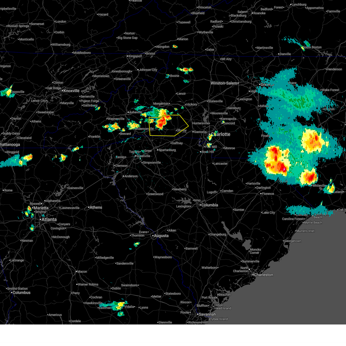
 At 811 pm edt, severe thunderstorms were located along a line extending from 13 miles west of lincolnton to 8 miles northeast of gaffney, moving northeast at 25 mph (radar indicated). Hazards include 60 mph wind gusts. Expect damage to trees and power lines. Locations impacted include, shelby, lincolnton, kings mountain, cherryville, bessemer city, south gastonia, blacksburg, belwood, grover, and lawndale. At 811 pm edt, severe thunderstorms were located along a line extending from 13 miles west of lincolnton to 8 miles northeast of gaffney, moving northeast at 25 mph (radar indicated). Hazards include 60 mph wind gusts. Expect damage to trees and power lines. Locations impacted include, shelby, lincolnton, kings mountain, cherryville, bessemer city, south gastonia, blacksburg, belwood, grover, and lawndale.
|
| 7/1/2025 7:51 PM EDT |
 the severe thunderstorm warning has been cancelled and is no longer in effect the severe thunderstorm warning has been cancelled and is no longer in effect
|
| 7/1/2025 7:51 PM EDT |
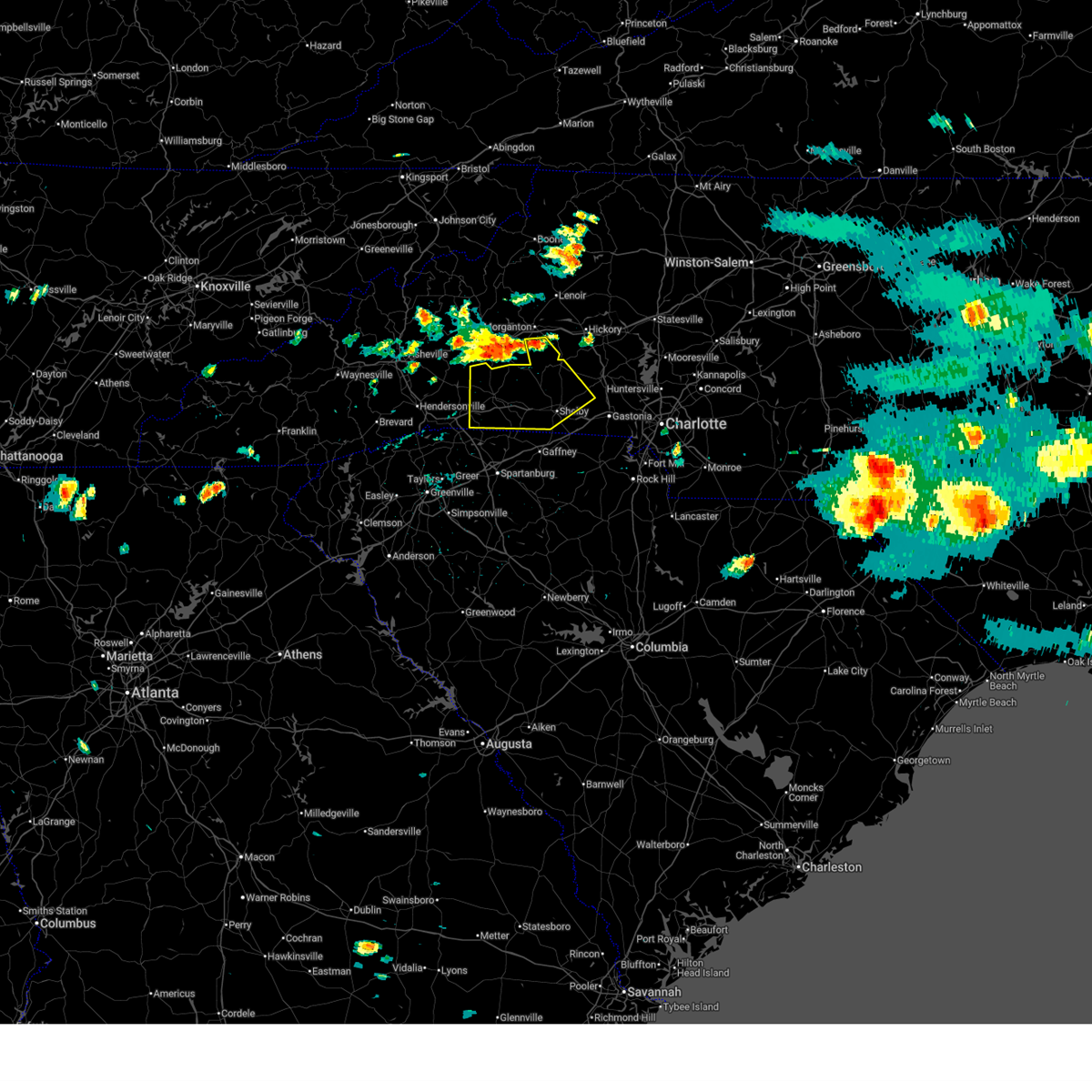
 At 750 pm edt, severe thunderstorms were located along a line extending from 7 miles northwest of shelby to 4 miles northwest of gaffney, moving east at 25 mph (radar indicated). Hazards include 60 mph wind gusts and quarter size hail. Minor hail damage to vehicles is expected. expect wind damage to trees and power lines. Locations impacted include, shelby, gaffney, lincolnton, kings mountain, cherryville, bessemer city, south gastonia, boiling springs nc, blacksburg, and belwood. At 750 pm edt, severe thunderstorms were located along a line extending from 7 miles northwest of shelby to 4 miles northwest of gaffney, moving east at 25 mph (radar indicated). Hazards include 60 mph wind gusts and quarter size hail. Minor hail damage to vehicles is expected. expect wind damage to trees and power lines. Locations impacted include, shelby, gaffney, lincolnton, kings mountain, cherryville, bessemer city, south gastonia, boiling springs nc, blacksburg, and belwood.
|
| 7/1/2025 7:46 PM EDT |
 Svrgsp the national weather service in greenville-spartanburg has issued a * severe thunderstorm warning for, southeastern rutherford county in western north carolina, western lincoln county in the piedmont of north carolina, cleveland county in the piedmont of north carolina, western gaston county in the piedmont of north carolina, northwestern york county in upstate south carolina, northern cherokee county in upstate south carolina, * until 830 pm edt. * at 746 pm edt, severe thunderstorms were located along a line extending from 7 miles northwest of shelby to 4 miles northwest of gaffney, moving east at 20 mph (radar indicated). Hazards include 60 mph wind gusts. expect damage to trees and power lines Svrgsp the national weather service in greenville-spartanburg has issued a * severe thunderstorm warning for, southeastern rutherford county in western north carolina, western lincoln county in the piedmont of north carolina, cleveland county in the piedmont of north carolina, western gaston county in the piedmont of north carolina, northwestern york county in upstate south carolina, northern cherokee county in upstate south carolina, * until 830 pm edt. * at 746 pm edt, severe thunderstorms were located along a line extending from 7 miles northwest of shelby to 4 miles northwest of gaffney, moving east at 20 mph (radar indicated). Hazards include 60 mph wind gusts. expect damage to trees and power lines
|
| 6/26/2025 4:50 PM EDT | the severe thunderstorm warning has been cancelled and is no longer in effect |
| 6/26/2025 4:14 PM EDT |
 Svrgsp the national weather service in greenville-spartanburg has issued a * severe thunderstorm warning for, southwestern lincoln county in the piedmont of north carolina, northeastern cleveland county in the piedmont of north carolina, northwestern gaston county in the piedmont of north carolina, * until 515 pm edt. * at 414 pm edt, a severe thunderstorm was located 10 miles northeast of shelby, or near cherryville, moving north at 5 mph (radar indicated). Hazards include 60 mph wind gusts and quarter size hail. Minor hail damage to vehicles is expected. Expect wind damage to trees and power lines. Svrgsp the national weather service in greenville-spartanburg has issued a * severe thunderstorm warning for, southwestern lincoln county in the piedmont of north carolina, northeastern cleveland county in the piedmont of north carolina, northwestern gaston county in the piedmont of north carolina, * until 515 pm edt. * at 414 pm edt, a severe thunderstorm was located 10 miles northeast of shelby, or near cherryville, moving north at 5 mph (radar indicated). Hazards include 60 mph wind gusts and quarter size hail. Minor hail damage to vehicles is expected. Expect wind damage to trees and power lines.
|
| 6/25/2025 5:32 PM EDT | At 531 pm edt, a severe thunderstorm was located 5 miles south of forest city, moving south at 20 mph. additional strong to severe storms are present in northern cleveland county (radar indicated). Hazards include 60 mph wind gusts and quarter size hail. Minor hail damage to vehicles is expected. expect wind damage to trees and power lines. Locations impacted include, shelby, forest city, boiling springs nc, belwood, lawndale, patterson springs, fallston, polkville, ellenboro, and lattimore. |
| 6/25/2025 5:32 PM EDT | the severe thunderstorm warning has been cancelled and is no longer in effect |
| 6/25/2025 5:10 PM EDT |
 At 509 pm edt, a severe thunderstorm was located near forest city, moving south at 20 mph. strong storms still may develop in cleveland, lincoln, and northwest gaston counties through 545 pm (radar indicated). Hazards include 60 mph wind gusts and half dollar size hail. Minor hail damage to vehicles is expected. expect wind damage to trees and power lines. Locations impacted include, shelby, forest city, rutherfordton, cherryville, spindale, boiling springs nc, belwood, lawndale, patterson springs, and fallston. At 509 pm edt, a severe thunderstorm was located near forest city, moving south at 20 mph. strong storms still may develop in cleveland, lincoln, and northwest gaston counties through 545 pm (radar indicated). Hazards include 60 mph wind gusts and half dollar size hail. Minor hail damage to vehicles is expected. expect wind damage to trees and power lines. Locations impacted include, shelby, forest city, rutherfordton, cherryville, spindale, boiling springs nc, belwood, lawndale, patterson springs, and fallston.
|
| 6/25/2025 4:58 PM EDT | the severe thunderstorm warning has been cancelled and is no longer in effect |
| 6/25/2025 4:58 PM EDT | At 458 pm edt, severe thunderstorms were located along a line extending from 9 miles northwest of rutherfordton to 9 miles north of forest city to 14 miles south of morganton, moving south at 20 mph (radar indicated). Hazards include 60 mph wind gusts and nickel size hail. Expect damage to trees and power lines. Locations impacted include, shelby, forest city, rutherfordton, cherryville, spindale, boiling springs nc, belwood, lawndale, patterson springs, and fallston. |
| 6/25/2025 4:31 PM EDT |
 Svrgsp the national weather service in greenville-spartanburg has issued a * severe thunderstorm warning for, rutherford county in western north carolina, eastern polk county in western north carolina, western lincoln county in the piedmont of north carolina, cleveland county in the piedmont of north carolina, northwestern gaston county in the piedmont of north carolina, south central burke county in western north carolina, * until 545 pm edt. * at 431 pm edt, severe thunderstorms were located along a line extending from 6 miles south of marion to 6 miles south of morganton, moving southeast at 15 mph (radar indicated). Hazards include 60 mph wind gusts and nickel size hail. expect damage to trees and power lines Svrgsp the national weather service in greenville-spartanburg has issued a * severe thunderstorm warning for, rutherford county in western north carolina, eastern polk county in western north carolina, western lincoln county in the piedmont of north carolina, cleveland county in the piedmont of north carolina, northwestern gaston county in the piedmont of north carolina, south central burke county in western north carolina, * until 545 pm edt. * at 431 pm edt, severe thunderstorms were located along a line extending from 6 miles south of marion to 6 miles south of morganton, moving southeast at 15 mph (radar indicated). Hazards include 60 mph wind gusts and nickel size hail. expect damage to trees and power lines
|
| 6/17/2025 10:18 PM EDT |
 At 1018 pm edt, severe thunderstorms were located along a line extending from 4 miles southeast of morganton to 9 miles northwest of lincolnton to 9 miles northwest of york to 5 miles west of chester, moving east at 50 mph (radar indicated). Hazards include 60 mph wind gusts. Expect damage to trees and power lines. Locations impacted include, gastonia, rock hill, hickory, shelby, morganton, newton, gaffney, lincolnton, union, and york. At 1018 pm edt, severe thunderstorms were located along a line extending from 4 miles southeast of morganton to 9 miles northwest of lincolnton to 9 miles northwest of york to 5 miles west of chester, moving east at 50 mph (radar indicated). Hazards include 60 mph wind gusts. Expect damage to trees and power lines. Locations impacted include, gastonia, rock hill, hickory, shelby, morganton, newton, gaffney, lincolnton, union, and york.
|
| 6/17/2025 10:02 PM EDT | the severe thunderstorm warning has been cancelled and is no longer in effect |
| 6/17/2025 10:02 PM EDT | At 1002 pm edt, severe thunderstorms were located along a line extending from 9 miles southwest of morganton to 14 miles north of shelby to 11 miles east of gaffney to 11 miles southeast of union, moving east at 50 mph (radar indicated). Hazards include 60 mph wind gusts. Expect damage to trees and power lines. Locations impacted include, gastonia, rock hill, hickory, shelby, morganton, newton, gaffney, lincolnton, union, and york. |
| 6/17/2025 9:43 PM EDT |
 Svrgsp the national weather service in greenville-spartanburg has issued a * severe thunderstorm warning for, catawba county in the piedmont of north carolina, rutherford county in western north carolina, lincoln county in the piedmont of north carolina, gaston county in the piedmont of north carolina, southeastern mcdowell county in western north carolina, cleveland county in the piedmont of north carolina, southern burke county in western north carolina, southeastern laurens county in upstate south carolina, union county in upstate south carolina, chester county in upstate south carolina, york county in upstate south carolina, eastern spartanburg county in upstate south carolina, cherokee county in upstate south carolina, * until 1045 pm edt. * at 943 pm edt, severe thunderstorms were located along a line extending from 10 miles north of rutherfordton to 10 miles east of forest city to 9 miles south of gaffney to 13 miles south of union, moving northeast at 50 mph (radar indicated). Hazards include 60 mph wind gusts. expect damage to trees and power lines Svrgsp the national weather service in greenville-spartanburg has issued a * severe thunderstorm warning for, catawba county in the piedmont of north carolina, rutherford county in western north carolina, lincoln county in the piedmont of north carolina, gaston county in the piedmont of north carolina, southeastern mcdowell county in western north carolina, cleveland county in the piedmont of north carolina, southern burke county in western north carolina, southeastern laurens county in upstate south carolina, union county in upstate south carolina, chester county in upstate south carolina, york county in upstate south carolina, eastern spartanburg county in upstate south carolina, cherokee county in upstate south carolina, * until 1045 pm edt. * at 943 pm edt, severe thunderstorms were located along a line extending from 10 miles north of rutherfordton to 10 miles east of forest city to 9 miles south of gaffney to 13 miles south of union, moving northeast at 50 mph (radar indicated). Hazards include 60 mph wind gusts. expect damage to trees and power lines
|
| 6/17/2025 9:34 PM EDT |
 At 933 pm edt, severe thunderstorms were located along a line extending from 3 miles northwest of rutherfordton to 4 miles south of forest city to 5 miles northeast of spartanburg to 13 miles east of laurens, moving east at 50 mph (radar indicated). Hazards include 60 mph wind gusts. Expect damage to trees and power lines. Locations impacted include, spartanburg, shelby, gaffney, union, forest city, rutherfordton, clinton, boiling springs sc, woodruff, and spindale. At 933 pm edt, severe thunderstorms were located along a line extending from 3 miles northwest of rutherfordton to 4 miles south of forest city to 5 miles northeast of spartanburg to 13 miles east of laurens, moving east at 50 mph (radar indicated). Hazards include 60 mph wind gusts. Expect damage to trees and power lines. Locations impacted include, spartanburg, shelby, gaffney, union, forest city, rutherfordton, clinton, boiling springs sc, woodruff, and spindale.
|
| 6/17/2025 9:34 PM EDT |
 the severe thunderstorm warning has been cancelled and is no longer in effect the severe thunderstorm warning has been cancelled and is no longer in effect
|
| 6/17/2025 9:19 PM EDT | the severe thunderstorm warning has been cancelled and is no longer in effect |
| 6/17/2025 9:19 PM EDT | At 918 pm edt, severe thunderstorms were located along a line extending from 4 miles north of columbus to 13 miles south of rutherfordton to 5 miles southwest of spartanburg to near laurens, moving east at 50 mph (radar indicated). Hazards include 60 mph wind gusts. Expect damage to trees and power lines. Locations impacted include, spartanburg, shelby, gaffney, laurens, union, forest city, rutherfordton, columbus, greer, and clinton. |
| 6/17/2025 8:50 PM EDT |
 Svrgsp the national weather service in greenville-spartanburg has issued a * severe thunderstorm warning for, rutherford county in western north carolina, southeastern henderson county in western north carolina, polk county in western north carolina, cleveland county in the piedmont of north carolina, laurens county in upstate south carolina, northeastern pickens county in upstate south carolina, union county in upstate south carolina, greenville county in upstate south carolina, spartanburg county in upstate south carolina, eastern anderson county in upstate south carolina, cherokee county in upstate south carolina, northeastern abbeville county in upstate south carolina, northwestern greenwood county in upstate south carolina, * until 945 pm edt. * at 849 pm edt, severe thunderstorms were located along a line extending from 12 miles south of hendersonville to 18 miles southwest of columbus to 7 miles south of greenville downtown to 11 miles north of abbeville, moving northeast at 50 mph (radar indicated). Hazards include 60 mph wind gusts. expect damage to trees and power lines Svrgsp the national weather service in greenville-spartanburg has issued a * severe thunderstorm warning for, rutherford county in western north carolina, southeastern henderson county in western north carolina, polk county in western north carolina, cleveland county in the piedmont of north carolina, laurens county in upstate south carolina, northeastern pickens county in upstate south carolina, union county in upstate south carolina, greenville county in upstate south carolina, spartanburg county in upstate south carolina, eastern anderson county in upstate south carolina, cherokee county in upstate south carolina, northeastern abbeville county in upstate south carolina, northwestern greenwood county in upstate south carolina, * until 945 pm edt. * at 849 pm edt, severe thunderstorms were located along a line extending from 12 miles south of hendersonville to 18 miles southwest of columbus to 7 miles south of greenville downtown to 11 miles north of abbeville, moving northeast at 50 mph (radar indicated). Hazards include 60 mph wind gusts. expect damage to trees and power lines
|
| 5/17/2025 6:26 AM EDT |
 the severe thunderstorm warning has been cancelled and is no longer in effect the severe thunderstorm warning has been cancelled and is no longer in effect
|
| 5/17/2025 6:26 AM EDT |
 At 626 am edt, a severe thunderstorm was located near lincolnton, or near high shoals, moving east at 60 mph (radar indicated). Hazards include 60 mph wind gusts and quarter size hail. Minor hail damage to vehicles is expected. expect wind damage to trees and power lines. Locations impacted include, westport, davidson, high shoals, crouse, huntersville, croft, lincolnton, cornelius, boger city, and northeast charlotte. At 626 am edt, a severe thunderstorm was located near lincolnton, or near high shoals, moving east at 60 mph (radar indicated). Hazards include 60 mph wind gusts and quarter size hail. Minor hail damage to vehicles is expected. expect wind damage to trees and power lines. Locations impacted include, westport, davidson, high shoals, crouse, huntersville, croft, lincolnton, cornelius, boger city, and northeast charlotte.
|
| 5/17/2025 6:15 AM EDT |
 Svrgsp the national weather service in greenville-spartanburg has issued a * severe thunderstorm warning for, lincoln county in the piedmont of north carolina, south central iredell county in the piedmont of north carolina, northwestern mecklenburg county in the piedmont of north carolina, central cleveland county in the piedmont of north carolina, northern gaston county in the piedmont of north carolina, * until 700 am edt. * at 614 am edt, a severe thunderstorm was located 9 miles northeast of shelby, or near fallston, moving east at 60 mph (radar indicated). Hazards include 60 mph wind gusts and quarter size hail. Minor hail damage to vehicles is expected. Expect wind damage to trees and power lines. Svrgsp the national weather service in greenville-spartanburg has issued a * severe thunderstorm warning for, lincoln county in the piedmont of north carolina, south central iredell county in the piedmont of north carolina, northwestern mecklenburg county in the piedmont of north carolina, central cleveland county in the piedmont of north carolina, northern gaston county in the piedmont of north carolina, * until 700 am edt. * at 614 am edt, a severe thunderstorm was located 9 miles northeast of shelby, or near fallston, moving east at 60 mph (radar indicated). Hazards include 60 mph wind gusts and quarter size hail. Minor hail damage to vehicles is expected. Expect wind damage to trees and power lines.
|
| 5/14/2025 3:12 PM EDT |
 The storm which prompted the warning has weakened below severe limits, and no longer poses an immediate threat to life or property. therefore, the warning will be allowed to expire. however, small hail and gusty winds are still possible with this thunderstorm. The storm which prompted the warning has weakened below severe limits, and no longer poses an immediate threat to life or property. therefore, the warning will be allowed to expire. however, small hail and gusty winds are still possible with this thunderstorm.
|
| 5/14/2025 2:51 PM EDT |
 At 250 pm edt, a severe thunderstorm was located 8 miles west of hickory, or near icard, moving southeast at 15 mph (radar indicated). Hazards include 60 mph wind gusts and quarter size hail. Minor hail damage to vehicles is expected. expect wind damage to trees and power lines. Locations impacted include, lake rhodhiss, longview, cooksville, icard, valdese, vale, hickory regional airport, newton, pleasant grove, and startown. At 250 pm edt, a severe thunderstorm was located 8 miles west of hickory, or near icard, moving southeast at 15 mph (radar indicated). Hazards include 60 mph wind gusts and quarter size hail. Minor hail damage to vehicles is expected. expect wind damage to trees and power lines. Locations impacted include, lake rhodhiss, longview, cooksville, icard, valdese, vale, hickory regional airport, newton, pleasant grove, and startown.
|
| 5/14/2025 2:51 PM EDT |
 the severe thunderstorm warning has been cancelled and is no longer in effect the severe thunderstorm warning has been cancelled and is no longer in effect
|
| 5/14/2025 2:21 PM EDT |
 Svrgsp the national weather service in greenville-spartanburg has issued a * severe thunderstorm warning for, southwestern catawba county in the piedmont of north carolina, western lincoln county in the piedmont of north carolina, south central caldwell county in western north carolina, southeastern burke county in western north carolina, * until 315 pm edt. * at 221 pm edt, a severe thunderstorm was located 8 miles east of morganton, or near lake rhodhiss, moving southeast at 15 mph (radar indicated). Hazards include 60 mph wind gusts and quarter size hail. Minor hail damage to vehicles is expected. Expect wind damage to trees and power lines. Svrgsp the national weather service in greenville-spartanburg has issued a * severe thunderstorm warning for, southwestern catawba county in the piedmont of north carolina, western lincoln county in the piedmont of north carolina, south central caldwell county in western north carolina, southeastern burke county in western north carolina, * until 315 pm edt. * at 221 pm edt, a severe thunderstorm was located 8 miles east of morganton, or near lake rhodhiss, moving southeast at 15 mph (radar indicated). Hazards include 60 mph wind gusts and quarter size hail. Minor hail damage to vehicles is expected. Expect wind damage to trees and power lines.
|
| 5/8/2025 8:11 PM EDT |
 The severe thunderstorm which prompted the warning has weakened. therefore, the warning will be allowed to expire. however, gusty winds and heavy rain are still possible with this thunderstorm. a severe thunderstorm watch remains in effect until midnight edt for western and the piedmont of north carolina. The severe thunderstorm which prompted the warning has weakened. therefore, the warning will be allowed to expire. however, gusty winds and heavy rain are still possible with this thunderstorm. a severe thunderstorm watch remains in effect until midnight edt for western and the piedmont of north carolina.
|
| 5/8/2025 7:53 PM EDT | At 751 pm edt, a severe thunderstorm was located near shelby, moving east at 25 mph. another strong storm was located over henrietta, moving northeast at 25 mph. this storm could strengthen as it moves into the western part of the warned area through 815 pm (radar indicated). Hazards include 60 mph wind gusts and nickel size hail. Expect damage to trees and power lines. Locations impacted include, lawndale, belwood, lattimore, kingstown, mooresboro, polkville, shelby, fallston, waco, and ellenboro. |
| 5/8/2025 7:38 PM EDT |
 At 738 pm edt, a severe thunderstorm was located 9 miles east of forest city, or 4 miles southwest of polkville, moving east at 25 mph (radar indicated). Hazards include 60 mph wind gusts and half dollar size hail. Minor hail damage to vehicles is expected. expect wind damage to trees and power lines. Locations impacted include, lawndale, belwood, lattimore, kingstown, mooresboro, polkville, shelby, fallston, waco, and ellenboro. At 738 pm edt, a severe thunderstorm was located 9 miles east of forest city, or 4 miles southwest of polkville, moving east at 25 mph (radar indicated). Hazards include 60 mph wind gusts and half dollar size hail. Minor hail damage to vehicles is expected. expect wind damage to trees and power lines. Locations impacted include, lawndale, belwood, lattimore, kingstown, mooresboro, polkville, shelby, fallston, waco, and ellenboro.
|
| 5/8/2025 7:29 PM EDT |
 At 729 pm edt, a severe thunderstorm was located 6 miles northeast of forest city, or near ellenboro, moving east at 25 mph (radar indicated). Hazards include tennis ball size hail and 60 mph wind gusts. People and animals outdoors will be injured. expect hail damage to roofs, siding, windows, and vehicles. expect wind damage to trees and power lines. Locations impacted include, lawndale, belwood, lattimore, kingstown, mooresboro, polkville, shelby, fallston, bostic, and forest city. At 729 pm edt, a severe thunderstorm was located 6 miles northeast of forest city, or near ellenboro, moving east at 25 mph (radar indicated). Hazards include tennis ball size hail and 60 mph wind gusts. People and animals outdoors will be injured. expect hail damage to roofs, siding, windows, and vehicles. expect wind damage to trees and power lines. Locations impacted include, lawndale, belwood, lattimore, kingstown, mooresboro, polkville, shelby, fallston, bostic, and forest city.
|
| 5/8/2025 7:24 PM EDT |
 Svrgsp the national weather service in greenville-spartanburg has issued a * severe thunderstorm warning for, east central rutherford county in western north carolina, central cleveland county in the piedmont of north carolina, * until 815 pm edt. * at 724 pm edt, a severe thunderstorm was located near forest city, or near bostic, moving east at 25 mph (radar indicated). Hazards include ping pong ball size hail. People and animals outdoors will be injured. Expect damage to roofs, siding, windows, and vehicles. Svrgsp the national weather service in greenville-spartanburg has issued a * severe thunderstorm warning for, east central rutherford county in western north carolina, central cleveland county in the piedmont of north carolina, * until 815 pm edt. * at 724 pm edt, a severe thunderstorm was located near forest city, or near bostic, moving east at 25 mph (radar indicated). Hazards include ping pong ball size hail. People and animals outdoors will be injured. Expect damage to roofs, siding, windows, and vehicles.
|
| 5/8/2025 6:22 PM EDT | Quarter sized hail reported 5.7 miles SSW of Belwood, NC |
| 5/8/2025 6:14 PM EDT | At 614 pm edt, a severe thunderstorm was located 13 miles northwest of lincolnton, or 6 miles northeast of belwood, moving east at 30 mph (radar indicated). Hazards include golf ball size hail and 60 mph wind gusts. People and animals outdoors will be injured. expect hail damage to roofs, siding, windows, and vehicles. expect wind damage to trees and power lines. Locations impacted include, westport, bandys, lake norman, cooksville, belwood, vale, lincolnton, lake norman state park, boger city, and newton. |
| 5/8/2025 6:07 PM EDT | Svrgsp the national weather service in greenville-spartanburg has issued a * severe thunderstorm warning for, southern catawba county in the piedmont of north carolina, lincoln county in the piedmont of north carolina, south central iredell county in the piedmont of north carolina, north central cleveland county in the piedmont of north carolina, southeastern burke county in western north carolina, * until 715 pm edt. * at 607 pm edt, a severe thunderstorm was located 15 miles southeast of morganton, or 6 miles north of belwood, moving east at 30 mph (radar indicated). Hazards include 60 mph wind gusts and quarter size hail. Minor hail damage to vehicles is expected. Expect wind damage to trees and power lines. |
| 5/8/2025 5:36 PM EDT |
 the severe thunderstorm warning has been cancelled and is no longer in effect the severe thunderstorm warning has been cancelled and is no longer in effect
|
| 5/8/2025 5:36 PM EDT |
 At 535 pm edt, a severe thunderstorm was located 7 miles southwest of morganton, or 6 miles south of glen alpine, moving east at 20 mph (radar indicated). Hazards include 60 mph wind gusts and penny size hail. Expect damage to trees and power lines. Locations impacted include, morganton, lake rhodhiss, rhodhiss, icard, valdese, glen alpine, pleasant grove, connelly springs, drexel, and south mountains state park. At 535 pm edt, a severe thunderstorm was located 7 miles southwest of morganton, or 6 miles south of glen alpine, moving east at 20 mph (radar indicated). Hazards include 60 mph wind gusts and penny size hail. Expect damage to trees and power lines. Locations impacted include, morganton, lake rhodhiss, rhodhiss, icard, valdese, glen alpine, pleasant grove, connelly springs, drexel, and south mountains state park.
|
| 5/8/2025 4:55 PM EDT |
 At 454 pm edt, a severe thunderstorm was located 6 miles east of marion, or near lake james state park, moving east at 25 mph (radar indicated). Hazards include 60 mph wind gusts and half dollar size hail. Minor hail damage to vehicles is expected. expect wind damage to trees and power lines. Locations impacted include, nebo, lake james state park, morganton, lake rhodhiss, pleasant gardens, glenwood, rhodhiss, icard, valdese, and glen alpine. At 454 pm edt, a severe thunderstorm was located 6 miles east of marion, or near lake james state park, moving east at 25 mph (radar indicated). Hazards include 60 mph wind gusts and half dollar size hail. Minor hail damage to vehicles is expected. expect wind damage to trees and power lines. Locations impacted include, nebo, lake james state park, morganton, lake rhodhiss, pleasant gardens, glenwood, rhodhiss, icard, valdese, and glen alpine.
|
| 5/8/2025 4:39 PM EDT |
 Svrgsp the national weather service in greenville-spartanburg has issued a * severe thunderstorm warning for, southeastern mcdowell county in western north carolina, northeastern rutherford county in western north carolina, northwestern cleveland county in the piedmont of north carolina, southern burke county in western north carolina, * until 600 pm edt. * at 439 pm edt, multiple severe thunderstorm were located over the north carolina foothills, one near marion, and another near morganton, both moving east at 25 mph (radar indicated). Hazards include ping pong ball size hail and 60 mph wind gusts. People and animals outdoors will be injured. expect hail damage to roofs, siding, windows, and vehicles. Expect wind damage to trees and power lines. Svrgsp the national weather service in greenville-spartanburg has issued a * severe thunderstorm warning for, southeastern mcdowell county in western north carolina, northeastern rutherford county in western north carolina, northwestern cleveland county in the piedmont of north carolina, southern burke county in western north carolina, * until 600 pm edt. * at 439 pm edt, multiple severe thunderstorm were located over the north carolina foothills, one near marion, and another near morganton, both moving east at 25 mph (radar indicated). Hazards include ping pong ball size hail and 60 mph wind gusts. People and animals outdoors will be injured. expect hail damage to roofs, siding, windows, and vehicles. Expect wind damage to trees and power lines.
|
| 12/29/2024 9:06 AM EST |
 the severe thunderstorm warning has been cancelled and is no longer in effect the severe thunderstorm warning has been cancelled and is no longer in effect
|
| 12/29/2024 9:06 AM EST |
 At 906 am est, severe thunderstorms were located along a line extending from 7 miles southwest of lenoir to 9 miles south of hickory to 10 miles southwest of lincolnton to 10 miles northwest of york, moving northeast at 50 mph (radar indicated). Hazards include 60 mph wind gusts. Expect damage to trees and power lines. locations impacted include, gastonia, hickory, lenoir, newton, lincolnton, kings mountain, st. Stephens, conover, cherryville, and bessemer city. At 906 am est, severe thunderstorms were located along a line extending from 7 miles southwest of lenoir to 9 miles south of hickory to 10 miles southwest of lincolnton to 10 miles northwest of york, moving northeast at 50 mph (radar indicated). Hazards include 60 mph wind gusts. Expect damage to trees and power lines. locations impacted include, gastonia, hickory, lenoir, newton, lincolnton, kings mountain, st. Stephens, conover, cherryville, and bessemer city.
|
| 12/29/2024 8:53 AM EST |
 At 853 am est, severe thunderstorms were located along a line extending from 8 miles northwest of morganton to 15 miles southwest of hickory to 4 miles northeast of shelby to 9 miles northeast of gaffney, moving northeast at 55 mph (radar indicated). Hazards include 60 mph wind gusts. Expect damage to trees and power lines. locations impacted include, gastonia, hickory, shelby, lenoir, morganton, newton, lincolnton, kings mountain, st. Stephens, and conover. At 853 am est, severe thunderstorms were located along a line extending from 8 miles northwest of morganton to 15 miles southwest of hickory to 4 miles northeast of shelby to 9 miles northeast of gaffney, moving northeast at 55 mph (radar indicated). Hazards include 60 mph wind gusts. Expect damage to trees and power lines. locations impacted include, gastonia, hickory, shelby, lenoir, morganton, newton, lincolnton, kings mountain, st. Stephens, and conover.
|
| 12/29/2024 8:25 AM EST |
 Svrgsp the national weather service in greenville-spartanburg has issued a * severe thunderstorm warning for, western catawba county in the piedmont of north carolina, southeastern mcdowell county in western north carolina, eastern rutherford county in western north carolina, lincoln county in the piedmont of north carolina, southern caldwell county in western north carolina, cleveland county in the piedmont of north carolina, gaston county in the piedmont of north carolina, burke county in western north carolina, eastern cherokee county in upstate south carolina, * until 945 am est. * at 824 am est, severe thunderstorms were located along a line extending from 10 miles southwest of marion to near forest city to 9 miles west of gaffney to 8 miles southeast of spartanburg, moving northeast at 55 mph (radar indicated). Hazards include 60 mph wind gusts. expect damage to trees and power lines Svrgsp the national weather service in greenville-spartanburg has issued a * severe thunderstorm warning for, western catawba county in the piedmont of north carolina, southeastern mcdowell county in western north carolina, eastern rutherford county in western north carolina, lincoln county in the piedmont of north carolina, southern caldwell county in western north carolina, cleveland county in the piedmont of north carolina, gaston county in the piedmont of north carolina, burke county in western north carolina, eastern cherokee county in upstate south carolina, * until 945 am est. * at 824 am est, severe thunderstorms were located along a line extending from 10 miles southwest of marion to near forest city to 9 miles west of gaffney to 8 miles southeast of spartanburg, moving northeast at 55 mph (radar indicated). Hazards include 60 mph wind gusts. expect damage to trees and power lines
|
| 8/16/2024 10:01 PM EDT |
 the severe thunderstorm warning has been cancelled and is no longer in effect the severe thunderstorm warning has been cancelled and is no longer in effect
|
| 8/16/2024 9:32 PM EDT |
 Svrgsp the national weather service in greenville-spartanburg has issued a * severe thunderstorm warning for, southwestern catawba county in the piedmont of north carolina, western lincoln county in the piedmont of north carolina, northeastern cleveland county in the piedmont of north carolina, northwestern gaston county in the piedmont of north carolina, southeastern burke county in western north carolina, * until 1015 pm edt. * at 932 pm edt, severe thunderstorms were located along a line extending from 5 miles east of newton to 3 miles northeast of lincolnton to 16 miles north of shelby, moving east at 25 mph (radar indicated). Hazards include 60 mph wind gusts and penny size hail. expect damage to trees and power lines Svrgsp the national weather service in greenville-spartanburg has issued a * severe thunderstorm warning for, southwestern catawba county in the piedmont of north carolina, western lincoln county in the piedmont of north carolina, northeastern cleveland county in the piedmont of north carolina, northwestern gaston county in the piedmont of north carolina, southeastern burke county in western north carolina, * until 1015 pm edt. * at 932 pm edt, severe thunderstorms were located along a line extending from 5 miles east of newton to 3 miles northeast of lincolnton to 16 miles north of shelby, moving east at 25 mph (radar indicated). Hazards include 60 mph wind gusts and penny size hail. expect damage to trees and power lines
|
| 8/16/2024 8:58 PM EDT |
 At 858 pm edt, severe thunderstorms were located along a line extending from 6 miles southeast of forest city to 12 miles northwest of gaffney to 10 miles east of columbus, moving southeast at 35 mph (radar indicated). Hazards include 60 mph wind gusts and penny size hail. Expect damage to trees and power lines. Locations impacted include, shelby, forest city, rutherfordton, spindale, boiling springs nc, mayo, chesnee, lawndale, fallston, and polkville. At 858 pm edt, severe thunderstorms were located along a line extending from 6 miles southeast of forest city to 12 miles northwest of gaffney to 10 miles east of columbus, moving southeast at 35 mph (radar indicated). Hazards include 60 mph wind gusts and penny size hail. Expect damage to trees and power lines. Locations impacted include, shelby, forest city, rutherfordton, spindale, boiling springs nc, mayo, chesnee, lawndale, fallston, and polkville.
|
| 8/16/2024 8:23 PM EDT |
 Svrgsp the national weather service in greenville-spartanburg has issued a * severe thunderstorm warning for, catawba county in the piedmont of north carolina, southwestern alexander county in the piedmont of north carolina, western lincoln county in the piedmont of north carolina, southeastern caldwell county in western north carolina, northeastern cleveland county in the piedmont of north carolina, northwestern gaston county in the piedmont of north carolina, southeastern burke county in western north carolina, * until 930 pm edt. * at 823 pm edt, severe thunderstorms were located along a line extending from 7 miles northwest of lenoir to 4 miles east of morganton to 11 miles southeast of marion, moving southeast at 30 mph (radar indicated). Hazards include 60 mph wind gusts and penny size hail. expect damage to trees and power lines Svrgsp the national weather service in greenville-spartanburg has issued a * severe thunderstorm warning for, catawba county in the piedmont of north carolina, southwestern alexander county in the piedmont of north carolina, western lincoln county in the piedmont of north carolina, southeastern caldwell county in western north carolina, northeastern cleveland county in the piedmont of north carolina, northwestern gaston county in the piedmont of north carolina, southeastern burke county in western north carolina, * until 930 pm edt. * at 823 pm edt, severe thunderstorms were located along a line extending from 7 miles northwest of lenoir to 4 miles east of morganton to 11 miles southeast of marion, moving southeast at 30 mph (radar indicated). Hazards include 60 mph wind gusts and penny size hail. expect damage to trees and power lines
|
| 8/16/2024 8:13 PM EDT |
 Svrgsp the national weather service in greenville-spartanburg has issued a * severe thunderstorm warning for, southeastern rutherford county in western north carolina, polk county in western north carolina, cleveland county in the piedmont of north carolina, northern spartanburg county in upstate south carolina, northwestern cherokee county in upstate south carolina, * until 915 pm edt. * at 813 pm edt, severe thunderstorms were located along a line extending from 8 miles south of marion to 9 miles northwest of rutherfordton to 13 miles northeast of hendersonville, moving southeast at 35 mph (radar indicated). Hazards include 60 mph wind gusts and penny size hail. expect damage to trees and power lines Svrgsp the national weather service in greenville-spartanburg has issued a * severe thunderstorm warning for, southeastern rutherford county in western north carolina, polk county in western north carolina, cleveland county in the piedmont of north carolina, northern spartanburg county in upstate south carolina, northwestern cherokee county in upstate south carolina, * until 915 pm edt. * at 813 pm edt, severe thunderstorms were located along a line extending from 8 miles south of marion to 9 miles northwest of rutherfordton to 13 miles northeast of hendersonville, moving southeast at 35 mph (radar indicated). Hazards include 60 mph wind gusts and penny size hail. expect damage to trees and power lines
|
| 8/2/2024 4:43 PM EDT |
 Svrgsp the national weather service in greenville-spartanburg has issued a * severe thunderstorm warning for, central lincoln county in the piedmont of north carolina, central cleveland county in the piedmont of north carolina, northwestern gaston county in the piedmont of north carolina, * until 530 pm edt. * at 443 pm edt, a severe thunderstorm was located 11 miles west of lincolnton, or near fallston, moving east at 25 mph (radar indicated). Hazards include 60 mph wind gusts. expect damage to trees and power lines Svrgsp the national weather service in greenville-spartanburg has issued a * severe thunderstorm warning for, central lincoln county in the piedmont of north carolina, central cleveland county in the piedmont of north carolina, northwestern gaston county in the piedmont of north carolina, * until 530 pm edt. * at 443 pm edt, a severe thunderstorm was located 11 miles west of lincolnton, or near fallston, moving east at 25 mph (radar indicated). Hazards include 60 mph wind gusts. expect damage to trees and power lines
|
| 7/30/2024 7:35 PM EDT | Carport roof blown off and a few trees knocked down. time estimated from radar velocit in lincoln county NC, 8.5 miles WSW of Belwood, NC |
| 7/29/2024 4:23 PM EDT |
 At 423 pm edt, a severe thunderstorm was located 11 miles southwest of hickory, or 6 miles south of icard, moving southeast at 20 mph (radar indicated). Hazards include 60 mph wind gusts. Expect damage to trees and power lines. Locations impacted include, icard, hildebran, belwood, mountain view, pleasant grove, cooksville, propst, vale, and connelly springs. At 423 pm edt, a severe thunderstorm was located 11 miles southwest of hickory, or 6 miles south of icard, moving southeast at 20 mph (radar indicated). Hazards include 60 mph wind gusts. Expect damage to trees and power lines. Locations impacted include, icard, hildebran, belwood, mountain view, pleasant grove, cooksville, propst, vale, and connelly springs.
|
| 7/29/2024 4:04 PM EDT |
 Svrgsp the national weather service in greenville-spartanburg has issued a * severe thunderstorm warning for, southwestern catawba county in the piedmont of north carolina, northwestern lincoln county in the piedmont of north carolina, north central cleveland county in the piedmont of north carolina, southeastern burke county in western north carolina, * until 445 pm edt. * at 404 pm edt, a severe thunderstorm was located 9 miles east of morganton, or near valdese, moving southeast at 20 mph (radar indicated). Hazards include 60 mph wind gusts. expect damage to trees and power lines Svrgsp the national weather service in greenville-spartanburg has issued a * severe thunderstorm warning for, southwestern catawba county in the piedmont of north carolina, northwestern lincoln county in the piedmont of north carolina, north central cleveland county in the piedmont of north carolina, southeastern burke county in western north carolina, * until 445 pm edt. * at 404 pm edt, a severe thunderstorm was located 9 miles east of morganton, or near valdese, moving southeast at 20 mph (radar indicated). Hazards include 60 mph wind gusts. expect damage to trees and power lines
|
| 5/26/2024 8:53 PM EDT |
 At 853 pm edt, severe thunderstorms were located along a line extending from 5 miles east of newton to 5 miles west of lincolnton to 5 miles northeast of forest city, moving east at 35 mph (radar indicated). Hazards include 60 mph wind gusts. Expect damage to trees and power lines. Locations impacted include, newton, conover, longview, maiden, belwood, lawndale, fallston, polkville, ellenboro, and lattimore. At 853 pm edt, severe thunderstorms were located along a line extending from 5 miles east of newton to 5 miles west of lincolnton to 5 miles northeast of forest city, moving east at 35 mph (radar indicated). Hazards include 60 mph wind gusts. Expect damage to trees and power lines. Locations impacted include, newton, conover, longview, maiden, belwood, lawndale, fallston, polkville, ellenboro, and lattimore.
|
| 5/26/2024 8:53 PM EDT |
 the severe thunderstorm warning has been cancelled and is no longer in effect the severe thunderstorm warning has been cancelled and is no longer in effect
|
| 5/26/2024 8:26 PM EDT |
 the severe thunderstorm warning has been cancelled and is no longer in effect the severe thunderstorm warning has been cancelled and is no longer in effect
|
| 5/26/2024 8:26 PM EDT |
 At 825 pm edt, severe thunderstorms were located along a line extending from 3 miles south of morganton to 8 miles west of rutherfordton, moving southeast at 35 mph (radar indicated). Hazards include 60 mph wind gusts and quarter size hail. Minor hail damage to vehicles is expected. expect wind damage to trees and power lines. Locations impacted include, hickory, morganton, newton, forest city, marion, rutherfordton, conover, longview, valdese, and spindale. At 825 pm edt, severe thunderstorms were located along a line extending from 3 miles south of morganton to 8 miles west of rutherfordton, moving southeast at 35 mph (radar indicated). Hazards include 60 mph wind gusts and quarter size hail. Minor hail damage to vehicles is expected. expect wind damage to trees and power lines. Locations impacted include, hickory, morganton, newton, forest city, marion, rutherfordton, conover, longview, valdese, and spindale.
|
| 5/26/2024 8:00 PM EDT |
 Svrgsp the national weather service in greenville-spartanburg has issued a * severe thunderstorm warning for, southwestern catawba county in the piedmont of north carolina, mcdowell county in western north carolina, rutherford county in western north carolina, northeastern polk county in western north carolina, western lincoln county in the piedmont of north carolina, southwestern caldwell county in western north carolina, east central buncombe county in western north carolina, western cleveland county in the piedmont of north carolina, burke county in western north carolina, * until 900 pm edt. * at 759 pm edt, severe thunderstorms were located along a line extending from 9 miles northwest of morganton to 16 miles east of downtown asheville, moving southeast at 35 mph (radar indicated). Hazards include 60 mph wind gusts and quarter size hail. Minor hail damage to vehicles is expected. Expect wind damage to trees and power lines. Svrgsp the national weather service in greenville-spartanburg has issued a * severe thunderstorm warning for, southwestern catawba county in the piedmont of north carolina, mcdowell county in western north carolina, rutherford county in western north carolina, northeastern polk county in western north carolina, western lincoln county in the piedmont of north carolina, southwestern caldwell county in western north carolina, east central buncombe county in western north carolina, western cleveland county in the piedmont of north carolina, burke county in western north carolina, * until 900 pm edt. * at 759 pm edt, severe thunderstorms were located along a line extending from 9 miles northwest of morganton to 16 miles east of downtown asheville, moving southeast at 35 mph (radar indicated). Hazards include 60 mph wind gusts and quarter size hail. Minor hail damage to vehicles is expected. Expect wind damage to trees and power lines.
|
| 5/15/2024 3:27 PM EDT |
 the severe thunderstorm warning has been cancelled and is no longer in effect the severe thunderstorm warning has been cancelled and is no longer in effect
|
| 5/15/2024 3:27 PM EDT |
 At 326 pm edt, severe thunderstorms were located along a line extending from near hickory to 8 miles southeast of morganton to 9 miles southeast of marion, moving southeast at 15 mph (radar indicated). Hazards include 60 mph wind gusts and quarter size hail. Minor hail damage to vehicles is expected. expect wind damage to trees and power lines. locations impacted include, hickory, newton, st. Stephens, conover, longview, icard, hildebran, claremont, casar, and hickory regional airport. At 326 pm edt, severe thunderstorms were located along a line extending from near hickory to 8 miles southeast of morganton to 9 miles southeast of marion, moving southeast at 15 mph (radar indicated). Hazards include 60 mph wind gusts and quarter size hail. Minor hail damage to vehicles is expected. expect wind damage to trees and power lines. locations impacted include, hickory, newton, st. Stephens, conover, longview, icard, hildebran, claremont, casar, and hickory regional airport.
|
| 5/15/2024 2:59 PM EDT |
 Svrgsp the national weather service in greenville-spartanburg has issued a * severe thunderstorm warning for, central catawba county in the piedmont of north carolina, southeastern mcdowell county in western north carolina, northeastern rutherford county in western north carolina, northwestern lincoln county in the piedmont of north carolina, southeastern caldwell county in western north carolina, northwestern cleveland county in the piedmont of north carolina, burke county in western north carolina, * until 345 pm edt. * at 258 pm edt, severe thunderstorms were located along a line extending from 6 miles northwest of hickory to near morganton to 4 miles east of marion, moving southeast at 15 mph (radar indicated). Hazards include 60 mph wind gusts and quarter size hail. Minor hail damage to vehicles is expected. Expect wind damage to trees and power lines. Svrgsp the national weather service in greenville-spartanburg has issued a * severe thunderstorm warning for, central catawba county in the piedmont of north carolina, southeastern mcdowell county in western north carolina, northeastern rutherford county in western north carolina, northwestern lincoln county in the piedmont of north carolina, southeastern caldwell county in western north carolina, northwestern cleveland county in the piedmont of north carolina, burke county in western north carolina, * until 345 pm edt. * at 258 pm edt, severe thunderstorms were located along a line extending from 6 miles northwest of hickory to near morganton to 4 miles east of marion, moving southeast at 15 mph (radar indicated). Hazards include 60 mph wind gusts and quarter size hail. Minor hail damage to vehicles is expected. Expect wind damage to trees and power lines.
|
| 5/8/2024 3:31 PM EDT |
 At 331 pm edt, severe thunderstorms were located along a line extending from 5 miles north of lincolnton to 9 miles east of shelby to near gaffney, moving east at 35 mph (radar indicated). Hazards include 70 mph wind gusts and half dollar size hail. Minor hail damage to vehicles is expected. expect considerable tree damage. wind damage is also likely to mobile homes, roofs, and outbuildings. Locations impacted include, shelby, lincolnton, cherryville, belwood, lawndale, patterson springs, fallston, waco, boger city, and crouse. At 331 pm edt, severe thunderstorms were located along a line extending from 5 miles north of lincolnton to 9 miles east of shelby to near gaffney, moving east at 35 mph (radar indicated). Hazards include 70 mph wind gusts and half dollar size hail. Minor hail damage to vehicles is expected. expect considerable tree damage. wind damage is also likely to mobile homes, roofs, and outbuildings. Locations impacted include, shelby, lincolnton, cherryville, belwood, lawndale, patterson springs, fallston, waco, boger city, and crouse.
|
| 5/8/2024 3:24 PM EDT |
 the severe thunderstorm warning has been cancelled and is no longer in effect the severe thunderstorm warning has been cancelled and is no longer in effect
|
| 5/8/2024 3:24 PM EDT |
 At 324 pm edt, severe thunderstorms were located along a line extending from 8 miles northwest of lincolnton to 5 miles east of shelby to 4 miles northwest of gaffney, moving east at 35 mph (radar indicated). Hazards include 70 mph wind gusts and half dollar size hail. Minor hail damage to vehicles is expected. expect considerable tree damage. wind damage is also likely to mobile homes, roofs, and outbuildings. Locations impacted include, shelby, lincolnton, cherryville, belwood, lawndale, patterson springs, fallston, polkville, lattimore, and mooresboro. At 324 pm edt, severe thunderstorms were located along a line extending from 8 miles northwest of lincolnton to 5 miles east of shelby to 4 miles northwest of gaffney, moving east at 35 mph (radar indicated). Hazards include 70 mph wind gusts and half dollar size hail. Minor hail damage to vehicles is expected. expect considerable tree damage. wind damage is also likely to mobile homes, roofs, and outbuildings. Locations impacted include, shelby, lincolnton, cherryville, belwood, lawndale, patterson springs, fallston, polkville, lattimore, and mooresboro.
|
| 5/8/2024 3:17 PM EDT |
 At 317 pm edt, a severe thunderstorm capable of producing a tornado was located 8 miles north of shelby, or near fallston, moving east at 30 mph (radar indicated rotation). Hazards include tornado and quarter size hail. Flying debris will be dangerous to those caught without shelter. mobile homes will be damaged or destroyed. damage to roofs, windows, and vehicles will occur. tree damage is likely. this dangerous storm will be near, fallston around 320 pm edt. cherryville and waco around 330 pm edt. Other locations impacted by this tornadic thunderstorm include crouse. At 317 pm edt, a severe thunderstorm capable of producing a tornado was located 8 miles north of shelby, or near fallston, moving east at 30 mph (radar indicated rotation). Hazards include tornado and quarter size hail. Flying debris will be dangerous to those caught without shelter. mobile homes will be damaged or destroyed. damage to roofs, windows, and vehicles will occur. tree damage is likely. this dangerous storm will be near, fallston around 320 pm edt. cherryville and waco around 330 pm edt. Other locations impacted by this tornadic thunderstorm include crouse.
|
| 5/8/2024 3:11 PM EDT |
 the severe thunderstorm warning has been cancelled and is no longer in effect the severe thunderstorm warning has been cancelled and is no longer in effect
|
| 5/8/2024 3:11 PM EDT |
 At 311 pm edt, severe thunderstorms were located along a line extending from 12 miles southwest of hickory to near shelby to 10 miles northwest of gaffney, moving southeast at 35 mph (radar indicated). Hazards include 70 mph wind gusts and quarter size hail. Minor hail damage to vehicles is expected. expect considerable tree damage. wind damage is also likely to mobile homes, roofs, and outbuildings. Locations impacted include, shelby, lincolnton, cherryville, belwood, lawndale, patterson springs, fallston, polkville, ellenboro, and lattimore. At 311 pm edt, severe thunderstorms were located along a line extending from 12 miles southwest of hickory to near shelby to 10 miles northwest of gaffney, moving southeast at 35 mph (radar indicated). Hazards include 70 mph wind gusts and quarter size hail. Minor hail damage to vehicles is expected. expect considerable tree damage. wind damage is also likely to mobile homes, roofs, and outbuildings. Locations impacted include, shelby, lincolnton, cherryville, belwood, lawndale, patterson springs, fallston, polkville, ellenboro, and lattimore.
|
| 5/8/2024 3:08 PM EDT |
 At 308 pm edt, a severe thunderstorm capable of producing a tornado was located 10 miles north of shelby, or near lawndale, moving southeast at 30 mph (radar indicated rotation). Hazards include tornado and quarter size hail. Flying debris will be dangerous to those caught without shelter. mobile homes will be damaged or destroyed. damage to roofs, windows, and vehicles will occur. tree damage is likely. this dangerous storm will be near, lawndale, fallston, and polkville around 310 pm edt. cherryville and waco around 330 pm edt. Other locations impacted by this tornadic thunderstorm include crouse. At 308 pm edt, a severe thunderstorm capable of producing a tornado was located 10 miles north of shelby, or near lawndale, moving southeast at 30 mph (radar indicated rotation). Hazards include tornado and quarter size hail. Flying debris will be dangerous to those caught without shelter. mobile homes will be damaged or destroyed. damage to roofs, windows, and vehicles will occur. tree damage is likely. this dangerous storm will be near, lawndale, fallston, and polkville around 310 pm edt. cherryville and waco around 330 pm edt. Other locations impacted by this tornadic thunderstorm include crouse.
|
| 5/8/2024 2:58 PM EDT |
 Torgsp the national weather service in greenville-spartanburg has issued a * tornado warning for, southwestern lincoln county in the piedmont of north carolina, central cleveland county in the piedmont of north carolina, northwestern gaston county in the piedmont of north carolina, * until 345 pm edt. * at 258 pm edt, a severe thunderstorm capable of producing a tornado was located 11 miles northwest of shelby, or near polkville, moving southeast at 40 mph (radar indicated rotation). Hazards include tornado and quarter size hail. Flying debris will be dangerous to those caught without shelter. mobile homes will be damaged or destroyed. damage to roofs, windows, and vehicles will occur. tree damage is likely. this dangerous storm will be near, lawndale, fallston, and polkville around 300 pm edt. cherryville and waco around 310 pm edt. Other locations impacted by this dangerous thunderstorm include crouse. Torgsp the national weather service in greenville-spartanburg has issued a * tornado warning for, southwestern lincoln county in the piedmont of north carolina, central cleveland county in the piedmont of north carolina, northwestern gaston county in the piedmont of north carolina, * until 345 pm edt. * at 258 pm edt, a severe thunderstorm capable of producing a tornado was located 11 miles northwest of shelby, or near polkville, moving southeast at 40 mph (radar indicated rotation). Hazards include tornado and quarter size hail. Flying debris will be dangerous to those caught without shelter. mobile homes will be damaged or destroyed. damage to roofs, windows, and vehicles will occur. tree damage is likely. this dangerous storm will be near, lawndale, fallston, and polkville around 300 pm edt. cherryville and waco around 310 pm edt. Other locations impacted by this dangerous thunderstorm include crouse.
|
| 5/8/2024 2:56 PM EDT |
 At 256 pm edt, severe thunderstorms were located along a line extending from 9 miles west of hickory to 10 miles north of shelby to 6 miles southwest of forest city, moving east at 35 mph (radar indicated). Hazards include 70 mph wind gusts and quarter size hail. Minor hail damage to vehicles is expected. expect considerable tree damage. wind damage is also likely to mobile homes, roofs, and outbuildings. Locations impacted include, shelby, lincolnton, forest city, rutherfordton, cherryville, spindale, maiden, belwood, lawndale, and patterson springs. At 256 pm edt, severe thunderstorms were located along a line extending from 9 miles west of hickory to 10 miles north of shelby to 6 miles southwest of forest city, moving east at 35 mph (radar indicated). Hazards include 70 mph wind gusts and quarter size hail. Minor hail damage to vehicles is expected. expect considerable tree damage. wind damage is also likely to mobile homes, roofs, and outbuildings. Locations impacted include, shelby, lincolnton, forest city, rutherfordton, cherryville, spindale, maiden, belwood, lawndale, and patterson springs.
|
| 5/8/2024 2:26 PM EDT |
 Svrgsp the national weather service in greenville-spartanburg has issued a * severe thunderstorm warning for, southwestern catawba county in the piedmont of north carolina, northeastern rutherford county in western north carolina, western lincoln county in the piedmont of north carolina, cleveland county in the piedmont of north carolina, northwestern gaston county in the piedmont of north carolina, southeastern burke county in western north carolina, * until 345 pm edt. * at 226 pm edt, severe thunderstorms were located along a line extending from 5 miles northwest of morganton to 12 miles north of forest city to 6 miles west of rutherfordton, moving east at 35 mph (radar indicated). Hazards include 70 mph wind gusts and quarter size hail. Minor hail damage to vehicles is expected. expect considerable tree damage. Wind damage is also likely to mobile homes, roofs, and outbuildings. Svrgsp the national weather service in greenville-spartanburg has issued a * severe thunderstorm warning for, southwestern catawba county in the piedmont of north carolina, northeastern rutherford county in western north carolina, western lincoln county in the piedmont of north carolina, cleveland county in the piedmont of north carolina, northwestern gaston county in the piedmont of north carolina, southeastern burke county in western north carolina, * until 345 pm edt. * at 226 pm edt, severe thunderstorms were located along a line extending from 5 miles northwest of morganton to 12 miles north of forest city to 6 miles west of rutherfordton, moving east at 35 mph (radar indicated). Hazards include 70 mph wind gusts and quarter size hail. Minor hail damage to vehicles is expected. expect considerable tree damage. Wind damage is also likely to mobile homes, roofs, and outbuildings.
|
| 1/9/2024 1:08 PM EST | Tree down on reeps grove church r in lincoln county NC, 6.6 miles SW of Belwood, NC |
| 10/20/2023 3:02 PM EDT |
 At 302 pm edt, severe thunderstorms were located along a line extending from 6 miles southwest of hickory to 10 miles northwest of lincolnton to 15 miles north of shelby, moving east at 35 mph (radar indicated). Hazards include 60 mph wind gusts and quarter size hail. Minor hail damage to vehicles is expected. Expect wind damage to trees and power lines. At 302 pm edt, severe thunderstorms were located along a line extending from 6 miles southwest of hickory to 10 miles northwest of lincolnton to 15 miles north of shelby, moving east at 35 mph (radar indicated). Hazards include 60 mph wind gusts and quarter size hail. Minor hail damage to vehicles is expected. Expect wind damage to trees and power lines.
|
| 9/7/2023 7:03 PM EDT |
 At 703 pm edt, a severe thunderstorm was located 5 miles north of belwood, or 15 miles west of lincolnton, moving northeast at 15 mph (radar indicated). Hazards include 60 mph wind gusts and quarter size hail. Minor hail damage to vehicles is expected. Expect wind damage to trees and power lines. At 703 pm edt, a severe thunderstorm was located 5 miles north of belwood, or 15 miles west of lincolnton, moving northeast at 15 mph (radar indicated). Hazards include 60 mph wind gusts and quarter size hail. Minor hail damage to vehicles is expected. Expect wind damage to trees and power lines.
|
| 8/27/2023 5:50 PM EDT |
 The severe thunderstorm warning for western lincoln and northern cleveland counties will expire at 600 pm edt, the storm which prompted the warning has weakened below severe limits, and no longer poses an immediate threat to life or property. therefore, the warning will be allowed to expire. however gusty winds and heavy rain are still possible with this thunderstorm. The severe thunderstorm warning for western lincoln and northern cleveland counties will expire at 600 pm edt, the storm which prompted the warning has weakened below severe limits, and no longer poses an immediate threat to life or property. therefore, the warning will be allowed to expire. however gusty winds and heavy rain are still possible with this thunderstorm.
|
| 8/27/2023 5:22 PM EDT |
 At 522 pm edt, a severe thunderstorm was located 14 miles north of shelby, or near casar, moving east at 15 mph (radar indicated). Hazards include 60 mph wind gusts and penny size hail. Expect damage to trees and power lines. locations impacted include, belwood, lawndale, fallston, polkville, waco, casar and vale. hail threat, radar indicated max hail size, 0. 75 in wind threat, radar indicated max wind gust, 60 mph. At 522 pm edt, a severe thunderstorm was located 14 miles north of shelby, or near casar, moving east at 15 mph (radar indicated). Hazards include 60 mph wind gusts and penny size hail. Expect damage to trees and power lines. locations impacted include, belwood, lawndale, fallston, polkville, waco, casar and vale. hail threat, radar indicated max hail size, 0. 75 in wind threat, radar indicated max wind gust, 60 mph.
|
| 8/27/2023 5:16 PM EDT |
 At 516 pm edt, a severe thunderstorm was located 14 miles northwest of shelby, or near casar, moving east at 10 mph (radar indicated). Hazards include 60 mph wind gusts and penny size hail. expect damage to trees and power lines At 516 pm edt, a severe thunderstorm was located 14 miles northwest of shelby, or near casar, moving east at 10 mph (radar indicated). Hazards include 60 mph wind gusts and penny size hail. expect damage to trees and power lines
|
| 8/12/2023 6:20 PM EDT |
 At 620 pm edt, severe thunderstorms were located along a line extending from 11 miles southeast of marion to 4 miles northeast of forest city to 12 miles northwest of gaffney, moving east at 30 mph (radar indicated). Hazards include 60 mph wind gusts. expect damage to trees and power lines At 620 pm edt, severe thunderstorms were located along a line extending from 11 miles southeast of marion to 4 miles northeast of forest city to 12 miles northwest of gaffney, moving east at 30 mph (radar indicated). Hazards include 60 mph wind gusts. expect damage to trees and power lines
|
| 8/7/2023 4:59 PM EDT |
 At 459 pm edt, severe thunderstorms were located along a line extending from 11 miles west of lincolnton to 3 miles southeast of shelby, moving east at 45 mph (radar indicated). Hazards include 70 mph wind gusts and quarter size hail. Minor hail damage to vehicles is expected. expect considerable tree damage. Wind damage is also likely to mobile homes, roofs, and outbuildings. At 459 pm edt, severe thunderstorms were located along a line extending from 11 miles west of lincolnton to 3 miles southeast of shelby, moving east at 45 mph (radar indicated). Hazards include 70 mph wind gusts and quarter size hail. Minor hail damage to vehicles is expected. expect considerable tree damage. Wind damage is also likely to mobile homes, roofs, and outbuildings.
|
| 8/7/2023 4:47 PM EDT |
 At 447 pm edt, a severe thunderstorm was located 9 miles west of shelby, or over mooresboro, moving east at 40 mph (radar indicated). Hazards include ping pong ball size hail and 60 mph wind gusts. People and animals outdoors will be injured. expect hail damage to roofs, siding, windows, and vehicles. expect wind damage to trees and power lines. locations impacted include, shelby, forest city, rutherfordton, spindale, boiling springs nc, belwood, lawndale, fallston, polkville and ellenboro. hail threat, radar indicated max hail size, 1. 50 in wind threat, radar indicated max wind gust, 60 mph. At 447 pm edt, a severe thunderstorm was located 9 miles west of shelby, or over mooresboro, moving east at 40 mph (radar indicated). Hazards include ping pong ball size hail and 60 mph wind gusts. People and animals outdoors will be injured. expect hail damage to roofs, siding, windows, and vehicles. expect wind damage to trees and power lines. locations impacted include, shelby, forest city, rutherfordton, spindale, boiling springs nc, belwood, lawndale, fallston, polkville and ellenboro. hail threat, radar indicated max hail size, 1. 50 in wind threat, radar indicated max wind gust, 60 mph.
|
| 8/7/2023 4:36 PM EDT | Social media image of tree blocking roadwa in lincoln county NC, 7.6 miles WSW of Belwood, NC |
| 8/7/2023 4:33 PM EDT | *** 1 inj *** multiple trees down in the vale area. one person struck by lightnin in lincoln county NC, 8 miles WSW of Belwood, NC |
| 8/7/2023 4:33 PM EDT |
 At 433 pm edt, a severe thunderstorm was located near forest city, or near ellenboro, moving east at 40 mph (radar indicated). Hazards include golf ball size hail and 60 mph wind gusts. People and animals outdoors will be injured. expect hail damage to roofs, siding, windows, and vehicles. expect wind damage to trees and power lines. locations impacted include, shelby, forest city, rutherfordton, spindale, boiling springs nc, belwood, lawndale, fallston, polkville and ellenboro. thunderstorm damage threat, considerable hail threat, radar indicated max hail size, 1. 75 in wind threat, radar indicated max wind gust, 60 mph. At 433 pm edt, a severe thunderstorm was located near forest city, or near ellenboro, moving east at 40 mph (radar indicated). Hazards include golf ball size hail and 60 mph wind gusts. People and animals outdoors will be injured. expect hail damage to roofs, siding, windows, and vehicles. expect wind damage to trees and power lines. locations impacted include, shelby, forest city, rutherfordton, spindale, boiling springs nc, belwood, lawndale, fallston, polkville and ellenboro. thunderstorm damage threat, considerable hail threat, radar indicated max hail size, 1. 75 in wind threat, radar indicated max wind gust, 60 mph.
|
| 8/7/2023 4:30 PM EDT | Social media report of a tree down across cat square rd in the henry communit in lincoln county NC, 7.6 miles SW of Belwood, NC |
| 8/7/2023 4:17 PM EDT |
 At 417 pm edt, a severe thunderstorm was located near rutherfordton, moving east at 45 mph (radar indicated). Hazards include 60 mph wind gusts and quarter size hail. Minor hail damage to vehicles is expected. Expect wind damage to trees and power lines. At 417 pm edt, a severe thunderstorm was located near rutherfordton, moving east at 45 mph (radar indicated). Hazards include 60 mph wind gusts and quarter size hail. Minor hail damage to vehicles is expected. Expect wind damage to trees and power lines.
|
| 8/6/2023 2:59 PM EDT |
 At 258 pm edt, severe thunderstorms were located along a line extending from 11 miles southwest of newton to 7 miles south of lincolnton to 12 miles southwest of gastonia, moving east at 35 mph (radar indicated). Hazards include 60 mph wind gusts and penny size hail. Expect damage to trees and power lines. locations impacted include, gastonia, lincolnton, kings mountain, cherryville, bessemer city, south gastonia, clover, dallas, maiden and stanley. hail threat, radar indicated max hail size, 0. 75 in wind threat, radar indicated max wind gust, 60 mph. At 258 pm edt, severe thunderstorms were located along a line extending from 11 miles southwest of newton to 7 miles south of lincolnton to 12 miles southwest of gastonia, moving east at 35 mph (radar indicated). Hazards include 60 mph wind gusts and penny size hail. Expect damage to trees and power lines. locations impacted include, gastonia, lincolnton, kings mountain, cherryville, bessemer city, south gastonia, clover, dallas, maiden and stanley. hail threat, radar indicated max hail size, 0. 75 in wind threat, radar indicated max wind gust, 60 mph.
|
| 8/6/2023 2:42 PM EDT |
 At 242 pm edt, severe thunderstorms were located along a line extending from 15 miles west of lincolnton to 5 miles east of shelby to 7 miles east of gaffney, moving east at 30 mph (radar indicated). Hazards include 60 mph wind gusts and penny size hail. expect damage to trees and power lines At 242 pm edt, severe thunderstorms were located along a line extending from 15 miles west of lincolnton to 5 miles east of shelby to 7 miles east of gaffney, moving east at 30 mph (radar indicated). Hazards include 60 mph wind gusts and penny size hail. expect damage to trees and power lines
|
| 7/29/2023 7:40 PM EDT | Large tree on roadway west of vale. time estimated from rada in lincoln county NC, 4.8 miles SSW of Belwood, NC |
| 7/29/2023 7:34 PM EDT |
 At 734 pm edt, severe thunderstorms were located along a line extending from 7 miles southeast of taylorsville to 3 miles south of newton to 9 miles northeast of forest city, moving southeast at 35 mph (radar indicated). Hazards include 60 mph wind gusts. expect damage to trees and power lines At 734 pm edt, severe thunderstorms were located along a line extending from 7 miles southeast of taylorsville to 3 miles south of newton to 9 miles northeast of forest city, moving southeast at 35 mph (radar indicated). Hazards include 60 mph wind gusts. expect damage to trees and power lines
|
| 7/29/2023 6:50 PM EDT |
 At 650 pm edt, severe thunderstorms were located along a line extending from near lenoir to near marion, moving east at 30 mph (radar indicated). Hazards include 60 mph wind gusts and nickel size hail. expect damage to trees and power lines At 650 pm edt, severe thunderstorms were located along a line extending from near lenoir to near marion, moving east at 30 mph (radar indicated). Hazards include 60 mph wind gusts and nickel size hail. expect damage to trees and power lines
|
| 5/16/2023 6:28 PM EDT |
 At 627 pm edt, a severe thunderstorm was located 9 miles southwest of lincolnton, or near cherryville, moving east at 30 mph (radar indicated). Hazards include two inch hail and 70 mph wind gusts. People and animals outdoors will be injured. expect hail damage to roofs, siding, windows, and vehicles. expect considerable tree damage. wind damage is also likely to mobile homes, roofs, and outbuildings. locations impacted include, lincolnton, cherryville, bessemer city, belwood, lawndale, fallston, waco, boger city, crouse and vale. thunderstorm damage threat, considerable hail threat, radar indicated max hail size, 2. 00 in wind threat, radar indicated max wind gust, 70 mph. At 627 pm edt, a severe thunderstorm was located 9 miles southwest of lincolnton, or near cherryville, moving east at 30 mph (radar indicated). Hazards include two inch hail and 70 mph wind gusts. People and animals outdoors will be injured. expect hail damage to roofs, siding, windows, and vehicles. expect considerable tree damage. wind damage is also likely to mobile homes, roofs, and outbuildings. locations impacted include, lincolnton, cherryville, bessemer city, belwood, lawndale, fallston, waco, boger city, crouse and vale. thunderstorm damage threat, considerable hail threat, radar indicated max hail size, 2. 00 in wind threat, radar indicated max wind gust, 70 mph.
|
| 5/16/2023 6:14 PM EDT |
 At 613 pm edt, a severe thunderstorm was located 10 miles north of shelby, or over fallston, moving east at 30 mph (radar indicated). Hazards include two inch hail and 70 mph wind gusts. People and animals outdoors will be injured. expect hail damage to roofs, siding, windows, and vehicles. expect considerable tree damage. Wind damage is also likely to mobile homes, roofs, and outbuildings. At 613 pm edt, a severe thunderstorm was located 10 miles north of shelby, or over fallston, moving east at 30 mph (radar indicated). Hazards include two inch hail and 70 mph wind gusts. People and animals outdoors will be injured. expect hail damage to roofs, siding, windows, and vehicles. expect considerable tree damage. Wind damage is also likely to mobile homes, roofs, and outbuildings.
|
| 5/16/2023 6:03 PM EDT |
 At 603 pm edt, a severe thunderstorm was located 16 miles south of morganton, or near casar, moving east at 20 mph (radar indicated). Hazards include golf ball size hail and 70 mph wind gusts. People and animals outdoors will be injured. expect hail damage to roofs, siding, windows, and vehicles. expect considerable tree damage. wind damage is also likely to mobile homes, roofs, and outbuildings. locations impacted include, belwood, lawndale, fallston, casar, south mountains state park, cooksville, vale and polkville. thunderstorm damage threat, considerable hail threat, radar indicated max hail size, 1. 75 in wind threat, radar indicated max wind gust, 70 mph. At 603 pm edt, a severe thunderstorm was located 16 miles south of morganton, or near casar, moving east at 20 mph (radar indicated). Hazards include golf ball size hail and 70 mph wind gusts. People and animals outdoors will be injured. expect hail damage to roofs, siding, windows, and vehicles. expect considerable tree damage. wind damage is also likely to mobile homes, roofs, and outbuildings. locations impacted include, belwood, lawndale, fallston, casar, south mountains state park, cooksville, vale and polkville. thunderstorm damage threat, considerable hail threat, radar indicated max hail size, 1. 75 in wind threat, radar indicated max wind gust, 70 mph.
|
| 5/16/2023 5:32 PM EDT |
 At 531 pm edt, a severe thunderstorm was located 13 miles south of morganton, or 6 miles southwest of south mountains state park, moving east at 20 mph (radar indicated). Hazards include 70 mph wind gusts and ping pong ball size hail. People and animals outdoors will be injured. expect hail damage to roofs, siding, windows, and vehicles. expect considerable tree damage. Wind damage is also likely to mobile homes, roofs, and outbuildings. At 531 pm edt, a severe thunderstorm was located 13 miles south of morganton, or 6 miles southwest of south mountains state park, moving east at 20 mph (radar indicated). Hazards include 70 mph wind gusts and ping pong ball size hail. People and animals outdoors will be injured. expect hail damage to roofs, siding, windows, and vehicles. expect considerable tree damage. Wind damage is also likely to mobile homes, roofs, and outbuildings.
|
| 1/12/2023 5:36 PM EST |
 At 534 pm est, severe thunderstorms were located along a line extending from 6 miles northeast of newton to 7 miles north of lincolnton, moving east at 50 mph. another line of strong to severe storms was moving into cleveland county from the west and may reach lincoln county before the current warning expires (radar indicated). Hazards include 60 mph wind gusts. Expect damage to trees and power lines. locations impacted include, statesville, newton, conover, maiden, claremont, catawba, lake norman, lake norman state park, denver and sherrills ford. hail threat, radar indicated max hail size, <. 75 in wind threat, radar indicated max wind gust, 60 mph. At 534 pm est, severe thunderstorms were located along a line extending from 6 miles northeast of newton to 7 miles north of lincolnton, moving east at 50 mph. another line of strong to severe storms was moving into cleveland county from the west and may reach lincoln county before the current warning expires (radar indicated). Hazards include 60 mph wind gusts. Expect damage to trees and power lines. locations impacted include, statesville, newton, conover, maiden, claremont, catawba, lake norman, lake norman state park, denver and sherrills ford. hail threat, radar indicated max hail size, <. 75 in wind threat, radar indicated max wind gust, 60 mph.
|
| 1/12/2023 5:32 PM EST |
 At 532 pm est, severe thunderstorms were located along a line extending from 12 miles northeast of forest city to 8 miles northwest of gaffney to near spartanburg, moving east at 55 mph (radar indicated). Hazards include 60 mph wind gusts and penny size hail. expect damage to trees and power lines At 532 pm est, severe thunderstorms were located along a line extending from 12 miles northeast of forest city to 8 miles northwest of gaffney to near spartanburg, moving east at 55 mph (radar indicated). Hazards include 60 mph wind gusts and penny size hail. expect damage to trees and power lines
|
| 1/12/2023 5:19 PM EST |
 At 518 pm est, severe thunderstorms were located along a line extending from 7 miles south of hickory to 12 miles west of lincolnton, moving east at 60 mph (radar indicated). Hazards include 60 mph wind gusts and penny size hail. expect damage to trees and power lines At 518 pm est, severe thunderstorms were located along a line extending from 7 miles south of hickory to 12 miles west of lincolnton, moving east at 60 mph (radar indicated). Hazards include 60 mph wind gusts and penny size hail. expect damage to trees and power lines
|
| 8/15/2022 4:44 PM EDT |
 At 444 pm edt, a severe thunderstorm was located 7 miles north of shelby, or near lawndale, moving southeast at 20 mph (radar indicated). Hazards include 60 mph wind gusts and quarter size hail. Minor hail damage to vehicles is expected. expect wind damage to trees and power lines. Locations impacted include, lincolnton, kings mountain, cherryville, bessemer city, dallas, belwood, high shoals, lawndale, fallston and waco. At 444 pm edt, a severe thunderstorm was located 7 miles north of shelby, or near lawndale, moving southeast at 20 mph (radar indicated). Hazards include 60 mph wind gusts and quarter size hail. Minor hail damage to vehicles is expected. expect wind damage to trees and power lines. Locations impacted include, lincolnton, kings mountain, cherryville, bessemer city, dallas, belwood, high shoals, lawndale, fallston and waco.
|
| 8/15/2022 4:39 PM EDT |
 At 439 pm edt, a severe thunderstorm was located 8 miles north of shelby, or over lawndale, moving southeast at 20 mph (radar indicated). Hazards include 60 mph wind gusts and quarter size hail. Minor hail damage to vehicles is expected. Expect wind damage to trees and power lines. At 439 pm edt, a severe thunderstorm was located 8 miles north of shelby, or over lawndale, moving southeast at 20 mph (radar indicated). Hazards include 60 mph wind gusts and quarter size hail. Minor hail damage to vehicles is expected. Expect wind damage to trees and power lines.
|
| 8/15/2022 4:03 PM EDT |
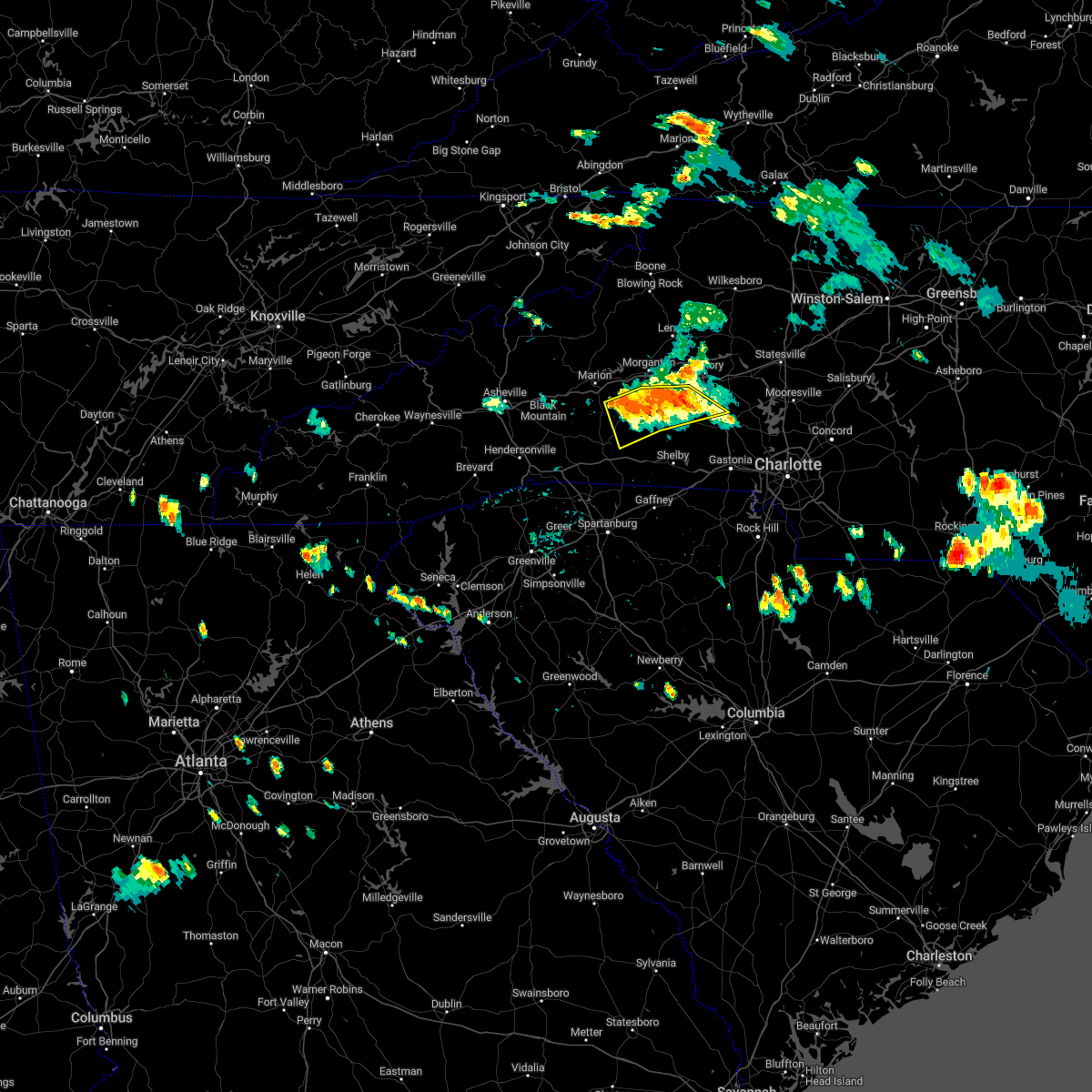 At 403 pm edt, severe thunderstorms were located along a line extending from 10 miles southwest of hickory to 7 miles southwest of morganton to 10 miles south of marion, moving southeast at 20 mph (radar indicated). Hazards include 60 mph wind gusts and quarter size hail. Minor hail damage to vehicles is expected. expect wind damage to trees and power lines. Locations impacted include, belwood, casar, south mountains state park, pleasant grove, cooksville, sunshine, propst, vale, dysartsville and bostic. At 403 pm edt, severe thunderstorms were located along a line extending from 10 miles southwest of hickory to 7 miles southwest of morganton to 10 miles south of marion, moving southeast at 20 mph (radar indicated). Hazards include 60 mph wind gusts and quarter size hail. Minor hail damage to vehicles is expected. expect wind damage to trees and power lines. Locations impacted include, belwood, casar, south mountains state park, pleasant grove, cooksville, sunshine, propst, vale, dysartsville and bostic.
|
| 8/15/2022 3:53 PM EDT |
 At 352 pm edt, severe thunderstorms were located along a line extending from 10 miles southwest of hickory to 6 miles southwest of morganton to 8 miles south of marion, moving southeast at 20 mph (radar indicated). Hazards include 60 mph wind gusts and quarter size hail. Minor hail damage to vehicles is expected. expect wind damage to trees and power lines. Locations impacted include, valdese, spindale, maiden, icard, hildebran, connelly springs, rutherford college, belwood, bostic and casar. At 352 pm edt, severe thunderstorms were located along a line extending from 10 miles southwest of hickory to 6 miles southwest of morganton to 8 miles south of marion, moving southeast at 20 mph (radar indicated). Hazards include 60 mph wind gusts and quarter size hail. Minor hail damage to vehicles is expected. expect wind damage to trees and power lines. Locations impacted include, valdese, spindale, maiden, icard, hildebran, connelly springs, rutherford college, belwood, bostic and casar.
|
| 8/15/2022 3:36 PM EDT |
 At 336 pm edt, severe thunderstorms were located along a line extending from 11 miles west of hickory to 6 miles west of morganton to 5 miles south of marion, moving southeast at 20 mph (radar indicated). Hazards include 60 mph wind gusts and quarter size hail. Minor hail damage to vehicles is expected. Expect wind damage to trees and power lines. At 336 pm edt, severe thunderstorms were located along a line extending from 11 miles west of hickory to 6 miles west of morganton to 5 miles south of marion, moving southeast at 20 mph (radar indicated). Hazards include 60 mph wind gusts and quarter size hail. Minor hail damage to vehicles is expected. Expect wind damage to trees and power lines.
|
| 8/10/2022 3:28 PM EDT |
 At 328 pm edt, a severe thunderstorm was located 12 miles southeast of morganton, or 4 miles east of south mountains state park, moving northeast at 15 mph (radar indicated). Hazards include 60 mph wind gusts and quarter size hail. Minor hail damage to vehicles is expected. Expect wind damage to trees and power lines. At 328 pm edt, a severe thunderstorm was located 12 miles southeast of morganton, or 4 miles east of south mountains state park, moving northeast at 15 mph (radar indicated). Hazards include 60 mph wind gusts and quarter size hail. Minor hail damage to vehicles is expected. Expect wind damage to trees and power lines.
|
| 7/26/2022 2:51 PM EDT |
 At 250 pm edt, a severe thunderstorm was located 9 miles northwest of shelby, or near polkville, moving east at 5 mph (radar indicated). Hazards include 60 mph wind gusts. Expect damage to trees and power lines. locations impacted include, belwood, lawndale, fallston, polkville, kingstown and shelby. hail threat, radar indicated max hail size, <. 75 in wind threat, radar indicated max wind gust, 60 mph. At 250 pm edt, a severe thunderstorm was located 9 miles northwest of shelby, or near polkville, moving east at 5 mph (radar indicated). Hazards include 60 mph wind gusts. Expect damage to trees and power lines. locations impacted include, belwood, lawndale, fallston, polkville, kingstown and shelby. hail threat, radar indicated max hail size, <. 75 in wind threat, radar indicated max wind gust, 60 mph.
|
| 7/26/2022 2:38 PM EDT |
 At 238 pm edt, a severe thunderstorm was located 10 miles northwest of shelby, or near polkville, moving east at 5 mph (radar indicated). Hazards include 60 mph wind gusts and penny size hail. expect damage to trees and power lines At 238 pm edt, a severe thunderstorm was located 10 miles northwest of shelby, or near polkville, moving east at 5 mph (radar indicated). Hazards include 60 mph wind gusts and penny size hail. expect damage to trees and power lines
|
| 7/25/2022 4:04 PM EDT |
 At 403 pm edt, severe thunderstorms were located along a line extending from 14 miles southeast of morganton to 14 miles north of shelby to 11 miles northeast of forest city, moving southeast at 35 mph (radar indicated). Hazards include 60 mph wind gusts and penny size hail. Expect damage to trees and power lines. locations impacted include, cherryville, belwood, lawndale, fallston, polkville, waco, casar, kingstown, south mountains state park and crouse. hail threat, radar indicated max hail size, 0. 75 in wind threat, radar indicated max wind gust, 60 mph. At 403 pm edt, severe thunderstorms were located along a line extending from 14 miles southeast of morganton to 14 miles north of shelby to 11 miles northeast of forest city, moving southeast at 35 mph (radar indicated). Hazards include 60 mph wind gusts and penny size hail. Expect damage to trees and power lines. locations impacted include, cherryville, belwood, lawndale, fallston, polkville, waco, casar, kingstown, south mountains state park and crouse. hail threat, radar indicated max hail size, 0. 75 in wind threat, radar indicated max wind gust, 60 mph.
|
| 7/25/2022 3:50 PM EDT |
 At 350 pm edt, a severe thunderstorm was located 13 miles south of morganton, or 4 miles southwest of south mountains state park, moving southeast at 25 mph (radar indicated). Hazards include 60 mph wind gusts. expect damage to trees and power lines At 350 pm edt, a severe thunderstorm was located 13 miles south of morganton, or 4 miles southwest of south mountains state park, moving southeast at 25 mph (radar indicated). Hazards include 60 mph wind gusts. expect damage to trees and power lines
|
| 7/25/2022 3:45 PM EDT |
 At 344 pm edt, severe thunderstorms were located along a line extending from 9 miles south of lenoir to 10 miles southeast of morganton to 20 miles northeast of forest city, moving southeast at 25 mph (radar indicated). Hazards include 60 mph wind gusts and penny size hail. Expect damage to trees and power lines. locations impacted include, hickory, morganton, st. stephens, longview, valdese, icard, drexel, hildebran, connelly springs and rutherford college. hail threat, radar indicated max hail size, 0. 75 in wind threat, radar indicated max wind gust, 60 mph. At 344 pm edt, severe thunderstorms were located along a line extending from 9 miles south of lenoir to 10 miles southeast of morganton to 20 miles northeast of forest city, moving southeast at 25 mph (radar indicated). Hazards include 60 mph wind gusts and penny size hail. Expect damage to trees and power lines. locations impacted include, hickory, morganton, st. stephens, longview, valdese, icard, drexel, hildebran, connelly springs and rutherford college. hail threat, radar indicated max hail size, 0. 75 in wind threat, radar indicated max wind gust, 60 mph.
|
| 7/25/2022 3:29 PM EDT |
 At 329 pm edt, a severe thunderstorm was located near morganton, moving east at 25 mph (radar indicated). Hazards include 60 mph wind gusts and penny size hail. expect damage to trees and power lines At 329 pm edt, a severe thunderstorm was located near morganton, moving east at 25 mph (radar indicated). Hazards include 60 mph wind gusts and penny size hail. expect damage to trees and power lines
|
| 7/6/2022 4:58 PM EDT |
 At 457 pm edt, severe thunderstorms were located along a line extending from 12 miles northeast of forest city to 10 miles west of lincolnton, moving southeast at 10 mph (radar indicated). Hazards include 60 mph wind gusts and nickel size hail. Expect damage to trees and power lines. locations impacted include, shelby, cherryville, bessemer city, belwood, lawndale, fallston, polkville, lattimore, mooresboro, waco, and crouse. hail threat, radar indicated max hail size, 0. 88 in wind threat, radar indicated max wind gust, 60 mph. At 457 pm edt, severe thunderstorms were located along a line extending from 12 miles northeast of forest city to 10 miles west of lincolnton, moving southeast at 10 mph (radar indicated). Hazards include 60 mph wind gusts and nickel size hail. Expect damage to trees and power lines. locations impacted include, shelby, cherryville, bessemer city, belwood, lawndale, fallston, polkville, lattimore, mooresboro, waco, and crouse. hail threat, radar indicated max hail size, 0. 88 in wind threat, radar indicated max wind gust, 60 mph.
|
| 7/6/2022 4:32 PM EDT | 911 call center reported a large tree blocking roadway on bess chapel church rd in lincoln county NC, 6.3 miles W of Belwood, NC |
| 7/6/2022 4:30 PM EDT |
 At 430 pm edt, severe thunderstorms were located along a line extending from 11 miles northeast of rutherfordton to 13 miles west of lincolnton, moving south at 10 mph (radar indicated). Hazards include 60 mph wind gusts and quarter size hail. Minor hail damage to vehicles is expected. Expect wind damage to trees and power lines. At 430 pm edt, severe thunderstorms were located along a line extending from 11 miles northeast of rutherfordton to 13 miles west of lincolnton, moving south at 10 mph (radar indicated). Hazards include 60 mph wind gusts and quarter size hail. Minor hail damage to vehicles is expected. Expect wind damage to trees and power lines.
|
| 7/6/2022 4:18 PM EDT |
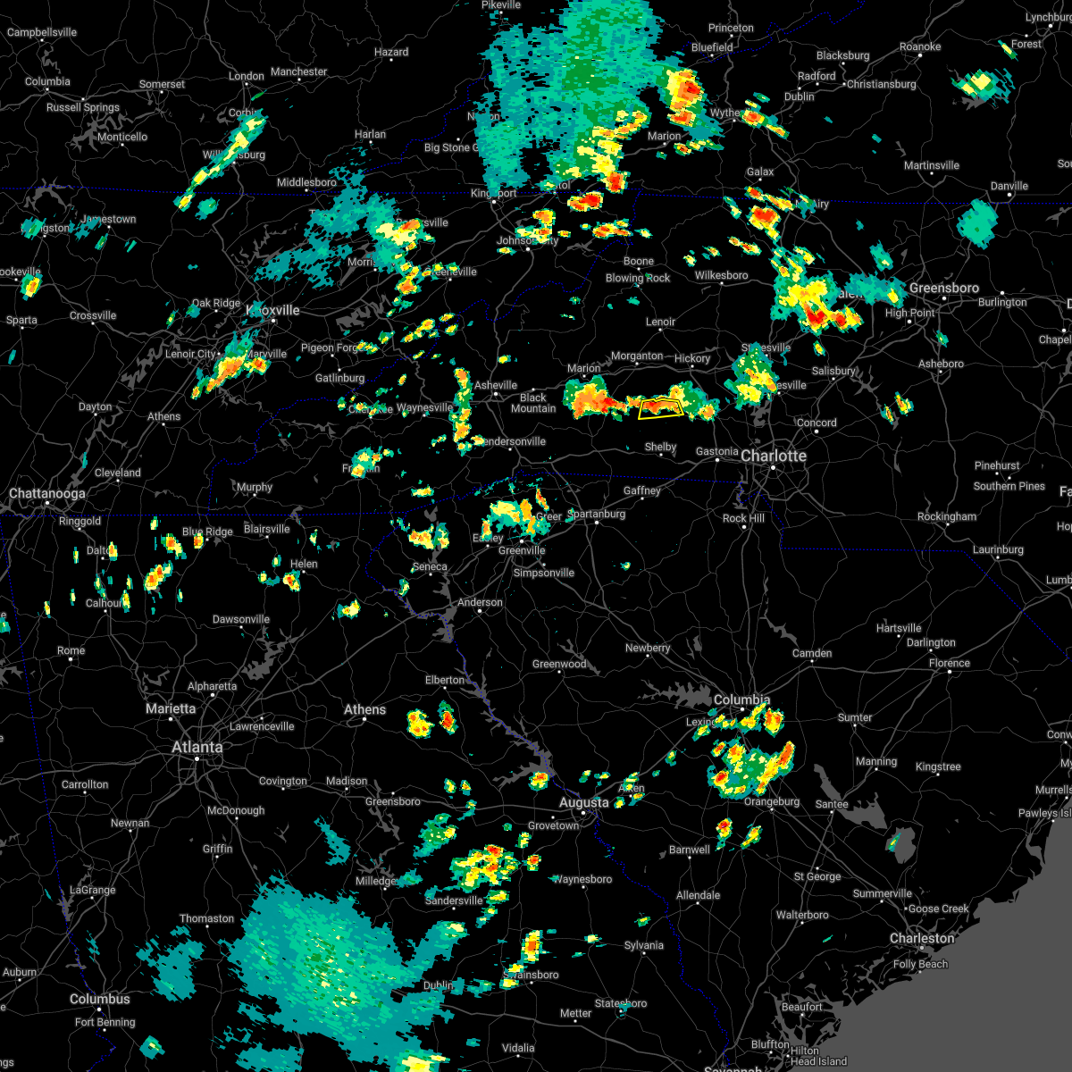 At 417 pm edt, a severe thunderstorm was located 16 miles southeast of morganton, or 4 miles north of belwood, moving south at 10 mph (radar indicated). Hazards include 60 mph wind gusts and penny size hail. Expect damage to trees and power lines. locations impacted include, casar and belwood. hail threat, radar indicated max hail size, 0. 75 in wind threat, radar indicated max wind gust, 60 mph. At 417 pm edt, a severe thunderstorm was located 16 miles southeast of morganton, or 4 miles north of belwood, moving south at 10 mph (radar indicated). Hazards include 60 mph wind gusts and penny size hail. Expect damage to trees and power lines. locations impacted include, casar and belwood. hail threat, radar indicated max hail size, 0. 75 in wind threat, radar indicated max wind gust, 60 mph.
|
| 7/6/2022 4:12 PM EDT | 911 call center reported large trees blocking roadway and damaged a bridge on houser farm rd in lincoln county NC, 5.4 miles WSW of Belwood, NC |
| 7/6/2022 3:40 PM EDT |
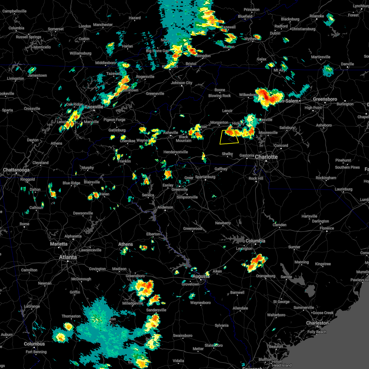 At 339 pm edt, a severe thunderstorm was located 12 miles southeast of morganton, or 7 miles southwest of icard, and is nearly stationary (radar indicated). Hazards include 60 mph wind gusts and half dollar size hail. Minor hail damage to vehicles is expected. Expect wind damage to trees and power lines. At 339 pm edt, a severe thunderstorm was located 12 miles southeast of morganton, or 7 miles southwest of icard, and is nearly stationary (radar indicated). Hazards include 60 mph wind gusts and half dollar size hail. Minor hail damage to vehicles is expected. Expect wind damage to trees and power lines.
|
| 7/5/2022 7:25 PM EDT | A few trees reported down off cooksville rd in val in lincoln county NC, 8 miles WSW of Belwood, NC |
| 7/5/2022 7:24 PM EDT |
 At 723 pm edt, severe thunderstorms were located along a line extending from 15 miles southwest of hickory to 5 miles northwest of salisbury, moving south at 15 mph (radar indicated). Hazards include 60 mph wind gusts and quarter size hail. Minor hail damage to vehicles is expected. Expect wind damage to trees and power lines. At 723 pm edt, severe thunderstorms were located along a line extending from 15 miles southwest of hickory to 5 miles northwest of salisbury, moving south at 15 mph (radar indicated). Hazards include 60 mph wind gusts and quarter size hail. Minor hail damage to vehicles is expected. Expect wind damage to trees and power lines.
|
| 7/5/2022 6:43 PM EDT |
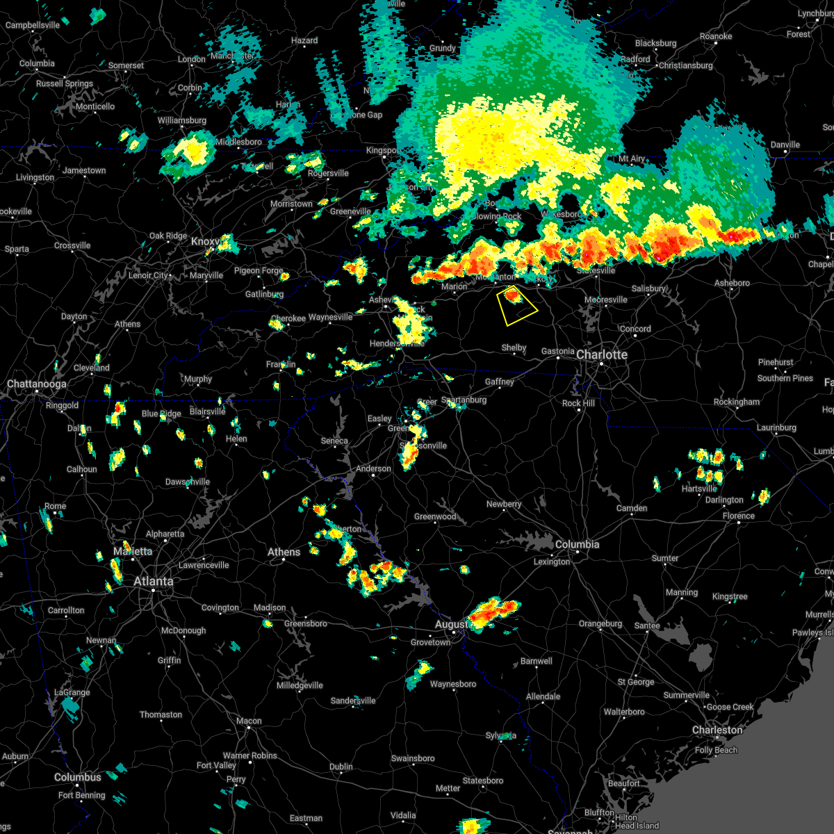 At 643 pm edt, a severe thunderstorm was located 10 miles southeast of morganton, or 6 miles northeast of south mountains state park, moving southeast at 10 mph (radar indicated). Hazards include 60 mph wind gusts and quarter size hail. Minor hail damage to vehicles is expected. Expect wind damage to trees and power lines. At 643 pm edt, a severe thunderstorm was located 10 miles southeast of morganton, or 6 miles northeast of south mountains state park, moving southeast at 10 mph (radar indicated). Hazards include 60 mph wind gusts and quarter size hail. Minor hail damage to vehicles is expected. Expect wind damage to trees and power lines.
|
| 6/16/2022 4:21 PM EDT |
 At 421 pm edt, a severe thunderstorm was located 9 miles west of lincolnton, or 4 miles north of cherryville, moving east at 15 mph (radar indicated). Hazards include 60 mph wind gusts and quarter size hail. Minor hail damage to vehicles is expected. Expect wind damage to trees and power lines. At 421 pm edt, a severe thunderstorm was located 9 miles west of lincolnton, or 4 miles north of cherryville, moving east at 15 mph (radar indicated). Hazards include 60 mph wind gusts and quarter size hail. Minor hail damage to vehicles is expected. Expect wind damage to trees and power lines.
|
| 6/14/2022 7:41 AM EDT |
 At 739 am edt, severe thunderstorms were located along a line extending from 16 miles southeast of morganton to 4 miles southeast of downtown concord, moving south at 20 mph (radar indicated). Hazards include 60 mph wind gusts and quarter size hail. Minor hail damage to vehicles is expected. Expect wind damage to trees and power lines. At 739 am edt, severe thunderstorms were located along a line extending from 16 miles southeast of morganton to 4 miles southeast of downtown concord, moving south at 20 mph (radar indicated). Hazards include 60 mph wind gusts and quarter size hail. Minor hail damage to vehicles is expected. Expect wind damage to trees and power lines.
|
| 6/14/2022 7:28 AM EDT |
 At 726 am edt, severe thunderstorms were located along a line extending from 8 miles northwest of burnsville to 13 miles southwest of hickory to near downtown concord, moving south at 20 mph (radar indicated). Hazards include 60 mph wind gusts and quarter size hail. Minor hail damage to vehicles is expected. expect wind damage to trees and power lines. locations impacted include, charlotte, huntersville, kannapolis, concord, morganton, lincolnton, marion, spruce pine, and burnsville. hail threat, radar indicated max hail size, 1. 00 in wind threat, radar indicated max wind gust, 60 mph. At 726 am edt, severe thunderstorms were located along a line extending from 8 miles northwest of burnsville to 13 miles southwest of hickory to near downtown concord, moving south at 20 mph (radar indicated). Hazards include 60 mph wind gusts and quarter size hail. Minor hail damage to vehicles is expected. expect wind damage to trees and power lines. locations impacted include, charlotte, huntersville, kannapolis, concord, morganton, lincolnton, marion, spruce pine, and burnsville. hail threat, radar indicated max hail size, 1. 00 in wind threat, radar indicated max wind gust, 60 mph.
|
| 6/14/2022 6:55 AM EDT |
 At 655 am edt, severe thunderstorms were located along a line extending from 6 miles southeast of erwin to 12 miles north of morganton to 4 miles southwest of kannapolis, moving south at 25 mph (radar indicated). Hazards include 60 mph wind gusts. expect damage to trees and power lines At 655 am edt, severe thunderstorms were located along a line extending from 6 miles southeast of erwin to 12 miles north of morganton to 4 miles southwest of kannapolis, moving south at 25 mph (radar indicated). Hazards include 60 mph wind gusts. expect damage to trees and power lines
|
| 6/8/2022 12:30 PM EDT | Thunderstorm wind gust pushed a tree onto a truck along highway 18. person in the truck was safely taken out of vehicle by fire departmen in burke county NC, 9 miles S of Belwood, NC |
| 5/26/2022 5:08 PM EDT |
 At 508 pm edt, a severe thunderstorm was located 8 miles north of shelby, or near fallston, moving northeast at 25 mph (radar indicated). Hazards include 60 mph wind gusts and quarter size hail. Minor hail damage to vehicles is expected. Expect wind damage to trees and power lines. At 508 pm edt, a severe thunderstorm was located 8 miles north of shelby, or near fallston, moving northeast at 25 mph (radar indicated). Hazards include 60 mph wind gusts and quarter size hail. Minor hail damage to vehicles is expected. Expect wind damage to trees and power lines.
|
| 5/26/2022 4:39 PM EDT |
 At 439 pm edt, a severe thunderstorm capable of producing a tornado was located 5 miles southwest of shelby, or near boiling springs nc, moving northeast at 30 mph (radar indicated rotation). Hazards include tornado. Flying debris will be dangerous to those caught without shelter. mobile homes will be damaged or destroyed. damage to roofs, windows, and vehicles will occur. tree damage is likely. this dangerous storm will be near, mooresboro around 440 pm edt. patterson springs and lattimore around 450 pm edt. shelby and kingstown around 500 pm edt. fallston, belwood, lawndale and waco around 510 pm edt. Cherryville around 520 pm edt. At 439 pm edt, a severe thunderstorm capable of producing a tornado was located 5 miles southwest of shelby, or near boiling springs nc, moving northeast at 30 mph (radar indicated rotation). Hazards include tornado. Flying debris will be dangerous to those caught without shelter. mobile homes will be damaged or destroyed. damage to roofs, windows, and vehicles will occur. tree damage is likely. this dangerous storm will be near, mooresboro around 440 pm edt. patterson springs and lattimore around 450 pm edt. shelby and kingstown around 500 pm edt. fallston, belwood, lawndale and waco around 510 pm edt. Cherryville around 520 pm edt.
|
| 5/26/2022 4:38 PM EDT |
 At 438 pm edt, a severe thunderstorm capable of producing a tornado was located 12 miles north of shelby, or near belwood, moving northeast at 30 mph (radar indicated rotation). Hazards include tornado. Flying debris will be dangerous to those caught without shelter. mobile homes will be damaged or destroyed. damage to roofs, windows, and vehicles will occur. tree damage is likely. this dangerous storm will be near, belwood and casar around 440 pm edt. Other locations impacted by this tornadic thunderstorm include cooksville, propst, pleasant grove and vale. At 438 pm edt, a severe thunderstorm capable of producing a tornado was located 12 miles north of shelby, or near belwood, moving northeast at 30 mph (radar indicated rotation). Hazards include tornado. Flying debris will be dangerous to those caught without shelter. mobile homes will be damaged or destroyed. damage to roofs, windows, and vehicles will occur. tree damage is likely. this dangerous storm will be near, belwood and casar around 440 pm edt. Other locations impacted by this tornadic thunderstorm include cooksville, propst, pleasant grove and vale.
|
| 5/26/2022 4:26 PM EDT |
 At 426 pm edt, a severe thunderstorm capable of producing a tornado was located 5 miles north of gaffney, moving northeast at 30 mph (radar indicated rotation). Hazards include tornado. Flying debris will be dangerous to those caught without shelter. mobile homes will be damaged or destroyed. damage to roofs, windows, and vehicles will occur. tree damage is likely. this dangerous storm will be near, blacksburg around 430 pm edt. boiling springs nc, earl and mooresboro around 440 pm edt. patterson springs and lattimore around 450 pm edt. shelby and kingstown around 500 pm edt. Fallston, belwood, lawndale and waco around 510 pm edt. At 426 pm edt, a severe thunderstorm capable of producing a tornado was located 5 miles north of gaffney, moving northeast at 30 mph (radar indicated rotation). Hazards include tornado. Flying debris will be dangerous to those caught without shelter. mobile homes will be damaged or destroyed. damage to roofs, windows, and vehicles will occur. tree damage is likely. this dangerous storm will be near, blacksburg around 430 pm edt. boiling springs nc, earl and mooresboro around 440 pm edt. patterson springs and lattimore around 450 pm edt. shelby and kingstown around 500 pm edt. Fallston, belwood, lawndale and waco around 510 pm edt.
|
| 5/26/2022 4:23 PM EDT |
 At 423 pm edt, a severe thunderstorm capable of producing a tornado was located 7 miles northwest of shelby, or near kingstown, moving northeast at 30 mph (radar indicated rotation). Hazards include tornado. Flying debris will be dangerous to those caught without shelter. mobile homes will be damaged or destroyed. damage to roofs, windows, and vehicles will occur. tree damage is likely. this dangerous storm will be near, belwood, casar and fallston around 440 pm edt. Other locations impacted by this tornadic thunderstorm include cooksville, propst, pleasant grove and vale. At 423 pm edt, a severe thunderstorm capable of producing a tornado was located 7 miles northwest of shelby, or near kingstown, moving northeast at 30 mph (radar indicated rotation). Hazards include tornado. Flying debris will be dangerous to those caught without shelter. mobile homes will be damaged or destroyed. damage to roofs, windows, and vehicles will occur. tree damage is likely. this dangerous storm will be near, belwood, casar and fallston around 440 pm edt. Other locations impacted by this tornadic thunderstorm include cooksville, propst, pleasant grove and vale.
|
| 5/26/2022 4:17 PM EDT |
 At 417 pm edt, a severe thunderstorm capable of producing a tornado was located near gaffney, moving northeast at 30 mph (radar indicated rotation). Hazards include tornado. Flying debris will be dangerous to those caught without shelter. mobile homes will be damaged or destroyed. damage to roofs, windows, and vehicles will occur. tree damage is likely. this dangerous storm will be near, blacksburg around 430 pm edt. boiling springs nc, earl and mooresboro around 440 pm edt. patterson springs and lattimore around 450 pm edt. shelby, waco, lawndale, kingstown and fallston around 500 pm edt. Other locations impacted by this dangerous thunderstorm include draytonville and thicketty. At 417 pm edt, a severe thunderstorm capable of producing a tornado was located near gaffney, moving northeast at 30 mph (radar indicated rotation). Hazards include tornado. Flying debris will be dangerous to those caught without shelter. mobile homes will be damaged or destroyed. damage to roofs, windows, and vehicles will occur. tree damage is likely. this dangerous storm will be near, blacksburg around 430 pm edt. boiling springs nc, earl and mooresboro around 440 pm edt. patterson springs and lattimore around 450 pm edt. shelby, waco, lawndale, kingstown and fallston around 500 pm edt. Other locations impacted by this dangerous thunderstorm include draytonville and thicketty.
|
| 5/26/2022 4:12 PM EDT |
 At 411 pm edt, a severe thunderstorm capable of producing a tornado was located 6 miles west of shelby, or over lattimore, moving northeast at 30 mph (radar indicated rotation). Hazards include tornado. Flying debris will be dangerous to those caught without shelter. mobile homes will be damaged or destroyed. damage to roofs, windows, and vehicles will occur. tree damage is likely. this dangerous storm will be near, kingstown around 420 pm edt. lawndale and polkville around 430 pm edt. belwood, casar and fallston around 440 pm edt. Other locations impacted by this dangerous thunderstorm include cooksville, propst, pleasant grove and vale. At 411 pm edt, a severe thunderstorm capable of producing a tornado was located 6 miles west of shelby, or over lattimore, moving northeast at 30 mph (radar indicated rotation). Hazards include tornado. Flying debris will be dangerous to those caught without shelter. mobile homes will be damaged or destroyed. damage to roofs, windows, and vehicles will occur. tree damage is likely. this dangerous storm will be near, kingstown around 420 pm edt. lawndale and polkville around 430 pm edt. belwood, casar and fallston around 440 pm edt. Other locations impacted by this dangerous thunderstorm include cooksville, propst, pleasant grove and vale.
|
| 5/23/2022 7:51 PM EDT |
 At 751 pm edt, a severe thunderstorm capable of producing a tornado was located 8 miles west of shelby, or near mooresboro, moving northeast at 30 mph (radar indicated rotation). Hazards include tornado. Flying debris will be dangerous to those caught without shelter. mobile homes will be damaged or destroyed. damage to roofs, windows, and vehicles will occur. tree damage is likely. this dangerous storm will be near, shelby, kingstown and polkville around 810 pm edt. Fallston, lawndale, belwood and waco around 820 pm edt. At 751 pm edt, a severe thunderstorm capable of producing a tornado was located 8 miles west of shelby, or near mooresboro, moving northeast at 30 mph (radar indicated rotation). Hazards include tornado. Flying debris will be dangerous to those caught without shelter. mobile homes will be damaged or destroyed. damage to roofs, windows, and vehicles will occur. tree damage is likely. this dangerous storm will be near, shelby, kingstown and polkville around 810 pm edt. Fallston, lawndale, belwood and waco around 820 pm edt.
|
| 5/23/2022 7:43 PM EDT |
 At 743 pm edt, a severe thunderstorm capable of producing a tornado was located 9 miles southeast of forest city, or 4 miles southwest of mooresboro, moving northeast at 30 mph (radar indicated rotation). Hazards include tornado. Flying debris will be dangerous to those caught without shelter. mobile homes will be damaged or destroyed. damage to roofs, windows, and vehicles will occur. tree damage is likely. this dangerous storm will be near, mooresboro around 750 pm edt. lattimore and boiling springs nc around 800 pm edt. shelby, kingstown, lawndale, belwood and fallston around 810 pm edt. Other locations impacted by this dangerous thunderstorm include cliffside, henrietta and caroleen. At 743 pm edt, a severe thunderstorm capable of producing a tornado was located 9 miles southeast of forest city, or 4 miles southwest of mooresboro, moving northeast at 30 mph (radar indicated rotation). Hazards include tornado. Flying debris will be dangerous to those caught without shelter. mobile homes will be damaged or destroyed. damage to roofs, windows, and vehicles will occur. tree damage is likely. this dangerous storm will be near, mooresboro around 750 pm edt. lattimore and boiling springs nc around 800 pm edt. shelby, kingstown, lawndale, belwood and fallston around 810 pm edt. Other locations impacted by this dangerous thunderstorm include cliffside, henrietta and caroleen.
|
| 5/6/2022 7:07 PM EDT |
 At 707 pm edt, a severe thunderstorm was located 4 miles west of lincolnton, moving northeast at 45 mph (radar indicated). Hazards include 60 mph wind gusts and half dollar size hail. Minor hail damage to vehicles is expected. expect wind damage to trees and power lines. locations impacted include, lincolnton, cherryville, maiden, westport, high shoals, boger city, iron station, denver, sherrills ford and bandys. hail threat, radar indicated max hail size, 1. 25 in wind threat, radar indicated max wind gust, 60 mph. At 707 pm edt, a severe thunderstorm was located 4 miles west of lincolnton, moving northeast at 45 mph (radar indicated). Hazards include 60 mph wind gusts and half dollar size hail. Minor hail damage to vehicles is expected. expect wind damage to trees and power lines. locations impacted include, lincolnton, cherryville, maiden, westport, high shoals, boger city, iron station, denver, sherrills ford and bandys. hail threat, radar indicated max hail size, 1. 25 in wind threat, radar indicated max wind gust, 60 mph.
|
| 5/6/2022 6:51 PM EDT |
 At 651 pm edt, a severe thunderstorm was located 8 miles north of shelby, or near fallston, moving northeast at 40 mph (radar indicated). Hazards include 60 mph wind gusts and half dollar size hail. Minor hail damage to vehicles is expected. Expect wind damage to trees and power lines. At 651 pm edt, a severe thunderstorm was located 8 miles north of shelby, or near fallston, moving northeast at 40 mph (radar indicated). Hazards include 60 mph wind gusts and half dollar size hail. Minor hail damage to vehicles is expected. Expect wind damage to trees and power lines.
|
| 5/6/2022 6:25 PM EDT |
 The severe thunderstorm warning for western lincoln, western mecklenburg, gaston, north central chester and central york counties will expire at 630 pm edt, the storms which prompted the warning have exited the warned area. therefore, the warning will be allowed to expire. a tornado watch remains in effect until 800 pm edt for the piedmont of north carolina, and upstate south carolina. The severe thunderstorm warning for western lincoln, western mecklenburg, gaston, north central chester and central york counties will expire at 630 pm edt, the storms which prompted the warning have exited the warned area. therefore, the warning will be allowed to expire. a tornado watch remains in effect until 800 pm edt for the piedmont of north carolina, and upstate south carolina.
|
| 5/6/2022 6:04 PM EDT |
 At 604 pm edt, severe thunderstorms were located along a line extending from 3 miles southwest of shelby to 9 miles west of york to 9 miles southeast of union, moving east at 20 mph (radar indicated). Hazards include golf ball size hail and 60 mph wind gusts. People and animals outdoors will be injured. expect hail damage to roofs, siding, windows, and vehicles. expect wind damage to trees and power lines. Locations impacted include, gastonia, lincolnton, york, cherryville, bessemer city, south gastonia, tega cay, clover, newport and dallas. At 604 pm edt, severe thunderstorms were located along a line extending from 3 miles southwest of shelby to 9 miles west of york to 9 miles southeast of union, moving east at 20 mph (radar indicated). Hazards include golf ball size hail and 60 mph wind gusts. People and animals outdoors will be injured. expect hail damage to roofs, siding, windows, and vehicles. expect wind damage to trees and power lines. Locations impacted include, gastonia, lincolnton, york, cherryville, bessemer city, south gastonia, tega cay, clover, newport and dallas.
|
| 5/6/2022 5:56 PM EDT |
 At 555 pm edt, severe thunderstorms were located along a line extending from 4 miles west of shelby to 11 miles west of york to 7 miles southeast of union, moving east at 20 mph (radar indicated). Hazards include golf ball size hail and 60 mph wind gusts. People and animals outdoors will be injured. expect hail damage to roofs, siding, windows, and vehicles. expect wind damage to trees and power lines. Locations impacted include, gastonia, lincolnton, york, kings mountain, cherryville, bessemer city, south gastonia, tega cay, clover and newport. At 555 pm edt, severe thunderstorms were located along a line extending from 4 miles west of shelby to 11 miles west of york to 7 miles southeast of union, moving east at 20 mph (radar indicated). Hazards include golf ball size hail and 60 mph wind gusts. People and animals outdoors will be injured. expect hail damage to roofs, siding, windows, and vehicles. expect wind damage to trees and power lines. Locations impacted include, gastonia, lincolnton, york, kings mountain, cherryville, bessemer city, south gastonia, tega cay, clover and newport.
|
| 5/6/2022 5:41 PM EDT |
 At 540 pm edt, severe thunderstorms were located along a line extending from 9 miles west of shelby to 7 miles east of gaffney to 4 miles south of union, moving east at 20 mph (radar indicated). Hazards include golf ball size hail and 60 mph wind gusts. People and animals outdoors will be injured. expect hail damage to roofs, siding, windows, and vehicles. Expect wind damage to trees and power lines. At 540 pm edt, severe thunderstorms were located along a line extending from 9 miles west of shelby to 7 miles east of gaffney to 4 miles south of union, moving east at 20 mph (radar indicated). Hazards include golf ball size hail and 60 mph wind gusts. People and animals outdoors will be injured. expect hail damage to roofs, siding, windows, and vehicles. Expect wind damage to trees and power lines.
|
| 5/6/2022 1:41 PM EDT |
 The severe thunderstorm warning for northeastern rutherford, western lincoln, central cleveland and south central burke counties will expire at 145 pm edt, the storm which prompted the warning has weakened below severe limits, and no longer poses an immediate threat to life or property. therefore, the warning will be allowed to expire. however, gusty winds and heavy rain are still possible with this thunderstorm. a tornado watch remains in effect until 800 pm edt for western and the piedmont of north carolina. The severe thunderstorm warning for northeastern rutherford, western lincoln, central cleveland and south central burke counties will expire at 145 pm edt, the storm which prompted the warning has weakened below severe limits, and no longer poses an immediate threat to life or property. therefore, the warning will be allowed to expire. however, gusty winds and heavy rain are still possible with this thunderstorm. a tornado watch remains in effect until 800 pm edt for western and the piedmont of north carolina.
|
| 5/6/2022 1:36 PM EDT |
 A tornado warning remains in effect until 145 pm edt for western catawba. northwestern lincoln. southeastern caldwell. north central cleveland and southeastern burke counties. At 135 pm edt, a severe thunderstorm capable of producing a tornado was located 15 miles northwest of lincolnton, or 5 miles north of belwood, moving northeast at 55 mph. A tornado warning remains in effect until 145 pm edt for western catawba. northwestern lincoln. southeastern caldwell. north central cleveland and southeastern burke counties. At 135 pm edt, a severe thunderstorm capable of producing a tornado was located 15 miles northwest of lincolnton, or 5 miles north of belwood, moving northeast at 55 mph.
|
| 5/6/2022 1:21 PM EDT |
 At 121 pm edt, a severe thunderstorm capable of producing a tornado was located 8 miles northwest of shelby, or near polkville, moving northeast at 55 mph (radar indicated rotation). Hazards include tornado and quarter size hail. Flying debris will be dangerous to those caught without shelter. mobile homes will be damaged or destroyed. damage to roofs, windows, and vehicles will occur. tree damage is likely. this dangerous storm will be near, belwood around 130 pm edt. Other locations impacted by this dangerous thunderstorm include cooksville, northlakes, propst, pleasant grove and vale. At 121 pm edt, a severe thunderstorm capable of producing a tornado was located 8 miles northwest of shelby, or near polkville, moving northeast at 55 mph (radar indicated rotation). Hazards include tornado and quarter size hail. Flying debris will be dangerous to those caught without shelter. mobile homes will be damaged or destroyed. damage to roofs, windows, and vehicles will occur. tree damage is likely. this dangerous storm will be near, belwood around 130 pm edt. Other locations impacted by this dangerous thunderstorm include cooksville, northlakes, propst, pleasant grove and vale.
|
| 5/6/2022 1:17 PM EDT |
 At 117 pm edt, a severe thunderstorm was located 8 miles northwest of shelby, or near kingstown, moving northeast at 35 mph (radar indicated). Hazards include 60 mph wind gusts and quarter size hail. Minor hail damage to vehicles is expected. expect wind damage to trees and power lines. locations impacted include, belwood, lawndale, fallston, polkville, ellenboro, lattimore, mooresboro, casar, kingstown and south mountains state park. hail threat, radar indicated max hail size, 1. 00 in wind threat, radar indicated max wind gust, 60 mph. At 117 pm edt, a severe thunderstorm was located 8 miles northwest of shelby, or near kingstown, moving northeast at 35 mph (radar indicated). Hazards include 60 mph wind gusts and quarter size hail. Minor hail damage to vehicles is expected. expect wind damage to trees and power lines. locations impacted include, belwood, lawndale, fallston, polkville, ellenboro, lattimore, mooresboro, casar, kingstown and south mountains state park. hail threat, radar indicated max hail size, 1. 00 in wind threat, radar indicated max wind gust, 60 mph.
|
| 5/6/2022 1:02 PM EDT |
 At 102 pm edt, a severe thunderstorm was located 9 miles west of shelby, or near boiling springs nc, moving northeast at 50 mph (radar indicated). Hazards include 60 mph wind gusts and quarter size hail. Minor hail damage to vehicles is expected. Expect wind damage to trees and power lines. At 102 pm edt, a severe thunderstorm was located 9 miles west of shelby, or near boiling springs nc, moving northeast at 50 mph (radar indicated). Hazards include 60 mph wind gusts and quarter size hail. Minor hail damage to vehicles is expected. Expect wind damage to trees and power lines.
|
| 10/29/2021 6:10 AM EDT |
 The severe thunderstorm warning for eastern rutherford and western cleveland counties will expire at 615 am edt, the storm which prompted the warning has weakened below severe limits, and no longer poses an immediate threat to life or property. therefore, the warning will be allowed to expire. however, gusty winds of 30 to 40 mph are still possible with this thunderstorm. The severe thunderstorm warning for eastern rutherford and western cleveland counties will expire at 615 am edt, the storm which prompted the warning has weakened below severe limits, and no longer poses an immediate threat to life or property. therefore, the warning will be allowed to expire. however, gusty winds of 30 to 40 mph are still possible with this thunderstorm.
|
| 10/29/2021 5:47 AM EDT |
 At 546 am edt, a severe thunderstorm was located 4 miles east of forest city, or near ellenboro, moving northeast at 30 mph (radar indicated). Hazards include 60 mph wind gusts and penny size hail. Expect damage to trees and power lines. locations impacted include, forest city, spindale, boiling springs nc, belwood, lawndale, fallston, polkville, ellenboro, lattimore and mooresboro. hail threat, radar indicated max hail size, 0. 75 in wind threat, radar indicated max wind gust, 60 mph. At 546 am edt, a severe thunderstorm was located 4 miles east of forest city, or near ellenboro, moving northeast at 30 mph (radar indicated). Hazards include 60 mph wind gusts and penny size hail. Expect damage to trees and power lines. locations impacted include, forest city, spindale, boiling springs nc, belwood, lawndale, fallston, polkville, ellenboro, lattimore and mooresboro. hail threat, radar indicated max hail size, 0. 75 in wind threat, radar indicated max wind gust, 60 mph.
|
| 10/29/2021 5:33 AM EDT |
 At 532 am edt, a severe thunderstorm was located 6 miles south of forest city, moving northeast at 30 mph (radar indicated). Hazards include 60 mph wind gusts and penny size hail. expect damage to trees and power lines At 532 am edt, a severe thunderstorm was located 6 miles south of forest city, moving northeast at 30 mph (radar indicated). Hazards include 60 mph wind gusts and penny size hail. expect damage to trees and power lines
|
| 8/31/2021 5:28 PM EDT |
 At 527 pm edt, severe thunderstorms were located along a line extending from 9 miles south of morganton to 13 miles northwest of lincolnton, moving north at 50 mph (radar indicated). Hazards include 60 mph wind gusts. expect damage to trees and power lines At 527 pm edt, severe thunderstorms were located along a line extending from 9 miles south of morganton to 13 miles northwest of lincolnton, moving north at 50 mph (radar indicated). Hazards include 60 mph wind gusts. expect damage to trees and power lines
|
| 8/31/2021 5:20 PM EDT |
 At 519 pm edt, severe thunderstorms were located along a line extending from 8 miles northeast of forest city to 13 miles west of lincolnton to 6 miles east of shelby, moving east at 50 mph (radar indicated). Hazards include 60 mph wind gusts. Expect damage to trees and power lines. locations impacted include, kings mountain, cherryville, belwood, lawndale, fallston, polkville, waco, casar, kingstown and crouse. hail threat, radar indicated max hail size, <. 75 in wind threat, radar indicated max wind gust, 60 mph. At 519 pm edt, severe thunderstorms were located along a line extending from 8 miles northeast of forest city to 13 miles west of lincolnton to 6 miles east of shelby, moving east at 50 mph (radar indicated). Hazards include 60 mph wind gusts. Expect damage to trees and power lines. locations impacted include, kings mountain, cherryville, belwood, lawndale, fallston, polkville, waco, casar, kingstown and crouse. hail threat, radar indicated max hail size, <. 75 in wind threat, radar indicated max wind gust, 60 mph.
|
| 8/31/2021 4:53 PM EDT |
 At 453 pm edt, severe thunderstorms were located along a line extending from 9 miles south of forest city to 7 miles south of shelby to 8 miles east of gaffney, moving north at 50 mph (radar indicated). Hazards include 60 mph wind gusts. expect damage to trees and power lines At 453 pm edt, severe thunderstorms were located along a line extending from 9 miles south of forest city to 7 miles south of shelby to 8 miles east of gaffney, moving north at 50 mph (radar indicated). Hazards include 60 mph wind gusts. expect damage to trees and power lines
|
| 8/11/2021 4:38 PM EDT |
 The severe thunderstorm warning for eastern rutherford, northwestern lincoln, northwestern cleveland and south central burke counties will expire at 445 pm edt, the severe thunderstorm which prompted the warning has weakened. therefore, the warning will be allowed to expire. The severe thunderstorm warning for eastern rutherford, northwestern lincoln, northwestern cleveland and south central burke counties will expire at 445 pm edt, the severe thunderstorm which prompted the warning has weakened. therefore, the warning will be allowed to expire.
|
| 8/11/2021 4:03 PM EDT |
 At 403 pm edt, a severe thunderstorm was located 14 miles south of morganton, or near casar, and is nearly stationary (radar indicated). Hazards include 60 mph wind gusts and quarter size hail. Minor hail damage to vehicles is expected. Expect wind damage to trees and power lines. At 403 pm edt, a severe thunderstorm was located 14 miles south of morganton, or near casar, and is nearly stationary (radar indicated). Hazards include 60 mph wind gusts and quarter size hail. Minor hail damage to vehicles is expected. Expect wind damage to trees and power lines.
|
| 7/26/2021 4:06 PM EDT |
 The severe thunderstorm warning for southwestern lincoln and central cleveland counties will expire at 415 pm edt, the storm which prompted the warning has moved out of the area. therefore the warning will be allowed to expire. if you observed large hail or wind damage, please report it to the national weather service greenville-spartanburg by calling toll free, 1, 800, 2 6 7, 8 1 0 1, or by posting on our facebook page, or tweet it using hashtag nwsgsp. your message should describe the event and the specific location where it occurred. remember, a severe thunderstorm warning still remains in effect for southeastern cleveland county until 445 pm edt. The severe thunderstorm warning for southwestern lincoln and central cleveland counties will expire at 415 pm edt, the storm which prompted the warning has moved out of the area. therefore the warning will be allowed to expire. if you observed large hail or wind damage, please report it to the national weather service greenville-spartanburg by calling toll free, 1, 800, 2 6 7, 8 1 0 1, or by posting on our facebook page, or tweet it using hashtag nwsgsp. your message should describe the event and the specific location where it occurred. remember, a severe thunderstorm warning still remains in effect for southeastern cleveland county until 445 pm edt.
|
| 7/26/2021 3:41 PM EDT |
 At 341 pm edt, a severe thunderstorm was located 10 miles north of shelby, or near lawndale, moving southeast at 20 mph (radar indicated). Hazards include 60 mph wind gusts. Expect damage to trees and power lines. Locations impacted include, belwood, lawndale, fallston, polkville and waco. At 341 pm edt, a severe thunderstorm was located 10 miles north of shelby, or near lawndale, moving southeast at 20 mph (radar indicated). Hazards include 60 mph wind gusts. Expect damage to trees and power lines. Locations impacted include, belwood, lawndale, fallston, polkville and waco.
|
| 7/26/2021 3:26 PM EDT |
 At 326 pm edt, a severe thunderstorm was located 15 miles north of shelby, or over casar, moving east at 20 mph (radar indicated). Hazards include 60 mph wind gusts and penny size hail. expect damage to trees and power lines At 326 pm edt, a severe thunderstorm was located 15 miles north of shelby, or over casar, moving east at 20 mph (radar indicated). Hazards include 60 mph wind gusts and penny size hail. expect damage to trees and power lines
|
| 4/10/2021 7:40 PM EDT |
 At 740 pm edt, rain showers capable of producing damaging winds were located along a line extending from 12 miles north of forest city to 3 miles east of shelby, moving northeast at 45 mph (radar indicated). Hazards include 60 mph wind gusts. expect damage to trees and power lines At 740 pm edt, rain showers capable of producing damaging winds were located along a line extending from 12 miles north of forest city to 3 miles east of shelby, moving northeast at 45 mph (radar indicated). Hazards include 60 mph wind gusts. expect damage to trees and power lines
|
| 3/27/2021 2:00 PM EDT |
 At 200 pm edt, a severe thunderstorm was located near marion, moving east at 40 mph (radar indicated). Hazards include 60 mph wind gusts and quarter size hail. Minor hail damage to vehicles is expected. Expect wind damage to trees and power lines. At 200 pm edt, a severe thunderstorm was located near marion, moving east at 40 mph (radar indicated). Hazards include 60 mph wind gusts and quarter size hail. Minor hail damage to vehicles is expected. Expect wind damage to trees and power lines.
|
| 8/31/2020 3:23 AM EDT |
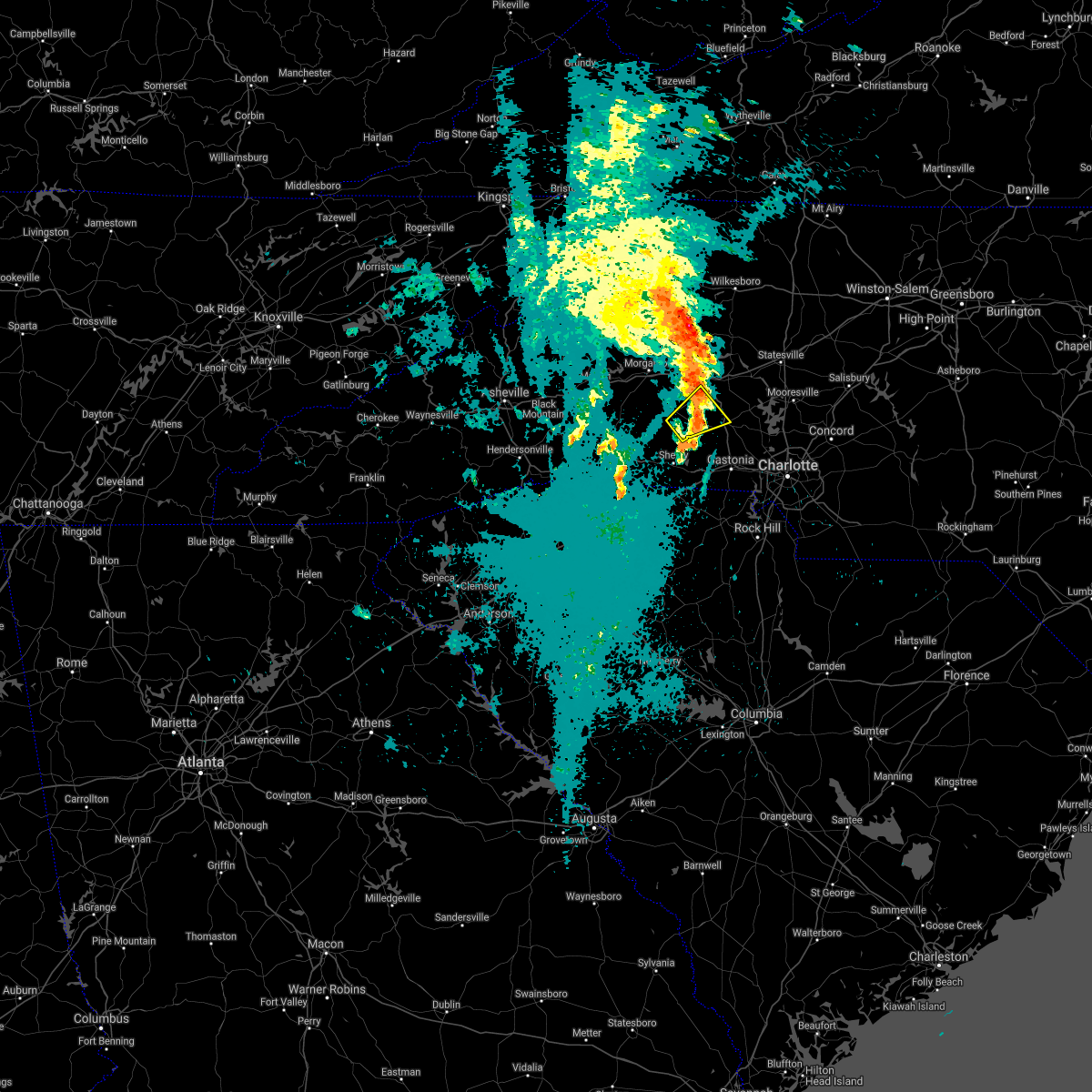 The severe thunderstorm warning for southwestern catawba, western lincoln and north central cleveland counties will expire at 330 am edt, the storm which prompted the warning has weakened below severe limits, and no longer poses an immediate threat to life or property. therefore the warning will be allowed to expire. however gusty winds are still possible with this thunderstorm. The severe thunderstorm warning for southwestern catawba, western lincoln and north central cleveland counties will expire at 330 am edt, the storm which prompted the warning has weakened below severe limits, and no longer poses an immediate threat to life or property. therefore the warning will be allowed to expire. however gusty winds are still possible with this thunderstorm.
|
| 8/31/2020 3:01 AM EDT |
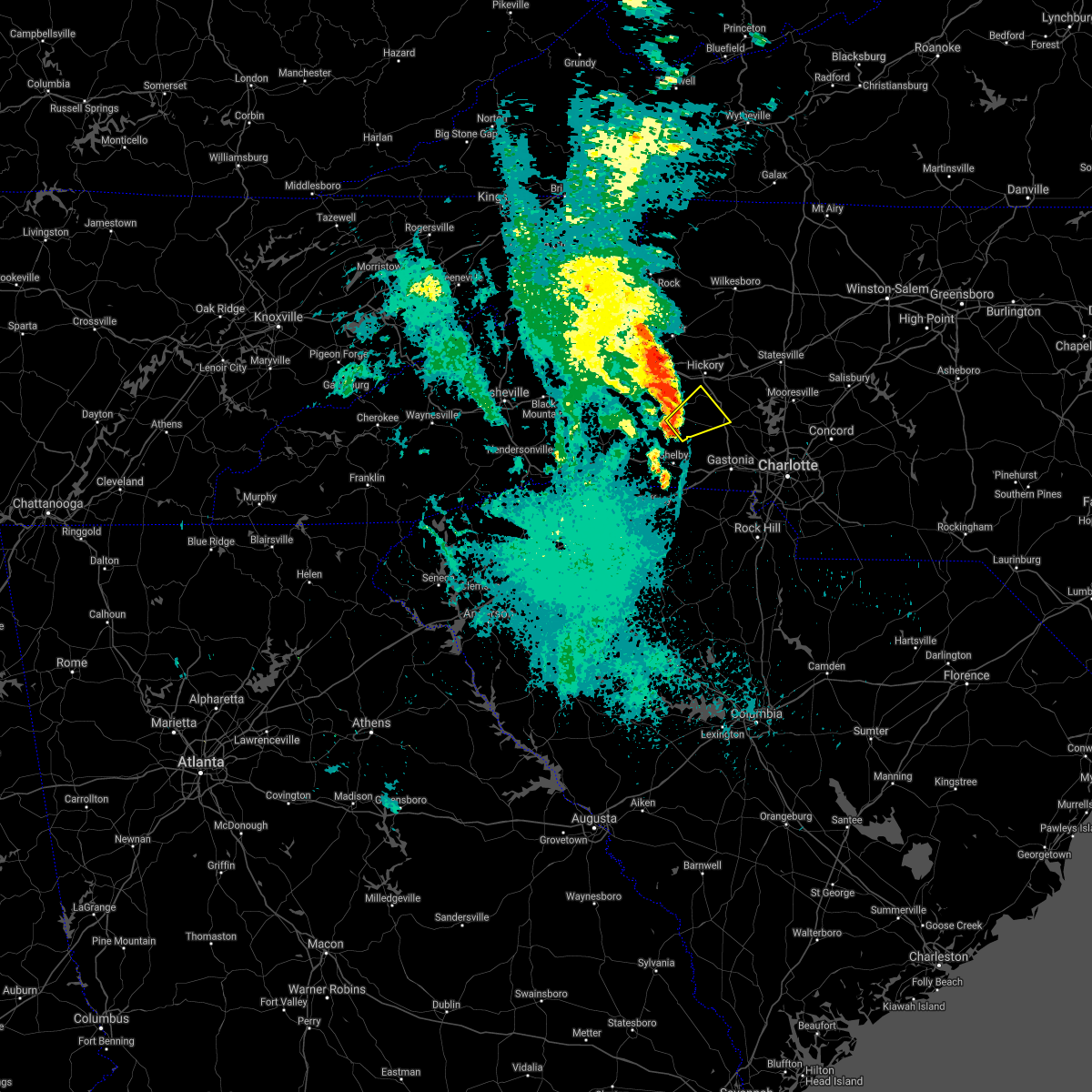 At 301 am edt, a severe thunderstorm was located 12 miles west of lincolnton, or near belwood, moving northeast at 20 mph (radar indicated). Hazards include 60 mph wind gusts. expect damage to trees and power lines At 301 am edt, a severe thunderstorm was located 12 miles west of lincolnton, or near belwood, moving northeast at 20 mph (radar indicated). Hazards include 60 mph wind gusts. expect damage to trees and power lines
|
| 8/17/2020 4:21 PM EDT |
 At 421 pm edt, severe thunderstorms were located along a line extending from 6 miles west of lincolnton to 18 miles northwest of gastonia to 8 miles north of shelby, moving southeast at 15 mph (radar indicated). Hazards include 60 mph wind gusts and nickel size hail. expect damage to trees and power lines At 421 pm edt, severe thunderstorms were located along a line extending from 6 miles west of lincolnton to 18 miles northwest of gastonia to 8 miles north of shelby, moving southeast at 15 mph (radar indicated). Hazards include 60 mph wind gusts and nickel size hail. expect damage to trees and power lines
|
| 8/7/2020 9:27 PM EDT |
 The severe thunderstorm warning for western lincoln, cleveland, western gaston, western york and cherokee counties will expire at 930 pm edt, the storms which prompted the warning have weakened below severe limits, and no longer pose an immediate threat to life or property. therefore the warning will be allowed to expire. however gusty winds are still possible with these thunderstorms. The severe thunderstorm warning for western lincoln, cleveland, western gaston, western york and cherokee counties will expire at 930 pm edt, the storms which prompted the warning have weakened below severe limits, and no longer pose an immediate threat to life or property. therefore the warning will be allowed to expire. however gusty winds are still possible with these thunderstorms.
|
| 8/7/2020 9:12 PM EDT |
 At 912 pm edt, severe thunderstorms were located along a line extending from 16 miles west of lincolnton to 8 miles southeast of shelby to 7 miles south of gaffney, moving east at 20 mph (radar indicated). Hazards include 60 mph wind gusts and quarter size hail. Minor hail damage to vehicles is expected. expect wind damage to trees and power lines. Locations impacted include, shelby, gaffney, lincolnton, kings mountain, cherryville, bessemer city, blacksburg, belwood, grover and lawndale. At 912 pm edt, severe thunderstorms were located along a line extending from 16 miles west of lincolnton to 8 miles southeast of shelby to 7 miles south of gaffney, moving east at 20 mph (radar indicated). Hazards include 60 mph wind gusts and quarter size hail. Minor hail damage to vehicles is expected. expect wind damage to trees and power lines. Locations impacted include, shelby, gaffney, lincolnton, kings mountain, cherryville, bessemer city, blacksburg, belwood, grover and lawndale.
|
| 8/7/2020 8:51 PM EDT |
 At 851 pm edt, severe thunderstorms were located along a line extending from 16 miles west of lincolnton to 6 miles south of shelby to 6 miles south of gaffney, moving east at 15 mph (radar indicated). Hazards include 60 mph wind gusts and quarter size hail. Minor hail damage to vehicles is expected. Expect wind damage to trees and power lines. At 851 pm edt, severe thunderstorms were located along a line extending from 16 miles west of lincolnton to 6 miles south of shelby to 6 miles south of gaffney, moving east at 15 mph (radar indicated). Hazards include 60 mph wind gusts and quarter size hail. Minor hail damage to vehicles is expected. Expect wind damage to trees and power lines.
|
| 8/6/2020 9:29 PM EDT |
 At 929 pm edt, a severe thunderstorm was located 15 miles north of shelby, or near belwood, moving northeast at 15 mph (radar indicated). Hazards include 60 mph wind gusts and quarter size hail. Minor hail damage to vehicles is expected. expect wind damage to trees and power lines. Locations impacted include, belwood, lawndale, casar, polkville and fallston. At 929 pm edt, a severe thunderstorm was located 15 miles north of shelby, or near belwood, moving northeast at 15 mph (radar indicated). Hazards include 60 mph wind gusts and quarter size hail. Minor hail damage to vehicles is expected. expect wind damage to trees and power lines. Locations impacted include, belwood, lawndale, casar, polkville and fallston.
|
| 8/6/2020 8:58 PM EDT |
 At 857 pm edt, a severe thunderstorm was located 11 miles northwest of shelby, or near polkville, moving northeast at 15 mph (radar indicated). Hazards include 60 mph wind gusts and quarter size hail. Minor hail damage to vehicles is expected. Expect wind damage to trees and power lines. At 857 pm edt, a severe thunderstorm was located 11 miles northwest of shelby, or near polkville, moving northeast at 15 mph (radar indicated). Hazards include 60 mph wind gusts and quarter size hail. Minor hail damage to vehicles is expected. Expect wind damage to trees and power lines.
|
| 8/3/2020 1:10 AM EDT |
 The severe thunderstorm warning for southwestern catawba, western lincoln, cleveland and southeastern burke counties will expire at 115 am edt, the storm which prompted the warning has weakened below severe limits, and no longer poses an immediate threat to life or property. therefore, the warning will be allowed to expire. however, gusty winds and heavy rain are still possible with these thunderstorms. The severe thunderstorm warning for southwestern catawba, western lincoln, cleveland and southeastern burke counties will expire at 115 am edt, the storm which prompted the warning has weakened below severe limits, and no longer poses an immediate threat to life or property. therefore, the warning will be allowed to expire. however, gusty winds and heavy rain are still possible with these thunderstorms.
|
| 8/3/2020 12:41 AM EDT |
 At 1241 am edt, a severe thunderstorm was located 13 miles west of lincolnton, or near belwood, moving northeast at 50 mph (radar indicated). Hazards include 60 mph wind gusts and penny size hail. Expect damage to trees and power lines. Locations impacted include, shelby, boiling springs nc, belwood, lawndale, fallston, polkville, lattimore, mooresboro, waco and casar. At 1241 am edt, a severe thunderstorm was located 13 miles west of lincolnton, or near belwood, moving northeast at 50 mph (radar indicated). Hazards include 60 mph wind gusts and penny size hail. Expect damage to trees and power lines. Locations impacted include, shelby, boiling springs nc, belwood, lawndale, fallston, polkville, lattimore, mooresboro, waco and casar.
|
| 8/3/2020 12:21 AM EDT |
 At 1220 am edt, a severe thunderstorm was located 7 miles west of shelby, or near mooresboro, moving northeast at 50 mph (radar indicated). Hazards include 60 mph wind gusts and penny size hail. expect damage to trees and power lines At 1220 am edt, a severe thunderstorm was located 7 miles west of shelby, or near mooresboro, moving northeast at 50 mph (radar indicated). Hazards include 60 mph wind gusts and penny size hail. expect damage to trees and power lines
|
| 7/20/2020 5:25 PM EDT |
 At 525 pm edt, a severe thunderstorm was located 8 miles east of forest city, or near mooresboro, moving northeast at 10 mph (radar indicated). Hazards include 60 mph wind gusts and quarter size hail. Minor hail damage to vehicles is expected. Expect wind damage to trees and power lines. At 525 pm edt, a severe thunderstorm was located 8 miles east of forest city, or near mooresboro, moving northeast at 10 mph (radar indicated). Hazards include 60 mph wind gusts and quarter size hail. Minor hail damage to vehicles is expected. Expect wind damage to trees and power lines.
|
| 4/13/2020 3:23 AM EDT |
 At 321 am edt, heavy rain with embedded thunderstorms were located across the north carolina foothills, from 4 miles northwest of laurel springs to 8 miles southeast of forest city, moving northeast at 60 mph. additional thundrestorms will move through the area early this morning. scattered damaging wind gusts will occur with these storms (radar indicated). Hazards include 60 mph wind gusts. expect damage to trees and power lines At 321 am edt, heavy rain with embedded thunderstorms were located across the north carolina foothills, from 4 miles northwest of laurel springs to 8 miles southeast of forest city, moving northeast at 60 mph. additional thundrestorms will move through the area early this morning. scattered damaging wind gusts will occur with these storms (radar indicated). Hazards include 60 mph wind gusts. expect damage to trees and power lines
|
| 2/6/2020 10:00 AM EST | Spotter reported trees down across a broad area including vale...lawndale... cooksville and casar. time is an estimat in lincoln county NC, 8 miles WSW of Belwood, NC |
| 2/6/2020 9:48 AM EST |
 At 948 am est, a severe thunderstorm capable of producing a tornado was located 9 miles north of shelby, or over lawndale, moving east at 35 mph (radar indicated rotation). Hazards include tornado. Flying debris will be dangerous to those caught without shelter. mobile homes will be damaged or destroyed. damage to roofs, windows, and vehicles will occur. tree damage is likely. this dangerous storm will be near, belwood and fallston around 950 am est. waco around 1000 am est. cherryville around 1010 am est. Other locations impacted by this dangerous thunderstorm include crouse and vale. At 948 am est, a severe thunderstorm capable of producing a tornado was located 9 miles north of shelby, or over lawndale, moving east at 35 mph (radar indicated rotation). Hazards include tornado. Flying debris will be dangerous to those caught without shelter. mobile homes will be damaged or destroyed. damage to roofs, windows, and vehicles will occur. tree damage is likely. this dangerous storm will be near, belwood and fallston around 950 am est. waco around 1000 am est. cherryville around 1010 am est. Other locations impacted by this dangerous thunderstorm include crouse and vale.
|
| 1/11/2020 9:24 PM EST | Tree blown down on hous in lincoln county NC, 3.2 miles SW of Belwood, NC |
| 1/11/2020 9:10 PM EST | Multiple trees blown dow in lincoln county NC, 8 miles WSW of Belwood, NC |
| 1/11/2020 8:57 PM EST |
 At 857 pm est, severe thunderstorms were located along a line extending from 4 miles south of boomer to 5 miles south of hickory to 6 miles northeast of gaffney, moving northeast at 35 mph (radar indicated). Hazards include 70 mph wind gusts. Expect considerable tree damage. Damage is likely to mobile homes, roofs, and outbuildings. At 857 pm est, severe thunderstorms were located along a line extending from 4 miles south of boomer to 5 miles south of hickory to 6 miles northeast of gaffney, moving northeast at 35 mph (radar indicated). Hazards include 70 mph wind gusts. Expect considerable tree damage. Damage is likely to mobile homes, roofs, and outbuildings.
|
| 1/11/2020 8:22 PM EST |
 At 822 pm est, severe thunderstorms were located along a line extending from near blowing rock to 8 miles southwest of morganton to 10 miles east of columbus, moving northeast at 50 mph (radar indicated). Hazards include 60 mph wind gusts. expect damage to trees and power lines At 822 pm est, severe thunderstorms were located along a line extending from near blowing rock to 8 miles southwest of morganton to 10 miles east of columbus, moving northeast at 50 mph (radar indicated). Hazards include 60 mph wind gusts. expect damage to trees and power lines
|
| 10/31/2019 4:35 PM EDT |
 At 434 pm edt, severe thunderstorms were located along a line extending from 12 miles north of shelby to near gaffney, moving east at 50 mph (radar indicated). Hazards include 60 mph wind gusts. Expect damage to trees and power lines. locations impacted include, shelby, gaffney, boiling springs nc, blacksburg, belwood, lawndale, patterson springs, fallston, polkville and lattimore. A tornado watch remains in effect until 1100 pm edt for western and the piedmont of north carolina, and upstate south carolina. At 434 pm edt, severe thunderstorms were located along a line extending from 12 miles north of shelby to near gaffney, moving east at 50 mph (radar indicated). Hazards include 60 mph wind gusts. Expect damage to trees and power lines. locations impacted include, shelby, gaffney, boiling springs nc, blacksburg, belwood, lawndale, patterson springs, fallston, polkville and lattimore. A tornado watch remains in effect until 1100 pm edt for western and the piedmont of north carolina, and upstate south carolina.
|
| 10/31/2019 3:58 PM EDT |
 At 357 pm edt, severe thunderstorms were located along a line extending from 6 miles southwest of rutherfordton to 14 miles east of greenville downtown, moving northeast at 45 mph (radar indicated). Hazards include 60 mph wind gusts. expect damage to trees and power lines At 357 pm edt, severe thunderstorms were located along a line extending from 6 miles southwest of rutherfordton to 14 miles east of greenville downtown, moving northeast at 45 mph (radar indicated). Hazards include 60 mph wind gusts. expect damage to trees and power lines
|
| 10/31/2019 10:14 AM EDT |
 At 1014 am edt, a severe thunderstorm was located 11 miles northwest of shelby, or over polkville, moving northeast at 45 mph (radar indicated). Hazards include 60 mph wind gusts. expect damage to trees and power lines At 1014 am edt, a severe thunderstorm was located 11 miles northwest of shelby, or over polkville, moving northeast at 45 mph (radar indicated). Hazards include 60 mph wind gusts. expect damage to trees and power lines
|
| 8/22/2019 3:25 PM EDT |
 The severe thunderstorm warning for western catawba, western alexander, northwestern lincoln, southeastern caldwell, northwestern cleveland and southeastern burke counties will expire at 330 pm edt, the storms which prompted the warning have weakened below severe limits, and no longer pose an immediate threat to life or property. therefore the warning will be allowed to expire. however cloud to ground lightning, gusty winds, and heavy rain are still possible in these areas. The severe thunderstorm warning for western catawba, western alexander, northwestern lincoln, southeastern caldwell, northwestern cleveland and southeastern burke counties will expire at 330 pm edt, the storms which prompted the warning have weakened below severe limits, and no longer pose an immediate threat to life or property. therefore the warning will be allowed to expire. however cloud to ground lightning, gusty winds, and heavy rain are still possible in these areas.
|
| 8/22/2019 3:11 PM EDT |
 At 311 pm edt, severe thunderstorms were located along a line extending from near hickory to 16 miles west of lincolnton to 15 miles northwest of shelby to 8 miles east of forest city, moving east at 15 mph (radar indicated). Hazards include 60 mph wind gusts. Expect damage to trees and power lines. locations impacted include, hickory, taylorsville, st. Stephens, conover, longview, granite falls, bethlehem, icard, hildebran and connelly springs. At 311 pm edt, severe thunderstorms were located along a line extending from near hickory to 16 miles west of lincolnton to 15 miles northwest of shelby to 8 miles east of forest city, moving east at 15 mph (radar indicated). Hazards include 60 mph wind gusts. Expect damage to trees and power lines. locations impacted include, hickory, taylorsville, st. Stephens, conover, longview, granite falls, bethlehem, icard, hildebran and connelly springs.
|
| 8/22/2019 2:45 PM EDT |
 At 245 pm edt, severe thunderstorms were located along a line extending from 6 miles southeast of lenoir to 15 miles south of morganton to near forest city, moving east at 15 mph (radar indicated). Hazards include 60 mph wind gusts and quarter size hail. Minor hail damage to vehicles is expected. Expect wind damage to trees and power lines. At 245 pm edt, severe thunderstorms were located along a line extending from 6 miles southeast of lenoir to 15 miles south of morganton to near forest city, moving east at 15 mph (radar indicated). Hazards include 60 mph wind gusts and quarter size hail. Minor hail damage to vehicles is expected. Expect wind damage to trees and power lines.
|
| 8/21/2019 4:25 PM EDT | Trees and power lines dow in lincoln county NC, 8 miles WSW of Belwood, NC |
| 8/4/2019 5:19 PM EDT | Report of large tree blocking roadway at the intersection of tallent rd and northbrook iii school rd. time estimated by rada in lincoln county NC, 4 miles SW of Belwood, NC |
| 7/22/2019 10:20 PM EDT |
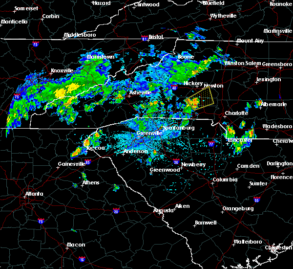 At 1018 pm edt, a severe thunderstorm was located 5 miles northwest of lincolnton, moving northeast at 35 mph (radar indicated). Hazards include 60 mph wind gusts. Expect damage to trees and power lines. this storm has begun to weaken. if this trend continues, the warning will be cancelled early. Locations impacted include, newton, lincolnton, cherryville, maiden, claremont, high shoals, boger city, iron station, bandys and crouse. At 1018 pm edt, a severe thunderstorm was located 5 miles northwest of lincolnton, moving northeast at 35 mph (radar indicated). Hazards include 60 mph wind gusts. Expect damage to trees and power lines. this storm has begun to weaken. if this trend continues, the warning will be cancelled early. Locations impacted include, newton, lincolnton, cherryville, maiden, claremont, high shoals, boger city, iron station, bandys and crouse.
|
| 7/22/2019 9:49 PM EDT |
 At 949 pm edt, a severe thunderstorm was located 6 miles north of shelby, or near lawndale, moving northeast at 35 mph (radar indicated). Hazards include 60 mph wind gusts. expect damage to trees and power lines At 949 pm edt, a severe thunderstorm was located 6 miles north of shelby, or near lawndale, moving northeast at 35 mph (radar indicated). Hazards include 60 mph wind gusts. expect damage to trees and power lines
|
| 6/24/2019 8:45 PM EDT |
 At 845 pm edt, severe thunderstorms were located along a line extending from 5 miles northeast of hickory to 5 miles northeast of lincolnton to 8 miles west of gastonia to 7 miles north of york to 13 miles northeast of union to 16 miles north of newberry, moving east at 60 mph (radar indicated). Hazards include 60 mph wind gusts. Expect damage to trees and power lines. Locations impacted include, gastonia, hickory, shelby, newton, gaffney, lincolnton, union, york, kings mountain and mt holly. At 845 pm edt, severe thunderstorms were located along a line extending from 5 miles northeast of hickory to 5 miles northeast of lincolnton to 8 miles west of gastonia to 7 miles north of york to 13 miles northeast of union to 16 miles north of newberry, moving east at 60 mph (radar indicated). Hazards include 60 mph wind gusts. Expect damage to trees and power lines. Locations impacted include, gastonia, hickory, shelby, newton, gaffney, lincolnton, union, york, kings mountain and mt holly.
|
| 6/24/2019 8:26 PM EDT |
 At 826 pm edt, severe thunderstorms were located along a line extending from 8 miles southwest of hickory to 7 miles southeast of shelby to 11 miles north of union to 7 miles southeast of laurens, moving northeast at 35 mph (radar indicated). Hazards include 60 mph wind gusts. expect damage to trees and power lines At 826 pm edt, severe thunderstorms were located along a line extending from 8 miles southwest of hickory to 7 miles southeast of shelby to 11 miles north of union to 7 miles southeast of laurens, moving northeast at 35 mph (radar indicated). Hazards include 60 mph wind gusts. expect damage to trees and power lines
|
| 6/24/2019 8:20 PM EDT |
 At 819 pm edt, severe thunderstorms were located along a line extending from 6 miles north of shelby to 7 miles south of gaffney to 8 miles southeast of laurens, moving east at 40 mph (radar indicated). Hazards include 70 mph wind gusts. Expect considerable tree damage. damage is likely to mobile homes, roofs, and outbuildings. Locations impacted include, spartanburg, shelby, gaffney, laurens, union, kings mountain, clinton, woodruff, boiling springs nc and pacolet. At 819 pm edt, severe thunderstorms were located along a line extending from 6 miles north of shelby to 7 miles south of gaffney to 8 miles southeast of laurens, moving east at 40 mph (radar indicated). Hazards include 70 mph wind gusts. Expect considerable tree damage. damage is likely to mobile homes, roofs, and outbuildings. Locations impacted include, spartanburg, shelby, gaffney, laurens, union, kings mountain, clinton, woodruff, boiling springs nc and pacolet.
|
| 6/24/2019 8:06 PM EDT |
 At 805 pm edt, severe thunderstorms were located along a line extending from 8 miles northwest of shelby to 9 miles southwest of gaffney to 8 miles southwest of laurens, moving east at 40 mph (radar indicated). Hazards include 70 mph wind gusts. Expect considerable tree damage. damage is likely to mobile homes, roofs, and outbuildings. Locations impacted include, spartanburg, shelby, gaffney, laurens, union, forest city, kings mountain, clinton, boiling springs sc and woodruff. At 805 pm edt, severe thunderstorms were located along a line extending from 8 miles northwest of shelby to 9 miles southwest of gaffney to 8 miles southwest of laurens, moving east at 40 mph (radar indicated). Hazards include 70 mph wind gusts. Expect considerable tree damage. damage is likely to mobile homes, roofs, and outbuildings. Locations impacted include, spartanburg, shelby, gaffney, laurens, union, forest city, kings mountain, clinton, boiling springs sc and woodruff.
|
| 6/24/2019 7:53 PM EDT |
 At 753 pm edt, severe thunderstorms were located along a line extending from 5 miles northeast of forest city to near spartanburg to 14 miles southwest of laurens, moving east at 40 mph (radar indicated). Hazards include 70 mph wind gusts. Expect considerable tree damage. Damage is likely to mobile homes, roofs, and outbuildings. At 753 pm edt, severe thunderstorms were located along a line extending from 5 miles northeast of forest city to near spartanburg to 14 miles southwest of laurens, moving east at 40 mph (radar indicated). Hazards include 70 mph wind gusts. Expect considerable tree damage. Damage is likely to mobile homes, roofs, and outbuildings.
|
| 5/31/2019 3:50 PM EDT | A few trees blown down and pea size hail on hwy 1 in lincoln county NC, 5.7 miles SSW of Belwood, NC |
| 5/4/2019 1:57 PM EDT |
 At 157 pm edt, a severe thunderstorm was located 6 miles north of shelby, or near lawndale, moving northeast at 20 mph (radar indicated). Hazards include 60 mph wind gusts and quarter size hail. Minor hail damage to vehicles is expected. Expect wind damage to trees and power lines. At 157 pm edt, a severe thunderstorm was located 6 miles north of shelby, or near lawndale, moving northeast at 20 mph (radar indicated). Hazards include 60 mph wind gusts and quarter size hail. Minor hail damage to vehicles is expected. Expect wind damage to trees and power lines.
|
| 4/14/2019 10:21 PM EDT |
 At 1021 pm edt, a severe thunderstorm was located 8 miles south of morganton, or over south mountains state park, moving northeast at 55 mph (radar indicated). Hazards include 70 mph wind gusts. Expect considerable tree damage. Damage is likely to mobile homes, roofs, and outbuildings. At 1021 pm edt, a severe thunderstorm was located 8 miles south of morganton, or over south mountains state park, moving northeast at 55 mph (radar indicated). Hazards include 70 mph wind gusts. Expect considerable tree damage. Damage is likely to mobile homes, roofs, and outbuildings.
|
| 4/14/2019 10:07 PM EDT |
 At 1007 pm edt, a severe thunderstorm was located 12 miles northeast of forest city, or 6 miles northwest of polkville, moving northeast at 55 mph (radar indicated). Hazards include 70 mph wind gusts. Expect considerable tree damage. damage is likely to mobile homes, roofs, and outbuildings. Locations impacted include, forest city, spindale, bostic, casar, sunshine, rutherfordton, union mills, belwood and polkville. At 1007 pm edt, a severe thunderstorm was located 12 miles northeast of forest city, or 6 miles northwest of polkville, moving northeast at 55 mph (radar indicated). Hazards include 70 mph wind gusts. Expect considerable tree damage. damage is likely to mobile homes, roofs, and outbuildings. Locations impacted include, forest city, spindale, bostic, casar, sunshine, rutherfordton, union mills, belwood and polkville.
|
| 4/14/2019 9:47 PM EDT |
 At 947 pm edt, a severe thunderstorm was located near rutherfordton, moving northeast at 55 mph (radar indicated). Hazards include 70 mph wind gusts. Expect considerable tree damage. Damage is likely to mobile homes, roofs, and outbuildings. At 947 pm edt, a severe thunderstorm was located near rutherfordton, moving northeast at 55 mph (radar indicated). Hazards include 70 mph wind gusts. Expect considerable tree damage. Damage is likely to mobile homes, roofs, and outbuildings.
|
| 9/27/2018 8:36 PM EDT |
 At 835 pm edt, severe thunderstorms were located along a line extending from 7 miles northeast of forest city to near shelby to 10 miles west of gastonia to near york, moving northeast at 50 mph (law enforcement and skywarn spotters have reported tree and roof damage with this line of storms). Hazards include 60 mph wind gusts. Expect damage to trees and power lines. Locations impacted include, gastonia, shelby, lincolnton, kings mountain, cherryville, bessemer city, south gastonia, dallas, lowell and ranlo. At 835 pm edt, severe thunderstorms were located along a line extending from 7 miles northeast of forest city to near shelby to 10 miles west of gastonia to near york, moving northeast at 50 mph (law enforcement and skywarn spotters have reported tree and roof damage with this line of storms). Hazards include 60 mph wind gusts. Expect damage to trees and power lines. Locations impacted include, gastonia, shelby, lincolnton, kings mountain, cherryville, bessemer city, south gastonia, dallas, lowell and ranlo.
|
| 9/27/2018 8:18 PM EDT |
 At 816 pm edt, severe thunderstorms were located along a line extending from near rutherfordton to 5 miles southeast of forest city and across cherokee county south carolina, moving northeast at 50 mph (law enforcement has reported damage along this line of thunderstorms). Hazards include 60 mph wind gusts and penny size hail. Expect damage to trees and power lines. Locations impacted include, gastonia, shelby, lincolnton, forest city, rutherfordton, kings mountain, cherryville, bessemer city, south gastonia and longview. At 816 pm edt, severe thunderstorms were located along a line extending from near rutherfordton to 5 miles southeast of forest city and across cherokee county south carolina, moving northeast at 50 mph (law enforcement has reported damage along this line of thunderstorms). Hazards include 60 mph wind gusts and penny size hail. Expect damage to trees and power lines. Locations impacted include, gastonia, shelby, lincolnton, forest city, rutherfordton, kings mountain, cherryville, bessemer city, south gastonia and longview.
|
| 9/27/2018 7:51 PM EDT |
 At 749 pm edt, severe thunderstorms were located along a line extending from 12 miles southwest of columbus to near inman to spartanburg to near pauline, moving northeast at 55 mph (law enforcement). Hazards include 60 mph wind gusts and penny size hail. expect damage to trees and power lines At 749 pm edt, severe thunderstorms were located along a line extending from 12 miles southwest of columbus to near inman to spartanburg to near pauline, moving northeast at 55 mph (law enforcement). Hazards include 60 mph wind gusts and penny size hail. expect damage to trees and power lines
|
| 7/21/2018 5:39 PM EDT |
 At 538 pm edt, a severe thunderstorm was located 11 miles southeast of morganton, or near south mountains state park, moving east at 30 mph (radar indicated). Hazards include 60 mph wind gusts and half dollar size hail. Minor hail damage to vehicles is expected. Expect wind damage to trees and power lines. At 538 pm edt, a severe thunderstorm was located 11 miles southeast of morganton, or near south mountains state park, moving east at 30 mph (radar indicated). Hazards include 60 mph wind gusts and half dollar size hail. Minor hail damage to vehicles is expected. Expect wind damage to trees and power lines.
|
| 6/25/2018 5:57 PM EDT |
 The national weather service in greenville-spartanburg has issued a * severe thunderstorm warning for. northwestern cabarrus county in the piedmont of north carolina. catawba county in the piedmont of north carolina. davie county in the piedmont of north carolina. Alexander county in the piedmont of north carolina. The national weather service in greenville-spartanburg has issued a * severe thunderstorm warning for. northwestern cabarrus county in the piedmont of north carolina. catawba county in the piedmont of north carolina. davie county in the piedmont of north carolina. Alexander county in the piedmont of north carolina.
|
| 6/25/2018 5:50 PM EDT |
 At 549 pm edt, severe thunderstorms were located along a line extending from 14 miles south of ronda to 9 miles northwest of shelby, moving east at 30 mph (radar indicated). Hazards include 60 mph wind gusts and quarter size hail. Minor hail damage to vehicles is expected. expect wind damage to trees and power lines. locations impacted include, hickory, newton, taylorsville, st. Stephens, conover, longview, sawmills, granite falls, valdese and bethlehem. At 549 pm edt, severe thunderstorms were located along a line extending from 14 miles south of ronda to 9 miles northwest of shelby, moving east at 30 mph (radar indicated). Hazards include 60 mph wind gusts and quarter size hail. Minor hail damage to vehicles is expected. expect wind damage to trees and power lines. locations impacted include, hickory, newton, taylorsville, st. Stephens, conover, longview, sawmills, granite falls, valdese and bethlehem.
|
| 6/25/2018 5:22 PM EDT |
 At 521 pm edt, severe thunderstorms were located along a line extending from 7 miles northeast of taylorsville to 5 miles north of forest city, moving east at 30 mph (radar indicated). Hazards include 60 mph wind gusts and quarter size hail. Minor hail damage to vehicles is expected. Expect wind damage to trees and power lines. At 521 pm edt, severe thunderstorms were located along a line extending from 7 miles northeast of taylorsville to 5 miles north of forest city, moving east at 30 mph (radar indicated). Hazards include 60 mph wind gusts and quarter size hail. Minor hail damage to vehicles is expected. Expect wind damage to trees and power lines.
|
| 6/15/2018 12:21 AM EDT |
 At 1143 pm edt, severe thunderstorms were located along a line extending from 6 miles east of lincolnton to 12 miles northeast of shelby, moving south at 10 mph (radar indicated). Hazards include 60 mph wind gusts and quarter size hail. Minor hail damage to vehicles is expected. Expect wind damage to trees and power lines. At 1143 pm edt, severe thunderstorms were located along a line extending from 6 miles east of lincolnton to 12 miles northeast of shelby, moving south at 10 mph (radar indicated). Hazards include 60 mph wind gusts and quarter size hail. Minor hail damage to vehicles is expected. Expect wind damage to trees and power lines.
|
| 6/14/2018 11:43 PM EDT |
 The national weather service in greenville-spartanburg has issued a * severe thunderstorm warning for. central lincoln county in the piedmont of north carolina. northern gaston county in the piedmont of north carolina. until 1230 am edt. At 1143 pm edt, severe thunderstorms were located along a line. The national weather service in greenville-spartanburg has issued a * severe thunderstorm warning for. central lincoln county in the piedmont of north carolina. northern gaston county in the piedmont of north carolina. until 1230 am edt. At 1143 pm edt, severe thunderstorms were located along a line.
|
| 6/3/2018 7:23 PM EDT |
 At 723 pm edt, severe thunderstorms were located along a line extending from 5 miles north of lincolnton to 14 miles northeast of shelby, moving east at 25 mph. this storm will produce widespread wind damage across lincolnton (radar indicated). Hazards include 70 mph wind gusts and ping pong ball size hail. People and animals outdoors will be injured. expect hail damage to roofs, siding, windows, and vehicles. expect considerable tree damage. wind damage is also likely to mobile homes, roofs, and outbuildings. Locations impacted include, newton, lincolnton, mt holly, belmont, conover, cherryville, dallas, maiden, stanley and cramerton. At 723 pm edt, severe thunderstorms were located along a line extending from 5 miles north of lincolnton to 14 miles northeast of shelby, moving east at 25 mph. this storm will produce widespread wind damage across lincolnton (radar indicated). Hazards include 70 mph wind gusts and ping pong ball size hail. People and animals outdoors will be injured. expect hail damage to roofs, siding, windows, and vehicles. expect considerable tree damage. wind damage is also likely to mobile homes, roofs, and outbuildings. Locations impacted include, newton, lincolnton, mt holly, belmont, conover, cherryville, dallas, maiden, stanley and cramerton.
|
| 6/3/2018 7:14 PM EDT |
 At 714 pm edt, severe thunderstorms were located along a line extending from 6 miles southwest of newton to 9 miles west of lincolnton, moving east at 25 mph (radar indicated). Hazards include 60 mph wind gusts and half dollar size hail. Minor hail damage to vehicles is expected. Expect wind damage to trees and power lines. At 714 pm edt, severe thunderstorms were located along a line extending from 6 miles southwest of newton to 9 miles west of lincolnton, moving east at 25 mph (radar indicated). Hazards include 60 mph wind gusts and half dollar size hail. Minor hail damage to vehicles is expected. Expect wind damage to trees and power lines.
|
| 6/3/2018 7:02 PM EDT |
 At 701 pm edt, a severe thunderstorm was located 13 miles south of morganton, or near south mountains state park, moving southeast at 25 mph. another severe thunderstorm was located near cooksville, also moving southeast at 25 mph (radar indicated). Hazards include ping pong ball size hail and 60 mph wind gusts. People and animals outdoors will be injured. expect hail damage to roofs, siding, windows, and vehicles. expect wind damage to trees and power lines. Locations impacted include, hickory, newton, conover, longview, valdese, icard, drexel, hildebran, connelly springs and rutherford college. At 701 pm edt, a severe thunderstorm was located 13 miles south of morganton, or near south mountains state park, moving southeast at 25 mph. another severe thunderstorm was located near cooksville, also moving southeast at 25 mph (radar indicated). Hazards include ping pong ball size hail and 60 mph wind gusts. People and animals outdoors will be injured. expect hail damage to roofs, siding, windows, and vehicles. expect wind damage to trees and power lines. Locations impacted include, hickory, newton, conover, longview, valdese, icard, drexel, hildebran, connelly springs and rutherford college.
|
| 6/3/2018 6:43 PM EDT |
 At 642 pm edt, a severe thunderstorm was located 8 miles south of morganton, or near south mountains state park, moving southeast at 30 mph. another severe thunderstorm was located 2 miles south of valdese, also moving southeast at 30 mph (radar indicated). Hazards include ping pong ball size hail and 60 mph wind gusts. People and animals outdoors will be injured. expect hail damage to roofs, siding, windows, and vehicles. Expect wind damage to trees and power lines. At 642 pm edt, a severe thunderstorm was located 8 miles south of morganton, or near south mountains state park, moving southeast at 30 mph. another severe thunderstorm was located 2 miles south of valdese, also moving southeast at 30 mph (radar indicated). Hazards include ping pong ball size hail and 60 mph wind gusts. People and animals outdoors will be injured. expect hail damage to roofs, siding, windows, and vehicles. Expect wind damage to trees and power lines.
|
| 6/1/2018 5:14 PM EDT |
 At 514 pm edt, a severe thunderstorm was located 5 miles north of shelby, or near kingstown, moving east at 20 mph (radar indicated). Hazards include 60 mph wind gusts and quarter size hail. Minor hail damage to vehicles is expected. expect wind damage to trees and power lines. Locations impacted include, cherryville, belwood, lawndale, fallston, polkville, lattimore, waco, kingstown, casar and shelby. At 514 pm edt, a severe thunderstorm was located 5 miles north of shelby, or near kingstown, moving east at 20 mph (radar indicated). Hazards include 60 mph wind gusts and quarter size hail. Minor hail damage to vehicles is expected. expect wind damage to trees and power lines. Locations impacted include, cherryville, belwood, lawndale, fallston, polkville, lattimore, waco, kingstown, casar and shelby.
|
| 6/1/2018 4:56 PM EDT |
 At 456 pm edt, a severe thunderstorm was located 10 miles northeast of forest city, or near polkville, moving east at 20 mph (radar indicated). Hazards include 60 mph wind gusts and quarter size hail. Minor hail damage to vehicles is expected. Expect wind damage to trees and power lines. At 456 pm edt, a severe thunderstorm was located 10 miles northeast of forest city, or near polkville, moving east at 20 mph (radar indicated). Hazards include 60 mph wind gusts and quarter size hail. Minor hail damage to vehicles is expected. Expect wind damage to trees and power lines.
|
| 6/1/2018 4:36 PM EDT |
 At 436 pm edt, a severe thunderstorm was located 8 miles northeast of forest city, or 5 miles northeast of bostic, moving east at 20 mph (radar indicated). Hazards include 60 mph wind gusts and quarter size hail. Minor hail damage to vehicles is expected. expect wind damage to trees and power lines. Locations impacted include, belwood, lawndale, fallston, polkville, bostic, casar, kingstown, sunshine and spindale. At 436 pm edt, a severe thunderstorm was located 8 miles northeast of forest city, or 5 miles northeast of bostic, moving east at 20 mph (radar indicated). Hazards include 60 mph wind gusts and quarter size hail. Minor hail damage to vehicles is expected. expect wind damage to trees and power lines. Locations impacted include, belwood, lawndale, fallston, polkville, bostic, casar, kingstown, sunshine and spindale.
|
| 6/1/2018 4:18 PM EDT |
 At 418 pm edt, a severe thunderstorm was located 8 miles northeast of rutherfordton, or 6 miles north of bostic, moving east at 20 mph (radar indicated). Hazards include 60 mph wind gusts and quarter size hail. Minor hail damage to vehicles is expected. Expect wind damage to trees and power lines. At 418 pm edt, a severe thunderstorm was located 8 miles northeast of rutherfordton, or 6 miles north of bostic, moving east at 20 mph (radar indicated). Hazards include 60 mph wind gusts and quarter size hail. Minor hail damage to vehicles is expected. Expect wind damage to trees and power lines.
|
| 5/31/2018 6:03 PM EDT |
 At 603 pm edt, a severe thunderstorm was located near shelby, moving southeast at 20 mph (radar indicated). Hazards include 60 mph wind gusts and quarter size hail. Minor hail damage to vehicles is expected. expect wind damage to trees and power lines. Locations impacted include, shelby, kings mountain, cherryville, bessemer city, boiling springs nc, belwood, grover, lawndale, patterson springs and fallston. At 603 pm edt, a severe thunderstorm was located near shelby, moving southeast at 20 mph (radar indicated). Hazards include 60 mph wind gusts and quarter size hail. Minor hail damage to vehicles is expected. expect wind damage to trees and power lines. Locations impacted include, shelby, kings mountain, cherryville, bessemer city, boiling springs nc, belwood, grover, lawndale, patterson springs and fallston.
|
| 5/31/2018 5:44 PM EDT |
 At 544 pm edt, a severe thunderstorm was located 7 miles northwest of shelby, or over kingstown, moving southeast at 20 mph (radar indicated). Hazards include 60 mph wind gusts and quarter size hail. Minor hail damage to vehicles is expected. Expect wind damage to trees and power lines. At 544 pm edt, a severe thunderstorm was located 7 miles northwest of shelby, or over kingstown, moving southeast at 20 mph (radar indicated). Hazards include 60 mph wind gusts and quarter size hail. Minor hail damage to vehicles is expected. Expect wind damage to trees and power lines.
|
| 4/15/2018 1:30 PM EDT |
 At 130 pm edt, severe thunderstorms were located along a line extending from 4 miles northeast of lenoir to 14 miles west of taylorsville to 5 miles southwest of hickory, moving northeast at 55 mph (radar indicated). Hazards include 60 mph wind gusts and quarter size hail. Minor hail damage to vehicles is expected. expect wind damage to trees and power lines. locations impacted include, hickory, lenoir, st. stephens, conover, longview, sawmills, granite falls, valdese, bethlehem and hudson. A tornado watch remains in effect until 700 pm edt for western and the piedmont of north carolina. At 130 pm edt, severe thunderstorms were located along a line extending from 4 miles northeast of lenoir to 14 miles west of taylorsville to 5 miles southwest of hickory, moving northeast at 55 mph (radar indicated). Hazards include 60 mph wind gusts and quarter size hail. Minor hail damage to vehicles is expected. expect wind damage to trees and power lines. locations impacted include, hickory, lenoir, st. stephens, conover, longview, sawmills, granite falls, valdese, bethlehem and hudson. A tornado watch remains in effect until 700 pm edt for western and the piedmont of north carolina.
|
| 4/15/2018 1:13 PM EDT |
 At 113 pm edt, severe thunderstorms were located along a line extending from 5 miles east of morganton to 12 miles southwest of hickory to 13 miles north of shelby, moving northeast at 40 mph (radar indicated). Hazards include 60 mph wind gusts and quarter size hail. Minor hail damage to vehicles is expected. Expect wind damage to trees and power lines. At 113 pm edt, severe thunderstorms were located along a line extending from 5 miles east of morganton to 12 miles southwest of hickory to 13 miles north of shelby, moving northeast at 40 mph (radar indicated). Hazards include 60 mph wind gusts and quarter size hail. Minor hail damage to vehicles is expected. Expect wind damage to trees and power lines.
|
| 4/15/2018 12:59 PM EDT |
 At 1246 pm edt, severe thunderstorms were located along a line extending from 10 miles northeast of forest city to 6 miles southwest of shelby, moving northeast at 55 mph (radar indicated). Hazards include 60 mph wind gusts and quarter size hail. Minor hail damage to vehicles is expected. Expect wind damage to trees and power lines. At 1246 pm edt, severe thunderstorms were located along a line extending from 10 miles northeast of forest city to 6 miles southwest of shelby, moving northeast at 55 mph (radar indicated). Hazards include 60 mph wind gusts and quarter size hail. Minor hail damage to vehicles is expected. Expect wind damage to trees and power lines.
|
| 4/15/2018 12:47 PM EDT |
 At 1246 pm edt, severe thunderstorms were located along a line extending from 10 miles northeast of forest city to 6 miles southwest of shelby, moving northeast at 55 mph (radar indicated). Hazards include 60 mph wind gusts and quarter size hail. Minor hail damage to vehicles is expected. Expect wind damage to trees and power lines. At 1246 pm edt, severe thunderstorms were located along a line extending from 10 miles northeast of forest city to 6 miles southwest of shelby, moving northeast at 55 mph (radar indicated). Hazards include 60 mph wind gusts and quarter size hail. Minor hail damage to vehicles is expected. Expect wind damage to trees and power lines.
|
| 10/23/2017 4:25 PM EDT | Trained spotter reported multiple houses with roof famage and numerous trees and power poles down along highway 10 in lincoln county. possible tornad in lincoln county NC, 5.7 miles SSW of Belwood, NC |
| 10/23/2017 4:14 PM EDT |
 At 414 pm edt, a severe thunderstorm capable of producing a tornado was located 15 miles southeast of morganton, or 4 miles northeast of casar, moving northeast at 80 mph (radar indicated rotation). Hazards include tornado. Flying debris will be dangerous to those caught without shelter. mobile homes will be damaged or destroyed. damage to roofs, windows, and vehicles will occur. tree damage is likely. This dangerous storm will remain over mainly rural areas of southwestern catawba, western lincoln, northwestern cleveland and southeastern burke counties, including the following locations: cooksville, vale and pleasant grove. At 414 pm edt, a severe thunderstorm capable of producing a tornado was located 15 miles southeast of morganton, or 4 miles northeast of casar, moving northeast at 80 mph (radar indicated rotation). Hazards include tornado. Flying debris will be dangerous to those caught without shelter. mobile homes will be damaged or destroyed. damage to roofs, windows, and vehicles will occur. tree damage is likely. This dangerous storm will remain over mainly rural areas of southwestern catawba, western lincoln, northwestern cleveland and southeastern burke counties, including the following locations: cooksville, vale and pleasant grove.
|
| 10/23/2017 3:59 PM EDT |
 At 359 pm edt, a severe thunderstorm capable of producing a tornado was located 9 miles northwest of shelby, or near polkville, moving northeast at 45 mph (radar indicated rotation). Hazards include tornado. Flying debris will be dangerous to those caught without shelter. mobile homes will be damaged or destroyed. damage to roofs, windows, and vehicles will occur. tree damage is likely. this dangerous storm will be near, polkville and lawndale around 400 pm edt. casar, belwood and fallston around 410 pm edt. Other locations impacted by this dangerous thunderstorm include cooksville, sunshine, pleasant grove and vale. At 359 pm edt, a severe thunderstorm capable of producing a tornado was located 9 miles northwest of shelby, or near polkville, moving northeast at 45 mph (radar indicated rotation). Hazards include tornado. Flying debris will be dangerous to those caught without shelter. mobile homes will be damaged or destroyed. damage to roofs, windows, and vehicles will occur. tree damage is likely. this dangerous storm will be near, polkville and lawndale around 400 pm edt. casar, belwood and fallston around 410 pm edt. Other locations impacted by this dangerous thunderstorm include cooksville, sunshine, pleasant grove and vale.
|
| 10/8/2017 5:12 PM EDT |
 At 512 pm edt, a confirmed tornado was located 15 miles southeast of morganton, or near casar, moving north at 30 mph (public confirmed tornado). Hazards include damaging tornado. Flying debris will be dangerous to those caught without shelter. mobile homes will be damaged or destroyed. damage to roofs, windows, and vehicles will occur. tree damage is likely. the tornado will be near, drexel around 540 pm edt. connelly springs, lake rhodhiss, rutherford college, valdese and icard around 550 pm edt. lenoir, hudson, sawmills, cajah`s mountain and granite falls around 600 pm edt. Other locations impacted by this dangerous thunderstorm include northlakes and pleasant grove. At 512 pm edt, a confirmed tornado was located 15 miles southeast of morganton, or near casar, moving north at 30 mph (public confirmed tornado). Hazards include damaging tornado. Flying debris will be dangerous to those caught without shelter. mobile homes will be damaged or destroyed. damage to roofs, windows, and vehicles will occur. tree damage is likely. the tornado will be near, drexel around 540 pm edt. connelly springs, lake rhodhiss, rutherford college, valdese and icard around 550 pm edt. lenoir, hudson, sawmills, cajah`s mountain and granite falls around 600 pm edt. Other locations impacted by this dangerous thunderstorm include northlakes and pleasant grove.
|
| 10/8/2017 4:56 PM EDT |
 At 455 pm edt, a severe thunderstorm capable of producing a tornado was located 10 miles northwest of shelby, or near polkville, moving north at 30 mph (radar indicated rotation). Hazards include tornado. Flying debris will be dangerous to those caught without shelter. mobile homes will be damaged or destroyed. damage to roofs, windows, and vehicles will occur. tree damage is likely. this dangerous storm will be near, belwood and fallston around 500 pm edt. casar around 510 pm edt. Other locations impacted by this dangerous storm include cooksville and pleasant grove. At 455 pm edt, a severe thunderstorm capable of producing a tornado was located 10 miles northwest of shelby, or near polkville, moving north at 30 mph (radar indicated rotation). Hazards include tornado. Flying debris will be dangerous to those caught without shelter. mobile homes will be damaged or destroyed. damage to roofs, windows, and vehicles will occur. tree damage is likely. this dangerous storm will be near, belwood and fallston around 500 pm edt. casar around 510 pm edt. Other locations impacted by this dangerous storm include cooksville and pleasant grove.
|
| 10/8/2017 4:38 PM EDT |
 At 438 pm edt, a severe thunderstorm capable of producing a tornado was located 6 miles west of shelby, or over lattimore, moving north at 35 mph (radar indicated rotation). Hazards include tornado. Flying debris will be dangerous to those caught without shelter. mobile homes will be damaged or destroyed. damage to roofs, windows, and vehicles will occur. tree damage is likely. this dangerous storm will be near, kingstown around 440 pm edt. lawndale around 450 pm edt. polkville, casar, belwood and fallston around 500 pm edt. south mountains state park around 510 pm edt. Other locations impacted by this dangerous thunderstorm include cooksville and pleasant grove. At 438 pm edt, a severe thunderstorm capable of producing a tornado was located 6 miles west of shelby, or over lattimore, moving north at 35 mph (radar indicated rotation). Hazards include tornado. Flying debris will be dangerous to those caught without shelter. mobile homes will be damaged or destroyed. damage to roofs, windows, and vehicles will occur. tree damage is likely. this dangerous storm will be near, kingstown around 440 pm edt. lawndale around 450 pm edt. polkville, casar, belwood and fallston around 500 pm edt. south mountains state park around 510 pm edt. Other locations impacted by this dangerous thunderstorm include cooksville and pleasant grove.
|
| 7/28/2017 4:04 PM EDT |
 At 404 pm edt, severe thunderstorms were located along a line extending from 4 miles north of lincolnton to 10 miles west of gastonia to 9 miles east of chester, moving east at 15 mph (radar indicated). Hazards include 60 mph wind gusts. Expect damage to trees and power lines. Locations impacted include, gastonia, rock hill, shelby, gaffney, lincolnton, york, chester, kings mountain, mt holly and fort mill. At 404 pm edt, severe thunderstorms were located along a line extending from 4 miles north of lincolnton to 10 miles west of gastonia to 9 miles east of chester, moving east at 15 mph (radar indicated). Hazards include 60 mph wind gusts. Expect damage to trees and power lines. Locations impacted include, gastonia, rock hill, shelby, gaffney, lincolnton, york, chester, kings mountain, mt holly and fort mill.
|
| 7/28/2017 3:55 PM EDT |
 At 355 pm edt, severe thunderstorms were located along a line extending from 3 miles north of lincolnton to 9 miles southeast of shelby to 8 miles southeast of chester, moving northeast at 15 mph (radar indicated). Hazards include 60 mph wind gusts. expect damage to trees and power lines At 355 pm edt, severe thunderstorms were located along a line extending from 3 miles north of lincolnton to 9 miles southeast of shelby to 8 miles southeast of chester, moving northeast at 15 mph (radar indicated). Hazards include 60 mph wind gusts. expect damage to trees and power lines
|
| 7/8/2017 4:53 PM EDT |
 At 453 pm edt, a severe thunderstorm was located 9 miles south of hickory, or 5 miles south of mountain view, moving east at 15 mph (radar indicated). Hazards include 60 mph wind gusts and quarter size hail. Minor hail damage to vehicles is expected. expect wind damage to trees and power lines. Locations impacted include, cooksville, propst crossroads, vale and lincolnton. At 453 pm edt, a severe thunderstorm was located 9 miles south of hickory, or 5 miles south of mountain view, moving east at 15 mph (radar indicated). Hazards include 60 mph wind gusts and quarter size hail. Minor hail damage to vehicles is expected. expect wind damage to trees and power lines. Locations impacted include, cooksville, propst crossroads, vale and lincolnton.
|
| 7/8/2017 4:31 PM EDT |
 At 430 pm edt, a severe thunderstorm was located 13 miles southwest of hickory, or 8 miles south of icard, moving east at 15 mph (radar indicated). Hazards include 60 mph wind gusts and quarter size hail. Minor hail damage to vehicles is expected. Expect wind damage to trees and power lines. At 430 pm edt, a severe thunderstorm was located 13 miles southwest of hickory, or 8 miles south of icard, moving east at 15 mph (radar indicated). Hazards include 60 mph wind gusts and quarter size hail. Minor hail damage to vehicles is expected. Expect wind damage to trees and power lines.
|
| 5/28/2017 2:24 AM EDT |
 The severe thunderstorm warning for catawba, lincoln, eastern cleveland and gaston counties will expire at 230 am edt, the storms which prompted the warning have moved out of the area. therefore the warning will be allowed to expire. however gusty winds and heavy rain are still possible with these thunderstorms. a severe thunderstorm watch remains in effect until 400 am edt for the piedmont of north carolina. a severe thunderstorm watch also remains in effect until 600 am edt for upstate south carolina. The severe thunderstorm warning for catawba, lincoln, eastern cleveland and gaston counties will expire at 230 am edt, the storms which prompted the warning have moved out of the area. therefore the warning will be allowed to expire. however gusty winds and heavy rain are still possible with these thunderstorms. a severe thunderstorm watch remains in effect until 400 am edt for the piedmont of north carolina. a severe thunderstorm watch also remains in effect until 600 am edt for upstate south carolina.
|
| 5/28/2017 1:35 AM EDT |
 The national weather service in greenville-spartanburg has issued a * severe thunderstorm warning for. catawba county in the piedmont of north carolina. lincoln county in the piedmont of north carolina. eastern cleveland county in the piedmont of north carolina. Gaston county in the piedmont of north carolina. The national weather service in greenville-spartanburg has issued a * severe thunderstorm warning for. catawba county in the piedmont of north carolina. lincoln county in the piedmont of north carolina. eastern cleveland county in the piedmont of north carolina. Gaston county in the piedmont of north carolina.
|
| 5/28/2017 1:32 AM EDT |
 At 132 am edt, severe thunderstorms were located along a line extending from 10 miles southeast of morganton to 8 miles northwest of gaffney, moving east at 35 mph (radar indicated). Hazards include 60 mph wind gusts and penny size hail. Expect damage to trees and power lines. Locations impacted include, shelby, kings mountain, boiling springs nc, belwood, grover, lawndale, patterson springs, fallston, polkville and lattimore. At 132 am edt, severe thunderstorms were located along a line extending from 10 miles southeast of morganton to 8 miles northwest of gaffney, moving east at 35 mph (radar indicated). Hazards include 60 mph wind gusts and penny size hail. Expect damage to trees and power lines. Locations impacted include, shelby, kings mountain, boiling springs nc, belwood, grover, lawndale, patterson springs, fallston, polkville and lattimore.
|
| 5/28/2017 1:05 AM EDT |
 At 105 am edt, severe thunderstorms were located along a line extending from 10 miles southeast of marion to 11 miles southwest of forest city, moving east at 40 mph (radar indicated). Hazards include 60 mph wind gusts and penny size hail. expect damage to trees and power lines At 105 am edt, severe thunderstorms were located along a line extending from 10 miles southeast of marion to 11 miles southwest of forest city, moving east at 40 mph (radar indicated). Hazards include 60 mph wind gusts and penny size hail. expect damage to trees and power lines
|
| 5/1/2017 3:23 PM EDT |
 At 322 pm edt, severe thunderstorms were located along a line extending from 13 miles southeast of morganton to 10 miles north of shelby to 5 miles northwest of gaffney, moving northeast at 55 mph (radar indicated). Hazards include 60 mph wind gusts. Expect damage to trees and power lines. locations impacted include, hickory, shelby, newton, st. Stephens, conover, cherryville, longview, boiling springs nc, icard and hildebran. At 322 pm edt, severe thunderstorms were located along a line extending from 13 miles southeast of morganton to 10 miles north of shelby to 5 miles northwest of gaffney, moving northeast at 55 mph (radar indicated). Hazards include 60 mph wind gusts. Expect damage to trees and power lines. locations impacted include, hickory, shelby, newton, st. Stephens, conover, cherryville, longview, boiling springs nc, icard and hildebran.
|
| 5/1/2017 3:03 PM EDT |
 At 302 pm edt, severe thunderstorms were located along a line extending from 9 miles northeast of rutherfordton to 6 miles east of forest city to 7 miles northeast of spartanburg, moving northeast at 60 mph (radar indicated). Hazards include 60 mph wind gusts. expect damage to trees and power lines At 302 pm edt, severe thunderstorms were located along a line extending from 9 miles northeast of rutherfordton to 6 miles east of forest city to 7 miles northeast of spartanburg, moving northeast at 60 mph (radar indicated). Hazards include 60 mph wind gusts. expect damage to trees and power lines
|
| 4/6/2017 1:08 AM EDT |
 The severe thunderstorm warning for western catawba, southeastern rutherford, western lincoln, southeastern caldwell, cleveland and southeastern burke counties will expire at 115 am edt, the storms which prompted the warning have moved out of the area. therefore the warning will be allowed to expire. however heavy rain is still possible with these thunderstorms. a severe thunderstorm watch remains in effect until 700 am edt for the piedmont of north carolina. remember, a severe thunderstorm warning still remains in effect for much of northern lincoln and central and eastern catawba counties until 1230 am. The severe thunderstorm warning for western catawba, southeastern rutherford, western lincoln, southeastern caldwell, cleveland and southeastern burke counties will expire at 115 am edt, the storms which prompted the warning have moved out of the area. therefore the warning will be allowed to expire. however heavy rain is still possible with these thunderstorms. a severe thunderstorm watch remains in effect until 700 am edt for the piedmont of north carolina. remember, a severe thunderstorm warning still remains in effect for much of northern lincoln and central and eastern catawba counties until 1230 am.
|
| 4/6/2017 12:48 AM EDT |
 At 1248 am edt, severe thunderstorms were located along a line extending from 3 miles north of lenoir to 11 miles southeast of morganton to 6 miles west of shelby, moving northeast at 75 mph (radar indicated). Hazards include 60 mph wind gusts. Expect damage to trees and minor damage to roofs and siding. Locations impacted include, hickory, shelby, forest city, longview, sawmills, granite falls, valdese, gamewell, boiling springs nc and hudson. At 1248 am edt, severe thunderstorms were located along a line extending from 3 miles north of lenoir to 11 miles southeast of morganton to 6 miles west of shelby, moving northeast at 75 mph (radar indicated). Hazards include 60 mph wind gusts. Expect damage to trees and minor damage to roofs and siding. Locations impacted include, hickory, shelby, forest city, longview, sawmills, granite falls, valdese, gamewell, boiling springs nc and hudson.
|
| 4/6/2017 12:30 AM EDT |
 At 1230 am edt, severe thunderstorms were located along a line extending from 5 miles west of morganton to 13 miles northeast of rutherfordton to 5 miles southwest of forest city, moving northeast at 70 mph (radar indicated). Hazards include 60 mph wind gusts and quarter size hail. Hail damage to vehicles is expected. Expect wind damage to roofs, siding, and trees. At 1230 am edt, severe thunderstorms were located along a line extending from 5 miles west of morganton to 13 miles northeast of rutherfordton to 5 miles southwest of forest city, moving northeast at 70 mph (radar indicated). Hazards include 60 mph wind gusts and quarter size hail. Hail damage to vehicles is expected. Expect wind damage to roofs, siding, and trees.
|
| 3/21/2017 8:07 PM EDT |
 At 807 pm edt, a severe thunderstorm was located near lincolnton, moving east at 25 mph (radar indicated). Hazards include 60 mph wind gusts and quarter size hail. Hail damage to vehicles is expected. Expect wind damage to roofs, siding and trees. At 807 pm edt, a severe thunderstorm was located near lincolnton, moving east at 25 mph (radar indicated). Hazards include 60 mph wind gusts and quarter size hail. Hail damage to vehicles is expected. Expect wind damage to roofs, siding and trees.
|
| 3/1/2017 5:24 PM EST |
 At 523 pm est, a severe thunderstorm was located 4 miles southwest of forest city, or near spindale, moving east at 55 mph (radar indicated). Hazards include 60 mph wind gusts and quarter size hail. Hail damage to vehicles is expected. expect wind damage to roofs, siding and trees. Locations impacted include, forest city, rutherfordton, spindale, belwood, lawndale, fallston, polkville, ellenboro, lattimore and mooresboro. At 523 pm est, a severe thunderstorm was located 4 miles southwest of forest city, or near spindale, moving east at 55 mph (radar indicated). Hazards include 60 mph wind gusts and quarter size hail. Hail damage to vehicles is expected. expect wind damage to roofs, siding and trees. Locations impacted include, forest city, rutherfordton, spindale, belwood, lawndale, fallston, polkville, ellenboro, lattimore and mooresboro.
|
| 3/1/2017 5:03 PM EST |
 At 502 pm est, a severe thunderstorm was located 4 miles west of columbus, or near saluda, moving east at 60 mph (radar indicated. at 5:02 pm dime size hail was reported near saluda). Hazards include 60 mph wind gusts and quarter size hail. Hail damage to vehicles is expected. Expect wind damage to roofs, siding and trees. At 502 pm est, a severe thunderstorm was located 4 miles west of columbus, or near saluda, moving east at 60 mph (radar indicated. at 5:02 pm dime size hail was reported near saluda). Hazards include 60 mph wind gusts and quarter size hail. Hail damage to vehicles is expected. Expect wind damage to roofs, siding and trees.
|
| 11/30/2016 5:42 PM EST |
 At 542 pm est, severe thunderstorms were located along a line extending from 11 miles southwest of yadkinville to 8 miles southwest of newton to 3 miles northwest of shelby to 10 miles east of union to 6 miles north of newberry, moving northeast at 55 mph (radar indicated). Hazards include 60 mph wind gusts. Expect damage to roofs. siding and trees. Locations impacted include, gastonia, rock hill, hickory, statesville, shelby, newton, gaffney, lincolnton, union and york. At 542 pm est, severe thunderstorms were located along a line extending from 11 miles southwest of yadkinville to 8 miles southwest of newton to 3 miles northwest of shelby to 10 miles east of union to 6 miles north of newberry, moving northeast at 55 mph (radar indicated). Hazards include 60 mph wind gusts. Expect damage to roofs. siding and trees. Locations impacted include, gastonia, rock hill, hickory, statesville, shelby, newton, gaffney, lincolnton, union and york.
|
| 11/30/2016 5:26 PM EST |
 At 526 pm est, severe thunderstorms were located along a line extending from 8 miles east of taylorsville to 14 miles north of shelby to 8 miles southeast of forest city to 5 miles south of union to 8 miles west of newberry, moving northeast at 55 mph (radar indicated). Hazards include 60 mph wind gusts. Expect damage to roofs. Siding and trees. At 526 pm est, severe thunderstorms were located along a line extending from 8 miles east of taylorsville to 14 miles north of shelby to 8 miles southeast of forest city to 5 miles south of union to 8 miles west of newberry, moving northeast at 55 mph (radar indicated). Hazards include 60 mph wind gusts. Expect damage to roofs. Siding and trees.
|
| 11/30/2016 5:17 PM EST |
 At 517 pm est, severe thunderstorms were located along a line extending from 13 miles southeast of morganton to 4 miles northeast of spartanburg to 13 miles northwest of union to 12 miles southeast of laurens to 9 miles east of greenwood, moving east at 55 mph (radar indicated). Hazards include 60 mph wind gusts. Expect damage to roofs. siding and trees. Locations impacted include, spartanburg, greenwood, shelby, gaffney, laurens, union, forest city, rutherfordton, clinton and boiling springs sc. At 517 pm est, severe thunderstorms were located along a line extending from 13 miles southeast of morganton to 4 miles northeast of spartanburg to 13 miles northwest of union to 12 miles southeast of laurens to 9 miles east of greenwood, moving east at 55 mph (radar indicated). Hazards include 60 mph wind gusts. Expect damage to roofs. siding and trees. Locations impacted include, spartanburg, greenwood, shelby, gaffney, laurens, union, forest city, rutherfordton, clinton and boiling springs sc.
|
| 11/30/2016 4:41 PM EST |
 At 441 pm est, severe thunderstorms were located along a line extending from 7 miles west of rutherfordton to near greenville downtown to 18 miles southeast of easley to 5 miles northeast of abbeville to 21 miles northeast of washington, moving east at 55 mph (radar indicated). Hazards include 60 mph wind gusts. Expect damage to roofs. Siding and trees. At 441 pm est, severe thunderstorms were located along a line extending from 7 miles west of rutherfordton to near greenville downtown to 18 miles southeast of easley to 5 miles northeast of abbeville to 21 miles northeast of washington, moving east at 55 mph (radar indicated). Hazards include 60 mph wind gusts. Expect damage to roofs. Siding and trees.
|
| 8/27/2016 5:29 PM EDT |
 At 528 pm edt, severe thunderstorms were located along a line extending from 8 miles northeast of shelby to 10 miles west of gastonia to 9 miles northeast of york, moving west at 20 mph (radar indicated). Hazards include 60 mph wind gusts. Expect damage to roofs. siding and trees. Locations impacted include, gastonia, shelby, york, kings mountain, cherryville, bessemer city, south gastonia, clover, newport and dallas. At 528 pm edt, severe thunderstorms were located along a line extending from 8 miles northeast of shelby to 10 miles west of gastonia to 9 miles northeast of york, moving west at 20 mph (radar indicated). Hazards include 60 mph wind gusts. Expect damage to roofs. siding and trees. Locations impacted include, gastonia, shelby, york, kings mountain, cherryville, bessemer city, south gastonia, clover, newport and dallas.
|
| 8/27/2016 5:15 PM EDT |
 At 515 pm edt, severe thunderstorms were located along a line extending from 10 miles southwest of lincolnton to 4 miles west of gastonia to 8 miles north of rock hill, moving northwest at 20 mph (radar indicated). Hazards include 60 mph wind gusts. Expect damage to roofs. Siding and trees. At 515 pm edt, severe thunderstorms were located along a line extending from 10 miles southwest of lincolnton to 4 miles west of gastonia to 8 miles north of rock hill, moving northwest at 20 mph (radar indicated). Hazards include 60 mph wind gusts. Expect damage to roofs. Siding and trees.
|
| 8/2/2016 3:39 PM EDT |
 The severe thunderstorm warning for southeastern burke, southwestern catawba, north central cleveland and western lincoln counties will expire at 345 pm edt, the storm which prompted the warning has weakened below severe limits, and no longer poses an immediate threat to life or property. therefore the warning will be allowed to expire. The severe thunderstorm warning for southeastern burke, southwestern catawba, north central cleveland and western lincoln counties will expire at 345 pm edt, the storm which prompted the warning has weakened below severe limits, and no longer poses an immediate threat to life or property. therefore the warning will be allowed to expire.
|
| 8/2/2016 3:19 PM EDT |
 At 318 pm edt, a severe thunderstorm was located 13 miles southwest of hickory, or 8 miles south of icard, moving southeast at 15 mph (radar indicated). Hazards include 60 mph wind gusts. Expect damage to roofs. siding and trees. Locations impacted include, belwood, south mountains state park, propst, vale, pleasant grove and cooksville. At 318 pm edt, a severe thunderstorm was located 13 miles southwest of hickory, or 8 miles south of icard, moving southeast at 15 mph (radar indicated). Hazards include 60 mph wind gusts. Expect damage to roofs. siding and trees. Locations impacted include, belwood, south mountains state park, propst, vale, pleasant grove and cooksville.
|
| 8/2/2016 2:59 PM EDT |
 At 259 pm edt, a severe thunderstorm was located 8 miles southeast of morganton, or 5 miles northeast of south mountains state park, moving southeast at 15 mph (radar indicated). Hazards include 60 mph wind gusts. Expect damage to roofs. Siding and trees. At 259 pm edt, a severe thunderstorm was located 8 miles southeast of morganton, or 5 miles northeast of south mountains state park, moving southeast at 15 mph (radar indicated). Hazards include 60 mph wind gusts. Expect damage to roofs. Siding and trees.
|
| 7/17/2016 9:34 PM EDT |
 At 933 pm edt, a rain shower capable of producing damaging winds was located 10 miles north of shelby, or near lawndale, moving northeast at 15 mph (radar indicated). Hazards include 60 mph wind gusts. Expect damage to roofs. siding and trees. Locations impacted include, belwood, lawndale, fallston, polkville, ellenboro, lattimore, mooresboro, casar, kingstown and sunshine. At 933 pm edt, a rain shower capable of producing damaging winds was located 10 miles north of shelby, or near lawndale, moving northeast at 15 mph (radar indicated). Hazards include 60 mph wind gusts. Expect damage to roofs. siding and trees. Locations impacted include, belwood, lawndale, fallston, polkville, ellenboro, lattimore, mooresboro, casar, kingstown and sunshine.
|
| 7/17/2016 9:16 PM EDT |
 At 916 pm edt, a severe thunderstorm was located 11 miles northwest of shelby, or near polkville, moving northeast at 15 mph (radar indicated). Hazards include 60 mph wind gusts and penny size hail. Expect damage to roofs. siding and trees. Locations impacted include, forest city, boiling springs nc, belwood, lawndale, fallston, polkville, ellenboro, lattimore, mooresboro and bostic. At 916 pm edt, a severe thunderstorm was located 11 miles northwest of shelby, or near polkville, moving northeast at 15 mph (radar indicated). Hazards include 60 mph wind gusts and penny size hail. Expect damage to roofs. siding and trees. Locations impacted include, forest city, boiling springs nc, belwood, lawndale, fallston, polkville, ellenboro, lattimore, mooresboro and bostic.
|
| 7/17/2016 9:08 PM EDT |
 At 908 pm edt, a severe thunderstorm was located 11 miles northwest of shelby, or near polkville, moving northeast at 15 mph (radar indicated). Hazards include 60 mph wind gusts and quarter size hail. Hail damage to vehicles is expected. Expect wind damage to roofs, siding and trees. At 908 pm edt, a severe thunderstorm was located 11 miles northwest of shelby, or near polkville, moving northeast at 15 mph (radar indicated). Hazards include 60 mph wind gusts and quarter size hail. Hail damage to vehicles is expected. Expect wind damage to roofs, siding and trees.
|
| 7/16/2016 3:45 PM EDT | Power lines down on leonhart road in lincoln county NC, 6.3 miles W of Belwood, NC |
| 7/16/2016 3:32 PM EDT |
 At 331 pm edt, severe thunderstorms were located along a line extending from 12 miles west of lincolnton to 6 miles southeast of forest city, moving east at 15 mph (radar indicated). Hazards include 60 mph wind gusts and nickel size hail. Expect damage to roofs. Siding and trees. At 331 pm edt, severe thunderstorms were located along a line extending from 12 miles west of lincolnton to 6 miles southeast of forest city, moving east at 15 mph (radar indicated). Hazards include 60 mph wind gusts and nickel size hail. Expect damage to roofs. Siding and trees.
|
| 7/8/2016 7:39 PM EDT |
 At 738 pm edt, a severe thunderstorm was located 8 miles north of shelby, or near fallston, moving east at 35 mph (radar indicated). Hazards include 60 mph wind gusts and quarter size hail. Hail damage to vehicles is expected. Expect wind damage to roofs, siding and trees. At 738 pm edt, a severe thunderstorm was located 8 miles north of shelby, or near fallston, moving east at 35 mph (radar indicated). Hazards include 60 mph wind gusts and quarter size hail. Hail damage to vehicles is expected. Expect wind damage to roofs, siding and trees.
|
| 7/8/2016 7:26 PM EDT |
 At 725 pm edt, a severe thunderstorm was located 10 miles northwest of shelby, or over polkville, moving southeast at 30 mph (radar indicated). Hazards include 60 mph wind gusts and quarter size hail. Hail damage to vehicles is expected. expect wind damage to roofs, siding and trees. Locations impacted include, shelby, cherryville, belwood, lawndale, fallston, polkville, lattimore, waco, casar and kingstown. At 725 pm edt, a severe thunderstorm was located 10 miles northwest of shelby, or over polkville, moving southeast at 30 mph (radar indicated). Hazards include 60 mph wind gusts and quarter size hail. Hail damage to vehicles is expected. expect wind damage to roofs, siding and trees. Locations impacted include, shelby, cherryville, belwood, lawndale, fallston, polkville, lattimore, waco, casar and kingstown.
|
| 7/8/2016 7:06 PM EDT |
 At 706 pm edt, a severe thunderstorm was located 10 miles north of forest city, or 8 miles north of bostic, moving southeast at 30 mph (radar indicated). Hazards include 60 mph wind gusts and penny size hail. Expect damage to roofs. Siding and trees. At 706 pm edt, a severe thunderstorm was located 10 miles north of forest city, or 8 miles north of bostic, moving southeast at 30 mph (radar indicated). Hazards include 60 mph wind gusts and penny size hail. Expect damage to roofs. Siding and trees.
|
| 7/5/2016 2:57 PM EDT |
 At 257 pm edt, severe thunderstorms were located along a line extending from 9 miles east of morganton to 9 miles northeast of forest city, moving east at 35 mph (trained weather spotters and emergency management officials). Hazards include 60 mph wind gusts. Expect damage to roofs. siding and trees. Locations impacted include, hickory, longview, valdese, icard, drexel, hildebran, connelly springs, rutherford college, belwood and lawndale. At 257 pm edt, severe thunderstorms were located along a line extending from 9 miles east of morganton to 9 miles northeast of forest city, moving east at 35 mph (trained weather spotters and emergency management officials). Hazards include 60 mph wind gusts. Expect damage to roofs. siding and trees. Locations impacted include, hickory, longview, valdese, icard, drexel, hildebran, connelly springs, rutherford college, belwood and lawndale.
|
| 7/5/2016 2:28 PM EDT |
 At 228 pm edt, severe thunderstorms were located along a line extending from 9 miles west of morganton to 5 miles northwest of rutherfordton, moving east at 40 mph (emergency management). Hazards include 60 mph wind gusts and nickel size hail. Expect damage to roofs. Siding and trees. At 228 pm edt, severe thunderstorms were located along a line extending from 9 miles west of morganton to 5 miles northwest of rutherfordton, moving east at 40 mph (emergency management). Hazards include 60 mph wind gusts and nickel size hail. Expect damage to roofs. Siding and trees.
|
| 7/3/2016 8:23 PM EDT |
 The severe thunderstorm warning for central cleveland county will expire at 830 pm edt, the storm which prompted the warning has weakened below severe limits, and no longer poses an immediate threat to life or property. therefore the warning will be allowed to expire. if you observed large hail or wind damage, please report it to the national weather service greenville-spartanburg by calling toll free, 1, 800, 2 6 7, 8 1 0 1, or by posting on our facebook page, or tweet it using hashtag nwsgsp. your message should describe the event and the specific location where it occurred. The severe thunderstorm warning for central cleveland county will expire at 830 pm edt, the storm which prompted the warning has weakened below severe limits, and no longer poses an immediate threat to life or property. therefore the warning will be allowed to expire. if you observed large hail or wind damage, please report it to the national weather service greenville-spartanburg by calling toll free, 1, 800, 2 6 7, 8 1 0 1, or by posting on our facebook page, or tweet it using hashtag nwsgsp. your message should describe the event and the specific location where it occurred.
|
| 7/3/2016 8:05 PM EDT |
 At 804 pm edt, a severe thunderstorm was located 10 miles northwest of shelby, or over polkville, moving east at 20 mph (radar indicated). Hazards include 60 mph wind gusts and penny size hail. Expect damage to roofs. siding and trees. Locations impacted include, lawndale, fallston, polkville, kingstown and belwood. At 804 pm edt, a severe thunderstorm was located 10 miles northwest of shelby, or over polkville, moving east at 20 mph (radar indicated). Hazards include 60 mph wind gusts and penny size hail. Expect damage to roofs. siding and trees. Locations impacted include, lawndale, fallston, polkville, kingstown and belwood.
|
| 7/3/2016 7:47 PM EDT |
 At 747 pm edt, a severe thunderstorm was located 11 miles northeast of forest city, or 4 miles northwest of polkville, moving east at 15 mph (radar indicated). Hazards include 60 mph wind gusts and half dollar size hail. Hail damage to vehicles is expected. Expect wind damage to roofs, siding and trees. At 747 pm edt, a severe thunderstorm was located 11 miles northeast of forest city, or 4 miles northwest of polkville, moving east at 15 mph (radar indicated). Hazards include 60 mph wind gusts and half dollar size hail. Hail damage to vehicles is expected. Expect wind damage to roofs, siding and trees.
|
| 6/14/2016 8:33 PM EDT |
 At 832 pm edt, severe thunderstorms were located along a line extending from 12 miles south of morganton to near shelby to 10 miles northeast of gaffney, moving northeast at 25 mph (radar indicated). Hazards include 60 mph wind gusts. Expect damage to roofs. siding and trees. Locations impacted include, shelby, boiling springs nc, belwood, lawndale, patterson springs, fallston, polkville, ellenboro, lattimore and mooresboro. At 832 pm edt, severe thunderstorms were located along a line extending from 12 miles south of morganton to near shelby to 10 miles northeast of gaffney, moving northeast at 25 mph (radar indicated). Hazards include 60 mph wind gusts. Expect damage to roofs. siding and trees. Locations impacted include, shelby, boiling springs nc, belwood, lawndale, patterson springs, fallston, polkville, ellenboro, lattimore and mooresboro.
|
| 6/14/2016 7:55 PM EDT |
 At 755 pm edt, severe thunderstorms were located along a line extending from 7 miles north of rutherfordton to 10 miles southeast of forest city to 8 miles south of gaffney, moving northeast at 15 mph (radar indicated). Hazards include 60 mph wind gusts and quarter size hail. Hail damage to vehicles is expected. Expect wind damage to roofs, siding and trees. At 755 pm edt, severe thunderstorms were located along a line extending from 7 miles north of rutherfordton to 10 miles southeast of forest city to 8 miles south of gaffney, moving northeast at 15 mph (radar indicated). Hazards include 60 mph wind gusts and quarter size hail. Hail damage to vehicles is expected. Expect wind damage to roofs, siding and trees.
|
| 5/3/2016 6:00 PM EDT | Trees down on cooksville roa in catawba county NC, 8 miles SSW of Belwood, NC |
| 5/3/2016 5:49 PM EDT |
 At 549 pm edt, a severe thunderstorm was located 13 miles southeast of morganton, or 7 miles east of south mountains state park, moving east at 20 mph (radar indicated). Hazards include 60 mph wind gusts and quarter size hail. Hail damage to vehicles is expected. Expect wind damage to roofs, siding and trees. At 549 pm edt, a severe thunderstorm was located 13 miles southeast of morganton, or 7 miles east of south mountains state park, moving east at 20 mph (radar indicated). Hazards include 60 mph wind gusts and quarter size hail. Hail damage to vehicles is expected. Expect wind damage to roofs, siding and trees.
|
| 5/1/2016 6:27 PM EDT |
 At 627 pm edt, a severe thunderstorm was located 11 miles north of forest city, or 9 miles north of bostic, moving east at 30 mph (radar indicated. this storm has a history of producing large hail). Hazards include 60 mph wind gusts and quarter size hail. Hail damage to vehicles is expected. Expect wind damage to roofs, siding and trees. At 627 pm edt, a severe thunderstorm was located 11 miles north of forest city, or 9 miles north of bostic, moving east at 30 mph (radar indicated. this storm has a history of producing large hail). Hazards include 60 mph wind gusts and quarter size hail. Hail damage to vehicles is expected. Expect wind damage to roofs, siding and trees.
|
| 2/24/2016 11:35 AM EST |
 At 1134 am est, doppler radar indicated a severe thunderstorm with a history of producing damaging winds in excess of 60 mph. this storm was located 5 miles northeast of hickory, or near st. stephens, moving northeast at 55 mph. locations impacted include, hickory, taylorsville, st. stephens, conover, longview, bethlehem, stony point, mountain view, oxford and propst. a tornado watch remains in effect until 700 pm est for central north carolina. At 1134 am est, doppler radar indicated a severe thunderstorm with a history of producing damaging winds in excess of 60 mph. this storm was located 5 miles northeast of hickory, or near st. stephens, moving northeast at 55 mph. locations impacted include, hickory, taylorsville, st. stephens, conover, longview, bethlehem, stony point, mountain view, oxford and propst. a tornado watch remains in effect until 700 pm est for central north carolina.
|
| 2/24/2016 11:06 AM EST |
 At 1105 am est, doppler radar indicated a severe thunderstorm with a history of producing damaging winds in excess of 60 mph. this storm was located 12 miles north of shelby, or near belwood, and moving northeast at 55 mph. * locations in the warning include, hickory, taylorsville, st. stephens, conover, longview, granite falls, bethlehem, icard, hildebran and connelly springs. At 1105 am est, doppler radar indicated a severe thunderstorm with a history of producing damaging winds in excess of 60 mph. this storm was located 12 miles north of shelby, or near belwood, and moving northeast at 55 mph. * locations in the warning include, hickory, taylorsville, st. stephens, conover, longview, granite falls, bethlehem, icard, hildebran and connelly springs.
|
| 7/20/2015 9:36 PM EDT |
 At 935 pm edt, doppler radar indicated a severe thunderstorm capable of producing damaging winds in excess of 60 mph. this storm was located 10 miles northeast of shelby, or near cherryville, moving east at 30 mph. locations impacted include, lincolnton, kings mountain, cherryville, bessemer city, south gastonia, dallas, high shoals, waco, crowders mountain state park and boger city. At 935 pm edt, doppler radar indicated a severe thunderstorm capable of producing damaging winds in excess of 60 mph. this storm was located 10 miles northeast of shelby, or near cherryville, moving east at 30 mph. locations impacted include, lincolnton, kings mountain, cherryville, bessemer city, south gastonia, dallas, high shoals, waco, crowders mountain state park and boger city.
|
| 7/20/2015 9:11 PM EDT |
 At 910 pm edt, doppler radar indicated a severe thunderstorm capable of producing damaging winds in excess of 60 mph. this storm was located 12 miles northwest of shelby, or near polkville, and moving east at 25 mph. * locations in the warning include, shelby, lincolnton, kings mountain, cherryville, bessemer city, south gastonia, dallas, belwood, high shoals and lawndale. At 910 pm edt, doppler radar indicated a severe thunderstorm capable of producing damaging winds in excess of 60 mph. this storm was located 12 miles northwest of shelby, or near polkville, and moving east at 25 mph. * locations in the warning include, shelby, lincolnton, kings mountain, cherryville, bessemer city, south gastonia, dallas, belwood, high shoals and lawndale.
|
| 7/18/2015 2:53 PM EDT |
 The severe thunderstorm warning for northwestern cleveland and western lincoln counties will expire at 300 pm edt, the storm which prompted the warning has weakened below severe limits, and no longer poses an immediate threat to life or property. therefore the warning will be allowed to expire. however gusty winds and heavy rain are still possible with this thunderstorm. The severe thunderstorm warning for northwestern cleveland and western lincoln counties will expire at 300 pm edt, the storm which prompted the warning has weakened below severe limits, and no longer poses an immediate threat to life or property. therefore the warning will be allowed to expire. however gusty winds and heavy rain are still possible with this thunderstorm.
|
| 7/18/2015 2:50 PM EDT | Trees down in vale in lincoln county NC, 8 miles WSW of Belwood, NC |
| 7/18/2015 2:38 PM EDT |
 At 237 pm edt, doppler radar indicated a severe thunderstorm capable of producing quarter size hail and damaging winds in excess of 60 mph. this storm was located 14 miles north of shelby, or near casar, moving southeast at 15 mph. locations impacted include, belwood, lawndale, fallston, waco, casar, vale and polkville. At 237 pm edt, doppler radar indicated a severe thunderstorm capable of producing quarter size hail and damaging winds in excess of 60 mph. this storm was located 14 miles north of shelby, or near casar, moving southeast at 15 mph. locations impacted include, belwood, lawndale, fallston, waco, casar, vale and polkville.
|
| 7/18/2015 2:21 PM EDT |
 At 221 pm edt, doppler radar indicated a severe thunderstorm capable of producing quarter size hail and damaging winds in excess of 60 mph. this storm was located 13 miles south of morganton, or near casar, and moving southeast at 15 mph. * locations in the warning include, belwood, lawndale, fallston, waco, casar, south mountains state park, vale, pleasant grove and polkville. At 221 pm edt, doppler radar indicated a severe thunderstorm capable of producing quarter size hail and damaging winds in excess of 60 mph. this storm was located 13 miles south of morganton, or near casar, and moving southeast at 15 mph. * locations in the warning include, belwood, lawndale, fallston, waco, casar, south mountains state park, vale, pleasant grove and polkville.
|
| 6/18/2015 5:01 PM EDT | Several trees down...a few of them bradford pear in catawba county NC, 8 miles SSW of Belwood, NC |
| 6/18/2015 4:53 PM EDT | At 453 pm edt, doppler radar indicated a severe thunderstorm capable of producing large damaging hail up to golf ball size and damaging winds in excess of 60 mph. this storm was located 12 miles southeast of morganton, or 7 miles east of south mountains state park, and moving east at 20 mph. |
| 7/28/2012 4:15 PM EDT | Trees down on carpenter hoyle roa in cleveland county NC, 3.6 miles SSE of Belwood, NC |
| 1/1/0001 12:00 AM | A couple trees and large branches blown dow in lincoln county NC, 8 miles SW of Belwood, NC |
| 1/1/0001 12:00 AM | Report of a small tree down in cooksville are in catawba county NC, 8 miles SSW of Belwood, NC |
| 1/1/0001 12:00 AM | Quarter sized hail reported 5.8 miles SW of Belwood, NC, 911 comm via police officer reports quarter size hail in the northwest part of lincoln c |
| 1/1/0001 12:00 AM | Cleveland county emergency management reports multiple trees blown down along casar road in northern cleveland county. most of the damage occurred near the intersection in cleveland county NC, 4.7 miles SSE of Belwood, NC |
Hail Maps for Belwood, NC


Connect with Interactive Hail Maps