

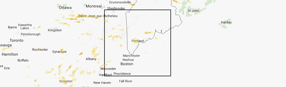
Hail Map for Boothbay Harbor, ME
The Boothbay Harbor, ME area has had 1 report of on-the-ground hail by trained spotters, and has been under severe weather warnings 0 times during the past 12 months. Doppler radar has detected hail at or near Boothbay Harbor, ME on 3 occasions.
| Name: | Boothbay Harbor, ME |
| Where Located: | 34.5 miles ENE of Portland, ME |
| Map: | Google Map for Boothbay Harbor, ME |
| Population: | 1086 |
| Housing Units: | 890 |
| More Info: | Search Google for Boothbay Harbor, ME |
5
The Top Recent Hail Date for Boothbay Harbor, ME is Wednesday, September 11, 2013 (1st out of 3)
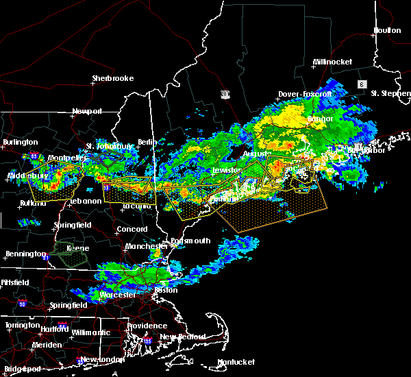
Hail and Wind Damage Spotted near Boothbay Harbor, ME
| Date / Time | Report Details |
|---|---|
| 6/23/2024 9:07 PM EDT |
 The storm which prompted the warning has weakened below severe limits, and no longer poses an immediate threat to life or property. therefore, the warning will be allowed to expire. however, gusty winds are still possible with this thunderstorm. a tornado watch remains in effect until 1000 pm edt for southwestern maine. The storm which prompted the warning has weakened below severe limits, and no longer poses an immediate threat to life or property. therefore, the warning will be allowed to expire. however, gusty winds are still possible with this thunderstorm. a tornado watch remains in effect until 1000 pm edt for southwestern maine.
|
| 6/23/2024 9:02 PM EDT |
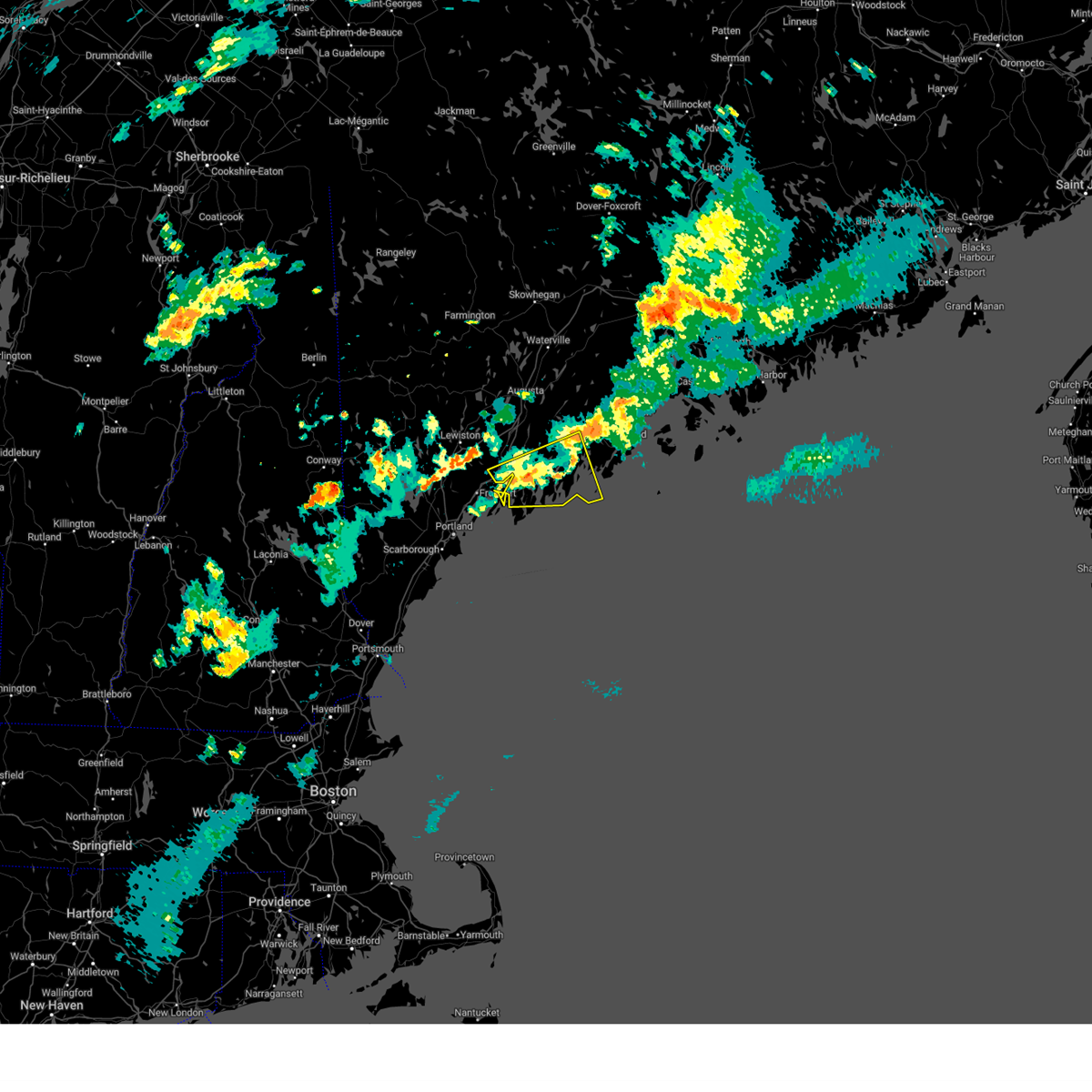 At 902 pm edt, a severe thunderstorm was located near bristol, or near damariscotta, moving east at 55 mph (radar indicated). Hazards include 60 mph wind gusts and quarter size hail. Hail damage to vehicles is expected. expect wind damage to roofs, siding, and trees. locations impacted include, brunswick, bath, damariscotta, topsham, wiscasset, bristol, georgetown, bremen, woolwich, harpswell, boothbay, bowdoinham, jefferson, dresden, edgecomb, friendship, alna, arowsic, nobleboro, and southport. this also includes, pemaquid beach. burnt island, friendship long island, cranberry island, otter island, and thompson island. This includes interstate 295 between mile markers 30 and 35. At 902 pm edt, a severe thunderstorm was located near bristol, or near damariscotta, moving east at 55 mph (radar indicated). Hazards include 60 mph wind gusts and quarter size hail. Hail damage to vehicles is expected. expect wind damage to roofs, siding, and trees. locations impacted include, brunswick, bath, damariscotta, topsham, wiscasset, bristol, georgetown, bremen, woolwich, harpswell, boothbay, bowdoinham, jefferson, dresden, edgecomb, friendship, alna, arowsic, nobleboro, and southport. this also includes, pemaquid beach. burnt island, friendship long island, cranberry island, otter island, and thompson island. This includes interstate 295 between mile markers 30 and 35.
|
| 6/23/2024 9:02 PM EDT |
 the severe thunderstorm warning has been cancelled and is no longer in effect the severe thunderstorm warning has been cancelled and is no longer in effect
|
| 6/23/2024 8:33 PM EDT |
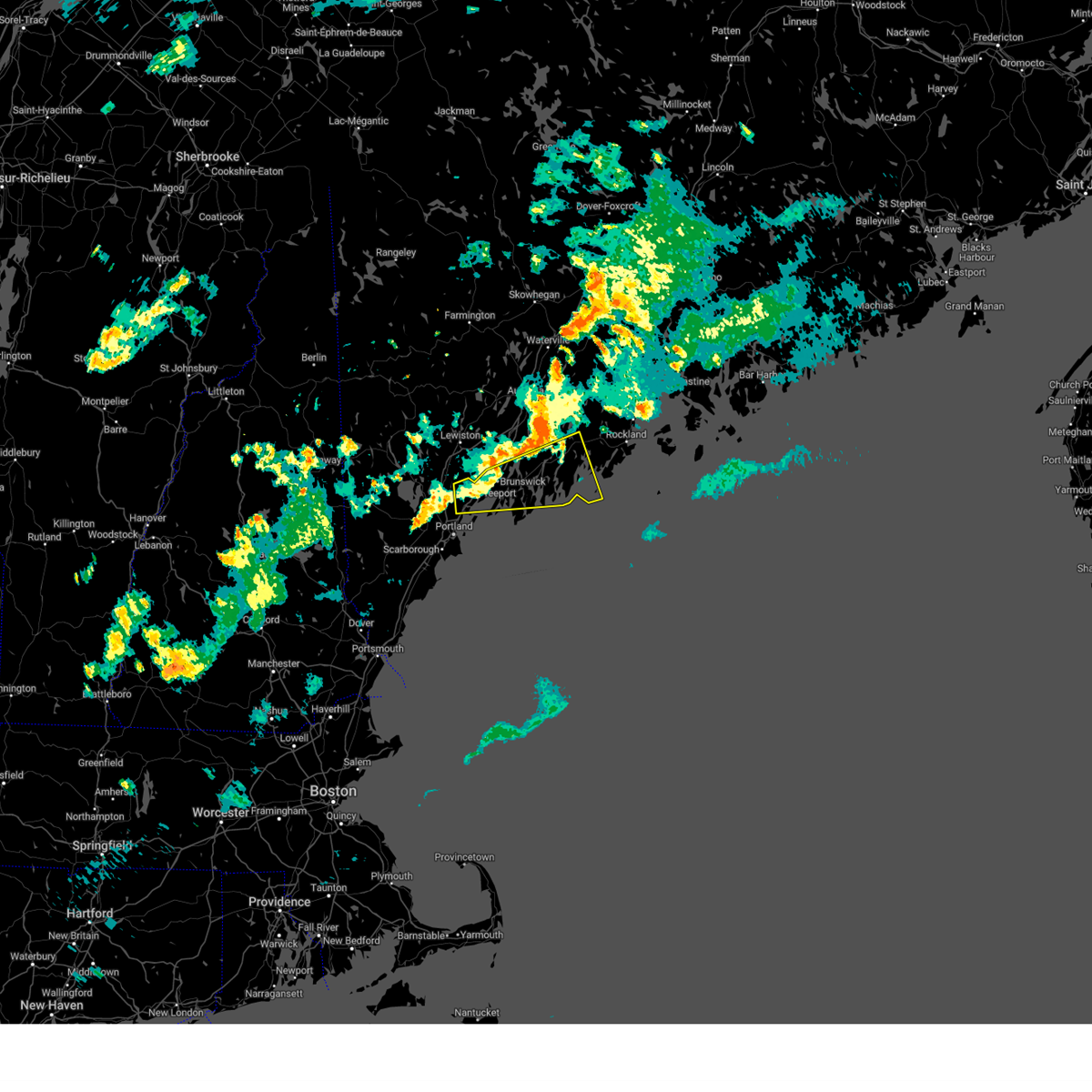 Svrgyx the national weather service in gray maine has issued a * severe thunderstorm warning for, southwestern knox county in south central maine, central lincoln county in south central maine, east central cumberland county in southwestern maine, central sagadahoc county in south central maine, * until 915 pm edt. * at 833 pm edt, a severe thunderstorm was located over freeport, or near brunswick, moving east at 55 mph (radar indicated). Hazards include 60 mph wind gusts and quarter size hail. Hail damage to vehicles is expected. Expect wind damage to roofs, siding, and trees. Svrgyx the national weather service in gray maine has issued a * severe thunderstorm warning for, southwestern knox county in south central maine, central lincoln county in south central maine, east central cumberland county in southwestern maine, central sagadahoc county in south central maine, * until 915 pm edt. * at 833 pm edt, a severe thunderstorm was located over freeport, or near brunswick, moving east at 55 mph (radar indicated). Hazards include 60 mph wind gusts and quarter size hail. Hail damage to vehicles is expected. Expect wind damage to roofs, siding, and trees.
|
| 7/8/2020 6:39 PM EDT |
 At 639 pm edt, severe thunderstorms were located along a line extending from near bristol to falmouth to 6 miles southeast of cornish, moving south at 30 mph (radar indicated). Hazards include 60 mph wind gusts and quarter size hail. Hail damage to vehicles is expected. expect wind damage to roofs, siding, and trees. locations impacted include, portland, south portland, biddeford, brunswick, westbrook, bath, damariscotta, wiscasset, topsham, naples, cumberland, saco, gorham, falmouth, kennebunk, cape elizabeth, buxton, freeport, gray and hollis. this also includes, sebago lake, higgins beach, crescent beach state park, scarborough beach state park, and reid state park. peaks island, long island, cushing island, cousins island, and bailey island. this includes the following highways, interstate 295 between mile markers 1 and 24. Interstate 95 between mile markers 29 and 62. At 639 pm edt, severe thunderstorms were located along a line extending from near bristol to falmouth to 6 miles southeast of cornish, moving south at 30 mph (radar indicated). Hazards include 60 mph wind gusts and quarter size hail. Hail damage to vehicles is expected. expect wind damage to roofs, siding, and trees. locations impacted include, portland, south portland, biddeford, brunswick, westbrook, bath, damariscotta, wiscasset, topsham, naples, cumberland, saco, gorham, falmouth, kennebunk, cape elizabeth, buxton, freeport, gray and hollis. this also includes, sebago lake, higgins beach, crescent beach state park, scarborough beach state park, and reid state park. peaks island, long island, cushing island, cousins island, and bailey island. this includes the following highways, interstate 295 between mile markers 1 and 24. Interstate 95 between mile markers 29 and 62.
|
| 7/8/2020 6:14 PM EDT |
 At 612 pm edt, severe thunderstorms were located along a line extending from 9 miles northeast of damariscotta to near brunswick to hiram, moving southeast at 50 mph. this line of storms has a history of damaging wind gusts. winds may arrive well before the rain arrives (radar indicated and spotter confirmed). Hazards include 60 mph wind gusts and quarter size hail. Hail damage to vehicles is expected. expect wind damage to roofs, siding, and trees. locations impacted include, portland, south portland, biddeford, brunswick, westbrook, bath, damariscotta, topsham, wiscasset, naples, cumberland, saco, gorham, falmouth, kennebunk, cape elizabeth, buxton, freeport, gray and hollis. this also includes, sebago lake, higgins beach, crescent beach state park, scarborough beach state park, and reid state park. peaks island, long island, cushing island, cousins island, and bailey island. this includes the following highways, interstate 295 between mile markers 1 and 41. Interstate 95 between mile markers 29 and 67. At 612 pm edt, severe thunderstorms were located along a line extending from 9 miles northeast of damariscotta to near brunswick to hiram, moving southeast at 50 mph. this line of storms has a history of damaging wind gusts. winds may arrive well before the rain arrives (radar indicated and spotter confirmed). Hazards include 60 mph wind gusts and quarter size hail. Hail damage to vehicles is expected. expect wind damage to roofs, siding, and trees. locations impacted include, portland, south portland, biddeford, brunswick, westbrook, bath, damariscotta, topsham, wiscasset, naples, cumberland, saco, gorham, falmouth, kennebunk, cape elizabeth, buxton, freeport, gray and hollis. this also includes, sebago lake, higgins beach, crescent beach state park, scarborough beach state park, and reid state park. peaks island, long island, cushing island, cousins island, and bailey island. this includes the following highways, interstate 295 between mile markers 1 and 41. Interstate 95 between mile markers 29 and 67.
|
| 7/8/2020 6:02 PM EDT |
 At 601 pm edt, severe thunderstorms were located along a line extending from 11 miles east of farmingdale to near topsham to near hiram, moving southeast at 45 mph (radar indicated). Hazards include 60 mph wind gusts and quarter size hail. Hail damage to vehicles is expected. Expect wind damage to roofs, siding, and trees. At 601 pm edt, severe thunderstorms were located along a line extending from 11 miles east of farmingdale to near topsham to near hiram, moving southeast at 45 mph (radar indicated). Hazards include 60 mph wind gusts and quarter size hail. Hail damage to vehicles is expected. Expect wind damage to roofs, siding, and trees.
|
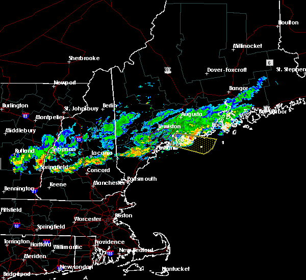
| 6/6/2020 1:47 PM EDT |
 At 147 pm edt, severe thunderstorms were located along a line extending from wiscasset to near georgetown, moving east at 40 mph (radar indicated). Hazards include 60 mph wind gusts. Expect damage to roofs, siding, and trees. locations impacted include, damariscotta, wiscasset, bristol, georgetown, woolwich, boothbay, dresden, edgecomb, alna, westport, southport, south bristol and newcastle. This also includes, pemaquid beach. At 147 pm edt, severe thunderstorms were located along a line extending from wiscasset to near georgetown, moving east at 40 mph (radar indicated). Hazards include 60 mph wind gusts. Expect damage to roofs, siding, and trees. locations impacted include, damariscotta, wiscasset, bristol, georgetown, woolwich, boothbay, dresden, edgecomb, alna, westport, southport, south bristol and newcastle. This also includes, pemaquid beach.
|
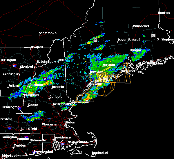
| 6/6/2020 1:15 PM EDT |
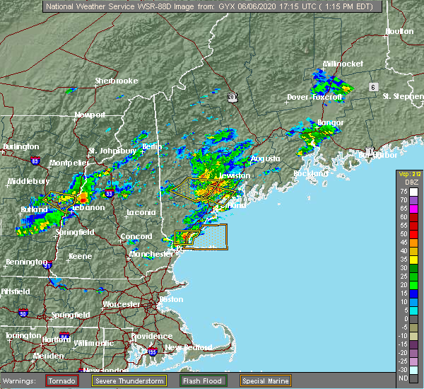 At 115 pm edt, severe thunderstorms were located along a line extending from 7 miles northwest of topsham to near freeport, moving east at 35 mph (radar indicated). Hazards include 60 mph wind gusts and quarter size hail. Hail damage to vehicles is expected. Expect wind damage to roofs, siding, and trees. At 115 pm edt, severe thunderstorms were located along a line extending from 7 miles northwest of topsham to near freeport, moving east at 35 mph (radar indicated). Hazards include 60 mph wind gusts and quarter size hail. Hail damage to vehicles is expected. Expect wind damage to roofs, siding, and trees.
|
| 5/26/2019 2:34 PM EDT |
 At 232 pm edt, a severe thunderstorm was located near wiscasset, moving southeast at 35 mph (radar indicated). Hazards include 60 mph wind gusts and quarter size hail. Hail damage to vehicles is expected. Expect wind damage to roofs, siding, and trees. At 232 pm edt, a severe thunderstorm was located near wiscasset, moving southeast at 35 mph (radar indicated). Hazards include 60 mph wind gusts and quarter size hail. Hail damage to vehicles is expected. Expect wind damage to roofs, siding, and trees.
|
| 9/6/2018 12:46 PM EDT | Pemiquid lighthouse measured wind gust to 69 mp in lincoln county ME, 5.8 miles W of Boothbay Harbor, ME |
| 9/6/2018 12:45 PM EDT |
 At 1223 pm edt, a two severe thunderstorms located near georgetown, and bath, moving east at 40 mph (radar indicated). Hazards include 60 mph wind gusts and quarter size hail. Hail damage to vehicles is expected. Expect wind damage to roofs, siding, and trees. At 1223 pm edt, a two severe thunderstorms located near georgetown, and bath, moving east at 40 mph (radar indicated). Hazards include 60 mph wind gusts and quarter size hail. Hail damage to vehicles is expected. Expect wind damage to roofs, siding, and trees.
|
| 9/6/2018 12:43 PM EDT | Storm damage reported in lincoln county ME, 6.3 miles W of Boothbay Harbor, ME |
| 9/6/2018 12:40 PM EDT | Quarter sized hail reported 1.7 miles S of Boothbay Harbor, ME, quarter size hail. |
| 9/6/2018 12:35 PM EDT | Numerous trees and power lines down. between 6 and 8 power poles down on back river road in lincoln county ME, 1.7 miles S of Boothbay Harbor, ME |
| 9/6/2018 12:24 PM EDT |
 At 1223 pm edt, a two severe thunderstorms located near georgetown, and bath, moving east at 40 mph (radar indicated). Hazards include 60 mph wind gusts and quarter size hail. Hail damage to vehicles is expected. Expect wind damage to roofs, siding, and trees. At 1223 pm edt, a two severe thunderstorms located near georgetown, and bath, moving east at 40 mph (radar indicated). Hazards include 60 mph wind gusts and quarter size hail. Hail damage to vehicles is expected. Expect wind damage to roofs, siding, and trees.
|
| 7/22/2016 10:49 PM EDT |
 At 1048 pm edt, severe thunderstorms were located along a line extending from near damariscotta to near bristol to 15 miles southeast of georgetown, moving east at 40 mph (radar indicated). Hazards include 60 mph wind gusts. Expect damage to roofs. siding. and trees. Locations impacted include, damariscotta, bristol, bremen, boothbay, cushing, edgecomb, friendship, waldoboro, south bristol, southport, newcastle, saint george, south thomaston, nobleboro and owls head. At 1048 pm edt, severe thunderstorms were located along a line extending from near damariscotta to near bristol to 15 miles southeast of georgetown, moving east at 40 mph (radar indicated). Hazards include 60 mph wind gusts. Expect damage to roofs. siding. and trees. Locations impacted include, damariscotta, bristol, bremen, boothbay, cushing, edgecomb, friendship, waldoboro, south bristol, southport, newcastle, saint george, south thomaston, nobleboro and owls head.
|
| 7/22/2016 10:20 PM EDT |
 At 1020 pm edt, severe thunderstorms were located along a line extending from 6 miles northwest of woolwich to georgetown to 19 miles south of bath, moving east at 40 mph (radar indicated). Hazards include 60 mph wind gusts. Expect damage to roofs. siding. And trees. At 1020 pm edt, severe thunderstorms were located along a line extending from 6 miles northwest of woolwich to georgetown to 19 miles south of bath, moving east at 40 mph (radar indicated). Hazards include 60 mph wind gusts. Expect damage to roofs. siding. And trees.
|
| 9/3/2015 3:05 PM EDT |
 At 303 pm edt, doppler radar indicated a severe thunderstorm capable of producing quarter size hail and damaging winds in excess of 60 mph. this storm was located 7 miles southwest of bristol, or 8 miles south of wiscasset, moving south at 20 mph. locations impacted include, wiscasset, bristol, boothbay, edgecomb, south bristol, westport and newcastle. At 303 pm edt, doppler radar indicated a severe thunderstorm capable of producing quarter size hail and damaging winds in excess of 60 mph. this storm was located 7 miles southwest of bristol, or 8 miles south of wiscasset, moving south at 20 mph. locations impacted include, wiscasset, bristol, boothbay, edgecomb, south bristol, westport and newcastle.
|
| 9/3/2015 2:32 PM EDT |
 At 232 pm edt, doppler radar indicated a severe thunderstorm capable of producing quarter size hail and damaging winds in excess of 60 mph. this storm was located near wiscasset, and moving southeast at 15 mph. At 232 pm edt, doppler radar indicated a severe thunderstorm capable of producing quarter size hail and damaging winds in excess of 60 mph. this storm was located near wiscasset, and moving southeast at 15 mph.
|
| 8/4/2015 5:31 PM EDT |
 At 531 pm edt, doppler radar indicated a severe thunderstorm capable of producing large hail up to ping pong ball size and damaging winds in excess of 60 mph. this storm was located over falmouth, or near portland, and moving east at 35 mph. At 531 pm edt, doppler radar indicated a severe thunderstorm capable of producing large hail up to ping pong ball size and damaging winds in excess of 60 mph. this storm was located over falmouth, or near portland, and moving east at 35 mph.
|
| 8/4/2015 4:40 PM EDT |
 At 440 pm edt, doppler radar indicated a severe thunderstorm capable of producing quarter size hail and damaging winds in excess of 60 mph. this storm was located near bath, and moving east at 45 mph. At 440 pm edt, doppler radar indicated a severe thunderstorm capable of producing quarter size hail and damaging winds in excess of 60 mph. this storm was located near bath, and moving east at 45 mph.
|
| 6/17/2013 5:59 PM EDT | Trees down many power outage in lincoln county ME, 3.2 miles W of Boothbay Harbor, ME |
| 6/17/2013 4:06 PM EDT | Trees down many power outage in lincoln county ME, 3.2 miles W of Boothbay Harbor, ME |
| 6/17/2013 4:05 PM EDT | Several trees down. time estimated from rada in lincoln county ME, 1.7 miles S of Boothbay Harbor, ME |
| 8/3/2012 8:05 PM EDT | Limbs down signs ripped off storefronts tents for rotary club auction destroyed in lincoln county ME, 3.6 miles SSE of Boothbay Harbor, ME |
| 8/3/2012 8:00 PM EDT | Numerous trees and wires down all across boothbay in lincoln county ME, 1.7 miles S of Boothbay Harbor, ME |
| 8/3/2012 7:50 PM EDT | Trees and wires down on rt144 in westport island in lincoln county ME, 5.3 miles SE of Boothbay Harbor, ME |
Hail Maps for Boothbay Harbor, ME


Connect with Interactive Hail Maps