

Hail Map for Camden, MI
The Camden, MI area has had 2 reports of on-the-ground hail by trained spotters, and has been under severe weather warnings 25 times during the past 12 months. Doppler radar has detected hail at or near Camden, MI on 33 occasions, including 1 occasion during the past year.
| Name: | Camden, MI |
| Where Located: | 50.3 miles NNE of Fort Wayne, IN |
| Map: | Google Map for Camden, MI |
| Population: | 512 |
| Housing Units: | 211 |
| More Info: | Search Google for Camden, MI |
0
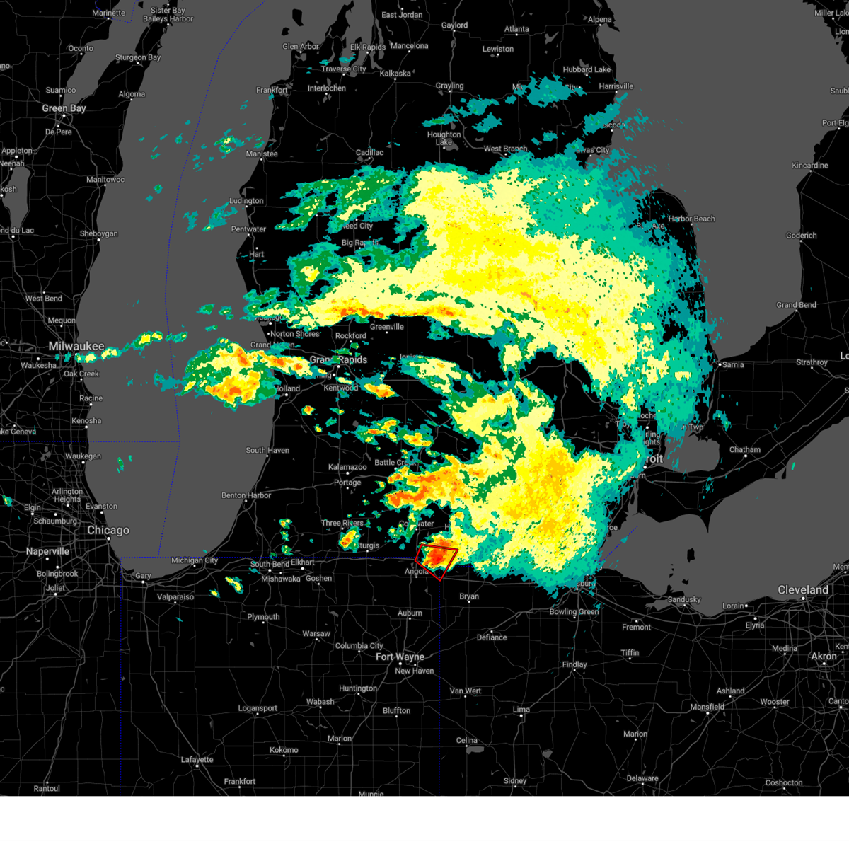
The Top Recent Hail Date for Camden, MI is Sunday, March 30, 2025 (13th out of 33)
Hail and Wind Damage Spotted near Camden, MI
| Date / Time | Report Details |
|---|---|
| 3/30/2025 6:17 PM EDT |
 The storms which prompted the warning have moved out of the area. therefore, the warning has been allowed to expire. however, gusty winds are still possible with these thunderstorms. a severe thunderstorm watch remains in effect until 1000 pm edt for southeastern michigan. The storms which prompted the warning have moved out of the area. therefore, the warning has been allowed to expire. however, gusty winds are still possible with these thunderstorms. a severe thunderstorm watch remains in effect until 1000 pm edt for southeastern michigan.
|
| 3/30/2025 6:08 PM EDT | the severe thunderstorm warning has been cancelled and is no longer in effect |
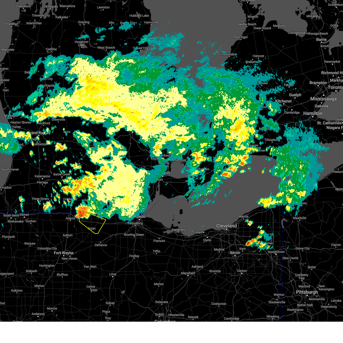
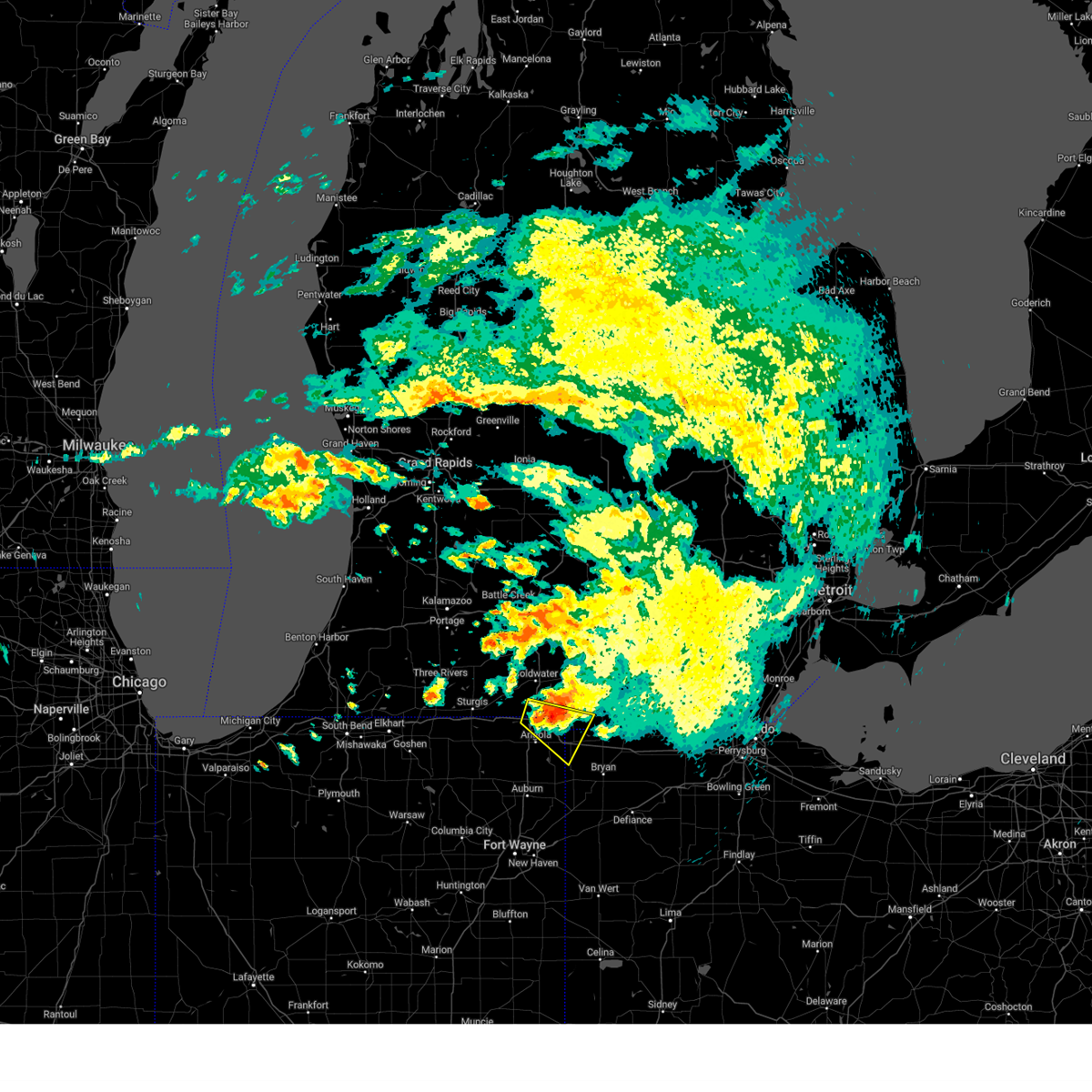
| 3/30/2025 6:08 PM EDT | At 608 pm edt, severe thunderstorms were located along a line extending from 7 miles northeast of pioneer to near hicksville, moving northeast at 50 mph (radar indicated). Hazards include 60 mph wind gusts and nickel size hail. Expect damage to roofs, siding, and trees. locations impacted include, ney, grelton, seward, ridgeville corners, gerald, liberty center, fayette, lake seneca, tedrow, brunersburg, wauseon, antwerp, okolona, mark center, ottokee, kunkle, bryan, jewell, pettisville, and bridgewater center. this includes the following highways, interstate 80 in indiana near mile marker 156. Interstate 80 in ohio between mile markers 0 and 48. |
| 3/30/2025 6:06 PM EDT | the severe thunderstorm warning has been cancelled and is no longer in effect |
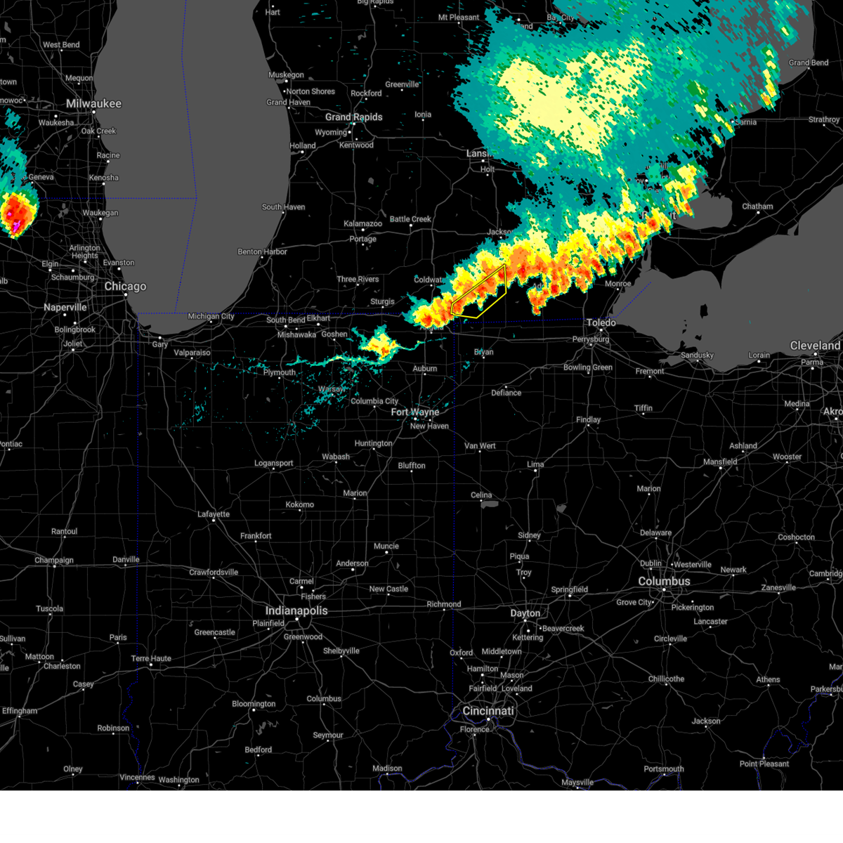
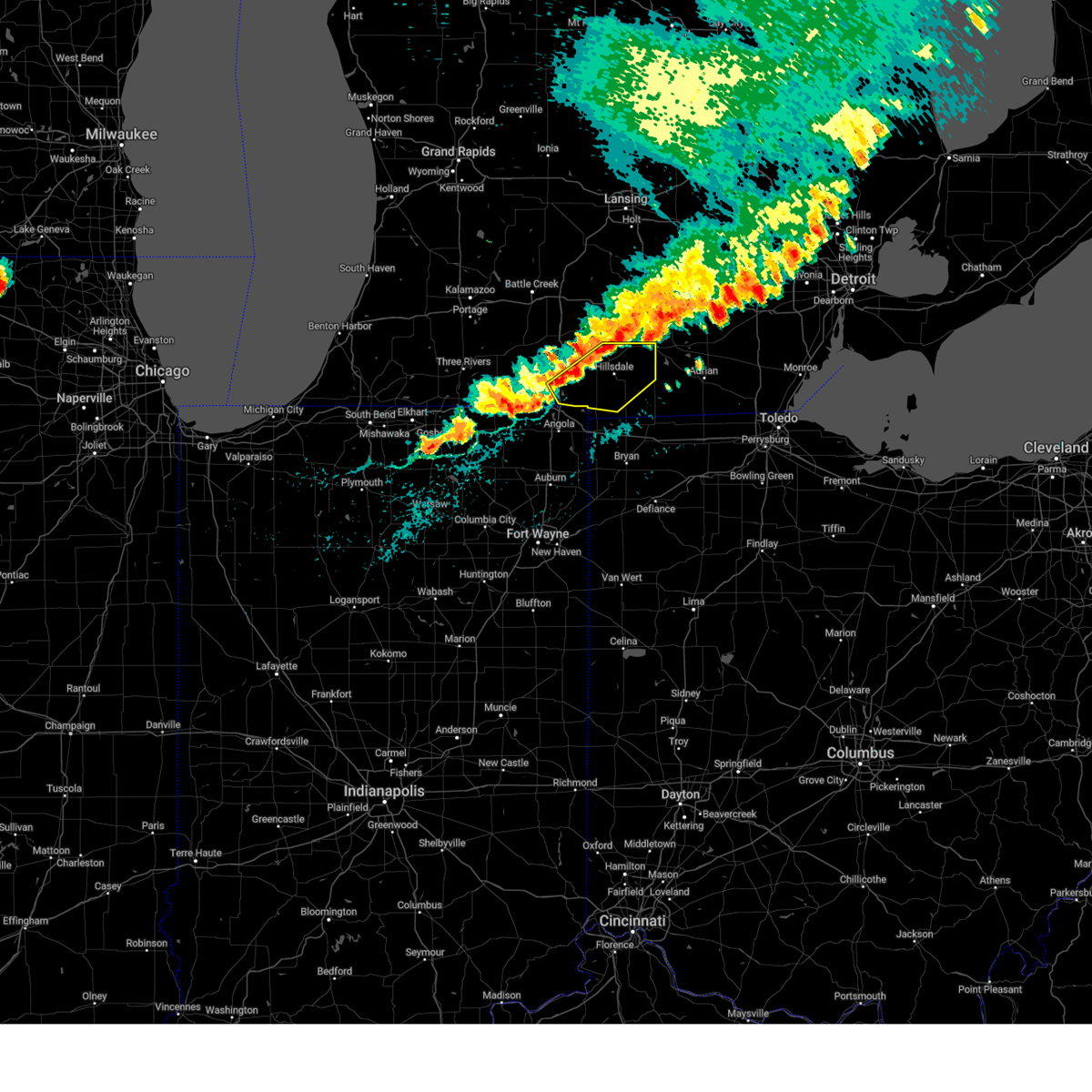
| 3/30/2025 6:06 PM EDT | At 606 pm edt, severe thunderstorms were located along a line extending from near albion to 8 miles northeast of jonesville, moving east at 75 mph (radar indicated). Hazards include 60 mph wind gusts and nickel size hail. Expect damage to roofs, siding, and trees. Locations impacted include, hillsdale, cambria, north adams, litchfield, lake wilson, frontier, allen, moscow, jonesville, reading, pittsford, shadyside, osseo, jerome, somerset center, bear lake, somerset, and camden. |
| 3/30/2025 5:57 PM EDT | At 557 pm edt, severe thunderstorms were located along a line extending from 8 miles west of pioneer to woodburn, moving northeast at 45 mph (radar indicated). Hazards include 70 mph wind gusts and nickel size hail. Expect considerable tree damage. damage is likely to mobile homes, roofs, and outbuildings. locations impacted include, paulding, grelton, ridgeville corners, gerald, liberty center, fayette, lake seneca, zulu, tedrow, antwerp, latty, okolona, mark center, kunkle, worstville, bryan, poe, hessen cassel, florida, and winameg. this includes the following highways, interstate 469 between mile markers 12 and 22. interstate 80 in indiana near mile marker 156. Interstate 80 in ohio between mile markers 0 and 48. |
| 3/30/2025 5:57 PM EDT | The tornado threat has diminished and the tornado warning has been cancelled. however, damaging winds remain likely and a severe thunderstorm warning remains in effect for the area. a tornado watch remains in effect until 800 pm edt for northeastern indiana. a severe thunderstorm watch remains in effect until 1000 pm edt for southeastern michigan, and northwestern ohio. |
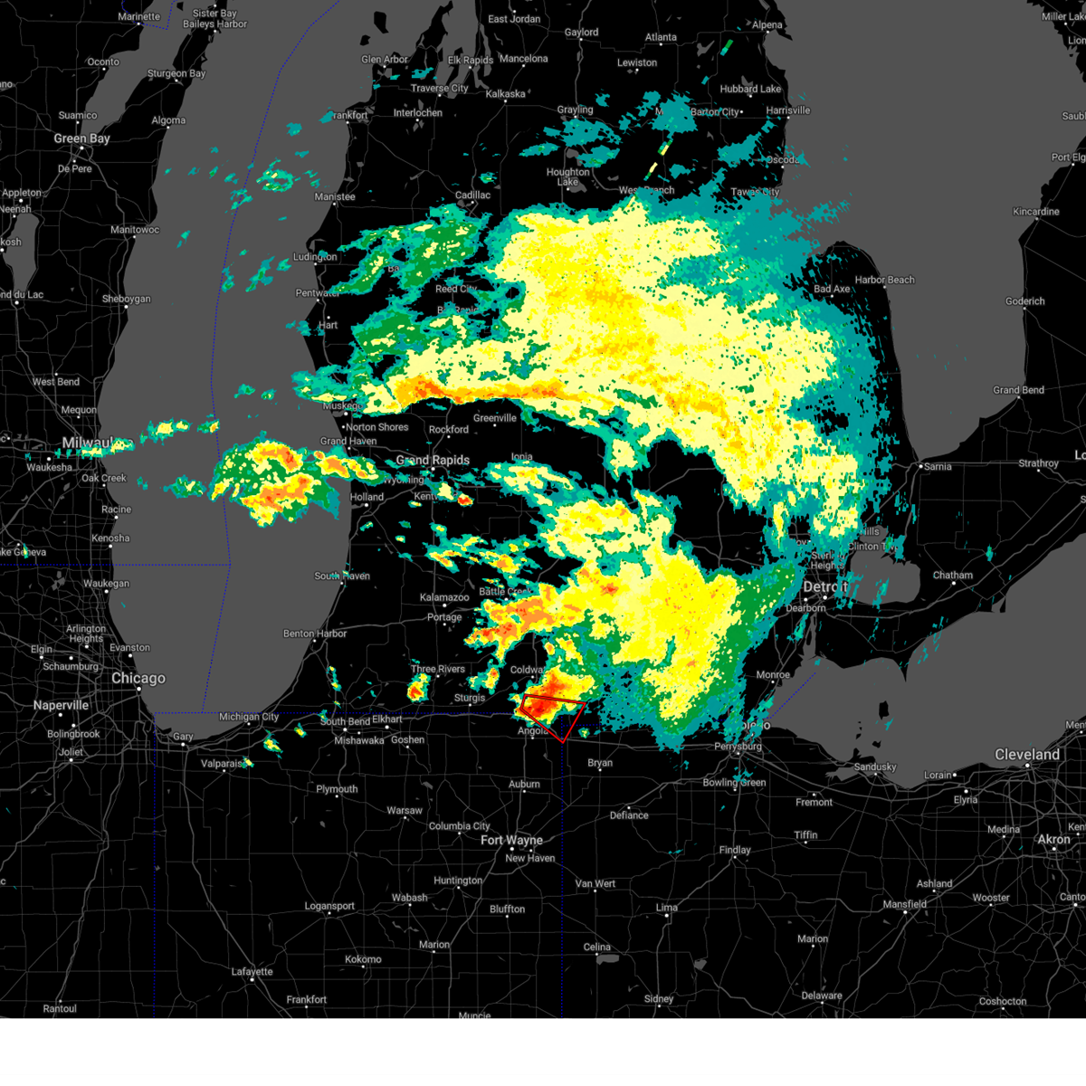
| 3/30/2025 5:51 PM EDT | At 549 pm edt, severe thunderstorms were located along a line extending from near burlington to near quincy, moving northeast at 75 mph. there have been numerous reports of damage in st joseph county, mi of trees and powerlines down as well as power outages (public). Hazards include 60 mph wind gusts and nickel size hail. Expect damage to roofs, siding, and trees. locations impacted include, quincy, girard, north adams, lake wilson, ray, union city, moscow, kinderhook, shadyside, osseo, coldwater, lake of the woods, bear lake, hodunk, coldwater lake, fremont, somerset, camden, hillsdale, and cambria. this includes the following highways, interstate 69 in michigan between mile markers 1 and 21. Interstate 80 in indiana near mile marker 145. |
| 3/30/2025 5:51 PM EDT | the severe thunderstorm warning has been cancelled and is no longer in effect |
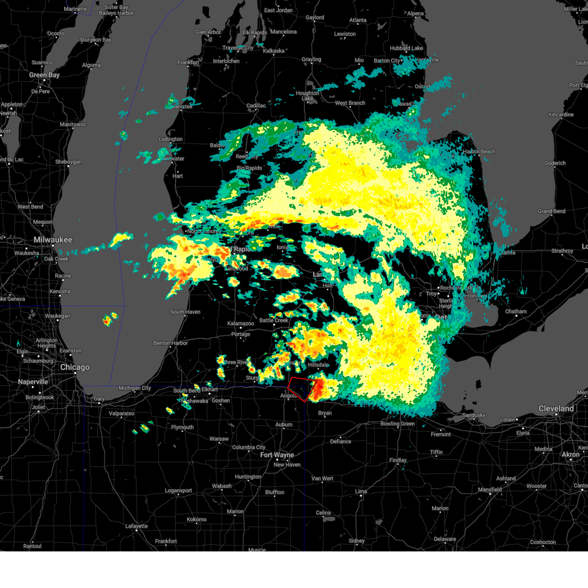
| 3/30/2025 5:48 PM EDT | At 548 pm edt, a severe thunderstorm capable of producing a tornado was located near reading, or 13 miles northwest of montpelier, moving northeast at 70 mph (radar indicated rotation). Hazards include tornado. Flying debris will be dangerous to those caught without shelter. mobile homes will be damaged or destroyed. damage to roofs, windows, and vehicles will occur. tree damage is likely. Locations impacted include, camden, reading, cambria, montgomery, lake wilson, long lake, frontier, nettle lake, allen, bear lake, lake seneca, and pioneer. |
| 3/30/2025 5:48 PM EDT | the tornado warning has been cancelled and is no longer in effect |
| 3/30/2025 5:34 PM EDT |
 Toriwx the national weather service in northern indiana has issued a * tornado warning for, steuben county in northeastern indiana, southeastern branch county in southwestern michigan, southwestern hillsdale county in southeastern michigan, northwestern williams county in northwestern ohio, * until 600 pm edt. * at 533 pm edt, a severe thunderstorm capable of producing a tornado was located over angola, moving northeast at 70 mph (radar indicated rotation). Hazards include tornado. Flying debris will be dangerous to those caught without shelter. mobile homes will be damaged or destroyed. damage to roofs, windows, and vehicles will occur. tree damage is likely. this tornadic thunderstorm will remain over mainly rural areas of steuben, southeastern branch, southwestern hillsdale and northwestern williams counties, including the following locations, camden, cambria, york, montgomery, bridgewater center, lake wilson, frontier, pleasant lake, nettle lake, and ray. this includes the following highways, interstate 69 in indiana between mile markers 341 and 357. interstate 69 in michigan near mile marker 1. interstate 80 in indiana between mile markers 142 and 156. Interstate 80 in ohio between mile markers 0 and 5. Toriwx the national weather service in northern indiana has issued a * tornado warning for, steuben county in northeastern indiana, southeastern branch county in southwestern michigan, southwestern hillsdale county in southeastern michigan, northwestern williams county in northwestern ohio, * until 600 pm edt. * at 533 pm edt, a severe thunderstorm capable of producing a tornado was located over angola, moving northeast at 70 mph (radar indicated rotation). Hazards include tornado. Flying debris will be dangerous to those caught without shelter. mobile homes will be damaged or destroyed. damage to roofs, windows, and vehicles will occur. tree damage is likely. this tornadic thunderstorm will remain over mainly rural areas of steuben, southeastern branch, southwestern hillsdale and northwestern williams counties, including the following locations, camden, cambria, york, montgomery, bridgewater center, lake wilson, frontier, pleasant lake, nettle lake, and ray. this includes the following highways, interstate 69 in indiana between mile markers 341 and 357. interstate 69 in michigan near mile marker 1. interstate 80 in indiana between mile markers 142 and 156. Interstate 80 in ohio between mile markers 0 and 5.
|
| 3/30/2025 5:34 PM EDT |
 Svriwx the national weather service in northern indiana has issued a * severe thunderstorm warning for, steuben county in northeastern indiana, allen county in northeastern indiana, de kalb county in northeastern indiana, southern hillsdale county in southeastern michigan, northern putnam county in west central ohio, defiance county in northwestern ohio, paulding county in west central ohio, henry county in northwestern ohio, northwestern van wert county in west central ohio, williams county in northwestern ohio, fulton county in northwestern ohio, * until 630 pm edt. * at 533 pm edt, severe thunderstorms were located along a line extending from angola to near ossian, moving east at 70 mph (radar indicated). Hazards include 70 mph wind gusts and nickel size hail. Expect considerable tree damage. Damage is likely to mobile homes, roofs, and outbuildings. Svriwx the national weather service in northern indiana has issued a * severe thunderstorm warning for, steuben county in northeastern indiana, allen county in northeastern indiana, de kalb county in northeastern indiana, southern hillsdale county in southeastern michigan, northern putnam county in west central ohio, defiance county in northwestern ohio, paulding county in west central ohio, henry county in northwestern ohio, northwestern van wert county in west central ohio, williams county in northwestern ohio, fulton county in northwestern ohio, * until 630 pm edt. * at 533 pm edt, severe thunderstorms were located along a line extending from angola to near ossian, moving east at 70 mph (radar indicated). Hazards include 70 mph wind gusts and nickel size hail. Expect considerable tree damage. Damage is likely to mobile homes, roofs, and outbuildings.
|
| 3/30/2025 5:30 PM EDT | At 529 pm edt, severe thunderstorms were located along a line extending from 6 miles west of colon to near sturgis, moving northeast at 75 mph. at 529 pm edt, the public reported trees down and a center pivot flipped and twisted in sturgis (public). Hazards include 60 mph wind gusts and nickel size hail. Expect damage to roofs, siding, and trees. locations impacted include, nottawa, girard, ray, sturgis, leonidas, kinderhook, shadyside, howe, coldwater, matteson lake, hodunk, coldwater lake, camden, mongo, montgomery, orland, burr oak, california, allen, and fairfax. this includes the following highways, interstate 69 in indiana between mile markers 355 and 357. interstate 69 in michigan between mile markers 1 and 21. Interstate 80 in indiana between mile markers 120 and 146. |
| 3/30/2025 5:20 PM EDT |
 Svriwx the national weather service in northern indiana has issued a * severe thunderstorm warning for, northern steuben county in northeastern indiana, northern lagrange county in northeastern indiana, st. joseph county in southwestern michigan, branch county in southwestern michigan, hillsdale county in southeastern michigan, * until 615 pm edt. * at 520 pm edt, severe thunderstorms were located along a line extending from three rivers to near white pigeon, moving east at 75 mph (radar indicated). Hazards include 60 mph wind gusts and nickel size hail. expect damage to roofs, siding, and trees Svriwx the national weather service in northern indiana has issued a * severe thunderstorm warning for, northern steuben county in northeastern indiana, northern lagrange county in northeastern indiana, st. joseph county in southwestern michigan, branch county in southwestern michigan, hillsdale county in southeastern michigan, * until 615 pm edt. * at 520 pm edt, severe thunderstorms were located along a line extending from three rivers to near white pigeon, moving east at 75 mph (radar indicated). Hazards include 60 mph wind gusts and nickel size hail. expect damage to roofs, siding, and trees
|
| 8/27/2024 6:15 PM EDT |
 the severe thunderstorm warning has been cancelled and is no longer in effect the severe thunderstorm warning has been cancelled and is no longer in effect
|
| 8/27/2024 6:15 PM EDT |
 At 615 pm edt, severe thunderstorms were located along a line extending from near addison to reading, moving east at 35 mph (radar indicated). Hazards include 60 mph wind gusts and penny size hail. Expect damage to roofs, siding, and trees. These severe thunderstorms will remain over mainly rural areas of central hillsdale county, including the following locations, camden, cambria, pittsford, shadyside, montgomery, osseo, north adams, lake wilson, frontier, and bear lake. At 615 pm edt, severe thunderstorms were located along a line extending from near addison to reading, moving east at 35 mph (radar indicated). Hazards include 60 mph wind gusts and penny size hail. Expect damage to roofs, siding, and trees. These severe thunderstorms will remain over mainly rural areas of central hillsdale county, including the following locations, camden, cambria, pittsford, shadyside, montgomery, osseo, north adams, lake wilson, frontier, and bear lake.
|
| 8/27/2024 5:50 PM EDT |
 Svriwx the national weather service in northern indiana has issued a * severe thunderstorm warning for, southeastern branch county in southwestern michigan, hillsdale county in southeastern michigan, * until 630 pm edt. * at 550 pm edt, severe thunderstorms were located along a line extending from near jonesville to near coldwater, moving east at 30 mph (radar indicated). Hazards include 60 mph wind gusts and penny size hail. Expect damage to roofs, siding, and trees. severe thunderstorms will be near, hillsdale, jonesville, and quincy around 555 pm edt. reading around 605 pm edt. other locations impacted by these severe thunderstorms include camden, cambria, montgomery, north adams, lake wilson, frontier, california, allen, moscow, and kinderhook. This includes interstate 69 in michigan between mile markers 2 and 12. Svriwx the national weather service in northern indiana has issued a * severe thunderstorm warning for, southeastern branch county in southwestern michigan, hillsdale county in southeastern michigan, * until 630 pm edt. * at 550 pm edt, severe thunderstorms were located along a line extending from near jonesville to near coldwater, moving east at 30 mph (radar indicated). Hazards include 60 mph wind gusts and penny size hail. Expect damage to roofs, siding, and trees. severe thunderstorms will be near, hillsdale, jonesville, and quincy around 555 pm edt. reading around 605 pm edt. other locations impacted by these severe thunderstorms include camden, cambria, montgomery, north adams, lake wilson, frontier, california, allen, moscow, and kinderhook. This includes interstate 69 in michigan between mile markers 2 and 12.
|
| 8/6/2024 10:16 AM EDT | Large tree down near territorial road and hillsdale road. time estimated from rada in hillsdale county MI, 7.3 miles WNW of Camden, MI |
| 8/6/2024 10:11 AM EDT |
 The storm which prompted the warning has moved out of the area. therefore, the warning will be allowed to expire. a tornado watch remains in effect until 300 pm edt for northeastern indiana, southeastern and southwestern michigan, and northwestern ohio. The storm which prompted the warning has moved out of the area. therefore, the warning will be allowed to expire. a tornado watch remains in effect until 300 pm edt for northeastern indiana, southeastern and southwestern michigan, and northwestern ohio.
|
| 8/6/2024 10:05 AM EDT |
 Svriwx the national weather service in northern indiana has issued a * severe thunderstorm warning for, southwestern hillsdale county in southeastern michigan, west central fulton county in northwestern ohio, williams county in northwestern ohio, * until 1045 am edt. * at 1005 am edt, a severe thunderstorm was located 7 miles west of pioneer, or 8 miles northwest of montpelier, moving southeast at 30 mph (radar indicated). Hazards include 60 mph wind gusts. expect damage to roofs, siding, and trees Svriwx the national weather service in northern indiana has issued a * severe thunderstorm warning for, southwestern hillsdale county in southeastern michigan, west central fulton county in northwestern ohio, williams county in northwestern ohio, * until 1045 am edt. * at 1005 am edt, a severe thunderstorm was located 7 miles west of pioneer, or 8 miles northwest of montpelier, moving southeast at 30 mph (radar indicated). Hazards include 60 mph wind gusts. expect damage to roofs, siding, and trees
|
| 8/6/2024 9:59 AM EDT |
 At 959 am edt, a severe thunderstorm was located near fremont, or 8 miles northeast of angola, moving southeast at 30 mph (radar indicated). Hazards include 60 mph wind gusts. Expect damage to roofs, siding, and trees. locations impacted include, fremont, edon, columbia, ray, california, camden, montgomery, clear lake, york, nettle lake, lake seneca, berlien, and metz. this includes the following highways, interstate 69 in indiana between mile markers 356 and 357. interstate 69 in michigan near mile marker 1. interstate 80 in indiana between mile markers 144 and 156. Interstate 80 in ohio between mile markers 0 and 5. At 959 am edt, a severe thunderstorm was located near fremont, or 8 miles northeast of angola, moving southeast at 30 mph (radar indicated). Hazards include 60 mph wind gusts. Expect damage to roofs, siding, and trees. locations impacted include, fremont, edon, columbia, ray, california, camden, montgomery, clear lake, york, nettle lake, lake seneca, berlien, and metz. this includes the following highways, interstate 69 in indiana between mile markers 356 and 357. interstate 69 in michigan near mile marker 1. interstate 80 in indiana between mile markers 144 and 156. Interstate 80 in ohio between mile markers 0 and 5.
|
| 8/6/2024 9:57 AM EDT |
 At 955 am edt, a severe thunderstorm capable of producing a tornado was located near fremont, or 12 miles northeast of angola, moving east at 30 mph. a storm spotter initially reported a funnel cloud in the kinderhook, mi area. a wall cloud continues to remain according to the spotter at 9:55am et (radar indicated rotation). Hazards include tornado and 60 mph wind gusts. Flying debris will be dangerous to those caught without shelter. mobile homes will be damaged or destroyed. damage to roofs, windows, and vehicles will occur. tree damage is likely. this tornadic thunderstorm will remain over mainly rural areas of northeastern steuben, southeastern branch, southwestern hillsdale and northwestern williams counties, including the following locations, camden, columbia, york, montgomery, clear lake, ray, and california. this includes the following highways, interstate 69 in indiana between mile markers 356 and 357. interstate 69 in michigan near mile marker 1. interstate 80 in indiana between mile markers 144 and 156. Interstate 80 in ohio between mile markers 0 and 1. At 955 am edt, a severe thunderstorm capable of producing a tornado was located near fremont, or 12 miles northeast of angola, moving east at 30 mph. a storm spotter initially reported a funnel cloud in the kinderhook, mi area. a wall cloud continues to remain according to the spotter at 9:55am et (radar indicated rotation). Hazards include tornado and 60 mph wind gusts. Flying debris will be dangerous to those caught without shelter. mobile homes will be damaged or destroyed. damage to roofs, windows, and vehicles will occur. tree damage is likely. this tornadic thunderstorm will remain over mainly rural areas of northeastern steuben, southeastern branch, southwestern hillsdale and northwestern williams counties, including the following locations, camden, columbia, york, montgomery, clear lake, ray, and california. this includes the following highways, interstate 69 in indiana between mile markers 356 and 357. interstate 69 in michigan near mile marker 1. interstate 80 in indiana between mile markers 144 and 156. Interstate 80 in ohio between mile markers 0 and 1.
|
| 8/6/2024 9:47 AM EDT |
 At 947 am edt, a severe thunderstorm was located over fremont, or 7 miles north of angola, moving southeast at 30 mph (radar indicated). Hazards include 60 mph wind gusts. Expect damage to roofs, siding, and trees. locations impacted include, angola, fremont, edon, columbia, ray, kinderhook, california, camden, montgomery, clear lake, york, alvarado, nevada mills, nettle lake, berlien, lake james, metz, coldwater lake, and lake seneca. this includes the following highways, interstate 69 in indiana between mile markers 352 and 357. interstate 69 in michigan between mile markers 1 and 6. interstate 80 in indiana between mile markers 139 and 156. Interstate 80 in ohio between mile markers 0 and 5. At 947 am edt, a severe thunderstorm was located over fremont, or 7 miles north of angola, moving southeast at 30 mph (radar indicated). Hazards include 60 mph wind gusts. Expect damage to roofs, siding, and trees. locations impacted include, angola, fremont, edon, columbia, ray, kinderhook, california, camden, montgomery, clear lake, york, alvarado, nevada mills, nettle lake, berlien, lake james, metz, coldwater lake, and lake seneca. this includes the following highways, interstate 69 in indiana between mile markers 352 and 357. interstate 69 in michigan between mile markers 1 and 6. interstate 80 in indiana between mile markers 139 and 156. Interstate 80 in ohio between mile markers 0 and 5.
|
| 8/6/2024 9:44 AM EDT |
 Toriwx the national weather service in northern indiana has issued a * tornado warning for, northeastern steuben county in northeastern indiana, southeastern branch county in southwestern michigan, southwestern hillsdale county in southeastern michigan, northwestern williams county in northwestern ohio, * until 1015 am edt. * at 943 am edt, a severe thunderstorm capable of producing a tornado was located near fremont, or 9 miles south of coldwater, moving east at 30 mph. storm spotters also reported a funnel cloud near kinderhood of branch county, michigan (radar indicated rotation). Hazards include tornado. Flying debris will be dangerous to those caught without shelter. mobile homes will be damaged or destroyed. damage to roofs, windows, and vehicles will occur. tree damage is likely. this dangerous storm will be near, fremont around 950 am edt. other locations impacted by this tornadic thunderstorm include camden, kinderhook, columbia, york, montgomery, clear lake, ray, california, coldwater lake, and lake of the woods. this includes the following highways, interstate 69 in indiana between mile markers 356 and 357. interstate 69 in michigan between mile markers 1 and 6. interstate 80 in indiana between mile markers 142 and 156. Interstate 80 in ohio between mile markers 0 and 1. Toriwx the national weather service in northern indiana has issued a * tornado warning for, northeastern steuben county in northeastern indiana, southeastern branch county in southwestern michigan, southwestern hillsdale county in southeastern michigan, northwestern williams county in northwestern ohio, * until 1015 am edt. * at 943 am edt, a severe thunderstorm capable of producing a tornado was located near fremont, or 9 miles south of coldwater, moving east at 30 mph. storm spotters also reported a funnel cloud near kinderhood of branch county, michigan (radar indicated rotation). Hazards include tornado. Flying debris will be dangerous to those caught without shelter. mobile homes will be damaged or destroyed. damage to roofs, windows, and vehicles will occur. tree damage is likely. this dangerous storm will be near, fremont around 950 am edt. other locations impacted by this tornadic thunderstorm include camden, kinderhook, columbia, york, montgomery, clear lake, ray, california, coldwater lake, and lake of the woods. this includes the following highways, interstate 69 in indiana between mile markers 356 and 357. interstate 69 in michigan between mile markers 1 and 6. interstate 80 in indiana between mile markers 142 and 156. Interstate 80 in ohio between mile markers 0 and 1.
|
| 8/6/2024 9:34 AM EDT |
 Svriwx the national weather service in northern indiana has issued a * severe thunderstorm warning for, northeastern steuben county in northeastern indiana, southeastern branch county in southwestern michigan, southwestern hillsdale county in southeastern michigan, northwestern williams county in northwestern ohio, * until 1015 am edt. * at 934 am edt, a severe thunderstorm was located 7 miles northwest of fremont, or 10 miles north of angola, moving southeast at 30 mph (radar indicated). Hazards include 60 mph wind gusts and quarter size hail. Hail damage to vehicles is expected. Expect wind damage to roofs, siding, and trees. Svriwx the national weather service in northern indiana has issued a * severe thunderstorm warning for, northeastern steuben county in northeastern indiana, southeastern branch county in southwestern michigan, southwestern hillsdale county in southeastern michigan, northwestern williams county in northwestern ohio, * until 1015 am edt. * at 934 am edt, a severe thunderstorm was located 7 miles northwest of fremont, or 10 miles north of angola, moving southeast at 30 mph (radar indicated). Hazards include 60 mph wind gusts and quarter size hail. Hail damage to vehicles is expected. Expect wind damage to roofs, siding, and trees.
|
| 5/7/2024 7:37 PM EDT |
 the severe thunderstorm warning has been cancelled and is no longer in effect the severe thunderstorm warning has been cancelled and is no longer in effect
|
| 5/7/2024 7:37 PM EDT |
 At 737 pm edt, a severe thunderstorm was located near reading, or 13 miles northwest of montpelier, moving northeast at 45 mph (radar indicated). Hazards include two inch hail and 60 mph wind gusts. People and animals outdoors will be injured. expect hail damage to roofs, siding, windows, and vehicles. expect wind damage to roofs, siding, and trees. Locations impacted include, hillsdale, reading, jerome, somerset, cambria, pittsford, ransom, camden, north adams, bear lake, lake wilson, frontier, shadyside, osseo, and somerset center. At 737 pm edt, a severe thunderstorm was located near reading, or 13 miles northwest of montpelier, moving northeast at 45 mph (radar indicated). Hazards include two inch hail and 60 mph wind gusts. People and animals outdoors will be injured. expect hail damage to roofs, siding, windows, and vehicles. expect wind damage to roofs, siding, and trees. Locations impacted include, hillsdale, reading, jerome, somerset, cambria, pittsford, ransom, camden, north adams, bear lake, lake wilson, frontier, shadyside, osseo, and somerset center.
|
| 5/7/2024 7:24 PM EDT |
 Svriwx the national weather service in northern indiana has issued a * severe thunderstorm warning for, eastern steuben county in northeastern indiana, hillsdale county in southeastern michigan, northwestern williams county in northwestern ohio, * until 815 pm edt. * at 722 pm edt, a severe thunderstorm was located near angola, moving northeast at 45 mph. ping pong hail was reported in angola around 720 pm edt. this storm has had a history of producing hail up to 2 to 3 inches in diameter. this is a destructive storm for berlien, camden, osseo, and clear lake (radar indicated). Hazards include baseball size hail and 60 mph wind gusts. People and animals outdoors will be severely injured. Expect shattered windows, extensive damage to roofs, siding, and vehicles. Svriwx the national weather service in northern indiana has issued a * severe thunderstorm warning for, eastern steuben county in northeastern indiana, hillsdale county in southeastern michigan, northwestern williams county in northwestern ohio, * until 815 pm edt. * at 722 pm edt, a severe thunderstorm was located near angola, moving northeast at 45 mph. ping pong hail was reported in angola around 720 pm edt. this storm has had a history of producing hail up to 2 to 3 inches in diameter. this is a destructive storm for berlien, camden, osseo, and clear lake (radar indicated). Hazards include baseball size hail and 60 mph wind gusts. People and animals outdoors will be severely injured. Expect shattered windows, extensive damage to roofs, siding, and vehicles.
|
| 5/7/2024 6:57 PM EDT |
 The storm which prompted the warning has moved out of the area. therefore, the warning will be allowed to expire. a tornado watch remains in effect until 1100 pm edt for northeastern indiana, and southeastern and southwestern michigan. remember, a tornado warning still remains in effect for eastern hillsdale county until 730 pm edt. The storm which prompted the warning has moved out of the area. therefore, the warning will be allowed to expire. a tornado watch remains in effect until 1100 pm edt for northeastern indiana, and southeastern and southwestern michigan. remember, a tornado warning still remains in effect for eastern hillsdale county until 730 pm edt.
|
| 5/7/2024 6:41 PM EDT |
 the tornado warning has been cancelled and is no longer in effect the tornado warning has been cancelled and is no longer in effect
|
| 5/7/2024 6:41 PM EDT |
 At 641 pm edt, a confirmed large and extremely dangerous tornado was located near reading, or 13 miles northeast of angola, moving east at 25 mph. this is a particularly dangerous situation. take cover now! (weather spotters confirmed tornado). Hazards include damaging tornado. You are in a life-threatening situation. flying debris may be deadly to those caught without shelter. mobile homes will be destroyed. considerable damage to homes, businesses, and vehicles is likely and complete destruction is possible. This tornadic thunderstorm will remain over mainly rural areas of southwestern hillsdale county, including the following locations, camden, cambria, frontier, bear lake, and montgomery. At 641 pm edt, a confirmed large and extremely dangerous tornado was located near reading, or 13 miles northeast of angola, moving east at 25 mph. this is a particularly dangerous situation. take cover now! (weather spotters confirmed tornado). Hazards include damaging tornado. You are in a life-threatening situation. flying debris may be deadly to those caught without shelter. mobile homes will be destroyed. considerable damage to homes, businesses, and vehicles is likely and complete destruction is possible. This tornadic thunderstorm will remain over mainly rural areas of southwestern hillsdale county, including the following locations, camden, cambria, frontier, bear lake, and montgomery.
|
| 5/7/2024 6:26 PM EDT |
 At 626 pm edt, a confirmed large and extremely dangerous tornado was located over fremont, or 8 miles northeast of angola, moving northeast at 30 mph. emergency management reports a tornado is on the ground southwest of fremont. this is a particularly dangerous situation. take cover now! (emergency management confirmed tornado). Hazards include damaging tornado. You are in a life-threatening situation. flying debris may be deadly to those caught without shelter. mobile homes will be destroyed. considerable damage to homes, businesses, and vehicles is likely and complete destruction is possible. the tornado will be near, reading around 640 pm edt. other locations impacted by this tornadic thunderstorm include camden, cambria, montgomery, lake wilson, clear lake, long lake, frontier, ray, california, and allen. this includes the following highways, interstate 69 in indiana between mile markers 353 and 357. interstate 69 in michigan near mile marker 1. Interstate 80 in indiana between mile markers 143 and 151. At 626 pm edt, a confirmed large and extremely dangerous tornado was located over fremont, or 8 miles northeast of angola, moving northeast at 30 mph. emergency management reports a tornado is on the ground southwest of fremont. this is a particularly dangerous situation. take cover now! (emergency management confirmed tornado). Hazards include damaging tornado. You are in a life-threatening situation. flying debris may be deadly to those caught without shelter. mobile homes will be destroyed. considerable damage to homes, businesses, and vehicles is likely and complete destruction is possible. the tornado will be near, reading around 640 pm edt. other locations impacted by this tornadic thunderstorm include camden, cambria, montgomery, lake wilson, clear lake, long lake, frontier, ray, california, and allen. this includes the following highways, interstate 69 in indiana between mile markers 353 and 357. interstate 69 in michigan near mile marker 1. Interstate 80 in indiana between mile markers 143 and 151.
|
| 5/7/2024 6:15 PM EDT |
 Toriwx the national weather service in northern indiana has issued a * tornado warning for, northern steuben county in northeastern indiana, southeastern branch county in southwestern michigan, southwestern hillsdale county in southeastern michigan, * until 700 pm edt. * at 615 pm edt, a severe thunderstorm capable of producing a tornado was located over angola, moving northeast at 30 mph (radar indicated rotation). Hazards include tornado and quarter size hail. Flying debris will be dangerous to those caught without shelter. mobile homes will be damaged or destroyed. damage to roofs, windows, and vehicles will occur. tree damage is likely. this dangerous storm will be near, fremont around 620 pm edt. reading around 640 pm edt. other locations impacted by this tornadic thunderstorm include camden, cambria, montgomery, lake wilson, frontier, ray, california, crooked lake, allen, and clear lake. this includes the following highways, interstate 69 in indiana between mile markers 348 and 357. interstate 69 in michigan between mile markers 1 and 2. Interstate 80 in indiana between mile markers 142 and 151. Toriwx the national weather service in northern indiana has issued a * tornado warning for, northern steuben county in northeastern indiana, southeastern branch county in southwestern michigan, southwestern hillsdale county in southeastern michigan, * until 700 pm edt. * at 615 pm edt, a severe thunderstorm capable of producing a tornado was located over angola, moving northeast at 30 mph (radar indicated rotation). Hazards include tornado and quarter size hail. Flying debris will be dangerous to those caught without shelter. mobile homes will be damaged or destroyed. damage to roofs, windows, and vehicles will occur. tree damage is likely. this dangerous storm will be near, fremont around 620 pm edt. reading around 640 pm edt. other locations impacted by this tornadic thunderstorm include camden, cambria, montgomery, lake wilson, frontier, ray, california, crooked lake, allen, and clear lake. this includes the following highways, interstate 69 in indiana between mile markers 348 and 357. interstate 69 in michigan between mile markers 1 and 2. Interstate 80 in indiana between mile markers 142 and 151.
|
| 3/26/2024 4:51 PM EDT |
 The severe thunderstorm which prompted the warning has weakened. therefore, the warning will be allowed to expire. however, gusty winds are still possible with this thunderstorm. The severe thunderstorm which prompted the warning has weakened. therefore, the warning will be allowed to expire. however, gusty winds are still possible with this thunderstorm.
|
| 3/26/2024 4:48 PM EDT |
 At 448 pm edt, a severe thunderstorm was located near pioneer, or 8 miles north of montpelier, moving northeast at 55 mph (radar indicated). Hazards include 60 mph wind gusts and penny size hail. Expect damage to roofs, siding, and trees. locations impacted include, montpelier, edgerton, pioneer, holiday city, camden, blakeslee, bridgewater center, nettle lake, and lake seneca. This includes interstate 80 in ohio between mile markers 2 and 14. At 448 pm edt, a severe thunderstorm was located near pioneer, or 8 miles north of montpelier, moving northeast at 55 mph (radar indicated). Hazards include 60 mph wind gusts and penny size hail. Expect damage to roofs, siding, and trees. locations impacted include, montpelier, edgerton, pioneer, holiday city, camden, blakeslee, bridgewater center, nettle lake, and lake seneca. This includes interstate 80 in ohio between mile markers 2 and 14.
|
| 3/26/2024 4:39 PM EDT |
 the severe thunderstorm warning has been cancelled and is no longer in effect the severe thunderstorm warning has been cancelled and is no longer in effect
|
| 3/26/2024 4:39 PM EDT |
 At 439 pm edt, a severe thunderstorm was located over edon, or 7 miles west of montpelier, moving northeast at 55 mph (radar indicated). Hazards include 60 mph wind gusts and penny size hail. Expect damage to roofs, siding, and trees. locations impacted include, montpelier, edgerton, pioneer, edon, holiday city, columbia, camden, blakeslee, bridgewater center, nettle lake, and lake seneca. This includes interstate 80 in ohio between mile markers 0 and 14. At 439 pm edt, a severe thunderstorm was located over edon, or 7 miles west of montpelier, moving northeast at 55 mph (radar indicated). Hazards include 60 mph wind gusts and penny size hail. Expect damage to roofs, siding, and trees. locations impacted include, montpelier, edgerton, pioneer, edon, holiday city, columbia, camden, blakeslee, bridgewater center, nettle lake, and lake seneca. This includes interstate 80 in ohio between mile markers 0 and 14.
|
| 3/26/2024 4:35 PM EDT |
 At 434 pm edt, a severe thunderstorm was located over edon, or 8 miles northeast of butler, moving northeast at 55 mph (radar indicated). Hazards include 60 mph wind gusts and penny size hail. Expect damage to roofs, siding, and trees. locations impacted include, montpelier, edgerton, hamilton, pioneer, edon, holiday city, columbia, camden, york, blakeslee, alvarado, bridgewater center, nettle lake, lake seneca, artic, and metz. this includes the following highways, interstate 80 in indiana between mile markers 154 and 156. Interstate 80 in ohio between mile markers 0 and 14. At 434 pm edt, a severe thunderstorm was located over edon, or 8 miles northeast of butler, moving northeast at 55 mph (radar indicated). Hazards include 60 mph wind gusts and penny size hail. Expect damage to roofs, siding, and trees. locations impacted include, montpelier, edgerton, hamilton, pioneer, edon, holiday city, columbia, camden, york, blakeslee, alvarado, bridgewater center, nettle lake, lake seneca, artic, and metz. this includes the following highways, interstate 80 in indiana between mile markers 154 and 156. Interstate 80 in ohio between mile markers 0 and 14.
|
| 3/26/2024 4:23 PM EDT |
 Svriwx the national weather service in northern indiana has issued a * severe thunderstorm warning for, southeastern steuben county in northeastern indiana, northeastern de kalb county in northeastern indiana, southwestern hillsdale county in southeastern michigan, western williams county in northwestern ohio, * until 500 pm edt. * at 423 pm edt, a severe thunderstorm was located over butler, moving northeast at 55 mph (radar indicated). Hazards include 60 mph wind gusts and nickel size hail. expect damage to roofs, siding, and trees Svriwx the national weather service in northern indiana has issued a * severe thunderstorm warning for, southeastern steuben county in northeastern indiana, northeastern de kalb county in northeastern indiana, southwestern hillsdale county in southeastern michigan, western williams county in northwestern ohio, * until 500 pm edt. * at 423 pm edt, a severe thunderstorm was located over butler, moving northeast at 55 mph (radar indicated). Hazards include 60 mph wind gusts and nickel size hail. expect damage to roofs, siding, and trees
|
| 7/26/2023 1:56 PM EDT |
 At 155 pm edt, a severe thunderstorm was located near reading, or 12 miles southeast of coldwater, moving east at 55 mph (radar indicated). Hazards include 60 mph wind gusts and penny size hail. Expect damage to roofs, siding, and trees. this severe thunderstorm will be near, reading around 200 pm edt. hillsdale around 205 pm edt. other locations impacted by this severe thunderstorm include camden, prattville, cambria, montgomery, north adams, lake wilson, waldron, frontier, ransom, and allen. hail threat, radar indicated max hail size, 0. 75 in wind threat, radar indicated max wind gust, 60 mph. At 155 pm edt, a severe thunderstorm was located near reading, or 12 miles southeast of coldwater, moving east at 55 mph (radar indicated). Hazards include 60 mph wind gusts and penny size hail. Expect damage to roofs, siding, and trees. this severe thunderstorm will be near, reading around 200 pm edt. hillsdale around 205 pm edt. other locations impacted by this severe thunderstorm include camden, prattville, cambria, montgomery, north adams, lake wilson, waldron, frontier, ransom, and allen. hail threat, radar indicated max hail size, 0. 75 in wind threat, radar indicated max wind gust, 60 mph.
|
| 6/25/2023 4:47 PM EDT |
 At 445 pm edt, severe thunderstorms were located along a line extending from near reading to near holiday city to near edgerton, moving east at 50 mph. numerous reports of structural damage to homes as well as trees in steuben county. these are destructive storms for eastern williams and all of fulton county (radar indicated). Hazards include 80 mph wind gusts and nickel size hail. Flying debris will be dangerous to those caught without shelter. mobile homes will be heavily damaged. expect considerable damage to roofs, windows, and vehicles. Extensive tree damage and power outages are likely. At 445 pm edt, severe thunderstorms were located along a line extending from near reading to near holiday city to near edgerton, moving east at 50 mph. numerous reports of structural damage to homes as well as trees in steuben county. these are destructive storms for eastern williams and all of fulton county (radar indicated). Hazards include 80 mph wind gusts and nickel size hail. Flying debris will be dangerous to those caught without shelter. mobile homes will be heavily damaged. expect considerable damage to roofs, windows, and vehicles. Extensive tree damage and power outages are likely.
|
| 6/25/2023 4:24 PM EDT |
 At 424 pm edt, severe thunderstorms were located along a line extending from 6 miles west of angola to hamilton to waterloo, moving east at 55 mph (radar indicated). Hazards include 70 mph wind gusts and quarter size hail. Hail damage to vehicles is expected. expect considerable tree damage. Wind damage is also likely to mobile homes, roofs, and outbuildings. At 424 pm edt, severe thunderstorms were located along a line extending from 6 miles west of angola to hamilton to waterloo, moving east at 55 mph (radar indicated). Hazards include 70 mph wind gusts and quarter size hail. Hail damage to vehicles is expected. expect considerable tree damage. Wind damage is also likely to mobile homes, roofs, and outbuildings.
|
| 8/29/2022 5:06 PM EDT |
 At 506 pm edt, severe thunderstorms were located along a line extending from 6 miles east of jonesville to near montpelier, moving east at 50 mph (radar indicated). Hazards include 60 mph wind gusts. Expect damage to roofs, siding, and trees. locations impacted include, bryan, hillsdale, montpelier, jonesville, edgerton, west unity, pioneer, litchfield, stryker, reading, edon, holiday city, edgerton in williams county, long lake, jerome, somerset, columbia, west jefferson, cambria and pulaski. this includes interstate 80 in ohio between mile markers 1 and 22. hail threat, radar indicated max hail size, <. 75 in wind threat, radar indicated max wind gust, 60 mph. At 506 pm edt, severe thunderstorms were located along a line extending from 6 miles east of jonesville to near montpelier, moving east at 50 mph (radar indicated). Hazards include 60 mph wind gusts. Expect damage to roofs, siding, and trees. locations impacted include, bryan, hillsdale, montpelier, jonesville, edgerton, west unity, pioneer, litchfield, stryker, reading, edon, holiday city, edgerton in williams county, long lake, jerome, somerset, columbia, west jefferson, cambria and pulaski. this includes interstate 80 in ohio between mile markers 1 and 22. hail threat, radar indicated max hail size, <. 75 in wind threat, radar indicated max wind gust, 60 mph.
|
| 8/29/2022 4:42 PM EDT |
 At 441 pm edt, severe thunderstorms were located along a line extending from near quincy to 6 miles west of hamilton, moving east at 55 mph (radar indicated). Hazards include 60 mph wind gusts. expect damage to roofs, siding, and trees At 441 pm edt, severe thunderstorms were located along a line extending from near quincy to 6 miles west of hamilton, moving east at 55 mph (radar indicated). Hazards include 60 mph wind gusts. expect damage to roofs, siding, and trees
|
| 6/13/2022 9:11 PM EDT |
 At 911 pm edt, a severe thunderstorm was located near fremont, or 8 miles northeast of angola, moving east at 45 mph (radar indicated). Hazards include 70 mph wind gusts and half dollar size hail. Hail damage to vehicles is expected. expect considerable tree damage. Wind damage is also likely to mobile homes, roofs, and outbuildings. At 911 pm edt, a severe thunderstorm was located near fremont, or 8 miles northeast of angola, moving east at 45 mph (radar indicated). Hazards include 70 mph wind gusts and half dollar size hail. Hail damage to vehicles is expected. expect considerable tree damage. Wind damage is also likely to mobile homes, roofs, and outbuildings.
|
| 8/12/2021 6:42 AM EDT |
 The severe thunderstorm warning for northeastern steuben, eastern branch and hillsdale counties will expire at 645 am edt, the storms which prompted the warning have moved out of the area. therefore, the warning will be allowed to expire. however gusty winds are still possible with these thunderstorms through 7 am edt. The severe thunderstorm warning for northeastern steuben, eastern branch and hillsdale counties will expire at 645 am edt, the storms which prompted the warning have moved out of the area. therefore, the warning will be allowed to expire. however gusty winds are still possible with these thunderstorms through 7 am edt.
|
| 8/12/2021 6:12 AM EDT |
 At 612 am edt, severe thunderstorms were located along a line extending from near litchfield to near fremont, moving northeast at 60 mph (radar indicated). Hazards include 60 mph wind gusts. Expect damage to roofs, siding, and trees. severe thunderstorms will be near, litchfield around 615 am edt. jonesville around 620 am edt. hillsdale around 625 am edt. hail threat, radar indicated max hail size, <. 75 in wind threat, radar indicated max wind gust, 60 mph. At 612 am edt, severe thunderstorms were located along a line extending from near litchfield to near fremont, moving northeast at 60 mph (radar indicated). Hazards include 60 mph wind gusts. Expect damage to roofs, siding, and trees. severe thunderstorms will be near, litchfield around 615 am edt. jonesville around 620 am edt. hillsdale around 625 am edt. hail threat, radar indicated max hail size, <. 75 in wind threat, radar indicated max wind gust, 60 mph.
|
| 8/11/2021 2:24 PM EDT |
 At 224 pm edt, severe thunderstorms were located along a line extending from near litchfield to 8 miles north of pioneer to near bryan, moving east at 45 mph (radar indicated). Hazards include 60 mph wind gusts and penny size hail. Expect damage to roofs, siding, and trees. locations impacted include, napoleon, bryan, hillsdale, wauseon, archbold, montpelier, butler, jonesville, waterloo, edgerton, west unity, hamilton, pioneer, litchfield, stryker, fayette, reading, edon, holiday city and edgerton in williams county. this includes the following highways, interstate 80 in indiana between mile markers 150 and 156. interstate 80 in ohio between mile markers 0 and 36. hail threat, radar indicated max hail size, 0. 75 in wind threat, radar indicated max wind gust, 60 mph. At 224 pm edt, severe thunderstorms were located along a line extending from near litchfield to 8 miles north of pioneer to near bryan, moving east at 45 mph (radar indicated). Hazards include 60 mph wind gusts and penny size hail. Expect damage to roofs, siding, and trees. locations impacted include, napoleon, bryan, hillsdale, wauseon, archbold, montpelier, butler, jonesville, waterloo, edgerton, west unity, hamilton, pioneer, litchfield, stryker, fayette, reading, edon, holiday city and edgerton in williams county. this includes the following highways, interstate 80 in indiana between mile markers 150 and 156. interstate 80 in ohio between mile markers 0 and 36. hail threat, radar indicated max hail size, 0. 75 in wind threat, radar indicated max wind gust, 60 mph.
|
| 8/11/2021 2:02 PM EDT |
 At 202 pm edt, severe thunderstorms were located along a line extending from near burlington to near reading to butler, moving east at 45 mph (radar indicated). Hazards include 60 mph wind gusts and penny size hail. expect damage to roofs, siding, and trees At 202 pm edt, severe thunderstorms were located along a line extending from near burlington to near reading to butler, moving east at 45 mph (radar indicated). Hazards include 60 mph wind gusts and penny size hail. expect damage to roofs, siding, and trees
|
| 6/20/2021 8:57 PM EDT |
 At 857 pm edt, a severe thunderstorm was located near reading, or 8 miles south of hillsdale, moving northeast at 50 mph (radar indicated). Hazards include 60 mph wind gusts and penny size hail. expect damage to roofs, siding, and trees At 857 pm edt, a severe thunderstorm was located near reading, or 8 miles south of hillsdale, moving northeast at 50 mph (radar indicated). Hazards include 60 mph wind gusts and penny size hail. expect damage to roofs, siding, and trees
|
| 6/19/2021 9:35 PM EDT |
 At 934 pm edt, severe thunderstorms were located along a line extending from near reading to near pioneer to near montpelier, moving east at 40 mph (radar indicated). Hazards include 60 mph wind gusts and penny size hail. Expect damage to roofs, siding, and trees. Locations impacted include, hudson, pioneer, reading, cambria, pittsford, ransom, waldron, camden, montgomery, bear lake, prattville, lake wilson, frontier, nettle lake, lake seneca, shadyside, betzer and osseo. At 934 pm edt, severe thunderstorms were located along a line extending from near reading to near pioneer to near montpelier, moving east at 40 mph (radar indicated). Hazards include 60 mph wind gusts and penny size hail. Expect damage to roofs, siding, and trees. Locations impacted include, hudson, pioneer, reading, cambria, pittsford, ransom, waldron, camden, montgomery, bear lake, prattville, lake wilson, frontier, nettle lake, lake seneca, shadyside, betzer and osseo.
|
| 6/19/2021 9:21 PM EDT |
 At 920 pm edt, severe thunderstorms were located along a line extending from near quincy to 7 miles east of fremont to near edon, moving east at 40 mph (radar indicated). Hazards include 60 mph wind gusts and nickel size hail. expect damage to roofs, siding, and trees At 920 pm edt, severe thunderstorms were located along a line extending from near quincy to 7 miles east of fremont to near edon, moving east at 40 mph (radar indicated). Hazards include 60 mph wind gusts and nickel size hail. expect damage to roofs, siding, and trees
|
| 6/26/2020 11:12 PM EDT |
 At 1112 pm edt, severe thunderstorms were located along a line extending from near cement city to 8 miles south of hillsdale, moving east at 50 mph (radar indicated). Hazards include 70 mph wind gusts. Expect considerable tree damage. damage is likely to mobile homes, roofs, and outbuildings. these severe storms will be near, hudson around 1130 pm edt. Other locations impacted by these severe thunderstorms include camden, prattville, cambria, north adams, waldron, frontier, ransom, moscow, pittsford and shadyside. At 1112 pm edt, severe thunderstorms were located along a line extending from near cement city to 8 miles south of hillsdale, moving east at 50 mph (radar indicated). Hazards include 70 mph wind gusts. Expect considerable tree damage. damage is likely to mobile homes, roofs, and outbuildings. these severe storms will be near, hudson around 1130 pm edt. Other locations impacted by these severe thunderstorms include camden, prattville, cambria, north adams, waldron, frontier, ransom, moscow, pittsford and shadyside.
|
| 6/26/2020 10:46 PM EDT |
 At 1046 pm edt, severe thunderstorms were located along a line extending from near litchfield to near coldwater, moving east at 55 mph (radar indicated). Hazards include 70 mph wind gusts. Expect considerable tree damage. damage is likely to mobile homes, roofs, and outbuildings. these severe storms will be near, litchfield around 1050 pm edt. hillsdale and jonesville around 1055 pm edt. reading around 1100 pm edt. Hudson around 1120 pm edt. At 1046 pm edt, severe thunderstorms were located along a line extending from near litchfield to near coldwater, moving east at 55 mph (radar indicated). Hazards include 70 mph wind gusts. Expect considerable tree damage. damage is likely to mobile homes, roofs, and outbuildings. these severe storms will be near, litchfield around 1050 pm edt. hillsdale and jonesville around 1055 pm edt. reading around 1100 pm edt. Hudson around 1120 pm edt.
|
| 6/26/2020 10:26 PM EDT |
 At 1026 pm edt, severe thunderstorms were located along a line extending from union city to near sturgis, moving east at 50 mph (radar indicated). Hazards include 70 mph wind gusts. Expect considerable tree damage. damage is likely to mobile homes, roofs, and outbuildings. severe thunderstorms will be near, union city around 1030 pm edt. coldwater around 1045 pm edt. litchfield around 1050 pm edt. jonesville and quincy around 1055 pm edt. reading around 1100 pm edt. hillsdale around 1105 pm edt. hudson around 1125 pm edt. other locations impacted by these severe thunderstorms include prattville, girard, north adams, lake wilson, waldron, ransom, moscow, kinderhook, shadyside and osseo. This includes interstate 69 in michigan between mile markers 3 and 21. At 1026 pm edt, severe thunderstorms were located along a line extending from union city to near sturgis, moving east at 50 mph (radar indicated). Hazards include 70 mph wind gusts. Expect considerable tree damage. damage is likely to mobile homes, roofs, and outbuildings. severe thunderstorms will be near, union city around 1030 pm edt. coldwater around 1045 pm edt. litchfield around 1050 pm edt. jonesville and quincy around 1055 pm edt. reading around 1100 pm edt. hillsdale around 1105 pm edt. hudson around 1125 pm edt. other locations impacted by these severe thunderstorms include prattville, girard, north adams, lake wilson, waldron, ransom, moscow, kinderhook, shadyside and osseo. This includes interstate 69 in michigan between mile markers 3 and 21.
|
| 6/10/2020 3:16 PM EDT |
 At 315 pm edt, severe thunderstorms were located along a line extending from near reading to near butler, moving northeast at 65 mph. these are very dangerous storms (radar indicated). Hazards include 80 mph wind gusts and quarter size hail. Flying debris will be dangerous to those caught without shelter. mobile homes will be heavily damaged. expect considerable damage to roofs, windows, and vehicles. extensive tree damage and power outages are likely. severe thunderstorms will be near, quincy and reading around 320 pm edt. hillsdale, jonesville and litchfield around 325 pm edt. montpelier around 330 pm edt. pioneer around 335 pm edt. other locations impacted by these severe thunderstorms include york, alvarado, north adams, lake wilson, ransom, pleasant lake, ray, hamilton lake, moscow and lake seneca. this includes the following highways, interstate 69 in indiana between mile markers 331 and 336, and between mile markers 352 and 357. interstate 69 in michigan between mile markers 1 and 2. interstate 80 in indiana between mile markers 144 and 156. Interstate 80 in ohio between mile markers 0 and 12. At 315 pm edt, severe thunderstorms were located along a line extending from near reading to near butler, moving northeast at 65 mph. these are very dangerous storms (radar indicated). Hazards include 80 mph wind gusts and quarter size hail. Flying debris will be dangerous to those caught without shelter. mobile homes will be heavily damaged. expect considerable damage to roofs, windows, and vehicles. extensive tree damage and power outages are likely. severe thunderstorms will be near, quincy and reading around 320 pm edt. hillsdale, jonesville and litchfield around 325 pm edt. montpelier around 330 pm edt. pioneer around 335 pm edt. other locations impacted by these severe thunderstorms include york, alvarado, north adams, lake wilson, ransom, pleasant lake, ray, hamilton lake, moscow and lake seneca. this includes the following highways, interstate 69 in indiana between mile markers 331 and 336, and between mile markers 352 and 357. interstate 69 in michigan between mile markers 1 and 2. interstate 80 in indiana between mile markers 144 and 156. Interstate 80 in ohio between mile markers 0 and 12.
|
| 6/10/2020 3:05 PM EDT |
 At 304 pm edt, severe thunderstorms were located along a line extending from near fremont to near st. joe, moving north at 75 mph (radar indicated). Hazards include 70 mph wind gusts and quarter size hail. Hail damage to vehicles is expected. expect considerable tree damage. wind damage is also likely to mobile homes, roofs, and outbuildings. these severe storms will be near, fremont around 310 pm edt. edgerton around 315 pm edt. hamilton and edon around 320 pm edt. reading around 335 pm edt. hillsdale around 340 pm edt. Other locations impacted by these severe thunderstorms include alvarado, fairfield center, saint johns, ray, hamilton lake, laotto, lake seneca, moore, kinderhook and shadyside. At 304 pm edt, severe thunderstorms were located along a line extending from near fremont to near st. joe, moving north at 75 mph (radar indicated). Hazards include 70 mph wind gusts and quarter size hail. Hail damage to vehicles is expected. expect considerable tree damage. wind damage is also likely to mobile homes, roofs, and outbuildings. these severe storms will be near, fremont around 310 pm edt. edgerton around 315 pm edt. hamilton and edon around 320 pm edt. reading around 335 pm edt. hillsdale around 340 pm edt. Other locations impacted by these severe thunderstorms include alvarado, fairfield center, saint johns, ray, hamilton lake, laotto, lake seneca, moore, kinderhook and shadyside.
|
| 6/10/2020 2:40 PM EDT |
 At 239 pm edt, severe thunderstorms were located along a line extending from 9 miles southwest of angola to near churubusco, moving northeast at 65 mph (radar indicated). Hazards include 70 mph wind gusts and quarter size hail. Hail damage to vehicles is expected. expect considerable tree damage. wind damage is also likely to mobile homes, roofs, and outbuildings. severe thunderstorms will be near, angola around 250 pm edt. auburn, waterloo and fremont around 255 pm edt. hamilton around 305 pm edt. reading around 325 pm edt. hillsdale around 330 pm edt. this includes the following highways, interstate 469 between mile markers 22 and 30. interstate 69 in indiana between mile markers 306 and 357. interstate 69 in michigan between mile markers 1 and 10. interstate 80 in indiana between mile markers 134 and 156. Interstate 80 in ohio between mile markers 0 and 12. At 239 pm edt, severe thunderstorms were located along a line extending from 9 miles southwest of angola to near churubusco, moving northeast at 65 mph (radar indicated). Hazards include 70 mph wind gusts and quarter size hail. Hail damage to vehicles is expected. expect considerable tree damage. wind damage is also likely to mobile homes, roofs, and outbuildings. severe thunderstorms will be near, angola around 250 pm edt. auburn, waterloo and fremont around 255 pm edt. hamilton around 305 pm edt. reading around 325 pm edt. hillsdale around 330 pm edt. this includes the following highways, interstate 469 between mile markers 22 and 30. interstate 69 in indiana between mile markers 306 and 357. interstate 69 in michigan between mile markers 1 and 10. interstate 80 in indiana between mile markers 134 and 156. Interstate 80 in ohio between mile markers 0 and 12.
|
| 6/10/2020 2:40 PM EDT |
 The national weather service in northern indiana has issued a * severe thunderstorm warning for. steuben county in northeastern indiana. northern allen county in northeastern indiana. eastern noble county in northeastern indiana. Northeastern whitley county in northeastern indiana. The national weather service in northern indiana has issued a * severe thunderstorm warning for. steuben county in northeastern indiana. northern allen county in northeastern indiana. eastern noble county in northeastern indiana. Northeastern whitley county in northeastern indiana.
|
| 6/10/2020 2:40 PM EDT |
 At 239 pm edt, severe thunderstorms were located along a line extending from 9 miles southwest of angola to near churubusco, moving northeast at 65 mph (radar indicated). Hazards include 70 mph wind gusts and quarter size hail. Hail damage to vehicles is expected. expect considerable tree damage. wind damage is also likely to mobile homes, roofs, and outbuildings. severe thunderstorms will be near, angola around 250 pm edt. auburn, waterloo and fremont around 255 pm edt. hamilton around 305 pm edt. reading around 325 pm edt. hillsdale around 330 pm edt. this includes the following highways, interstate 469 between mile markers 22 and 30. interstate 69 in indiana between mile markers 306 and 357. interstate 69 in michigan between mile markers 1 and 10. interstate 80 in indiana between mile markers 134 and 156. Interstate 80 in ohio between mile markers 0 and 12. At 239 pm edt, severe thunderstorms were located along a line extending from 9 miles southwest of angola to near churubusco, moving northeast at 65 mph (radar indicated). Hazards include 70 mph wind gusts and quarter size hail. Hail damage to vehicles is expected. expect considerable tree damage. wind damage is also likely to mobile homes, roofs, and outbuildings. severe thunderstorms will be near, angola around 250 pm edt. auburn, waterloo and fremont around 255 pm edt. hamilton around 305 pm edt. reading around 325 pm edt. hillsdale around 330 pm edt. this includes the following highways, interstate 469 between mile markers 22 and 30. interstate 69 in indiana between mile markers 306 and 357. interstate 69 in michigan between mile markers 1 and 10. interstate 80 in indiana between mile markers 134 and 156. Interstate 80 in ohio between mile markers 0 and 12.
|
| 5/10/2020 3:22 PM EDT |
 At 320 pm edt, severe thunderstorms were located along a line extending from 7 miles southeast of reading to near west unity to near defiance, moving northeast at 45 mph (radar indicated. at 247 pm, a 61 mph gust was reported by a mesonet station 4 miles northeast of antwerp). Hazards include 60 mph wind gusts. Expect damage to roofs, siding, and trees. Locations impacted include, defiance, napoleon, bryan, wauseon, archbold, montpelier, hicksville, paulding, delta, edgerton, west unity, hamilton, pioneer, stryker, fayette, liberty center, continental, holgate, edon and mcclure. At 320 pm edt, severe thunderstorms were located along a line extending from 7 miles southeast of reading to near west unity to near defiance, moving northeast at 45 mph (radar indicated. at 247 pm, a 61 mph gust was reported by a mesonet station 4 miles northeast of antwerp). Hazards include 60 mph wind gusts. Expect damage to roofs, siding, and trees. Locations impacted include, defiance, napoleon, bryan, wauseon, archbold, montpelier, hicksville, paulding, delta, edgerton, west unity, hamilton, pioneer, stryker, fayette, liberty center, continental, holgate, edon and mcclure.
|
| 5/10/2020 2:53 PM EDT |
 At 252 pm edt, severe thunderstorms were located along a line extending from near waterloo to near hicksville to near paulding, moving northeast at 45 mph (radar indicated. at 247 pm, a 61 mph gust was reported by a mesonet station 4 miles northeast of antwerp). Hazards include 60 mph wind gusts. Expect damage to roofs, siding, and trees. Locations impacted include, defiance, auburn, napoleon, bryan, wauseon, garrett, archbold, montpelier, hicksville, butler, paulding, delta, waterloo, edgerton, antwerp, west unity, hamilton, pioneer, stryker and fayette. At 252 pm edt, severe thunderstorms were located along a line extending from near waterloo to near hicksville to near paulding, moving northeast at 45 mph (radar indicated. at 247 pm, a 61 mph gust was reported by a mesonet station 4 miles northeast of antwerp). Hazards include 60 mph wind gusts. Expect damage to roofs, siding, and trees. Locations impacted include, defiance, auburn, napoleon, bryan, wauseon, garrett, archbold, montpelier, hicksville, butler, paulding, delta, waterloo, edgerton, antwerp, west unity, hamilton, pioneer, stryker and fayette.
|
| 5/10/2020 2:41 PM EDT |
 At 241 pm edt, severe thunderstorms were located along a line extending from near auburn to near antwerp to near convoy, moving northeast at 45 mph (radar indicated). Hazards include 60 mph wind gusts. expect damage to roofs, siding, and trees At 241 pm edt, severe thunderstorms were located along a line extending from near auburn to near antwerp to near convoy, moving northeast at 45 mph (radar indicated). Hazards include 60 mph wind gusts. expect damage to roofs, siding, and trees
|
| 4/7/2020 9:57 PM EDT |
 At 957 pm edt, a severe thunderstorm was located near litchfield, or 11 miles northeast of coldwater, moving southeast at 50 mph (radar indicated). Hazards include ping pong ball size hail and 60 mph wind gusts. People and animals outdoors will be injured. expect hail damage to roofs, siding, windows, and vehicles. Expect wind damage to roofs, siding, and trees. At 957 pm edt, a severe thunderstorm was located near litchfield, or 11 miles northeast of coldwater, moving southeast at 50 mph (radar indicated). Hazards include ping pong ball size hail and 60 mph wind gusts. People and animals outdoors will be injured. expect hail damage to roofs, siding, windows, and vehicles. Expect wind damage to roofs, siding, and trees.
|
| 7/2/2019 7:25 PM EDT |
 At 724 pm edt, a severe thunderstorm was located near fremont, or 9 miles northeast of angola, moving east at 30 mph (trained weather spotters reported trees and powerlines down). Hazards include 60 mph wind gusts and penny size hail. Expect damage to roofs, siding, and trees. Locations impacted include, angola, montpelier, fremont, pioneer, holiday city, columbia, west jefferson, ray, california, ransom, camden, montgomery, clear lake, york, bridgewater center, frontier, nettle lake, lake seneca and berlien. At 724 pm edt, a severe thunderstorm was located near fremont, or 9 miles northeast of angola, moving east at 30 mph (trained weather spotters reported trees and powerlines down). Hazards include 60 mph wind gusts and penny size hail. Expect damage to roofs, siding, and trees. Locations impacted include, angola, montpelier, fremont, pioneer, holiday city, columbia, west jefferson, ray, california, ransom, camden, montgomery, clear lake, york, bridgewater center, frontier, nettle lake, lake seneca and berlien.
|
| 7/2/2019 7:09 PM EDT |
 At 708 pm edt, a severe thunderstorm was located over fremont, or near angola, moving east at 25 mph (trained weather spotters reported trees down in northern steuben county). Hazards include 60 mph wind gusts and penny size hail. expect damage to roofs, siding, and trees At 708 pm edt, a severe thunderstorm was located over fremont, or near angola, moving east at 25 mph (trained weather spotters reported trees down in northern steuben county). Hazards include 60 mph wind gusts and penny size hail. expect damage to roofs, siding, and trees
|
| 6/1/2019 7:55 PM EDT | Quarter sized hail reported 11 miles WNW of Camden, MI |
| 5/23/2019 5:19 AM EDT |
 At 518 am edt, severe thunderstorms were located along a line extending from near burlington to near fremont to near grabill, moving east at 65 mph (radar indicated). Hazards include 60 mph wind gusts. expect damage to roofs, siding, and trees At 518 am edt, severe thunderstorms were located along a line extending from near burlington to near fremont to near grabill, moving east at 65 mph (radar indicated). Hazards include 60 mph wind gusts. expect damage to roofs, siding, and trees
|
| 9/20/2018 6:37 PM EDT | Several trees down in lake diane vicinity near territorial road. size of trees unknown. time estimated from rada in hillsdale county MI, 6.4 miles WNW of Camden, MI |
| 9/20/2018 6:12 PM EDT |
 At 612 pm edt, a severe thunderstorm was located near fremont, or 11 miles southeast of coldwater, moving east at 30 mph (radar indicated). Hazards include 60 mph wind gusts. Expect damage to roofs, siding, and trees. Locations impacted include, hillsdale, fremont, reading, long lake, ray, cambria, california, camden, montgomery, clear lake, bear lake, lake wilson and marble lake. At 612 pm edt, a severe thunderstorm was located near fremont, or 11 miles southeast of coldwater, moving east at 30 mph (radar indicated). Hazards include 60 mph wind gusts. Expect damage to roofs, siding, and trees. Locations impacted include, hillsdale, fremont, reading, long lake, ray, cambria, california, camden, montgomery, clear lake, bear lake, lake wilson and marble lake.
|
| 9/20/2018 6:12 PM EDT |
 A severe thunderstorm warning remains in effect until 645 pm edt for northeastern steuben. southeastern branch and southwestern hillsdale counties. at 612 pm edt, a severe thunderstorm was located near fremont, or 11 miles southeast of coldwater, moving east at 30 mph. hazard. 60 mph wind gusts. A severe thunderstorm warning remains in effect until 645 pm edt for northeastern steuben. southeastern branch and southwestern hillsdale counties. at 612 pm edt, a severe thunderstorm was located near fremont, or 11 miles southeast of coldwater, moving east at 30 mph. hazard. 60 mph wind gusts.
|
| 9/20/2018 5:59 PM EDT |
 The national weather service in northern indiana has issued a * severe thunderstorm warning for. northeastern steuben county in northeastern indiana. southeastern branch county in southwestern michigan. southwestern hillsdale county in southeastern michigan. Until 645 pm edt. The national weather service in northern indiana has issued a * severe thunderstorm warning for. northeastern steuben county in northeastern indiana. southeastern branch county in southwestern michigan. southwestern hillsdale county in southeastern michigan. Until 645 pm edt.
|
| 8/9/2018 7:08 PM EDT |
 The severe thunderstorm warning for eastern steuben, southwestern hillsdale and northwestern williams counties will expire at 715 pm edt, the storms which prompted the warning have weakened below severe limits. therefore, the warning will be allowed to expire. however gusty winds to 40 mph and heavy rain are still possible with these thunderstorms through 730 pm edt. The severe thunderstorm warning for eastern steuben, southwestern hillsdale and northwestern williams counties will expire at 715 pm edt, the storms which prompted the warning have weakened below severe limits. therefore, the warning will be allowed to expire. however gusty winds to 40 mph and heavy rain are still possible with these thunderstorms through 730 pm edt.
|
| 8/9/2018 6:50 PM EDT |
 At 649 pm edt, severe thunderstorms were located along a line extending from 7 miles south of hillsdale to near fremont, moving east at 20 mph (radar indicated). Hazards include 60 mph wind gusts. Expect damage to roofs, siding, and trees. Locations impacted include, fremont, hamilton, pioneer, columbia, ransom, camden, montgomery, clear lake, york, alvarado, bridgewater center, frontier, nettle lake, hamilton lake, lake seneca, betzer, berlien and metz. At 649 pm edt, severe thunderstorms were located along a line extending from 7 miles south of hillsdale to near fremont, moving east at 20 mph (radar indicated). Hazards include 60 mph wind gusts. Expect damage to roofs, siding, and trees. Locations impacted include, fremont, hamilton, pioneer, columbia, ransom, camden, montgomery, clear lake, york, alvarado, bridgewater center, frontier, nettle lake, hamilton lake, lake seneca, betzer, berlien and metz.
|
| 8/9/2018 6:29 PM EDT |
 At 629 pm edt, severe thunderstorms were located along a line extending from reading to near fremont, moving southeast at 20 mph (radar indicated). Hazards include 60 mph wind gusts and penny size hail. expect damage to roofs, siding, and trees At 629 pm edt, severe thunderstorms were located along a line extending from reading to near fremont, moving southeast at 20 mph (radar indicated). Hazards include 60 mph wind gusts and penny size hail. expect damage to roofs, siding, and trees
|
| 8/6/2018 7:05 PM EDT |
 The severe thunderstorm warning for northeastern steuben, southeastern branch, southwestern hillsdale and northwestern williams counties will expire at 715 pm edt, the storm which prompted the warning has weakened below severe limits, and has exited the warned area. therefore, the warning will be allowed to expire. The severe thunderstorm warning for northeastern steuben, southeastern branch, southwestern hillsdale and northwestern williams counties will expire at 715 pm edt, the storm which prompted the warning has weakened below severe limits, and has exited the warned area. therefore, the warning will be allowed to expire.
|
| 8/6/2018 6:40 PM EDT |
 At 639 pm edt, a severe thunderstorm was located near fremont, or 10 miles south of coldwater, moving southeast at 35 mph (radar indicated). Hazards include 60 mph wind gusts and quarter size hail. Hail damage to vehicles is expected. Expect wind damage to roofs, siding, and trees. At 639 pm edt, a severe thunderstorm was located near fremont, or 10 miles south of coldwater, moving southeast at 35 mph (radar indicated). Hazards include 60 mph wind gusts and quarter size hail. Hail damage to vehicles is expected. Expect wind damage to roofs, siding, and trees.
|
| 8/6/2018 6:14 PM EDT |
 At 613 pm edt, a severe thunderstorm was located near reading, or 11 miles southwest of hillsdale, moving east at 35 mph (radar indicated). Hazards include 60 mph wind gusts and quarter size hail. Hail damage to vehicles is expected. Expect wind damage to roofs, siding, and trees. At 613 pm edt, a severe thunderstorm was located near reading, or 11 miles southwest of hillsdale, moving east at 35 mph (radar indicated). Hazards include 60 mph wind gusts and quarter size hail. Hail damage to vehicles is expected. Expect wind damage to roofs, siding, and trees.
|
| 6/9/2018 7:31 PM EDT |
 At 730 pm edt, a severe thunderstorm was located 7 miles south of reading, or 11 miles northwest of montpelier, moving northeast at 20 mph (radar indicated). Hazards include 60 mph wind gusts. Expect damage to roofs, siding, and trees. Locations impacted include, hillsdale, pioneer, columbia, cambria, ransom, waldron, camden, montgomery, clear lake, york, bridgewater center, frontier, nettle lake, lake seneca, shadyside, betzer, osseo and metz. At 730 pm edt, a severe thunderstorm was located 7 miles south of reading, or 11 miles northwest of montpelier, moving northeast at 20 mph (radar indicated). Hazards include 60 mph wind gusts. Expect damage to roofs, siding, and trees. Locations impacted include, hillsdale, pioneer, columbia, cambria, ransom, waldron, camden, montgomery, clear lake, york, bridgewater center, frontier, nettle lake, lake seneca, shadyside, betzer, osseo and metz.
|
| 6/9/2018 7:31 PM EDT |
 At 706 pm edt, a severe thunderstorm was located near fremont, or 7 miles east of angola, moving northeast at 20 mph (radar indicated). Hazards include 60 mph wind gusts. expect damage to roofs, siding, and trees At 706 pm edt, a severe thunderstorm was located near fremont, or 7 miles east of angola, moving northeast at 20 mph (radar indicated). Hazards include 60 mph wind gusts. expect damage to roofs, siding, and trees
|
| 6/9/2018 7:07 PM EDT |
 At 706 pm edt, a severe thunderstorm was located near fremont, or 7 miles east of angola, moving northeast at 20 mph (radar indicated). Hazards include 60 mph wind gusts. expect damage to roofs, siding, and trees At 706 pm edt, a severe thunderstorm was located near fremont, or 7 miles east of angola, moving northeast at 20 mph (radar indicated). Hazards include 60 mph wind gusts. expect damage to roofs, siding, and trees
|
| 5/2/2018 9:16 PM EDT |
 At 916 pm edt, a severe thunderstorm was located near quincy, or 9 miles west of hillsdale, moving east at 60 mph (radar indicated). Hazards include 70 mph wind gusts. Expect considerable tree damage. Damage is likely to mobile homes, roofs, and outbuildings. At 916 pm edt, a severe thunderstorm was located near quincy, or 9 miles west of hillsdale, moving east at 60 mph (radar indicated). Hazards include 70 mph wind gusts. Expect considerable tree damage. Damage is likely to mobile homes, roofs, and outbuildings.
|
| 7/7/2017 5:16 AM EDT |
 At 515 am edt, severe thunderstorms were located along a line extending from 7 miles north of fremont to near millersburg, moving southeast at 45 mph (radar indicated). Hazards include 60 mph wind gusts and penny size hail. Expect damage to roofs, siding, and trees. Locations impacted include, angola, ligonier, lagrange, fremont, rome city, topeka, ray, kinderhook, california, wolcottville, gilead, camden, orland, montgomery, clear lake, york, brimfield, honeyville, flint and nevada mills. At 515 am edt, severe thunderstorms were located along a line extending from 7 miles north of fremont to near millersburg, moving southeast at 45 mph (radar indicated). Hazards include 60 mph wind gusts and penny size hail. Expect damage to roofs, siding, and trees. Locations impacted include, angola, ligonier, lagrange, fremont, rome city, topeka, ray, kinderhook, california, wolcottville, gilead, camden, orland, montgomery, clear lake, york, brimfield, honeyville, flint and nevada mills.
|
| 7/7/2017 5:06 AM EDT |
 At 504 am edt, severe thunderstorms were located along a line extending from near coldwater to near milford, moving southeast at 40 mph (radar indicated). Hazards include 60 mph wind gusts and penny size hail. Expect damage to roofs, siding, and trees. Locations impacted include, goshen, sturgis, coldwater, kendallville, angola, ligonier, syracuse, lagrange, middlebury, albion, bronson, fremont, wakarusa, rome city, topeka, millersburg, new paris, benton and ray. At 504 am edt, severe thunderstorms were located along a line extending from near coldwater to near milford, moving southeast at 40 mph (radar indicated). Hazards include 60 mph wind gusts and penny size hail. Expect damage to roofs, siding, and trees. Locations impacted include, goshen, sturgis, coldwater, kendallville, angola, ligonier, syracuse, lagrange, middlebury, albion, bronson, fremont, wakarusa, rome city, topeka, millersburg, new paris, benton and ray.
|
| 7/7/2017 4:46 AM EDT |
 At 446 am edt, severe thunderstorms were located along a line extending from near union city to near wakarusa, moving southeast at 40 mph (radar indicated). Hazards include 60 mph wind gusts and quarter size hail. Hail damage to vehicles is expected. Expect wind damage to roofs, siding, and trees. At 446 am edt, severe thunderstorms were located along a line extending from near union city to near wakarusa, moving southeast at 40 mph (radar indicated). Hazards include 60 mph wind gusts and quarter size hail. Hail damage to vehicles is expected. Expect wind damage to roofs, siding, and trees.
|
| 3/1/2017 2:29 AM EST |
 At 227 am est, severe thunderstorms were located along a line extending from fremont to near auburn to 10 miles west of fort wayne, moving east at 70 mph. these are very dangerous storms (radar indicated). Hazards include 80 mph wind gusts and nickel size hail. Flying debris will be dangerous to those caught without shelter. mobile homes will be heavily damaged. expect considerable damage to roofs, windows, and vehicles. Extensive tree damage and power outages are likely. At 227 am est, severe thunderstorms were located along a line extending from fremont to near auburn to 10 miles west of fort wayne, moving east at 70 mph. these are very dangerous storms (radar indicated). Hazards include 80 mph wind gusts and nickel size hail. Flying debris will be dangerous to those caught without shelter. mobile homes will be heavily damaged. expect considerable damage to roofs, windows, and vehicles. Extensive tree damage and power outages are likely.
|
| 2/28/2017 11:22 PM EST |
 At 1122 pm est, a severe thunderstorm was located near reading, or 11 miles south of hillsdale, moving east at 60 mph (radar indicated). Hazards include 60 mph wind gusts and quarter size hail. Hail damage to vehicles is expected. Expect wind damage to roofs, siding, and trees. At 1122 pm est, a severe thunderstorm was located near reading, or 11 miles south of hillsdale, moving east at 60 mph (radar indicated). Hazards include 60 mph wind gusts and quarter size hail. Hail damage to vehicles is expected. Expect wind damage to roofs, siding, and trees.
|
| 2/28/2017 11:15 PM EST | Ping Pong Ball sized hail reported 0.5 miles NNE of Camden, MI, . |
| 2/28/2017 11:12 PM EST |
 At 1111 pm est, a severe thunderstorm capable of producing a tornado was located near fremont, or near angola, moving east at 45 mph (radar indicated rotation). Hazards include tornado and half dollar size hail. Flying debris will be dangerous to those caught without shelter. mobile homes will be damaged or destroyed. damage to roofs, windows, and vehicles will occur. tree damage is likely. this dangerous storm will be near, pioneer and holiday city around 1135 pm est. Other locations impacted by this tornadic thunderstorm include camden, alvordton, york, bridgewater center, waldron, nettle lake, ray, lake seneca, columbia and betzer. At 1111 pm est, a severe thunderstorm capable of producing a tornado was located near fremont, or near angola, moving east at 45 mph (radar indicated rotation). Hazards include tornado and half dollar size hail. Flying debris will be dangerous to those caught without shelter. mobile homes will be damaged or destroyed. damage to roofs, windows, and vehicles will occur. tree damage is likely. this dangerous storm will be near, pioneer and holiday city around 1135 pm est. Other locations impacted by this tornadic thunderstorm include camden, alvordton, york, bridgewater center, waldron, nettle lake, ray, lake seneca, columbia and betzer.
|
| 2/28/2017 7:00 PM EST |
 At 700 pm est, a severe thunderstorm was located 7 miles north of edon, or 10 miles east of angola, moving northeast at 60 mph (radar indicated). Hazards include 60 mph wind gusts and quarter size hail. Hail damage to vehicles is expected. expect wind damage to roofs, siding, and trees. locations impacted include, pioneer, columbia, cambria, ransom, waldron, camden, montgomery, clear lake, bear lake, york, alvarado, bridgewater center, lake wilson, frontier, nettle lake, lake seneca, betzer, berlien and metz. this includes the following highways, interstate 80 in indiana between mile markers 149 and 156. Interstate 80 in ohio between mile markers 0 and 6. At 700 pm est, a severe thunderstorm was located 7 miles north of edon, or 10 miles east of angola, moving northeast at 60 mph (radar indicated). Hazards include 60 mph wind gusts and quarter size hail. Hail damage to vehicles is expected. expect wind damage to roofs, siding, and trees. locations impacted include, pioneer, columbia, cambria, ransom, waldron, camden, montgomery, clear lake, bear lake, york, alvarado, bridgewater center, lake wilson, frontier, nettle lake, lake seneca, betzer, berlien and metz. this includes the following highways, interstate 80 in indiana between mile markers 149 and 156. Interstate 80 in ohio between mile markers 0 and 6.
|
| 2/28/2017 6:45 PM EST |
 At 644 pm est, a severe thunderstorm was located near waterloo, or 9 miles north of auburn, moving northeast at 70 mph (radar indicated). Hazards include 60 mph wind gusts and quarter size hail. Hail damage to vehicles is expected. Expect wind damage to roofs, siding, and trees. At 644 pm est, a severe thunderstorm was located near waterloo, or 9 miles north of auburn, moving northeast at 70 mph (radar indicated). Hazards include 60 mph wind gusts and quarter size hail. Hail damage to vehicles is expected. Expect wind damage to roofs, siding, and trees.
|
| 8/2/2015 11:42 PM EDT |
 At 1142 pm edt, severe thunderstorms were located along a line extending from near hillsdale to near reading, moving southeast at 45 mph (radar indicated). Hazards include 60 mph wind gusts and quarter size hail. Hail damage to vehicles is expected. Expect wind damage to roofs, siding and trees. At 1142 pm edt, severe thunderstorms were located along a line extending from near hillsdale to near reading, moving southeast at 45 mph (radar indicated). Hazards include 60 mph wind gusts and quarter size hail. Hail damage to vehicles is expected. Expect wind damage to roofs, siding and trees.
|
| 7/18/2015 8:48 PM EDT |
 At 847 pm edt, severe thunderstorms were located along a line extending from near addison to near holiday city, moving east at 40 mph (emergency management. at 835 pm edt...emergency management reported power lines downed east of camden). Hazards include 60 mph wind gusts. Expect damage to roofs. siding and trees. locations impacted include, hillsdale, hudson, jonesville, pioneer, litchfield, reading, holiday city, long lake, jerome, columbia, cambria, pittsford, ransom, waldron, camden, north adams, montgomery, bear lake, allen and betzer. this includes interstate 80 in ohio between mile markers 0 and 15. A tornado watch remains in effect until midnight edt for northeastern indiana, southern michigan and northwestern ohio. At 847 pm edt, severe thunderstorms were located along a line extending from near addison to near holiday city, moving east at 40 mph (emergency management. at 835 pm edt...emergency management reported power lines downed east of camden). Hazards include 60 mph wind gusts. Expect damage to roofs. siding and trees. locations impacted include, hillsdale, hudson, jonesville, pioneer, litchfield, reading, holiday city, long lake, jerome, columbia, cambria, pittsford, ransom, waldron, camden, north adams, montgomery, bear lake, allen and betzer. this includes interstate 80 in ohio between mile markers 0 and 15. A tornado watch remains in effect until midnight edt for northeastern indiana, southern michigan and northwestern ohio.
|
| 7/18/2015 8:24 PM EDT | Power lines dow in hillsdale county MI, 0.5 miles NNE of Camden, MI |
| 7/18/2015 8:19 PM EDT |
 At 817 pm edt, severe thunderstorms were located along a line extending from near litchfield to angola, moving east at 35 mph (emergency management. at 813 pm edt...emergency management reported trees down in bronson). Hazards include 60 mph wind gusts. Expect damage to roofs. siding and trees. locations impacted include, coldwater, angola, hillsdale, hudson, jonesville, fremont, quincy, pioneer, litchfield, reading, holiday city, long lake, jerome, somerset, columbia, ray, cambria, girard, pittsford and kinderhook. this includes the following highways, interstate 69 in indiana between mile markers 346 and 357. interstate 69 in michigan between mile markers 1 and 21. interstate 80 in indiana between mile markers 136 and 156. interstate 80 in ohio between mile markers 0 and 15. A tornado watch remains in effect until midnight edt for northeastern indiana, southern michigan and northwestern ohio. At 817 pm edt, severe thunderstorms were located along a line extending from near litchfield to angola, moving east at 35 mph (emergency management. at 813 pm edt...emergency management reported trees down in bronson). Hazards include 60 mph wind gusts. Expect damage to roofs. siding and trees. locations impacted include, coldwater, angola, hillsdale, hudson, jonesville, fremont, quincy, pioneer, litchfield, reading, holiday city, long lake, jerome, somerset, columbia, ray, cambria, girard, pittsford and kinderhook. this includes the following highways, interstate 69 in indiana between mile markers 346 and 357. interstate 69 in michigan between mile markers 1 and 21. interstate 80 in indiana between mile markers 136 and 156. interstate 80 in ohio between mile markers 0 and 15. A tornado watch remains in effect until midnight edt for northeastern indiana, southern michigan and northwestern ohio.
|
| 7/18/2015 8:10 PM EDT |
 At 806 pm edt, severe thunderstorms were located along a line extending from near homer to 8 miles west of angola, moving east at 40 mph (trained spotters. at 805 pm edt...trained spotters reported numerous trees down in and near coldwater). Hazards include 60 mph wind gusts. Expect damage to roofs. siding and trees. locations impacted include, coldwater, angola, hillsdale, lagrange, bronson, hudson, jonesville, fremont, quincy, union city, pioneer, litchfield, reading, holiday city, long lake, jerome, somerset, columbia, ray and cambria. this includes the following highways, interstate 69 in indiana between mile markers 346 and 357. interstate 69 in michigan between mile markers 1 and 21. interstate 80 in indiana between mile markers 124 and 156. interstate 80 in ohio between mile markers 0 and 15. A tornado watch remains in effect until midnight edt for northeastern indiana, southern michigan and northwestern ohio. At 806 pm edt, severe thunderstorms were located along a line extending from near homer to 8 miles west of angola, moving east at 40 mph (trained spotters. at 805 pm edt...trained spotters reported numerous trees down in and near coldwater). Hazards include 60 mph wind gusts. Expect damage to roofs. siding and trees. locations impacted include, coldwater, angola, hillsdale, lagrange, bronson, hudson, jonesville, fremont, quincy, union city, pioneer, litchfield, reading, holiday city, long lake, jerome, somerset, columbia, ray and cambria. this includes the following highways, interstate 69 in indiana between mile markers 346 and 357. interstate 69 in michigan between mile markers 1 and 21. interstate 80 in indiana between mile markers 124 and 156. interstate 80 in ohio between mile markers 0 and 15. A tornado watch remains in effect until midnight edt for northeastern indiana, southern michigan and northwestern ohio.
|
| 7/18/2015 7:57 PM EDT |
 At 756 pm edt, severe thunderstorms were located along a line extending from near burlington to 7 miles east of lagrange, moving east at 40 mph (radar indicated). Hazards include 60 mph wind gusts. Expect damage to roofs. Siding and trees. At 756 pm edt, severe thunderstorms were located along a line extending from near burlington to 7 miles east of lagrange, moving east at 40 mph (radar indicated). Hazards include 60 mph wind gusts. Expect damage to roofs. Siding and trees.
|
Hail Maps for Camden, MI


Connect with Interactive Hail Maps