

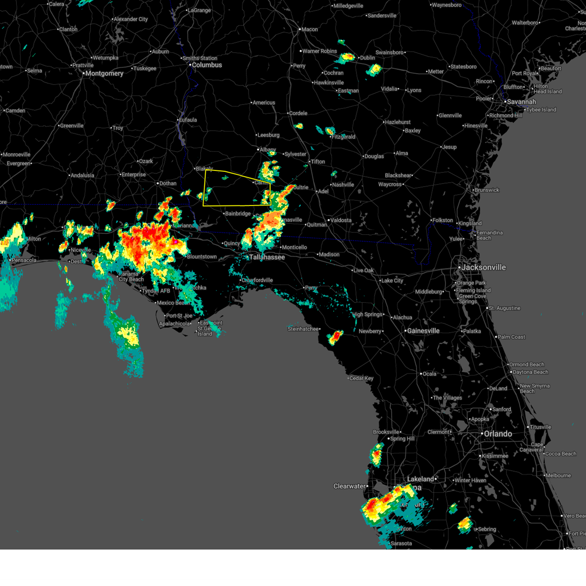
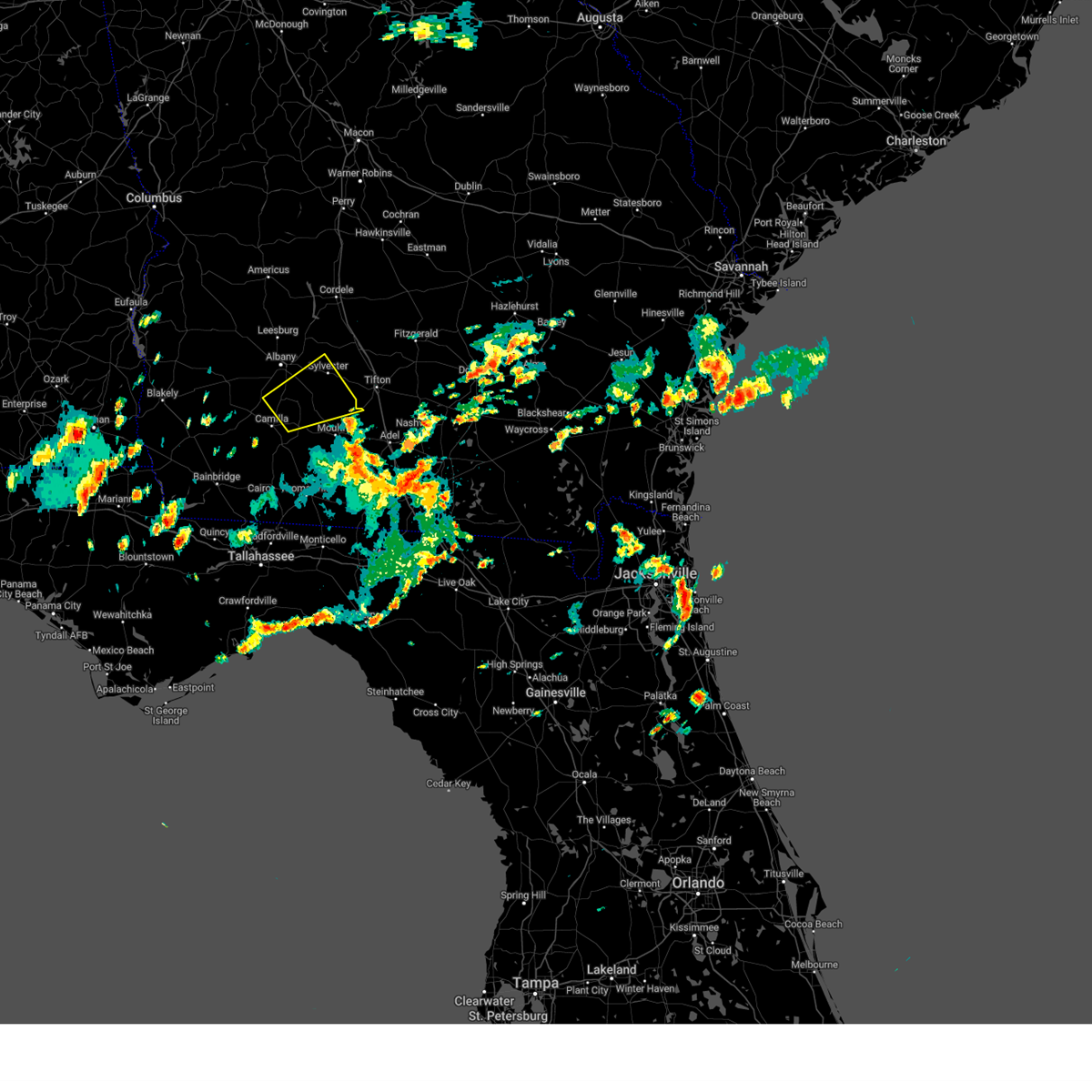
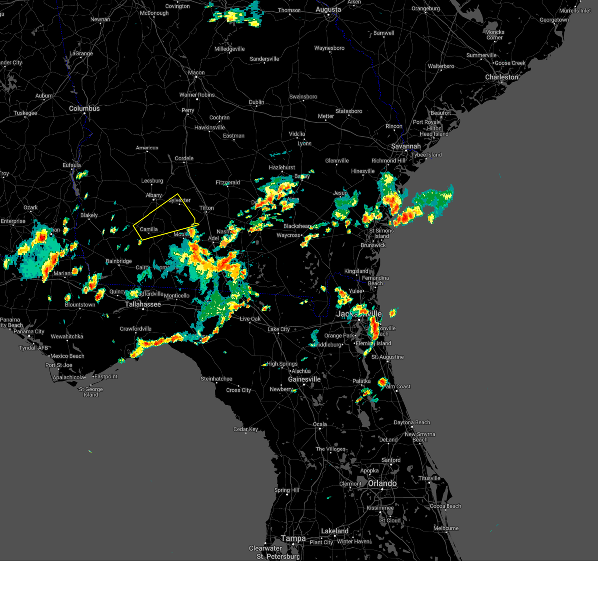
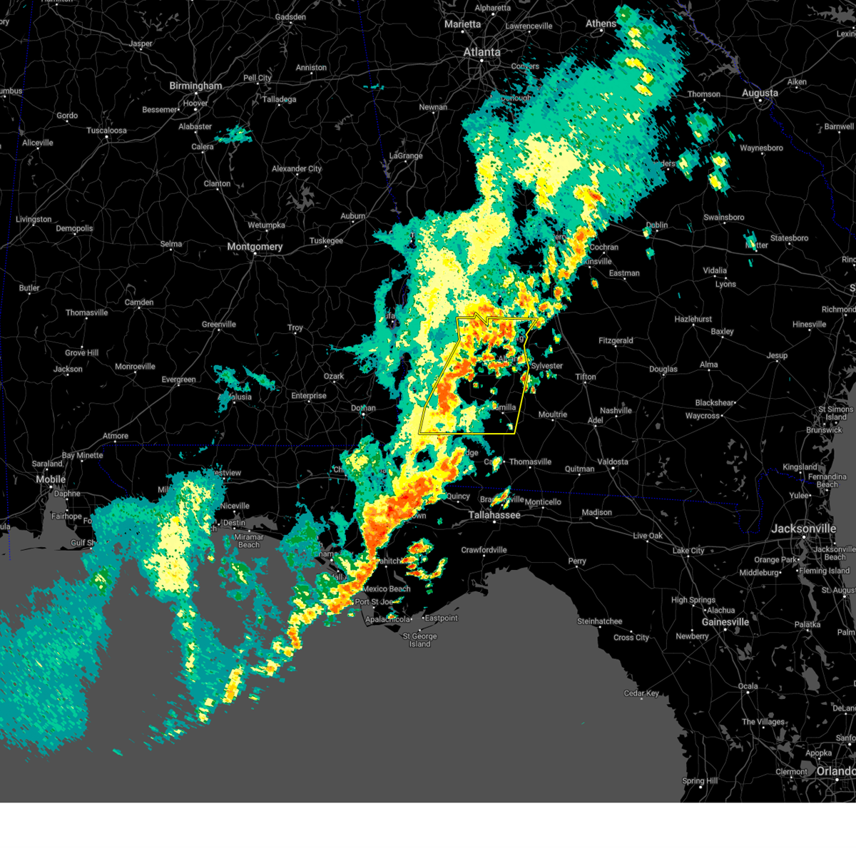
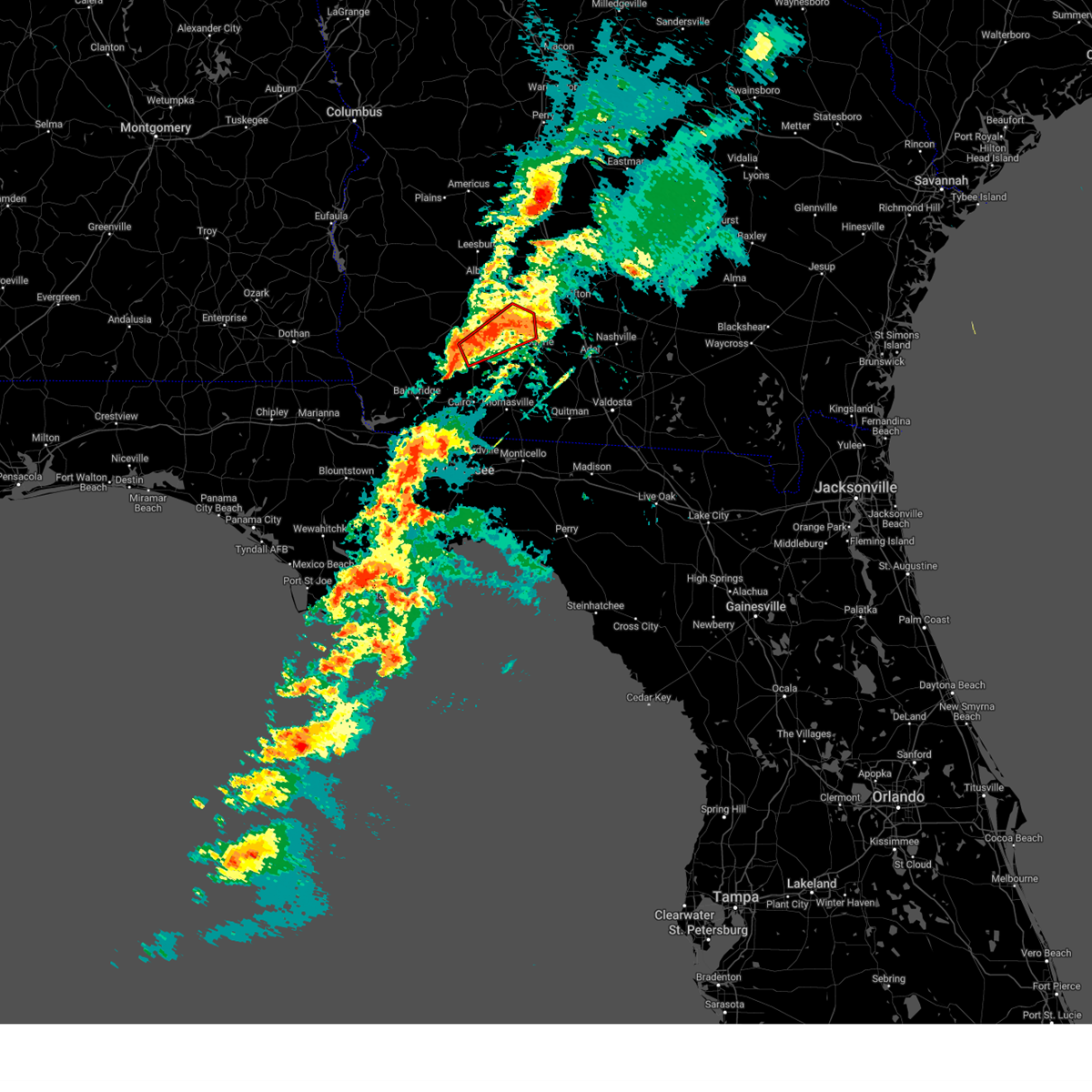
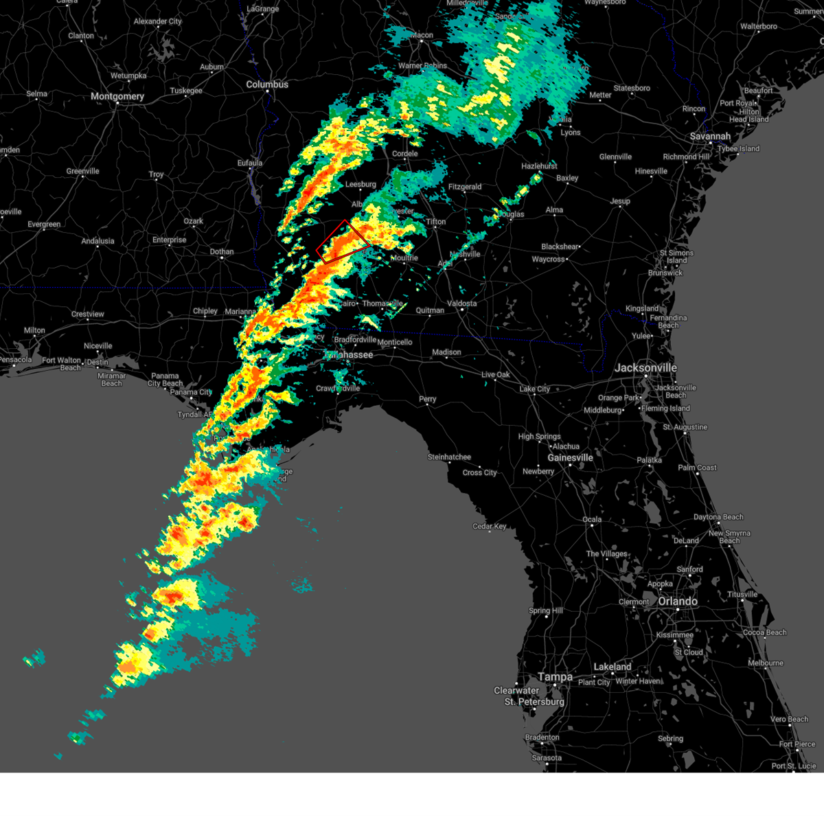
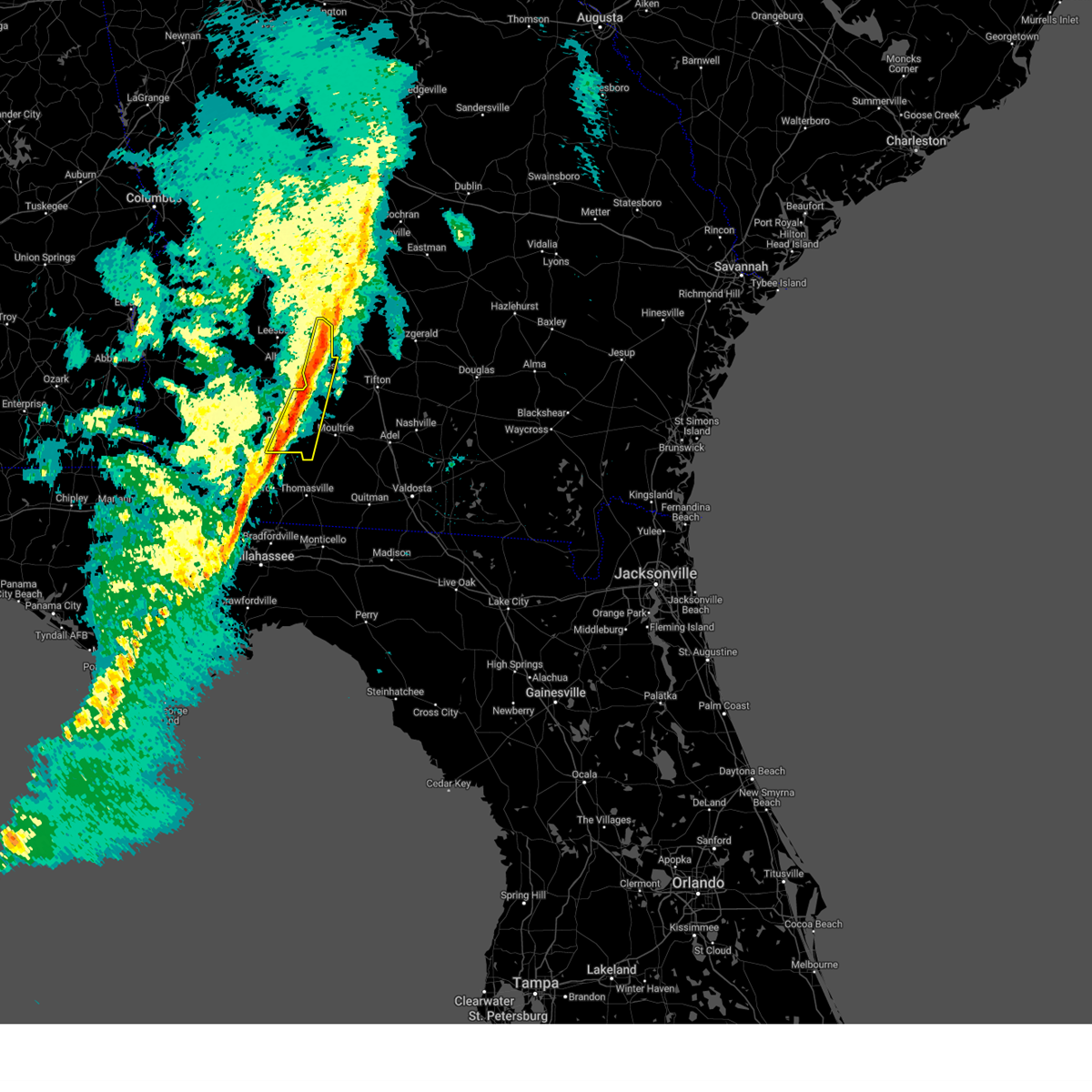
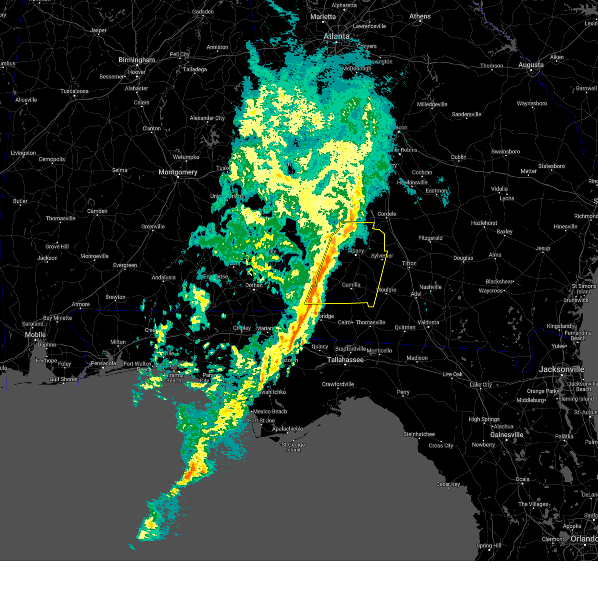
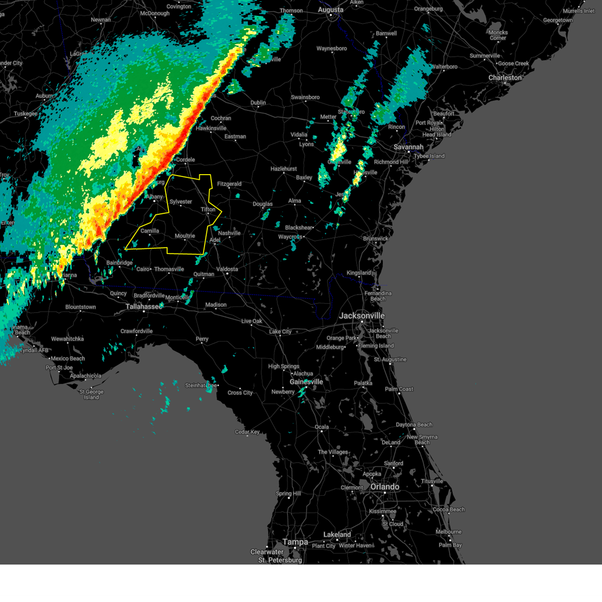
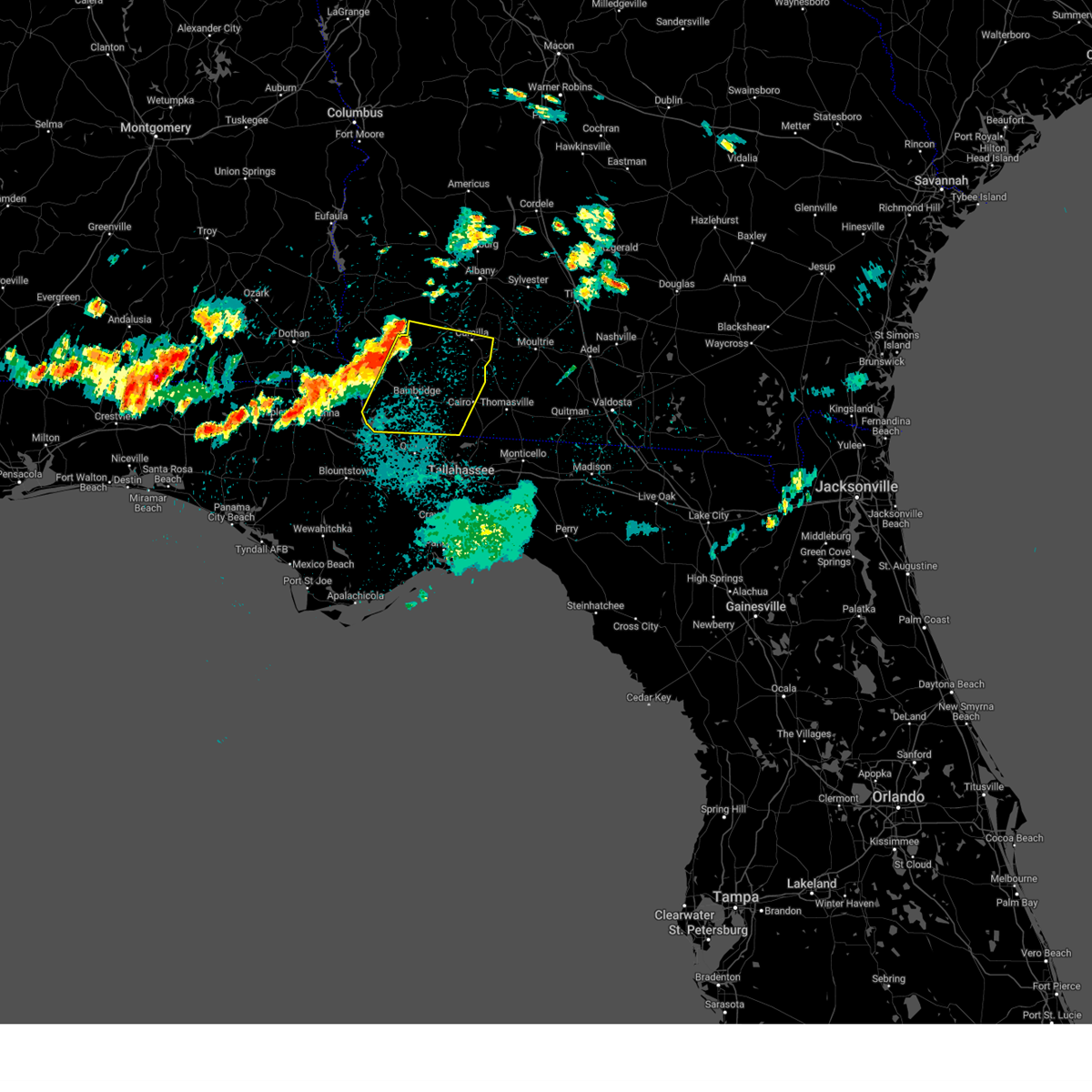
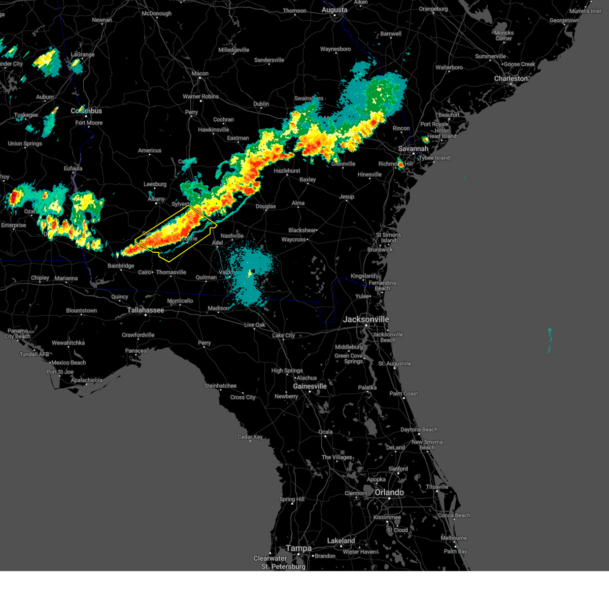
Hail Map for Camilla, GA
The Camilla, GA area has had 3 reports of on-the-ground hail by trained spotters, and has been under severe weather warnings 42 times during the past 12 months. Doppler radar has detected hail at or near Camilla, GA on 53 occasions, including 1 occasion during the past year.
| Name: | Camilla, GA |
| Where Located: | 54.9 miles N of Tallahassee, FL |
| Map: | Google Map for Camilla, GA |
| Population: | 5360 |
| Housing Units: | 2154 |
| More Info: | Search Google for Camilla, GA |
0
The Top Recent Hail Date for Camilla, GA is Wednesday, June 25, 2025 (48th out of 53)

Hail and Wind Damage Spotted near Camilla, GA
| Date / Time | Report Details |
|---|---|
| 6/25/2025 7:41 PM EDT | At 741 pm edt, a severe thunderstorm was located 13 miles south of newton, moving west at 20 mph (radar indicated). Hazards include 60 mph wind gusts and quarter size hail. Hail damage to vehicles is expected. expect wind damage to roofs, siding, and trees. Locations impacted include, colquitt, newton, camilla, donalsonville, douglasville, iron city, damascus, brinson, ausmac, babcock, harrells still, boykin, mimsville, branchville, bellview, vada, hopeful, crestview, hoggard mill, and eldorendo. |
| 6/25/2025 7:41 PM EDT | the severe thunderstorm warning has been cancelled and is no longer in effect |
| 6/25/2025 7:01 PM EDT |
 Svrtae the national weather service in tallahassee has issued a * severe thunderstorm warning for, northeastern decatur county in southwestern georgia, miller county in southwestern georgia, northern grady county in southwestern georgia, mitchell county in southwestern georgia, southwestern baker county in southwestern georgia, northwestern thomas county in south central georgia, east central early county in southwestern georgia, northeastern seminole county in southwestern georgia, * until 815 pm edt. * at 701 pm edt, a severe thunderstorm was located near pelham, moving west at 15 mph (radar indicated). Hazards include 60 mph wind gusts and quarter size hail. Hail damage to vehicles is expected. Expect wind damage to roofs, siding, and trees. Svrtae the national weather service in tallahassee has issued a * severe thunderstorm warning for, northeastern decatur county in southwestern georgia, miller county in southwestern georgia, northern grady county in southwestern georgia, mitchell county in southwestern georgia, southwestern baker county in southwestern georgia, northwestern thomas county in south central georgia, east central early county in southwestern georgia, northeastern seminole county in southwestern georgia, * until 815 pm edt. * at 701 pm edt, a severe thunderstorm was located near pelham, moving west at 15 mph (radar indicated). Hazards include 60 mph wind gusts and quarter size hail. Hail damage to vehicles is expected. Expect wind damage to roofs, siding, and trees.
|
| 6/25/2025 5:00 PM EDT | the severe thunderstorm warning has been cancelled and is no longer in effect |
| 6/25/2025 4:22 PM EDT | Svrtae the national weather service in tallahassee has issued a * severe thunderstorm warning for, southeastern mitchell county in southwestern georgia, northwestern colquitt county in south central georgia, * until 515 pm edt. * at 422 pm edt, a severe thunderstorm was located 8 miles west of riverside, or 9 miles west of moultrie, moving west at 15 mph (radar indicated). Hazards include 60 mph wind gusts. expect damage to roofs, siding, and trees |
| 6/10/2025 4:04 AM EDT | Svrtae the national weather service in tallahassee has issued a * severe thunderstorm warning for, mitchell county in southwestern georgia, northeastern baker county in southwestern georgia, northeastern thomas county in south central georgia, colquitt county in south central georgia, southern worth county in south central georgia, * until 500 am edt. * at 404 am edt, a severe thunderstorm was located near pelham, moving east at 25 mph (radar indicated). Hazards include 60 mph wind gusts. expect damage to roofs, siding, and trees |
| 6/9/2025 3:24 PM EDT |
 At 324 pm edt, a severe thunderstorm was located near baconton, or 9 miles south of putney, moving east at 35 mph (radar indicated). Hazards include 60 mph wind gusts. Expect damage to roofs, siding, and trees. Locations impacted include, sylvester, putney, baconton, poulan, doerun, marine corps logistics base, sale city, bridgeboro, minton, flint, scooterville, sylvester airport, anderson city, tempy, parkerville, red rock, acree, lester, sigsbee, and pritchetts. At 324 pm edt, a severe thunderstorm was located near baconton, or 9 miles south of putney, moving east at 35 mph (radar indicated). Hazards include 60 mph wind gusts. Expect damage to roofs, siding, and trees. Locations impacted include, sylvester, putney, baconton, poulan, doerun, marine corps logistics base, sale city, bridgeboro, minton, flint, scooterville, sylvester airport, anderson city, tempy, parkerville, red rock, acree, lester, sigsbee, and pritchetts.
|
| 6/9/2025 3:09 PM EDT |
 Svrtae the national weather service in tallahassee has issued a * severe thunderstorm warning for, southeastern dougherty county in southwestern georgia, eastern mitchell county in southwestern georgia, northeastern baker county in southwestern georgia, northwestern colquitt county in south central georgia, southern worth county in south central georgia, * until 400 pm edt. * at 309 pm edt, a severe thunderstorm was located near camilla, moving northeast at 35 mph (radar indicated). Hazards include 60 mph wind gusts and penny size hail. expect damage to roofs, siding, and trees Svrtae the national weather service in tallahassee has issued a * severe thunderstorm warning for, southeastern dougherty county in southwestern georgia, eastern mitchell county in southwestern georgia, northeastern baker county in southwestern georgia, northwestern colquitt county in south central georgia, southern worth county in south central georgia, * until 400 pm edt. * at 309 pm edt, a severe thunderstorm was located near camilla, moving northeast at 35 mph (radar indicated). Hazards include 60 mph wind gusts and penny size hail. expect damage to roofs, siding, and trees
|
| 3/31/2025 2:37 PM EDT |
 At 236 pm edt, severe thunderstorms were located along a line extending from near smithville to near morgan to 6 miles east of donalsonville, moving east at 45 mph (radar indicated). Hazards include 60 mph wind gusts and penny size hail. Expect damage to roofs, siding, and trees. Locations impacted include, iveys mill, stocks, radium springs, smithville, parrott, dawson municipal a/p, lester, chambliss, neyami, greenough, chickasawhatchee, arlington, bellview, rowena, albany, hopeful, hoggard mill, walker, pecan city, and herod. At 236 pm edt, severe thunderstorms were located along a line extending from near smithville to near morgan to 6 miles east of donalsonville, moving east at 45 mph (radar indicated). Hazards include 60 mph wind gusts and penny size hail. Expect damage to roofs, siding, and trees. Locations impacted include, iveys mill, stocks, radium springs, smithville, parrott, dawson municipal a/p, lester, chambliss, neyami, greenough, chickasawhatchee, arlington, bellview, rowena, albany, hopeful, hoggard mill, walker, pecan city, and herod.
|
| 3/31/2025 2:37 PM EDT |
 the severe thunderstorm warning has been cancelled and is no longer in effect the severe thunderstorm warning has been cancelled and is no longer in effect
|
| 3/31/2025 1:58 PM EDT |
 Svrtae the national weather service in tallahassee has issued a * severe thunderstorm warning for, southeastern henry county in southeastern alabama, northeastern houston county in southeastern alabama, miller county in southwestern georgia, dougherty county in southwestern georgia, clay county in southwestern georgia, randolph county in southwestern georgia, mitchell county in southwestern georgia, lee county in southwestern georgia, baker county in southwestern georgia, calhoun county in southwestern georgia, early county in southwestern georgia, terrell county in southwestern georgia, * until 300 pm edt/200 pm cdt/. * at 158 pm edt/1258 pm cdt/, severe thunderstorms were located along a line extending from near cuthbert to 9 miles northwest of blakely to near cottonwood, moving east at 45 mph (radar indicated). Hazards include 60 mph wind gusts and penny size hail. expect damage to roofs, siding, and trees Svrtae the national weather service in tallahassee has issued a * severe thunderstorm warning for, southeastern henry county in southeastern alabama, northeastern houston county in southeastern alabama, miller county in southwestern georgia, dougherty county in southwestern georgia, clay county in southwestern georgia, randolph county in southwestern georgia, mitchell county in southwestern georgia, lee county in southwestern georgia, baker county in southwestern georgia, calhoun county in southwestern georgia, early county in southwestern georgia, terrell county in southwestern georgia, * until 300 pm edt/200 pm cdt/. * at 158 pm edt/1258 pm cdt/, severe thunderstorms were located along a line extending from near cuthbert to 9 miles northwest of blakely to near cottonwood, moving east at 45 mph (radar indicated). Hazards include 60 mph wind gusts and penny size hail. expect damage to roofs, siding, and trees
|
| 3/16/2025 6:40 AM EDT | At 640 am edt, a severe thunderstorm was located over doerun, or 12 miles northwest of moultrie, moving northeast at 60 mph (radar indicated). Hazards include 60 mph wind gusts and quarter size hail. Hail damage to vehicles is expected. expect wind damage to roofs, siding, and trees. Locations impacted include, bridgeboro, funston, minton, flint, scooterville, anderson city, tempy, parkerville, cotton, omega, lester, sigsbee, pritchetts, sumner, poplar arbor church, ty ty, branchville, greenough, hillsdale, and doerun. |
| 3/16/2025 6:40 AM EDT | the severe thunderstorm warning has been cancelled and is no longer in effect |
| 3/16/2025 6:33 AM EDT |
 At 633 am edt, a confirmed tornado was located 7 miles west of doerun, or 10 miles northeast of camilla, moving northeast at 40 mph (radar confirmed tornado). Hazards include damaging tornado. Flying debris will be dangerous to those caught without shelter. mobile homes will be damaged or destroyed. damage to roofs, windows, and vehicles will occur. tree damage is likely. this tornado will be near, doerun around 640 am edt. Other locations impacted by this tornadic thunderstorm include bridgeboro, minton, livingston, anderson city, ticknor, minnesota, cotton, schley, laney, and lester. At 633 am edt, a confirmed tornado was located 7 miles west of doerun, or 10 miles northeast of camilla, moving northeast at 40 mph (radar confirmed tornado). Hazards include damaging tornado. Flying debris will be dangerous to those caught without shelter. mobile homes will be damaged or destroyed. damage to roofs, windows, and vehicles will occur. tree damage is likely. this tornado will be near, doerun around 640 am edt. Other locations impacted by this tornadic thunderstorm include bridgeboro, minton, livingston, anderson city, ticknor, minnesota, cotton, schley, laney, and lester.
|
| 3/16/2025 6:26 AM EDT |
 The storm which prompted the warning has moved out of the area. therefore, the warning will be allowed to expire. however, gusty winds are still possible with this thunderstorm. a tornado watch remains in effect until 1000 am edt for south central and southwestern georgia. The storm which prompted the warning has moved out of the area. therefore, the warning will be allowed to expire. however, gusty winds are still possible with this thunderstorm. a tornado watch remains in effect until 1000 am edt for south central and southwestern georgia.
|
| 3/16/2025 6:25 AM EDT | Trees reported down on hwy 37 near sale city roa in mitchell county GA, 4.4 miles W of Camilla, GA |
| 3/16/2025 6:15 AM EDT |
 Tortae the national weather service in tallahassee has issued a * tornado warning for, southeastern mitchell county in southwestern georgia, northwestern colquitt county in south central georgia, southwestern worth county in south central georgia, * until 700 am edt. * at 615 am edt, a severe thunderstorm capable of producing a tornado was located over camilla, moving northeast at 35 mph (radar indicated rotation). Hazards include tornado. Flying debris will be dangerous to those caught without shelter. mobile homes will be damaged or destroyed. damage to roofs, windows, and vehicles will occur. tree damage is likely. this dangerous storm will be near, camilla around 620 am edt. doerun around 640 am edt. Other locations impacted by this tornadic thunderstorm include bridgeboro, minton, livingston, anderson city, ticknor, minnesota, cotton, schley, laney, and lester. Tortae the national weather service in tallahassee has issued a * tornado warning for, southeastern mitchell county in southwestern georgia, northwestern colquitt county in south central georgia, southwestern worth county in south central georgia, * until 700 am edt. * at 615 am edt, a severe thunderstorm capable of producing a tornado was located over camilla, moving northeast at 35 mph (radar indicated rotation). Hazards include tornado. Flying debris will be dangerous to those caught without shelter. mobile homes will be damaged or destroyed. damage to roofs, windows, and vehicles will occur. tree damage is likely. this dangerous storm will be near, camilla around 620 am edt. doerun around 640 am edt. Other locations impacted by this tornadic thunderstorm include bridgeboro, minton, livingston, anderson city, ticknor, minnesota, cotton, schley, laney, and lester.
|
| 3/16/2025 6:13 AM EDT | Svrtae the national weather service in tallahassee has issued a * severe thunderstorm warning for, northeastern decatur county in southwestern georgia, southeastern miller county in southwestern georgia, northern grady county in southwestern georgia, mitchell county in southwestern georgia, southwestern baker county in southwestern georgia, northwestern thomas county in south central georgia, colquitt county in south central georgia, western tift county in south central georgia, southern worth county in south central georgia, * until 715 am edt. * at 612 am edt, a severe thunderstorm was located 7 miles west of pelham, moving northeast at 75 mph (radar indicated). Hazards include 60 mph wind gusts and quarter size hail. Hail damage to vehicles is expected. Expect wind damage to roofs, siding, and trees. |
| 3/16/2025 5:48 AM EDT |
 Svrtae the national weather service in tallahassee has issued a * severe thunderstorm warning for, southeastern dougherty county in southwestern georgia, northeastern mitchell county in southwestern georgia, northeastern baker county in southwestern georgia, southern worth county in south central georgia, * until 630 am edt. * at 547 am edt, a severe thunderstorm was located over baconton, or 8 miles east of newton, moving northeast at 40 mph (radar indicated). Hazards include 60 mph wind gusts and quarter size hail. Hail damage to vehicles is expected. Expect wind damage to roofs, siding, and trees. Svrtae the national weather service in tallahassee has issued a * severe thunderstorm warning for, southeastern dougherty county in southwestern georgia, northeastern mitchell county in southwestern georgia, northeastern baker county in southwestern georgia, southern worth county in south central georgia, * until 630 am edt. * at 547 am edt, a severe thunderstorm was located over baconton, or 8 miles east of newton, moving northeast at 40 mph (radar indicated). Hazards include 60 mph wind gusts and quarter size hail. Hail damage to vehicles is expected. Expect wind damage to roofs, siding, and trees.
|
| 3/16/2025 5:27 AM EDT |
 The storm which prompted the warning has weakened below severe limits, and no longer appears capable of producing a tornado. therefore, the warning will be allowed to expire. however, gusty winds are still possible with this thunderstorm. a tornado watch remains in effect until 1000 am edt for southwestern georgia. The storm which prompted the warning has weakened below severe limits, and no longer appears capable of producing a tornado. therefore, the warning will be allowed to expire. however, gusty winds are still possible with this thunderstorm. a tornado watch remains in effect until 1000 am edt for southwestern georgia.
|
| 3/16/2025 5:13 AM EDT |
 the tornado warning has been cancelled and is no longer in effect the tornado warning has been cancelled and is no longer in effect
|
| 3/16/2025 5:13 AM EDT |
 At 513 am edt, a severe thunderstorm capable of producing a tornado was located 9 miles southwest of newton, moving northeast at 40 mph (radar indicated rotation). Hazards include tornado. Flying debris will be dangerous to those caught without shelter. mobile homes will be damaged or destroyed. damage to roofs, windows, and vehicles will occur. tree damage is likely. this dangerous storm will be near, newton around 520 am edt. baconton around 540 am edt. Other locations impacted by this tornadic thunderstorm include hawkinstown, flint, mimsville, red store crossroads, hoggard mill, greenough, and elmodel wma. At 513 am edt, a severe thunderstorm capable of producing a tornado was located 9 miles southwest of newton, moving northeast at 40 mph (radar indicated rotation). Hazards include tornado. Flying debris will be dangerous to those caught without shelter. mobile homes will be damaged or destroyed. damage to roofs, windows, and vehicles will occur. tree damage is likely. this dangerous storm will be near, newton around 520 am edt. baconton around 540 am edt. Other locations impacted by this tornadic thunderstorm include hawkinstown, flint, mimsville, red store crossroads, hoggard mill, greenough, and elmodel wma.
|
| 3/16/2025 5:11 AM EDT |
 Svrtae the national weather service in tallahassee has issued a * severe thunderstorm warning for, northern decatur county in southwestern georgia, southeastern miller county in southwestern georgia, northwestern grady county in southwestern georgia, southern mitchell county in southwestern georgia, central baker county in southwestern georgia, eastern seminole county in southwestern georgia, * until 615 am edt. * at 510 am edt, a severe thunderstorm was located 8 miles southeast of donalsonville, moving northeast at 40 mph (radar indicated). Hazards include 60 mph wind gusts and quarter size hail. Hail damage to vehicles is expected. Expect wind damage to roofs, siding, and trees. Svrtae the national weather service in tallahassee has issued a * severe thunderstorm warning for, northern decatur county in southwestern georgia, southeastern miller county in southwestern georgia, northwestern grady county in southwestern georgia, southern mitchell county in southwestern georgia, central baker county in southwestern georgia, eastern seminole county in southwestern georgia, * until 615 am edt. * at 510 am edt, a severe thunderstorm was located 8 miles southeast of donalsonville, moving northeast at 40 mph (radar indicated). Hazards include 60 mph wind gusts and quarter size hail. Hail damage to vehicles is expected. Expect wind damage to roofs, siding, and trees.
|
| 3/16/2025 5:04 AM EDT |
 Tortae the national weather service in tallahassee has issued a * tornado warning for, northeastern miller county in southwestern georgia, south central dougherty county in southwestern georgia, central mitchell county in southwestern georgia, baker county in southwestern georgia, * until 530 am edt. * at 504 am edt, a severe thunderstorm capable of producing a tornado was located 11 miles east of colquitt, moving northeast at 40 mph (radar indicated rotation). Hazards include tornado. Flying debris will be dangerous to those caught without shelter. mobile homes will be damaged or destroyed. damage to roofs, windows, and vehicles will occur. tree damage is likely. this dangerous storm will be near, newton around 520 am edt. Other locations impacted by this tornadic thunderstorm include hawkinstown, flint, mimsville, red store crossroads, hoggard mill, greenough, cooktown, and elmodel wma. Tortae the national weather service in tallahassee has issued a * tornado warning for, northeastern miller county in southwestern georgia, south central dougherty county in southwestern georgia, central mitchell county in southwestern georgia, baker county in southwestern georgia, * until 530 am edt. * at 504 am edt, a severe thunderstorm capable of producing a tornado was located 11 miles east of colquitt, moving northeast at 40 mph (radar indicated rotation). Hazards include tornado. Flying debris will be dangerous to those caught without shelter. mobile homes will be damaged or destroyed. damage to roofs, windows, and vehicles will occur. tree damage is likely. this dangerous storm will be near, newton around 520 am edt. Other locations impacted by this tornadic thunderstorm include hawkinstown, flint, mimsville, red store crossroads, hoggard mill, greenough, cooktown, and elmodel wma.
|
| 3/16/2025 4:26 AM EDT |
 Svrtae the national weather service in tallahassee has issued a * severe thunderstorm warning for, southeastern houston county in southeastern alabama, northeastern jackson county in the panhandle of florida, northeastern decatur county in southwestern georgia, miller county in southwestern georgia, southwestern mitchell county in southwestern georgia, baker county in southwestern georgia, southeastern calhoun county in southwestern georgia, seminole county in southwestern georgia, central early county in southwestern georgia, * until 515 am edt/415 am cdt/. * at 425 am edt/325 am cdt/, a severe thunderstorm was located 11 miles northeast of marianna, moving northeast at 60 mph (radar indicated). Hazards include 60 mph wind gusts and quarter size hail. Hail damage to vehicles is expected. Expect wind damage to roofs, siding, and trees. Svrtae the national weather service in tallahassee has issued a * severe thunderstorm warning for, southeastern houston county in southeastern alabama, northeastern jackson county in the panhandle of florida, northeastern decatur county in southwestern georgia, miller county in southwestern georgia, southwestern mitchell county in southwestern georgia, baker county in southwestern georgia, southeastern calhoun county in southwestern georgia, seminole county in southwestern georgia, central early county in southwestern georgia, * until 515 am edt/415 am cdt/. * at 425 am edt/325 am cdt/, a severe thunderstorm was located 11 miles northeast of marianna, moving northeast at 60 mph (radar indicated). Hazards include 60 mph wind gusts and quarter size hail. Hail damage to vehicles is expected. Expect wind damage to roofs, siding, and trees.
|
| 3/5/2025 4:05 AM EST |
 the severe thunderstorm warning has been cancelled and is no longer in effect the severe thunderstorm warning has been cancelled and is no longer in effect
|
| 3/5/2025 4:05 AM EST |
 At 405 am est, severe thunderstorms were located along a line extending from near cordele to pelham, moving east at 40 mph (radar indicated). Hazards include 60 mph wind gusts. Expect damage to roofs, siding, and trees. Locations impacted include, bridgeboro, sylvester, sylvester airport, anderson city, parkerville, cotton, red rock, lester, pritchetts, poplar arbor church, crestwood, shingler, greenough, gordy, doerun, livingston, ticknor, minnesota, laney, and freeman. At 405 am est, severe thunderstorms were located along a line extending from near cordele to pelham, moving east at 40 mph (radar indicated). Hazards include 60 mph wind gusts. Expect damage to roofs, siding, and trees. Locations impacted include, bridgeboro, sylvester, sylvester airport, anderson city, parkerville, cotton, red rock, lester, pritchetts, poplar arbor church, crestwood, shingler, greenough, gordy, doerun, livingston, ticknor, minnesota, laney, and freeman.
|
| 3/5/2025 3:52 AM EST |
 At 352 am est, severe thunderstorms were located along a line extending from 6 miles southwest of cordele to 8 miles west of pelham, moving east at 40 mph (radar indicated). Hazards include 60 mph wind gusts. Expect damage to roofs, siding, and trees. Locations impacted include, bridgeboro, warwick, sylvester, flint, stocks, radium springs, sylvester airport, anderson city, parkerville, cotton, red rock, acree, lester, pritchetts, poplar arbor church, crestwood, shingler, williamsburg, branchville, and greenough. At 352 am est, severe thunderstorms were located along a line extending from 6 miles southwest of cordele to 8 miles west of pelham, moving east at 40 mph (radar indicated). Hazards include 60 mph wind gusts. Expect damage to roofs, siding, and trees. Locations impacted include, bridgeboro, warwick, sylvester, flint, stocks, radium springs, sylvester airport, anderson city, parkerville, cotton, red rock, acree, lester, pritchetts, poplar arbor church, crestwood, shingler, williamsburg, branchville, and greenough.
|
| 3/5/2025 3:34 AM EST |
 At 334 am est, severe thunderstorms were located along a line extending from near de soto to 13 miles northeast of west bainbridge, moving east at 35 mph (radar indicated). Hazards include 60 mph wind gusts. Expect damage to roofs, siding, and trees. Locations impacted include, stocks, radium springs, sylvester airport, anderson city, parkerville, lester, pritchetts, crestwood, greenough, albany, hopeful, hoggard mill, walker, ticknor, pecan city, laney, newton, gammage, mitchell co a/p, and baconton. At 334 am est, severe thunderstorms were located along a line extending from near de soto to 13 miles northeast of west bainbridge, moving east at 35 mph (radar indicated). Hazards include 60 mph wind gusts. Expect damage to roofs, siding, and trees. Locations impacted include, stocks, radium springs, sylvester airport, anderson city, parkerville, lester, pritchetts, crestwood, greenough, albany, hopeful, hoggard mill, walker, ticknor, pecan city, laney, newton, gammage, mitchell co a/p, and baconton.
|
| 3/5/2025 3:34 AM EST |
 the severe thunderstorm warning has been cancelled and is no longer in effect the severe thunderstorm warning has been cancelled and is no longer in effect
|
| 3/5/2025 3:14 AM EST |
 At 314 am est, severe thunderstorms were located along a line extending from near smithville to 6 miles southeast of colquitt, moving east at 40 mph (radar indicated). Hazards include 60 mph wind gusts. Expect damage to roofs, siding, and trees. Locations impacted include, iveys mill, stocks, radium springs, smithville, sylvester airport, anderson city, parkerville, dawson municipal a/p, lester, pritchetts, crestwood, neyami, greenough, chickasawhatchee, bellview, albany, vada, hopeful, hoggard mill, and walker. At 314 am est, severe thunderstorms were located along a line extending from near smithville to 6 miles southeast of colquitt, moving east at 40 mph (radar indicated). Hazards include 60 mph wind gusts. Expect damage to roofs, siding, and trees. Locations impacted include, iveys mill, stocks, radium springs, smithville, sylvester airport, anderson city, parkerville, dawson municipal a/p, lester, pritchetts, crestwood, neyami, greenough, chickasawhatchee, bellview, albany, vada, hopeful, hoggard mill, and walker.
|
| 3/5/2025 3:14 AM EST |
 the severe thunderstorm warning has been cancelled and is no longer in effect the severe thunderstorm warning has been cancelled and is no longer in effect
|
| 3/5/2025 2:53 AM EST |
 Svrtae the national weather service in tallahassee has issued a * severe thunderstorm warning for, miller county in southwestern georgia, dougherty county in southwestern georgia, southeastern randolph county in southwestern georgia, mitchell county in southwestern georgia, lee county in southwestern georgia, baker county in southwestern georgia, calhoun county in southwestern georgia, eastern early county in southwestern georgia, western colquitt county in south central georgia, terrell county in southwestern georgia, worth county in south central georgia, * until 430 am est. * at 253 am est, severe thunderstorms were located along a line extending from 8 miles north of dawson to near donalsonville, moving east at 40 mph (radar indicated). Hazards include 60 mph wind gusts. expect damage to roofs, siding, and trees Svrtae the national weather service in tallahassee has issued a * severe thunderstorm warning for, miller county in southwestern georgia, dougherty county in southwestern georgia, southeastern randolph county in southwestern georgia, mitchell county in southwestern georgia, lee county in southwestern georgia, baker county in southwestern georgia, calhoun county in southwestern georgia, eastern early county in southwestern georgia, western colquitt county in south central georgia, terrell county in southwestern georgia, worth county in south central georgia, * until 430 am est. * at 253 am est, severe thunderstorms were located along a line extending from 8 miles north of dawson to near donalsonville, moving east at 40 mph (radar indicated). Hazards include 60 mph wind gusts. expect damage to roofs, siding, and trees
|
| 2/16/2025 6:17 AM EST |
 Svrtae the national weather service in tallahassee has issued a * severe thunderstorm warning for, turner county in south central georgia, mitchell county in southwestern georgia, colquitt county in south central georgia, tift county in south central georgia, worth county in south central georgia, * until 745 am est. * at 616 am est, severe thunderstorms were located along a line extending from near leslie to 7 miles northwest of donalsonville, moving east at 45 mph (radar indicated). Hazards include 60 mph wind gusts. expect damage to roofs, siding, and trees Svrtae the national weather service in tallahassee has issued a * severe thunderstorm warning for, turner county in south central georgia, mitchell county in southwestern georgia, colquitt county in south central georgia, tift county in south central georgia, worth county in south central georgia, * until 745 am est. * at 616 am est, severe thunderstorms were located along a line extending from near leslie to 7 miles northwest of donalsonville, moving east at 45 mph (radar indicated). Hazards include 60 mph wind gusts. expect damage to roofs, siding, and trees
|
| 9/26/2024 6:38 PM EDT |
 Tortae the national weather service in tallahassee has issued a * tornado warning for, western dougherty county in southwestern georgia, northeastern mitchell county in southwestern georgia, northeastern baker county in southwestern georgia, southeastern calhoun county in southwestern georgia, * until 715 pm edt. * at 638 pm edt, a severe thunderstorm capable of producing a tornado was located near baconton, or 7 miles north of camilla, moving northwest at 30 mph (radar indicated rotation). Hazards include tornado. Flying debris will be dangerous to those caught without shelter. mobile homes will be damaged or destroyed. damage to roofs, windows, and vehicles will occur. tree damage is likely. This tornadic thunderstorm will remain over mainly rural areas of western dougherty, northeastern mitchell, northeastern baker and southeastern calhoun counties in southwestern georgia, including the following locations, walker, bermuda, flint, holt, red store crossroads, and ducker. Tortae the national weather service in tallahassee has issued a * tornado warning for, western dougherty county in southwestern georgia, northeastern mitchell county in southwestern georgia, northeastern baker county in southwestern georgia, southeastern calhoun county in southwestern georgia, * until 715 pm edt. * at 638 pm edt, a severe thunderstorm capable of producing a tornado was located near baconton, or 7 miles north of camilla, moving northwest at 30 mph (radar indicated rotation). Hazards include tornado. Flying debris will be dangerous to those caught without shelter. mobile homes will be damaged or destroyed. damage to roofs, windows, and vehicles will occur. tree damage is likely. This tornadic thunderstorm will remain over mainly rural areas of western dougherty, northeastern mitchell, northeastern baker and southeastern calhoun counties in southwestern georgia, including the following locations, walker, bermuda, flint, holt, red store crossroads, and ducker.
|
| 8/19/2024 1:52 AM EDT |
 Svrtae the national weather service in tallahassee has issued a * severe thunderstorm warning for, decatur county in southwestern georgia, grady county in southwestern georgia, eastern miller county in southwestern georgia, southern mitchell county in southwestern georgia, southwestern baker county in southwestern georgia, eastern seminole county in southwestern georgia, * until 330 am edt. * at 152 am edt, severe thunderstorms were located along a line extending from near colquitt to 6 miles southwest of donalsonville, moving east at 40 mph (radar indicated). Hazards include 60 mph wind gusts. expect damage to roofs, siding, and trees Svrtae the national weather service in tallahassee has issued a * severe thunderstorm warning for, decatur county in southwestern georgia, grady county in southwestern georgia, eastern miller county in southwestern georgia, southern mitchell county in southwestern georgia, southwestern baker county in southwestern georgia, eastern seminole county in southwestern georgia, * until 330 am edt. * at 152 am edt, severe thunderstorms were located along a line extending from near colquitt to 6 miles southwest of donalsonville, moving east at 40 mph (radar indicated). Hazards include 60 mph wind gusts. expect damage to roofs, siding, and trees
|
| 8/18/2024 9:15 PM EDT | Several calls about trees down in mitchell count in mitchell county GA, 0.4 miles ENE of Camilla, GA |
| 8/18/2024 9:14 PM EDT |
 the severe thunderstorm warning has been cancelled and is no longer in effect the severe thunderstorm warning has been cancelled and is no longer in effect
|
| 8/18/2024 9:14 PM EDT |
 At 914 pm edt, severe thunderstorms were located along a line extending from near ty ty to camilla, moving east at 30 mph (radar indicated). Hazards include 60 mph wind gusts. Expect damage to roofs, siding, and trees. Locations impacted include, moultrie, sylvester, pelham, camilla, tifton, omega, norman park, poulan, doerun, ty ty, riverside, schley, funston, sumner, sale city, minton, scooterville, anderson city, parkerville, and lester. At 914 pm edt, severe thunderstorms were located along a line extending from near ty ty to camilla, moving east at 30 mph (radar indicated). Hazards include 60 mph wind gusts. Expect damage to roofs, siding, and trees. Locations impacted include, moultrie, sylvester, pelham, camilla, tifton, omega, norman park, poulan, doerun, ty ty, riverside, schley, funston, sumner, sale city, minton, scooterville, anderson city, parkerville, and lester.
|
| 8/18/2024 8:56 PM EDT |
 Svrtae the national weather service in tallahassee has issued a * severe thunderstorm warning for, southeastern dougherty county in southwestern georgia, mitchell county in southwestern georgia, central baker county in southwestern georgia, northwestern thomas county in south central georgia, colquitt county in south central georgia, southwestern tift county in south central georgia, southern worth county in south central georgia, * until 1000 pm edt. * at 856 pm edt, severe thunderstorms were located along a line extending from near poulan to 6 miles south of newton, moving east at 25 mph (radar indicated). Hazards include 60 mph wind gusts. expect damage to roofs, siding, and trees Svrtae the national weather service in tallahassee has issued a * severe thunderstorm warning for, southeastern dougherty county in southwestern georgia, mitchell county in southwestern georgia, central baker county in southwestern georgia, northwestern thomas county in south central georgia, colquitt county in south central georgia, southwestern tift county in south central georgia, southern worth county in south central georgia, * until 1000 pm edt. * at 856 pm edt, severe thunderstorms were located along a line extending from near poulan to 6 miles south of newton, moving east at 25 mph (radar indicated). Hazards include 60 mph wind gusts. expect damage to roofs, siding, and trees
|
| 7/31/2024 7:08 PM EDT | At 707 pm edt, a severe thunderstorm was located 13 miles east of colquitt, moving south at 10 mph (radar indicated). Hazards include 60 mph wind gusts and quarter size hail. Hail damage to vehicles is expected. expect wind damage to roofs, siding, and trees. Locations impacted include, colquitt, newton, pelham, camilla, arlington, douglasville, damascus, babcock, cotton, boykin, mimsville, branchville, bellview, rowena, hopeful, crestview, hoggard mill, laney, hawkinstown, and mitchell co a/p. |
| 7/31/2024 7:08 PM EDT | the severe thunderstorm warning has been cancelled and is no longer in effect |
| 7/31/2024 6:28 PM EDT | Svrtae the national weather service in tallahassee has issued a * severe thunderstorm warning for, miller county in southwestern georgia, southwestern dougherty county in southwestern georgia, mitchell county in southwestern georgia, baker county in southwestern georgia, southeastern calhoun county in southwestern georgia, northeastern early county in southwestern georgia, * until 730 pm edt. * at 628 pm edt, a severe thunderstorm was located 9 miles west of newton, moving south at 10 mph (radar indicated). Hazards include 60 mph wind gusts and quarter size hail. Hail damage to vehicles is expected. Expect wind damage to roofs, siding, and trees. |
| 7/31/2024 5:41 PM EDT |
 Svrtae the national weather service in tallahassee has issued a * severe thunderstorm warning for, dougherty county in southwestern georgia, southeastern clay county in southwestern georgia, northeastern mitchell county in southwestern georgia, baker county in southwestern georgia, calhoun county in southwestern georgia, northeastern early county in southwestern georgia, * until 630 pm edt. * at 540 pm edt, severe thunderstorms were located along a line extending from 6 miles west of putney to near morgan to near blakely, moving south at 25 mph (radar indicated). Hazards include 60 mph wind gusts and penny size hail. expect damage to roofs, siding, and trees Svrtae the national weather service in tallahassee has issued a * severe thunderstorm warning for, dougherty county in southwestern georgia, southeastern clay county in southwestern georgia, northeastern mitchell county in southwestern georgia, baker county in southwestern georgia, calhoun county in southwestern georgia, northeastern early county in southwestern georgia, * until 630 pm edt. * at 540 pm edt, severe thunderstorms were located along a line extending from 6 miles west of putney to near morgan to near blakely, moving south at 25 mph (radar indicated). Hazards include 60 mph wind gusts and penny size hail. expect damage to roofs, siding, and trees
|
| 5/18/2024 10:59 AM EDT |
 the severe thunderstorm warning has been cancelled and is no longer in effect the severe thunderstorm warning has been cancelled and is no longer in effect
|
| 5/18/2024 10:48 AM EDT |
 At 1048 am edt, a severe thunderstorm was located 13 miles southwest of newton, moving east at 30 mph (radar indicated). Hazards include 60 mph wind gusts. Expect damage to roofs, siding, and trees. Locations impacted include, colquitt, pelham, camilla, sale city, babcock, hopeful, hoggard mill, cotton, boykin, laney, hawkinstown, mimsville, mitchell co a/p, harmony church rd/hwy 45, branchville, hinsonton, jeterville, cooktown, and bellview. At 1048 am edt, a severe thunderstorm was located 13 miles southwest of newton, moving east at 30 mph (radar indicated). Hazards include 60 mph wind gusts. Expect damage to roofs, siding, and trees. Locations impacted include, colquitt, pelham, camilla, sale city, babcock, hopeful, hoggard mill, cotton, boykin, laney, hawkinstown, mimsville, mitchell co a/p, harmony church rd/hwy 45, branchville, hinsonton, jeterville, cooktown, and bellview.
|
| 5/18/2024 10:36 AM EDT |
 At 1035 am edt, a severe thunderstorm was located 8 miles east of colquitt, moving east at 30 mph (radar indicated). Hazards include 60 mph wind gusts. Expect damage to roofs, siding, and trees. Locations impacted include, colquitt, newton, pelham, camilla, arlington, baconton, douglasville, sale city, damascus, babcock, iveys mill, flint, cotton, boykin, lester, mimsville, branchville, greenough, bellview, and rowena. At 1035 am edt, a severe thunderstorm was located 8 miles east of colquitt, moving east at 30 mph (radar indicated). Hazards include 60 mph wind gusts. Expect damage to roofs, siding, and trees. Locations impacted include, colquitt, newton, pelham, camilla, arlington, baconton, douglasville, sale city, damascus, babcock, iveys mill, flint, cotton, boykin, lester, mimsville, branchville, greenough, bellview, and rowena.
|
| 5/18/2024 10:36 AM EDT |
 the severe thunderstorm warning has been cancelled and is no longer in effect the severe thunderstorm warning has been cancelled and is no longer in effect
|
| 5/18/2024 10:23 AM EDT |
 Svrtae the national weather service in tallahassee has issued a * severe thunderstorm warning for, miller county in southwestern georgia, dougherty county in southwestern georgia, mitchell county in southwestern georgia, baker county in southwestern georgia, calhoun county in southwestern georgia, northwestern thomas county in south central georgia, northeastern early county in southwestern georgia, * until 1115 am edt. * at 1023 am edt, a severe thunderstorm was located near colquitt, moving east at 30 mph (radar indicated). Hazards include 60 mph wind gusts. expect damage to roofs, siding, and trees Svrtae the national weather service in tallahassee has issued a * severe thunderstorm warning for, miller county in southwestern georgia, dougherty county in southwestern georgia, mitchell county in southwestern georgia, baker county in southwestern georgia, calhoun county in southwestern georgia, northwestern thomas county in south central georgia, northeastern early county in southwestern georgia, * until 1115 am edt. * at 1023 am edt, a severe thunderstorm was located near colquitt, moving east at 30 mph (radar indicated). Hazards include 60 mph wind gusts. expect damage to roofs, siding, and trees
|
| 5/17/2024 6:52 PM EDT |
 the severe thunderstorm warning has been cancelled and is no longer in effect the severe thunderstorm warning has been cancelled and is no longer in effect
|
| 5/17/2024 6:52 PM EDT |
 At 652 pm edt, a severe thunderstorm was located over camilla, moving east at 25 mph (radar indicated). Hazards include 60 mph wind gusts and penny size hail. Expect damage to roofs, siding, and trees. Locations impacted include, newton, pelham, camilla, baconton, doerun, funston, sale city, bridgeboro, flint, parkerville, cotton, lester, pritchetts, poplar arbor church, crestwood, branchville, greenough, gordy, hopeful, and livingston. At 652 pm edt, a severe thunderstorm was located over camilla, moving east at 25 mph (radar indicated). Hazards include 60 mph wind gusts and penny size hail. Expect damage to roofs, siding, and trees. Locations impacted include, newton, pelham, camilla, baconton, doerun, funston, sale city, bridgeboro, flint, parkerville, cotton, lester, pritchetts, poplar arbor church, crestwood, branchville, greenough, gordy, hopeful, and livingston.
|
| 5/17/2024 6:42 PM EDT | Pecan tree down in mitchell county at the intersection of branchville and strawberry road in mitchell county GA, 6.4 miles NE of Camilla, GA |
| 5/17/2024 6:20 PM EDT |
 Svrtae the national weather service in tallahassee has issued a * severe thunderstorm warning for, southeastern dougherty county in southwestern georgia, mitchell county in southwestern georgia, baker county in southwestern georgia, western colquitt county in south central georgia, southwestern worth county in south central georgia, * until 730 pm edt. * at 620 pm edt, a severe thunderstorm was located 7 miles southwest of newton, moving east at 25 mph (radar indicated). Hazards include 60 mph wind gusts and penny size hail. expect damage to roofs, siding, and trees Svrtae the national weather service in tallahassee has issued a * severe thunderstorm warning for, southeastern dougherty county in southwestern georgia, mitchell county in southwestern georgia, baker county in southwestern georgia, western colquitt county in south central georgia, southwestern worth county in south central georgia, * until 730 pm edt. * at 620 pm edt, a severe thunderstorm was located 7 miles southwest of newton, moving east at 25 mph (radar indicated). Hazards include 60 mph wind gusts and penny size hail. expect damage to roofs, siding, and trees
|
| 5/17/2024 6:19 PM EDT |
 Svrtae the national weather service in tallahassee has issued a * severe thunderstorm warning for, southeastern dougherty county in southwestern georgia, mitchell county in southwestern georgia, baker county in southwestern georgia, western colquitt county in south central georgia, southwestern worth county in south central georgia, * until 730 pm edt. * at 619 pm edt, a severe thunderstorm was located near newton, moving east at 25 mph (radar indicated). Hazards include 60 mph wind gusts and penny size hail. expect damage to roofs, siding, and trees Svrtae the national weather service in tallahassee has issued a * severe thunderstorm warning for, southeastern dougherty county in southwestern georgia, mitchell county in southwestern georgia, baker county in southwestern georgia, western colquitt county in south central georgia, southwestern worth county in south central georgia, * until 730 pm edt. * at 619 pm edt, a severe thunderstorm was located near newton, moving east at 25 mph (radar indicated). Hazards include 60 mph wind gusts and penny size hail. expect damage to roofs, siding, and trees
|
| 5/10/2024 6:41 AM EDT |
 the tornado warning has been cancelled and is no longer in effect the tornado warning has been cancelled and is no longer in effect
|
| 5/10/2024 6:29 AM EDT |
 At 628 am edt, a severe thunderstorm capable of producing a tornado was located over pelham, moving east at 30 mph (radar indicated rotation). Hazards include tornado. Flying debris will be dangerous to those caught without shelter. mobile homes will be damaged or destroyed. damage to roofs, windows, and vehicles will occur. tree damage is likely. This tornadic thunderstorm will remain over mainly rural areas of northeastern grady, southeastern mitchell and northwestern thomas counties, including the following locations, laney, hinsonton, sale city, spence, cotton, and quality. At 628 am edt, a severe thunderstorm capable of producing a tornado was located over pelham, moving east at 30 mph (radar indicated rotation). Hazards include tornado. Flying debris will be dangerous to those caught without shelter. mobile homes will be damaged or destroyed. damage to roofs, windows, and vehicles will occur. tree damage is likely. This tornadic thunderstorm will remain over mainly rural areas of northeastern grady, southeastern mitchell and northwestern thomas counties, including the following locations, laney, hinsonton, sale city, spence, cotton, and quality.
|
| 5/10/2024 6:18 AM EDT |
 At 617 am edt, a severe thunderstorm capable of producing a tornado was located near pelham, moving east at 35 mph (radar indicated rotation). Hazards include tornado. Flying debris will be dangerous to those caught without shelter. mobile homes will be damaged or destroyed. damage to roofs, windows, and vehicles will occur. tree damage is likely. this dangerous storm will be near, pelham around 625 am edt. Other locations impacted by this tornadic thunderstorm include laney, spence, quality, mitchell co a/p, branchville, hinsonton, sale city, and cotton. At 617 am edt, a severe thunderstorm capable of producing a tornado was located near pelham, moving east at 35 mph (radar indicated rotation). Hazards include tornado. Flying debris will be dangerous to those caught without shelter. mobile homes will be damaged or destroyed. damage to roofs, windows, and vehicles will occur. tree damage is likely. this dangerous storm will be near, pelham around 625 am edt. Other locations impacted by this tornadic thunderstorm include laney, spence, quality, mitchell co a/p, branchville, hinsonton, sale city, and cotton.
|
| 5/10/2024 6:18 AM EDT |
 the tornado warning has been cancelled and is no longer in effect the tornado warning has been cancelled and is no longer in effect
|
| 5/10/2024 6:04 AM EDT |
 Tortae the national weather service in tallahassee has issued a * tornado warning for, northeastern decatur county in southwestern georgia, northern grady county in southwestern georgia, mitchell county in southwestern georgia, northwestern thomas county in south central georgia, * until 700 am edt. * at 604 am edt, a severe thunderstorm capable of producing a tornado was located 12 miles southwest of newton, moving east at 30 mph (radar indicated rotation). Hazards include tornado. Flying debris will be dangerous to those caught without shelter. mobile homes will be damaged or destroyed. damage to roofs, windows, and vehicles will occur. tree damage is likely. this dangerous storm will be near, pelham and camilla around 625 am edt. Other locations impacted by this tornadic thunderstorm include vada, laney, spence, hopeful, quality, mitchell co a/p, branchville, hinsonton, sale city, and cotton. Tortae the national weather service in tallahassee has issued a * tornado warning for, northeastern decatur county in southwestern georgia, northern grady county in southwestern georgia, mitchell county in southwestern georgia, northwestern thomas county in south central georgia, * until 700 am edt. * at 604 am edt, a severe thunderstorm capable of producing a tornado was located 12 miles southwest of newton, moving east at 30 mph (radar indicated rotation). Hazards include tornado. Flying debris will be dangerous to those caught without shelter. mobile homes will be damaged or destroyed. damage to roofs, windows, and vehicles will occur. tree damage is likely. this dangerous storm will be near, pelham and camilla around 625 am edt. Other locations impacted by this tornadic thunderstorm include vada, laney, spence, hopeful, quality, mitchell co a/p, branchville, hinsonton, sale city, and cotton.
|
| 5/10/2024 5:37 AM EDT |
 Svrtae the national weather service in tallahassee has issued a * severe thunderstorm warning for, decatur county in southwestern georgia, grady county in southwestern georgia, eastern miller county in southwestern georgia, mitchell county in southwestern georgia, baker county in southwestern georgia, thomas county in south central georgia, southeastern seminole county in southwestern georgia, western colquitt county in south central georgia, * until 645 am edt. * at 537 am edt, severe thunderstorms were located along a line extending from 8 miles southwest of leesburg to near colquitt to 8 miles northeast of marianna, moving east at 65 mph (radar indicated). Hazards include 60 mph wind gusts and quarter size hail. Hail damage to vehicles is expected. Expect wind damage to roofs, siding, and trees. Svrtae the national weather service in tallahassee has issued a * severe thunderstorm warning for, decatur county in southwestern georgia, grady county in southwestern georgia, eastern miller county in southwestern georgia, mitchell county in southwestern georgia, baker county in southwestern georgia, thomas county in south central georgia, southeastern seminole county in southwestern georgia, western colquitt county in south central georgia, * until 645 am edt. * at 537 am edt, severe thunderstorms were located along a line extending from 8 miles southwest of leesburg to near colquitt to 8 miles northeast of marianna, moving east at 65 mph (radar indicated). Hazards include 60 mph wind gusts and quarter size hail. Hail damage to vehicles is expected. Expect wind damage to roofs, siding, and trees.
|
| 4/3/2024 6:22 AM EDT |
 The tornado threat has diminished and the tornado warning has been cancelled. however, damaging winds remain likely and a severe thunderstorm warning remains in effect for the area. a tornado watch remains in effect until 800 am edt for southwestern georgia. a tornado watch also remains in effect until 100 pm edt for south central georgia. to report severe weather, contact your nearest law enforcement agency. they will relay your report to the national weather service tallahassee. The tornado threat has diminished and the tornado warning has been cancelled. however, damaging winds remain likely and a severe thunderstorm warning remains in effect for the area. a tornado watch remains in effect until 800 am edt for southwestern georgia. a tornado watch also remains in effect until 100 pm edt for south central georgia. to report severe weather, contact your nearest law enforcement agency. they will relay your report to the national weather service tallahassee.
|
| 4/3/2024 6:20 AM EDT |
 Svrtae the national weather service in tallahassee has issued a * severe thunderstorm warning for, southeastern dougherty county in southwestern georgia, mitchell county in southwestern georgia, colquitt county in south central georgia, tift county in south central georgia, worth county in south central georgia, * until 745 am edt. * at 620 am edt, severe thunderstorms were located along a line extending from near putney to 13 miles south of newton, moving east at 35 mph (radar indicated). Hazards include 60 mph wind gusts. expect damage to roofs, siding, and trees Svrtae the national weather service in tallahassee has issued a * severe thunderstorm warning for, southeastern dougherty county in southwestern georgia, mitchell county in southwestern georgia, colquitt county in south central georgia, tift county in south central georgia, worth county in south central georgia, * until 745 am edt. * at 620 am edt, severe thunderstorms were located along a line extending from near putney to 13 miles south of newton, moving east at 35 mph (radar indicated). Hazards include 60 mph wind gusts. expect damage to roofs, siding, and trees
|
| 4/3/2024 6:11 AM EDT |
 At 611 am edt, a severe thunderstorm was located near newton, moving east at 40 mph (radar indicated). Hazards include 60 mph wind gusts. Expect damage to roofs, siding, and trees. Locations impacted include, colquitt, newton, pelham, camilla, baconton, sale city, babcock, flint, cotton, boykin, lester, mimsville, branchville, greenough, bellview, milford, hopeful, red store crossroads, crestview, and hoggard mill. At 611 am edt, a severe thunderstorm was located near newton, moving east at 40 mph (radar indicated). Hazards include 60 mph wind gusts. Expect damage to roofs, siding, and trees. Locations impacted include, colquitt, newton, pelham, camilla, baconton, sale city, babcock, flint, cotton, boykin, lester, mimsville, branchville, greenough, bellview, milford, hopeful, red store crossroads, crestview, and hoggard mill.
|
| 4/3/2024 5:58 AM EDT |
 At 558 am edt, a severe thunderstorm capable of producing a tornado was located near newton, moving east at 55 mph (radar indicated rotation). Hazards include tornado. Flying debris will be dangerous to those caught without shelter. mobile homes will be damaged or destroyed. damage to roofs, windows, and vehicles will occur. tree damage is likely. this dangerous storm will be near, baconton around 605 am edt. Other locations impacted by this tornadic thunderstorm include lester, flint, freeman, red store crossroads, greenough, sale city, and elmodel wma. At 558 am edt, a severe thunderstorm capable of producing a tornado was located near newton, moving east at 55 mph (radar indicated rotation). Hazards include tornado. Flying debris will be dangerous to those caught without shelter. mobile homes will be damaged or destroyed. damage to roofs, windows, and vehicles will occur. tree damage is likely. this dangerous storm will be near, baconton around 605 am edt. Other locations impacted by this tornadic thunderstorm include lester, flint, freeman, red store crossroads, greenough, sale city, and elmodel wma.
|
| 4/3/2024 5:51 AM EDT |
 Tortae the national weather service in tallahassee has issued a * tornado warning for, northeastern mitchell county in southwestern georgia, baker county in southwestern georgia, * until 630 am edt. * at 550 am edt, a severe thunderstorm capable of producing a tornado was located 9 miles south of leary, or 10 miles west of newton, moving east at 55 mph (radar indicated rotation). Hazards include tornado. Flying debris will be dangerous to those caught without shelter. mobile homes will be damaged or destroyed. damage to roofs, windows, and vehicles will occur. tree damage is likely. this dangerous storm will be near, newton around 555 am edt. baconton around 610 am edt. Other locations impacted by this tornadic thunderstorm include lester, iveys mill, flint, freeman, milford, red store crossroads, crestview, greenough, sale city, and elmodel wma. Tortae the national weather service in tallahassee has issued a * tornado warning for, northeastern mitchell county in southwestern georgia, baker county in southwestern georgia, * until 630 am edt. * at 550 am edt, a severe thunderstorm capable of producing a tornado was located 9 miles south of leary, or 10 miles west of newton, moving east at 55 mph (radar indicated rotation). Hazards include tornado. Flying debris will be dangerous to those caught without shelter. mobile homes will be damaged or destroyed. damage to roofs, windows, and vehicles will occur. tree damage is likely. this dangerous storm will be near, newton around 555 am edt. baconton around 610 am edt. Other locations impacted by this tornadic thunderstorm include lester, iveys mill, flint, freeman, milford, red store crossroads, crestview, greenough, sale city, and elmodel wma.
|
| 4/3/2024 5:43 AM EDT |
 Svrtae the national weather service in tallahassee has issued a * severe thunderstorm warning for, miller county in southwestern georgia, mitchell county in southwestern georgia, baker county in southwestern georgia, eastern early county in southwestern georgia, * until 645 am edt. * at 543 am edt, a severe thunderstorm was located 9 miles northeast of colquitt, moving east at 55 mph (radar indicated). Hazards include 60 mph wind gusts. expect damage to roofs, siding, and trees Svrtae the national weather service in tallahassee has issued a * severe thunderstorm warning for, miller county in southwestern georgia, mitchell county in southwestern georgia, baker county in southwestern georgia, eastern early county in southwestern georgia, * until 645 am edt. * at 543 am edt, a severe thunderstorm was located 9 miles northeast of colquitt, moving east at 55 mph (radar indicated). Hazards include 60 mph wind gusts. expect damage to roofs, siding, and trees
|
| 3/27/2024 3:50 AM EDT |
 The storm which prompted the warning has weakened below severe limits, and has exited the warned area. therefore, the warning will be allowed to expire. The storm which prompted the warning has weakened below severe limits, and has exited the warned area. therefore, the warning will be allowed to expire.
|
| 3/27/2024 3:41 AM EDT |
 Svrtae the national weather service in tallahassee has issued a * severe thunderstorm warning for, eastern mitchell county in southwestern georgia, western colquitt county in south central georgia, southwestern tift county in south central georgia, southern worth county in south central georgia, * until 430 am edt. * at 341 am edt, severe thunderstorms were located along a line extending from near pelham to near coolidge, moving northeast at 50 mph (radar indicated). Hazards include 60 mph wind gusts and quarter size hail. Hail damage to vehicles is expected. Expect wind damage to roofs, siding, and trees. Svrtae the national weather service in tallahassee has issued a * severe thunderstorm warning for, eastern mitchell county in southwestern georgia, western colquitt county in south central georgia, southwestern tift county in south central georgia, southern worth county in south central georgia, * until 430 am edt. * at 341 am edt, severe thunderstorms were located along a line extending from near pelham to near coolidge, moving northeast at 50 mph (radar indicated). Hazards include 60 mph wind gusts and quarter size hail. Hail damage to vehicles is expected. Expect wind damage to roofs, siding, and trees.
|
| 3/27/2024 3:18 AM EDT |
 Svrtae the national weather service in tallahassee has issued a * severe thunderstorm warning for, grady county in southwestern georgia, southeastern mitchell county in southwestern georgia, northwestern thomas county in south central georgia, * until 400 am edt. * at 318 am edt, a severe thunderstorm was located over whigham, or near cairo, moving northeast at 60 mph (radar indicated). Hazards include 60 mph wind gusts and quarter size hail. Hail damage to vehicles is expected. Expect wind damage to roofs, siding, and trees. Svrtae the national weather service in tallahassee has issued a * severe thunderstorm warning for, grady county in southwestern georgia, southeastern mitchell county in southwestern georgia, northwestern thomas county in south central georgia, * until 400 am edt. * at 318 am edt, a severe thunderstorm was located over whigham, or near cairo, moving northeast at 60 mph (radar indicated). Hazards include 60 mph wind gusts and quarter size hail. Hail damage to vehicles is expected. Expect wind damage to roofs, siding, and trees.
|
| 3/9/2024 7:30 AM EST |
 the severe thunderstorm warning has been cancelled and is no longer in effect the severe thunderstorm warning has been cancelled and is no longer in effect
|
| 3/9/2024 7:30 AM EST |
 At 730 am est/630 am cst/, severe thunderstorms were located along a line extending from 6 miles east of doerun to 6 miles southwest of pelham to west bainbridge, moving east at 55 mph (radar indicated). Hazards include 60 mph wind gusts and penny size hail. Expect damage to roofs, siding, and trees. Locations impacted include, newton, bainbridge, donalsonville, pelham, marianna, camilla, west bainbridge, chattahoochee, malone, sneads, cottondale, grand ridge, greenwood, sale city, iron city, brinson, bascom, recovery, lovedale, and harrells still. At 730 am est/630 am cst/, severe thunderstorms were located along a line extending from 6 miles east of doerun to 6 miles southwest of pelham to west bainbridge, moving east at 55 mph (radar indicated). Hazards include 60 mph wind gusts and penny size hail. Expect damage to roofs, siding, and trees. Locations impacted include, newton, bainbridge, donalsonville, pelham, marianna, camilla, west bainbridge, chattahoochee, malone, sneads, cottondale, grand ridge, greenwood, sale city, iron city, brinson, bascom, recovery, lovedale, and harrells still.
|
| 3/9/2024 7:05 AM EST | There were 4 reports of trees down in mitchell count in mitchell county GA, 0.4 miles ENE of Camilla, GA |
| 3/9/2024 6:41 AM EST |
 the severe thunderstorm warning has been cancelled and is no longer in effect the severe thunderstorm warning has been cancelled and is no longer in effect
|
| 3/9/2024 6:41 AM EST |
 At 640 am est/540 am cst/, severe thunderstorms were located along a line extending from 11 miles west of newton to 6 miles northwest of marianna, moving east at 45 mph (radar indicated). Hazards include 60 mph wind gusts. Expect damage to roofs, siding, and trees. Locations impacted include, colquitt, newton, bainbridge, donalsonville, pelham, marianna, camilla, west bainbridge, chattahoochee, malone, sneads, cottondale, grand ridge, greenwood, sale city, iron city, damascus, brinson, jakin, and bascom. At 640 am est/540 am cst/, severe thunderstorms were located along a line extending from 11 miles west of newton to 6 miles northwest of marianna, moving east at 45 mph (radar indicated). Hazards include 60 mph wind gusts. Expect damage to roofs, siding, and trees. Locations impacted include, colquitt, newton, bainbridge, donalsonville, pelham, marianna, camilla, west bainbridge, chattahoochee, malone, sneads, cottondale, grand ridge, greenwood, sale city, iron city, damascus, brinson, jakin, and bascom.
|
| 3/9/2024 5:14 AM CST |
 Svrtae the national weather service in tallahassee has issued a * severe thunderstorm warning for, southeastern houston county in southeastern alabama, jackson county in the panhandle of florida, decatur county in southwestern georgia, northwestern grady county in southwestern georgia, miller county in southwestern georgia, mitchell county in southwestern georgia, southwestern baker county in southwestern georgia, southern early county in southwestern georgia, seminole county in southwestern georgia, * until 745 am est/645 am cst/. * at 614 am est/514 am cst/, severe thunderstorms were located along a line extending from 8 miles southeast of blakely to 6 miles south of graceville, moving east at 50 mph (radar indicated). Hazards include 60 mph wind gusts. expect damage to roofs, siding, and trees Svrtae the national weather service in tallahassee has issued a * severe thunderstorm warning for, southeastern houston county in southeastern alabama, jackson county in the panhandle of florida, decatur county in southwestern georgia, northwestern grady county in southwestern georgia, miller county in southwestern georgia, mitchell county in southwestern georgia, southwestern baker county in southwestern georgia, southern early county in southwestern georgia, seminole county in southwestern georgia, * until 745 am est/645 am cst/. * at 614 am est/514 am cst/, severe thunderstorms were located along a line extending from 8 miles southeast of blakely to 6 miles south of graceville, moving east at 50 mph (radar indicated). Hazards include 60 mph wind gusts. expect damage to roofs, siding, and trees
|
| 1/9/2024 9:50 AM EST |
 At 949 am est, severe thunderstorms were located along a line extending from 6 miles south of weston to 6 miles southwest of colquitt, moving east at 50 mph (radar indicated). Hazards include 70 mph wind gusts. Expect considerable tree damage. Damage is likely to mobile homes, roofs, and outbuildings. At 949 am est, severe thunderstorms were located along a line extending from 6 miles south of weston to 6 miles southwest of colquitt, moving east at 50 mph (radar indicated). Hazards include 70 mph wind gusts. Expect considerable tree damage. Damage is likely to mobile homes, roofs, and outbuildings.
|
| 9/7/2023 4:17 PM EDT |
 At 417 pm edt, a severe thunderstorm was located near baconton, or 7 miles north of camilla, moving southeast at 10 mph (radar indicated). Hazards include 60 mph wind gusts and penny size hail. expect damage to roofs, siding, and trees At 417 pm edt, a severe thunderstorm was located near baconton, or 7 miles north of camilla, moving southeast at 10 mph (radar indicated). Hazards include 60 mph wind gusts and penny size hail. expect damage to roofs, siding, and trees
|
| 8/15/2023 6:28 PM EDT |
 The severe thunderstorm warning for southern dougherty, central mitchell, baker and southeastern calhoun counties in southwestern georgia will expire at 630 pm edt, the storm which prompted the warning has weakened below severe limits, and no longer poses an immediate threat to life or property. therefore, the warning will be allowed to expire. however gusty winds are still possible with this thunderstorm. The severe thunderstorm warning for southern dougherty, central mitchell, baker and southeastern calhoun counties in southwestern georgia will expire at 630 pm edt, the storm which prompted the warning has weakened below severe limits, and no longer poses an immediate threat to life or property. therefore, the warning will be allowed to expire. however gusty winds are still possible with this thunderstorm.
|
| 8/15/2023 6:03 PM EDT |
 At 603 pm edt, a severe thunderstorm was located near leary, or 9 miles northwest of newton, moving east at 20 mph (radar indicated). Hazards include 60 mph wind gusts. Expect damage to roofs, siding, and trees. locations impacted include, newton, putney, camilla, baconton, leary, iveys mill, milford, red store crossroads, crestview, holt, hawkinstown, mimsville, mitchell co a/p, bermuda, williamsburg, elmodel wma, bethany and patmos. hail threat, radar indicated max hail size, <. 75 in wind threat, radar indicated max wind gust, 60 mph. At 603 pm edt, a severe thunderstorm was located near leary, or 9 miles northwest of newton, moving east at 20 mph (radar indicated). Hazards include 60 mph wind gusts. Expect damage to roofs, siding, and trees. locations impacted include, newton, putney, camilla, baconton, leary, iveys mill, milford, red store crossroads, crestview, holt, hawkinstown, mimsville, mitchell co a/p, bermuda, williamsburg, elmodel wma, bethany and patmos. hail threat, radar indicated max hail size, <. 75 in wind threat, radar indicated max wind gust, 60 mph.
|
| 8/15/2023 5:24 PM EDT |
 At 524 pm edt, a severe thunderstorm was located near arlington, or 8 miles southwest of morgan, moving east at 20 mph (radar indicated). Hazards include 60 mph wind gusts. expect damage to roofs, siding, and trees At 524 pm edt, a severe thunderstorm was located near arlington, or 8 miles southwest of morgan, moving east at 20 mph (radar indicated). Hazards include 60 mph wind gusts. expect damage to roofs, siding, and trees
|
| 8/8/2023 5:45 PM EDT |
 At 545 pm edt, severe thunderstorms were located along a line extending from 11 miles southeast of arlington to near donalsonville, moving east at 40 mph (radar indicated). Hazards include 60 mph wind gusts. Expect damage to roofs, siding, and trees. locations impacted include, colquitt, newton, donalsonville, camilla, arlington, douglasville, iron city, damascus, brinson, iveys mill, donaldsonville a/p, bellview, rowena, vada, hopeful, hoggard mill, eldorendo, mitchell co a/p, cooktown and bethany. hail threat, radar indicated max hail size, <. 75 in wind threat, radar indicated max wind gust, 60 mph. At 545 pm edt, severe thunderstorms were located along a line extending from 11 miles southeast of arlington to near donalsonville, moving east at 40 mph (radar indicated). Hazards include 60 mph wind gusts. Expect damage to roofs, siding, and trees. locations impacted include, colquitt, newton, donalsonville, camilla, arlington, douglasville, iron city, damascus, brinson, iveys mill, donaldsonville a/p, bellview, rowena, vada, hopeful, hoggard mill, eldorendo, mitchell co a/p, cooktown and bethany. hail threat, radar indicated max hail size, <. 75 in wind threat, radar indicated max wind gust, 60 mph.
|
| 8/8/2023 4:56 PM EDT |
 At 456 pm edt/356 pm cdt/, severe thunderstorms were located along a line extending from near blakely to near slocomb, moving east at 30 mph (radar indicated). Hazards include 60 mph wind gusts. expect damage to roofs, siding, and trees At 456 pm edt/356 pm cdt/, severe thunderstorms were located along a line extending from near blakely to near slocomb, moving east at 30 mph (radar indicated). Hazards include 60 mph wind gusts. expect damage to roofs, siding, and trees
|
| 8/6/2023 10:04 PM EDT |
 At 1003 pm edt, severe thunderstorms were located along a line extending from near baconton to 10 miles southwest of newton, moving southeast at 25 mph (radar indicated). Hazards include 60 mph wind gusts. expect damage to roofs, siding, and trees At 1003 pm edt, severe thunderstorms were located along a line extending from near baconton to 10 miles southwest of newton, moving southeast at 25 mph (radar indicated). Hazards include 60 mph wind gusts. expect damage to roofs, siding, and trees
|
| 8/6/2023 9:42 PM EDT |
 At 941 pm edt, severe thunderstorms were located along a line extending from near leslie to 10 miles south of leary, moving east at 45 mph (radar indicated). Hazards include 60 mph wind gusts. Expect damage to roofs, siding, and trees. locations impacted include, newton, morgan, albany, leesburg, putney, camilla, baconton, leary, smithville, east albany, marine corps logistics base, turner city, walker, sale city, sasser, bronwood, iveys mill, stocks, radium springs and lester. hail threat, radar indicated max hail size, <. 75 in wind threat, radar indicated max wind gust, 60 mph. At 941 pm edt, severe thunderstorms were located along a line extending from near leslie to 10 miles south of leary, moving east at 45 mph (radar indicated). Hazards include 60 mph wind gusts. Expect damage to roofs, siding, and trees. locations impacted include, newton, morgan, albany, leesburg, putney, camilla, baconton, leary, smithville, east albany, marine corps logistics base, turner city, walker, sale city, sasser, bronwood, iveys mill, stocks, radium springs and lester. hail threat, radar indicated max hail size, <. 75 in wind threat, radar indicated max wind gust, 60 mph.
|
| 8/6/2023 8:52 PM EDT |
 At 851 pm edt, severe thunderstorms were located along a line extending from 9 miles northwest of cuthbert to near headland, moving southeast at 40 mph (radar indicated). Hazards include 60 mph wind gusts. expect damage to roofs, siding, and trees At 851 pm edt, severe thunderstorms were located along a line extending from 9 miles northwest of cuthbert to near headland, moving southeast at 40 mph (radar indicated). Hazards include 60 mph wind gusts. expect damage to roofs, siding, and trees
|
| 8/6/2023 5:28 PM EDT |
 At 528 pm edt, a severe thunderstorm was located near pelham, moving east at 15 mph (radar indicated). Hazards include 60 mph wind gusts. expect damage to roofs, siding, and trees At 528 pm edt, a severe thunderstorm was located near pelham, moving east at 15 mph (radar indicated). Hazards include 60 mph wind gusts. expect damage to roofs, siding, and trees
|
| 7/30/2023 4:14 PM EDT |
 At 414 pm edt, a severe thunderstorm was located 10 miles northwest of baconton, or 10 miles southwest of albany, moving southeast at 10 mph (radar indicated). Hazards include 60 mph wind gusts. expect damage to roofs, siding, and trees At 414 pm edt, a severe thunderstorm was located 10 miles northwest of baconton, or 10 miles southwest of albany, moving southeast at 10 mph (radar indicated). Hazards include 60 mph wind gusts. expect damage to roofs, siding, and trees
|
| 7/22/2023 2:10 PM EDT |
 The severe thunderstorm warning for northwestern cook, irwin, northern berrien, southeastern dougherty, northeastern mitchell, northeastern baker, northern colquitt, tift and southern worth counties will expire at 215 pm edt, the storms which prompted the warning have moved out of the area. therefore, the warning will be allowed to expire. however gusty winds and heavy rain are still possible with these thunderstorms. a severe thunderstorm watch remains in effect until 800 pm edt for south central and southwestern georgia. remember, a severe thunderstorm warning still remains in effect for central and southern berrien, cook, colquitt, and southeast mitchell counties. The severe thunderstorm warning for northwestern cook, irwin, northern berrien, southeastern dougherty, northeastern mitchell, northeastern baker, northern colquitt, tift and southern worth counties will expire at 215 pm edt, the storms which prompted the warning have moved out of the area. therefore, the warning will be allowed to expire. however gusty winds and heavy rain are still possible with these thunderstorms. a severe thunderstorm watch remains in effect until 800 pm edt for south central and southwestern georgia. remember, a severe thunderstorm warning still remains in effect for central and southern berrien, cook, colquitt, and southeast mitchell counties.
|
| 7/22/2023 1:54 PM EDT |
 At 154 pm edt, severe thunderstorms were located along a line extending from near ambrose to near doerun, moving east at 35 mph (radar indicated). Hazards include 60 mph wind gusts and penny size hail. Expect damage to roofs, siding, and trees. locations impacted include, tifton, ocilla, camilla, moultrie, sylvester, enigma, omega, norman park, baconton, lenox, doerun, ty ty, alapaha, phillipsburg, unionville, poulan, schley, funston, sumner and sale city. hail threat, radar indicated max hail size, 0. 75 in wind threat, radar indicated max wind gust, 60 mph. At 154 pm edt, severe thunderstorms were located along a line extending from near ambrose to near doerun, moving east at 35 mph (radar indicated). Hazards include 60 mph wind gusts and penny size hail. Expect damage to roofs, siding, and trees. locations impacted include, tifton, ocilla, camilla, moultrie, sylvester, enigma, omega, norman park, baconton, lenox, doerun, ty ty, alapaha, phillipsburg, unionville, poulan, schley, funston, sumner and sale city. hail threat, radar indicated max hail size, 0. 75 in wind threat, radar indicated max wind gust, 60 mph.
|
| 7/22/2023 1:21 PM EDT |
 At 121 pm edt, severe thunderstorms were located along a line extending from near newton to 9 miles north of donalsonville, moving southeast at 45 mph (radar indicated). Hazards include 60 mph wind gusts and penny size hail. expect damage to roofs, siding, and trees At 121 pm edt, severe thunderstorms were located along a line extending from near newton to 9 miles north of donalsonville, moving southeast at 45 mph (radar indicated). Hazards include 60 mph wind gusts and penny size hail. expect damage to roofs, siding, and trees
|
| 7/22/2023 1:18 PM EDT |
 At 118 pm edt, severe thunderstorms were located along a line extending from mystic to near baconton, moving east at 35 mph (radar indicated). Hazards include 60 mph wind gusts and penny size hail. expect damage to roofs, siding, and trees At 118 pm edt, severe thunderstorms were located along a line extending from mystic to near baconton, moving east at 35 mph (radar indicated). Hazards include 60 mph wind gusts and penny size hail. expect damage to roofs, siding, and trees
|
| 7/22/2023 1:11 PM EDT |
 At 111 pm edt, severe thunderstorms were located along a line extending from 7 miles east of marine corps logistics base to near baconton to 10 miles south of leary to 8 miles south of arlington, moving southeast at 20 mph (radar indicated). Hazards include 60 mph wind gusts and penny size hail. Expect damage to roofs, siding, and trees. locations impacted include, colquitt, newton, albany, ashburn, sylvester, pelham, putney, camilla, tifton, baconton, poulan, doerun, ty ty, east albany, marine corps logistics base, turner city, walker, douglasville, terrell and sycamore. hail threat, radar indicated max hail size, 0. 75 in wind threat, radar indicated max wind gust, 60 mph. At 111 pm edt, severe thunderstorms were located along a line extending from 7 miles east of marine corps logistics base to near baconton to 10 miles south of leary to 8 miles south of arlington, moving southeast at 20 mph (radar indicated). Hazards include 60 mph wind gusts and penny size hail. Expect damage to roofs, siding, and trees. locations impacted include, colquitt, newton, albany, ashburn, sylvester, pelham, putney, camilla, tifton, baconton, poulan, doerun, ty ty, east albany, marine corps logistics base, turner city, walker, douglasville, terrell and sycamore. hail threat, radar indicated max hail size, 0. 75 in wind threat, radar indicated max wind gust, 60 mph.
|
| 7/22/2023 12:52 PM EDT |
 At 1252 pm edt, severe thunderstorms were located along a line extending from 7 miles northeast of marine corps logistics base to 8 miles northwest of baconton to 7 miles south of leary to 7 miles southwest of arlington, moving southeast at 20 mph (radar indicated). Hazards include 60 mph wind gusts and penny size hail. expect damage to roofs, siding, and trees At 1252 pm edt, severe thunderstorms were located along a line extending from 7 miles northeast of marine corps logistics base to 8 miles northwest of baconton to 7 miles south of leary to 7 miles southwest of arlington, moving southeast at 20 mph (radar indicated). Hazards include 60 mph wind gusts and penny size hail. expect damage to roofs, siding, and trees
|
| 7/22/2023 12:36 AM EDT |
 The severe thunderstorm warning for mitchell and western baker counties will expire at 1245 am edt, the storm which prompted the warning has weakened below severe limits, and has exited the warned area. therefore, the warning will be allowed to expire. however gusty winds are still possible with this thunderstorm. The severe thunderstorm warning for mitchell and western baker counties will expire at 1245 am edt, the storm which prompted the warning has weakened below severe limits, and has exited the warned area. therefore, the warning will be allowed to expire. however gusty winds are still possible with this thunderstorm.
|
| 7/21/2023 11:58 PM EDT |
 At 1158 pm edt, a severe thunderstorm was located 7 miles southwest of newton, moving east at 50 mph (radar indicated). Hazards include 60 mph wind gusts and penny size hail. expect damage to roofs, siding, and trees At 1158 pm edt, a severe thunderstorm was located 7 miles southwest of newton, moving east at 50 mph (radar indicated). Hazards include 60 mph wind gusts and penny size hail. expect damage to roofs, siding, and trees
|
| 7/15/2023 7:36 PM EDT |
 At 736 pm edt, severe thunderstorms were located along a line extending from near putney to 9 miles north of quincy, moving east at 30 mph (radar indicated). Hazards include 60 mph wind gusts. Expect damage to roofs, siding, and trees. locations impacted include, newton, bainbridge, cairo, pelham, putney, camilla, baconton, doerun, ochlocknee, whigham, attapulgus, sale city, climax, capel, anderson city, parkerville, rocky hill, harrells still, laingkat and calvary. hail threat, radar indicated max hail size, <. 75 in wind threat, radar indicated max wind gust, 60 mph. At 736 pm edt, severe thunderstorms were located along a line extending from near putney to 9 miles north of quincy, moving east at 30 mph (radar indicated). Hazards include 60 mph wind gusts. Expect damage to roofs, siding, and trees. locations impacted include, newton, bainbridge, cairo, pelham, putney, camilla, baconton, doerun, ochlocknee, whigham, attapulgus, sale city, climax, capel, anderson city, parkerville, rocky hill, harrells still, laingkat and calvary. hail threat, radar indicated max hail size, <. 75 in wind threat, radar indicated max wind gust, 60 mph.
|
| 7/15/2023 7:03 PM EDT |
 At 702 pm edt, severe thunderstorms were located along a line extending from 7 miles southeast of leary to 9 miles north of chattahoochee, moving east at 30 mph (radar indicated). Hazards include 60 mph wind gusts. expect damage to roofs, siding, and trees At 702 pm edt, severe thunderstorms were located along a line extending from 7 miles southeast of leary to 9 miles north of chattahoochee, moving east at 30 mph (radar indicated). Hazards include 60 mph wind gusts. expect damage to roofs, siding, and trees
|
| 7/10/2023 10:34 AM EDT |
 At 1033 am edt, a severe thunderstorm was located near doerun, or 11 miles southeast of putney, moving east at 40 mph (radar indicated). Hazards include 60 mph wind gusts. expect damage to roofs, siding, and trees At 1033 am edt, a severe thunderstorm was located near doerun, or 11 miles southeast of putney, moving east at 40 mph (radar indicated). Hazards include 60 mph wind gusts. expect damage to roofs, siding, and trees
|
| 7/9/2023 3:39 PM EDT |
 At 338 pm edt, severe thunderstorms were located along a line extending from near camilla to near thomasville, moving east at 25 mph (radar indicated). Hazards include 60 mph wind gusts. Expect damage to roofs, siding, and trees. locations impacted include, moultrie, thomasville, camilla, pelham, boston, doerun, ochlocknee, pavo, coolidge, riverside, schley, funston, barwick, sale city, thomasville municipal a/p, dillon, enon, cotton, south moultrie and merrillville. hail threat, radar indicated max hail size, <. 75 in wind threat, radar indicated max wind gust, 60 mph. At 338 pm edt, severe thunderstorms were located along a line extending from near camilla to near thomasville, moving east at 25 mph (radar indicated). Hazards include 60 mph wind gusts. Expect damage to roofs, siding, and trees. locations impacted include, moultrie, thomasville, camilla, pelham, boston, doerun, ochlocknee, pavo, coolidge, riverside, schley, funston, barwick, sale city, thomasville municipal a/p, dillon, enon, cotton, south moultrie and merrillville. hail threat, radar indicated max hail size, <. 75 in wind threat, radar indicated max wind gust, 60 mph.
|
| 7/9/2023 3:15 PM EDT |
 At 314 pm edt, severe thunderstorms were located along a line extending from near camilla to near cairo, moving east at 25 mph (radar indicated). Hazards include 60 mph wind gusts. expect damage to roofs, siding, and trees At 314 pm edt, severe thunderstorms were located along a line extending from near camilla to near cairo, moving east at 25 mph (radar indicated). Hazards include 60 mph wind gusts. expect damage to roofs, siding, and trees
|
| 6/19/2023 8:53 AM EDT |
 At 853 am edt/753 am cdt/, severe thunderstorms were located along a line extending from 8 miles southwest of doerun to near cairo to near whigham to 11 miles south of bainbridge, moving east at 60 mph (radar indicated). Hazards include 60 mph wind gusts. Expect damage to roofs, siding, and trees. locations impacted include, moultrie, thomasville, cairo, quitman, pelham, camilla, bainbridge, boston, norman park, ochlocknee, pavo, coolidge, whigham, riverside, chattahoochee, schley, berlin, funston, attapulgus and barwick. hail threat, radar indicated max hail size, <. 75 in wind threat, radar indicated max wind gust, 60 mph. At 853 am edt/753 am cdt/, severe thunderstorms were located along a line extending from 8 miles southwest of doerun to near cairo to near whigham to 11 miles south of bainbridge, moving east at 60 mph (radar indicated). Hazards include 60 mph wind gusts. Expect damage to roofs, siding, and trees. locations impacted include, moultrie, thomasville, cairo, quitman, pelham, camilla, bainbridge, boston, norman park, ochlocknee, pavo, coolidge, whigham, riverside, chattahoochee, schley, berlin, funston, attapulgus and barwick. hail threat, radar indicated max hail size, <. 75 in wind threat, radar indicated max wind gust, 60 mph.
|
| 6/19/2023 8:39 AM EDT |
 At 837 am edt, severe thunderstorms were located along a line extending from 11 miles southwest of arabi to putney to near newton to 16 miles west of camilla, moving east at 45 mph (radar indicated). Hazards include 60 mph wind gusts. Expect damage to roofs, siding, and trees. locations impacted include, newton, albany, sylvester, leesburg, putney, baconton, poulan, doerun, east albany, marine corps logistics base, turner city, walker, worth, terrell, sumner, warwick, minton, stocks, radium springs and sylvester airport. hail threat, radar indicated max hail size, <. 75 in wind threat, radar indicated max wind gust, 60 mph. At 837 am edt, severe thunderstorms were located along a line extending from 11 miles southwest of arabi to putney to near newton to 16 miles west of camilla, moving east at 45 mph (radar indicated). Hazards include 60 mph wind gusts. Expect damage to roofs, siding, and trees. locations impacted include, newton, albany, sylvester, leesburg, putney, baconton, poulan, doerun, east albany, marine corps logistics base, turner city, walker, worth, terrell, sumner, warwick, minton, stocks, radium springs and sylvester airport. hail threat, radar indicated max hail size, <. 75 in wind threat, radar indicated max wind gust, 60 mph.
|
| 6/19/2023 8:17 AM EDT |
 At 817 am edt/717 am cdt/, severe thunderstorms were located along a line extending from 11 miles northeast of colquitt to 6 miles southeast of donalsonville to 13 miles northwest of chattahoochee to marianna, moving east at 55 mph (radar indicated). Hazards include 60 mph wind gusts. expect damage to roofs, siding, and trees At 817 am edt/717 am cdt/, severe thunderstorms were located along a line extending from 11 miles northeast of colquitt to 6 miles southeast of donalsonville to 13 miles northwest of chattahoochee to marianna, moving east at 55 mph (radar indicated). Hazards include 60 mph wind gusts. expect damage to roofs, siding, and trees
|
| 6/19/2023 8:00 AM EDT | At 759 am edt, severe thunderstorms were located along a line extending from near dawson to 6 miles southwest of leary to 7 miles southwest of arlington to 7 miles northwest of donalsonville, moving east at 45 mph (radar indicated). Hazards include 60 mph wind gusts. expect damage to roofs, siding, and trees |
| 6/15/2023 6:39 AM EDT |
 The severe thunderstorm warning for miller, dougherty, mitchell, baker, calhoun and eastern early counties in southwestern georgia will expire at 645 am edt, the storms which prompted the warning have weakened below severe limits, and no longer pose an immediate threat to life or property. therefore, the warning will be allowed to expire. however gusty winds and heavy rain are still possible with these thunderstorms. to report severe weather, contact your nearest law enforcement agency. they will relay your report to the national weather service tallahassee. The severe thunderstorm warning for miller, dougherty, mitchell, baker, calhoun and eastern early counties in southwestern georgia will expire at 645 am edt, the storms which prompted the warning have weakened below severe limits, and no longer pose an immediate threat to life or property. therefore, the warning will be allowed to expire. however gusty winds and heavy rain are still possible with these thunderstorms. to report severe weather, contact your nearest law enforcement agency. they will relay your report to the national weather service tallahassee.
|
| 6/15/2023 6:01 AM EDT |
 At 601 am edt, severe thunderstorms were located along a line extending from near morgan to 9 miles northeast of colquitt to near donalsonville, moving east at 65 mph (radar indicated). Hazards include 60 mph wind gusts and quarter size hail. Hail damage to vehicles is expected. Expect wind damage to roofs, siding, and trees. At 601 am edt, severe thunderstorms were located along a line extending from near morgan to 9 miles northeast of colquitt to near donalsonville, moving east at 65 mph (radar indicated). Hazards include 60 mph wind gusts and quarter size hail. Hail damage to vehicles is expected. Expect wind damage to roofs, siding, and trees.
|
| 6/14/2023 8:49 PM EDT |
 At 849 pm edt, severe thunderstorms were located along a line extending from 7 miles southeast of putney to 10 miles south of bainbridge, moving east at 65 mph (radar indicated). Hazards include 70 mph wind gusts. Expect considerable tree damage. damage is likely to mobile homes, roofs, and outbuildings. locations impacted include, newton, bainbridge, moultrie, thomasville, cairo, pelham, camilla, boston, norman park, baconton, doerun, ochlocknee, coolidge, whigham, west bainbridge, riverside, schley, funston, attapulgus and sale city. thunderstorm damage threat, considerable hail threat, radar indicated max hail size, <. 75 in wind threat, radar indicated max wind gust, 70 mph. At 849 pm edt, severe thunderstorms were located along a line extending from 7 miles southeast of putney to 10 miles south of bainbridge, moving east at 65 mph (radar indicated). Hazards include 70 mph wind gusts. Expect considerable tree damage. damage is likely to mobile homes, roofs, and outbuildings. locations impacted include, newton, bainbridge, moultrie, thomasville, cairo, pelham, camilla, boston, norman park, baconton, doerun, ochlocknee, coolidge, whigham, west bainbridge, riverside, schley, funston, attapulgus and sale city. thunderstorm damage threat, considerable hail threat, radar indicated max hail size, <. 75 in wind threat, radar indicated max wind gust, 70 mph.
|
| 6/14/2023 8:40 PM EDT | Trees down along river roa in mitchell county GA, 7.9 miles ESE of Camilla, GA |
| 6/14/2023 8:31 PM EDT |
 At 831 pm edt, severe thunderstorms were located along a line extending from 6 miles north of newton to 8 miles southeast of donalsonville, moving east at 65 mph (radar indicated). Hazards include 60 mph wind gusts. expect damage to roofs, siding, and trees At 831 pm edt, severe thunderstorms were located along a line extending from 6 miles north of newton to 8 miles southeast of donalsonville, moving east at 65 mph (radar indicated). Hazards include 60 mph wind gusts. expect damage to roofs, siding, and trees
|
| 6/14/2023 7:02 PM EDT |
 At 702 pm edt, severe thunderstorms were located along a line extending from near blakely to 7 miles east of camilla, moving southeast at 40 mph (radar indicated). Hazards include 60 mph wind gusts. expect damage to roofs, siding, and trees At 702 pm edt, severe thunderstorms were located along a line extending from near blakely to 7 miles east of camilla, moving southeast at 40 mph (radar indicated). Hazards include 60 mph wind gusts. expect damage to roofs, siding, and trees
|
| 6/14/2023 6:56 PM EDT | Tree down on a house at 175 n butler stree in mitchell county GA, 0.6 miles SE of Camilla, GA |
| 6/14/2023 6:45 PM EDT | Mesonet station uga09 camill in mitchell county GA, 6 miles ESE of Camilla, GA |
| 6/14/2023 6:21 PM EDT |
 At 621 pm edt/521 pm cdt/, severe thunderstorms were located along a line extending from near texasville to marine corps logistics base, moving southeast at 50 mph (radar indicated). Hazards include 60 mph wind gusts. expect damage to roofs, siding, and trees At 621 pm edt/521 pm cdt/, severe thunderstorms were located along a line extending from near texasville to marine corps logistics base, moving southeast at 50 mph (radar indicated). Hazards include 60 mph wind gusts. expect damage to roofs, siding, and trees
|
| 6/13/2023 4:36 PM EDT | Large tree limbs fell on sr 97 at branchville road blocking all lane in mitchell county GA, 15.3 miles NE of Camilla, GA |
| 6/13/2023 4:34 PM EDT |
 At 434 pm edt, severe thunderstorms were located along a line extending from near putney to near pelham, moving east at 45 mph (radar indicated). Hazards include 60 mph wind gusts. expect damage to roofs, siding, and trees At 434 pm edt, severe thunderstorms were located along a line extending from near putney to near pelham, moving east at 45 mph (radar indicated). Hazards include 60 mph wind gusts. expect damage to roofs, siding, and trees
|
| 6/13/2023 4:13 PM EDT |
 At 413 pm edt, a severe thunderstorm was located 10 miles southwest of pelham, moving east at 25 mph (radar indicated). Hazards include 60 mph wind gusts and quarter size hail. Hail damage to vehicles is expected. Expect wind damage to roofs, siding, and trees. At 413 pm edt, a severe thunderstorm was located 10 miles southwest of pelham, moving east at 25 mph (radar indicated). Hazards include 60 mph wind gusts and quarter size hail. Hail damage to vehicles is expected. Expect wind damage to roofs, siding, and trees.
|
| 6/13/2023 4:06 PM EDT | Report of several trees down on andrew avery road near the county borde in decatur county GA, 18.9 miles NE of Camilla, GA |
| 6/12/2023 7:44 PM EDT | Tree down near psc roa in mitchell county GA, 1.8 miles S of Camilla, GA |
| 6/12/2023 7:40 PM EDT |
 At 740 pm edt, a severe thunderstorm was located over camilla, moving east at 30 mph (radar indicated). Hazards include 60 mph wind gusts and penny size hail. Expect damage to roofs, siding, and trees. locations impacted include, newton, camilla, baconton, sale city, laney, lester, flint, freeman, mitchell co a/p, greenough, hinsonton and cotton. hail threat, radar indicated max hail size, 0. 75 in wind threat, radar indicated max wind gust, 60 mph. At 740 pm edt, a severe thunderstorm was located over camilla, moving east at 30 mph (radar indicated). Hazards include 60 mph wind gusts and penny size hail. Expect damage to roofs, siding, and trees. locations impacted include, newton, camilla, baconton, sale city, laney, lester, flint, freeman, mitchell co a/p, greenough, hinsonton and cotton. hail threat, radar indicated max hail size, 0. 75 in wind threat, radar indicated max wind gust, 60 mph.
|
| 6/12/2023 7:23 PM EDT |
 At 723 pm edt, a severe thunderstorm was located over newton, moving east at 30 mph (radar indicated). Hazards include 60 mph wind gusts and penny size hail. expect damage to roofs, siding, and trees At 723 pm edt, a severe thunderstorm was located over newton, moving east at 30 mph (radar indicated). Hazards include 60 mph wind gusts and penny size hail. expect damage to roofs, siding, and trees
|
| 6/12/2023 8:06 AM EDT |
 At 805 am edt, a severe thunderstorm was located near baconton, or near putney, moving east at 50 mph (radar indicated). Hazards include 60 mph wind gusts and penny size hail. Expect damage to roofs, siding, and trees. locations impacted include, baconton, doerun, sale city, bridgeboro, flint, livingston, ticknor, minnesota, parkerville, lester, sigsbee, pritchetts, freeman, poplar arbor church and greenough. hail threat, radar indicated max hail size, 0. 75 in wind threat, radar indicated max wind gust, 60 mph. At 805 am edt, a severe thunderstorm was located near baconton, or near putney, moving east at 50 mph (radar indicated). Hazards include 60 mph wind gusts and penny size hail. Expect damage to roofs, siding, and trees. locations impacted include, baconton, doerun, sale city, bridgeboro, flint, livingston, ticknor, minnesota, parkerville, lester, sigsbee, pritchetts, freeman, poplar arbor church and greenough. hail threat, radar indicated max hail size, 0. 75 in wind threat, radar indicated max wind gust, 60 mph.
|
| 6/12/2023 7:43 AM EDT |
 At 741 am edt, a severe thunderstorm was located near newton, moving east at 50 mph (radar indicated). Hazards include 60 mph wind gusts and penny size hail. expect damage to roofs, siding, and trees At 741 am edt, a severe thunderstorm was located near newton, moving east at 50 mph (radar indicated). Hazards include 60 mph wind gusts and penny size hail. expect damage to roofs, siding, and trees
|
| 6/12/2023 6:56 AM EDT |
 At 656 am edt, a severe thunderstorm was located near camilla, moving southeast at 40 mph (radar indicated). Hazards include 60 mph wind gusts and penny size hail. expect damage to roofs, siding, and trees At 656 am edt, a severe thunderstorm was located near camilla, moving southeast at 40 mph (radar indicated). Hazards include 60 mph wind gusts and penny size hail. expect damage to roofs, siding, and trees
|
| 6/12/2023 6:36 AM EDT |
 At 636 am edt, severe thunderstorms were located along a line extending from near doerun to near arlington, moving east at 30 mph (radar indicated). Hazards include 60 mph wind gusts and penny size hail. Expect damage to roofs, siding, and trees. locations impacted include, newton, moultrie, pelham, camilla, norman park, baconton, doerun, riverside, douglasville, schley, funston, sale city, damascus, iveys mill, flint, cotton, south moultrie, lester, sigsbee and pritchetts. hail threat, radar indicated max hail size, 0. 75 in wind threat, radar indicated max wind gust, 60 mph. At 636 am edt, severe thunderstorms were located along a line extending from near doerun to near arlington, moving east at 30 mph (radar indicated). Hazards include 60 mph wind gusts and penny size hail. Expect damage to roofs, siding, and trees. locations impacted include, newton, moultrie, pelham, camilla, norman park, baconton, doerun, riverside, douglasville, schley, funston, sale city, damascus, iveys mill, flint, cotton, south moultrie, lester, sigsbee and pritchetts. hail threat, radar indicated max hail size, 0. 75 in wind threat, radar indicated max wind gust, 60 mph.
|
| 6/12/2023 5:54 AM EDT |
 At 554 am edt, severe thunderstorms were located along a line extending from near newton to near blakely, moving east at 30 mph (radar indicated). Hazards include 60 mph wind gusts and penny size hail. expect damage to roofs, siding, and trees At 554 am edt, severe thunderstorms were located along a line extending from near newton to near blakely, moving east at 30 mph (radar indicated). Hazards include 60 mph wind gusts and penny size hail. expect damage to roofs, siding, and trees
|
| 4/13/2023 12:59 PM EDT |
 At 1259 pm edt, severe thunderstorms were located along a line extending from 7 miles southwest of albany to 7 miles southeast of baconton, moving north at 30 mph (radar indicated). Hazards include 60 mph wind gusts. Expect damage to roofs, siding, and trees. locations impacted include, albany, putney, baconton, east albany, marine corps logistics base, turner city, walker, sale city, bridgeboro, flint, radium springs, lockett crossing, south albany, southwest ga regional a/p, parkerville, lester, pritchetts, crestwood, williamsburg and greenough. hail threat, radar indicated max hail size, <. 75 in wind threat, radar indicated max wind gust, 60 mph. At 1259 pm edt, severe thunderstorms were located along a line extending from 7 miles southwest of albany to 7 miles southeast of baconton, moving north at 30 mph (radar indicated). Hazards include 60 mph wind gusts. Expect damage to roofs, siding, and trees. locations impacted include, albany, putney, baconton, east albany, marine corps logistics base, turner city, walker, sale city, bridgeboro, flint, radium springs, lockett crossing, south albany, southwest ga regional a/p, parkerville, lester, pritchetts, crestwood, williamsburg and greenough. hail threat, radar indicated max hail size, <. 75 in wind threat, radar indicated max wind gust, 60 mph.
|
| 4/13/2023 12:45 PM EDT |
 At 1244 pm edt, severe thunderstorms were located along a line extending from 8 miles north of newton to near camilla, moving north at 30 mph (radar indicated). Hazards include 60 mph wind gusts. expect damage to roofs, siding, and trees At 1244 pm edt, severe thunderstorms were located along a line extending from 8 miles north of newton to near camilla, moving north at 30 mph (radar indicated). Hazards include 60 mph wind gusts. expect damage to roofs, siding, and trees
|
| 3/25/2023 4:58 PM EDT | Tree down on newton rd at mm 2 in mitchell county GA, 1.3 miles NE of Camilla, GA |
| 3/25/2023 12:52 PM EDT |
 At 1251 pm edt, a severe thunderstorm was located near camilla, moving east at 35 mph (radar indicated). Hazards include 60 mph wind gusts and quarter size hail. Hail damage to vehicles is expected. Expect wind damage to roofs, siding, and trees. At 1251 pm edt, a severe thunderstorm was located near camilla, moving east at 35 mph (radar indicated). Hazards include 60 mph wind gusts and quarter size hail. Hail damage to vehicles is expected. Expect wind damage to roofs, siding, and trees.
|
| 3/25/2023 12:44 PM EDT | Ping Pong Ball sized hail reported 2.2 miles WNW of Camilla, GA |
| 3/25/2023 12:43 PM EDT |
 At 1242 pm edt, a severe thunderstorm was located near camilla, moving east at 35 mph (radar indicated). Hazards include 60 mph wind gusts and half dollar size hail. Hail damage to vehicles is expected. expect wind damage to roofs, siding, and trees. Locations impacted include, pelham, camilla, hopeful, mitchell co a/p, hoggard mill, branchville and cotton. At 1242 pm edt, a severe thunderstorm was located near camilla, moving east at 35 mph (radar indicated). Hazards include 60 mph wind gusts and half dollar size hail. Hail damage to vehicles is expected. expect wind damage to roofs, siding, and trees. Locations impacted include, pelham, camilla, hopeful, mitchell co a/p, hoggard mill, branchville and cotton.
|
| 3/25/2023 12:42 PM EDT | Corrects time of previous tstm wnd dmg report from 1 ssw camilla. tree down on newton rd at mm 2 in mitchell county GA, 1.3 miles NE of Camilla, GA |
| 3/25/2023 12:40 PM EDT | Tree down near the intersection of highway 37 and river roa in mitchell county GA, 7.4 miles ESE of Camilla, GA |
| 3/25/2023 12:32 PM EDT |
 At 1232 pm edt, a severe thunderstorm capable of producing a tornado was located 9 miles west of camilla, moving east at 35 mph (radar indicated rotation). Hazards include tornado. Flying debris will be dangerous to those caught without shelter. mobile homes will be damaged or destroyed. damage to roofs, windows, and vehicles will occur. tree damage is likely. this dangerous storm will be near, camilla and pelham around 1250 pm edt. Other locations impacted by this tornadic thunderstorm include branchville and mitchell co a/p. At 1232 pm edt, a severe thunderstorm capable of producing a tornado was located 9 miles west of camilla, moving east at 35 mph (radar indicated rotation). Hazards include tornado. Flying debris will be dangerous to those caught without shelter. mobile homes will be damaged or destroyed. damage to roofs, windows, and vehicles will occur. tree damage is likely. this dangerous storm will be near, camilla and pelham around 1250 pm edt. Other locations impacted by this tornadic thunderstorm include branchville and mitchell co a/p.
|
| 3/25/2023 12:17 PM EDT |
 At 1217 pm edt, a severe thunderstorm capable of producing a tornado was located 14 miles east of colquitt, moving east at 35 mph (radar indicated rotation). Hazards include tornado. Flying debris will be dangerous to those caught without shelter. mobile homes will be damaged or destroyed. damage to roofs, windows, and vehicles will occur. tree damage is likely. this dangerous storm will be near, camilla and pelham around 1245 pm edt. Other locations impacted by this tornadic thunderstorm include hopeful, branchville and mitchell co a/p. At 1217 pm edt, a severe thunderstorm capable of producing a tornado was located 14 miles east of colquitt, moving east at 35 mph (radar indicated rotation). Hazards include tornado. Flying debris will be dangerous to those caught without shelter. mobile homes will be damaged or destroyed. damage to roofs, windows, and vehicles will occur. tree damage is likely. this dangerous storm will be near, camilla and pelham around 1245 pm edt. Other locations impacted by this tornadic thunderstorm include hopeful, branchville and mitchell co a/p.
|
| 3/25/2023 12:12 PM EDT |
 At 1211 pm edt, a severe thunderstorm was located 8 miles east of colquitt, moving east at 35 mph (radar indicated). Hazards include 60 mph wind gusts and penny size hail. expect damage to roofs, siding, and trees At 1211 pm edt, a severe thunderstorm was located 8 miles east of colquitt, moving east at 35 mph (radar indicated). Hazards include 60 mph wind gusts and penny size hail. expect damage to roofs, siding, and trees
|
| 3/25/2023 11:48 AM EDT |
 At 1147 am edt, a severe thunderstorm was located over baconton, or 7 miles southwest of putney, moving east at 35 mph (radar indicated). Hazards include 60 mph wind gusts and penny size hail. Expect damage to roofs, siding, and trees. locations impacted include, newton, baconton, lester, flint, freeman, red store crossroads and greenough. hail threat, radar indicated max hail size, 0. 75 in wind threat, radar indicated max wind gust, 60 mph. At 1147 am edt, a severe thunderstorm was located over baconton, or 7 miles southwest of putney, moving east at 35 mph (radar indicated). Hazards include 60 mph wind gusts and penny size hail. Expect damage to roofs, siding, and trees. locations impacted include, newton, baconton, lester, flint, freeman, red store crossroads and greenough. hail threat, radar indicated max hail size, 0. 75 in wind threat, radar indicated max wind gust, 60 mph.
|
| 3/25/2023 11:29 AM EDT |
 At 1128 am edt, a severe thunderstorm was located near newton, moving east at 35 mph (radar indicated). Hazards include 60 mph wind gusts and penny size hail. Expect damage to roofs, siding, and trees. locations impacted include, newton, putney, baconton, lester, flint, freeman, red store crossroads, williamsburg, greenough and elmodel wma. hail threat, radar indicated max hail size, 0. 75 in wind threat, radar indicated max wind gust, 60 mph. At 1128 am edt, a severe thunderstorm was located near newton, moving east at 35 mph (radar indicated). Hazards include 60 mph wind gusts and penny size hail. Expect damage to roofs, siding, and trees. locations impacted include, newton, putney, baconton, lester, flint, freeman, red store crossroads, williamsburg, greenough and elmodel wma. hail threat, radar indicated max hail size, 0. 75 in wind threat, radar indicated max wind gust, 60 mph.
|
| 3/25/2023 11:15 AM EDT |
 At 1115 am edt, a severe thunderstorm was located 9 miles south of leary, or 10 miles west of newton, moving east at 35 mph (radar indicated). Hazards include 60 mph wind gusts and penny size hail. expect damage to roofs, siding, and trees At 1115 am edt, a severe thunderstorm was located 9 miles south of leary, or 10 miles west of newton, moving east at 35 mph (radar indicated). Hazards include 60 mph wind gusts and penny size hail. expect damage to roofs, siding, and trees
|
| 3/17/2023 7:54 PM EDT |
 At 754 pm edt, severe thunderstorms were located along a line extending from near turner city to near putney to near baconton to near newton, moving east at 45 mph (radar indicated). Hazards include 60 mph wind gusts. Expect damage to roofs, siding, and trees. locations impacted include, newton, sylvester, albany, putney, baconton, poulan, east albany, marine corps logistics base, turner city, terrell, sumner, bridgeboro, minton, flint, radium springs, lockett crossing, sylvester airport, anderson city, south albany and tempy. hail threat, radar indicated max hail size, <. 75 in wind threat, radar indicated max wind gust, 60 mph. At 754 pm edt, severe thunderstorms were located along a line extending from near turner city to near putney to near baconton to near newton, moving east at 45 mph (radar indicated). Hazards include 60 mph wind gusts. Expect damage to roofs, siding, and trees. locations impacted include, newton, sylvester, albany, putney, baconton, poulan, east albany, marine corps logistics base, turner city, terrell, sumner, bridgeboro, minton, flint, radium springs, lockett crossing, sylvester airport, anderson city, south albany and tempy. hail threat, radar indicated max hail size, <. 75 in wind threat, radar indicated max wind gust, 60 mph.
|
| 3/17/2023 7:36 PM EDT |
 At 736 pm edt, doppler radar indicated a line of severe thunderstorms capable of producing damaging winds in excess of 60 mph. these storms were located along a line extending from 9 miles west of albany to 9 miles northwest of baconton to near newton to 15 miles south of leary, and moving east at 45 mph. At 736 pm edt, doppler radar indicated a line of severe thunderstorms capable of producing damaging winds in excess of 60 mph. these storms were located along a line extending from 9 miles west of albany to 9 miles northwest of baconton to near newton to 15 miles south of leary, and moving east at 45 mph.
|
| 3/12/2023 2:02 PM EDT | Tree down on stagecoach road. time estimated by rada in mitchell county GA, 6.9 miles WSW of Camilla, GA |
| 1/12/2023 8:32 PM EST |
 At 832 pm est, severe thunderstorms were located along a line extending from near poulan to 7 miles southwest of donalsonville, moving east at 30 mph (radar indicated). Hazards include 60 mph wind gusts and quarter size hail. Hail damage to vehicles is expected. expect wind damage to roofs, siding, and trees. Locations impacted include, pelham, camilla, sylvester, doerun, ty ty, poulan, schley, funston, sumner, sale city, bridgeboro, minton, flint, scooterville, anderson city, tempy, parkerville, cotton, harrells still and lester. At 832 pm est, severe thunderstorms were located along a line extending from near poulan to 7 miles southwest of donalsonville, moving east at 30 mph (radar indicated). Hazards include 60 mph wind gusts and quarter size hail. Hail damage to vehicles is expected. expect wind damage to roofs, siding, and trees. Locations impacted include, pelham, camilla, sylvester, doerun, ty ty, poulan, schley, funston, sumner, sale city, bridgeboro, minton, flint, scooterville, anderson city, tempy, parkerville, cotton, harrells still and lester.
|
| 1/12/2023 8:19 PM EST |
 At 818 pm est, severe thunderstorms were located along a line extending from sylvester to 13 miles southwest of donalsonville, moving east at 30 mph (radar indicated). Hazards include 60 mph wind gusts and quarter size hail. Hail damage to vehicles is expected. expect wind damage to roofs, siding, and trees. Locations impacted include, newton, sylvester, pelham, putney, camilla, baconton, poulan, doerun, ty ty, marine corps logistics base, schley, funston, sumner, sale city, minton, scooterville, sylvester airport, anderson city, parkerville and harrells still. At 818 pm est, severe thunderstorms were located along a line extending from sylvester to 13 miles southwest of donalsonville, moving east at 30 mph (radar indicated). Hazards include 60 mph wind gusts and quarter size hail. Hail damage to vehicles is expected. expect wind damage to roofs, siding, and trees. Locations impacted include, newton, sylvester, pelham, putney, camilla, baconton, poulan, doerun, ty ty, marine corps logistics base, schley, funston, sumner, sale city, minton, scooterville, sylvester airport, anderson city, parkerville and harrells still.
|
| 1/12/2023 7:56 PM EST |
 At 756 pm est, a severe thunderstorm capable of producing a tornado was located near baconton, or near putney, moving east at 45 mph (radar indicated rotation). Hazards include tornado and quarter size hail. Flying debris will be dangerous to those caught without shelter. mobile homes will be damaged or destroyed. damage to roofs, windows, and vehicles will occur. tree damage is likely. this dangerous storm will be near, marine corps logistics base around 810 pm est. Other locations impacted by this tornadic thunderstorm include bridgeboro, flint, livingston, ticknor, minnesota, pecan city, acree, lester, pritchetts and freeman. At 756 pm est, a severe thunderstorm capable of producing a tornado was located near baconton, or near putney, moving east at 45 mph (radar indicated rotation). Hazards include tornado and quarter size hail. Flying debris will be dangerous to those caught without shelter. mobile homes will be damaged or destroyed. damage to roofs, windows, and vehicles will occur. tree damage is likely. this dangerous storm will be near, marine corps logistics base around 810 pm est. Other locations impacted by this tornadic thunderstorm include bridgeboro, flint, livingston, ticknor, minnesota, pecan city, acree, lester, pritchetts and freeman.
|
| 1/12/2023 7:54 PM EST |
 At 753 pm est/653 pm cst/, severe thunderstorms were located along a line extending from near marine corps logistics base to 9 miles south of cottonwood, moving east at 25 mph (radar indicated). Hazards include 60 mph wind gusts and quarter size hail. Hail damage to vehicles is expected. Expect wind damage to roofs, siding, and trees. At 753 pm est/653 pm cst/, severe thunderstorms were located along a line extending from near marine corps logistics base to 9 miles south of cottonwood, moving east at 25 mph (radar indicated). Hazards include 60 mph wind gusts and quarter size hail. Hail damage to vehicles is expected. Expect wind damage to roofs, siding, and trees.
|
| 1/12/2023 7:38 PM EST |
 At 738 pm est, a severe thunderstorm capable of producing a tornado was located over newton, moving east at 45 mph (radar indicated rotation). Hazards include tornado and quarter size hail. Flying debris will be dangerous to those caught without shelter. mobile homes will be damaged or destroyed. damage to roofs, windows, and vehicles will occur. tree damage is likely. this dangerous storm will be near, baconton around 750 pm est. putney around 800 pm est. marine corps logistics base around 810 pm est. Other locations impacted by this tornadic thunderstorm include bridgeboro, flint, red store crossroads, livingston, ticknor, minnesota, pecan city, acree, lester and pritchetts. At 738 pm est, a severe thunderstorm capable of producing a tornado was located over newton, moving east at 45 mph (radar indicated rotation). Hazards include tornado and quarter size hail. Flying debris will be dangerous to those caught without shelter. mobile homes will be damaged or destroyed. damage to roofs, windows, and vehicles will occur. tree damage is likely. this dangerous storm will be near, baconton around 750 pm est. putney around 800 pm est. marine corps logistics base around 810 pm est. Other locations impacted by this tornadic thunderstorm include bridgeboro, flint, red store crossroads, livingston, ticknor, minnesota, pecan city, acree, lester and pritchetts.
|
| 1/4/2023 10:33 AM EST |
 At 1033 am est, a severe thunderstorm capable of producing a tornado was located near camilla, moving northeast at 50 mph (radar indicated rotation). Hazards include tornado. Flying debris will be dangerous to those caught without shelter. mobile homes will be damaged or destroyed. damage to roofs, windows, and vehicles will occur. tree damage is likely. this dangerous storm will be near, doerun around 1050 am est. Other locations impacted by this tornadic thunderstorm include bridgeboro, minton, gordy, flint, livingston, anderson city, ticknor, tempy, minnesota and parkerville. At 1033 am est, a severe thunderstorm capable of producing a tornado was located near camilla, moving northeast at 50 mph (radar indicated rotation). Hazards include tornado. Flying debris will be dangerous to those caught without shelter. mobile homes will be damaged or destroyed. damage to roofs, windows, and vehicles will occur. tree damage is likely. this dangerous storm will be near, doerun around 1050 am est. Other locations impacted by this tornadic thunderstorm include bridgeboro, minton, gordy, flint, livingston, anderson city, ticknor, tempy, minnesota and parkerville.
|
| 1/4/2023 10:31 AM EST |
 At 1030 am est, severe thunderstorms were located along a line extending from near baconton to 6 miles east of pelham to near ochlocknee to 8 miles southeast of cairo, moving northeast at 50 mph (radar indicated). Hazards include 60 mph wind gusts. expect damage to roofs, siding, and trees At 1030 am est, severe thunderstorms were located along a line extending from near baconton to 6 miles east of pelham to near ochlocknee to 8 miles southeast of cairo, moving northeast at 50 mph (radar indicated). Hazards include 60 mph wind gusts. expect damage to roofs, siding, and trees
|
| 1/4/2023 9:43 AM EST |
 At 942 am est, severe thunderstorms were located along a line extending from near newton to 10 miles north of quincy, moving east at 45 mph (radar indicated). Hazards include 60 mph wind gusts. expect damage to roofs, siding, and trees At 942 am est, severe thunderstorms were located along a line extending from near newton to 10 miles north of quincy, moving east at 45 mph (radar indicated). Hazards include 60 mph wind gusts. expect damage to roofs, siding, and trees
|
| 11/30/2022 8:44 AM EST |
 At 844 am est/744 am cst/, severe thunderstorms were located along a line extending from 10 miles southwest of newton to 10 miles north of west bainbridge to 6 miles southeast of donalsonville to 17 miles northwest of chattahoochee to near marianna to 8 miles east of chipley, moving southeast at 40 mph (radar indicated). Hazards include 60 mph wind gusts. expect damage to roofs, siding, and trees At 844 am est/744 am cst/, severe thunderstorms were located along a line extending from 10 miles southwest of newton to 10 miles north of west bainbridge to 6 miles southeast of donalsonville to 17 miles northwest of chattahoochee to near marianna to 8 miles east of chipley, moving southeast at 40 mph (radar indicated). Hazards include 60 mph wind gusts. expect damage to roofs, siding, and trees
|
| 8/20/2022 6:05 PM EDT |
 The severe thunderstorm warning for southern mitchell and central baker counties will expire at 615 pm edt, the storm which prompted the warning has weakened below severe limits, and no longer poses an immediate threat to life or property. therefore, the warning will be allowed to expire. to report severe weather, contact your nearest law enforcement agency. they will relay your report to the national weather service tallahassee. The severe thunderstorm warning for southern mitchell and central baker counties will expire at 615 pm edt, the storm which prompted the warning has weakened below severe limits, and no longer poses an immediate threat to life or property. therefore, the warning will be allowed to expire. to report severe weather, contact your nearest law enforcement agency. they will relay your report to the national weather service tallahassee.
|
| 8/20/2022 5:16 PM EDT |
 At 516 pm edt, a severe thunderstorm was located 8 miles southwest of pelham, moving north at 20 mph (radar indicated). Hazards include 60 mph wind gusts. expect damage to roofs, siding, and trees At 516 pm edt, a severe thunderstorm was located 8 miles southwest of pelham, moving north at 20 mph (radar indicated). Hazards include 60 mph wind gusts. expect damage to roofs, siding, and trees
|
| 8/10/2022 5:53 PM EDT |
 At 553 pm edt, severe thunderstorms were located along a line extending from near newton to 6 miles northwest of riverside, moving north at 35 mph (radar indicated). Hazards include 60 mph wind gusts. Expect damage to roofs, siding, and trees. locations impacted include, moultrie, baconton, doerun, riverside, schley, funston, sale city, bridgeboro, minton, flint, livingston, anderson city, ticknor, minnesota, powelltown, lester, sigsbee, pritchetts, freeman and poplar arbor church. hail threat, radar indicated max hail size, <. 75 in wind threat, radar indicated max wind gust, 60 mph. At 553 pm edt, severe thunderstorms were located along a line extending from near newton to 6 miles northwest of riverside, moving north at 35 mph (radar indicated). Hazards include 60 mph wind gusts. Expect damage to roofs, siding, and trees. locations impacted include, moultrie, baconton, doerun, riverside, schley, funston, sale city, bridgeboro, minton, flint, livingston, anderson city, ticknor, minnesota, powelltown, lester, sigsbee, pritchetts, freeman and poplar arbor church. hail threat, radar indicated max hail size, <. 75 in wind threat, radar indicated max wind gust, 60 mph.
|
| 8/10/2022 5:26 PM EDT | Scattered trees dow in mitchell county GA, 8.5 miles NE of Camilla, GA |
| 8/10/2022 5:12 PM EDT |
 At 512 pm edt, severe thunderstorms were located along a line extending from 6 miles northwest of whigham to near thomasville, moving northeast at 35 mph (radar indicated). Hazards include 60 mph wind gusts. expect damage to roofs, siding, and trees At 512 pm edt, severe thunderstorms were located along a line extending from 6 miles northwest of whigham to near thomasville, moving northeast at 35 mph (radar indicated). Hazards include 60 mph wind gusts. expect damage to roofs, siding, and trees
|
| 6/14/2022 4:33 PM EDT |
 At 433 pm edt, a severe thunderstorm was located near newton, moving south at 25 mph (radar indicated). Hazards include 60 mph wind gusts. Expect damage to roofs, siding, and trees. locations impacted include, colquitt, newton, pelham, camilla, baconton, leary, sale city, babcock, iveys mill, flint, cotton, holt, boykin, lester, mimsville, branchville, greenough, bellview, milford and hopeful. hail threat, radar indicated max hail size, <. 75 in wind threat, radar indicated max wind gust, 60 mph. At 433 pm edt, a severe thunderstorm was located near newton, moving south at 25 mph (radar indicated). Hazards include 60 mph wind gusts. Expect damage to roofs, siding, and trees. locations impacted include, colquitt, newton, pelham, camilla, baconton, leary, sale city, babcock, iveys mill, flint, cotton, holt, boykin, lester, mimsville, branchville, greenough, bellview, milford and hopeful. hail threat, radar indicated max hail size, <. 75 in wind threat, radar indicated max wind gust, 60 mph.
|
| 6/14/2022 3:51 PM EDT |
 At 351 pm edt, a severe thunderstorm was located near albany, moving southwest at 30 mph (radar indicated). Hazards include 60 mph wind gusts. expect damage to roofs, siding, and trees At 351 pm edt, a severe thunderstorm was located near albany, moving southwest at 30 mph (radar indicated). Hazards include 60 mph wind gusts. expect damage to roofs, siding, and trees
|
| 5/24/2022 4:08 PM EDT | Tree down over road in camilla... 500 block south macarthu in mitchell county GA, 1.2 miles NW of Camilla, GA |
| 5/24/2022 4:06 PM EDT |
 At 406 pm edt, severe thunderstorms were located along a line extending from near doerun to 9 miles west of camilla, moving north at 15 mph (radar indicated). Hazards include 60 mph wind gusts and penny size hail. expect damage to roofs, siding, and trees At 406 pm edt, severe thunderstorms were located along a line extending from near doerun to 9 miles west of camilla, moving north at 15 mph (radar indicated). Hazards include 60 mph wind gusts and penny size hail. expect damage to roofs, siding, and trees
|
| 4/5/2022 4:32 PM EDT |
 At 432 pm edt/332 pm cdt/, severe thunderstorms were located along a line extending from near baconton to 10 miles northeast of bainbridge to near chattahoochee, moving east at 35 mph (radar indicated). Hazards include 60 mph wind gusts and penny size hail. Expect damage to roofs, siding, and trees. Locations impacted include, quincy, havana, pelham, bainbridge, cairo, camilla, thomasville, moultrie, baconton, doerun, ochlocknee, whigham, chattahoochee, west bainbridge, riverside, schley, sneads, gretna, grand ridge and funston. At 432 pm edt/332 pm cdt/, severe thunderstorms were located along a line extending from near baconton to 10 miles northeast of bainbridge to near chattahoochee, moving east at 35 mph (radar indicated). Hazards include 60 mph wind gusts and penny size hail. Expect damage to roofs, siding, and trees. Locations impacted include, quincy, havana, pelham, bainbridge, cairo, camilla, thomasville, moultrie, baconton, doerun, ochlocknee, whigham, chattahoochee, west bainbridge, riverside, schley, sneads, gretna, grand ridge and funston.
|
| 4/5/2022 4:10 PM EDT |
 At 410 pm edt, a severe thunderstorm capable of producing a tornado was located near baconton, or 7 miles northeast of camilla, moving east at 45 mph (radar indicated rotation). Hazards include tornado. Flying debris will be dangerous to those caught without shelter. mobile homes will be damaged or destroyed. damage to roofs, windows, and vehicles will occur. tree damage is likely. this dangerous storm will be near, doerun around 430 pm edt. Other locations impacted by this tornadic thunderstorm include bridgeboro, minton, flint, scooterville, livingston, anderson city, ticknor, tempy, minnesota and parkerville. At 410 pm edt, a severe thunderstorm capable of producing a tornado was located near baconton, or 7 miles northeast of camilla, moving east at 45 mph (radar indicated rotation). Hazards include tornado. Flying debris will be dangerous to those caught without shelter. mobile homes will be damaged or destroyed. damage to roofs, windows, and vehicles will occur. tree damage is likely. this dangerous storm will be near, doerun around 430 pm edt. Other locations impacted by this tornadic thunderstorm include bridgeboro, minton, flint, scooterville, livingston, anderson city, ticknor, tempy, minnesota and parkerville.
|
| 4/5/2022 4:06 PM EDT | Multiple trees down across the county roughly in a line from us hwy 19 near the tyson chicken plan to north of sale cit in mitchell county GA, 1.2 miles NW of Camilla, GA |
| 4/5/2022 3:59 PM EDT | Uga weather network station at camilla reported a 59.6 mph gust in mitchell county GA, 6 miles SE of Camilla, GA |
| 4/5/2022 3:43 PM EDT |
 At 342 pm edt/242 pm cdt/, severe thunderstorms were located along a line extending from 10 miles southeast of arlington to near donalsonville to 12 miles southwest of marianna, moving east at 35 mph (radar indicated). Hazards include 60 mph wind gusts and penny size hail. expect damage to roofs, siding, and trees At 342 pm edt/242 pm cdt/, severe thunderstorms were located along a line extending from 10 miles southeast of arlington to near donalsonville to 12 miles southwest of marianna, moving east at 35 mph (radar indicated). Hazards include 60 mph wind gusts and penny size hail. expect damage to roofs, siding, and trees
|
| 3/18/2022 3:07 PM EDT |
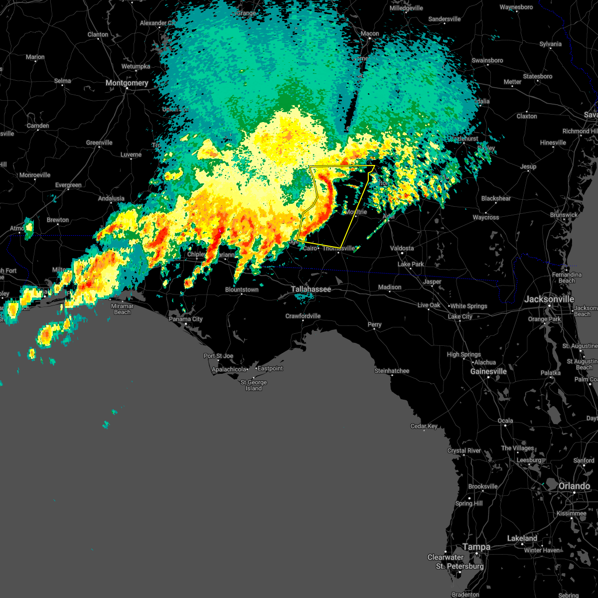 At 306 pm edt, severe thunderstorms were located along a line extending from marine corps logistics base to 8 miles north of whigham, moving east at 30 mph (radar indicated). Hazards include 60 mph wind gusts. Expect damage to roofs, siding, and trees. Locations impacted include, albany, sylvester, pelham, putney, camilla, moultrie, baconton, poulan, doerun, ochlocknee, east albany, marine corps logistics base, turner city, terrell, schley, funston, sumner, sale city, minton and capel. At 306 pm edt, severe thunderstorms were located along a line extending from marine corps logistics base to 8 miles north of whigham, moving east at 30 mph (radar indicated). Hazards include 60 mph wind gusts. Expect damage to roofs, siding, and trees. Locations impacted include, albany, sylvester, pelham, putney, camilla, moultrie, baconton, poulan, doerun, ochlocknee, east albany, marine corps logistics base, turner city, terrell, schley, funston, sumner, sale city, minton and capel.
|
| 3/18/2022 2:37 PM EDT |
 At 236 pm edt, severe thunderstorms were located along a line extending from 10 miles west of albany to 9 miles north of west bainbridge, moving northeast at 40 mph (radar indicated). Hazards include 60 mph wind gusts. expect damage to roofs, siding, and trees At 236 pm edt, severe thunderstorms were located along a line extending from 10 miles west of albany to 9 miles north of west bainbridge, moving northeast at 40 mph (radar indicated). Hazards include 60 mph wind gusts. expect damage to roofs, siding, and trees
|
| 1/2/2022 4:44 PM EST |
 At 444 pm est/344 pm cst/, severe thunderstorms were located along a line extending from near east albany to 8 miles west of west bainbridge, moving east at 40 mph (radar indicated). Hazards include 60 mph wind gusts. Expect damage to roofs, siding, and trees. locations impacted include, newton, bainbridge, albany, putney, camilla, baconton, west bainbridge, east albany, marine corps logistics base, turner city, brinson, hanover, ausmac, babcock, reynoldsville, flint, radium springs, lockett crossing, south albany and southwest ga regional a/p. hail threat, radar indicated max hail size, <. 75 in wind threat, radar indicated max wind gust, 60 mph. At 444 pm est/344 pm cst/, severe thunderstorms were located along a line extending from near east albany to 8 miles west of west bainbridge, moving east at 40 mph (radar indicated). Hazards include 60 mph wind gusts. Expect damage to roofs, siding, and trees. locations impacted include, newton, bainbridge, albany, putney, camilla, baconton, west bainbridge, east albany, marine corps logistics base, turner city, brinson, hanover, ausmac, babcock, reynoldsville, flint, radium springs, lockett crossing, south albany and southwest ga regional a/p. hail threat, radar indicated max hail size, <. 75 in wind threat, radar indicated max wind gust, 60 mph.
|
| 1/2/2022 4:00 PM EST |
 At 400 pm est/300 pm cst/, severe thunderstorms were located along a line extending from leary to near donalsonville, moving northeast at 35 mph (radar indicated). Hazards include 60 mph wind gusts. expect damage to roofs, siding, and trees At 400 pm est/300 pm cst/, severe thunderstorms were located along a line extending from leary to near donalsonville, moving northeast at 35 mph (radar indicated). Hazards include 60 mph wind gusts. expect damage to roofs, siding, and trees
|
| 9/1/2021 7:27 PM EDT |
 The severe thunderstorm warning for northwestern cook, eastern dougherty, northeastern mitchell, northeastern baker, colquitt, southwestern tift and southern worth counties will expire at 730 pm edt, the storms which prompted the warning have weakened below severe limits, and no longer pose an immediate threat to life or property. therefore, the warning will be allowed to expire. however gusty winds are still possible with these thunderstorms. to report severe weather, contact your nearest law enforcement agency. they will relay your report to the national weather service tallahassee. The severe thunderstorm warning for northwestern cook, eastern dougherty, northeastern mitchell, northeastern baker, colquitt, southwestern tift and southern worth counties will expire at 730 pm edt, the storms which prompted the warning have weakened below severe limits, and no longer pose an immediate threat to life or property. therefore, the warning will be allowed to expire. however gusty winds are still possible with these thunderstorms. to report severe weather, contact your nearest law enforcement agency. they will relay your report to the national weather service tallahassee.
|
| 9/1/2021 6:46 PM EDT |
 At 646 pm edt, severe thunderstorms were located along a line extending from near east albany to 6 miles north of doerun to near ty ty, moving southeast at 20 mph (radar indicated). Hazards include 60 mph wind gusts. expect damage to roofs, siding, and trees At 646 pm edt, severe thunderstorms were located along a line extending from near east albany to 6 miles north of doerun to near ty ty, moving southeast at 20 mph (radar indicated). Hazards include 60 mph wind gusts. expect damage to roofs, siding, and trees
|
| 7/28/2021 8:48 PM EDT | Tree down on highway 112 north of jerusalem church road. time estimated by rada in mitchell county GA, 7.2 miles SW of Camilla, GA |
| 7/8/2021 7:59 PM EDT |
 At 758 pm edt, a severe thunderstorm was located 9 miles west of newton, moving east at 25 mph (radar indicated). Hazards include 60 mph wind gusts. expect damage to roofs, siding, and trees At 758 pm edt, a severe thunderstorm was located 9 miles west of newton, moving east at 25 mph (radar indicated). Hazards include 60 mph wind gusts. expect damage to roofs, siding, and trees
|
| 6/29/2021 6:35 PM EDT |
 The severe thunderstorm warning for northwestern grady, mitchell, northwestern colquitt and southwestern worth counties will expire at 645 pm edt, the storms which prompted the warning have moved out of the area. therefore, the warning will be allowed to expire. to report severe weather, contact your nearest law enforcement agency. they will relay your report to the national weather service tallahassee. The severe thunderstorm warning for northwestern grady, mitchell, northwestern colquitt and southwestern worth counties will expire at 645 pm edt, the storms which prompted the warning have moved out of the area. therefore, the warning will be allowed to expire. to report severe weather, contact your nearest law enforcement agency. they will relay your report to the national weather service tallahassee.
|
| 6/29/2021 6:15 PM EDT | Reports of a few trees down in mitchell count in mitchell county GA, 0.4 miles ENE of Camilla, GA |
| 6/29/2021 6:09 PM EDT |
 At 609 pm edt, severe thunderstorms were located along a line extending from 6 miles southwest of sylvester to 6 miles east of bainbridge, moving north at 40 mph (radar indicated). Hazards include 60 mph wind gusts. Expect damage to roofs, siding, and trees. Locations impacted include, newton, pelham, camilla, sylvester, baconton, doerun, whigham, sale city, bridgeboro, minton, flint, sylvester airport, anderson city, tempy, parkerville, cotton, harrells still, lester, peoples still and pritchetts. At 609 pm edt, severe thunderstorms were located along a line extending from 6 miles southwest of sylvester to 6 miles east of bainbridge, moving north at 40 mph (radar indicated). Hazards include 60 mph wind gusts. Expect damage to roofs, siding, and trees. Locations impacted include, newton, pelham, camilla, sylvester, baconton, doerun, whigham, sale city, bridgeboro, minton, flint, sylvester airport, anderson city, tempy, parkerville, cotton, harrells still, lester, peoples still and pritchetts.
|
| 6/29/2021 5:44 PM EDT |
 At 544 pm edt, severe thunderstorms were located along a line extending from 6 miles northwest of norman park to near whigham, moving northwest at 35 mph (radar indicated). Hazards include 60 mph wind gusts. expect damage to roofs, siding, and trees At 544 pm edt, severe thunderstorms were located along a line extending from 6 miles northwest of norman park to near whigham, moving northwest at 35 mph (radar indicated). Hazards include 60 mph wind gusts. expect damage to roofs, siding, and trees
|
| 5/12/2021 11:28 AM EDT |
 At 1128 am edt, severe thunderstorms were located along a line extending from putney to near ochlocknee, moving northeast at 40 mph (radar indicated). Hazards include 60 mph wind gusts. Expect damage to roofs, siding, and trees. Locations impacted include, moultrie, sylvester, pelham, putney, camilla, norman park, baconton, poulan, doerun, ochlocknee, pavo, coolidge, riverside, schley, berlin, funston, sumner, sale city, minton and scooterville. At 1128 am edt, severe thunderstorms were located along a line extending from putney to near ochlocknee, moving northeast at 40 mph (radar indicated). Hazards include 60 mph wind gusts. Expect damage to roofs, siding, and trees. Locations impacted include, moultrie, sylvester, pelham, putney, camilla, norman park, baconton, poulan, doerun, ochlocknee, pavo, coolidge, riverside, schley, berlin, funston, sumner, sale city, minton and scooterville.
|
| 5/12/2021 11:06 AM EDT |
 At 1106 am edt, severe thunderstorms were located along a line extending from 6 miles north of newton to near cairo, moving northeast at 40 mph (radar indicated). Hazards include 60 mph wind gusts. expect damage to roofs, siding, and trees At 1106 am edt, severe thunderstorms were located along a line extending from 6 miles north of newton to near cairo, moving northeast at 40 mph (radar indicated). Hazards include 60 mph wind gusts. expect damage to roofs, siding, and trees
|
| 5/4/2021 10:40 PM EDT | Multiple lines and trees down on andrews in camilla... g in mitchell county GA, 0.4 miles ENE of Camilla, GA |
| 5/4/2021 10:36 PM EDT |
 At 1035 pm edt, severe thunderstorms were located along a line extending from near baconton to 10 miles northwest of donalsonville, moving southeast at 40 mph (radar indicated). Hazards include 60 mph wind gusts. Expect damage to roofs, siding, and trees. Locations impacted include, colquitt, newton, donalsonville, pelham, putney, camilla, albany, baconton, columbia, east albany, marine corps logistics base, turner city, douglasville, centerville, sale city, gordon, iron city, damascus, jakin and iveys mill. At 1035 pm edt, severe thunderstorms were located along a line extending from near baconton to 10 miles northwest of donalsonville, moving southeast at 40 mph (radar indicated). Hazards include 60 mph wind gusts. Expect damage to roofs, siding, and trees. Locations impacted include, colquitt, newton, donalsonville, pelham, putney, camilla, albany, baconton, columbia, east albany, marine corps logistics base, turner city, douglasville, centerville, sale city, gordon, iron city, damascus, jakin and iveys mill.
|
| 5/4/2021 9:52 PM EDT |
 At 952 pm edt, severe thunderstorms were located along a line extending from near morgan to near columbia, moving southeast at 55 mph (radar indicated). Hazards include 60 mph wind gusts. expect damage to roofs, siding, and trees At 952 pm edt, severe thunderstorms were located along a line extending from near morgan to near columbia, moving southeast at 55 mph (radar indicated). Hazards include 60 mph wind gusts. expect damage to roofs, siding, and trees
|
| 4/24/2021 5:44 PM EDT |
 At 544 pm edt, severe thunderstorms were located along a line extending from 7 miles northwest of doerun to near camilla, moving east at 45 mph (radar indicated). Hazards include 60 mph wind gusts and quarter size hail. Hail damage to vehicles is expected. Expect wind damage to roofs, siding, and trees. At 544 pm edt, severe thunderstorms were located along a line extending from 7 miles northwest of doerun to near camilla, moving east at 45 mph (radar indicated). Hazards include 60 mph wind gusts and quarter size hail. Hail damage to vehicles is expected. Expect wind damage to roofs, siding, and trees.
|
| 4/24/2021 5:20 PM EDT | Trees down and in the road in mitchell count in mitchell county GA, 0.4 miles ENE of Camilla, GA |
| 4/24/2021 4:58 PM EDT |
 At 457 pm edt, severe thunderstorms were located along a line extending from near albany to near newton to near colquitt, moving east at 50 mph (radar indicated). Hazards include 60 mph wind gusts and quarter size hail. Hail damage to vehicles is expected. Expect wind damage to roofs, siding, and trees. At 457 pm edt, severe thunderstorms were located along a line extending from near albany to near newton to near colquitt, moving east at 50 mph (radar indicated). Hazards include 60 mph wind gusts and quarter size hail. Hail damage to vehicles is expected. Expect wind damage to roofs, siding, and trees.
|
| 4/24/2021 9:46 AM EDT |
 At 945 am edt, severe thunderstorms were located along a line extending from near leesburg to near baconton to 9 miles west of pelham, moving east at 60 mph (radar indicated). Hazards include golf ball size hail and 70 mph wind gusts. People and animals outdoors will be injured. expect hail damage to roofs, siding, windows, and vehicles. expect considerable tree damage. wind damage is also likely to mobile homes, roofs, and outbuildings. Locations impacted include, newton, albany, moultrie, sylvester, leesburg, pelham, putney, camilla, ashburn, norman park, baconton, poulan, doerun, east albany, marine corps logistics base, turner city, riverside, worth, terrell and schley. At 945 am edt, severe thunderstorms were located along a line extending from near leesburg to near baconton to 9 miles west of pelham, moving east at 60 mph (radar indicated). Hazards include golf ball size hail and 70 mph wind gusts. People and animals outdoors will be injured. expect hail damage to roofs, siding, windows, and vehicles. expect considerable tree damage. wind damage is also likely to mobile homes, roofs, and outbuildings. Locations impacted include, newton, albany, moultrie, sylvester, leesburg, pelham, putney, camilla, ashburn, norman park, baconton, poulan, doerun, east albany, marine corps logistics base, turner city, riverside, worth, terrell and schley.
|
| 4/24/2021 9:33 AM EDT |
 At 933 am edt, a severe thunderstorm capable of producing a tornado was located 8 miles west of newton, moving east at 50 mph (radar indicated rotation). Hazards include tornado and quarter size hail. Flying debris will be dangerous to those caught without shelter. mobile homes will be damaged or destroyed. damage to roofs, windows, and vehicles will occur. Tree damage is likely. At 933 am edt, a severe thunderstorm capable of producing a tornado was located 8 miles west of newton, moving east at 50 mph (radar indicated rotation). Hazards include tornado and quarter size hail. Flying debris will be dangerous to those caught without shelter. mobile homes will be damaged or destroyed. damage to roofs, windows, and vehicles will occur. Tree damage is likely.
|
| 4/24/2021 9:28 AM EDT |
 At 928 am edt, severe thunderstorms were located along a line extending from dawson to near newton to 9 miles southeast of colquitt, moving east at 60 mph (radar indicated). Hazards include 70 mph wind gusts. Expect considerable tree damage. Damage is likely to mobile homes, roofs, and outbuildings. At 928 am edt, severe thunderstorms were located along a line extending from dawson to near newton to 9 miles southeast of colquitt, moving east at 60 mph (radar indicated). Hazards include 70 mph wind gusts. Expect considerable tree damage. Damage is likely to mobile homes, roofs, and outbuildings.
|
| 3/31/2021 7:27 PM EDT |
 At 726 pm edt/626 pm cdt/, severe thunderstorms were located along a line extending from near ochlocknee to near bainbridge to 10 miles east of marianna, moving southeast at 30 mph (radar indicated). Hazards include 60 mph wind gusts. Expect damage to roofs, siding, and trees. Locations impacted include, colquitt, newton, bainbridge, donalsonville, pelham, camilla, whigham, west bainbridge, chattahoochee, malone, sneads, grand ridge, greenwood, sale city, iron city, climax, brinson, jakin, bascom and crosby. At 726 pm edt/626 pm cdt/, severe thunderstorms were located along a line extending from near ochlocknee to near bainbridge to 10 miles east of marianna, moving southeast at 30 mph (radar indicated). Hazards include 60 mph wind gusts. Expect damage to roofs, siding, and trees. Locations impacted include, colquitt, newton, bainbridge, donalsonville, pelham, camilla, whigham, west bainbridge, chattahoochee, malone, sneads, grand ridge, greenwood, sale city, iron city, climax, brinson, jakin, bascom and crosby.
|
| 3/31/2021 6:54 PM EDT |
 At 654 pm edt/554 pm cdt/, severe thunderstorms were located along a line extending from near leary to near colquitt to near cottonwood, moving east at 55 mph (radar indicated). Hazards include 60 mph wind gusts. expect damage to roofs, siding, and trees At 654 pm edt/554 pm cdt/, severe thunderstorms were located along a line extending from near leary to near colquitt to near cottonwood, moving east at 55 mph (radar indicated). Hazards include 60 mph wind gusts. expect damage to roofs, siding, and trees
|
| 3/31/2021 6:54 PM EDT |
 The national weather service in tallahassee has issued a * severe thunderstorm warning for. southeastern houston county in southeastern alabama. northeastern jackson county in the panhandle of florida. northwestern gadsden county in big bend of florida. Decatur county in southwestern georgia. The national weather service in tallahassee has issued a * severe thunderstorm warning for. southeastern houston county in southeastern alabama. northeastern jackson county in the panhandle of florida. northwestern gadsden county in big bend of florida. Decatur county in southwestern georgia.
|
| 3/31/2021 6:54 PM EDT |
 At 654 pm edt/554 pm cdt/, severe thunderstorms were located along a line extending from near leary to near colquitt to near cottonwood, moving east at 55 mph (radar indicated). Hazards include 60 mph wind gusts. expect damage to roofs, siding, and trees At 654 pm edt/554 pm cdt/, severe thunderstorms were located along a line extending from near leary to near colquitt to near cottonwood, moving east at 55 mph (radar indicated). Hazards include 60 mph wind gusts. expect damage to roofs, siding, and trees
|
| 3/28/2021 6:22 PM EDT |
 The severe thunderstorm warning for northeastern decatur, northern grady, mitchell and northwestern thomas counties will expire at 630 pm edt, the storms which prompted the warning have weakened below severe limits, and have exited the warned area. therefore, the warning will be allowed to expire. to report severe weather, contact your nearest law enforcement agency. they will relay your report to the national weather service tallahassee. The severe thunderstorm warning for northeastern decatur, northern grady, mitchell and northwestern thomas counties will expire at 630 pm edt, the storms which prompted the warning have weakened below severe limits, and have exited the warned area. therefore, the warning will be allowed to expire. to report severe weather, contact your nearest law enforcement agency. they will relay your report to the national weather service tallahassee.
|
| 3/28/2021 6:00 PM EDT | Strong winds caused some power lines to sag... resulting in a power outage. in addition... tree limbs were also blown onto the lines. outages affected around 99 custome in mitchell county GA, 0.4 miles ENE of Camilla, GA |
| 3/28/2021 5:58 PM EDT |
 At 558 pm edt, severe thunderstorms were located along a line extending from baconton to 13 miles northeast of bainbridge, moving east at 45 mph (radar indicated). Hazards include 60 mph wind gusts. Expect damage to roofs, siding, and trees. Locations impacted include, pelham, camilla, baconton, sale city, vada, flint, elpino, hopeful, cotton, harrells still, laney, lester, spence, freeman, quality, mitchell co a/p, branchville, greenough and hinsonton. At 558 pm edt, severe thunderstorms were located along a line extending from baconton to 13 miles northeast of bainbridge, moving east at 45 mph (radar indicated). Hazards include 60 mph wind gusts. Expect damage to roofs, siding, and trees. Locations impacted include, pelham, camilla, baconton, sale city, vada, flint, elpino, hopeful, cotton, harrells still, laney, lester, spence, freeman, quality, mitchell co a/p, branchville, greenough and hinsonton.
|
| 3/28/2021 5:50 PM EDT |
 At 550 pm edt, severe thunderstorms were located along a line extending from near newton to 13 miles northeast of west bainbridge, moving east at 45 mph (radar indicated). Hazards include 60 mph wind gusts. Expect damage to roofs, siding, and trees. Locations impacted include, newton, pelham, camilla, baconton, sale city, vada, flint, elpino, hopeful, red store crossroads, hoggard mill, cotton, steinham store, harrells still, laney, lester, spence, freeman, quality and mitchell co a/p. At 550 pm edt, severe thunderstorms were located along a line extending from near newton to 13 miles northeast of west bainbridge, moving east at 45 mph (radar indicated). Hazards include 60 mph wind gusts. Expect damage to roofs, siding, and trees. Locations impacted include, newton, pelham, camilla, baconton, sale city, vada, flint, elpino, hopeful, red store crossroads, hoggard mill, cotton, steinham store, harrells still, laney, lester, spence, freeman, quality and mitchell co a/p.
|
| 3/28/2021 5:33 PM EDT |
 At 533 pm edt, severe thunderstorms were located along a line extending from 8 miles southeast of arlington to 7 miles southeast of colquitt, moving northeast at 40 mph (radar indicated). Hazards include 60 mph wind gusts. expect damage to roofs, siding, and trees At 533 pm edt, severe thunderstorms were located along a line extending from 8 miles southeast of arlington to 7 miles southeast of colquitt, moving northeast at 40 mph (radar indicated). Hazards include 60 mph wind gusts. expect damage to roofs, siding, and trees
|
| 2/15/2021 5:05 PM EST | Tree down along dellwood road near highway 9 in mitchell county GA, 15.8 miles NE of Camilla, GA |
| 2/15/2021 4:53 PM EST |
 At 453 pm est, severe thunderstorms were located along a line extending from leary to near bainbridge, moving northeast at 50 mph (radar indicated). Hazards include 60 mph wind gusts and penny size hail. Expect damage to roofs, siding, and trees. Locations impacted include, newton, morgan, albany, dawson, leesburg, pelham, putney, camilla, baconton, leary, east albany, marine corps logistics base, turner city, smithville, walker, sale city, sasser, bronwood, iveys mill and stocks. At 453 pm est, severe thunderstorms were located along a line extending from leary to near bainbridge, moving northeast at 50 mph (radar indicated). Hazards include 60 mph wind gusts and penny size hail. Expect damage to roofs, siding, and trees. Locations impacted include, newton, morgan, albany, dawson, leesburg, pelham, putney, camilla, baconton, leary, east albany, marine corps logistics base, turner city, smithville, walker, sale city, sasser, bronwood, iveys mill and stocks.
|
| 2/15/2021 4:52 PM EST |
 At 452 pm est, severe thunderstorms were located along a line extending from leary to near bainbridge, moving northeast at 50 mph (radar indicated). Hazards include 60 mph wind gusts and penny size hail. expect damage to roofs, siding, and trees At 452 pm est, severe thunderstorms were located along a line extending from leary to near bainbridge, moving northeast at 50 mph (radar indicated). Hazards include 60 mph wind gusts and penny size hail. expect damage to roofs, siding, and trees
|
| 9/16/2020 2:05 PM EDT |
 At 205 pm edt, severe thunderstorms were located along a line extending from 14 miles northeast of west bainbridge to 12 miles southwest of monticello, moving east at 30 mph (radar indicated). Hazards include 60 mph wind gusts. expect damage to roofs, siding, and trees At 205 pm edt, severe thunderstorms were located along a line extending from 14 miles northeast of west bainbridge to 12 miles southwest of monticello, moving east at 30 mph (radar indicated). Hazards include 60 mph wind gusts. expect damage to roofs, siding, and trees
|
| 8/10/2020 5:19 PM EDT |
 At 518 pm edt, a severe thunderstorm was located 9 miles north of whigham, or 10 miles southwest of pelham, moving southwest at 20 mph (radar indicated). Hazards include 60 mph wind gusts and quarter size hail. Hail damage to vehicles is possible. Expect wind damage to roofs, siding, and trees. At 518 pm edt, a severe thunderstorm was located 9 miles north of whigham, or 10 miles southwest of pelham, moving southwest at 20 mph (radar indicated). Hazards include 60 mph wind gusts and quarter size hail. Hail damage to vehicles is possible. Expect wind damage to roofs, siding, and trees.
|
| 4/23/2020 3:42 PM EDT |
 The national weather service in tallahassee has issued a * severe thunderstorm warning for. southeastern houston county in southeastern alabama. jackson county in the panhandle of florida. northeastern calhoun county in the panhandle of florida. Northern liberty county in big bend of florida. The national weather service in tallahassee has issued a * severe thunderstorm warning for. southeastern houston county in southeastern alabama. jackson county in the panhandle of florida. northeastern calhoun county in the panhandle of florida. Northern liberty county in big bend of florida.
|
| 4/23/2020 3:42 PM EDT |
 At 342 pm edt/242 pm cdt/, severe thunderstorms were located along a line extending from near colquitt to 7 miles southeast of chipley, moving east at 40 mph (radar indicated). Hazards include 60 mph wind gusts and penny size hail. expect damage to roofs, siding, and trees At 342 pm edt/242 pm cdt/, severe thunderstorms were located along a line extending from near colquitt to 7 miles southeast of chipley, moving east at 40 mph (radar indicated). Hazards include 60 mph wind gusts and penny size hail. expect damage to roofs, siding, and trees
|
| 4/23/2020 11:48 AM EDT | Numerous trees down on the roa in mitchell county GA, 16.1 miles NE of Camilla, GA |
| 4/20/2020 2:28 AM EDT |
 At 228 am edt, severe thunderstorms were located along a line extending from near cordele to 7 miles northeast of doerun to 6 miles west of riverside, moving east at 50 mph (radar indicated). Hazards include 70 mph wind gusts and quarter size hail. Hail damage to vehicles is expected. expect considerable tree damage. wind damage is also likely to mobile homes, roofs, and outbuildings. Locations impacted include, newton, tifton, albany, putney, ashburn, sylvester, leesburg, camilla, moultrie, sparks, omega, norman park, baconton, lenox, poulan, doerun, ty ty, phillipsburg, unionville and east albany. At 228 am edt, severe thunderstorms were located along a line extending from near cordele to 7 miles northeast of doerun to 6 miles west of riverside, moving east at 50 mph (radar indicated). Hazards include 70 mph wind gusts and quarter size hail. Hail damage to vehicles is expected. expect considerable tree damage. wind damage is also likely to mobile homes, roofs, and outbuildings. Locations impacted include, newton, tifton, albany, putney, ashburn, sylvester, leesburg, camilla, moultrie, sparks, omega, norman park, baconton, lenox, poulan, doerun, ty ty, phillipsburg, unionville and east albany.
|
| 4/20/2020 2:14 AM EDT |
 At 214 am edt, severe thunderstorms were located along a line extending from 6 miles east of desoto to 6 miles northwest of doerun to 7 miles east of camilla, moving east at 50 mph (radar indicated). Hazards include 70 mph wind gusts. Expect considerable tree damage. damage is likely to mobile homes, roofs, and outbuildings. Locations impacted include, newton, tifton, albany, putney, ashburn, sylvester, leesburg, camilla, moultrie, sparks, omega, norman park, baconton, lenox, poulan, doerun, ty ty, phillipsburg, unionville and east albany. At 214 am edt, severe thunderstorms were located along a line extending from 6 miles east of desoto to 6 miles northwest of doerun to 7 miles east of camilla, moving east at 50 mph (radar indicated). Hazards include 70 mph wind gusts. Expect considerable tree damage. damage is likely to mobile homes, roofs, and outbuildings. Locations impacted include, newton, tifton, albany, putney, ashburn, sylvester, leesburg, camilla, moultrie, sparks, omega, norman park, baconton, lenox, poulan, doerun, ty ty, phillipsburg, unionville and east albany.
|
| 4/20/2020 1:52 AM EDT |
 At 152 am edt/1252 am cdt/, severe thunderstorms were located along a line extending from 8 miles south of newton to near west bainbridge to 9 miles north of chattahoochee to 12 miles east of marianna, moving east at 50 mph (radar indicated). Hazards include 70 mph wind gusts. Expect considerable tree damage. Damage is likely to mobile homes, roofs, and outbuildings. At 152 am edt/1252 am cdt/, severe thunderstorms were located along a line extending from 8 miles south of newton to near west bainbridge to 9 miles north of chattahoochee to 12 miles east of marianna, moving east at 50 mph (radar indicated). Hazards include 70 mph wind gusts. Expect considerable tree damage. Damage is likely to mobile homes, roofs, and outbuildings.
|
| 4/20/2020 1:38 AM EDT |
 At 138 am edt, severe thunderstorms were located along a line extending from near plains to 8 miles east of leary to 7 miles west of newton, moving east at 50 mph (radar indicated). Hazards include 70 mph wind gusts. Expect considerable tree damage. Damage is likely to mobile homes, roofs, and outbuildings. At 138 am edt, severe thunderstorms were located along a line extending from near plains to 8 miles east of leary to 7 miles west of newton, moving east at 50 mph (radar indicated). Hazards include 70 mph wind gusts. Expect considerable tree damage. Damage is likely to mobile homes, roofs, and outbuildings.
|
| 4/20/2020 1:26 AM EDT |
 At 126 am edt/1226 am cdt/, severe thunderstorms were located along a line extending from near colquitt to 9 miles west of donalsonville to near marianna to 6 miles southeast of chipley, moving east at 35 mph (radar indicated). Hazards include 70 mph wind gusts. Expect considerable tree damage. Damage is likely to mobile homes, roofs, and outbuildings. At 126 am edt/1226 am cdt/, severe thunderstorms were located along a line extending from near colquitt to 9 miles west of donalsonville to near marianna to 6 miles southeast of chipley, moving east at 35 mph (radar indicated). Hazards include 70 mph wind gusts. Expect considerable tree damage. Damage is likely to mobile homes, roofs, and outbuildings.
|
| 4/20/2020 1:05 AM EDT |
 At 105 am edt, severe thunderstorms were located along a line extending from near lumpkin to 6 miles west of edison to near blakely, moving east at 50 mph (radar indicated). Hazards include 70 mph wind gusts. Expect considerable tree damage. Damage is likely to mobile homes, roofs, and outbuildings. At 105 am edt, severe thunderstorms were located along a line extending from near lumpkin to 6 miles west of edison to near blakely, moving east at 50 mph (radar indicated). Hazards include 70 mph wind gusts. Expect considerable tree damage. Damage is likely to mobile homes, roofs, and outbuildings.
|
| 4/13/2020 5:16 AM EDT |
 At 515 am edt, a severe thunderstorm was located over camilla, moving east at 55 mph (radar indicated). Hazards include 60 mph wind gusts. expect damage to roofs, siding, and trees At 515 am edt, a severe thunderstorm was located over camilla, moving east at 55 mph (radar indicated). Hazards include 60 mph wind gusts. expect damage to roofs, siding, and trees
|
| 4/13/2020 4:59 AM EDT |
 At 458 am edt, a severe thunderstorm was located 7 miles southwest of newton, moving east at 55 mph (radar indicated). Hazards include 60 mph wind gusts. Expect damage to roofs, siding, and trees. Locations impacted include, colquitt, newton, albany, pelham, putney, camilla, baconton, east albany, marine corps logistics base, turner city, walker, sale city, damascus, jakin, iveys mill, radium springs, lester, greenough, bellview and hopeful. At 458 am edt, a severe thunderstorm was located 7 miles southwest of newton, moving east at 55 mph (radar indicated). Hazards include 60 mph wind gusts. Expect damage to roofs, siding, and trees. Locations impacted include, colquitt, newton, albany, pelham, putney, camilla, baconton, east albany, marine corps logistics base, turner city, walker, sale city, damascus, jakin, iveys mill, radium springs, lester, greenough, bellview and hopeful.
|
| 4/13/2020 4:05 AM EDT |
 At 405 am edt, a severe thunderstorm was located near ashford, or 10 miles northeast of cottonwood, moving east at 45 mph (radar indicated). Hazards include 60 mph wind gusts. expect damage to roofs, siding, and trees At 405 am edt, a severe thunderstorm was located near ashford, or 10 miles northeast of cottonwood, moving east at 45 mph (radar indicated). Hazards include 60 mph wind gusts. expect damage to roofs, siding, and trees
|
| 3/31/2020 2:23 PM EDT | Trees and power poles down on ga hwy 311... south of ga hwy 65 to the decatur county lin in mitchell county GA, 17.3 miles ENE of Camilla, GA |
| 3/31/2020 2:20 PM EDT |
 At 219 pm edt, severe thunderstorms were located along a line extending from 6 miles southeast of pineview to 6 miles northwest of doerun to 10 miles southwest of newton, moving east at 70 mph (radar indicated). Hazards include 60 mph wind gusts. Expect damage to roofs, siding, and trees. Locations impacted include, newton, bainbridge, cairo, pelham, putney, camilla, sylvester, albany, baconton, doerun, whigham, west bainbridge, east albany, marine corps logistics base, turner city, attapulgus, warwick, sale city, climax and brinson. At 219 pm edt, severe thunderstorms were located along a line extending from 6 miles southeast of pineview to 6 miles northwest of doerun to 10 miles southwest of newton, moving east at 70 mph (radar indicated). Hazards include 60 mph wind gusts. Expect damage to roofs, siding, and trees. Locations impacted include, newton, bainbridge, cairo, pelham, putney, camilla, sylvester, albany, baconton, doerun, whigham, west bainbridge, east albany, marine corps logistics base, turner city, attapulgus, warwick, sale city, climax and brinson.
|
| 3/31/2020 1:43 PM EDT |
 At 143 pm edt, severe thunderstorms were located along a line extending from leslie to 7 miles north of colquitt to 10 miles southeast of ashford, moving east at 70 mph (radar indicated). Hazards include 60 mph wind gusts. expect damage to roofs, siding, and trees At 143 pm edt, severe thunderstorms were located along a line extending from leslie to 7 miles north of colquitt to 10 miles southeast of ashford, moving east at 70 mph (radar indicated). Hazards include 60 mph wind gusts. expect damage to roofs, siding, and trees
|
| 2/6/2020 4:15 PM EST | Tree down over a county road. multiple power outages across the count in mitchell county GA, 15.8 miles NE of Camilla, GA |
| 2/6/2020 3:35 PM EST |
 At 334 pm est/234 pm cst/, severe thunderstorms were located along a line extending from 9 miles south of leary to 9 miles northeast of blountstown, moving east at 25 mph (radar indicated). Hazards include 60 mph wind gusts. Expect damage to roofs, siding, and trees. Locations impacted include, colquitt, newton, bainbridge, camilla, pelham, baconton, greensboro, west bainbridge, chattahoochee, gretna, attapulgus, iron city, climax, brinson, rock bluff, ocheesee, juniper, douglas city, selman and recovery. At 334 pm est/234 pm cst/, severe thunderstorms were located along a line extending from 9 miles south of leary to 9 miles northeast of blountstown, moving east at 25 mph (radar indicated). Hazards include 60 mph wind gusts. Expect damage to roofs, siding, and trees. Locations impacted include, colquitt, newton, bainbridge, camilla, pelham, baconton, greensboro, west bainbridge, chattahoochee, gretna, attapulgus, iron city, climax, brinson, rock bluff, ocheesee, juniper, douglas city, selman and recovery.
|
| 2/6/2020 2:58 PM EST |
 At 258 pm est/158 pm cst/, severe thunderstorms were located along a line extending from 8 miles south of arlington to 11 miles northwest of blountstown, moving east at 25 mph (radar indicated). Hazards include 60 mph wind gusts. expect damage to roofs, siding, and trees At 258 pm est/158 pm cst/, severe thunderstorms were located along a line extending from 8 miles south of arlington to 11 miles northwest of blountstown, moving east at 25 mph (radar indicated). Hazards include 60 mph wind gusts. expect damage to roofs, siding, and trees
|
| 12/17/2019 10:05 AM EST |
 At 1005 am est, a severe thunderstorm capable of producing a tornado was located over newton, moving east at 35 mph (radar indicated rotation). Hazards include tornado. Flying debris will be dangerous to those caught without shelter. mobile homes will be damaged or destroyed. damage to roofs, windows, and vehicles will occur. tree damage is likely. this dangerous storm will be near, baconton around 1020 am est. Other locations impacted by this tornadic thunderstorm include lester, greenough, flint, freeman and red store crossroads. At 1005 am est, a severe thunderstorm capable of producing a tornado was located over newton, moving east at 35 mph (radar indicated rotation). Hazards include tornado. Flying debris will be dangerous to those caught without shelter. mobile homes will be damaged or destroyed. damage to roofs, windows, and vehicles will occur. tree damage is likely. this dangerous storm will be near, baconton around 1020 am est. Other locations impacted by this tornadic thunderstorm include lester, greenough, flint, freeman and red store crossroads.
|
| 12/17/2019 9:51 AM EST |
 At 951 am est, a severe thunderstorm capable of producing a tornado was located near newton, moving east at 40 mph (radar indicated rotation). Hazards include tornado. Flying debris will be dangerous to those caught without shelter. mobile homes will be damaged or destroyed. damage to roofs, windows, and vehicles will occur. tree damage is likely. this dangerous storm will be near, newton around 1000 am est. baconton around 1015 am est. Other locations impacted by this tornadic thunderstorm include hawkinstown, lester, flint, freeman, red store crossroads, greenough and elmodel wma. At 951 am est, a severe thunderstorm capable of producing a tornado was located near newton, moving east at 40 mph (radar indicated rotation). Hazards include tornado. Flying debris will be dangerous to those caught without shelter. mobile homes will be damaged or destroyed. damage to roofs, windows, and vehicles will occur. tree damage is likely. this dangerous storm will be near, newton around 1000 am est. baconton around 1015 am est. Other locations impacted by this tornadic thunderstorm include hawkinstown, lester, flint, freeman, red store crossroads, greenough and elmodel wma.
|
| 7/7/2019 8:52 PM EDT | Tree dow in mitchell county GA, 3.4 miles ENE of Camilla, GA |
| 7/7/2019 8:49 PM EDT |
 At 848 pm edt, a severe thunderstorm was located near camilla, moving east at 15 mph (radar indicated). Hazards include 60 mph wind gusts. expect damage to roofs, siding, and trees At 848 pm edt, a severe thunderstorm was located near camilla, moving east at 15 mph (radar indicated). Hazards include 60 mph wind gusts. expect damage to roofs, siding, and trees
|
| 6/24/2019 5:40 PM EDT | Irrigation pivot turned over between camilla and pebble cit in mitchell county GA, 4.4 miles W of Camilla, GA |
| 6/24/2019 5:30 PM EDT |
 At 530 pm edt, a severe thunderstorm was located over camilla, moving southeast at 30 mph (radar indicated). Hazards include 60 mph wind gusts. expect damage to roofs, siding, and trees At 530 pm edt, a severe thunderstorm was located over camilla, moving southeast at 30 mph (radar indicated). Hazards include 60 mph wind gusts. expect damage to roofs, siding, and trees
|
| 6/20/2019 7:20 PM EDT | Tree down near stagecoach roa in mitchell county GA, 8.1 miles SW of Camilla, GA |
| 6/20/2019 7:20 PM EDT |
 The severe thunderstorm warning for southeastern dougherty, northeastern mitchell, baker and central early counties will expire at 730 pm edt, the storms which prompted the warning have weakened below severe limits, and no longer pose an immediate threat to life or property. therefore, the warning will be allowed to expire. a severe thunderstorm watch remains in effect until 1000 pm edt for south central and southwestern georgia. to report severe weather, contact your nearest law enforcement agency. they will relay your report to the national weather service tallahassee. The severe thunderstorm warning for southeastern dougherty, northeastern mitchell, baker and central early counties will expire at 730 pm edt, the storms which prompted the warning have weakened below severe limits, and no longer pose an immediate threat to life or property. therefore, the warning will be allowed to expire. a severe thunderstorm watch remains in effect until 1000 pm edt for south central and southwestern georgia. to report severe weather, contact your nearest law enforcement agency. they will relay your report to the national weather service tallahassee.
|
| 6/20/2019 7:07 PM EDT |
 At 706 pm edt, severe thunderstorms were located along a line extending from 7 miles north of colquitt to near baconton, moving southeast at 50 mph (radar indicated). Hazards include 60 mph wind gusts. Expect damage to roofs, siding, and trees. Locations impacted include, newton, putney, blakely, baconton, douglasville, centerville, sale city, damascus, iveys mill, flint, rock hill, lester, williamsburg, greenough, hentown, hilton, rowena, milford, red store crossroads and crestview. At 706 pm edt, severe thunderstorms were located along a line extending from 7 miles north of colquitt to near baconton, moving southeast at 50 mph (radar indicated). Hazards include 60 mph wind gusts. Expect damage to roofs, siding, and trees. Locations impacted include, newton, putney, blakely, baconton, douglasville, centerville, sale city, damascus, iveys mill, flint, rock hill, lester, williamsburg, greenough, hentown, hilton, rowena, milford, red store crossroads and crestview.
|
| 6/20/2019 6:28 PM EDT |
 At 628 pm edt, doppler radar indicated a line of severe thunderstorms capable of producing damaging winds in excess of 60 mph. these storms were located along a line extending from near blakely to 9 miles east of leary, and moving east at 30 mph. At 628 pm edt, doppler radar indicated a line of severe thunderstorms capable of producing damaging winds in excess of 60 mph. these storms were located along a line extending from near blakely to 9 miles east of leary, and moving east at 30 mph.
|
| 5/12/2019 1:15 PM EDT |
 At 115 pm edt, severe thunderstorms were located along a line extending from near albany to 6 miles southeast of baconton to near cairo, moving east at 45 mph (radar indicated). Hazards include 60 mph wind gusts and penny size hail. expect damage to roofs, siding, and trees At 115 pm edt, severe thunderstorms were located along a line extending from near albany to 6 miles southeast of baconton to near cairo, moving east at 45 mph (radar indicated). Hazards include 60 mph wind gusts and penny size hail. expect damage to roofs, siding, and trees
|
| 5/12/2019 12:42 PM EDT |
 At 1241 pm edt, severe thunderstorms were located along a line extending from 7 miles south of shellman to 9 miles west of newton to near bainbridge, moving east at 45 mph (radar indicated). Hazards include 60 mph wind gusts and penny size hail. expect damage to roofs, siding, and trees At 1241 pm edt, severe thunderstorms were located along a line extending from 7 miles south of shellman to 9 miles west of newton to near bainbridge, moving east at 45 mph (radar indicated). Hazards include 60 mph wind gusts and penny size hail. expect damage to roofs, siding, and trees
|
| 5/11/2019 2:55 PM EDT |
 At 255 pm edt, a severe thunderstorm was located near newton, moving northeast at 30 mph (radar indicated). Hazards include 60 mph wind gusts and quarter size hail. Hail damage to vehicles is expected. Expect wind damage to roofs, siding, and trees. At 255 pm edt, a severe thunderstorm was located near newton, moving northeast at 30 mph (radar indicated). Hazards include 60 mph wind gusts and quarter size hail. Hail damage to vehicles is expected. Expect wind damage to roofs, siding, and trees.
|
| 4/19/2019 9:45 AM EDT |
 At 945 am edt, severe thunderstorms were located along a line extending from near baconton to near ochlocknee, moving northeast at 60 mph (radar indicated). Hazards include 60 mph wind gusts. Expect damage to roofs, siding, and trees. locations impacted include, moultrie, thomasville, pelham, putney, camilla, albany, norman park, baconton, doerun, coolidge, marine corps logistics base, riverside, schley, funston, sale city, minton, radium springs, anderson city, parkerville and lester. A tornado watch remains in effect until 1100 am edt for big bend of florida, and south central and southwestern georgia. At 945 am edt, severe thunderstorms were located along a line extending from near baconton to near ochlocknee, moving northeast at 60 mph (radar indicated). Hazards include 60 mph wind gusts. Expect damage to roofs, siding, and trees. locations impacted include, moultrie, thomasville, pelham, putney, camilla, albany, norman park, baconton, doerun, coolidge, marine corps logistics base, riverside, schley, funston, sale city, minton, radium springs, anderson city, parkerville and lester. A tornado watch remains in effect until 1100 am edt for big bend of florida, and south central and southwestern georgia.
|
| 4/19/2019 9:24 AM EDT |
 At 924 am edt, severe thunderstorms were located along a line extending from 9 miles north of whigham to 9 miles southeast of cairo, moving northeast at 60 mph (radar indicated). Hazards include 60 mph wind gusts. expect damage to roofs, siding, and trees At 924 am edt, severe thunderstorms were located along a line extending from 9 miles north of whigham to 9 miles southeast of cairo, moving northeast at 60 mph (radar indicated). Hazards include 60 mph wind gusts. expect damage to roofs, siding, and trees
|
| 4/19/2019 8:30 AM EDT | A couple of reports of tree branches temporarily blocking roads have since been cleare in mitchell county GA, 0.4 miles ENE of Camilla, GA |
| 4/19/2019 8:24 AM EDT |
 At 824 am edt, a severe thunderstorm was located near pelham, moving north at 55 mph (radar indicated). Hazards include 60 mph wind gusts. Expect damage to roofs, siding, and trees. locations impacted include, cairo, pelham, camilla, vada, akridge, capel, elpino, hopeful, cotton, harrells still, laney, peoples still, spence, mitchell co a/p, branchville and hinsonton. A tornado watch remains in effect until 1100 am edt for south central and southwestern georgia. At 824 am edt, a severe thunderstorm was located near pelham, moving north at 55 mph (radar indicated). Hazards include 60 mph wind gusts. Expect damage to roofs, siding, and trees. locations impacted include, cairo, pelham, camilla, vada, akridge, capel, elpino, hopeful, cotton, harrells still, laney, peoples still, spence, mitchell co a/p, branchville and hinsonton. A tornado watch remains in effect until 1100 am edt for south central and southwestern georgia.
|
| 4/19/2019 8:14 AM EDT |
 At 813 am edt, severe thunderstorms were located along a line extending from near dawson to camilla, moving north at 75 mph (radar indicated). Hazards include 60 mph wind gusts. expect damage to roofs, siding, and trees At 813 am edt, severe thunderstorms were located along a line extending from near dawson to camilla, moving north at 75 mph (radar indicated). Hazards include 60 mph wind gusts. expect damage to roofs, siding, and trees
|
| 4/19/2019 7:47 AM EDT |
 At 747 am edt, a severe thunderstorm was located near havana, moving north at 55 mph (radar indicated). Hazards include 60 mph wind gusts. expect damage to roofs, siding, and trees At 747 am edt, a severe thunderstorm was located near havana, moving north at 55 mph (radar indicated). Hazards include 60 mph wind gusts. expect damage to roofs, siding, and trees
|
| 4/14/2019 1:56 PM EDT |
 At 156 pm edt, a severe thunderstorm was located over pelham, moving northeast at 45 mph (radar indicated). Hazards include 60 mph wind gusts. expect damage to roofs, siding, and trees At 156 pm edt, a severe thunderstorm was located over pelham, moving northeast at 45 mph (radar indicated). Hazards include 60 mph wind gusts. expect damage to roofs, siding, and trees
|
| 4/14/2019 12:52 PM EDT |
 At 1252 pm edt, severe thunderstorms were located along a line extending from near lilly to 7 miles west of cordele to 8 miles east of leesburg, moving northeast at 80 mph (radar indicated). Hazards include 60 mph wind gusts. Expect damage to roofs, siding, and trees. locations impacted include, newton, albany, ashburn, sylvester, leesburg, putney, camilla, baconton, poulan, doerun, east albany, marine corps logistics base, turner city, walker, terrell, warwick, sale city, stocks, radium springs and sylvester airport. A tornado watch remains in effect until 400 pm edt for south central and southwestern georgia. At 1252 pm edt, severe thunderstorms were located along a line extending from near lilly to 7 miles west of cordele to 8 miles east of leesburg, moving northeast at 80 mph (radar indicated). Hazards include 60 mph wind gusts. Expect damage to roofs, siding, and trees. locations impacted include, newton, albany, ashburn, sylvester, leesburg, putney, camilla, baconton, poulan, doerun, east albany, marine corps logistics base, turner city, walker, terrell, warwick, sale city, stocks, radium springs and sylvester airport. A tornado watch remains in effect until 400 pm edt for south central and southwestern georgia.
|
| 4/14/2019 12:31 PM EDT | Tree dow in mitchell county GA, 5.1 miles SE of Camilla, GA |
| 4/14/2019 12:22 PM EDT |
 At 1222 pm edt, severe thunderstorms were located along a line extending from 6 miles west of leesburg to 10 miles northwest of baconton to 6 miles west of newton, moving northeast at 80 mph (radar indicated). Hazards include 60 mph wind gusts. expect damage to roofs, siding, and trees At 1222 pm edt, severe thunderstorms were located along a line extending from 6 miles west of leesburg to 10 miles northwest of baconton to 6 miles west of newton, moving northeast at 80 mph (radar indicated). Hazards include 60 mph wind gusts. expect damage to roofs, siding, and trees
|
| 3/3/2019 7:36 PM EST |
 At 736 pm est, severe thunderstorms were located along a line extending from 7 miles east of camilla to near havana, moving east at 60 mph (radar indicated). Hazards include 60 mph wind gusts. expect damage to roofs, siding, and trees At 736 pm est, severe thunderstorms were located along a line extending from 7 miles east of camilla to near havana, moving east at 60 mph (radar indicated). Hazards include 60 mph wind gusts. expect damage to roofs, siding, and trees
|
| 3/3/2019 7:28 PM EST |
 At 727 pm est, severe thunderstorms were located along a line extending from 11 miles southwest of camilla to 8 miles south of bainbridge, moving east at 45 mph (radar indicated). Hazards include 60 mph wind gusts. Expect damage to roofs, siding, and trees. locations impacted include, newton, bainbridge, pelham, camilla, cairo, baconton, whigham, west bainbridge, chattahoochee, attapulgus, climax, hanover, ausmac, flint, capel, recovery, decatur co a/p, harrells still, laingkat and calvary. A tornado watch remains in effect until 1000 pm est for big bend of and the panhandle of florida, and southwestern georgia. At 727 pm est, severe thunderstorms were located along a line extending from 11 miles southwest of camilla to 8 miles south of bainbridge, moving east at 45 mph (radar indicated). Hazards include 60 mph wind gusts. Expect damage to roofs, siding, and trees. locations impacted include, newton, bainbridge, pelham, camilla, cairo, baconton, whigham, west bainbridge, chattahoochee, attapulgus, climax, hanover, ausmac, flint, capel, recovery, decatur co a/p, harrells still, laingkat and calvary. A tornado watch remains in effect until 1000 pm est for big bend of and the panhandle of florida, and southwestern georgia.
|
| 3/3/2019 7:03 PM EST |
 At 703 pm est, severe thunderstorms were located along a line extending from near colquitt to 7 miles northwest of chattahoochee, moving east at 35 mph (radar indicated). Hazards include 60 mph wind gusts. expect damage to roofs, siding, and trees At 703 pm est, severe thunderstorms were located along a line extending from near colquitt to 7 miles northwest of chattahoochee, moving east at 35 mph (radar indicated). Hazards include 60 mph wind gusts. expect damage to roofs, siding, and trees
|
| 3/3/2019 6:49 PM EST |
 At 648 pm est, severe thunderstorms were located along a line extending from 11 miles north of sylvester to 6 miles west of donalsonville, moving east at 30 mph (radar indicated). Hazards include 60 mph wind gusts. Expect damage to roofs, siding, and trees. locations impacted include, colquitt, newton, albany, donalsonville, pelham, putney, camilla, baconton, east albany, marine corps logistics base, turner city, walker, douglasville, centerville, warwick, iron city, damascus, brinson, jakin and iveys mill. A tornado watch remains in effect until 1000 pm est for southeastern alabama, and south central and southwestern georgia. At 648 pm est, severe thunderstorms were located along a line extending from 11 miles north of sylvester to 6 miles west of donalsonville, moving east at 30 mph (radar indicated). Hazards include 60 mph wind gusts. Expect damage to roofs, siding, and trees. locations impacted include, colquitt, newton, albany, donalsonville, pelham, putney, camilla, baconton, east albany, marine corps logistics base, turner city, walker, douglasville, centerville, warwick, iron city, damascus, brinson, jakin and iveys mill. A tornado watch remains in effect until 1000 pm est for southeastern alabama, and south central and southwestern georgia.
|
| 3/3/2019 6:27 PM EST |
 At 627 pm est/527 pm cst/, severe thunderstorms were located along a line extending from near arabi to 11 miles west of donalsonville, moving east at 60 mph (radar indicated). Hazards include 60 mph wind gusts. expect damage to roofs, siding, and trees At 627 pm est/527 pm cst/, severe thunderstorms were located along a line extending from near arabi to 11 miles west of donalsonville, moving east at 60 mph (radar indicated). Hazards include 60 mph wind gusts. expect damage to roofs, siding, and trees
|
| 1/4/2019 8:21 AM EST |
 The tornado warning for southern mitchell county will expire at 830 am est, the storm which prompted the warning has weakened below severe limits, and has exited the warned area. therefore, the warning will be allowed to expire. The tornado warning for southern mitchell county will expire at 830 am est, the storm which prompted the warning has weakened below severe limits, and has exited the warned area. therefore, the warning will be allowed to expire.
|
| 1/4/2019 7:54 AM EST |
 At 753 am est, a severe thunderstorm capable of producing a tornado was located 11 miles southwest of camilla, moving northeast at 35 mph (radar indicated rotation). Hazards include tornado. Flying debris will be dangerous to those caught without shelter. mobile homes will be damaged or destroyed. damage to roofs, windows, and vehicles will occur. tree damage is likely. this dangerous storm will be near, pelham around 810 am est. camilla around 815 am est. Other locations impacted by this tornadic thunderstorm include branchville and mitchell co a/p. At 753 am est, a severe thunderstorm capable of producing a tornado was located 11 miles southwest of camilla, moving northeast at 35 mph (radar indicated rotation). Hazards include tornado. Flying debris will be dangerous to those caught without shelter. mobile homes will be damaged or destroyed. damage to roofs, windows, and vehicles will occur. tree damage is likely. this dangerous storm will be near, pelham around 810 am est. camilla around 815 am est. Other locations impacted by this tornadic thunderstorm include branchville and mitchell co a/p.
|
| 1/4/2019 7:31 AM EST |
 At 731 am est, a severe thunderstorm was located near newton, moving northeast at 40 mph (radar indicated). Hazards include 60 mph wind gusts. expect damage to roofs, siding, and trees At 731 am est, a severe thunderstorm was located near newton, moving northeast at 40 mph (radar indicated). Hazards include 60 mph wind gusts. expect damage to roofs, siding, and trees
|
| 12/2/2018 10:09 AM EST |
 At 1009 am est, a severe thunderstorm was located 8 miles west of riverside, or 10 miles west of moultrie, moving northeast at 50 mph (radar indicated). Hazards include 60 mph wind gusts. Expect damage to roofs, siding, and trees. locations impacted include, moultrie, pelham, camilla, norman park, doerun, riverside, schley, funston, sale city, pineboro, ticknor, minnesota, center hill, cotton, south moultrie, laney, sigsbee, poplar arbor church, crosland and hartsfield. A tornado watch remains in effect until 600 pm est for south central and southwestern georgia. At 1009 am est, a severe thunderstorm was located 8 miles west of riverside, or 10 miles west of moultrie, moving northeast at 50 mph (radar indicated). Hazards include 60 mph wind gusts. Expect damage to roofs, siding, and trees. locations impacted include, moultrie, pelham, camilla, norman park, doerun, riverside, schley, funston, sale city, pineboro, ticknor, minnesota, center hill, cotton, south moultrie, laney, sigsbee, poplar arbor church, crosland and hartsfield. A tornado watch remains in effect until 600 pm est for south central and southwestern georgia.
|
| 12/2/2018 9:50 AM EST |
 At 950 am est, doppler radar indicated a severe thunderstorm capable of producing damaging winds in excess of 60 mph. this storm was located near pelham, and moving northeast at 50 mph. At 950 am est, doppler radar indicated a severe thunderstorm capable of producing damaging winds in excess of 60 mph. this storm was located near pelham, and moving northeast at 50 mph.
|
| 12/2/2018 9:27 AM EST |
 At 927 am est, doppler radar indicated a severe thunderstorm capable of producing damaging winds in excess of 60 mph. this storm was located near putney, and moving northeast at 60 mph. At 927 am est, doppler radar indicated a severe thunderstorm capable of producing damaging winds in excess of 60 mph. this storm was located near putney, and moving northeast at 60 mph.
|
| 12/2/2018 9:13 AM EST |
 At 913 am est, a severe thunderstorm was located near newton, moving northeast at 60 mph (radar indicated). Hazards include 60 mph wind gusts. Expect damage to roofs, siding, and trees. locations impacted include, newton, putney, camilla, baconton, marine corps logistics base, sale city, flint, red store crossroads, lester, freeman, mitchell co a/p, branchville, greenough, williamsburg and pecan city. A tornado watch remains in effect until 1100 am est for south central and southwestern georgia. At 913 am est, a severe thunderstorm was located near newton, moving northeast at 60 mph (radar indicated). Hazards include 60 mph wind gusts. Expect damage to roofs, siding, and trees. locations impacted include, newton, putney, camilla, baconton, marine corps logistics base, sale city, flint, red store crossroads, lester, freeman, mitchell co a/p, branchville, greenough, williamsburg and pecan city. A tornado watch remains in effect until 1100 am est for south central and southwestern georgia.
|
| 12/2/2018 8:57 AM EST |
 At 857 am est, a severe thunderstorm was located 10 miles southwest of newton, moving northeast at 60 mph (radar indicated). Hazards include 60 mph wind gusts. expect damage to roofs, siding, and trees At 857 am est, a severe thunderstorm was located 10 miles southwest of newton, moving northeast at 60 mph (radar indicated). Hazards include 60 mph wind gusts. expect damage to roofs, siding, and trees
|
| 12/2/2018 4:01 AM EST |
 At 401 am est, a severe thunderstorm was located near leary, or near morgan, moving east at 40 mph (radar indicated). Hazards include 60 mph wind gusts. expect damage to roofs, siding, and trees At 401 am est, a severe thunderstorm was located near leary, or near morgan, moving east at 40 mph (radar indicated). Hazards include 60 mph wind gusts. expect damage to roofs, siding, and trees
|
| 9/3/2018 2:40 PM EDT |
 At 240 pm edt, a severe thunderstorm was located near pelham, moving west at 30 mph (radar indicated). Hazards include 60 mph wind gusts. Expect damage to roofs, siding, and trees. Locations impacted include, pelham, camilla, akridge, spence, capel, elpino, quality and mitchell co a/p. At 240 pm edt, a severe thunderstorm was located near pelham, moving west at 30 mph (radar indicated). Hazards include 60 mph wind gusts. Expect damage to roofs, siding, and trees. Locations impacted include, pelham, camilla, akridge, spence, capel, elpino, quality and mitchell co a/p.
|
| 9/3/2018 2:31 PM EDT |
 At 231 pm edt, a severe thunderstorm was located 8 miles northwest of coolidge, or 11 miles east of pelham, moving west at 30 mph (radar indicated). Hazards include 60 mph wind gusts. Expect damage to roofs, siding, and trees. Locations impacted include, pelham, camilla, akridge, spence, capel, elpino, quality, mitchell co a/p, cotton and chastain. At 231 pm edt, a severe thunderstorm was located 8 miles northwest of coolidge, or 11 miles east of pelham, moving west at 30 mph (radar indicated). Hazards include 60 mph wind gusts. Expect damage to roofs, siding, and trees. Locations impacted include, pelham, camilla, akridge, spence, capel, elpino, quality, mitchell co a/p, cotton and chastain.
|
| 9/3/2018 2:17 PM EDT |
 At 217 pm edt, a severe thunderstorm was located near coolidge, or 8 miles southwest of moultrie, moving west at 30 mph (radar indicated). Hazards include 60 mph wind gusts. expect damage to roofs, siding, and trees At 217 pm edt, a severe thunderstorm was located near coolidge, or 8 miles southwest of moultrie, moving west at 30 mph (radar indicated). Hazards include 60 mph wind gusts. expect damage to roofs, siding, and trees
|
| 8/31/2018 6:08 PM EDT | One tree down on palmer street. north side of camilla... g in mitchell county GA, 0.6 miles SE of Camilla, GA |
| 8/31/2018 5:56 PM EDT |
 At 556 pm edt, severe thunderstorms were located along a line extending from 9 miles north of donalsonville to 14 miles south of newton, moving northwest at 20 mph (radar indicated). Hazards include 60 mph wind gusts. expect damage to roofs, siding, and trees At 556 pm edt, severe thunderstorms were located along a line extending from 9 miles north of donalsonville to 14 miles south of newton, moving northwest at 20 mph (radar indicated). Hazards include 60 mph wind gusts. expect damage to roofs, siding, and trees
|
| 8/31/2018 5:45 PM EDT |
 At 545 pm edt, severe thunderstorms were located along a line extending from near ochlocknee to 6 miles northwest of norman park, moving northwest at 30 mph (radar indicated). Hazards include 60 mph wind gusts. Expect damage to roofs, siding, and trees. Locations impacted include, moultrie, pelham, camilla, cairo, thomasville, norman park, baconton, doerun, ochlocknee, coolidge, riverside, schley, funston, sale city, flint, capel, cotton, south moultrie, chastain and harrells still. At 545 pm edt, severe thunderstorms were located along a line extending from near ochlocknee to 6 miles northwest of norman park, moving northwest at 30 mph (radar indicated). Hazards include 60 mph wind gusts. Expect damage to roofs, siding, and trees. Locations impacted include, moultrie, pelham, camilla, cairo, thomasville, norman park, baconton, doerun, ochlocknee, coolidge, riverside, schley, funston, sale city, flint, capel, cotton, south moultrie, chastain and harrells still.
|
| 8/31/2018 5:31 PM EDT |
 At 531 pm edt, a severe thunderstorm was located near coolidge, or 8 miles northeast of thomasville, moving northwest at 30 mph (radar indicated). Hazards include 60 mph wind gusts. expect damage to roofs, siding, and trees At 531 pm edt, a severe thunderstorm was located near coolidge, or 8 miles northeast of thomasville, moving northwest at 30 mph (radar indicated). Hazards include 60 mph wind gusts. expect damage to roofs, siding, and trees
|
| 8/13/2018 8:06 PM EDT |
 The severe thunderstorm warning for southeastern dougherty, northeastern mitchell, northeastern baker, northwestern colquitt and southwestern worth counties will expire at 815 pm edt, the storm which prompted the warning has weakened below severe limits, and no longer poses an immediate threat to life or property. therefore, the warning will be allowed to expire. however gusty winds are still possible with this thunderstorm. The severe thunderstorm warning for southeastern dougherty, northeastern mitchell, northeastern baker, northwestern colquitt and southwestern worth counties will expire at 815 pm edt, the storm which prompted the warning has weakened below severe limits, and no longer poses an immediate threat to life or property. therefore, the warning will be allowed to expire. however gusty winds are still possible with this thunderstorm.
|
| 8/13/2018 7:25 PM EDT |
 At 725 pm edt, a severe thunderstorm was located over baconton, or 8 miles southwest of putney, moving east at 15 mph (radar indicated). Hazards include 60 mph wind gusts. expect damage to roofs, siding, and trees At 725 pm edt, a severe thunderstorm was located over baconton, or 8 miles southwest of putney, moving east at 15 mph (radar indicated). Hazards include 60 mph wind gusts. expect damage to roofs, siding, and trees
|
| 7/21/2018 10:45 PM EDT | Tree dow in mitchell county GA, 16.5 miles ENE of Camilla, GA |
| 7/21/2018 10:13 PM EDT |
 At 1013 pm edt, severe thunderstorms were located along a line extending from near newton to 15 miles east of colquitt, moving southeast at 45 mph (radar indicated). Hazards include 60 mph wind gusts and quarter size hail. Hail damage to vehicles is expected. expect wind damage to roofs, siding, and trees. Locations impacted include, newton, camilla, arlington, douglasville, damascus, iveys mill, milford, hopeful, red store crossroads, crestview, hoggard mill, hawkinstown, commissary hill, mimsville, mitchell co a/p, branchville, old damascus, jeterville, cooktown and elmodel wma. At 1013 pm edt, severe thunderstorms were located along a line extending from near newton to 15 miles east of colquitt, moving southeast at 45 mph (radar indicated). Hazards include 60 mph wind gusts and quarter size hail. Hail damage to vehicles is expected. expect wind damage to roofs, siding, and trees. Locations impacted include, newton, camilla, arlington, douglasville, damascus, iveys mill, milford, hopeful, red store crossroads, crestview, hoggard mill, hawkinstown, commissary hill, mimsville, mitchell co a/p, branchville, old damascus, jeterville, cooktown and elmodel wma.
|
| 7/21/2018 9:54 PM EDT |
 At 954 pm edt, severe thunderstorms were located along a line extending from 7 miles east of leary to 9 miles southeast of arlington, moving southeast at 40 mph (radar indicated). Hazards include 60 mph wind gusts and quarter size hail. Hail damage to vehicles is expected. expect wind damage to roofs, siding, and trees. Locations impacted include, newton, morgan, pelham, camilla, edison, arlington, baconton, leary, walker, douglasville, damascus, iveys mill, flint, parksville, cotton, holt, mimsville, branchville, greenough and bellview. At 954 pm edt, severe thunderstorms were located along a line extending from 7 miles east of leary to 9 miles southeast of arlington, moving southeast at 40 mph (radar indicated). Hazards include 60 mph wind gusts and quarter size hail. Hail damage to vehicles is expected. expect wind damage to roofs, siding, and trees. Locations impacted include, newton, morgan, pelham, camilla, edison, arlington, baconton, leary, walker, douglasville, damascus, iveys mill, flint, parksville, cotton, holt, mimsville, branchville, greenough and bellview.
|
| 7/21/2018 9:39 PM EDT |
 At 939 pm edt, severe thunderstorms were located along a line extending from 11 miles south of dawson to near morgan, moving southeast at 45 mph (radar indicated). Hazards include 60 mph wind gusts and quarter size hail. Hail damage to vehicles is expected. Expect wind damage to roofs, siding, and trees. At 939 pm edt, severe thunderstorms were located along a line extending from 11 miles south of dawson to near morgan, moving southeast at 45 mph (radar indicated). Hazards include 60 mph wind gusts and quarter size hail. Hail damage to vehicles is expected. Expect wind damage to roofs, siding, and trees.
|
| 7/21/2018 12:30 PM EDT | Trees reported down along highway 31 in mitchell county GA, 14.1 miles ENE of Camilla, GA |
| 7/21/2018 12:26 PM EDT |
 At 1225 pm edt, a severe thunderstorm was located near pelham, moving southeast at 45 mph (radar indicated). Hazards include 60 mph wind gusts. Expect damage to roofs, siding, and trees. Locations impacted include, newton, thomasville, pelham, camilla, baconton, ochlocknee, pavo, coolidge, sale city, thomasville municipal a/p, flint, capel, dillon, enon, cotton, merrillville, chastain, quality, poplar arbor church and branchville. At 1225 pm edt, a severe thunderstorm was located near pelham, moving southeast at 45 mph (radar indicated). Hazards include 60 mph wind gusts. Expect damage to roofs, siding, and trees. Locations impacted include, newton, thomasville, pelham, camilla, baconton, ochlocknee, pavo, coolidge, sale city, thomasville municipal a/p, flint, capel, dillon, enon, cotton, merrillville, chastain, quality, poplar arbor church and branchville.
|
| 7/21/2018 12:24 PM EDT | Tree down on power lines on s turkey r in mitchell county GA, 8.4 miles ESE of Camilla, GA |
| 7/21/2018 11:56 AM EDT |
 At 1156 am edt, a severe thunderstorm was located near newton, moving southeast at 45 mph (radar indicated). Hazards include 60 mph wind gusts. expect damage to roofs, siding, and trees At 1156 am edt, a severe thunderstorm was located near newton, moving southeast at 45 mph (radar indicated). Hazards include 60 mph wind gusts. expect damage to roofs, siding, and trees
|
| 7/21/2018 11:48 AM EDT |
 At 1148 am edt/1048 am cdt/, severe thunderstorms were located along a line extending from 6 miles east of leary to 11 miles southeast of columbia, moving southeast at 45 mph (radar indicated). Hazards include 60 mph wind gusts and nickel size hail. Expect damage to roofs, siding, and trees. Locations impacted include, colquitt, newton, morgan, donalsonville, camilla, blakely, arlington, leary, douglasville, centerville, gordon, iron city, damascus, brinson, jakin, iveys mill, donaldsonville a/p, bellview, rowena and vada. At 1148 am edt/1048 am cdt/, severe thunderstorms were located along a line extending from 6 miles east of leary to 11 miles southeast of columbia, moving southeast at 45 mph (radar indicated). Hazards include 60 mph wind gusts and nickel size hail. Expect damage to roofs, siding, and trees. Locations impacted include, colquitt, newton, morgan, donalsonville, camilla, blakely, arlington, leary, douglasville, centerville, gordon, iron city, damascus, brinson, jakin, iveys mill, donaldsonville a/p, bellview, rowena and vada.
|
| 7/21/2018 11:25 AM EDT |
 At 1124 am edt/1024 am cdt/, severe thunderstorms were located along a line extending from near edison to webb, moving southeast at 45 mph (radar indicated). Hazards include 60 mph wind gusts and nickel size hail. expect damage to roofs, siding, and trees At 1124 am edt/1024 am cdt/, severe thunderstorms were located along a line extending from near edison to webb, moving southeast at 45 mph (radar indicated). Hazards include 60 mph wind gusts and nickel size hail. expect damage to roofs, siding, and trees
|
| 6/27/2018 11:06 PM EDT | Some power lines down and a couple of power poles broken due to strong winds as well as lightning in the mitchell and baker county areas. over 700 customers without pow in mitchell county GA, 7.8 miles ENE of Camilla, GA |
| 6/27/2018 11:03 PM EDT |
 At 1102 pm edt, a severe thunderstorm was located 9 miles south of newton, moving southeast at 25 mph (radar indicated). Hazards include 60 mph wind gusts. expect damage to roofs, siding, and trees At 1102 pm edt, a severe thunderstorm was located 9 miles south of newton, moving southeast at 25 mph (radar indicated). Hazards include 60 mph wind gusts. expect damage to roofs, siding, and trees
|
| 4/15/2018 8:55 AM EDT |
 At 855 am edt, a severe thunderstorm capable of producing a tornado was located 9 miles north of west bainbridge, or 10 miles north of bainbridge, moving northeast at 40 mph (radar indicated rotation). Hazards include tornado. Flying debris will be dangerous to those caught without shelter. mobile homes will be damaged or destroyed. damage to roofs, windows, and vehicles will occur. tree damage is likely. this dangerous storm will be near, newton around 930 am edt. Other locations impacted by this tornadic thunderstorm include ausmac, babcock, milford, hopeful, hoggard mill, eldorendo, decatur co a/p, steinham store, boykin and hawkinstown. At 855 am edt, a severe thunderstorm capable of producing a tornado was located 9 miles north of west bainbridge, or 10 miles north of bainbridge, moving northeast at 40 mph (radar indicated rotation). Hazards include tornado. Flying debris will be dangerous to those caught without shelter. mobile homes will be damaged or destroyed. damage to roofs, windows, and vehicles will occur. tree damage is likely. this dangerous storm will be near, newton around 930 am edt. Other locations impacted by this tornadic thunderstorm include ausmac, babcock, milford, hopeful, hoggard mill, eldorendo, decatur co a/p, steinham store, boykin and hawkinstown.
|
| 8/14/2017 4:33 PM EDT |
 At 432 pm edt, a severe thunderstorm was located near camilla, moving east at 15 mph (radar indicated). Hazards include 60 mph wind gusts. expect damage to roofs, siding, and trees At 432 pm edt, a severe thunderstorm was located near camilla, moving east at 15 mph (radar indicated). Hazards include 60 mph wind gusts. expect damage to roofs, siding, and trees
|
| 7/13/2017 6:42 PM EDT |
 At 641 pm edt, severe thunderstorms were located along a line extending from 6 miles south of sylvester to near doerun, moving northwest at 35 mph (radar indicated). Hazards include 60 mph wind gusts. expect damage to roofs, siding, and trees At 641 pm edt, severe thunderstorms were located along a line extending from 6 miles south of sylvester to near doerun, moving northwest at 35 mph (radar indicated). Hazards include 60 mph wind gusts. expect damage to roofs, siding, and trees
|
| 4/5/2017 5:34 AM EDT |
 At 534 am edt, a severe thunderstorm was located 10 miles west of newton, moving east at 35 mph (radar indicated). Hazards include 60 mph wind gusts and quarter size hail. Hail damage to vehicles is expected. Expect wind damage to roofs, siding, and trees. At 534 am edt, a severe thunderstorm was located 10 miles west of newton, moving east at 35 mph (radar indicated). Hazards include 60 mph wind gusts and quarter size hail. Hail damage to vehicles is expected. Expect wind damage to roofs, siding, and trees.
|
| 4/3/2017 2:00 PM EDT | Tree down on highway 19 north of lewis collins road in mitchell county GA, 3.1 miles NW of Camilla, GA |
| 4/3/2017 1:18 PM EDT |
 At 117 pm edt, a severe thunderstorm was located 9 miles east of colquitt, moving east at 40 mph (radar indicated). Hazards include 60 mph wind gusts. expect damage to roofs, siding, and trees At 117 pm edt, a severe thunderstorm was located 9 miles east of colquitt, moving east at 40 mph (radar indicated). Hazards include 60 mph wind gusts. expect damage to roofs, siding, and trees
|
| 2/7/2017 7:00 PM EST | Trees down n of 311 on river rd in mitchell county GA, 11.4 miles ENE of Camilla, GA |
| 2/7/2017 6:50 PM EST |
 At 650 pm est, severe thunderstorms were located along a line extending from near newton to near pelham to near cairo, moving east at 55 mph (radar indicated). Hazards include 60 mph wind gusts. Expect damage to roofs, siding, and trees. Locations impacted include, newton, thomasville, camilla, cairo, pelham, moultrie, boston, baconton, doerun, ochlocknee, coolidge, whigham, riverside, schley, funston, sale city, cotton, quality, branchville and harrells still. At 650 pm est, severe thunderstorms were located along a line extending from near newton to near pelham to near cairo, moving east at 55 mph (radar indicated). Hazards include 60 mph wind gusts. Expect damage to roofs, siding, and trees. Locations impacted include, newton, thomasville, camilla, cairo, pelham, moultrie, boston, baconton, doerun, ochlocknee, coolidge, whigham, riverside, schley, funston, sale city, cotton, quality, branchville and harrells still.
|
| 2/7/2017 6:23 PM EST |
 At 622 pm est, severe thunderstorms were located along a line extending from 9 miles northeast of colquitt to 10 miles north of west bainbridge to 6 miles south of bainbridge, moving east at 55 mph (radar indicated). Hazards include 60 mph wind gusts. expect damage to roofs, siding, and trees At 622 pm est, severe thunderstorms were located along a line extending from 9 miles northeast of colquitt to 10 miles north of west bainbridge to 6 miles south of bainbridge, moving east at 55 mph (radar indicated). Hazards include 60 mph wind gusts. expect damage to roofs, siding, and trees
|
| 1/22/2017 3:42 PM EST |
 At 342 pm est, a severe thunderstorm capable of producing a tornado was located near baconton, or 7 miles northeast of camilla, moving northeast at 50 mph (radar indicated rotation). Hazards include tornado. Flying debris will be dangerous to those caught without shelter. mobile homes will be damaged or destroyed. damage to roofs, windows, and vehicles will occur. tree damage is likely. this dangerous storm will be near, marine corps logistics base around 405 pm est. sylvester, poulan and poulan around 410 pm est. Other locations impacted by this tornadic thunderstorm include bridgeboro, greenough, freeman, isabella, crestwood, sylvester airport, gammage, red rock, lester and livingston. At 342 pm est, a severe thunderstorm capable of producing a tornado was located near baconton, or 7 miles northeast of camilla, moving northeast at 50 mph (radar indicated rotation). Hazards include tornado. Flying debris will be dangerous to those caught without shelter. mobile homes will be damaged or destroyed. damage to roofs, windows, and vehicles will occur. tree damage is likely. this dangerous storm will be near, marine corps logistics base around 405 pm est. sylvester, poulan and poulan around 410 pm est. Other locations impacted by this tornadic thunderstorm include bridgeboro, greenough, freeman, isabella, crestwood, sylvester airport, gammage, red rock, lester and livingston.
|
| 1/22/2017 3:44 AM EST |
 At 344 am est, a severe thunderstorm was located 7 miles north of newton, moving east at 60 mph (radar indicated). Hazards include 60 mph wind gusts and penny size hail. expect damage to roofs, siding, and trees At 344 am est, a severe thunderstorm was located 7 miles north of newton, moving east at 60 mph (radar indicated). Hazards include 60 mph wind gusts and penny size hail. expect damage to roofs, siding, and trees
|
| 1/21/2017 10:58 PM EST |
 At 1057 pm est, a severe thunderstorm was located near baconton, or near putney, moving northeast at 45 mph (radar indicated). Hazards include two inch hail and 60 mph wind gusts. People and animals outdoors will be injured. expect hail damage to roofs, siding, windows, and vehicles. Expect wind damage to roofs, siding, and trees. At 1057 pm est, a severe thunderstorm was located near baconton, or near putney, moving northeast at 45 mph (radar indicated). Hazards include two inch hail and 60 mph wind gusts. People and animals outdoors will be injured. expect hail damage to roofs, siding, windows, and vehicles. Expect wind damage to roofs, siding, and trees.
|
| 1/21/2017 10:37 PM EST |
 At 1036 pm est, a severe thunderstorm capable of producing a tornado was located near newton, moving northeast at 45 mph (radar indicated rotation). Hazards include tornado and two inch hail. Flying debris will be dangerous to those caught without shelter. mobile homes will be damaged or destroyed. damage to roofs, windows, and vehicles will occur. tree damage is likely. this dangerous storm will be near, camilla around 1045 pm est. baconton around 1050 pm est. Other locations impacted by this tornadic thunderstorm include hinsonton, mitchell co a/p, sale city, cotton, greenough, branchville, laney, flint and hopeful. At 1036 pm est, a severe thunderstorm capable of producing a tornado was located near newton, moving northeast at 45 mph (radar indicated rotation). Hazards include tornado and two inch hail. Flying debris will be dangerous to those caught without shelter. mobile homes will be damaged or destroyed. damage to roofs, windows, and vehicles will occur. tree damage is likely. this dangerous storm will be near, camilla around 1045 pm est. baconton around 1050 pm est. Other locations impacted by this tornadic thunderstorm include hinsonton, mitchell co a/p, sale city, cotton, greenough, branchville, laney, flint and hopeful.
|
| 1/21/2017 10:23 PM EST |
 At 1022 pm est, a severe thunderstorm capable of producing a tornado was located 12 miles southwest of newton, moving northeast at 45 mph (radar indicated rotation). Hazards include tornado and quarter size hail. Flying debris will be dangerous to those caught without shelter. mobile homes will be damaged or destroyed. damage to roofs, windows, and vehicles will occur. tree damage is likely. this dangerous storm will be near, newton around 1040 pm est. camilla around 1045 pm est. baconton around 1055 pm est. Other locations impacted by this tornadic thunderstorm include mitchell co a/p, cotton, greenough, branchville, hopeful, hinsonton, sale city, hoggard mill, red store crossroads and hawkinstown. At 1022 pm est, a severe thunderstorm capable of producing a tornado was located 12 miles southwest of newton, moving northeast at 45 mph (radar indicated rotation). Hazards include tornado and quarter size hail. Flying debris will be dangerous to those caught without shelter. mobile homes will be damaged or destroyed. damage to roofs, windows, and vehicles will occur. tree damage is likely. this dangerous storm will be near, newton around 1040 pm est. camilla around 1045 pm est. baconton around 1055 pm est. Other locations impacted by this tornadic thunderstorm include mitchell co a/p, cotton, greenough, branchville, hopeful, hinsonton, sale city, hoggard mill, red store crossroads and hawkinstown.
|
| 1/21/2017 12:25 PM EST |
 At 1225 pm est, severe thunderstorms were located along a line extending from 6 miles south of leary to 6 miles southeast of donalsonville, moving east at 55 mph (radar indicated). Hazards include 60 mph wind gusts. expect damage to roofs, siding, and trees At 1225 pm est, severe thunderstorms were located along a line extending from 6 miles south of leary to 6 miles southeast of donalsonville, moving east at 55 mph (radar indicated). Hazards include 60 mph wind gusts. expect damage to roofs, siding, and trees
|
| 1/2/2017 9:51 PM EST |
 At 951 pm est, a confirmed tornado was located 8 miles southwest of newton, moving northeast at 50 mph (radar confirmed tornado). Hazards include damaging tornado. Flying debris will be dangerous to those caught without shelter. mobile homes will be damaged or destroyed. damage to roofs, windows, and vehicles will occur. tree damage is likely. this tornado will be near, newton around 1000 pm est. Other locations impacted by this tornadic thunderstorm include mimsville, hoggard mill, red store crossroads and hawkinstown. At 951 pm est, a confirmed tornado was located 8 miles southwest of newton, moving northeast at 50 mph (radar confirmed tornado). Hazards include damaging tornado. Flying debris will be dangerous to those caught without shelter. mobile homes will be damaged or destroyed. damage to roofs, windows, and vehicles will occur. tree damage is likely. this tornado will be near, newton around 1000 pm est. Other locations impacted by this tornadic thunderstorm include mimsville, hoggard mill, red store crossroads and hawkinstown.
|
| 1/2/2017 9:44 PM EST |
 At 943 pm est, a severe thunderstorm capable of producing a tornado was located 11 miles east of colquitt, moving northeast at 50 mph (radar indicated rotation). Hazards include tornado. Flying debris will be dangerous to those caught without shelter. mobile homes will be damaged or destroyed. damage to roofs, windows, and vehicles will occur. tree damage is likely. this dangerous storm will be near, newton around 1000 pm est. Other locations impacted by this tornadic thunderstorm include mimsville, cooktown, hoggard mill, red store crossroads and hawkinstown. At 943 pm est, a severe thunderstorm capable of producing a tornado was located 11 miles east of colquitt, moving northeast at 50 mph (radar indicated rotation). Hazards include tornado. Flying debris will be dangerous to those caught without shelter. mobile homes will be damaged or destroyed. damage to roofs, windows, and vehicles will occur. tree damage is likely. this dangerous storm will be near, newton around 1000 pm est. Other locations impacted by this tornadic thunderstorm include mimsville, cooktown, hoggard mill, red store crossroads and hawkinstown.
|
| 1/2/2017 9:34 PM EST |
 At 933 pm est, severe thunderstorms were located along a line extending from near morgan to 9 miles east of chattahoochee, moving east at 45 mph (radar indicated). Hazards include 70 mph wind gusts. Expect considerable tree damage. Damage is likely to mobile homes, roofs, and outbuildings. At 933 pm est, severe thunderstorms were located along a line extending from near morgan to 9 miles east of chattahoochee, moving east at 45 mph (radar indicated). Hazards include 70 mph wind gusts. Expect considerable tree damage. Damage is likely to mobile homes, roofs, and outbuildings.
|
| 7/21/2016 3:52 PM EDT |
 At 352 pm edt, a severe thunderstorm was located 8 miles north of newton, moving south at 35 mph (radar indicated). Hazards include 60 mph wind gusts. Expect damage to roofs. siding. And trees. At 352 pm edt, a severe thunderstorm was located 8 miles north of newton, moving south at 35 mph (radar indicated). Hazards include 60 mph wind gusts. Expect damage to roofs. siding. And trees.
|
| 7/11/2016 3:26 PM EDT |
 At 326 pm edt, severe thunderstorms were located along a line extending from near morgan to 12 miles northeast of colquitt, moving east at 50 mph (radar indicated). Hazards include 60 mph wind gusts. Expect damage to roofs. siding. And trees. At 326 pm edt, severe thunderstorms were located along a line extending from near morgan to 12 miles northeast of colquitt, moving east at 50 mph (radar indicated). Hazards include 60 mph wind gusts. Expect damage to roofs. siding. And trees.
|
| 5/19/2016 5:48 PM EDT | Tree down across wiregrass road near evergreen roa in mitchell county GA, 4.9 miles NE of Camilla, GA |
| 5/3/2016 4:11 PM EDT |
 At 411 pm edt, a severe thunderstorm was located over camilla, moving east at 10 mph (radar indicated). Hazards include 60 mph wind gusts and quarter size hail. Hail damage to vehicles is expected. expect wind damage to roofs, siding, and trees. Locations impacted include, camilla, pelham, sale city, hinsonton, cotton, hartsfield, poplar arbor church and laney. At 411 pm edt, a severe thunderstorm was located over camilla, moving east at 10 mph (radar indicated). Hazards include 60 mph wind gusts and quarter size hail. Hail damage to vehicles is expected. expect wind damage to roofs, siding, and trees. Locations impacted include, camilla, pelham, sale city, hinsonton, cotton, hartsfield, poplar arbor church and laney.
|
| 5/3/2016 4:04 PM EDT |
 At 404 pm edt, a severe thunderstorm was located over camilla, moving east at 10 mph (radar indicated). Hazards include 60 mph wind gusts and quarter size hail. Hail damage to vehicles is expected. Expect wind damage to roofs, siding, and trees. At 404 pm edt, a severe thunderstorm was located over camilla, moving east at 10 mph (radar indicated). Hazards include 60 mph wind gusts and quarter size hail. Hail damage to vehicles is expected. Expect wind damage to roofs, siding, and trees.
|
| 3/31/2016 7:25 PM EDT |
 At 725 pm edt, a severe thunderstorm capable of producing a tornado was located 11 miles west of pelham, moving northeast at 25 mph (radar indicated rotation). Hazards include tornado. Flying debris will be dangerous to those caught without shelter. mobile homes will be damaged or destroyed. damage to roofs, windows, and vehicles will occur. tree damage is likely. this dangerous storm will be near, pelham and camilla around 755 pm edt. Other locations impacted by this tornadic thunderstorm include branchville. At 725 pm edt, a severe thunderstorm capable of producing a tornado was located 11 miles west of pelham, moving northeast at 25 mph (radar indicated rotation). Hazards include tornado. Flying debris will be dangerous to those caught without shelter. mobile homes will be damaged or destroyed. damage to roofs, windows, and vehicles will occur. tree damage is likely. this dangerous storm will be near, pelham and camilla around 755 pm edt. Other locations impacted by this tornadic thunderstorm include branchville.
|
| 2/24/2016 3:06 AM EST |
 The severe thunderstorm warning for northwestern grady, east central decatur, northwestern colquitt and southeastern mitchell counties will expire at 315 am est, the storms which prompted the warning have moved out of the area. therefore the warning will be allowed to expire. a tornado watch remains in effect until 600 am est for southwestern georgia. The severe thunderstorm warning for northwestern grady, east central decatur, northwestern colquitt and southeastern mitchell counties will expire at 315 am est, the storms which prompted the warning have moved out of the area. therefore the warning will be allowed to expire. a tornado watch remains in effect until 600 am est for southwestern georgia.
|
| 2/24/2016 2:53 AM EST |
 At 253 am est, severe thunderstorms were located along a line extending from near baconton to near cairo, moving northeast at 45 mph (radar indicated). Hazards include 60 mph wind gusts. Expect damage to roofs. siding and trees. locations impacted include, pelham, camilla, sale city, mitchell co a/p, spence, peoples still, harrells still, capel, elpino and branchville. A tornado watch remains in effect until 600 am est for southwestern georgia. At 253 am est, severe thunderstorms were located along a line extending from near baconton to near cairo, moving northeast at 45 mph (radar indicated). Hazards include 60 mph wind gusts. Expect damage to roofs. siding and trees. locations impacted include, pelham, camilla, sale city, mitchell co a/p, spence, peoples still, harrells still, capel, elpino and branchville. A tornado watch remains in effect until 600 am est for southwestern georgia.
|
| 2/24/2016 2:40 AM EST |
 At 240 am est, severe thunderstorms were located along a line extending from near camilla to near whigham, moving northeast at 55 mph (radar indicated). Hazards include 60 mph wind gusts. Expect damage to roofs. siding and trees. locations impacted include, pelham, camilla, sale city, mitchell co a/p, mount pleasant, spence, vada, peoples still, branchville, harrells still, capel, elpino and hopeful. A tornado watch remains in effect until 600 am est for southwestern georgia. At 240 am est, severe thunderstorms were located along a line extending from near camilla to near whigham, moving northeast at 55 mph (radar indicated). Hazards include 60 mph wind gusts. Expect damage to roofs. siding and trees. locations impacted include, pelham, camilla, sale city, mitchell co a/p, mount pleasant, spence, vada, peoples still, branchville, harrells still, capel, elpino and hopeful. A tornado watch remains in effect until 600 am est for southwestern georgia.
|
| 2/24/2016 2:21 AM EST |
 At 221 am est, severe thunderstorms were located along a line extending from near newton to near bainbridge, moving northeast at 50 mph (radar indicated). Hazards include 60 mph wind gusts. Expect damage to roofs. Siding and trees. At 221 am est, severe thunderstorms were located along a line extending from near newton to near bainbridge, moving northeast at 50 mph (radar indicated). Hazards include 60 mph wind gusts. Expect damage to roofs. Siding and trees.
|
| 2/24/2016 2:16 AM EST |
 At 216 am est, severe thunderstorms were located along a line extending from newton to near bainbridge, moving northeast at 45 mph (radar indicated). Hazards include 60 mph wind gusts. Expect damage to roofs. siding and trees. locations impacted include, newton, camilla, bainbridge, sale city, mitchell co a/p, greenough, mount pleasant, vada, branchville, lynn, bellview, hopeful, babcock, hanover, hoggard mill, hawkinstown, mimsville, cooktown, ausmac and steinham store. A tornado watch remains in effect until 400 am est for southwestern georgia. At 216 am est, severe thunderstorms were located along a line extending from newton to near bainbridge, moving northeast at 45 mph (radar indicated). Hazards include 60 mph wind gusts. Expect damage to roofs. siding and trees. locations impacted include, newton, camilla, bainbridge, sale city, mitchell co a/p, greenough, mount pleasant, vada, branchville, lynn, bellview, hopeful, babcock, hanover, hoggard mill, hawkinstown, mimsville, cooktown, ausmac and steinham store. A tornado watch remains in effect until 400 am est for southwestern georgia.
|
| 2/24/2016 1:56 AM EST |
 At 155 am est, severe thunderstorms were located along a line extending from 6 miles east of arabi to near ty ty to 6 miles south of doerun, moving east at 45 mph (radar indicated). Hazards include 70 mph wind gusts and penny size hail. Expect considerable tree damage. damage is likely to mobile homes, roofs and outbuildings. locations impacted include, newton, putney, albany, sylvester, leesburg, baconton, marine corps logistics base, turner city, east albany, walker, warwick, forrester, sylvester airport, livingston, pecan city, palmyra, red store crossroads, elmodel wma, pretoria and philema. A tornado watch remains in effect until 400 am est for southwestern georgia. At 155 am est, severe thunderstorms were located along a line extending from 6 miles east of arabi to near ty ty to 6 miles south of doerun, moving east at 45 mph (radar indicated). Hazards include 70 mph wind gusts and penny size hail. Expect considerable tree damage. damage is likely to mobile homes, roofs and outbuildings. locations impacted include, newton, putney, albany, sylvester, leesburg, baconton, marine corps logistics base, turner city, east albany, walker, warwick, forrester, sylvester airport, livingston, pecan city, palmyra, red store crossroads, elmodel wma, pretoria and philema. A tornado watch remains in effect until 400 am est for southwestern georgia.
|
| 2/24/2016 1:41 AM EST |
 At 140 am est, severe thunderstorms were located along a line extending from 6 miles northeast of newton to 10 miles west of west bainbridge, moving northeast at 70 mph (radar indicated). Hazards include 60 mph wind gusts. Expect damage to roofs. Siding and trees. At 140 am est, severe thunderstorms were located along a line extending from 6 miles northeast of newton to 10 miles west of west bainbridge, moving northeast at 70 mph (radar indicated). Hazards include 60 mph wind gusts. Expect damage to roofs. Siding and trees.
|
| 2/24/2016 1:10 AM EST |
 At 109 am est, severe thunderstorms were located along a line extending from near smithville to 6 miles southwest of albany to 9 miles west of newton, moving east at 45 mph (radar indicated). Hazards include 70 mph wind gusts and penny size hail. Expect considerable tree damage. Damage is likely to mobile homes, roofs and outbuildings. At 109 am est, severe thunderstorms were located along a line extending from near smithville to 6 miles southwest of albany to 9 miles west of newton, moving east at 45 mph (radar indicated). Hazards include 70 mph wind gusts and penny size hail. Expect considerable tree damage. Damage is likely to mobile homes, roofs and outbuildings.
|
| 2/15/2016 9:35 PM EST |
 At 935 pm est, severe thunderstorms were located along a line extending from 11 miles southwest of newton to 8 miles southwest of west bainbridge, moving northeast at 55 mph (radar indicated). Hazards include 60 mph wind gusts. Expect damage to roofs. siding and trees. locations impacted include, newton, bainbridge, baconton, west bainbridge, brinson, patmos, bethany, vada, branchville, lynn, hopeful, macedonia, hoggard mill, red store crossroads, mimsville, elmodel wma, cooktown, boykin, steinham store and cyrene. A tornado watch remains in effect until 100 am est for southwestern georgia. At 935 pm est, severe thunderstorms were located along a line extending from 11 miles southwest of newton to 8 miles southwest of west bainbridge, moving northeast at 55 mph (radar indicated). Hazards include 60 mph wind gusts. Expect damage to roofs. siding and trees. locations impacted include, newton, bainbridge, baconton, west bainbridge, brinson, patmos, bethany, vada, branchville, lynn, hopeful, macedonia, hoggard mill, red store crossroads, mimsville, elmodel wma, cooktown, boykin, steinham store and cyrene. A tornado watch remains in effect until 100 am est for southwestern georgia.
|
| 2/15/2016 9:18 PM EST |
 At 918 pm est /818 pm cst/, severe thunderstorms were located along a line extending from 9 miles northeast of colquitt to 12 miles west of chattahoochee, moving northeast at 50 mph (radar indicated). Hazards include 60 mph wind gusts. Expect damage to roofs. Siding and trees. At 918 pm est /818 pm cst/, severe thunderstorms were located along a line extending from 9 miles northeast of colquitt to 12 miles west of chattahoochee, moving northeast at 50 mph (radar indicated). Hazards include 60 mph wind gusts. Expect damage to roofs. Siding and trees.
|
| 2/3/2016 2:28 PM EST |
 At 227 pm est, a severe thunderstorm was located near colquitt, moving northeast at 40 mph (radar indicated). Hazards include 60 mph wind gusts. Expect damage to roofs. Siding and trees. At 227 pm est, a severe thunderstorm was located near colquitt, moving northeast at 40 mph (radar indicated). Hazards include 60 mph wind gusts. Expect damage to roofs. Siding and trees.
|
| 8/7/2015 5:54 PM EDT |
 At 554 pm edt, the national weather service has detected a severe thunderstorm capable of producing damaging winds in excess of 60 mph. this storm was located over pelham, and moving southeast at 20 mph. At 554 pm edt, the national weather service has detected a severe thunderstorm capable of producing damaging winds in excess of 60 mph. this storm was located over pelham, and moving southeast at 20 mph.
|
| 7/21/2015 5:49 PM EDT |
 At 549 pm edt, doppler radar indicated a severe thunderstorm capable of producing damaging winds in excess of 60 mph. this storm was located near baconton, or near camilla, moving east at 25 mph. locations impacted include, newton, baconton, sale city, greenough, freeman, lester and flint. At 549 pm edt, doppler radar indicated a severe thunderstorm capable of producing damaging winds in excess of 60 mph. this storm was located near baconton, or near camilla, moving east at 25 mph. locations impacted include, newton, baconton, sale city, greenough, freeman, lester and flint.
|
| 7/21/2015 5:41 PM EDT |
 At 541 pm edt, doppler radar indicated a severe thunderstorm capable of producing damaging winds in excess of 60 mph. this storm was located near newton, moving east at 30 mph. locations impacted include, newton, baconton, sale city, greenough, freeman, red store crossroads, lester and flint. At 541 pm edt, doppler radar indicated a severe thunderstorm capable of producing damaging winds in excess of 60 mph. this storm was located near newton, moving east at 30 mph. locations impacted include, newton, baconton, sale city, greenough, freeman, red store crossroads, lester and flint.
|
| 7/21/2015 5:29 PM EDT |
 At 529 pm edt, doppler radar indicated a severe thunderstorm capable of producing damaging winds in excess of 60 mph. this storm was located 7 miles north of newton, moving east at 30 mph. locations impacted include, newton, putney, albany, baconton, marine corps logistics base, east albany, walker, sale city, greenough, freeman, lester, acree, pecan city, radium springs, ducker, southwest ga regional a/p, south albany, lockett crossing, red store crossroads and williamsburg. At 529 pm edt, doppler radar indicated a severe thunderstorm capable of producing damaging winds in excess of 60 mph. this storm was located 7 miles north of newton, moving east at 30 mph. locations impacted include, newton, putney, albany, baconton, marine corps logistics base, east albany, walker, sale city, greenough, freeman, lester, acree, pecan city, radium springs, ducker, southwest ga regional a/p, south albany, lockett crossing, red store crossroads and williamsburg.
|
| 7/21/2015 5:25 PM EDT |
 At 525 pm edt, doppler radar indicated a severe thunderstorm capable of producing damaging winds in excess of 60 mph. this storm was located 8 miles north of newton, moving east at 25 mph. locations impacted include, newton, albany, putney, baconton, leary, marine corps logistics base, east albany, turner city, walker, sale city, lester, acree, pecan city, ducker, southwest ga regional a/p, red store crossroads, elmodel wma, pretoria, greenough and freeman. At 525 pm edt, doppler radar indicated a severe thunderstorm capable of producing damaging winds in excess of 60 mph. this storm was located 8 miles north of newton, moving east at 25 mph. locations impacted include, newton, albany, putney, baconton, leary, marine corps logistics base, east albany, turner city, walker, sale city, lester, acree, pecan city, ducker, southwest ga regional a/p, red store crossroads, elmodel wma, pretoria, greenough and freeman.
|
| 7/21/2015 5:09 PM EDT |
 At 508 pm edt, the national weather service has detected a severe thunderstorm capable of producing damaging winds in excess of 60 mph. this storm was located near leary, or 10 miles east of morgan, and moving east at 35 mph. At 508 pm edt, the national weather service has detected a severe thunderstorm capable of producing damaging winds in excess of 60 mph. this storm was located near leary, or 10 miles east of morgan, and moving east at 35 mph.
|
| 7/15/2015 6:28 PM EDT |
 At 627 pm edt, doppler radar indicated a line of severe thunderstorms capable of producing damaging winds in excess of 60 mph. these storms were located along a line extending from 8 miles northeast of colquitt to 9 miles southwest of doerun, moving south at 10 mph. locations impacted include, newton, camilla, pelham, sale city, bethany, mitchell co a/p, cotton, greenough, branchville, bellview, hopeful, babcock, hinsonton, hoggard mill, hawkinstown, mimsville, elmodel wma, laney, cooktown and flint. At 627 pm edt, doppler radar indicated a line of severe thunderstorms capable of producing damaging winds in excess of 60 mph. these storms were located along a line extending from 8 miles northeast of colquitt to 9 miles southwest of doerun, moving south at 10 mph. locations impacted include, newton, camilla, pelham, sale city, bethany, mitchell co a/p, cotton, greenough, branchville, bellview, hopeful, babcock, hinsonton, hoggard mill, hawkinstown, mimsville, elmodel wma, laney, cooktown and flint.
|
| 7/15/2015 5:45 PM EDT |
 At 544 pm edt, the national weather service has detected a line of severe thunderstorms capable of producing damaging winds in excess of 60 mph. these storms were located along a line extending from arlington to 6 miles southeast of putney, and moving south at 35 mph. At 544 pm edt, the national weather service has detected a line of severe thunderstorms capable of producing damaging winds in excess of 60 mph. these storms were located along a line extending from arlington to 6 miles southeast of putney, and moving south at 35 mph.
|
| 7/5/2015 11:31 AM EDT |
 At 1130 am edt, doppler radar indicated a line of severe thunderstorms capable of producing damaging winds in excess of 60 mph. these storms were located along a line extending from near turner city to near bainbridge, moving east at 30 mph. locations impacted include, newton, camilla, putney, bainbridge, cairo, albany, sylvester, pelham, leesburg, baconton, whigham, marine corps logistics base, west bainbridge, turner city, east albany, walker, sale city, forrester, sylvester airport and vada. At 1130 am edt, doppler radar indicated a line of severe thunderstorms capable of producing damaging winds in excess of 60 mph. these storms were located along a line extending from near turner city to near bainbridge, moving east at 30 mph. locations impacted include, newton, camilla, putney, bainbridge, cairo, albany, sylvester, pelham, leesburg, baconton, whigham, marine corps logistics base, west bainbridge, turner city, east albany, walker, sale city, forrester, sylvester airport and vada.
|
| 7/5/2015 10:54 AM EDT |
 At 1053 am edt, the national weather service has detected a line of severe thunderstorms capable of producing damaging winds in excess of 60 mph. these storms were located along a line extending from near leesburg to near donalsonville, and moving east at 40 mph. At 1053 am edt, the national weather service has detected a line of severe thunderstorms capable of producing damaging winds in excess of 60 mph. these storms were located along a line extending from near leesburg to near donalsonville, and moving east at 40 mph.
|
| 7/2/2015 3:38 PM EDT |
 At 337 pm edt, doppler radar indicated a line of severe thunderstorms capable of producing damaging winds in excess of 60 mph. these storms were located along a line extending from 8 miles north of doerun to 9 miles south of thomasville, moving east at 30 mph. some trees have been reported down in mitchell county. locations impacted include, thomasville, putney, moultrie, camilla, boston, baconton, doerun, ochlocknee, pavo, coolidge, riverside, schley, funston, sale city, cotton, south moultrie, quality, new elm, ticknor and livingston. At 337 pm edt, doppler radar indicated a line of severe thunderstorms capable of producing damaging winds in excess of 60 mph. these storms were located along a line extending from 8 miles north of doerun to 9 miles south of thomasville, moving east at 30 mph. some trees have been reported down in mitchell county. locations impacted include, thomasville, putney, moultrie, camilla, boston, baconton, doerun, ochlocknee, pavo, coolidge, riverside, schley, funston, sale city, cotton, south moultrie, quality, new elm, ticknor and livingston.
|
| 7/2/2015 3:20 PM EDT | Tree and power line down on harney street in camilla in mitchell county GA, 0.4 miles ENE of Camilla, GA |
| 7/2/2015 3:07 PM EDT |
 At 307 pm edt, the national weather service has detected a line of severe thunderstorms capable of producing damaging winds in excess of 60 mph. these storms were located along a line extending from near baconton to 10 miles northeast of havana, and moving east at 30 mph. At 307 pm edt, the national weather service has detected a line of severe thunderstorms capable of producing damaging winds in excess of 60 mph. these storms were located along a line extending from near baconton to 10 miles northeast of havana, and moving east at 30 mph.
|
| 7/2/2015 3:06 PM EDT |
 At 305 pm edt, doppler radar indicated a line of severe thunderstorms capable of producing damaging winds in excess of 60 mph. these storms were located along a line extending from near leary to 8 miles northwest of havana, moving east at 45 mph. locations impacted include, newton, bainbridge, camilla, leary, whigham, west bainbridge, attapulgus, climax, vada, branchville, harrells still, amsterdam, hopeful, hoggard mill, red store crossroads, mimsville, calvary, elmodel wma, peoples still and cooktown. At 305 pm edt, doppler radar indicated a line of severe thunderstorms capable of producing damaging winds in excess of 60 mph. these storms were located along a line extending from near leary to 8 miles northwest of havana, moving east at 45 mph. locations impacted include, newton, bainbridge, camilla, leary, whigham, west bainbridge, attapulgus, climax, vada, branchville, harrells still, amsterdam, hopeful, hoggard mill, red store crossroads, mimsville, calvary, elmodel wma, peoples still and cooktown.
|
| 7/2/2015 2:49 PM EDT |
 At 249 pm edt, doppler radar indicated a line of severe thunderstorms capable of producing damaging winds in excess of 60 mph. these storms were located along a line extending from near morgan to 6 miles east of chattahoochee, moving east at 40 mph. locations impacted include, colquitt, newton, bainbridge, camilla, arlington, leary, whigham, west bainbridge, douglasville, attapulgus, climax, damascus, brinson, vada, branchville, harrells still, lynn, amsterdam, macedonia and hoggard mill. At 249 pm edt, doppler radar indicated a line of severe thunderstorms capable of producing damaging winds in excess of 60 mph. these storms were located along a line extending from near morgan to 6 miles east of chattahoochee, moving east at 40 mph. locations impacted include, colquitt, newton, bainbridge, camilla, arlington, leary, whigham, west bainbridge, douglasville, attapulgus, climax, damascus, brinson, vada, branchville, harrells still, lynn, amsterdam, macedonia and hoggard mill.
|
| 7/2/2015 2:23 PM EDT |
 At 223 pm edt /123 pm cdt/, the national weather service has detected a line of severe thunderstorms capable of producing damaging winds in excess of 60 mph. these storms were located along a line extending from 8 miles north of blakely to 10 miles west of chattahoochee, and moving east at 35 mph. At 223 pm edt /123 pm cdt/, the national weather service has detected a line of severe thunderstorms capable of producing damaging winds in excess of 60 mph. these storms were located along a line extending from 8 miles north of blakely to 10 miles west of chattahoochee, and moving east at 35 mph.
|
| 6/30/2015 1:28 PM EDT |
 At 128 pm edt, the national weather service has detected a severe thunderstorm capable of producing damaging winds in excess of 60 mph. this storm was located 7 miles west of pelham, and moving east at 40 mph. At 128 pm edt, the national weather service has detected a severe thunderstorm capable of producing damaging winds in excess of 60 mph. this storm was located 7 miles west of pelham, and moving east at 40 mph.
|
| 6/23/2015 4:41 PM EDT |
 At 440 pm edt, the national weather service has detected a severe thunderstorm capable of producing damaging winds in excess of 60 mph. this storm was located 7 miles west of riverside, or 8 miles west of moultrie, and moving southeast at 20 mph. additional severe storms are possible in mitchell county. At 440 pm edt, the national weather service has detected a severe thunderstorm capable of producing damaging winds in excess of 60 mph. this storm was located 7 miles west of riverside, or 8 miles west of moultrie, and moving southeast at 20 mph. additional severe storms are possible in mitchell county.
|
| 6/23/2015 4:33 PM EDT |
 At 432 pm edt, local law enforcement reported a severe thunderstorm producing damaging winds in excess of 60 mph. this storm was located 7 miles west of pelham, moving southeast at 10 mph. in addition, a tree was reported down on highway 65. locations impacted include, camilla, pelham, sale city, mitchell co a/p, hartsfield, cotton, center hill, branchville, hopeful, hinsonton, bay, hoggard mill, hawkinstown, mimsville, poplar arbor church and laney. At 432 pm edt, local law enforcement reported a severe thunderstorm producing damaging winds in excess of 60 mph. this storm was located 7 miles west of pelham, moving southeast at 10 mph. in addition, a tree was reported down on highway 65. locations impacted include, camilla, pelham, sale city, mitchell co a/p, hartsfield, cotton, center hill, branchville, hopeful, hinsonton, bay, hoggard mill, hawkinstown, mimsville, poplar arbor church and laney.
|
| 6/23/2015 4:16 PM EDT | Trees blown down on highway 65 in mitchell c in mitchell county GA, 10.2 miles ENE of Camilla, GA |
| 6/23/2015 4:05 PM EDT |
 At 404 pm edt, the national weather service has detected a severe thunderstorm capable of producing damaging winds in excess of 60 mph. this storm was located near newton, and moving southeast at 30 mph. At 404 pm edt, the national weather service has detected a severe thunderstorm capable of producing damaging winds in excess of 60 mph. this storm was located near newton, and moving southeast at 30 mph.
|
| 6/17/2015 7:51 PM EDT |
 At 751 pm edt, the national weather service has detected a line of severe thunderstorms capable of producing quarter size hail and damaging winds in excess of 60 mph. these storms were located along a line extending from near marine corps logistics base to near baconton, and moving northwest at 10 mph. At 751 pm edt, the national weather service has detected a line of severe thunderstorms capable of producing quarter size hail and damaging winds in excess of 60 mph. these storms were located along a line extending from near marine corps logistics base to near baconton, and moving northwest at 10 mph.
|
| 6/17/2015 7:35 PM EDT | Tree down across the road near 2501 jerusalem church road in mitchell county GA, 7.7 miles SW of Camilla, GA |
| 6/17/2015 7:20 PM EDT |
 At 720 pm edt, the national weather service has detected a severe thunderstorm capable of producing quarter size hail and damaging winds in excess of 60 mph. this storm was located near camilla, and moving north at 10 mph. At 720 pm edt, the national weather service has detected a severe thunderstorm capable of producing quarter size hail and damaging winds in excess of 60 mph. this storm was located near camilla, and moving north at 10 mph.
|
| 5/31/2015 4:06 PM EDT | At 405 pm edt, doppler radar indicated a line of severe thunderstorms capable of producing damaging winds in excess of 60 mph. these storms were located along a line extending from 6 miles northeast of colquitt to near riverside, moving northeast at 25 mph. some trees have been blown down in mitchell and colquitt counties with these storms. locations impacted include, colquitt, newton, camilla, pelham, moultrie, baconton, doerun, riverside, schley, funston, sale city, damascus, cotton, new elm, branchville, ticknor, livingston, tempy, macedonia and hoggard mill. |
| 5/31/2015 3:44 PM EDT | A couple trees reported down northwest of camilla near sr-3 in mitchell county GA, 4.3 miles ESE of Camilla, GA |
| 5/31/2015 3:37 PM EDT | At 337 pm edt, the national weather service has detected a line of severe thunderstorms capable of producing damaging winds in excess of 60 mph. these storms were located along a line extending from near colquitt to 7 miles west of riverside, and moving northeast at 35 mph. |
| 4/25/2015 7:42 PM EDT | At 741 pm edt, national weather service doppler radar indicated a line of severe thunderstorms capable of producing destructive winds in excess of 70 mph. these storms were located along a line extending from 7 miles west of fitzgerald to 8 miles southeast of baconton, moving east at 50 mph. locations impacted include, newton, ocilla, tifton, ashburn, sylvester, fitzgerald, putney, moultrie, camilla, albany, omega, norman park, baconton, poulan, doerun, ty ty, phillipsburg, mystic, marine corps logistics base and riverside. |
| 4/25/2015 7:14 PM EDT | At 714 pm edt, the national weather service has detected a line of severe thunderstorms capable of producing destructive winds in excess of 70 mph. these storms were located along a line extending from near arabi to near newton, and moving east at 50 mph. |
| 10/3/2014 1:14 PM EDT | Tree down at the intersection of highway 65 and branchville roa in mitchell county GA, 7.3 miles NE of Camilla, GA |
| 6/8/2014 6:16 PM EDT | Multiple trees down on branchville roa in mitchell county GA, 7.3 miles NE of Camilla, GA |
| 6/6/2014 10:30 PM EDT | Multiple reports of trees and power lines down across mitchell count in mitchell county GA, 0.4 miles ENE of Camilla, GA |
| 8/30/2013 7:04 PM EDT | Tree limbs fell on power lines on mount zion roa in mitchell county GA, 1 miles NNW of Camilla, GA |
| 6/9/2013 6:25 PM EDT | A tree fell on an ice cream shop. from the photograph it appears that there is just minor damage to the roo in mitchell county GA, 0.4 miles ENE of Camilla, GA |
| 7/17/2012 1:15 PM EDT | Quarter sized hail reported 0.4 miles ENE of Camilla, GA, quarter size hail in camilla. |
| 7/17/2012 1:00 PM EDT | Quarter sized hail reported 0.4 miles ENE of Camilla, GA, quarter size hail reported in camilla. |
| 7/1/2012 11:12 PM EDT | One tree dow in mitchell county GA, 0.4 miles ENE of Camilla, GA |
| 1/1/0001 12:00 AM | Trees and telephone lines down in camill in mitchell county GA, 0.4 miles ENE of Camilla, GA |
| 1/1/0001 12:00 AM | County wide trees and power lines down. the majority of these reports are focused on the southern part of the count in mitchell county GA, 0.4 miles ENE of Camilla, GA |
| 1/1/0001 12:00 AM | Trees down with power outages in parts of camilla. time estimated from rada in mitchell county GA, 0.4 miles ENE of Camilla, GA |
| 1/1/0001 12:00 AM | Multiple trees and power lines down across the county in mitchell county GA, 2.7 miles NE of Camilla, GA |
| 1/1/0001 12:00 AM | Trees and power lines down along highway 112 near camill in mitchell county GA, 0.4 miles ENE of Camilla, GA |
| 1/1/0001 12:00 AM | A trampoline was blown across the street and a pecan tree blow ove in mitchell county GA, 0.4 miles ENE of Camilla, GA |
| 1/1/0001 12:00 AM | Trees down county-wide. house had water damage caused by a tree falling on its roof in camill in mitchell county GA, 0.4 miles ENE of Camilla, GA |
Hail Maps for Camilla, GA


Connect with Interactive Hail Maps