

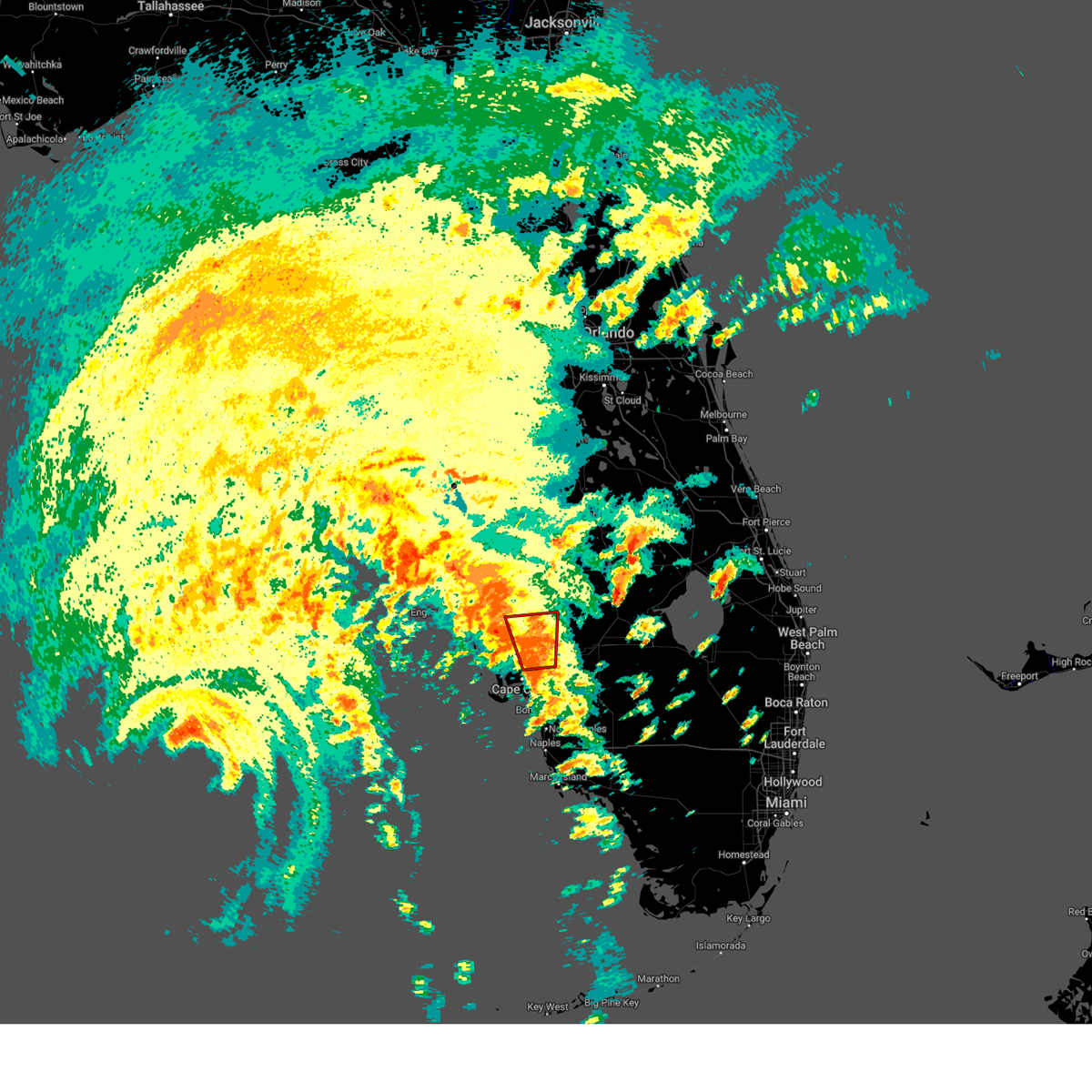
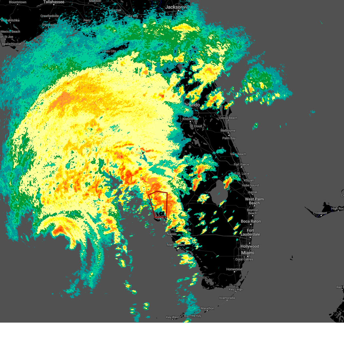
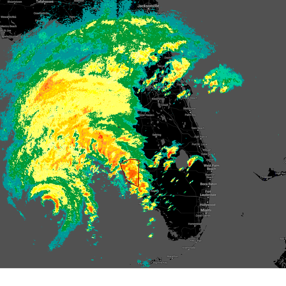
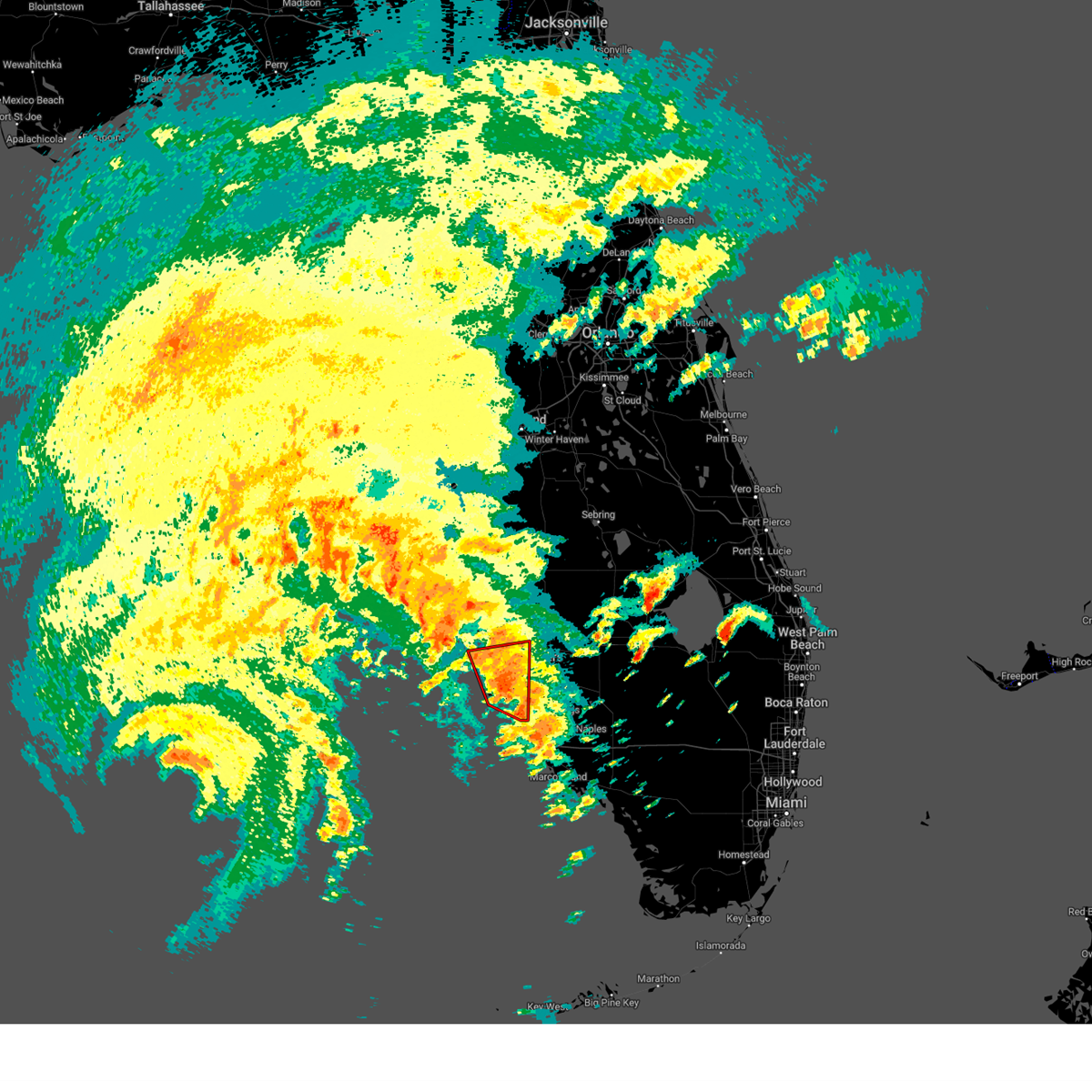
Hail Map for Cape Coral, FL
The Cape Coral, FL area has had 3 reports of on-the-ground hail by trained spotters, and has been under severe weather warnings 17 times during the past 12 months. Doppler radar has detected hail at or near Cape Coral, FL on 85 occasions, including 5 occasions during the past year.
| Name: | Cape Coral, FL |
| Where Located: | 36 miles NNW of Naples, FL |
| Map: | Google Map for Cape Coral, FL |
| Population: | 154305 |
| Housing Units: | 78948 |
| More Info: | Search Google for Cape Coral, FL |
1
The Top Recent Hail Date for Cape Coral, FL is Wednesday, June 25, 2025 (16th out of 85)
Hail and Wind Damage Spotted near Cape Coral, FL
| Date / Time | Report Details |
|---|---|
| 6/11/2025 4:38 PM EDT |
 Svrtbw the national weather service in ruskin has issued a * severe thunderstorm warning for, south central charlotte county in southwestern florida, northeastern lee county in southwestern florida, * until 515 pm edt. * at 438 pm edt, a severe thunderstorm was located near buckingham, or near lehigh acres, moving northwest at 20 mph (radar indicated). Hazards include 60 mph wind gusts and quarter size hail. Hail damage to vehicles is expected. Expect wind damage to roofs, siding, and trees. Svrtbw the national weather service in ruskin has issued a * severe thunderstorm warning for, south central charlotte county in southwestern florida, northeastern lee county in southwestern florida, * until 515 pm edt. * at 438 pm edt, a severe thunderstorm was located near buckingham, or near lehigh acres, moving northwest at 20 mph (radar indicated). Hazards include 60 mph wind gusts and quarter size hail. Hail damage to vehicles is expected. Expect wind damage to roofs, siding, and trees.
|
| 6/2/2025 11:35 AM EDT |
 Svrtbw the national weather service in ruskin has issued a * severe thunderstorm warning for, northwestern lee county in southwestern florida, * until noon edt. * at 1135 am edt, severe thunderstorms were located along a line extending from 7 miles northwest of pineland to near pine island center, moving east at 10 mph (radar indicated). Hazards include 60 mph wind gusts and penny size hail. expect damage to roofs, siding, and trees Svrtbw the national weather service in ruskin has issued a * severe thunderstorm warning for, northwestern lee county in southwestern florida, * until noon edt. * at 1135 am edt, severe thunderstorms were located along a line extending from 7 miles northwest of pineland to near pine island center, moving east at 10 mph (radar indicated). Hazards include 60 mph wind gusts and penny size hail. expect damage to roofs, siding, and trees
|
| 10/9/2024 1:17 PM EDT |
 the tornado warning has been cancelled and is no longer in effect the tornado warning has been cancelled and is no longer in effect
|
| 10/9/2024 12:53 PM EDT |
 Tortbw the national weather service in ruskin has issued a * tornado warning for, northeastern lee county in southwestern florida, * until 130 pm edt. * at 1252 pm edt, a severe thunderstorm capable of producing a tornado was located near southwest florida airport, or near lehigh acres, moving north at 25 mph (radar indicated rotation). Hazards include tornado. Flying debris will be dangerous to those caught without shelter. mobile homes will be damaged or destroyed. damage to roofs, windows, and vehicles will occur. tree damage is likely. this dangerous storm will be near, fort myers, lehigh acres, buckingham, and olga around 100 pm edt. east dunbar around 105 pm edt. Other locations impacted by this tornadic thunderstorm include tice, fort myers shores, page park, north fort myers, page field airport, gateway, alva, suncoast estates, fort myers villas, and whiskey creek. Tortbw the national weather service in ruskin has issued a * tornado warning for, northeastern lee county in southwestern florida, * until 130 pm edt. * at 1252 pm edt, a severe thunderstorm capable of producing a tornado was located near southwest florida airport, or near lehigh acres, moving north at 25 mph (radar indicated rotation). Hazards include tornado. Flying debris will be dangerous to those caught without shelter. mobile homes will be damaged or destroyed. damage to roofs, windows, and vehicles will occur. tree damage is likely. this dangerous storm will be near, fort myers, lehigh acres, buckingham, and olga around 100 pm edt. east dunbar around 105 pm edt. Other locations impacted by this tornadic thunderstorm include tice, fort myers shores, page park, north fort myers, page field airport, gateway, alva, suncoast estates, fort myers villas, and whiskey creek.
|
| 10/9/2024 12:51 PM EDT |
 Tortbw the national weather service in ruskin has issued a * tornado warning for, eastern charlotte county in southwestern florida, south central desoto county in south central florida, northern lee county in southwestern florida, * until 115 pm edt. * at 1251 pm edt, a confirmed large and extremely dangerous tornado was located near babcock webb wma, or 12 miles north of fort myers, moving north at 25 mph. this is a particularly dangerous situation. take cover now! (broadcast media confirmed tornado). Hazards include damaging tornado. You are in a life-threatening situation. flying debris may be deadly to those caught without shelter. mobile homes will be destroyed. considerable damage to homes, businesses, and vehicles is likely and complete destruction is possible. the tornado will be near, babcock webb wma around 1255 pm edt. Other locations impacted by this tornadic thunderstorm include north fort myers, suncoast estates, fort myers shores, and cleveland. Tortbw the national weather service in ruskin has issued a * tornado warning for, eastern charlotte county in southwestern florida, south central desoto county in south central florida, northern lee county in southwestern florida, * until 115 pm edt. * at 1251 pm edt, a confirmed large and extremely dangerous tornado was located near babcock webb wma, or 12 miles north of fort myers, moving north at 25 mph. this is a particularly dangerous situation. take cover now! (broadcast media confirmed tornado). Hazards include damaging tornado. You are in a life-threatening situation. flying debris may be deadly to those caught without shelter. mobile homes will be destroyed. considerable damage to homes, businesses, and vehicles is likely and complete destruction is possible. the tornado will be near, babcock webb wma around 1255 pm edt. Other locations impacted by this tornadic thunderstorm include north fort myers, suncoast estates, fort myers shores, and cleveland.
|
| 10/9/2024 12:41 PM EDT |
 At 1241 pm edt, a confirmed large and extremely dangerous tornado was located over palmona park, or near fort myers, moving north at 25 mph. this is a particularly dangerous situation. take cover now! (broadcast media confirmed tornado). Hazards include damaging tornado. You are in a life-threatening situation. flying debris may be deadly to those caught without shelter. mobile homes will be destroyed. considerable damage to homes, businesses, and vehicles is likely and complete destruction is possible. the tornado will be near, cape coral around 1245 pm edt. Other locations impacted by this tornadic thunderstorm include tice, fort myers shores, north fort myers, tropical gulf acres, suncoast estates, charlotte park, solana, and cleveland. At 1241 pm edt, a confirmed large and extremely dangerous tornado was located over palmona park, or near fort myers, moving north at 25 mph. this is a particularly dangerous situation. take cover now! (broadcast media confirmed tornado). Hazards include damaging tornado. You are in a life-threatening situation. flying debris may be deadly to those caught without shelter. mobile homes will be destroyed. considerable damage to homes, businesses, and vehicles is likely and complete destruction is possible. the tornado will be near, cape coral around 1245 pm edt. Other locations impacted by this tornadic thunderstorm include tice, fort myers shores, north fort myers, tropical gulf acres, suncoast estates, charlotte park, solana, and cleveland.
|
| 10/9/2024 12:36 PM EDT |
 Tortbw the national weather service in ruskin has issued a * tornado warning for, southeastern charlotte county in southwestern florida, north central lee county in southwestern florida, * until 100 pm edt. * at 1236 pm edt, a severe thunderstorm capable of producing a tornado was located over palmona park, or near fort myers, moving north at 25 mph (radar indicated rotation). Hazards include tornado. Flying debris will be dangerous to those caught without shelter. mobile homes will be damaged or destroyed. damage to roofs, windows, and vehicles will occur. tree damage is likely. this dangerous storm will be near, cape coral and palmona park around 1240 pm edt. Other locations impacted by this tornadic thunderstorm include fort myers shores, north fort myers, page field airport, tropical gulf acres, suncoast estates, charlotte park, burnt store marina, pirate harbor, tice, and page park. Tortbw the national weather service in ruskin has issued a * tornado warning for, southeastern charlotte county in southwestern florida, north central lee county in southwestern florida, * until 100 pm edt. * at 1236 pm edt, a severe thunderstorm capable of producing a tornado was located over palmona park, or near fort myers, moving north at 25 mph (radar indicated rotation). Hazards include tornado. Flying debris will be dangerous to those caught without shelter. mobile homes will be damaged or destroyed. damage to roofs, windows, and vehicles will occur. tree damage is likely. this dangerous storm will be near, cape coral and palmona park around 1240 pm edt. Other locations impacted by this tornadic thunderstorm include fort myers shores, north fort myers, page field airport, tropical gulf acres, suncoast estates, charlotte park, burnt store marina, pirate harbor, tice, and page park.
|
| 10/9/2024 12:31 PM EDT |
 the tornado warning has been cancelled and is no longer in effect the tornado warning has been cancelled and is no longer in effect
|
| 10/9/2024 12:29 PM EDT |
 the tornado warning has been cancelled and is no longer in effect the tornado warning has been cancelled and is no longer in effect
|
| 10/9/2024 12:20 PM EDT | At 1220 pm edt, a confirmed tornado was located near punta gorda, moving north at 35 mph (broadcast media confirmed tornado). Hazards include damaging tornado. Flying debris will be dangerous to those caught without shelter. mobile homes will be damaged or destroyed. damage to roofs, windows, and vehicles will occur. tree damage is likely. this tornado will be near, punta gorda and port charlotte around 1225 pm edt. charlotte county airport around 1230 pm edt. Other locations impacted by this tornadic thunderstorm include tropical gulf acres, placida, charlotte park, cleveland, burnt store marina, bokeelia, pirate harbor, solana, charlotte harbor, and punta rassa. |
| 10/9/2024 12:14 PM EDT | Tortbw the national weather service in ruskin has issued a * tornado warning for, southeastern charlotte county in southwestern florida, central lee county in southwestern florida, * until 1245 pm edt. * at 1214 pm edt, a severe thunderstorm capable of producing a tornado was located near san carlos park, or 8 miles south of fort myers, moving north at 35 mph (radar indicated rotation). Hazards include tornado. Flying debris will be dangerous to those caught without shelter. mobile homes will be damaged or destroyed. damage to roofs, windows, and vehicles will occur. tree damage is likely. this dangerous storm will be near, fort myers, pine manor, villas, buckingham, east dunbar, lochmoor waterway estates, cypress lake, and mcgregor around 1220 pm edt. palmona park around 1225 pm edt. Other locations impacted by this tornadic thunderstorm include tice, whiskey creek, page park, north fort myers, page field airport, suncoast estates, fort myers villas, gateway, fort myers shores, and estero. |
| 10/9/2024 12:07 PM EDT |
 At 1206 pm edt, a confirmed tornado was located near matlacha or isles-matlacha shores, moving north at 35 mph (broadcast media confirmed tornado). Hazards include damaging tornado. Flying debris will be dangerous to those caught without shelter. mobile homes will be damaged or destroyed. damage to roofs, windows, and vehicles will occur. tree damage is likely. this tornado will be near, cape coral and pineland around 1210 pm edt. punta gorda around 1215 pm edt. port charlotte around 1225 pm edt. charlotte county airport around 1230 pm edt. Other locations impacted by this tornadic thunderstorm include saint james city, tropical gulf acres, punta rassa, palm island, placida, rotonda, charlotte park, cleveland, burnt store marina, and bokeelia. At 1206 pm edt, a confirmed tornado was located near matlacha or isles-matlacha shores, moving north at 35 mph (broadcast media confirmed tornado). Hazards include damaging tornado. Flying debris will be dangerous to those caught without shelter. mobile homes will be damaged or destroyed. damage to roofs, windows, and vehicles will occur. tree damage is likely. this tornado will be near, cape coral and pineland around 1210 pm edt. punta gorda around 1215 pm edt. port charlotte around 1225 pm edt. charlotte county airport around 1230 pm edt. Other locations impacted by this tornadic thunderstorm include saint james city, tropical gulf acres, punta rassa, palm island, placida, rotonda, charlotte park, cleveland, burnt store marina, and bokeelia.
|
| 10/9/2024 11:58 AM EDT |
 Tortbw the national weather service in ruskin has issued a * tornado warning for, western charlotte county in southwestern florida, western lee county in southwestern florida, * until 1245 pm edt. * at 1157 am edt, a severe thunderstorm capable of producing a tornado was located near matlacha isles-matlacha shores, or near cape coral, moving north at 35 mph (radar indicated rotation). Hazards include tornado. Flying debris will be dangerous to those caught without shelter. mobile homes will be damaged or destroyed. damage to roofs, windows, and vehicles will occur. tree damage is likely. this dangerous storm will be near, cape coral, matlacha, matlacha isles-matlacha shores, pineland, and pine island center around 1205 pm edt. punta gorda around 1215 pm edt. port charlotte around 1225 pm edt. charlotte county airport around 1230 pm edt. Other locations impacted by this tornadic thunderstorm include saint james city, tropical gulf acres, punta rassa, palm island, placida, rotonda, charlotte park, cleveland, burnt store marina, and bokeelia. Tortbw the national weather service in ruskin has issued a * tornado warning for, western charlotte county in southwestern florida, western lee county in southwestern florida, * until 1245 pm edt. * at 1157 am edt, a severe thunderstorm capable of producing a tornado was located near matlacha isles-matlacha shores, or near cape coral, moving north at 35 mph (radar indicated rotation). Hazards include tornado. Flying debris will be dangerous to those caught without shelter. mobile homes will be damaged or destroyed. damage to roofs, windows, and vehicles will occur. tree damage is likely. this dangerous storm will be near, cape coral, matlacha, matlacha isles-matlacha shores, pineland, and pine island center around 1205 pm edt. punta gorda around 1215 pm edt. port charlotte around 1225 pm edt. charlotte county airport around 1230 pm edt. Other locations impacted by this tornadic thunderstorm include saint james city, tropical gulf acres, punta rassa, palm island, placida, rotonda, charlotte park, cleveland, burnt store marina, and bokeelia.
|
| 10/9/2024 11:47 AM EDT |
 At 1147 am edt, a severe thunderstorm capable of producing a tornado was located near st. james city, or 8 miles south of cape coral, moving north at 45 mph (radar indicated rotation). Hazards include tornado. Flying debris will be dangerous to those caught without shelter. mobile homes will be damaged or destroyed. damage to roofs, windows, and vehicles will occur. tree damage is likely. this dangerous storm will be near, cape coral, matlacha, matlacha isles-matlacha shores, iona, pineland, pine island center, mcgregor, and st. james city around 1150 am edt. lochmoor waterway estates around 1155 am edt. Other locations impacted by this tornadic thunderstorm include saint james city, bokeelia, punta rassa, burnt store marina, useppa island, and north fort myers. At 1147 am edt, a severe thunderstorm capable of producing a tornado was located near st. james city, or 8 miles south of cape coral, moving north at 45 mph (radar indicated rotation). Hazards include tornado. Flying debris will be dangerous to those caught without shelter. mobile homes will be damaged or destroyed. damage to roofs, windows, and vehicles will occur. tree damage is likely. this dangerous storm will be near, cape coral, matlacha, matlacha isles-matlacha shores, iona, pineland, pine island center, mcgregor, and st. james city around 1150 am edt. lochmoor waterway estates around 1155 am edt. Other locations impacted by this tornadic thunderstorm include saint james city, bokeelia, punta rassa, burnt store marina, useppa island, and north fort myers.
|
| 10/9/2024 11:33 AM EDT |
 Tortbw the national weather service in ruskin has issued a * tornado warning for, south central charlotte county in southwestern florida, western lee county in southwestern florida, * until noon edt. * at 1133 am edt, a severe thunderstorm capable of producing a tornado was located 10 miles west of lovers key state park, or 15 miles west of bonita springs, moving north at 45 mph (radar indicated rotation). Hazards include tornado. Flying debris will be dangerous to those caught without shelter. mobile homes will be damaged or destroyed. damage to roofs, windows, and vehicles will occur. tree damage is likely. this dangerous storm will be near, cape coral, harlem heights, iona, mcgregor, and st. james city around 1140 am edt. matlacha, matlacha isles-matlacha shores, and pine island center around 1145 am edt. lochmoor waterway estates around 1155 am edt. Other locations impacted by this tornadic thunderstorm include saint james city, bokeelia, punta rassa, burnt store marina, useppa island, and north fort myers. Tortbw the national weather service in ruskin has issued a * tornado warning for, south central charlotte county in southwestern florida, western lee county in southwestern florida, * until noon edt. * at 1133 am edt, a severe thunderstorm capable of producing a tornado was located 10 miles west of lovers key state park, or 15 miles west of bonita springs, moving north at 45 mph (radar indicated rotation). Hazards include tornado. Flying debris will be dangerous to those caught without shelter. mobile homes will be damaged or destroyed. damage to roofs, windows, and vehicles will occur. tree damage is likely. this dangerous storm will be near, cape coral, harlem heights, iona, mcgregor, and st. james city around 1140 am edt. matlacha, matlacha isles-matlacha shores, and pine island center around 1145 am edt. lochmoor waterway estates around 1155 am edt. Other locations impacted by this tornadic thunderstorm include saint james city, bokeelia, punta rassa, burnt store marina, useppa island, and north fort myers.
|
| 9/26/2024 6:29 PM EDT |
 Tortbw the national weather service in ruskin has issued a * tornado warning for, central charlotte county in southwestern florida, southwestern desoto county in south central florida, northwestern lee county in southwestern florida, * until 700 pm edt. * at 629 pm edt, a severe thunderstorm capable of producing a tornado was located 8 miles southeast of punta gorda, moving north at 75 mph (radar indicated rotation). Hazards include tornado. Flying debris will be dangerous to those caught without shelter. mobile homes will be damaged or destroyed. damage to roofs, windows, and vehicles will occur. tree damage is likely. this dangerous storm will be near, punta gorda and charlotte county airport around 635 pm edt. southeast arcadia around 645 pm edt. Other locations impacted by this tornadic thunderstorm include pirate harbor, solana, nocatee, tropical gulf acres, harbour heights, cleveland, fort ogden, burnt store marina, and charlotte park. Tortbw the national weather service in ruskin has issued a * tornado warning for, central charlotte county in southwestern florida, southwestern desoto county in south central florida, northwestern lee county in southwestern florida, * until 700 pm edt. * at 629 pm edt, a severe thunderstorm capable of producing a tornado was located 8 miles southeast of punta gorda, moving north at 75 mph (radar indicated rotation). Hazards include tornado. Flying debris will be dangerous to those caught without shelter. mobile homes will be damaged or destroyed. damage to roofs, windows, and vehicles will occur. tree damage is likely. this dangerous storm will be near, punta gorda and charlotte county airport around 635 pm edt. southeast arcadia around 645 pm edt. Other locations impacted by this tornadic thunderstorm include pirate harbor, solana, nocatee, tropical gulf acres, harbour heights, cleveland, fort ogden, burnt store marina, and charlotte park.
|
| 9/26/2024 5:06 PM EDT |
 Tortbw the national weather service in ruskin has issued a * tornado warning for, western charlotte county in southwestern florida, southwestern desoto county in south central florida, northwestern lee county in southwestern florida, southeastern sarasota county in west central florida, * until 530 pm edt. * at 506 pm edt, a severe thunderstorm capable of producing a tornado was located near pineland, or 13 miles west of cape coral, moving north at 55 mph (radar indicated rotation). Hazards include tornado. Flying debris will be dangerous to those caught without shelter. mobile homes will be damaged or destroyed. damage to roofs, windows, and vehicles will occur. tree damage is likely. this dangerous storm will be near, north port and port charlotte around 520 pm edt. Other locations impacted by this tornadic thunderstorm include murdock, south venice, gulf cove, el jobean, palm island, harbour heights, placida, rotonda, charlotte park, and cleveland. Tortbw the national weather service in ruskin has issued a * tornado warning for, western charlotte county in southwestern florida, southwestern desoto county in south central florida, northwestern lee county in southwestern florida, southeastern sarasota county in west central florida, * until 530 pm edt. * at 506 pm edt, a severe thunderstorm capable of producing a tornado was located near pineland, or 13 miles west of cape coral, moving north at 55 mph (radar indicated rotation). Hazards include tornado. Flying debris will be dangerous to those caught without shelter. mobile homes will be damaged or destroyed. damage to roofs, windows, and vehicles will occur. tree damage is likely. this dangerous storm will be near, north port and port charlotte around 520 pm edt. Other locations impacted by this tornadic thunderstorm include murdock, south venice, gulf cove, el jobean, palm island, harbour heights, placida, rotonda, charlotte park, and cleveland.
|
| 5/30/2024 6:37 PM EDT |
 At 637 pm edt, a severe thunderstorm was located over lochmoor waterway estates, or near fort myers, moving southeast at 10 mph (radar indicated). Hazards include 60 mph wind gusts and quarter size hail. Hail damage to vehicles is expected. expect wind damage to roofs, siding, and trees. Locations impacted include, cape coral, fort myers, whiskey creek, page park, north fort myers, page field airport, mcgregor, east dunbar, suncoast estates, and fort myers villas. At 637 pm edt, a severe thunderstorm was located over lochmoor waterway estates, or near fort myers, moving southeast at 10 mph (radar indicated). Hazards include 60 mph wind gusts and quarter size hail. Hail damage to vehicles is expected. expect wind damage to roofs, siding, and trees. Locations impacted include, cape coral, fort myers, whiskey creek, page park, north fort myers, page field airport, mcgregor, east dunbar, suncoast estates, and fort myers villas.
|
| 5/30/2024 6:17 PM EDT |
 Svrtbw the national weather service in ruskin has issued a * severe thunderstorm warning for, northeastern lee county in southwestern florida, * until 645 pm edt. * at 617 pm edt, a severe thunderstorm was located over palmona park, or near fort myers, moving southeast at 10 mph (radar indicated). Hazards include 60 mph wind gusts and quarter size hail. Hail damage to vehicles is expected. Expect wind damage to roofs, siding, and trees. Svrtbw the national weather service in ruskin has issued a * severe thunderstorm warning for, northeastern lee county in southwestern florida, * until 645 pm edt. * at 617 pm edt, a severe thunderstorm was located over palmona park, or near fort myers, moving southeast at 10 mph (radar indicated). Hazards include 60 mph wind gusts and quarter size hail. Hail damage to vehicles is expected. Expect wind damage to roofs, siding, and trees.
|
| 1/9/2024 6:34 PM EST |
 At 634 pm est, severe thunderstorms were located along a line extending from near southeast arcadia to near st. james city, moving east at 15 mph (radar indicated). Hazards include 60 mph wind gusts. Expect damage to roofs, siding, and trees. locations impacted include, cape coral, fort myers, punta gorda, arcadia, burnt store marina, page park, nocatee, east dunbar, harbour heights, and cleveland. hail threat, radar indicated max hail size, <. 75 in wind threat, radar indicated max wind gust, 60 mph. At 634 pm est, severe thunderstorms were located along a line extending from near southeast arcadia to near st. james city, moving east at 15 mph (radar indicated). Hazards include 60 mph wind gusts. Expect damage to roofs, siding, and trees. locations impacted include, cape coral, fort myers, punta gorda, arcadia, burnt store marina, page park, nocatee, east dunbar, harbour heights, and cleveland. hail threat, radar indicated max hail size, <. 75 in wind threat, radar indicated max wind gust, 60 mph.
|
| 1/9/2024 6:12 PM EST |
 The national weather service in ruskin has issued a * severe thunderstorm warning for. southeastern manatee county in west central florida. charlotte county in southwestern florida. desoto county in south central florida. Northern lee county in southwestern florida. The national weather service in ruskin has issued a * severe thunderstorm warning for. southeastern manatee county in west central florida. charlotte county in southwestern florida. desoto county in south central florida. Northern lee county in southwestern florida.
|
| 1/9/2024 6:12 PM EST |
 At 612 pm est, severe thunderstorms were located along a line extending from 7 miles northwest of north port to 25 miles west of pineland, moving east at 45 mph (radar indicated). Hazards include 60 mph wind gusts. expect damage to roofs, siding, and trees At 612 pm est, severe thunderstorms were located along a line extending from 7 miles northwest of north port to 25 miles west of pineland, moving east at 45 mph (radar indicated). Hazards include 60 mph wind gusts. expect damage to roofs, siding, and trees
|
| 1/9/2024 5:49 PM EST |
 At 548 pm est, severe thunderstorms were located along a line extending from 8 miles west of north port to 19 miles west of pineland to 38 miles west of st. james city, moving east at 50 mph (radar indicated). Hazards include 60 mph wind gusts. expect damage to roofs, siding, and trees At 548 pm est, severe thunderstorms were located along a line extending from 8 miles west of north port to 19 miles west of pineland to 38 miles west of st. james city, moving east at 50 mph (radar indicated). Hazards include 60 mph wind gusts. expect damage to roofs, siding, and trees
|
| 12/17/2023 2:48 AM EST |
 At 248 am est, a severe thunderstorm was located 8 miles southwest of punta gorda, moving northeast at 50 mph (radar indicated). Hazards include 60 mph wind gusts. expect damage to roofs, siding, and trees At 248 am est, a severe thunderstorm was located 8 miles southwest of punta gorda, moving northeast at 50 mph (radar indicated). Hazards include 60 mph wind gusts. expect damage to roofs, siding, and trees
|
| 4/30/2023 6:15 AM EDT |
 At 615 am edt, a severe thunderstorm was located near babcock webb wma, or 12 miles east of punta gorda, moving northeast at 65 mph (radar indicated). Hazards include 60 mph wind gusts. expect damage to roofs, siding, and trees At 615 am edt, a severe thunderstorm was located near babcock webb wma, or 12 miles east of punta gorda, moving northeast at 65 mph (radar indicated). Hazards include 60 mph wind gusts. expect damage to roofs, siding, and trees
|
| 4/30/2023 6:03 AM EDT |
 At 603 am edt, severe thunderstorms were located along a line extending from arcadia to 10 miles southeast of southeast arcadia to near babcock ranch, moving east at 50 mph (law enforcement). Hazards include 60 mph wind gusts. Expect damage to roofs, siding, and trees. Locations impacted include, north port, punta gorda, burnt store marina, murdock, southeast arcadia, nocatee, tropical gulf acres, babcock ranch, harbour heights, and placida. At 603 am edt, severe thunderstorms were located along a line extending from arcadia to 10 miles southeast of southeast arcadia to near babcock ranch, moving east at 50 mph (law enforcement). Hazards include 60 mph wind gusts. Expect damage to roofs, siding, and trees. Locations impacted include, north port, punta gorda, burnt store marina, murdock, southeast arcadia, nocatee, tropical gulf acres, babcock ranch, harbour heights, and placida.
|
| 4/30/2023 5:24 AM EDT |
 At 524 am edt, severe thunderstorms were located along a line extending from 9 miles southwest of myakka river state park to near north port to 10 miles west of punta gorda, moving east at 50 mph (radar indicated). Hazards include 60 mph wind gusts. expect damage to roofs, siding, and trees At 524 am edt, severe thunderstorms were located along a line extending from 9 miles southwest of myakka river state park to near north port to 10 miles west of punta gorda, moving east at 50 mph (radar indicated). Hazards include 60 mph wind gusts. expect damage to roofs, siding, and trees
|
| 11/2/2022 11:25 PM EDT |
 At 1125 pm edt, a severe thunderstorm was located 7 miles north of palmona park, or 10 miles southeast of punta gorda, and is nearly stationary (radar indicated). Hazards include 60 mph wind gusts and nickel size hail. Expect damage to roofs, siding, and trees. locations impacted include, cape coral, fort myers, burnt store marina, north fort myers, east dunbar, suncoast estates, matlacha, pirate harbor, bokeelia and tice. hail threat, radar indicated max hail size, 0. 88 in wind threat, radar indicated max wind gust, 60 mph. At 1125 pm edt, a severe thunderstorm was located 7 miles north of palmona park, or 10 miles southeast of punta gorda, and is nearly stationary (radar indicated). Hazards include 60 mph wind gusts and nickel size hail. Expect damage to roofs, siding, and trees. locations impacted include, cape coral, fort myers, burnt store marina, north fort myers, east dunbar, suncoast estates, matlacha, pirate harbor, bokeelia and tice. hail threat, radar indicated max hail size, 0. 88 in wind threat, radar indicated max wind gust, 60 mph.
|
| 11/2/2022 10:53 PM EDT |
 At 1053 pm edt, a severe thunderstorm was located near charlotte county airport, or 8 miles southeast of punta gorda, and is nearly stationary (radar indicated). Hazards include 60 mph wind gusts and quarter size hail. Hail damage to vehicles is expected. Expect wind damage to roofs, siding, and trees. At 1053 pm edt, a severe thunderstorm was located near charlotte county airport, or 8 miles southeast of punta gorda, and is nearly stationary (radar indicated). Hazards include 60 mph wind gusts and quarter size hail. Hail damage to vehicles is expected. Expect wind damage to roofs, siding, and trees.
|
| 11/2/2022 10:35 PM EDT |
 At 1035 pm edt, a severe thunderstorm was located near charlotte county airport, or 8 miles east of punta gorda, and is nearly stationary (radar indicated). Hazards include 60 mph wind gusts and nickel size hail. expect damage to roofs, siding, and trees At 1035 pm edt, a severe thunderstorm was located near charlotte county airport, or 8 miles east of punta gorda, and is nearly stationary (radar indicated). Hazards include 60 mph wind gusts and nickel size hail. expect damage to roofs, siding, and trees
|
| 9/8/2022 4:39 PM EDT |
 The severe thunderstorm warning for central lee county will expire at 445 pm edt, the storm which prompted the warning has moved out of the area. therefore, the warning will be allowed to expire. however gusty winds are still possible with this thunderstorm. The severe thunderstorm warning for central lee county will expire at 445 pm edt, the storm which prompted the warning has moved out of the area. therefore, the warning will be allowed to expire. however gusty winds are still possible with this thunderstorm.
|
| 9/8/2022 4:20 PM EDT |
 At 420 pm edt, a severe thunderstorm was located near iona, or 12 miles northwest of bonita springs, moving northeast at 25 mph (radar indicated). Hazards include 60 mph wind gusts. expect damage to roofs, siding, and trees At 420 pm edt, a severe thunderstorm was located near iona, or 12 miles northwest of bonita springs, moving northeast at 25 mph (radar indicated). Hazards include 60 mph wind gusts. expect damage to roofs, siding, and trees
|
| 8/24/2022 6:26 PM EDT | At 626 pm edt, severe thunderstorms were located along a line extending from near charlotte county airport to 6 miles southeast of punta gorda to cape coral, moving northwest at 20 mph (radar indicated). Hazards include 60 mph wind gusts and nickel size hail. Expect damage to roofs, siding, and trees. locations impacted include, cape coral, fort myers, north port, punta gorda, burnt store marina, murdock, page park, punta rassa, east dunbar and fort myers villas. hail threat, radar indicated max hail size, 0. 88 in wind threat, radar indicated max wind gust, 60 mph. |
| 8/24/2022 6:02 PM EDT | At 602 pm edt, severe thunderstorms were located along a line extending from near babcock webb wma to near palmona park to pine manor, moving northwest at 20 mph (radar indicated). Hazards include 60 mph wind gusts and nickel size hail. expect damage to roofs, siding, and trees |
| 8/3/2022 7:23 PM EDT |
 At 723 pm edt, a severe thunderstorm was located over east dunbar, or over fort myers, moving northwest at 15 mph (radar indicated). Hazards include 60 mph wind gusts and quarter size hail. Hail damage to vehicles is expected. expect wind damage to roofs, siding, and trees. locations impacted include, cape coral, fort myers, page park, east dunbar, fort myers villas, matlacha, tice, palmona park, lochmoor waterway estates and iona. hail threat, radar indicated max hail size, 1. 00 in wind threat, radar indicated max wind gust, 60 mph. At 723 pm edt, a severe thunderstorm was located over east dunbar, or over fort myers, moving northwest at 15 mph (radar indicated). Hazards include 60 mph wind gusts and quarter size hail. Hail damage to vehicles is expected. expect wind damage to roofs, siding, and trees. locations impacted include, cape coral, fort myers, page park, east dunbar, fort myers villas, matlacha, tice, palmona park, lochmoor waterway estates and iona. hail threat, radar indicated max hail size, 1. 00 in wind threat, radar indicated max wind gust, 60 mph.
|
| 8/3/2022 7:02 PM EDT |
 At 702 pm edt, a severe thunderstorm was located over fort myers, moving northwest at 25 mph (radar indicated). Hazards include 60 mph wind gusts and quarter size hail. Hail damage to vehicles is expected. Expect wind damage to roofs, siding, and trees. At 702 pm edt, a severe thunderstorm was located over fort myers, moving northwest at 25 mph (radar indicated). Hazards include 60 mph wind gusts and quarter size hail. Hail damage to vehicles is expected. Expect wind damage to roofs, siding, and trees.
|
| 8/2/2022 6:14 PM EDT |
 At 613 pm edt, severe thunderstorms were located along a line extending from near babcock webb wma to 7 miles northeast of palmona park, moving west at 15 mph (radar indicated). Hazards include quarter size hail. damage to vehicles is expected At 613 pm edt, severe thunderstorms were located along a line extending from near babcock webb wma to 7 miles northeast of palmona park, moving west at 15 mph (radar indicated). Hazards include quarter size hail. damage to vehicles is expected
|
| 6/18/2022 5:41 PM EDT |
 The severe thunderstorm warning for charlotte and northeastern lee counties will expire at 545 pm edt, the storms which prompted the warning have weakened below severe limits, and no longer pose an immediate threat to life or property. therefore, the warning will be allowed to expire. however gusty winds are still possible with these thunderstorms. a severe thunderstorm watch remains in effect until 800 pm edt for southwestern florida. The severe thunderstorm warning for charlotte and northeastern lee counties will expire at 545 pm edt, the storms which prompted the warning have weakened below severe limits, and no longer pose an immediate threat to life or property. therefore, the warning will be allowed to expire. however gusty winds are still possible with these thunderstorms. a severe thunderstorm watch remains in effect until 800 pm edt for southwestern florida.
|
| 6/18/2022 5:30 PM EDT |
 At 530 pm edt, severe thunderstorms were located along a line extending from 13 miles southeast of southeast arcadia to near babcock ranch to 7 miles northeast of charlotte county airport, moving east at 5 mph (radar indicated). Hazards include 60 mph wind gusts and quarter size hail. Hail damage to vehicles is expected. expect wind damage to roofs, siding, and trees. locations impacted include, cape coral, fort myers shores, olga, north fort myers, babcock webb wma, charlotte county airport, tropical gulf acres, babcock ranch, alva and suncoast estates. hail threat, radar indicated max hail size, 1. 00 in wind threat, radar indicated max wind gust, 60 mph. At 530 pm edt, severe thunderstorms were located along a line extending from 13 miles southeast of southeast arcadia to near babcock ranch to 7 miles northeast of charlotte county airport, moving east at 5 mph (radar indicated). Hazards include 60 mph wind gusts and quarter size hail. Hail damage to vehicles is expected. expect wind damage to roofs, siding, and trees. locations impacted include, cape coral, fort myers shores, olga, north fort myers, babcock webb wma, charlotte county airport, tropical gulf acres, babcock ranch, alva and suncoast estates. hail threat, radar indicated max hail size, 1. 00 in wind threat, radar indicated max wind gust, 60 mph.
|
| 6/18/2022 5:13 PM EDT |
 At 513 pm edt, severe thunderstorms were located along a line extending from 13 miles southeast of southeast arcadia to near babcock ranch to 8 miles north of charlotte county airport, moving south at 5 mph (radar indicated). Hazards include 60 mph wind gusts and quarter size hail. Hail damage to vehicles is expected. Expect wind damage to roofs, siding, and trees. At 513 pm edt, severe thunderstorms were located along a line extending from 13 miles southeast of southeast arcadia to near babcock ranch to 8 miles north of charlotte county airport, moving south at 5 mph (radar indicated). Hazards include 60 mph wind gusts and quarter size hail. Hail damage to vehicles is expected. Expect wind damage to roofs, siding, and trees.
|
| 5/31/2022 6:22 PM EDT |
 At 622 pm edt, a severe thunderstorm was located 8 miles southwest of punta gorda, and is nearly stationary (radar indicated). Hazards include 60 mph wind gusts and quarter size hail. Hail damage to vehicles is expected. Expect wind damage to roofs, siding, and trees. At 622 pm edt, a severe thunderstorm was located 8 miles southwest of punta gorda, and is nearly stationary (radar indicated). Hazards include 60 mph wind gusts and quarter size hail. Hail damage to vehicles is expected. Expect wind damage to roofs, siding, and trees.
|
| 5/30/2022 5:08 PM EDT |
 The severe thunderstorm warning for central lee county will expire at 515 pm edt, the storm which prompted the warning has weakened below severe limits, and no longer poses an immediate threat to life or property. therefore, the warning will be allowed to expire. however small hail and gusty winds are still possible with this thunderstorm. The severe thunderstorm warning for central lee county will expire at 515 pm edt, the storm which prompted the warning has weakened below severe limits, and no longer poses an immediate threat to life or property. therefore, the warning will be allowed to expire. however small hail and gusty winds are still possible with this thunderstorm.
|
| 5/30/2022 5:03 PM EDT |
 At 503 pm edt, a severe thunderstorm was located over east dunbar, or over fort myers, and is nearly stationary (radar indicated). Hazards include 60 mph wind gusts and quarter size hail. Hail damage to vehicles is expected. expect wind damage to roofs, siding, and trees. locations impacted include, cape coral, fort myers, whiskey creek, page park, page field airport, mcgregor, east dunbar, fort myers villas, pine manor and lochmoor waterway estates. hail threat, radar indicated max hail size, 1. 00 in wind threat, radar indicated max wind gust, 60 mph. At 503 pm edt, a severe thunderstorm was located over east dunbar, or over fort myers, and is nearly stationary (radar indicated). Hazards include 60 mph wind gusts and quarter size hail. Hail damage to vehicles is expected. expect wind damage to roofs, siding, and trees. locations impacted include, cape coral, fort myers, whiskey creek, page park, page field airport, mcgregor, east dunbar, fort myers villas, pine manor and lochmoor waterway estates. hail threat, radar indicated max hail size, 1. 00 in wind threat, radar indicated max wind gust, 60 mph.
|
| 5/30/2022 4:41 PM EDT |
 At 441 pm edt, a severe thunderstorm was located over fort myers, and is nearly stationary (radar indicated). Hazards include 60 mph wind gusts and quarter size hail. Hail damage to vehicles is expected. Expect wind damage to roofs, siding, and trees. At 441 pm edt, a severe thunderstorm was located over fort myers, and is nearly stationary (radar indicated). Hazards include 60 mph wind gusts and quarter size hail. Hail damage to vehicles is expected. Expect wind damage to roofs, siding, and trees.
|
| 5/13/2022 5:34 PM EDT |
 At 532 pm edt, a severe thunderstorm was located over lochmoor waterway estates, or near cape coral, and is nearly stationary. quarter sized hail has been observed in this storm (radar indicated). Hazards include 60 mph wind gusts and quarter size hail. Hail damage to vehicles is expected. expect wind damage to roofs, siding, and trees. locations impacted include, cape coral, fort myers, whiskey creek, north fort myers, page field airport, mcgregor, east dunbar, suncoast estates, pine manor and matlacha. hail threat, observed max hail size, 1. 00 in wind threat, radar indicated max wind gust, 60 mph. At 532 pm edt, a severe thunderstorm was located over lochmoor waterway estates, or near cape coral, and is nearly stationary. quarter sized hail has been observed in this storm (radar indicated). Hazards include 60 mph wind gusts and quarter size hail. Hail damage to vehicles is expected. expect wind damage to roofs, siding, and trees. locations impacted include, cape coral, fort myers, whiskey creek, north fort myers, page field airport, mcgregor, east dunbar, suncoast estates, pine manor and matlacha. hail threat, observed max hail size, 1. 00 in wind threat, radar indicated max wind gust, 60 mph.
|
| 5/13/2022 5:29 PM EDT | Quarter sized hail reported 4.7 miles N of Cape Coral, FL, social media report of hail the size of quarters. |
| 5/13/2022 5:23 PM EDT |
 At 523 pm edt, a severe thunderstorm was located over lochmoor waterway estates, or near cape coral, and is nearly stationary (radar indicated). Hazards include 60 mph wind gusts and quarter size hail. Hail damage to vehicles is expected. Expect wind damage to roofs, siding, and trees. At 523 pm edt, a severe thunderstorm was located over lochmoor waterway estates, or near cape coral, and is nearly stationary (radar indicated). Hazards include 60 mph wind gusts and quarter size hail. Hail damage to vehicles is expected. Expect wind damage to roofs, siding, and trees.
|
| 1/16/2022 9:02 AM EST |
 At 902 am est, a severe thunderstorm capable of producing a tornado was located over cape coral, moving east at 40 mph (radar indicated rotation). Hazards include tornado. Flying debris will be dangerous to those caught without shelter. mobile homes will be damaged or destroyed. damage to roofs, windows, and vehicles will occur. tree damage is likely. this dangerous storm will be near, cypress lake around 905 am est. lochmoor waterway estates, palmona park, pine manor and villas around 910 am est. fort myers and east dunbar around 915 am est. buckingham around 920 am est. olga around 930 am est. Other locations impacted by this tornadic thunderstorm include tice, whiskey creek, fort myers shores, page park, north fort myers, page field airport, suncoast estates and gateway. At 902 am est, a severe thunderstorm capable of producing a tornado was located over cape coral, moving east at 40 mph (radar indicated rotation). Hazards include tornado. Flying debris will be dangerous to those caught without shelter. mobile homes will be damaged or destroyed. damage to roofs, windows, and vehicles will occur. tree damage is likely. this dangerous storm will be near, cypress lake around 905 am est. lochmoor waterway estates, palmona park, pine manor and villas around 910 am est. fort myers and east dunbar around 915 am est. buckingham around 920 am est. olga around 930 am est. Other locations impacted by this tornadic thunderstorm include tice, whiskey creek, fort myers shores, page park, north fort myers, page field airport, suncoast estates and gateway.
|
| 1/16/2022 8:30 AM EST |
 At 829 am est, a radar indicated waterspout was located just offshore 9 miles west of st. james city, or 16 miles west of cape coral, moving northeast at 40 mph (radar indicated rotation). Hazards include tornado. Flying debris will be dangerous to those caught without shelter. mobile homes will be damaged or destroyed. damage to roofs, windows, and vehicles will occur. tree damage is likely. this tornado will be near, st. james city, pine island center and pineland around 845 am est. matlacha and matlacha isles-matlacha shores around 850 am est. cape coral and lochmoor waterway estates around 900 am est. Other locations impacted by this tornadic thunderstorm include bokeelia, saint james city, whiskey creek, useppa island, burnt store marina, page park and punta rassa. At 829 am est, a radar indicated waterspout was located just offshore 9 miles west of st. james city, or 16 miles west of cape coral, moving northeast at 40 mph (radar indicated rotation). Hazards include tornado. Flying debris will be dangerous to those caught without shelter. mobile homes will be damaged or destroyed. damage to roofs, windows, and vehicles will occur. tree damage is likely. this tornado will be near, st. james city, pine island center and pineland around 845 am est. matlacha and matlacha isles-matlacha shores around 850 am est. cape coral and lochmoor waterway estates around 900 am est. Other locations impacted by this tornadic thunderstorm include bokeelia, saint james city, whiskey creek, useppa island, burnt store marina, page park and punta rassa.
|
| 1/16/2022 7:55 AM EST |
 The tornado warning for central lee county will expire at 800 am est, the storm which prompted the warning has weakened below severe limits, and no longer appears capable of producing a tornado. therefore, the warning will be allowed to expire. however gusty winds and heavy rain are still possible with this thunderstorm. to report severe weather, contact your nearest law enforcement agency. they will relay your report to the national weather service ruskin. The tornado warning for central lee county will expire at 800 am est, the storm which prompted the warning has weakened below severe limits, and no longer appears capable of producing a tornado. therefore, the warning will be allowed to expire. however gusty winds and heavy rain are still possible with this thunderstorm. to report severe weather, contact your nearest law enforcement agency. they will relay your report to the national weather service ruskin.
|
| 1/16/2022 7:32 AM EST |
 At 731 am est, a severe thunderstorm capable of producing a tornado was located near iona, or 11 miles south of cape coral, moving northeast at 25 mph (radar indicated rotation). Hazards include tornado. Flying debris will be dangerous to those caught without shelter. mobile homes will be damaged or destroyed. damage to roofs, windows, and vehicles will occur. tree damage is likely. this dangerous storm will be near, iona and harlem heights around 745 am est. cypress lake, san carlos park and three oaks around 750 am est. villas, pine manor and mcgregor around 755 am est. fort myers and lochmoor waterway estates around 800 am est. Other locations impacted by this tornadic thunderstorm include whiskey creek, punta rassa, page park, fort myers villas and page field airport. At 731 am est, a severe thunderstorm capable of producing a tornado was located near iona, or 11 miles south of cape coral, moving northeast at 25 mph (radar indicated rotation). Hazards include tornado. Flying debris will be dangerous to those caught without shelter. mobile homes will be damaged or destroyed. damage to roofs, windows, and vehicles will occur. tree damage is likely. this dangerous storm will be near, iona and harlem heights around 745 am est. cypress lake, san carlos park and three oaks around 750 am est. villas, pine manor and mcgregor around 755 am est. fort myers and lochmoor waterway estates around 800 am est. Other locations impacted by this tornadic thunderstorm include whiskey creek, punta rassa, page park, fort myers villas and page field airport.
|
| 6/24/2021 3:31 PM EDT |
 At 330 pm edt, a severe thunderstorm was located over iona, or 8 miles south of cape coral, moving west at 15 mph (radar indicated). Hazards include 60 mph wind gusts. Expect damage to roofs, siding, and trees. Locations impacted include, cape coral, fort myers, saint james city, whiskey creek, page park, page field airport, mcgregor, punta rassa, fort myers villas and pine manor. At 330 pm edt, a severe thunderstorm was located over iona, or 8 miles south of cape coral, moving west at 15 mph (radar indicated). Hazards include 60 mph wind gusts. Expect damage to roofs, siding, and trees. Locations impacted include, cape coral, fort myers, saint james city, whiskey creek, page park, page field airport, mcgregor, punta rassa, fort myers villas and pine manor.
|
| 6/24/2021 3:16 PM EDT |
 At 316 pm edt, a severe thunderstorm was located over harlem heights, or 9 miles southeast of cape coral, moving west at 15 mph (radar indicated). Hazards include 60 mph wind gusts. expect damage to roofs, siding, and trees At 316 pm edt, a severe thunderstorm was located over harlem heights, or 9 miles southeast of cape coral, moving west at 15 mph (radar indicated). Hazards include 60 mph wind gusts. expect damage to roofs, siding, and trees
|
| 4/11/2021 4:08 PM EDT |
 At 408 pm edt, a severe thunderstorm was located over cape coral, moving east at 25 mph (radar indicated). Hazards include 60 mph wind gusts and quarter size hail. Hail damage to vehicles is expected. Expect wind damage to roofs, siding, and trees. At 408 pm edt, a severe thunderstorm was located over cape coral, moving east at 25 mph (radar indicated). Hazards include 60 mph wind gusts and quarter size hail. Hail damage to vehicles is expected. Expect wind damage to roofs, siding, and trees.
|
| 9/13/2020 6:30 PM EDT |
 At 626 pm edt, a radar indicated waterspout was located just offshore 6 miles south of sanibel, 13 miles south of st. james city, or 17 miles southwest of cape coral, moving north at 20 mph (radar indicated rotation). Hazards include tornado. Flying debris will be dangerous to those caught without shelter. mobile homes will be damaged or destroyed. damage to roofs, windows, and vehicles will occur. tree damage is likely. this tornado will be near, sanibel island, around 6:45 pm edt, st. james city, matlacha, and pine island center around 710 pm edt. Other locations impacted by this tornadic thunderstorm include saint james city and punta rassa. At 626 pm edt, a radar indicated waterspout was located just offshore 6 miles south of sanibel, 13 miles south of st. james city, or 17 miles southwest of cape coral, moving north at 20 mph (radar indicated rotation). Hazards include tornado. Flying debris will be dangerous to those caught without shelter. mobile homes will be damaged or destroyed. damage to roofs, windows, and vehicles will occur. tree damage is likely. this tornado will be near, sanibel island, around 6:45 pm edt, st. james city, matlacha, and pine island center around 710 pm edt. Other locations impacted by this tornadic thunderstorm include saint james city and punta rassa.
|
| 9/13/2020 6:04 PM EDT |
 At 601 pm edt, a severe thunderstorm capable of producing a tornado was located 7 miles south of sanibel, 11 miles south of st. james city, or 14 miles southwest of cape coral, moving north at 20 mph (radar indicated rotation). Hazards include tornado. Flying debris will be dangerous to those caught without shelter. mobile homes will be damaged or destroyed. damage to roofs, windows, and vehicles will occur. tree damage is likely. this dangerous storm will be near, st. james city around 630 pm edt. Other locations impacted by this tornadic thunderstorm include sanibel island, saint james city and punta rassa. At 601 pm edt, a severe thunderstorm capable of producing a tornado was located 7 miles south of sanibel, 11 miles south of st. james city, or 14 miles southwest of cape coral, moving north at 20 mph (radar indicated rotation). Hazards include tornado. Flying debris will be dangerous to those caught without shelter. mobile homes will be damaged or destroyed. damage to roofs, windows, and vehicles will occur. tree damage is likely. this dangerous storm will be near, st. james city around 630 pm edt. Other locations impacted by this tornadic thunderstorm include sanibel island, saint james city and punta rassa.
|
| 8/24/2020 1:27 PM EDT | Mesonet station xtrp tarpon p in lee county FL, 6.9 miles NNE of Cape Coral, FL |
| 8/9/2020 4:42 PM EDT |
 The severe thunderstorm warning for charlotte and western lee counties will expire at 445 pm edt, the storms which prompted the warning have weakened below severe limits, and no longer pose an immediate threat to life or property. therefore, the warning will be allowed to expire. however gusty winds and heavy rain are still possible with these thunderstorms. The severe thunderstorm warning for charlotte and western lee counties will expire at 445 pm edt, the storms which prompted the warning have weakened below severe limits, and no longer pose an immediate threat to life or property. therefore, the warning will be allowed to expire. however gusty winds and heavy rain are still possible with these thunderstorms.
|
| 8/9/2020 4:00 PM EDT |
 At 400 pm edt, severe thunderstorms were located along a line extending from 6 miles northwest of olga to palmona park to near iona, moving northwest at 20 mph (radar indicated). Hazards include 60 mph wind gusts. expect damage to roofs, siding, and trees At 400 pm edt, severe thunderstorms were located along a line extending from 6 miles northwest of olga to palmona park to near iona, moving northwest at 20 mph (radar indicated). Hazards include 60 mph wind gusts. expect damage to roofs, siding, and trees
|
| 6/10/2020 7:26 PM EDT |
 At 725 pm edt, a severe thunderstorm was located over east dunbar, or over fort myers, moving north at 15 mph (radar indicated). Hazards include 60 mph wind gusts and penny size hail. expect damage to roofs, siding, and trees At 725 pm edt, a severe thunderstorm was located over east dunbar, or over fort myers, moving north at 15 mph (radar indicated). Hazards include 60 mph wind gusts and penny size hail. expect damage to roofs, siding, and trees
|
| 6/10/2020 7:01 PM EDT |
 At 700 pm edt, a severe thunderstorm was located over southwest florida airport, or near fort myers, moving northwest at 15 mph (radar indicated). Hazards include 60 mph wind gusts. expect damage to roofs, siding, and trees At 700 pm edt, a severe thunderstorm was located over southwest florida airport, or near fort myers, moving northwest at 15 mph (radar indicated). Hazards include 60 mph wind gusts. expect damage to roofs, siding, and trees
|
| 5/22/2020 5:02 PM EDT | Quarter sized hail reported 1.3 miles NNE of Cape Coral, FL, broadcast media relayed report and video of dime to quarter sized hail in cape coral. time estimated by radar. |
| 7/19/2019 5:28 PM EDT |
 At 527 pm edt, a severe thunderstorm was located near charlotte county airport, or 8 miles southeast of punta gorda, moving north at 10 mph (radar indicated). Hazards include 60 mph wind gusts and quarter size hail. Hail damage to vehicles is expected. expect wind damage to roofs, siding, and trees. Locations impacted include, cape coral, punta gorda, babcock webb wma, charlotte county airport, pirate harbor, solana, tropical gulf acres, charlotte park, cleveland, charlotte harbor and north fort myers. At 527 pm edt, a severe thunderstorm was located near charlotte county airport, or 8 miles southeast of punta gorda, moving north at 10 mph (radar indicated). Hazards include 60 mph wind gusts and quarter size hail. Hail damage to vehicles is expected. expect wind damage to roofs, siding, and trees. Locations impacted include, cape coral, punta gorda, babcock webb wma, charlotte county airport, pirate harbor, solana, tropical gulf acres, charlotte park, cleveland, charlotte harbor and north fort myers.
|
| 7/19/2019 5:11 PM EDT |
 At 510 pm edt, a severe thunderstorm was located 8 miles southwest of babcock webb wma, or 11 miles southeast of punta gorda, moving north at 10 mph (radar indicated). Hazards include 60 mph wind gusts and quarter size hail. Hail damage to vehicles is expected. Expect wind damage to roofs, siding, and trees. At 510 pm edt, a severe thunderstorm was located 8 miles southwest of babcock webb wma, or 11 miles southeast of punta gorda, moving north at 10 mph (radar indicated). Hazards include 60 mph wind gusts and quarter size hail. Hail damage to vehicles is expected. Expect wind damage to roofs, siding, and trees.
|
| 6/28/2019 4:14 PM EDT |
 At 414 pm edt, a severe thunderstorm capable of producing a tornado was located over east dunbar, or over fort myers, moving northwest at 15 mph (radar indicated rotation). Hazards include tornado. Flying debris will be dangerous to those caught without shelter. mobile homes will be damaged or destroyed. damage to roofs, windows, and vehicles will occur. tree damage is likely. this dangerous storm will be near, east dunbar around 420 pm edt. fort myers around 425 pm edt. mcgregor around 430 pm edt. lochmoor waterway estates and palmona park around 435 pm edt. Other locations impacted by this tornadic thunderstorm include north fort myers, page field airport, suncoast estates, tice, page park, whiskey creek and gateway. At 414 pm edt, a severe thunderstorm capable of producing a tornado was located over east dunbar, or over fort myers, moving northwest at 15 mph (radar indicated rotation). Hazards include tornado. Flying debris will be dangerous to those caught without shelter. mobile homes will be damaged or destroyed. damage to roofs, windows, and vehicles will occur. tree damage is likely. this dangerous storm will be near, east dunbar around 420 pm edt. fort myers around 425 pm edt. mcgregor around 430 pm edt. lochmoor waterway estates and palmona park around 435 pm edt. Other locations impacted by this tornadic thunderstorm include north fort myers, page field airport, suncoast estates, tice, page park, whiskey creek and gateway.
|
| 6/28/2019 4:07 PM EDT |
 At 406 pm edt, a severe thunderstorm was located over palmona park, or near fort myers, moving northwest at 20 mph (radar indicated). Hazards include 60 mph wind gusts and quarter size hail. Hail damage to vehicles is expected. Expect wind damage to roofs, siding, and trees. At 406 pm edt, a severe thunderstorm was located over palmona park, or near fort myers, moving northwest at 20 mph (radar indicated). Hazards include 60 mph wind gusts and quarter size hail. Hail damage to vehicles is expected. Expect wind damage to roofs, siding, and trees.
|
| 12/20/2018 11:21 AM EST |
 At 1120 am est, severe thunderstorms were located along a line extending from south gate ridge to 27 miles west of pineland, moving east at 45 mph (radar indicated). Hazards include 60 mph wind gusts. expect damage to roofs, siding, and trees At 1120 am est, severe thunderstorms were located along a line extending from south gate ridge to 27 miles west of pineland, moving east at 45 mph (radar indicated). Hazards include 60 mph wind gusts. expect damage to roofs, siding, and trees
|
| 6/7/2017 2:58 PM EDT |
 The severe thunderstorm warning for central lee county will expire at 300 pm edt, the storm which prompted the warning has weakened below severe limits, and no longer poses an immediate threat to life or property. therefore the warning will be allowed to expire. however gusty winds are still possible with this thunderstorm. The severe thunderstorm warning for central lee county will expire at 300 pm edt, the storm which prompted the warning has weakened below severe limits, and no longer poses an immediate threat to life or property. therefore the warning will be allowed to expire. however gusty winds are still possible with this thunderstorm.
|
| 6/7/2017 2:16 PM EDT |
 At 215 pm edt, a severe thunderstorm was located 14 miles southwest of lovers key state park, or 18 miles west of bonita springs, moving northeast at 30 mph (radar indicated). Hazards include 60 mph wind gusts. expect damage to roofs, siding, and trees At 215 pm edt, a severe thunderstorm was located 14 miles southwest of lovers key state park, or 18 miles west of bonita springs, moving northeast at 30 mph (radar indicated). Hazards include 60 mph wind gusts. expect damage to roofs, siding, and trees
|
| 6/7/2017 1:50 PM EDT |
 The severe thunderstorm warning for central lee county will expire at 200 pm edt, the storm which prompted the warning has moved out of the area. therefore the warning will be allowed to expire. however, gusty winds are still possible with this thunderstorm. The severe thunderstorm warning for central lee county will expire at 200 pm edt, the storm which prompted the warning has moved out of the area. therefore the warning will be allowed to expire. however, gusty winds are still possible with this thunderstorm.
|
| 6/7/2017 1:34 PM EDT |
 At 134 pm edt, a severe thunderstorm was located over san carlos park, or 8 miles south of fort myers, moving east at 45 mph (radar indicated). Hazards include 60 mph wind gusts. Expect damage to roofs, siding, and trees. Locations impacted include, cape coral, fort myers, bonita springs, east dunbar, southwest florida airport, harlem heights, lochmoor waterway estates, iona, cypress lake, san carlos park, mcgregor, pine manor, lovers key state park, buckingham, villas, three oaks, page park, punta rassa, fort myers villas and tice. At 134 pm edt, a severe thunderstorm was located over san carlos park, or 8 miles south of fort myers, moving east at 45 mph (radar indicated). Hazards include 60 mph wind gusts. Expect damage to roofs, siding, and trees. Locations impacted include, cape coral, fort myers, bonita springs, east dunbar, southwest florida airport, harlem heights, lochmoor waterway estates, iona, cypress lake, san carlos park, mcgregor, pine manor, lovers key state park, buckingham, villas, three oaks, page park, punta rassa, fort myers villas and tice.
|
| 6/7/2017 1:07 PM EDT |
 At 106 pm edt, a severe thunderstorm was located 11 miles south of st. james city, or 16 miles southwest of cape coral, moving northeast at 40 mph (radar indicated). Hazards include 60 mph wind gusts. expect damage to roofs, siding, and trees At 106 pm edt, a severe thunderstorm was located 11 miles south of st. james city, or 16 miles southwest of cape coral, moving northeast at 40 mph (radar indicated). Hazards include 60 mph wind gusts. expect damage to roofs, siding, and trees
|
| 6/7/2017 12:40 PM EDT |
 At 1240 pm edt, a severe thunderstorm was located 9 miles south of punta gorda, moving east northeast at 50 mph (radar indicated). Hazards include 60 mph wind gusts. expect damage to roofs, siding, and trees At 1240 pm edt, a severe thunderstorm was located 9 miles south of punta gorda, moving east northeast at 50 mph (radar indicated). Hazards include 60 mph wind gusts. expect damage to roofs, siding, and trees
|
| 3/23/2017 4:06 PM EDT | Quarter sized hail reported 5.9 miles NE of Cape Coral, FL, viewer video showed an estimated 1/2 to 1 inch hail. |
| 3/23/2017 3:58 PM EDT |
 At 358 pm edt, a severe thunderstorm was located near st. james city, or near cape coral, moving southwest at 20 mph (radar indicated). Hazards include 60 mph wind gusts and penny size hail. expect damage to roofs, siding, and trees At 358 pm edt, a severe thunderstorm was located near st. james city, or near cape coral, moving southwest at 20 mph (radar indicated). Hazards include 60 mph wind gusts and penny size hail. expect damage to roofs, siding, and trees
|
| 6/3/2016 7:05 PM EDT |
 At 704 pm edt, a severe thunderstorm was located over east dunbar, or over fort myers, moving northwest at 15 mph (radar indicated). Hazards include 60 mph wind gusts and quarter size hail. Hail damage to vehicles is expected. Expect wind damage to roofs, siding, and trees. At 704 pm edt, a severe thunderstorm was located over east dunbar, or over fort myers, moving northwest at 15 mph (radar indicated). Hazards include 60 mph wind gusts and quarter size hail. Hail damage to vehicles is expected. Expect wind damage to roofs, siding, and trees.
|
| 1/17/2016 4:58 AM EST |
 At 456 am est, severe thunderstorms were located along a line extending from near babcock ranch to 20 miles southwest of lovers key state park, moving east at 50 mph. these storms have a history of producing damaging winds of 60 mph (public). Hazards include 60 mph wind gusts. Expect damage to roofs. Siding and trees. At 456 am est, severe thunderstorms were located along a line extending from near babcock ranch to 20 miles southwest of lovers key state park, moving east at 50 mph. these storms have a history of producing damaging winds of 60 mph (public). Hazards include 60 mph wind gusts. Expect damage to roofs. Siding and trees.
|
| 1/17/2016 4:32 AM EST |
 At 431 am est, severe thunderstorms were located along a line extending from near port charlotte to 30 miles southwest of st. james city, moving east at 60 mph. these storms have a history of producing damaging winds around 60 mph (public). Hazards include 60 mph wind gusts. Expect damage to roofs. siding and trees. locations impacted include, cape coral, fort myers, north port, punta gorda, port charlotte, babcock ranch, st. james city, buckingham, matlacha, east dunbar, southwest florida airport, iona, charlotte county airport, lochmoor waterway estates, babcock webb wma, olga, cypress lake, pine manor, matlacha isles-matlacha shores and three oaks. A tornado watch remains in effect until 800 am est for southwestern florida. At 431 am est, severe thunderstorms were located along a line extending from near port charlotte to 30 miles southwest of st. james city, moving east at 60 mph. these storms have a history of producing damaging winds around 60 mph (public). Hazards include 60 mph wind gusts. Expect damage to roofs. siding and trees. locations impacted include, cape coral, fort myers, north port, punta gorda, port charlotte, babcock ranch, st. james city, buckingham, matlacha, east dunbar, southwest florida airport, iona, charlotte county airport, lochmoor waterway estates, babcock webb wma, olga, cypress lake, pine manor, matlacha isles-matlacha shores and three oaks. A tornado watch remains in effect until 800 am est for southwestern florida.
|
| 1/17/2016 4:15 AM EST |
 At 414 am est, severe thunderstorms were located along a line extending from 10 miles southwest of north port to 45 miles southwest of st. james city, moving east at 60 mph (radar indicated). Hazards include 60 mph wind gusts. Expect damage to roofs. Siding and trees. At 414 am est, severe thunderstorms were located along a line extending from 10 miles southwest of north port to 45 miles southwest of st. james city, moving east at 60 mph (radar indicated). Hazards include 60 mph wind gusts. Expect damage to roofs. Siding and trees.
|
| 1/15/2016 10:52 AM EST |
 At 1051 am est, a severe thunderstorm capable of producing a tornado was located near iona, or 8 miles southwest of cape coral, moving east at 40 mph (radar indicated rotation). Hazards include tornado. Flying debris will be dangerous to those caught without shelter. mobile homes will be damaged or destroyed. damage to roofs, windows and vehicles will occur. tree damage is likely. this dangerous storm will be near, harlem heights and iona around 1105 am est. cypress lake, villas, pine manor and mcgregor around 1110 am est. southwest florida airport, san carlos park, three oaks and east dunbar around 1115 am est. Other locations impacted by this tornadic thunderstorm include saint james city, fort myers villas, estero, page park, gateway, punta rassa, whiskey creek, page field airport, tice and fort myers shores. At 1051 am est, a severe thunderstorm capable of producing a tornado was located near iona, or 8 miles southwest of cape coral, moving east at 40 mph (radar indicated rotation). Hazards include tornado. Flying debris will be dangerous to those caught without shelter. mobile homes will be damaged or destroyed. damage to roofs, windows and vehicles will occur. tree damage is likely. this dangerous storm will be near, harlem heights and iona around 1105 am est. cypress lake, villas, pine manor and mcgregor around 1110 am est. southwest florida airport, san carlos park, three oaks and east dunbar around 1115 am est. Other locations impacted by this tornadic thunderstorm include saint james city, fort myers villas, estero, page park, gateway, punta rassa, whiskey creek, page field airport, tice and fort myers shores.
|
| 1/15/2016 10:08 AM EST |
 At 1007 am est, a severe thunderstorm was located 11 miles northwest of pineland, or 19 miles southwest of punta gorda, moving northeast at 45 mph (radar indicated). Hazards include 60 mph wind gusts. Expect damage to roofs. Siding and trees. At 1007 am est, a severe thunderstorm was located 11 miles northwest of pineland, or 19 miles southwest of punta gorda, moving northeast at 45 mph (radar indicated). Hazards include 60 mph wind gusts. Expect damage to roofs. Siding and trees.
|
| 1/9/2016 7:32 PM EST |
 At 732 pm est, a severe thunderstorm capable of producing a tornado was located over harlem heights, or near cape coral, moving northeast at 55 mph (radar indicated rotation). Hazards include tornado. Flying debris will be dangerous to those caught without shelter. mobile homes will be damaged or destroyed. damage to roofs, windows and vehicles will occur. tree damage is likely. this dangerous storm will be near, cypress lake around 735 pm est. villas, pine manor, san carlos park, three oaks and mcgregor around 740 pm est. southwest florida airport around 745 pm est. buckingham around 750 pm est. lehigh acres and olga around 755 pm est. charleston park around 800 pm est. Other locations impacted by this tornadic thunderstorm include fort myers villas, page park, gateway, alva, whiskey creek, page field airport and punta rassa. At 732 pm est, a severe thunderstorm capable of producing a tornado was located over harlem heights, or near cape coral, moving northeast at 55 mph (radar indicated rotation). Hazards include tornado. Flying debris will be dangerous to those caught without shelter. mobile homes will be damaged or destroyed. damage to roofs, windows and vehicles will occur. tree damage is likely. this dangerous storm will be near, cypress lake around 735 pm est. villas, pine manor, san carlos park, three oaks and mcgregor around 740 pm est. southwest florida airport around 745 pm est. buckingham around 750 pm est. lehigh acres and olga around 755 pm est. charleston park around 800 pm est. Other locations impacted by this tornadic thunderstorm include fort myers villas, page park, gateway, alva, whiskey creek, page field airport and punta rassa.
|
| 1/9/2016 7:04 PM EST |
 At 703 pm est, a severe thunderstorm capable of producing a tornado was located over fort myers, moving east at 35 mph (radar indicated rotation). Hazards include tornado. Flying debris will be dangerous to those caught without shelter. mobile homes will be damaged or destroyed. damage to roofs, windows and vehicles will occur. tree damage is likely. this dangerous storm will be near, buckingham, southwest florida airport and olga around 715 pm est. Other locations impacted by this tornadic thunderstorm include fort myers shores, north fort myers, fort myers villas, page park, gateway, tice, whiskey creek, page field airport, suncoast estates and punta rassa. At 703 pm est, a severe thunderstorm capable of producing a tornado was located over fort myers, moving east at 35 mph (radar indicated rotation). Hazards include tornado. Flying debris will be dangerous to those caught without shelter. mobile homes will be damaged or destroyed. damage to roofs, windows and vehicles will occur. tree damage is likely. this dangerous storm will be near, buckingham, southwest florida airport and olga around 715 pm est. Other locations impacted by this tornadic thunderstorm include fort myers shores, north fort myers, fort myers villas, page park, gateway, tice, whiskey creek, page field airport, suncoast estates and punta rassa.
|
| 1/9/2016 6:50 PM EST | Spotter reports snapped power poles and small trees dow in lee county FL, 6.3 miles NE of Cape Coral, FL |
| 1/9/2016 6:50 PM EST |
 The national weather service in ruskin has issued a * tornado warning for. central lee county in southwestern florida. until 715 pm est * at 650 pm est. a severe thunderstorm capable of producing a tornado was located over cape coral. Moving east at 25 mph. The national weather service in ruskin has issued a * tornado warning for. central lee county in southwestern florida. until 715 pm est * at 650 pm est. a severe thunderstorm capable of producing a tornado was located over cape coral. Moving east at 25 mph.
|
| 7/8/2015 4:33 PM EDT |
 At 432 pm edt, doppler radar indicated a severe thunderstorm capable of producing quarter size hail and damaging winds in excess of 60 mph. this storm was located over lovers key state park, or near bonita springs, and moving northwest at 25 mph. At 432 pm edt, doppler radar indicated a severe thunderstorm capable of producing quarter size hail and damaging winds in excess of 60 mph. this storm was located over lovers key state park, or near bonita springs, and moving northwest at 25 mph.
|
| 7/3/2015 5:55 PM EDT |
 The severe thunderstorm warning for lee county will expire at 600 pm edt, the storms which prompted the warning have weakened below severe limits, therefore the warning will be allowed to expire. however. The severe thunderstorm warning for lee county will expire at 600 pm edt, the storms which prompted the warning have weakened below severe limits, therefore the warning will be allowed to expire. however.
|
| 7/3/2015 5:45 PM EDT |
 At 544 pm edt, doppler radar indicated a line of severe thunderstorms capable of producing quarter size hail and damaging winds in excess of 60 mph. these storms were located along a line extending from southwest florida international airport to fort myers, moving west at 10 mph. locations impacted include, cape coral, fort myers, palmona park, lochmoor waterway estates, cypress lake, villas, pine manor, mcgregor, buckingham, southwest florida airport, east dunbar, iona, harlem heights, san carlos park, fort myers villas, page park, whiskey creek, suncoast estates, north fort myers and gateway. At 544 pm edt, doppler radar indicated a line of severe thunderstorms capable of producing quarter size hail and damaging winds in excess of 60 mph. these storms were located along a line extending from southwest florida international airport to fort myers, moving west at 10 mph. locations impacted include, cape coral, fort myers, palmona park, lochmoor waterway estates, cypress lake, villas, pine manor, mcgregor, buckingham, southwest florida airport, east dunbar, iona, harlem heights, san carlos park, fort myers villas, page park, whiskey creek, suncoast estates, north fort myers and gateway.
|
| 7/3/2015 5:20 PM EDT |
 At 520 pm edt, doppler radar indicated a severe thunderstorm capable of producing quarter size hail and damaging winds in excess of 60 mph. this storm was located over fort myers, and moving west at 5 mph. At 520 pm edt, doppler radar indicated a severe thunderstorm capable of producing quarter size hail and damaging winds in excess of 60 mph. this storm was located over fort myers, and moving west at 5 mph.
|
| 5/31/2015 7:17 PM EDT | At 716 pm edt, doppler radar indicated a severe thunderstorm capable of producing quarter size hail and damaging winds in excess of 60 mph. this storm was located over buckingham, or near lehigh acres, moving north at 15 mph. this storm has a history of producing 50 mph wind gusts. locations impacted include, cape coral, fort myers, lehigh acres, olga, pine manor, buckingham, three oaks, east dunbar, southwest florida airport, san carlos park, palmona park, lochmoor waterway estates, villas, charleston park, mcgregor, fort myers villas, page park, suncoast estates, north fort myers and page field airport. |
| 5/31/2015 6:57 PM EDT | At 656 pm edt, doppler radar indicated a severe thunderstorm capable of producing quarter size hail and damaging winds in excess of 60 mph. this storm was located near lehigh acres, and moving north at 15 mph. |
| 5/12/2015 4:27 PM EDT | At 427 pm edt, local law enforcement reported a line of severe thunderstorms producing quarter size hail and damaging winds in excess of 60 mph. these storms were located along a line extending from 6 miles south of punta gorda to near st. james city, moving northwest at 20 mph. locations impacted include, cape coral, punta gorda, st. james city, matlacha isles-matlacha shores, matlacha, pineland, pine island center, burnt store marina, rotonda, placida, tropical gulf acres, pirate harbor, charlotte park and bokeelia. |
| 5/12/2015 4:07 PM EDT | At 406 pm edt, local law enforcement reported a line of severe thunderstorms producing quarter size hail and damaging winds in excess of 60 mph. these storms were located along a line extending from near matlacha isles-matlacha shores to near st. james city, moving west at 20 mph. locations impacted include, cape coral, fort myers, punta gorda, palmona park, lochmoor waterway estates, st. james city, matlacha isles-matlacha shores, matlacha, pineland, pine island center, iona, mcgregor, harlem heights, burnt store marina, rotonda, placida, saint james city, north fort myers, tropical gulf acres and pirate harbor. |
| 5/12/2015 4:04 PM EDT | At 403 pm edt, local law enforcement reported a line of severe thunderstorms producing quarter size hail and damaging winds in excess of 60 mph. these storms were located along a line extending from near lochmoor waterway estates to near cape coral, moving west at 20 mph. in addition, cape coral police has reported large hail, along many downed trees and powerlines across the city. locations impacted include, cape coral, fort myers, punta gorda, palmona park, lochmoor waterway estates, st. james city, matlacha isles-matlacha shores, matlacha, pineland, pine island center, iona, mcgregor, harlem heights, burnt store marina, rotonda, placida, saint james city, north fort myers, tropical gulf acres and pirate harbor. |
| 5/12/2015 4:00 PM EDT | At 400 pm edt, doppler radar indicated a line of severe thunderstorms capable of producing quarter size hail and damaging winds in excess of 60 mph. these storms were located along a line extending from near lochmoor waterway estates to near cape coral, and moving west at 20 mph. |
| 5/12/2015 3:40 PM EDT | Cape coral police reported several trees and power lines down in cape coral and south cape coral areas. damage occured between 340 pm and 355 p in lee county FL, 4.1 miles NNE of Cape Coral, FL |
| 5/12/2015 3:33 PM EDT | At 333 pm edt, doppler radar indicated a line of severe thunderstorms capable of producing quarter size hail and damaging winds in excess of 60 mph. these storms were located along a line extending from lochmoor waterway estates to harlem heights, and moving west at 15 mph. |
| 5/11/2015 5:41 PM EDT | The severe thunderstorm warning for lee county will expire at 545 pm edt, the storms which prompted the warning have weakened below severe limits and exited the warned area. therefore the warning will be allowed to expire. however gusty winds are still possible with thunderstorms entering the area from collier county. |
| 5/11/2015 5:30 PM EDT | At 529 pm edt, doppler radar indicated a line of severe thunderstorms capable of producing quarter size hail and damaging winds in excess of 60 mph. these storms were located along a line extending from near palmona park to near lovers key state park, moving west at 15 mph. locations impacted include, cape coral, fort myers, bonita springs, cypress lake, st. james city, pine manor, matlacha isles-matlacha shores, matlacha, three oaks, pineland, east dunbar, southwest florida airport, san carlos park, pine island center, iona, palmona park, lochmoor waterway estates, villas, mcgregor and harlem heights. |
| 5/11/2015 5:04 PM EDT | At 504 pm edt, doppler radar indicated a line of severe thunderstorms capable of producing quarter size hail and damaging winds in excess of 60 mph. these storms were located along a line extending from near pineland to near cape coral to lovers key state park, and moving west at 20 mph. |
| 9/3/2014 4:30 PM EDT | Broadcast media relayed pictures of wind damage to a pool cage and fence in cape coral. time was estimated from rada in lee county FL, 4.1 miles NNE of Cape Coral, FL |
| 8/9/2013 2:55 PM EDT | Cape coral police department reported a couple of downed trees in the veterans parkway and skyline boulevard area. time estimated off radar velocitie in lee county FL, 0.5 miles ESE of Cape Coral, FL |
| 6/12/2013 4:50 PM EDT | Lcec reports 28 outages affecting 556 customers in the cape coral area due to stor in lee county FL, 5.8 miles NNE of Cape Coral, FL |
| 1/1/0001 12:00 AM | Several reports of trees...branches and powerlines down in cape coral are in lee county FL, 2.9 miles WNW of Cape Coral, FL |
| 1/1/0001 12:00 AM | Several trees and numerous branches down at coral oaks golf cours in lee county FL, 5.1 miles SE of Cape Coral, FL |
Hail Maps for Cape Coral, FL
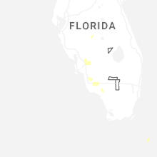
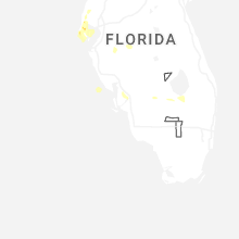
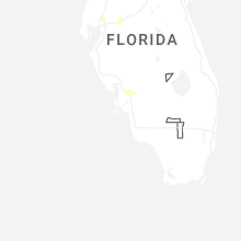


Connect with Interactive Hail Maps