

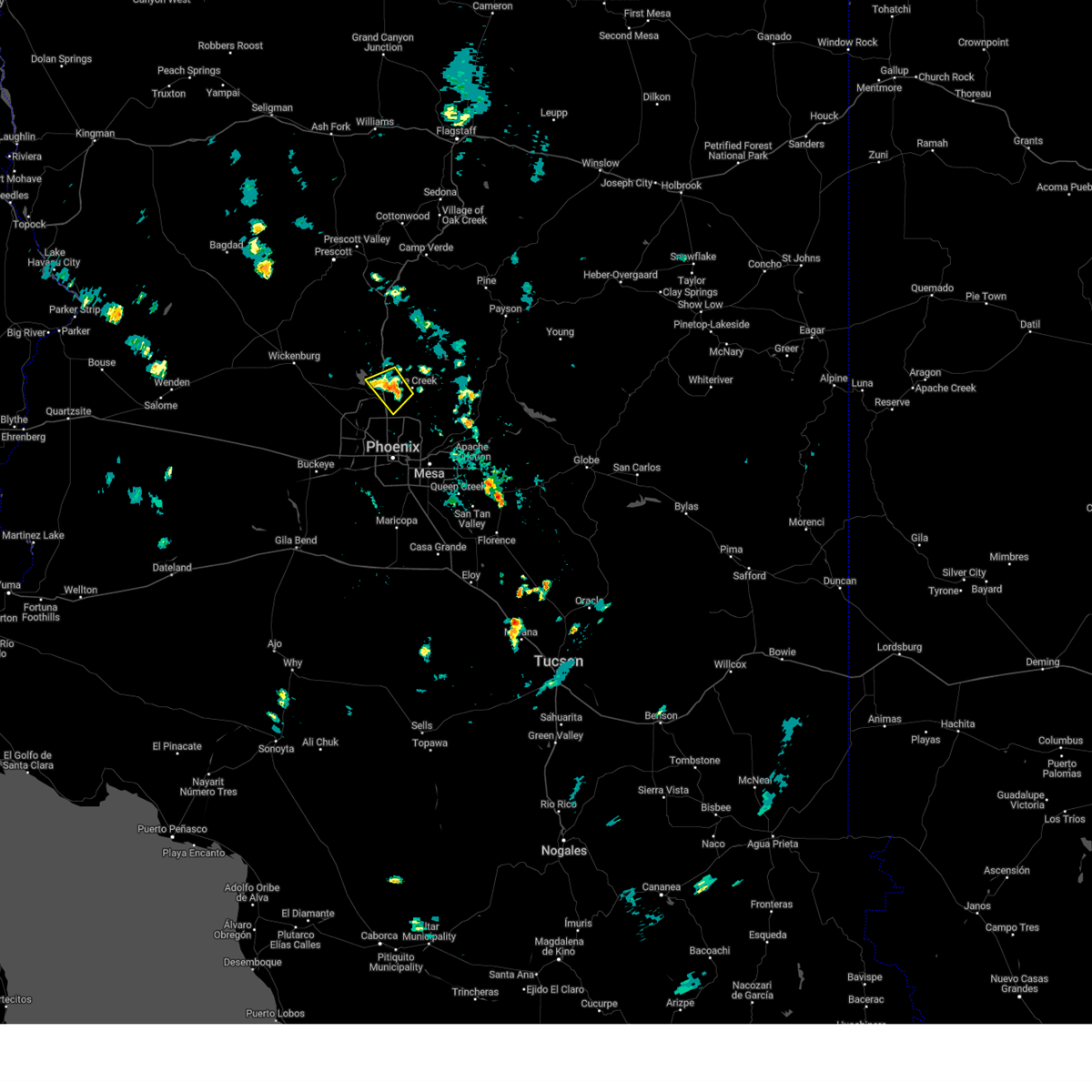
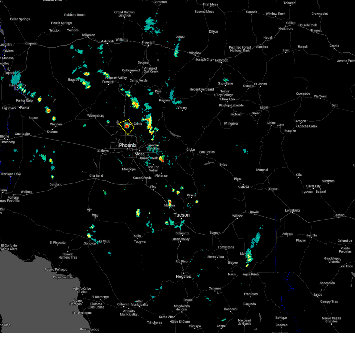
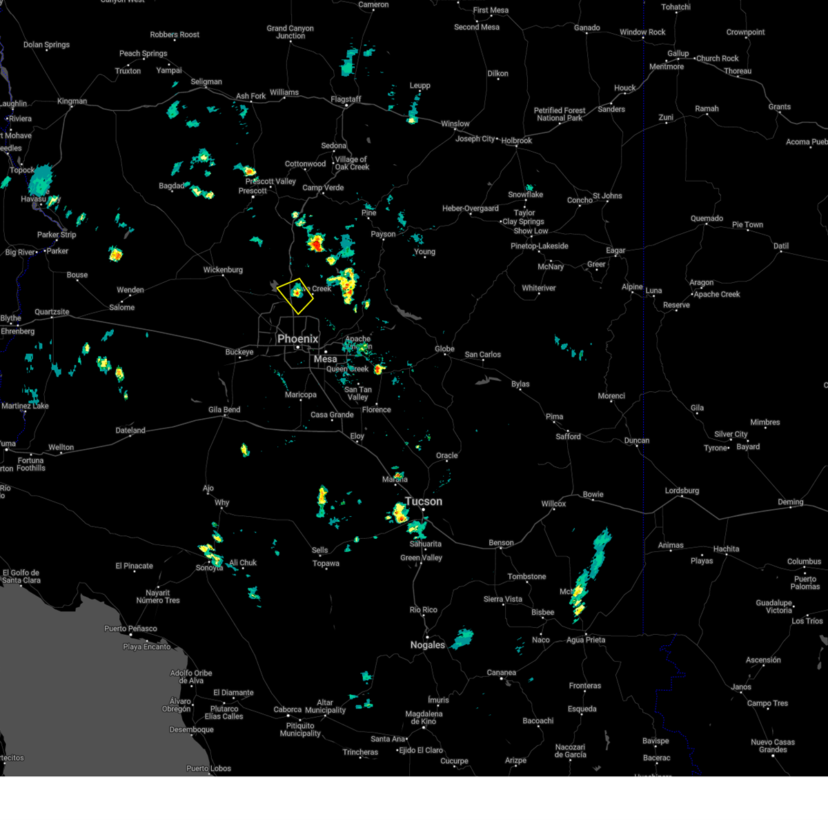
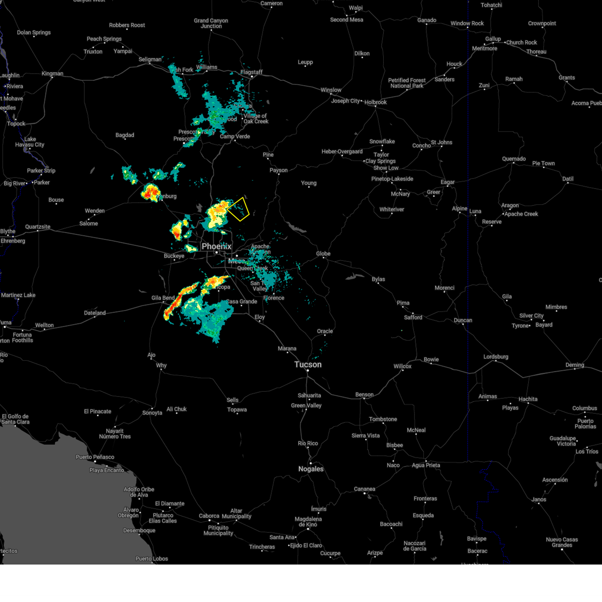
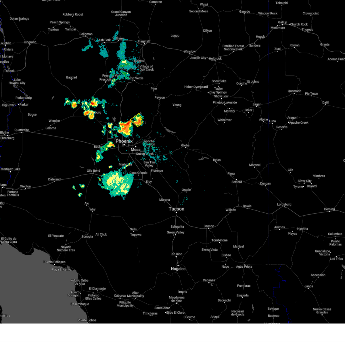
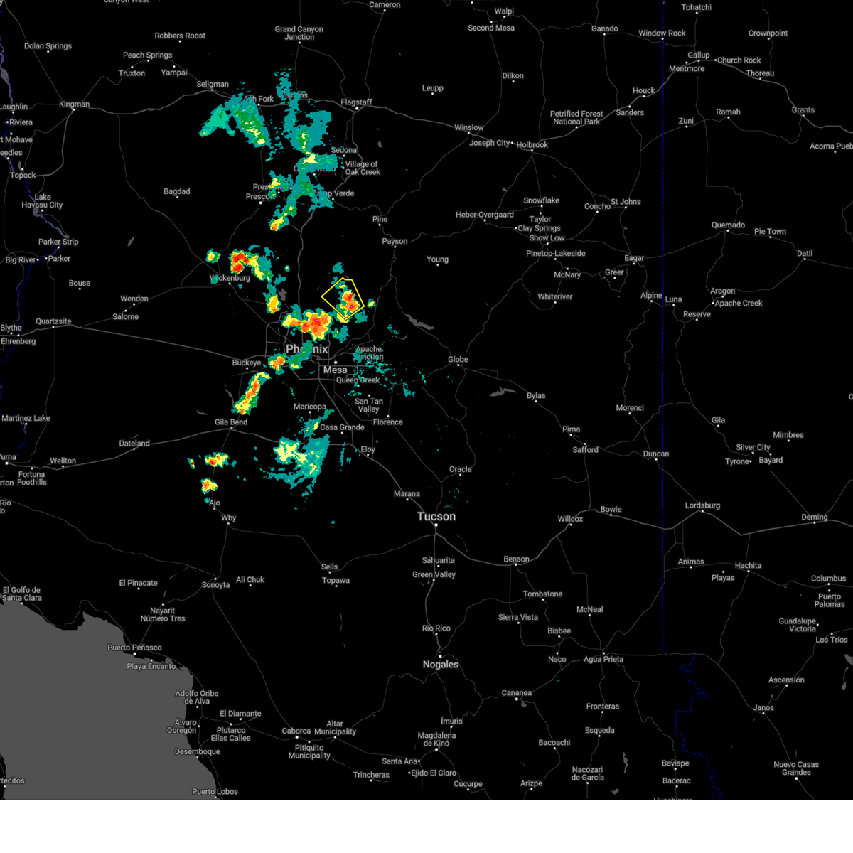
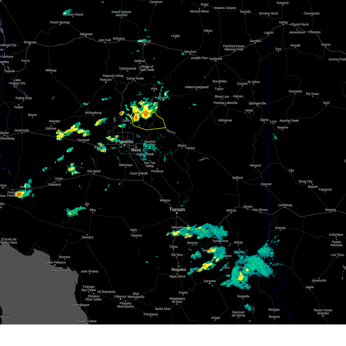
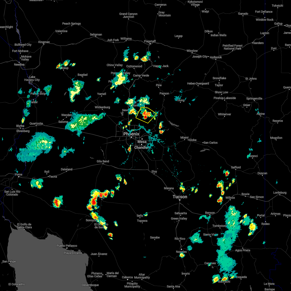
Hail Map for Carefree, AZ
The Carefree, AZ area has had 1 report of on-the-ground hail by trained spotters, and has been under severe weather warnings 17 times during the past 12 months. Doppler radar has detected hail at or near Carefree, AZ on 19 occasions, including 1 occasion during the past year.
| Name: | Carefree, AZ |
| Where Located: | 27 miles NNE of Phoenix, AZ |
| Map: | Google Map for Carefree, AZ |
| Population: | 3363 |
| Housing Units: | 2251 |
| More Info: | Search Google for Carefree, AZ |
1
The Top Recent Hail Date for Carefree, AZ is Sunday, July 14, 2024 (10th out of 19)

Hail and Wind Damage Spotted near Carefree, AZ
| Date / Time | Report Details |
|---|---|
| 8/31/2024 5:57 PM MST |
 The storm which prompted the warning has weakened below severe limits, and no longer poses an immediate threat to life or property. therefore, the warning will be allowed to expire. remember, a severe thunderstorm warning still remains in effect for portions of maricopa county. The storm which prompted the warning has weakened below severe limits, and no longer poses an immediate threat to life or property. therefore, the warning will be allowed to expire. remember, a severe thunderstorm warning still remains in effect for portions of maricopa county.
|
| 8/31/2024 5:31 PM MST |
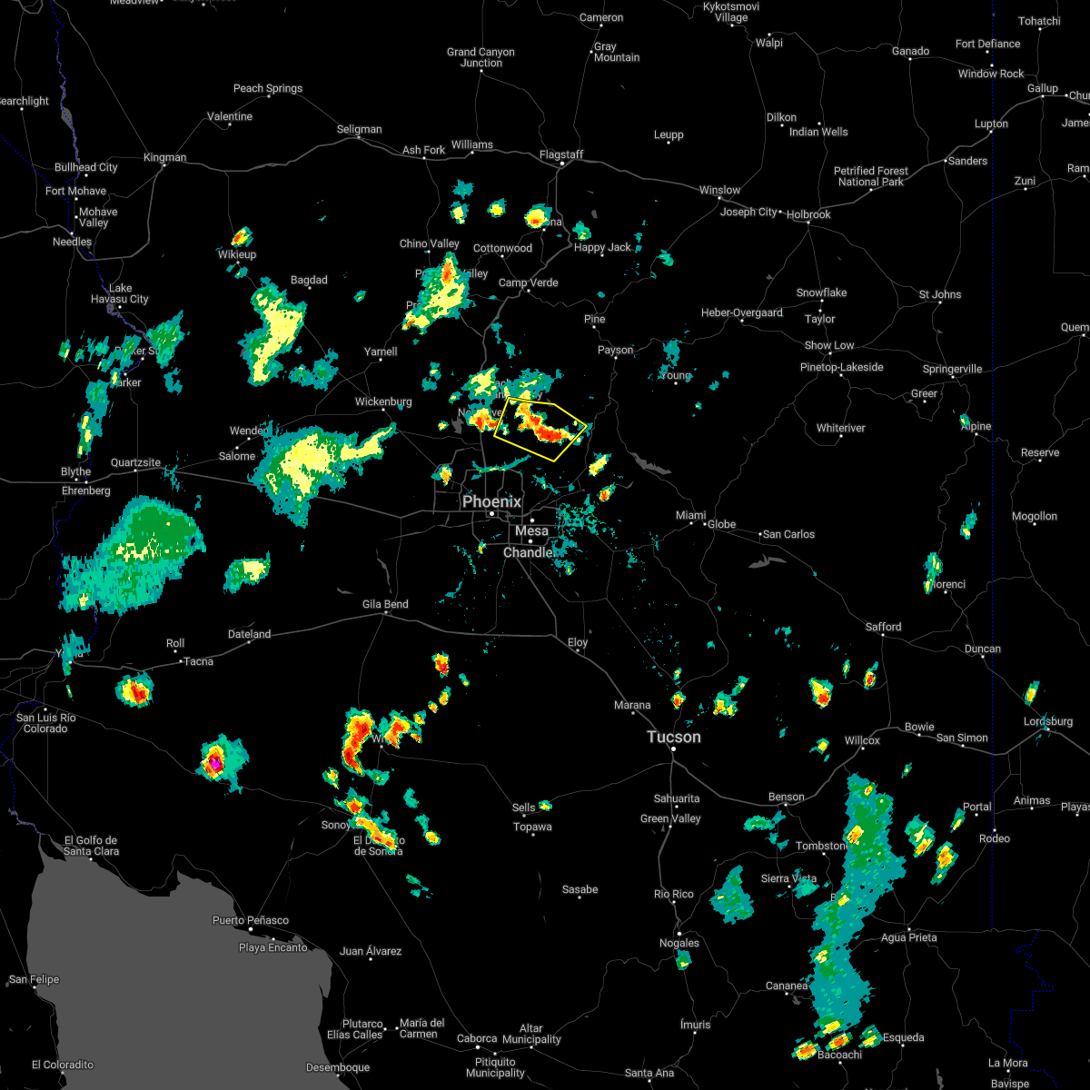
 At 531 pm mst, a severe thunderstorm was located near anthem, and is nearly stationary (radar indicated). Hazards include 60 mph wind gusts. Expect damage to roofs, siding, and trees. locations impacted include, new river, cave creek, carefree, and anthem. this includes the following highways, az interstate 17 between mile markers 221 and 232. az route 74 between mile markers 29 and 30. Az route 303 near mile marker 139. At 531 pm mst, a severe thunderstorm was located near anthem, and is nearly stationary (radar indicated). Hazards include 60 mph wind gusts. Expect damage to roofs, siding, and trees. locations impacted include, new river, cave creek, carefree, and anthem. this includes the following highways, az interstate 17 between mile markers 221 and 232. az route 74 between mile markers 29 and 30. Az route 303 near mile marker 139.
|
| 8/31/2024 5:16 PM MST |
 Svrpsr the national weather service in phoenix has issued a * severe thunderstorm warning for, maricopa county in south central arizona, * until 600 pm mst. * at 515 pm mst, a severe thunderstorm was located near anthem, and is nearly stationary (radar indicated). Hazards include 60 mph wind gusts. expect damage to roofs, siding, and trees Svrpsr the national weather service in phoenix has issued a * severe thunderstorm warning for, maricopa county in south central arizona, * until 600 pm mst. * at 515 pm mst, a severe thunderstorm was located near anthem, and is nearly stationary (radar indicated). Hazards include 60 mph wind gusts. expect damage to roofs, siding, and trees
|
| 7/21/2024 3:22 PM MST |
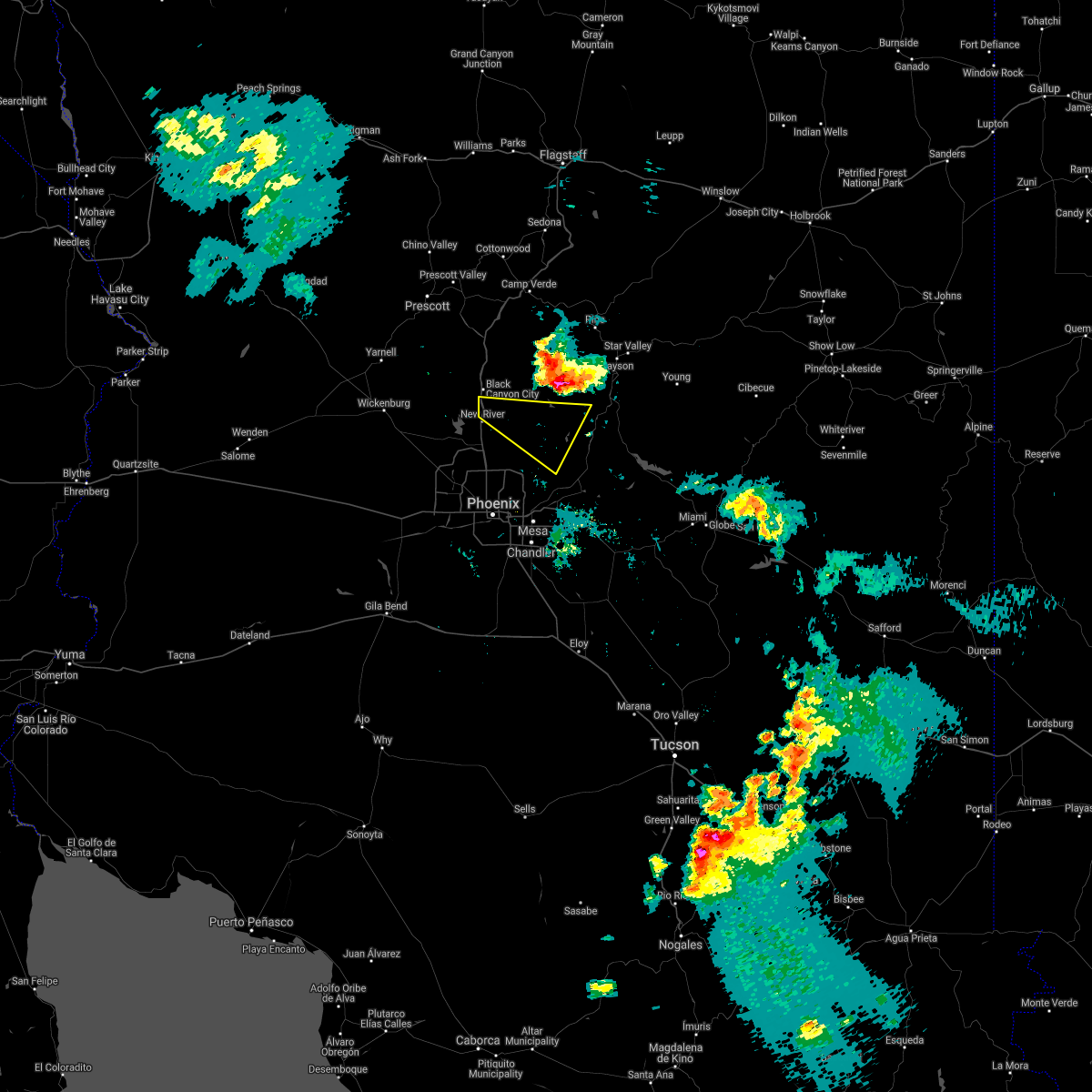
 At 321 pm mst, a severe thunderstorm was located near new river, moving southeast at 20 mph (radar indicated). Hazards include 60 mph wind gusts and penny size hail. Expect damage to roofs, siding, and trees. locations impacted include, new river, cave creek, carefree, lake pleasant, and anthem. this includes the following highways, az interstate 17 between mile markers 225 and 241. Az route 74 between mile markers 13 and 24. At 321 pm mst, a severe thunderstorm was located near new river, moving southeast at 20 mph (radar indicated). Hazards include 60 mph wind gusts and penny size hail. Expect damage to roofs, siding, and trees. locations impacted include, new river, cave creek, carefree, lake pleasant, and anthem. this includes the following highways, az interstate 17 between mile markers 225 and 241. Az route 74 between mile markers 13 and 24.
|
| 7/21/2024 3:14 PM MST |
 The storms which prompted the warning have weakened below severe limits, and no longer pose an immediate threat to life or property. therefore, the warning will be allowed to expire. however, gusty winds are still possible with these thunderstorms. a severe thunderstorm watch remains in effect until 800 pm mst for south central, southeastern and east central arizona. remember, a severe thunderstorm warning still remains in effect for parts of northern maricopa county until 345 pm mst. The storms which prompted the warning have weakened below severe limits, and no longer pose an immediate threat to life or property. therefore, the warning will be allowed to expire. however, gusty winds are still possible with these thunderstorms. a severe thunderstorm watch remains in effect until 800 pm mst for south central, southeastern and east central arizona. remember, a severe thunderstorm warning still remains in effect for parts of northern maricopa county until 345 pm mst.
|
| 7/21/2024 2:58 PM MST |
 Svrpsr the national weather service in phoenix has issued a * severe thunderstorm warning for, maricopa county in south central arizona, * until 345 pm mst. * at 257 pm mst, a severe thunderstorm was located over rock springs, or 13 miles north of new river, moving south at 25 mph (radar indicated). Hazards include 60 mph wind gusts and penny size hail. expect damage to roofs, siding, and trees Svrpsr the national weather service in phoenix has issued a * severe thunderstorm warning for, maricopa county in south central arizona, * until 345 pm mst. * at 257 pm mst, a severe thunderstorm was located over rock springs, or 13 miles north of new river, moving south at 25 mph (radar indicated). Hazards include 60 mph wind gusts and penny size hail. expect damage to roofs, siding, and trees
|
| 7/21/2024 2:52 PM MST |
 At 252 pm mst, severe thunderstorms were located along a line extending from 6 miles south of apache lake to near rio verde to near scottsdale, moving east at 25 mph (radar indicated). Hazards include 60 mph wind gusts and penny size hail. Expect damage to roofs, siding, and trees. locations impacted include, phoenix, scottsdale, fountain hills, sugarloaf mountain, ballantine trailhead, round valley, sunflower, new river, cave creek, carefree, canyon lake, goldfield ranch, four peaks, desert mountain, and camp creek. this includes the following highways, az route 87 between mile markers 187 and 222. az route 101 between mile markers 31 and 38. Az route 188 between mile markers 246 and 260. At 252 pm mst, severe thunderstorms were located along a line extending from 6 miles south of apache lake to near rio verde to near scottsdale, moving east at 25 mph (radar indicated). Hazards include 60 mph wind gusts and penny size hail. Expect damage to roofs, siding, and trees. locations impacted include, phoenix, scottsdale, fountain hills, sugarloaf mountain, ballantine trailhead, round valley, sunflower, new river, cave creek, carefree, canyon lake, goldfield ranch, four peaks, desert mountain, and camp creek. this includes the following highways, az route 87 between mile markers 187 and 222. az route 101 between mile markers 31 and 38. Az route 188 between mile markers 246 and 260.
|
| 7/21/2024 2:30 PM MST |
 Svrpsr the national weather service in phoenix has issued a * severe thunderstorm warning for, gila county in east central arizona, maricopa county in south central arizona, pinal county in southeastern arizona, * until 315 pm mst. * at 230 pm mst, severe thunderstorms were located along a line extending from apache lake to 6 miles northeast of rio verde to near carefree, moving south at 25 mph (radar indicated). Hazards include 60 mph wind gusts and penny size hail. expect damage to roofs, siding, and trees Svrpsr the national weather service in phoenix has issued a * severe thunderstorm warning for, gila county in east central arizona, maricopa county in south central arizona, pinal county in southeastern arizona, * until 315 pm mst. * at 230 pm mst, severe thunderstorms were located along a line extending from apache lake to 6 miles northeast of rio verde to near carefree, moving south at 25 mph (radar indicated). Hazards include 60 mph wind gusts and penny size hail. expect damage to roofs, siding, and trees
|
| 7/14/2024 10:28 PM MST |
 The storm which prompted the warning has weakened below severe limits, and has exited the warned area. therefore, the warning will be allowed to expire. remember, a severe thunderstorm warning still remains in effect for parts of maricopa county until 1100 pm mst. The storm which prompted the warning has weakened below severe limits, and has exited the warned area. therefore, the warning will be allowed to expire. remember, a severe thunderstorm warning still remains in effect for parts of maricopa county until 1100 pm mst.
|
| 7/14/2024 10:28 PM MST |
 The storm which prompted the warning has weakened below severe limits, and no longer poses an immediate threat to life or property. therefore, the warning will be allowed to expire. remember, a severe thunderstorm warning still remains in effect for parts of northern maricopa county until 1100 pm mst. The storm which prompted the warning has weakened below severe limits, and no longer poses an immediate threat to life or property. therefore, the warning will be allowed to expire. remember, a severe thunderstorm warning still remains in effect for parts of northern maricopa county until 1100 pm mst.
|
| 7/14/2024 10:15 PM MST |
 The storm which prompted the warning has weakened below severe limits, and no longer poses an immediate threat to life or property. therefore, the warning has been allowed to expire. remember, a severe thunderstorm warning still remains in effect for for parts of northern maricopa county until 1100 pm mst. The storm which prompted the warning has weakened below severe limits, and no longer poses an immediate threat to life or property. therefore, the warning has been allowed to expire. remember, a severe thunderstorm warning still remains in effect for for parts of northern maricopa county until 1100 pm mst.
|
| 7/14/2024 10:10 PM MST |
 At 1010 pm mst, a severe thunderstorm was located near deer valley airport, or near new river, moving northwest at 10 mph (radar indicated). Hazards include 60 mph wind gusts and penny size hail. Expect damage to roofs, siding, and trees. locations impacted include, phoenix, new river, cave creek, carefree, and deer valley airport. this includes the following highways, az interstate 17 between mile markers 216 and 226. az route 101 between mile markers 25 and 28. Az route 74 between mile markers 28 and 30. At 1010 pm mst, a severe thunderstorm was located near deer valley airport, or near new river, moving northwest at 10 mph (radar indicated). Hazards include 60 mph wind gusts and penny size hail. Expect damage to roofs, siding, and trees. locations impacted include, phoenix, new river, cave creek, carefree, and deer valley airport. this includes the following highways, az interstate 17 between mile markers 216 and 226. az route 101 between mile markers 25 and 28. Az route 74 between mile markers 28 and 30.
|
| 7/14/2024 10:07 PM MST |
 At 1007 pm mst, a severe thunderstorm was located near desert mountain, or 13 miles northeast of scottsdale, moving northwest at 10 mph (radar indicated). Hazards include 60 mph wind gusts and penny size hail. Expect damage to roofs, siding, and trees. Locations impacted include, scottsdale, carefree, desert mountain, and camp creek. At 1007 pm mst, a severe thunderstorm was located near desert mountain, or 13 miles northeast of scottsdale, moving northwest at 10 mph (radar indicated). Hazards include 60 mph wind gusts and penny size hail. Expect damage to roofs, siding, and trees. Locations impacted include, scottsdale, carefree, desert mountain, and camp creek.
|
| 7/14/2024 9:54 PM MST |
 At 953 pm mst, a severe thunderstorm was located over desert ridge marketplace, or 7 miles north of paradise valley, moving northwest at 10 mph (radar indicated). Hazards include 60 mph wind gusts and penny size hail. Expect damage to roofs, siding, and trees. locations impacted include, phoenix, scottsdale, carefree, deer valley airport, and desert ridge marketplace. this includes the following highways, az interstate 17 between mile markers 212 and 216. az route 51 between mile markers 9 and 15. Az route 101 between mile markers 23 and 36. At 953 pm mst, a severe thunderstorm was located over desert ridge marketplace, or 7 miles north of paradise valley, moving northwest at 10 mph (radar indicated). Hazards include 60 mph wind gusts and penny size hail. Expect damage to roofs, siding, and trees. locations impacted include, phoenix, scottsdale, carefree, deer valley airport, and desert ridge marketplace. this includes the following highways, az interstate 17 between mile markers 212 and 216. az route 51 between mile markers 9 and 15. Az route 101 between mile markers 23 and 36.
|
| 7/14/2024 9:45 PM MST |
 Svrpsr the national weather service in phoenix has issued a * severe thunderstorm warning for, maricopa county in south central arizona, * until 1030 pm mst. * at 945 pm mst, a severe thunderstorm was located near rio verde, or 12 miles northeast of scottsdale, moving northwest at 10 mph (radar indicated). Hazards include 60 mph wind gusts and penny size hail. expect damage to roofs, siding, and trees Svrpsr the national weather service in phoenix has issued a * severe thunderstorm warning for, maricopa county in south central arizona, * until 1030 pm mst. * at 945 pm mst, a severe thunderstorm was located near rio verde, or 12 miles northeast of scottsdale, moving northwest at 10 mph (radar indicated). Hazards include 60 mph wind gusts and penny size hail. expect damage to roofs, siding, and trees
|
| 7/14/2024 9:41 PM MST |
 Svrpsr the national weather service in phoenix has issued a * severe thunderstorm warning for, maricopa county in south central arizona, * until 1030 pm mst. * at 940 pm mst, a severe thunderstorm was located near desert ridge marketplace, or 8 miles west of scottsdale, moving northwest at 10 mph (radar indicated). Hazards include 60 mph wind gusts and penny size hail. expect damage to roofs, siding, and trees Svrpsr the national weather service in phoenix has issued a * severe thunderstorm warning for, maricopa county in south central arizona, * until 1030 pm mst. * at 940 pm mst, a severe thunderstorm was located near desert ridge marketplace, or 8 miles west of scottsdale, moving northwest at 10 mph (radar indicated). Hazards include 60 mph wind gusts and penny size hail. expect damage to roofs, siding, and trees
|
| 7/14/2024 9:27 PM MST | Svrpsr the national weather service in phoenix has issued a * severe thunderstorm warning for, maricopa county in south central arizona, * until 1015 pm mst. * at 926 pm mst, a severe thunderstorm was located over scottsdale airport, or near paradise valley, moving northwest at 10 mph (radar indicated). Hazards include 60 mph wind gusts and penny size hail. expect damage to roofs, siding, and trees |
| 9/12/2023 8:12 PM MST |
 At 810 pm mst, a severe thunderstorm was located over desert ridge marketplace, or near scottsdale, moving northeast at 30 mph (radar indicated). Hazards include 60 mph wind gusts and penny size hail. Expect damage to roofs, siding, and trees. locations impacted include, north phoenix, glendale, scottsdale, peoria, paradise valley, sun city, new river, cave creek, carefree, piestewa peak park, deer valley airport, north mountain park, and arizona state fairgrounds. this includes the following highways, az interstate 10 between mile markers 140 and 143. az interstate 17 between mile markers 201 and 224. az route 51 between mile markers 1 and 15. hail threat, radar indicated max hail size, 0. 75 in wind threat, radar indicated max wind gust, 60 mph. At 810 pm mst, a severe thunderstorm was located over desert ridge marketplace, or near scottsdale, moving northeast at 30 mph (radar indicated). Hazards include 60 mph wind gusts and penny size hail. Expect damage to roofs, siding, and trees. locations impacted include, north phoenix, glendale, scottsdale, peoria, paradise valley, sun city, new river, cave creek, carefree, piestewa peak park, deer valley airport, north mountain park, and arizona state fairgrounds. this includes the following highways, az interstate 10 between mile markers 140 and 143. az interstate 17 between mile markers 201 and 224. az route 51 between mile markers 1 and 15. hail threat, radar indicated max hail size, 0. 75 in wind threat, radar indicated max wind gust, 60 mph.
|
| 9/12/2023 7:50 PM MST |
 At 749 pm mst, a severe thunderstorm was located over metro center, or near glendale, moving northeast at 30 mph (radar indicated). Hazards include 60 mph wind gusts and penny size hail. expect damage to roofs, siding, and trees At 749 pm mst, a severe thunderstorm was located over metro center, or near glendale, moving northeast at 30 mph (radar indicated). Hazards include 60 mph wind gusts and penny size hail. expect damage to roofs, siding, and trees
|
| 9/12/2023 5:15 PM MST |
 At 514 pm mst, a severe thunderstorm was located near horseshoe reservoir, or 10 miles northwest of sycamore creek, moving east at 25 mph (radar indicated). Hazards include 60 mph wind gusts and nickel size hail. expect damage to roofs, siding, and trees At 514 pm mst, a severe thunderstorm was located near horseshoe reservoir, or 10 miles northwest of sycamore creek, moving east at 25 mph (radar indicated). Hazards include 60 mph wind gusts and nickel size hail. expect damage to roofs, siding, and trees
|
| 8/31/2023 10:40 PM MST |
 The severe thunderstorm warning for maricopa county will expire at 1045 pm mst, the storm which prompted the warning has weakened below severe limits, and no longer poses an immediate threat to life or property. therefore, the warning will be allowed to expire. however, heavy rain is still possible with this thunderstorm. The severe thunderstorm warning for maricopa county will expire at 1045 pm mst, the storm which prompted the warning has weakened below severe limits, and no longer poses an immediate threat to life or property. therefore, the warning will be allowed to expire. however, heavy rain is still possible with this thunderstorm.
|
| 8/31/2023 9:45 PM MST |
 At 945 pm mst, a severe thunderstorm was located over new river, moving northwest at 5 mph (radar indicated). Hazards include 60 mph wind gusts and penny size hail. expect damage to roofs, siding, and trees At 945 pm mst, a severe thunderstorm was located over new river, moving northwest at 5 mph (radar indicated). Hazards include 60 mph wind gusts and penny size hail. expect damage to roofs, siding, and trees
|
| 8/31/2023 9:11 PM MST |
 At 911 pm mst, severe winds associated with thunderstorms were located along a line extending from cave creek to near peoria to near litchfield park, moving north at 50 mph (radar indicated). Hazards include 60 mph wind gusts. expect damage to roofs, siding, and trees At 911 pm mst, severe winds associated with thunderstorms were located along a line extending from cave creek to near peoria to near litchfield park, moving north at 50 mph (radar indicated). Hazards include 60 mph wind gusts. expect damage to roofs, siding, and trees
|
| 8/16/2023 7:22 PM MST |
 The severe thunderstorm warning for maricopa county will expire at 730 pm mst, the storm which prompted the warning has weakened below severe limits, and has exited the warned area. therefore, the warning will be allowed to expire. The severe thunderstorm warning for maricopa county will expire at 730 pm mst, the storm which prompted the warning has weakened below severe limits, and has exited the warned area. therefore, the warning will be allowed to expire.
|
| 8/16/2023 6:50 PM MST |
 At 650 pm mst, a severe thunderstorm was located over scottsdale, moving north at 15 mph (radar indicated). Hazards include 60 mph wind gusts. expect damage to roofs, siding, and trees At 650 pm mst, a severe thunderstorm was located over scottsdale, moving north at 15 mph (radar indicated). Hazards include 60 mph wind gusts. expect damage to roofs, siding, and trees
|
| 7/26/2023 11:11 PM MST |
 The severe thunderstorm warning for gila and maricopa counties will expire at 1115 pm mst, the thunderstorm winds which prompted the warning have weakened below severe limits. therefore, the warning will be allowed to expire. The severe thunderstorm warning for gila and maricopa counties will expire at 1115 pm mst, the thunderstorm winds which prompted the warning have weakened below severe limits. therefore, the warning will be allowed to expire.
|
| 7/26/2023 10:33 PM MST |
 At 1033 pm mst, severe thunderstorm winds were located along a line extending from near peoria to 6 miles north of desert ridge marketplace to round valley, moving northwest at 45 mph (radar indicated). Hazards include 60 mph wind gusts. expect damage to roofs, siding, and trees At 1033 pm mst, severe thunderstorm winds were located along a line extending from near peoria to 6 miles north of desert ridge marketplace to round valley, moving northwest at 45 mph (radar indicated). Hazards include 60 mph wind gusts. expect damage to roofs, siding, and trees
|
| 7/26/2023 10:27 PM MST |
 At 1026 pm mst, a severe thunderstorm was located over piestewa peak park, or over paradise valley, moving northwest at 25 mph (radar indicated). Hazards include 60 mph wind gusts. expect damage to roofs, siding, and trees At 1026 pm mst, a severe thunderstorm was located over piestewa peak park, or over paradise valley, moving northwest at 25 mph (radar indicated). Hazards include 60 mph wind gusts. expect damage to roofs, siding, and trees
|
| 10/15/2022 2:04 PM MST |
 At 204 pm mst, severe thunderstorms were located along a line extending from 9 miles northwest of sycamore creek to near camp creek to near peoria, moving north at 35 mph (radar indicated). Hazards include 60 mph wind gusts. Expect damage to roofs, siding, and trees. locations impacted include, phoenix, scottsdale, new river, cave creek, carefree, deer valley airport, lake pleasant, desert mountain, desert ridge marketplace, camp creek, horseshoe reservoir, anthem and seven springs. this includes the following highways, az interstate 17 between mile markers 210 and 241. az route 51 between mile markers 13 and 15. az route 101 between mile markers 21 and 33. hail threat, radar indicated max hail size, <. 75 in wind threat, radar indicated max wind gust, 60 mph. At 204 pm mst, severe thunderstorms were located along a line extending from 9 miles northwest of sycamore creek to near camp creek to near peoria, moving north at 35 mph (radar indicated). Hazards include 60 mph wind gusts. Expect damage to roofs, siding, and trees. locations impacted include, phoenix, scottsdale, new river, cave creek, carefree, deer valley airport, lake pleasant, desert mountain, desert ridge marketplace, camp creek, horseshoe reservoir, anthem and seven springs. this includes the following highways, az interstate 17 between mile markers 210 and 241. az route 51 between mile markers 13 and 15. az route 101 between mile markers 21 and 33. hail threat, radar indicated max hail size, <. 75 in wind threat, radar indicated max wind gust, 60 mph.
|
| 10/15/2022 1:54 PM MST |
 At 154 pm mst, severe thunderstorms were located along a line extending from near sycamore creek to near desert mountain to near arrowhead mall, moving north at 35 mph (radar indicated). Hazards include 60 mph wind gusts. Expect damage to roofs, siding, and trees. locations impacted include, phoenix, scottsdale, paradise valley, round valley, new river, sycamore creek, sunflower, cave creek, carefree, piestewa peak park, deer valley airport, lake pleasant, mcdowell mountain park, north mountain park and desert mountain. this includes the following highways, az interstate 17 between mile markers 210 and 241. az route 51 between mile markers 3 and 15. az route 87 between mile markers 211 and 219. hail threat, radar indicated max hail size, <. 75 in wind threat, radar indicated max wind gust, 60 mph. At 154 pm mst, severe thunderstorms were located along a line extending from near sycamore creek to near desert mountain to near arrowhead mall, moving north at 35 mph (radar indicated). Hazards include 60 mph wind gusts. Expect damage to roofs, siding, and trees. locations impacted include, phoenix, scottsdale, paradise valley, round valley, new river, sycamore creek, sunflower, cave creek, carefree, piestewa peak park, deer valley airport, lake pleasant, mcdowell mountain park, north mountain park and desert mountain. this includes the following highways, az interstate 17 between mile markers 210 and 241. az route 51 between mile markers 3 and 15. az route 87 between mile markers 211 and 219. hail threat, radar indicated max hail size, <. 75 in wind threat, radar indicated max wind gust, 60 mph.
|
| 10/15/2022 1:38 PM MST |
 At 137 pm mst, severe thunderstorms were located along a line extending from near round valley to near scottsdale to near downtown glendale, moving north at 35 mph (radar indicated). Hazards include 60 mph wind gusts. expect damage to roofs, siding, and trees At 137 pm mst, severe thunderstorms were located along a line extending from near round valley to near scottsdale to near downtown glendale, moving north at 35 mph (radar indicated). Hazards include 60 mph wind gusts. expect damage to roofs, siding, and trees
|
| 9/23/2022 4:59 PM MST |
 At 458 pm mst, a severe thunderstorm was located near desert mountain, or 13 miles northeast of scottsdale, moving northeast at 10 mph (radar indicated). Hazards include 60 mph wind gusts and quarter size hail. Hail damage to vehicles is expected. expect wind damage to roofs, siding, and trees. locations impacted include, scottsdale, cave creek, carefree, desert mountain, camp creek, rio verde, horseshoe reservoir and seven springs. hail threat, radar indicated max hail size, 1. 00 in wind threat, radar indicated max wind gust, 60 mph. At 458 pm mst, a severe thunderstorm was located near desert mountain, or 13 miles northeast of scottsdale, moving northeast at 10 mph (radar indicated). Hazards include 60 mph wind gusts and quarter size hail. Hail damage to vehicles is expected. expect wind damage to roofs, siding, and trees. locations impacted include, scottsdale, cave creek, carefree, desert mountain, camp creek, rio verde, horseshoe reservoir and seven springs. hail threat, radar indicated max hail size, 1. 00 in wind threat, radar indicated max wind gust, 60 mph.
|
| 9/23/2022 4:41 PM MST |
 At 440 pm mst, a severe thunderstorm was located near camp creek, or 13 miles northeast of scottsdale, moving northwest at 5 mph (radar indicated). Hazards include 60 mph wind gusts and quarter size hail. Hail damage to vehicles is expected. Expect wind damage to roofs, siding, and trees. At 440 pm mst, a severe thunderstorm was located near camp creek, or 13 miles northeast of scottsdale, moving northwest at 5 mph (radar indicated). Hazards include 60 mph wind gusts and quarter size hail. Hail damage to vehicles is expected. Expect wind damage to roofs, siding, and trees.
|
| 8/23/2022 4:32 PM MST | At 431 pm mst, a severe thunderstorm was located over scottsdale airport, or near scottsdale, moving southwest at 20 mph (radar indicated). Hazards include 60 mph wind gusts and penny size hail. Expect damage to roofs, siding, and trees. locations impacted include, phoenix, scottsdale, fountain hills, paradise valley, carefree, downtown scottsdale, mcdowell mountain park, scottsdale airport and desert ridge marketplace. this includes the following highways, az route 51 between mile markers 11 and 15. az route 101 between mile markers 28 and 47. hail threat, radar indicated max hail size, 0. 75 in wind threat, radar indicated max wind gust, 60 mph. |
| 8/23/2022 4:09 PM MST | At 409 pm mst, a severe thunderstorm was located near scottsdale, moving southwest at 20 mph (radar indicated). Hazards include 60 mph wind gusts and penny size hail. expect damage to roofs, siding, and trees |
| 8/23/2022 3:37 PM MST | At 337 pm mst, severe thunderstorms were located along a line extending from near round valley to sugarloaf mountain to near saguaro lake, and are nearly stationary (radar indicated). Hazards include 60 mph wind gusts and quarter size hail. Hail damage to vehicles is expected. expect wind damage to roofs, siding, and trees. locations impacted include, mesa, scottsdale, fountain hills, sugarloaf mountain, ballantine trailhead, granite reef dam, mcdowell mountain park, usery mountain park, saguaro lake, canyon lake, goldfield ranch, desert mountain, camp creek, salt river tubing recreation area and rio verde. this includes the following highways, az route 87 between mile markers 186 and 211. az route 202 between mile markers 23 and 25. hail threat, radar indicated max hail size, 1. 00 in wind threat, radar indicated max wind gust, 60 mph. |
| 8/23/2022 3:21 PM MST | At 321 pm mst, severe thunderstorms were located along a line extending from near round valley to sugarloaf mountain to near saguaro lake, moving west at 15 mph (radar indicated). Hazards include 60 mph wind gusts and quarter size hail. Hail damage to vehicles is expected. Expect wind damage to roofs, siding, and trees. |
| 8/21/2022 6:10 PM MST | The severe thunderstorm warning for maricopa county will expire at 615 pm mst, the storm which prompted the warning has weakened below severe limits, and has exited the warned area. therefore, the warning will be allowed to expire. however gusty winds and heavy rain are still possible with this thunderstorm. |
| 8/21/2022 5:48 PM MST |
 At 547 pm mst, a severe thunderstorm was located over new river, moving south at 20 mph (radar indicated). Hazards include 60 mph wind gusts. Expect damage to roofs, siding, and trees. locations impacted include, scottsdale, new river, cave creek, carefree, lake pleasant, desert mountain and anthem. this includes the following highways, az interstate 17 between mile markers 220 and 241. az route 74 between mile markers 16 and 30. az route 303 between mile markers 129 and 139. hail threat, radar indicated max hail size, <. 75 in wind threat, radar indicated max wind gust, 60 mph. At 547 pm mst, a severe thunderstorm was located over new river, moving south at 20 mph (radar indicated). Hazards include 60 mph wind gusts. Expect damage to roofs, siding, and trees. locations impacted include, scottsdale, new river, cave creek, carefree, lake pleasant, desert mountain and anthem. this includes the following highways, az interstate 17 between mile markers 220 and 241. az route 74 between mile markers 16 and 30. az route 303 between mile markers 129 and 139. hail threat, radar indicated max hail size, <. 75 in wind threat, radar indicated max wind gust, 60 mph.
|
| 8/21/2022 5:45 PM MST |
 At 545 pm mst, severe thunderstorms were located along a line extending from near scottsdale to near rio verde, moving southeast at 15 mph (radar indicated). Hazards include 60 mph wind gusts. expect damage to roofs, siding, and trees At 545 pm mst, severe thunderstorms were located along a line extending from near scottsdale to near rio verde, moving southeast at 15 mph (radar indicated). Hazards include 60 mph wind gusts. expect damage to roofs, siding, and trees
|
| 8/21/2022 5:29 PM MST |
 At 528 pm mst, a severe thunderstorm was located 7 miles northeast of new river, and is nearly stationary (radar indicated). Hazards include 60 mph wind gusts. expect damage to roofs, siding, and trees At 528 pm mst, a severe thunderstorm was located 7 miles northeast of new river, and is nearly stationary (radar indicated). Hazards include 60 mph wind gusts. expect damage to roofs, siding, and trees
|
| 8/21/2022 5:12 PM MST |
 At 512 pm mst, a severe thunderstorm was located 9 miles east of new river, moving southwest at 10 mph (radar indicated). Hazards include 60 mph wind gusts and nickel size hail. Expect damage to roofs, siding, and trees. locations impacted include, scottsdale, new river, cave creek, carefree, desert mountain, camp creek, anthem and seven springs. this includes az interstate 17 between mile markers 225 and 227. hail threat, radar indicated max hail size, 0. 88 in wind threat, radar indicated max wind gust, 60 mph. At 512 pm mst, a severe thunderstorm was located 9 miles east of new river, moving southwest at 10 mph (radar indicated). Hazards include 60 mph wind gusts and nickel size hail. Expect damage to roofs, siding, and trees. locations impacted include, scottsdale, new river, cave creek, carefree, desert mountain, camp creek, anthem and seven springs. this includes az interstate 17 between mile markers 225 and 227. hail threat, radar indicated max hail size, 0. 88 in wind threat, radar indicated max wind gust, 60 mph.
|
| 8/21/2022 4:58 PM MST |
 At 458 pm mst, a severe thunderstorm was located over camp creek, or 16 miles east of new river, and is nearly stationary (radar indicated). Hazards include 60 mph wind gusts. Expect damage to roofs, siding, and trees. locations impacted include, scottsdale, new river, cave creek, carefree, desert mountain, camp creek, anthem and seven springs. this includes az interstate 17 between mile markers 225 and 227. hail threat, radar indicated max hail size, <. 75 in wind threat, radar indicated max wind gust, 60 mph. At 458 pm mst, a severe thunderstorm was located over camp creek, or 16 miles east of new river, and is nearly stationary (radar indicated). Hazards include 60 mph wind gusts. Expect damage to roofs, siding, and trees. locations impacted include, scottsdale, new river, cave creek, carefree, desert mountain, camp creek, anthem and seven springs. this includes az interstate 17 between mile markers 225 and 227. hail threat, radar indicated max hail size, <. 75 in wind threat, radar indicated max wind gust, 60 mph.
|
| 8/21/2022 4:48 PM MST |
 At 448 pm mst, a severe thunderstorm was located near camp creek, or 16 miles east of new river, and is nearly stationary (radar indicated). Hazards include 60 mph wind gusts. expect damage to roofs, siding, and trees At 448 pm mst, a severe thunderstorm was located near camp creek, or 16 miles east of new river, and is nearly stationary (radar indicated). Hazards include 60 mph wind gusts. expect damage to roofs, siding, and trees
|
| 8/20/2022 8:58 PM MST |
 At 857 pm mst, a severe thunderstorm was located near peoria, moving south at 20 mph (radar indicated). Hazards include 60 mph wind gusts. Expect damage to roofs, siding, and trees. locations impacted include, phoenix, glendale, scottsdale, peoria, surprise, el mirage, fountain hills, paradise valley, youngtown, new river, sun city west, sun city, cave creek, carefree and piestewa peak park. this includes the following highways, az interstate 17 between mile markers 203 and 241. az route 51 between mile markers 3 and 15. us highway 60 between mile markers 135 and 159. hail threat, radar indicated max hail size, <. 75 in wind threat, radar indicated max wind gust, 60 mph. At 857 pm mst, a severe thunderstorm was located near peoria, moving south at 20 mph (radar indicated). Hazards include 60 mph wind gusts. Expect damage to roofs, siding, and trees. locations impacted include, phoenix, glendale, scottsdale, peoria, surprise, el mirage, fountain hills, paradise valley, youngtown, new river, sun city west, sun city, cave creek, carefree and piestewa peak park. this includes the following highways, az interstate 17 between mile markers 203 and 241. az route 51 between mile markers 3 and 15. us highway 60 between mile markers 135 and 159. hail threat, radar indicated max hail size, <. 75 in wind threat, radar indicated max wind gust, 60 mph.
|
| 8/20/2022 8:42 PM MST |
 At 842 pm mst, a severe thunderstorm was located near lake pleasant, or 8 miles southwest of new river, moving south at 20 mph (radar indicated). Hazards include 60 mph wind gusts. expect damage to roofs, siding, and trees At 842 pm mst, a severe thunderstorm was located near lake pleasant, or 8 miles southwest of new river, moving south at 20 mph (radar indicated). Hazards include 60 mph wind gusts. expect damage to roofs, siding, and trees
|
| 8/20/2022 8:30 PM MST |
 At 829 pm mst, a severe thunderstorm was located near lake pleasant, or 8 miles southwest of new river, moving south at 30 mph (radar indicated). Hazards include 60 mph wind gusts. Expect damage to roofs, siding, and trees. locations impacted include, phoenix, glendale, scottsdale, peoria, new river, cave creek, carefree, deer valley airport, lake pleasant, desert mountain, desert ridge marketplace, anthem and seven springs. this includes the following highways, az interstate 17 between mile markers 215 and 241. az route 101 between mile markers 17 and 32. az route 74 between mile markers 19 and 30. hail threat, radar indicated max hail size, <. 75 in wind threat, radar indicated max wind gust, 60 mph. At 829 pm mst, a severe thunderstorm was located near lake pleasant, or 8 miles southwest of new river, moving south at 30 mph (radar indicated). Hazards include 60 mph wind gusts. Expect damage to roofs, siding, and trees. locations impacted include, phoenix, glendale, scottsdale, peoria, new river, cave creek, carefree, deer valley airport, lake pleasant, desert mountain, desert ridge marketplace, anthem and seven springs. this includes the following highways, az interstate 17 between mile markers 215 and 241. az route 101 between mile markers 17 and 32. az route 74 between mile markers 19 and 30. hail threat, radar indicated max hail size, <. 75 in wind threat, radar indicated max wind gust, 60 mph.
|
| 8/20/2022 8:18 PM MST |
 At 817 pm mst, a severe thunderstorm was located near lake pleasant, or 7 miles northwest of new river, moving south at 10 mph (radar indicated). Hazards include 60 mph wind gusts. expect damage to roofs, siding, and trees At 817 pm mst, a severe thunderstorm was located near lake pleasant, or 7 miles northwest of new river, moving south at 10 mph (radar indicated). Hazards include 60 mph wind gusts. expect damage to roofs, siding, and trees
|
| 8/18/2022 5:47 PM MST |
 At 547 pm mst, a severe thunderstorm was located near mcdowell mountain park, or 7 miles northeast of scottsdale, moving south at 25 mph (radar indicated). Hazards include 60 mph wind gusts. Expect damage to roofs, siding, and trees. locations impacted include, scottsdale, cave creek, carefree, mcdowell mountain park, desert mountain, camp creek and horseshoe reservoir. hail threat, radar indicated max hail size, <. 75 in wind threat, radar indicated max wind gust, 60 mph. At 547 pm mst, a severe thunderstorm was located near mcdowell mountain park, or 7 miles northeast of scottsdale, moving south at 25 mph (radar indicated). Hazards include 60 mph wind gusts. Expect damage to roofs, siding, and trees. locations impacted include, scottsdale, cave creek, carefree, mcdowell mountain park, desert mountain, camp creek and horseshoe reservoir. hail threat, radar indicated max hail size, <. 75 in wind threat, radar indicated max wind gust, 60 mph.
|
| 8/18/2022 5:30 PM MST |
 At 530 pm mst, a severe thunderstorm was located over desert mountain, or 11 miles north of scottsdale, moving south at 25 mph (radar indicated). Hazards include 60 mph wind gusts. Expect damage to roofs, siding, and trees. locations impacted include, scottsdale, cave creek, carefree, mcdowell mountain park, desert mountain, camp creek, horseshoe reservoir and seven springs. hail threat, radar indicated max hail size, <. 75 in wind threat, radar indicated max wind gust, 60 mph. At 530 pm mst, a severe thunderstorm was located over desert mountain, or 11 miles north of scottsdale, moving south at 25 mph (radar indicated). Hazards include 60 mph wind gusts. Expect damage to roofs, siding, and trees. locations impacted include, scottsdale, cave creek, carefree, mcdowell mountain park, desert mountain, camp creek, horseshoe reservoir and seven springs. hail threat, radar indicated max hail size, <. 75 in wind threat, radar indicated max wind gust, 60 mph.
|
| 8/18/2022 5:15 PM MST |
 At 515 pm mst, a severe thunderstorm was located over camp creek, or 17 miles north of scottsdale, moving south at 25 mph (radar indicated). Hazards include 60 mph wind gusts. expect damage to roofs, siding, and trees At 515 pm mst, a severe thunderstorm was located over camp creek, or 17 miles north of scottsdale, moving south at 25 mph (radar indicated). Hazards include 60 mph wind gusts. expect damage to roofs, siding, and trees
|
| 8/17/2022 4:09 PM MST |
 At 409 pm mst, a severe thunderstorm was located over desert mountain, or 12 miles north of scottsdale, moving south at 15 mph (radar indicated). Hazards include 60 mph wind gusts. Expect damage to roofs, siding, and trees. locations impacted include, scottsdale, cave creek, carefree, desert mountain, camp creek and seven springs. hail threat, radar indicated max hail size, <. 75 in wind threat, radar indicated max wind gust, 60 mph. At 409 pm mst, a severe thunderstorm was located over desert mountain, or 12 miles north of scottsdale, moving south at 15 mph (radar indicated). Hazards include 60 mph wind gusts. Expect damage to roofs, siding, and trees. locations impacted include, scottsdale, cave creek, carefree, desert mountain, camp creek and seven springs. hail threat, radar indicated max hail size, <. 75 in wind threat, radar indicated max wind gust, 60 mph.
|
| 8/17/2022 3:53 PM MST |
 At 353 pm mst, a severe thunderstorm was located over camp creek, or 15 miles north of scottsdale, moving south at 10 mph (radar indicated). Hazards include 60 mph wind gusts and penny size hail. expect damage to roofs, siding, and trees At 353 pm mst, a severe thunderstorm was located over camp creek, or 15 miles north of scottsdale, moving south at 10 mph (radar indicated). Hazards include 60 mph wind gusts and penny size hail. expect damage to roofs, siding, and trees
|
| 8/14/2022 3:44 PM MST |
 At 344 pm mst, severe thunderstorms were located along a line extending from near desert mountain to near new river, moving south at 10 mph (radar indicated). Hazards include 60 mph wind gusts and penny size hail. Expect damage to roofs, siding, and trees. locations impacted include, scottsdale, round valley, new river, sycamore creek, cave creek, carefree, desert mountain, camp creek, rio verde, horseshoe reservoir, anthem and seven springs. this includes the following highways, az interstate 17 between mile markers 224 and 241. az route 87 near mile marker 213. hail threat, radar indicated max hail size, 0. 75 in wind threat, radar indicated max wind gust, 60 mph. At 344 pm mst, severe thunderstorms were located along a line extending from near desert mountain to near new river, moving south at 10 mph (radar indicated). Hazards include 60 mph wind gusts and penny size hail. Expect damage to roofs, siding, and trees. locations impacted include, scottsdale, round valley, new river, sycamore creek, cave creek, carefree, desert mountain, camp creek, rio verde, horseshoe reservoir, anthem and seven springs. this includes the following highways, az interstate 17 between mile markers 224 and 241. az route 87 near mile marker 213. hail threat, radar indicated max hail size, 0. 75 in wind threat, radar indicated max wind gust, 60 mph.
|
| 8/14/2022 3:09 PM MST |
 At 308 pm mst, severe thunderstorms were located along a line extending from near camp creek to new river, and are nearly stationary (radar indicated). Hazards include 60 mph wind gusts. expect damage to roofs, siding, and trees At 308 pm mst, severe thunderstorms were located along a line extending from near camp creek to new river, and are nearly stationary (radar indicated). Hazards include 60 mph wind gusts. expect damage to roofs, siding, and trees
|
| 8/12/2022 3:37 PM MST |
 At 337 pm mst, severe thunderstorms were located along a line extending from near scottsdale airport to near salt river indian community, and are nearly stationary (radar indicated). Hazards include 60 mph wind gusts and quarter size hail. Hail damage to vehicles is expected. Expect wind damage to roofs, siding, and trees. At 337 pm mst, severe thunderstorms were located along a line extending from near scottsdale airport to near salt river indian community, and are nearly stationary (radar indicated). Hazards include 60 mph wind gusts and quarter size hail. Hail damage to vehicles is expected. Expect wind damage to roofs, siding, and trees.
|
| 7/30/2022 7:01 PM MST |
 At 700 pm mst, a severe thunderstorm was located near black canyon city, or near new river, moving northwest at 35 mph (public). Hazards include 60 mph wind gusts. Expect damage to roofs, siding, and trees. locations impacted include, scottsdale, new river, cave creek, carefree, lake pleasant, desert mountain and anthem. this includes the following highways, az interstate 17 between mile markers 222 and 241. az route 74 between mile markers 21 and 30. az route 303 between mile markers 133 and 139. hail threat, radar indicated max hail size, <. 75 in wind threat, radar indicated max wind gust, 60 mph. At 700 pm mst, a severe thunderstorm was located near black canyon city, or near new river, moving northwest at 35 mph (public). Hazards include 60 mph wind gusts. Expect damage to roofs, siding, and trees. locations impacted include, scottsdale, new river, cave creek, carefree, lake pleasant, desert mountain and anthem. this includes the following highways, az interstate 17 between mile markers 222 and 241. az route 74 between mile markers 21 and 30. az route 303 between mile markers 133 and 139. hail threat, radar indicated max hail size, <. 75 in wind threat, radar indicated max wind gust, 60 mph.
|
| 7/30/2022 6:30 PM MST |
 At 629 pm mst, severe thunderstorms were located along a line extending from arrowhead mall to deer valley airport to scottsdale, moving north at 20 mph (radar indicated). Hazards include 60 mph wind gusts and penny size hail. expect damage to roofs, siding, and trees At 629 pm mst, severe thunderstorms were located along a line extending from arrowhead mall to deer valley airport to scottsdale, moving north at 20 mph (radar indicated). Hazards include 60 mph wind gusts and penny size hail. expect damage to roofs, siding, and trees
|
| 6/23/2022 4:46 PM MST |
 At 446 pm mst, a severe thunderstorm was located over desert ridge marketplace, or near scottsdale, moving northeast at 15 mph (radar indicated). Hazards include 60 mph wind gusts. Expect damage to roofs, siding, and trees. locations impacted include, phoenix, glendale, scottsdale, paradise valley, cave creek, carefree, papago park, piestewa peak park, deer valley airport, mcdowell mountain park, north mountain park, downtown scottsdale, metro center mall, scottsdale airport and camelback mountain. this includes the following highways, az interstate 17 between mile markers 202 and 213. az route 51 between mile markers 1 and 15. us highway 60 between mile markers 154 and 160. hail threat, radar indicated max hail size, <. 75 in wind threat, radar indicated max wind gust, 60 mph. At 446 pm mst, a severe thunderstorm was located over desert ridge marketplace, or near scottsdale, moving northeast at 15 mph (radar indicated). Hazards include 60 mph wind gusts. Expect damage to roofs, siding, and trees. locations impacted include, phoenix, glendale, scottsdale, paradise valley, cave creek, carefree, papago park, piestewa peak park, deer valley airport, mcdowell mountain park, north mountain park, downtown scottsdale, metro center mall, scottsdale airport and camelback mountain. this includes the following highways, az interstate 17 between mile markers 202 and 213. az route 51 between mile markers 1 and 15. us highway 60 between mile markers 154 and 160. hail threat, radar indicated max hail size, <. 75 in wind threat, radar indicated max wind gust, 60 mph.
|
| 6/23/2022 4:25 PM MST |
 At 425 pm mst, a severe thunderstorm was located over piestewa peak park, or near phoenix, moving northeast at 15 mph (radar indicated). Hazards include 60 mph wind gusts. expect damage to roofs, siding, and trees At 425 pm mst, a severe thunderstorm was located over piestewa peak park, or near phoenix, moving northeast at 15 mph (radar indicated). Hazards include 60 mph wind gusts. expect damage to roofs, siding, and trees
|
| 8/18/2021 5:59 PM MST |
 At 559 pm mst, a severe thunderstorm was located near cave creek, or 7 miles southeast of new river, moving northeast at 25 mph (radar indicated). Hazards include 60 mph wind gusts and penny size hail. Expect damage to roofs, siding, and trees. locations impacted include, scottsdale, new river, cave creek, carefree and desert mountain. hail threat, radar indicated max hail size, 0. 75 in wind threat, radar indicated max wind gust, 60 mph. At 559 pm mst, a severe thunderstorm was located near cave creek, or 7 miles southeast of new river, moving northeast at 25 mph (radar indicated). Hazards include 60 mph wind gusts and penny size hail. Expect damage to roofs, siding, and trees. locations impacted include, scottsdale, new river, cave creek, carefree and desert mountain. hail threat, radar indicated max hail size, 0. 75 in wind threat, radar indicated max wind gust, 60 mph.
|
| 8/18/2021 5:43 PM MST |
 At 543 pm mst, a severe thunderstorm was located near deer valley airport, or 9 miles south of new river, moving northeast at 25 mph (radar indicated). Hazards include 60 mph wind gusts and penny size hail. expect damage to roofs, siding, and trees At 543 pm mst, a severe thunderstorm was located near deer valley airport, or 9 miles south of new river, moving northeast at 25 mph (radar indicated). Hazards include 60 mph wind gusts and penny size hail. expect damage to roofs, siding, and trees
|
| 8/18/2021 1:12 PM MST |
 At 112 pm mst, a severe thunderstorm was located 9 miles west of horseshoe reservoir, or 15 miles northeast of new river, moving north at 10 mph (radar indicated). Hazards include 60 mph wind gusts and quarter size hail. Hail damage to vehicles is expected. expect wind damage to roofs, siding, and trees. Locations impacted include, scottsdale, new river, cave creek, carefree, desert mountain, camp creek and seven springs. At 112 pm mst, a severe thunderstorm was located 9 miles west of horseshoe reservoir, or 15 miles northeast of new river, moving north at 10 mph (radar indicated). Hazards include 60 mph wind gusts and quarter size hail. Hail damage to vehicles is expected. expect wind damage to roofs, siding, and trees. Locations impacted include, scottsdale, new river, cave creek, carefree, desert mountain, camp creek and seven springs.
|
| 8/18/2021 1:00 PM MST |
 At 100 pm mst, a severe thunderstorm was located 8 miles northwest of camp creek, or 14 miles northeast of new river, moving north at 10 mph (radar indicated). Hazards include 60 mph wind gusts and quarter size hail. Hail damage to vehicles is expected. Expect wind damage to roofs, siding, and trees. At 100 pm mst, a severe thunderstorm was located 8 miles northwest of camp creek, or 14 miles northeast of new river, moving north at 10 mph (radar indicated). Hazards include 60 mph wind gusts and quarter size hail. Hail damage to vehicles is expected. Expect wind damage to roofs, siding, and trees.
|
| 8/16/2021 11:52 PM MST |
 At 1151 pm mst, a severe thunderstorm was located near cave creek, or 10 miles southeast of new river, moving southwest at 10 mph (radar indicated). Hazards include 60 mph wind gusts and quarter size hail. Hail damage to vehicles is expected. Expect wind damage to roofs, siding, and trees. At 1151 pm mst, a severe thunderstorm was located near cave creek, or 10 miles southeast of new river, moving southwest at 10 mph (radar indicated). Hazards include 60 mph wind gusts and quarter size hail. Hail damage to vehicles is expected. Expect wind damage to roofs, siding, and trees.
|
| 8/16/2021 10:54 PM MST |
 At 1054 pm mst, severe thunderstorms were located along a line extending from near deer valley airport to arizona state fairgrounds to south phoenix to 6 miles east of bapchule, moving southwest at 30 mph. these are destructive storms for phoenix metro area (radar indicated). Hazards include 80 mph wind gusts and quarter size hail. Flying debris will be dangerous to those caught without shelter. mobile homes will be heavily damaged. expect considerable damage to roofs, windows, and vehicles. Extensive tree damage and power outages are likely. At 1054 pm mst, severe thunderstorms were located along a line extending from near deer valley airport to arizona state fairgrounds to south phoenix to 6 miles east of bapchule, moving southwest at 30 mph. these are destructive storms for phoenix metro area (radar indicated). Hazards include 80 mph wind gusts and quarter size hail. Flying debris will be dangerous to those caught without shelter. mobile homes will be heavily damaged. expect considerable damage to roofs, windows, and vehicles. Extensive tree damage and power outages are likely.
|
| 8/16/2021 10:14 PM MST |
 At 1014 pm mst, severe thunderstorms were located along a line extending from near camp creek to near rio verde to near apache junction to near gold canyon to near superior, moving southwest at 30 mph (radar indicated). Hazards include 70 mph wind gusts and quarter size hail. Hail damage to vehicles is expected. expect considerable tree damage. Wind damage is also likely to mobile homes, roofs, and outbuildings. At 1014 pm mst, severe thunderstorms were located along a line extending from near camp creek to near rio verde to near apache junction to near gold canyon to near superior, moving southwest at 30 mph (radar indicated). Hazards include 70 mph wind gusts and quarter size hail. Hail damage to vehicles is expected. expect considerable tree damage. Wind damage is also likely to mobile homes, roofs, and outbuildings.
|
| 8/14/2021 6:54 PM MST |
 The severe thunderstorm warning for maricopa county will expire at 700 pm mst, the storms which prompted the warning have weakened below severe limits, and no longer pose an immediate threat to life or property. therefore, the warning will be allowed to expire. The severe thunderstorm warning for maricopa county will expire at 700 pm mst, the storms which prompted the warning have weakened below severe limits, and no longer pose an immediate threat to life or property. therefore, the warning will be allowed to expire.
|
| 8/14/2021 6:22 PM MST |
 At 622 pm mst, severe thunderstorms were located along a line extending from near horseshoe reservoir to near desert mountain to rio verde, moving southwest at 25 mph (radar indicated). Hazards include 60 mph wind gusts and nickel size hail. expect damage to roofs, siding, and trees At 622 pm mst, severe thunderstorms were located along a line extending from near horseshoe reservoir to near desert mountain to rio verde, moving southwest at 25 mph (radar indicated). Hazards include 60 mph wind gusts and nickel size hail. expect damage to roofs, siding, and trees
|
| 8/13/2021 9:03 PM MST |
 At 903 pm mst, severe thunderstorms were located along a line extending from near crown king to near rock springs to near new river, moving west at 35 mph (radar indicated). Hazards include 60 mph wind gusts and quarter size hail. Hail damage to vehicles is expected. Expect wind damage to roofs, siding, and trees. At 903 pm mst, severe thunderstorms were located along a line extending from near crown king to near rock springs to near new river, moving west at 35 mph (radar indicated). Hazards include 60 mph wind gusts and quarter size hail. Hail damage to vehicles is expected. Expect wind damage to roofs, siding, and trees.
|
| 7/12/2021 10:05 PM MST |
 At 1005 pm mst, a severe thunderstorm was located over desert ridge marketplace, or near scottsdale, moving southwest at 25 mph (radar indicated). Hazards include 60 mph wind gusts and quarter size hail. Hail damage to vehicles is expected. Expect wind damage to roofs, siding, and trees. At 1005 pm mst, a severe thunderstorm was located over desert ridge marketplace, or near scottsdale, moving southwest at 25 mph (radar indicated). Hazards include 60 mph wind gusts and quarter size hail. Hail damage to vehicles is expected. Expect wind damage to roofs, siding, and trees.
|
| 7/12/2021 9:40 PM MST |
 At 940 pm mst, a severe thunderstorm was located near desert mountain, or 12 miles northeast of scottsdale, moving southwest at 10 mph (radar indicated). Hazards include 60 mph wind gusts and quarter size hail. Hail damage to vehicles is expected. Expect wind damage to roofs, siding, and trees. At 940 pm mst, a severe thunderstorm was located near desert mountain, or 12 miles northeast of scottsdale, moving southwest at 10 mph (radar indicated). Hazards include 60 mph wind gusts and quarter size hail. Hail damage to vehicles is expected. Expect wind damage to roofs, siding, and trees.
|
| 7/10/2021 7:12 PM MST |
 At 712 pm mst, severe thunderstorms were located along a line extending from near new river to cave creek to near desert mountain, moving southwest at 45 mph (radar indicated). Hazards include 70 mph wind gusts and nickel size hail. Expect considerable tree damage. Damage is likely to mobile homes, roofs, and outbuildings. At 712 pm mst, severe thunderstorms were located along a line extending from near new river to cave creek to near desert mountain, moving southwest at 45 mph (radar indicated). Hazards include 70 mph wind gusts and nickel size hail. Expect considerable tree damage. Damage is likely to mobile homes, roofs, and outbuildings.
|
| 7/10/2021 6:42 PM MST |
 At 641 pm mst, a severe thunderstorm was located near horseshoe reservoir, or 16 miles northwest of sycamore creek, moving southwest at 25 mph (radar indicated). Hazards include 70 mph wind gusts and quarter size hail. Hail damage to vehicles is expected. expect considerable tree damage. Wind damage is also likely to mobile homes, roofs, and outbuildings. At 641 pm mst, a severe thunderstorm was located near horseshoe reservoir, or 16 miles northwest of sycamore creek, moving southwest at 25 mph (radar indicated). Hazards include 70 mph wind gusts and quarter size hail. Hail damage to vehicles is expected. expect considerable tree damage. Wind damage is also likely to mobile homes, roofs, and outbuildings.
|
| 11/29/2019 4:13 AM MST |
 The severe thunderstorm warning for maricopa county will expire at 415 am mst, the storms which prompted the warning have weakened below severe limits, and no longer pose an immediate threat to life or property. therefore, the warning will be allowed to expire. however gusty winds and heavy rain are still possible with these thunderstorms. The severe thunderstorm warning for maricopa county will expire at 415 am mst, the storms which prompted the warning have weakened below severe limits, and no longer pose an immediate threat to life or property. therefore, the warning will be allowed to expire. however gusty winds and heavy rain are still possible with these thunderstorms.
|
| 11/29/2019 3:58 AM MST |
 At 357 am mst, severe thunderstorms were located along a line extending from near deer valley airport to phoenix to near south mountain park, moving northeast at 65 mph (radar indicated). Hazards include 60 mph wind gusts. Expect damage to roofs, siding, and trees. locations impacted include, phoenix, mesa, chandler, scottsdale, tempe, fountain hills, paradise valley, laveen, carefree, tempe marketplace, papago park, piestewa peak park, deer valley airport, salt river indian community and north mountain park. this includes the following highways, az interstate 10 between mile markers 141 and 159. az interstate 17 between mile markers 195 and 219. Az route 51 between mile markers 1 and 15. At 357 am mst, severe thunderstorms were located along a line extending from near deer valley airport to phoenix to near south mountain park, moving northeast at 65 mph (radar indicated). Hazards include 60 mph wind gusts. Expect damage to roofs, siding, and trees. locations impacted include, phoenix, mesa, chandler, scottsdale, tempe, fountain hills, paradise valley, laveen, carefree, tempe marketplace, papago park, piestewa peak park, deer valley airport, salt river indian community and north mountain park. this includes the following highways, az interstate 10 between mile markers 141 and 159. az interstate 17 between mile markers 195 and 219. Az route 51 between mile markers 1 and 15.
|
| 11/29/2019 3:45 AM MST |
 At 345 am mst, severe thunderstorms were located along a line extending from arrowhead mall to near phoenix international raceway to 10 miles northwest of estrella sailport, moving northeast at 50 mph (radar indicated). Hazards include 60 mph wind gusts. expect damage to roofs, siding, and trees At 345 am mst, severe thunderstorms were located along a line extending from arrowhead mall to near phoenix international raceway to 10 miles northwest of estrella sailport, moving northeast at 50 mph (radar indicated). Hazards include 60 mph wind gusts. expect damage to roofs, siding, and trees
|
| 9/23/2019 12:39 PM MST |
 The tornado warning for maricopa county will expire at 1245 pm mst, the storm which prompted the warning has weakened below severe limits, and no longer appears capable of producing a tornado. therefore, the warning will be allowed to expire. however small hail and heavy rain are still possible with this thunderstorm. a severe thunderstorm watch remains in effect until 800 pm mst for south central arizona. The tornado warning for maricopa county will expire at 1245 pm mst, the storm which prompted the warning has weakened below severe limits, and no longer appears capable of producing a tornado. therefore, the warning will be allowed to expire. however small hail and heavy rain are still possible with this thunderstorm. a severe thunderstorm watch remains in effect until 800 pm mst for south central arizona.
|
| 9/23/2019 12:33 PM MST |
 At 1232 pm mst, a severe thunderstorm capable of producing a tornado was located near desert mountain, or 12 miles east of new river, moving east at 20 mph (radar indicated rotation). Hazards include tornado. Flying debris will be dangerous to those caught without shelter. mobile homes will be damaged or destroyed. damage to roofs, windows, and vehicles will occur. tree damage is likely. this dangerous storm will be near, desert mountain around 1240 pm mst. camp creek around 1245 pm mst. Other locations impacted by this tornadic thunderstorm include seven springs. At 1232 pm mst, a severe thunderstorm capable of producing a tornado was located near desert mountain, or 12 miles east of new river, moving east at 20 mph (radar indicated rotation). Hazards include tornado. Flying debris will be dangerous to those caught without shelter. mobile homes will be damaged or destroyed. damage to roofs, windows, and vehicles will occur. tree damage is likely. this dangerous storm will be near, desert mountain around 1240 pm mst. camp creek around 1245 pm mst. Other locations impacted by this tornadic thunderstorm include seven springs.
|
| 9/23/2019 12:18 PM MST |
 At 1218 pm mst, a severe thunderstorm capable of producing a tornado was located near cave creek, or 8 miles east of new river, moving northeast at 25 mph (radar indicated rotation). Hazards include tornado. Flying debris will be dangerous to those caught without shelter. mobile homes will be damaged or destroyed. damage to roofs, windows, and vehicles will occur. tree damage is likely. this dangerous storm will be near, desert mountain around 1235 pm mst. camp creek around 1240 pm mst. Other locations impacted by this tornadic thunderstorm include seven springs. At 1218 pm mst, a severe thunderstorm capable of producing a tornado was located near cave creek, or 8 miles east of new river, moving northeast at 25 mph (radar indicated rotation). Hazards include tornado. Flying debris will be dangerous to those caught without shelter. mobile homes will be damaged or destroyed. damage to roofs, windows, and vehicles will occur. tree damage is likely. this dangerous storm will be near, desert mountain around 1235 pm mst. camp creek around 1240 pm mst. Other locations impacted by this tornadic thunderstorm include seven springs.
|
| 9/23/2019 12:14 PM MST |
 At 1214 pm mst, a severe thunderstorm capable of producing a tornado was located near cave creek, or near new river, moving northeast at 25 mph (radar indicated rotation). Hazards include tornado. Flying debris will be dangerous to those caught without shelter. mobile homes will be damaged or destroyed. damage to roofs, windows, and vehicles will occur. tree damage is likely. this dangerous storm will be near, carefree around 1225 pm mst. scottsdale and desert mountain around 1235 pm mst. camp creek around 1245 pm mst. Other locations impacted by this tornadic thunderstorm include seven springs. At 1214 pm mst, a severe thunderstorm capable of producing a tornado was located near cave creek, or near new river, moving northeast at 25 mph (radar indicated rotation). Hazards include tornado. Flying debris will be dangerous to those caught without shelter. mobile homes will be damaged or destroyed. damage to roofs, windows, and vehicles will occur. tree damage is likely. this dangerous storm will be near, carefree around 1225 pm mst. scottsdale and desert mountain around 1235 pm mst. camp creek around 1245 pm mst. Other locations impacted by this tornadic thunderstorm include seven springs.
|
| 2/21/2019 1:05 PM MST |
 At 105 pm mst, a severe thunderstorm was located near cave creek, or 7 miles east of new river, moving northeast at 35 mph (radar indicated). Hazards include 60 mph wind gusts and penny size hail. Expect damage to roofs, siding, and trees. Locations impacted include, scottsdale, new river, cave creek, carefree and desert mountain. At 105 pm mst, a severe thunderstorm was located near cave creek, or 7 miles east of new river, moving northeast at 35 mph (radar indicated). Hazards include 60 mph wind gusts and penny size hail. Expect damage to roofs, siding, and trees. Locations impacted include, scottsdale, new river, cave creek, carefree and desert mountain.
|
| 2/21/2019 12:51 PM MST |
 At 1250 pm mst, a severe thunderstorm was located near new river, moving northeast at 35 mph (radar indicated). Hazards include 60 mph wind gusts and penny size hail. Expect damage to roofs, siding, and trees. locations impacted include, north scottsdale, new river, cave creek, carefree, desert mountain and anthem. this includes the following highways, az interstate 17 between mile markers 222 and 230. az route 74 near mile marker 30. Az route 303 near mile marker 139. At 1250 pm mst, a severe thunderstorm was located near new river, moving northeast at 35 mph (radar indicated). Hazards include 60 mph wind gusts and penny size hail. Expect damage to roofs, siding, and trees. locations impacted include, north scottsdale, new river, cave creek, carefree, desert mountain and anthem. this includes the following highways, az interstate 17 between mile markers 222 and 230. az route 74 near mile marker 30. Az route 303 near mile marker 139.
|
| 2/21/2019 12:43 PM MST |
 At 1242 pm mst, a severe thunderstorm was located 8 miles southeast of lake pleasant, or 8 miles south of new river, moving northeast at 35 mph (radar indicated). Hazards include 60 mph wind gusts and penny size hail. expect damage to roofs, siding, and trees At 1242 pm mst, a severe thunderstorm was located 8 miles southeast of lake pleasant, or 8 miles south of new river, moving northeast at 35 mph (radar indicated). Hazards include 60 mph wind gusts and penny size hail. expect damage to roofs, siding, and trees
|
| 10/23/2018 3:52 PM MST |
 The severe thunderstorm warning for maricopa county will expire at 400 pm mst, the storm which prompted the warning has weakened below severe limits, and no longer poses an immediate threat to life or property. therefore, the warning will be allowed to expire. however small hail is still possible with this thunderstorm. The severe thunderstorm warning for maricopa county will expire at 400 pm mst, the storm which prompted the warning has weakened below severe limits, and no longer poses an immediate threat to life or property. therefore, the warning will be allowed to expire. however small hail is still possible with this thunderstorm.
|
| 10/23/2018 3:32 PM MST |
 At 332 pm mst, a severe thunderstorm was located near scottsdale, moving northwest at 15 mph (radar indicated). Hazards include quarter size hail. Damage to vehicles is expected. locations impacted include, scottsdale, new river, cave creek, carefree, mcdowell mountain park, desert mountain, camp creek, rio verde and seven springs. this includes the following highways, az interstate 17 between mile markers 230 and 232. Az route 101 between mile markers 35 and 38. At 332 pm mst, a severe thunderstorm was located near scottsdale, moving northwest at 15 mph (radar indicated). Hazards include quarter size hail. Damage to vehicles is expected. locations impacted include, scottsdale, new river, cave creek, carefree, mcdowell mountain park, desert mountain, camp creek, rio verde and seven springs. this includes the following highways, az interstate 17 between mile markers 230 and 232. Az route 101 between mile markers 35 and 38.
|
| 10/23/2018 3:26 PM MST |
 At 325 pm mst, a severe thunderstorm was located near scottsdale, moving northwest at 15 mph (radar indicated). Hazards include quarter size hail. damage to vehicles is expected At 325 pm mst, a severe thunderstorm was located near scottsdale, moving northwest at 15 mph (radar indicated). Hazards include quarter size hail. damage to vehicles is expected
|
| 8/23/2018 6:31 PM MST |
 At 631 pm mst, a severe thunderstorm was located over desert ridge marketplace, or 7 miles west of scottsdale, and is nearly stationary (radar indicated). Hazards include 60 mph wind gusts and quarter size hail. Hail damage to vehicles is expected. expect wind damage to roofs, siding, and trees. locations impacted include, phoenix, glendale, scottsdale, tempe, paradise valley, laveen, sun city, carefree, papago park, piestewa peak park, deer valley airport, north mountain park, south phoenix, arizona state fairgrounds and downtown peoria. this includes the following highways, az interstate 10 between mile markers 138 and 156. az interstate 17 between mile markers 195 and 219. Az route 51 between mile markers 1 and 15. At 631 pm mst, a severe thunderstorm was located over desert ridge marketplace, or 7 miles west of scottsdale, and is nearly stationary (radar indicated). Hazards include 60 mph wind gusts and quarter size hail. Hail damage to vehicles is expected. expect wind damage to roofs, siding, and trees. locations impacted include, phoenix, glendale, scottsdale, tempe, paradise valley, laveen, sun city, carefree, papago park, piestewa peak park, deer valley airport, north mountain park, south phoenix, arizona state fairgrounds and downtown peoria. this includes the following highways, az interstate 10 between mile markers 138 and 156. az interstate 17 between mile markers 195 and 219. Az route 51 between mile markers 1 and 15.
|
| 8/23/2018 6:06 PM MST |
 At 606 pm mst, a severe thunderstorm was located near desert ridge marketplace, or 7 miles northeast of phoenix, and is nearly stationary (radar indicated). Hazards include 60 mph wind gusts and quarter size hail. Hail damage to vehicles is expected. expect wind damage to roofs, siding, and trees. locations impacted include, phoenix, glendale, scottsdale, tempe, paradise valley, laveen, sun city, carefree, papago park, piestewa peak park, deer valley airport, north mountain park, south phoenix, arizona state fairgrounds and downtown peoria. this includes the following highways, az interstate 10 between mile markers 138 and 156. az interstate 17 between mile markers 195 and 219. Az route 51 between mile markers 1 and 15. At 606 pm mst, a severe thunderstorm was located near desert ridge marketplace, or 7 miles northeast of phoenix, and is nearly stationary (radar indicated). Hazards include 60 mph wind gusts and quarter size hail. Hail damage to vehicles is expected. expect wind damage to roofs, siding, and trees. locations impacted include, phoenix, glendale, scottsdale, tempe, paradise valley, laveen, sun city, carefree, papago park, piestewa peak park, deer valley airport, north mountain park, south phoenix, arizona state fairgrounds and downtown peoria. this includes the following highways, az interstate 10 between mile markers 138 and 156. az interstate 17 between mile markers 195 and 219. Az route 51 between mile markers 1 and 15.
|
| 8/23/2018 5:53 PM MST |
 At 552 pm mst, a severe thunderstorm was located near north mountain park, or near phoenix, and is nearly stationary (radar indicated). Hazards include 60 mph wind gusts and quarter size hail. Hail damage to vehicles is expected. expect wind damage to roofs, siding, and trees. locations impacted include, phoenix, glendale, scottsdale, tempe, paradise valley, laveen, sun city, carefree, papago park, piestewa peak park, deer valley airport, north mountain park, south phoenix, arizona state fairgrounds and downtown peoria. this includes the following highways, az interstate 10 between mile markers 138 and 156. az interstate 17 between mile markers 195 and 219. Az route 51 between mile markers 1 and 15. At 552 pm mst, a severe thunderstorm was located near north mountain park, or near phoenix, and is nearly stationary (radar indicated). Hazards include 60 mph wind gusts and quarter size hail. Hail damage to vehicles is expected. expect wind damage to roofs, siding, and trees. locations impacted include, phoenix, glendale, scottsdale, tempe, paradise valley, laveen, sun city, carefree, papago park, piestewa peak park, deer valley airport, north mountain park, south phoenix, arizona state fairgrounds and downtown peoria. this includes the following highways, az interstate 10 between mile markers 138 and 156. az interstate 17 between mile markers 195 and 219. Az route 51 between mile markers 1 and 15.
|
| 8/23/2018 5:43 PM MST |
 At 543 pm mst, a severe thunderstorm was located near north mountain park, or near phoenix, and is nearly stationary (radar indicated). Hazards include 60 mph wind gusts and quarter size hail. Hail damage to vehicles is expected. Expect wind damage to roofs, siding, and trees. At 543 pm mst, a severe thunderstorm was located near north mountain park, or near phoenix, and is nearly stationary (radar indicated). Hazards include 60 mph wind gusts and quarter size hail. Hail damage to vehicles is expected. Expect wind damage to roofs, siding, and trees.
|
| 8/23/2018 5:14 PM MST |
 At 514 pm mst, a severe thunderstorm was located over carefree, or 9 miles northwest of scottsdale, and is nearly stationary (radar indicated). Hazards include 60 mph wind gusts and quarter size hail. Hail damage to vehicles is expected. expect wind damage to roofs, siding, and trees. locations impacted include, phoenix, scottsdale, new river, cave creek, carefree, desert mountain and desert ridge marketplace. this includes the following highways, az route 51 between mile markers 14 and 15. Az route 101 between mile markers 27 and 37. At 514 pm mst, a severe thunderstorm was located over carefree, or 9 miles northwest of scottsdale, and is nearly stationary (radar indicated). Hazards include 60 mph wind gusts and quarter size hail. Hail damage to vehicles is expected. expect wind damage to roofs, siding, and trees. locations impacted include, phoenix, scottsdale, new river, cave creek, carefree, desert mountain and desert ridge marketplace. this includes the following highways, az route 51 between mile markers 14 and 15. Az route 101 between mile markers 27 and 37.
|
| 8/23/2018 5:06 PM MST |
 At 505 pm mst, a severe thunderstorm was located over carefree, or 8 miles northwest of scottsdale, and is nearly stationary (radar indicated). Hazards include 60 mph wind gusts and quarter size hail. Hail damage to vehicles is expected. Expect wind damage to roofs, siding, and trees. At 505 pm mst, a severe thunderstorm was located over carefree, or 8 miles northwest of scottsdale, and is nearly stationary (radar indicated). Hazards include 60 mph wind gusts and quarter size hail. Hail damage to vehicles is expected. Expect wind damage to roofs, siding, and trees.
|
| 8/23/2018 4:43 PM MST |
 At 443 pm mst, a severe thunderstorm was located over carefree, or 10 miles north of scottsdale, and is nearly stationary (radar indicated). Hazards include 60 mph wind gusts and quarter size hail. Hail damage to vehicles is expected. expect wind damage to roofs, siding, and trees. Locations impacted include, scottsdale, cave creek, carefree, desert mountain, camp creek and seven springs. At 443 pm mst, a severe thunderstorm was located over carefree, or 10 miles north of scottsdale, and is nearly stationary (radar indicated). Hazards include 60 mph wind gusts and quarter size hail. Hail damage to vehicles is expected. expect wind damage to roofs, siding, and trees. Locations impacted include, scottsdale, cave creek, carefree, desert mountain, camp creek and seven springs.
|
| 8/23/2018 4:30 PM MST |
 At 430 pm mst, a severe thunderstorm was located over carefree, or 10 miles north of scottsdale, and is nearly stationary (radar indicated). Hazards include 60 mph wind gusts and quarter size hail. Hail damage to vehicles is expected. Expect wind damage to roofs, siding, and trees. At 430 pm mst, a severe thunderstorm was located over carefree, or 10 miles north of scottsdale, and is nearly stationary (radar indicated). Hazards include 60 mph wind gusts and quarter size hail. Hail damage to vehicles is expected. Expect wind damage to roofs, siding, and trees.
|
| 8/12/2018 6:12 PM MST |
 The severe thunderstorm warning for maricopa county will expire at 615 pm mst, the storm which prompted the warning has moved out of the area. therefore, the warning will be allowed to expire. a severe thunderstorm watch remains in effect until 1100 pm mst for south central arizona. The severe thunderstorm warning for maricopa county will expire at 615 pm mst, the storm which prompted the warning has moved out of the area. therefore, the warning will be allowed to expire. a severe thunderstorm watch remains in effect until 1100 pm mst for south central arizona.
|
| 8/12/2018 5:51 PM MST |
 At 551 pm mst, a severe thunderstorm was located over fountain hills, moving west at 25 mph (radar indicated). Hazards include 60 mph wind gusts. Expect damage to roofs, siding, and trees. locations impacted include, mesa, scottsdale, fountain hills, granite reef dam, falcon field airport, mcdowell mountain park, goldfield ranch, downtown mesa, usery mountain park, rio verde and fort mcdowell. this includes the following highways, us highway 60 near mile marker 181. az route 87 between mile markers 176 and 196. Az route 202 between mile markers 13 and 26. At 551 pm mst, a severe thunderstorm was located over fountain hills, moving west at 25 mph (radar indicated). Hazards include 60 mph wind gusts. Expect damage to roofs, siding, and trees. locations impacted include, mesa, scottsdale, fountain hills, granite reef dam, falcon field airport, mcdowell mountain park, goldfield ranch, downtown mesa, usery mountain park, rio verde and fort mcdowell. this includes the following highways, us highway 60 near mile marker 181. az route 87 between mile markers 176 and 196. Az route 202 between mile markers 13 and 26.
|
| 8/12/2018 5:42 PM MST |
 At 542 pm mst, a severe thunderstorm was located over fountain hills, moving west at 20 mph (radar indicated). Hazards include 60 mph wind gusts. Expect damage to roofs, siding, and trees. locations impacted include, mesa, scottsdale, fountain hills, granite reef dam, falcon field airport, mcdowell mountain park, goldfield ranch, downtown mesa, usery mountain park, salt river tubing recreation area, rio verde and fort mcdowell. this includes the following highways, us highway 60 near mile marker 181. az route 87 between mile markers 176 and 200. Az route 202 between mile markers 13 and 26. At 542 pm mst, a severe thunderstorm was located over fountain hills, moving west at 20 mph (radar indicated). Hazards include 60 mph wind gusts. Expect damage to roofs, siding, and trees. locations impacted include, mesa, scottsdale, fountain hills, granite reef dam, falcon field airport, mcdowell mountain park, goldfield ranch, downtown mesa, usery mountain park, salt river tubing recreation area, rio verde and fort mcdowell. this includes the following highways, us highway 60 near mile marker 181. az route 87 between mile markers 176 and 200. Az route 202 between mile markers 13 and 26.
|
| 8/12/2018 5:36 PM MST |
 At 536 pm mst, a severe thunderstorm was located over goldfield ranch, or near fountain hills, moving east at 25 mph (radar indicated). Hazards include 60 mph wind gusts. Expect damage to roofs, siding, and trees. locations impacted include, mesa, scottsdale, fountain hills, sugarloaf mountain, granite reef dam, falcon field airport, mcdowell mountain park, downtown mesa, usery mountain park, saguaro lake, goldfield ranch, salt river tubing recreation area, rio verde and fort mcdowell. this includes the following highways, us highway 60 near mile marker 181. az route 87 between mile markers 176 and 202. Az route 202 between mile markers 13 and 26. At 536 pm mst, a severe thunderstorm was located over goldfield ranch, or near fountain hills, moving east at 25 mph (radar indicated). Hazards include 60 mph wind gusts. Expect damage to roofs, siding, and trees. locations impacted include, mesa, scottsdale, fountain hills, sugarloaf mountain, granite reef dam, falcon field airport, mcdowell mountain park, downtown mesa, usery mountain park, saguaro lake, goldfield ranch, salt river tubing recreation area, rio verde and fort mcdowell. this includes the following highways, us highway 60 near mile marker 181. az route 87 between mile markers 176 and 202. Az route 202 between mile markers 13 and 26.
|
| 8/12/2018 5:30 PM MST |
 At 530 pm mst, a severe thunderstorm was located near goldfield ranch, or near fountain hills, moving west at 20 mph (radar indicated). Hazards include 60 mph wind gusts. expect damage to roofs, siding, and trees At 530 pm mst, a severe thunderstorm was located near goldfield ranch, or near fountain hills, moving west at 20 mph (radar indicated). Hazards include 60 mph wind gusts. expect damage to roofs, siding, and trees
|
| 8/10/2018 11:28 PM MST |
 The severe thunderstorm warning for maricopa county will expire at 1130 pm mst, the storms which prompted the warning have weakened below severe limits, and no longer pose an immediate threat to life or property. therefore, the warning will be allowed to expire. however gusty winds and heavy rain are still possible with these thunderstorms. The severe thunderstorm warning for maricopa county will expire at 1130 pm mst, the storms which prompted the warning have weakened below severe limits, and no longer pose an immediate threat to life or property. therefore, the warning will be allowed to expire. however gusty winds and heavy rain are still possible with these thunderstorms.
|
| 8/10/2018 11:14 PM MST |
 At 1114 pm mst, severe thunderstorms were located along a line extending from downtown scottsdale to near north mountain park, moving west at 20 mph (radar indicated). Hazards include 60 mph wind gusts. Expect damage to roofs, siding, and trees. locations impacted include, phoenix, scottsdale, tempe, fountain hills, paradise valley, papago park, piestewa peak park, mcdowell mountain park, salt river indian community, north mountain park, downtown scottsdale, scottsdale airport, camelback mountain, desert ridge marketplace and desert mountain. this includes the following highways, az route 51 between mile markers 5 and 15. az route 202 between mile markers 4 and 5. Az route 101 between mile markers 30 and 51. At 1114 pm mst, severe thunderstorms were located along a line extending from downtown scottsdale to near north mountain park, moving west at 20 mph (radar indicated). Hazards include 60 mph wind gusts. Expect damage to roofs, siding, and trees. locations impacted include, phoenix, scottsdale, tempe, fountain hills, paradise valley, papago park, piestewa peak park, mcdowell mountain park, salt river indian community, north mountain park, downtown scottsdale, scottsdale airport, camelback mountain, desert ridge marketplace and desert mountain. this includes the following highways, az route 51 between mile markers 5 and 15. az route 202 between mile markers 4 and 5. Az route 101 between mile markers 30 and 51.
|
| 8/10/2018 10:58 PM MST |
 At 1057 pm mst, severe thunderstorms were located along a line extending from near salt river indian community to near scottsdale airport, moving west at 20 mph (radar indicated). Hazards include 60 mph wind gusts. Expect damage to roofs, siding, and trees. locations impacted include, phoenix, mesa, scottsdale, tempe, fountain hills, paradise valley, papago park, piestewa peak park, granite reef dam, falcon field airport, mcdowell mountain park, salt river indian community, north mountain park, downtown scottsdale and scottsdale airport. this includes the following highways, az route 51 between mile markers 5 and 15. az route 87 between mile markers 176 and 193. Az route 202 between mile markers 4 and 5, and between mile markers 11 and 27. At 1057 pm mst, severe thunderstorms were located along a line extending from near salt river indian community to near scottsdale airport, moving west at 20 mph (radar indicated). Hazards include 60 mph wind gusts. Expect damage to roofs, siding, and trees. locations impacted include, phoenix, mesa, scottsdale, tempe, fountain hills, paradise valley, papago park, piestewa peak park, granite reef dam, falcon field airport, mcdowell mountain park, salt river indian community, north mountain park, downtown scottsdale and scottsdale airport. this includes the following highways, az route 51 between mile markers 5 and 15. az route 87 between mile markers 176 and 193. Az route 202 between mile markers 4 and 5, and between mile markers 11 and 27.
|
| 8/10/2018 10:39 PM MST |
 At 1038 pm mst, a severe thunderstorm was located near rio verde, or near sugarloaf mountain, moving west at 20 mph (radar indicated). Hazards include 60 mph wind gusts and penny size hail. expect damage to roofs, siding, and trees At 1038 pm mst, a severe thunderstorm was located near rio verde, or near sugarloaf mountain, moving west at 20 mph (radar indicated). Hazards include 60 mph wind gusts and penny size hail. expect damage to roofs, siding, and trees
|
| 8/2/2018 8:13 PM MST |
 The severe thunderstorm warning for maricopa county will expire at 815 pm mst. the storm which prompted the warning has weakened below severe limits, and no longer poses an immediate threat to life or property. therefore, the warning will be allowed to expire. However gusty winds and heavy rain are still possible with this thunderstorm. The severe thunderstorm warning for maricopa county will expire at 815 pm mst. the storm which prompted the warning has weakened below severe limits, and no longer poses an immediate threat to life or property. therefore, the warning will be allowed to expire. However gusty winds and heavy rain are still possible with this thunderstorm.
|
| 8/2/2018 7:49 PM MST |
 At 749 pm mst, a severe thunderstorm was located near lake pleasant, or 8 miles southwest of new river, moving northeast at 15 mph (radar indicated). Hazards include 60 mph wind gusts and nickel size hail. expect damage to roofs, siding, and trees At 749 pm mst, a severe thunderstorm was located near lake pleasant, or 8 miles southwest of new river, moving northeast at 15 mph (radar indicated). Hazards include 60 mph wind gusts and nickel size hail. expect damage to roofs, siding, and trees
|
| 7/30/2018 7:28 PM MST |
 At 726 pm mst, severe thunderstorms were located along a line extending from 8 miles northeast of wittmann to near scottsdale to goldfield ranch, moving south at 30 mph. deer valley municipal airport recorded a gust of 74 mph with this line of storms. gusts up to 60 mph are still possible (radar indicated). Hazards include 60 mph wind gusts. Expect damage to roofs, siding, and trees. locations impacted include, phoenix, glendale, scottsdale, peoria, surprise, fountain hills, new river, cave creek, carefree, deer valley airport, granite reef dam, lake pleasant, mcdowell mountain park, goldfield ranch and scottsdale airport. this includes the following highways, az interstate 17 between mile markers 213 and 232. az route 51 between mile markers 12 and 15. Us highway 60 between mile markers 131 and 135. At 726 pm mst, severe thunderstorms were located along a line extending from 8 miles northeast of wittmann to near scottsdale to goldfield ranch, moving south at 30 mph. deer valley municipal airport recorded a gust of 74 mph with this line of storms. gusts up to 60 mph are still possible (radar indicated). Hazards include 60 mph wind gusts. Expect damage to roofs, siding, and trees. locations impacted include, phoenix, glendale, scottsdale, peoria, surprise, fountain hills, new river, cave creek, carefree, deer valley airport, granite reef dam, lake pleasant, mcdowell mountain park, goldfield ranch and scottsdale airport. this includes the following highways, az interstate 17 between mile markers 213 and 232. az route 51 between mile markers 12 and 15. Us highway 60 between mile markers 131 and 135.
|
| 7/30/2018 7:12 PM MST |
 At 712 pm mst, severe thunderstorms were located along a line extending from near castle hot springs to carefree to near rio verde, moving south at 30 mph (radar indicated). Hazards include 60 mph wind gusts. expect damage to roofs, siding, and trees At 712 pm mst, severe thunderstorms were located along a line extending from near castle hot springs to carefree to near rio verde, moving south at 30 mph (radar indicated). Hazards include 60 mph wind gusts. expect damage to roofs, siding, and trees
|
| 7/9/2018 4:31 PM MST |
 At 431 pm mst, severe thunderstorms were located along a line extending from near camp creek to near paradise valley, moving northwest at 30 mph (radar indicated). Hazards include 60 mph wind gusts and penny size hail. expect damage to roofs, siding, and trees At 431 pm mst, severe thunderstorms were located along a line extending from near camp creek to near paradise valley, moving northwest at 30 mph (radar indicated). Hazards include 60 mph wind gusts and penny size hail. expect damage to roofs, siding, and trees
|
| 7/9/2018 4:16 PM MST |
 At 416 pm mst, severe thunderstorms were located along a line extending from 8 miles west of sunflower to near granite reef dam, moving west at 20 mph (radar indicated). Hazards include 60 mph wind gusts and penny size hail. Expect damage to roofs, siding, and trees. locations impacted include, mesa, scottsdale, fountain hills, cave creek, carefree, granite reef dam, mcdowell mountain park, salt river indian community, goldfield ranch, desert mountain, camp creek, rio verde and fort mcdowell. this includes the following highways, az route 87 between mile markers 177 and 198. az route 202 between mile markers 14 and 23. Az route 101 between mile markers 36 and 46. At 416 pm mst, severe thunderstorms were located along a line extending from 8 miles west of sunflower to near granite reef dam, moving west at 20 mph (radar indicated). Hazards include 60 mph wind gusts and penny size hail. Expect damage to roofs, siding, and trees. locations impacted include, mesa, scottsdale, fountain hills, cave creek, carefree, granite reef dam, mcdowell mountain park, salt river indian community, goldfield ranch, desert mountain, camp creek, rio verde and fort mcdowell. this includes the following highways, az route 87 between mile markers 177 and 198. az route 202 between mile markers 14 and 23. Az route 101 between mile markers 36 and 46.
|
| 7/9/2018 3:57 PM MST |
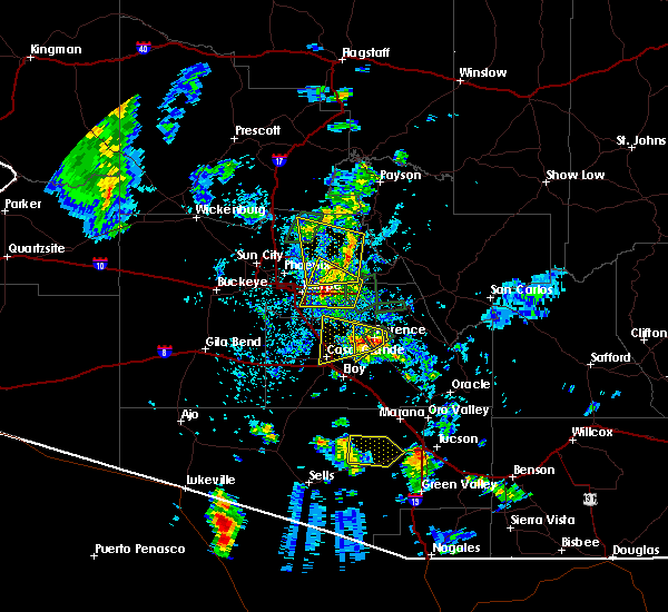 At 357 pm mst, severe thunderstorms were located along a line extending from near sunflower to salt river tubing recreation area, moving west at 20 mph (radar indicated). Hazards include 60 mph wind gusts and penny size hail. expect damage to roofs, siding, and trees At 357 pm mst, severe thunderstorms were located along a line extending from near sunflower to salt river tubing recreation area, moving west at 20 mph (radar indicated). Hazards include 60 mph wind gusts and penny size hail. expect damage to roofs, siding, and trees
|
| 9/7/2017 8:33 PM MST |
 At 833 pm mst, a severe thunderstorm was located near scottsdale, moving northwest at 25 mph (radar indicated). Hazards include 60 mph wind gusts and penny size hail. Expect damage to roofs, siding, and trees. Locations impacted include, phoenix, scottsdale, fountain hills, cave creek, carefree, mcdowell mountain park, desert mountain, scottsdale airport and desert ridge marketplace. At 833 pm mst, a severe thunderstorm was located near scottsdale, moving northwest at 25 mph (radar indicated). Hazards include 60 mph wind gusts and penny size hail. Expect damage to roofs, siding, and trees. Locations impacted include, phoenix, scottsdale, fountain hills, cave creek, carefree, mcdowell mountain park, desert mountain, scottsdale airport and desert ridge marketplace.
|
| 9/7/2017 8:21 PM MST |
 At 820 pm mst, a severe thunderstorm was located over scottsdale, moving northwest at 25 mph (radar indicated). Hazards include 60 mph wind gusts and penny size hail. expect damage to roofs, siding, and trees At 820 pm mst, a severe thunderstorm was located over scottsdale, moving northwest at 25 mph (radar indicated). Hazards include 60 mph wind gusts and penny size hail. expect damage to roofs, siding, and trees
|
| 8/3/2017 4:50 PM MST |
 The severe thunderstorm warning for maricopa county will expire at 500 pm mst, the storm which prompted the warning has weakened below severe limits, and no longer poses an immediate threat to life or property. therefore the warning will be allowed to expire. however heavy rain is still possible with this thunderstorm. The severe thunderstorm warning for maricopa county will expire at 500 pm mst, the storm which prompted the warning has weakened below severe limits, and no longer poses an immediate threat to life or property. therefore the warning will be allowed to expire. however heavy rain is still possible with this thunderstorm.
|
| 8/3/2017 4:43 PM MST |
 At 443 pm mst, a severe thunderstorm was located near deer valley airport, or 9 miles south of new river, moving northwest at 10 mph (radar indicated). Hazards include 60 mph wind gusts. Expect damage to roofs, siding, and trees. Locations impacted include, phoenix, new river, cave creek, deer valley airport, scottsdale airport, north mountain park, desert ridge marketplace, lake pleasant and anthem. At 443 pm mst, a severe thunderstorm was located near deer valley airport, or 9 miles south of new river, moving northwest at 10 mph (radar indicated). Hazards include 60 mph wind gusts. Expect damage to roofs, siding, and trees. Locations impacted include, phoenix, new river, cave creek, deer valley airport, scottsdale airport, north mountain park, desert ridge marketplace, lake pleasant and anthem.
|
| 8/3/2017 4:37 PM MST |
 The severe thunderstorm warning for maricopa county will expire at 445 pm mst, the severe thunderstorm which prompted the warning has is now covered under a new severe thunderstorm warning. therefore, this particular warning will be allowed to expire. The severe thunderstorm warning for maricopa county will expire at 445 pm mst, the severe thunderstorm which prompted the warning has is now covered under a new severe thunderstorm warning. therefore, this particular warning will be allowed to expire.
|
| 8/3/2017 4:36 PM MST |
 At 436 pm mst, a severe thunderstorm was located near deer valley airport, or 10 miles northeast of peoria, moving northwest at 10 mph (radar indicated). Hazards include 60 mph wind gusts. expect damage to roofs, siding, and trees At 436 pm mst, a severe thunderstorm was located near deer valley airport, or 10 miles northeast of peoria, moving northwest at 10 mph (radar indicated). Hazards include 60 mph wind gusts. expect damage to roofs, siding, and trees
|
| 8/3/2017 4:20 PM MST |
 At 420 pm mst, a severe thunderstorm was located near desert ridge marketplace, or 8 miles northwest of scottsdale, moving north at 20 mph (radar indicated). Hazards include 60 mph wind gusts. Expect damage to roofs, siding, and trees. Locations impacted include, phoenix, scottsdale, new river, cave creek, carefree, deer valley airport, desert mountain and desert ridge marketplace. At 420 pm mst, a severe thunderstorm was located near desert ridge marketplace, or 8 miles northwest of scottsdale, moving north at 20 mph (radar indicated). Hazards include 60 mph wind gusts. Expect damage to roofs, siding, and trees. Locations impacted include, phoenix, scottsdale, new river, cave creek, carefree, deer valley airport, desert mountain and desert ridge marketplace.
|
| 8/3/2017 4:15 PM MST |
 At 415 pm mst, a severe thunderstorm was located near desert ridge marketplace, or 8 miles west of scottsdale, moving north at 20 mph (radar indicated). Hazards include 60 mph wind gusts. expect damage to roofs, siding, and trees At 415 pm mst, a severe thunderstorm was located near desert ridge marketplace, or 8 miles west of scottsdale, moving north at 20 mph (radar indicated). Hazards include 60 mph wind gusts. expect damage to roofs, siding, and trees
|
| 8/3/2017 4:07 PM MST |
 The severe thunderstorm warning for maricopa county will expire at 415 pm mst, the storm which prompted the warning has weakened below severe limits, and no longer poses an immediate threat to life or property. therefore the warning will be allowed to expire. however, storms are still in the area. The severe thunderstorm warning for maricopa county will expire at 415 pm mst, the storm which prompted the warning has weakened below severe limits, and no longer poses an immediate threat to life or property. therefore the warning will be allowed to expire. however, storms are still in the area.
|
| 8/3/2017 3:57 PM MST |
 At 357 pm mst, a severe thunderstorm was located over desert ridge marketplace, or near scottsdale, moving north at 15 mph (radar indicated). Hazards include 60 mph wind gusts. Expect damage to roofs, siding, and trees. Locations impacted include, phoenix, scottsdale, new river, cave creek, carefree, scottsdale airport and desert ridge marketplace. At 357 pm mst, a severe thunderstorm was located over desert ridge marketplace, or near scottsdale, moving north at 15 mph (radar indicated). Hazards include 60 mph wind gusts. Expect damage to roofs, siding, and trees. Locations impacted include, phoenix, scottsdale, new river, cave creek, carefree, scottsdale airport and desert ridge marketplace.
|
| 8/3/2017 3:49 PM MST |
 At 349 pm mst, a severe thunderstorm was located over desert ridge marketplace, or near scottsdale, moving north at 15 mph (radar indicated). Hazards include 60 mph wind gusts. expect damage to roofs, siding, and trees At 349 pm mst, a severe thunderstorm was located over desert ridge marketplace, or near scottsdale, moving north at 15 mph (radar indicated). Hazards include 60 mph wind gusts. expect damage to roofs, siding, and trees
|
| 7/16/2017 9:30 PM MST |
 At 930 pm mst, a severe thunderstorm was located near fountain hills, moving south at 35 mph (radar indicated). Hazards include 60 mph wind gusts. Expect damage to roofs, siding, and trees. Locations impacted include, scottsdale, round valley, sugarloaf mountain, sycamore creek, ballantine trailhead, sunflower, cave creek, carefree, punkin center, mcdowell mountain park, tonto basin, four peaks, desert mountain, camp creek and rio verde. At 930 pm mst, a severe thunderstorm was located near fountain hills, moving south at 35 mph (radar indicated). Hazards include 60 mph wind gusts. Expect damage to roofs, siding, and trees. Locations impacted include, scottsdale, round valley, sugarloaf mountain, sycamore creek, ballantine trailhead, sunflower, cave creek, carefree, punkin center, mcdowell mountain park, tonto basin, four peaks, desert mountain, camp creek and rio verde.
|
| 7/16/2017 9:12 PM MST |
 At 912 pm mst, a severe thunderstorm was located near rio verde, or 11 miles northeast of scottsdale, moving south at 35 mph (radar indicated). Hazards include 60 mph wind gusts. expect damage to roofs, siding, and trees At 912 pm mst, a severe thunderstorm was located near rio verde, or 11 miles northeast of scottsdale, moving south at 35 mph (radar indicated). Hazards include 60 mph wind gusts. expect damage to roofs, siding, and trees
|
| 7/13/2017 5:48 PM MST |
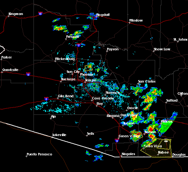 At 548 pm mst, a severe thunderstorm was located near desert mountain, or 8 miles north of scottsdale, moving south at 10 mph (radar indicated). Hazards include 60 mph wind gusts. Expect damage to roofs, siding, and trees. Locations impacted include, scottsdale and carefree. At 548 pm mst, a severe thunderstorm was located near desert mountain, or 8 miles north of scottsdale, moving south at 10 mph (radar indicated). Hazards include 60 mph wind gusts. Expect damage to roofs, siding, and trees. Locations impacted include, scottsdale and carefree.
|
| 7/13/2017 5:32 PM MST |
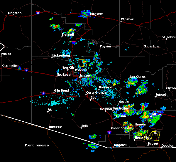 At 532 pm mst, a severe thunderstorm was located over desert mountain, or 10 miles north of scottsdale, and is nearly stationary (radar indicated). Hazards include 60 mph wind gusts. expect damage to roofs, siding, and trees At 532 pm mst, a severe thunderstorm was located over desert mountain, or 10 miles north of scottsdale, and is nearly stationary (radar indicated). Hazards include 60 mph wind gusts. expect damage to roofs, siding, and trees
|
| 7/1/2016 5:07 PM MST |
 At 506 pm mst, doppler radar indicated severe thunderstorms capable of producing quarter size hail and damaging winds in excess of 60 mph. this storm was located near cave creek, or 10 miles northwest of scottsdale, and moving south at 10 mph. At 506 pm mst, doppler radar indicated severe thunderstorms capable of producing quarter size hail and damaging winds in excess of 60 mph. this storm was located near cave creek, or 10 miles northwest of scottsdale, and moving south at 10 mph.
|
| 7/1/2016 5:00 PM MST |
 At 458 pm mst, doppler radar indicated severe thunderstorms near the community of anthem, capable of producing quarter size hail and damaging winds in excess of 60 mph. this storm was located near anthem and beginning to move south at 8 mph. locations impacted include, new river, cave creek, carefree, camp creek, desert mountain, anthem and seven springs. At 458 pm mst, doppler radar indicated severe thunderstorms near the community of anthem, capable of producing quarter size hail and damaging winds in excess of 60 mph. this storm was located near anthem and beginning to move south at 8 mph. locations impacted include, new river, cave creek, carefree, camp creek, desert mountain, anthem and seven springs.
|
| 7/1/2016 4:31 PM MST |
 At 430 pm mst, doppler radar indicated a severe thunderstorm capable of producing quarter size hail and damaging winds in excess of 60 mph. this storm was located near new river. this storm was nearly stationary or moving south at 3 mph. At 430 pm mst, doppler radar indicated a severe thunderstorm capable of producing quarter size hail and damaging winds in excess of 60 mph. this storm was located near new river. this storm was nearly stationary or moving south at 3 mph.
|
| 10/20/2015 12:57 PM MST |
 At 1256 pm mst, doppler radar indicated a severe thunderstorm capable of producing quarter size hail. this storm was located near camp creek, or 14 miles northeast of scottsdale, and moving northeast at 20 mph. strong wind gusts to near 50 mph are also possible. At 1256 pm mst, doppler radar indicated a severe thunderstorm capable of producing quarter size hail. this storm was located near camp creek, or 14 miles northeast of scottsdale, and moving northeast at 20 mph. strong wind gusts to near 50 mph are also possible.
|
| 10/20/2015 10:47 AM MST |
 At 1045 am mst, doppler radar indicated a severe thunderstorm producing large hail, and strong winds to near 60 mph. this storm was located near deer valley airport, or near peoria, and moving northeast at 10 mph. At 1045 am mst, doppler radar indicated a severe thunderstorm producing large hail, and strong winds to near 60 mph. this storm was located near deer valley airport, or near peoria, and moving northeast at 10 mph.
|
| 10/20/2015 4:39 AM MST |
 At 438 am mst, doppler radar continued to indicate a severe thunderstorm capable of producing damaging winds in excess of 60 mph. this storm was located near new river, moving northwest at 30 mph. penny size hail may also accompany the damaging winds. locations impacted include, north scottsdale, new river, cave creek, carefree, camp creek, desert mountain and seven springs. At 438 am mst, doppler radar continued to indicate a severe thunderstorm capable of producing damaging winds in excess of 60 mph. this storm was located near new river, moving northwest at 30 mph. penny size hail may also accompany the damaging winds. locations impacted include, north scottsdale, new river, cave creek, carefree, camp creek, desert mountain and seven springs.
|
| 10/20/2015 4:21 AM MST |
 At 421 am mst, doppler radar indicated a severe thunderstorm capable of producing damaging winds in excess of 60 mph. this storm was located over carefree, or 10 miles north of scottsdale, and moving north at 30 mph. penny size hail may also accompany the damaging winds. At 421 am mst, doppler radar indicated a severe thunderstorm capable of producing damaging winds in excess of 60 mph. this storm was located over carefree, or 10 miles north of scottsdale, and moving north at 30 mph. penny size hail may also accompany the damaging winds.
|
| 9/14/2015 8:09 PM MST |
 The severe thunderstorm warning for north central maricopa county will expire at 815 pm mst, the storm which prompted the warning has weakened below severe limits, and no longer poses an immediate threat to life or property. therefore the warning will be allowed to expire on time at 815 pm. however gusty winds and heavy rain are still possible with this thunderstorm. The severe thunderstorm warning for north central maricopa county will expire at 815 pm mst, the storm which prompted the warning has weakened below severe limits, and no longer poses an immediate threat to life or property. therefore the warning will be allowed to expire on time at 815 pm. however gusty winds and heavy rain are still possible with this thunderstorm.
|
| 9/14/2015 7:57 PM MST |
 At 756 pm mst, doppler radar indicated a severe thunderstorm capable of producing damaging winds in excess of 60 mph. this storm was located near desert mountain, or 8 miles northeast of scottsdale, moving northeast at 40 mph. the storm generated a wind gust to 59 mph at the scottsdale airport at 738 pm, and caused damage to trees within the warning area. locations impacted include, phoenix, scottsdale, fountain hills, cave creek, carefree, camp creek, desert mountain, mcdowell mountain park, deer valley airport, desert ridge marketplace, rio verde and scottsdale airport. At 756 pm mst, doppler radar indicated a severe thunderstorm capable of producing damaging winds in excess of 60 mph. this storm was located near desert mountain, or 8 miles northeast of scottsdale, moving northeast at 40 mph. the storm generated a wind gust to 59 mph at the scottsdale airport at 738 pm, and caused damage to trees within the warning area. locations impacted include, phoenix, scottsdale, fountain hills, cave creek, carefree, camp creek, desert mountain, mcdowell mountain park, deer valley airport, desert ridge marketplace, rio verde and scottsdale airport.
|
| 9/14/2015 7:36 PM MST |
 At 735 pm mst, doppler radar indicated a severe thunderstorm capable of producing damaging winds in excess of 60 mph. this storm was located over scottsdale airport, or near scottsdale, and moving northeast at 35 mph. At 735 pm mst, doppler radar indicated a severe thunderstorm capable of producing damaging winds in excess of 60 mph. this storm was located over scottsdale airport, or near scottsdale, and moving northeast at 35 mph.
|
| 8/11/2015 9:41 PM MST |
 At 940 pm mst, doppler radar indicated severe thunderstorms with a broad outflow boundary of 40 to 60 mph winds moving across the phoenix area from the south. damaging winds are possible along with torrential rainfall. At 940 pm mst, doppler radar indicated severe thunderstorms with a broad outflow boundary of 40 to 60 mph winds moving across the phoenix area from the south. damaging winds are possible along with torrential rainfall.
|
| 10/5/2010 12:52 PM MST | Quarter sized hail reported 0.9 miles S of Carefree, AZ |
Hail Maps for Carefree, AZ


Connect with Interactive Hail Maps