

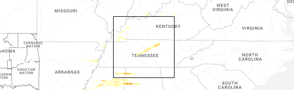
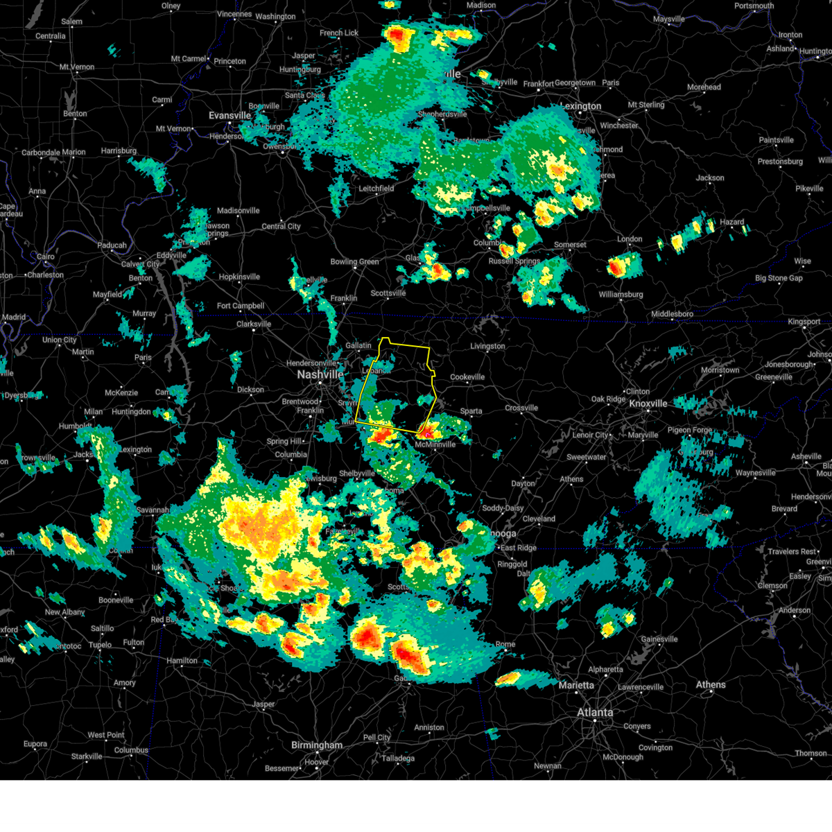
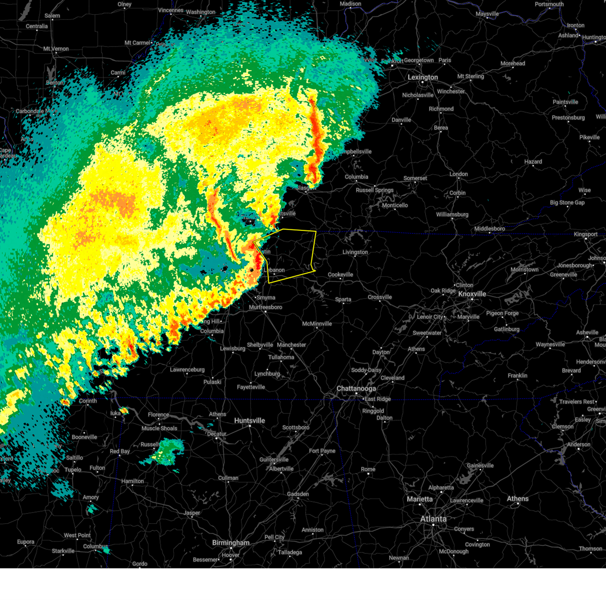
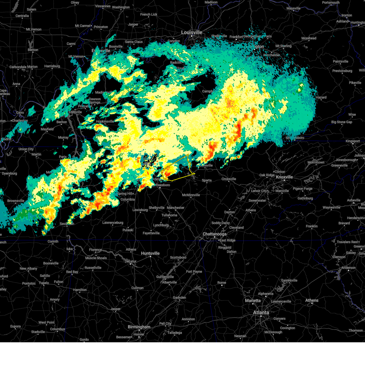
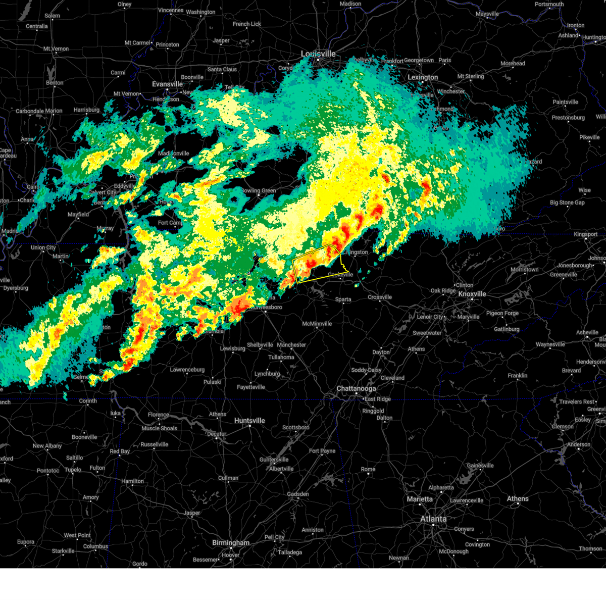
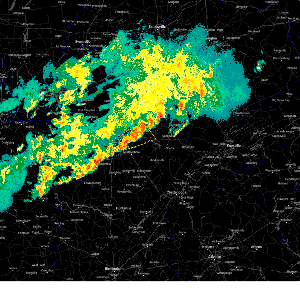
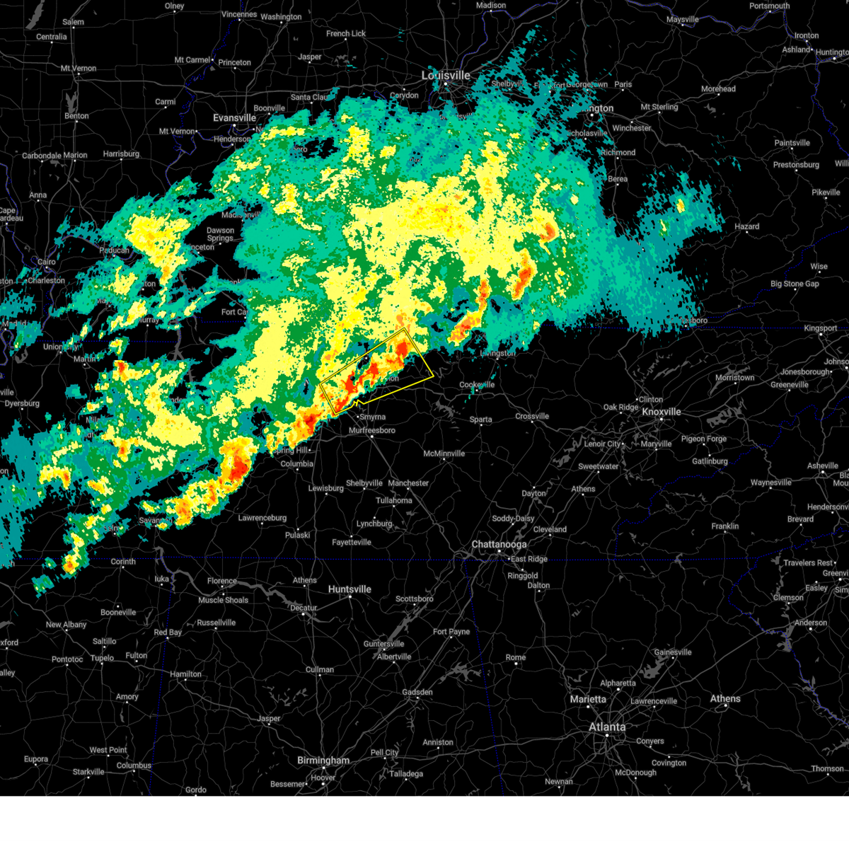
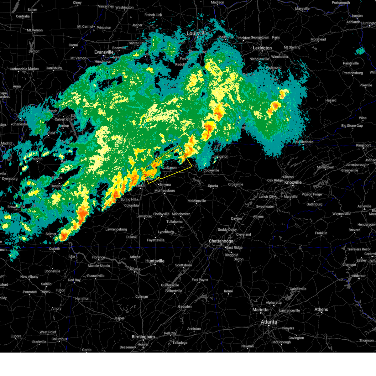
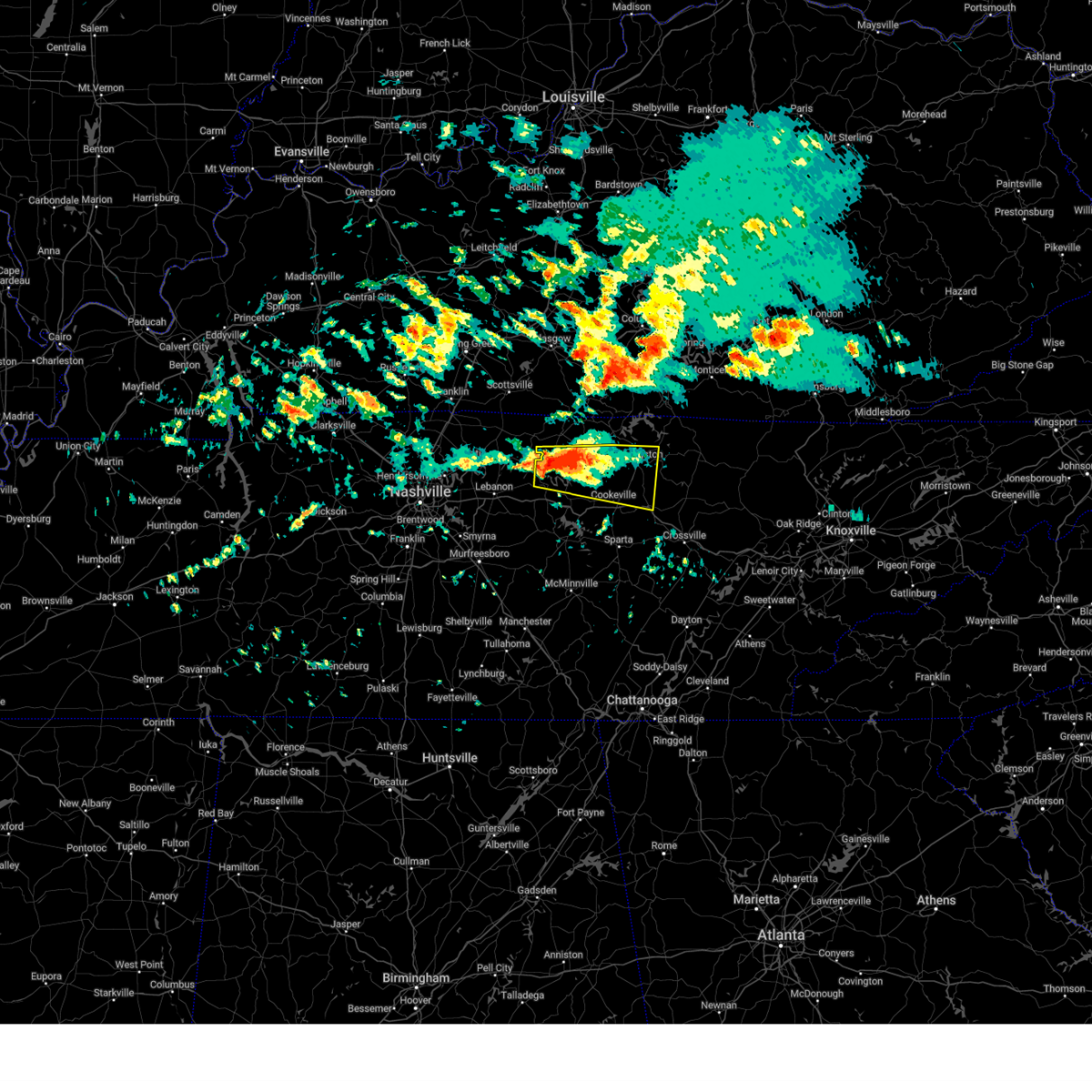
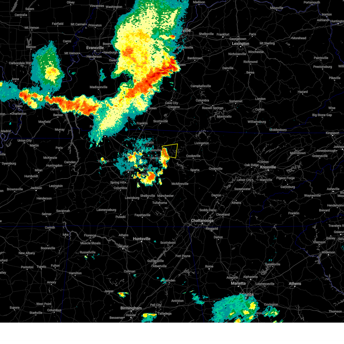
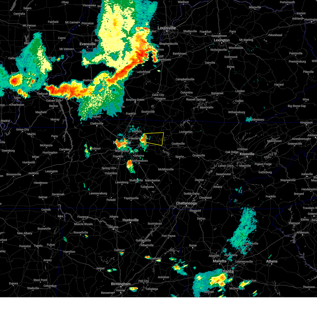
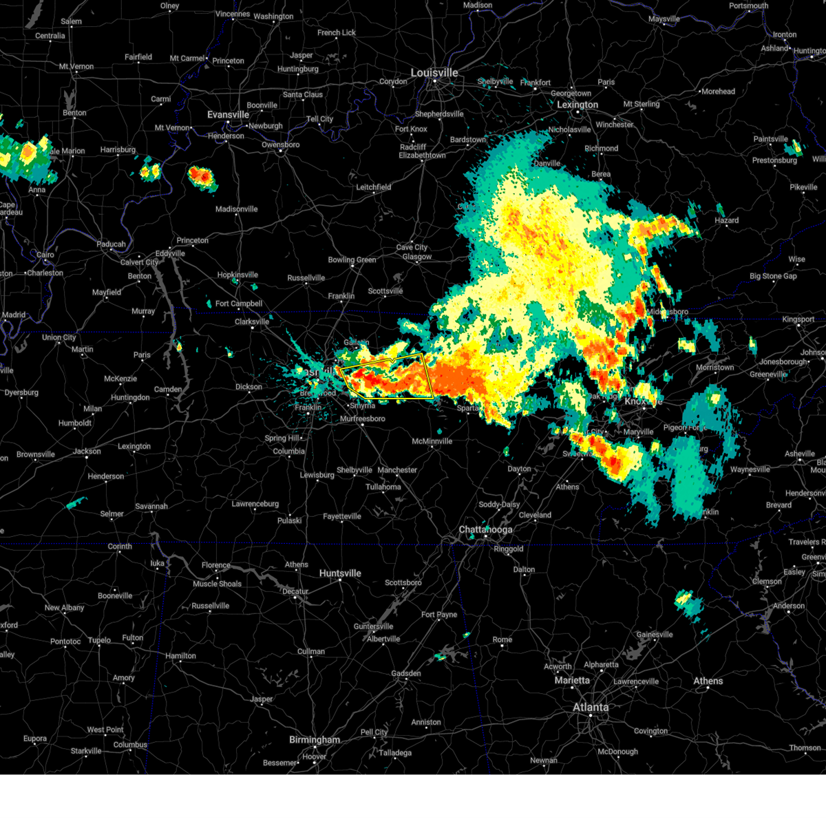
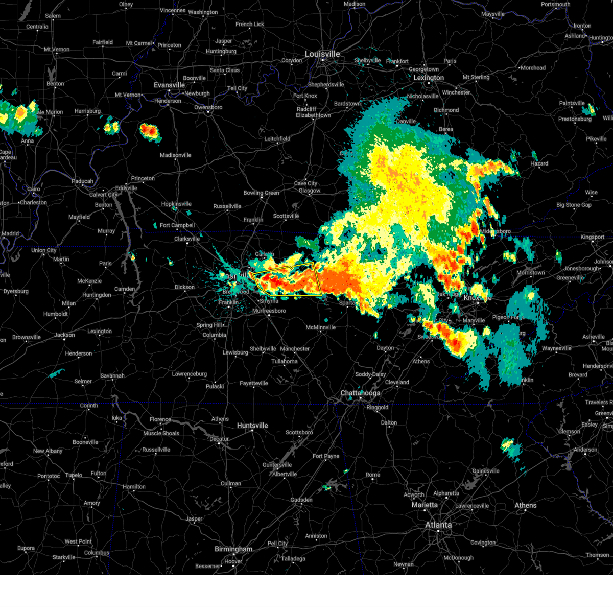
Hail Map for Carthage, TN
The Carthage, TN area has had 7 reports of on-the-ground hail by trained spotters, and has been under severe weather warnings 44 times during the past 12 months. Doppler radar has detected hail at or near Carthage, TN on 58 occasions, including 4 occasions during the past year.
| Name: | Carthage, TN |
| Where Located: | 46.7 miles E of Nashville, TN |
| Map: | Google Map for Carthage, TN |
| Population: | 2306 |
| Housing Units: | 1048 |
| More Info: | Search Google for Carthage, TN |
4
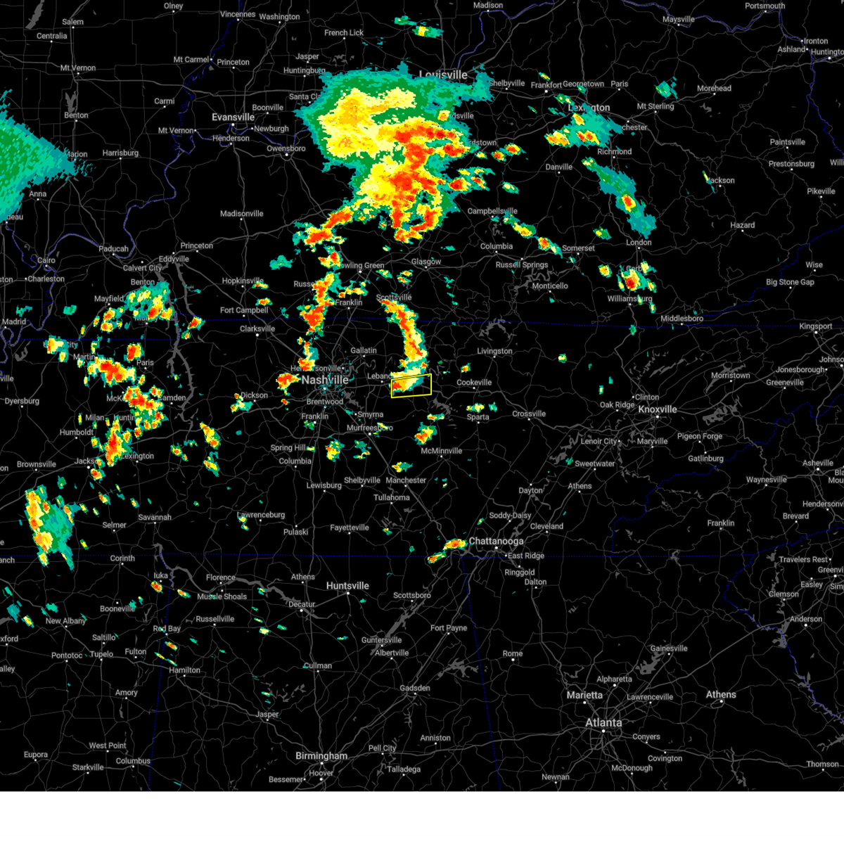
The Top Recent Hail Date for Carthage, TN is Sunday, March 23, 2025 (2nd out of 58)
Hail and Wind Damage Spotted near Carthage, TN
| Date / Time | Report Details |
|---|---|
| 6/6/2025 12:11 PM CDT |
 Svrohx the national weather service in nashville has issued a * severe thunderstorm warning for, southwestern smith county in middle tennessee, east central wilson county in middle tennessee, * until 100 pm cdt. * at 1210 pm cdt, a severe thunderstorm was located near watertown, or 11 miles east of lebanon, moving east at 20 mph (radar indicated). Hazards include 60 mph wind gusts and quarter size hail. Hail damage to vehicles is expected. Expect wind damage to roofs, siding, and trees. Svrohx the national weather service in nashville has issued a * severe thunderstorm warning for, southwestern smith county in middle tennessee, east central wilson county in middle tennessee, * until 100 pm cdt. * at 1210 pm cdt, a severe thunderstorm was located near watertown, or 11 miles east of lebanon, moving east at 20 mph (radar indicated). Hazards include 60 mph wind gusts and quarter size hail. Hail damage to vehicles is expected. Expect wind damage to roofs, siding, and trees.
|
| 5/20/2025 6:58 PM CDT |
 Svrohx the national weather service in nashville has issued a * severe thunderstorm warning for, smith county in middle tennessee, northern de kalb county in middle tennessee, southern jackson county in middle tennessee, eastern wilson county in middle tennessee, northwestern white county in middle tennessee, western putnam county in middle tennessee, * until 745 pm cdt. * at 658 pm cdt, a severe thunderstorm was located near watertown, or 11 miles southwest of carthage, moving east at 55 mph (radar indicated). Hazards include 60 mph wind gusts and quarter size hail. Hail damage to vehicles is expected. Expect wind damage to roofs, siding, and trees. Svrohx the national weather service in nashville has issued a * severe thunderstorm warning for, smith county in middle tennessee, northern de kalb county in middle tennessee, southern jackson county in middle tennessee, eastern wilson county in middle tennessee, northwestern white county in middle tennessee, western putnam county in middle tennessee, * until 745 pm cdt. * at 658 pm cdt, a severe thunderstorm was located near watertown, or 11 miles southwest of carthage, moving east at 55 mph (radar indicated). Hazards include 60 mph wind gusts and quarter size hail. Hail damage to vehicles is expected. Expect wind damage to roofs, siding, and trees.
|
| 5/17/2025 12:04 AM CDT | At 1203 am cdt, severe thunderstorms were located along a line extending from duckrun to 7 miles southeast of gainesboro, moving east at 75 mph (radar indicated). Hazards include 60 mph wind gusts and quarter size hail. Hail damage to vehicles is expected. expect wind damage to roofs, siding, and trees. locations impacted include, grimsley, allardt, hickman, gordonsville, algood, gainesboro, baxter, livingston, rickman, pall mall, carthage, wolf river dock, jamestown, byrdstown, clarkrange, crawford, granville, pickett state park, monterey, and south carthage. This includes interstate 40 between mile markers 252 and 268, and between mile markers 278 and 302. |
| 5/17/2025 12:04 AM CDT | the severe thunderstorm warning has been cancelled and is no longer in effect |
| 5/16/2025 11:28 PM CDT | Svrohx the national weather service in nashville has issued a * severe thunderstorm warning for, overton county in middle tennessee, pickett county in middle tennessee, smith county in middle tennessee, jackson county in middle tennessee, central wilson county in middle tennessee, southeastern clay county in middle tennessee, central putnam county in middle tennessee, fentress county in middle tennessee, * until 1230 am cdt. * at 1128 pm cdt, severe thunderstorms were located along a line extending from near sunnybrook to near lebanon, moving east at 75 mph (radar indicated). Hazards include 60 mph wind gusts and quarter size hail. Hail damage to vehicles is expected. Expect wind damage to roofs, siding, and trees. |
| 5/8/2025 5:01 PM CDT |
 the severe thunderstorm warning has been cancelled and is no longer in effect the severe thunderstorm warning has been cancelled and is no longer in effect
|
| 5/8/2025 5:01 PM CDT |
 At 500 pm cdt, a severe thunderstorm was located 7 miles south of gordonsville, or 12 miles northwest of smithville, moving east at 35 mph (radar indicated). Hazards include ping pong ball size hail and 60 mph wind gusts. People and animals outdoors will be injured. expect hail damage to roofs, siding, windows, and vehicles. expect wind damage to roofs, siding, and trees. locations impacted include, center hill lake, hickman, gordonsville, baxter, dowelltown, granville, alexandria, liberty, edgar evins state park, south carthage, carthage, and smithville. This includes interstate 40 between mile markers 250 and 280. At 500 pm cdt, a severe thunderstorm was located 7 miles south of gordonsville, or 12 miles northwest of smithville, moving east at 35 mph (radar indicated). Hazards include ping pong ball size hail and 60 mph wind gusts. People and animals outdoors will be injured. expect hail damage to roofs, siding, windows, and vehicles. expect wind damage to roofs, siding, and trees. locations impacted include, center hill lake, hickman, gordonsville, baxter, dowelltown, granville, alexandria, liberty, edgar evins state park, south carthage, carthage, and smithville. This includes interstate 40 between mile markers 250 and 280.
|
| 5/8/2025 4:52 PM CDT | At 452 pm cdt, a severe thunderstorm was located near watertown, or 14 miles northwest of smithville, moving east at 30 mph (radar indicated). Hazards include ping pong ball size hail and 60 mph wind gusts. People and animals outdoors will be injured. expect hail damage to roofs, siding, windows, and vehicles. expect wind damage to roofs, siding, and trees. locations impacted include, tuckers crossroads, hickman, gordonsville, baxter, dowelltown, liberty, carthage, center hill lake, watertown, granville, alexandria, edgar evins state park, south carthage, and smithville. This includes interstate 40 between mile markers 244 and 280. |
| 5/8/2025 4:47 PM CDT | Svrohx the national weather service in nashville has issued a * severe thunderstorm warning for, smith county in middle tennessee, northern de kalb county in middle tennessee, southwestern jackson county in middle tennessee, southeastern wilson county in middle tennessee, southwestern putnam county in middle tennessee, * until 530 pm cdt. * at 447 pm cdt, a severe thunderstorm was located over watertown, or 14 miles southwest of carthage, moving east at 30 mph (radar indicated). Hazards include 60 mph wind gusts and quarter size hail. Hail damage to vehicles is expected. Expect wind damage to roofs, siding, and trees. |
| 4/10/2025 6:15 PM CDT |
 the severe thunderstorm warning has been cancelled and is no longer in effect the severe thunderstorm warning has been cancelled and is no longer in effect
|
| 4/10/2025 6:15 PM CDT |
 At 614 pm cdt, severe thunderstorms were located along a line extending from 6 miles east of hartsville to near woodbury, moving east at 35 mph (radar indicated). Hazards include 60 mph wind gusts. Expect damage to roofs, siding, and trees. locations impacted include, gordonsville, hartsville, pleasant shade, dickerson chapel recreation area, liberty, cedars of lebanon state park, carthage, auburntown, center hill lake, alexandria, edgar evins state park, south carthage, lascassas, tuckers crossroads, hickman, walterhill, dixon springs, dowelltown, lebanon, and watertown. this includes the following highways, interstate 40 between mile markers 234 and 267. Interstate 840 between mile markers 54 and 76. At 614 pm cdt, severe thunderstorms were located along a line extending from 6 miles east of hartsville to near woodbury, moving east at 35 mph (radar indicated). Hazards include 60 mph wind gusts. Expect damage to roofs, siding, and trees. locations impacted include, gordonsville, hartsville, pleasant shade, dickerson chapel recreation area, liberty, cedars of lebanon state park, carthage, auburntown, center hill lake, alexandria, edgar evins state park, south carthage, lascassas, tuckers crossroads, hickman, walterhill, dixon springs, dowelltown, lebanon, and watertown. this includes the following highways, interstate 40 between mile markers 234 and 267. Interstate 840 between mile markers 54 and 76.
|
| 4/10/2025 5:59 PM CDT |
 At 558 pm cdt, severe thunderstorms were located along a line extending from near hartsville to 8 miles southeast of murfreesboro, moving east at 35 mph (radar indicated). Hazards include 60 mph wind gusts. Expect damage to roofs, siding, and trees. locations impacted include, gordonsville, hartsville, pleasant shade, la vergne, gallatin, bledsoe creek state park, dickerson chapel recreation area, liberty, cedars of lebanon state park, carthage, auburntown, center hill lake, mount juliet, alexandria, smyrna, edgar evins state park, south carthage, lascassas, tuckers crossroads, and hickman. this includes the following highways, interstate 40 between mile markers 225 and 267. interstate 24 between mile markers 66 and 73. Interstate 840 between mile markers 54 and 76. At 558 pm cdt, severe thunderstorms were located along a line extending from near hartsville to 8 miles southeast of murfreesboro, moving east at 35 mph (radar indicated). Hazards include 60 mph wind gusts. Expect damage to roofs, siding, and trees. locations impacted include, gordonsville, hartsville, pleasant shade, la vergne, gallatin, bledsoe creek state park, dickerson chapel recreation area, liberty, cedars of lebanon state park, carthage, auburntown, center hill lake, mount juliet, alexandria, smyrna, edgar evins state park, south carthage, lascassas, tuckers crossroads, and hickman. this includes the following highways, interstate 40 between mile markers 225 and 267. interstate 24 between mile markers 66 and 73. Interstate 840 between mile markers 54 and 76.
|
| 4/10/2025 5:59 PM CDT |
 the severe thunderstorm warning has been cancelled and is no longer in effect the severe thunderstorm warning has been cancelled and is no longer in effect
|
| 4/10/2025 5:41 PM CDT | Svrohx the national weather service in nashville has issued a * severe thunderstorm warning for, smith county in middle tennessee, southeastern davidson county in middle tennessee, western de kalb county in middle tennessee, northern rutherford county in middle tennessee, southern sumner county in middle tennessee, northeastern williamson county in middle tennessee, wilson county in middle tennessee, southern macon county in middle tennessee, trousdale county in middle tennessee, northern cannon county in middle tennessee, * until 630 pm cdt. * at 541 pm cdt, severe thunderstorms were located along a line extending from 6 miles northeast of gallatin to near murfreesboro, moving east at 35 mph (radar indicated). Hazards include 60 mph wind gusts. expect damage to roofs, siding, and trees |
| 4/5/2025 5:43 PM CDT |
 At 543 pm cdt, severe thunderstorms were located along a line extending from 8 miles northeast of westmoreland to 6 miles south of lafayette to 9 miles north of watertown, moving east at 60 mph (radar indicated). Hazards include 70 mph wind gusts and quarter size hail. Hail damage to vehicles is expected. expect considerable tree damage. wind damage is also likely to mobile homes, roofs, and outbuildings. Locations impacted include, carthage, red boiling springs, lafayette, hartsville, dixon springs, westmoreland, pleasant shade, and south carthage. At 543 pm cdt, severe thunderstorms were located along a line extending from 8 miles northeast of westmoreland to 6 miles south of lafayette to 9 miles north of watertown, moving east at 60 mph (radar indicated). Hazards include 70 mph wind gusts and quarter size hail. Hail damage to vehicles is expected. expect considerable tree damage. wind damage is also likely to mobile homes, roofs, and outbuildings. Locations impacted include, carthage, red boiling springs, lafayette, hartsville, dixon springs, westmoreland, pleasant shade, and south carthage.
|
| 4/5/2025 5:32 PM CDT |
 At 532 pm cdt, severe thunderstorms were located along a line extending from westmoreland to hartsville to near lebanon, moving east at 60 mph (radar indicated). Hazards include 70 mph wind gusts and quarter size hail. Hail damage to vehicles is expected. expect considerable tree damage. wind damage is also likely to mobile homes, roofs, and outbuildings. locations impacted include, red boiling springs, tuckers crossroads, bethpage, hartsville, dixon springs, oak grove, pleasant shade, bledsoe creek state park, dickerson chapel recreation area, carthage, lebanon, lafayette, westmoreland, south carthage, and gallatin. this includes the following highways, interstate 40 between mile markers 235 and 248. Interstate 840 between mile markers 75 and 76. At 532 pm cdt, severe thunderstorms were located along a line extending from westmoreland to hartsville to near lebanon, moving east at 60 mph (radar indicated). Hazards include 70 mph wind gusts and quarter size hail. Hail damage to vehicles is expected. expect considerable tree damage. wind damage is also likely to mobile homes, roofs, and outbuildings. locations impacted include, red boiling springs, tuckers crossroads, bethpage, hartsville, dixon springs, oak grove, pleasant shade, bledsoe creek state park, dickerson chapel recreation area, carthage, lebanon, lafayette, westmoreland, south carthage, and gallatin. this includes the following highways, interstate 40 between mile markers 235 and 248. Interstate 840 between mile markers 75 and 76.
|
| 4/5/2025 5:32 PM CDT |
 the severe thunderstorm warning has been cancelled and is no longer in effect the severe thunderstorm warning has been cancelled and is no longer in effect
|
| 4/5/2025 5:24 PM CDT | At 524 pm cdt, severe thunderstorms were located along a line extending from 6 miles west of westmoreland to 7 miles southwest of hartsville to near rural hill, moving east at 60 mph (radar indicated). Hazards include 70 mph wind gusts and quarter size hail. Hail damage to vehicles is expected. expect considerable tree damage. wind damage is also likely to mobile homes, roofs, and outbuildings. locations impacted include, red boiling springs, gordonsville, hartsville, pleasant shade, millersville, gallatin, bledsoe creek state park, dickerson chapel recreation area, hendersonville, carthage, cottontown, mount juliet, westmoreland, south carthage, green hill, tuckers crossroads, bethpage, rural hill, dixon springs, and oak grove. this includes the following highways, interstate 40 between mile markers 223 and 260. interstate 65 between mile markers 102 and 103. Interstate 840 between mile markers 66 and 76. |
| 4/5/2025 5:24 PM CDT | the severe thunderstorm warning has been cancelled and is no longer in effect |
| 4/5/2025 5:00 PM CDT |
 Svrohx the national weather service in nashville has issued a * severe thunderstorm warning for, smith county in middle tennessee, eastern davidson county in middle tennessee, northwestern rutherford county in middle tennessee, sumner county in middle tennessee, wilson county in middle tennessee, macon county in middle tennessee, trousdale county in middle tennessee, * until 600 pm cdt. * at 500 pm cdt, severe thunderstorms were located along a line extending from millersville to lakewood to brentwood, moving east at 60 mph (radar indicated). Hazards include 70 mph wind gusts and quarter size hail. Hail damage to vehicles is expected. expect considerable tree damage. Wind damage is also likely to mobile homes, roofs, and outbuildings. Svrohx the national weather service in nashville has issued a * severe thunderstorm warning for, smith county in middle tennessee, eastern davidson county in middle tennessee, northwestern rutherford county in middle tennessee, sumner county in middle tennessee, wilson county in middle tennessee, macon county in middle tennessee, trousdale county in middle tennessee, * until 600 pm cdt. * at 500 pm cdt, severe thunderstorms were located along a line extending from millersville to lakewood to brentwood, moving east at 60 mph (radar indicated). Hazards include 70 mph wind gusts and quarter size hail. Hail damage to vehicles is expected. expect considerable tree damage. Wind damage is also likely to mobile homes, roofs, and outbuildings.
|
| 4/3/2025 10:04 AM CDT |
 the tornado warning has been cancelled and is no longer in effect the tornado warning has been cancelled and is no longer in effect
|
| 4/3/2025 10:04 AM CDT |
 At 1004 am cdt, a severe thunderstorm capable of producing a tornado was located 8 miles west of carthage, moving northeast at 45 mph (radar indicated rotation). Hazards include tornado. Flying debris will be dangerous to those caught without shelter. mobile homes will be damaged or destroyed. damage to roofs, windows, and vehicles will occur. tree damage is likely. this dangerous storm will be near, carthage around 1010 am cdt. Other locations impacted by this tornadic thunderstorm include south carthage and dixon springs. At 1004 am cdt, a severe thunderstorm capable of producing a tornado was located 8 miles west of carthage, moving northeast at 45 mph (radar indicated rotation). Hazards include tornado. Flying debris will be dangerous to those caught without shelter. mobile homes will be damaged or destroyed. damage to roofs, windows, and vehicles will occur. tree damage is likely. this dangerous storm will be near, carthage around 1010 am cdt. Other locations impacted by this tornadic thunderstorm include south carthage and dixon springs.
|
| 4/3/2025 9:40 AM CDT |
 Torohx the national weather service in nashville has issued a * tornado warning for, central smith county in middle tennessee, central wilson county in middle tennessee, central trousdale county in middle tennessee, * until 1015 am cdt. * at 940 am cdt, a severe thunderstorm capable of producing a tornado was located 8 miles south of lebanon, moving northeast at 45 mph (radar indicated rotation). Hazards include tornado. Flying debris will be dangerous to those caught without shelter. mobile homes will be damaged or destroyed. damage to roofs, windows, and vehicles will occur. tree damage is likely. this dangerous storm will be near, lebanon around 945 am cdt. carthage around 1010 am cdt. other locations impacted by this tornadic thunderstorm include cedars of lebanon state park, tuckers crossroads, gladeville, south carthage, and dixon springs. this includes the following highways, interstate 40 between mile markers 235 and 258. Interstate 840 between mile markers 68 and 76. Torohx the national weather service in nashville has issued a * tornado warning for, central smith county in middle tennessee, central wilson county in middle tennessee, central trousdale county in middle tennessee, * until 1015 am cdt. * at 940 am cdt, a severe thunderstorm capable of producing a tornado was located 8 miles south of lebanon, moving northeast at 45 mph (radar indicated rotation). Hazards include tornado. Flying debris will be dangerous to those caught without shelter. mobile homes will be damaged or destroyed. damage to roofs, windows, and vehicles will occur. tree damage is likely. this dangerous storm will be near, lebanon around 945 am cdt. carthage around 1010 am cdt. other locations impacted by this tornadic thunderstorm include cedars of lebanon state park, tuckers crossroads, gladeville, south carthage, and dixon springs. this includes the following highways, interstate 40 between mile markers 235 and 258. Interstate 840 between mile markers 68 and 76.
|
| 4/3/2025 6:24 AM CDT |
 Svrohx the national weather service in nashville has issued a * severe thunderstorm warning for, smith county in middle tennessee, northern de kalb county in middle tennessee, southeastern wilson county in middle tennessee, * until 715 am cdt. * at 624 am cdt, a severe thunderstorm was located near watertown, or 12 miles southeast of lebanon, moving northeast at 45 mph (radar indicated). Hazards include 60 mph wind gusts and quarter size hail. Hail damage to vehicles is expected. Expect wind damage to roofs, siding, and trees. Svrohx the national weather service in nashville has issued a * severe thunderstorm warning for, smith county in middle tennessee, northern de kalb county in middle tennessee, southeastern wilson county in middle tennessee, * until 715 am cdt. * at 624 am cdt, a severe thunderstorm was located near watertown, or 12 miles southeast of lebanon, moving northeast at 45 mph (radar indicated). Hazards include 60 mph wind gusts and quarter size hail. Hail damage to vehicles is expected. Expect wind damage to roofs, siding, and trees.
|
| 4/3/2025 5:43 AM CDT |
 Svrohx the national weather service in nashville has issued a * severe thunderstorm warning for, smith county in middle tennessee, jackson county in middle tennessee, northwestern putnam county in middle tennessee, * until 615 am cdt. * at 543 am cdt, a severe thunderstorm was located near carthage, moving northeast at 55 mph (radar indicated). Hazards include 60 mph wind gusts and quarter size hail. Hail damage to vehicles is expected. Expect wind damage to roofs, siding, and trees. Svrohx the national weather service in nashville has issued a * severe thunderstorm warning for, smith county in middle tennessee, jackson county in middle tennessee, northwestern putnam county in middle tennessee, * until 615 am cdt. * at 543 am cdt, a severe thunderstorm was located near carthage, moving northeast at 55 mph (radar indicated). Hazards include 60 mph wind gusts and quarter size hail. Hail damage to vehicles is expected. Expect wind damage to roofs, siding, and trees.
|
| 4/3/2025 5:19 AM CDT | At 519 am cdt, a severe thunderstorm was located near lebanon, moving northeast at 50 mph (radar indicated). Hazards include golf ball size hail and 60 mph wind gusts. People and animals outdoors will be injured. expect hail damage to roofs, siding, windows, and vehicles. expect wind damage to roofs, siding, and trees. locations impacted include, tuckers crossroads, hickman, gordonsville, hartsville, dixon springs, dickerson chapel recreation area, belinda city, cedars of lebanon state park, carthage, lebanon, watertown, gladeville, south carthage, alexandria, mount juliet, and walterhill. this includes the following highways, interstate 40 between mile markers 227 and 267. Interstate 840 between mile markers 61 and 76. |
| 4/3/2025 5:19 AM CDT | the severe thunderstorm warning has been cancelled and is no longer in effect |
| 4/3/2025 4:57 AM CDT |
 Svrohx the national weather service in nashville has issued a * severe thunderstorm warning for, smith county in middle tennessee, southeastern davidson county in middle tennessee, northwestern rutherford county in middle tennessee, wilson county in middle tennessee, trousdale county in middle tennessee, * until 545 am cdt. * at 456 am cdt, a severe thunderstorm was located over la vergne, or 15 miles northwest of murfreesboro, moving northeast at 50 mph (radar indicated). Hazards include 60 mph wind gusts and quarter size hail. Hail damage to vehicles is expected. Expect wind damage to roofs, siding, and trees. Svrohx the national weather service in nashville has issued a * severe thunderstorm warning for, smith county in middle tennessee, southeastern davidson county in middle tennessee, northwestern rutherford county in middle tennessee, wilson county in middle tennessee, trousdale county in middle tennessee, * until 545 am cdt. * at 456 am cdt, a severe thunderstorm was located over la vergne, or 15 miles northwest of murfreesboro, moving northeast at 50 mph (radar indicated). Hazards include 60 mph wind gusts and quarter size hail. Hail damage to vehicles is expected. Expect wind damage to roofs, siding, and trees.
|
| 4/3/2025 4:27 AM CDT |
 At 427 am cdt, severe thunderstorms were located along a line extending from near lafayette to near antioch, moving east at 40 mph (radar indicated). Hazards include 60 mph wind gusts and nickel size hail. Expect damage to roofs, siding, and trees. locations impacted include, madison, hermitage, hartsville, gallatin, bledsoe creek state park, dickerson chapel recreation area, hendersonville, carthage, berry hill, mount juliet, south carthage, green hill, tuckers crossroads, bethpage, rural hill, dixon springs, nashville, antioch, belinda city, and lakewood. this includes the following highways, interstate 40 between mile markers 207 and 247. interstate 65 between mile markers 79 and 92. interstate 24 between mile markers 44 and 61. Interstate 840 between mile markers 68 and 76. At 427 am cdt, severe thunderstorms were located along a line extending from near lafayette to near antioch, moving east at 40 mph (radar indicated). Hazards include 60 mph wind gusts and nickel size hail. Expect damage to roofs, siding, and trees. locations impacted include, madison, hermitage, hartsville, gallatin, bledsoe creek state park, dickerson chapel recreation area, hendersonville, carthage, berry hill, mount juliet, south carthage, green hill, tuckers crossroads, bethpage, rural hill, dixon springs, nashville, antioch, belinda city, and lakewood. this includes the following highways, interstate 40 between mile markers 207 and 247. interstate 65 between mile markers 79 and 92. interstate 24 between mile markers 44 and 61. Interstate 840 between mile markers 68 and 76.
|
| 4/3/2025 4:07 AM CDT |
 Svrohx the national weather service in nashville has issued a * severe thunderstorm warning for, northwestern smith county in middle tennessee, southeastern davidson county in middle tennessee, southeastern sumner county in middle tennessee, wilson county in middle tennessee, western macon county in middle tennessee, trousdale county in middle tennessee, * until 500 am cdt. * at 407 am cdt, a severe thunderstorm was located over hermitage, or 9 miles east of nashville, moving northeast at 50 mph (radar indicated). Hazards include 60 mph wind gusts and quarter size hail. Hail damage to vehicles is expected. Expect wind damage to roofs, siding, and trees. Svrohx the national weather service in nashville has issued a * severe thunderstorm warning for, northwestern smith county in middle tennessee, southeastern davidson county in middle tennessee, southeastern sumner county in middle tennessee, wilson county in middle tennessee, western macon county in middle tennessee, trousdale county in middle tennessee, * until 500 am cdt. * at 407 am cdt, a severe thunderstorm was located over hermitage, or 9 miles east of nashville, moving northeast at 50 mph (radar indicated). Hazards include 60 mph wind gusts and quarter size hail. Hail damage to vehicles is expected. Expect wind damage to roofs, siding, and trees.
|
| 3/30/2025 11:21 PM CDT |
 the severe thunderstorm warning has been cancelled and is no longer in effect the severe thunderstorm warning has been cancelled and is no longer in effect
|
| 3/30/2025 11:21 PM CDT |
 At 1121 pm cdt, a severe thunderstorm was located near lafayette, moving east at 45 mph (radar indicated). Hazards include 70 mph wind gusts and penny size hail. Expect considerable tree damage. damage is likely to mobile homes, roofs, and outbuildings. locations impacted include, red boiling springs, bethpage, goodlettsville, hartsville, dixon springs, oak grove, pleasant shade, millersville, gallatin, bledsoe creek state park, dickerson chapel recreation area, hendersonville, carthage, cottontown, lafayette, westmoreland, south carthage, white house, and mount juliet. this includes the following highways, interstate 65 between mile markers 93 and 102. Interstate 24 between mile markers 38 and 41. At 1121 pm cdt, a severe thunderstorm was located near lafayette, moving east at 45 mph (radar indicated). Hazards include 70 mph wind gusts and penny size hail. Expect considerable tree damage. damage is likely to mobile homes, roofs, and outbuildings. locations impacted include, red boiling springs, bethpage, goodlettsville, hartsville, dixon springs, oak grove, pleasant shade, millersville, gallatin, bledsoe creek state park, dickerson chapel recreation area, hendersonville, carthage, cottontown, lafayette, westmoreland, south carthage, white house, and mount juliet. this includes the following highways, interstate 65 between mile markers 93 and 102. Interstate 24 between mile markers 38 and 41.
|
| 3/30/2025 10:45 PM CDT |
 Svrohx the national weather service in nashville has issued a * severe thunderstorm warning for, northern smith county in middle tennessee, northeastern davidson county in middle tennessee, sumner county in middle tennessee, northern wilson county in middle tennessee, macon county in middle tennessee, trousdale county in middle tennessee, southeastern robertson county in middle tennessee, * until 1145 pm cdt. * at 1044 pm cdt, a severe thunderstorm was located over portland, or 13 miles north of gallatin, moving east at 55 mph (radar indicated). Hazards include 70 mph wind gusts and penny size hail. Expect considerable tree damage. Damage is likely to mobile homes, roofs, and outbuildings. Svrohx the national weather service in nashville has issued a * severe thunderstorm warning for, northern smith county in middle tennessee, northeastern davidson county in middle tennessee, sumner county in middle tennessee, northern wilson county in middle tennessee, macon county in middle tennessee, trousdale county in middle tennessee, southeastern robertson county in middle tennessee, * until 1145 pm cdt. * at 1044 pm cdt, a severe thunderstorm was located over portland, or 13 miles north of gallatin, moving east at 55 mph (radar indicated). Hazards include 70 mph wind gusts and penny size hail. Expect considerable tree damage. Damage is likely to mobile homes, roofs, and outbuildings.
|
| 3/23/2025 7:01 PM CDT |
 Svrohx the national weather service in nashville has issued a * severe thunderstorm warning for, smith county in middle tennessee, jackson county in middle tennessee, northwestern putnam county in middle tennessee, * until 745 pm cdt. * at 700 pm cdt, a severe thunderstorm was located over carthage, moving northeast at 50 mph (radar indicated). Hazards include 60 mph wind gusts and quarter size hail. Hail damage to vehicles is expected. Expect wind damage to roofs, siding, and trees. Svrohx the national weather service in nashville has issued a * severe thunderstorm warning for, smith county in middle tennessee, jackson county in middle tennessee, northwestern putnam county in middle tennessee, * until 745 pm cdt. * at 700 pm cdt, a severe thunderstorm was located over carthage, moving northeast at 50 mph (radar indicated). Hazards include 60 mph wind gusts and quarter size hail. Hail damage to vehicles is expected. Expect wind damage to roofs, siding, and trees.
|
| 3/23/2025 7:00 PM CDT | Quarter sized hail reported 1.4 miles NNE of Carthage, TN, quarter size hail in south carthage. time estimated by radar. |
| 2/6/2025 5:45 PM CST |
 Svrohx the national weather service in nashville has issued a * severe thunderstorm warning for, western overton county in middle tennessee, northeastern smith county in middle tennessee, jackson county in middle tennessee, south central clay county in middle tennessee, southeastern macon county in middle tennessee, northern putnam county in middle tennessee, * until 630 pm cst. * at 545 pm cst, a severe thunderstorm was located 8 miles northeast of carthage, moving east at 50 mph (radar indicated). Hazards include 60 mph wind gusts and quarter size hail. Hail damage to vehicles is expected. Expect wind damage to roofs, siding, and trees. Svrohx the national weather service in nashville has issued a * severe thunderstorm warning for, western overton county in middle tennessee, northeastern smith county in middle tennessee, jackson county in middle tennessee, south central clay county in middle tennessee, southeastern macon county in middle tennessee, northern putnam county in middle tennessee, * until 630 pm cst. * at 545 pm cst, a severe thunderstorm was located 8 miles northeast of carthage, moving east at 50 mph (radar indicated). Hazards include 60 mph wind gusts and quarter size hail. Hail damage to vehicles is expected. Expect wind damage to roofs, siding, and trees.
|
| 2/6/2025 5:38 PM CST | Debris on hwy 80 near pleasant shade... road passabl in smith county TN, 7.8 miles S of Carthage, TN |
| 9/24/2024 4:03 PM CDT |
 Svrohx the national weather service in nashville has issued a * severe thunderstorm warning for, central smith county in middle tennessee, jackson county in middle tennessee, * until 445 pm cdt. * at 403 pm cdt, a severe thunderstorm was located over carthage, moving east at 40 mph (radar indicated). Hazards include 60 mph wind gusts and penny size hail. expect damage to roofs, siding, and trees Svrohx the national weather service in nashville has issued a * severe thunderstorm warning for, central smith county in middle tennessee, jackson county in middle tennessee, * until 445 pm cdt. * at 403 pm cdt, a severe thunderstorm was located over carthage, moving east at 40 mph (radar indicated). Hazards include 60 mph wind gusts and penny size hail. expect damage to roofs, siding, and trees
|
| 9/24/2024 3:50 PM CDT |
 At 350 pm cdt, a severe thunderstorm was located near watertown, or 8 miles southeast of lebanon, moving east at 35 mph (radar indicated). Hazards include 60 mph wind gusts and nickel size hail. Expect damage to roofs, siding, and trees. locations impacted include, lebanon, carthage, gordonsville, south carthage, and tuckers crossroads. This includes interstate 40 between mile markers 238 and 258. At 350 pm cdt, a severe thunderstorm was located near watertown, or 8 miles southeast of lebanon, moving east at 35 mph (radar indicated). Hazards include 60 mph wind gusts and nickel size hail. Expect damage to roofs, siding, and trees. locations impacted include, lebanon, carthage, gordonsville, south carthage, and tuckers crossroads. This includes interstate 40 between mile markers 238 and 258.
|
| 9/24/2024 3:33 PM CDT |
 Svrohx the national weather service in nashville has issued a * severe thunderstorm warning for, southwestern smith county in middle tennessee, central wilson county in middle tennessee, * until 415 pm cdt. * at 332 pm cdt, a severe thunderstorm was located near lebanon, moving east at 35 mph (radar indicated). Hazards include 60 mph wind gusts and nickel size hail. expect damage to roofs, siding, and trees Svrohx the national weather service in nashville has issued a * severe thunderstorm warning for, southwestern smith county in middle tennessee, central wilson county in middle tennessee, * until 415 pm cdt. * at 332 pm cdt, a severe thunderstorm was located near lebanon, moving east at 35 mph (radar indicated). Hazards include 60 mph wind gusts and nickel size hail. expect damage to roofs, siding, and trees
|
| 7/30/2024 8:12 PM CDT |
 At 812 pm cdt, a severe thunderstorm was located near rome, moving east at 30 mph (radar indicated). Hazards include 60 mph wind gusts and penny size hail. Expect damage to roofs, siding, and trees. Locations impacted include, carthage, gordonsville, south carthage, pleasant shade, and dixon springs. At 812 pm cdt, a severe thunderstorm was located near rome, moving east at 30 mph (radar indicated). Hazards include 60 mph wind gusts and penny size hail. Expect damage to roofs, siding, and trees. Locations impacted include, carthage, gordonsville, south carthage, pleasant shade, and dixon springs.
|
| 7/30/2024 8:12 PM CDT |
 the severe thunderstorm warning has been cancelled and is no longer in effect the severe thunderstorm warning has been cancelled and is no longer in effect
|
| 7/30/2024 7:55 PM CDT |
 Svrohx the national weather service in nashville has issued a * severe thunderstorm warning for, smith county in middle tennessee, northeastern wilson county in middle tennessee, southern trousdale county in middle tennessee, * until 830 pm cdt. * at 754 pm cdt, a severe thunderstorm was located 5 miles south of hartsville, or near taylorsville, moving east at 30 mph (radar indicated). Hazards include 60 mph wind gusts and quarter size hail. Hail damage to vehicles is expected. Expect wind damage to roofs, siding, and trees. Svrohx the national weather service in nashville has issued a * severe thunderstorm warning for, smith county in middle tennessee, northeastern wilson county in middle tennessee, southern trousdale county in middle tennessee, * until 830 pm cdt. * at 754 pm cdt, a severe thunderstorm was located 5 miles south of hartsville, or near taylorsville, moving east at 30 mph (radar indicated). Hazards include 60 mph wind gusts and quarter size hail. Hail damage to vehicles is expected. Expect wind damage to roofs, siding, and trees.
|
| 7/30/2024 3:38 PM CDT |
 the severe thunderstorm warning has been cancelled and is no longer in effect the severe thunderstorm warning has been cancelled and is no longer in effect
|
| 7/30/2024 3:38 PM CDT |
 At 337 pm cdt, severe thunderstorms were located along a line extending from near baxter to near rural hill, moving southeast at 40 mph (radar indicated). Hazards include 60 mph wind gusts and quarter size hail. Hail damage to vehicles is expected. expect wind damage to roofs, siding, and trees. locations impacted include, lebanon, carthage, mount juliet, watertown, gordonsville, rural hill, belinda city, hickman, south carthage, alexandria, green hill, tuckers crossroads, cedars of lebanon state park, center hill lake, gladeville, and edgar evins state park. this includes the following highways, interstate 40 between mile markers 224 and 267. Interstate 840 between mile markers 67 and 76. At 337 pm cdt, severe thunderstorms were located along a line extending from near baxter to near rural hill, moving southeast at 40 mph (radar indicated). Hazards include 60 mph wind gusts and quarter size hail. Hail damage to vehicles is expected. expect wind damage to roofs, siding, and trees. locations impacted include, lebanon, carthage, mount juliet, watertown, gordonsville, rural hill, belinda city, hickman, south carthage, alexandria, green hill, tuckers crossroads, cedars of lebanon state park, center hill lake, gladeville, and edgar evins state park. this includes the following highways, interstate 40 between mile markers 224 and 267. Interstate 840 between mile markers 67 and 76.
|
| 7/30/2024 3:10 PM CDT | Trees down near and across little salt lick creek r in smith county TN, 9 miles SW of Carthage, TN |
| 7/30/2024 3:02 PM CDT |
 Svrohx the national weather service in nashville has issued a * severe thunderstorm warning for, smith county in middle tennessee, northwestern de kalb county in middle tennessee, southern sumner county in middle tennessee, wilson county in middle tennessee, southwestern macon county in middle tennessee, trousdale county in middle tennessee, * until 400 pm cdt. * at 302 pm cdt, severe thunderstorms were located along a line extending from red boiling springs to near white house, moving southeast at 30 mph (radar indicated). Hazards include 60 mph wind gusts and quarter size hail. Hail damage to vehicles is expected. Expect wind damage to roofs, siding, and trees. Svrohx the national weather service in nashville has issued a * severe thunderstorm warning for, smith county in middle tennessee, northwestern de kalb county in middle tennessee, southern sumner county in middle tennessee, wilson county in middle tennessee, southwestern macon county in middle tennessee, trousdale county in middle tennessee, * until 400 pm cdt. * at 302 pm cdt, severe thunderstorms were located along a line extending from red boiling springs to near white house, moving southeast at 30 mph (radar indicated). Hazards include 60 mph wind gusts and quarter size hail. Hail damage to vehicles is expected. Expect wind damage to roofs, siding, and trees.
|
| 6/26/2024 5:38 PM CDT |
 Svrohx the national weather service in nashville has issued a * severe thunderstorm warning for, smith county in middle tennessee, northwestern jackson county in middle tennessee, clay county in middle tennessee, southeastern macon county in middle tennessee, southeastern trousdale county in middle tennessee, * until 645 pm cdt. * at 538 pm cdt, a severe thunderstorm was located near carthage, moving northeast at 30 mph (radar indicated). Hazards include 60 mph wind gusts. expect damage to roofs, siding, and trees Svrohx the national weather service in nashville has issued a * severe thunderstorm warning for, smith county in middle tennessee, northwestern jackson county in middle tennessee, clay county in middle tennessee, southeastern macon county in middle tennessee, southeastern trousdale county in middle tennessee, * until 645 pm cdt. * at 538 pm cdt, a severe thunderstorm was located near carthage, moving northeast at 30 mph (radar indicated). Hazards include 60 mph wind gusts. expect damage to roofs, siding, and trees
|
| 5/26/2024 2:32 PM CDT |
 Svrohx the national weather service in nashville has issued a * severe thunderstorm warning for, northern smith county in middle tennessee, jackson county in middle tennessee, clay county in middle tennessee, macon county in middle tennessee, trousdale county in middle tennessee, * until 315 pm cdt. * at 231 pm cdt, severe thunderstorms were located along a line extending from 10 miles northeast of westmoreland to 6 miles south of lafayette to 8 miles south of hartsville, moving east at 50 mph (radar indicated). Hazards include 60 mph wind gusts and nickel size hail. expect damage to roofs, siding, and trees Svrohx the national weather service in nashville has issued a * severe thunderstorm warning for, northern smith county in middle tennessee, jackson county in middle tennessee, clay county in middle tennessee, macon county in middle tennessee, trousdale county in middle tennessee, * until 315 pm cdt. * at 231 pm cdt, severe thunderstorms were located along a line extending from 10 miles northeast of westmoreland to 6 miles south of lafayette to 8 miles south of hartsville, moving east at 50 mph (radar indicated). Hazards include 60 mph wind gusts and nickel size hail. expect damage to roofs, siding, and trees
|
| 5/26/2024 10:17 AM CDT |
 the severe thunderstorm warning has been cancelled and is no longer in effect the severe thunderstorm warning has been cancelled and is no longer in effect
|
| 5/26/2024 10:17 AM CDT |
 At 1017 am cdt, severe thunderstorms were located along a line extending from near scottsville to near portland to near greenbrier, moving east at 65 mph (radar indicated). Hazards include 60 mph wind gusts and nickel size hail. Expect damage to roofs, siding, and trees. locations impacted include, gallatin, lebanon, springfield, lafayette, carthage, hartsville, hendersonville, mount juliet, goodlettsville, white house, millersville, greenbrier, coopertown, westmoreland, ridgetop, cross plains, red boiling springs, portland, pleasant view, and south carthage. this includes the following highways, interstate 65 between mile markers 98 and 121. Interstate 24 between mile markers 18 and 28. At 1017 am cdt, severe thunderstorms were located along a line extending from near scottsville to near portland to near greenbrier, moving east at 65 mph (radar indicated). Hazards include 60 mph wind gusts and nickel size hail. Expect damage to roofs, siding, and trees. locations impacted include, gallatin, lebanon, springfield, lafayette, carthage, hartsville, hendersonville, mount juliet, goodlettsville, white house, millersville, greenbrier, coopertown, westmoreland, ridgetop, cross plains, red boiling springs, portland, pleasant view, and south carthage. this includes the following highways, interstate 65 between mile markers 98 and 121. Interstate 24 between mile markers 18 and 28.
|
| 5/26/2024 10:01 AM CDT |
 At 1000 am cdt, severe thunderstorms were located along a line extending from 12 miles north of portland to near white house to 9 miles southeast of clarksville, moving east at 65 mph (radar indicated). Hazards include 70 mph wind gusts and nickel size hail. Expect considerable tree damage. damage is likely to mobile homes, roofs, and outbuildings. locations impacted include, clarksville, gallatin, lebanon, springfield, ashland city, lafayette, carthage, hartsville, madison, hendersonville, mount juliet, goodlettsville, white house, millersville, greenbrier, coopertown, lakewood, westmoreland, ridgetop, and cross plains. this includes the following highways, interstate 65 between mile markers 92 and 121. Interstate 24 between mile markers 1 and 42. At 1000 am cdt, severe thunderstorms were located along a line extending from 12 miles north of portland to near white house to 9 miles southeast of clarksville, moving east at 65 mph (radar indicated). Hazards include 70 mph wind gusts and nickel size hail. Expect considerable tree damage. damage is likely to mobile homes, roofs, and outbuildings. locations impacted include, clarksville, gallatin, lebanon, springfield, ashland city, lafayette, carthage, hartsville, madison, hendersonville, mount juliet, goodlettsville, white house, millersville, greenbrier, coopertown, lakewood, westmoreland, ridgetop, and cross plains. this includes the following highways, interstate 65 between mile markers 92 and 121. Interstate 24 between mile markers 1 and 42.
|
| 5/26/2024 10:01 AM CDT |
 the severe thunderstorm warning has been cancelled and is no longer in effect the severe thunderstorm warning has been cancelled and is no longer in effect
|
| 5/26/2024 9:51 AM CDT |
 Svrohx the national weather service in nashville has issued a * severe thunderstorm warning for, smith county in middle tennessee, northern davidson county in middle tennessee, northeastern dickson county in middle tennessee, montgomery county in middle tennessee, sumner county in middle tennessee, southeastern stewart county in middle tennessee, northern wilson county in middle tennessee, northeastern houston county in middle tennessee, northern cheatham county in middle tennessee, macon county in middle tennessee, trousdale county in middle tennessee, robertson county in middle tennessee, * until 1045 am cdt. * at 951 am cdt, severe thunderstorms were located along a line extending from 12 miles north of cross plains to near coopertown to 13 miles northeast of erin, moving east at 65 mph (radar indicated). Hazards include 70 mph wind gusts and nickel size hail. Expect considerable tree damage. Damage is likely to mobile homes, roofs, and outbuildings. Svrohx the national weather service in nashville has issued a * severe thunderstorm warning for, smith county in middle tennessee, northern davidson county in middle tennessee, northeastern dickson county in middle tennessee, montgomery county in middle tennessee, sumner county in middle tennessee, southeastern stewart county in middle tennessee, northern wilson county in middle tennessee, northeastern houston county in middle tennessee, northern cheatham county in middle tennessee, macon county in middle tennessee, trousdale county in middle tennessee, robertson county in middle tennessee, * until 1045 am cdt. * at 951 am cdt, severe thunderstorms were located along a line extending from 12 miles north of cross plains to near coopertown to 13 miles northeast of erin, moving east at 65 mph (radar indicated). Hazards include 70 mph wind gusts and nickel size hail. Expect considerable tree damage. Damage is likely to mobile homes, roofs, and outbuildings.
|
| 5/22/2024 4:54 PM CDT |
 the severe thunderstorm warning has been cancelled and is no longer in effect the severe thunderstorm warning has been cancelled and is no longer in effect
|
| 5/22/2024 4:54 PM CDT |
 At 453 pm cdt, a severe thunderstorm was located near red boiling springs, or 10 miles northwest of gainesboro, moving east at 45 mph (radar indicated). Hazards include 60 mph wind gusts and penny size hail. Expect damage to roofs, siding, and trees. Locations impacted include, livingston, carthage, celina, gainesboro, red boiling springs, south carthage, whitleyville, moss, bugtussle, pleasant shade, dale hollow lake, boles, and standing stone state park. At 453 pm cdt, a severe thunderstorm was located near red boiling springs, or 10 miles northwest of gainesboro, moving east at 45 mph (radar indicated). Hazards include 60 mph wind gusts and penny size hail. Expect damage to roofs, siding, and trees. Locations impacted include, livingston, carthage, celina, gainesboro, red boiling springs, south carthage, whitleyville, moss, bugtussle, pleasant shade, dale hollow lake, boles, and standing stone state park.
|
| 5/22/2024 4:45 PM CDT |
 the severe thunderstorm warning has been cancelled and is no longer in effect the severe thunderstorm warning has been cancelled and is no longer in effect
|
| 5/22/2024 4:45 PM CDT |
 At 444 pm cdt, a severe thunderstorm was located near red boiling springs, or 7 miles east of lafayette, moving east at 55 mph (radar indicated). Hazards include 60 mph wind gusts and penny size hail. Expect damage to roofs, siding, and trees. Locations impacted include, lafayette, livingston, carthage, celina, gainesboro, red boiling springs, south carthage, whitleyville, moss, bugtussle, dixon springs, pleasant shade, dale hollow lake, boles, and standing stone state park. At 444 pm cdt, a severe thunderstorm was located near red boiling springs, or 7 miles east of lafayette, moving east at 55 mph (radar indicated). Hazards include 60 mph wind gusts and penny size hail. Expect damage to roofs, siding, and trees. Locations impacted include, lafayette, livingston, carthage, celina, gainesboro, red boiling springs, south carthage, whitleyville, moss, bugtussle, dixon springs, pleasant shade, dale hollow lake, boles, and standing stone state park.
|
| 5/22/2024 4:35 PM CDT |
 Svrohx the national weather service in nashville has issued a * severe thunderstorm warning for, northwestern overton county in middle tennessee, northern smith county in middle tennessee, jackson county in middle tennessee, northeastern wilson county in middle tennessee, clay county in middle tennessee, macon county in middle tennessee, trousdale county in middle tennessee, * until 515 pm cdt. * at 435 pm cdt, a severe thunderstorm was located near lafayette, moving east at 55 mph (radar indicated). Hazards include 60 mph wind gusts and penny size hail. expect damage to roofs, siding, and trees Svrohx the national weather service in nashville has issued a * severe thunderstorm warning for, northwestern overton county in middle tennessee, northern smith county in middle tennessee, jackson county in middle tennessee, northeastern wilson county in middle tennessee, clay county in middle tennessee, macon county in middle tennessee, trousdale county in middle tennessee, * until 515 pm cdt. * at 435 pm cdt, a severe thunderstorm was located near lafayette, moving east at 55 mph (radar indicated). Hazards include 60 mph wind gusts and penny size hail. expect damage to roofs, siding, and trees
|
| 5/8/2024 6:50 PM CDT |
 Svrohx the national weather service in nashville has issued a * severe thunderstorm warning for, southeastern smith county in middle tennessee, de kalb county in middle tennessee, northeastern warren county in middle tennessee, east central wilson county in middle tennessee, western white county in middle tennessee, southwestern putnam county in middle tennessee, * until 730 pm cdt. * at 649 pm cdt, a severe thunderstorm was located near gordonsville, or 9 miles north of smithville, moving southeast at 35 mph (radar indicated). Hazards include 60 mph wind gusts and quarter size hail. Hail damage to vehicles is expected. Expect wind damage to roofs, siding, and trees. Svrohx the national weather service in nashville has issued a * severe thunderstorm warning for, southeastern smith county in middle tennessee, de kalb county in middle tennessee, northeastern warren county in middle tennessee, east central wilson county in middle tennessee, western white county in middle tennessee, southwestern putnam county in middle tennessee, * until 730 pm cdt. * at 649 pm cdt, a severe thunderstorm was located near gordonsville, or 9 miles north of smithville, moving southeast at 35 mph (radar indicated). Hazards include 60 mph wind gusts and quarter size hail. Hail damage to vehicles is expected. Expect wind damage to roofs, siding, and trees.
|
| 5/8/2024 6:49 PM CDT | Steeple blown off north carthage baptist church... cars also damaged by falling trees in the area. possible tornado damag in smith county TN, 0.2 miles SSE of Carthage, TN |
| 5/8/2024 6:47 PM CDT | Structure damage reported along carmack and colonial avenue in carthage. time is radar estimated. tornado damage possibl in smith county TN, 0.2 miles SSE of Carthage, TN |
| 5/8/2024 6:47 PM CDT |
 At 646 pm cdt, a severe thunderstorm was located near carthage, moving east at 35 mph (trained weather spotters). Hazards include 60 mph wind gusts and quarter size hail. Hail damage to vehicles is expected. expect wind damage to roofs, siding, and trees. locations impacted include, carthage, gainesboro, hartsville, watertown, baxter, gordonsville, hickman, south carthage, alexandria, dixon springs, pleasant shade, center hill lake, granville, and edgar evins state park. This includes interstate 40 between mile markers 246 and 281. At 646 pm cdt, a severe thunderstorm was located near carthage, moving east at 35 mph (trained weather spotters). Hazards include 60 mph wind gusts and quarter size hail. Hail damage to vehicles is expected. expect wind damage to roofs, siding, and trees. locations impacted include, carthage, gainesboro, hartsville, watertown, baxter, gordonsville, hickman, south carthage, alexandria, dixon springs, pleasant shade, center hill lake, granville, and edgar evins state park. This includes interstate 40 between mile markers 246 and 281.
|
| 5/8/2024 6:45 PM CDT |
 Torohx the national weather service in nashville has issued a * tornado warning for, southern smith county in middle tennessee, northeastern de kalb county in middle tennessee, west central putnam county in middle tennessee, * until 715 pm cdt. * at 645 pm cdt, a severe thunderstorm capable of producing a tornado was located over carthage, moving southeast at 40 mph (radar indicated rotation). Hazards include tornado and quarter size hail. Flying debris will be dangerous to those caught without shelter. mobile homes will be damaged or destroyed. damage to roofs, windows, and vehicles will occur. tree damage is likely. this dangerous storm will be near, gordonsville around 650 pm cdt. other locations impacted by this tornadic thunderstorm include center hill lake, hickman, edgar evins state park, and south carthage. This includes interstate 40 between mile markers 256 and 281. Torohx the national weather service in nashville has issued a * tornado warning for, southern smith county in middle tennessee, northeastern de kalb county in middle tennessee, west central putnam county in middle tennessee, * until 715 pm cdt. * at 645 pm cdt, a severe thunderstorm capable of producing a tornado was located over carthage, moving southeast at 40 mph (radar indicated rotation). Hazards include tornado and quarter size hail. Flying debris will be dangerous to those caught without shelter. mobile homes will be damaged or destroyed. damage to roofs, windows, and vehicles will occur. tree damage is likely. this dangerous storm will be near, gordonsville around 650 pm cdt. other locations impacted by this tornadic thunderstorm include center hill lake, hickman, edgar evins state park, and south carthage. This includes interstate 40 between mile markers 256 and 281.
|
| 5/8/2024 6:43 PM CDT |
 the tornado warning has been cancelled and is no longer in effect the tornado warning has been cancelled and is no longer in effect
|
| 5/8/2024 6:43 PM CDT |
 At 642 pm cdt, a severe thunderstorm capable of producing a tornado was located near carthage, moving east at 20 mph (radar indicated rotation). Hazards include tornado and quarter size hail. Flying debris will be dangerous to those caught without shelter. mobile homes will be damaged or destroyed. damage to roofs, windows, and vehicles will occur. tree damage is likely. this dangerous storm will be near, carthage around 645 pm cdt. Other locations impacted by this tornadic thunderstorm include south carthage. At 642 pm cdt, a severe thunderstorm capable of producing a tornado was located near carthage, moving east at 20 mph (radar indicated rotation). Hazards include tornado and quarter size hail. Flying debris will be dangerous to those caught without shelter. mobile homes will be damaged or destroyed. damage to roofs, windows, and vehicles will occur. tree damage is likely. this dangerous storm will be near, carthage around 645 pm cdt. Other locations impacted by this tornadic thunderstorm include south carthage.
|
| 5/8/2024 6:33 PM CDT |
 At 633 pm cdt, a severe thunderstorm was located near carthage, moving east at 35 mph (trained weather spotters). Hazards include 60 mph wind gusts and quarter size hail. Hail damage to vehicles is expected. expect wind damage to roofs, siding, and trees. locations impacted include, lebanon, carthage, gainesboro, hartsville, watertown, baxter, gordonsville, hickman, south carthage, alexandria, tuckers crossroads, dixon springs, pleasant shade, dickerson chapel recreation area, center hill lake, granville, and edgar evins state park. This includes interstate 40 between mile markers 238 and 281. At 633 pm cdt, a severe thunderstorm was located near carthage, moving east at 35 mph (trained weather spotters). Hazards include 60 mph wind gusts and quarter size hail. Hail damage to vehicles is expected. expect wind damage to roofs, siding, and trees. locations impacted include, lebanon, carthage, gainesboro, hartsville, watertown, baxter, gordonsville, hickman, south carthage, alexandria, tuckers crossroads, dixon springs, pleasant shade, dickerson chapel recreation area, center hill lake, granville, and edgar evins state park. This includes interstate 40 between mile markers 238 and 281.
|
| 5/8/2024 6:27 PM CDT |
 Torohx the national weather service in nashville has issued a * tornado warning for, central smith county in middle tennessee, northeastern wilson county in middle tennessee, southeastern trousdale county in middle tennessee, * until 700 pm cdt. * at 627 pm cdt, a severe thunderstorm capable of producing a tornado was located near hartsville, moving east at 20 mph (radar indicated rotation). Hazards include tornado and quarter size hail. Flying debris will be dangerous to those caught without shelter. mobile homes will be damaged or destroyed. damage to roofs, windows, and vehicles will occur. tree damage is likely. this dangerous storm will be near, carthage around 645 pm cdt. Other locations impacted by this tornadic thunderstorm include pleasant shade, south carthage, and dixon springs. Torohx the national weather service in nashville has issued a * tornado warning for, central smith county in middle tennessee, northeastern wilson county in middle tennessee, southeastern trousdale county in middle tennessee, * until 700 pm cdt. * at 627 pm cdt, a severe thunderstorm capable of producing a tornado was located near hartsville, moving east at 20 mph (radar indicated rotation). Hazards include tornado and quarter size hail. Flying debris will be dangerous to those caught without shelter. mobile homes will be damaged or destroyed. damage to roofs, windows, and vehicles will occur. tree damage is likely. this dangerous storm will be near, carthage around 645 pm cdt. Other locations impacted by this tornadic thunderstorm include pleasant shade, south carthage, and dixon springs.
|
| 5/8/2024 6:26 PM CDT |
 Svrohx the national weather service in nashville has issued a * severe thunderstorm warning for, smith county in middle tennessee, northern de kalb county in middle tennessee, southwestern jackson county in middle tennessee, northeastern wilson county in middle tennessee, trousdale county in middle tennessee, southwestern putnam county in middle tennessee, * until 700 pm cdt. * at 625 pm cdt, a severe thunderstorm was located 9 miles west of carthage, moving east at 35 mph (radar indicated). Hazards include 60 mph wind gusts and quarter size hail. Hail damage to vehicles is expected. Expect wind damage to roofs, siding, and trees. Svrohx the national weather service in nashville has issued a * severe thunderstorm warning for, smith county in middle tennessee, northern de kalb county in middle tennessee, southwestern jackson county in middle tennessee, northeastern wilson county in middle tennessee, trousdale county in middle tennessee, southwestern putnam county in middle tennessee, * until 700 pm cdt. * at 625 pm cdt, a severe thunderstorm was located 9 miles west of carthage, moving east at 35 mph (radar indicated). Hazards include 60 mph wind gusts and quarter size hail. Hail damage to vehicles is expected. Expect wind damage to roofs, siding, and trees.
|
| 5/6/2024 3:39 PM CDT |
 Svrohx the national weather service in nashville has issued a * severe thunderstorm warning for, southeastern smith county in middle tennessee, southern jackson county in middle tennessee, northwestern putnam county in middle tennessee, * until 415 pm cdt. * at 338 pm cdt, a severe thunderstorm was located over gordonsville, or near carthage, moving east at 30 mph (radar indicated). Hazards include 60 mph wind gusts and quarter size hail. Hail damage to vehicles is expected. Expect wind damage to roofs, siding, and trees. Svrohx the national weather service in nashville has issued a * severe thunderstorm warning for, southeastern smith county in middle tennessee, southern jackson county in middle tennessee, northwestern putnam county in middle tennessee, * until 415 pm cdt. * at 338 pm cdt, a severe thunderstorm was located over gordonsville, or near carthage, moving east at 30 mph (radar indicated). Hazards include 60 mph wind gusts and quarter size hail. Hail damage to vehicles is expected. Expect wind damage to roofs, siding, and trees.
|
| 5/6/2024 3:11 PM CDT |
 the tornado warning has been cancelled and is no longer in effect the tornado warning has been cancelled and is no longer in effect
|
| 5/6/2024 2:55 PM CDT |
 Torohx the national weather service in nashville has issued a * tornado warning for, central smith county in middle tennessee, northeastern wilson county in middle tennessee, * until 330 pm cdt. * at 255 pm cdt, a severe thunderstorm capable of producing a tornado was located 9 miles south of hartsville, or near tuckers crossroads, moving east at 25 mph (radar indicated rotation). Hazards include tornado and quarter size hail. Flying debris will be dangerous to those caught without shelter. mobile homes will be damaged or destroyed. damage to roofs, windows, and vehicles will occur. tree damage is likely. This dangerous storm will be near, carthage around 310 pm cdt. Torohx the national weather service in nashville has issued a * tornado warning for, central smith county in middle tennessee, northeastern wilson county in middle tennessee, * until 330 pm cdt. * at 255 pm cdt, a severe thunderstorm capable of producing a tornado was located 9 miles south of hartsville, or near tuckers crossroads, moving east at 25 mph (radar indicated rotation). Hazards include tornado and quarter size hail. Flying debris will be dangerous to those caught without shelter. mobile homes will be damaged or destroyed. damage to roofs, windows, and vehicles will occur. tree damage is likely. This dangerous storm will be near, carthage around 310 pm cdt.
|
| 8/12/2023 12:49 PM CDT |
 At 1248 pm cdt, severe thunderstorms were located along a line extending from baxter to near centertown, moving east at 50 mph (radar indicated). Hazards include 70 mph wind gusts. Expect considerable tree damage. damage is likely to mobile homes, roofs, and outbuildings. locations impacted include, mcminnville, smithville, woodbury, carthage, baxter, gordonsville, hickman, south carthage, alexandria, dowelltown, liberty, centertown, center hill lake, granville and edgar evans state park. This includes interstate 40 between mile markers 253 and 278. At 1248 pm cdt, severe thunderstorms were located along a line extending from baxter to near centertown, moving east at 50 mph (radar indicated). Hazards include 70 mph wind gusts. Expect considerable tree damage. damage is likely to mobile homes, roofs, and outbuildings. locations impacted include, mcminnville, smithville, woodbury, carthage, baxter, gordonsville, hickman, south carthage, alexandria, dowelltown, liberty, centertown, center hill lake, granville and edgar evans state park. This includes interstate 40 between mile markers 253 and 278.
|
| 8/12/2023 12:26 PM CDT |
 At 1226 pm cdt, severe thunderstorms were located along a line extending from hartsville to woodbury to murfreesboro, moving east at 50 mph (radar indicated). Hazards include 70 mph wind gusts. Expect considerable tree damage. Damage is likely to mobile homes, roofs, and outbuildings. At 1226 pm cdt, severe thunderstorms were located along a line extending from hartsville to woodbury to murfreesboro, moving east at 50 mph (radar indicated). Hazards include 70 mph wind gusts. Expect considerable tree damage. Damage is likely to mobile homes, roofs, and outbuildings.
|
| 7/20/2023 1:51 PM CDT |
 The severe thunderstorm warning for smith, northeastern rutherford and southeastern wilson counties will expire at 200 pm cdt, the storm which prompted the warning has moved out of the area. therefore, the warning will be allowed to expire. however gusty winds and heavy rain are still possible with this thunderstorm. a severe thunderstorm watch remains in effect until 700 pm cdt for middle tennessee. The severe thunderstorm warning for smith, northeastern rutherford and southeastern wilson counties will expire at 200 pm cdt, the storm which prompted the warning has moved out of the area. therefore, the warning will be allowed to expire. however gusty winds and heavy rain are still possible with this thunderstorm. a severe thunderstorm watch remains in effect until 700 pm cdt for middle tennessee.
|
| 7/20/2023 1:42 PM CDT |
 At 141 pm cdt, a severe thunderstorm was located over watertown, or 13 miles southwest of carthage, moving southeast at 50 mph (radar indicated). Hazards include 70 mph wind gusts and nickel size hail. Expect considerable tree damage. damage is likely to mobile homes, roofs, and outbuildings. locations impacted include, carthage, watertown, gordonsville, walterhill, hickman, south carthage, auburntown, cedars of lebanon state park, lascassas, tuckers crossroads and milton. this includes the following highways, interstate 40 between mile markers 242 and 265. interstate 840 between mile markers 63 and 65. thunderstorm damage threat, considerable hail threat, radar indicated max hail size, 0. 88 in wind threat, radar indicated max wind gust, 70 mph. At 141 pm cdt, a severe thunderstorm was located over watertown, or 13 miles southwest of carthage, moving southeast at 50 mph (radar indicated). Hazards include 70 mph wind gusts and nickel size hail. Expect considerable tree damage. damage is likely to mobile homes, roofs, and outbuildings. locations impacted include, carthage, watertown, gordonsville, walterhill, hickman, south carthage, auburntown, cedars of lebanon state park, lascassas, tuckers crossroads and milton. this includes the following highways, interstate 40 between mile markers 242 and 265. interstate 840 between mile markers 63 and 65. thunderstorm damage threat, considerable hail threat, radar indicated max hail size, 0. 88 in wind threat, radar indicated max wind gust, 70 mph.
|
| 7/20/2023 1:35 PM CDT |
 At 134 pm cdt, severe thunderstorms were located along a line extending from near gordonsville to near murfreesboro, moving southeast at 50 mph (radar indicated). Hazards include 70 mph wind gusts and nickel size hail. Expect considerable tree damage. Damage is likely to mobile homes, roofs, and outbuildings. At 134 pm cdt, severe thunderstorms were located along a line extending from near gordonsville to near murfreesboro, moving southeast at 50 mph (radar indicated). Hazards include 70 mph wind gusts and nickel size hail. Expect considerable tree damage. Damage is likely to mobile homes, roofs, and outbuildings.
|
| 7/20/2023 1:27 PM CDT |
 At 125 pm cdt, a severe thunderstorm was located near lebanon, moving southeast at 45 mph. this is a destructive storm for the lebanon and watertown areas (radar indicated). Hazards include 80 mph wind gusts and nickel size hail. Flying debris will be dangerous to those caught without shelter. mobile homes will be heavily damaged. expect considerable damage to roofs, windows, and vehicles. extensive tree damage and power outages are likely. locations impacted include, lebanon, carthage, hartsville, hendersonville, la vergne, mount juliet, watertown, gordonsville, rural hill, belinda city, walterhill, hickman, south carthage, auburntown, green hill, lascassas, tuckers crossroads, dickerson chapel recreation area, cedars of lebanon state park and milton. this includes the following highways, interstate 40 between mile markers 224 and 265. interstate 840 between mile markers 63 and 76. thunderstorm damage threat, destructive hail threat, radar indicated max hail size, 0. 88 in wind threat, radar indicated max wind gust, 80 mph. At 125 pm cdt, a severe thunderstorm was located near lebanon, moving southeast at 45 mph. this is a destructive storm for the lebanon and watertown areas (radar indicated). Hazards include 80 mph wind gusts and nickel size hail. Flying debris will be dangerous to those caught without shelter. mobile homes will be heavily damaged. expect considerable damage to roofs, windows, and vehicles. extensive tree damage and power outages are likely. locations impacted include, lebanon, carthage, hartsville, hendersonville, la vergne, mount juliet, watertown, gordonsville, rural hill, belinda city, walterhill, hickman, south carthage, auburntown, green hill, lascassas, tuckers crossroads, dickerson chapel recreation area, cedars of lebanon state park and milton. this includes the following highways, interstate 40 between mile markers 224 and 265. interstate 840 between mile markers 63 and 76. thunderstorm damage threat, destructive hail threat, radar indicated max hail size, 0. 88 in wind threat, radar indicated max wind gust, 80 mph.
|
| 7/20/2023 1:11 PM CDT |
 At 110 pm cdt, a severe thunderstorm was located near mount juliet, or 7 miles west of lebanon, moving southeast at 45 mph. this is a destructive storm for the mount juliet and lebanon areas (radar indicated). Hazards include 80 mph wind gusts and nickel size hail. Flying debris will be dangerous to those caught without shelter. mobile homes will be heavily damaged. expect considerable damage to roofs, windows, and vehicles. Extensive tree damage and power outages are likely. At 110 pm cdt, a severe thunderstorm was located near mount juliet, or 7 miles west of lebanon, moving southeast at 45 mph. this is a destructive storm for the mount juliet and lebanon areas (radar indicated). Hazards include 80 mph wind gusts and nickel size hail. Flying debris will be dangerous to those caught without shelter. mobile homes will be heavily damaged. expect considerable damage to roofs, windows, and vehicles. Extensive tree damage and power outages are likely.
|
| 7/18/2023 4:43 PM CDT |
 At 443 pm cdt, severe thunderstorms were located along a line extending from near westmoreland to near lebanon to la vergne, moving east at 50 mph (radar indicated). Hazards include 60 mph wind gusts and penny size hail. Expect damage to roofs, siding, and trees. locations impacted include, murfreesboro, gallatin, lebanon, lafayette, carthage, hartsville, smyrna, la vergne, mount juliet, westmoreland, watertown, gordonsville, red boiling springs, walterhill, rural hill, belinda city, hickman, south carthage, alexandria and liberty. this includes the following highways, interstate 40 between mile markers 223 and 264. interstate 840 between mile markers 58 and 76. hail threat, radar indicated max hail size, 0. 75 in wind threat, radar indicated max wind gust, 60 mph. At 443 pm cdt, severe thunderstorms were located along a line extending from near westmoreland to near lebanon to la vergne, moving east at 50 mph (radar indicated). Hazards include 60 mph wind gusts and penny size hail. Expect damage to roofs, siding, and trees. locations impacted include, murfreesboro, gallatin, lebanon, lafayette, carthage, hartsville, smyrna, la vergne, mount juliet, westmoreland, watertown, gordonsville, red boiling springs, walterhill, rural hill, belinda city, hickman, south carthage, alexandria and liberty. this includes the following highways, interstate 40 between mile markers 223 and 264. interstate 840 between mile markers 58 and 76. hail threat, radar indicated max hail size, 0. 75 in wind threat, radar indicated max wind gust, 60 mph.
|
| 7/18/2023 4:28 PM CDT |
 At 428 pm cdt, severe thunderstorms were located along a line extending from 7 miles northwest of westmoreland to near lebanon to antioch, moving east at 50 mph (radar indicated). Hazards include 60 mph wind gusts and penny size hail. Expect damage to roofs, siding, and trees. locations impacted include, murfreesboro, gallatin, lebanon, lafayette, carthage, hartsville, nashville, hendersonville, smyrna, la vergne, mount juliet, lakewood, westmoreland, watertown, gordonsville, red boiling springs, hermitage, walterhill, rural hill and belinda city. this includes the following highways, interstate 40 between mile markers 207 and 264. interstate 65 between mile markers 82 and 88. interstate 24 between mile markers 47 and 54. interstate 840 between mile markers 58 and 76. hail threat, radar indicated max hail size, 0. 75 in wind threat, radar indicated max wind gust, 60 mph. At 428 pm cdt, severe thunderstorms were located along a line extending from 7 miles northwest of westmoreland to near lebanon to antioch, moving east at 50 mph (radar indicated). Hazards include 60 mph wind gusts and penny size hail. Expect damage to roofs, siding, and trees. locations impacted include, murfreesboro, gallatin, lebanon, lafayette, carthage, hartsville, nashville, hendersonville, smyrna, la vergne, mount juliet, lakewood, westmoreland, watertown, gordonsville, red boiling springs, hermitage, walterhill, rural hill and belinda city. this includes the following highways, interstate 40 between mile markers 207 and 264. interstate 65 between mile markers 82 and 88. interstate 24 between mile markers 47 and 54. interstate 840 between mile markers 58 and 76. hail threat, radar indicated max hail size, 0. 75 in wind threat, radar indicated max wind gust, 60 mph.
|
| 7/18/2023 4:13 PM CDT |
 At 413 pm cdt, severe thunderstorms were located along a line extending from 7 miles northeast of portland to near hendersonville to forest hills, moving east at 50 mph (radar indicated). Hazards include 60 mph wind gusts and penny size hail. expect damage to roofs, siding, and trees At 413 pm cdt, severe thunderstorms were located along a line extending from 7 miles northeast of portland to near hendersonville to forest hills, moving east at 50 mph (radar indicated). Hazards include 60 mph wind gusts and penny size hail. expect damage to roofs, siding, and trees
|
| 7/1/2023 2:28 PM CDT |
 At 227 pm cdt, severe thunderstorms were located along a line extending from 6 miles southwest of red boiling springs to 8 miles northeast of carthage to 6 miles west of baxter to 8 miles south of smithville, moving east at 45 mph (radar indicated). Hazards include 70 mph wind gusts. Expect considerable tree damage. damage is likely to mobile homes, roofs, and outbuildings. locations impacted include, cookeville, sparta, smithville, lafayette, carthage, gainesboro, algood, baxter, gordonsville, hickman, south carthage, doyle, dowelltown, liberty, hamptons crossroads, bakers crossroads, whitleyville, burgess falls state park, pleasant shade and center hill lake. this includes interstate 40 between mile markers 258 and 294. thunderstorm damage threat, considerable hail threat, radar indicated max hail size, <. 75 in wind threat, observed max wind gust, 70 mph. At 227 pm cdt, severe thunderstorms were located along a line extending from 6 miles southwest of red boiling springs to 8 miles northeast of carthage to 6 miles west of baxter to 8 miles south of smithville, moving east at 45 mph (radar indicated). Hazards include 70 mph wind gusts. Expect considerable tree damage. damage is likely to mobile homes, roofs, and outbuildings. locations impacted include, cookeville, sparta, smithville, lafayette, carthage, gainesboro, algood, baxter, gordonsville, hickman, south carthage, doyle, dowelltown, liberty, hamptons crossroads, bakers crossroads, whitleyville, burgess falls state park, pleasant shade and center hill lake. this includes interstate 40 between mile markers 258 and 294. thunderstorm damage threat, considerable hail threat, radar indicated max hail size, <. 75 in wind threat, observed max wind gust, 70 mph.
|
| 7/1/2023 2:15 PM CDT |
 At 214 pm cdt, severe thunderstorms were located along a line extending from near hartsville to near carthage to near gordonsville to near woodbury, moving east at 45 mph (emergency management). Hazards include 70 mph wind gusts. Expect considerable tree damage. Damage is likely to mobile homes, roofs, and outbuildings. At 214 pm cdt, severe thunderstorms were located along a line extending from near hartsville to near carthage to near gordonsville to near woodbury, moving east at 45 mph (emergency management). Hazards include 70 mph wind gusts. Expect considerable tree damage. Damage is likely to mobile homes, roofs, and outbuildings.
|
| 7/1/2023 2:03 PM CDT |
 At 202 pm cdt, severe thunderstorms were located along a line extending from near hartsville to 6 miles north of watertown to 6 miles northwest of woodbury, moving east at 50 mph (emergency management). Hazards include 70 mph wind gusts. Expect considerable tree damage. damage is likely to mobile homes, roofs, and outbuildings. locations impacted include, murfreesboro, gallatin, lebanon, smithville, carthage, hartsville, watertown, gordonsville, walterhill, hickman, south carthage, alexandria, dowelltown, liberty, auburntown, pleasant shade, bledsoe creek state park, dickerson chapel recreation area, cedars of lebanon state park and center hill lake. this includes the following highways, interstate 40 between mile markers 235 and 266. interstate 840 near mile marker 76. thunderstorm damage threat, considerable hail threat, radar indicated max hail size, <. 75 in wind threat, observed max wind gust, 70 mph. At 202 pm cdt, severe thunderstorms were located along a line extending from near hartsville to 6 miles north of watertown to 6 miles northwest of woodbury, moving east at 50 mph (emergency management). Hazards include 70 mph wind gusts. Expect considerable tree damage. damage is likely to mobile homes, roofs, and outbuildings. locations impacted include, murfreesboro, gallatin, lebanon, smithville, carthage, hartsville, watertown, gordonsville, walterhill, hickman, south carthage, alexandria, dowelltown, liberty, auburntown, pleasant shade, bledsoe creek state park, dickerson chapel recreation area, cedars of lebanon state park and center hill lake. this includes the following highways, interstate 40 between mile markers 235 and 266. interstate 840 near mile marker 76. thunderstorm damage threat, considerable hail threat, radar indicated max hail size, <. 75 in wind threat, observed max wind gust, 70 mph.
|
| 7/1/2023 1:49 PM CDT |
 At 148 pm cdt, severe thunderstorms were located along a line extending from 7 miles west of hartsville to 7 miles east of murfreesboro, moving east at 50 mph (emergency management). Hazards include 70 mph wind gusts. Expect considerable tree damage. Damage is likely to mobile homes, roofs, and outbuildings. At 148 pm cdt, severe thunderstorms were located along a line extending from 7 miles west of hartsville to 7 miles east of murfreesboro, moving east at 50 mph (emergency management). Hazards include 70 mph wind gusts. Expect considerable tree damage. Damage is likely to mobile homes, roofs, and outbuildings.
|
| 6/30/2023 7:32 PM CDT |
 At 732 pm cdt, a severe thunderstorm was located near carthage, moving south at 30 mph (radar indicated). Hazards include 60 mph wind gusts and quarter size hail. Hail damage to vehicles is expected. Expect wind damage to roofs, siding, and trees. At 732 pm cdt, a severe thunderstorm was located near carthage, moving south at 30 mph (radar indicated). Hazards include 60 mph wind gusts and quarter size hail. Hail damage to vehicles is expected. Expect wind damage to roofs, siding, and trees.
|
| 6/30/2023 7:23 PM CDT |
 At 723 pm cdt, a severe thunderstorm was located near carthage, moving south at 30 mph (radar indicated). Hazards include 60 mph wind gusts and quarter size hail. Hail damage to vehicles is expected. expect wind damage to roofs, siding, and trees. locations impacted include, lafayette, carthage, hartsville, red boiling springs, south carthage, dixon springs, pleasant shade and granville. hail threat, radar indicated max hail size, 1. 00 in wind threat, radar indicated max wind gust, 60 mph. At 723 pm cdt, a severe thunderstorm was located near carthage, moving south at 30 mph (radar indicated). Hazards include 60 mph wind gusts and quarter size hail. Hail damage to vehicles is expected. expect wind damage to roofs, siding, and trees. locations impacted include, lafayette, carthage, hartsville, red boiling springs, south carthage, dixon springs, pleasant shade and granville. hail threat, radar indicated max hail size, 1. 00 in wind threat, radar indicated max wind gust, 60 mph.
|
| 6/30/2023 6:59 PM CDT |
 At 658 pm cdt, a severe thunderstorm was located near lafayette, moving south at 30 mph (radar indicated). Hazards include 60 mph wind gusts and quarter size hail. Hail damage to vehicles is expected. Expect wind damage to roofs, siding, and trees. At 658 pm cdt, a severe thunderstorm was located near lafayette, moving south at 30 mph (radar indicated). Hazards include 60 mph wind gusts and quarter size hail. Hail damage to vehicles is expected. Expect wind damage to roofs, siding, and trees.
|
| 6/26/2023 2:21 AM CDT |
 The severe thunderstorm warning for overton, northern smith, jackson, clay, macon, trousdale and northwestern putnam counties will expire at 230 am cdt, the storm which prompted the warning has weakened below severe limits, and no longer poses an immediate threat to life or property. therefore, the warning will be allowed to expire. however gusty winds and heavy rain are still possible with this thunderstorm. a severe thunderstorm watch remains in effect until 300 am cdt for middle tennessee. The severe thunderstorm warning for overton, northern smith, jackson, clay, macon, trousdale and northwestern putnam counties will expire at 230 am cdt, the storm which prompted the warning has weakened below severe limits, and no longer poses an immediate threat to life or property. therefore, the warning will be allowed to expire. however gusty winds and heavy rain are still possible with this thunderstorm. a severe thunderstorm watch remains in effect until 300 am cdt for middle tennessee.
|
| 6/26/2023 1:44 AM CDT |
 At 144 am cdt, a severe thunderstorm was located near red boiling springs, or 9 miles southeast of lafayette, moving east at 60 mph (radar indicated). Hazards include 60 mph wind gusts and nickel size hail. expect damage to roofs, siding, and trees At 144 am cdt, a severe thunderstorm was located near red boiling springs, or 9 miles southeast of lafayette, moving east at 60 mph (radar indicated). Hazards include 60 mph wind gusts and nickel size hail. expect damage to roofs, siding, and trees
|
| 6/25/2023 1:08 PM CDT |
 At 108 pm cdt, a severe thunderstorm was located near gordonsville, or 8 miles south of carthage, moving southeast at 20 mph (radar indicated). Hazards include 60 mph wind gusts and quarter size hail. Hail damage to vehicles is expected. expect wind damage to roofs, siding, and trees. locations impacted include, carthage, gordonsville, hickman, south carthage, alexandria, dowelltown, liberty, center hill lake and edgar evans state park. this includes interstate 40 between mile markers 253 and 270. hail threat, radar indicated max hail size, 1. 00 in wind threat, radar indicated max wind gust, 60 mph. At 108 pm cdt, a severe thunderstorm was located near gordonsville, or 8 miles south of carthage, moving southeast at 20 mph (radar indicated). Hazards include 60 mph wind gusts and quarter size hail. Hail damage to vehicles is expected. expect wind damage to roofs, siding, and trees. locations impacted include, carthage, gordonsville, hickman, south carthage, alexandria, dowelltown, liberty, center hill lake and edgar evans state park. this includes interstate 40 between mile markers 253 and 270. hail threat, radar indicated max hail size, 1. 00 in wind threat, radar indicated max wind gust, 60 mph.
|
| 6/25/2023 1:03 PM CDT | Hen Egg sized hail reported 3.5 miles NNW of Carthage, TN |
| 6/25/2023 12:54 PM CDT |
 At 1254 pm cdt, a severe thunderstorm was located near gordonsville, or near carthage, moving southeast at 20 mph (radar indicated). Hazards include 60 mph wind gusts and quarter size hail. Hail damage to vehicles is expected. expect wind damage to roofs, siding, and trees. locations impacted include, carthage, watertown, gordonsville, hickman, south carthage, alexandria, dowelltown, liberty, center hill lake and edgar evans state park. this includes interstate 40 between mile markers 247 and 270. hail threat, radar indicated max hail size, 1. 00 in wind threat, radar indicated max wind gust, 60 mph. At 1254 pm cdt, a severe thunderstorm was located near gordonsville, or near carthage, moving southeast at 20 mph (radar indicated). Hazards include 60 mph wind gusts and quarter size hail. Hail damage to vehicles is expected. expect wind damage to roofs, siding, and trees. locations impacted include, carthage, watertown, gordonsville, hickman, south carthage, alexandria, dowelltown, liberty, center hill lake and edgar evans state park. this includes interstate 40 between mile markers 247 and 270. hail threat, radar indicated max hail size, 1. 00 in wind threat, radar indicated max wind gust, 60 mph.
|
| 6/25/2023 12:40 PM CDT |
 At 1239 pm cdt, a severe thunderstorm was located 7 miles west of carthage, moving southeast at 20 mph (radar indicated). Hazards include 60 mph wind gusts and quarter size hail. Hail damage to vehicles is expected. Expect wind damage to roofs, siding, and trees. At 1239 pm cdt, a severe thunderstorm was located 7 miles west of carthage, moving southeast at 20 mph (radar indicated). Hazards include 60 mph wind gusts and quarter size hail. Hail damage to vehicles is expected. Expect wind damage to roofs, siding, and trees.
|
| 6/11/2023 2:40 PM CDT |
 At 240 pm cdt, a severe thunderstorm was located over gordonsville, or near carthage, moving northeast at 40 mph (radar indicated). Hazards include 60 mph wind gusts and quarter size hail. Hail damage to vehicles is expected. expect wind damage to roofs, siding, and trees. locations impacted include, carthage, gordonsville, hickman, south carthage and alexandria. this includes interstate 40 between mile markers 252 and 266. hail threat, radar indicated max hail size, 1. 00 in wind threat, radar indicated max wind gust, 60 mph. At 240 pm cdt, a severe thunderstorm was located over gordonsville, or near carthage, moving northeast at 40 mph (radar indicated). Hazards include 60 mph wind gusts and quarter size hail. Hail damage to vehicles is expected. expect wind damage to roofs, siding, and trees. locations impacted include, carthage, gordonsville, hickman, south carthage and alexandria. this includes interstate 40 between mile markers 252 and 266. hail threat, radar indicated max hail size, 1. 00 in wind threat, radar indicated max wind gust, 60 mph.
|
| 6/11/2023 2:23 PM CDT |
 At 222 pm cdt, a severe thunderstorm was located over watertown, or 14 miles southeast of lebanon, moving northeast at 40 mph (radar indicated). Hazards include 60 mph wind gusts and quarter size hail. Hail damage to vehicles is expected. Expect wind damage to roofs, siding, and trees. At 222 pm cdt, a severe thunderstorm was located over watertown, or 14 miles southeast of lebanon, moving northeast at 40 mph (radar indicated). Hazards include 60 mph wind gusts and quarter size hail. Hail damage to vehicles is expected. Expect wind damage to roofs, siding, and trees.
|
| 3/24/2023 11:55 PM CDT |
 The severe thunderstorm warning for smith, de kalb, northeastern rutherford, jackson, southeastern wilson, west central putnam and northern cannon counties will expire at midnight cdt, the storms which prompted the warning have weakened below severe limits, and no longer pose an immediate threat to life or property. therefore, the warning will be allowed to expire. a tornado watch remains in effect until 300 am cdt for middle tennessee. The severe thunderstorm warning for smith, de kalb, northeastern rutherford, jackson, southeastern wilson, west central putnam and northern cannon counties will expire at midnight cdt, the storms which prompted the warning have weakened below severe limits, and no longer pose an immediate threat to life or property. therefore, the warning will be allowed to expire. a tornado watch remains in effect until 300 am cdt for middle tennessee.
|
| 3/24/2023 11:37 PM CDT |
 The severe thunderstorm warning for western smith, east central rutherford and eastern wilson counties will expire at 1145 pm cdt, the storms which prompted the warning have moved out of the area. therefore, the warning will be allowed to expire. however gusty winds are still possible with these thunderstorms. a tornado watch remains in effect until 300 am cdt for middle tennessee. The severe thunderstorm warning for western smith, east central rutherford and eastern wilson counties will expire at 1145 pm cdt, the storms which prompted the warning have moved out of the area. therefore, the warning will be allowed to expire. however gusty winds are still possible with these thunderstorms. a tornado watch remains in effect until 300 am cdt for middle tennessee.
|
| 3/24/2023 11:32 PM CDT |
 At 1131 pm cdt, severe thunderstorms were located along a line extending from 6 miles east of hartsville to near gordonsville to 8 miles northwest of woodbury, moving northeast at 50 mph (radar indicated). Hazards include 60 mph wind gusts. Expect damage to roofs, siding, and trees. locations impacted include, carthage, watertown, south carthage, milton and dixon springs. this includes interstate 40 between mile markers 248 and 255. hail threat, radar indicated max hail size, <. 75 in wind threat, radar indicated max wind gust, 60 mph. At 1131 pm cdt, severe thunderstorms were located along a line extending from 6 miles east of hartsville to near gordonsville to 8 miles northwest of woodbury, moving northeast at 50 mph (radar indicated). Hazards include 60 mph wind gusts. Expect damage to roofs, siding, and trees. locations impacted include, carthage, watertown, south carthage, milton and dixon springs. this includes interstate 40 between mile markers 248 and 255. hail threat, radar indicated max hail size, <. 75 in wind threat, radar indicated max wind gust, 60 mph.
|
| 3/24/2023 11:26 PM CDT |
 At 1125 pm cdt, severe thunderstorms were located along a line extending from near hartsville to near watertown to 7 miles southeast of walterhill, moving northeast at 65 mph (radar indicated). Hazards include 60 mph wind gusts. expect damage to roofs, siding, and trees At 1125 pm cdt, severe thunderstorms were located along a line extending from near hartsville to near watertown to 7 miles southeast of walterhill, moving northeast at 65 mph (radar indicated). Hazards include 60 mph wind gusts. expect damage to roofs, siding, and trees
|
| 3/24/2023 11:17 PM CDT |
 At 1116 pm cdt, severe thunderstorms were located along a line extending from 7 miles west of hartsville to near lebanon to near murfreesboro, moving northeast at 70 mph (radar indicated). Hazards include 60 mph wind gusts. Expect damage to roofs, siding, and trees. locations impacted include, murfreesboro, gallatin, lebanon, carthage, hartsville, hendersonville, smyrna, watertown, walterhill, south carthage, lascassas, tuckers crossroads, dixon springs, bledsoe creek state park, dickerson chapel recreation area, cedars of lebanon state park and milton. hail threat, radar indicated max hail size, <. 75 in wind threat, radar indicated max wind gust, 60 mph. At 1116 pm cdt, severe thunderstorms were located along a line extending from 7 miles west of hartsville to near lebanon to near murfreesboro, moving northeast at 70 mph (radar indicated). Hazards include 60 mph wind gusts. Expect damage to roofs, siding, and trees. locations impacted include, murfreesboro, gallatin, lebanon, carthage, hartsville, hendersonville, smyrna, watertown, walterhill, south carthage, lascassas, tuckers crossroads, dixon springs, bledsoe creek state park, dickerson chapel recreation area, cedars of lebanon state park and milton. hail threat, radar indicated max hail size, <. 75 in wind threat, radar indicated max wind gust, 60 mph.
|
| 3/24/2023 10:59 PM CDT |
 At 1058 pm cdt, severe thunderstorms were located along a line extending from near lakewood to la vergne to 12 miles east of spring hill, moving northeast at 70 mph (radar indicated). Hazards include 70 mph wind gusts. Expect considerable tree damage. Damage is likely to mobile homes, roofs, and outbuildings. At 1058 pm cdt, severe thunderstorms were located along a line extending from near lakewood to la vergne to 12 miles east of spring hill, moving northeast at 70 mph (radar indicated). Hazards include 70 mph wind gusts. Expect considerable tree damage. Damage is likely to mobile homes, roofs, and outbuildings.
|
| 3/3/2023 12:15 PM CST |
 At 1214 pm cst, a severe thunderstorm was located 7 miles northwest of carthage, moving northeast at 60 mph (radar indicated). Hazards include 70 mph wind gusts. Expect considerable tree damage. Damage is likely to mobile homes, roofs, and outbuildings. At 1214 pm cst, a severe thunderstorm was located 7 miles northwest of carthage, moving northeast at 60 mph (radar indicated). Hazards include 70 mph wind gusts. Expect considerable tree damage. Damage is likely to mobile homes, roofs, and outbuildings.
|
| 1/12/2023 1:20 PM CST |
 At 120 pm cst, a severe thunderstorm was located near antioch, or 9 miles northeast of franklin, moving east at 60 mph (radar indicated). Hazards include 60 mph wind gusts and half dollar size hail. Hail damage to vehicles is expected. Expect wind damage to roofs, siding, and trees. At 120 pm cst, a severe thunderstorm was located near antioch, or 9 miles northeast of franklin, moving east at 60 mph (radar indicated). Hazards include 60 mph wind gusts and half dollar size hail. Hail damage to vehicles is expected. Expect wind damage to roofs, siding, and trees.
|
| 10/12/2022 5:08 PM CDT |
 At 507 pm cdt, severe thunderstorms were located along a line extending from near hartsville to near lebanon, moving east at 45 mph (radar indicated). Hazards include 60 mph wind gusts and penny size hail. expect damage to roofs, siding, and trees At 507 pm cdt, severe thunderstorms were located along a line extending from near hartsville to near lebanon, moving east at 45 mph (radar indicated). Hazards include 60 mph wind gusts and penny size hail. expect damage to roofs, siding, and trees
|
| 7/12/2022 5:37 PM CDT | Reports of trees down and power outages in the defeated creek area and across the northern part of the count in smith county TN, 4.8 miles SSW of Carthage, TN |
| 7/12/2022 5:32 PM CDT |
 At 532 pm cdt, severe thunderstorms were located along a line extending from gainesboro to near smyrna, moving southeast at 25 mph (radar indicated). Hazards include 60 mph wind gusts and nickel size hail. expect damage to roofs, siding, and trees At 532 pm cdt, severe thunderstorms were located along a line extending from gainesboro to near smyrna, moving southeast at 25 mph (radar indicated). Hazards include 60 mph wind gusts and nickel size hail. expect damage to roofs, siding, and trees
|
| 7/12/2022 5:06 PM CDT |
 At 506 pm cdt, a severe thunderstorm was located near lebanon, moving east at 20 mph (radar indicated). Hazards include 60 mph wind gusts and nickel size hail. expect damage to roofs, siding, and trees At 506 pm cdt, a severe thunderstorm was located near lebanon, moving east at 20 mph (radar indicated). Hazards include 60 mph wind gusts and nickel size hail. expect damage to roofs, siding, and trees
|
| 5/6/2022 3:02 PM CDT |
 At 302 pm cdt, severe thunderstorms were located along a line extending from near hartsville to near carthage to near gordonsville, moving east at 35 mph (radar indicated). Hazards include 60 mph wind gusts and penny size hail. Expect damage to roofs, siding, and trees. locations impacted include, carthage, hartsville, gordonsville, hickman, south carthage and dixon springs. this includes interstate 40 between mile markers 252 and 265. hail threat, radar indicated max hail size, 0. 75 in wind threat, radar indicated max wind gust, 60 mph. At 302 pm cdt, severe thunderstorms were located along a line extending from near hartsville to near carthage to near gordonsville, moving east at 35 mph (radar indicated). Hazards include 60 mph wind gusts and penny size hail. Expect damage to roofs, siding, and trees. locations impacted include, carthage, hartsville, gordonsville, hickman, south carthage and dixon springs. this includes interstate 40 between mile markers 252 and 265. hail threat, radar indicated max hail size, 0. 75 in wind threat, radar indicated max wind gust, 60 mph.
|
| 5/6/2022 2:45 PM CDT |
 At 244 pm cdt, severe thunderstorms were located along a line extending from 6 miles north of lebanon to near watertown, moving east at 25 mph (radar indicated). Hazards include 60 mph wind gusts and quarter size hail. Hail damage to vehicles is expected. Expect wind damage to roofs, siding, and trees. At 244 pm cdt, severe thunderstorms were located along a line extending from 6 miles north of lebanon to near watertown, moving east at 25 mph (radar indicated). Hazards include 60 mph wind gusts and quarter size hail. Hail damage to vehicles is expected. Expect wind damage to roofs, siding, and trees.
|
| 1/1/0001 12:00 AM | Trees down countywid in smith county TN, 0.5 miles WSW of Carthage, TN |
| 4/13/2022 8:24 PM CDT |
 At 824 pm cdt, severe thunderstorms were located along a line extending from 6 miles east of hartsville to 6 miles west of gordonsville to 8 miles south of watertown, moving east at 65 mph (radar indicated). Hazards include 70 mph wind gusts. Expect considerable tree damage. Damage is likely to mobile homes, roofs, and outbuildings. At 824 pm cdt, severe thunderstorms were located along a line extending from 6 miles east of hartsville to 6 miles west of gordonsville to 8 miles south of watertown, moving east at 65 mph (radar indicated). Hazards include 70 mph wind gusts. Expect considerable tree damage. Damage is likely to mobile homes, roofs, and outbuildings.
|
| 4/13/2022 8:11 PM CDT |
 At 810 pm cdt, severe thunderstorms were located along a line extending from 7 miles northeast of lebanon to 8 miles southwest of murfreesboro, moving east at 65 mph (radar indicated). Hazards include 70 mph wind gusts. Expect considerable tree damage. damage is likely to mobile homes, roofs, and outbuildings. locations impacted include, murfreesboro, gallatin, lebanon, woodbury, carthage, hendersonville, smyrna, la vergne, mount juliet, watertown, gordonsville, walterhill, rural hill, belinda city, hickman, south carthage, alexandria, eagleville, dowelltown and liberty. this includes the following highways, interstate 40 between mile markers 223 and 263. interstate 24 between mile markers 65 and 91. Interstate 840 between mile markers 46 and 76. At 810 pm cdt, severe thunderstorms were located along a line extending from 7 miles northeast of lebanon to 8 miles southwest of murfreesboro, moving east at 65 mph (radar indicated). Hazards include 70 mph wind gusts. Expect considerable tree damage. damage is likely to mobile homes, roofs, and outbuildings. locations impacted include, murfreesboro, gallatin, lebanon, woodbury, carthage, hendersonville, smyrna, la vergne, mount juliet, watertown, gordonsville, walterhill, rural hill, belinda city, hickman, south carthage, alexandria, eagleville, dowelltown and liberty. this includes the following highways, interstate 40 between mile markers 223 and 263. interstate 24 between mile markers 65 and 91. Interstate 840 between mile markers 46 and 76.
|
| 4/13/2022 7:52 PM CDT |
 At 752 pm cdt, severe thunderstorms were located along a line extending from hendersonville to 6 miles east of spring hill, moving east at 65 mph (radar indicated). Hazards include 70 mph wind gusts. Expect considerable tree damage. Damage is likely to mobile homes, roofs, and outbuildings. At 752 pm cdt, severe thunderstorms were located along a line extending from hendersonville to 6 miles east of spring hill, moving east at 65 mph (radar indicated). Hazards include 70 mph wind gusts. Expect considerable tree damage. Damage is likely to mobile homes, roofs, and outbuildings.
|
| 1/1/2022 1:29 PM CST |
 At 129 pm cst, severe thunderstorms were located along a line extending from near tompkinsville to near lebanon, moving east at 65 mph (radar indicated). Hazards include 60 mph wind gusts. expect damage to roofs, siding, and trees At 129 pm cst, severe thunderstorms were located along a line extending from near tompkinsville to near lebanon, moving east at 65 mph (radar indicated). Hazards include 60 mph wind gusts. expect damage to roofs, siding, and trees
|
| 12/6/2021 7:19 AM CST | Shop destroyed and trees and power lines down on toe town road in pleasant shade. report via faceboo in smith county TN, 8.5 miles S of Carthage, TN |
| 12/6/2021 6:20 AM CST |
 At 620 am cst, severe thunderstorms were located along a line extending from near tompkinsville to near watertown, moving east at 45 mph (radar indicated). Hazards include 60 mph wind gusts. Expect damage to roofs, siding, and trees. locations impacted include, carthage, gordonsville, red boiling springs, hickman, south carthage, tuckers crossroads, whitleyville, moss, dixon springs, pleasant shade and granville. This includes interstate 40 between mile markers 243 and 264. At 620 am cst, severe thunderstorms were located along a line extending from near tompkinsville to near watertown, moving east at 45 mph (radar indicated). Hazards include 60 mph wind gusts. Expect damage to roofs, siding, and trees. locations impacted include, carthage, gordonsville, red boiling springs, hickman, south carthage, tuckers crossroads, whitleyville, moss, dixon springs, pleasant shade and granville. This includes interstate 40 between mile markers 243 and 264.
|
| 12/6/2021 6:02 AM CST |
 At 601 am cst, severe thunderstorms were located along a line extending from lafayette to near mount juliet, moving east at 45 mph (radar indicated). Hazards include 60 mph wind gusts. expect damage to roofs, siding, and trees At 601 am cst, severe thunderstorms were located along a line extending from lafayette to near mount juliet, moving east at 45 mph (radar indicated). Hazards include 60 mph wind gusts. expect damage to roofs, siding, and trees
|
| 8/9/2021 6:40 PM CDT |
 The severe thunderstorm warning for east central smith and southwestern jackson counties will expire at 645 pm cdt, the storm which prompted the warning has weakened below severe limits, and no longer poses an immediate threat to life or property. therefore, the warning will be allowed to expire. however gusty winds are still possible with this thunderstorm. The severe thunderstorm warning for east central smith and southwestern jackson counties will expire at 645 pm cdt, the storm which prompted the warning has weakened below severe limits, and no longer poses an immediate threat to life or property. therefore, the warning will be allowed to expire. however gusty winds are still possible with this thunderstorm.
|
| 8/9/2021 6:16 PM CDT |
 At 616 pm cdt, a severe thunderstorm was located near carthage, moving east at 15 mph (radar indicated). Hazards include 60 mph wind gusts and penny size hail. expect damage to roofs, siding, and trees At 616 pm cdt, a severe thunderstorm was located near carthage, moving east at 15 mph (radar indicated). Hazards include 60 mph wind gusts and penny size hail. expect damage to roofs, siding, and trees
|
| 8/9/2021 5:44 PM CDT |
 At 544 pm cdt, a severe thunderstorm was located over gordonsville, or near carthage, moving east at 15 mph (radar indicated). Hazards include 60 mph wind gusts and penny size hail. expect damage to roofs, siding, and trees At 544 pm cdt, a severe thunderstorm was located over gordonsville, or near carthage, moving east at 15 mph (radar indicated). Hazards include 60 mph wind gusts and penny size hail. expect damage to roofs, siding, and trees
|
| 6/21/2021 2:38 PM CDT |
 At 237 pm cdt, a severe thunderstorm was located 7 miles east of carthage, moving northeast at 45 mph (radar indicated). Hazards include 60 mph wind gusts. expect damage to roofs, siding, and trees At 237 pm cdt, a severe thunderstorm was located 7 miles east of carthage, moving northeast at 45 mph (radar indicated). Hazards include 60 mph wind gusts. expect damage to roofs, siding, and trees
|
| 6/21/2021 2:25 PM CDT |
 At 225 pm cdt, a severe thunderstorm was located near gordonsville, or near carthage, moving northeast at 40 mph (radar indicated). Hazards include 60 mph wind gusts. Expect damage to roofs, siding, and trees. locations impacted include, carthage, gordonsville, hickman, south carthage, alexandria and center hill lake. This includes interstate 40 between mile markers 250 and 266. At 225 pm cdt, a severe thunderstorm was located near gordonsville, or near carthage, moving northeast at 40 mph (radar indicated). Hazards include 60 mph wind gusts. Expect damage to roofs, siding, and trees. locations impacted include, carthage, gordonsville, hickman, south carthage, alexandria and center hill lake. This includes interstate 40 between mile markers 250 and 266.
|
| 6/21/2021 2:13 PM CDT |
 At 213 pm cdt, a severe thunderstorm was located over watertown, or 13 miles southeast of lebanon, moving northeast at 40 mph (radar indicated). Hazards include 60 mph wind gusts. Expect damage to roofs, siding, and trees. locations impacted include, carthage, watertown, gordonsville, hickman, south carthage, alexandria, center hill lake, tuckers crossroads and edgar evans state park. This includes interstate 40 between mile markers 245 and 266. At 213 pm cdt, a severe thunderstorm was located over watertown, or 13 miles southeast of lebanon, moving northeast at 40 mph (radar indicated). Hazards include 60 mph wind gusts. Expect damage to roofs, siding, and trees. locations impacted include, carthage, watertown, gordonsville, hickman, south carthage, alexandria, center hill lake, tuckers crossroads and edgar evans state park. This includes interstate 40 between mile markers 245 and 266.
|
| 6/21/2021 2:04 PM CDT |
 At 204 pm cdt, a severe thunderstorm was located near watertown, or 11 miles southeast of lebanon, moving northeast at 40 mph (radar indicated). Hazards include 60 mph wind gusts. expect damage to roofs, siding, and trees At 204 pm cdt, a severe thunderstorm was located near watertown, or 11 miles southeast of lebanon, moving northeast at 40 mph (radar indicated). Hazards include 60 mph wind gusts. expect damage to roofs, siding, and trees
|
| 5/6/2021 6:47 PM CDT |
 At 646 pm cdt, severe thunderstorms were located along a line extending from near gainesboro to 11 miles south of woodbury, moving east at 35 mph (radar indicated). Hazards include 60 mph wind gusts. Expect damage to roofs, siding, and trees. Locations impacted include, cookeville, mcminnville, smithville, woodbury, gainesboro, baxter, gordonsville, hickman, dowelltown, liberty, auburntown, centertown, center hill lake, bradyville, granville, edgar evans state park and cummins falls state park. At 646 pm cdt, severe thunderstorms were located along a line extending from near gainesboro to 11 miles south of woodbury, moving east at 35 mph (radar indicated). Hazards include 60 mph wind gusts. Expect damage to roofs, siding, and trees. Locations impacted include, cookeville, mcminnville, smithville, woodbury, gainesboro, baxter, gordonsville, hickman, dowelltown, liberty, auburntown, centertown, center hill lake, bradyville, granville, edgar evans state park and cummins falls state park.
|
| 5/6/2021 6:13 PM CDT |
 The national weather service in nashville has issued a * severe thunderstorm warning for. smith county in middle tennessee. de kalb county in middle tennessee. eastern rutherford county in middle tennessee. Jackson county in middle tennessee. The national weather service in nashville has issued a * severe thunderstorm warning for. smith county in middle tennessee. de kalb county in middle tennessee. eastern rutherford county in middle tennessee. Jackson county in middle tennessee.
|
| 5/4/2021 6:52 AM CDT |
 At 651 am cdt, severe thunderstorms were located along a line extending from near lafayette to 6 miles west of watertown, moving east at 45 mph (radar indicated). Hazards include 60 mph wind gusts and penny size hail. expect damage to roofs, siding, and trees At 651 am cdt, severe thunderstorms were located along a line extending from near lafayette to 6 miles west of watertown, moving east at 45 mph (radar indicated). Hazards include 60 mph wind gusts and penny size hail. expect damage to roofs, siding, and trees
|
| 3/27/2021 7:44 AM CDT |
 At 744 am cdt, a severe thunderstorm was located 8 miles east of hartsville, moving northeast at 40 mph (radar indicated). Hazards include 60 mph wind gusts and quarter size hail. Hail damage to vehicles is expected. expect wind damage to roofs, siding, and trees. Locations impacted include, lafayette, carthage, hartsville, south carthage, pleasant shade and dixon springs. At 744 am cdt, a severe thunderstorm was located 8 miles east of hartsville, moving northeast at 40 mph (radar indicated). Hazards include 60 mph wind gusts and quarter size hail. Hail damage to vehicles is expected. expect wind damage to roofs, siding, and trees. Locations impacted include, lafayette, carthage, hartsville, south carthage, pleasant shade and dixon springs.
|
| 3/27/2021 7:19 AM CDT |
 At 719 am cdt, a severe thunderstorm was located near lebanon, moving northeast at 40 mph (radar indicated). Hazards include 60 mph wind gusts and quarter size hail. Hail damage to vehicles is expected. Expect wind damage to roofs, siding, and trees. At 719 am cdt, a severe thunderstorm was located near lebanon, moving northeast at 40 mph (radar indicated). Hazards include 60 mph wind gusts and quarter size hail. Hail damage to vehicles is expected. Expect wind damage to roofs, siding, and trees.
|
| 3/25/2021 9:07 PM CDT |
 The tornado warning for smith and southeastern trousdale counties will expire at 915 pm cdt, the storm which prompted the warning has moved out of the area. therefore, the warning will be allowed to expire. a tornado watch remains in effect until 1100 pm cdt for middle tennessee. The tornado warning for smith and southeastern trousdale counties will expire at 915 pm cdt, the storm which prompted the warning has moved out of the area. therefore, the warning will be allowed to expire. a tornado watch remains in effect until 1100 pm cdt for middle tennessee.
|
| 3/25/2021 9:01 PM CDT |
 At 901 pm cdt, a severe thunderstorm capable of producing a tornado was located near carthage, moving northeast at 60 mph (radar indicated rotation). Hazards include tornado. Flying debris will be dangerous to those caught without shelter. mobile homes will be damaged or destroyed. damage to roofs, windows, and vehicles will occur. tree damage is likely. this dangerous storm will be near, gainesboro around 915 pm cdt. Other locations impacted by this tornadic thunderstorm include pleasant shade, granville and whitleyville. At 901 pm cdt, a severe thunderstorm capable of producing a tornado was located near carthage, moving northeast at 60 mph (radar indicated rotation). Hazards include tornado. Flying debris will be dangerous to those caught without shelter. mobile homes will be damaged or destroyed. damage to roofs, windows, and vehicles will occur. tree damage is likely. this dangerous storm will be near, gainesboro around 915 pm cdt. Other locations impacted by this tornadic thunderstorm include pleasant shade, granville and whitleyville.
|
| 3/25/2021 8:53 PM CDT |
 At 852 pm cdt, a severe thunderstorm capable of producing a tornado was located near carthage, moving northeast at 55 mph (radar indicated rotation). Hazards include tornado. Flying debris will be dangerous to those caught without shelter. mobile homes will be damaged or destroyed. damage to roofs, windows, and vehicles will occur. tree damage is likely. this tornadic thunderstorm will remain over mainly rural areas of smith and southeastern trousdale counties, including the following locations, pleasant shade, south carthage and dixon springs. This includes interstate 40 between mile markers 251 and 257. At 852 pm cdt, a severe thunderstorm capable of producing a tornado was located near carthage, moving northeast at 55 mph (radar indicated rotation). Hazards include tornado. Flying debris will be dangerous to those caught without shelter. mobile homes will be damaged or destroyed. damage to roofs, windows, and vehicles will occur. tree damage is likely. this tornadic thunderstorm will remain over mainly rural areas of smith and southeastern trousdale counties, including the following locations, pleasant shade, south carthage and dixon springs. This includes interstate 40 between mile markers 251 and 257.
|
| 3/25/2021 8:41 PM CDT |
 At 840 pm cdt, a severe thunderstorm capable of producing a tornado was located near watertown, or 7 miles east of lebanon, moving northeast at 55 mph (radar indicated rotation). Hazards include tornado. Flying debris will be dangerous to those caught without shelter. mobile homes will be damaged or destroyed. damage to roofs, windows, and vehicles will occur. tree damage is likely. this dangerous storm will be near, gordonsville around 855 pm cdt. carthage around 900 pm cdt. other locations impacted by this tornadic thunderstorm include pleasant shade, tuckers crossroads, south carthage and dixon springs. This includes interstate 40 between mile markers 236 and 260. At 840 pm cdt, a severe thunderstorm capable of producing a tornado was located near watertown, or 7 miles east of lebanon, moving northeast at 55 mph (radar indicated rotation). Hazards include tornado. Flying debris will be dangerous to those caught without shelter. mobile homes will be damaged or destroyed. damage to roofs, windows, and vehicles will occur. tree damage is likely. this dangerous storm will be near, gordonsville around 855 pm cdt. carthage around 900 pm cdt. other locations impacted by this tornadic thunderstorm include pleasant shade, tuckers crossroads, south carthage and dixon springs. This includes interstate 40 between mile markers 236 and 260.
|
| 3/25/2021 8:13 PM CDT |
 At 813 pm cdt, a severe thunderstorm capable of producing a tornado was located near la vergne, or 13 miles southeast of nashville, moving east at 45 mph (radar indicated rotation). Hazards include tornado and quarter size hail. Flying debris will be dangerous to those caught without shelter. mobile homes will be damaged or destroyed. damage to roofs, windows, and vehicles will occur. Tree damage is likely. At 813 pm cdt, a severe thunderstorm capable of producing a tornado was located near la vergne, or 13 miles southeast of nashville, moving east at 45 mph (radar indicated rotation). Hazards include tornado and quarter size hail. Flying debris will be dangerous to those caught without shelter. mobile homes will be damaged or destroyed. damage to roofs, windows, and vehicles will occur. Tree damage is likely.
|
| 2/28/2021 8:05 PM CST |
 At 805 pm cst, a severe thunderstorm was located near gallatin, moving east at 50 mph (radar indicated). Hazards include 60 mph wind gusts and penny size hail. expect damage to roofs, siding, and trees At 805 pm cst, a severe thunderstorm was located near gallatin, moving east at 50 mph (radar indicated). Hazards include 60 mph wind gusts and penny size hail. expect damage to roofs, siding, and trees
|
| 9/1/2020 5:59 PM CDT |
 The national weather service in nashville has issued a * severe thunderstorm warning for. smith county in middle tennessee. northeastern wilson county in middle tennessee. southwestern macon county in middle tennessee. Trousdale county in middle tennessee. The national weather service in nashville has issued a * severe thunderstorm warning for. smith county in middle tennessee. northeastern wilson county in middle tennessee. southwestern macon county in middle tennessee. Trousdale county in middle tennessee.
|
| 8/10/2020 3:25 PM CDT | Multiple trees and power lines down in the area of defeated creek in smith county TN, 5.7 miles SSW of Carthage, TN |
| 8/10/2020 3:16 PM CDT |
 At 316 pm cdt, a severe thunderstorm was located near hartsville, moving southeast at 10 mph (radar indicated). Hazards include 60 mph wind gusts and quarter size hail. Hail damage to vehicles is expected. Expect wind damage to roofs, siding, and trees. At 316 pm cdt, a severe thunderstorm was located near hartsville, moving southeast at 10 mph (radar indicated). Hazards include 60 mph wind gusts and quarter size hail. Hail damage to vehicles is expected. Expect wind damage to roofs, siding, and trees.
|
| 5/3/2020 5:25 PM CDT | Destroyed shed on dog branch road in smith county TN, 9.5 miles SSW of Carthage, TN |
| 5/3/2020 5:20 PM CDT | Barn destroyed in the hackett subdivision in tanglewood in smith county TN, 2.7 miles SE of Carthage, TN |
| 5/3/2020 5:17 PM CDT | Numerous trees down on lock 7 lane in smith county TN, 4 miles ESE of Carthage, TN |
| 5/3/2020 5:13 PM CDT |
 At 512 pm cdt, severe thunderstorms were located along a line extending from near westmoreland to near watertown, moving east at 65 mph. these are very dangerous storms (radar indicated). Hazards include 80 mph wind gusts. Flying debris will be dangerous to those caught without shelter. mobile homes will be heavily damaged. expect considerable damage to roofs, windows, and vehicles. extensive tree damage and power outages are likely. locations impacted include, cookeville, lafayette, carthage, gainesboro, hartsville, westmoreland, watertown, baxter, gordonsville, red boiling springs, hickman, south carthage, alexandria, dowelltown, liberty, hamptons crossroads, moss, pleasant shade, dickerson chapel recreation area and center hill lake. This includes interstate 40 between mile markers 241 and 289. At 512 pm cdt, severe thunderstorms were located along a line extending from near westmoreland to near watertown, moving east at 65 mph. these are very dangerous storms (radar indicated). Hazards include 80 mph wind gusts. Flying debris will be dangerous to those caught without shelter. mobile homes will be heavily damaged. expect considerable damage to roofs, windows, and vehicles. extensive tree damage and power outages are likely. locations impacted include, cookeville, lafayette, carthage, gainesboro, hartsville, westmoreland, watertown, baxter, gordonsville, red boiling springs, hickman, south carthage, alexandria, dowelltown, liberty, hamptons crossroads, moss, pleasant shade, dickerson chapel recreation area and center hill lake. This includes interstate 40 between mile markers 241 and 289.
|
| 5/3/2020 5:11 PM CDT |
 At 510 pm cdt, severe thunderstorms were located along a line extending from near westmoreland to near watertown, moving east at 65 mph. these are very dangerous storms (radar indicated). Hazards include 80 mph wind gusts and penny size hail. Flying debris will be dangerous to those caught without shelter. mobile homes will be heavily damaged. expect considerable damage to roofs, windows, and vehicles. Extensive tree damage and power outages are likely. At 510 pm cdt, severe thunderstorms were located along a line extending from near westmoreland to near watertown, moving east at 65 mph. these are very dangerous storms (radar indicated). Hazards include 80 mph wind gusts and penny size hail. Flying debris will be dangerous to those caught without shelter. mobile homes will be heavily damaged. expect considerable damage to roofs, windows, and vehicles. Extensive tree damage and power outages are likely.
|
| 4/25/2020 5:10 PM CDT |
 The severe thunderstorm warning for central smith county will expire at 515 pm cdt, the storm which prompted the warning has weakened below severe limits, and no longer poses an immediate threat to life or property. therefore, the warning will be allowed to expire. however gusty winds are still possible with this thunderstorm. to report severe weather, contact your nearest law enforcement agency. they will relay your report to the national weather service nashville. The severe thunderstorm warning for central smith county will expire at 515 pm cdt, the storm which prompted the warning has weakened below severe limits, and no longer poses an immediate threat to life or property. therefore, the warning will be allowed to expire. however gusty winds are still possible with this thunderstorm. to report severe weather, contact your nearest law enforcement agency. they will relay your report to the national weather service nashville.
|
| 4/25/2020 4:59 PM CDT |
 At 458 pm cdt, a severe thunderstorm was located near carthage, moving northeast at 45 mph (radar indicated). Hazards include 60 mph wind gusts and quarter size hail. Hail damage to vehicles is expected. expect wind damage to roofs, siding, and trees. locations impacted include, carthage, gordonsville, hickman and south carthage. This includes interstate 40 between mile markers 252 and 262. At 458 pm cdt, a severe thunderstorm was located near carthage, moving northeast at 45 mph (radar indicated). Hazards include 60 mph wind gusts and quarter size hail. Hail damage to vehicles is expected. expect wind damage to roofs, siding, and trees. locations impacted include, carthage, gordonsville, hickman and south carthage. This includes interstate 40 between mile markers 252 and 262.
|
| 4/25/2020 4:55 PM CDT |
 At 454 pm cdt, a confirmed tornado was located near i-40 around 7 miles west of gordonsville, moving east at 40 mph (radar confirmed tornado). Hazards include damaging tornado and quarter size hail. Flying debris will be dangerous to those caught without shelter. mobile homes will be damaged or destroyed. damage to roofs, windows, and vehicles will occur. tree damage is likely. this tornado will be near, carthage and gordonsville around 500 pm cdt. other locations impacted by this tornadic thunderstorm include south carthage. This includes interstate 40 between mile markers 253 and 260. At 454 pm cdt, a confirmed tornado was located near i-40 around 7 miles west of gordonsville, moving east at 40 mph (radar confirmed tornado). Hazards include damaging tornado and quarter size hail. Flying debris will be dangerous to those caught without shelter. mobile homes will be damaged or destroyed. damage to roofs, windows, and vehicles will occur. tree damage is likely. this tornado will be near, carthage and gordonsville around 500 pm cdt. other locations impacted by this tornadic thunderstorm include south carthage. This includes interstate 40 between mile markers 253 and 260.
|
| 4/25/2020 4:51 PM CDT |
 At 450 pm cdt, a confirmed tornado was located near i-40 northeast of watertown, or 8 miles southwest of carthage, moving east at 35 mph (radar confirmed tornado). Hazards include damaging tornado and quarter size hail. Flying debris will be dangerous to those caught without shelter. mobile homes will be damaged or destroyed. damage to roofs, windows, and vehicles will occur. tree damage is likely. this tornado will be near, gordonsville around 500 pm cdt. carthage around 505 pm cdt. This includes interstate 40 between mile markers 250 and 261. At 450 pm cdt, a confirmed tornado was located near i-40 northeast of watertown, or 8 miles southwest of carthage, moving east at 35 mph (radar confirmed tornado). Hazards include damaging tornado and quarter size hail. Flying debris will be dangerous to those caught without shelter. mobile homes will be damaged or destroyed. damage to roofs, windows, and vehicles will occur. tree damage is likely. this tornado will be near, gordonsville around 500 pm cdt. carthage around 505 pm cdt. This includes interstate 40 between mile markers 250 and 261.
|
| 4/25/2020 4:46 PM CDT |
 At 446 pm cdt, a severe thunderstorm capable of producing a tornado was located near watertown, or 11 miles southwest of carthage, moving east at 35 mph (radar indicated rotation). Hazards include tornado and quarter size hail. Flying debris will be dangerous to those caught without shelter. mobile homes will be damaged or destroyed. damage to roofs, windows, and vehicles will occur. tree damage is likely. this dangerous storm will be near, carthage and gordonsville around 505 pm cdt. other locations impacted by this tornadic thunderstorm include tuckers crossroads, south carthage and hickman. This includes interstate 40 between mile markers 243 and 264. At 446 pm cdt, a severe thunderstorm capable of producing a tornado was located near watertown, or 11 miles southwest of carthage, moving east at 35 mph (radar indicated rotation). Hazards include tornado and quarter size hail. Flying debris will be dangerous to those caught without shelter. mobile homes will be damaged or destroyed. damage to roofs, windows, and vehicles will occur. tree damage is likely. this dangerous storm will be near, carthage and gordonsville around 505 pm cdt. other locations impacted by this tornadic thunderstorm include tuckers crossroads, south carthage and hickman. This includes interstate 40 between mile markers 243 and 264.
|
| 4/25/2020 4:43 PM CDT |
 At 442 pm cdt, a severe thunderstorm was located near watertown, or 10 miles southeast of lebanon, moving northeast at 40 mph (radar indicated). Hazards include 60 mph wind gusts and quarter size hail. Hail damage to vehicles is expected. Expect wind damage to roofs, siding, and trees. At 442 pm cdt, a severe thunderstorm was located near watertown, or 10 miles southeast of lebanon, moving northeast at 40 mph (radar indicated). Hazards include 60 mph wind gusts and quarter size hail. Hail damage to vehicles is expected. Expect wind damage to roofs, siding, and trees.
|
| 4/8/2020 10:09 PM CDT |
 At 1009 pm cdt, severe thunderstorms were located along a line extending from 6 miles southwest of westmoreland to near mount juliet, moving southeast at 55 mph (radar indicated). Hazards include 60 mph wind gusts and nickel size hail. expect damage to roofs, siding, and trees At 1009 pm cdt, severe thunderstorms were located along a line extending from 6 miles southwest of westmoreland to near mount juliet, moving southeast at 55 mph (radar indicated). Hazards include 60 mph wind gusts and nickel size hail. expect damage to roofs, siding, and trees
|
| 4/8/2020 6:27 PM CDT |
 The severe thunderstorm warning for northern smith, west central jackson, southeastern macon and east central trousdale counties will expire at 630 pm cdt, the storm which prompted the warning has weakened below severe limits, and no longer poses an immediate threat to life or property. therefore, the warning will be allowed to expire. however small hail and gusty winds are still possible with this thunderstorm. The severe thunderstorm warning for northern smith, west central jackson, southeastern macon and east central trousdale counties will expire at 630 pm cdt, the storm which prompted the warning has weakened below severe limits, and no longer poses an immediate threat to life or property. therefore, the warning will be allowed to expire. however small hail and gusty winds are still possible with this thunderstorm.
|
| 4/8/2020 6:07 PM CDT |
 At 607 pm cdt, a severe thunderstorm was located 7 miles northwest of carthage, moving northeast at 25 mph (radar indicated). Hazards include 60 mph wind gusts and quarter size hail. Hail damage to vehicles is expected. expect wind damage to roofs, siding, and trees. Locations impacted include, carthage, south carthage, pleasant shade and dixon springs. At 607 pm cdt, a severe thunderstorm was located 7 miles northwest of carthage, moving northeast at 25 mph (radar indicated). Hazards include 60 mph wind gusts and quarter size hail. Hail damage to vehicles is expected. expect wind damage to roofs, siding, and trees. Locations impacted include, carthage, south carthage, pleasant shade and dixon springs.
|
| 4/8/2020 6:06 PM CDT | Quarter sized hail reported 4.4 miles SSE of Carthage, TN, 1" hail report. time estimated via radar. |
| 4/8/2020 5:58 PM CDT |
 At 558 pm cdt, a severe thunderstorm was located near hartsville, moving northeast at 25 mph (radar indicated). Hazards include 60 mph wind gusts and quarter size hail. Hail damage to vehicles is expected. Expect wind damage to roofs, siding, and trees. At 558 pm cdt, a severe thunderstorm was located near hartsville, moving northeast at 25 mph (radar indicated). Hazards include 60 mph wind gusts and quarter size hail. Hail damage to vehicles is expected. Expect wind damage to roofs, siding, and trees.
|
| 3/3/2020 2:18 AM CST |
 At 218 am cst, a severe thunderstorm was located over carthage, moving east at 40 mph (radar indicated). Hazards include 60 mph wind gusts and quarter size hail. Hail damage to vehicles is expected. Expect wind damage to roofs, siding, and trees. At 218 am cst, a severe thunderstorm was located over carthage, moving east at 40 mph (radar indicated). Hazards include 60 mph wind gusts and quarter size hail. Hail damage to vehicles is expected. Expect wind damage to roofs, siding, and trees.
|
| 3/3/2020 1:52 AM CST |
 The severe thunderstorm warning for smith, southwestern jackson, northern wilson and southwestern trousdale counties will expire at 200 am cst, the storm which prompted the warning has weakened below severe limits, and no longer poses an immediate threat to life or property. therefore, the warning will be allowed to expire. a tornado watch remains in effect until 300 am cst for middle tennessee. The severe thunderstorm warning for smith, southwestern jackson, northern wilson and southwestern trousdale counties will expire at 200 am cst, the storm which prompted the warning has weakened below severe limits, and no longer poses an immediate threat to life or property. therefore, the warning will be allowed to expire. a tornado watch remains in effect until 300 am cst for middle tennessee.
|
| 3/3/2020 1:28 AM CST |
 At 127 am cst, a severe thunderstorm was located near mount juliet, or 7 miles northwest of lebanon, moving east at 55 mph (radar indicated). Hazards include 60 mph wind gusts and quarter size hail. Hail damage to vehicles is expected. Expect wind damage to roofs, siding, and trees. At 127 am cst, a severe thunderstorm was located near mount juliet, or 7 miles northwest of lebanon, moving east at 55 mph (radar indicated). Hazards include 60 mph wind gusts and quarter size hail. Hail damage to vehicles is expected. Expect wind damage to roofs, siding, and trees.
|
| 3/3/2020 1:17 AM CST |
 At 116 am cst, a confirmed large and extremely dangerous tornado was located 7 miles east of lebanon, moving east at 50 mph. this is a particularly dangerous situation. take cover now! (weather spotters confirmed tornado). Hazards include damaging tornado. You are in a life-threatening situation. flying debris may be deadly to those caught without shelter. mobile homes will be destroyed. considerable damage to homes, businesses, and vehicles is likely and complete destruction is possible. the tornado will be near, carthage and gordonsville around 135 am cst. other locations impacted by this tornadic thunderstorm include granville, south carthage and tuckers crossroads. This includes interstate 40 between mile markers 243 and 264. At 116 am cst, a confirmed large and extremely dangerous tornado was located 7 miles east of lebanon, moving east at 50 mph. this is a particularly dangerous situation. take cover now! (weather spotters confirmed tornado). Hazards include damaging tornado. You are in a life-threatening situation. flying debris may be deadly to those caught without shelter. mobile homes will be destroyed. considerable damage to homes, businesses, and vehicles is likely and complete destruction is possible. the tornado will be near, carthage and gordonsville around 135 am cst. other locations impacted by this tornadic thunderstorm include granville, south carthage and tuckers crossroads. This includes interstate 40 between mile markers 243 and 264.
|
| 1/11/2020 6:57 PM CST |
 At 657 pm cst, severe thunderstorms were located along a line extending from 7 miles southwest of tompkinsville to near gordonsville, moving east at 35 mph (radar indicated). Hazards include 60-65 mph wind gusts. Expect damage to roofs, siding, and trees. Locations impacted include, carthage, celina, gainesboro, red boiling springs, south carthage, moss, whitleyville and granville. At 657 pm cst, severe thunderstorms were located along a line extending from 7 miles southwest of tompkinsville to near gordonsville, moving east at 35 mph (radar indicated). Hazards include 60-65 mph wind gusts. Expect damage to roofs, siding, and trees. Locations impacted include, carthage, celina, gainesboro, red boiling springs, south carthage, moss, whitleyville and granville.
|
| 1/11/2020 6:55 PM CST |
 At 655 pm cst, severe thunderstorms were located along a line extending from near carthage to 8 miles northwest of smithville, moving east at 35 mph (radar indicated). Hazards include 60 mph wind gusts. expect damage to roofs, siding, and trees At 655 pm cst, severe thunderstorms were located along a line extending from near carthage to 8 miles northwest of smithville, moving east at 35 mph (radar indicated). Hazards include 60 mph wind gusts. expect damage to roofs, siding, and trees
|
| 1/11/2020 6:42 PM CST |
 At 642 pm cst, severe thunderstorms were located along a line extending from 8 miles northwest of red boiling springs to near gordonsville, moving east at 35 mph (radar indicated). Hazards include 70 mph wind gusts. Expect considerable tree damage. Damage is likely to mobile homes, roofs, and outbuildings. At 642 pm cst, severe thunderstorms were located along a line extending from 8 miles northwest of red boiling springs to near gordonsville, moving east at 35 mph (radar indicated). Hazards include 70 mph wind gusts. Expect considerable tree damage. Damage is likely to mobile homes, roofs, and outbuildings.
|
| 1/11/2020 6:34 PM CST |
 At 634 pm cst, severe thunderstorms were located along a line extending from near lafayette to near carthage, moving east at 50 mph (radar indicated). Hazards include 70 mph wind gusts. Expect considerable tree damage. damage is likely to mobile homes, roofs, and outbuildings. Locations impacted include, lafayette, carthage, hartsville, red boiling springs, south carthage, dixon springs, pleasant shade and dickerson chapel recreation area. At 634 pm cst, severe thunderstorms were located along a line extending from near lafayette to near carthage, moving east at 50 mph (radar indicated). Hazards include 70 mph wind gusts. Expect considerable tree damage. damage is likely to mobile homes, roofs, and outbuildings. Locations impacted include, lafayette, carthage, hartsville, red boiling springs, south carthage, dixon springs, pleasant shade and dickerson chapel recreation area.
|
| 1/11/2020 6:20 PM CST |
 At 620 pm cst, severe thunderstorms were located along a line extending from lebanon to near walterhill, moving east at 50 mph (radar indicated). Hazards include 60 mph wind gusts. expect damage to roofs, siding, and trees At 620 pm cst, severe thunderstorms were located along a line extending from lebanon to near walterhill, moving east at 50 mph (radar indicated). Hazards include 60 mph wind gusts. expect damage to roofs, siding, and trees
|
| 1/11/2020 6:09 PM CST |
 At 609 pm cst, severe thunderstorms were located along a line extending from 6 miles southwest of westmoreland to near lebanon, moving east at 50 mph (radar indicated). Hazards include 60 mph wind gusts. expect damage to roofs, siding, and trees At 609 pm cst, severe thunderstorms were located along a line extending from 6 miles southwest of westmoreland to near lebanon, moving east at 50 mph (radar indicated). Hazards include 60 mph wind gusts. expect damage to roofs, siding, and trees
|
| 1/11/2020 10:47 AM CST |
 At 1047 am cst, severe thunderstorms were located along a line extending from 10 miles north of gordonsville to near carthage, moving northeast at 55 mph (radar indicated). Hazards include 60 mph wind gusts. expect damage to roofs, siding, and trees At 1047 am cst, severe thunderstorms were located along a line extending from 10 miles north of gordonsville to near carthage, moving northeast at 55 mph (radar indicated). Hazards include 60 mph wind gusts. expect damage to roofs, siding, and trees
|
| 8/13/2019 4:06 PM CDT |
 At 406 pm cdt, a severe thunderstorm was located near gordonsville, or 9 miles south of carthage, moving east at 55 mph (radar indicated). Hazards include 70 mph wind gusts and nickel size hail. Expect considerable tree damage. damage is likely to mobile homes, roofs, and outbuildings. locations impacted include, carthage, watertown, gordonsville, hickman, south carthage, alexandria and tuckers crossroads. This includes interstate 40 between mile markers 242 and 260. At 406 pm cdt, a severe thunderstorm was located near gordonsville, or 9 miles south of carthage, moving east at 55 mph (radar indicated). Hazards include 70 mph wind gusts and nickel size hail. Expect considerable tree damage. damage is likely to mobile homes, roofs, and outbuildings. locations impacted include, carthage, watertown, gordonsville, hickman, south carthage, alexandria and tuckers crossroads. This includes interstate 40 between mile markers 242 and 260.
|
| 8/13/2019 3:49 PM CDT |
 At 349 pm cdt, a severe thunderstorm was located near watertown, or 9 miles southeast of lebanon, moving east at 35 mph (radar indicated). Hazards include 60 mph wind gusts and nickel size hail. expect damage to roofs, siding, and trees At 349 pm cdt, a severe thunderstorm was located near watertown, or 9 miles southeast of lebanon, moving east at 35 mph (radar indicated). Hazards include 60 mph wind gusts and nickel size hail. expect damage to roofs, siding, and trees
|
| 8/13/2019 3:27 PM CDT |
 At 306 pm cdt, severe thunderstorms were located along a line extending from near westmoreland to near gallatin to near hendersonville, moving east at 45 mph (radar indicated). Hazards include 60 mph wind gusts. expect damage to roofs, siding, and trees At 306 pm cdt, severe thunderstorms were located along a line extending from near westmoreland to near gallatin to near hendersonville, moving east at 45 mph (radar indicated). Hazards include 60 mph wind gusts. expect damage to roofs, siding, and trees
|
| 8/13/2019 3:06 PM CDT |
 At 306 pm cdt, severe thunderstorms were located along a line extending from near westmoreland to near gallatin to near hendersonville, moving east at 45 mph (radar indicated). Hazards include 60 mph wind gusts. expect damage to roofs, siding, and trees At 306 pm cdt, severe thunderstorms were located along a line extending from near westmoreland to near gallatin to near hendersonville, moving east at 45 mph (radar indicated). Hazards include 60 mph wind gusts. expect damage to roofs, siding, and trees
|
| 6/24/2019 1:09 PM CDT | Trees down on hwy 85 west of kempville in smith county TN, 7.2 miles SSW of Carthage, TN |
| 6/24/2019 1:07 PM CDT | Tree down on turkey creek road (hwy 263) in smith county TN, 3 miles S of Carthage, TN |
| 6/24/2019 1:01 PM CDT |
 At 101 pm cdt, a severe thunderstorm was located near carthage, moving east at 40 mph (radar indicated). Hazards include 60 mph wind gusts. expect damage to roofs, siding, and trees At 101 pm cdt, a severe thunderstorm was located near carthage, moving east at 40 mph (radar indicated). Hazards include 60 mph wind gusts. expect damage to roofs, siding, and trees
|
| 6/21/2019 8:29 PM CDT |
 At 829 pm cdt, severe thunderstorms were located along a line extending from near red boiling springs to near carthage to near watertown, moving east at 45 mph (radar indicated). Hazards include 70 mph wind gusts and nickel size hail. Expect considerable tree damage. damage is likely to mobile homes, roofs, and outbuildings. locations impacted include, lebanon, lafayette, carthage, hartsville, watertown, gordonsville, red boiling springs, hickman, south carthage, alexandria, liberty, tuckers crossroads, moss, whitleyville, dixon springs, pleasant shade, dickerson chapel recreation area and granville. this includes the following highways, interstate 40 between mile markers 234 and 265. Interstate 840 between mile markers 73 and 76. At 829 pm cdt, severe thunderstorms were located along a line extending from near red boiling springs to near carthage to near watertown, moving east at 45 mph (radar indicated). Hazards include 70 mph wind gusts and nickel size hail. Expect considerable tree damage. damage is likely to mobile homes, roofs, and outbuildings. locations impacted include, lebanon, lafayette, carthage, hartsville, watertown, gordonsville, red boiling springs, hickman, south carthage, alexandria, liberty, tuckers crossroads, moss, whitleyville, dixon springs, pleasant shade, dickerson chapel recreation area and granville. this includes the following highways, interstate 40 between mile markers 234 and 265. Interstate 840 between mile markers 73 and 76.
|
| 6/21/2019 8:01 PM CDT |
 At 801 pm cdt, severe thunderstorms were located along a line extending from 7 miles northwest of lafayette to 7 miles east of gallatin to mount juliet, moving east at 45 mph (radar indicated). Hazards include 70 mph wind gusts and nickel size hail. Expect considerable tree damage. Damage is likely to mobile homes, roofs, and outbuildings. At 801 pm cdt, severe thunderstorms were located along a line extending from 7 miles northwest of lafayette to 7 miles east of gallatin to mount juliet, moving east at 45 mph (radar indicated). Hazards include 70 mph wind gusts and nickel size hail. Expect considerable tree damage. Damage is likely to mobile homes, roofs, and outbuildings.
|
| 3/9/2019 8:04 PM CDT |
 At 703 pm cst, a severe thunderstorm was located near lebanon, moving east at 50 mph (radar indicated). Hazards include 60 mph wind gusts. expect damage to roofs, siding, and trees At 703 pm cst, a severe thunderstorm was located near lebanon, moving east at 50 mph (radar indicated). Hazards include 60 mph wind gusts. expect damage to roofs, siding, and trees
|
| 8/8/2018 11:38 AM CDT |
 The severe thunderstorm warning for smith and northeastern wilson counties will expire at 1145 am cdt, the storm which prompted the warning has moved out of the area. therefore, the warning will be allowed to expire. The severe thunderstorm warning for smith and northeastern wilson counties will expire at 1145 am cdt, the storm which prompted the warning has moved out of the area. therefore, the warning will be allowed to expire.
|
| 8/8/2018 11:28 AM CDT |
 At 1127 am cdt, a severe thunderstorm was located near carthage, moving east at 25 mph (radar indicated). Hazards include 60 mph wind gusts. expect damage to roofs, siding, and trees At 1127 am cdt, a severe thunderstorm was located near carthage, moving east at 25 mph (radar indicated). Hazards include 60 mph wind gusts. expect damage to roofs, siding, and trees
|
| 8/8/2018 11:24 AM CDT |
 At 1124 am cdt, a severe thunderstorm was located near carthage, moving east at 25 mph (radar indicated). Hazards include 60 mph wind gusts. Expect damage to roofs, siding, and trees. locations impacted include, carthage, gordonsville, hickman, south carthage, pleasant shade and dixon springs. This includes interstate 40 between mile markers 248 and 262. At 1124 am cdt, a severe thunderstorm was located near carthage, moving east at 25 mph (radar indicated). Hazards include 60 mph wind gusts. Expect damage to roofs, siding, and trees. locations impacted include, carthage, gordonsville, hickman, south carthage, pleasant shade and dixon springs. This includes interstate 40 between mile markers 248 and 262.
|
| 8/8/2018 11:20 AM CDT | Wind knocked the steeple off of first baptist church in carthag in smith county TN, 0.5 miles WSW of Carthage, TN |
| 8/8/2018 11:20 AM CDT | Wind knocked the steeple off of first baptist church in carthag in smith county TN, 4.7 miles ENE of Carthage, TN |
| 8/8/2018 11:16 AM CDT | Facebook report of trees down in the morris subdivision with a soccer goal flung 20 yards into the cumberland river in smith county TN, 2.4 miles ESE of Carthage, TN |
| 8/8/2018 11:02 AM CDT |
 The national weather service in nashville has issued a * severe thunderstorm warning for. smith county in middle tennessee. northeastern wilson county in middle tennessee. southwestern trousdale county in middle tennessee. Until 1145 am cdt. The national weather service in nashville has issued a * severe thunderstorm warning for. smith county in middle tennessee. northeastern wilson county in middle tennessee. southwestern trousdale county in middle tennessee. Until 1145 am cdt.
|
| 7/21/2018 1:42 AM CDT |
 At 142 am cdt, severe thunderstorms were located along a line extending from lebanon to gordonsville, moving southeast at 25 mph (radar indicated). Hazards include 60 mph wind gusts and quarter size hail. Hail damage to vehicles is expected. expect wind damage to roofs, siding, and trees. locations impacted include, lebanon, carthage, watertown, gordonsville, hickman, south carthage, alexandria, dowelltown, tuckers crossroads and dickerson chapel recreation area. this includes interstate 40 between mile markers 236 and 264. A tornado watch remains in effect until 200 am cdt for middle tennessee. At 142 am cdt, severe thunderstorms were located along a line extending from lebanon to gordonsville, moving southeast at 25 mph (radar indicated). Hazards include 60 mph wind gusts and quarter size hail. Hail damage to vehicles is expected. expect wind damage to roofs, siding, and trees. locations impacted include, lebanon, carthage, watertown, gordonsville, hickman, south carthage, alexandria, dowelltown, tuckers crossroads and dickerson chapel recreation area. this includes interstate 40 between mile markers 236 and 264. A tornado watch remains in effect until 200 am cdt for middle tennessee.
|
| 7/21/2018 1:21 AM CDT |
 At 120 am cdt, a severe thunderstorm was located near watertown, or 10 miles southwest of carthage, moving east at 20 mph (radar indicated). Hazards include 60 mph wind gusts and quarter size hail. Hail damage to vehicles is expected. Expect wind damage to roofs, siding, and trees. At 120 am cdt, a severe thunderstorm was located near watertown, or 10 miles southwest of carthage, moving east at 20 mph (radar indicated). Hazards include 60 mph wind gusts and quarter size hail. Hail damage to vehicles is expected. Expect wind damage to roofs, siding, and trees.
|
| 6/27/2018 5:26 PM CDT |
 At 525 pm cdt, a severe thunderstorm was located near gordonsville, or 7 miles southeast of carthage, moving southeast at 45 mph (radar indicated). Hazards include 70 mph wind gusts. Expect considerable tree damage. Damage is likely to mobile homes, roofs, and outbuildings. At 525 pm cdt, a severe thunderstorm was located near gordonsville, or 7 miles southeast of carthage, moving southeast at 45 mph (radar indicated). Hazards include 70 mph wind gusts. Expect considerable tree damage. Damage is likely to mobile homes, roofs, and outbuildings.
|
| 6/27/2018 5:18 PM CDT |
 At 518 pm cdt, a severe thunderstorm was located over carthage, moving east at 45 mph (radar indicated). Hazards include 70 mph wind gusts. Expect considerable tree damage. damage is likely to mobile homes, roofs, and outbuildings. locations impacted include, carthage, gordonsville, south carthage, granville, pleasant shade and dixon springs. This includes interstate 40 between mile markers 258 and 264. At 518 pm cdt, a severe thunderstorm was located over carthage, moving east at 45 mph (radar indicated). Hazards include 70 mph wind gusts. Expect considerable tree damage. damage is likely to mobile homes, roofs, and outbuildings. locations impacted include, carthage, gordonsville, south carthage, granville, pleasant shade and dixon springs. This includes interstate 40 between mile markers 258 and 264.
|
| 6/27/2018 5:12 PM CDT |
 At 510 pm cdt, a severe thunderstorm was located near carthage, moving southeast at 40 mph (radar indicated. at 425 pm cdt, numerous trees were blown down across sumner county with this storm). Hazards include 70 mph wind gusts. Expect considerable tree damage. damage is likely to mobile homes, roofs, and outbuildings. locations impacted include, carthage, hartsville, gordonsville, south carthage, dixon springs, granville, pleasant shade and dickerson chapel recreation area. This includes interstate 40 between mile markers 258 and 264. At 510 pm cdt, a severe thunderstorm was located near carthage, moving southeast at 40 mph (radar indicated. at 425 pm cdt, numerous trees were blown down across sumner county with this storm). Hazards include 70 mph wind gusts. Expect considerable tree damage. damage is likely to mobile homes, roofs, and outbuildings. locations impacted include, carthage, hartsville, gordonsville, south carthage, dixon springs, granville, pleasant shade and dickerson chapel recreation area. This includes interstate 40 between mile markers 258 and 264.
|
| 6/27/2018 4:54 PM CDT |
 At 454 pm cdt, a severe thunderstorm was located over hartsville, moving east at 50 mph (radar indicated). Hazards include 60 mph wind gusts. expect damage to roofs, siding, and trees At 454 pm cdt, a severe thunderstorm was located over hartsville, moving east at 50 mph (radar indicated). Hazards include 60 mph wind gusts. expect damage to roofs, siding, and trees
|
| 6/27/2018 4:14 PM CDT | Trees down on hwy 70 causing motor vehicle acciden in smith county TN, 4.5 miles E of Carthage, TN |
| 5/31/2018 2:06 PM CDT |
 At 206 pm cdt, a severe thunderstorm was located near carthage, moving east at 20 mph (radar indicated). Hazards include 60 mph wind gusts and quarter size hail. Hail damage to vehicles is expected. Expect wind damage to roofs, siding, and trees. At 206 pm cdt, a severe thunderstorm was located near carthage, moving east at 20 mph (radar indicated). Hazards include 60 mph wind gusts and quarter size hail. Hail damage to vehicles is expected. Expect wind damage to roofs, siding, and trees.
|
| 4/3/2018 9:25 PM CDT |
 At 925 pm cdt, a severe thunderstorm was located near lebanon, moving northeast at 55 mph (radar indicated). Hazards include 60 mph wind gusts and nickel size hail. expect damage to roofs, siding, and trees At 925 pm cdt, a severe thunderstorm was located near lebanon, moving northeast at 55 mph (radar indicated). Hazards include 60 mph wind gusts and nickel size hail. expect damage to roofs, siding, and trees
|
| 2/24/2018 11:50 PM CST |
 At 1149 pm cst, severe thunderstorms were located along a line extending from near celina to 8 miles southeast of watertown, moving east at 35 mph (radar indicated). Hazards include 60 mph wind gusts. Expect damage to roofs, siding, and trees. locations impacted include, carthage, celina, gainesboro, watertown, gordonsville, hickman, south carthage, alexandria, dowelltown, liberty, lascassas, whitleyville, center hill lake, granville, dale hollow lake, edgar evans state park, milton and standing stone state park. A tornado watch remains in effect until 200 am cst for middle tennessee. At 1149 pm cst, severe thunderstorms were located along a line extending from near celina to 8 miles southeast of watertown, moving east at 35 mph (radar indicated). Hazards include 60 mph wind gusts. Expect damage to roofs, siding, and trees. locations impacted include, carthage, celina, gainesboro, watertown, gordonsville, hickman, south carthage, alexandria, dowelltown, liberty, lascassas, whitleyville, center hill lake, granville, dale hollow lake, edgar evans state park, milton and standing stone state park. A tornado watch remains in effect until 200 am cst for middle tennessee.
|
| 2/24/2018 11:27 PM CST |
 At 1127 pm cst, severe thunderstorms were located along a line extending from 7 miles east of red boiling springs to near walterhill, moving east at 35 mph (radar indicated). Hazards include 60 mph wind gusts. expect damage to roofs, siding, and trees At 1127 pm cst, severe thunderstorms were located along a line extending from 7 miles east of red boiling springs to near walterhill, moving east at 35 mph (radar indicated). Hazards include 60 mph wind gusts. expect damage to roofs, siding, and trees
|
| 2/24/2018 11:12 PM CST |
 At 1111 pm cst, severe thunderstorms were located along a line extending from 6 miles south of tompkinsville to 12 miles south of nolensville, moving east at 45 mph (radar indicated). Hazards include 60 mph wind gusts. Expect damage to roofs, siding, and trees. locations impacted include, murfreesboro, lebanon, lafayette, carthage, celina, gainesboro, hartsville, smyrna, la vergne, spring hill, mount juliet, nolensville, thompson`s station, watertown, gordonsville, red boiling springs, walterhill, rural hill, belinda city and hickman. A tornado watch remains in effect until 200 am cst for middle tennessee. At 1111 pm cst, severe thunderstorms were located along a line extending from 6 miles south of tompkinsville to 12 miles south of nolensville, moving east at 45 mph (radar indicated). Hazards include 60 mph wind gusts. Expect damage to roofs, siding, and trees. locations impacted include, murfreesboro, lebanon, lafayette, carthage, celina, gainesboro, hartsville, smyrna, la vergne, spring hill, mount juliet, nolensville, thompson`s station, watertown, gordonsville, red boiling springs, walterhill, rural hill, belinda city and hickman. A tornado watch remains in effect until 200 am cst for middle tennessee.
|
| 2/24/2018 10:41 PM CST |
 At 1041 pm cst, severe thunderstorms were located along a line extending from 6 miles north of lafayette to near spring hill, moving east at 45 mph (radar indicated). Hazards include 60 mph wind gusts. expect damage to roofs, siding, and trees At 1041 pm cst, severe thunderstorms were located along a line extending from 6 miles north of lafayette to near spring hill, moving east at 45 mph (radar indicated). Hazards include 60 mph wind gusts. expect damage to roofs, siding, and trees
|
| 11/18/2017 5:09 PM CST |
 At 508 pm cst, severe thunderstorms were located along a line extending from lafayette to murfreesboro, moving east at 55 mph (radar indicated). Hazards include 70 mph wind gusts. Expect considerable tree damage. Damage is likely to mobile homes, roofs, and outbuildings. At 508 pm cst, severe thunderstorms were located along a line extending from lafayette to murfreesboro, moving east at 55 mph (radar indicated). Hazards include 70 mph wind gusts. Expect considerable tree damage. Damage is likely to mobile homes, roofs, and outbuildings.
|
| 9/20/2017 5:00 PM CDT |
 At 500 pm cdt, a severe thunderstorm was located near gainesboro, moving south at 5 mph (radar indicated). Hazards include 60 mph wind gusts and quarter size hail. Hail damage to vehicles is expected. Expect wind damage to roofs, siding, and trees. At 500 pm cdt, a severe thunderstorm was located near gainesboro, moving south at 5 mph (radar indicated). Hazards include 60 mph wind gusts and quarter size hail. Hail damage to vehicles is expected. Expect wind damage to roofs, siding, and trees.
|
| 8/4/2017 4:33 PM CDT |
 At 433 pm cdt, a severe thunderstorm was located 8 miles south of hartsville, moving east at 20 mph (radar indicated). Hazards include 60 mph wind gusts and penny size hail. Expect damage to roofs, siding, and trees. Locations impacted include, carthage, south carthage, dixon springs and pleasant shade. At 433 pm cdt, a severe thunderstorm was located 8 miles south of hartsville, moving east at 20 mph (radar indicated). Hazards include 60 mph wind gusts and penny size hail. Expect damage to roofs, siding, and trees. Locations impacted include, carthage, south carthage, dixon springs and pleasant shade.
|
| 8/4/2017 4:16 PM CDT |
 At 415 pm cdt, a severe thunderstorm was located 7 miles northeast of lebanon, moving east at 20 mph (radar indicated). Hazards include 60 mph wind gusts and penny size hail. expect damage to roofs, siding, and trees At 415 pm cdt, a severe thunderstorm was located 7 miles northeast of lebanon, moving east at 20 mph (radar indicated). Hazards include 60 mph wind gusts and penny size hail. expect damage to roofs, siding, and trees
|
| 7/23/2017 6:24 PM CDT | Tspotter report of trees down and power out in popes hill area in smith county TN, 3.1 miles ENE of Carthage, TN |
| 6/18/2017 2:08 PM CDT |
 At 207 pm cdt, a severe thunderstorm was located over carthage, moving east at 45 mph (radar indicated). Hazards include 60 mph wind gusts and penny size hail. Expect damage to roofs, siding, and trees. Locations impacted include, carthage, south carthage, pleasant shade, granville and dixon springs. At 207 pm cdt, a severe thunderstorm was located over carthage, moving east at 45 mph (radar indicated). Hazards include 60 mph wind gusts and penny size hail. Expect damage to roofs, siding, and trees. Locations impacted include, carthage, south carthage, pleasant shade, granville and dixon springs.
|
| 6/18/2017 1:57 PM CDT |
 At 157 pm cdt, a severe thunderstorm was located 9 miles west of carthage, moving east at 55 mph (radar indicated). Hazards include 60 mph wind gusts and penny size hail. expect damage to roofs, siding, and trees At 157 pm cdt, a severe thunderstorm was located 9 miles west of carthage, moving east at 55 mph (radar indicated). Hazards include 60 mph wind gusts and penny size hail. expect damage to roofs, siding, and trees
|
| 5/27/2017 7:52 PM CDT |
 At 752 pm cdt, a severe thunderstorm was located near gordonsville, or 9 miles southwest of carthage, moving east at 70 mph (radar indicated). Hazards include 70 mph wind gusts and quarter size hail. Hail damage to vehicles is expected. expect considerable tree damage. wind damage is also likely to mobile homes, roofs, and outbuildings. Locations impacted include, murfreesboro, franklin, cookeville, smithville, woodbury, carthage, smyrna, brentwood, la vergne, nolensville, oak hill, algood, watertown, baxter, gordonsville, walterhill, antioch, rural hill, hickman and south carthage. At 752 pm cdt, a severe thunderstorm was located near gordonsville, or 9 miles southwest of carthage, moving east at 70 mph (radar indicated). Hazards include 70 mph wind gusts and quarter size hail. Hail damage to vehicles is expected. expect considerable tree damage. wind damage is also likely to mobile homes, roofs, and outbuildings. Locations impacted include, murfreesboro, franklin, cookeville, smithville, woodbury, carthage, smyrna, brentwood, la vergne, nolensville, oak hill, algood, watertown, baxter, gordonsville, walterhill, antioch, rural hill, hickman and south carthage.
|
| 5/27/2017 7:48 PM CDT | Tspotter report of trees down at defeated creek highway and kempville highwa in smith county TN, 7.2 miles SSW of Carthage, TN |
| 5/27/2017 7:47 PM CDT |
 At 746 pm cdt, a severe thunderstorm was located near watertown, or 10 miles southeast of lebanon, moving east at 70 mph (radar indicated). Hazards include 70 mph wind gusts and quarter size hail. Hail damage to vehicles is expected. expect considerable tree damage. Wind damage is also likely to mobile homes, roofs, and outbuildings. At 746 pm cdt, a severe thunderstorm was located near watertown, or 10 miles southeast of lebanon, moving east at 70 mph (radar indicated). Hazards include 70 mph wind gusts and quarter size hail. Hail damage to vehicles is expected. expect considerable tree damage. Wind damage is also likely to mobile homes, roofs, and outbuildings.
|
| 5/27/2017 7:43 PM CDT |
 At 743 pm cdt, a severe thunderstorm was located 9 miles north of carthage, moving east at 45 mph (radar indicated). Hazards include 70 mph wind gusts and quarter size hail. Hail damage to vehicles is expected. expect considerable tree damage. Wind damage is also likely to mobile homes, roofs, and outbuildings. At 743 pm cdt, a severe thunderstorm was located 9 miles north of carthage, moving east at 45 mph (radar indicated). Hazards include 70 mph wind gusts and quarter size hail. Hail damage to vehicles is expected. expect considerable tree damage. Wind damage is also likely to mobile homes, roofs, and outbuildings.
|
| 5/27/2017 3:53 PM CDT |
 At 353 pm cdt, a severe thunderstorm was located over gordonsville, or near carthage, moving east at 40 mph. this is a very dangerous storm (radar indicated). Hazards include baseball size hail and 60 mph wind gusts. People and animals outdoors will be severely injured. Expect shattered windows, extensive damage to roofs, siding, and vehicles. At 353 pm cdt, a severe thunderstorm was located over gordonsville, or near carthage, moving east at 40 mph. this is a very dangerous storm (radar indicated). Hazards include baseball size hail and 60 mph wind gusts. People and animals outdoors will be severely injured. Expect shattered windows, extensive damage to roofs, siding, and vehicles.
|
| 5/27/2017 3:43 PM CDT |
 A severe thunderstorm warning remains in effect until 400 pm cdt for smith county. at 341 pm cdt, a severe thunderstorm was located over carthage, moving east at 50 mph. hazard. 60 mph wind gusts and quarter size hail. source. Radar indicated. A severe thunderstorm warning remains in effect until 400 pm cdt for smith county. at 341 pm cdt, a severe thunderstorm was located over carthage, moving east at 50 mph. hazard. 60 mph wind gusts and quarter size hail. source. Radar indicated.
|
| 5/27/2017 3:26 PM CDT |
 At 325 pm cdt, a severe thunderstorm was located 8 miles north of watertown, or 8 miles west of carthage, moving east at 45 mph (radar indicated). Hazards include 60 mph wind gusts and quarter size hail. Hail damage to vehicles is expected. Expect wind damage to roofs, siding, and trees. At 325 pm cdt, a severe thunderstorm was located 8 miles north of watertown, or 8 miles west of carthage, moving east at 45 mph (radar indicated). Hazards include 60 mph wind gusts and quarter size hail. Hail damage to vehicles is expected. Expect wind damage to roofs, siding, and trees.
|
| 5/24/2017 11:43 AM CDT |
 At 1142 am cdt, a severe thunderstorm was located 7 miles west of carthage, moving northeast at 25 mph (radar indicated). Hazards include 60 mph wind gusts and nickel size hail. Expect damage to roofs, siding, and trees. Locations impacted include, carthage, hartsville, south carthage and dixon springs. At 1142 am cdt, a severe thunderstorm was located 7 miles west of carthage, moving northeast at 25 mph (radar indicated). Hazards include 60 mph wind gusts and nickel size hail. Expect damage to roofs, siding, and trees. Locations impacted include, carthage, hartsville, south carthage and dixon springs.
|
| 5/24/2017 11:31 AM CDT |
 At 1130 am cdt, a severe thunderstorm was located 9 miles south of hartsville, moving northeast at 25 mph (radar indicated). Hazards include 60 mph wind gusts and nickel size hail. expect damage to roofs, siding, and trees At 1130 am cdt, a severe thunderstorm was located 9 miles south of hartsville, moving northeast at 25 mph (radar indicated). Hazards include 60 mph wind gusts and nickel size hail. expect damage to roofs, siding, and trees
|
| 4/29/2017 8:10 PM CDT | Social media report of a tree down in the tanglewood community. time estimated by rada in smith county TN, 2.4 miles ESE of Carthage, TN |
| 4/5/2017 4:53 PM CDT |
 The severe thunderstorm warning for northern smith, southwestern jackson and southeastern macon counties will expire at 500 pm cdt, a new warning has been issued for this storm which prompted the earlier warning. a tornado watch remains in effect until 900 pm cdt for middle tennessee. remember, a severe thunderstorm warning still remains in effect for smith, jackson, macon, and clay counties. The severe thunderstorm warning for northern smith, southwestern jackson and southeastern macon counties will expire at 500 pm cdt, a new warning has been issued for this storm which prompted the earlier warning. a tornado watch remains in effect until 900 pm cdt for middle tennessee. remember, a severe thunderstorm warning still remains in effect for smith, jackson, macon, and clay counties.
|
| 4/5/2017 4:46 PM CDT |
 At 445 pm cdt, a severe thunderstorm was located near carthage, moving northeast at 60 mph (radar indicated. at 445 pm cdt, nickel size hail was reported in carthage). Hazards include 60 mph wind gusts and quarter size hail. Hail damage to vehicles is expected. expect wind damage to roofs, siding, and trees. locations impacted include, carthage, gainesboro, red boiling springs, south carthage, pleasant shade and granville. A tornado watch remains in effect until 900 pm cdt for middle tennessee. At 445 pm cdt, a severe thunderstorm was located near carthage, moving northeast at 60 mph (radar indicated. at 445 pm cdt, nickel size hail was reported in carthage). Hazards include 60 mph wind gusts and quarter size hail. Hail damage to vehicles is expected. expect wind damage to roofs, siding, and trees. locations impacted include, carthage, gainesboro, red boiling springs, south carthage, pleasant shade and granville. A tornado watch remains in effect until 900 pm cdt for middle tennessee.
|
| 4/5/2017 4:40 PM CDT | Quarter sized hail reported 0.5 miles WSW of Carthage, TN, facebook image of quarter size hail |
| 4/5/2017 4:36 PM CDT |
 At 436 pm cdt, a severe thunderstorm was located 7 miles northeast of watertown, or 8 miles southwest of carthage, moving northeast at 60 mph (radar indicated). Hazards include 60 mph wind gusts and quarter size hail. Hail damage to vehicles is expected. Expect wind damage to roofs, siding, and trees. At 436 pm cdt, a severe thunderstorm was located 7 miles northeast of watertown, or 8 miles southwest of carthage, moving northeast at 60 mph (radar indicated). Hazards include 60 mph wind gusts and quarter size hail. Hail damage to vehicles is expected. Expect wind damage to roofs, siding, and trees.
|
| 3/1/2017 7:58 AM CST |
 At 758 am cst, severe thunderstorms were located along a line extending from 6 miles north of red boiling springs to 8 miles southwest of smithville, moving east at 75 mph (radar indicated). Hazards include 70 mph wind gusts and penny size hail. Expect considerable tree damage. Damage is likely to mobile homes, roofs, and outbuildings. At 758 am cst, severe thunderstorms were located along a line extending from 6 miles north of red boiling springs to 8 miles southwest of smithville, moving east at 75 mph (radar indicated). Hazards include 70 mph wind gusts and penny size hail. Expect considerable tree damage. Damage is likely to mobile homes, roofs, and outbuildings.
|
| 3/1/2017 7:26 AM CST |
 At 726 am cst, severe thunderstorms were located along a line extending from 7 miles northwest of westmoreland to near murfreesboro, moving east at 70 mph (radar indicated). Hazards include 60 mph wind gusts and penny size hail. expect damage to roofs, siding, and trees At 726 am cst, severe thunderstorms were located along a line extending from 7 miles northwest of westmoreland to near murfreesboro, moving east at 70 mph (radar indicated). Hazards include 60 mph wind gusts and penny size hail. expect damage to roofs, siding, and trees
|
| 12/17/2016 11:49 PM CST | Small barn blown in the road and a large barn had a tin removed from the roof. in the pleasant shade community on sloan branch roa in smith county TN, 5.9 miles SSE of Carthage, TN |
| 11/28/2016 7:24 PM CST |
 At 724 pm cst, severe thunderstorms were located along a line extending from near tompkinsville to near red boiling springs to gordonsville, moving east at 50 mph (radar indicated). Hazards include 60 mph wind gusts. Expect damage to roofs. siding. and trees. Locations impacted include, carthage, gordonsville, red boiling springs, hickman, south carthage, granville and pleasant shade. At 724 pm cst, severe thunderstorms were located along a line extending from near tompkinsville to near red boiling springs to gordonsville, moving east at 50 mph (radar indicated). Hazards include 60 mph wind gusts. Expect damage to roofs. siding. and trees. Locations impacted include, carthage, gordonsville, red boiling springs, hickman, south carthage, granville and pleasant shade.
|
| 11/28/2016 7:10 PM CST |
 At 710 pm cst, severe thunderstorms were located along a line extending from akersvilles to near watertown, moving east at 50 mph (radar indicated). Hazards include 60 mph wind gusts. Expect damage to roofs. siding. and trees. Locations impacted include, lafayette, carthage, hartsville, gordonsville, rlafayette to ed boiling springs, hickman, south carthage, granville, dixon springs, pleasant shade, tuckers crossroads and bugtussle. At 710 pm cst, severe thunderstorms were located along a line extending from akersvilles to near watertown, moving east at 50 mph (radar indicated). Hazards include 60 mph wind gusts. Expect damage to roofs. siding. and trees. Locations impacted include, lafayette, carthage, hartsville, gordonsville, rlafayette to ed boiling springs, hickman, south carthage, granville, dixon springs, pleasant shade, tuckers crossroads and bugtussle.
|
| 11/28/2016 6:57 PM CST |
 At 657 pm cst, severe thunderstorms were located along a line extending from lafayette to near hartsville to lebanon, moving east at 50 mph (radar indicated). Hazards include 60 mph wind gusts. Expect damage to roofs. siding. And trees. At 657 pm cst, severe thunderstorms were located along a line extending from lafayette to near hartsville to lebanon, moving east at 50 mph (radar indicated). Hazards include 60 mph wind gusts. Expect damage to roofs. siding. And trees.
|
| 9/10/2016 5:47 PM CDT |
 At 547 pm cdt, severe thunderstorms were located along a line extending from near baxter to near woodbury, moving east at 45 mph (radar indicated). Hazards include 60 mph wind gusts. Expect damage to roofs. siding. and trees. Locations impacted include, murfreesboro, smithville, woodbury, carthage, baxter, gordonsville, hickman, south carthage, alexandria, dowelltown, liberty, auburntown, edgar evans state park, center hill lake, readyville and milton. At 547 pm cdt, severe thunderstorms were located along a line extending from near baxter to near woodbury, moving east at 45 mph (radar indicated). Hazards include 60 mph wind gusts. Expect damage to roofs. siding. and trees. Locations impacted include, murfreesboro, smithville, woodbury, carthage, baxter, gordonsville, hickman, south carthage, alexandria, dowelltown, liberty, auburntown, edgar evans state park, center hill lake, readyville and milton.
|
| 9/10/2016 5:35 PM CDT |
 At 535 pm cdt, severe thunderstorms were located along a line extending from near gordonsville to near murfreesboro, moving east at 45 mph (radar indicated). Hazards include 60 mph wind gusts. Expect damage to roofs. siding. and trees. Locations impacted include, murfreesboro, smithville, woodbury, carthage, watertown, baxter, gordonsville, walterhill, hickman, south carthage, alexandria, dowelltown, liberty, auburntown, edgar evans state park, cedars of lebanon state park, tuckers crossroads, center hill lake, readyville and milton. At 535 pm cdt, severe thunderstorms were located along a line extending from near gordonsville to near murfreesboro, moving east at 45 mph (radar indicated). Hazards include 60 mph wind gusts. Expect damage to roofs. siding. and trees. Locations impacted include, murfreesboro, smithville, woodbury, carthage, watertown, baxter, gordonsville, walterhill, hickman, south carthage, alexandria, dowelltown, liberty, auburntown, edgar evans state park, cedars of lebanon state park, tuckers crossroads, center hill lake, readyville and milton.
|
| 9/10/2016 5:18 PM CDT |
 At 517 pm cdt, severe thunderstorms were located along a line extending from carthage to near murfreesboro, moving east at 45 mph (radar indicated). Hazards include 60 mph wind gusts. Expect damage to roofs. siding. And trees. At 517 pm cdt, severe thunderstorms were located along a line extending from carthage to near murfreesboro, moving east at 45 mph (radar indicated). Hazards include 60 mph wind gusts. Expect damage to roofs. siding. And trees.
|
| 7/27/2016 3:39 PM CDT |
 The severe thunderstorm warning for northeastern smith, southeastern macon and western jackson counties will expire at 345 pm cdt, the storm which prompted the warning has weakened below severe limits, and no longer poses an immediate threat to life or property. therefore the warning will be allowed to expire. however gusty winds are still possible with this thunderstorm. The severe thunderstorm warning for northeastern smith, southeastern macon and western jackson counties will expire at 345 pm cdt, the storm which prompted the warning has weakened below severe limits, and no longer poses an immediate threat to life or property. therefore the warning will be allowed to expire. however gusty winds are still possible with this thunderstorm.
|
| 7/27/2016 3:25 PM CDT |
 At 324 pm cdt, a severe thunderstorm was located 9 miles northeast of carthage, moving north at 15 mph (radar indicated). Hazards include 60 mph wind gusts and nickel size hail. Expect damage to roofs. siding. and trees. Locations impacted include, lafayette, carthage, south carthage, pleasant shade, whitleyville and granville. At 324 pm cdt, a severe thunderstorm was located 9 miles northeast of carthage, moving north at 15 mph (radar indicated). Hazards include 60 mph wind gusts and nickel size hail. Expect damage to roofs. siding. and trees. Locations impacted include, lafayette, carthage, south carthage, pleasant shade, whitleyville and granville.
|
| 7/27/2016 3:20 PM CDT | Tspotter report of a large tree down across highway 85 in the defeated community. time estimated based on rada in smith county TN, 5.4 miles SSW of Carthage, TN |
| 7/27/2016 3:09 PM CDT |
 At 308 pm cdt, a severe thunderstorm was located near carthage, moving north at 15 mph (radar indicated). Hazards include 60 mph wind gusts and quarter size hail. Hail damage to vehicles is expected. Expect wind damage to roofs, siding, and trees. At 308 pm cdt, a severe thunderstorm was located near carthage, moving north at 15 mph (radar indicated). Hazards include 60 mph wind gusts and quarter size hail. Hail damage to vehicles is expected. Expect wind damage to roofs, siding, and trees.
|
| 7/8/2016 9:46 PM CDT |
 At 945 pm cdt, severe thunderstorms were located along a line extending from gainesboro to near woodbury, moving east at 55 mph (radar indicated). Hazards include 60 mph wind gusts and penny size hail. Expect damage to roofs. siding. and trees. Locations impacted include, murfreesboro, lebanon, smithville, woodbury, carthage, smyrna, watertown, baxter, gordonsville, walterhill, hickman, south carthage, alexandria, dowelltown, liberty, auburntown, dickerson chapel recreation area, granville, edgar evans state park and cedars of lebanon state park. At 945 pm cdt, severe thunderstorms were located along a line extending from gainesboro to near woodbury, moving east at 55 mph (radar indicated). Hazards include 60 mph wind gusts and penny size hail. Expect damage to roofs. siding. and trees. Locations impacted include, murfreesboro, lebanon, smithville, woodbury, carthage, smyrna, watertown, baxter, gordonsville, walterhill, hickman, south carthage, alexandria, dowelltown, liberty, auburntown, dickerson chapel recreation area, granville, edgar evans state park and cedars of lebanon state park.
|
| 7/8/2016 9:30 PM CDT | Trees down in riddleton in smith county TN, 4.1 miles ESE of Carthage, TN |
| 7/8/2016 9:25 PM CDT |
 At 925 pm cdt, severe thunderstorms were located along a line extending from near carthage to near walterhill, moving east at 55 mph (radar indicated). Hazards include 70 mph wind gusts and penny size hail. Expect considerable tree damage. Damage is likely to mobile homes, roofs, and outbuildings. At 925 pm cdt, severe thunderstorms were located along a line extending from near carthage to near walterhill, moving east at 55 mph (radar indicated). Hazards include 70 mph wind gusts and penny size hail. Expect considerable tree damage. Damage is likely to mobile homes, roofs, and outbuildings.
|
| 7/8/2016 9:10 PM CDT |
 At 909 pm cdt, severe thunderstorms were located along a line extending from lafayette to thompson`s station, moving east at 60 mph (trained weather spotters. numerous trees and power lines have been blown down with these storms all across the nashville metro area). Hazards include 70 mph wind gusts and quarter size hail. Hail damage to vehicles is expected. expect considerable tree damage. wind damage is also likely to mobile homes, roofs, and outbuildings. Locations impacted include, murfreesboro, franklin, gallatin, lebanon, lafayette, carthage, hartsville, nashville, madison, hendersonville, smyrna, brentwood, la vergne, spring hill, mount juliet, goodlettsville, white house, nolensville, forest hills and oak hill. At 909 pm cdt, severe thunderstorms were located along a line extending from lafayette to thompson`s station, moving east at 60 mph (trained weather spotters. numerous trees and power lines have been blown down with these storms all across the nashville metro area). Hazards include 70 mph wind gusts and quarter size hail. Hail damage to vehicles is expected. expect considerable tree damage. wind damage is also likely to mobile homes, roofs, and outbuildings. Locations impacted include, murfreesboro, franklin, gallatin, lebanon, lafayette, carthage, hartsville, nashville, madison, hendersonville, smyrna, brentwood, la vergne, spring hill, mount juliet, goodlettsville, white house, nolensville, forest hills and oak hill.
|
| 7/8/2016 9:06 PM CDT |
 At 905 pm cdt, severe thunderstorms were located along a line extending from westmoreland to near thompson`s station, moving east at 45 mph (trained spotters. at 9 pm cdt...60 mph winds were estimated at the nws nashville office in old hickory. numerous trees and power lines have been blown down with these storms across the nashville metro area). Hazards include 60 mph wind gusts and quarter size hail. Hail damage to vehicles is expected. expect wind damage to roofs, siding, and trees. Locations impacted include, murfreesboro, franklin, gallatin, lebanon, lafayette, carthage, hartsville, nashville, madison, hendersonville, smyrna, brentwood, la vergne, spring hill, mount juliet, goodlettsville, white house, nolensville, forest hills and oak hill. At 905 pm cdt, severe thunderstorms were located along a line extending from westmoreland to near thompson`s station, moving east at 45 mph (trained spotters. at 9 pm cdt...60 mph winds were estimated at the nws nashville office in old hickory. numerous trees and power lines have been blown down with these storms across the nashville metro area). Hazards include 60 mph wind gusts and quarter size hail. Hail damage to vehicles is expected. expect wind damage to roofs, siding, and trees. Locations impacted include, murfreesboro, franklin, gallatin, lebanon, lafayette, carthage, hartsville, nashville, madison, hendersonville, smyrna, brentwood, la vergne, spring hill, mount juliet, goodlettsville, white house, nolensville, forest hills and oak hill.
|
| 7/8/2016 8:50 PM CDT |
 At 849 pm cdt, severe thunderstorms were located along a line extending from portland to near thompson`s station, moving east at 55 mph (radar indicated). Hazards include 60 mph wind gusts and quarter size hail. Hail damage to vehicles is expected. Expect wind damage to roofs, siding, and trees. At 849 pm cdt, severe thunderstorms were located along a line extending from portland to near thompson`s station, moving east at 55 mph (radar indicated). Hazards include 60 mph wind gusts and quarter size hail. Hail damage to vehicles is expected. Expect wind damage to roofs, siding, and trees.
|
| 7/7/2016 4:06 PM CDT |
 At 404 pm cdt, a severe thunderstorm was located near carthage, moving southeast at 35 mph (radar indicated). Hazards include 60 mph wind gusts. Expect damage to roofs. siding. and trees. Locations impacted include, carthage, gordonsville, hickman, south carthage, alexandria, dowelltown, liberty and center hill lake. At 404 pm cdt, a severe thunderstorm was located near carthage, moving southeast at 35 mph (radar indicated). Hazards include 60 mph wind gusts. Expect damage to roofs. siding. and trees. Locations impacted include, carthage, gordonsville, hickman, south carthage, alexandria, dowelltown, liberty and center hill lake.
|
| 7/7/2016 4:00 PM CDT | Trees reported down in carthage... tn. time estimated by rada in smith county TN, 0.5 miles N of Carthage, TN |
| 7/7/2016 3:55 PM CDT |
 At 353 pm cdt, a cluster of severe thunderstorms were located alonga line from gainesboro to celina, moving southeast at 55 mph (radar indicated). Hazards include 60 mph wind gusts. Expect damage to roofs. siding. and trees. Locations impacted include, cookeville, livingston, carthage, celina, gainesboro, baxter, granville, dale hollow lake, standing stone state park, dixon springs, pleasant shade, whitleyville and moss. At 353 pm cdt, a cluster of severe thunderstorms were located alonga line from gainesboro to celina, moving southeast at 55 mph (radar indicated). Hazards include 60 mph wind gusts. Expect damage to roofs. siding. and trees. Locations impacted include, cookeville, livingston, carthage, celina, gainesboro, baxter, granville, dale hollow lake, standing stone state park, dixon springs, pleasant shade, whitleyville and moss.
|
| 7/7/2016 3:48 PM CDT | Trees down reported near kempville... tn. time estimated based on rada in smith county TN, 8.1 miles SW of Carthage, TN |
| 7/7/2016 3:41 PM CDT |
 At 340 pm cdt, a severe thunderstorm was located 7 miles southwest of hartsville, moving southeast at 35 mph (radar indicated). Hazards include 60 mph wind gusts. Expect damage to roofs. siding. And trees. At 340 pm cdt, a severe thunderstorm was located 7 miles southwest of hartsville, moving southeast at 35 mph (radar indicated). Hazards include 60 mph wind gusts. Expect damage to roofs. siding. And trees.
|
| 7/7/2016 3:32 PM CDT |
 At 331 pm cdt, a severe thunderstorm was located 7 miles south of lafayette, moving southeast at 55 mph (radar indicated). Hazards include 60 mph wind gusts. Expect damage to roofs. siding. And trees. At 331 pm cdt, a severe thunderstorm was located 7 miles south of lafayette, moving southeast at 55 mph (radar indicated). Hazards include 60 mph wind gusts. Expect damage to roofs. siding. And trees.
|
| 7/6/2016 4:33 PM CDT |
 At 433 pm cdt, severe thunderstorms were located along a line extending from carthage to near brentwood, moving east at 40 mph (radar indicated). Hazards include 60 mph wind gusts and penny size hail. Expect damage to roofs. siding. And trees. At 433 pm cdt, severe thunderstorms were located along a line extending from carthage to near brentwood, moving east at 40 mph (radar indicated). Hazards include 60 mph wind gusts and penny size hail. Expect damage to roofs. siding. And trees.
|
| 7/6/2016 3:17 PM CDT |
 At 317 pm cdt, a severe thunderstorm was located 7 miles west of carthage, moving east at 35 mph (radar indicated). Hazards include 60 mph wind gusts and nickel size hail. Expect damage to roofs. siding. and trees. Locations impacted include, carthage, watertown, gordonsville, hickman, south carthage, dixon springs, pleasant shade and tuckers crossroads. At 317 pm cdt, a severe thunderstorm was located 7 miles west of carthage, moving east at 35 mph (radar indicated). Hazards include 60 mph wind gusts and nickel size hail. Expect damage to roofs. siding. and trees. Locations impacted include, carthage, watertown, gordonsville, hickman, south carthage, dixon springs, pleasant shade and tuckers crossroads.
|
| 7/6/2016 3:10 PM CDT |
 At 310 pm cdt, a severe thunderstorm was located 7 miles west of carthage, moving northeast at 45 mph (radar indicated). Hazards include 70 mph wind gusts and nickel size hail. Expect considerable tree damage. damage is likely to mobile homes, roofs, and outbuildings. Locations impacted include, lebanon, carthage, watertown, gordonsville, hickman, south carthage, dixon springs, pleasant shade and tuckers crossroads. At 310 pm cdt, a severe thunderstorm was located 7 miles west of carthage, moving northeast at 45 mph (radar indicated). Hazards include 70 mph wind gusts and nickel size hail. Expect considerable tree damage. damage is likely to mobile homes, roofs, and outbuildings. Locations impacted include, lebanon, carthage, watertown, gordonsville, hickman, south carthage, dixon springs, pleasant shade and tuckers crossroads.
|
| 7/6/2016 3:02 PM CDT |
 At 302 pm cdt, a severe thunderstorm was located 7 miles north of watertown, or 7 miles east of lebanon, moving northeast at 45 mph (radar indicated). Hazards include 60 mph wind gusts and nickel size hail. Expect damage to roofs. siding. And trees. At 302 pm cdt, a severe thunderstorm was located 7 miles north of watertown, or 7 miles east of lebanon, moving northeast at 45 mph (radar indicated). Hazards include 60 mph wind gusts and nickel size hail. Expect damage to roofs. siding. And trees.
|
| 7/6/2016 2:45 PM CDT |
 At 245 pm cdt, a severe thunderstorm was located 9 miles south of lafayette, moving northeast at 50 mph (radar indicated). Hazards include 60 mph wind gusts. Expect damage to roofs. siding. and trees. Locations impacted include, lafayette, carthage, hartsville, south carthage, dickerson chapel recreation area, dixon springs and pleasant shade. At 245 pm cdt, a severe thunderstorm was located 9 miles south of lafayette, moving northeast at 50 mph (radar indicated). Hazards include 60 mph wind gusts. Expect damage to roofs. siding. and trees. Locations impacted include, lafayette, carthage, hartsville, south carthage, dickerson chapel recreation area, dixon springs and pleasant shade.
|
| 7/6/2016 2:28 PM CDT |
 At 228 pm cdt, a severe thunderstorm was located near hartsville, moving northeast at 35 mph (radar indicated). Hazards include 60 mph wind gusts. Expect damage to roofs. siding. And trees. At 228 pm cdt, a severe thunderstorm was located near hartsville, moving northeast at 35 mph (radar indicated). Hazards include 60 mph wind gusts. Expect damage to roofs. siding. And trees.
|
| 7/4/2016 3:30 PM CDT |
 At 330 pm cdt, a severe thunderstorm was located near carthage, moving northeast at 45 mph (radar indicated). Hazards include 60 mph wind gusts. Expect damage to roofs. siding. and trees. Locations impacted include, carthage, gainesboro, gordonsville, red boiling springs, south carthage, granville, dixon springs and pleasant shade. At 330 pm cdt, a severe thunderstorm was located near carthage, moving northeast at 45 mph (radar indicated). Hazards include 60 mph wind gusts. Expect damage to roofs. siding. and trees. Locations impacted include, carthage, gainesboro, gordonsville, red boiling springs, south carthage, granville, dixon springs and pleasant shade.
|
| 7/4/2016 3:28 PM CDT | Multiple power outages across the county due to limbs and trees down. source is the power compan in smith county TN, 0.5 miles WSW of Carthage, TN |
| 7/4/2016 3:08 PM CDT |
 At 308 pm cdt, a severe thunderstorm was located near watertown, or near lebanon, moving northeast at 45 mph (radar indicated). Hazards include 60 mph wind gusts. Expect damage to roofs. siding. And trees. At 308 pm cdt, a severe thunderstorm was located near watertown, or near lebanon, moving northeast at 45 mph (radar indicated). Hazards include 60 mph wind gusts. Expect damage to roofs. siding. And trees.
|
| 6/24/2016 12:10 AM CDT | A few trees down in carthage in smith county TN, 0.5 miles WSW of Carthage, TN |
| 6/15/2016 4:48 PM CDT | Detached carport flipped and destroyed in smith county TN, 0.5 miles WSW of Carthage, TN |
| 6/15/2016 4:37 PM CDT | A large grain bin was toppled over. time estimated based on radar in smith county TN, 6.8 miles ESE of Carthage, TN |
| 6/4/2016 10:45 AM CDT | A tspotter report and photos indicated a few trees were blown down in the stonewall area just northeast of gordonsvill in smith county TN, 4.3 miles NW of Carthage, TN |
| 4/6/2016 6:12 PM CDT | Tree down in carthage on jefferson av in smith county TN, 0.5 miles WSW of Carthage, TN |
| 4/6/2016 6:10 PM CDT |
 At 609 pm cdt, severe thunderstorms were located along a line extending from 7 miles north of red boiling springs to carthage, moving northeast at 60 mph (radar indicated. this storm does have a history of producing wind damage, including large trees down and power outages). Hazards include 60 mph wind gusts. Expect damage to roofs. siding. And trees. At 609 pm cdt, severe thunderstorms were located along a line extending from 7 miles north of red boiling springs to carthage, moving northeast at 60 mph (radar indicated. this storm does have a history of producing wind damage, including large trees down and power outages). Hazards include 60 mph wind gusts. Expect damage to roofs. siding. And trees.
|
| 3/31/2016 7:01 PM CDT |
 At 700 pm cdt, a severe thunderstorm was located near hartsville, moving north at 70 mph (radar indicated). Hazards include 60 mph wind gusts and quarter size hail. Hail damage to vehicles is expected. expect wind damage to roofs, siding, and trees. Locations impacted include, carthage, hartsville, south carthage, dickerson chapel recreation area, dixon springs and tuckers crossroads. At 700 pm cdt, a severe thunderstorm was located near hartsville, moving north at 70 mph (radar indicated). Hazards include 60 mph wind gusts and quarter size hail. Hail damage to vehicles is expected. expect wind damage to roofs, siding, and trees. Locations impacted include, carthage, hartsville, south carthage, dickerson chapel recreation area, dixon springs and tuckers crossroads.
|
| 3/31/2016 6:53 PM CDT |
 At 652 pm cdt, a severe thunderstorm was located 7 miles south of hartsville, moving north at 45 mph (radar indicated). Hazards include 60 mph wind gusts and quarter size hail. Hail damage to vehicles is expected. Expect wind damage to roofs, siding, and trees. At 652 pm cdt, a severe thunderstorm was located 7 miles south of hartsville, moving north at 45 mph (radar indicated). Hazards include 60 mph wind gusts and quarter size hail. Hail damage to vehicles is expected. Expect wind damage to roofs, siding, and trees.
|
| 11/6/2015 4:52 AM CST |
 At 452 am cst, a severe thunderstorm was located near gordonsville, or near carthage, moving east at 45 mph (radar indicated). Hazards include 60 mph wind gusts. Expect damage to roofs. siding and trees. Locations impacted include, carthage, gordonsville, hickman and south carthage. At 452 am cst, a severe thunderstorm was located near gordonsville, or near carthage, moving east at 45 mph (radar indicated). Hazards include 60 mph wind gusts. Expect damage to roofs. siding and trees. Locations impacted include, carthage, gordonsville, hickman and south carthage.
|
| 11/6/2015 4:36 AM CST |
 At 436 am cst, a severe thunderstorm was located near carthage, moving east at 45 mph (radar indicated). Hazards include 60 mph wind gusts. Expect damage to roofs. siding and trees. Locations impacted include, carthage, watertown, gordonsville, hickman and south carthage. At 436 am cst, a severe thunderstorm was located near carthage, moving east at 45 mph (radar indicated). Hazards include 60 mph wind gusts. Expect damage to roofs. siding and trees. Locations impacted include, carthage, watertown, gordonsville, hickman and south carthage.
|
| 11/6/2015 4:21 AM CST |
 At 420 am cst, a severe thunderstorm was located over lebanon, moving east at 45 mph (radar indicated). Hazards include 60 mph wind gusts. Expect damage to roofs. Siding and trees. At 420 am cst, a severe thunderstorm was located over lebanon, moving east at 45 mph (radar indicated). Hazards include 60 mph wind gusts. Expect damage to roofs. Siding and trees.
|
| 7/14/2015 2:40 PM CDT |
 At 240 pm cdt, a severe thunderstorm was located 7 miles northeast of lebanon, moving southeast at 25 mph (radar indicated). Hazards include 60 mph wind gusts and quarter size hail. Hail damage to vehicles is expected. expect wind damage to roofs, siding and trees. this severe thunderstorm will be near, watertown around 310 pm cdt. Other locations impacted by this severe thunderstorm include dickerson chapel recreation area, tuckers crossroads and south carthage. At 240 pm cdt, a severe thunderstorm was located 7 miles northeast of lebanon, moving southeast at 25 mph (radar indicated). Hazards include 60 mph wind gusts and quarter size hail. Hail damage to vehicles is expected. expect wind damage to roofs, siding and trees. this severe thunderstorm will be near, watertown around 310 pm cdt. Other locations impacted by this severe thunderstorm include dickerson chapel recreation area, tuckers crossroads and south carthage.
|
| 6/23/2015 7:29 PM CDT |
 At 728 pm cdt, a severe thunderstorm was located over hartsville, moving southeast at 40 mph (radar indicated). Hazards include 60 mph wind gusts and quarter size hail. Hail damage to vehicles is expected. expect wind damage to roofs, siding and trees. this severe thunderstorm will be near, carthage around 750 pm cdt. gordonsville around 755 pm cdt. Other locations impacted by this severe thunderstorm include south carthage and dixon springs. At 728 pm cdt, a severe thunderstorm was located over hartsville, moving southeast at 40 mph (radar indicated). Hazards include 60 mph wind gusts and quarter size hail. Hail damage to vehicles is expected. expect wind damage to roofs, siding and trees. this severe thunderstorm will be near, carthage around 750 pm cdt. gordonsville around 755 pm cdt. Other locations impacted by this severe thunderstorm include south carthage and dixon springs.
|
| 4/20/2015 1:52 AM CDT | The severe thunderstorm warning for southwestern macon, northern wilson, trousdale, southeastern sumner and west central smith counties will expire at 200 am cdt, the storm which prompted the warning has weakened below severe limits, and no longer poses an immediate threat to life or property. however, gusty winds up to 50 mph are still possible with this thunderstorm. |
| 4/20/2015 1:43 AM CDT | At 140 am cdt, a severe thunderstorm was located 7 miles southwest of hartsville, and moving east at 45 mph (radar indicated). Hazards include 60 mph wind gusts. Expect damage to roofs. siding and trees. the severe thunderstorm will be near, hartsville around 150 am cdt. other locations in the warning include dixon springs. 75in. |
| 4/20/2015 1:29 AM CDT | At 127 am cdt, a severe thunderstorm was located near gallatin, and moving east at 45 mph (radar indicated). Hazards include 60 mph wind gusts. Expect damage to roofs. siding and trees. the severe thunderstorm will be near, hartsville around 150 am cdt. other locations in the warning include bledsoe creek state park, castalian springs, dickerson chapel recreation area and dixon springs. 75in. |
| 4/10/2015 3:41 AM CDT | A severe thunderstorm warning remains in effect for jackson. clay. east central wilson. smith. northwestern putnam and northwestern overton counties until 400 am cdt. at 339 am cdt. severe thunderstorms were located along a line extending from 6 miles north of celina to 5 miles northwest of gainesboro to gordonsville. And moving northeast at 60 mph. |
| 4/10/2015 3:27 AM CDT | The national weather service in nashville has issued a * severe thunderstorm warning for. clay county in middle tennessee. jackson county in middle tennessee. southeastern macon county in middle tennessee. Northwestern overton county in middle tennessee. |
| 4/10/2015 3:12 AM CDT | A severe thunderstorm warning remains in effect for southeastern macon. wilson. eastern trousdale and western smith counties until 330 am cdt. at 309 am cdt. severe thunderstorms were located along a line extending from 6 miles southeast of hartsville to lebanon. And moving northeast at 60 mph. |
| 4/10/2015 2:54 AM CDT | The national weather service in nashville has issued a * severe thunderstorm warning for. southern macon county in middle tennessee. western smith county in middle tennessee. trousdale county in middle tennessee. Wilson county in middle tennessee. |
| 4/3/2015 5:53 PM CDT | A severe thunderstorm warning remains in effect for western de kalb. southeastern wilson and southern smith counties until 600 pm cdt. at 551 pm cdt. a severe thunderstorm was located 6 miles south of gordonsville. and moving east at 45 mph. hazard. 60 mph wind gusts and quarter size hail. |
| 4/3/2015 5:43 PM CDT | A severe thunderstorm warning remains in effect for western de kalb. southeastern wilson and southern smith counties until 600 pm cdt. at 540 pm cdt. a severe thunderstorm was located near watertown. and moving east at 45 mph. hazard. 60 mph wind gusts and quarter size hail. |
| 4/3/2015 5:29 PM CDT | The national weather service in nashville has issued a * severe thunderstorm warning for. western de kalb county in middle tennessee. southern smith county in middle tennessee. eastern wilson county in middle tennessee. Until 600 pm cdt. |
| 2/20/2014 9:00 PM CST | Trees were reported down across the county. multiple power outages were also reporte in smith county TN, 0.5 miles WSW of Carthage, TN |
| 12/21/2013 10:31 PM CST | Sonic drive in reports sign blown ou in smith county TN, 0.5 miles WSW of Carthage, TN |
| 8/21/2013 11:33 AM CDT | Quarter sized hail reported 0.5 miles WSW of Carthage, TN, quarter sized hail reported in carthage from trained spotter. |
| 5/21/2013 1:52 PM CDT | Trees down across the count in smith county TN, 0.5 miles WSW of Carthage, TN |
| 5/21/2013 1:33 PM CDT | Multiple trees down around town in smith county TN, 0.5 miles WSW of Carthage, TN |
| 7/8/2012 5:25 PM CDT | Trees and power lines downed across the count in smith county TN, 0.5 miles WSW of Carthage, TN |
| 3/2/2012 4:55 PM CST | Half Dollar sized hail reported 0.5 miles WSW of Carthage, TN, spotter reported half dollar size hail at carthage. |
| 1/1/0001 12:00 AM | Windows were reportedly blown out of buildings in downtown carthage in smith county TN, 0.5 miles WSW of Carthage, TN |
| 1/1/0001 12:00 AM | Quarter sized hail reported 1.3 miles NNW of Carthage, TN, spotter rpt quarter sized hail. |
| 1/1/0001 12:00 AM | Spotter estimated a 70 mph wind gus in smith county TN, 0.5 miles WSW of Carthage, TN |
Hail Maps for Carthage, TN


Connect with Interactive Hail Maps