

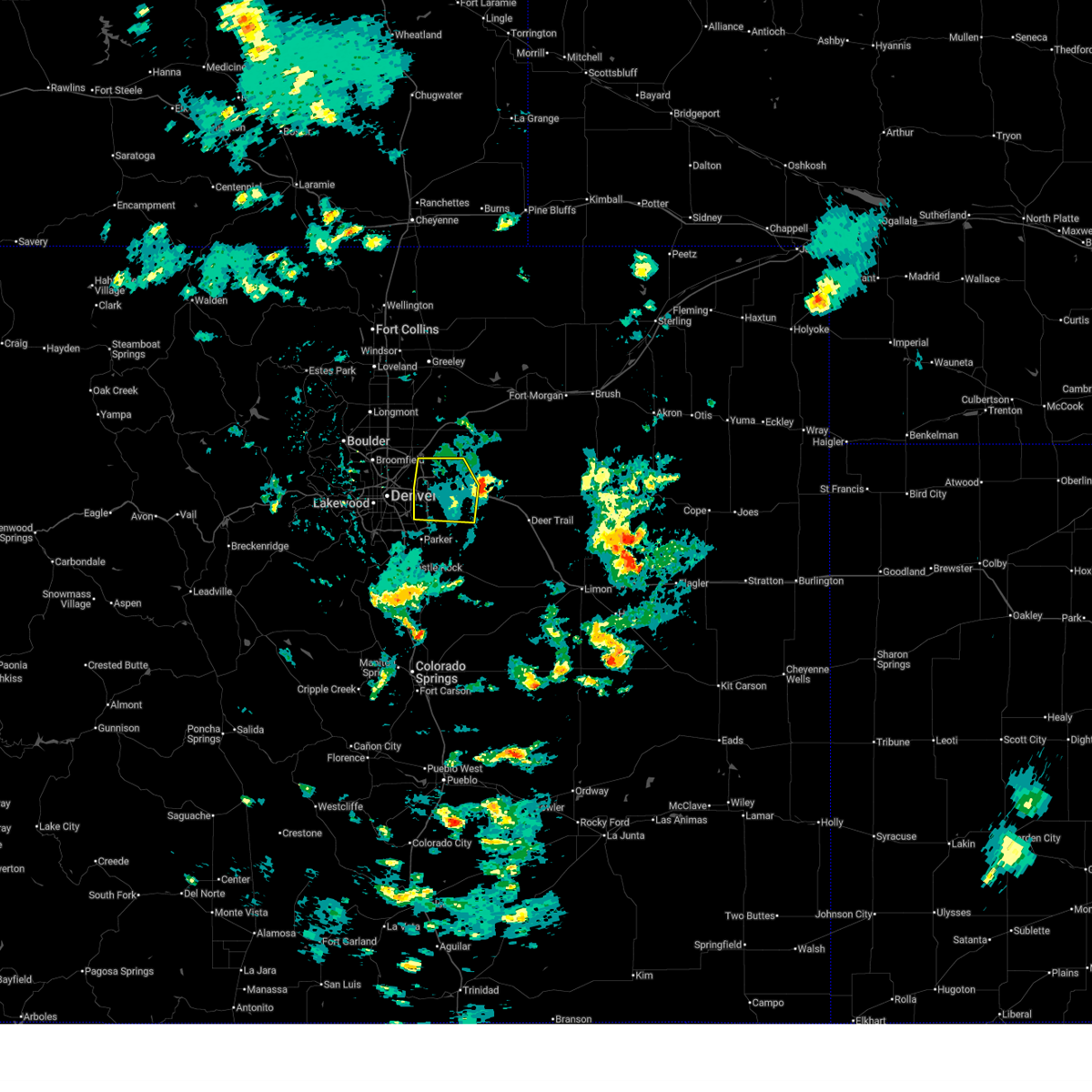
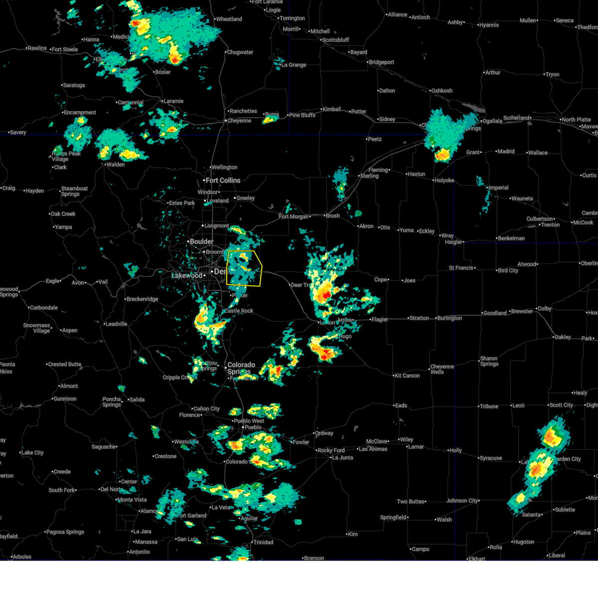
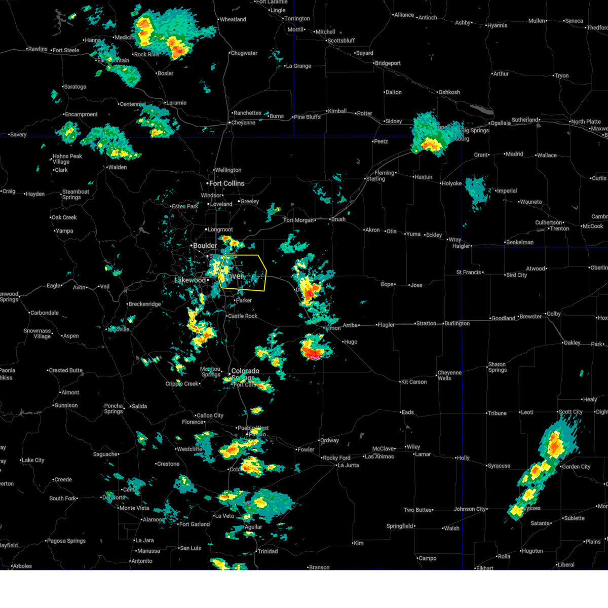
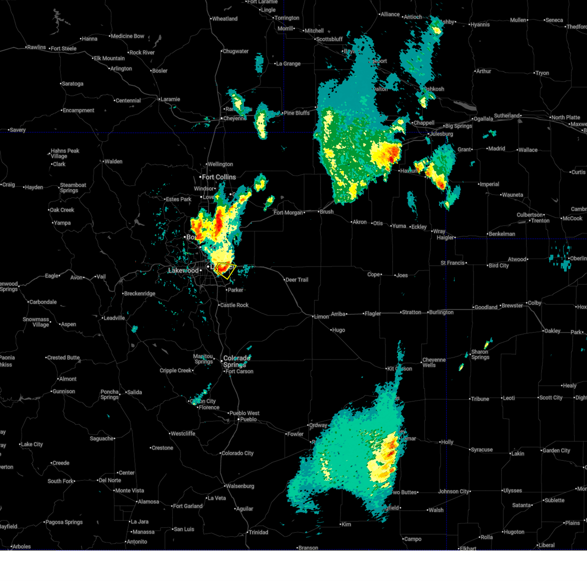
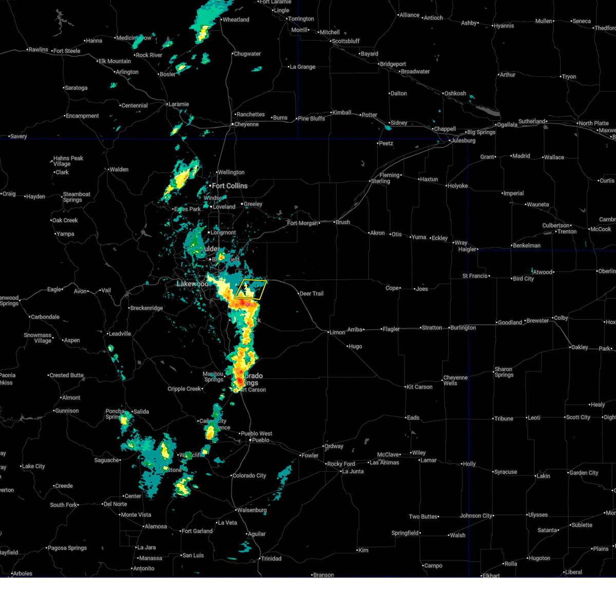
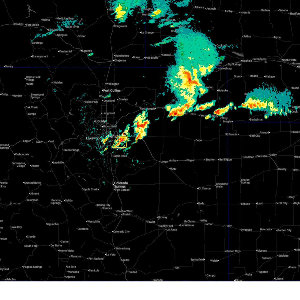
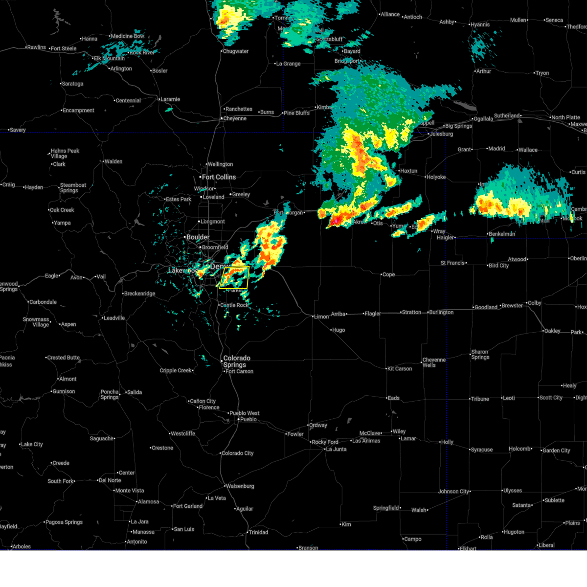
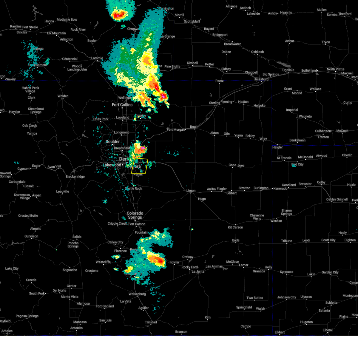
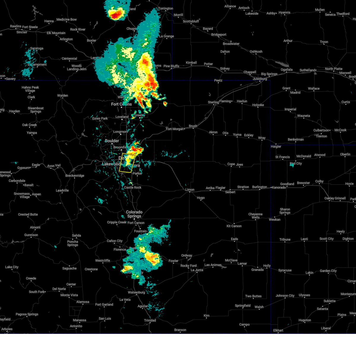
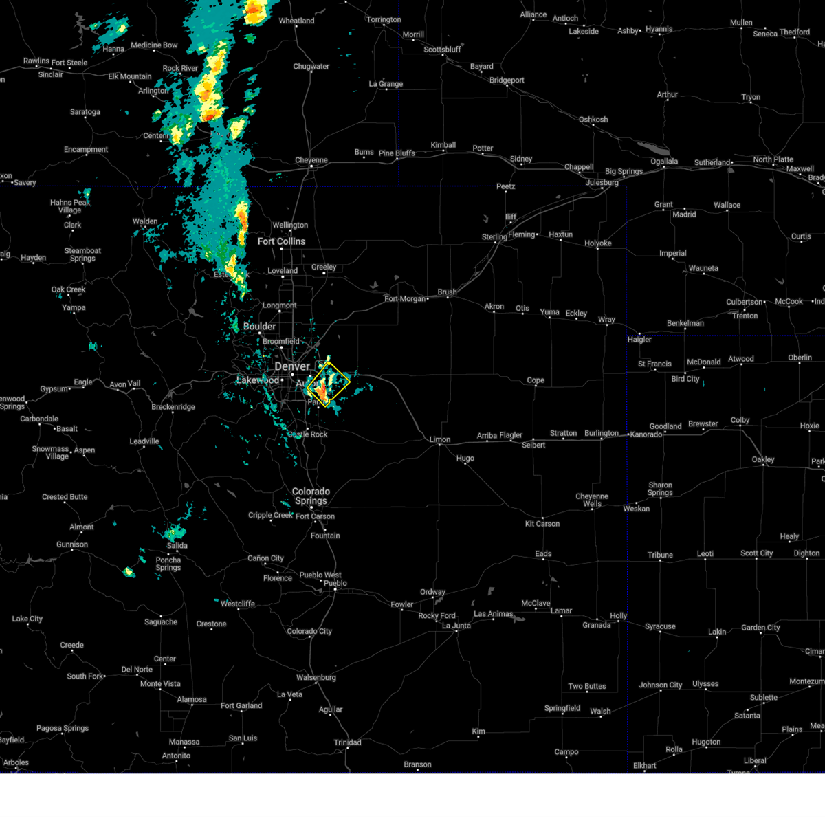
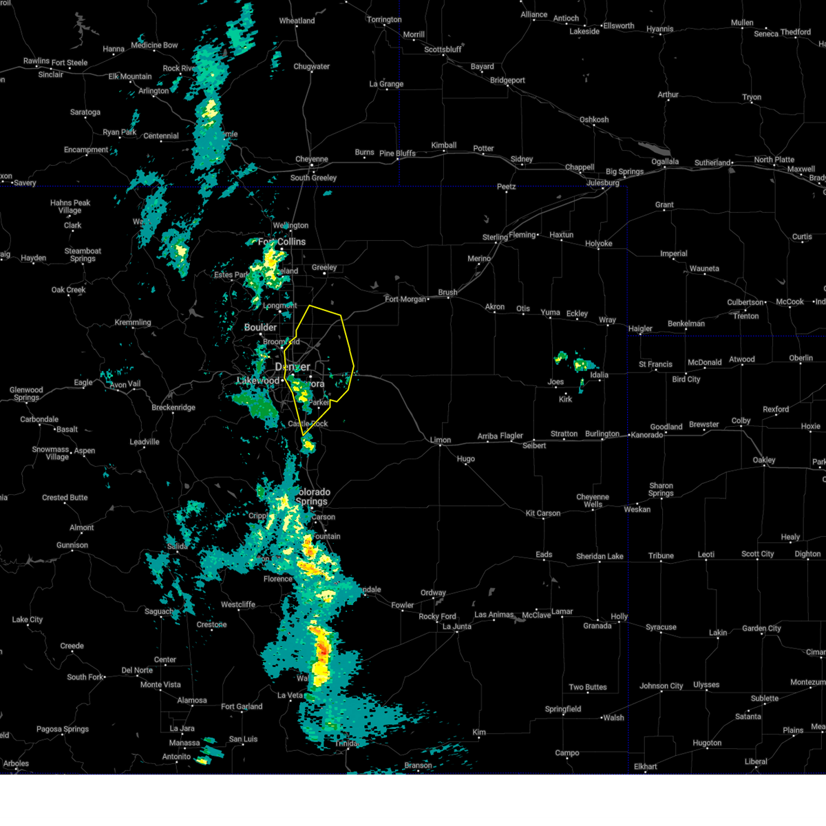
Hail Map for Centennial, CO
The Centennial, CO area has had 2 reports of on-the-ground hail by trained spotters, and has been under severe weather warnings 23 times during the past 12 months. Doppler radar has detected hail at or near Centennial, CO on 133 occasions, including 6 occasions during the past year.
| Name: | Centennial, CO |
| Where Located: | 13 miles SE of Denver, CO |
| Map: | Google Map for Centennial, CO |
| Population: | 100377 |
| Housing Units: | 38779 |
| More Info: | Search Google for Centennial, CO |
1
The Top Recent Hail Date for Centennial, CO is Friday, May 30, 2025 (55th out of 133)
Hail and Wind Damage Spotted near Centennial, CO
| Date / Time | Report Details |
|---|---|
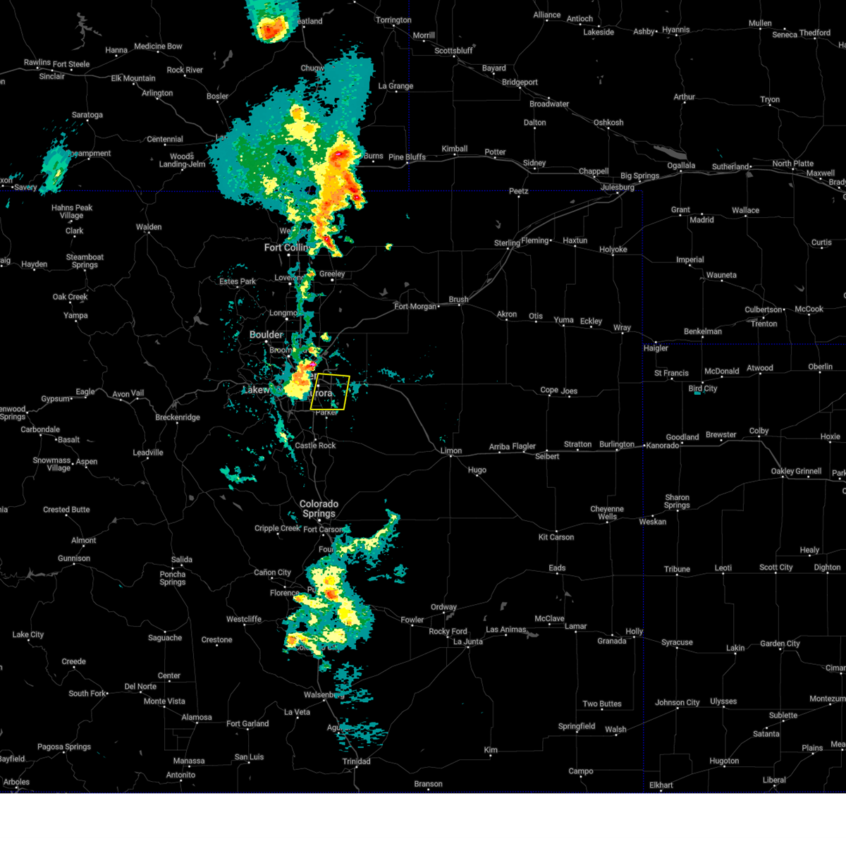
| 7/10/2025 3:05 PM MDT |
 The severe thunderstorm warning that was previously in effect has been reissued for adams and arapahoe counties and is in effect until 345 pm mdt. please refer to that bulletin for the latest severe weather information. a severe thunderstorm watch remains in effect until 900 pm mdt thursday for a portion of northeast colorado. The severe thunderstorm warning that was previously in effect has been reissued for adams and arapahoe counties and is in effect until 345 pm mdt. please refer to that bulletin for the latest severe weather information. a severe thunderstorm watch remains in effect until 900 pm mdt thursday for a portion of northeast colorado.
|
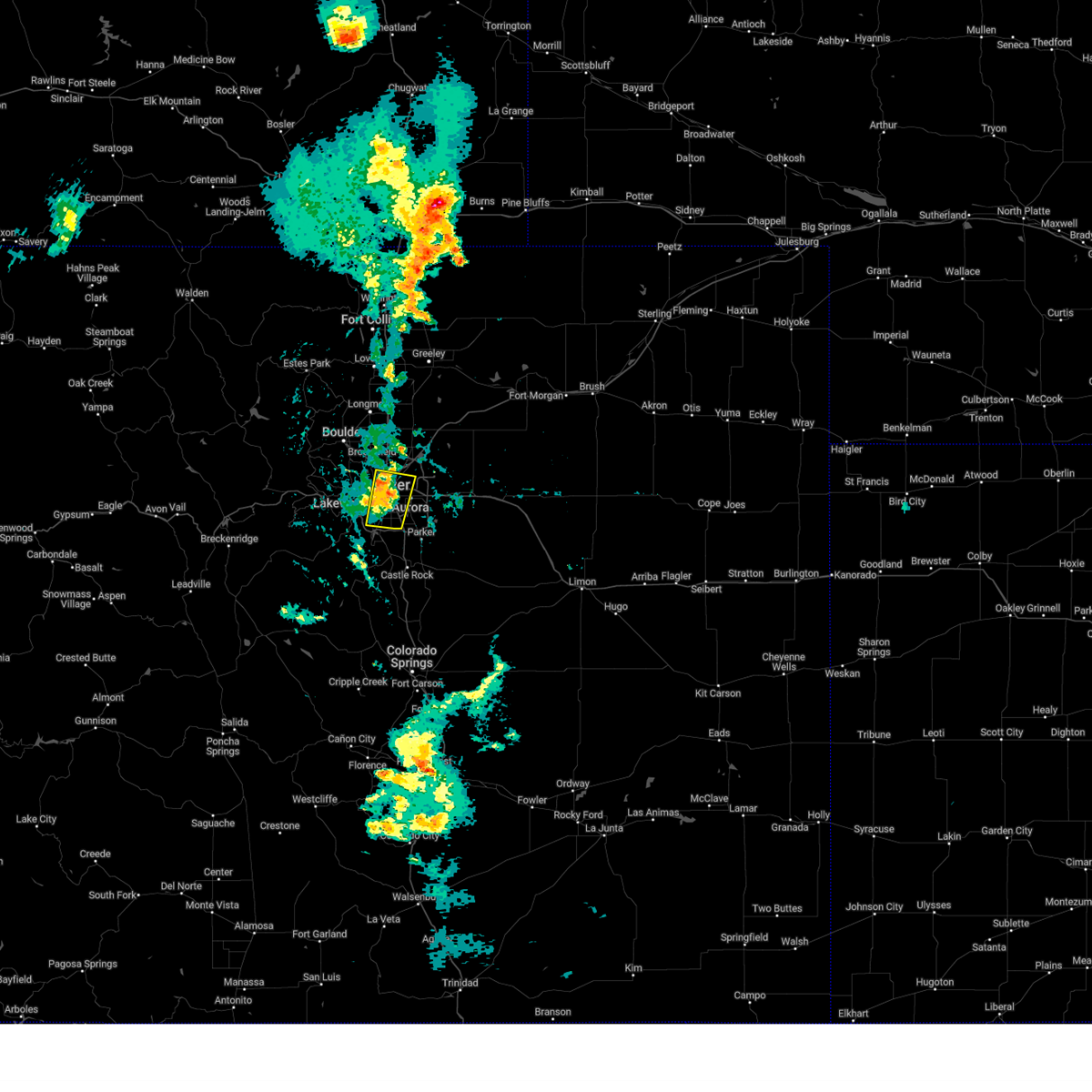
| 7/10/2025 2:48 PM MDT |
 At 248 pm mdt, a severe thunderstorm was located near aurora, or 15 miles east of denver, moving east at 25 mph (denver international airport reported a 58 mph wind gust at 242 pm). Hazards include 60 mph wind gusts. Expect damage to roofs, siding, and trees. locations impacted include, northeastern denver, aurora, northeastern centennial, northeastern commerce city, denver international airport, d. i. A terminal and concourses, bennett, watkins, manila village, arapahoe park and buckley sfb. At 248 pm mdt, a severe thunderstorm was located near aurora, or 15 miles east of denver, moving east at 25 mph (denver international airport reported a 58 mph wind gust at 242 pm). Hazards include 60 mph wind gusts. Expect damage to roofs, siding, and trees. locations impacted include, northeastern denver, aurora, northeastern centennial, northeastern commerce city, denver international airport, d. i. A terminal and concourses, bennett, watkins, manila village, arapahoe park and buckley sfb.
|
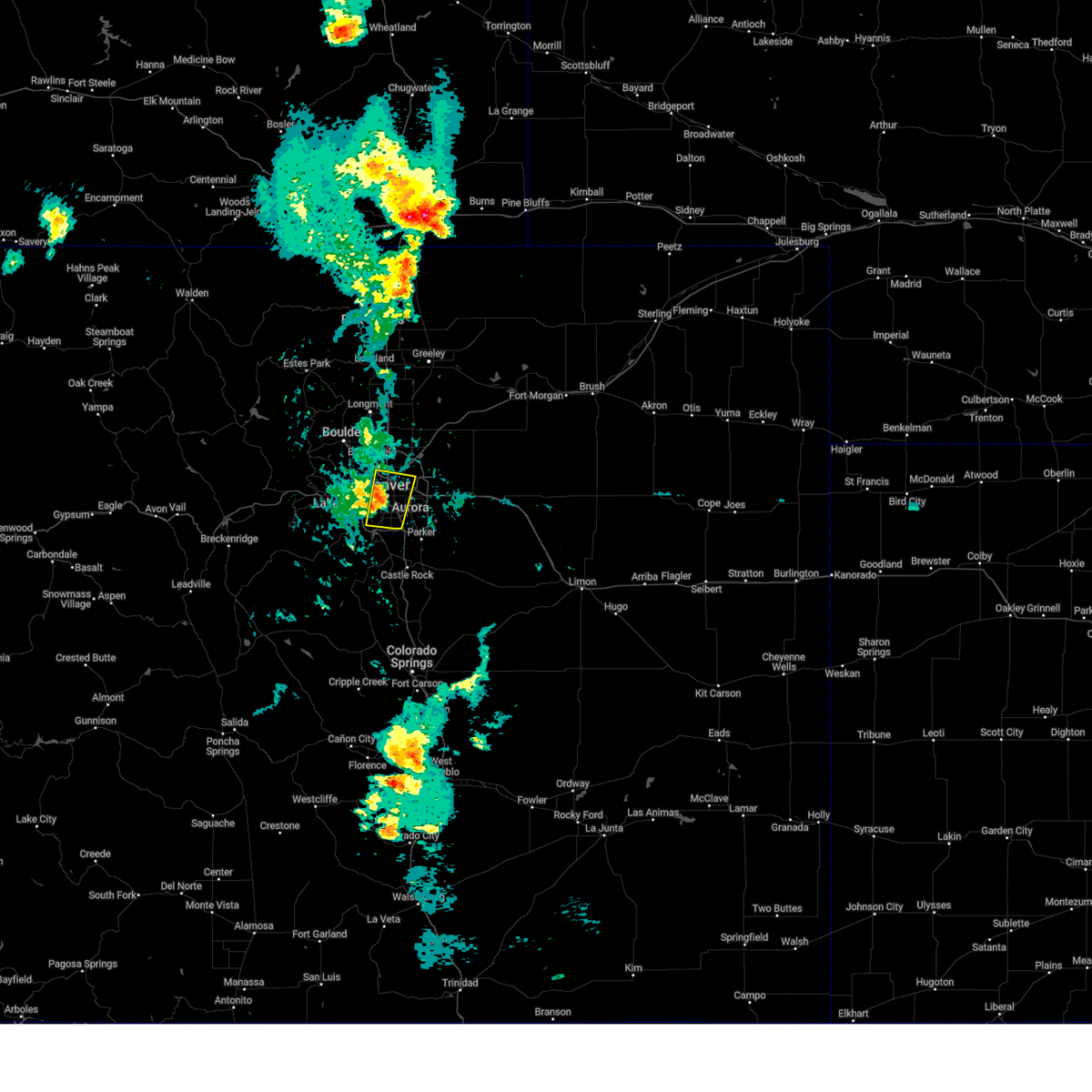
| 7/10/2025 2:28 PM MDT |
 Svrbou the national weather service in denver has issued a * severe thunderstorm warning for, southwestern adams county in northeastern colorado, western arapahoe county in northeastern colorado, denver county in northeastern colorado, * until 315 pm mdt. * at 228 pm mdt, a severe thunderstorm was located 5 miles south of commerce city, or 7 miles northeast of denver, moving east at 25 mph (multiple weather stations reported 59 mph wind gusts along i-70 in northern denver). Hazards include 60 mph wind gusts. expect damage to roofs, siding, and trees Svrbou the national weather service in denver has issued a * severe thunderstorm warning for, southwestern adams county in northeastern colorado, western arapahoe county in northeastern colorado, denver county in northeastern colorado, * until 315 pm mdt. * at 228 pm mdt, a severe thunderstorm was located 5 miles south of commerce city, or 7 miles northeast of denver, moving east at 25 mph (multiple weather stations reported 59 mph wind gusts along i-70 in northern denver). Hazards include 60 mph wind gusts. expect damage to roofs, siding, and trees
|
| 6/25/2025 8:44 PM MDT |
 The storm which prompted the warning has weakened below severe limits, and no longer poses an immediate threat to life or property. therefore, the warning will be allowed to expire. however, heavy rain is still possible with this thunderstorm. The storm which prompted the warning has weakened below severe limits, and no longer poses an immediate threat to life or property. therefore, the warning will be allowed to expire. however, heavy rain is still possible with this thunderstorm.
|
| 6/25/2025 8:21 PM MDT |
 Svrbou the national weather service in denver has issued a * severe thunderstorm warning for, southwestern adams county in northeastern colorado, northwestern arapahoe county in northeastern colorado, * until 845 pm mdt. * at 821 pm mdt, a severe thunderstorm was located over northwest aurora, or about 8 miles east of denver, moving southeast at 10 mph (radar indicated). Hazards include quarter size hail. damage to vehicles is expected Svrbou the national weather service in denver has issued a * severe thunderstorm warning for, southwestern adams county in northeastern colorado, northwestern arapahoe county in northeastern colorado, * until 845 pm mdt. * at 821 pm mdt, a severe thunderstorm was located over northwest aurora, or about 8 miles east of denver, moving southeast at 10 mph (radar indicated). Hazards include quarter size hail. damage to vehicles is expected
|
| 6/24/2025 2:37 PM MDT |
 the severe thunderstorm warning has been cancelled and is no longer in effect the severe thunderstorm warning has been cancelled and is no longer in effect
|
| 6/24/2025 2:21 PM MDT |
 At 221 pm mdt, a severe thunderstorm was located over arapahoe park, or 18 miles east of denver, moving northeast at 20 mph (automated weather station reported. at 215 pm, a 61 mph wind gust was reported by an automated weather station southwest of arapahoe park). Hazards include 60 mph wind gusts and small hail. Expect damage to roofs, siding, and trees. Locations impacted include, aurora, northeastern centennial and arapahoe park. At 221 pm mdt, a severe thunderstorm was located over arapahoe park, or 18 miles east of denver, moving northeast at 20 mph (automated weather station reported. at 215 pm, a 61 mph wind gust was reported by an automated weather station southwest of arapahoe park). Hazards include 60 mph wind gusts and small hail. Expect damage to roofs, siding, and trees. Locations impacted include, aurora, northeastern centennial and arapahoe park.
|
| 6/24/2025 2:07 PM MDT |
 Svrbou the national weather service in denver has issued a * severe thunderstorm warning for, western arapahoe county in northeastern colorado, * until 245 pm mdt. * at 207 pm mdt, a severe thunderstorm was located over arapahoe park, or 17 miles southeast of denver, moving northeast at 20 mph (radar indicated). Hazards include 60 mph wind gusts and small hail. expect damage to roofs, siding, and trees Svrbou the national weather service in denver has issued a * severe thunderstorm warning for, western arapahoe county in northeastern colorado, * until 245 pm mdt. * at 207 pm mdt, a severe thunderstorm was located over arapahoe park, or 17 miles southeast of denver, moving northeast at 20 mph (radar indicated). Hazards include 60 mph wind gusts and small hail. expect damage to roofs, siding, and trees
|
| 6/24/2025 1:46 PM MDT |
 At 146 pm mdt, a severe thunderstorm was located over parker, or 20 miles southeast of denver, moving northeast at 15 mph (radar indicated). Hazards include quarter size hail. Damage to vehicles is expected. Locations impacted include, southern aurora, southern centennial, northeastern castle rock, parker, the pinery and southeastern castle pines. At 146 pm mdt, a severe thunderstorm was located over parker, or 20 miles southeast of denver, moving northeast at 15 mph (radar indicated). Hazards include quarter size hail. Damage to vehicles is expected. Locations impacted include, southern aurora, southern centennial, northeastern castle rock, parker, the pinery and southeastern castle pines.
|
| 6/24/2025 1:34 PM MDT |
 Svrbou the national weather service in denver has issued a * severe thunderstorm warning for, northeastern douglas county in northeastern colorado, * until 200 pm mdt. * at 134 pm mdt, a severe thunderstorm was located over the pinery, or 20 miles southeast of denver, moving northeast at 20 mph (radar indicated). Hazards include quarter size hail. damage to vehicles is expected Svrbou the national weather service in denver has issued a * severe thunderstorm warning for, northeastern douglas county in northeastern colorado, * until 200 pm mdt. * at 134 pm mdt, a severe thunderstorm was located over the pinery, or 20 miles southeast of denver, moving northeast at 20 mph (radar indicated). Hazards include quarter size hail. damage to vehicles is expected
|
| 6/17/2025 5:45 AM MDT |
 At 545 am mdt, a severe thunderstorm was located near arapahoe park, or 19 miles east of denver, moving east at 15 mph (radar indicated). Hazards include ping pong ball size hail. People and animals outdoors will be injured. expect damage to roofs, siding, windows, and vehicles. Locations impacted include, aurora, eastern centennial, northwestern parker, arapahoe park and foxfield. At 545 am mdt, a severe thunderstorm was located near arapahoe park, or 19 miles east of denver, moving east at 15 mph (radar indicated). Hazards include ping pong ball size hail. People and animals outdoors will be injured. expect damage to roofs, siding, windows, and vehicles. Locations impacted include, aurora, eastern centennial, northwestern parker, arapahoe park and foxfield.
|
| 6/17/2025 5:35 AM MDT |
 At 535 am mdt, a severe thunderstorm was located over arapahoe park, or 17 miles east of denver, moving east at 15 mph (radar indicated). Hazards include ping pong ball size hail. People and animals outdoors will be injured. expect damage to roofs, siding, windows, and vehicles. Locations impacted include, aurora, eastern centennial, northwestern parker, arapahoe park and foxfield. At 535 am mdt, a severe thunderstorm was located over arapahoe park, or 17 miles east of denver, moving east at 15 mph (radar indicated). Hazards include ping pong ball size hail. People and animals outdoors will be injured. expect damage to roofs, siding, windows, and vehicles. Locations impacted include, aurora, eastern centennial, northwestern parker, arapahoe park and foxfield.
|
| 6/17/2025 5:21 AM MDT |
 Svrbou the national weather service in denver has issued a * severe thunderstorm warning for, northwestern elbert county in east central colorado, western arapahoe county in northeastern colorado, northeastern douglas county in northeastern colorado, * until 600 am mdt. * at 521 am mdt, a severe thunderstorm was located over arapahoe park, or 14 miles southeast of denver, moving east at 15 mph (radar indicated). Hazards include half dollar size hail. damage to vehicles is expected Svrbou the national weather service in denver has issued a * severe thunderstorm warning for, northwestern elbert county in east central colorado, western arapahoe county in northeastern colorado, northeastern douglas county in northeastern colorado, * until 600 am mdt. * at 521 am mdt, a severe thunderstorm was located over arapahoe park, or 14 miles southeast of denver, moving east at 15 mph (radar indicated). Hazards include half dollar size hail. damage to vehicles is expected
|
| 6/1/2025 5:25 PM MDT |
 The storm which prompted the warning has weakened below severe limits, and no longer poses an immediate threat to life or property. therefore, the warning will be allowed to expire. however, heavy rain is still possible with this thunderstorm. The storm which prompted the warning has weakened below severe limits, and no longer poses an immediate threat to life or property. therefore, the warning will be allowed to expire. however, heavy rain is still possible with this thunderstorm.
|
| 6/1/2025 5:10 PM MDT |
 The storm which prompted the warning has weakened below severe limits, and no longer poses an immediate threat to life or property. therefore, the warning will be allowed to expire. however, small hail, gusty winds, and heavy rain are still possible with this thunderstorm. The storm which prompted the warning has weakened below severe limits, and no longer poses an immediate threat to life or property. therefore, the warning will be allowed to expire. however, small hail, gusty winds, and heavy rain are still possible with this thunderstorm.
|
| 6/1/2025 5:01 PM MDT |
 Svrbou the national weather service in denver has issued a * severe thunderstorm warning for, southwestern adams county in northeastern colorado, western arapahoe county in northeastern colorado, central denver county in northeastern colorado, * until 530 pm mdt. * at 501 pm mdt, a severe thunderstorm was located over buckley sfb, or 11 miles east of denver, moving east at 20 mph (radar indicated). Hazards include 60 mph wind gusts and small hail. expect damage to roofs, siding, and trees Svrbou the national weather service in denver has issued a * severe thunderstorm warning for, southwestern adams county in northeastern colorado, western arapahoe county in northeastern colorado, central denver county in northeastern colorado, * until 530 pm mdt. * at 501 pm mdt, a severe thunderstorm was located over buckley sfb, or 11 miles east of denver, moving east at 20 mph (radar indicated). Hazards include 60 mph wind gusts and small hail. expect damage to roofs, siding, and trees
|
| 6/1/2025 4:52 PM MDT |
 At 452 pm mdt, a severe thunderstorm was located near denver, moving east at 15 mph (radar indicated). Hazards include 60 mph wind gusts and small hail. Expect damage to roofs, siding, and trees. Locations impacted include, denver, western aurora, eastern lakewood, southwestern thornton, southeastern arvada, southern westminster, southwestern centennial, southwestern commerce city, littleton, englewood, eastern wheat ridge, greenwood village, federal heights, sheridan, cherry hills village, edgewater, mountain view, cherry creek reservoir, columbine and ken caryl. At 452 pm mdt, a severe thunderstorm was located near denver, moving east at 15 mph (radar indicated). Hazards include 60 mph wind gusts and small hail. Expect damage to roofs, siding, and trees. Locations impacted include, denver, western aurora, eastern lakewood, southwestern thornton, southeastern arvada, southern westminster, southwestern centennial, southwestern commerce city, littleton, englewood, eastern wheat ridge, greenwood village, federal heights, sheridan, cherry hills village, edgewater, mountain view, cherry creek reservoir, columbine and ken caryl.
|
| 6/1/2025 4:38 PM MDT |
 Svrbou the national weather service in denver has issued a * severe thunderstorm warning for, east central jefferson county in central colorado, southwestern adams county in northeastern colorado, western arapahoe county in northeastern colorado, denver county in northeastern colorado, * until 515 pm mdt. * at 438 pm mdt, a severe thunderstorm was located near englewood, or near denver, moving east at 15 mph (radar indicated). Hazards include 60 mph wind gusts and small hail. expect damage to roofs, siding, and trees Svrbou the national weather service in denver has issued a * severe thunderstorm warning for, east central jefferson county in central colorado, southwestern adams county in northeastern colorado, western arapahoe county in northeastern colorado, denver county in northeastern colorado, * until 515 pm mdt. * at 438 pm mdt, a severe thunderstorm was located near englewood, or near denver, moving east at 15 mph (radar indicated). Hazards include 60 mph wind gusts and small hail. expect damage to roofs, siding, and trees
|
| 5/30/2025 5:42 PM MDT |
 Svrbou the national weather service in denver has issued a * severe thunderstorm warning for, northwestern elbert county in east central colorado, southwestern arapahoe county in northeastern colorado, northeastern douglas county in northeastern colorado, * until 630 pm mdt. * at 542 pm mdt, a severe thunderstorm was located near arapahoe park, or 18 miles southeast of denver, moving southeast at 25 mph (radar indicated). Hazards include 60 mph wind gusts and quarter size hail. Hail damage to vehicles is expected. Expect wind damage to roofs, siding, and trees. Svrbou the national weather service in denver has issued a * severe thunderstorm warning for, northwestern elbert county in east central colorado, southwestern arapahoe county in northeastern colorado, northeastern douglas county in northeastern colorado, * until 630 pm mdt. * at 542 pm mdt, a severe thunderstorm was located near arapahoe park, or 18 miles southeast of denver, moving southeast at 25 mph (radar indicated). Hazards include 60 mph wind gusts and quarter size hail. Hail damage to vehicles is expected. Expect wind damage to roofs, siding, and trees.
|
| 5/18/2025 1:09 PM MDT |
 Svrbou the national weather service in denver has issued a * severe thunderstorm warning for, south central adams county in northeastern colorado, western arapahoe county in northeastern colorado, northeastern douglas county in northeastern colorado, * until 145 pm mdt. * at 109 pm mdt, a severe thunderstorm was located over arapahoe park, or 14 miles southeast of denver, moving northeast at 15 mph (radar indicated). Hazards include 60 mph wind gusts and half dollar size hail. Hail damage to vehicles is expected. Expect wind damage to roofs, siding, and trees. Svrbou the national weather service in denver has issued a * severe thunderstorm warning for, south central adams county in northeastern colorado, western arapahoe county in northeastern colorado, northeastern douglas county in northeastern colorado, * until 145 pm mdt. * at 109 pm mdt, a severe thunderstorm was located over arapahoe park, or 14 miles southeast of denver, moving northeast at 15 mph (radar indicated). Hazards include 60 mph wind gusts and half dollar size hail. Hail damage to vehicles is expected. Expect wind damage to roofs, siding, and trees.
|
| 9/17/2024 2:36 PM MDT |
 Svrbou the national weather service in denver colorado has issued a * severe thunderstorm warning for, northeastern douglas county in northeastern colorado, southwestern weld county in northeastern colorado, western arapahoe county in northeastern colorado, denver county in northeastern colorado, western adams county in northeastern colorado, * until 315 pm mdt. * at 234 pm mdt, severe thunderstorms were located along a line extending from thornton to denver to 3 miles west of parker, or along a line extending from 40 miles south of greeley to 65 miles southwest of fort morgan to 45 miles north of colorado springs, moving northeast at 30 mph (radar indicated. at 215 pm mdt, an automated sensor reported a 60 mph wind gust was reported near chatfield state park). Hazards include 60 mph wind gusts. expect damage to roofs, siding, and trees Svrbou the national weather service in denver colorado has issued a * severe thunderstorm warning for, northeastern douglas county in northeastern colorado, southwestern weld county in northeastern colorado, western arapahoe county in northeastern colorado, denver county in northeastern colorado, western adams county in northeastern colorado, * until 315 pm mdt. * at 234 pm mdt, severe thunderstorms were located along a line extending from thornton to denver to 3 miles west of parker, or along a line extending from 40 miles south of greeley to 65 miles southwest of fort morgan to 45 miles north of colorado springs, moving northeast at 30 mph (radar indicated. at 215 pm mdt, an automated sensor reported a 60 mph wind gust was reported near chatfield state park). Hazards include 60 mph wind gusts. expect damage to roofs, siding, and trees
|
| 7/20/2024 9:41 PM MDT |
 The storm which prompted the warning has weakened below severe limits, and no longer poses an immediate threat to life or property. therefore, the warning will be allowed to expire. however, heavy rain is still possible with this thunderstorm. The storm which prompted the warning has weakened below severe limits, and no longer poses an immediate threat to life or property. therefore, the warning will be allowed to expire. however, heavy rain is still possible with this thunderstorm.
|
| 7/20/2024 9:20 PM MDT |
 Svrbou the national weather service in denver colorado has issued a * severe thunderstorm warning for, northeastern douglas county in northeastern colorado, northwestern elbert county in east central colorado, western arapahoe county in northeastern colorado, * until 945 pm mdt. * at 920 pm mdt, a severe thunderstorm was located over northwestern aurora, or 11 miles southeast of denver, moving south at 35 mph (radar indicated). Hazards include 60 mph wind gusts and penny size hail. expect damage to roofs, siding, and trees Svrbou the national weather service in denver colorado has issued a * severe thunderstorm warning for, northeastern douglas county in northeastern colorado, northwestern elbert county in east central colorado, western arapahoe county in northeastern colorado, * until 945 pm mdt. * at 920 pm mdt, a severe thunderstorm was located over northwestern aurora, or 11 miles southeast of denver, moving south at 35 mph (radar indicated). Hazards include 60 mph wind gusts and penny size hail. expect damage to roofs, siding, and trees
|
| 6/14/2024 2:41 PM MDT |
 the severe thunderstorm warning has been cancelled and is no longer in effect the severe thunderstorm warning has been cancelled and is no longer in effect
|
| 6/14/2024 2:26 PM MDT |
 Svrbou the national weather service in denver colorado has issued a * severe thunderstorm warning for, north central douglas county in northeastern colorado, western arapahoe county in northeastern colorado, southwestern denver county in northeastern colorado, southwestern adams county in northeastern colorado, * until 315 pm mdt. * at 226 pm mdt, a severe thunderstorm was located over western centennial, or 9 miles south of denver, moving northeast at 25 mph (radar indicated). Hazards include quarter size hail. damage to vehicles is expected Svrbou the national weather service in denver colorado has issued a * severe thunderstorm warning for, north central douglas county in northeastern colorado, western arapahoe county in northeastern colorado, southwestern denver county in northeastern colorado, southwestern adams county in northeastern colorado, * until 315 pm mdt. * at 226 pm mdt, a severe thunderstorm was located over western centennial, or 9 miles south of denver, moving northeast at 25 mph (radar indicated). Hazards include quarter size hail. damage to vehicles is expected
|
| 6/14/2024 2:07 PM MDT |
 At 207 pm mdt, a severe thunderstorm was located over chatfield reservoir, or 12 miles southwest of denver, moving northeast at 30 mph (radar indicated). Hazards include quarter size hail. Damage to vehicles is expected. Locations impacted include, denver, western aurora, lakewood, southeastern arvada, southwestern centennial, northwestern highlands ranch, southwestern commerce city, littleton, englewood, eastern wheat ridge, greenwood village, roxborough park, sheridan, morrison, and chatfield reservoir. At 207 pm mdt, a severe thunderstorm was located over chatfield reservoir, or 12 miles southwest of denver, moving northeast at 30 mph (radar indicated). Hazards include quarter size hail. Damage to vehicles is expected. Locations impacted include, denver, western aurora, lakewood, southeastern arvada, southwestern centennial, northwestern highlands ranch, southwestern commerce city, littleton, englewood, eastern wheat ridge, greenwood village, roxborough park, sheridan, morrison, and chatfield reservoir.
|
| 6/14/2024 1:52 PM MDT |
 Svrbou the national weather service in denver colorado has issued a * severe thunderstorm warning for, north central douglas county in northeastern colorado, western arapahoe county in northeastern colorado, denver county in northeastern colorado, east central jefferson county in central colorado, * until 230 pm mdt. * at 152 pm mdt, a severe thunderstorm was located 6 miles northwest of roxborough park, or 19 miles southwest of denver, moving northeast at 30 mph (radar indicated). Hazards include 60 mph wind gusts and quarter size hail. Expect damage to roofs, siding, and trees. Hail damage to vehicles is expected. Svrbou the national weather service in denver colorado has issued a * severe thunderstorm warning for, north central douglas county in northeastern colorado, western arapahoe county in northeastern colorado, denver county in northeastern colorado, east central jefferson county in central colorado, * until 230 pm mdt. * at 152 pm mdt, a severe thunderstorm was located 6 miles northwest of roxborough park, or 19 miles southwest of denver, moving northeast at 30 mph (radar indicated). Hazards include 60 mph wind gusts and quarter size hail. Expect damage to roofs, siding, and trees. Hail damage to vehicles is expected.
|
| 6/9/2024 5:49 PM MDT |
 the severe thunderstorm warning has been cancelled and is no longer in effect the severe thunderstorm warning has been cancelled and is no longer in effect
|
| 6/9/2024 5:49 PM MDT |
 At 549 pm mdt, a severe thunderstorm was located near ponderosa park, or 25 miles southeast of denver, moving east at 15 mph (radar indicated). Hazards include quarter size hail. Damage to vehicles is expected. Locations impacted include, northeastern castle rock, parker, the pinery, eastern castle pines, and ponderosa park. At 549 pm mdt, a severe thunderstorm was located near ponderosa park, or 25 miles southeast of denver, moving east at 15 mph (radar indicated). Hazards include quarter size hail. Damage to vehicles is expected. Locations impacted include, northeastern castle rock, parker, the pinery, eastern castle pines, and ponderosa park.
|
| 6/9/2024 5:10 PM MDT |
 Svrbou the national weather service in denver colorado has issued a * severe thunderstorm warning for, northeastern douglas county in northeastern colorado, northwestern elbert county in east central colorado, * until 600 pm mdt. * at 510 pm mdt, a severe thunderstorm was located over southwestern parker, or 18 miles southeast of denver, moving southeast at 15 mph (radar indicated). Hazards include quarter size hail. damage to vehicles is expected Svrbou the national weather service in denver colorado has issued a * severe thunderstorm warning for, northeastern douglas county in northeastern colorado, northwestern elbert county in east central colorado, * until 600 pm mdt. * at 510 pm mdt, a severe thunderstorm was located over southwestern parker, or 18 miles southeast of denver, moving southeast at 15 mph (radar indicated). Hazards include quarter size hail. damage to vehicles is expected
|
| 6/9/2024 5:07 PM MDT |
 The storm which prompted the warning has weakened below severe limits, and no longer poses an immediate threat to life or property. therefore, the warning will be allowed to expire. however, pea size hail hail and heavy rain are continuing. there is a urban and small stream adivory in effect for this area. don't drive through flooded roadways. The storm which prompted the warning has weakened below severe limits, and no longer poses an immediate threat to life or property. therefore, the warning will be allowed to expire. however, pea size hail hail and heavy rain are continuing. there is a urban and small stream adivory in effect for this area. don't drive through flooded roadways.
|
| 6/9/2024 4:51 PM MDT |
 At 450 pm mdt, a severe thunderstorm was located 5 miles east of parker, or 20 miles southeast of denver, moving southeast at 15 mph (trained weather spotters). Hazards include ping pong ball size hail and 60 mph wind gusts. Expect damage to roofs, siding, and trees. people and animals outdoors will be injured. expect hail damage to roofs, siding, windows, and vehicles. Locations impacted include, southern aurora, eastern centennial, northern parker, and arapahoe park. At 450 pm mdt, a severe thunderstorm was located 5 miles east of parker, or 20 miles southeast of denver, moving southeast at 15 mph (trained weather spotters). Hazards include ping pong ball size hail and 60 mph wind gusts. Expect damage to roofs, siding, and trees. people and animals outdoors will be injured. expect hail damage to roofs, siding, windows, and vehicles. Locations impacted include, southern aurora, eastern centennial, northern parker, and arapahoe park.
|
| 6/9/2024 4:34 PM MDT |
 Svrbou the national weather service in denver colorado has issued a * severe thunderstorm warning for, northeastern douglas county in northeastern colorado, northwestern elbert county in east central colorado, southwestern arapahoe county in northeastern colorado, * until 515 pm mdt. * at 434 pm mdt, a severe thunderstorm was located near parker, or 17 miles southeast of denver, moving southeast at 15 mph (radar indicated). Hazards include 60 mph wind gusts and half dollar size hail. Expect damage to roofs, siding, and trees. Hail damage to vehicles is expected. Svrbou the national weather service in denver colorado has issued a * severe thunderstorm warning for, northeastern douglas county in northeastern colorado, northwestern elbert county in east central colorado, southwestern arapahoe county in northeastern colorado, * until 515 pm mdt. * at 434 pm mdt, a severe thunderstorm was located near parker, or 17 miles southeast of denver, moving southeast at 15 mph (radar indicated). Hazards include 60 mph wind gusts and half dollar size hail. Expect damage to roofs, siding, and trees. Hail damage to vehicles is expected.
|
| 6/7/2024 8:23 PM MDT |
 The strong winds which prompted the warning have weakened below severe limits, and no longer poses an immediate threat to life or property. therefore, the warning will be allowed to expire. however, gusty winds to 50 mph are still possible. The strong winds which prompted the warning have weakened below severe limits, and no longer poses an immediate threat to life or property. therefore, the warning will be allowed to expire. however, gusty winds to 50 mph are still possible.
|
| 6/7/2024 7:54 PM MDT |
 Svrbou the national weather service in denver colorado has issued a * severe thunderstorm warning for, central arapahoe county in northeastern colorado, northeastern denver county in northeastern colorado, western adams county in northeastern colorado, * until 830 pm mdt. * at 754 pm mdt, strong winds from a decaying thunderstorm were located 6 miles northeast of d.i.a terminal and concourses, or 23 miles northeast of denver, moving south at 55 mph (radar indicated). Hazards include 60 mph wind gusts. Expect damage to roofs, siding, and trees. This severe thunderstorm will be near, northeastern aurora, eastern denver international airport, watkins, and manila village around 800 pm mdt. Svrbou the national weather service in denver colorado has issued a * severe thunderstorm warning for, central arapahoe county in northeastern colorado, northeastern denver county in northeastern colorado, western adams county in northeastern colorado, * until 830 pm mdt. * at 754 pm mdt, strong winds from a decaying thunderstorm were located 6 miles northeast of d.i.a terminal and concourses, or 23 miles northeast of denver, moving south at 55 mph (radar indicated). Hazards include 60 mph wind gusts. Expect damage to roofs, siding, and trees. This severe thunderstorm will be near, northeastern aurora, eastern denver international airport, watkins, and manila village around 800 pm mdt.
|
| 6/7/2024 3:03 PM MDT |
 the severe thunderstorm warning has been cancelled and is no longer in effect the severe thunderstorm warning has been cancelled and is no longer in effect
|
| 6/7/2024 2:42 PM MDT |
 At 241 pm mdt, a severe thunderstorm was located over chatfield reservoir, or 14 miles southwest of denver, moving east at 30 mph (radar indicated). Hazards include 60 mph wind gusts. Expect damage to roofs, siding, and trees. Locations impacted include, southern centennial, highlands ranch, littleton, louviers, lone tree, northern castle pines, greenwood village, parker and southern aurora. At 241 pm mdt, a severe thunderstorm was located over chatfield reservoir, or 14 miles southwest of denver, moving east at 30 mph (radar indicated). Hazards include 60 mph wind gusts. Expect damage to roofs, siding, and trees. Locations impacted include, southern centennial, highlands ranch, littleton, louviers, lone tree, northern castle pines, greenwood village, parker and southern aurora.
|
| 6/7/2024 2:23 PM MDT |
 Svrbou the national weather service in denver colorado has issued a * severe thunderstorm warning for, northeastern douglas county in northeastern colorado, western arapahoe county in northeastern colorado, southwestern denver county in northeastern colorado, northeastern jefferson county in central colorado, * until 315 pm mdt. * at 223 pm mdt, a severe thunderstorm was located near aspen park, or 20 miles southwest of denver, moving east at 30 mph (radar indicated). Hazards include 60 mph wind gusts and nickel size hail. Expect damage to roofs, siding, and trees. this severe thunderstorm will be near, littleton around 230 pm mdt. highlands ranch, roxborough park, and chatfield reservoir around 235 pm mdt. Other locations in the path of this severe thunderstorm include southwestern centennial, louviers, lone tree, northern castle pines and western parker. Svrbou the national weather service in denver colorado has issued a * severe thunderstorm warning for, northeastern douglas county in northeastern colorado, western arapahoe county in northeastern colorado, southwestern denver county in northeastern colorado, northeastern jefferson county in central colorado, * until 315 pm mdt. * at 223 pm mdt, a severe thunderstorm was located near aspen park, or 20 miles southwest of denver, moving east at 30 mph (radar indicated). Hazards include 60 mph wind gusts and nickel size hail. Expect damage to roofs, siding, and trees. this severe thunderstorm will be near, littleton around 230 pm mdt. highlands ranch, roxborough park, and chatfield reservoir around 235 pm mdt. Other locations in the path of this severe thunderstorm include southwestern centennial, louviers, lone tree, northern castle pines and western parker.
|
| 5/30/2024 11:49 PM MDT |
 the severe thunderstorm warning has been cancelled and is no longer in effect the severe thunderstorm warning has been cancelled and is no longer in effect
|
| 5/30/2024 11:38 PM MDT |
 At 1137 pm mdt, a severe thunderstorm was located over southwestern aurora, or 10 miles east of denver, moving east at 15 mph (trained weather spotters). Hazards include quarter size hail. Damage to vehicles is expected. Locations impacted include, aurora, eastern centennial, northeastern parker, buckley sfb, and arapahoe park. At 1137 pm mdt, a severe thunderstorm was located over southwestern aurora, or 10 miles east of denver, moving east at 15 mph (trained weather spotters). Hazards include quarter size hail. Damage to vehicles is expected. Locations impacted include, aurora, eastern centennial, northeastern parker, buckley sfb, and arapahoe park.
|
| 5/30/2024 11:38 PM MDT |
 the severe thunderstorm warning has been cancelled and is no longer in effect the severe thunderstorm warning has been cancelled and is no longer in effect
|
| 5/30/2024 11:11 PM MDT |
 Svrbou the national weather service in denver colorado has issued a * severe thunderstorm warning for, northeastern douglas county in northeastern colorado, western arapahoe county in northeastern colorado, south central denver county in northeastern colorado, * until midnight mdt. * at 1111 pm mdt, a severe thunderstorm was located over eastern denver, moving southeast at 10 mph (trained weather spotters). Hazards include golf ball size hail. People and animals outdoors will be injured. Expect damage to roofs, siding, windows, and vehicles. Svrbou the national weather service in denver colorado has issued a * severe thunderstorm warning for, northeastern douglas county in northeastern colorado, western arapahoe county in northeastern colorado, south central denver county in northeastern colorado, * until midnight mdt. * at 1111 pm mdt, a severe thunderstorm was located over eastern denver, moving southeast at 10 mph (trained weather spotters). Hazards include golf ball size hail. People and animals outdoors will be injured. Expect damage to roofs, siding, windows, and vehicles.
|
| 5/30/2024 10:57 PM MDT |
 Svrbou the national weather service in denver colorado has issued a * severe thunderstorm warning for, northwestern elbert county in east central colorado, central arapahoe county in northeastern colorado, south central adams county in northeastern colorado, * until 1145 pm mdt. * at 1056 pm mdt, severe thunderstorms were located along a line extending from 5 miles north of bennett to near arapahoe park, or along a line extending from 44 miles southwest of fort morgan to 13 miles east of denver, moving southeast at 15 mph (trained weather spotters). Hazards include golf ball size hail and 60 mph wind gusts. Expect damage to roofs, siding, and trees. people and animals outdoors will be injured. Expect hail damage to roofs, siding, windows, and vehicles. Svrbou the national weather service in denver colorado has issued a * severe thunderstorm warning for, northwestern elbert county in east central colorado, central arapahoe county in northeastern colorado, south central adams county in northeastern colorado, * until 1145 pm mdt. * at 1056 pm mdt, severe thunderstorms were located along a line extending from 5 miles north of bennett to near arapahoe park, or along a line extending from 44 miles southwest of fort morgan to 13 miles east of denver, moving southeast at 15 mph (trained weather spotters). Hazards include golf ball size hail and 60 mph wind gusts. Expect damage to roofs, siding, and trees. people and animals outdoors will be injured. Expect hail damage to roofs, siding, windows, and vehicles.
|
| 5/30/2024 10:50 PM MDT |
 At 1050 pm mdt, a severe thunderstorm was located over northern denver, moving east at 15 mph (radar indicated). Hazards include quarter size hail. Damage to vehicles is expected. Locations impacted include, denver, northwestern aurora, southern thornton, northeastern centennial, southern commerce city, southwestern denver international airport, and buckley sfb. At 1050 pm mdt, a severe thunderstorm was located over northern denver, moving east at 15 mph (radar indicated). Hazards include quarter size hail. Damage to vehicles is expected. Locations impacted include, denver, northwestern aurora, southern thornton, northeastern centennial, southern commerce city, southwestern denver international airport, and buckley sfb.
|
| 5/30/2024 10:35 PM MDT |
 Svrbou the national weather service in denver colorado has issued a * severe thunderstorm warning for, northwestern arapahoe county in northeastern colorado, denver county in northeastern colorado, southwestern adams county in northeastern colorado, * until 1115 pm mdt. * at 1035 pm mdt, a severe thunderstorm was located over northwestern denver, moving east at 15 mph (radar indicated). Hazards include golf ball size hail. People and animals outdoors will be injured. Expect damage to roofs, siding, windows, and vehicles. Svrbou the national weather service in denver colorado has issued a * severe thunderstorm warning for, northwestern arapahoe county in northeastern colorado, denver county in northeastern colorado, southwestern adams county in northeastern colorado, * until 1115 pm mdt. * at 1035 pm mdt, a severe thunderstorm was located over northwestern denver, moving east at 15 mph (radar indicated). Hazards include golf ball size hail. People and animals outdoors will be injured. Expect damage to roofs, siding, windows, and vehicles.
|
| 8/11/2023 5:10 PM MDT |
 At 509 pm mdt, a severe thunderstorm was located over northwestern parker, or 15 miles southeast of denver, moving northeast at 25 mph (radar indicated). Hazards include 60 mph wind gusts. Expect damage to roofs, siding, and trees. this severe storm will be near, southwestern aurora around 515 pm mdt. other locations in the path of this severe thunderstorm include arapahoe park. hail threat, radar indicated max hail size, <. 75 in wind threat, radar indicated max wind gust, 60 mph. At 509 pm mdt, a severe thunderstorm was located over northwestern parker, or 15 miles southeast of denver, moving northeast at 25 mph (radar indicated). Hazards include 60 mph wind gusts. Expect damage to roofs, siding, and trees. this severe storm will be near, southwestern aurora around 515 pm mdt. other locations in the path of this severe thunderstorm include arapahoe park. hail threat, radar indicated max hail size, <. 75 in wind threat, radar indicated max wind gust, 60 mph.
|
| 8/11/2023 5:00 PM MDT |
 At 500 pm mdt, a severe thunderstorm was located near castle pines, or 15 miles south of denver, moving northeast at 25 mph (radar indicated). Hazards include 60 mph wind gusts. Expect damage to roofs, siding, and trees. this severe thunderstorm will be near, the pinery around 510 pm mdt. southwestern aurora and parker around 515 pm mdt. other locations in the path of this severe thunderstorm include arapahoe park. hail threat, radar indicated max hail size, <. 75 in wind threat, radar indicated max wind gust, 60 mph. At 500 pm mdt, a severe thunderstorm was located near castle pines, or 15 miles south of denver, moving northeast at 25 mph (radar indicated). Hazards include 60 mph wind gusts. Expect damage to roofs, siding, and trees. this severe thunderstorm will be near, the pinery around 510 pm mdt. southwestern aurora and parker around 515 pm mdt. other locations in the path of this severe thunderstorm include arapahoe park. hail threat, radar indicated max hail size, <. 75 in wind threat, radar indicated max wind gust, 60 mph.
|
| 8/8/2023 11:14 PM MDT |
 At 1113 pm mdt, a severe thunderstorm was located over parker, or 16 miles southeast of denver, moving southeast at 20 mph (trained weather spotters reported quarter size hail in parker). Hazards include quarter size hail. Damage to vehicles is expected. this severe thunderstorm will be near, the pinery around 1125 pm mdt. other locations in the path of this severe thunderstorm include elizabeth and ponderosa park. hail threat, radar indicated max hail size, 1. 00 in wind threat, radar indicated max wind gust, <50 mph. At 1113 pm mdt, a severe thunderstorm was located over parker, or 16 miles southeast of denver, moving southeast at 20 mph (trained weather spotters reported quarter size hail in parker). Hazards include quarter size hail. Damage to vehicles is expected. this severe thunderstorm will be near, the pinery around 1125 pm mdt. other locations in the path of this severe thunderstorm include elizabeth and ponderosa park. hail threat, radar indicated max hail size, 1. 00 in wind threat, radar indicated max wind gust, <50 mph.
|
| 8/6/2023 3:55 PM MDT |
 At 354 pm mdt, a severe thunderstorm was located near parker, or 14 miles southeast of denver, moving east at 40 mph (radar indicated). Hazards include quarter size hail. Damage to vehicles is expected. this severe thunderstorm will be near, southwestern aurora around 400 pm mdt. the pinery around 405 pm mdt. hail threat, radar indicated max hail size, 1. 00 in wind threat, radar indicated max wind gust, <50 mph. At 354 pm mdt, a severe thunderstorm was located near parker, or 14 miles southeast of denver, moving east at 40 mph (radar indicated). Hazards include quarter size hail. Damage to vehicles is expected. this severe thunderstorm will be near, southwestern aurora around 400 pm mdt. the pinery around 405 pm mdt. hail threat, radar indicated max hail size, 1. 00 in wind threat, radar indicated max wind gust, <50 mph.
|
| 8/2/2023 8:42 PM MDT |
 At 841 pm mdt, severe thunderstorms were located along a line extending from westminster to aurora to near elizabeth, or along a line extending from 9 miles northwest of denver to 68 miles southwest of fort morgan to 34 miles north of colorado springs, moving northeast at 35 mph (radar indicated). Hazards include 60 mph wind gusts, brief heavy rain and small hail. Expect damage to roofs, siding, and trees. locations impacted include, aurora, federal heights, buckley sfb, arapahoe park, southeastern westminster, northglenn, thornton, brighton, commerce city, todd creek and southwestern denver international airport. hail threat, radar indicated max hail size, <. 75 in wind threat, observed max wind gust, 60 mph. At 841 pm mdt, severe thunderstorms were located along a line extending from westminster to aurora to near elizabeth, or along a line extending from 9 miles northwest of denver to 68 miles southwest of fort morgan to 34 miles north of colorado springs, moving northeast at 35 mph (radar indicated). Hazards include 60 mph wind gusts, brief heavy rain and small hail. Expect damage to roofs, siding, and trees. locations impacted include, aurora, federal heights, buckley sfb, arapahoe park, southeastern westminster, northglenn, thornton, brighton, commerce city, todd creek and southwestern denver international airport. hail threat, radar indicated max hail size, <. 75 in wind threat, observed max wind gust, 60 mph.
|
| 8/2/2023 8:18 PM MDT |
 At 817 pm mdt, severe thunderstorms were located along a line extending from near red rocks park to near louviers to near greenland, or along a line extending from 14 miles west of denver to 82 miles southwest of fort morgan to 24 miles north of colorado springs, moving northeast at 35 mph (radar indicated). Hazards include 60 mph wind gusts and penny size hail. Expect damage to roofs, siding, and trees. severe thunderstorms will be near, highlands ranch and castle pines around 825 pm mdt. littleton, wheat ridge and lone tree around 830 pm mdt. southeastern arvada, centennial, parker and greenwood village around 835 pm mdt. other locations in the path of these severe thunderstorms include aurora, franktown, federal heights, elizabeth, the pinery, northglenn, buckley sfb, ponderosa park, arapahoe park, southeastern westminster, thornton, commerce city, brighton and todd creek. hail threat, radar indicated max hail size, 0. 75 in wind threat, radar indicated max wind gust, 60 mph. At 817 pm mdt, severe thunderstorms were located along a line extending from near red rocks park to near louviers to near greenland, or along a line extending from 14 miles west of denver to 82 miles southwest of fort morgan to 24 miles north of colorado springs, moving northeast at 35 mph (radar indicated). Hazards include 60 mph wind gusts and penny size hail. Expect damage to roofs, siding, and trees. severe thunderstorms will be near, highlands ranch and castle pines around 825 pm mdt. littleton, wheat ridge and lone tree around 830 pm mdt. southeastern arvada, centennial, parker and greenwood village around 835 pm mdt. other locations in the path of these severe thunderstorms include aurora, franktown, federal heights, elizabeth, the pinery, northglenn, buckley sfb, ponderosa park, arapahoe park, southeastern westminster, thornton, commerce city, brighton and todd creek. hail threat, radar indicated max hail size, 0. 75 in wind threat, radar indicated max wind gust, 60 mph.
|
| 7/20/2023 4:36 PM MDT |
 The severe thunderstorm warning for northeastern douglas and southwestern arapahoe counties will expire at 445 pm mdt, the storm which prompted the warning has weakened below severe limits, and no longer poses an immediate threat to life or property. therefore, the warning will be allowed to expire. a severe thunderstorm watch remains in effect until 900 pm mdt for central and northeastern colorado. The severe thunderstorm warning for northeastern douglas and southwestern arapahoe counties will expire at 445 pm mdt, the storm which prompted the warning has weakened below severe limits, and no longer poses an immediate threat to life or property. therefore, the warning will be allowed to expire. a severe thunderstorm watch remains in effect until 900 pm mdt for central and northeastern colorado.
|
| 7/20/2023 4:18 PM MDT |
 At 416 pm mdt, a severe thunderstorm was located over western centennial, or 9 miles south of denver, moving southeast at 35 mph (trained weather spotters). Hazards include half dollar size hail. Damage to vehicles is expected. this severe storm will be near, centennial around 420 pm mdt. other locations in the path of this severe thunderstorm include lone tree, castle pines and western parker. hail threat, radar indicated max hail size, 1. 25 in wind threat, radar indicated max wind gust, <50 mph. At 416 pm mdt, a severe thunderstorm was located over western centennial, or 9 miles south of denver, moving southeast at 35 mph (trained weather spotters). Hazards include half dollar size hail. Damage to vehicles is expected. this severe storm will be near, centennial around 420 pm mdt. other locations in the path of this severe thunderstorm include lone tree, castle pines and western parker. hail threat, radar indicated max hail size, 1. 25 in wind threat, radar indicated max wind gust, <50 mph.
|
| 7/20/2023 4:01 PM MDT |
 At 359 pm mdt, a severe thunderstorm was located over southwestern lakewood, or 12 miles southwest of denver, moving southeast at 30 mph (radar indicated). Hazards include half dollar size hail. Damage to vehicles is expected. this severe thunderstorm will be near, englewood and sheridan around 410 pm mdt. littleton and chatfield reservoir around 415 pm mdt. other locations in the path of this severe thunderstorm include roxborough park, centennial, highlands ranch, louviers, lone tree, sedalia, castle pines and western parker. hail threat, radar indicated max hail size, 1. 25 in wind threat, radar indicated max wind gust, <50 mph. At 359 pm mdt, a severe thunderstorm was located over southwestern lakewood, or 12 miles southwest of denver, moving southeast at 30 mph (radar indicated). Hazards include half dollar size hail. Damage to vehicles is expected. this severe thunderstorm will be near, englewood and sheridan around 410 pm mdt. littleton and chatfield reservoir around 415 pm mdt. other locations in the path of this severe thunderstorm include roxborough park, centennial, highlands ranch, louviers, lone tree, sedalia, castle pines and western parker. hail threat, radar indicated max hail size, 1. 25 in wind threat, radar indicated max wind gust, <50 mph.
|
| 7/10/2023 12:18 PM MDT |
 At 1218 pm mdt, a severe thunderstorm was located over sprucewood, or 27 miles south of denver, moving northeast at 25 mph (radar indicated). Hazards include 60 mph wind gusts. Expect damage to roofs, siding, and trees. this severe thunderstorm will be near, roxborough park around 1235 pm mdt. other locations in the path of this severe thunderstorm include castle rock, sedalia, louviers, southwestern centennial, highlands ranch, parker, lone tree, castle pines and the pinery. hail threat, radar indicated max hail size, <. 75 in wind threat, radar indicated max wind gust, 60 mph. At 1218 pm mdt, a severe thunderstorm was located over sprucewood, or 27 miles south of denver, moving northeast at 25 mph (radar indicated). Hazards include 60 mph wind gusts. Expect damage to roofs, siding, and trees. this severe thunderstorm will be near, roxborough park around 1235 pm mdt. other locations in the path of this severe thunderstorm include castle rock, sedalia, louviers, southwestern centennial, highlands ranch, parker, lone tree, castle pines and the pinery. hail threat, radar indicated max hail size, <. 75 in wind threat, radar indicated max wind gust, 60 mph.
|
| 7/8/2023 3:47 PM MDT |
 At 346 pm mdt, a severe thunderstorm was located over southeastern littleton, or 11 miles south of denver, moving southeast at 30 mph (radar indicated. spotters have reported quarter sized hail with this storm). Hazards include golf ball size hail. People and animals outdoors will be injured. expect damage to roofs, siding, windows, and vehicles. this severe storm will be near, louviers around 350 pm mdt. other locations in the path of this severe thunderstorm include highlands ranch, greenwood village, sedalia, southwestern centennial, lone tree, castle pines and northwestern parker. thunderstorm damage threat, considerable hail threat, radar indicated max hail size, 1. 75 in wind threat, radar indicated max wind gust, <50 mph. At 346 pm mdt, a severe thunderstorm was located over southeastern littleton, or 11 miles south of denver, moving southeast at 30 mph (radar indicated. spotters have reported quarter sized hail with this storm). Hazards include golf ball size hail. People and animals outdoors will be injured. expect damage to roofs, siding, windows, and vehicles. this severe storm will be near, louviers around 350 pm mdt. other locations in the path of this severe thunderstorm include highlands ranch, greenwood village, sedalia, southwestern centennial, lone tree, castle pines and northwestern parker. thunderstorm damage threat, considerable hail threat, radar indicated max hail size, 1. 75 in wind threat, radar indicated max wind gust, <50 mph.
|
| 7/8/2023 3:33 PM MDT |
 At 333 pm mdt, a severe thunderstorm was located near morrison, or 12 miles southwest of denver, moving southeast at 25 mph (radar indicated). Hazards include quarter size hail. Damage to vehicles is expected. this severe thunderstorm will be near, southern englewood and sheridan around 340 pm mdt. littleton and chatfield reservoir around 345 pm mdt. roxborough park around 350 pm mdt. other locations in the path of this severe thunderstorm include highlands ranch, louviers, southwestern centennial, sedalia, lone tree, castle pines and northwestern parker. hail threat, radar indicated max hail size, 1. 00 in wind threat, radar indicated max wind gust, <50 mph. At 333 pm mdt, a severe thunderstorm was located near morrison, or 12 miles southwest of denver, moving southeast at 25 mph (radar indicated). Hazards include quarter size hail. Damage to vehicles is expected. this severe thunderstorm will be near, southern englewood and sheridan around 340 pm mdt. littleton and chatfield reservoir around 345 pm mdt. roxborough park around 350 pm mdt. other locations in the path of this severe thunderstorm include highlands ranch, louviers, southwestern centennial, sedalia, lone tree, castle pines and northwestern parker. hail threat, radar indicated max hail size, 1. 00 in wind threat, radar indicated max wind gust, <50 mph.
|
| 6/22/2023 8:25 PM MDT |
 At 825 pm mdt, a severe thunderstorm was located near aspen park, or 20 miles southwest of denver, moving east at 30 mph (radar indicated). Hazards include quarter size hail. Damage to vehicles is expected. this severe thunderstorm will be near, morrison around 835 pm mdt. roxborough park around 840 pm mdt. southeastern lakewood and chatfield reservoir around 845 pm mdt. other locations in the path of this severe thunderstorm include louviers, littleton, englewood, sheridan, southwestern centennial and highlands ranch. hail threat, radar indicated max hail size, 1. 00 in wind threat, radar indicated max wind gust, <50 mph. At 825 pm mdt, a severe thunderstorm was located near aspen park, or 20 miles southwest of denver, moving east at 30 mph (radar indicated). Hazards include quarter size hail. Damage to vehicles is expected. this severe thunderstorm will be near, morrison around 835 pm mdt. roxborough park around 840 pm mdt. southeastern lakewood and chatfield reservoir around 845 pm mdt. other locations in the path of this severe thunderstorm include louviers, littleton, englewood, sheridan, southwestern centennial and highlands ranch. hail threat, radar indicated max hail size, 1. 00 in wind threat, radar indicated max wind gust, <50 mph.
|
| 6/22/2023 4:10 PM MDT |
 At 410 pm mdt, a severe thunderstorm was located over southeastern centennial, or 14 miles southeast of denver, moving east at 30 mph (radar indicated). Hazards include two inch hail. People and animals outdoors will be injured. expect damage to roofs, siding, windows, and vehicles. this severe thunderstorm will be near, arapahoe park around 415 pm mdt. thunderstorm damage threat, considerable hail threat, radar indicated max hail size, 2. 00 in wind threat, radar indicated max wind gust, <50 mph. At 410 pm mdt, a severe thunderstorm was located over southeastern centennial, or 14 miles southeast of denver, moving east at 30 mph (radar indicated). Hazards include two inch hail. People and animals outdoors will be injured. expect damage to roofs, siding, windows, and vehicles. this severe thunderstorm will be near, arapahoe park around 415 pm mdt. thunderstorm damage threat, considerable hail threat, radar indicated max hail size, 2. 00 in wind threat, radar indicated max wind gust, <50 mph.
|
| 6/22/2023 3:49 PM MDT |
 At 348 pm mdt, a large and extremely dangerous tornado was located over lone tree, or 13 miles south of denver, moving east at 15 mph. this is a particularly dangerous situation. take cover now! (radar indicated rotation). Hazards include damaging tornado. You are in a life-threatening situation. flying debris may be deadly to those caught without shelter. mobile homes will be destroyed. considerable damage to homes, businesses, and vehicles is likely and complete destruction is possible. the tornado will be near, castle pines around 355 pm mdt. parker around 405 pm mdt. Other locations in the path of this tornadic thunderstorm include the pinery. At 348 pm mdt, a large and extremely dangerous tornado was located over lone tree, or 13 miles south of denver, moving east at 15 mph. this is a particularly dangerous situation. take cover now! (radar indicated rotation). Hazards include damaging tornado. You are in a life-threatening situation. flying debris may be deadly to those caught without shelter. mobile homes will be destroyed. considerable damage to homes, businesses, and vehicles is likely and complete destruction is possible. the tornado will be near, castle pines around 355 pm mdt. parker around 405 pm mdt. Other locations in the path of this tornadic thunderstorm include the pinery.
|
| 6/22/2023 3:31 PM MDT |
 At 331 pm mdt, a confirmed large and extremely dangerous tornado was located over northeastern highlands ranch, or 12 miles south of denver, moving southeast at 15 mph. this is a particularly dangerous situation. take cover now! (weather spotters confirmed tornado). Hazards include damaging tornado. You are in a life-threatening situation. flying debris may be deadly to those caught without shelter. mobile homes will be destroyed. considerable damage to homes, businesses, and vehicles is likely and complete destruction is possible. Locations impacted include, southwestern centennial and lone tree. At 331 pm mdt, a confirmed large and extremely dangerous tornado was located over northeastern highlands ranch, or 12 miles south of denver, moving southeast at 15 mph. this is a particularly dangerous situation. take cover now! (weather spotters confirmed tornado). Hazards include damaging tornado. You are in a life-threatening situation. flying debris may be deadly to those caught without shelter. mobile homes will be destroyed. considerable damage to homes, businesses, and vehicles is likely and complete destruction is possible. Locations impacted include, southwestern centennial and lone tree.
|
| 6/22/2023 3:22 PM MDT |
 At 322 pm mdt, a severe thunderstorm capable of producing a tornado was located over northwestern highlands ranch, or 12 miles south of denver, moving southeast at 15 mph (radar indicated rotation). Hazards include tornado. Flying debris will be dangerous to those caught without shelter. mobile homes will be damaged or destroyed. damage to roofs, windows, and vehicles will occur. tree damage is likely. this dangerous storm will be near, louviers around 330 pm mdt. highlands ranch around 335 pm mdt. Other locations in the path of this tornadic thunderstorm include southwestern centennial. At 322 pm mdt, a severe thunderstorm capable of producing a tornado was located over northwestern highlands ranch, or 12 miles south of denver, moving southeast at 15 mph (radar indicated rotation). Hazards include tornado. Flying debris will be dangerous to those caught without shelter. mobile homes will be damaged or destroyed. damage to roofs, windows, and vehicles will occur. tree damage is likely. this dangerous storm will be near, louviers around 330 pm mdt. highlands ranch around 335 pm mdt. Other locations in the path of this tornadic thunderstorm include southwestern centennial.
|
| 6/22/2023 3:22 PM MDT |
 At 322 pm mdt, a severe thunderstorm capable of producing a tornado was located over northwestern highlands ranch, or 12 miles south of denver, moving southeast at 15 mph (radar indicated rotation). Hazards include tornado. Flying debris will be dangerous to those caught without shelter. mobile homes will be damaged or destroyed. damage to roofs, windows, and vehicles will occur. tree damage is likely. this dangerous storm will be near, louviers around 330 pm mdt. highlands ranch around 335 pm mdt. Other locations in the path of this tornadic thunderstorm include southwestern centennial and lone tree. At 322 pm mdt, a severe thunderstorm capable of producing a tornado was located over northwestern highlands ranch, or 12 miles south of denver, moving southeast at 15 mph (radar indicated rotation). Hazards include tornado. Flying debris will be dangerous to those caught without shelter. mobile homes will be damaged or destroyed. damage to roofs, windows, and vehicles will occur. tree damage is likely. this dangerous storm will be near, louviers around 330 pm mdt. highlands ranch around 335 pm mdt. Other locations in the path of this tornadic thunderstorm include southwestern centennial and lone tree.
|
| 6/22/2023 3:15 PM MDT |
 At 314 pm mdt, a severe thunderstorm was located over southwestern denver, moving east at 10 mph (trained weather spotters). Hazards include tennis ball size hail. People and animals outdoors will be injured. expect damage to roofs, siding, windows, and vehicles. this severe thunderstorm will be near, chatfield reservoir around 325 pm mdt. englewood and sheridan around 330 pm mdt. other locations in the path of this severe thunderstorm include littleton, louviers, highlands ranch, southwestern aurora, centennial, greenwood village, lone tree and northwestern castle pines. thunderstorm damage threat, considerable hail threat, radar indicated max hail size, 2. 50 in wind threat, radar indicated max wind gust, <50 mph. At 314 pm mdt, a severe thunderstorm was located over southwestern denver, moving east at 10 mph (trained weather spotters). Hazards include tennis ball size hail. People and animals outdoors will be injured. expect damage to roofs, siding, windows, and vehicles. this severe thunderstorm will be near, chatfield reservoir around 325 pm mdt. englewood and sheridan around 330 pm mdt. other locations in the path of this severe thunderstorm include littleton, louviers, highlands ranch, southwestern aurora, centennial, greenwood village, lone tree and northwestern castle pines. thunderstorm damage threat, considerable hail threat, radar indicated max hail size, 2. 50 in wind threat, radar indicated max wind gust, <50 mph.
|
| 6/22/2023 3:01 PM MDT |
 At 300 pm mdt, a severe thunderstorm was located over southwestern lakewood, or 10 miles west of denver, moving east at 10 mph. this is a destructive storm for southern denver metro area (trained weather spotters). Hazards include baseball size hail. People and animals outdoors will be severely injured. expect shattered windows, extensive damage to roofs, siding, and vehicles. this severe thunderstorm will be near, southern wheat ridge around 310 pm mdt. lakewood around 315 pm mdt. Other locations in the path of this severe thunderstorm include littleton, englewood, sheridan, western centennial and greenwood village. At 300 pm mdt, a severe thunderstorm was located over southwestern lakewood, or 10 miles west of denver, moving east at 10 mph. this is a destructive storm for southern denver metro area (trained weather spotters). Hazards include baseball size hail. People and animals outdoors will be severely injured. expect shattered windows, extensive damage to roofs, siding, and vehicles. this severe thunderstorm will be near, southern wheat ridge around 310 pm mdt. lakewood around 315 pm mdt. Other locations in the path of this severe thunderstorm include littleton, englewood, sheridan, western centennial and greenwood village.
|
| 6/21/2023 10:23 PM MDT |
 The severe thunderstorm warning for western arapahoe county will expire at 1030 pm mdt, the severe thunderstorm which prompted the warning has moved out of the warned area. therefore, the warning will be allowed to expire. however heavy rain is still possible with this thunderstorm. a severe thunderstorm watch remains in effect until 400 am mdt for northeastern colorado. The severe thunderstorm warning for western arapahoe county will expire at 1030 pm mdt, the severe thunderstorm which prompted the warning has moved out of the warned area. therefore, the warning will be allowed to expire. however heavy rain is still possible with this thunderstorm. a severe thunderstorm watch remains in effect until 400 am mdt for northeastern colorado.
|
| 6/21/2023 9:59 PM MDT |
 At 959 pm mdt, a severe thunderstorm was located over arapahoe park, or 14 miles east of denver, moving east at 10 mph (radar indicated). Hazards include half dollar size hail. Damage to vehicles is expected. this severe thunderstorm will remain over mainly rural areas of western arapahoe county. hail threat, radar indicated max hail size, 1. 25 in wind threat, radar indicated max wind gust, <50 mph. At 959 pm mdt, a severe thunderstorm was located over arapahoe park, or 14 miles east of denver, moving east at 10 mph (radar indicated). Hazards include half dollar size hail. Damage to vehicles is expected. this severe thunderstorm will remain over mainly rural areas of western arapahoe county. hail threat, radar indicated max hail size, 1. 25 in wind threat, radar indicated max wind gust, <50 mph.
|
| 6/21/2023 9:56 PM MDT |
 The severe thunderstorm warning for west central arapahoe, southwestern denver and northeastern jefferson counties will expire at 1000 pm mdt, the storm which prompted the warning has moved out of the area. therefore, the warning will be allowed to expire. however small hail and heavy rain are still possible with this thunderstorm. a severe thunderstorm watch remains in effect until 1000 pm mdt for central and northeastern colorado. The severe thunderstorm warning for west central arapahoe, southwestern denver and northeastern jefferson counties will expire at 1000 pm mdt, the storm which prompted the warning has moved out of the area. therefore, the warning will be allowed to expire. however small hail and heavy rain are still possible with this thunderstorm. a severe thunderstorm watch remains in effect until 1000 pm mdt for central and northeastern colorado.
|
| 6/21/2023 9:42 PM MDT |
 At 941 pm mdt, a severe thunderstorm was located near lakewood, or 10 miles southwest of denver, moving east at 20 mph (trained weather spotters reported golf ball size hail at red rocks amphitheater). Hazards include golf ball size hail and 60 mph wind gusts. Expect damage to roofs, siding, and trees. people and animals outdoors will be injured. expect hail damage to roofs, siding, windows, and vehicles. locations impacted include, northeastern littleton, englewood, sheridan, western centennial and greenwood village. thunderstorm damage threat, considerable hail threat, radar indicated max hail size, 1. 75 in wind threat, radar indicated max wind gust, 60 mph. At 941 pm mdt, a severe thunderstorm was located near lakewood, or 10 miles southwest of denver, moving east at 20 mph (trained weather spotters reported golf ball size hail at red rocks amphitheater). Hazards include golf ball size hail and 60 mph wind gusts. Expect damage to roofs, siding, and trees. people and animals outdoors will be injured. expect hail damage to roofs, siding, windows, and vehicles. locations impacted include, northeastern littleton, englewood, sheridan, western centennial and greenwood village. thunderstorm damage threat, considerable hail threat, radar indicated max hail size, 1. 75 in wind threat, radar indicated max wind gust, 60 mph.
|
| 6/21/2023 9:39 PM MDT |
 At 939 pm mdt, a severe thunderstorm was located over northeastern denver, moving east at 10 mph (radar indicated). Hazards include ping pong ball size hail. People and animals outdoors will be injured. expect damage to roofs, siding, windows, and vehicles. this severe thunderstorm will remain over mainly rural areas of northwestern arapahoe and southwestern denver counties, including the following locations, cherry hills village and cherry creek reservoir. hail threat, radar indicated max hail size, 1. 50 in wind threat, radar indicated max wind gust, <50 mph. At 939 pm mdt, a severe thunderstorm was located over northeastern denver, moving east at 10 mph (radar indicated). Hazards include ping pong ball size hail. People and animals outdoors will be injured. expect damage to roofs, siding, windows, and vehicles. this severe thunderstorm will remain over mainly rural areas of northwestern arapahoe and southwestern denver counties, including the following locations, cherry hills village and cherry creek reservoir. hail threat, radar indicated max hail size, 1. 50 in wind threat, radar indicated max wind gust, <50 mph.
|
| 6/21/2023 9:20 PM MDT |
 At 920 pm mdt, a severe thunderstorm was located over indian hills, or 15 miles west of denver, moving east at 20 mph (trained weather spotters). Hazards include golf ball size hail and 60 mph wind gusts. Expect damage to roofs, siding, and trees. people and animals outdoors will be injured. expect hail damage to roofs, siding, windows, and vehicles. this severe thunderstorm will be near, morrison around 930 pm mdt. other locations in the path of this severe thunderstorm include lakewood, sheridan, southwestern centennial, northwestern highlands ranch, littleton, englewood and greenwood village. thunderstorm damage threat, considerable hail threat, radar indicated max hail size, 1. 75 in wind threat, radar indicated max wind gust, 60 mph. At 920 pm mdt, a severe thunderstorm was located over indian hills, or 15 miles west of denver, moving east at 20 mph (trained weather spotters). Hazards include golf ball size hail and 60 mph wind gusts. Expect damage to roofs, siding, and trees. people and animals outdoors will be injured. expect hail damage to roofs, siding, windows, and vehicles. this severe thunderstorm will be near, morrison around 930 pm mdt. other locations in the path of this severe thunderstorm include lakewood, sheridan, southwestern centennial, northwestern highlands ranch, littleton, englewood and greenwood village. thunderstorm damage threat, considerable hail threat, radar indicated max hail size, 1. 75 in wind threat, radar indicated max wind gust, 60 mph.
|
| 6/11/2023 4:11 PM MDT |
 The severe thunderstorm warning for northeastern douglas county will expire at 415 pm mdt, the storm which prompted the warning has weakened below severe limits, and has exited the warned area. therefore, the warning will be allowed to expire. however small hail and heavy rain are still possible with this thunderstorm. a severe thunderstorm watch remains in effect until 900 pm mdt for northeastern and east central colorado. The severe thunderstorm warning for northeastern douglas county will expire at 415 pm mdt, the storm which prompted the warning has weakened below severe limits, and has exited the warned area. therefore, the warning will be allowed to expire. however small hail and heavy rain are still possible with this thunderstorm. a severe thunderstorm watch remains in effect until 900 pm mdt for northeastern and east central colorado.
|
| 6/11/2023 3:51 PM MDT |
 At 351 pm mdt, a severe thunderstorm was located over southwestern parker, or 18 miles southeast of denver, moving east at 10 mph (radar indicated). Hazards include ping pong ball size hail and 60 mph wind gusts. Expect damage to roofs, siding, and trees. people and animals outdoors will be injured. expect hail damage to roofs, siding, windows, and vehicles. locations impacted include, northeastern castle rock, parker, the pinery and ponderosa park. hail threat, radar indicated max hail size, 1. 50 in wind threat, radar indicated max wind gust, 60 mph. At 351 pm mdt, a severe thunderstorm was located over southwestern parker, or 18 miles southeast of denver, moving east at 10 mph (radar indicated). Hazards include ping pong ball size hail and 60 mph wind gusts. Expect damage to roofs, siding, and trees. people and animals outdoors will be injured. expect hail damage to roofs, siding, windows, and vehicles. locations impacted include, northeastern castle rock, parker, the pinery and ponderosa park. hail threat, radar indicated max hail size, 1. 50 in wind threat, radar indicated max wind gust, 60 mph.
|
| 6/11/2023 3:25 PM MDT |
 At 324 pm mdt, a severe thunderstorm was located near castle pines, or 18 miles south of denver, moving east at 10 mph (radar indicated). Hazards include ping pong ball size hail and 60 mph wind gusts. Expect damage to roofs, siding, and trees. people and animals outdoors will be injured. Expect hail damage to roofs, siding, windows, and vehicles. At 324 pm mdt, a severe thunderstorm was located near castle pines, or 18 miles south of denver, moving east at 10 mph (radar indicated). Hazards include ping pong ball size hail and 60 mph wind gusts. Expect damage to roofs, siding, and trees. people and animals outdoors will be injured. Expect hail damage to roofs, siding, windows, and vehicles.
|
| 6/8/2023 9:09 PM MDT |
 At 908 pm mdt, a severe thunderstorm was located over western aurora, or 10 miles east of denver, moving northeast at 20 mph (radar indicated. large amounts of pea to marble size hail have been reported in southern aurora and eastern centennial). Hazards include 60 mph wind gusts and quarter size hail. Expect damage to roofs, siding, and trees. hail damage to vehicles is expected. hail may accumulate on roadways causing hazardous travel. locations impacted include, eastern denver, aurora, eastern centennial, greenwood village, watkins, buckley sfb and arapahoe park. hail threat, radar indicated max hail size, 1. 00 in wind threat, radar indicated max wind gust, 60 mph. At 908 pm mdt, a severe thunderstorm was located over western aurora, or 10 miles east of denver, moving northeast at 20 mph (radar indicated. large amounts of pea to marble size hail have been reported in southern aurora and eastern centennial). Hazards include 60 mph wind gusts and quarter size hail. Expect damage to roofs, siding, and trees. hail damage to vehicles is expected. hail may accumulate on roadways causing hazardous travel. locations impacted include, eastern denver, aurora, eastern centennial, greenwood village, watkins, buckley sfb and arapahoe park. hail threat, radar indicated max hail size, 1. 00 in wind threat, radar indicated max wind gust, 60 mph.
|
| 6/8/2023 8:48 PM MDT |
 At 847 pm mdt, a severe thunderstorm was located over southwestern aurora, or 6 miles southeast of denver, moving northeast at 20 mph (radar indicated). Hazards include large amounts of hail up to half dollar size. Damage to vehicles is expected. Hail may accumulate on roadways causing hazardous travel. At 847 pm mdt, a severe thunderstorm was located over southwestern aurora, or 6 miles southeast of denver, moving northeast at 20 mph (radar indicated). Hazards include large amounts of hail up to half dollar size. Damage to vehicles is expected. Hail may accumulate on roadways causing hazardous travel.
|
| 6/6/2023 5:24 PM MDT |
 The severe thunderstorm warning for northeastern douglas, western arapahoe, eastern denver and western adams counties will expire at 530 pm mdt, the storms have moved northward and a new warning is in effect for areas from aurora across denver international airport to brighton. The severe thunderstorm warning for northeastern douglas, western arapahoe, eastern denver and western adams counties will expire at 530 pm mdt, the storms have moved northward and a new warning is in effect for areas from aurora across denver international airport to brighton.
|
| 6/6/2023 5:22 PM MDT |
 At 521 pm mdt, severe thunderstorms were located along a line extending from 3 miles southeast of fort lupton to 5 miles southwest of arapahoe park, or along a line extending from 24 miles south of greeley to 13 miles southeast of denver, moving north at 15 mph (trained weather spotters). Hazards include half dollar size hail. Damage to vehicles is expected. Hail may accumulate on roadways causing hazardous travel. At 521 pm mdt, severe thunderstorms were located along a line extending from 3 miles southeast of fort lupton to 5 miles southwest of arapahoe park, or along a line extending from 24 miles south of greeley to 13 miles southeast of denver, moving north at 15 mph (trained weather spotters). Hazards include half dollar size hail. Damage to vehicles is expected. Hail may accumulate on roadways causing hazardous travel.
|
| 6/6/2023 5:04 PM MDT |
 At 503 pm mdt, severe thunderstorms were located along a line extending from near barr lake to 3 miles northeast of castle rock, or along a line extending from 17 miles northeast of denver to 20 miles southeast of denver, moving north at 5 mph (trained weather spotters). Hazards include half dollar size hail. these storms are producing large amounts of hail. Damage to vehicles is expected. hail may accumulate on roadways causing hazardous travel. locations impacted include, eastern denver, aurora, eastern centennial, northern castle rock, northeastern commerce city, parker, brighton, greenwood village, lone tree, denver international airport, d. i. a terminal and concourses, the pinery, arapahoe park, buckley sfb, barr lake and eastern castle pines. hail threat, observed max hail size, 1. 25 in wind threat, radar indicated max wind gust, <50 mph. At 503 pm mdt, severe thunderstorms were located along a line extending from near barr lake to 3 miles northeast of castle rock, or along a line extending from 17 miles northeast of denver to 20 miles southeast of denver, moving north at 5 mph (trained weather spotters). Hazards include half dollar size hail. these storms are producing large amounts of hail. Damage to vehicles is expected. hail may accumulate on roadways causing hazardous travel. locations impacted include, eastern denver, aurora, eastern centennial, northern castle rock, northeastern commerce city, parker, brighton, greenwood village, lone tree, denver international airport, d. i. a terminal and concourses, the pinery, arapahoe park, buckley sfb, barr lake and eastern castle pines. hail threat, observed max hail size, 1. 25 in wind threat, radar indicated max wind gust, <50 mph.
|
| 6/6/2023 4:35 PM MDT |
 At 434 pm mdt, severe thunderstorms were developing along a line extending from 4 miles south of barr lake to castle rock, or along a line extending from 14 miles northeast of denver to 35 miles north of colorado springs, and are nearly stationary (radar indicated). Hazards include half dollar size hail. Damage to vehicles is expected. Hail may accumulate on roadways causing hazardous travel. At 434 pm mdt, severe thunderstorms were developing along a line extending from 4 miles south of barr lake to castle rock, or along a line extending from 14 miles northeast of denver to 35 miles north of colorado springs, and are nearly stationary (radar indicated). Hazards include half dollar size hail. Damage to vehicles is expected. Hail may accumulate on roadways causing hazardous travel.
|
| 5/30/2023 2:34 PM MDT |
 At 233 pm mdt, a severe thunderstorm was located 4 miles southwest of watkins, or 16 miles east of denver, moving east at 20 mph (radar indicated). Hazards include 60 mph wind gusts and penny size hail. Expect damage to roofs, siding, and trees. this severe thunderstorm will be near, watkins around 240 pm mdt. other locations in the path of this severe thunderstorm include manila village and bennett. hail threat, radar indicated max hail size, 0. 75 in wind threat, radar indicated max wind gust, 60 mph. At 233 pm mdt, a severe thunderstorm was located 4 miles southwest of watkins, or 16 miles east of denver, moving east at 20 mph (radar indicated). Hazards include 60 mph wind gusts and penny size hail. Expect damage to roofs, siding, and trees. this severe thunderstorm will be near, watkins around 240 pm mdt. other locations in the path of this severe thunderstorm include manila village and bennett. hail threat, radar indicated max hail size, 0. 75 in wind threat, radar indicated max wind gust, 60 mph.
|
| 5/26/2023 3:13 PM MDT |
 At 313 pm mdt, a severe thunderstorm was located over northeastern denver, moving northeast at 35 mph (radar indicated). Hazards include 60 mph wind gusts and half dollar size hail. Expect damage to roofs, siding, and trees. hail damage to vehicles is expected. this severe thunderstorm will be near, brighton around 320 pm mdt. d. i. a terminal and concourses around 325 pm mdt. denver international airport and barr lake around 330 pm mdt. other locations in the path of this severe thunderstorm include lochbuie and hudson. hail threat, radar indicated max hail size, 1. 25 in wind threat, radar indicated max wind gust, 60 mph. At 313 pm mdt, a severe thunderstorm was located over northeastern denver, moving northeast at 35 mph (radar indicated). Hazards include 60 mph wind gusts and half dollar size hail. Expect damage to roofs, siding, and trees. hail damage to vehicles is expected. this severe thunderstorm will be near, brighton around 320 pm mdt. d. i. a terminal and concourses around 325 pm mdt. denver international airport and barr lake around 330 pm mdt. other locations in the path of this severe thunderstorm include lochbuie and hudson. hail threat, radar indicated max hail size, 1. 25 in wind threat, radar indicated max wind gust, 60 mph.
|
| 5/25/2023 3:35 PM MDT |
 At 335 pm mdt, a severe thunderstorm was located near englewood, or 6 miles south of denver, moving north at 10 mph (trained weather spotters). Hazards include quarter size hail. Damage to vehicles is expected. locations impacted include, denver, southwestern aurora, western centennial, southwestern commerce city, eastern englewood and greenwood village. hail threat, observed max hail size, 1. 00 in wind threat, radar indicated max wind gust, <50 mph. At 335 pm mdt, a severe thunderstorm was located near englewood, or 6 miles south of denver, moving north at 10 mph (trained weather spotters). Hazards include quarter size hail. Damage to vehicles is expected. locations impacted include, denver, southwestern aurora, western centennial, southwestern commerce city, eastern englewood and greenwood village. hail threat, observed max hail size, 1. 00 in wind threat, radar indicated max wind gust, <50 mph.
|
| 5/25/2023 3:04 PM MDT |
 At 304 pm mdt, a severe thunderstorm was located over southwestern centennial, or 10 miles south of denver, moving north at 15 mph (radar indicated). Hazards include half dollar size hail. damage to vehicles is expected At 304 pm mdt, a severe thunderstorm was located over southwestern centennial, or 10 miles south of denver, moving north at 15 mph (radar indicated). Hazards include half dollar size hail. damage to vehicles is expected
|
| 5/24/2023 2:21 PM MDT |
 At 220 pm mdt, a severe thunderstorm was located near arapahoe park, or 17 miles east of denver, moving northeast at 25 mph (public). Hazards include quarter size hail. Damage to vehicles is expected. this severe thunderstorm will remain over mainly rural areas of western arapahoe county, including the following locations, foxfield. hail threat, radar indicated max hail size, 1. 00 in wind threat, radar indicated max wind gust, <50 mph. At 220 pm mdt, a severe thunderstorm was located near arapahoe park, or 17 miles east of denver, moving northeast at 25 mph (public). Hazards include quarter size hail. Damage to vehicles is expected. this severe thunderstorm will remain over mainly rural areas of western arapahoe county, including the following locations, foxfield. hail threat, radar indicated max hail size, 1. 00 in wind threat, radar indicated max wind gust, <50 mph.
|
| 5/24/2023 1:56 PM MDT |
 At 156 pm mdt, a severe thunderstorm was located over southeastern parker, or 18 miles southeast of denver, moving northeast at 25 mph (radar indicated). Hazards include quarter size hail. Damage to vehicles is expected. this severe thunderstorm will be near, aurora around 205 pm mdt. arapahoe park around 215 pm mdt. hail threat, radar indicated max hail size, 1. 00 in wind threat, radar indicated max wind gust, <50 mph. At 156 pm mdt, a severe thunderstorm was located over southeastern parker, or 18 miles southeast of denver, moving northeast at 25 mph (radar indicated). Hazards include quarter size hail. Damage to vehicles is expected. this severe thunderstorm will be near, aurora around 205 pm mdt. arapahoe park around 215 pm mdt. hail threat, radar indicated max hail size, 1. 00 in wind threat, radar indicated max wind gust, <50 mph.
|
| 5/10/2023 3:59 PM MDT |
 At 359 pm mdt, a severe thunderstorm capable of producing a tornado was located over southwestern aurora, or 14 miles southeast of denver, moving northeast at 25 mph (radar indicated rotation). Hazards include tornado and hail up to two inches in diameter. Flying debris will be dangerous to those caught without shelter. mobile homes will be damaged or destroyed. damage to roofs, windows, and vehicles will occur. tree damage is likely. this dangerous storm will be near, aurora around 405 pm mdt. arapahoe park around 410 pm mdt. buckley sfb around 415 pm mdt. Other locations in the path of this tornadic thunderstorm include watkins and manila village. At 359 pm mdt, a severe thunderstorm capable of producing a tornado was located over southwestern aurora, or 14 miles southeast of denver, moving northeast at 25 mph (radar indicated rotation). Hazards include tornado and hail up to two inches in diameter. Flying debris will be dangerous to those caught without shelter. mobile homes will be damaged or destroyed. damage to roofs, windows, and vehicles will occur. tree damage is likely. this dangerous storm will be near, aurora around 405 pm mdt. arapahoe park around 410 pm mdt. buckley sfb around 415 pm mdt. Other locations in the path of this tornadic thunderstorm include watkins and manila village.
|
| 5/10/2023 3:46 PM MDT |
 At 346 pm mdt, a severe thunderstorm capable of producing a tornado was located over northwestern aurora, or 10 miles southeast of denver, moving north at 30 mph (radar indicated rotation). Hazards include tornado and half dollar size hail. Flying debris will be dangerous to those caught without shelter. mobile homes will be damaged or destroyed. damage to roofs, windows, and vehicles will occur. tree damage is likely. this dangerous storm will be near, aurora around 350 pm mdt. Other locations in the path of this tornadic thunderstorm include arapahoe park and buckley sfb. At 346 pm mdt, a severe thunderstorm capable of producing a tornado was located over northwestern aurora, or 10 miles southeast of denver, moving north at 30 mph (radar indicated rotation). Hazards include tornado and half dollar size hail. Flying debris will be dangerous to those caught without shelter. mobile homes will be damaged or destroyed. damage to roofs, windows, and vehicles will occur. tree damage is likely. this dangerous storm will be near, aurora around 350 pm mdt. Other locations in the path of this tornadic thunderstorm include arapahoe park and buckley sfb.
|
| 5/10/2023 3:32 PM MDT |
 At 332 pm mdt, a severe thunderstorm capable of producing a tornado was located near castle pines, or 16 miles south of denver, moving north at 30 mph (radar indicated rotation). Hazards include tornado and quarter size hail. Flying debris will be dangerous to those caught without shelter. mobile homes will be damaged or destroyed. damage to roofs, windows, and vehicles will occur. tree damage is likely. this dangerous storm will be near, centennial around 345 pm mdt. aurora and greenwood village around 350 pm mdt. Other locations in the path of this tornadic thunderstorm include arapahoe park and buckley sfb. At 332 pm mdt, a severe thunderstorm capable of producing a tornado was located near castle pines, or 16 miles south of denver, moving north at 30 mph (radar indicated rotation). Hazards include tornado and quarter size hail. Flying debris will be dangerous to those caught without shelter. mobile homes will be damaged or destroyed. damage to roofs, windows, and vehicles will occur. tree damage is likely. this dangerous storm will be near, centennial around 345 pm mdt. aurora and greenwood village around 350 pm mdt. Other locations in the path of this tornadic thunderstorm include arapahoe park and buckley sfb.
|
| 5/10/2023 3:12 PM MDT |
 At 311 pm mdt, a severe thunderstorm capable of producing a tornado was located over louviers, or 16 miles south of denver, moving northeast at 30 mph (radar indicated rotation). Hazards include tornado and half dollar size hail. Flying debris will be dangerous to those caught without shelter. mobile homes will be damaged or destroyed. damage to roofs, windows, and vehicles will occur. tree damage is likely. Locations impacted include, chatfield reservoir, castle pines, highlands ranch, lone tree, southern centennial and southern littleton. At 311 pm mdt, a severe thunderstorm capable of producing a tornado was located over louviers, or 16 miles south of denver, moving northeast at 30 mph (radar indicated rotation). Hazards include tornado and half dollar size hail. Flying debris will be dangerous to those caught without shelter. mobile homes will be damaged or destroyed. damage to roofs, windows, and vehicles will occur. tree damage is likely. Locations impacted include, chatfield reservoir, castle pines, highlands ranch, lone tree, southern centennial and southern littleton.
|
| 5/10/2023 2:56 PM MDT |
 At 255 pm mdt, a severe thunderstorm capable of producing a tornado was located over sprucewood, or 25 miles south of denver, moving northeast at 35 mph (radar indicated rotation). Hazards include tornado and half dollar size hail. Flying debris will be dangerous to those caught without shelter. mobile homes will be damaged or destroyed. damage to roofs, windows, and vehicles will occur. tree damage is likely. this dangerous storm will be near, roxborough park and sedalia around 310 pm mdt. louviers around 315 pm mdt. Other locations in the path of this tornadic thunderstorm include chatfield reservoir, castle pines, highlands ranch, lone tree, southern centennial and southern littleton. At 255 pm mdt, a severe thunderstorm capable of producing a tornado was located over sprucewood, or 25 miles south of denver, moving northeast at 35 mph (radar indicated rotation). Hazards include tornado and half dollar size hail. Flying debris will be dangerous to those caught without shelter. mobile homes will be damaged or destroyed. damage to roofs, windows, and vehicles will occur. tree damage is likely. this dangerous storm will be near, roxborough park and sedalia around 310 pm mdt. louviers around 315 pm mdt. Other locations in the path of this tornadic thunderstorm include chatfield reservoir, castle pines, highlands ranch, lone tree, southern centennial and southern littleton.
|
| 5/4/2023 4:27 PM MDT |
 The severe thunderstorm warning for western arapahoe, eastern denver and central adams counties will expire at 430 pm mdt, the storm which prompted the warning has weakened below severe limits, and has exited the warned area. therefore, the warning will be allowed to expire. however gusty winds are still possible with this thunderstorm. The severe thunderstorm warning for western arapahoe, eastern denver and central adams counties will expire at 430 pm mdt, the storm which prompted the warning has weakened below severe limits, and has exited the warned area. therefore, the warning will be allowed to expire. however gusty winds are still possible with this thunderstorm.
|
| 5/4/2023 4:07 PM MDT |
 At 406 pm mdt, a severe thunderstorm was located over northeastern aurora, or 16 miles east of denver, moving northeast at 30 mph (radar indicated. at centennial airport a 60 mph gust was reported). Hazards include 60 mph wind gusts. Expect damage to roofs, siding, and trees. locations impacted include, denver, aurora, northeastern centennial, southern commerce city, denver international airport, d. i. a terminal and concourses, bennett, watkins, manila village, buckley sfb and arapahoe park. hail threat, radar indicated max hail size, <. 75 in wind threat, observed max wind gust, 60 mph. At 406 pm mdt, a severe thunderstorm was located over northeastern aurora, or 16 miles east of denver, moving northeast at 30 mph (radar indicated. at centennial airport a 60 mph gust was reported). Hazards include 60 mph wind gusts. Expect damage to roofs, siding, and trees. locations impacted include, denver, aurora, northeastern centennial, southern commerce city, denver international airport, d. i. a terminal and concourses, bennett, watkins, manila village, buckley sfb and arapahoe park. hail threat, radar indicated max hail size, <. 75 in wind threat, observed max wind gust, 60 mph.
|
| 5/4/2023 3:46 PM MDT |
 At 345 pm mdt, a severe thunderstorm with little to no lightning was located over western aurora, or 7 miles east of denver, moving northeast at 40 mph (radar indicated). Hazards include 60 mph wind gusts. expect damage to roofs, siding, and trees At 345 pm mdt, a severe thunderstorm with little to no lightning was located over western aurora, or 7 miles east of denver, moving northeast at 40 mph (radar indicated). Hazards include 60 mph wind gusts. expect damage to roofs, siding, and trees
|
| 8/15/2022 4:10 PM MDT |
 The severe thunderstorm warning for northeastern douglas, northwestern elbert and western arapahoe counties will expire at 415 pm mdt, the storm which prompted the warning has moved out of the area. therefore, the warning will be allowed to expire. however heavy rain is still possible with this thunderstorm. The severe thunderstorm warning for northeastern douglas, northwestern elbert and western arapahoe counties will expire at 415 pm mdt, the storm which prompted the warning has moved out of the area. therefore, the warning will be allowed to expire. however heavy rain is still possible with this thunderstorm.
|
| 8/15/2022 3:50 PM MDT |
 At 350 pm mdt, a severe thunderstorm was located 4 miles northeast of parker, or 15 miles southeast of denver, moving northeast at 20 mph (radar indicated). Hazards include 60 mph wind gusts and quarter size hail. Expect damage to roofs, siding, and trees. hail damage to vehicles is expected. locations impacted include, southwestern aurora, eastern centennial, parker, greenwood village, arapahoe park, buckley afb and the pinery. hail threat, radar indicated max hail size, 1. 00 in wind threat, radar indicated max wind gust, 60 mph. At 350 pm mdt, a severe thunderstorm was located 4 miles northeast of parker, or 15 miles southeast of denver, moving northeast at 20 mph (radar indicated). Hazards include 60 mph wind gusts and quarter size hail. Expect damage to roofs, siding, and trees. hail damage to vehicles is expected. locations impacted include, southwestern aurora, eastern centennial, parker, greenwood village, arapahoe park, buckley afb and the pinery. hail threat, radar indicated max hail size, 1. 00 in wind threat, radar indicated max wind gust, 60 mph.
|
| 8/15/2022 3:40 PM MDT |
 At 338 pm mdt, a severe thunderstorm was located over parker, or 17 miles southeast of denver, moving northeast at 20 mph (centennial airport reported a wind gust to 62 mph and radar has indicated stronger winds). Hazards include 70 mph wind gusts and quarter size hail. Expect considerable tree damage. damage is likely to mobile homes, roofs, and outbuildings. hail damage to vehicles is expected. locations impacted include, southwestern aurora, arapahoe park and buckley afb. thunderstorm damage threat, considerable hail threat, radar indicated max hail size, 1. 00 in wind threat, radar indicated max wind gust, 70 mph. At 338 pm mdt, a severe thunderstorm was located over parker, or 17 miles southeast of denver, moving northeast at 20 mph (centennial airport reported a wind gust to 62 mph and radar has indicated stronger winds). Hazards include 70 mph wind gusts and quarter size hail. Expect considerable tree damage. damage is likely to mobile homes, roofs, and outbuildings. hail damage to vehicles is expected. locations impacted include, southwestern aurora, arapahoe park and buckley afb. thunderstorm damage threat, considerable hail threat, radar indicated max hail size, 1. 00 in wind threat, radar indicated max wind gust, 70 mph.
|
| 8/15/2022 3:27 PM MDT |
 At 327 pm mdt, a severe thunderstorm was located near the pinery, or 19 miles south of denver, moving northeast at 20 mph (radar indicated). Hazards include 60 mph wind gusts and quarter size hail. Expect damage to roofs, siding, and trees. hail damage to vehicles is expected. this severe thunderstorm will be near, the pinery around 335 pm mdt. lone tree around 340 pm mdt. eastern centennial and parker around 345 pm mdt. other locations in the path of this severe thunderstorm include southwestern aurora, arapahoe park and buckley afb. hail threat, radar indicated max hail size, 1. 00 in wind threat, radar indicated max wind gust, 60 mph. At 327 pm mdt, a severe thunderstorm was located near the pinery, or 19 miles south of denver, moving northeast at 20 mph (radar indicated). Hazards include 60 mph wind gusts and quarter size hail. Expect damage to roofs, siding, and trees. hail damage to vehicles is expected. this severe thunderstorm will be near, the pinery around 335 pm mdt. lone tree around 340 pm mdt. eastern centennial and parker around 345 pm mdt. other locations in the path of this severe thunderstorm include southwestern aurora, arapahoe park and buckley afb. hail threat, radar indicated max hail size, 1. 00 in wind threat, radar indicated max wind gust, 60 mph.
|
| 7/27/2022 11:52 PM MDT |
 The severe thunderstorm warning for north central douglas, southwestern arapahoe, southwestern denver and east central jefferson counties will expire at midnight mdt, the storm which prompted the warning has weakened below severe limits, and no longer poses an immediate threat to life or property. therefore, the warning will be allowed to expire. however heavy rain is still possible with this thunderstorm. The severe thunderstorm warning for north central douglas, southwestern arapahoe, southwestern denver and east central jefferson counties will expire at midnight mdt, the storm which prompted the warning has weakened below severe limits, and no longer poses an immediate threat to life or property. therefore, the warning will be allowed to expire. however heavy rain is still possible with this thunderstorm.
|
| 7/27/2022 11:27 PM MDT |
 At 1127 pm mdt, a severe thunderstorm was located over chatfield reservoir, or 13 miles southwest of denver, moving east at 15 mph (radar indicated). Hazards include 60 mph wind gusts and quarter size hail. Expect damage to roofs, siding, and trees. hail damage to vehicles is expected. this severe thunderstorm will be near, littleton and sheridan around 1145 pm mdt. other locations in the path of this severe thunderstorm include louviers, sedalia, centennial, highlands ranch, greenwood village, lone tree and castle pines. hail threat, radar indicated max hail size, 1. 00 in wind threat, radar indicated max wind gust, 60 mph. At 1127 pm mdt, a severe thunderstorm was located over chatfield reservoir, or 13 miles southwest of denver, moving east at 15 mph (radar indicated). Hazards include 60 mph wind gusts and quarter size hail. Expect damage to roofs, siding, and trees. hail damage to vehicles is expected. this severe thunderstorm will be near, littleton and sheridan around 1145 pm mdt. other locations in the path of this severe thunderstorm include louviers, sedalia, centennial, highlands ranch, greenwood village, lone tree and castle pines. hail threat, radar indicated max hail size, 1. 00 in wind threat, radar indicated max wind gust, 60 mph.
|
| 7/26/2022 5:29 PM MDT |
 At 528 pm mdt, a severe thunderstorm was located 5 miles northeast of parker, or 19 miles southeast of denver, moving southeast at 20 mph (radar indicated). Hazards include 60 mph wind gusts and quarter size hail. Possible damage to roofs, siding, and trees. hail damage to vegetation is expected. this severe thunderstorm will be near, the pinery around 540 pm mdt. other locations in the path of this severe thunderstorm include ponderosa park. hail threat, radar indicated max hail size, 1. 00 in wind threat, radar indicated max wind gust, 60 mph. At 528 pm mdt, a severe thunderstorm was located 5 miles northeast of parker, or 19 miles southeast of denver, moving southeast at 20 mph (radar indicated). Hazards include 60 mph wind gusts and quarter size hail. Possible damage to roofs, siding, and trees. hail damage to vegetation is expected. this severe thunderstorm will be near, the pinery around 540 pm mdt. other locations in the path of this severe thunderstorm include ponderosa park. hail threat, radar indicated max hail size, 1. 00 in wind threat, radar indicated max wind gust, 60 mph.
|
| 7/26/2022 5:06 PM MDT |
 At 506 pm mdt, a severe thunderstorm was located over aurora, or 10 miles southeast of denver, moving southeast at 20 mph (radar indicated). Hazards include 60 mph wind gusts and quarter size hail. Expect damage to roofs, siding, and trees. hail damage to vehicles is expected. this severe thunderstorm will be near, parker and arapahoe park around 510 pm mdt. hail threat, radar indicated max hail size, 1. 00 in wind threat, radar indicated max wind gust, 60 mph. At 506 pm mdt, a severe thunderstorm was located over aurora, or 10 miles southeast of denver, moving southeast at 20 mph (radar indicated). Hazards include 60 mph wind gusts and quarter size hail. Expect damage to roofs, siding, and trees. hail damage to vehicles is expected. this severe thunderstorm will be near, parker and arapahoe park around 510 pm mdt. hail threat, radar indicated max hail size, 1. 00 in wind threat, radar indicated max wind gust, 60 mph.
|
| 7/8/2022 5:38 PM MDT |
 At 538 pm mdt, a severe thunderstorm was located 4 miles south of arapahoe park, or 17 miles southeast of denver, and is nearly stationary (radar indicated). Hazards include quarter size hail. Damage to vehicles is expected. this severe thunderstorm will be near, parker around 545 pm mdt. hail threat, radar indicated max hail size, 1. 00 in wind threat, radar indicated max wind gust, <50 mph. At 538 pm mdt, a severe thunderstorm was located 4 miles south of arapahoe park, or 17 miles southeast of denver, and is nearly stationary (radar indicated). Hazards include quarter size hail. Damage to vehicles is expected. this severe thunderstorm will be near, parker around 545 pm mdt. hail threat, radar indicated max hail size, 1. 00 in wind threat, radar indicated max wind gust, <50 mph.
|
| 9/3/2021 1:45 PM MDT |
 At 144 pm mdt, a severe thunderstorm was located near lone tree, or 14 miles south of denver, moving east at 15 mph (trained weather spotters. a wind gust to 64 mph was reported at centennial airport at 135 pm). Hazards include 70 mph wind gusts and quarter size hail. Expect considerable tree damage. damage is likely to mobile homes, roofs, and outbuildings. hail damage to vehicles is expected. locations impacted include, southwestern aurora, centennial, highlands ranch, northern castle rock, parker, littleton, southern englewood, greenwood village, lone tree, roxborough park, sheridan, the pinery, louviers, franktown, castle pines, sedalia and ponderosa park. thunderstorm damage threat, considerable hail threat, observed max hail size, 1. 00 in wind threat, observed max wind gust, 70 mph. At 144 pm mdt, a severe thunderstorm was located near lone tree, or 14 miles south of denver, moving east at 15 mph (trained weather spotters. a wind gust to 64 mph was reported at centennial airport at 135 pm). Hazards include 70 mph wind gusts and quarter size hail. Expect considerable tree damage. damage is likely to mobile homes, roofs, and outbuildings. hail damage to vehicles is expected. locations impacted include, southwestern aurora, centennial, highlands ranch, northern castle rock, parker, littleton, southern englewood, greenwood village, lone tree, roxborough park, sheridan, the pinery, louviers, franktown, castle pines, sedalia and ponderosa park. thunderstorm damage threat, considerable hail threat, observed max hail size, 1. 00 in wind threat, observed max wind gust, 70 mph.
|
| 9/3/2021 1:20 PM MDT |
 At 119 pm mdt, a severe thunderstorm was located over western highlands ranch, or 13 miles south of denver, moving east at 15 mph (radar indicated. this storm has produced nickel size hail and wind gusts to 54 mph and is strengthening). Hazards include 60 mph wind gusts and half dollar size hail. Expect damage to roofs, siding, and trees. Hail damage to vehicles is expected. At 119 pm mdt, a severe thunderstorm was located over western highlands ranch, or 13 miles south of denver, moving east at 15 mph (radar indicated. this storm has produced nickel size hail and wind gusts to 54 mph and is strengthening). Hazards include 60 mph wind gusts and half dollar size hail. Expect damage to roofs, siding, and trees. Hail damage to vehicles is expected.
|
| 6/13/2021 6:02 PM MDT |
 At 602 pm mdt, a severe thunderstorm was located over southern denver, moving east at 15 mph (trained weather spotters). Hazards include quarter size hail. Damage to vehicles is expected. Locations impacted include, denver, southwestern aurora, centennial, northern highlands ranch, littleton, englewood, greenwood village, lone tree, sheridan and buckley afb. At 602 pm mdt, a severe thunderstorm was located over southern denver, moving east at 15 mph (trained weather spotters). Hazards include quarter size hail. Damage to vehicles is expected. Locations impacted include, denver, southwestern aurora, centennial, northern highlands ranch, littleton, englewood, greenwood village, lone tree, sheridan and buckley afb.
|
| 6/13/2021 5:45 PM MDT |
 At 545 pm mdt, a severe thunderstorm was located over southeastern englewood, or 6 miles south of denver, moving east at 15 mph (radar indicated). Hazards include quarter size hail. damage to vehicles is expected At 545 pm mdt, a severe thunderstorm was located over southeastern englewood, or 6 miles south of denver, moving east at 15 mph (radar indicated). Hazards include quarter size hail. damage to vehicles is expected
|
| 6/13/2021 5:37 PM MDT |
 At 537 pm mdt, a severe thunderstorm was located near greenwood village, or 7 miles southeast of denver, moving east at 15 mph (trained weather spotters). Hazards include quarter size hail. Damage to vehicles is expected. Locations impacted include, southern denver, southwestern aurora, centennial, northwestern parker, eastern englewood and greenwood village. At 537 pm mdt, a severe thunderstorm was located near greenwood village, or 7 miles southeast of denver, moving east at 15 mph (trained weather spotters). Hazards include quarter size hail. Damage to vehicles is expected. Locations impacted include, southern denver, southwestern aurora, centennial, northwestern parker, eastern englewood and greenwood village.
|
| 6/13/2021 5:14 PM MDT |
 At 514 pm mdt, a severe thunderstorm was located near greenwood village, or 6 miles southeast of denver, moving east at 10 mph (trained weather spotters). Hazards include half dollar size hail. damage to vehicles is expected At 514 pm mdt, a severe thunderstorm was located near greenwood village, or 6 miles southeast of denver, moving east at 10 mph (trained weather spotters). Hazards include half dollar size hail. damage to vehicles is expected
|
| 6/13/2021 4:59 PM MDT |
 At 458 pm mdt, a severe thunderstorm was located over northwestern aurora, or 7 miles east of denver, moving east at 15 mph (radar indicated). Hazards include 60 mph wind gusts and quarter size hail. Expect damage to roofs, siding, and trees. Hail damage to vehicles is expected. At 458 pm mdt, a severe thunderstorm was located over northwestern aurora, or 7 miles east of denver, moving east at 15 mph (radar indicated). Hazards include 60 mph wind gusts and quarter size hail. Expect damage to roofs, siding, and trees. Hail damage to vehicles is expected.
|
| 6/13/2021 4:48 PM MDT |
 At 448 pm mdt, a severe thunderstorm was located over western aurora, or 6 miles southeast of denver, moving southeast at 15 mph (trained weather spotters). Hazards include ping pong ball size hail and 60 mph wind gusts. Expect damage to roofs, siding, and trees. people and animals outdoors will be injured. expect hail damage to roofs, siding, windows, and vehicles. Locations impacted include, denver, aurora, eastern centennial, greenwood village and buckley afb. At 448 pm mdt, a severe thunderstorm was located over western aurora, or 6 miles southeast of denver, moving southeast at 15 mph (trained weather spotters). Hazards include ping pong ball size hail and 60 mph wind gusts. Expect damage to roofs, siding, and trees. people and animals outdoors will be injured. expect hail damage to roofs, siding, windows, and vehicles. Locations impacted include, denver, aurora, eastern centennial, greenwood village and buckley afb.
|
| 6/13/2021 4:38 PM MDT |
 At 438 pm mdt, a severe thunderstorm was located over southeastern denver, moving southeast at 10 mph (radar indicated). Hazards include quarter size hail. damage to vehicles is expected At 438 pm mdt, a severe thunderstorm was located over southeastern denver, moving southeast at 10 mph (radar indicated). Hazards include quarter size hail. damage to vehicles is expected
|
| 6/26/2020 2:00 PM MDT |
 At 200 pm mdt, a severe thunderstorm was located near roxborough park, or 21 miles southwest of denver, moving east at 20 mph (radar indicated). Hazards include 60 mph wind gusts and quarter size hail. Expect damage to roofs, siding, and trees. Hail damage to vehicles is expected. At 200 pm mdt, a severe thunderstorm was located near roxborough park, or 21 miles southwest of denver, moving east at 20 mph (radar indicated). Hazards include 60 mph wind gusts and quarter size hail. Expect damage to roofs, siding, and trees. Hail damage to vehicles is expected.
|
| 6/24/2020 7:15 PM MDT |
 At 711 pm mdt, a severe thunderstorm was located over northwestern aurora, or 9 miles east of denver, moving east at 30 mph (radar indicated). Hazards include 60 mph wind gusts. Expect damage to roofs, siding, and trees. Locations impacted include, denver, western aurora, thornton, southeastern arvada, eastern westminster, centennial, commerce city, northeastern littleton, northglenn, brighton, englewood, southeastern wheat ridge, greenwood village, federal heights, southwestern denver international airport, sheridan, buckley afb, barr lake and todd creek. At 711 pm mdt, a severe thunderstorm was located over northwestern aurora, or 9 miles east of denver, moving east at 30 mph (radar indicated). Hazards include 60 mph wind gusts. Expect damage to roofs, siding, and trees. Locations impacted include, denver, western aurora, thornton, southeastern arvada, eastern westminster, centennial, commerce city, northeastern littleton, northglenn, brighton, englewood, southeastern wheat ridge, greenwood village, federal heights, southwestern denver international airport, sheridan, buckley afb, barr lake and todd creek.
|
| 6/24/2020 6:58 PM MDT |
 At 657 pm mdt, strong and damaging outflow from a thunderstorm was located over northeastern denver, moving east at 40 mph (radar indicated). Hazards include 60 mph wind gusts. expect damage to roofs, siding, and trees At 657 pm mdt, strong and damaging outflow from a thunderstorm was located over northeastern denver, moving east at 40 mph (radar indicated). Hazards include 60 mph wind gusts. expect damage to roofs, siding, and trees
|
| 6/6/2020 4:44 PM MDT |
 At 444 pm mdt, severe thunderstorms were located along a line extending from 8 miles south of grover to near orchard to 5 miles southwest of leader to 3 miles east of elbert, or along a line extending from 40 miles southeast of cheyenne to 20 miles west of fort morgan to 43 miles east of denver to 27 miles northeast of colorado springs, moving east at 35 mph. these are very dangerous storms (radar indicated). Hazards include 80 mph wind gusts. Flying debris will be dangerous to those caught without shelter. mobile homes will be heavily damaged. expect considerable damage to roofs, windows, and vehicles. extensive tree damage and power outages are likely. locations impacted include, eastern denver, southeastern greeley, aurora, eastern centennial, southeastern highlands ranch, castle rock, eastern commerce city, parker, elbert, greenwood village, lone tree, denver international airport, d. i. A terminal and concourses, lochbuie, hudson, bennett, kersey, elizabeth, keenesburg and kiowa. At 444 pm mdt, severe thunderstorms were located along a line extending from 8 miles south of grover to near orchard to 5 miles southwest of leader to 3 miles east of elbert, or along a line extending from 40 miles southeast of cheyenne to 20 miles west of fort morgan to 43 miles east of denver to 27 miles northeast of colorado springs, moving east at 35 mph. these are very dangerous storms (radar indicated). Hazards include 80 mph wind gusts. Flying debris will be dangerous to those caught without shelter. mobile homes will be heavily damaged. expect considerable damage to roofs, windows, and vehicles. extensive tree damage and power outages are likely. locations impacted include, eastern denver, southeastern greeley, aurora, eastern centennial, southeastern highlands ranch, castle rock, eastern commerce city, parker, elbert, greenwood village, lone tree, denver international airport, d. i. A terminal and concourses, lochbuie, hudson, bennett, kersey, elizabeth, keenesburg and kiowa.
|
| 6/6/2020 3:56 PM MDT |
 At 355 pm mdt, severe thunderstorms were located along a line extending from 6 miles south of carr to 3 miles east of dacono to aurora to 5 miles east of greenland, or along a line extending from 21 miles northeast of fort collins to 24 miles south of greeley to 10 miles east of denver to 22 miles north of colorado springs, moving northeast at 60 mph. these are very dangerous storms (radar indicated). Hazards include 80 mph wind gusts. Flying debris will be dangerous to those caught without shelter. mobile homes will be heavily damaged. expect considerable damage to roofs, windows, and vehicles. Extensive tree damage and power outages are likely. At 355 pm mdt, severe thunderstorms were located along a line extending from 6 miles south of carr to 3 miles east of dacono to aurora to 5 miles east of greenland, or along a line extending from 21 miles northeast of fort collins to 24 miles south of greeley to 10 miles east of denver to 22 miles north of colorado springs, moving northeast at 60 mph. these are very dangerous storms (radar indicated). Hazards include 80 mph wind gusts. Flying debris will be dangerous to those caught without shelter. mobile homes will be heavily damaged. expect considerable damage to roofs, windows, and vehicles. Extensive tree damage and power outages are likely.
|
| 6/6/2020 3:46 PM MDT |
 At 342 pm mdt, severe thunderstorms were located along a line extending from 3 miles north of drake to near aspen springs to 7 miles west of elevenmile canyon reservoir, or along a line extending from 15 miles west of fort collins to 28 miles west of denver to 39 miles north of hayden pass burn scar, the storms are moving northeast at 60 mph. these are very dangerous storms (an automated weather station in lakewood recorded a peak wind gust to 70 mph at bear creek golf club in southwest lakewood). Hazards include 75 mph wind gusts. Flying debris will be dangerous to those caught without shelter. mobile homes will be heavily damaged. expect considerable damage to roofs, windows, and vehicles. extensive tree damage and power outages are likely. Locations impacted include, denver, fort collins, greeley, aurora, lakewood, thornton, arvada, westminster, centennial, boulder, longmont, loveland, broomfield, highlands ranch, castle rock, commerce city, parker, littleton, northglenn and brighton. At 342 pm mdt, severe thunderstorms were located along a line extending from 3 miles north of drake to near aspen springs to 7 miles west of elevenmile canyon reservoir, or along a line extending from 15 miles west of fort collins to 28 miles west of denver to 39 miles north of hayden pass burn scar, the storms are moving northeast at 60 mph. these are very dangerous storms (an automated weather station in lakewood recorded a peak wind gust to 70 mph at bear creek golf club in southwest lakewood). Hazards include 75 mph wind gusts. Flying debris will be dangerous to those caught without shelter. mobile homes will be heavily damaged. expect considerable damage to roofs, windows, and vehicles. extensive tree damage and power outages are likely. Locations impacted include, denver, fort collins, greeley, aurora, lakewood, thornton, arvada, westminster, centennial, boulder, longmont, loveland, broomfield, highlands ranch, castle rock, commerce city, parker, littleton, northglenn and brighton.
|
| 6/6/2020 3:03 PM MDT |
 At 303 pm mdt, severe thunderstorms were located along a line extending from 3 miles north of drake to near aspen springs to 8 miles west of elevenmile canyon reservoir, or along a line extending from 15 miles west of fort collins to 28 miles west of denver to 39 miles north of hayden pass burn scar, moving northeast at 65 mph. these are very dangerous storms (radar indicated). Hazards include 80 mph wind gusts. Flying debris will be dangerous to those caught without shelter. mobile homes will be heavily damaged. expect considerable damage to roofs, windows, and vehicles. Extensive tree damage and power outages are likely. At 303 pm mdt, severe thunderstorms were located along a line extending from 3 miles north of drake to near aspen springs to 8 miles west of elevenmile canyon reservoir, or along a line extending from 15 miles west of fort collins to 28 miles west of denver to 39 miles north of hayden pass burn scar, moving northeast at 65 mph. these are very dangerous storms (radar indicated). Hazards include 80 mph wind gusts. Flying debris will be dangerous to those caught without shelter. mobile homes will be heavily damaged. expect considerable damage to roofs, windows, and vehicles. Extensive tree damage and power outages are likely.
|
| 9/6/2019 4:10 PM MDT |
 At 410 pm mdt, a severe thunderstorm capable of producing a tornado was located over southwestern aurora, or 15 miles southeast of denver, moving northeast at 25 mph (radar indicated rotation). Hazards include tornado and quarter size hail. expect damage to mobile homes, roofs, and vehicles At 410 pm mdt, a severe thunderstorm capable of producing a tornado was located over southwestern aurora, or 15 miles southeast of denver, moving northeast at 25 mph (radar indicated rotation). Hazards include tornado and quarter size hail. expect damage to mobile homes, roofs, and vehicles
|
| 9/6/2019 3:59 PM MDT |
 The national weather service in denver colorado has issued a * severe thunderstorm warning for. eastern douglas county in northeastern colorado. western arapahoe county in northeastern colorado. south central denver county in northeastern colorado. Until 445 pm mdt. The national weather service in denver colorado has issued a * severe thunderstorm warning for. eastern douglas county in northeastern colorado. western arapahoe county in northeastern colorado. south central denver county in northeastern colorado. Until 445 pm mdt.
|
| 9/6/2019 3:47 PM MDT |
 At 347 pm mdt, a severe thunderstorm was located near louviers, or 17 miles south of denver, moving east at 15 mph (radar indicated). Hazards include quarter size hail. Damage to vehicles is expected. Locations impacted include, centennial, highlands ranch, littleton, southern englewood, greenwood village, lone tree, roxborough park, louviers, sedalia and northern castle pines. At 347 pm mdt, a severe thunderstorm was located near louviers, or 17 miles south of denver, moving east at 15 mph (radar indicated). Hazards include quarter size hail. Damage to vehicles is expected. Locations impacted include, centennial, highlands ranch, littleton, southern englewood, greenwood village, lone tree, roxborough park, louviers, sedalia and northern castle pines.
|
| 9/6/2019 3:26 PM MDT |
 At 325 pm mdt, a severe thunderstorm was located 5 miles southwest of chatfield reservoir, or 18 miles southwest of denver, moving east at 15 mph (radar indicated). Hazards include quarter size hail. damage to vehicles is expected At 325 pm mdt, a severe thunderstorm was located 5 miles southwest of chatfield reservoir, or 18 miles southwest of denver, moving east at 15 mph (radar indicated). Hazards include quarter size hail. damage to vehicles is expected
|
| 9/6/2019 3:13 PM MDT |
 At 312 pm mdt, a severe thunderstorm was located over southeastern lakewood, or 7 miles southwest of denver, moving east at 15 mph (trained weather spotters reported quarter sized hail 3 miles southwest of tiny town). Hazards include 60 mph wind gusts and quarter size hail. Expect damage to roofs, siding, and trees. hail damage to vehicles is expected. Locations impacted include, southwestern denver, southern lakewood, southwestern centennial, northwestern highlands ranch, littleton, southwestern englewood, greenwood village, evergreen, morrison, tiny town, chatfield reservoir, indian hills, aspen park and conifer. At 312 pm mdt, a severe thunderstorm was located over southeastern lakewood, or 7 miles southwest of denver, moving east at 15 mph (trained weather spotters reported quarter sized hail 3 miles southwest of tiny town). Hazards include 60 mph wind gusts and quarter size hail. Expect damage to roofs, siding, and trees. hail damage to vehicles is expected. Locations impacted include, southwestern denver, southern lakewood, southwestern centennial, northwestern highlands ranch, littleton, southwestern englewood, greenwood village, evergreen, morrison, tiny town, chatfield reservoir, indian hills, aspen park and conifer.
|
| 9/6/2019 2:44 PM MDT |
 At 244 pm mdt, a severe thunderstorm was located over idledale, or 13 miles west of denver, moving east at 15 mph (radar indicated). Hazards include 60 mph wind gusts and quarter size hail. Expect damage to roofs, siding, and trees. Hail damage to vehicles is expected. At 244 pm mdt, a severe thunderstorm was located over idledale, or 13 miles west of denver, moving east at 15 mph (radar indicated). Hazards include 60 mph wind gusts and quarter size hail. Expect damage to roofs, siding, and trees. Hail damage to vehicles is expected.
|
| 8/21/2019 7:07 PM MDT |
 A severe thunderstorm warning remains in effect until 715 pm mdt for northwestern arapahoe and south central denver counties. at 707 pm mdt, a severe thunderstorm was located over northeastern denver, moving northwest at 5 mph. hazard. quarter size hail. source. Radar indicated. A severe thunderstorm warning remains in effect until 715 pm mdt for northwestern arapahoe and south central denver counties. at 707 pm mdt, a severe thunderstorm was located over northeastern denver, moving northwest at 5 mph. hazard. quarter size hail. source. Radar indicated.
|
| 8/21/2019 6:34 PM MDT |
 At 634 pm mdt, a severe thunderstorm was located over western aurora, or 8 miles southeast of denver, moving northwest at 5 mph (radar indicated). Hazards include 60 mph wind gusts and quarter size hail. Expect damage to roofs, siding, and trees. Hail damage to vehicles is expected. At 634 pm mdt, a severe thunderstorm was located over western aurora, or 8 miles southeast of denver, moving northwest at 5 mph (radar indicated). Hazards include 60 mph wind gusts and quarter size hail. Expect damage to roofs, siding, and trees. Hail damage to vehicles is expected.
|
| 7/30/2019 5:58 PM MDT |
 The severe thunderstorm warning for central arapahoe, northeastern denver and western adams counties will expire at 600 pm mdt, the storm which prompted the warning has weakened below severe limits, and has exited the warned area. therefore, the warning will be allowed to expire. The severe thunderstorm warning for central arapahoe, northeastern denver and western adams counties will expire at 600 pm mdt, the storm which prompted the warning has weakened below severe limits, and has exited the warned area. therefore, the warning will be allowed to expire.
|
| 7/30/2019 5:31 PM MDT |
 At 531 pm mdt, a severe thunderstorm was located near watkins, or 20 miles east of denver, moving east at 20 mph (radar indicated). Hazards include 60 mph wind gusts. expect damage to roofs, siding, and trees At 531 pm mdt, a severe thunderstorm was located near watkins, or 20 miles east of denver, moving east at 20 mph (radar indicated). Hazards include 60 mph wind gusts. expect damage to roofs, siding, and trees
|
| 7/22/2019 5:20 PM MDT |
 The severe thunderstorm warning for northeastern douglas, northwestern elbert and south central arapahoe counties will expire at 530 pm mdt, the storm which prompted the warning has weakened below severe limits, and no longer poses an immediate threat to life or property. therefore, the warning will be allowed to expire. however gusty winds and heavy rain are still possible with this thunderstorm. The severe thunderstorm warning for northeastern douglas, northwestern elbert and south central arapahoe counties will expire at 530 pm mdt, the storm which prompted the warning has weakened below severe limits, and no longer poses an immediate threat to life or property. therefore, the warning will be allowed to expire. however gusty winds and heavy rain are still possible with this thunderstorm.
|
| 7/22/2019 5:16 PM MDT |
 At 516 pm mdt, a severe thunderstorm was located over southeastern highlands ranch, or 15 miles south of denver, moving southwest at 15 mph (radar indicated). Hazards include 60 mph wind gusts and quarter size hail. Expect damage to roofs, siding, and trees. Hail damage to vehicles is expected. At 516 pm mdt, a severe thunderstorm was located over southeastern highlands ranch, or 15 miles south of denver, moving southwest at 15 mph (radar indicated). Hazards include 60 mph wind gusts and quarter size hail. Expect damage to roofs, siding, and trees. Hail damage to vehicles is expected.
|
| 7/22/2019 5:07 PM MDT |
 At 506 pm mdt, a severe thunderstorm was located over southern aurora, or 18 miles southeast of denver, moving southeast at 15 mph (public). Hazards include 60 mph wind gusts and quarter size hail. Expect damage to roofs, siding, and trees. Hail damage to vehicles is expected. At 506 pm mdt, a severe thunderstorm was located over southern aurora, or 18 miles southeast of denver, moving southeast at 15 mph (public). Hazards include 60 mph wind gusts and quarter size hail. Expect damage to roofs, siding, and trees. Hail damage to vehicles is expected.
|
| 7/21/2019 7:26 PM MDT |
 At 726 pm mdt, a severe thunderstorm was located over southern aurora, or 19 miles southeast of denver, moving south at 5 mph (radar indicated). Hazards include ping pong ball size hail and 60 mph wind gusts. Expect damage to roofs, siding, and trees. people and animals outdoors will be injured. expect hail damage to roofs, siding, windows, and vehicles. Locations impacted include, southern aurora, southeastern centennial, eastern parker and arapahoe park. At 726 pm mdt, a severe thunderstorm was located over southern aurora, or 19 miles southeast of denver, moving south at 5 mph (radar indicated). Hazards include ping pong ball size hail and 60 mph wind gusts. Expect damage to roofs, siding, and trees. people and animals outdoors will be injured. expect hail damage to roofs, siding, windows, and vehicles. Locations impacted include, southern aurora, southeastern centennial, eastern parker and arapahoe park.
|
| 7/21/2019 6:53 PM MDT |
 At 653 pm mdt, a severe thunderstorm was located over southern aurora, or 19 miles southeast of denver, moving south at 20 mph (radar indicated). Hazards include 60 mph wind gusts and half dollar size hail. Expect damage to roofs, siding, and trees. Hail damage to vehicles is expected. At 653 pm mdt, a severe thunderstorm was located over southern aurora, or 19 miles southeast of denver, moving south at 20 mph (radar indicated). Hazards include 60 mph wind gusts and half dollar size hail. Expect damage to roofs, siding, and trees. Hail damage to vehicles is expected.
|
| 7/20/2019 3:37 PM MDT |
 The severe thunderstorm warning for north central douglas, western arapahoe, denver and east central jefferson counties will expire at 345 pm mdt, the storm which prompted the warning has weakened below severe limits, and no longer poses an immediate threat to life or property. therefore, the warning will be allowed to expire. a severe thunderstorm watch remains in effect until 1100 pm mdt for central and northeastern colorado. The severe thunderstorm warning for north central douglas, western arapahoe, denver and east central jefferson counties will expire at 345 pm mdt, the storm which prompted the warning has weakened below severe limits, and no longer poses an immediate threat to life or property. therefore, the warning will be allowed to expire. a severe thunderstorm watch remains in effect until 1100 pm mdt for central and northeastern colorado.
|
| 7/20/2019 3:05 PM MDT |
 At 305 pm mdt, a severe thunderstorm was located over northeastern littleton, or 8 miles south of denver, moving east at 15 mph (radar indicated). Hazards include 60 mph wind gusts and half dollar size hail. Expect damage to roofs, siding, and trees. Hail damage to vehicles is expected. At 305 pm mdt, a severe thunderstorm was located over northeastern littleton, or 8 miles south of denver, moving east at 15 mph (radar indicated). Hazards include 60 mph wind gusts and half dollar size hail. Expect damage to roofs, siding, and trees. Hail damage to vehicles is expected.
|
| 7/5/2019 6:42 PM MDT |
 At 641 pm mdt, a severe thunderstorm was located over northwestern aurora, or 13 miles east of denver, moving northeast at 25 mph (trained spotters). Hazards include ping pong ball size hail. People and animals outdoors will be injured. expect damage to roofs, siding, windows, and vehicles. hail may accumulate on roadways causing hazardous travel. Locations impacted include, southeastern denver, aurora, northeastern centennial, greenwood village, arapahoe park and buckley afb. At 641 pm mdt, a severe thunderstorm was located over northwestern aurora, or 13 miles east of denver, moving northeast at 25 mph (trained spotters). Hazards include ping pong ball size hail. People and animals outdoors will be injured. expect damage to roofs, siding, windows, and vehicles. hail may accumulate on roadways causing hazardous travel. Locations impacted include, southeastern denver, aurora, northeastern centennial, greenwood village, arapahoe park and buckley afb.
|
| 7/5/2019 6:20 PM MDT |
 At 620 pm mdt, a severe thunderstorm was located near aurora, or 6 miles southeast of denver, moving northeast at 15 mph (radar indicated). Hazards include two inch hail. People and animals outdoors will be injured. expect damage to roofs, siding, windows, and vehicles. Locations impacted include, southeastern denver, aurora, northeastern centennial, eastern englewood, greenwood village, arapahoe park and buckley afb. At 620 pm mdt, a severe thunderstorm was located near aurora, or 6 miles southeast of denver, moving northeast at 15 mph (radar indicated). Hazards include two inch hail. People and animals outdoors will be injured. expect damage to roofs, siding, windows, and vehicles. Locations impacted include, southeastern denver, aurora, northeastern centennial, eastern englewood, greenwood village, arapahoe park and buckley afb.
|
| 7/5/2019 6:10 PM MDT |
 At 610 pm mdt, a severe thunderstorm was located over southeastern denver, moving northeast at 25 mph (radar indicated). Hazards include ping pong ball size hail. People and animals outdoors will be injured. Expect damage to roofs, siding, windows, and vehicles. At 610 pm mdt, a severe thunderstorm was located over southeastern denver, moving northeast at 25 mph (radar indicated). Hazards include ping pong ball size hail. People and animals outdoors will be injured. Expect damage to roofs, siding, windows, and vehicles.
|
| 7/4/2019 6:48 PM MDT |
 At 647 pm mdt, a severe thunderstorm was located over northwestern centennial, or 13 miles southeast of denver, moving east at 30 mph (radar indicated). Hazards include half dollar size hail. damage to vehicles is expected At 647 pm mdt, a severe thunderstorm was located over northwestern centennial, or 13 miles southeast of denver, moving east at 30 mph (radar indicated). Hazards include half dollar size hail. damage to vehicles is expected
|
| 7/4/2019 6:33 PM MDT |
 At 632 pm mdt, a severe thunderstorm was located over southwestern denver, moving east at 25 mph (radar indicated). Hazards include half dollar size hail. damage to vehicles is expected At 632 pm mdt, a severe thunderstorm was located over southwestern denver, moving east at 25 mph (radar indicated). Hazards include half dollar size hail. damage to vehicles is expected
|
| 7/4/2019 6:18 PM MDT |
 At 618 pm mdt, a severe thunderstorm was located over louviers, or 17 miles south of denver, moving east at 25 mph (radar indicated). Hazards include golf ball size hail. People and animals outdoors will be injured. Expect damage to roofs, siding, windows, and vehicles. At 618 pm mdt, a severe thunderstorm was located over louviers, or 17 miles south of denver, moving east at 25 mph (radar indicated). Hazards include golf ball size hail. People and animals outdoors will be injured. Expect damage to roofs, siding, windows, and vehicles.
|
| 7/4/2019 6:04 PM MDT |
 At 604 pm mdt, a severe thunderstorm was located over northern highlands ranch, or 12 miles south of denver, moving north at 25 mph (radar indicated). Hazards include quarter size hail. Damage to vehicles is expected. Locations impacted include, southwestern centennial, highlands ranch, roxborough park and louviers. At 604 pm mdt, a severe thunderstorm was located over northern highlands ranch, or 12 miles south of denver, moving north at 25 mph (radar indicated). Hazards include quarter size hail. Damage to vehicles is expected. Locations impacted include, southwestern centennial, highlands ranch, roxborough park and louviers.
|
| 7/4/2019 5:39 PM MDT |
 At 538 pm mdt, a severe thunderstorm was located over southern denver, moving north at 35 mph (radar indicated). Hazards include golf ball size hail. People and animals outdoors will be injured. Expect damage to roofs, siding, windows, and vehicles. At 538 pm mdt, a severe thunderstorm was located over southern denver, moving north at 35 mph (radar indicated). Hazards include golf ball size hail. People and animals outdoors will be injured. Expect damage to roofs, siding, windows, and vehicles.
|
| 7/4/2019 5:33 PM MDT |
 At 533 pm mdt, a severe thunderstorm was located over sedalia, or 22 miles south of denver, moving northeast at 20 mph (radar indicated). Hazards include golf ball size hail. People and animals outdoors will be injured. Expect damage to roofs, siding, windows, and vehicles. At 533 pm mdt, a severe thunderstorm was located over sedalia, or 22 miles south of denver, moving northeast at 20 mph (radar indicated). Hazards include golf ball size hail. People and animals outdoors will be injured. Expect damage to roofs, siding, windows, and vehicles.
|
| 7/4/2019 5:26 PM MDT |
 At 525 pm mdt, a severe thunderstorm was located over lone tree, or 14 miles southeast of denver, moving northeast at 35 mph (radar indicated). Hazards include golf ball size hail. People and animals outdoors will be injured. Expect damage to roofs, siding, windows, and vehicles. At 525 pm mdt, a severe thunderstorm was located over lone tree, or 14 miles southeast of denver, moving northeast at 35 mph (radar indicated). Hazards include golf ball size hail. People and animals outdoors will be injured. Expect damage to roofs, siding, windows, and vehicles.
|
| 7/4/2019 5:13 PM MDT |
 At 513 pm mdt, a severe thunderstorm was located over louviers, or 19 miles south of denver, moving northeast at 30 mph (radar indicated). Hazards include two inch hail. People and animals outdoors will be injured. expect damage to roofs, siding, windows, and vehicles. Locations impacted include, southwestern centennial, highlands ranch, northwestern castle rock, eastern littleton, lone tree, roxborough park, castle pines, louviers and sedalia. At 513 pm mdt, a severe thunderstorm was located over louviers, or 19 miles south of denver, moving northeast at 30 mph (radar indicated). Hazards include two inch hail. People and animals outdoors will be injured. expect damage to roofs, siding, windows, and vehicles. Locations impacted include, southwestern centennial, highlands ranch, northwestern castle rock, eastern littleton, lone tree, roxborough park, castle pines, louviers and sedalia.
|
| 7/4/2019 4:44 PM MDT |
 At 443 pm mdt, a severe thunderstorm was located 4 miles southwest of castle rock, or 27 miles south of denver, moving north at 20 mph (radar indicated). Hazards include golf ball size hail. People and animals outdoors will be injured. Expect damage to roofs, siding, windows, and vehicles. At 443 pm mdt, a severe thunderstorm was located 4 miles southwest of castle rock, or 27 miles south of denver, moving north at 20 mph (radar indicated). Hazards include golf ball size hail. People and animals outdoors will be injured. Expect damage to roofs, siding, windows, and vehicles.
|
| 7/4/2019 4:35 PM MDT |
 At 434 pm mdt, a severe thunderstorm was located near franktown, or 25 miles southeast of denver, moving north at 20 mph (trained weather spotters reported 1 inch diameter hail 2 miles east/northeast of franktown). Hazards include quarter size hail. Damage to vehicles is expected. Locations impacted include, southern aurora, castle rock, parker, the pinery, franktown, northeastern castle pines and ponderosa park. At 434 pm mdt, a severe thunderstorm was located near franktown, or 25 miles southeast of denver, moving north at 20 mph (trained weather spotters reported 1 inch diameter hail 2 miles east/northeast of franktown). Hazards include quarter size hail. Damage to vehicles is expected. Locations impacted include, southern aurora, castle rock, parker, the pinery, franktown, northeastern castle pines and ponderosa park.
|
| 7/4/2019 4:13 PM MDT |
 At 413 pm mdt, a severe thunderstorm was located 4 miles south of franktown, or 30 miles south of denver, moving north at 25 mph (radar indicated). Hazards include golf ball size hail. People and animals outdoors will be injured. Expect damage to roofs, siding, windows, and vehicles. At 413 pm mdt, a severe thunderstorm was located 4 miles south of franktown, or 30 miles south of denver, moving north at 25 mph (radar indicated). Hazards include golf ball size hail. People and animals outdoors will be injured. Expect damage to roofs, siding, windows, and vehicles.
|
| 6/8/2019 5:45 PM MDT |
 At 545 pm mdt, a severe thunderstorm was located over southern denver, moving northeast at 35 mph (radar indicated). Hazards include 60 mph wind gusts and quarter size hail. Expect damage to roofs, siding, and trees. Hail damage to vehicles is expected. At 545 pm mdt, a severe thunderstorm was located over southern denver, moving northeast at 35 mph (radar indicated). Hazards include 60 mph wind gusts and quarter size hail. Expect damage to roofs, siding, and trees. Hail damage to vehicles is expected.
|
| 6/1/2019 2:42 PM MDT |
 At 242 pm mdt, a severe thunderstorm was located over southern aurora, or 18 miles southeast of denver, moving east at 15 mph (trained weather spotters). Hazards include golf ball size hail. People and animals outdoors will be injured. Expect damage to roofs, siding, windows, and vehicles. At 242 pm mdt, a severe thunderstorm was located over southern aurora, or 18 miles southeast of denver, moving east at 15 mph (trained weather spotters). Hazards include golf ball size hail. People and animals outdoors will be injured. Expect damage to roofs, siding, windows, and vehicles.
|
| 6/1/2019 2:24 PM MDT |
 At 223 pm mdt, a severe thunderstorm was located near centennial, or 10 miles southeast of denver, moving east at 10 mph (radar indicated). Hazards include golf ball size hail and 60 mph wind gusts. Expect damage to roofs, siding, and trees. people and animals outdoors will be injured. expect hail damage to roofs, siding, windows, and vehicles. Locations impacted include, aurora, eastern centennial, greenwood village, arapahoe park and buckley afb. At 223 pm mdt, a severe thunderstorm was located near centennial, or 10 miles southeast of denver, moving east at 10 mph (radar indicated). Hazards include golf ball size hail and 60 mph wind gusts. Expect damage to roofs, siding, and trees. people and animals outdoors will be injured. expect hail damage to roofs, siding, windows, and vehicles. Locations impacted include, aurora, eastern centennial, greenwood village, arapahoe park and buckley afb.
|
| 6/1/2019 2:12 PM MDT |
 At 211 pm mdt, a severe thunderstorm was located near greenwood village, or 9 miles southeast of denver, moving east at 10 mph (radar indicated). Hazards include 60 mph wind gusts and quarter size hail. Expect damage to roofs, siding, and trees. Hail damage to vehicles is expected. At 211 pm mdt, a severe thunderstorm was located near greenwood village, or 9 miles southeast of denver, moving east at 10 mph (radar indicated). Hazards include 60 mph wind gusts and quarter size hail. Expect damage to roofs, siding, and trees. Hail damage to vehicles is expected.
|
| 5/26/2019 4:54 PM MDT |
 The tornado warning for central arapahoe and south central adams counties will expire at 500 pm mdt, the storm which prompted the warning has weakened below severe limits, and has exited the warned area. therefore, the warning will be allowed to expire. a tornado watch remains in effect until 900 pm mdt for northeastern colorado. The tornado warning for central arapahoe and south central adams counties will expire at 500 pm mdt, the storm which prompted the warning has weakened below severe limits, and has exited the warned area. therefore, the warning will be allowed to expire. a tornado watch remains in effect until 900 pm mdt for northeastern colorado.
|
| 5/26/2019 4:34 PM MDT |
 At 434 pm mdt, a severe thunderstorm capable of producing a tornado was located 4 miles southeast of arapahoe park, or 20 miles southeast of denver, moving north at 20 mph (radar indicated rotation). Hazards include tornado and ping pong ball size hail. Flying debris will be dangerous to those caught without shelter. mobile homes will be damaged or destroyed. damage to roofs, windows, and vehicles will occur. tree damage is likely. this dangerous storm will be near, arapahoe park around 445 pm mdt. Watkins and manila village around 500 pm mdt. At 434 pm mdt, a severe thunderstorm capable of producing a tornado was located 4 miles southeast of arapahoe park, or 20 miles southeast of denver, moving north at 20 mph (radar indicated rotation). Hazards include tornado and ping pong ball size hail. Flying debris will be dangerous to those caught without shelter. mobile homes will be damaged or destroyed. damage to roofs, windows, and vehicles will occur. tree damage is likely. this dangerous storm will be near, arapahoe park around 445 pm mdt. Watkins and manila village around 500 pm mdt.
|
| 11/2/2018 10:53 PM MDT |
 At 1050 pm mdt, a strong storm was located near federal heights, or 7 miles north of denver, moving southeast at 35 mph. denver international airport reported a wind gust of 58 mph (radar indicated). Hazards include 60 mph wind gusts. Expect damage to roofs, siding, and trees. Locations impacted include, denver, aurora, thornton, arvada, westminster, northeastern centennial, boulder, broomfield, commerce city, northglenn, brighton, wheat ridge, lafayette, louisville, erie, superior, federal heights, denver international airport, rocky flats and eldorado springs. At 1050 pm mdt, a strong storm was located near federal heights, or 7 miles north of denver, moving southeast at 35 mph. denver international airport reported a wind gust of 58 mph (radar indicated). Hazards include 60 mph wind gusts. Expect damage to roofs, siding, and trees. Locations impacted include, denver, aurora, thornton, arvada, westminster, northeastern centennial, boulder, broomfield, commerce city, northglenn, brighton, wheat ridge, lafayette, louisville, erie, superior, federal heights, denver international airport, rocky flats and eldorado springs.
|
| 11/2/2018 10:35 PM MDT |
 At 1034 pm mdt, a strong strom was located over southwestern broomfield, or 16 miles northwest of denver, moving southeast at 35 mph (radar indicated). Hazards include 70 mph wind gusts. Expect considerable tree damage. Damage is likely to mobile homes, roofs, and outbuildings. At 1034 pm mdt, a strong strom was located over southwestern broomfield, or 16 miles northwest of denver, moving southeast at 35 mph (radar indicated). Hazards include 70 mph wind gusts. Expect considerable tree damage. Damage is likely to mobile homes, roofs, and outbuildings.
|
| 8/14/2018 7:29 PM MDT |
 At 729 pm mdt, severe thunderstorms were located along a line extending from near manila village to near arapahoe park, moving southeast at 10 mph (radar indicated). Hazards include 70 mph wind gusts and quarter size hail. Expect considerable tree damage. damage is likely to mobile homes, roofs, and outbuildings. Hail damage to vehicles is expected. At 729 pm mdt, severe thunderstorms were located along a line extending from near manila village to near arapahoe park, moving southeast at 10 mph (radar indicated). Hazards include 70 mph wind gusts and quarter size hail. Expect considerable tree damage. damage is likely to mobile homes, roofs, and outbuildings. Hail damage to vehicles is expected.
|
| 8/14/2018 6:03 PM MDT |
 At 602 pm mdt, a severe thunderstorm was located over southeastern littleton, or 11 miles south of denver, moving southeast at 20 mph (radar indicated). Hazards include 60 mph wind gusts, nickel size hail and heavy rain. Expect damage to roofs, siding, and trees. Locations impacted include, southwestern denver, centennial, highlands ranch, littleton, englewood, greenwood village, lone tree, sheridan and louviers. At 602 pm mdt, a severe thunderstorm was located over southeastern littleton, or 11 miles south of denver, moving southeast at 20 mph (radar indicated). Hazards include 60 mph wind gusts, nickel size hail and heavy rain. Expect damage to roofs, siding, and trees. Locations impacted include, southwestern denver, centennial, highlands ranch, littleton, englewood, greenwood village, lone tree, sheridan and louviers.
|
| 8/14/2018 5:39 PM MDT |
 At 538 pm mdt, a severe thunderstorm was located near lakewood, or 9 miles southwest of denver, moving southeast at 20 mph (radar indicated). Hazards include 60 mph wind gusts, quarter size hail and heavy rain. Expect damage to roofs, siding, and trees. Hail damage to vehicles is expected. At 538 pm mdt, a severe thunderstorm was located near lakewood, or 9 miles southwest of denver, moving southeast at 20 mph (radar indicated). Hazards include 60 mph wind gusts, quarter size hail and heavy rain. Expect damage to roofs, siding, and trees. Hail damage to vehicles is expected.
|
| 8/6/2018 8:28 PM MDT |
 At 828 pm mdt, a severe thunderstorm was located over northern highlands ranch, or 11 miles south of denver, moving southeast at 25 mph (radar indicated). Hazards include golf ball size hail and 60 mph wind gusts. Expect damage to roofs, siding, and trees. people and animals outdoors will be injured. Expect hail damage to roofs, siding, windows, and vehicles. At 828 pm mdt, a severe thunderstorm was located over northern highlands ranch, or 11 miles south of denver, moving southeast at 25 mph (radar indicated). Hazards include golf ball size hail and 60 mph wind gusts. Expect damage to roofs, siding, and trees. people and animals outdoors will be injured. Expect hail damage to roofs, siding, windows, and vehicles.
|
| 8/3/2018 9:26 PM MDT |
 The severe thunderstorm warning for north central douglas, broomfield, southwestern arapahoe, southeastern gilpin, southwestern denver, jefferson, west central adams and southeastern boulder counties will expire at 930 pm mdt, the winds which prompted the warning have weakened below severe limits, and no longer poses an immediate threat to life or property. therefore, the warning will be allowed to expire. however gusty winds to 50 mph are still possible with in and near the foothills. The severe thunderstorm warning for north central douglas, broomfield, southwestern arapahoe, southeastern gilpin, southwestern denver, jefferson, west central adams and southeastern boulder counties will expire at 930 pm mdt, the winds which prompted the warning have weakened below severe limits, and no longer poses an immediate threat to life or property. therefore, the warning will be allowed to expire. however gusty winds to 50 mph are still possible with in and near the foothills.
|
| 8/3/2018 9:15 PM MDT |
 At 912 pm mdt, doppler radar and reports indicate strong winds to 65 mph in and near the foothiills associated with dissipating thunderstorms over the foothills northwest of denver. wind gusts of 60 to 65 mph will remain possible with this activity over western parts of the denver metro area (radar indicated). Hazards include 60 mph wind gusts. Expect damage to roofs, siding, and trees. Locations impacted include, western denver, lakewood, southwestern thornton, arvada, westminster, southwestern centennial, boulder, broomfield, highlands ranch, northwestern castle rock, littleton, southwestern northglenn, englewood, wheat ridge, lafayette, golden, louisville, erie, greenwood village and evergreen. At 912 pm mdt, doppler radar and reports indicate strong winds to 65 mph in and near the foothiills associated with dissipating thunderstorms over the foothills northwest of denver. wind gusts of 60 to 65 mph will remain possible with this activity over western parts of the denver metro area (radar indicated). Hazards include 60 mph wind gusts. Expect damage to roofs, siding, and trees. Locations impacted include, western denver, lakewood, southwestern thornton, arvada, westminster, southwestern centennial, boulder, broomfield, highlands ranch, northwestern castle rock, littleton, southwestern northglenn, englewood, wheat ridge, lafayette, golden, louisville, erie, greenwood village and evergreen.
|
| 8/3/2018 8:39 PM MDT |
 At 839 pm mdt, doppler radar showed thunderstorms dissipating over the foothills northwest of denver. wind gusts of 60 to 65 mph will be possible with this activity as it pushes through the denver metro area (radar indicated). Hazards include 60 mph wind gusts. expect damage to roofs, siding, and trees At 839 pm mdt, doppler radar showed thunderstorms dissipating over the foothills northwest of denver. wind gusts of 60 to 65 mph will be possible with this activity as it pushes through the denver metro area (radar indicated). Hazards include 60 mph wind gusts. expect damage to roofs, siding, and trees
|
| 7/24/2018 7:06 PM MDT |
 At 701 pm mdt, a severe thunderstorm was located near arapahoe park, or 14 miles southeast of denver, moving southeast at 25 mph (radar indicated). Hazards include 60 mph wind gusts and quarter size hail. Expect damage to roofs, siding, and trees. hail damage to vehicles is expected. Locations impacted include, aurora, eastern centennial and arapahoe park. At 701 pm mdt, a severe thunderstorm was located near arapahoe park, or 14 miles southeast of denver, moving southeast at 25 mph (radar indicated). Hazards include 60 mph wind gusts and quarter size hail. Expect damage to roofs, siding, and trees. hail damage to vehicles is expected. Locations impacted include, aurora, eastern centennial and arapahoe park.
|
| 7/24/2018 6:28 PM MDT |
 At 628 pm mdt, a severe thunderstorm was located over englewood, or 5 miles south of denver, moving east at 20 mph (radar indicated). Hazards include 70 mph wind gusts and ping pong ball size hail. Expect considerable tree damage. damage is likely to mobile homes, roofs, and outbuildings. people and animals outdoors will be injured. Expect hail damage to roofs, siding, windows, and vehicles. At 628 pm mdt, a severe thunderstorm was located over englewood, or 5 miles south of denver, moving east at 20 mph (radar indicated). Hazards include 70 mph wind gusts and ping pong ball size hail. Expect considerable tree damage. damage is likely to mobile homes, roofs, and outbuildings. people and animals outdoors will be injured. Expect hail damage to roofs, siding, windows, and vehicles.
|
| 7/24/2018 6:00 PM MDT |
 At 559 pm mdt, a severe thunderstorm was located 4 miles northwest of chatfield reservoir, or 13 miles southwest of denver, moving east at 15 mph (radar indicated). Hazards include golf ball size hail and 60 mph wind gusts. Expect damage to roofs, siding, and trees. people and animals outdoors will be injured. expect hail damage to roofs, siding, windows, and vehicles. Locations impacted include, southwestern denver, southeastern lakewood, southwestern centennial, highlands ranch, littleton, englewood, greenwood village, roxborough park, sheridan, morrison, louviers, chatfield reservoir and sedalia. At 559 pm mdt, a severe thunderstorm was located 4 miles northwest of chatfield reservoir, or 13 miles southwest of denver, moving east at 15 mph (radar indicated). Hazards include golf ball size hail and 60 mph wind gusts. Expect damage to roofs, siding, and trees. people and animals outdoors will be injured. expect hail damage to roofs, siding, windows, and vehicles. Locations impacted include, southwestern denver, southeastern lakewood, southwestern centennial, highlands ranch, littleton, englewood, greenwood village, roxborough park, sheridan, morrison, louviers, chatfield reservoir and sedalia.
|
| 7/24/2018 5:56 PM MDT |
 At 556 pm mdt, a severe thunderstorm was located near tiny town, or 14 miles southwest of denver, moving east at 15 mph (radar indicated). Hazards include golf ball size hail. People and animals outdoors will be injured. Expect damage to roofs, siding, windows, and vehicles. At 556 pm mdt, a severe thunderstorm was located near tiny town, or 14 miles southwest of denver, moving east at 15 mph (radar indicated). Hazards include golf ball size hail. People and animals outdoors will be injured. Expect damage to roofs, siding, windows, and vehicles.
|
| 7/16/2018 7:52 PM MDT |
 The severe thunderstorm warning for northeastern douglas county will expire at 800 pm mdt, the storm which prompted the warning has moved out of the area. therefore, the warning will be allowed to expire. however gusty winds and heavy rain are still possible with this thunderstorm. The severe thunderstorm warning for northeastern douglas county will expire at 800 pm mdt, the storm which prompted the warning has moved out of the area. therefore, the warning will be allowed to expire. however gusty winds and heavy rain are still possible with this thunderstorm.
|
| 7/16/2018 7:34 PM MDT |
 At 733 pm mdt, a severe thunderstorm was located near parker, or 15 miles southeast of denver, moving south at 10 mph (radar indicated). Hazards include 60 mph wind gusts and quarter size hail. Expect damage to roofs, siding, and trees. Hail damage to vehicles is expected. At 733 pm mdt, a severe thunderstorm was located near parker, or 15 miles southeast of denver, moving south at 10 mph (radar indicated). Hazards include 60 mph wind gusts and quarter size hail. Expect damage to roofs, siding, and trees. Hail damage to vehicles is expected.
|
| 7/16/2018 7:12 PM MDT |
 The severe thunderstorm warning for south central arapahoe county will expire at 715 pm mdt, the storm which prompted the warning has weakened below severe limits, and no longer poses an immediate threat to life or property. therefore, the warning will be allowed to expire. however gusty winds to 45 mph and heavy rain are still possible with this thunderstorm. localized street flooding can be expected along e-470 in aurora. i. The severe thunderstorm warning for south central arapahoe county will expire at 715 pm mdt, the storm which prompted the warning has weakened below severe limits, and no longer poses an immediate threat to life or property. therefore, the warning will be allowed to expire. however gusty winds to 45 mph and heavy rain are still possible with this thunderstorm. localized street flooding can be expected along e-470 in aurora. i.
|
| 7/16/2018 6:44 PM MDT |
 The national weather service in denver colorado has issued a * severe thunderstorm warning for. south central arapahoe county in northeastern colorado. until 715 pm mdt. At 642 pm mdt, a severe thunderstorm was located over arapahoe park, or 14 miles southeast of denver, and nearly stationary. The national weather service in denver colorado has issued a * severe thunderstorm warning for. south central arapahoe county in northeastern colorado. until 715 pm mdt. At 642 pm mdt, a severe thunderstorm was located over arapahoe park, or 14 miles southeast of denver, and nearly stationary.
|
| 6/19/2018 3:30 PM MDT |
 At 329 pm mdt, a severe thunderstorm was located near arapahoe park, or 18 miles southeast of denver, moving northeast at 35 mph (radar indicated). Hazards include half dollar size hail. damage to vehicles is expected At 329 pm mdt, a severe thunderstorm was located near arapahoe park, or 18 miles southeast of denver, moving northeast at 35 mph (radar indicated). Hazards include half dollar size hail. damage to vehicles is expected
|
| 6/19/2018 1:56 PM MDT |
 At 156 pm mdt, a severe thunderstorm was located over arapahoe park, or 15 miles southeast of denver, moving east at 15 mph. baseball hail was recently reported near smokey hill. this is a very dangerous storm (radar indicated). Hazards include baseball size hail. People and animals outdoors will be severely injured. expect shattered windows, extensive damage to roofs, siding, and vehicles. locations impacted include, southern aurora, eastern centennial, bennett, arapahoe park and strasburg. A tornado watch remains in effect until 700 pm mdt for northeastern colorado. At 156 pm mdt, a severe thunderstorm was located over arapahoe park, or 15 miles southeast of denver, moving east at 15 mph. baseball hail was recently reported near smokey hill. this is a very dangerous storm (radar indicated). Hazards include baseball size hail. People and animals outdoors will be severely injured. expect shattered windows, extensive damage to roofs, siding, and vehicles. locations impacted include, southern aurora, eastern centennial, bennett, arapahoe park and strasburg. A tornado watch remains in effect until 700 pm mdt for northeastern colorado.
|
| 6/19/2018 1:42 PM MDT |
 At 141 pm mdt, a severe thunderstorm was located over northeastern centennial, or 13 miles southeast of denver, moving east at 20 mph. baseball hail was reported recently with this storm east of centennial. this is a very dangerous storm (radar indicated). Hazards include baseball size hail. People and animals outdoors will be severely injured. expect shattered windows, extensive damage to roofs, siding, and vehicles. locations impacted include, southern aurora, eastern centennial, bennett, arapahoe park and strasburg. A tornado watch remains in effect until 700 pm mdt for northeastern colorado. At 141 pm mdt, a severe thunderstorm was located over northeastern centennial, or 13 miles southeast of denver, moving east at 20 mph. baseball hail was reported recently with this storm east of centennial. this is a very dangerous storm (radar indicated). Hazards include baseball size hail. People and animals outdoors will be severely injured. expect shattered windows, extensive damage to roofs, siding, and vehicles. locations impacted include, southern aurora, eastern centennial, bennett, arapahoe park and strasburg. A tornado watch remains in effect until 700 pm mdt for northeastern colorado.
|
| 6/19/2018 1:29 PM MDT |
 At 128 pm mdt, a severe thunderstorm was located over southwestern aurora, or 12 miles southeast of denver, moving east at 25 mph. this stom has a history of giant hail (radar indicated). Hazards include two inch hail. People and animals outdoors will be injured. Expect damage to roofs, siding, windows, and vehicles. At 128 pm mdt, a severe thunderstorm was located over southwestern aurora, or 12 miles southeast of denver, moving east at 25 mph. this stom has a history of giant hail (radar indicated). Hazards include two inch hail. People and animals outdoors will be injured. Expect damage to roofs, siding, windows, and vehicles.
|
| 6/19/2018 1:20 PM MDT |
 At 120 pm mdt, a severe thunderstorm was located over northwestern centennial, or 8 miles south of denver, moving east at 15 mph. baseball hail was reported in greenwood village in the last 5 minutes. this is a very dangerous storm (trained weather spotters). Hazards include baseball size hail. People and animals outdoors will be severely injured. expect shattered windows, extensive damage to roofs, siding, and vehicles. locations impacted include, denver, southwestern aurora, centennial, northeastern littleton, englewood, greenwood village, lone tree and sheridan. A tornado watch remains in effect until 700 pm mdt for northeastern colorado. At 120 pm mdt, a severe thunderstorm was located over northwestern centennial, or 8 miles south of denver, moving east at 15 mph. baseball hail was reported in greenwood village in the last 5 minutes. this is a very dangerous storm (trained weather spotters). Hazards include baseball size hail. People and animals outdoors will be severely injured. expect shattered windows, extensive damage to roofs, siding, and vehicles. locations impacted include, denver, southwestern aurora, centennial, northeastern littleton, englewood, greenwood village, lone tree and sheridan. A tornado watch remains in effect until 700 pm mdt for northeastern colorado.
|
| 6/19/2018 1:09 PM MDT |
 At 108 pm mdt, a severe thunderstorm was located over southwestern denver, moving east at 20 mph. trained weather spotters reported golfball hail in littleton at 105 pm mdt (trained weather spotters). Hazards include golf ball size hail. People and animals outdoors will be injured. expect damage to roofs, siding, windows, and vehicles. locations impacted include, denver, southwestern aurora, eastern lakewood, centennial, northeastern highlands ranch, littleton, englewood, greenwood village, lone tree and sheridan. A tornado watch remains in effect until 700 pm mdt for central and northeastern colorado. At 108 pm mdt, a severe thunderstorm was located over southwestern denver, moving east at 20 mph. trained weather spotters reported golfball hail in littleton at 105 pm mdt (trained weather spotters). Hazards include golf ball size hail. People and animals outdoors will be injured. expect damage to roofs, siding, windows, and vehicles. locations impacted include, denver, southwestern aurora, eastern lakewood, centennial, northeastern highlands ranch, littleton, englewood, greenwood village, lone tree and sheridan. A tornado watch remains in effect until 700 pm mdt for central and northeastern colorado.
|
| 6/19/2018 12:53 PM MDT |
 At 1253 pm mdt, a severe thunderstorm was located near morrison, or 13 miles southwest of denver, moving east at 20 mph (radar indicated). Hazards include quarter size hail. damage to vehicles is expected At 1253 pm mdt, a severe thunderstorm was located near morrison, or 13 miles southwest of denver, moving east at 20 mph (radar indicated). Hazards include quarter size hail. damage to vehicles is expected
|
| 6/6/2018 8:08 PM MDT |
 At 807 pm mdt, a severe thunderstorm was located over sheridan, or 6 miles southwest of denver, moving east at 15 mph. a gust to 58 mph was reported south of ken caryl at 801 pm (radar indicated). Hazards include 60 mph wind gusts. Expect damage to roofs, siding, and trees. Locations impacted include, western denver, lakewood, southeastern arvada, southwestern centennial, highlands ranch, littleton, englewood, wheat ridge, southern golden, greenwood village, roxborough park, sheridan, morrison, chatfield reservoir and red rocks park. At 807 pm mdt, a severe thunderstorm was located over sheridan, or 6 miles southwest of denver, moving east at 15 mph. a gust to 58 mph was reported south of ken caryl at 801 pm (radar indicated). Hazards include 60 mph wind gusts. Expect damage to roofs, siding, and trees. Locations impacted include, western denver, lakewood, southeastern arvada, southwestern centennial, highlands ranch, littleton, englewood, wheat ridge, southern golden, greenwood village, roxborough park, sheridan, morrison, chatfield reservoir and red rocks park.
|
| 6/6/2018 7:55 PM MDT |
 At 754 pm mdt, a severe thunderstorm was located near morrison, or 12 miles southwest of denver, moving northeast at 5 mph. the s severe winds will precede the precipitation and last for 10 minutes or more (radar indicated). Hazards include 60 mph wind gusts. expect damage to roofs, siding, and trees At 754 pm mdt, a severe thunderstorm was located near morrison, or 12 miles southwest of denver, moving northeast at 5 mph. the s severe winds will precede the precipitation and last for 10 minutes or more (radar indicated). Hazards include 60 mph wind gusts. expect damage to roofs, siding, and trees
|
| 5/28/2018 4:54 PM MDT |
 The severe thunderstorm warning for southwestern arapahoe, southwestern denver and northeastern jefferson counties will expire at 500 pm mdt, the storm which prompted the warning has weakened below severe limits, and has exited the warned area. therefore, the warning will be allowed to expire. a severe thunderstorm watch remains in effect until 900 pm mdt for central and northeastern colorado. The severe thunderstorm warning for southwestern arapahoe, southwestern denver and northeastern jefferson counties will expire at 500 pm mdt, the storm which prompted the warning has weakened below severe limits, and has exited the warned area. therefore, the warning will be allowed to expire. a severe thunderstorm watch remains in effect until 900 pm mdt for central and northeastern colorado.
|
| 5/28/2018 4:40 PM MDT |
 At 440 pm mdt, a severe thunderstorm was located over surrey ridge, or 15 miles south of denver, moving northeast at 25 mph (radar indicated). Hazards include quarter size hail. damage to vehicles is expected At 440 pm mdt, a severe thunderstorm was located over surrey ridge, or 15 miles south of denver, moving northeast at 25 mph (radar indicated). Hazards include quarter size hail. damage to vehicles is expected
|
| 5/28/2018 4:27 PM MDT |
 At 427 pm mdt, a severe thunderstorm was located over southeastern lakewood, or 6 miles southwest of denver, moving east at 20 mph (radar indicated). Hazards include half dollar size hail. Damage to vehicles is expected. Locations impacted include, denver, lakewood, western centennial, northeastern littleton, englewood, southeastern wheat ridge, greenwood village and sheridan. At 427 pm mdt, a severe thunderstorm was located over southeastern lakewood, or 6 miles southwest of denver, moving east at 20 mph (radar indicated). Hazards include half dollar size hail. Damage to vehicles is expected. Locations impacted include, denver, lakewood, western centennial, northeastern littleton, englewood, southeastern wheat ridge, greenwood village and sheridan.
|
| 5/28/2018 4:13 PM MDT |
 At 412 pm mdt, a severe thunderstorm was located over southwestern lakewood, or 11 miles southwest of denver, moving east at 20 mph (radar indicated). Hazards include quarter size hail. damage to vehicles is expected At 412 pm mdt, a severe thunderstorm was located over southwestern lakewood, or 11 miles southwest of denver, moving east at 20 mph (radar indicated). Hazards include quarter size hail. damage to vehicles is expected
|
| 5/14/2018 1:22 PM MDT |
 At 121 pm mdt, a severe thunderstorm was located over the pinery, or 24 miles southeast of denver, moving east at 15 mph (doppler radar indicated). Hazards include golf ball size hail. People and animals outdoors will be injured. Expect damage to roofs, siding, windows, and vehicles. At 121 pm mdt, a severe thunderstorm was located over the pinery, or 24 miles southeast of denver, moving east at 15 mph (doppler radar indicated). Hazards include golf ball size hail. People and animals outdoors will be injured. Expect damage to roofs, siding, windows, and vehicles.
|
| 8/10/2017 3:46 PM MDT |
 At 345 pm mdt, a severe thunderstorm was located over northeastern lakewood, or 6 miles west of denver, moving southeast at 30 mph (radar indicated). Hazards include quarter size hail. Damage to vehicles is expected. Locations impacted include, denver, western aurora, lakewood, southeastern arvada, southwestern centennial, northwestern highlands ranch, southwestern commerce city, littleton, englewood, wheat ridge, southern golden, greenwood village and sheridan. At 345 pm mdt, a severe thunderstorm was located over northeastern lakewood, or 6 miles west of denver, moving southeast at 30 mph (radar indicated). Hazards include quarter size hail. Damage to vehicles is expected. Locations impacted include, denver, western aurora, lakewood, southeastern arvada, southwestern centennial, northwestern highlands ranch, southwestern commerce city, littleton, englewood, wheat ridge, southern golden, greenwood village and sheridan.
|
| 8/10/2017 3:18 PM MDT |
 At 317 pm mdt, a severe thunderstorm was located near white ranch open space, or 20 miles west of denver, moving southeast at 30 mph (radar indicated). Hazards include half dollar size hail. damage to vehicles is expected At 317 pm mdt, a severe thunderstorm was located near white ranch open space, or 20 miles west of denver, moving southeast at 30 mph (radar indicated). Hazards include half dollar size hail. damage to vehicles is expected
|
| 7/20/2017 3:03 PM MDT |
 At 303 pm mdt, a severe thunderstorm was located near roxborough park, or 23 miles south of denver, moving northeast at 15 mph (radar indicated). Hazards include 60 mph wind gusts and quarter size hail. Hail damage to vehicles is expected. Expect wind damage to roofs, siding, and trees. At 303 pm mdt, a severe thunderstorm was located near roxborough park, or 23 miles south of denver, moving northeast at 15 mph (radar indicated). Hazards include 60 mph wind gusts and quarter size hail. Hail damage to vehicles is expected. Expect wind damage to roofs, siding, and trees.
|
| 7/8/2017 3:37 PM MDT |
 At 337 pm mdt, a severe thunderstorm was located over southwestern denver, moving southeast at 25 mph (radar indicated). Hazards include 60 mph wind gusts and quarter size hail. Hail damage to vehicles is expected. Expect wind damage to roofs, siding, and trees. At 337 pm mdt, a severe thunderstorm was located over southwestern denver, moving southeast at 25 mph (radar indicated). Hazards include 60 mph wind gusts and quarter size hail. Hail damage to vehicles is expected. Expect wind damage to roofs, siding, and trees.
|
| 5/7/2017 3:41 PM MDT |
 At 340 pm mdt, a severe thunderstorm was located over northeastern denver, moving northeast at 35 mph (radar indicated). Hazards include 60 mph wind gusts. expect damage to roofs, siding, and trees At 340 pm mdt, a severe thunderstorm was located over northeastern denver, moving northeast at 35 mph (radar indicated). Hazards include 60 mph wind gusts. expect damage to roofs, siding, and trees
|
| 7/28/2016 9:53 PM MDT |
 The severe thunderstorm warning for eastern jefferson, southwestern arapahoe, north central douglas and southwestern denver counties will expire at 1000 pm mdt, the storm which prompted the warning has weakened below severe limits, and no longer poses an immediate threat to life or property. therefore the warning will be allowed to expire. however small hail, gusty winds and heavy rain are still possible with this thunderstorm. The severe thunderstorm warning for eastern jefferson, southwestern arapahoe, north central douglas and southwestern denver counties will expire at 1000 pm mdt, the storm which prompted the warning has weakened below severe limits, and no longer poses an immediate threat to life or property. therefore the warning will be allowed to expire. however small hail, gusty winds and heavy rain are still possible with this thunderstorm.
|
| 7/28/2016 9:42 PM MDT |
 At 942 pm mdt, a severe thunderstorm was located over littleton, or 10 miles southwest of denver, moving southeast at 25 mph (radar indicated). Hazards include 60 mph wind gusts and quarter size hail. Hail damage to vehicles is expected. expect wind damage to roofs, siding, and trees. Locations impacted include, southwestern denver, southeastern lakewood, southwestern centennial, highlands ranch, littleton, englewood, greenwood village, sheridan and chatfield reservoir. At 942 pm mdt, a severe thunderstorm was located over littleton, or 10 miles southwest of denver, moving southeast at 25 mph (radar indicated). Hazards include 60 mph wind gusts and quarter size hail. Hail damage to vehicles is expected. expect wind damage to roofs, siding, and trees. Locations impacted include, southwestern denver, southeastern lakewood, southwestern centennial, highlands ranch, littleton, englewood, greenwood village, sheridan and chatfield reservoir.
|
| 7/28/2016 9:30 PM MDT |
 At 929 pm mdt, a severe thunderstorm was located near lakewood, or 9 miles southwest of denver, moving southeast at 25 mph (radar indicated). Hazards include 60 mph wind gusts and half dollar size hail. Hail damage to vehicles is expected. Expect wind damage to roofs, siding, and trees. At 929 pm mdt, a severe thunderstorm was located near lakewood, or 9 miles southwest of denver, moving southeast at 25 mph (radar indicated). Hazards include 60 mph wind gusts and half dollar size hail. Hail damage to vehicles is expected. Expect wind damage to roofs, siding, and trees.
|
| 7/19/2016 6:50 PM MDT |
 At 649 pm mdt, a severe thunderstorm was located over englewood, or 5 miles south of denver, moving northeast at 20 mph (radar indicated). Hazards include 60 mph wind gusts and quarter size hail. Hail damage to vehicles is expected. Expect wind damage to roofs, siding, and trees. At 649 pm mdt, a severe thunderstorm was located over englewood, or 5 miles south of denver, moving northeast at 20 mph (radar indicated). Hazards include 60 mph wind gusts and quarter size hail. Hail damage to vehicles is expected. Expect wind damage to roofs, siding, and trees.
|
| 7/17/2016 4:55 PM MDT |
 The severe thunderstorm warning for western arapahoe county will expire at 500 pm mdt, the storm which prompted the warning has weakened below severe limits, and has exited the warned area. therefore the warning will be allowed to expire. The severe thunderstorm warning for western arapahoe county will expire at 500 pm mdt, the storm which prompted the warning has weakened below severe limits, and has exited the warned area. therefore the warning will be allowed to expire.
|
| 7/17/2016 4:47 PM MDT |
 At 447 pm mdt, a severe thunderstorm was located over southwestern aurora, or 12 miles east of denver, moving northeast at 10 mph (radar indicated). Hazards include quarter size hail. Damage to vehicles is expected. Locations impacted include, aurora, northeastern centennial, arapahoe park and buckley afb. At 447 pm mdt, a severe thunderstorm was located over southwestern aurora, or 12 miles east of denver, moving northeast at 10 mph (radar indicated). Hazards include quarter size hail. Damage to vehicles is expected. Locations impacted include, aurora, northeastern centennial, arapahoe park and buckley afb.
|
| 7/17/2016 4:33 PM MDT |
 At 433 pm mdt, a severe thunderstorm was located over southwestern aurora, or 11 miles southeast of denver, moving northeast at 10 mph (radar indicated). Hazards include half dollar size hail. damage to vehicles is expected At 433 pm mdt, a severe thunderstorm was located over southwestern aurora, or 11 miles southeast of denver, moving northeast at 10 mph (radar indicated). Hazards include half dollar size hail. damage to vehicles is expected
|
| 7/15/2016 5:55 PM MDT |
 The severe thunderstorm warning for southwestern arapahoe county will expire at 600 pm mdt, the storm which prompted the warning has weakened below severe limits, and no longer poses an immediate threat to life or property. therefore the warning will be allowed to expire. however heavy rain is still possible with this thunderstorm. The severe thunderstorm warning for southwestern arapahoe county will expire at 600 pm mdt, the storm which prompted the warning has weakened below severe limits, and no longer poses an immediate threat to life or property. therefore the warning will be allowed to expire. however heavy rain is still possible with this thunderstorm.
|
| 7/15/2016 5:44 PM MDT |
 At 543 pm mdt, a severe thunderstorm was located over southwestern aurora, or 12 miles southeast of denver, moving east at 15 mph (radar indicated). Hazards include 60 mph wind gusts and quarter size hail. Hail damage to vehicles is expected. expect wind damage to roofs, siding, and trees. Locations impacted include, southern aurora, eastern centennial, northwestern parker, greenwood village, lone tree, arapahoe park and buckley afb. At 543 pm mdt, a severe thunderstorm was located over southwestern aurora, or 12 miles southeast of denver, moving east at 15 mph (radar indicated). Hazards include 60 mph wind gusts and quarter size hail. Hail damage to vehicles is expected. expect wind damage to roofs, siding, and trees. Locations impacted include, southern aurora, eastern centennial, northwestern parker, greenwood village, lone tree, arapahoe park and buckley afb.
|
| 7/15/2016 5:30 PM MDT |
 At 529 pm mdt, a severe thunderstorm was located 4 miles north of centennial, or 8 miles southeast of denver, moving east at 20 mph (radar indicated). Hazards include 60 mph wind gusts and half dollar size hail. Hail damage to vehicles is expected. Expect wind damage to roofs, siding, and trees. At 529 pm mdt, a severe thunderstorm was located 4 miles north of centennial, or 8 miles southeast of denver, moving east at 20 mph (radar indicated). Hazards include 60 mph wind gusts and half dollar size hail. Hail damage to vehicles is expected. Expect wind damage to roofs, siding, and trees.
|
| 7/15/2016 5:19 PM MDT |
 At 519 pm mdt, a severe thunderstorm was located over western aurora, or 6 miles southeast of denver, moving east at 15 mph (radar indicated). Hazards include 60 mph wind gusts and half dollar size hail. Hail damage to vehicles is expected. expect wind damage to roofs, siding, and trees. Locations impacted include, denver, western aurora, southwestern centennial, northeastern littleton, englewood, greenwood village and sheridan. At 519 pm mdt, a severe thunderstorm was located over western aurora, or 6 miles southeast of denver, moving east at 15 mph (radar indicated). Hazards include 60 mph wind gusts and half dollar size hail. Hail damage to vehicles is expected. expect wind damage to roofs, siding, and trees. Locations impacted include, denver, western aurora, southwestern centennial, northeastern littleton, englewood, greenwood village and sheridan.
|
| 7/15/2016 5:04 PM MDT |
 At 504 pm mdt, a severe thunderstorm was located over southwestern denver, moving east at 15 mph (radar indicated). Hazards include 60 mph wind gusts and half dollar size hail. Hail damage to vehicles is expected. Expect wind damage to roofs, siding, and trees. At 504 pm mdt, a severe thunderstorm was located over southwestern denver, moving east at 15 mph (radar indicated). Hazards include 60 mph wind gusts and half dollar size hail. Hail damage to vehicles is expected. Expect wind damage to roofs, siding, and trees.
|
| 6/29/2016 5:30 PM MDT |
 At 529 pm mdt, a severe thunderstorm was located 8 miles north of ponderosa park, or 25 miles southeast of denver, moving east at 25 mph (radar indicated). Hazards include 60 mph wind gusts and quarter size hail. Hail damage to vehicles is expected. Expect wind damage to roofs, siding, and trees. At 529 pm mdt, a severe thunderstorm was located 8 miles north of ponderosa park, or 25 miles southeast of denver, moving east at 25 mph (radar indicated). Hazards include 60 mph wind gusts and quarter size hail. Hail damage to vehicles is expected. Expect wind damage to roofs, siding, and trees.
|
| 6/28/2016 6:42 PM MDT |
 At 641 pm mdt, a severe thunderstorm was located over northwestern denver, moving southeast at 20 mph (radar indicated). Hazards include 60 mph wind gusts and quarter size hail. Hail damage to vehicles is expected. expect wind damage to roofs, siding, and trees. Locations impacted include, denver, southwestern aurora, lakewood, southwestern thornton, arvada, westminster, centennial, northern highlands ranch, southwestern commerce city, littleton, southwestern northglenn, englewood, wheat ridge, golden, greenwood village, federal heights, sheridan, morrison and chatfield reservoir. At 641 pm mdt, a severe thunderstorm was located over northwestern denver, moving southeast at 20 mph (radar indicated). Hazards include 60 mph wind gusts and quarter size hail. Hail damage to vehicles is expected. expect wind damage to roofs, siding, and trees. Locations impacted include, denver, southwestern aurora, lakewood, southwestern thornton, arvada, westminster, centennial, northern highlands ranch, southwestern commerce city, littleton, southwestern northglenn, englewood, wheat ridge, golden, greenwood village, federal heights, sheridan, morrison and chatfield reservoir.
|
| 6/28/2016 6:24 PM MDT |
 At 624 pm mdt, a severe thunderstorm was located over southeastern arvada, or 7 miles northwest of denver, moving southeast at 15 mph (radar indicated). Hazards include half dollar size hail. damage to vehicles is expected At 624 pm mdt, a severe thunderstorm was located over southeastern arvada, or 7 miles northwest of denver, moving southeast at 15 mph (radar indicated). Hazards include half dollar size hail. damage to vehicles is expected
|
| 6/23/2016 4:45 PM MDT |
 At 445 pm mdt, a severe thunderstorm was located near greenwood village, or 7 miles southeast of denver, moving northeast at 20 mph (radar indicated). Hazards include 60 mph wind gusts and penny size hail. Expect damage to roofs. siding. And trees. At 445 pm mdt, a severe thunderstorm was located near greenwood village, or 7 miles southeast of denver, moving northeast at 20 mph (radar indicated). Hazards include 60 mph wind gusts and penny size hail. Expect damage to roofs. siding. And trees.
|
| 6/13/2016 5:19 PM MDT |
 At 518 pm mdt, a severe thunderstorm was located between the pinery and castle rock, or 20 miles southeast of denver, moving northeast at 35 mph (radar indicated). Hazards include 60 mph wind gusts and quarter size hail. Hail damage to vehicles is expected. expect wind damage to roofs, siding, and trees. locations impacted include, castle rock, parker, the pinery, franktown, surrey ridge, beverly hills and ponderosa park. A tornado watch remains in effect until 900 pm mdt for northeastern colorado. At 518 pm mdt, a severe thunderstorm was located between the pinery and castle rock, or 20 miles southeast of denver, moving northeast at 35 mph (radar indicated). Hazards include 60 mph wind gusts and quarter size hail. Hail damage to vehicles is expected. expect wind damage to roofs, siding, and trees. locations impacted include, castle rock, parker, the pinery, franktown, surrey ridge, beverly hills and ponderosa park. A tornado watch remains in effect until 900 pm mdt for northeastern colorado.
|
| 6/13/2016 5:06 PM MDT |
 At 506 pm mdt, a severe thunderstorm was located 5 miles east of parker, or 20 miles southeast of denver, moving northeast at 40 mph (radar indicated). Hazards include 60 mph wind gusts and quarter size hail. Hail damage to vehicles is expected. Expect wind damage to roofs, siding, and trees. At 506 pm mdt, a severe thunderstorm was located 5 miles east of parker, or 20 miles southeast of denver, moving northeast at 40 mph (radar indicated). Hazards include 60 mph wind gusts and quarter size hail. Hail damage to vehicles is expected. Expect wind damage to roofs, siding, and trees.
|
| 6/13/2016 4:38 PM MDT |
 At 438 pm mdt, a severe thunderstorm was located near castle rock, or 25 miles south of denver, moving northeast at 40 mph (radar indicated). Hazards include 60 mph wind gusts and quarter size hail. Hail damage to vehicles is expected. Expect wind damage to roofs, siding, and trees. At 438 pm mdt, a severe thunderstorm was located near castle rock, or 25 miles south of denver, moving northeast at 40 mph (radar indicated). Hazards include 60 mph wind gusts and quarter size hail. Hail damage to vehicles is expected. Expect wind damage to roofs, siding, and trees.
|
| 6/7/2016 6:37 PM MDT |
 At 637 pm mdt, a severe thunderstorm was located 5 miles northeast of the pinery, or 23 miles southeast of denver, moving east at 25 mph (trained weather spotters). Hazards include penny size hail. Expect damage to roofs. siding. and trees. Locations impacted include, southern aurora, southeastern centennial, parker, the pinery and ponderosa park. At 637 pm mdt, a severe thunderstorm was located 5 miles northeast of the pinery, or 23 miles southeast of denver, moving east at 25 mph (trained weather spotters). Hazards include penny size hail. Expect damage to roofs. siding. and trees. Locations impacted include, southern aurora, southeastern centennial, parker, the pinery and ponderosa park.
|
| 6/7/2016 6:11 PM MDT |
 At 610 pm mdt, a severe thunderstorm was located near lone tree, or 14 miles southeast of denver, moving east at 25 mph (radar indicated). Hazards include 60 mph wind gusts and quarter size hail. Hail damage to vehicles is expected. Expect wind damage to roofs, siding, and trees. At 610 pm mdt, a severe thunderstorm was located near lone tree, or 14 miles southeast of denver, moving east at 25 mph (radar indicated). Hazards include 60 mph wind gusts and quarter size hail. Hail damage to vehicles is expected. Expect wind damage to roofs, siding, and trees.
|
| 6/6/2016 6:08 PM MDT |
 The severe thunderstorm warning for western arapahoe county will expire at 615 pm mdt, the storm which prompted the warning has weakened below severe limits, and no longer pose an immediate threat to life or property. therefore the warning will be allowed to expire. however small hail, gusty winds and heavy rain are still possible with this thunderstorm. The severe thunderstorm warning for western arapahoe county will expire at 615 pm mdt, the storm which prompted the warning has weakened below severe limits, and no longer pose an immediate threat to life or property. therefore the warning will be allowed to expire. however small hail, gusty winds and heavy rain are still possible with this thunderstorm.
|
| 6/6/2016 5:44 PM MDT |
 At 543 pm mdt, a severe thunderstorm was located over greenwood village, or 7 miles south of denver, moving east at 5 mph (radar indicated). Hazards include 60 mph wind gusts. Expect damage to roofs. siding. And trees. At 543 pm mdt, a severe thunderstorm was located over greenwood village, or 7 miles south of denver, moving east at 5 mph (radar indicated). Hazards include 60 mph wind gusts. Expect damage to roofs. siding. And trees.
|
| 6/6/2016 4:58 PM MDT |
 At 457 pm mdt, a severe thunderstorm was located over southwestern centennial, or 10 miles south of denver, moving north at 10 mph (radar indicated). Hazards include golf ball size hail. People and animals outdoors will be injured. Expect damage to roofs, siding, windows, and vehicles. At 457 pm mdt, a severe thunderstorm was located over southwestern centennial, or 10 miles south of denver, moving north at 10 mph (radar indicated). Hazards include golf ball size hail. People and animals outdoors will be injured. Expect damage to roofs, siding, windows, and vehicles.
|
| 6/6/2016 4:21 PM MDT |
 At 420 pm mdt, a severe thunderstorm was located over southern highlands ranch, or 14 miles south of denver, moving northeast at 10 mph (radar indicated). Hazards include golf ball size hail. People and animals outdoors will be injured. Expect damage to roofs, siding, windows, and vehicles. At 420 pm mdt, a severe thunderstorm was located over southern highlands ranch, or 14 miles south of denver, moving northeast at 10 mph (radar indicated). Hazards include golf ball size hail. People and animals outdoors will be injured. Expect damage to roofs, siding, windows, and vehicles.
|
| 5/26/2016 1:48 PM MDT |
 At 147 pm mdt, a severe thunderstorm was located over eastern denver international airport, or 19 miles northeast of denver, moving east at 25 mph (radar indicated). Hazards include quarter size hail. Damage to vehicles is expected. locations impacted include, northeastern denver, aurora, northeastern centennial, northeastern commerce city, denver international airport, d. i. A terminal and concourses, arapahoe park and buckley afb. At 147 pm mdt, a severe thunderstorm was located over eastern denver international airport, or 19 miles northeast of denver, moving east at 25 mph (radar indicated). Hazards include quarter size hail. Damage to vehicles is expected. locations impacted include, northeastern denver, aurora, northeastern centennial, northeastern commerce city, denver international airport, d. i. A terminal and concourses, arapahoe park and buckley afb.
|
| 5/26/2016 1:26 PM MDT |
 At 126 pm mdt, a severe thunderstorm was located over northwestern aurora, or 11 miles east of denver, moving east at 15 mph (radar indicated). Hazards include half dollar size hail. damage to vehicles is expected At 126 pm mdt, a severe thunderstorm was located over northwestern aurora, or 11 miles east of denver, moving east at 15 mph (radar indicated). Hazards include half dollar size hail. damage to vehicles is expected
|
| 5/24/2016 8:17 AM MDT | A severe thunderstorm warning remains in effect until 230 pm mdt for western arapahoe and southwestern denver counties. at 215 pm mdt. a severe thunderstorm was located over southern denver. moving northeast at 20 mph. hazard. half dollar size hail. source. Spotters have been reporting dime sized hail near the. |
| 4/25/2016 8:26 PM MDT |
 At 825 pm mdt, a severe thunderstorm was located over northern castle rock, or 24 miles south of denver, moving north at 30 mph (radar indicated). Hazards include 60 mph wind gusts and quarter size hail. Hail damage to vehicles is expected. Expect wind damage to roofs, siding and trees. At 825 pm mdt, a severe thunderstorm was located over northern castle rock, or 24 miles south of denver, moving north at 30 mph (radar indicated). Hazards include 60 mph wind gusts and quarter size hail. Hail damage to vehicles is expected. Expect wind damage to roofs, siding and trees.
|
| 9/29/2015 5:15 PM MDT |
 At 514 pm mdt, a severe thunderstorm was located over lone tree, or 12 miles south of denver, moving southeast at 30 mph (trained weather spotters). Hazards include ping pong ball size hail and 70 mph wind gusts. People and animals outdoors will be injured. expect hail damage to roofs, siding, windows and vehicles. expect considerable tree damage. wind damage is also likely to mobile homes, roofs and outbuildings. Locations impacted include, southwestern centennial, highlands ranch, southwestern parker, northeastern littleton, englewood, greenwood village, lone tree, sheridan, surrey ridge, beverly hills and the pinery. At 514 pm mdt, a severe thunderstorm was located over lone tree, or 12 miles south of denver, moving southeast at 30 mph (trained weather spotters). Hazards include ping pong ball size hail and 70 mph wind gusts. People and animals outdoors will be injured. expect hail damage to roofs, siding, windows and vehicles. expect considerable tree damage. wind damage is also likely to mobile homes, roofs and outbuildings. Locations impacted include, southwestern centennial, highlands ranch, southwestern parker, northeastern littleton, englewood, greenwood village, lone tree, sheridan, surrey ridge, beverly hills and the pinery.
|
| 9/29/2015 4:55 PM MDT |
 At 453 pm mdt, a severe thunderstorm was located over lakewood, moving southeast at 35 mph. this storm has a history of producing one-inch diameter hail (radar indicated). Hazards include 70 mph wind gusts and half dollar size hail. Hail damage to vehicles is expected. expect considerable tree damage. Wind damage is also likely to mobile homes, roofs and outbuildings. At 453 pm mdt, a severe thunderstorm was located over lakewood, moving southeast at 35 mph. this storm has a history of producing one-inch diameter hail (radar indicated). Hazards include 70 mph wind gusts and half dollar size hail. Hail damage to vehicles is expected. expect considerable tree damage. Wind damage is also likely to mobile homes, roofs and outbuildings.
|
| 8/11/2015 4:26 PM MDT |
 At 425 pm mdt, severe thunderstorms were located along a line extending from near greenwood village to highlands ranch, or along a line extending from 7 miles southeast of denver to 49 miles north of colorado springs, moving northeast at 5 mph (radar indicated). Hazards include quarter size hail. damage to vehicles is expected At 425 pm mdt, severe thunderstorms were located along a line extending from near greenwood village to highlands ranch, or along a line extending from 7 miles southeast of denver to 49 miles north of colorado springs, moving northeast at 5 mph (radar indicated). Hazards include quarter size hail. damage to vehicles is expected
|
| 6/25/2015 6:49 PM MDT |
 At 648 pm mdt, a severe thunderstorm was located over western denver, moving southeast at 25 mph (radar indicated). Hazards include quarter size hail and 60 mph wind gusts. Hail damage to vehicles is expected. expect wind damage to roofs, siding and trees. Locations impacted include, denver, southwestern aurora, centennial, northeastern englewood and greenwood village. At 648 pm mdt, a severe thunderstorm was located over western denver, moving southeast at 25 mph (radar indicated). Hazards include quarter size hail and 60 mph wind gusts. Hail damage to vehicles is expected. expect wind damage to roofs, siding and trees. Locations impacted include, denver, southwestern aurora, centennial, northeastern englewood and greenwood village.
|
| 6/25/2015 6:34 PM MDT |
 At 634 pm mdt, a severe thunderstorm was located over southeastern wheat ridge, or 6 miles west of denver, moving southeast at 30 mph (radar indicated). Hazards include golf ball size hail and 60 mph wind gusts. People and animals outdoors will be injured. expect hail damage to roofs, siding, windows and vehicles. Expect wind damage to roofs, siding and trees. At 634 pm mdt, a severe thunderstorm was located over southeastern wheat ridge, or 6 miles west of denver, moving southeast at 30 mph (radar indicated). Hazards include golf ball size hail and 60 mph wind gusts. People and animals outdoors will be injured. expect hail damage to roofs, siding, windows and vehicles. Expect wind damage to roofs, siding and trees.
|
| 6/24/2015 5:00 PM MDT |
 At 500 pm mdt, a severe thunderstorm capable of producing a tornado was located over southern denver, moving east at 15 mph (weather spotters reported funnel cloud). Hazards include tornado and quarter size hail. Flying debris will be dangerous to those caught without shelter. mobile homes will be damaged or destroyed. damage to roofs, windows and vehicles will occur. Tree damage is likely. At 500 pm mdt, a severe thunderstorm capable of producing a tornado was located over southern denver, moving east at 15 mph (weather spotters reported funnel cloud). Hazards include tornado and quarter size hail. Flying debris will be dangerous to those caught without shelter. mobile homes will be damaged or destroyed. damage to roofs, windows and vehicles will occur. Tree damage is likely.
|
| 6/17/2015 5:57 PM MDT | The severe thunderstorm warning for western elbert, northeastern douglas and southwestern arapahoe counties will expire at 600 pm mdt, the storm which prompted the warning has weakened below severe limits, and no longer poses an immediate threat to life or property. therefore the warning will be allowed to expire. however, hail and heavy rain are still possible with this thunderstorm. remember, a severe thunderstorm warning still remains in effect for central arapahoe county and northwest elbert county until 615 pm mdt. |
| 6/17/2015 5:43 PM MDT |
 At 541 pm mdt, a severe thunderstorm was located near the pinery, or 20 miles southeast of denver, moving southeast at 10 mph (public. the public reported 1 inch diameter hail in parker at 535 pm mdt. pictures on social media showed inch and a half diameter hail at southlands mall at 540 pm mdt). Hazards include ping pong ball size hail. People and animals outdoors will be injured. expect damage to roofs, siding, windows and vehicles. Locations impacted include, southwestern aurora, eastern centennial, eastern highlands ranch, castle rock, parker, lone tree, the pinery, franktown, surrey ridge, ponderosa park and beverly hills. At 541 pm mdt, a severe thunderstorm was located near the pinery, or 20 miles southeast of denver, moving southeast at 10 mph (public. the public reported 1 inch diameter hail in parker at 535 pm mdt. pictures on social media showed inch and a half diameter hail at southlands mall at 540 pm mdt). Hazards include ping pong ball size hail. People and animals outdoors will be injured. expect damage to roofs, siding, windows and vehicles. Locations impacted include, southwestern aurora, eastern centennial, eastern highlands ranch, castle rock, parker, lone tree, the pinery, franktown, surrey ridge, ponderosa park and beverly hills.
|
| 6/17/2015 5:29 PM MDT |
 At 528 pm mdt, a severe thunderstorm was located near beverly hills, or 18 miles south of denver, moving southeast at 10 mph (radar indicated. a spotter in lone tree also reported 1 inch diameter hail at 520 pm mdt). Hazards include half dollar size hail. damage to vehicles is expected At 528 pm mdt, a severe thunderstorm was located near beverly hills, or 18 miles south of denver, moving southeast at 10 mph (radar indicated. a spotter in lone tree also reported 1 inch diameter hail at 520 pm mdt). Hazards include half dollar size hail. damage to vehicles is expected
|
| 6/5/2015 2:05 PM MDT | At 202 pm mdt, a severe thunderstorm capable of producing a tornado was located 9 miles south of manila village, or 25 miles east of denver, moving northeast at 25 mph. the initial thunderstorm, which is approaching bennett, has weakened and a new thunderstorm cell has developed over the southern arapahoe county line. this new cell will be capable of producing funnel clouds and tornadoes. heavy rain and hail can also be expected (radar indicated rotation). Hazards include tornado and ping pong ball size hail. Flying debris will be dangerous to those caught without shelter. mobile homes will be damaged or destroyed. damage to roofs, windows and vehicles will occur. tree damage is likely. Locations impacted include, eastern aurora, southeastern centennial, bennett, arapahoe park, strasburg, manila village and watkins. |
| 6/5/2015 1:48 PM MDT | At 147 pm mdt, a severe thunderstorm capable of producing a tornado was located 6 miles southeast of watkins, or 22 miles east of denver, moving northeast at 15 mph (radar indicated rotation). Hazards include tornado and ping pong ball size hail. Flying debris will be dangerous to those caught without shelter. mobile homes will be damaged or destroyed. damage to roofs, windows and vehicles will occur. Tree damage is likely. |
| 6/5/2015 1:08 PM MDT | At 107 pm mdt, a severe thunderstorm capable of producing a tornado was located 6 miles east of parker, or 21 miles southeast of denver, moving northeast at 15 mph (radar indicated rotation). Hazards include tornado and half dollar size hail. Flying debris will be dangerous to those caught without shelter. mobile homes will be damaged or destroyed. damage to roofs, windows and vehicles will occur. Tree damage is likely. |
| 6/5/2015 12:52 PM MDT | At 1251 pm mdt, a severe thunderstorm capable of producing a tornado was located over parker, or 20 miles southeast of denver, moving northeast at 15 mph (radar indicated rotation). Hazards include tornado and half dollar size hail. Flying debris will be dangerous to those caught without shelter. mobile homes will be damaged or destroyed. damage to roofs, windows and vehicles will occur. Tree damage is likely. |
| 6/5/2015 1:00 AM MDT | At 100 am mdt, a severe thunderstorm was located near englewood, or 5 miles south of denver, moving northeast at 15 mph (radar indicated). Hazards include half dollar size hail. Damage to vehicles is expected. Locations impacted include, denver, western aurora, southeastern lakewood, western centennial, northwestern highlands ranch, littleton, englewood, greenwood village, sheridan and chatfield reservoir. |
| 6/5/2015 12:42 AM MDT | At 1242 am mdt, a severe thunderstorm was located over northeastern littleton, or 8 miles south of denver, moving northeast at 15 mph (radar indicated). Hazards include half dollar size hail. damage to vehicles is expected |
| 6/3/2015 8:22 PM MDT | At 822 pm mdt, a severe thunderstorm was located near bennett, or 27 miles east of denver, moving east at 30 mph (radar indicated). Hazards include quarter size hail. Damage to vehicles is expected. locations impacted include, aurora, eastern centennial, northwestern parker, arapahoe park, manila village, watkins and buckley afb. A tornado watch remains in effect until 900 pm mdt for northeastern colorado. |
| 6/3/2015 7:45 PM MDT | At 745 pm mdt, a severe thunderstorm was located over southwestern aurora, or 12 miles southeast of denver, moving east at 30 mph (radar indicated). Hazards include quarter size hail. damage to vehicles is expected |
| 6/3/2015 5:54 PM MDT | At 553 pm mdt, a severe thunderstorm was located near the pinery, or 21 miles southeast of denver, moving east at 20 mph (radar indicated). Hazards include quarter size hail and 60 mph wind gusts. Hail damage to vehicles is expected. expect wind damage to roofs, siding and trees. locations impacted include, southern aurora, southeastern centennial, parker, beverly hills, arapahoe park and the pinery. A tornado watch remains in effect until 900 pm mdt for northeastern colorado. |
| 6/3/2015 5:49 PM MDT | At 548 pm mdt, a severe thunderstorm was located over parker, or 20 miles southeast of denver, moving east at 10 mph (radar indicated). Hazards include half dollar size hail and 60 mph wind gusts. Hail damage to vehicles is expected. expect wind damage to roofs, siding and trees. locations impacted include, southwestern aurora, eastern centennial, parker, lone tree, arapahoe park, surrey ridge, beverly hills and the pinery. A tornado watch remains in effect until 900 pm mdt for northeastern colorado. |
| 6/3/2015 5:24 PM MDT | At 523 pm mdt, a severe thunderstorm was located near lone tree, or 15 miles southeast of denver, moving east at 30 mph (radar indicated). Hazards include 60 mph wind gusts and half dollar size hail. Hail damage to vehicles is expected. Expect wind damage to roofs, siding and trees. |
| 6/3/2015 4:59 PM MDT | At 458 pm mdt, a severe thunderstorm was located near lakewood, or 9 miles southwest of denver, moving northeast at 30 mph (radar indicated). Hazards include half dollar size hail. damage to vehicles is expected |
| 5/28/2015 7:50 PM MDT | At 749 pm mdt, a severe thunderstorm was located over western aurora, or 6 miles east of denver, moving east at 20 mph (radar indicated). Hazards include quarter size hail. damage to vehicles is expected |
| 5/15/2015 1:15 PM MDT | At 114 pm mdt, a severe thunderstorm was located near watkins, or 19 miles east of denver, moving northeast at 25 mph (radar indicated. spotters have reported hail up to 1.25 inches in diameter with this storm). Hazards include ping pong ball size hail and 60 mph wind gusts. People and animals outdoors will be injured. expect hail damage to roofs, siding, windows and vehicles. expect wind damage to roofs, siding and trees. locations impacted include, aurora, manila village, watkins and arapahoe park. 1. 50in. |
| 5/15/2015 1:02 PM MDT | At 101 pm mdt, a severe thunderstorm was located over southern aurora, or 15 miles east of denver, moving northeast at 25 mph (radar indicated. spotters have reported hail up to 1.25 inches in diameter with this storm). Hazards include ping pong ball size hail and 60 mph wind gusts. People and animals outdoors will be injured. expect hail damage to roofs, siding, windows and vehicles. expect wind damage to roofs, siding and trees. locations impacted include, aurora, eastern centennial, manila village, watkins, arapahoe park and buckley afb. 1. 50in. |
| 5/15/2015 1:00 PM MDT | Quarter sized hail reported 4.3 miles WSW of Centennial, CO |
| 5/15/2015 12:52 PM MDT | Half Dollar sized hail reported 4.3 miles WSW of Centennial, CO |
| 5/15/2015 12:49 PM MDT | At 1248 pm mdt, a severe thunderstorm was located over southwestern aurora, or 15 miles southeast of denver, moving northeast at 25 mph (radar indicated). Hazards include 60 mph wind gusts and quarter size hail. Hail damage to vehicles is expected. Expect wind damage to roofs, siding and trees. |
Hail Maps for Centennial, CO

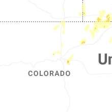
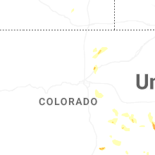


Connect with Interactive Hail Maps