

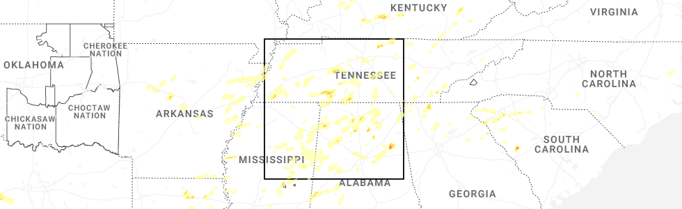
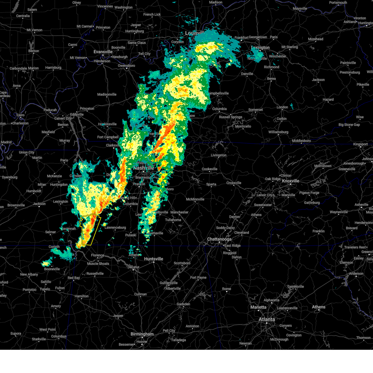
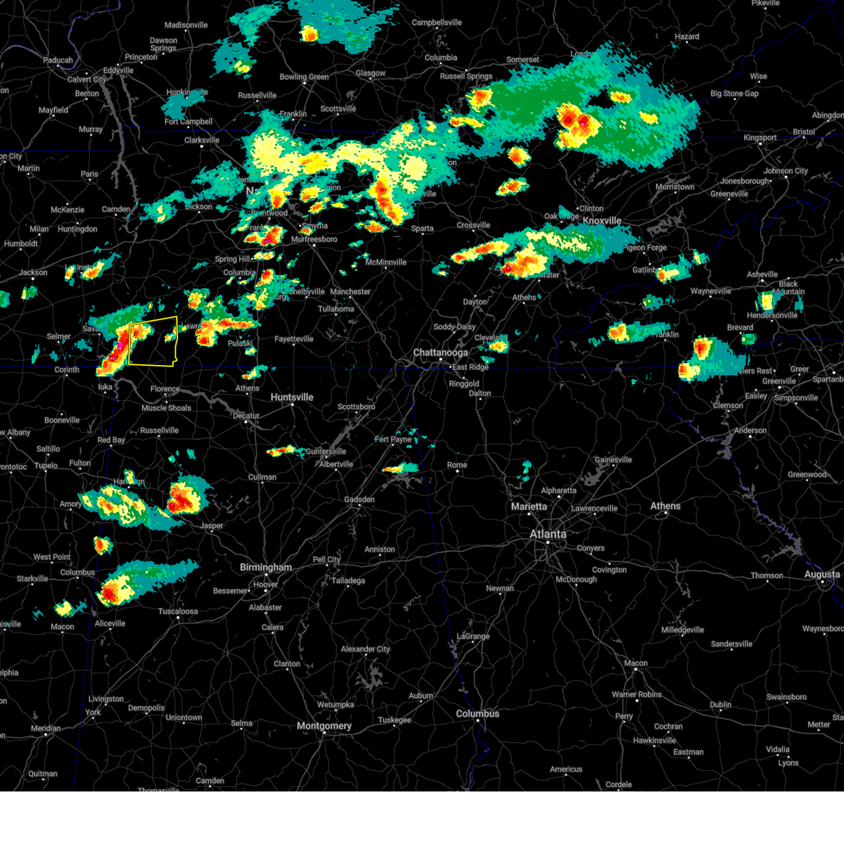
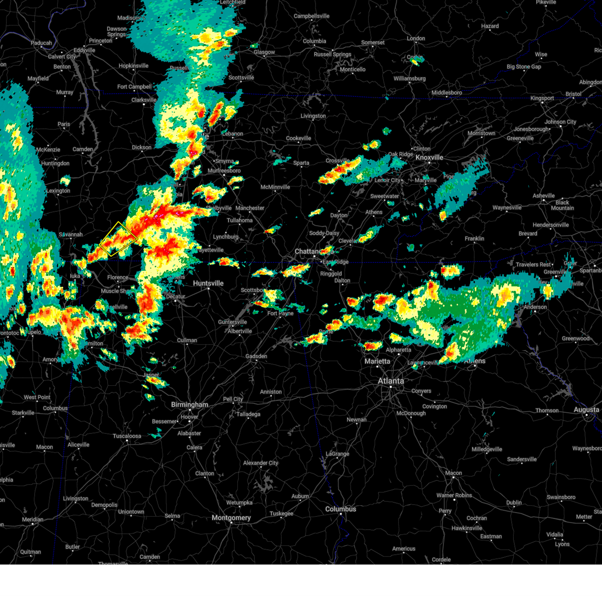
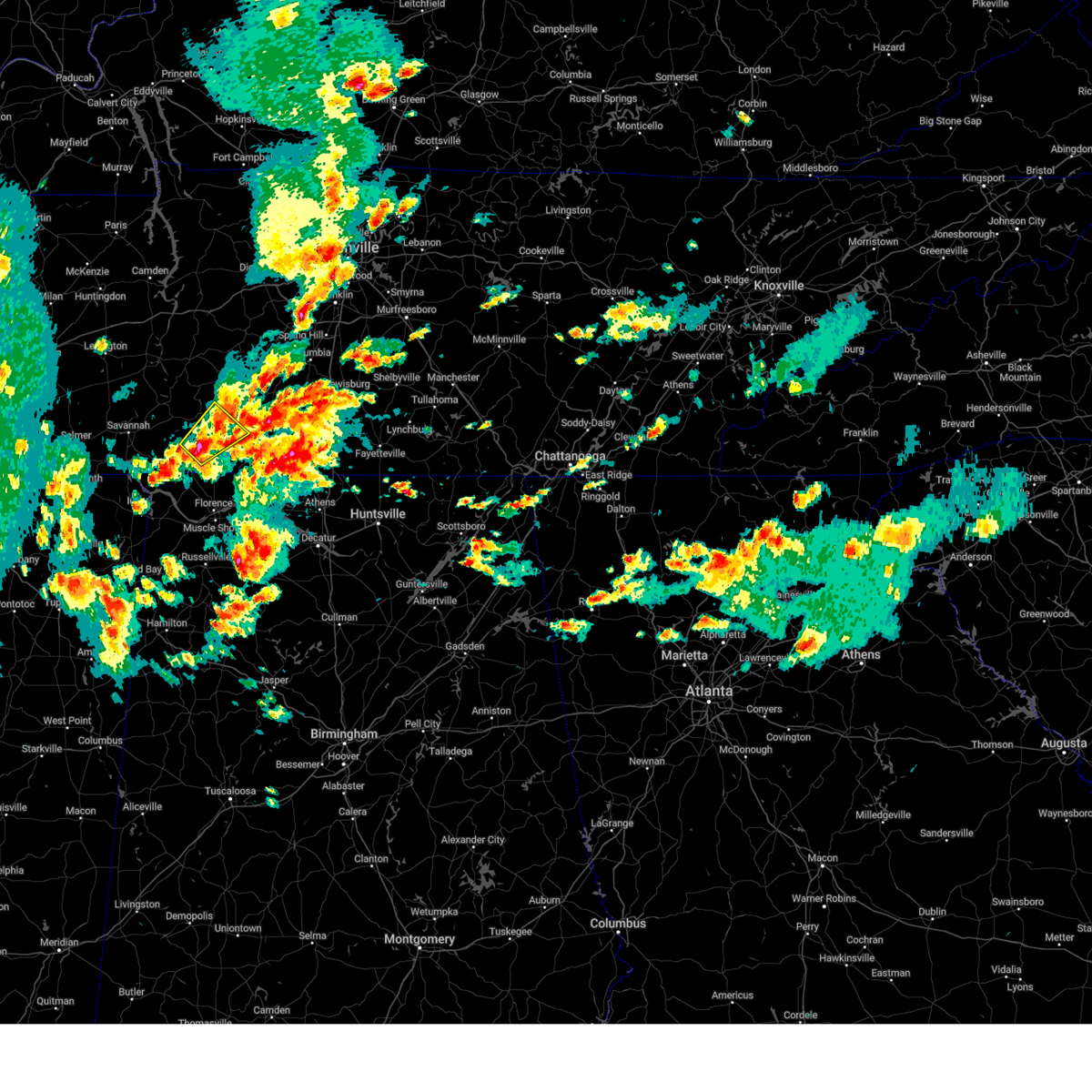
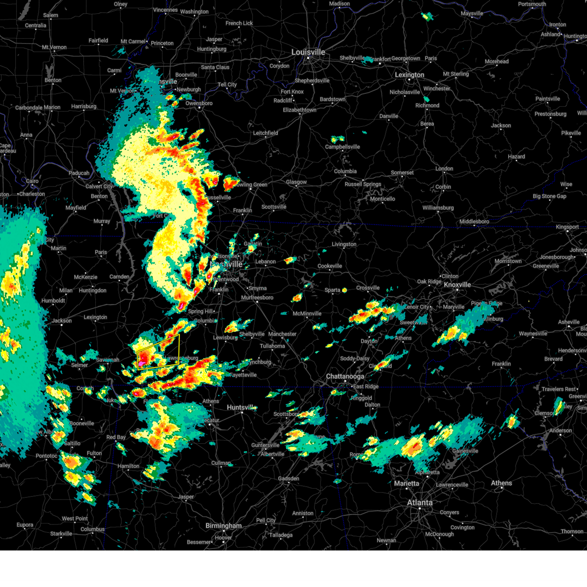
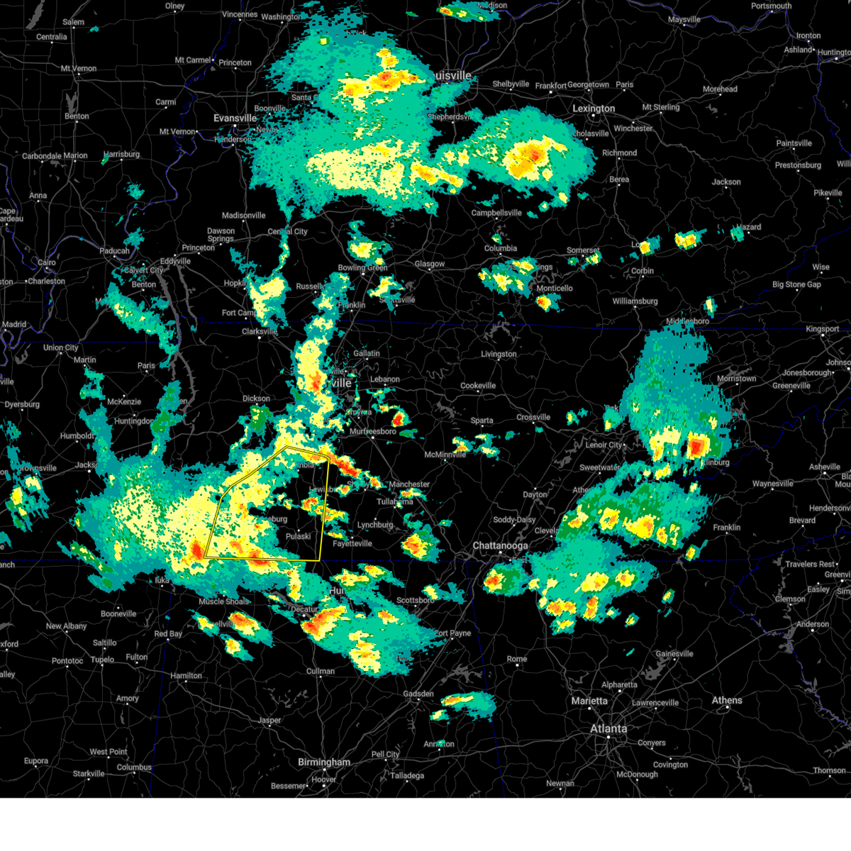
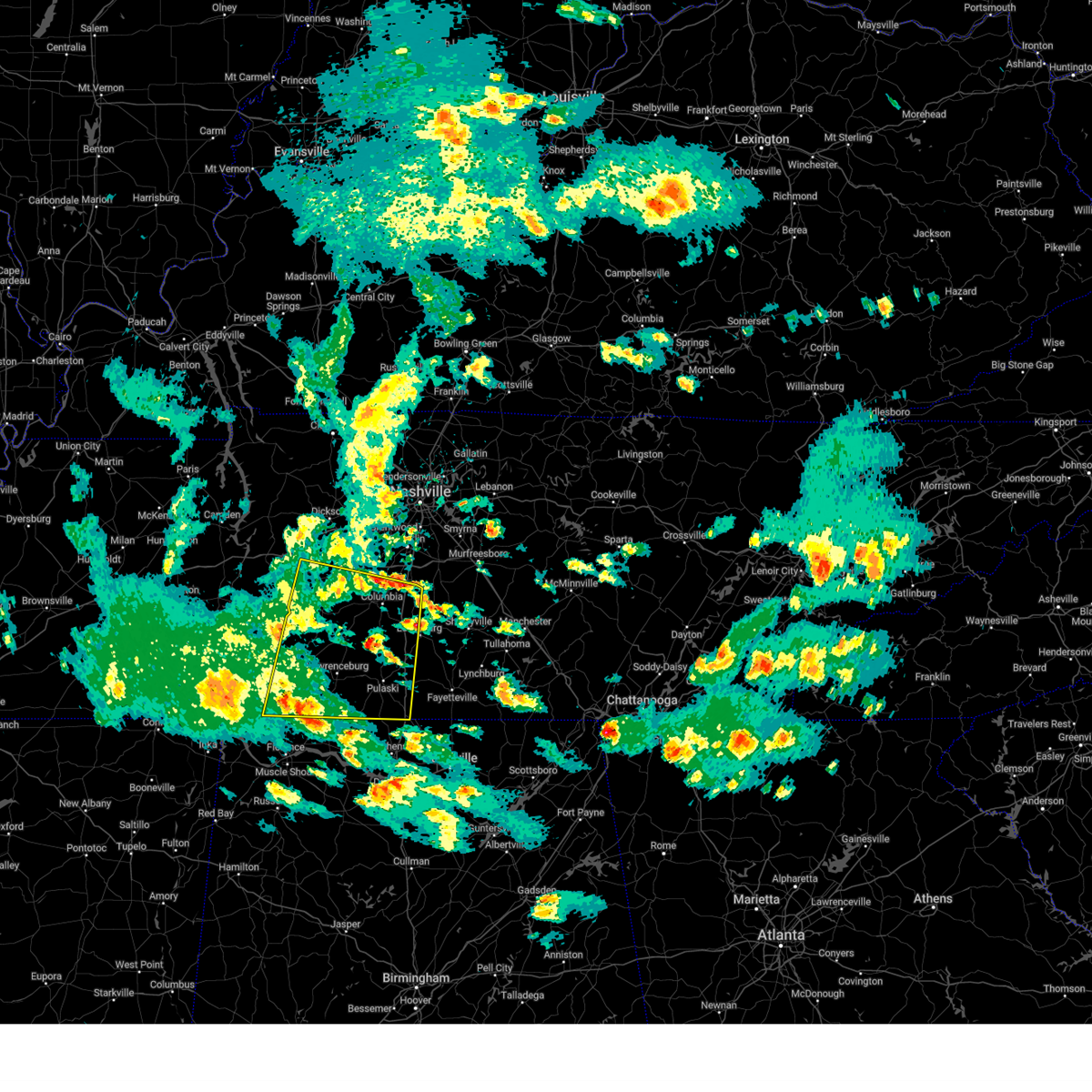
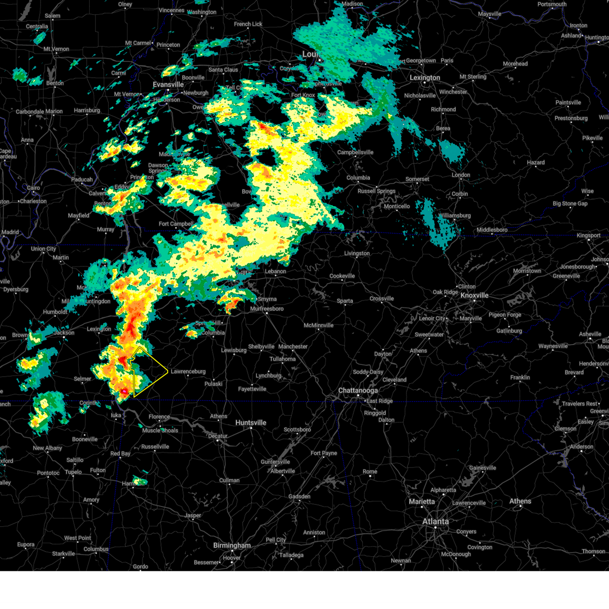
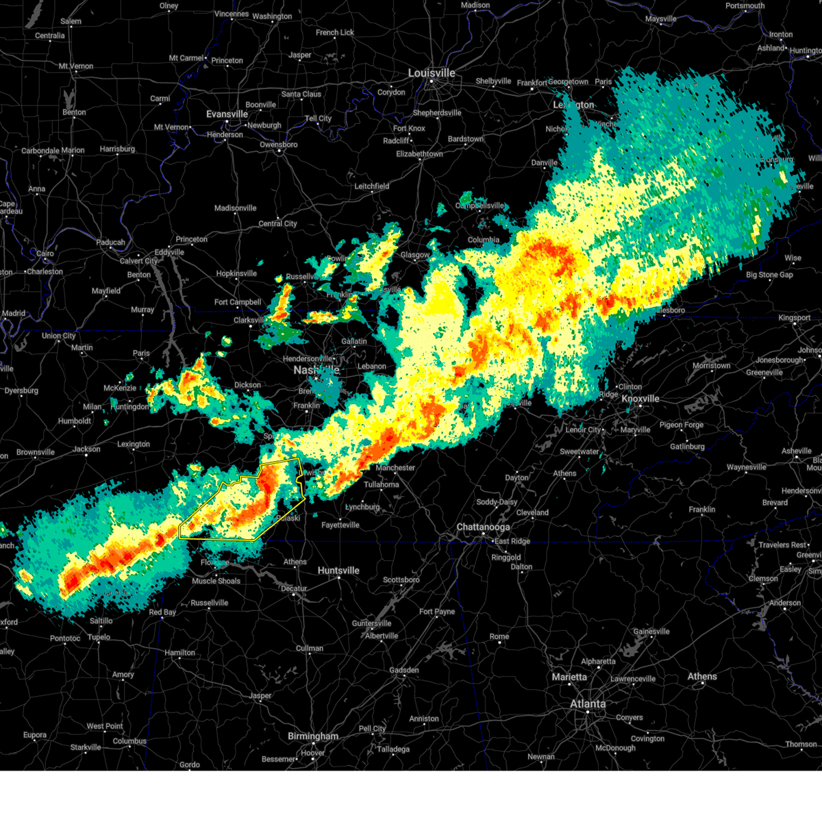
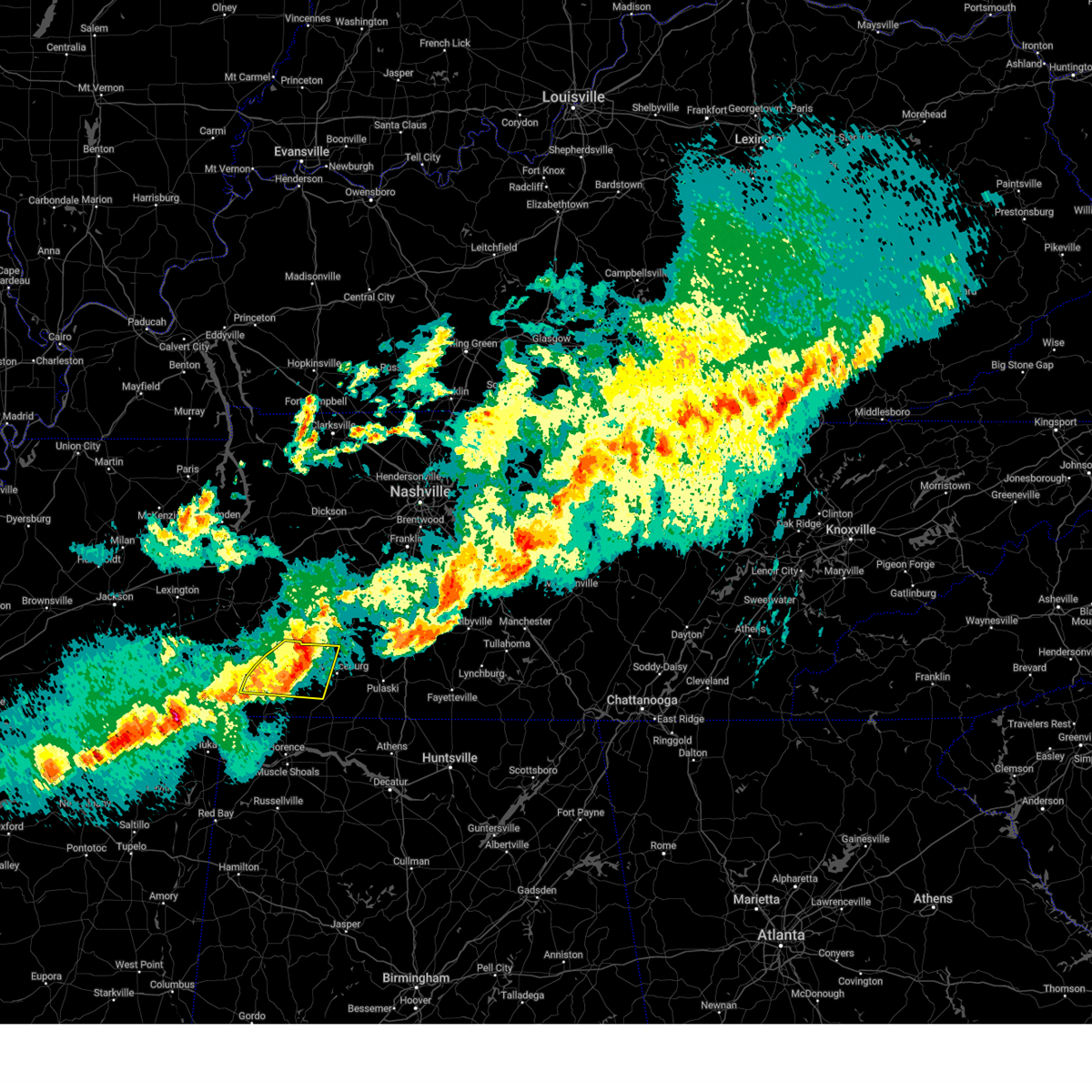
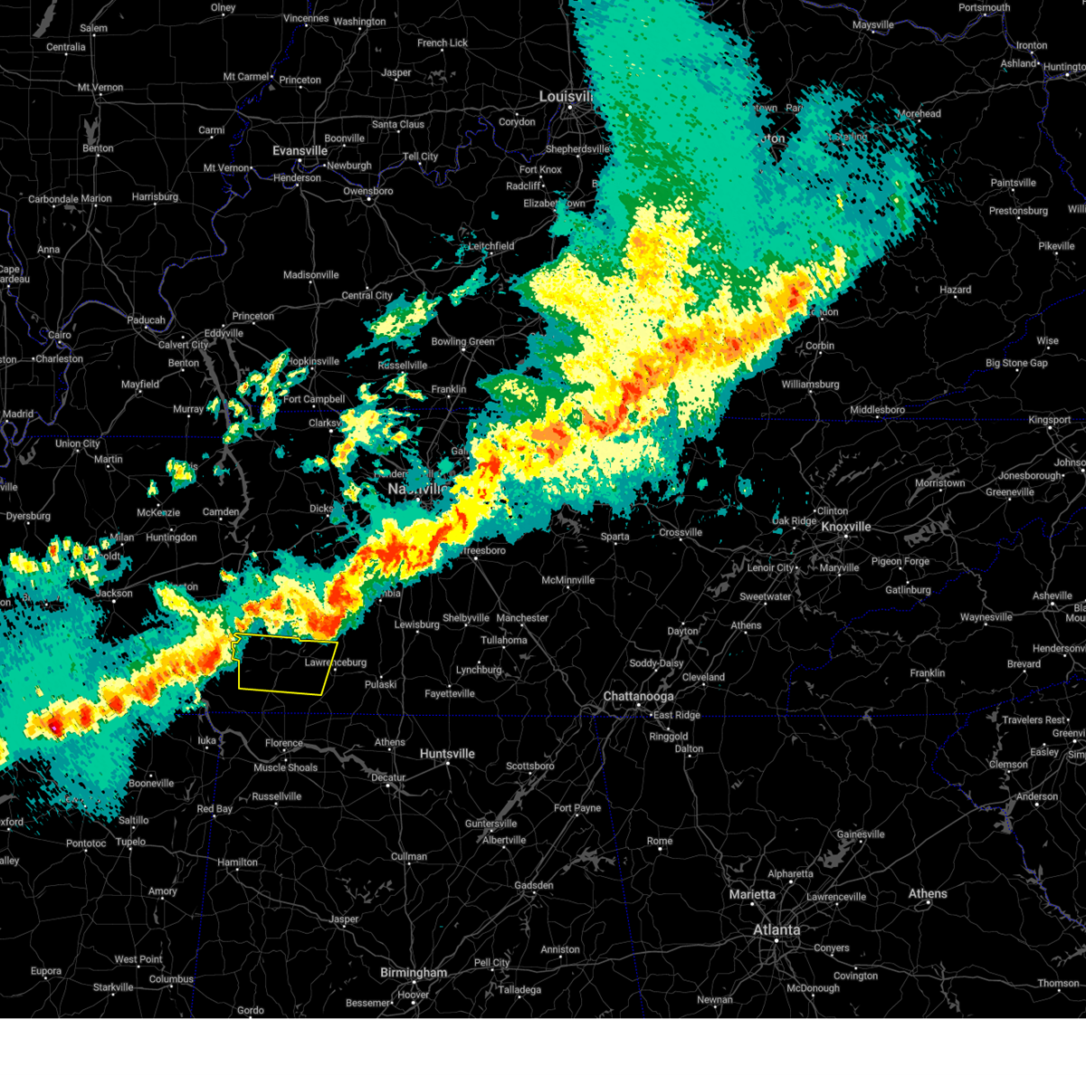
Hail Map for Collinwood, TN
The Collinwood, TN area has had 4 reports of on-the-ground hail by trained spotters, and has been under severe weather warnings 29 times during the past 12 months. Doppler radar has detected hail at or near Collinwood, TN on 66 occasions, including 4 occasions during the past year.
| Name: | Collinwood, TN |
| Where Located: | 25.7 miles N of Florence, AL |
| Map: | Google Map for Collinwood, TN |
| Population: | 982 |
| Housing Units: | 459 |
| More Info: | Search Google for Collinwood, TN |
5
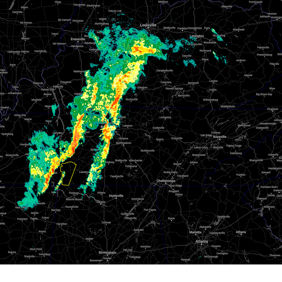
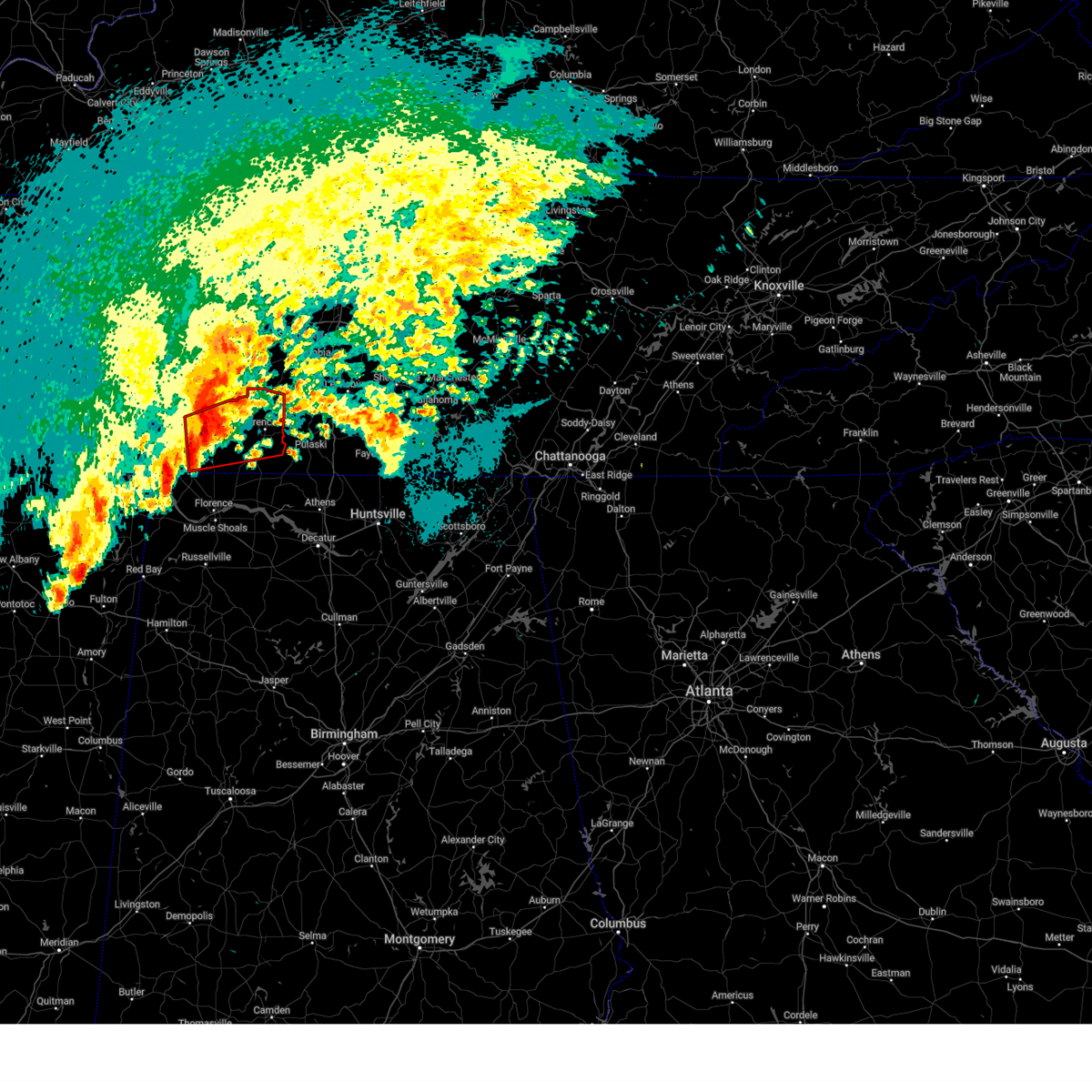
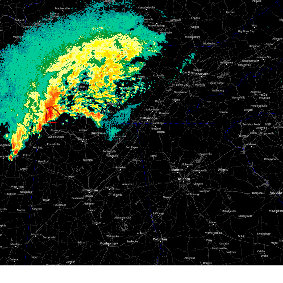
The Top Recent Hail Date for Collinwood, TN is Friday, May 2, 2025 (2nd out of 66)
Hail and Wind Damage Spotted near Collinwood, TN
| Date / Time | Report Details |
|---|---|
| 5/25/2025 2:43 PM CDT |
 At 242 pm cdt, severe thunderstorms were located along a line extending from 10 miles southeast of centerville to 8 miles west of lawrenceburg to 7 miles south of walnut grove, moving east at 55 mph (radar indicated). Hazards include 60 mph wind gusts. Expect damage to roofs, siding, and trees. locations impacted include, columbia, lawrenceburg, hohenwald, waynesboro, mount pleasant, loretto, collinwood, summertown, st. Joseph, ethridge, gordonsburg, henryville, kimmins, cypress inn, leoma, westpoint, iron city, hampshire, and williamsport. At 242 pm cdt, severe thunderstorms were located along a line extending from 10 miles southeast of centerville to 8 miles west of lawrenceburg to 7 miles south of walnut grove, moving east at 55 mph (radar indicated). Hazards include 60 mph wind gusts. Expect damage to roofs, siding, and trees. locations impacted include, columbia, lawrenceburg, hohenwald, waynesboro, mount pleasant, loretto, collinwood, summertown, st. Joseph, ethridge, gordonsburg, henryville, kimmins, cypress inn, leoma, westpoint, iron city, hampshire, and williamsport.
|
| 5/25/2025 2:43 PM CDT |
 the severe thunderstorm warning has been cancelled and is no longer in effect the severe thunderstorm warning has been cancelled and is no longer in effect
|
| 5/25/2025 2:21 PM CDT |
 Svrohx the national weather service in nashville has issued a * severe thunderstorm warning for, lewis county in middle tennessee, wayne county in middle tennessee, lawrence county in middle tennessee, southwestern maury county in middle tennessee, northwestern giles county in middle tennessee, southeastern perry county in middle tennessee, southern hickman county in middle tennessee, * until 300 pm cdt. * at 220 pm cdt, severe thunderstorms were located along a line extending from 11 miles west of centerville to near waynesboro to near pineflat, moving east at 55 mph (radar indicated). Hazards include 60 mph wind gusts. expect damage to roofs, siding, and trees Svrohx the national weather service in nashville has issued a * severe thunderstorm warning for, lewis county in middle tennessee, wayne county in middle tennessee, lawrence county in middle tennessee, southwestern maury county in middle tennessee, northwestern giles county in middle tennessee, southeastern perry county in middle tennessee, southern hickman county in middle tennessee, * until 300 pm cdt. * at 220 pm cdt, severe thunderstorms were located along a line extending from 11 miles west of centerville to near waynesboro to near pineflat, moving east at 55 mph (radar indicated). Hazards include 60 mph wind gusts. expect damage to roofs, siding, and trees
|
| 5/20/2025 10:36 AM CDT |
 The storms which prompted the warning have weakened below severe limits, and no longer pose an immediate threat to life or property. therefore, the warning will be allowed to expire. however, gusty winds are still possible with these thunderstorms. The storms which prompted the warning have weakened below severe limits, and no longer pose an immediate threat to life or property. therefore, the warning will be allowed to expire. however, gusty winds are still possible with these thunderstorms.
|
| 5/20/2025 10:30 AM CDT | Emergency manager reports several large trees down... as well as damage to a few sheds. from em and pictures... everything blown eas in wayne county TN, 4.8 miles ENE of Collinwood, TN |
| 5/20/2025 10:23 AM CDT |
 At 1022 am cdt, severe thunderstorms were located along a line extending from 10 miles northwest of waynesboro to near walnut grove, moving east at 45 mph (radar indicated). Hazards include 60 mph wind gusts. Expect damage to roofs, siding, and trees. Locations impacted include, cypress inn, clifton, collinwood, waynesboro, lutts, and flatwoods. At 1022 am cdt, severe thunderstorms were located along a line extending from 10 miles northwest of waynesboro to near walnut grove, moving east at 45 mph (radar indicated). Hazards include 60 mph wind gusts. Expect damage to roofs, siding, and trees. Locations impacted include, cypress inn, clifton, collinwood, waynesboro, lutts, and flatwoods.
|
| 5/20/2025 10:02 AM CDT |
 Svrohx the national weather service in nashville has issued a * severe thunderstorm warning for, wayne county in middle tennessee, * until 1045 am cdt. * at 1001 am cdt, severe thunderstorms were located along a line extending from 9 miles northwest of olive hill to near pickwick dam, moving east at 45 mph (radar indicated). Hazards include 60 mph wind gusts. expect damage to roofs, siding, and trees Svrohx the national weather service in nashville has issued a * severe thunderstorm warning for, wayne county in middle tennessee, * until 1045 am cdt. * at 1001 am cdt, severe thunderstorms were located along a line extending from 9 miles northwest of olive hill to near pickwick dam, moving east at 45 mph (radar indicated). Hazards include 60 mph wind gusts. expect damage to roofs, siding, and trees
|
| 5/8/2025 5:51 PM CDT |
 The storm which prompted the warning has weakened below severe limits, and no longer poses an immediate threat to life or property. therefore, the warning will be allowed to expire. however, small hail, gusty winds and heavy rain are still possible with this thunderstorm. a severe thunderstorm watch remains in effect until 800 pm cdt for middle tennessee. The storm which prompted the warning has weakened below severe limits, and no longer poses an immediate threat to life or property. therefore, the warning will be allowed to expire. however, small hail, gusty winds and heavy rain are still possible with this thunderstorm. a severe thunderstorm watch remains in effect until 800 pm cdt for middle tennessee.
|
| 5/8/2025 5:26 PM CDT |
 Svrohx the national weather service in nashville has issued a * severe thunderstorm warning for, wayne county in middle tennessee, * until 600 pm cdt. * at 525 pm cdt, a severe thunderstorm was located 7 miles south of olive hill, or 14 miles east of savannah, moving east at 35 mph (radar indicated). Hazards include 60 mph wind gusts and quarter size hail. Hail damage to vehicles is expected. Expect wind damage to roofs, siding, and trees. Svrohx the national weather service in nashville has issued a * severe thunderstorm warning for, wayne county in middle tennessee, * until 600 pm cdt. * at 525 pm cdt, a severe thunderstorm was located 7 miles south of olive hill, or 14 miles east of savannah, moving east at 35 mph (radar indicated). Hazards include 60 mph wind gusts and quarter size hail. Hail damage to vehicles is expected. Expect wind damage to roofs, siding, and trees.
|
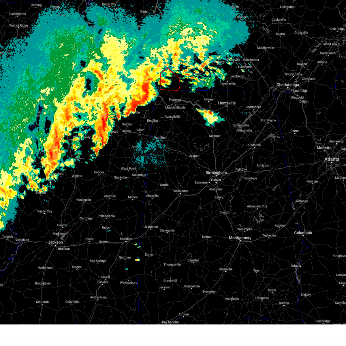
| 5/2/2025 1:20 PM CDT |
 the severe thunderstorm warning has been cancelled and is no longer in effect the severe thunderstorm warning has been cancelled and is no longer in effect
|
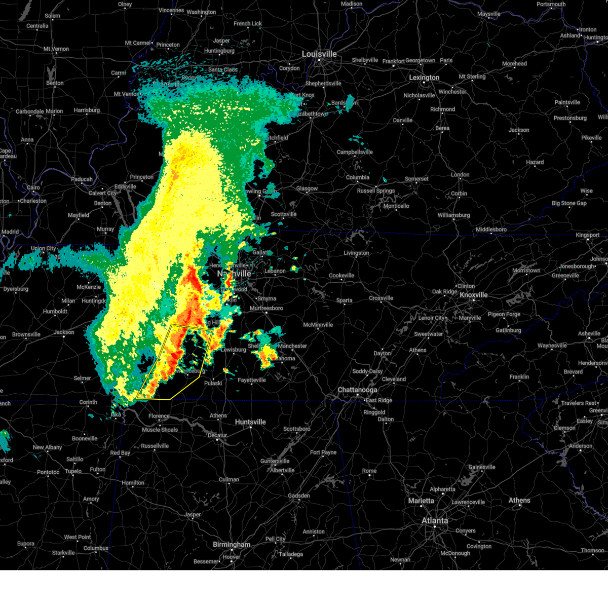
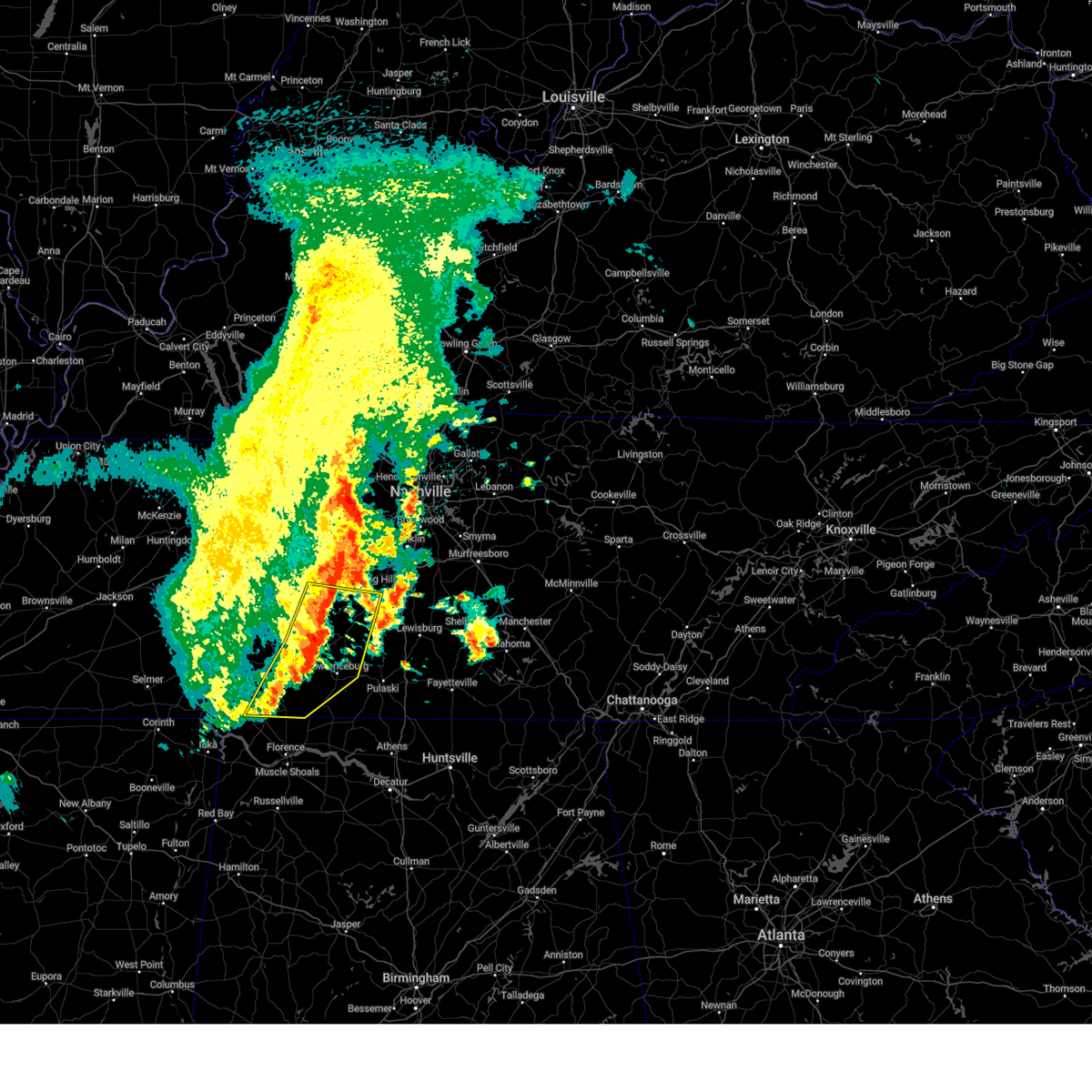
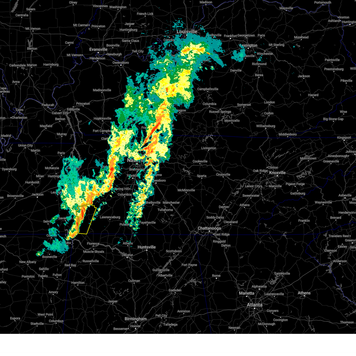
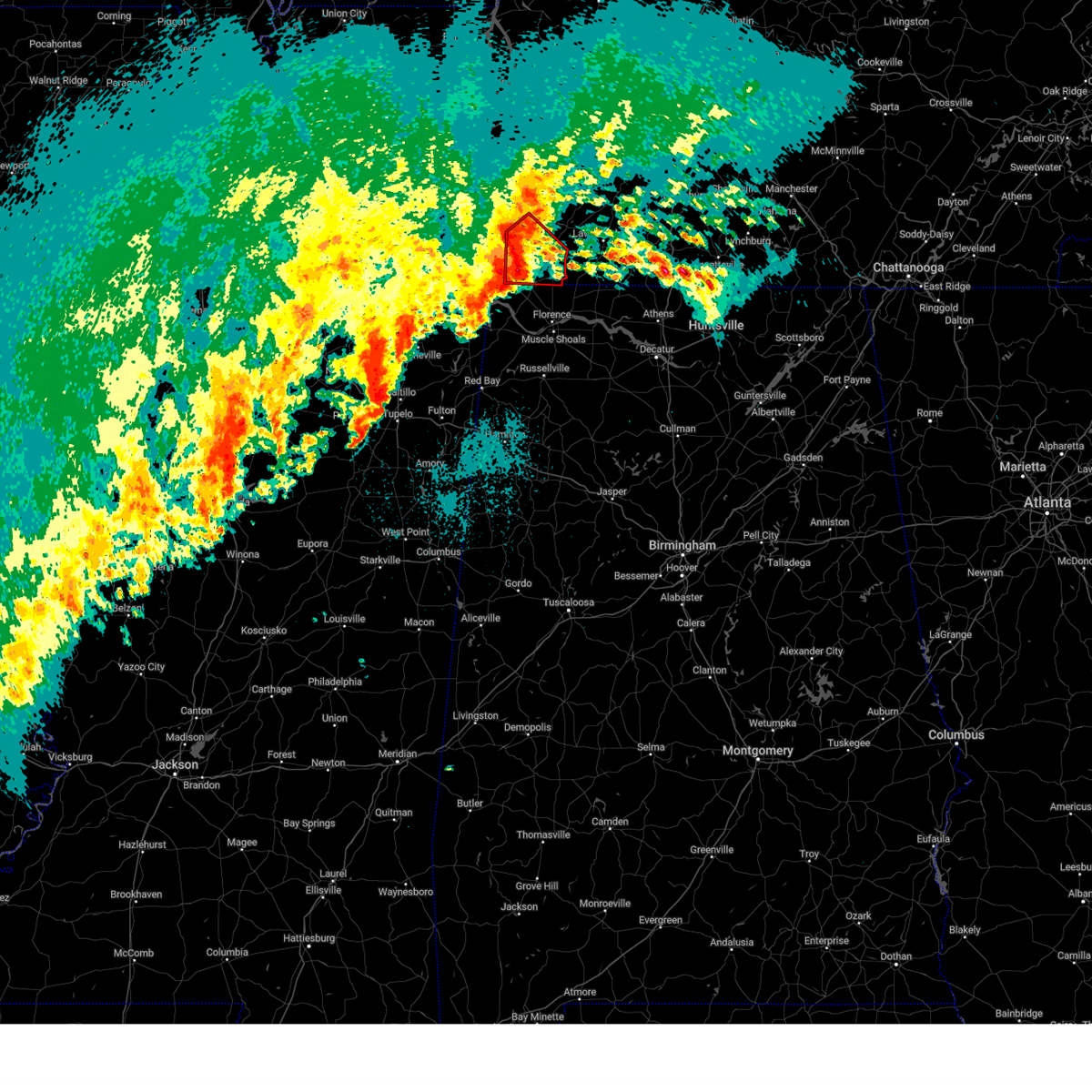
| 5/2/2025 1:05 PM CDT | Quarter sized hail reported 0.7 miles SSW of Collinwood, TN |
| 5/2/2025 1:01 PM CDT |
 Svrohx the national weather service in nashville has issued a * severe thunderstorm warning for, southeastern wayne county in middle tennessee, west central lawrence county in middle tennessee, * until 145 pm cdt. * at 101 pm cdt, a severe thunderstorm was located over collinwood, or 12 miles south of waynesboro, moving northeast at 20 mph (radar indicated). Hazards include 60 mph wind gusts and quarter size hail. Hail damage to vehicles is expected. Expect wind damage to roofs, siding, and trees. Svrohx the national weather service in nashville has issued a * severe thunderstorm warning for, southeastern wayne county in middle tennessee, west central lawrence county in middle tennessee, * until 145 pm cdt. * at 101 pm cdt, a severe thunderstorm was located over collinwood, or 12 miles south of waynesboro, moving northeast at 20 mph (radar indicated). Hazards include 60 mph wind gusts and quarter size hail. Hail damage to vehicles is expected. Expect wind damage to roofs, siding, and trees.
|
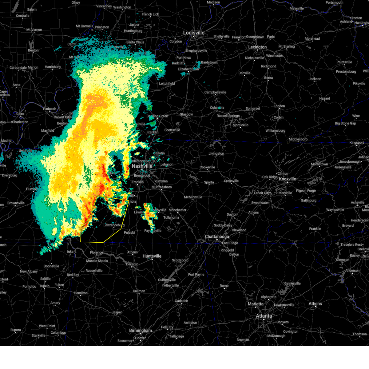
| 5/2/2025 12:39 PM CDT |
 Svrohx the national weather service in nashville has issued a * severe thunderstorm warning for, southeastern lewis county in middle tennessee, northeastern wayne county in middle tennessee, northwestern lawrence county in middle tennessee, * until 115 pm cdt. * at 1239 pm cdt, a severe thunderstorm was located near waynesboro, moving northeast at 35 mph (radar indicated). Hazards include golf ball size hail and 60 mph wind gusts. People and animals outdoors will be injured. expect hail damage to roofs, siding, windows, and vehicles. Expect wind damage to roofs, siding, and trees. Svrohx the national weather service in nashville has issued a * severe thunderstorm warning for, southeastern lewis county in middle tennessee, northeastern wayne county in middle tennessee, northwestern lawrence county in middle tennessee, * until 115 pm cdt. * at 1239 pm cdt, a severe thunderstorm was located near waynesboro, moving northeast at 35 mph (radar indicated). Hazards include golf ball size hail and 60 mph wind gusts. People and animals outdoors will be injured. expect hail damage to roofs, siding, windows, and vehicles. Expect wind damage to roofs, siding, and trees.
|
| 4/10/2025 5:26 PM CDT |
 At 525 pm cdt, severe thunderstorms were located along a line extending from 8 miles northwest of mount pleasant to near lexington, moving southeast at 35 mph (radar indicated). Hazards include 60 mph wind gusts. Expect damage to roofs, siding, and trees. locations impacted include, gordonsburg, henryville, culleoka, st. joseph, pulaski, goodspring, leoma, lynnville, frankewing, hampshire, williamsport, loretto, ethridge, mount pleasant, minor hill, cypress inn, collinwood, i-65 east of columbia, elkton, and lawrenceburg. This includes interstate 65 between mile markers 1 and 52. At 525 pm cdt, severe thunderstorms were located along a line extending from 8 miles northwest of mount pleasant to near lexington, moving southeast at 35 mph (radar indicated). Hazards include 60 mph wind gusts. Expect damage to roofs, siding, and trees. locations impacted include, gordonsburg, henryville, culleoka, st. joseph, pulaski, goodspring, leoma, lynnville, frankewing, hampshire, williamsport, loretto, ethridge, mount pleasant, minor hill, cypress inn, collinwood, i-65 east of columbia, elkton, and lawrenceburg. This includes interstate 65 between mile markers 1 and 52.
|
| 4/10/2025 5:26 PM CDT |
 the severe thunderstorm warning has been cancelled and is no longer in effect the severe thunderstorm warning has been cancelled and is no longer in effect
|
| 4/10/2025 5:11 PM CDT |
 Svrohx the national weather service in nashville has issued a * severe thunderstorm warning for, lewis county in middle tennessee, eastern wayne county in middle tennessee, western marshall county in middle tennessee, lawrence county in middle tennessee, maury county in middle tennessee, giles county in middle tennessee, southern hickman county in middle tennessee, * until 600 pm cdt. * at 511 pm cdt, severe thunderstorms were located along a line extending from 6 miles southeast of centerville to 8 miles southwest of loretto, moving southeast at 35 mph (radar indicated). Hazards include 60 mph wind gusts. expect damage to roofs, siding, and trees Svrohx the national weather service in nashville has issued a * severe thunderstorm warning for, lewis county in middle tennessee, eastern wayne county in middle tennessee, western marshall county in middle tennessee, lawrence county in middle tennessee, maury county in middle tennessee, giles county in middle tennessee, southern hickman county in middle tennessee, * until 600 pm cdt. * at 511 pm cdt, severe thunderstorms were located along a line extending from 6 miles southeast of centerville to 8 miles southwest of loretto, moving southeast at 35 mph (radar indicated). Hazards include 60 mph wind gusts. expect damage to roofs, siding, and trees
|
| 4/5/2025 9:08 PM CDT |
 Torohx the national weather service in nashville has issued a * tornado warning for, southeastern wayne county in middle tennessee, lawrence county in middle tennessee, * until 1015 pm cdt. * at 907 pm cdt, a severe thunderstorm capable of producing a tornado was located near collinwood, or 9 miles southeast of waynesboro, moving east at 35 mph (radar indicated rotation). Hazards include tornado. Flying debris will be dangerous to those caught without shelter. mobile homes will be damaged or destroyed. damage to roofs, windows, and vehicles will occur. tree damage is likely. this dangerous storm will be near, lawrenceburg around 930 pm cdt. Other locations impacted by this tornadic thunderstorm include ethridge, henryville, leoma, and westpoint. Torohx the national weather service in nashville has issued a * tornado warning for, southeastern wayne county in middle tennessee, lawrence county in middle tennessee, * until 1015 pm cdt. * at 907 pm cdt, a severe thunderstorm capable of producing a tornado was located near collinwood, or 9 miles southeast of waynesboro, moving east at 35 mph (radar indicated rotation). Hazards include tornado. Flying debris will be dangerous to those caught without shelter. mobile homes will be damaged or destroyed. damage to roofs, windows, and vehicles will occur. tree damage is likely. this dangerous storm will be near, lawrenceburg around 930 pm cdt. Other locations impacted by this tornadic thunderstorm include ethridge, henryville, leoma, and westpoint.
|
| 4/5/2025 9:04 PM CDT |
 At 904 pm cdt, a severe thunderstorm capable of producing a tornado was located near collinwood, or 8 miles southeast of waynesboro, moving east at 35 mph (radar indicated rotation). Hazards include tornado. Flying debris will be dangerous to those caught without shelter. mobile homes will be damaged or destroyed. damage to roofs, windows, and vehicles will occur. tree damage is likely. This tornadic thunderstorm will remain over mainly rural areas of southeastern wayne county, including the following locations, cypress inn. At 904 pm cdt, a severe thunderstorm capable of producing a tornado was located near collinwood, or 8 miles southeast of waynesboro, moving east at 35 mph (radar indicated rotation). Hazards include tornado. Flying debris will be dangerous to those caught without shelter. mobile homes will be damaged or destroyed. damage to roofs, windows, and vehicles will occur. tree damage is likely. This tornadic thunderstorm will remain over mainly rural areas of southeastern wayne county, including the following locations, cypress inn.
|
| 4/5/2025 8:44 PM CDT |
 At 843 pm cdt, a severe thunderstorm capable of producing a tornado was located 8 miles west of collinwood, or 14 miles southwest of waynesboro, moving northeast at 40 mph (radar indicated rotation). Hazards include tornado. Flying debris will be dangerous to those caught without shelter. mobile homes will be damaged or destroyed. damage to roofs, windows, and vehicles will occur. tree damage is likely. this dangerous storm will be near, collinwood around 850 pm cdt. Other locations impacted by this tornadic thunderstorm include cypress inn and lutts. At 843 pm cdt, a severe thunderstorm capable of producing a tornado was located 8 miles west of collinwood, or 14 miles southwest of waynesboro, moving northeast at 40 mph (radar indicated rotation). Hazards include tornado. Flying debris will be dangerous to those caught without shelter. mobile homes will be damaged or destroyed. damage to roofs, windows, and vehicles will occur. tree damage is likely. this dangerous storm will be near, collinwood around 850 pm cdt. Other locations impacted by this tornadic thunderstorm include cypress inn and lutts.
|
| 4/5/2025 8:17 PM CDT |
 Torohx the national weather service in nashville has issued a * tornado warning for, wayne county in middle tennessee, * until 915 pm cdt. * at 817 pm cdt, a severe thunderstorm capable of producing a tornado was located near pickwick landing state park, moving northeast at 45 mph (radar indicated rotation). Hazards include tornado. Flying debris will be dangerous to those caught without shelter. mobile homes will be damaged or destroyed. damage to roofs, windows, and vehicles will occur. tree damage is likely. this dangerous storm will be near, collinwood around 850 pm cdt. waynesboro around 855 pm cdt. Other locations impacted by this tornadic thunderstorm include cypress inn and lutts. Torohx the national weather service in nashville has issued a * tornado warning for, wayne county in middle tennessee, * until 915 pm cdt. * at 817 pm cdt, a severe thunderstorm capable of producing a tornado was located near pickwick landing state park, moving northeast at 45 mph (radar indicated rotation). Hazards include tornado. Flying debris will be dangerous to those caught without shelter. mobile homes will be damaged or destroyed. damage to roofs, windows, and vehicles will occur. tree damage is likely. this dangerous storm will be near, collinwood around 850 pm cdt. waynesboro around 855 pm cdt. Other locations impacted by this tornadic thunderstorm include cypress inn and lutts.
|
| 4/3/2025 5:36 PM CDT |
 At 536 pm cdt, a confirmed tornado was located near waynesboro, moving northeast at 55 mph (weather spotters confirmed tornado). Hazards include damaging tornado. Flying debris will be dangerous to those caught without shelter. mobile homes will be damaged or destroyed. damage to roofs, windows, and vehicles will occur. tree damage is likely. This tornadic thunderstorm will remain over mainly rural areas of southwestern lewis, northeastern wayne and northwestern lawrence counties. At 536 pm cdt, a confirmed tornado was located near waynesboro, moving northeast at 55 mph (weather spotters confirmed tornado). Hazards include damaging tornado. Flying debris will be dangerous to those caught without shelter. mobile homes will be damaged or destroyed. damage to roofs, windows, and vehicles will occur. tree damage is likely. This tornadic thunderstorm will remain over mainly rural areas of southwestern lewis, northeastern wayne and northwestern lawrence counties.
|
| 4/3/2025 5:26 PM CDT |
 Torohx the national weather service in nashville has issued a * tornado warning for, southwestern lewis county in middle tennessee, central wayne county in middle tennessee, northwestern lawrence county in middle tennessee, * until 600 pm cdt. * at 526 pm cdt, a severe thunderstorm capable of producing a tornado was located near collinwood, or 10 miles southwest of waynesboro, moving northeast at 55 mph (radar indicated rotation). Hazards include tornado. Flying debris will be dangerous to those caught without shelter. mobile homes will be damaged or destroyed. damage to roofs, windows, and vehicles will occur. tree damage is likely. this dangerous storm will be near, collinwood around 530 pm cdt. Other locations impacted by this tornadic thunderstorm include lutts. Torohx the national weather service in nashville has issued a * tornado warning for, southwestern lewis county in middle tennessee, central wayne county in middle tennessee, northwestern lawrence county in middle tennessee, * until 600 pm cdt. * at 526 pm cdt, a severe thunderstorm capable of producing a tornado was located near collinwood, or 10 miles southwest of waynesboro, moving northeast at 55 mph (radar indicated rotation). Hazards include tornado. Flying debris will be dangerous to those caught without shelter. mobile homes will be damaged or destroyed. damage to roofs, windows, and vehicles will occur. tree damage is likely. this dangerous storm will be near, collinwood around 530 pm cdt. Other locations impacted by this tornadic thunderstorm include lutts.
|
| 4/3/2025 5:09 PM CDT |
 Svrohx the national weather service in nashville has issued a * severe thunderstorm warning for, central wayne county in middle tennessee, south central perry county in middle tennessee, * until 545 pm cdt. * at 509 pm cdt, a severe thunderstorm was located near walnut grove, or 7 miles northeast of pickwick landing state park, moving northeast at 45 mph (radar indicated). Hazards include 60 mph wind gusts and quarter size hail. Hail damage to vehicles is expected. Expect wind damage to roofs, siding, and trees. Svrohx the national weather service in nashville has issued a * severe thunderstorm warning for, central wayne county in middle tennessee, south central perry county in middle tennessee, * until 545 pm cdt. * at 509 pm cdt, a severe thunderstorm was located near walnut grove, or 7 miles northeast of pickwick landing state park, moving northeast at 45 mph (radar indicated). Hazards include 60 mph wind gusts and quarter size hail. Hail damage to vehicles is expected. Expect wind damage to roofs, siding, and trees.
|
| 4/2/2025 6:02 PM CDT |
 Svrohx the national weather service in nashville has issued a * severe thunderstorm warning for, wayne county in middle tennessee, northern lawrence county in middle tennessee, * until 645 pm cdt. * at 602 pm cdt, a severe thunderstorm was located near collinwood, or 15 miles south of waynesboro, moving northeast at 45 mph (radar indicated). Hazards include 60 mph wind gusts and quarter size hail. Hail damage to vehicles is expected. Expect wind damage to roofs, siding, and trees. Svrohx the national weather service in nashville has issued a * severe thunderstorm warning for, wayne county in middle tennessee, northern lawrence county in middle tennessee, * until 645 pm cdt. * at 602 pm cdt, a severe thunderstorm was located near collinwood, or 15 miles south of waynesboro, moving northeast at 45 mph (radar indicated). Hazards include 60 mph wind gusts and quarter size hail. Hail damage to vehicles is expected. Expect wind damage to roofs, siding, and trees.
|
| 3/31/2025 1:52 AM CDT | Svrohx the national weather service in nashville has issued a * severe thunderstorm warning for, southeastern wayne county in middle tennessee, lawrence county in middle tennessee, * until 230 am cdt. * at 152 am cdt, a severe thunderstorm was located near collinwood, or 17 miles south of waynesboro, moving east at 35 mph (radar indicated). Hazards include 60 mph wind gusts and penny size hail. expect damage to roofs, siding, and trees |
| 3/31/2025 1:31 AM CDT | At 129 am cdt, severe thunderstorms were located along a line extending from 11 miles southeast of mount pleasant to 8 miles north of pulaski to 10 miles southeast of lawrenceburg, moving east at 45 mph (radar indicated). Hazards include 60 mph wind gusts and penny size hail. Expect damage to roofs, siding, and trees. locations impacted include, lawrenceburg, loretto, ethridge, leoma, lynnville, westpoint, iron city, culleoka, cypress inn, collinwood, st. joseph, and pulaski. This includes interstate 65 near mile marker 22. |
| 3/31/2025 1:17 AM CDT |
 the severe thunderstorm warning has been cancelled and is no longer in effect the severe thunderstorm warning has been cancelled and is no longer in effect
|
| 3/31/2025 1:17 AM CDT |
 At 117 am cdt, severe thunderstorms were located along a line extending from 6 miles east of summertown to 9 miles northeast of lawrenceburg to 6 miles northeast of loretto, moving east at 45 mph (radar indicated). Hazards include 60 mph wind gusts and penny size hail. Expect damage to roofs, siding, and trees. locations impacted include, loretto, ethridge, henryville, mount pleasant, culleoka, cypress inn, collinwood, st. joseph, lawrenceburg, leoma, lynnville, westpoint, summertown, iron city, pulaski, and columbia. This includes interstate 65 near mile marker 22. At 117 am cdt, severe thunderstorms were located along a line extending from 6 miles east of summertown to 9 miles northeast of lawrenceburg to 6 miles northeast of loretto, moving east at 45 mph (radar indicated). Hazards include 60 mph wind gusts and penny size hail. Expect damage to roofs, siding, and trees. locations impacted include, loretto, ethridge, henryville, mount pleasant, culleoka, cypress inn, collinwood, st. joseph, lawrenceburg, leoma, lynnville, westpoint, summertown, iron city, pulaski, and columbia. This includes interstate 65 near mile marker 22.
|
| 3/31/2025 12:56 AM CDT | Svrohx the national weather service in nashville has issued a * severe thunderstorm warning for, southeastern lewis county in middle tennessee, southern wayne county in middle tennessee, lawrence county in middle tennessee, southwestern maury county in middle tennessee, northern giles county in middle tennessee, * until 145 am cdt. * at 1255 am cdt, severe thunderstorms were located along a line extending from 9 miles west of summertown to 8 miles west of lawrenceburg to 6 miles southeast of collinwood, moving east at 45 mph (radar indicated). Hazards include 60 mph wind gusts and penny size hail. expect damage to roofs, siding, and trees |
| 3/31/2025 12:49 AM CDT |
 At 1248 am cdt, a severe thunderstorm was located 9 miles west of lawrenceburg, moving east at 40 mph (radar indicated). Hazards include 60 mph wind gusts and penny size hail. Expect damage to roofs, siding, and trees. Locations impacted include, collinwood, henryville, westpoint, waynesboro, lutts, and lawrenceburg. At 1248 am cdt, a severe thunderstorm was located 9 miles west of lawrenceburg, moving east at 40 mph (radar indicated). Hazards include 60 mph wind gusts and penny size hail. Expect damage to roofs, siding, and trees. Locations impacted include, collinwood, henryville, westpoint, waynesboro, lutts, and lawrenceburg.
|
| 3/31/2025 12:02 AM CDT |
 Svrohx the national weather service in nashville has issued a * severe thunderstorm warning for, wayne county in middle tennessee, western lawrence county in middle tennessee, * until 100 am cdt. * at 1201 am cdt, a severe thunderstorm was located near olive hill, or 10 miles northeast of savannah, moving east at 40 mph (radar indicated). Hazards include 60 mph wind gusts and penny size hail. expect damage to roofs, siding, and trees Svrohx the national weather service in nashville has issued a * severe thunderstorm warning for, wayne county in middle tennessee, western lawrence county in middle tennessee, * until 100 am cdt. * at 1201 am cdt, a severe thunderstorm was located near olive hill, or 10 miles northeast of savannah, moving east at 40 mph (radar indicated). Hazards include 60 mph wind gusts and penny size hail. expect damage to roofs, siding, and trees
|
| 5/27/2024 2:26 AM CDT |
 At 226 am cdt, severe thunderstorms were located along a line extending from 7 miles east of waynesboro to 10 miles northwest of underwood-petersville, moving east at 50 mph (radar indicated). Hazards include 60 mph wind gusts. Expect damage to roofs, siding, and trees. locations impacted include, lawrenceburg, waynesboro, loretto, collinwood, clifton, st. Joseph, ethridge, leoma, westpoint, iron city, cypress inn, and lutts. At 226 am cdt, severe thunderstorms were located along a line extending from 7 miles east of waynesboro to 10 miles northwest of underwood-petersville, moving east at 50 mph (radar indicated). Hazards include 60 mph wind gusts. Expect damage to roofs, siding, and trees. locations impacted include, lawrenceburg, waynesboro, loretto, collinwood, clifton, st. Joseph, ethridge, leoma, westpoint, iron city, cypress inn, and lutts.
|
| 5/27/2024 2:26 AM CDT |
 the severe thunderstorm warning has been cancelled and is no longer in effect the severe thunderstorm warning has been cancelled and is no longer in effect
|
| 5/27/2024 2:11 AM CDT |
 At 210 am cdt, severe thunderstorms were located along a line extending from waynesboro to near j p coleman state park, moving east at 50 mph (radar indicated). Hazards include 60 mph wind gusts and penny size hail. Expect damage to roofs, siding, and trees. locations impacted include, lawrenceburg, waynesboro, loretto, collinwood, summertown, clifton, st. Joseph, ethridge, henryville, cypress inn, flatwoods, lutts, leoma, westpoint, and iron city. At 210 am cdt, severe thunderstorms were located along a line extending from waynesboro to near j p coleman state park, moving east at 50 mph (radar indicated). Hazards include 60 mph wind gusts and penny size hail. Expect damage to roofs, siding, and trees. locations impacted include, lawrenceburg, waynesboro, loretto, collinwood, summertown, clifton, st. Joseph, ethridge, henryville, cypress inn, flatwoods, lutts, leoma, westpoint, and iron city.
|
| 5/27/2024 1:59 AM CDT |
 the severe thunderstorm warning has been cancelled and is no longer in effect the severe thunderstorm warning has been cancelled and is no longer in effect
|
| 5/27/2024 1:59 AM CDT |
 At 159 am cdt, severe thunderstorms were located along a line extending from linden to pickwick dam, moving east at 50 mph (radar indicated). Hazards include 70 mph wind gusts and penny size hail. Expect considerable tree damage. damage is likely to mobile homes, roofs, and outbuildings. locations impacted include, lawrenceburg, waynesboro, loretto, collinwood, summertown, clifton, st. Joseph, ethridge, henryville, cypress inn, flatwoods, lutts, leoma, westpoint, and iron city. At 159 am cdt, severe thunderstorms were located along a line extending from linden to pickwick dam, moving east at 50 mph (radar indicated). Hazards include 70 mph wind gusts and penny size hail. Expect considerable tree damage. damage is likely to mobile homes, roofs, and outbuildings. locations impacted include, lawrenceburg, waynesboro, loretto, collinwood, summertown, clifton, st. Joseph, ethridge, henryville, cypress inn, flatwoods, lutts, leoma, westpoint, and iron city.
|
| 5/27/2024 1:36 AM CDT |
 Svrohx the national weather service in nashville has issued a * severe thunderstorm warning for, lewis county in middle tennessee, wayne county in middle tennessee, lawrence county in middle tennessee, southwestern maury county in middle tennessee, perry county in middle tennessee, southwestern hickman county in middle tennessee, * until 245 am cdt. * at 135 am cdt, severe thunderstorms were located along a line extending from near parsons to near corinth, moving east at 50 mph (radar indicated). Hazards include 70 mph wind gusts and penny size hail. Expect considerable tree damage. Damage is likely to mobile homes, roofs, and outbuildings. Svrohx the national weather service in nashville has issued a * severe thunderstorm warning for, lewis county in middle tennessee, wayne county in middle tennessee, lawrence county in middle tennessee, southwestern maury county in middle tennessee, perry county in middle tennessee, southwestern hickman county in middle tennessee, * until 245 am cdt. * at 135 am cdt, severe thunderstorms were located along a line extending from near parsons to near corinth, moving east at 50 mph (radar indicated). Hazards include 70 mph wind gusts and penny size hail. Expect considerable tree damage. Damage is likely to mobile homes, roofs, and outbuildings.
|
| 3/14/2024 8:13 PM CDT |
 Svrohx the national weather service in nashville has issued a * severe thunderstorm warning for, southeastern wayne county in middle tennessee, lawrence county in middle tennessee, * until 900 pm cdt. * at 813 pm cdt, a severe thunderstorm was located 9 miles southeast of collinwood, or 15 miles north of florence, moving northeast at 55 mph (radar indicated). Hazards include 60 mph wind gusts and nickel size hail. expect damage to roofs, siding, and trees Svrohx the national weather service in nashville has issued a * severe thunderstorm warning for, southeastern wayne county in middle tennessee, lawrence county in middle tennessee, * until 900 pm cdt. * at 813 pm cdt, a severe thunderstorm was located 9 miles southeast of collinwood, or 15 miles north of florence, moving northeast at 55 mph (radar indicated). Hazards include 60 mph wind gusts and nickel size hail. expect damage to roofs, siding, and trees
|
| 12/9/2023 5:57 PM CST |
 At 557 pm cst, a severe thunderstorm capable of producing a tornado was located near waynesboro, moving east at 45 mph (radar indicated rotation). Hazards include tornado. Flying debris will be dangerous to those caught without shelter. mobile homes will be damaged or destroyed. damage to roofs, windows, and vehicles will occur. tree damage is likely. this dangerous storm will be near, lawrenceburg around 620 pm cst. Other locations impacted by this tornadic thunderstorm include ethridge and henryville. At 557 pm cst, a severe thunderstorm capable of producing a tornado was located near waynesboro, moving east at 45 mph (radar indicated rotation). Hazards include tornado. Flying debris will be dangerous to those caught without shelter. mobile homes will be damaged or destroyed. damage to roofs, windows, and vehicles will occur. tree damage is likely. this dangerous storm will be near, lawrenceburg around 620 pm cst. Other locations impacted by this tornadic thunderstorm include ethridge and henryville.
|
| 12/9/2023 5:28 PM CST |
 At 528 pm cst, a severe thunderstorm was located 7 miles north of walnut grove, or 13 miles east of savannah, moving northeast at 40 mph (radar indicated). Hazards include 60 mph wind gusts and quarter size hail. Hail damage to vehicles is expected. Expect wind damage to roofs, siding, and trees. At 528 pm cst, a severe thunderstorm was located 7 miles north of walnut grove, or 13 miles east of savannah, moving northeast at 40 mph (radar indicated). Hazards include 60 mph wind gusts and quarter size hail. Hail damage to vehicles is expected. Expect wind damage to roofs, siding, and trees.
|
| 12/9/2023 4:24 PM CST |
 At 424 pm cst, severe thunderstorms were located along a line extending from hurricane mills to near big hill pond state park, moving northeast at 45 mph (radar indicated). Hazards include 60 mph wind gusts and quarter size hail. Hail damage to vehicles is expected. Expect wind damage to roofs, siding, and trees. At 424 pm cst, severe thunderstorms were located along a line extending from hurricane mills to near big hill pond state park, moving northeast at 45 mph (radar indicated). Hazards include 60 mph wind gusts and quarter size hail. Hail damage to vehicles is expected. Expect wind damage to roofs, siding, and trees.
|
| 8/26/2023 6:12 PM CDT |
 The severe thunderstorm warning for lewis, wayne, northern lawrence, southwestern maury and southern perry counties will expire at 615 pm cdt, the storms which prompted the warning have weakened below severe limits, and no longer pose an immediate threat to life or property. therefore, the warning will be allowed to expire. to report severe weather, contact your nearest law enforcement agency. they will relay your report to the national weather service nashville. The severe thunderstorm warning for lewis, wayne, northern lawrence, southwestern maury and southern perry counties will expire at 615 pm cdt, the storms which prompted the warning have weakened below severe limits, and no longer pose an immediate threat to life or property. therefore, the warning will be allowed to expire. to report severe weather, contact your nearest law enforcement agency. they will relay your report to the national weather service nashville.
|
| 8/26/2023 5:52 PM CDT |
 At 552 pm cdt, severe thunderstorms were located along a line extending from near summertown to 12 miles southwest of linden, moving south at 35 mph (radar indicated). Hazards include 60 mph wind gusts. Expect damage to roofs, siding, and trees. locations impacted include, lawrenceburg, hohenwald, waynesboro, linden, mount pleasant, collinwood, summertown, clifton, ethridge, henryville, flatwoods, and lutts. hail threat, radar indicated max hail size, <. 75 in wind threat, radar indicated max wind gust, 60 mph. At 552 pm cdt, severe thunderstorms were located along a line extending from near summertown to 12 miles southwest of linden, moving south at 35 mph (radar indicated). Hazards include 60 mph wind gusts. Expect damage to roofs, siding, and trees. locations impacted include, lawrenceburg, hohenwald, waynesboro, linden, mount pleasant, collinwood, summertown, clifton, ethridge, henryville, flatwoods, and lutts. hail threat, radar indicated max hail size, <. 75 in wind threat, radar indicated max wind gust, 60 mph.
|
| 8/26/2023 5:19 PM CDT |
 At 519 pm cdt, severe thunderstorms were located along a line extending from 9 miles southeast of centerville to linden, moving south at 30 mph (radar indicated). Hazards include 60 mph wind gusts. expect damage to roofs, siding, and trees At 519 pm cdt, severe thunderstorms were located along a line extending from 9 miles southeast of centerville to linden, moving south at 30 mph (radar indicated). Hazards include 60 mph wind gusts. expect damage to roofs, siding, and trees
|
| 8/10/2023 1:42 AM CDT |
 The severe thunderstorm warning for lewis, northeastern wayne and northern lawrence counties will expire at 145 am cdt, the storms which prompted the warning have weakened below severe limits, and no longer pose an immediate threat to life or property. therefore, the warning will be allowed to expire. however gusty winds and heavy rain are still possible with these thunderstorms. The severe thunderstorm warning for lewis, northeastern wayne and northern lawrence counties will expire at 145 am cdt, the storms which prompted the warning have weakened below severe limits, and no longer pose an immediate threat to life or property. therefore, the warning will be allowed to expire. however gusty winds and heavy rain are still possible with these thunderstorms.
|
| 8/10/2023 1:30 AM CDT |
 At 129 am cdt, severe thunderstorms were located along a line extending from near hohenwald to 6 miles southeast of waynesboro, moving east at 50 mph (radar indicated). Hazards include 60 mph wind gusts and penny size hail. Expect damage to roofs, siding, and trees. locations impacted include, lawrenceburg, hohenwald, waynesboro, collinwood, summertown, ethridge, gordonsburg, kimmins and henryville. hail threat, radar indicated max hail size, 0. 75 in wind threat, radar indicated max wind gust, 60 mph. At 129 am cdt, severe thunderstorms were located along a line extending from near hohenwald to 6 miles southeast of waynesboro, moving east at 50 mph (radar indicated). Hazards include 60 mph wind gusts and penny size hail. Expect damage to roofs, siding, and trees. locations impacted include, lawrenceburg, hohenwald, waynesboro, collinwood, summertown, ethridge, gordonsburg, kimmins and henryville. hail threat, radar indicated max hail size, 0. 75 in wind threat, radar indicated max wind gust, 60 mph.
|
| 8/10/2023 1:19 AM CDT |
 At 118 am cdt, severe thunderstorms were located along a line extending from 7 miles east of linden to 6 miles northwest of collinwood, moving east at 50 mph (radar indicated). Hazards include 60 mph wind gusts and penny size hail. Expect damage to roofs, siding, and trees. locations impacted include, lawrenceburg, hohenwald, waynesboro, collinwood, summertown, ethridge, gordonsburg, kimmins, henryville and flatwoods. hail threat, radar indicated max hail size, 0. 75 in wind threat, radar indicated max wind gust, 60 mph. At 118 am cdt, severe thunderstorms were located along a line extending from 7 miles east of linden to 6 miles northwest of collinwood, moving east at 50 mph (radar indicated). Hazards include 60 mph wind gusts and penny size hail. Expect damage to roofs, siding, and trees. locations impacted include, lawrenceburg, hohenwald, waynesboro, collinwood, summertown, ethridge, gordonsburg, kimmins, henryville and flatwoods. hail threat, radar indicated max hail size, 0. 75 in wind threat, radar indicated max wind gust, 60 mph.
|
| 8/10/2023 12:43 AM CDT |
 At 1243 am cdt, severe thunderstorms were located along a line extending from parsons to near savannah, moving east at 50 mph (radar indicated). Hazards include 60 mph wind gusts and penny size hail. expect damage to roofs, siding, and trees At 1243 am cdt, severe thunderstorms were located along a line extending from parsons to near savannah, moving east at 50 mph (radar indicated). Hazards include 60 mph wind gusts and penny size hail. expect damage to roofs, siding, and trees
|
| 8/9/2023 2:42 PM CDT |
 At 241 pm cdt, severe thunderstorms were located along a line extending from waynesboro to cypress inn, moving east at 50 mph (radar indicated). Hazards include 70 mph wind gusts. Expect considerable tree damage. Damage is likely to mobile homes, roofs, and outbuildings. At 241 pm cdt, severe thunderstorms were located along a line extending from waynesboro to cypress inn, moving east at 50 mph (radar indicated). Hazards include 70 mph wind gusts. Expect considerable tree damage. Damage is likely to mobile homes, roofs, and outbuildings.
|
| 8/9/2023 2:37 PM CDT |
 At 236 pm cdt, severe thunderstorms were located along a line extending from near waynesboro to cypress inn, moving east at 55 mph (radar indicated). Hazards include 70 mph wind gusts. Expect considerable tree damage. damage is likely to mobile homes, roofs, and outbuildings. locations impacted include, waynesboro, collinwood, clifton, cypress inn and lutts. thunderstorm damage threat, considerable hail threat, radar indicated max hail size, <. 75 in wind threat, radar indicated max wind gust, 70 mph. At 236 pm cdt, severe thunderstorms were located along a line extending from near waynesboro to cypress inn, moving east at 55 mph (radar indicated). Hazards include 70 mph wind gusts. Expect considerable tree damage. damage is likely to mobile homes, roofs, and outbuildings. locations impacted include, waynesboro, collinwood, clifton, cypress inn and lutts. thunderstorm damage threat, considerable hail threat, radar indicated max hail size, <. 75 in wind threat, radar indicated max wind gust, 70 mph.
|
| 8/9/2023 2:21 PM CDT |
 At 220 pm cdt, severe thunderstorms were located along a line extending from 7 miles northeast of savannah to near j p coleman state park, moving east at 50 mph (radar indicated). Hazards include 60 mph wind gusts. expect damage to roofs, siding, and trees At 220 pm cdt, severe thunderstorms were located along a line extending from 7 miles northeast of savannah to near j p coleman state park, moving east at 50 mph (radar indicated). Hazards include 60 mph wind gusts. expect damage to roofs, siding, and trees
|
| 8/7/2023 10:28 AM CDT |
 At 1027 am cdt, severe thunderstorms were located along a line extending from near centerville to 7 miles south of collinwood, moving east at 50 mph (radar indicated). Hazards include 60 mph wind gusts and penny size hail. expect damage to roofs, siding, and trees At 1027 am cdt, severe thunderstorms were located along a line extending from near centerville to 7 miles south of collinwood, moving east at 50 mph (radar indicated). Hazards include 60 mph wind gusts and penny size hail. expect damage to roofs, siding, and trees
|
| 8/7/2023 9:51 AM CDT |
 At 950 am cdt, severe thunderstorms were located along a line extending from near parsons to 6 miles southwest of shiloh, moving east at 50 mph (radar indicated). Hazards include 60 mph wind gusts and nickel size hail. expect damage to roofs, siding, and trees At 950 am cdt, severe thunderstorms were located along a line extending from near parsons to 6 miles southwest of shiloh, moving east at 50 mph (radar indicated). Hazards include 60 mph wind gusts and nickel size hail. expect damage to roofs, siding, and trees
|
| 8/5/2023 7:39 PM CDT |
 The severe thunderstorm warning for southeastern wayne county will expire at 745 pm cdt, the storm which prompted the warning has moved out of the area. therefore, the warning will be allowed to expire. The severe thunderstorm warning for southeastern wayne county will expire at 745 pm cdt, the storm which prompted the warning has moved out of the area. therefore, the warning will be allowed to expire.
|
| 8/5/2023 7:20 PM CDT |
 At 719 pm cdt, a severe thunderstorm was located near collinwood, or 14 miles south of waynesboro, moving east at 40 mph (radar indicated). Hazards include 60 mph wind gusts and nickel size hail. Expect damage to roofs, siding, and trees. locations impacted include, collinwood and cypress inn. hail threat, radar indicated max hail size, 0. 88 in wind threat, radar indicated max wind gust, 60 mph. At 719 pm cdt, a severe thunderstorm was located near collinwood, or 14 miles south of waynesboro, moving east at 40 mph (radar indicated). Hazards include 60 mph wind gusts and nickel size hail. Expect damage to roofs, siding, and trees. locations impacted include, collinwood and cypress inn. hail threat, radar indicated max hail size, 0. 88 in wind threat, radar indicated max wind gust, 60 mph.
|
| 8/5/2023 6:59 PM CDT |
 At 658 pm cdt, a severe thunderstorm was located near walnut grove, or 11 miles southeast of savannah, moving east at 40 mph (radar indicated). Hazards include 60 mph wind gusts. expect damage to roofs, siding, and trees At 658 pm cdt, a severe thunderstorm was located near walnut grove, or 11 miles southeast of savannah, moving east at 40 mph (radar indicated). Hazards include 60 mph wind gusts. expect damage to roofs, siding, and trees
|
| 7/21/2023 3:33 PM CDT |
 At 333 pm cdt, a severe thunderstorm was located near savannah, moving east at 45 mph (radar indicated). Hazards include 60 mph wind gusts and quarter size hail. Hail damage to vehicles is expected. Expect wind damage to roofs, siding, and trees. At 333 pm cdt, a severe thunderstorm was located near savannah, moving east at 45 mph (radar indicated). Hazards include 60 mph wind gusts and quarter size hail. Hail damage to vehicles is expected. Expect wind damage to roofs, siding, and trees.
|
| 7/18/2023 7:27 PM CDT |
 The severe thunderstorm warning for southern wayne county will expire at 730 pm cdt, the storm which prompted the warning has weakened below severe limits, and has exited the warned area. therefore, the warning will be allowed to expire. however gusty winds and heavy rain are still possible with this thunderstorm. a severe thunderstorm watch remains in effect until 800 pm cdt for middle tennessee. The severe thunderstorm warning for southern wayne county will expire at 730 pm cdt, the storm which prompted the warning has weakened below severe limits, and has exited the warned area. therefore, the warning will be allowed to expire. however gusty winds and heavy rain are still possible with this thunderstorm. a severe thunderstorm watch remains in effect until 800 pm cdt for middle tennessee.
|
| 7/18/2023 6:52 PM CDT |
 At 652 pm cdt, a severe thunderstorm was located near olive hill, or 7 miles east of savannah, moving southeast at 50 mph (radar indicated). Hazards include 60 mph wind gusts and penny size hail. expect damage to roofs, siding, and trees At 652 pm cdt, a severe thunderstorm was located near olive hill, or 7 miles east of savannah, moving southeast at 50 mph (radar indicated). Hazards include 60 mph wind gusts and penny size hail. expect damage to roofs, siding, and trees
|
| 7/18/2023 4:40 PM CDT |
 At 439 pm cdt, severe thunderstorms were located along a line extending from 8 miles northeast of pulaski to near loretto, moving southeast at 50 mph (radar indicated). Hazards include 60 mph wind gusts and penny size hail. Expect damage to roofs, siding, and trees. locations impacted include, lawrenceburg, pulaski, waynesboro, loretto, collinwood, clifton, ardmore, st. joseph, elkton, minor hill, ethridge, lynnville, cypress inn, lutts, goodspring, leoma, westpoint, frankewing, iron city and prospect. this includes interstate 65 between mile markers 1 and 22. hail threat, radar indicated max hail size, 0. 75 in wind threat, radar indicated max wind gust, 60 mph. At 439 pm cdt, severe thunderstorms were located along a line extending from 8 miles northeast of pulaski to near loretto, moving southeast at 50 mph (radar indicated). Hazards include 60 mph wind gusts and penny size hail. Expect damage to roofs, siding, and trees. locations impacted include, lawrenceburg, pulaski, waynesboro, loretto, collinwood, clifton, ardmore, st. joseph, elkton, minor hill, ethridge, lynnville, cypress inn, lutts, goodspring, leoma, westpoint, frankewing, iron city and prospect. this includes interstate 65 between mile markers 1 and 22. hail threat, radar indicated max hail size, 0. 75 in wind threat, radar indicated max wind gust, 60 mph.
|
| 7/18/2023 4:26 PM CDT |
 At 426 pm cdt, severe thunderstorms were located along a line extending from 11 miles southeast of mount pleasant to 7 miles east of collinwood, moving southeast at 60 mph (radar indicated). Hazards include 60 mph wind gusts and penny size hail. Expect damage to roofs, siding, and trees. locations impacted include, lawrenceburg, pulaski, waynesboro, mount pleasant, loretto, collinwood, summertown, clifton, ardmore, st. joseph, elkton, minor hill, ethridge, lynnville, henryville, cypress inn, lutts, goodspring, leoma and westpoint. this includes interstate 65 between mile markers 1 and 22. hail threat, radar indicated max hail size, 0. 75 in wind threat, radar indicated max wind gust, 60 mph. At 426 pm cdt, severe thunderstorms were located along a line extending from 11 miles southeast of mount pleasant to 7 miles east of collinwood, moving southeast at 60 mph (radar indicated). Hazards include 60 mph wind gusts and penny size hail. Expect damage to roofs, siding, and trees. locations impacted include, lawrenceburg, pulaski, waynesboro, mount pleasant, loretto, collinwood, summertown, clifton, ardmore, st. joseph, elkton, minor hill, ethridge, lynnville, henryville, cypress inn, lutts, goodspring, leoma and westpoint. this includes interstate 65 between mile markers 1 and 22. hail threat, radar indicated max hail size, 0. 75 in wind threat, radar indicated max wind gust, 60 mph.
|
| 7/18/2023 4:20 PM CDT | Facebook report of large tree snapped in collinwoo in wayne county TN, 0.7 miles SSW of Collinwood, TN |
| 7/18/2023 3:52 PM CDT |
 At 352 pm cdt, severe thunderstorms were located along a line extending from 6 miles east of centerville to 6 miles southwest of linden, moving southeast at 60 mph (radar indicated). Hazards include 60 mph wind gusts and penny size hail. expect damage to roofs, siding, and trees At 352 pm cdt, severe thunderstorms were located along a line extending from 6 miles east of centerville to 6 miles southwest of linden, moving southeast at 60 mph (radar indicated). Hazards include 60 mph wind gusts and penny size hail. expect damage to roofs, siding, and trees
|
| 6/11/2023 7:20 PM CDT |
 The tornado warning for eastern wayne and west central lawrence counties will expire at 730 pm cdt, the storm which prompted the warning has weakened below severe limits, and no longer appears capable of producing a tornado. therefore, the warning will be allowed to expire. however gusty winds and heavy rain are still possible with this thunderstorm. a severe thunderstorm watch remains in effect until 1000 pm cdt for middle tennessee. The tornado warning for eastern wayne and west central lawrence counties will expire at 730 pm cdt, the storm which prompted the warning has weakened below severe limits, and no longer appears capable of producing a tornado. therefore, the warning will be allowed to expire. however gusty winds and heavy rain are still possible with this thunderstorm. a severe thunderstorm watch remains in effect until 1000 pm cdt for middle tennessee.
|
| 6/11/2023 7:05 PM CDT |
 At 705 pm cdt, a severe thunderstorm capable of producing a tornado was located near waynesboro, moving southeast at 30 mph (radar indicated rotation). Hazards include tornado and quarter size hail. Flying debris will be dangerous to those caught without shelter. mobile homes will be damaged or destroyed. damage to roofs, windows, and vehicles will occur. Tree damage is likely. At 705 pm cdt, a severe thunderstorm capable of producing a tornado was located near waynesboro, moving southeast at 30 mph (radar indicated rotation). Hazards include tornado and quarter size hail. Flying debris will be dangerous to those caught without shelter. mobile homes will be damaged or destroyed. damage to roofs, windows, and vehicles will occur. Tree damage is likely.
|
| 4/5/2023 3:41 PM CDT |
 At 341 pm cdt, a severe thunderstorm was located over waynesboro, moving northeast at 40 mph (radar indicated). Hazards include 60 mph wind gusts and quarter size hail. Hail damage to vehicles is expected. Expect wind damage to roofs, siding, and trees. At 341 pm cdt, a severe thunderstorm was located over waynesboro, moving northeast at 40 mph (radar indicated). Hazards include 60 mph wind gusts and quarter size hail. Hail damage to vehicles is expected. Expect wind damage to roofs, siding, and trees.
|
| 7/12/2022 10:54 PM CDT |
 At 1053 pm cdt, severe thunderstorms were located along a line extending from collinwood to lynnville, moving southeast at 10 mph (radar indicated). Hazards include 60 mph wind gusts and quarter size hail. Hail damage to vehicles is expected. Expect wind damage to roofs, siding, and trees. At 1053 pm cdt, severe thunderstorms were located along a line extending from collinwood to lynnville, moving southeast at 10 mph (radar indicated). Hazards include 60 mph wind gusts and quarter size hail. Hail damage to vehicles is expected. Expect wind damage to roofs, siding, and trees.
|
| 5/25/2022 4:23 PM CDT |
 At 422 pm cdt, severe thunderstorms were located along a line extending from near walnut grove to muscle shoals, moving northeast at 45 mph (radar indicated). Hazards include 60 mph wind gusts. expect damage to roofs, siding, and trees At 422 pm cdt, severe thunderstorms were located along a line extending from near walnut grove to muscle shoals, moving northeast at 45 mph (radar indicated). Hazards include 60 mph wind gusts. expect damage to roofs, siding, and trees
|
| 4/13/2022 7:05 PM CDT |
 At 704 pm cdt, severe thunderstorms were located along a line extending from 8 miles northwest of centerville to 12 miles north of hohenwald to 8 miles north of waynesboro to 9 miles east of walnut grove, moving east at 60 mph (radar indicated). Hazards include 70 mph wind gusts. Expect considerable tree damage. damage is likely to mobile homes, roofs, and outbuildings. locations impacted include, hohenwald, centerville, waynesboro, linden, loretto, collinwood, clifton, lobelville, st. joseph, gordonsburg, bon aqua, kimmins, henryville, flatwoods, bucksnort, lutts, pleasantville, nunnelly, cypress inn and lyles. this includes interstate 40 between mile markers 134 and 161. thunderstorm damage threat, considerable hail threat, radar indicated max hail size, <. 75 in wind threat, radar indicated max wind gust, 70 mph. At 704 pm cdt, severe thunderstorms were located along a line extending from 8 miles northwest of centerville to 12 miles north of hohenwald to 8 miles north of waynesboro to 9 miles east of walnut grove, moving east at 60 mph (radar indicated). Hazards include 70 mph wind gusts. Expect considerable tree damage. damage is likely to mobile homes, roofs, and outbuildings. locations impacted include, hohenwald, centerville, waynesboro, linden, loretto, collinwood, clifton, lobelville, st. joseph, gordonsburg, bon aqua, kimmins, henryville, flatwoods, bucksnort, lutts, pleasantville, nunnelly, cypress inn and lyles. this includes interstate 40 between mile markers 134 and 161. thunderstorm damage threat, considerable hail threat, radar indicated max hail size, <. 75 in wind threat, radar indicated max wind gust, 70 mph.
|
| 4/13/2022 6:34 PM CDT |
 At 633 pm cdt, severe thunderstorms were located along a line extending from 11 miles southwest of new johnsonville to near darden to near sardis to near corinth, moving east at 55 mph (radar indicated). Hazards include 70 mph wind gusts. Expect considerable tree damage. Damage is likely to mobile homes, roofs, and outbuildings. At 633 pm cdt, severe thunderstorms were located along a line extending from 11 miles southwest of new johnsonville to near darden to near sardis to near corinth, moving east at 55 mph (radar indicated). Hazards include 70 mph wind gusts. Expect considerable tree damage. Damage is likely to mobile homes, roofs, and outbuildings.
|
| 3/30/2022 8:04 PM CDT |
 At 804 pm cdt, severe thunderstorms were located along a line extending from hohenwald to underwood-petersville, moving northeast at 65 mph (radar indicated). Hazards include 60 mph wind gusts. expect damage to roofs, siding, and trees At 804 pm cdt, severe thunderstorms were located along a line extending from hohenwald to underwood-petersville, moving northeast at 65 mph (radar indicated). Hazards include 60 mph wind gusts. expect damage to roofs, siding, and trees
|
| 3/30/2022 7:38 PM CDT |
 At 737 pm cdt, severe thunderstorms were located along a line extending from near hurricane mills to near collinwood, moving northeast at 65 mph (radar indicated). Hazards include 70 mph wind gusts. Expect considerable tree damage. damage is likely to mobile homes, roofs, and outbuildings. locations impacted include, hohenwald, waynesboro, linden, mcewen, collinwood, hurricane mills, clifton, lobelville, cypress inn, flatwoods, i-40 near the tennessee river, bucksnort, lutts, mousetail landing state park and pleasantville. This includes interstate 40 between mile markers 136 and 157. At 737 pm cdt, severe thunderstorms were located along a line extending from near hurricane mills to near collinwood, moving northeast at 65 mph (radar indicated). Hazards include 70 mph wind gusts. Expect considerable tree damage. damage is likely to mobile homes, roofs, and outbuildings. locations impacted include, hohenwald, waynesboro, linden, mcewen, collinwood, hurricane mills, clifton, lobelville, cypress inn, flatwoods, i-40 near the tennessee river, bucksnort, lutts, mousetail landing state park and pleasantville. This includes interstate 40 between mile markers 136 and 157.
|
| 3/30/2022 7:12 PM CDT |
 At 711 pm cdt, severe thunderstorms were located along a line extending from decaturville to near walnut grove, moving northeast at 70 mph (radar indicated). Hazards include 60 mph wind gusts. expect damage to roofs, siding, and trees At 711 pm cdt, severe thunderstorms were located along a line extending from decaturville to near walnut grove, moving northeast at 70 mph (radar indicated). Hazards include 60 mph wind gusts. expect damage to roofs, siding, and trees
|
| 7/31/2021 11:24 PM CDT |
 At 1124 pm cdt, severe thunderstorms were located along a line extending from near parsons to 7 miles southeast of decaturville to 7 miles southeast of sardis, moving southeast at 40 mph (radar indicated). Hazards include 60 mph wind gusts. expect damage to roofs, siding, and trees At 1124 pm cdt, severe thunderstorms were located along a line extending from near parsons to 7 miles southeast of decaturville to 7 miles southeast of sardis, moving southeast at 40 mph (radar indicated). Hazards include 60 mph wind gusts. expect damage to roofs, siding, and trees
|
| 6/8/2021 4:07 PM CDT | Several trees were blown down on 1st butler creek road blocking the roadway and tree tops were blown off trees on a nearby ridge. two outbuildings at a nearby home were in wayne county TN, 2.8 miles NNW of Collinwood, TN |
| 5/6/2021 5:05 PM CDT |
 At 505 pm cdt, severe thunderstorms were located along a line extending from 10 miles northeast of centerville to near hohenwald to 8 miles southwest of collinwood, moving east at 60 mph (radar indicated). Hazards include 60 mph wind gusts. expect damage to roofs, siding, and trees At 505 pm cdt, severe thunderstorms were located along a line extending from 10 miles northeast of centerville to near hohenwald to 8 miles southwest of collinwood, moving east at 60 mph (radar indicated). Hazards include 60 mph wind gusts. expect damage to roofs, siding, and trees
|
| 3/28/2021 12:42 AM CDT |
 At 1241 am cdt, severe thunderstorms were located along a line extending from 7 miles northwest of hohenwald to 10 miles southwest of collinwood, moving east at 60 mph (radar indicated). Hazards include 60 mph wind gusts. Expect damage to roofs, siding, and trees. locations impacted include, hohenwald, waynesboro, linden, collinwood, clifton, st. Joseph, gordonsburg, kimmins, henryville, cypress inn, flatwoods, lutts, westpoint, iron city and pleasantville. At 1241 am cdt, severe thunderstorms were located along a line extending from 7 miles northwest of hohenwald to 10 miles southwest of collinwood, moving east at 60 mph (radar indicated). Hazards include 60 mph wind gusts. Expect damage to roofs, siding, and trees. locations impacted include, hohenwald, waynesboro, linden, collinwood, clifton, st. Joseph, gordonsburg, kimmins, henryville, cypress inn, flatwoods, lutts, westpoint, iron city and pleasantville.
|
| 3/28/2021 12:17 AM CDT |
 At 1216 am cdt, severe thunderstorms were located along a line extending from near parsons to pickwick dam, moving east at 60 mph (radar indicated). Hazards include 60 mph wind gusts. expect damage to roofs, siding, and trees At 1216 am cdt, severe thunderstorms were located along a line extending from near parsons to pickwick dam, moving east at 60 mph (radar indicated). Hazards include 60 mph wind gusts. expect damage to roofs, siding, and trees
|
| 3/25/2021 7:50 PM CDT |
 At 750 pm cdt, a severe thunderstorm was located 10 miles southwest of collinwood, or 18 miles northwest of florence, moving east at 50 mph (radar indicated). Hazards include 60 mph wind gusts and quarter size hail. Hail damage to vehicles is expected. Expect wind damage to roofs, siding, and trees. At 750 pm cdt, a severe thunderstorm was located 10 miles southwest of collinwood, or 18 miles northwest of florence, moving east at 50 mph (radar indicated). Hazards include 60 mph wind gusts and quarter size hail. Hail damage to vehicles is expected. Expect wind damage to roofs, siding, and trees.
|
| 8/27/2020 5:02 PM CDT |
 At 501 pm cdt, severe thunderstorms were located along a line extending from near collinwood to near lawrenceburg, moving north at 35 mph (emergency management). Hazards include 60 mph wind gusts. Expect damage to roofs, siding, and trees. Locations impacted include, lawrenceburg, waynesboro, collinwood, ethridge, leoma and westpoint. At 501 pm cdt, severe thunderstorms were located along a line extending from near collinwood to near lawrenceburg, moving north at 35 mph (emergency management). Hazards include 60 mph wind gusts. Expect damage to roofs, siding, and trees. Locations impacted include, lawrenceburg, waynesboro, collinwood, ethridge, leoma and westpoint.
|
| 8/27/2020 4:40 PM CDT |
 At 439 pm cdt, severe thunderstorms were located along a line extending from 7 miles northwest of underwood-petersville to 9 miles northeast of lexington, moving north at 35 mph (radar indicated). Hazards include 60 mph wind gusts. expect damage to roofs, siding, and trees At 439 pm cdt, severe thunderstorms were located along a line extending from 7 miles northwest of underwood-petersville to 9 miles northeast of lexington, moving north at 35 mph (radar indicated). Hazards include 60 mph wind gusts. expect damage to roofs, siding, and trees
|
| 7/20/2020 8:58 PM CDT |
 At 857 pm cdt, a severe thunderstorm was located near waynesboro, moving east at 40 mph (radar indicated). Hazards include 60 mph wind gusts and penny size hail. Expect damage to roofs, siding, and trees. Locations impacted include, waynesboro, collinwood, clifton and lutts. At 857 pm cdt, a severe thunderstorm was located near waynesboro, moving east at 40 mph (radar indicated). Hazards include 60 mph wind gusts and penny size hail. Expect damage to roofs, siding, and trees. Locations impacted include, waynesboro, collinwood, clifton and lutts.
|
| 7/20/2020 8:46 PM CDT |
 At 845 pm cdt, a severe thunderstorm was located near waynesboro, moving east at 20 mph (radar indicated). Hazards include 60 mph wind gusts and penny size hail. expect damage to roofs, siding, and trees At 845 pm cdt, a severe thunderstorm was located near waynesboro, moving east at 20 mph (radar indicated). Hazards include 60 mph wind gusts and penny size hail. expect damage to roofs, siding, and trees
|
| 5/4/2020 8:38 PM CDT |
 At 838 pm cdt, a severe thunderstorm was located 8 miles southwest of collinwood, or 17 miles south of waynesboro, moving southeast at 40 mph (radar indicated). Hazards include 60 mph wind gusts and half dollar size hail. Hail damage to vehicles is expected. expect wind damage to roofs, siding, and trees. Locations impacted include, collinwood. At 838 pm cdt, a severe thunderstorm was located 8 miles southwest of collinwood, or 17 miles south of waynesboro, moving southeast at 40 mph (radar indicated). Hazards include 60 mph wind gusts and half dollar size hail. Hail damage to vehicles is expected. expect wind damage to roofs, siding, and trees. Locations impacted include, collinwood.
|
| 5/4/2020 8:24 PM CDT |
 At 823 pm cdt, severe thunderstorms were located along a line extending from 6 miles southeast of waynesboro to 8 miles east of walnut grove, moving southeast at 65 mph (radar indicated). Hazards include 60 mph wind gusts and quarter size hail. Hail damage to vehicles is expected. Expect wind damage to roofs, siding, and trees. At 823 pm cdt, severe thunderstorms were located along a line extending from 6 miles southeast of waynesboro to 8 miles east of walnut grove, moving southeast at 65 mph (radar indicated). Hazards include 60 mph wind gusts and quarter size hail. Hail damage to vehicles is expected. Expect wind damage to roofs, siding, and trees.
|
| 5/4/2020 8:02 PM CDT |
 At 802 pm cdt, a severe thunderstorm was located near olive hill, or 13 miles west of waynesboro, moving southeast at 35 mph (radar indicated). Hazards include 60 mph wind gusts and half dollar size hail. Hail damage to vehicles is expected. Expect wind damage to roofs, siding, and trees. At 802 pm cdt, a severe thunderstorm was located near olive hill, or 13 miles west of waynesboro, moving southeast at 35 mph (radar indicated). Hazards include 60 mph wind gusts and half dollar size hail. Hail damage to vehicles is expected. Expect wind damage to roofs, siding, and trees.
|
| 5/3/2020 4:27 PM CDT | Numerous trees down on the natchez trace parkway blocking the road in wayne county TN, 0.7 miles SSW of Collinwood, TN |
| 5/3/2020 4:26 PM CDT |
 At 425 pm cdt, a severe thunderstorm was located near collinwood, or 8 miles southwest of waynesboro, moving southeast at 55 mph (radar indicated). Hazards include 60 mph wind gusts and penny size hail. expect damage to roofs, siding, and trees At 425 pm cdt, a severe thunderstorm was located near collinwood, or 8 miles southwest of waynesboro, moving southeast at 55 mph (radar indicated). Hazards include 60 mph wind gusts and penny size hail. expect damage to roofs, siding, and trees
|
| 3/28/2020 11:22 PM CDT |
 The severe thunderstorm warning for wayne county will expire at 1130 pm cdt, the storm which prompted the warning has moved out of the area. therefore, the warning will be allowed to expire. a tornado watch remains in effect until 400 am cdt for middle tennessee. to report severe weather, contact your nearest law enforcement agency. they will relay your report to the national weather service nashville. The severe thunderstorm warning for wayne county will expire at 1130 pm cdt, the storm which prompted the warning has moved out of the area. therefore, the warning will be allowed to expire. a tornado watch remains in effect until 400 am cdt for middle tennessee. to report severe weather, contact your nearest law enforcement agency. they will relay your report to the national weather service nashville.
|
| 3/28/2020 11:05 PM CDT |
 At 1105 pm cdt, a severe thunderstorm was located over waynesboro, moving northeast at 60 mph (radar indicated). Hazards include 60 mph wind gusts and penny size hail. Expect damage to roofs, siding, and trees. Locations impacted include, waynesboro and collinwood. At 1105 pm cdt, a severe thunderstorm was located over waynesboro, moving northeast at 60 mph (radar indicated). Hazards include 60 mph wind gusts and penny size hail. Expect damage to roofs, siding, and trees. Locations impacted include, waynesboro and collinwood.
|
| 3/28/2020 10:43 PM CDT |
 At 1043 pm cdt, a severe thunderstorm was located near savannah, moving northeast at 55 mph (radar indicated). Hazards include 60 mph wind gusts and quarter size hail. Hail damage to vehicles is expected. Expect wind damage to roofs, siding, and trees. At 1043 pm cdt, a severe thunderstorm was located near savannah, moving northeast at 55 mph (radar indicated). Hazards include 60 mph wind gusts and quarter size hail. Hail damage to vehicles is expected. Expect wind damage to roofs, siding, and trees.
|
| 1/11/2020 8:22 AM CST |
 At 822 am cst, severe thunderstorms were located along a line extending from 7 miles northwest of hohenwald to underwood-petersville, moving northeast at 35 mph (radar indicated). Hazards include 70 mph wind gusts. Expect considerable tree damage. damage is likely to mobile homes, roofs, and outbuildings. locations impacted include, lawrenceburg, hohenwald, loretto, collinwood, summertown, st. Joseph, ethridge, gordonsburg, kimmins, henryville, cypress inn, primm springs, leoma, westpoint, iron city and hampshire. At 822 am cst, severe thunderstorms were located along a line extending from 7 miles northwest of hohenwald to underwood-petersville, moving northeast at 35 mph (radar indicated). Hazards include 70 mph wind gusts. Expect considerable tree damage. damage is likely to mobile homes, roofs, and outbuildings. locations impacted include, lawrenceburg, hohenwald, loretto, collinwood, summertown, st. Joseph, ethridge, gordonsburg, kimmins, henryville, cypress inn, primm springs, leoma, westpoint, iron city and hampshire.
|
| 1/11/2020 8:06 AM CST |
 At 805 am cst, severe thunderstorms were located along a line extending from near linden to 7 miles northeast of cherokee, moving northeast at 35 mph (radar indicated). Hazards include 70 mph wind gusts. Expect considerable tree damage. Damage is likely to mobile homes, roofs, and outbuildings. At 805 am cst, severe thunderstorms were located along a line extending from near linden to 7 miles northeast of cherokee, moving northeast at 35 mph (radar indicated). Hazards include 70 mph wind gusts. Expect considerable tree damage. Damage is likely to mobile homes, roofs, and outbuildings.
|
| 1/11/2020 7:52 AM CST |
 At 752 am cst, a severe thunderstorm was located 8 miles east of olive hill, or 10 miles southwest of waynesboro, moving northeast at 45 mph (radar indicated). Hazards include 60 mph wind gusts. Expect damage to roofs, siding, and trees. Locations impacted include, waynesboro, collinwood, cypress inn and lutts. At 752 am cst, a severe thunderstorm was located 8 miles east of olive hill, or 10 miles southwest of waynesboro, moving northeast at 45 mph (radar indicated). Hazards include 60 mph wind gusts. Expect damage to roofs, siding, and trees. Locations impacted include, waynesboro, collinwood, cypress inn and lutts.
|
| 1/11/2020 7:37 AM CST |
 At 736 am cst, a severe thunderstorm was located near walnut grove, or 11 miles northeast of pickwick landing state park, moving northeast at 45 mph (radar indicated). Hazards include 60 mph wind gusts. expect damage to roofs, siding, and trees At 736 am cst, a severe thunderstorm was located near walnut grove, or 11 miles northeast of pickwick landing state park, moving northeast at 45 mph (radar indicated). Hazards include 60 mph wind gusts. expect damage to roofs, siding, and trees
|
| 12/16/2019 4:42 PM CST | Report of several trees down on south road. also a few tree limbs. time estimated via rada in wayne county TN, 0.7 miles SSW of Collinwood, TN |
| 12/16/2019 4:34 PM CST |
 At 434 pm cst, a severe thunderstorm was located near collinwood, or 14 miles south of waynesboro, moving east at 45 mph (radar indicated). Hazards include 60 mph wind gusts and penny size hail. expect damage to roofs, siding, and trees At 434 pm cst, a severe thunderstorm was located near collinwood, or 14 miles south of waynesboro, moving east at 45 mph (radar indicated). Hazards include 60 mph wind gusts and penny size hail. expect damage to roofs, siding, and trees
|
| 8/13/2019 8:35 PM CDT | Tree down on highway 13 south near dales market in wayne county TN, 5.6 miles S of Collinwood, TN |
| 8/7/2019 12:25 AM CDT |
 At 1225 am cdt, severe thunderstorms were located along a line extending from 8 miles northwest of lawrenceburg to 7 miles east of collinwood to 6 miles east of walnut grove, moving southeast at 30 mph (radar indicated). Hazards include 60 mph wind gusts. Expect damage to roofs, siding, and trees. locations impacted include, lawrenceburg, loretto, collinwood, st. Joseph, leoma, westpoint, iron city, cypress inn and lutts. At 1225 am cdt, severe thunderstorms were located along a line extending from 8 miles northwest of lawrenceburg to 7 miles east of collinwood to 6 miles east of walnut grove, moving southeast at 30 mph (radar indicated). Hazards include 60 mph wind gusts. Expect damage to roofs, siding, and trees. locations impacted include, lawrenceburg, loretto, collinwood, st. Joseph, leoma, westpoint, iron city, cypress inn and lutts.
|
| 8/7/2019 12:02 AM CDT |
 At 1201 am cdt, severe thunderstorms were located along a line extending from 13 miles south of hohenwald to near waynesboro to near savannah, moving southeast at 40 mph (radar indicated). Hazards include 60 mph wind gusts. expect damage to roofs, siding, and trees At 1201 am cdt, severe thunderstorms were located along a line extending from 13 miles south of hohenwald to near waynesboro to near savannah, moving southeast at 40 mph (radar indicated). Hazards include 60 mph wind gusts. expect damage to roofs, siding, and trees
|
| 6/21/2019 9:02 PM CDT |
 At 902 pm cdt, severe thunderstorms were located along a line extending from near petersburg to 7 miles northeast of cherokee, moving south at 40 mph (radar indicated). Hazards include 70 mph wind gusts. Expect considerable tree damage. damage is likely to mobile homes, roofs, and outbuildings. locations impacted include, lewisburg, lawrenceburg, pulaski, loretto, collinwood, ardmore, cornersville, st. joseph, elkton, minor hill, lynnville, cypress inn, belfast, goodspring, leoma, westpoint, frankewing, iron city, prospect and farmington. This includes interstate 65 between mile markers 1 and 32. At 902 pm cdt, severe thunderstorms were located along a line extending from near petersburg to 7 miles northeast of cherokee, moving south at 40 mph (radar indicated). Hazards include 70 mph wind gusts. Expect considerable tree damage. damage is likely to mobile homes, roofs, and outbuildings. locations impacted include, lewisburg, lawrenceburg, pulaski, loretto, collinwood, ardmore, cornersville, st. joseph, elkton, minor hill, lynnville, cypress inn, belfast, goodspring, leoma, westpoint, frankewing, iron city, prospect and farmington. This includes interstate 65 between mile markers 1 and 32.
|
| 6/21/2019 8:39 PM CDT |
 At 838 pm cdt, severe thunderstorms were located along a line extending from chapel hill to walnut grove, moving south at 40 mph (radar indicated). Hazards include 70 mph wind gusts. Expect considerable tree damage. Damage is likely to mobile homes, roofs, and outbuildings. At 838 pm cdt, severe thunderstorms were located along a line extending from chapel hill to walnut grove, moving south at 40 mph (radar indicated). Hazards include 70 mph wind gusts. Expect considerable tree damage. Damage is likely to mobile homes, roofs, and outbuildings.
|
| 6/21/2019 8:30 PM CDT |
 At 830 pm cdt, severe thunderstorms were located along a line extending from columbia to lawrenceburg to collinwood, moving southeast at 50 mph (radar indicated). Hazards include 70 mph wind gusts and nickel size hail. Expect considerable tree damage. damage is likely to mobile homes, roofs, and outbuildings. Locations impacted include, columbia, lawrenceburg, waynesboro, mount pleasant, collinwood, summertown, ethridge, lynnville, henryville, culleoka, lutts, westpoint and hampshire. At 830 pm cdt, severe thunderstorms were located along a line extending from columbia to lawrenceburg to collinwood, moving southeast at 50 mph (radar indicated). Hazards include 70 mph wind gusts and nickel size hail. Expect considerable tree damage. damage is likely to mobile homes, roofs, and outbuildings. Locations impacted include, columbia, lawrenceburg, waynesboro, mount pleasant, collinwood, summertown, ethridge, lynnville, henryville, culleoka, lutts, westpoint and hampshire.
|
| 6/21/2019 8:07 PM CDT |
 At 807 pm cdt, severe thunderstorms were located along a line extending from 7 miles northwest of columbia to near hohenwald to near olive hill, moving southeast at 30 mph (radar indicated). Hazards include 60 mph wind gusts and nickel size hail. expect damage to roofs, siding, and trees At 807 pm cdt, severe thunderstorms were located along a line extending from 7 miles northwest of columbia to near hohenwald to near olive hill, moving southeast at 30 mph (radar indicated). Hazards include 60 mph wind gusts and nickel size hail. expect damage to roofs, siding, and trees
|
| 5/1/2019 5:13 PM CDT |
 At 513 pm cdt, a severe thunderstorm was located near collinwood, or 13 miles south of waynesboro, moving northeast at 30 mph (radar indicated). Hazards include 60 mph wind gusts and penny size hail. Expect damage to roofs, siding, and trees. Locations impacted include, collinwood and cypress inn. At 513 pm cdt, a severe thunderstorm was located near collinwood, or 13 miles south of waynesboro, moving northeast at 30 mph (radar indicated). Hazards include 60 mph wind gusts and penny size hail. Expect damage to roofs, siding, and trees. Locations impacted include, collinwood and cypress inn.
|
| 5/1/2019 4:50 PM CDT |
 At 449 pm cdt, a severe thunderstorm was located near walnut grove, or 14 miles northeast of j p coleman state park, moving northeast at 30 mph (radar indicated). Hazards include 60 mph wind gusts and penny size hail. expect damage to roofs, siding, and trees At 449 pm cdt, a severe thunderstorm was located near walnut grove, or 14 miles northeast of j p coleman state park, moving northeast at 30 mph (radar indicated). Hazards include 60 mph wind gusts and penny size hail. expect damage to roofs, siding, and trees
|
| 3/14/2019 1:22 PM CDT |
 The severe thunderstorm warning for eastern wayne county will expire at 130 pm cdt, the storm which prompted the warning has weakened below severe limits, and no longer poses an immediate threat to life or property. therefore, the warning will be allowed to expire. a tornado watch remains in effect until 700 pm cdt for middle tennessee. to report severe weather, contact your nearest law enforcement agency. they will relay your report to the national weather service nashville. The severe thunderstorm warning for eastern wayne county will expire at 130 pm cdt, the storm which prompted the warning has weakened below severe limits, and no longer poses an immediate threat to life or property. therefore, the warning will be allowed to expire. a tornado watch remains in effect until 700 pm cdt for middle tennessee. to report severe weather, contact your nearest law enforcement agency. they will relay your report to the national weather service nashville.
|
| 3/14/2019 1:11 PM CDT |
 At 111 pm cdt, a severe thunderstorm was located near collinwood, or 10 miles south of waynesboro, moving northeast at 45 mph (radar indicated). Hazards include 60 mph wind gusts. Expect damage to roofs, siding, and trees. Locations impacted include, waynesboro and collinwood. At 111 pm cdt, a severe thunderstorm was located near collinwood, or 10 miles south of waynesboro, moving northeast at 45 mph (radar indicated). Hazards include 60 mph wind gusts. Expect damage to roofs, siding, and trees. Locations impacted include, waynesboro and collinwood.
|
| 3/14/2019 12:58 PM CDT |
 At 1258 pm cdt, a severe thunderstorm was located 8 miles east of walnut grove, or 17 miles northeast of j p coleman state park, moving northeast at 45 mph (radar indicated). Hazards include 60 mph wind gusts. Expect damage to roofs, siding, and trees. Locations impacted include, waynesboro, collinwood and lutts. At 1258 pm cdt, a severe thunderstorm was located 8 miles east of walnut grove, or 17 miles northeast of j p coleman state park, moving northeast at 45 mph (radar indicated). Hazards include 60 mph wind gusts. Expect damage to roofs, siding, and trees. Locations impacted include, waynesboro, collinwood and lutts.
|
| 3/14/2019 12:44 PM CDT |
 At 1243 pm cdt, a severe thunderstorm was located near walnut grove, or 12 miles east of pickwick landing state park, moving northeast at 45 mph (radar indicated). Hazards include 60 mph wind gusts. expect damage to roofs, siding, and trees At 1243 pm cdt, a severe thunderstorm was located near walnut grove, or 12 miles east of pickwick landing state park, moving northeast at 45 mph (radar indicated). Hazards include 60 mph wind gusts. expect damage to roofs, siding, and trees
|
| 11/5/2018 11:24 PM CST |
 At 1124 pm cst, a severe thunderstorm capable of producing a tornado was located 9 miles south of collinwood, or 16 miles north of florence, moving northeast at 50 mph (radar indicated rotation). Hazards include tornado. Flying debris will be dangerous to those caught without shelter. mobile homes will be damaged or destroyed. damage to roofs, windows, and vehicles will occur. tree damage is likely. this dangerous storm will be near, loretto around 1145 pm cst. other locations impacted by this tornadic thunderstorm include cypress inn, st. Joseph, westpoint and iron city. At 1124 pm cst, a severe thunderstorm capable of producing a tornado was located 9 miles south of collinwood, or 16 miles north of florence, moving northeast at 50 mph (radar indicated rotation). Hazards include tornado. Flying debris will be dangerous to those caught without shelter. mobile homes will be damaged or destroyed. damage to roofs, windows, and vehicles will occur. tree damage is likely. this dangerous storm will be near, loretto around 1145 pm cst. other locations impacted by this tornadic thunderstorm include cypress inn, st. Joseph, westpoint and iron city.
|
| 11/5/2018 11:08 PM CST |
 At 1108 pm cst, a severe thunderstorm capable of producing a tornado was located 9 miles southeast of walnut grove, or 13 miles east of j p coleman state park, moving northeast at 40 mph (radar indicated rotation). Hazards include tornado. Flying debris will be dangerous to those caught without shelter. mobile homes will be damaged or destroyed. damage to roofs, windows, and vehicles will occur. tree damage is likely. this dangerous storm will be near, loretto around 1145 pm cst. other locations impacted by this tornadic thunderstorm include cypress inn, st. Joseph, westpoint and iron city. At 1108 pm cst, a severe thunderstorm capable of producing a tornado was located 9 miles southeast of walnut grove, or 13 miles east of j p coleman state park, moving northeast at 40 mph (radar indicated rotation). Hazards include tornado. Flying debris will be dangerous to those caught without shelter. mobile homes will be damaged or destroyed. damage to roofs, windows, and vehicles will occur. tree damage is likely. this dangerous storm will be near, loretto around 1145 pm cst. other locations impacted by this tornadic thunderstorm include cypress inn, st. Joseph, westpoint and iron city.
|
| 11/5/2018 10:55 PM CST |
 At 1055 pm cst, a severe thunderstorm capable of producing a tornado was located near waynesboro, moving northeast at 40 mph (radar indicated rotation). Hazards include tornado. Flying debris will be dangerous to those caught without shelter. mobile homes will be damaged or destroyed. damage to roofs, windows, and vehicles will occur. tree damage is likely. this dangerous storm will be near, summertown around 1130 pm cst. Other locations impacted by this tornadic thunderstorm include ethridge and henryville. At 1055 pm cst, a severe thunderstorm capable of producing a tornado was located near waynesboro, moving northeast at 40 mph (radar indicated rotation). Hazards include tornado. Flying debris will be dangerous to those caught without shelter. mobile homes will be damaged or destroyed. damage to roofs, windows, and vehicles will occur. tree damage is likely. this dangerous storm will be near, summertown around 1130 pm cst. Other locations impacted by this tornadic thunderstorm include ethridge and henryville.
|
| 11/5/2018 10:43 PM CST |
 At 1043 pm cst, a severe thunderstorm capable of producing a tornado was located near collinwood, or 9 miles southwest of waynesboro, moving northeast at 55 mph (radar indicated rotation). Hazards include tornado. Flying debris will be dangerous to those caught without shelter. mobile homes will be damaged or destroyed. damage to roofs, windows, and vehicles will occur. tree damage is likely. this dangerous storm will be near, waynesboro around 1055 pm cst. Other locations impacted by this tornadic thunderstorm include lutts. At 1043 pm cst, a severe thunderstorm capable of producing a tornado was located near collinwood, or 9 miles southwest of waynesboro, moving northeast at 55 mph (radar indicated rotation). Hazards include tornado. Flying debris will be dangerous to those caught without shelter. mobile homes will be damaged or destroyed. damage to roofs, windows, and vehicles will occur. tree damage is likely. this dangerous storm will be near, waynesboro around 1055 pm cst. Other locations impacted by this tornadic thunderstorm include lutts.
|
| 11/5/2018 10:31 PM CST |
 At 1030 pm cst, a severe thunderstorm capable of producing a tornado was located near olive hill, or 10 miles east of savannah, moving northeast at 55 mph (radar indicated rotation). Hazards include tornado. Flying debris will be dangerous to those caught without shelter. mobile homes will be damaged or destroyed. damage to roofs, windows, and vehicles will occur. tree damage is likely. this dangerous storm will be near, waynesboro around 1055 pm cst. Other locations impacted by this tornadic thunderstorm include lutts. At 1030 pm cst, a severe thunderstorm capable of producing a tornado was located near olive hill, or 10 miles east of savannah, moving northeast at 55 mph (radar indicated rotation). Hazards include tornado. Flying debris will be dangerous to those caught without shelter. mobile homes will be damaged or destroyed. damage to roofs, windows, and vehicles will occur. tree damage is likely. this dangerous storm will be near, waynesboro around 1055 pm cst. Other locations impacted by this tornadic thunderstorm include lutts.
|
| 7/5/2018 5:10 PM CDT |
 The severe thunderstorm warning for southeastern wayne and southwestern lawrence counties will expire at 515 pm cdt, the storm which prompted the warning has weakened below severe limits, and no longer poses an immediate threat to life or property. therefore, the warning will be allowed to expire. however gusty winds are still possible with this thunderstorm. The severe thunderstorm warning for southeastern wayne and southwestern lawrence counties will expire at 515 pm cdt, the storm which prompted the warning has weakened below severe limits, and no longer poses an immediate threat to life or property. therefore, the warning will be allowed to expire. however gusty winds are still possible with this thunderstorm.
|
| 7/5/2018 4:56 PM CDT |
 At 455 pm cdt, a severe thunderstorm was located near westpoint, or 14 miles southeast of waynesboro, moving west at 30 mph (emergency management. at 449 pm cdt, several trees were reportedly blown down in lawrenceburg and leoma with this storm). Hazards include 60 mph wind gusts. Expect damage to roofs, siding, and trees. locations impacted include, collinwood, st. Joseph and westpoint. At 455 pm cdt, a severe thunderstorm was located near westpoint, or 14 miles southeast of waynesboro, moving west at 30 mph (emergency management. at 449 pm cdt, several trees were reportedly blown down in lawrenceburg and leoma with this storm). Hazards include 60 mph wind gusts. Expect damage to roofs, siding, and trees. locations impacted include, collinwood, st. Joseph and westpoint.
|
| 7/5/2018 4:40 PM CDT |
 At 439 pm cdt, a severe thunderstorm was located near loretto, or 12 miles southwest of lawrenceburg, moving west at 35 mph (emergency management. at 431 pm cdt, trees were reportedly knocked down in lawrenceburg and the roof was blown off a shed in eastern lawrence county with this storm). Hazards include 60 mph wind gusts. Expect damage to roofs, siding, and trees. locations impacted include, lawrenceburg, loretto, collinwood, st. Joseph, leoma, westpoint, iron city and cypress inn. At 439 pm cdt, a severe thunderstorm was located near loretto, or 12 miles southwest of lawrenceburg, moving west at 35 mph (emergency management. at 431 pm cdt, trees were reportedly knocked down in lawrenceburg and the roof was blown off a shed in eastern lawrence county with this storm). Hazards include 60 mph wind gusts. Expect damage to roofs, siding, and trees. locations impacted include, lawrenceburg, loretto, collinwood, st. Joseph, leoma, westpoint, iron city and cypress inn.
|
| 7/5/2018 4:27 PM CDT |
 At 426 pm cdt, a severe thunderstorm was located near leoma, or 7 miles south of lawrenceburg, moving west at 35 mph (radar indicated. this storm has a history of blowing down trees in giles county). Hazards include 60 mph wind gusts. expect damage to roofs, siding, and trees At 426 pm cdt, a severe thunderstorm was located near leoma, or 7 miles south of lawrenceburg, moving west at 35 mph (radar indicated. this storm has a history of blowing down trees in giles county). Hazards include 60 mph wind gusts. expect damage to roofs, siding, and trees
|
| 6/23/2018 7:46 PM CDT |
 At 746 pm cdt, a severe thunderstorm was located 8 miles east of walnut grove, or 18 miles northeast of j p coleman state park, moving east at 15 mph (radar indicated). Hazards include 60 mph wind gusts and quarter size hail. Hail damage to vehicles is expected. Expect wind damage to roofs, siding, and trees. At 746 pm cdt, a severe thunderstorm was located 8 miles east of walnut grove, or 18 miles northeast of j p coleman state park, moving east at 15 mph (radar indicated). Hazards include 60 mph wind gusts and quarter size hail. Hail damage to vehicles is expected. Expect wind damage to roofs, siding, and trees.
|
| 6/23/2018 10:42 AM CDT | Report of several trees down in colinwood on 7th avenue. time is estimated via rada in wayne county TN, 0.7 miles SSW of Collinwood, TN |
| 6/23/2018 10:27 AM CDT |
 At 1027 am cdt, a severe thunderstorm was located 7 miles west of collinwood, or 13 miles southwest of waynesboro, moving east at 50 mph (radar indicated). Hazards include 60 mph wind gusts and penny size hail. expect damage to roofs, siding, and trees At 1027 am cdt, a severe thunderstorm was located 7 miles west of collinwood, or 13 miles southwest of waynesboro, moving east at 50 mph (radar indicated). Hazards include 60 mph wind gusts and penny size hail. expect damage to roofs, siding, and trees
|
| 4/14/2018 8:12 AM CDT | Received a report of trees and power lines down in the 2500 block of highway 13. in addition there was roof and carport damage to a structure at 2516. time is estimated in wayne county TN, 2.2 miles NNE of Collinwood, TN |
| 4/22/2017 3:21 PM CDT |
 At 321 pm cdt, a severe thunderstorm capable of producing a tornado was located 10 miles east of waynesboro, moving east at 40 mph (radar indicated rotation). Hazards include tornado and quarter size hail. Flying debris will be dangerous to those caught without shelter. mobile homes will be damaged or destroyed. damage to roofs, windows, and vehicles will occur. tree damage is likely. this dangerous storm will be near, lawrenceburg around 345 pm cdt. Other locations impacted by this tornadic thunderstorm include leoma, westpoint and henryville. At 321 pm cdt, a severe thunderstorm capable of producing a tornado was located 10 miles east of waynesboro, moving east at 40 mph (radar indicated rotation). Hazards include tornado and quarter size hail. Flying debris will be dangerous to those caught without shelter. mobile homes will be damaged or destroyed. damage to roofs, windows, and vehicles will occur. tree damage is likely. this dangerous storm will be near, lawrenceburg around 345 pm cdt. Other locations impacted by this tornadic thunderstorm include leoma, westpoint and henryville.
|
| 4/22/2017 3:10 PM CDT |
 At 310 pm cdt, a severe thunderstorm was located over waynesboro, moving east at 40 mph (radar indicated). Hazards include 60 mph wind gusts and quarter size hail. Hail damage to vehicles is expected. expect wind damage to roofs, siding, and trees. Locations impacted include, waynesboro and collinwood. At 310 pm cdt, a severe thunderstorm was located over waynesboro, moving east at 40 mph (radar indicated). Hazards include 60 mph wind gusts and quarter size hail. Hail damage to vehicles is expected. expect wind damage to roofs, siding, and trees. Locations impacted include, waynesboro and collinwood.
|
| 4/22/2017 3:01 PM CDT |
 At 300 pm cdt, a severe thunderstorm was located near waynesboro, moving east at 40 mph (radar indicated). Hazards include 60 mph wind gusts and quarter size hail. Hail damage to vehicles is expected. Expect wind damage to roofs, siding, and trees. At 300 pm cdt, a severe thunderstorm was located near waynesboro, moving east at 40 mph (radar indicated). Hazards include 60 mph wind gusts and quarter size hail. Hail damage to vehicles is expected. Expect wind damage to roofs, siding, and trees.
|
| 3/27/2017 7:58 PM CDT |
 At 756 pm cdt, a severe thunderstorm was located near loretto, or 7 miles south of lawrenceburg, moving east at 45 mph (radar indicated). Hazards include 60 mph wind gusts and quarter size hail. Hail damage to vehicles is expected. Expect wind damage to roofs, siding, and trees. At 756 pm cdt, a severe thunderstorm was located near loretto, or 7 miles south of lawrenceburg, moving east at 45 mph (radar indicated). Hazards include 60 mph wind gusts and quarter size hail. Hail damage to vehicles is expected. Expect wind damage to roofs, siding, and trees.
|
| 3/27/2017 7:47 PM CDT |
 At 747 pm cdt, a severe thunderstorm was located near lawrenceburg, moving east at 35 mph (radar indicated). Hazards include 60 mph wind gusts and nickel size hail. Expect damage to roofs, siding, and trees. locations impacted include, lawrenceburg, loretto, collinwood, st. Joseph, leoma, westpoint and lutts. At 747 pm cdt, a severe thunderstorm was located near lawrenceburg, moving east at 35 mph (radar indicated). Hazards include 60 mph wind gusts and nickel size hail. Expect damage to roofs, siding, and trees. locations impacted include, lawrenceburg, loretto, collinwood, st. Joseph, leoma, westpoint and lutts.
|
| 3/27/2017 7:35 PM CDT |
 The tornado warning for southern wayne county will expire at 745 pm cdt, the storm which prompted the warning has weakened below severe limits, and no longer appears capable of producing a tornado. therefore the warning will be allowed to expire. however large hail and damaging winds are still possible with this thunderstorm. a severe thunderstorm watch remains in effect until 800 pm cdt for middle tennessee. remember, a severe thunderstorm warning still remains in effect for wayne county until 800 pm cdt. The tornado warning for southern wayne county will expire at 745 pm cdt, the storm which prompted the warning has weakened below severe limits, and no longer appears capable of producing a tornado. therefore the warning will be allowed to expire. however large hail and damaging winds are still possible with this thunderstorm. a severe thunderstorm watch remains in effect until 800 pm cdt for middle tennessee. remember, a severe thunderstorm warning still remains in effect for wayne county until 800 pm cdt.
|
| 3/27/2017 7:22 PM CDT |
 At 722 pm cdt, a severe thunderstorm was located near collinwood, or near waynesboro, moving east at 35 mph (radar indicated). Hazards include 60 mph wind gusts and quarter size hail. Hail damage to vehicles is expected. Expect wind damage to roofs, siding, and trees. At 722 pm cdt, a severe thunderstorm was located near collinwood, or near waynesboro, moving east at 35 mph (radar indicated). Hazards include 60 mph wind gusts and quarter size hail. Hail damage to vehicles is expected. Expect wind damage to roofs, siding, and trees.
|
| 3/27/2017 7:14 PM CDT |
 At 712 pm cdt, a severe thunderstorm capable of producing a tornado was located near olive hill, or 11 miles east of savannah, moving east at 35 mph. another possible tornado was located near collinwood, also moving east at 35 mph (radar indicated rotation). Hazards include tornado and quarter size hail. Flying debris will be dangerous to those caught without shelter. mobile homes will be damaged or destroyed. damage to roofs, windows, and vehicles will occur. tree damage is likely. this dangerous storm will be near, lutts around 725 pm cdt. collinwood around 740 pm cdt. Other locations impacted by this tornadic thunderstorm include lutts. At 712 pm cdt, a severe thunderstorm capable of producing a tornado was located near olive hill, or 11 miles east of savannah, moving east at 35 mph. another possible tornado was located near collinwood, also moving east at 35 mph (radar indicated rotation). Hazards include tornado and quarter size hail. Flying debris will be dangerous to those caught without shelter. mobile homes will be damaged or destroyed. damage to roofs, windows, and vehicles will occur. tree damage is likely. this dangerous storm will be near, lutts around 725 pm cdt. collinwood around 740 pm cdt. Other locations impacted by this tornadic thunderstorm include lutts.
|
| 3/27/2017 7:06 PM CDT |
 At 705 pm cdt, a severe thunderstorm capable of producing a tornado was located 8 miles southwest of waynesboro, moving east at 30 mph (radar indicated rotation). Hazards include tornado and quarter size hail. Flying debris will be dangerous to those caught without shelter. mobile homes will be damaged or destroyed. damage to roofs, windows, and vehicles will occur. tree damage is likely. This dangerous storm will be near, collinwood around 715 pm cdt. At 705 pm cdt, a severe thunderstorm capable of producing a tornado was located 8 miles southwest of waynesboro, moving east at 30 mph (radar indicated rotation). Hazards include tornado and quarter size hail. Flying debris will be dangerous to those caught without shelter. mobile homes will be damaged or destroyed. damage to roofs, windows, and vehicles will occur. tree damage is likely. This dangerous storm will be near, collinwood around 715 pm cdt.
|
| 3/27/2017 6:43 PM CDT |
 At 642 pm cdt, a severe thunderstorm capable of producing a tornado was located over olive hill, or 10 miles northeast of savannah, moving southeast at 40 mph (radar indicated rotation). Hazards include tornado and ping pong ball size hail. Flying debris will be dangerous to those caught without shelter. mobile homes will be damaged or destroyed. damage to roofs, windows, and vehicles will occur. tree damage is likely. This dangerous storm will be near, collinwood around 710 pm cdt. At 642 pm cdt, a severe thunderstorm capable of producing a tornado was located over olive hill, or 10 miles northeast of savannah, moving southeast at 40 mph (radar indicated rotation). Hazards include tornado and ping pong ball size hail. Flying debris will be dangerous to those caught without shelter. mobile homes will be damaged or destroyed. damage to roofs, windows, and vehicles will occur. tree damage is likely. This dangerous storm will be near, collinwood around 710 pm cdt.
|
| 3/27/2017 2:33 PM CDT |
 At 232 pm cdt, a severe thunderstorm was located near collinwood, or near waynesboro, moving northeast at 30 mph. another severe thunderstorm was located near lutts, moving northeast at 30 mph (radar indicated). Hazards include 60 mph wind gusts and quarter size hail. Hail damage to vehicles is expected. expect wind damage to roofs, siding, and trees. Locations impacted include, waynesboro, lutts, and collinwood. At 232 pm cdt, a severe thunderstorm was located near collinwood, or near waynesboro, moving northeast at 30 mph. another severe thunderstorm was located near lutts, moving northeast at 30 mph (radar indicated). Hazards include 60 mph wind gusts and quarter size hail. Hail damage to vehicles is expected. expect wind damage to roofs, siding, and trees. Locations impacted include, waynesboro, lutts, and collinwood.
|
| 3/27/2017 2:16 PM CDT |
 At 216 pm cdt, a severe thunderstorm was located near collinwood, or 11 miles south of waynesboro, moving northeast at 25 mph (radar indicated). Hazards include 60 mph wind gusts and quarter size hail. Hail damage to vehicles is expected. Expect wind damage to roofs, siding, and trees. At 216 pm cdt, a severe thunderstorm was located near collinwood, or 11 miles south of waynesboro, moving northeast at 25 mph (radar indicated). Hazards include 60 mph wind gusts and quarter size hail. Hail damage to vehicles is expected. Expect wind damage to roofs, siding, and trees.
|
| 3/21/2017 3:41 PM CDT |
 At 340 pm cdt, a severe thunderstorm was located over waynesboro, moving east at 30 mph (radar indicated). Hazards include ping pong ball size hail and 60 mph wind gusts. People and animals outdoors will be injured. expect hail damage to roofs, siding, windows, and vehicles. expect wind damage to roofs, siding, and trees. Locations impacted include, waynesboro and collinwood. At 340 pm cdt, a severe thunderstorm was located over waynesboro, moving east at 30 mph (radar indicated). Hazards include ping pong ball size hail and 60 mph wind gusts. People and animals outdoors will be injured. expect hail damage to roofs, siding, windows, and vehicles. expect wind damage to roofs, siding, and trees. Locations impacted include, waynesboro and collinwood.
|
| 3/21/2017 3:21 PM CDT |
 At 321 pm cdt, a severe thunderstorm was located 8 miles northeast of olive hill, or 9 miles west of waynesboro, moving east at 30 mph (radar indicated). Hazards include 60 mph wind gusts and half dollar size hail. Hail damage to vehicles is expected. Expect wind damage to roofs, siding, and trees. At 321 pm cdt, a severe thunderstorm was located 8 miles northeast of olive hill, or 9 miles west of waynesboro, moving east at 30 mph (radar indicated). Hazards include 60 mph wind gusts and half dollar size hail. Hail damage to vehicles is expected. Expect wind damage to roofs, siding, and trees.
|
| 3/9/2017 11:35 PM CST |
 At 1135 pm cst, a severe thunderstorm was located near walnut grove, or 14 miles northeast of j p coleman state park, moving east at 50 mph (radar indicated). Hazards include 60 mph wind gusts. expect damage to roofs, siding, and trees At 1135 pm cst, a severe thunderstorm was located near walnut grove, or 14 miles northeast of j p coleman state park, moving east at 50 mph (radar indicated). Hazards include 60 mph wind gusts. expect damage to roofs, siding, and trees
|
| 3/9/2017 11:23 PM CST |
 At 1123 pm cst, a severe thunderstorm was located near waynesboro, moving east at 55 mph (radar indicated). Hazards include 60 mph wind gusts. Expect damage to roofs, siding, and trees. Locations impacted include, lawrenceburg, waynesboro, collinwood, ethridge, leoma, lutts and westpoint. At 1123 pm cst, a severe thunderstorm was located near waynesboro, moving east at 55 mph (radar indicated). Hazards include 60 mph wind gusts. Expect damage to roofs, siding, and trees. Locations impacted include, lawrenceburg, waynesboro, collinwood, ethridge, leoma, lutts and westpoint.
|
| 3/9/2017 11:11 PM CST |
 At 1110 pm cst, a severe thunderstorm was located near olive hill, or 11 miles west of waynesboro, moving east at 55 mph (radar indicated). Hazards include 60 mph wind gusts. expect damage to roofs, siding, and trees At 1110 pm cst, a severe thunderstorm was located near olive hill, or 11 miles west of waynesboro, moving east at 55 mph (radar indicated). Hazards include 60 mph wind gusts. expect damage to roofs, siding, and trees
|
| 3/1/2017 11:06 AM CST | Quarter sized hail reported 0.7 miles SSW of Collinwood, TN, county spotters reported hail up to quarter size. time estimated based on radar. |
| 3/1/2017 10:57 AM CST |
 The severe thunderstorm warning for wayne and western lawrence counties will expire at 1100 am cst, the storm which prompted the warning has weakened below severe limits, and no longer poses an immediate threat to life or property. therefore the warning will be allowed to expire. however gusty winds are still possible with this thunderstorm. The severe thunderstorm warning for wayne and western lawrence counties will expire at 1100 am cst, the storm which prompted the warning has weakened below severe limits, and no longer poses an immediate threat to life or property. therefore the warning will be allowed to expire. however gusty winds are still possible with this thunderstorm.
|
| 3/1/2017 10:47 AM CST |
 At 1046 am cst, a severe thunderstorm was located 11 miles west of lawrenceburg, moving east at 50 mph (radar indicated). Hazards include 60 mph wind gusts. Expect damage to roofs, siding, and trees. locations impacted include, lawrenceburg, loretto, collinwood, st. Joseph, henryville, westpoint, iron city, cypress inn and lutts. At 1046 am cst, a severe thunderstorm was located 11 miles west of lawrenceburg, moving east at 50 mph (radar indicated). Hazards include 60 mph wind gusts. Expect damage to roofs, siding, and trees. locations impacted include, lawrenceburg, loretto, collinwood, st. Joseph, henryville, westpoint, iron city, cypress inn and lutts.
|
| 3/1/2017 10:34 AM CST |
 At 1033 am cst, a severe thunderstorm was located over collinwood, or 9 miles south of waynesboro, moving east at 65 mph (radar indicated). Hazards include 60 mph wind gusts. Expect damage to roofs, siding, and trees. locations impacted include, lawrenceburg, waynesboro, loretto, collinwood, st. Joseph, henryville, westpoint, iron city, cypress inn and lutts. At 1033 am cst, a severe thunderstorm was located over collinwood, or 9 miles south of waynesboro, moving east at 65 mph (radar indicated). Hazards include 60 mph wind gusts. Expect damage to roofs, siding, and trees. locations impacted include, lawrenceburg, waynesboro, loretto, collinwood, st. Joseph, henryville, westpoint, iron city, cypress inn and lutts.
|
| 3/1/2017 10:18 AM CST |
 At 1017 am cst, a severe thunderstorm was located near olive hill, or 9 miles east of savannah, moving east at 65 mph (radar indicated). Hazards include 60 mph wind gusts and penny size hail. expect damage to roofs, siding, and trees At 1017 am cst, a severe thunderstorm was located near olive hill, or 9 miles east of savannah, moving east at 65 mph (radar indicated). Hazards include 60 mph wind gusts and penny size hail. expect damage to roofs, siding, and trees
|
| 12/28/2016 5:18 PM CST |
 At 518 pm cst, a severe thunderstorm was located 8 miles south of collinwood, or 18 miles north of florence, moving east at 65 mph (radar indicated). Hazards include 60 mph wind gusts and quarter size hail. Hail damage to vehicles is expected. expect wind damage to roofs, siding, and trees. locations impacted include, loretto, collinwood, st. Joseph, westpoint, iron city and cypress inn. At 518 pm cst, a severe thunderstorm was located 8 miles south of collinwood, or 18 miles north of florence, moving east at 65 mph (radar indicated). Hazards include 60 mph wind gusts and quarter size hail. Hail damage to vehicles is expected. expect wind damage to roofs, siding, and trees. locations impacted include, loretto, collinwood, st. Joseph, westpoint, iron city and cypress inn.
|
| 12/28/2016 5:04 PM CST |
 At 504 pm cst, a severe thunderstorm was located 8 miles east of walnut grove, or 17 miles northeast of j p coleman state park, moving east at 55 mph (radar indicated). Hazards include 60 mph wind gusts and quarter size hail. Hail damage to vehicles is expected. Expect wind damage to roofs, siding, and trees. At 504 pm cst, a severe thunderstorm was located 8 miles east of walnut grove, or 17 miles northeast of j p coleman state park, moving east at 55 mph (radar indicated). Hazards include 60 mph wind gusts and quarter size hail. Hail damage to vehicles is expected. Expect wind damage to roofs, siding, and trees.
|
| 8/26/2016 5:01 PM CDT |
 At 500 pm cdt, a severe thunderstorm was located over collinwood, or 10 miles south of waynesboro, moving northwest at 15 mph (radar indicated). Hazards include 60 mph wind gusts and quarter size hail. Hail damage to vehicles is expected. expect wind damage to roofs, siding, and trees. Locations impacted include, collinwood. At 500 pm cdt, a severe thunderstorm was located over collinwood, or 10 miles south of waynesboro, moving northwest at 15 mph (radar indicated). Hazards include 60 mph wind gusts and quarter size hail. Hail damage to vehicles is expected. expect wind damage to roofs, siding, and trees. Locations impacted include, collinwood.
|
| 8/26/2016 4:57 PM CDT | One tree down in the two hundred block of bear creek roa in wayne county TN, 1.4 miles NNE of Collinwood, TN |
| 8/26/2016 4:43 PM CDT |
 At 443 pm cdt, a severe thunderstorm was located near collinwood, or 14 miles southeast of waynesboro, moving northwest at 15 mph (radar indicated). Hazards include 60 mph wind gusts and quarter size hail. Hail damage to vehicles is expected. Expect wind damage to roofs, siding, and trees. At 443 pm cdt, a severe thunderstorm was located near collinwood, or 14 miles southeast of waynesboro, moving northwest at 15 mph (radar indicated). Hazards include 60 mph wind gusts and quarter size hail. Hail damage to vehicles is expected. Expect wind damage to roofs, siding, and trees.
|
| 6/15/2016 5:23 PM CDT |
 At 523 pm cdt, a severe thunderstorm was located near collinwood, or 13 miles south of waynesboro, moving east at 25 mph (radar indicated). Hazards include 60 mph wind gusts and penny size hail. Expect damage to roofs. siding. And trees. At 523 pm cdt, a severe thunderstorm was located near collinwood, or 13 miles south of waynesboro, moving east at 25 mph (radar indicated). Hazards include 60 mph wind gusts and penny size hail. Expect damage to roofs. siding. And trees.
|
| 3/31/2016 5:14 PM CDT |
 At 514 pm cdt, a severe thunderstorm was located near collinwood, or 8 miles southeast of waynesboro, moving northeast at 55 mph (radar indicated). Hazards include 60 mph wind gusts and quarter size hail. Hail damage to vehicles is expected. Expect wind damage to roofs, siding, and trees. At 514 pm cdt, a severe thunderstorm was located near collinwood, or 8 miles southeast of waynesboro, moving northeast at 55 mph (radar indicated). Hazards include 60 mph wind gusts and quarter size hail. Hail damage to vehicles is expected. Expect wind damage to roofs, siding, and trees.
|
| 3/31/2016 5:07 PM CDT |
 At 507 pm cdt, a severe thunderstorm was located over waynesboro, moving northeast at 55 mph (radar indicated). Hazards include 60 mph wind gusts and quarter size hail. Hail damage to vehicles is expected. expect wind damage to roofs, siding, and trees. Locations impacted include, waynesboro, collinwood and cypress inn. At 507 pm cdt, a severe thunderstorm was located over waynesboro, moving northeast at 55 mph (radar indicated). Hazards include 60 mph wind gusts and quarter size hail. Hail damage to vehicles is expected. expect wind damage to roofs, siding, and trees. Locations impacted include, waynesboro, collinwood and cypress inn.
|
| 3/31/2016 4:49 PM CDT |
 At 449 pm cdt, a severe thunderstorm was located 7 miles southeast of olive hill, or 15 miles southwest of waynesboro, moving northeast at 55 mph (radar indicated). Hazards include 60 mph wind gusts and quarter size hail. Hail damage to vehicles is expected. Expect wind damage to roofs, siding, and trees. At 449 pm cdt, a severe thunderstorm was located 7 miles southeast of olive hill, or 15 miles southwest of waynesboro, moving northeast at 55 mph (radar indicated). Hazards include 60 mph wind gusts and quarter size hail. Hail damage to vehicles is expected. Expect wind damage to roofs, siding, and trees.
|
| 2/2/2016 5:35 PM CST |
 At 534 pm cst, a severe thunderstorm capable of producing a tornado was located over collinwood, or 10 miles south of waynesboro, moving northeast at 55 mph (radar indicated rotation). Hazards include tornado. Flying debris will be dangerous to those caught without shelter. mobile homes will be damaged or destroyed. damage to roofs, windows and vehicles will occur. tree damage is likely. This dangerous storm will be near, waynesboro around 545 pm cst. At 534 pm cst, a severe thunderstorm capable of producing a tornado was located over collinwood, or 10 miles south of waynesboro, moving northeast at 55 mph (radar indicated rotation). Hazards include tornado. Flying debris will be dangerous to those caught without shelter. mobile homes will be damaged or destroyed. damage to roofs, windows and vehicles will occur. tree damage is likely. This dangerous storm will be near, waynesboro around 545 pm cst.
|
| 2/2/2016 5:22 PM CST |
 At 521 pm cst, a severe thunderstorm capable of producing a tornado was located 11 miles south of collinwood, or 16 miles northwest of florence, moving northeast at 55 mph (radar indicated rotation). Hazards include tornado. Flying debris will be dangerous to those caught without shelter. mobile homes will be damaged or destroyed. damage to roofs, windows and vehicles will occur. tree damage is likely. this dangerous storm will be near, collinwood around 535 pm cst. waynesboro around 545 pm cst. Other locations impacted by this tornadic thunderstorm include cypress inn. At 521 pm cst, a severe thunderstorm capable of producing a tornado was located 11 miles south of collinwood, or 16 miles northwest of florence, moving northeast at 55 mph (radar indicated rotation). Hazards include tornado. Flying debris will be dangerous to those caught without shelter. mobile homes will be damaged or destroyed. damage to roofs, windows and vehicles will occur. tree damage is likely. this dangerous storm will be near, collinwood around 535 pm cst. waynesboro around 545 pm cst. Other locations impacted by this tornadic thunderstorm include cypress inn.
|
| 12/23/2015 8:44 PM CST | At 843 pm cst, a severe thunderstorm was located near collinwood, or 7 miles southwest of waynesboro, moving northeast at 45 mph (radar indicated). Hazards include 60 mph wind gusts and quarter size hail. Hail damage to vehicles is expected. Expect wind damage to roofs, siding and trees. |
| 12/23/2015 7:41 PM CST | The tornado warning for southern wayne county will expire at 745 pm cst, the storm which prompted the warning has moved out of the area. therefore the warning will be allowed to expire. a tornado watch remains in effect until 1100 pm cst for central tennessee. |
| 12/23/2015 7:33 PM CST | At 732 pm cst, a severe thunderstorm capable of producing a tornado was located near collinwood, or 11 miles southeast of waynesboro, moving northeast at 55 mph (radar indicated rotation). Hazards include tornado. Flying debris will be dangerous to those caught without shelter. mobile homes will be damaged or destroyed. damage to roofs, windows and vehicles will occur. tree damage is likely. this dangerous storm will be near, lawrenceburg around 755 pm cst. Other locations impacted by this tornadic thunderstorm include ethridge and henryville. |
| 12/23/2015 7:19 PM CST | At 719 pm cst, a confirmed tornado was located 8 miles southwest of collinwood, or 16 miles south of waynesboro, moving northeast at 50 mph (radar confirmed tornado). Hazards include damaging tornado and quarter size hail. Flying debris will be dangerous to those caught without shelter. mobile homes will be damaged or destroyed. damage to roofs, windows and vehicles will occur. tree damage is likely. this tornado will be near, collinwood around 730 pm cst. Other locations impacted by this tornadic thunderstorm include cypress inn and lutts. |
| 12/23/2015 7:12 PM CST | At 711 pm cst, a severe thunderstorm capable of producing a tornado was located near walnut grove, or 15 miles northeast of j p coleman state park, moving northeast at 55 mph (radar indicated rotation). Hazards include tornado and quarter size hail. Flying debris will be dangerous to those caught without shelter. mobile homes will be damaged or destroyed. damage to roofs, windows and vehicles will occur. tree damage is likely. this dangerous storm will be near, collinwood around 725 pm cst. other locations impacted by this tornadic thunderstorm include cypress inn and lutts. This tornado warning is for a separate storm than the tornadic storm that`s affecting northeast wayne county. |
| 12/23/2015 7:08 PM CST | At 707 pm cst, a confirmed large and extremely dangerous tornado was located near collinwood, or near waynesboro, moving northeast at 50 mph. this is a particularly dangerous situation (radar confirmed tornado). Hazards include damaging tornado. You are in a life threatening situation. flying debris may be deadly to those caught without shelter. mobile homes will be destroyed. considerable damage to homes, businesses and vehicles is likely and complete destruction is possible. This tornadic thunderstorm will remain over mainly rural areas of northeastern wayne, southwestern lewis and northwestern lawrence counties. |
| 12/23/2015 6:58 PM CST | At 657 pm cst, a severe thunderstorm capable of producing a tornado was located 8 miles southeast of olive hill, or 14 miles southwest of waynesboro, moving northeast at 45 mph (radar indicated rotation). Hazards include tornado and quarter size hail. Flying debris will be dangerous to those caught without shelter. mobile homes will be damaged or destroyed. damage to roofs, windows and vehicles will occur. tree damage is likely. this dangerous storm will be near, collinwood around 710 pm cst. Other locations impacted by this tornadic thunderstorm include lutts. |
| 12/23/2015 6:48 PM CST | At 647 pm cst, a severe thunderstorm capable of producing a tornado was located near walnut grove, or 10 miles northeast of pickwick landing state park, moving northeast at 45 mph (radar indicated rotation). Hazards include tornado and quarter size hail. Flying debris will be dangerous to those caught without shelter. mobile homes will be damaged or destroyed. damage to roofs, windows and vehicles will occur. tree damage is likely. this dangerous storm will be near, collinwood around 710 pm cst. Other locations impacted by this tornadic thunderstorm include lutts. |
| 7/14/2015 5:58 PM CDT | The severe thunderstorm warning for wayne county will expire at 600 pm cdt, the storm which prompted the warning has moved out of the area. therefore the warning will be allowed to expire. a severe thunderstorm watch remains in effect until 900 pm cdt for central tennessee. |
| 7/14/2015 5:45 PM CDT | Spotter estimated 60 mph wind gust in southern wayne county. report relayed by emergency manage in wayne county TN, 9.9 miles NE of Collinwood, TN |
| 7/14/2015 5:43 PM CDT |
 At 543 pm cdt, a severe thunderstorm was located near collinwood, or 12 miles south of waynesboro, moving east at 40 mph (radar indicated). Hazards include 60 mph wind gusts. Expect damage to roofs. siding and trees. This severe thunderstorm will remain over mainly rural areas of wayne county, including the following locations, cypress inn, clifton and lutts. At 543 pm cdt, a severe thunderstorm was located near collinwood, or 12 miles south of waynesboro, moving east at 40 mph (radar indicated). Hazards include 60 mph wind gusts. Expect damage to roofs. siding and trees. This severe thunderstorm will remain over mainly rural areas of wayne county, including the following locations, cypress inn, clifton and lutts.
|
| 7/14/2015 5:18 PM CDT |
 At 518 pm cdt, a severe thunderstorm was located over olive hill, or 10 miles east of savannah, moving east at 40 mph (radar indicated). Hazards include 60 mph wind gusts. Expect damage to roofs. siding and trees. this severe thunderstorm will be near, collinwood around 545 pm cdt. Other locations impacted by this severe thunderstorm include cypress inn, clifton and lutts. At 518 pm cdt, a severe thunderstorm was located over olive hill, or 10 miles east of savannah, moving east at 40 mph (radar indicated). Hazards include 60 mph wind gusts. Expect damage to roofs. siding and trees. this severe thunderstorm will be near, collinwood around 545 pm cdt. Other locations impacted by this severe thunderstorm include cypress inn, clifton and lutts.
|
| 6/29/2015 7:27 PM CDT |
 At 726 pm cdt, a severe thunderstorm was located near collinwood, or 13 miles south of waynesboro, moving east at 30 mph (radar indicated). Hazards include 60 mph wind gusts and quarter size hail. Hail damage to vehicles is expected. expect wind damage to roofs, siding and trees. this severe thunderstorm will be near, loretto around 800 pm cdt. other locations impacted by this severe thunderstorm include westpoint, st. Joseph and iron city. At 726 pm cdt, a severe thunderstorm was located near collinwood, or 13 miles south of waynesboro, moving east at 30 mph (radar indicated). Hazards include 60 mph wind gusts and quarter size hail. Hail damage to vehicles is expected. expect wind damage to roofs, siding and trees. this severe thunderstorm will be near, loretto around 800 pm cdt. other locations impacted by this severe thunderstorm include westpoint, st. Joseph and iron city.
|
| 6/29/2015 6:53 PM CDT |
 At 653 pm cdt, a severe thunderstorm was located near collinwood, or near waynesboro, moving east at 30 mph (radar indicated). Hazards include 60 mph wind gusts and quarter size hail. Hail damage to vehicles is expected. expect wind damage to roofs, siding and trees. This severe thunderstorm will remain over mainly rural areas of southeastern wayne county. At 653 pm cdt, a severe thunderstorm was located near collinwood, or near waynesboro, moving east at 30 mph (radar indicated). Hazards include 60 mph wind gusts and quarter size hail. Hail damage to vehicles is expected. expect wind damage to roofs, siding and trees. This severe thunderstorm will remain over mainly rural areas of southeastern wayne county.
|
| 6/29/2015 6:35 PM CDT |
 At 634 pm cdt, a severe thunderstorm was located near olive hill, or 10 miles southwest of waynesboro, moving east at 30 mph (radar indicated). Hazards include 60 mph wind gusts and quarter size hail. Hail damage to vehicles is expected. expect wind damage to roofs, siding and trees. this severe thunderstorm will be near, collinwood around 655 pm cdt. Other locations impacted by this severe thunderstorm include lutts. At 634 pm cdt, a severe thunderstorm was located near olive hill, or 10 miles southwest of waynesboro, moving east at 30 mph (radar indicated). Hazards include 60 mph wind gusts and quarter size hail. Hail damage to vehicles is expected. expect wind damage to roofs, siding and trees. this severe thunderstorm will be near, collinwood around 655 pm cdt. Other locations impacted by this severe thunderstorm include lutts.
|
| 3/31/2015 5:46 PM CDT | The national weather service in nashville has issued a * severe thunderstorm warning for. southeastern wayne county in middle tennessee. until 615 pm cdt * at 541 pm cdt. National weather service meteorologists detected a severe thunderstorm capable of producing one inch diameter hail. |
| 6/9/2014 8:29 PM CDT | Trees were reported down in the city of collinwood along highway 1 in wayne county TN, 0.7 miles SSW of Collinwood, TN |
| 12/21/2013 9:23 PM CST | Power outages reported along hwy 64 in western lawrence county in lawrence county TN, 11.3 miles WSW of Collinwood, TN |
| 8/1/2012 5:05 PM CDT | Reports of several trees downed across southwestern portions of the count in wayne county TN, 8.5 miles ESE of Collinwood, TN |
| 8/1/2012 4:40 PM CDT | Trees down in the town of lutt in wayne county TN, 5.8 miles ENE of Collinwood, TN |
| 3/31/2012 4:30 PM CDT | Golf Ball sized hail reported 0.7 miles SSW of Collinwood, TN |
| 1/1/0001 12:00 AM | Quarter sized hail reported 0.7 miles SSW of Collinwood, TN, trees down and up to quarter size hail reported across southern portions of the county. |
| 1/1/0001 12:00 AM | Trees and power lines were reported downed across southern portions of the count in wayne county TN, 0.7 miles SSW of Collinwood, TN |
Hail Maps for Collinwood, TN


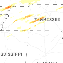


Connect with Interactive Hail Maps