

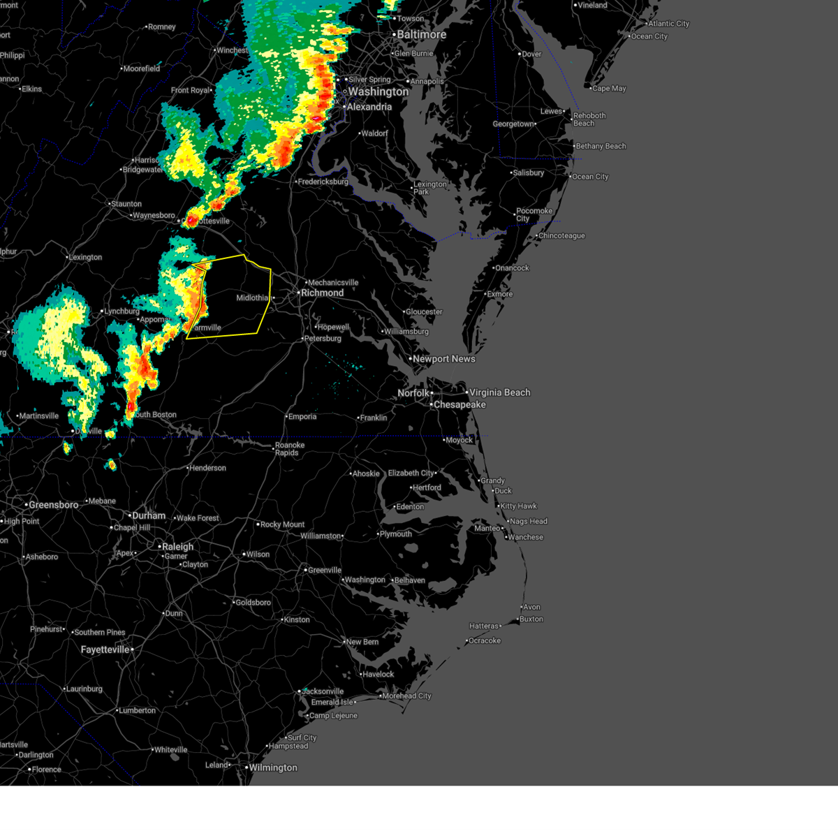
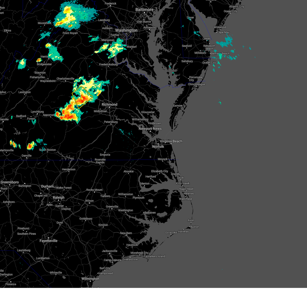
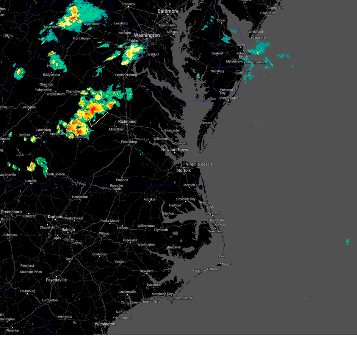
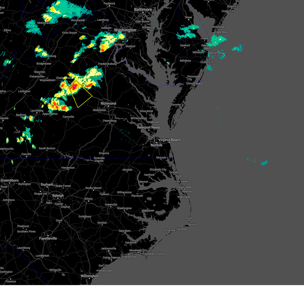
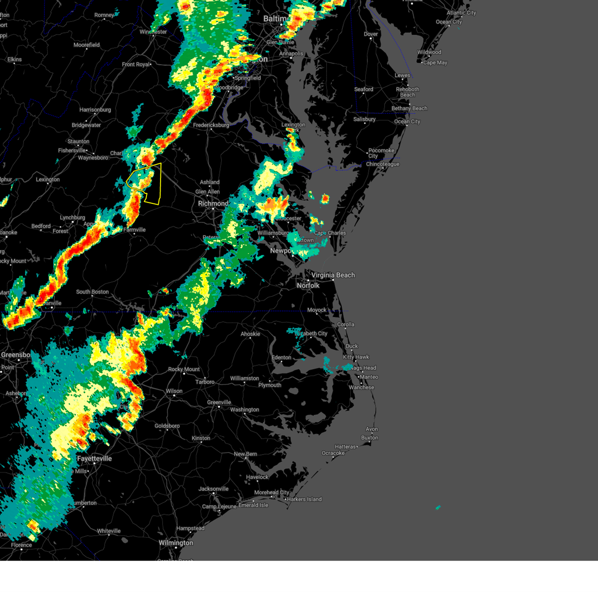
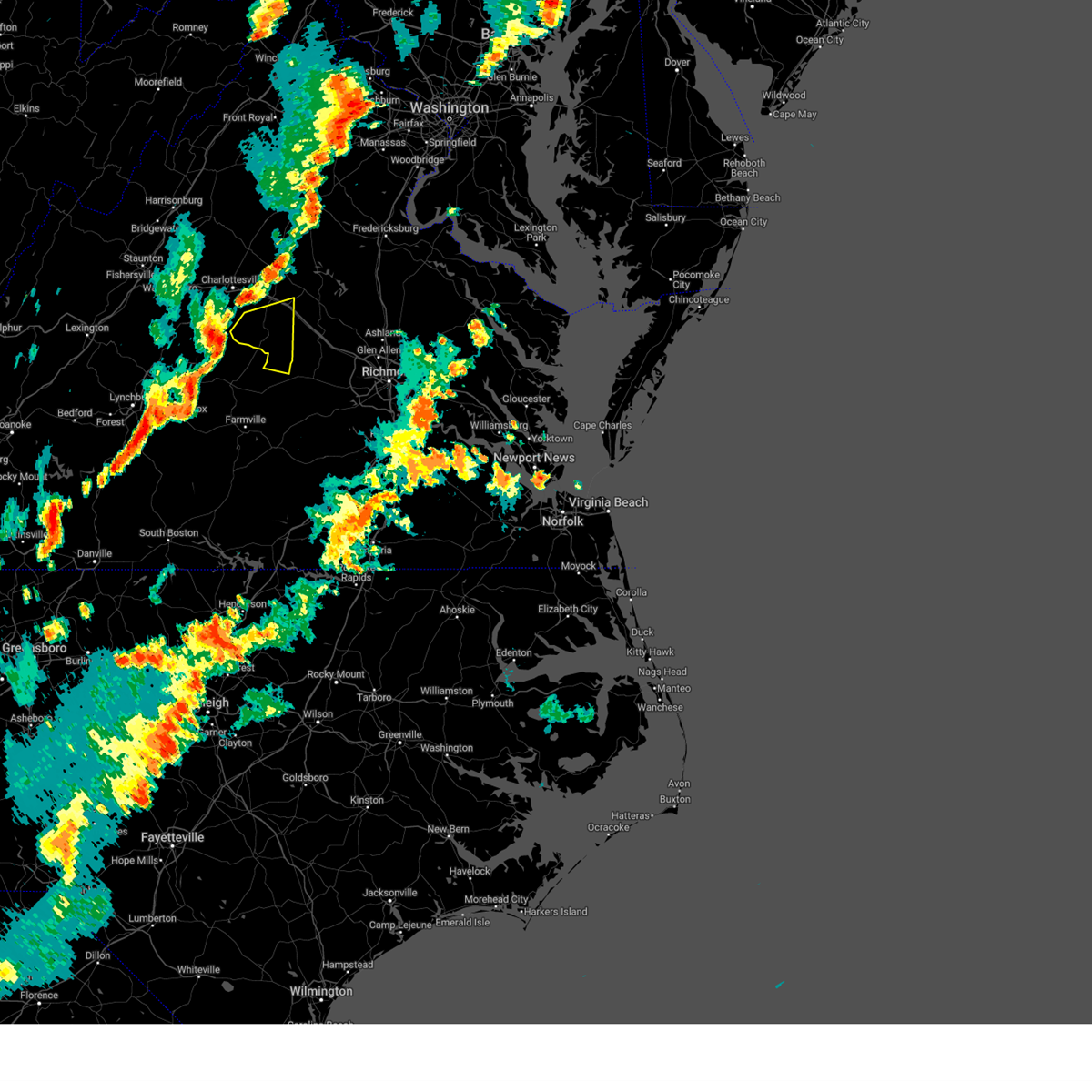
Hail Map for Columbia, VA
The Columbia, VA area has had 7 reports of on-the-ground hail by trained spotters, and has been under severe weather warnings 10 times during the past 12 months. Doppler radar has detected hail at or near Columbia, VA on 45 occasions, including 3 occasions during the past year.
| Name: | Columbia, VA |
| Where Located: | 32.9 miles WNW of Richmond, VA |
| Map: | Google Map for Columbia, VA |
| Population: | 83 |
| Housing Units: | 30 |
| More Info: | Search Google for Columbia, VA |
0
The Top Recent Hail Date for Columbia, VA is Sunday, June 29, 2025 (15th out of 45)

Hail and Wind Damage Spotted near Columbia, VA
| Date / Time | Report Details |
|---|---|
| 6/19/2025 4:34 PM EDT | At 434 pm edt, severe thunderstorms were located along a line extending from near goochland to near macon to near amelia courthouse, moving east at 45 mph (radar indicated). Hazards include 60 mph wind gusts. Expect damage to trees and powerlines. these severe storms will be near, goochland, scotts fork, chula, and oilville around 440 pm edt. moseley, manakin, and sabot around 445 pm edt. Other locations impacted by these severe thunderstorms include crozier, rock castle, pilkinton, maidens, three square, irwin, johnsons springs, winterham, skinquarter, and maplewood. |
| 6/19/2025 4:34 PM EDT | the severe thunderstorm warning has been cancelled and is no longer in effect |
| 6/19/2025 4:09 PM EDT |
 Svrakq the national weather service in wakefield has issued a * severe thunderstorm warning for, northwestern chesterfield county in central virginia, cumberland county in central virginia, east central prince edward county in central virginia, northwestern nottoway county in south central virginia, goochland county in central virginia, amelia county in central virginia, powhatan county in central virginia, southeastern fluvanna county in central virginia, * until 500 pm edt. * at 409 pm edt, severe thunderstorms were located along a line extending from near new canton to near cumberland to near longwood university, moving east at 45 mph (radar indicated). Hazards include 60 mph wind gusts. Expect damage to trees and powerlines. severe thunderstorms will be near, cartersville, rice, sunnyside, duncan, tobaccoville, and lakeside village around 415 pm edt. morven, ballsville, and trenholm around 420 pm edt. jetersville, macon, and fife around 425 pm edt. powhatan, goochland, and amelia courthouse around 430 pm edt. chula around 435 pm edt. scotts fork and oilville around 440 pm edt. moseley, manakin, and sabot around 445 pm edt. Other locations impacted by these severe thunderstorms include angola, maidens, three square, bremo bluff, skinquarter, fine creek mills, whiteville, michaux, west view, and grays siding. Svrakq the national weather service in wakefield has issued a * severe thunderstorm warning for, northwestern chesterfield county in central virginia, cumberland county in central virginia, east central prince edward county in central virginia, northwestern nottoway county in south central virginia, goochland county in central virginia, amelia county in central virginia, powhatan county in central virginia, southeastern fluvanna county in central virginia, * until 500 pm edt. * at 409 pm edt, severe thunderstorms were located along a line extending from near new canton to near cumberland to near longwood university, moving east at 45 mph (radar indicated). Hazards include 60 mph wind gusts. Expect damage to trees and powerlines. severe thunderstorms will be near, cartersville, rice, sunnyside, duncan, tobaccoville, and lakeside village around 415 pm edt. morven, ballsville, and trenholm around 420 pm edt. jetersville, macon, and fife around 425 pm edt. powhatan, goochland, and amelia courthouse around 430 pm edt. chula around 435 pm edt. scotts fork and oilville around 440 pm edt. moseley, manakin, and sabot around 445 pm edt. Other locations impacted by these severe thunderstorms include angola, maidens, three square, bremo bluff, skinquarter, fine creek mills, whiteville, michaux, west view, and grays siding.
|
| 6/6/2025 5:29 PM EDT |
 The storm which prompted the warning has weakened below severe limits, and has exited the warned area. therefore, the warning will be allowed to expire. however, gusty winds and heavy rain are still possible with this thunderstorm. The storm which prompted the warning has weakened below severe limits, and has exited the warned area. therefore, the warning will be allowed to expire. however, gusty winds and heavy rain are still possible with this thunderstorm.
|
| 6/6/2025 5:11 PM EDT |
 At 511 pm edt, a severe thunderstorm was located over fife, or near cartersville, moving southeast at 30 mph (radar indicated). Hazards include 70 mph wind gusts and quarter size hail. Minor damage to vehicles is possible. expect considerable tree damage. wind damage is also likely to mobile homes, roofs, and outbuildings. this severe storm will be near, cartersville, duncan, and fife around 515 pm edt. Other locations impacted by this severe thunderstorm include dixie, sandy hook, ashby, stage junction, three square, irwin, clinton, tamworth, caledonia, and elk hill. At 511 pm edt, a severe thunderstorm was located over fife, or near cartersville, moving southeast at 30 mph (radar indicated). Hazards include 70 mph wind gusts and quarter size hail. Minor damage to vehicles is possible. expect considerable tree damage. wind damage is also likely to mobile homes, roofs, and outbuildings. this severe storm will be near, cartersville, duncan, and fife around 515 pm edt. Other locations impacted by this severe thunderstorm include dixie, sandy hook, ashby, stage junction, three square, irwin, clinton, tamworth, caledonia, and elk hill.
|
| 6/6/2025 5:11 PM EDT |
 the severe thunderstorm warning has been cancelled and is no longer in effect the severe thunderstorm warning has been cancelled and is no longer in effect
|
| 6/6/2025 4:50 PM EDT |
 Svrakq the national weather service in wakefield has issued a * severe thunderstorm warning for, central louisa county in central virginia, northeastern cumberland county in central virginia, goochland county in central virginia, northwestern powhatan county in central virginia, fluvanna county in central virginia, * until 530 pm edt. * at 450 pm edt, a severe thunderstorm was located near palmyra, moving southeast at 30 mph (radar indicated). Hazards include 70 mph wind gusts and half dollar size hail. Minor damage to vehicles is possible. expect considerable tree damage. wind damage is also likely to mobile homes, roofs, and outbuildings. this severe thunderstorm will be near, kents store around 455 pm edt. columbia around 500 pm edt. fife around 505 pm edt. duncan around 510 pm edt. cartersville around 515 pm edt. Other locations impacted by this severe thunderstorm include three square, irwin, whiteville, west view, tabscott, othma, wilmington, pemberton, cunningham, and dixie. Svrakq the national weather service in wakefield has issued a * severe thunderstorm warning for, central louisa county in central virginia, northeastern cumberland county in central virginia, goochland county in central virginia, northwestern powhatan county in central virginia, fluvanna county in central virginia, * until 530 pm edt. * at 450 pm edt, a severe thunderstorm was located near palmyra, moving southeast at 30 mph (radar indicated). Hazards include 70 mph wind gusts and half dollar size hail. Minor damage to vehicles is possible. expect considerable tree damage. wind damage is also likely to mobile homes, roofs, and outbuildings. this severe thunderstorm will be near, kents store around 455 pm edt. columbia around 500 pm edt. fife around 505 pm edt. duncan around 510 pm edt. cartersville around 515 pm edt. Other locations impacted by this severe thunderstorm include three square, irwin, whiteville, west view, tabscott, othma, wilmington, pemberton, cunningham, and dixie.
|
| 8/3/2024 6:12 PM EDT |
 The storms which prompted the warning have weakened below severe limits, and no longer pose an immediate threat to life or property. therefore, the warning will be allowed to expire. however, gusty winds are still possible with these thunderstorms. a severe thunderstorm watch remains in effect until 900 pm edt for central virginia. The storms which prompted the warning have weakened below severe limits, and no longer pose an immediate threat to life or property. therefore, the warning will be allowed to expire. however, gusty winds are still possible with these thunderstorms. a severe thunderstorm watch remains in effect until 900 pm edt for central virginia.
|
| 8/3/2024 5:23 PM EDT |
 Svrakq the national weather service in wakefield has issued a * severe thunderstorm warning for, west central louisa county in central virginia, northeastern cumberland county in central virginia, northwestern goochland county in central virginia, fluvanna county in central virginia, * until 615 pm edt. * at 522 pm edt, severe thunderstorms were located along a line extending from 7 miles east of schuyler to near centenary, moving east at 25 mph (radar indicated). Hazards include 60 mph wind gusts. Expect damage to trees and powerlines. severe thunderstorms will be near, fork union around 550 pm edt. palmyra around 555 pm edt. Other locations impacted by these severe thunderstorms include dixie, nahor, stage junction, shores, central plains, bremo bluff, antioch, tamworth, caledonia, and wildwood. Svrakq the national weather service in wakefield has issued a * severe thunderstorm warning for, west central louisa county in central virginia, northeastern cumberland county in central virginia, northwestern goochland county in central virginia, fluvanna county in central virginia, * until 615 pm edt. * at 522 pm edt, severe thunderstorms were located along a line extending from 7 miles east of schuyler to near centenary, moving east at 25 mph (radar indicated). Hazards include 60 mph wind gusts. Expect damage to trees and powerlines. severe thunderstorms will be near, fork union around 550 pm edt. palmyra around 555 pm edt. Other locations impacted by these severe thunderstorms include dixie, nahor, stage junction, shores, central plains, bremo bluff, antioch, tamworth, caledonia, and wildwood.
|
| 7/17/2024 5:13 PM EDT | Svrakq the national weather service in wakefield has issued a * severe thunderstorm warning for, cumberland county in central virginia, southwestern goochland county in central virginia, northwestern amelia county in central virginia, western powhatan county in central virginia, southern fluvanna county in central virginia, * until 615 pm edt. * at 512 pm edt, a severe thunderstorm was located near gold hill, or near dillwyn, moving east at 25 mph (radar indicated). Hazards include 60 mph wind gusts. expect damage to trees and powerlines |
| 6/6/2024 3:51 PM EDT |
 the severe thunderstorm warning has been cancelled and is no longer in effect the severe thunderstorm warning has been cancelled and is no longer in effect
|
| 6/6/2024 3:51 PM EDT |
 At 350 pm edt, severe thunderstorms were located along a line extending from near hadensville to near trenholm, moving east at 30 mph (radar indicated). Hazards include 60 mph wind gusts. Expect damage to trees and powerlines. these severe storms will be near, macon and gum spring around 355 pm edt. powhatan and goochland around 400 pm edt. oilville around 410 pm edt. Other locations impacted by these severe thunderstorms include orchid, crozier, rock castle, oak forest, maidens, three square, irwin, whiteville, fine creek mills, and michaux. At 350 pm edt, severe thunderstorms were located along a line extending from near hadensville to near trenholm, moving east at 30 mph (radar indicated). Hazards include 60 mph wind gusts. Expect damage to trees and powerlines. these severe storms will be near, macon and gum spring around 355 pm edt. powhatan and goochland around 400 pm edt. oilville around 410 pm edt. Other locations impacted by these severe thunderstorms include orchid, crozier, rock castle, oak forest, maidens, three square, irwin, whiteville, fine creek mills, and michaux.
|
| 6/6/2024 3:48 PM EDT | Large tree limbs downed at tabscott road at shannon hill road. power outages also reported in the area. time radar estimate in goochland county VA, 9.3 miles SW of Columbia, VA |
| 6/6/2024 3:33 PM EDT |
 Svrakq the national weather service in wakefield has issued a * severe thunderstorm warning for, southeastern louisa county in central virginia, northeastern cumberland county in central virginia, goochland county in central virginia, powhatan county in central virginia, southeastern fluvanna county in central virginia, * until 415 pm edt. * at 333 pm edt, severe thunderstorms were located along a line extending from kents store to near cumberland, moving east at 30 mph (radar indicated). Hazards include 60 mph wind gusts. Expect damage to trees and powerlines. severe thunderstorms will be near, hadensville, cartersville, fife, and trenholm around 340 pm edt. macon and gum spring around 350 pm edt. powhatan and goochland around 355 pm edt. Other locations impacted by these severe thunderstorms include orchid, crozier, rock castle, oak forest, maidens, three square, irwin, bremo bluff, whiteville, and fine creek mills. Svrakq the national weather service in wakefield has issued a * severe thunderstorm warning for, southeastern louisa county in central virginia, northeastern cumberland county in central virginia, goochland county in central virginia, powhatan county in central virginia, southeastern fluvanna county in central virginia, * until 415 pm edt. * at 333 pm edt, severe thunderstorms were located along a line extending from kents store to near cumberland, moving east at 30 mph (radar indicated). Hazards include 60 mph wind gusts. Expect damage to trees and powerlines. severe thunderstorms will be near, hadensville, cartersville, fife, and trenholm around 340 pm edt. macon and gum spring around 350 pm edt. powhatan and goochland around 355 pm edt. Other locations impacted by these severe thunderstorms include orchid, crozier, rock castle, oak forest, maidens, three square, irwin, bremo bluff, whiteville, and fine creek mills.
|
| 5/26/2024 9:10 PM EDT |
 At 909 pm edt, severe thunderstorms were located along a line extending from near madison to 7 miles northwest of louisa to near goochland, moving northeast at 35 mph (radar indicated). Hazards include 60 mph wind gusts. Expect damage to trees and powerlines. these severe storms will be near, louisa and mineral around 915 pm edt. Other locations impacted by these severe thunderstorms include pendleton, louisa airport, rock castle, green springs, three square, cuckoo, caledonia, elk hill, yanceyville, and west view. At 909 pm edt, severe thunderstorms were located along a line extending from near madison to 7 miles northwest of louisa to near goochland, moving northeast at 35 mph (radar indicated). Hazards include 60 mph wind gusts. Expect damage to trees and powerlines. these severe storms will be near, louisa and mineral around 915 pm edt. Other locations impacted by these severe thunderstorms include pendleton, louisa airport, rock castle, green springs, three square, cuckoo, caledonia, elk hill, yanceyville, and west view.
|
| 5/26/2024 9:10 PM EDT |
 The storms which prompted the warning have weakened below severe limits, and no longer pose an immediate threat to life or property. therefore, the warning will be allowed to expire. however, gusty winds to 45 mph and heavy rain are still possible with these thunderstorms. a severe thunderstorm watch remains in effect until 1100 pm edt for central and south central virginia. a severe thunderstorm watch also remains in effect until midnight edt for central and south central virginia. The storms which prompted the warning have weakened below severe limits, and no longer pose an immediate threat to life or property. therefore, the warning will be allowed to expire. however, gusty winds to 45 mph and heavy rain are still possible with these thunderstorms. a severe thunderstorm watch remains in effect until 1100 pm edt for central and south central virginia. a severe thunderstorm watch also remains in effect until midnight edt for central and south central virginia.
|
| 5/26/2024 9:10 PM EDT |
 the severe thunderstorm warning has been cancelled and is no longer in effect the severe thunderstorm warning has been cancelled and is no longer in effect
|
| 5/26/2024 8:50 PM EDT | Public report of several large trees downed along us-15 at va- in fluvanna county VA, 3.2 miles E of Columbia, VA |
| 5/26/2024 8:47 PM EDT |
 At 847 pm edt, severe thunderstorms were located along a line extending from fork union to near cumberland to near keysville, moving east northeast at 35 mph (radar indicated). Hazards include 60 mph wind gusts. Expect damage to trees and powerlines. Locations impacted include, cumberland, farmville, blackstone, crewe, victoria, kenbridge, amelia courthouse, cartersville, hampden sydney college, longwood university, hampden sydney, nottoway, lunenburg, burkeville, columbia, guinea mills, tobaccoville, trenholm, morven, and lakeside village. At 847 pm edt, severe thunderstorms were located along a line extending from fork union to near cumberland to near keysville, moving east northeast at 35 mph (radar indicated). Hazards include 60 mph wind gusts. Expect damage to trees and powerlines. Locations impacted include, cumberland, farmville, blackstone, crewe, victoria, kenbridge, amelia courthouse, cartersville, hampden sydney college, longwood university, hampden sydney, nottoway, lunenburg, burkeville, columbia, guinea mills, tobaccoville, trenholm, morven, and lakeside village.
|
| 5/26/2024 8:19 PM EDT |
 Svrakq the national weather service in wakefield has issued a * severe thunderstorm warning for, louisa county in central virginia, western goochland county in central virginia, fluvanna county in central virginia, * until 930 pm edt. * at 818 pm edt, severe thunderstorms were located along a line extending from near bridgewater to near crozet to near toga, moving northeast at 45 mph (radar indicated). Hazards include 60 mph wind gusts. Expect damage to trees and powerlines. severe thunderstorms will be near, lake monticello around 855 pm edt. palmyra and troy around 905 pm edt. boswells tavern around 915 pm edt. Other locations impacted by these severe thunderstorms include louisa airport, rock castle, green springs, three square, shores, central plains, bremo bluff, cohasset, west view, and waldrop. Svrakq the national weather service in wakefield has issued a * severe thunderstorm warning for, louisa county in central virginia, western goochland county in central virginia, fluvanna county in central virginia, * until 930 pm edt. * at 818 pm edt, severe thunderstorms were located along a line extending from near bridgewater to near crozet to near toga, moving northeast at 45 mph (radar indicated). Hazards include 60 mph wind gusts. Expect damage to trees and powerlines. severe thunderstorms will be near, lake monticello around 855 pm edt. palmyra and troy around 905 pm edt. boswells tavern around 915 pm edt. Other locations impacted by these severe thunderstorms include louisa airport, rock castle, green springs, three square, shores, central plains, bremo bluff, cohasset, west view, and waldrop.
|
| 5/26/2024 8:06 PM EDT |
 Svrakq the national weather service in wakefield has issued a * severe thunderstorm warning for, cumberland county in central virginia, prince edward county in central virginia, lunenburg county in south central virginia, nottoway county in south central virginia, western amelia county in central virginia, western powhatan county in central virginia, * until 915 pm edt. * at 805 pm edt, severe thunderstorms were located along a line extending from 6 miles south of shipman to near tower hill to near cody, moving east northeast at 35 mph (radar indicated). Hazards include 60 mph wind gusts. Expect damage to trees and powerlines. severe thunderstorms will be near, prospect and darlington heights around 830 pm edt. hampden sydney around 835 pm edt. farmville around 840 pm edt. longwood university, hampden sydney college, and guinea mills around 845 pm edt. cumberland around 850 pm edt. rice around 855 pm edt. sunnyside, duncan, green bay, and lakeside village around 900 pm edt. cartersville, burkeville, ballsville, and tobaccoville around 905 pm edt. Other locations impacted by these severe thunderstorms include bacons fork, tuggle, angola, arvins store, murdocks, nutbush, hawk, plantersville, elam, and whiteville. Svrakq the national weather service in wakefield has issued a * severe thunderstorm warning for, cumberland county in central virginia, prince edward county in central virginia, lunenburg county in south central virginia, nottoway county in south central virginia, western amelia county in central virginia, western powhatan county in central virginia, * until 915 pm edt. * at 805 pm edt, severe thunderstorms were located along a line extending from 6 miles south of shipman to near tower hill to near cody, moving east northeast at 35 mph (radar indicated). Hazards include 60 mph wind gusts. Expect damage to trees and powerlines. severe thunderstorms will be near, prospect and darlington heights around 830 pm edt. hampden sydney around 835 pm edt. farmville around 840 pm edt. longwood university, hampden sydney college, and guinea mills around 845 pm edt. cumberland around 850 pm edt. rice around 855 pm edt. sunnyside, duncan, green bay, and lakeside village around 900 pm edt. cartersville, burkeville, ballsville, and tobaccoville around 905 pm edt. Other locations impacted by these severe thunderstorms include bacons fork, tuggle, angola, arvins store, murdocks, nutbush, hawk, plantersville, elam, and whiteville.
|
| 4/15/2024 7:11 PM EDT |
 At 711 pm edt, a severe thunderstorm was located over lakeside village, or near cartersville, moving southeast at 35 mph (radar indicated). Hazards include 60 mph wind gusts and quarter size hail. Minor damage to vehicles is possible. expect wind damage to trees and powerlines. this severe storm will be near, cartersville around 715 pm edt. trenholm around 720 pm edt. Other locations impacted by this severe thunderstorm include dixie, hatchers, ashby, stage junction, three square, bremo bluff, clinton, tamworth, elk hill, and cohasset. At 711 pm edt, a severe thunderstorm was located over lakeside village, or near cartersville, moving southeast at 35 mph (radar indicated). Hazards include 60 mph wind gusts and quarter size hail. Minor damage to vehicles is possible. expect wind damage to trees and powerlines. this severe storm will be near, cartersville around 715 pm edt. trenholm around 720 pm edt. Other locations impacted by this severe thunderstorm include dixie, hatchers, ashby, stage junction, three square, bremo bluff, clinton, tamworth, elk hill, and cohasset.
|
| 4/15/2024 6:56 PM EDT |
 Svrakq the national weather service in wakefield has issued a * severe thunderstorm warning for, northeastern cumberland county in central virginia, southwestern goochland county in central virginia, northwestern powhatan county in central virginia, southern fluvanna county in central virginia, * until 745 pm edt. * at 655 pm edt, a severe thunderstorm was located near fork union, moving southeast at 25 mph (radar indicated). Hazards include 60 mph wind gusts and quarter size hail. Minor damage to vehicles is possible. expect wind damage to trees and powerlines. this severe thunderstorm will be near, fork union around 700 pm edt. columbia, duncan, and lakeside village around 715 pm edt. cartersville around 720 pm edt. trenholm around 730 pm edt. Other locations impacted by this severe thunderstorm include dixie, hatchers, ashby, stage junction, three square, shores, central plains, bremo bluff, clinton, and tamworth. Svrakq the national weather service in wakefield has issued a * severe thunderstorm warning for, northeastern cumberland county in central virginia, southwestern goochland county in central virginia, northwestern powhatan county in central virginia, southern fluvanna county in central virginia, * until 745 pm edt. * at 655 pm edt, a severe thunderstorm was located near fork union, moving southeast at 25 mph (radar indicated). Hazards include 60 mph wind gusts and quarter size hail. Minor damage to vehicles is possible. expect wind damage to trees and powerlines. this severe thunderstorm will be near, fork union around 700 pm edt. columbia, duncan, and lakeside village around 715 pm edt. cartersville around 720 pm edt. trenholm around 730 pm edt. Other locations impacted by this severe thunderstorm include dixie, hatchers, ashby, stage junction, three square, shores, central plains, bremo bluff, clinton, and tamworth.
|
| 4/15/2024 6:28 PM EDT |
 Svrakq the national weather service in wakefield has issued a * severe thunderstorm warning for, northeastern cumberland county in central virginia, goochland county in central virginia, northwestern powhatan county in central virginia, southeastern fluvanna county in central virginia, * until 715 pm edt. * at 627 pm edt, a severe thunderstorm was located over fife, or near cartersville, moving southeast at 30 mph (radar indicated). Hazards include 60 mph wind gusts and quarter size hail. Minor damage to vehicles is possible. expect wind damage to trees and powerlines. this severe thunderstorm will be near, fife around 635 pm edt. goochland around 645 pm edt. Other locations impacted by this severe thunderstorm include goodwins store, crozier, sandy hook, rock castle, stage junction, jefferson, maidens, provost, three square, and irwin. Svrakq the national weather service in wakefield has issued a * severe thunderstorm warning for, northeastern cumberland county in central virginia, goochland county in central virginia, northwestern powhatan county in central virginia, southeastern fluvanna county in central virginia, * until 715 pm edt. * at 627 pm edt, a severe thunderstorm was located over fife, or near cartersville, moving southeast at 30 mph (radar indicated). Hazards include 60 mph wind gusts and quarter size hail. Minor damage to vehicles is possible. expect wind damage to trees and powerlines. this severe thunderstorm will be near, fife around 635 pm edt. goochland around 645 pm edt. Other locations impacted by this severe thunderstorm include goodwins store, crozier, sandy hook, rock castle, stage junction, jefferson, maidens, provost, three square, and irwin.
|
| 4/15/2024 6:20 PM EDT |
 At 620 pm edt, a severe thunderstorm was located over duncan, or near cartersville, moving southeast at 30 mph (radar indicated). Hazards include 60 mph wind gusts and quarter size hail. Minor damage to vehicles is possible. expect wind damage to trees and powerlines. this severe storm will be near, cartersville and fife around 625 pm edt. Other locations impacted by this severe thunderstorm include hatchers, sandy hook, rock castle, stage junction, provost, three square, irwin, tamworth, caledonia, and elk hill. At 620 pm edt, a severe thunderstorm was located over duncan, or near cartersville, moving southeast at 30 mph (radar indicated). Hazards include 60 mph wind gusts and quarter size hail. Minor damage to vehicles is possible. expect wind damage to trees and powerlines. this severe storm will be near, cartersville and fife around 625 pm edt. Other locations impacted by this severe thunderstorm include hatchers, sandy hook, rock castle, stage junction, provost, three square, irwin, tamworth, caledonia, and elk hill.
|
| 4/15/2024 6:03 PM EDT |
 At 602 pm edt, a severe thunderstorm was located over fork union, moving southeast at 25 mph (radar indicated. at 6 pm edt, quarter sized hail was reported in fluvanna county). Hazards include 60 mph wind gusts and quarter size hail. Minor damage to vehicles is possible. expect wind damage to trees and powerlines. this severe storm will be near, fork union around 605 pm edt. columbia around 610 pm edt. duncan around 615 pm edt. fife around 625 pm edt. cartersville around 630 pm edt. Other locations impacted by this severe thunderstorm include dixie, hatchers, sandy hook, rock castle, stage junction, maidens, provost, three square, irwin, and central plains. At 602 pm edt, a severe thunderstorm was located over fork union, moving southeast at 25 mph (radar indicated. at 6 pm edt, quarter sized hail was reported in fluvanna county). Hazards include 60 mph wind gusts and quarter size hail. Minor damage to vehicles is possible. expect wind damage to trees and powerlines. this severe storm will be near, fork union around 605 pm edt. columbia around 610 pm edt. duncan around 615 pm edt. fife around 625 pm edt. cartersville around 630 pm edt. Other locations impacted by this severe thunderstorm include dixie, hatchers, sandy hook, rock castle, stage junction, maidens, provost, three square, irwin, and central plains.
|
| 4/15/2024 5:46 PM EDT |
 Svrakq the national weather service in wakefield has issued a * severe thunderstorm warning for, northeastern cumberland county in central virginia, southwestern goochland county in central virginia, northwestern powhatan county in central virginia, fluvanna county in central virginia, * until 630 pm edt. * at 545 pm edt, a severe thunderstorm was located near palmyra, moving southeast at 40 mph (radar indicated). Hazards include 60 mph wind gusts and quarter size hail. Minor damage to vehicles is possible. expect wind damage to trees and powerlines. this severe thunderstorm will be near, fork union around 550 pm edt. columbia around 555 pm edt. duncan around 600 pm edt. fife around 605 pm edt. cartersville around 610 pm edt. Other locations impacted by this severe thunderstorm include rock castle, maidens, three square, shores, irwin, central plains, bremo bluff, cohasset, whiteville, and michaux. Svrakq the national weather service in wakefield has issued a * severe thunderstorm warning for, northeastern cumberland county in central virginia, southwestern goochland county in central virginia, northwestern powhatan county in central virginia, fluvanna county in central virginia, * until 630 pm edt. * at 545 pm edt, a severe thunderstorm was located near palmyra, moving southeast at 40 mph (radar indicated). Hazards include 60 mph wind gusts and quarter size hail. Minor damage to vehicles is possible. expect wind damage to trees and powerlines. this severe thunderstorm will be near, fork union around 550 pm edt. columbia around 555 pm edt. duncan around 600 pm edt. fife around 605 pm edt. cartersville around 610 pm edt. Other locations impacted by this severe thunderstorm include rock castle, maidens, three square, shores, irwin, central plains, bremo bluff, cohasset, whiteville, and michaux.
|
| 4/11/2024 11:45 PM EDT | Trees down on duval road. time estimated from radar dat in goochland county VA, 9.2 miles SSW of Columbia, VA |
| 4/11/2024 11:45 PM EDT |
 Svrakq the national weather service in wakefield has issued a * severe thunderstorm warning for, the western city of richmond in central virginia, chesterfield county in central virginia, eastern cumberland county in central virginia, eastern lunenburg county in south central virginia, nottoway county in south central virginia, northwestern henrico county in central virginia, dinwiddie county in south central virginia, amelia county in central virginia, powhatan county in central virginia, northern brunswick county in south central virginia, * until 1245 am edt. * at 1145 pm edt, severe thunderstorms were located along a line extending from near hadensville to near goochland to near spainville to near alberta, moving northeast at 45 mph (radar indicated). Hazards include 60 mph wind gusts. expect damage to roofs, siding, and trees Svrakq the national weather service in wakefield has issued a * severe thunderstorm warning for, the western city of richmond in central virginia, chesterfield county in central virginia, eastern cumberland county in central virginia, eastern lunenburg county in south central virginia, nottoway county in south central virginia, northwestern henrico county in central virginia, dinwiddie county in south central virginia, amelia county in central virginia, powhatan county in central virginia, northern brunswick county in south central virginia, * until 1245 am edt. * at 1145 pm edt, severe thunderstorms were located along a line extending from near hadensville to near goochland to near spainville to near alberta, moving northeast at 45 mph (radar indicated). Hazards include 60 mph wind gusts. expect damage to roofs, siding, and trees
|
| 4/11/2024 11:20 PM EDT |
 Svrakq the national weather service in wakefield has issued a * severe thunderstorm warning for, louisa county in central virginia, northeastern cumberland county in central virginia, goochland county in central virginia, northwestern henrico county in central virginia, northwestern hanover county in central virginia, central powhatan county in central virginia, fluvanna county in central virginia, * until midnight edt. * at 1119 pm edt, severe thunderstorms were located along a line extending from near fork union to near gold hill to 6 miles southeast of guinea mills, moving east at 40 mph (radar indicated). Hazards include 60 mph wind gusts. expect damage to roofs, siding, and trees Svrakq the national weather service in wakefield has issued a * severe thunderstorm warning for, louisa county in central virginia, northeastern cumberland county in central virginia, goochland county in central virginia, northwestern henrico county in central virginia, northwestern hanover county in central virginia, central powhatan county in central virginia, fluvanna county in central virginia, * until midnight edt. * at 1119 pm edt, severe thunderstorms were located along a line extending from near fork union to near gold hill to 6 miles southeast of guinea mills, moving east at 40 mph (radar indicated). Hazards include 60 mph wind gusts. expect damage to roofs, siding, and trees
|
| 1/9/2024 4:16 PM EST |
 At 416 pm est, severe thunderstorms were located along a line extending from near lake monticello to near cumberland, moving northeast at 65 mph (radar indicated). Hazards include 60 mph wind gusts. Expect damage to trees and powerlines. severe thunderstorms will be near, palmyra, fork union, lake monticello, columbia, duncan, troy, and lakeside village around 420 pm est. cartersville, boswells tavern, kents store, and trenholm around 425 pm est. hadensville, ferncliff, and fife around 430 pm est. goochland, louisa, and gum spring around 435 pm est. mineral around 440 pm est. bumpass around 450 pm est. other locations impacted by these severe thunderstorms include orchid, maidens, three square, central plains, bremo bluff, whiteville, michaux, west view, grays siding, and wares crossroads. hail threat, radar indicated max hail size, <. 75 in wind threat, radar indicated max wind gust, 60 mph. At 416 pm est, severe thunderstorms were located along a line extending from near lake monticello to near cumberland, moving northeast at 65 mph (radar indicated). Hazards include 60 mph wind gusts. Expect damage to trees and powerlines. severe thunderstorms will be near, palmyra, fork union, lake monticello, columbia, duncan, troy, and lakeside village around 420 pm est. cartersville, boswells tavern, kents store, and trenholm around 425 pm est. hadensville, ferncliff, and fife around 430 pm est. goochland, louisa, and gum spring around 435 pm est. mineral around 440 pm est. bumpass around 450 pm est. other locations impacted by these severe thunderstorms include orchid, maidens, three square, central plains, bremo bluff, whiteville, michaux, west view, grays siding, and wares crossroads. hail threat, radar indicated max hail size, <. 75 in wind threat, radar indicated max wind gust, 60 mph.
|
| 9/8/2023 8:59 PM EDT |
 At 859 pm edt, severe thunderstorms were located along a line extending from near schuyler to duncan, moving north at 25 mph (radar indicated). Hazards include 60 mph wind gusts and quarter size hail. Minor damage to vehicles is possible. expect wind damage to trees and powerlines. these severe storms will be near, fork union and columbia around 905 pm edt. palmyra around 910 pm edt. lake monticello around 915 pm edt. kents store around 920 pm edt. troy around 925 pm edt. other locations impacted by these severe thunderstorms include dixie, nahor, stage junction, shores, zion crossroads, central plains, bremo bluff, antioch, union mills, and caledonia. hail threat, radar indicated max hail size, 1. 00 in wind threat, radar indicated max wind gust, 60 mph. At 859 pm edt, severe thunderstorms were located along a line extending from near schuyler to duncan, moving north at 25 mph (radar indicated). Hazards include 60 mph wind gusts and quarter size hail. Minor damage to vehicles is possible. expect wind damage to trees and powerlines. these severe storms will be near, fork union and columbia around 905 pm edt. palmyra around 910 pm edt. lake monticello around 915 pm edt. kents store around 920 pm edt. troy around 925 pm edt. other locations impacted by these severe thunderstorms include dixie, nahor, stage junction, shores, zion crossroads, central plains, bremo bluff, antioch, union mills, and caledonia. hail threat, radar indicated max hail size, 1. 00 in wind threat, radar indicated max wind gust, 60 mph.
|
| 9/8/2023 8:38 PM EDT |
 At 838 pm edt, severe thunderstorms were located along a line extending from 6 miles west of centenary to near lakeside village, moving north at 25 mph (radar indicated). Hazards include 60 mph wind gusts and quarter size hail. Minor damage to vehicles is possible. expect wind damage to trees and powerlines. severe thunderstorms will be near, lakeside village around 845 pm edt. cartersville, fork union, and duncan around 850 pm edt. columbia around 855 pm edt. palmyra around 905 pm edt. lake monticello and kents store around 915 pm edt. other locations impacted by these severe thunderstorms include oak forest, shores, central plains, bremo bluff, cohasset, whiteville, grays siding, tabscott, hardware, and wilmington. hail threat, radar indicated max hail size, 1. 00 in wind threat, radar indicated max wind gust, 60 mph. At 838 pm edt, severe thunderstorms were located along a line extending from 6 miles west of centenary to near lakeside village, moving north at 25 mph (radar indicated). Hazards include 60 mph wind gusts and quarter size hail. Minor damage to vehicles is possible. expect wind damage to trees and powerlines. severe thunderstorms will be near, lakeside village around 845 pm edt. cartersville, fork union, and duncan around 850 pm edt. columbia around 855 pm edt. palmyra around 905 pm edt. lake monticello and kents store around 915 pm edt. other locations impacted by these severe thunderstorms include oak forest, shores, central plains, bremo bluff, cohasset, whiteville, grays siding, tabscott, hardware, and wilmington. hail threat, radar indicated max hail size, 1. 00 in wind threat, radar indicated max wind gust, 60 mph.
|
| 7/28/2023 7:32 PM EDT |
 At 731 pm edt, severe thunderstorms were located along a line extending from near free union to near wingina, moving east at 40 mph (radar indicated). Hazards include 60 mph wind gusts and penny size hail. expect damage to trees and powerlines At 731 pm edt, severe thunderstorms were located along a line extending from near free union to near wingina, moving east at 40 mph (radar indicated). Hazards include 60 mph wind gusts and penny size hail. expect damage to trees and powerlines
|
| 7/7/2023 7:34 PM EDT | Corrects previous tstm wnd dmg report from 2 wsw new canton. numerous trees and power lines down across the eastern portion of the county beginning at arvonia and conti in buckingham county VA, 10.2 miles ENE of Columbia, VA |
| 7/7/2023 7:34 PM EDT | Corrects previous tstm wnd dmg report from 2 wsw new canton. numerous trees and power lines down across the eastern portion of the county beginning at arvonia and conti in buckingham county VA, 10.2 miles ENE of Columbia, VA |
| 7/7/2023 7:30 PM EDT | Tree limbs downed on cloverdale road. utility outage map also shows several power outages due to storm in the area. time is estimate in fluvanna county VA, 4.9 miles E of Columbia, VA |
| 7/7/2023 7:30 PM EDT | Trees downed along cartersville road at va-45. time estimate in cumberland county VA, 6.8 miles NNW of Columbia, VA |
| 7/7/2023 7:14 PM EDT |
 At 714 pm edt, a severe thunderstorm was located near lakeside village, or near fork union, moving south at 15 mph (radar indicated). Hazards include 60 mph wind gusts and penny size hail. expect damage to trees and powerlines At 714 pm edt, a severe thunderstorm was located near lakeside village, or near fork union, moving south at 15 mph (radar indicated). Hazards include 60 mph wind gusts and penny size hail. expect damage to trees and powerlines
|
| 6/26/2023 7:25 PM EDT | Quarter sized hail reported 7.9 miles NNW of Columbia, VA |
| 6/26/2023 7:12 PM EDT |
 At 712 pm edt, severe thunderstorms were located along a line extending from duncan to near cumberland, moving east at 30 mph (radar indicated). Hazards include 70 mph wind gusts and quarter size hail. Minor damage to vehicles is possible. expect considerable tree damage. wind damage is also likely to mobile homes, roofs, and outbuildings. these severe storms will be near, trenholm around 725 pm edt. other locations impacted by these severe thunderstorms include hatchers, trents mill, rock castle, ashby, oak forest, provost, three square, irwin, clinton and tamworth. thunderstorm damage threat, considerable hail threat, radar indicated max hail size, 1. 00 in wind threat, radar indicated max wind gust, 70 mph. At 712 pm edt, severe thunderstorms were located along a line extending from duncan to near cumberland, moving east at 30 mph (radar indicated). Hazards include 70 mph wind gusts and quarter size hail. Minor damage to vehicles is possible. expect considerable tree damage. wind damage is also likely to mobile homes, roofs, and outbuildings. these severe storms will be near, trenholm around 725 pm edt. other locations impacted by these severe thunderstorms include hatchers, trents mill, rock castle, ashby, oak forest, provost, three square, irwin, clinton and tamworth. thunderstorm damage threat, considerable hail threat, radar indicated max hail size, 1. 00 in wind threat, radar indicated max wind gust, 70 mph.
|
| 6/26/2023 6:51 PM EDT |
 At 651 pm edt, severe thunderstorms were located along a line extending from new canton to near gold hill, moving east at 25 mph (radar indicated). Hazards include 70 mph wind gusts and half dollar size hail. Minor damage to vehicles is possible. expect considerable tree damage. wind damage is also likely to mobile homes, roofs, and outbuildings. severe thunderstorms will be near, columbia, duncan and lakeside village around 710 pm edt. cartersville around 720 pm edt. trenholm around 730 pm edt. other locations impacted by these severe thunderstorms include hatchers, trents mill, rock castle, ashby, oak forest, provost, three square, irwin, bremo bluff and clinton. thunderstorm damage threat, considerable hail threat, radar indicated max hail size, 1. 25 in wind threat, radar indicated max wind gust, 70 mph. At 651 pm edt, severe thunderstorms were located along a line extending from new canton to near gold hill, moving east at 25 mph (radar indicated). Hazards include 70 mph wind gusts and half dollar size hail. Minor damage to vehicles is possible. expect considerable tree damage. wind damage is also likely to mobile homes, roofs, and outbuildings. severe thunderstorms will be near, columbia, duncan and lakeside village around 710 pm edt. cartersville around 720 pm edt. trenholm around 730 pm edt. other locations impacted by these severe thunderstorms include hatchers, trents mill, rock castle, ashby, oak forest, provost, three square, irwin, bremo bluff and clinton. thunderstorm damage threat, considerable hail threat, radar indicated max hail size, 1. 25 in wind threat, radar indicated max wind gust, 70 mph.
|
| 6/26/2023 6:35 PM EDT |
 At 634 pm edt, severe thunderstorms were located along a line extending from near mineral to near hadensville to near lakeside village, moving east at 20 mph (radar indicated). Hazards include 70 mph wind gusts and quarter size hail. Minor damage to vehicles is possible. expect considerable tree damage. wind damage is also likely to mobile homes, roofs, and outbuildings. these severe storms will be near, mineral and hadensville around 640 pm edt. fife around 700 pm edt. other locations impacted by these severe thunderstorms include elk hill, pendleton, yanceyville, tabscott, apple grove, trenton mills, cuckoo and caledonia. thunderstorm damage threat, considerable hail threat, radar indicated max hail size, 1. 00 in wind threat, radar indicated max wind gust, 70 mph. At 634 pm edt, severe thunderstorms were located along a line extending from near mineral to near hadensville to near lakeside village, moving east at 20 mph (radar indicated). Hazards include 70 mph wind gusts and quarter size hail. Minor damage to vehicles is possible. expect considerable tree damage. wind damage is also likely to mobile homes, roofs, and outbuildings. these severe storms will be near, mineral and hadensville around 640 pm edt. fife around 700 pm edt. other locations impacted by these severe thunderstorms include elk hill, pendleton, yanceyville, tabscott, apple grove, trenton mills, cuckoo and caledonia. thunderstorm damage threat, considerable hail threat, radar indicated max hail size, 1. 00 in wind threat, radar indicated max wind gust, 70 mph.
|
| 6/26/2023 6:15 PM EDT | Trees downed by thunderstorm winds in new canton are in buckingham county VA, 8.1 miles ENE of Columbia, VA |
| 6/26/2023 6:15 PM EDT |
 At 615 pm edt, severe thunderstorms were located along a line extending from near louisa to near kents store to new canton, moving east at 20 mph (radar indicated). Hazards include 70 mph wind gusts and half dollar size hail. Minor damage to vehicles is possible. expect considerable tree damage. wind damage is also likely to mobile homes, roofs, and outbuildings. these severe storms will be near, louisa and ferncliff around 620 pm edt. hadensville around 625 pm edt. mineral around 635 pm edt. columbia around 640 pm edt. fife around 655 pm edt. other locations impacted by these severe thunderstorms include dixie, pendleton, louisa airport, stage junction, shores, central plains, bremo bluff, cuckoo, caledonia and elk hill. thunderstorm damage threat, considerable hail threat, radar indicated max hail size, 1. 25 in wind threat, radar indicated max wind gust, 70 mph. At 615 pm edt, severe thunderstorms were located along a line extending from near louisa to near kents store to new canton, moving east at 20 mph (radar indicated). Hazards include 70 mph wind gusts and half dollar size hail. Minor damage to vehicles is possible. expect considerable tree damage. wind damage is also likely to mobile homes, roofs, and outbuildings. these severe storms will be near, louisa and ferncliff around 620 pm edt. hadensville around 625 pm edt. mineral around 635 pm edt. columbia around 640 pm edt. fife around 655 pm edt. other locations impacted by these severe thunderstorms include dixie, pendleton, louisa airport, stage junction, shores, central plains, bremo bluff, cuckoo, caledonia and elk hill. thunderstorm damage threat, considerable hail threat, radar indicated max hail size, 1. 25 in wind threat, radar indicated max wind gust, 70 mph.
|
| 6/26/2023 5:57 PM EDT |
 At 556 pm edt, severe thunderstorms were located along a line extending from near ferncliff to near kents store to near centenary, moving east at 20 mph (radar indicated). Hazards include 60 mph wind gusts and quarter size hail. Minor damage to vehicles is possible. expect wind damage to trees and powerlines. severe thunderstorms will be near, ferncliff around 600 pm edt. kents store around 605 pm edt. louisa around 620 pm edt. fork union around 625 pm edt. hadensville around 630 pm edt. mineral around 635 pm edt. columbia, lakeside village, duncan and fife around 645 pm edt. other locations impacted by these severe thunderstorms include dixie, pendleton, louisa airport, stage junction, shores, central plains, bremo bluff, cuckoo, caledonia and elk hill. hail threat, radar indicated max hail size, 1. 00 in wind threat, radar indicated max wind gust, 60 mph. At 556 pm edt, severe thunderstorms were located along a line extending from near ferncliff to near kents store to near centenary, moving east at 20 mph (radar indicated). Hazards include 60 mph wind gusts and quarter size hail. Minor damage to vehicles is possible. expect wind damage to trees and powerlines. severe thunderstorms will be near, ferncliff around 600 pm edt. kents store around 605 pm edt. louisa around 620 pm edt. fork union around 625 pm edt. hadensville around 630 pm edt. mineral around 635 pm edt. columbia, lakeside village, duncan and fife around 645 pm edt. other locations impacted by these severe thunderstorms include dixie, pendleton, louisa airport, stage junction, shores, central plains, bremo bluff, cuckoo, caledonia and elk hill. hail threat, radar indicated max hail size, 1. 00 in wind threat, radar indicated max wind gust, 60 mph.
|
| 6/16/2023 6:10 PM EDT |
 The severe thunderstorm warning for northeastern cumberland, west central goochland and southeastern fluvanna counties will expire at 615 pm edt, the storm which prompted the warning has weakened below severe limits, and no longer poses an immediate threat to life or property. therefore, the warning will be allowed to expire. however small hail, gusty winds and heavy rain are still possible with this thunderstorm. a severe thunderstorm watch remains in effect until 900 pm edt for central virginia. The severe thunderstorm warning for northeastern cumberland, west central goochland and southeastern fluvanna counties will expire at 615 pm edt, the storm which prompted the warning has weakened below severe limits, and no longer poses an immediate threat to life or property. therefore, the warning will be allowed to expire. however small hail, gusty winds and heavy rain are still possible with this thunderstorm. a severe thunderstorm watch remains in effect until 900 pm edt for central virginia.
|
| 6/16/2023 6:07 PM EDT |
 At 607 pm edt, a severe thunderstorm was located over columbia, or near fork union, moving southeast at 25 mph (radar indicated). Hazards include 60 mph wind gusts and quarter size hail. Minor damage to vehicles is possible. expect wind damage to trees and powerlines. this severe storm will be near, columbia around 610 pm edt. duncan around 615 pm edt. fife and lakeside village around 620 pm edt. cartersville around 630 pm edt. other locations impacted by this severe thunderstorm include dixie, elk hill, whiteville, ashby, stage junction, georges tavern, othma, pemberton, caledonia and carysbrook. hail threat, radar indicated max hail size, 1. 00 in wind threat, radar indicated max wind gust, 60 mph. At 607 pm edt, a severe thunderstorm was located over columbia, or near fork union, moving southeast at 25 mph (radar indicated). Hazards include 60 mph wind gusts and quarter size hail. Minor damage to vehicles is possible. expect wind damage to trees and powerlines. this severe storm will be near, columbia around 610 pm edt. duncan around 615 pm edt. fife and lakeside village around 620 pm edt. cartersville around 630 pm edt. other locations impacted by this severe thunderstorm include dixie, elk hill, whiteville, ashby, stage junction, georges tavern, othma, pemberton, caledonia and carysbrook. hail threat, radar indicated max hail size, 1. 00 in wind threat, radar indicated max wind gust, 60 mph.
|
| 6/16/2023 5:52 PM EDT |
 At 552 pm edt, a severe thunderstorm was located over palmyra, moving southeast at 25 mph (radar indicated). Hazards include 60 mph wind gusts and half dollar size hail. Minor damage to vehicles is possible. expect wind damage to trees and powerlines. this severe storm will be near, fork union around 600 pm edt. columbia around 610 pm edt. duncan around 615 pm edt. lakeside village and fife around 620 pm edt. cartersville around 630 pm edt. other locations impacted by this severe thunderstorm include dixie, nahor, ashby, stage junction, shores, zion crossroads, central plains, bremo bluff, antioch and union mills. hail threat, radar indicated max hail size, 1. 25 in wind threat, radar indicated max wind gust, 60 mph. At 552 pm edt, a severe thunderstorm was located over palmyra, moving southeast at 25 mph (radar indicated). Hazards include 60 mph wind gusts and half dollar size hail. Minor damage to vehicles is possible. expect wind damage to trees and powerlines. this severe storm will be near, fork union around 600 pm edt. columbia around 610 pm edt. duncan around 615 pm edt. lakeside village and fife around 620 pm edt. cartersville around 630 pm edt. other locations impacted by this severe thunderstorm include dixie, nahor, ashby, stage junction, shores, zion crossroads, central plains, bremo bluff, antioch and union mills. hail threat, radar indicated max hail size, 1. 25 in wind threat, radar indicated max wind gust, 60 mph.
|
| 6/16/2023 5:34 PM EDT |
 At 534 pm edt, a severe thunderstorm was located over lake monticello, or near palmyra, moving southeast at 25 mph (radar indicated). Hazards include 60 mph wind gusts and quarter size hail. Minor damage to vehicles is possible. expect wind damage to trees and powerlines. this severe thunderstorm will be near, troy around 540 pm edt. palmyra around 550 pm edt. fork union around 600 pm edt. columbia around 610 pm edt. cartersville, duncan, lakeside village and fife around 615 pm edt. other locations impacted by this severe thunderstorm include dixie, nahor, ashby, stage junction, shores, zion crossroads, central plains, bremo bluff, antioch and union mills. hail threat, radar indicated max hail size, 1. 00 in wind threat, radar indicated max wind gust, 60 mph. At 534 pm edt, a severe thunderstorm was located over lake monticello, or near palmyra, moving southeast at 25 mph (radar indicated). Hazards include 60 mph wind gusts and quarter size hail. Minor damage to vehicles is possible. expect wind damage to trees and powerlines. this severe thunderstorm will be near, troy around 540 pm edt. palmyra around 550 pm edt. fork union around 600 pm edt. columbia around 610 pm edt. cartersville, duncan, lakeside village and fife around 615 pm edt. other locations impacted by this severe thunderstorm include dixie, nahor, ashby, stage junction, shores, zion crossroads, central plains, bremo bluff, antioch and union mills. hail threat, radar indicated max hail size, 1. 00 in wind threat, radar indicated max wind gust, 60 mph.
|
| 9/13/2022 1:06 AM EDT |
 The severe thunderstorm warning for louisa, northwestern goochland, northwestern hanover and eastern fluvanna counties will expire at 115 am edt, the severe thunderstorm which prompted the warning has weakened. therefore, the warning will be allowed to expire. The severe thunderstorm warning for louisa, northwestern goochland, northwestern hanover and eastern fluvanna counties will expire at 115 am edt, the severe thunderstorm which prompted the warning has weakened. therefore, the warning will be allowed to expire.
|
| 9/13/2022 12:45 AM EDT |
 At 1245 am edt, a severe thunderstorm was located over kents store, or near hadensville, moving northeast at 35 mph (radar indicated). Hazards include 60 mph wind gusts and penny size hail. Expect damage to trees and powerlines. this severe storm will be near, louisa around 105 am edt. mineral around 110 am edt. bumpass around 120 am edt. other locations impacted by this severe thunderstorm include orchid, nahor, pendleton, louisa airport, green springs, stage junction, zion crossroads, union mills, cuckoo and caledonia. hail threat, radar indicated max hail size, 0. 75 in wind threat, radar indicated max wind gust, 60 mph. At 1245 am edt, a severe thunderstorm was located over kents store, or near hadensville, moving northeast at 35 mph (radar indicated). Hazards include 60 mph wind gusts and penny size hail. Expect damage to trees and powerlines. this severe storm will be near, louisa around 105 am edt. mineral around 110 am edt. bumpass around 120 am edt. other locations impacted by this severe thunderstorm include orchid, nahor, pendleton, louisa airport, green springs, stage junction, zion crossroads, union mills, cuckoo and caledonia. hail threat, radar indicated max hail size, 0. 75 in wind threat, radar indicated max wind gust, 60 mph.
|
| 9/13/2022 12:25 AM EDT | Tree down between bremo bluff and fork unio in fluvanna county VA, 7 miles E of Columbia, VA |
| 9/13/2022 12:21 AM EDT |
 At 1221 am edt, a severe thunderstorm was located over fork union, moving northeast at 35 mph (radar indicated). Hazards include 60 mph wind gusts and quarter size hail. Minor damage to vehicles is possible. expect wind damage to trees and powerlines. this severe thunderstorm will be near, fork union around 1225 am edt. palmyra and columbia around 1230 am edt. kents store around 1245 am edt. hadensville and ferncliff around 1250 am edt. louisa around 105 am edt. mineral around 110 am edt. bumpass around 115 am edt. other locations impacted by this severe thunderstorm include orchid, louisa airport, green springs, shores, central plains, bremo bluff, cohasset, tabscott, trevilians and wilmington. hail threat, radar indicated max hail size, 1. 00 in wind threat, radar indicated max wind gust, 60 mph. At 1221 am edt, a severe thunderstorm was located over fork union, moving northeast at 35 mph (radar indicated). Hazards include 60 mph wind gusts and quarter size hail. Minor damage to vehicles is possible. expect wind damage to trees and powerlines. this severe thunderstorm will be near, fork union around 1225 am edt. palmyra and columbia around 1230 am edt. kents store around 1245 am edt. hadensville and ferncliff around 1250 am edt. louisa around 105 am edt. mineral around 110 am edt. bumpass around 115 am edt. other locations impacted by this severe thunderstorm include orchid, louisa airport, green springs, shores, central plains, bremo bluff, cohasset, tabscott, trevilians and wilmington. hail threat, radar indicated max hail size, 1. 00 in wind threat, radar indicated max wind gust, 60 mph.
|
| 9/13/2022 12:13 AM EDT | Corrects previous tstm wnd dmg report from 2 wsw new canton. multiple trees down in the arvonia are in buckingham county VA, 10.2 miles ENE of Columbia, VA |
| 8/22/2022 7:57 PM EDT | The severe thunderstorm warning for southeastern louisa. goochland and southeastern fluvanna counties will expire at 800 pm edt. the storms which prompted the warning have weakened below severe limits, and no longer pose an immediate threat to life or property. therefore, the warning will be allowed to expire. However gusty. |
| 8/22/2022 7:33 PM EDT | At 732 pm edt, severe thunderstorms were located along a line extending from near kents store to near columbia to near fork union, moving southeast at 20 mph (radar indicated). Hazards include 60 mph wind gusts. Expect damage to trees and powerlines. these severe storms will be near, hadensville and columbia around 755 pm edt. fife around 810 pm edt. goochland and gum spring around 815 pm edt. other locations impacted by these severe thunderstorms include orchid, dixie, sandy hook, rock castle, stage junction, three square, irwin, caledonia, elk hill and dabneys. hail threat, radar indicated max hail size, <. 75 in wind threat, radar indicated max wind gust, 60 mph. |
| 8/22/2022 7:30 PM EDT | Power lines down. time estimated from radar dat in fluvanna county VA, 4.6 miles ESE of Columbia, VA |
| 8/22/2022 7:22 PM EDT | At 722 pm edt, severe thunderstorms were located along a line extending from near mineral to near ferncliff to near palmyra, moving east at 20 mph (radar indicated). Hazards include 60 mph wind gusts. Expect damage to trees and powerlines. these severe storms will be near, mineral around 730 pm edt. fife around 805 pm edt. hadensville around 810 pm edt. goochland and gum spring around 815 pm edt. other locations impacted by these severe thunderstorms include orchid, dixie, pendleton, sandy hook, rock castle, stage junction, three square, irwin, cuckoo and caledonia. hail threat, radar indicated max hail size, <. 75 in wind threat, radar indicated max wind gust, 60 mph. |
| 8/22/2022 7:11 PM EDT | At 710 pm edt, severe thunderstorms were located along a line extending from louisa to near ferncliff to near palmyra, moving southeast at 20 mph (radar indicated). Hazards include 60 mph wind gusts. Expect damage to trees and powerlines. severe thunderstorms will be near, mineral around 725 pm edt. hadensville and columbia around 730 pm edt. fife around 745 pm edt. gum spring around 750 pm edt. goochland around 800 pm edt. other locations impacted by these severe thunderstorms include orchid, dixie, pendleton, sandy hook, louisa airport, rock castle, stage junction, three square, irwin and cuckoo. hail threat, radar indicated max hail size, <. 75 in wind threat, radar indicated max wind gust, 60 mph. |
| 8/5/2022 6:00 PM EDT |
 At 559 pm edt, severe thunderstorms were located along a line extending from near hadensville to near goochland to near moseley, moving east to northeast at 20 mph (radar indicated). Hazards include 60 mph wind gusts and quarter size hail. Minor damage to vehicles is possible. expect wind damage to trees and powerlines. severe thunderstorms will be near, moseley around 605 pm edt. oilville around 610 pm edt. sabot around 615 pm edt. manakin around 620 pm edt. gum spring around 625 pm edt. tuckahoe around 630 pm edt. wyndham and chesterfield court house around 635 pm edt. laurel and glen allen around 645 pm edt. other locations impacted by these severe thunderstorms include orchid, crozier, rock castle, pilkinton, vontay, maidens, three square, irwin, johnsons springs and pocahontas state park. hail threat, radar indicated max hail size, 1. 00 in wind threat, radar indicated max wind gust, 60 mph. At 559 pm edt, severe thunderstorms were located along a line extending from near hadensville to near goochland to near moseley, moving east to northeast at 20 mph (radar indicated). Hazards include 60 mph wind gusts and quarter size hail. Minor damage to vehicles is possible. expect wind damage to trees and powerlines. severe thunderstorms will be near, moseley around 605 pm edt. oilville around 610 pm edt. sabot around 615 pm edt. manakin around 620 pm edt. gum spring around 625 pm edt. tuckahoe around 630 pm edt. wyndham and chesterfield court house around 635 pm edt. laurel and glen allen around 645 pm edt. other locations impacted by these severe thunderstorms include orchid, crozier, rock castle, pilkinton, vontay, maidens, three square, irwin, johnsons springs and pocahontas state park. hail threat, radar indicated max hail size, 1. 00 in wind threat, radar indicated max wind gust, 60 mph.
|
| 6/22/2022 5:46 PM EDT |
 At 545 pm edt, a severe thunderstorm was located near louisa, moving south at 45 mph (radar indicated). Hazards include 60 mph wind gusts. Expect damage to trees and powerlines. this severe thunderstorm will be near, ferncliff around 555 pm edt. kents store and troy around 600 pm edt. palmyra around 605 pm edt. fork union and columbia around 615 pm edt. other locations impacted by this severe thunderstorm include dixie, nahor, louisa airport, green springs, stage junction, shores, zion crossroads, central plains, antioch and union mills. hail threat, radar indicated max hail size, <. 75 in wind threat, radar indicated max wind gust, 60 mph. At 545 pm edt, a severe thunderstorm was located near louisa, moving south at 45 mph (radar indicated). Hazards include 60 mph wind gusts. Expect damage to trees and powerlines. this severe thunderstorm will be near, ferncliff around 555 pm edt. kents store and troy around 600 pm edt. palmyra around 605 pm edt. fork union and columbia around 615 pm edt. other locations impacted by this severe thunderstorm include dixie, nahor, louisa airport, green springs, stage junction, shores, zion crossroads, central plains, antioch and union mills. hail threat, radar indicated max hail size, <. 75 in wind threat, radar indicated max wind gust, 60 mph.
|
| 6/12/2022 7:08 PM EDT | Numerous trees dow in fluvanna county VA, 6.5 miles NE of Columbia, VA |
| 6/12/2022 6:53 PM EDT | Multiple trees down around bremo bluf in fluvanna county VA, 8.1 miles ENE of Columbia, VA |
| 6/2/2022 4:53 PM EDT |
 At 453 pm edt, severe thunderstorms were located along a line extending from 7 miles north of louisa to near ferncliff to near kents store to near fork union, moving east at 35 mph (radar indicated). Hazards include 60 mph wind gusts and penny size hail. Expect damage to trees and powerlines. these severe storms will be near, louisa around 500 pm edt. mineral around 505 pm edt. hadensville around 510 pm edt. fife around 520 pm edt. other locations impacted by these severe thunderstorms include louisa airport, green springs, shores, central plains, bremo bluff, cohasset, waldrop, tabscott, trevilians and wares crossroads. hail threat, radar indicated max hail size, 0. 75 in wind threat, radar indicated max wind gust, 60 mph. At 453 pm edt, severe thunderstorms were located along a line extending from 7 miles north of louisa to near ferncliff to near kents store to near fork union, moving east at 35 mph (radar indicated). Hazards include 60 mph wind gusts and penny size hail. Expect damage to trees and powerlines. these severe storms will be near, louisa around 500 pm edt. mineral around 505 pm edt. hadensville around 510 pm edt. fife around 520 pm edt. other locations impacted by these severe thunderstorms include louisa airport, green springs, shores, central plains, bremo bluff, cohasset, waldrop, tabscott, trevilians and wares crossroads. hail threat, radar indicated max hail size, 0. 75 in wind threat, radar indicated max wind gust, 60 mph.
|
| 6/2/2022 4:34 PM EDT |
 At 433 pm edt, severe thunderstorms were located along a line extending from near boswells tavern to 7 miles north of centenary, moving east at 35 mph (radar indicated). Hazards include 60 mph wind gusts and penny size hail. Expect damage to trees and powerlines. severe thunderstorms will be near, boswells tavern around 440 pm edt. lake monticello around 450 pm edt. palmyra and fork union around 455 pm edt. columbia and kents store around 505 pm edt. ferncliff and fife around 510 pm edt. hadensville around 515 pm edt. other locations impacted by these severe thunderstorms include louisa airport, green springs, shores, central plains, bremo bluff, cohasset, waldrop, tabscott, trevilians and wares crossroads. hail threat, radar indicated max hail size, 0. 75 in wind threat, radar indicated max wind gust, 60 mph. At 433 pm edt, severe thunderstorms were located along a line extending from near boswells tavern to 7 miles north of centenary, moving east at 35 mph (radar indicated). Hazards include 60 mph wind gusts and penny size hail. Expect damage to trees and powerlines. severe thunderstorms will be near, boswells tavern around 440 pm edt. lake monticello around 450 pm edt. palmyra and fork union around 455 pm edt. columbia and kents store around 505 pm edt. ferncliff and fife around 510 pm edt. hadensville around 515 pm edt. other locations impacted by these severe thunderstorms include louisa airport, green springs, shores, central plains, bremo bluff, cohasset, waldrop, tabscott, trevilians and wares crossroads. hail threat, radar indicated max hail size, 0. 75 in wind threat, radar indicated max wind gust, 60 mph.
|
| 5/27/2022 7:40 PM EDT |
 At 739 pm edt, severe thunderstorms were located along a line extending from boswells tavern to kents store to near duncan, moving northeast at 35 mph (radar indicated). Hazards include 60 mph wind gusts and nickel size hail. Expect damage to trees and powerlines. severe thunderstorms will be near, ferncliff around 745 pm edt. louisa around 755 pm edt. hadensville around 800 pm edt. mineral and gum spring around 805 pm edt. bumpass around 815 pm edt. other locations impacted by these severe thunderstorms include orchid, dixie, pendleton, louisa airport, green springs, stage junction, zion crossroads, mabelton, cuckoo and caledonia. hail threat, radar indicated max hail size, 0. 88 in wind threat, radar indicated max wind gust, 60 mph. At 739 pm edt, severe thunderstorms were located along a line extending from boswells tavern to kents store to near duncan, moving northeast at 35 mph (radar indicated). Hazards include 60 mph wind gusts and nickel size hail. Expect damage to trees and powerlines. severe thunderstorms will be near, ferncliff around 745 pm edt. louisa around 755 pm edt. hadensville around 800 pm edt. mineral and gum spring around 805 pm edt. bumpass around 815 pm edt. other locations impacted by these severe thunderstorms include orchid, dixie, pendleton, louisa airport, green springs, stage junction, zion crossroads, mabelton, cuckoo and caledonia. hail threat, radar indicated max hail size, 0. 88 in wind threat, radar indicated max wind gust, 60 mph.
|
| 5/27/2022 7:01 PM EDT |
 At 701 pm edt, severe thunderstorms were located along a line extending from 6 miles west of lake monticello to near centenary to near dillwyn, moving northeast at 35 mph (radar indicated). Hazards include 60 mph wind gusts and penny size hail. Expect damage to trees and powerlines. severe thunderstorms will be near, fork union and lake monticello around 715 pm edt. troy around 720 pm edt. palmyra around 725 pm edt. kents store, boswells tavern and lakeside village around 735 pm edt. cartersville, columbia, duncan and ferncliff around 740 pm edt. fife around 745 pm edt. Other locations impacted by these severe thunderstorms include green springs, shores, central plains, bremo bluff, cohasset, waldrop, tabscott, trevilians, hardware and wilmington. At 701 pm edt, severe thunderstorms were located along a line extending from 6 miles west of lake monticello to near centenary to near dillwyn, moving northeast at 35 mph (radar indicated). Hazards include 60 mph wind gusts and penny size hail. Expect damage to trees and powerlines. severe thunderstorms will be near, fork union and lake monticello around 715 pm edt. troy around 720 pm edt. palmyra around 725 pm edt. kents store, boswells tavern and lakeside village around 735 pm edt. cartersville, columbia, duncan and ferncliff around 740 pm edt. fife around 745 pm edt. Other locations impacted by these severe thunderstorms include green springs, shores, central plains, bremo bluff, cohasset, waldrop, tabscott, trevilians, hardware and wilmington.
|
| 5/27/2022 5:55 PM EDT |
 The severe thunderstorm warning for northwestern goochland county will expire at 600 pm edt, the storm which prompted the warning has weakened below severe limits, and no longer poses an immediate threat to life or property. therefore, the warning will be allowed to expire. a severe thunderstorm watch remains in effect until 1000 pm edt for central virginia. to report severe weather, contact your nearest law enforcement agency. they will relay your report to the national weather service wakefield. The severe thunderstorm warning for northwestern goochland county will expire at 600 pm edt, the storm which prompted the warning has weakened below severe limits, and no longer poses an immediate threat to life or property. therefore, the warning will be allowed to expire. a severe thunderstorm watch remains in effect until 1000 pm edt for central virginia. to report severe weather, contact your nearest law enforcement agency. they will relay your report to the national weather service wakefield.
|
| 5/27/2022 5:47 PM EDT |
 At 546 pm edt, a severe thunderstorm was located over columbia, or 7 miles north of cartersville, moving northeast at 25 mph (radar indicated). Hazards include 60 mph wind gusts. Expect damage to trees and powerlines. this severe storm will be near, fife around 550 pm edt. hadensville around 605 pm edt. other locations impacted by this severe thunderstorm include elk hill, sandy hook, georges tavern, tabscott, othma, three square, pemberton and caledonia. hail threat, radar indicated max hail size, <. 75 in wind threat, radar indicated max wind gust, 60 mph. At 546 pm edt, a severe thunderstorm was located over columbia, or 7 miles north of cartersville, moving northeast at 25 mph (radar indicated). Hazards include 60 mph wind gusts. Expect damage to trees and powerlines. this severe storm will be near, fife around 550 pm edt. hadensville around 605 pm edt. other locations impacted by this severe thunderstorm include elk hill, sandy hook, georges tavern, tabscott, othma, three square, pemberton and caledonia. hail threat, radar indicated max hail size, <. 75 in wind threat, radar indicated max wind gust, 60 mph.
|
| 5/27/2022 5:28 PM EDT |
 At 528 pm edt, a severe thunderstorm was located over lakeside village, or near fork union, moving northeast at 25 mph (radar indicated). Hazards include 60 mph wind gusts. Expect damage to trees and powerlines. this severe storm will be near, cartersville and duncan around 540 pm edt. columbia around 545 pm edt. fife around 550 pm edt. kents store around 600 pm edt. hadensville around 605 pm edt. other locations impacted by this severe thunderstorm include elk hill, whiteville, sandy hook, stage junction, georges tavern, tabscott, othma, three square, pemberton and trenton mills. hail threat, radar indicated max hail size, <. 75 in wind threat, radar indicated max wind gust, 60 mph. At 528 pm edt, a severe thunderstorm was located over lakeside village, or near fork union, moving northeast at 25 mph (radar indicated). Hazards include 60 mph wind gusts. Expect damage to trees and powerlines. this severe storm will be near, cartersville and duncan around 540 pm edt. columbia around 545 pm edt. fife around 550 pm edt. kents store around 600 pm edt. hadensville around 605 pm edt. other locations impacted by this severe thunderstorm include elk hill, whiteville, sandy hook, stage junction, georges tavern, tabscott, othma, three square, pemberton and trenton mills. hail threat, radar indicated max hail size, <. 75 in wind threat, radar indicated max wind gust, 60 mph.
|
| 5/27/2022 5:11 PM EDT |
 At 511 pm edt, a severe thunderstorm was located over gold hill, or 8 miles northwest of cumberland, moving northeast at 25 mph (radar indicated). Hazards include 60 mph wind gusts and penny size hail. Expect damage to trees and powerlines. this severe thunderstorm will be near, lakeside village around 530 pm edt. fork union around 535 pm edt. cartersville and duncan around 540 pm edt. columbia around 545 pm edt. fife around 550 pm edt. hadensville and kents store around 600 pm edt. other locations impacted by this severe thunderstorm include dixie, trents mill, sandy hook, ashby, stage junction, three square, bremo bluff, tamworth, caledonia and elk hill. hail threat, radar indicated max hail size, 0. 75 in wind threat, radar indicated max wind gust, 60 mph. At 511 pm edt, a severe thunderstorm was located over gold hill, or 8 miles northwest of cumberland, moving northeast at 25 mph (radar indicated). Hazards include 60 mph wind gusts and penny size hail. Expect damage to trees and powerlines. this severe thunderstorm will be near, lakeside village around 530 pm edt. fork union around 535 pm edt. cartersville and duncan around 540 pm edt. columbia around 545 pm edt. fife around 550 pm edt. hadensville and kents store around 600 pm edt. other locations impacted by this severe thunderstorm include dixie, trents mill, sandy hook, ashby, stage junction, three square, bremo bluff, tamworth, caledonia and elk hill. hail threat, radar indicated max hail size, 0. 75 in wind threat, radar indicated max wind gust, 60 mph.
|
| 5/27/2022 10:59 AM EDT | Trees down near columbi in cumberland county VA, 0.3 miles NNW of Columbia, VA |
| 5/27/2022 10:27 AM EDT | Multiple trees down along ampthill r in cumberland county VA, 5 miles NW of Columbia, VA |
| 4/26/2022 3:16 PM EDT |
 At 316 pm edt, a severe thunderstorm was located over columbia, or 7 miles north of cartersville, moving east at 25 mph (radar indicated). Hazards include 60 mph wind gusts and quarter size hail. Minor damage to vehicles is possible. expect wind damage to trees and powerlines. this severe storm will be near, fife around 325 pm edt. hadensville around 335 pm edt. other locations impacted by this severe thunderstorm include sandy hook, stage junction, three square, irwin, tamworth, caledonia, elk hill, georges tavern, tabscott and othma. hail threat, radar indicated max hail size, 1. 00 in wind threat, radar indicated max wind gust, 60 mph. At 316 pm edt, a severe thunderstorm was located over columbia, or 7 miles north of cartersville, moving east at 25 mph (radar indicated). Hazards include 60 mph wind gusts and quarter size hail. Minor damage to vehicles is possible. expect wind damage to trees and powerlines. this severe storm will be near, fife around 325 pm edt. hadensville around 335 pm edt. other locations impacted by this severe thunderstorm include sandy hook, stage junction, three square, irwin, tamworth, caledonia, elk hill, georges tavern, tabscott and othma. hail threat, radar indicated max hail size, 1. 00 in wind threat, radar indicated max wind gust, 60 mph.
|
| 4/26/2022 3:10 PM EDT | Trees down in northern cumberland county near columbi in cumberland county VA, 1 miles NNE of Columbia, VA |
| 4/26/2022 3:00 PM EDT | Trees down on powerline. time estimated from rada in fluvanna county VA, 7.9 miles ENE of Columbia, VA |
| 4/26/2022 2:46 PM EDT |
 At 245 pm edt, a severe thunderstorm was located near new canton, or near fork union, moving east to northeast at 30 mph (radar indicated). Hazards include 60 mph wind gusts and quarter size hail. Minor damage to vehicles is possible. expect wind damage to trees and powerlines. this severe thunderstorm will be near, fork union around 300 pm edt. lakeside village around 305 pm edt. columbia and duncan around 310 pm edt. fife around 320 pm edt. hadensville around 330 pm edt. other locations impacted by this severe thunderstorm include dixie, sandy hook, stage junction, three square, shores, irwin, central plains, bremo bluff, tamworth and caledonia. hail threat, radar indicated max hail size, 1. 00 in wind threat, radar indicated max wind gust, 60 mph. At 245 pm edt, a severe thunderstorm was located near new canton, or near fork union, moving east to northeast at 30 mph (radar indicated). Hazards include 60 mph wind gusts and quarter size hail. Minor damage to vehicles is possible. expect wind damage to trees and powerlines. this severe thunderstorm will be near, fork union around 300 pm edt. lakeside village around 305 pm edt. columbia and duncan around 310 pm edt. fife around 320 pm edt. hadensville around 330 pm edt. other locations impacted by this severe thunderstorm include dixie, sandy hook, stage junction, three square, shores, irwin, central plains, bremo bluff, tamworth and caledonia. hail threat, radar indicated max hail size, 1. 00 in wind threat, radar indicated max wind gust, 60 mph.
|
| 4/26/2022 2:44 PM EDT | Quarter sized hail reported 9.6 miles ENE of Columbia, VA, business also reports porta-john also being blown over. |
| 8/28/2021 10:26 PM EDT |
 The severe thunderstorm warning for eastern louisa, northeastern cumberland, goochland, northwestern hanover, powhatan and southern fluvanna counties will expire at 1030 pm edt, the storms which prompted the warning have weakened below severe limits, and have exited the warned area. therefore, the warning will be allowed to expire. The severe thunderstorm warning for eastern louisa, northeastern cumberland, goochland, northwestern hanover, powhatan and southern fluvanna counties will expire at 1030 pm edt, the storms which prompted the warning have weakened below severe limits, and have exited the warned area. therefore, the warning will be allowed to expire.
|
| 8/28/2021 9:53 PM EDT |
 At 952 pm edt, severe thunderstorms were located along a line extending from bumpass to near gum spring to gold hill, moving southeast at 30 mph (radar indicated). Hazards include 60 mph wind gusts. Expect damage to trees and powerlines. locations impacted include, powhatan, goochland, louisa, mineral, hadensville, cartersville, fork union, columbia, gum spring, oilville, tobaccoville, trenholm, lakeside village, macon, sabot, fife, bumpass, montpelier, ballsville and duncan. hail threat, radar indicated max hail size, <. 75 in wind threat, radar indicated max wind gust, 60 mph. At 952 pm edt, severe thunderstorms were located along a line extending from bumpass to near gum spring to gold hill, moving southeast at 30 mph (radar indicated). Hazards include 60 mph wind gusts. Expect damage to trees and powerlines. locations impacted include, powhatan, goochland, louisa, mineral, hadensville, cartersville, fork union, columbia, gum spring, oilville, tobaccoville, trenholm, lakeside village, macon, sabot, fife, bumpass, montpelier, ballsville and duncan. hail threat, radar indicated max hail size, <. 75 in wind threat, radar indicated max wind gust, 60 mph.
|
| 8/28/2021 9:39 PM EDT |
 At 938 pm edt, severe thunderstorms were located along a line extending from 6 miles northeast of mineral to hadensville to near centenary, moving southeast at 30 mph (radar indicated. at 9:30 pm edt a tree was reported down on louisa rd due to wind). Hazards include 60 mph wind gusts and penny size hail. expect damage to trees and powerlines At 938 pm edt, severe thunderstorms were located along a line extending from 6 miles northeast of mineral to hadensville to near centenary, moving southeast at 30 mph (radar indicated. at 9:30 pm edt a tree was reported down on louisa rd due to wind). Hazards include 60 mph wind gusts and penny size hail. expect damage to trees and powerlines
|
| 8/10/2021 4:25 PM EDT |
 The severe thunderstorm warning for central louisa, northeastern cumberland, northwestern goochland and fluvanna counties will expire at 430 pm edt, the storms which prompted the warning have weakened below severe limits, and no longer pose an immediate threat to life or property. therefore, the warning will be allowed to expire. The severe thunderstorm warning for central louisa, northeastern cumberland, northwestern goochland and fluvanna counties will expire at 430 pm edt, the storms which prompted the warning have weakened below severe limits, and no longer pose an immediate threat to life or property. therefore, the warning will be allowed to expire.
|
| 8/10/2021 4:10 PM EDT | Tree knocked down on powerline. time estimated from rada in fluvanna county VA, 2.8 miles ENE of Columbia, VA |
| 8/10/2021 4:02 PM EDT |
 At 402 pm edt, severe thunderstorms were located along a line extending from ferncliff to near kents store to near fork union, moving east at 15 mph (radar indicated). Hazards include 60 mph wind gusts. Expect damage to trees and powerlines. locations impacted include, hadensville, palmyra, cartersville, fork union, columbia, fife, ferncliff, lakeside village, kents store, duncan, shores, central plains, bremo bluff, cohasset, tabscott, othma, hardware, wilmington, pemberton and dixie. hail threat, radar indicated max hail size, <. 75 in wind threat, radar indicated max wind gust, 60 mph. At 402 pm edt, severe thunderstorms were located along a line extending from ferncliff to near kents store to near fork union, moving east at 15 mph (radar indicated). Hazards include 60 mph wind gusts. Expect damage to trees and powerlines. locations impacted include, hadensville, palmyra, cartersville, fork union, columbia, fife, ferncliff, lakeside village, kents store, duncan, shores, central plains, bremo bluff, cohasset, tabscott, othma, hardware, wilmington, pemberton and dixie. hail threat, radar indicated max hail size, <. 75 in wind threat, radar indicated max wind gust, 60 mph.
|
| 8/10/2021 3:40 PM EDT |
 At 339 pm edt, severe thunderstorms were located along a line extending from near troy to palmyra to near new canton, moving east at 20 mph (radar indicated). Hazards include 60 mph wind gusts. expect damage to trees and powerlines At 339 pm edt, severe thunderstorms were located along a line extending from near troy to palmyra to near new canton, moving east at 20 mph (radar indicated). Hazards include 60 mph wind gusts. expect damage to trees and powerlines
|
| 6/11/2021 6:30 PM EDT | Tree down near arvonia on bridgeport roa in buckingham county VA, 9.6 miles ENE of Columbia, VA |
| 5/4/2021 4:46 PM EDT |
 At 445 pm edt, severe thunderstorms were located along a line extending from near louisa to near hadensville to near cumberland, moving east at 50 mph (radar indicated. additionally, fluvanna county reported multiple trees down). Hazards include 60 mph wind gusts and penny size hail. Expect damage to trees and powerlines. these severe storms will be near, louisa around 450 pm edt. mineral around 455 pm edt. Other locations impacted by these severe thunderstorms include orchid, three square, central plains, bremo bluff, whiteville, west view, grays siding, wares crossroads, wilmington and pemberton. At 445 pm edt, severe thunderstorms were located along a line extending from near louisa to near hadensville to near cumberland, moving east at 50 mph (radar indicated. additionally, fluvanna county reported multiple trees down). Hazards include 60 mph wind gusts and penny size hail. Expect damage to trees and powerlines. these severe storms will be near, louisa around 450 pm edt. mineral around 455 pm edt. Other locations impacted by these severe thunderstorms include orchid, three square, central plains, bremo bluff, whiteville, west view, grays siding, wares crossroads, wilmington and pemberton.
|
| 5/4/2021 4:33 PM EDT |
 At 433 pm edt, severe thunderstorms were located along a line extending from near troy to near kents store to near dillwyn, moving east at 50 mph (radar indicated). Hazards include 60 mph wind gusts and penny size hail. Expect damage to trees and powerlines. these severe storms will be near, kents store, boswells tavern and ferncliff around 440 pm edt. hadensville and sunnyside around 445 pm edt. louisa, tobaccoville and lakeside village around 450 pm edt. mineral, cartersville, trenholm and ballsville around 455 pm edt. Other locations impacted by these severe thunderstorms include orchid, three square, central plains, bremo bluff, whiteville, west view, grays siding, wares crossroads, wilmington and pemberton. At 433 pm edt, severe thunderstorms were located along a line extending from near troy to near kents store to near dillwyn, moving east at 50 mph (radar indicated). Hazards include 60 mph wind gusts and penny size hail. Expect damage to trees and powerlines. these severe storms will be near, kents store, boswells tavern and ferncliff around 440 pm edt. hadensville and sunnyside around 445 pm edt. louisa, tobaccoville and lakeside village around 450 pm edt. mineral, cartersville, trenholm and ballsville around 455 pm edt. Other locations impacted by these severe thunderstorms include orchid, three square, central plains, bremo bluff, whiteville, west view, grays siding, wares crossroads, wilmington and pemberton.
|
| 5/4/2021 4:12 PM EDT |
 At 412 pm edt, severe thunderstorms were located along a line extending from 6 miles west of lake monticello to near toga, moving east at 45 mph (radar indicated). Hazards include 60 mph wind gusts and penny size hail. Expect damage to trees and powerlines. severe thunderstorms will be near, lake monticello around 420 pm edt. palmyra and troy around 425 pm edt. ferncliff, boswells tavern and guinea mills around 435 pm edt. cumberland around 440 pm edt. louisa and sunnyside around 445 pm edt. tobaccoville and lakeside village around 450 pm edt. mineral, cartersville, trenholm and ballsville around 455 pm edt. Other locations impacted by these severe thunderstorms include orchid, three square, central plains, bremo bluff, whiteville, west view, grays siding, wares crossroads, wilmington and pemberton. At 412 pm edt, severe thunderstorms were located along a line extending from 6 miles west of lake monticello to near toga, moving east at 45 mph (radar indicated). Hazards include 60 mph wind gusts and penny size hail. Expect damage to trees and powerlines. severe thunderstorms will be near, lake monticello around 420 pm edt. palmyra and troy around 425 pm edt. ferncliff, boswells tavern and guinea mills around 435 pm edt. cumberland around 440 pm edt. louisa and sunnyside around 445 pm edt. tobaccoville and lakeside village around 450 pm edt. mineral, cartersville, trenholm and ballsville around 455 pm edt. Other locations impacted by these severe thunderstorms include orchid, three square, central plains, bremo bluff, whiteville, west view, grays siding, wares crossroads, wilmington and pemberton.
|
| 8/6/2020 5:45 PM EDT | Numerous trees down between fork union and dixi in fluvanna county VA, 4.4 miles ESE of Columbia, VA |
| 8/6/2020 5:43 PM EDT |
 At 543 pm edt, a severe thunderstorm was located over columbia, or near fork union, moving east at 15 mph (radar indicated). Hazards include 60 mph wind gusts and quarter size hail. Minor damage to vehicles is possible. expect wind damage to trees and powerlines. this severe thunderstorm will be near, columbia and lakeside village around 555 pm edt. duncan around 600 pm edt. cartersville around 615 pm edt. fife around 620 pm edt. Other locations impacted by this severe thunderstorm include dixie, elk hill, stage junction, tabscott, carysbrook, bremo bluff, wilmington, pemberton, tamworth and caledonia. At 543 pm edt, a severe thunderstorm was located over columbia, or near fork union, moving east at 15 mph (radar indicated). Hazards include 60 mph wind gusts and quarter size hail. Minor damage to vehicles is possible. expect wind damage to trees and powerlines. this severe thunderstorm will be near, columbia and lakeside village around 555 pm edt. duncan around 600 pm edt. cartersville around 615 pm edt. fife around 620 pm edt. Other locations impacted by this severe thunderstorm include dixie, elk hill, stage junction, tabscott, carysbrook, bremo bluff, wilmington, pemberton, tamworth and caledonia.
|
| 7/22/2020 5:10 PM EDT | Tree was downed on game farm roa in cumberland county VA, 7.3 miles NNW of Columbia, VA |
| 4/24/2020 3:28 PM EDT | Quarter sized hail reported 7.9 miles NNW of Columbia, VA, multiple reports of nickel to quarter sized hail covering the ground near cartersville... va. time estimated from radar. |
| 4/24/2020 3:22 PM EDT | Trees down on ampthill roa in cumberland county VA, 2.6 miles NNW of Columbia, VA |
| 4/24/2020 3:20 PM EDT | Trees down on duncan store roa in cumberland county VA, 5.7 miles NNE of Columbia, VA |
| 4/24/2020 3:13 PM EDT |
 At 313 pm edt, severe thunderstorms were located along a line extending from near columbia to new canton, moving east at 25 mph (radar indicated). Hazards include 60 mph wind gusts and quarter size hail. Minor damage to vehicles is possible. expect wind damage to trees and powerlines. these severe storms will be near, columbia around 320 pm edt. lakeside village, fife and duncan around 330 pm edt. cartersville around 340 pm edt. trenholm around 345 pm edt. Other locations impacted by these severe thunderstorms include dixie, hatchers, stage junction, shores, bremo bluff, tamworth, caledonia, elk hill, cohasset and georges tavern. At 313 pm edt, severe thunderstorms were located along a line extending from near columbia to new canton, moving east at 25 mph (radar indicated). Hazards include 60 mph wind gusts and quarter size hail. Minor damage to vehicles is possible. expect wind damage to trees and powerlines. these severe storms will be near, columbia around 320 pm edt. lakeside village, fife and duncan around 330 pm edt. cartersville around 340 pm edt. trenholm around 345 pm edt. Other locations impacted by these severe thunderstorms include dixie, hatchers, stage junction, shores, bremo bluff, tamworth, caledonia, elk hill, cohasset and georges tavern.
|
| 4/24/2020 3:02 PM EDT |
 At 302 pm edt, a severe thunderstorm was located over fork union, moving east at 25 mph (radar indicated). Hazards include 60 mph wind gusts and quarter size hail. Minor damage to vehicles is possible. expect wind damage to trees and powerlines. this severe thunderstorm will be near, columbia around 320 pm edt. duncan and lakeside village around 325 pm edt. cartersville and fife around 335 pm edt. trenholm around 340 pm edt. Other locations impacted by this severe thunderstorm include dixie, hatchers, stage junction, shores, central plains, bremo bluff, tamworth, caledonia, elk hill and cohasset. At 302 pm edt, a severe thunderstorm was located over fork union, moving east at 25 mph (radar indicated). Hazards include 60 mph wind gusts and quarter size hail. Minor damage to vehicles is possible. expect wind damage to trees and powerlines. this severe thunderstorm will be near, columbia around 320 pm edt. duncan and lakeside village around 325 pm edt. cartersville and fife around 335 pm edt. trenholm around 340 pm edt. Other locations impacted by this severe thunderstorm include dixie, hatchers, stage junction, shores, central plains, bremo bluff, tamworth, caledonia, elk hill and cohasset.
|
| 4/13/2020 7:10 AM EDT |
 The severe thunderstorm warning for cumberland, prince edward and southeastern fluvanna counties will expire at 715 am edt, the storms which prompted the warning have moved out of the area. therefore, the warning will be allowed to expire. a tornado watch remains in effect until noon edt for central virginia. The severe thunderstorm warning for cumberland, prince edward and southeastern fluvanna counties will expire at 715 am edt, the storms which prompted the warning have moved out of the area. therefore, the warning will be allowed to expire. a tornado watch remains in effect until noon edt for central virginia.
|
| 4/13/2020 6:46 AM EDT |
 At 645 am edt, severe thunderstorms were located along a line extending from lakeside village to longwood university, moving northeast at 50 mph (radar indicated). Hazards include 60 mph wind gusts. Expect damage to trees and powerlines. these severe storms will be near, columbia, duncan and lakeside village around 650 am edt. sunnyside around 710 am edt. Other locations impacted by these severe thunderstorms include raines tavern, briery creek lake, trents mill, tuggle, angola, ashby, briery, oak forest, allens mill and mcrae. At 645 am edt, severe thunderstorms were located along a line extending from lakeside village to longwood university, moving northeast at 50 mph (radar indicated). Hazards include 60 mph wind gusts. Expect damage to trees and powerlines. these severe storms will be near, columbia, duncan and lakeside village around 650 am edt. sunnyside around 710 am edt. Other locations impacted by these severe thunderstorms include raines tavern, briery creek lake, trents mill, tuggle, angola, ashby, briery, oak forest, allens mill and mcrae.
|
| 4/13/2020 6:28 AM EDT |
 At 627 am edt, severe thunderstorms were located along a line extending from near dillwyn to near madisonville, moving northeast at 55 mph (radar indicated). Hazards include 60 mph wind gusts. Expect damage to trees and powerlines. severe thunderstorms will be near, farmville, longwood university and duncan around 645 am edt. columbia around 650 am edt. guinea mills around 655 am edt. cumberland around 700 am edt. sunnyside around 705 am edt. cartersville and lakeside village around 715 am edt. other locations impacted by these severe thunderstorms include raines tavern, briery creek lake, trents mill, tuggle, angola, ashby, briery, oak forest, allens mill and mcrae. People at centra southside community hospital should seek safe shelter immediately! a tornado watch remains in effect until noon edt for central virginia. At 627 am edt, severe thunderstorms were located along a line extending from near dillwyn to near madisonville, moving northeast at 55 mph (radar indicated). Hazards include 60 mph wind gusts. Expect damage to trees and powerlines. severe thunderstorms will be near, farmville, longwood university and duncan around 645 am edt. columbia around 650 am edt. guinea mills around 655 am edt. cumberland around 700 am edt. sunnyside around 705 am edt. cartersville and lakeside village around 715 am edt. other locations impacted by these severe thunderstorms include raines tavern, briery creek lake, trents mill, tuggle, angola, ashby, briery, oak forest, allens mill and mcrae. People at centra southside community hospital should seek safe shelter immediately! a tornado watch remains in effect until noon edt for central virginia.
|
| 1/12/2020 12:26 AM EST |
 The severe thunderstorm warning for louisa, northeastern cumberland, goochland and fluvanna counties will expire at 1230 am est, the storms which prompted the warning have weakened below severe limits, and no longer pose an immediate threat to life or property. therefore, the warning will be allowed to expire. however gusty winds and heavy rain are still possible with these thunderstorms. remember, another severe thunderstorm warning remains in effect for parts of cumberland county until 1245 am. a severe thunderstorm watch remains in effect until 500 am est for central virginia. The severe thunderstorm warning for louisa, northeastern cumberland, goochland and fluvanna counties will expire at 1230 am est, the storms which prompted the warning have weakened below severe limits, and no longer pose an immediate threat to life or property. therefore, the warning will be allowed to expire. however gusty winds and heavy rain are still possible with these thunderstorms. remember, another severe thunderstorm warning remains in effect for parts of cumberland county until 1245 am. a severe thunderstorm watch remains in effect until 500 am est for central virginia.
|
| 1/12/2020 12:17 AM EST |
 At 1217 am est, severe thunderstorms were located along a line extending from 6 miles south of orange to kents store to new canton, moving east at 65 mph (radar indicated). Hazards include 60 mph wind gusts. Expect damage to trees and powerlines. these severe storms will be near, ferncliff around 1220 am est. cartersville around 1225 am est. louisa, mineral and fife around 1230 am est. hadensville and gum spring around 1235 am est. bumpass around 1240 am est. Other locations impacted by these severe thunderstorms include orchid, louisa airport, green springs, three square, shores, irwin, central plains, bremo bluff, cohasset and whiteville. At 1217 am est, severe thunderstorms were located along a line extending from 6 miles south of orange to kents store to new canton, moving east at 65 mph (radar indicated). Hazards include 60 mph wind gusts. Expect damage to trees and powerlines. these severe storms will be near, ferncliff around 1220 am est. cartersville around 1225 am est. louisa, mineral and fife around 1230 am est. hadensville and gum spring around 1235 am est. bumpass around 1240 am est. Other locations impacted by these severe thunderstorms include orchid, louisa airport, green springs, three square, shores, irwin, central plains, bremo bluff, cohasset and whiteville.
|
| 1/11/2020 11:47 PM EST |
 At 1147 pm est, severe thunderstorms were located along a line extending from 6 miles southwest of charlottesville to near centenary to near tower hill, moving northeast at 50 mph (radar indicated). Hazards include 60 mph wind gusts. Expect damage to trees and powerlines. severe thunderstorms will be near, lake monticello around 1210 am est. palmyra and boswells tavern around 1215 am est. kents store and troy around 1220 am est. fork union, ferncliff and lakeside village around 1225 am est. louisa, columbia, duncan and fife around 1230 am est. Other locations impacted by these severe thunderstorms include orchid, three square, central plains, bremo bluff, whiteville, west view, wares crossroads, wilmington, pemberton and dixie. At 1147 pm est, severe thunderstorms were located along a line extending from 6 miles southwest of charlottesville to near centenary to near tower hill, moving northeast at 50 mph (radar indicated). Hazards include 60 mph wind gusts. Expect damage to trees and powerlines. severe thunderstorms will be near, lake monticello around 1210 am est. palmyra and boswells tavern around 1215 am est. kents store and troy around 1220 am est. fork union, ferncliff and lakeside village around 1225 am est. louisa, columbia, duncan and fife around 1230 am est. Other locations impacted by these severe thunderstorms include orchid, three square, central plains, bremo bluff, whiteville, west view, wares crossroads, wilmington, pemberton and dixie.
|
| 10/31/2019 8:29 PM EDT |
 At 829 pm edt, severe thunderstorms capable of producing tornadoes were located along a line extending from near kents store to near lakeside village, moving northeast at 55 mph (radar indicated rotation). Hazards include tornado. Flying debris will be dangerous to those caught without shelter. mobile homes will be damaged or destroyed. damage to roofs, windows, and vehicles will occur. tree damage is likely. these dangerous storms will be near, ferncliff and kents store around 835 pm edt. louisa and hadensville around 845 pm edt. mineral around 900 pm edt. Other locations impacted by these tornadic storms include orchid, pendleton, louisa airport, stage junction, cuckoo, caledonia, elk hill, bybee, yanceyville and fredericks hall. At 829 pm edt, severe thunderstorms capable of producing tornadoes were located along a line extending from near kents store to near lakeside village, moving northeast at 55 mph (radar indicated rotation). Hazards include tornado. Flying debris will be dangerous to those caught without shelter. mobile homes will be damaged or destroyed. damage to roofs, windows, and vehicles will occur. tree damage is likely. these dangerous storms will be near, ferncliff and kents store around 835 pm edt. louisa and hadensville around 845 pm edt. mineral around 900 pm edt. Other locations impacted by these tornadic storms include orchid, pendleton, louisa airport, stage junction, cuckoo, caledonia, elk hill, bybee, yanceyville and fredericks hall.
|
| 10/31/2019 8:07 PM EDT |
 At 807 pm edt, severe thunderstorms capable of producing a tornado were located along a line extending from near centenary to near dillwyn, moving northeast at 55 mph (radar indicated rotation). Hazards include tornado. Flying debris will be dangerous to those caught without shelter. mobile homes will be damaged or destroyed. damage to roofs, windows, and vehicles will occur. tree damage is likely. these dangerous storms will be near, fork union around 820 pm edt. palmyra around 825 pm edt. cartersville, lakeside village and kents store around 830 pm edt. columbia, ferncliff and duncan around 835 pm edt. fife around 840 pm edt. louisa, mineral and hadensville around 845 pm edt. Other locations impacted by these tornadic storms include orchid, louisa airport, shores, central plains, bremo bluff, cohasset, tabscott, trevilians, othma and wares crossroads. At 807 pm edt, severe thunderstorms capable of producing a tornado were located along a line extending from near centenary to near dillwyn, moving northeast at 55 mph (radar indicated rotation). Hazards include tornado. Flying debris will be dangerous to those caught without shelter. mobile homes will be damaged or destroyed. damage to roofs, windows, and vehicles will occur. tree damage is likely. these dangerous storms will be near, fork union around 820 pm edt. palmyra around 825 pm edt. cartersville, lakeside village and kents store around 830 pm edt. columbia, ferncliff and duncan around 835 pm edt. fife around 840 pm edt. louisa, mineral and hadensville around 845 pm edt. Other locations impacted by these tornadic storms include orchid, louisa airport, shores, central plains, bremo bluff, cohasset, tabscott, trevilians, othma and wares crossroads.
|
| 10/31/2019 7:32 PM EDT |
 At 732 pm edt, severe thunderstorms were located along a line extending from near charlottesville to near phenix, moving east at 45 mph (radar indicated). Hazards include 60 mph wind gusts and penny size hail. Expect damage to trees and powerlines. severe thunderstorms will be near, darlington heights around 750 pm edt. hampden sydney college, hampden sydney and boswells tavern around 800 pm edt. farmville around 805 pm edt. longwood university and green bay around 810 pm edt. burkeville and rice around 815 pm edt. other locations impacted by these severe thunderstorms include tuggle, angola, three square, central plains, bremo bluff, hawk, elam, whiteville, grays siding and west view. A tornado watch remains in effect until 1100 pm edt for central and south central virginia. At 732 pm edt, severe thunderstorms were located along a line extending from near charlottesville to near phenix, moving east at 45 mph (radar indicated). Hazards include 60 mph wind gusts and penny size hail. Expect damage to trees and powerlines. severe thunderstorms will be near, darlington heights around 750 pm edt. hampden sydney college, hampden sydney and boswells tavern around 800 pm edt. farmville around 805 pm edt. longwood university and green bay around 810 pm edt. burkeville and rice around 815 pm edt. other locations impacted by these severe thunderstorms include tuggle, angola, three square, central plains, bremo bluff, hawk, elam, whiteville, grays siding and west view. A tornado watch remains in effect until 1100 pm edt for central and south central virginia.
|
| 9/11/2019 6:40 PM EDT |
 At 639 pm edt, severe thunderstorms were located along a line extending from near mineral to 7 miles north of gum spring to near lakeside village, moving east at 25 mph (radar indicated). Hazards include 60 mph wind gusts. Expect damage to trees and powerlines. these severe storms will be near, gum spring around 645 pm edt. bumpass around 650 pm edt. Other locations impacted by these severe thunderstorms include orchid, louisa airport, three square, tabscott, othma, wares crossroads, pemberton, pendleton, sandy hook and stage junction. At 639 pm edt, severe thunderstorms were located along a line extending from near mineral to 7 miles north of gum spring to near lakeside village, moving east at 25 mph (radar indicated). Hazards include 60 mph wind gusts. Expect damage to trees and powerlines. these severe storms will be near, gum spring around 645 pm edt. bumpass around 650 pm edt. Other locations impacted by these severe thunderstorms include orchid, louisa airport, three square, tabscott, othma, wares crossroads, pemberton, pendleton, sandy hook and stage junction.
|
| 9/11/2019 6:28 PM EDT |
 At 628 pm edt, severe thunderstorms were located along a line extending from near mineral to near hadensville to near gold hill, moving east at 25 mph (radar indicated). Hazards include 60 mph wind gusts. Expect damage to trees and powerlines. severe thunderstorms will be near, mineral, hadensville and fife around 635 pm edt. gum spring around 650 pm edt. cartersville and bumpass around 655 pm edt. Other locations impacted by these severe thunderstorms include orchid, louisa airport, three square, bremo bluff, tabscott, othma, wares crossroads, pemberton, pendleton and sandy hook. At 628 pm edt, severe thunderstorms were located along a line extending from near mineral to near hadensville to near gold hill, moving east at 25 mph (radar indicated). Hazards include 60 mph wind gusts. Expect damage to trees and powerlines. severe thunderstorms will be near, mineral, hadensville and fife around 635 pm edt. gum spring around 650 pm edt. cartersville and bumpass around 655 pm edt. Other locations impacted by these severe thunderstorms include orchid, louisa airport, three square, bremo bluff, tabscott, othma, wares crossroads, pemberton, pendleton and sandy hook.
|
| 9/11/2019 6:05 PM EDT |
 At 605 pm edt, severe thunderstorms were located along a line extending from near louisa to palmyra to near centenary, moving east at 25 mph (radar indicated). Hazards include 60 mph wind gusts. Expect damage to trees and powerlines. severe thunderstorms will be near, fork union around 610 pm edt. louisa and kents store around 620 pm edt. columbia and duncan around 625 pm edt. mineral, hadensville and fife around 630 pm edt. Other locations impacted by these severe thunderstorms include orchid, louisa airport, green springs, central plains, cohasset, tabscott, trevilians, othma, wares crossroads and wilmington. At 605 pm edt, severe thunderstorms were located along a line extending from near louisa to palmyra to near centenary, moving east at 25 mph (radar indicated). Hazards include 60 mph wind gusts. Expect damage to trees and powerlines. severe thunderstorms will be near, fork union around 610 pm edt. louisa and kents store around 620 pm edt. columbia and duncan around 625 pm edt. mineral, hadensville and fife around 630 pm edt. Other locations impacted by these severe thunderstorms include orchid, louisa airport, green springs, central plains, cohasset, tabscott, trevilians, othma, wares crossroads and wilmington.
|
| 8/13/2019 9:05 PM EDT |
 At 905 pm edt, severe thunderstorms were located along a line extending from near montpelier to near oilville to fife, moving southeast at 25 mph (radar indicated). Hazards include 60 mph wind gusts and penny size hail. Expect damage to trees and powerlines. these severe storms will be near, oilville and montpelier around 910 pm edt. Other locations impacted by these severe thunderstorms include orchid, crozier, rock castle, vontay, maidens, gum tree, three square, irwin, johnsons springs and gilman. At 905 pm edt, severe thunderstorms were located along a line extending from near montpelier to near oilville to fife, moving southeast at 25 mph (radar indicated). Hazards include 60 mph wind gusts and penny size hail. Expect damage to trees and powerlines. these severe storms will be near, oilville and montpelier around 910 pm edt. Other locations impacted by these severe thunderstorms include orchid, crozier, rock castle, vontay, maidens, gum tree, three square, irwin, johnsons springs and gilman.
|
| 8/13/2019 8:41 PM EDT |
 At 841 pm edt, severe thunderstorms were located along a line extending from near bumpass to near hadensville to near kents store, moving southeast at 30 mph (radar indicated). Hazards include 60 mph wind gusts and penny size hail. Expect damage to trees and powerlines. severe thunderstorms will be near, gum spring around 845 pm edt. montpelier around 855 pm edt. goochland around 915 pm edt. oilville around 925 pm edt. Other locations impacted by these severe thunderstorms include orchid, crozier, rock castle, vontay, maidens, gum tree, three square, irwin, johnsons springs and gilman. At 841 pm edt, severe thunderstorms were located along a line extending from near bumpass to near hadensville to near kents store, moving southeast at 30 mph (radar indicated). Hazards include 60 mph wind gusts and penny size hail. Expect damage to trees and powerlines. severe thunderstorms will be near, gum spring around 845 pm edt. montpelier around 855 pm edt. goochland around 915 pm edt. oilville around 925 pm edt. Other locations impacted by these severe thunderstorms include orchid, crozier, rock castle, vontay, maidens, gum tree, three square, irwin, johnsons springs and gilman.
|
| 8/7/2019 11:12 PM EDT |
 At 1112 pm edt, a severe thunderstorm was located over fife, or near hadensville, moving southeast at 15 mph (radar indicated). Hazards include 60 mph wind gusts. Expect damage to trees and powerlines. Locations impacted include, hadensville, columbia, fife, elk hill, georges tavern, tabscott, othma and caledonia. At 1112 pm edt, a severe thunderstorm was located over fife, or near hadensville, moving southeast at 15 mph (radar indicated). Hazards include 60 mph wind gusts. Expect damage to trees and powerlines. Locations impacted include, hadensville, columbia, fife, elk hill, georges tavern, tabscott, othma and caledonia.
|
| 8/7/2019 11:09 PM EDT | Trees down on power lines along shannon hill rd. time estimated via rada in goochland county VA, 10.1 miles SW of Columbia, VA |
| 8/7/2019 11:02 PM EDT |
 At 1102 pm edt, a severe thunderstorm was located near fife, or near hadensville, moving east at 25 mph (radar indicated). Hazards include 60 mph wind gusts and penny size hail. Expect damage to trees and powerlines. This severe thunderstorm will remain over mainly rural areas of northwestern goochland and southeastern fluvanna counties, including the following locations, dixie, elk hill, stage junction, georges tavern, tabscott, othma, carysbrook, wilmington and caledonia. At 1102 pm edt, a severe thunderstorm was located near fife, or near hadensville, moving east at 25 mph (radar indicated). Hazards include 60 mph wind gusts and penny size hail. Expect damage to trees and powerlines. This severe thunderstorm will remain over mainly rural areas of northwestern goochland and southeastern fluvanna counties, including the following locations, dixie, elk hill, stage junction, georges tavern, tabscott, othma, carysbrook, wilmington and caledonia.
|
| 8/7/2019 10:48 PM EDT |
 At 1048 pm edt, a severe thunderstorm was located over kents store, or near palmyra, moving southeast at 20 mph (radar indicated). Hazards include 60 mph wind gusts and quarter size hail. Minor damage to vehicles is possible. expect wind damage to trees and powerlines. this severe thunderstorm will be near, columbia around 1100 pm edt. hadensville around 1110 pm edt. fife around 1115 pm edt. Other locations impacted by this severe thunderstorm include dixie, elk hill, stage junction, georges tavern, tabscott, othma, carysbrook, wilmington and caledonia. At 1048 pm edt, a severe thunderstorm was located over kents store, or near palmyra, moving southeast at 20 mph (radar indicated). Hazards include 60 mph wind gusts and quarter size hail. Minor damage to vehicles is possible. expect wind damage to trees and powerlines. this severe thunderstorm will be near, columbia around 1100 pm edt. hadensville around 1110 pm edt. fife around 1115 pm edt. Other locations impacted by this severe thunderstorm include dixie, elk hill, stage junction, georges tavern, tabscott, othma, carysbrook, wilmington and caledonia.
|
| 7/22/2019 6:25 PM EDT |
 At 625 pm edt, severe thunderstorms were located along a line extending from near charlottesville to troy to near fork union, moving northeast at 40 mph (radar indicated). Hazards include 60 mph wind gusts. Expect damage to trees and powerlines. these severe storms will be near, kents store and boswells tavern around 635 pm edt. ferncliff around 640 pm edt. louisa around 650 pm edt. Other locations impacted by these severe thunderstorms include dixie, nahor, green springs, stage junction, shores, zion crossroads, central plains, bremo bluff, antioch and union mills. At 625 pm edt, severe thunderstorms were located along a line extending from near charlottesville to troy to near fork union, moving northeast at 40 mph (radar indicated). Hazards include 60 mph wind gusts. Expect damage to trees and powerlines. these severe storms will be near, kents store and boswells tavern around 635 pm edt. ferncliff around 640 pm edt. louisa around 650 pm edt. Other locations impacted by these severe thunderstorms include dixie, nahor, green springs, stage junction, shores, zion crossroads, central plains, bremo bluff, antioch and union mills.
|
| 7/22/2019 6:08 PM EDT |
 At 608 pm edt, a severe thunderstorm was located 9 miles north of centenary, or 11 miles west of palmyra, moving northeast at 35 mph (radar indicated). Hazards include 60 mph wind gusts and quarter size hail. Minor damage to vehicles is possible. expect wind damage to trees and powerlines. this severe thunderstorm will be near, lake monticello around 620 pm edt. palmyra around 630 pm edt. troy around 635 pm edt. ferncliff around 645 pm edt. boswells tavern around 650 pm edt. louisa around 700 pm edt. Other locations impacted by this severe thunderstorm include dixie, nahor, green springs, stage junction, shores, zion crossroads, central plains, bremo bluff, antioch and union mills. At 608 pm edt, a severe thunderstorm was located 9 miles north of centenary, or 11 miles west of palmyra, moving northeast at 35 mph (radar indicated). Hazards include 60 mph wind gusts and quarter size hail. Minor damage to vehicles is possible. expect wind damage to trees and powerlines. this severe thunderstorm will be near, lake monticello around 620 pm edt. palmyra around 630 pm edt. troy around 635 pm edt. ferncliff around 645 pm edt. boswells tavern around 650 pm edt. louisa around 700 pm edt. Other locations impacted by this severe thunderstorm include dixie, nahor, green springs, stage junction, shores, zion crossroads, central plains, bremo bluff, antioch and union mills.
|
| 5/31/2019 7:55 PM EDT |
 At 755 pm edt, a severe thunderstorm was located over lakeside village, or near fork union, moving southeast at 10 mph (radar indicated). Hazards include 60 mph wind gusts and quarter size hail. Minor damage to vehicles is possible. Expect wind damage to trees and powerlines. At 755 pm edt, a severe thunderstorm was located over lakeside village, or near fork union, moving southeast at 10 mph (radar indicated). Hazards include 60 mph wind gusts and quarter size hail. Minor damage to vehicles is possible. Expect wind damage to trees and powerlines.
|
| 5/26/2019 6:20 PM EDT |
 The severe thunderstorm warning for northeastern cumberland, northwestern goochland and southeastern fluvanna counties will expire at 630 pm edt, the storm which prompted the warning has weakened below severe limits, and has exited the warned area. therefore, the warning will be allowed to expire. The severe thunderstorm warning for northeastern cumberland, northwestern goochland and southeastern fluvanna counties will expire at 630 pm edt, the storm which prompted the warning has weakened below severe limits, and has exited the warned area. therefore, the warning will be allowed to expire.
|
| 5/26/2019 6:07 PM EDT |
 At 607 pm edt, a severe thunderstorm was located over columbia, or near fork union, moving east at 25 mph (radar indicated). Hazards include 60 mph wind gusts and penny size hail. Expect damage to trees and powerlines. this severe storm will be near, fife around 620 pm edt. hadensville around 625 pm edt. Other locations impacted by this severe thunderstorm include dixie, elk hill, stage junction, georges tavern, carysbrook, wilmington, pemberton and caledonia. At 607 pm edt, a severe thunderstorm was located over columbia, or near fork union, moving east at 25 mph (radar indicated). Hazards include 60 mph wind gusts and penny size hail. Expect damage to trees and powerlines. this severe storm will be near, fife around 620 pm edt. hadensville around 625 pm edt. Other locations impacted by this severe thunderstorm include dixie, elk hill, stage junction, georges tavern, carysbrook, wilmington, pemberton and caledonia.
|
| 5/26/2019 5:57 PM EDT |
 At 557 pm edt, a severe thunderstorm was located over fork union, moving east at 25 mph (radar indicated). Hazards include 60 mph wind gusts and quarter size hail. Minor damage to vehicles is possible. expect wind damage to trees and powerlines. this severe storm will be near, kents store around 605 pm edt. columbia and duncan around 610 pm edt. cartersville and fife around 620 pm edt. hadensville around 625 pm edt. Other locations impacted by this severe thunderstorm include dixie, stage junction, shores, central plains, tamworth, cuckoo, caledonia, elk hill, bybee and cohasset. At 557 pm edt, a severe thunderstorm was located over fork union, moving east at 25 mph (radar indicated). Hazards include 60 mph wind gusts and quarter size hail. Minor damage to vehicles is possible. expect wind damage to trees and powerlines. this severe storm will be near, kents store around 605 pm edt. columbia and duncan around 610 pm edt. cartersville and fife around 620 pm edt. hadensville around 625 pm edt. Other locations impacted by this severe thunderstorm include dixie, stage junction, shores, central plains, tamworth, cuckoo, caledonia, elk hill, bybee and cohasset.
|
| 5/26/2019 5:39 PM EDT |
 The national weather service in wakefield has issued a * severe thunderstorm warning for. central louisa county in central virginia. northeastern cumberland county in central virginia. northwestern goochland county in central virginia. Fluvanna county in central virginia. The national weather service in wakefield has issued a * severe thunderstorm warning for. central louisa county in central virginia. northeastern cumberland county in central virginia. northwestern goochland county in central virginia. Fluvanna county in central virginia.
|
| 4/19/2019 6:38 PM EDT |
 At 637 pm edt, a severe thunderstorm capable of producing a tornado was located near lakeside village, or near cumberland, moving northeast at 50 mph (radar indicated rotation). Hazards include tornado. Flying debris will be dangerous to those caught without shelter. mobile homes will be damaged or destroyed. damage to roofs, windows, and vehicles will occur. tree damage is likely. this dangerous storm will be near, lakeside village around 645 pm edt. columbia and duncan around 650 pm edt. fife around 655 pm edt. hadensville and kents store around 705 pm edt. Other locations impacted by this tornadic thunderstorm include elk hill, stage junction, georges tavern, tabscott, trenton mills, caledonia and trents mill. At 637 pm edt, a severe thunderstorm capable of producing a tornado was located near lakeside village, or near cumberland, moving northeast at 50 mph (radar indicated rotation). Hazards include tornado. Flying debris will be dangerous to those caught without shelter. mobile homes will be damaged or destroyed. damage to roofs, windows, and vehicles will occur. tree damage is likely. this dangerous storm will be near, lakeside village around 645 pm edt. columbia and duncan around 650 pm edt. fife around 655 pm edt. hadensville and kents store around 705 pm edt. Other locations impacted by this tornadic thunderstorm include elk hill, stage junction, georges tavern, tabscott, trenton mills, caledonia and trents mill.
|
| 4/15/2019 1:07 AM EDT |
 At 107 am edt, severe thunderstorms were located along a line extending from 10 miles west of spotsylvania to near lakeside village, moving northeast at 60 mph (radar indicated). Hazards include 60 mph wind gusts and penny size hail. Expect damage to trees and powerlines. these severe storms will be near, hadensville and kents store around 120 am edt. louisa and mineral around 130 am edt. other locations impacted by these severe thunderstorms include dixie, pendleton, louisa airport, stage junction, bremo bluff, cuckoo, caledonia, elk hill, yanceyville and fredericks hall. A tornado watch remains in effect until 700 am edt for central virginia. At 107 am edt, severe thunderstorms were located along a line extending from 10 miles west of spotsylvania to near lakeside village, moving northeast at 60 mph (radar indicated). Hazards include 60 mph wind gusts and penny size hail. Expect damage to trees and powerlines. these severe storms will be near, hadensville and kents store around 120 am edt. louisa and mineral around 130 am edt. other locations impacted by these severe thunderstorms include dixie, pendleton, louisa airport, stage junction, bremo bluff, cuckoo, caledonia, elk hill, yanceyville and fredericks hall. A tornado watch remains in effect until 700 am edt for central virginia.
|
| 4/15/2019 12:50 AM EDT |
 At 1249 am edt, a severe thunderstorm was located near columbia, or near fork union, moving northeast at 65 mph (radar indicated). Hazards include 60 mph wind gusts and penny size hail. Expect damage to trees and powerlines. this severe storm will be near, hadensville and ferncliff around 1255 am edt. louisa around 105 am edt. mineral around 110 am edt. other locations impacted by this severe thunderstorm include louisa airport, green springs, shores, central plains, bremo bluff, cohasset, tabscott, trevilians, wares crossroads and hardware. A tornado watch remains in effect until 700 am edt for central virginia. At 1249 am edt, a severe thunderstorm was located near columbia, or near fork union, moving northeast at 65 mph (radar indicated). Hazards include 60 mph wind gusts and penny size hail. Expect damage to trees and powerlines. this severe storm will be near, hadensville and ferncliff around 1255 am edt. louisa around 105 am edt. mineral around 110 am edt. other locations impacted by this severe thunderstorm include louisa airport, green springs, shores, central plains, bremo bluff, cohasset, tabscott, trevilians, wares crossroads and hardware. A tornado watch remains in effect until 700 am edt for central virginia.
|
| 4/15/2019 12:39 AM EDT |
 At 1239 am edt, a severe thunderstorm was located over new canton, or near fork union, moving northeast at 70 mph (radar indicated). Hazards include 60 mph wind gusts and quarter size hail. Minor damage to vehicles is possible. expect wind damage to trees and powerlines. this severe thunderstorm will be near, columbia and duncan around 1245 am edt. palmyra and fife around 1250 am edt. hadensville, kents store and ferncliff around 1255 am edt. louisa and mineral around 105 am edt. other locations impacted by this severe thunderstorm include louisa airport, green springs, shores, central plains, bremo bluff, cohasset, tabscott, trevilians, wares crossroads and hardware. A tornado watch remains in effect until 700 am edt for central virginia. At 1239 am edt, a severe thunderstorm was located over new canton, or near fork union, moving northeast at 70 mph (radar indicated). Hazards include 60 mph wind gusts and quarter size hail. Minor damage to vehicles is possible. expect wind damage to trees and powerlines. this severe thunderstorm will be near, columbia and duncan around 1245 am edt. palmyra and fife around 1250 am edt. hadensville, kents store and ferncliff around 1255 am edt. louisa and mineral around 105 am edt. other locations impacted by this severe thunderstorm include louisa airport, green springs, shores, central plains, bremo bluff, cohasset, tabscott, trevilians, wares crossroads and hardware. A tornado watch remains in effect until 700 am edt for central virginia.
|
| 6/24/2018 5:10 PM EDT | Trees down along boston hill roa in cumberland county VA, 5.2 miles NNW of Columbia, VA |
| 6/24/2018 4:53 PM EDT |
 At 452 pm edt, severe thunderstorms were located along a line extending from hadensville to near guinea mills, moving east at 40 mph (radar indicated). Hazards include 60 mph wind gusts and quarter size hail. Minor damage to vehicles is possible. expect wind damage to trees and powerlines. severe thunderstorms will be near, hadensville around 500 pm edt. gum spring around 505 pm edt. oilville, sunnyside and tobaccoville around 515 pm edt. montpelier and morven around 520 pm edt. amelia courthouse and wyndham around 530 pm edt. chula around 535 pm edt. Other locations impacted by these severe thunderstorms include orchid, angola, maidens, three square, bremo bluff, hawk, whiteville, fine creek mills, michaux and west view. At 452 pm edt, severe thunderstorms were located along a line extending from hadensville to near guinea mills, moving east at 40 mph (radar indicated). Hazards include 60 mph wind gusts and quarter size hail. Minor damage to vehicles is possible. expect wind damage to trees and powerlines. severe thunderstorms will be near, hadensville around 500 pm edt. gum spring around 505 pm edt. oilville, sunnyside and tobaccoville around 515 pm edt. montpelier and morven around 520 pm edt. amelia courthouse and wyndham around 530 pm edt. chula around 535 pm edt. Other locations impacted by these severe thunderstorms include orchid, angola, maidens, three square, bremo bluff, hawk, whiteville, fine creek mills, michaux and west view.
|
| 6/10/2018 5:45 PM EDT |
 At 544 pm edt, severe thunderstorms were located along a line extending from near mineral to near fife to near duncan, moving southeast at 15 mph (radar indicated). Hazards include 60 mph wind gusts and quarter size hail. Minor damage to vehicles is possible. expect wind damage to trees and powerlines. these severe storms will be near, gum spring and trenholm around 550 pm edt. bumpass around 555 pm edt. goochland around 600 pm edt. Other locations impacted by these severe thunderstorms include orchid, rock castle, maidens, three square, irwin, michaux, west view, tabscott, othma and wares crossroads. At 544 pm edt, severe thunderstorms were located along a line extending from near mineral to near fife to near duncan, moving southeast at 15 mph (radar indicated). Hazards include 60 mph wind gusts and quarter size hail. Minor damage to vehicles is possible. expect wind damage to trees and powerlines. these severe storms will be near, gum spring and trenholm around 550 pm edt. bumpass around 555 pm edt. goochland around 600 pm edt. Other locations impacted by these severe thunderstorms include orchid, rock castle, maidens, three square, irwin, michaux, west view, tabscott, othma and wares crossroads.
|
| 6/10/2018 5:32 PM EDT |
 At 531 pm edt, severe thunderstorms were located along a line extending from near louisa to duncan, moving southeast at 15 mph (radar indicated). Hazards include 60 mph wind gusts and quarter size hail. Minor damage to vehicles is possible. expect wind damage to trees and powerlines. severe thunderstorms will be near, mineral and fife around 545 pm edt. trenholm around 605 pm edt. goochland and bumpass around 615 pm edt. Other locations impacted by these severe thunderstorms include orchid, rock castle, louisa airport, maidens, three square, irwin, michaux, west view, tabscott and othma. At 531 pm edt, severe thunderstorms were located along a line extending from near louisa to duncan, moving southeast at 15 mph (radar indicated). Hazards include 60 mph wind gusts and quarter size hail. Minor damage to vehicles is possible. expect wind damage to trees and powerlines. severe thunderstorms will be near, mineral and fife around 545 pm edt. trenholm around 605 pm edt. goochland and bumpass around 615 pm edt. Other locations impacted by these severe thunderstorms include orchid, rock castle, louisa airport, maidens, three square, irwin, michaux, west view, tabscott and othma.
|
| 6/10/2018 5:17 PM EDT |
 At 516 pm edt, severe thunderstorms were located along a line extending from near louisa to kents store to near new canton, moving southeast at 15 mph (radar indicated). Hazards include 60 mph wind gusts and penny size hail. Expect damage to trees and powerlines. these severe storms will be near, kents store around 520 pm edt. louisa around 525 pm edt. columbia around 530 pm edt. Other locations impacted by these severe thunderstorms include dixie, louisa airport, green springs, stage junction, shores, zion crossroads, central plains, bremo bluff, wildwood and bybee. At 516 pm edt, severe thunderstorms were located along a line extending from near louisa to kents store to near new canton, moving southeast at 15 mph (radar indicated). Hazards include 60 mph wind gusts and penny size hail. Expect damage to trees and powerlines. these severe storms will be near, kents store around 520 pm edt. louisa around 525 pm edt. columbia around 530 pm edt. Other locations impacted by these severe thunderstorms include dixie, louisa airport, green springs, stage junction, shores, zion crossroads, central plains, bremo bluff, wildwood and bybee.
|
| 6/10/2018 5:05 PM EDT |
 At 505 pm edt, severe thunderstorms were located along a line extending from 7 miles northwest of louisa to near kents store to near centenary, moving southeast at 15 mph (radar indicated). Hazards include 60 mph wind gusts and penny size hail. Expect damage to trees and powerlines. these severe storms will be near, ferncliff around 510 pm edt. kents store around 520 pm edt. louisa and columbia around 530 pm edt. Other locations impacted by these severe thunderstorms include nahor, dixie, louisa airport, green springs, stage junction, shores, zion crossroads, central plains, bremo bluff and antioch. At 505 pm edt, severe thunderstorms were located along a line extending from 7 miles northwest of louisa to near kents store to near centenary, moving southeast at 15 mph (radar indicated). Hazards include 60 mph wind gusts and penny size hail. Expect damage to trees and powerlines. these severe storms will be near, ferncliff around 510 pm edt. kents store around 520 pm edt. louisa and columbia around 530 pm edt. Other locations impacted by these severe thunderstorms include nahor, dixie, louisa airport, green springs, stage junction, shores, zion crossroads, central plains, bremo bluff and antioch.
|
| 6/10/2018 4:50 PM EDT |
 At 449 pm edt, severe thunderstorms were located along a line extending from near orange to troy to near centenary, moving southeast at 15 mph (radar indicated). Hazards include 60 mph wind gusts and penny size hail. Expect damage to trees and powerlines. severe thunderstorms will be near, palmyra around 500 pm edt. ferncliff around 510 pm edt. kents store around 520 pm edt. louisa around 530 pm edt. Other locations impacted by these severe thunderstorms include nahor, dixie, louisa airport, green springs, stage junction, shores, zion crossroads, central plains, bremo bluff and antioch. At 449 pm edt, severe thunderstorms were located along a line extending from near orange to troy to near centenary, moving southeast at 15 mph (radar indicated). Hazards include 60 mph wind gusts and penny size hail. Expect damage to trees and powerlines. severe thunderstorms will be near, palmyra around 500 pm edt. ferncliff around 510 pm edt. kents store around 520 pm edt. louisa around 530 pm edt. Other locations impacted by these severe thunderstorms include nahor, dixie, louisa airport, green springs, stage junction, shores, zion crossroads, central plains, bremo bluff and antioch.
|
| 5/14/2018 7:17 PM EDT |
 At 717 pm edt, severe thunderstorms were located along a line extending from nanjemoy creek to near ladysmith to new canton, moving east at 50 mph (radar indicated). Hazards include 60 mph wind gusts and quarter size hail. Minor damage to vehicles is possible. expect wind damage to trees and powerlines. these severe storms will be near, ladysmith around 720 pm edt. milford and kings dominion around 725 pm edt. fife and dawn around 730 pm edt. oilville around 745 pm edt. Other locations impacted by these severe thunderstorms include chilesburg, orchid, gum tree, three square, central plains, bremo bluff, west view, nancy wrights corner, ruther glen and wilmington. At 717 pm edt, severe thunderstorms were located along a line extending from nanjemoy creek to near ladysmith to new canton, moving east at 50 mph (radar indicated). Hazards include 60 mph wind gusts and quarter size hail. Minor damage to vehicles is possible. expect wind damage to trees and powerlines. these severe storms will be near, ladysmith around 720 pm edt. milford and kings dominion around 725 pm edt. fife and dawn around 730 pm edt. oilville around 745 pm edt. Other locations impacted by these severe thunderstorms include chilesburg, orchid, gum tree, three square, central plains, bremo bluff, west view, nancy wrights corner, ruther glen and wilmington.
|
| 5/14/2018 7:02 PM EDT |
 At 702 pm edt, severe thunderstorms were located along a line extending from near aquia creek to near bumpass to near centenary, moving east at 50 mph (radar indicated). Hazards include 60 mph wind gusts and penny size hail. Expect damage to trees and powerlines. severe thunderstorms will be near, bumpass around 705 pm edt. fork union and ladysmith around 715 pm edt. milford around 720 pm edt. columbia, dawn and kings dominion around 725 pm edt. fife around 730 pm edt. oilville around 745 pm edt. Other locations impacted by these severe thunderstorms include chilesburg, orchid, gum tree, three square, central plains, bremo bluff, west view, nancy wrights corner, wares crossroads and ruther glen. At 702 pm edt, severe thunderstorms were located along a line extending from near aquia creek to near bumpass to near centenary, moving east at 50 mph (radar indicated). Hazards include 60 mph wind gusts and penny size hail. Expect damage to trees and powerlines. severe thunderstorms will be near, bumpass around 705 pm edt. fork union and ladysmith around 715 pm edt. milford around 720 pm edt. columbia, dawn and kings dominion around 725 pm edt. fife around 730 pm edt. oilville around 745 pm edt. Other locations impacted by these severe thunderstorms include chilesburg, orchid, gum tree, three square, central plains, bremo bluff, west view, nancy wrights corner, wares crossroads and ruther glen.
|
| 5/14/2018 6:38 PM EDT |
 At 637 pm edt, severe thunderstorms were located along a line extending from 10 miles northwest of spotsylvania to near boswells tavern to 8 miles northeast of schuyler, moving southeast at 45 mph (radar indicated). Hazards include 60 mph wind gusts and quarter size hail. Minor damage to vehicles is possible. expect wind damage to trees and powerlines. these severe storms will be near, ferncliff and kents store around 645 pm edt. louisa around 650 pm edt. mineral and hadensville around 655 pm edt. fork union and palmyra around 700 pm edt. Other locations impacted by these severe thunderstorms include louisa airport, green springs, shores, central plains, bremo bluff, cohasset, waldrop, tabscott, trevilians and wares crossroads. At 637 pm edt, severe thunderstorms were located along a line extending from 10 miles northwest of spotsylvania to near boswells tavern to 8 miles northeast of schuyler, moving southeast at 45 mph (radar indicated). Hazards include 60 mph wind gusts and quarter size hail. Minor damage to vehicles is possible. expect wind damage to trees and powerlines. these severe storms will be near, ferncliff and kents store around 645 pm edt. louisa around 650 pm edt. mineral and hadensville around 655 pm edt. fork union and palmyra around 700 pm edt. Other locations impacted by these severe thunderstorms include louisa airport, green springs, shores, central plains, bremo bluff, cohasset, waldrop, tabscott, trevilians and wares crossroads.
|
| 5/14/2018 6:18 PM EDT |
 At 617 pm edt, severe thunderstorms were located along a line extending from 7 miles south of culpeper to 9 miles north of schuyler, moving southeast at 50 mph (radar indicated). Hazards include 60 mph wind gusts and quarter size hail. Minor damage to vehicles is possible. expect wind damage to trees and powerlines. severe thunderstorms will be near, fork union around 650 pm edt. columbia around 655 pm edt. Other locations impacted by these severe thunderstorms include louisa airport, green springs, shores, central plains, bremo bluff, cohasset, waldrop, tabscott, trevilians and wares crossroads. At 617 pm edt, severe thunderstorms were located along a line extending from 7 miles south of culpeper to 9 miles north of schuyler, moving southeast at 50 mph (radar indicated). Hazards include 60 mph wind gusts and quarter size hail. Minor damage to vehicles is possible. expect wind damage to trees and powerlines. severe thunderstorms will be near, fork union around 650 pm edt. columbia around 655 pm edt. Other locations impacted by these severe thunderstorms include louisa airport, green springs, shores, central plains, bremo bluff, cohasset, waldrop, tabscott, trevilians and wares crossroads.
|
| 5/10/2018 4:03 PM EDT |
 A severe thunderstorm warning remains in effect until 415 pm edt for northeastern cumberland and west central goochland counties. at 403 pm edt, severe thunderstorms were located along a line extending from near kents store to fife to near trenholm, moving east at 35 mph. hazard. 60 mph wind gusts and quarter size hail. A severe thunderstorm warning remains in effect until 415 pm edt for northeastern cumberland and west central goochland counties. at 403 pm edt, severe thunderstorms were located along a line extending from near kents store to fife to near trenholm, moving east at 35 mph. hazard. 60 mph wind gusts and quarter size hail.
|
| 5/10/2018 3:35 PM EDT | Tree down on cartersville rd in buckingham county VA, 9.1 miles NE of Columbia, VA |
| 5/10/2018 3:26 PM EDT |
 At 325 pm edt, severe thunderstorms were located along a line extending from 11 miles northwest of new canton to near centenary to near buckingham, moving east at 35 mph (radar indicated). Hazards include 60 mph wind gusts and quarter size hail. Minor damage to vehicles is possible. expect wind damage to trees and powerlines. severe thunderstorms will be near, palmyra and fork union around 345 pm edt. columbia and duncan around 350 pm edt. fife and lakeside village around 400 pm edt. cartersville around 405 pm edt. Other locations impacted by these severe thunderstorms include dixie, trents mill, ashby, stage junction, shores, central plains, bremo bluff, clinton, tamworth and elk hill. At 325 pm edt, severe thunderstorms were located along a line extending from 11 miles northwest of new canton to near centenary to near buckingham, moving east at 35 mph (radar indicated). Hazards include 60 mph wind gusts and quarter size hail. Minor damage to vehicles is possible. expect wind damage to trees and powerlines. severe thunderstorms will be near, palmyra and fork union around 345 pm edt. columbia and duncan around 350 pm edt. fife and lakeside village around 400 pm edt. cartersville around 405 pm edt. Other locations impacted by these severe thunderstorms include dixie, trents mill, ashby, stage junction, shores, central plains, bremo bluff, clinton, tamworth and elk hill.
|
| 4/15/2018 8:45 PM EDT |
 At 844 pm edt, severe thunderstorms were located along a line extending from near orange to near louisa to duncan, moving north at 55 mph (radar indicated). Hazards include 60 mph wind gusts and nickel size hail. Expect damage to trees and powerlines. locations impacted include, cumberland, hadensville, columbia, fife, kents store, sunnyside, lakeside village, duncan, dixie, ashby, oak forest, stage junction, clinton, tamworth, caledonia, elk hill, bybee, whiteville, grays siding and georges tavern. A tornado watch remains in effect until midnight edt for central virginia. At 844 pm edt, severe thunderstorms were located along a line extending from near orange to near louisa to duncan, moving north at 55 mph (radar indicated). Hazards include 60 mph wind gusts and nickel size hail. Expect damage to trees and powerlines. locations impacted include, cumberland, hadensville, columbia, fife, kents store, sunnyside, lakeside village, duncan, dixie, ashby, oak forest, stage junction, clinton, tamworth, caledonia, elk hill, bybee, whiteville, grays siding and georges tavern. A tornado watch remains in effect until midnight edt for central virginia.
|
| 4/15/2018 8:30 PM EDT |
 At 830 pm edt, severe thunderstorms were located along a line extending from near boswells tavern to near ferncliff to near lakeside village, moving northeast at 55 mph (radar indicated). Hazards include 60 mph wind gusts and penny size hail. Expect damage to trees and powerlines. severe thunderstorms will be near, kents store around 845 pm edt. hadensville around 850 pm edt. other locations impacted by these severe thunderstorms include dixie, ashby, oak forest, stage junction, clinton, tamworth, caledonia, elk hill, bybee and whiteville. A tornado watch remains in effect until midnight edt for central virginia. At 830 pm edt, severe thunderstorms were located along a line extending from near boswells tavern to near ferncliff to near lakeside village, moving northeast at 55 mph (radar indicated). Hazards include 60 mph wind gusts and penny size hail. Expect damage to trees and powerlines. severe thunderstorms will be near, kents store around 845 pm edt. hadensville around 850 pm edt. other locations impacted by these severe thunderstorms include dixie, ashby, oak forest, stage junction, clinton, tamworth, caledonia, elk hill, bybee and whiteville. A tornado watch remains in effect until midnight edt for central virginia.
|
| 4/15/2018 8:09 PM EDT |
 At 807 pm edt, severe thunderstorms were located along a line extending from near crozet to near lake monticello to new canton to near cumberland, moving northeast at 45 mph (radar indicated). Hazards include 60 mph wind gusts and nickel size hail. Expect damage to trees and powerlines. these severe storms will be near, lake monticello around 815 pm edt. palmyra and troy around 820 pm edt. kents store around 825 pm edt. fife around 830 pm edt. other locations impacted by these severe thunderstorms include raines tavern, angola, oak forest, shores, central plains, bremo bluff, hawk, cohasset, whiteville and grays siding. A tornado watch remains in effect until midnight edt for central virginia. At 807 pm edt, severe thunderstorms were located along a line extending from near crozet to near lake monticello to new canton to near cumberland, moving northeast at 45 mph (radar indicated). Hazards include 60 mph wind gusts and nickel size hail. Expect damage to trees and powerlines. these severe storms will be near, lake monticello around 815 pm edt. palmyra and troy around 820 pm edt. kents store around 825 pm edt. fife around 830 pm edt. other locations impacted by these severe thunderstorms include raines tavern, angola, oak forest, shores, central plains, bremo bluff, hawk, cohasset, whiteville and grays siding. A tornado watch remains in effect until midnight edt for central virginia.
|
| 4/15/2018 7:48 PM EDT |
 At 748 pm edt, severe thunderstorms were located along a line extending from 7 miles northwest of schuyler to near centenary to dillwyn to near sheppards, moving northeast at 45 mph (radar indicated). Hazards include 60 mph wind gusts. expect damage to trees and powerlines At 748 pm edt, severe thunderstorms were located along a line extending from 7 miles northwest of schuyler to near centenary to dillwyn to near sheppards, moving northeast at 45 mph (radar indicated). Hazards include 60 mph wind gusts. expect damage to trees and powerlines
|
| 7/17/2017 7:32 PM EDT | Multiple trees knocked down. time estimated from rada in cumberland county VA, 7.9 miles NNW of Columbia, VA |
| 6/19/2017 6:14 PM EDT |
 At 613 pm edt, severe thunderstorms were located along a line extending from hadensville to near trenholm, moving east at 40 mph (radar indicated). Hazards include 60 mph wind gusts and penny size hail. Expect damage to trees and powerlines. these severe storms will be near, gum spring around 620 pm edt. goochland around 625 pm edt. sabot and oilville around 635 pm edt. Other locations impacted by these severe thunderstorms include orchid, crozier, rock castle, oak forest, maidens, three square, irwin, whiteville, fine creek mills and michaux. At 613 pm edt, severe thunderstorms were located along a line extending from hadensville to near trenholm, moving east at 40 mph (radar indicated). Hazards include 60 mph wind gusts and penny size hail. Expect damage to trees and powerlines. these severe storms will be near, gum spring around 620 pm edt. goochland around 625 pm edt. sabot and oilville around 635 pm edt. Other locations impacted by these severe thunderstorms include orchid, crozier, rock castle, oak forest, maidens, three square, irwin, whiteville, fine creek mills and michaux.
|
| 6/19/2017 5:55 PM EDT |
 At 555 pm edt, severe thunderstorms were located along a line extending from columbia to near cumberland, moving east at 40 mph (radar indicated). Hazards include 60 mph wind gusts and penny size hail. Expect damage to trees and powerlines. severe thunderstorms will be near, trenholm and fife around 605 pm edt. powhatan and hadensville around 615 pm edt. gum spring around 620 pm edt. goochland around 625 pm edt. sabot and oilville around 635 pm edt. Other locations impacted by these severe thunderstorms include orchid, crozier, rock castle, oak forest, maidens, three square, irwin, bremo bluff, cohasset and whiteville. At 555 pm edt, severe thunderstorms were located along a line extending from columbia to near cumberland, moving east at 40 mph (radar indicated). Hazards include 60 mph wind gusts and penny size hail. Expect damage to trees and powerlines. severe thunderstorms will be near, trenholm and fife around 605 pm edt. powhatan and hadensville around 615 pm edt. gum spring around 620 pm edt. goochland around 625 pm edt. sabot and oilville around 635 pm edt. Other locations impacted by these severe thunderstorms include orchid, crozier, rock castle, oak forest, maidens, three square, irwin, bremo bluff, cohasset and whiteville.
|
| 3/1/2017 1:38 PM EST |
 At 137 pm est, severe thunderstorms were located along a line extending from near hadensville to near cumberland, moving east at 65 mph (radar indicated). Hazards include 60 mph wind gusts. Expect damage to roofs, siding, and trees. severe thunderstorms will be near, gum spring around 145 pm est. macon around 150 pm est. powhatan and montpelier around 155 pm est. goochland around 200 pm est. sabot, manakin and oilville around 205 pm est. tuckahoe and wyndham around 210 pm est. Other locations impacted by these severe thunderstorms include orchid, crozier, rock castle, oak forest, vontay, maidens, three square, irwin, johnsons springs and gilman. At 137 pm est, severe thunderstorms were located along a line extending from near hadensville to near cumberland, moving east at 65 mph (radar indicated). Hazards include 60 mph wind gusts. Expect damage to roofs, siding, and trees. severe thunderstorms will be near, gum spring around 145 pm est. macon around 150 pm est. powhatan and montpelier around 155 pm est. goochland around 200 pm est. sabot, manakin and oilville around 205 pm est. tuckahoe and wyndham around 210 pm est. Other locations impacted by these severe thunderstorms include orchid, crozier, rock castle, oak forest, vontay, maidens, three square, irwin, johnsons springs and gilman.
|
| 9/28/2016 9:07 PM EDT |
 The severe thunderstorm warning for northwestern goochland county will expire at 915 pm edt, the storm which prompted the warning has weakened below severe limits, and no longer pose an immediate threat to life or property. therefore the warning will be allowed to expire. however heavy rain is still possible with this thunderstorm. a severe thunderstorm watch remains in effect until 1000 pm edt for central virginia. The severe thunderstorm warning for northwestern goochland county will expire at 915 pm edt, the storm which prompted the warning has weakened below severe limits, and no longer pose an immediate threat to life or property. therefore the warning will be allowed to expire. however heavy rain is still possible with this thunderstorm. a severe thunderstorm watch remains in effect until 1000 pm edt for central virginia.
|
| 9/28/2016 8:51 PM EDT |
 At 850 pm edt, a severe thunderstorm was located over duncan, or 8 miles east of fork union, moving east at 15 mph (radar indicated). Hazards include 60 mph wind gusts and quarter size hail. Hail damage to vehicles is expected. expect wind damage to roofs, siding, and trees. this severe storm will be near, fife around 905 pm edt. hadensville around 915 pm edt. Other locations impacted by this severe thunderstorm include georges tavern, elk hill, sandy hook and othma. At 850 pm edt, a severe thunderstorm was located over duncan, or 8 miles east of fork union, moving east at 15 mph (radar indicated). Hazards include 60 mph wind gusts and quarter size hail. Hail damage to vehicles is expected. expect wind damage to roofs, siding, and trees. this severe storm will be near, fife around 905 pm edt. hadensville around 915 pm edt. Other locations impacted by this severe thunderstorm include georges tavern, elk hill, sandy hook and othma.
|
| 9/28/2016 8:48 PM EDT | Golf Ball sized hail reported 2.5 miles WNW of Columbia, VA, . |
| 9/28/2016 8:30 PM EDT |
 At 829 pm edt, a severe thunderstorm was located over duncan, or near fork union, moving east at 20 mph (radar indicated). Hazards include 60 mph wind gusts and quarter size hail. Hail damage to vehicles is expected. expect wind damage to roofs, siding, and trees. this severe thunderstorm will be near, columbia and duncan around 835 pm edt. fife around 850 pm edt. hadensville around 905 pm edt. goochland and gum spring around 915 pm edt. Other locations impacted by this severe thunderstorm include dixie, caledonia, stage junction, apple grove, irwin, elk hill, sandy hook, georges tavern, tabscott and orchid. At 829 pm edt, a severe thunderstorm was located over duncan, or near fork union, moving east at 20 mph (radar indicated). Hazards include 60 mph wind gusts and quarter size hail. Hail damage to vehicles is expected. expect wind damage to roofs, siding, and trees. this severe thunderstorm will be near, columbia and duncan around 835 pm edt. fife around 850 pm edt. hadensville around 905 pm edt. goochland and gum spring around 915 pm edt. Other locations impacted by this severe thunderstorm include dixie, caledonia, stage junction, apple grove, irwin, elk hill, sandy hook, georges tavern, tabscott and orchid.
|
| 6/23/2016 5:47 AM EDT |
 At 546 am edt, a severe thunderstorm was located near dillwyn, moving east at 40 mph (radar indicated). Hazards include 60 mph wind gusts and quarter size hail. Hail damage to vehicles is expected. expect wind damage to roofs, siding, and trees. this severe thunderstorm will be near, cumberland around 605 am edt. lakeside village and sunnyside around 610 am edt. cartersville and tobaccoville around 615 am edt. trenholm and ballsville around 620 am edt. macon around 625 am edt. powhatan around 630 am edt. Other locations impacted by this severe thunderstorm include grays siding, trenton mills, dixie, michaux, jefferson, goodwins store, shores, maidens, ashby and irwin. At 546 am edt, a severe thunderstorm was located near dillwyn, moving east at 40 mph (radar indicated). Hazards include 60 mph wind gusts and quarter size hail. Hail damage to vehicles is expected. expect wind damage to roofs, siding, and trees. this severe thunderstorm will be near, cumberland around 605 am edt. lakeside village and sunnyside around 610 am edt. cartersville and tobaccoville around 615 am edt. trenholm and ballsville around 620 am edt. macon around 625 am edt. powhatan around 630 am edt. Other locations impacted by this severe thunderstorm include grays siding, trenton mills, dixie, michaux, jefferson, goodwins store, shores, maidens, ashby and irwin.
|
| 6/21/2016 4:10 PM EDT |
 The severe thunderstorm warning for northwestern louisa, northwestern goochland and eastern fluvanna counties will expire at 415 pm edt, the storm which prompted the warning has weakened below severe limits, and no longer pose an immediate threat to life or property. therefore the warning will be allowed to expire. a severe thunderstorm watch remains in effect until 900 pm edt for central virginia. to report severe weather, contact your nearest law enforcement agency. they will relay your report to the national weather service wakefield. The severe thunderstorm warning for northwestern louisa, northwestern goochland and eastern fluvanna counties will expire at 415 pm edt, the storm which prompted the warning has weakened below severe limits, and no longer pose an immediate threat to life or property. therefore the warning will be allowed to expire. a severe thunderstorm watch remains in effect until 900 pm edt for central virginia. to report severe weather, contact your nearest law enforcement agency. they will relay your report to the national weather service wakefield.
|
| 6/21/2016 3:56 PM EDT |
 At 356 pm edt, a severe thunderstorm was located over troy, or 8 miles north of palmyra, moving southeast at 30 mph (radar indicated). Hazards include 60 mph wind gusts and quarter size hail. Hail damage to vehicles is expected. expect wind damage to roofs, siding, and trees. This severe thunderstorm will remain over mainly rural areas of northwestern louisa, northwestern goochland and eastern fluvanna counties, including the following locations: yanceyville, byrd mill, elk hill, wilmington, zion crossroads, waldrop, tabscott, cuckoo, caledonia and stage junction. At 356 pm edt, a severe thunderstorm was located over troy, or 8 miles north of palmyra, moving southeast at 30 mph (radar indicated). Hazards include 60 mph wind gusts and quarter size hail. Hail damage to vehicles is expected. expect wind damage to roofs, siding, and trees. This severe thunderstorm will remain over mainly rural areas of northwestern louisa, northwestern goochland and eastern fluvanna counties, including the following locations: yanceyville, byrd mill, elk hill, wilmington, zion crossroads, waldrop, tabscott, cuckoo, caledonia and stage junction.
|
| 6/21/2016 3:39 PM EDT |
 At 339 pm edt, a severe thunderstorm was located near lake monticello, or 9 miles east of charlottesville, moving southeast at 30 mph (radar indicated). Hazards include 60 mph wind gusts and quarter size hail. Hail damage to vehicles is expected. expect wind damage to roofs, siding, and trees. this severe storm will be near, troy around 350 pm edt. palmyra around 355 pm edt. kents store and ferncliff around 405 pm edt. hadensville and fife around 415 pm edt. other locations impacted by this severe thunderstorm include yanceyville, wilmington, zion crossroads, cuckoo, caledonia, carysbrook, stage junction, bybee, byrd mill and nahor. precautionary/preparedness actions, for your protection move to an interior room on the lowest floor of a building. continuous cloud to ground lightning is occurring with this storm. move indoors immediately. lightning is one of nature`s leading killers. remember, if you can hear thunder, you are close enough to be struck by lightning. please send your reports of hail and or wind damage, including trees or large limbs downed, by calling noaa`s national weather service in wakefield at , 7 5 7, 8 9 9, 2 4 1 5. At 339 pm edt, a severe thunderstorm was located near lake monticello, or 9 miles east of charlottesville, moving southeast at 30 mph (radar indicated). Hazards include 60 mph wind gusts and quarter size hail. Hail damage to vehicles is expected. expect wind damage to roofs, siding, and trees. this severe storm will be near, troy around 350 pm edt. palmyra around 355 pm edt. kents store and ferncliff around 405 pm edt. hadensville and fife around 415 pm edt. other locations impacted by this severe thunderstorm include yanceyville, wilmington, zion crossroads, cuckoo, caledonia, carysbrook, stage junction, bybee, byrd mill and nahor. precautionary/preparedness actions, for your protection move to an interior room on the lowest floor of a building. continuous cloud to ground lightning is occurring with this storm. move indoors immediately. lightning is one of nature`s leading killers. remember, if you can hear thunder, you are close enough to be struck by lightning. please send your reports of hail and or wind damage, including trees or large limbs downed, by calling noaa`s national weather service in wakefield at , 7 5 7, 8 9 9, 2 4 1 5.
|
| 6/21/2016 3:24 PM EDT |
 At 322 pm edt, a severe thunderstorm was located over charlottesville, moving southeast at 30 mph (radar indicated). Hazards include 60 mph wind gusts and quarter size hail. Hail damage to vehicles is expected. expect wind damage to roofs, siding, and trees. this severe thunderstorm will be near, lake monticello around 345 pm edt. troy around 350 pm edt. palmyra around 355 pm edt. kents store and ferncliff around 405 pm edt. hadensville and fife around 415 pm edt. Other locations impacted by this severe thunderstorm include yanceyville, wilmington, zion crossroads, cuckoo, caledonia, carysbrook, stage junction, bybee, byrd mill and nahor. At 322 pm edt, a severe thunderstorm was located over charlottesville, moving southeast at 30 mph (radar indicated). Hazards include 60 mph wind gusts and quarter size hail. Hail damage to vehicles is expected. expect wind damage to roofs, siding, and trees. this severe thunderstorm will be near, lake monticello around 345 pm edt. troy around 350 pm edt. palmyra around 355 pm edt. kents store and ferncliff around 405 pm edt. hadensville and fife around 415 pm edt. Other locations impacted by this severe thunderstorm include yanceyville, wilmington, zion crossroads, cuckoo, caledonia, carysbrook, stage junction, bybee, byrd mill and nahor.
|
| 6/16/2016 9:26 PM EDT | The severe thunderstorm warning for northwestern goochland, southeastern fluvanna and northeastern cumberland counties will expire at 930 pm edt, the storms which prompted the warning have moved out of the area. therefore the warning will be allowed to expire. a severe thunderstorm watch remains in effect until 300 am edt for central virginia. |
| 6/16/2016 9:08 PM EDT |
 At 907 pm edt, severe thunderstorms were located along a line extending from near hadensville to fife to near gold hill, moving east at 40 mph (radar indicated). Hazards include 70 mph wind gusts and half dollar size hail. Hail damage to vehicles is expected. expect considerable tree damage. wind damage is also likely to mobile homes, roofs, and outbuildings. these severe storms will be near, lakeside village around 925 pm edt. other locations impacted by these severe thunderstorms include trenton mills, trents mill, tamworth, caledonia, stage junction, irwin, elk hill, sandy hook, georges tavern and bremo bluff. precautionary/preparedness actions, for your protection move to an interior room on the lowest floor of a building. prepare immediately for large hail and damaging winds. people outside should move to a shelter, inside a strong building and away from windows. please send your reports of hail and or wind damage, including trees or large limbs downed, by calling noaa`s national weather service in wakefield at , 7 5 7, 8 9 9, 2 4 1 5. At 907 pm edt, severe thunderstorms were located along a line extending from near hadensville to fife to near gold hill, moving east at 40 mph (radar indicated). Hazards include 70 mph wind gusts and half dollar size hail. Hail damage to vehicles is expected. expect considerable tree damage. wind damage is also likely to mobile homes, roofs, and outbuildings. these severe storms will be near, lakeside village around 925 pm edt. other locations impacted by these severe thunderstorms include trenton mills, trents mill, tamworth, caledonia, stage junction, irwin, elk hill, sandy hook, georges tavern and bremo bluff. precautionary/preparedness actions, for your protection move to an interior room on the lowest floor of a building. prepare immediately for large hail and damaging winds. people outside should move to a shelter, inside a strong building and away from windows. please send your reports of hail and or wind damage, including trees or large limbs downed, by calling noaa`s national weather service in wakefield at , 7 5 7, 8 9 9, 2 4 1 5.
|
| 6/16/2016 8:38 PM EDT |
 At 837 pm edt, severe thunderstorms were located along a line extending from near lake monticello to 8 miles north of centenary to shipman, moving east at 35 mph (radar indicated). Hazards include 60 mph wind gusts and quarter size hail. Hail damage to vehicles is expected. expect wind damage to roofs, siding, and trees. severe thunderstorms will be near, lake monticello around 840 pm edt. fork union and palmyra around 905 pm edt. hadensville, columbia and lakeside village around 915 pm edt. duncan around 920 pm edt. cartersville and fife around 925 pm edt. Other locations impacted by these severe thunderstorms include trenton mills, dixie, wilmington, central plains, shores, carysbrook, stage junction, irwin, nahor and elk hill. At 837 pm edt, severe thunderstorms were located along a line extending from near lake monticello to 8 miles north of centenary to shipman, moving east at 35 mph (radar indicated). Hazards include 60 mph wind gusts and quarter size hail. Hail damage to vehicles is expected. expect wind damage to roofs, siding, and trees. severe thunderstorms will be near, lake monticello around 840 pm edt. fork union and palmyra around 905 pm edt. hadensville, columbia and lakeside village around 915 pm edt. duncan around 920 pm edt. cartersville and fife around 925 pm edt. Other locations impacted by these severe thunderstorms include trenton mills, dixie, wilmington, central plains, shores, carysbrook, stage junction, irwin, nahor and elk hill.
|
| 5/2/2016 7:55 PM EDT |
 At 755 pm edt, a severe thunderstorm was located over columbia, or near fork union, moving east at 35 mph (radar indicated). Hazards include 60 mph wind gusts and quarter size hail. Hail damage to vehicles is expected. expect wind damage to roofs, siding, and trees. this severe thunderstorm will be near, fife around 805 pm edt. hadensville around 810 pm edt. goochland and gum spring around 820 pm edt. oilville around 825 pm edt. montpelier around 840 pm edt. Other locations impacted by this severe thunderstorm include three square, crozier, dixie, michaux, west view, rockville, caledonia, carysbrook, stage junction and johnsons springs. At 755 pm edt, a severe thunderstorm was located over columbia, or near fork union, moving east at 35 mph (radar indicated). Hazards include 60 mph wind gusts and quarter size hail. Hail damage to vehicles is expected. expect wind damage to roofs, siding, and trees. this severe thunderstorm will be near, fife around 805 pm edt. hadensville around 810 pm edt. goochland and gum spring around 820 pm edt. oilville around 825 pm edt. montpelier around 840 pm edt. Other locations impacted by this severe thunderstorm include three square, crozier, dixie, michaux, west view, rockville, caledonia, carysbrook, stage junction and johnsons springs.
|
| 2/24/2016 4:25 PM EST |
 At 424 pm est, doppler radar indicated a tornado. this dangerous storm was located near gold hill, or 9 miles north of cumberland, and moving northeast at 55 mph. * this dangerous storm will be near, lakeside village around 430 pm est. fork union, cartersville, columbia and duncan around 435 pm est. fife around 440 pm est. kents store around 445 pm est. hadensville around 450 pm est. other locations impacted by this tornadic thunderstorm include trenton mills, trents mill, dixie, tamworth, bear creek lake state park, wilmington, caledonia, carysbrook, stage junction and ashby. At 424 pm est, doppler radar indicated a tornado. this dangerous storm was located near gold hill, or 9 miles north of cumberland, and moving northeast at 55 mph. * this dangerous storm will be near, lakeside village around 430 pm est. fork union, cartersville, columbia and duncan around 435 pm est. fife around 440 pm est. kents store around 445 pm est. hadensville around 450 pm est. other locations impacted by this tornadic thunderstorm include trenton mills, trents mill, dixie, tamworth, bear creek lake state park, wilmington, caledonia, carysbrook, stage junction and ashby.
|
| 2/24/2016 4:20 PM EST | Numerous trees down in fluvanna county VA, 4.6 miles ESE of Columbia, VA |
| 2/24/2016 4:20 PM EST | Numerous trees down in fluvanna county VA, 5.4 miles E of Columbia, VA |
| 7/30/2015 7:08 PM EDT |
 The severe thunderstorm warning for northwestern goochland, eastern fluvanna and central louisa counties will expire at 715 pm edt, the storm which prompted the warning has weakened below severe limits, and no longer poses an immediate threat to life or property. therefore the warning will be allowed to expire. The severe thunderstorm warning for northwestern goochland, eastern fluvanna and central louisa counties will expire at 715 pm edt, the storm which prompted the warning has weakened below severe limits, and no longer poses an immediate threat to life or property. therefore the warning will be allowed to expire.
|
| 7/30/2015 6:55 PM EDT |
 At 655 pm edt, doppler radar indicated a severe thunderstorm capable of producing damaging winds in excess of 60 mph. this storm was located near columbia, or near fork union, moving southeast at 20 mph. penny size hail may also accompany the damaging winds. this severe storm will be near, columbia around 705 pm edt. hadensville and fife around 715 pm edt. other locations impacted by this severe thunderstorm include yanceyville, wilmington, zion crossroads, caledonia, carysbrook, stage junction, bybee, byrd mill, elk hill and georges tavern. At 655 pm edt, doppler radar indicated a severe thunderstorm capable of producing damaging winds in excess of 60 mph. this storm was located near columbia, or near fork union, moving southeast at 20 mph. penny size hail may also accompany the damaging winds. this severe storm will be near, columbia around 705 pm edt. hadensville and fife around 715 pm edt. other locations impacted by this severe thunderstorm include yanceyville, wilmington, zion crossroads, caledonia, carysbrook, stage junction, bybee, byrd mill, elk hill and georges tavern.
|
| 7/30/2015 6:26 PM EDT |
 At 626 pm edt, doppler radar indicated a severe thunderstorm capable of producing damaging winds in excess of 60 mph. this storm was located near boswells tavern, or 12 miles north of palmyra, and moving southeast at 20 mph. penny size hail may also accompany the damaging winds. * this severe thunderstorm will be near, boswells tavern around 630 pm edt. ferncliff and kents store around 655 pm edt. louisa around 700 pm edt. mineral around 715 pm edt. other locations impacted by this severe thunderstorm include yanceyville, louisa airport, wilmington, vawter corner, zion crossroads, green springs, pendleton, caledonia, carysbrook and stage junction. At 626 pm edt, doppler radar indicated a severe thunderstorm capable of producing damaging winds in excess of 60 mph. this storm was located near boswells tavern, or 12 miles north of palmyra, and moving southeast at 20 mph. penny size hail may also accompany the damaging winds. * this severe thunderstorm will be near, boswells tavern around 630 pm edt. ferncliff and kents store around 655 pm edt. louisa around 700 pm edt. mineral around 715 pm edt. other locations impacted by this severe thunderstorm include yanceyville, louisa airport, wilmington, vawter corner, zion crossroads, green springs, pendleton, caledonia, carysbrook and stage junction.
|
| 6/25/2015 9:33 PM EDT |
 At 932 pm edt, doppler radar indicated a severe thunderstorm capable of producing large hail up to ping pong ball size and destructive winds in excess of 70 mph. this storm was located near bon air, moving southeast at 35 mph. this severe storm will be near, bon air and university of richmond around 940 pm edt. downtown richmond, virginia commonwealth university and chesterfield court house around 950 pm edt. bensley around 955 pm edt. chester and bellwood around 1000 pm edt. other locations impacted by this severe thunderstorm include winterpock, crozier, dixie, chesterfield, jefferson, michaux, goodwins store, stage junction, maidens and ashby. At 932 pm edt, doppler radar indicated a severe thunderstorm capable of producing large hail up to ping pong ball size and destructive winds in excess of 70 mph. this storm was located near bon air, moving southeast at 35 mph. this severe storm will be near, bon air and university of richmond around 940 pm edt. downtown richmond, virginia commonwealth university and chesterfield court house around 950 pm edt. bensley around 955 pm edt. chester and bellwood around 1000 pm edt. other locations impacted by this severe thunderstorm include winterpock, crozier, dixie, chesterfield, jefferson, michaux, goodwins store, stage junction, maidens and ashby.
|
| 6/25/2015 9:14 PM EDT |
 At 913 pm edt, doppler radar indicated a severe thunderstorm capable of producing large hail up to ping pong ball size and destructive winds in excess of 70 mph. this storm was located near sabot, or near goochland, and moving east at 30 mph. * this severe thunderstorm will be near, sabot around 920 pm edt. manakin around 925 pm edt. tuckahoe and wyndham around 930 pm edt. university of richmond, bon air and laurel around 945 pm edt. richmond and lakeside around 950 pm edt. virginia commonwealth university, virginia union university, downtown richmond, mechanicsville and east highland park around 955 pm edt. highland springs, bensley and bellwood around 1000 pm edt. other locations impacted by this severe thunderstorm include winterpock, crozier, dixie, chesterfield, jefferson, michaux, goodwins store, stage junction, maidens and ashby. At 913 pm edt, doppler radar indicated a severe thunderstorm capable of producing large hail up to ping pong ball size and destructive winds in excess of 70 mph. this storm was located near sabot, or near goochland, and moving east at 30 mph. * this severe thunderstorm will be near, sabot around 920 pm edt. manakin around 925 pm edt. tuckahoe and wyndham around 930 pm edt. university of richmond, bon air and laurel around 945 pm edt. richmond and lakeside around 950 pm edt. virginia commonwealth university, virginia union university, downtown richmond, mechanicsville and east highland park around 955 pm edt. highland springs, bensley and bellwood around 1000 pm edt. other locations impacted by this severe thunderstorm include winterpock, crozier, dixie, chesterfield, jefferson, michaux, goodwins store, stage junction, maidens and ashby.
|
| 6/25/2015 9:08 PM EDT |
 At 908 pm edt, doppler radar indicated a line of severe thunderstorms capable of producing quarter size hail and damaging winds in excess of 60 mph. these storms were located along a line extending from 7 miles north of bumpass to near gold hill, moving southeast at 30 mph. locations impacted include, louisa, mineral, palmyra, fork union, lake monticello, columbia, troy, ferncliff, kents store, boswells tavern, dixie, louisa airport, wilmington, central plains, zion crossroads, shores, pendleton, carysbrook, stage junction and bybee. At 908 pm edt, doppler radar indicated a line of severe thunderstorms capable of producing quarter size hail and damaging winds in excess of 60 mph. these storms were located along a line extending from 7 miles north of bumpass to near gold hill, moving southeast at 30 mph. locations impacted include, louisa, mineral, palmyra, fork union, lake monticello, columbia, troy, ferncliff, kents store, boswells tavern, dixie, louisa airport, wilmington, central plains, zion crossroads, shores, pendleton, carysbrook, stage junction and bybee.
|
| 6/25/2015 9:07 PM EDT |
 At 907 pm edt, doppler radar indicated a line of severe thunderstorms capable of producing quarter size hail and damaging winds in excess of 60 mph. these storms were located along a line extending from near kings dominion to near goochland, moving east at 30 mph. these severe storms will be near, ashland, randolph macon college and kings dominion around 910 pm edt. dawn around 920 pm edt. wyndham around 930 pm edt. other locations impacted by these severe thunderstorms include crozier, jefferson, michaux, maidens, burruss corner, irwin, lake powhatan, provost, hewlett and whiteville. At 907 pm edt, doppler radar indicated a line of severe thunderstorms capable of producing quarter size hail and damaging winds in excess of 60 mph. these storms were located along a line extending from near kings dominion to near goochland, moving east at 30 mph. these severe storms will be near, ashland, randolph macon college and kings dominion around 910 pm edt. dawn around 920 pm edt. wyndham around 930 pm edt. other locations impacted by these severe thunderstorms include crozier, jefferson, michaux, maidens, burruss corner, irwin, lake powhatan, provost, hewlett and whiteville.
|
| 6/25/2015 9:00 PM EDT | Several trees downed in fork union. time radar estimate in fluvanna county VA, 5.4 miles E of Columbia, VA |
| 6/25/2015 8:40 PM EDT |
 At 839 pm edt, doppler radar indicated a line of severe thunderstorms capable of producing quarter size hail and damaging winds in excess of 60 mph. these storms were located along a line extending from 9 miles southeast of orange to near schuyler, and moving southeast at 30 mph. * these severe thunderstorms will remain over mainly rural areas of fluvanna and louisa counties, including the following locations, yanceyville, dixie, louisa airport, wilmington, vawter corner, central plains, zion crossroads, shores, green springs and pendleton. At 839 pm edt, doppler radar indicated a line of severe thunderstorms capable of producing quarter size hail and damaging winds in excess of 60 mph. these storms were located along a line extending from 9 miles southeast of orange to near schuyler, and moving southeast at 30 mph. * these severe thunderstorms will remain over mainly rural areas of fluvanna and louisa counties, including the following locations, yanceyville, dixie, louisa airport, wilmington, vawter corner, central plains, zion crossroads, shores, green springs and pendleton.
|
| 6/25/2015 8:38 PM EDT |
 At 837 pm edt, doppler radar indicated a line of severe thunderstorms capable of producing quarter size hail and damaging winds in excess of 60 mph. these storms were located along a line extending from near montpelier to lakeside village, and moving east at 30 mph. * severe thunderstorms will be near, montpelier around 845 pm edt. powhatan and goochland around 905 pm edt. ashland and randolph macon college around 910 pm edt. kings dominion and oilville around 915 pm edt. dawn and sabot around 920 pm edt. wyndham around 930 pm edt. other locations impacted by these severe thunderstorms include crozier, jefferson, michaux, maidens, burruss corner, irwin, lake powhatan, provost, hewlett and whiteville. At 837 pm edt, doppler radar indicated a line of severe thunderstorms capable of producing quarter size hail and damaging winds in excess of 60 mph. these storms were located along a line extending from near montpelier to lakeside village, and moving east at 30 mph. * severe thunderstorms will be near, montpelier around 845 pm edt. powhatan and goochland around 905 pm edt. ashland and randolph macon college around 910 pm edt. kings dominion and oilville around 915 pm edt. dawn and sabot around 920 pm edt. wyndham around 930 pm edt. other locations impacted by these severe thunderstorms include crozier, jefferson, michaux, maidens, burruss corner, irwin, lake powhatan, provost, hewlett and whiteville.
|
| 6/25/2015 8:33 PM EDT |
 At 832 pm edt, doppler radar indicated a line of severe thunderstorms capable of producing quarter size hail and damaging winds in excess of 60 mph. these storms were located along a line extending from 6 miles northeast of gum spring to lakeside village, moving southeast at 25 mph. these severe storms will be near, gum spring around 835 pm edt. other locations impacted by these severe thunderstorms include trenton mills, dixie, louisa airport, wilmington, central plains, zion crossroads, shores, pendleton, carysbrook and stage junction. At 832 pm edt, doppler radar indicated a line of severe thunderstorms capable of producing quarter size hail and damaging winds in excess of 60 mph. these storms were located along a line extending from 6 miles northeast of gum spring to lakeside village, moving southeast at 25 mph. these severe storms will be near, gum spring around 835 pm edt. other locations impacted by these severe thunderstorms include trenton mills, dixie, louisa airport, wilmington, central plains, zion crossroads, shores, pendleton, carysbrook and stage junction.
|
| 6/25/2015 8:06 PM EDT |
 At 806 pm edt, doppler radar indicated a line of severe thunderstorms capable of producing quarter size hail and damaging winds in excess of 60 mph. these storms were located along a line extending from near hadensville to near new canton, and moving southeast at 25 mph. * severe thunderstorms will be near, hadensville around 810 pm edt. columbia and gum spring around 825 pm edt. duncan around 830 pm edt. lakeside village around 835 pm edt. cartersville around 840 pm edt. montpelier around 845 pm edt. other locations impacted by these severe thunderstorms include dixie, central plains, pendleton, carysbrook, stage junction, ashby, irwin, hewlett, whiteville and antioch. At 806 pm edt, doppler radar indicated a line of severe thunderstorms capable of producing quarter size hail and damaging winds in excess of 60 mph. these storms were located along a line extending from near hadensville to near new canton, and moving southeast at 25 mph. * severe thunderstorms will be near, hadensville around 810 pm edt. columbia and gum spring around 825 pm edt. duncan around 830 pm edt. lakeside village around 835 pm edt. cartersville around 840 pm edt. montpelier around 845 pm edt. other locations impacted by these severe thunderstorms include dixie, central plains, pendleton, carysbrook, stage junction, ashby, irwin, hewlett, whiteville and antioch.
|
| 6/25/2015 5:27 PM EDT | The severe thunderstorm warning for west central goochland, southeastern fluvanna and northeastern cumberland counties will expire at 530 pm edt, the storm which prompted the warning has weakened below severe limits, and no longer poses an immediate threat to life or property. therefore the warning will be allowed to expire. |
| 6/25/2015 5:12 PM EDT |
 At 511 pm edt, doppler radar indicated a severe thunderstorm capable of producing quarter size hail and damaging winds in excess of 60 mph. this storm was located over duncan, or 7 miles southeast of fork union, moving southeast at 30 mph. this severe storm will be near, fife around 520 pm edt. other locations impacted by this severe thunderstorm include three square, georges tavern, elk hill and stage junction. At 511 pm edt, doppler radar indicated a severe thunderstorm capable of producing quarter size hail and damaging winds in excess of 60 mph. this storm was located over duncan, or 7 miles southeast of fork union, moving southeast at 30 mph. this severe storm will be near, fife around 520 pm edt. other locations impacted by this severe thunderstorm include three square, georges tavern, elk hill and stage junction.
|
| 6/25/2015 5:00 PM EDT |
 At 458 pm edt, doppler radar indicated a severe thunderstorm capable of producing quarter size hail and damaging winds in excess of 60 mph. this storm was located over fork union, and moving southeast at 30 mph. * this severe thunderstorm will be near, columbia, duncan and lakeside village around 510 pm edt. fife around 520 pm edt. trenholm around 530 pm edt. other locations impacted by this severe thunderstorm include three square, dixie, tamworth, elk hill, west view, georges tavern, cohasset, hatchers, pemberton and stage junction. At 458 pm edt, doppler radar indicated a severe thunderstorm capable of producing quarter size hail and damaging winds in excess of 60 mph. this storm was located over fork union, and moving southeast at 30 mph. * this severe thunderstorm will be near, columbia, duncan and lakeside village around 510 pm edt. fife around 520 pm edt. trenholm around 530 pm edt. other locations impacted by this severe thunderstorm include three square, dixie, tamworth, elk hill, west view, georges tavern, cohasset, hatchers, pemberton and stage junction.
|
| 6/20/2015 7:41 PM EDT |
 At 740 pm edt, doppler radar indicated a line of severe thunderstorms capable of producing damaging winds in excess of 60 mph. these storms were located along a line extending from 8 miles northwest of boswells tavern to near trenholm, moving northeast at 45 mph. these severe storms will be near, fife around 755 pm edt. other locations impacted by these severe thunderstorms include grays siding, trenton mills, dixie, louisa airport, wilmington, central plains, zion crossroads, jefferson, shores and carysbrook. At 740 pm edt, doppler radar indicated a line of severe thunderstorms capable of producing damaging winds in excess of 60 mph. these storms were located along a line extending from 8 miles northwest of boswells tavern to near trenholm, moving northeast at 45 mph. these severe storms will be near, fife around 755 pm edt. other locations impacted by these severe thunderstorms include grays siding, trenton mills, dixie, louisa airport, wilmington, central plains, zion crossroads, jefferson, shores and carysbrook.
|
| 6/20/2015 7:15 PM EDT |
 At 715 pm edt, doppler radar indicated a line of severe thunderstorms capable of producing damaging winds in excess of 60 mph. these storms were located along a line extending from near charlottesville to near sheppards, and moving northeast at 45 mph. * severe thunderstorms will be near, cumberland around 730 pm edt. sunnyside around 735 pm edt. ballsville and tobaccoville around 740 pm edt. trenholm, lakeside village and duncan around 745 pm edt. cartersville around 750 pm edt. fife around 755 pm edt. other locations impacted by these severe thunderstorms include dixie, central plains, jefferson, carysbrook, stage junction, ashby, irwin, lake powhatan, provost and hawk. At 715 pm edt, doppler radar indicated a line of severe thunderstorms capable of producing damaging winds in excess of 60 mph. these storms were located along a line extending from near charlottesville to near sheppards, and moving northeast at 45 mph. * severe thunderstorms will be near, cumberland around 730 pm edt. sunnyside around 735 pm edt. ballsville and tobaccoville around 740 pm edt. trenholm, lakeside village and duncan around 745 pm edt. cartersville around 750 pm edt. fife around 755 pm edt. other locations impacted by these severe thunderstorms include dixie, central plains, jefferson, carysbrook, stage junction, ashby, irwin, lake powhatan, provost and hawk.
|
| 6/20/2015 6:31 PM EDT | Numerous trees down. tree on a car in powhatan county VA, 9.3 miles NNW of Columbia, VA |
| 6/20/2015 6:03 PM EDT |
 At 602 pm edt, doppler radar indicated a severe thunderstorm capable of producing quarter size hail and damaging winds in excess of 60 mph. this storm was located near cumberland, and moving northeast at 30 mph. * this severe thunderstorm will be near, trenholm around 615 pm edt. lakeside village around 620 pm edt. duncan around 625 pm edt. columbia and fife around 630 pm edt. other locations impacted by this severe thunderstorm include three square, grays siding, trenton mills, trents mill, tamworth, bear creek lake state park, west view, oak forest, caledonia and stage junction. At 602 pm edt, doppler radar indicated a severe thunderstorm capable of producing quarter size hail and damaging winds in excess of 60 mph. this storm was located near cumberland, and moving northeast at 30 mph. * this severe thunderstorm will be near, trenholm around 615 pm edt. lakeside village around 620 pm edt. duncan around 625 pm edt. columbia and fife around 630 pm edt. other locations impacted by this severe thunderstorm include three square, grays siding, trenton mills, trents mill, tamworth, bear creek lake state park, west view, oak forest, caledonia and stage junction.
|
| 6/19/2014 6:30 PM EDT | Quarter sized hail reported 8.4 miles ENE of Columbia, VA, nickel to quarter size hail. wind bending trees. time from radar. |
| 6/19/2014 3:35 PM EDT | Tree down near the intersection of cartersville road and sugar bottom roa in buckingham county VA, 9.1 miles NE of Columbia, VA |
| 6/11/2014 6:12 PM EDT | Trees down in arvonia along highway 1 in buckingham county VA, 11 miles ENE of Columbia, VA |
| 8/1/2013 5:53 PM EDT | One tree down on bridgeport road near arvoni in buckingham county VA, 9.4 miles ENE of Columbia, VA |
| 6/13/2013 3:05 PM EDT | Trees down in goochland county VA, 7 miles WSW of Columbia, VA |
| 6/13/2013 2:49 PM EDT | Multiple trees downed on va-6...just west of columbia in fluvanna county VA, 1.6 miles ESE of Columbia, VA |
| 6/10/2013 6:25 PM EDT | Trees down along highway 45 near cartersvill in cumberland county VA, 6.8 miles NNW of Columbia, VA |
| 6/22/2012 3:45 PM EDT | Several trees down blocking roads around cartersvill in cumberland county VA, 7.3 miles NNW of Columbia, VA |
| 6/1/2012 4:20 PM EDT | Quarter sized hail reported 8.6 miles NE of Columbia, VA, social hall road |
| 1/1/0001 12:00 AM | Numerous trees and power lines down...west river road area in fluvanna county VA, 5.4 miles E of Columbia, VA |
| 1/1/0001 12:00 AM | Golf Ball sized hail reported 0.5 miles ENE of Columbia, VA |
| 1/1/0001 12:00 AM | Power lines down in the community of arvoni in buckingham county VA, 10.6 miles ENE of Columbia, VA |
Hail Maps for Columbia, VA
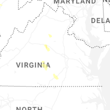


Connect with Interactive Hail Maps