

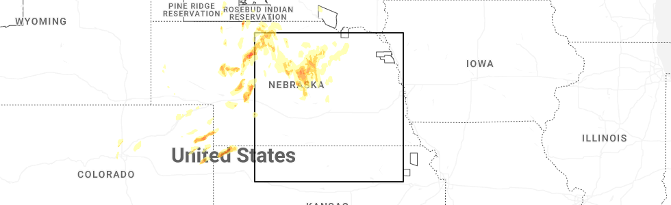
Hail Map for Comstock, NE
The Comstock, NE area has had 8 reports of on-the-ground hail by trained spotters, and has been under severe weather warnings 3 times during the past 12 months. Doppler radar has detected hail at or near Comstock, NE on 89 occasions, including 6 occasions during the past year.
| Name: | Comstock, NE |
| Where Located: | 64.2 miles NW of Grand Island, NE |
| Map: | Google Map for Comstock, NE |
| Population: | 93 |
| Housing Units: | 83 |
| More Info: | Search Google for Comstock, NE |
1
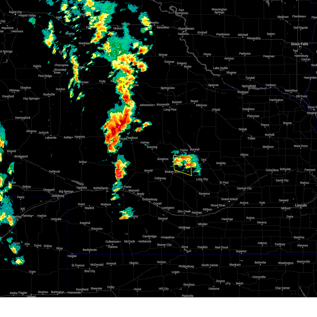
The Top Recent Hail Date for Comstock, NE is Wednesday, May 14, 2025 (33rd out of 89)
Hail and Wind Damage Spotted near Comstock, NE
| Date / Time | Report Details |
|---|---|
| 5/14/2025 8:00 PM CDT | Quarter sized hail reported 5.7 miles SW of Comstock, NE, hail up to quarter size...most smaller. |
| 5/14/2025 6:12 PM CDT |
 The storms which prompted the warning have weakened below severe limits, and have exited the warned area. therefore, the warning will be allowed to expire. however, small hail and heavy rain are still possible with these thunderstorms. a severe thunderstorm watch remains in effect until 1100 pm cdt for central nebraska. The storms which prompted the warning have weakened below severe limits, and have exited the warned area. therefore, the warning will be allowed to expire. however, small hail and heavy rain are still possible with these thunderstorms. a severe thunderstorm watch remains in effect until 1100 pm cdt for central nebraska.
|
| 5/14/2025 5:47 PM CDT |
 At 547 pm cdt, severe thunderstorms were located along a line extending from 6 miles northwest of weissert to near arcadia, moving north at 25 mph (radar indicated). Hazards include golf ball size hail and 60 mph wind gusts. People and animals outdoors will be injured. expect hail damage to roofs, siding, windows, and vehicles. expect wind damage to roofs, siding, and trees. locations impacted include, sargent, comstock, weissert, round valley, walworth, big oak canyon, arcadia diversion dam state wildlife management area, divide hill, and wescott. This includes highway 183 between mile markers 100 and 118. At 547 pm cdt, severe thunderstorms were located along a line extending from 6 miles northwest of weissert to near arcadia, moving north at 25 mph (radar indicated). Hazards include golf ball size hail and 60 mph wind gusts. People and animals outdoors will be injured. expect hail damage to roofs, siding, windows, and vehicles. expect wind damage to roofs, siding, and trees. locations impacted include, sargent, comstock, weissert, round valley, walworth, big oak canyon, arcadia diversion dam state wildlife management area, divide hill, and wescott. This includes highway 183 between mile markers 100 and 118.
|
| 5/14/2025 5:28 PM CDT |
 Svrlbf the national weather service in north platte has issued a * severe thunderstorm warning for, northeastern custer county in central nebraska, * until 615 pm cdt. * at 528 pm cdt, severe thunderstorms were located along a line extending from near weissert to 7 miles southwest of arcadia, moving north at 25 mph (radar indicated). Hazards include 60 mph wind gusts and half dollar size hail. Hail damage to vehicles is expected. Expect wind damage to roofs, siding, and trees. Svrlbf the national weather service in north platte has issued a * severe thunderstorm warning for, northeastern custer county in central nebraska, * until 615 pm cdt. * at 528 pm cdt, severe thunderstorms were located along a line extending from near weissert to 7 miles southwest of arcadia, moving north at 25 mph (radar indicated). Hazards include 60 mph wind gusts and half dollar size hail. Hail damage to vehicles is expected. Expect wind damage to roofs, siding, and trees.
|
| 6/2/2024 9:29 PM CDT |
 The storms which prompted the warning have weakened below severe limits, and have exited the warned area. therefore, the warning will be allowed to expire. however, gusty winds are still possible with these thunderstorms. a severe thunderstorm watch remains in effect until 1100 pm cdt for central nebraska. to report severe weather, contact your nearest law enforcement agency. they will relay your report to the national weather service north platte. The storms which prompted the warning have weakened below severe limits, and have exited the warned area. therefore, the warning will be allowed to expire. however, gusty winds are still possible with these thunderstorms. a severe thunderstorm watch remains in effect until 1100 pm cdt for central nebraska. to report severe weather, contact your nearest law enforcement agency. they will relay your report to the national weather service north platte.
|
| 6/2/2024 9:13 PM CDT |
 At 913 pm cdt, severe thunderstorms were located along a line extending from 6 miles southwest of arcadia to near mason city to 10 miles southwest of ansley, moving southeast at 35 mph (radar indicated). Hazards include 60 mph wind gusts. Expect damage to roofs, siding, and trees. locations impacted include, sargent, ansley, mason city, comstock, westerville, big oak canyon, arcadia diversion dam state wildlife management area, gavin siding, divide hill, wescott, and block hill basin. this includes the following highways, highway 183 between mile markers 78 and 120. highway 2 between mile markers 289 and 306. Highway 92 between mile markers 300 and 307. At 913 pm cdt, severe thunderstorms were located along a line extending from 6 miles southwest of arcadia to near mason city to 10 miles southwest of ansley, moving southeast at 35 mph (radar indicated). Hazards include 60 mph wind gusts. Expect damage to roofs, siding, and trees. locations impacted include, sargent, ansley, mason city, comstock, westerville, big oak canyon, arcadia diversion dam state wildlife management area, gavin siding, divide hill, wescott, and block hill basin. this includes the following highways, highway 183 between mile markers 78 and 120. highway 2 between mile markers 289 and 306. Highway 92 between mile markers 300 and 307.
|
| 6/2/2024 8:41 PM CDT |
 Svrlbf the national weather service in north platte has issued a * severe thunderstorm warning for, eastern custer county in central nebraska, * until 930 pm cdt. * at 841 pm cdt, severe thunderstorms were located along a line extending from near weissert to near broken bow to near callaway, moving east at 30 mph (radar indicated). Hazards include 60 mph wind gusts and penny size hail. expect damage to roofs, siding, and trees Svrlbf the national weather service in north platte has issued a * severe thunderstorm warning for, eastern custer county in central nebraska, * until 930 pm cdt. * at 841 pm cdt, severe thunderstorms were located along a line extending from near weissert to near broken bow to near callaway, moving east at 30 mph (radar indicated). Hazards include 60 mph wind gusts and penny size hail. expect damage to roofs, siding, and trees
|
| 5/20/2024 11:48 PM CDT |
 the severe thunderstorm warning has been cancelled and is no longer in effect the severe thunderstorm warning has been cancelled and is no longer in effect
|
| 5/20/2024 11:29 PM CDT |
 Svrlbf the national weather service in north platte has issued a * severe thunderstorm warning for, southeastern loup county in north central nebraska, southwestern garfield county in north central nebraska, northeastern custer county in central nebraska, * until 1215 am cdt. * at 1129 pm cdt, a severe thunderstorm was located near comstock, or 17 miles south of taylor, moving northeast at 25 mph (radar indicated). Hazards include 60 mph wind gusts and quarter size hail. Hail damage to vehicles is expected. Expect wind damage to roofs, siding, and trees. Svrlbf the national weather service in north platte has issued a * severe thunderstorm warning for, southeastern loup county in north central nebraska, southwestern garfield county in north central nebraska, northeastern custer county in central nebraska, * until 1215 am cdt. * at 1129 pm cdt, a severe thunderstorm was located near comstock, or 17 miles south of taylor, moving northeast at 25 mph (radar indicated). Hazards include 60 mph wind gusts and quarter size hail. Hail damage to vehicles is expected. Expect wind damage to roofs, siding, and trees.
|
| 5/20/2024 11:19 PM CDT |
 At 1119 pm cdt, a severe thunderstorm was located near comstock, or 17 miles northeast of broken bow, moving east at 25 mph (radar indicated). Hazards include 60 mph wind gusts and quarter size hail. Hail damage to vehicles is expected. expect wind damage to roofs, siding, and trees. locations impacted include, comstock, weissert, westerville, arcadia diversion dam state wildlife management area, wescott, and big oak canyon. This includes highway 183 between mile markers 98 and 113. At 1119 pm cdt, a severe thunderstorm was located near comstock, or 17 miles northeast of broken bow, moving east at 25 mph (radar indicated). Hazards include 60 mph wind gusts and quarter size hail. Hail damage to vehicles is expected. expect wind damage to roofs, siding, and trees. locations impacted include, comstock, weissert, westerville, arcadia diversion dam state wildlife management area, wescott, and big oak canyon. This includes highway 183 between mile markers 98 and 113.
|
| 5/20/2024 11:03 PM CDT |
 Svrlbf the national weather service in north platte has issued a * severe thunderstorm warning for, east central custer county in central nebraska, * until 1130 pm cdt. * at 1102 pm cdt, a severe thunderstorm was located over weissert, or 10 miles northeast of broken bow, moving east at 30 mph (radar indicated). Hazards include 60 mph wind gusts and quarter size hail. Hail damage to vehicles is expected. Expect wind damage to roofs, siding, and trees. Svrlbf the national weather service in north platte has issued a * severe thunderstorm warning for, east central custer county in central nebraska, * until 1130 pm cdt. * at 1102 pm cdt, a severe thunderstorm was located over weissert, or 10 miles northeast of broken bow, moving east at 30 mph (radar indicated). Hazards include 60 mph wind gusts and quarter size hail. Hail damage to vehicles is expected. Expect wind damage to roofs, siding, and trees.
|
| 4/16/2024 4:00 AM CDT |
 Svrlbf the national weather service in north platte has issued a * severe thunderstorm warning for, southeastern rock county in north central nebraska, eastern loup county in north central nebraska, garfield county in north central nebraska, southern holt county in north central nebraska, northeastern custer county in central nebraska, wheeler county in north central nebraska, * until 445 am cdt. * at 400 am cdt, severe thunderstorms were located along a line extending from near greeley center to near elyria to near comstock, moving north at 55 mph (radar indicated). Hazards include 70 mph wind gusts. Expect considerable tree damage. Damage is likely to mobile homes, roofs, and outbuildings. Svrlbf the national weather service in north platte has issued a * severe thunderstorm warning for, southeastern rock county in north central nebraska, eastern loup county in north central nebraska, garfield county in north central nebraska, southern holt county in north central nebraska, northeastern custer county in central nebraska, wheeler county in north central nebraska, * until 445 am cdt. * at 400 am cdt, severe thunderstorms were located along a line extending from near greeley center to near elyria to near comstock, moving north at 55 mph (radar indicated). Hazards include 70 mph wind gusts. Expect considerable tree damage. Damage is likely to mobile homes, roofs, and outbuildings.
|
| 4/6/2024 5:16 PM CDT |
 The storms which prompted the warning have weakened below severe limits, and no longer pose an immediate threat to life or property. therefore, the warning has been allowed to expire. however, gusty winds are still possible with these thunderstorms. a severe thunderstorm watch remains in effect until 800 pm cdt for central nebraska. The storms which prompted the warning have weakened below severe limits, and no longer pose an immediate threat to life or property. therefore, the warning has been allowed to expire. however, gusty winds are still possible with these thunderstorms. a severe thunderstorm watch remains in effect until 800 pm cdt for central nebraska.
|
| 4/6/2024 4:57 PM CDT |
 At 456 pm cdt, severe thunderstorms were located along a line extending from 14 miles east of elsmere to 9 miles east of brewster to 8 miles east of sargent, moving northeast at 35 mph (radar indicated). Hazards include 60 mph wind gusts. Expect damage to roofs, siding, and trees. locations impacted include, burwell, taylor, brewster, sargent, comstock, calamus reservoir state recreation area, fox bayou, almeria meadow state wildlife management area, virginia smith dam, hannamon bayou campground, wescott, kent diversion dam state wildlife management area, homestead knolls campground, horseshoe bend lake, big oak canyon, almeria, nunda shoal campground, divide hill, and valley view flat campground. This includes highway 183 between mile markers 111 and 151. At 456 pm cdt, severe thunderstorms were located along a line extending from 14 miles east of elsmere to 9 miles east of brewster to 8 miles east of sargent, moving northeast at 35 mph (radar indicated). Hazards include 60 mph wind gusts. Expect damage to roofs, siding, and trees. locations impacted include, burwell, taylor, brewster, sargent, comstock, calamus reservoir state recreation area, fox bayou, almeria meadow state wildlife management area, virginia smith dam, hannamon bayou campground, wescott, kent diversion dam state wildlife management area, homestead knolls campground, horseshoe bend lake, big oak canyon, almeria, nunda shoal campground, divide hill, and valley view flat campground. This includes highway 183 between mile markers 111 and 151.
|
| 4/6/2024 4:28 PM CDT |
 Svrlbf the national weather service in north platte has issued a * severe thunderstorm warning for, southwestern rock county in north central nebraska, loup county in north central nebraska, southeastern brown county in north central nebraska, southwestern garfield county in north central nebraska, northeastern custer county in central nebraska, eastern blaine county in north central nebraska, * until 515 pm cdt. * at 428 pm cdt, severe thunderstorms were located along a line extending from 9 miles north of anselmo to near victoria springs state recreation area to 6 miles southwest of arcadia, moving north at 45 mph (radar indicated). Hazards include 70 mph wind gusts. Expect considerable tree damage. Damage is likely to mobile homes, roofs, and outbuildings. Svrlbf the national weather service in north platte has issued a * severe thunderstorm warning for, southwestern rock county in north central nebraska, loup county in north central nebraska, southeastern brown county in north central nebraska, southwestern garfield county in north central nebraska, northeastern custer county in central nebraska, eastern blaine county in north central nebraska, * until 515 pm cdt. * at 428 pm cdt, severe thunderstorms were located along a line extending from 9 miles north of anselmo to near victoria springs state recreation area to 6 miles southwest of arcadia, moving north at 45 mph (radar indicated). Hazards include 70 mph wind gusts. Expect considerable tree damage. Damage is likely to mobile homes, roofs, and outbuildings.
|
| 4/6/2024 4:05 PM CDT |
 At 405 pm cdt, severe thunderstorms were located along a line extending from merna to broken bow to near litchfield, moving north at 65 mph (radar indicated). Hazards include 70 mph wind gusts. Expect considerable tree damage. damage is likely to mobile homes, roofs, and outbuildings. locations impacted include, broken bow, sargent, ansley, merna, mason city, anselmo, comstock, berwyn, victoria springs state recreation area, weissert, westerville, lillian, milburn, walworth, buckeye, round valley, arcadia diversion dam state wildlife management area, burr oak, gavin siding, and wescott. this includes the following highways, highway 183 between mile markers 73 and 121. highway 2 between mile markers 259 and 307. Highway 92 between mile markers 270 and 308. At 405 pm cdt, severe thunderstorms were located along a line extending from merna to broken bow to near litchfield, moving north at 65 mph (radar indicated). Hazards include 70 mph wind gusts. Expect considerable tree damage. damage is likely to mobile homes, roofs, and outbuildings. locations impacted include, broken bow, sargent, ansley, merna, mason city, anselmo, comstock, berwyn, victoria springs state recreation area, weissert, westerville, lillian, milburn, walworth, buckeye, round valley, arcadia diversion dam state wildlife management area, burr oak, gavin siding, and wescott. this includes the following highways, highway 183 between mile markers 73 and 121. highway 2 between mile markers 259 and 307. Highway 92 between mile markers 270 and 308.
|
| 4/6/2024 3:49 PM CDT |
 Svrlbf the national weather service in north platte has issued a * severe thunderstorm warning for, eastern custer county in central nebraska, * until 430 pm cdt. * at 349 pm cdt, severe thunderstorms were located along a line extending from 8 miles east of callaway to 10 miles southwest of ansley to 7 miles northeast of miller, moving northeast at 50 mph (radar indicated). Hazards include 70 mph wind gusts. Expect considerable tree damage. Damage is likely to mobile homes, roofs, and outbuildings. Svrlbf the national weather service in north platte has issued a * severe thunderstorm warning for, eastern custer county in central nebraska, * until 430 pm cdt. * at 349 pm cdt, severe thunderstorms were located along a line extending from 8 miles east of callaway to 10 miles southwest of ansley to 7 miles northeast of miller, moving northeast at 50 mph (radar indicated). Hazards include 70 mph wind gusts. Expect considerable tree damage. Damage is likely to mobile homes, roofs, and outbuildings.
|
| 7/29/2023 5:26 AM CDT |
 The severe thunderstorm warning for east central lincoln and custer counties will expire at 530 am cdt, the storms which prompted the warning have weakened below severe limits, and have exited the warned area. therefore, the warning will be allowed to expire. however gusty winds are still possible with these thunderstorms. a severe thunderstorm watch remains in effect until 1100 am cdt for central and southwestern nebraska. The severe thunderstorm warning for east central lincoln and custer counties will expire at 530 am cdt, the storms which prompted the warning have weakened below severe limits, and have exited the warned area. therefore, the warning will be allowed to expire. however gusty winds are still possible with these thunderstorms. a severe thunderstorm watch remains in effect until 1100 am cdt for central and southwestern nebraska.
|
| 7/29/2023 4:43 AM CDT |
 At 443 am cdt, severe thunderstorms were located along a line extending from berwyn to 9 miles northeast of gothenburg, moving southeast at 45 mph (radar indicated). Hazards include 70 mph wind gusts and quarter size hail. Hail damage to vehicles is expected. expect considerable tree damage. Wind damage is also likely to mobile homes, roofs, and outbuildings. At 443 am cdt, severe thunderstorms were located along a line extending from berwyn to 9 miles northeast of gothenburg, moving southeast at 45 mph (radar indicated). Hazards include 70 mph wind gusts and quarter size hail. Hail damage to vehicles is expected. expect considerable tree damage. Wind damage is also likely to mobile homes, roofs, and outbuildings.
|
| 7/29/2023 4:36 AM CDT |
 At 435 am cdt, severe thunderstorms were located along a line extending from near berwyn to near gothenburg, moving southeast at 55 mph (radar indicated). Hazards include 70 mph wind gusts and quarter size hail. Hail damage to vehicles is expected. expect considerable tree damage. wind damage is also likely to mobile homes, roofs, and outbuildings. locations impacted include, broken bow, arnold, callaway, sargent, ansley, merna, mason city, oconto, anselmo, comstock, berwyn, victoria springs state recreation area, weissert, westerville, lillian, walworth, lodi, buckeye, finchville and round valley. this includes the following highways, highway 183 between mile markers 73 and 114. highway 2 between mile markers 257 and 307. highway 92 between mile markers 244 and 308. thunderstorm damage threat, considerable hail threat, radar indicated max hail size, 1. 00 in wind threat, observed max wind gust, 70 mph. At 435 am cdt, severe thunderstorms were located along a line extending from near berwyn to near gothenburg, moving southeast at 55 mph (radar indicated). Hazards include 70 mph wind gusts and quarter size hail. Hail damage to vehicles is expected. expect considerable tree damage. wind damage is also likely to mobile homes, roofs, and outbuildings. locations impacted include, broken bow, arnold, callaway, sargent, ansley, merna, mason city, oconto, anselmo, comstock, berwyn, victoria springs state recreation area, weissert, westerville, lillian, walworth, lodi, buckeye, finchville and round valley. this includes the following highways, highway 183 between mile markers 73 and 114. highway 2 between mile markers 257 and 307. highway 92 between mile markers 244 and 308. thunderstorm damage threat, considerable hail threat, radar indicated max hail size, 1. 00 in wind threat, observed max wind gust, 70 mph.
|
| 7/29/2023 4:17 AM CDT |
 At 417 am cdt, a severe thunderstorm was located 7 miles southwest of burwell, moving southeast at 30 mph (radar indicated). Hazards include 60 mph wind gusts and quarter size hail. Hail damage to vehicles is expected. expect wind damage to roofs, siding, and trees. locations impacted include, burwell, taylor, sargent, comstock, calamus reservoir state recreation area, virginia smith dam, arcadia diversion dam state wildlife management area, wescott, kent diversion dam state wildlife management area, homestead knolls campground, big oak canyon, nunda shoal campground, deverre and divide hill. this includes highway 183 between mile markers 104 and 129. hail threat, radar indicated max hail size, 1. 00 in wind threat, radar indicated max wind gust, 60 mph. At 417 am cdt, a severe thunderstorm was located 7 miles southwest of burwell, moving southeast at 30 mph (radar indicated). Hazards include 60 mph wind gusts and quarter size hail. Hail damage to vehicles is expected. expect wind damage to roofs, siding, and trees. locations impacted include, burwell, taylor, sargent, comstock, calamus reservoir state recreation area, virginia smith dam, arcadia diversion dam state wildlife management area, wescott, kent diversion dam state wildlife management area, homestead knolls campground, big oak canyon, nunda shoal campground, deverre and divide hill. this includes highway 183 between mile markers 104 and 129. hail threat, radar indicated max hail size, 1. 00 in wind threat, radar indicated max wind gust, 60 mph.
|
| 7/29/2023 4:06 AM CDT |
 At 406 am cdt, severe thunderstorms were located along a line extending from near victoria springs state recreation area to 11 miles south of gandy, moving southeast at 55 mph (radar indicated). Hazards include 70 mph wind gusts and quarter size hail. Hail damage to vehicles is expected. expect considerable tree damage. Wind damage is also likely to mobile homes, roofs, and outbuildings. At 406 am cdt, severe thunderstorms were located along a line extending from near victoria springs state recreation area to 11 miles south of gandy, moving southeast at 55 mph (radar indicated). Hazards include 70 mph wind gusts and quarter size hail. Hail damage to vehicles is expected. expect considerable tree damage. Wind damage is also likely to mobile homes, roofs, and outbuildings.
|
| 7/29/2023 4:00 AM CDT |
 At 359 am cdt, a severe thunderstorm was located near taylor, moving southeast at 35 mph (radar indicated). Hazards include 60 mph wind gusts and quarter size hail. Hail damage to vehicles is expected. expect wind damage to roofs, siding, and trees. locations impacted include, burwell, taylor, sargent, comstock, calamus reservoir state recreation area, virginia smith dam, hannamon bayou campground, arcadia diversion dam state wildlife management area, wescott, kent diversion dam state wildlife management area, homestead knolls campground, horseshoe bend lake, almeria, big oak canyon, nunda shoal campground, deverre, divide hill and valley view flat campground. this includes highway 183 between mile markers 104 and 136. hail threat, radar indicated max hail size, 1. 00 in wind threat, radar indicated max wind gust, 60 mph. At 359 am cdt, a severe thunderstorm was located near taylor, moving southeast at 35 mph (radar indicated). Hazards include 60 mph wind gusts and quarter size hail. Hail damage to vehicles is expected. expect wind damage to roofs, siding, and trees. locations impacted include, burwell, taylor, sargent, comstock, calamus reservoir state recreation area, virginia smith dam, hannamon bayou campground, arcadia diversion dam state wildlife management area, wescott, kent diversion dam state wildlife management area, homestead knolls campground, horseshoe bend lake, almeria, big oak canyon, nunda shoal campground, deverre, divide hill and valley view flat campground. this includes highway 183 between mile markers 104 and 136. hail threat, radar indicated max hail size, 1. 00 in wind threat, radar indicated max wind gust, 60 mph.
|
| 7/29/2023 3:46 AM CDT |
 At 345 am cdt, a severe thunderstorm was located near taylor, moving southeast at 35 mph (radar indicated). Hazards include 60 mph wind gusts and quarter size hail. Hail damage to vehicles is expected. Expect wind damage to roofs, siding, and trees. At 345 am cdt, a severe thunderstorm was located near taylor, moving southeast at 35 mph (radar indicated). Hazards include 60 mph wind gusts and quarter size hail. Hail damage to vehicles is expected. Expect wind damage to roofs, siding, and trees.
|
| 7/25/2023 10:03 PM CDT |
 At 1002 pm cdt, a severe thunderstorm was located over taylor, moving southeast at 30 mph (radar indicated). Hazards include 60 mph wind gusts and quarter size hail. Hail damage to vehicles is expected. Expect wind damage to roofs, siding, and trees. At 1002 pm cdt, a severe thunderstorm was located over taylor, moving southeast at 30 mph (radar indicated). Hazards include 60 mph wind gusts and quarter size hail. Hail damage to vehicles is expected. Expect wind damage to roofs, siding, and trees.
|
| 7/16/2023 6:11 AM CDT |
 The severe thunderstorm warning for southern loup, southwestern garfield, northeastern custer and southeastern blaine counties will expire at 615 am cdt, the storms which prompted the warning have weakened below severe limits, and no longer pose an immediate threat to life or property. therefore, the warning will be allowed to expire. however gusty winds and heavy rain are still possible with these thunderstorms. The severe thunderstorm warning for southern loup, southwestern garfield, northeastern custer and southeastern blaine counties will expire at 615 am cdt, the storms which prompted the warning have weakened below severe limits, and no longer pose an immediate threat to life or property. therefore, the warning will be allowed to expire. however gusty winds and heavy rain are still possible with these thunderstorms.
|
| 7/16/2023 5:55 AM CDT |
 At 554 am cdt, severe thunderstorms were located along a line extending from 14 miles northeast of anselmo to 8 miles east of victoria springs state recreation area to near merna, moving southeast at 45 mph (radar indicated). Hazards include 60 mph wind gusts and penny size hail. Expect damage to roofs, siding, and trees. locations impacted include, broken bow, burwell, taylor, sargent, merna, comstock, victoria springs state recreation area, calamus reservoir state recreation area, weissert, lillian, milburn, milburn diversion dam state wildlife management area, round valley, walworth, virginia smith dam, wescott, kent diversion dam state wildlife management area, homestead knolls campground, horseshoe bend lake and almeria. this includes the following highways, highway 183 between mile markers 103 and 135. highway 2 between mile markers 260 and 276. highway 92 between mile markers 272 and 273. hail threat, radar indicated max hail size, 0. 75 in wind threat, radar indicated max wind gust, 60 mph. At 554 am cdt, severe thunderstorms were located along a line extending from 14 miles northeast of anselmo to 8 miles east of victoria springs state recreation area to near merna, moving southeast at 45 mph (radar indicated). Hazards include 60 mph wind gusts and penny size hail. Expect damage to roofs, siding, and trees. locations impacted include, broken bow, burwell, taylor, sargent, merna, comstock, victoria springs state recreation area, calamus reservoir state recreation area, weissert, lillian, milburn, milburn diversion dam state wildlife management area, round valley, walworth, virginia smith dam, wescott, kent diversion dam state wildlife management area, homestead knolls campground, horseshoe bend lake and almeria. this includes the following highways, highway 183 between mile markers 103 and 135. highway 2 between mile markers 260 and 276. highway 92 between mile markers 272 and 273. hail threat, radar indicated max hail size, 0. 75 in wind threat, radar indicated max wind gust, 60 mph.
|
| 7/16/2023 5:30 AM CDT |
 At 528 am cdt, severe thunderstorms were located along a line extending from 9 miles northwest of taylor to near dunning, moving southeast at 40 mph (public). Hazards include 60 mph wind gusts and penny size hail. expect damage to roofs, siding, and trees At 528 am cdt, severe thunderstorms were located along a line extending from 9 miles northwest of taylor to near dunning, moving southeast at 40 mph (public). Hazards include 60 mph wind gusts and penny size hail. expect damage to roofs, siding, and trees
|
| 6/24/2023 1:58 AM CDT |
 The severe thunderstorm warning for southern rock, loup, southern brown, garfield, southwestern holt, northeastern custer and blaine counties will expire at 200 am cdt, the storms which prompted the warning have weakened below severe limits, and no longer pose an immediate threat to life or property. therefore, the warning will be allowed to expire. however gusty winds and heavy rain are still possible with these thunderstorms. a severe thunderstorm watch remains in effect until 600 am cdt for central and north central nebraska. to report severe weather, contact your nearest law enforcement agency. they will relay your report to the national weather service north platte. The severe thunderstorm warning for southern rock, loup, southern brown, garfield, southwestern holt, northeastern custer and blaine counties will expire at 200 am cdt, the storms which prompted the warning have weakened below severe limits, and no longer pose an immediate threat to life or property. therefore, the warning will be allowed to expire. however gusty winds and heavy rain are still possible with these thunderstorms. a severe thunderstorm watch remains in effect until 600 am cdt for central and north central nebraska. to report severe weather, contact your nearest law enforcement agency. they will relay your report to the national weather service north platte.
|
| 6/24/2023 1:41 AM CDT |
 At 141 am cdt, severe thunderstorms were located along a line extending from 20 miles south of long pine to 6 miles south of rose to near taylor to near sargent, moving east at 45 mph (radar indicated). Hazards include 60 mph wind gusts. Expect damage to roofs, siding, and trees. locations impacted include, burwell, taylor, brewster, sargent, anselmo, comstock, rose, amelia, victoria springs state recreation area, calamus reservoir state recreation area, lillian, milburn, milburn diversion dam state wildlife management area, hofeld lake, fox bayou, raven, almeria meadow state wildlife management area, walworth, virginia smith dam and hawley flats. this includes the following highways, highway 183 between mile markers 106 and 173. highway 2 between mile markers 255 and 267. hail threat, radar indicated max hail size, <. 75 in wind threat, observed max wind gust, 60 mph. At 141 am cdt, severe thunderstorms were located along a line extending from 20 miles south of long pine to 6 miles south of rose to near taylor to near sargent, moving east at 45 mph (radar indicated). Hazards include 60 mph wind gusts. Expect damage to roofs, siding, and trees. locations impacted include, burwell, taylor, brewster, sargent, anselmo, comstock, rose, amelia, victoria springs state recreation area, calamus reservoir state recreation area, lillian, milburn, milburn diversion dam state wildlife management area, hofeld lake, fox bayou, raven, almeria meadow state wildlife management area, walworth, virginia smith dam and hawley flats. this includes the following highways, highway 183 between mile markers 106 and 173. highway 2 between mile markers 255 and 267. hail threat, radar indicated max hail size, <. 75 in wind threat, observed max wind gust, 60 mph.
|
| 6/24/2023 1:21 AM CDT |
 At 120 am cdt, severe thunderstorms were located along a line extending from 8 miles east of elsmere to near brewster to 8 miles northeast of victoria springs state recreation area to near merna, moving east at 50 mph (radar indicated. at 109 am cdt, a 66 mph gust was reported 1 mile south of dunning). Hazards include 60 mph wind gusts. expect damage to roofs, siding, and trees At 120 am cdt, severe thunderstorms were located along a line extending from 8 miles east of elsmere to near brewster to 8 miles northeast of victoria springs state recreation area to near merna, moving east at 50 mph (radar indicated. at 109 am cdt, a 66 mph gust was reported 1 mile south of dunning). Hazards include 60 mph wind gusts. expect damage to roofs, siding, and trees
|
| 5/31/2023 1:12 AM CDT |
 The severe thunderstorm warning for eastern custer county will expire at 115 am cdt, the storms which prompted the warning have weakened below severe limits, and no longer pose an immediate threat to life or property. therefore, the warning will be allowed to expire. however gusty winds are still possible with these thunderstorms. The severe thunderstorm warning for eastern custer county will expire at 115 am cdt, the storms which prompted the warning have weakened below severe limits, and no longer pose an immediate threat to life or property. therefore, the warning will be allowed to expire. however gusty winds are still possible with these thunderstorms.
|
| 5/31/2023 12:56 AM CDT |
 At 1256 am cdt, severe thunderstorms were located along a line extending from near sargent to near berwyn to near callaway, moving east at 40 mph (radar indicated). Hazards include 60 mph wind gusts. Expect damage to roofs, siding, and trees. locations impacted include, broken bow, sargent, ansley, mason city, oconto, comstock, berwyn, weissert, westerville, lillian, round valley, walworth, arcadia diversion dam state wildlife management area, burr oak, gavin siding, wescott, lodi, intersection of highway 183 and cumro road, buckeye and block hill basin. this includes the following highways, highway 183 between mile markers 73 and 121. highway 2 between mile markers 271 and 306. highway 92 between mile markers 300 and 308. hail threat, radar indicated max hail size, <. 75 in wind threat, radar indicated max wind gust, 60 mph. At 1256 am cdt, severe thunderstorms were located along a line extending from near sargent to near berwyn to near callaway, moving east at 40 mph (radar indicated). Hazards include 60 mph wind gusts. Expect damage to roofs, siding, and trees. locations impacted include, broken bow, sargent, ansley, mason city, oconto, comstock, berwyn, weissert, westerville, lillian, round valley, walworth, arcadia diversion dam state wildlife management area, burr oak, gavin siding, wescott, lodi, intersection of highway 183 and cumro road, buckeye and block hill basin. this includes the following highways, highway 183 between mile markers 73 and 121. highway 2 between mile markers 271 and 306. highway 92 between mile markers 300 and 308. hail threat, radar indicated max hail size, <. 75 in wind threat, radar indicated max wind gust, 60 mph.
|
| 5/31/2023 12:30 AM CDT |
 At 1228 am cdt, severe thunderstorms were located along a line extending from near victoria springs state recreation area to callaway, moving southeast at 40 mph (radar indicated. at 1223 am cdt, a wind gust to 58 mph was recorded at broken bow airport). Hazards include 60 mph wind gusts and penny size hail. expect damage to roofs, siding, and trees At 1228 am cdt, severe thunderstorms were located along a line extending from near victoria springs state recreation area to callaway, moving southeast at 40 mph (radar indicated. at 1223 am cdt, a wind gust to 58 mph was recorded at broken bow airport). Hazards include 60 mph wind gusts and penny size hail. expect damage to roofs, siding, and trees
|
| 5/5/2023 11:58 PM CDT |
 The severe thunderstorm warning for eastern custer county will expire at midnight cdt, the storms which prompted the warning have moved out of the area. therefore, the warning will be allowed to expire. however gusty winds are still possible with these thunderstorms. The severe thunderstorm warning for eastern custer county will expire at midnight cdt, the storms which prompted the warning have moved out of the area. therefore, the warning will be allowed to expire. however gusty winds are still possible with these thunderstorms.
|
| 5/5/2023 11:45 PM CDT |
 At 1145 pm cdt, severe thunderstorms were located along a line extending from near sargent to near mason city to near hazard, moving east at 40 mph (radar indicated). Hazards include 60 mph wind gusts. Expect damage to roofs, siding, and trees. locations impacted include, sargent, ansley, mason city, comstock, berwyn, weissert, westerville, round valley, arcadia diversion dam state wildlife management area, gavin siding, wescott, intersection of highway 183 and cumro road, block hill basin, big oak canyon, divide hill and cumro. this includes the following highways, highway 183 between mile markers 73 and 121. highway 2 between mile markers 285 and 307. highway 92 between mile markers 300 and 308. hail threat, radar indicated max hail size, <. 75 in wind threat, radar indicated max wind gust, 60 mph. At 1145 pm cdt, severe thunderstorms were located along a line extending from near sargent to near mason city to near hazard, moving east at 40 mph (radar indicated). Hazards include 60 mph wind gusts. Expect damage to roofs, siding, and trees. locations impacted include, sargent, ansley, mason city, comstock, berwyn, weissert, westerville, round valley, arcadia diversion dam state wildlife management area, gavin siding, wescott, intersection of highway 183 and cumro road, block hill basin, big oak canyon, divide hill and cumro. this includes the following highways, highway 183 between mile markers 73 and 121. highway 2 between mile markers 285 and 307. highway 92 between mile markers 300 and 308. hail threat, radar indicated max hail size, <. 75 in wind threat, radar indicated max wind gust, 60 mph.
|
| 5/5/2023 11:23 PM CDT |
 At 1123 pm cdt, severe thunderstorms were located along a line extending from 7 miles west of sargent to near ansley to near sumner, moving east at 40 mph (radar indicated). Hazards include 60 mph wind gusts. expect damage to roofs, siding, and trees At 1123 pm cdt, severe thunderstorms were located along a line extending from 7 miles west of sargent to near ansley to near sumner, moving east at 40 mph (radar indicated). Hazards include 60 mph wind gusts. expect damage to roofs, siding, and trees
|
| 6/13/2022 5:20 PM CDT | At 519 pm cdt, a severe thunderstorm was located 7 miles northeast of oconto, or 13 miles south of broken bow, moving northeast at 35 mph (radar indicated). Hazards include 60 mph wind gusts. expect damage to roofs, siding, and trees |
| 5/30/2022 12:18 AM CDT |
 At 1218 am cdt, severe thunderstorms were located along a line extending from near arcadia to 9 miles southwest of mason city, moving northeast at 45 mph (radar indicated). Hazards include 60 mph wind gusts and half dollar size hail. Hail damage to vehicles is expected. expect wind damage to roofs, siding, and trees. locations impacted include, ansley, mason city, comstock, big oak canyon, arcadia diversion dam state wildlife management area, gavin siding and wescott. this includes the following highways, highway 183 between mile markers 88 and 96. highway 2 between mile markers 293 and 307. highway 92 between mile markers 300 and 308. hail threat, radar indicated max hail size, 1. 25 in wind threat, radar indicated max wind gust, 60 mph. At 1218 am cdt, severe thunderstorms were located along a line extending from near arcadia to 9 miles southwest of mason city, moving northeast at 45 mph (radar indicated). Hazards include 60 mph wind gusts and half dollar size hail. Hail damage to vehicles is expected. expect wind damage to roofs, siding, and trees. locations impacted include, ansley, mason city, comstock, big oak canyon, arcadia diversion dam state wildlife management area, gavin siding and wescott. this includes the following highways, highway 183 between mile markers 88 and 96. highway 2 between mile markers 293 and 307. highway 92 between mile markers 300 and 308. hail threat, radar indicated max hail size, 1. 25 in wind threat, radar indicated max wind gust, 60 mph.
|
| 5/29/2022 11:58 PM CDT |
 At 1157 pm cdt, a severe thunderstorm was located near ansley, or 19 miles east of broken bow, moving northeast at 35 mph (trained weather spotters). Hazards include golf ball size hail and 60 mph wind gusts. People and animals outdoors will be injured. expect hail damage to roofs, siding, windows, and vehicles. Expect wind damage to roofs, siding, and trees. At 1157 pm cdt, a severe thunderstorm was located near ansley, or 19 miles east of broken bow, moving northeast at 35 mph (trained weather spotters). Hazards include golf ball size hail and 60 mph wind gusts. People and animals outdoors will be injured. expect hail damage to roofs, siding, windows, and vehicles. Expect wind damage to roofs, siding, and trees.
|
| 5/29/2022 11:41 PM CDT |
 At 1141 pm cdt, a severe thunderstorm was located near arcadia, or 20 miles east of broken bow, moving north at 35 mph (radar indicated). Hazards include ping pong ball size hail and 60 mph wind gusts. People and animals outdoors will be injured. expect hail damage to roofs, siding, windows, and vehicles. Expect wind damage to roofs, siding, and trees. At 1141 pm cdt, a severe thunderstorm was located near arcadia, or 20 miles east of broken bow, moving north at 35 mph (radar indicated). Hazards include ping pong ball size hail and 60 mph wind gusts. People and animals outdoors will be injured. expect hail damage to roofs, siding, windows, and vehicles. Expect wind damage to roofs, siding, and trees.
|
| 5/29/2022 10:55 PM CDT |
 The severe thunderstorm warning for southeastern rock, loup, southeastern brown, northeastern custer and blaine counties will expire at 1100 pm cdt, the storms which prompted the warning remain severe and have moved out of the area. therefore, this warning will be allowed to expire and a new warning has been issued. a tornado watch remains in effect until 200 am cdt for central and north central nebraska. The severe thunderstorm warning for southeastern rock, loup, southeastern brown, northeastern custer and blaine counties will expire at 1100 pm cdt, the storms which prompted the warning remain severe and have moved out of the area. therefore, this warning will be allowed to expire and a new warning has been issued. a tornado watch remains in effect until 200 am cdt for central and north central nebraska.
|
| 5/29/2022 10:35 PM CDT |
 At 1035 pm cdt, severe thunderstorms were located along a line extending from 15 miles west of rose to 12 miles east of brewster to near anselmo, moving east at 35 mph (radar indicated). Hazards include 60 mph wind gusts and quarter size hail. Hail damage to vehicles is expected. expect wind damage to roofs, siding, and trees. locations impacted include, taylor, brewster, sargent, anselmo, comstock, victoria springs state recreation area, calamus reservoir state recreation area, lillian, milburn, milburn diversion dam state wildlife management area, fox bayou, almeria meadow state wildlife management area, walworth, hawley flats, kent diversion dam state wildlife management area, nunda shoal campground, round valley, hannamon bayou campground, wescott and linscott. this includes the following highways, highway 183 between mile markers 108 and 149. highway 2 between mile markers 246 and 261. hail threat, radar indicated max hail size, 1. 00 in wind threat, radar indicated max wind gust, 60 mph. At 1035 pm cdt, severe thunderstorms were located along a line extending from 15 miles west of rose to 12 miles east of brewster to near anselmo, moving east at 35 mph (radar indicated). Hazards include 60 mph wind gusts and quarter size hail. Hail damage to vehicles is expected. expect wind damage to roofs, siding, and trees. locations impacted include, taylor, brewster, sargent, anselmo, comstock, victoria springs state recreation area, calamus reservoir state recreation area, lillian, milburn, milburn diversion dam state wildlife management area, fox bayou, almeria meadow state wildlife management area, walworth, hawley flats, kent diversion dam state wildlife management area, nunda shoal campground, round valley, hannamon bayou campground, wescott and linscott. this includes the following highways, highway 183 between mile markers 108 and 149. highway 2 between mile markers 246 and 261. hail threat, radar indicated max hail size, 1. 00 in wind threat, radar indicated max wind gust, 60 mph.
|
| 5/29/2022 10:11 PM CDT |
 At 1011 pm cdt, severe thunderstorms were located along a line extending from near elsmere to 6 miles south of brewster to 7 miles northeast of arnold, moving east at 35 mph (radar indicated). Hazards include 60 mph wind gusts and quarter size hail. Hail damage to vehicles is expected. Expect wind damage to roofs, siding, and trees. At 1011 pm cdt, severe thunderstorms were located along a line extending from near elsmere to 6 miles south of brewster to 7 miles northeast of arnold, moving east at 35 mph (radar indicated). Hazards include 60 mph wind gusts and quarter size hail. Hail damage to vehicles is expected. Expect wind damage to roofs, siding, and trees.
|
| 5/12/2022 2:34 PM CDT |
 At 232 pm cdt, a severe thunderstorm was located near arcadia, or 17 miles southwest of ord, moving northeast at 65 mph. this is a destructive storm for far northeastern custer and southern garfield counties (emergency management reported tree damage and flipped irrigation pivots near ansley). Hazards include 80 mph wind gusts and half dollar size hail. Flying debris will be dangerous to those caught without shelter. mobile homes will be heavily damaged. expect considerable damage to roofs, windows, and vehicles. Extensive tree damage and power outages are likely. At 232 pm cdt, a severe thunderstorm was located near arcadia, or 17 miles southwest of ord, moving northeast at 65 mph. this is a destructive storm for far northeastern custer and southern garfield counties (emergency management reported tree damage and flipped irrigation pivots near ansley). Hazards include 80 mph wind gusts and half dollar size hail. Flying debris will be dangerous to those caught without shelter. mobile homes will be heavily damaged. expect considerable damage to roofs, windows, and vehicles. Extensive tree damage and power outages are likely.
|
| 4/29/2022 5:21 PM CDT |
 The severe thunderstorm warning for northeastern custer county will expire at 530 pm cdt, the storms which prompted the warning have moved out of the area. therefore, the warning will be allowed to expire. however gusty winds and heavy rain are still possible with these thunderstorms. a tornado watch remains in effect until 900 pm cdt for central nebraska. The severe thunderstorm warning for northeastern custer county will expire at 530 pm cdt, the storms which prompted the warning have moved out of the area. therefore, the warning will be allowed to expire. however gusty winds and heavy rain are still possible with these thunderstorms. a tornado watch remains in effect until 900 pm cdt for central nebraska.
|
| 4/29/2022 4:50 PM CDT |
 At 449 pm cdt, severe thunderstorms were located along a line extending from sargent to near ansley, moving east at 30 mph (radar indicated). Hazards include 60 mph wind gusts and quarter size hail. Hail damage to vehicles is expected. expect wind damage to roofs, siding, and trees. locations impacted include, broken bow, sargent, comstock, berwyn, weissert, westerville, lillian, round valley, walworth, arcadia diversion dam state wildlife management area, wescott, big oak canyon and divide hill. this includes the following highways, highway 183 between mile markers 91 and 119. highway 2 between mile markers 278 and 294. hail threat, radar indicated max hail size, 1. 00 in wind threat, radar indicated max wind gust, 60 mph. At 449 pm cdt, severe thunderstorms were located along a line extending from sargent to near ansley, moving east at 30 mph (radar indicated). Hazards include 60 mph wind gusts and quarter size hail. Hail damage to vehicles is expected. expect wind damage to roofs, siding, and trees. locations impacted include, broken bow, sargent, comstock, berwyn, weissert, westerville, lillian, round valley, walworth, arcadia diversion dam state wildlife management area, wescott, big oak canyon and divide hill. this includes the following highways, highway 183 between mile markers 91 and 119. highway 2 between mile markers 278 and 294. hail threat, radar indicated max hail size, 1. 00 in wind threat, radar indicated max wind gust, 60 mph.
|
| 4/29/2022 4:38 PM CDT |
 At 438 pm cdt, a severe thunderstorm was located near weissert, or 7 miles northeast of broken bow, moving east at 45 mph (radar indicated). Hazards include 60 mph wind gusts and quarter size hail. Hail damage to vehicles is expected. Expect wind damage to roofs, siding, and trees. At 438 pm cdt, a severe thunderstorm was located near weissert, or 7 miles northeast of broken bow, moving east at 45 mph (radar indicated). Hazards include 60 mph wind gusts and quarter size hail. Hail damage to vehicles is expected. Expect wind damage to roofs, siding, and trees.
|
| 7/11/2020 2:03 AM CDT |
 At 202 am cdt, a severe thunderstorm was located near sargent, or 9 miles southwest of taylor, moving southeast at 35 mph (radar indicated). Hazards include 60 mph wind gusts and quarter size hail. Hail damage to vehicles is expected. Expect wind damage to roofs, siding, and trees. At 202 am cdt, a severe thunderstorm was located near sargent, or 9 miles southwest of taylor, moving southeast at 35 mph (radar indicated). Hazards include 60 mph wind gusts and quarter size hail. Hail damage to vehicles is expected. Expect wind damage to roofs, siding, and trees.
|
| 7/10/2020 5:13 PM CDT |
 At 513 pm cdt, a severe thunderstorm was located near mason city, or 20 miles southeast of broken bow, moving southeast at 30 mph. this is a very dangerous storm (radar indicated). Hazards include 80 mph wind gusts and ping pong ball size hail. Flying debris will be dangerous to those caught without shelter. mobile homes will be heavily damaged. expect considerable damage to roofs, windows, and vehicles. Extensive tree damage and power outages are likely. At 513 pm cdt, a severe thunderstorm was located near mason city, or 20 miles southeast of broken bow, moving southeast at 30 mph. this is a very dangerous storm (radar indicated). Hazards include 80 mph wind gusts and ping pong ball size hail. Flying debris will be dangerous to those caught without shelter. mobile homes will be heavily damaged. expect considerable damage to roofs, windows, and vehicles. Extensive tree damage and power outages are likely.
|
| 7/10/2020 4:53 PM CDT |
 At 452 pm cdt, a severe thunderstorm was located near weissert, or 13 miles east of broken bow, moving southeast at 30 mph. this is a very dangerous storm (radar indicated). Hazards include 80 mph wind gusts and ping pong ball size hail. Flying debris will be dangerous to those caught without shelter. mobile homes will be heavily damaged. expect considerable damage to roofs, windows, and vehicles. extensive tree damage and power outages are likely. locations impacted include, ansley, mason city, comstock, berwyn, weissert, westerville,and wescott. this includes the following highways, highway 183 between mile markers 85 and 112. highway 2 between mile markers 284 and 307. Highway 92 between mile markers 300 and 308. At 452 pm cdt, a severe thunderstorm was located near weissert, or 13 miles east of broken bow, moving southeast at 30 mph. this is a very dangerous storm (radar indicated). Hazards include 80 mph wind gusts and ping pong ball size hail. Flying debris will be dangerous to those caught without shelter. mobile homes will be heavily damaged. expect considerable damage to roofs, windows, and vehicles. extensive tree damage and power outages are likely. locations impacted include, ansley, mason city, comstock, berwyn, weissert, westerville,and wescott. this includes the following highways, highway 183 between mile markers 85 and 112. highway 2 between mile markers 284 and 307. Highway 92 between mile markers 300 and 308.
|
| 7/10/2020 4:26 PM CDT |
 At 425 pm cdt, a severe thunderstorm was located 7 miles southwest of sargent, or 14 miles south of taylor, moving southeast at 55 mph. this is a very dangerous storm (radar indicated). Hazards include 90 mph wind gusts and ping pong ball size hail. You are in a life-threatening situation. flying debris may be deadly to those caught without shelter. mobile homes will be heavily damaged or destroyed. homes and businesses will have substantial roof and window damage. Expect extensive tree damage and power outages. At 425 pm cdt, a severe thunderstorm was located 7 miles southwest of sargent, or 14 miles south of taylor, moving southeast at 55 mph. this is a very dangerous storm (radar indicated). Hazards include 90 mph wind gusts and ping pong ball size hail. You are in a life-threatening situation. flying debris may be deadly to those caught without shelter. mobile homes will be heavily damaged or destroyed. homes and businesses will have substantial roof and window damage. Expect extensive tree damage and power outages.
|
| 7/10/2020 4:11 PM CDT |
 At 409 pm cdt, a severe thunderstorm was located near victoria springs state recreation area, or 17 miles south of brewster, moving southeast at 20 mph. this is a very dangerous storm (radar indicated). Hazards include 80 mph wind gusts and golf ball size hail. Flying debris will be dangerous to those caught without shelter. mobile homes will be heavily damaged. expect considerable damage to roofs, windows, and vehicles. extensive tree damage and power outages are likely. locations impacted include, taylor, sargent, anselmo, comstock, berwyn, victoria springs state recreation area, gates and almeria. this includes the following highways, highway 183 between mile markers 96 and 125. Highway 2 between mile markers 252 and 263, and between mile markers 284 and 291. At 409 pm cdt, a severe thunderstorm was located near victoria springs state recreation area, or 17 miles south of brewster, moving southeast at 20 mph. this is a very dangerous storm (radar indicated). Hazards include 80 mph wind gusts and golf ball size hail. Flying debris will be dangerous to those caught without shelter. mobile homes will be heavily damaged. expect considerable damage to roofs, windows, and vehicles. extensive tree damage and power outages are likely. locations impacted include, taylor, sargent, anselmo, comstock, berwyn, victoria springs state recreation area, gates and almeria. this includes the following highways, highway 183 between mile markers 96 and 125. Highway 2 between mile markers 252 and 263, and between mile markers 284 and 291.
|
| 7/10/2020 3:59 PM CDT |
 At 358 pm cdt, a severe thunderstorm was located 7 miles north of victoria springs state recreation area, or 15 miles south of brewster, moving southeast at 20 mph (radar indicated). Hazards include two inch hail and 70 mph wind gusts. People and animals outdoors will be injured. expect hail damage to roofs, siding, windows, and vehicles. expect considerable tree damage. Wind damage is also likely to mobile homes, roofs, and outbuildings. At 358 pm cdt, a severe thunderstorm was located 7 miles north of victoria springs state recreation area, or 15 miles south of brewster, moving southeast at 20 mph (radar indicated). Hazards include two inch hail and 70 mph wind gusts. People and animals outdoors will be injured. expect hail damage to roofs, siding, windows, and vehicles. expect considerable tree damage. Wind damage is also likely to mobile homes, roofs, and outbuildings.
|
| 7/8/2020 10:26 PM CDT |
 At 1025 pm cdt, a severe thunderstorm was located near weissert, or 13 miles northeast of broken bow, moving southeast at 45 mph (radar indicated). Hazards include 70 mph wind gusts. Expect considerable tree damage. damage is likely to mobile homes, roofs, and outbuildings. locations impacted include, sargent, comstock, weissert, westerville, lillian, round valley, walworth, wescott and gates. This includes highway 183 between mile markers 98 and 117. At 1025 pm cdt, a severe thunderstorm was located near weissert, or 13 miles northeast of broken bow, moving southeast at 45 mph (radar indicated). Hazards include 70 mph wind gusts. Expect considerable tree damage. damage is likely to mobile homes, roofs, and outbuildings. locations impacted include, sargent, comstock, weissert, westerville, lillian, round valley, walworth, wescott and gates. This includes highway 183 between mile markers 98 and 117.
|
| 7/8/2020 10:03 PM CDT |
 At 1002 pm cdt, a severe thunderstorm was located 7 miles north of victoria springs state recreation area, or 16 miles south of brewster, moving southeast at 40 mph (radar indicated). Hazards include 70 mph wind gusts. Expect considerable tree damage. Damage is likely to mobile homes, roofs, and outbuildings. At 1002 pm cdt, a severe thunderstorm was located 7 miles north of victoria springs state recreation area, or 16 miles south of brewster, moving southeast at 40 mph (radar indicated). Hazards include 70 mph wind gusts. Expect considerable tree damage. Damage is likely to mobile homes, roofs, and outbuildings.
|
| 6/20/2020 6:43 PM CDT |
 At 642 pm cdt, a severe thunderstorm was located 8 miles southwest of taylor, moving southeast at 30 mph (radar indicated). Hazards include 70 mph wind gusts and half dollar size hail. Hail damage to vehicles is expected. expect considerable tree damage. wind damage is also likely to mobile homes, roofs, and outbuildings. locations impacted include, taylor, sargent, comstock, round valley, walworth, virginia smith dam, big oak canyon, almeria, divide hill, wescott, gates and kent diversion dam state wildlife management area. This includes highway 183 between mile markers 102 and 130. At 642 pm cdt, a severe thunderstorm was located 8 miles southwest of taylor, moving southeast at 30 mph (radar indicated). Hazards include 70 mph wind gusts and half dollar size hail. Hail damage to vehicles is expected. expect considerable tree damage. wind damage is also likely to mobile homes, roofs, and outbuildings. locations impacted include, taylor, sargent, comstock, round valley, walworth, virginia smith dam, big oak canyon, almeria, divide hill, wescott, gates and kent diversion dam state wildlife management area. This includes highway 183 between mile markers 102 and 130.
|
| 6/20/2020 6:25 PM CDT |
 At 624 pm cdt, a severe thunderstorm was located 10 miles north of victoria springs state recreation area, or 14 miles southeast of brewster, moving southeast at 35 mph (radar indicated). Hazards include 70 mph wind gusts and half dollar size hail. Hail damage to vehicles is expected. expect considerable tree damage. Wind damage is also likely to mobile homes, roofs, and outbuildings. At 624 pm cdt, a severe thunderstorm was located 10 miles north of victoria springs state recreation area, or 14 miles southeast of brewster, moving southeast at 35 mph (radar indicated). Hazards include 70 mph wind gusts and half dollar size hail. Hail damage to vehicles is expected. expect considerable tree damage. Wind damage is also likely to mobile homes, roofs, and outbuildings.
|
| 6/4/2020 8:53 PM CDT |
 The severe thunderstorm warning for southeastern loup, southwestern garfield and northeastern custer counties will expire at 900 pm cdt, the storm which prompted the warning has moved out of the area. therefore, the warning will be allowed to expire. a severe thunderstorm watch remains in effect until 200 am cdt for central and north central nebraska. The severe thunderstorm warning for southeastern loup, southwestern garfield and northeastern custer counties will expire at 900 pm cdt, the storm which prompted the warning has moved out of the area. therefore, the warning will be allowed to expire. a severe thunderstorm watch remains in effect until 200 am cdt for central and north central nebraska.
|
| 6/4/2020 8:48 PM CDT |
 At 848 pm cdt, a severe thunderstorm was located near comstock, or 14 miles west of ord, moving southeast at 40 mph (radar indicated). Hazards include 60 mph wind gusts and quarter size hail. Hail damage to vehicles is expected. expect wind damage to roofs, siding, and trees. locations impacted include, taylor, sargent, comstock, weissert, big oak canyon, arcadia diversion dam state wildlife management area, divide hill, wescott and kent diversion dam state wildlife management area. this includes the following highways, highway 183 between mile markers 98 and 127. Highway 92 between mile markers 307 and 308. At 848 pm cdt, a severe thunderstorm was located near comstock, or 14 miles west of ord, moving southeast at 40 mph (radar indicated). Hazards include 60 mph wind gusts and quarter size hail. Hail damage to vehicles is expected. expect wind damage to roofs, siding, and trees. locations impacted include, taylor, sargent, comstock, weissert, big oak canyon, arcadia diversion dam state wildlife management area, divide hill, wescott and kent diversion dam state wildlife management area. this includes the following highways, highway 183 between mile markers 98 and 127. Highway 92 between mile markers 307 and 308.
|
| 6/4/2020 8:37 PM CDT |
 At 837 pm cdt, a severe thunderstorm was located near comstock, or 13 miles south of taylor, moving southeast at 40 mph (radar indicated). Hazards include 60 mph wind gusts and quarter size hail. Hail damage to vehicles is expected. expect wind damage to roofs, siding, and trees. locations impacted include, taylor, sargent, comstock, weissert, westerville, round valley, big oak canyon, arcadia diversion dam state wildlife management area, divide hill, wescott and kent diversion dam state wildlife management area. this includes the following highways, highway 183 between mile markers 97 and 127. Highway 92 between mile markers 307 and 308. At 837 pm cdt, a severe thunderstorm was located near comstock, or 13 miles south of taylor, moving southeast at 40 mph (radar indicated). Hazards include 60 mph wind gusts and quarter size hail. Hail damage to vehicles is expected. expect wind damage to roofs, siding, and trees. locations impacted include, taylor, sargent, comstock, weissert, westerville, round valley, big oak canyon, arcadia diversion dam state wildlife management area, divide hill, wescott and kent diversion dam state wildlife management area. this includes the following highways, highway 183 between mile markers 97 and 127. Highway 92 between mile markers 307 and 308.
|
| 6/4/2020 8:16 PM CDT |
 At 815 pm cdt, a severe thunderstorm was located 10 miles west of sargent, or 10 miles southwest of taylor, moving southeast at 40 mph (radar indicated). Hazards include 60 mph wind gusts and quarter size hail. Hail damage to vehicles is expected. Expect wind damage to roofs, siding, and trees. At 815 pm cdt, a severe thunderstorm was located 10 miles west of sargent, or 10 miles southwest of taylor, moving southeast at 40 mph (radar indicated). Hazards include 60 mph wind gusts and quarter size hail. Hail damage to vehicles is expected. Expect wind damage to roofs, siding, and trees.
|
| 6/3/2020 7:16 PM CDT |
 At 716 pm cdt, a severe thunderstorm was located near sargent, or 9 miles southwest of taylor, moving southeast at 45 mph (radar indicated). Hazards include 60 mph wind gusts and half dollar size hail. Hail damage to vehicles is expected. Expect wind damage to roofs, siding, and trees. At 716 pm cdt, a severe thunderstorm was located near sargent, or 9 miles southwest of taylor, moving southeast at 45 mph (radar indicated). Hazards include 60 mph wind gusts and half dollar size hail. Hail damage to vehicles is expected. Expect wind damage to roofs, siding, and trees.
|
| 5/24/2020 12:57 AM CDT |
 At 1256 am cdt, severe thunderstorms were located along a line extending from 13 miles north of calamus reservoir state recreation area to near burwell to 8 miles west of arcadia, moving east at 40 mph (radar indicated). Hazards include ping pong ball size hail and 60 mph wind gusts. People and animals outdoors will be injured. expect hail damage to roofs, siding, windows, and vehicles. Expect wind damage to roofs, siding, and trees. At 1256 am cdt, severe thunderstorms were located along a line extending from 13 miles north of calamus reservoir state recreation area to near burwell to 8 miles west of arcadia, moving east at 40 mph (radar indicated). Hazards include ping pong ball size hail and 60 mph wind gusts. People and animals outdoors will be injured. expect hail damage to roofs, siding, windows, and vehicles. Expect wind damage to roofs, siding, and trees.
|
| 5/24/2020 12:48 AM CDT |
 At 1248 am cdt, a severe thunderstorm was located over comstock, or 17 miles west of ord, moving northeast at 25 mph (radar indicated). Hazards include 70 mph wind gusts and quarter size hail. Hail damage to vehicles is expected. expect considerable tree damage. wind damage is also likely to mobile homes, roofs, and outbuildings. locations impacted include, comstock, berwyn, weissert, westerville, big oak canyon, arcadia diversion dam state wildlife management area and wescott. this includes the following highways, highway 183 between mile markers 95 and 109. Highway 2 between mile markers 287 and 289. At 1248 am cdt, a severe thunderstorm was located over comstock, or 17 miles west of ord, moving northeast at 25 mph (radar indicated). Hazards include 70 mph wind gusts and quarter size hail. Hail damage to vehicles is expected. expect considerable tree damage. wind damage is also likely to mobile homes, roofs, and outbuildings. locations impacted include, comstock, berwyn, weissert, westerville, big oak canyon, arcadia diversion dam state wildlife management area and wescott. this includes the following highways, highway 183 between mile markers 95 and 109. Highway 2 between mile markers 287 and 289.
|
| 5/24/2020 12:21 AM CDT |
 At 1221 am cdt, a severe thunderstorm was located over weissert, or 12 miles east of broken bow, moving northeast at 40 mph (radar indicated). Hazards include golf ball size hail and 70 mph wind gusts. People and animals outdoors will be injured. expect hail damage to roofs, siding, windows, and vehicles. expect considerable tree damage. Wind damage is also likely to mobile homes, roofs, and outbuildings. At 1221 am cdt, a severe thunderstorm was located over weissert, or 12 miles east of broken bow, moving northeast at 40 mph (radar indicated). Hazards include golf ball size hail and 70 mph wind gusts. People and animals outdoors will be injured. expect hail damage to roofs, siding, windows, and vehicles. expect considerable tree damage. Wind damage is also likely to mobile homes, roofs, and outbuildings.
|
| 9/30/2019 8:16 PM CDT |
 At 816 pm cdt, a severe thunderstorm was located over comstock, or 16 miles south of taylor, moving northeast at 45 mph (radar indicated). Hazards include 60 mph wind gusts and quarter size hail. Hail damage to vehicles is expected. Expect wind damage to roofs, siding, and trees. At 816 pm cdt, a severe thunderstorm was located over comstock, or 16 miles south of taylor, moving northeast at 45 mph (radar indicated). Hazards include 60 mph wind gusts and quarter size hail. Hail damage to vehicles is expected. Expect wind damage to roofs, siding, and trees.
|
| 9/11/2019 11:05 PM CDT |
 At 1105 pm cdt, severe thunderstorms were located along a line extending from near dunning to 11 miles southwest of callaway, moving east at 45 mph (radar indicated). Hazards include 60 mph wind gusts and quarter size hail. Hail damage to vehicles is expected. Expect wind damage to roofs, siding, and trees. At 1105 pm cdt, severe thunderstorms were located along a line extending from near dunning to 11 miles southwest of callaway, moving east at 45 mph (radar indicated). Hazards include 60 mph wind gusts and quarter size hail. Hail damage to vehicles is expected. Expect wind damage to roofs, siding, and trees.
|
| 8/26/2019 5:26 AM CDT |
 The severe thunderstorm warning for northeastern custer county will expire at 530 am cdt, the storm which prompted the warning has moved out of the area. therefore, the warning will be allowed to expire. however gusty winds and heavy rain are still possible with this thunderstorm. a severe thunderstorm watch remains in effect until 600 am cdt for central nebraska. The severe thunderstorm warning for northeastern custer county will expire at 530 am cdt, the storm which prompted the warning has moved out of the area. therefore, the warning will be allowed to expire. however gusty winds and heavy rain are still possible with this thunderstorm. a severe thunderstorm watch remains in effect until 600 am cdt for central nebraska.
|
| 8/26/2019 5:09 AM CDT |
 At 455 am cdt, a severe thunderstorm was located near comstock, or 14 miles south of taylor, moving southeast at 25 mph (radar indicated). Hazards include golf ball size hail and 70 mph wind gusts. People and animals outdoors will be injured. expect hail damage to roofs, siding, windows, and vehicles. expect considerable tree damage. Wind damage is also likely to mobile homes, roofs, and outbuildings. At 455 am cdt, a severe thunderstorm was located near comstock, or 14 miles south of taylor, moving southeast at 25 mph (radar indicated). Hazards include golf ball size hail and 70 mph wind gusts. People and animals outdoors will be injured. expect hail damage to roofs, siding, windows, and vehicles. expect considerable tree damage. Wind damage is also likely to mobile homes, roofs, and outbuildings.
|
| 8/26/2019 4:55 AM CDT |
 At 455 am cdt, a severe thunderstorm was located near comstock, or 14 miles south of taylor, moving southeast at 25 mph (radar indicated). Hazards include golf ball size hail and 70 mph wind gusts. People and animals outdoors will be injured. expect hail damage to roofs, siding, windows, and vehicles. expect considerable tree damage. Wind damage is also likely to mobile homes, roofs, and outbuildings. At 455 am cdt, a severe thunderstorm was located near comstock, or 14 miles south of taylor, moving southeast at 25 mph (radar indicated). Hazards include golf ball size hail and 70 mph wind gusts. People and animals outdoors will be injured. expect hail damage to roofs, siding, windows, and vehicles. expect considerable tree damage. Wind damage is also likely to mobile homes, roofs, and outbuildings.
|
| 8/26/2019 4:38 AM CDT |
 At 438 am cdt, a severe thunderstorm was located near sargent, or 12 miles south of taylor, moving southeast at 30 mph (radar indicated). Hazards include 60 mph wind gusts and half dollar size hail. Hail damage to vehicles is expected. expect wind damage to roofs, siding, and trees. locations impacted include, sargent, comstock, weissert, lillian, round valley, big oak canyon, arcadia diversion dam state wildlife management area, divide hill and wescott. This includes highway 183 between mile markers 101 and 119. At 438 am cdt, a severe thunderstorm was located near sargent, or 12 miles south of taylor, moving southeast at 30 mph (radar indicated). Hazards include 60 mph wind gusts and half dollar size hail. Hail damage to vehicles is expected. expect wind damage to roofs, siding, and trees. locations impacted include, sargent, comstock, weissert, lillian, round valley, big oak canyon, arcadia diversion dam state wildlife management area, divide hill and wescott. This includes highway 183 between mile markers 101 and 119.
|
| 8/26/2019 4:21 AM CDT |
 At 420 am cdt, a severe thunderstorm was located 9 miles east of victoria springs state recreation area, or 13 miles southwest of taylor, moving southeast at 30 mph (radar indicated). Hazards include 60 mph wind gusts and quarter size hail. Hail damage to vehicles is expected. expect wind damage to roofs, siding, and trees. locations impacted include, taylor, sargent, comstock, weissert, lillian, round valley, walworth, big oak canyon, divide hill, wescott and gates. This includes highway 183 between mile markers 101 and 124. At 420 am cdt, a severe thunderstorm was located 9 miles east of victoria springs state recreation area, or 13 miles southwest of taylor, moving southeast at 30 mph (radar indicated). Hazards include 60 mph wind gusts and quarter size hail. Hail damage to vehicles is expected. expect wind damage to roofs, siding, and trees. locations impacted include, taylor, sargent, comstock, weissert, lillian, round valley, walworth, big oak canyon, divide hill, wescott and gates. This includes highway 183 between mile markers 101 and 124.
|
| 8/26/2019 3:59 AM CDT |
 At 358 am cdt, a severe thunderstorm was located 10 miles north of victoria springs state recreation area, or 12 miles southeast of brewster, moving east at 30 mph (radar indicated). Hazards include ping pong ball size hail and 60 mph wind gusts. People and animals outdoors will be injured. expect hail damage to roofs, siding, windows, and vehicles. Expect wind damage to roofs, siding, and trees. At 358 am cdt, a severe thunderstorm was located 10 miles north of victoria springs state recreation area, or 12 miles southeast of brewster, moving east at 30 mph (radar indicated). Hazards include ping pong ball size hail and 60 mph wind gusts. People and animals outdoors will be injured. expect hail damage to roofs, siding, windows, and vehicles. Expect wind damage to roofs, siding, and trees.
|
| 8/21/2019 5:31 AM CDT |
 At 531 am cdt, severe thunderstorms were located along a line extending from 9 miles northeast of brewster to near weissert, moving east at 45 mph (radar indicated). Hazards include 70 mph wind gusts. Expect considerable tree damage. damage is likely to mobile homes, roofs, and outbuildings. locations impacted include, broken bow, taylor, sargent, comstock, berwyn, rose, weissert, westerville, lillian, milburn, hofeld lake, fox bayou, raven, almeria meadow state wildlife management area, walworth, kent diversion dam state wildlife management area, duff, round valley, hannamon bayou campground and arcadia diversion dam state wildlife management area. this includes the following highways, highway 183 between mile markers 94 and 169. Highway 2 between mile markers 279 and 289. At 531 am cdt, severe thunderstorms were located along a line extending from 9 miles northeast of brewster to near weissert, moving east at 45 mph (radar indicated). Hazards include 70 mph wind gusts. Expect considerable tree damage. damage is likely to mobile homes, roofs, and outbuildings. locations impacted include, broken bow, taylor, sargent, comstock, berwyn, rose, weissert, westerville, lillian, milburn, hofeld lake, fox bayou, raven, almeria meadow state wildlife management area, walworth, kent diversion dam state wildlife management area, duff, round valley, hannamon bayou campground and arcadia diversion dam state wildlife management area. this includes the following highways, highway 183 between mile markers 94 and 169. Highway 2 between mile markers 279 and 289.
|
| 8/21/2019 5:09 AM CDT |
 The national weather service in north platte has issued a * severe thunderstorm warning for. southwestern rock county in north central nebraska. loup county in north central nebraska. southern brown county in north central nebraska. Northeastern custer county in central nebraska. The national weather service in north platte has issued a * severe thunderstorm warning for. southwestern rock county in north central nebraska. loup county in north central nebraska. southern brown county in north central nebraska. Northeastern custer county in central nebraska.
|
| 8/21/2019 1:10 AM CDT |
 At 110 am cdt, severe thunderstorms were located along a line extending from near mason city to 7 miles north of oconto to 13 miles north of gothenburg, moving north at 20 mph (radar indicated). Hazards include ping pong ball size hail. People and animals outdoors will be injured. Expect damage to roofs, siding, windows, and vehicles. At 110 am cdt, severe thunderstorms were located along a line extending from near mason city to 7 miles north of oconto to 13 miles north of gothenburg, moving north at 20 mph (radar indicated). Hazards include ping pong ball size hail. People and animals outdoors will be injured. Expect damage to roofs, siding, windows, and vehicles.
|
| 7/13/2019 12:41 AM CDT |
 The severe thunderstorm warning for southeastern cherry, loup, southern brown, southwestern garfield, northeastern custer, blaine and northeastern thomas counties will expire at 1245 am cdt, the storms which prompted the warning have weakened below severe limits, and no longer pose an immediate threat to life or property. therefore, the warning will be allowed to expire. however gusty winds are still possible with these thunderstorms. a severe thunderstorm watch remains in effect until 200 am cdt for central and north central nebraska. to report severe weather, contact your nearest law enforcement agency. they will relay your report to the national weather service north platte. The severe thunderstorm warning for southeastern cherry, loup, southern brown, southwestern garfield, northeastern custer, blaine and northeastern thomas counties will expire at 1245 am cdt, the storms which prompted the warning have weakened below severe limits, and no longer pose an immediate threat to life or property. therefore, the warning will be allowed to expire. however gusty winds are still possible with these thunderstorms. a severe thunderstorm watch remains in effect until 200 am cdt for central and north central nebraska. to report severe weather, contact your nearest law enforcement agency. they will relay your report to the national weather service north platte.
|
| 7/13/2019 12:12 AM CDT |
 At 1212 am cdt, severe thunderstorms were located along a line extending from near elsmere to 8 miles east of brewster to near weissert, moving east at 45 mph (radar indicated). Hazards include 70 mph wind gusts and penny size hail. Expect considerable tree damage. damage is likely to mobile homes, roofs, and outbuildings. locations impacted include, broken bow, taylor, brewster, sargent, merna, anselmo, dunning, comstock, purdum, victoria springs state recreation area, elsmere, weissert, lillian, milburn, milburn diversion dam state wildlife management area, fox bayou, almeria meadow state wildlife management area, walworth, hawley flats and willow lake state wildlife management area. this includes the following highways, highway 183 between mile markers 99 and 136. highway 2 between mile markers 235 and 240, and between mile markers 242 and 276. highway 92 between mile markers 269 and 273. Highway 83 between mile markers 160 and 165. At 1212 am cdt, severe thunderstorms were located along a line extending from near elsmere to 8 miles east of brewster to near weissert, moving east at 45 mph (radar indicated). Hazards include 70 mph wind gusts and penny size hail. Expect considerable tree damage. damage is likely to mobile homes, roofs, and outbuildings. locations impacted include, broken bow, taylor, brewster, sargent, merna, anselmo, dunning, comstock, purdum, victoria springs state recreation area, elsmere, weissert, lillian, milburn, milburn diversion dam state wildlife management area, fox bayou, almeria meadow state wildlife management area, walworth, hawley flats and willow lake state wildlife management area. this includes the following highways, highway 183 between mile markers 99 and 136. highway 2 between mile markers 235 and 240, and between mile markers 242 and 276. highway 92 between mile markers 269 and 273. Highway 83 between mile markers 160 and 165.
|
| 7/12/2019 11:40 PM CDT |
 At 1140 pm cdt, severe thunderstorms were located along a line extending from 9 miles south of brownlee to near thedford to near dunning to near merna, moving east at 50 mph (radar indicated). Hazards include 70 mph wind gusts and penny size hail. Expect considerable tree damage. Damage is likely to mobile homes, roofs, and outbuildings. At 1140 pm cdt, severe thunderstorms were located along a line extending from 9 miles south of brownlee to near thedford to near dunning to near merna, moving east at 50 mph (radar indicated). Hazards include 70 mph wind gusts and penny size hail. Expect considerable tree damage. Damage is likely to mobile homes, roofs, and outbuildings.
|
| 7/5/2019 3:20 AM CDT |
 At 319 am cdt, severe thunderstorms were located along a line extending from near sargent to near curtis, moving northeast at 30 mph (radar indicated). Hazards include 60 mph wind gusts and quarter size hail. Hail damage to vehicles is expected. expect wind damage to roofs, siding, and trees. locations impacted include, broken bow, curtis, callaway, sargent, ansley, brady, merna, oconto, comstock, stockville, weissert, maywood, westerville, lillian, lodi. this includes the following highways, highway 183 between mile markers 89 and 120. highway 2 between mile markers 265 and 295. highway 92 between mile markers 268 and 273. interstate 80 in nebraska between mile markers 198 and 207. Highway 83 between mile markers 40 and 54. At 319 am cdt, severe thunderstorms were located along a line extending from near sargent to near curtis, moving northeast at 30 mph (radar indicated). Hazards include 60 mph wind gusts and quarter size hail. Hail damage to vehicles is expected. expect wind damage to roofs, siding, and trees. locations impacted include, broken bow, curtis, callaway, sargent, ansley, brady, merna, oconto, comstock, stockville, weissert, maywood, westerville, lillian, lodi. this includes the following highways, highway 183 between mile markers 89 and 120. highway 2 between mile markers 265 and 295. highway 92 between mile markers 268 and 273. interstate 80 in nebraska between mile markers 198 and 207. Highway 83 between mile markers 40 and 54.
|
| 7/5/2019 2:44 AM CDT |
 At 243 am cdt, severe thunderstorms were located along a line extending from merna to 8 miles east of hayes center, moving east at 35 mph (radar indicated). Hazards include 60 mph wind gusts and quarter size hail. Hail damage to vehicles is expected. Expect wind damage to roofs, siding, and trees. At 243 am cdt, severe thunderstorms were located along a line extending from merna to 8 miles east of hayes center, moving east at 35 mph (radar indicated). Hazards include 60 mph wind gusts and quarter size hail. Hail damage to vehicles is expected. Expect wind damage to roofs, siding, and trees.
|
| 6/26/2019 3:14 AM CDT |
 At 313 am cdt, severe thunderstorms were located along a line extending from 7 miles southeast of bartlett to near ord, moving east at 45 mph (radar indicated). Hazards include 60 mph wind gusts and half dollar size hail. Hail damage to vehicles is expected. expect wind damage to roofs, siding, and trees. locations impacted include, sargent, bartlett, comstock, ericson, pibel lake state recreation area, big oak canyon, arcadia diversion dam state wildlife management area, divide hill and wescott. this includes the following highways, highway 183 between mile markers 105 and 119. Highway 281 between mile markers 132 and 144. At 313 am cdt, severe thunderstorms were located along a line extending from 7 miles southeast of bartlett to near ord, moving east at 45 mph (radar indicated). Hazards include 60 mph wind gusts and half dollar size hail. Hail damage to vehicles is expected. expect wind damage to roofs, siding, and trees. locations impacted include, sargent, bartlett, comstock, ericson, pibel lake state recreation area, big oak canyon, arcadia diversion dam state wildlife management area, divide hill and wescott. this includes the following highways, highway 183 between mile markers 105 and 119. Highway 281 between mile markers 132 and 144.
|
| 6/26/2019 2:53 AM CDT |
 At 252 am cdt, severe thunderstorms were located along a line extending from near ericson to near comstock, moving east at 40 mph (radar indicated). Hazards include 60 mph wind gusts and half dollar size hail. Hail damage to vehicles is expected. Expect wind damage to roofs, siding, and trees. At 252 am cdt, severe thunderstorms were located along a line extending from near ericson to near comstock, moving east at 40 mph (radar indicated). Hazards include 60 mph wind gusts and half dollar size hail. Hail damage to vehicles is expected. Expect wind damage to roofs, siding, and trees.
|
| 6/26/2019 2:36 AM CDT |
 At 236 am cdt, severe thunderstorms were located along a line extending from near taylor to 10 miles east of victoria springs state recreation area, moving east at 25 mph (radar indicated). Hazards include 60 mph wind gusts and half dollar size hail. Hail damage to vehicles is expected. expect wind damage to roofs, siding, and trees. locations impacted include, taylor, sargent, comstock, victoria springs state recreation area, lillian, round valley, walworth, big oak canyon, divide hill, gates and kent diversion dam state wildlife management area. this includes the following highways, highway 183 between mile markers 109 and 125. Highway 2 between mile markers 260 and 264. At 236 am cdt, severe thunderstorms were located along a line extending from near taylor to 10 miles east of victoria springs state recreation area, moving east at 25 mph (radar indicated). Hazards include 60 mph wind gusts and half dollar size hail. Hail damage to vehicles is expected. expect wind damage to roofs, siding, and trees. locations impacted include, taylor, sargent, comstock, victoria springs state recreation area, lillian, round valley, walworth, big oak canyon, divide hill, gates and kent diversion dam state wildlife management area. this includes the following highways, highway 183 between mile markers 109 and 125. Highway 2 between mile markers 260 and 264.
|
| 6/26/2019 2:10 AM CDT |
 At 210 am cdt, severe thunderstorms were located along a line extending from 12 miles west of taylor to victoria springs state recreation area, moving east at 25 mph (radar indicated). Hazards include 60 mph wind gusts and half dollar size hail. Hail damage to vehicles is expected. Expect wind damage to roofs, siding, and trees. At 210 am cdt, severe thunderstorms were located along a line extending from 12 miles west of taylor to victoria springs state recreation area, moving east at 25 mph (radar indicated). Hazards include 60 mph wind gusts and half dollar size hail. Hail damage to vehicles is expected. Expect wind damage to roofs, siding, and trees.
|
| 6/8/2019 8:41 PM CDT |
 At 841 pm cdt, a severe thunderstorm was located 7 miles east of weissert, or 17 miles east of broken bow, moving southeast at 25 mph (radar indicated). Hazards include 60 mph wind gusts and quarter size hail. Hail damage to vehicles is expected. expect wind damage to roofs, siding, and trees. locations impacted include, mason city, comstock, weissert, westerville, arcadia diversion dam state wildlife management area, gavin siding and wescott. this includes the following highways, highway 183 between mile markers 94 and 109. highway 2 between mile markers 301 and 307. Highway 92 between mile markers 302 and 308. At 841 pm cdt, a severe thunderstorm was located 7 miles east of weissert, or 17 miles east of broken bow, moving southeast at 25 mph (radar indicated). Hazards include 60 mph wind gusts and quarter size hail. Hail damage to vehicles is expected. expect wind damage to roofs, siding, and trees. locations impacted include, mason city, comstock, weissert, westerville, arcadia diversion dam state wildlife management area, gavin siding and wescott. this includes the following highways, highway 183 between mile markers 94 and 109. highway 2 between mile markers 301 and 307. Highway 92 between mile markers 302 and 308.
|
| 6/8/2019 8:29 PM CDT |
 At 828 pm cdt, a severe thunderstorm was located over weissert, or 11 miles east of broken bow, moving southeast at 25 mph (radar indicated). Hazards include 60 mph wind gusts and quarter size hail. Hail damage to vehicles is expected. Expect wind damage to roofs, siding, and trees. At 828 pm cdt, a severe thunderstorm was located over weissert, or 11 miles east of broken bow, moving southeast at 25 mph (radar indicated). Hazards include 60 mph wind gusts and quarter size hail. Hail damage to vehicles is expected. Expect wind damage to roofs, siding, and trees.
|
| 6/8/2019 8:12 PM CDT |
 At 811 pm cdt, a severe thunderstorm was located near weissert, or 9 miles northeast of broken bow, moving east at 20 mph (radar indicated). Hazards include 60 mph wind gusts and quarter size hail. Hail damage to vehicles is expected. expect wind damage to roofs, siding, and trees. locations impacted include, merna, comstock, weissert, westerville, lillian, round valley, arcadia diversion dam state wildlife management area and wescott. this includes the following highways, highway 183 between mile markers 95 and 112. highway 2 between mile markers 267 and 270. Highway 92 near mile marker 273. At 811 pm cdt, a severe thunderstorm was located near weissert, or 9 miles northeast of broken bow, moving east at 20 mph (radar indicated). Hazards include 60 mph wind gusts and quarter size hail. Hail damage to vehicles is expected. expect wind damage to roofs, siding, and trees. locations impacted include, merna, comstock, weissert, westerville, lillian, round valley, arcadia diversion dam state wildlife management area and wescott. this includes the following highways, highway 183 between mile markers 95 and 112. highway 2 between mile markers 267 and 270. Highway 92 near mile marker 273.
|
| 6/8/2019 7:52 PM CDT |
 The national weather service in north platte has issued a * severe thunderstorm warning for. northeastern custer county in central nebraska. until 830 pm cdt. At 752 pm cdt, a severe thunderstorm was located near merna, or 9 miles north of broken bow, moving east at 20 mph. The national weather service in north platte has issued a * severe thunderstorm warning for. northeastern custer county in central nebraska. until 830 pm cdt. At 752 pm cdt, a severe thunderstorm was located near merna, or 9 miles north of broken bow, moving east at 20 mph.
|
| 5/27/2019 11:47 PM CDT |
 At 1146 pm cdt, a severe thunderstorm was located near weissert, or 14 miles south of taylor, moving northeast at 35 mph (radar indicated). Hazards include 60 mph wind gusts and quarter size hail. Hail damage to vehicles is expected. Expect wind damage to roofs, siding, and trees. At 1146 pm cdt, a severe thunderstorm was located near weissert, or 14 miles south of taylor, moving northeast at 35 mph (radar indicated). Hazards include 60 mph wind gusts and quarter size hail. Hail damage to vehicles is expected. Expect wind damage to roofs, siding, and trees.
|
| 7/18/2018 8:00 PM CDT |
 At 800 pm cdt, a severe thunderstorm was located near comstock, or 18 miles west of ord, moving southeast at 15 mph (radar indicated). Hazards include ping pong ball size hail and 60 mph wind gusts. People and animals outdoors will be injured. expect hail damage to roofs, siding, windows, and vehicles. expect wind damage to roofs, siding, and trees. Locations impacted include, comstock, arcadia diversion dam state wildlife management area and wescott. At 800 pm cdt, a severe thunderstorm was located near comstock, or 18 miles west of ord, moving southeast at 15 mph (radar indicated). Hazards include ping pong ball size hail and 60 mph wind gusts. People and animals outdoors will be injured. expect hail damage to roofs, siding, windows, and vehicles. expect wind damage to roofs, siding, and trees. Locations impacted include, comstock, arcadia diversion dam state wildlife management area and wescott.
|
| 7/18/2018 7:42 PM CDT | Golf Ball sized hail reported 3.1 miles ENE of Comstock, NE, lots of ping pong size with some golf ball |
| 7/18/2018 7:42 PM CDT |
 At 742 pm cdt, a severe thunderstorm was located near comstock, or 16 miles south of taylor, moving east at 15 mph (radar indicated). Hazards include 60 mph wind gusts and half dollar size hail. Hail damage to vehicles is expected. Expect wind damage to roofs, siding, and trees. At 742 pm cdt, a severe thunderstorm was located near comstock, or 16 miles south of taylor, moving east at 15 mph (radar indicated). Hazards include 60 mph wind gusts and half dollar size hail. Hail damage to vehicles is expected. Expect wind damage to roofs, siding, and trees.
|
| 6/9/2018 1:01 AM CDT |
 At 100 am cdt, severe thunderstorms were located along a line extending from 8 miles southeast of arnold to near comstock, moving southeast at 30 mph (radar indicated). Hazards include 60 mph wind gusts. Expect damage to roofs, siding, and trees. locations impacted include, broken bow, arnold, callaway, sargent, ansley, merna, mason city, oconto, anselmo, comstock, berwyn, victoria springs state recreation area, weissert, westerville, lillian, walworth, lodi, buckeye, finchville and round valley. this includes the following highways, highway 183 between mile markers 73 and 121. highway 2 between mile markers 253 and 307. Highway 92 between mile markers 248 and 308. At 100 am cdt, severe thunderstorms were located along a line extending from 8 miles southeast of arnold to near comstock, moving southeast at 30 mph (radar indicated). Hazards include 60 mph wind gusts. Expect damage to roofs, siding, and trees. locations impacted include, broken bow, arnold, callaway, sargent, ansley, merna, mason city, oconto, anselmo, comstock, berwyn, victoria springs state recreation area, weissert, westerville, lillian, walworth, lodi, buckeye, finchville and round valley. this includes the following highways, highway 183 between mile markers 73 and 121. highway 2 between mile markers 253 and 307. Highway 92 between mile markers 248 and 308.
|
| 6/9/2018 12:39 AM CDT |
 At 1237 am cdt, severe thunderstorms were located along a line extending from near arnold to near sargent, moving south at 45 mph (radar indicated). Hazards include 60 mph wind gusts. expect damage to roofs, siding, and trees At 1237 am cdt, severe thunderstorms were located along a line extending from near arnold to near sargent, moving south at 45 mph (radar indicated). Hazards include 60 mph wind gusts. expect damage to roofs, siding, and trees
|
| 6/1/2018 9:16 PM CDT |
 At 915 pm cdt, severe thunderstorms were located along a line extending from 6 miles west of arcadia to near eddyville, moving southeast at 15 mph (radar indicated). Hazards include 70 mph wind gusts and ping pong ball size hail. People and animals outdoors will be injured. expect hail damage to roofs, siding, windows, and vehicles. expect considerable tree damage. wind damage is also likely to mobile homes, roofs, and outbuildings. locations impacted include, ansley, mason city, comstock, berwyn, westerville, arcadia diversion dam state wildlife management area, burr oak, gavin siding, wescott, intersection of highway 183 and cumro road, buckeye, block hill basin, big oak canyon and cumro. this includes the following highways, highway 183 between mile markers 74 and 104. highway 2 between mile markers 288 and 307. highway 92 between mile markers 300 and 308. A tornado watch remains in effect until 1100 pm cdt for central nebraska. At 915 pm cdt, severe thunderstorms were located along a line extending from 6 miles west of arcadia to near eddyville, moving southeast at 15 mph (radar indicated). Hazards include 70 mph wind gusts and ping pong ball size hail. People and animals outdoors will be injured. expect hail damage to roofs, siding, windows, and vehicles. expect considerable tree damage. wind damage is also likely to mobile homes, roofs, and outbuildings. locations impacted include, ansley, mason city, comstock, berwyn, westerville, arcadia diversion dam state wildlife management area, burr oak, gavin siding, wescott, intersection of highway 183 and cumro road, buckeye, block hill basin, big oak canyon and cumro. this includes the following highways, highway 183 between mile markers 74 and 104. highway 2 between mile markers 288 and 307. highway 92 between mile markers 300 and 308. A tornado watch remains in effect until 1100 pm cdt for central nebraska.
|
| 6/1/2018 8:55 PM CDT |
 At 855 pm cdt, severe thunderstorms were located along a line extending from near comstock to near eddyville, moving southeast at 10 mph (radar indicated). Hazards include 70 mph wind gusts and ping pong ball size hail. People and animals outdoors will be injured. expect hail damage to roofs, siding, windows, and vehicles. expect considerable tree damage. Wind damage is also likely to mobile homes, roofs, and outbuildings. At 855 pm cdt, severe thunderstorms were located along a line extending from near comstock to near eddyville, moving southeast at 10 mph (radar indicated). Hazards include 70 mph wind gusts and ping pong ball size hail. People and animals outdoors will be injured. expect hail damage to roofs, siding, windows, and vehicles. expect considerable tree damage. Wind damage is also likely to mobile homes, roofs, and outbuildings.
|
| 6/1/2018 8:44 PM CDT |
 At 844 pm cdt, severe thunderstorms were located along a line extending from 6 miles southwest of burwell to 9 miles southwest of berwyn, moving east at 20 mph (radar indicated). Hazards include ping pong ball size hail and 60 mph wind gusts. People and animals outdoors will be injured. expect hail damage to roofs, siding, windows, and vehicles. expect wind damage to roofs, siding, and trees. locations impacted include, sargent, ansley, mason city, comstock, berwyn, weissert, westerville, big oak canyon, arcadia diversion dam state wildlife management area, gavin siding and wescott. this includes the following highways, highway 183 between mile markers 82 and 116. highway 2 between mile markers 281 and 307. highway 92 between mile markers 300 and 308. A tornado watch remains in effect until 1100 pm cdt for central nebraska. At 844 pm cdt, severe thunderstorms were located along a line extending from 6 miles southwest of burwell to 9 miles southwest of berwyn, moving east at 20 mph (radar indicated). Hazards include ping pong ball size hail and 60 mph wind gusts. People and animals outdoors will be injured. expect hail damage to roofs, siding, windows, and vehicles. expect wind damage to roofs, siding, and trees. locations impacted include, sargent, ansley, mason city, comstock, berwyn, weissert, westerville, big oak canyon, arcadia diversion dam state wildlife management area, gavin siding and wescott. this includes the following highways, highway 183 between mile markers 82 and 116. highway 2 between mile markers 281 and 307. highway 92 between mile markers 300 and 308. A tornado watch remains in effect until 1100 pm cdt for central nebraska.
|
| 6/1/2018 8:17 PM CDT |
 At 816 pm cdt, severe thunderstorms were located along a line extending from 7 miles northeast of sargent to 7 miles north of oconto, moving east at 30 mph (radar indicated). Hazards include 60 mph wind gusts and quarter size hail. Hail damage to vehicles is expected. Expect wind damage to roofs, siding, and trees. At 816 pm cdt, severe thunderstorms were located along a line extending from 7 miles northeast of sargent to 7 miles north of oconto, moving east at 30 mph (radar indicated). Hazards include 60 mph wind gusts and quarter size hail. Hail damage to vehicles is expected. Expect wind damage to roofs, siding, and trees.
|
| 5/11/2018 12:25 AM CDT |
 The severe thunderstorm warning for southeastern custer county will expire at 1230 am cdt, the storms which prompted the warning have moved out of the area. therefore the warning will be allowed to expire. however gusty winds are still possible with these thunderstorms. a severe thunderstorm watch remains in effect until 300 am cdt for central nebraska. The severe thunderstorm warning for southeastern custer county will expire at 1230 am cdt, the storms which prompted the warning have moved out of the area. therefore the warning will be allowed to expire. however gusty winds are still possible with these thunderstorms. a severe thunderstorm watch remains in effect until 300 am cdt for central nebraska.
|
| 5/11/2018 12:18 AM CDT |
 At 1218 am cdt, severe thunderstorms were located along a line extending from 7 miles northeast of arcadia to 6 miles southwest of litchfield, moving east at 40 mph (radar indicated). Hazards include 60 mph wind gusts. Expect damage to roofs, siding, and trees. locations impacted include, ansley, mason city, comstock, westerville, buckeye, block hill basin, arcadia diversion dam state wildlife management area, burr oak, gavin siding, wescott, cumro and intersection of highway 183 and cumro road. this includes the following highways, highway 183 between mile markers 73 and 100. highway 2 between mile markers 289 and 307. Highway 92 between mile markers 300 and 308. At 1218 am cdt, severe thunderstorms were located along a line extending from 7 miles northeast of arcadia to 6 miles southwest of litchfield, moving east at 40 mph (radar indicated). Hazards include 60 mph wind gusts. Expect damage to roofs, siding, and trees. locations impacted include, ansley, mason city, comstock, westerville, buckeye, block hill basin, arcadia diversion dam state wildlife management area, burr oak, gavin siding, wescott, cumro and intersection of highway 183 and cumro road. this includes the following highways, highway 183 between mile markers 73 and 100. highway 2 between mile markers 289 and 307. Highway 92 between mile markers 300 and 308.
|
| 5/10/2018 11:59 PM CDT |
 At 1159 pm cdt, severe thunderstorms were located along a line extending from near comstock to 9 miles northeast of sumner, moving east at 40 mph (radar indicated). Hazards include 60 mph wind gusts. expect damage to roofs, siding, and trees At 1159 pm cdt, severe thunderstorms were located along a line extending from near comstock to 9 miles northeast of sumner, moving east at 40 mph (radar indicated). Hazards include 60 mph wind gusts. expect damage to roofs, siding, and trees
|
| 5/10/2018 11:23 PM CDT |
 At 1057 pm cdt, severe thunderstorms were located along a line extending from near taylor to near berwyn to near oconto, moving east at 25 mph (radar indicated). Hazards include 70 mph wind gusts and penny size hail. Expect considerable tree damage. Damage is likely to mobile homes, roofs, and outbuildings. At 1057 pm cdt, severe thunderstorms were located along a line extending from near taylor to near berwyn to near oconto, moving east at 25 mph (radar indicated). Hazards include 70 mph wind gusts and penny size hail. Expect considerable tree damage. Damage is likely to mobile homes, roofs, and outbuildings.
|
| 5/10/2018 10:58 PM CDT |
 At 1057 pm cdt, severe thunderstorms were located along a line extending from near taylor to near berwyn to near oconto, moving east at 25 mph (radar indicated). Hazards include 70 mph wind gusts and penny size hail. Expect considerable tree damage. Damage is likely to mobile homes, roofs, and outbuildings. At 1057 pm cdt, severe thunderstorms were located along a line extending from near taylor to near berwyn to near oconto, moving east at 25 mph (radar indicated). Hazards include 70 mph wind gusts and penny size hail. Expect considerable tree damage. Damage is likely to mobile homes, roofs, and outbuildings.
|
| 5/10/2018 10:34 PM CDT |
 At 1033 pm cdt, severe thunderstorms were located along a line extending from 9 miles northeast of victoria springs state recreation area to near berwyn to 12 miles west of oconto, moving east at 35 mph (radar indicated). Hazards include 70 mph wind gusts and quarter size hail. Hail damage to vehicles is expected. expect considerable tree damage. wind damage is also likely to mobile homes, roofs, and outbuildings. locations impacted include, broken bow, callaway, sargent, ansley, merna, mason city, oconto, anselmo, comstock, berwyn, victoria springs state recreation area, weissert, westerville, lillian, milburn, walworth, lodi, buckeye, finchville and round valley. this includes the following highways, highway 183 between mile markers 73 and 121. highway 2 between mile markers 256 and 307. Highway 92 between mile markers 257 and 308. At 1033 pm cdt, severe thunderstorms were located along a line extending from 9 miles northeast of victoria springs state recreation area to near berwyn to 12 miles west of oconto, moving east at 35 mph (radar indicated). Hazards include 70 mph wind gusts and quarter size hail. Hail damage to vehicles is expected. expect considerable tree damage. wind damage is also likely to mobile homes, roofs, and outbuildings. locations impacted include, broken bow, callaway, sargent, ansley, merna, mason city, oconto, anselmo, comstock, berwyn, victoria springs state recreation area, weissert, westerville, lillian, milburn, walworth, lodi, buckeye, finchville and round valley. this includes the following highways, highway 183 between mile markers 73 and 121. highway 2 between mile markers 256 and 307. Highway 92 between mile markers 257 and 308.
|
| 5/10/2018 10:05 PM CDT |
 At 1005 pm cdt, severe thunderstorms were located along a line extending from 8 miles north of anselmo to 14 miles northeast of brady, moving east at 20 mph (radar indicated). Hazards include 60 mph wind gusts and penny size hail. expect damage to roofs, siding, and trees At 1005 pm cdt, severe thunderstorms were located along a line extending from 8 miles north of anselmo to 14 miles northeast of brady, moving east at 20 mph (radar indicated). Hazards include 60 mph wind gusts and penny size hail. expect damage to roofs, siding, and trees
|
| 4/30/2018 9:30 PM CDT | Quarter sized hail reported 0.3 miles SW of Comstock, NE, report via social media of quarter size hail at estimated time of 930pm cdt. |
| 4/30/2018 9:27 PM CDT |
 The severe thunderstorm warning for east central custer county will expire at 930 pm cdt, the storms which prompted the warning have weakened below severe limits, and no longer pose an immediate threat to life or property. therefore the warning will be allowed to expire. however small hail, gusty winds and heavy rain are still possible with these thunderstorms. a severe thunderstorm watch remains in effect until 1100 pm cdt for central nebraska. to report severe weather, contact your nearest law enforcement agency. they will relay your report to the national weather service north platte. The severe thunderstorm warning for east central custer county will expire at 930 pm cdt, the storms which prompted the warning have weakened below severe limits, and no longer pose an immediate threat to life or property. therefore the warning will be allowed to expire. however small hail, gusty winds and heavy rain are still possible with these thunderstorms. a severe thunderstorm watch remains in effect until 1100 pm cdt for central nebraska. to report severe weather, contact your nearest law enforcement agency. they will relay your report to the national weather service north platte.
|
| 4/30/2018 9:09 PM CDT |
 At 850 pm cdt, severe thunderstorms were located along a line extending from near comstock to ansley, moving east at 25 mph (radar indicated). Hazards include golf ball size hail and 70 mph wind gusts. People and animals outdoors will be injured. expect hail damage to roofs, siding, windows, and vehicles. expect considerable tree damage. Wind damage is also likely to mobile homes, roofs, and outbuildings. At 850 pm cdt, severe thunderstorms were located along a line extending from near comstock to ansley, moving east at 25 mph (radar indicated). Hazards include golf ball size hail and 70 mph wind gusts. People and animals outdoors will be injured. expect hail damage to roofs, siding, windows, and vehicles. expect considerable tree damage. Wind damage is also likely to mobile homes, roofs, and outbuildings.
|
| 4/30/2018 8:53 PM CDT | Quarter sized hail reported 1.9 miles E of Comstock, NE, covering the ground. |
| 4/30/2018 8:51 PM CDT |
 At 850 pm cdt, severe thunderstorms were located along a line extending from near comstock to ansley, moving east at 25 mph (radar indicated). Hazards include golf ball size hail and 70 mph wind gusts. People and animals outdoors will be injured. expect hail damage to roofs, siding, windows, and vehicles. expect considerable tree damage. Wind damage is also likely to mobile homes, roofs, and outbuildings. At 850 pm cdt, severe thunderstorms were located along a line extending from near comstock to ansley, moving east at 25 mph (radar indicated). Hazards include golf ball size hail and 70 mph wind gusts. People and animals outdoors will be injured. expect hail damage to roofs, siding, windows, and vehicles. expect considerable tree damage. Wind damage is also likely to mobile homes, roofs, and outbuildings.
|
| 4/30/2018 8:47 PM CDT |
 At 844 pm cdt, a severe thunderstorm was located near comstock, or 15 miles south of taylor, moving northeast at 45 mph (radar indicated). Hazards include golf ball size hail and 70 mph wind gusts. People and animals outdoors will be injured. expect hail damage to roofs, siding, windows, and vehicles. expect considerable tree damage. wind damage is also likely to mobile homes, roofs, and outbuildings. this severe thunderstorm will remain over mainly rural areas of northeastern custer county, including the following locations: round valley, divide hill, wescott and big oak canyon. This includes highway 183 between mile markers 103 and 121. At 844 pm cdt, a severe thunderstorm was located near comstock, or 15 miles south of taylor, moving northeast at 45 mph (radar indicated). Hazards include golf ball size hail and 70 mph wind gusts. People and animals outdoors will be injured. expect hail damage to roofs, siding, windows, and vehicles. expect considerable tree damage. wind damage is also likely to mobile homes, roofs, and outbuildings. this severe thunderstorm will remain over mainly rural areas of northeastern custer county, including the following locations: round valley, divide hill, wescott and big oak canyon. This includes highway 183 between mile markers 103 and 121.
|
| 4/30/2018 8:14 PM CDT |
 At 813 pm cdt, a severe thunderstorm was located near weissert, or 14 miles northeast of broken bow, moving northeast at 40 mph (radar indicated). Hazards include 60 mph wind gusts and quarter size hail. Hail damage to vehicles is expected. expect wind damage to roofs, siding, and trees. this severe thunderstorm will be near, sargent around 820 pm cdt. comstock around 825 pm cdt. other locations impacted by this severe thunderstorm include round valley, divide hill, wescott and big oak canyon. This includes highway 183 between mile markers 103 and 121. At 813 pm cdt, a severe thunderstorm was located near weissert, or 14 miles northeast of broken bow, moving northeast at 40 mph (radar indicated). Hazards include 60 mph wind gusts and quarter size hail. Hail damage to vehicles is expected. expect wind damage to roofs, siding, and trees. this severe thunderstorm will be near, sargent around 820 pm cdt. comstock around 825 pm cdt. other locations impacted by this severe thunderstorm include round valley, divide hill, wescott and big oak canyon. This includes highway 183 between mile markers 103 and 121.
|
| 8/19/2017 10:06 PM CDT |
 At 1005 pm cdt, a severe thunderstorm was located 8 miles northwest of weissert, or 12 miles northeast of broken bow, moving east at 30 mph (radar indicated). Hazards include 60 mph wind gusts and half dollar size hail. Hail damage to vehicles is expected. expect wind damage to roofs, siding, and trees. locations impacted include, sargent, comstock, weissert, westerville, lillian, round valley, walworth, big oak canyon, arcadia diversion dam state wildlife management area, divide hill, wescott and gates. This includes highway 183 between mile markers 96 and 120. At 1005 pm cdt, a severe thunderstorm was located 8 miles northwest of weissert, or 12 miles northeast of broken bow, moving east at 30 mph (radar indicated). Hazards include 60 mph wind gusts and half dollar size hail. Hail damage to vehicles is expected. expect wind damage to roofs, siding, and trees. locations impacted include, sargent, comstock, weissert, westerville, lillian, round valley, walworth, big oak canyon, arcadia diversion dam state wildlife management area, divide hill, wescott and gates. This includes highway 183 between mile markers 96 and 120.
|
| 8/19/2017 9:45 PM CDT |
 At 944 pm cdt, a severe thunderstorm was located near comstock, or 17 miles south of taylor, moving southeast at 30 mph (radar indicated). Hazards include two inch hail and 60 mph wind gusts. People and animals outdoors will be injured. expect hail damage to roofs, siding, windows, and vehicles. Expect wind damage to roofs, siding, and trees. At 944 pm cdt, a severe thunderstorm was located near comstock, or 17 miles south of taylor, moving southeast at 30 mph (radar indicated). Hazards include two inch hail and 60 mph wind gusts. People and animals outdoors will be injured. expect hail damage to roofs, siding, windows, and vehicles. Expect wind damage to roofs, siding, and trees.
|
| 8/19/2017 9:38 PM CDT |
 At 937 pm cdt, a severe thunderstorm was located near weissert, or 14 miles east of broken bow, moving south at 25 mph (radar indicated). Hazards include two inch hail and 60 mph wind gusts. People and animals outdoors will be injured. expect hail damage to roofs, siding, windows, and vehicles. expect wind damage to roofs, siding, and trees. locations impacted include, sargent, comstock, weissert, lillian, round valley, walworth, big oak canyon, divide hill, wescott and gates. This includes highway 183 between mile markers 101 and 121. At 937 pm cdt, a severe thunderstorm was located near weissert, or 14 miles east of broken bow, moving south at 25 mph (radar indicated). Hazards include two inch hail and 60 mph wind gusts. People and animals outdoors will be injured. expect hail damage to roofs, siding, windows, and vehicles. expect wind damage to roofs, siding, and trees. locations impacted include, sargent, comstock, weissert, lillian, round valley, walworth, big oak canyon, divide hill, wescott and gates. This includes highway 183 between mile markers 101 and 121.
|
| 8/19/2017 9:11 PM CDT |
 At 910 pm cdt, a severe thunderstorm was located 7 miles west of sargent, or 10 miles southwest of taylor, moving south at 15 mph (radar indicated). Hazards include tennis ball size hail and 60 mph wind gusts. People and animals outdoors will be injured. expect hail damage to roofs, siding, windows, and vehicles. expect wind damage to roofs, siding, and trees. locations impacted include, sargent, comstock, weissert, lillian, round valley, walworth, big oak canyon, divide hill, wescott and gates. This includes highway 183 between mile markers 101 and 121. At 910 pm cdt, a severe thunderstorm was located 7 miles west of sargent, or 10 miles southwest of taylor, moving south at 15 mph (radar indicated). Hazards include tennis ball size hail and 60 mph wind gusts. People and animals outdoors will be injured. expect hail damage to roofs, siding, windows, and vehicles. expect wind damage to roofs, siding, and trees. locations impacted include, sargent, comstock, weissert, lillian, round valley, walworth, big oak canyon, divide hill, wescott and gates. This includes highway 183 between mile markers 101 and 121.
|
| 8/19/2017 8:44 PM CDT |
 At 843 pm cdt, a severe thunderstorm was located 9 miles southwest of taylor, moving south at 25 mph (radar indicated). Hazards include tennis ball size hail and 60 mph wind gusts. People and animals outdoors will be injured. expect hail damage to roofs, siding, windows, and vehicles. Expect wind damage to roofs, siding, and trees. At 843 pm cdt, a severe thunderstorm was located 9 miles southwest of taylor, moving south at 25 mph (radar indicated). Hazards include tennis ball size hail and 60 mph wind gusts. People and animals outdoors will be injured. expect hail damage to roofs, siding, windows, and vehicles. Expect wind damage to roofs, siding, and trees.
|
| 7/2/2017 5:54 PM CDT |
 The severe thunderstorm warning for southern loup, southwestern garfield and northeastern custer counties will expire at 600 pm cdt, the storms which prompted the warning have moved out of the area. therefore the warning will be allowed to expire. remember, a severe thunderstorm warning still remains in effect for northern custer county in central nebraska. The severe thunderstorm warning for southern loup, southwestern garfield and northeastern custer counties will expire at 600 pm cdt, the storms which prompted the warning have moved out of the area. therefore the warning will be allowed to expire. remember, a severe thunderstorm warning still remains in effect for northern custer county in central nebraska.
|
| 7/2/2017 5:26 PM CDT |
 At 525 pm cdt, severe thunderstorms were located along a line extending from near comstock to near taylor to near victoria springs state recreation area, and are nearly stationary (public). Hazards include half dollar size hail. Damage to vehicles is expected. locations impacted include, taylor, sargent, comstock, victoria springs state recreation area, calamus reservoir state recreation area, lillian, milburn, round valley, walworth, virginia smith dam, arcadia diversion dam state wildlife management area, wescott, kent diversion dam state wildlife management area, homestead knolls campground, big oak canyon, almeria, nunda shoal campground, divide hill and gates. this includes the following highways, highway 183 between mile markers 104 and 133. Highway 2 between mile markers 254 and 255. At 525 pm cdt, severe thunderstorms were located along a line extending from near comstock to near taylor to near victoria springs state recreation area, and are nearly stationary (public). Hazards include half dollar size hail. Damage to vehicles is expected. locations impacted include, taylor, sargent, comstock, victoria springs state recreation area, calamus reservoir state recreation area, lillian, milburn, round valley, walworth, virginia smith dam, arcadia diversion dam state wildlife management area, wescott, kent diversion dam state wildlife management area, homestead knolls campground, big oak canyon, almeria, nunda shoal campground, divide hill and gates. this includes the following highways, highway 183 between mile markers 104 and 133. Highway 2 between mile markers 254 and 255.
|
| 7/2/2017 5:22 PM CDT | Half Dollar sized hail reported 0.3 miles SW of Comstock, NE |
| 7/2/2017 5:20 PM CDT | Half Dollar sized hail reported 0.3 miles SW of Comstock, NE, relayed by dispatch from fire chief... report of half dollar size hail. |
| 7/2/2017 5:12 PM CDT |
 At 511 pm cdt, severe thunderstorms were located along a line extending from taylor to near victoria springs state recreation area, moving southwest at 5 mph (emergency management). Hazards include half dollar size hail. damage to vehicles is expected At 511 pm cdt, severe thunderstorms were located along a line extending from taylor to near victoria springs state recreation area, moving southwest at 5 mph (emergency management). Hazards include half dollar size hail. damage to vehicles is expected
|
| 7/2/2017 5:06 PM CDT | Ping Pong Ball sized hail reported 6.2 miles SW of Comstock, NE |
| 6/27/2017 4:44 PM CDT |
 At 943 pm cdt, severe thunderstorms were located along a line extending from near taylor to near comstock to near ansley to 10 miles north of miller, moving northeast at 55 mph (radar indicated). Hazards include 60 mph wind gusts. Expect damage to roofs, siding, and trees. severe thunderstorms will be near, comstock around 950 pm cdt. other locations impacted by these severe thunderstorms include westerville, block hill basin, big oak canyon, arcadia diversion dam state wildlife management area, gavin siding, divide hill, wescott, intersection of highway 183 and cumro road and cumro. this includes the following highways, highway 183 between mile markers 73 and 121. highway 2 between mile markers 290 and 307. Highway 92 between mile markers 300 and 308. At 943 pm cdt, severe thunderstorms were located along a line extending from near taylor to near comstock to near ansley to 10 miles north of miller, moving northeast at 55 mph (radar indicated). Hazards include 60 mph wind gusts. Expect damage to roofs, siding, and trees. severe thunderstorms will be near, comstock around 950 pm cdt. other locations impacted by these severe thunderstorms include westerville, block hill basin, big oak canyon, arcadia diversion dam state wildlife management area, gavin siding, divide hill, wescott, intersection of highway 183 and cumro road and cumro. this includes the following highways, highway 183 between mile markers 73 and 121. highway 2 between mile markers 290 and 307. Highway 92 between mile markers 300 and 308.
|
| 6/27/2017 4:24 PM CDT |
 At 924 pm cdt, severe thunderstorms were located along a line extending from 8 miles southeast of brewster to near victoria springs state recreation area, moving northeast at 60 mph (radar indicated). Hazards include 70 mph wind gusts. Expect considerable tree damage. damage is likely to mobile homes, roofs, and outbuildings. these severe storms will be near, taylor and sargent around 940 pm cdt. calamus reservoir state recreation area around 945 pm cdt. other locations impacted by these severe thunderstorms include milburn diversion dam state wildlife management area, round valley, walworth, hannamon bayou campground, kent diversion dam state wildlife management area, linscott, lillian, milburn, horseshoe bend lake and big oak canyon. this includes the following highways, highway 183 between mile markers 109 and 135. Highway 2 between mile markers 245 and 263. At 924 pm cdt, severe thunderstorms were located along a line extending from 8 miles southeast of brewster to near victoria springs state recreation area, moving northeast at 60 mph (radar indicated). Hazards include 70 mph wind gusts. Expect considerable tree damage. damage is likely to mobile homes, roofs, and outbuildings. these severe storms will be near, taylor and sargent around 940 pm cdt. calamus reservoir state recreation area around 945 pm cdt. other locations impacted by these severe thunderstorms include milburn diversion dam state wildlife management area, round valley, walworth, hannamon bayou campground, kent diversion dam state wildlife management area, linscott, lillian, milburn, horseshoe bend lake and big oak canyon. this includes the following highways, highway 183 between mile markers 109 and 135. Highway 2 between mile markers 245 and 263.
|
| 6/27/2017 4:11 PM CDT |
 At 910 pm cdt, severe thunderstorms were located along a line extending from near dunning to 6 miles southwest of anselmo, moving northeast at 50 mph (radar indicated). Hazards include 70 mph wind gusts. Expect considerable tree damage. Damage is likely to mobile homes, roofs, and outbuildings. At 910 pm cdt, severe thunderstorms were located along a line extending from near dunning to 6 miles southwest of anselmo, moving northeast at 50 mph (radar indicated). Hazards include 70 mph wind gusts. Expect considerable tree damage. Damage is likely to mobile homes, roofs, and outbuildings.
|
| 4/14/2017 10:56 PM CDT |
 At 1056 pm cdt, a severe thunderstorm was located near comstock, or 18 miles south of taylor, moving northeast at 30 mph (trained weather spotters). Hazards include half dollar size hail. Damage to vehicles is expected. Locations impacted include, comstock, arcadia diversion dam state wildlife management area, wescott and big oak canyon. At 1056 pm cdt, a severe thunderstorm was located near comstock, or 18 miles south of taylor, moving northeast at 30 mph (trained weather spotters). Hazards include half dollar size hail. Damage to vehicles is expected. Locations impacted include, comstock, arcadia diversion dam state wildlife management area, wescott and big oak canyon.
|
| 4/14/2017 10:43 PM CDT |
 At 1043 pm cdt, a severe thunderstorm was located near weissert, or 15 miles east of broken bow, moving northeast at 30 mph (radar indicated). Hazards include half dollar size hail. damage to vehicles is expected At 1043 pm cdt, a severe thunderstorm was located near weissert, or 15 miles east of broken bow, moving northeast at 30 mph (radar indicated). Hazards include half dollar size hail. damage to vehicles is expected
|
| 7/28/2016 10:06 PM CDT |
 The severe thunderstorm warning for northeastern custer county will expire at 1015 pm cdt, the storm which prompted the warning has weakened below severe limits, and no longer pose an immediate threat to life or property. therefore the warning will be allowed to expire. however gusty winds and heavy rain are still possible with this thunderstorm. to report severe weather, contact your nearest law enforcement agency. they will relay your report to the national weather service north platte. The severe thunderstorm warning for northeastern custer county will expire at 1015 pm cdt, the storm which prompted the warning has weakened below severe limits, and no longer pose an immediate threat to life or property. therefore the warning will be allowed to expire. however gusty winds and heavy rain are still possible with this thunderstorm. to report severe weather, contact your nearest law enforcement agency. they will relay your report to the national weather service north platte.
|
| 7/28/2016 10:00 PM CDT |
 At 1000 pm cdt, a severe thunderstorm was located over weissert, or 12 miles northeast of broken bow, moving south at 25 mph (radar indicated). Hazards include 60 mph wind gusts and quarter size hail. Hail damage to vehicles is expected. expect wind damage to roofs, siding, and trees. locations impacted include, sargent, comstock, weissert, westerville, round valley, walworth, wescott and divide hill. This includes highway 183 between mile markers 97 and 121. At 1000 pm cdt, a severe thunderstorm was located over weissert, or 12 miles northeast of broken bow, moving south at 25 mph (radar indicated). Hazards include 60 mph wind gusts and quarter size hail. Hail damage to vehicles is expected. expect wind damage to roofs, siding, and trees. locations impacted include, sargent, comstock, weissert, westerville, round valley, walworth, wescott and divide hill. This includes highway 183 between mile markers 97 and 121.
|
| 7/28/2016 9:50 PM CDT |
 At 950 pm cdt, a severe thunderstorm was located near weissert, or 14 miles northeast of broken bow, moving south at 25 mph (radar indicated). Hazards include 60 mph wind gusts and half dollar size hail. Hail damage to vehicles is expected. expect wind damage to roofs, siding, and trees. locations impacted include, sargent, comstock, weissert, westerville, round valley, walworth, wescott and divide hill. This includes highway 183 between mile markers 97 and 121. At 950 pm cdt, a severe thunderstorm was located near weissert, or 14 miles northeast of broken bow, moving south at 25 mph (radar indicated). Hazards include 60 mph wind gusts and half dollar size hail. Hail damage to vehicles is expected. expect wind damage to roofs, siding, and trees. locations impacted include, sargent, comstock, weissert, westerville, round valley, walworth, wescott and divide hill. This includes highway 183 between mile markers 97 and 121.
|
| 7/28/2016 9:36 PM CDT |
 At 935 pm cdt, a severe thunderstorm was located near sargent, or 11 miles south of taylor, moving south at 25 mph. this is a very dangerous storm (radar indicated). Hazards include baseball size hail and 60 mph wind gusts. People and animals outdoors will be severely injured. expect shattered windows, extensive damage to roofs, siding, and vehicles. locations impacted include, sargent, comstock, weissert, westerville, round valley, walworth, wescott and divide hill. This includes highway 183 between mile markers 97 and 121. At 935 pm cdt, a severe thunderstorm was located near sargent, or 11 miles south of taylor, moving south at 25 mph. this is a very dangerous storm (radar indicated). Hazards include baseball size hail and 60 mph wind gusts. People and animals outdoors will be severely injured. expect shattered windows, extensive damage to roofs, siding, and vehicles. locations impacted include, sargent, comstock, weissert, westerville, round valley, walworth, wescott and divide hill. This includes highway 183 between mile markers 97 and 121.
|
| 7/28/2016 9:28 PM CDT |
 At 928 pm cdt, a severe thunderstorm was located near sargent, or 8 miles southwest of taylor, moving south at 25 mph (radar indicated). Hazards include 60 mph wind gusts and half dollar size hail. Hail damage to vehicles is expected. Expect wind damage to roofs, siding, and trees. At 928 pm cdt, a severe thunderstorm was located near sargent, or 8 miles southwest of taylor, moving south at 25 mph (radar indicated). Hazards include 60 mph wind gusts and half dollar size hail. Hail damage to vehicles is expected. Expect wind damage to roofs, siding, and trees.
|
| 7/27/2016 12:09 AM CDT |
 At 1208 am cdt, severe thunderstorms were located along a line extending from near north platte airport to near brady to 8 miles east of callaway to near sargent, moving southeast at 60 mph (radar indicated). Hazards include 70 mph wind gusts. Expect considerable tree damage. damage is likely to mobile homes, roofs, and outbuildings. locations impacted include, north platte, broken bow, stapleton, taylor, arnold, callaway, sargent, ansley, brady, merna, maxwell, mason city, oconto, anselmo, comstock, berwyn, gandy, calamus reservoir state recreation area, ringgold and north platte airport. this includes the following highways, highway 183 between mile markers 81 and 130. highway 2 between mile markers 254 and 302. highway 92 between mile markers 208 and 308. highway 97 between mile markers 1 and 26. interstate 80 in nebraska between mile markers 177 and 208. Highway 83 between mile markers 78 and 113. At 1208 am cdt, severe thunderstorms were located along a line extending from near north platte airport to near brady to 8 miles east of callaway to near sargent, moving southeast at 60 mph (radar indicated). Hazards include 70 mph wind gusts. Expect considerable tree damage. damage is likely to mobile homes, roofs, and outbuildings. locations impacted include, north platte, broken bow, stapleton, taylor, arnold, callaway, sargent, ansley, brady, merna, maxwell, mason city, oconto, anselmo, comstock, berwyn, gandy, calamus reservoir state recreation area, ringgold and north platte airport. this includes the following highways, highway 183 between mile markers 81 and 130. highway 2 between mile markers 254 and 302. highway 92 between mile markers 208 and 308. highway 97 between mile markers 1 and 26. interstate 80 in nebraska between mile markers 177 and 208. Highway 83 between mile markers 78 and 113.
|
| 7/26/2016 11:58 PM CDT |
 At 1157 pm cdt, severe thunderstorms were located along a line extending from near north platte to 7 miles north of brady to near taylor, moving southeast at 50 mph (radar indicated). Hazards include 70 mph wind gusts. Expect considerable tree damage. damage is likely to mobile homes, roofs, and outbuildings. locations impacted include, north platte, broken bow, stapleton, taylor, arnold, callaway, sargent, ansley, brady, merna, maxwell, mason city, oconto, anselmo, comstock, berwyn, gandy, calamus reservoir state recreation area, ringgold and north platte airport. this includes the following highways, highway 183 between mile markers 81 and 130. highway 2 between mile markers 254 and 302. highway 92 between mile markers 208 and 308. highway 97 between mile markers 1 and 26. interstate 80 in nebraska between mile markers 177 and 208. Highway 83 between mile markers 78 and 113. At 1157 pm cdt, severe thunderstorms were located along a line extending from near north platte to 7 miles north of brady to near taylor, moving southeast at 50 mph (radar indicated). Hazards include 70 mph wind gusts. Expect considerable tree damage. damage is likely to mobile homes, roofs, and outbuildings. locations impacted include, north platte, broken bow, stapleton, taylor, arnold, callaway, sargent, ansley, brady, merna, maxwell, mason city, oconto, anselmo, comstock, berwyn, gandy, calamus reservoir state recreation area, ringgold and north platte airport. this includes the following highways, highway 183 between mile markers 81 and 130. highway 2 between mile markers 254 and 302. highway 92 between mile markers 208 and 308. highway 97 between mile markers 1 and 26. interstate 80 in nebraska between mile markers 177 and 208. Highway 83 between mile markers 78 and 113.
|
| 7/26/2016 11:36 PM CDT |
 At 1136 pm cdt, severe thunderstorms were located along a line extending from 8 miles southwest of ringgold to near gandy to 7 miles northwest of calamus reservoir state recreation area, moving southeast at 45 mph (radar indicated). Hazards include 60 mph wind gusts. Expect damage to roofs. siding. And trees. At 1136 pm cdt, severe thunderstorms were located along a line extending from 8 miles southwest of ringgold to near gandy to 7 miles northwest of calamus reservoir state recreation area, moving southeast at 45 mph (radar indicated). Hazards include 60 mph wind gusts. Expect damage to roofs. siding. And trees.
|
| 6/28/2016 11:34 PM CDT |
 At 1133 pm cdt, severe thunderstorms were located along a line extending from near arcadia to 7 miles northeast of sumner, moving east at 30 mph (radar indicated). Hazards include 60 mph wind gusts. Expect damage to roofs. siding. and trees. locations impacted include, ansley, mason city, westerville, block hill basin, cumro, buckeye, burr oak, intersection of highway 183 and cumro road, gavin siding and arcadia diversion dam state wildlife management area. this includes the following highways, highway 183 between mile markers 73 and 98. highway 2 between mile markers 290 and 307. Highway 92 between mile markers 300 and 308. At 1133 pm cdt, severe thunderstorms were located along a line extending from near arcadia to 7 miles northeast of sumner, moving east at 30 mph (radar indicated). Hazards include 60 mph wind gusts. Expect damage to roofs. siding. and trees. locations impacted include, ansley, mason city, westerville, block hill basin, cumro, buckeye, burr oak, intersection of highway 183 and cumro road, gavin siding and arcadia diversion dam state wildlife management area. this includes the following highways, highway 183 between mile markers 73 and 98. highway 2 between mile markers 290 and 307. Highway 92 between mile markers 300 and 308.
|
| 6/28/2016 11:14 PM CDT |
 At 1114 pm cdt, severe thunderstorms were located along a line extending from comstock to near eddyville, moving east at 45 mph (radar indicated). Hazards include 60 mph wind gusts. Expect damage to roofs. siding. And trees. At 1114 pm cdt, severe thunderstorms were located along a line extending from comstock to near eddyville, moving east at 45 mph (radar indicated). Hazards include 60 mph wind gusts. Expect damage to roofs. siding. And trees.
|
| 6/28/2016 11:12 PM CDT | The severe thunderstorm warning for southeastern blaine, northeastern custer, garfield and loup counties will expire at 1115 pm cdt, the storms which prompted the warning have moved out of the area. therefore the warning will be allowed to expire. however gusty winds are still possible with these thunderstorms. a severe thunderstorm watch remains in effect until 400 am cdt for north central and central nebraska. |
| 6/28/2016 10:53 PM CDT |
 At 1052 pm cdt, severe thunderstorms were located along a line extending from near weissert to near oconto, moving east at 50 mph (radar indicated). Hazards include 70 mph wind gusts. Expect considerable tree damage. damage is likely to mobile homes, roofs, and outbuildings. locations impacted include, broken bow, ansley, merna, mason city, oconto, comstock, berwyn, weissert, westerville, block hill basin, round valley, burr oak, gavin siding, lodi, cumro, buckeye, pressey state wildlife management area, wescott, intersection of highway 183 and cumro road and arcadia diversion dam state wildlife management area. this includes the following highways, highway 183 between mile markers 73 and 109. highway 2 between mile markers 262 and 307. Highway 92 between mile markers 268 and 308. At 1052 pm cdt, severe thunderstorms were located along a line extending from near weissert to near oconto, moving east at 50 mph (radar indicated). Hazards include 70 mph wind gusts. Expect considerable tree damage. damage is likely to mobile homes, roofs, and outbuildings. locations impacted include, broken bow, ansley, merna, mason city, oconto, comstock, berwyn, weissert, westerville, block hill basin, round valley, burr oak, gavin siding, lodi, cumro, buckeye, pressey state wildlife management area, wescott, intersection of highway 183 and cumro road and arcadia diversion dam state wildlife management area. this includes the following highways, highway 183 between mile markers 73 and 109. highway 2 between mile markers 262 and 307. Highway 92 between mile markers 268 and 308.
|
| 6/28/2016 10:49 PM CDT |
 At 1049 pm cdt, severe thunderstorms were located along a line extending from 12 miles northwest of calamus reservoir state recreation area to near sargent, moving east at 40 mph (radar indicated). Hazards include 70 mph wind gusts. Expect considerable tree damage. damage is likely to mobile homes, roofs, and outbuildings. locations impacted include, burwell, taylor, sargent, comstock, victoria springs state recreation area, calamus reservoir state recreation area, lillian, milburn, nunda shoal campground, kent diversion dam state wildlife management area, virginia smith dam, almeria meadow state wildlife management area, hannamon bayou campground, deverre, almeria, divide hill, horseshoe bend lake, homestead knolls campground, round valley and milburn diversion dam state wildlife management area. this includes the following highways, highway 183 between mile markers 109 and 147. Highway 2 between mile markers 259 and 261. At 1049 pm cdt, severe thunderstorms were located along a line extending from 12 miles northwest of calamus reservoir state recreation area to near sargent, moving east at 40 mph (radar indicated). Hazards include 70 mph wind gusts. Expect considerable tree damage. damage is likely to mobile homes, roofs, and outbuildings. locations impacted include, burwell, taylor, sargent, comstock, victoria springs state recreation area, calamus reservoir state recreation area, lillian, milburn, nunda shoal campground, kent diversion dam state wildlife management area, virginia smith dam, almeria meadow state wildlife management area, hannamon bayou campground, deverre, almeria, divide hill, horseshoe bend lake, homestead knolls campground, round valley and milburn diversion dam state wildlife management area. this includes the following highways, highway 183 between mile markers 109 and 147. Highway 2 between mile markers 259 and 261.
|
| 6/28/2016 10:29 PM CDT |
 At 1029 pm cdt, severe thunderstorms were located along a line extending from 10 miles southwest of rose to 6 miles southeast of victoria springs state recreation area, moving east at 40 mph (radar indicated). Hazards include 70 mph wind gusts. Expect considerable tree damage. Damage is likely to mobile homes, roofs, and outbuildings. At 1029 pm cdt, severe thunderstorms were located along a line extending from 10 miles southwest of rose to 6 miles southeast of victoria springs state recreation area, moving east at 40 mph (radar indicated). Hazards include 70 mph wind gusts. Expect considerable tree damage. Damage is likely to mobile homes, roofs, and outbuildings.
|
| 6/28/2016 10:15 PM CDT |
 At 1015 pm cdt, severe thunderstorms were located along a line extending from 7 miles north of anselmo to 6 miles southwest of arnold, moving southeast at 50 mph (radar indicated). Hazards include 70 mph wind gusts. Expect considerable tree damage. Damage is likely to mobile homes, roofs, and outbuildings. At 1015 pm cdt, severe thunderstorms were located along a line extending from 7 miles north of anselmo to 6 miles southwest of arnold, moving southeast at 50 mph (radar indicated). Hazards include 70 mph wind gusts. Expect considerable tree damage. Damage is likely to mobile homes, roofs, and outbuildings.
|
| 6/28/2016 10:08 PM CDT |
 At 1007 pm cdt, severe thunderstorms were located along a line extending from near long pine to 8 miles southeast of dunning, moving southeast at 35 mph (radar indicated). Hazards include 60 mph wind gusts. Expect damage to roofs. siding. and trees. locations impacted include, ainsworth, bassett, taylor, brewster, sargent, long pine, anselmo, dunning, comstock, victoria springs state recreation area, calamus reservoir state recreation area, rose, lillian, milburn, nunda shoal campground, linscott, kent diversion dam state wildlife management area, almeria meadow state wildlife management area, brown lake and hannamon bayou campground. this includes the following highways, highway 183 between mile markers 109 and 201. highway 20 between mile markers 241 and 266. Highway 2 between mile markers 232 and 261. At 1007 pm cdt, severe thunderstorms were located along a line extending from near long pine to 8 miles southeast of dunning, moving southeast at 35 mph (radar indicated). Hazards include 60 mph wind gusts. Expect damage to roofs. siding. and trees. locations impacted include, ainsworth, bassett, taylor, brewster, sargent, long pine, anselmo, dunning, comstock, victoria springs state recreation area, calamus reservoir state recreation area, rose, lillian, milburn, nunda shoal campground, linscott, kent diversion dam state wildlife management area, almeria meadow state wildlife management area, brown lake and hannamon bayou campground. this includes the following highways, highway 183 between mile markers 109 and 201. highway 20 between mile markers 241 and 266. Highway 2 between mile markers 232 and 261.
|
| 6/28/2016 9:43 PM CDT |
 At 942 pm cdt, severe thunderstorms were located along a line extending from 8 miles north of long pine to near halsey, moving southeast at 50 mph (radar indicated). Hazards include 60 mph wind gusts. Expect damage to roofs. siding. And trees. At 942 pm cdt, severe thunderstorms were located along a line extending from 8 miles north of long pine to near halsey, moving southeast at 50 mph (radar indicated). Hazards include 60 mph wind gusts. Expect damage to roofs. siding. And trees.
|
| 5/25/2016 12:15 AM CDT | A severe thunderstorm warning remains in effect until 1245 am cdt for custer county. at 1215 am cdt. severe thunderstorms were located along a line extending from 12 miles northeast of anselmo to near victoria springs state recreation area to near broken bow to 10 miles south of merna to 12 miles southwest of berwyn to near oconto. Moving east at 35. |
| 5/24/2016 11:49 PM CDT |
 At 1148 pm cdt, severe thunderstorms were located along a line extending from 7 miles west of anselmo to 7 miles east of arnold to near callaway to 9 miles southwest of oconto, moving east at 35 mph (radar indicated). Hazards include 60 mph wind gusts and penny size hail. Expect damage to roofs. siding. And trees. At 1148 pm cdt, severe thunderstorms were located along a line extending from 7 miles west of anselmo to 7 miles east of arnold to near callaway to 9 miles southwest of oconto, moving east at 35 mph (radar indicated). Hazards include 60 mph wind gusts and penny size hail. Expect damage to roofs. siding. And trees.
|
| 8/2/2015 5:58 PM CDT | The severe thunderstorm warning for northeastern custer and southeastern loup counties will expire at 600 pm cdt, the storm which prompted the warning has weakened below severe limits, and no longer pose an immediate threat to life or property. therefore the warning will be allowed to expire. to report severe weather, contact your nearest law enforcement agency. they will relay your report to the national weather service north platte. |
| 8/2/2015 5:37 PM CDT |
 At 537 pm cdt, a severe thunderstorm was located over sargent, or 7 miles south of taylor, moving east at 25 mph (radar indicated). Hazards include quarter size hail. Damage to vehicles is expected. this includes highway 183 between mile markers 108 and 125. Locations impacted include, comstock, big oak canyon, wescott, kent diversion dam state wildlife management area, sargent, divide hill, arcadia diversion dam state wildlife management area and taylor. At 537 pm cdt, a severe thunderstorm was located over sargent, or 7 miles south of taylor, moving east at 25 mph (radar indicated). Hazards include quarter size hail. Damage to vehicles is expected. this includes highway 183 between mile markers 108 and 125. Locations impacted include, comstock, big oak canyon, wescott, kent diversion dam state wildlife management area, sargent, divide hill, arcadia diversion dam state wildlife management area and taylor.
|
| 8/2/2015 5:28 PM CDT |
 At 528 pm cdt, a severe thunderstorm was located over sargent, or near taylor, moving east at 25 mph (radar indicated). Hazards include quarter size hail. Damage to vehicles is expected. this includes highway 183 between mile markers 108 and 125. Locations impacted include, comstock, big oak canyon, wescott, kent diversion dam state wildlife management area, sargent, divide hill, arcadia diversion dam state wildlife management area and taylor. At 528 pm cdt, a severe thunderstorm was located over sargent, or near taylor, moving east at 25 mph (radar indicated). Hazards include quarter size hail. Damage to vehicles is expected. this includes highway 183 between mile markers 108 and 125. Locations impacted include, comstock, big oak canyon, wescott, kent diversion dam state wildlife management area, sargent, divide hill, arcadia diversion dam state wildlife management area and taylor.
|
| 8/2/2015 5:11 PM CDT |
 At 510 pm cdt, a severe thunderstorm was located 8 miles northwest of sargent, or 9 miles southwest of taylor, moving east at 25 mph (radar indicated). Hazards include golf ball size hail and 60 mph wind gusts. People and animals outdoors will be injured. expect hail damage to roofs, siding, windows and vehicles. expect wind damage to roofs, siding and trees. this includes highway 183 between mile markers 103 and 123. Locations impacted include, comstock, big oak canyon, round valley, walworth, wescott, kent diversion dam state wildlife management area, sargent, lillian, gates, divide hill, arcadia diversion dam state wildlife management area and taylor. At 510 pm cdt, a severe thunderstorm was located 8 miles northwest of sargent, or 9 miles southwest of taylor, moving east at 25 mph (radar indicated). Hazards include golf ball size hail and 60 mph wind gusts. People and animals outdoors will be injured. expect hail damage to roofs, siding, windows and vehicles. expect wind damage to roofs, siding and trees. this includes highway 183 between mile markers 103 and 123. Locations impacted include, comstock, big oak canyon, round valley, walworth, wescott, kent diversion dam state wildlife management area, sargent, lillian, gates, divide hill, arcadia diversion dam state wildlife management area and taylor.
|
| 8/2/2015 5:03 PM CDT |
 At 503 pm cdt, a severe thunderstorm was located 9 miles northeast of victoria springs state recreation area, or 13 miles southwest of taylor, moving east at 25 mph (radar indicated). Hazards include golf ball size hail and 60 mph wind gusts. People and animals outdoors will be injured. expect hail damage to roofs, siding, windows and vehicles. expect wind damage to roofs, siding and trees. this includes the following highways, highway 183 between mile markers 103 and 123. highway 2 between mile markers 257 and 260. Locations impacted include, milburn, victoria springs state recreation area, round valley, milburn diversion dam state wildlife management area, kent diversion dam state wildlife management area, anselmo, sargent, lillian, gates, comstock, big oak canyon, walworth, wescott, divide hill, arcadia diversion dam state wildlife management area and taylor. At 503 pm cdt, a severe thunderstorm was located 9 miles northeast of victoria springs state recreation area, or 13 miles southwest of taylor, moving east at 25 mph (radar indicated). Hazards include golf ball size hail and 60 mph wind gusts. People and animals outdoors will be injured. expect hail damage to roofs, siding, windows and vehicles. expect wind damage to roofs, siding and trees. this includes the following highways, highway 183 between mile markers 103 and 123. highway 2 between mile markers 257 and 260. Locations impacted include, milburn, victoria springs state recreation area, round valley, milburn diversion dam state wildlife management area, kent diversion dam state wildlife management area, anselmo, sargent, lillian, gates, comstock, big oak canyon, walworth, wescott, divide hill, arcadia diversion dam state wildlife management area and taylor.
|
| 8/2/2015 4:58 PM CDT |
 At 458 pm cdt, a severe thunderstorm was located 7 miles northeast of victoria springs state recreation area, or 14 miles west of taylor, moving east at 25 mph (radar indicated). Hazards include 60 mph wind gusts and quarter size hail. Hail damage to vehicles is expected. expect wind damage to roofs, siding and trees. this includes the following highways, highway 183 between mile markers 103 and 123. highway 2 between mile markers 257 and 260. Locations impacted include, milburn, victoria springs state recreation area, round valley, milburn diversion dam state wildlife management area, kent diversion dam state wildlife management area, anselmo, sargent, lillian, gates, comstock, big oak canyon, walworth, wescott, divide hill, arcadia diversion dam state wildlife management area and taylor. At 458 pm cdt, a severe thunderstorm was located 7 miles northeast of victoria springs state recreation area, or 14 miles west of taylor, moving east at 25 mph (radar indicated). Hazards include 60 mph wind gusts and quarter size hail. Hail damage to vehicles is expected. expect wind damage to roofs, siding and trees. this includes the following highways, highway 183 between mile markers 103 and 123. highway 2 between mile markers 257 and 260. Locations impacted include, milburn, victoria springs state recreation area, round valley, milburn diversion dam state wildlife management area, kent diversion dam state wildlife management area, anselmo, sargent, lillian, gates, comstock, big oak canyon, walworth, wescott, divide hill, arcadia diversion dam state wildlife management area and taylor.
|
| 8/2/2015 4:44 PM CDT |
 At 444 pm cdt, a severe thunderstorm was located near victoria springs state recreation area, or 18 miles south of brewster, moving east at 30 mph (radar indicated). Hazards include 60 mph wind gusts and quarter size hail. Hail damage to vehicles is expected. expect wind damage to roofs, siding and trees. this includes the following highways, highway 183 between mile markers 103 and 123. highway 2 between mile markers 257 and 260. Locations impacted include, milburn, victoria springs state recreation area, round valley, milburn diversion dam state wildlife management area, kent diversion dam state wildlife management area, anselmo, sargent, lillian, gates, comstock, big oak canyon, walworth, wescott, divide hill, arcadia diversion dam state wildlife management area and taylor. At 444 pm cdt, a severe thunderstorm was located near victoria springs state recreation area, or 18 miles south of brewster, moving east at 30 mph (radar indicated). Hazards include 60 mph wind gusts and quarter size hail. Hail damage to vehicles is expected. expect wind damage to roofs, siding and trees. this includes the following highways, highway 183 between mile markers 103 and 123. highway 2 between mile markers 257 and 260. Locations impacted include, milburn, victoria springs state recreation area, round valley, milburn diversion dam state wildlife management area, kent diversion dam state wildlife management area, anselmo, sargent, lillian, gates, comstock, big oak canyon, walworth, wescott, divide hill, arcadia diversion dam state wildlife management area and taylor.
|
| 8/2/2015 4:32 PM CDT |
 At 431 pm cdt, a severe thunderstorm was located near anselmo, or 18 miles south of brewster, moving southeast at 30 mph (trained weather spotters). Hazards include golf ball size hail and 60 mph wind gusts. People and animals outdoors will be injured. expect hail damage to roofs, siding, windows and vehicles. expect wind damage to roofs, siding and trees. this includes the following highways, highway 183 between mile markers 92 and 114. highway 2 between mile markers 248 and 293. highway 92 between mile markers 263 and 273. Locations impacted include, merna, victoria springs state recreation area, round valley, anselmo, lillian, westerville, gates, weissert, berwyn, comstock, big oak canyon, walworth, wescott, broken bow, arcadia diversion dam state wildlife management area and sargent. At 431 pm cdt, a severe thunderstorm was located near anselmo, or 18 miles south of brewster, moving southeast at 30 mph (trained weather spotters). Hazards include golf ball size hail and 60 mph wind gusts. People and animals outdoors will be injured. expect hail damage to roofs, siding, windows and vehicles. expect wind damage to roofs, siding and trees. this includes the following highways, highway 183 between mile markers 92 and 114. highway 2 between mile markers 248 and 293. highway 92 between mile markers 263 and 273. Locations impacted include, merna, victoria springs state recreation area, round valley, anselmo, lillian, westerville, gates, weissert, berwyn, comstock, big oak canyon, walworth, wescott, broken bow, arcadia diversion dam state wildlife management area and sargent.
|
| 8/2/2015 4:21 PM CDT |
 At 420 pm cdt, a severe thunderstorm was located near anselmo, or 18 miles south of brewster, moving southeast at 30 mph (radar indicated). Hazards include ping pong ball size hail and 60 mph wind gusts. People and animals outdoors will be injured. expect hail damage to roofs, siding, windows and vehicles. expect wind damage to roofs, siding and trees. this includes the following highways, highway 183 between mile markers 92 and 114. highway 2 between mile markers 248 and 293. highway 92 between mile markers 263 and 273. Locations impacted include, merna, victoria springs state recreation area, round valley, anselmo, lillian, westerville, gates, weissert, berwyn, comstock, big oak canyon, walworth, wescott, broken bow, arcadia diversion dam state wildlife management area and sargent. At 420 pm cdt, a severe thunderstorm was located near anselmo, or 18 miles south of brewster, moving southeast at 30 mph (radar indicated). Hazards include ping pong ball size hail and 60 mph wind gusts. People and animals outdoors will be injured. expect hail damage to roofs, siding, windows and vehicles. expect wind damage to roofs, siding and trees. this includes the following highways, highway 183 between mile markers 92 and 114. highway 2 between mile markers 248 and 293. highway 92 between mile markers 263 and 273. Locations impacted include, merna, victoria springs state recreation area, round valley, anselmo, lillian, westerville, gates, weissert, berwyn, comstock, big oak canyon, walworth, wescott, broken bow, arcadia diversion dam state wildlife management area and sargent.
|
| 7/31/2015 6:35 PM CDT | 6 to 8 inch tree limbs down in custer county NE, 0.8 miles ESE of Comstock, NE |
| 7/31/2015 6:27 PM CDT |
 At 627 pm cdt, a severe thunderstorm was located over comstock, or 15 miles south of burwell, moving southeast at 15 mph (trained weather spotters). Hazards include golf ball size hail and 60 mph wind gusts. People and animals outdoors will be injured. expect hail damage to roofs, siding, windows and vehicles. expect wind damage to roofs, siding and trees. this includes highway 183 near mile marker 109. Locations impacted include, comstock, arcadia diversion dam state wildlife management area, big oak canyon and wescott. At 627 pm cdt, a severe thunderstorm was located over comstock, or 15 miles south of burwell, moving southeast at 15 mph (trained weather spotters). Hazards include golf ball size hail and 60 mph wind gusts. People and animals outdoors will be injured. expect hail damage to roofs, siding, windows and vehicles. expect wind damage to roofs, siding and trees. this includes highway 183 near mile marker 109. Locations impacted include, comstock, arcadia diversion dam state wildlife management area, big oak canyon and wescott.
|
| 7/31/2015 6:16 PM CDT |
 At 616 pm cdt, a severe thunderstorm was located over comstock, or 15 miles south of burwell, moving southeast at 30 mph (trained weather spotters). Hazards include golf ball size hail and 60 mph wind gusts. People and animals outdoors will be injured. expect hail damage to roofs, siding, windows and vehicles. expect wind damage to roofs, siding and trees. this includes highway 183 near mile marker 109. Locations impacted include, comstock, arcadia diversion dam state wildlife management area, big oak canyon and wescott. At 616 pm cdt, a severe thunderstorm was located over comstock, or 15 miles south of burwell, moving southeast at 30 mph (trained weather spotters). Hazards include golf ball size hail and 60 mph wind gusts. People and animals outdoors will be injured. expect hail damage to roofs, siding, windows and vehicles. expect wind damage to roofs, siding and trees. this includes highway 183 near mile marker 109. Locations impacted include, comstock, arcadia diversion dam state wildlife management area, big oak canyon and wescott.
|
| 7/18/2015 1:08 AM CDT |
 At 107 am cdt, a severe thunderstorm was located near sargent, and moving northeast at 40 mph (radar indicated). Hazards include 60 mph wind gusts and half dollar size hail. Hail damage to vehicles is expected. expect wind damage to roofs, siding and trees. locations impacted include, big oak canyon. This includes highway 183 between mile markers 99 and 121. At 107 am cdt, a severe thunderstorm was located near sargent, and moving northeast at 40 mph (radar indicated). Hazards include 60 mph wind gusts and half dollar size hail. Hail damage to vehicles is expected. expect wind damage to roofs, siding and trees. locations impacted include, big oak canyon. This includes highway 183 between mile markers 99 and 121.
|
| 7/18/2015 12:55 AM CDT |
 At 1254 am cdt, a severe thunderstorm was located 8 miles southwest of sargent, and moving northeast at 35 mph (radar indicated). Hazards include ping pong ball size hail and 60 mph wind gusts. People and animals outdoors will be injured. expect hail damage to roofs, siding, windows and vehicles. Expect wind damage to roofs, siding and trees. At 1254 am cdt, a severe thunderstorm was located 8 miles southwest of sargent, and moving northeast at 35 mph (radar indicated). Hazards include ping pong ball size hail and 60 mph wind gusts. People and animals outdoors will be injured. expect hail damage to roofs, siding, windows and vehicles. Expect wind damage to roofs, siding and trees.
|
| 7/17/2015 10:39 PM CDT |
 At 1036 pm cdt, a severe thunderstorm was located near westerville, and moving east at 30 mph (radar indicated). Hazards include 60 mph wind gusts and penny size hail. Expect damage to roofs. siding and trees. locations impacted include, comstock, wescott and arcadia diversion dam state wildlife management area. this includes highway 92 between mile markers 302 and 307. This includes highway 183 between mile markers 94 and 109. At 1036 pm cdt, a severe thunderstorm was located near westerville, and moving east at 30 mph (radar indicated). Hazards include 60 mph wind gusts and penny size hail. Expect damage to roofs. siding and trees. locations impacted include, comstock, wescott and arcadia diversion dam state wildlife management area. this includes highway 92 between mile markers 302 and 307. This includes highway 183 between mile markers 94 and 109.
|
| 7/17/2015 10:27 PM CDT |
 At 1025 pm cdt, a severe thunderstorm was located near westerville, and moving east at 30 mph (radar indicated). Hazards include 60 mph wind gusts and quarter size hail. Hail damage to vehicles is expected. Expect wind damage to roofs, siding and trees. At 1025 pm cdt, a severe thunderstorm was located near westerville, and moving east at 30 mph (radar indicated). Hazards include 60 mph wind gusts and quarter size hail. Hail damage to vehicles is expected. Expect wind damage to roofs, siding and trees.
|
| 7/17/2015 6:48 PM CDT |
 At 646 pm cdt, a severe thunderstorm was located near comstock, and moving northeast at 35 mph (radar indicated). Hazards include ping pong ball size hail. People and animals outdoors will be injured. Expect damage to roofs, siding, windows and vehicles. At 646 pm cdt, a severe thunderstorm was located near comstock, and moving northeast at 35 mph (radar indicated). Hazards include ping pong ball size hail. People and animals outdoors will be injured. Expect damage to roofs, siding, windows and vehicles.
|
| 6/10/2015 5:41 PM CDT |
 At 539 pm cdt, severe thunderstorms were located along a line extending from 6 miles north of calamus reservoir state recreation area to burwell to comstock, and moving northeast at 40 mph (radar indicated). Hazards include 70 mph wind gusts. Expect considerable tree damage. Damage is likely to mobile homes, roofs and outbuildings. At 539 pm cdt, severe thunderstorms were located along a line extending from 6 miles north of calamus reservoir state recreation area to burwell to comstock, and moving northeast at 40 mph (radar indicated). Hazards include 70 mph wind gusts. Expect considerable tree damage. Damage is likely to mobile homes, roofs and outbuildings.
|
| 6/10/2015 5:32 PM CDT |
 At 528 pm cdt, severe thunderstorms were located along a line extending from calamus reservoir state recreation area to 6 miles southeast of taylor to sargent, and moving east at 40 mph (radar indicated. wind gusts exceeding 60 mph was reported about 6 miles northwst of taylor). Hazards include 70 mph wind gusts and quarter size hail. Hail damage to vehicles is expected. expect considerable tree damage. wind damage is also likely to mobile homes, roofs and outbuildings. locations impacted include, comstock, wescott and big oak canyon. this includes highway 2 between mile markers 259 and 265. This includes highway 183 between mile markers 108 and 135. At 528 pm cdt, severe thunderstorms were located along a line extending from calamus reservoir state recreation area to 6 miles southeast of taylor to sargent, and moving east at 40 mph (radar indicated. wind gusts exceeding 60 mph was reported about 6 miles northwst of taylor). Hazards include 70 mph wind gusts and quarter size hail. Hail damage to vehicles is expected. expect considerable tree damage. wind damage is also likely to mobile homes, roofs and outbuildings. locations impacted include, comstock, wescott and big oak canyon. this includes highway 2 between mile markers 259 and 265. This includes highway 183 between mile markers 108 and 135.
|
| 6/10/2015 5:00 PM CDT |
 At 456 pm cdt, severe thunderstorms were located along a line extending from 8 miles southeast of brewster to milburn to victoria springs state recreation area, and moving east at 40 mph (radar indicated). Hazards include 70 mph wind gusts and quarter size hail. Hail damage to vehicles is expected. expect considerable tree damage. Wind damage is also likely to mobile homes, roofs and outbuildings. At 456 pm cdt, severe thunderstorms were located along a line extending from 8 miles southeast of brewster to milburn to victoria springs state recreation area, and moving east at 40 mph (radar indicated). Hazards include 70 mph wind gusts and quarter size hail. Hail damage to vehicles is expected. expect considerable tree damage. Wind damage is also likely to mobile homes, roofs and outbuildings.
|
| 6/3/2015 12:52 AM CDT | At 1249 am cdt, severe thunderstorms were located along a line extending from 7 miles south of ord to 7 miles west of loup city to sumner, and moving southeast at 45 mph (radar indicated). Hazards include 70 mph wind gusts and penny size hail. Expect considerable tree damage. damage is likely to mobile homes, roofs and outbuildings. severe thunderstorms will affect mainly rural areas of custer county. this includes highway 2 between mile markers 265 and 307. this includes highway 92 between mile markers 269 and 308. This includes highway 183 between mile markers 73 and 121. |
| 6/3/2015 12:30 AM CDT | At 1228 am cdt, severe thunderstorms were located along a line extending from comstock to westerville to 7 miles south of oconto, and moving southeast at 45 mph (radar indicated). Hazards include 70 mph wind gusts and penny size hail. Expect considerable tree damage. damage is likely to mobile homes, roofs and outbuildings. severe thunderstorms will be near, mason city around 1240 am cdt. other locations in the warning include burr oak, cumro, gavin siding, intersection of highway 183 and cumro road and block hill basin. this includes highway 2 between mile markers 265 and 307. this includes highway 92 between mile markers 269 and 308. This includes highway 183 between mile markers 73 and 122. |
| 7/9/2014 8:03 PM CDT | Estimated wind to 60 mph with nickel to quarter size hai in custer county NE, 1.9 miles N of Comstock, NE |
| 6/3/2014 8:45 PM CDT | Quarter sized hail reported 0.8 miles ESE of Comstock, NE |
| 6/21/2013 10:45 PM CDT | A machine shed located approximately 11 miles west and 1 mile north of ord was destroyed. from there to approximately 4 miles west of ord...a number of power poles were in valley county NE, 6.2 miles WSW of Comstock, NE |
| 1/1/0001 12:00 AM | Considerable damage to grain bins...pivots and side of shed collapsed. time estimated from rada in valley county NE, 6.2 miles WSW of Comstock, NE |
Hail Maps for Comstock, NE
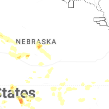


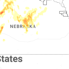


Connect with Interactive Hail Maps