

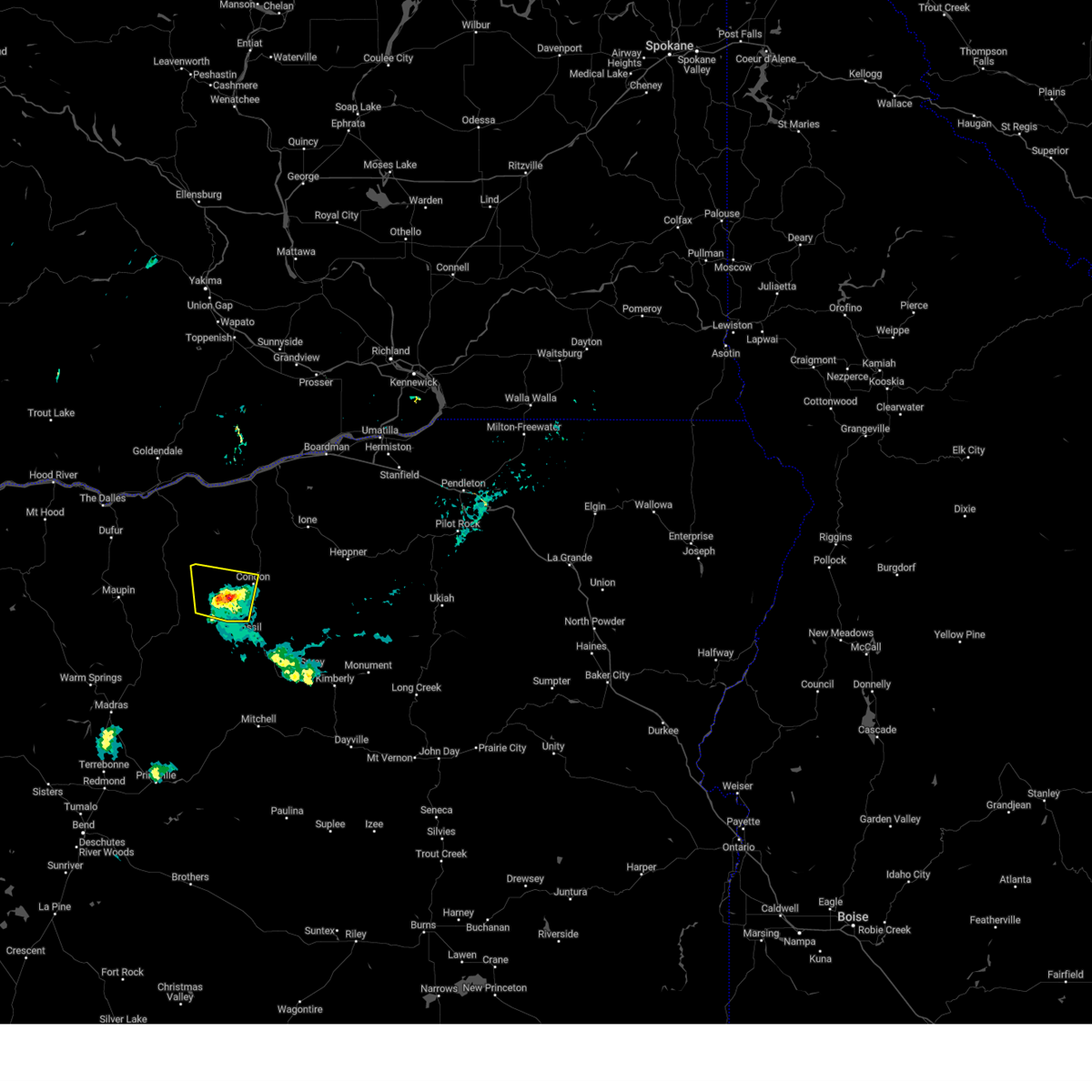
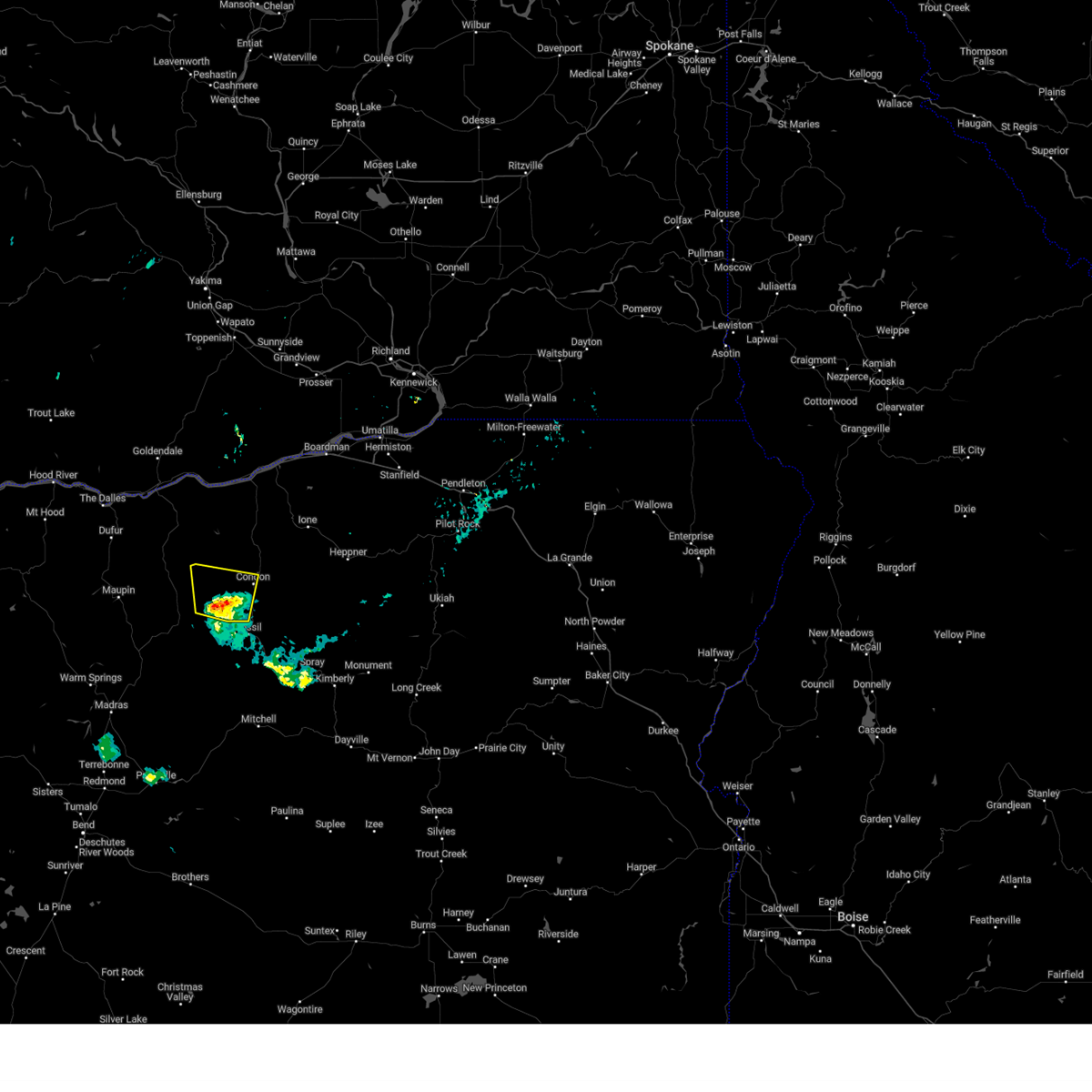
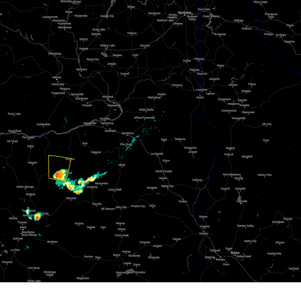
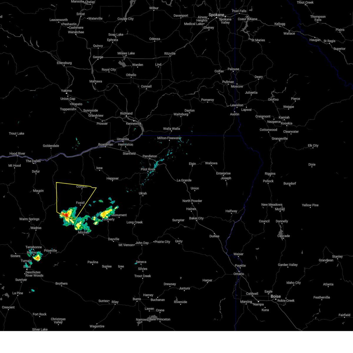
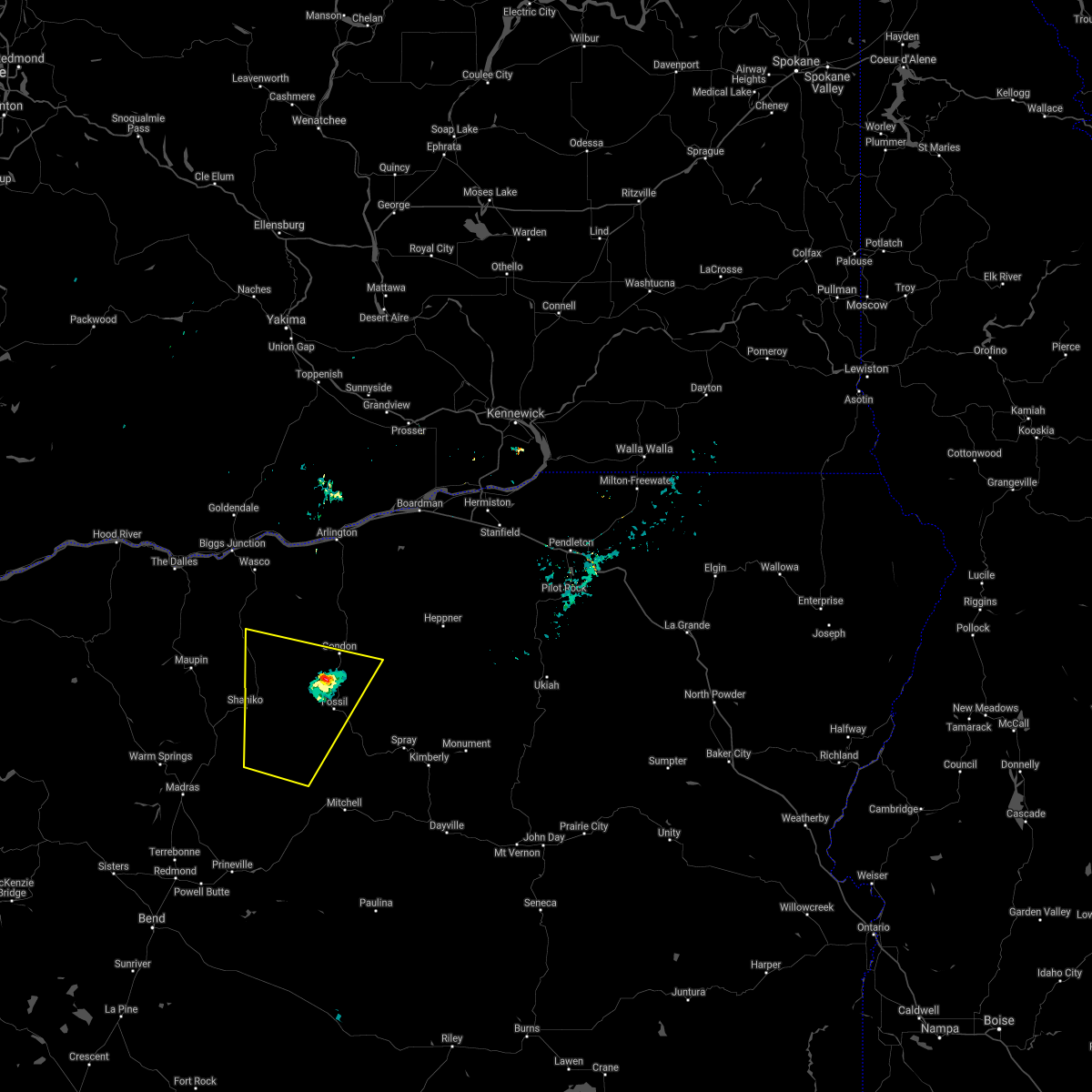
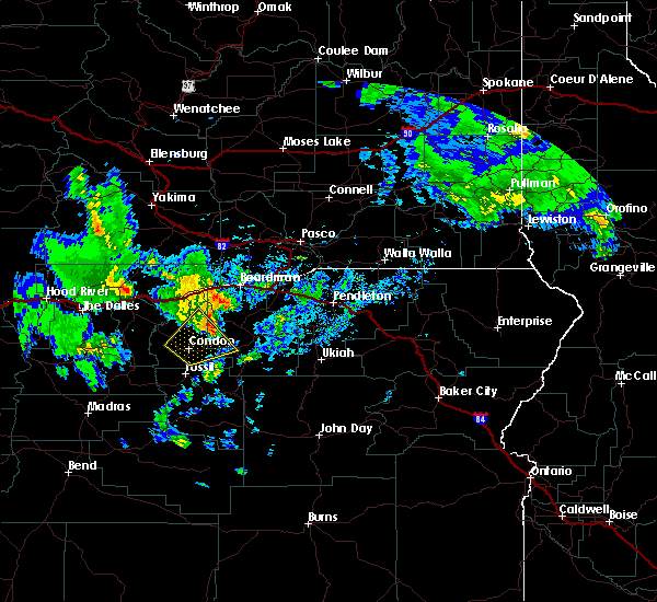
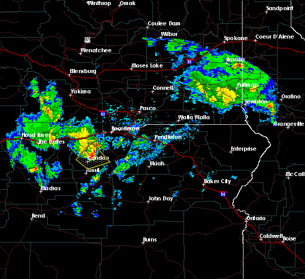
Hail Map for Condon, OR
The Condon, OR area has had 0 reports of on-the-ground hail by trained spotters, and has been under severe weather warnings 7 times during the past 12 months. Doppler radar has detected hail at or near Condon, OR on 5 occasions.
| Name: | Condon, OR |
| Where Located: | 72.3 miles NNE of Bend, OR |
| Map: | Google Map for Condon, OR |
| Population: | 682 |
| Housing Units: | 455 |
| More Info: | Search Google for Condon, OR |
5
The Top Recent Hail Date for Condon, OR is Saturday, May 30, 2020 (2nd out of 5)

Hail and Wind Damage Spotted near Condon, OR
| Date / Time | Report Details |
|---|---|
| 8/17/2024 7:43 PM PDT |
 At 739 pm pdt, an outflow from thunderstorms over wasco and klickitat county continue to push eastward and are approaching arlington. wind gusts near 60 mph were reported at blalok canyon along interstate 84 at 730 mph (observations). Hazards include 70 mph wind gusts. Expect considerable tree damage. damage is likely to mobile homes, roofs, and outbuildings. Locations impacted include, boardman, heppner, condon, arlington, moro, irrigon, wasco, ione, rufus, lexington, goodnoe hills, alderdale, kent, rock creek, cliffs, bickleton, mikkalo, ruggs, blalock, and hardman. At 739 pm pdt, an outflow from thunderstorms over wasco and klickitat county continue to push eastward and are approaching arlington. wind gusts near 60 mph were reported at blalok canyon along interstate 84 at 730 mph (observations). Hazards include 70 mph wind gusts. Expect considerable tree damage. damage is likely to mobile homes, roofs, and outbuildings. Locations impacted include, boardman, heppner, condon, arlington, moro, irrigon, wasco, ione, rufus, lexington, goodnoe hills, alderdale, kent, rock creek, cliffs, bickleton, mikkalo, ruggs, blalock, and hardman.
|
| 8/17/2024 7:16 PM PDT |
 Svrpdt the national weather service in pendleton oregon has issued a * severe thunderstorm warning for, morrow county in northeastern oregon, gilliam county in north central oregon, sherman county in north central oregon, southwestern benton county in south central washington, eastern klickitat county in south central washington, * until 815 pm pdt. * at 712 pm pdt, thunderstorms over wasco county are producing outflow winds of around 70 mph pushing to the east across north central oregon and far southern washington along the columbia river (public). Hazards include 70 mph wind gusts. Expect considerable tree damage. Damage is likely to mobile homes, roofs, and outbuildings. Svrpdt the national weather service in pendleton oregon has issued a * severe thunderstorm warning for, morrow county in northeastern oregon, gilliam county in north central oregon, sherman county in north central oregon, southwestern benton county in south central washington, eastern klickitat county in south central washington, * until 815 pm pdt. * at 712 pm pdt, thunderstorms over wasco county are producing outflow winds of around 70 mph pushing to the east across north central oregon and far southern washington along the columbia river (public). Hazards include 70 mph wind gusts. Expect considerable tree damage. Damage is likely to mobile homes, roofs, and outbuildings.
|
| 8/4/2024 6:37 PM PDT |
 The storm which prompted the warning has weakened below severe limits, and no longer poses an immediate threat to life or property. therefore, the warning will be allowed to expire. however, small hail and gusty winds are still possible with this thunderstorm. to report severe weather, contact your nearest law enforcement agency. they will relay your report to the national weather service pendleton oregon. The storm which prompted the warning has weakened below severe limits, and no longer poses an immediate threat to life or property. therefore, the warning will be allowed to expire. however, small hail and gusty winds are still possible with this thunderstorm. to report severe weather, contact your nearest law enforcement agency. they will relay your report to the national weather service pendleton oregon.
|
| 8/4/2024 6:29 PM PDT |
 At 628 pm pdt, a severe thunderstorm was located 12 miles east of kent, or 13 miles west of condon, moving north at 35 mph (radar indicated). Hazards include quarter size hail. Damage to vehicles is expected. Locations impacted include, condon. At 628 pm pdt, a severe thunderstorm was located 12 miles east of kent, or 13 miles west of condon, moving north at 35 mph (radar indicated). Hazards include quarter size hail. Damage to vehicles is expected. Locations impacted include, condon.
|
| 8/4/2024 6:29 PM PDT |
 the severe thunderstorm warning has been cancelled and is no longer in effect the severe thunderstorm warning has been cancelled and is no longer in effect
|
| 8/4/2024 6:13 PM PDT |
 At 612 pm pdt, a severe thunderstorm was located 8 miles north of clarno, or 13 miles west of fossil, moving north at 45 mph (radar indicated). Hazards include quarter size hail. Damage to vehicles is expected. Locations impacted include, condon, kent, and clarno. At 612 pm pdt, a severe thunderstorm was located 8 miles north of clarno, or 13 miles west of fossil, moving north at 45 mph (radar indicated). Hazards include quarter size hail. Damage to vehicles is expected. Locations impacted include, condon, kent, and clarno.
|
| 8/4/2024 5:59 PM PDT |
 Svrpdt the national weather service in pendleton oregon has issued a * severe thunderstorm warning for, northwestern wheeler county in northeastern oregon, southern gilliam county in north central oregon, south central sherman county in north central oregon, southeastern wasco county in north central oregon, * until 645 pm pdt. * at 559 pm pdt, a severe thunderstorm was located over clarno, or 14 miles west of fossil, moving north at 35 mph (radar indicated). Hazards include quarter size hail. damage to vehicles is expected Svrpdt the national weather service in pendleton oregon has issued a * severe thunderstorm warning for, northwestern wheeler county in northeastern oregon, southern gilliam county in north central oregon, south central sherman county in north central oregon, southeastern wasco county in north central oregon, * until 645 pm pdt. * at 559 pm pdt, a severe thunderstorm was located over clarno, or 14 miles west of fossil, moving north at 35 mph (radar indicated). Hazards include quarter size hail. damage to vehicles is expected
|
| 8/18/2020 7:22 PM PDT |
 At 721 pm pdt, a severe thunderstorm was located 8 miles west of mayville, or 10 miles northwest of fossil, moving north at 30 mph (radar indicated). Hazards include 60 mph wind gusts and penny size hail, along with heavy rain and frequent lightning is likely. Expect damage to roofs, siding, and trees. Locations impacted include, condon, fossil, antelope, shaniko, kent, mayville and clarno. At 721 pm pdt, a severe thunderstorm was located 8 miles west of mayville, or 10 miles northwest of fossil, moving north at 30 mph (radar indicated). Hazards include 60 mph wind gusts and penny size hail, along with heavy rain and frequent lightning is likely. Expect damage to roofs, siding, and trees. Locations impacted include, condon, fossil, antelope, shaniko, kent, mayville and clarno.
|
| 8/18/2020 6:40 PM PDT |
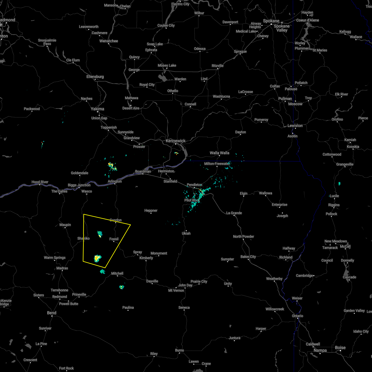 At 639 pm pdt, a severe thunderstorm was located 8 miles south of clarno, or 20 miles southwest of fossil, moving north at 30 mph (radar indicated). Hazards include 60 mph wind gusts and penny size hail, along with heavy rain and frequent lightning are likely. expect damage to roofs, siding, and trees At 639 pm pdt, a severe thunderstorm was located 8 miles south of clarno, or 20 miles southwest of fossil, moving north at 30 mph (radar indicated). Hazards include 60 mph wind gusts and penny size hail, along with heavy rain and frequent lightning are likely. expect damage to roofs, siding, and trees
|
| 5/30/2020 4:00 PM PDT | Tree down and damage to home. report via social medi in gilliam county OR, 0.2 miles SW of Condon, OR |
| 5/30/2020 3:55 PM PDT |
 At 355 pm pdt, a severe thunderstorm was located over condon, moving north at 55 mph (radar indicated). Hazards include 70 mph wind gusts and half dollar size hail. Hail damage to vehicles is expected. expect considerable tree damage. Wind damage is also likely to mobile homes, roofs, and outbuildings. At 355 pm pdt, a severe thunderstorm was located over condon, moving north at 55 mph (radar indicated). Hazards include 70 mph wind gusts and half dollar size hail. Hail damage to vehicles is expected. expect considerable tree damage. Wind damage is also likely to mobile homes, roofs, and outbuildings.
|
| 6/26/2019 4:54 PM PDT |
 The severe thunderstorm warning for southwestern morrow and southeastern gilliam counties will expire at 500 pm pdt, the storm which prompted the warning has weakened below severe limits, and has exited the warned area. therefore, the warning will be allowed to expire. however small hail, gusty winds and heavy rain are still possible with this thunderstorm. a severe thunderstorm watch remains in effect until 800 pm pdt for north central and northeastern oregon. The severe thunderstorm warning for southwestern morrow and southeastern gilliam counties will expire at 500 pm pdt, the storm which prompted the warning has weakened below severe limits, and has exited the warned area. therefore, the warning will be allowed to expire. however small hail, gusty winds and heavy rain are still possible with this thunderstorm. a severe thunderstorm watch remains in effect until 800 pm pdt for north central and northeastern oregon.
|
| 6/26/2019 4:34 PM PDT |
 At 430 pm pdt, a severe thunderstorm was located 9 miles northeast of condon, moving northeast at 25 mph (trained weather spotters). Hazards include 60 mph wind gusts and quarter size hail remain possible. trained weather spotters in condon reported pea to dime size hail up to 2 inches deep. Hail damage to vehicles is expected. expect wind damage to roofs, siding, and trees. Locations impacted include, condon and olex. At 430 pm pdt, a severe thunderstorm was located 9 miles northeast of condon, moving northeast at 25 mph (trained weather spotters). Hazards include 60 mph wind gusts and quarter size hail remain possible. trained weather spotters in condon reported pea to dime size hail up to 2 inches deep. Hail damage to vehicles is expected. expect wind damage to roofs, siding, and trees. Locations impacted include, condon and olex.
|
| 6/26/2019 4:18 PM PDT |
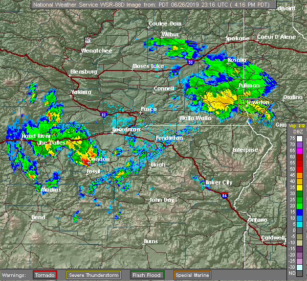 At 417 pm pdt, a severe thunderstorm was located over condon, moving northeast at 35 mph (radar indicated). Hazards include 60 mph wind gusts and quarter size hail. Hail damage to vehicles is expected. Expect wind damage to roofs, siding, and trees. At 417 pm pdt, a severe thunderstorm was located over condon, moving northeast at 35 mph (radar indicated). Hazards include 60 mph wind gusts and quarter size hail. Hail damage to vehicles is expected. Expect wind damage to roofs, siding, and trees.
|
| 2/17/2018 1:27 PM PST | Storm damage reported in gilliam county OR, 16.7 miles SE of Condon, OR |
| 1/1/0001 12:00 AM | Blowing dust visibility down to 200ft briefly. wind gust 63 mph. around 635 p in gilliam county OR, 11.2 miles S of Condon, OR |
Hail Maps for Condon, OR


Connect with Interactive Hail Maps