

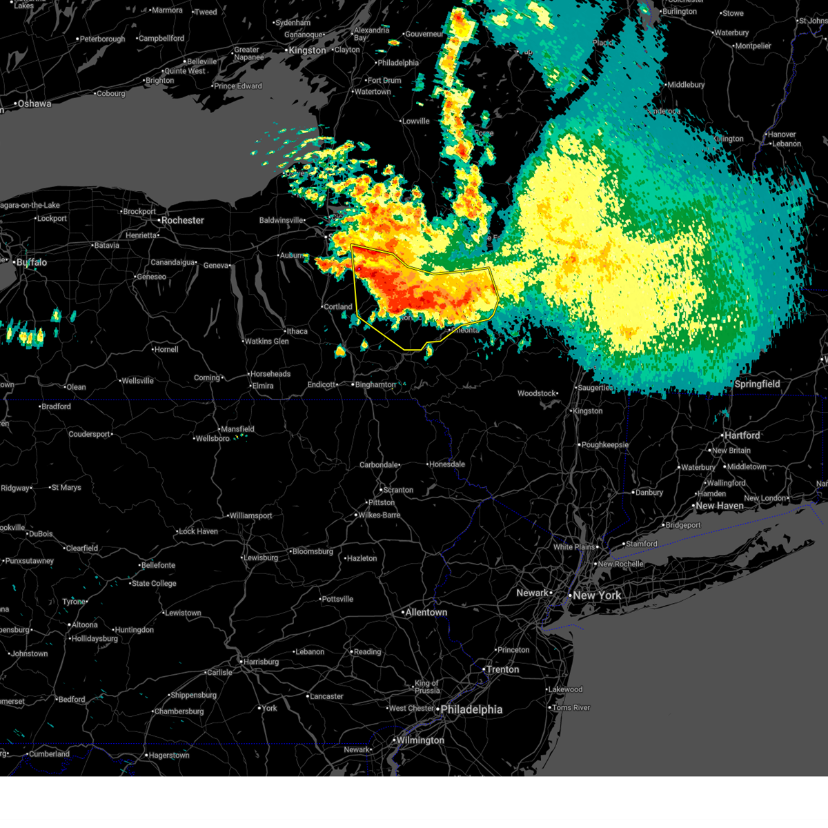
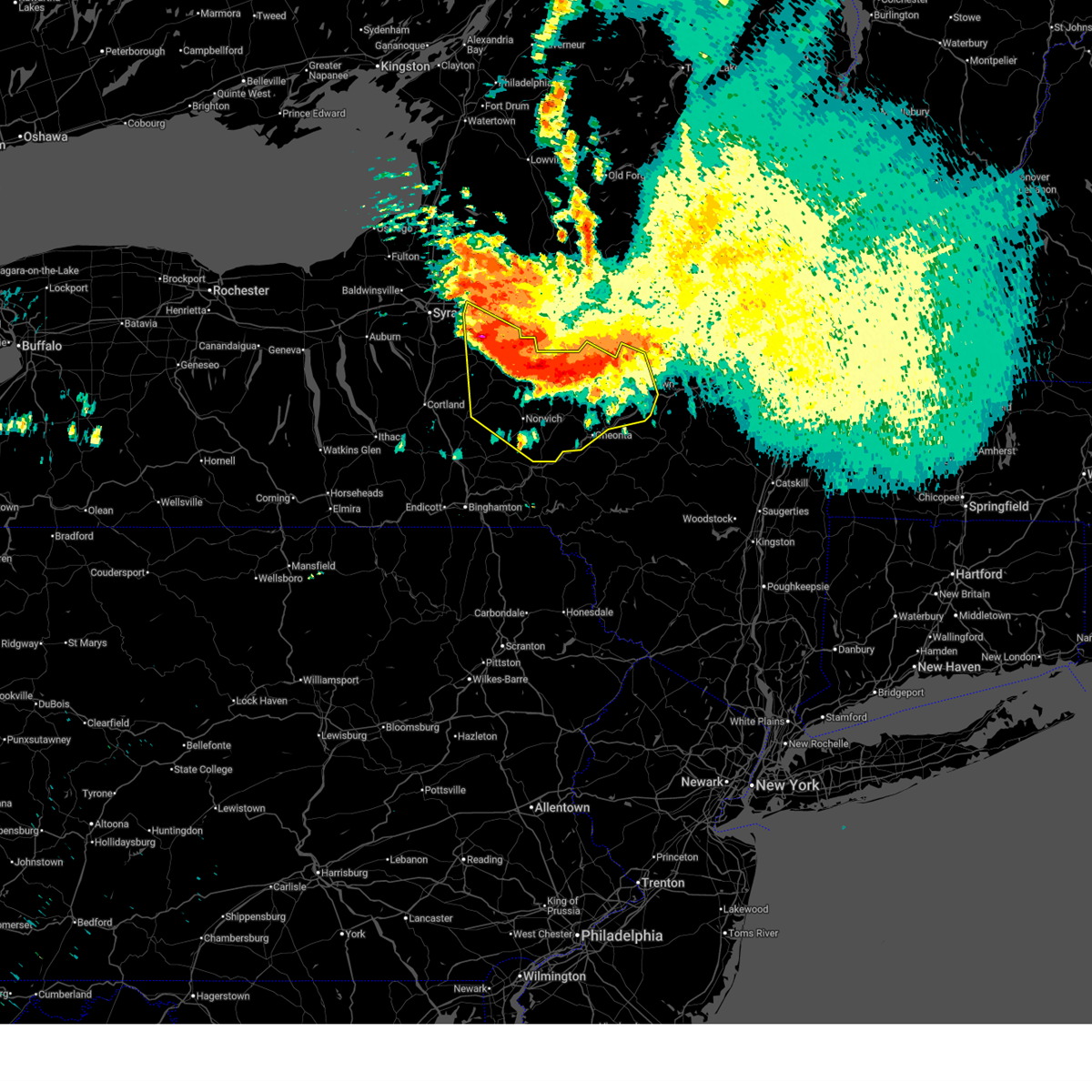
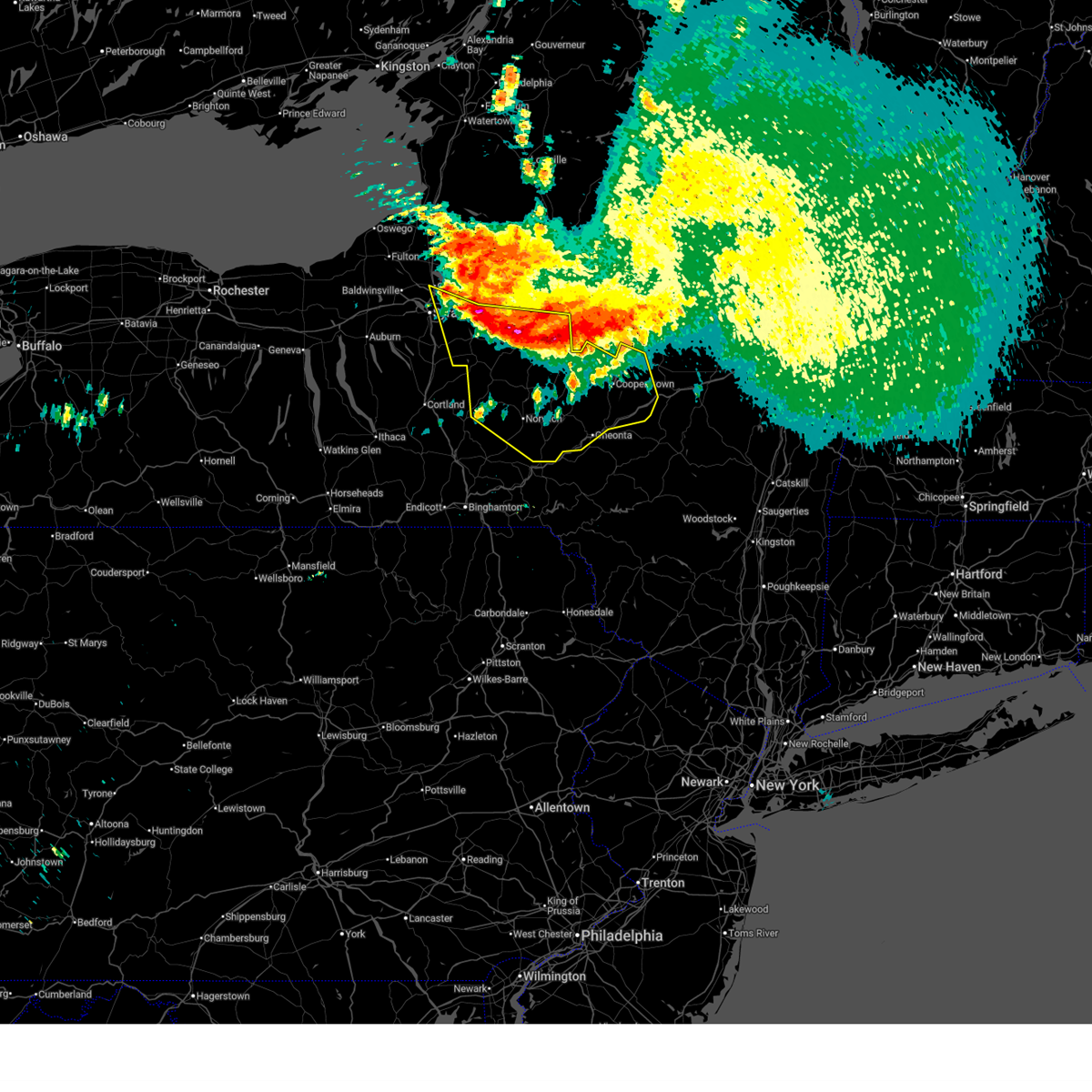
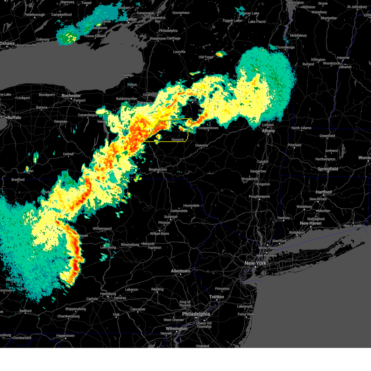
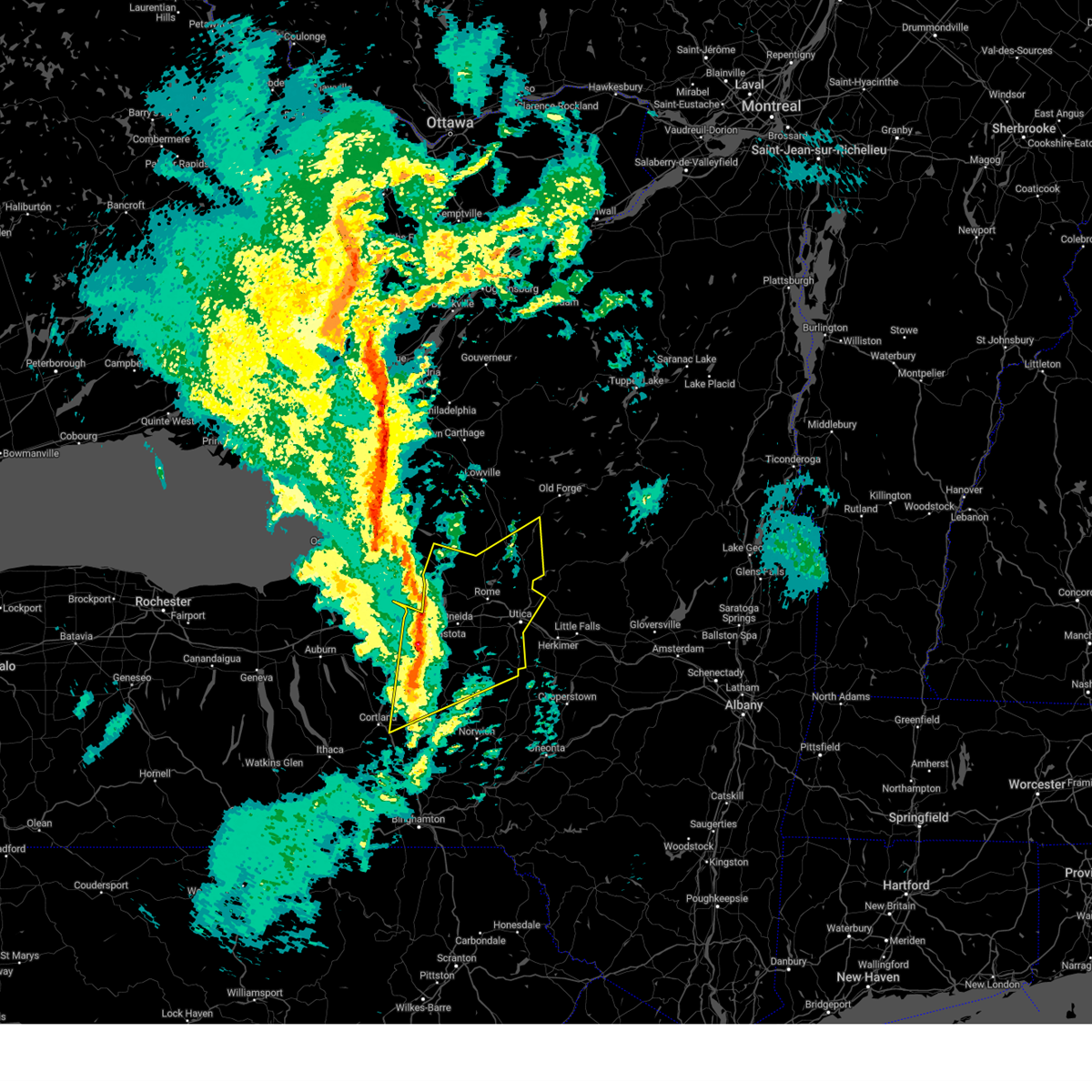
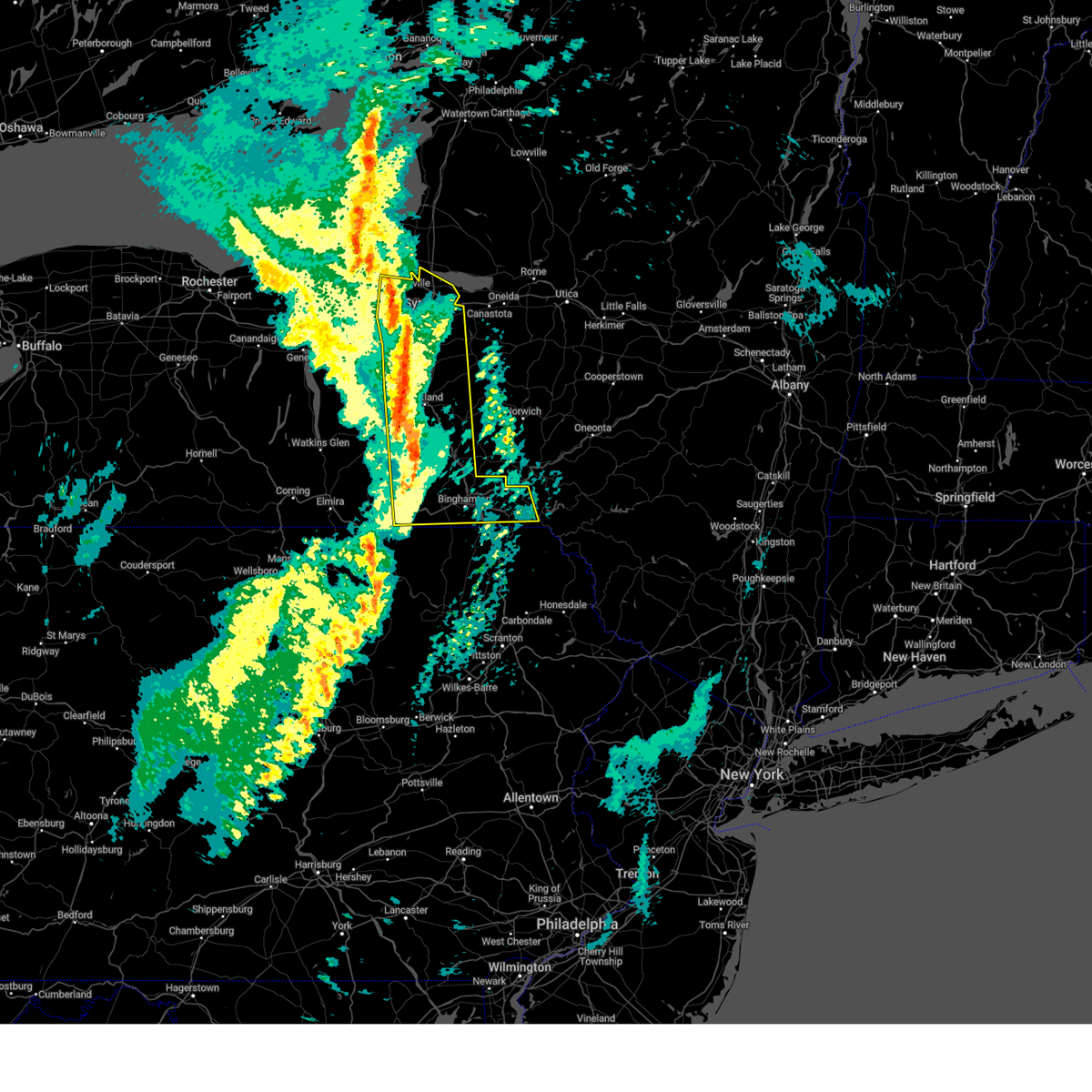
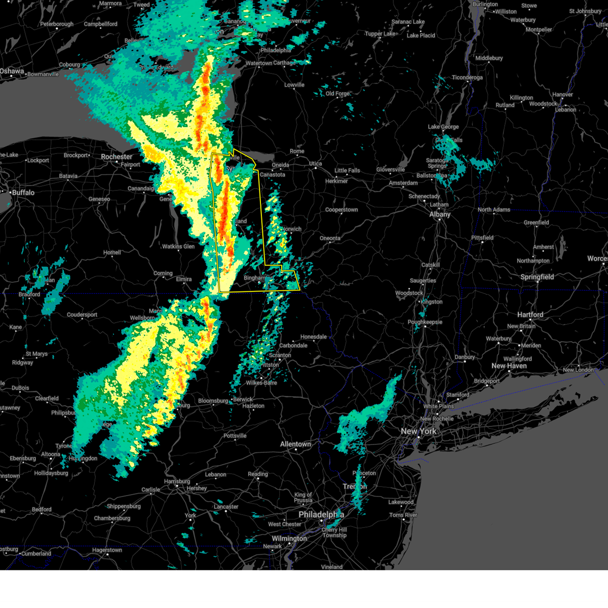
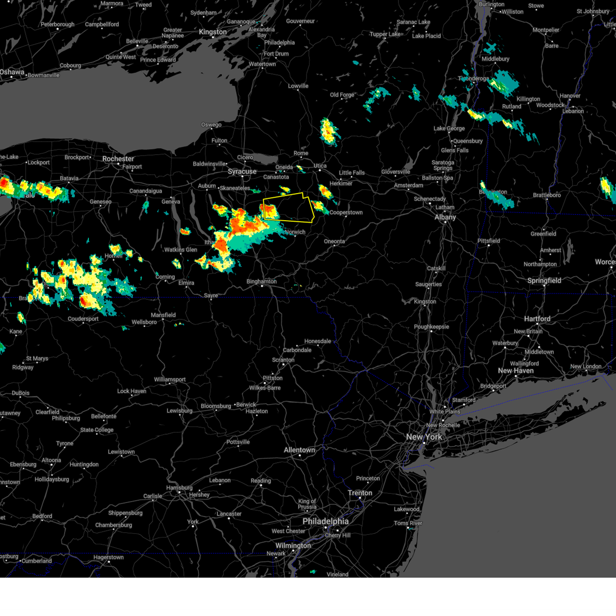
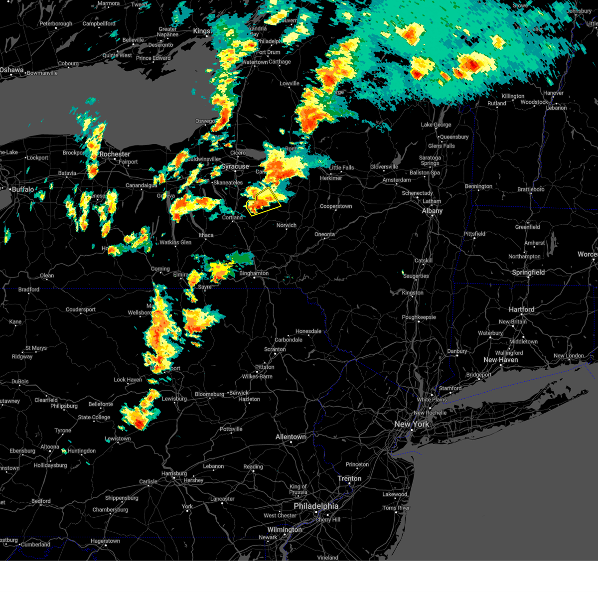
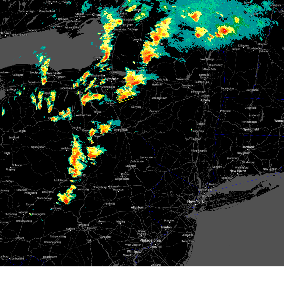
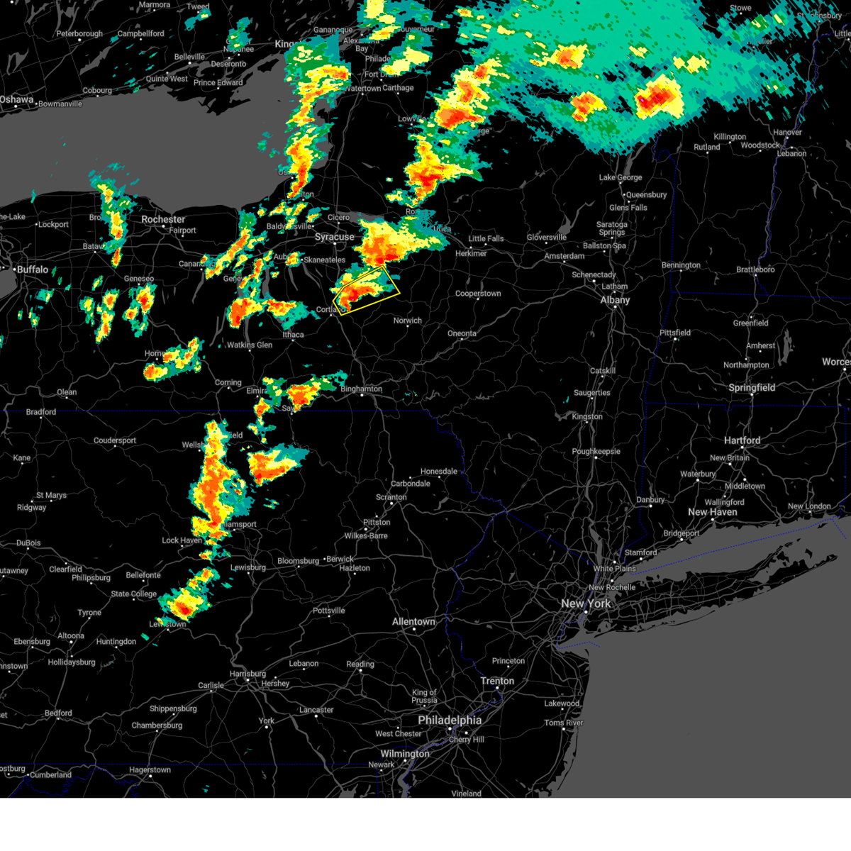
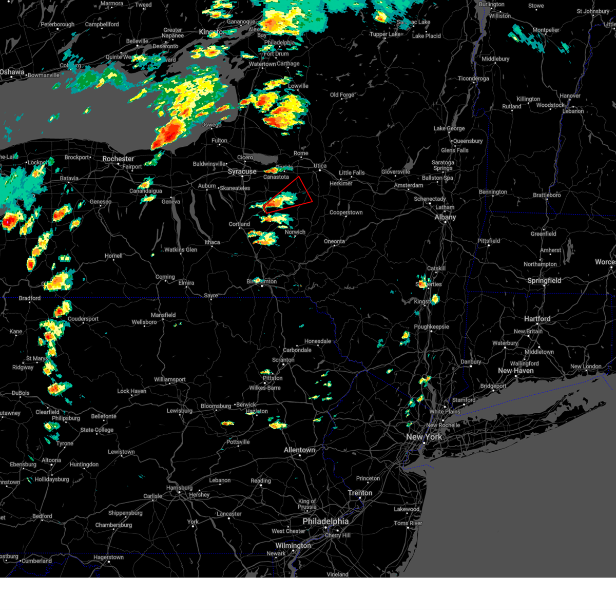
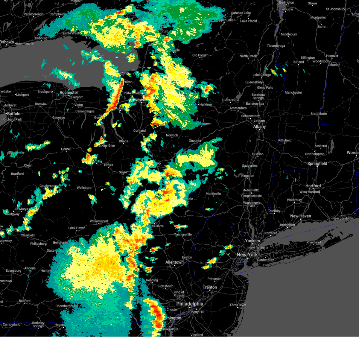
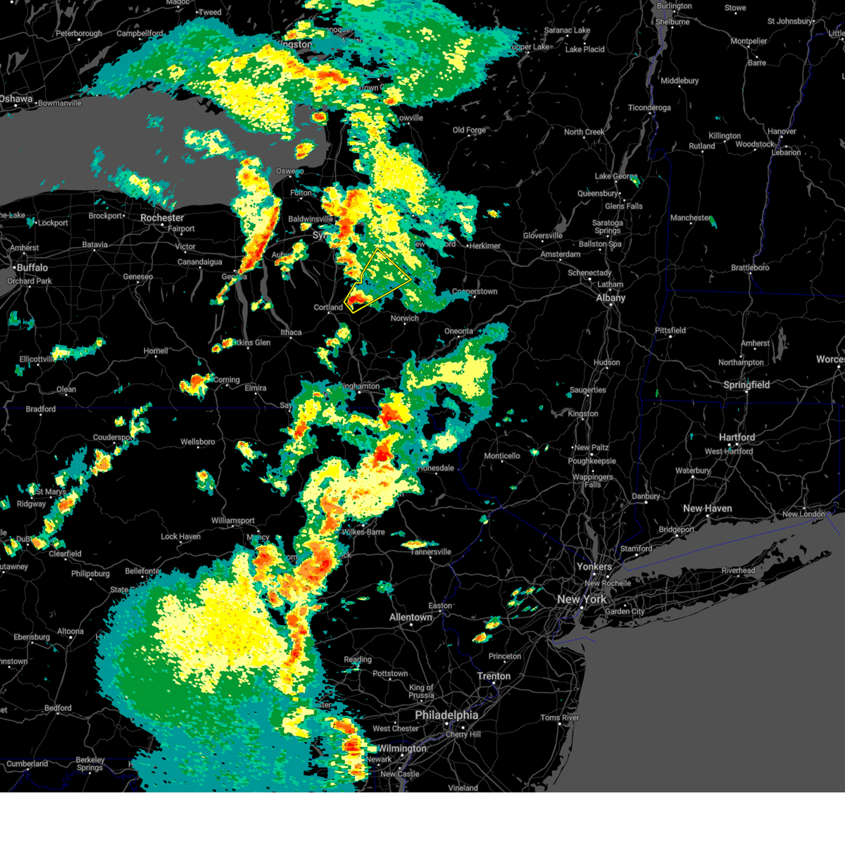
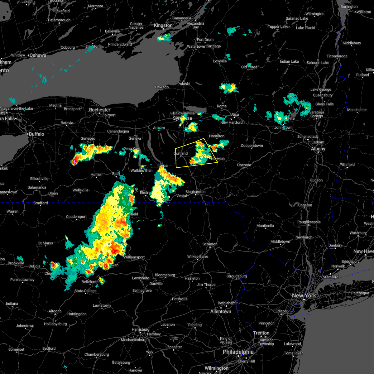
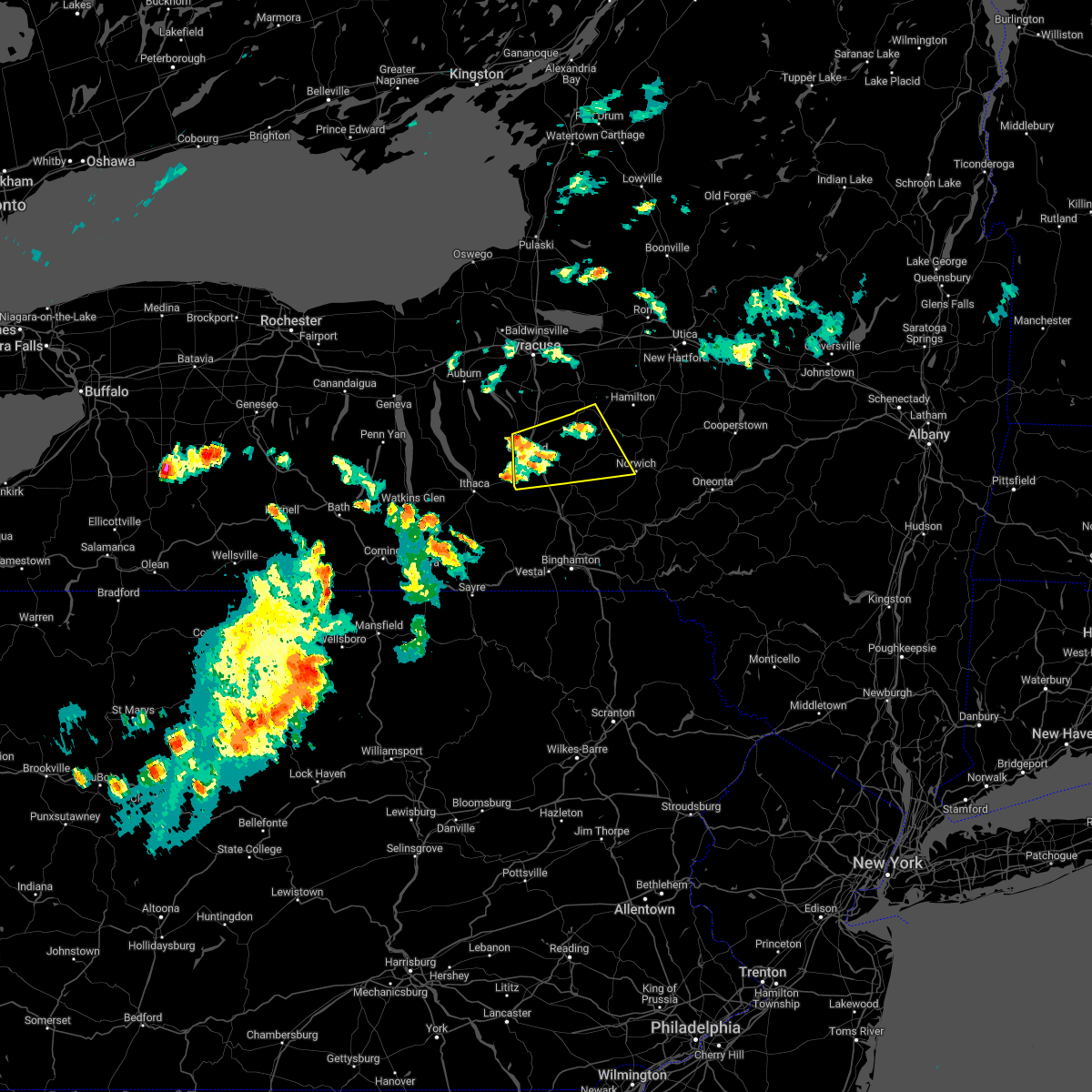
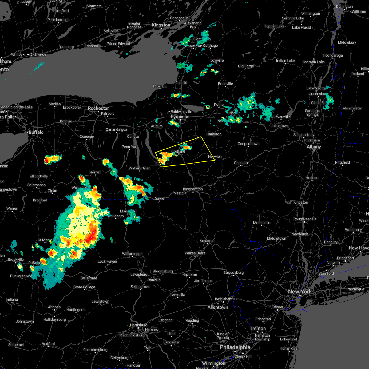
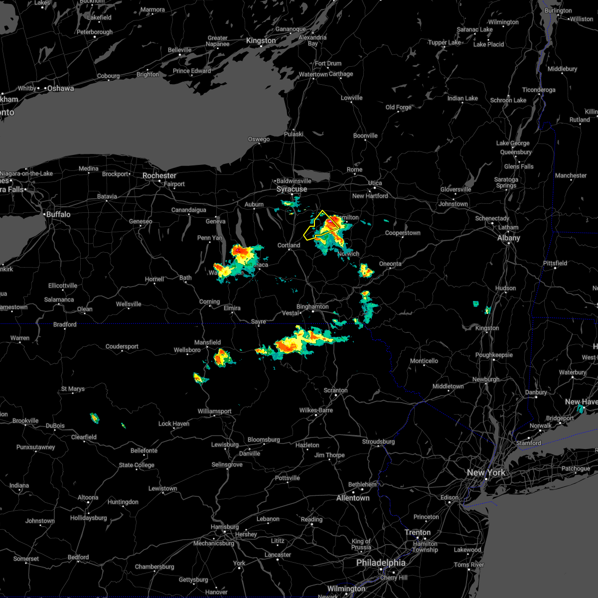
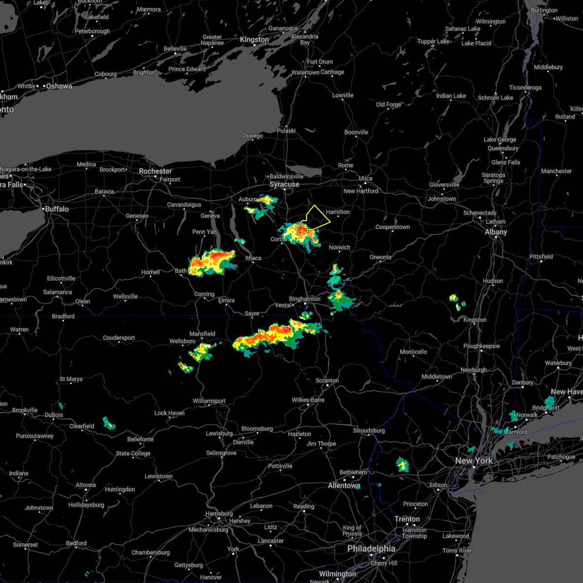
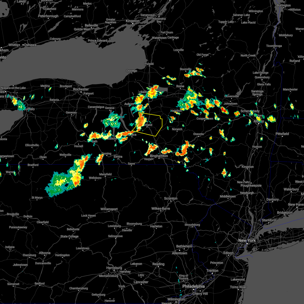
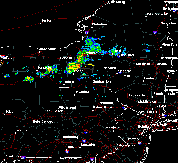
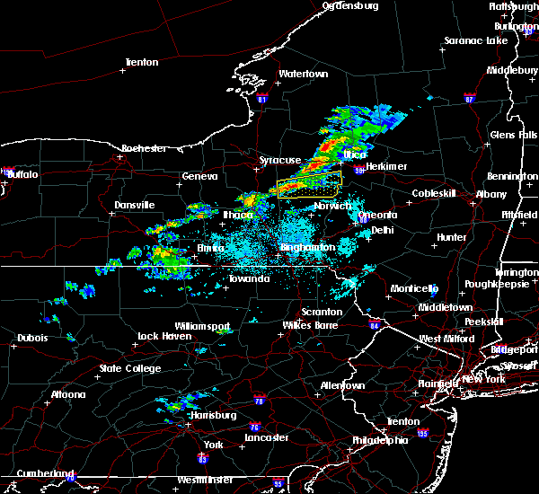
Hail Map for DeRuyter, NY
The DeRuyter, NY area has had 10 reports of on-the-ground hail by trained spotters, and has been under severe weather warnings 30 times during the past 12 months. Doppler radar has detected hail at or near DeRuyter, NY on 18 occasions, including 2 occasions during the past year.
| Name: | DeRuyter, NY |
| Where Located: | 24.1 miles SSE of Syracuse, NY |
| Map: | Google Map for DeRuyter, NY |
| Population: | 558 |
| Housing Units: | 259 |
| More Info: | Search Google for DeRuyter, NY |
1
The Top Recent Hail Date for DeRuyter, NY is Monday, July 15, 2024 (4th out of 18)

Hail and Wind Damage Spotted near DeRuyter, NY
| Date / Time | Report Details |
|---|---|
| 6/22/2025 4:50 AM EDT |
 At 450 am edt, severe thunderstorms were located along a line extending from near worcester to near morris to near otselic to near fabius, moving south at 40 mph (radar indicated). Hazards include 60 mph wind gusts. Expect damage to roofs, siding, and trees. Locations impacted include, oneonta, norwich, eaton, hamilton, guilford, cazenovia, brookfield, worcester, morrisville, and middlefield. At 450 am edt, severe thunderstorms were located along a line extending from near worcester to near morris to near otselic to near fabius, moving south at 40 mph (radar indicated). Hazards include 60 mph wind gusts. Expect damage to roofs, siding, and trees. Locations impacted include, oneonta, norwich, eaton, hamilton, guilford, cazenovia, brookfield, worcester, morrisville, and middlefield.
|
| 6/22/2025 4:36 AM EDT |
 the severe thunderstorm warning has been cancelled and is no longer in effect the severe thunderstorm warning has been cancelled and is no longer in effect
|
| 6/22/2025 4:36 AM EDT |
 At 436 am edt, severe thunderstorms were located along a line extending from near middlefield to near edmeston to georgetown to watervale, moving south at 40 mph (radar indicated). Hazards include 70 mph wind gusts. Expect considerable tree damage. damage is likely to mobile homes, roofs, and outbuildings. Locations impacted include, sullivan, oneonta, norwich, eaton, chittenango, hamilton, guilford, cazenovia, brookfield, and worcester. At 436 am edt, severe thunderstorms were located along a line extending from near middlefield to near edmeston to georgetown to watervale, moving south at 40 mph (radar indicated). Hazards include 70 mph wind gusts. Expect considerable tree damage. damage is likely to mobile homes, roofs, and outbuildings. Locations impacted include, sullivan, oneonta, norwich, eaton, chittenango, hamilton, guilford, cazenovia, brookfield, and worcester.
|
| 6/22/2025 4:13 AM EDT |
 Svrbgm the national weather service in binghamton has issued a * severe thunderstorm warning for, southeastern oneida county in central new york, otsego county in central new york, madison county in central new york, eastern onondaga county in central new york, chenango county in central new york, * until 515 am edt. * at 412 am edt, severe thunderstorms were located along a line extending from near jordanville to near waterville to near cazenovia to near cicero, moving south at 40 mph (radar indicated). Hazards include 70 mph wind gusts. Expect considerable tree damage. Damage is likely to mobile homes, roofs, and outbuildings. Svrbgm the national weather service in binghamton has issued a * severe thunderstorm warning for, southeastern oneida county in central new york, otsego county in central new york, madison county in central new york, eastern onondaga county in central new york, chenango county in central new york, * until 515 am edt. * at 412 am edt, severe thunderstorms were located along a line extending from near jordanville to near waterville to near cazenovia to near cicero, moving south at 40 mph (radar indicated). Hazards include 70 mph wind gusts. Expect considerable tree damage. Damage is likely to mobile homes, roofs, and outbuildings.
|
| 5/2/2025 5:04 PM EDT | the severe thunderstorm warning has been cancelled and is no longer in effect |
| 5/2/2025 5:04 PM EDT | At 504 pm edt, a severe thunderstorm was located near cuyler, or 12 miles northeast of cortland, moving east at 45 mph (radar indicated). Hazards include 60 mph wind gusts and nickel size hail. Expect damage to roofs, siding, and trees. Locations impacted include, preble, taylor, de ruyter, lincklaen, east homer, solon, cuyler, keeney, mcgraw, and truxton. |
| 5/2/2025 4:50 PM EDT | Svrbgm the national weather service in binghamton has issued a * severe thunderstorm warning for, southwestern madison county in central new york, southeastern cayuga county in central new york, northern cortland county in central new york, northwestern chenango county in central new york, * until 515 pm edt. * at 450 pm edt, a severe thunderstorm was located over homer, or near cortland, moving east at 45 mph (radar indicated). Hazards include 60 mph wind gusts and nickel size hail. expect damage to roofs, siding, and trees |
| 4/29/2025 7:11 PM EDT |
 Svrbgm the national weather service in binghamton has issued a * severe thunderstorm warning for, southern madison county in central new york, northern cortland county in central new york, northern chenango county in central new york, * until 800 pm edt. * at 711 pm edt, severe thunderstorms were located along a line extending from near de ruyter to near taylor to solon, moving east at 60 mph (radar indicated). Hazards include 60 mph wind gusts and penny size hail. expect damage to roofs, siding, and trees Svrbgm the national weather service in binghamton has issued a * severe thunderstorm warning for, southern madison county in central new york, northern cortland county in central new york, northern chenango county in central new york, * until 800 pm edt. * at 711 pm edt, severe thunderstorms were located along a line extending from near de ruyter to near taylor to solon, moving east at 60 mph (radar indicated). Hazards include 60 mph wind gusts and penny size hail. expect damage to roofs, siding, and trees
|
| 4/29/2025 7:05 PM EDT | Trees and wires down on morgan hill road. time estimated from rada in cortland county NY, 6.7 miles ENE of DeRuyter, NY |
| 3/16/2025 5:11 PM EDT |
 At 510 pm edt, severe thunderstorms were located along a line extending from 10 miles northeast of central square to near cuyler, moving northeast at 60 mph (the new york mesonet recorded a gust of 62 mph in fayetteville). Hazards include 70 mph wind gusts. Expect considerable tree damage. damage is likely to mobile homes, roofs, and outbuildings. Locations impacted include, union corners, pierceville, florence, blossvale, new london, remsen, colemans, manlius, westmoreland, and verona mills. At 510 pm edt, severe thunderstorms were located along a line extending from 10 miles northeast of central square to near cuyler, moving northeast at 60 mph (the new york mesonet recorded a gust of 62 mph in fayetteville). Hazards include 70 mph wind gusts. Expect considerable tree damage. damage is likely to mobile homes, roofs, and outbuildings. Locations impacted include, union corners, pierceville, florence, blossvale, new london, remsen, colemans, manlius, westmoreland, and verona mills.
|
| 3/16/2025 5:07 PM EDT |
 the severe thunderstorm warning has been cancelled and is no longer in effect the severe thunderstorm warning has been cancelled and is no longer in effect
|
| 3/16/2025 5:07 PM EDT |
 At 507 pm edt, severe thunderstorms were located along a line extending from 6 miles north of central square to near willet, moving northeast at 60 mph (radar indicated). Hazards include 60 mph wind gusts. Expect damage to roofs, siding, and trees. Locations impacted include, hunts corners, tioga terrace, harford, cincinnatus, solon, lisle, east syracuse, bridgeport, manlius, and owego. At 507 pm edt, severe thunderstorms were located along a line extending from 6 miles north of central square to near willet, moving northeast at 60 mph (radar indicated). Hazards include 60 mph wind gusts. Expect damage to roofs, siding, and trees. Locations impacted include, hunts corners, tioga terrace, harford, cincinnatus, solon, lisle, east syracuse, bridgeport, manlius, and owego.
|
| 3/16/2025 5:06 PM EDT |
 At 506 pm edt, severe thunderstorms were located along a line extending from 7 miles northeast of central square to near cuyler, moving northeast at 60 mph (radar indicated). Hazards include 60 mph wind gusts. Expect damage to roofs, siding, and trees. Locations impacted include, union corners, pierceville, florence, blossvale, new london, remsen, colemans, manlius, westmoreland, and verona mills. At 506 pm edt, severe thunderstorms were located along a line extending from 7 miles northeast of central square to near cuyler, moving northeast at 60 mph (radar indicated). Hazards include 60 mph wind gusts. Expect damage to roofs, siding, and trees. Locations impacted include, union corners, pierceville, florence, blossvale, new london, remsen, colemans, manlius, westmoreland, and verona mills.
|
| 3/16/2025 4:57 PM EDT |
 Svrbgm the national weather service in binghamton has issued a * severe thunderstorm warning for, oneida county in central new york, madison county in central new york, northeastern cortland county in central new york, eastern onondaga county in central new york, northwestern chenango county in central new york, * until 600 pm edt. * at 457 pm edt, severe thunderstorms were located along a line extending from central square to near mcgraw, moving northeast at 55 mph (radar indicated). Hazards include 60 mph wind gusts. expect damage to roofs, siding, and trees Svrbgm the national weather service in binghamton has issued a * severe thunderstorm warning for, oneida county in central new york, madison county in central new york, northeastern cortland county in central new york, eastern onondaga county in central new york, northwestern chenango county in central new york, * until 600 pm edt. * at 457 pm edt, severe thunderstorms were located along a line extending from central square to near mcgraw, moving northeast at 55 mph (radar indicated). Hazards include 60 mph wind gusts. expect damage to roofs, siding, and trees
|
| 3/16/2025 4:45 PM EDT |
 the severe thunderstorm warning has been cancelled and is no longer in effect the severe thunderstorm warning has been cancelled and is no longer in effect
|
| 3/16/2025 4:45 PM EDT |
 At 444 pm edt, severe thunderstorms were located along a line extending from lysander to near newark valley, moving northeast at 60 mph (radar indicated). Hazards include 60 mph wind gusts. Expect damage to roofs, siding, and trees. Locations impacted include, south cortland, hunts corners, chenango valley state park, preble, tioga terrace, bennetts corners, bayberry, cedarvale, harford, and clark reservation state park. At 444 pm edt, severe thunderstorms were located along a line extending from lysander to near newark valley, moving northeast at 60 mph (radar indicated). Hazards include 60 mph wind gusts. Expect damage to roofs, siding, and trees. Locations impacted include, south cortland, hunts corners, chenango valley state park, preble, tioga terrace, bennetts corners, bayberry, cedarvale, harford, and clark reservation state park.
|
| 3/16/2025 4:17 PM EDT | Svrbgm the national weather service in binghamton has issued a * severe thunderstorm warning for, seneca county in central new york, eastern schuyler county in central new york, broome county in central new york, cayuga county in central new york, cortland county in central new york, eastern chemung county in central new york, tioga county in central new york, onondaga county in central new york, tompkins county in central new york, * until 515 pm edt. * at 417 pm edt, severe thunderstorms were located along a line extending from 6 miles southeast of lyons to lowman, moving northeast at 60 mph (radar indicated). Hazards include 60 mph wind gusts. expect damage to roofs, siding, and trees |
| 8/5/2024 3:12 PM EDT |
 Svrbgm the national weather service in binghamton has issued a * severe thunderstorm warning for, southern madison county in central new york, northern chenango county in central new york, * until 345 pm edt. * at 312 pm edt, a severe thunderstorm was located near georgetown, or 12 miles west of hamilton, moving east at 40 mph (radar indicated). Hazards include 60 mph wind gusts and penny size hail. expect damage to roofs, siding, and trees Svrbgm the national weather service in binghamton has issued a * severe thunderstorm warning for, southern madison county in central new york, northern chenango county in central new york, * until 345 pm edt. * at 312 pm edt, a severe thunderstorm was located near georgetown, or 12 miles west of hamilton, moving east at 40 mph (radar indicated). Hazards include 60 mph wind gusts and penny size hail. expect damage to roofs, siding, and trees
|
| 7/24/2024 3:29 PM EDT |
 Svrbgm the national weather service in binghamton has issued a * severe thunderstorm warning for, southwestern madison county in central new york, northeastern cortland county in central new york, northwestern chenango county in central new york, * until 430 pm edt. * at 328 pm edt, a severe thunderstorm was located near solon, or 7 miles northeast of cortland, moving east at 20 mph (radar indicated). Hazards include 60 mph wind gusts and penny size hail. expect damage to roofs, siding, and trees Svrbgm the national weather service in binghamton has issued a * severe thunderstorm warning for, southwestern madison county in central new york, northeastern cortland county in central new york, northwestern chenango county in central new york, * until 430 pm edt. * at 328 pm edt, a severe thunderstorm was located near solon, or 7 miles northeast of cortland, moving east at 20 mph (radar indicated). Hazards include 60 mph wind gusts and penny size hail. expect damage to roofs, siding, and trees
|
| 7/16/2024 3:33 PM EDT |
 the severe thunderstorm warning has been cancelled and is no longer in effect the severe thunderstorm warning has been cancelled and is no longer in effect
|
| 7/16/2024 3:04 PM EDT | Trees down on highway 13... time estimated from rada in cortland county NY, 3.5 miles ENE of DeRuyter, NY |
| 7/16/2024 2:55 PM EDT |
 At 255 pm edt, severe thunderstorms were located along a line extending from new york state fairgrounds to munsons corners, moving east at 40 mph (radar indicated). Hazards include 60 mph wind gusts and penny size hail. Expect damage to roofs, siding, and trees. Locations impacted include, onondaga, syracuse, de witt, sullivan, oneida, lenox, pompey, solvay, chittenango, and canastota. At 255 pm edt, severe thunderstorms were located along a line extending from new york state fairgrounds to munsons corners, moving east at 40 mph (radar indicated). Hazards include 60 mph wind gusts and penny size hail. Expect damage to roofs, siding, and trees. Locations impacted include, onondaga, syracuse, de witt, sullivan, oneida, lenox, pompey, solvay, chittenango, and canastota.
|
| 7/16/2024 2:39 PM EDT |
 Svrbgm the national weather service in binghamton has issued a * severe thunderstorm warning for, western madison county in central new york, eastern cayuga county in central new york, northern cortland county in central new york, onondaga county in central new york, northwestern chenango county in central new york, * until 345 pm edt. * at 239 pm edt, severe thunderstorms were located along a line extending from near marcellus to near freeville, moving east at 40 mph (radar indicated). Hazards include 60 mph wind gusts and penny size hail. expect damage to roofs, siding, and trees Svrbgm the national weather service in binghamton has issued a * severe thunderstorm warning for, western madison county in central new york, eastern cayuga county in central new york, northern cortland county in central new york, onondaga county in central new york, northwestern chenango county in central new york, * until 345 pm edt. * at 239 pm edt, severe thunderstorms were located along a line extending from near marcellus to near freeville, moving east at 40 mph (radar indicated). Hazards include 60 mph wind gusts and penny size hail. expect damage to roofs, siding, and trees
|
| 7/15/2024 7:13 PM EDT | the severe thunderstorm warning has been cancelled and is no longer in effect |
| 7/15/2024 7:13 PM EDT | At 713 pm edt, severe thunderstorms were located along a line extending from near redfield to sylvan beach to near erieville, moving northeast at 35 mph (radar indicated). Hazards include 60 mph wind gusts and quarter size hail. Hail damage to vehicles is expected. expect wind damage to roofs, siding, and trees. Locations impacted include, rome, sullivan, oneida, kirkland, lenox, lee, verona, westmoreland, vienna, and eaton. |
| 7/15/2024 7:04 PM EDT | Large uprooted tree... multiple smaller trees and branches down. picture from social medi in madison county NY, 7.5 miles W of DeRuyter, NY |
| 7/15/2024 7:02 PM EDT | Trees and wires down on mariposa roa in madison county NY, 3.6 miles WNW of DeRuyter, NY |
| 7/15/2024 6:53 PM EDT | Report of roof blown of in chenango county NY, 9.3 miles NW of DeRuyter, NY |
| 7/15/2024 6:52 PM EDT | Trees and wires down on springer roa in chenango county NY, 4.7 miles NNW of DeRuyter, NY |
| 7/15/2024 6:47 PM EDT | Tree down on brown roa in cortland county NY, 7.2 miles NE of DeRuyter, NY |
| 7/15/2024 6:40 PM EDT |
 Svrbgm the national weather service in binghamton has issued a * severe thunderstorm warning for, otsego county in central new york, broome county in central new york, southern madison county in central new york, western delaware county in central new york, cortland county in central new york, eastern tioga county in central new york, southeastern onondaga county in central new york, chenango county in central new york, northwestern susquehanna county in northeastern pennsylvania, northeastern bradford county in northeastern pennsylvania, * until 745 pm edt. * at 640 pm edt, severe thunderstorms were located along a line extending from truxton to near lisle to near windham, moving east at 55 mph (radar indicated). Hazards include 70 mph wind gusts and penny size hail. Expect considerable tree damage. Damage is likely to mobile homes, roofs, and outbuildings. Svrbgm the national weather service in binghamton has issued a * severe thunderstorm warning for, otsego county in central new york, broome county in central new york, southern madison county in central new york, western delaware county in central new york, cortland county in central new york, eastern tioga county in central new york, southeastern onondaga county in central new york, chenango county in central new york, northwestern susquehanna county in northeastern pennsylvania, northeastern bradford county in northeastern pennsylvania, * until 745 pm edt. * at 640 pm edt, severe thunderstorms were located along a line extending from truxton to near lisle to near windham, moving east at 55 mph (radar indicated). Hazards include 70 mph wind gusts and penny size hail. Expect considerable tree damage. Damage is likely to mobile homes, roofs, and outbuildings.
|
| 7/15/2024 6:27 PM EDT | Svrbgm the national weather service in binghamton has issued a * severe thunderstorm warning for, western oneida county in central new york, madison county in central new york, northern cortland county in central new york, onondaga county in central new york, * until 730 pm edt. * at 626 pm edt, severe thunderstorms were located along a line extending from near brewerton to near syracuse to tully, moving northeast at 35 mph (radar indicated). Hazards include 60 mph wind gusts and quarter size hail. Hail damage to vehicles is expected. Expect wind damage to roofs, siding, and trees. |
| 7/10/2024 5:49 PM EDT |
 At 549 pm edt, a severe thunderstorm was located over cuyler, or 15 miles northeast of cortland, moving northeast at 35 mph (radar indicated). Hazards include 60 mph wind gusts and quarter size hail. Hail damage to vehicles is expected. expect wind damage to roofs, siding, and trees. Locations impacted include, lebanon, otselic, cuyler, georgetown, deruyter, south lebanon, erieville, de ruyter, sheds, and keeney. At 549 pm edt, a severe thunderstorm was located over cuyler, or 15 miles northeast of cortland, moving northeast at 35 mph (radar indicated). Hazards include 60 mph wind gusts and quarter size hail. Hail damage to vehicles is expected. expect wind damage to roofs, siding, and trees. Locations impacted include, lebanon, otselic, cuyler, georgetown, deruyter, south lebanon, erieville, de ruyter, sheds, and keeney.
|
| 7/10/2024 5:49 PM EDT |
 the severe thunderstorm warning has been cancelled and is no longer in effect the severe thunderstorm warning has been cancelled and is no longer in effect
|
| 7/10/2024 5:37 PM EDT |
 Svrbgm the national weather service in binghamton has issued a * severe thunderstorm warning for, southwestern madison county in central new york, northeastern cortland county in central new york, southeastern onondaga county in central new york, northwestern chenango county in central new york, * until 615 pm edt. * at 537 pm edt, a severe thunderstorm was located over east homer, or 7 miles northeast of cortland, moving northeast at 30 mph (radar indicated). Hazards include 60 mph wind gusts and quarter size hail. Hail damage to vehicles is expected. Expect wind damage to roofs, siding, and trees. Svrbgm the national weather service in binghamton has issued a * severe thunderstorm warning for, southwestern madison county in central new york, northeastern cortland county in central new york, southeastern onondaga county in central new york, northwestern chenango county in central new york, * until 615 pm edt. * at 537 pm edt, a severe thunderstorm was located over east homer, or 7 miles northeast of cortland, moving northeast at 30 mph (radar indicated). Hazards include 60 mph wind gusts and quarter size hail. Hail damage to vehicles is expected. Expect wind damage to roofs, siding, and trees.
|
| 7/10/2024 12:45 PM EDT |
 Torbgm the national weather service in binghamton has issued a * tornado warning for, south central oneida county in central new york, southern madison county in central new york, * until 130 pm edt. * at 1245 pm edt, a severe thunderstorm capable of producing a tornado was located near de ruyter, or 14 miles west of hamilton, moving northeast at 30 mph (radar indicated rotation). Hazards include tornado and quarter size hail. Flying debris will be dangerous to those caught without shelter. mobile homes will be damaged or destroyed. damage to roofs, windows, and vehicles will occur. tree damage is likely. this dangerous storm will be near, georgetown and erieville around 1250 pm edt. morrisville and pierceville around 100 pm edt. hamilton around 105 pm edt. pecksport around 110 pm edt. madison and solsville around 115 pm edt. Augusta around 120 pm edt. Torbgm the national weather service in binghamton has issued a * tornado warning for, south central oneida county in central new york, southern madison county in central new york, * until 130 pm edt. * at 1245 pm edt, a severe thunderstorm capable of producing a tornado was located near de ruyter, or 14 miles west of hamilton, moving northeast at 30 mph (radar indicated rotation). Hazards include tornado and quarter size hail. Flying debris will be dangerous to those caught without shelter. mobile homes will be damaged or destroyed. damage to roofs, windows, and vehicles will occur. tree damage is likely. this dangerous storm will be near, georgetown and erieville around 1250 pm edt. morrisville and pierceville around 100 pm edt. hamilton around 105 pm edt. pecksport around 110 pm edt. madison and solsville around 115 pm edt. Augusta around 120 pm edt.
|
| 7/10/2024 12:37 PM EDT |
 Svrbgm the national weather service in binghamton has issued a * severe thunderstorm warning for, south central oneida county in central new york, southern madison county in central new york, northeastern cortland county in central new york, * until 115 pm edt. * at 1237 pm edt, a severe thunderstorm was located over de ruyter, or 17 miles northeast of cortland, moving northeast at 30 mph (radar indicated). Hazards include 60 mph wind gusts and quarter size hail. Hail damage to vehicles is expected. Expect wind damage to roofs, siding, and trees. Svrbgm the national weather service in binghamton has issued a * severe thunderstorm warning for, south central oneida county in central new york, southern madison county in central new york, northeastern cortland county in central new york, * until 115 pm edt. * at 1237 pm edt, a severe thunderstorm was located over de ruyter, or 17 miles northeast of cortland, moving northeast at 30 mph (radar indicated). Hazards include 60 mph wind gusts and quarter size hail. Hail damage to vehicles is expected. Expect wind damage to roofs, siding, and trees.
|
| 6/22/2024 9:24 PM EDT |
 the severe thunderstorm warning has been cancelled and is no longer in effect the severe thunderstorm warning has been cancelled and is no longer in effect
|
| 6/22/2024 9:00 PM EDT |
 Svrbgm the national weather service in binghamton has issued a * severe thunderstorm warning for, southwestern madison county in central new york, east central cayuga county in central new york, northern cortland county in central new york, southeastern onondaga county in central new york, * until 945 pm edt. * at 900 pm edt, a severe thunderstorm was located near scott, or 12 miles north of cortland, moving east at 40 mph (radar indicated). Hazards include 60 mph wind gusts and quarter size hail. Hail damage to vehicles is expected. Expect wind damage to roofs, siding, and trees. Svrbgm the national weather service in binghamton has issued a * severe thunderstorm warning for, southwestern madison county in central new york, east central cayuga county in central new york, northern cortland county in central new york, southeastern onondaga county in central new york, * until 945 pm edt. * at 900 pm edt, a severe thunderstorm was located near scott, or 12 miles north of cortland, moving east at 40 mph (radar indicated). Hazards include 60 mph wind gusts and quarter size hail. Hail damage to vehicles is expected. Expect wind damage to roofs, siding, and trees.
|
| 9/7/2023 6:25 PM EDT |
 The severe thunderstorm warning for southwestern otsego, southwestern madison, northwestern delaware, northeastern cortland and northeastern chenango counties will expire at 630 pm edt, the storms which prompted the warning have moved out of the area. therefore, the warning will be allowed to expire. a severe thunderstorm watch remains in effect until 900 pm edt for central new york. to report severe weather, contact your nearest law enforcement agency. they will relay your report to the national weather service binghamton. The severe thunderstorm warning for southwestern otsego, southwestern madison, northwestern delaware, northeastern cortland and northeastern chenango counties will expire at 630 pm edt, the storms which prompted the warning have moved out of the area. therefore, the warning will be allowed to expire. a severe thunderstorm watch remains in effect until 900 pm edt for central new york. to report severe weather, contact your nearest law enforcement agency. they will relay your report to the national weather service binghamton.
|
| 9/7/2023 6:05 PM EDT |
 At 605 pm edt, severe thunderstorms were located along a line extending from near de ruyter to earlville to near franklin, moving northeast at 45 mph (radar indicated). Hazards include 60 mph wind gusts. Expect damage to roofs, siding, and trees. locations impacted include, oneonta, norwich, eaton, hamilton, sidney, guilford, nelson, plymouth, north norwich, and oxford. hail threat, radar indicated max hail size, <. 75 in wind threat, radar indicated max wind gust, 60 mph. At 605 pm edt, severe thunderstorms were located along a line extending from near de ruyter to earlville to near franklin, moving northeast at 45 mph (radar indicated). Hazards include 60 mph wind gusts. Expect damage to roofs, siding, and trees. locations impacted include, oneonta, norwich, eaton, hamilton, sidney, guilford, nelson, plymouth, north norwich, and oxford. hail threat, radar indicated max hail size, <. 75 in wind threat, radar indicated max wind gust, 60 mph.
|
| 9/7/2023 5:47 PM EDT |
 At 545 pm edt, severe thunderstorms were located along a line extending from near solon to near plymouth to 7 miles northeast of deposit, moving northeast at 40 mph (radar indicated). Hazards include 60 mph wind gusts. expect damage to roofs, siding, and trees At 545 pm edt, severe thunderstorms were located along a line extending from near solon to near plymouth to 7 miles northeast of deposit, moving northeast at 40 mph (radar indicated). Hazards include 60 mph wind gusts. expect damage to roofs, siding, and trees
|
| 8/7/2023 6:10 PM EDT |
 At 610 pm edt, a severe thunderstorm was located over de ruyter, or 17 miles northeast of cortland, moving northeast at 30 mph (radar indicated). Hazards include 60 mph wind gusts and penny size hail. Expect damage to roofs, siding, and trees. Locations impacted include, eaton, hamilton, morrisville, nelson, lebanon, cuyler, georgetown, deruyter, pierceville and erieville. At 610 pm edt, a severe thunderstorm was located over de ruyter, or 17 miles northeast of cortland, moving northeast at 30 mph (radar indicated). Hazards include 60 mph wind gusts and penny size hail. Expect damage to roofs, siding, and trees. Locations impacted include, eaton, hamilton, morrisville, nelson, lebanon, cuyler, georgetown, deruyter, pierceville and erieville.
|
| 8/7/2023 5:58 PM EDT |
 At 557 pm edt, a severe thunderstorm was located near solon, or 11 miles east of cortland, moving northeast at 30 mph (radar indicated). Hazards include 60 mph wind gusts and penny size hail. expect damage to roofs, siding, and trees At 557 pm edt, a severe thunderstorm was located near solon, or 11 miles east of cortland, moving northeast at 30 mph (radar indicated). Hazards include 60 mph wind gusts and penny size hail. expect damage to roofs, siding, and trees
|
| 4/1/2023 4:43 PM EDT |
 At 442 pm edt, severe thunderstorms were located along a line extending from near camillus to marathon, moving east at 45 mph (radar indicated). Hazards include 60 mph wind gusts and penny size hail. expect damage to roofs, siding, and trees At 442 pm edt, severe thunderstorms were located along a line extending from near camillus to marathon, moving east at 45 mph (radar indicated). Hazards include 60 mph wind gusts and penny size hail. expect damage to roofs, siding, and trees
|
| 7/24/2022 4:58 PM EDT |
 At 458 pm edt, severe thunderstorms were located along a line extending from near truxton to mc donough to coventry, moving northeast at 50 mph (law enforcement). Hazards include 60 mph wind gusts and penny size hail. expect damage to roofs, siding, and trees At 458 pm edt, severe thunderstorms were located along a line extending from near truxton to mc donough to coventry, moving northeast at 50 mph (law enforcement). Hazards include 60 mph wind gusts and penny size hail. expect damage to roofs, siding, and trees
|
| 7/24/2022 4:24 PM EDT |
 The severe thunderstorm warning for southwestern madison, cortland and northwestern chenango counties will expire at 430 pm edt, the storm which prompted the warning has moved out of the area. therefore, the warning will be allowed to expire. a severe thunderstorm watch remains in effect until 1000 pm edt for central new york. to report severe weather, contact your nearest law enforcement agency. they will relay your report to the national weather service binghamton. remember, a severe thunderstorm warning still remains in effect for cortland and chenango counties until 500pm. The severe thunderstorm warning for southwestern madison, cortland and northwestern chenango counties will expire at 430 pm edt, the storm which prompted the warning has moved out of the area. therefore, the warning will be allowed to expire. a severe thunderstorm watch remains in effect until 1000 pm edt for central new york. to report severe weather, contact your nearest law enforcement agency. they will relay your report to the national weather service binghamton. remember, a severe thunderstorm warning still remains in effect for cortland and chenango counties until 500pm.
|
| 7/24/2022 4:05 PM EDT |
 At 405 pm edt, a severe thunderstorm was located near taylor, or 16 miles east of cortland, moving east at 55 mph (radar indicated). Hazards include 60 mph wind gusts and penny size hail. Expect damage to roofs, siding, and trees. locations impacted include, cortland, homer, virgil, preble, truxton, solon, cincinnatus, otselic, mcgraw and preston. hail threat, radar indicated max hail size, 0. 75 in wind threat, radar indicated max wind gust, 60 mph. At 405 pm edt, a severe thunderstorm was located near taylor, or 16 miles east of cortland, moving east at 55 mph (radar indicated). Hazards include 60 mph wind gusts and penny size hail. Expect damage to roofs, siding, and trees. locations impacted include, cortland, homer, virgil, preble, truxton, solon, cincinnatus, otselic, mcgraw and preston. hail threat, radar indicated max hail size, 0. 75 in wind threat, radar indicated max wind gust, 60 mph.
|
| 7/24/2022 3:42 PM EDT |
 At 341 pm edt, a severe thunderstorm was located near south cortland, or near cortland, moving east at 55 mph (radar indicated). Hazards include 60 mph wind gusts and penny size hail. expect damage to roofs, siding, and trees At 341 pm edt, a severe thunderstorm was located near south cortland, or near cortland, moving east at 55 mph (radar indicated). Hazards include 60 mph wind gusts and penny size hail. expect damage to roofs, siding, and trees
|
| 7/22/2022 7:26 PM EDT |
 The severe thunderstorm warning for southwestern madison and northeastern cortland counties will expire at 730 pm edt, the storm which prompted the warning has moved out of the area. therefore, the warning will be allowed to expire but was reissued for portions of madison county. however small hail and gusty winds are still possible with this thunderstorm. remember, a severe thunderstorm warning still remains in effect for south-central madison county. The severe thunderstorm warning for southwestern madison and northeastern cortland counties will expire at 730 pm edt, the storm which prompted the warning has moved out of the area. therefore, the warning will be allowed to expire but was reissued for portions of madison county. however small hail and gusty winds are still possible with this thunderstorm. remember, a severe thunderstorm warning still remains in effect for south-central madison county.
|
| 7/22/2022 7:09 PM EDT | Multiple reports of trees down in deruyte in madison county NY, 0.2 miles ESE of DeRuyter, NY |
| 7/22/2022 7:04 PM EDT |
 At 704 pm edt, a severe thunderstorm was located over de ruyter, or 18 miles west of hamilton, moving northeast at 25 mph (radar indicated). Hazards include 60 mph wind gusts and penny size hail. Expect damage to roofs, siding, and trees. locations impacted include, lebanon, cuyler, georgetown, deruyter, erieville, de ruyter, sheds and keeney. hail threat, radar indicated max hail size, 0. 75 in wind threat, radar indicated max wind gust, 60 mph. At 704 pm edt, a severe thunderstorm was located over de ruyter, or 18 miles west of hamilton, moving northeast at 25 mph (radar indicated). Hazards include 60 mph wind gusts and penny size hail. Expect damage to roofs, siding, and trees. locations impacted include, lebanon, cuyler, georgetown, deruyter, erieville, de ruyter, sheds and keeney. hail threat, radar indicated max hail size, 0. 75 in wind threat, radar indicated max wind gust, 60 mph.
|
| 7/22/2022 6:39 PM EDT |
 At 639 pm edt, a severe thunderstorm was located over east homer, or 7 miles northeast of cortland, moving northeast at 30 mph (radar indicated). Hazards include 60 mph wind gusts and penny size hail. expect damage to roofs, siding, and trees At 639 pm edt, a severe thunderstorm was located over east homer, or 7 miles northeast of cortland, moving northeast at 30 mph (radar indicated). Hazards include 60 mph wind gusts and penny size hail. expect damage to roofs, siding, and trees
|
| 6/16/2022 6:14 PM EDT |
 At 613 pm edt, severe thunderstorms were located along a line extending from peterboro to near groton, moving southeast at 30 mph (radar indicated). Hazards include 60 mph wind gusts and penny size hail. Expect damage to roofs, siding, and trees. Locations impacted include, sullivan, oneida, lenox, pompey, chittenango, canastota, manlius, fayetteville, cazenovia and otisco. At 613 pm edt, severe thunderstorms were located along a line extending from peterboro to near groton, moving southeast at 30 mph (radar indicated). Hazards include 60 mph wind gusts and penny size hail. Expect damage to roofs, siding, and trees. Locations impacted include, sullivan, oneida, lenox, pompey, chittenango, canastota, manlius, fayetteville, cazenovia and otisco.
|
| 6/16/2022 5:54 PM EDT |
 At 553 pm edt, severe thunderstorms were located along a line extending from near canastota to genoa, moving southeast at 30 mph (radar indicated). Hazards include 60 mph wind gusts and quarter size hail. Hail damage to vehicles is expected. expect wind damage to roofs, siding, and trees. Locations impacted include, onondaga, syracuse, de witt, sullivan, oneida, lenox, pompey, north syracuse, solvay and chittenango. At 553 pm edt, severe thunderstorms were located along a line extending from near canastota to genoa, moving southeast at 30 mph (radar indicated). Hazards include 60 mph wind gusts and quarter size hail. Hail damage to vehicles is expected. expect wind damage to roofs, siding, and trees. Locations impacted include, onondaga, syracuse, de witt, sullivan, oneida, lenox, pompey, north syracuse, solvay and chittenango.
|
| 6/16/2022 5:26 PM EDT |
 At 526 pm edt, severe thunderstorms were located along a line extending from bridgeport to near levanna, moving southeast at 30 mph (radar indicated). Hazards include 60 mph wind gusts and quarter size hail. Hail damage to vehicles is expected. Expect wind damage to roofs, siding, and trees. At 526 pm edt, severe thunderstorms were located along a line extending from bridgeport to near levanna, moving southeast at 30 mph (radar indicated). Hazards include 60 mph wind gusts and quarter size hail. Hail damage to vehicles is expected. Expect wind damage to roofs, siding, and trees.
|
| 8/29/2021 4:19 PM EDT |
 At 418 pm edt, a severe thunderstorm was located over melrose park, or near auburn, moving east at 25 mph (radar indicated). Hazards include 60 mph wind gusts. expect damage to roofs, siding, and trees At 418 pm edt, a severe thunderstorm was located over melrose park, or near auburn, moving east at 25 mph (radar indicated). Hazards include 60 mph wind gusts. expect damage to roofs, siding, and trees
|
| 8/1/2021 1:14 PM EDT |
 At 113 pm edt, a severe thunderstorm was located near de ruyter, or 14 miles southwest of hamilton, moving east at 30 mph (radar indicated). Hazards include 60 mph wind gusts and penny size hail. expect damage to roofs, siding, and trees At 113 pm edt, a severe thunderstorm was located near de ruyter, or 14 miles southwest of hamilton, moving east at 30 mph (radar indicated). Hazards include 60 mph wind gusts and penny size hail. expect damage to roofs, siding, and trees
|
| 8/1/2021 12:50 PM EDT |
 At 1250 pm edt, a severe thunderstorm was located over truxton, or 10 miles northeast of cortland, moving east at 30 mph (radar indicated). Hazards include 60 mph wind gusts and penny size hail. Expect damage to roofs, siding, and trees. Locations impacted include, cortland, homer, preble, truxton, solon, mcgraw, cuyler, pitcher, pharsalia and deruyter. At 1250 pm edt, a severe thunderstorm was located over truxton, or 10 miles northeast of cortland, moving east at 30 mph (radar indicated). Hazards include 60 mph wind gusts and penny size hail. Expect damage to roofs, siding, and trees. Locations impacted include, cortland, homer, preble, truxton, solon, mcgraw, cuyler, pitcher, pharsalia and deruyter.
|
| 8/1/2021 12:29 PM EDT |
 At 1228 pm edt, a severe thunderstorm was located over homer, or over cortland, moving east at 30 mph (radar indicated). Hazards include 60 mph wind gusts and penny size hail. expect damage to roofs, siding, and trees At 1228 pm edt, a severe thunderstorm was located over homer, or over cortland, moving east at 30 mph (radar indicated). Hazards include 60 mph wind gusts and penny size hail. expect damage to roofs, siding, and trees
|
| 7/27/2021 2:59 PM EDT |
 At 259 pm edt, severe thunderstorms were located along a line extending from near solsville to south lebanon to taylor, moving east at 50 mph (radar indicated). Hazards include 60 mph wind gusts. Expect damage to roofs, siding, and trees. Locations impacted include, sullivan, oneida, lenox, norwich, eaton, chittenango, canastota, paris, hamilton and sherrill. At 259 pm edt, severe thunderstorms were located along a line extending from near solsville to south lebanon to taylor, moving east at 50 mph (radar indicated). Hazards include 60 mph wind gusts. Expect damage to roofs, siding, and trees. Locations impacted include, sullivan, oneida, lenox, norwich, eaton, chittenango, canastota, paris, hamilton and sherrill.
|
| 7/27/2021 2:29 PM EDT |
 At 228 pm edt, severe thunderstorms were located along a line extending from kirkville to la fayette to kelloggsville, moving east at 45 mph. Hazards include 60 mph wind gusts. expect damage to roofs, siding, and trees At 228 pm edt, severe thunderstorms were located along a line extending from kirkville to la fayette to kelloggsville, moving east at 45 mph. Hazards include 60 mph wind gusts. expect damage to roofs, siding, and trees
|
| 7/13/2021 10:41 PM EDT |
 At 1039 pm edt, severe thunderstorms were located along a line extending from near cuyler to nineveh, moving east at 40 mph (radar indicated). Hazards include 70 mph wind gusts. Expect considerable tree damage. damage is likely to mobile homes, roofs, and outbuildings. Locations impacted include, binghamton, vestal, cortland, johnson city, endicott, norwich, kirkwood, conklin, maine and eaton. At 1039 pm edt, severe thunderstorms were located along a line extending from near cuyler to nineveh, moving east at 40 mph (radar indicated). Hazards include 70 mph wind gusts. Expect considerable tree damage. damage is likely to mobile homes, roofs, and outbuildings. Locations impacted include, binghamton, vestal, cortland, johnson city, endicott, norwich, kirkwood, conklin, maine and eaton.
|
| 7/13/2021 10:35 PM EDT |
 At 1034 pm edt, severe thunderstorms were located along a line extending from 8 miles north of taberg to near rome to peterboro, moving northeast at 40 mph (radar indicated). Hazards include 60 mph wind gusts. Expect damage to roofs, siding, and trees. Locations impacted include, utica, rome, sullivan, oneida, kirkland, lenox, lee, verona, westmoreland and vienna. At 1034 pm edt, severe thunderstorms were located along a line extending from 8 miles north of taberg to near rome to peterboro, moving northeast at 40 mph (radar indicated). Hazards include 60 mph wind gusts. Expect damage to roofs, siding, and trees. Locations impacted include, utica, rome, sullivan, oneida, kirkland, lenox, lee, verona, westmoreland and vienna.
|
| 7/13/2021 10:07 PM EDT |
 At 1007 pm edt, severe thunderstorms were located along a line extending from dryden to brackney, moving northeast at 35 mph (radar indicated). Hazards include 70 mph wind gusts. Expect considerable tree damage. Damage is likely to mobile homes, roofs, and outbuildings. At 1007 pm edt, severe thunderstorms were located along a line extending from dryden to brackney, moving northeast at 35 mph (radar indicated). Hazards include 70 mph wind gusts. Expect considerable tree damage. Damage is likely to mobile homes, roofs, and outbuildings.
|
| 7/13/2021 9:57 PM EDT |
 At 956 pm edt, severe thunderstorms were located along a line extending from near cicero to near watervale to near truxton, moving east at 40 mph (radar indicated). Hazards include 60 mph wind gusts. expect damage to roofs, siding, and trees At 956 pm edt, severe thunderstorms were located along a line extending from near cicero to near watervale to near truxton, moving east at 40 mph (radar indicated). Hazards include 60 mph wind gusts. expect damage to roofs, siding, and trees
|
| 7/6/2021 1:42 PM EDT |
 At 142 pm edt, severe thunderstorms were located along a line extending from near kelloggsville to near scott to groton, moving east at 40 mph (radar indicated). Hazards include 60 mph wind gusts and penny size hail. expect damage to roofs, siding, and trees At 142 pm edt, severe thunderstorms were located along a line extending from near kelloggsville to near scott to groton, moving east at 40 mph (radar indicated). Hazards include 60 mph wind gusts and penny size hail. expect damage to roofs, siding, and trees
|
| 6/30/2021 3:28 PM EDT |
 At 328 pm edt, severe thunderstorms were located along a line extending from de ruyter to near ithaca to near big flats, moving east at 45 mph (radar indicated). Hazards include 60 mph wind gusts and quarter size hail. Hail damage to vehicles is expected. Expect wind damage to roofs, siding, and trees. At 328 pm edt, severe thunderstorms were located along a line extending from de ruyter to near ithaca to near big flats, moving east at 45 mph (radar indicated). Hazards include 60 mph wind gusts and quarter size hail. Hail damage to vehicles is expected. Expect wind damage to roofs, siding, and trees.
|
| 6/21/2021 6:05 PM EDT |
 At 605 pm edt, severe thunderstorms were located along a line extending from 8 miles south of highmarket to preble, moving northeast at 45 mph (radar indicated). Hazards include 60 mph wind gusts and quarter size hail. Hail damage to vehicles is expected. Expect wind damage to roofs, siding, and trees. At 605 pm edt, severe thunderstorms were located along a line extending from 8 miles south of highmarket to preble, moving northeast at 45 mph (radar indicated). Hazards include 60 mph wind gusts and quarter size hail. Hail damage to vehicles is expected. Expect wind damage to roofs, siding, and trees.
|
| 6/21/2021 5:34 PM EDT |
 At 534 pm edt, severe thunderstorms were located along a line extending from galeville to groton, moving northeast at 45 mph (radar indicated). Hazards include 60 mph wind gusts. expect damage to roofs, siding, and trees At 534 pm edt, severe thunderstorms were located along a line extending from galeville to groton, moving northeast at 45 mph (radar indicated). Hazards include 60 mph wind gusts. expect damage to roofs, siding, and trees
|
| 6/21/2021 4:15 PM EDT | Quarter sized hail reported 0.2 miles ESE of DeRuyter, NY |
| 6/21/2021 4:10 PM EDT |
 At 409 pm edt, a severe thunderstorm was located over cuyler, or 16 miles northeast of cortland, moving northeast at 40 mph (radar indicated). Hazards include 60 mph wind gusts and half dollar size hail. Hail damage to vehicles is expected. Expect wind damage to roofs, siding, and trees. At 409 pm edt, a severe thunderstorm was located over cuyler, or 16 miles northeast of cortland, moving northeast at 40 mph (radar indicated). Hazards include 60 mph wind gusts and half dollar size hail. Hail damage to vehicles is expected. Expect wind damage to roofs, siding, and trees.
|
| 6/21/2021 2:33 PM EDT |
 At 233 pm edt, a severe thunderstorm was located near fabius, or 18 miles northeast of cortland, moving northeast at 30 mph (radar indicated). Hazards include 60 mph wind gusts and half dollar size hail. Hail damage to vehicles is expected. expect wind damage to roofs, siding, and trees. Locations impacted include, cazenovia, cuyler, deruyter, fabius, de ruyter, sheds and keeney. At 233 pm edt, a severe thunderstorm was located near fabius, or 18 miles northeast of cortland, moving northeast at 30 mph (radar indicated). Hazards include 60 mph wind gusts and half dollar size hail. Hail damage to vehicles is expected. expect wind damage to roofs, siding, and trees. Locations impacted include, cazenovia, cuyler, deruyter, fabius, de ruyter, sheds and keeney.
|
| 6/21/2021 2:21 PM EDT |
 At 220 pm edt, a severe thunderstorm was located over truxton, or 11 miles northeast of cortland, moving east at 30 mph (radar indicated). Hazards include ping pong ball size hail and 60 mph wind gusts. People and animals outdoors will be injured. expect hail damage to roofs, siding, windows, and vehicles. expect wind damage to roofs, siding, and trees. Locations impacted include, cazenovia, preble, truxton, cuyler, tully, deruyter, fabius, de ruyter, apulia and baltimore. At 220 pm edt, a severe thunderstorm was located over truxton, or 11 miles northeast of cortland, moving east at 30 mph (radar indicated). Hazards include ping pong ball size hail and 60 mph wind gusts. People and animals outdoors will be injured. expect hail damage to roofs, siding, windows, and vehicles. expect wind damage to roofs, siding, and trees. Locations impacted include, cazenovia, preble, truxton, cuyler, tully, deruyter, fabius, de ruyter, apulia and baltimore.
|
| 6/21/2021 2:07 PM EDT |
 At 207 pm edt, a severe thunderstorm was located over preble, or 7 miles north of cortland, moving northeast at 20 mph (radar indicated). Hazards include 60 mph wind gusts and half dollar size hail. Hail damage to vehicles is expected. Expect wind damage to roofs, siding, and trees. At 207 pm edt, a severe thunderstorm was located over preble, or 7 miles north of cortland, moving northeast at 20 mph (radar indicated). Hazards include 60 mph wind gusts and half dollar size hail. Hail damage to vehicles is expected. Expect wind damage to roofs, siding, and trees.
|
| 6/3/2021 5:15 PM EDT | Large tree fell on a house near intersection of neal road and rt 26 in chenango county NY, 9.7 miles NNW of DeRuyter, NY |
| 5/26/2021 2:08 PM EDT |
 At 207 pm edt, severe thunderstorms were located along a line extending from 8 miles east of forestport to near taylor, moving east at 40 mph (reports of trees and wires downed in onondaga and madison counties). Hazards include 60 mph wind gusts and penny size hail. Expect damage to roofs, siding, and trees. Locations impacted include, utica, rome, oneida, kirkland, westmoreland, eaton, trenton, paris, deerfield and hamilton. At 207 pm edt, severe thunderstorms were located along a line extending from 8 miles east of forestport to near taylor, moving east at 40 mph (reports of trees and wires downed in onondaga and madison counties). Hazards include 60 mph wind gusts and penny size hail. Expect damage to roofs, siding, and trees. Locations impacted include, utica, rome, oneida, kirkland, westmoreland, eaton, trenton, paris, deerfield and hamilton.
|
| 5/26/2021 1:57 PM EDT |
 A severe thunderstorm warning remains in effect until 215 pm edt for oneida. madison. northeastern cortland. southeastern onondaga and northwestern chenango counties. At 155 pm edt, severe thunderstorms were located along a line extending from near forestport to near east homer, moving east at 40 mph. A severe thunderstorm warning remains in effect until 215 pm edt for oneida. madison. northeastern cortland. southeastern onondaga and northwestern chenango counties. At 155 pm edt, severe thunderstorms were located along a line extending from near forestport to near east homer, moving east at 40 mph.
|
| 5/26/2021 1:36 PM EDT |
 At 135 pm edt, severe thunderstorms were located along a line extending from 6 miles west of boonville to near sempronius, moving east at 40 mph (law enforcement has reported numerous trees and wires down in onondaga county). Hazards include 60 mph wind gusts and penny size hail. Expect damage to roofs, siding, and trees. Locations impacted include, syracuse, utica, rome, de witt, sullivan, oneida, kirkland, lenox, pompey and lee. At 135 pm edt, severe thunderstorms were located along a line extending from 6 miles west of boonville to near sempronius, moving east at 40 mph (law enforcement has reported numerous trees and wires down in onondaga county). Hazards include 60 mph wind gusts and penny size hail. Expect damage to roofs, siding, and trees. Locations impacted include, syracuse, utica, rome, de witt, sullivan, oneida, kirkland, lenox, pompey and lee.
|
| 5/26/2021 1:19 PM EDT |
 At 118 pm edt, severe thunderstorms were located along a line extending from 8 miles east of redfield to genoa, moving east at 40 mph (trees and wires downed in marcellus). Hazards include 60 mph wind gusts and penny size hail. expect damage to roofs, siding, and trees At 118 pm edt, severe thunderstorms were located along a line extending from 8 miles east of redfield to genoa, moving east at 40 mph (trees and wires downed in marcellus). Hazards include 60 mph wind gusts and penny size hail. expect damage to roofs, siding, and trees
|
| 10/7/2020 2:44 PM EDT |
 At 243 pm edt, severe thunderstorms were located along a line extending from near frankfort to near erieville, moving southeast at 55 mph (radar indicated). Hazards include 60 mph wind gusts and penny size hail. expect damage to roofs, siding, and trees At 243 pm edt, severe thunderstorms were located along a line extending from near frankfort to near erieville, moving southeast at 55 mph (radar indicated). Hazards include 60 mph wind gusts and penny size hail. expect damage to roofs, siding, and trees
|
| 10/7/2020 2:13 PM EDT |
 The national weather service in binghamton has issued a * severe thunderstorm warning for. southwestern madison county in central new york. cayuga county in central new york. cortland county in central new york. Onondaga county in central new york. The national weather service in binghamton has issued a * severe thunderstorm warning for. southwestern madison county in central new york. cayuga county in central new york. cortland county in central new york. Onondaga county in central new york.
|
| 8/27/2020 1:50 PM EDT | Tree down on hickey and brown roads near campgroun in cortland county NY, 7.2 miles NE of DeRuyter, NY |
| 8/27/2020 8:59 AM EDT |
 A severe thunderstorm warning remains in effect until 930 am edt for southern madison. northeastern cortland and northern chenango counties. at 858 am edt, a severe thunderstorm was located over south lebanon, or 7 miles southwest of hamilton, moving southeast at 50 mph. hazard. 60 mph wind gusts and quarter size hail. A severe thunderstorm warning remains in effect until 930 am edt for southern madison. northeastern cortland and northern chenango counties. at 858 am edt, a severe thunderstorm was located over south lebanon, or 7 miles southwest of hamilton, moving southeast at 50 mph. hazard. 60 mph wind gusts and quarter size hail.
|
| 8/27/2020 8:37 AM EDT |
 At 837 am edt, a severe thunderstorm was located over pompey, or 12 miles southeast of syracuse, moving southeast at 50 mph (radar indicated). Hazards include 60 mph wind gusts and quarter size hail. Hail damage to vehicles is expected. Expect wind damage to roofs, siding, and trees. At 837 am edt, a severe thunderstorm was located over pompey, or 12 miles southeast of syracuse, moving southeast at 50 mph (radar indicated). Hazards include 60 mph wind gusts and quarter size hail. Hail damage to vehicles is expected. Expect wind damage to roofs, siding, and trees.
|
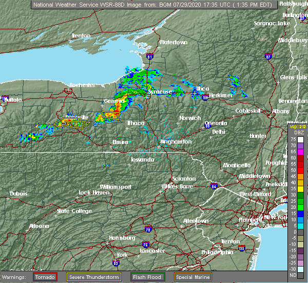
| 7/29/2020 2:07 PM EDT |
 At 207 pm edt, a severe thunderstorm was located near scott, or 7 miles northwest of cortland, moving east at 40 mph (radar indicated). Hazards include 60 mph wind gusts. Expect damage to trees, powerlines and possibly homes. Locations impacted include, homer, locke, preble, moravia, scott, truxton, cuyler, sempronius, deruyter and taylor. At 207 pm edt, a severe thunderstorm was located near scott, or 7 miles northwest of cortland, moving east at 40 mph (radar indicated). Hazards include 60 mph wind gusts. Expect damage to trees, powerlines and possibly homes. Locations impacted include, homer, locke, preble, moravia, scott, truxton, cuyler, sempronius, deruyter and taylor.
|
| 7/29/2020 1:37 PM EDT |
 At 136 pm edt, a severe thunderstorm was located over ledyard, or 15 miles south of auburn, moving east at 45 mph (radar indicated). Hazards include 60 mph wind gusts. expect damage to roofs, siding, and trees At 136 pm edt, a severe thunderstorm was located over ledyard, or 15 miles south of auburn, moving east at 45 mph (radar indicated). Hazards include 60 mph wind gusts. expect damage to roofs, siding, and trees
|
| 7/19/2020 5:31 PM EDT |
 At 530 pm edt, severe thunderstorms were located along a line extending from near de ruyter to near cuyler to near lisle to near owego to near nichols, moving east at 40 mph (radar indicated). Hazards include 60 mph wind gusts and penny size hail. Expect damage to roofs, siding, and trees. Locations impacted include, endicott, barton, sayre, maine, waverly, owego, athens, nanticoke, litchfield and berkshire. At 530 pm edt, severe thunderstorms were located along a line extending from near de ruyter to near cuyler to near lisle to near owego to near nichols, moving east at 40 mph (radar indicated). Hazards include 60 mph wind gusts and penny size hail. Expect damage to roofs, siding, and trees. Locations impacted include, endicott, barton, sayre, maine, waverly, owego, athens, nanticoke, litchfield and berkshire.
|
| 7/19/2020 5:20 PM EDT |
 At 518 pm edt, severe thunderstorms were located along a line extending from near fabius to east homer to near harford to barton to sayre, moving east at 35 mph (radar indicated. trees have been blown down with this line of thunderstorms as it moved through previous counties). Hazards include 60 mph wind gusts and penny size hail. Expect damage to roofs, siding, and trees. Locations impacted include, chemung, cortland, endicott, barton, sayre, maine, waverly, owego, athens and homer. At 518 pm edt, severe thunderstorms were located along a line extending from near fabius to east homer to near harford to barton to sayre, moving east at 35 mph (radar indicated. trees have been blown down with this line of thunderstorms as it moved through previous counties). Hazards include 60 mph wind gusts and penny size hail. Expect damage to roofs, siding, and trees. Locations impacted include, chemung, cortland, endicott, barton, sayre, maine, waverly, owego, athens and homer.
|
| 7/19/2020 5:01 PM EDT |
 At 500 pm edt, severe thunderstorms were located along a line extending from near otisco to kelloggsville to near ithaca to near erin to near lowman, moving east at 25 mph. trees have been blown down with this line of thunderstorms (radar indicated). Hazards include 60 mph wind gusts and penny size hail. expect damage to roofs, siding, and trees At 500 pm edt, severe thunderstorms were located along a line extending from near otisco to kelloggsville to near ithaca to near erin to near lowman, moving east at 25 mph. trees have been blown down with this line of thunderstorms (radar indicated). Hazards include 60 mph wind gusts and penny size hail. expect damage to roofs, siding, and trees
|
| 7/8/2020 2:30 PM EDT | Tree down on cairns mills road. time estimate in cortland county NY, 2.9 miles NE of DeRuyter, NY |
| 10/31/2019 10:51 PM EDT |
 The severe thunderstorm warning for south central oneida, southwestern madison, eastern cortland and northwestern chenango counties will expire at 1100 pm edt, the showers which prompted the warning have weakened below severe limits, and have exited the warned area. therefore, the warning will be allowed to expire. The severe thunderstorm warning for south central oneida, southwestern madison, eastern cortland and northwestern chenango counties will expire at 1100 pm edt, the showers which prompted the warning have weakened below severe limits, and have exited the warned area. therefore, the warning will be allowed to expire.
|
| 10/31/2019 10:29 PM EDT |
 At 1028 pm edt, gusty showers were located along a line extending from near peterboro to near east freetown, moving northeast at 60 mph (radar indicated). Hazards include 60 mph wind gusts. Expect damage to roofs, siding, and trees. Locations impacted include, kirkland, eaton, hamilton, whitesboro, new york mills, yorkville, morrisville, stockbridge, augusta and nelson. At 1028 pm edt, gusty showers were located along a line extending from near peterboro to near east freetown, moving northeast at 60 mph (radar indicated). Hazards include 60 mph wind gusts. Expect damage to roofs, siding, and trees. Locations impacted include, kirkland, eaton, hamilton, whitesboro, new york mills, yorkville, morrisville, stockbridge, augusta and nelson.
|
| 10/31/2019 10:14 PM EDT |
 At 1014 pm edt, gusty showers were located along a line extending from near fabius to near harford, moving northeast at 60 mph (radar indicated). Hazards include 60 mph wind gusts. expect damage to roofs, siding, and trees At 1014 pm edt, gusty showers were located along a line extending from near fabius to near harford, moving northeast at 60 mph (radar indicated). Hazards include 60 mph wind gusts. expect damage to roofs, siding, and trees
|
| 10/31/2019 6:54 PM EDT |
 At 653 pm edt, gusty showers were located along a line extending from sylvan beach to slaterville springs, moving northeast at 75 mph. these showers have downed trees earlier this evening (radar indicated). Hazards include 60 mph wind gusts. expect damage to roofs, siding, and trees At 653 pm edt, gusty showers were located along a line extending from sylvan beach to slaterville springs, moving northeast at 75 mph. these showers have downed trees earlier this evening (radar indicated). Hazards include 60 mph wind gusts. expect damage to roofs, siding, and trees
|
| 8/9/2019 8:23 PM EDT |
 The national weather service in binghamton has issued a * severe thunderstorm warning for. southwestern madison county in central new york. northeastern cortland county in central new york. northwestern chenango county in central new york. Until 900 pm edt. The national weather service in binghamton has issued a * severe thunderstorm warning for. southwestern madison county in central new york. northeastern cortland county in central new york. northwestern chenango county in central new york. Until 900 pm edt.
|
| 8/8/2019 2:35 PM EDT |
 At 234 pm edt, severe thunderstorms were located along a line extending from brewerton to near east homer to near spencer, moving east at 55 mph (radar indicated). Hazards include 60 mph wind gusts and penny size hail. expect damage to roofs, siding, and trees At 234 pm edt, severe thunderstorms were located along a line extending from brewerton to near east homer to near spencer, moving east at 55 mph (radar indicated). Hazards include 60 mph wind gusts and penny size hail. expect damage to roofs, siding, and trees
|
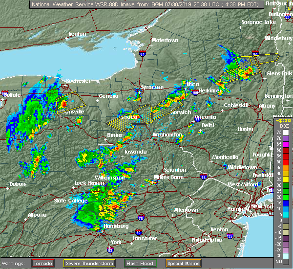
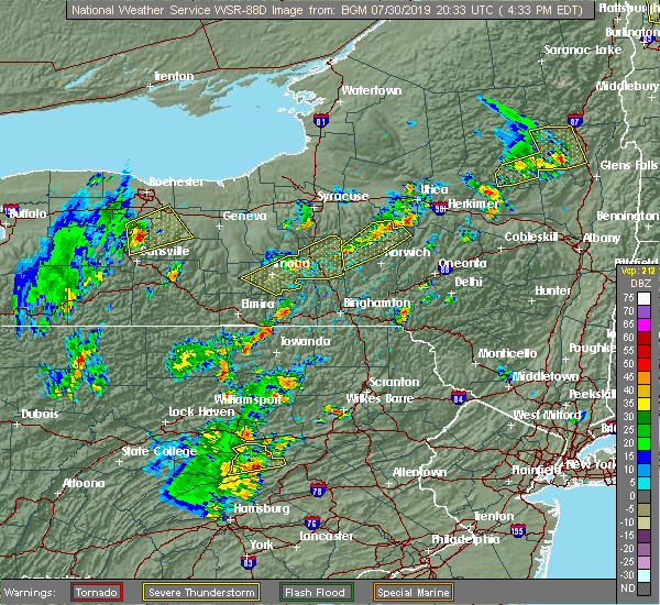
| 7/30/2019 9:25 PM EDT | Quarter sized hail reported 6.4 miles NNW of DeRuyter, NY |
| 7/30/2019 9:14 PM EDT | Quarter sized hail reported 6.4 miles NNW of DeRuyter, NY |
| 7/30/2019 5:25 PM EDT |
 At 525 pm edt, severe thunderstorms were located along a line extending from near fabius to otselic, moving northeast at 35 mph (radar indicated). Hazards include 60 mph wind gusts. Expect damage to roofs, siding, and trees. Locations impacted include, sullivan, oneida, lenox, eaton, chittenango, canastota, hamilton, cazenovia, morrisville and stockbridge. At 525 pm edt, severe thunderstorms were located along a line extending from near fabius to otselic, moving northeast at 35 mph (radar indicated). Hazards include 60 mph wind gusts. Expect damage to roofs, siding, and trees. Locations impacted include, sullivan, oneida, lenox, eaton, chittenango, canastota, hamilton, cazenovia, morrisville and stockbridge.
|
| 7/30/2019 5:00 PM EDT | Quarter sized hail reported 6.4 miles NNW of DeRuyter, NY |
| 7/30/2019 4:51 PM EDT |
 At 450 pm edt, severe thunderstorms were located along a line extending from near homer to solon, moving northeast at 35 mph (radar indicated). Hazards include 60 mph wind gusts and half dollar size hail. Hail damage to vehicles is expected. Expect wind damage to roofs, siding, and trees. At 450 pm edt, severe thunderstorms were located along a line extending from near homer to solon, moving northeast at 35 mph (radar indicated). Hazards include 60 mph wind gusts and half dollar size hail. Hail damage to vehicles is expected. Expect wind damage to roofs, siding, and trees.
|
| 7/30/2019 4:40 PM EDT |
 At 439 pm edt, severe thunderstorms were located along a line extending from near south cortland to near virgil, moving northeast at 40 mph (radar indicated). Hazards include 60 mph wind gusts and half dollar size hail. Hail damage to vehicles is expected. expect wind damage to roofs, siding, and trees. Locations impacted include, cortland, homer, virgil, groton, truxton, solon, mcgraw, cuyler, deruyter and taylor. At 439 pm edt, severe thunderstorms were located along a line extending from near south cortland to near virgil, moving northeast at 40 mph (radar indicated). Hazards include 60 mph wind gusts and half dollar size hail. Hail damage to vehicles is expected. expect wind damage to roofs, siding, and trees. Locations impacted include, cortland, homer, virgil, groton, truxton, solon, mcgraw, cuyler, deruyter and taylor.
|
| 7/30/2019 4:32 PM EDT |
 At 432 pm edt, severe thunderstorms were located along a line extending from freeville to near harford, moving northeast at 35 mph (radar indicated). Hazards include 60 mph wind gusts and quarter size hail. Hail damage to vehicles is expected. expect wind damage to roofs, siding, and trees. Locations impacted include, ithaca, cortland, newfield, cayuga heights, lansing, enfield, danby, homer, caroline and virgil. At 432 pm edt, severe thunderstorms were located along a line extending from freeville to near harford, moving northeast at 35 mph (radar indicated). Hazards include 60 mph wind gusts and quarter size hail. Hail damage to vehicles is expected. expect wind damage to roofs, siding, and trees. Locations impacted include, ithaca, cortland, newfield, cayuga heights, lansing, enfield, danby, homer, caroline and virgil.
|
| 7/30/2019 4:04 PM EDT |
 At 404 pm edt, severe thunderstorms were located along a line extending from enfield to danby, moving northeast at 35 mph (radar indicated). Hazards include 60 mph wind gusts and quarter size hail. Hail damage to vehicles is expected. Expect wind damage to roofs, siding, and trees. At 404 pm edt, severe thunderstorms were located along a line extending from enfield to danby, moving northeast at 35 mph (radar indicated). Hazards include 60 mph wind gusts and quarter size hail. Hail damage to vehicles is expected. Expect wind damage to roofs, siding, and trees.
|
| 7/16/2019 6:41 PM EDT |
 The national weather service in binghamton has issued a * severe thunderstorm warning for. northwestern broome county in central new york. southeastern madison county in central new york. eastern cortland county in central new york. Chenango county in central new york. The national weather service in binghamton has issued a * severe thunderstorm warning for. northwestern broome county in central new york. southeastern madison county in central new york. eastern cortland county in central new york. Chenango county in central new york.
|
| 6/26/2019 2:57 PM EDT |
 The severe thunderstorm warning for southwestern madison, northern cortland, southeastern onondaga and northwestern chenango counties will expire at 300 pm edt, the storms which prompted the warning have moved out of the area. therefore, the warning will be allowed to expire. remember, a severe thunderstorm warning still remains in effect for cortland and western chenango counties until 345 pm. The severe thunderstorm warning for southwestern madison, northern cortland, southeastern onondaga and northwestern chenango counties will expire at 300 pm edt, the storms which prompted the warning have moved out of the area. therefore, the warning will be allowed to expire. remember, a severe thunderstorm warning still remains in effect for cortland and western chenango counties until 345 pm.
|
| 6/26/2019 2:38 PM EDT |
 At 237 pm edt, severe thunderstorms were located along a line extending from near tully to homer, moving east at 25 mph (radar indicated). Hazards include 60 mph wind gusts and quarter size hail. Hail damage to vehicles is expected. expect wind damage to roofs, siding, and trees. Locations impacted include, homer, preble, truxton, cuyler, tully, pharsalia, deruyter, taylor, lincklaen and fabius. At 237 pm edt, severe thunderstorms were located along a line extending from near tully to homer, moving east at 25 mph (radar indicated). Hazards include 60 mph wind gusts and quarter size hail. Hail damage to vehicles is expected. expect wind damage to roofs, siding, and trees. Locations impacted include, homer, preble, truxton, cuyler, tully, pharsalia, deruyter, taylor, lincklaen and fabius.
|
| 6/26/2019 2:27 PM EDT |
 At 227 pm edt, severe thunderstorms were located along a line extending from near tully to near scott, moving east at 25 mph (radar indicated). Hazards include 60 mph wind gusts and quarter size hail. Hail damage to vehicles is expected. expect wind damage to roofs, siding, and trees. Locations impacted include, homer, preble, scott, truxton, cuyler, tully, pharsalia, deruyter, taylor and lincklaen. At 227 pm edt, severe thunderstorms were located along a line extending from near tully to near scott, moving east at 25 mph (radar indicated). Hazards include 60 mph wind gusts and quarter size hail. Hail damage to vehicles is expected. expect wind damage to roofs, siding, and trees. Locations impacted include, homer, preble, scott, truxton, cuyler, tully, pharsalia, deruyter, taylor and lincklaen.
|
| 6/26/2019 2:11 PM EDT |
 The national weather service in binghamton has issued a * severe thunderstorm warning for. southwestern madison county in central new york. southeastern cayuga county in central new york. northern cortland county in central new york. Southeastern onondaga county in central new york. The national weather service in binghamton has issued a * severe thunderstorm warning for. southwestern madison county in central new york. southeastern cayuga county in central new york. northern cortland county in central new york. Southeastern onondaga county in central new york.
|
| 5/10/2019 2:58 PM EDT |
 At 258 pm edt, a severe thunderstorm was located over hamilton, moving east at 40 mph (radar indicated). Hazards include 60 mph wind gusts and half dollar size hail. Hail damage to vehicles is expected. expect wind damage to roofs, siding, and trees. Locations impacted include, eaton, hamilton, brookfield, morrisville, waterville, lebanon, georgetown, earlville, west winfield and oriskany falls. At 258 pm edt, a severe thunderstorm was located over hamilton, moving east at 40 mph (radar indicated). Hazards include 60 mph wind gusts and half dollar size hail. Hail damage to vehicles is expected. expect wind damage to roofs, siding, and trees. Locations impacted include, eaton, hamilton, brookfield, morrisville, waterville, lebanon, georgetown, earlville, west winfield and oriskany falls.
|
| 5/10/2019 2:42 PM EDT |
 At 241 pm edt, a severe thunderstorm was located over erieville, or 10 miles west of hamilton, moving east at 40 mph (radar indicated). Hazards include 60 mph wind gusts and quarter size hail. Hail damage to vehicles is expected. expect wind damage to roofs, siding, and trees. Locations impacted include, eaton, paris, hamilton, brookfield, morrisville, augusta, nelson, waterville, lebanon and georgetown. At 241 pm edt, a severe thunderstorm was located over erieville, or 10 miles west of hamilton, moving east at 40 mph (radar indicated). Hazards include 60 mph wind gusts and quarter size hail. Hail damage to vehicles is expected. expect wind damage to roofs, siding, and trees. Locations impacted include, eaton, paris, hamilton, brookfield, morrisville, augusta, nelson, waterville, lebanon and georgetown.
|
| 5/10/2019 2:34 PM EDT |
 At 233 pm edt, a severe thunderstorm was located near de ruyter, or 15 miles west of hamilton, moving east at 40 mph (radar indicated). Hazards include 60 mph wind gusts and penny size hail. expect damage to roofs, siding, and trees At 233 pm edt, a severe thunderstorm was located near de ruyter, or 15 miles west of hamilton, moving east at 40 mph (radar indicated). Hazards include 60 mph wind gusts and penny size hail. expect damage to roofs, siding, and trees
|
| 7/16/2018 7:34 PM EDT |
 At 733 pm edt, severe thunderstorms were located along a line extending from kirkville to near truxton, moving east at 20 mph (radar indicated). Hazards include 60 mph wind gusts and penny size hail. Expect damage to roofs, siding, and trees. these severe storms will be near, kirkville around 740 pm edt. sullivan and chittenango around 745 pm edt. de ruyter around 755 pm edt. canastota around 800 pm edt. lenox and wampsville around 805 pm edt. Oneida, sherrill and morrisville around 815 pm edt. At 733 pm edt, severe thunderstorms were located along a line extending from kirkville to near truxton, moving east at 20 mph (radar indicated). Hazards include 60 mph wind gusts and penny size hail. Expect damage to roofs, siding, and trees. these severe storms will be near, kirkville around 740 pm edt. sullivan and chittenango around 745 pm edt. de ruyter around 755 pm edt. canastota around 800 pm edt. lenox and wampsville around 805 pm edt. Oneida, sherrill and morrisville around 815 pm edt.
|
| 7/16/2018 7:33 PM EDT |
 At 732 pm edt, severe thunderstorms were located along a line extending from kirkville to near truxton, moving east at 20 mph (radar indicated). Hazards include 60 mph wind gusts and penny size hail. Expect damage to roofs, siding, and trees. these severe storms will be near, kirkville around 740 pm edt. sullivan and chittenango around 745 pm edt. de ruyter around 755 pm edt. canastota around 800 pm edt. lenox and wampsville around 805 pm edt. Oneida, sherrill and morrisville around 815 pm edt. At 732 pm edt, severe thunderstorms were located along a line extending from kirkville to near truxton, moving east at 20 mph (radar indicated). Hazards include 60 mph wind gusts and penny size hail. Expect damage to roofs, siding, and trees. these severe storms will be near, kirkville around 740 pm edt. sullivan and chittenango around 745 pm edt. de ruyter around 755 pm edt. canastota around 800 pm edt. lenox and wampsville around 805 pm edt. Oneida, sherrill and morrisville around 815 pm edt.
|
| 7/16/2018 7:15 PM EDT |
 The national weather service in binghamton has issued a * severe thunderstorm warning for. west central oneida county in central new york. madison county in central new york. northern cortland county in central new york. Southeastern onondaga county in central new york. The national weather service in binghamton has issued a * severe thunderstorm warning for. west central oneida county in central new york. madison county in central new york. northern cortland county in central new york. Southeastern onondaga county in central new york.
|
| 7/2/2018 6:00 PM EDT |
 At 559 pm edt, severe thunderstorms were located along a line extending from de ruyter to near cincinnatus to marathon, moving northeast at 35 mph (radar indicated). Hazards include 60 mph wind gusts and quarter size hail. Hail damage to vehicles is expected. Expect wind damage to roofs, siding, and trees. At 559 pm edt, severe thunderstorms were located along a line extending from de ruyter to near cincinnatus to marathon, moving northeast at 35 mph (radar indicated). Hazards include 60 mph wind gusts and quarter size hail. Hail damage to vehicles is expected. Expect wind damage to roofs, siding, and trees.
|
| 7/2/2018 5:51 PM EDT |
 At 550 pm edt, severe thunderstorms were located along a line extending from nelson to erieville to near solon, moving east at 35 mph (law enforcement). Hazards include 60 mph wind gusts and quarter size hail. Hail damage to vehicles is expected. expect wind damage to roofs, siding, and trees. Locations impacted include, eaton, hamilton, cazenovia, morrisville, stockbridge, nelson, lebanon, solon, otselic and mcgraw. At 550 pm edt, severe thunderstorms were located along a line extending from nelson to erieville to near solon, moving east at 35 mph (law enforcement). Hazards include 60 mph wind gusts and quarter size hail. Hail damage to vehicles is expected. expect wind damage to roofs, siding, and trees. Locations impacted include, eaton, hamilton, cazenovia, morrisville, stockbridge, nelson, lebanon, solon, otselic and mcgraw.
|
| 7/2/2018 5:36 PM EDT |
 At 535 pm edt, severe thunderstorms were located along a line extending from near cazenovia to near de ruyter to mcgraw, moving northeast at 25 mph (law enforcement. at 520 pm edt, trees and powerlines were blown down near cortland). Hazards include 60 mph wind gusts and quarter size hail. Hail damage to vehicles is expected. expect wind damage to roofs, siding, and trees. Locations impacted include, cortland, eaton, hamilton, homer, cazenovia, morrisville, stockbridge, nelson, lebanon and truxton. At 535 pm edt, severe thunderstorms were located along a line extending from near cazenovia to near de ruyter to mcgraw, moving northeast at 25 mph (law enforcement. at 520 pm edt, trees and powerlines were blown down near cortland). Hazards include 60 mph wind gusts and quarter size hail. Hail damage to vehicles is expected. expect wind damage to roofs, siding, and trees. Locations impacted include, cortland, eaton, hamilton, homer, cazenovia, morrisville, stockbridge, nelson, lebanon and truxton.
|
| 7/2/2018 5:14 PM EDT |
 At 514 pm edt, severe thunderstorms were located along a line extending from fabius to near truxton to cortland, moving east at 35 mph (radar indicated). Hazards include 60 mph wind gusts and quarter size hail. Hail damage to vehicles is expected. Expect wind damage to roofs, siding, and trees. At 514 pm edt, severe thunderstorms were located along a line extending from fabius to near truxton to cortland, moving east at 35 mph (radar indicated). Hazards include 60 mph wind gusts and quarter size hail. Hail damage to vehicles is expected. Expect wind damage to roofs, siding, and trees.
|
| 7/2/2018 5:07 PM EDT |
 At 506 pm edt, a severe thunderstorm was located over preble, or 8 miles northeast of cortland, moving east at 30 mph (radar indicated). Hazards include 60 mph wind gusts and nickel size hail. Expect damage to roofs, siding, and trees. Locations impacted include, cortland, homer, preble, scott, truxton, cuyler, tully, deruyter, fabius and east homer. At 506 pm edt, a severe thunderstorm was located over preble, or 8 miles northeast of cortland, moving east at 30 mph (radar indicated). Hazards include 60 mph wind gusts and nickel size hail. Expect damage to roofs, siding, and trees. Locations impacted include, cortland, homer, preble, scott, truxton, cuyler, tully, deruyter, fabius and east homer.
|
| 7/2/2018 4:50 PM EDT |
 At 449 pm edt, a severe thunderstorm was located near scott, moving east at 30 mph (radar indicated). Hazards include 60 mph wind gusts and nickel size hail. expect damage to roofs, siding, and trees At 449 pm edt, a severe thunderstorm was located near scott, moving east at 30 mph (radar indicated). Hazards include 60 mph wind gusts and nickel size hail. expect damage to roofs, siding, and trees
|
| 5/4/2018 6:27 PM EDT |
 At 627 pm edt, severe thunderstorms were located along a line extending from near sherrill to near erieville to near truxton to near danby, moving southeast at 40 mph (radar indicated). Hazards include 60 mph wind gusts. Expect damage to trees, and power lines. severe thunderstorms will be near, oneida, sherrill and nelson around 630 pm edt. morrisville, stockbridge and georgetown around 635 pm edt. hamilton, augusta and lebanon around 640 pm edt. clinton, candor and pecksport around 645 pm edt. waterville, berkshire and earlville around 650 pm edt. owego, plymouth and sherburne around 655 pm edt. brookfield, north norwich and nanticoke around 700 pm edt. norwich, oxford and columbus around 705 pm edt. A tornado watch remains in effect until 1000 pm edt for central new york. At 627 pm edt, severe thunderstorms were located along a line extending from near sherrill to near erieville to near truxton to near danby, moving southeast at 40 mph (radar indicated). Hazards include 60 mph wind gusts. Expect damage to trees, and power lines. severe thunderstorms will be near, oneida, sherrill and nelson around 630 pm edt. morrisville, stockbridge and georgetown around 635 pm edt. hamilton, augusta and lebanon around 640 pm edt. clinton, candor and pecksport around 645 pm edt. waterville, berkshire and earlville around 650 pm edt. owego, plymouth and sherburne around 655 pm edt. brookfield, north norwich and nanticoke around 700 pm edt. norwich, oxford and columbus around 705 pm edt. A tornado watch remains in effect until 1000 pm edt for central new york.
|
| 5/4/2018 6:20 PM EDT |
 At 619 pm edt, severe thunderstorms were located along a line extending from near cazenovia to near truxton to homer to newfield, moving east at 50 mph (radar indicated). Hazards include 60 mph wind gusts. Expect damage to trees, and power lines. these severe storms will be near, cazenovia, nelson and cuyler around 625 pm edt. Caroline, morrisville and stockbridge around 630 pm edt. At 619 pm edt, severe thunderstorms were located along a line extending from near cazenovia to near truxton to homer to newfield, moving east at 50 mph (radar indicated). Hazards include 60 mph wind gusts. Expect damage to trees, and power lines. these severe storms will be near, cazenovia, nelson and cuyler around 625 pm edt. Caroline, morrisville and stockbridge around 630 pm edt.
|
| 5/4/2018 5:49 PM EDT |
 At 548 pm edt, severe thunderstorms were located along a line extending from near syracuse to kelloggsville to near genoa to near reading center, moving east at 75 mph (radar indicated). Hazards include 60 mph wind gusts. Expect damage to trees, and power lines. severe thunderstorms will be near, pompey, manlius and otisco around 555 pm edt. chittenango, cazenovia and preble around 600 pm edt. cortland, newfield and enfield around 605 pm edt. ithaca, danby and morrisville around 610 pm edt. hamilton, caroline and stockbridge around 615 pm edt. berkshire, lebanon and richford around 620 pm edt. nanticoke, waterville and sherburne around 625 pm edt. norwich, marathon and brookfield around 630 pm edt. A tornado watch remains in effect until 1000 pm edt for central new york. At 548 pm edt, severe thunderstorms were located along a line extending from near syracuse to kelloggsville to near genoa to near reading center, moving east at 75 mph (radar indicated). Hazards include 60 mph wind gusts. Expect damage to trees, and power lines. severe thunderstorms will be near, pompey, manlius and otisco around 555 pm edt. chittenango, cazenovia and preble around 600 pm edt. cortland, newfield and enfield around 605 pm edt. ithaca, danby and morrisville around 610 pm edt. hamilton, caroline and stockbridge around 615 pm edt. berkshire, lebanon and richford around 620 pm edt. nanticoke, waterville and sherburne around 625 pm edt. norwich, marathon and brookfield around 630 pm edt. A tornado watch remains in effect until 1000 pm edt for central new york.
|
| 10/15/2017 7:04 PM EDT |
 At 703 pm edt, severe thunderstorms were located along a line extending from 6 miles south of nicks lake campground to holland patent to new york mills to near peterboro to near fabius to scott, moving east at 55 mph (radar indicated). Hazards include 60 mph wind gusts. Expect damage to trees and power lines. severe thunderstorms will be near, utica, new hartford and trenton around 710 pm edt. nelson around 715 pm edt. clinton, waterville and pierceville around 720 pm edt. clayville around 725 pm edt. lebanon, otselic and georgetown around 730 pm edt. brookfield, earlville and smyrna around 735 pm edt. sherburne, bridgewater and unadilla forks around 740 pm edt. Edmeston, columbus and south brookfield around 745 pm edt. At 703 pm edt, severe thunderstorms were located along a line extending from 6 miles south of nicks lake campground to holland patent to new york mills to near peterboro to near fabius to scott, moving east at 55 mph (radar indicated). Hazards include 60 mph wind gusts. Expect damage to trees and power lines. severe thunderstorms will be near, utica, new hartford and trenton around 710 pm edt. nelson around 715 pm edt. clinton, waterville and pierceville around 720 pm edt. clayville around 725 pm edt. lebanon, otselic and georgetown around 730 pm edt. brookfield, earlville and smyrna around 735 pm edt. sherburne, bridgewater and unadilla forks around 740 pm edt. Edmeston, columbus and south brookfield around 745 pm edt.
|
| 10/15/2017 6:39 PM EDT |
 The national weather service in binghamton has issued a * severe thunderstorm warning for. southeastern seneca county in central new york. northeastern schuyler county in central new york. southern madison county in central new york. Southern cayuga county in central new york. The national weather service in binghamton has issued a * severe thunderstorm warning for. southeastern seneca county in central new york. northeastern schuyler county in central new york. southern madison county in central new york. Southern cayuga county in central new york.
|
| 10/15/2017 6:08 PM EDT |
 At 607 pm edt, severe thunderstorms were located along a line extending from 7 miles northwest of redfield to i-81 exit 33 to near phoenix to near camillus to sennett to cayuga, moving east at 45 mph (radar indicated). Hazards include 60 mph wind gusts. Expect damage to trees and power lines. severe thunderstorms will be near, brewerton around 615 pm edt. syracuse, cicero and galeville around 620 pm edt. owasco around 625 pm edt. camden, manlius and niles around 630 pm edt. kirkville around 635 pm edt. sullivan, chittenango and taberg around 640 pm edt. pompey, vienna and canastota around 645 pm edt. Boonville, lenox and tully around 650 pm edt. At 607 pm edt, severe thunderstorms were located along a line extending from 7 miles northwest of redfield to i-81 exit 33 to near phoenix to near camillus to sennett to cayuga, moving east at 45 mph (radar indicated). Hazards include 60 mph wind gusts. Expect damage to trees and power lines. severe thunderstorms will be near, brewerton around 615 pm edt. syracuse, cicero and galeville around 620 pm edt. owasco around 625 pm edt. camden, manlius and niles around 630 pm edt. kirkville around 635 pm edt. sullivan, chittenango and taberg around 640 pm edt. pompey, vienna and canastota around 645 pm edt. Boonville, lenox and tully around 650 pm edt.
|
| 8/22/2017 4:39 PM EDT |
 At 438 pm edt, a severe thunderstorm capable of producing a tornado was located over fabius, or 18 miles northeast of cortland, moving east at 45 mph (radar indicated rotation). Hazards include tornado and quarter size hail. Flying debris will be dangerous to those caught without shelter. mobile homes will be damaged or destroyed. damage to roofs, windows, and vehicles will occur. tree damage is likely. this dangerous storm will be near, nelson, georgetown and erieville around 455 pm edt. morrisville, lebanon and pierceville around 500 pm edt. hamilton, stockbridge and pecksport around 505 pm edt. Madison, solsville and poolville around 510 pm edt. At 438 pm edt, a severe thunderstorm capable of producing a tornado was located over fabius, or 18 miles northeast of cortland, moving east at 45 mph (radar indicated rotation). Hazards include tornado and quarter size hail. Flying debris will be dangerous to those caught without shelter. mobile homes will be damaged or destroyed. damage to roofs, windows, and vehicles will occur. tree damage is likely. this dangerous storm will be near, nelson, georgetown and erieville around 455 pm edt. morrisville, lebanon and pierceville around 500 pm edt. hamilton, stockbridge and pecksport around 505 pm edt. Madison, solsville and poolville around 510 pm edt.
|
| 7/1/2017 2:35 PM EDT |
 At 234 pm edt, a severe thunderstorm was located over otisco, or 13 miles south of syracuse, moving east at 50 mph (radar indicated). Hazards include 60 mph wind gusts. Expect damage to trees, and power lines. this severe thunderstorm will be near, tully and la fayette around 240 pm edt. pompey, fabius and watervale around 250 pm edt. cazenovia around 300 pm edt. nelson and erieville around 305 pm edt. morrisville, lebanon and pierceville around 310 pm edt. Hamilton and stockbridge around 315 pm edt. At 234 pm edt, a severe thunderstorm was located over otisco, or 13 miles south of syracuse, moving east at 50 mph (radar indicated). Hazards include 60 mph wind gusts. Expect damage to trees, and power lines. this severe thunderstorm will be near, tully and la fayette around 240 pm edt. pompey, fabius and watervale around 250 pm edt. cazenovia around 300 pm edt. nelson and erieville around 305 pm edt. morrisville, lebanon and pierceville around 310 pm edt. Hamilton and stockbridge around 315 pm edt.
|
| 5/18/2017 5:53 PM EDT |
 At 553 pm edt, a severe thunderstorm was located near taughannock falls, or near ithaca, moving northeast at 40 mph (radar indicated). Hazards include 60 mph wind gusts and quarter size hail. Hail damage to vehicles is expected. expect wind damage to roofs, siding, and trees. this severe thunderstorm will be near, dryden and freeville around 605 pm edt. groton around 610 pm edt. virgil and south cortland around 615 pm edt. cortland and munsons corners around 620 pm edt. homer, scott and mcgraw around 625 pm edt. preble, solon and east homer around 630 pm edt. truxton and tully around 635 pm edt. Cuyler around 640 pm edt. At 553 pm edt, a severe thunderstorm was located near taughannock falls, or near ithaca, moving northeast at 40 mph (radar indicated). Hazards include 60 mph wind gusts and quarter size hail. Hail damage to vehicles is expected. expect wind damage to roofs, siding, and trees. this severe thunderstorm will be near, dryden and freeville around 605 pm edt. groton around 610 pm edt. virgil and south cortland around 615 pm edt. cortland and munsons corners around 620 pm edt. homer, scott and mcgraw around 625 pm edt. preble, solon and east homer around 630 pm edt. truxton and tully around 635 pm edt. Cuyler around 640 pm edt.
|
| 5/18/2017 5:39 PM EDT |
 At 539 pm edt, severe thunderstorms were located along a line extending from near otisco to near la fayette to near tully to near truxton to near east homer, moving east at 50 mph (radar indicated). Hazards include golf ball size hail and 70 mph wind gusts. People and animals outdoors will be injured. expect hail damage to roofs, siding, windows, and vehicles. expect considerable tree damage. wind damage is also likely to mobile homes, roofs, and outbuildings. severe thunderstorms will be near, pompey and fabius around 545 pm edt. cuyler and de ruyter around 550 pm edt. taylor and watervale around 555 pm edt. cazenovia, georgetown and erieville around 600 pm edt. nelson, lebanon and otselic around 605 pm edt. hamilton, morrisville and pecksport around 610 pm edt. madison, smyrna and peterboro around 615 pm edt. Stockbridge, sherburne and earlville around 620 pm edt. At 539 pm edt, severe thunderstorms were located along a line extending from near otisco to near la fayette to near tully to near truxton to near east homer, moving east at 50 mph (radar indicated). Hazards include golf ball size hail and 70 mph wind gusts. People and animals outdoors will be injured. expect hail damage to roofs, siding, windows, and vehicles. expect considerable tree damage. wind damage is also likely to mobile homes, roofs, and outbuildings. severe thunderstorms will be near, pompey and fabius around 545 pm edt. cuyler and de ruyter around 550 pm edt. taylor and watervale around 555 pm edt. cazenovia, georgetown and erieville around 600 pm edt. nelson, lebanon and otselic around 605 pm edt. hamilton, morrisville and pecksport around 610 pm edt. madison, smyrna and peterboro around 615 pm edt. Stockbridge, sherburne and earlville around 620 pm edt.
|
| 5/18/2017 5:13 PM EDT |
 At 513 pm edt, severe thunderstorms were located along a line extending from near fleming to venice center to near genoa to ledyard, moving east at 45 mph (radar indicated). Hazards include golf ball size hail and 70 mph wind gusts. People and animals outdoors will be injured. expect hail damage to roofs, siding, windows, and vehicles. expect considerable tree damage. wind damage is also likely to mobile homes, roofs, and outbuildings. severe thunderstorms will be near, owasco and niles around 520 pm edt. locke, moravia and kelloggsville around 525 pm edt. montville around 530 pm edt. otisco and sempronius around 535 pm edt. scott and la fayette around 540 pm edt. pompey, preble and tully around 545 pm edt. truxton and fabius around 555 pm edt. Cuyler around 600 pm edt. At 513 pm edt, severe thunderstorms were located along a line extending from near fleming to venice center to near genoa to ledyard, moving east at 45 mph (radar indicated). Hazards include golf ball size hail and 70 mph wind gusts. People and animals outdoors will be injured. expect hail damage to roofs, siding, windows, and vehicles. expect considerable tree damage. wind damage is also likely to mobile homes, roofs, and outbuildings. severe thunderstorms will be near, owasco and niles around 520 pm edt. locke, moravia and kelloggsville around 525 pm edt. montville around 530 pm edt. otisco and sempronius around 535 pm edt. scott and la fayette around 540 pm edt. pompey, preble and tully around 545 pm edt. truxton and fabius around 555 pm edt. Cuyler around 600 pm edt.
|
| 5/1/2017 7:14 PM EDT |
 At 713 pm edt, severe thunderstorms were located along a line extending from cuyler to near virgil to willseyville to barton to near burlington, moving northeast at 40 mph (radar indicated). Hazards include 60 mph wind gusts and penny size hail. Expect damage to roofs, siding, and trees. severe thunderstorms will be near, mcgraw, cuyler and de ruyter around 720 pm edt. solon around 725 pm edt. towanda, berkshire and richford around 730 pm edt. wysox, lebanon and cincinnatus around 735 pm edt. litchfield, newark valley and rome around 740 pm edt. endicott, hamilton and marathon around 745 pm edt. johnson city, nws binghamton and nanticoke around 750 pm edt. binghamton, plymouth and otselic around 755 pm edt. A tornado watch remains in effect until 1000 pm edt for central new york, and northeastern pennsylvania. At 713 pm edt, severe thunderstorms were located along a line extending from cuyler to near virgil to willseyville to barton to near burlington, moving northeast at 40 mph (radar indicated). Hazards include 60 mph wind gusts and penny size hail. Expect damage to roofs, siding, and trees. severe thunderstorms will be near, mcgraw, cuyler and de ruyter around 720 pm edt. solon around 725 pm edt. towanda, berkshire and richford around 730 pm edt. wysox, lebanon and cincinnatus around 735 pm edt. litchfield, newark valley and rome around 740 pm edt. endicott, hamilton and marathon around 745 pm edt. johnson city, nws binghamton and nanticoke around 750 pm edt. binghamton, plymouth and otselic around 755 pm edt. A tornado watch remains in effect until 1000 pm edt for central new york, and northeastern pennsylvania.
|
| 5/1/2017 6:49 PM EDT |
 At 649 pm edt, a severe thunderstorm was located over la fayette, or 12 miles south of syracuse, moving northeast at 50 mph (radar indicated). Hazards include 60 mph wind gusts. Expect damage to roofs, siding, and trees. this severe thunderstorm will be near, manlius and watervale around 700 pm edt. sullivan, chittenango and cazenovia around 705 pm edt. nelson around 710 pm edt. lenox, canastota and wampsville around 715 pm edt. oneida, sherrill and stockbridge around 720 pm edt. verona and vernon around 725 pm edt. westmoreland and clinton around 730 pm edt. clark mills around 735 pm edt. A tornado watch remains in effect until 1000 pm edt for central new york. At 649 pm edt, a severe thunderstorm was located over la fayette, or 12 miles south of syracuse, moving northeast at 50 mph (radar indicated). Hazards include 60 mph wind gusts. Expect damage to roofs, siding, and trees. this severe thunderstorm will be near, manlius and watervale around 700 pm edt. sullivan, chittenango and cazenovia around 705 pm edt. nelson around 710 pm edt. lenox, canastota and wampsville around 715 pm edt. oneida, sherrill and stockbridge around 720 pm edt. verona and vernon around 725 pm edt. westmoreland and clinton around 730 pm edt. clark mills around 735 pm edt. A tornado watch remains in effect until 1000 pm edt for central new york.
|
| 6/12/2015 6:53 PM EDT |
 At 651 pm edt, a severe thunderstorm was located near taylor, or 17 miles southwest of hamilton, moving east at 35 mph (radar indicated). Hazards include 60 mph wind gusts and quarter size hail. in addition, expect very heavy rainfall which could lead to localized flooding issues, especially over southern madison county where recent storms in the past couple hours have already produced heavy rain. Hail damage to vehicles is expected. expect wind damage to roofs, siding and trees. localized flooding is also possible. this severe storm will be near, otselic around 700 pm edt. georgetown around 705 pm edt. plymouth, lebanon and south lebanon around 710 pm edt. smyrna around 715 pm edt. sherburne and earlville around 720 pm edt. A tornado watch remains in effect until 1100 pm edt for central new york. At 651 pm edt, a severe thunderstorm was located near taylor, or 17 miles southwest of hamilton, moving east at 35 mph (radar indicated). Hazards include 60 mph wind gusts and quarter size hail. in addition, expect very heavy rainfall which could lead to localized flooding issues, especially over southern madison county where recent storms in the past couple hours have already produced heavy rain. Hail damage to vehicles is expected. expect wind damage to roofs, siding and trees. localized flooding is also possible. this severe storm will be near, otselic around 700 pm edt. georgetown around 705 pm edt. plymouth, lebanon and south lebanon around 710 pm edt. smyrna around 715 pm edt. sherburne and earlville around 720 pm edt. A tornado watch remains in effect until 1100 pm edt for central new york.
|
| 6/12/2015 6:39 PM EDT |
 At 639 pm edt, a severe thunderstorm was located over solon, or 9 miles east of cortland, moving east at 20 mph (radar indicated). Hazards include 60 mph wind gusts. Expect damage to roofs. siding and trees. this severe thunderstorm will be near, cincinnatus around 645 pm edt. cuyler and taylor around 650 pm edt. pitcher around 655 pm edt. de ruyter around 700 pm edt. otselic around 720 pm edt. georgetown around 725 pm edt. plymouth, sherburne and lebanon around 730 pm edt. A tornado watch remains in effect until 1100 pm edt for central new york. At 639 pm edt, a severe thunderstorm was located over solon, or 9 miles east of cortland, moving east at 20 mph (radar indicated). Hazards include 60 mph wind gusts. Expect damage to roofs. siding and trees. this severe thunderstorm will be near, cincinnatus around 645 pm edt. cuyler and taylor around 650 pm edt. pitcher around 655 pm edt. de ruyter around 700 pm edt. otselic around 720 pm edt. georgetown around 725 pm edt. plymouth, sherburne and lebanon around 730 pm edt. A tornado watch remains in effect until 1100 pm edt for central new york.
|
| 6/12/2015 4:25 PM EDT | A few trees and wires down town of de ruyter to georgetow in madison county NY, 1.1 miles NW of DeRuyter, NY |
| 6/12/2015 4:15 PM EDT |
 At 414 pm edt, a severe thunderstorm was located over hamilton, moving east at 40 mph (radar indicated). Hazards include golf ball size hail and 60 mph wind gusts. People and animals outdoors will be injured. expect hail damage to roofs, siding, windows and vehicles. expect wind damage to roofs, siding and trees. this severe thunderstorm will remain over mainly rural areas of southwestern madison and northwestern chenango counties. A tornado watch remains in effect until 1100 pm edt for central new york. At 414 pm edt, a severe thunderstorm was located over hamilton, moving east at 40 mph (radar indicated). Hazards include golf ball size hail and 60 mph wind gusts. People and animals outdoors will be injured. expect hail damage to roofs, siding, windows and vehicles. expect wind damage to roofs, siding and trees. this severe thunderstorm will remain over mainly rural areas of southwestern madison and northwestern chenango counties. A tornado watch remains in effect until 1100 pm edt for central new york.
|
| 6/12/2015 4:09 PM EDT |
 At 408 pm edt, a severe thunderstorm capable of producing a tornado was located over de ruyter, or 16 miles west of hamilton, moving east at 30 mph (radar indicated rotation). Hazards include tornado and quarter size hail. Flying debris will be dangerous to those caught without shelter. mobile homes will be damaged or destroyed. damage to roofs, windows and vehicles will occur. tree damage is likely. This tornadic thunderstorm will remain over mainly rural areas of southwestern madison, northwestern chenango and east central cayuga counties. At 408 pm edt, a severe thunderstorm capable of producing a tornado was located over de ruyter, or 16 miles west of hamilton, moving east at 30 mph (radar indicated rotation). Hazards include tornado and quarter size hail. Flying debris will be dangerous to those caught without shelter. mobile homes will be damaged or destroyed. damage to roofs, windows and vehicles will occur. tree damage is likely. This tornadic thunderstorm will remain over mainly rural areas of southwestern madison, northwestern chenango and east central cayuga counties.
|
| 6/12/2015 3:29 PM EDT |
 At 329 pm edt, a severe thunderstorm capable of producing a tornado was located near scott, or 12 miles north of cortland, moving east at 30 mph (radar indicated rotation). Hazards include tornado and quarter size hail. Flying debris will be dangerous to those caught without shelter. mobile homes will be damaged or destroyed. damage to roofs, windows and vehicles will occur. tree damage is likely. this dangerous storm will be near, preble around 340 pm edt. tully around 345 pm edt. truxton around 350 pm edt. fabius around 355 pm edt. cuyler around 400 pm edt. de ruyter around 410 pm edt. Otselic, georgetown and erieville around 415 pm edt. At 329 pm edt, a severe thunderstorm capable of producing a tornado was located near scott, or 12 miles north of cortland, moving east at 30 mph (radar indicated rotation). Hazards include tornado and quarter size hail. Flying debris will be dangerous to those caught without shelter. mobile homes will be damaged or destroyed. damage to roofs, windows and vehicles will occur. tree damage is likely. this dangerous storm will be near, preble around 340 pm edt. tully around 345 pm edt. truxton around 350 pm edt. fabius around 355 pm edt. cuyler around 400 pm edt. de ruyter around 410 pm edt. Otselic, georgetown and erieville around 415 pm edt.
|
| 6/12/2015 3:25 PM EDT |
 At 325 pm edt, a severe thunderstorm was located near scott, or 14 miles north of cortland, moving east at 40 mph (radar indicated). Hazards include golf ball size hail and 60 mph wind gusts. People and animals outdoors will be injured. expect hail damage to roofs, siding, windows and vehicles. expect wind damage to roofs, siding and trees. this severe thunderstorm will be near, preble, tully and la fayette around 335 pm edt. truxton around 340 pm edt. fabius around 345 pm edt. cuyler and de ruyter around 350 pm edt. erieville around 400 pm edt. otselic and georgetown around 405 pm edt. morrisville, lebanon and pierceville around 410 pm edt. hamilton, earlville and pecksport around 415 pm edt. A tornado watch remains in effect until 1100 pm edt for central new york. At 325 pm edt, a severe thunderstorm was located near scott, or 14 miles north of cortland, moving east at 40 mph (radar indicated). Hazards include golf ball size hail and 60 mph wind gusts. People and animals outdoors will be injured. expect hail damage to roofs, siding, windows and vehicles. expect wind damage to roofs, siding and trees. this severe thunderstorm will be near, preble, tully and la fayette around 335 pm edt. truxton around 340 pm edt. fabius around 345 pm edt. cuyler and de ruyter around 350 pm edt. erieville around 400 pm edt. otselic and georgetown around 405 pm edt. morrisville, lebanon and pierceville around 410 pm edt. hamilton, earlville and pecksport around 415 pm edt. A tornado watch remains in effect until 1100 pm edt for central new york.
|
| 6/8/2015 2:09 PM EDT |
 At 209 pm edt, a severe thunderstorm was located near de ruyter, or 14 miles west of hamilton, moving east at 55 mph (radar indicated). Hazards include 60 mph wind gusts. Expect damage to roofs. siding and trees. this severe storm will be near, nelson and erieville around 215 pm edt. morrisville, lebanon and pierceville around 220 pm edt. hamilton, stockbridge and pecksport around 225 pm edt. augusta, madison and solsville around 230 pm edt. waterville around 235 pm edt. clinton and bridgewater around 240 pm edt. utica, new hartford and clayville around 245 pm edt. A tornado watch remains in effect until 800 pm edt for central new york. At 209 pm edt, a severe thunderstorm was located near de ruyter, or 14 miles west of hamilton, moving east at 55 mph (radar indicated). Hazards include 60 mph wind gusts. Expect damage to roofs. siding and trees. this severe storm will be near, nelson and erieville around 215 pm edt. morrisville, lebanon and pierceville around 220 pm edt. hamilton, stockbridge and pecksport around 225 pm edt. augusta, madison and solsville around 230 pm edt. waterville around 235 pm edt. clinton and bridgewater around 240 pm edt. utica, new hartford and clayville around 245 pm edt. A tornado watch remains in effect until 800 pm edt for central new york.
|
| 6/8/2015 1:49 PM EDT |
 At 149 pm edt, a severe thunderstorm was located over preble, or 9 miles north of cortland, moving northeast at 55 mph (radar indicated). Hazards include 60 mph wind gusts. Expect damage to roofs. siding and trees. this severe thunderstorm will be near, truxton around 155 pm edt. pompey, cuyler and fabius around 200 pm edt. de ruyter around 205 pm edt. cazenovia around 210 pm edt. nelson and erieville around 215 pm edt. morrisville, peterboro and pierceville around 220 pm edt. hamilton, stockbridge and madison around 225 pm edt. augusta and solsville around 230 pm edt. A tornado watch remains in effect until 800 pm edt for central new york. At 149 pm edt, a severe thunderstorm was located over preble, or 9 miles north of cortland, moving northeast at 55 mph (radar indicated). Hazards include 60 mph wind gusts. Expect damage to roofs. siding and trees. this severe thunderstorm will be near, truxton around 155 pm edt. pompey, cuyler and fabius around 200 pm edt. de ruyter around 205 pm edt. cazenovia around 210 pm edt. nelson and erieville around 215 pm edt. morrisville, peterboro and pierceville around 220 pm edt. hamilton, stockbridge and madison around 225 pm edt. augusta and solsville around 230 pm edt. A tornado watch remains in effect until 800 pm edt for central new york.
|
| 5/29/2013 4:55 PM EDT | Quarter sized hail reported 3.3 miles E of DeRuyter, NY |
| 8/10/2012 6:38 AM EDT | Trees down in madison county NY, 4.4 miles SW of DeRuyter, NY |
| 1/1/0001 12:00 AM | Trees and wires down in chenango county NY, 9.3 miles NW of DeRuyter, NY |
| 1/1/0001 12:00 AM | Hen Egg sized hail reported 9.3 miles NW of DeRuyter, NY |
| 1/1/0001 12:00 AM | Golf Ball sized hail reported 10.2 miles NNW of DeRuyter, NY, also gusty winds with a few limbs down |
| 1/1/0001 12:00 AM | Tea Cup sized hail reported 9.3 miles NW of DeRuyter, NY |
| 1/1/0001 12:00 AM | Tennis Ball sized hail reported 9.3 miles NW of DeRuyter, NY |
| 1/1/0001 12:00 AM | Hen Egg sized hail reported 9.3 miles NW of DeRuyter, NY |
Hail Maps for DeRuyter, NY


Connect with Interactive Hail Maps