

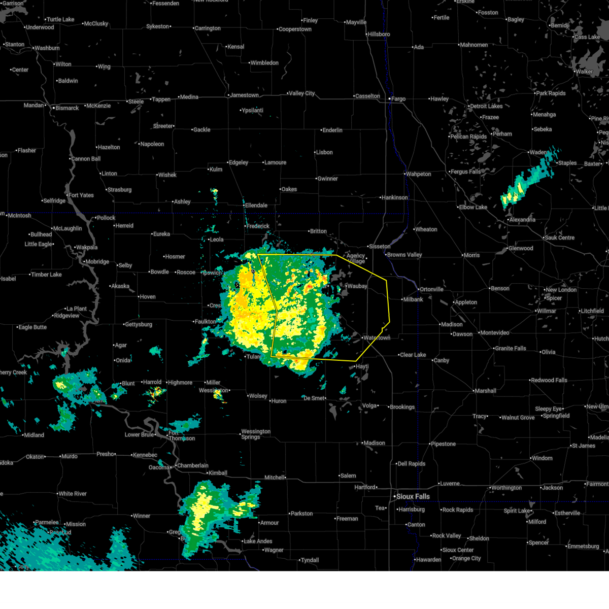
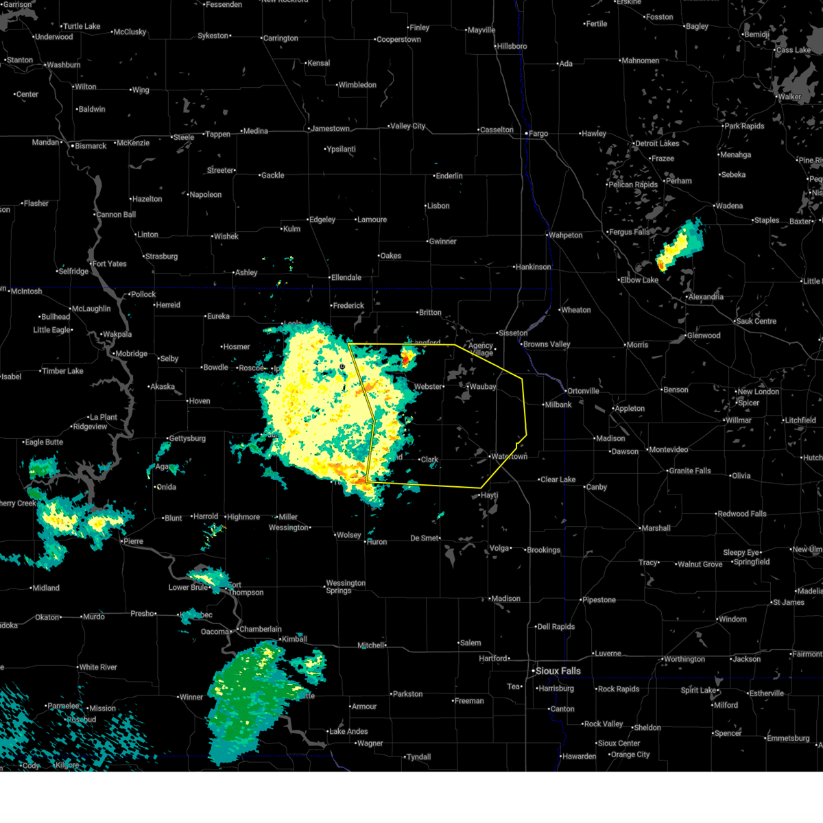
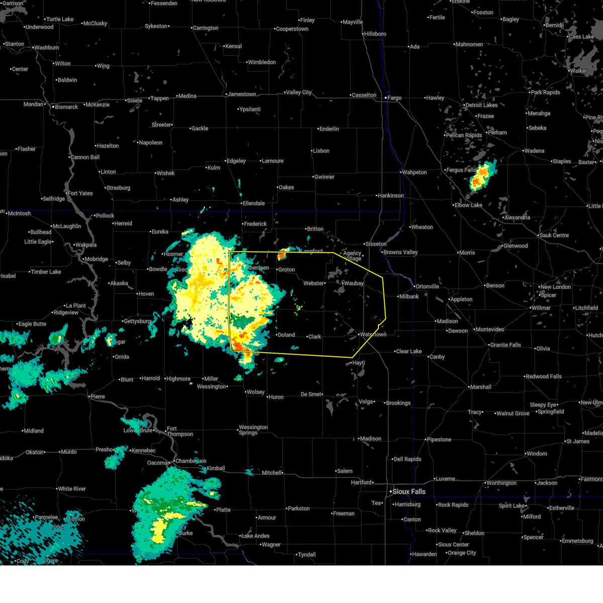
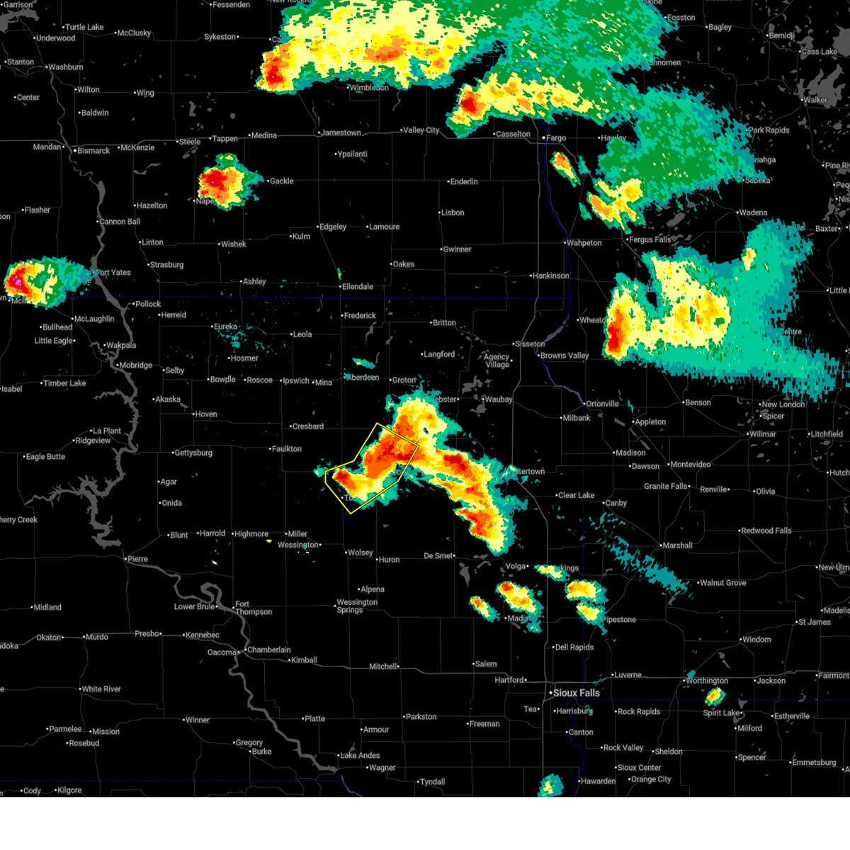
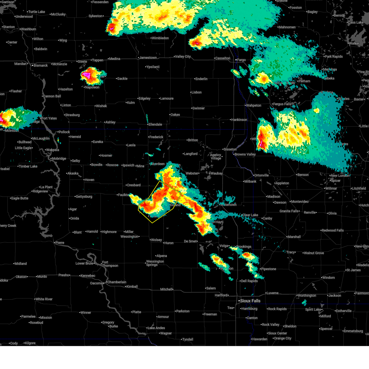
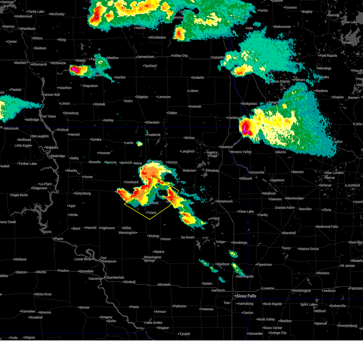
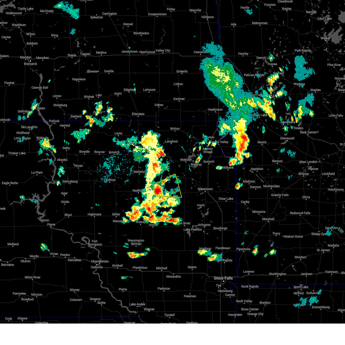
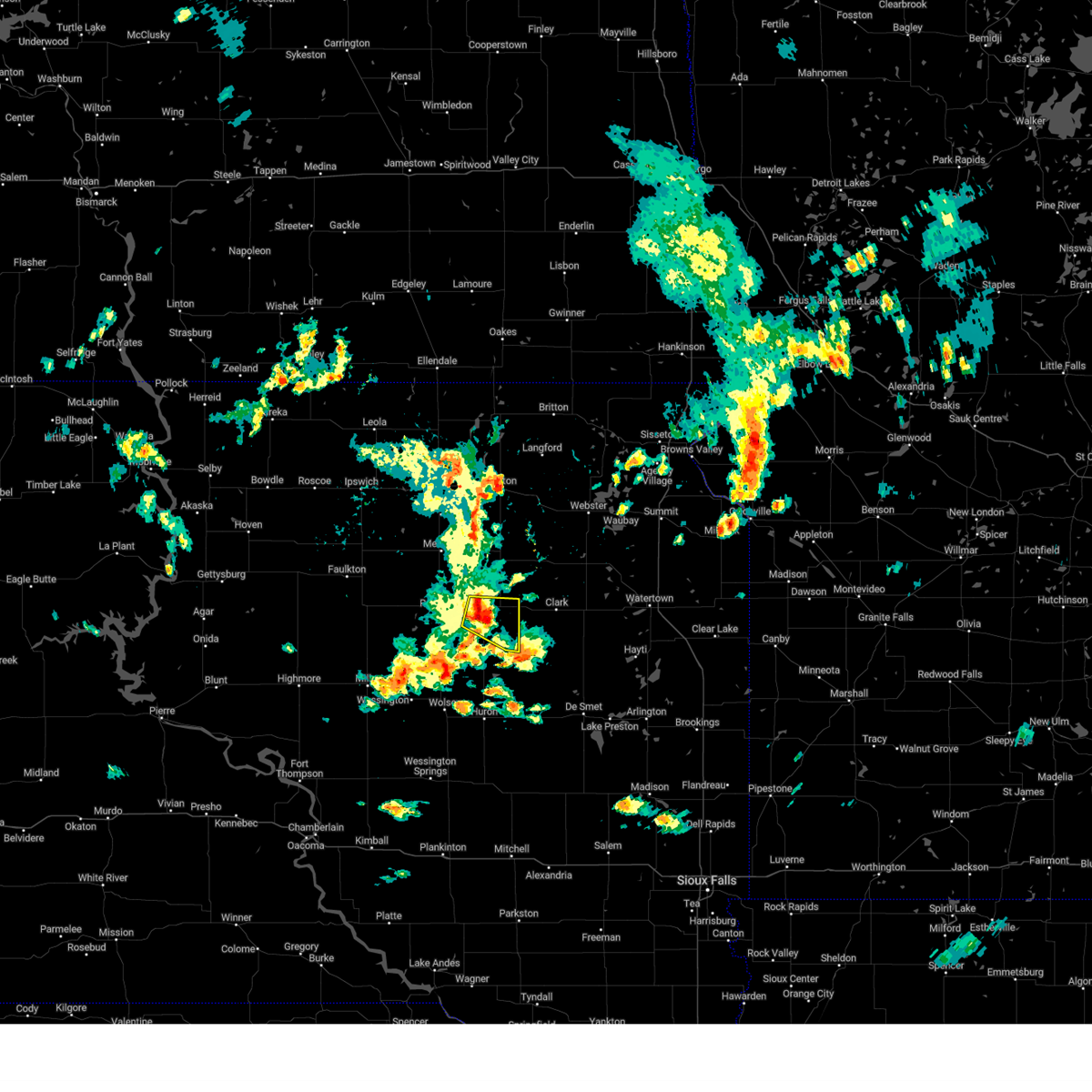
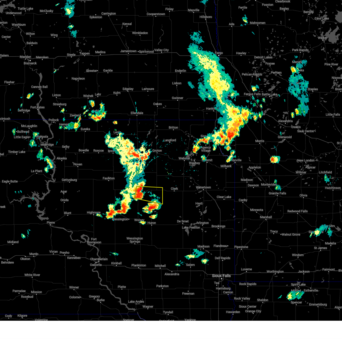
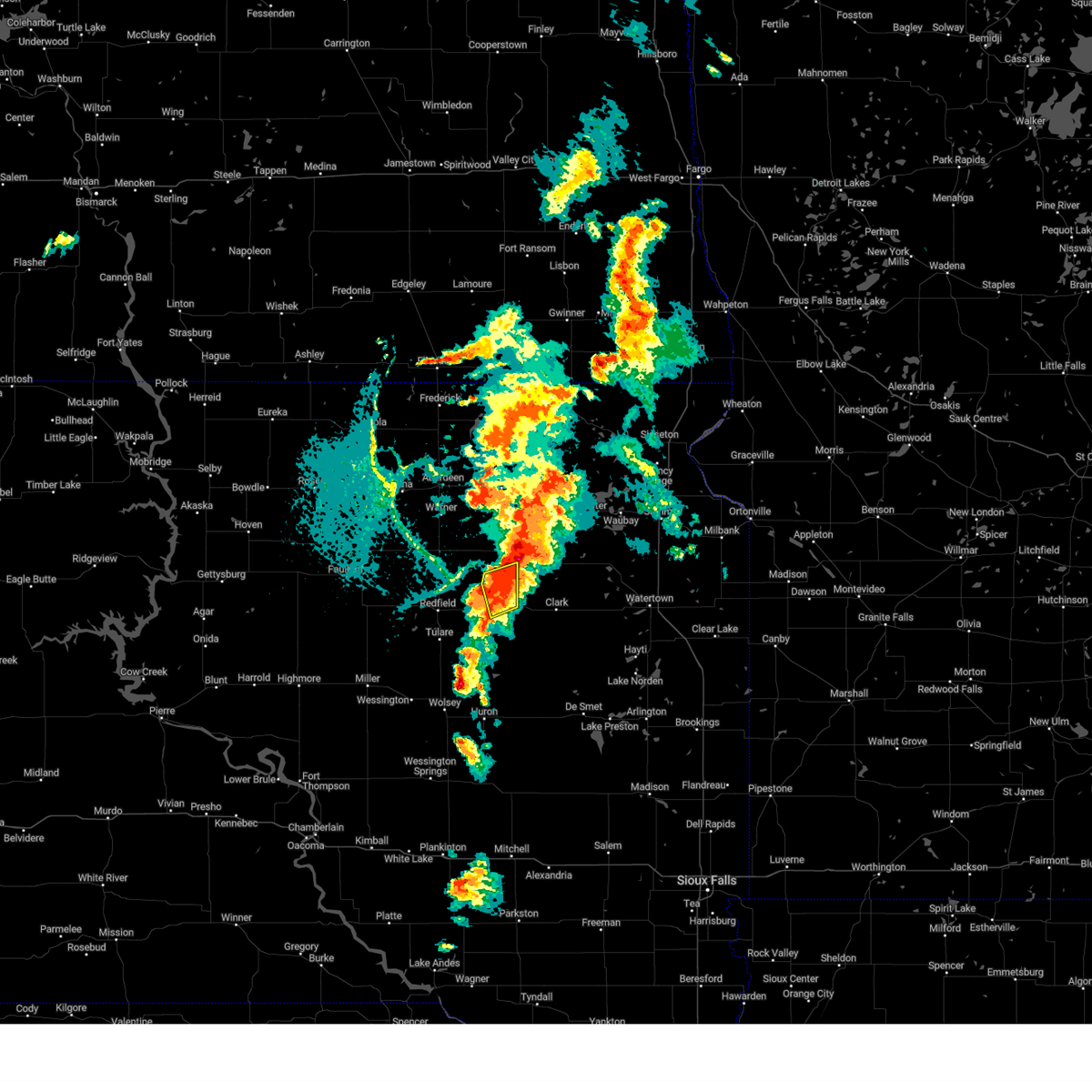
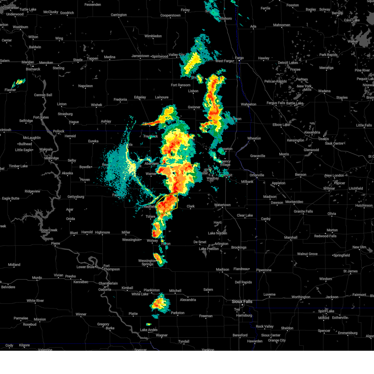
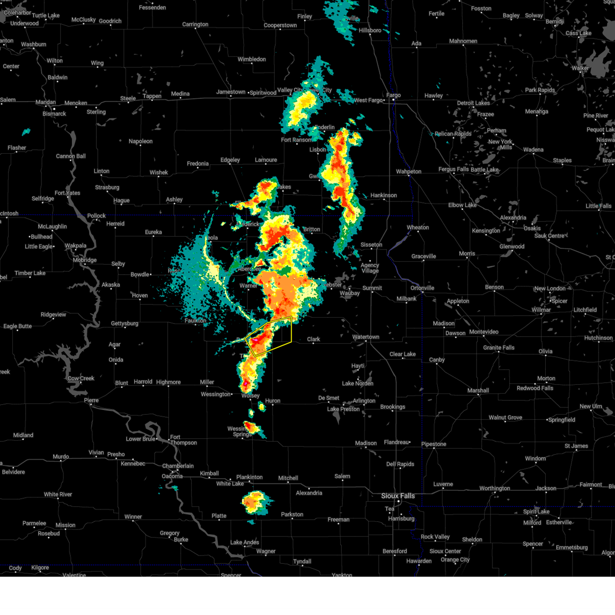
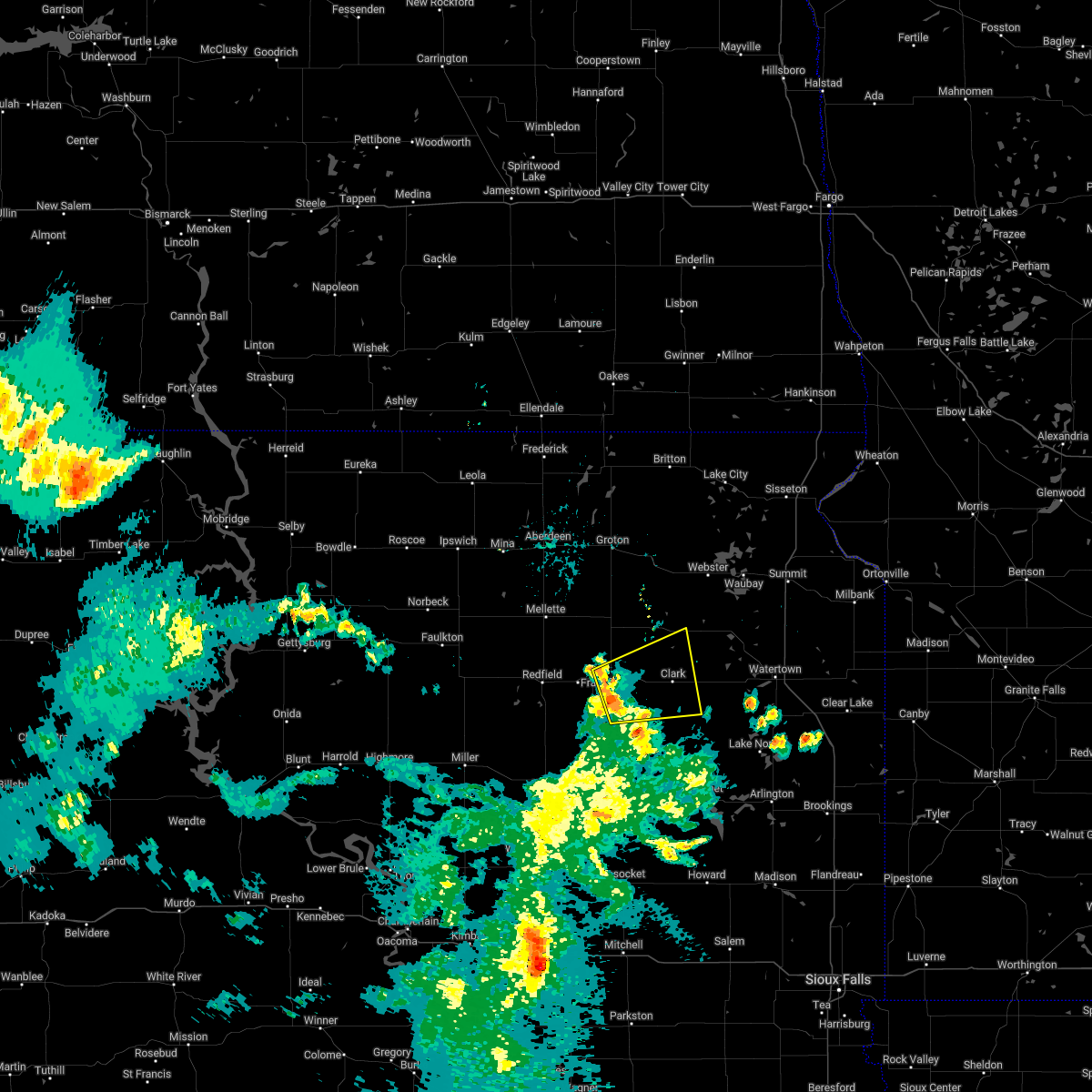
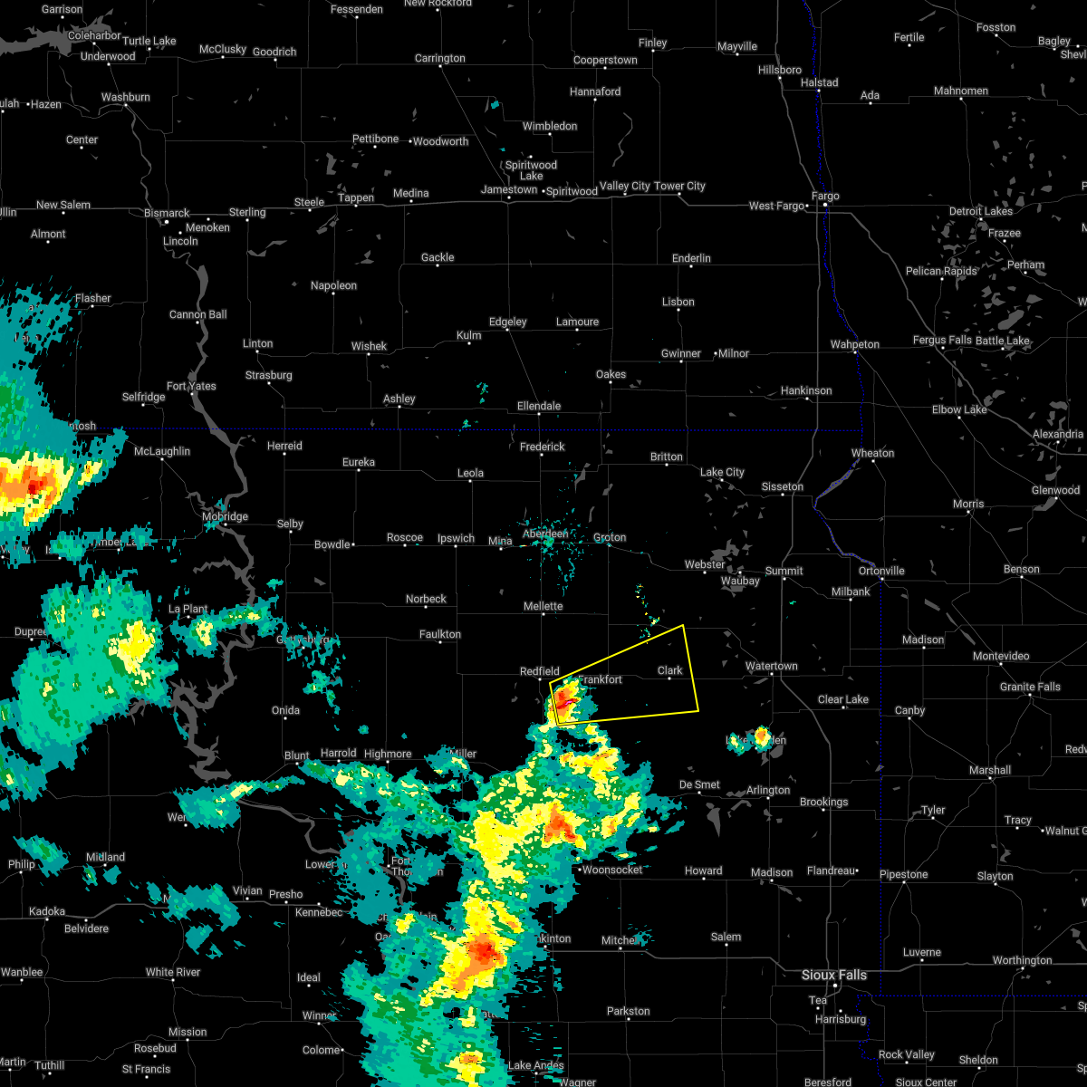
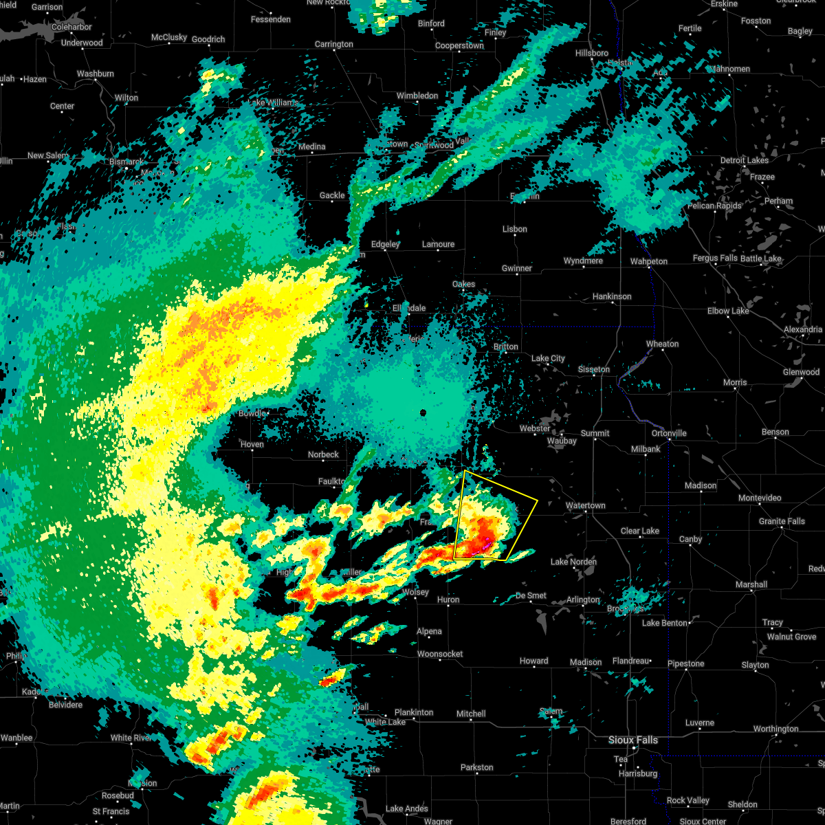
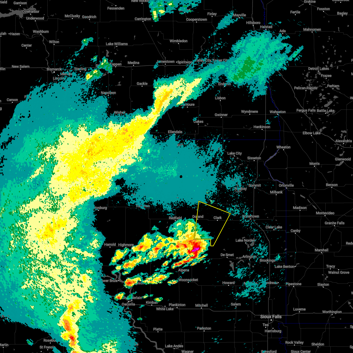
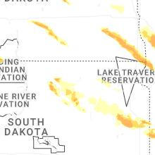
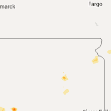
Hail Map for Doland, SD
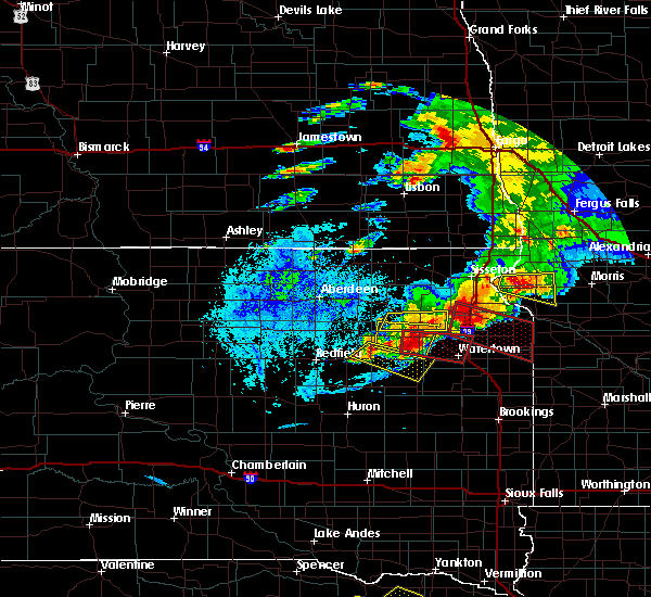
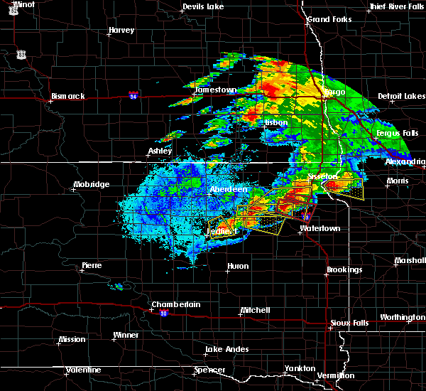
The Doland, SD area has had 3 reports of on-the-ground hail by trained spotters, and has been under severe weather warnings 10 times during the past 12 months. Doppler radar has detected hail at or near Doland, SD on 37 occasions, including 2 occasions during the past year.
| Name: | Doland, SD |
| Where Located: | 43.5 miles SSE of Aberdeen, SD |
| Map: | Google Map for Doland, SD |
| Population: | 180 |
| Housing Units: | 131 |
| More Info: | Search Google for Doland, SD |
3
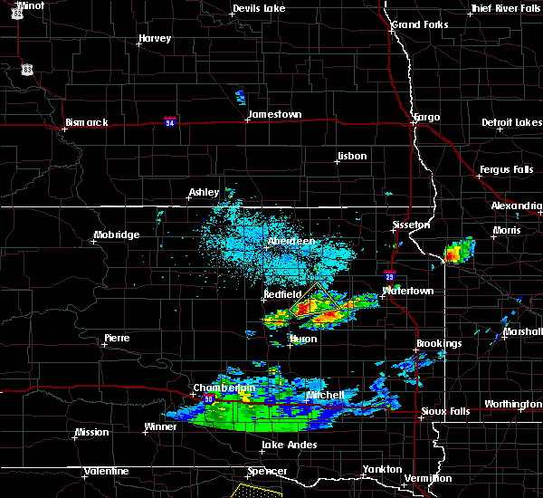
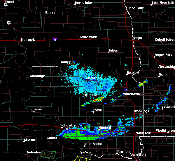
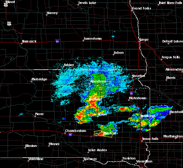
The Top Recent Hail Date for Doland, SD is Saturday, July 6, 2024 (2nd out of 37)

Hail and Wind Damage Spotted near Doland, SD
| Date / Time | Report Details |
|---|---|
| 6/29/2025 10:15 PM CDT |
 the severe thunderstorm warning has been cancelled and is no longer in effect the severe thunderstorm warning has been cancelled and is no longer in effect
|
| 6/29/2025 9:52 PM CDT |
 At 951 pm cdt, severe thunderstorms were located along a line extending from putney to near bristol to near bradley to fordham colony, moving east at 50 mph (radar indicated). Hazards include 60 mph wind gusts. Expect damage to roofs, siding, and trees. Locations impacted include, groton, clark, bristol, pierpont, hillcrest colony, andover, bradley, garden city, butler, lily, webster, wallace, antelope lake, henry, naples, long lake, grass lake, waubay lake, medicine lake, florence, minnewasta lake, bitter lake, rush lake, tinkertown, watertown, waubay, goose lake, roslyn, hazel, lake kampeska, blue dog lake, waubay wildlife rec area, memorial park camping site, enemy swim housing, rauville, ortley, grenville, enemy swim lake, campbell slough, pelican lake, sandy shore rec area, dakota sioux casino, kellerton church, opitz lake, thomas, summit, waverly, rudebusch corner and pickerel lake rec area. At 951 pm cdt, severe thunderstorms were located along a line extending from putney to near bristol to near bradley to fordham colony, moving east at 50 mph (radar indicated). Hazards include 60 mph wind gusts. Expect damage to roofs, siding, and trees. Locations impacted include, groton, clark, bristol, pierpont, hillcrest colony, andover, bradley, garden city, butler, lily, webster, wallace, antelope lake, henry, naples, long lake, grass lake, waubay lake, medicine lake, florence, minnewasta lake, bitter lake, rush lake, tinkertown, watertown, waubay, goose lake, roslyn, hazel, lake kampeska, blue dog lake, waubay wildlife rec area, memorial park camping site, enemy swim housing, rauville, ortley, grenville, enemy swim lake, campbell slough, pelican lake, sandy shore rec area, dakota sioux casino, kellerton church, opitz lake, thomas, summit, waverly, rudebusch corner and pickerel lake rec area.
|
| 6/29/2025 9:30 PM CDT |
 Svrabr the national weather service in aberdeen has issued a * severe thunderstorm warning for, southwestern roberts county in northeastern south dakota, southwestern marshall county in northeastern south dakota, day county in northeastern south dakota, southern brown county in northeastern south dakota, northwestern hamlin county in northeastern south dakota, western grant county in northeastern south dakota, clark county in northeastern south dakota, spink county in northeastern south dakota, codington county in northeastern south dakota, * until 1030 pm cdt. * at 929 pm cdt, severe thunderstorms were located along a line extending from near richmond lake rec area to near groton to turton to near glendale colony, moving east at 50 mph (radar indicated). Hazards include 60 mph wind gusts. Expect damage to roofs, siding, and trees. severe thunderstorms will be near, aberdeen, groton, doland, glendale colony, bath, putney, andover, raymond, crandall, and tacoma park around 935 pm cdt. crocker around 940 pm cdt. bristol, pierpont, hillside colony, clark colony, butler, and lily around 945 pm cdt. Other locations in the path of these severe thunderstorms include clark, hillcrest colony, bradley, fordham colony, swan lake, holmquist, webster, wallace, garden city, grass lake, antelope lake, waubay lake, silver lake, florence, henry, roslyn, long lake, minnewasta lake, bitter lake, rush lake, medicine lake, waubay, enemy swim housing, grenville, naples, enemy swim lake, campbell slough, blue dog lake and waubay wildlife rec area. Svrabr the national weather service in aberdeen has issued a * severe thunderstorm warning for, southwestern roberts county in northeastern south dakota, southwestern marshall county in northeastern south dakota, day county in northeastern south dakota, southern brown county in northeastern south dakota, northwestern hamlin county in northeastern south dakota, western grant county in northeastern south dakota, clark county in northeastern south dakota, spink county in northeastern south dakota, codington county in northeastern south dakota, * until 1030 pm cdt. * at 929 pm cdt, severe thunderstorms were located along a line extending from near richmond lake rec area to near groton to turton to near glendale colony, moving east at 50 mph (radar indicated). Hazards include 60 mph wind gusts. Expect damage to roofs, siding, and trees. severe thunderstorms will be near, aberdeen, groton, doland, glendale colony, bath, putney, andover, raymond, crandall, and tacoma park around 935 pm cdt. crocker around 940 pm cdt. bristol, pierpont, hillside colony, clark colony, butler, and lily around 945 pm cdt. Other locations in the path of these severe thunderstorms include clark, hillcrest colony, bradley, fordham colony, swan lake, holmquist, webster, wallace, garden city, grass lake, antelope lake, waubay lake, silver lake, florence, henry, roslyn, long lake, minnewasta lake, bitter lake, rush lake, medicine lake, waubay, enemy swim housing, grenville, naples, enemy swim lake, campbell slough, blue dog lake and waubay wildlife rec area.
|
| 6/19/2025 10:28 PM CDT |
 At 1028 pm cdt, severe thunderstorms were located along a line extending from turton to near doland to near tulare, moving east at 30 mph (radar indicated). Hazards include 60 mph wind gusts and quarter size hail. Hail damage to vehicles is expected. expect wind damage to roofs, siding, and trees. Locations impacted include, redfield, tulare, doland, glendale colony, frankfort, spink colony, camrose colony, turton, and twin lakes. At 1028 pm cdt, severe thunderstorms were located along a line extending from turton to near doland to near tulare, moving east at 30 mph (radar indicated). Hazards include 60 mph wind gusts and quarter size hail. Hail damage to vehicles is expected. expect wind damage to roofs, siding, and trees. Locations impacted include, redfield, tulare, doland, glendale colony, frankfort, spink colony, camrose colony, turton, and twin lakes.
|
| 6/19/2025 10:15 PM CDT |
 the severe thunderstorm warning has been cancelled and is no longer in effect the severe thunderstorm warning has been cancelled and is no longer in effect
|
| 6/19/2025 10:15 PM CDT |
 At 1015 pm cdt, severe thunderstorms were located along a line extending from near turton to camrose colony to twin lakes, moving east at 30 mph (radar indicated). Hazards include 60 mph wind gusts and quarter size hail. Hail damage to vehicles is expected. expect wind damage to roofs, siding, and trees. Locations impacted include, doland, glendale colony, frankfort, camrose colony, turton and spink colony. At 1015 pm cdt, severe thunderstorms were located along a line extending from near turton to camrose colony to twin lakes, moving east at 30 mph (radar indicated). Hazards include 60 mph wind gusts and quarter size hail. Hail damage to vehicles is expected. expect wind damage to roofs, siding, and trees. Locations impacted include, doland, glendale colony, frankfort, camrose colony, turton and spink colony.
|
| 6/19/2025 9:53 PM CDT |
 Svrabr the national weather service in aberdeen has issued a * severe thunderstorm warning for, northeastern hand county in central south dakota, southeastern faulk county in north central south dakota, northwestern clark county in northeastern south dakota, spink county in northeastern south dakota, * until 1045 pm cdt. * at 953 pm cdt, severe thunderstorms were located along a line extending from brentford to near ashton to near zell, moving southeast at 30 mph (radar indicated). Hazards include 60 mph wind gusts and half dollar size hail. Hail damage to vehicles is expected. expect wind damage to roofs, siding, and trees. severe thunderstorms will be near, redfield, twin lakes, and cottonwood lake around 1000 pm cdt. frankfort and camrose colony around 1005 pm cdt. tulare and turton around 1010 pm cdt. Other locations in the path of these severe thunderstorms include doland, glendale colony and spink colony. Svrabr the national weather service in aberdeen has issued a * severe thunderstorm warning for, northeastern hand county in central south dakota, southeastern faulk county in north central south dakota, northwestern clark county in northeastern south dakota, spink county in northeastern south dakota, * until 1045 pm cdt. * at 953 pm cdt, severe thunderstorms were located along a line extending from brentford to near ashton to near zell, moving southeast at 30 mph (radar indicated). Hazards include 60 mph wind gusts and half dollar size hail. Hail damage to vehicles is expected. expect wind damage to roofs, siding, and trees. severe thunderstorms will be near, redfield, twin lakes, and cottonwood lake around 1000 pm cdt. frankfort and camrose colony around 1005 pm cdt. tulare and turton around 1010 pm cdt. Other locations in the path of these severe thunderstorms include doland, glendale colony and spink colony.
|
| 7/6/2024 4:28 PM CDT |
 Svrabr the national weather service in aberdeen has issued a * severe thunderstorm warning for, northwestern clark county in northeastern south dakota, east central spink county in northeastern south dakota, * until 515 pm cdt. * at 428 pm cdt, a severe thunderstorm was located over doland, or 16 miles west of clark, moving east at 30 mph (radar indicated). Hazards include 60 mph wind gusts and quarter size hail. Hail damage to vehicles is expected. expect wind damage to roofs, siding, and trees. this severe thunderstorm will be near, raymond around 435 pm cdt. Other locations in the path of this severe thunderstorm include hillcrest colony. Svrabr the national weather service in aberdeen has issued a * severe thunderstorm warning for, northwestern clark county in northeastern south dakota, east central spink county in northeastern south dakota, * until 515 pm cdt. * at 428 pm cdt, a severe thunderstorm was located over doland, or 16 miles west of clark, moving east at 30 mph (radar indicated). Hazards include 60 mph wind gusts and quarter size hail. Hail damage to vehicles is expected. expect wind damage to roofs, siding, and trees. this severe thunderstorm will be near, raymond around 435 pm cdt. Other locations in the path of this severe thunderstorm include hillcrest colony.
|
| 7/6/2024 4:09 PM CDT |
 At 409 pm cdt, a severe thunderstorm was located near glendale colony, or 15 miles east of redfield, moving east at 30 mph (radar indicated). Hazards include 60 mph wind gusts and half dollar size hail. Hail damage to vehicles is expected. expect wind damage to roofs, siding, and trees. Locations impacted include, doland, hillside colony and clark colony. At 409 pm cdt, a severe thunderstorm was located near glendale colony, or 15 miles east of redfield, moving east at 30 mph (radar indicated). Hazards include 60 mph wind gusts and half dollar size hail. Hail damage to vehicles is expected. expect wind damage to roofs, siding, and trees. Locations impacted include, doland, hillside colony and clark colony.
|
| 7/6/2024 3:42 PM CDT |
 Svrabr the national weather service in aberdeen has issued a * severe thunderstorm warning for, southern spink county in northeastern south dakota, * until 430 pm cdt. * at 342 pm cdt, a severe thunderstorm was located near redfield, moving east at 30 mph (radar indicated). Hazards include 60 mph wind gusts and quarter size hail. Hail damage to vehicles is expected. expect wind damage to roofs, siding, and trees. this severe thunderstorm will be near, frankfort around 345 pm cdt. glendale colony around 350 pm cdt. Other locations in the path of this severe thunderstorm include doland and hillside colony. Svrabr the national weather service in aberdeen has issued a * severe thunderstorm warning for, southern spink county in northeastern south dakota, * until 430 pm cdt. * at 342 pm cdt, a severe thunderstorm was located near redfield, moving east at 30 mph (radar indicated). Hazards include 60 mph wind gusts and quarter size hail. Hail damage to vehicles is expected. expect wind damage to roofs, siding, and trees. this severe thunderstorm will be near, frankfort around 345 pm cdt. glendale colony around 350 pm cdt. Other locations in the path of this severe thunderstorm include doland and hillside colony.
|
| 6/2/2024 8:13 PM CDT |
 Svrabr the national weather service in aberdeen has issued a * severe thunderstorm warning for, south central day county in northeastern south dakota, northern clark county in northeastern south dakota, east central spink county in northeastern south dakota, northwestern codington county in northeastern south dakota, * until 900 pm cdt. * at 813 pm cdt, a severe thunderstorm was located near turton, or 17 miles west of clark, moving northeast at 50 mph (radar indicated). Hazards include 60 mph wind gusts and quarter size hail. Hail damage to vehicles is expected. expect wind damage to roofs, siding, and trees. this severe thunderstorm will be near, crocker around 825 pm cdt. Other locations in the path of this severe thunderstorm include bradley, lily, swan lake and butler. Svrabr the national weather service in aberdeen has issued a * severe thunderstorm warning for, south central day county in northeastern south dakota, northern clark county in northeastern south dakota, east central spink county in northeastern south dakota, northwestern codington county in northeastern south dakota, * until 900 pm cdt. * at 813 pm cdt, a severe thunderstorm was located near turton, or 17 miles west of clark, moving northeast at 50 mph (radar indicated). Hazards include 60 mph wind gusts and quarter size hail. Hail damage to vehicles is expected. expect wind damage to roofs, siding, and trees. this severe thunderstorm will be near, crocker around 825 pm cdt. Other locations in the path of this severe thunderstorm include bradley, lily, swan lake and butler.
|
| 8/10/2023 6:17 PM CDT |
 At 617 pm cdt, a severe thunderstorm was located near turton, or 19 miles northwest of clark, moving northeast at 35 mph (trained weather spotters. at 608 pm cdt quarter sized hail was reported in turton). Hazards include 60 mph wind gusts and quarter size hail. Hail damage to vehicles is expected. expect wind damage to roofs, siding, and trees. locations impacted include, doland and turton. hail threat, observed max hail size, 1. 00 in wind threat, radar indicated max wind gust, 60 mph. At 617 pm cdt, a severe thunderstorm was located near turton, or 19 miles northwest of clark, moving northeast at 35 mph (trained weather spotters. at 608 pm cdt quarter sized hail was reported in turton). Hazards include 60 mph wind gusts and quarter size hail. Hail damage to vehicles is expected. expect wind damage to roofs, siding, and trees. locations impacted include, doland and turton. hail threat, observed max hail size, 1. 00 in wind threat, radar indicated max wind gust, 60 mph.
|
| 8/10/2023 6:10 PM CDT |
 At 609 pm cdt, a severe thunderstorm was located over camrose colony, or 17 miles northeast of redfield, moving northeast at 35 mph (trained weather spotters. at 608 pm cdt quarter sized hail was reported in turton). Hazards include 60 mph wind gusts and quarter size hail. Hail damage to vehicles is expected. expect wind damage to roofs, siding, and trees. locations impacted include, turton. hail threat, observed max hail size, 1. 00 in wind threat, radar indicated max wind gust, 60 mph. At 609 pm cdt, a severe thunderstorm was located over camrose colony, or 17 miles northeast of redfield, moving northeast at 35 mph (trained weather spotters. at 608 pm cdt quarter sized hail was reported in turton). Hazards include 60 mph wind gusts and quarter size hail. Hail damage to vehicles is expected. expect wind damage to roofs, siding, and trees. locations impacted include, turton. hail threat, observed max hail size, 1. 00 in wind threat, radar indicated max wind gust, 60 mph.
|
| 8/10/2023 5:54 PM CDT |
 At 554 pm cdt, a severe thunderstorm was located near frankfort, or 7 miles east of redfield, moving northeast at 35 mph (radar indicated). Hazards include 60 mph wind gusts and quarter size hail. Hail damage to vehicles is expected. expect wind damage to roofs, siding, and trees. this severe thunderstorm will be near, camrose colony around 605 pm cdt. other locations in the path of this severe thunderstorm include doland and turton. hail threat, radar indicated max hail size, 1. 00 in wind threat, radar indicated max wind gust, 60 mph. At 554 pm cdt, a severe thunderstorm was located near frankfort, or 7 miles east of redfield, moving northeast at 35 mph (radar indicated). Hazards include 60 mph wind gusts and quarter size hail. Hail damage to vehicles is expected. expect wind damage to roofs, siding, and trees. this severe thunderstorm will be near, camrose colony around 605 pm cdt. other locations in the path of this severe thunderstorm include doland and turton. hail threat, radar indicated max hail size, 1. 00 in wind threat, radar indicated max wind gust, 60 mph.
|
| 7/4/2022 12:08 AM CDT |
 At 1208 am cdt, a severe thunderstorm was located near mellette, or 17 miles north of redfield, moving east at 35 mph (radar indicated). Hazards include 60 mph wind gusts. Expect damage to roofs, siding, and trees. this severe thunderstorm will be near, brentford around 1215 am cdt. other locations in the path of this severe thunderstorm include conde and turton. hail threat, radar indicated max hail size, <. 75 in wind threat, radar indicated max wind gust, 60 mph. At 1208 am cdt, a severe thunderstorm was located near mellette, or 17 miles north of redfield, moving east at 35 mph (radar indicated). Hazards include 60 mph wind gusts. Expect damage to roofs, siding, and trees. this severe thunderstorm will be near, brentford around 1215 am cdt. other locations in the path of this severe thunderstorm include conde and turton. hail threat, radar indicated max hail size, <. 75 in wind threat, radar indicated max wind gust, 60 mph.
|
| 6/29/2022 8:31 PM CDT |
 At 830 pm cdt, a severe thunderstorm was located near clark colony, or 13 miles west of clark, moving east at 35 mph (radar indicated). Hazards include 60 mph wind gusts and nickel size hail. Expect damage to roofs, siding, and trees. locations impacted include, fordham colony, raymond, clark and hillcrest colony. hail threat, radar indicated max hail size, 0. 88 in wind threat, radar indicated max wind gust, 60 mph. At 830 pm cdt, a severe thunderstorm was located near clark colony, or 13 miles west of clark, moving east at 35 mph (radar indicated). Hazards include 60 mph wind gusts and nickel size hail. Expect damage to roofs, siding, and trees. locations impacted include, fordham colony, raymond, clark and hillcrest colony. hail threat, radar indicated max hail size, 0. 88 in wind threat, radar indicated max wind gust, 60 mph.
|
| 6/29/2022 8:11 PM CDT |
 At 810 pm cdt, a severe thunderstorm was located over glendale colony, or 14 miles east of redfield, moving east at 40 mph (trained weather spotters. at 802 pm, a 63 mph wind gust was reported 12 miles south of redfield). Hazards include 60 mph wind gusts and nickel size hail. Expect damage to roofs, siding, and trees. this severe thunderstorm will be near, doland and hillside colony around 820 pm cdt. clark colony and fordham colony around 830 pm cdt. other locations in the path of this severe thunderstorm include raymond, clark and hillcrest colony. hail threat, radar indicated max hail size, 0. 88 in wind threat, observed max wind gust, 60 mph. At 810 pm cdt, a severe thunderstorm was located over glendale colony, or 14 miles east of redfield, moving east at 40 mph (trained weather spotters. at 802 pm, a 63 mph wind gust was reported 12 miles south of redfield). Hazards include 60 mph wind gusts and nickel size hail. Expect damage to roofs, siding, and trees. this severe thunderstorm will be near, doland and hillside colony around 820 pm cdt. clark colony and fordham colony around 830 pm cdt. other locations in the path of this severe thunderstorm include raymond, clark and hillcrest colony. hail threat, radar indicated max hail size, 0. 88 in wind threat, observed max wind gust, 60 mph.
|
| 5/12/2022 5:48 PM CDT |
 At 548 pm cdt, a severe squall line capable of producing both tornadoes and extensive straight line wind damage was located along a line extending from near frankfort to raymond, moving north at 50 mph (radar indicated rotation). Hazards include tornado. Flying debris will be dangerous to those caught without shelter. mobile homes will be damaged or destroyed. damage to roofs, windows, and vehicles will occur. tree damage is likely. Locations impacted include, turton. At 548 pm cdt, a severe squall line capable of producing both tornadoes and extensive straight line wind damage was located along a line extending from near frankfort to raymond, moving north at 50 mph (radar indicated rotation). Hazards include tornado. Flying debris will be dangerous to those caught without shelter. mobile homes will be damaged or destroyed. damage to roofs, windows, and vehicles will occur. tree damage is likely. Locations impacted include, turton.
|
| 5/12/2022 5:42 PM CDT |
 At 541 pm cdt, severe thunderstorms were located along a line extending from near camrose colony to near clark to near bryant, moving northeast at 55 mph. these are destructive storms for hamlin, clark, spink, and codington counties (radar indicated). Hazards include 80 mph wind gusts and quarter size hail. Flying debris will be dangerous to those caught without shelter. mobile homes will be heavily damaged. expect considerable damage to roofs, windows, and vehicles. extensive tree damage and power outages are likely. Locations impacted include, clark, lake norden, hamlin education center, kellerton church, hillcrest colony, hayti, henry, hazel, garden city, turton, thomas, long lake, conde, wallace, pelican lake, goose lake, lake kampeska, sandy shore rec area, medicine lake and swan lake. At 541 pm cdt, severe thunderstorms were located along a line extending from near camrose colony to near clark to near bryant, moving northeast at 55 mph. these are destructive storms for hamlin, clark, spink, and codington counties (radar indicated). Hazards include 80 mph wind gusts and quarter size hail. Flying debris will be dangerous to those caught without shelter. mobile homes will be heavily damaged. expect considerable damage to roofs, windows, and vehicles. extensive tree damage and power outages are likely. Locations impacted include, clark, lake norden, hamlin education center, kellerton church, hillcrest colony, hayti, henry, hazel, garden city, turton, thomas, long lake, conde, wallace, pelican lake, goose lake, lake kampeska, sandy shore rec area, medicine lake and swan lake.
|
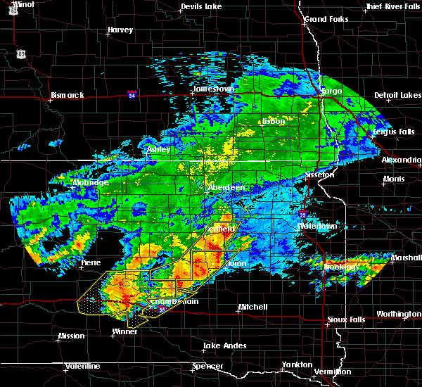
| 5/12/2022 5:27 PM CDT |
 At 527 pm cdt, severe thunderstorms capable of producing both tornadoes and extensive straight line wind damage were located along a line extending from tulare to near spink colony to hillside colony, moving north at 35 mph (radar indicated rotation). Hazards include tornado. Flying debris will be dangerous to those caught without shelter. mobile homes will be damaged or destroyed. damage to roofs, windows, and vehicles will occur. tree damage is likely. these dangerous storms will be near, clark colony around 535 pm cdt. glendale colony around 540 pm cdt. redfield, doland and frankfort around 545 pm cdt. Other locations in the path of these tornadic storms include raymond, camrose colony, ashton, athol and turton. At 527 pm cdt, severe thunderstorms capable of producing both tornadoes and extensive straight line wind damage were located along a line extending from tulare to near spink colony to hillside colony, moving north at 35 mph (radar indicated rotation). Hazards include tornado. Flying debris will be dangerous to those caught without shelter. mobile homes will be damaged or destroyed. damage to roofs, windows, and vehicles will occur. tree damage is likely. these dangerous storms will be near, clark colony around 535 pm cdt. glendale colony around 540 pm cdt. redfield, doland and frankfort around 545 pm cdt. Other locations in the path of these tornadic storms include raymond, camrose colony, ashton, athol and turton.
|
| 5/12/2022 5:01 PM CDT |
 At 459 pm cdt, severe thunderstorms were located along a line extending from near hitchcock to near cavour to near carthage, moving northeast at 60 mph. these are destructive storms for tulare, carpenter, willow lake, bryant (radar indicated). Hazards include 80 mph wind gusts and ping pong ball size hail. Flying debris will be dangerous to those caught without shelter. mobile homes will be heavily damaged. expect considerable damage to roofs, windows, and vehicles. extensive tree damage and power outages are likely. severe thunderstorms will be near, tulare around 505 pm cdt. spink colony around 510 pm cdt. glendale colony around 515 pm cdt. Other locations in the path of these severe thunderstorms include frankfort, carpenter, doland, camrose colony, fordham colony, clark colony, willow lake, bryant, turton, mayfield colony, clark, vienna, kellerton church and hamlin education center. At 459 pm cdt, severe thunderstorms were located along a line extending from near hitchcock to near cavour to near carthage, moving northeast at 60 mph. these are destructive storms for tulare, carpenter, willow lake, bryant (radar indicated). Hazards include 80 mph wind gusts and ping pong ball size hail. Flying debris will be dangerous to those caught without shelter. mobile homes will be heavily damaged. expect considerable damage to roofs, windows, and vehicles. extensive tree damage and power outages are likely. severe thunderstorms will be near, tulare around 505 pm cdt. spink colony around 510 pm cdt. glendale colony around 515 pm cdt. Other locations in the path of these severe thunderstorms include frankfort, carpenter, doland, camrose colony, fordham colony, clark colony, willow lake, bryant, turton, mayfield colony, clark, vienna, kellerton church and hamlin education center.
|
| 5/9/2022 3:26 AM CDT |
 At 325 am cdt, a severe thunderstorm was located over fordham colony, or 10 miles southwest of clark, moving northeast at 45 mph (radar indicated). Hazards include 60 mph wind gusts and quarter size hail. Hail damage to vehicles is expected. expect wind damage to roofs, siding, and trees. locations impacted include, raymond, clark, hillcrest colony and garden city. hail threat, radar indicated max hail size, 1. 00 in wind threat, radar indicated max wind gust, 60 mph. At 325 am cdt, a severe thunderstorm was located over fordham colony, or 10 miles southwest of clark, moving northeast at 45 mph (radar indicated). Hazards include 60 mph wind gusts and quarter size hail. Hail damage to vehicles is expected. expect wind damage to roofs, siding, and trees. locations impacted include, raymond, clark, hillcrest colony and garden city. hail threat, radar indicated max hail size, 1. 00 in wind threat, radar indicated max wind gust, 60 mph.
|
| 5/9/2022 3:05 AM CDT |
 At 305 am cdt, a severe thunderstorm was located near carpenter, or 20 miles southwest of clark, moving northeast at 55 mph (radar indicated). Hazards include 60 mph wind gusts and quarter size hail. Hail damage to vehicles is expected. expect wind damage to roofs, siding, and trees. this severe thunderstorm will be near, fordham colony and clark colony around 315 am cdt. raymond around 325 am cdt. other locations in the path of this severe thunderstorm include clark, garden city and hillcrest colony. hail threat, radar indicated max hail size, 1. 00 in wind threat, radar indicated max wind gust, 60 mph. At 305 am cdt, a severe thunderstorm was located near carpenter, or 20 miles southwest of clark, moving northeast at 55 mph (radar indicated). Hazards include 60 mph wind gusts and quarter size hail. Hail damage to vehicles is expected. expect wind damage to roofs, siding, and trees. this severe thunderstorm will be near, fordham colony and clark colony around 315 am cdt. raymond around 325 am cdt. other locations in the path of this severe thunderstorm include clark, garden city and hillcrest colony. hail threat, radar indicated max hail size, 1. 00 in wind threat, radar indicated max wind gust, 60 mph.
|
| 8/26/2021 9:08 AM CDT |
 At 907 am cdt, a severe thunderstorm was located near fordham colony, or 9 miles southwest of clark, moving east at 40 mph (radar indicated). Hazards include 60 mph wind gusts and penny size hail. Expect damage to roofs, siding, and trees. locations impacted include, clark and mayfield colony. hail threat, radar indicated max hail size, 0. 75 in wind threat, radar indicated max wind gust, 60 mph. At 907 am cdt, a severe thunderstorm was located near fordham colony, or 9 miles southwest of clark, moving east at 40 mph (radar indicated). Hazards include 60 mph wind gusts and penny size hail. Expect damage to roofs, siding, and trees. locations impacted include, clark and mayfield colony. hail threat, radar indicated max hail size, 0. 75 in wind threat, radar indicated max wind gust, 60 mph.
|
| 8/26/2021 8:57 AM CDT | 4 inch diameter tree snapped and damage to the elevator in town. time estimated from rada in spink county SD, 0.5 miles S of Doland, SD |
| 8/26/2021 8:55 AM CDT | 8 power poles down and many of them snapped of in spink county SD, 3 miles E of Doland, SD |
| 8/26/2021 8:45 AM CDT |
 At 845 am cdt, a severe thunderstorm was located over turton, or 20 miles northwest of clark, moving east at 40 mph (radar indicated). Hazards include 60 mph wind gusts. Expect damage to roofs, siding, and trees. this severe thunderstorm will be near, raymond around 900 am cdt. other locations in the path of this severe thunderstorm include clark, hillcrest colony and garden city. hail threat, radar indicated max hail size, <. 75 in wind threat, radar indicated max wind gust, 60 mph. At 845 am cdt, a severe thunderstorm was located over turton, or 20 miles northwest of clark, moving east at 40 mph (radar indicated). Hazards include 60 mph wind gusts. Expect damage to roofs, siding, and trees. this severe thunderstorm will be near, raymond around 900 am cdt. other locations in the path of this severe thunderstorm include clark, hillcrest colony and garden city. hail threat, radar indicated max hail size, <. 75 in wind threat, radar indicated max wind gust, 60 mph.
|
| 8/24/2021 1:55 AM CDT |
 The severe thunderstorm warning for northeastern hand, southeastern brown and spink counties will expire at 200 am cdt, the storms which prompted the warning have weakened below severe limits, and no longer pose an immediate threat to life or property. therefore, the warning will be allowed to expire. a severe thunderstorm watch remains in effect until 300 am cdt for central and northeastern south dakota. The severe thunderstorm warning for northeastern hand, southeastern brown and spink counties will expire at 200 am cdt, the storms which prompted the warning have weakened below severe limits, and no longer pose an immediate threat to life or property. therefore, the warning will be allowed to expire. a severe thunderstorm watch remains in effect until 300 am cdt for central and northeastern south dakota.
|
| 8/24/2021 1:42 AM CDT |
 At 142 am cdt, severe thunderstorms were located along a line extending from near ferney to near redfield, moving east at 40 mph (radar indicated). Hazards include 60 mph wind gusts. Expect damage to roofs, siding, and trees. locations impacted include, verdon, ferney, spink colony, doland and hillside colony. hail threat, radar indicated max hail size, <. 75 in wind threat, radar indicated max wind gust, 60 mph. At 142 am cdt, severe thunderstorms were located along a line extending from near ferney to near redfield, moving east at 40 mph (radar indicated). Hazards include 60 mph wind gusts. Expect damage to roofs, siding, and trees. locations impacted include, verdon, ferney, spink colony, doland and hillside colony. hail threat, radar indicated max hail size, <. 75 in wind threat, radar indicated max wind gust, 60 mph.
|
| 8/24/2021 1:05 AM CDT |
 At 105 am cdt, severe thunderstorms were located along a line extending from 6 miles northwest of warner to near miranda, moving east at 40 mph (radar indicated). Hazards include 60 mph wind gusts. Expect damage to roofs, siding, and trees. severe thunderstorms will be near, warner around 115 am cdt. stratford and zell around 125 am cdt. other locations in the path of these severe thunderstorms include cottonwood lake, redfield, ferney, twin lakes, verdon, frankfort, glendale colony, spink colony, doland and camrose colony. hail threat, radar indicated max hail size, <. 75 in wind threat, radar indicated max wind gust, 60 mph. At 105 am cdt, severe thunderstorms were located along a line extending from 6 miles northwest of warner to near miranda, moving east at 40 mph (radar indicated). Hazards include 60 mph wind gusts. Expect damage to roofs, siding, and trees. severe thunderstorms will be near, warner around 115 am cdt. stratford and zell around 125 am cdt. other locations in the path of these severe thunderstorms include cottonwood lake, redfield, ferney, twin lakes, verdon, frankfort, glendale colony, spink colony, doland and camrose colony. hail threat, radar indicated max hail size, <. 75 in wind threat, radar indicated max wind gust, 60 mph.
|
| 6/11/2021 4:49 AM CDT |
 At 449 am cdt, a severe thunderstorm was located near raymond, or 7 miles west of clark, moving east at 70 mph (radar indicated). Hazards include 60 mph wind gusts and quarter size hail. Hail damage to vehicles is expected. expect wind damage to roofs, siding, and trees. this severe thunderstorm will be near, clark around 455 am cdt. hillcrest colony around 500 am cdt. henry and garden city around 505 am cdt. Other locations in the path of this severe thunderstorm include long lake, tinkertown, florence, medicine lake, memorial park camping site, sandy shore rec area, lake kampeska, watertown, dakota sioux casino, watertown city park, rauville and waverly. At 449 am cdt, a severe thunderstorm was located near raymond, or 7 miles west of clark, moving east at 70 mph (radar indicated). Hazards include 60 mph wind gusts and quarter size hail. Hail damage to vehicles is expected. expect wind damage to roofs, siding, and trees. this severe thunderstorm will be near, clark around 455 am cdt. hillcrest colony around 500 am cdt. henry and garden city around 505 am cdt. Other locations in the path of this severe thunderstorm include long lake, tinkertown, florence, medicine lake, memorial park camping site, sandy shore rec area, lake kampeska, watertown, dakota sioux casino, watertown city park, rauville and waverly.
|
| 8/28/2020 1:11 AM CDT | At 110 am cdt, a severe thunderstorm was located near clark colony, or 11 miles west of clark, moving east at 70 mph (radar indicated). Hazards include 60 mph wind gusts. expect damage to roofs, siding, and trees |
| 7/31/2020 8:57 PM CDT |
 The severe thunderstorm warning for southeastern brown and eastern spink counties will expire at 900 pm cdt, the storm which prompted the warning has weakened below severe limits, and no longer poses an immediate threat to life or property. therefore, the warning will be allowed to expire. however small hail and gusty winds are still possible with this thunderstorm. The severe thunderstorm warning for southeastern brown and eastern spink counties will expire at 900 pm cdt, the storm which prompted the warning has weakened below severe limits, and no longer poses an immediate threat to life or property. therefore, the warning will be allowed to expire. however small hail and gusty winds are still possible with this thunderstorm.
|
| 7/31/2020 8:53 PM CDT |
 At 853 pm cdt, a severe thunderstorm was located near turton, or 18 miles northwest of clark, moving southeast at 30 mph (radar indicated). Hazards include 60 mph wind gusts and nickel size hail. Expect damage to roofs, siding, and trees. Locations impacted include, doland, frankfort, conde, stratford, turton, verdon, ferney and glendale colony. At 853 pm cdt, a severe thunderstorm was located near turton, or 18 miles northwest of clark, moving southeast at 30 mph (radar indicated). Hazards include 60 mph wind gusts and nickel size hail. Expect damage to roofs, siding, and trees. Locations impacted include, doland, frankfort, conde, stratford, turton, verdon, ferney and glendale colony.
|
| 7/31/2020 8:21 PM CDT |
 At 821 pm cdt, a severe thunderstorm was located near verdon, or 13 miles south of groton, moving southeast at 30 mph (radar indicated). Hazards include 60 mph wind gusts and nickel size hail. expect damage to roofs, siding, and trees At 821 pm cdt, a severe thunderstorm was located near verdon, or 13 miles south of groton, moving southeast at 30 mph (radar indicated). Hazards include 60 mph wind gusts and nickel size hail. expect damage to roofs, siding, and trees
|
| 7/8/2020 10:32 PM CDT |
 At 1032 pm cdt, a severe thunderstorm was located near hillside colony, or 15 miles southwest of clark, moving northeast at 20 mph (radar indicated). Hazards include 60 mph wind gusts and quarter size hail. Hail damage to vehicles is expected. expect wind damage to roofs, siding, and trees. this severe thunderstorm will be near, clark colony around 1035 pm cdt. fordham colony around 1040 pm cdt. raymond around 1055 pm cdt. clark around 1105 pm cdt. Hillcrest colony around 1110 pm cdt. At 1032 pm cdt, a severe thunderstorm was located near hillside colony, or 15 miles southwest of clark, moving northeast at 20 mph (radar indicated). Hazards include 60 mph wind gusts and quarter size hail. Hail damage to vehicles is expected. expect wind damage to roofs, siding, and trees. this severe thunderstorm will be near, clark colony around 1035 pm cdt. fordham colony around 1040 pm cdt. raymond around 1055 pm cdt. clark around 1105 pm cdt. Hillcrest colony around 1110 pm cdt.
|
| 7/8/2020 9:25 PM CDT |
 At 925 pm cdt, a severe thunderstorm was located near raymond, or 11 miles west of clark, moving northeast at 30 mph (radar indicated). Hazards include 60 mph wind gusts and quarter size hail. Hail damage to vehicles is expected. expect wind damage to roofs, siding, and trees. this severe storm will be near, raymond around 930 pm cdt. Clark around 950 pm cdt. At 925 pm cdt, a severe thunderstorm was located near raymond, or 11 miles west of clark, moving northeast at 30 mph (radar indicated). Hazards include 60 mph wind gusts and quarter size hail. Hail damage to vehicles is expected. expect wind damage to roofs, siding, and trees. this severe storm will be near, raymond around 930 pm cdt. Clark around 950 pm cdt.
|
| 7/8/2020 9:04 PM CDT |
 At 904 pm cdt, a severe thunderstorm was located near hillside colony, or 20 miles east of redfield, moving northeast at 30 mph (radar indicated). Hazards include 60 mph wind gusts and quarter size hail. Hail damage to vehicles is expected. expect wind damage to roofs, siding, and trees. this severe thunderstorm will be near, doland around 915 pm cdt. clark colony around 920 pm cdt. fordham colony around 925 pm cdt. raymond around 935 pm cdt. Clark around 945 pm cdt. At 904 pm cdt, a severe thunderstorm was located near hillside colony, or 20 miles east of redfield, moving northeast at 30 mph (radar indicated). Hazards include 60 mph wind gusts and quarter size hail. Hail damage to vehicles is expected. expect wind damage to roofs, siding, and trees. this severe thunderstorm will be near, doland around 915 pm cdt. clark colony around 920 pm cdt. fordham colony around 925 pm cdt. raymond around 935 pm cdt. Clark around 945 pm cdt.
|
| 7/20/2019 5:53 AM CDT |
 At 551 am cdt, severe thunderstorms were located along a line extending from near turton to near hitchcock, moving east at 40 mph (radar indicated). Hazards include 60 mph wind gusts and quarter size hail. Hail damage to vehicles is expected. Expect wind damage to roofs, siding, and trees. At 551 am cdt, severe thunderstorms were located along a line extending from near turton to near hitchcock, moving east at 40 mph (radar indicated). Hazards include 60 mph wind gusts and quarter size hail. Hail damage to vehicles is expected. Expect wind damage to roofs, siding, and trees.
|
| 7/20/2019 5:50 AM CDT |
 At 549 am cdt, severe thunderstorms were located along a line extending from near frankfort to near pleasant valley country church, moving east at 40 mph (trained weather spotters). Hazards include 60 mph wind gusts and quarter size hail. Hail damage to vehicles is expected. expect wind damage to roofs, siding, and trees. Locations impacted include, redfield, tulare, doland, frankfort, hitchcock, turton, vayland, rosehill dam, miller dale colony, sunshine bible academy, twin lakes, spink colony, glendale colony, pleasant valley country church and spottswood. At 549 am cdt, severe thunderstorms were located along a line extending from near frankfort to near pleasant valley country church, moving east at 40 mph (trained weather spotters). Hazards include 60 mph wind gusts and quarter size hail. Hail damage to vehicles is expected. expect wind damage to roofs, siding, and trees. Locations impacted include, redfield, tulare, doland, frankfort, hitchcock, turton, vayland, rosehill dam, miller dale colony, sunshine bible academy, twin lakes, spink colony, glendale colony, pleasant valley country church and spottswood.
|
| 7/20/2019 5:22 AM CDT |
 At 522 am cdt, severe thunderstorms were located along a line extending from near athol to 9 miles west of pleasant valley country church, moving east at 40 mph (radar indicated). Hazards include 60 mph wind gusts and quarter size hail. Hail damage to vehicles is expected. Expect wind damage to roofs, siding, and trees. At 522 am cdt, severe thunderstorms were located along a line extending from near athol to 9 miles west of pleasant valley country church, moving east at 40 mph (radar indicated). Hazards include 60 mph wind gusts and quarter size hail. Hail damage to vehicles is expected. Expect wind damage to roofs, siding, and trees.
|
| 6/16/2018 9:22 PM CDT |
 At 921 pm cdt, a severe thunderstorm was located over glendale colony, or 12 miles southeast of redfield, moving northeast at 40 mph (public). Hazards include 60 mph wind gusts and penny size hail. expect damage to roofs, siding, and trees At 921 pm cdt, a severe thunderstorm was located over glendale colony, or 12 miles southeast of redfield, moving northeast at 40 mph (public). Hazards include 60 mph wind gusts and penny size hail. expect damage to roofs, siding, and trees
|
| 9/19/2017 8:50 PM CDT | Quarter sized hail reported 0.2 miles N of Doland, SD, heavy rains causing ponding of water in city streets. |
| 9/19/2017 8:39 PM CDT |
 At 838 pm cdt, a severe thunderstorm capable of producing a tornado was located over clark colony, or 14 miles southwest of clark, moving northeast at 40 mph (radar indicated rotation). Hazards include tornado and half dollar size hail. Flying debris will be dangerous to those caught without shelter. mobile homes will be damaged or destroyed. damage to roofs, windows, and vehicles will occur. tree damage is likely. this dangerous storm will be near, raymond around 855 pm cdt. Clark around 900 pm cdt. At 838 pm cdt, a severe thunderstorm capable of producing a tornado was located over clark colony, or 14 miles southwest of clark, moving northeast at 40 mph (radar indicated rotation). Hazards include tornado and half dollar size hail. Flying debris will be dangerous to those caught without shelter. mobile homes will be damaged or destroyed. damage to roofs, windows, and vehicles will occur. tree damage is likely. this dangerous storm will be near, raymond around 855 pm cdt. Clark around 900 pm cdt.
|
| 9/19/2017 8:34 PM CDT |
 At 833 pm cdt, a severe thunderstorm capable of producing a tornado was located over clark colony, or 15 miles southwest of clark, moving northeast at 40 mph (radar indicated rotation). Hazards include tornado and half dollar size hail. Flying debris will be dangerous to those caught without shelter. mobile homes will be damaged or destroyed. damage to roofs, windows, and vehicles will occur. tree damage is likely. This dangerous storm will be near, raymond around 845 pm cdt. At 833 pm cdt, a severe thunderstorm capable of producing a tornado was located over clark colony, or 15 miles southwest of clark, moving northeast at 40 mph (radar indicated rotation). Hazards include tornado and half dollar size hail. Flying debris will be dangerous to those caught without shelter. mobile homes will be damaged or destroyed. damage to roofs, windows, and vehicles will occur. tree damage is likely. This dangerous storm will be near, raymond around 845 pm cdt.
|
| 9/19/2017 8:28 PM CDT |
 At 827 pm cdt, a severe thunderstorm capable of producing a tornado was located near hillside colony, or 22 miles southwest of clark, moving northeast at 40 mph (radar indicated rotation). Hazards include tornado and half dollar size hail. Flying debris will be dangerous to those caught without shelter. mobile homes will be damaged or destroyed. damage to roofs, windows, and vehicles will occur. tree damage is likely. this dangerous storm will be near, clark colony and fordham colony around 840 pm cdt. raymond around 855 pm cdt. Clark around 900 pm cdt. At 827 pm cdt, a severe thunderstorm capable of producing a tornado was located near hillside colony, or 22 miles southwest of clark, moving northeast at 40 mph (radar indicated rotation). Hazards include tornado and half dollar size hail. Flying debris will be dangerous to those caught without shelter. mobile homes will be damaged or destroyed. damage to roofs, windows, and vehicles will occur. tree damage is likely. this dangerous storm will be near, clark colony and fordham colony around 840 pm cdt. raymond around 855 pm cdt. Clark around 900 pm cdt.
|
| 9/19/2017 8:13 PM CDT |
 At 813 pm cdt, a severe thunderstorm capable of producing a tornado was located 8 miles southeast of spink colony, or 19 miles north of huron, moving northeast at 50 mph (radar indicated rotation). Hazards include tornado and quarter size hail. Flying debris will be dangerous to those caught without shelter. mobile homes will be damaged or destroyed. damage to roofs, windows, and vehicles will occur. tree damage is likely. this dangerous storm will be near, hillside colony around 825 pm cdt. clark colony around 830 pm cdt. doland around 835 pm cdt. Raymond around 840 pm cdt. At 813 pm cdt, a severe thunderstorm capable of producing a tornado was located 8 miles southeast of spink colony, or 19 miles north of huron, moving northeast at 50 mph (radar indicated rotation). Hazards include tornado and quarter size hail. Flying debris will be dangerous to those caught without shelter. mobile homes will be damaged or destroyed. damage to roofs, windows, and vehicles will occur. tree damage is likely. this dangerous storm will be near, hillside colony around 825 pm cdt. clark colony around 830 pm cdt. doland around 835 pm cdt. Raymond around 840 pm cdt.
|
| 7/21/2017 11:11 PM CDT |
 At 1108 pm cdt, severe thunderstorms were located along a line extending from near crandall to 7 miles east of ashton, moving south at 60 mph. these are very dangerous storms (radar indicated). Hazards include 80 mph wind gusts. Flying debris will be dangerous to those caught without shelter. mobile homes will be heavily damaged. expect considerable damage to roofs, windows, and vehicles. Extensive tree damage and power outages are likely. At 1108 pm cdt, severe thunderstorms were located along a line extending from near crandall to 7 miles east of ashton, moving south at 60 mph. these are very dangerous storms (radar indicated). Hazards include 80 mph wind gusts. Flying debris will be dangerous to those caught without shelter. mobile homes will be heavily damaged. expect considerable damage to roofs, windows, and vehicles. Extensive tree damage and power outages are likely.
|
| 5/28/2017 5:20 PM CDT |
 At 519 pm cdt, severe thunderstorms were located along a line extending from bradley to near doland, moving east at 55 mph (trained weather spotters). Hazards include 60 mph wind gusts and penny size hail. Expect damage to roofs, siding, and trees. Locations impacted include, clark and hillside colony. At 519 pm cdt, severe thunderstorms were located along a line extending from bradley to near doland, moving east at 55 mph (trained weather spotters). Hazards include 60 mph wind gusts and penny size hail. Expect damage to roofs, siding, and trees. Locations impacted include, clark and hillside colony.
|
| 5/28/2017 4:54 PM CDT |
 At 454 pm cdt, severe thunderstorms were located along a line extending from near andover to 6 miles southwest of brentford, moving southeast at 55 mph (trained weather spotters). Hazards include 60 mph wind gusts and penny size hail. Expect damage to roofs, siding, and trees. severe thunderstorms will be near, butler around 505 pm cdt. lily around 510 pm cdt. doland and crocker around 515 pm cdt. bradley and swan lake around 520 pm cdt. wallace, clark colony, hillside colony and hillcrest colony around 525 pm cdt. Garden city and fordham colony around 530 pm cdt. At 454 pm cdt, severe thunderstorms were located along a line extending from near andover to 6 miles southwest of brentford, moving southeast at 55 mph (trained weather spotters). Hazards include 60 mph wind gusts and penny size hail. Expect damage to roofs, siding, and trees. severe thunderstorms will be near, butler around 505 pm cdt. lily around 510 pm cdt. doland and crocker around 515 pm cdt. bradley and swan lake around 520 pm cdt. wallace, clark colony, hillside colony and hillcrest colony around 525 pm cdt. Garden city and fordham colony around 530 pm cdt.
|
| 9/7/2016 7:36 PM CDT |
 The severe thunderstorm warning for southeastern spink county will expire at 745 pm cdt, the storm which prompted the warning has weakened below severe limits, and no longer poses an immediate threat to life or property. therefore, the warning will be allowed to expire. however small hail is still possible with this thunderstorm. a severe thunderstorm watch remains in effect until 900 pm cdt for northeastern south dakota. The severe thunderstorm warning for southeastern spink county will expire at 745 pm cdt, the storm which prompted the warning has weakened below severe limits, and no longer poses an immediate threat to life or property. therefore, the warning will be allowed to expire. however small hail is still possible with this thunderstorm. a severe thunderstorm watch remains in effect until 900 pm cdt for northeastern south dakota.
|
| 9/7/2016 7:25 PM CDT |
 At 725 pm cdt, a severe thunderstorm was located near frankfort, or 13 miles east of redfield, moving southeast at 40 mph (radar indicated). Hazards include 60 mph wind gusts and quarter size hail. Hail damage to vehicles is expected. expect wind damage to roofs, siding, and trees. this severe storm will be near, doland around 735 pm cdt. Clark colony and hillside colony around 745 pm cdt. At 725 pm cdt, a severe thunderstorm was located near frankfort, or 13 miles east of redfield, moving southeast at 40 mph (radar indicated). Hazards include 60 mph wind gusts and quarter size hail. Hail damage to vehicles is expected. expect wind damage to roofs, siding, and trees. this severe storm will be near, doland around 735 pm cdt. Clark colony and hillside colony around 745 pm cdt.
|
| 9/7/2016 7:12 PM CDT |
 At 712 pm cdt, a severe thunderstorm was located near frankfort, or 9 miles northeast of redfield, moving east at 45 mph (radar indicated). Hazards include 60 mph wind gusts and quarter size hail. Hail damage to vehicles is expected. expect wind damage to roofs, siding, and trees. this severe thunderstorm will be near, doland around 730 pm cdt. Clark colony around 740 pm cdt. At 712 pm cdt, a severe thunderstorm was located near frankfort, or 9 miles northeast of redfield, moving east at 45 mph (radar indicated). Hazards include 60 mph wind gusts and quarter size hail. Hail damage to vehicles is expected. expect wind damage to roofs, siding, and trees. this severe thunderstorm will be near, doland around 730 pm cdt. Clark colony around 740 pm cdt.
|
| 8/10/2016 10:28 PM CDT |
 At 1028 pm cdt, a severe thunderstorm was located near turton, or 19 miles northeast of redfield, moving east at 40 mph (radar indicated). Hazards include 70 mph wind gusts and quarter size hail. Hail damage to vehicles is expected. expect considerable tree damage. wind damage is also likely to mobile homes, roofs, and outbuildings. this severe thunderstorm will be near, conde and turton around 1035 pm cdt. crandall around 1045 pm cdt. crocker around 1100 pm cdt. hillcrest colony around 1105 pm cdt. Bradley around 1110 pm cdt. At 1028 pm cdt, a severe thunderstorm was located near turton, or 19 miles northeast of redfield, moving east at 40 mph (radar indicated). Hazards include 70 mph wind gusts and quarter size hail. Hail damage to vehicles is expected. expect considerable tree damage. wind damage is also likely to mobile homes, roofs, and outbuildings. this severe thunderstorm will be near, conde and turton around 1035 pm cdt. crandall around 1045 pm cdt. crocker around 1100 pm cdt. hillcrest colony around 1105 pm cdt. Bradley around 1110 pm cdt.
|
| 8/9/2015 5:01 PM CDT |
 At 501 pm cdt, severe thunderstorms were located along a line extending from near crandall to 8 miles west of carpenter, moving east at 45 mph (radar indicated). Hazards include 60 mph wind gusts and quarter size hail. Hail damage to vehicles is expected. expect wind damage to roofs, siding and trees. these severe storms will be near, carpenter around 510 pm cdt. Willow lake and mayfield colony around 530 pm cdt. At 501 pm cdt, severe thunderstorms were located along a line extending from near crandall to 8 miles west of carpenter, moving east at 45 mph (radar indicated). Hazards include 60 mph wind gusts and quarter size hail. Hail damage to vehicles is expected. expect wind damage to roofs, siding and trees. these severe storms will be near, carpenter around 510 pm cdt. Willow lake and mayfield colony around 530 pm cdt.
|
| 8/9/2015 4:47 PM CDT |
 At 446 pm cdt, severe thunderstorms were located along a line extending from 6 miles northwest of turton to 6 miles east of hitchcock, moving east at 45 mph (radar indicated). Hazards include 60 mph wind gusts and quarter size hail. Hail damage to vehicles is expected. expect wind damage to roofs, siding and trees. severe thunderstorms will be near, turton around 455 pm cdt. carpenter around 510 pm cdt. crocker around 515 pm cdt. bradley around 525 pm cdt. Willow lake, swan lake and mayfield colony around 530 pm cdt. At 446 pm cdt, severe thunderstorms were located along a line extending from 6 miles northwest of turton to 6 miles east of hitchcock, moving east at 45 mph (radar indicated). Hazards include 60 mph wind gusts and quarter size hail. Hail damage to vehicles is expected. expect wind damage to roofs, siding and trees. severe thunderstorms will be near, turton around 455 pm cdt. carpenter around 510 pm cdt. crocker around 515 pm cdt. bradley around 525 pm cdt. Willow lake, swan lake and mayfield colony around 530 pm cdt.
|
| 7/28/2015 1:43 AM CDT |
 At 143 am cdt, a severe thunderstorm was located near crandall, or 17 miles northwest of clark, moving northeast at 50 mph (radar indicated). Hazards include 60 mph wind gusts. Expect damage to roofs. siding and trees. this severe storm will be near, crocker around 155 am cdt. lily around 200 am cdt. Butler around 205 am cdt. At 143 am cdt, a severe thunderstorm was located near crandall, or 17 miles northwest of clark, moving northeast at 50 mph (radar indicated). Hazards include 60 mph wind gusts. Expect damage to roofs. siding and trees. this severe storm will be near, crocker around 155 am cdt. lily around 200 am cdt. Butler around 205 am cdt.
|
| 7/28/2015 1:23 AM CDT |
 At 123 am cdt, a severe thunderstorm was located near frankfort, or 13 miles east of redfield, moving northeast at 50 mph (radar indicated). Hazards include 60 mph wind gusts. Expect damage to roofs. siding and trees. this severe thunderstorm will be near, doland around 130 am cdt. turton around 135 am cdt. crandall around 150 am cdt. crocker around 155 am cdt. Butler and lily around 205 am cdt. At 123 am cdt, a severe thunderstorm was located near frankfort, or 13 miles east of redfield, moving northeast at 50 mph (radar indicated). Hazards include 60 mph wind gusts. Expect damage to roofs. siding and trees. this severe thunderstorm will be near, doland around 130 am cdt. turton around 135 am cdt. crandall around 150 am cdt. crocker around 155 am cdt. Butler and lily around 205 am cdt.
|
| 7/25/2015 6:46 PM CDT |
 At 644 pm cdt, a severe thunderstorm was located over brentford, or 20 miles north of redfield, moving east at 35 mph (law enforcement. at 640 pm cdt...local law enforcement reported 60 mph winds and quarter sized hail near mellette). Hazards include 60 mph wind gusts and quarter size hail. Hail damage to vehicles is expected. expect wind damage to roofs, siding and trees. this severe thunderstorm will be near, conde, turton and verdon around 710 pm cdt. crandall around 720 pm cdt. A tornado watch remains in effect until 1100 pm cdt for northeastern south dakota. At 644 pm cdt, a severe thunderstorm was located over brentford, or 20 miles north of redfield, moving east at 35 mph (law enforcement. at 640 pm cdt...local law enforcement reported 60 mph winds and quarter sized hail near mellette). Hazards include 60 mph wind gusts and quarter size hail. Hail damage to vehicles is expected. expect wind damage to roofs, siding and trees. this severe thunderstorm will be near, conde, turton and verdon around 710 pm cdt. crandall around 720 pm cdt. A tornado watch remains in effect until 1100 pm cdt for northeastern south dakota.
|
| 7/17/2015 8:51 PM CDT |
 The severe thunderstorm warning for northwestern hamlin, east central spink, southwestern codington and central clark counties will expire at 900 pm cdt, the storm which prompted the warning has moved out of the area. therefore the warning will be allowed to expire. however small hail and gusty winds are still possible with this thunderstorm. a severe thunderstorm watch remains in effect until 1100 pm cdt for northeastern south dakota. The severe thunderstorm warning for northwestern hamlin, east central spink, southwestern codington and central clark counties will expire at 900 pm cdt, the storm which prompted the warning has moved out of the area. therefore the warning will be allowed to expire. however small hail and gusty winds are still possible with this thunderstorm. a severe thunderstorm watch remains in effect until 1100 pm cdt for northeastern south dakota.
|
| 7/17/2015 8:33 PM CDT |
 At 833 pm cdt, a severe thunderstorm was located near raymond, or near clark, moving east at 40 mph (radar indicated). Hazards include 60 mph wind gusts and quarter size hail. Hail damage to vehicles is expected. expect wind damage to roofs, siding and trees. this severe storm will be near, clark around 840 pm cdt. hillcrest colony around 845 pm cdt. Henry around 900 pm cdt. At 833 pm cdt, a severe thunderstorm was located near raymond, or near clark, moving east at 40 mph (radar indicated). Hazards include 60 mph wind gusts and quarter size hail. Hail damage to vehicles is expected. expect wind damage to roofs, siding and trees. this severe storm will be near, clark around 840 pm cdt. hillcrest colony around 845 pm cdt. Henry around 900 pm cdt.
|
| 7/17/2015 8:22 PM CDT |
 At 822 pm cdt, a severe thunderstorm was located near doland, or 14 miles west of clark, moving east at 30 mph (radar indicated). Hazards include 60 mph wind gusts and quarter size hail. Hail damage to vehicles is expected. expect wind damage to roofs, siding and trees. this severe thunderstorm will be near, raymond around 825 pm cdt. clark colony around 830 pm cdt. fordham colony around 835 pm cdt. clark around 840 pm cdt. mayfield colony around 855 pm cdt. Naples around 900 pm cdt. At 822 pm cdt, a severe thunderstorm was located near doland, or 14 miles west of clark, moving east at 30 mph (radar indicated). Hazards include 60 mph wind gusts and quarter size hail. Hail damage to vehicles is expected. expect wind damage to roofs, siding and trees. this severe thunderstorm will be near, raymond around 825 pm cdt. clark colony around 830 pm cdt. fordham colony around 835 pm cdt. clark around 840 pm cdt. mayfield colony around 855 pm cdt. Naples around 900 pm cdt.
|
| 7/17/2015 8:05 PM CDT |
 At 804 pm cdt, a severe thunderstorm was located 7 miles north of frankfort, or 11 miles northeast of redfield, moving east at 25 mph (radar indicated). Hazards include 60 mph wind gusts and half dollar size hail. Hail damage to vehicles is expected. expect wind damage to roofs, siding and trees. This severe thunderstorm will remain over mainly rural areas of central spink county. At 804 pm cdt, a severe thunderstorm was located 7 miles north of frankfort, or 11 miles northeast of redfield, moving east at 25 mph (radar indicated). Hazards include 60 mph wind gusts and half dollar size hail. Hail damage to vehicles is expected. expect wind damage to roofs, siding and trees. This severe thunderstorm will remain over mainly rural areas of central spink county.
|
| 7/17/2015 7:36 PM CDT |
 At 735 pm cdt, a severe thunderstorm was located near redfield, moving east at 25 mph (radar indicated). Hazards include 60 mph wind gusts and half dollar size hail. Hail damage to vehicles is expected. expect wind damage to roofs, siding and trees. this severe thunderstorm will be near, redfield around 740 pm cdt. ashton around 750 pm cdt. Frankfort around 805 pm cdt. At 735 pm cdt, a severe thunderstorm was located near redfield, moving east at 25 mph (radar indicated). Hazards include 60 mph wind gusts and half dollar size hail. Hail damage to vehicles is expected. expect wind damage to roofs, siding and trees. this severe thunderstorm will be near, redfield around 740 pm cdt. ashton around 750 pm cdt. Frankfort around 805 pm cdt.
|
| 6/22/2015 3:31 AM CDT |
 At 331 am cdt, severe thunderstorms were located along a line extending from 6 miles northwest of brentford to rockham, moving east at 50 mph (radar indicated). Hazards include 70 mph wind gusts. Expect considerable tree damage. damage is likely to mobile homes, roofs and outbuildings. severe thunderstorms will be near, brentford around 335 am cdt. redfield and conde around 350 am cdt. crandall around 400 am cdt. frankfort and glendale colony around 405 am cdt. Doland around 415 am cdt. At 331 am cdt, severe thunderstorms were located along a line extending from 6 miles northwest of brentford to rockham, moving east at 50 mph (radar indicated). Hazards include 70 mph wind gusts. Expect considerable tree damage. damage is likely to mobile homes, roofs and outbuildings. severe thunderstorms will be near, brentford around 335 am cdt. redfield and conde around 350 am cdt. crandall around 400 am cdt. frankfort and glendale colony around 405 am cdt. Doland around 415 am cdt.
|
| 5/10/2015 4:23 PM CDT | At 421 pm cdt, a severe thunderstorm was located 9 miles north of frankfort, or 15 miles northeast of redfield, moving northwest at 35 mph (trained weather spotters. at 420 pm cdt...golfball sized hail was reported 5 miles southeast of frankfort). Hazards include golf ball size hail. People and animals outdoors will be injured. expect damage to roofs, siding, windows and vehicles. this severe thunderstorm will remain over mainly rural areas of central spink county. 1. 75in. |
| 5/10/2015 4:20 PM CDT | Golf Ball sized hail reported 5 miles NE of Doland, SD |
| 5/10/2015 4:08 PM CDT | At 408 pm cdt, a severe thunderstorm was located near doland, or 17 miles east of redfield, moving north at 45 mph (radar indicated). Hazards include half dollar size hail. Damage to vehicles is expected. this severe thunderstorm will be near, turton around 425 pm cdt. 1. 25in. |
| 6/12/2013 3:46 AM CDT | Tree knocked down onto powerlin in spink county SD, 0.2 miles N of Doland, SD |
| 6/12/2013 3:45 AM CDT | 100 by 75 foot storage building flattened. tractors planters and other equipment in the building were damage in spink county SD, 2.9 miles N of Doland, SD |
| 6/11/2013 3:45 AM CDT | 100 by 75 foot storage building flattened. tractors planters and other equipment in the building were damage in spink county SD, 2.9 miles N of Doland, SD |
| 8/3/2012 6:08 PM CDT | Quarter sized hail reported 0.2 miles N of Doland, SD, 50 mph |
| 8/3/2012 5:59 PM CDT | Storm damage reported in spink county SD, 0.2 miles N of Doland, SD |
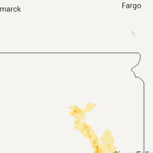
Hail Maps for Doland, SD


Connect with Interactive Hail Maps