

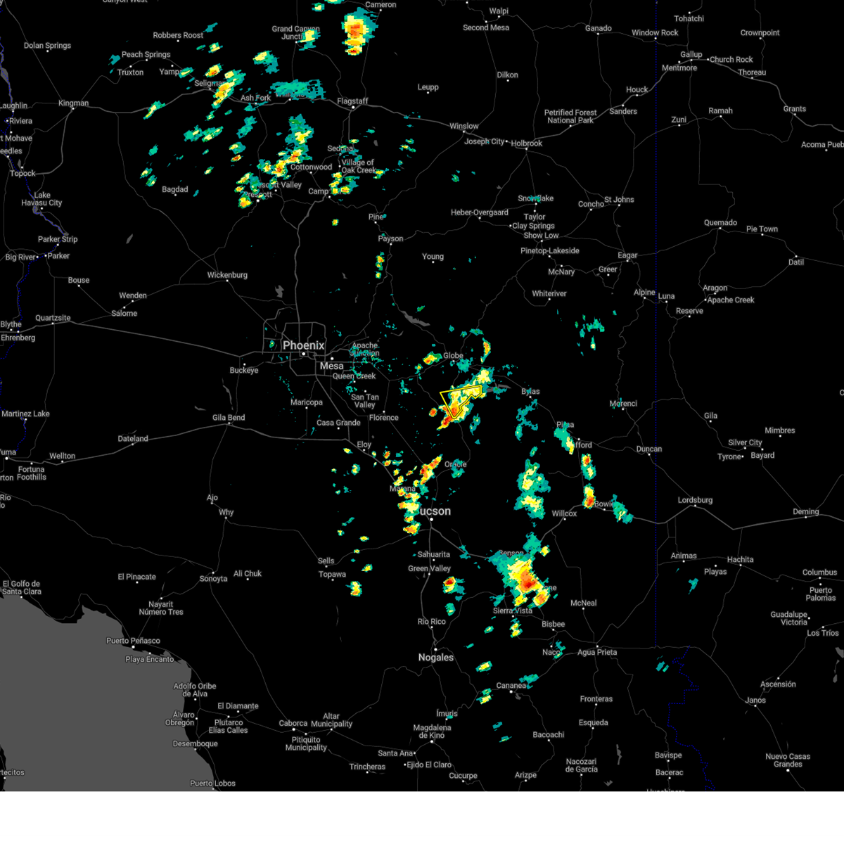
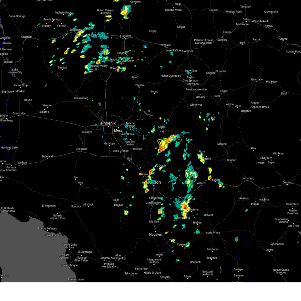
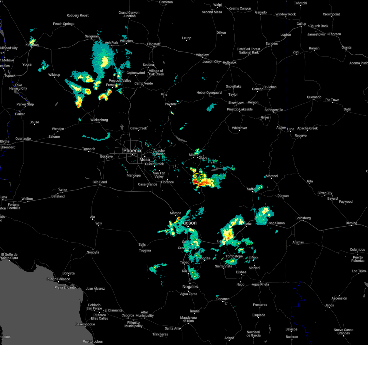
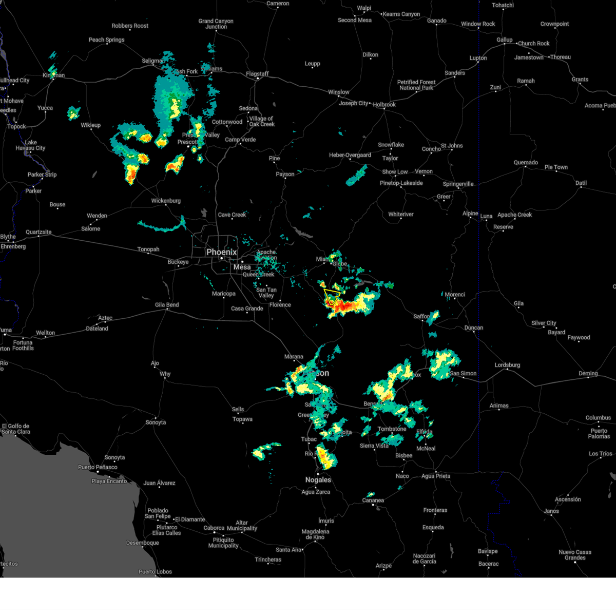
Hail Map for Dripping Springs, AZ
The Dripping Springs, AZ area has had 0 reports of on-the-ground hail by trained spotters, and has been under severe weather warnings 2 times during the past 12 months. Doppler radar has detected hail at or near Dripping Springs, AZ on 38 occasions, including 2 occasions during the past year.
| Name: | Dripping Springs, AZ |
| Where Located: | 61.6 miles NNE of Tucson, AZ |
| Map: | Google Map for Dripping Springs, AZ |
| Population: | 235 |
| Housing Units: | 121 |
| More Info: | Search Google for Dripping Springs, AZ |
0
The Top Recent Hail Date for Dripping Springs, AZ is Thursday, August 22, 2024 (30th out of 38)

Hail and Wind Damage Spotted near Dripping Springs, AZ
| Date / Time | Report Details |
|---|---|
| 8/22/2024 2:44 PM MST |
 the severe thunderstorm warning has been cancelled and is no longer in effect the severe thunderstorm warning has been cancelled and is no longer in effect
|
| 8/22/2024 2:27 PM MST |
 Svrpsr the national weather service in phoenix has issued a * severe thunderstorm warning for, gila county in east central arizona, * until 300 pm mst. * at 227 pm mst, a severe thunderstorm was located over hayden, moving north at 15 mph (radar indicated). Hazards include 60 mph wind gusts and penny size hail. expect damage to roofs, siding, and trees Svrpsr the national weather service in phoenix has issued a * severe thunderstorm warning for, gila county in east central arizona, * until 300 pm mst. * at 227 pm mst, a severe thunderstorm was located over hayden, moving north at 15 mph (radar indicated). Hazards include 60 mph wind gusts and penny size hail. expect damage to roofs, siding, and trees
|
| 7/9/2024 5:51 PM MST |
 The storm which prompted the warning has weakened below severe limits, and has exited the warned area. therefore, the warning will be allowed to expire. however, gusty winds are still possible with this thunderstorm. The storm which prompted the warning has weakened below severe limits, and has exited the warned area. therefore, the warning will be allowed to expire. however, gusty winds are still possible with this thunderstorm.
|
| 7/9/2024 5:27 PM MST |
 The storm which prompted the warning has moved out of the area. therefore, the warning will be allowed to expire. remember, a new severe thunderstorm warning still remains in effect for southern gila county until 6:00 pm mst!. The storm which prompted the warning has moved out of the area. therefore, the warning will be allowed to expire. remember, a new severe thunderstorm warning still remains in effect for southern gila county until 6:00 pm mst!.
|
| 7/9/2024 5:25 PM MST |
 Svrpsr the national weather service in phoenix has issued a * severe thunderstorm warning for, gila county in east central arizona, * until 600 pm mst. * at 525 pm mst, a severe thunderstorm was located 9 miles northeast of christmas, moving southeast at 10 mph (radar indicated). Hazards include 60 mph wind gusts and penny size hail. expect damage to roofs, siding, and trees Svrpsr the national weather service in phoenix has issued a * severe thunderstorm warning for, gila county in east central arizona, * until 600 pm mst. * at 525 pm mst, a severe thunderstorm was located 9 miles northeast of christmas, moving southeast at 10 mph (radar indicated). Hazards include 60 mph wind gusts and penny size hail. expect damage to roofs, siding, and trees
|
| 7/9/2024 4:48 PM MST |
 Svrpsr the national weather service in phoenix has issued a * severe thunderstorm warning for, gila county in east central arizona, * until 530 pm mst. * at 448 pm mst, a severe thunderstorm was located 9 miles south of cutter, or 12 miles northeast of christmas, moving southeast at 10 mph (radar indicated). Hazards include 60 mph wind gusts and penny size hail. Expect damage to roofs, siding, and trees. this severe thunderstorm will remain over mainly rural areas of gila county. This includes az route 77 between mile markers 146 and 149, and between mile markers 161 and 166. Svrpsr the national weather service in phoenix has issued a * severe thunderstorm warning for, gila county in east central arizona, * until 530 pm mst. * at 448 pm mst, a severe thunderstorm was located 9 miles south of cutter, or 12 miles northeast of christmas, moving southeast at 10 mph (radar indicated). Hazards include 60 mph wind gusts and penny size hail. Expect damage to roofs, siding, and trees. this severe thunderstorm will remain over mainly rural areas of gila county. This includes az route 77 between mile markers 146 and 149, and between mile markers 161 and 166.
|
| 6/20/2024 3:29 PM MST |
 Svrpsr the national weather service in phoenix has issued a * severe thunderstorm warning for, gila county in east central arizona, * until 415 pm mst. * at 328 pm mst, a severe thunderstorm was located 7 miles north of christmas, moving northeast at 20 mph (radar indicated). Hazards include 60 mph wind gusts and penny size hail. expect damage to roofs, siding, and trees Svrpsr the national weather service in phoenix has issued a * severe thunderstorm warning for, gila county in east central arizona, * until 415 pm mst. * at 328 pm mst, a severe thunderstorm was located 7 miles north of christmas, moving northeast at 20 mph (radar indicated). Hazards include 60 mph wind gusts and penny size hail. expect damage to roofs, siding, and trees
|
| 6/20/2024 3:14 PM MST |
 At 314 pm mst, a severe thunderstorm was located near christmas, moving north at 20 mph (radar indicated). Hazards include 60 mph wind gusts and penny size hail. Expect damage to roofs, siding, and trees. locations impacted include, christmas. This includes az route 77 near mile marker 143, and between mile markers 146 and 162. At 314 pm mst, a severe thunderstorm was located near christmas, moving north at 20 mph (radar indicated). Hazards include 60 mph wind gusts and penny size hail. Expect damage to roofs, siding, and trees. locations impacted include, christmas. This includes az route 77 near mile marker 143, and between mile markers 146 and 162.
|
| 6/20/2024 2:45 PM MST |
 Svrpsr the national weather service in phoenix has issued a * severe thunderstorm warning for, gila county in east central arizona, * until 330 pm mst. * at 245 pm mst, a severe thunderstorm was located over hayden, moving north at 20 mph (radar indicated). Hazards include 60 mph wind gusts and penny size hail. expect damage to roofs, siding, and trees Svrpsr the national weather service in phoenix has issued a * severe thunderstorm warning for, gila county in east central arizona, * until 330 pm mst. * at 245 pm mst, a severe thunderstorm was located over hayden, moving north at 20 mph (radar indicated). Hazards include 60 mph wind gusts and penny size hail. expect damage to roofs, siding, and trees
|
| 9/13/2023 6:38 PM MST |
 The severe thunderstorm warning for gila county will expire at 645 pm mst, the storm which prompted the warning has weakened below severe limits, and no longer poses an immediate threat to life or property. therefore, the warning will be allowed to expire. however gusty winds and heavy rain are still possible with this thunderstorm. The severe thunderstorm warning for gila county will expire at 645 pm mst, the storm which prompted the warning has weakened below severe limits, and no longer poses an immediate threat to life or property. therefore, the warning will be allowed to expire. however gusty winds and heavy rain are still possible with this thunderstorm.
|
| 9/13/2023 6:30 PM MST |
 At 629 pm mst, a severe thunderstorm was located 7 miles northwest of christmas, moving northeast at 25 mph (radar indicated). Hazards include 60 mph wind gusts and penny size hail. Expect damage to roofs, siding, and trees. this severe thunderstorm will remain over mainly rural areas of gila county. this includes az route 77 between mile markers 146 and 168. hail threat, radar indicated max hail size, 0. 75 in wind threat, radar indicated max wind gust, 60 mph. At 629 pm mst, a severe thunderstorm was located 7 miles northwest of christmas, moving northeast at 25 mph (radar indicated). Hazards include 60 mph wind gusts and penny size hail. Expect damage to roofs, siding, and trees. this severe thunderstorm will remain over mainly rural areas of gila county. this includes az route 77 between mile markers 146 and 168. hail threat, radar indicated max hail size, 0. 75 in wind threat, radar indicated max wind gust, 60 mph.
|
| 9/13/2023 6:05 PM MST |
 At 604 pm mst, a severe thunderstorm was located over kearny, or 8 miles west of hayden, moving northeast at 20 mph (radar indicated). Hazards include 60 mph wind gusts and nickel size hail. expect damage to roofs, siding, and trees At 604 pm mst, a severe thunderstorm was located over kearny, or 8 miles west of hayden, moving northeast at 20 mph (radar indicated). Hazards include 60 mph wind gusts and nickel size hail. expect damage to roofs, siding, and trees
|
| 7/28/2023 8:06 PM MST |
 At 806 pm mst, a severe thunderstorm was located near hayden, moving west at 10 mph (radar indicated). Hazards include 60 mph wind gusts and quarter size hail. Hail damage to vehicles is expected. expect wind damage to roofs, siding, and trees. locations impacted include, hayden and christmas. this includes the following highways, az route 77 between mile markers 135 and 141, near mile marker 143, and between mile markers 146 and 151. az route 177 between mile markers 137 and 138. hail threat, radar indicated max hail size, 1. 00 in wind threat, radar indicated max wind gust, 60 mph. At 806 pm mst, a severe thunderstorm was located near hayden, moving west at 10 mph (radar indicated). Hazards include 60 mph wind gusts and quarter size hail. Hail damage to vehicles is expected. expect wind damage to roofs, siding, and trees. locations impacted include, hayden and christmas. this includes the following highways, az route 77 between mile markers 135 and 141, near mile marker 143, and between mile markers 146 and 151. az route 177 between mile markers 137 and 138. hail threat, radar indicated max hail size, 1. 00 in wind threat, radar indicated max wind gust, 60 mph.
|
| 7/28/2023 7:44 PM MST |
 At 744 pm mst, a severe thunderstorm was located over hayden, moving west at 10 mph (radar indicated). Hazards include 60 mph wind gusts and quarter size hail. Hail damage to vehicles is expected. Expect wind damage to roofs, siding, and trees. At 744 pm mst, a severe thunderstorm was located over hayden, moving west at 10 mph (radar indicated). Hazards include 60 mph wind gusts and quarter size hail. Hail damage to vehicles is expected. Expect wind damage to roofs, siding, and trees.
|
| 8/22/2022 5:08 PM MST | The severe thunderstorm warning for gila county will expire at 515 pm mst, the storm which prompted the warning across southern gila county has weakened below severe limits, and has exited the warned area. therefore, the warning will be allowed to expire. |
| 8/22/2022 4:05 PM MST | At 405 pm mst, a severe thunderstorm was located over cutter, or 9 miles east of globe, moving south at 15 mph (radar indicated). Hazards include 60 mph wind gusts and quarter size hail. Hail damage to vehicles is expected. Expect wind damage to roofs, siding, and trees. |
| 8/21/2022 7:21 PM MST | The severe thunderstorm warning for gila county will expire at 730 pm mst, the storm which prompted the warning has weakened below severe limits, and has exited the warned area. therefore, the warning will be allowed to expire. |
| 8/21/2022 6:56 PM MST | At 656 pm mst, a severe thunderstorm was located over christmas, moving southwest at 15 mph (radar indicated). Hazards include 60 mph wind gusts and quarter size hail. Hail damage to vehicles is expected. expect wind damage to roofs, siding, and trees. locations impacted include, hayden and christmas. this includes the following highways, az route 77 between mile markers 135 and 141, near mile marker 143, and between mile markers 146 and 161. az route 177 between mile markers 137 and 138. hail threat, radar indicated max hail size, 1. 00 in wind threat, radar indicated max wind gust, 60 mph. |
| 8/21/2022 6:38 PM MST | At 638 pm mst, a severe thunderstorm was located 10 miles northeast of christmas, moving southwest at 5 mph (radar indicated). Hazards include 60 mph wind gusts and quarter size hail. Hail damage to vehicles is expected. Expect wind damage to roofs, siding, and trees. |
| 7/5/2022 5:21 PM MST |
 The severe thunderstorm warning for gila county will expire at 530 pm mst, the storm which prompted the warning has weakened below severe limits, and no longer poses an immediate threat to life or property. therefore, the warning will be allowed to expire. however gusty winds and heavy rain are still possible with this thunderstorm. The severe thunderstorm warning for gila county will expire at 530 pm mst, the storm which prompted the warning has weakened below severe limits, and no longer poses an immediate threat to life or property. therefore, the warning will be allowed to expire. however gusty winds and heavy rain are still possible with this thunderstorm.
|
| 7/5/2022 4:49 PM MST |
 At 449 pm mst, a severe thunderstorm was located 10 miles south of globe, moving north at 15 mph (radar indicated). Hazards include 60 mph wind gusts and penny size hail. Expect damage to roofs, siding, and trees. this includes az route 77 between mile markers 151 and 168. hail threat, radar indicated max hail size, 0. 75 in wind threat, radar indicated max wind gust, 60 mph. At 449 pm mst, a severe thunderstorm was located 10 miles south of globe, moving north at 15 mph (radar indicated). Hazards include 60 mph wind gusts and penny size hail. Expect damage to roofs, siding, and trees. this includes az route 77 between mile markers 151 and 168. hail threat, radar indicated max hail size, 0. 75 in wind threat, radar indicated max wind gust, 60 mph.
|
| 9/30/2021 1:10 AM MST |
 At 109 am mst, a severe thunderstorm was located near christmas, moving east at 25 mph (radar indicated). Hazards include 60 mph wind gusts and quarter size hail. Hail damage to vehicles is expected. expect wind damage to roofs, siding, and trees. locations impacted include, hayden and christmas. this includes the following highways, az route 77 between mile markers 135 and 143, and between mile markers 146 and 167. az route 177 between mile markers 137 and 138. hail threat, radar indicated max hail size, 1. 00 in wind threat, radar indicated max wind gust, 60 mph. At 109 am mst, a severe thunderstorm was located near christmas, moving east at 25 mph (radar indicated). Hazards include 60 mph wind gusts and quarter size hail. Hail damage to vehicles is expected. expect wind damage to roofs, siding, and trees. locations impacted include, hayden and christmas. this includes the following highways, az route 77 between mile markers 135 and 143, and between mile markers 146 and 167. az route 177 between mile markers 137 and 138. hail threat, radar indicated max hail size, 1. 00 in wind threat, radar indicated max wind gust, 60 mph.
|
| 9/30/2021 12:42 AM MST |
 At 1241 am mst, a severe thunderstorm was located near kearny, or 11 miles northwest of hayden, moving east at 20 mph (radar indicated). Hazards include 60 mph wind gusts and quarter size hail. Hail damage to vehicles is expected. Expect wind damage to roofs, siding, and trees. At 1241 am mst, a severe thunderstorm was located near kearny, or 11 miles northwest of hayden, moving east at 20 mph (radar indicated). Hazards include 60 mph wind gusts and quarter size hail. Hail damage to vehicles is expected. Expect wind damage to roofs, siding, and trees.
|
| 9/5/2021 5:36 PM MST |
 The severe thunderstorm warning for gila and pinal counties will expire at 545 pm mst, the storms which prompted the warning have weakened below severe limits, and have exited the warned area. therefore, the warning will be allowed to expire. however gusty winds are still possible with these thunderstorms. The severe thunderstorm warning for gila and pinal counties will expire at 545 pm mst, the storms which prompted the warning have weakened below severe limits, and have exited the warned area. therefore, the warning will be allowed to expire. however gusty winds are still possible with these thunderstorms.
|
| 9/5/2021 5:04 PM MST |
 At 504 pm mst, severe thunderstorms were located along a line extending from 9 miles southeast of superior to near christmas, moving south at 30 mph (radar indicated). Hazards include 60 mph wind gusts and penny size hail. expect damage to roofs, siding, and trees At 504 pm mst, severe thunderstorms were located along a line extending from 9 miles southeast of superior to near christmas, moving south at 30 mph (radar indicated). Hazards include 60 mph wind gusts and penny size hail. expect damage to roofs, siding, and trees
|
| 7/12/2021 8:57 PM MST |
 The severe thunderstorm warning for gila county will expire at 900 pm mst, the storm which prompted the warning has moved out of the area. therefore, the warning will be allowed to expire. however gusty winds are still possible with this thunderstorm. The severe thunderstorm warning for gila county will expire at 900 pm mst, the storm which prompted the warning has moved out of the area. therefore, the warning will be allowed to expire. however gusty winds are still possible with this thunderstorm.
|
| 7/12/2021 8:17 PM MST |
 At 817 pm mst, a severe thunderstorm was located 9 miles north of christmas, moving southwest at 25 mph (radar indicated). Hazards include 60 mph wind gusts and quarter size hail. Hail damage to vehicles is expected. Expect wind damage to roofs, siding, and trees. At 817 pm mst, a severe thunderstorm was located 9 miles north of christmas, moving southwest at 25 mph (radar indicated). Hazards include 60 mph wind gusts and quarter size hail. Hail damage to vehicles is expected. Expect wind damage to roofs, siding, and trees.
|
| 7/10/2021 7:00 PM MST |
 At 659 pm mst, severe thunderstorms were located along a line extending from 7 miles southeast of apache lake to near superior to 9 miles south of globe, moving southwest at 40 mph (radar indicated). Hazards include 70 mph wind gusts and quarter size hail. Hail damage to vehicles is expected. expect considerable tree damage. Wind damage is also likely to mobile homes, roofs, and outbuildings. At 659 pm mst, severe thunderstorms were located along a line extending from 7 miles southeast of apache lake to near superior to 9 miles south of globe, moving southwest at 40 mph (radar indicated). Hazards include 70 mph wind gusts and quarter size hail. Hail damage to vehicles is expected. expect considerable tree damage. Wind damage is also likely to mobile homes, roofs, and outbuildings.
|
| 7/10/2021 6:24 PM MST |
 At 623 pm mst, severe thunderstorms were located along a line extending from 16 miles east of tonto national monument to near hilltop to 12 miles east of san carlos, moving southwest at 25 mph (radar indicated). Hazards include 60 mph wind gusts and quarter size hail. Hail damage to vehicles is expected. Expect wind damage to roofs, siding, and trees. At 623 pm mst, severe thunderstorms were located along a line extending from 16 miles east of tonto national monument to near hilltop to 12 miles east of san carlos, moving southwest at 25 mph (radar indicated). Hazards include 60 mph wind gusts and quarter size hail. Hail damage to vehicles is expected. Expect wind damage to roofs, siding, and trees.
|
| 8/20/2020 6:46 PM MST |
 At 645 pm mst, a severe thunderstorm was located near christmas, moving southwest at 10 mph (radar indicated). Hazards include 60 mph wind gusts. Expect damage to roofs, siding, and trees. locations impacted include, hayden and christmas. this includes the following highways, az route 77 between mile markers 135 and 141, near mile marker 143, and between mile markers 146 and 163. Az route 177 between mile markers 137 and 138. At 645 pm mst, a severe thunderstorm was located near christmas, moving southwest at 10 mph (radar indicated). Hazards include 60 mph wind gusts. Expect damage to roofs, siding, and trees. locations impacted include, hayden and christmas. this includes the following highways, az route 77 between mile markers 135 and 141, near mile marker 143, and between mile markers 146 and 163. Az route 177 between mile markers 137 and 138.
|
| 8/20/2020 6:24 PM MST |
 At 624 pm mst, a severe thunderstorm was located near christmas, moving southwest at 10 mph (radar indicated). Hazards include 60 mph wind gusts and quarter size hail. Hail damage to vehicles is expected. Expect wind damage to roofs, siding, and trees. At 624 pm mst, a severe thunderstorm was located near christmas, moving southwest at 10 mph (radar indicated). Hazards include 60 mph wind gusts and quarter size hail. Hail damage to vehicles is expected. Expect wind damage to roofs, siding, and trees.
|
| 8/16/2020 3:52 PM MST |
 At 351 pm mst, a severe thunderstorm was located near top-of-the-world, or 9 miles southwest of globe, moving southwest at 20 mph (radar indicated). Hazards include 60 mph wind gusts and quarter size hail. Hail damage to vehicles is expected. expect wind damage to roofs, siding, and trees. locations impacted include, globe, superior, miami, cutter, central heights-midland city, top-of-the-world, claypool and inspiration. this includes the following highways, us highway 60 between mile markers 227 and 255. az route 70 between mile markers 253 and 260. Az route 77 between mile markers 152 and 170. At 351 pm mst, a severe thunderstorm was located near top-of-the-world, or 9 miles southwest of globe, moving southwest at 20 mph (radar indicated). Hazards include 60 mph wind gusts and quarter size hail. Hail damage to vehicles is expected. expect wind damage to roofs, siding, and trees. locations impacted include, globe, superior, miami, cutter, central heights-midland city, top-of-the-world, claypool and inspiration. this includes the following highways, us highway 60 between mile markers 227 and 255. az route 70 between mile markers 253 and 260. Az route 77 between mile markers 152 and 170.
|
| 8/16/2020 3:30 PM MST |
 At 330 pm mst, a severe thunderstorm was located near miami, or near globe, moving southwest at 15 mph (radar indicated). Hazards include 60 mph wind gusts and quarter size hail. Hail damage to vehicles is expected. Expect wind damage to roofs, siding, and trees. At 330 pm mst, a severe thunderstorm was located near miami, or near globe, moving southwest at 15 mph (radar indicated). Hazards include 60 mph wind gusts and quarter size hail. Hail damage to vehicles is expected. Expect wind damage to roofs, siding, and trees.
|
| 8/23/2015 5:40 PM MST |
 At 539 pm mst, doppler radar indicated a severe thunderstorm capable of producing damaging winds in excess of 60 mph. this storm was located near kearny, or near christmas. this storm was nearly stationary. locations impacted include, hayden and christmas. At 539 pm mst, doppler radar indicated a severe thunderstorm capable of producing damaging winds in excess of 60 mph. this storm was located near kearny, or near christmas. this storm was nearly stationary. locations impacted include, hayden and christmas.
|
| 8/23/2015 5:19 PM MST |
 At 519 pm mst, doppler radar indicated a severe thunderstorm capable of producing damaging winds in excess of 60 mph. this storm was located near kearny, or near christmas, and moving southwest at 10 mph. At 519 pm mst, doppler radar indicated a severe thunderstorm capable of producing damaging winds in excess of 60 mph. this storm was located near kearny, or near christmas, and moving southwest at 10 mph.
|
| 8/7/2015 1:57 PM MST | The severe thunderstorm warning for northeastern pinal county will expire at 200 pm mst, the storm which prompted the warning near kearny has weakened below severe limits, and no longer poses an immediate threat to life or property. therefore the warning will be allowed to expire. however heavy rain is still possible with this thunderstorm and a flash flood warning remains in effect. |
| 8/7/2015 1:33 PM MST |
 At 132 pm mst, doppler radar indicated a severe thunderstorm capable of producing damaging winds in excess of 60 mph. this storm was located near hayden, and moving northeast at 5 to 10 mph. At 132 pm mst, doppler radar indicated a severe thunderstorm capable of producing damaging winds in excess of 60 mph. this storm was located near hayden, and moving northeast at 5 to 10 mph.
|
Hail Maps for Dripping Springs, AZ


Connect with Interactive Hail Maps