

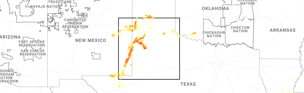
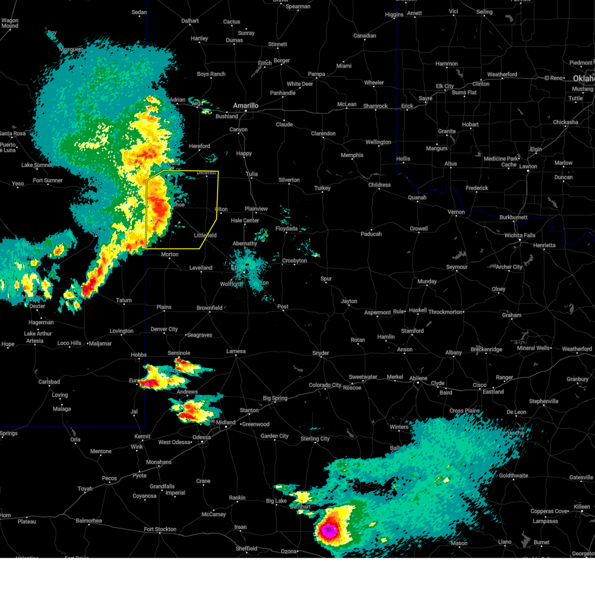
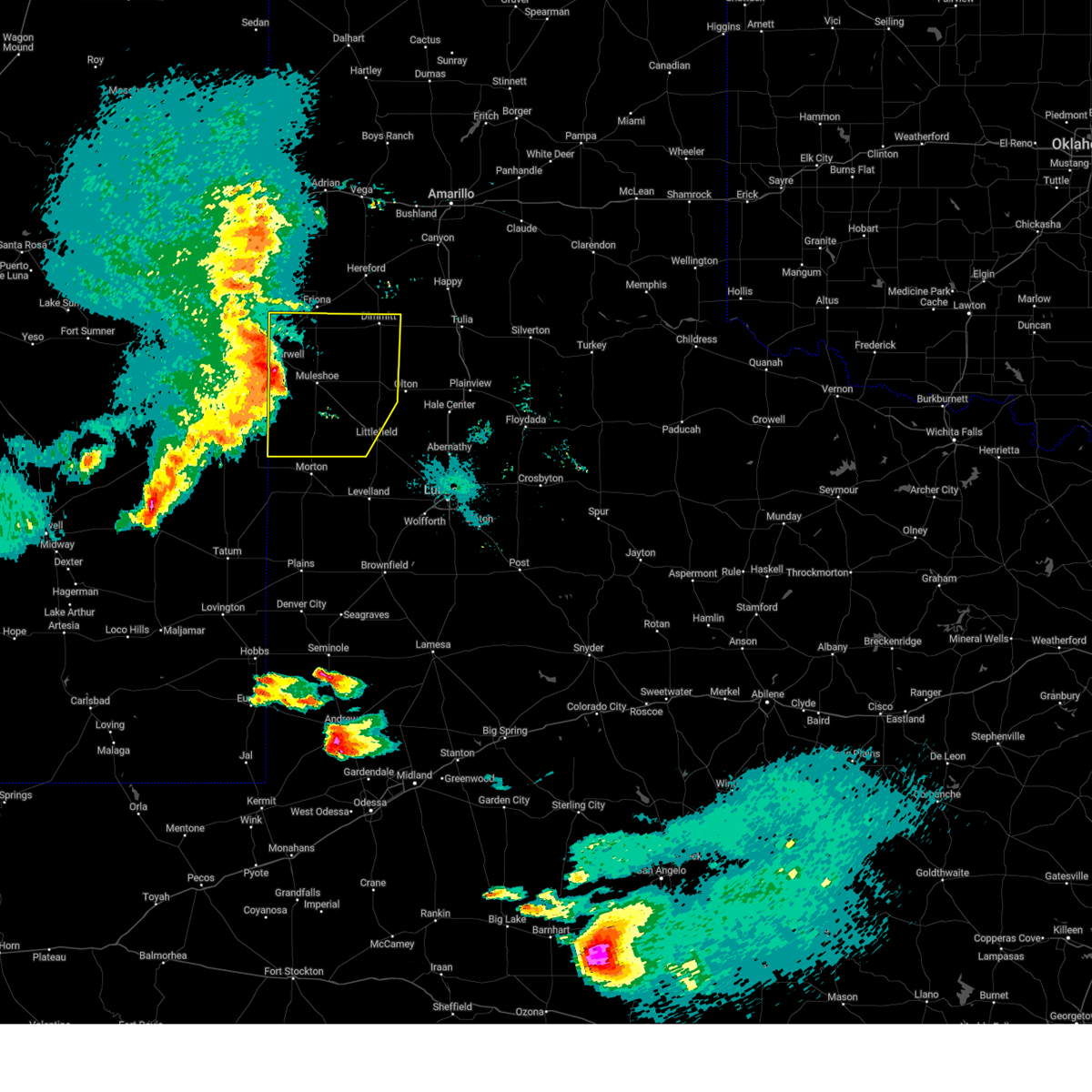
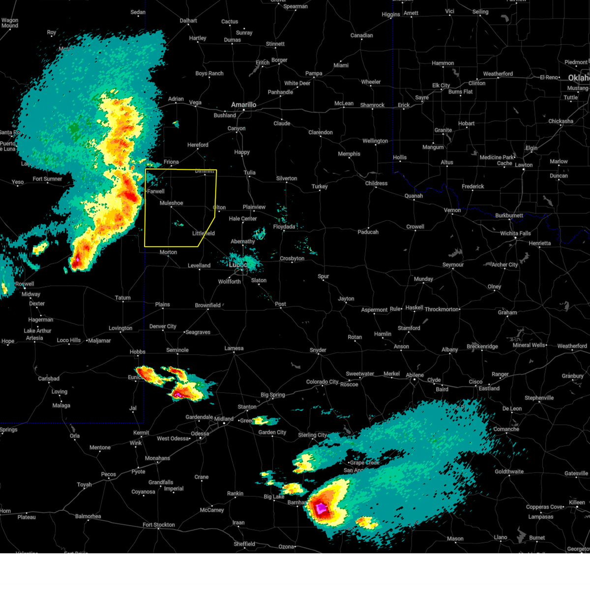
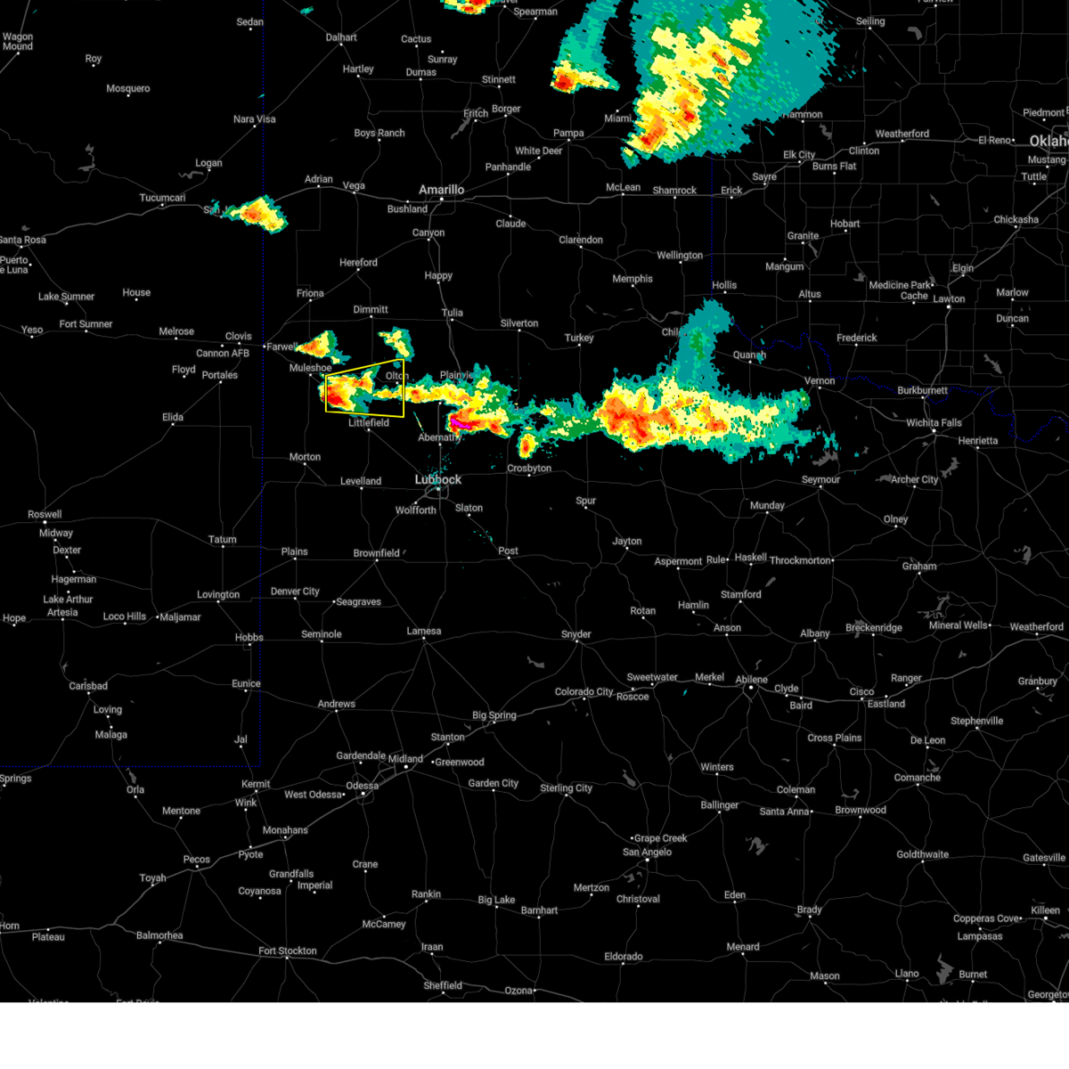
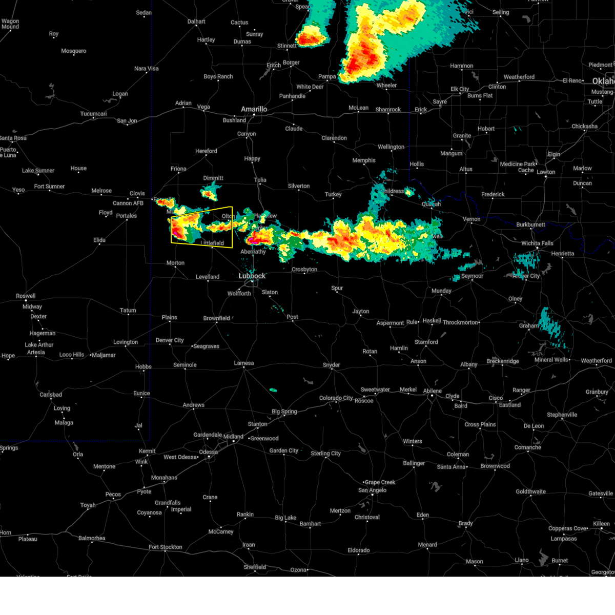
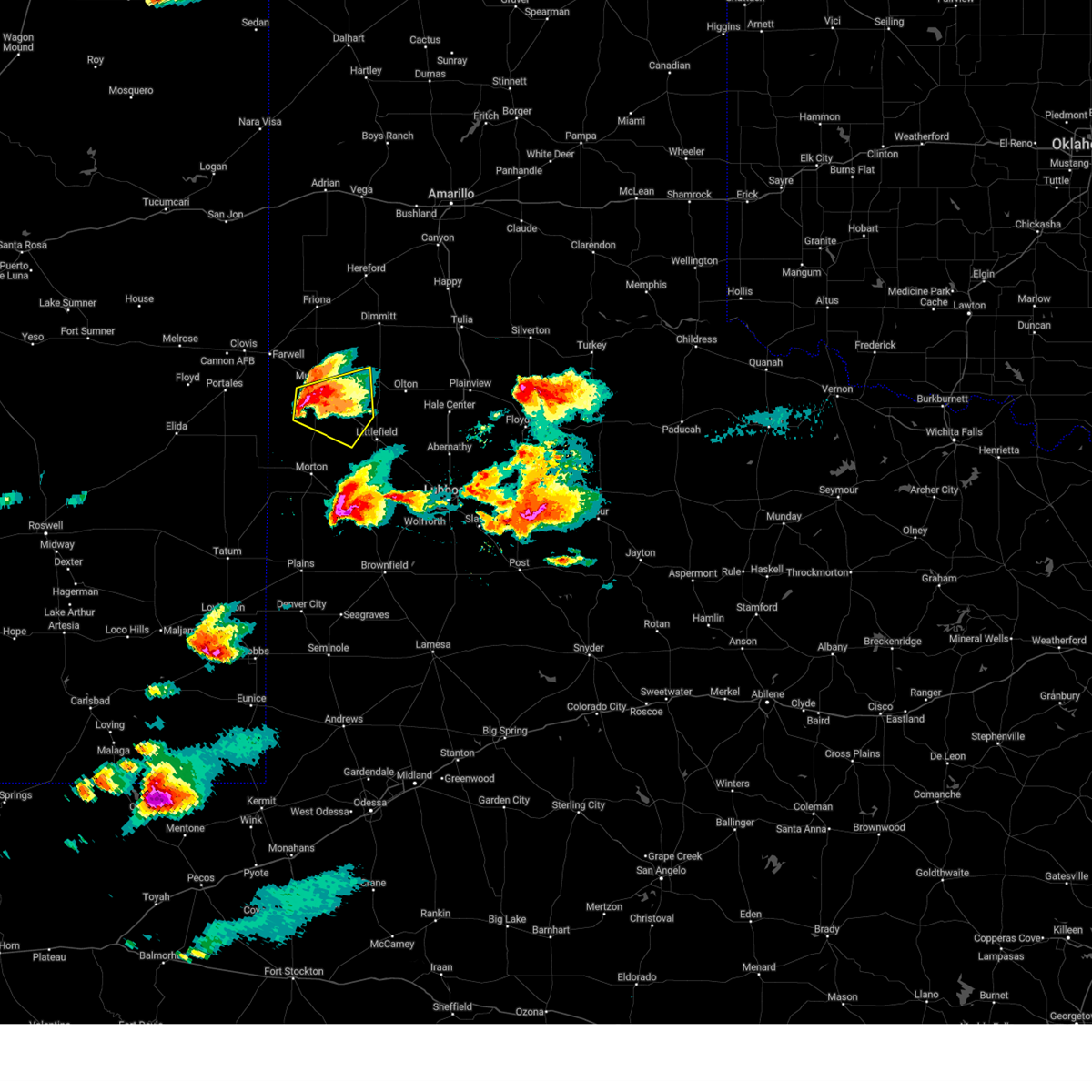
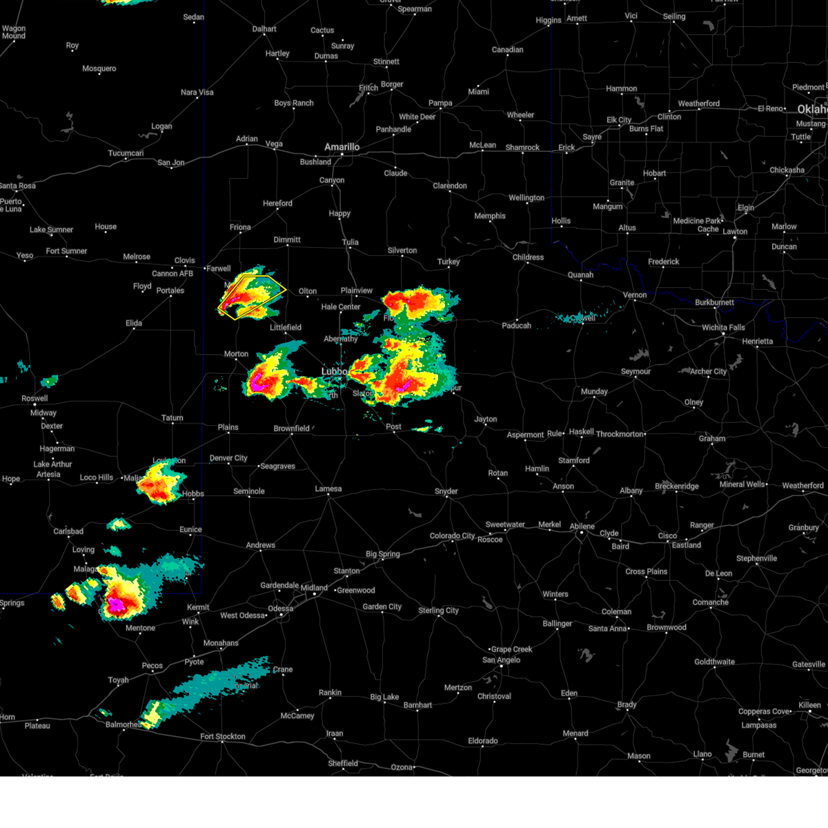
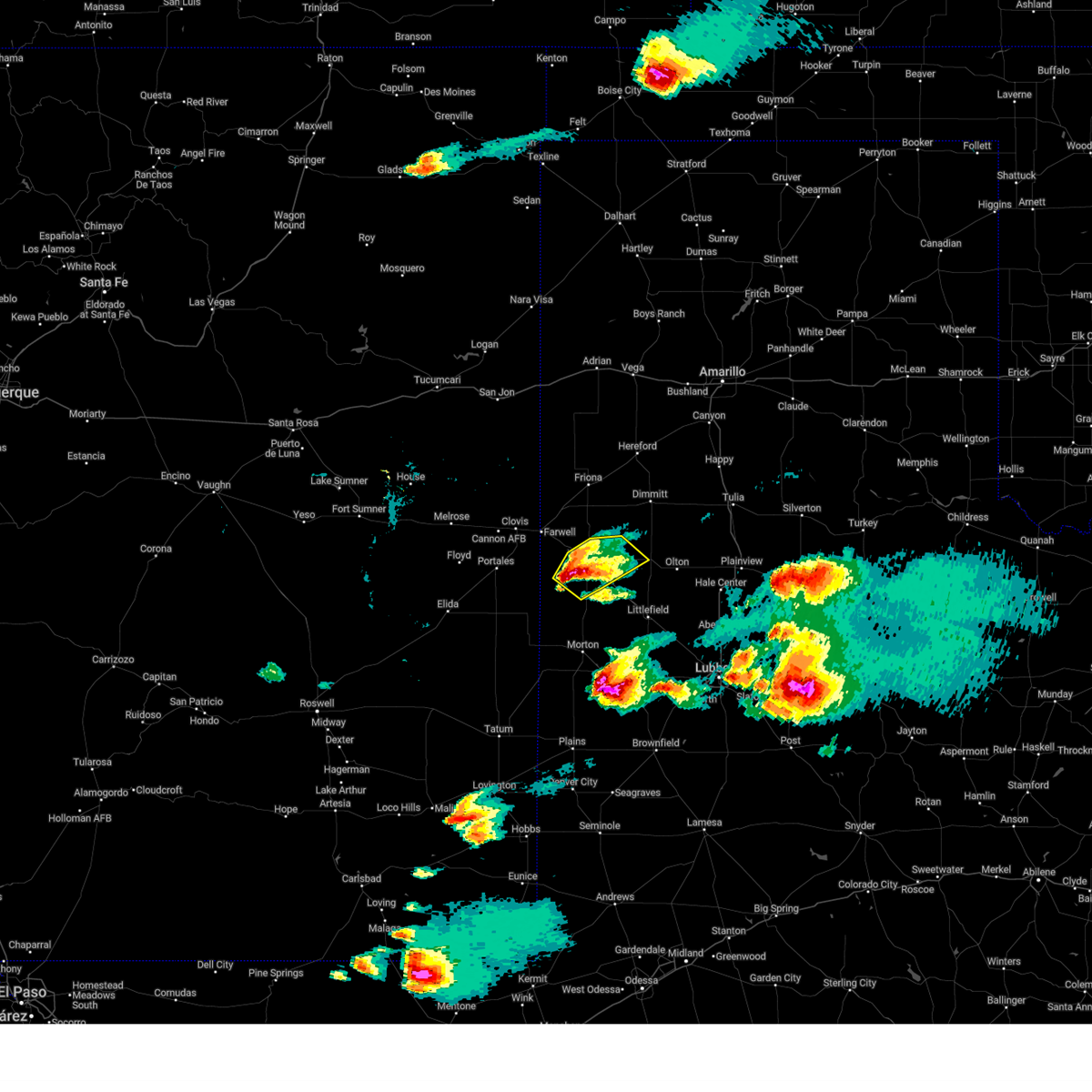
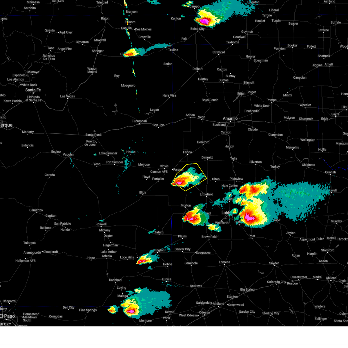
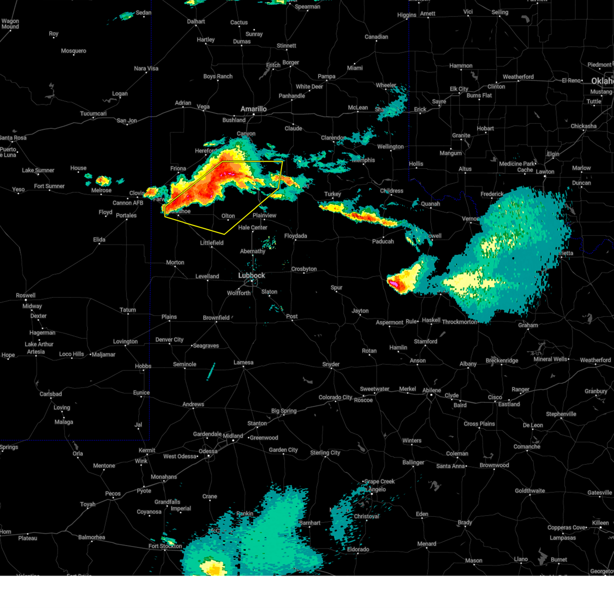
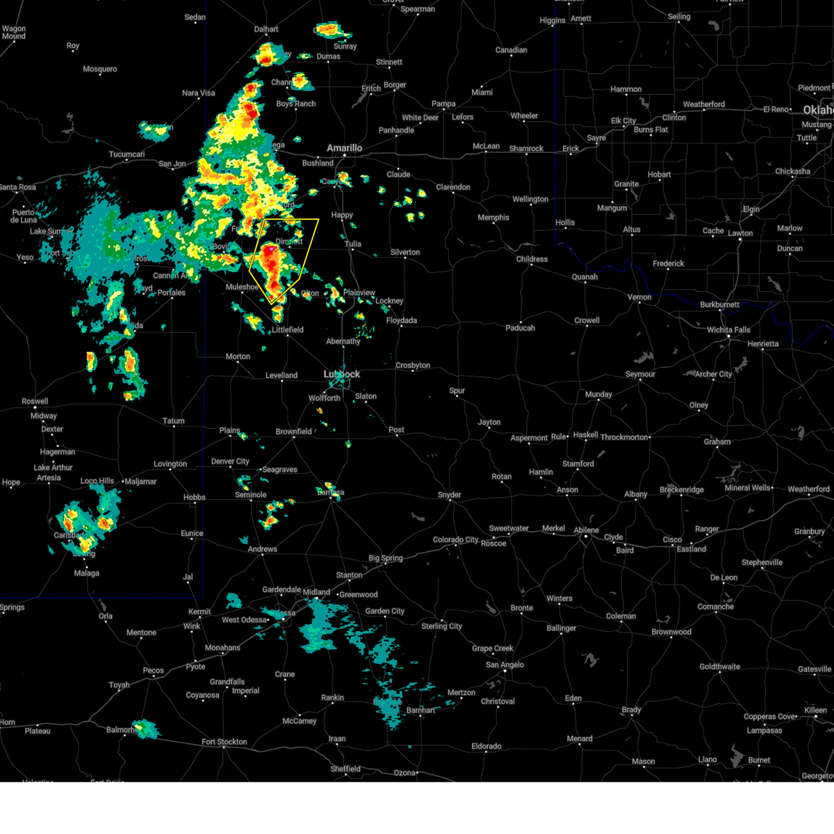
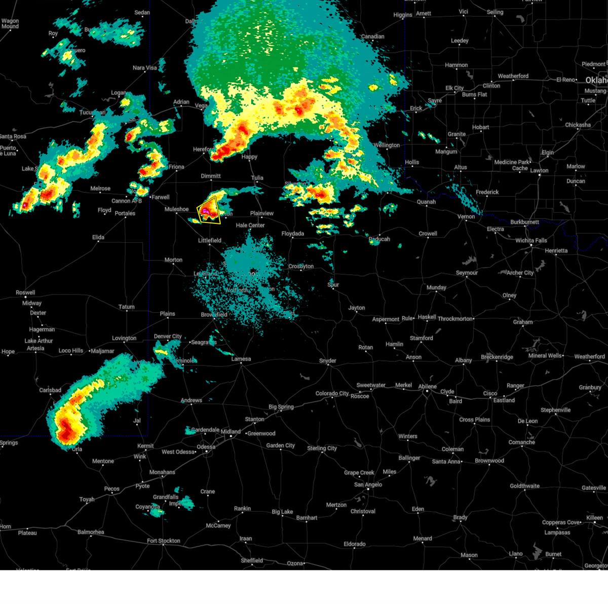
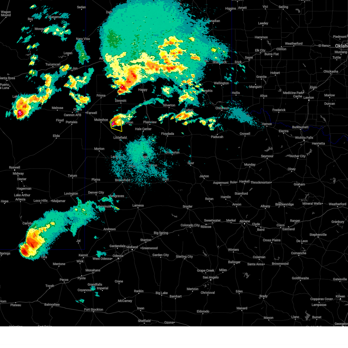
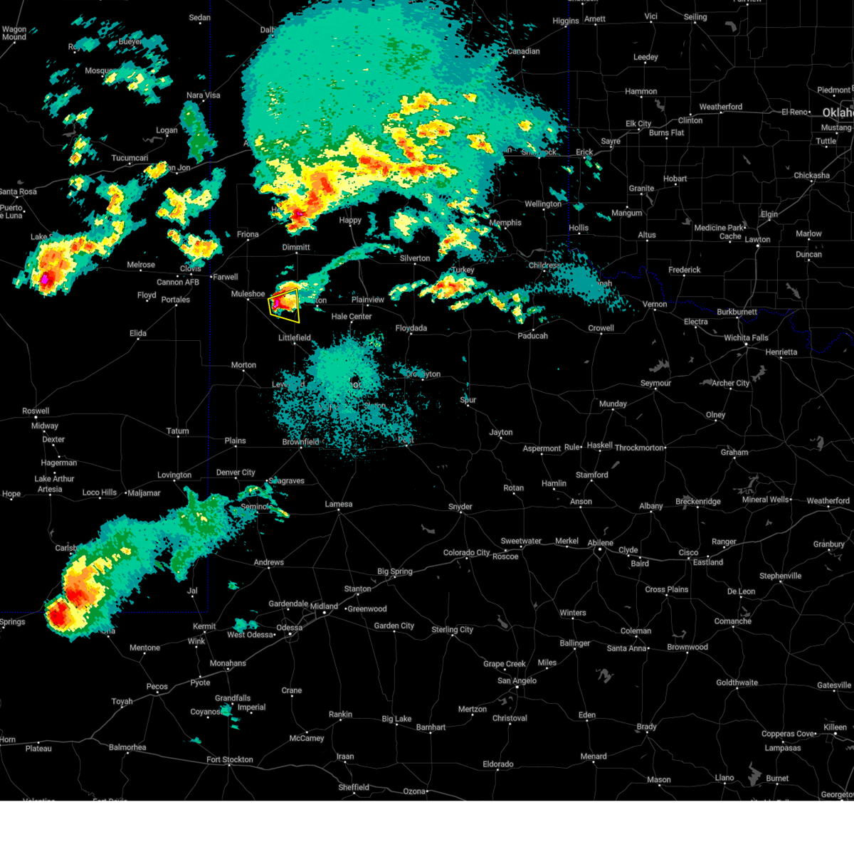
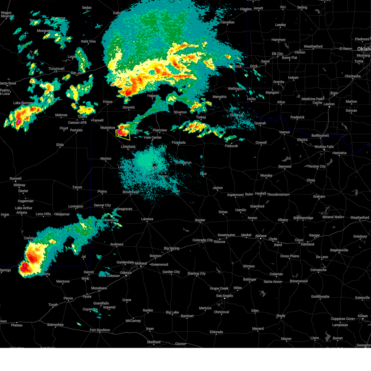
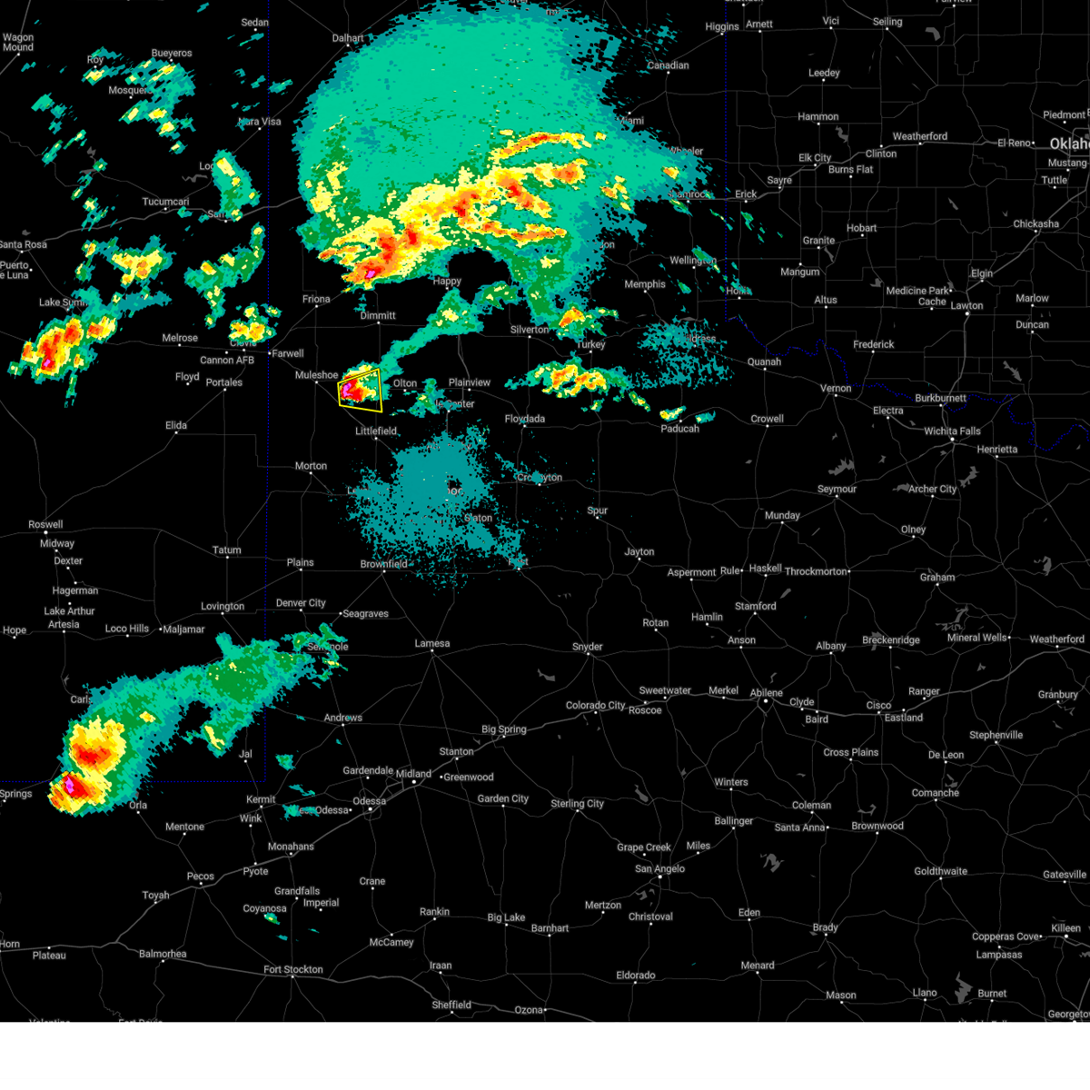
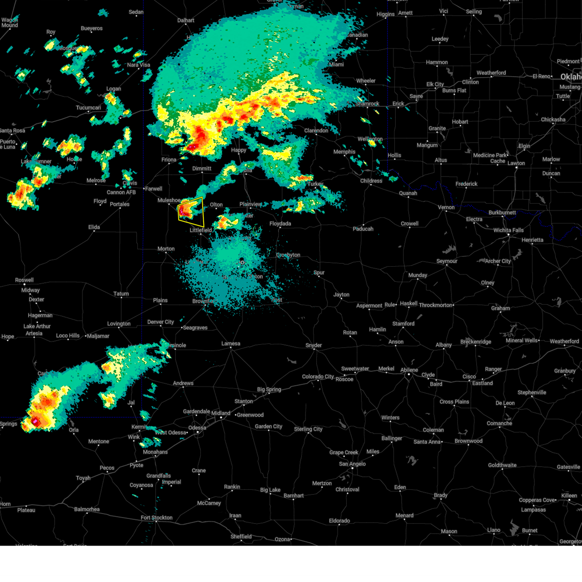
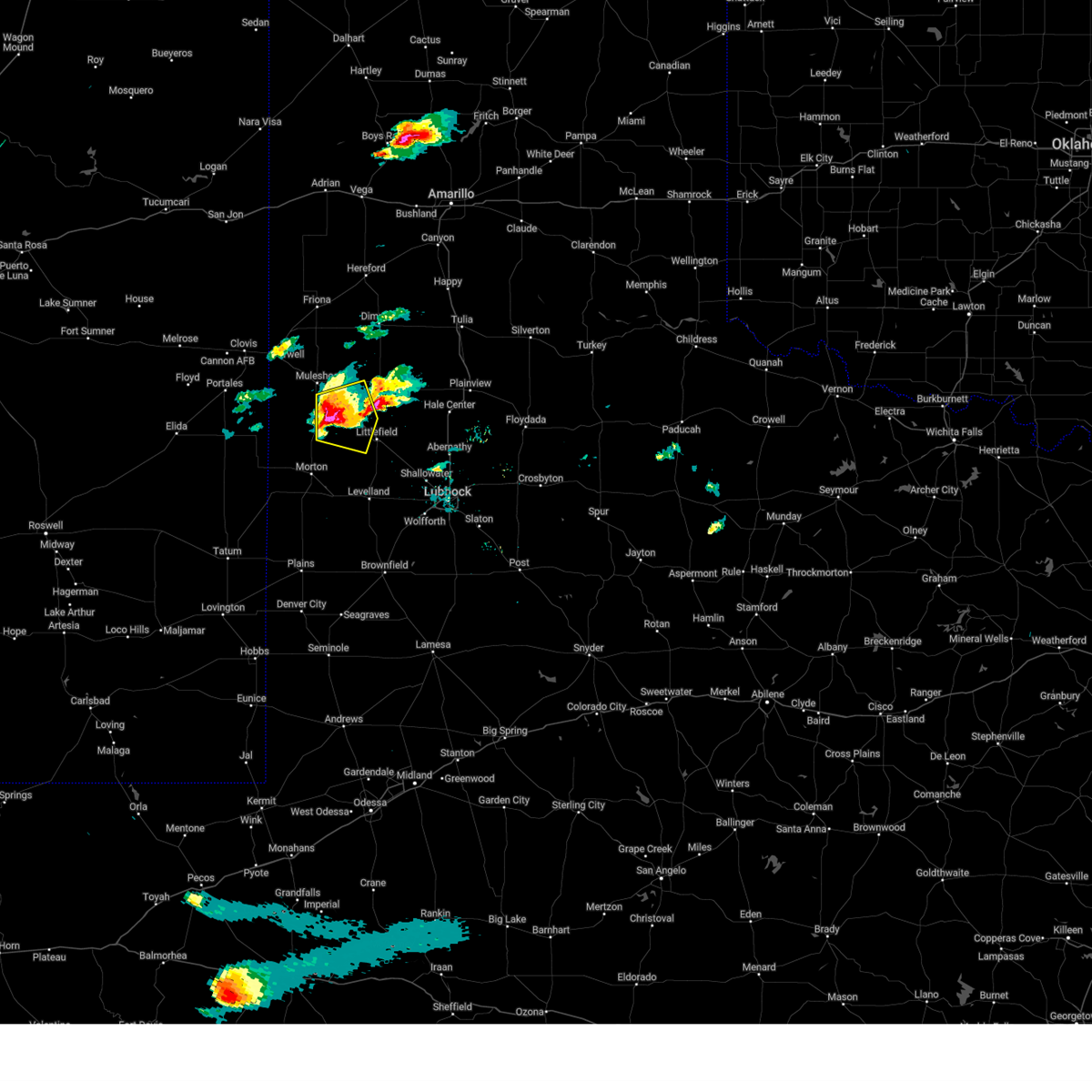
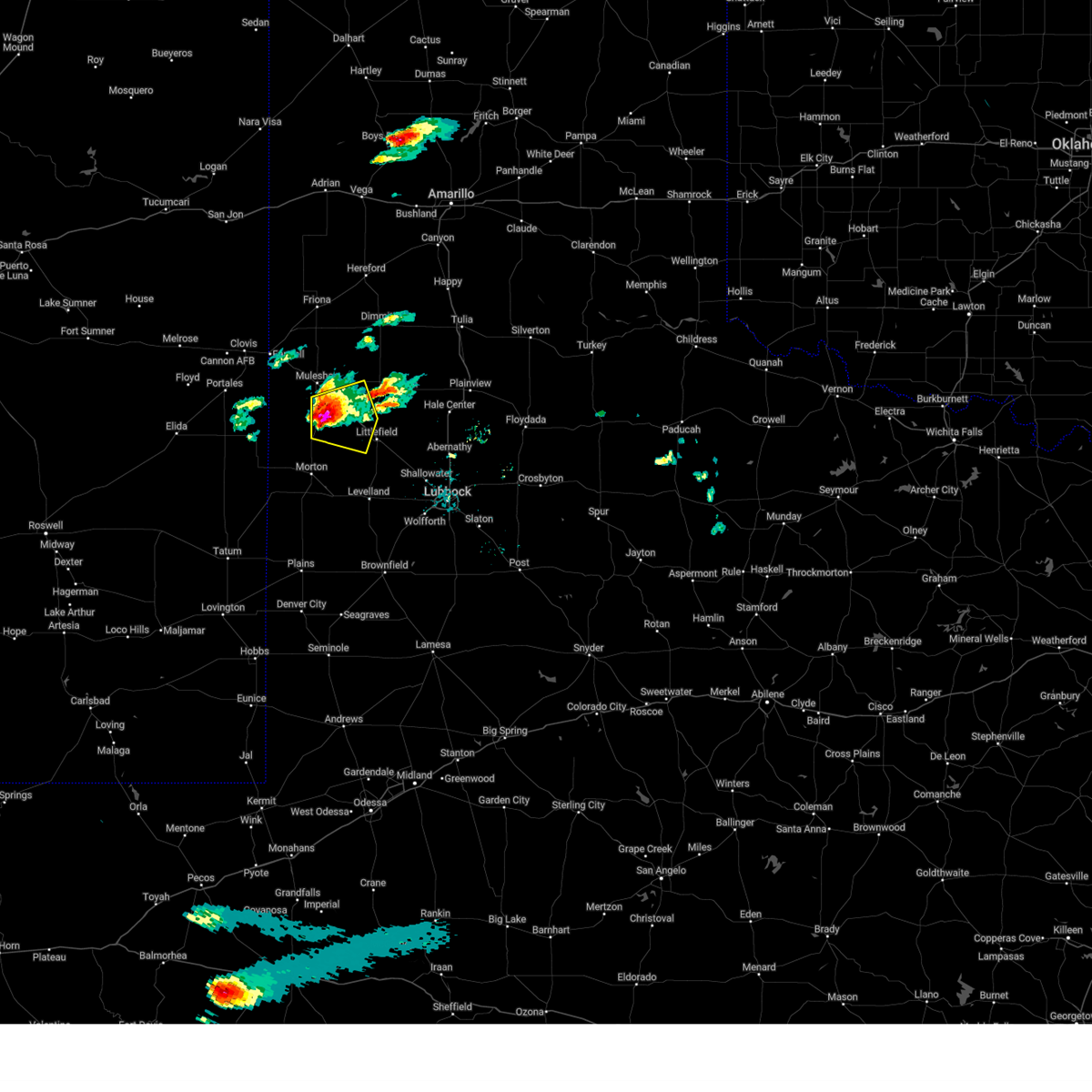
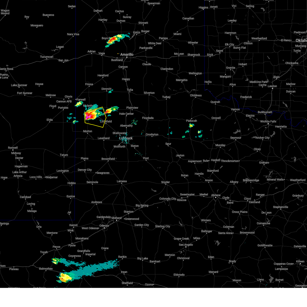
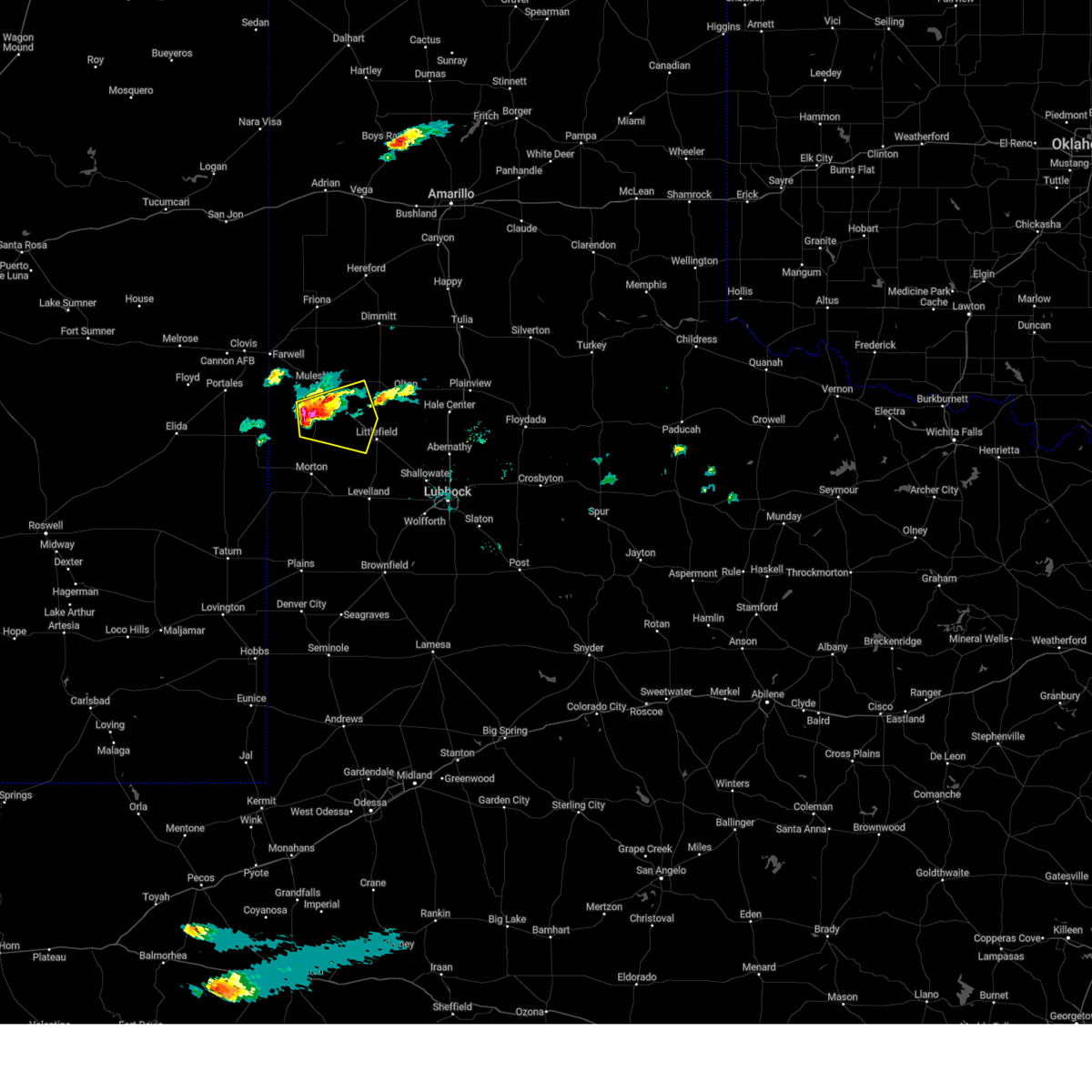
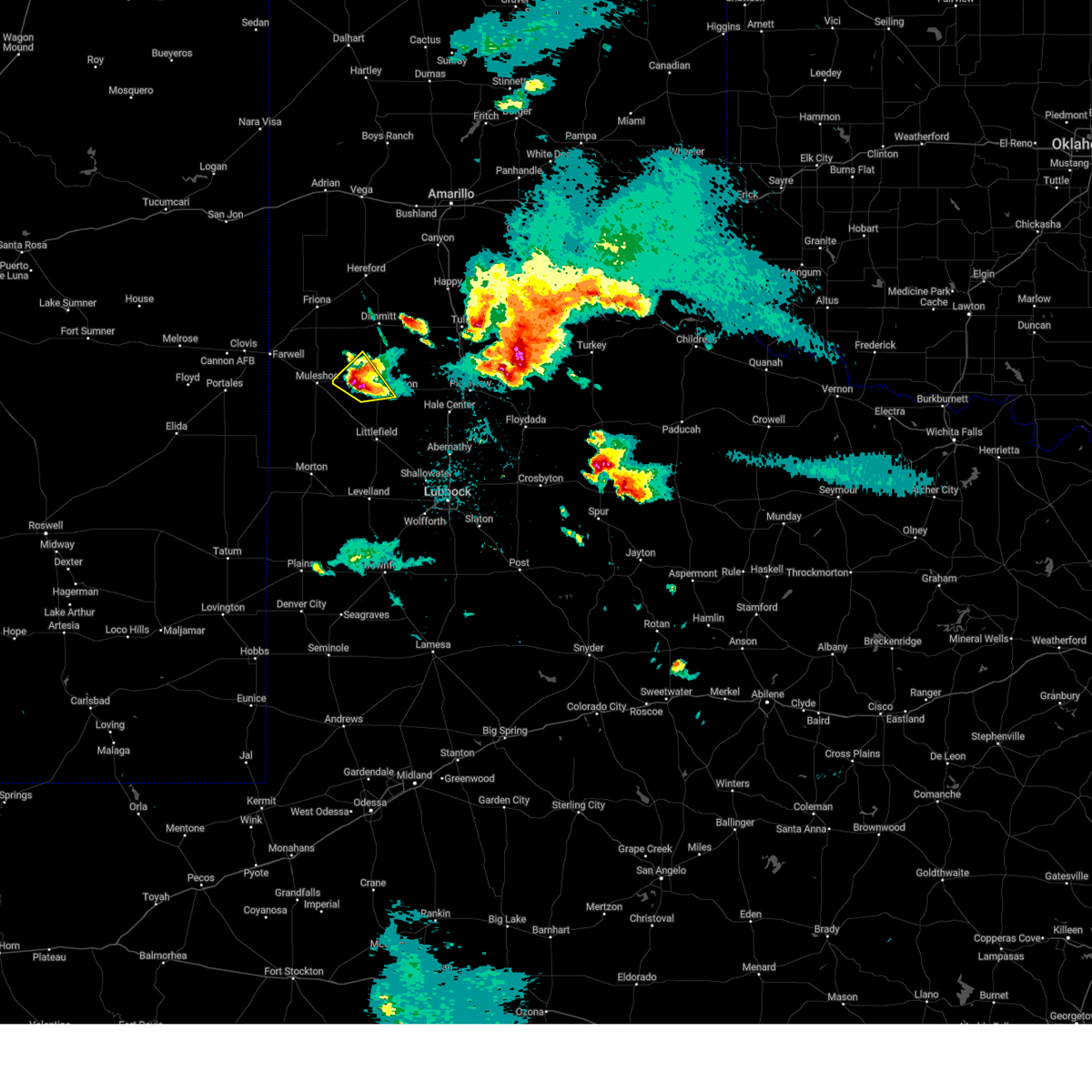
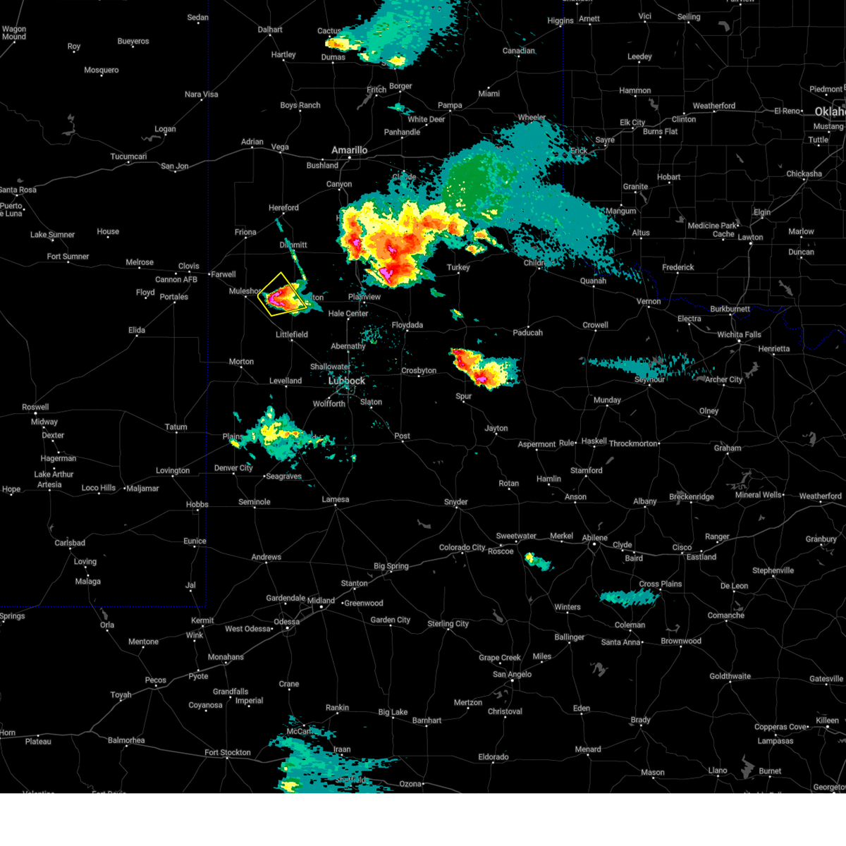
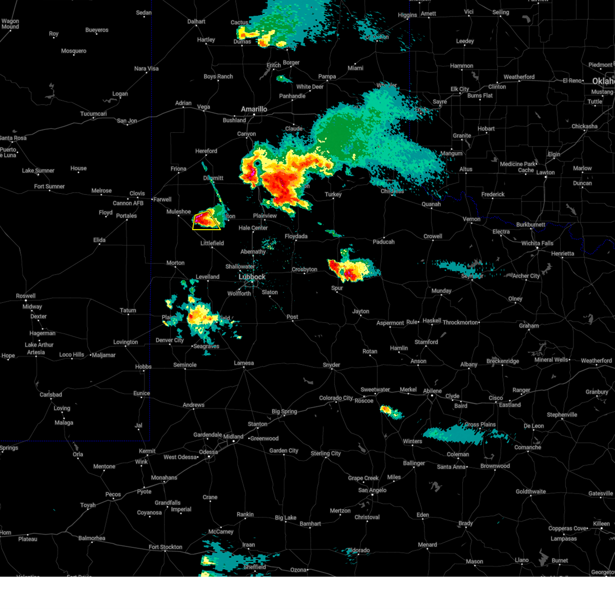
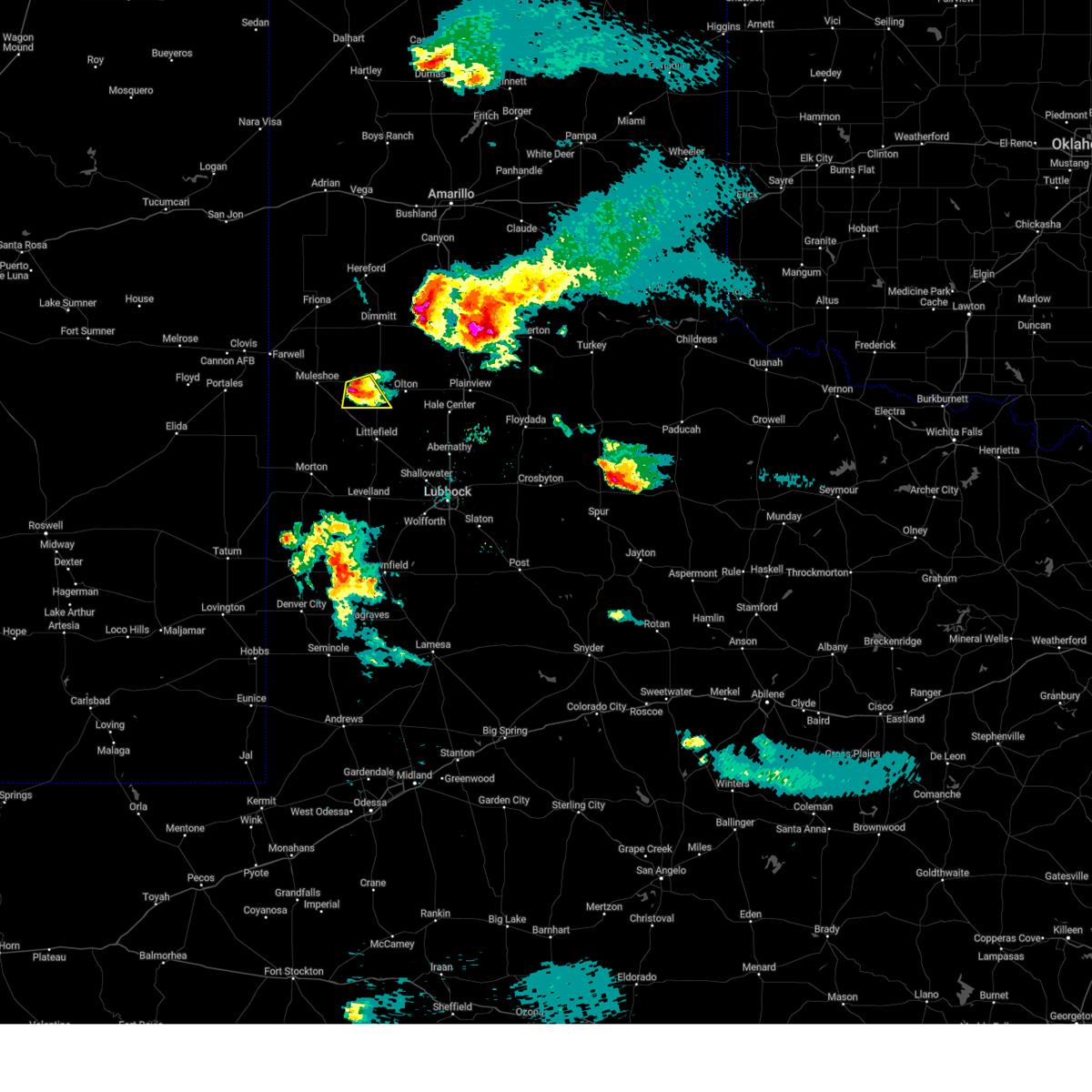
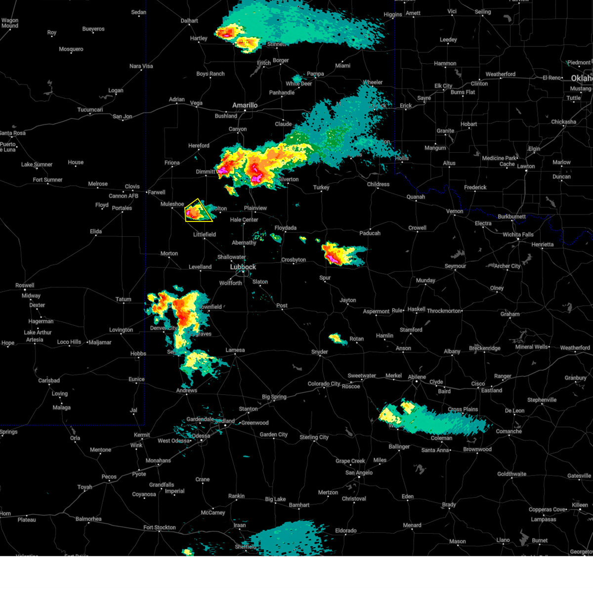
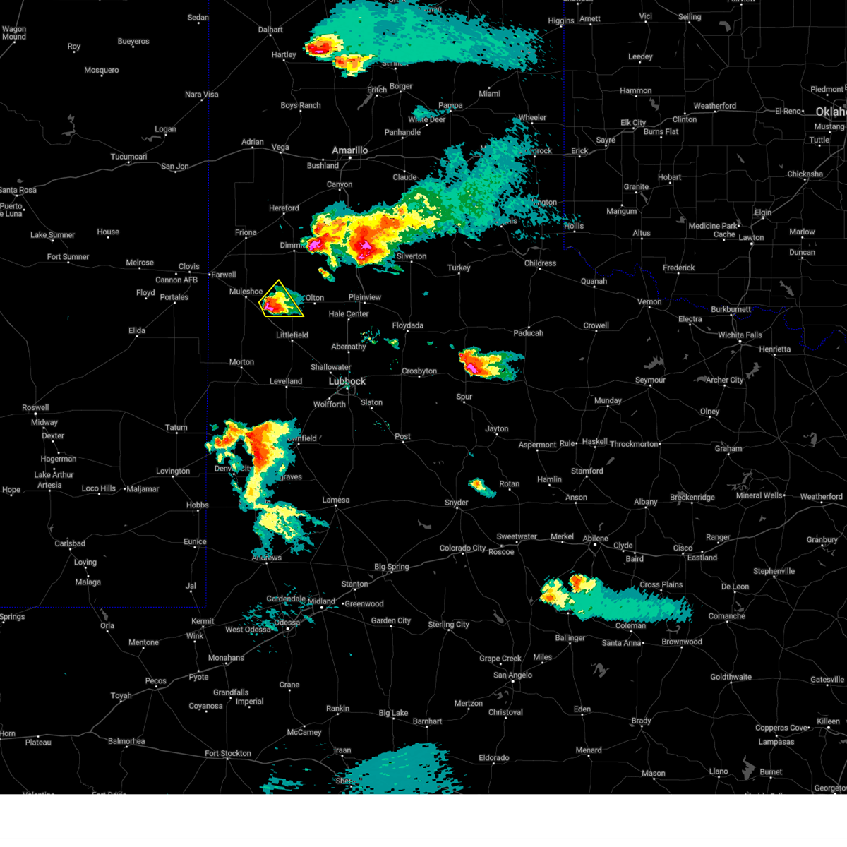
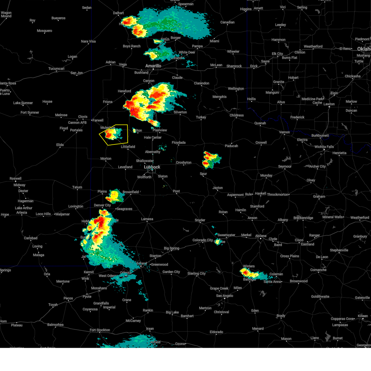
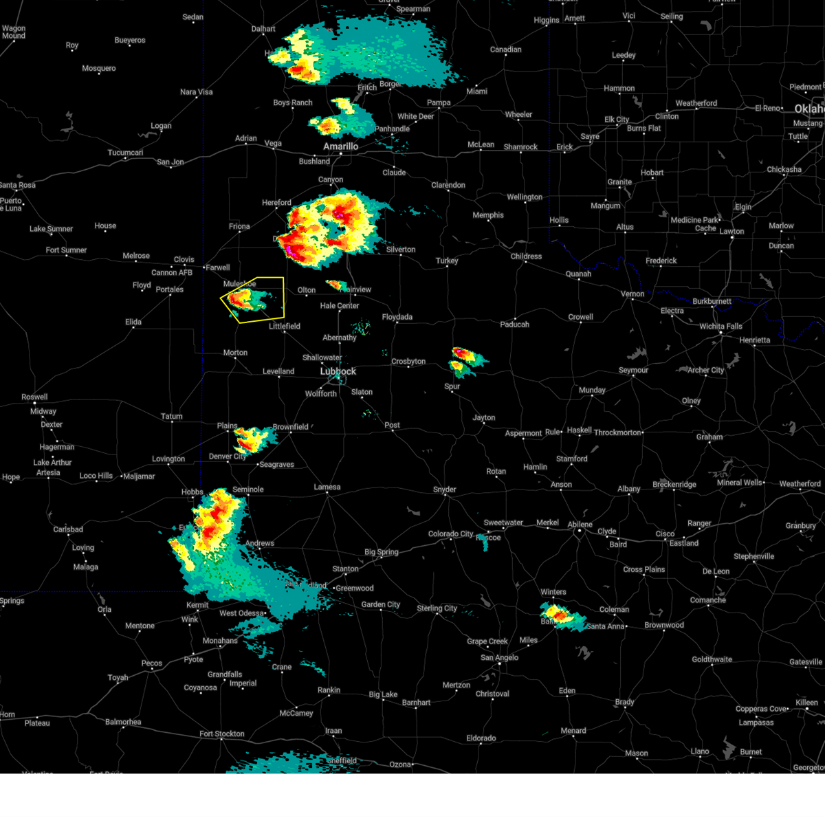
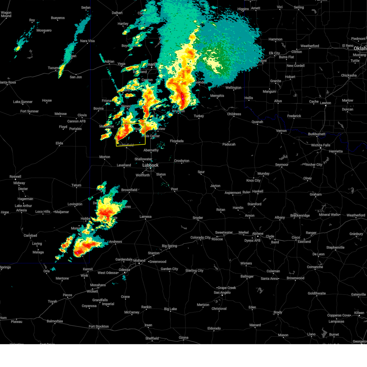
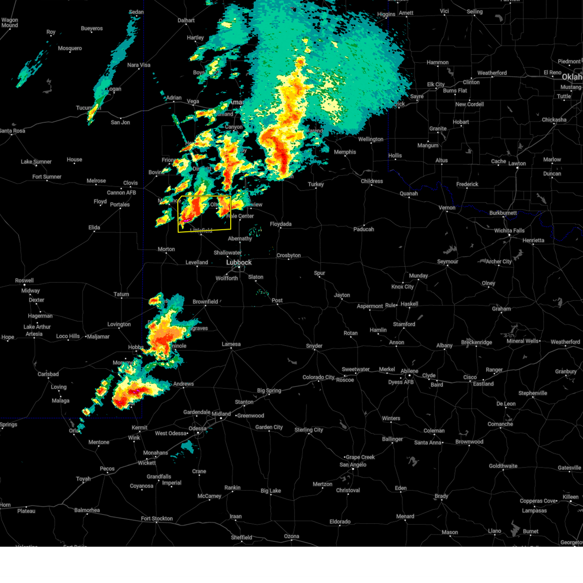
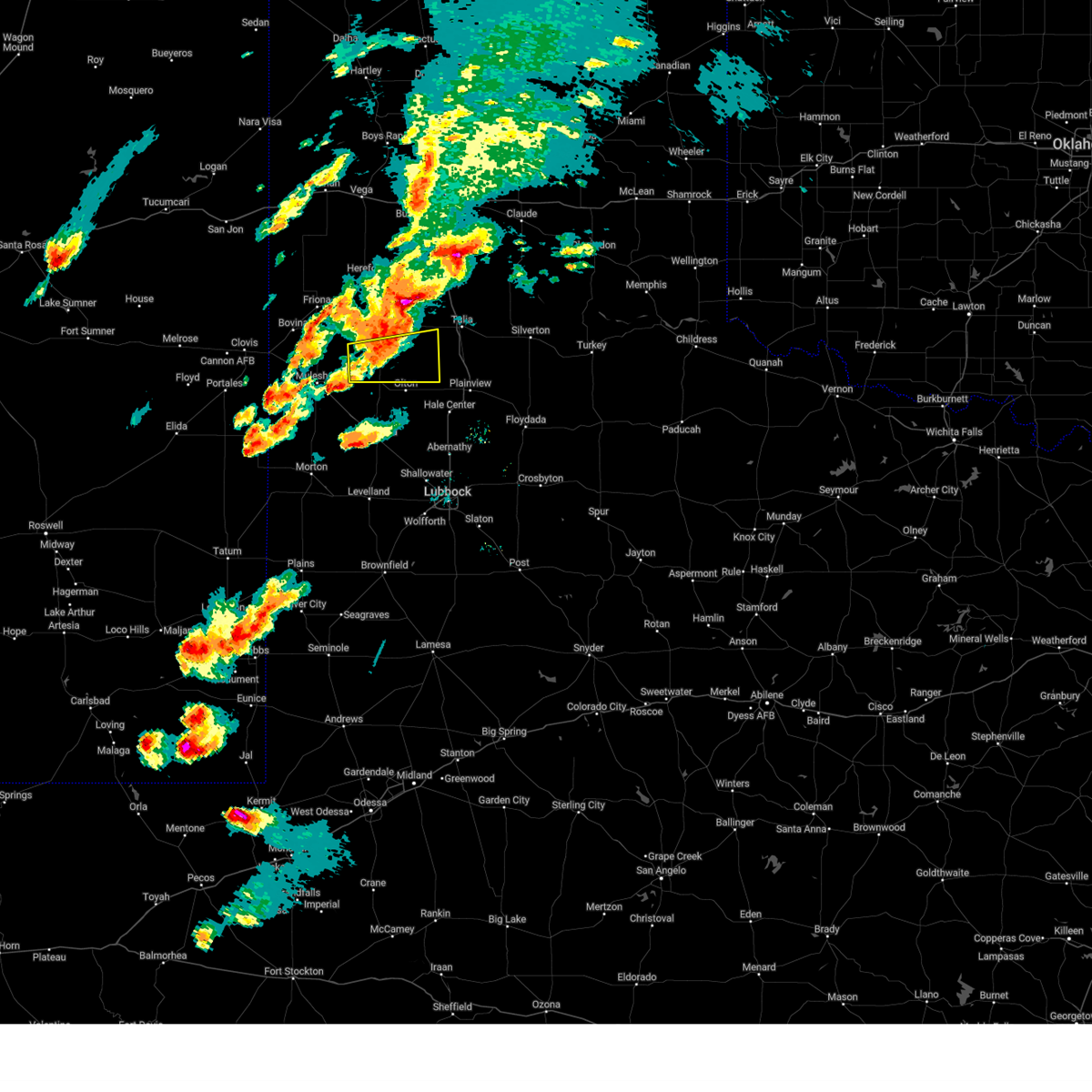
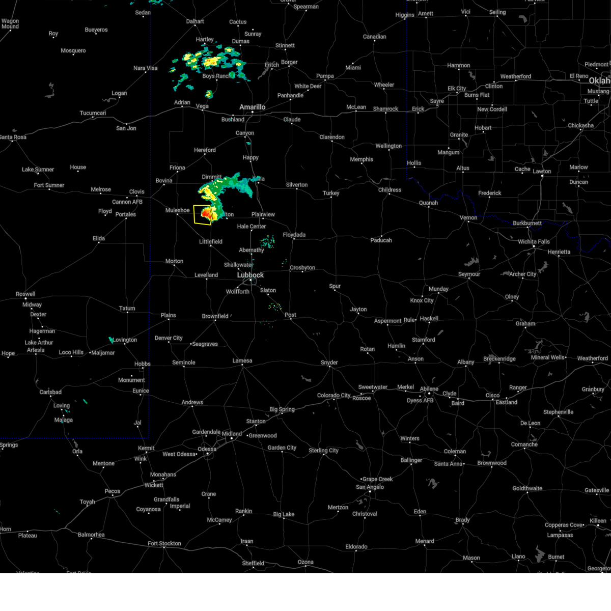
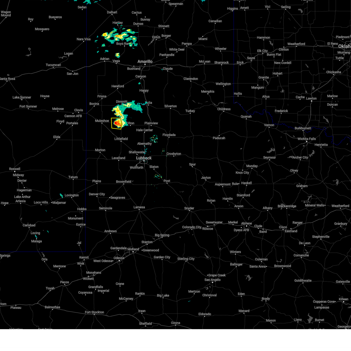
Hail Map for Earth, TX
The Earth, TX area has had 4 reports of on-the-ground hail by trained spotters, and has been under severe weather warnings 78 times during the past 12 months. Doppler radar has detected hail at or near Earth, TX on 92 occasions, including 7 occasions during the past year.
| Name: | Earth, TX |
| Where Located: | 54.3 miles NW of Lubbock, TX |
| Map: | Google Map for Earth, TX |
| Population: | 1065 |
| Housing Units: | 453 |
| More Info: | Search Google for Earth, TX |
2
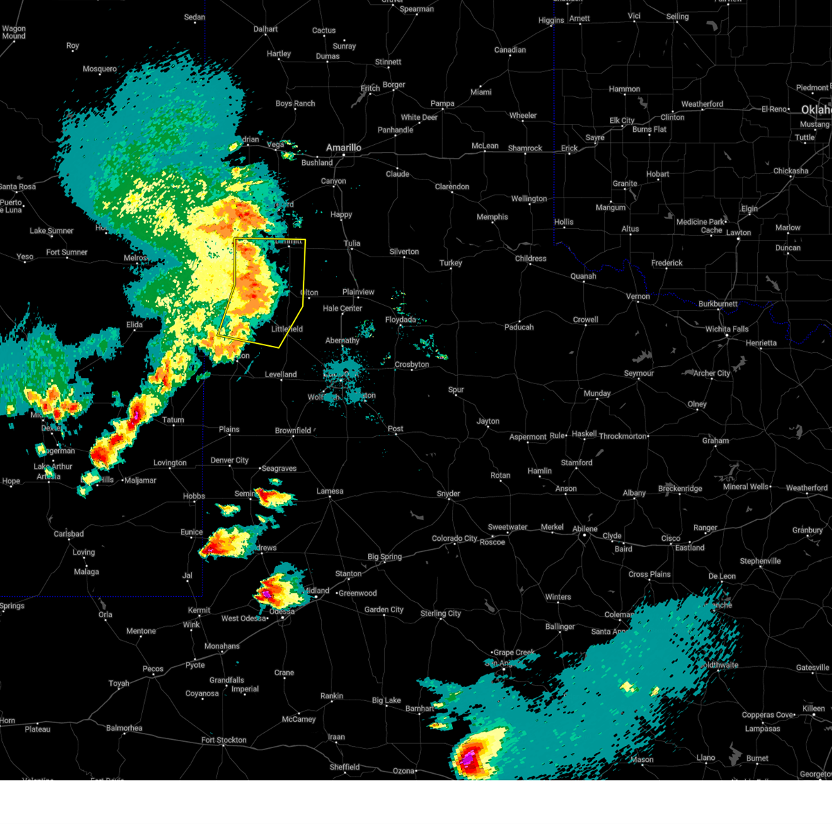
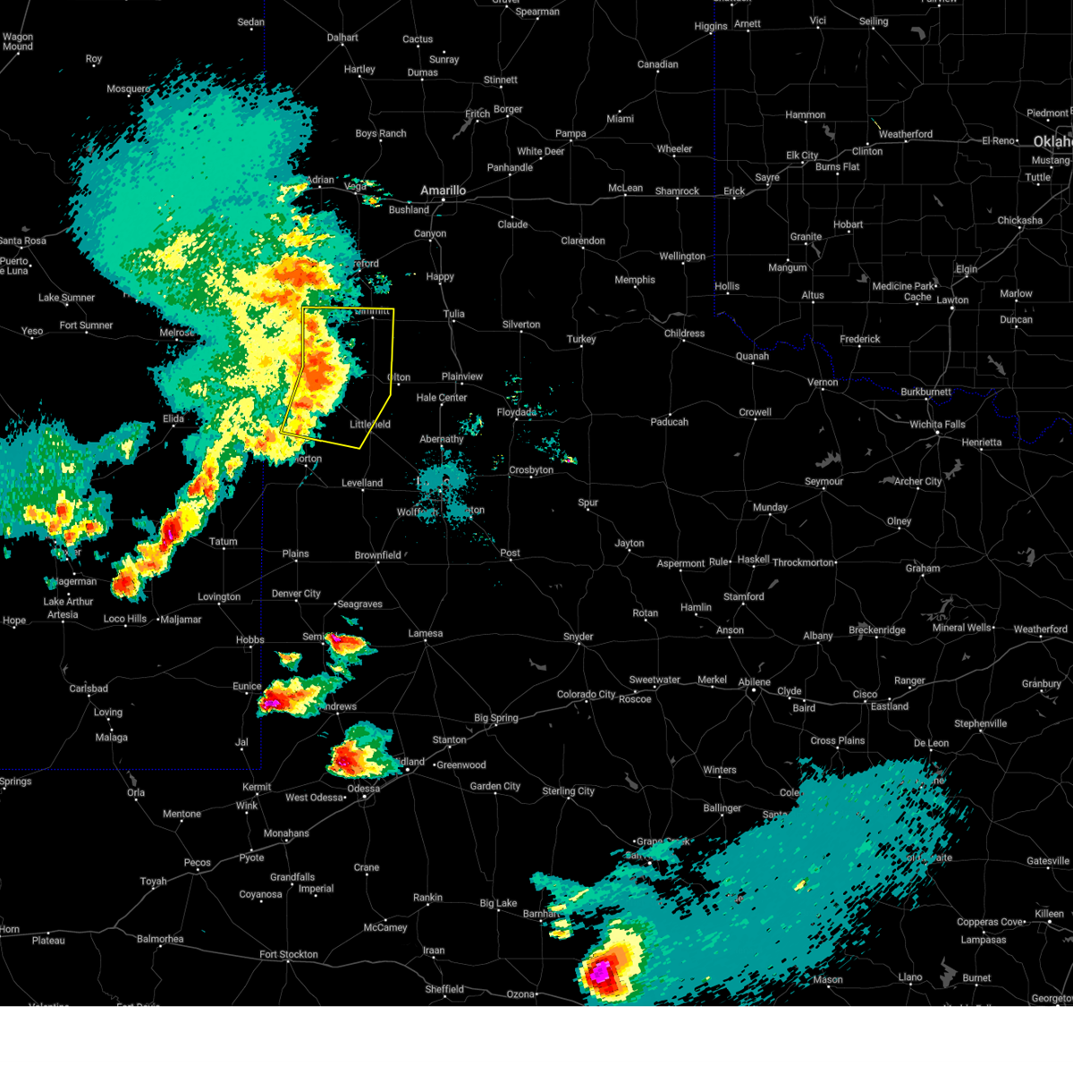
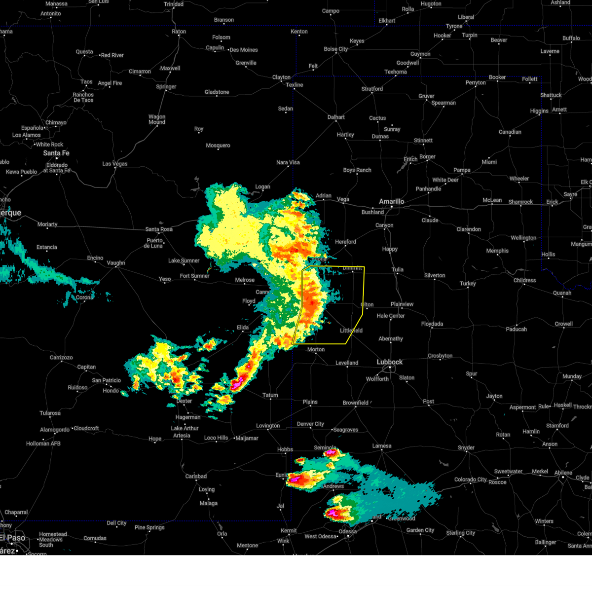
The Top Recent Hail Date for Earth, TX is Friday, April 25, 2025 (2nd out of 92)
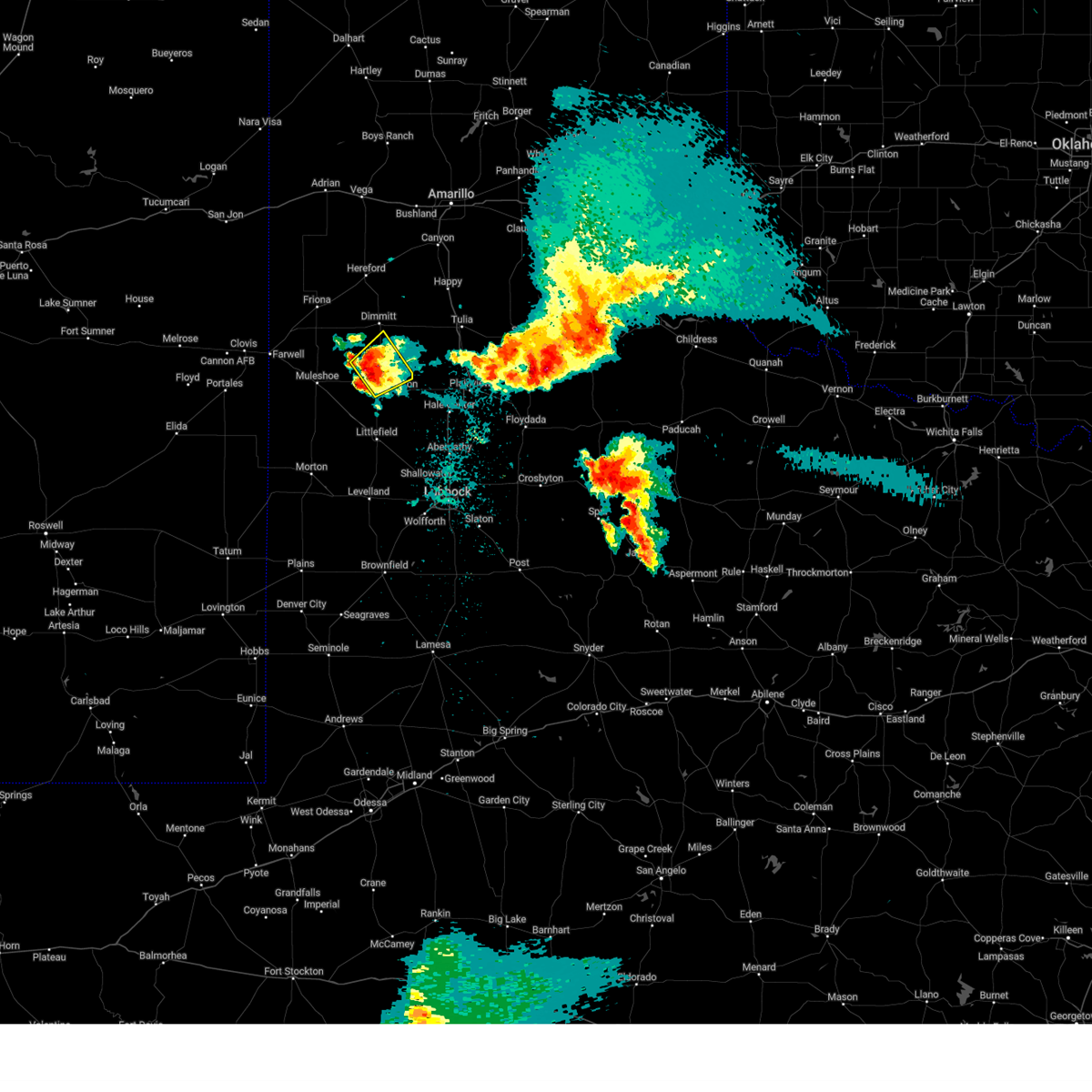
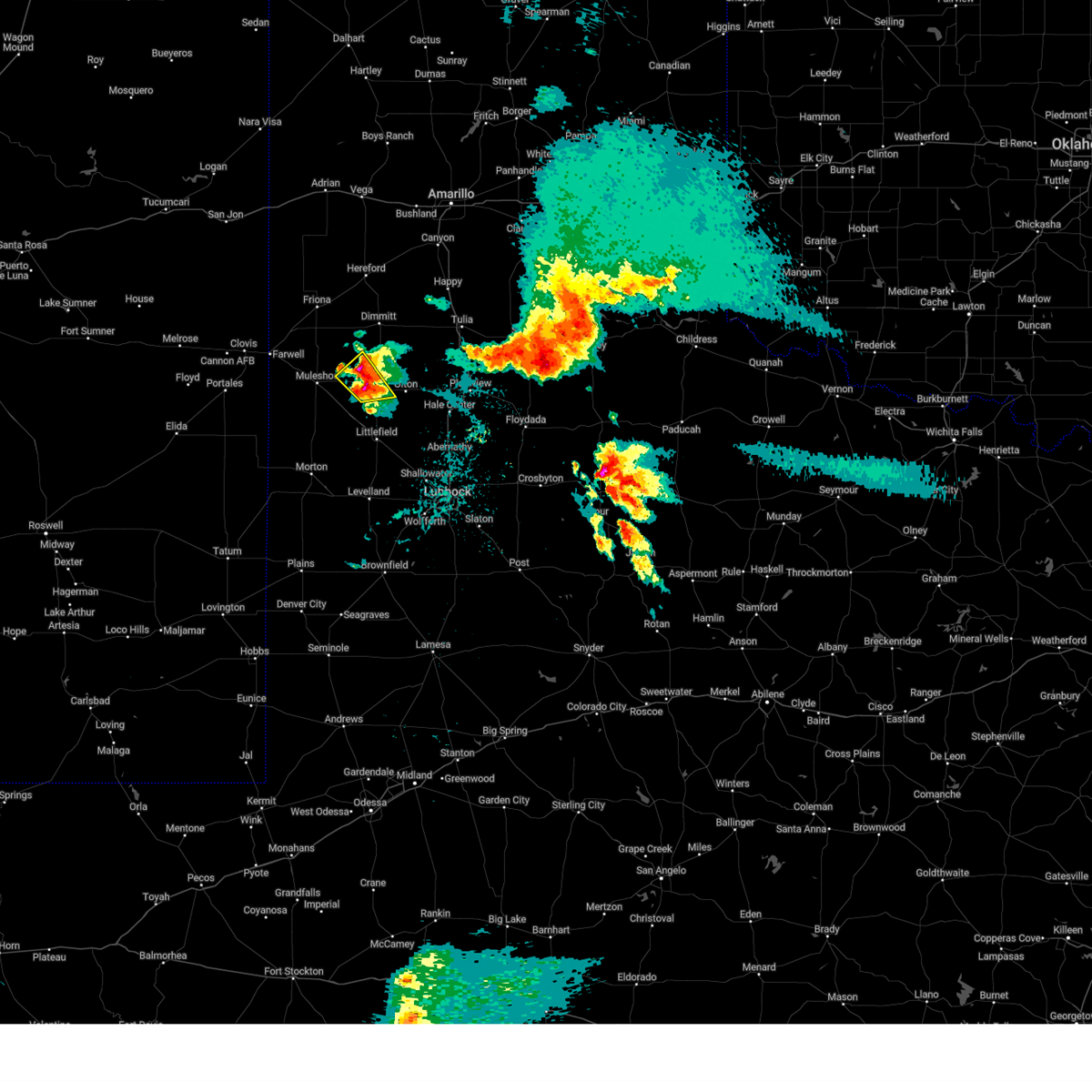
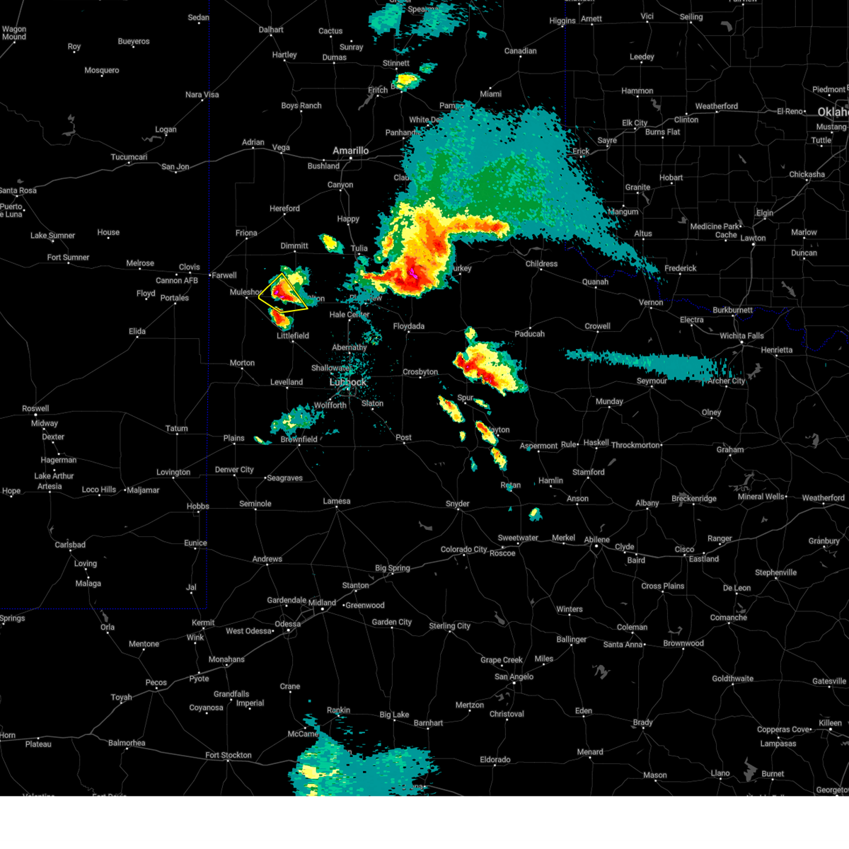
Hail and Wind Damage Spotted near Earth, TX
| Date / Time | Report Details |
|---|---|
| 6/9/2025 10:44 PM CDT |
 The storm which prompted the warning has weakened below severe limits, and no longer poses an immediate threat to life or property. therefore, the warning will be allowed to expire. a severe thunderstorm watch remains in effect until 200 am cdt for the panhandle of and northwestern texas. The storm which prompted the warning has weakened below severe limits, and no longer poses an immediate threat to life or property. therefore, the warning will be allowed to expire. a severe thunderstorm watch remains in effect until 200 am cdt for the panhandle of and northwestern texas.
|
| 6/9/2025 10:36 PM CDT |
 At 1036 pm cdt, a severe thunderstorm was located 6 miles west of earth, moving east at 40 mph (radar indicated). Hazards include 60 mph wind gusts. Expect damage to roofs, siding, and trees. Locations impacted include, littlefield, muleshoe, dimmitt, earth, sudan, amherst, needmore, lazbuddie, bula, muleshoe wildlife refuge, and springlake. At 1036 pm cdt, a severe thunderstorm was located 6 miles west of earth, moving east at 40 mph (radar indicated). Hazards include 60 mph wind gusts. Expect damage to roofs, siding, and trees. Locations impacted include, littlefield, muleshoe, dimmitt, earth, sudan, amherst, needmore, lazbuddie, bula, muleshoe wildlife refuge, and springlake.
|
| 6/9/2025 10:27 PM CDT |
 At 1026 pm cdt, a severe thunderstorm was located 6 miles southeast of muleshoe, moving east at 35 mph (radar indicated). Hazards include 60 mph wind gusts. Expect damage to roofs, siding, and trees. Locations impacted include, littlefield, muleshoe, dimmitt, earth, bovina, sudan, amherst, needmore, lazbuddie, progress, oklahoma lane, lariat, enochs, bula, muleshoe wildlife refuge, maple, and springlake. At 1026 pm cdt, a severe thunderstorm was located 6 miles southeast of muleshoe, moving east at 35 mph (radar indicated). Hazards include 60 mph wind gusts. Expect damage to roofs, siding, and trees. Locations impacted include, littlefield, muleshoe, dimmitt, earth, bovina, sudan, amherst, needmore, lazbuddie, progress, oklahoma lane, lariat, enochs, bula, muleshoe wildlife refuge, maple, and springlake.
|
| 6/9/2025 10:18 PM CDT |
 At 1018 pm cdt, severe thunderstorms were located along a line extending from 4 miles southeast of bovina to near muleshoe to 4 miles northeast of maple, moving east at 40 mph (radar indicated). Hazards include 70 mph wind gusts. Expect considerable tree damage. damage is likely to mobile homes, roofs, and outbuildings. Locations impacted include, littlefield, muleshoe, dimmitt, earth, bovina, farwell, sudan, amherst, needmore, lazbuddie, progress, oklahoma lane, lariat, west camp, enochs, bula, muleshoe wildlife refuge, maple, and springlake. At 1018 pm cdt, severe thunderstorms were located along a line extending from 4 miles southeast of bovina to near muleshoe to 4 miles northeast of maple, moving east at 40 mph (radar indicated). Hazards include 70 mph wind gusts. Expect considerable tree damage. damage is likely to mobile homes, roofs, and outbuildings. Locations impacted include, littlefield, muleshoe, dimmitt, earth, bovina, farwell, sudan, amherst, needmore, lazbuddie, progress, oklahoma lane, lariat, west camp, enochs, bula, muleshoe wildlife refuge, maple, and springlake.
|
| 6/9/2025 9:58 PM CDT |
 At 958 pm cdt, severe thunderstorms were located along a line extending from 6 miles north of texico to 5 miles south of west camp to 5 miles east of dora, moving east at 35 mph (radar indicated). Hazards include 70 mph wind gusts and quarter size hail. Hail damage to vehicles is expected. expect considerable tree damage. wind damage is also likely to mobile homes, roofs, and outbuildings. Locations impacted include, littlefield, muleshoe, dimmitt, earth, bovina, farwell, sudan, amherst, needmore, lazbuddie, progress, oklahoma lane, lariat, west camp, enochs, bula, muleshoe wildlife refuge, maple, and springlake. At 958 pm cdt, severe thunderstorms were located along a line extending from 6 miles north of texico to 5 miles south of west camp to 5 miles east of dora, moving east at 35 mph (radar indicated). Hazards include 70 mph wind gusts and quarter size hail. Hail damage to vehicles is expected. expect considerable tree damage. wind damage is also likely to mobile homes, roofs, and outbuildings. Locations impacted include, littlefield, muleshoe, dimmitt, earth, bovina, farwell, sudan, amherst, needmore, lazbuddie, progress, oklahoma lane, lariat, west camp, enochs, bula, muleshoe wildlife refuge, maple, and springlake.
|
| 6/9/2025 9:41 PM CDT |
 Svrlub the national weather service in lubbock texas has issued a * severe thunderstorm warning for, bailey county in northwestern texas, parmer county in the panhandle of texas, southwestern castro county in the panhandle of texas, lamb county in northwestern texas, * until 1045 pm cdt. * at 940 pm cdt, severe thunderstorms were located along a line extending from 6 miles north of clovis to 7 miles north of arch to 8 miles east of elida, moving east at 40 mph (radar indicated). Hazards include 70 mph wind gusts and quarter size hail. Hail damage to vehicles is expected. expect considerable tree damage. Wind damage is also likely to mobile homes, roofs, and outbuildings. Svrlub the national weather service in lubbock texas has issued a * severe thunderstorm warning for, bailey county in northwestern texas, parmer county in the panhandle of texas, southwestern castro county in the panhandle of texas, lamb county in northwestern texas, * until 1045 pm cdt. * at 940 pm cdt, severe thunderstorms were located along a line extending from 6 miles north of clovis to 7 miles north of arch to 8 miles east of elida, moving east at 40 mph (radar indicated). Hazards include 70 mph wind gusts and quarter size hail. Hail damage to vehicles is expected. expect considerable tree damage. Wind damage is also likely to mobile homes, roofs, and outbuildings.
|
| 6/7/2025 1:52 AM CDT |
 the severe thunderstorm warning has been cancelled and is no longer in effect the severe thunderstorm warning has been cancelled and is no longer in effect
|
| 6/7/2025 1:52 AM CDT |
 At 151 am cdt, a severe thunderstorm was located over sudan, or 12 miles southwest of earth, moving east at 25 mph (radar indicated). Hazards include 60 mph wind gusts and quarter size hail. Hail damage to vehicles is expected. expect wind damage to roofs, siding, and trees. Locations impacted include, olton, earth, sudan, amherst, fieldton, and springlake. At 151 am cdt, a severe thunderstorm was located over sudan, or 12 miles southwest of earth, moving east at 25 mph (radar indicated). Hazards include 60 mph wind gusts and quarter size hail. Hail damage to vehicles is expected. expect wind damage to roofs, siding, and trees. Locations impacted include, olton, earth, sudan, amherst, fieldton, and springlake.
|
| 6/7/2025 1:26 AM CDT |
 Svrlub the national weather service in lubbock texas has issued a * severe thunderstorm warning for, northeastern bailey county in northwestern texas, lamb county in northwestern texas, * until 230 am cdt. * at 126 am cdt, a severe thunderstorm was located over needmore, or 12 miles south of muleshoe, moving east at 30 mph (radar indicated). Hazards include 60 mph wind gusts and half dollar size hail. Hail damage to vehicles is expected. Expect wind damage to roofs, siding, and trees. Svrlub the national weather service in lubbock texas has issued a * severe thunderstorm warning for, northeastern bailey county in northwestern texas, lamb county in northwestern texas, * until 230 am cdt. * at 126 am cdt, a severe thunderstorm was located over needmore, or 12 miles south of muleshoe, moving east at 30 mph (radar indicated). Hazards include 60 mph wind gusts and half dollar size hail. Hail damage to vehicles is expected. Expect wind damage to roofs, siding, and trees.
|
| 6/6/2025 7:11 PM CDT | At 710 pm cdt, a severe thunderstorm was located over needmore, or 12 miles south of muleshoe, moving east at 15 mph (radar indicated). Hazards include two inch hail and 60 mph wind gusts. People and animals outdoors will be injured. expect hail damage to roofs, siding, windows, and vehicles. expect wind damage to roofs, siding, and trees. Locations impacted include, sudan, amherst, and needmore. |
| 6/6/2025 6:55 PM CDT |
 Svrlub the national weather service in lubbock texas has issued a * severe thunderstorm warning for, northeastern bailey county in northwestern texas, western lamb county in northwestern texas, * until 745 pm cdt. * at 655 pm cdt, a severe thunderstorm was located 4 miles northwest of needmore, or 11 miles south of muleshoe, moving east at 15 mph (radar indicated). Hazards include two inch hail and 60 mph wind gusts. People and animals outdoors will be injured. expect hail damage to roofs, siding, windows, and vehicles. Expect wind damage to roofs, siding, and trees. Svrlub the national weather service in lubbock texas has issued a * severe thunderstorm warning for, northeastern bailey county in northwestern texas, western lamb county in northwestern texas, * until 745 pm cdt. * at 655 pm cdt, a severe thunderstorm was located 4 miles northwest of needmore, or 11 miles south of muleshoe, moving east at 15 mph (radar indicated). Hazards include two inch hail and 60 mph wind gusts. People and animals outdoors will be injured. expect hail damage to roofs, siding, windows, and vehicles. Expect wind damage to roofs, siding, and trees.
|
| 6/6/2025 6:51 PM CDT |
 At 651 pm cdt, a severe thunderstorm was located 5 miles northwest of needmore, or 11 miles southwest of muleshoe, moving east at 15 mph (radar indicated). Hazards include ping pong ball size hail and 60 mph wind gusts. People and animals outdoors will be injured. expect hail damage to roofs, siding, windows, and vehicles. expect wind damage to roofs, siding, and trees. Locations impacted include, muleshoe, earth, and needmore. At 651 pm cdt, a severe thunderstorm was located 5 miles northwest of needmore, or 11 miles southwest of muleshoe, moving east at 15 mph (radar indicated). Hazards include ping pong ball size hail and 60 mph wind gusts. People and animals outdoors will be injured. expect hail damage to roofs, siding, windows, and vehicles. expect wind damage to roofs, siding, and trees. Locations impacted include, muleshoe, earth, and needmore.
|
| 6/6/2025 6:42 PM CDT |
 At 641 pm cdt, a severe thunderstorm was located 8 miles northwest of needmore, or 8 miles southwest of muleshoe, moving east at 30 mph (radar indicated). Hazards include ping pong ball size hail and 60 mph wind gusts. People and animals outdoors will be injured. expect hail damage to roofs, siding, windows, and vehicles. expect wind damage to roofs, siding, and trees. Locations impacted include, muleshoe, earth, needmore, and progress. At 641 pm cdt, a severe thunderstorm was located 8 miles northwest of needmore, or 8 miles southwest of muleshoe, moving east at 30 mph (radar indicated). Hazards include ping pong ball size hail and 60 mph wind gusts. People and animals outdoors will be injured. expect hail damage to roofs, siding, windows, and vehicles. expect wind damage to roofs, siding, and trees. Locations impacted include, muleshoe, earth, needmore, and progress.
|
| 6/6/2025 6:26 PM CDT |
 At 626 pm cdt, a severe thunderstorm was located over muleshoe, moving east at 35 mph (radar indicated). Hazards include ping pong ball size hail and 60 mph wind gusts. People and animals outdoors will be injured. expect hail damage to roofs, siding, windows, and vehicles. expect wind damage to roofs, siding, and trees. Locations impacted include, muleshoe, earth, needmore, lazbuddie, progress, and lariat. At 626 pm cdt, a severe thunderstorm was located over muleshoe, moving east at 35 mph (radar indicated). Hazards include ping pong ball size hail and 60 mph wind gusts. People and animals outdoors will be injured. expect hail damage to roofs, siding, windows, and vehicles. expect wind damage to roofs, siding, and trees. Locations impacted include, muleshoe, earth, needmore, lazbuddie, progress, and lariat.
|
| 6/6/2025 6:10 PM CDT |
 Svrlub the national weather service in lubbock texas has issued a * severe thunderstorm warning for, northern bailey county in northwestern texas, southeastern parmer county in the panhandle of texas, southwestern castro county in the panhandle of texas, northwestern lamb county in northwestern texas, * until 700 pm cdt. * at 610 pm cdt, a severe thunderstorm was located 6 miles southwest of muleshoe, moving northeast at 35 mph (radar indicated). Hazards include 60 mph wind gusts and quarter size hail. Hail damage to vehicles is expected. Expect wind damage to roofs, siding, and trees. Svrlub the national weather service in lubbock texas has issued a * severe thunderstorm warning for, northern bailey county in northwestern texas, southeastern parmer county in the panhandle of texas, southwestern castro county in the panhandle of texas, northwestern lamb county in northwestern texas, * until 700 pm cdt. * at 610 pm cdt, a severe thunderstorm was located 6 miles southwest of muleshoe, moving northeast at 35 mph (radar indicated). Hazards include 60 mph wind gusts and quarter size hail. Hail damage to vehicles is expected. Expect wind damage to roofs, siding, and trees.
|
| 6/6/2025 1:06 AM CDT |
 the severe thunderstorm warning has been cancelled and is no longer in effect the severe thunderstorm warning has been cancelled and is no longer in effect
|
| 6/6/2025 1:06 AM CDT |
 At 105 am cdt, severe thunderstorms were located along a line extending from 3 miles south of tulia to 7 miles southeast of earth, moving east at 45 mph (radar indicated). Hazards include two inch hail and 60 mph wind gusts. People and animals outdoors will be injured. expect hail damage to roofs, siding, windows, and vehicles. expect wind damage to roofs, siding, and trees. Locations impacted include, tulia, olton, hart, earth, kress, nazareth, edmonson, and springlake. At 105 am cdt, severe thunderstorms were located along a line extending from 3 miles south of tulia to 7 miles southeast of earth, moving east at 45 mph (radar indicated). Hazards include two inch hail and 60 mph wind gusts. People and animals outdoors will be injured. expect hail damage to roofs, siding, windows, and vehicles. expect wind damage to roofs, siding, and trees. Locations impacted include, tulia, olton, hart, earth, kress, nazareth, edmonson, and springlake.
|
| 6/6/2025 12:57 AM CDT |
 At 1256 am cdt, severe thunderstorms were located along a line extending from 13 miles west of tulia to muleshoe, moving east at 45 mph. large hail up to 2 inches in diameter is possible near hart (radar indicated). Hazards include two inch hail and 60 mph wind gusts. People and animals outdoors will be injured. expect hail damage to roofs, siding, windows, and vehicles. expect wind damage to roofs, siding, and trees. Locations impacted include, muleshoe, tulia, dimmitt, olton, hart, earth, kress, happy, lazbuddie, nazareth, edmonson, and springlake. At 1256 am cdt, severe thunderstorms were located along a line extending from 13 miles west of tulia to muleshoe, moving east at 45 mph. large hail up to 2 inches in diameter is possible near hart (radar indicated). Hazards include two inch hail and 60 mph wind gusts. People and animals outdoors will be injured. expect hail damage to roofs, siding, windows, and vehicles. expect wind damage to roofs, siding, and trees. Locations impacted include, muleshoe, tulia, dimmitt, olton, hart, earth, kress, happy, lazbuddie, nazareth, edmonson, and springlake.
|
| 6/6/2025 12:31 AM CDT |
 Svrlub the national weather service in lubbock texas has issued a * severe thunderstorm warning for, northeastern bailey county in northwestern texas, southeastern parmer county in the panhandle of texas, northwestern hale county in northwestern texas, castro county in the panhandle of texas, swisher county in the panhandle of texas, northern lamb county in northwestern texas, * until 130 am cdt. * at 1231 am cdt, severe thunderstorms were located along a line extending from 14 miles east of dimmitt to near muleshoe, moving east at 35 mph (radar indicated). Hazards include 60 mph wind gusts and half dollar size hail. Hail damage to vehicles is expected. Expect wind damage to roofs, siding, and trees. Svrlub the national weather service in lubbock texas has issued a * severe thunderstorm warning for, northeastern bailey county in northwestern texas, southeastern parmer county in the panhandle of texas, northwestern hale county in northwestern texas, castro county in the panhandle of texas, swisher county in the panhandle of texas, northern lamb county in northwestern texas, * until 130 am cdt. * at 1231 am cdt, severe thunderstorms were located along a line extending from 14 miles east of dimmitt to near muleshoe, moving east at 35 mph (radar indicated). Hazards include 60 mph wind gusts and half dollar size hail. Hail damage to vehicles is expected. Expect wind damage to roofs, siding, and trees.
|
| 6/5/2025 7:32 PM CDT |
 At 732 pm cdt, a severe thunderstorm was located 5 miles north of earth, moving east at 35 mph (radar indicated). Hazards include 60 mph wind gusts and quarter size hail. Hail damage to vehicles is expected. expect wind damage to roofs, siding, and trees. Locations impacted include, hart, earth, halfway, and springlake. At 732 pm cdt, a severe thunderstorm was located 5 miles north of earth, moving east at 35 mph (radar indicated). Hazards include 60 mph wind gusts and quarter size hail. Hail damage to vehicles is expected. expect wind damage to roofs, siding, and trees. Locations impacted include, hart, earth, halfway, and springlake.
|
| 6/5/2025 7:17 PM CDT |
 Svrlub the national weather service in lubbock texas has issued a * severe thunderstorm warning for, northwestern hale county in northwestern texas, southern castro county in the panhandle of texas, southwestern swisher county in the panhandle of texas, northern lamb county in northwestern texas, * until 815 pm cdt. * at 717 pm cdt, a severe thunderstorm was located 5 miles east of lazbuddie, or 10 miles northwest of earth, moving east at 25 mph (radar indicated). Hazards include 60 mph wind gusts and half dollar size hail. Hail damage to vehicles is expected. Expect wind damage to roofs, siding, and trees. Svrlub the national weather service in lubbock texas has issued a * severe thunderstorm warning for, northwestern hale county in northwestern texas, southern castro county in the panhandle of texas, southwestern swisher county in the panhandle of texas, northern lamb county in northwestern texas, * until 815 pm cdt. * at 717 pm cdt, a severe thunderstorm was located 5 miles east of lazbuddie, or 10 miles northwest of earth, moving east at 25 mph (radar indicated). Hazards include 60 mph wind gusts and half dollar size hail. Hail damage to vehicles is expected. Expect wind damage to roofs, siding, and trees.
|
| 6/2/2025 2:56 PM CDT |
 At 255 pm cdt, a severe thunderstorm was located 4 miles west of dimmitt, moving northeast at 30 mph (radar indicated). Hazards include 60 mph wind gusts and nickel size hail. Expect damage to roofs, siding, and trees. Locations impacted include, dimmitt, earth, summerfield, and easter. At 255 pm cdt, a severe thunderstorm was located 4 miles west of dimmitt, moving northeast at 30 mph (radar indicated). Hazards include 60 mph wind gusts and nickel size hail. Expect damage to roofs, siding, and trees. Locations impacted include, dimmitt, earth, summerfield, and easter.
|
| 6/2/2025 2:47 PM CDT |
 Svrlub the national weather service in lubbock texas has issued a * severe thunderstorm warning for, southeastern parmer county in the panhandle of texas, castro county in the panhandle of texas, northwestern lamb county in northwestern texas, * until 345 pm cdt. * at 246 pm cdt, a severe thunderstorm was located 8 miles southwest of dimmitt, moving northeast at 35 mph (radar indicated). Hazards include 60 mph wind gusts and nickel size hail. expect damage to roofs, siding, and trees Svrlub the national weather service in lubbock texas has issued a * severe thunderstorm warning for, southeastern parmer county in the panhandle of texas, castro county in the panhandle of texas, northwestern lamb county in northwestern texas, * until 345 pm cdt. * at 246 pm cdt, a severe thunderstorm was located 8 miles southwest of dimmitt, moving northeast at 35 mph (radar indicated). Hazards include 60 mph wind gusts and nickel size hail. expect damage to roofs, siding, and trees
|
| 5/25/2025 8:36 PM CDT | the severe thunderstorm warning has been cancelled and is no longer in effect |
| 5/25/2025 8:36 PM CDT | At 834 pm cdt, a severe thunderstorm was located 4 miles southeast of olton, moving east at 20 mph. another severe thunderstorm was located 1 mile north of amherst, also moving east at 20 mph (public). Hazards include tennis ball size hail and 70 mph wind gusts. People and animals outdoors will be injured. expect hail damage to roofs, siding, windows, and vehicles. expect considerable tree damage. wind damage is also likely to mobile homes, roofs, and outbuildings. Locations impacted include, olton, earth, sudan, amherst, fieldton, and springlake. |
| 5/25/2025 8:27 PM CDT | At 825 pm cdt, a severe thunderstorm was located near olton, moving east at 25 mph. another severe storm was located 2 miles east of sudan, also moving east at 25 mph (radar indicated). Hazards include golf ball size hail and 70 mph wind gusts. People and animals outdoors will be injured. expect hail damage to roofs, siding, windows, and vehicles. expect considerable tree damage. wind damage is also likely to mobile homes, roofs, and outbuildings. Locations impacted include, olton, hart, earth, sudan, amherst, fieldton, and springlake. |
| 5/25/2025 8:27 PM CDT | the severe thunderstorm warning has been cancelled and is no longer in effect |
| 5/25/2025 8:06 PM CDT |
 At 805 pm cdt, severe thunderstorms were located along a line extending from 7 miles northwest of olton to 5 miles southeast of needmore, moving east at 15 mph (radar indicated). Hazards include golf ball size hail and 70 mph wind gusts. People and animals outdoors will be injured. expect hail damage to roofs, siding, windows, and vehicles. expect considerable tree damage. wind damage is also likely to mobile homes, roofs, and outbuildings. Locations impacted include, muleshoe, olton, hart, earth, sudan, amherst, needmore, fieldton, progress, muleshoe wildlife refuge, and springlake. At 805 pm cdt, severe thunderstorms were located along a line extending from 7 miles northwest of olton to 5 miles southeast of needmore, moving east at 15 mph (radar indicated). Hazards include golf ball size hail and 70 mph wind gusts. People and animals outdoors will be injured. expect hail damage to roofs, siding, windows, and vehicles. expect considerable tree damage. wind damage is also likely to mobile homes, roofs, and outbuildings. Locations impacted include, muleshoe, olton, hart, earth, sudan, amherst, needmore, fieldton, progress, muleshoe wildlife refuge, and springlake.
|
| 5/25/2025 7:55 PM CDT |
 Svrlub the national weather service in lubbock texas has issued a * severe thunderstorm warning for, eastern bailey county in northwestern texas, northwestern hale county in northwestern texas, southern castro county in the panhandle of texas, lamb county in northwestern texas, * until 900 pm cdt. * at 754 pm cdt, severe thunderstorms were located along a line extending from 7 miles east of earth to near muleshoe wildlife refuge, moving east at 15 mph (radar indicated). Hazards include golf ball size hail and 70 mph wind gusts. People and animals outdoors will be injured. expect hail damage to roofs, siding, windows, and vehicles. expect considerable tree damage. Wind damage is also likely to mobile homes, roofs, and outbuildings. Svrlub the national weather service in lubbock texas has issued a * severe thunderstorm warning for, eastern bailey county in northwestern texas, northwestern hale county in northwestern texas, southern castro county in the panhandle of texas, lamb county in northwestern texas, * until 900 pm cdt. * at 754 pm cdt, severe thunderstorms were located along a line extending from 7 miles east of earth to near muleshoe wildlife refuge, moving east at 15 mph (radar indicated). Hazards include golf ball size hail and 70 mph wind gusts. People and animals outdoors will be injured. expect hail damage to roofs, siding, windows, and vehicles. expect considerable tree damage. Wind damage is also likely to mobile homes, roofs, and outbuildings.
|
| 5/25/2025 7:50 PM CDT | At 749 pm cdt, a severe thunderstorm was located near earth, moving northeast at 10 mph. this is a destructive storm for amherst (radar indicated. at 743 pm a wind gust of 81 mph was reported 1 mile northeast of amherst). Hazards include 80 mph wind gusts and half dollar size hail. Flying debris will be dangerous to those caught without shelter. mobile homes will be heavily damaged. expect considerable damage to roofs, windows, and vehicles. extensive tree damage and power outages are likely. Locations impacted include, olton, earth, sudan, amherst, fieldton, and springlake. |
| 5/25/2025 7:31 PM CDT | At 731 pm cdt, a severe thunderstorm was located 6 miles southwest of earth, moving northeast at 15 mph (radar indicated). Hazards include 60 mph wind gusts and half dollar size hail. Hail damage to vehicles is expected. expect wind damage to roofs, siding, and trees. Locations impacted include, olton, earth, sudan, amherst, fieldton, and springlake. |
| 5/25/2025 7:09 PM CDT |
 At 709 pm cdt, a severe thunderstorm was located 5 miles northeast of sudan, or 8 miles south of earth, moving northeast at 10 mph (radar indicated). Hazards include ping pong ball size hail and 60 mph wind gusts. People and animals outdoors will be injured. expect hail damage to roofs, siding, windows, and vehicles. expect wind damage to roofs, siding, and trees. Locations impacted include, olton, earth, sudan, amherst, fieldton, and springlake. At 709 pm cdt, a severe thunderstorm was located 5 miles northeast of sudan, or 8 miles south of earth, moving northeast at 10 mph (radar indicated). Hazards include ping pong ball size hail and 60 mph wind gusts. People and animals outdoors will be injured. expect hail damage to roofs, siding, windows, and vehicles. expect wind damage to roofs, siding, and trees. Locations impacted include, olton, earth, sudan, amherst, fieldton, and springlake.
|
| 5/25/2025 6:53 PM CDT | Svrlub the national weather service in lubbock texas has issued a * severe thunderstorm warning for, lamb county in northwestern texas, * until 800 pm cdt. * at 653 pm cdt, a severe thunderstorm was located over sudan, or 12 miles south of earth, moving northeast at 10 mph (radar indicated). Hazards include ping pong ball size hail and 60 mph wind gusts. People and animals outdoors will be injured. expect hail damage to roofs, siding, windows, and vehicles. Expect wind damage to roofs, siding, and trees. |
| 4/26/2025 1:27 AM CDT |
 At 127 am cdt, a severe thunderstorm was located 5 miles east of earth, moving east at 10 mph. this is a destructive storm for springlake and northern lamb county (radar indicated). Hazards include three inch hail and 60 mph wind gusts. People and animals outdoors will be severely injured. expect shattered windows, extensive damage to roofs, siding, and vehicles. Locations impacted include, earth and springlake. At 127 am cdt, a severe thunderstorm was located 5 miles east of earth, moving east at 10 mph. this is a destructive storm for springlake and northern lamb county (radar indicated). Hazards include three inch hail and 60 mph wind gusts. People and animals outdoors will be severely injured. expect shattered windows, extensive damage to roofs, siding, and vehicles. Locations impacted include, earth and springlake.
|
| 4/26/2025 1:24 AM CDT |
 At 123 am cdt, a severe thunderstorm was located 4 miles east of earth, moving east at 10 mph. this is a destructive storm for springlake and northern lamb county (radar indicated). Hazards include three inch hail and 60 mph wind gusts. People and animals outdoors will be severely injured. expect shattered windows, extensive damage to roofs, siding, and vehicles. Locations impacted include, earth and springlake. At 123 am cdt, a severe thunderstorm was located 4 miles east of earth, moving east at 10 mph. this is a destructive storm for springlake and northern lamb county (radar indicated). Hazards include three inch hail and 60 mph wind gusts. People and animals outdoors will be severely injured. expect shattered windows, extensive damage to roofs, siding, and vehicles. Locations impacted include, earth and springlake.
|
| 4/26/2025 1:16 AM CDT |
 At 115 am cdt, a severe thunderstorm was located over earth, moving east at 10 mph. this is a destructive storm for earth, springlake, and northern lamb county (radar indicated). Hazards include baseball size hail and 60 mph wind gusts. People and animals outdoors will be severely injured. expect shattered windows, extensive damage to roofs, siding, and vehicles. Locations impacted include, earth and springlake. At 115 am cdt, a severe thunderstorm was located over earth, moving east at 10 mph. this is a destructive storm for earth, springlake, and northern lamb county (radar indicated). Hazards include baseball size hail and 60 mph wind gusts. People and animals outdoors will be severely injured. expect shattered windows, extensive damage to roofs, siding, and vehicles. Locations impacted include, earth and springlake.
|
| 4/26/2025 1:04 AM CDT |
 At 104 am cdt, a severe thunderstorm was located over earth, moving east at 10 mph. this is a destructive storm for earth and springlake (radar indicated). Hazards include dvd size hail and 60 mph wind gusts. People and animals outdoors will be severely injured. expect shattered windows, extensive damage to roofs, siding, and vehicles. Locations impacted include, earth and springlake. At 104 am cdt, a severe thunderstorm was located over earth, moving east at 10 mph. this is a destructive storm for earth and springlake (radar indicated). Hazards include dvd size hail and 60 mph wind gusts. People and animals outdoors will be severely injured. expect shattered windows, extensive damage to roofs, siding, and vehicles. Locations impacted include, earth and springlake.
|
| 4/26/2025 1:02 AM CDT |
 At 102 am cdt, a severe thunderstorm was located over earth, moving east at 10 mph. this is a destructive storm for earth and springlake (radar indicated). Hazards include softball size hail and 60 mph wind gusts. People and animals outdoors will be severely injured. expect shattered windows, extensive damage to roofs, siding, and vehicles. Locations impacted include, earth and springlake. At 102 am cdt, a severe thunderstorm was located over earth, moving east at 10 mph. this is a destructive storm for earth and springlake (radar indicated). Hazards include softball size hail and 60 mph wind gusts. People and animals outdoors will be severely injured. expect shattered windows, extensive damage to roofs, siding, and vehicles. Locations impacted include, earth and springlake.
|
| 4/26/2025 12:57 AM CDT |
 At 1256 am cdt, a severe thunderstorm was located over earth, moving east at 10 mph. this is a destructive storm for earth and springlake (radar indicated). Hazards include softball size hail and 60 mph wind gusts. People and animals outdoors will be severely injured. expect shattered windows, extensive damage to roofs, siding, and vehicles. Locations impacted include, earth and springlake. At 1256 am cdt, a severe thunderstorm was located over earth, moving east at 10 mph. this is a destructive storm for earth and springlake (radar indicated). Hazards include softball size hail and 60 mph wind gusts. People and animals outdoors will be severely injured. expect shattered windows, extensive damage to roofs, siding, and vehicles. Locations impacted include, earth and springlake.
|
| 4/26/2025 12:50 AM CDT |
 At 1250 am cdt, a severe thunderstorm was located near earth, moving east at 10 mph (radar indicated). Hazards include tennis ball size hail and 60 mph wind gusts. People and animals outdoors will be injured. expect hail damage to roofs, siding, windows, and vehicles. expect wind damage to roofs, siding, and trees. Locations impacted include, earth and springlake. At 1250 am cdt, a severe thunderstorm was located near earth, moving east at 10 mph (radar indicated). Hazards include tennis ball size hail and 60 mph wind gusts. People and animals outdoors will be injured. expect hail damage to roofs, siding, windows, and vehicles. expect wind damage to roofs, siding, and trees. Locations impacted include, earth and springlake.
|
| 4/26/2025 12:49 AM CDT |
 Svrlub the national weather service in lubbock texas has issued a * severe thunderstorm warning for, south central castro county in the panhandle of texas, northeastern lamb county in northwestern texas, * until 145 am cdt. * at 1249 am cdt, a severe thunderstorm was located near earth, moving east at 10 mph (radar indicated). Hazards include tennis ball size hail and 60 mph wind gusts. People and animals outdoors will be injured. expect hail damage to roofs, siding, windows, and vehicles. Expect wind damage to roofs, siding, and trees. Svrlub the national weather service in lubbock texas has issued a * severe thunderstorm warning for, south central castro county in the panhandle of texas, northeastern lamb county in northwestern texas, * until 145 am cdt. * at 1249 am cdt, a severe thunderstorm was located near earth, moving east at 10 mph (radar indicated). Hazards include tennis ball size hail and 60 mph wind gusts. People and animals outdoors will be injured. expect hail damage to roofs, siding, windows, and vehicles. Expect wind damage to roofs, siding, and trees.
|
| 4/26/2025 12:44 AM CDT |
 At 1244 am cdt, a severe thunderstorm was located 4 miles southwest of earth, moving east at 10 mph (radar indicated). Hazards include tennis ball size hail and 60 mph wind gusts. People and animals outdoors will be injured. expect hail damage to roofs, siding, windows, and vehicles. expect wind damage to roofs, siding, and trees. Locations impacted include, earth and springlake. At 1244 am cdt, a severe thunderstorm was located 4 miles southwest of earth, moving east at 10 mph (radar indicated). Hazards include tennis ball size hail and 60 mph wind gusts. People and animals outdoors will be injured. expect hail damage to roofs, siding, windows, and vehicles. expect wind damage to roofs, siding, and trees. Locations impacted include, earth and springlake.
|
| 4/26/2025 12:37 AM CDT |
 At 1237 am cdt, a severe thunderstorm was located 5 miles southwest of earth, moving east at 10 mph (radar indicated). Hazards include golf ball size hail and 60 mph wind gusts. People and animals outdoors will be injured. expect hail damage to roofs, siding, windows, and vehicles. expect wind damage to roofs, siding, and trees. Locations impacted include, earth and springlake. At 1237 am cdt, a severe thunderstorm was located 5 miles southwest of earth, moving east at 10 mph (radar indicated). Hazards include golf ball size hail and 60 mph wind gusts. People and animals outdoors will be injured. expect hail damage to roofs, siding, windows, and vehicles. expect wind damage to roofs, siding, and trees. Locations impacted include, earth and springlake.
|
| 4/26/2025 12:29 AM CDT |
 At 1228 am cdt, a severe thunderstorm was located 6 miles southwest of earth, moving east at 10 mph (radar indicated). Hazards include golf ball size hail and 60 mph wind gusts. People and animals outdoors will be injured. expect hail damage to roofs, siding, windows, and vehicles. expect wind damage to roofs, siding, and trees. Locations impacted include, earth and springlake. At 1228 am cdt, a severe thunderstorm was located 6 miles southwest of earth, moving east at 10 mph (radar indicated). Hazards include golf ball size hail and 60 mph wind gusts. People and animals outdoors will be injured. expect hail damage to roofs, siding, windows, and vehicles. expect wind damage to roofs, siding, and trees. Locations impacted include, earth and springlake.
|
| 4/26/2025 12:20 AM CDT |
 At 1220 am cdt, a severe thunderstorm was located 6 miles north of sudan, or 8 miles southwest of earth, moving northeast at 10 mph (radar indicated). Hazards include two inch hail and 60 mph wind gusts. People and animals outdoors will be injured. expect hail damage to roofs, siding, windows, and vehicles. expect wind damage to roofs, siding, and trees. Locations impacted include, earth and springlake. At 1220 am cdt, a severe thunderstorm was located 6 miles north of sudan, or 8 miles southwest of earth, moving northeast at 10 mph (radar indicated). Hazards include two inch hail and 60 mph wind gusts. People and animals outdoors will be injured. expect hail damage to roofs, siding, windows, and vehicles. expect wind damage to roofs, siding, and trees. Locations impacted include, earth and springlake.
|
| 4/26/2025 12:06 AM CDT |
 Svrlub the national weather service in lubbock texas has issued a * severe thunderstorm warning for, northwestern lamb county in northwestern texas, * until 100 am cdt. * at 1206 am cdt, a severe thunderstorm was located 4 miles north of sudan, or 10 miles southwest of earth, moving east at 10 mph (broadcast media). Hazards include two inch hail and 60 mph wind gusts. People and animals outdoors will be injured. expect hail damage to roofs, siding, windows, and vehicles. Expect wind damage to roofs, siding, and trees. Svrlub the national weather service in lubbock texas has issued a * severe thunderstorm warning for, northwestern lamb county in northwestern texas, * until 100 am cdt. * at 1206 am cdt, a severe thunderstorm was located 4 miles north of sudan, or 10 miles southwest of earth, moving east at 10 mph (broadcast media). Hazards include two inch hail and 60 mph wind gusts. People and animals outdoors will be injured. expect hail damage to roofs, siding, windows, and vehicles. Expect wind damage to roofs, siding, and trees.
|
| 4/25/2025 3:51 PM CDT |
 At 350 pm cdt, a severe thunderstorm was located 5 miles east of needmore, or 15 miles south of muleshoe, moving east at 10 mph. an additional thunderstorm was developing just north of amherst (radar indicated). Hazards include two inch hail and 60 mph wind gusts. People and animals outdoors will be injured. expect hail damage to roofs, siding, windows, and vehicles. expect wind damage to roofs, siding, and trees. Locations impacted include, earth, amherst, bula, sudan, and littlefield. At 350 pm cdt, a severe thunderstorm was located 5 miles east of needmore, or 15 miles south of muleshoe, moving east at 10 mph. an additional thunderstorm was developing just north of amherst (radar indicated). Hazards include two inch hail and 60 mph wind gusts. People and animals outdoors will be injured. expect hail damage to roofs, siding, windows, and vehicles. expect wind damage to roofs, siding, and trees. Locations impacted include, earth, amherst, bula, sudan, and littlefield.
|
| 4/25/2025 3:41 PM CDT |
 At 341 pm cdt, a severe thunderstorm was located near needmore, or 14 miles south of muleshoe, moving east at 15 mph. this is a destructive storm for needmore and sudan (radar indicated). Hazards include three inch hail and 60 mph wind gusts. People and animals outdoors will be severely injured. expect shattered windows, extensive damage to roofs, siding, and vehicles. Locations impacted include, earth, amherst, needmore, bula, muleshoe wildlife refuge, sudan, and littlefield. At 341 pm cdt, a severe thunderstorm was located near needmore, or 14 miles south of muleshoe, moving east at 15 mph. this is a destructive storm for needmore and sudan (radar indicated). Hazards include three inch hail and 60 mph wind gusts. People and animals outdoors will be severely injured. expect shattered windows, extensive damage to roofs, siding, and vehicles. Locations impacted include, earth, amherst, needmore, bula, muleshoe wildlife refuge, sudan, and littlefield.
|
| 4/25/2025 3:29 PM CDT |
 At 329 pm cdt, a severe thunderstorm was located over needmore, or 14 miles south of muleshoe, moving east at 10 mph. this is a destructive storm for needmore (radar indicated). Hazards include three inch hail and 60 mph wind gusts. People and animals outdoors will be severely injured. expect shattered windows, extensive damage to roofs, siding, and vehicles. Locations impacted include, earth, amherst, needmore, bula, muleshoe wildlife refuge, sudan, and littlefield. At 329 pm cdt, a severe thunderstorm was located over needmore, or 14 miles south of muleshoe, moving east at 10 mph. this is a destructive storm for needmore (radar indicated). Hazards include three inch hail and 60 mph wind gusts. People and animals outdoors will be severely injured. expect shattered windows, extensive damage to roofs, siding, and vehicles. Locations impacted include, earth, amherst, needmore, bula, muleshoe wildlife refuge, sudan, and littlefield.
|
| 4/25/2025 3:21 PM CDT |
 Svrlub the national weather service in lubbock texas has issued a * severe thunderstorm warning for, southeastern bailey county in northwestern texas, western lamb county in northwestern texas, * until 415 pm cdt. * at 321 pm cdt, a severe thunderstorm was located over needmore, or 14 miles south of muleshoe, moving east at 10 mph (trained weather spotters reported tennis ball size hail west of needmore.). Hazards include tennis ball size hail and 60 mph wind gusts. People and animals outdoors will be injured. expect hail damage to roofs, siding, windows, and vehicles. Expect wind damage to roofs, siding, and trees. Svrlub the national weather service in lubbock texas has issued a * severe thunderstorm warning for, southeastern bailey county in northwestern texas, western lamb county in northwestern texas, * until 415 pm cdt. * at 321 pm cdt, a severe thunderstorm was located over needmore, or 14 miles south of muleshoe, moving east at 10 mph (trained weather spotters reported tennis ball size hail west of needmore.). Hazards include tennis ball size hail and 60 mph wind gusts. People and animals outdoors will be injured. expect hail damage to roofs, siding, windows, and vehicles. Expect wind damage to roofs, siding, and trees.
|
| 4/23/2025 10:43 PM CDT |
 Svrlub the national weather service in lubbock texas has issued a * severe thunderstorm warning for, southwestern castro county in the panhandle of texas, northeastern lamb county in northwestern texas, * until 1115 pm cdt. * at 1043 pm cdt, a severe thunderstorm was located 4 miles northeast of earth, moving northeast at 10 mph (radar indicated). Hazards include 60 mph wind gusts and quarter size hail. Hail damage to vehicles is expected. Expect wind damage to roofs, siding, and trees. Svrlub the national weather service in lubbock texas has issued a * severe thunderstorm warning for, southwestern castro county in the panhandle of texas, northeastern lamb county in northwestern texas, * until 1115 pm cdt. * at 1043 pm cdt, a severe thunderstorm was located 4 miles northeast of earth, moving northeast at 10 mph (radar indicated). Hazards include 60 mph wind gusts and quarter size hail. Hail damage to vehicles is expected. Expect wind damage to roofs, siding, and trees.
|
| 4/23/2025 10:32 PM CDT |
 At 1032 pm cdt, a severe thunderstorm was located over earth, moving northeast at 10 mph (radar indicated). Hazards include 70 mph wind gusts and ping pong ball size hail. People and animals outdoors will be injured. expect hail damage to roofs, siding, windows, and vehicles. expect considerable tree damage. wind damage is also likely to mobile homes, roofs, and outbuildings. Locations impacted include, earth and springlake. At 1032 pm cdt, a severe thunderstorm was located over earth, moving northeast at 10 mph (radar indicated). Hazards include 70 mph wind gusts and ping pong ball size hail. People and animals outdoors will be injured. expect hail damage to roofs, siding, windows, and vehicles. expect considerable tree damage. wind damage is also likely to mobile homes, roofs, and outbuildings. Locations impacted include, earth and springlake.
|
| 4/23/2025 10:16 PM CDT |
 At 1015 pm cdt, a severe thunderstorm was located over earth, moving northeast at 10 mph (radar indicated). Hazards include 70 mph wind gusts and ping pong ball size hail. People and animals outdoors will be injured. expect hail damage to roofs, siding, windows, and vehicles. expect considerable tree damage. wind damage is also likely to mobile homes, roofs, and outbuildings. Locations impacted include, earth and springlake. At 1015 pm cdt, a severe thunderstorm was located over earth, moving northeast at 10 mph (radar indicated). Hazards include 70 mph wind gusts and ping pong ball size hail. People and animals outdoors will be injured. expect hail damage to roofs, siding, windows, and vehicles. expect considerable tree damage. wind damage is also likely to mobile homes, roofs, and outbuildings. Locations impacted include, earth and springlake.
|
| 4/23/2025 10:03 PM CDT |
 At 1002 pm cdt, a severe thunderstorm was located over earth, moving northeast at 10 mph (radar indicated). Hazards include 70 mph wind gusts and ping pong ball size hail. People and animals outdoors will be injured. expect hail damage to roofs, siding, windows, and vehicles. expect considerable tree damage. wind damage is also likely to mobile homes, roofs, and outbuildings. Locations impacted include, earth and springlake. At 1002 pm cdt, a severe thunderstorm was located over earth, moving northeast at 10 mph (radar indicated). Hazards include 70 mph wind gusts and ping pong ball size hail. People and animals outdoors will be injured. expect hail damage to roofs, siding, windows, and vehicles. expect considerable tree damage. wind damage is also likely to mobile homes, roofs, and outbuildings. Locations impacted include, earth and springlake.
|
| 4/23/2025 9:43 PM CDT |
 Svrlub the national weather service in lubbock texas has issued a * severe thunderstorm warning for, southwestern castro county in the panhandle of texas, northern lamb county in northwestern texas, * until 1045 pm cdt. * at 943 pm cdt, a severe thunderstorm was located 5 miles west of earth, and is nearly stationary (radar indicated). Hazards include golf ball size hail and 70 mph wind gusts. People and animals outdoors will be injured. expect hail damage to roofs, siding, windows, and vehicles. expect considerable tree damage. Wind damage is also likely to mobile homes, roofs, and outbuildings. Svrlub the national weather service in lubbock texas has issued a * severe thunderstorm warning for, southwestern castro county in the panhandle of texas, northern lamb county in northwestern texas, * until 1045 pm cdt. * at 943 pm cdt, a severe thunderstorm was located 5 miles west of earth, and is nearly stationary (radar indicated). Hazards include golf ball size hail and 70 mph wind gusts. People and animals outdoors will be injured. expect hail damage to roofs, siding, windows, and vehicles. expect considerable tree damage. Wind damage is also likely to mobile homes, roofs, and outbuildings.
|
| 4/23/2025 9:28 PM CDT |
 At 928 pm cdt, a severe thunderstorm was located 5 miles southwest of earth, and is nearly stationary (radar indicated). Hazards include golf ball size hail and 70 mph wind gusts. People and animals outdoors will be injured. expect hail damage to roofs, siding, windows, and vehicles. expect considerable tree damage. wind damage is also likely to mobile homes, roofs, and outbuildings. Locations impacted include, earth. At 928 pm cdt, a severe thunderstorm was located 5 miles southwest of earth, and is nearly stationary (radar indicated). Hazards include golf ball size hail and 70 mph wind gusts. People and animals outdoors will be injured. expect hail damage to roofs, siding, windows, and vehicles. expect considerable tree damage. wind damage is also likely to mobile homes, roofs, and outbuildings. Locations impacted include, earth.
|
| 4/23/2025 9:13 PM CDT |
 At 912 pm cdt, a severe thunderstorm was located 5 miles southwest of earth, moving east at 15 mph (radar indicated). Hazards include 60 mph wind gusts and half dollar size hail. Hail damage to vehicles is expected. expect wind damage to roofs, siding, and trees. Locations impacted include, earth. At 912 pm cdt, a severe thunderstorm was located 5 miles southwest of earth, moving east at 15 mph (radar indicated). Hazards include 60 mph wind gusts and half dollar size hail. Hail damage to vehicles is expected. expect wind damage to roofs, siding, and trees. Locations impacted include, earth.
|
| 4/23/2025 9:13 PM CDT |
 the severe thunderstorm warning has been cancelled and is no longer in effect the severe thunderstorm warning has been cancelled and is no longer in effect
|
| 4/23/2025 9:05 PM CDT |
 At 904 pm cdt, a severe thunderstorm was located 6 miles southwest of earth, moving east at 10 mph (radar indicated). Hazards include 60 mph wind gusts and quarter size hail. Hail damage to vehicles is expected. expect wind damage to roofs, siding, and trees. Locations impacted include, earth. At 904 pm cdt, a severe thunderstorm was located 6 miles southwest of earth, moving east at 10 mph (radar indicated). Hazards include 60 mph wind gusts and quarter size hail. Hail damage to vehicles is expected. expect wind damage to roofs, siding, and trees. Locations impacted include, earth.
|
| 4/23/2025 8:51 PM CDT |
 Svrlub the national weather service in lubbock texas has issued a * severe thunderstorm warning for, southwestern castro county in the panhandle of texas, northwestern lamb county in northwestern texas, * until 945 pm cdt. * at 851 pm cdt, a severe thunderstorm was located 6 miles north of sudan, or 7 miles southwest of earth, moving northeast at 10 mph (radar indicated). Hazards include 60 mph wind gusts and quarter size hail. Hail damage to vehicles is expected. Expect wind damage to roofs, siding, and trees. Svrlub the national weather service in lubbock texas has issued a * severe thunderstorm warning for, southwestern castro county in the panhandle of texas, northwestern lamb county in northwestern texas, * until 945 pm cdt. * at 851 pm cdt, a severe thunderstorm was located 6 miles north of sudan, or 7 miles southwest of earth, moving northeast at 10 mph (radar indicated). Hazards include 60 mph wind gusts and quarter size hail. Hail damage to vehicles is expected. Expect wind damage to roofs, siding, and trees.
|
| 4/23/2025 7:47 PM CDT |
 At 747 pm cdt, a severe thunderstorm was located 6 miles south of muleshoe, moving northeast at 15 mph (radar indicated). Hazards include 60 mph wind gusts and half dollar size hail. Hail damage to vehicles is expected. expect wind damage to roofs, siding, and trees. Locations impacted include, earth, muleshoe, amherst, needmore, and sudan. At 747 pm cdt, a severe thunderstorm was located 6 miles south of muleshoe, moving northeast at 15 mph (radar indicated). Hazards include 60 mph wind gusts and half dollar size hail. Hail damage to vehicles is expected. expect wind damage to roofs, siding, and trees. Locations impacted include, earth, muleshoe, amherst, needmore, and sudan.
|
| 4/23/2025 7:32 PM CDT |
 At 731 pm cdt, a severe thunderstorm was located 6 miles north of needmore, or 7 miles south of muleshoe, moving northeast at 15 mph (radar indicated). Hazards include 60 mph wind gusts and half dollar size hail. Hail damage to vehicles is expected. expect wind damage to roofs, siding, and trees. Locations impacted include, earth, muleshoe, amherst, needmore, and sudan. At 731 pm cdt, a severe thunderstorm was located 6 miles north of needmore, or 7 miles south of muleshoe, moving northeast at 15 mph (radar indicated). Hazards include 60 mph wind gusts and half dollar size hail. Hail damage to vehicles is expected. expect wind damage to roofs, siding, and trees. Locations impacted include, earth, muleshoe, amherst, needmore, and sudan.
|
| 4/23/2025 7:13 PM CDT | Svrlub the national weather service in lubbock texas has issued a * severe thunderstorm warning for, northeastern bailey county in northwestern texas, northwestern lamb county in northwestern texas, * until 800 pm cdt. * at 713 pm cdt, a severe thunderstorm was located 5 miles northwest of needmore, or 9 miles southwest of muleshoe, moving northeast at 30 mph (radar indicated). Hazards include 60 mph wind gusts and half dollar size hail. Hail damage to vehicles is expected. Expect wind damage to roofs, siding, and trees. |
| 9/21/2024 8:18 PM CDT |
 At 818 pm cdt, a severe thunderstorm was located near amherst, or 10 miles northwest of littlefield, moving east at 30 mph (radar indicated). Hazards include 60 mph wind gusts and half dollar size hail. Hail damage to vehicles is expected. expect wind damage to roofs, siding, and trees. Locations impacted include, olton, earth, sudan, amherst, cotton center, fieldton, and springlake. At 818 pm cdt, a severe thunderstorm was located near amherst, or 10 miles northwest of littlefield, moving east at 30 mph (radar indicated). Hazards include 60 mph wind gusts and half dollar size hail. Hail damage to vehicles is expected. expect wind damage to roofs, siding, and trees. Locations impacted include, olton, earth, sudan, amherst, cotton center, fieldton, and springlake.
|
| 9/21/2024 8:09 PM CDT |
 the severe thunderstorm warning has been cancelled and is no longer in effect the severe thunderstorm warning has been cancelled and is no longer in effect
|
| 9/21/2024 8:09 PM CDT |
 At 809 pm cdt, a severe thunderstorm was located over sudan, or 13 miles northwest of littlefield, moving east at 30 mph (radar indicated). Hazards include 60 mph wind gusts and half dollar size hail. Hail damage to vehicles is expected. expect wind damage to roofs, siding, and trees. Locations impacted include, olton, earth, sudan, amherst, cotton center, fieldton, and springlake. At 809 pm cdt, a severe thunderstorm was located over sudan, or 13 miles northwest of littlefield, moving east at 30 mph (radar indicated). Hazards include 60 mph wind gusts and half dollar size hail. Hail damage to vehicles is expected. expect wind damage to roofs, siding, and trees. Locations impacted include, olton, earth, sudan, amherst, cotton center, fieldton, and springlake.
|
| 9/21/2024 7:56 PM CDT |
 Svrlub the national weather service in lubbock texas has issued a * severe thunderstorm warning for, southeastern bailey county in northwestern texas, northwestern hale county in northwestern texas, lamb county in northwestern texas, * until 900 pm cdt. * at 756 pm cdt, a severe thunderstorm was located near sudan, or 12 miles southeast of muleshoe, moving east at 40 mph (radar indicated). Hazards include 60 mph wind gusts and half dollar size hail. Hail damage to vehicles is expected. Expect wind damage to roofs, siding, and trees. Svrlub the national weather service in lubbock texas has issued a * severe thunderstorm warning for, southeastern bailey county in northwestern texas, northwestern hale county in northwestern texas, lamb county in northwestern texas, * until 900 pm cdt. * at 756 pm cdt, a severe thunderstorm was located near sudan, or 12 miles southeast of muleshoe, moving east at 40 mph (radar indicated). Hazards include 60 mph wind gusts and half dollar size hail. Hail damage to vehicles is expected. Expect wind damage to roofs, siding, and trees.
|
| 9/21/2024 6:51 PM CDT |
 At 651 pm cdt, a severe thunderstorm was located 7 miles west of hart, moving east at 35 mph (radar indicated). Hazards include 70 mph wind gusts and quarter size hail. Hail damage to vehicles is expected. expect considerable tree damage. wind damage is also likely to mobile homes, roofs, and outbuildings. Locations impacted include, hart, earth, and springlake. At 651 pm cdt, a severe thunderstorm was located 7 miles west of hart, moving east at 35 mph (radar indicated). Hazards include 70 mph wind gusts and quarter size hail. Hail damage to vehicles is expected. expect considerable tree damage. wind damage is also likely to mobile homes, roofs, and outbuildings. Locations impacted include, hart, earth, and springlake.
|
| 9/21/2024 6:51 PM CDT |
 the severe thunderstorm warning has been cancelled and is no longer in effect the severe thunderstorm warning has been cancelled and is no longer in effect
|
| 9/21/2024 6:30 PM CDT | Svrlub the national weather service in lubbock texas has issued a * severe thunderstorm warning for, southeastern parmer county in the panhandle of texas, northwestern hale county in northwestern texas, southern castro county in the panhandle of texas, southwestern swisher county in the panhandle of texas, northern lamb county in northwestern texas, * until 715 pm cdt. * at 630 pm cdt, a severe thunderstorm was located 8 miles east of lazbuddie, or 9 miles north of earth, moving east at 35 mph (radar indicated). Hazards include 70 mph wind gusts and ping pong ball size hail. People and animals outdoors will be injured. expect hail damage to roofs, siding, windows, and vehicles. expect considerable tree damage. Wind damage is also likely to mobile homes, roofs, and outbuildings. |
| 9/17/2024 10:21 PM CDT |
 The storm which prompted the warning has weakened below severe limits, and no longer poses an immediate threat to life or property. therefore, the warning will be allowed to expire. however, heavy rain is still possible with this thunderstorm. The storm which prompted the warning has weakened below severe limits, and no longer poses an immediate threat to life or property. therefore, the warning will be allowed to expire. however, heavy rain is still possible with this thunderstorm.
|
| 9/17/2024 10:12 PM CDT |
 At 1011 pm cdt, a severe thunderstorm was located over earth, moving east at 20 mph (radar indicated). Hazards include 60 mph wind gusts and quarter size hail. Hail damage to vehicles is expected. expect wind damage to roofs, siding, and trees. Locations impacted include, earth. At 1011 pm cdt, a severe thunderstorm was located over earth, moving east at 20 mph (radar indicated). Hazards include 60 mph wind gusts and quarter size hail. Hail damage to vehicles is expected. expect wind damage to roofs, siding, and trees. Locations impacted include, earth.
|
| 9/17/2024 10:12 PM CDT |
 the severe thunderstorm warning has been cancelled and is no longer in effect the severe thunderstorm warning has been cancelled and is no longer in effect
|
| 9/17/2024 9:58 PM CDT |
 At 958 pm cdt, a severe thunderstorm was located 5 miles south of earth, moving east at 30 mph (radar indicated). Hazards include 70 mph wind gusts and half dollar size hail. Hail damage to vehicles is expected. expect considerable tree damage. wind damage is also likely to mobile homes, roofs, and outbuildings. Locations impacted include, earth and sudan. At 958 pm cdt, a severe thunderstorm was located 5 miles south of earth, moving east at 30 mph (radar indicated). Hazards include 70 mph wind gusts and half dollar size hail. Hail damage to vehicles is expected. expect considerable tree damage. wind damage is also likely to mobile homes, roofs, and outbuildings. Locations impacted include, earth and sudan.
|
| 9/17/2024 9:58 PM CDT |
 the severe thunderstorm warning has been cancelled and is no longer in effect the severe thunderstorm warning has been cancelled and is no longer in effect
|
| 9/17/2024 9:40 PM CDT |
 At 939 pm cdt, a severe thunderstorm was located 8 miles east of muleshoe, moving east at 30 mph (radar indicated). Hazards include 70 mph wind gusts and half dollar size hail. Hail damage to vehicles is expected. expect considerable tree damage. wind damage is also likely to mobile homes, roofs, and outbuildings. Locations impacted include, muleshoe, earth, sudan, and amherst. At 939 pm cdt, a severe thunderstorm was located 8 miles east of muleshoe, moving east at 30 mph (radar indicated). Hazards include 70 mph wind gusts and half dollar size hail. Hail damage to vehicles is expected. expect considerable tree damage. wind damage is also likely to mobile homes, roofs, and outbuildings. Locations impacted include, muleshoe, earth, sudan, and amherst.
|
| 9/17/2024 9:40 PM CDT |
 the severe thunderstorm warning has been cancelled and is no longer in effect the severe thunderstorm warning has been cancelled and is no longer in effect
|
| 9/17/2024 9:28 PM CDT |
 Svrlub the national weather service in lubbock texas has issued a * severe thunderstorm warning for, northeastern bailey county in northwestern texas, southeastern parmer county in the panhandle of texas, southwestern castro county in the panhandle of texas, northwestern lamb county in northwestern texas, * until 1030 pm cdt. * at 928 pm cdt, a severe thunderstorm was located near muleshoe, moving east at 30 mph (radar indicated). Hazards include 60 mph wind gusts and half dollar size hail. Hail damage to vehicles is expected. Expect wind damage to roofs, siding, and trees. Svrlub the national weather service in lubbock texas has issued a * severe thunderstorm warning for, northeastern bailey county in northwestern texas, southeastern parmer county in the panhandle of texas, southwestern castro county in the panhandle of texas, northwestern lamb county in northwestern texas, * until 1030 pm cdt. * at 928 pm cdt, a severe thunderstorm was located near muleshoe, moving east at 30 mph (radar indicated). Hazards include 60 mph wind gusts and half dollar size hail. Hail damage to vehicles is expected. Expect wind damage to roofs, siding, and trees.
|
| 7/7/2024 5:56 PM CDT |
 Svrlub the national weather service in lubbock texas has issued a * severe thunderstorm warning for, northwestern hale county in northwestern texas, northeastern lamb county in northwestern texas, * until 630 pm cdt. * at 556 pm cdt, a severe thunderstorm was located 7 miles east of earth, moving northeast at 15 mph (radar indicated). Hazards include ping pong ball size hail and 60 mph wind gusts. People and animals outdoors will be injured. expect hail damage to roofs, siding, windows, and vehicles. Expect wind damage to roofs, siding, and trees. Svrlub the national weather service in lubbock texas has issued a * severe thunderstorm warning for, northwestern hale county in northwestern texas, northeastern lamb county in northwestern texas, * until 630 pm cdt. * at 556 pm cdt, a severe thunderstorm was located 7 miles east of earth, moving northeast at 15 mph (radar indicated). Hazards include ping pong ball size hail and 60 mph wind gusts. People and animals outdoors will be injured. expect hail damage to roofs, siding, windows, and vehicles. Expect wind damage to roofs, siding, and trees.
|
| 6/9/2024 4:43 PM CDT |
 Svrlub the national weather service in lubbock texas has issued a * severe thunderstorm warning for, northern bailey county in northwestern texas, southern parmer county in the panhandle of texas, southwestern castro county in the panhandle of texas, northern lamb county in northwestern texas, * until 515 pm cdt. * at 443 pm cdt, a cluster of severe thunderstorms were located over muleshoe, moving west at 15 mph (radar indicated). Hazards include 60 mph wind gusts and quarter size hail. Hail damage to vehicles is expected. Expect wind damage to roofs, siding, and trees. Svrlub the national weather service in lubbock texas has issued a * severe thunderstorm warning for, northern bailey county in northwestern texas, southern parmer county in the panhandle of texas, southwestern castro county in the panhandle of texas, northern lamb county in northwestern texas, * until 515 pm cdt. * at 443 pm cdt, a cluster of severe thunderstorms were located over muleshoe, moving west at 15 mph (radar indicated). Hazards include 60 mph wind gusts and quarter size hail. Hail damage to vehicles is expected. Expect wind damage to roofs, siding, and trees.
|
| 6/9/2024 4:14 PM CDT |
 Svrlub the national weather service in lubbock texas has issued a * severe thunderstorm warning for, northern bailey county in northwestern texas, southern parmer county in the panhandle of texas, southwestern castro county in the panhandle of texas, northwestern lamb county in northwestern texas, * until 445 pm cdt. * at 413 pm cdt, a custer of severe thunderstorms were located over progress, or 4 miles northwest of muleshoe, moving west at 10 mph (radar indicated). Hazards include 60 mph wind gusts and quarter size hail. Hail damage to vehicles is expected. Expect wind damage to roofs, siding, and trees. Svrlub the national weather service in lubbock texas has issued a * severe thunderstorm warning for, northern bailey county in northwestern texas, southern parmer county in the panhandle of texas, southwestern castro county in the panhandle of texas, northwestern lamb county in northwestern texas, * until 445 pm cdt. * at 413 pm cdt, a custer of severe thunderstorms were located over progress, or 4 miles northwest of muleshoe, moving west at 10 mph (radar indicated). Hazards include 60 mph wind gusts and quarter size hail. Hail damage to vehicles is expected. Expect wind damage to roofs, siding, and trees.
|
| 6/6/2024 9:16 PM CDT |
 Svrlub the national weather service in lubbock texas has issued a * severe thunderstorm warning for, northeastern bailey county in northwestern texas, southeastern parmer county in the panhandle of texas, northwestern hale county in northwestern texas, southwestern castro county in the panhandle of texas, northern lamb county in northwestern texas, * until 1015 pm cdt. * at 915 pm cdt, a severe thunderstorm was located 8 miles north of lazbuddie, or 11 miles southeast of friona, moving southeast at 35 mph (radar indicated). Hazards include 60 mph wind gusts and penny size hail. expect damage to roofs, siding, and trees Svrlub the national weather service in lubbock texas has issued a * severe thunderstorm warning for, northeastern bailey county in northwestern texas, southeastern parmer county in the panhandle of texas, northwestern hale county in northwestern texas, southwestern castro county in the panhandle of texas, northern lamb county in northwestern texas, * until 1015 pm cdt. * at 915 pm cdt, a severe thunderstorm was located 8 miles north of lazbuddie, or 11 miles southeast of friona, moving southeast at 35 mph (radar indicated). Hazards include 60 mph wind gusts and penny size hail. expect damage to roofs, siding, and trees
|
| 5/28/2024 4:47 PM CDT |
 the severe thunderstorm warning has been cancelled and is no longer in effect the severe thunderstorm warning has been cancelled and is no longer in effect
|
| 5/28/2024 4:47 PM CDT |
 the severe thunderstorm warning has been cancelled and is no longer in effect the severe thunderstorm warning has been cancelled and is no longer in effect
|
| 5/28/2024 4:38 PM CDT |
 At 437 pm cdt, a severe thunderstorm was located 7 miles north of amherst, or 7 miles south of earth, moving east at 20 mph (radar indicated). Hazards include golf ball size hail and 60 mph wind gusts. People and animals outdoors will be injured. expect hail damage to roofs, siding, windows, and vehicles. expect wind damage to roofs, siding, and trees. Locations impacted include, earth, sudan, and springlake. At 437 pm cdt, a severe thunderstorm was located 7 miles north of amherst, or 7 miles south of earth, moving east at 20 mph (radar indicated). Hazards include golf ball size hail and 60 mph wind gusts. People and animals outdoors will be injured. expect hail damage to roofs, siding, windows, and vehicles. expect wind damage to roofs, siding, and trees. Locations impacted include, earth, sudan, and springlake.
|
| 5/28/2024 4:27 PM CDT |
 Svrlub the national weather service in lubbock texas has issued a * severe thunderstorm warning for, east central bailey county in northwestern texas, northwestern lamb county in northwestern texas, * until 530 pm cdt. * at 426 pm cdt, a severe thunderstorm was located 6 miles northeast of needmore, or 10 miles southeast of muleshoe, moving east at 30 mph (radar indicated). Hazards include golf ball size hail and 60 mph wind gusts. People and animals outdoors will be injured. expect hail damage to roofs, siding, windows, and vehicles. Expect wind damage to roofs, siding, and trees. Svrlub the national weather service in lubbock texas has issued a * severe thunderstorm warning for, east central bailey county in northwestern texas, northwestern lamb county in northwestern texas, * until 530 pm cdt. * at 426 pm cdt, a severe thunderstorm was located 6 miles northeast of needmore, or 10 miles southeast of muleshoe, moving east at 30 mph (radar indicated). Hazards include golf ball size hail and 60 mph wind gusts. People and animals outdoors will be injured. expect hail damage to roofs, siding, windows, and vehicles. Expect wind damage to roofs, siding, and trees.
|
| 5/28/2024 3:58 PM CDT |
 Svrlub the national weather service in lubbock texas has issued a * severe thunderstorm warning for, east central bailey county in northwestern texas, northwestern lamb county in northwestern texas, * until 500 pm cdt. * at 357 pm cdt, a severe thunderstorm was located over earth, moving east at 15 mph (radar indicated). Hazards include ping pong ball size hail and 60 mph wind gusts. People and animals outdoors will be injured. expect hail damage to roofs, siding, windows, and vehicles. Expect wind damage to roofs, siding, and trees. Svrlub the national weather service in lubbock texas has issued a * severe thunderstorm warning for, east central bailey county in northwestern texas, northwestern lamb county in northwestern texas, * until 500 pm cdt. * at 357 pm cdt, a severe thunderstorm was located over earth, moving east at 15 mph (radar indicated). Hazards include ping pong ball size hail and 60 mph wind gusts. People and animals outdoors will be injured. expect hail damage to roofs, siding, windows, and vehicles. Expect wind damage to roofs, siding, and trees.
|
| 5/28/2024 3:23 PM CDT |
 Svrlub the national weather service in lubbock texas has issued a * severe thunderstorm warning for, east central bailey county in northwestern texas, northwestern lamb county in northwestern texas, * until 430 pm cdt. * at 323 pm cdt, a severe thunderstorm was located 6 miles east of muleshoe, moving northeast at 20 mph (radar indicated). Hazards include golf ball size hail and 60 mph wind gusts. People and animals outdoors will be injured. expect hail damage to roofs, siding, windows, and vehicles. Expect wind damage to roofs, siding, and trees. Svrlub the national weather service in lubbock texas has issued a * severe thunderstorm warning for, east central bailey county in northwestern texas, northwestern lamb county in northwestern texas, * until 430 pm cdt. * at 323 pm cdt, a severe thunderstorm was located 6 miles east of muleshoe, moving northeast at 20 mph (radar indicated). Hazards include golf ball size hail and 60 mph wind gusts. People and animals outdoors will be injured. expect hail damage to roofs, siding, windows, and vehicles. Expect wind damage to roofs, siding, and trees.
|
| 9/16/2023 12:23 AM CDT |
 The severe thunderstorm warning for northeastern bailey, southeastern parmer, southern castro, southwestern swisher and northwestern lamb counties will expire at 1230 am cdt, the storm which prompted the warning has weakened below severe limits, and no longer poses an immediate threat to life or property. therefore, the warning will be allowed to expire. however, small hail, gusty winds and heavy rain are still possible with this thunderstorm. a severe thunderstorm watch remains in effect until 200 am cdt for the panhandle of and northwestern texas. The severe thunderstorm warning for northeastern bailey, southeastern parmer, southern castro, southwestern swisher and northwestern lamb counties will expire at 1230 am cdt, the storm which prompted the warning has weakened below severe limits, and no longer poses an immediate threat to life or property. therefore, the warning will be allowed to expire. however, small hail, gusty winds and heavy rain are still possible with this thunderstorm. a severe thunderstorm watch remains in effect until 200 am cdt for the panhandle of and northwestern texas.
|
| 9/15/2023 11:49 PM CDT |
 At 1149 pm cdt, a severe thunderstorm was located 6 miles east of lazbuddie, or 9 miles northwest of earth, moving southeast at 30 mph (radar indicated). Hazards include 60 mph wind gusts and penny size hail. Expect damage to roofs, siding, and trees. locations impacted include, hart, earth, lazbuddie, and springlake. hail threat, radar indicated max hail size, 0. 75 in wind threat, radar indicated max wind gust, 60 mph. At 1149 pm cdt, a severe thunderstorm was located 6 miles east of lazbuddie, or 9 miles northwest of earth, moving southeast at 30 mph (radar indicated). Hazards include 60 mph wind gusts and penny size hail. Expect damage to roofs, siding, and trees. locations impacted include, hart, earth, lazbuddie, and springlake. hail threat, radar indicated max hail size, 0. 75 in wind threat, radar indicated max wind gust, 60 mph.
|
| 9/15/2023 11:39 PM CDT |
 At 1139 pm cdt, a severe thunderstorm was located over lazbuddie, or 14 miles northeast of muleshoe, moving southeast at 35 mph (radar indicated). Hazards include 60 mph wind gusts and quarter size hail. Hail damage to vehicles is expected. expect wind damage to roofs, siding, and trees. locations impacted include, hart, earth, lazbuddie, and springlake. hail threat, radar indicated max hail size, 1. 00 in wind threat, radar indicated max wind gust, 60 mph. At 1139 pm cdt, a severe thunderstorm was located over lazbuddie, or 14 miles northeast of muleshoe, moving southeast at 35 mph (radar indicated). Hazards include 60 mph wind gusts and quarter size hail. Hail damage to vehicles is expected. expect wind damage to roofs, siding, and trees. locations impacted include, hart, earth, lazbuddie, and springlake. hail threat, radar indicated max hail size, 1. 00 in wind threat, radar indicated max wind gust, 60 mph.
|
| 9/15/2023 11:29 PM CDT |
 At 1129 pm cdt, a severe thunderstorm was located 8 miles north of lazbuddie, or 9 miles southeast of friona, moving southeast at 30 mph (radar indicated). Hazards include ping pong ball size hail and 60 mph wind gusts. People and animals outdoors will be injured. expect hail damage to roofs, siding, windows, and vehicles. Expect wind damage to roofs, siding, and trees. At 1129 pm cdt, a severe thunderstorm was located 8 miles north of lazbuddie, or 9 miles southeast of friona, moving southeast at 30 mph (radar indicated). Hazards include ping pong ball size hail and 60 mph wind gusts. People and animals outdoors will be injured. expect hail damage to roofs, siding, windows, and vehicles. Expect wind damage to roofs, siding, and trees.
|
| 9/14/2023 8:04 PM CDT |
 At 803 pm cdt, a severe thunderstorm was located 5 miles southeast of earth, moving southeast at 15 mph (public reported golf ball size hail in earth at 745 pm). Hazards include golf ball size hail and 60 mph wind gusts. People and animals outdoors will be injured. expect hail damage to roofs, siding, windows, and vehicles. expect wind damage to roofs, siding, and trees. locations impacted include, olton, earth, fieldton, and springlake. thunderstorm damage threat, considerable hail threat, radar indicated max hail size, 1. 75 in wind threat, radar indicated max wind gust, 60 mph. At 803 pm cdt, a severe thunderstorm was located 5 miles southeast of earth, moving southeast at 15 mph (public reported golf ball size hail in earth at 745 pm). Hazards include golf ball size hail and 60 mph wind gusts. People and animals outdoors will be injured. expect hail damage to roofs, siding, windows, and vehicles. expect wind damage to roofs, siding, and trees. locations impacted include, olton, earth, fieldton, and springlake. thunderstorm damage threat, considerable hail threat, radar indicated max hail size, 1. 75 in wind threat, radar indicated max wind gust, 60 mph.
|
| 9/14/2023 8:00 PM CDT |
 At 800 pm cdt, a severe thunderstorm was located 4 miles east of earth, moving southeast at 15 mph (radar indicated). Hazards include golf ball size hail and 60 mph wind gusts. People and animals outdoors will be injured. expect hail damage to roofs, siding, windows, and vehicles. expect wind damage to roofs, siding, and trees. locations impacted include, olton, earth, fieldton, and springlake. thunderstorm damage threat, considerable hail threat, radar indicated max hail size, 1. 75 in wind threat, radar indicated max wind gust, 60 mph. At 800 pm cdt, a severe thunderstorm was located 4 miles east of earth, moving southeast at 15 mph (radar indicated). Hazards include golf ball size hail and 60 mph wind gusts. People and animals outdoors will be injured. expect hail damage to roofs, siding, windows, and vehicles. expect wind damage to roofs, siding, and trees. locations impacted include, olton, earth, fieldton, and springlake. thunderstorm damage threat, considerable hail threat, radar indicated max hail size, 1. 75 in wind threat, radar indicated max wind gust, 60 mph.
|
| 9/14/2023 7:45 PM CDT | Golf Ball sized hail reported 0.6 miles NE of Earth, TX, media relayed public report of hail up to golf ball size. mostly quarter to half-dollar size. time estimated. |
| 9/14/2023 7:43 PM CDT |
 At 743 pm cdt, a severe thunderstorm was located over earth, moving southeast at 15 mph (radar indicated). Hazards include golf ball size hail and 60 mph wind gusts. People and animals outdoors will be injured. expect hail damage to roofs, siding, windows, and vehicles. Expect wind damage to roofs, siding, and trees. At 743 pm cdt, a severe thunderstorm was located over earth, moving southeast at 15 mph (radar indicated). Hazards include golf ball size hail and 60 mph wind gusts. People and animals outdoors will be injured. expect hail damage to roofs, siding, windows, and vehicles. Expect wind damage to roofs, siding, and trees.
|
| 9/14/2023 7:20 PM CDT |
 At 719 pm cdt, severe thunderstorms were located along a line extending from 7 miles northeast of earth to 6 miles southwest of lazbuddie, moving southeast at 15 mph (radar indicated). Hazards include 60 mph wind gusts and half dollar size hail. Hail damage to vehicles is expected. expect wind damage to roofs, siding, and trees. locations impacted include, muleshoe, earth, lazbuddie, and springlake. hail threat, radar indicated max hail size, 1. 25 in wind threat, radar indicated max wind gust, 60 mph. At 719 pm cdt, severe thunderstorms were located along a line extending from 7 miles northeast of earth to 6 miles southwest of lazbuddie, moving southeast at 15 mph (radar indicated). Hazards include 60 mph wind gusts and half dollar size hail. Hail damage to vehicles is expected. expect wind damage to roofs, siding, and trees. locations impacted include, muleshoe, earth, lazbuddie, and springlake. hail threat, radar indicated max hail size, 1. 25 in wind threat, radar indicated max wind gust, 60 mph.
|
| 9/14/2023 7:03 PM CDT |
 At 703 pm cdt, severe thunderstorms were located along a line extending from 9 miles north of earth to 6 miles east of oklahoma lane, moving southeast at 15 mph (radar indicated). Hazards include 60 mph wind gusts and quarter size hail. Hail damage to vehicles is expected. Expect wind damage to roofs, siding, and trees. At 703 pm cdt, severe thunderstorms were located along a line extending from 9 miles north of earth to 6 miles east of oklahoma lane, moving southeast at 15 mph (radar indicated). Hazards include 60 mph wind gusts and quarter size hail. Hail damage to vehicles is expected. Expect wind damage to roofs, siding, and trees.
|
| 9/10/2023 10:02 PM CDT |
 At 1002 pm cdt, severe thunderstorms were located along a line extending from 8 miles northeast of dimmitt to 4 miles northeast of earth to 4 miles northwest of sudan, moving southeast at 45 mph (radar indicated). Hazards include 60 mph wind gusts. Expect damage to roofs, siding, and trees. locations impacted include, muleshoe, dimmitt, earth, easter, lazbuddie, and springlake. hail threat, radar indicated max hail size, <. 75 in wind threat, radar indicated max wind gust, 60 mph. At 1002 pm cdt, severe thunderstorms were located along a line extending from 8 miles northeast of dimmitt to 4 miles northeast of earth to 4 miles northwest of sudan, moving southeast at 45 mph (radar indicated). Hazards include 60 mph wind gusts. Expect damage to roofs, siding, and trees. locations impacted include, muleshoe, dimmitt, earth, easter, lazbuddie, and springlake. hail threat, radar indicated max hail size, <. 75 in wind threat, radar indicated max wind gust, 60 mph.
|
| 9/10/2023 9:45 PM CDT |
 At 945 pm cdt, severe thunderstorms were located along a line extending from near summerfield to lazbuddie to 6 miles southwest of progress, moving southeast at 45 mph (west texas mesonet). Hazards include 70 mph wind gusts. Expect considerable tree damage. damage is likely to mobile homes, roofs, and outbuildings. locations impacted include, muleshoe, dimmitt, friona, earth, summerfield, easter, lazbuddie, progress, lariat, black, and springlake. thunderstorm damage threat, considerable hail threat, radar indicated max hail size, <. 75 in wind threat, observed max wind gust, 70 mph. At 945 pm cdt, severe thunderstorms were located along a line extending from near summerfield to lazbuddie to 6 miles southwest of progress, moving southeast at 45 mph (west texas mesonet). Hazards include 70 mph wind gusts. Expect considerable tree damage. damage is likely to mobile homes, roofs, and outbuildings. locations impacted include, muleshoe, dimmitt, friona, earth, summerfield, easter, lazbuddie, progress, lariat, black, and springlake. thunderstorm damage threat, considerable hail threat, radar indicated max hail size, <. 75 in wind threat, observed max wind gust, 70 mph.
|
| 8/5/2023 4:57 PM CDT |
 At 456 pm cdt, a severe thunderstorm was located 5 miles south of earth, moving south at 20 mph (radar indicated). Hazards include ping pong ball size hail and 60 mph wind gusts. People and animals outdoors will be injured. expect hail damage to roofs, siding, windows, and vehicles. Expect wind damage to roofs, siding, and trees. At 456 pm cdt, a severe thunderstorm was located 5 miles south of earth, moving south at 20 mph (radar indicated). Hazards include ping pong ball size hail and 60 mph wind gusts. People and animals outdoors will be injured. expect hail damage to roofs, siding, windows, and vehicles. Expect wind damage to roofs, siding, and trees.
|
| 8/5/2023 4:51 PM CDT |
 At 451 pm cdt, a severe thunderstorm was located near earth, moving southeast at 20 mph (radar indicated). Hazards include ping pong ball size hail and 60 mph wind gusts. People and animals outdoors will be injured. expect hail damage to roofs, siding, windows, and vehicles. expect wind damage to roofs, siding, and trees. locations impacted include, earth and springlake. hail threat, radar indicated max hail size, 1. 50 in wind threat, radar indicated max wind gust, 60 mph. At 451 pm cdt, a severe thunderstorm was located near earth, moving southeast at 20 mph (radar indicated). Hazards include ping pong ball size hail and 60 mph wind gusts. People and animals outdoors will be injured. expect hail damage to roofs, siding, windows, and vehicles. expect wind damage to roofs, siding, and trees. locations impacted include, earth and springlake. hail threat, radar indicated max hail size, 1. 50 in wind threat, radar indicated max wind gust, 60 mph.
|
| 8/5/2023 4:45 PM CDT |
 At 445 pm cdt, a severe thunderstorm was located over earth, moving southeast at 15 mph (radar indicated). Hazards include ping pong ball size hail and 60 mph wind gusts. People and animals outdoors will be injured. expect hail damage to roofs, siding, windows, and vehicles. expect wind damage to roofs, siding, and trees. locations impacted include, earth and springlake. hail threat, radar indicated max hail size, 1. 50 in wind threat, radar indicated max wind gust, 60 mph. At 445 pm cdt, a severe thunderstorm was located over earth, moving southeast at 15 mph (radar indicated). Hazards include ping pong ball size hail and 60 mph wind gusts. People and animals outdoors will be injured. expect hail damage to roofs, siding, windows, and vehicles. expect wind damage to roofs, siding, and trees. locations impacted include, earth and springlake. hail threat, radar indicated max hail size, 1. 50 in wind threat, radar indicated max wind gust, 60 mph.
|
| 8/5/2023 4:29 PM CDT |
 At 428 pm cdt, a severe thunderstorm was located near earth, moving southeast at 20 mph (radar indicated). Hazards include golf ball size hail and 60 mph wind gusts. People and animals outdoors will be injured. expect hail damage to roofs, siding, windows, and vehicles. expect wind damage to roofs, siding, and trees. locations impacted include, earth and springlake. thunderstorm damage threat, considerable hail threat, radar indicated max hail size, 1. 75 in wind threat, radar indicated max wind gust, 60 mph. At 428 pm cdt, a severe thunderstorm was located near earth, moving southeast at 20 mph (radar indicated). Hazards include golf ball size hail and 60 mph wind gusts. People and animals outdoors will be injured. expect hail damage to roofs, siding, windows, and vehicles. expect wind damage to roofs, siding, and trees. locations impacted include, earth and springlake. thunderstorm damage threat, considerable hail threat, radar indicated max hail size, 1. 75 in wind threat, radar indicated max wind gust, 60 mph.
|
| 8/5/2023 4:15 PM CDT |
 At 415 pm cdt, a severe thunderstorm was located 8 miles north of earth, moving southeast at 15 mph (radar indicated). Hazards include golf ball size hail and 60 mph wind gusts. People and animals outdoors will be injured. expect hail damage to roofs, siding, windows, and vehicles. expect wind damage to roofs, siding, and trees. locations impacted include, earth and springlake. thunderstorm damage threat, considerable hail threat, radar indicated max hail size, 1. 75 in wind threat, radar indicated max wind gust, 60 mph. At 415 pm cdt, a severe thunderstorm was located 8 miles north of earth, moving southeast at 15 mph (radar indicated). Hazards include golf ball size hail and 60 mph wind gusts. People and animals outdoors will be injured. expect hail damage to roofs, siding, windows, and vehicles. expect wind damage to roofs, siding, and trees. locations impacted include, earth and springlake. thunderstorm damage threat, considerable hail threat, radar indicated max hail size, 1. 75 in wind threat, radar indicated max wind gust, 60 mph.
|
| 8/5/2023 3:54 PM CDT |
 At 354 pm cdt, a severe thunderstorm was located 10 miles southwest of dimmitt, moving southeast at 20 mph (radar indicated). Hazards include two inch hail and 60 mph wind gusts. People and animals outdoors will be injured. expect hail damage to roofs, siding, windows, and vehicles. Expect wind damage to roofs, siding, and trees. At 354 pm cdt, a severe thunderstorm was located 10 miles southwest of dimmitt, moving southeast at 20 mph (radar indicated). Hazards include two inch hail and 60 mph wind gusts. People and animals outdoors will be injured. expect hail damage to roofs, siding, windows, and vehicles. Expect wind damage to roofs, siding, and trees.
|
| 7/7/2023 6:16 PM CDT |
 At 616 pm cdt, severe thunderstorms were located along a line extending from 8 miles east of happy to kress to cotton center, moving east at 45 mph (radar indicated). Hazards include 70 mph wind gusts. Expect considerable tree damage. damage is likely to mobile homes, roofs, and outbuildings. locations impacted include, plainview, littlefield, tulia, dimmitt, abernathy, hale center, olton, hart, earth, petersburg, sudan, amherst, kress, happy, cotton center, vigo park, fieldton, spade, claytonville and halfway. thunderstorm damage threat, considerable hail threat, radar indicated max hail size, <. 75 in wind threat, radar indicated max wind gust, 70 mph. At 616 pm cdt, severe thunderstorms were located along a line extending from 8 miles east of happy to kress to cotton center, moving east at 45 mph (radar indicated). Hazards include 70 mph wind gusts. Expect considerable tree damage. damage is likely to mobile homes, roofs, and outbuildings. locations impacted include, plainview, littlefield, tulia, dimmitt, abernathy, hale center, olton, hart, earth, petersburg, sudan, amherst, kress, happy, cotton center, vigo park, fieldton, spade, claytonville and halfway. thunderstorm damage threat, considerable hail threat, radar indicated max hail size, <. 75 in wind threat, radar indicated max wind gust, 70 mph.
|
| 7/7/2023 6:10 PM CDT |
 At 609 pm cdt, severe thunderstorms were located along a line extending from 4 miles east of happy to 3 miles southwest of kress to near cotton center, moving east at 45 mph (radar indicated). Hazards include 70 mph wind gusts. Expect considerable tree damage. damage is likely to mobile homes, roofs, and outbuildings. locations impacted include, plainview, littlefield, tulia, dimmitt, abernathy, hale center, olton, hart, earth, petersburg, sudan, amherst, kress, happy, cotton center, vigo park, fieldton, spade, claytonville and halfway. thunderstorm damage threat, considerable hail threat, radar indicated max hail size, <. 75 in wind threat, radar indicated max wind gust, 70 mph. At 609 pm cdt, severe thunderstorms were located along a line extending from 4 miles east of happy to 3 miles southwest of kress to near cotton center, moving east at 45 mph (radar indicated). Hazards include 70 mph wind gusts. Expect considerable tree damage. damage is likely to mobile homes, roofs, and outbuildings. locations impacted include, plainview, littlefield, tulia, dimmitt, abernathy, hale center, olton, hart, earth, petersburg, sudan, amherst, kress, happy, cotton center, vigo park, fieldton, spade, claytonville and halfway. thunderstorm damage threat, considerable hail threat, radar indicated max hail size, <. 75 in wind threat, radar indicated max wind gust, 70 mph.
|
| 7/7/2023 5:31 PM CDT |
 At 530 pm cdt, severe thunderstorms were located along a line extending from 5 miles east of easter to 5 miles northeast of earth to 5 miles east of bula, moving east at 45 mph (west texas mesonet. at 525 pm cdt, dimmitt mesonet gusted to 64 mph). Hazards include 70 mph wind gusts. Expect considerable tree damage. Damage is likely to mobile homes, roofs, and outbuildings. At 530 pm cdt, severe thunderstorms were located along a line extending from 5 miles east of easter to 5 miles northeast of earth to 5 miles east of bula, moving east at 45 mph (west texas mesonet. at 525 pm cdt, dimmitt mesonet gusted to 64 mph). Hazards include 70 mph wind gusts. Expect considerable tree damage. Damage is likely to mobile homes, roofs, and outbuildings.
|
| 7/7/2023 5:21 PM CDT |
 At 521 pm cdt, severe thunderstorms were located along a line extending from 4 miles west of dimmitt to 4 miles southwest of earth to bula, moving east at 40 mph (radar indicated). Hazards include 70 mph wind gusts and quarter size hail. Hail damage to vehicles is expected. expect considerable tree damage. wind damage is also likely to mobile homes, roofs, and outbuildings. locations impacted include, littlefield, muleshoe, dimmitt, friona, earth, bovina, sudan, amherst, summerfield, needmore, easter, lazbuddie, progress, oklahoma lane, lariat, enochs, black, bula and muleshoe wildlife refuge. thunderstorm damage threat, considerable hail threat, radar indicated max hail size, 1. 00 in wind threat, radar indicated max wind gust, 70 mph. At 521 pm cdt, severe thunderstorms were located along a line extending from 4 miles west of dimmitt to 4 miles southwest of earth to bula, moving east at 40 mph (radar indicated). Hazards include 70 mph wind gusts and quarter size hail. Hail damage to vehicles is expected. expect considerable tree damage. wind damage is also likely to mobile homes, roofs, and outbuildings. locations impacted include, littlefield, muleshoe, dimmitt, friona, earth, bovina, sudan, amherst, summerfield, needmore, easter, lazbuddie, progress, oklahoma lane, lariat, enochs, black, bula and muleshoe wildlife refuge. thunderstorm damage threat, considerable hail threat, radar indicated max hail size, 1. 00 in wind threat, radar indicated max wind gust, 70 mph.
|
| 7/7/2023 5:01 PM CDT |
 At 501 pm cdt, severe thunderstorms were located along a line extending from 3 miles west of black to 4 miles east of progress to 5 miles north of maple, moving northeast at 45 mph (west texas mesonet. at 455 pm cdt, the friona mesonet gusted to 67 mph). Hazards include 70 mph wind gusts and quarter size hail. Hail damage to vehicles is expected. expect considerable tree damage. wind damage is also likely to mobile homes, roofs, and outbuildings. locations impacted include, littlefield, muleshoe, dimmitt, friona, earth, bovina, farwell, sudan, amherst, summerfield, needmore, easter, lazbuddie, progress, oklahoma lane, lariat, enochs, west camp, black and rhea. thunderstorm damage threat, considerable hail threat, radar indicated max hail size, 1. 00 in wind threat, observed max wind gust, 70 mph. At 501 pm cdt, severe thunderstorms were located along a line extending from 3 miles west of black to 4 miles east of progress to 5 miles north of maple, moving northeast at 45 mph (west texas mesonet. at 455 pm cdt, the friona mesonet gusted to 67 mph). Hazards include 70 mph wind gusts and quarter size hail. Hail damage to vehicles is expected. expect considerable tree damage. wind damage is also likely to mobile homes, roofs, and outbuildings. locations impacted include, littlefield, muleshoe, dimmitt, friona, earth, bovina, farwell, sudan, amherst, summerfield, needmore, easter, lazbuddie, progress, oklahoma lane, lariat, enochs, west camp, black and rhea. thunderstorm damage threat, considerable hail threat, radar indicated max hail size, 1. 00 in wind threat, observed max wind gust, 70 mph.
|
| 7/7/2023 4:40 PM CDT |
 At 439 pm cdt, severe thunderstorms were located along a line extending from near bovina to 4 miles southeast of west camp to 5 miles north of causey, moving northeast at 40 mph. at 428 pm cdt, the clovis municipal aiport reported a wind gust of 66 mph (asos). Hazards include 70 mph wind gusts and quarter size hail. Hail damage to vehicles is expected. expect considerable tree damage. wind damage is also likely to mobile homes, roofs, and outbuildings. locations impacted include, littlefield, muleshoe, dimmitt, friona, earth, bovina, farwell, sudan, amherst, summerfield, needmore, easter, lazbuddie, progress, oklahoma lane, lariat, enochs, west camp, black and rhea. thunderstorm damage threat, considerable hail threat, radar indicated max hail size, 1. 00 in wind threat, observed max wind gust, 70 mph. At 439 pm cdt, severe thunderstorms were located along a line extending from near bovina to 4 miles southeast of west camp to 5 miles north of causey, moving northeast at 40 mph. at 428 pm cdt, the clovis municipal aiport reported a wind gust of 66 mph (asos). Hazards include 70 mph wind gusts and quarter size hail. Hail damage to vehicles is expected. expect considerable tree damage. wind damage is also likely to mobile homes, roofs, and outbuildings. locations impacted include, littlefield, muleshoe, dimmitt, friona, earth, bovina, farwell, sudan, amherst, summerfield, needmore, easter, lazbuddie, progress, oklahoma lane, lariat, enochs, west camp, black and rhea. thunderstorm damage threat, considerable hail threat, radar indicated max hail size, 1. 00 in wind threat, observed max wind gust, 70 mph.
|
| 7/7/2023 4:30 PM CDT |
 At 430 pm cdt, severe thunderstorms were located along a line extending from 5 miles south of rhea to west camp to 5 miles northeast of dora, moving northeast at 45 mph (radar indicated). Hazards include 60 mph wind gusts and quarter size hail. Hail damage to vehicles is expected. Expect wind damage to roofs, siding, and trees. At 430 pm cdt, severe thunderstorms were located along a line extending from 5 miles south of rhea to west camp to 5 miles northeast of dora, moving northeast at 45 mph (radar indicated). Hazards include 60 mph wind gusts and quarter size hail. Hail damage to vehicles is expected. Expect wind damage to roofs, siding, and trees.
|
| 6/23/2023 6:56 PM CDT |
 At 656 pm cdt, severe thunderstorms were located along a line extending from 8 miles southwest of kress to 8 miles northeast of earth, moving east at 25 mph (radar indicated). Hazards include ping pong ball size hail and 60 mph wind gusts. People and animals outdoors will be injured. expect hail damage to roofs, siding, windows, and vehicles. expect wind damage to roofs, siding, and trees. locations impacted include, plainview, tulia, olton, hart, earth, kress, vigo park, halfway, claytonville, seth ward, edmonson and springlake. hail threat, radar indicated max hail size, 1. 50 in wind threat, radar indicated max wind gust, 60 mph. At 656 pm cdt, severe thunderstorms were located along a line extending from 8 miles southwest of kress to 8 miles northeast of earth, moving east at 25 mph (radar indicated). Hazards include ping pong ball size hail and 60 mph wind gusts. People and animals outdoors will be injured. expect hail damage to roofs, siding, windows, and vehicles. expect wind damage to roofs, siding, and trees. locations impacted include, plainview, tulia, olton, hart, earth, kress, vigo park, halfway, claytonville, seth ward, edmonson and springlake. hail threat, radar indicated max hail size, 1. 50 in wind threat, radar indicated max wind gust, 60 mph.
|
| 6/23/2023 6:45 PM CDT |
 At 645 pm cdt, severe thunderstorms were located along a line extending from 8 miles southwest of kress to 4 miles northeast of earth, moving east at 40 mph (radar indicated). Hazards include 60 mph wind gusts and half dollar size hail. Hail damage to vehicles is expected. expect wind damage to roofs, siding, and trees. locations impacted include, plainview, tulia, olton, hart, earth, kress, vigo park, halfway, claytonville, seth ward, edmonson and springlake. hail threat, radar indicated max hail size, 1. 25 in wind threat, radar indicated max wind gust, 60 mph. At 645 pm cdt, severe thunderstorms were located along a line extending from 8 miles southwest of kress to 4 miles northeast of earth, moving east at 40 mph (radar indicated). Hazards include 60 mph wind gusts and half dollar size hail. Hail damage to vehicles is expected. expect wind damage to roofs, siding, and trees. locations impacted include, plainview, tulia, olton, hart, earth, kress, vigo park, halfway, claytonville, seth ward, edmonson and springlake. hail threat, radar indicated max hail size, 1. 25 in wind threat, radar indicated max wind gust, 60 mph.
|
| 6/23/2023 6:38 PM CDT |
 At 638 pm cdt, severe thunderstorms were located along a line extending from 6 miles north of halfway to near earth, moving east at 40 mph (radar indicated). Hazards include 60 mph wind gusts and half dollar size hail. Hail damage to vehicles is expected. Expect wind damage to roofs, siding, and trees. At 638 pm cdt, severe thunderstorms were located along a line extending from 6 miles north of halfway to near earth, moving east at 40 mph (radar indicated). Hazards include 60 mph wind gusts and half dollar size hail. Hail damage to vehicles is expected. Expect wind damage to roofs, siding, and trees.
|
| 6/23/2023 6:33 PM CDT |
 At 633 pm cdt, a severe thunderstorm was located near earth, moving east at 25 mph (radar indicated). Hazards include 60 mph wind gusts and quarter size hail. Hail damage to vehicles is expected. expect wind damage to roofs, siding, and trees. locations impacted include, earth and springlake. hail threat, radar indicated max hail size, 1. 00 in wind threat, radar indicated max wind gust, 60 mph. At 633 pm cdt, a severe thunderstorm was located near earth, moving east at 25 mph (radar indicated). Hazards include 60 mph wind gusts and quarter size hail. Hail damage to vehicles is expected. expect wind damage to roofs, siding, and trees. locations impacted include, earth and springlake. hail threat, radar indicated max hail size, 1. 00 in wind threat, radar indicated max wind gust, 60 mph.
|
| 6/23/2023 6:20 PM CDT |
 At 619 pm cdt, a severe thunderstorm was located 7 miles northwest of earth, moving northeast at 35 mph (radar indicated). Hazards include 60 mph wind gusts and quarter size hail. Hail damage to vehicles is expected. expect wind damage to roofs, siding, and trees. locations impacted include, dimmitt, earth and springlake. hail threat, radar indicated max hail size, 1. 00 in wind threat, radar indicated max wind gust, 60 mph. At 619 pm cdt, a severe thunderstorm was located 7 miles northwest of earth, moving northeast at 35 mph (radar indicated). Hazards include 60 mph wind gusts and quarter size hail. Hail damage to vehicles is expected. expect wind damage to roofs, siding, and trees. locations impacted include, dimmitt, earth and springlake. hail threat, radar indicated max hail size, 1. 00 in wind threat, radar indicated max wind gust, 60 mph.
|
| 6/23/2023 6:09 PM CDT |
 At 609 pm cdt, a severe thunderstorm was located 8 miles west of earth, moving northeast at 45 mph (radar indicated). Hazards include 60 mph wind gusts and quarter size hail. Hail damage to vehicles is expected. Expect wind damage to roofs, siding, and trees. At 609 pm cdt, a severe thunderstorm was located 8 miles west of earth, moving northeast at 45 mph (radar indicated). Hazards include 60 mph wind gusts and quarter size hail. Hail damage to vehicles is expected. Expect wind damage to roofs, siding, and trees.
|
| 6/23/2023 5:02 PM CDT |
 At 502 pm cdt, a severe thunderstorm was located near earth, moving east at 40 mph (radar indicated). Hazards include 60 mph wind gusts and quarter size hail. Hail damage to vehicles is expected. expect wind damage to roofs, siding, and trees. locations impacted include, olton, earth and springlake. hail threat, radar indicated max hail size, 1. 00 in wind threat, radar indicated max wind gust, 60 mph. At 502 pm cdt, a severe thunderstorm was located near earth, moving east at 40 mph (radar indicated). Hazards include 60 mph wind gusts and quarter size hail. Hail damage to vehicles is expected. expect wind damage to roofs, siding, and trees. locations impacted include, olton, earth and springlake. hail threat, radar indicated max hail size, 1. 00 in wind threat, radar indicated max wind gust, 60 mph.
|
| 6/23/2023 4:42 PM CDT |
 At 441 pm cdt, a severe thunderstorm was located near muleshoe, moving east at 40 mph (radar indicated). Hazards include 60 mph wind gusts and half dollar size hail. Hail damage to vehicles is expected. Expect wind damage to roofs, siding, and trees. At 441 pm cdt, a severe thunderstorm was located near muleshoe, moving east at 40 mph (radar indicated). Hazards include 60 mph wind gusts and half dollar size hail. Hail damage to vehicles is expected. Expect wind damage to roofs, siding, and trees.
|
| 6/2/2023 2:05 PM CDT |
 At 204 pm cdt, a severe thunderstorm was located 5 miles northwest of whitharral, or 9 miles southwest of littlefield, moving northeast at 35 mph (radar indicated). Hazards include 60 mph wind gusts and half dollar size hail. Hail damage to vehicles is expected. expect wind damage to roofs, siding, and trees. locations impacted include, littlefield, olton, earth, amherst, fieldton, whitharral, pep, lehman, whiteface and springlake. hail threat, radar indicated max hail size, 1. 25 in wind threat, radar indicated max wind gust, 60 mph. At 204 pm cdt, a severe thunderstorm was located 5 miles northwest of whitharral, or 9 miles southwest of littlefield, moving northeast at 35 mph (radar indicated). Hazards include 60 mph wind gusts and half dollar size hail. Hail damage to vehicles is expected. expect wind damage to roofs, siding, and trees. locations impacted include, littlefield, olton, earth, amherst, fieldton, whitharral, pep, lehman, whiteface and springlake. hail threat, radar indicated max hail size, 1. 25 in wind threat, radar indicated max wind gust, 60 mph.
|
| 6/2/2023 1:51 PM CDT |
 At 150 pm cdt, a severe thunderstorm was located 6 miles south of pep, or 13 miles northwest of levelland, moving east at 25 mph (radar indicated). Hazards include 60 mph wind gusts and half dollar size hail. Hail damage to vehicles is expected. expect wind damage to roofs, siding, and trees. locations impacted include, littlefield, olton, morton, earth, sudan, amherst, fieldton, whitharral, bula, pep, lehman, whiteface and springlake. hail threat, radar indicated max hail size, 1. 25 in wind threat, radar indicated max wind gust, 60 mph. At 150 pm cdt, a severe thunderstorm was located 6 miles south of pep, or 13 miles northwest of levelland, moving east at 25 mph (radar indicated). Hazards include 60 mph wind gusts and half dollar size hail. Hail damage to vehicles is expected. expect wind damage to roofs, siding, and trees. locations impacted include, littlefield, olton, morton, earth, sudan, amherst, fieldton, whitharral, bula, pep, lehman, whiteface and springlake. hail threat, radar indicated max hail size, 1. 25 in wind threat, radar indicated max wind gust, 60 mph.
|
| 6/2/2023 1:36 PM CDT |
 At 135 pm cdt, a severe thunderstorm was located 6 miles southeast of morton, moving east at 30 mph (radar indicated). Hazards include 60 mph wind gusts and half dollar size hail. Hail damage to vehicles is expected. Expect wind damage to roofs, siding, and trees. At 135 pm cdt, a severe thunderstorm was located 6 miles southeast of morton, moving east at 30 mph (radar indicated). Hazards include 60 mph wind gusts and half dollar size hail. Hail damage to vehicles is expected. Expect wind damage to roofs, siding, and trees.
|
| 5/31/2023 8:12 PM CDT |
 The severe thunderstorm warning for northeastern bailey, southeastern parmer, southwestern castro and northwestern lamb counties will expire at 815 pm cdt, the storm which prompted the warning has weakened below severe limits, and no longer poses an immediate threat to life or property. therefore, the warning will be allowed to expire. a severe thunderstorm watch remains in effect until 1000 pm cdt for the panhandle of and northwestern texas. The severe thunderstorm warning for northeastern bailey, southeastern parmer, southwestern castro and northwestern lamb counties will expire at 815 pm cdt, the storm which prompted the warning has weakened below severe limits, and no longer poses an immediate threat to life or property. therefore, the warning will be allowed to expire. a severe thunderstorm watch remains in effect until 1000 pm cdt for the panhandle of and northwestern texas.
|
| 5/31/2023 8:06 PM CDT |
 At 805 pm cdt, a severe thunderstorm was located 4 miles west of earth, moving northeast at 30 mph (radar indicated). Hazards include 60 mph wind gusts. Expect damage to roofs, siding, and trees. locations impacted include, muleshoe, earth and lazbuddie. hail threat, radar indicated max hail size, <. 75 in wind threat, radar indicated max wind gust, 60 mph. At 805 pm cdt, a severe thunderstorm was located 4 miles west of earth, moving northeast at 30 mph (radar indicated). Hazards include 60 mph wind gusts. Expect damage to roofs, siding, and trees. locations impacted include, muleshoe, earth and lazbuddie. hail threat, radar indicated max hail size, <. 75 in wind threat, radar indicated max wind gust, 60 mph.
|
| 5/31/2023 7:56 PM CDT |
 At 756 pm cdt, a severe thunderstorm was located 4 miles north of sudan, or 9 miles southwest of earth, moving northeast at 35 mph (radar indicated). Hazards include 60 mph wind gusts. Expect damage to roofs, siding, and trees. locations impacted include, muleshoe, earth, sudan, amherst and lazbuddie. hail threat, radar indicated max hail size, <. 75 in wind threat, radar indicated max wind gust, 60 mph. At 756 pm cdt, a severe thunderstorm was located 4 miles north of sudan, or 9 miles southwest of earth, moving northeast at 35 mph (radar indicated). Hazards include 60 mph wind gusts. Expect damage to roofs, siding, and trees. locations impacted include, muleshoe, earth, sudan, amherst and lazbuddie. hail threat, radar indicated max hail size, <. 75 in wind threat, radar indicated max wind gust, 60 mph.
|
| 5/31/2023 7:47 PM CDT |
 At 747 pm cdt, a severe thunderstorm was located 5 miles northwest of sudan, or 10 miles southwest of earth, moving northeast at 30 mph (radar indicated). Hazards include 60 mph wind gusts. Expect damage to roofs, siding, and trees. locations impacted include, muleshoe, earth, sudan, amherst and lazbuddie. hail threat, radar indicated max hail size, <. 75 in wind threat, radar indicated max wind gust, 60 mph. At 747 pm cdt, a severe thunderstorm was located 5 miles northwest of sudan, or 10 miles southwest of earth, moving northeast at 30 mph (radar indicated). Hazards include 60 mph wind gusts. Expect damage to roofs, siding, and trees. locations impacted include, muleshoe, earth, sudan, amherst and lazbuddie. hail threat, radar indicated max hail size, <. 75 in wind threat, radar indicated max wind gust, 60 mph.
|
| 5/31/2023 7:33 PM CDT |
 At 732 pm cdt, severe thunderstorms were located along a line extending from 3 miles south of lariat to 4 miles southeast of needmore, moving northeast at 25 mph (radar indicated). Hazards include 60 mph wind gusts and penny size hail. Expect damage to roofs, siding, and trees. locations impacted include, muleshoe, earth, bovina, sudan, amherst, needmore, lazbuddie, progress, oklahoma lane, lariat, bula and muleshoe wildlife refuge. hail threat, radar indicated max hail size, 0. 75 in wind threat, radar indicated max wind gust, 60 mph. At 732 pm cdt, severe thunderstorms were located along a line extending from 3 miles south of lariat to 4 miles southeast of needmore, moving northeast at 25 mph (radar indicated). Hazards include 60 mph wind gusts and penny size hail. Expect damage to roofs, siding, and trees. locations impacted include, muleshoe, earth, bovina, sudan, amherst, needmore, lazbuddie, progress, oklahoma lane, lariat, bula and muleshoe wildlife refuge. hail threat, radar indicated max hail size, 0. 75 in wind threat, radar indicated max wind gust, 60 mph.
|
| 5/31/2023 7:21 PM CDT |
 At 721 pm cdt, a severe thunderstorm was located 8 miles northwest of needmore, or 9 miles southwest of muleshoe, moving northeast at 30 mph (radar indicated). Hazards include 60 mph wind gusts and nickel size hail. expect damage to roofs, siding, and trees At 721 pm cdt, a severe thunderstorm was located 8 miles northwest of needmore, or 9 miles southwest of muleshoe, moving northeast at 30 mph (radar indicated). Hazards include 60 mph wind gusts and nickel size hail. expect damage to roofs, siding, and trees
|
| 5/24/2023 11:34 PM CDT |
 At 1134 pm cdt, severe thunderstorms were located along a line extending from 5 miles southeast of dimmitt to 5 miles southwest of sudan, moving southeast at 30 mph (radar indicated). Hazards include 60 mph wind gusts and penny size hail. Expect damage to roofs, siding, and trees. locations impacted include, muleshoe, dimmitt, hart, earth, sudan and springlake. hail threat, radar indicated max hail size, 0. 75 in wind threat, radar indicated max wind gust, 60 mph. At 1134 pm cdt, severe thunderstorms were located along a line extending from 5 miles southeast of dimmitt to 5 miles southwest of sudan, moving southeast at 30 mph (radar indicated). Hazards include 60 mph wind gusts and penny size hail. Expect damage to roofs, siding, and trees. locations impacted include, muleshoe, dimmitt, hart, earth, sudan and springlake. hail threat, radar indicated max hail size, 0. 75 in wind threat, radar indicated max wind gust, 60 mph.
|
| 5/24/2023 11:00 PM CDT |
 At 1100 pm cdt, severe thunderstorms were located along a line extending from 3 miles north of dimmitt to progress, moving southeast at 20 mph (radar indicated). Hazards include 60 mph wind gusts and penny size hail. expect damage to roofs, siding, and trees At 1100 pm cdt, severe thunderstorms were located along a line extending from 3 miles north of dimmitt to progress, moving southeast at 20 mph (radar indicated). Hazards include 60 mph wind gusts and penny size hail. expect damage to roofs, siding, and trees
|
| 5/23/2023 7:35 PM CDT |
 At 734 pm cdt, a severe thunderstorm was located near earth, moving southeast at 20 mph (radar indicated). Hazards include ping pong ball size hail and 60 mph wind gusts. People and animals outdoors will be injured. expect hail damage to roofs, siding, windows, and vehicles. expect wind damage to roofs, siding, and trees. locations impacted include, earth and springlake. hail threat, radar indicated max hail size, 1. 50 in wind threat, radar indicated max wind gust, 60 mph. At 734 pm cdt, a severe thunderstorm was located near earth, moving southeast at 20 mph (radar indicated). Hazards include ping pong ball size hail and 60 mph wind gusts. People and animals outdoors will be injured. expect hail damage to roofs, siding, windows, and vehicles. expect wind damage to roofs, siding, and trees. locations impacted include, earth and springlake. hail threat, radar indicated max hail size, 1. 50 in wind threat, radar indicated max wind gust, 60 mph.
|
| 5/23/2023 7:09 PM CDT |
 At 709 pm cdt, a severe thunderstorm was located 5 miles northwest of earth, moving southeast at 25 mph (radar indicated). Hazards include 60 mph wind gusts and quarter size hail. Hail damage to vehicles is expected. Expect wind damage to roofs, siding, and trees. At 709 pm cdt, a severe thunderstorm was located 5 miles northwest of earth, moving southeast at 25 mph (radar indicated). Hazards include 60 mph wind gusts and quarter size hail. Hail damage to vehicles is expected. Expect wind damage to roofs, siding, and trees.
|
| 10/16/2022 1:07 AM CDT |
 At 106 am cdt, a severe thunderstorm was located 9 miles west of hart, moving northeast at 20 mph (radar indicated). Hazards include 70 mph wind gusts. Expect considerable tree damage. Damage is likely to mobile homes, roofs, and outbuildings. At 106 am cdt, a severe thunderstorm was located 9 miles west of hart, moving northeast at 20 mph (radar indicated). Hazards include 70 mph wind gusts. Expect considerable tree damage. Damage is likely to mobile homes, roofs, and outbuildings.
|
| 6/8/2022 8:24 AM CDT |
 At 824 am cdt, severe thunderstorms were located along a line extending from 10 miles east of flomot to 4 miles north of fieldton, moving southeast at 60 mph (radar indicated. at 815 am cdt the west texas mesonet in south plains reported a wind gust of 62 mph). Hazards include 60 mph wind gusts. Expect damage to roofs, siding, and trees. locations impacted include, plainview, littlefield, floydada, abernathy, hale center, olton, earth, matador, lockney, petersburg, amherst, cotton center, fieldton, spade, south plains, dougherty, aiken, flomot, halfway and northfield. hail threat, radar indicated max hail size, <. 75 in wind threat, radar indicated max wind gust, 60 mph. At 824 am cdt, severe thunderstorms were located along a line extending from 10 miles east of flomot to 4 miles north of fieldton, moving southeast at 60 mph (radar indicated. at 815 am cdt the west texas mesonet in south plains reported a wind gust of 62 mph). Hazards include 60 mph wind gusts. Expect damage to roofs, siding, and trees. locations impacted include, plainview, littlefield, floydada, abernathy, hale center, olton, earth, matador, lockney, petersburg, amherst, cotton center, fieldton, spade, south plains, dougherty, aiken, flomot, halfway and northfield. hail threat, radar indicated max hail size, <. 75 in wind threat, radar indicated max wind gust, 60 mph.
|
| 6/8/2022 8:15 AM CDT |
 At 815 am cdt, severe thunderstorms were located along a line extending from 7 miles east of flomot to 6 miles west of olton, moving southeast at 60 mph (radar indicated). Hazards include 60 mph wind gusts. Expect damage to roofs, siding, and trees. locations impacted include, plainview, littlefield, floydada, abernathy, hale center, olton, earth, matador, lockney, petersburg, amherst, cotton center, fieldton, spade, south plains, dougherty, aiken, flomot, halfway and northfield. hail threat, radar indicated max hail size, <. 75 in wind threat, radar indicated max wind gust, 60 mph. At 815 am cdt, severe thunderstorms were located along a line extending from 7 miles east of flomot to 6 miles west of olton, moving southeast at 60 mph (radar indicated). Hazards include 60 mph wind gusts. Expect damage to roofs, siding, and trees. locations impacted include, plainview, littlefield, floydada, abernathy, hale center, olton, earth, matador, lockney, petersburg, amherst, cotton center, fieldton, spade, south plains, dougherty, aiken, flomot, halfway and northfield. hail threat, radar indicated max hail size, <. 75 in wind threat, radar indicated max wind gust, 60 mph.
|
| 6/8/2022 7:58 AM CDT |
 At 757 am cdt, severe thunderstorms were located along a line extending from near caprock canyon state park to 10 miles north of earth, moving southeast at 60 mph (radar indicated). Hazards include 60 mph wind gusts. expect damage to roofs, siding, and trees At 757 am cdt, severe thunderstorms were located along a line extending from near caprock canyon state park to 10 miles north of earth, moving southeast at 60 mph (radar indicated). Hazards include 60 mph wind gusts. expect damage to roofs, siding, and trees
|
| 5/23/2022 11:18 PM CDT |
 At 1118 pm cdt, a severe thunderstorm was located 6 miles southeast of earth, moving east at 20 mph (radar indicated). Hazards include 60 mph wind gusts and quarter size hail. Hail damage to vehicles is expected. expect wind damage to roofs, siding, and trees. locations impacted include, muleshoe, earth, sudan, amherst, needmore, progress, lariat, muleshoe wildlife refuge, west camp and springlake. hail threat, radar indicated max hail size, 1. 00 in wind threat, radar indicated max wind gust, 60 mph. At 1118 pm cdt, a severe thunderstorm was located 6 miles southeast of earth, moving east at 20 mph (radar indicated). Hazards include 60 mph wind gusts and quarter size hail. Hail damage to vehicles is expected. expect wind damage to roofs, siding, and trees. locations impacted include, muleshoe, earth, sudan, amherst, needmore, progress, lariat, muleshoe wildlife refuge, west camp and springlake. hail threat, radar indicated max hail size, 1. 00 in wind threat, radar indicated max wind gust, 60 mph.
|
| 5/23/2022 11:14 PM CDT | Lamb county sheriff's office reported power lines down on county road 167. time estimated from rada in lamb county TX, 3.4 miles NNW of Earth, TX |
| 5/23/2022 10:58 PM CDT |
 At 1057 pm cdt, a severe thunderstorm was located 5 miles south of earth, moving east at 25 mph (radar indicated). Hazards include 60 mph wind gusts and quarter size hail. Hail damage to vehicles is expected. expect wind damage to roofs, siding, and trees. locations impacted include, muleshoe, earth, sudan, amherst, needmore, progress, lariat, muleshoe wildlife refuge, west camp and springlake. hail threat, radar indicated max hail size, 1. 00 in wind threat, radar indicated max wind gust, 60 mph. At 1057 pm cdt, a severe thunderstorm was located 5 miles south of earth, moving east at 25 mph (radar indicated). Hazards include 60 mph wind gusts and quarter size hail. Hail damage to vehicles is expected. expect wind damage to roofs, siding, and trees. locations impacted include, muleshoe, earth, sudan, amherst, needmore, progress, lariat, muleshoe wildlife refuge, west camp and springlake. hail threat, radar indicated max hail size, 1. 00 in wind threat, radar indicated max wind gust, 60 mph.
|
| 5/23/2022 10:42 PM CDT |
 At 1042 pm cdt, a severe thunderstorm was located 7 miles north of sudan, or 9 miles southwest of earth, moving east at 25 mph (radar indicated). Hazards include 60 mph wind gusts and quarter size hail. Hail damage to vehicles is expected. Expect wind damage to roofs, siding, and trees. At 1042 pm cdt, a severe thunderstorm was located 7 miles north of sudan, or 9 miles southwest of earth, moving east at 25 mph (radar indicated). Hazards include 60 mph wind gusts and quarter size hail. Hail damage to vehicles is expected. Expect wind damage to roofs, siding, and trees.
|
| 5/23/2022 7:13 PM CDT |
 At 713 pm cdt, a severe thunderstorm was located 6 miles northwest of earth, moving north at 10 mph (radar indicated). Hazards include 60 mph wind gusts and quarter size hail. Hail damage to vehicles is expected. Expect wind damage to roofs, siding, and trees. At 713 pm cdt, a severe thunderstorm was located 6 miles northwest of earth, moving north at 10 mph (radar indicated). Hazards include 60 mph wind gusts and quarter size hail. Hail damage to vehicles is expected. Expect wind damage to roofs, siding, and trees.
|
| 5/23/2022 6:57 PM CDT |
 At 656 pm cdt, severe thunderstorms were located along a line extending from muleshoe to 5 miles west of sudan to near morton, moving northeast at 25 mph. these are destructive storms for maple and enochs (trained weather spotters). Hazards include three inch hail and 60 mph wind gusts. People and animals outdoors will be severely injured. expect shattered windows, extensive damage to roofs, siding, and vehicles. Locations impacted include, muleshoe, earth, sudan, amherst, needmore, muleshoe wildlife refuge, bula, enochs, and maple. At 656 pm cdt, severe thunderstorms were located along a line extending from muleshoe to 5 miles west of sudan to near morton, moving northeast at 25 mph. these are destructive storms for maple and enochs (trained weather spotters). Hazards include three inch hail and 60 mph wind gusts. People and animals outdoors will be severely injured. expect shattered windows, extensive damage to roofs, siding, and vehicles. Locations impacted include, muleshoe, earth, sudan, amherst, needmore, muleshoe wildlife refuge, bula, enochs, and maple.
|
| 5/23/2022 6:49 PM CDT |
 At 648 pm cdt, severe thunderstorms were located along a line extending from near muleshoe to 6 miles northeast of needmore to near morton, moving northeast at 25 mph. these are destructive storms for maple and enochs (radar indicated). Hazards include three inch hail and 60 mph wind gusts. People and animals outdoors will be severely injured. expect shattered windows, extensive damage to roofs, siding, and vehicles. Locations impacted include, muleshoe, earth, sudan, amherst, needmore, muleshoe wildlife refuge, bula, enochs, and maple. At 648 pm cdt, severe thunderstorms were located along a line extending from near muleshoe to 6 miles northeast of needmore to near morton, moving northeast at 25 mph. these are destructive storms for maple and enochs (radar indicated). Hazards include three inch hail and 60 mph wind gusts. People and animals outdoors will be severely injured. expect shattered windows, extensive damage to roofs, siding, and vehicles. Locations impacted include, muleshoe, earth, sudan, amherst, needmore, muleshoe wildlife refuge, bula, enochs, and maple.
|
| 5/23/2022 6:39 PM CDT |
 At 638 pm cdt, severe thunderstorms were located along a line extending from 4 miles south of progress to 3 miles northeast of needmore to 3 miles west of morton, moving northeast at 25 mph (trained weather spotters reported two inch diameter hail 3 miles north of maple at 638 pm cdt). Hazards include two inch hail and 60 mph wind gusts. People and animals outdoors will be injured. expect hail damage to roofs, siding, windows, and vehicles. Expect wind damage to roofs, siding, and trees. At 638 pm cdt, severe thunderstorms were located along a line extending from 4 miles south of progress to 3 miles northeast of needmore to 3 miles west of morton, moving northeast at 25 mph (trained weather spotters reported two inch diameter hail 3 miles north of maple at 638 pm cdt). Hazards include two inch hail and 60 mph wind gusts. People and animals outdoors will be injured. expect hail damage to roofs, siding, windows, and vehicles. Expect wind damage to roofs, siding, and trees.
|
| 5/16/2022 7:41 PM CDT |
 At 740 pm cdt, a severe thunderstorm was located near amherst, or 8 miles northwest of littlefield, moving northeast at 35 mph (radar indicated). Hazards include 60 mph wind gusts. Expect damage to roofs, siding, and trees. locations impacted include, littlefield, olton, earth, sudan, amherst, fieldton, spade and springlake. hail threat, radar indicated max hail size, <. 75 in wind threat, radar indicated max wind gust, 60 mph. At 740 pm cdt, a severe thunderstorm was located near amherst, or 8 miles northwest of littlefield, moving northeast at 35 mph (radar indicated). Hazards include 60 mph wind gusts. Expect damage to roofs, siding, and trees. locations impacted include, littlefield, olton, earth, sudan, amherst, fieldton, spade and springlake. hail threat, radar indicated max hail size, <. 75 in wind threat, radar indicated max wind gust, 60 mph.
|
| 5/16/2022 7:23 PM CDT |
 At 723 pm cdt, a severe thunderstorm was located over bula, or 15 miles northeast of morton, moving northeast at 35 mph (radar indicated). Hazards include 60 mph wind gusts and penny size hail. expect damage to roofs, siding, and trees At 723 pm cdt, a severe thunderstorm was located over bula, or 15 miles northeast of morton, moving northeast at 35 mph (radar indicated). Hazards include 60 mph wind gusts and penny size hail. expect damage to roofs, siding, and trees
|
| 5/10/2022 6:22 PM CDT |
 At 621 pm cdt, severe thunderstorms were located along a line extending from 5 miles southeast of lazbuddie to 6 miles east of earth to 3 miles northwest of littlefield, moving northeast at 30 mph. these are destructive storms for northeastern lamb county and southeastern castro counties, including springlake, olton, and hart (west texas mesonet. at 612 pm cdt, the west texas mesonet at hart measured a wind gust of 82 mph). Hazards include 90 mph wind gusts and nickel size hail. You are in a life-threatening situation. flying debris may be deadly to those caught without shelter. mobile homes will be heavily damaged or destroyed. homes and businesses will have substantial roof and window damage. expect extensive tree damage and power outages. locations impacted include, olton, hart, earth, and springlake. thunderstorm damage threat, destructive hail threat, radar indicated max hail size, 0. 88 in wind threat, radar indicated max wind gust, 90 mph. At 621 pm cdt, severe thunderstorms were located along a line extending from 5 miles southeast of lazbuddie to 6 miles east of earth to 3 miles northwest of littlefield, moving northeast at 30 mph. these are destructive storms for northeastern lamb county and southeastern castro counties, including springlake, olton, and hart (west texas mesonet. at 612 pm cdt, the west texas mesonet at hart measured a wind gust of 82 mph). Hazards include 90 mph wind gusts and nickel size hail. You are in a life-threatening situation. flying debris may be deadly to those caught without shelter. mobile homes will be heavily damaged or destroyed. homes and businesses will have substantial roof and window damage. expect extensive tree damage and power outages. locations impacted include, olton, hart, earth, and springlake. thunderstorm damage threat, destructive hail threat, radar indicated max hail size, 0. 88 in wind threat, radar indicated max wind gust, 90 mph.
|
| 5/10/2022 6:18 PM CDT |
 At 618 pm cdt, severe thunderstorms were located along a line extending from 5 miles southeast of lazbuddie to 6 miles southeast of earth to 4 miles west of littlefield, moving northeast at 30 mph. these are destructive storms for northeastern lamb county, including springlake, olton, and earth (west texas mesonet. at 602 pm cdt, the west texas mesonet at amherst measured a wind gust of 87 mph). Hazards include 90 mph wind gusts and nickel size hail. You are in a life-threatening situation. flying debris may be deadly to those caught without shelter. mobile homes will be heavily damaged or destroyed. homes and businesses will have substantial roof and window damage. expect extensive tree damage and power outages. locations impacted include, olton, hart, earth, and springlake. thunderstorm damage threat, destructive hail threat, radar indicated max hail size, 0. 88 in wind threat, radar indicated max wind gust, 90 mph. At 618 pm cdt, severe thunderstorms were located along a line extending from 5 miles southeast of lazbuddie to 6 miles southeast of earth to 4 miles west of littlefield, moving northeast at 30 mph. these are destructive storms for northeastern lamb county, including springlake, olton, and earth (west texas mesonet. at 602 pm cdt, the west texas mesonet at amherst measured a wind gust of 87 mph). Hazards include 90 mph wind gusts and nickel size hail. You are in a life-threatening situation. flying debris may be deadly to those caught without shelter. mobile homes will be heavily damaged or destroyed. homes and businesses will have substantial roof and window damage. expect extensive tree damage and power outages. locations impacted include, olton, hart, earth, and springlake. thunderstorm damage threat, destructive hail threat, radar indicated max hail size, 0. 88 in wind threat, radar indicated max wind gust, 90 mph.
|
| 5/10/2022 6:13 PM CDT |
 At 611 pm cdt, severe thunderstorms were located along a line extending from 6 miles south of lazbuddie to 5 miles southeast of earth to 5 miles west of littlefield, moving northeast at 30 mph. these are destructive storms for central and northeastern lamb county, including amherst, springlake, olton, and earth (west texas mesonet. at 602 pm cdt, the west texas mesonet at amherst measured a wind gust of 87 mph). Hazards include 90 mph wind gusts and nickel size hail. You are in a life-threatening situation. flying debris may be deadly to those caught without shelter. mobile homes will be heavily damaged or destroyed. homes and businesses will have substantial roof and window damage. expect extensive tree damage and power outages. locations impacted include, littlefield, olton, hart, earth, sudan, amherst, fieldton, and springlake. thunderstorm damage threat, destructive hail threat, radar indicated max hail size, 0. 88 in wind threat, radar indicated max wind gust, 90 mph. At 611 pm cdt, severe thunderstorms were located along a line extending from 6 miles south of lazbuddie to 5 miles southeast of earth to 5 miles west of littlefield, moving northeast at 30 mph. these are destructive storms for central and northeastern lamb county, including amherst, springlake, olton, and earth (west texas mesonet. at 602 pm cdt, the west texas mesonet at amherst measured a wind gust of 87 mph). Hazards include 90 mph wind gusts and nickel size hail. You are in a life-threatening situation. flying debris may be deadly to those caught without shelter. mobile homes will be heavily damaged or destroyed. homes and businesses will have substantial roof and window damage. expect extensive tree damage and power outages. locations impacted include, littlefield, olton, hart, earth, sudan, amherst, fieldton, and springlake. thunderstorm damage threat, destructive hail threat, radar indicated max hail size, 0. 88 in wind threat, radar indicated max wind gust, 90 mph.
|
| 5/10/2022 6:09 PM CDT |
 At 608 pm cdt, severe thunderstorms were located along a line extending from 7 miles south of lazbuddie to 6 miles southeast of earth to 6 miles west of littlefield, moving northeast at 30 mph (west texas mesonet. at 550 pm cdt, the west texas mesonet at amherst measured a wind gust of 66 mph). Hazards include 70 mph wind gusts and nickel size hail. Expect considerable tree damage. damage is likely to mobile homes, roofs, and outbuildings. locations impacted include, littlefield, olton, hart, earth, sudan, amherst, fieldton, and springlake. thunderstorm damage threat, considerable hail threat, radar indicated max hail size, 0. 88 in wind threat, radar indicated max wind gust, 70 mph. At 608 pm cdt, severe thunderstorms were located along a line extending from 7 miles south of lazbuddie to 6 miles southeast of earth to 6 miles west of littlefield, moving northeast at 30 mph (west texas mesonet. at 550 pm cdt, the west texas mesonet at amherst measured a wind gust of 66 mph). Hazards include 70 mph wind gusts and nickel size hail. Expect considerable tree damage. damage is likely to mobile homes, roofs, and outbuildings. locations impacted include, littlefield, olton, hart, earth, sudan, amherst, fieldton, and springlake. thunderstorm damage threat, considerable hail threat, radar indicated max hail size, 0. 88 in wind threat, radar indicated max wind gust, 70 mph.
|
| 5/10/2022 6:04 PM CDT |
 At 603 pm cdt, severe thunderstorms were located along a line extending from 7 miles east of muleshoe to 7 miles south of earth to 6 miles northeast of pep, moving northeast at 30 mph (west texas mesonet. at 550 pm cdt, the west texas mesonet at amherst measured a wind gust of 66 mph). Hazards include 70 mph wind gusts and nickel size hail. Expect considerable tree damage. damage is likely to mobile homes, roofs, and outbuildings. locations impacted include, littlefield, olton, hart, earth, sudan, amherst, fieldton, and springlake. thunderstorm damage threat, considerable hail threat, radar indicated max hail size, 0. 88 in wind threat, radar indicated max wind gust, 70 mph. At 603 pm cdt, severe thunderstorms were located along a line extending from 7 miles east of muleshoe to 7 miles south of earth to 6 miles northeast of pep, moving northeast at 30 mph (west texas mesonet. at 550 pm cdt, the west texas mesonet at amherst measured a wind gust of 66 mph). Hazards include 70 mph wind gusts and nickel size hail. Expect considerable tree damage. damage is likely to mobile homes, roofs, and outbuildings. locations impacted include, littlefield, olton, hart, earth, sudan, amherst, fieldton, and springlake. thunderstorm damage threat, considerable hail threat, radar indicated max hail size, 0. 88 in wind threat, radar indicated max wind gust, 70 mph.
|
| 5/10/2022 5:56 PM CDT |
 At 555 pm cdt, severe thunderstorms were located along a line extending from 4 miles east of muleshoe to 5 miles north of amherst to 3 miles east of pep, moving northeast at 30 mph (west texas mesonet. at 550 pm cdt, the west texas mesonet at amherst measured a wind gust of 66 mph). Hazards include 70 mph wind gusts and nickel size hail. Expect considerable tree damage. damage is likely to mobile homes, roofs, and outbuildings. locations impacted include, littlefield, muleshoe, olton, hart, earth, sudan, amherst, fieldton, and springlake. thunderstorm damage threat, considerable hail threat, radar indicated max hail size, 0. 88 in wind threat, radar indicated max wind gust, 70 mph. At 555 pm cdt, severe thunderstorms were located along a line extending from 4 miles east of muleshoe to 5 miles north of amherst to 3 miles east of pep, moving northeast at 30 mph (west texas mesonet. at 550 pm cdt, the west texas mesonet at amherst measured a wind gust of 66 mph). Hazards include 70 mph wind gusts and nickel size hail. Expect considerable tree damage. damage is likely to mobile homes, roofs, and outbuildings. locations impacted include, littlefield, muleshoe, olton, hart, earth, sudan, amherst, fieldton, and springlake. thunderstorm damage threat, considerable hail threat, radar indicated max hail size, 0. 88 in wind threat, radar indicated max wind gust, 70 mph.
|
| 5/10/2022 5:52 PM CDT |
 At 551 pm cdt, severe thunderstorms were located along a line extending from 4 miles east of muleshoe to 5 miles north of amherst to 3 miles east of pep, moving northeast at 30 mph (west texas mesonet. at 545 pm cdt, the west texas mesonet at amherst measured a wind gust of 63 mph). Hazards include 70 mph wind gusts and nickel size hail. Expect considerable tree damage. Damage is likely to mobile homes, roofs, and outbuildings. At 551 pm cdt, severe thunderstorms were located along a line extending from 4 miles east of muleshoe to 5 miles north of amherst to 3 miles east of pep, moving northeast at 30 mph (west texas mesonet. at 545 pm cdt, the west texas mesonet at amherst measured a wind gust of 63 mph). Hazards include 70 mph wind gusts and nickel size hail. Expect considerable tree damage. Damage is likely to mobile homes, roofs, and outbuildings.
|
| 5/10/2022 5:38 PM CDT |
 At 538 pm cdt, a severe thunderstorm was located 8 miles northeast of earth, moving north at 35 mph (radar indicated). Hazards include 60 mph wind gusts and nickel size hail. Expect damage to roofs, siding, and trees. locations impacted include, earth and springlake. hail threat, radar indicated max hail size, 0. 88 in wind threat, radar indicated max wind gust, 60 mph. At 538 pm cdt, a severe thunderstorm was located 8 miles northeast of earth, moving north at 35 mph (radar indicated). Hazards include 60 mph wind gusts and nickel size hail. Expect damage to roofs, siding, and trees. locations impacted include, earth and springlake. hail threat, radar indicated max hail size, 0. 88 in wind threat, radar indicated max wind gust, 60 mph.
|
| 5/10/2022 5:31 PM CDT |
 At 530 pm cdt, a severe thunderstorm was located 4 miles northeast of earth, moving north at 35 mph (radar indicated). Hazards include 60 mph wind gusts and nickel size hail. Expect damage to roofs, siding, and trees. locations impacted include, earth and springlake. hail threat, radar indicated max hail size, 0. 88 in wind threat, radar indicated max wind gust, 60 mph. At 530 pm cdt, a severe thunderstorm was located 4 miles northeast of earth, moving north at 35 mph (radar indicated). Hazards include 60 mph wind gusts and nickel size hail. Expect damage to roofs, siding, and trees. locations impacted include, earth and springlake. hail threat, radar indicated max hail size, 0. 88 in wind threat, radar indicated max wind gust, 60 mph.
|
| 5/10/2022 5:22 PM CDT |
 At 521 pm cdt, a severe thunderstorm was located near earth, moving north at 35 mph (radar indicated). Hazards include 70 mph wind gusts and quarter size hail. Hail damage to vehicles is expected. expect considerable tree damage. wind damage is also likely to mobile homes, roofs, and outbuildings. locations impacted include, earth, fieldton, and springlake. thunderstorm damage threat, considerable hail threat, radar indicated max hail size, 1. 00 in wind threat, radar indicated max wind gust, 70 mph. At 521 pm cdt, a severe thunderstorm was located near earth, moving north at 35 mph (radar indicated). Hazards include 70 mph wind gusts and quarter size hail. Hail damage to vehicles is expected. expect considerable tree damage. wind damage is also likely to mobile homes, roofs, and outbuildings. locations impacted include, earth, fieldton, and springlake. thunderstorm damage threat, considerable hail threat, radar indicated max hail size, 1. 00 in wind threat, radar indicated max wind gust, 70 mph.
|
| 5/10/2022 5:13 PM CDT |
 At 513 pm cdt, a severe thunderstorm was located 6 miles north of amherst, or 8 miles south of earth, moving north at 35 mph (west texas mesonet. at 502 pm cdt, the west texas mesonet at amherst measured a wind gust of 63 mph. at 507 pm cdt, quarter size hail was reported in amherst). Hazards include 70 mph wind gusts and quarter size hail. Hail damage to vehicles is expected. expect considerable tree damage. wind damage is also likely to mobile homes, roofs, and outbuildings. locations impacted include, earth, sudan, amherst, fieldton, and springlake. thunderstorm damage threat, considerable hail threat, radar indicated max hail size, 1. 00 in wind threat, radar indicated max wind gust, 70 mph. At 513 pm cdt, a severe thunderstorm was located 6 miles north of amherst, or 8 miles south of earth, moving north at 35 mph (west texas mesonet. at 502 pm cdt, the west texas mesonet at amherst measured a wind gust of 63 mph. at 507 pm cdt, quarter size hail was reported in amherst). Hazards include 70 mph wind gusts and quarter size hail. Hail damage to vehicles is expected. expect considerable tree damage. wind damage is also likely to mobile homes, roofs, and outbuildings. locations impacted include, earth, sudan, amherst, fieldton, and springlake. thunderstorm damage threat, considerable hail threat, radar indicated max hail size, 1. 00 in wind threat, radar indicated max wind gust, 70 mph.
|
| 5/10/2022 5:10 PM CDT |
 At 509 pm cdt, a severe thunderstorm was located 4 miles north of amherst, or 10 miles south of earth, moving north at 35 mph (west texas mesonet. at 459 pm cdt, the west texas mesonet at amherst measured a wind gust of 64 mph. at 507 pm cdt, quarter size hail was reported in amherst). Hazards include 70 mph wind gusts and quarter size hail. Hail damage to vehicles is expected. expect considerable tree damage. wind damage is also likely to mobile homes, roofs, and outbuildings. locations impacted include, littlefield, earth, sudan, amherst, fieldton and springlake. thunderstorm damage threat, considerable hail threat, radar indicated max hail size, 1. 00 in wind threat, radar indicated max wind gust, 70 mph. At 509 pm cdt, a severe thunderstorm was located 4 miles north of amherst, or 10 miles south of earth, moving north at 35 mph (west texas mesonet. at 459 pm cdt, the west texas mesonet at amherst measured a wind gust of 64 mph. at 507 pm cdt, quarter size hail was reported in amherst). Hazards include 70 mph wind gusts and quarter size hail. Hail damage to vehicles is expected. expect considerable tree damage. wind damage is also likely to mobile homes, roofs, and outbuildings. locations impacted include, littlefield, earth, sudan, amherst, fieldton and springlake. thunderstorm damage threat, considerable hail threat, radar indicated max hail size, 1. 00 in wind threat, radar indicated max wind gust, 70 mph.
|
| 5/10/2022 5:06 PM CDT |
 At 505 pm cdt, a severe thunderstorm was located over amherst, or 8 miles northwest of littlefield, moving north at 35 mph (west texas mesonet. at 459 pm cdt, the west texas mesonet at amherst measured a wind gust of 64 mph). Hazards include 70 mph wind gusts and quarter size hail. Hail damage to vehicles is expected. expect considerable tree damage. wind damage is also likely to mobile homes, roofs, and outbuildings. locations impacted include, littlefield, earth, sudan, amherst, fieldton, and springlake. thunderstorm damage threat, considerable hail threat, radar indicated max hail size, 1. 00 in wind threat, radar indicated max wind gust, 70 mph. At 505 pm cdt, a severe thunderstorm was located over amherst, or 8 miles northwest of littlefield, moving north at 35 mph (west texas mesonet. at 459 pm cdt, the west texas mesonet at amherst measured a wind gust of 64 mph). Hazards include 70 mph wind gusts and quarter size hail. Hail damage to vehicles is expected. expect considerable tree damage. wind damage is also likely to mobile homes, roofs, and outbuildings. locations impacted include, littlefield, earth, sudan, amherst, fieldton, and springlake. thunderstorm damage threat, considerable hail threat, radar indicated max hail size, 1. 00 in wind threat, radar indicated max wind gust, 70 mph.
|
| 5/10/2022 5:01 PM CDT |
 At 501 pm cdt, a severe thunderstorm was located over amherst, or 6 miles northwest of littlefield, moving north at 35 mph (radar indicated). Hazards include 70 mph wind gusts and quarter size hail. Hail damage to vehicles is expected. expect considerable tree damage. wind damage is also likely to mobile homes, roofs, and outbuildings. locations impacted include, littlefield, earth, sudan, amherst, fieldton, and springlake. thunderstorm damage threat, considerable hail threat, radar indicated max hail size, 1. 00 in wind threat, radar indicated max wind gust, 70 mph. At 501 pm cdt, a severe thunderstorm was located over amherst, or 6 miles northwest of littlefield, moving north at 35 mph (radar indicated). Hazards include 70 mph wind gusts and quarter size hail. Hail damage to vehicles is expected. expect considerable tree damage. wind damage is also likely to mobile homes, roofs, and outbuildings. locations impacted include, littlefield, earth, sudan, amherst, fieldton, and springlake. thunderstorm damage threat, considerable hail threat, radar indicated max hail size, 1. 00 in wind threat, radar indicated max wind gust, 70 mph.
|
| 5/10/2022 4:53 PM CDT |
 At 453 pm cdt, a severe thunderstorm was located near littlefield, moving north at 35 mph (radar indicated). Hazards include 70 mph wind gusts and quarter size hail. Hail damage to vehicles is expected. expect considerable tree damage. wind damage is also likely to mobile homes, roofs, and outbuildings. locations impacted include, littlefield, earth, sudan, amherst, fieldton, and springlake. thunderstorm damage threat, considerable hail threat, radar indicated max hail size, 1. 00 in wind threat, radar indicated max wind gust, 70 mph. At 453 pm cdt, a severe thunderstorm was located near littlefield, moving north at 35 mph (radar indicated). Hazards include 70 mph wind gusts and quarter size hail. Hail damage to vehicles is expected. expect considerable tree damage. wind damage is also likely to mobile homes, roofs, and outbuildings. locations impacted include, littlefield, earth, sudan, amherst, fieldton, and springlake. thunderstorm damage threat, considerable hail threat, radar indicated max hail size, 1. 00 in wind threat, radar indicated max wind gust, 70 mph.
|
| 5/10/2022 4:42 PM CDT |
 At 441 pm cdt, a severe thunderstorm was located 6 miles northwest of whitharral, or 7 miles southwest of littlefield, moving north at 35 mph (radar indicated). Hazards include 70 mph wind gusts and quarter size hail. Hail damage to vehicles is expected. expect considerable tree damage. Wind damage is also likely to mobile homes, roofs, and outbuildings. At 441 pm cdt, a severe thunderstorm was located 6 miles northwest of whitharral, or 7 miles southwest of littlefield, moving north at 35 mph (radar indicated). Hazards include 70 mph wind gusts and quarter size hail. Hail damage to vehicles is expected. expect considerable tree damage. Wind damage is also likely to mobile homes, roofs, and outbuildings.
|
| 10/10/2021 3:25 PM CDT |
 At 322 pm cdt, a severe thunderstorm was located 7 miles west of olton, moving northeast at 55 mph. this is a destructive storm for hart, springlake, olton, halfway and edmonson (radar indicated, with 73 mph gust measured at amherst). Hazards include 80 mph wind gusts and quarter size hail. Flying debris will be dangerous to those caught without shelter. mobile homes will be heavily damaged. expect considerable damage to roofs, windows, and vehicles. Extensive tree damage and power outages are likely. At 322 pm cdt, a severe thunderstorm was located 7 miles west of olton, moving northeast at 55 mph. this is a destructive storm for hart, springlake, olton, halfway and edmonson (radar indicated, with 73 mph gust measured at amherst). Hazards include 80 mph wind gusts and quarter size hail. Flying debris will be dangerous to those caught without shelter. mobile homes will be heavily damaged. expect considerable damage to roofs, windows, and vehicles. Extensive tree damage and power outages are likely.
|
| 7/17/2021 9:50 PM CDT |
 At 950 pm cdt, severe thunderstorms were located along a line extending from 4 miles southeast of dimmitt to 5 miles south of lazbuddie to 5 miles west of west camp, moving south at 20 mph (radar indicated). Hazards include 60 mph wind gusts and nickel size hail. Expect damage to roofs, siding, and trees. Locations impacted include, muleshoe, dimmitt, earth, bovina, sudan, needmore, lazbuddie, oklahoma lane, progress, lariat, west camp and springlake. At 950 pm cdt, severe thunderstorms were located along a line extending from 4 miles southeast of dimmitt to 5 miles south of lazbuddie to 5 miles west of west camp, moving south at 20 mph (radar indicated). Hazards include 60 mph wind gusts and nickel size hail. Expect damage to roofs, siding, and trees. Locations impacted include, muleshoe, dimmitt, earth, bovina, sudan, needmore, lazbuddie, oklahoma lane, progress, lariat, west camp and springlake.
|
| 7/17/2021 9:39 PM CDT |
 At 939 pm cdt, severe thunderstorms were located along a line extending from dimmitt to near lazbuddie to 3 miles southwest of texico, moving southeast at 15 mph (radar indicated). Hazards include 60 mph wind gusts and nickel size hail. Expect damage to roofs, siding, and trees. Locations impacted include, muleshoe, dimmitt, friona, hart, earth, bovina, farwell, sudan, needmore, easter, lazbuddie, oklahoma lane, progress, lariat, west camp and springlake. At 939 pm cdt, severe thunderstorms were located along a line extending from dimmitt to near lazbuddie to 3 miles southwest of texico, moving southeast at 15 mph (radar indicated). Hazards include 60 mph wind gusts and nickel size hail. Expect damage to roofs, siding, and trees. Locations impacted include, muleshoe, dimmitt, friona, hart, earth, bovina, farwell, sudan, needmore, easter, lazbuddie, oklahoma lane, progress, lariat, west camp and springlake.
|
| 7/17/2021 9:27 PM CDT |
 At 926 pm cdt, severe thunderstorms were located along a line extending from near dimmitt to lazbuddie to near clovis, moving south at 20 mph (radar indicated). Hazards include 60 mph wind gusts and nickel size hail. Expect damage to roofs, siding, and trees. Locations impacted include, muleshoe, dimmitt, friona, hart, earth, bovina, farwell, sudan, summerfield, needmore, easter, lazbuddie, oklahoma lane, progress, lariat, west camp, black, rhea and springlake. At 926 pm cdt, severe thunderstorms were located along a line extending from near dimmitt to lazbuddie to near clovis, moving south at 20 mph (radar indicated). Hazards include 60 mph wind gusts and nickel size hail. Expect damage to roofs, siding, and trees. Locations impacted include, muleshoe, dimmitt, friona, hart, earth, bovina, farwell, sudan, summerfield, needmore, easter, lazbuddie, oklahoma lane, progress, lariat, west camp, black, rhea and springlake.
|
| 7/17/2021 9:13 PM CDT |
 At 913 pm cdt, severe thunderstorms were located along a line extending from 4 miles east of easter to 4 miles northwest of lazbuddie to 5 miles north of clovis, moving south at 20 mph (radar indicated). Hazards include 60 mph wind gusts and nickel size hail. expect damage to roofs, siding, and trees At 913 pm cdt, severe thunderstorms were located along a line extending from 4 miles east of easter to 4 miles northwest of lazbuddie to 5 miles north of clovis, moving south at 20 mph (radar indicated). Hazards include 60 mph wind gusts and nickel size hail. expect damage to roofs, siding, and trees
|
| 6/26/2021 8:52 PM CDT |
 At 850 pm cdt, a severe thunderstorm was located near amherst, or 4 miles northwest of littlefield, moving east at 20 mph. this is a very dangerous storm (the west texas mesonet station at amherst measured a 75 mph wind gust at 836 pm cdt and social media reports indicate hail up to the size of tennis balls fell near the muleshoe wildlife refuge around 815 pm cdt). Hazards include 80 mph wind gusts and tennis ball size hail. Flying debris will be dangerous to those caught without shelter. mobile homes will be heavily damaged. expect considerable damage to roofs, windows, and vehicles. extensive tree damage and power outages are likely. Locations impacted include, littlefield, earth, sudan, amherst, fieldton, whitharral, pep, whiteface and springlake. At 850 pm cdt, a severe thunderstorm was located near amherst, or 4 miles northwest of littlefield, moving east at 20 mph. this is a very dangerous storm (the west texas mesonet station at amherst measured a 75 mph wind gust at 836 pm cdt and social media reports indicate hail up to the size of tennis balls fell near the muleshoe wildlife refuge around 815 pm cdt). Hazards include 80 mph wind gusts and tennis ball size hail. Flying debris will be dangerous to those caught without shelter. mobile homes will be heavily damaged. expect considerable damage to roofs, windows, and vehicles. extensive tree damage and power outages are likely. Locations impacted include, littlefield, earth, sudan, amherst, fieldton, whitharral, pep, whiteface and springlake.
|
| 6/26/2021 8:19 PM CDT |
 At 819 pm cdt, a severe thunderstorm was located near sudan, or 15 miles northwest of littlefield, moving southeast at 20 mph. this is a very dangerous storm (radar indicated). Hazards include 80 mph wind gusts and quarter size hail. Flying debris will be dangerous to those caught without shelter. mobile homes will be heavily damaged. expect considerable damage to roofs, windows, and vehicles. Extensive tree damage and power outages are likely. At 819 pm cdt, a severe thunderstorm was located near sudan, or 15 miles northwest of littlefield, moving southeast at 20 mph. this is a very dangerous storm (radar indicated). Hazards include 80 mph wind gusts and quarter size hail. Flying debris will be dangerous to those caught without shelter. mobile homes will be heavily damaged. expect considerable damage to roofs, windows, and vehicles. Extensive tree damage and power outages are likely.
|
| 6/26/2021 12:24 AM CDT |
 At 1224 am cdt, severe thunderstorms were located along a line extending from 8 miles southeast of hereford to 7 miles southeast of dimmitt to 4 miles northeast of earth, moving east at 30 mph (radar indicated). Hazards include 60 mph wind gusts and penny size hail. Expect damage to roofs, siding, and trees. Locations impacted include, plainview, tulia, dimmitt, olton, hart, earth, kress, happy, easter, halfway, nazareth, edmonson and springlake. At 1224 am cdt, severe thunderstorms were located along a line extending from 8 miles southeast of hereford to 7 miles southeast of dimmitt to 4 miles northeast of earth, moving east at 30 mph (radar indicated). Hazards include 60 mph wind gusts and penny size hail. Expect damage to roofs, siding, and trees. Locations impacted include, plainview, tulia, dimmitt, olton, hart, earth, kress, happy, easter, halfway, nazareth, edmonson and springlake.
|
| 6/26/2021 12:08 AM CDT |
 At 1208 am cdt, severe thunderstorms were located along a line extending from 4 miles south of hereford to 5 miles south of dimmitt to 4 miles northwest of earth, moving east at 30 mph (radar indicated). Hazards include 60 mph wind gusts and penny size hail. expect damage to roofs, siding, and trees At 1208 am cdt, severe thunderstorms were located along a line extending from 4 miles south of hereford to 5 miles south of dimmitt to 4 miles northwest of earth, moving east at 30 mph (radar indicated). Hazards include 60 mph wind gusts and penny size hail. expect damage to roofs, siding, and trees
|
| 6/6/2021 9:27 PM CDT |
 At 927 pm cdt, a severe thunderstorm was located 8 miles north of earth, moving northeast at 20 mph (radar indicated). Hazards include 60 mph wind gusts and quarter size hail. Hail damage to vehicles is expected. Expect wind damage to roofs, siding, and trees. At 927 pm cdt, a severe thunderstorm was located 8 miles north of earth, moving northeast at 20 mph (radar indicated). Hazards include 60 mph wind gusts and quarter size hail. Hail damage to vehicles is expected. Expect wind damage to roofs, siding, and trees.
|
| 5/28/2021 8:50 PM CDT |
 At 850 pm cdt, severe thunderstorms were located along a line extending from 4 miles northeast of muleshoe to near bula to 7 miles southwest of bledsoe, moving southeast at 35 mph (radar indicated). Hazards include 70 mph wind gusts and nickel size hail. Expect considerable tree damage. damage is likely to mobile homes, roofs, and outbuildings. Locations impacted include, littlefield, muleshoe, morton, earth, sudan, amherst, needmore, progress, fieldton, bledsoe, enochs, west camp, muleshoe wildlife refuge, bula, pep, lehman, maple and springlake. At 850 pm cdt, severe thunderstorms were located along a line extending from 4 miles northeast of muleshoe to near bula to 7 miles southwest of bledsoe, moving southeast at 35 mph (radar indicated). Hazards include 70 mph wind gusts and nickel size hail. Expect considerable tree damage. damage is likely to mobile homes, roofs, and outbuildings. Locations impacted include, littlefield, muleshoe, morton, earth, sudan, amherst, needmore, progress, fieldton, bledsoe, enochs, west camp, muleshoe wildlife refuge, bula, pep, lehman, maple and springlake.
|
| 5/28/2021 8:31 PM CDT |
 At 830 pm cdt, severe thunderstorms were located along a line extending from oklahoma lane to muleshoe wildlife refuge to 6 miles east of milnesand, moving southeast at 40 mph. the rotation has shown some weakening but we continue to carefully monitor the storm (radar indicated). Hazards include 70 mph wind gusts and penny size hail. Expect considerable tree damage. damage is likely to mobile homes, roofs, and outbuildings. Locations impacted include, littlefield, muleshoe, morton, earth, bovina, farwell, sudan, amherst, needmore, lazbuddie, oklahoma lane, progress, fieldton, lariat, bledsoe, enochs, west camp, muleshoe wildlife refuge, bula and pep. At 830 pm cdt, severe thunderstorms were located along a line extending from oklahoma lane to muleshoe wildlife refuge to 6 miles east of milnesand, moving southeast at 40 mph. the rotation has shown some weakening but we continue to carefully monitor the storm (radar indicated). Hazards include 70 mph wind gusts and penny size hail. Expect considerable tree damage. damage is likely to mobile homes, roofs, and outbuildings. Locations impacted include, littlefield, muleshoe, morton, earth, bovina, farwell, sudan, amherst, needmore, lazbuddie, oklahoma lane, progress, fieldton, lariat, bledsoe, enochs, west camp, muleshoe wildlife refuge, bula and pep.
|
| 5/28/2021 8:28 PM CDT |
 At 825 pm cdt, severe thunderstorms were located along a line extending from oklahoma lane to 4 miles northwest of muleshoe wildlife refuge to 4 miles east of milnesand, moving southeast at 40 mph. the strongest winds are expected to be along and south of us highway 84 (radar indicated). Hazards include 70 mph wind gusts and penny size hail. Expect considerable tree damage. damage is likely to mobile homes, roofs, and outbuildings. Locations impacted include, littlefield, muleshoe, morton, earth, bovina, farwell, sudan, amherst, needmore, lazbuddie, oklahoma lane, progress, fieldton, lariat, bledsoe, enochs, west camp, muleshoe wildlife refuge, bula and pep. At 825 pm cdt, severe thunderstorms were located along a line extending from oklahoma lane to 4 miles northwest of muleshoe wildlife refuge to 4 miles east of milnesand, moving southeast at 40 mph. the strongest winds are expected to be along and south of us highway 84 (radar indicated). Hazards include 70 mph wind gusts and penny size hail. Expect considerable tree damage. damage is likely to mobile homes, roofs, and outbuildings. Locations impacted include, littlefield, muleshoe, morton, earth, bovina, farwell, sudan, amherst, needmore, lazbuddie, oklahoma lane, progress, fieldton, lariat, bledsoe, enochs, west camp, muleshoe wildlife refuge, bula and pep.
|
| 5/28/2021 8:16 PM CDT |
 At 815 pm cdt, severe thunderstorms were located along a line extending from 6 miles northwest of bovina to 11 miles west of needmore to 6 miles north of milnesand, moving southeast at 40 mph (radar indicated). Hazards include 70 mph wind gusts and nickel size hail. Expect considerable tree damage. damage is likely to mobile homes, roofs, and outbuildings. Locations impacted include, littlefield, muleshoe, morton, earth, bovina, farwell, sudan, amherst, needmore, lazbuddie, oklahoma lane, progress, fieldton, lariat, bledsoe, enochs, west camp, muleshoe wildlife refuge, bula and pep. At 815 pm cdt, severe thunderstorms were located along a line extending from 6 miles northwest of bovina to 11 miles west of needmore to 6 miles north of milnesand, moving southeast at 40 mph (radar indicated). Hazards include 70 mph wind gusts and nickel size hail. Expect considerable tree damage. damage is likely to mobile homes, roofs, and outbuildings. Locations impacted include, littlefield, muleshoe, morton, earth, bovina, farwell, sudan, amherst, needmore, lazbuddie, oklahoma lane, progress, fieldton, lariat, bledsoe, enochs, west camp, muleshoe wildlife refuge, bula and pep.
|
| 5/28/2021 8:07 PM CDT |
 At 806 pm cdt, severe thunderstorms were located along a line extending from 6 miles northeast of progress to 4 miles northwest of milnesand, moving southeast at 35 mph (radar indicated). Hazards include 70 mph wind gusts and nickel size hail. Expect considerable tree damage. damage is likely to mobile homes, roofs, and outbuildings. at 806 pm, an increased threat for a tornado is located about 4 miles south of farwell. Locations impacted include, littlefield, muleshoe, morton, earth, bovina, farwell, sudan, amherst, needmore, lazbuddie, oklahoma lane, progress, fieldton, lariat, bledsoe, enochs, west camp, muleshoe wildlife refuge, bula and pep. At 806 pm cdt, severe thunderstorms were located along a line extending from 6 miles northeast of progress to 4 miles northwest of milnesand, moving southeast at 35 mph (radar indicated). Hazards include 70 mph wind gusts and nickel size hail. Expect considerable tree damage. damage is likely to mobile homes, roofs, and outbuildings. at 806 pm, an increased threat for a tornado is located about 4 miles south of farwell. Locations impacted include, littlefield, muleshoe, morton, earth, bovina, farwell, sudan, amherst, needmore, lazbuddie, oklahoma lane, progress, fieldton, lariat, bledsoe, enochs, west camp, muleshoe wildlife refuge, bula and pep.
|
| 5/28/2021 7:53 PM CDT |
 At 753 pm cdt, severe thunderstorms were located along a line extending from 4 miles northeast of oklahoma lane to 8 miles southwest of pep, moving southeast at 35 mph (radar indicated). Hazards include 70 mph wind gusts and nickel size hail. Expect considerable tree damage. Damage is likely to mobile homes, roofs, and outbuildings. At 753 pm cdt, severe thunderstorms were located along a line extending from 4 miles northeast of oklahoma lane to 8 miles southwest of pep, moving southeast at 35 mph (radar indicated). Hazards include 70 mph wind gusts and nickel size hail. Expect considerable tree damage. Damage is likely to mobile homes, roofs, and outbuildings.
|
| 5/26/2021 9:51 PM CDT |
 At 950 pm cdt, severe thunderstorms were located along a line extending from 7 miles northeast of hart to 5 miles north of fieldton, moving east at 30 mph (radar indicated). Hazards include two inch hail and 70 mph wind gusts. People and animals outdoors will be injured. expect hail damage to roofs, siding, windows, and vehicles. expect considerable tree damage. wind damage is also likely to mobile homes, roofs, and outbuildings. Locations impacted include, olton, earth and springlake. At 950 pm cdt, severe thunderstorms were located along a line extending from 7 miles northeast of hart to 5 miles north of fieldton, moving east at 30 mph (radar indicated). Hazards include two inch hail and 70 mph wind gusts. People and animals outdoors will be injured. expect hail damage to roofs, siding, windows, and vehicles. expect considerable tree damage. wind damage is also likely to mobile homes, roofs, and outbuildings. Locations impacted include, olton, earth and springlake.
|
| 5/26/2021 9:34 PM CDT |
 At 933 pm cdt, severe thunderstorms were located along a line extending from near hart to 5 miles northeast of amherst, moving east at 15 mph (radar indicated). Hazards include two inch hail and 60 mph wind gusts. People and animals outdoors will be injured. expect hail damage to roofs, siding, windows, and vehicles. expect wind damage to roofs, siding, and trees. Locations impacted include, olton, earth, sudan and springlake. At 933 pm cdt, severe thunderstorms were located along a line extending from near hart to 5 miles northeast of amherst, moving east at 15 mph (radar indicated). Hazards include two inch hail and 60 mph wind gusts. People and animals outdoors will be injured. expect hail damage to roofs, siding, windows, and vehicles. expect wind damage to roofs, siding, and trees. Locations impacted include, olton, earth, sudan and springlake.
|
| 5/26/2021 9:24 PM CDT |
 At 923 pm cdt, severe thunderstorms were located along a line extending from 4 miles northwest of hart to 7 miles north of amherst, moving east at 30 mph (radar indicated). Hazards include ping pong ball size hail and 60 mph wind gusts. People and animals outdoors will be injured. expect hail damage to roofs, siding, windows, and vehicles. expect wind damage to roofs, siding, and trees. Locations impacted include, olton, hart, earth, sudan and springlake. At 923 pm cdt, severe thunderstorms were located along a line extending from 4 miles northwest of hart to 7 miles north of amherst, moving east at 30 mph (radar indicated). Hazards include ping pong ball size hail and 60 mph wind gusts. People and animals outdoors will be injured. expect hail damage to roofs, siding, windows, and vehicles. expect wind damage to roofs, siding, and trees. Locations impacted include, olton, hart, earth, sudan and springlake.
|
| 5/26/2021 9:14 PM CDT |
 At 914 pm cdt, severe thunderstorms were located along a line extending from 6 miles northwest of hart to 4 miles northeast of sudan, moving east at 30 mph (radar indicated). Hazards include ping pong ball size hail and 60 mph wind gusts. People and animals outdoors will be injured. expect hail damage to roofs, siding, windows, and vehicles. Expect wind damage to roofs, siding, and trees. At 914 pm cdt, severe thunderstorms were located along a line extending from 6 miles northwest of hart to 4 miles northeast of sudan, moving east at 30 mph (radar indicated). Hazards include ping pong ball size hail and 60 mph wind gusts. People and animals outdoors will be injured. expect hail damage to roofs, siding, windows, and vehicles. Expect wind damage to roofs, siding, and trees.
|
| 5/26/2021 7:56 PM CDT |
 At 756 pm cdt, a severe thunderstorm was located over fieldton, or 10 miles southwest of olton, moving northeast at 30 mph (radar indicated). Hazards include 60 mph wind gusts and quarter size hail. Hail damage to vehicles is expected. Expect wind damage to roofs, siding, and trees. At 756 pm cdt, a severe thunderstorm was located over fieldton, or 10 miles southwest of olton, moving northeast at 30 mph (radar indicated). Hazards include 60 mph wind gusts and quarter size hail. Hail damage to vehicles is expected. Expect wind damage to roofs, siding, and trees.
|
| 5/26/2021 7:50 PM CDT |
 At 750 pm cdt, a severe thunderstorm was located over olton, moving northeast at 30 mph (radar indicated). Hazards include 60 mph wind gusts and quarter size hail. Hail damage to vehicles is expected. expect wind damage to roofs, siding, and trees. Locations impacted include, plainview, tulia, olton, hart, earth, kress, fieldton, claytonville, mackenzie reservoir, halfway, seth ward, edmonson and springlake. At 750 pm cdt, a severe thunderstorm was located over olton, moving northeast at 30 mph (radar indicated). Hazards include 60 mph wind gusts and quarter size hail. Hail damage to vehicles is expected. expect wind damage to roofs, siding, and trees. Locations impacted include, plainview, tulia, olton, hart, earth, kress, fieldton, claytonville, mackenzie reservoir, halfway, seth ward, edmonson and springlake.
|
| 5/26/2021 7:33 PM CDT |
 At 733 pm cdt, a severe thunderstorm was located 5 miles northwest of fieldton, or 11 miles southwest of olton, moving northeast at 30 mph (radar indicated). Hazards include 60 mph wind gusts and quarter size hail. Hail damage to vehicles is expected. expect wind damage to roofs, siding, and trees. Locations impacted include, plainview, littlefield, tulia, olton, hart, earth, amherst, kress, fieldton, claytonville, mackenzie reservoir, halfway, seth ward, edmonson and springlake. At 733 pm cdt, a severe thunderstorm was located 5 miles northwest of fieldton, or 11 miles southwest of olton, moving northeast at 30 mph (radar indicated). Hazards include 60 mph wind gusts and quarter size hail. Hail damage to vehicles is expected. expect wind damage to roofs, siding, and trees. Locations impacted include, plainview, littlefield, tulia, olton, hart, earth, amherst, kress, fieldton, claytonville, mackenzie reservoir, halfway, seth ward, edmonson and springlake.
|
| 5/26/2021 7:15 PM CDT |
 At 715 pm cdt, a severe thunderstorm was located over amherst, or 9 miles northwest of littlefield, moving northeast at 35 mph (radar indicated). Hazards include 60 mph wind gusts and quarter size hail. Hail damage to vehicles is expected. Expect wind damage to roofs, siding, and trees. At 715 pm cdt, a severe thunderstorm was located over amherst, or 9 miles northwest of littlefield, moving northeast at 35 mph (radar indicated). Hazards include 60 mph wind gusts and quarter size hail. Hail damage to vehicles is expected. Expect wind damage to roofs, siding, and trees.
|
| 5/26/2021 6:53 PM CDT |
 At 652 pm cdt, a severe thunderstorm was located 5 miles north of bula, or 17 miles south of muleshoe, moving northeast at 30 mph (radar indicated). Hazards include 60 mph wind gusts and quarter size hail. Hail damage to vehicles is expected. expect wind damage to roofs, siding, and trees. Locations impacted include, earth, sudan, amherst, fieldton and springlake. At 652 pm cdt, a severe thunderstorm was located 5 miles north of bula, or 17 miles south of muleshoe, moving northeast at 30 mph (radar indicated). Hazards include 60 mph wind gusts and quarter size hail. Hail damage to vehicles is expected. expect wind damage to roofs, siding, and trees. Locations impacted include, earth, sudan, amherst, fieldton and springlake.
|
| 5/26/2021 6:42 PM CDT |
 At 642 pm cdt, a severe thunderstorm was located over muleshoe wildlife refuge, or 15 miles north of morton, moving northeast at 30 mph (radar indicated). Hazards include 60 mph wind gusts and quarter size hail. Hail damage to vehicles is expected. Expect wind damage to roofs, siding, and trees. At 642 pm cdt, a severe thunderstorm was located over muleshoe wildlife refuge, or 15 miles north of morton, moving northeast at 30 mph (radar indicated). Hazards include 60 mph wind gusts and quarter size hail. Hail damage to vehicles is expected. Expect wind damage to roofs, siding, and trees.
|
| 5/26/2021 6:31 PM CDT |
 At 630 pm cdt, a severe thunderstorm was located 5 miles north of earth, moving northeast at 15 mph (radar indicated). Hazards include 60 mph wind gusts and quarter size hail. Hail damage to vehicles is expected. expect wind damage to roofs, siding, and trees. Locations impacted include, hart, earth, happy and nazareth. At 630 pm cdt, a severe thunderstorm was located 5 miles north of earth, moving northeast at 15 mph (radar indicated). Hazards include 60 mph wind gusts and quarter size hail. Hail damage to vehicles is expected. expect wind damage to roofs, siding, and trees. Locations impacted include, hart, earth, happy and nazareth.
|
| 5/26/2021 6:17 PM CDT |
 At 616 pm cdt, a severe thunderstorm was located 7 miles east of earth, moving northeast at 25 mph (radar indicated). Hazards include golf ball size hail and 70 mph wind gusts. People and animals outdoors will be injured. expect hail damage to roofs, siding, windows, and vehicles. expect considerable tree damage. Wind damage is also likely to mobile homes, roofs, and outbuildings. At 616 pm cdt, a severe thunderstorm was located 7 miles east of earth, moving northeast at 25 mph (radar indicated). Hazards include golf ball size hail and 70 mph wind gusts. People and animals outdoors will be injured. expect hail damage to roofs, siding, windows, and vehicles. expect considerable tree damage. Wind damage is also likely to mobile homes, roofs, and outbuildings.
|
| 5/26/2021 6:05 PM CDT |
 At 605 pm cdt, a severe thunderstorm was located near earth, moving northeast at 15 mph (radar indicated). Hazards include 60 mph wind gusts and quarter size hail. Hail damage to vehicles is expected. expect wind damage to roofs, siding, and trees. Locations impacted include, dimmitt, hart, earth, happy and nazareth. At 605 pm cdt, a severe thunderstorm was located near earth, moving northeast at 15 mph (radar indicated). Hazards include 60 mph wind gusts and quarter size hail. Hail damage to vehicles is expected. expect wind damage to roofs, siding, and trees. Locations impacted include, dimmitt, hart, earth, happy and nazareth.
|
| 5/26/2021 5:56 PM CDT |
 At 556 pm cdt, a severe thunderstorm was located 5 miles west of earth, moving northeast at 15 mph (radar indicated). Hazards include 60 mph wind gusts and quarter size hail. Hail damage to vehicles is expected. Expect wind damage to roofs, siding, and trees. At 556 pm cdt, a severe thunderstorm was located 5 miles west of earth, moving northeast at 15 mph (radar indicated). Hazards include 60 mph wind gusts and quarter size hail. Hail damage to vehicles is expected. Expect wind damage to roofs, siding, and trees.
|
| 5/25/2021 1:24 AM CDT |
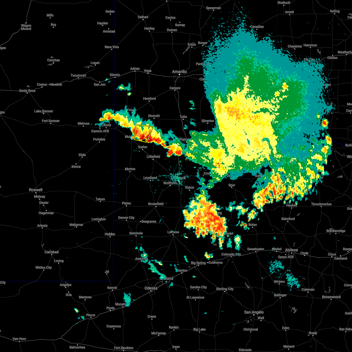 The severe thunderstorm warning for northeastern bailey, southeastern parmer, southwestern castro and northwestern lamb counties will expire at 130 am cdt, the storm which prompted the warning has weakened below severe limits, and no longer poses an immediate threat to life or property. therefore, the warning will be allowed to expire. however hail up to the size of pennies and gusty winds are still possible with this thunderstorm. The severe thunderstorm warning for northeastern bailey, southeastern parmer, southwestern castro and northwestern lamb counties will expire at 130 am cdt, the storm which prompted the warning has weakened below severe limits, and no longer poses an immediate threat to life or property. therefore, the warning will be allowed to expire. however hail up to the size of pennies and gusty winds are still possible with this thunderstorm.
|
| 5/25/2021 1:09 AM CDT |
 At 108 am cdt, a severe thunderstorm was located 5 miles west of earth, moving northeast at 10 mph (radar indicated). Hazards include 60 mph wind gusts and quarter size hail. Hail damage to vehicles is expected. expect wind damage to roofs, siding, and trees. Locations impacted include, earth and lazbuddie. At 108 am cdt, a severe thunderstorm was located 5 miles west of earth, moving northeast at 10 mph (radar indicated). Hazards include 60 mph wind gusts and quarter size hail. Hail damage to vehicles is expected. expect wind damage to roofs, siding, and trees. Locations impacted include, earth and lazbuddie.
|
| 5/25/2021 12:51 AM CDT |
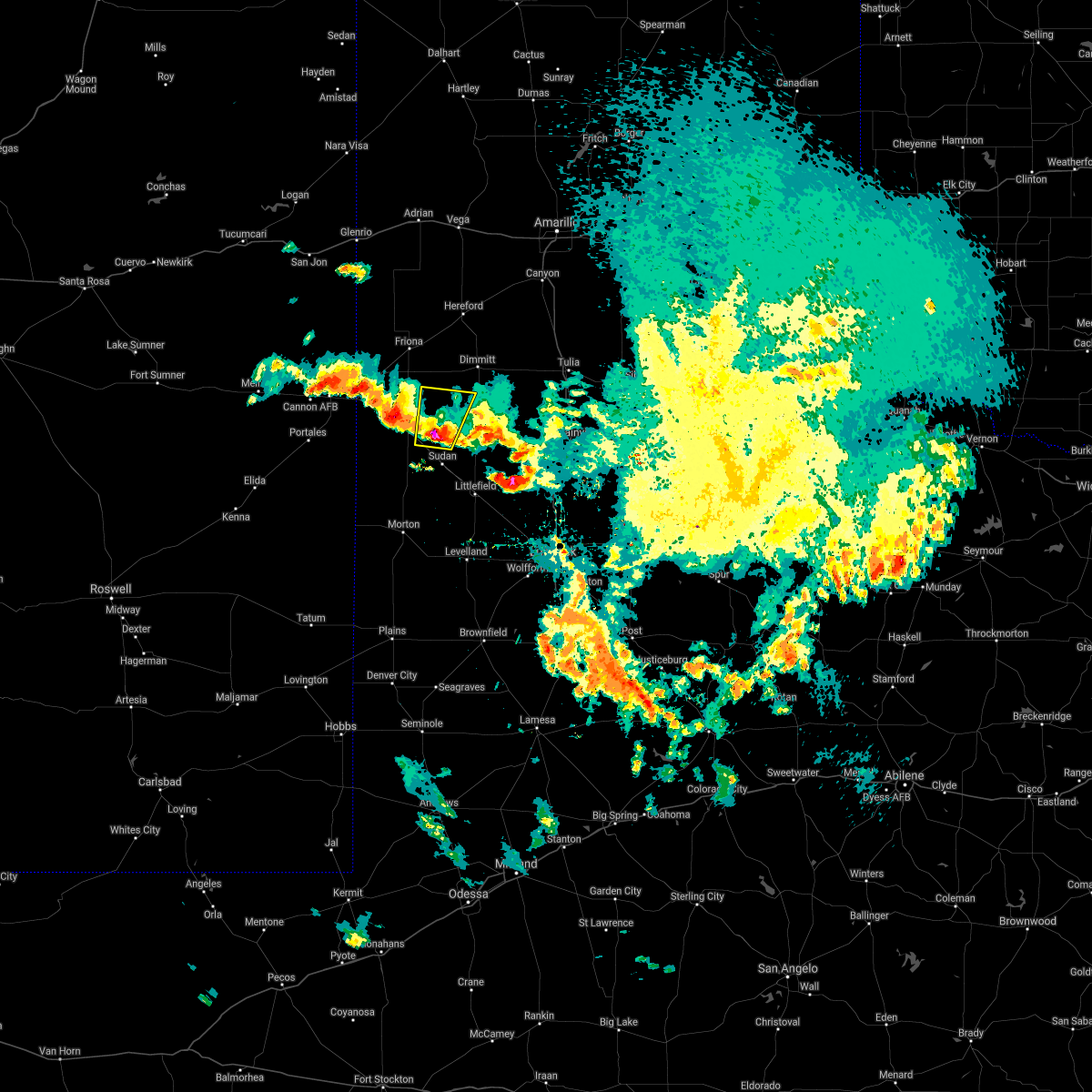 At 1250 am cdt, a severe thunderstorm was located 8 miles east of muleshoe, moving north at 10 mph (radar indicated). Hazards include ping pong ball size hail and 60 mph wind gusts. People and animals outdoors will be injured. expect hail damage to roofs, siding, windows, and vehicles. Expect wind damage to roofs, siding, and trees. At 1250 am cdt, a severe thunderstorm was located 8 miles east of muleshoe, moving north at 10 mph (radar indicated). Hazards include ping pong ball size hail and 60 mph wind gusts. People and animals outdoors will be injured. expect hail damage to roofs, siding, windows, and vehicles. Expect wind damage to roofs, siding, and trees.
|
| 5/24/2021 8:25 PM CDT |
 The severe thunderstorm warning for northwestern hale, southeastern castro, southern swisher and northern lamb counties will expire at 830 pm cdt, the storm which prompted the warning has weakened below severe limits, and no longer poses an immediate threat to life or property. therefore, the warning will be allowed to expire. however gusty winds are still possible with this thunderstorm. a severe thunderstorm watch remains in effect until 1100 pm cdt for the panhandle of and northwestern texas. The severe thunderstorm warning for northwestern hale, southeastern castro, southern swisher and northern lamb counties will expire at 830 pm cdt, the storm which prompted the warning has weakened below severe limits, and no longer poses an immediate threat to life or property. therefore, the warning will be allowed to expire. however gusty winds are still possible with this thunderstorm. a severe thunderstorm watch remains in effect until 1100 pm cdt for the panhandle of and northwestern texas.
|
| 5/24/2021 8:15 PM CDT |
 At 814 pm cdt, a severe thunderstorm was located 4 miles east of olton, moving northeast at 15 mph (radar indicated). Hazards include 60 mph wind gusts and quarter size hail. Hail damage to vehicles is expected. expect wind damage to roofs, siding, and trees. Locations impacted include, plainview, tulia, hale center, olton, hart, earth, kress, cotton center, fieldton, spade, claytonville, halfway, mackenzie reservoir, seth ward, edmonson and springlake. At 814 pm cdt, a severe thunderstorm was located 4 miles east of olton, moving northeast at 15 mph (radar indicated). Hazards include 60 mph wind gusts and quarter size hail. Hail damage to vehicles is expected. expect wind damage to roofs, siding, and trees. Locations impacted include, plainview, tulia, hale center, olton, hart, earth, kress, cotton center, fieldton, spade, claytonville, halfway, mackenzie reservoir, seth ward, edmonson and springlake.
|
| 5/24/2021 7:47 PM CDT |
 At 747 pm cdt, a severe thunderstorm was located near earth, moving northeast at 15 mph (radar indicated). Hazards include 60 mph wind gusts and quarter size hail. Hail damage to vehicles is expected. expect wind damage to roofs, siding, and trees. Locations impacted include, plainview, tulia, hale center, olton, hart, earth, kress, cotton center, fieldton, spade, claytonville, halfway, mackenzie reservoir, seth ward, nazareth, edmonson and springlake. At 747 pm cdt, a severe thunderstorm was located near earth, moving northeast at 15 mph (radar indicated). Hazards include 60 mph wind gusts and quarter size hail. Hail damage to vehicles is expected. expect wind damage to roofs, siding, and trees. Locations impacted include, plainview, tulia, hale center, olton, hart, earth, kress, cotton center, fieldton, spade, claytonville, halfway, mackenzie reservoir, seth ward, nazareth, edmonson and springlake.
|
| 5/24/2021 7:28 PM CDT |
 At 728 pm cdt, a cluster of severe thunderstorms were located 6 miles south of earth to near tulia, moving northeast at 15 mph (radar indicated). Hazards include 60 mph wind gusts and quarter size hail. Hail damage to vehicles is expected. Expect wind damage to roofs, siding, and trees. At 728 pm cdt, a cluster of severe thunderstorms were located 6 miles south of earth to near tulia, moving northeast at 15 mph (radar indicated). Hazards include 60 mph wind gusts and quarter size hail. Hail damage to vehicles is expected. Expect wind damage to roofs, siding, and trees.
|
| 5/24/2021 6:59 PM CDT |
 At 642 pm cdt, a cluster of severe thunderstorms were located 8 miles west of hart, moving northeast at 15 mph (radar indicated). Hazards include ping pong ball size hail and 60 mph wind gusts. People and animals outdoors will be injured. expect hail damage to roofs, siding, windows, and vehicles. expect wind damage to roofs, siding, and trees. Locations impacted include, olton, hart, earth, nazareth and springlake. At 642 pm cdt, a cluster of severe thunderstorms were located 8 miles west of hart, moving northeast at 15 mph (radar indicated). Hazards include ping pong ball size hail and 60 mph wind gusts. People and animals outdoors will be injured. expect hail damage to roofs, siding, windows, and vehicles. expect wind damage to roofs, siding, and trees. Locations impacted include, olton, hart, earth, nazareth and springlake.
|
| 5/24/2021 6:43 PM CDT |
 At 642 pm cdt, a cluster of severe thunderstorms were located 8 miles west of hart, moving northeast at 15 mph (radar indicated). Hazards include ping pong ball size hail and 60 mph wind gusts. People and animals outdoors will be injured. expect hail damage to roofs, siding, windows, and vehicles. expect wind damage to roofs, siding, and trees. Locations impacted include, olton, hart, earth, nazareth and springlake. At 642 pm cdt, a cluster of severe thunderstorms were located 8 miles west of hart, moving northeast at 15 mph (radar indicated). Hazards include ping pong ball size hail and 60 mph wind gusts. People and animals outdoors will be injured. expect hail damage to roofs, siding, windows, and vehicles. expect wind damage to roofs, siding, and trees. Locations impacted include, olton, hart, earth, nazareth and springlake.
|
| 5/24/2021 6:24 PM CDT |
 At 623 pm cdt, a cluster of severe thunderstorms were located 10 miles northeast of earth, moving northeast at 15 mph (radar indicated). Hazards include 60 mph wind gusts and quarter size hail. Hail damage to vehicles is expected. Expect wind damage to roofs, siding, and trees. At 623 pm cdt, a cluster of severe thunderstorms were located 10 miles northeast of earth, moving northeast at 15 mph (radar indicated). Hazards include 60 mph wind gusts and quarter size hail. Hail damage to vehicles is expected. Expect wind damage to roofs, siding, and trees.
|
| 5/18/2021 5:46 PM CDT |
 At 546 pm cdt, severe thunderstorms were located along a line extending from 5 miles south of buffalo lake to 3 miles northwest of littlefield, moving east at 25 mph (radar indicated). Hazards include 60 mph wind gusts and quarter size hail. Hail damage to vehicles is expected. Expect wind damage to roofs, siding, and trees. At 546 pm cdt, severe thunderstorms were located along a line extending from 5 miles south of buffalo lake to 3 miles northwest of littlefield, moving east at 25 mph (radar indicated). Hazards include 60 mph wind gusts and quarter size hail. Hail damage to vehicles is expected. Expect wind damage to roofs, siding, and trees.
|
| 5/17/2021 8:29 PM CDT |
 At 829 pm cdt, a severe thunderstorm was located 5 miles south of earth, moving east at 25 mph (radar indicated). Hazards include 60 mph wind gusts and quarter size hail. Hail damage to vehicles is expected. expect wind damage to roofs, siding, and trees. Locations impacted include, earth, sudan, amherst, fieldton and springlake. At 829 pm cdt, a severe thunderstorm was located 5 miles south of earth, moving east at 25 mph (radar indicated). Hazards include 60 mph wind gusts and quarter size hail. Hail damage to vehicles is expected. expect wind damage to roofs, siding, and trees. Locations impacted include, earth, sudan, amherst, fieldton and springlake.
|
| 5/17/2021 8:10 PM CDT |
 At 810 pm cdt, a severe thunderstorm was located 5 miles north of sudan, or 9 miles southwest of earth, moving east at 25 mph (radar indicated). Hazards include two inch hail and 60 mph wind gusts. People and animals outdoors will be injured. expect hail damage to roofs, siding, windows, and vehicles. expect wind damage to roofs, siding, and trees. Locations impacted include, earth, sudan, amherst, fieldton and springlake. At 810 pm cdt, a severe thunderstorm was located 5 miles north of sudan, or 9 miles southwest of earth, moving east at 25 mph (radar indicated). Hazards include two inch hail and 60 mph wind gusts. People and animals outdoors will be injured. expect hail damage to roofs, siding, windows, and vehicles. expect wind damage to roofs, siding, and trees. Locations impacted include, earth, sudan, amherst, fieldton and springlake.
|
| 5/17/2021 8:02 PM CDT |
 At 802 pm cdt, a severe thunderstorm was located 5 miles northwest of sudan, or 10 miles southeast of muleshoe, moving east at 25 mph (radar indicated). Hazards include two inch hail and 60 mph wind gusts. People and animals outdoors will be injured. expect hail damage to roofs, siding, windows, and vehicles. expect wind damage to roofs, siding, and trees. Locations impacted include, muleshoe, earth, sudan, amherst, fieldton and springlake. At 802 pm cdt, a severe thunderstorm was located 5 miles northwest of sudan, or 10 miles southeast of muleshoe, moving east at 25 mph (radar indicated). Hazards include two inch hail and 60 mph wind gusts. People and animals outdoors will be injured. expect hail damage to roofs, siding, windows, and vehicles. expect wind damage to roofs, siding, and trees. Locations impacted include, muleshoe, earth, sudan, amherst, fieldton and springlake.
|
| 5/17/2021 7:50 PM CDT |
 At 749 pm cdt, a severe thunderstorm was located 6 miles northeast of needmore, or 8 miles south of muleshoe, moving east at 25 mph. a second storm was located between earth and amherst, moving east at 25 mph (radar indicated). Hazards include two inch hail and 60 mph wind gusts. People and animals outdoors will be injured. expect hail damage to roofs, siding, windows, and vehicles. Expect wind damage to roofs, siding, and trees. At 749 pm cdt, a severe thunderstorm was located 6 miles northeast of needmore, or 8 miles south of muleshoe, moving east at 25 mph. a second storm was located between earth and amherst, moving east at 25 mph (radar indicated). Hazards include two inch hail and 60 mph wind gusts. People and animals outdoors will be injured. expect hail damage to roofs, siding, windows, and vehicles. Expect wind damage to roofs, siding, and trees.
|
| 5/16/2021 7:42 PM CDT |
 At 742 pm cdt, a confirmed tornado was located 5 miles northeast of sudan, or 8 miles south of earth, moving east at 10 mph (weather spotters confirmed tornado). Hazards include damaging tornado and ping pong ball size hail. Flying debris will be dangerous to those caught without shelter. mobile homes will be damaged or destroyed. damage to roofs, windows, and vehicles will occur. Tree damage is likely. At 742 pm cdt, a confirmed tornado was located 5 miles northeast of sudan, or 8 miles south of earth, moving east at 10 mph (weather spotters confirmed tornado). Hazards include damaging tornado and ping pong ball size hail. Flying debris will be dangerous to those caught without shelter. mobile homes will be damaged or destroyed. damage to roofs, windows, and vehicles will occur. Tree damage is likely.
|
| 5/16/2021 7:38 PM CDT |
 At 738 pm cdt, a severe thunderstorm was located near earth, moving northeast at 15 mph (trained weather spotters). Hazards include 60 mph wind gusts and quarter size hail. Hail damage to vehicles is expected. expect wind damage to roofs, siding, and trees. Locations impacted include, earth and springlake. At 738 pm cdt, a severe thunderstorm was located near earth, moving northeast at 15 mph (trained weather spotters). Hazards include 60 mph wind gusts and quarter size hail. Hail damage to vehicles is expected. expect wind damage to roofs, siding, and trees. Locations impacted include, earth and springlake.
|
| 5/16/2021 7:28 PM CDT | Ping Pong Ball sized hail reported 1.1 miles NNE of Earth, TX |
| 5/16/2021 7:17 PM CDT |
 At 716 pm cdt, a severe thunderstorm was located 6 miles southwest of earth, moving northeast at 15 mph (radar indicated). Hazards include 60 mph wind gusts and quarter size hail. Hail damage to vehicles is expected. Expect wind damage to roofs, siding, and trees. At 716 pm cdt, a severe thunderstorm was located 6 miles southwest of earth, moving northeast at 15 mph (radar indicated). Hazards include 60 mph wind gusts and quarter size hail. Hail damage to vehicles is expected. Expect wind damage to roofs, siding, and trees.
|
| 5/15/2021 5:50 PM CDT |
 At 550 pm cdt, a severe thunderstorm was located 4 miles northeast of amherst, or 10 miles north of littlefield, moving northeast at 10 mph (radar indicated). Hazards include 60 mph wind gusts and quarter size hail. Hail damage to vehicles is expected. expect wind damage to roofs, siding, and trees. Locations impacted include, earth, sudan, amherst, fieldton and springlake. At 550 pm cdt, a severe thunderstorm was located 4 miles northeast of amherst, or 10 miles north of littlefield, moving northeast at 10 mph (radar indicated). Hazards include 60 mph wind gusts and quarter size hail. Hail damage to vehicles is expected. expect wind damage to roofs, siding, and trees. Locations impacted include, earth, sudan, amherst, fieldton and springlake.
|
| 5/15/2021 5:33 PM CDT |
 At 532 pm cdt, a severe thunderstorm was located near sudan, or 13 miles northwest of littlefield, moving northeast at 10 mph (radar indicated). Hazards include 60 mph wind gusts and quarter size hail. Hail damage to vehicles is expected. expect wind damage to roofs, siding, and trees. Locations impacted include, littlefield, earth, sudan, amherst, fieldton and springlake. At 532 pm cdt, a severe thunderstorm was located near sudan, or 13 miles northwest of littlefield, moving northeast at 10 mph (radar indicated). Hazards include 60 mph wind gusts and quarter size hail. Hail damage to vehicles is expected. expect wind damage to roofs, siding, and trees. Locations impacted include, littlefield, earth, sudan, amherst, fieldton and springlake.
|
| 5/15/2021 5:18 PM CDT |
 At 518 pm cdt, a severe thunderstorm was located 4 miles south of sudan, or 11 miles northwest of littlefield, moving northeast at 15 mph (radar indicated). Hazards include 60 mph wind gusts and quarter size hail. Hail damage to vehicles is expected. Expect wind damage to roofs, siding, and trees. At 518 pm cdt, a severe thunderstorm was located 4 miles south of sudan, or 11 miles northwest of littlefield, moving northeast at 15 mph (radar indicated). Hazards include 60 mph wind gusts and quarter size hail. Hail damage to vehicles is expected. Expect wind damage to roofs, siding, and trees.
|
| 5/7/2021 7:04 PM CDT |
 At 703 pm cdt, severe thunderstorms were located along a line extending from earth to 6 miles southeast of bronco, moving east at 30 mph (radar indicated. at 635 pm, the muleshoe west texas mesonet measured a 68 mph wind gust). Hazards include 70 mph wind gusts and penny size hail. Expect considerable tree damage. damage is likely to mobile homes, roofs, and outbuildings. Locations impacted include, levelland, brownfield, littlefield, olton, morton, plains, earth, sundown, anton, sudan, amherst, needmore, fieldton, spade, tokio, bledsoe, locketville, maple, bronco and enochs. At 703 pm cdt, severe thunderstorms were located along a line extending from earth to 6 miles southeast of bronco, moving east at 30 mph (radar indicated. at 635 pm, the muleshoe west texas mesonet measured a 68 mph wind gust). Hazards include 70 mph wind gusts and penny size hail. Expect considerable tree damage. damage is likely to mobile homes, roofs, and outbuildings. Locations impacted include, levelland, brownfield, littlefield, olton, morton, plains, earth, sundown, anton, sudan, amherst, needmore, fieldton, spade, tokio, bledsoe, locketville, maple, bronco and enochs.
|
| 5/7/2021 6:43 PM CDT |
 At 643 pm cdt, severe thunderstorms were located along a line extending from 4 miles east of muleshoe to 6 miles northeast of bronco, moving east at 35 mph (radar indicated). Hazards include 70 mph wind gusts and penny size hail. Expect considerable tree damage. Damage is likely to mobile homes, roofs, and outbuildings. At 643 pm cdt, severe thunderstorms were located along a line extending from 4 miles east of muleshoe to 6 miles northeast of bronco, moving east at 35 mph (radar indicated). Hazards include 70 mph wind gusts and penny size hail. Expect considerable tree damage. Damage is likely to mobile homes, roofs, and outbuildings.
|
| 6/22/2020 11:37 PM CDT |
 The severe thunderstorm warning for east central bailey, northwestern hockley, northwestern hale and lamb counties will expire at 1145 pm cdt, the storms which prompted the warning have moved out of central lamb county. therefore, the warning will be allowed to expire. remember, a severe thunderstorm warning still remains in effect for northern hockley county and southern lamb county until 1230 am cdt. a severe thunderstorm watch remains in effect until 500 am cdt for northwestern texas. The severe thunderstorm warning for east central bailey, northwestern hockley, northwestern hale and lamb counties will expire at 1145 pm cdt, the storms which prompted the warning have moved out of central lamb county. therefore, the warning will be allowed to expire. remember, a severe thunderstorm warning still remains in effect for northern hockley county and southern lamb county until 1230 am cdt. a severe thunderstorm watch remains in effect until 500 am cdt for northwestern texas.
|
| 6/22/2020 11:19 PM CDT |
 At 1116 pm cdt, severe thunderstorms were located along a line extending from 7 miles northeast of olton to 6 miles southeast of pep, moving southeast at 25 mph. these are very dangerous storms (law enforcement. at 1110 pm cdt, downed power lines were reported in the city of littlefield). Hazards include 80 mph wind gusts and nickel size hail. Flying debris will be dangerous to those caught without shelter. mobile homes will be heavily damaged. expect considerable damage to roofs, windows, and vehicles. extensive tree damage and power outages are likely. Locations impacted include, levelland, littlefield, olton, earth, anton, sudan, amherst, fieldton, spade, halfway, whitharral, edmonson and springlake. At 1116 pm cdt, severe thunderstorms were located along a line extending from 7 miles northeast of olton to 6 miles southeast of pep, moving southeast at 25 mph. these are very dangerous storms (law enforcement. at 1110 pm cdt, downed power lines were reported in the city of littlefield). Hazards include 80 mph wind gusts and nickel size hail. Flying debris will be dangerous to those caught without shelter. mobile homes will be heavily damaged. expect considerable damage to roofs, windows, and vehicles. extensive tree damage and power outages are likely. Locations impacted include, levelland, littlefield, olton, earth, anton, sudan, amherst, fieldton, spade, halfway, whitharral, edmonson and springlake.
|
| 6/22/2020 10:57 PM CDT |
 At 1056 pm cdt, severe thunderstorms were located along a line extending from 3 miles south of hart to 6 miles east of bula, moving southeast at 25 mph (radar indicated). Hazards include 70 mph wind gusts and nickel size hail. Expect considerable tree damage. Damage is likely to mobile homes, roofs, and outbuildings. At 1056 pm cdt, severe thunderstorms were located along a line extending from 3 miles south of hart to 6 miles east of bula, moving southeast at 25 mph (radar indicated). Hazards include 70 mph wind gusts and nickel size hail. Expect considerable tree damage. Damage is likely to mobile homes, roofs, and outbuildings.
|
| 6/22/2020 10:40 PM CDT |
 At 1040 pm cdt, severe thunderstorms were located along a line extending from 8 miles south of silverton to 8 miles southwest of hart, moving southeast at 30 mph (radar indicated). Hazards include 60 mph wind gusts and quarter size hail. Hail damage to vehicles is expected. expect wind damage to roofs, siding, and trees. Locations impacted include, plainview, tulia, dimmitt, friona, olton, hart, earth, silverton, kress, lazbuddie, south plains, claytonville, mackenzie reservoir, aiken, halfway, seth ward, nazareth, edmonson and springlake. At 1040 pm cdt, severe thunderstorms were located along a line extending from 8 miles south of silverton to 8 miles southwest of hart, moving southeast at 30 mph (radar indicated). Hazards include 60 mph wind gusts and quarter size hail. Hail damage to vehicles is expected. expect wind damage to roofs, siding, and trees. Locations impacted include, plainview, tulia, dimmitt, friona, olton, hart, earth, silverton, kress, lazbuddie, south plains, claytonville, mackenzie reservoir, aiken, halfway, seth ward, nazareth, edmonson and springlake.
|
| 6/22/2020 10:21 PM CDT |
 At 1021 pm cdt, severe thunderstorms were located along a line extending from 7 miles northeast of claytonville to 9 miles east of lazbuddie, moving southeast at 40 mph (radar indicated). Hazards include 60 mph wind gusts and quarter size hail. Hail damage to vehicles is expected. expect wind damage to roofs, siding, and trees. Locations impacted include, plainview, tulia, dimmitt, friona, olton, hart, earth, silverton, kress, happy, summerfield, vigo park, easter, lazbuddie, south plains, claytonville, mackenzie reservoir, aiken, black and halfway. At 1021 pm cdt, severe thunderstorms were located along a line extending from 7 miles northeast of claytonville to 9 miles east of lazbuddie, moving southeast at 40 mph (radar indicated). Hazards include 60 mph wind gusts and quarter size hail. Hail damage to vehicles is expected. expect wind damage to roofs, siding, and trees. Locations impacted include, plainview, tulia, dimmitt, friona, olton, hart, earth, silverton, kress, happy, summerfield, vigo park, easter, lazbuddie, south plains, claytonville, mackenzie reservoir, aiken, black and halfway.
|
| 6/22/2020 9:59 PM CDT |
 The national weather service in lubbock texas has issued a * severe thunderstorm warning for. northern floyd county in northwestern texas. eastern parmer county in the panhandle of texas. northern hale county in northwestern texas. Castro county in the panhandle of texas. The national weather service in lubbock texas has issued a * severe thunderstorm warning for. northern floyd county in northwestern texas. eastern parmer county in the panhandle of texas. northern hale county in northwestern texas. Castro county in the panhandle of texas.
|
| 6/19/2020 5:15 PM CDT |
 At 515 pm cdt, a severe thunderstorm was located 6 miles southeast of earth, moving northeast at 20 mph (radar indicated). Hazards include 60 mph wind gusts and quarter size hail. Hail damage to vehicles is expected. expect wind damage to roofs, siding, and trees. Locations impacted include, littlefield, olton, earth, amherst, fieldton and springlake. At 515 pm cdt, a severe thunderstorm was located 6 miles southeast of earth, moving northeast at 20 mph (radar indicated). Hazards include 60 mph wind gusts and quarter size hail. Hail damage to vehicles is expected. expect wind damage to roofs, siding, and trees. Locations impacted include, littlefield, olton, earth, amherst, fieldton and springlake.
|
| 6/19/2020 4:47 PM CDT |
 At 447 pm cdt, a severe thunderstorm was located over sudan, or 12 miles southwest of earth, moving northeast at 20 mph (radar indicated). Hazards include 60 mph wind gusts and quarter size hail. Hail damage to vehicles is expected. Expect wind damage to roofs, siding, and trees. At 447 pm cdt, a severe thunderstorm was located over sudan, or 12 miles southwest of earth, moving northeast at 20 mph (radar indicated). Hazards include 60 mph wind gusts and quarter size hail. Hail damage to vehicles is expected. Expect wind damage to roofs, siding, and trees.
|
| 6/17/2020 5:17 PM CDT |
 At 517 pm cdt, severe thunderstorms were located along a line extending from 3 miles north of earth to 9 miles southwest of locketville, moving east at 40 mph (radar indicated). Hazards include 70 mph wind gusts and nickel size hail. Expect considerable tree damage. damage is likely to mobile homes, roofs, and outbuildings. Locations impacted include, levelland, littlefield, olton, earth, anton, sudan, amherst, fieldton, spade, whitharral, pep, smyer, whiteface, ropesville, opdyke west and springlake. At 517 pm cdt, severe thunderstorms were located along a line extending from 3 miles north of earth to 9 miles southwest of locketville, moving east at 40 mph (radar indicated). Hazards include 70 mph wind gusts and nickel size hail. Expect considerable tree damage. damage is likely to mobile homes, roofs, and outbuildings. Locations impacted include, levelland, littlefield, olton, earth, anton, sudan, amherst, fieldton, spade, whitharral, pep, smyer, whiteface, ropesville, opdyke west and springlake.
|
| 6/17/2020 5:11 PM CDT |
 At 511 pm cdt, severe thunderstorms were located along a line extending from 3 miles northwest of earth to 9 miles northeast of tokio, moving east at 40 mph (radar indicated). Hazards include 70 mph wind gusts and penny size hail. Expect considerable tree damage. Damage is likely to mobile homes, roofs, and outbuildings. At 511 pm cdt, severe thunderstorms were located along a line extending from 3 miles northwest of earth to 9 miles northeast of tokio, moving east at 40 mph (radar indicated). Hazards include 70 mph wind gusts and penny size hail. Expect considerable tree damage. Damage is likely to mobile homes, roofs, and outbuildings.
|
| 5/23/2020 4:19 PM CDT |
 At 418 pm cdt, a severe thunderstorm was located 7 miles east of earth, moving northeast at 25 mph (radar indicated). Hazards include 60 mph wind gusts and quarter size hail. Hail damage to vehicles is expected. Expect wind damage to roofs, siding, and trees. At 418 pm cdt, a severe thunderstorm was located 7 miles east of earth, moving northeast at 25 mph (radar indicated). Hazards include 60 mph wind gusts and quarter size hail. Hail damage to vehicles is expected. Expect wind damage to roofs, siding, and trees.
|
| 5/20/2020 4:55 PM CDT |
 The severe thunderstorm warning for southeastern castro and northeastern lamb counties will expire at 500 pm cdt, the severe thunderstorm which prompted the warning has weakened. therefore, the warning will be allowed to expire. a severe thunderstorm watch remains in effect until midnight cdt for the panhandle of and northwestern texas. remember, a severe thunderstorm warning still remains in effect for north central castro county. The severe thunderstorm warning for southeastern castro and northeastern lamb counties will expire at 500 pm cdt, the severe thunderstorm which prompted the warning has weakened. therefore, the warning will be allowed to expire. a severe thunderstorm watch remains in effect until midnight cdt for the panhandle of and northwestern texas. remember, a severe thunderstorm warning still remains in effect for north central castro county.
|
| 5/20/2020 4:35 PM CDT |
 At 435 pm cdt, a severe thunderstorm was located 7 miles northeast of earth, moving northeast at 15 mph (radar indicated). Hazards include 60 mph wind gusts and quarter size hail. Hail damage to vehicles is expected. expect wind damage to roofs, siding, and trees. Locations impacted include, hart, earth and springlake. At 435 pm cdt, a severe thunderstorm was located 7 miles northeast of earth, moving northeast at 15 mph (radar indicated). Hazards include 60 mph wind gusts and quarter size hail. Hail damage to vehicles is expected. expect wind damage to roofs, siding, and trees. Locations impacted include, hart, earth and springlake.
|
| 5/20/2020 4:06 PM CDT |
 At 405 pm cdt, a severe thunderstorm was located near earth, moving northeast at 20 mph (radar indicated). Hazards include ping pong ball size hail and 60 mph wind gusts. People and animals outdoors will be injured. expect hail damage to roofs, siding, windows, and vehicles. Expect wind damage to roofs, siding, and trees. At 405 pm cdt, a severe thunderstorm was located near earth, moving northeast at 20 mph (radar indicated). Hazards include ping pong ball size hail and 60 mph wind gusts. People and animals outdoors will be injured. expect hail damage to roofs, siding, windows, and vehicles. Expect wind damage to roofs, siding, and trees.
|
| 3/17/2020 8:29 AM CDT |
 At 828 am cdt, severe thunderstorms were located along a line extending from 3 miles northeast of needmore to pep to 7 miles northwest of sundown, moving northeast at 40 mph (radar indicated). Hazards include 60 mph wind gusts and quarter size hail. Hail damage to vehicles is expected. expect wind damage to roofs, siding, and trees. Locations impacted include, littlefield, sundown, sudan, amherst, needmore, bula, pep and whiteface. At 828 am cdt, severe thunderstorms were located along a line extending from 3 miles northeast of needmore to pep to 7 miles northwest of sundown, moving northeast at 40 mph (radar indicated). Hazards include 60 mph wind gusts and quarter size hail. Hail damage to vehicles is expected. expect wind damage to roofs, siding, and trees. Locations impacted include, littlefield, sundown, sudan, amherst, needmore, bula, pep and whiteface.
|
| 3/17/2020 8:19 AM CDT |
 At 752 am cdt, severe thunderstorms were located along a line extending from 4 miles west of maple to 3 miles southwest of lehman to 16 miles north of plains, moving east at 30 mph. the strongest portions of the storm will impact lehman and morton (radar indicated). Hazards include 60 mph wind gusts and quarter size hail. Hail damage to vehicles is expected. expect wind damage to roofs, siding, and trees. Locations impacted include, littlefield, morton, earth, sundown, sudan, amherst, needmore, bledsoe, enochs, muleshoe wildlife refuge, bula, pep, lehman, maple and whiteface. At 752 am cdt, severe thunderstorms were located along a line extending from 4 miles west of maple to 3 miles southwest of lehman to 16 miles north of plains, moving east at 30 mph. the strongest portions of the storm will impact lehman and morton (radar indicated). Hazards include 60 mph wind gusts and quarter size hail. Hail damage to vehicles is expected. expect wind damage to roofs, siding, and trees. Locations impacted include, littlefield, morton, earth, sundown, sudan, amherst, needmore, bledsoe, enochs, muleshoe wildlife refuge, bula, pep, lehman, maple and whiteface.
|
| 3/17/2020 7:53 AM CDT |
 At 752 am cdt, severe thunderstorms were located along a line extending from 4 miles west of maple to 3 miles southwest of lehman to 16 miles north of plains, moving east at 30 mph. the strongest portions of the storm will impact lehman and morton (radar indicated). Hazards include 60 mph wind gusts and quarter size hail. Hail damage to vehicles is expected. expect wind damage to roofs, siding, and trees. Locations impacted include, littlefield, morton, earth, sundown, sudan, amherst, needmore, bledsoe, enochs, muleshoe wildlife refuge, bula, pep, lehman, maple and whiteface. At 752 am cdt, severe thunderstorms were located along a line extending from 4 miles west of maple to 3 miles southwest of lehman to 16 miles north of plains, moving east at 30 mph. the strongest portions of the storm will impact lehman and morton (radar indicated). Hazards include 60 mph wind gusts and quarter size hail. Hail damage to vehicles is expected. expect wind damage to roofs, siding, and trees. Locations impacted include, littlefield, morton, earth, sundown, sudan, amherst, needmore, bledsoe, enochs, muleshoe wildlife refuge, bula, pep, lehman, maple and whiteface.
|
| 3/17/2020 7:38 AM CDT |
 At 738 am cdt, severe thunderstorms were located along a line extending from 4 miles east of lingo to 14 miles south of bledsoe to 4 miles northeast of bronco, moving northeast at 40 mph (radar indicated). Hazards include 60 mph wind gusts and quarter size hail. Hail damage to vehicles is expected. Expect wind damage to roofs, siding, and trees. At 738 am cdt, severe thunderstorms were located along a line extending from 4 miles east of lingo to 14 miles south of bledsoe to 4 miles northeast of bronco, moving northeast at 40 mph (radar indicated). Hazards include 60 mph wind gusts and quarter size hail. Hail damage to vehicles is expected. Expect wind damage to roofs, siding, and trees.
|
| 9/28/2019 7:07 PM CDT |
 At 706 pm cdt, a severe thunderstorm was located over earth, moving northeast at 40 mph. this is a very dangerous storm (radar indicated. at 700 pm cdt the west texas mesonet located at earth reported a wind gust of 73 mph). Hazards include 80 mph wind gusts and ping pong ball size hail. Flying debris will be dangerous to those caught without shelter. mobile homes will be heavily damaged. expect considerable damage to roofs, windows, and vehicles. extensive tree damage and power outages are likely. Locations impacted include, olton, hart, earth and springlake. At 706 pm cdt, a severe thunderstorm was located over earth, moving northeast at 40 mph. this is a very dangerous storm (radar indicated. at 700 pm cdt the west texas mesonet located at earth reported a wind gust of 73 mph). Hazards include 80 mph wind gusts and ping pong ball size hail. Flying debris will be dangerous to those caught without shelter. mobile homes will be heavily damaged. expect considerable damage to roofs, windows, and vehicles. extensive tree damage and power outages are likely. Locations impacted include, olton, hart, earth and springlake.
|
| 9/28/2019 6:59 PM CDT |
 At 659 pm cdt, a severe thunderstorm was located 5 miles southwest of earth, moving northeast at 40 mph. this is a very dangerous storm (radar indicated). Hazards include 80 mph wind gusts and tennis ball size hail. Flying debris will be dangerous to those caught without shelter. mobile homes will be heavily damaged. expect considerable damage to roofs, windows, and vehicles. extensive tree damage and power outages are likely. Locations impacted include, olton, hart, earth, sudan and springlake. At 659 pm cdt, a severe thunderstorm was located 5 miles southwest of earth, moving northeast at 40 mph. this is a very dangerous storm (radar indicated). Hazards include 80 mph wind gusts and tennis ball size hail. Flying debris will be dangerous to those caught without shelter. mobile homes will be heavily damaged. expect considerable damage to roofs, windows, and vehicles. extensive tree damage and power outages are likely. Locations impacted include, olton, hart, earth, sudan and springlake.
|
| 9/28/2019 6:52 PM CDT |
 At 651 pm cdt, a severe thunderstorm was located near sudan, or 10 miles southwest of earth, moving northeast at 40 mph (radar indicated). Hazards include 70 mph wind gusts and half dollar size hail. Hail damage to vehicles is expected. expect considerable tree damage. Wind damage is also likely to mobile homes, roofs, and outbuildings. At 651 pm cdt, a severe thunderstorm was located near sudan, or 10 miles southwest of earth, moving northeast at 40 mph (radar indicated). Hazards include 70 mph wind gusts and half dollar size hail. Hail damage to vehicles is expected. expect considerable tree damage. Wind damage is also likely to mobile homes, roofs, and outbuildings.
|
| 7/10/2019 3:26 PM CDT |
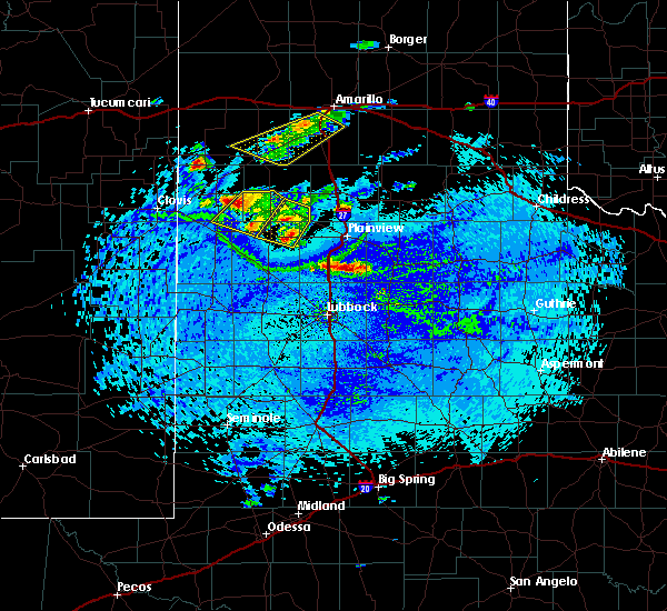 The severe thunderstorm warning for northeastern bailey, southeastern parmer, southwestern castro and northwestern lamb counties will expire at 330 pm cdt, the storm which prompted the warning has weakened below severe limits, and no longer poses an immediate threat to life or property. therefore, the warning will be allowed to expire. however gusty winds and heavy rain are still possible with this thunderstorm. The severe thunderstorm warning for northeastern bailey, southeastern parmer, southwestern castro and northwestern lamb counties will expire at 330 pm cdt, the storm which prompted the warning has weakened below severe limits, and no longer poses an immediate threat to life or property. therefore, the warning will be allowed to expire. however gusty winds and heavy rain are still possible with this thunderstorm.
|
| 7/10/2019 3:25 PM CDT |
 The severe thunderstorm warning for southeastern castro, northwestern hale and northeastern lamb counties will expire at 330 pm cdt, the storm which prompted the warning has weakened below severe limits, and no longer poses an immediate threat to life or property. therefore, the warning will be allowed to expire. however gusty winds and heavy rain are still possible with this thunderstorm. The severe thunderstorm warning for southeastern castro, northwestern hale and northeastern lamb counties will expire at 330 pm cdt, the storm which prompted the warning has weakened below severe limits, and no longer poses an immediate threat to life or property. therefore, the warning will be allowed to expire. however gusty winds and heavy rain are still possible with this thunderstorm.
|
| 7/10/2019 3:11 PM CDT |
 At 310 pm cdt, a severe thunderstorm was located 5 miles west of hart, moving southwest at 15 mph (radar indicated). Hazards include 60 mph wind gusts and quarter size hail. Hail damage to vehicles is expected. expect wind damage to roofs, siding, and trees. Locations impacted include, olton, hart, earth and springlake. At 310 pm cdt, a severe thunderstorm was located 5 miles west of hart, moving southwest at 15 mph (radar indicated). Hazards include 60 mph wind gusts and quarter size hail. Hail damage to vehicles is expected. expect wind damage to roofs, siding, and trees. Locations impacted include, olton, hart, earth and springlake.
|
| 7/10/2019 3:09 PM CDT |
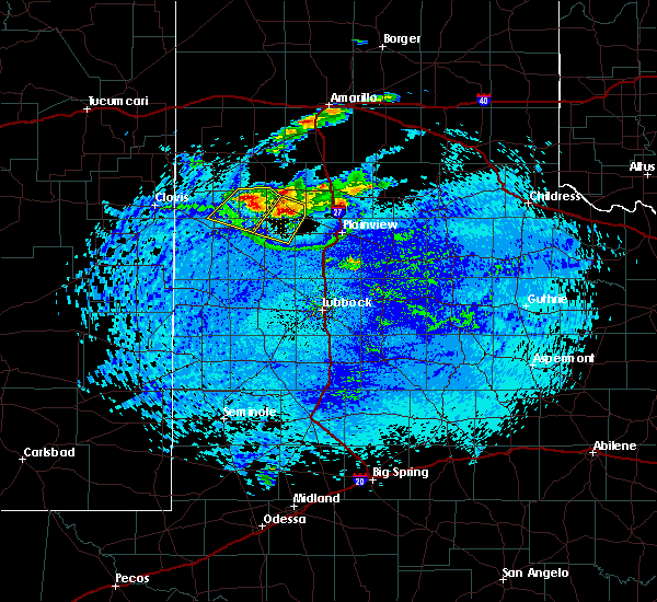 At 309 pm cdt, a severe thunderstorm was located 7 miles north of earth, moving southwest at 25 mph (radar indicated). Hazards include 60 mph wind gusts and quarter size hail. Hail damage to vehicles is expected. expect wind damage to roofs, siding, and trees. Locations impacted include, dimmitt, earth and lazbuddie. At 309 pm cdt, a severe thunderstorm was located 7 miles north of earth, moving southwest at 25 mph (radar indicated). Hazards include 60 mph wind gusts and quarter size hail. Hail damage to vehicles is expected. expect wind damage to roofs, siding, and trees. Locations impacted include, dimmitt, earth and lazbuddie.
|
| 7/10/2019 2:57 PM CDT |
 At 257 pm cdt, a severe thunderstorm was located over hart, moving southwest at 15 mph (radar indicated). Hazards include 60 mph wind gusts and quarter size hail. Hail damage to vehicles is expected. Expect wind damage to roofs, siding, and trees. At 257 pm cdt, a severe thunderstorm was located over hart, moving southwest at 15 mph (radar indicated). Hazards include 60 mph wind gusts and quarter size hail. Hail damage to vehicles is expected. Expect wind damage to roofs, siding, and trees.
|
| 7/10/2019 2:51 PM CDT |
 At 251 pm cdt, a severe thunderstorm was located 10 miles south of dimmitt, moving southwest at 20 mph (radar indicated). Hazards include 60 mph wind gusts and quarter size hail. Hail damage to vehicles is expected. Expect wind damage to roofs, siding, and trees. At 251 pm cdt, a severe thunderstorm was located 10 miles south of dimmitt, moving southwest at 20 mph (radar indicated). Hazards include 60 mph wind gusts and quarter size hail. Hail damage to vehicles is expected. Expect wind damage to roofs, siding, and trees.
|
| 6/18/2019 6:55 PM CDT |
 At 654 pm cdt, a severe thunderstorm was located 4 miles southwest of earth, moving east at 35 mph (radar indicated). Hazards include 70 mph wind gusts and ping pong ball size hail. People and animals outdoors will be injured. expect hail damage to roofs, siding, windows, and vehicles. expect considerable tree damage. wind damage is also likely to mobile homes, roofs, and outbuildings. Locations impacted include, muleshoe, olton, earth, sudan, needmore and springlake. At 654 pm cdt, a severe thunderstorm was located 4 miles southwest of earth, moving east at 35 mph (radar indicated). Hazards include 70 mph wind gusts and ping pong ball size hail. People and animals outdoors will be injured. expect hail damage to roofs, siding, windows, and vehicles. expect considerable tree damage. wind damage is also likely to mobile homes, roofs, and outbuildings. Locations impacted include, muleshoe, olton, earth, sudan, needmore and springlake.
|
| 6/18/2019 6:29 PM CDT |
 At 628 pm cdt, a severe thunderstorm was located 11 miles east of arch, or 16 miles southwest of muleshoe, moving east at 30 mph (radar indicated). Hazards include 70 mph wind gusts and ping pong ball size hail. People and animals outdoors will be injured. expect hail damage to roofs, siding, windows, and vehicles. expect considerable tree damage. Wind damage is also likely to mobile homes, roofs, and outbuildings. At 628 pm cdt, a severe thunderstorm was located 11 miles east of arch, or 16 miles southwest of muleshoe, moving east at 30 mph (radar indicated). Hazards include 70 mph wind gusts and ping pong ball size hail. People and animals outdoors will be injured. expect hail damage to roofs, siding, windows, and vehicles. expect considerable tree damage. Wind damage is also likely to mobile homes, roofs, and outbuildings.
|
| 6/17/2019 9:13 PM CDT |
 At 912 pm cdt, a severe thunderstorm was located 6 miles south of earth, moving east at 15 mph (radar indicated). Hazards include 60 mph wind gusts and quarter size hail. Hail damage to vehicles is expected. expect wind damage to roofs, siding, and trees. Locations impacted include, olton, earth, fieldton and springlake. At 912 pm cdt, a severe thunderstorm was located 6 miles south of earth, moving east at 15 mph (radar indicated). Hazards include 60 mph wind gusts and quarter size hail. Hail damage to vehicles is expected. expect wind damage to roofs, siding, and trees. Locations impacted include, olton, earth, fieldton and springlake.
|
| 6/17/2019 8:59 PM CDT |
 At 858 pm cdt, a severe thunderstorm was located 6 miles south of earth, moving east at 15 mph (radar indicated). Hazards include 60 mph wind gusts and half dollar size hail. Hail damage to vehicles is expected. Expect wind damage to roofs, siding, and trees. At 858 pm cdt, a severe thunderstorm was located 6 miles south of earth, moving east at 15 mph (radar indicated). Hazards include 60 mph wind gusts and half dollar size hail. Hail damage to vehicles is expected. Expect wind damage to roofs, siding, and trees.
|
| 6/15/2019 4:20 PM CDT |
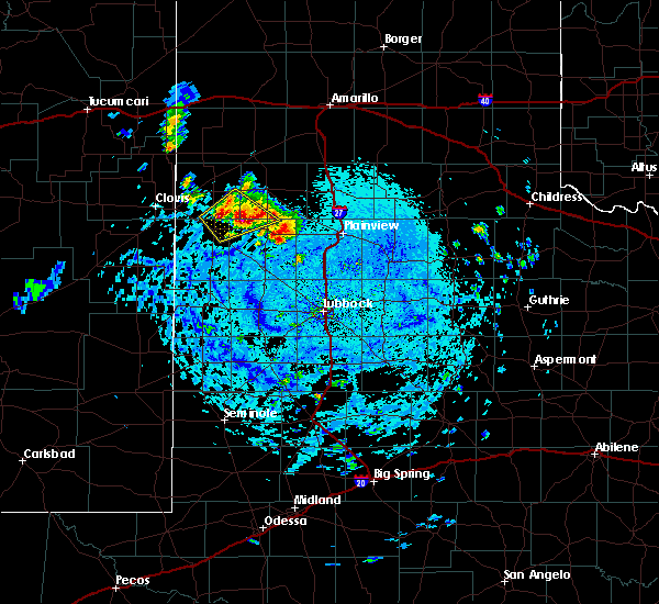 At 420 pm cdt, a severe thunderstorm was located 6 miles northwest of earth, moving northeast at 20 mph (radar indicated). Hazards include 70 mph wind gusts and quarter size hail. Hail damage to vehicles is expected. expect considerable tree damage. wind damage is also likely to mobile homes, roofs, and outbuildings. Locations impacted include, earth and lazbuddie. At 420 pm cdt, a severe thunderstorm was located 6 miles northwest of earth, moving northeast at 20 mph (radar indicated). Hazards include 70 mph wind gusts and quarter size hail. Hail damage to vehicles is expected. expect considerable tree damage. wind damage is also likely to mobile homes, roofs, and outbuildings. Locations impacted include, earth and lazbuddie.
|
| 6/15/2019 4:08 PM CDT |
 At 408 pm cdt, a severe thunderstorm was located 7 miles west of earth, moving northeast at 20 mph (radar indicated). Hazards include 70 mph wind gusts and quarter size hail. Hail damage to vehicles is expected. expect considerable tree damage. wind damage is also likely to mobile homes, roofs, and outbuildings. Locations impacted include, earth and lazbuddie. At 408 pm cdt, a severe thunderstorm was located 7 miles west of earth, moving northeast at 20 mph (radar indicated). Hazards include 70 mph wind gusts and quarter size hail. Hail damage to vehicles is expected. expect considerable tree damage. wind damage is also likely to mobile homes, roofs, and outbuildings. Locations impacted include, earth and lazbuddie.
|
| 6/15/2019 3:44 PM CDT |
 At 344 pm cdt, a severe thunderstorm was located over muleshoe, moving northeast at 25 mph (radar indicated). Hazards include 70 mph wind gusts and quarter size hail. Hail damage to vehicles is expected. expect considerable tree damage. Wind damage is also likely to mobile homes, roofs, and outbuildings. At 344 pm cdt, a severe thunderstorm was located over muleshoe, moving northeast at 25 mph (radar indicated). Hazards include 70 mph wind gusts and quarter size hail. Hail damage to vehicles is expected. expect considerable tree damage. Wind damage is also likely to mobile homes, roofs, and outbuildings.
|
| 5/26/2019 9:59 PM CDT |
 At 959 pm cdt, a confirmed tornado was located 6 miles west of earth, moving northeast at 45 mph (weather spotters confirmed tornado). Hazards include damaging tornado and hail up to two inches in diameter. Flying debris will be dangerous to those caught without shelter. mobile homes will be damaged or destroyed. damage to roofs, windows, and vehicles will occur. Tree damage is likely. At 959 pm cdt, a confirmed tornado was located 6 miles west of earth, moving northeast at 45 mph (weather spotters confirmed tornado). Hazards include damaging tornado and hail up to two inches in diameter. Flying debris will be dangerous to those caught without shelter. mobile homes will be damaged or destroyed. damage to roofs, windows, and vehicles will occur. Tree damage is likely.
|
| 5/25/2019 4:41 PM CDT |
 At 440 pm cdt, a severe thunderstorm was located near olton, moving northeast at 40 mph. this is a very dangerous storm (radar indicated). Hazards include 80 mph wind gusts and two inch hail. Flying debris will be dangerous to those caught without shelter. mobile homes will be heavily damaged. expect considerable damage to roofs, windows, and vehicles. extensive tree damage and power outages are likely. Locations impacted include, plainview, olton, earth, sudan, amherst, fieldton, halfway, seth ward, edmonson and springlake. At 440 pm cdt, a severe thunderstorm was located near olton, moving northeast at 40 mph. this is a very dangerous storm (radar indicated). Hazards include 80 mph wind gusts and two inch hail. Flying debris will be dangerous to those caught without shelter. mobile homes will be heavily damaged. expect considerable damage to roofs, windows, and vehicles. extensive tree damage and power outages are likely. Locations impacted include, plainview, olton, earth, sudan, amherst, fieldton, halfway, seth ward, edmonson and springlake.
|
| 5/25/2019 4:20 PM CDT |
 At 420 pm cdt, a severe thunderstorm was located near littlefield, moving northeast at 35 mph. this is a very dangerous storm (radar indicated). Hazards include 80 mph wind gusts and ping pong ball size hail. Flying debris will be dangerous to those caught without shelter. mobile homes will be heavily damaged. expect considerable damage to roofs, windows, and vehicles. extensive tree damage and power outages are likely. Locations impacted include, plainview, littlefield, olton, hart, earth, sudan, amherst, fieldton, halfway, bula, pep, spade, seth ward, edmonson and springlake. At 420 pm cdt, a severe thunderstorm was located near littlefield, moving northeast at 35 mph. this is a very dangerous storm (radar indicated). Hazards include 80 mph wind gusts and ping pong ball size hail. Flying debris will be dangerous to those caught without shelter. mobile homes will be heavily damaged. expect considerable damage to roofs, windows, and vehicles. extensive tree damage and power outages are likely. Locations impacted include, plainview, littlefield, olton, hart, earth, sudan, amherst, fieldton, halfway, bula, pep, spade, seth ward, edmonson and springlake.
|
| 5/25/2019 3:55 PM CDT |
 At 355 pm cdt, a severe thunderstorm was located 5 miles southwest of amherst, or 8 miles west of littlefield, moving northeast at 40 mph (radar indicated). Hazards include ping pong ball size hail and 60 mph wind gusts. People and animals outdoors will be injured. expect hail damage to roofs, siding, windows, and vehicles. Expect wind damage to roofs, siding, and trees. At 355 pm cdt, a severe thunderstorm was located 5 miles southwest of amherst, or 8 miles west of littlefield, moving northeast at 40 mph (radar indicated). Hazards include ping pong ball size hail and 60 mph wind gusts. People and animals outdoors will be injured. expect hail damage to roofs, siding, windows, and vehicles. Expect wind damage to roofs, siding, and trees.
|
| 5/23/2019 5:12 PM CDT |
 At 511 pm cdt, a severe thunderstorm was located 6 miles southeast of earth, moving northeast at 60 mph (radar indicated). Hazards include ping pong ball size hail and 60 mph wind gusts. People and animals outdoors will be injured. expect hail damage to roofs, siding, windows, and vehicles. Expect wind damage to roofs, siding, and trees. At 511 pm cdt, a severe thunderstorm was located 6 miles southeast of earth, moving northeast at 60 mph (radar indicated). Hazards include ping pong ball size hail and 60 mph wind gusts. People and animals outdoors will be injured. expect hail damage to roofs, siding, windows, and vehicles. Expect wind damage to roofs, siding, and trees.
|
| 5/8/2019 11:29 PM CDT |
 At 1129 pm cdt, severe thunderstorms were located along a line extending from 4 miles north of sudan to 7 miles northwest of levelland, moving east at 30 mph (radar indicated). Hazards include 60 mph wind gusts and quarter size hail. Hail damage to vehicles is expected. expect wind damage to roofs, siding and trees. Locations impacted include, levelland, littlefield, olton, earth, anton and sudan. At 1129 pm cdt, severe thunderstorms were located along a line extending from 4 miles north of sudan to 7 miles northwest of levelland, moving east at 30 mph (radar indicated). Hazards include 60 mph wind gusts and quarter size hail. Hail damage to vehicles is expected. expect wind damage to roofs, siding and trees. Locations impacted include, levelland, littlefield, olton, earth, anton and sudan.
|
| 5/8/2019 11:06 PM CDT |
 At 1106 pm cdt, severe thunderstorms were located along a line extending from 4 miles northeast of needmore, moving east at 25 mph (radar indicated). Hazards include 60 mph wind gusts and quarter size hail. Hail damage to vehicles is expected. Expect wind damage to roofs, siding and trees. At 1106 pm cdt, severe thunderstorms were located along a line extending from 4 miles northeast of needmore, moving east at 25 mph (radar indicated). Hazards include 60 mph wind gusts and quarter size hail. Hail damage to vehicles is expected. Expect wind damage to roofs, siding and trees.
|
| 5/8/2019 9:37 PM CDT |
 At 936 pm cdt, a severe thunderstorm was located 9 miles east of lazbuddie, or 10 miles southwest of dimmitt, moving east at 25 mph. this storm continues to exhibit good rotation above the base of the storm (radar indicated). Hazards include 60 mph wind gusts and half dollar size hail. Hail damage to vehicles is expected. expect wind damage to roofs, siding, and trees. Locations impacted include, dimmitt, earth, nazareth and springlake. At 936 pm cdt, a severe thunderstorm was located 9 miles east of lazbuddie, or 10 miles southwest of dimmitt, moving east at 25 mph. this storm continues to exhibit good rotation above the base of the storm (radar indicated). Hazards include 60 mph wind gusts and half dollar size hail. Hail damage to vehicles is expected. expect wind damage to roofs, siding, and trees. Locations impacted include, dimmitt, earth, nazareth and springlake.
|
| 5/8/2019 9:25 PM CDT |
 At 924 pm cdt, a severe thunderstorm was located 6 miles northeast of lazbuddie, or 13 miles southwest of dimmitt, moving east at 25 mph. this storm is showing strong rotation aloft though the surface layer has remained stable thus far. tornado development is possible (radar indicated). Hazards include 60 mph wind gusts and half dollar size hail. Hail damage to vehicles is expected. Expect wind damage to roofs, siding, and trees. At 924 pm cdt, a severe thunderstorm was located 6 miles northeast of lazbuddie, or 13 miles southwest of dimmitt, moving east at 25 mph. this storm is showing strong rotation aloft though the surface layer has remained stable thus far. tornado development is possible (radar indicated). Hazards include 60 mph wind gusts and half dollar size hail. Hail damage to vehicles is expected. Expect wind damage to roofs, siding, and trees.
|
| 5/7/2019 2:59 PM CDT |
 At 258 pm cdt, a severe thunderstorm was located over littlefield, moving northeast at 35 mph (radar indicated). Hazards include 60 mph wind gusts and half dollar size hail. Hail damage to vehicles is expected. Expect wind damage to roofs, siding, and trees. At 258 pm cdt, a severe thunderstorm was located over littlefield, moving northeast at 35 mph (radar indicated). Hazards include 60 mph wind gusts and half dollar size hail. Hail damage to vehicles is expected. Expect wind damage to roofs, siding, and trees.
|
| 5/4/2019 7:10 PM CDT |
 At 708 pm cdt, a severe thunderstorm was located 6 miles west of sudan, or 11 miles southeast of muleshoe, moving southeast at 10 mph. an additional severe storm was also located about 10 miles west of muleshoe, also moving southeast at 10 mph (radar indicated). Hazards include golf ball size hail and 60 mph wind gusts. People and animals outdoors will be injured. expect hail damage to roofs, siding, windows, and vehicles. expect wind damage to roofs, siding, and trees. Locations impacted include, littlefield, sudan, amherst, needmore, progress, bula, and springlake. At 708 pm cdt, a severe thunderstorm was located 6 miles west of sudan, or 11 miles southeast of muleshoe, moving southeast at 10 mph. an additional severe storm was also located about 10 miles west of muleshoe, also moving southeast at 10 mph (radar indicated). Hazards include golf ball size hail and 60 mph wind gusts. People and animals outdoors will be injured. expect hail damage to roofs, siding, windows, and vehicles. expect wind damage to roofs, siding, and trees. Locations impacted include, littlefield, sudan, amherst, needmore, progress, bula, and springlake.
|
| 5/4/2019 6:44 PM CDT |
 At 643 pm cdt, a severe thunderstorm was located 6 miles north of needmore, or 7 miles south of muleshoe, moving southeast at 15 mph. an additional severe thunderstorm was located about 5 miles west of lariat, also moving southeast at 15 mph (radar indicated). Hazards include two inch hail and 60 mph wind gusts. People and animals outdoors will be injured. expect hail damage to roofs, siding, windows, and vehicles. Expect wind damage to roofs, siding, and trees. At 643 pm cdt, a severe thunderstorm was located 6 miles north of needmore, or 7 miles south of muleshoe, moving southeast at 15 mph. an additional severe thunderstorm was located about 5 miles west of lariat, also moving southeast at 15 mph (radar indicated). Hazards include two inch hail and 60 mph wind gusts. People and animals outdoors will be injured. expect hail damage to roofs, siding, windows, and vehicles. Expect wind damage to roofs, siding, and trees.
|
| 5/3/2019 4:21 PM CDT |
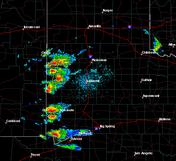 The severe thunderstorm warning for northeastern bailey and northwestern lamb counties will expire at 430 pm cdt, the storm which prompted the warning has weakened below severe limits, and no longer poses an immediate threat to life or property. therefore, the warning will be allowed to expire. however small hail is still possible with this thunderstorm. a severe thunderstorm watch remains in effect until 1100 pm cdt for northwestern texas. The severe thunderstorm warning for northeastern bailey and northwestern lamb counties will expire at 430 pm cdt, the storm which prompted the warning has weakened below severe limits, and no longer poses an immediate threat to life or property. therefore, the warning will be allowed to expire. however small hail is still possible with this thunderstorm. a severe thunderstorm watch remains in effect until 1100 pm cdt for northwestern texas.
|
| 5/3/2019 4:01 PM CDT |
 At 401 pm cdt, a severe thunderstorm was located 9 miles west of earth, moving southeast at 20 mph (radar indicated). Hazards include golf ball size hail. People and animals outdoors will be injured. expect damage to roofs, siding, windows, and vehicles. Locations impacted include, earth. At 401 pm cdt, a severe thunderstorm was located 9 miles west of earth, moving southeast at 20 mph (radar indicated). Hazards include golf ball size hail. People and animals outdoors will be injured. expect damage to roofs, siding, windows, and vehicles. Locations impacted include, earth.
|
| 5/3/2019 3:41 PM CDT |
 At 341 pm cdt, a severe thunderstorm was located 5 miles south of lazbuddie, or 8 miles northeast of muleshoe, moving southeast at 15 mph (radar indicated). Hazards include golf ball size hail. People and animals outdoors will be injured. Expect damage to roofs, siding, windows, and vehicles. At 341 pm cdt, a severe thunderstorm was located 5 miles south of lazbuddie, or 8 miles northeast of muleshoe, moving southeast at 15 mph (radar indicated). Hazards include golf ball size hail. People and animals outdoors will be injured. Expect damage to roofs, siding, windows, and vehicles.
|
| 3/9/2019 1:49 AM CST |
 At 147 am cst, severe thunderstorms with a history of wind gusts around 60 mph were located from near littlefield to near happy, moving east at 60 mph (radar and mesonet indicated). Hazards include 60 mph wind gusts. Expect damage to roofs. siding and trees. Locations impacted include, plainview, tulia, dimmitt, hale center, olton and hart. At 147 am cst, severe thunderstorms with a history of wind gusts around 60 mph were located from near littlefield to near happy, moving east at 60 mph (radar and mesonet indicated). Hazards include 60 mph wind gusts. Expect damage to roofs. siding and trees. Locations impacted include, plainview, tulia, dimmitt, hale center, olton and hart.
|
| 3/9/2019 1:30 AM CST |
 At 129 am cst, severe thunderstorms were located along a line extending from 3 miles south of sudan, moving east at 45 mph (radar indicated). Hazards include 60 mph wind gusts. Expect damage to roofs. Siding and trees. At 129 am cst, severe thunderstorms were located along a line extending from 3 miles south of sudan, moving east at 45 mph (radar indicated). Hazards include 60 mph wind gusts. Expect damage to roofs. Siding and trees.
|
| 10/5/2018 4:49 PM CDT |
 At 449 pm cdt, a severe thunderstorm was located near earth, moving northeast at 25 mph (radar indicated). Hazards include 60 mph wind gusts and quarter size hail. Hail damage to vehicles is expected. expect wind damage to roofs, siding and trees. Locations impacted include, earth and springlake. At 449 pm cdt, a severe thunderstorm was located near earth, moving northeast at 25 mph (radar indicated). Hazards include 60 mph wind gusts and quarter size hail. Hail damage to vehicles is expected. expect wind damage to roofs, siding and trees. Locations impacted include, earth and springlake.
|
| 10/5/2018 4:19 PM CDT |
 At 418 pm cdt, a severe thunderstorm was located near sudan, moving northeast at 15 mph (radar indicated). Hazards include 60 mph wind gusts and half dollar size hail. Hail damage to vehicles is expected. Expect wind damage to roofs, siding and trees. At 418 pm cdt, a severe thunderstorm was located near sudan, moving northeast at 15 mph (radar indicated). Hazards include 60 mph wind gusts and half dollar size hail. Hail damage to vehicles is expected. Expect wind damage to roofs, siding and trees.
|
| 8/10/2018 3:47 PM CDT |
 At 346 pm cdt, a severe thunderstorm was located over olton, moving southwest at 20 mph (radar indicated). Hazards include 60 mph wind gusts and nickel size hail. Expect damage to roofs, siding, and trees. Locations impacted include, olton, earth, cotton center, halfway, edmonson and springlake. At 346 pm cdt, a severe thunderstorm was located over olton, moving southwest at 20 mph (radar indicated). Hazards include 60 mph wind gusts and nickel size hail. Expect damage to roofs, siding, and trees. Locations impacted include, olton, earth, cotton center, halfway, edmonson and springlake.
|
| 8/10/2018 3:29 PM CDT |
 At 328 pm cdt, a severe thunderstorm was located 7 miles northwest of halfway, or 7 miles northeast of olton, moving southwest at 20 mph (radar indicated). Hazards include 60 mph wind gusts and nickel size hail. expect damage to roofs, siding, and trees At 328 pm cdt, a severe thunderstorm was located 7 miles northwest of halfway, or 7 miles northeast of olton, moving southwest at 20 mph (radar indicated). Hazards include 60 mph wind gusts and nickel size hail. expect damage to roofs, siding, and trees
|
| 6/22/2018 8:52 PM CDT |
 At 852 pm cdt, a severe thunderstorm was located 7 miles northeast of earth, moving east at 30 mph (radar indicated). Hazards include 60 mph wind gusts and penny size hail. Expect damage to roofs, siding, and trees. Locations impacted include, hart, earth and springlake. At 852 pm cdt, a severe thunderstorm was located 7 miles northeast of earth, moving east at 30 mph (radar indicated). Hazards include 60 mph wind gusts and penny size hail. Expect damage to roofs, siding, and trees. Locations impacted include, hart, earth and springlake.
|
| 6/22/2018 8:40 PM CDT |
 At 839 pm cdt, a severe thunderstorm was located 6 miles north of earth, moving east at 30 mph (radar indicated. at 818 pm, quarter size hail was observed 8 miles west of lazbuddie). Hazards include 60 mph wind gusts and half dollar size hail. Hail damage to vehicles is expected. expect wind damage to roofs, siding, and trees. Locations impacted include, hart, earth and springlake. At 839 pm cdt, a severe thunderstorm was located 6 miles north of earth, moving east at 30 mph (radar indicated. at 818 pm, quarter size hail was observed 8 miles west of lazbuddie). Hazards include 60 mph wind gusts and half dollar size hail. Hail damage to vehicles is expected. expect wind damage to roofs, siding, and trees. Locations impacted include, hart, earth and springlake.
|
| 6/22/2018 8:23 PM CDT |
 At 822 pm cdt, a severe thunderstorm was located near lazbuddie, or 11 miles northeast of muleshoe, moving east at 25 mph (radar indicated). Hazards include 70 mph wind gusts and half dollar size hail. Hail damage to vehicles is expected. expect considerable tree damage. wind damage is also likely to mobile homes, roofs, and outbuildings. Locations impacted include, earth, lazbuddie and springlake. At 822 pm cdt, a severe thunderstorm was located near lazbuddie, or 11 miles northeast of muleshoe, moving east at 25 mph (radar indicated). Hazards include 70 mph wind gusts and half dollar size hail. Hail damage to vehicles is expected. expect considerable tree damage. wind damage is also likely to mobile homes, roofs, and outbuildings. Locations impacted include, earth, lazbuddie and springlake.
|
| 6/22/2018 7:58 PM CDT |
 At 756 pm cdt, a severe thunderstorm was located 7 miles west of lazbuddie, or 10 miles north of muleshoe, moving east at 30 mph (radar indicated). Hazards include 70 mph wind gusts and half dollar size hail. Hail damage to vehicles is expected. expect considerable tree damage. Wind damage is also likely to mobile homes, roofs, and outbuildings. At 756 pm cdt, a severe thunderstorm was located 7 miles west of lazbuddie, or 10 miles north of muleshoe, moving east at 30 mph (radar indicated). Hazards include 70 mph wind gusts and half dollar size hail. Hail damage to vehicles is expected. expect considerable tree damage. Wind damage is also likely to mobile homes, roofs, and outbuildings.
|
| 5/15/2018 8:37 PM CDT |
 At 835 pm cdt, severe thunderstorms were located along a line extending from near tulia to near halfway to 6 miles west of olton, moving southeast at 35 mph (radar indicated. at 832 pm a wind gust of 60 mph was reported 2 miles west northwest of olton). Hazards include 70 mph wind gusts and half dollar size hail. Hail damage to vehicles is expected. expect considerable tree damage. wind damage is also likely to mobile homes, roofs, and outbuildings. Locations impacted include, plainview, tulia, dimmitt, olton, hart, earth, kress, fieldton, halfway, nazareth, edmonson and springlake. At 835 pm cdt, severe thunderstorms were located along a line extending from near tulia to near halfway to 6 miles west of olton, moving southeast at 35 mph (radar indicated. at 832 pm a wind gust of 60 mph was reported 2 miles west northwest of olton). Hazards include 70 mph wind gusts and half dollar size hail. Hail damage to vehicles is expected. expect considerable tree damage. wind damage is also likely to mobile homes, roofs, and outbuildings. Locations impacted include, plainview, tulia, dimmitt, olton, hart, earth, kress, fieldton, halfway, nazareth, edmonson and springlake.
|
| 5/15/2018 8:17 PM CDT |
 At 816 pm cdt, severe thunderstorms were located along a line extending from 10 miles west of tulia to near hart to near earth, moving southeast at 35 mph (radar indicated. at 807 pm downed power lines were reported at flagg). Hazards include 70 mph wind gusts and half dollar size hail. Hail damage to vehicles is expected. expect considerable tree damage. Wind damage is also likely to mobile homes, roofs, and outbuildings. At 816 pm cdt, severe thunderstorms were located along a line extending from 10 miles west of tulia to near hart to near earth, moving southeast at 35 mph (radar indicated. at 807 pm downed power lines were reported at flagg). Hazards include 70 mph wind gusts and half dollar size hail. Hail damage to vehicles is expected. expect considerable tree damage. Wind damage is also likely to mobile homes, roofs, and outbuildings.
|
| 5/15/2018 7:58 PM CDT |
 At 758 pm cdt, severe thunderstorms were located along a line extending from 12 miles northeast of dimmitt to 9 miles west of hart to 8 miles northwest of earth, moving southeast at 35 mph (radar indicated). Hazards include 70 mph wind gusts and ping pong ball size hail. People and animals outdoors will be injured. expect hail damage to roofs, siding, windows, and vehicles. expect considerable tree damage. Wind damage is also likely to mobile homes, roofs, and outbuildings. At 758 pm cdt, severe thunderstorms were located along a line extending from 12 miles northeast of dimmitt to 9 miles west of hart to 8 miles northwest of earth, moving southeast at 35 mph (radar indicated). Hazards include 70 mph wind gusts and ping pong ball size hail. People and animals outdoors will be injured. expect hail damage to roofs, siding, windows, and vehicles. expect considerable tree damage. Wind damage is also likely to mobile homes, roofs, and outbuildings.
|
| 5/15/2018 7:44 PM CDT |
 At 743 pm cdt, severe thunderstorms were located along a line extending from near easter to near lazbuddie, moving southeast at 30 mph. these are very dangerous storms (radar indicated). Hazards include 80 mph wind gusts and ping pong ball size hail. Flying debris will be dangerous to those caught without shelter. mobile homes will be heavily damaged. expect considerable damage to roofs, windows, and vehicles. extensive tree damage and power outages are likely. Locations impacted include, muleshoe, dimmitt, hart, earth, sudan, summerfield, easter, lazbuddie, black, nazareth and springlake. At 743 pm cdt, severe thunderstorms were located along a line extending from near easter to near lazbuddie, moving southeast at 30 mph. these are very dangerous storms (radar indicated). Hazards include 80 mph wind gusts and ping pong ball size hail. Flying debris will be dangerous to those caught without shelter. mobile homes will be heavily damaged. expect considerable damage to roofs, windows, and vehicles. extensive tree damage and power outages are likely. Locations impacted include, muleshoe, dimmitt, hart, earth, sudan, summerfield, easter, lazbuddie, black, nazareth and springlake.
|
| 5/15/2018 7:33 PM CDT |
 At 732 pm cdt, severe thunderstorms were located along a line extending from near easter to 7 miles northeast of oklahoma lane, moving southeast at 30 mph (radar indicated. at 720 pm a 58 mph wind gusts was reported at the west texas mesonet station located 2 miles northeast of friona). Hazards include ping pong ball size hail and 60 mph wind gusts. People and animals outdoors will be injured. expect hail damage to roofs, siding, windows, and vehicles. expect wind damage to roofs, siding, and trees. Locations impacted include, muleshoe, dimmitt, friona, hart, earth, bovina, sudan, summerfield, easter, lazbuddie, black, nazareth and springlake. At 732 pm cdt, severe thunderstorms were located along a line extending from near easter to 7 miles northeast of oklahoma lane, moving southeast at 30 mph (radar indicated. at 720 pm a 58 mph wind gusts was reported at the west texas mesonet station located 2 miles northeast of friona). Hazards include ping pong ball size hail and 60 mph wind gusts. People and animals outdoors will be injured. expect hail damage to roofs, siding, windows, and vehicles. expect wind damage to roofs, siding, and trees. Locations impacted include, muleshoe, dimmitt, friona, hart, earth, bovina, sudan, summerfield, easter, lazbuddie, black, nazareth and springlake.
|
| 5/15/2018 7:18 PM CDT |
 At 717 pm cdt, severe thunderstorms were located along a line extending from near summerfield to near bovina, moving southeast at 30 mph (radar indicated). Hazards include ping pong ball size hail and 60 mph wind gusts. People and animals outdoors will be injured. expect hail damage to roofs, siding, windows, and vehicles. Expect wind damage to roofs, siding, and trees. At 717 pm cdt, severe thunderstorms were located along a line extending from near summerfield to near bovina, moving southeast at 30 mph (radar indicated). Hazards include ping pong ball size hail and 60 mph wind gusts. People and animals outdoors will be injured. expect hail damage to roofs, siding, windows, and vehicles. Expect wind damage to roofs, siding, and trees.
|
| 4/29/2018 8:29 PM CDT |
 At 828 pm cdt, a severe thunderstorm was located near earth, moving east at 25 mph (radar indicated). Hazards include 60 mph wind gusts and quarter size hail. Hail damage to vehicles is expected. expect wind damage to roofs, siding, and trees. Locations impacted include, earth, lazbuddie and springlake. At 828 pm cdt, a severe thunderstorm was located near earth, moving east at 25 mph (radar indicated). Hazards include 60 mph wind gusts and quarter size hail. Hail damage to vehicles is expected. expect wind damage to roofs, siding, and trees. Locations impacted include, earth, lazbuddie and springlake.
|
| 4/29/2018 8:07 PM CDT |
 At 807 pm cdt, a severe thunderstorm was located near muleshoe, moving east at 20 mph (radar indicated). Hazards include 60 mph wind gusts and quarter size hail. Hail damage to vehicles is expected. expect wind damage to roofs, siding, and trees. Locations impacted include, muleshoe, earth, lazbuddie, progress and springlake. At 807 pm cdt, a severe thunderstorm was located near muleshoe, moving east at 20 mph (radar indicated). Hazards include 60 mph wind gusts and quarter size hail. Hail damage to vehicles is expected. expect wind damage to roofs, siding, and trees. Locations impacted include, muleshoe, earth, lazbuddie, progress and springlake.
|
| 4/29/2018 7:48 PM CDT |
 At 748 pm cdt, a severe thunderstorm was located near muleshoe, moving northeast at 25 mph (radar indicated). Hazards include 60 mph wind gusts and quarter size hail. Hail damage to vehicles is expected. Expect wind damage to roofs, siding, and trees. At 748 pm cdt, a severe thunderstorm was located near muleshoe, moving northeast at 25 mph (radar indicated). Hazards include 60 mph wind gusts and quarter size hail. Hail damage to vehicles is expected. Expect wind damage to roofs, siding, and trees.
|
| 10/6/2017 9:19 PM CDT |
 A severe thunderstorm warning remains in effect until 930 pm cdt for southwestern castro and northern lamb counties. at 918 pm cdt, a severe thunderstorm was located 10 miles west of hart, moving east at 50 mph. hazard. 60 mph wind gusts and quarter size hail. source. Radar indicated. A severe thunderstorm warning remains in effect until 930 pm cdt for southwestern castro and northern lamb counties. at 918 pm cdt, a severe thunderstorm was located 10 miles west of hart, moving east at 50 mph. hazard. 60 mph wind gusts and quarter size hail. source. Radar indicated.
|
| 10/6/2017 8:54 PM CDT |
 At 853 pm cdt, a severe thunderstorm was located near muleshoe, moving east at 50 mph (radar indicated). Hazards include 60 mph wind gusts and quarter size hail. Hail damage to vehicles is expected. Expect wind damage to roofs, siding, and trees. At 853 pm cdt, a severe thunderstorm was located near muleshoe, moving east at 50 mph (radar indicated). Hazards include 60 mph wind gusts and quarter size hail. Hail damage to vehicles is expected. Expect wind damage to roofs, siding, and trees.
|
| 7/4/2017 8:21 PM CDT |
 At 819 pm cdt, severe thunderstorms were located along a line extending from 9 miles north of hart to olton to near bula, moving east at 30 mph. at 810 pm, the west texas mesonet station at olton reported a wind gust to 62 mph. near zero visibility is also reported in spots along highway 385 near littlefield due to blowing dust (radar indicated). Hazards include 70 mph wind gusts and penny size hail. Expect considerable tree damage. damage is likely to mobile homes, roofs, and outbuildings. Locations impacted include, littlefield, muleshoe, tulia, olton, hart, earth, sudan, amherst, happy, needmore, fieldton, enochs, halfway, muleshoe wildlife refuge, bula, nazareth, edmonson and springlake. At 819 pm cdt, severe thunderstorms were located along a line extending from 9 miles north of hart to olton to near bula, moving east at 30 mph. at 810 pm, the west texas mesonet station at olton reported a wind gust to 62 mph. near zero visibility is also reported in spots along highway 385 near littlefield due to blowing dust (radar indicated). Hazards include 70 mph wind gusts and penny size hail. Expect considerable tree damage. damage is likely to mobile homes, roofs, and outbuildings. Locations impacted include, littlefield, muleshoe, tulia, olton, hart, earth, sudan, amherst, happy, needmore, fieldton, enochs, halfway, muleshoe wildlife refuge, bula, nazareth, edmonson and springlake.
|
| 7/4/2017 8:03 PM CDT |
 At 802 pm cdt, severe thunderstorms were located along a line extending from 14 miles northeast of dimmitt to 9 miles northeast of earth to near sudan, moving southeast at 30 mph (radar indicated). Hazards include 70 mph wind gusts and penny size hail. Expect considerable tree damage. damage is likely to mobile homes, roofs, and outbuildings. Locations impacted include, littlefield, muleshoe, tulia, dimmitt, olton, hart, earth, sudan, amherst, happy, needmore, fieldton, enochs, halfway, muleshoe wildlife refuge, bula, nazareth, edmonson and springlake. At 802 pm cdt, severe thunderstorms were located along a line extending from 14 miles northeast of dimmitt to 9 miles northeast of earth to near sudan, moving southeast at 30 mph (radar indicated). Hazards include 70 mph wind gusts and penny size hail. Expect considerable tree damage. damage is likely to mobile homes, roofs, and outbuildings. Locations impacted include, littlefield, muleshoe, tulia, dimmitt, olton, hart, earth, sudan, amherst, happy, needmore, fieldton, enochs, halfway, muleshoe wildlife refuge, bula, nazareth, edmonson and springlake.
|
| 7/4/2017 7:48 PM CDT |
 At 747 pm cdt, severe thunderstorms were located along a line extending from 11 miles east of easter to 6 miles north of earth to near muleshoe, moving southeast at 30 mph (radar indicated). Hazards include 70 mph wind gusts and nickel size hail. Expect considerable tree damage. Damage is likely to mobile homes, roofs, and outbuildings. At 747 pm cdt, severe thunderstorms were located along a line extending from 11 miles east of easter to 6 miles north of earth to near muleshoe, moving southeast at 30 mph (radar indicated). Hazards include 70 mph wind gusts and nickel size hail. Expect considerable tree damage. Damage is likely to mobile homes, roofs, and outbuildings.
|
| 7/4/2017 7:42 PM CDT |
 At 741 pm cdt, severe thunderstorms were located along a line extending from near easter to 8 miles north of earth, moving southeast at 40 mph. the west texas mesonet site in dimmitt reported wind gusts to 70 mph and local media reported wind gusts to 70 mph in springlake earth with near zero visibility. these are very dangerous storms (radar indicated). Hazards include 80 mph wind gusts and quarter size hail. Flying debris will be dangerous to those caught without shelter. mobile homes will be heavily damaged. expect considerable damage to roofs, windows, and vehicles. extensive tree damage and power outages are likely. Locations impacted include, dimmitt, earth, summerfield, lazbuddie, easter and springlake. At 741 pm cdt, severe thunderstorms were located along a line extending from near easter to 8 miles north of earth, moving southeast at 40 mph. the west texas mesonet site in dimmitt reported wind gusts to 70 mph and local media reported wind gusts to 70 mph in springlake earth with near zero visibility. these are very dangerous storms (radar indicated). Hazards include 80 mph wind gusts and quarter size hail. Flying debris will be dangerous to those caught without shelter. mobile homes will be heavily damaged. expect considerable damage to roofs, windows, and vehicles. extensive tree damage and power outages are likely. Locations impacted include, dimmitt, earth, summerfield, lazbuddie, easter and springlake.
|
| 7/4/2017 7:35 PM CDT |
 At 734 pm cdt, severe thunderstorms were located along a line extending from easter to 6 miles east of lazbuddie, moving east southeast at 35 mph (radar indicated). Hazards include 70 mph wind gusts and quarter size hail. Hail damage to vehicles is expected. expect considerable tree damage. wind damage is also likely to mobile homes, roofs, and outbuildings. Locations impacted include, dimmitt, earth, summerfield, lazbuddie, easter and springlake. At 734 pm cdt, severe thunderstorms were located along a line extending from easter to 6 miles east of lazbuddie, moving east southeast at 35 mph (radar indicated). Hazards include 70 mph wind gusts and quarter size hail. Hail damage to vehicles is expected. expect considerable tree damage. wind damage is also likely to mobile homes, roofs, and outbuildings. Locations impacted include, dimmitt, earth, summerfield, lazbuddie, easter and springlake.
|
| 7/4/2017 7:14 PM CDT |
 At 714 pm cdt, severe thunderstorms were located along a line extending from near summerfield to near lazbuddie, moving southeast at 35 mph (radar indicated). Hazards include 70 mph wind gusts and quarter size hail. Hail damage to vehicles is expected. expect considerable tree damage. Wind damage is also likely to mobile homes, roofs, and outbuildings. At 714 pm cdt, severe thunderstorms were located along a line extending from near summerfield to near lazbuddie, moving southeast at 35 mph (radar indicated). Hazards include 70 mph wind gusts and quarter size hail. Hail damage to vehicles is expected. expect considerable tree damage. Wind damage is also likely to mobile homes, roofs, and outbuildings.
|
| 7/2/2017 12:28 AM CDT |
 At 1228 am cdt, a severe thunderstorm was located near spade, or near littlefield, moving east at 30 mph (radar indicated). Hazards include 60 mph wind gusts. Expect damage to roofs, siding, and trees. Locations impacted include, littlefield, olton, earth, amherst, fieldton, spade and springlake. At 1228 am cdt, a severe thunderstorm was located near spade, or near littlefield, moving east at 30 mph (radar indicated). Hazards include 60 mph wind gusts. Expect damage to roofs, siding, and trees. Locations impacted include, littlefield, olton, earth, amherst, fieldton, spade and springlake.
|
| 7/2/2017 12:14 AM CDT |
 At 1214 am cdt, a severe thunderstorm was located near amherst, or 8 miles north of littlefield, moving east at 30 mph (radar indicated). Hazards include 60 mph wind gusts. expect damage to roofs, siding, and trees At 1214 am cdt, a severe thunderstorm was located near amherst, or 8 miles north of littlefield, moving east at 30 mph (radar indicated). Hazards include 60 mph wind gusts. expect damage to roofs, siding, and trees
|
| 7/1/2017 11:52 PM CDT |
 At 1152 pm cdt, severe thunderstorms were located along a line extending from 9 miles north of earth to near bula to near bledsoe, moving southeast at 35 mph (radar indicated). Hazards include 60 mph wind gusts. Expect damage to roofs, siding, and trees. Locations impacted include, littlefield, muleshoe, olton, morton, earth, anton, sudan, amherst, cotton center, needmore, lazbuddie, fieldton, spade, bledsoe, halfway, maple, progress, enochs, whitharral and muleshoe wildlife refuge. At 1152 pm cdt, severe thunderstorms were located along a line extending from 9 miles north of earth to near bula to near bledsoe, moving southeast at 35 mph (radar indicated). Hazards include 60 mph wind gusts. Expect damage to roofs, siding, and trees. Locations impacted include, littlefield, muleshoe, olton, morton, earth, anton, sudan, amherst, cotton center, needmore, lazbuddie, fieldton, spade, bledsoe, halfway, maple, progress, enochs, whitharral and muleshoe wildlife refuge.
|
| 7/1/2017 11:30 PM CDT |
 At 1130 pm cdt, severe thunderstorms were located along a line extending from 7 miles east of lazbuddie to 7 miles northeast of needmore to near lingo, moving east at 35 mph (radar indicated). Hazards include 70 mph wind gusts. Expect considerable tree damage. Damage is likely to mobile homes, roofs, and outbuildings. At 1130 pm cdt, severe thunderstorms were located along a line extending from 7 miles east of lazbuddie to 7 miles northeast of needmore to near lingo, moving east at 35 mph (radar indicated). Hazards include 70 mph wind gusts. Expect considerable tree damage. Damage is likely to mobile homes, roofs, and outbuildings.
|
| 6/30/2017 11:20 PM CDT |
 At 1120 pm cdt, a severe thunderstorm was located near amherst, or near littlefield, moving southeast at 30 mph (radar indicated). Hazards include 60 mph wind gusts and half dollar size hail. Hail damage to vehicles is expected. expect wind damage to roofs, siding, and trees. Locations impacted include, littlefield, olton, earth, sudan, amherst, fieldton and springlake. At 1120 pm cdt, a severe thunderstorm was located near amherst, or near littlefield, moving southeast at 30 mph (radar indicated). Hazards include 60 mph wind gusts and half dollar size hail. Hail damage to vehicles is expected. expect wind damage to roofs, siding, and trees. Locations impacted include, littlefield, olton, earth, sudan, amherst, fieldton and springlake.
|
| 6/30/2017 10:59 PM CDT |
 At 1059 pm cdt, a severe thunderstorm was located near amherst, or 10 miles south of earth, moving southeast at 25 mph (radar indicated). Hazards include 60 mph wind gusts and half dollar size hail. Hail damage to vehicles is expected. Expect wind damage to roofs, siding, and trees. At 1059 pm cdt, a severe thunderstorm was located near amherst, or 10 miles south of earth, moving southeast at 25 mph (radar indicated). Hazards include 60 mph wind gusts and half dollar size hail. Hail damage to vehicles is expected. Expect wind damage to roofs, siding, and trees.
|
| 6/25/2017 11:49 PM CDT |
 At 1148 pm cdt, a severe thunderstorm was located near pep, or 10 miles west of littlefield, moving southeast at 35 mph. this storm produced a wind gust to 82 mph at 1125 pm at the west texas mesonet site near muleshoe. the greatest wind threat exists along and south of us highway 84. this is a very dangerous storm (radar indicated). Hazards include 80 mph wind gusts. Flying debris will be dangerous to those caught without shelter. mobile homes will be heavily damaged. expect considerable damage to roofs, windows, and vehicles. extensive tree damage and power outages are likely. Locations impacted include, littlefield, earth, sudan, amherst, bula, enochs and springlake. At 1148 pm cdt, a severe thunderstorm was located near pep, or 10 miles west of littlefield, moving southeast at 35 mph. this storm produced a wind gust to 82 mph at 1125 pm at the west texas mesonet site near muleshoe. the greatest wind threat exists along and south of us highway 84. this is a very dangerous storm (radar indicated). Hazards include 80 mph wind gusts. Flying debris will be dangerous to those caught without shelter. mobile homes will be heavily damaged. expect considerable damage to roofs, windows, and vehicles. extensive tree damage and power outages are likely. Locations impacted include, littlefield, earth, sudan, amherst, bula, enochs and springlake.
|
| 6/25/2017 11:35 PM CDT |
 At 1133 pm cdt, a severe thunderstorm was located near bula, or 14 miles west of littlefield, moving southeast at 35 mph. at 1125 pm, this storm generated a wind gust to 82 mph at the west texas mesonet station in muleshoe. the area between enochs and sudan will experience the greatest threat of high winds. this is a very dangerous storm (radar indicated). Hazards include 80 mph wind gusts. Flying debris will be dangerous to those caught without shelter. mobile homes will be heavily damaged. expect considerable damage to roofs, windows, and vehicles. extensive tree damage and power outages are likely. Locations impacted include, littlefield, earth, sudan, amherst, needmore, muleshoe wildlife refuge, bula, enochs and springlake. At 1133 pm cdt, a severe thunderstorm was located near bula, or 14 miles west of littlefield, moving southeast at 35 mph. at 1125 pm, this storm generated a wind gust to 82 mph at the west texas mesonet station in muleshoe. the area between enochs and sudan will experience the greatest threat of high winds. this is a very dangerous storm (radar indicated). Hazards include 80 mph wind gusts. Flying debris will be dangerous to those caught without shelter. mobile homes will be heavily damaged. expect considerable damage to roofs, windows, and vehicles. extensive tree damage and power outages are likely. Locations impacted include, littlefield, earth, sudan, amherst, needmore, muleshoe wildlife refuge, bula, enochs and springlake.
|
| 6/25/2017 11:27 PM CDT |
 At 1126 pm cdt, a severe thunderstorm was located near needmore, or 14 miles southeast of muleshoe, moving southeast at 35 mph. at 1120 pm, the west texas mesonet station at muleshoe recorded a gust to 72 mph (radar indicated). Hazards include 70 mph wind gusts. Expect considerable tree damage. Damage is likely to mobile homes, roofs, and outbuildings. At 1126 pm cdt, a severe thunderstorm was located near needmore, or 14 miles southeast of muleshoe, moving southeast at 35 mph. at 1120 pm, the west texas mesonet station at muleshoe recorded a gust to 72 mph (radar indicated). Hazards include 70 mph wind gusts. Expect considerable tree damage. Damage is likely to mobile homes, roofs, and outbuildings.
|
| 6/21/2017 9:20 PM CDT |
 At 918 pm cdt, severe thunderstorms were located along a line extending from 7 miles east of easter to 11 miles west of needmore, moving southeast at 25 mph (radar indicated). Hazards include 60 mph wind gusts. Expect damage to roofs, siding, and trees. Locations impacted include, muleshoe, dimmitt, earth, needmore, lazbuddie, easter, progress, muleshoe wildlife refuge, enochs and maple. At 918 pm cdt, severe thunderstorms were located along a line extending from 7 miles east of easter to 11 miles west of needmore, moving southeast at 25 mph (radar indicated). Hazards include 60 mph wind gusts. Expect damage to roofs, siding, and trees. Locations impacted include, muleshoe, dimmitt, earth, needmore, lazbuddie, easter, progress, muleshoe wildlife refuge, enochs and maple.
|
| 6/21/2017 9:10 PM CDT |
 At 909 pm cdt, severe thunderstorms were located along a line extending from 7 miles northeast of easter to 10 miles east of arch, moving southeast at 25 mph (radar indicated). Hazards include 70 mph wind gusts. Expect considerable tree damage. damage is likely to mobile homes, roofs, and outbuildings. Locations impacted include, muleshoe, dimmitt, earth, needmore, lazbuddie, easter, progress, lariat, muleshoe wildlife refuge, enochs and maple. At 909 pm cdt, severe thunderstorms were located along a line extending from 7 miles northeast of easter to 10 miles east of arch, moving southeast at 25 mph (radar indicated). Hazards include 70 mph wind gusts. Expect considerable tree damage. damage is likely to mobile homes, roofs, and outbuildings. Locations impacted include, muleshoe, dimmitt, earth, needmore, lazbuddie, easter, progress, lariat, muleshoe wildlife refuge, enochs and maple.
|
| 6/21/2017 8:43 PM CDT |
 At 841 pm cdt, severe thunderstorms were located along a line extending from near black to 6 miles southwest of west camp, moving southeast at 25 mph. these storms have produced measured wind gusts to 65 mph near friona at 825 pm (radar indicated). Hazards include 70 mph wind gusts and quarter size hail. Hail damage to vehicles is expected. expect considerable tree damage. Wind damage is also likely to mobile homes, roofs, and outbuildings. At 841 pm cdt, severe thunderstorms were located along a line extending from near black to 6 miles southwest of west camp, moving southeast at 25 mph. these storms have produced measured wind gusts to 65 mph near friona at 825 pm (radar indicated). Hazards include 70 mph wind gusts and quarter size hail. Hail damage to vehicles is expected. expect considerable tree damage. Wind damage is also likely to mobile homes, roofs, and outbuildings.
|
| 5/10/2017 12:55 AM CDT |
 At 1254 am cdt, a severe thunderstorm was located 7 miles north of earth, moving northeast at 35 mph (radar indicated). Hazards include two inch hail and 60 mph wind gusts. People and animals outdoors will be injured. expect hail damage to roofs, siding, windows and vehicles. Expect wind damage to roofs, siding and trees. At 1254 am cdt, a severe thunderstorm was located 7 miles north of earth, moving northeast at 35 mph (radar indicated). Hazards include two inch hail and 60 mph wind gusts. People and animals outdoors will be injured. expect hail damage to roofs, siding, windows and vehicles. Expect wind damage to roofs, siding and trees.
|
| 5/10/2017 12:50 AM CDT |
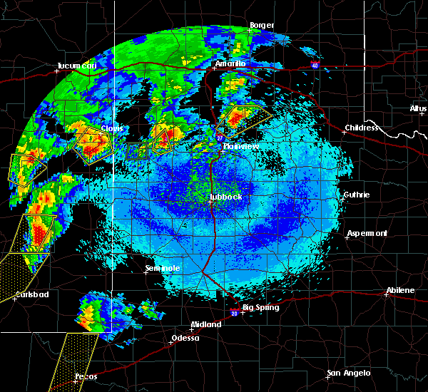 At 1249 am cdt, a severe thunderstorm was located near earth, moving northeast at 45 mph (radar indicated). Hazards include golf ball size hail and 60 mph wind gusts. People and animals outdoors will be injured. expect hail damage to roofs, siding, windows and vehicles. expect wind damage to roofs, siding and trees. Locations impacted include, earth. At 1249 am cdt, a severe thunderstorm was located near earth, moving northeast at 45 mph (radar indicated). Hazards include golf ball size hail and 60 mph wind gusts. People and animals outdoors will be injured. expect hail damage to roofs, siding, windows and vehicles. expect wind damage to roofs, siding and trees. Locations impacted include, earth.
|
| 5/10/2017 12:38 AM CDT |
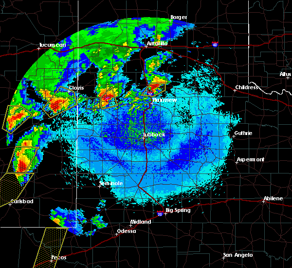 At 1237 am cdt, a severe thunderstorm was located near earth, moving northeast at 40 mph (radar indicated). Hazards include 60 mph wind gusts and half dollar size hail. Hail damage to vehicles is expected. expect wind damage to roofs, siding and trees. Locations impacted include, earth. At 1237 am cdt, a severe thunderstorm was located near earth, moving northeast at 40 mph (radar indicated). Hazards include 60 mph wind gusts and half dollar size hail. Hail damage to vehicles is expected. expect wind damage to roofs, siding and trees. Locations impacted include, earth.
|
| 5/10/2017 12:22 AM CDT |
 At 1221 am cdt, a severe thunderstorm was located near muleshoe, moving northeast at 35 mph (radar indicated). Hazards include 60 mph wind gusts and half dollar size hail. Hail damage to vehicles is expected. expect wind damage to roofs, siding and trees. Locations impacted include, muleshoe and earth. At 1221 am cdt, a severe thunderstorm was located near muleshoe, moving northeast at 35 mph (radar indicated). Hazards include 60 mph wind gusts and half dollar size hail. Hail damage to vehicles is expected. expect wind damage to roofs, siding and trees. Locations impacted include, muleshoe and earth.
|
| 5/10/2017 12:14 AM CDT |
 At 1212 am cdt, a dangerous severe thunderstorm was located near needmore, moving northeast at 35 mph (radar indicated). Hazards include tennis ball size hail and 60 mph wind gusts. People and animals outdoors will be injured. expect hail damage to roofs, siding, windows and vehicles. Expect wind damage to roofs, siding and trees. At 1212 am cdt, a dangerous severe thunderstorm was located near needmore, moving northeast at 35 mph (radar indicated). Hazards include tennis ball size hail and 60 mph wind gusts. People and animals outdoors will be injured. expect hail damage to roofs, siding, windows and vehicles. Expect wind damage to roofs, siding and trees.
|
| 5/30/2016 7:54 PM CDT |
 At 753 pm cdt, a severe thunderstorm was located 8 miles north of earth, moving east at 20 mph (radar indicated). Hazards include 60 mph wind gusts and quarter size hail. Hail damage to vehicles is expected. Expect wind damage to roofs, siding and trees. At 753 pm cdt, a severe thunderstorm was located 8 miles north of earth, moving east at 20 mph (radar indicated). Hazards include 60 mph wind gusts and quarter size hail. Hail damage to vehicles is expected. Expect wind damage to roofs, siding and trees.
|
| 9/13/2015 4:35 PM CDT |
 At 435 pm cdt, a severe thunderstorm was located near earth, or 19 miles south of dimmitt, moving east at 15 mph (radar indicated). Hazards include 60 mph wind gusts and half dollar size hail. Hail damage to vehicles is expected. Expect wind damage to roofs, siding and trees. At 435 pm cdt, a severe thunderstorm was located near earth, or 19 miles south of dimmitt, moving east at 15 mph (radar indicated). Hazards include 60 mph wind gusts and half dollar size hail. Hail damage to vehicles is expected. Expect wind damage to roofs, siding and trees.
|
| 8/9/2015 5:44 PM CDT |
 At 541 pm cdt, doppler radar indicated a severe thunderstorm capable of producing quarter size hail and damaging winds in excess of 60 mph. this storm was located near earth, or 15 miles east of muleshoe, and moving northeast at 10 mph. an additional severe thunderstorm was located 3 miles southeast of lazbuddie, moving slowly east. At 541 pm cdt, doppler radar indicated a severe thunderstorm capable of producing quarter size hail and damaging winds in excess of 60 mph. this storm was located near earth, or 15 miles east of muleshoe, and moving northeast at 10 mph. an additional severe thunderstorm was located 3 miles southeast of lazbuddie, moving slowly east.
|
| 8/9/2015 5:30 PM CDT |
 At 528 pm cdt, a severe thunderstorm was located near earth, or 18 miles south of dimmitt, and is nearly stationary. at 513 pm, a storm spotter in sunnyside reported quarter size hail. broadcast media also reported a wind gust to 67 mph in sunnyside at 456 pm (radar indicated). Hazards include quarter size hail and 70 mph wind gusts. Hail damage to vehicles is expected. expect considerable tree damage. wind damage is also likely to mobile homes, roofs and outbuildings. Locations impacted include, hart, earth and springlake. At 528 pm cdt, a severe thunderstorm was located near earth, or 18 miles south of dimmitt, and is nearly stationary. at 513 pm, a storm spotter in sunnyside reported quarter size hail. broadcast media also reported a wind gust to 67 mph in sunnyside at 456 pm (radar indicated). Hazards include quarter size hail and 70 mph wind gusts. Hail damage to vehicles is expected. expect considerable tree damage. wind damage is also likely to mobile homes, roofs and outbuildings. Locations impacted include, hart, earth and springlake.
|
| 8/9/2015 5:14 PM CDT |
 At 510 pm cdt, a severe thunderstorm was located 9 miles northeast of earth, or 14 miles south of dimmitt, and is nearly stationary. a weather station in sunnyside recorded a 67 mph gust with this storm at 4:56 pm. in addition, 1.21 inches of rain fell in a short period of time, with instantaneous rates near 6 inches an hour (radar indicated). Hazards include half dollar size hail and 70 mph wind gusts. Hail damage to vehicles is expected. expect considerable tree damage. wind damage is also likely to mobile homes, roofs and outbuildings. Locations impacted include, sunnyside, highway 385 between dimmitt and spring lake and earth. At 510 pm cdt, a severe thunderstorm was located 9 miles northeast of earth, or 14 miles south of dimmitt, and is nearly stationary. a weather station in sunnyside recorded a 67 mph gust with this storm at 4:56 pm. in addition, 1.21 inches of rain fell in a short period of time, with instantaneous rates near 6 inches an hour (radar indicated). Hazards include half dollar size hail and 70 mph wind gusts. Hail damage to vehicles is expected. expect considerable tree damage. wind damage is also likely to mobile homes, roofs and outbuildings. Locations impacted include, sunnyside, highway 385 between dimmitt and spring lake and earth.
|
| 8/9/2015 4:56 PM CDT |
 At 454 pm cdt, a severe thunderstorm was located 10 miles northeast of earth, or 13 miles south of dimmitt, moving northeast at 5 mph. another severe storm was located 8 miles south of dimmitt, moving northeast at 5 mph (radar indicated). Hazards include 60 mph wind gusts and quarter size hail. Hail damage to vehicles is expected. Expect wind damage to roofs, siding and trees. At 454 pm cdt, a severe thunderstorm was located 10 miles northeast of earth, or 13 miles south of dimmitt, moving northeast at 5 mph. another severe storm was located 8 miles south of dimmitt, moving northeast at 5 mph (radar indicated). Hazards include 60 mph wind gusts and quarter size hail. Hail damage to vehicles is expected. Expect wind damage to roofs, siding and trees.
|
| 6/29/2015 4:38 PM CDT |
 At 437 pm cdt, a cluster of severe thunderstorms was located from amherst to bula, or 9 miles northwest of littlefield, moving southeast at 10 mph (radar indicated). Hazards include 70 mph wind gusts and quarter size hail. Hail damage to vehicles is expected. expect considerable tree damage. Wind damage is also likely to mobile homes, roofs and outbuildings. At 437 pm cdt, a cluster of severe thunderstorms was located from amherst to bula, or 9 miles northwest of littlefield, moving southeast at 10 mph (radar indicated). Hazards include 70 mph wind gusts and quarter size hail. Hail damage to vehicles is expected. expect considerable tree damage. Wind damage is also likely to mobile homes, roofs and outbuildings.
|
| 6/12/2015 4:38 PM CDT |
 At 436 pm cdt, a severe thunderstorm was located 7 miles north of sudan, or 11 miles east of muleshoe, moving east at 25 mph. additional storms were intensifying near the muleshoe wildlife refuge or about 15 miles west of littlefield (radar indicated). Hazards include ping pong size hail and 60 mph wind gusts. People and animals outdoors will be injured. expect hail damage to roofs, siding, windows and vehicles. expect wind damage to roofs, siding and trees. locations impacted include, littlefield, earth, sudan, amherst, needmore and muleshoe wildlife refuge. A tornado watch remains in effect until 1000 pm cdt for northwestern texas. At 436 pm cdt, a severe thunderstorm was located 7 miles north of sudan, or 11 miles east of muleshoe, moving east at 25 mph. additional storms were intensifying near the muleshoe wildlife refuge or about 15 miles west of littlefield (radar indicated). Hazards include ping pong size hail and 60 mph wind gusts. People and animals outdoors will be injured. expect hail damage to roofs, siding, windows and vehicles. expect wind damage to roofs, siding and trees. locations impacted include, littlefield, earth, sudan, amherst, needmore and muleshoe wildlife refuge. A tornado watch remains in effect until 1000 pm cdt for northwestern texas.
|
| 6/12/2015 4:18 PM CDT |
 At 417 pm cdt, a severe thunderstorm was located near muleshoe, moving east at 25 mph. ping pong ball size hail was reported by muleshoe police at 212pm. this storm exhibits a persistent rotation (radar indicated). Hazards include two inch hail and 70 mph wind gusts. People and animals outdoors will be injured. expect hail damage to roofs, siding, windows and vehicles. expect considerable tree damage. wind damage is also likely to mobile homes, roofs and outbuildings. locations impacted include, littlefield, muleshoe, earth, sudan, amherst, needmore, muleshoe wildlife refuge and lazbuddie. A tornado watch remains in effect until 1000 pm cdt for northwestern texas. At 417 pm cdt, a severe thunderstorm was located near muleshoe, moving east at 25 mph. ping pong ball size hail was reported by muleshoe police at 212pm. this storm exhibits a persistent rotation (radar indicated). Hazards include two inch hail and 70 mph wind gusts. People and animals outdoors will be injured. expect hail damage to roofs, siding, windows and vehicles. expect considerable tree damage. wind damage is also likely to mobile homes, roofs and outbuildings. locations impacted include, littlefield, muleshoe, earth, sudan, amherst, needmore, muleshoe wildlife refuge and lazbuddie. A tornado watch remains in effect until 1000 pm cdt for northwestern texas.
|
| 6/12/2015 4:12 PM CDT |
 At 410 pm cdt, a severe thunderstorm was located near needmore, or near muleshoe, moving east at 25 mph. this storm has had a persistent wall cloud and a tornado may develop at any time. additional storms are developing south of muleshoe and west of sudan (radar indicated). Hazards include two inch hail and 70 mph wind gusts. People and animals outdoors will be injured. expect hail damage to roofs, siding, windows and vehicles. expect considerable tree damage. Wind damage is also likely to mobile homes, roofs and outbuildings. At 410 pm cdt, a severe thunderstorm was located near needmore, or near muleshoe, moving east at 25 mph. this storm has had a persistent wall cloud and a tornado may develop at any time. additional storms are developing south of muleshoe and west of sudan (radar indicated). Hazards include two inch hail and 70 mph wind gusts. People and animals outdoors will be injured. expect hail damage to roofs, siding, windows and vehicles. expect considerable tree damage. Wind damage is also likely to mobile homes, roofs and outbuildings.
|
| 5/29/2015 9:05 PM CDT | At 903 pm cdt, a line of severe thunderstorms were located along a halfway to fieldton to littlefield line, moving southeast at 45 mph (radar indicated). Hazards include 60 mph wind gusts and penny size hail. Expect damage to roofs. siding and trees. Locations impacted include, plainview, littlefield, hale center, olton, earth, sudan, amherst, cotton center, needmore, spade, muleshoe wildlife refuge, maple, bula, halfway, enochs, fieldton, edmonson and springlake. |
| 5/29/2015 8:48 PM CDT | At 846 pm cdt, a line of severe thunderstorms was located from near olton to amherst to bula, moving southeast at 40 mph (radar indicated). Hazards include 60 mph wind gusts and quarter size hail. Hail damage to vehicles is expected. Expect wind damage to roofs, siding and trees. |
| 4/16/2015 7:01 PM CDT | At 701 pm cdt, a severe thunderstorm was located near earth, or 18 miles south of dimmitt, moving northeast at 35 mph (radar indicated). Hazards include quarter size hail and 60 mph wind gusts. Hail damage to vehicles is expected. expect wind damage to roofs, siding and trees. locations impacted include, hart, earth and springlake. 1. 00in. |
| 4/16/2015 6:41 PM CDT | At 641 pm cdt, a severe thunderstorm was located 7 miles southwest of earth, or 12 miles east of muleshoe, moving northeast at 35 mph (radar indicated). Hazards include 60 mph wind gusts and quarter size hail. Hail damage to vehicles is expected. Expect wind damage to roofs, siding and trees. |
| 6/18/2014 4:08 PM CDT | Quarter sized hail reported 0.6 miles NE of Earth, TX, abundant small hail of pea to marble size...with occasional hailstones to one inch |
| 6/5/2013 9:22 PM CDT | Hen Egg sized hail reported 2.5 miles W of Earth, TX |
Hail Maps for Earth, TX


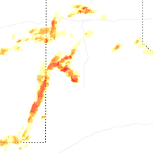
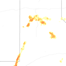


Connect with Interactive Hail Maps