

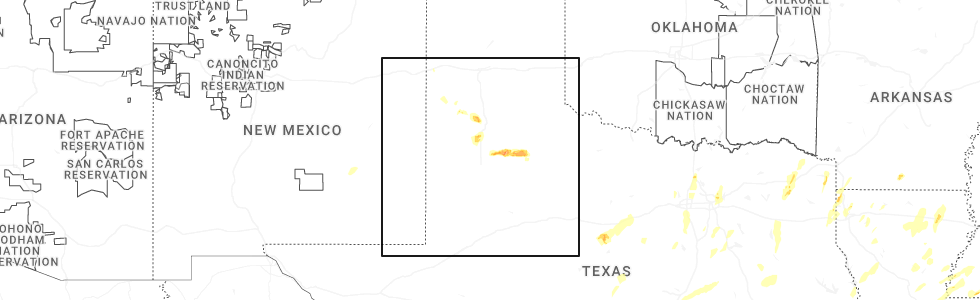
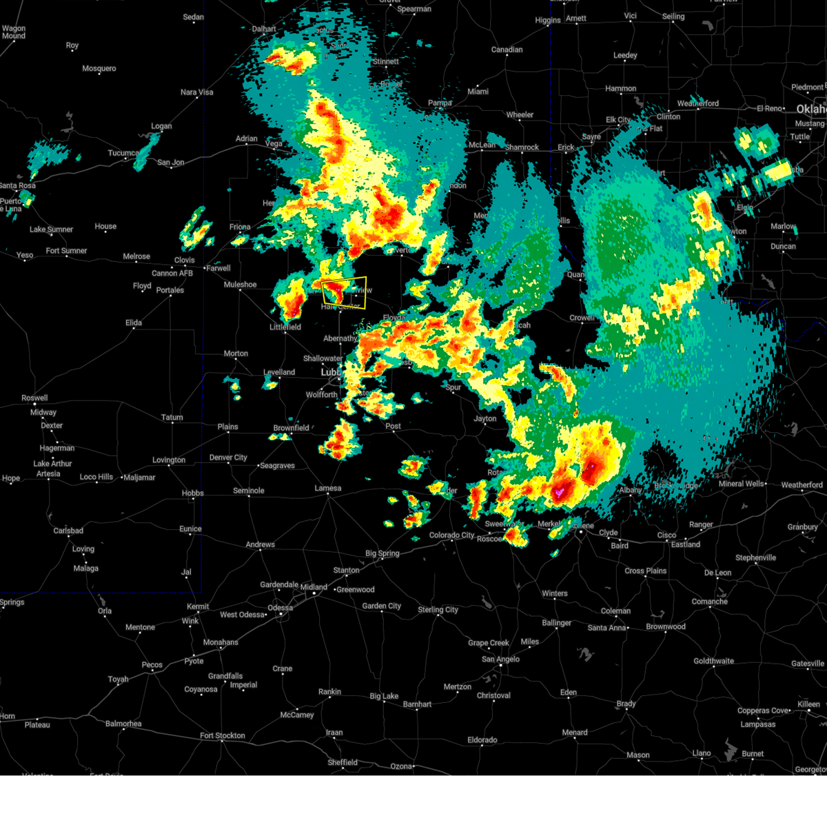
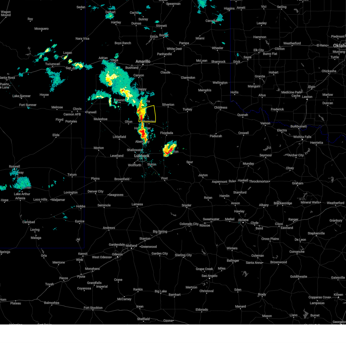
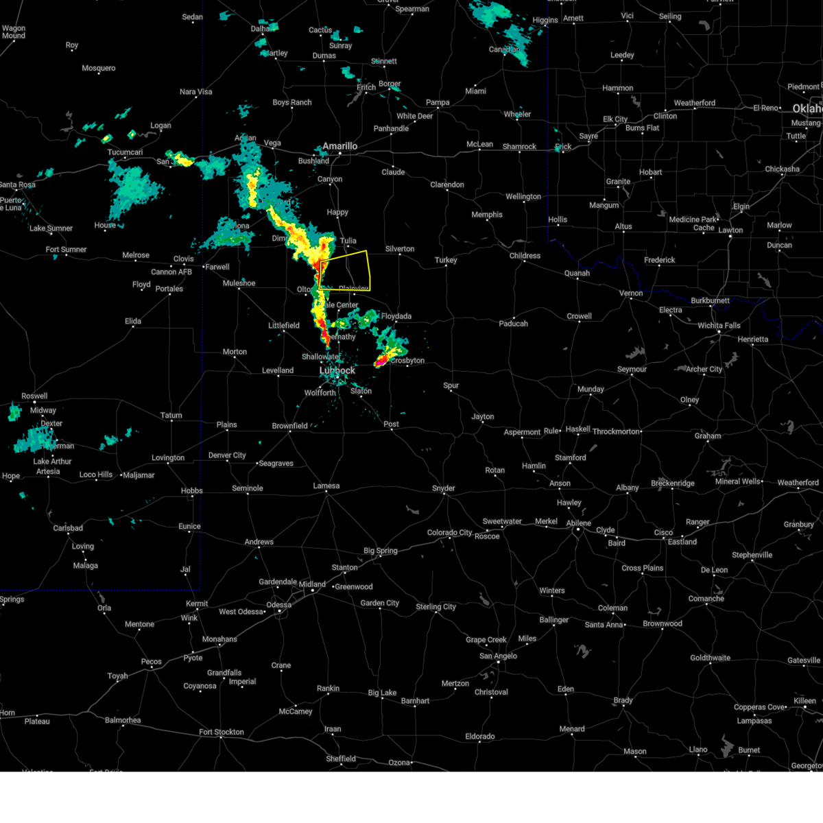
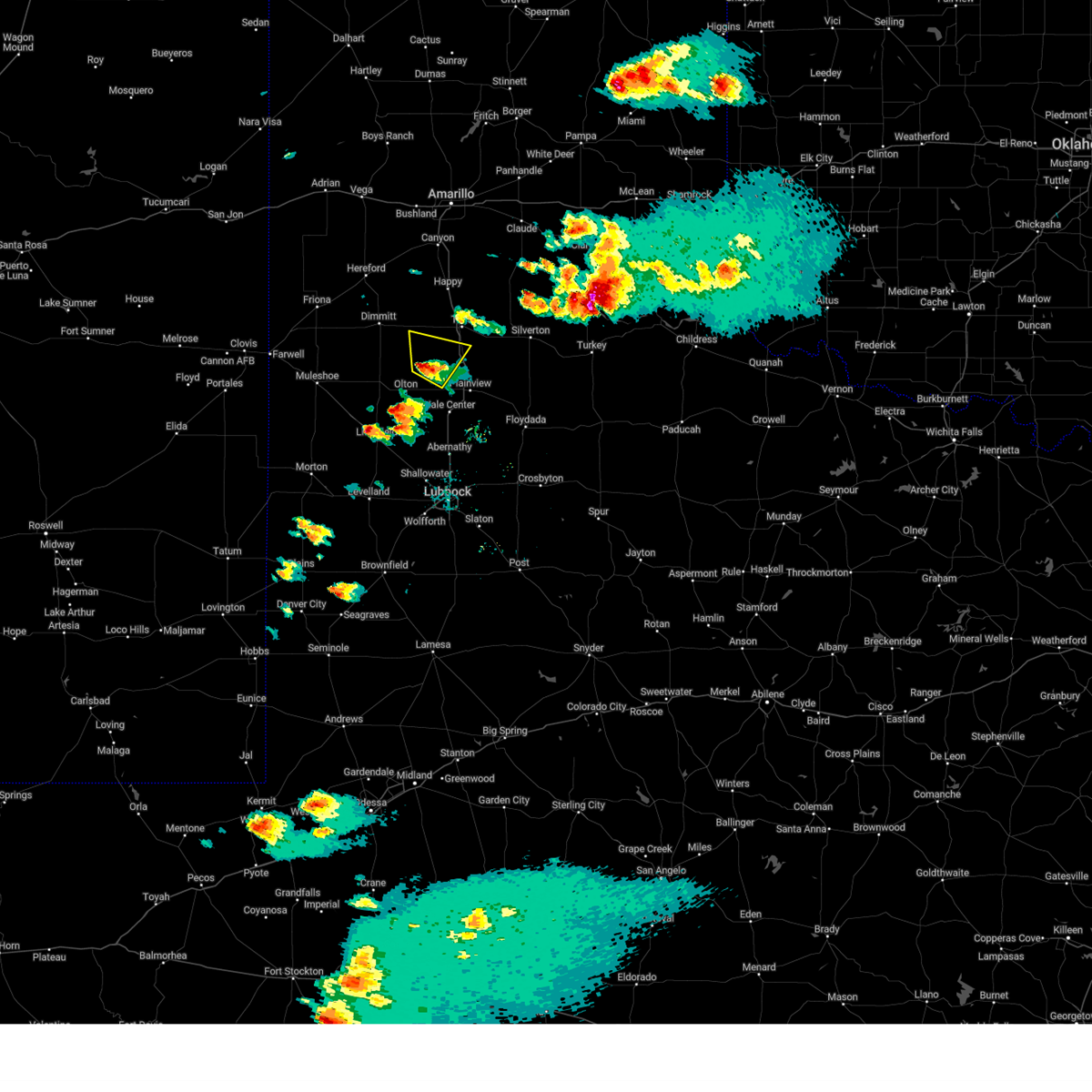
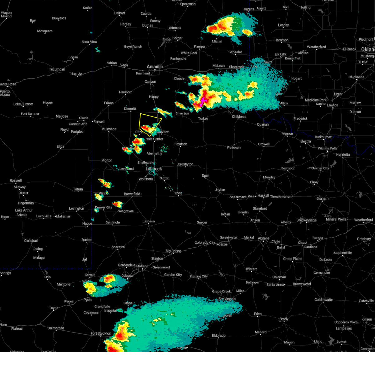
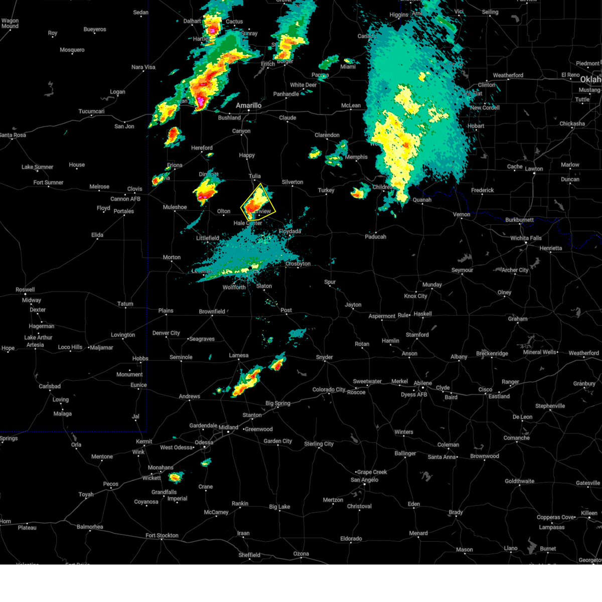
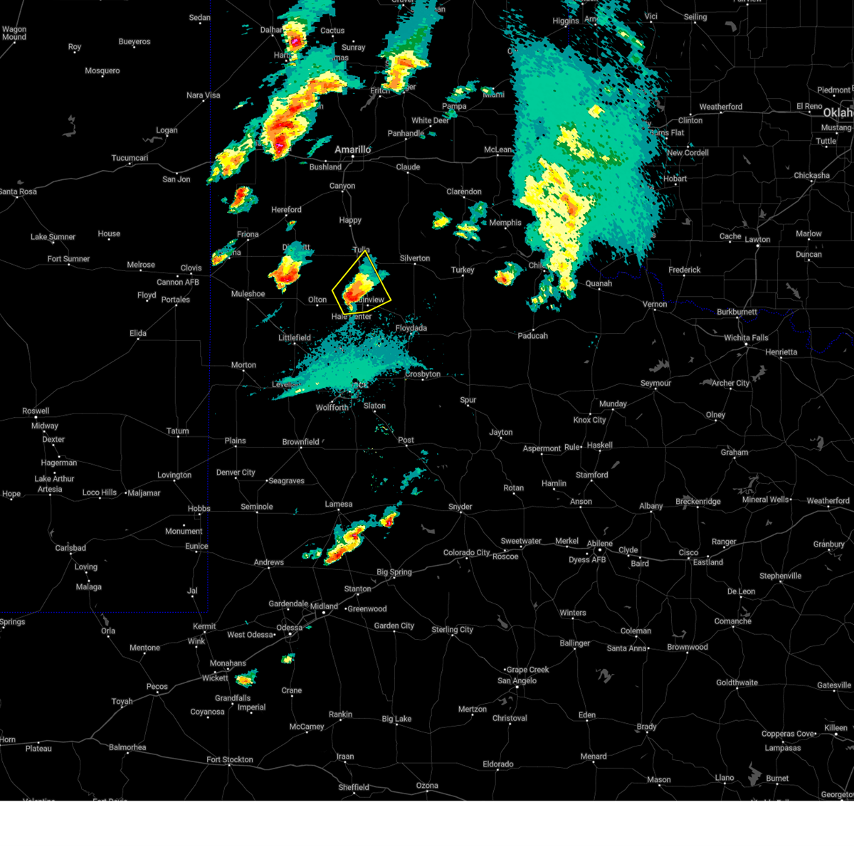
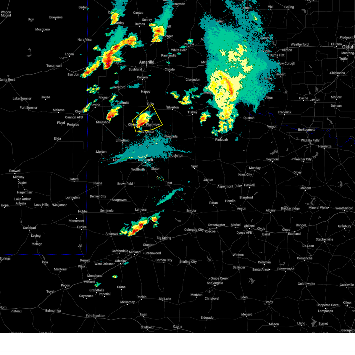
Hail Map for Edmonson, TX
The Edmonson, TX area has had 2 reports of on-the-ground hail by trained spotters, and has been under severe weather warnings 24 times during the past 12 months. Doppler radar has detected hail at or near Edmonson, TX on 88 occasions, including 9 occasions during the past year.
| Name: | Edmonson, TX |
| Where Located: | 47.5 miles N of Lubbock, TX |
| Map: | Google Map for Edmonson, TX |
| Population: | 111 |
| Housing Units: | 48 |
| More Info: | Search Google for Edmonson, TX |
3
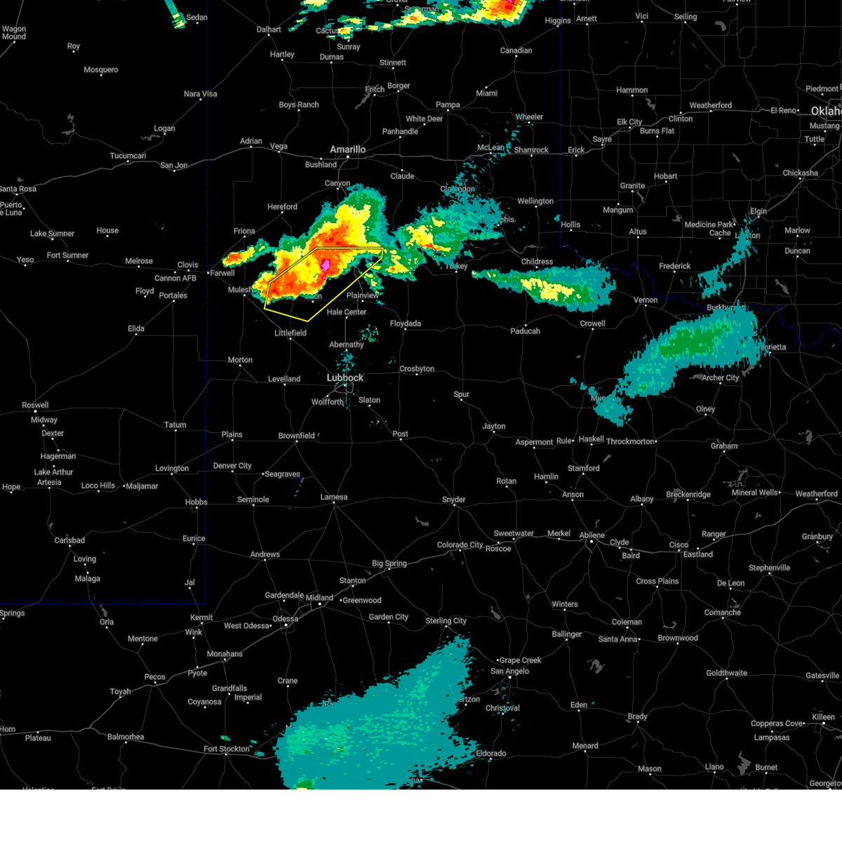
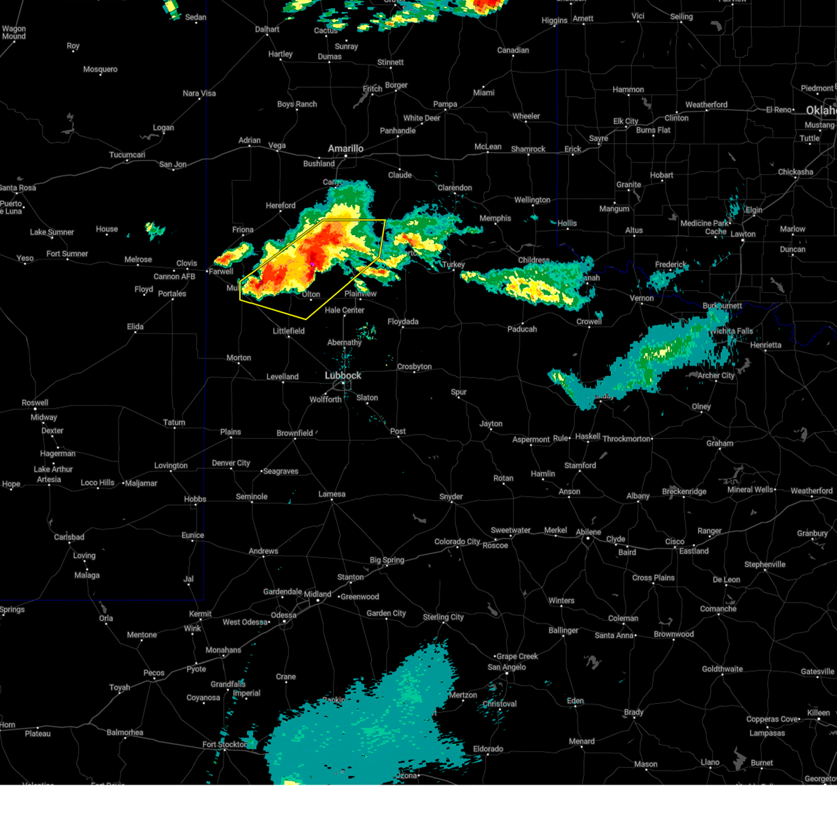
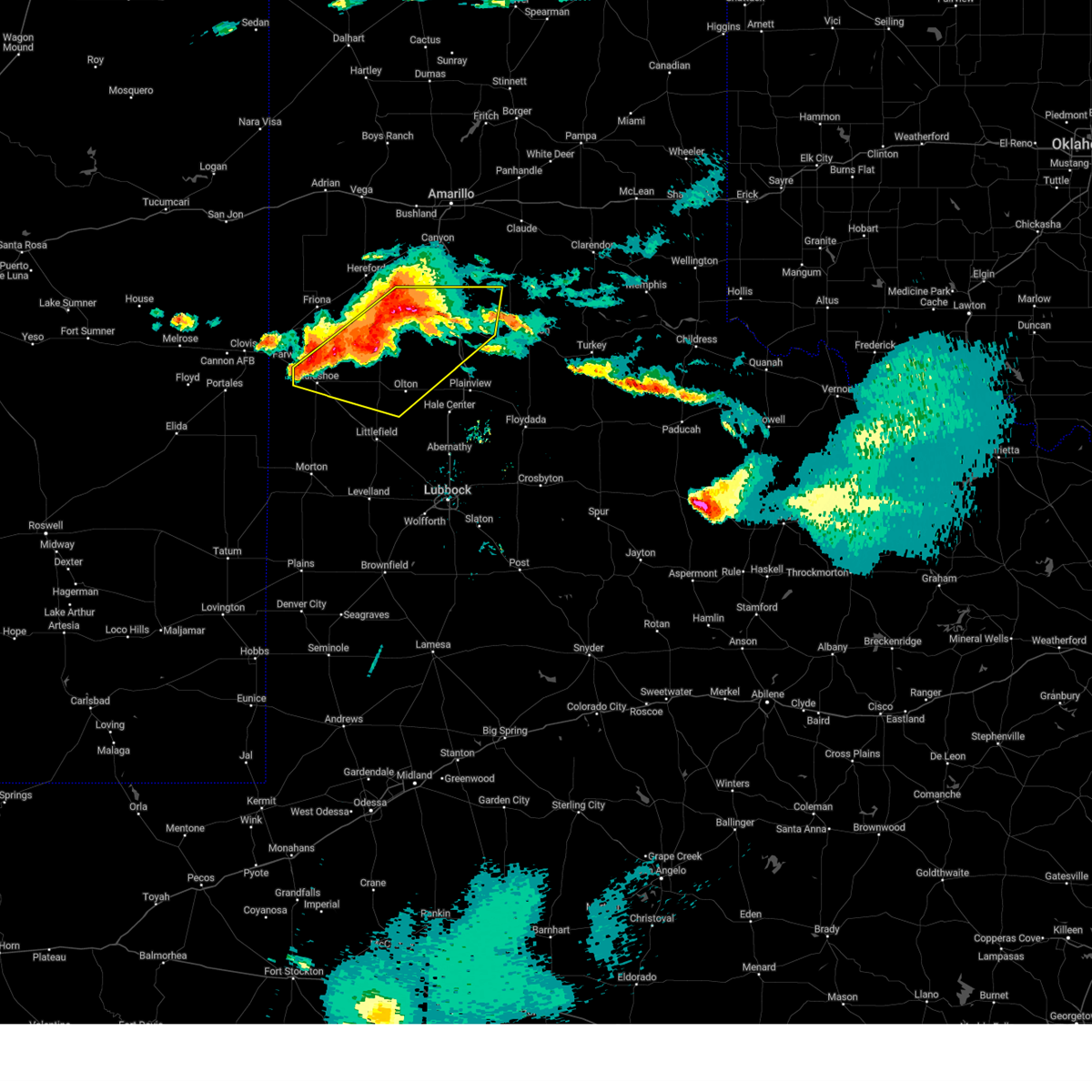
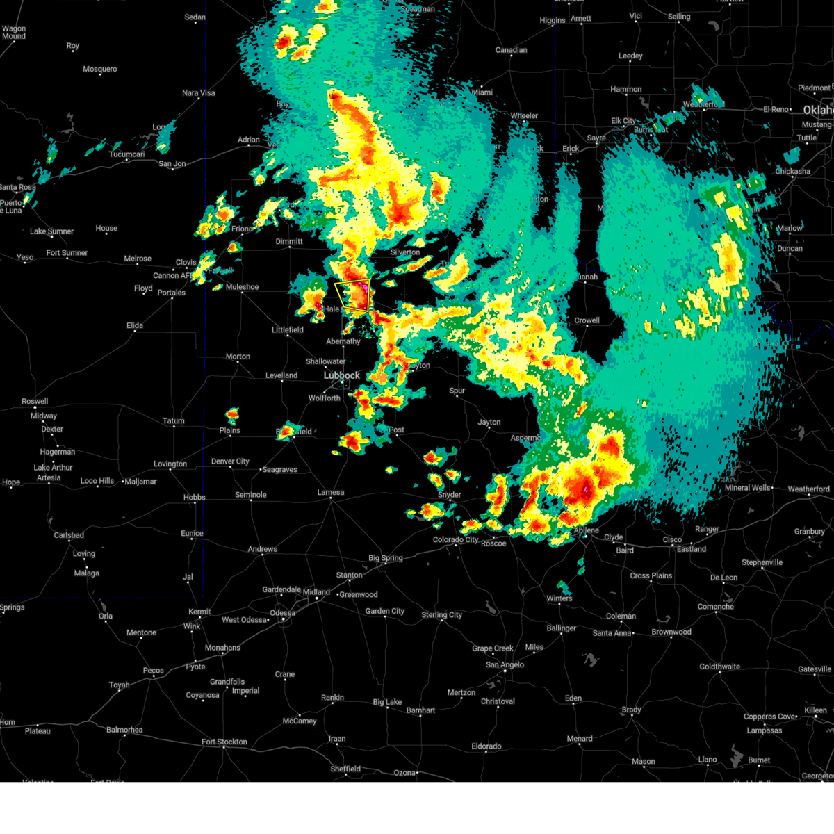
The Top Recent Hail Date for Edmonson, TX is Tuesday, May 6, 2025 (5th out of 88)
Hail and Wind Damage Spotted near Edmonson, TX
| Date / Time | Report Details |
|---|---|
| 6/6/2025 1:35 AM CDT |
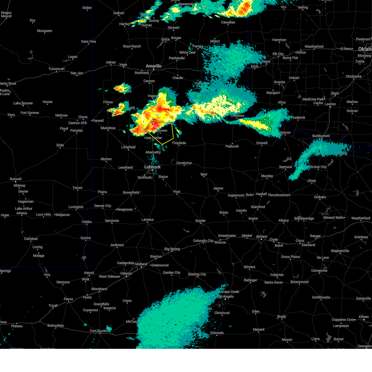 At 135 am cdt, a severe thunderstorm was located 6 miles south of kress, or 7 miles northwest of plainview, moving east at 35 mph (radar indicated). Hazards include two inch hail and 60 mph wind gusts. People and animals outdoors will be injured. expect hail damage to roofs, siding, windows, and vehicles. expect wind damage to roofs, siding, and trees. Locations impacted include, plainview, lockney, kress, aiken, seth ward, and edmonson. At 135 am cdt, a severe thunderstorm was located 6 miles south of kress, or 7 miles northwest of plainview, moving east at 35 mph (radar indicated). Hazards include two inch hail and 60 mph wind gusts. People and animals outdoors will be injured. expect hail damage to roofs, siding, windows, and vehicles. expect wind damage to roofs, siding, and trees. Locations impacted include, plainview, lockney, kress, aiken, seth ward, and edmonson.
|
| 6/6/2025 1:18 AM CDT |
 the severe thunderstorm warning has been cancelled and is no longer in effect the severe thunderstorm warning has been cancelled and is no longer in effect
|
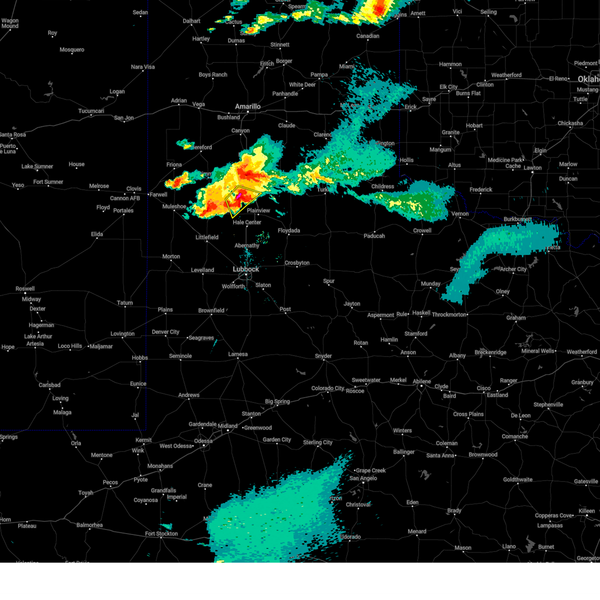
| 6/6/2025 1:18 AM CDT |
 At 117 am cdt, a severe thunderstorm was located 9 miles north of halfway, or 11 miles east of hart, moving southeast at 30 mph (radar indicated). Hazards include tennis ball size hail and 60 mph wind gusts. People and animals outdoors will be injured. expect hail damage to roofs, siding, windows, and vehicles. expect wind damage to roofs, siding, and trees. Locations impacted include, kress and edmonson. At 117 am cdt, a severe thunderstorm was located 9 miles north of halfway, or 11 miles east of hart, moving southeast at 30 mph (radar indicated). Hazards include tennis ball size hail and 60 mph wind gusts. People and animals outdoors will be injured. expect hail damage to roofs, siding, windows, and vehicles. expect wind damage to roofs, siding, and trees. Locations impacted include, kress and edmonson.
|
| 6/6/2025 1:15 AM CDT |
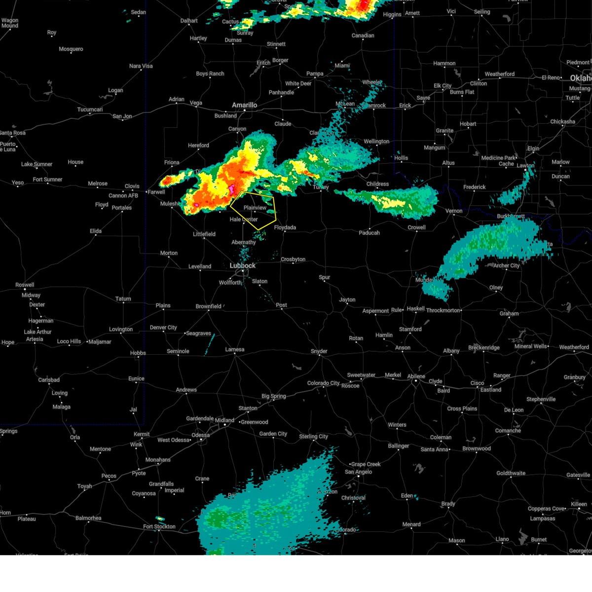 Svrlub the national weather service in lubbock texas has issued a * severe thunderstorm warning for, northwestern floyd county in northwestern texas, northern hale county in northwestern texas, southeastern swisher county in the panhandle of texas, * until 215 am cdt. * at 114 am cdt, a severe thunderstorm was located 4 miles east of hart, moving southeast at 30 mph (radar indicated). Hazards include tennis ball size hail and 60 mph wind gusts. People and animals outdoors will be injured. expect hail damage to roofs, siding, windows, and vehicles. Expect wind damage to roofs, siding, and trees. Svrlub the national weather service in lubbock texas has issued a * severe thunderstorm warning for, northwestern floyd county in northwestern texas, northern hale county in northwestern texas, southeastern swisher county in the panhandle of texas, * until 215 am cdt. * at 114 am cdt, a severe thunderstorm was located 4 miles east of hart, moving southeast at 30 mph (radar indicated). Hazards include tennis ball size hail and 60 mph wind gusts. People and animals outdoors will be injured. expect hail damage to roofs, siding, windows, and vehicles. Expect wind damage to roofs, siding, and trees.
|
| 6/6/2025 1:06 AM CDT |
 the severe thunderstorm warning has been cancelled and is no longer in effect the severe thunderstorm warning has been cancelled and is no longer in effect
|
| 6/6/2025 1:06 AM CDT |
 At 105 am cdt, severe thunderstorms were located along a line extending from 3 miles south of tulia to 7 miles southeast of earth, moving east at 45 mph (radar indicated). Hazards include two inch hail and 60 mph wind gusts. People and animals outdoors will be injured. expect hail damage to roofs, siding, windows, and vehicles. expect wind damage to roofs, siding, and trees. Locations impacted include, tulia, olton, hart, earth, kress, nazareth, edmonson, and springlake. At 105 am cdt, severe thunderstorms were located along a line extending from 3 miles south of tulia to 7 miles southeast of earth, moving east at 45 mph (radar indicated). Hazards include two inch hail and 60 mph wind gusts. People and animals outdoors will be injured. expect hail damage to roofs, siding, windows, and vehicles. expect wind damage to roofs, siding, and trees. Locations impacted include, tulia, olton, hart, earth, kress, nazareth, edmonson, and springlake.
|
| 6/6/2025 12:57 AM CDT |
 At 1256 am cdt, severe thunderstorms were located along a line extending from 13 miles west of tulia to muleshoe, moving east at 45 mph. large hail up to 2 inches in diameter is possible near hart (radar indicated). Hazards include two inch hail and 60 mph wind gusts. People and animals outdoors will be injured. expect hail damage to roofs, siding, windows, and vehicles. expect wind damage to roofs, siding, and trees. Locations impacted include, muleshoe, tulia, dimmitt, olton, hart, earth, kress, happy, lazbuddie, nazareth, edmonson, and springlake. At 1256 am cdt, severe thunderstorms were located along a line extending from 13 miles west of tulia to muleshoe, moving east at 45 mph. large hail up to 2 inches in diameter is possible near hart (radar indicated). Hazards include two inch hail and 60 mph wind gusts. People and animals outdoors will be injured. expect hail damage to roofs, siding, windows, and vehicles. expect wind damage to roofs, siding, and trees. Locations impacted include, muleshoe, tulia, dimmitt, olton, hart, earth, kress, happy, lazbuddie, nazareth, edmonson, and springlake.
|
| 6/6/2025 12:31 AM CDT |
 Svrlub the national weather service in lubbock texas has issued a * severe thunderstorm warning for, northeastern bailey county in northwestern texas, southeastern parmer county in the panhandle of texas, northwestern hale county in northwestern texas, castro county in the panhandle of texas, swisher county in the panhandle of texas, northern lamb county in northwestern texas, * until 130 am cdt. * at 1231 am cdt, severe thunderstorms were located along a line extending from 14 miles east of dimmitt to near muleshoe, moving east at 35 mph (radar indicated). Hazards include 60 mph wind gusts and half dollar size hail. Hail damage to vehicles is expected. Expect wind damage to roofs, siding, and trees. Svrlub the national weather service in lubbock texas has issued a * severe thunderstorm warning for, northeastern bailey county in northwestern texas, southeastern parmer county in the panhandle of texas, northwestern hale county in northwestern texas, castro county in the panhandle of texas, swisher county in the panhandle of texas, northern lamb county in northwestern texas, * until 130 am cdt. * at 1231 am cdt, severe thunderstorms were located along a line extending from 14 miles east of dimmitt to near muleshoe, moving east at 35 mph (radar indicated). Hazards include 60 mph wind gusts and half dollar size hail. Hail damage to vehicles is expected. Expect wind damage to roofs, siding, and trees.
|
| 5/25/2025 9:27 PM CDT |
 The storm which prompted the warning has weakened below severe limits, and no longer poses an immediate threat to life or property. therefore, the warning will be allowed to expire. a tornado watch remains in effect until 1100 pm cdt for the panhandle of and northwestern texas. The storm which prompted the warning has weakened below severe limits, and no longer poses an immediate threat to life or property. therefore, the warning will be allowed to expire. a tornado watch remains in effect until 1100 pm cdt for the panhandle of and northwestern texas.
|
| 5/25/2025 9:15 PM CDT | At 915 pm cdt, a severe thunderstorm was located over plainview, moving east at 30 mph (radar indicated). Hazards include 60 mph wind gusts and half dollar size hail. Hail damage to vehicles is expected. expect wind damage to roofs, siding, and trees. Locations impacted include, plainview, seth ward, and edmonson. |
| 5/25/2025 9:05 PM CDT |
 At 905 pm cdt, a severe thunderstorm was located 6 miles west of plainview, moving east at 25 mph (radar indicated). Hazards include ping pong ball size hail and 60 mph wind gusts. People and animals outdoors will be injured. expect hail damage to roofs, siding, windows, and vehicles. expect wind damage to roofs, siding, and trees. Locations impacted include, plainview, halfway, seth ward, and edmonson. At 905 pm cdt, a severe thunderstorm was located 6 miles west of plainview, moving east at 25 mph (radar indicated). Hazards include ping pong ball size hail and 60 mph wind gusts. People and animals outdoors will be injured. expect hail damage to roofs, siding, windows, and vehicles. expect wind damage to roofs, siding, and trees. Locations impacted include, plainview, halfway, seth ward, and edmonson.
|
| 5/25/2025 8:51 PM CDT | Svrlub the national weather service in lubbock texas has issued a * severe thunderstorm warning for, northern hale county in northwestern texas, south central swisher county in the panhandle of texas, * until 930 pm cdt. * at 851 pm cdt, a severe thunderstorm was located over halfway, or 8 miles northwest of hale center, moving east at 25 mph (radar indicated). Hazards include golf ball size hail and 60 mph wind gusts. People and animals outdoors will be injured. expect hail damage to roofs, siding, windows, and vehicles. Expect wind damage to roofs, siding, and trees. |
| 5/6/2025 7:07 PM CDT |
 At 707 pm cdt, a severe thunderstorm was located 7 miles southwest of kress, or 8 miles northwest of plainview, moving east at 25 mph (radar indicated). Hazards include quarter size hail. Damage to vehicles is expected. Locations impacted include, plainview, kress, seth ward, and edmonson. At 707 pm cdt, a severe thunderstorm was located 7 miles southwest of kress, or 8 miles northwest of plainview, moving east at 25 mph (radar indicated). Hazards include quarter size hail. Damage to vehicles is expected. Locations impacted include, plainview, kress, seth ward, and edmonson.
|
| 5/6/2025 6:49 PM CDT |
 Svrlub the national weather service in lubbock texas has issued a * severe thunderstorm warning for, northern hale county in northwestern texas, southern swisher county in the panhandle of texas, * until 745 pm cdt. * at 649 pm cdt, a severe thunderstorm was located 9 miles southeast of hart, moving east at 20 mph (radar indicated). Hazards include quarter size hail. damage to vehicles is expected Svrlub the national weather service in lubbock texas has issued a * severe thunderstorm warning for, northern hale county in northwestern texas, southern swisher county in the panhandle of texas, * until 745 pm cdt. * at 649 pm cdt, a severe thunderstorm was located 9 miles southeast of hart, moving east at 20 mph (radar indicated). Hazards include quarter size hail. damage to vehicles is expected
|
| 4/22/2025 6:01 PM CDT |
 At 601 pm cdt, a severe thunderstorm was located 6 miles southeast of hart, moving north at 15 mph (radar indicated). Hazards include 60 mph wind gusts and quarter size hail. Hail damage to vehicles is expected. expect wind damage to roofs, siding, and trees. Locations impacted include, edmonson and kress. At 601 pm cdt, a severe thunderstorm was located 6 miles southeast of hart, moving north at 15 mph (radar indicated). Hazards include 60 mph wind gusts and quarter size hail. Hail damage to vehicles is expected. expect wind damage to roofs, siding, and trees. Locations impacted include, edmonson and kress.
|
| 4/22/2025 6:01 PM CDT |
 the severe thunderstorm warning has been cancelled and is no longer in effect the severe thunderstorm warning has been cancelled and is no longer in effect
|
| 4/22/2025 5:48 PM CDT |
 At 548 pm cdt, a severe thunderstorm was located 6 miles east of hart, moving north at 25 mph (radar indicated). Hazards include 60 mph wind gusts and half dollar size hail. Hail damage to vehicles is expected. expect wind damage to roofs, siding, and trees. Locations impacted include, hart, halfway, edmonson, and kress. At 548 pm cdt, a severe thunderstorm was located 6 miles east of hart, moving north at 25 mph (radar indicated). Hazards include 60 mph wind gusts and half dollar size hail. Hail damage to vehicles is expected. expect wind damage to roofs, siding, and trees. Locations impacted include, hart, halfway, edmonson, and kress.
|
| 4/22/2025 5:38 PM CDT |
 At 538 pm cdt, a severe thunderstorm was located 7 miles southeast of hart, moving north at 25 mph (radar indicated). Hazards include ping pong ball size hail and 60 mph wind gusts. People and animals outdoors will be injured. expect hail damage to roofs, siding, windows, and vehicles. expect wind damage to roofs, siding, and trees. Locations impacted include, hart, halfway, edmonson, and kress. At 538 pm cdt, a severe thunderstorm was located 7 miles southeast of hart, moving north at 25 mph (radar indicated). Hazards include ping pong ball size hail and 60 mph wind gusts. People and animals outdoors will be injured. expect hail damage to roofs, siding, windows, and vehicles. expect wind damage to roofs, siding, and trees. Locations impacted include, hart, halfway, edmonson, and kress.
|
| 4/22/2025 5:20 PM CDT |
 At 520 pm cdt, a severe thunderstorm was located 5 miles northeast of olton, moving north at 25 mph (radar indicated). Hazards include 60 mph wind gusts and quarter size hail. Hail damage to vehicles is expected. expect wind damage to roofs, siding, and trees. Locations impacted include, hart, halfway, edmonson, olton, and kress. At 520 pm cdt, a severe thunderstorm was located 5 miles northeast of olton, moving north at 25 mph (radar indicated). Hazards include 60 mph wind gusts and quarter size hail. Hail damage to vehicles is expected. expect wind damage to roofs, siding, and trees. Locations impacted include, hart, halfway, edmonson, olton, and kress.
|
| 4/22/2025 5:11 PM CDT |
 Svrlub the national weather service in lubbock texas has issued a * severe thunderstorm warning for, northwestern hale county in northwestern texas, southeastern castro county in the panhandle of texas, southwestern swisher county in the panhandle of texas, northeastern lamb county in northwestern texas, * until 615 pm cdt. * at 511 pm cdt, a severe thunderstorm was located over olton, moving north at 25 mph (radar indicated). Hazards include 60 mph wind gusts and half dollar size hail. Hail damage to vehicles is expected. Expect wind damage to roofs, siding, and trees. Svrlub the national weather service in lubbock texas has issued a * severe thunderstorm warning for, northwestern hale county in northwestern texas, southeastern castro county in the panhandle of texas, southwestern swisher county in the panhandle of texas, northeastern lamb county in northwestern texas, * until 615 pm cdt. * at 511 pm cdt, a severe thunderstorm was located over olton, moving north at 25 mph (radar indicated). Hazards include 60 mph wind gusts and half dollar size hail. Hail damage to vehicles is expected. Expect wind damage to roofs, siding, and trees.
|
| 9/21/2024 11:52 PM CDT |
 At 1152 pm cdt, a severe thunderstorm was located 6 miles northwest of plainview, moving east at 25 mph (radar indicated). Hazards include 60 mph wind gusts and quarter size hail. Hail damage to vehicles is expected. expect wind damage to roofs, siding, and trees. Locations impacted include, plainview, kress, seth ward, and edmonson. At 1152 pm cdt, a severe thunderstorm was located 6 miles northwest of plainview, moving east at 25 mph (radar indicated). Hazards include 60 mph wind gusts and quarter size hail. Hail damage to vehicles is expected. expect wind damage to roofs, siding, and trees. Locations impacted include, plainview, kress, seth ward, and edmonson.
|
| 9/21/2024 11:44 PM CDT |
 the severe thunderstorm warning has been cancelled and is no longer in effect the severe thunderstorm warning has been cancelled and is no longer in effect
|
| 9/21/2024 11:44 PM CDT |
 At 1143 pm cdt, a severe thunderstorm was located 7 miles northwest of plainview, moving east at 30 mph (radar indicated). Hazards include 60 mph wind gusts and quarter size hail. Hail damage to vehicles is expected. expect wind damage to roofs, siding, and trees. Locations impacted include, plainview, tulia, kress, seth ward, and edmonson. At 1143 pm cdt, a severe thunderstorm was located 7 miles northwest of plainview, moving east at 30 mph (radar indicated). Hazards include 60 mph wind gusts and quarter size hail. Hail damage to vehicles is expected. expect wind damage to roofs, siding, and trees. Locations impacted include, plainview, tulia, kress, seth ward, and edmonson.
|
| 9/21/2024 11:27 PM CDT |
 Svrlub the national weather service in lubbock texas has issued a * severe thunderstorm warning for, western floyd county in northwestern texas, northern hale county in northwestern texas, southeastern castro county in the panhandle of texas, southwestern swisher county in the panhandle of texas, northeastern lamb county in northwestern texas, * until 1215 am cdt. * at 1127 pm cdt, a severe thunderstorm was located near halfway, or 11 miles east of olton, moving east at 30 mph (radar indicated). Hazards include 60 mph wind gusts and half dollar size hail. Hail damage to vehicles is expected. Expect wind damage to roofs, siding, and trees. Svrlub the national weather service in lubbock texas has issued a * severe thunderstorm warning for, western floyd county in northwestern texas, northern hale county in northwestern texas, southeastern castro county in the panhandle of texas, southwestern swisher county in the panhandle of texas, northeastern lamb county in northwestern texas, * until 1215 am cdt. * at 1127 pm cdt, a severe thunderstorm was located near halfway, or 11 miles east of olton, moving east at 30 mph (radar indicated). Hazards include 60 mph wind gusts and half dollar size hail. Hail damage to vehicles is expected. Expect wind damage to roofs, siding, and trees.
|
| 6/6/2024 9:30 PM CDT |
 At 930 pm cdt, severe thunderstorms were located along a line extending from 7 miles south of silverton to 6 miles west of plainview, moving southeast at 30 mph (radar indicated). Hazards include 60 mph wind gusts and penny size hail. Expect damage to roofs, siding, and trees. Locations impacted include, plainview, hale center, silverton, lockney, halfway, south plains, claytonville, aiken, seth ward, and edmonson. At 930 pm cdt, severe thunderstorms were located along a line extending from 7 miles south of silverton to 6 miles west of plainview, moving southeast at 30 mph (radar indicated). Hazards include 60 mph wind gusts and penny size hail. Expect damage to roofs, siding, and trees. Locations impacted include, plainview, hale center, silverton, lockney, halfway, south plains, claytonville, aiken, seth ward, and edmonson.
|
| 6/6/2024 9:30 PM CDT |
 the severe thunderstorm warning has been cancelled and is no longer in effect the severe thunderstorm warning has been cancelled and is no longer in effect
|
| 6/6/2024 8:53 PM CDT |
 Svrlub the national weather service in lubbock texas has issued a * severe thunderstorm warning for, northern floyd county in northwestern texas, northeastern hale county in northwestern texas, southeastern castro county in the panhandle of texas, southern swisher county in the panhandle of texas, southwestern briscoe county in the panhandle of texas, * until 1000 pm cdt. * at 852 pm cdt, severe thunderstorms were located along a line extending from near mackenzie reservoir to 4 miles east of hart, moving southeast at 30 mph (radar indicated). Hazards include 60 mph wind gusts and penny size hail. expect damage to roofs, siding, and trees Svrlub the national weather service in lubbock texas has issued a * severe thunderstorm warning for, northern floyd county in northwestern texas, northeastern hale county in northwestern texas, southeastern castro county in the panhandle of texas, southern swisher county in the panhandle of texas, southwestern briscoe county in the panhandle of texas, * until 1000 pm cdt. * at 852 pm cdt, severe thunderstorms were located along a line extending from near mackenzie reservoir to 4 miles east of hart, moving southeast at 30 mph (radar indicated). Hazards include 60 mph wind gusts and penny size hail. expect damage to roofs, siding, and trees
|
| 5/3/2024 4:25 PM CDT |
 Svrlub the national weather service in lubbock texas has issued a * severe thunderstorm warning for, north central hale county in northwestern texas, swisher county in the panhandle of texas, western briscoe county in the panhandle of texas, * until 530 pm cdt. * at 425 pm cdt, a severe thunderstorm was located 7 miles west of kress, or 13 miles southwest of tulia, moving northeast at 20 mph (radar indicated). Hazards include 60 mph wind gusts and half dollar size hail. Hail damage to vehicles is expected. Expect wind damage to roofs, siding, and trees. Svrlub the national weather service in lubbock texas has issued a * severe thunderstorm warning for, north central hale county in northwestern texas, swisher county in the panhandle of texas, western briscoe county in the panhandle of texas, * until 530 pm cdt. * at 425 pm cdt, a severe thunderstorm was located 7 miles west of kress, or 13 miles southwest of tulia, moving northeast at 20 mph (radar indicated). Hazards include 60 mph wind gusts and half dollar size hail. Hail damage to vehicles is expected. Expect wind damage to roofs, siding, and trees.
|
| 5/1/2024 7:29 PM CDT | Svrlub the national weather service in lubbock texas has issued a * severe thunderstorm warning for, western dickens county in northwestern texas, floyd county in northwestern texas, northern crosby county in northwestern texas, western motley county in northwestern texas, hale county in northwestern texas, * until 815 pm cdt. * at 729 pm cdt, a severe thunderstorm was located 4 miles north of cone, or 9 miles southwest of floydada, moving northeast at 30 mph (radar indicated). Hazards include 60 mph wind gusts and quarter size hail. Hail damage to vehicles is expected. Expect wind damage to roofs, siding, and trees. |
| 10/4/2023 2:27 PM CDT |
 At 227 pm cdt, a severe thunderstorm was located over hale center, moving east at 50 mph (radar indicated). Hazards include 60 mph wind gusts and quarter size hail. Hail damage to vehicles is expected. expect wind damage to roofs, siding, and trees. locations impacted include, plainview, hale center, petersburg, cotton center, halfway, and edmonson. hail threat, radar indicated max hail size, 1. 00 in wind threat, radar indicated max wind gust, 60 mph. At 227 pm cdt, a severe thunderstorm was located over hale center, moving east at 50 mph (radar indicated). Hazards include 60 mph wind gusts and quarter size hail. Hail damage to vehicles is expected. expect wind damage to roofs, siding, and trees. locations impacted include, plainview, hale center, petersburg, cotton center, halfway, and edmonson. hail threat, radar indicated max hail size, 1. 00 in wind threat, radar indicated max wind gust, 60 mph.
|
| 10/4/2023 2:07 PM CDT |
 At 207 pm cdt, a severe thunderstorm was located over spade, or 12 miles east of littlefield, moving east at 50 mph (radar indicated). Hazards include 60 mph wind gusts and quarter size hail. Hail damage to vehicles is expected. expect wind damage to roofs, siding, and trees. locations impacted include, plainview, hale center, petersburg, cotton center, fieldton, spade, halfway, and edmonson. hail threat, radar indicated max hail size, 1. 00 in wind threat, radar indicated max wind gust, 60 mph. At 207 pm cdt, a severe thunderstorm was located over spade, or 12 miles east of littlefield, moving east at 50 mph (radar indicated). Hazards include 60 mph wind gusts and quarter size hail. Hail damage to vehicles is expected. expect wind damage to roofs, siding, and trees. locations impacted include, plainview, hale center, petersburg, cotton center, fieldton, spade, halfway, and edmonson. hail threat, radar indicated max hail size, 1. 00 in wind threat, radar indicated max wind gust, 60 mph.
|
| 10/4/2023 2:00 PM CDT |
 At 200 pm cdt, a severe thunderstorm was located 4 miles west of spade, or 6 miles east of littlefield, moving east at 50 mph (radar indicated). Hazards include 60 mph wind gusts and quarter size hail. Hail damage to vehicles is expected. Expect wind damage to roofs, siding, and trees. At 200 pm cdt, a severe thunderstorm was located 4 miles west of spade, or 6 miles east of littlefield, moving east at 50 mph (radar indicated). Hazards include 60 mph wind gusts and quarter size hail. Hail damage to vehicles is expected. Expect wind damage to roofs, siding, and trees.
|
| 9/15/2023 11:23 PM CDT |
 The severe thunderstorm warning for northwestern floyd, northeastern hale, southeastern castro and southwestern swisher counties will expire at 1130 pm cdt, the storm which prompted the warning has weakened below severe limits, and no longer poses an immediate threat to life or property. therefore, the warning will be allowed to expire. however, small hail and heavy rain are still possible with this thunderstorm. a severe thunderstorm watch remains in effect until 200 am cdt for the panhandle of and northwestern texas. The severe thunderstorm warning for northwestern floyd, northeastern hale, southeastern castro and southwestern swisher counties will expire at 1130 pm cdt, the storm which prompted the warning has weakened below severe limits, and no longer poses an immediate threat to life or property. therefore, the warning will be allowed to expire. however, small hail and heavy rain are still possible with this thunderstorm. a severe thunderstorm watch remains in effect until 200 am cdt for the panhandle of and northwestern texas.
|
| 9/15/2023 11:00 PM CDT |
 At 1059 pm cdt, a severe thunderstorm was located over kress, or 11 miles north of plainview, moving southeast at 35 mph (radar indicated). Hazards include 60 mph wind gusts and quarter size hail. Hail damage to vehicles is expected. expect wind damage to roofs, siding, and trees. locations impacted include, plainview, tulia, kress, aiken, seth ward, and edmonson. hail threat, radar indicated max hail size, 1. 00 in wind threat, radar indicated max wind gust, 60 mph. At 1059 pm cdt, a severe thunderstorm was located over kress, or 11 miles north of plainview, moving southeast at 35 mph (radar indicated). Hazards include 60 mph wind gusts and quarter size hail. Hail damage to vehicles is expected. expect wind damage to roofs, siding, and trees. locations impacted include, plainview, tulia, kress, aiken, seth ward, and edmonson. hail threat, radar indicated max hail size, 1. 00 in wind threat, radar indicated max wind gust, 60 mph.
|
| 9/15/2023 10:50 PM CDT |
 At 1050 pm cdt, a severe thunderstorm was located 6 miles northwest of kress, or 9 miles southwest of tulia, moving southeast at 35 mph (radar indicated). Hazards include ping pong ball size hail and 60 mph wind gusts. People and animals outdoors will be injured. expect hail damage to roofs, siding, windows, and vehicles. expect wind damage to roofs, siding, and trees. locations impacted include, plainview, tulia, hart, kress, aiken, seth ward, and edmonson. hail threat, radar indicated max hail size, 1. 50 in wind threat, radar indicated max wind gust, 60 mph. At 1050 pm cdt, a severe thunderstorm was located 6 miles northwest of kress, or 9 miles southwest of tulia, moving southeast at 35 mph (radar indicated). Hazards include ping pong ball size hail and 60 mph wind gusts. People and animals outdoors will be injured. expect hail damage to roofs, siding, windows, and vehicles. expect wind damage to roofs, siding, and trees. locations impacted include, plainview, tulia, hart, kress, aiken, seth ward, and edmonson. hail threat, radar indicated max hail size, 1. 50 in wind threat, radar indicated max wind gust, 60 mph.
|
| 9/15/2023 10:30 PM CDT |
 At 1030 pm cdt, a severe thunderstorm was located 8 miles northeast of hart, moving southeast at 35 mph (radar indicated). Hazards include ping pong ball size hail and 60 mph wind gusts. People and animals outdoors will be injured. expect hail damage to roofs, siding, windows, and vehicles. Expect wind damage to roofs, siding, and trees. At 1030 pm cdt, a severe thunderstorm was located 8 miles northeast of hart, moving southeast at 35 mph (radar indicated). Hazards include ping pong ball size hail and 60 mph wind gusts. People and animals outdoors will be injured. expect hail damage to roofs, siding, windows, and vehicles. Expect wind damage to roofs, siding, and trees.
|
| 7/7/2023 7:00 PM CDT |
 At 700 pm cdt, severe thunderstorms were located along a line extending from 11 miles west of brice to 8 miles west of flomot to 3 miles north of cone to downtown lubbock, moving east at 60 mph (radar indicated). Hazards include 60 mph wind gusts. Expect damage to roofs, siding, and trees. locations impacted include, lubbock, plainview, levelland, slaton, tulia, floydada, abernathy, memphis, hale center, crosbyton, silverton, matador, turkey, caprock canyon state park, wolfforth, shallowater, idalou, ralls, lockney and sundown. hail threat, radar indicated max hail size, <. 75 in wind threat, radar indicated max wind gust, 60 mph. At 700 pm cdt, severe thunderstorms were located along a line extending from 11 miles west of brice to 8 miles west of flomot to 3 miles north of cone to downtown lubbock, moving east at 60 mph (radar indicated). Hazards include 60 mph wind gusts. Expect damage to roofs, siding, and trees. locations impacted include, lubbock, plainview, levelland, slaton, tulia, floydada, abernathy, memphis, hale center, crosbyton, silverton, matador, turkey, caprock canyon state park, wolfforth, shallowater, idalou, ralls, lockney and sundown. hail threat, radar indicated max hail size, <. 75 in wind threat, radar indicated max wind gust, 60 mph.
|
| 7/7/2023 6:31 PM CDT |
 At 631 pm cdt, severe thunderstorms were located along a line extending from 4 miles northwest of vigo park to 4 miles northwest of aiken to abernathy to 6 miles southeast of levelland, moving east at 60 mph (radar indicated). Hazards include 70 mph wind gusts. Expect considerable tree damage. Damage is likely to mobile homes, roofs, and outbuildings. At 631 pm cdt, severe thunderstorms were located along a line extending from 4 miles northwest of vigo park to 4 miles northwest of aiken to abernathy to 6 miles southeast of levelland, moving east at 60 mph (radar indicated). Hazards include 70 mph wind gusts. Expect considerable tree damage. Damage is likely to mobile homes, roofs, and outbuildings.
|
| 7/7/2023 6:16 PM CDT |
 At 616 pm cdt, severe thunderstorms were located along a line extending from 8 miles east of happy to kress to cotton center, moving east at 45 mph (radar indicated). Hazards include 70 mph wind gusts. Expect considerable tree damage. damage is likely to mobile homes, roofs, and outbuildings. locations impacted include, plainview, littlefield, tulia, dimmitt, abernathy, hale center, olton, hart, earth, petersburg, sudan, amherst, kress, happy, cotton center, vigo park, fieldton, spade, claytonville and halfway. thunderstorm damage threat, considerable hail threat, radar indicated max hail size, <. 75 in wind threat, radar indicated max wind gust, 70 mph. At 616 pm cdt, severe thunderstorms were located along a line extending from 8 miles east of happy to kress to cotton center, moving east at 45 mph (radar indicated). Hazards include 70 mph wind gusts. Expect considerable tree damage. damage is likely to mobile homes, roofs, and outbuildings. locations impacted include, plainview, littlefield, tulia, dimmitt, abernathy, hale center, olton, hart, earth, petersburg, sudan, amherst, kress, happy, cotton center, vigo park, fieldton, spade, claytonville and halfway. thunderstorm damage threat, considerable hail threat, radar indicated max hail size, <. 75 in wind threat, radar indicated max wind gust, 70 mph.
|
| 7/7/2023 6:10 PM CDT |
 At 609 pm cdt, severe thunderstorms were located along a line extending from 4 miles east of happy to 3 miles southwest of kress to near cotton center, moving east at 45 mph (radar indicated). Hazards include 70 mph wind gusts. Expect considerable tree damage. damage is likely to mobile homes, roofs, and outbuildings. locations impacted include, plainview, littlefield, tulia, dimmitt, abernathy, hale center, olton, hart, earth, petersburg, sudan, amherst, kress, happy, cotton center, vigo park, fieldton, spade, claytonville and halfway. thunderstorm damage threat, considerable hail threat, radar indicated max hail size, <. 75 in wind threat, radar indicated max wind gust, 70 mph. At 609 pm cdt, severe thunderstorms were located along a line extending from 4 miles east of happy to 3 miles southwest of kress to near cotton center, moving east at 45 mph (radar indicated). Hazards include 70 mph wind gusts. Expect considerable tree damage. damage is likely to mobile homes, roofs, and outbuildings. locations impacted include, plainview, littlefield, tulia, dimmitt, abernathy, hale center, olton, hart, earth, petersburg, sudan, amherst, kress, happy, cotton center, vigo park, fieldton, spade, claytonville and halfway. thunderstorm damage threat, considerable hail threat, radar indicated max hail size, <. 75 in wind threat, radar indicated max wind gust, 70 mph.
|
| 7/7/2023 5:31 PM CDT |
 At 530 pm cdt, severe thunderstorms were located along a line extending from 5 miles east of easter to 5 miles northeast of earth to 5 miles east of bula, moving east at 45 mph (west texas mesonet. at 525 pm cdt, dimmitt mesonet gusted to 64 mph). Hazards include 70 mph wind gusts. Expect considerable tree damage. Damage is likely to mobile homes, roofs, and outbuildings. At 530 pm cdt, severe thunderstorms were located along a line extending from 5 miles east of easter to 5 miles northeast of earth to 5 miles east of bula, moving east at 45 mph (west texas mesonet. at 525 pm cdt, dimmitt mesonet gusted to 64 mph). Hazards include 70 mph wind gusts. Expect considerable tree damage. Damage is likely to mobile homes, roofs, and outbuildings.
|
| 6/23/2023 7:44 PM CDT |
 At 744 pm cdt, a severe thunderstorm was located 4 miles east of halfway, or 8 miles north of hale center, moving east at 35 mph (radar indicated). Hazards include 60 mph wind gusts and half dollar size hail. Hail damage to vehicles is expected. Expect wind damage to roofs, siding, and trees. At 744 pm cdt, a severe thunderstorm was located 4 miles east of halfway, or 8 miles north of hale center, moving east at 35 mph (radar indicated). Hazards include 60 mph wind gusts and half dollar size hail. Hail damage to vehicles is expected. Expect wind damage to roofs, siding, and trees.
|
| 6/23/2023 7:37 PM CDT |
 At 736 pm cdt, a severe thunderstorm was located 5 miles north of halfway, or 12 miles northeast of olton, moving east at 40 mph (radar indicated). Hazards include 60 mph wind gusts and half dollar size hail. Hail damage to vehicles is expected. expect wind damage to roofs, siding, and trees. locations impacted include, plainview, kress, halfway, seth ward and edmonson. hail threat, radar indicated max hail size, 1. 25 in wind threat, radar indicated max wind gust, 60 mph. At 736 pm cdt, a severe thunderstorm was located 5 miles north of halfway, or 12 miles northeast of olton, moving east at 40 mph (radar indicated). Hazards include 60 mph wind gusts and half dollar size hail. Hail damage to vehicles is expected. expect wind damage to roofs, siding, and trees. locations impacted include, plainview, kress, halfway, seth ward and edmonson. hail threat, radar indicated max hail size, 1. 25 in wind threat, radar indicated max wind gust, 60 mph.
|
| 6/23/2023 7:26 PM CDT |
 At 726 pm cdt, a severe thunderstorm was located 6 miles northeast of olton, moving east at 20 mph (radar indicated). Hazards include 60 mph wind gusts and quarter size hail. Hail damage to vehicles is expected. expect wind damage to roofs, siding, and trees. locations impacted include, plainview, olton, kress, halfway, seth ward and edmonson. hail threat, radar indicated max hail size, 1. 00 in wind threat, radar indicated max wind gust, 60 mph. At 726 pm cdt, a severe thunderstorm was located 6 miles northeast of olton, moving east at 20 mph (radar indicated). Hazards include 60 mph wind gusts and quarter size hail. Hail damage to vehicles is expected. expect wind damage to roofs, siding, and trees. locations impacted include, plainview, olton, kress, halfway, seth ward and edmonson. hail threat, radar indicated max hail size, 1. 00 in wind threat, radar indicated max wind gust, 60 mph.
|
| 6/23/2023 7:17 PM CDT |
 At 717 pm cdt, severe thunderstorms were located along a line extending from 4 miles north of plainview to 6 miles south of hart, moving east at 40 mph (radar indicated). Hazards include 60 mph wind gusts and quarter size hail. Hail damage to vehicles is expected. expect wind damage to roofs, siding, and trees. locations impacted include, plainview, olton, hart, kress, halfway, claytonville, seth ward and edmonson. hail threat, radar indicated max hail size, 1. 00 in wind threat, radar indicated max wind gust, 60 mph. At 717 pm cdt, severe thunderstorms were located along a line extending from 4 miles north of plainview to 6 miles south of hart, moving east at 40 mph (radar indicated). Hazards include 60 mph wind gusts and quarter size hail. Hail damage to vehicles is expected. expect wind damage to roofs, siding, and trees. locations impacted include, plainview, olton, hart, kress, halfway, claytonville, seth ward and edmonson. hail threat, radar indicated max hail size, 1. 00 in wind threat, radar indicated max wind gust, 60 mph.
|
| 6/23/2023 7:10 PM CDT |
 At 709 pm cdt, severe thunderstorms were located along a line extending from 6 miles northwest of plainview to 7 miles north of olton, moving east at 35 mph (radar indicated). Hazards include 60 mph wind gusts and quarter size hail. Hail damage to vehicles is expected. expect wind damage to roofs, siding, and trees. locations impacted include, plainview, olton, hart, kress, halfway, claytonville, seth ward, edmonson and springlake. hail threat, radar indicated max hail size, 1. 00 in wind threat, radar indicated max wind gust, 60 mph. At 709 pm cdt, severe thunderstorms were located along a line extending from 6 miles northwest of plainview to 7 miles north of olton, moving east at 35 mph (radar indicated). Hazards include 60 mph wind gusts and quarter size hail. Hail damage to vehicles is expected. expect wind damage to roofs, siding, and trees. locations impacted include, plainview, olton, hart, kress, halfway, claytonville, seth ward, edmonson and springlake. hail threat, radar indicated max hail size, 1. 00 in wind threat, radar indicated max wind gust, 60 mph.
|
| 6/23/2023 7:02 PM CDT |
 At 702 pm cdt, severe thunderstorms were located along a line extending from 7 miles northwest of plainview to 9 miles northwest of olton, moving east at 30 mph (radar indicated). Hazards include 60 mph wind gusts and quarter size hail. Hail damage to vehicles is expected. expect wind damage to roofs, siding, and trees. locations impacted include, plainview, olton, hart, kress, halfway, claytonville, seth ward, edmonson and springlake. hail threat, radar indicated max hail size, 1. 00 in wind threat, radar indicated max wind gust, 60 mph. At 702 pm cdt, severe thunderstorms were located along a line extending from 7 miles northwest of plainview to 9 miles northwest of olton, moving east at 30 mph (radar indicated). Hazards include 60 mph wind gusts and quarter size hail. Hail damage to vehicles is expected. expect wind damage to roofs, siding, and trees. locations impacted include, plainview, olton, hart, kress, halfway, claytonville, seth ward, edmonson and springlake. hail threat, radar indicated max hail size, 1. 00 in wind threat, radar indicated max wind gust, 60 mph.
|
| 6/23/2023 6:56 PM CDT |
 At 656 pm cdt, severe thunderstorms were located along a line extending from 8 miles southwest of kress to 8 miles northeast of earth, moving east at 25 mph (radar indicated). Hazards include ping pong ball size hail and 60 mph wind gusts. People and animals outdoors will be injured. expect hail damage to roofs, siding, windows, and vehicles. expect wind damage to roofs, siding, and trees. locations impacted include, plainview, tulia, olton, hart, earth, kress, vigo park, halfway, claytonville, seth ward, edmonson and springlake. hail threat, radar indicated max hail size, 1. 50 in wind threat, radar indicated max wind gust, 60 mph. At 656 pm cdt, severe thunderstorms were located along a line extending from 8 miles southwest of kress to 8 miles northeast of earth, moving east at 25 mph (radar indicated). Hazards include ping pong ball size hail and 60 mph wind gusts. People and animals outdoors will be injured. expect hail damage to roofs, siding, windows, and vehicles. expect wind damage to roofs, siding, and trees. locations impacted include, plainview, tulia, olton, hart, earth, kress, vigo park, halfway, claytonville, seth ward, edmonson and springlake. hail threat, radar indicated max hail size, 1. 50 in wind threat, radar indicated max wind gust, 60 mph.
|
| 6/23/2023 6:45 PM CDT |
 At 645 pm cdt, severe thunderstorms were located along a line extending from 8 miles southwest of kress to 4 miles northeast of earth, moving east at 40 mph (radar indicated). Hazards include 60 mph wind gusts and half dollar size hail. Hail damage to vehicles is expected. expect wind damage to roofs, siding, and trees. locations impacted include, plainview, tulia, olton, hart, earth, kress, vigo park, halfway, claytonville, seth ward, edmonson and springlake. hail threat, radar indicated max hail size, 1. 25 in wind threat, radar indicated max wind gust, 60 mph. At 645 pm cdt, severe thunderstorms were located along a line extending from 8 miles southwest of kress to 4 miles northeast of earth, moving east at 40 mph (radar indicated). Hazards include 60 mph wind gusts and half dollar size hail. Hail damage to vehicles is expected. expect wind damage to roofs, siding, and trees. locations impacted include, plainview, tulia, olton, hart, earth, kress, vigo park, halfway, claytonville, seth ward, edmonson and springlake. hail threat, radar indicated max hail size, 1. 25 in wind threat, radar indicated max wind gust, 60 mph.
|
| 6/23/2023 6:38 PM CDT |
 At 638 pm cdt, severe thunderstorms were located along a line extending from 6 miles north of halfway to near earth, moving east at 40 mph (radar indicated). Hazards include 60 mph wind gusts and half dollar size hail. Hail damage to vehicles is expected. Expect wind damage to roofs, siding, and trees. At 638 pm cdt, severe thunderstorms were located along a line extending from 6 miles north of halfway to near earth, moving east at 40 mph (radar indicated). Hazards include 60 mph wind gusts and half dollar size hail. Hail damage to vehicles is expected. Expect wind damage to roofs, siding, and trees.
|
| 6/23/2023 6:27 PM CDT |
 At 627 pm cdt, a severe thunderstorm was located 8 miles north of halfway, or 8 miles southeast of hart, moving east at 35 mph (radar indicated). Hazards include 70 mph wind gusts and ping pong ball size hail. People and animals outdoors will be injured. expect hail damage to roofs, siding, windows, and vehicles. expect considerable tree damage. wind damage is also likely to mobile homes, roofs, and outbuildings. locations impacted include, hart and edmonson. thunderstorm damage threat, considerable hail threat, radar indicated max hail size, 1. 50 in wind threat, radar indicated max wind gust, 70 mph. At 627 pm cdt, a severe thunderstorm was located 8 miles north of halfway, or 8 miles southeast of hart, moving east at 35 mph (radar indicated). Hazards include 70 mph wind gusts and ping pong ball size hail. People and animals outdoors will be injured. expect hail damage to roofs, siding, windows, and vehicles. expect considerable tree damage. wind damage is also likely to mobile homes, roofs, and outbuildings. locations impacted include, hart and edmonson. thunderstorm damage threat, considerable hail threat, radar indicated max hail size, 1. 50 in wind threat, radar indicated max wind gust, 70 mph.
|
| 6/23/2023 6:15 PM CDT |
 At 614 pm cdt, a severe thunderstorm was located 7 miles southwest of kress, or 10 miles northwest of plainview, moving northeast at 35 mph (radar indicated). Hazards include 60 mph wind gusts and half dollar size hail. Hail damage to vehicles is expected. expect wind damage to roofs, siding, and trees. locations impacted include, plainview, hale center, cotton center, halfway and edmonson. hail threat, radar indicated max hail size, 1. 25 in wind threat, radar indicated max wind gust, 60 mph. At 614 pm cdt, a severe thunderstorm was located 7 miles southwest of kress, or 10 miles northwest of plainview, moving northeast at 35 mph (radar indicated). Hazards include 60 mph wind gusts and half dollar size hail. Hail damage to vehicles is expected. expect wind damage to roofs, siding, and trees. locations impacted include, plainview, hale center, cotton center, halfway and edmonson. hail threat, radar indicated max hail size, 1. 25 in wind threat, radar indicated max wind gust, 60 mph.
|
| 6/23/2023 6:12 PM CDT |
 At 612 pm cdt, a severe thunderstorm was located 5 miles south of hart, moving east at 20 mph (radar indicated). Hazards include 70 mph wind gusts and ping pong ball size hail. People and animals outdoors will be injured. expect hail damage to roofs, siding, windows, and vehicles. expect considerable tree damage. wind damage is also likely to mobile homes, roofs, and outbuildings. locations impacted include, hart, nazareth and edmonson. thunderstorm damage threat, considerable hail threat, radar indicated max hail size, 1. 50 in wind threat, radar indicated max wind gust, 70 mph. At 612 pm cdt, a severe thunderstorm was located 5 miles south of hart, moving east at 20 mph (radar indicated). Hazards include 70 mph wind gusts and ping pong ball size hail. People and animals outdoors will be injured. expect hail damage to roofs, siding, windows, and vehicles. expect considerable tree damage. wind damage is also likely to mobile homes, roofs, and outbuildings. locations impacted include, hart, nazareth and edmonson. thunderstorm damage threat, considerable hail threat, radar indicated max hail size, 1. 50 in wind threat, radar indicated max wind gust, 70 mph.
|
| 6/23/2023 6:01 PM CDT |
 At 601 pm cdt, a severe thunderstorm was located over halfway, or 10 miles east of olton, moving northeast at 55 mph (radar indicated). Hazards include 60 mph wind gusts and quarter size hail. Hail damage to vehicles is expected. expect wind damage to roofs, siding, and trees. locations impacted include, plainview, hale center, olton, cotton center, halfway and edmonson. hail threat, radar indicated max hail size, 1. 00 in wind threat, radar indicated max wind gust, 60 mph. At 601 pm cdt, a severe thunderstorm was located over halfway, or 10 miles east of olton, moving northeast at 55 mph (radar indicated). Hazards include 60 mph wind gusts and quarter size hail. Hail damage to vehicles is expected. expect wind damage to roofs, siding, and trees. locations impacted include, plainview, hale center, olton, cotton center, halfway and edmonson. hail threat, radar indicated max hail size, 1. 00 in wind threat, radar indicated max wind gust, 60 mph.
|
| 6/23/2023 5:56 PM CDT |
 At 555 pm cdt, a severe thunderstorm was located near hart, moving east at 25 mph. a second thunderstorm core was located 3 miles east of dimmitt (radar indicated). Hazards include 70 mph wind gusts and quarter size hail. Hail damage to vehicles is expected. expect considerable tree damage. wind damage is also likely to mobile homes, roofs, and outbuildings. locations impacted include, dimmitt, hart, nazareth and edmonson. thunderstorm damage threat, considerable hail threat, radar indicated max hail size, 1. 00 in wind threat, radar indicated max wind gust, 70 mph. At 555 pm cdt, a severe thunderstorm was located near hart, moving east at 25 mph. a second thunderstorm core was located 3 miles east of dimmitt (radar indicated). Hazards include 70 mph wind gusts and quarter size hail. Hail damage to vehicles is expected. expect considerable tree damage. wind damage is also likely to mobile homes, roofs, and outbuildings. locations impacted include, dimmitt, hart, nazareth and edmonson. thunderstorm damage threat, considerable hail threat, radar indicated max hail size, 1. 00 in wind threat, radar indicated max wind gust, 70 mph.
|
| 6/23/2023 5:51 PM CDT |
 At 551 pm cdt, a severe thunderstorm was located 6 miles northwest of cotton center, or 8 miles southeast of olton, moving northeast at 35 mph (radar indicated). Hazards include 60 mph wind gusts and half dollar size hail. Hail damage to vehicles is expected. expect wind damage to roofs, siding, and trees. locations impacted include, plainview, hale center, olton, cotton center, halfway and edmonson. hail threat, radar indicated max hail size, 1. 25 in wind threat, radar indicated max wind gust, 60 mph. At 551 pm cdt, a severe thunderstorm was located 6 miles northwest of cotton center, or 8 miles southeast of olton, moving northeast at 35 mph (radar indicated). Hazards include 60 mph wind gusts and half dollar size hail. Hail damage to vehicles is expected. expect wind damage to roofs, siding, and trees. locations impacted include, plainview, hale center, olton, cotton center, halfway and edmonson. hail threat, radar indicated max hail size, 1. 25 in wind threat, radar indicated max wind gust, 60 mph.
|
| 6/23/2023 5:44 PM CDT |
 At 544 pm cdt, a severe thunderstorm was located 7 miles south of dimmitt, moving east at 35 mph (radar indicated). Hazards include 70 mph wind gusts and ping pong ball size hail. People and animals outdoors will be injured. expect hail damage to roofs, siding, windows, and vehicles. expect considerable tree damage. Wind damage is also likely to mobile homes, roofs, and outbuildings. At 544 pm cdt, a severe thunderstorm was located 7 miles south of dimmitt, moving east at 35 mph (radar indicated). Hazards include 70 mph wind gusts and ping pong ball size hail. People and animals outdoors will be injured. expect hail damage to roofs, siding, windows, and vehicles. expect considerable tree damage. Wind damage is also likely to mobile homes, roofs, and outbuildings.
|
| 6/23/2023 5:40 PM CDT |
 At 539 pm cdt, a severe thunderstorm was located 5 miles east of fieldton, or 11 miles south of olton, moving northeast at 45 mph (radar indicated). Hazards include ping pong ball size hail and 60 mph wind gusts. People and animals outdoors will be injured. expect hail damage to roofs, siding, windows, and vehicles. expect wind damage to roofs, siding, and trees. locations impacted include, plainview, hale center, olton, cotton center, fieldton, spade, halfway and edmonson. hail threat, radar indicated max hail size, 1. 50 in wind threat, radar indicated max wind gust, 60 mph. At 539 pm cdt, a severe thunderstorm was located 5 miles east of fieldton, or 11 miles south of olton, moving northeast at 45 mph (radar indicated). Hazards include ping pong ball size hail and 60 mph wind gusts. People and animals outdoors will be injured. expect hail damage to roofs, siding, windows, and vehicles. expect wind damage to roofs, siding, and trees. locations impacted include, plainview, hale center, olton, cotton center, fieldton, spade, halfway and edmonson. hail threat, radar indicated max hail size, 1. 50 in wind threat, radar indicated max wind gust, 60 mph.
|
| 6/23/2023 5:31 PM CDT |
 At 531 pm cdt, a severe thunderstorm was located over spade, or 8 miles east of littlefield, moving northeast at 35 mph (radar indicated). Hazards include 60 mph wind gusts and quarter size hail. Hail damage to vehicles is expected. Expect wind damage to roofs, siding, and trees. At 531 pm cdt, a severe thunderstorm was located over spade, or 8 miles east of littlefield, moving northeast at 35 mph (radar indicated). Hazards include 60 mph wind gusts and quarter size hail. Hail damage to vehicles is expected. Expect wind damage to roofs, siding, and trees.
|
| 6/2/2023 3:02 PM CDT |
 At 301 pm cdt, a severe thunderstorm was located 5 miles southeast of hale center, moving northeast at 30 mph (radar indicated). Hazards include 60 mph wind gusts and quarter size hail. Hail damage to vehicles is expected. Expect wind damage to roofs, siding, and trees. At 301 pm cdt, a severe thunderstorm was located 5 miles southeast of hale center, moving northeast at 30 mph (radar indicated). Hazards include 60 mph wind gusts and quarter size hail. Hail damage to vehicles is expected. Expect wind damage to roofs, siding, and trees.
|
| 6/2/2023 2:35 PM CDT |
 At 234 pm cdt, a severe thunderstorm was located 4 miles north of cotton center, or 7 miles west of hale center, moving east at 35 mph (radar indicated). Hazards include 60 mph wind gusts and quarter size hail. Hail damage to vehicles is expected. expect wind damage to roofs, siding, and trees. locations impacted include, plainview, levelland, littlefield, hale center, olton, anton, cotton center, fieldton, spade, halfway, whitharral, pep, lehman, smyer, whiteface, opdyke west and edmonson. hail threat, radar indicated max hail size, 1. 00 in wind threat, radar indicated max wind gust, 60 mph. At 234 pm cdt, a severe thunderstorm was located 4 miles north of cotton center, or 7 miles west of hale center, moving east at 35 mph (radar indicated). Hazards include 60 mph wind gusts and quarter size hail. Hail damage to vehicles is expected. expect wind damage to roofs, siding, and trees. locations impacted include, plainview, levelland, littlefield, hale center, olton, anton, cotton center, fieldton, spade, halfway, whitharral, pep, lehman, smyer, whiteface, opdyke west and edmonson. hail threat, radar indicated max hail size, 1. 00 in wind threat, radar indicated max wind gust, 60 mph.
|
| 6/2/2023 2:17 PM CDT |
 At 217 pm cdt, a severe thunderstorm was located 7 miles south of olton, moving east at 30 mph (radar indicated). Hazards include 60 mph wind gusts and quarter size hail. Hail damage to vehicles is expected. Expect wind damage to roofs, siding, and trees. At 217 pm cdt, a severe thunderstorm was located 7 miles south of olton, moving east at 30 mph (radar indicated). Hazards include 60 mph wind gusts and quarter size hail. Hail damage to vehicles is expected. Expect wind damage to roofs, siding, and trees.
|
| 5/27/2023 4:27 AM CDT |
 The severe thunderstorm warning for northwestern floyd, hale, southeastern castro, southern swisher and southwestern briscoe counties will expire at 430 am cdt, the storm which prompted the warning has weakened below severe limits, and no longer poses an immediate threat to life or property. therefore, the warning will be allowed to expire. however gusty winds and heavy rain are still possible with this thunderstorm. The severe thunderstorm warning for northwestern floyd, hale, southeastern castro, southern swisher and southwestern briscoe counties will expire at 430 am cdt, the storm which prompted the warning has weakened below severe limits, and no longer poses an immediate threat to life or property. therefore, the warning will be allowed to expire. however gusty winds and heavy rain are still possible with this thunderstorm.
|
| 5/27/2023 3:37 AM CDT |
 At 336 am cdt, a severe thunderstorm was located 4 miles south of kress, or 7 miles north of plainview, moving southeast at 30 mph (radar indicated). Hazards include 60 mph wind gusts and quarter size hail. Hail damage to vehicles is expected. Expect wind damage to roofs, siding, and trees. At 336 am cdt, a severe thunderstorm was located 4 miles south of kress, or 7 miles north of plainview, moving southeast at 30 mph (radar indicated). Hazards include 60 mph wind gusts and quarter size hail. Hail damage to vehicles is expected. Expect wind damage to roofs, siding, and trees.
|
| 6/8/2022 8:24 AM CDT |
 At 824 am cdt, severe thunderstorms were located along a line extending from 10 miles east of flomot to 4 miles north of fieldton, moving southeast at 60 mph (radar indicated. at 815 am cdt the west texas mesonet in south plains reported a wind gust of 62 mph). Hazards include 60 mph wind gusts. Expect damage to roofs, siding, and trees. locations impacted include, plainview, littlefield, floydada, abernathy, hale center, olton, earth, matador, lockney, petersburg, amherst, cotton center, fieldton, spade, south plains, dougherty, aiken, flomot, halfway and northfield. hail threat, radar indicated max hail size, <. 75 in wind threat, radar indicated max wind gust, 60 mph. At 824 am cdt, severe thunderstorms were located along a line extending from 10 miles east of flomot to 4 miles north of fieldton, moving southeast at 60 mph (radar indicated. at 815 am cdt the west texas mesonet in south plains reported a wind gust of 62 mph). Hazards include 60 mph wind gusts. Expect damage to roofs, siding, and trees. locations impacted include, plainview, littlefield, floydada, abernathy, hale center, olton, earth, matador, lockney, petersburg, amherst, cotton center, fieldton, spade, south plains, dougherty, aiken, flomot, halfway and northfield. hail threat, radar indicated max hail size, <. 75 in wind threat, radar indicated max wind gust, 60 mph.
|
| 6/8/2022 8:15 AM CDT |
 At 815 am cdt, severe thunderstorms were located along a line extending from 7 miles east of flomot to 6 miles west of olton, moving southeast at 60 mph (radar indicated). Hazards include 60 mph wind gusts. Expect damage to roofs, siding, and trees. locations impacted include, plainview, littlefield, floydada, abernathy, hale center, olton, earth, matador, lockney, petersburg, amherst, cotton center, fieldton, spade, south plains, dougherty, aiken, flomot, halfway and northfield. hail threat, radar indicated max hail size, <. 75 in wind threat, radar indicated max wind gust, 60 mph. At 815 am cdt, severe thunderstorms were located along a line extending from 7 miles east of flomot to 6 miles west of olton, moving southeast at 60 mph (radar indicated). Hazards include 60 mph wind gusts. Expect damage to roofs, siding, and trees. locations impacted include, plainview, littlefield, floydada, abernathy, hale center, olton, earth, matador, lockney, petersburg, amherst, cotton center, fieldton, spade, south plains, dougherty, aiken, flomot, halfway and northfield. hail threat, radar indicated max hail size, <. 75 in wind threat, radar indicated max wind gust, 60 mph.
|
| 6/8/2022 7:58 AM CDT |
 At 757 am cdt, severe thunderstorms were located along a line extending from near caprock canyon state park to 10 miles north of earth, moving southeast at 60 mph (radar indicated). Hazards include 60 mph wind gusts. expect damage to roofs, siding, and trees At 757 am cdt, severe thunderstorms were located along a line extending from near caprock canyon state park to 10 miles north of earth, moving southeast at 60 mph (radar indicated). Hazards include 60 mph wind gusts. expect damage to roofs, siding, and trees
|
| 5/10/2022 7:13 PM CDT |
 At 713 pm cdt, a severe thunderstorm was located 7 miles northeast of halfway, or 10 miles northwest of plainview, moving east at 20 mph (radar indicated). Hazards include 70 mph wind gusts and nickel size hail. Expect considerable tree damage. damage is likely to mobile homes, roofs, and outbuildings. locations impacted include, plainview, tulia, hale center, kress, halfway, seth ward, and edmonson. thunderstorm damage threat, considerable hail threat, radar indicated max hail size, 0. 88 in wind threat, radar indicated max wind gust, 70 mph. At 713 pm cdt, a severe thunderstorm was located 7 miles northeast of halfway, or 10 miles northwest of plainview, moving east at 20 mph (radar indicated). Hazards include 70 mph wind gusts and nickel size hail. Expect considerable tree damage. damage is likely to mobile homes, roofs, and outbuildings. locations impacted include, plainview, tulia, hale center, kress, halfway, seth ward, and edmonson. thunderstorm damage threat, considerable hail threat, radar indicated max hail size, 0. 88 in wind threat, radar indicated max wind gust, 70 mph.
|
| 5/10/2022 7:10 PM CDT |
 At 709 pm cdt, a severe thunderstorm was located 7 miles northeast of halfway, or 11 miles northwest of plainview, moving east at 20 mph (radar indicated). Hazards include 70 mph wind gusts and nickel size hail. Expect considerable tree damage. damage is likely to mobile homes, roofs, and outbuildings. locations impacted include, plainview, tulia, hale center, kress, halfway, seth ward, and edmonson. thunderstorm damage threat, considerable hail threat, radar indicated max hail size, 0. 88 in wind threat, radar indicated max wind gust, 70 mph. At 709 pm cdt, a severe thunderstorm was located 7 miles northeast of halfway, or 11 miles northwest of plainview, moving east at 20 mph (radar indicated). Hazards include 70 mph wind gusts and nickel size hail. Expect considerable tree damage. damage is likely to mobile homes, roofs, and outbuildings. locations impacted include, plainview, tulia, hale center, kress, halfway, seth ward, and edmonson. thunderstorm damage threat, considerable hail threat, radar indicated max hail size, 0. 88 in wind threat, radar indicated max wind gust, 70 mph.
|
| 5/10/2022 7:02 PM CDT |
 At 702 pm cdt, a severe thunderstorm was located 5 miles north of halfway, or 12 miles southeast of hart, moving northeast at 25 mph (west texas mesonet. at 655 pm cdt, the west texas mesonet at tulia measured a wind gust of 70 mph). Hazards include 70 mph wind gusts and nickel size hail. Expect considerable tree damage. damage is likely to mobile homes, roofs, and outbuildings. locations impacted include, plainview, tulia, hale center, kress, halfway, seth ward and edmonson. thunderstorm damage threat, considerable hail threat, radar indicated max hail size, 0. 88 in wind threat, radar indicated max wind gust, 70 mph. At 702 pm cdt, a severe thunderstorm was located 5 miles north of halfway, or 12 miles southeast of hart, moving northeast at 25 mph (west texas mesonet. at 655 pm cdt, the west texas mesonet at tulia measured a wind gust of 70 mph). Hazards include 70 mph wind gusts and nickel size hail. Expect considerable tree damage. damage is likely to mobile homes, roofs, and outbuildings. locations impacted include, plainview, tulia, hale center, kress, halfway, seth ward and edmonson. thunderstorm damage threat, considerable hail threat, radar indicated max hail size, 0. 88 in wind threat, radar indicated max wind gust, 70 mph.
|
| 5/10/2022 6:49 PM CDT |
 At 647 pm cdt, a severe thunderstorm was located over olton, moving east at 20 mph. this is a destructive storm for far northeastern lamb county, far southeastern castro county, northwestern hale county, and southwestern swisher county. (west texas mesonet. at 628 pm cdt, the west texas mesonet at hart measured a wind gust of 86 mph). Hazards include 90 mph wind gusts and nickel size hail. You are in a life-threatening situation. this storm has a history of producing destructive winds between 80 and 90 mph. flying debris may be deadly to those caught without shelter. mobile homes will be heavily damaged or destroyed. homes and businesses will have substantial roof and window damage. expect extensive tree damage and power outages. severe wind gusts may precede heavy rain. locations impacted include, plainview, tulia, hale center, olton, hart, kress, halfway, seth ward and edmonson. thunderstorm damage threat, destructive hail threat, radar indicated max hail size, 0. 88 in wind threat, radar indicated max wind gust, 90 mph. At 647 pm cdt, a severe thunderstorm was located over olton, moving east at 20 mph. this is a destructive storm for far northeastern lamb county, far southeastern castro county, northwestern hale county, and southwestern swisher county. (west texas mesonet. at 628 pm cdt, the west texas mesonet at hart measured a wind gust of 86 mph). Hazards include 90 mph wind gusts and nickel size hail. You are in a life-threatening situation. this storm has a history of producing destructive winds between 80 and 90 mph. flying debris may be deadly to those caught without shelter. mobile homes will be heavily damaged or destroyed. homes and businesses will have substantial roof and window damage. expect extensive tree damage and power outages. severe wind gusts may precede heavy rain. locations impacted include, plainview, tulia, hale center, olton, hart, kress, halfway, seth ward and edmonson. thunderstorm damage threat, destructive hail threat, radar indicated max hail size, 0. 88 in wind threat, radar indicated max wind gust, 90 mph.
|
| 5/10/2022 6:42 PM CDT |
 At 639 pm cdt, a severe thunderstorm was located over olton, moving east at 20 mph. this is a destructive storm for far northeastern lamb county, far southeastern castro county, northwestern hale county, and southwestern swisher county (west texas mesonet. at 628 pm cdt, the west texas mesonet at hart measured a wind gust of 86 mph). Hazards include 90 mph wind gusts and nickel size hail. You are in a life-threatening situation. this storm has a history of producing destructive winds between 80 and 90 mph. flying debris may be deadly to those caught without shelter. mobile homes will be heavily damaged or destroyed. homes and businesses will have substantial roof and window damage. expect extensive tree damage and power outages. locations impacted include, plainview, tulia, hale center, olton, hart, kress, halfway, seth ward and edmonson. thunderstorm damage threat, destructive hail threat, radar indicated max hail size, 0. 88 in wind threat, radar indicated max wind gust, 90 mph. At 639 pm cdt, a severe thunderstorm was located over olton, moving east at 20 mph. this is a destructive storm for far northeastern lamb county, far southeastern castro county, northwestern hale county, and southwestern swisher county (west texas mesonet. at 628 pm cdt, the west texas mesonet at hart measured a wind gust of 86 mph). Hazards include 90 mph wind gusts and nickel size hail. You are in a life-threatening situation. this storm has a history of producing destructive winds between 80 and 90 mph. flying debris may be deadly to those caught without shelter. mobile homes will be heavily damaged or destroyed. homes and businesses will have substantial roof and window damage. expect extensive tree damage and power outages. locations impacted include, plainview, tulia, hale center, olton, hart, kress, halfway, seth ward and edmonson. thunderstorm damage threat, destructive hail threat, radar indicated max hail size, 0. 88 in wind threat, radar indicated max wind gust, 90 mph.
|
| 5/10/2022 6:29 PM CDT |
 At 629 pm cdt, a severe thunderstorm was located 5 miles west of olton, moving east at 20 mph (radar indicated). Hazards include 70 mph wind gusts and nickel size hail. Expect considerable tree damage. Damage is likely to mobile homes, roofs, and outbuildings. At 629 pm cdt, a severe thunderstorm was located 5 miles west of olton, moving east at 20 mph (radar indicated). Hazards include 70 mph wind gusts and nickel size hail. Expect considerable tree damage. Damage is likely to mobile homes, roofs, and outbuildings.
|
| 4/22/2022 6:51 PM CDT |
 At 650 pm cdt, a severe thunderstorm was located 6 miles northwest of olton, moving northeast at 55 mph (radar indicated). Hazards include 60 mph wind gusts and quarter size hail. Hail damage to vehicles is expected. Expect wind damage to roofs, siding, and trees. At 650 pm cdt, a severe thunderstorm was located 6 miles northwest of olton, moving northeast at 55 mph (radar indicated). Hazards include 60 mph wind gusts and quarter size hail. Hail damage to vehicles is expected. Expect wind damage to roofs, siding, and trees.
|
| 10/10/2021 3:55 PM CDT |
 At 351 pm cdt, a severe thunderstorm was located 6 miles west of kress, or 12 miles south of tulia, moving northeast at 55 mph. this is a destructive storm for cotton center, and the i27 corridor between hale center and abernathy (radar indicated). Hazards include 80 mph wind gusts and quarter size hail. Flying debris will be dangerous to those caught without shelter. mobile homes will be heavily damaged. expect considerable damage to roofs, windows, and vehicles. extensive tree damage and power outages are likely. locations impacted include, plainview, tulia, abernathy, hale center, hart, petersburg, kress, cotton center, spade, halfway, seth ward and edmonson. thunderstorm damage threat, destructive hail threat, radar indicated max hail size, 1. 00 in wind threat, radar indicated max wind gust, 80 mph. At 351 pm cdt, a severe thunderstorm was located 6 miles west of kress, or 12 miles south of tulia, moving northeast at 55 mph. this is a destructive storm for cotton center, and the i27 corridor between hale center and abernathy (radar indicated). Hazards include 80 mph wind gusts and quarter size hail. Flying debris will be dangerous to those caught without shelter. mobile homes will be heavily damaged. expect considerable damage to roofs, windows, and vehicles. extensive tree damage and power outages are likely. locations impacted include, plainview, tulia, abernathy, hale center, hart, petersburg, kress, cotton center, spade, halfway, seth ward and edmonson. thunderstorm damage threat, destructive hail threat, radar indicated max hail size, 1. 00 in wind threat, radar indicated max wind gust, 80 mph.
|
| 10/10/2021 3:25 PM CDT |
 At 322 pm cdt, a severe thunderstorm was located 7 miles west of olton, moving northeast at 55 mph. this is a destructive storm for hart, springlake, olton, halfway and edmonson (radar indicated, with 73 mph gust measured at amherst). Hazards include 80 mph wind gusts and quarter size hail. Flying debris will be dangerous to those caught without shelter. mobile homes will be heavily damaged. expect considerable damage to roofs, windows, and vehicles. Extensive tree damage and power outages are likely. At 322 pm cdt, a severe thunderstorm was located 7 miles west of olton, moving northeast at 55 mph. this is a destructive storm for hart, springlake, olton, halfway and edmonson (radar indicated, with 73 mph gust measured at amherst). Hazards include 80 mph wind gusts and quarter size hail. Flying debris will be dangerous to those caught without shelter. mobile homes will be heavily damaged. expect considerable damage to roofs, windows, and vehicles. Extensive tree damage and power outages are likely.
|
| 6/26/2021 9:57 PM CDT |
 At 957 pm cdt, severe thunderstorms were located along a line extending from 3 miles northeast of claytonville to 8 miles west of caprock, moving east at 20 mph (radar indicated). Hazards include 70 mph wind gusts and ping pong ball size hail. People and animals outdoors will be injured. expect hail damage to roofs, siding, windows, and vehicles. expect considerable tree damage. Wind damage is also likely to mobile homes, roofs, and outbuildings. At 957 pm cdt, severe thunderstorms were located along a line extending from 3 miles northeast of claytonville to 8 miles west of caprock, moving east at 20 mph (radar indicated). Hazards include 70 mph wind gusts and ping pong ball size hail. People and animals outdoors will be injured. expect hail damage to roofs, siding, windows, and vehicles. expect considerable tree damage. Wind damage is also likely to mobile homes, roofs, and outbuildings.
|
| 6/26/2021 9:34 PM CDT |
 At 933 pm cdt, severe thunderstorms were located along a line extending from 9 miles west of kress to 6 miles northwest of abernathy, moving northeast at 30 mph (golf ball size hail reported in abernathy at 917 pm cdt.). Hazards include golf ball size hail and 70 mph wind gusts. People and animals outdoors will be injured. expect hail damage to roofs, siding, windows, and vehicles. expect considerable tree damage. wind damage is also likely to mobile homes, roofs, and outbuildings. Locations impacted include, plainview, tulia, abernathy, hale center, petersburg, kress, cotton center, halfway, seth ward and edmonson. At 933 pm cdt, severe thunderstorms were located along a line extending from 9 miles west of kress to 6 miles northwest of abernathy, moving northeast at 30 mph (golf ball size hail reported in abernathy at 917 pm cdt.). Hazards include golf ball size hail and 70 mph wind gusts. People and animals outdoors will be injured. expect hail damage to roofs, siding, windows, and vehicles. expect considerable tree damage. wind damage is also likely to mobile homes, roofs, and outbuildings. Locations impacted include, plainview, tulia, abernathy, hale center, petersburg, kress, cotton center, halfway, seth ward and edmonson.
|
| 6/26/2021 9:03 PM CDT |
 At 902 pm cdt, severe thunderstorms were located along a line extending from 8 miles southwest of hart to 4 miles west of anton, moving northeast at 25 mph. these are very dangerous storms (radar indicated). Hazards include 80 mph wind gusts and ping pong ball size hail. Flying debris will be dangerous to those caught without shelter. mobile homes will be heavily damaged. expect considerable damage to roofs, windows, and vehicles. Extensive tree damage and power outages are likely. At 902 pm cdt, severe thunderstorms were located along a line extending from 8 miles southwest of hart to 4 miles west of anton, moving northeast at 25 mph. these are very dangerous storms (radar indicated). Hazards include 80 mph wind gusts and ping pong ball size hail. Flying debris will be dangerous to those caught without shelter. mobile homes will be heavily damaged. expect considerable damage to roofs, windows, and vehicles. Extensive tree damage and power outages are likely.
|
| 6/26/2021 12:24 AM CDT |
 At 1224 am cdt, severe thunderstorms were located along a line extending from 8 miles southeast of hereford to 7 miles southeast of dimmitt to 4 miles northeast of earth, moving east at 30 mph (radar indicated). Hazards include 60 mph wind gusts and penny size hail. Expect damage to roofs, siding, and trees. Locations impacted include, plainview, tulia, dimmitt, olton, hart, earth, kress, happy, easter, halfway, nazareth, edmonson and springlake. At 1224 am cdt, severe thunderstorms were located along a line extending from 8 miles southeast of hereford to 7 miles southeast of dimmitt to 4 miles northeast of earth, moving east at 30 mph (radar indicated). Hazards include 60 mph wind gusts and penny size hail. Expect damage to roofs, siding, and trees. Locations impacted include, plainview, tulia, dimmitt, olton, hart, earth, kress, happy, easter, halfway, nazareth, edmonson and springlake.
|
| 6/26/2021 12:08 AM CDT |
 At 1208 am cdt, severe thunderstorms were located along a line extending from 4 miles south of hereford to 5 miles south of dimmitt to 4 miles northwest of earth, moving east at 30 mph (radar indicated). Hazards include 60 mph wind gusts and penny size hail. expect damage to roofs, siding, and trees At 1208 am cdt, severe thunderstorms were located along a line extending from 4 miles south of hereford to 5 miles south of dimmitt to 4 miles northwest of earth, moving east at 30 mph (radar indicated). Hazards include 60 mph wind gusts and penny size hail. expect damage to roofs, siding, and trees
|
| 6/6/2021 11:05 PM CDT |
 At 1104 pm cdt, severe thunderstorms were located along a line extending from 9 miles southwest of happy to near littlefield, moving north at 5 mph (radar indicated). Hazards include 60 mph wind gusts and quarter size hail. Hail damage to vehicles is expected. expect wind damage to roofs, siding, and trees. Locations impacted include, plainview, tulia, abernathy, hale center, kress, cotton center, spade, halfway, seth ward and edmonson. At 1104 pm cdt, severe thunderstorms were located along a line extending from 9 miles southwest of happy to near littlefield, moving north at 5 mph (radar indicated). Hazards include 60 mph wind gusts and quarter size hail. Hail damage to vehicles is expected. expect wind damage to roofs, siding, and trees. Locations impacted include, plainview, tulia, abernathy, hale center, kress, cotton center, spade, halfway, seth ward and edmonson.
|
| 6/6/2021 10:59 PM CDT |
 At 1059 pm cdt, severe thunderstorms were located along a line extending from 10 miles southwest of happy to near littlefield, moving north at 5 mph (radar indicated). Hazards include 60 mph wind gusts and quarter size hail. Hail damage to vehicles is expected. Expect wind damage to roofs, siding, and trees. At 1059 pm cdt, severe thunderstorms were located along a line extending from 10 miles southwest of happy to near littlefield, moving north at 5 mph (radar indicated). Hazards include 60 mph wind gusts and quarter size hail. Hail damage to vehicles is expected. Expect wind damage to roofs, siding, and trees.
|
| 6/6/2021 10:48 PM CDT |
 At 1048 pm cdt, severe thunderstorms were located along a line extending from 6 miles northeast of hart to 3 miles northeast of littlefield, moving northeast at 10 mph (radar indicated). Hazards include 60 mph wind gusts and quarter size hail. Hail damage to vehicles is expected. expect wind damage to roofs, siding, and trees. Locations impacted include, plainview, hale center, olton, kress, cotton center, fieldton, halfway, spade and edmonson. At 1048 pm cdt, severe thunderstorms were located along a line extending from 6 miles northeast of hart to 3 miles northeast of littlefield, moving northeast at 10 mph (radar indicated). Hazards include 60 mph wind gusts and quarter size hail. Hail damage to vehicles is expected. expect wind damage to roofs, siding, and trees. Locations impacted include, plainview, hale center, olton, kress, cotton center, fieldton, halfway, spade and edmonson.
|
| 6/6/2021 10:29 PM CDT |
 At 1028 pm cdt, severe thunderstorms were located along a line extending from 3 miles north of hart to near littlefield, moving northeast at 10 mph (radar indicated). Hazards include 60 mph wind gusts and quarter size hail. Hail damage to vehicles is expected. expect wind damage to roofs, siding, and trees. Locations impacted include, plainview, littlefield, hale center, olton, kress, cotton center, fieldton, halfway, spade and edmonson. At 1028 pm cdt, severe thunderstorms were located along a line extending from 3 miles north of hart to near littlefield, moving northeast at 10 mph (radar indicated). Hazards include 60 mph wind gusts and quarter size hail. Hail damage to vehicles is expected. expect wind damage to roofs, siding, and trees. Locations impacted include, plainview, littlefield, hale center, olton, kress, cotton center, fieldton, halfway, spade and edmonson.
|
| 6/6/2021 10:21 PM CDT |
 The national weather service in lubbock texas has issued a * severe thunderstorm warning for. northwestern hale county in northwestern texas. southeastern castro county in the panhandle of texas. southwestern swisher county in the panhandle of texas. Eastern lamb county in northwestern texas. The national weather service in lubbock texas has issued a * severe thunderstorm warning for. northwestern hale county in northwestern texas. southeastern castro county in the panhandle of texas. southwestern swisher county in the panhandle of texas. Eastern lamb county in northwestern texas.
|
| 5/26/2021 10:51 PM CDT |
 The severe thunderstorm warning for hale, southeastern castro, southern swisher and southeastern lamb counties will expire at 1100 pm cdt, the storm which prompted the warning has weakened below severe limits, and no longer poses an immediate threat to life or property. therefore, the warning will be allowed to expire. however gusty winds are still possible with this thunderstorm. a tornado watch remains in effect until midnight cdt for the panhandle of and northwestern texas. The severe thunderstorm warning for hale, southeastern castro, southern swisher and southeastern lamb counties will expire at 1100 pm cdt, the storm which prompted the warning has weakened below severe limits, and no longer poses an immediate threat to life or property. therefore, the warning will be allowed to expire. however gusty winds are still possible with this thunderstorm. a tornado watch remains in effect until midnight cdt for the panhandle of and northwestern texas.
|
| 5/26/2021 10:33 PM CDT |
 At 1033 pm cdt, a severe thunderstorm was located 4 miles northeast of hale center, moving east at 30 mph (radar indicated). Hazards include 70 mph wind gusts and quarter size hail. Hail damage to vehicles is expected. expect considerable tree damage. wind damage is also likely to mobile homes, roofs, and outbuildings. Locations impacted include, plainview, hale center, petersburg, kress, cotton center, spade, halfway, seth ward and edmonson. At 1033 pm cdt, a severe thunderstorm was located 4 miles northeast of hale center, moving east at 30 mph (radar indicated). Hazards include 70 mph wind gusts and quarter size hail. Hail damage to vehicles is expected. expect considerable tree damage. wind damage is also likely to mobile homes, roofs, and outbuildings. Locations impacted include, plainview, hale center, petersburg, kress, cotton center, spade, halfway, seth ward and edmonson.
|
| 5/26/2021 10:24 PM CDT |
 The tornado warning for northwestern hale county will expire at 1030 pm cdt, the storm which prompted the warning has weakened below severe limits, and no longer appears capable of producing a tornado. therefore, the warning will be allowed to expire. a tornado watch remains in effect until midnight cdt for northwestern texas. remember, a severe thunderstorm warning still remains in effect. The tornado warning for northwestern hale county will expire at 1030 pm cdt, the storm which prompted the warning has weakened below severe limits, and no longer appears capable of producing a tornado. therefore, the warning will be allowed to expire. a tornado watch remains in effect until midnight cdt for northwestern texas. remember, a severe thunderstorm warning still remains in effect.
|
| 5/26/2021 10:17 PM CDT |
 At 1017 pm cdt, a severe thunderstorm was located 5 miles northwest of hale center, moving east at 30 mph (trained weather spotters). Hazards include golf ball size hail and 70 mph wind gusts. People and animals outdoors will be injured. expect hail damage to roofs, siding, windows, and vehicles. expect considerable tree damage. wind damage is also likely to mobile homes, roofs, and outbuildings. Locations impacted include, plainview, hale center, olton, petersburg, kress, cotton center, spade, halfway, seth ward and edmonson. At 1017 pm cdt, a severe thunderstorm was located 5 miles northwest of hale center, moving east at 30 mph (trained weather spotters). Hazards include golf ball size hail and 70 mph wind gusts. People and animals outdoors will be injured. expect hail damage to roofs, siding, windows, and vehicles. expect considerable tree damage. wind damage is also likely to mobile homes, roofs, and outbuildings. Locations impacted include, plainview, hale center, olton, petersburg, kress, cotton center, spade, halfway, seth ward and edmonson.
|
| 5/26/2021 10:10 PM CDT |
 At 1009 pm cdt, a severe thunderstorm was located 7 miles north of cotton center, or 9 miles southeast of olton, moving east at 30 mph (west texas mesonet in olton reported a gust to 69 mph at 10:05 pm). Hazards include golf ball size hail and 70 mph wind gusts. People and animals outdoors will be injured. expect hail damage to roofs, siding, windows, and vehicles. expect considerable tree damage. wind damage is also likely to mobile homes, roofs, and outbuildings. Locations impacted include, plainview, hale center, olton, petersburg, kress, cotton center, fieldton, spade, halfway, seth ward and edmonson. At 1009 pm cdt, a severe thunderstorm was located 7 miles north of cotton center, or 9 miles southeast of olton, moving east at 30 mph (west texas mesonet in olton reported a gust to 69 mph at 10:05 pm). Hazards include golf ball size hail and 70 mph wind gusts. People and animals outdoors will be injured. expect hail damage to roofs, siding, windows, and vehicles. expect considerable tree damage. wind damage is also likely to mobile homes, roofs, and outbuildings. Locations impacted include, plainview, hale center, olton, petersburg, kress, cotton center, fieldton, spade, halfway, seth ward and edmonson.
|
| 5/26/2021 10:07 PM CDT |
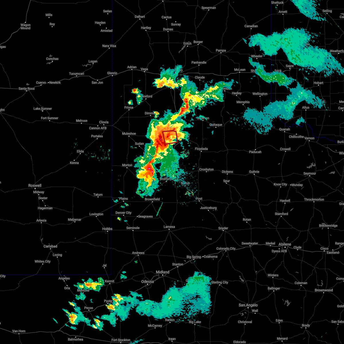 At 1006 pm cdt, a severe thunderstorm capable of producing a tornado was located near halfway, or 7 miles north of hale center, moving north at 15 mph (radar indicated rotation). Hazards include tornado and quarter size hail. Flying debris will be dangerous to those caught without shelter. mobile homes will be damaged or destroyed. damage to roofs, windows, and vehicles will occur. tree damage is likely. Locations impacted include, halfway and edmonson. At 1006 pm cdt, a severe thunderstorm capable of producing a tornado was located near halfway, or 7 miles north of hale center, moving north at 15 mph (radar indicated rotation). Hazards include tornado and quarter size hail. Flying debris will be dangerous to those caught without shelter. mobile homes will be damaged or destroyed. damage to roofs, windows, and vehicles will occur. tree damage is likely. Locations impacted include, halfway and edmonson.
|
| 5/26/2021 10:04 PM CDT |
 At 1004 pm cdt, a severe thunderstorm was located 7 miles northwest of cotton center, or 7 miles southeast of olton, moving east at 30 mph (radar indicated). Hazards include 70 mph wind gusts and ping pong ball size hail. People and animals outdoors will be injured. expect hail damage to roofs, siding, windows, and vehicles. expect considerable tree damage. Wind damage is also likely to mobile homes, roofs, and outbuildings. At 1004 pm cdt, a severe thunderstorm was located 7 miles northwest of cotton center, or 7 miles southeast of olton, moving east at 30 mph (radar indicated). Hazards include 70 mph wind gusts and ping pong ball size hail. People and animals outdoors will be injured. expect hail damage to roofs, siding, windows, and vehicles. expect considerable tree damage. Wind damage is also likely to mobile homes, roofs, and outbuildings.
|
| 5/26/2021 9:59 PM CDT |
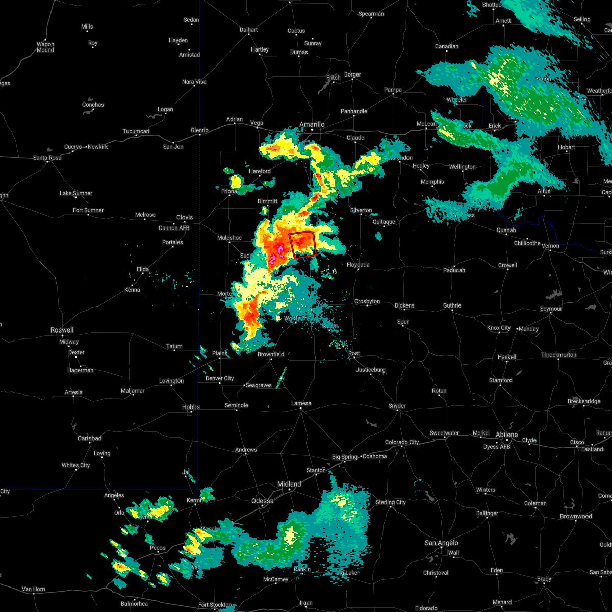 At 959 pm cdt, a severe thunderstorm capable of producing a tornado was located over halfway, or 7 miles northwest of hale center, moving north at 10 mph (radar indicated rotation). Hazards include tornado and quarter size hail. Flying debris will be dangerous to those caught without shelter. mobile homes will be damaged or destroyed. damage to roofs, windows, and vehicles will occur. Tree damage is likely. At 959 pm cdt, a severe thunderstorm capable of producing a tornado was located over halfway, or 7 miles northwest of hale center, moving north at 10 mph (radar indicated rotation). Hazards include tornado and quarter size hail. Flying debris will be dangerous to those caught without shelter. mobile homes will be damaged or destroyed. damage to roofs, windows, and vehicles will occur. Tree damage is likely.
|
| 5/26/2021 8:38 PM CDT |
 At 837 pm cdt, a severe thunderstorm was located 4 miles northeast of halfway, or 11 miles west of plainview, moving northeast at 30 mph (radar indicated). Hazards include ping pong ball size hail and 60 mph wind gusts. People and animals outdoors will be injured. expect hail damage to roofs, siding, windows, and vehicles. expect wind damage to roofs, siding, and trees. Locations impacted include, plainview, hale center, olton, cotton center, halfway, seth ward and edmonson. At 837 pm cdt, a severe thunderstorm was located 4 miles northeast of halfway, or 11 miles west of plainview, moving northeast at 30 mph (radar indicated). Hazards include ping pong ball size hail and 60 mph wind gusts. People and animals outdoors will be injured. expect hail damage to roofs, siding, windows, and vehicles. expect wind damage to roofs, siding, and trees. Locations impacted include, plainview, hale center, olton, cotton center, halfway, seth ward and edmonson.
|
| 5/26/2021 8:22 PM CDT |
 At 820 pm cdt, a severe thunderstorm was located 4 miles east of olton, moving northeast at 30 mph (radar indicated). Hazards include 60 mph wind gusts and quarter size hail. Hail damage to vehicles is expected. expect wind damage to roofs, siding, and trees. Locations impacted include, plainview, tulia, hale center, olton, kress, cotton center, vigo park, fieldton, spade, claytonville, mackenzie reservoir, aiken, halfway, seth ward and edmonson. At 820 pm cdt, a severe thunderstorm was located 4 miles east of olton, moving northeast at 30 mph (radar indicated). Hazards include 60 mph wind gusts and quarter size hail. Hail damage to vehicles is expected. expect wind damage to roofs, siding, and trees. Locations impacted include, plainview, tulia, hale center, olton, kress, cotton center, vigo park, fieldton, spade, claytonville, mackenzie reservoir, aiken, halfway, seth ward and edmonson.
|
| 5/26/2021 7:56 PM CDT |
 At 756 pm cdt, a severe thunderstorm was located over fieldton, or 10 miles southwest of olton, moving northeast at 30 mph (radar indicated). Hazards include 60 mph wind gusts and quarter size hail. Hail damage to vehicles is expected. Expect wind damage to roofs, siding, and trees. At 756 pm cdt, a severe thunderstorm was located over fieldton, or 10 miles southwest of olton, moving northeast at 30 mph (radar indicated). Hazards include 60 mph wind gusts and quarter size hail. Hail damage to vehicles is expected. Expect wind damage to roofs, siding, and trees.
|
| 5/26/2021 7:50 PM CDT |
 At 750 pm cdt, a severe thunderstorm was located over olton, moving northeast at 30 mph (radar indicated). Hazards include 60 mph wind gusts and quarter size hail. Hail damage to vehicles is expected. expect wind damage to roofs, siding, and trees. Locations impacted include, plainview, tulia, olton, hart, earth, kress, fieldton, claytonville, mackenzie reservoir, halfway, seth ward, edmonson and springlake. At 750 pm cdt, a severe thunderstorm was located over olton, moving northeast at 30 mph (radar indicated). Hazards include 60 mph wind gusts and quarter size hail. Hail damage to vehicles is expected. expect wind damage to roofs, siding, and trees. Locations impacted include, plainview, tulia, olton, hart, earth, kress, fieldton, claytonville, mackenzie reservoir, halfway, seth ward, edmonson and springlake.
|
| 5/26/2021 7:33 PM CDT |
 At 733 pm cdt, a severe thunderstorm was located 5 miles northwest of fieldton, or 11 miles southwest of olton, moving northeast at 30 mph (radar indicated). Hazards include 60 mph wind gusts and quarter size hail. Hail damage to vehicles is expected. expect wind damage to roofs, siding, and trees. Locations impacted include, plainview, littlefield, tulia, olton, hart, earth, amherst, kress, fieldton, claytonville, mackenzie reservoir, halfway, seth ward, edmonson and springlake. At 733 pm cdt, a severe thunderstorm was located 5 miles northwest of fieldton, or 11 miles southwest of olton, moving northeast at 30 mph (radar indicated). Hazards include 60 mph wind gusts and quarter size hail. Hail damage to vehicles is expected. expect wind damage to roofs, siding, and trees. Locations impacted include, plainview, littlefield, tulia, olton, hart, earth, amherst, kress, fieldton, claytonville, mackenzie reservoir, halfway, seth ward, edmonson and springlake.
|
| 5/26/2021 7:15 PM CDT |
 At 715 pm cdt, a severe thunderstorm was located over amherst, or 9 miles northwest of littlefield, moving northeast at 35 mph (radar indicated). Hazards include 60 mph wind gusts and quarter size hail. Hail damage to vehicles is expected. Expect wind damage to roofs, siding, and trees. At 715 pm cdt, a severe thunderstorm was located over amherst, or 9 miles northwest of littlefield, moving northeast at 35 mph (radar indicated). Hazards include 60 mph wind gusts and quarter size hail. Hail damage to vehicles is expected. Expect wind damage to roofs, siding, and trees.
|
| 5/26/2021 6:32 PM CDT |
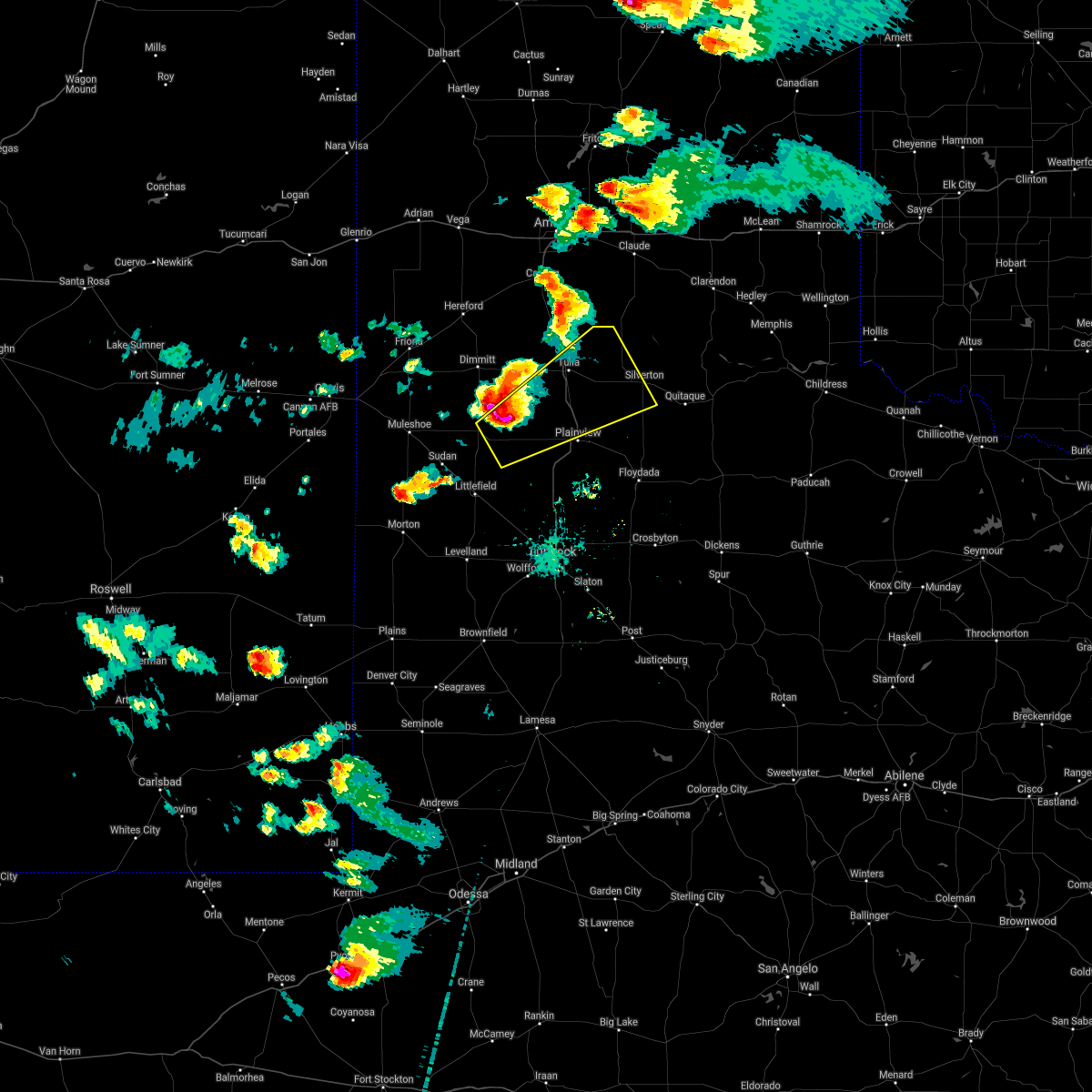 At 632 pm cdt, a severe thunderstorm was located 6 miles southwest of hart, moving northeast at 30 mph (radar indicated). Hazards include golf ball size hail and 70 mph wind gusts. People and animals outdoors will be injured. expect hail damage to roofs, siding, windows, and vehicles. expect considerable tree damage. wind damage is also likely to mobile homes, roofs, and outbuildings. Locations impacted include, plainview, tulia, olton, hart, silverton, kress, vigo park, halfway, claytonville, mackenzie reservoir, seth ward and edmonson. At 632 pm cdt, a severe thunderstorm was located 6 miles southwest of hart, moving northeast at 30 mph (radar indicated). Hazards include golf ball size hail and 70 mph wind gusts. People and animals outdoors will be injured. expect hail damage to roofs, siding, windows, and vehicles. expect considerable tree damage. wind damage is also likely to mobile homes, roofs, and outbuildings. Locations impacted include, plainview, tulia, olton, hart, silverton, kress, vigo park, halfway, claytonville, mackenzie reservoir, seth ward and edmonson.
|
| 5/26/2021 6:17 PM CDT |
 At 616 pm cdt, a severe thunderstorm was located 7 miles east of earth, moving northeast at 25 mph (radar indicated). Hazards include golf ball size hail and 70 mph wind gusts. People and animals outdoors will be injured. expect hail damage to roofs, siding, windows, and vehicles. expect considerable tree damage. Wind damage is also likely to mobile homes, roofs, and outbuildings. At 616 pm cdt, a severe thunderstorm was located 7 miles east of earth, moving northeast at 25 mph (radar indicated). Hazards include golf ball size hail and 70 mph wind gusts. People and animals outdoors will be injured. expect hail damage to roofs, siding, windows, and vehicles. expect considerable tree damage. Wind damage is also likely to mobile homes, roofs, and outbuildings.
|
| 5/24/2021 8:25 PM CDT |
 The severe thunderstorm warning for northwestern hale, southeastern castro, southern swisher and northern lamb counties will expire at 830 pm cdt, the storm which prompted the warning has weakened below severe limits, and no longer poses an immediate threat to life or property. therefore, the warning will be allowed to expire. however gusty winds are still possible with this thunderstorm. a severe thunderstorm watch remains in effect until 1100 pm cdt for the panhandle of and northwestern texas. The severe thunderstorm warning for northwestern hale, southeastern castro, southern swisher and northern lamb counties will expire at 830 pm cdt, the storm which prompted the warning has weakened below severe limits, and no longer poses an immediate threat to life or property. therefore, the warning will be allowed to expire. however gusty winds are still possible with this thunderstorm. a severe thunderstorm watch remains in effect until 1100 pm cdt for the panhandle of and northwestern texas.
|
| 5/24/2021 8:15 PM CDT |
 At 814 pm cdt, a severe thunderstorm was located 4 miles east of olton, moving northeast at 15 mph (radar indicated). Hazards include 60 mph wind gusts and quarter size hail. Hail damage to vehicles is expected. expect wind damage to roofs, siding, and trees. Locations impacted include, plainview, tulia, hale center, olton, hart, earth, kress, cotton center, fieldton, spade, claytonville, halfway, mackenzie reservoir, seth ward, edmonson and springlake. At 814 pm cdt, a severe thunderstorm was located 4 miles east of olton, moving northeast at 15 mph (radar indicated). Hazards include 60 mph wind gusts and quarter size hail. Hail damage to vehicles is expected. expect wind damage to roofs, siding, and trees. Locations impacted include, plainview, tulia, hale center, olton, hart, earth, kress, cotton center, fieldton, spade, claytonville, halfway, mackenzie reservoir, seth ward, edmonson and springlake.
|
| 5/24/2021 7:47 PM CDT |
 At 747 pm cdt, a severe thunderstorm was located near earth, moving northeast at 15 mph (radar indicated). Hazards include 60 mph wind gusts and quarter size hail. Hail damage to vehicles is expected. expect wind damage to roofs, siding, and trees. Locations impacted include, plainview, tulia, hale center, olton, hart, earth, kress, cotton center, fieldton, spade, claytonville, halfway, mackenzie reservoir, seth ward, nazareth, edmonson and springlake. At 747 pm cdt, a severe thunderstorm was located near earth, moving northeast at 15 mph (radar indicated). Hazards include 60 mph wind gusts and quarter size hail. Hail damage to vehicles is expected. expect wind damage to roofs, siding, and trees. Locations impacted include, plainview, tulia, hale center, olton, hart, earth, kress, cotton center, fieldton, spade, claytonville, halfway, mackenzie reservoir, seth ward, nazareth, edmonson and springlake.
|
| 5/24/2021 7:28 PM CDT |
 At 728 pm cdt, a cluster of severe thunderstorms were located 6 miles south of earth to near tulia, moving northeast at 15 mph (radar indicated). Hazards include 60 mph wind gusts and quarter size hail. Hail damage to vehicles is expected. Expect wind damage to roofs, siding, and trees. At 728 pm cdt, a cluster of severe thunderstorms were located 6 miles south of earth to near tulia, moving northeast at 15 mph (radar indicated). Hazards include 60 mph wind gusts and quarter size hail. Hail damage to vehicles is expected. Expect wind damage to roofs, siding, and trees.
|
| 5/24/2021 6:52 PM CDT |
 At 651 pm cdt, a severe thunderstorm was located 4 miles northeast of fieldton, or 6 miles south of olton, moving north at 25 mph (radar indicated). Hazards include ping pong ball size hail and 60 mph wind gusts. People and animals outdoors will be injured. expect hail damage to roofs, siding, windows, and vehicles. expect wind damage to roofs, siding, and trees. Locations impacted include, olton, fieldton, halfway and edmonson. At 651 pm cdt, a severe thunderstorm was located 4 miles northeast of fieldton, or 6 miles south of olton, moving north at 25 mph (radar indicated). Hazards include ping pong ball size hail and 60 mph wind gusts. People and animals outdoors will be injured. expect hail damage to roofs, siding, windows, and vehicles. expect wind damage to roofs, siding, and trees. Locations impacted include, olton, fieldton, halfway and edmonson.
|
| 5/24/2021 6:38 PM CDT |
 At 637 pm cdt, a severe thunderstorm was located over fieldton, or 10 miles northeast of littlefield, moving north at 25 mph (trained weather spotters reported quarter sized hail). Hazards include ping pong ball size hail and 60 mph wind gusts. People and animals outdoors will be injured. expect hail damage to roofs, siding, windows, and vehicles. Expect wind damage to roofs, siding, and trees. At 637 pm cdt, a severe thunderstorm was located over fieldton, or 10 miles northeast of littlefield, moving north at 25 mph (trained weather spotters reported quarter sized hail). Hazards include ping pong ball size hail and 60 mph wind gusts. People and animals outdoors will be injured. expect hail damage to roofs, siding, windows, and vehicles. Expect wind damage to roofs, siding, and trees.
|
| 5/18/2021 6:15 PM CDT |
 At 613 pm cdt, severe thunderstorms were located along a line extending from 7 miles northwest of happy to 7 miles southwest of olton, moving east at 25 mph (radar indicated). Hazards include 60 mph wind gusts and quarter size hail. Hail damage to vehicles is expected. expect wind damage to roofs, siding, and trees. Locations impacted include, tulia, olton, hart, happy, halfway, nazareth and edmonson. At 613 pm cdt, severe thunderstorms were located along a line extending from 7 miles northwest of happy to 7 miles southwest of olton, moving east at 25 mph (radar indicated). Hazards include 60 mph wind gusts and quarter size hail. Hail damage to vehicles is expected. expect wind damage to roofs, siding, and trees. Locations impacted include, tulia, olton, hart, happy, halfway, nazareth and edmonson.
|
| 5/18/2021 5:46 PM CDT |
 At 546 pm cdt, severe thunderstorms were located along a line extending from 5 miles south of buffalo lake to 3 miles northwest of littlefield, moving east at 25 mph (radar indicated). Hazards include 60 mph wind gusts and quarter size hail. Hail damage to vehicles is expected. Expect wind damage to roofs, siding, and trees. At 546 pm cdt, severe thunderstorms were located along a line extending from 5 miles south of buffalo lake to 3 miles northwest of littlefield, moving east at 25 mph (radar indicated). Hazards include 60 mph wind gusts and quarter size hail. Hail damage to vehicles is expected. Expect wind damage to roofs, siding, and trees.
|
| 5/17/2021 9:25 PM CDT |
 The severe thunderstorm warning for northwestern floyd, northern hale, southern swisher, western briscoe and eastern lamb counties will expire at 930 pm cdt, the storms which prompted the warning have weakened below severe limits, and no longer pose an immediate threat to life or property. therefore, the warning will be allowed to expire. a tornado watch remains in effect until 1100 pm cdt for the panhandle of and northwestern texas. The severe thunderstorm warning for northwestern floyd, northern hale, southern swisher, western briscoe and eastern lamb counties will expire at 930 pm cdt, the storms which prompted the warning have weakened below severe limits, and no longer pose an immediate threat to life or property. therefore, the warning will be allowed to expire. a tornado watch remains in effect until 1100 pm cdt for the panhandle of and northwestern texas.
|
| 5/17/2021 9:19 PM CDT |
 At 919 pm cdt, severe thunderstorms were located along a line extending from 10 miles southeast of goodnight to 4 miles southeast of silverton to plainview, moving east at 25 mph (radar indicated). Hazards include 60 mph wind gusts and quarter size hail. Hail damage to vehicles is expected. expect wind damage to roofs, siding, and trees. Locations impacted include, plainview, silverton, kress, vigo park, halfway, claytonville, mackenzie reservoir, seth ward and edmonson. At 919 pm cdt, severe thunderstorms were located along a line extending from 10 miles southeast of goodnight to 4 miles southeast of silverton to plainview, moving east at 25 mph (radar indicated). Hazards include 60 mph wind gusts and quarter size hail. Hail damage to vehicles is expected. expect wind damage to roofs, siding, and trees. Locations impacted include, plainview, silverton, kress, vigo park, halfway, claytonville, mackenzie reservoir, seth ward and edmonson.
|
| 5/17/2021 9:11 PM CDT |
 At 911 pm cdt, severe thunderstorms were located along a line extending from 9 miles south of goodnight to near silverton to 3 miles west of plainview, moving east at 25 mph (radar indicated). Hazards include 60 mph wind gusts and quarter size hail. Hail damage to vehicles is expected. expect wind damage to roofs, siding, and trees. Locations impacted include, plainview, tulia, olton, silverton, kress, vigo park, halfway, claytonville, mackenzie reservoir, seth ward and edmonson. At 911 pm cdt, severe thunderstorms were located along a line extending from 9 miles south of goodnight to near silverton to 3 miles west of plainview, moving east at 25 mph (radar indicated). Hazards include 60 mph wind gusts and quarter size hail. Hail damage to vehicles is expected. expect wind damage to roofs, siding, and trees. Locations impacted include, plainview, tulia, olton, silverton, kress, vigo park, halfway, claytonville, mackenzie reservoir, seth ward and edmonson.
|
| 5/17/2021 9:01 PM CDT |
 At 828 pm cdt, severe thunderstorms were located along a line extending from 8 miles northeast of wayside to 4 miles northwest of claytonville to near olton, moving east at 25 mph (radar indicated). Hazards include 60 mph wind gusts and quarter size hail. Hail damage to vehicles is expected. Expect wind damage to roofs, siding, and trees. At 828 pm cdt, severe thunderstorms were located along a line extending from 8 miles northeast of wayside to 4 miles northwest of claytonville to near olton, moving east at 25 mph (radar indicated). Hazards include 60 mph wind gusts and quarter size hail. Hail damage to vehicles is expected. Expect wind damage to roofs, siding, and trees.
|
| 5/17/2021 8:28 PM CDT |
 At 828 pm cdt, severe thunderstorms were located along a line extending from 8 miles northeast of wayside to 4 miles northwest of claytonville to near olton, moving east at 25 mph (radar indicated). Hazards include 60 mph wind gusts and quarter size hail. Hail damage to vehicles is expected. Expect wind damage to roofs, siding, and trees. At 828 pm cdt, severe thunderstorms were located along a line extending from 8 miles northeast of wayside to 4 miles northwest of claytonville to near olton, moving east at 25 mph (radar indicated). Hazards include 60 mph wind gusts and quarter size hail. Hail damage to vehicles is expected. Expect wind damage to roofs, siding, and trees.
|
| 5/7/2021 7:30 PM CDT |
 At 730 pm cdt, a severe thunderstorm was located over halfway, or 9 miles east of olton, moving east at 40 mph (radar indicated). Hazards include 60 mph wind gusts and penny size hail. expect damage to roofs, siding, and trees At 730 pm cdt, a severe thunderstorm was located over halfway, or 9 miles east of olton, moving east at 40 mph (radar indicated). Hazards include 60 mph wind gusts and penny size hail. expect damage to roofs, siding, and trees
|
| 6/22/2020 11:37 PM CDT |
 The severe thunderstorm warning for east central bailey, northwestern hockley, northwestern hale and lamb counties will expire at 1145 pm cdt, the storms which prompted the warning have moved out of central lamb county. therefore, the warning will be allowed to expire. remember, a severe thunderstorm warning still remains in effect for northern hockley county and southern lamb county until 1230 am cdt. a severe thunderstorm watch remains in effect until 500 am cdt for northwestern texas. The severe thunderstorm warning for east central bailey, northwestern hockley, northwestern hale and lamb counties will expire at 1145 pm cdt, the storms which prompted the warning have moved out of central lamb county. therefore, the warning will be allowed to expire. remember, a severe thunderstorm warning still remains in effect for northern hockley county and southern lamb county until 1230 am cdt. a severe thunderstorm watch remains in effect until 500 am cdt for northwestern texas.
|
| 6/22/2020 11:19 PM CDT |
 At 1116 pm cdt, severe thunderstorms were located along a line extending from 7 miles northeast of olton to 6 miles southeast of pep, moving southeast at 25 mph. these are very dangerous storms (law enforcement. at 1110 pm cdt, downed power lines were reported in the city of littlefield). Hazards include 80 mph wind gusts and nickel size hail. Flying debris will be dangerous to those caught without shelter. mobile homes will be heavily damaged. expect considerable damage to roofs, windows, and vehicles. extensive tree damage and power outages are likely. Locations impacted include, levelland, littlefield, olton, earth, anton, sudan, amherst, fieldton, spade, halfway, whitharral, edmonson and springlake. At 1116 pm cdt, severe thunderstorms were located along a line extending from 7 miles northeast of olton to 6 miles southeast of pep, moving southeast at 25 mph. these are very dangerous storms (law enforcement. at 1110 pm cdt, downed power lines were reported in the city of littlefield). Hazards include 80 mph wind gusts and nickel size hail. Flying debris will be dangerous to those caught without shelter. mobile homes will be heavily damaged. expect considerable damage to roofs, windows, and vehicles. extensive tree damage and power outages are likely. Locations impacted include, levelland, littlefield, olton, earth, anton, sudan, amherst, fieldton, spade, halfway, whitharral, edmonson and springlake.
|
| 6/22/2020 10:57 PM CDT |
 At 1056 pm cdt, severe thunderstorms were located along a line extending from 3 miles south of hart to 6 miles east of bula, moving southeast at 25 mph (radar indicated). Hazards include 70 mph wind gusts and nickel size hail. Expect considerable tree damage. Damage is likely to mobile homes, roofs, and outbuildings. At 1056 pm cdt, severe thunderstorms were located along a line extending from 3 miles south of hart to 6 miles east of bula, moving southeast at 25 mph (radar indicated). Hazards include 70 mph wind gusts and nickel size hail. Expect considerable tree damage. Damage is likely to mobile homes, roofs, and outbuildings.
|
| 6/22/2020 10:40 PM CDT |
 At 1040 pm cdt, severe thunderstorms were located along a line extending from 8 miles south of silverton to 8 miles southwest of hart, moving southeast at 30 mph (radar indicated). Hazards include 60 mph wind gusts and quarter size hail. Hail damage to vehicles is expected. expect wind damage to roofs, siding, and trees. Locations impacted include, plainview, tulia, dimmitt, friona, olton, hart, earth, silverton, kress, lazbuddie, south plains, claytonville, mackenzie reservoir, aiken, halfway, seth ward, nazareth, edmonson and springlake. At 1040 pm cdt, severe thunderstorms were located along a line extending from 8 miles south of silverton to 8 miles southwest of hart, moving southeast at 30 mph (radar indicated). Hazards include 60 mph wind gusts and quarter size hail. Hail damage to vehicles is expected. expect wind damage to roofs, siding, and trees. Locations impacted include, plainview, tulia, dimmitt, friona, olton, hart, earth, silverton, kress, lazbuddie, south plains, claytonville, mackenzie reservoir, aiken, halfway, seth ward, nazareth, edmonson and springlake.
|
| 6/22/2020 10:21 PM CDT |
 At 1021 pm cdt, severe thunderstorms were located along a line extending from 7 miles northeast of claytonville to 9 miles east of lazbuddie, moving southeast at 40 mph (radar indicated). Hazards include 60 mph wind gusts and quarter size hail. Hail damage to vehicles is expected. expect wind damage to roofs, siding, and trees. Locations impacted include, plainview, tulia, dimmitt, friona, olton, hart, earth, silverton, kress, happy, summerfield, vigo park, easter, lazbuddie, south plains, claytonville, mackenzie reservoir, aiken, black and halfway. At 1021 pm cdt, severe thunderstorms were located along a line extending from 7 miles northeast of claytonville to 9 miles east of lazbuddie, moving southeast at 40 mph (radar indicated). Hazards include 60 mph wind gusts and quarter size hail. Hail damage to vehicles is expected. expect wind damage to roofs, siding, and trees. Locations impacted include, plainview, tulia, dimmitt, friona, olton, hart, earth, silverton, kress, happy, summerfield, vigo park, easter, lazbuddie, south plains, claytonville, mackenzie reservoir, aiken, black and halfway.
|
| 6/22/2020 9:59 PM CDT |
 The national weather service in lubbock texas has issued a * severe thunderstorm warning for. northern floyd county in northwestern texas. eastern parmer county in the panhandle of texas. northern hale county in northwestern texas. Castro county in the panhandle of texas. The national weather service in lubbock texas has issued a * severe thunderstorm warning for. northern floyd county in northwestern texas. eastern parmer county in the panhandle of texas. northern hale county in northwestern texas. Castro county in the panhandle of texas.
|
| 6/17/2020 6:06 PM CDT |
 At 605 pm cdt, a severe thunderstorm was located 7 miles northwest of cotton center, or 8 miles south of olton, moving northeast at 20 mph (radar indicated). Hazards include 60 mph wind gusts and penny size hail. expect damage to roofs, siding, and trees At 605 pm cdt, a severe thunderstorm was located 7 miles northwest of cotton center, or 8 miles south of olton, moving northeast at 20 mph (radar indicated). Hazards include 60 mph wind gusts and penny size hail. expect damage to roofs, siding, and trees
|
| 5/20/2020 8:41 PM CDT |
 At 841 pm cdt, a severe thunderstorm was located 6 miles north of olton, moving north at 25 mph (radar indicated). Hazards include 60 mph wind gusts and half dollar size hail. Hail damage to vehicles is expected. expect wind damage to roofs, siding, and trees. Locations impacted include, tulia, dimmitt, hart, kress, nazareth and edmonson. At 841 pm cdt, a severe thunderstorm was located 6 miles north of olton, moving north at 25 mph (radar indicated). Hazards include 60 mph wind gusts and half dollar size hail. Hail damage to vehicles is expected. expect wind damage to roofs, siding, and trees. Locations impacted include, tulia, dimmitt, hart, kress, nazareth and edmonson.
|
| 5/20/2020 8:25 PM CDT |
 At 824 pm cdt, a severe thunderstorm was located over olton, moving north at 30 mph (radar indicated). Hazards include 60 mph wind gusts and half dollar size hail. Hail damage to vehicles is expected. Expect wind damage to roofs, siding, and trees. At 824 pm cdt, a severe thunderstorm was located over olton, moving north at 30 mph (radar indicated). Hazards include 60 mph wind gusts and half dollar size hail. Hail damage to vehicles is expected. Expect wind damage to roofs, siding, and trees.
|
| 5/20/2020 7:49 PM CDT |
 At 748 pm cdt, a severe thunderstorm was located 8 miles northeast of abernathy, moving north at 40 mph (radar indicated). Hazards include 60 mph wind gusts and half dollar size hail. Hail damage to vehicles is expected. Expect wind damage to roofs, siding, and trees. At 748 pm cdt, a severe thunderstorm was located 8 miles northeast of abernathy, moving north at 40 mph (radar indicated). Hazards include 60 mph wind gusts and half dollar size hail. Hail damage to vehicles is expected. Expect wind damage to roofs, siding, and trees.
|
| 5/20/2020 5:39 PM CDT |
 At 538 pm cdt, severe thunderstorms were located near olton and hart, moving northeast at 35 mph (radar indicated). Hazards include 60 mph wind gusts and quarter size hail. Hail damage to vehicles is expected. Expect wind damage to roofs, siding, and trees. At 538 pm cdt, severe thunderstorms were located near olton and hart, moving northeast at 35 mph (radar indicated). Hazards include 60 mph wind gusts and quarter size hail. Hail damage to vehicles is expected. Expect wind damage to roofs, siding, and trees.
|
| 5/19/2020 8:37 PM CDT |
 At 837 pm cdt, a severe thunderstorm was located near hale center, moving northeast at 30 mph (radar indicated). Hazards include 60 mph wind gusts and quarter size hail. Hail damage to vehicles is expected. Expect wind damage to roofs, siding, and trees. At 837 pm cdt, a severe thunderstorm was located near hale center, moving northeast at 30 mph (radar indicated). Hazards include 60 mph wind gusts and quarter size hail. Hail damage to vehicles is expected. Expect wind damage to roofs, siding, and trees.
|
| 6/15/2019 5:36 PM CDT |
 At 536 pm cdt, a severe thunderstorm was located over plainview, moving east at 25 mph (trained weather spotters. at 534 pm, quarter size hail was reported by a storm chaser in plainview). Hazards include quarter size hail. Damage to vehicles is expected. Locations impacted include, plainview, kress, aiken, claytonville, seth ward and edmonson. At 536 pm cdt, a severe thunderstorm was located over plainview, moving east at 25 mph (trained weather spotters. at 534 pm, quarter size hail was reported by a storm chaser in plainview). Hazards include quarter size hail. Damage to vehicles is expected. Locations impacted include, plainview, kress, aiken, claytonville, seth ward and edmonson.
|
| 6/15/2019 5:29 PM CDT |
 At 528 pm cdt, a severe thunderstorm was located over plainview, moving east at 25 mph (radar indicated). Hazards include 60 mph wind gusts and quarter size hail. Hail damage to vehicles is expected. expect wind damage to roofs, siding, and trees. Locations impacted include, plainview, kress, aiken, claytonville, seth ward and edmonson. At 528 pm cdt, a severe thunderstorm was located over plainview, moving east at 25 mph (radar indicated). Hazards include 60 mph wind gusts and quarter size hail. Hail damage to vehicles is expected. expect wind damage to roofs, siding, and trees. Locations impacted include, plainview, kress, aiken, claytonville, seth ward and edmonson.
|
| 6/15/2019 5:17 PM CDT |
 At 517 pm cdt, a severe thunderstorm was located 4 miles east of halfway, or 9 miles west of plainview, moving east at 20 mph (radar indicated). Hazards include 60 mph wind gusts and quarter size hail. Hail damage to vehicles is expected. Expect wind damage to roofs, siding, and trees. At 517 pm cdt, a severe thunderstorm was located 4 miles east of halfway, or 9 miles west of plainview, moving east at 20 mph (radar indicated). Hazards include 60 mph wind gusts and quarter size hail. Hail damage to vehicles is expected. Expect wind damage to roofs, siding, and trees.
|
| 6/15/2019 5:07 PM CDT |
 At 506 pm cdt, a severe thunderstorm was located over halfway, or 10 miles northwest of hale center, moving east at 20 mph (radar indicated). Hazards include 60 mph wind gusts and half dollar size hail. Hail damage to vehicles is expected. expect wind damage to roofs, siding, and trees. Locations impacted include, halfway and edmonson. At 506 pm cdt, a severe thunderstorm was located over halfway, or 10 miles northwest of hale center, moving east at 20 mph (radar indicated). Hazards include 60 mph wind gusts and half dollar size hail. Hail damage to vehicles is expected. expect wind damage to roofs, siding, and trees. Locations impacted include, halfway and edmonson.
|
| 6/15/2019 4:50 PM CDT |
 At 450 pm cdt, a severe thunderstorm was located 6 miles northeast of olton, moving northeast at 20 mph (radar indicated). Hazards include 60 mph wind gusts and half dollar size hail. Hail damage to vehicles is expected. expect wind damage to roofs, siding, and trees. Locations impacted include, olton, halfway and edmonson. At 450 pm cdt, a severe thunderstorm was located 6 miles northeast of olton, moving northeast at 20 mph (radar indicated). Hazards include 60 mph wind gusts and half dollar size hail. Hail damage to vehicles is expected. expect wind damage to roofs, siding, and trees. Locations impacted include, olton, halfway and edmonson.
|
| 6/15/2019 4:34 PM CDT |
 At 433 pm cdt, a severe thunderstorm was located over olton, moving northeast at 15 mph (radar indicated. at 430 pm, a national weather service cooperative observer reported nickle size hail in olton). Hazards include 60 mph wind gusts and quarter size hail. Hail damage to vehicles is expected. Expect wind damage to roofs, siding, and trees. At 433 pm cdt, a severe thunderstorm was located over olton, moving northeast at 15 mph (radar indicated. at 430 pm, a national weather service cooperative observer reported nickle size hail in olton). Hazards include 60 mph wind gusts and quarter size hail. Hail damage to vehicles is expected. Expect wind damage to roofs, siding, and trees.
|
| 5/25/2019 5:53 PM CDT |
 The severe thunderstorm warning for northwestern floyd, northern hale, southeastern swisher, southwestern briscoe and east central lamb counties will expire at 600 pm cdt, severe thunderstorm warning 219 for lamb, hale, floyd, swisher, briscoe has been replaced with other warnings and will be allowed to expire. The severe thunderstorm warning for northwestern floyd, northern hale, southeastern swisher, southwestern briscoe and east central lamb counties will expire at 600 pm cdt, severe thunderstorm warning 219 for lamb, hale, floyd, swisher, briscoe has been replaced with other warnings and will be allowed to expire.
|
| 5/25/2019 5:27 PM CDT |
 At 526 pm cdt, a severe thunderstorm capable of producing a tornado was located 4 miles west of plainview, moving northeast at 20 mph (radar indicated rotation). Hazards include tornado and two inch hail. Flying debris will be dangerous to those caught without shelter. mobile homes will be damaged or destroyed. damage to roofs, windows, and vehicles will occur. tree damage is likely. Locations impacted include, plainview, hale center, aiken, halfway, seth ward and edmonson. At 526 pm cdt, a severe thunderstorm capable of producing a tornado was located 4 miles west of plainview, moving northeast at 20 mph (radar indicated rotation). Hazards include tornado and two inch hail. Flying debris will be dangerous to those caught without shelter. mobile homes will be damaged or destroyed. damage to roofs, windows, and vehicles will occur. tree damage is likely. Locations impacted include, plainview, hale center, aiken, halfway, seth ward and edmonson.
|
| 5/25/2019 5:05 PM CDT |
 At 504 pm cdt, a severe thunderstorm capable of producing a tornado was located near halfway, or 7 miles northwest of hale center, moving northeast at 20 mph (radar indicated rotation). Hazards include tornado. Flying debris will be dangerous to those caught without shelter. mobile homes will be damaged or destroyed. damage to roofs, windows, and vehicles will occur. Tree damage is likely. At 504 pm cdt, a severe thunderstorm capable of producing a tornado was located near halfway, or 7 miles northwest of hale center, moving northeast at 20 mph (radar indicated rotation). Hazards include tornado. Flying debris will be dangerous to those caught without shelter. mobile homes will be damaged or destroyed. damage to roofs, windows, and vehicles will occur. Tree damage is likely.
|
| 5/25/2019 4:58 PM CDT |
 At 458 pm cdt, a severe thunderstorm was located 5 miles southwest of halfway, or 7 miles southeast of olton, moving east at 40 mph. this is a very dangerous storm (radar indicated). Hazards include 80 mph wind gusts and two inch hail. Flying debris will be dangerous to those caught without shelter. mobile homes will be heavily damaged. expect considerable damage to roofs, windows, and vehicles. Extensive tree damage and power outages are likely. At 458 pm cdt, a severe thunderstorm was located 5 miles southwest of halfway, or 7 miles southeast of olton, moving east at 40 mph. this is a very dangerous storm (radar indicated). Hazards include 80 mph wind gusts and two inch hail. Flying debris will be dangerous to those caught without shelter. mobile homes will be heavily damaged. expect considerable damage to roofs, windows, and vehicles. Extensive tree damage and power outages are likely.
|
| 5/25/2019 4:41 PM CDT |
 At 440 pm cdt, a severe thunderstorm was located near olton, moving northeast at 40 mph. this is a very dangerous storm (radar indicated). Hazards include 80 mph wind gusts and two inch hail. Flying debris will be dangerous to those caught without shelter. mobile homes will be heavily damaged. expect considerable damage to roofs, windows, and vehicles. extensive tree damage and power outages are likely. Locations impacted include, plainview, olton, earth, sudan, amherst, fieldton, halfway, seth ward, edmonson and springlake. At 440 pm cdt, a severe thunderstorm was located near olton, moving northeast at 40 mph. this is a very dangerous storm (radar indicated). Hazards include 80 mph wind gusts and two inch hail. Flying debris will be dangerous to those caught without shelter. mobile homes will be heavily damaged. expect considerable damage to roofs, windows, and vehicles. extensive tree damage and power outages are likely. Locations impacted include, plainview, olton, earth, sudan, amherst, fieldton, halfway, seth ward, edmonson and springlake.
|
| 5/25/2019 4:20 PM CDT |
 At 420 pm cdt, a severe thunderstorm was located near littlefield, moving northeast at 35 mph. this is a very dangerous storm (radar indicated). Hazards include 80 mph wind gusts and ping pong ball size hail. Flying debris will be dangerous to those caught without shelter. mobile homes will be heavily damaged. expect considerable damage to roofs, windows, and vehicles. extensive tree damage and power outages are likely. Locations impacted include, plainview, littlefield, olton, hart, earth, sudan, amherst, fieldton, halfway, bula, pep, spade, seth ward, edmonson and springlake. At 420 pm cdt, a severe thunderstorm was located near littlefield, moving northeast at 35 mph. this is a very dangerous storm (radar indicated). Hazards include 80 mph wind gusts and ping pong ball size hail. Flying debris will be dangerous to those caught without shelter. mobile homes will be heavily damaged. expect considerable damage to roofs, windows, and vehicles. extensive tree damage and power outages are likely. Locations impacted include, plainview, littlefield, olton, hart, earth, sudan, amherst, fieldton, halfway, bula, pep, spade, seth ward, edmonson and springlake.
|
| 5/25/2019 3:55 PM CDT |
 At 355 pm cdt, a severe thunderstorm was located 5 miles southwest of amherst, or 8 miles west of littlefield, moving northeast at 40 mph (radar indicated). Hazards include ping pong ball size hail and 60 mph wind gusts. People and animals outdoors will be injured. expect hail damage to roofs, siding, windows, and vehicles. Expect wind damage to roofs, siding, and trees. At 355 pm cdt, a severe thunderstorm was located 5 miles southwest of amherst, or 8 miles west of littlefield, moving northeast at 40 mph (radar indicated). Hazards include ping pong ball size hail and 60 mph wind gusts. People and animals outdoors will be injured. expect hail damage to roofs, siding, windows, and vehicles. Expect wind damage to roofs, siding, and trees.
|
| 5/25/2019 3:02 PM CDT |
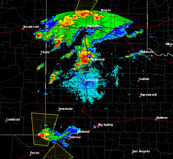 At 300 pm cdt, a severe thunderstorm was located over halfway, or 8 miles northwest of hale center, moving northeast at 35 mph. a second severe thunderstorm was located 8 miles southeast of olton also moving northeast at 35 mph (radar indicated). Hazards include 70 mph wind gusts and ping pong ball size hail. People and animals outdoors will be injured. expect hail damage to roofs, siding, windows, and vehicles. expect considerable tree damage. wind damage is also likely to mobile homes, roofs, and outbuildings. Locations impacted include, hale center, halfway and edmonson. At 300 pm cdt, a severe thunderstorm was located over halfway, or 8 miles northwest of hale center, moving northeast at 35 mph. a second severe thunderstorm was located 8 miles southeast of olton also moving northeast at 35 mph (radar indicated). Hazards include 70 mph wind gusts and ping pong ball size hail. People and animals outdoors will be injured. expect hail damage to roofs, siding, windows, and vehicles. expect considerable tree damage. wind damage is also likely to mobile homes, roofs, and outbuildings. Locations impacted include, hale center, halfway and edmonson.
|
| 5/25/2019 2:48 PM CDT |
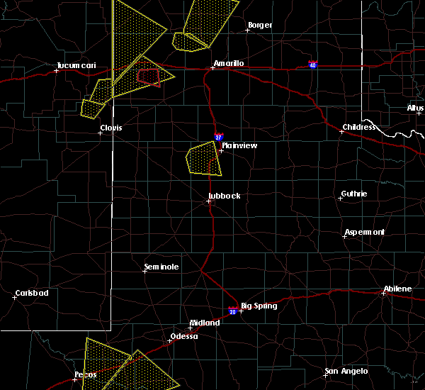 At 248 pm cdt, a severe thunderstorm was located 6 miles north of cotton center, or 9 miles west of hale center, moving northeast at 40 mph (radar indicated). Hazards include 70 mph wind gusts and ping pong ball size hail. People and animals outdoors will be injured. expect hail damage to roofs, siding, windows, and vehicles. expect considerable tree damage. wind damage is also likely to mobile homes, roofs, and outbuildings. Locations impacted include, hale center, cotton center, halfway and edmonson. At 248 pm cdt, a severe thunderstorm was located 6 miles north of cotton center, or 9 miles west of hale center, moving northeast at 40 mph (radar indicated). Hazards include 70 mph wind gusts and ping pong ball size hail. People and animals outdoors will be injured. expect hail damage to roofs, siding, windows, and vehicles. expect considerable tree damage. wind damage is also likely to mobile homes, roofs, and outbuildings. Locations impacted include, hale center, cotton center, halfway and edmonson.
|
| 5/25/2019 2:38 PM CDT |
 At 238 pm cdt, a severe thunderstorm was located 4 miles east of fieldton, or 10 miles south of olton, moving northeast at 30 mph (radar indicated). Hazards include golf ball size hail and 70 mph wind gusts. People and animals outdoors will be injured. expect hail damage to roofs, siding, windows, and vehicles. expect considerable tree damage. wind damage is also likely to mobile homes, roofs, and outbuildings. Locations impacted include, hale center, olton, cotton center, halfway and edmonson. At 238 pm cdt, a severe thunderstorm was located 4 miles east of fieldton, or 10 miles south of olton, moving northeast at 30 mph (radar indicated). Hazards include golf ball size hail and 70 mph wind gusts. People and animals outdoors will be injured. expect hail damage to roofs, siding, windows, and vehicles. expect considerable tree damage. wind damage is also likely to mobile homes, roofs, and outbuildings. Locations impacted include, hale center, olton, cotton center, halfway and edmonson.
|
| 5/25/2019 2:26 PM CDT |
 At 226 pm cdt, a severe thunderstorm was located near fieldton, or 7 miles northeast of littlefield, moving east at 30 mph (radar indicated). Hazards include 70 mph wind gusts and quarter size hail. Hail damage to vehicles is expected. expect considerable tree damage. Wind damage is also likely to mobile homes, roofs, and outbuildings. At 226 pm cdt, a severe thunderstorm was located near fieldton, or 7 miles northeast of littlefield, moving east at 30 mph (radar indicated). Hazards include 70 mph wind gusts and quarter size hail. Hail damage to vehicles is expected. expect considerable tree damage. Wind damage is also likely to mobile homes, roofs, and outbuildings.
|
| 5/8/2019 10:29 PM CDT |
 At 1028 pm cdt, a severe thunderstorm was located over hart, moving east at 25 mph. between quarter and half-dollar size hail was reported 4 miles west of hart around 10 pm (radar indicated). Hazards include 60 mph wind gusts and half dollar size hail. Hail damage to vehicles is expected. expect wind damage to roofs, siding, and trees. Locations impacted include, hart, kress and edmonson. At 1028 pm cdt, a severe thunderstorm was located over hart, moving east at 25 mph. between quarter and half-dollar size hail was reported 4 miles west of hart around 10 pm (radar indicated). Hazards include 60 mph wind gusts and half dollar size hail. Hail damage to vehicles is expected. expect wind damage to roofs, siding, and trees. Locations impacted include, hart, kress and edmonson.
|
| 5/8/2019 10:21 PM CDT |
 At 1021 pm cdt, a severe thunderstorm was located near hart, moving east at 25 mph (radar indicated). Hazards include 60 mph wind gusts and half dollar size hail. Hail damage to vehicles is expected. Expect wind damage to roofs, siding, and trees. At 1021 pm cdt, a severe thunderstorm was located near hart, moving east at 25 mph (radar indicated). Hazards include 60 mph wind gusts and half dollar size hail. Hail damage to vehicles is expected. Expect wind damage to roofs, siding, and trees.
|
| 5/7/2019 4:47 PM CDT |
 At 446 pm cdt, a severe thunderstorm was located 8 miles northwest of mackenzie reservoir, or 13 miles northeast of tulia, moving northeast at 45 mph (radar indicated). Hazards include golf ball size hail and 70 mph wind gusts. People and animals outdoors will be injured. expect hail damage to roofs, siding, windows, and vehicles. expect considerable tree damage. wind damage is also likely to mobile homes, roofs, and outbuildings. Locations impacted include, tulia, hart, kress, nazareth and edmonson. At 446 pm cdt, a severe thunderstorm was located 8 miles northwest of mackenzie reservoir, or 13 miles northeast of tulia, moving northeast at 45 mph (radar indicated). Hazards include golf ball size hail and 70 mph wind gusts. People and animals outdoors will be injured. expect hail damage to roofs, siding, windows, and vehicles. expect considerable tree damage. wind damage is also likely to mobile homes, roofs, and outbuildings. Locations impacted include, tulia, hart, kress, nazareth and edmonson.
|
| 5/7/2019 4:40 PM CDT |
 At 439 pm cdt, a severe thunderstorm capable of producing a tornado was located 10 miles east of hart, moving north at 45 mph (weather spotters reported a funnel cloud). Hazards include tornado and golf ball size hail. Flying debris will be dangerous to those caught without shelter. mobile homes will be damaged or destroyed. damage to roofs, windows, and vehicles will occur. Tree damage is likely. At 439 pm cdt, a severe thunderstorm capable of producing a tornado was located 10 miles east of hart, moving north at 45 mph (weather spotters reported a funnel cloud). Hazards include tornado and golf ball size hail. Flying debris will be dangerous to those caught without shelter. mobile homes will be damaged or destroyed. damage to roofs, windows, and vehicles will occur. Tree damage is likely.
|
| 5/7/2019 4:33 PM CDT |
 A severe thunderstorm warning remains in effect until 500 pm cdt for southeastern castro. northwestern hale and southern swisher counties. at 433 pm cdt, a severe thunderstorm was located 4 miles southeast of tulia, moving northeast at 45 mph. hazard. Golf ball size hail and 70 mph wind gusts. A severe thunderstorm warning remains in effect until 500 pm cdt for southeastern castro. northwestern hale and southern swisher counties. at 433 pm cdt, a severe thunderstorm was located 4 miles southeast of tulia, moving northeast at 45 mph. hazard. Golf ball size hail and 70 mph wind gusts.
|
| 5/7/2019 4:23 PM CDT |
 At 423 pm cdt, a severe thunderstorm capable of producing a tornado was located 4 miles north of halfway, or 11 miles northeast of olton, moving northeast at 25 mph (radar indicated rotation). Hazards include tornado and golf ball size hail. Flying debris will be dangerous to those caught without shelter. mobile homes will be damaged or destroyed. damage to roofs, windows, and vehicles will occur. Tree damage is likely. At 423 pm cdt, a severe thunderstorm capable of producing a tornado was located 4 miles north of halfway, or 11 miles northeast of olton, moving northeast at 25 mph (radar indicated rotation). Hazards include tornado and golf ball size hail. Flying debris will be dangerous to those caught without shelter. mobile homes will be damaged or destroyed. damage to roofs, windows, and vehicles will occur. Tree damage is likely.
|
| 5/7/2019 3:54 PM CDT |
 At 354 pm cdt, a severe thunderstorm was located over olton, moving northeast at 45 mph (radar indicated). Hazards include golf ball size hail and 70 mph wind gusts. People and animals outdoors will be injured. expect hail damage to roofs, siding, windows, and vehicles. expect considerable tree damage. Wind damage is also likely to mobile homes, roofs, and outbuildings. At 354 pm cdt, a severe thunderstorm was located over olton, moving northeast at 45 mph (radar indicated). Hazards include golf ball size hail and 70 mph wind gusts. People and animals outdoors will be injured. expect hail damage to roofs, siding, windows, and vehicles. expect considerable tree damage. Wind damage is also likely to mobile homes, roofs, and outbuildings.
|
| 5/5/2019 5:36 PM CDT |
 At 536 pm cdt, a severe thunderstorm was located 7 miles southwest of kress, or 9 miles northwest of plainview, moving east at 30 mph (radar indicated). Hazards include 60 mph wind gusts and quarter size hail. Hail damage to vehicles is expected. expect wind damage to roofs, siding, and trees. Locations impacted include, plainview, kress, claytonville, seth ward and edmonson. At 536 pm cdt, a severe thunderstorm was located 7 miles southwest of kress, or 9 miles northwest of plainview, moving east at 30 mph (radar indicated). Hazards include 60 mph wind gusts and quarter size hail. Hail damage to vehicles is expected. expect wind damage to roofs, siding, and trees. Locations impacted include, plainview, kress, claytonville, seth ward and edmonson.
|
| 5/5/2019 5:25 PM CDT |
 At 525 pm cdt, a severe thunderstorm was located 6 miles north of halfway, or 12 miles northwest of plainview, moving east at 35 mph (radar indicated). Hazards include 60 mph wind gusts and half dollar size hail. Hail damage to vehicles is expected. expect wind damage to roofs, siding, and trees. Locations impacted include, plainview, kress, halfway, claytonville, seth ward and edmonson. At 525 pm cdt, a severe thunderstorm was located 6 miles north of halfway, or 12 miles northwest of plainview, moving east at 35 mph (radar indicated). Hazards include 60 mph wind gusts and half dollar size hail. Hail damage to vehicles is expected. expect wind damage to roofs, siding, and trees. Locations impacted include, plainview, kress, halfway, claytonville, seth ward and edmonson.
|
| 5/5/2019 5:03 PM CDT |
 At 503 pm cdt, a severe thunderstorm was located 5 miles northwest of halfway, or 6 miles northeast of olton, moving east at 20 mph (radar indicated). Hazards include ping pong ball size hail and 60 mph wind gusts. People and animals outdoors will be injured. expect hail damage to roofs, siding, windows, and vehicles. Expect wind damage to roofs, siding, and trees. At 503 pm cdt, a severe thunderstorm was located 5 miles northwest of halfway, or 6 miles northeast of olton, moving east at 20 mph (radar indicated). Hazards include ping pong ball size hail and 60 mph wind gusts. People and animals outdoors will be injured. expect hail damage to roofs, siding, windows, and vehicles. Expect wind damage to roofs, siding, and trees.
|
| 4/30/2019 8:36 AM CDT |
 A severe thunderstorm warning remains in effect until 930 am cdt for northwestern hale and swisher counties. at 835 am cdt, a severe thunderstorm was located over halfway, moving northeast at 45 mph. hazard. quarter size hail. source. Radar indicated. A severe thunderstorm warning remains in effect until 930 am cdt for northwestern hale and swisher counties. at 835 am cdt, a severe thunderstorm was located over halfway, moving northeast at 45 mph. hazard. quarter size hail. source. Radar indicated.
|
| 4/30/2019 8:25 AM CDT |
 At 825 am cdt, a severe thunderstorm was located 6 miles southeast of olton, moving northeast at 45 mph (radar indicated). Hazards include 60 mph wind gusts and quarter size hail. Hail damage to vehicles is expected. Expect wind damage to roofs, siding and trees. At 825 am cdt, a severe thunderstorm was located 6 miles southeast of olton, moving northeast at 45 mph (radar indicated). Hazards include 60 mph wind gusts and quarter size hail. Hail damage to vehicles is expected. Expect wind damage to roofs, siding and trees.
|
| 3/9/2019 2:05 AM CST |
 At 201 am cst, severe thunderstorms with a history of severe wind gusts were located along a line from near cotton center to vigo park, moving east at 60 mph. recently, a wind gust to 66 mph was measured by a west texas mesonet located near tulia (radar and mesonet indicated). Hazards include 70 mph wind gusts. Expect considerable tree damage. damage is likely to mobile homes, roofs and outbuildings. Locations impacted include, plainview, tulia, hale center, kress, happy and cotton center. At 201 am cst, severe thunderstorms with a history of severe wind gusts were located along a line from near cotton center to vigo park, moving east at 60 mph. recently, a wind gust to 66 mph was measured by a west texas mesonet located near tulia (radar and mesonet indicated). Hazards include 70 mph wind gusts. Expect considerable tree damage. damage is likely to mobile homes, roofs and outbuildings. Locations impacted include, plainview, tulia, hale center, kress, happy and cotton center.
|
| 3/9/2019 1:49 AM CST |
 At 147 am cst, severe thunderstorms with a history of wind gusts around 60 mph were located from near littlefield to near happy, moving east at 60 mph (radar and mesonet indicated). Hazards include 60 mph wind gusts. Expect damage to roofs. siding and trees. Locations impacted include, plainview, tulia, dimmitt, hale center, olton and hart. At 147 am cst, severe thunderstorms with a history of wind gusts around 60 mph were located from near littlefield to near happy, moving east at 60 mph (radar and mesonet indicated). Hazards include 60 mph wind gusts. Expect damage to roofs. siding and trees. Locations impacted include, plainview, tulia, dimmitt, hale center, olton and hart.
|
| 3/9/2019 1:30 AM CST |
 At 129 am cst, severe thunderstorms were located along a line extending from 3 miles south of sudan, moving east at 45 mph (radar indicated). Hazards include 60 mph wind gusts. Expect damage to roofs. Siding and trees. At 129 am cst, severe thunderstorms were located along a line extending from 3 miles south of sudan, moving east at 45 mph (radar indicated). Hazards include 60 mph wind gusts. Expect damage to roofs. Siding and trees.
|
| 10/5/2018 6:13 PM CDT |
 At 612 pm cdt, severe thunderstorms were located along a line extending from kress to 14 miles southwest of kress, moving east at 20 mph (radar indicated). Hazards include 60 mph wind gusts and half dollar size hail. Hail damage to vehicles is expected. Expect wind damage to roofs, siding and trees. At 612 pm cdt, severe thunderstorms were located along a line extending from kress to 14 miles southwest of kress, moving east at 20 mph (radar indicated). Hazards include 60 mph wind gusts and half dollar size hail. Hail damage to vehicles is expected. Expect wind damage to roofs, siding and trees.
|
| 10/5/2018 5:51 PM CDT |
 At 550 pm cdt, a pair of severe thunderstorms were located from just west of edmonson, to 12 miles west of edmonson. both storms were moving northeast at 25 mph (radar indicated). Hazards include ping pong ball size hail and 60 mph wind gusts. People and animals outdoors will be injured. expect hail damage to roofs, siding, windows and vehicles. expect wind damage to roofs, siding and trees. Locations impacted include, hart, kress and edmonson. At 550 pm cdt, a pair of severe thunderstorms were located from just west of edmonson, to 12 miles west of edmonson. both storms were moving northeast at 25 mph (radar indicated). Hazards include ping pong ball size hail and 60 mph wind gusts. People and animals outdoors will be injured. expect hail damage to roofs, siding, windows and vehicles. expect wind damage to roofs, siding and trees. Locations impacted include, hart, kress and edmonson.
|
| 10/5/2018 5:12 PM CDT |
 At 512 pm cdt, a severe thunderstorm was located 7 miles northwest of olton, moving northeast at 25 mph (radar indicated). Hazards include golf ball size hail and 70 mph wind gusts. earlier this storm produced quarter size hail in springlake. People and animals outdoors will be injured. expect hail damage to roofs, siding, windows and vehicles. expect considerable tree damage. Wind damage is likely to mobile homes, roofs and outbuildings. At 512 pm cdt, a severe thunderstorm was located 7 miles northwest of olton, moving northeast at 25 mph (radar indicated). Hazards include golf ball size hail and 70 mph wind gusts. earlier this storm produced quarter size hail in springlake. People and animals outdoors will be injured. expect hail damage to roofs, siding, windows and vehicles. expect considerable tree damage. Wind damage is likely to mobile homes, roofs and outbuildings.
|
| 8/10/2018 3:47 PM CDT |
 At 346 pm cdt, a severe thunderstorm was located over olton, moving southwest at 20 mph (radar indicated). Hazards include 60 mph wind gusts and nickel size hail. Expect damage to roofs, siding, and trees. Locations impacted include, olton, earth, cotton center, halfway, edmonson and springlake. At 346 pm cdt, a severe thunderstorm was located over olton, moving southwest at 20 mph (radar indicated). Hazards include 60 mph wind gusts and nickel size hail. Expect damage to roofs, siding, and trees. Locations impacted include, olton, earth, cotton center, halfway, edmonson and springlake.
|
| 8/10/2018 3:29 PM CDT |
 At 328 pm cdt, a severe thunderstorm was located 7 miles northwest of halfway, or 7 miles northeast of olton, moving southwest at 20 mph (radar indicated). Hazards include 60 mph wind gusts and nickel size hail. expect damage to roofs, siding, and trees At 328 pm cdt, a severe thunderstorm was located 7 miles northwest of halfway, or 7 miles northeast of olton, moving southwest at 20 mph (radar indicated). Hazards include 60 mph wind gusts and nickel size hail. expect damage to roofs, siding, and trees
|
| 5/19/2018 10:29 PM CDT |
 At 1028 pm cdt, a severe thunderstorm was located over hale center, moving north at 10 mph (radar indicated). Hazards include half dollar size hail. damage to vehicles is expected At 1028 pm cdt, a severe thunderstorm was located over hale center, moving north at 10 mph (radar indicated). Hazards include half dollar size hail. damage to vehicles is expected
|
| 5/17/2018 6:06 PM CDT |
 At 603 pm cdt, a severe thunderstorm was located 8 miles southeast of claytonville, or 14 miles northeast of plainview, moving east at 30 mph. additional strong to severe thunderstorms were affect much of briscoe and eastern swisher counties. at 549 pm the west texas mesonet in vigo park recorded a wind gust to 66 mph (radar indicated). Hazards include 70 mph wind gusts and quarter size hail. Hail damage to vehicles is expected. expect considerable tree damage. wind damage is also likely to mobile homes, roofs, and outbuildings. Locations impacted include, plainview, tulia, silverton, caprock canyon state park, kress, quitaque, south plains, claytonville, mackenzie reservoir, seth ward and edmonson. At 603 pm cdt, a severe thunderstorm was located 8 miles southeast of claytonville, or 14 miles northeast of plainview, moving east at 30 mph. additional strong to severe thunderstorms were affect much of briscoe and eastern swisher counties. at 549 pm the west texas mesonet in vigo park recorded a wind gust to 66 mph (radar indicated). Hazards include 70 mph wind gusts and quarter size hail. Hail damage to vehicles is expected. expect considerable tree damage. wind damage is also likely to mobile homes, roofs, and outbuildings. Locations impacted include, plainview, tulia, silverton, caprock canyon state park, kress, quitaque, south plains, claytonville, mackenzie reservoir, seth ward and edmonson.
|
| 5/17/2018 5:52 PM CDT |
 At 548 pm cdt, a severe thunderstorm was located 7 miles northeast of plainview, moving east at 25 mph. additionally strong to severe thunderstorms were located near edmonson and mackenzie reservior (radar indicated). Hazards include ping pong ball size hail and 60 mph wind gusts. People and animals outdoors will be injured. expect hail damage to roofs, siding, windows, and vehicles. expect wind damage to roofs, siding, and trees. Locations impacted include, plainview, tulia, silverton, caprock canyon state park, kress, quitaque, halfway, south plains, claytonville, mackenzie reservoir, seth ward and edmonson. At 548 pm cdt, a severe thunderstorm was located 7 miles northeast of plainview, moving east at 25 mph. additionally strong to severe thunderstorms were located near edmonson and mackenzie reservior (radar indicated). Hazards include ping pong ball size hail and 60 mph wind gusts. People and animals outdoors will be injured. expect hail damage to roofs, siding, windows, and vehicles. expect wind damage to roofs, siding, and trees. Locations impacted include, plainview, tulia, silverton, caprock canyon state park, kress, quitaque, halfway, south plains, claytonville, mackenzie reservoir, seth ward and edmonson.
|
| 5/17/2018 5:29 PM CDT |
 At 527 pm cdt, a severe thunderstorm was located over kress, or 11 miles north of plainview, moving east at 30 mph. additional severe thunderstorms are located near claytonville and 15 miles southwest of silverton, moving northeast at 30 mph (radar indicated). Hazards include ping pong ball size hail and 60 mph wind gusts. People and animals outdoors will be injured. expect hail damage to roofs, siding, windows, and vehicles. Expect wind damage to roofs, siding, and trees. At 527 pm cdt, a severe thunderstorm was located over kress, or 11 miles north of plainview, moving east at 30 mph. additional severe thunderstorms are located near claytonville and 15 miles southwest of silverton, moving northeast at 30 mph (radar indicated). Hazards include ping pong ball size hail and 60 mph wind gusts. People and animals outdoors will be injured. expect hail damage to roofs, siding, windows, and vehicles. Expect wind damage to roofs, siding, and trees.
|
| 5/17/2018 5:16 PM CDT |
 At 515 pm cdt, a severe thunderstorm was located 9 miles northeast of hart, moving northeast at 30 mph (radar indicated). Hazards include ping pong ball size hail and 60 mph wind gusts. People and animals outdoors will be injured. expect hail damage to roofs, siding, windows, and vehicles. expect wind damage to roofs, siding, and trees. Locations impacted include, tulia, kress and edmonson. At 515 pm cdt, a severe thunderstorm was located 9 miles northeast of hart, moving northeast at 30 mph (radar indicated). Hazards include ping pong ball size hail and 60 mph wind gusts. People and animals outdoors will be injured. expect hail damage to roofs, siding, windows, and vehicles. expect wind damage to roofs, siding, and trees. Locations impacted include, tulia, kress and edmonson.
|
| 5/17/2018 5:04 PM CDT |
 A severe thunderstorm warning remains in effect until 530 pm cdt for eastern castro. northern hale and western swisher counties. at 503 pm cdt, a severe thunderstorm was located near hart, moving northeast at 25 mph. hazard. two inch hail and 70 mph wind gusts. source. Radar indicated. A severe thunderstorm warning remains in effect until 530 pm cdt for eastern castro. northern hale and western swisher counties. at 503 pm cdt, a severe thunderstorm was located near hart, moving northeast at 25 mph. hazard. two inch hail and 70 mph wind gusts. source. Radar indicated.
|
| 5/17/2018 4:48 PM CDT |
 At 448 pm cdt, a severe thunderstorm was located near hart, moving east at 15 mph (radar indicated). Hazards include two inch hail and 70 mph wind gusts. People and animals outdoors will be injured. expect hail damage to roofs, siding, windows, and vehicles. expect considerable tree damage. wind damage is also likely to mobile homes, roofs, and outbuildings. Locations impacted include, tulia, hart, kress, nazareth and edmonson. At 448 pm cdt, a severe thunderstorm was located near hart, moving east at 15 mph (radar indicated). Hazards include two inch hail and 70 mph wind gusts. People and animals outdoors will be injured. expect hail damage to roofs, siding, windows, and vehicles. expect considerable tree damage. wind damage is also likely to mobile homes, roofs, and outbuildings. Locations impacted include, tulia, hart, kress, nazareth and edmonson.
|
| 5/17/2018 4:41 PM CDT |
 At 441 pm cdt, a severe thunderstorm was located near hale center, moving northeast at 35 mph (radar indicated). Hazards include ping pong ball size hail and 60 mph wind gusts. People and animals outdoors will be injured. expect hail damage to roofs, siding, windows, and vehicles. Expect wind damage to roofs, siding, and trees. At 441 pm cdt, a severe thunderstorm was located near hale center, moving northeast at 35 mph (radar indicated). Hazards include ping pong ball size hail and 60 mph wind gusts. People and animals outdoors will be injured. expect hail damage to roofs, siding, windows, and vehicles. Expect wind damage to roofs, siding, and trees.
|
| 5/17/2018 4:35 PM CDT |
 At 434 pm cdt, a severe thunderstorm was located over hart, moving northeast at 25 mph (radar indicated). Hazards include 60 mph wind gusts and half dollar size hail. Hail damage to vehicles is expected. Expect wind damage to roofs, siding, and trees. At 434 pm cdt, a severe thunderstorm was located over hart, moving northeast at 25 mph (radar indicated). Hazards include 60 mph wind gusts and half dollar size hail. Hail damage to vehicles is expected. Expect wind damage to roofs, siding, and trees.
|
| 5/15/2018 9:17 PM CDT |
 At 917 pm cdt, severe thunderstorms were located along a line extending from 7 miles east of claytonville to lockney to 6 miles southeast of hale center, moving east at 45 mph (radar indicated). Hazards include 70 mph wind gusts. Expect considerable tree damage. damage is likely to mobile homes, roofs, and outbuildings. Locations impacted include, plainview, tulia, floydada, hale center, silverton, lockney, petersburg, kress, south plains, claytonville, aiken, halfway, seth ward and edmonson. At 917 pm cdt, severe thunderstorms were located along a line extending from 7 miles east of claytonville to lockney to 6 miles southeast of hale center, moving east at 45 mph (radar indicated). Hazards include 70 mph wind gusts. Expect considerable tree damage. damage is likely to mobile homes, roofs, and outbuildings. Locations impacted include, plainview, tulia, floydada, hale center, silverton, lockney, petersburg, kress, south plains, claytonville, aiken, halfway, seth ward and edmonson.
|
| 5/15/2018 9:03 PM CDT |
 At 902 pm cdt, severe thunderstorms were located along a line extending from near claytonville to near aiken to near hale center, moving east at 45 mph (radar indicated). Hazards include 70 mph wind gusts and quarter size hail. Hail damage to vehicles is expected. expect considerable tree damage. wind damage is also likely to mobile homes, roofs, and outbuildings. Locations impacted include, plainview, tulia, floydada, hale center, silverton, lockney, petersburg, kress, cotton center, south plains, claytonville, aiken, halfway, seth ward and edmonson. At 902 pm cdt, severe thunderstorms were located along a line extending from near claytonville to near aiken to near hale center, moving east at 45 mph (radar indicated). Hazards include 70 mph wind gusts and quarter size hail. Hail damage to vehicles is expected. expect considerable tree damage. wind damage is also likely to mobile homes, roofs, and outbuildings. Locations impacted include, plainview, tulia, floydada, hale center, silverton, lockney, petersburg, kress, cotton center, south plains, claytonville, aiken, halfway, seth ward and edmonson.
|
| 5/15/2018 8:45 PM CDT |
 At 845 pm cdt, severe thunderstorms were located along a line extending from near tulia to near plainview to near olton, moving east at 40 mph (radar indicated). Hazards include 70 mph wind gusts and quarter size hail. Hail damage to vehicles is expected. expect considerable tree damage. Wind damage is also likely to mobile homes, roofs, and outbuildings. At 845 pm cdt, severe thunderstorms were located along a line extending from near tulia to near plainview to near olton, moving east at 40 mph (radar indicated). Hazards include 70 mph wind gusts and quarter size hail. Hail damage to vehicles is expected. expect considerable tree damage. Wind damage is also likely to mobile homes, roofs, and outbuildings.
|
| 5/15/2018 8:37 PM CDT |
 At 835 pm cdt, severe thunderstorms were located along a line extending from near tulia to near halfway to 6 miles west of olton, moving southeast at 35 mph (radar indicated. at 832 pm a wind gust of 60 mph was reported 2 miles west northwest of olton). Hazards include 70 mph wind gusts and half dollar size hail. Hail damage to vehicles is expected. expect considerable tree damage. wind damage is also likely to mobile homes, roofs, and outbuildings. Locations impacted include, plainview, tulia, dimmitt, olton, hart, earth, kress, fieldton, halfway, nazareth, edmonson and springlake. At 835 pm cdt, severe thunderstorms were located along a line extending from near tulia to near halfway to 6 miles west of olton, moving southeast at 35 mph (radar indicated. at 832 pm a wind gust of 60 mph was reported 2 miles west northwest of olton). Hazards include 70 mph wind gusts and half dollar size hail. Hail damage to vehicles is expected. expect considerable tree damage. wind damage is also likely to mobile homes, roofs, and outbuildings. Locations impacted include, plainview, tulia, dimmitt, olton, hart, earth, kress, fieldton, halfway, nazareth, edmonson and springlake.
|
| 5/15/2018 8:17 PM CDT |
 At 816 pm cdt, severe thunderstorms were located along a line extending from 10 miles west of tulia to near hart to near earth, moving southeast at 35 mph (radar indicated. at 807 pm downed power lines were reported at flagg). Hazards include 70 mph wind gusts and half dollar size hail. Hail damage to vehicles is expected. expect considerable tree damage. Wind damage is also likely to mobile homes, roofs, and outbuildings. At 816 pm cdt, severe thunderstorms were located along a line extending from 10 miles west of tulia to near hart to near earth, moving southeast at 35 mph (radar indicated. at 807 pm downed power lines were reported at flagg). Hazards include 70 mph wind gusts and half dollar size hail. Hail damage to vehicles is expected. expect considerable tree damage. Wind damage is also likely to mobile homes, roofs, and outbuildings.
|
| 5/15/2018 7:58 PM CDT |
 At 758 pm cdt, severe thunderstorms were located along a line extending from 12 miles northeast of dimmitt to 9 miles west of hart to 8 miles northwest of earth, moving southeast at 35 mph (radar indicated). Hazards include 70 mph wind gusts and ping pong ball size hail. People and animals outdoors will be injured. expect hail damage to roofs, siding, windows, and vehicles. expect considerable tree damage. Wind damage is also likely to mobile homes, roofs, and outbuildings. At 758 pm cdt, severe thunderstorms were located along a line extending from 12 miles northeast of dimmitt to 9 miles west of hart to 8 miles northwest of earth, moving southeast at 35 mph (radar indicated). Hazards include 70 mph wind gusts and ping pong ball size hail. People and animals outdoors will be injured. expect hail damage to roofs, siding, windows, and vehicles. expect considerable tree damage. Wind damage is also likely to mobile homes, roofs, and outbuildings.
|
| 10/6/2017 10:06 PM CDT |
 At 1006 pm cdt, a severe thunderstorm was located near claytonville, or 11 miles southeast of tulia, moving east at 45 mph (radar indicated). Hazards include 70 mph wind gusts and quarter size hail. Hail damage to vehicles is expected. expect considerable tree damage. Wind damage is also likely to mobile homes, roofs, and outbuildings. At 1006 pm cdt, a severe thunderstorm was located near claytonville, or 11 miles southeast of tulia, moving east at 45 mph (radar indicated). Hazards include 70 mph wind gusts and quarter size hail. Hail damage to vehicles is expected. expect considerable tree damage. Wind damage is also likely to mobile homes, roofs, and outbuildings.
|
| 7/4/2017 9:13 PM CDT |
 At 910 pm cdt, severe thunderstorms were located along a line extending from 7 miles south of claytonville to 7 miles southeast of abernathy to near reese center to 6 miles southwest of locketville to near bronco, moving southeast at 40 mph. the west texas mesonet station at sundown reported a wind gust to 64 mph and the station at levelland reported 58 mph, both at 905 pm. these are very dangerous storms (radar indicated). Hazards include 80 mph wind gusts. Flying debris will be dangerous to those caught without shelter. mobile homes will be heavily damaged. expect considerable damage to roofs, windows, and vehicles. extensive tree damage and power outages are likely. Locations impacted include, lubbock, plainview, levelland, brownfield, slaton, tulia, floydada, abernathy, hale center, plains, silverton, wolfforth, shallowater, idalou, ralls, lockney, sundown, petersburg, lorenzo and anton. At 910 pm cdt, severe thunderstorms were located along a line extending from 7 miles south of claytonville to 7 miles southeast of abernathy to near reese center to 6 miles southwest of locketville to near bronco, moving southeast at 40 mph. the west texas mesonet station at sundown reported a wind gust to 64 mph and the station at levelland reported 58 mph, both at 905 pm. these are very dangerous storms (radar indicated). Hazards include 80 mph wind gusts. Flying debris will be dangerous to those caught without shelter. mobile homes will be heavily damaged. expect considerable damage to roofs, windows, and vehicles. extensive tree damage and power outages are likely. Locations impacted include, lubbock, plainview, levelland, brownfield, slaton, tulia, floydada, abernathy, hale center, plains, silverton, wolfforth, shallowater, idalou, ralls, lockney, sundown, petersburg, lorenzo and anton.
|
| 7/4/2017 8:59 PM CDT |
 At 858 pm cdt, severe thunderstorms were located along a line extending from near claytonville to abernathy to near shallowater to sundown to 11 miles north of bronco, moving southeast at 40 mph. these are very dangerous storms (radar indicated). Hazards include 80 mph wind gusts. Flying debris will be dangerous to those caught without shelter. mobile homes will be heavily damaged. expect considerable damage to roofs, windows, and vehicles. Extensive tree damage and power outages are likely. At 858 pm cdt, severe thunderstorms were located along a line extending from near claytonville to abernathy to near shallowater to sundown to 11 miles north of bronco, moving southeast at 40 mph. these are very dangerous storms (radar indicated). Hazards include 80 mph wind gusts. Flying debris will be dangerous to those caught without shelter. mobile homes will be heavily damaged. expect considerable damage to roofs, windows, and vehicles. Extensive tree damage and power outages are likely.
|
| 7/4/2017 8:41 PM CDT |
 At 839 pm cdt, severe thunderstorms were located along a line extending from near tulia to near hale center to near spade to 8 miles southeast of pep to 6 miles east of bledsoe, moving southeast at 30 mph. at 830 pm, the west texas mesonet station at morton reported a wind gust to 58 mph and the station at olton reported a wind gust to 59 mph at 835 pm (radar indicated). Hazards include 70 mph wind gusts. Expect considerable tree damage. damage is likely to mobile homes, roofs, and outbuildings. Locations impacted include, lubbock, plainview, levelland, littlefield, tulia, abernathy, hale center, olton, morton, wolfforth, shallowater, sundown, petersburg, anton, kress, cotton center, fieldton, spade, claytonville and lubbock south plains mall. At 839 pm cdt, severe thunderstorms were located along a line extending from near tulia to near hale center to near spade to 8 miles southeast of pep to 6 miles east of bledsoe, moving southeast at 30 mph. at 830 pm, the west texas mesonet station at morton reported a wind gust to 58 mph and the station at olton reported a wind gust to 59 mph at 835 pm (radar indicated). Hazards include 70 mph wind gusts. Expect considerable tree damage. damage is likely to mobile homes, roofs, and outbuildings. Locations impacted include, lubbock, plainview, levelland, littlefield, tulia, abernathy, hale center, olton, morton, wolfforth, shallowater, sundown, petersburg, anton, kress, cotton center, fieldton, spade, claytonville and lubbock south plains mall.
|
| 7/4/2017 8:31 PM CDT |
 At 829 pm cdt, severe thunderstorms were located along a line extending from 8 miles west of tulia to near spade to pep to 7 miles south of maple, moving southeast at 30 mph (radar indicated). Hazards include 70 mph wind gusts. Expect considerable tree damage. Damage is likely to mobile homes, roofs, and outbuildings. At 829 pm cdt, severe thunderstorms were located along a line extending from 8 miles west of tulia to near spade to pep to 7 miles south of maple, moving southeast at 30 mph (radar indicated). Hazards include 70 mph wind gusts. Expect considerable tree damage. Damage is likely to mobile homes, roofs, and outbuildings.
|
| 7/4/2017 8:21 PM CDT |
 At 819 pm cdt, severe thunderstorms were located along a line extending from 9 miles north of hart to olton to near bula, moving east at 30 mph. at 810 pm, the west texas mesonet station at olton reported a wind gust to 62 mph. near zero visibility is also reported in spots along highway 385 near littlefield due to blowing dust (radar indicated). Hazards include 70 mph wind gusts and penny size hail. Expect considerable tree damage. damage is likely to mobile homes, roofs, and outbuildings. Locations impacted include, littlefield, muleshoe, tulia, olton, hart, earth, sudan, amherst, happy, needmore, fieldton, enochs, halfway, muleshoe wildlife refuge, bula, nazareth, edmonson and springlake. At 819 pm cdt, severe thunderstorms were located along a line extending from 9 miles north of hart to olton to near bula, moving east at 30 mph. at 810 pm, the west texas mesonet station at olton reported a wind gust to 62 mph. near zero visibility is also reported in spots along highway 385 near littlefield due to blowing dust (radar indicated). Hazards include 70 mph wind gusts and penny size hail. Expect considerable tree damage. damage is likely to mobile homes, roofs, and outbuildings. Locations impacted include, littlefield, muleshoe, tulia, olton, hart, earth, sudan, amherst, happy, needmore, fieldton, enochs, halfway, muleshoe wildlife refuge, bula, nazareth, edmonson and springlake.
|
| 7/4/2017 8:03 PM CDT |
 At 802 pm cdt, severe thunderstorms were located along a line extending from 14 miles northeast of dimmitt to 9 miles northeast of earth to near sudan, moving southeast at 30 mph (radar indicated). Hazards include 70 mph wind gusts and penny size hail. Expect considerable tree damage. damage is likely to mobile homes, roofs, and outbuildings. Locations impacted include, littlefield, muleshoe, tulia, dimmitt, olton, hart, earth, sudan, amherst, happy, needmore, fieldton, enochs, halfway, muleshoe wildlife refuge, bula, nazareth, edmonson and springlake. At 802 pm cdt, severe thunderstorms were located along a line extending from 14 miles northeast of dimmitt to 9 miles northeast of earth to near sudan, moving southeast at 30 mph (radar indicated). Hazards include 70 mph wind gusts and penny size hail. Expect considerable tree damage. damage is likely to mobile homes, roofs, and outbuildings. Locations impacted include, littlefield, muleshoe, tulia, dimmitt, olton, hart, earth, sudan, amherst, happy, needmore, fieldton, enochs, halfway, muleshoe wildlife refuge, bula, nazareth, edmonson and springlake.
|
| 7/4/2017 7:48 PM CDT |
 At 747 pm cdt, severe thunderstorms were located along a line extending from 11 miles east of easter to 6 miles north of earth to near muleshoe, moving southeast at 30 mph (radar indicated). Hazards include 70 mph wind gusts and nickel size hail. Expect considerable tree damage. Damage is likely to mobile homes, roofs, and outbuildings. At 747 pm cdt, severe thunderstorms were located along a line extending from 11 miles east of easter to 6 miles north of earth to near muleshoe, moving southeast at 30 mph (radar indicated). Hazards include 70 mph wind gusts and nickel size hail. Expect considerable tree damage. Damage is likely to mobile homes, roofs, and outbuildings.
|
| 6/8/2017 10:29 PM CDT |
 At 1028 pm cdt, severe thunderstorms were located along a line extending from near tulia to turkey, moving south at 30 mph (radar indicated). Hazards include 60 mph wind gusts and half dollar size hail. Hail damage to vehicles is expected. Expect wind damage to roofs, siding and trees. At 1028 pm cdt, severe thunderstorms were located along a line extending from near tulia to turkey, moving south at 30 mph (radar indicated). Hazards include 60 mph wind gusts and half dollar size hail. Hail damage to vehicles is expected. Expect wind damage to roofs, siding and trees.
|
| 5/9/2017 11:43 PM CDT |
 At 1142 pm cdt, a severe thunderstorm was located near halfway, moving northeast at 30 mph (radar indicated). Hazards include 60 mph wind gusts and quarter size hail. Hail damage to vehicles is expected. expect wind damage to roofs, siding and trees. Locations impacted include, plainview, halfway, seth ward and edmonson. At 1142 pm cdt, a severe thunderstorm was located near halfway, moving northeast at 30 mph (radar indicated). Hazards include 60 mph wind gusts and quarter size hail. Hail damage to vehicles is expected. expect wind damage to roofs, siding and trees. Locations impacted include, plainview, halfway, seth ward and edmonson.
|
| 5/9/2017 11:24 PM CDT |
 At 1123 pm cdt, a severe thunderstorm was located near cotton center, moving northeast at 35 mph (radar indicated). Hazards include 60 mph wind gusts and quarter size hail. Hail damage to vehicles is expected. Expect wind damage to roofs, siding and trees. At 1123 pm cdt, a severe thunderstorm was located near cotton center, moving northeast at 35 mph (radar indicated). Hazards include 60 mph wind gusts and quarter size hail. Hail damage to vehicles is expected. Expect wind damage to roofs, siding and trees.
|
| 4/29/2017 1:30 AM CDT |
 At 129 am cdt, a severe thunderstorm was located near kress, or 12 miles south of tulia, moving northeast at 30 mph (radar indicated). Hazards include quarter size hail. Damage to vehicles is expected. Locations impacted include, plainview, tulia, kress, claytonville, mackenzie reservoir, seth ward and edmonson. At 129 am cdt, a severe thunderstorm was located near kress, or 12 miles south of tulia, moving northeast at 30 mph (radar indicated). Hazards include quarter size hail. Damage to vehicles is expected. Locations impacted include, plainview, tulia, kress, claytonville, mackenzie reservoir, seth ward and edmonson.
|
| 4/29/2017 1:15 AM CDT |
 At 115 am cdt, a severe thunderstorm was located near halfway, or 10 miles northwest of plainview, moving northeast at 30 mph (radar indicated). Hazards include quarter size hail. damage to vehicles is expected At 115 am cdt, a severe thunderstorm was located near halfway, or 10 miles northwest of plainview, moving northeast at 30 mph (radar indicated). Hazards include quarter size hail. damage to vehicles is expected
|
| 4/15/2017 12:14 AM CDT |
 At 1214 am cdt, a severe thunderstorm was located over plainview, moving southeast at 15 mph (radar indicated). Hazards include 70 mph wind gusts and ping pong ball size hail. People and animals outdoors will be injured. expect hail damage to roofs, siding, windows, and vehicles. expect considerable tree damage. Wind damage is also likely to mobile homes, roofs, and outbuildings. At 1214 am cdt, a severe thunderstorm was located over plainview, moving southeast at 15 mph (radar indicated). Hazards include 70 mph wind gusts and ping pong ball size hail. People and animals outdoors will be injured. expect hail damage to roofs, siding, windows, and vehicles. expect considerable tree damage. Wind damage is also likely to mobile homes, roofs, and outbuildings.
|
| 4/15/2017 12:04 AM CDT |
 At 1204 am cdt, a severe thunderstorm was located over plainview, moving southeast at 15 mph. this is a very dangerous storm (radar indicated). Hazards include three inch hail and 70 mph wind gusts. People and animals outdoors will be severely injured. expect shattered windows, extensive damage to roofs, siding, and vehicles. Locations impacted include, plainview, kress, seth ward and edmonson. At 1204 am cdt, a severe thunderstorm was located over plainview, moving southeast at 15 mph. this is a very dangerous storm (radar indicated). Hazards include three inch hail and 70 mph wind gusts. People and animals outdoors will be severely injured. expect shattered windows, extensive damage to roofs, siding, and vehicles. Locations impacted include, plainview, kress, seth ward and edmonson.
|
| 4/14/2017 11:56 PM CDT |
 At 1156 pm cdt, a severe thunderstorm was located near plainview, moving southeast at 15 mph (radar indicated). Hazards include ping pong ball size hail and 60 mph wind gusts. People and animals outdoors will be injured. expect hail damage to roofs, siding, windows, and vehicles. expect wind damage to roofs, siding, and trees. Locations impacted include, plainview, kress, seth ward and edmonson. At 1156 pm cdt, a severe thunderstorm was located near plainview, moving southeast at 15 mph (radar indicated). Hazards include ping pong ball size hail and 60 mph wind gusts. People and animals outdoors will be injured. expect hail damage to roofs, siding, windows, and vehicles. expect wind damage to roofs, siding, and trees. Locations impacted include, plainview, kress, seth ward and edmonson.
|
| 4/14/2017 11:41 PM CDT |
 At 1141 pm cdt, a severe thunderstorm was located 7 miles southwest of kress, or 12 miles northwest of plainview, moving southeast at 10 mph (radar indicated). Hazards include two inch hail and 60 mph wind gusts. People and animals outdoors will be injured. expect hail damage to roofs, siding, windows, and vehicles. Expect wind damage to roofs, siding, and trees. At 1141 pm cdt, a severe thunderstorm was located 7 miles southwest of kress, or 12 miles northwest of plainview, moving southeast at 10 mph (radar indicated). Hazards include two inch hail and 60 mph wind gusts. People and animals outdoors will be injured. expect hail damage to roofs, siding, windows, and vehicles. Expect wind damage to roofs, siding, and trees.
|
| 4/14/2017 11:29 PM CDT |
 At 1128 pm cdt, a severe thunderstorm capable of producing a tornado was located 8 miles north of halfway, or 10 miles southeast of hart, moving south at 10 mph. a new rotation has developed to the northwest of edmonson (radar indicated rotation). Hazards include tornado and quarter size hail. Flying debris will be dangerous to those caught without shelter. mobile homes will be damaged or destroyed. damage to roofs, windows, and vehicles will occur. tree damage is likely. this dangerous storm will be near, halfway around 1145 pm cdt. Other locations impacted by this tornadic thunderstorm include edmonson and seth ward. At 1128 pm cdt, a severe thunderstorm capable of producing a tornado was located 8 miles north of halfway, or 10 miles southeast of hart, moving south at 10 mph. a new rotation has developed to the northwest of edmonson (radar indicated rotation). Hazards include tornado and quarter size hail. Flying debris will be dangerous to those caught without shelter. mobile homes will be damaged or destroyed. damage to roofs, windows, and vehicles will occur. tree damage is likely. this dangerous storm will be near, halfway around 1145 pm cdt. Other locations impacted by this tornadic thunderstorm include edmonson and seth ward.
|
| 4/14/2017 11:21 PM CDT |
 At 1121 pm cdt, a severe thunderstorm capable of producing a tornado was located near halfway, or 10 miles northwest of plainview, moving southeast at 15 mph (radar indicated rotation). Hazards include tornado and ping pong ball size hail. Flying debris will be dangerous to those caught without shelter. mobile homes will be damaged or destroyed. damage to roofs, windows, and vehicles will occur. tree damage is likely. this dangerous storm will be near, plainview around 1145 pm cdt. Other locations impacted by this tornadic thunderstorm include edmonson and seth ward. At 1121 pm cdt, a severe thunderstorm capable of producing a tornado was located near halfway, or 10 miles northwest of plainview, moving southeast at 15 mph (radar indicated rotation). Hazards include tornado and ping pong ball size hail. Flying debris will be dangerous to those caught without shelter. mobile homes will be damaged or destroyed. damage to roofs, windows, and vehicles will occur. tree damage is likely. this dangerous storm will be near, plainview around 1145 pm cdt. Other locations impacted by this tornadic thunderstorm include edmonson and seth ward.
|
| 4/14/2017 11:13 PM CDT |
 At 1111 pm cdt, a severe thunderstorm was located 7 miles north of halfway, or 10 miles southeast of hart, moving southeast at 15 mph. this storm continues to indicate low level rotation near edmonson. winds in excess of 70mph were reported at the mesonet station in hart (radar indicated). Hazards include 70 mph wind gusts and half dollar size hail. Hail damage to vehicles is expected. expect considerable tree damage. Wind damage is also likely to mobile homes, roofs, and outbuildings. At 1111 pm cdt, a severe thunderstorm was located 7 miles north of halfway, or 10 miles southeast of hart, moving southeast at 15 mph. this storm continues to indicate low level rotation near edmonson. winds in excess of 70mph were reported at the mesonet station in hart (radar indicated). Hazards include 70 mph wind gusts and half dollar size hail. Hail damage to vehicles is expected. expect considerable tree damage. Wind damage is also likely to mobile homes, roofs, and outbuildings.
|
| 4/14/2017 11:00 PM CDT |
 At 1059 pm cdt, a severe thunderstorm was located 8 miles east of hart, moving southeast at 15 mph. at 1050pm the west texas mesonet site in hart measured 77mph wind gust associated with this storm (radar indicated). Hazards include 70 mph wind gusts and ping pong ball size hail. People and animals outdoors will be injured. expect hail damage to roofs, siding, windows, and vehicles. expect considerable tree damage. wind damage is also likely to mobile homes, roofs, and outbuildings. Locations impacted include, tulia, hart and edmonson. At 1059 pm cdt, a severe thunderstorm was located 8 miles east of hart, moving southeast at 15 mph. at 1050pm the west texas mesonet site in hart measured 77mph wind gust associated with this storm (radar indicated). Hazards include 70 mph wind gusts and ping pong ball size hail. People and animals outdoors will be injured. expect hail damage to roofs, siding, windows, and vehicles. expect considerable tree damage. wind damage is also likely to mobile homes, roofs, and outbuildings. Locations impacted include, tulia, hart and edmonson.
|
| 4/14/2017 10:53 PM CDT |
 At 1050 pm cdt, a severe thunderstorm was located 7 miles east of hart, moving southeast at 15 mph. there is still low level rotation associated with this storm located 5 miles northwest of edmonson (radar indicated). Hazards include tennis ball size hail and 60 mph wind gusts. People and animals outdoors will be injured. expect hail damage to roofs, siding, windows, and vehicles. expect wind damage to roofs, siding, and trees. Locations impacted include, tulia, hart and edmonson. At 1050 pm cdt, a severe thunderstorm was located 7 miles east of hart, moving southeast at 15 mph. there is still low level rotation associated with this storm located 5 miles northwest of edmonson (radar indicated). Hazards include tennis ball size hail and 60 mph wind gusts. People and animals outdoors will be injured. expect hail damage to roofs, siding, windows, and vehicles. expect wind damage to roofs, siding, and trees. Locations impacted include, tulia, hart and edmonson.
|
| 4/14/2017 10:40 PM CDT |
 At 1039 pm cdt, a severe thunderstorm was located near hart, moving southeast at 10 mph (radar indicated). Hazards include two inch hail and 60 mph wind gusts. People and animals outdoors will be injured. expect hail damage to roofs, siding, windows, and vehicles. Expect wind damage to roofs, siding, and trees. At 1039 pm cdt, a severe thunderstorm was located near hart, moving southeast at 10 mph (radar indicated). Hazards include two inch hail and 60 mph wind gusts. People and animals outdoors will be injured. expect hail damage to roofs, siding, windows, and vehicles. Expect wind damage to roofs, siding, and trees.
|
| 4/14/2017 10:28 PM CDT |
 At 1027 pm cdt, a severe thunderstorm was located 7 miles northeast of hart, moving southeast at 10 mph. there continues to be low level rotation with this storm. this is a very dangerous storm (radar indicated). Hazards include baseball size hail and 60 mph wind gusts. People and animals outdoors will be severely injured. Expect shattered windows, extensive damage to roofs, siding, and vehicles. At 1027 pm cdt, a severe thunderstorm was located 7 miles northeast of hart, moving southeast at 10 mph. there continues to be low level rotation with this storm. this is a very dangerous storm (radar indicated). Hazards include baseball size hail and 60 mph wind gusts. People and animals outdoors will be severely injured. Expect shattered windows, extensive damage to roofs, siding, and vehicles.
|
| 7/5/2016 6:47 PM CDT |
 At 646 pm cdt, a severe thunderstorm was located near hale center, moving northeast at 30 mph (radar indicated). Hazards include 60 mph wind gusts and quarter size hail. Hail damage to vehicles is expected. expect wind damage to roofs, siding and trees. Locations impacted include, plainview, hale center, kress, aiken, seth ward and edmonson. At 646 pm cdt, a severe thunderstorm was located near hale center, moving northeast at 30 mph (radar indicated). Hazards include 60 mph wind gusts and quarter size hail. Hail damage to vehicles is expected. expect wind damage to roofs, siding and trees. Locations impacted include, plainview, hale center, kress, aiken, seth ward and edmonson.
|
| 7/5/2016 6:29 PM CDT |
 At 629 pm cdt, a severe thunderstorm was located near hale center, moving northeast at 25 mph (radar indicated). Hazards include 60 mph wind gusts and quarter size hail. Hail damage to vehicles is expected. Expect wind damage to roofs, siding and trees. At 629 pm cdt, a severe thunderstorm was located near hale center, moving northeast at 25 mph (radar indicated). Hazards include 60 mph wind gusts and quarter size hail. Hail damage to vehicles is expected. Expect wind damage to roofs, siding and trees.
|
| 4/20/2016 8:22 PM CDT |
 At 822 pm cdt, severe thunderstorms were located along a line extending from near claytonville to near plainview, moving southeast at 35 mph (radar indicated). Hazards include ping pong ball size hail. People and animals outdoors will be injured. expect damage to roofs, siding, windows and vehicles. Locations impacted include, plainview, silverton, quitaque, lockney, kress, claytonville, aiken, south plains, mackenzie reservoir, seth ward and edmonson. At 822 pm cdt, severe thunderstorms were located along a line extending from near claytonville to near plainview, moving southeast at 35 mph (radar indicated). Hazards include ping pong ball size hail. People and animals outdoors will be injured. expect damage to roofs, siding, windows and vehicles. Locations impacted include, plainview, silverton, quitaque, lockney, kress, claytonville, aiken, south plains, mackenzie reservoir, seth ward and edmonson.
|
| 4/20/2016 8:11 PM CDT |
 At 810 pm cdt, severe thunderstorms were located along a line extending from 7 miles southwest of mackenzie reservoir to 6 miles southwest of kress, moving southeast at 40 mph (radar indicated). Hazards include half dollar size hail. damage to vehicles is expected At 810 pm cdt, severe thunderstorms were located along a line extending from 7 miles southwest of mackenzie reservoir to 6 miles southwest of kress, moving southeast at 40 mph (radar indicated). Hazards include half dollar size hail. damage to vehicles is expected
|
| 4/10/2016 7:59 PM CDT |
 At 757 pm cdt, a severe thunderstorm was located over hart, or 17 miles southeast of dimmitt, moving east at 30 mph. at 756 pm cdt, trained spotters reported half-dollar sized hail in hart (trained weather spotters). Hazards include 60 mph wind gusts and half dollar size hail. Hail damage to vehicles is expected. expect wind damage to roofs, siding and trees. Locations impacted include, hart, nazareth and edmonson. At 757 pm cdt, a severe thunderstorm was located over hart, or 17 miles southeast of dimmitt, moving east at 30 mph. at 756 pm cdt, trained spotters reported half-dollar sized hail in hart (trained weather spotters). Hazards include 60 mph wind gusts and half dollar size hail. Hail damage to vehicles is expected. expect wind damage to roofs, siding and trees. Locations impacted include, hart, nazareth and edmonson.
|
| 4/10/2016 7:42 PM CDT |
 At 742 pm cdt, a severe thunderstorm was located near hart, or 13 miles southeast of dimmitt, moving east at 30 mph (radar indicated). Hazards include 60 mph wind gusts and half dollar size hail. Hail damage to vehicles is expected. Expect wind damage to roofs, siding and trees. At 742 pm cdt, a severe thunderstorm was located near hart, or 13 miles southeast of dimmitt, moving east at 30 mph (radar indicated). Hazards include 60 mph wind gusts and half dollar size hail. Hail damage to vehicles is expected. Expect wind damage to roofs, siding and trees.
|
| 4/10/2016 6:50 PM CDT |
 At 649 pm cdt, a severe thunderstorm was located near kress, or 10 miles northwest of plainview, moving northeast at 15 mph (radar indicated). Hazards include 60 mph wind gusts and half dollar size hail. Hail damage to vehicles is expected. expect wind damage to roofs, siding and trees. Locations impacted include, kress and edmonson. At 649 pm cdt, a severe thunderstorm was located near kress, or 10 miles northwest of plainview, moving northeast at 15 mph (radar indicated). Hazards include 60 mph wind gusts and half dollar size hail. Hail damage to vehicles is expected. expect wind damage to roofs, siding and trees. Locations impacted include, kress and edmonson.
|
| 4/10/2016 6:41 PM CDT |
 At 639 pm cdt, a severe thunderstorm was located 8 miles southwest of kress, or 10 miles northwest of plainview, moving northeast at 15 mph. spotters reported quarter-sized hail near edmundson and golf ball sized hail near halfway (trained weather spotters). Hazards include 60 mph wind gusts and half dollar size hail. Hail damage to vehicles is expected. expect wind damage to roofs, siding and trees. Locations impacted include, halfway, kress and edmonson. At 639 pm cdt, a severe thunderstorm was located 8 miles southwest of kress, or 10 miles northwest of plainview, moving northeast at 15 mph. spotters reported quarter-sized hail near edmundson and golf ball sized hail near halfway (trained weather spotters). Hazards include 60 mph wind gusts and half dollar size hail. Hail damage to vehicles is expected. expect wind damage to roofs, siding and trees. Locations impacted include, halfway, kress and edmonson.
|
| 4/10/2016 6:40 PM CDT | Golf Ball sized hail reported 0.5 miles W of Edmonson, TX, scattered hail as large as golf balls |
| 4/10/2016 6:32 PM CDT | Quarter sized hail reported 0.5 miles W of Edmonson, TX, few larger stones at least the size of quarters |
| 4/10/2016 6:29 PM CDT |
 At 628 pm cdt, a severe thunderstorm was located near halfway, or 10 miles northwest of plainview, moving northeast at 15 mph (radar indicated). Hazards include 60 mph wind gusts and half dollar size hail. Hail damage to vehicles is expected. Expect wind damage to roofs, siding and trees. At 628 pm cdt, a severe thunderstorm was located near halfway, or 10 miles northwest of plainview, moving northeast at 15 mph (radar indicated). Hazards include 60 mph wind gusts and half dollar size hail. Hail damage to vehicles is expected. Expect wind damage to roofs, siding and trees.
|
| 6/29/2015 5:23 PM CDT |
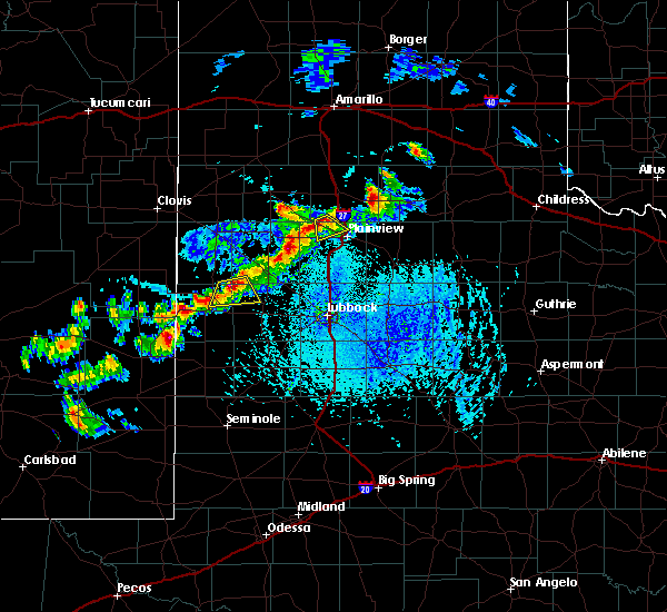 At 523 pm cdt, a severe thunderstorm was located 7 miles north of halfway, or 13 miles northwest of plainview, moving south at 10 mph (radar indicated). Hazards include quarter size hail and 70 mph wind gusts. Hail damage to vehicles is expected. expect considerable tree damage. wind damage is also likely to mobile homes, roofs and outbuildings. Locations impacted include, edmonson. At 523 pm cdt, a severe thunderstorm was located 7 miles north of halfway, or 13 miles northwest of plainview, moving south at 10 mph (radar indicated). Hazards include quarter size hail and 70 mph wind gusts. Hail damage to vehicles is expected. expect considerable tree damage. wind damage is also likely to mobile homes, roofs and outbuildings. Locations impacted include, edmonson.
|
| 6/29/2015 5:13 PM CDT |
 At 513 pm cdt, a severe thunderstorm was located near kress, or 13 miles northwest of plainview, moving south at 15 mph (radar indicated). Hazards include quarter size hail and 70 mph wind gusts. Hail damage to vehicles is expected. expect considerable tree damage. wind damage is also likely to mobile homes, roofs and outbuildings. Locations impacted include, kress and edmonson. At 513 pm cdt, a severe thunderstorm was located near kress, or 13 miles northwest of plainview, moving south at 15 mph (radar indicated). Hazards include quarter size hail and 70 mph wind gusts. Hail damage to vehicles is expected. expect considerable tree damage. wind damage is also likely to mobile homes, roofs and outbuildings. Locations impacted include, kress and edmonson.
|
| 6/29/2015 5:04 PM CDT |
 At 503 pm cdt, a severe thunderstorm was located near kress, or 12 miles southwest of tulia, moving south at 5 mph (radar indicated). Hazards include half dollar size hail and 70 mph wind gusts. Hail damage to vehicles is expected. expect considerable tree damage. wind damage is also likely to mobile homes, roofs and outbuildings. Locations impacted include, kress and edmonson. At 503 pm cdt, a severe thunderstorm was located near kress, or 12 miles southwest of tulia, moving south at 5 mph (radar indicated). Hazards include half dollar size hail and 70 mph wind gusts. Hail damage to vehicles is expected. expect considerable tree damage. wind damage is also likely to mobile homes, roofs and outbuildings. Locations impacted include, kress and edmonson.
|
| 6/29/2015 4:50 PM CDT |
 At 450 pm cdt, a severe thunderstorm was located near kress, or 11 miles southwest of tulia, moving southeast at 10 mph (radar indicated). Hazards include 70 mph wind gusts and quarter size hail. Hail damage to vehicles is expected. expect considerable tree damage. Wind damage is also likely to mobile homes, roofs and outbuildings. At 450 pm cdt, a severe thunderstorm was located near kress, or 11 miles southwest of tulia, moving southeast at 10 mph (radar indicated). Hazards include 70 mph wind gusts and quarter size hail. Hail damage to vehicles is expected. expect considerable tree damage. Wind damage is also likely to mobile homes, roofs and outbuildings.
|
| 6/12/2015 6:03 PM CDT |
 At 602 pm cdt, a severe thunderstorm was located over cotton center, or 9 miles southwest of hale center, moving east at 30 mph. winds near 60 mph are expected with the outflow ahead of this storm (radar indicated). Hazards include ping pong size hail and 70 mph wind gusts. People and animals outdoors will be injured. expect hail damage to roofs, siding, windows and vehicles. expect considerable tree damage. wind damage is also likely to mobile homes, roofs and outbuildings. locations impacted include, plainview, hale center, petersburg, kress, cotton center, claytonville, halfway, seth ward and edmonson. A tornado watch remains in effect until 1000 pm cdt for northwestern texas. At 602 pm cdt, a severe thunderstorm was located over cotton center, or 9 miles southwest of hale center, moving east at 30 mph. winds near 60 mph are expected with the outflow ahead of this storm (radar indicated). Hazards include ping pong size hail and 70 mph wind gusts. People and animals outdoors will be injured. expect hail damage to roofs, siding, windows and vehicles. expect considerable tree damage. wind damage is also likely to mobile homes, roofs and outbuildings. locations impacted include, plainview, hale center, petersburg, kress, cotton center, claytonville, halfway, seth ward and edmonson. A tornado watch remains in effect until 1000 pm cdt for northwestern texas.
|
| 6/12/2015 6:01 PM CDT |
 At 600 pm cdt, a severe thunderstorm was located over halfway, or 11 miles northwest of hale center, moving northeast at 30 mph (radar indicated). Hazards include half dollar size hail and 60 mph wind gusts. Hail damage to vehicles is expected. expect wind damage to roofs, siding and trees. locations impacted include, olton, halfway and edmonson. A tornado watch remains in effect until 1000 pm cdt for northwestern texas. At 600 pm cdt, a severe thunderstorm was located over halfway, or 11 miles northwest of hale center, moving northeast at 30 mph (radar indicated). Hazards include half dollar size hail and 60 mph wind gusts. Hail damage to vehicles is expected. expect wind damage to roofs, siding and trees. locations impacted include, olton, halfway and edmonson. A tornado watch remains in effect until 1000 pm cdt for northwestern texas.
|
| 6/12/2015 5:54 PM CDT |
 At 553 pm cdt, a severe thunderstorm was located near halfway, or 7 miles northwest of hale center, moving east at 35 mph. strong low level rotation is indicated with this storm about 7 miles west of plainview. a tornado may form at any time (radar indicated). Hazards include 70 mph wind gusts and ping pong ball size hail. People and animals outdoors will be injured. expect hail damage to roofs, siding, windows and vehicles. expect considerable tree damage. Wind damage is also likely to mobile homes, roofs and outbuildings. At 553 pm cdt, a severe thunderstorm was located near halfway, or 7 miles northwest of hale center, moving east at 35 mph. strong low level rotation is indicated with this storm about 7 miles west of plainview. a tornado may form at any time (radar indicated). Hazards include 70 mph wind gusts and ping pong ball size hail. People and animals outdoors will be injured. expect hail damage to roofs, siding, windows and vehicles. expect considerable tree damage. Wind damage is also likely to mobile homes, roofs and outbuildings.
|
| 6/12/2015 5:43 PM CDT |
 At 542 pm cdt, a severe thunderstorm was located near olton, or 16 miles west of hale center, moving northeast at 25 mph. an increasing area of low level rotation is indicated about 5 miles south of olton. a tornado could develop at any time (radar indicated). Hazards include half dollar size hail and 60 mph wind gusts. Hail damage to vehicles is expected. expect wind damage to roofs, siding and trees. locations impacted include, littlefield, olton, hart, amherst, halfway, fieldton, edmonson and springlake. A tornado watch remains in effect until 1000 pm cdt for northwestern texas. At 542 pm cdt, a severe thunderstorm was located near olton, or 16 miles west of hale center, moving northeast at 25 mph. an increasing area of low level rotation is indicated about 5 miles south of olton. a tornado could develop at any time (radar indicated). Hazards include half dollar size hail and 60 mph wind gusts. Hail damage to vehicles is expected. expect wind damage to roofs, siding and trees. locations impacted include, littlefield, olton, hart, amherst, halfway, fieldton, edmonson and springlake. A tornado watch remains in effect until 1000 pm cdt for northwestern texas.
|
| 6/12/2015 5:32 PM CDT |
 At 531 pm cdt, a severe thunderstorm was located near fieldton, or 14 miles northeast of littlefield, moving northeast at 35 mph. this complex has a history of large hail. a wall cloud has been reported with this storm to the north north of littlefield (radar indicated). Hazards include half dollar size hail and 60 mph wind gusts. Hail damage to vehicles is expected. expect wind damage to roofs, siding and trees. locations impacted include, littlefield, olton, hart, amherst, halfway, fieldton, edmonson and springlake. A tornado watch remains in effect until 1000 pm cdt for northwestern texas. At 531 pm cdt, a severe thunderstorm was located near fieldton, or 14 miles northeast of littlefield, moving northeast at 35 mph. this complex has a history of large hail. a wall cloud has been reported with this storm to the north north of littlefield (radar indicated). Hazards include half dollar size hail and 60 mph wind gusts. Hail damage to vehicles is expected. expect wind damage to roofs, siding and trees. locations impacted include, littlefield, olton, hart, amherst, halfway, fieldton, edmonson and springlake. A tornado watch remains in effect until 1000 pm cdt for northwestern texas.
|
| 6/12/2015 5:24 PM CDT |
 At 523 pm cdt, a severe thunderstorm was located near fieldton, or 15 miles northeast of littlefield, moving northeast at 30 mph. a tornado may form with this storm (radar indicated). Hazards include 60 mph wind gusts and half dollar size hail. Hail damage to vehicles is expected. Expect wind damage to roofs, siding and trees. At 523 pm cdt, a severe thunderstorm was located near fieldton, or 15 miles northeast of littlefield, moving northeast at 30 mph. a tornado may form with this storm (radar indicated). Hazards include 60 mph wind gusts and half dollar size hail. Hail damage to vehicles is expected. Expect wind damage to roofs, siding and trees.
|
| 5/29/2015 9:42 PM CDT | At 938 pm cdt, severe thunderstorms were located along a line extending from near wayside to 7 miles southeast of claytonville to near petersburg, moving east at 35 mph. the winds will quickly pick up behind a gust front, with the heavy rain not moving in until 10 to 15 minutes later. the strongest winds will occur behind the gust front (radar indicated). Hazards include 60 mph wind gusts. Expect damage to roofs. siding and trees. Locations impacted include, plainview, littlefield, tulia, floydada, abernathy, hale center, silverton, quitaque, lockney, petersburg, kress, happy, cotton center, spade, valley schools, mackenzie reservoir, aiken, caprock canyon state park, claytonville and halfway. |
| 5/29/2015 9:13 PM CDT | At 911 pm cdt, severe thunderstorms were located along a line extending from 6 miles east of happy to 7 miles northwest of plainview to near anton, moving east at 50 mph (radar indicated). Hazards include 60 mph wind gusts and penny size hail. Expect damage to roofs. Siding and trees. |
| 5/29/2015 9:05 PM CDT | At 903 pm cdt, a line of severe thunderstorms were located along a halfway to fieldton to littlefield line, moving southeast at 45 mph (radar indicated). Hazards include 60 mph wind gusts and penny size hail. Expect damage to roofs. siding and trees. Locations impacted include, plainview, littlefield, hale center, olton, earth, sudan, amherst, cotton center, needmore, spade, muleshoe wildlife refuge, maple, bula, halfway, enochs, fieldton, edmonson and springlake. |
| 5/29/2015 8:55 PM CDT | At 852 pm cdt, severe thunderstorms were located along a line from 15 miles west of happy to near hart, moving east at 35 mph. this storm produced a 60 mph at the dimmitt west texas mesonet as it moved through at 830 pm (radar indicated). Hazards include quarter size hail and 60 mph wind gusts. Hail damage to vehicles is expected. expect wind damage to roofs, siding and trees. Locations impacted include, tulia, dimmitt, hart, kress, happy, nazareth and edmonson. |
| 5/29/2015 8:48 PM CDT | At 846 pm cdt, a line of severe thunderstorms was located from near olton to amherst to bula, moving southeast at 40 mph (radar indicated). Hazards include 60 mph wind gusts and quarter size hail. Hail damage to vehicles is expected. Expect wind damage to roofs, siding and trees. |
| 5/29/2015 8:31 PM CDT | At 831 pm cdt, a severe thunderstorm was located near dimmitt, moving east at 35 mph (radar indicated). Hazards include 60 mph wind gusts and quarter size hail. Hail damage to vehicles is expected. Expect wind damage to roofs, siding and trees. |
| 5/27/2015 11:44 PM CDT | At 1144 pm cdt, severe thunderstorms were located along a line extending from near halfway to 6 miles southwest of aiken, moving northeast at 25 mph (radar indicated). Hazards include half dollar size hail and 60 mph wind gusts. Hail damage to vehicles is expected. expect wind damage to roofs, siding and trees. Locations impacted include, plainview, hale center, olton, lockney, halfway, aiken, seth ward and edmonson. |
| 5/27/2015 11:34 PM CDT | At 1134 pm cdt, severe thunderstorms were located along a line extending from near halfway to 9 miles east of hale center, moving northeast at 20 mph (radar indicated). Hazards include ping pong size hail and 60 mph wind gusts. People and animals outdoors will be injured. expect hail damage to roofs, siding, windows and vehicles. expect wind damage to roofs, siding and trees. Locations impacted include, plainview, hale center, olton, lockney, cotton center, halfway, aiken, seth ward and edmonson. |
| 5/27/2015 11:12 PM CDT | At 1112 pm cdt, severe thunderstorms were located along a line extending from 6 miles southeast of olton to 9 miles northeast of abernathy, moving northeast at 15 mph (radar indicated). Hazards include ping pong ball size hail and 60 mph wind gusts. People and animals outdoors will be injured. expect hail damage to roofs, siding, windows and vehicles. Expect wind damage to roofs, siding and trees. |
| 5/27/2015 8:59 PM CDT | At 859 pm cdt, severe thunderstorms were located along a line extending from near hale center, moving northeast at 10 mph (radar indicated). Hazards include golf ball size hail. People and animals outdoors will be injured. Expect damage to roofs, siding, windows and vehicles. |
| 5/16/2015 12:23 PM CDT | At 1222 pm cdt, a severe thunderstorm was located near kress, or 9 miles northwest of plainview, moving northeast at 40 mph (radar indicated). Hazards include golf ball size hail and 60 mph wind gusts. People and animals outdoors will be injured. expect hail damage to roofs, siding, windows and vehicles. Expect wind damage to roofs, siding and trees. |
| 5/8/2015 10:44 AM CDT | At 1043 am cdt, a severe thunderstorm was located near plainview, moving northeast at 30 mph. this storm has a history of producing large hail (radar indicated). Hazards include tennis ball size hail and 70 mph wind gusts. People and animals outdoors will be injured. expect hail damage to roofs, siding, windows and vehicles. expect considerable tree damage. Wind damage is also likely to mobile homes, roofs and outbuildings. |
| 5/8/2015 10:35 AM CDT | At 1035 am cdt, a severe thunderstorm was located over plainview, moving northeast at 45 mph. this storm has a history of producing quarter size hail and larger (trained weather spotters). Hazards include two inch hail and 60 mph wind gusts. People and animals outdoors will be injured. expect hail damage to roofs, siding, windows and vehicles. expect wind damage to roofs, siding and trees. locations impacted include, plainview, hale center, cotton center, halfway, seth ward and edmonson. a tornado watch remains in effect until 500 pm cdt for northwestern texas. 2. 00in. |
| 5/8/2015 10:28 AM CDT | At 1027 am cdt, a severe thunderstorm was located over hale center, moving northeast at 35 mph. half dollar size hail was reported with this storm in cotton center at 1014 am (trained weather spotters). Hazards include golf ball size hail and 60 mph wind gusts. People and animals outdoors will be injured. expect hail damage to roofs, siding, windows and vehicles. expect wind damage to roofs, siding and trees. locations impacted include, plainview, hale center, cotton center, halfway, seth ward and edmonson. a tornado watch remains in effect until 500 pm cdt for northwestern texas. 1. 75in. |
| 5/8/2015 10:20 AM CDT | At 1019 am cdt, a severe thunderstorm was located over hale center, moving northeast at 40 mph. golf ball size hail was reported in cotton center at 1013 pm (radar indicated). Hazards include golf ball size hail and 60 mph wind gusts. People and animals outdoors will be injured. expect hail damage to roofs, siding, windows and vehicles. expect wind damage to roofs, siding and trees. locations impacted include, plainview, hale center, olton, cotton center, halfway, seth ward and edmonson. a tornado watch remains in effect until 500 pm cdt for northwestern texas. 1. 75in. |
| 5/8/2015 10:11 AM CDT | At 1010 am cdt, a severe thunderstorm was located near cotton center, or 12 miles southwest of hale center, moving northeast at 45 mph. this storm has a history of hail to the size of half dollars (radar indicated). Hazards include 60 mph wind gusts and half dollar size hail. Hail damage to vehicles is expected. Expect wind damage to roofs, siding and trees. |
Hail Maps for Edmonson, TX


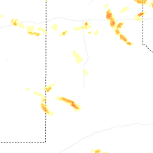


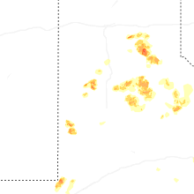


Connect with Interactive Hail Maps