

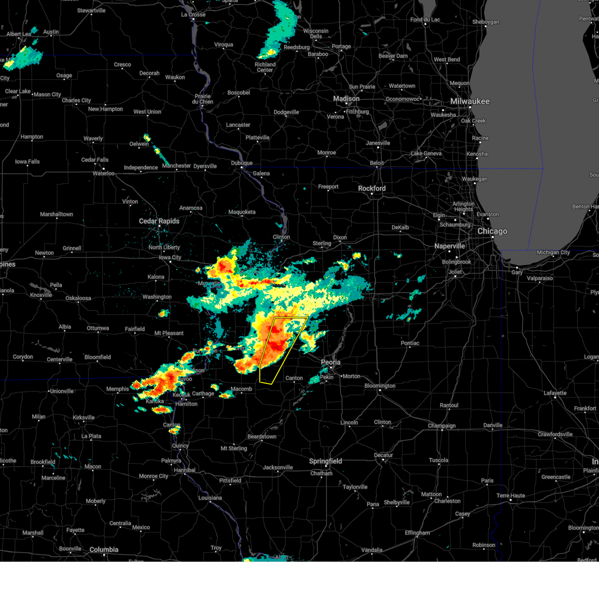
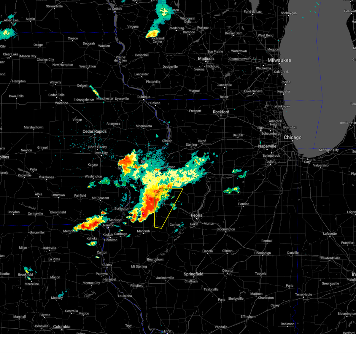
Hail Map for Ellisville, IL
The Ellisville, IL area has had 1 report of on-the-ground hail by trained spotters, and has been under severe weather warnings 15 times during the past 12 months. Doppler radar has detected hail at or near Ellisville, IL on 48 occasions, including 2 occasions during the past year.
| Name: | Ellisville, IL |
| Where Located: | 37.9 miles W of Peoria, IL |
| Map: | Google Map for Ellisville, IL |
| Population: | 96 |
| Housing Units: | 40 |
| More Info: | Search Google for Ellisville, IL |
0
The Top Recent Hail Date for Ellisville, IL is Friday, July 11, 2025 (48th out of 48)
Hail and Wind Damage Spotted near Ellisville, IL
| Date / Time | Report Details |
|---|---|
| 4/20/2025 7:59 PM CDT |
 Svrilx the national weather service in lincoln has issued a * severe thunderstorm warning for, fulton county in west central illinois, knox county in west central illinois, eastern schuyler county in west central illinois, northeastern mason county in central illinois, * until 830 pm cdt. * at 758 pm cdt, severe thunderstorms were located along a line extending from joy to near astoria, moving northeast at 50 mph (radar indicated). Hazards include 60 mph wind gusts. Expect damage to roofs, siding, and trees. severe thunderstorms will be near, abingdon, lewistown, st. augustine, cuba, and avon around 805 pm cdt. london mills and galesburg around 810 pm cdt. rio, fairview, knoxville, st. david, and henderson around 815 pm cdt. other locations in the path of these severe thunderstorms include maquon, wataga and canton. This includes interstate 74 between mile markers 35 and 63. Svrilx the national weather service in lincoln has issued a * severe thunderstorm warning for, fulton county in west central illinois, knox county in west central illinois, eastern schuyler county in west central illinois, northeastern mason county in central illinois, * until 830 pm cdt. * at 758 pm cdt, severe thunderstorms were located along a line extending from joy to near astoria, moving northeast at 50 mph (radar indicated). Hazards include 60 mph wind gusts. Expect damage to roofs, siding, and trees. severe thunderstorms will be near, abingdon, lewistown, st. augustine, cuba, and avon around 805 pm cdt. london mills and galesburg around 810 pm cdt. rio, fairview, knoxville, st. david, and henderson around 815 pm cdt. other locations in the path of these severe thunderstorms include maquon, wataga and canton. This includes interstate 74 between mile markers 35 and 63.
|
| 3/21/2025 9:23 PM CDT |
 The storm which prompted the warning has moved out of the area. therefore, the warning will be allowed to expire. however, gusty winds are still possible with showers moving across the area. The storm which prompted the warning has moved out of the area. therefore, the warning will be allowed to expire. however, gusty winds are still possible with showers moving across the area.
|
| 3/21/2025 9:02 PM CDT |
 At 902 pm cdt, a severe thunderstorm was located over lewistown, moving east at 45 mph (radar indicated). Hazards include 60 mph wind gusts. Expect damage to roofs, siding, and trees. this severe storm will be near, lewistown around 905 pm cdt. Other locations impacted by this severe thunderstorm include bryant, norris, frederick, liverpool, bluff city, bernadotte, ellisville, chatauqua park, dunfermline, and snicarte. At 902 pm cdt, a severe thunderstorm was located over lewistown, moving east at 45 mph (radar indicated). Hazards include 60 mph wind gusts. Expect damage to roofs, siding, and trees. this severe storm will be near, lewistown around 905 pm cdt. Other locations impacted by this severe thunderstorm include bryant, norris, frederick, liverpool, bluff city, bernadotte, ellisville, chatauqua park, dunfermline, and snicarte.
|
| 3/21/2025 8:40 PM CDT |
 Svrilx the national weather service in lincoln has issued a * severe thunderstorm warning for, fulton county in west central illinois, cass county in west central illinois, eastern schuyler county in west central illinois, western mason county in central illinois, * until 930 pm cdt. * at 839 pm cdt, a severe thunderstorm was located over adair, or 9 miles southeast of macomb, moving east at 50 mph (trained weather spotters). Hazards include 60 mph wind gusts. Expect damage to roofs, siding, and trees. this severe thunderstorm will be near, ipava around 850 pm cdt. Other locations in the path of this severe thunderstorm include lewistown. Svrilx the national weather service in lincoln has issued a * severe thunderstorm warning for, fulton county in west central illinois, cass county in west central illinois, eastern schuyler county in west central illinois, western mason county in central illinois, * until 930 pm cdt. * at 839 pm cdt, a severe thunderstorm was located over adair, or 9 miles southeast of macomb, moving east at 50 mph (trained weather spotters). Hazards include 60 mph wind gusts. Expect damage to roofs, siding, and trees. this severe thunderstorm will be near, ipava around 850 pm cdt. Other locations in the path of this severe thunderstorm include lewistown.
|
| 3/14/2025 9:56 PM CDT | The storms which prompted the warning have moved out of the area. therefore, the warning will be allowed to expire. however, gusty winds are still possible with these thunderstorms. a severe thunderstorm warning remains in effect until 1045 pm cdt for far northeastern fulton county. a tornado watch remains in effect until 300 am cdt for central and west central illinois. |
| 3/14/2025 8:57 PM CDT |
 Svrilx the national weather service in lincoln has issued a * severe thunderstorm warning for, fulton county in west central illinois, knox county in west central illinois, * until 1000 pm cdt. * at 857 pm cdt, severe thunderstorms were located along a line extending from lake warren to near bushnell to near industry, moving northeast at 65 mph (radar indicated). Hazards include 70 mph wind gusts and quarter size hail. Hail damage to vehicles is expected. expect considerable tree damage. wind damage is also likely to mobile homes, roofs, and outbuildings. severe thunderstorms will be near, st. augustine and avon around 900 pm cdt. abingdon and galesburg around 905 pm cdt. rio and henderson around 910 pm cdt. knoxville, wataga, and london mills around 915 pm cdt. other locations in the path of these severe thunderstorms include oneida, maquon, altona, victoria and williamsfield. This includes interstate 74 between mile markers 34 and 67. Svrilx the national weather service in lincoln has issued a * severe thunderstorm warning for, fulton county in west central illinois, knox county in west central illinois, * until 1000 pm cdt. * at 857 pm cdt, severe thunderstorms were located along a line extending from lake warren to near bushnell to near industry, moving northeast at 65 mph (radar indicated). Hazards include 70 mph wind gusts and quarter size hail. Hail damage to vehicles is expected. expect considerable tree damage. wind damage is also likely to mobile homes, roofs, and outbuildings. severe thunderstorms will be near, st. augustine and avon around 900 pm cdt. abingdon and galesburg around 905 pm cdt. rio and henderson around 910 pm cdt. knoxville, wataga, and london mills around 915 pm cdt. other locations in the path of these severe thunderstorms include oneida, maquon, altona, victoria and williamsfield. This includes interstate 74 between mile markers 34 and 67.
|
| 8/15/2024 11:17 PM CDT |
 the severe thunderstorm warning has been cancelled and is no longer in effect the severe thunderstorm warning has been cancelled and is no longer in effect
|
| 8/15/2024 11:03 PM CDT |
 At 1103 pm cdt, severe thunderstorms were located along a line extending from near galva to near knoxville to avon, moving east at 40 mph (radar indicated). Hazards include 70 mph wind gusts and ping pong ball size hail. People and animals outdoors will be injured. expect hail damage to roofs, siding, windows, and vehicles. expect considerable tree damage. wind damage is also likely to mobile homes, roofs, and outbuildings. these severe storms will be near, london mills, maquon, and la fayette around 1110 pm cdt. other locations impacted by these severe thunderstorms include dahinda, ellisville, and gilson. This includes interstate 74 between mile markers 56 and 63. At 1103 pm cdt, severe thunderstorms were located along a line extending from near galva to near knoxville to avon, moving east at 40 mph (radar indicated). Hazards include 70 mph wind gusts and ping pong ball size hail. People and animals outdoors will be injured. expect hail damage to roofs, siding, windows, and vehicles. expect considerable tree damage. wind damage is also likely to mobile homes, roofs, and outbuildings. these severe storms will be near, london mills, maquon, and la fayette around 1110 pm cdt. other locations impacted by these severe thunderstorms include dahinda, ellisville, and gilson. This includes interstate 74 between mile markers 56 and 63.
|
| 8/15/2024 10:59 PM CDT |
 Svrilx the national weather service in lincoln has issued a * severe thunderstorm warning for, northern fulton county in west central illinois, stark county in north central illinois, eastern knox county in west central illinois, western peoria county in central illinois, * until 1145 pm cdt. * at 1059 pm cdt, severe thunderstorms were located along a line extending from near altona to near maquon to avon, moving east at 35 mph (radar indicated). Hazards include 70 mph wind gusts and ping pong ball size hail. People and animals outdoors will be injured. expect hail damage to roofs, siding, windows, and vehicles. expect considerable tree damage. wind damage is also likely to mobile homes, roofs, and outbuildings. severe thunderstorms will be near, williamsfield, london mills, maquon, la fayette, and elmore around 1105 pm cdt. toulon, elmwood, yates city, fairview, and laura around 1110 pm cdt. farmington around 1115 pm cdt. other locations in the path of these severe thunderstorms include wyoming, brimfield, princeville, trivoli, castleton, canton and hanna city. This includes interstate 74 between mile markers 56 and 85. Svrilx the national weather service in lincoln has issued a * severe thunderstorm warning for, northern fulton county in west central illinois, stark county in north central illinois, eastern knox county in west central illinois, western peoria county in central illinois, * until 1145 pm cdt. * at 1059 pm cdt, severe thunderstorms were located along a line extending from near altona to near maquon to avon, moving east at 35 mph (radar indicated). Hazards include 70 mph wind gusts and ping pong ball size hail. People and animals outdoors will be injured. expect hail damage to roofs, siding, windows, and vehicles. expect considerable tree damage. wind damage is also likely to mobile homes, roofs, and outbuildings. severe thunderstorms will be near, williamsfield, london mills, maquon, la fayette, and elmore around 1105 pm cdt. toulon, elmwood, yates city, fairview, and laura around 1110 pm cdt. farmington around 1115 pm cdt. other locations in the path of these severe thunderstorms include wyoming, brimfield, princeville, trivoli, castleton, canton and hanna city. This includes interstate 74 between mile markers 56 and 85.
|
| 8/15/2024 10:52 PM CDT |
 At 1052 pm cdt, severe thunderstorms were located along a line extending from near galva to near little swan lake, moving east at 35 mph (radar indicated). Hazards include ping pong ball size hail and 60 mph wind gusts. People and animals outdoors will be injured. expect hail damage to roofs, siding, windows, and vehicles. expect wind damage to roofs, siding, and trees. these severe storms will be near, abingdon, knoxville, victoria, la fayette, and st. augustine around 1100 pm cdt. london mills around 1105 pm cdt. maquon around 1110 pm cdt. other locations impacted by these severe thunderstorms include gilson, dahinda, ellisville, delong, and east galesburg. This includes interstate 74 between mile markers 45 and 63. At 1052 pm cdt, severe thunderstorms were located along a line extending from near galva to near little swan lake, moving east at 35 mph (radar indicated). Hazards include ping pong ball size hail and 60 mph wind gusts. People and animals outdoors will be injured. expect hail damage to roofs, siding, windows, and vehicles. expect wind damage to roofs, siding, and trees. these severe storms will be near, abingdon, knoxville, victoria, la fayette, and st. augustine around 1100 pm cdt. london mills around 1105 pm cdt. maquon around 1110 pm cdt. other locations impacted by these severe thunderstorms include gilson, dahinda, ellisville, delong, and east galesburg. This includes interstate 74 between mile markers 45 and 63.
|
| 8/15/2024 10:40 PM CDT |
 Svrilx the national weather service in lincoln has issued a * severe thunderstorm warning for, northwestern fulton county in west central illinois, west central stark county in north central illinois, knox county in west central illinois, * until 1130 pm cdt. * at 1039 pm cdt, severe thunderstorms were located along a line extending from near woodhull to near roseville, moving east at 35 mph (radar indicated). Hazards include 60 mph wind gusts and quarter size hail. Hail damage to vehicles is expected. expect wind damage to roofs, siding, and trees. severe thunderstorms will be near, galesburg, abingdon, knoxville, wataga, oneida, altona, and henderson around 1045 pm cdt. st. augustine around 1050 pm cdt. avon and victoria around 1055 pm cdt. other locations in the path of these severe thunderstorms include la fayette, london mills and maquon. This includes interstate 74 between mile markers 36 and 63. Svrilx the national weather service in lincoln has issued a * severe thunderstorm warning for, northwestern fulton county in west central illinois, west central stark county in north central illinois, knox county in west central illinois, * until 1130 pm cdt. * at 1039 pm cdt, severe thunderstorms were located along a line extending from near woodhull to near roseville, moving east at 35 mph (radar indicated). Hazards include 60 mph wind gusts and quarter size hail. Hail damage to vehicles is expected. expect wind damage to roofs, siding, and trees. severe thunderstorms will be near, galesburg, abingdon, knoxville, wataga, oneida, altona, and henderson around 1045 pm cdt. st. augustine around 1050 pm cdt. avon and victoria around 1055 pm cdt. other locations in the path of these severe thunderstorms include la fayette, london mills and maquon. This includes interstate 74 between mile markers 36 and 63.
|
| 7/31/2024 6:23 AM CDT |
 At 622 am cdt, severe thunderstorms were located along a line extending from prairie city to near augusta to near quincy regional airport, moving east at 50 mph (radar indicated). Hazards include 60 mph wind gusts and nickel size hail. Expect damage to roofs, siding, and trees. locations impacted include, canton, rushville, lewistown, farmington, cuba, astoria, avon, vermont, st. David, fairview, ipava, london mills, littleton, browning, table grove, dunfermline, bernadotte, smithfield, bryant, and norris. At 622 am cdt, severe thunderstorms were located along a line extending from prairie city to near augusta to near quincy regional airport, moving east at 50 mph (radar indicated). Hazards include 60 mph wind gusts and nickel size hail. Expect damage to roofs, siding, and trees. locations impacted include, canton, rushville, lewistown, farmington, cuba, astoria, avon, vermont, st. David, fairview, ipava, london mills, littleton, browning, table grove, dunfermline, bernadotte, smithfield, bryant, and norris.
|
| 7/31/2024 6:05 AM CDT |
 Svrilx the national weather service in lincoln has issued a * severe thunderstorm warning for, fulton county in west central illinois, schuyler county in west central illinois, * until 700 am cdt. * at 604 am cdt, severe thunderstorms were located along a line extending from near good hope to near la grange, moving east at 45 mph (radar indicated). Hazards include 60 mph wind gusts and nickel size hail. expect damage to roofs, siding, and trees Svrilx the national weather service in lincoln has issued a * severe thunderstorm warning for, fulton county in west central illinois, schuyler county in west central illinois, * until 700 am cdt. * at 604 am cdt, severe thunderstorms were located along a line extending from near good hope to near la grange, moving east at 45 mph (radar indicated). Hazards include 60 mph wind gusts and nickel size hail. expect damage to roofs, siding, and trees
|
| 7/15/2024 8:31 PM CDT | At 830 pm cdt, severe thunderstorms were located along a line extending from near st. david to near industry, moving southeast at 55 mph (radar indicated). Hazards include 60 mph wind gusts and penny size hail. Expect damage to roofs, siding, and trees. these severe storms will be near, lewistown, vermont, and ipava around 835 pm cdt. Other locations impacted by these severe thunderstorms include bryant, smithfield, marietta, liverpool, little america, fiatt, bernadotte, ellisville, dunfermline, and duncan mills. |
| 7/15/2024 8:07 PM CDT |
 Svrilx the national weather service in lincoln has issued a * severe thunderstorm warning for, fulton county in west central illinois, southwestern knox county in west central illinois, * until 845 pm cdt. * at 806 pm cdt, severe thunderstorms were located along a line extending from near st. augustine to near la harpe, moving south at 55 mph (radar indicated). Hazards include 60 mph wind gusts and penny size hail. Expect damage to roofs, siding, and trees. severe thunderstorms will be near, avon, london mills, and st. augustine around 810 pm cdt. cuba around 825 pm cdt. Other locations in the path of these severe thunderstorms include lewistown, ipava and vermont. Svrilx the national weather service in lincoln has issued a * severe thunderstorm warning for, fulton county in west central illinois, southwestern knox county in west central illinois, * until 845 pm cdt. * at 806 pm cdt, severe thunderstorms were located along a line extending from near st. augustine to near la harpe, moving south at 55 mph (radar indicated). Hazards include 60 mph wind gusts and penny size hail. Expect damage to roofs, siding, and trees. severe thunderstorms will be near, avon, london mills, and st. augustine around 810 pm cdt. cuba around 825 pm cdt. Other locations in the path of these severe thunderstorms include lewistown, ipava and vermont.
|
| 7/2/2024 10:06 PM CDT |
 Svrilx the national weather service in lincoln has issued a * severe thunderstorm warning for, fulton county in west central illinois, * until 1100 pm cdt. * at 1006 pm cdt, a severe thunderstorm was located over new philadelphia, or 11 miles east of macomb, moving east at 35 mph (radar indicated). Hazards include 60 mph wind gusts and quarter size hail. Hail damage to vehicles is expected. expect wind damage to roofs, siding, and trees. this severe thunderstorm will be near, cuba around 1025 pm cdt. other locations in the path of this severe thunderstorm include st. David and canton. Svrilx the national weather service in lincoln has issued a * severe thunderstorm warning for, fulton county in west central illinois, * until 1100 pm cdt. * at 1006 pm cdt, a severe thunderstorm was located over new philadelphia, or 11 miles east of macomb, moving east at 35 mph (radar indicated). Hazards include 60 mph wind gusts and quarter size hail. Hail damage to vehicles is expected. expect wind damage to roofs, siding, and trees. this severe thunderstorm will be near, cuba around 1025 pm cdt. other locations in the path of this severe thunderstorm include st. David and canton.
|
| 6/13/2024 7:40 PM CDT |
 The storm which prompted the warning has weakened below severe limits, and no longer poses an immediate threat to life or property. therefore, the warning will be allowed to expire. however, gusty winds and heavy rain are still possible with this thunderstorm. a severe thunderstorm watch remains in effect until 1000 pm cdt for central and west central illinois. The storm which prompted the warning has weakened below severe limits, and no longer poses an immediate threat to life or property. therefore, the warning will be allowed to expire. however, gusty winds and heavy rain are still possible with this thunderstorm. a severe thunderstorm watch remains in effect until 1000 pm cdt for central and west central illinois.
|
| 6/13/2024 7:20 PM CDT |
 the severe thunderstorm warning has been cancelled and is no longer in effect the severe thunderstorm warning has been cancelled and is no longer in effect
|
| 6/13/2024 7:20 PM CDT |
 At 719 pm cdt, a severe thunderstorm was located near cuba, or 9 miles northwest of lewistown, moving east at 35 mph (radar indicated). Hazards include 60 mph wind gusts and quarter size hail. Hail damage to vehicles is expected. expect wind damage to roofs, siding, and trees. locations impacted include, canton, lewistown, cuba, avon, st. David, fairview, ipava, dunfermline, bernadotte, smithfield, bryant, norris, banner, liverpool, marietta, ellisville, smithville, duncan mills, little america, and fiatt. At 719 pm cdt, a severe thunderstorm was located near cuba, or 9 miles northwest of lewistown, moving east at 35 mph (radar indicated). Hazards include 60 mph wind gusts and quarter size hail. Hail damage to vehicles is expected. expect wind damage to roofs, siding, and trees. locations impacted include, canton, lewistown, cuba, avon, st. David, fairview, ipava, dunfermline, bernadotte, smithfield, bryant, norris, banner, liverpool, marietta, ellisville, smithville, duncan mills, little america, and fiatt.
|
| 6/13/2024 6:57 PM CDT |
 Svrilx the national weather service in lincoln has issued a * severe thunderstorm warning for, fulton county in west central illinois, southwestern knox county in west central illinois, west central tazewell county in central illinois, north central mason county in central illinois, southwestern peoria county in central illinois, * until 745 pm cdt. * at 657 pm cdt, a severe thunderstorm was located over bushnell, or 8 miles northeast of macomb, moving east at 40 mph (radar indicated). Hazards include 60 mph wind gusts and quarter size hail. Hail damage to vehicles is expected. Expect wind damage to roofs, siding, and trees. Svrilx the national weather service in lincoln has issued a * severe thunderstorm warning for, fulton county in west central illinois, southwestern knox county in west central illinois, west central tazewell county in central illinois, north central mason county in central illinois, southwestern peoria county in central illinois, * until 745 pm cdt. * at 657 pm cdt, a severe thunderstorm was located over bushnell, or 8 miles northeast of macomb, moving east at 40 mph (radar indicated). Hazards include 60 mph wind gusts and quarter size hail. Hail damage to vehicles is expected. Expect wind damage to roofs, siding, and trees.
|
| 6/13/2024 6:43 PM CDT |
 the severe thunderstorm warning has been cancelled and is no longer in effect the severe thunderstorm warning has been cancelled and is no longer in effect
|
| 6/13/2024 6:43 PM CDT |
 At 642 pm cdt, a severe thunderstorm was located over prairie city, or 15 miles northeast of macomb, moving east at 45 mph (radar indicated). Hazards include 60 mph wind gusts and quarter size hail. Hail damage to vehicles is expected. expect wind damage to roofs, siding, and trees. this severe storm will be near, avon around 645 pm cdt. canton around 705 pm cdt. st. david around 710 pm cdt. Other locations impacted by this severe thunderstorm include bryant, norris, smithfield, marietta, little america, fiatt, ellisville, dunfermline, and middle grove. At 642 pm cdt, a severe thunderstorm was located over prairie city, or 15 miles northeast of macomb, moving east at 45 mph (radar indicated). Hazards include 60 mph wind gusts and quarter size hail. Hail damage to vehicles is expected. expect wind damage to roofs, siding, and trees. this severe storm will be near, avon around 645 pm cdt. canton around 705 pm cdt. st. david around 710 pm cdt. Other locations impacted by this severe thunderstorm include bryant, norris, smithfield, marietta, little america, fiatt, ellisville, dunfermline, and middle grove.
|
| 6/13/2024 6:16 PM CDT |
 Svrilx the national weather service in lincoln has issued a * severe thunderstorm warning for, fulton county in west central illinois, southern knox county in west central illinois, schuyler county in west central illinois, western mason county in central illinois, southwestern peoria county in central illinois, * until 700 pm cdt. * at 615 pm cdt, severe thunderstorms were located along a line extending from near st. augustine to near augusta, moving east at 45 mph (radar indicated). Hazards include 60 mph wind gusts and quarter size hail. Hail damage to vehicles is expected. expect wind damage to roofs, siding, and trees. severe thunderstorms will be near, avon and st. augustine around 620 pm cdt. london mills around 625 pm cdt. littleton around 630 pm cdt. fairview around 635 pm cdt. other locations in the path of these severe thunderstorms include rushville, farmington, cuba, vermont, ipava, canton, astoria, lewistown, trivoli, st. David and browning. Svrilx the national weather service in lincoln has issued a * severe thunderstorm warning for, fulton county in west central illinois, southern knox county in west central illinois, schuyler county in west central illinois, western mason county in central illinois, southwestern peoria county in central illinois, * until 700 pm cdt. * at 615 pm cdt, severe thunderstorms were located along a line extending from near st. augustine to near augusta, moving east at 45 mph (radar indicated). Hazards include 60 mph wind gusts and quarter size hail. Hail damage to vehicles is expected. expect wind damage to roofs, siding, and trees. severe thunderstorms will be near, avon and st. augustine around 620 pm cdt. london mills around 625 pm cdt. littleton around 630 pm cdt. fairview around 635 pm cdt. other locations in the path of these severe thunderstorms include rushville, farmington, cuba, vermont, ipava, canton, astoria, lewistown, trivoli, st. David and browning.
|
| 5/7/2024 4:50 AM CDT |
 Svrilx the national weather service in lincoln has issued a * severe thunderstorm warning for, fulton county in west central illinois, north central mason county in central illinois, * until 530 am cdt. * at 450 am cdt, severe thunderstorms were located along a line extending from near new philadelphia to near bath, moving northeast at 45 mph (radar indicated). Hazards include 60 mph wind gusts. Expect damage to roofs, siding, and trees. severe thunderstorms will be near, havana, lewistown, and cuba around 455 am cdt. st. david and fairview around 505 am cdt. Canton around 510 am cdt. Svrilx the national weather service in lincoln has issued a * severe thunderstorm warning for, fulton county in west central illinois, north central mason county in central illinois, * until 530 am cdt. * at 450 am cdt, severe thunderstorms were located along a line extending from near new philadelphia to near bath, moving northeast at 45 mph (radar indicated). Hazards include 60 mph wind gusts. Expect damage to roofs, siding, and trees. severe thunderstorms will be near, havana, lewistown, and cuba around 455 am cdt. st. david and fairview around 505 am cdt. Canton around 510 am cdt.
|
| 5/2/2024 5:51 PM CDT |
 At 550 pm cdt, a severe thunderstorm was located 7 miles southeast of prairie city, or 15 miles northwest of lewistown, moving northeast at 40 mph (radar indicated). Hazards include 60 mph wind gusts and quarter size hail. Hail damage to vehicles is expected. expect wind damage to roofs, siding, and trees. locations impacted include, canton, lewistown, cuba, avon, st. David, fairview, ipava, dunfermline, bernadotte, smithfield, bryant, banner, marietta, ellisville, and fiatt. At 550 pm cdt, a severe thunderstorm was located 7 miles southeast of prairie city, or 15 miles northwest of lewistown, moving northeast at 40 mph (radar indicated). Hazards include 60 mph wind gusts and quarter size hail. Hail damage to vehicles is expected. expect wind damage to roofs, siding, and trees. locations impacted include, canton, lewistown, cuba, avon, st. David, fairview, ipava, dunfermline, bernadotte, smithfield, bryant, banner, marietta, ellisville, and fiatt.
|
| 5/2/2024 5:51 PM CDT |
 the severe thunderstorm warning has been cancelled and is no longer in effect the severe thunderstorm warning has been cancelled and is no longer in effect
|
| 5/2/2024 5:45 PM CDT |
 Svrilx the national weather service in lincoln has issued a * severe thunderstorm warning for, northern fulton county in west central illinois, southern knox county in west central illinois, southwestern peoria county in central illinois, * until 630 pm cdt. * at 543 pm cdt, a severe thunderstorm was located near fairview, or near canton, moving northeast at 35 mph. a line of storms behind that are located from roughly adair to smithfield, moving northeast at 50 mph (radar indicated. though spotter indicate the line of storms further southwest is producing intense straight line winds). Hazards include 60 mph wind gusts and half dollar size hail. Hail damage to vehicles is expected. expect wind damage to roofs, siding, and trees. the storms further southwest are producing strong winds, while the storm near fairview is producing mainly hail. this severe thunderstorm will be near, farmington around 550 pm cdt. elmwood and yates city around 600 pm cdt. other locations in the path of this severe thunderstorm include trivoli and brimfield. this includes the following highways, interstate 474 between mile markers 0 and 5. Interstate 74 between mile markers 42 and 91. Svrilx the national weather service in lincoln has issued a * severe thunderstorm warning for, northern fulton county in west central illinois, southern knox county in west central illinois, southwestern peoria county in central illinois, * until 630 pm cdt. * at 543 pm cdt, a severe thunderstorm was located near fairview, or near canton, moving northeast at 35 mph. a line of storms behind that are located from roughly adair to smithfield, moving northeast at 50 mph (radar indicated. though spotter indicate the line of storms further southwest is producing intense straight line winds). Hazards include 60 mph wind gusts and half dollar size hail. Hail damage to vehicles is expected. expect wind damage to roofs, siding, and trees. the storms further southwest are producing strong winds, while the storm near fairview is producing mainly hail. this severe thunderstorm will be near, farmington around 550 pm cdt. elmwood and yates city around 600 pm cdt. other locations in the path of this severe thunderstorm include trivoli and brimfield. this includes the following highways, interstate 474 between mile markers 0 and 5. Interstate 74 between mile markers 42 and 91.
|
| 5/2/2024 5:40 PM CDT |
 At 539 pm cdt, a severe thunderstorm was located near adair, or 13 miles west of lewistown, moving northeast at 35 mph (trained weather spotters. at 635 pm, a trained weather spotter reported sustained 60 to 70 mph winds north of table grove, and noted numerous trees down along highway 136). Hazards include 70 mph wind gusts and half dollar size hail. Hail damage to vehicles is expected. expect considerable tree damage. wind damage is also likely to mobile homes, roofs, and outbuildings. locations impacted include, canton, lewistown, cuba, avon, vermont, st. David, fairview, ipava, table grove, dunfermline, bernadotte, smithfield, bryant, banner, marietta, ellisville, and fiatt. At 539 pm cdt, a severe thunderstorm was located near adair, or 13 miles west of lewistown, moving northeast at 35 mph (trained weather spotters. at 635 pm, a trained weather spotter reported sustained 60 to 70 mph winds north of table grove, and noted numerous trees down along highway 136). Hazards include 70 mph wind gusts and half dollar size hail. Hail damage to vehicles is expected. expect considerable tree damage. wind damage is also likely to mobile homes, roofs, and outbuildings. locations impacted include, canton, lewistown, cuba, avon, vermont, st. David, fairview, ipava, table grove, dunfermline, bernadotte, smithfield, bryant, banner, marietta, ellisville, and fiatt.
|
| 5/2/2024 5:27 PM CDT |
 Svrilx the national weather service in lincoln has issued a * severe thunderstorm warning for, fulton county in west central illinois, northeastern schuyler county in west central illinois, southwestern peoria county in central illinois, * until 615 pm cdt. * at 526 pm cdt, a severe thunderstorm was located near vermont, or 13 miles southeast of macomb, moving northeast at 35 mph. a second storm was located near smithfield, moving northeast at 35 mph (radar indicated). Hazards include 60 mph wind gusts and half dollar size hail. Hail damage to vehicles is expected. Expect wind damage to roofs, siding, and trees. Svrilx the national weather service in lincoln has issued a * severe thunderstorm warning for, fulton county in west central illinois, northeastern schuyler county in west central illinois, southwestern peoria county in central illinois, * until 615 pm cdt. * at 526 pm cdt, a severe thunderstorm was located near vermont, or 13 miles southeast of macomb, moving northeast at 35 mph. a second storm was located near smithfield, moving northeast at 35 mph (radar indicated). Hazards include 60 mph wind gusts and half dollar size hail. Hail damage to vehicles is expected. Expect wind damage to roofs, siding, and trees.
|
| 5/2/2024 5:17 PM CDT |
 At 516 pm cdt, a severe thunderstorm was located near ipava, or 8 miles west of lewistown, moving northeast at 35 mph (law enforcement. at 512 pm, law enforcement observed golf ball size hail north of ipava). Hazards include golf ball size hail and 60 mph wind gusts. People and animals outdoors will be injured. expect hail damage to roofs, siding, windows, and vehicles. expect wind damage to roofs, siding, and trees. this severe storm will be near, cuba around 520 pm cdt. Other locations impacted by this severe thunderstorm include bryant, smithfield, marietta, fiatt, bernadotte, ellisville, and dunfermline. At 516 pm cdt, a severe thunderstorm was located near ipava, or 8 miles west of lewistown, moving northeast at 35 mph (law enforcement. at 512 pm, law enforcement observed golf ball size hail north of ipava). Hazards include golf ball size hail and 60 mph wind gusts. People and animals outdoors will be injured. expect hail damage to roofs, siding, windows, and vehicles. expect wind damage to roofs, siding, and trees. this severe storm will be near, cuba around 520 pm cdt. Other locations impacted by this severe thunderstorm include bryant, smithfield, marietta, fiatt, bernadotte, ellisville, and dunfermline.
|
| 5/2/2024 5:15 PM CDT |
 At 515 pm cdt, a severe thunderstorm was located near cuba, or 7 miles northwest of lewistown, moving northeast at 35 mph (law enforcement). Hazards include golf ball size hail and 60 mph wind gusts. People and animals outdoors will be injured. expect hail damage to roofs, siding, windows, and vehicles. expect wind damage to roofs, siding, and trees. this severe storm will be near, cuba around 520 pm cdt. canton around 535 pm cdt. Other locations impacted by this severe thunderstorm include bryant, smithfield, marietta, fiatt, bernadotte, ellisville, and dunfermline. At 515 pm cdt, a severe thunderstorm was located near cuba, or 7 miles northwest of lewistown, moving northeast at 35 mph (law enforcement). Hazards include golf ball size hail and 60 mph wind gusts. People and animals outdoors will be injured. expect hail damage to roofs, siding, windows, and vehicles. expect wind damage to roofs, siding, and trees. this severe storm will be near, cuba around 520 pm cdt. canton around 535 pm cdt. Other locations impacted by this severe thunderstorm include bryant, smithfield, marietta, fiatt, bernadotte, ellisville, and dunfermline.
|
| 5/2/2024 5:10 PM CDT |
 At 510 pm cdt, a severe thunderstorm was located near ipava, or 9 miles west of lewistown, moving northeast at 30 mph (radar indicated). Hazards include golf ball size hail and 60 mph wind gusts. People and animals outdoors will be injured. expect hail damage to roofs, siding, windows, and vehicles. expect wind damage to roofs, siding, and trees. this severe storm will be near, cuba around 520 pm cdt. Other locations impacted by this severe thunderstorm include bryant, smithfield, marietta, fiatt, bernadotte, ellisville, and dunfermline. At 510 pm cdt, a severe thunderstorm was located near ipava, or 9 miles west of lewistown, moving northeast at 30 mph (radar indicated). Hazards include golf ball size hail and 60 mph wind gusts. People and animals outdoors will be injured. expect hail damage to roofs, siding, windows, and vehicles. expect wind damage to roofs, siding, and trees. this severe storm will be near, cuba around 520 pm cdt. Other locations impacted by this severe thunderstorm include bryant, smithfield, marietta, fiatt, bernadotte, ellisville, and dunfermline.
|
| 5/2/2024 4:57 PM CDT |
 Svrilx the national weather service in lincoln has issued a * severe thunderstorm warning for, northern fulton county in west central illinois, * until 530 pm cdt. * at 457 pm cdt, a severe thunderstorm was located near ipava, or 13 miles west of lewistown, moving northeast at 35 mph (law enforcement. at 456 pm, law enforcement reported golf ball size hail in table grove). Hazards include golf ball size hail and 60 mph wind gusts. People and animals outdoors will be injured. expect hail damage to roofs, siding, windows, and vehicles. expect wind damage to roofs, siding, and trees. this severe thunderstorm will be near, ipava around 500 pm cdt. Cuba around 515 pm cdt. Svrilx the national weather service in lincoln has issued a * severe thunderstorm warning for, northern fulton county in west central illinois, * until 530 pm cdt. * at 457 pm cdt, a severe thunderstorm was located near ipava, or 13 miles west of lewistown, moving northeast at 35 mph (law enforcement. at 456 pm, law enforcement reported golf ball size hail in table grove). Hazards include golf ball size hail and 60 mph wind gusts. People and animals outdoors will be injured. expect hail damage to roofs, siding, windows, and vehicles. expect wind damage to roofs, siding, and trees. this severe thunderstorm will be near, ipava around 500 pm cdt. Cuba around 515 pm cdt.
|
| 5/2/2024 4:35 PM CDT |
 the severe thunderstorm warning has been cancelled and is no longer in effect the severe thunderstorm warning has been cancelled and is no longer in effect
|
| 5/2/2024 4:20 PM CDT |
 At 420 pm cdt, a severe thunderstorm was located near avon, or 18 miles northwest of canton, moving northeast at 30 mph (radar indicated). Hazards include 60 mph wind gusts and quarter size hail. Hail damage to vehicles is expected. expect wind damage to roofs, siding, and trees. this severe storm will be near, london mills and st. augustine around 425 pm cdt. Other locations impacted by this severe thunderstorm include ellisville and delong. At 420 pm cdt, a severe thunderstorm was located near avon, or 18 miles northwest of canton, moving northeast at 30 mph (radar indicated). Hazards include 60 mph wind gusts and quarter size hail. Hail damage to vehicles is expected. expect wind damage to roofs, siding, and trees. this severe storm will be near, london mills and st. augustine around 425 pm cdt. Other locations impacted by this severe thunderstorm include ellisville and delong.
|
| 5/2/2024 4:02 PM CDT |
 Svrilx the national weather service in lincoln has issued a * severe thunderstorm warning for, northwestern fulton county in west central illinois, southwestern knox county in west central illinois, * until 445 pm cdt. * at 401 pm cdt, a severe thunderstorm was located over bushnell, or 12 miles northeast of macomb, moving northeast at 30 mph (trained weather spotters. at 359 pm, a trained weather spotter reported quarter size hail in bushnell). Hazards include 60 mph wind gusts and quarter size hail. Hail damage to vehicles is expected. expect wind damage to roofs, siding, and trees. this severe thunderstorm will be near, avon around 405 pm cdt. st. augustine around 420 pm cdt. london mills around 425 pm cdt. Other locations impacted by this severe thunderstorm include ellisville and delong. Svrilx the national weather service in lincoln has issued a * severe thunderstorm warning for, northwestern fulton county in west central illinois, southwestern knox county in west central illinois, * until 445 pm cdt. * at 401 pm cdt, a severe thunderstorm was located over bushnell, or 12 miles northeast of macomb, moving northeast at 30 mph (trained weather spotters. at 359 pm, a trained weather spotter reported quarter size hail in bushnell). Hazards include 60 mph wind gusts and quarter size hail. Hail damage to vehicles is expected. expect wind damage to roofs, siding, and trees. this severe thunderstorm will be near, avon around 405 pm cdt. st. augustine around 420 pm cdt. london mills around 425 pm cdt. Other locations impacted by this severe thunderstorm include ellisville and delong.
|
| 5/2/2024 4:01 PM CDT |
 Svrilx the national weather service in lincoln has issued a * severe thunderstorm warning for, northwestern fulton county in west central illinois, southwestern knox county in west central illinois, * until 445 pm cdt. * at 400 pm cdt, a severe thunderstorm was located over bushnell, or 12 miles northeast of macomb, moving northeast at 30 mph (trained weather spotters. at 259 pm, a trained weather spotter reported quarter size hail in bushnell). Hazards include 60 mph wind gusts and quarter size hail. Hail damage to vehicles is expected. expect wind damage to roofs, siding, and trees. this severe thunderstorm will be near, avon around 405 pm cdt. st. augustine around 415 pm cdt. Other locations in the path of this severe thunderstorm include london mills. Svrilx the national weather service in lincoln has issued a * severe thunderstorm warning for, northwestern fulton county in west central illinois, southwestern knox county in west central illinois, * until 445 pm cdt. * at 400 pm cdt, a severe thunderstorm was located over bushnell, or 12 miles northeast of macomb, moving northeast at 30 mph (trained weather spotters. at 259 pm, a trained weather spotter reported quarter size hail in bushnell). Hazards include 60 mph wind gusts and quarter size hail. Hail damage to vehicles is expected. expect wind damage to roofs, siding, and trees. this severe thunderstorm will be near, avon around 405 pm cdt. st. augustine around 415 pm cdt. Other locations in the path of this severe thunderstorm include london mills.
|
| 3/14/2024 4:23 AM CDT |
 Svrilx the national weather service in lincoln has issued a * severe thunderstorm warning for, northwestern fulton county in west central illinois, southern knox county in west central illinois, * until 500 am cdt. * at 422 am cdt, a severe thunderstorm was located over little swan lake, or 12 miles northeast of macomb, moving northeast at 50 mph (radar indicated). Hazards include 60 mph wind gusts. Expect damage to roofs, siding, and trees. this severe thunderstorm will be near, avon and st. augustine around 430 am cdt. london mills around 440 am cdt. other locations in the path of this severe thunderstorm include maquon. This includes interstate 74 between mile markers 46 and 59. Svrilx the national weather service in lincoln has issued a * severe thunderstorm warning for, northwestern fulton county in west central illinois, southern knox county in west central illinois, * until 500 am cdt. * at 422 am cdt, a severe thunderstorm was located over little swan lake, or 12 miles northeast of macomb, moving northeast at 50 mph (radar indicated). Hazards include 60 mph wind gusts. Expect damage to roofs, siding, and trees. this severe thunderstorm will be near, avon and st. augustine around 430 am cdt. london mills around 440 am cdt. other locations in the path of this severe thunderstorm include maquon. This includes interstate 74 between mile markers 46 and 59.
|
| 3/4/2024 8:58 PM CST |
 The storm which prompted the warning has weakened below severe limits, and no longer poses an immediate threat to life or property. therefore, the warning will be allowed to expire. however, small hail is still possible with this thunderstorm. The storm which prompted the warning has weakened below severe limits, and no longer poses an immediate threat to life or property. therefore, the warning will be allowed to expire. however, small hail is still possible with this thunderstorm.
|
| 3/4/2024 8:35 PM CST |
 Svrilx the national weather service in lincoln has issued a * severe thunderstorm warning for, northwestern fulton county in west central illinois, * until 900 pm cst. * at 834 pm cst, a severe thunderstorm was located over bushnell, or 13 miles northeast of macomb, moving northeast at 40 mph (trained weather spotters). Hazards include quarter size hail. damage to vehicles is expected Svrilx the national weather service in lincoln has issued a * severe thunderstorm warning for, northwestern fulton county in west central illinois, * until 900 pm cst. * at 834 pm cst, a severe thunderstorm was located over bushnell, or 13 miles northeast of macomb, moving northeast at 40 mph (trained weather spotters). Hazards include quarter size hail. damage to vehicles is expected
|
| 6/29/2023 11:41 AM CDT |
 At 1139 am cdt, severe thunderstorms were located along a line extending from near maquon to near canton to lewistown, moving east at 65 mph. these are destructive storms for canton, st. david, and little america (emergency management). Hazards include 80 mph wind gusts and half dollar size hail. Flying debris will be dangerous to those caught without shelter. mobile homes will be heavily damaged. expect considerable damage to roofs, windows, and vehicles. extensive tree damage and power outages are likely. locations impacted include, farmington. This includes interstate 74 between mile markers 38 and 58. At 1139 am cdt, severe thunderstorms were located along a line extending from near maquon to near canton to lewistown, moving east at 65 mph. these are destructive storms for canton, st. david, and little america (emergency management). Hazards include 80 mph wind gusts and half dollar size hail. Flying debris will be dangerous to those caught without shelter. mobile homes will be heavily damaged. expect considerable damage to roofs, windows, and vehicles. extensive tree damage and power outages are likely. locations impacted include, farmington. This includes interstate 74 between mile markers 38 and 58.
|
| 6/29/2023 11:20 AM CDT |
 At 1119 am cdt, severe thunderstorms were located along a line extending from near roseville to bushnell to near adair, moving east at 70 mph. these are destructive storms for avon, marietta, and ellisville (emergency management). Hazards include 80 mph wind gusts and half dollar size hail. Flying debris will be dangerous to those caught without shelter. mobile homes will be heavily damaged. expect considerable damage to roofs, windows, and vehicles. extensive tree damage and power outages are likely. these severe storms will be near, abingdon around 1130 am cdt. other locations in the path of these severe thunderstorms include lewistown, cuba, fairview, london mills, canton, st. david, maquon and farmington. This includes interstate 74 between mile markers 38 and 58. At 1119 am cdt, severe thunderstorms were located along a line extending from near roseville to bushnell to near adair, moving east at 70 mph. these are destructive storms for avon, marietta, and ellisville (emergency management). Hazards include 80 mph wind gusts and half dollar size hail. Flying debris will be dangerous to those caught without shelter. mobile homes will be heavily damaged. expect considerable damage to roofs, windows, and vehicles. extensive tree damage and power outages are likely. these severe storms will be near, abingdon around 1130 am cdt. other locations in the path of these severe thunderstorms include lewistown, cuba, fairview, london mills, canton, st. david, maquon and farmington. This includes interstate 74 between mile markers 38 and 58.
|
| 6/29/2023 11:10 AM CDT |
 At 1107 am cdt, severe thunderstorms were located along a line extending from near stronghurst to near western illinois university to near fandon, moving east at 70 mph. these are destructive storms for avon, marietta, and ellisville (radar indicated). Hazards include 80 mph wind gusts and half dollar size hail. Flying debris will be dangerous to those caught without shelter. mobile homes will be heavily damaged. expect considerable damage to roofs, windows, and vehicles. extensive tree damage and power outages are likely. severe thunderstorms will be near, avon around 1125 am cdt. other locations in the path of these severe thunderstorms include abingdon, lewistown, knoxville, cuba, fairview, london mills, canton, farmington, st. david, maquon and gilson. This includes interstate 74 between mile markers 38 and 58. At 1107 am cdt, severe thunderstorms were located along a line extending from near stronghurst to near western illinois university to near fandon, moving east at 70 mph. these are destructive storms for avon, marietta, and ellisville (radar indicated). Hazards include 80 mph wind gusts and half dollar size hail. Flying debris will be dangerous to those caught without shelter. mobile homes will be heavily damaged. expect considerable damage to roofs, windows, and vehicles. extensive tree damage and power outages are likely. severe thunderstorms will be near, avon around 1125 am cdt. other locations in the path of these severe thunderstorms include abingdon, lewistown, knoxville, cuba, fairview, london mills, canton, farmington, st. david, maquon and gilson. This includes interstate 74 between mile markers 38 and 58.
|
| 5/7/2023 8:30 PM CDT |
 At 829 pm cdt, a severe thunderstorm was located over new philadelphia, or 11 miles east of macomb, moving southeast at 45 mph (radar indicated). Hazards include 60 mph wind gusts. Expect damage to roofs, siding, and trees. this severe thunderstorm will be near, ipava around 845 pm cdt. other locations in the path of this severe thunderstorm include lewistown and havana. hail threat, radar indicated max hail size, <. 75 in wind threat, radar indicated max wind gust, 60 mph. At 829 pm cdt, a severe thunderstorm was located over new philadelphia, or 11 miles east of macomb, moving southeast at 45 mph (radar indicated). Hazards include 60 mph wind gusts. Expect damage to roofs, siding, and trees. this severe thunderstorm will be near, ipava around 845 pm cdt. other locations in the path of this severe thunderstorm include lewistown and havana. hail threat, radar indicated max hail size, <. 75 in wind threat, radar indicated max wind gust, 60 mph.
|
| 5/7/2023 7:58 PM CDT |
 At 758 pm cdt, a severe thunderstorm was located near abingdon, or 12 miles south of galesburg, moving southeast at 40 mph (radar indicated). Hazards include 60 mph wind gusts and quarter size hail. Hail damage to vehicles is expected. expect wind damage to roofs, siding, and trees. this severe thunderstorm will be near, london mills and maquon around 805 pm cdt. fairview around 815 pm cdt. other locations in the path of this severe thunderstorm include farmington. this includes the following highways, interstate 474 near mile marker 0. interstate 74 between mile markers 64 and 86. hail threat, radar indicated max hail size, 1. 00 in wind threat, radar indicated max wind gust, 60 mph. At 758 pm cdt, a severe thunderstorm was located near abingdon, or 12 miles south of galesburg, moving southeast at 40 mph (radar indicated). Hazards include 60 mph wind gusts and quarter size hail. Hail damage to vehicles is expected. expect wind damage to roofs, siding, and trees. this severe thunderstorm will be near, london mills and maquon around 805 pm cdt. fairview around 815 pm cdt. other locations in the path of this severe thunderstorm include farmington. this includes the following highways, interstate 474 near mile marker 0. interstate 74 between mile markers 64 and 86. hail threat, radar indicated max hail size, 1. 00 in wind threat, radar indicated max wind gust, 60 mph.
|
| 5/7/2023 6:49 PM CDT |
 At 649 pm cdt, a severe thunderstorm was located over prairie city, or 14 miles northeast of macomb, moving east at 30 mph (radar indicated). Hazards include ping pong ball size hail. People and animals outdoors will be injured. Expect damage to roofs, siding, windows, and vehicles. At 649 pm cdt, a severe thunderstorm was located over prairie city, or 14 miles northeast of macomb, moving east at 30 mph (radar indicated). Hazards include ping pong ball size hail. People and animals outdoors will be injured. Expect damage to roofs, siding, windows, and vehicles.
|
| 5/7/2023 2:47 AM CDT |
 At 246 am cdt, a severe thunderstorm was located 7 miles northwest of cuba, or 13 miles northwest of lewistown, moving east at 30 mph (radar indicated). Hazards include quarter size hail. Damage to vehicles is expected. locations impacted include, canton, fairview, smithfield, marietta, ellisville and fiatt. hail threat, radar indicated max hail size, 1. 00 in wind threat, radar indicated max wind gust, <50 mph. At 246 am cdt, a severe thunderstorm was located 7 miles northwest of cuba, or 13 miles northwest of lewistown, moving east at 30 mph (radar indicated). Hazards include quarter size hail. Damage to vehicles is expected. locations impacted include, canton, fairview, smithfield, marietta, ellisville and fiatt. hail threat, radar indicated max hail size, 1. 00 in wind threat, radar indicated max wind gust, <50 mph.
|
| 5/7/2023 2:33 AM CDT |
 At 233 am cdt, a severe thunderstorm was located near bushnell, or 13 miles east of macomb, moving northeast at 40 mph (radar indicated). Hazards include quarter size hail. damage to vehicles is expected At 233 am cdt, a severe thunderstorm was located near bushnell, or 13 miles east of macomb, moving northeast at 40 mph (radar indicated). Hazards include quarter size hail. damage to vehicles is expected
|
| 5/6/2023 11:07 PM CDT |
 At 1107 pm cdt, severe thunderstorms were located along a line extending from near maquon to cuba to near industry, moving east at 55 mph (radar indicated). Hazards include 60 mph wind gusts and nickel size hail. Expect damage to roofs, siding, and trees. these severe storms will be near, farmington, yates city and st. david around 1115 pm cdt. other locations in the path of these severe thunderstorms include canton, astoria, ipava, lewistown, bath, havana and kilbourne. hail threat, radar indicated max hail size, 0. 88 in wind threat, radar indicated max wind gust, 60 mph. At 1107 pm cdt, severe thunderstorms were located along a line extending from near maquon to cuba to near industry, moving east at 55 mph (radar indicated). Hazards include 60 mph wind gusts and nickel size hail. Expect damage to roofs, siding, and trees. these severe storms will be near, farmington, yates city and st. david around 1115 pm cdt. other locations in the path of these severe thunderstorms include canton, astoria, ipava, lewistown, bath, havana and kilbourne. hail threat, radar indicated max hail size, 0. 88 in wind threat, radar indicated max wind gust, 60 mph.
|
| 5/6/2023 10:59 PM CDT |
 At 1058 pm cdt, severe thunderstorms were located along a line extending from near gilson to near new philadelphia to near fandon, moving east at 50 mph (radar indicated). Hazards include 60 mph wind gusts and quarter size hail. Hail damage to vehicles is expected. expect wind damage to roofs, siding, and trees. these severe storms will be near, maquon around 1105 pm cdt. other locations in the path of these severe thunderstorms include farmington, cuba, yates city, vermont, astoria, canton, st. david, ipava, lewistown, bath, havana and kilbourne. hail threat, radar indicated max hail size, 1. 00 in wind threat, radar indicated max wind gust, 60 mph. At 1058 pm cdt, severe thunderstorms were located along a line extending from near gilson to near new philadelphia to near fandon, moving east at 50 mph (radar indicated). Hazards include 60 mph wind gusts and quarter size hail. Hail damage to vehicles is expected. expect wind damage to roofs, siding, and trees. these severe storms will be near, maquon around 1105 pm cdt. other locations in the path of these severe thunderstorms include farmington, cuba, yates city, vermont, astoria, canton, st. david, ipava, lewistown, bath, havana and kilbourne. hail threat, radar indicated max hail size, 1. 00 in wind threat, radar indicated max wind gust, 60 mph.
|
| 5/6/2023 10:45 PM CDT |
 At 1044 pm cdt, severe thunderstorms were located along a line extending from near abingdon to bardolph to near colmar, moving east at 50 mph (radar indicated). Hazards include 60 mph wind gusts and quarter size hail. Hail damage to vehicles is expected. expect wind damage to roofs, siding, and trees. severe thunderstorms will be near, abingdon around 1050 pm cdt. london mills around 1055 pm cdt. littleton around 1100 pm cdt. other locations in the path of these severe thunderstorms include maquon, cuba, yates city, lewistown, farmington, vermont, canton, astoria, st. david, ipava, havana and bath. hail threat, radar indicated max hail size, 1. 00 in wind threat, radar indicated max wind gust, 60 mph. At 1044 pm cdt, severe thunderstorms were located along a line extending from near abingdon to bardolph to near colmar, moving east at 50 mph (radar indicated). Hazards include 60 mph wind gusts and quarter size hail. Hail damage to vehicles is expected. expect wind damage to roofs, siding, and trees. severe thunderstorms will be near, abingdon around 1050 pm cdt. london mills around 1055 pm cdt. littleton around 1100 pm cdt. other locations in the path of these severe thunderstorms include maquon, cuba, yates city, lewistown, farmington, vermont, canton, astoria, st. david, ipava, havana and bath. hail threat, radar indicated max hail size, 1. 00 in wind threat, radar indicated max wind gust, 60 mph.
|
| 4/19/2023 11:56 AM CDT |
 The severe thunderstorm warning for northwestern fulton county will expire at noon cdt, the storm which prompted the warning has weakened below severe limits, and no longer poses an immediate threat to life or property. therefore, the warning will be allowed to expire. however small hail and gusty winds are still possible with this thunderstorm. The severe thunderstorm warning for northwestern fulton county will expire at noon cdt, the storm which prompted the warning has weakened below severe limits, and no longer poses an immediate threat to life or property. therefore, the warning will be allowed to expire. however small hail and gusty winds are still possible with this thunderstorm.
|
| 4/19/2023 11:43 AM CDT |
 At 1143 am cdt, a severe thunderstorm was located near fairview, or 12 miles west of canton, moving northeast at 25 mph (radar indicated). Hazards include 60 mph wind gusts and quarter size hail. Hail damage to vehicles is expected. expect wind damage to roofs, siding, and trees. locations impacted include, fairview, ellisville and fiatt. hail threat, radar indicated max hail size, 1. 00 in wind threat, radar indicated max wind gust, 60 mph. At 1143 am cdt, a severe thunderstorm was located near fairview, or 12 miles west of canton, moving northeast at 25 mph (radar indicated). Hazards include 60 mph wind gusts and quarter size hail. Hail damage to vehicles is expected. expect wind damage to roofs, siding, and trees. locations impacted include, fairview, ellisville and fiatt. hail threat, radar indicated max hail size, 1. 00 in wind threat, radar indicated max wind gust, 60 mph.
|
| 4/19/2023 11:32 AM CDT |
 At 1131 am cdt, a severe thunderstorm was located near new philadelphia, or 15 miles east of macomb, moving northeast at 20 mph (radar indicated). Hazards include 60 mph wind gusts and quarter size hail. Hail damage to vehicles is expected. Expect wind damage to roofs, siding, and trees. At 1131 am cdt, a severe thunderstorm was located near new philadelphia, or 15 miles east of macomb, moving northeast at 20 mph (radar indicated). Hazards include 60 mph wind gusts and quarter size hail. Hail damage to vehicles is expected. Expect wind damage to roofs, siding, and trees.
|
| 4/15/2023 7:56 PM CDT |
 At 756 pm cdt, a severe thunderstorm was located over fairview, or 10 miles northwest of canton, moving northeast at 30 mph (emergency management). Hazards include 70 mph wind gusts and nickel size hail. Expect considerable tree damage. damage is likely to mobile homes, roofs, and outbuildings. this severe thunderstorm will be near, farmington and maquon around 810 pm cdt. yates city and gilson around 815 pm cdt. other locations in the path of this severe thunderstorm include elmwood, brimfield, williamsfield, elmore, laura and west jersey. this includes interstate 74 between mile markers 34 and 78. thunderstorm damage threat, considerable hail threat, radar indicated max hail size, 0. 88 in wind threat, observed max wind gust, 70 mph. At 756 pm cdt, a severe thunderstorm was located over fairview, or 10 miles northwest of canton, moving northeast at 30 mph (emergency management). Hazards include 70 mph wind gusts and nickel size hail. Expect considerable tree damage. damage is likely to mobile homes, roofs, and outbuildings. this severe thunderstorm will be near, farmington and maquon around 810 pm cdt. yates city and gilson around 815 pm cdt. other locations in the path of this severe thunderstorm include elmwood, brimfield, williamsfield, elmore, laura and west jersey. this includes interstate 74 between mile markers 34 and 78. thunderstorm damage threat, considerable hail threat, radar indicated max hail size, 0. 88 in wind threat, observed max wind gust, 70 mph.
|
| 4/15/2023 7:25 PM CDT |
 The severe thunderstorm warning for northwestern fulton and southern knox counties will expire at 730 pm cdt, the severe thunderstorm which prompted the warning has been replaced by a new severe thunderstorm warning. remember, a severe thunderstorm warning still remains in effect for portions of fulton, star, knowx, and peoria counties. The severe thunderstorm warning for northwestern fulton and southern knox counties will expire at 730 pm cdt, the severe thunderstorm which prompted the warning has been replaced by a new severe thunderstorm warning. remember, a severe thunderstorm warning still remains in effect for portions of fulton, star, knowx, and peoria counties.
|
| 4/15/2023 7:10 PM CDT |
 At 710 pm cdt, a severe thunderstorm was located near maquon, or 13 miles northwest of canton, moving northeast at 35 mph (radar indicated). Hazards include 60 mph wind gusts and quarter size hail. Hail damage to vehicles is expected. expect wind damage to roofs, siding, and trees. locations impacted include, abingdon, farmington, yates city, fairview, london mills, maquon, st. augustine, ellisville, fiatt, delong and middle grove. hail threat, radar indicated max hail size, 1. 00 in wind threat, radar indicated max wind gust, 60 mph. At 710 pm cdt, a severe thunderstorm was located near maquon, or 13 miles northwest of canton, moving northeast at 35 mph (radar indicated). Hazards include 60 mph wind gusts and quarter size hail. Hail damage to vehicles is expected. expect wind damage to roofs, siding, and trees. locations impacted include, abingdon, farmington, yates city, fairview, london mills, maquon, st. augustine, ellisville, fiatt, delong and middle grove. hail threat, radar indicated max hail size, 1. 00 in wind threat, radar indicated max wind gust, 60 mph.
|
| 4/15/2023 6:39 PM CDT |
 At 638 pm cdt, a severe thunderstorm was located over new philadelphia, or 13 miles east of macomb, moving northeast at 30 mph (radar indicated). Hazards include 60 mph wind gusts and quarter size hail. Hail damage to vehicles is expected. Expect wind damage to roofs, siding, and trees. At 638 pm cdt, a severe thunderstorm was located over new philadelphia, or 13 miles east of macomb, moving northeast at 30 mph (radar indicated). Hazards include 60 mph wind gusts and quarter size hail. Hail damage to vehicles is expected. Expect wind damage to roofs, siding, and trees.
|
| 8/1/2022 4:02 AM CDT |
 At 401 am cdt, a severe thunderstorm was located over london mills, or 13 miles northwest of canton, moving southeast at 60 mph (radar indicated). Hazards include 60 mph wind gusts and penny size hail. expect damage to roofs, siding, and trees At 401 am cdt, a severe thunderstorm was located over london mills, or 13 miles northwest of canton, moving southeast at 60 mph (radar indicated). Hazards include 60 mph wind gusts and penny size hail. expect damage to roofs, siding, and trees
|
| 5/13/2022 5:47 PM CDT |
 At 546 pm cdt, a severe thunderstorm was located over abingdon, or 9 miles south of galesburg, moving northeast at 25 mph (trained weather spotters). Hazards include 60 mph wind gusts and quarter size hail. Hail damage to vehicles is expected. expect wind damage to roofs, siding, and trees. landspout tornadoes could also occur with these storms. this severe storm will be near, galesburg around 600 pm cdt. knoxville around 605 pm cdt. maquon and gilson around 610 pm cdt. williamsfield and victoria around 630 pm cdt. other locations impacted by this severe thunderstorm include snake den hollow, dahinda, galesburg airport, ellisville, delong, east galesburg, st. augustine, middle grove and henderson. This includes interstate 74 between mile markers 40 and 65. At 546 pm cdt, a severe thunderstorm was located over abingdon, or 9 miles south of galesburg, moving northeast at 25 mph (trained weather spotters). Hazards include 60 mph wind gusts and quarter size hail. Hail damage to vehicles is expected. expect wind damage to roofs, siding, and trees. landspout tornadoes could also occur with these storms. this severe storm will be near, galesburg around 600 pm cdt. knoxville around 605 pm cdt. maquon and gilson around 610 pm cdt. williamsfield and victoria around 630 pm cdt. other locations impacted by this severe thunderstorm include snake den hollow, dahinda, galesburg airport, ellisville, delong, east galesburg, st. augustine, middle grove and henderson. This includes interstate 74 between mile markers 40 and 65.
|
| 5/13/2022 5:38 PM CDT |
 At 537 pm cdt, a severe thunderstorm was located over abingdon, or 12 miles south of galesburg, moving northeast at 25 mph (trained weather spotters). Hazards include 60 mph wind gusts and quarter size hail. Hail damage to vehicles is expected. expect wind damage to roofs, siding, and trees. this severe thunderstorm will be near, abingdon around 545 pm cdt. other locations in the path of this severe thunderstorm include galesburg, knoxville, maquon and gilson. This includes interstate 74 between mile markers 40 and 65. At 537 pm cdt, a severe thunderstorm was located over abingdon, or 12 miles south of galesburg, moving northeast at 25 mph (trained weather spotters). Hazards include 60 mph wind gusts and quarter size hail. Hail damage to vehicles is expected. expect wind damage to roofs, siding, and trees. this severe thunderstorm will be near, abingdon around 545 pm cdt. other locations in the path of this severe thunderstorm include galesburg, knoxville, maquon and gilson. This includes interstate 74 between mile markers 40 and 65.
|
| 6/20/2021 11:00 PM CDT |
 At 1059 pm cdt, a severe thunderstorm was located near fairview, or near canton, moving east at 40 mph (radar indicated). Hazards include 60 mph wind gusts. Expect damage to roofs, siding, and trees. locations impacted include, canton, cuba, st. David, fairview, dunfermline, norris, banner, ellisville and fiatt. At 1059 pm cdt, a severe thunderstorm was located near fairview, or near canton, moving east at 40 mph (radar indicated). Hazards include 60 mph wind gusts. Expect damage to roofs, siding, and trees. locations impacted include, canton, cuba, st. David, fairview, dunfermline, norris, banner, ellisville and fiatt.
|
| 6/20/2021 10:36 PM CDT |
 At 1036 pm cdt, emergency management reported a severe thunderstorm located over bardolph, or 8 miles east of macomb, moving east at 35 mph (emergency management). Hazards include 60 mph wind gusts and penny size hail. expect damage to roofs, siding, and trees At 1036 pm cdt, emergency management reported a severe thunderstorm located over bardolph, or 8 miles east of macomb, moving east at 35 mph (emergency management). Hazards include 60 mph wind gusts and penny size hail. expect damage to roofs, siding, and trees
|
| 6/18/2021 11:47 PM CDT |
 At 1147 pm cdt, a severe thunderstorm was located near london mills, or 13 miles south of galesburg, moving southeast at 30 mph (radar indicated). Hazards include 70 mph wind gusts and quarter size hail. Hail damage to vehicles is expected. expect considerable tree damage. wind damage is also likely to mobile homes, roofs, and outbuildings. this severe thunderstorm will be near, london mills and maquon around 1155 pm cdt. other locations in the path of this severe thunderstorm include fairview, farmington and canton. This includes interstate 74 between mile markers 50 and 84. At 1147 pm cdt, a severe thunderstorm was located near london mills, or 13 miles south of galesburg, moving southeast at 30 mph (radar indicated). Hazards include 70 mph wind gusts and quarter size hail. Hail damage to vehicles is expected. expect considerable tree damage. wind damage is also likely to mobile homes, roofs, and outbuildings. this severe thunderstorm will be near, london mills and maquon around 1155 pm cdt. other locations in the path of this severe thunderstorm include fairview, farmington and canton. This includes interstate 74 between mile markers 50 and 84.
|
| 11/10/2020 2:41 PM CST |
 At 241 pm cst, severe thunderstorms were located along a line extending from 7 miles northwest of kewanee to near rushville, moving east at 45 mph (radar indicated). Hazards include 60 mph wind gusts and penny size hail. expect damage to roofs, siding, and trees At 241 pm cst, severe thunderstorms were located along a line extending from 7 miles northwest of kewanee to near rushville, moving east at 45 mph (radar indicated). Hazards include 60 mph wind gusts and penny size hail. expect damage to roofs, siding, and trees
|
| 11/10/2020 2:24 PM CST |
 At 223 pm cst, severe thunderstorms were located along a line extending from near woodhull to near adair, moving east at 40 mph (radar indicated). Hazards include 60 mph wind gusts and penny size hail. Expect damage to roofs, siding, and trees. locations impacted include, galesburg, canton, lewistown, abingdon, knoxville, cuba, wataga, avon, oneida, altona, fairview, london mills, victoria, maquon, rio, gilson, east galesburg, table grove, bernadotte and henderson. This includes interstate 74 between mile markers 34 and 65. At 223 pm cst, severe thunderstorms were located along a line extending from near woodhull to near adair, moving east at 40 mph (radar indicated). Hazards include 60 mph wind gusts and penny size hail. Expect damage to roofs, siding, and trees. locations impacted include, galesburg, canton, lewistown, abingdon, knoxville, cuba, wataga, avon, oneida, altona, fairview, london mills, victoria, maquon, rio, gilson, east galesburg, table grove, bernadotte and henderson. This includes interstate 74 between mile markers 34 and 65.
|
| 11/10/2020 2:01 PM CST |
 At 201 pm cst, severe thunderstorms were located along a line extending from near shale city to near fandon, moving east at 55 mph (radar indicated). Hazards include 60 mph wind gusts and nickel size hail. expect damage to roofs, siding, and trees At 201 pm cst, severe thunderstorms were located along a line extending from near shale city to near fandon, moving east at 55 mph (radar indicated). Hazards include 60 mph wind gusts and nickel size hail. expect damage to roofs, siding, and trees
|
| 8/10/2020 2:05 PM CDT |
 At 202 pm cdt, severe thunderstorms were located along a line extending from 6 miles northeast of kewanee to near victoria to bushnell, moving east at 70 mph (radar indicated. at 155 pm gusts to 54 mph was reported at galesburg airport). Hazards include 70 mph wind gusts. Expect considerable tree damage. damage is likely to mobile homes, roofs, and outbuildings. strong winds will continue for an extended period behind the initial gusts. these severe storms will be near, osceola, williamsfield, west jersey, la fayette and elmore around 205 pm cdt. toulon and laura around 210 pm cdt. wyoming around 215 pm cdt. other locations impacted by these severe thunderstorms include snake den hollow, galesburg airport, ellisville, monica, smithfield, marietta, fiatt, dahinda, delong and east galesburg. This includes interstate 74 between mile markers 34 and 75. At 202 pm cdt, severe thunderstorms were located along a line extending from 6 miles northeast of kewanee to near victoria to bushnell, moving east at 70 mph (radar indicated. at 155 pm gusts to 54 mph was reported at galesburg airport). Hazards include 70 mph wind gusts. Expect considerable tree damage. damage is likely to mobile homes, roofs, and outbuildings. strong winds will continue for an extended period behind the initial gusts. these severe storms will be near, osceola, williamsfield, west jersey, la fayette and elmore around 205 pm cdt. toulon and laura around 210 pm cdt. wyoming around 215 pm cdt. other locations impacted by these severe thunderstorms include snake den hollow, galesburg airport, ellisville, monica, smithfield, marietta, fiatt, dahinda, delong and east galesburg. This includes interstate 74 between mile markers 34 and 75.
|
| 8/10/2020 1:33 PM CDT |
 At 131 pm cdt, severe thunderstorms were located along a line extending from near coal valley to near burgess to dallas city, moving east at 70 mph (radar indicated). Hazards include 70 mph wind gusts. Expect considerable tree damage. damage is likely to mobile homes, roofs, and outbuildings. severe thunderstorms will be near, rio and galesburg around 145 pm cdt. wataga and oneida around 150 pm cdt. altona around 155 pm cdt. victoria around 200 pm cdt. toulon, osceola, williamsfield, west jersey, la fayette, elmore and laura around 205 pm cdt. wyoming around 210 pm cdt. other locations impacted by these severe thunderstorms include snake den hollow, galesburg airport, ellisville, monica, smithfield, marietta, fiatt, dahinda, delong and east galesburg. This includes interstate 74 between mile markers 34 and 75. At 131 pm cdt, severe thunderstorms were located along a line extending from near coal valley to near burgess to dallas city, moving east at 70 mph (radar indicated). Hazards include 70 mph wind gusts. Expect considerable tree damage. damage is likely to mobile homes, roofs, and outbuildings. severe thunderstorms will be near, rio and galesburg around 145 pm cdt. wataga and oneida around 150 pm cdt. altona around 155 pm cdt. victoria around 200 pm cdt. toulon, osceola, williamsfield, west jersey, la fayette, elmore and laura around 205 pm cdt. wyoming around 210 pm cdt. other locations impacted by these severe thunderstorms include snake den hollow, galesburg airport, ellisville, monica, smithfield, marietta, fiatt, dahinda, delong and east galesburg. This includes interstate 74 between mile markers 34 and 75.
|
| 7/9/2020 8:21 PM CDT |
 At 820 pm cdt, severe thunderstorms were located along a line extending from laura to near cuba, moving east at 45 mph (radar indicated). Hazards include 60 mph wind gusts. Expect damage to roofs, siding, and trees. locations impacted include, canton, farmington, elmwood, princeville, cuba, hanna city, glasford, trivoli, brimfield, yates city, st. david, williamsfield, fairview, london mills, maquon, laura, elmore, dunfermline, duncan and norris. This includes interstate 74 between mile markers 59 and 80. At 820 pm cdt, severe thunderstorms were located along a line extending from laura to near cuba, moving east at 45 mph (radar indicated). Hazards include 60 mph wind gusts. Expect damage to roofs, siding, and trees. locations impacted include, canton, farmington, elmwood, princeville, cuba, hanna city, glasford, trivoli, brimfield, yates city, st. david, williamsfield, fairview, london mills, maquon, laura, elmore, dunfermline, duncan and norris. This includes interstate 74 between mile markers 59 and 80.
|
| 7/9/2020 7:38 PM CDT |
 At 738 pm cdt, severe thunderstorms were located along a line extending from altona to near prairie city, moving northeast at 40 mph (radar indicated). Hazards include 60 mph wind gusts. expect damage to roofs, siding, and trees At 738 pm cdt, severe thunderstorms were located along a line extending from altona to near prairie city, moving northeast at 40 mph (radar indicated). Hazards include 60 mph wind gusts. expect damage to roofs, siding, and trees
|
| 6/3/2020 8:18 PM CDT |
 At 817 pm cdt, a severe thunderstorm was located 8 miles east of prairie city, or 14 miles west of canton, moving southeast at 20 mph (radar indicated). Hazards include 60 mph wind gusts and quarter size hail. Hail damage to vehicles is expected. Expect wind damage to roofs, siding, and trees. At 817 pm cdt, a severe thunderstorm was located 8 miles east of prairie city, or 14 miles west of canton, moving southeast at 20 mph (radar indicated). Hazards include 60 mph wind gusts and quarter size hail. Hail damage to vehicles is expected. Expect wind damage to roofs, siding, and trees.
|
| 5/14/2020 10:20 PM CDT |
 The national weather service in lincoln has issued a * severe thunderstorm warning for. northern fulton county in west central illinois. southern stark county in north central illinois. knox county in west central illinois. Peoria county in central illinois. The national weather service in lincoln has issued a * severe thunderstorm warning for. northern fulton county in west central illinois. southern stark county in north central illinois. knox county in west central illinois. Peoria county in central illinois.
|
| 4/11/2020 6:24 PM CDT |
 The severe thunderstorm warning for northwestern fulton county will expire at 630 pm cdt, the storm which prompted the warning has weakened below severe limits, and no longer poses an immediate threat to life or property. therefore, the warning will be allowed to expire. however small hail is still possible with this thunderstorm. The severe thunderstorm warning for northwestern fulton county will expire at 630 pm cdt, the storm which prompted the warning has weakened below severe limits, and no longer poses an immediate threat to life or property. therefore, the warning will be allowed to expire. however small hail is still possible with this thunderstorm.
|
| 4/11/2020 6:19 PM CDT |
 At 605 pm cdt, a severe thunderstorm was located near prairie city, or 11 miles northeast of macomb, moving east at 45 mph (radar indicated). Hazards include quarter size hail. damage to vehicles is expected At 605 pm cdt, a severe thunderstorm was located near prairie city, or 11 miles northeast of macomb, moving east at 45 mph (radar indicated). Hazards include quarter size hail. damage to vehicles is expected
|
| 4/11/2020 6:05 PM CDT |
 At 605 pm cdt, a severe thunderstorm was located near prairie city, or 11 miles northeast of macomb, moving east at 45 mph (radar indicated). Hazards include quarter size hail. damage to vehicles is expected At 605 pm cdt, a severe thunderstorm was located near prairie city, or 11 miles northeast of macomb, moving east at 45 mph (radar indicated). Hazards include quarter size hail. damage to vehicles is expected
|
| 9/27/2019 8:20 PM CDT |
 At 819 pm cdt, a severe thunderstorm was located near fairview, or near canton, moving east at 45 mph (radar indicated). Hazards include 60 mph wind gusts and nickel size hail. Expect damage to roofs, siding, and trees. locations impacted include, canton, lewistown, farmington, cuba, st. David, fairview, dunfermline, bernadotte, smithfield, bryant, norris, banner, liverpool, marietta, ellisville, little america and fiatt. At 819 pm cdt, a severe thunderstorm was located near fairview, or near canton, moving east at 45 mph (radar indicated). Hazards include 60 mph wind gusts and nickel size hail. Expect damage to roofs, siding, and trees. locations impacted include, canton, lewistown, farmington, cuba, st. David, fairview, dunfermline, bernadotte, smithfield, bryant, norris, banner, liverpool, marietta, ellisville, little america and fiatt.
|
| 9/27/2019 7:53 PM CDT |
 At 753 pm cdt, a severe thunderstorm was located over bushnell, or 9 miles northeast of macomb, moving east at 45 mph (radar indicated). Hazards include ping pong ball size hail and 60 mph wind gusts. People and animals outdoors will be injured. expect hail damage to roofs, siding, windows, and vehicles. Expect wind damage to roofs, siding, and trees. At 753 pm cdt, a severe thunderstorm was located over bushnell, or 9 miles northeast of macomb, moving east at 45 mph (radar indicated). Hazards include ping pong ball size hail and 60 mph wind gusts. People and animals outdoors will be injured. expect hail damage to roofs, siding, windows, and vehicles. Expect wind damage to roofs, siding, and trees.
|
| 8/20/2019 8:55 AM CDT | Young cedar tree blown down. time estimate in fulton county IL, 0.3 miles ESE of Ellisville, IL |
| 8/20/2019 8:46 AM CDT |
 A severe thunderstorm warning remains in effect until 930 am cdt for fulton. stark. knox. schuyler and peoria counties. at 846 am cdt, severe thunderstorms were located along a line extending from andover to near abingdon to near bowen, moving east at 55 mph. hazard. 60 mph wind gusts and quarter size hail. A severe thunderstorm warning remains in effect until 930 am cdt for fulton. stark. knox. schuyler and peoria counties. at 846 am cdt, severe thunderstorms were located along a line extending from andover to near abingdon to near bowen, moving east at 55 mph. hazard. 60 mph wind gusts and quarter size hail.
|
| 8/20/2019 8:20 AM CDT |
 At 819 am cdt, severe thunderstorms were located along a line extending from andalusia to kirkwood to near warsaw, moving east at 55 mph (radar indicated). Hazards include 60 mph wind gusts and quarter size hail. Hail damage to vehicles is expected. Expect wind damage to roofs, siding, and trees. At 819 am cdt, severe thunderstorms were located along a line extending from andalusia to kirkwood to near warsaw, moving east at 55 mph (radar indicated). Hazards include 60 mph wind gusts and quarter size hail. Hail damage to vehicles is expected. Expect wind damage to roofs, siding, and trees.
|
| 7/17/2019 4:41 PM CDT |
 The severe thunderstorm warning for fulton and schuyler counties will expire at 445 pm cdt, the storms which prompted the warning have weakened below severe limits, and no longer pose an immediate threat to life or property. therefore, the warning will be allowed to expire. however gusty winds are still possible with these thunderstorms. a severe thunderstorm watch remains in effect until 900 pm cdt for central and west central illinois. The severe thunderstorm warning for fulton and schuyler counties will expire at 445 pm cdt, the storms which prompted the warning have weakened below severe limits, and no longer pose an immediate threat to life or property. therefore, the warning will be allowed to expire. however gusty winds are still possible with these thunderstorms. a severe thunderstorm watch remains in effect until 900 pm cdt for central and west central illinois.
|
| 7/17/2019 4:15 PM CDT |
 At 415 pm cdt, severe thunderstorms were located along a line extending from near bushnell to near rushville to near atlas, moving southeast at 40 mph (radar indicated). Hazards include 60 mph wind gusts and quarter size hail. Hail damage to vehicles is expected. expect wind damage to roofs, siding, and trees. locations impacted include, beardstown, rushville, lewistown, cuba, astoria, avon, vermont, st. David, ipava, littleton, browning, table grove, dunfermline, bernadotte, smithfield, bryant, frederick, huntsville, marietta and ellisville. At 415 pm cdt, severe thunderstorms were located along a line extending from near bushnell to near rushville to near atlas, moving southeast at 40 mph (radar indicated). Hazards include 60 mph wind gusts and quarter size hail. Hail damage to vehicles is expected. expect wind damage to roofs, siding, and trees. locations impacted include, beardstown, rushville, lewistown, cuba, astoria, avon, vermont, st. David, ipava, littleton, browning, table grove, dunfermline, bernadotte, smithfield, bryant, frederick, huntsville, marietta and ellisville.
|
| 7/17/2019 3:32 PM CDT |
 At 332 pm cdt, severe thunderstorms were located along a line extending from near biggsville to near colmar to near quincy, moving southeast at 45 mph (radar indicated). Hazards include 60 mph wind gusts and quarter size hail. Hail damage to vehicles is expected. Expect wind damage to roofs, siding, and trees. At 332 pm cdt, severe thunderstorms were located along a line extending from near biggsville to near colmar to near quincy, moving southeast at 45 mph (radar indicated). Hazards include 60 mph wind gusts and quarter size hail. Hail damage to vehicles is expected. Expect wind damage to roofs, siding, and trees.
|
| 6/30/2019 8:03 PM CDT |
 At 803 pm cdt, severe thunderstorms were located along a line extending from near henry to avon, moving southeast at 50 mph (trained weather spotters). Hazards include 60 mph wind gusts. Expect damage to roofs, siding, and trees. locations impacted include, peoria, galesburg, canton, lacon, chillicothe, abingdon, knoxville, henry, farmington, elmwood, princeville, rome, wyoming, dunlap, cuba, trivoli, brimfield, avon, yates city and williamsfield. This includes interstate 74 between mile markers 49 and 83. At 803 pm cdt, severe thunderstorms were located along a line extending from near henry to avon, moving southeast at 50 mph (trained weather spotters). Hazards include 60 mph wind gusts. Expect damage to roofs, siding, and trees. locations impacted include, peoria, galesburg, canton, lacon, chillicothe, abingdon, knoxville, henry, farmington, elmwood, princeville, rome, wyoming, dunlap, cuba, trivoli, brimfield, avon, yates city and williamsfield. This includes interstate 74 between mile markers 49 and 83.
|
| 6/30/2019 7:35 PM CDT |
 At 735 pm cdt, severe thunderstorms were located along a line extending from near buda to 7 miles south of north henderson, moving southeast at 55 mph (radar indicated). Hazards include 60 mph wind gusts. expect damage to roofs, siding, and trees At 735 pm cdt, severe thunderstorms were located along a line extending from near buda to 7 miles south of north henderson, moving southeast at 55 mph (radar indicated). Hazards include 60 mph wind gusts. expect damage to roofs, siding, and trees
|
| 5/28/2019 8:16 PM CDT |
 At 815 pm cdt, severe thunderstorms were located along a line extending from near altona to near lewistown, moving east at 50 mph. a spotter reported 70 mph wind gust 2 miles north of abingdon at 806 pm with this storm (trained weather spotters). Hazards include 70 mph wind gusts and quarter size hail. Hail damage to vehicles is expected. expect considerable tree damage. wind damage is also likely to mobile homes, roofs, and outbuildings. locations impacted include, galesburg, canton, lewistown, abingdon, knoxville, farmington, cuba, wataga, avon, oneida, yates city, vermont, st. david, williamsfield, altona, fairview, ipava, london mills, victoria and maquon. This includes interstate 74 between mile markers 34 and 68. At 815 pm cdt, severe thunderstorms were located along a line extending from near altona to near lewistown, moving east at 50 mph. a spotter reported 70 mph wind gust 2 miles north of abingdon at 806 pm with this storm (trained weather spotters). Hazards include 70 mph wind gusts and quarter size hail. Hail damage to vehicles is expected. expect considerable tree damage. wind damage is also likely to mobile homes, roofs, and outbuildings. locations impacted include, galesburg, canton, lewistown, abingdon, knoxville, farmington, cuba, wataga, avon, oneida, yates city, vermont, st. david, williamsfield, altona, fairview, ipava, london mills, victoria and maquon. This includes interstate 74 between mile markers 34 and 68.
|
| 5/28/2019 8:01 PM CDT |
 At 800 pm cdt, severe thunderstorms were located along a line extending from near alpha to near vermont, moving east at 50 mph (radar indicated). Hazards include 70 mph wind gusts and quarter size hail. Hail damage to vehicles is expected. expect considerable tree damage. wind damage is also likely to mobile homes, roofs, and outbuildings. locations impacted include, galesburg, canton, lewistown, abingdon, knoxville, farmington, cuba, wataga, avon, oneida, yates city, vermont, st. david, williamsfield, altona, fairview, ipava, london mills, victoria and maquon. This includes interstate 74 between mile markers 34 and 68. At 800 pm cdt, severe thunderstorms were located along a line extending from near alpha to near vermont, moving east at 50 mph (radar indicated). Hazards include 70 mph wind gusts and quarter size hail. Hail damage to vehicles is expected. expect considerable tree damage. wind damage is also likely to mobile homes, roofs, and outbuildings. locations impacted include, galesburg, canton, lewistown, abingdon, knoxville, farmington, cuba, wataga, avon, oneida, yates city, vermont, st. david, williamsfield, altona, fairview, ipava, london mills, victoria and maquon. This includes interstate 74 between mile markers 34 and 68.
|
| 5/28/2019 7:41 PM CDT |
 At 740 pm cdt, severe thunderstorms were located along a line extending from shale city to near littleton, moving east at 60 mph (radar indicated). Hazards include 70 mph wind gusts and quarter size hail. Hail damage to vehicles is expected. expect considerable tree damage. Wind damage is also likely to mobile homes, roofs, and outbuildings. At 740 pm cdt, severe thunderstorms were located along a line extending from shale city to near littleton, moving east at 60 mph (radar indicated). Hazards include 70 mph wind gusts and quarter size hail. Hail damage to vehicles is expected. expect considerable tree damage. Wind damage is also likely to mobile homes, roofs, and outbuildings.
|
| 5/22/2019 9:47 PM CDT |
 At 947 pm cdt, severe thunderstorms were located along a line extending from 6 miles southwest of cuba to vermont, moving east at 45 mph (radar indicated). Hazards include 60 mph wind gusts and half dollar size hail. Hail damage to vehicles is expected. expect wind damage to roofs, siding, and trees. locations impacted include, canton, lewistown, farmington, cuba, vermont, st. David, fairview, ipava, london mills, table grove, dunfermline, bernadotte, smithfield, bryant, norris, marietta, ellisville, fiatt, little america and middle grove. At 947 pm cdt, severe thunderstorms were located along a line extending from 6 miles southwest of cuba to vermont, moving east at 45 mph (radar indicated). Hazards include 60 mph wind gusts and half dollar size hail. Hail damage to vehicles is expected. expect wind damage to roofs, siding, and trees. locations impacted include, canton, lewistown, farmington, cuba, vermont, st. David, fairview, ipava, london mills, table grove, dunfermline, bernadotte, smithfield, bryant, norris, marietta, ellisville, fiatt, little america and middle grove.
|
| 5/22/2019 9:44 PM CDT |
 At 944 pm cdt, a severe thunderstorm capable of producing a tornado was located 3 miles south of fairview, or 7 miles northwest of canton, moving northeast at 40 mph (radar indicated rotation). Hazards include tornado. Flying debris will be dangerous to those caught without shelter. mobile homes will be damaged or destroyed. damage to roofs, windows, and vehicles will occur. tree damage is likely. this dangerous storm will be near, farmington and yates city around 1000 pm cdt. Other locations impacted by this tornadic thunderstorm include norris, fiatt, middle grove and ellisville. At 944 pm cdt, a severe thunderstorm capable of producing a tornado was located 3 miles south of fairview, or 7 miles northwest of canton, moving northeast at 40 mph (radar indicated rotation). Hazards include tornado. Flying debris will be dangerous to those caught without shelter. mobile homes will be damaged or destroyed. damage to roofs, windows, and vehicles will occur. tree damage is likely. this dangerous storm will be near, farmington and yates city around 1000 pm cdt. Other locations impacted by this tornadic thunderstorm include norris, fiatt, middle grove and ellisville.
|
| 5/22/2019 9:33 PM CDT |
 At 932 pm cdt, a severe thunderstorm capable of producing a tornado was located 7 miles northwest of cuba, or 13 miles northwest of lewistown, moving northeast at 40 mph. another severe storm capable of producing a tornado was located 3 miles southeast of london mills, also moving northeast at 40 mph (radar indicated rotation). Hazards include tornado. Flying debris will be dangerous to those caught without shelter. mobile homes will be damaged or destroyed. damage to roofs, windows, and vehicles will occur. tree damage is likely. these dangerous storms will be near, fairview and london mills around 945 pm cdt. farmington and yates city around 1000 pm cdt. Other locations impacted by this tornadic thunderstorm include norris, fiatt, ellisville and middle grove. At 932 pm cdt, a severe thunderstorm capable of producing a tornado was located 7 miles northwest of cuba, or 13 miles northwest of lewistown, moving northeast at 40 mph. another severe storm capable of producing a tornado was located 3 miles southeast of london mills, also moving northeast at 40 mph (radar indicated rotation). Hazards include tornado. Flying debris will be dangerous to those caught without shelter. mobile homes will be damaged or destroyed. damage to roofs, windows, and vehicles will occur. tree damage is likely. these dangerous storms will be near, fairview and london mills around 945 pm cdt. farmington and yates city around 1000 pm cdt. Other locations impacted by this tornadic thunderstorm include norris, fiatt, ellisville and middle grove.
|
| 5/22/2019 9:26 PM CDT |
 At 926 pm cdt, severe thunderstorms were located along a line extending from near fairview to industry, moving east at 30 mph (radar indicated). Hazards include 60 mph wind gusts. expect damage to roofs, siding, and trees At 926 pm cdt, severe thunderstorms were located along a line extending from near fairview to industry, moving east at 30 mph (radar indicated). Hazards include 60 mph wind gusts. expect damage to roofs, siding, and trees
|
| 8/28/2018 9:46 PM CDT |
 At 945 pm cdt, severe thunderstorms were located along a line extending from oneida to near london mills to near adair, moving east at 50 mph (radar indicated). Hazards include 60 mph wind gusts and penny size hail. Expect damage to roofs, siding, and trees. locations impacted include, galesburg, canton, lewistown, abingdon, knoxville, farmington, elmwood, cuba, toulon, brimfield, wataga, avon, oneida, yates city, vermont, st. david, williamsfield, altona, fairview and ipava. This includes interstate 74 between mile markers 34 and 75. At 945 pm cdt, severe thunderstorms were located along a line extending from oneida to near london mills to near adair, moving east at 50 mph (radar indicated). Hazards include 60 mph wind gusts and penny size hail. Expect damage to roofs, siding, and trees. locations impacted include, galesburg, canton, lewistown, abingdon, knoxville, farmington, elmwood, cuba, toulon, brimfield, wataga, avon, oneida, yates city, vermont, st. david, williamsfield, altona, fairview and ipava. This includes interstate 74 between mile markers 34 and 75.
|
| 8/28/2018 9:20 PM CDT |
 At 919 pm cdt, severe thunderstorms were located along a line extending from 6 miles east of little york to roseville to near tennessee, moving east at 50 mph (radar indicated). Hazards include 60 mph wind gusts and penny size hail. expect damage to roofs, siding, and trees At 919 pm cdt, severe thunderstorms were located along a line extending from 6 miles east of little york to roseville to near tennessee, moving east at 50 mph (radar indicated). Hazards include 60 mph wind gusts and penny size hail. expect damage to roofs, siding, and trees
|
| 6/28/2018 4:25 PM CDT |
 The severe thunderstorm warning for fulton and eastern schuyler counties will expire at 430 pm cdt, the storms which prompted the warning have weakened below severe limits, and have exited the warned area. therefore the warning will be allowed to expire. a severe thunderstorm watch remains in effect until 700 pm cdt for central and west central illinois. The severe thunderstorm warning for fulton and eastern schuyler counties will expire at 430 pm cdt, the storms which prompted the warning have weakened below severe limits, and have exited the warned area. therefore the warning will be allowed to expire. a severe thunderstorm watch remains in effect until 700 pm cdt for central and west central illinois.
|
| 6/28/2018 4:03 PM CDT |
 At 402 pm cdt, severe thunderstorms were located along a line extending from canton to havana to near chandlerville, moving east at 50 mph (radar indicated). Hazards include 70 mph wind gusts. Expect considerable tree damage. damage is likely to mobile homes, roofs, and outbuildings. locations impacted include, canton, lewistown, farmington, cuba, astoria, avon, vermont, st. David, fairview, ipava, london mills, browning, table grove, dunfermline, bernadotte, smithfield, bryant, norris, banner and frederick. At 402 pm cdt, severe thunderstorms were located along a line extending from canton to havana to near chandlerville, moving east at 50 mph (radar indicated). Hazards include 70 mph wind gusts. Expect considerable tree damage. damage is likely to mobile homes, roofs, and outbuildings. locations impacted include, canton, lewistown, farmington, cuba, astoria, avon, vermont, st. David, fairview, ipava, london mills, browning, table grove, dunfermline, bernadotte, smithfield, bryant, norris, banner and frederick.
|
| 6/28/2018 3:49 PM CDT |
 At 348 pm cdt, severe thunderstorms were located along a line extending from near fairview to near ipava to browning, moving east at 45 mph (radar indicated). Hazards include 70 mph wind gusts. Expect considerable tree damage. damage is likely to mobile homes, roofs, and outbuildings. locations impacted include, canton, lewistown, farmington, cuba, astoria, avon, vermont, st. David, fairview, ipava, london mills, browning, table grove, dunfermline, bernadotte, smithfield, bryant, norris, banner and frederick. At 348 pm cdt, severe thunderstorms were located along a line extending from near fairview to near ipava to browning, moving east at 45 mph (radar indicated). Hazards include 70 mph wind gusts. Expect considerable tree damage. damage is likely to mobile homes, roofs, and outbuildings. locations impacted include, canton, lewistown, farmington, cuba, astoria, avon, vermont, st. David, fairview, ipava, london mills, browning, table grove, dunfermline, bernadotte, smithfield, bryant, norris, banner and frederick.
|
| 6/28/2018 3:28 PM CDT |
 At 328 pm cdt, severe thunderstorms were located along a line extending from near little swan lake to near industry to 6 miles west of littleton, moving east at 50 mph (radar indicated). Hazards include 70 mph wind gusts. Expect considerable tree damage. Damage is likely to mobile homes, roofs, and outbuildings. At 328 pm cdt, severe thunderstorms were located along a line extending from near little swan lake to near industry to 6 miles west of littleton, moving east at 50 mph (radar indicated). Hazards include 70 mph wind gusts. Expect considerable tree damage. Damage is likely to mobile homes, roofs, and outbuildings.
|
| 6/10/2018 2:06 AM CDT |
 At 204 am cdt, severe thunderstorms were located along a line extending from near castleton to elmore to near knoxville, moving southeast at 25 mph (radar indicated). Hazards include 60 mph wind gusts. expect damage to roofs, siding, and trees At 204 am cdt, severe thunderstorms were located along a line extending from near castleton to elmore to near knoxville, moving southeast at 25 mph (radar indicated). Hazards include 60 mph wind gusts. expect damage to roofs, siding, and trees
|
| 5/26/2018 6:20 PM CDT |
 At 619 pm cdt, a severe thunderstorm was located near london mills, or 13 miles south of galesburg, moving south at 10 mph (radar indicated). Hazards include 60 mph wind gusts and quarter size hail. Hail damage to vehicles is expected. Expect wind damage to roofs, siding, and trees. At 619 pm cdt, a severe thunderstorm was located near london mills, or 13 miles south of galesburg, moving south at 10 mph (radar indicated). Hazards include 60 mph wind gusts and quarter size hail. Hail damage to vehicles is expected. Expect wind damage to roofs, siding, and trees.
|
| 10/14/2017 6:49 PM CDT |
 At 649 pm cdt, a severe thunderstorm was located near cuba, or 11 miles west of canton, moving east at 55 mph (radar indicated). Hazards include 60 mph wind gusts and quarter size hail. Hail damage to vehicles is expected. expect wind damage to roofs, siding, and trees. locations impacted include, canton, lewistown, farmington, cuba, hanna city, trivoli, st. david, fairview, london mills, dunfermline, bernadotte, smithfield, bryant, norris, banner, marietta, ellisville, smithville, fiatt and little america. A tornado watch remains in effect until 100 am cdt for central and west central illinois. At 649 pm cdt, a severe thunderstorm was located near cuba, or 11 miles west of canton, moving east at 55 mph (radar indicated). Hazards include 60 mph wind gusts and quarter size hail. Hail damage to vehicles is expected. expect wind damage to roofs, siding, and trees. locations impacted include, canton, lewistown, farmington, cuba, hanna city, trivoli, st. david, fairview, london mills, dunfermline, bernadotte, smithfield, bryant, norris, banner, marietta, ellisville, smithville, fiatt and little america. A tornado watch remains in effect until 100 am cdt for central and west central illinois.
|
| 10/14/2017 6:39 PM CDT |
 At 639 pm cdt, a severe thunderstorm was located near new philadelphia, or 13 miles east of macomb, moving east at 55 mph (radar indicated). Hazards include 60 mph wind gusts and quarter size hail. Hail damage to vehicles is expected. Expect wind damage to roofs, siding, and trees. At 639 pm cdt, a severe thunderstorm was located near new philadelphia, or 13 miles east of macomb, moving east at 55 mph (radar indicated). Hazards include 60 mph wind gusts and quarter size hail. Hail damage to vehicles is expected. Expect wind damage to roofs, siding, and trees.
|
| 7/10/2017 7:58 PM CDT |
 The national weather service in lincoln has issued a * severe thunderstorm warning for. central fulton county in west central illinois. Until 830 pm cdt * at 758 pm cdt, a severe thunderstorm was located over bushnell, or 13 miles northeast of macomb, moving southeast at 35 mph. The national weather service in lincoln has issued a * severe thunderstorm warning for. central fulton county in west central illinois. Until 830 pm cdt * at 758 pm cdt, a severe thunderstorm was located over bushnell, or 13 miles northeast of macomb, moving southeast at 35 mph.
|
| 7/10/2017 7:39 PM CDT |
 At 738 pm cdt, a severe thunderstorm was located near canton, moving southeast at 35 mph. additional strong to severe storms were located along the warren and mcdonough county line, and were moving southeast toward western fulton county (radar indicated). Hazards include 60 mph wind gusts and quarter size hail. Hail damage to vehicles is expected. expect wind damage to roofs, siding, and trees. locations impacted include, canton, havana, lewistown, farmington, manito, cuba, glasford, avon, green valley, st. David, fairview, ipava, london mills, easton, kingston mines, dunfermline, bernadotte, forest city, smithfield and bryant. At 738 pm cdt, a severe thunderstorm was located near canton, moving southeast at 35 mph. additional strong to severe storms were located along the warren and mcdonough county line, and were moving southeast toward western fulton county (radar indicated). Hazards include 60 mph wind gusts and quarter size hail. Hail damage to vehicles is expected. expect wind damage to roofs, siding, and trees. locations impacted include, canton, havana, lewistown, farmington, manito, cuba, glasford, avon, green valley, st. David, fairview, ipava, london mills, easton, kingston mines, dunfermline, bernadotte, forest city, smithfield and bryant.
|
| 7/10/2017 7:24 PM CDT |
 At 724 pm cdt, a severe thunderstorm was located between fairview and canton, moving east at 35 mph (radar indicated. at 723 pm, golfball size hail was reported by the public 3 miles north of fairview). Hazards include golf ball size hail and 60 mph wind gusts. People and animals outdoors will be injured. expect hail damage to roofs, siding, windows, and vehicles. expect wind damage to roofs, siding, and trees. locations impacted include, canton, havana, lewistown, farmington, manito, cuba, glasford, avon, green valley, st. David, fairview, ipava, london mills, easton, kingston mines, dunfermline, bernadotte, forest city, smithfield and bryant. At 724 pm cdt, a severe thunderstorm was located between fairview and canton, moving east at 35 mph (radar indicated. at 723 pm, golfball size hail was reported by the public 3 miles north of fairview). Hazards include golf ball size hail and 60 mph wind gusts. People and animals outdoors will be injured. expect hail damage to roofs, siding, windows, and vehicles. expect wind damage to roofs, siding, and trees. locations impacted include, canton, havana, lewistown, farmington, manito, cuba, glasford, avon, green valley, st. David, fairview, ipava, london mills, easton, kingston mines, dunfermline, bernadotte, forest city, smithfield and bryant.
|
| 7/10/2017 7:12 PM CDT |
 At 711 pm cdt, a severe thunderstorm was located near fairview, or 8 miles west of canton, moving southeast at 50 mph (radar indicated). Hazards include 60 mph wind gusts and half dollar size hail. Hail damage to vehicles is expected. Expect wind damage to roofs, siding, and trees. At 711 pm cdt, a severe thunderstorm was located near fairview, or 8 miles west of canton, moving southeast at 50 mph (radar indicated). Hazards include 60 mph wind gusts and half dollar size hail. Hail damage to vehicles is expected. Expect wind damage to roofs, siding, and trees.
|
| 7/10/2017 7:02 PM CDT |
 At 702 pm cdt, a severe thunderstorm was located near avon, or 17 miles west of canton, moving southeast at 40 mph (radar indicated). Hazards include 60 mph wind gusts and quarter size hail. Hail damage to vehicles is expected. expect wind damage to roofs, siding, and trees. locations impacted include, canton, lewistown, farmington, cuba, avon, st. David, fairview, london mills, dunfermline, smithfield, bryant, norris, marietta, ellisville, fiatt and middle grove. At 702 pm cdt, a severe thunderstorm was located near avon, or 17 miles west of canton, moving southeast at 40 mph (radar indicated). Hazards include 60 mph wind gusts and quarter size hail. Hail damage to vehicles is expected. expect wind damage to roofs, siding, and trees. locations impacted include, canton, lewistown, farmington, cuba, avon, st. David, fairview, london mills, dunfermline, smithfield, bryant, norris, marietta, ellisville, fiatt and middle grove.
|
| 7/10/2017 6:45 PM CDT |
 At 644 pm cdt, a severe thunderstorm was located near cuba, or 10 miles west of canton, moving southeast at 40 mph. additional strong to severe storms were in southeast warren county, and will move into northern fulton county shortly (radar indicated). Hazards include 60 mph wind gusts and quarter size hail. Hail damage to vehicles is expected. expect wind damage to roofs, siding, and trees. locations impacted include, canton, lewistown, farmington, cuba, avon, st. David, fairview, london mills, dunfermline, smithfield, bryant, norris, marietta, ellisville, fiatt and middle grove. At 644 pm cdt, a severe thunderstorm was located near cuba, or 10 miles west of canton, moving southeast at 40 mph. additional strong to severe storms were in southeast warren county, and will move into northern fulton county shortly (radar indicated). Hazards include 60 mph wind gusts and quarter size hail. Hail damage to vehicles is expected. expect wind damage to roofs, siding, and trees. locations impacted include, canton, lewistown, farmington, cuba, avon, st. David, fairview, london mills, dunfermline, smithfield, bryant, norris, marietta, ellisville, fiatt and middle grove.
|
| 7/10/2017 6:29 PM CDT |
 At 629 pm cdt, a severe thunderstorm was located over prairie city, or 17 miles northeast of macomb, moving southeast at 40 mph (radar indicated). Hazards include 60 mph wind gusts and quarter size hail. Hail damage to vehicles is expected. Expect wind damage to roofs, siding, and trees. At 629 pm cdt, a severe thunderstorm was located over prairie city, or 17 miles northeast of macomb, moving southeast at 40 mph (radar indicated). Hazards include 60 mph wind gusts and quarter size hail. Hail damage to vehicles is expected. Expect wind damage to roofs, siding, and trees.
|
| 5/26/2017 2:25 PM CDT |
 At 225 pm cdt, a severe thunderstorm was located over prairie city, or 14 miles northeast of macomb, moving east at 45 mph (radar indicated). Hazards include 60 mph wind gusts and quarter size hail. Hail damage to vehicles is expected. Expect wind damage to roofs, siding, and trees. At 225 pm cdt, a severe thunderstorm was located over prairie city, or 14 miles northeast of macomb, moving east at 45 mph (radar indicated). Hazards include 60 mph wind gusts and quarter size hail. Hail damage to vehicles is expected. Expect wind damage to roofs, siding, and trees.
|
| 5/10/2017 6:05 PM CDT |
 At 605 pm cdt, severe thunderstorms were located along a line extending from london mills to near ipava, moving east at 55 mph (radar indicated). Hazards include 60 mph wind gusts. Expect damage to roofs, siding, and trees. locations impacted include, canton, lewistown, farmington, cuba, avon, st. David, fairview, london mills, dunfermline, smithfield, bryant, norris, banner, marietta, ellisville, fiatt, little america and middle grove. At 605 pm cdt, severe thunderstorms were located along a line extending from london mills to near ipava, moving east at 55 mph (radar indicated). Hazards include 60 mph wind gusts. Expect damage to roofs, siding, and trees. locations impacted include, canton, lewistown, farmington, cuba, avon, st. David, fairview, london mills, dunfermline, smithfield, bryant, norris, banner, marietta, ellisville, fiatt, little america and middle grove.
|
| 5/10/2017 5:53 PM CDT |
 At 553 pm cdt, severe thunderstorms were located along a line extending from avon to vermont, moving northeast at 60 mph (trained weather spotters). Hazards include 60 mph wind gusts. expect damage to roofs, siding, and trees At 553 pm cdt, severe thunderstorms were located along a line extending from avon to vermont, moving northeast at 60 mph (trained weather spotters). Hazards include 60 mph wind gusts. expect damage to roofs, siding, and trees
|
| 4/10/2017 2:42 PM CDT |
 At 241 pm cdt, a severe thunderstorm was located near fairview, or 10 miles northwest of canton, moving northeast at 55 mph (radar indicated). Hazards include 60 mph wind gusts and quarter size hail. Hail damage to vehicles is expected. expect wind damage to roofs, siding, and trees. locations impacted include, canton, farmington, yates city, williamsfield, fairview, london mills, maquon, norris, ellisville, fiatt and middle grove. This includes interstate 74 between mile markers 63 and 67. At 241 pm cdt, a severe thunderstorm was located near fairview, or 10 miles northwest of canton, moving northeast at 55 mph (radar indicated). Hazards include 60 mph wind gusts and quarter size hail. Hail damage to vehicles is expected. expect wind damage to roofs, siding, and trees. locations impacted include, canton, farmington, yates city, williamsfield, fairview, london mills, maquon, norris, ellisville, fiatt and middle grove. This includes interstate 74 between mile markers 63 and 67.
|
| 4/10/2017 2:25 PM CDT |
 At 224 pm cdt, a severe thunderstorm was located near prairie city, or 16 miles northeast of macomb, moving northeast at 55 mph (radar indicated). Hazards include 60 mph wind gusts and quarter size hail. Hail damage to vehicles is expected. Expect wind damage to roofs, siding, and trees. At 224 pm cdt, a severe thunderstorm was located near prairie city, or 16 miles northeast of macomb, moving northeast at 55 mph (radar indicated). Hazards include 60 mph wind gusts and quarter size hail. Hail damage to vehicles is expected. Expect wind damage to roofs, siding, and trees.
|
| 4/10/2017 4:56 AM CDT |
 At 456 am cdt, a severe thunderstorm was located near new philadelphia, or 14 miles northwest of lewistown, moving east at 55 mph (radar indicated). Hazards include 60 mph wind gusts and quarter size hail. Hail damage to vehicles is expected. Expect wind damage to roofs, siding, and trees. At 456 am cdt, a severe thunderstorm was located near new philadelphia, or 14 miles northwest of lewistown, moving east at 55 mph (radar indicated). Hazards include 60 mph wind gusts and quarter size hail. Hail damage to vehicles is expected. Expect wind damage to roofs, siding, and trees.
|
| 3/6/2017 11:36 PM CST |
 At 1135 pm cst, severe thunderstorms were located along a line extending from near elmira to near arenzville, moving northeast at 60 mph (radar indicated). Hazards include 70 mph wind gusts and quarter size hail. Hail damage to vehicles is expected. expect considerable tree damage. wind damage is also likely to mobile homes, roofs, and outbuildings. locations impacted include, canton, lewistown, farmington, elmwood, princeville, wyoming, cuba, toulon, hanna city, astoria, trivoli, osceola, brimfield, bradford, yates city, st. david, williamsfield, altona, fairview and ipava. this includes interstate 74 between mile markers 54 and 82. A tornado watch remains in effect until 400 am cst for central, north central and west central illinois. At 1135 pm cst, severe thunderstorms were located along a line extending from near elmira to near arenzville, moving northeast at 60 mph (radar indicated). Hazards include 70 mph wind gusts and quarter size hail. Hail damage to vehicles is expected. expect considerable tree damage. wind damage is also likely to mobile homes, roofs, and outbuildings. locations impacted include, canton, lewistown, farmington, elmwood, princeville, wyoming, cuba, toulon, hanna city, astoria, trivoli, osceola, brimfield, bradford, yates city, st. david, williamsfield, altona, fairview and ipava. this includes interstate 74 between mile markers 54 and 82. A tornado watch remains in effect until 400 am cst for central, north central and west central illinois.
|
| 3/6/2017 11:25 PM CST |
 A severe thunderstorm warning remains in effect until midnight cst for fulton, stark, knox, schuyler and western peoria counties, , a tornado warning remains in effect for portions of knox and northern fulton county. at 1124 pm cst, severe thunderstorms were located along a line extending from near galva to near meredosia, moving northeast at 70 mph (radar indicated). Hazards include 70 mph wind gusts and quarter size hail. Hail damage to vehicles is expected. expect considerable tree damage. wind damage is also likely to mobile homes, roofs, and outbuildings. locations impacted include, galesburg, canton, beardstown, rushville, lewistown, abingdon, knoxville, farmington, elmwood, princeville, wyoming, cuba, toulon, hanna city, astoria, trivoli, osceola, brimfield, wataga and avon. this includes interstate 74 between mile markers 35 and 82. A tornado watch remains in effect until 400 am cst for central, north central and west central illinois. A severe thunderstorm warning remains in effect until midnight cst for fulton, stark, knox, schuyler and western peoria counties, , a tornado warning remains in effect for portions of knox and northern fulton county. at 1124 pm cst, severe thunderstorms were located along a line extending from near galva to near meredosia, moving northeast at 70 mph (radar indicated). Hazards include 70 mph wind gusts and quarter size hail. Hail damage to vehicles is expected. expect considerable tree damage. wind damage is also likely to mobile homes, roofs, and outbuildings. locations impacted include, galesburg, canton, beardstown, rushville, lewistown, abingdon, knoxville, farmington, elmwood, princeville, wyoming, cuba, toulon, hanna city, astoria, trivoli, osceola, brimfield, wataga and avon. this includes interstate 74 between mile markers 35 and 82. A tornado watch remains in effect until 400 am cst for central, north central and west central illinois.
|
| 3/6/2017 11:12 PM CST |
 At 1109 pm cst, severe thunderstorms were located along a line extending from abingdon to 7 miles west of griggsville, moving east at 60 mph (radar indicated). Hazards include 70 mph wind gusts and quarter size hail. Hail damage to vehicles is expected. expect considerable tree damage. wind damage is also likely to mobile homes, roofs, and outbuildings. locations impacted include, galesburg, canton, beardstown, rushville, lewistown, abingdon, knoxville, farmington, elmwood, princeville, wyoming, cuba, toulon, hanna city, astoria, trivoli, osceola, brimfield, wataga and avon. this includes interstate 74 between mile markers 35 and 82. A tornado watch remains in effect until 400 am cst for central, north central and west central illinois. At 1109 pm cst, severe thunderstorms were located along a line extending from abingdon to 7 miles west of griggsville, moving east at 60 mph (radar indicated). Hazards include 70 mph wind gusts and quarter size hail. Hail damage to vehicles is expected. expect considerable tree damage. wind damage is also likely to mobile homes, roofs, and outbuildings. locations impacted include, galesburg, canton, beardstown, rushville, lewistown, abingdon, knoxville, farmington, elmwood, princeville, wyoming, cuba, toulon, hanna city, astoria, trivoli, osceola, brimfield, wataga and avon. this includes interstate 74 between mile markers 35 and 82. A tornado watch remains in effect until 400 am cst for central, north central and west central illinois.
|
| 3/6/2017 10:58 PM CST |
 At 1058 pm cst, severe thunderstorms were located along a line extending from north henderson to near clayton, moving northeast at 60 mph (radar indicated). Hazards include 70 mph wind gusts and quarter size hail. Hail damage to vehicles is expected. expect considerable tree damage. Wind damage is also likely to mobile homes, roofs, and outbuildings. At 1058 pm cst, severe thunderstorms were located along a line extending from north henderson to near clayton, moving northeast at 60 mph (radar indicated). Hazards include 70 mph wind gusts and quarter size hail. Hail damage to vehicles is expected. expect considerable tree damage. Wind damage is also likely to mobile homes, roofs, and outbuildings.
|
| 3/6/2017 10:49 PM CST |
 At 1049 pm cst, severe thunderstorms were located along a line extending from near kirkwood to near beverly, moving northeast at 60 mph (radar indicated). Hazards include 70 mph wind gusts and quarter size hail. Hail damage to vehicles is expected. expect considerable tree damage. wind damage is also likely to mobile homes, roofs, and outbuildings. locations impacted include, galesburg, canton, rushville, lewistown, abingdon, knoxville, farmington, elmwood, princeville, wyoming, cuba, toulon, hanna city, astoria, trivoli, osceola, brimfield, wataga, avon and bradford. this includes interstate 74 between mile markers 34 and 82. A tornado watch remains in effect until 400 am cst for central, north central and west central illinois. At 1049 pm cst, severe thunderstorms were located along a line extending from near kirkwood to near beverly, moving northeast at 60 mph (radar indicated). Hazards include 70 mph wind gusts and quarter size hail. Hail damage to vehicles is expected. expect considerable tree damage. wind damage is also likely to mobile homes, roofs, and outbuildings. locations impacted include, galesburg, canton, rushville, lewistown, abingdon, knoxville, farmington, elmwood, princeville, wyoming, cuba, toulon, hanna city, astoria, trivoli, osceola, brimfield, wataga, avon and bradford. this includes interstate 74 between mile markers 34 and 82. A tornado watch remains in effect until 400 am cst for central, north central and west central illinois.
|
| 3/6/2017 10:32 PM CST |
 At 1031 pm cst, severe thunderstorms were located along a line extending from near rock island to near stronghurst to near palmyra, moving northeast at 65 mph (radar indicated). Hazards include 70 mph wind gusts and quarter size hail. Hail damage to vehicles is expected. expect considerable tree damage. Wind damage is also likely to mobile homes, roofs, and outbuildings. At 1031 pm cst, severe thunderstorms were located along a line extending from near rock island to near stronghurst to near palmyra, moving northeast at 65 mph (radar indicated). Hazards include 70 mph wind gusts and quarter size hail. Hail damage to vehicles is expected. expect considerable tree damage. Wind damage is also likely to mobile homes, roofs, and outbuildings.
|
| 7/24/2016 9:57 PM CDT |
 At 956 pm cdt, a severe thunderstorm was located over cuba, or near lewistown, moving east at 50 mph (radar indicated). Hazards include 60 mph wind gusts. Expect damage to roofs. siding. and trees. locations impacted include, canton, lewistown, cuba, st. David, fairview, dunfermline, bernadotte, smithfield, bryant, norris, banner, liverpool, ellisville, fiatt and little america. At 956 pm cdt, a severe thunderstorm was located over cuba, or near lewistown, moving east at 50 mph (radar indicated). Hazards include 60 mph wind gusts. Expect damage to roofs. siding. and trees. locations impacted include, canton, lewistown, cuba, st. David, fairview, dunfermline, bernadotte, smithfield, bryant, norris, banner, liverpool, ellisville, fiatt and little america.
|
| 7/24/2016 9:43 PM CDT |
 At 943 pm cdt, a severe thunderstorm was located near new philadelphia, or 13 miles northwest of lewistown, moving east at 50 mph (radar indicated). Hazards include 60 mph wind gusts. Expect damage to roofs. siding. And trees. At 943 pm cdt, a severe thunderstorm was located near new philadelphia, or 13 miles northwest of lewistown, moving east at 50 mph (radar indicated). Hazards include 60 mph wind gusts. Expect damage to roofs. siding. And trees.
|
| 7/13/2016 3:36 PM CDT |
 At 335 pm cdt, severe thunderstorms were located along a line extending from near ipava to near chandlerville, moving east at 45 mph (radar indicated). Hazards include 60 mph wind gusts. Expect damage to roofs. siding. and trees. Locations impacted include, beardstown, lewistown, astoria, vermont, chandlerville, ipava, bath, browning, table grove, bernadotte, smithfield, frederick, marietta, ellisville, bluff city, snicarte, marbletown, ray and duncan mills. At 335 pm cdt, severe thunderstorms were located along a line extending from near ipava to near chandlerville, moving east at 45 mph (radar indicated). Hazards include 60 mph wind gusts. Expect damage to roofs. siding. and trees. Locations impacted include, beardstown, lewistown, astoria, vermont, chandlerville, ipava, bath, browning, table grove, bernadotte, smithfield, frederick, marietta, ellisville, bluff city, snicarte, marbletown, ray and duncan mills.
|
| 7/13/2016 3:21 PM CDT |
 At 320 pm cdt, severe thunderstorms were located along a line extending from industry to beardstown, moving east at 55 mph (radar indicated). Hazards include 60 mph wind gusts. Expect damage to roofs. siding. and trees. Locations impacted include, beardstown, rushville, lewistown, astoria, vermont, chandlerville, ipava, bath, littleton, browning, table grove, bernadotte, smithfield, frederick, marietta, ellisville, ripley, bluff city, snicarte and marbletown. At 320 pm cdt, severe thunderstorms were located along a line extending from industry to beardstown, moving east at 55 mph (radar indicated). Hazards include 60 mph wind gusts. Expect damage to roofs. siding. and trees. Locations impacted include, beardstown, rushville, lewistown, astoria, vermont, chandlerville, ipava, bath, littleton, browning, table grove, bernadotte, smithfield, frederick, marietta, ellisville, ripley, bluff city, snicarte and marbletown.
|
| 7/13/2016 2:58 PM CDT |
 At 257 pm cdt, severe thunderstorms were located along a line extending from near bowen to near buckhorn, moving east at 45 mph (radar indicated). Hazards include 60 mph wind gusts and penny size hail. Expect damage to roofs. siding. And trees. At 257 pm cdt, severe thunderstorms were located along a line extending from near bowen to near buckhorn, moving east at 45 mph (radar indicated). Hazards include 60 mph wind gusts and penny size hail. Expect damage to roofs. siding. And trees.
|
| 6/22/2016 4:34 AM CDT |
 At 434 am cdt, severe thunderstorms were located along a line extending from near fairview to cuba, moving southeast at 50 mph (radar indicated). Hazards include 60 mph wind gusts. Expect damage to roofs. siding. and trees. locations impacted include, canton, lewistown, cuba, st. David, fairview, dunfermline, smithfield, bryant, norris, ellisville, fiatt, duncan mills and little america. At 434 am cdt, severe thunderstorms were located along a line extending from near fairview to cuba, moving southeast at 50 mph (radar indicated). Hazards include 60 mph wind gusts. Expect damage to roofs. siding. and trees. locations impacted include, canton, lewistown, cuba, st. David, fairview, dunfermline, smithfield, bryant, norris, ellisville, fiatt, duncan mills and little america.
|
| 6/22/2016 4:20 AM CDT |
 At 420 am cdt, severe thunderstorms were located along a line extending from near maquon to near avon, moving southeast at 45 mph (radar indicated). Hazards include 60 mph wind gusts. Expect damage to roofs. siding. and trees. locations impacted include, canton, lewistown, abingdon, farmington, cuba, avon, yates city, st. david, fairview, london mills, maquon, gilson, dunfermline, smithfield, bryant, norris, st. Augustine, marietta, ellisville and fiatt. At 420 am cdt, severe thunderstorms were located along a line extending from near maquon to near avon, moving southeast at 45 mph (radar indicated). Hazards include 60 mph wind gusts. Expect damage to roofs. siding. and trees. locations impacted include, canton, lewistown, abingdon, farmington, cuba, avon, yates city, st. david, fairview, london mills, maquon, gilson, dunfermline, smithfield, bryant, norris, st. Augustine, marietta, ellisville and fiatt.
|
| 6/22/2016 3:58 AM CDT |
 At 358 am cdt, severe thunderstorms were located along a line extending from near galesburg to 6 miles south of monmouth, moving southeast at 35 mph (trained weather spotters). Hazards include 60 mph wind gusts and quarter size hail. Hail damage to vehicles is expected. Expect wind damage to roofs, siding, and trees. At 358 am cdt, severe thunderstorms were located along a line extending from near galesburg to 6 miles south of monmouth, moving southeast at 35 mph (trained weather spotters). Hazards include 60 mph wind gusts and quarter size hail. Hail damage to vehicles is expected. Expect wind damage to roofs, siding, and trees.
|
| 3/15/2016 7:09 PM CDT |
 At 708 pm cdt, a severe thunderstorm was located 7 miles northwest of cuba, or 13 miles west of canton, moving northeast at 60 mph (radar indicated). Hazards include two inch hail and 60 mph wind gusts. People and animals outdoors will be injured. expect hail damage to roofs, siding, windows and vehicles. Expect wind damage to roofs, siding and trees. At 708 pm cdt, a severe thunderstorm was located 7 miles northwest of cuba, or 13 miles west of canton, moving northeast at 60 mph (radar indicated). Hazards include two inch hail and 60 mph wind gusts. People and animals outdoors will be injured. expect hail damage to roofs, siding, windows and vehicles. Expect wind damage to roofs, siding and trees.
|
| 3/15/2016 6:33 PM CDT |
 At 633 pm cdt, a confirmed tornado was located over good hope, or 8 miles north of macomb, moving east at 30 mph (weather spotters confirmed tornado). Hazards include damaging tornado and golf ball size hail. Flying debris will be dangerous to those caught without shelter. mobile homes will be damaged or destroyed. damage to roofs, windows and vehicles will occur. Tree damage is likely. At 633 pm cdt, a confirmed tornado was located over good hope, or 8 miles north of macomb, moving east at 30 mph (weather spotters confirmed tornado). Hazards include damaging tornado and golf ball size hail. Flying debris will be dangerous to those caught without shelter. mobile homes will be damaged or destroyed. damage to roofs, windows and vehicles will occur. Tree damage is likely.
|
| 11/11/2015 6:25 PM CST |
 At 624 pm cst, severe thunderstorms were located along a line extending from near warner to prairie city, moving northeast at 55 mph (radar indicated). Hazards include 70 mph wind gusts. Expect considerable tree damage. damage is likely to mobile homes, roofs and outbuildings. locations impacted include, peoria, galesburg, canton, bartonville, abingdon, knoxville, farmington, elmwood, bellevue, princeville, wyoming, dunlap, cuba, toulon, hanna city, glasford, trivoli, osceola, brimfield and wataga. this includes the following highways, interstate 474 between mile markers 0 and 6. interstate 74 between mile markers 34 and 87. A tornado watch remains in effect until 900 pm cst for northwestern illinois. At 624 pm cst, severe thunderstorms were located along a line extending from near warner to prairie city, moving northeast at 55 mph (radar indicated). Hazards include 70 mph wind gusts. Expect considerable tree damage. damage is likely to mobile homes, roofs and outbuildings. locations impacted include, peoria, galesburg, canton, bartonville, abingdon, knoxville, farmington, elmwood, bellevue, princeville, wyoming, dunlap, cuba, toulon, hanna city, glasford, trivoli, osceola, brimfield and wataga. this includes the following highways, interstate 474 between mile markers 0 and 6. interstate 74 between mile markers 34 and 87. A tornado watch remains in effect until 900 pm cst for northwestern illinois.
|
| 11/11/2015 6:01 PM CST |
 At 600 pm cst, severe thunderstorms were located along a line extending from near shale city to fandon, moving northeast at 70 mph (radar indicated). Hazards include 70 mph wind gusts. Expect considerable tree damage. Damage is likely to mobile homes, roofs and outbuildings. At 600 pm cst, severe thunderstorms were located along a line extending from near shale city to fandon, moving northeast at 70 mph (radar indicated). Hazards include 70 mph wind gusts. Expect considerable tree damage. Damage is likely to mobile homes, roofs and outbuildings.
|
| 7/16/2015 8:07 PM CDT |
 At 807 pm cdt, a severe thunderstorm was located over london mills, or 15 miles northwest of canton, moving east at 40 mph (radar indicated). Hazards include 60 mph wind gusts. Expect damage to roofs. siding and trees. Locations impacted include, farmington, yates city, fairview, london mills, maquon, norris, ellisville, delong and middle grove. At 807 pm cdt, a severe thunderstorm was located over london mills, or 15 miles northwest of canton, moving east at 40 mph (radar indicated). Hazards include 60 mph wind gusts. Expect damage to roofs. siding and trees. Locations impacted include, farmington, yates city, fairview, london mills, maquon, norris, ellisville, delong and middle grove.
|
| 7/16/2015 7:49 PM CDT |
 At 748 pm cdt, a severe thunderstorm was located 5 miles northwest of avon, or 16 miles south of galesburg, moving east at 45 mph (radar indicated). Hazards include 60 mph wind gusts. Expect damage to roofs. Siding and trees. At 748 pm cdt, a severe thunderstorm was located 5 miles northwest of avon, or 16 miles south of galesburg, moving east at 45 mph (radar indicated). Hazards include 60 mph wind gusts. Expect damage to roofs. Siding and trees.
|
| 6/20/2015 8:55 PM CDT |
 At 855 pm cdt, severe thunderstorms were located along a line extending from victoria to 4 miles northeast of cuba to near astoria, moving east at 50 mph (radar indicated). Hazards include 60 mph wind gusts. Expect damage to roofs. siding and trees. locations impacted include, canton, havana, rushville, knoxville, farmington, lewistown, cuba, astoria, wataga, brooklyn, oneida, yates city, vermont, st. david, williamsfield, altona, fairview, ipava, london mills and victoria. this includes interstate 74 between mile markers 51 and 68. A tornado watch remains in effect until 1100 pm cdt for northwestern illinois. At 855 pm cdt, severe thunderstorms were located along a line extending from victoria to 4 miles northeast of cuba to near astoria, moving east at 50 mph (radar indicated). Hazards include 60 mph wind gusts. Expect damage to roofs. siding and trees. locations impacted include, canton, havana, rushville, knoxville, farmington, lewistown, cuba, astoria, wataga, brooklyn, oneida, yates city, vermont, st. david, williamsfield, altona, fairview, ipava, london mills and victoria. this includes interstate 74 between mile markers 51 and 68. A tornado watch remains in effect until 1100 pm cdt for northwestern illinois.
|
| 6/20/2015 8:39 PM CDT |
 At 839 pm cdt, severe thunderstorms were located along a line extending from wataga to 7 miles northwest of cuba to 7 miles north of rushville, moving east at 50 mph (radar indicated). Hazards include 60 mph wind gusts and penny size hail. Expect damage to roofs. siding and trees. locations impacted include, galesburg, canton, havana, rushville, abingdon, knoxville, farmington, lewistown, cuba, astoria, wataga, avon, brooklyn, oneida, yates city, vermont, st. david, williamsfield, altona and fairview. this includes interstate 74 between mile markers 34 and 68. A tornado watch remains in effect until 1100 pm cdt for northwestern illinois. At 839 pm cdt, severe thunderstorms were located along a line extending from wataga to 7 miles northwest of cuba to 7 miles north of rushville, moving east at 50 mph (radar indicated). Hazards include 60 mph wind gusts and penny size hail. Expect damage to roofs. siding and trees. locations impacted include, galesburg, canton, havana, rushville, abingdon, knoxville, farmington, lewistown, cuba, astoria, wataga, avon, brooklyn, oneida, yates city, vermont, st. david, williamsfield, altona and fairview. this includes interstate 74 between mile markers 34 and 68. A tornado watch remains in effect until 1100 pm cdt for northwestern illinois.
|
| 6/20/2015 8:14 PM CDT |
 At 813 pm cdt, severe thunderstorms were located along a line extending from 10 miles northwest of abingdon to 11 miles west of avon to 11 miles north of brooklyn, moving east at 55 mph (trained weather spotters). Hazards include 60 mph wind gusts and penny size hail. Expect damage to roofs. Siding and trees. At 813 pm cdt, severe thunderstorms were located along a line extending from 10 miles northwest of abingdon to 11 miles west of avon to 11 miles north of brooklyn, moving east at 55 mph (trained weather spotters). Hazards include 60 mph wind gusts and penny size hail. Expect damage to roofs. Siding and trees.
|
| 6/10/2015 11:11 PM CDT |
 At 1111 pm cdt, severe thunderstorms were located along a line extending from near knoxville to 4 miles southeast of cuba to 5 miles northeast of brooklyn, moving east at 55 mph (radar indicated). Hazards include 70 mph wind gusts. Expect considerable tree damage. Damage is likely to mobile homes, roofs and outbuildings. At 1111 pm cdt, severe thunderstorms were located along a line extending from near knoxville to 4 miles southeast of cuba to 5 miles northeast of brooklyn, moving east at 55 mph (radar indicated). Hazards include 70 mph wind gusts. Expect considerable tree damage. Damage is likely to mobile homes, roofs and outbuildings.
|
| 6/10/2015 10:51 PM CDT |
 At 1050 pm cdt, severe thunderstorms were located along a line extending from 10 miles southwest of rio to 6 miles southwest of avon to 9 miles northwest of brooklyn, moving east at 30 mph (radar indicated). Hazards include 70 mph wind gusts. Expect considerable tree damage. Damage is likely to mobile homes, roofs and outbuildings. At 1050 pm cdt, severe thunderstorms were located along a line extending from 10 miles southwest of rio to 6 miles southwest of avon to 9 miles northwest of brooklyn, moving east at 30 mph (radar indicated). Hazards include 70 mph wind gusts. Expect considerable tree damage. Damage is likely to mobile homes, roofs and outbuildings.
|
| 4/17/2013 3:24 PM CDT | Quarter sized hail reported 5.7 miles NNW of Ellisville, IL |
Hail Maps for Ellisville, IL


Connect with Interactive Hail Maps