

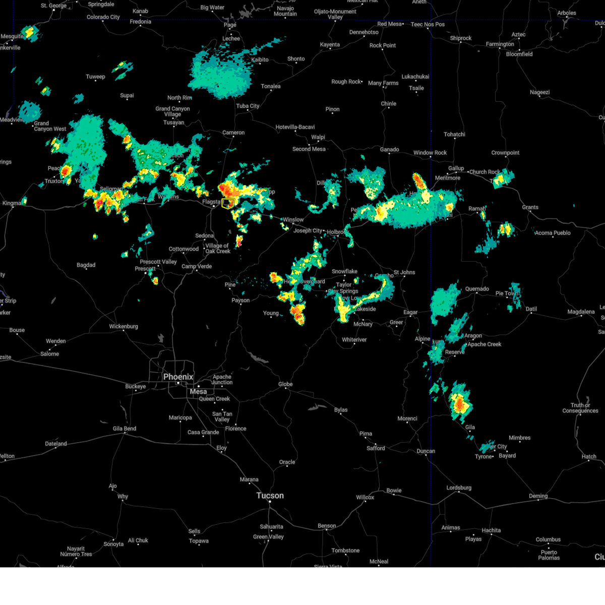
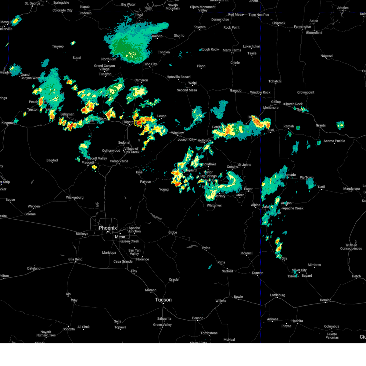
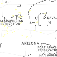
Hail Map for Flagstaff, AZ
The Flagstaff, AZ area has had 32 reports of on-the-ground hail by trained spotters, and has been under severe weather warnings 4 times during the past 12 months. Doppler radar has detected hail at or near Flagstaff, AZ on 42 occasions, including 4 occasions during the past year.
| Name: | Flagstaff, AZ |
| Where Located: | 1.8 miles E of Flagstaff, AZ |
| Map: | Google Map for Flagstaff, AZ |
| Population: | 65870 |
| Housing Units: | 26254 |
| More Info: | Search Google for Flagstaff, AZ |
2
The Top Recent Hail Date for Flagstaff, AZ is Monday, July 15, 2024 (5th out of 42)

Hail and Wind Damage Spotted near Flagstaff, AZ
| Date / Time | Report Details |
|---|---|
| 8/11/2024 5:51 PM MST |
 the severe thunderstorm warning has been cancelled and is no longer in effect the severe thunderstorm warning has been cancelled and is no longer in effect
|
| 8/11/2024 5:31 PM MST |
 Svrfgz the national weather service in flagstaff has issued a * severe thunderstorm warning for, coconino county in north central arizona, * until 615 pm mst/715 pm mdt. * at 530 pm mst/630 pm mdt, a severe thunderstorm was over cosnino and was moving west at 5 mph (radar indicated). Hazards include 60 mph wind gusts and quarter size hail. Hail damage to vehicles is expected. Expect wind damage to roofs, siding, and trees. Svrfgz the national weather service in flagstaff has issued a * severe thunderstorm warning for, coconino county in north central arizona, * until 615 pm mst/715 pm mdt. * at 530 pm mst/630 pm mdt, a severe thunderstorm was over cosnino and was moving west at 5 mph (radar indicated). Hazards include 60 mph wind gusts and quarter size hail. Hail damage to vehicles is expected. Expect wind damage to roofs, siding, and trees.
|
| 7/15/2024 2:39 PM MST |
 The storm which prompted the warning over flagstaff has weakened below severe limits, and no longer poses an immediate threat to life or property. therefore, the warning will be allowed to expire. however, heavy rain is still falling with this thunderstorm. The storm which prompted the warning over flagstaff has weakened below severe limits, and no longer poses an immediate threat to life or property. therefore, the warning will be allowed to expire. however, heavy rain is still falling with this thunderstorm.
|
| 7/15/2024 2:25 PM MST |
 Svrfgz the national weather service in flagstaff has issued a * severe thunderstorm warning for, coconino county in north central arizona, * until 245 pm mst. * at 225 pm mst, a severe thunderstorm was located over thorpe park, or over flagstaff, moving north at 5 mph (radar indicated). Hazards include quarter size hail. damage to vehicles is expected Svrfgz the national weather service in flagstaff has issued a * severe thunderstorm warning for, coconino county in north central arizona, * until 245 pm mst. * at 225 pm mst, a severe thunderstorm was located over thorpe park, or over flagstaff, moving north at 5 mph (radar indicated). Hazards include quarter size hail. damage to vehicles is expected
|
| 8/9/2023 6:06 PM MST |
 At 605 pm mst, a severe thunderstorm was located near doney park, or 10 miles northeast of flagstaff, moving east at 25 mph (radar indicated). Hazards include 60 mph wind gusts and penny size hail. Expect damage to roofs, siding, and trees. locations impacted include, flagstaff, flagstaff mall, timberline, hutchison acres, country club, pioneer valley, pine mountain estates, picture canyon preserve, cosnino, little elden springs horse camp, hutchinson acres, macann estates, winona, doney park, wupatki trails, fernwood, sunset crater volcano national monument, walnut canyon n. m. and mt. elden. this includes the following highways, route 66 between mile markers 201 and 204. interstate 40 between mile markers 201 and 211. u. s. highway 89 between mile markers 419 and 429. hail threat, radar indicated max hail size, 0. 75 in wind threat, radar indicated max wind gust, 60 mph. At 605 pm mst, a severe thunderstorm was located near doney park, or 10 miles northeast of flagstaff, moving east at 25 mph (radar indicated). Hazards include 60 mph wind gusts and penny size hail. Expect damage to roofs, siding, and trees. locations impacted include, flagstaff, flagstaff mall, timberline, hutchison acres, country club, pioneer valley, pine mountain estates, picture canyon preserve, cosnino, little elden springs horse camp, hutchinson acres, macann estates, winona, doney park, wupatki trails, fernwood, sunset crater volcano national monument, walnut canyon n. m. and mt. elden. this includes the following highways, route 66 between mile markers 201 and 204. interstate 40 between mile markers 201 and 211. u. s. highway 89 between mile markers 419 and 429. hail threat, radar indicated max hail size, 0. 75 in wind threat, radar indicated max wind gust, 60 mph.
|
| 8/9/2023 5:45 PM MST |
 At 544 pm mst, a severe thunderstorm was located over schultz pass, or near flagstaff, moving east at 25 mph (radar indicated). Hazards include 60 mph wind gusts. expect damage to roofs, siding, and trees At 544 pm mst, a severe thunderstorm was located over schultz pass, or near flagstaff, moving east at 25 mph (radar indicated). Hazards include 60 mph wind gusts. expect damage to roofs, siding, and trees
|
| 7/31/2023 12:20 PM MST |
 At 1220 pm mst, a severe thunderstorm was located near walnut canyon national monument, or 8 miles southeast of flagstaff, moving north at 5 mph (radar indicated). Hazards include 60 mph wind gusts and quarter size hail. Hail damage to vehicles is expected. Expect wind damage to roofs, siding, and trees. At 1220 pm mst, a severe thunderstorm was located near walnut canyon national monument, or 8 miles southeast of flagstaff, moving north at 5 mph (radar indicated). Hazards include 60 mph wind gusts and quarter size hail. Hail damage to vehicles is expected. Expect wind damage to roofs, siding, and trees.
|
| 5/17/2023 1:55 PM MST | Ping Pong Ball sized hail reported 6.2 miles SE of Flagstaff, AZ, from report on facebook. |
| 8/17/2021 1:39 PM MST |
 The severe thunderstorm warning for coconino county will expire at 145 pm mst, the storm which prompted the warning has weakened below severe limits, and no longer poses an immediate threat to life or property. therefore, the warning will be allowed to expire. however a flash flood warning continues for this area and heavy rain is still possible with this thunderstorm. The severe thunderstorm warning for coconino county will expire at 145 pm mst, the storm which prompted the warning has weakened below severe limits, and no longer poses an immediate threat to life or property. therefore, the warning will be allowed to expire. however a flash flood warning continues for this area and heavy rain is still possible with this thunderstorm.
|
| 8/17/2021 12:59 PM MST |
 At 1258 pm mst, a severe thunderstorm was located over fort valley, or 7 miles northwest of flagstaff, and is nearly stationary (radar indicated). Hazards include 60 mph wind gusts and quarter size hail. Hail damage to vehicles is expected. Expect wind damage to roofs, siding, and trees. At 1258 pm mst, a severe thunderstorm was located over fort valley, or 7 miles northwest of flagstaff, and is nearly stationary (radar indicated). Hazards include 60 mph wind gusts and quarter size hail. Hail damage to vehicles is expected. Expect wind damage to roofs, siding, and trees.
|
| 8/16/2021 3:13 PM MST | Hen Egg sized hail reported 4.6 miles N of Flagstaff, AZ |
| 8/16/2021 3:12 PM MST |
 The severe thunderstorm warning for coconino county will expire at 315 pm mst, the storm east of kachina village and mountainaire which prompted the warning has weakened below severe limits, and no longer poses an immediate threat to life or property. therefore, the warning will be allowed to expire. The severe thunderstorm warning for coconino county will expire at 315 pm mst, the storm east of kachina village and mountainaire which prompted the warning has weakened below severe limits, and no longer poses an immediate threat to life or property. therefore, the warning will be allowed to expire.
|
| 8/16/2021 3:01 PM MST | Ping Pong Ball sized hail reported 8.3 miles NNE of Flagstaff, AZ |
| 8/16/2021 2:51 PM MST |
 At 250 pm mst, a severe thunderstorm was located over mountainaire, or 8 miles south of flagstaff, moving southwest at 10 mph (radar indicated). Hazards include golf ball size hail. People and animals outdoors will be injured. expect damage to roofs, siding, windows, and vehicles. locations impacted include, kachina village, mountainaire and intestate-17 are in the path of this storm. find shelter now. thunderstorm damage threat, considerable hail threat, radar indicated max hail size, 1. 75 in wind threat, radar indicated max wind gust, <50 mph. At 250 pm mst, a severe thunderstorm was located over mountainaire, or 8 miles south of flagstaff, moving southwest at 10 mph (radar indicated). Hazards include golf ball size hail. People and animals outdoors will be injured. expect damage to roofs, siding, windows, and vehicles. locations impacted include, kachina village, mountainaire and intestate-17 are in the path of this storm. find shelter now. thunderstorm damage threat, considerable hail threat, radar indicated max hail size, 1. 75 in wind threat, radar indicated max wind gust, <50 mph.
|
| 8/16/2021 2:48 PM MST | Quarter sized hail reported 9.7 miles NW of Flagstaff, AZ |
| 8/16/2021 2:45 PM MST | Tennis Ball sized hail reported 3.9 miles N of Flagstaff, AZ, along lake mary road. spotter reports several homes with roof damage. |
| 8/16/2021 2:41 PM MST |
 At 241 pm mst, a severe thunderstorm was located over mountainaire, or 7 miles south of flagstaff, moving southwest at 10 mph (radar indicated). Hazards include golf ball size hail. People and animals outdoors will be injured. Expect damage to roofs, siding, windows, and vehicles. At 241 pm mst, a severe thunderstorm was located over mountainaire, or 7 miles south of flagstaff, moving southwest at 10 mph (radar indicated). Hazards include golf ball size hail. People and animals outdoors will be injured. Expect damage to roofs, siding, windows, and vehicles.
|
| 8/16/2021 2:34 PM MST |
 At 233 pm mst, a severe thunderstorm was located near walnut canyon national monument, or 7 miles southeast of flagstaff, and is nearly stationary (radar indicated). Hazards include two inch hail. People and animals outdoors will be injured. expect damage to roofs, siding, windows, and vehicles. locations impacted include, mountainaire, walnut canyon national monument, mormon lake, upper lake mary, upper lake mary boat ramps, pinegrove campground, lower lake mary, canyon vista campground and lake view campground. thunderstorm damage threat, considerable hail threat, radar indicated max hail size, 2. 00 in wind threat, radar indicated max wind gust, <50 mph. At 233 pm mst, a severe thunderstorm was located near walnut canyon national monument, or 7 miles southeast of flagstaff, and is nearly stationary (radar indicated). Hazards include two inch hail. People and animals outdoors will be injured. expect damage to roofs, siding, windows, and vehicles. locations impacted include, mountainaire, walnut canyon national monument, mormon lake, upper lake mary, upper lake mary boat ramps, pinegrove campground, lower lake mary, canyon vista campground and lake view campground. thunderstorm damage threat, considerable hail threat, radar indicated max hail size, 2. 00 in wind threat, radar indicated max wind gust, <50 mph.
|
| 8/16/2021 2:25 PM MST |
 At 225 pm mst, a severe thunderstorm was located near walnut canyon national monument, or near flagstaff, and is nearly stationary (radar indicated). Hazards include ping pong ball size hail. People and animals outdoors will be injured. Expect damage to roofs, siding, windows, and vehicles. At 225 pm mst, a severe thunderstorm was located near walnut canyon national monument, or near flagstaff, and is nearly stationary (radar indicated). Hazards include ping pong ball size hail. People and animals outdoors will be injured. Expect damage to roofs, siding, windows, and vehicles.
|
| 8/16/2021 2:08 PM MST |
 The severe thunderstorm warning for coconino county will expire at 215 pm mst, the storm of cosnino and winona which prompted the warning has weakened below severe limits. therefore, the warning will be allowed to expire. heavy rain and cloud-to-ground lightning will remain a threat. The severe thunderstorm warning for coconino county will expire at 215 pm mst, the storm of cosnino and winona which prompted the warning has weakened below severe limits. therefore, the warning will be allowed to expire. heavy rain and cloud-to-ground lightning will remain a threat.
|
| 8/16/2021 1:30 PM MST |
 At 129 pm mst, a severe thunderstorm was located near winona, or 10 miles east of flagstaff, and is nearly stationary (radar indicated). Hazards include 60 mph wind gusts and quarter size hail. Hail damage to vehicles is expected. Expect wind damage to roofs, siding, and trees. At 129 pm mst, a severe thunderstorm was located near winona, or 10 miles east of flagstaff, and is nearly stationary (radar indicated). Hazards include 60 mph wind gusts and quarter size hail. Hail damage to vehicles is expected. Expect wind damage to roofs, siding, and trees.
|
| 8/10/2021 11:55 AM MST |
 At 1155 am mst, a severe thunderstorm was located over mountainaire, or near flagstaff, moving southwest at 10 mph (radar indicated). Hazards include 60 mph wind gusts and quarter size hail. Hail damage to vehicles is expected. Expect wind damage to roofs, siding, and trees. At 1155 am mst, a severe thunderstorm was located over mountainaire, or near flagstaff, moving southwest at 10 mph (radar indicated). Hazards include 60 mph wind gusts and quarter size hail. Hail damage to vehicles is expected. Expect wind damage to roofs, siding, and trees.
|
| 7/16/2021 1:41 PM MST |
 The severe thunderstorm warning for coconino county will expire at 145 pm mst, the storm which prompted the warning has weakened below severe limits. therefore, the warning will be allowed to expire and will be replaced with a significant weather advisory however small hail, gusty winds and heavy rain are still possible with this thunderstorm. The severe thunderstorm warning for coconino county will expire at 145 pm mst, the storm which prompted the warning has weakened below severe limits. therefore, the warning will be allowed to expire and will be replaced with a significant weather advisory however small hail, gusty winds and heavy rain are still possible with this thunderstorm.
|
| 7/16/2021 1:16 PM MST |
 At 115 pm mst, a severe thunderstorm was located near flagstaff, moving south at 10 mph (radar indicated). Hazards include 60 mph wind gusts and quarter size hail. Hail damage to vehicles is expected. Expect wind damage to roofs, siding, and trees. At 115 pm mst, a severe thunderstorm was located near flagstaff, moving south at 10 mph (radar indicated). Hazards include 60 mph wind gusts and quarter size hail. Hail damage to vehicles is expected. Expect wind damage to roofs, siding, and trees.
|
| 7/12/2021 1:37 PM MST | Quarter sized hail reported 9.2 miles SE of Flagstaff, AZ |
| 8/22/2020 3:00 PM MST | Quarter sized hail reported 10.3 miles SE of Flagstaff, AZ, from facebook... a photo of estimat |
| 8/28/2019 2:20 PM MST |
 At 219 pm mst, a severe thunderstorm was located over flagstaff, moving north at 10 mph (trained weather spotters reported nickel sized hail along route 66 and first street in flagstaff). Hazards include quarter size hail. Damage to vehicles is expected. Locations impacted include, flagstaff and fort valley. At 219 pm mst, a severe thunderstorm was located over flagstaff, moving north at 10 mph (trained weather spotters reported nickel sized hail along route 66 and first street in flagstaff). Hazards include quarter size hail. Damage to vehicles is expected. Locations impacted include, flagstaff and fort valley.
|
| 8/28/2019 1:56 PM MST |
 At 155 pm mst, a severe thunderstorm was located over downtown flagstaff, moving southeast at 10 mph (radar indicated). Hazards include quarter size hail. damage to vehicles is expected At 155 pm mst, a severe thunderstorm was located over downtown flagstaff, moving southeast at 10 mph (radar indicated). Hazards include quarter size hail. damage to vehicles is expected
|
| 8/4/2019 1:42 PM MST |
 At 141 pm mst, a severe thunderstorm was located over kachina village, or 9 miles southwest of flagstaff, and is nearly stationary (radar indicated). Hazards include 60 mph wind gusts and quarter size hail. Hail damage to vehicles is expected. Expect wind damage to roofs, siding, and trees. At 141 pm mst, a severe thunderstorm was located over kachina village, or 9 miles southwest of flagstaff, and is nearly stationary (radar indicated). Hazards include 60 mph wind gusts and quarter size hail. Hail damage to vehicles is expected. Expect wind damage to roofs, siding, and trees.
|
| 7/23/2019 3:42 PM MST |
 The severe thunderstorm warning for coconino county will expire at 345 pm mst, the severe thunderstorm near kachina village, which prompted the warning, has weakened below severe limits. therefore, the warning will be allowed to expire. this storm is still producing half inch diameter hail and heavy rain west of kachina village. The severe thunderstorm warning for coconino county will expire at 345 pm mst, the severe thunderstorm near kachina village, which prompted the warning, has weakened below severe limits. therefore, the warning will be allowed to expire. this storm is still producing half inch diameter hail and heavy rain west of kachina village.
|
| 7/23/2019 3:22 PM MST |
 At 320 pm mst, a severe thunderstorm was located over mountainaire, or 10 miles southwest of flagstaff, moving northwest at 15 mph (radar indicated). Hazards include quarter size hail. damage to vehicles is expected At 320 pm mst, a severe thunderstorm was located over mountainaire, or 10 miles southwest of flagstaff, moving northwest at 15 mph (radar indicated). Hazards include quarter size hail. damage to vehicles is expected
|
| 8/9/2018 3:20 PM MST | Quarter sized hail reported 7.4 miles E of Flagstaff, AZ, observed 1 inch hail on i-40 1/2 mile west of exit 190. |
| 8/9/2018 3:12 PM MST |
 At 311 pm mst, a severe thunderstorm was located near kachina village, or near flagstaff, moving west at 10 mph (trained weather spotters). Hazards include 60 mph wind gusts and half dollar size hail. Hail damage to vehicles is expected. expect wind damage to roofs, siding, and trees. locations impacted include, flagstaff, bellemont, mountainaire, downtown flagstaff, kachina village, cave springs campground, pine flat campground, sterling fish hatchery, west fork of oak creek and canyon vista campground. this includes the following highways, route 66 between mile markers 192 and 198. interstate 40 between mile markers 183 and 199. interstate 17 between mile markers 328 and 339. state route 89a between mile markers 384 and 398. Highway 180 between mile markers 217 and 219. At 311 pm mst, a severe thunderstorm was located near kachina village, or near flagstaff, moving west at 10 mph (trained weather spotters). Hazards include 60 mph wind gusts and half dollar size hail. Hail damage to vehicles is expected. expect wind damage to roofs, siding, and trees. locations impacted include, flagstaff, bellemont, mountainaire, downtown flagstaff, kachina village, cave springs campground, pine flat campground, sterling fish hatchery, west fork of oak creek and canyon vista campground. this includes the following highways, route 66 between mile markers 192 and 198. interstate 40 between mile markers 183 and 199. interstate 17 between mile markers 328 and 339. state route 89a between mile markers 384 and 398. Highway 180 between mile markers 217 and 219.
|
| 8/9/2018 3:10 PM MST | Half Dollar sized hail reported 3.8 miles NE of Flagstaff, AZ, largest stones 1.25".several one inch stones observed. |
| 8/9/2018 3:10 PM MST | Ping Pong Ball sized hail reported 4.3 miles NE of Flagstaff, AZ, reported at 5078 s amethyst... flagstaff... az. |
| 8/9/2018 3:08 PM MST | Quarter sized hail reported 3.8 miles NE of Flagstaff, AZ |
| 8/9/2018 3:08 PM MST |
 At 308 pm mst, a severe thunderstorm was located near downtown flagstaff, moving west at 10 mph (radar indicated). Hazards include 60 mph wind gusts and half dollar size hail. Hail damage to vehicles is expected. Expect wind damage to roofs, siding, and trees. At 308 pm mst, a severe thunderstorm was located near downtown flagstaff, moving west at 10 mph (radar indicated). Hazards include 60 mph wind gusts and half dollar size hail. Hail damage to vehicles is expected. Expect wind damage to roofs, siding, and trees.
|
| 8/9/2018 3:05 PM MST | Half Dollar sized hail reported 3.6 miles ENE of Flagstaff, AZ, reported at 2050 w university ave... flagstaff... az. |
| 7/28/2018 12:36 PM MST |
 The severe thunderstorm warning for coconino county will expire at 1245 pm mst, the storm which prompted the warning has weakened below severe limits, and no longer pose an immediate threat to life or property. therefore the warning will be allowed to expire. however heavy rain is still possible with this thunderstorm. The severe thunderstorm warning for coconino county will expire at 1245 pm mst, the storm which prompted the warning has weakened below severe limits, and no longer pose an immediate threat to life or property. therefore the warning will be allowed to expire. however heavy rain is still possible with this thunderstorm.
|
| 7/28/2018 12:15 PM MST | Quarter sized hail reported 10.7 miles SSW of Flagstaff, AZ, public report of hail approximately 1" in diameter due to a storm passing over fernwood... az. |
| 7/28/2018 11:59 AM MST |
 At 1159 am mst, a severe thunderstorm was located over timberline, or 10 miles northeast of flagstaff, and is nearly stationary (radar indicated). Hazards include 60 mph wind gusts and quarter size hail. Hail damage to vehicles is expected. Expect wind damage to roofs, siding, and trees. At 1159 am mst, a severe thunderstorm was located over timberline, or 10 miles northeast of flagstaff, and is nearly stationary (radar indicated). Hazards include 60 mph wind gusts and quarter size hail. Hail damage to vehicles is expected. Expect wind damage to roofs, siding, and trees.
|
| 7/27/2018 3:39 PM MST |
 At 307 pm mst, a severe thunderstorm was located over mountainaire, or 7 miles south of flagstaff, moving south at 25 mph (radar indicated). Hazards include 60 mph wind gusts and quarter size hail. Hail damage to vehicles is expected. Expect wind damage to roofs, siding, and trees. At 307 pm mst, a severe thunderstorm was located over mountainaire, or 7 miles south of flagstaff, moving south at 25 mph (radar indicated). Hazards include 60 mph wind gusts and quarter size hail. Hail damage to vehicles is expected. Expect wind damage to roofs, siding, and trees.
|
| 7/27/2018 3:07 PM MST |
 The national weather service in flagstaff has issued a * severe thunderstorm warning for. coconino county near mountainaire in north central arizona. Until 345 pm mst * at 307 pm mst, a severe thunderstorm was located over mountainaire, or 7 miles south of flagstaff, moving south at 25 mph. The national weather service in flagstaff has issued a * severe thunderstorm warning for. coconino county near mountainaire in north central arizona. Until 345 pm mst * at 307 pm mst, a severe thunderstorm was located over mountainaire, or 7 miles south of flagstaff, moving south at 25 mph.
|
| 7/19/2018 1:26 PM MST | Quarter sized hail reported 2.5 miles WNW of Flagstaff, AZ |
| 7/19/2018 1:26 PM MST |
 At 126 pm mst, a severe thunderstorm was located over east flagstaff, moving north at 10 mph (spotter report). Hazards include quarter size hail. damage to vehicles is expected At 126 pm mst, a severe thunderstorm was located over east flagstaff, moving north at 10 mph (spotter report). Hazards include quarter size hail. damage to vehicles is expected
|
| 7/19/2018 1:10 PM MST |
 The severe thunderstorm warning for coconino county will expire at 115 pm mst, the severe thunderstorm near the flagstaff mall has weakened and moved north. the severe thunderstorm warning will be allowed to expire. heavy rain is still occurring in east flagstaff. The severe thunderstorm warning for coconino county will expire at 115 pm mst, the severe thunderstorm near the flagstaff mall has weakened and moved north. the severe thunderstorm warning will be allowed to expire. heavy rain is still occurring in east flagstaff.
|
| 7/19/2018 12:47 PM MST |
 The national weather service in flagstaff has issued a * severe thunderstorm warning for. coconino county in north central arizona. Until 115 pm mst * at 1246 pm mst, a severe thunderstorm was located over flagstaff mall and is nearly stationary. The national weather service in flagstaff has issued a * severe thunderstorm warning for. coconino county in north central arizona. Until 115 pm mst * at 1246 pm mst, a severe thunderstorm was located over flagstaff mall and is nearly stationary.
|
| 8/13/2017 6:18 PM MST |
 At 617 pm mst, a severe thunderstorm was located over downtown flagstaff, or over flagstaff, moving southeast at 30 mph (radar indicated). Hazards include 60 mph wind gusts and quarter size hail. Hail damage to vehicles is expected. Expect wind damage to roofs, siding, and trees. At 617 pm mst, a severe thunderstorm was located over downtown flagstaff, or over flagstaff, moving southeast at 30 mph (radar indicated). Hazards include 60 mph wind gusts and quarter size hail. Hail damage to vehicles is expected. Expect wind damage to roofs, siding, and trees.
|
| 8/6/2016 12:07 PM MST | Quarter sized hail reported 9.9 miles WSW of Flagstaff, AZ, updated to correct time. |
| 8/6/2016 11:50 AM MST | Quarter sized hail reported 9.9 miles WSW of Flagstaff, AZ, . |
| 7/7/2015 3:08 PM MST |
 The severe thunderstorm warning for central coconino county will expire at 315 pm mst, the severe thunderstorm which prompted the warning over east flagstaff has weakened. therefore the warning will be allowed to expire. The severe thunderstorm warning for central coconino county will expire at 315 pm mst, the severe thunderstorm which prompted the warning over east flagstaff has weakened. therefore the warning will be allowed to expire.
|
| 7/7/2015 2:50 PM MST | Quarter sized hail reported 3.6 miles SW of Flagstaff, AZ |
| 7/7/2015 2:49 PM MST |
 At 249 pm mst, doppler radar indicated a severe thunderstorm capable of producing quarter size hail. this storm was located over flagstaff, and moving northeast at 25 mph. At 249 pm mst, doppler radar indicated a severe thunderstorm capable of producing quarter size hail. this storm was located over flagstaff, and moving northeast at 25 mph.
|
| 7/1/2015 2:40 PM MST | Quarter sized hail reported 8.1 miles SE of Flagstaff, AZ |
| 7/1/2015 2:00 PM MST | Quarter sized hail reported 13.4 miles S of Flagstaff, AZ, 1 inch diamter hail near az snowbowl |
| 7/8/2014 4:25 PM MST | Quarter sized hail reported 0.4 miles N of Flagstaff, AZ, east flagstaff. quarter size hail with 2 inches of rain. |
| 8/27/2013 12:46 PM MST | Quarter sized hail reported 7.7 miles NNE of Flagstaff, AZ |
| 7/25/2013 11:33 AM MST | Quarter sized hail reported 0.4 miles N of Flagstaff, AZ, accompanied by 1.25 inches of rain so far... |
| 7/2/2013 3:02 PM MST | Quarter sized hail reported 7.7 miles NNE of Flagstaff, AZ, mostly smaller stones with a few up to quarter sized |
| 7/2/2013 3:01 PM MST | Ping Pong Ball sized hail reported 7.7 miles NNE of Flagstaff, AZ, kachina village |
| 7/2/2013 2:55 PM MST | Quarter sized hail reported 0.4 miles N of Flagstaff, AZ, university heights neighborhood. |
| 9/12/2011 6:30 AM MST | Ping Pong Ball sized hail reported 2.2 miles W of Flagstaff, AZ, quarter to ping pong ball sized hail in flagstaff |
| 9/12/2011 6:25 AM MST | Quarter sized hail reported 2.5 miles N of Flagstaff, AZ, i40 and i17 interchange into west flagstaff |
| 9/12/2011 6:16 AM MST | Quarter sized hail reported 2.5 miles NE of Flagstaff, AZ, lake mary road...2 inches deep |
| 9/12/2011 6:10 AM MST | Quarter sized hail reported 0.4 miles N of Flagstaff, AZ, nau campus |
| 9/12/2011 6:08 AM MST | Quarter sized hail reported 0.7 miles ESE of Flagstaff, AZ, measured at university heights...hail is covering the ground |
| 9/12/2011 6:05 AM MST | Quarter sized hail reported 1.3 miles ENE of Flagstaff, AZ, quarter sized hail covering the ground. |
| 9/8/2011 3:40 PM MST | Quarter sized hail reported 5.1 miles NW of Flagstaff, AZ, lake mary campground. pea to quarter-sized hail. some dents in roofs of rvs. hail lasted 30 minutes. at least 1 inch accumulation on ground. |
Hail Maps for Flagstaff, AZ


Connect with Interactive Hail Maps