

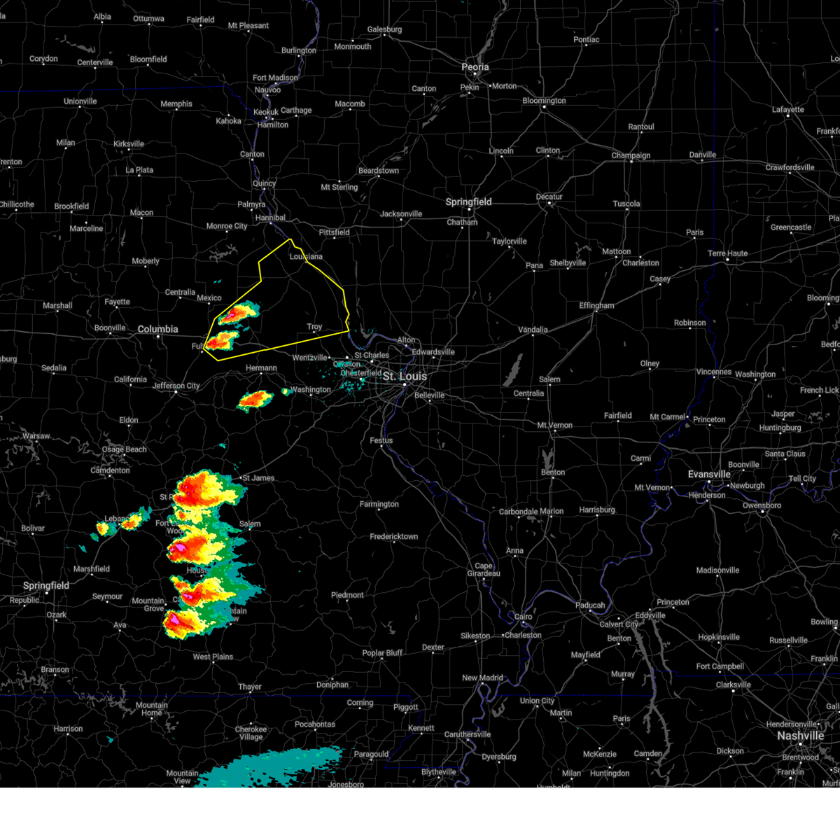
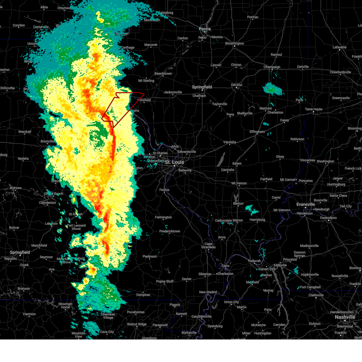
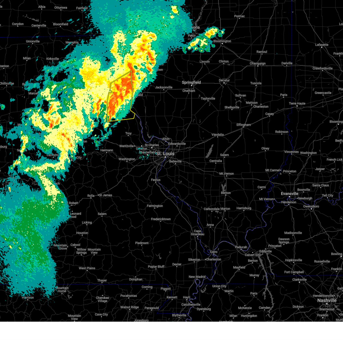
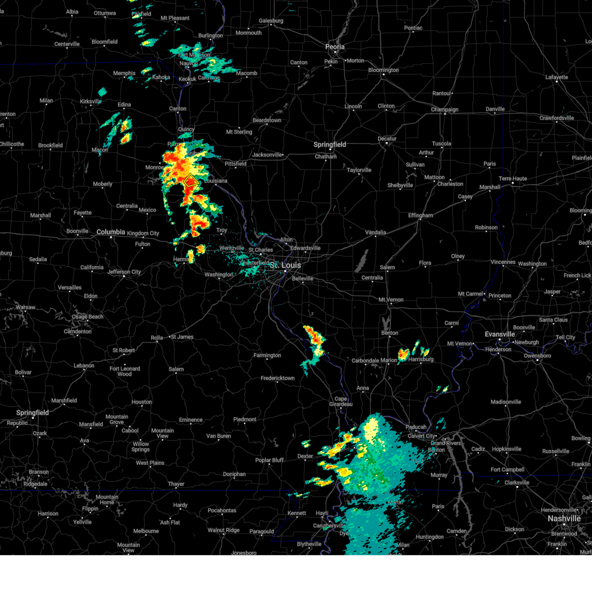
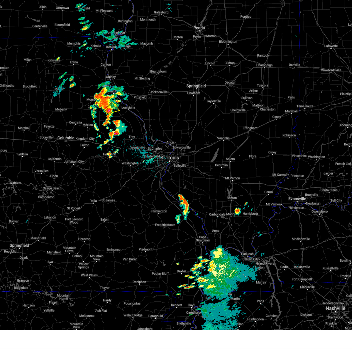
Hail Map for Frankford, MO
The Frankford, MO area has had 4 reports of on-the-ground hail by trained spotters, and has been under severe weather warnings 20 times during the past 12 months. Doppler radar has detected hail at or near Frankford, MO on 53 occasions.
| Name: | Frankford, MO |
| Where Located: | 66 miles NE of Columbia, MO |
| Map: | Google Map for Frankford, MO |
| Population: | 323 |
| Housing Units: | 171 |
| More Info: | Search Google for Frankford, MO |
3
The Top Recent Hail Date for Frankford, MO is Thursday, April 18, 2024 (3rd out of 53)

Hail and Wind Damage Spotted near Frankford, MO
| Date / Time | Report Details |
|---|---|
| 7/11/2025 10:59 PM CDT |
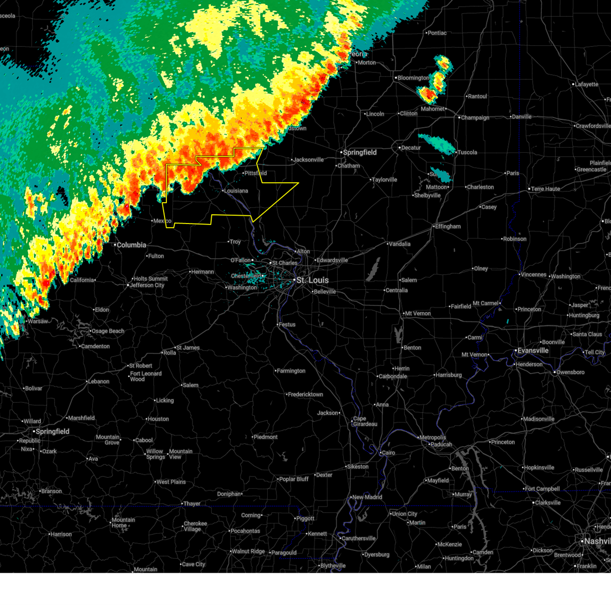
 The storms which prompted the warning have weakened below severe limits, and no longer pose an immediate threat to life or property. therefore, the warning will be allowed to expire. however, gusty winds and heavy rain are still possible with these thunderstorms. The storms which prompted the warning have weakened below severe limits, and no longer pose an immediate threat to life or property. therefore, the warning will be allowed to expire. however, gusty winds and heavy rain are still possible with these thunderstorms.
|
| 7/11/2025 10:35 PM CDT |
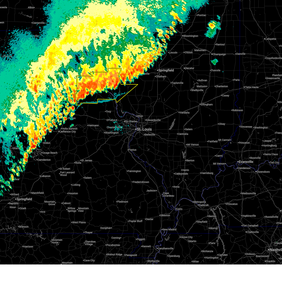
 At 1035 pm cdt, severe thunderstorms were located along a line from 10 miles northwest of white hall to over laddonia, or along a line from 10 miles northwest of white hall to 7 miles southwest of vandalia, moving south at 25 mph (law enforcement reported tree damage in hannibal, mo and highway 79 in eastern ralls county). Hazards include 60 mph wind gusts. Expect damage to roofs, siding, and trees. this severe thunderstorm will be near, atlas, spencerburg, pittsfield, perry, frankford, griggsville and center around 1015 pm cdt. louisiana and pike around 1020 pm cdt. other locations impacted by the severe thunderstorm include detroit, summer hill, rockport, new hartford, valley city, ashburn, el dara, time, martinsburg and independence. This includes interstate 72 between exits 10 and 35. At 1035 pm cdt, severe thunderstorms were located along a line from 10 miles northwest of white hall to over laddonia, or along a line from 10 miles northwest of white hall to 7 miles southwest of vandalia, moving south at 25 mph (law enforcement reported tree damage in hannibal, mo and highway 79 in eastern ralls county). Hazards include 60 mph wind gusts. Expect damage to roofs, siding, and trees. this severe thunderstorm will be near, atlas, spencerburg, pittsfield, perry, frankford, griggsville and center around 1015 pm cdt. louisiana and pike around 1020 pm cdt. other locations impacted by the severe thunderstorm include detroit, summer hill, rockport, new hartford, valley city, ashburn, el dara, time, martinsburg and independence. This includes interstate 72 between exits 10 and 35.
|
| 7/11/2025 10:15 PM CDT |
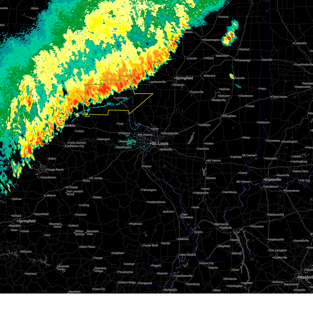
 Svrlsx the national weather service in st louis has issued a * severe thunderstorm warning for, northwestern calhoun county in southwestern illinois, northern greene county in southwestern illinois, pike county in west central illinois, eastern audrain county in central missouri, pike county in northeastern missouri, ralls county in northeastern missouri, * until 1100 pm cdt. * at 1015 pm cdt, severe thunderstorms were located along a line from 9 miles southeast of griggsville to near perry, or along a line from 12 miles east of pittsfield to 9 miles east of santa fe, moving south at 20 mph (law enforcement reported tree damage was reported in hannibal, mo and highway 79 in eastern ralls county). Hazards include 60 mph wind gusts. Expect damage to roofs, siding, and trees. this severe thunderstorm will be near, atlas, spencerburg, pittsfield, louisiana, perry, frankford, griggsville and center around 1015 pm cdt. pike around 1020 pm cdt. other locations impacted by the severe thunderstorm include detroit, summer hill, rockport, new hartford, valley city, ashburn, el dara, independence, milton and martinsburg. This includes interstate 72 between exits 10 and 35. Svrlsx the national weather service in st louis has issued a * severe thunderstorm warning for, northwestern calhoun county in southwestern illinois, northern greene county in southwestern illinois, pike county in west central illinois, eastern audrain county in central missouri, pike county in northeastern missouri, ralls county in northeastern missouri, * until 1100 pm cdt. * at 1015 pm cdt, severe thunderstorms were located along a line from 9 miles southeast of griggsville to near perry, or along a line from 12 miles east of pittsfield to 9 miles east of santa fe, moving south at 20 mph (law enforcement reported tree damage was reported in hannibal, mo and highway 79 in eastern ralls county). Hazards include 60 mph wind gusts. Expect damage to roofs, siding, and trees. this severe thunderstorm will be near, atlas, spencerburg, pittsfield, louisiana, perry, frankford, griggsville and center around 1015 pm cdt. pike around 1020 pm cdt. other locations impacted by the severe thunderstorm include detroit, summer hill, rockport, new hartford, valley city, ashburn, el dara, independence, milton and martinsburg. This includes interstate 72 between exits 10 and 35.
|
| 5/16/2025 1:26 PM CDT |
 At 126 pm cdt, a severe thunderstorm was located near wellsville, moving east at 50 mph (radar indicated). Hazards include golf ball size hail and 60 mph wind gusts. People and animals outdoors will be injured. expect hail damage to roofs, siding, windows, and vehicles. expect wind damage to roofs, siding, and trees. locations impacted include, troy, bowling green, louisiana, montgomery city, elsberry, wellsville, moscow mills, winfield, davis, new florence, hawk point, eolia, clarksville, bellflower, frankford, martinsburg, curryville, fountain n' lakes, new hartford and tarrants. this includes the following state parks, cuivre river state park and graham cave state park. This includes interstate 70 in missouri between exits 155 and 179. At 126 pm cdt, a severe thunderstorm was located near wellsville, moving east at 50 mph (radar indicated). Hazards include golf ball size hail and 60 mph wind gusts. People and animals outdoors will be injured. expect hail damage to roofs, siding, windows, and vehicles. expect wind damage to roofs, siding, and trees. locations impacted include, troy, bowling green, louisiana, montgomery city, elsberry, wellsville, moscow mills, winfield, davis, new florence, hawk point, eolia, clarksville, bellflower, frankford, martinsburg, curryville, fountain n' lakes, new hartford and tarrants. this includes the following state parks, cuivre river state park and graham cave state park. This includes interstate 70 in missouri between exits 155 and 179.
|
| 5/16/2025 1:17 PM CDT |
 Svrlsx the national weather service in st louis has issued a * severe thunderstorm warning for, southeastern audrain county in central missouri, northeastern callaway county in central missouri, lincoln county in east central missouri, montgomery county in east central missouri, north central warren county in east central missouri, pike county in northeastern missouri, * until 230 pm cdt. * at 117 pm cdt, a severe thunderstorm was located over martinsburg, or 6 miles west of wellsville, moving northeast at 50 mph (radar indicated). Hazards include 60 mph wind gusts and half dollar size hail. Hail damage to vehicles is expected. Expect wind damage to roofs, siding, and trees. Svrlsx the national weather service in st louis has issued a * severe thunderstorm warning for, southeastern audrain county in central missouri, northeastern callaway county in central missouri, lincoln county in east central missouri, montgomery county in east central missouri, north central warren county in east central missouri, pike county in northeastern missouri, * until 230 pm cdt. * at 117 pm cdt, a severe thunderstorm was located over martinsburg, or 6 miles west of wellsville, moving northeast at 50 mph (radar indicated). Hazards include 60 mph wind gusts and half dollar size hail. Hail damage to vehicles is expected. Expect wind damage to roofs, siding, and trees.
|
| 4/20/2025 6:32 PM CDT |
 At 632 pm cdt, a severe thunderstorm capable of producing a tornado was located 6 miles east of frankford, or 8 miles northwest of louisiana, moving northeast at 60 mph (radar indicated rotation). Hazards include tornado. Flying debris will be dangerous to those caught without shelter. mobile homes will be damaged or destroyed. damage to roofs, windows and vehicles will occur. tree damage is likely. other locations impacted by the tornado include ashburn, new canton, el dara, kinderhook, baylis and new salem. This includes interstate 72 between exits 10 and 20. At 632 pm cdt, a severe thunderstorm capable of producing a tornado was located 6 miles east of frankford, or 8 miles northwest of louisiana, moving northeast at 60 mph (radar indicated rotation). Hazards include tornado. Flying debris will be dangerous to those caught without shelter. mobile homes will be damaged or destroyed. damage to roofs, windows and vehicles will occur. tree damage is likely. other locations impacted by the tornado include ashburn, new canton, el dara, kinderhook, baylis and new salem. This includes interstate 72 between exits 10 and 20.
|
| 4/20/2025 6:21 PM CDT |
 At 621 pm cdt, a severe thunderstorm capable of producing a tornado was located over frankford, or 11 miles northwest of bowling green, moving northeast at 60 mph (radar indicated rotation). Hazards include tornado. Flying debris will be dangerous to those caught without shelter. mobile homes will be damaged or destroyed. damage to roofs, windows and vehicles will occur. tree damage is likely. this tornado will be near, spencerburg and curryville around 615 pm cdt. frankford around 625 pm cdt. other locations impacted by the tornado include ashburn, saverton, new canton, kinderhook, hull, el dara and baylis. This includes interstate 72 between exits 10 and 20. At 621 pm cdt, a severe thunderstorm capable of producing a tornado was located over frankford, or 11 miles northwest of bowling green, moving northeast at 60 mph (radar indicated rotation). Hazards include tornado. Flying debris will be dangerous to those caught without shelter. mobile homes will be damaged or destroyed. damage to roofs, windows and vehicles will occur. tree damage is likely. this tornado will be near, spencerburg and curryville around 615 pm cdt. frankford around 625 pm cdt. other locations impacted by the tornado include ashburn, saverton, new canton, kinderhook, hull, el dara and baylis. This includes interstate 72 between exits 10 and 20.
|
| 4/20/2025 6:16 PM CDT |
 At 616 pm cdt, severe thunderstorms were located along a line from near spaulding to near bellflower, or along a line from 10 miles southeast of monroe city to 11 miles northeast of montgomery city, moving northeast at 60 mph (trained spotters reported. at 6:10 pm a 63 mph wind gust was reported at vandalia, mo). Hazards include 70 mph wind gusts. Expect considerable tree damage. damage is likely to mobile homes, roofs, and outbuildings. this severe thunderstorm will be near, vandalia around 610 pm cdt. other locations impacted by the severe thunderstorm include the landing, st. Clement, ashley, cyrene, saverton, ilasco, edgewood and ashburn. At 616 pm cdt, severe thunderstorms were located along a line from near spaulding to near bellflower, or along a line from 10 miles southeast of monroe city to 11 miles northeast of montgomery city, moving northeast at 60 mph (trained spotters reported. at 6:10 pm a 63 mph wind gust was reported at vandalia, mo). Hazards include 70 mph wind gusts. Expect considerable tree damage. damage is likely to mobile homes, roofs, and outbuildings. this severe thunderstorm will be near, vandalia around 610 pm cdt. other locations impacted by the severe thunderstorm include the landing, st. Clement, ashley, cyrene, saverton, ilasco, edgewood and ashburn.
|
| 4/20/2025 6:11 PM CDT |
 Torlsx the national weather service in st louis has issued a * tornado warning for, northwestern pike county in west central illinois, northwestern pike county in northeastern missouri, central ralls county in northeastern missouri, * until 700 pm cdt. * at 611 pm cdt, a severe thunderstorm capable of producing a tornado was located near vandalia, moving northeast at 70 mph (radar indicated rotation). Hazards include tornado. Flying debris will be dangerous to those caught without shelter. mobile homes will be damaged or destroyed. damage to roofs, windows and vehicles will occur. tree damage is likely. this tornado will be near, spencerburg, curryville and vandalia around 615 pm cdt. frankford around 620 pm cdt. other locations impacted by the tornado include ashburn, saverton, ilasco, new canton, kinderhook, hull, el dara and baylis. This includes interstate 72 between exits 10 and 20. Torlsx the national weather service in st louis has issued a * tornado warning for, northwestern pike county in west central illinois, northwestern pike county in northeastern missouri, central ralls county in northeastern missouri, * until 700 pm cdt. * at 611 pm cdt, a severe thunderstorm capable of producing a tornado was located near vandalia, moving northeast at 70 mph (radar indicated rotation). Hazards include tornado. Flying debris will be dangerous to those caught without shelter. mobile homes will be damaged or destroyed. damage to roofs, windows and vehicles will occur. tree damage is likely. this tornado will be near, spencerburg, curryville and vandalia around 615 pm cdt. frankford around 620 pm cdt. other locations impacted by the tornado include ashburn, saverton, ilasco, new canton, kinderhook, hull, el dara and baylis. This includes interstate 72 between exits 10 and 20.
|
| 4/20/2025 6:03 PM CDT |
 Svrlsx the national weather service in st louis has issued a * severe thunderstorm warning for, pike county in northeastern missouri, ralls county in northeastern missouri, * until 645 pm cdt. * at 603 pm cdt, severe thunderstorms were located along a line from over perry to over new florence, or along a line from 8 miles northeast of santa fe to 5 miles southeast of montgomery city, moving northeast at 60 mph (radar indicated). Hazards include 70 mph wind gusts. Expect considerable tree damage. damage is likely to mobile homes, roofs, and outbuildings. this severe thunderstorm will be near, vandalia around 610 pm cdt. other locations impacted by the severe thunderstorm include the landing, st. Clement, ashley, cyrene, saverton, ilasco, edgewood and ashburn. Svrlsx the national weather service in st louis has issued a * severe thunderstorm warning for, pike county in northeastern missouri, ralls county in northeastern missouri, * until 645 pm cdt. * at 603 pm cdt, severe thunderstorms were located along a line from over perry to over new florence, or along a line from 8 miles northeast of santa fe to 5 miles southeast of montgomery city, moving northeast at 60 mph (radar indicated). Hazards include 70 mph wind gusts. Expect considerable tree damage. damage is likely to mobile homes, roofs, and outbuildings. this severe thunderstorm will be near, vandalia around 610 pm cdt. other locations impacted by the severe thunderstorm include the landing, st. Clement, ashley, cyrene, saverton, ilasco, edgewood and ashburn.
|
| 4/10/2025 2:33 PM CDT |
 Svrlsx the national weather service in st louis has issued a * severe thunderstorm warning for, south central adams county in west central illinois, western pike county in west central illinois, southeastern marion county in northeastern missouri, northwestern pike county in northeastern missouri, northeastern ralls county in northeastern missouri, * until 315 pm cdt. * at 233 pm cdt, a severe thunderstorm was located near fall creek, or 8 miles east of hannibal, moving southeast at 25 mph (radar indicated). Hazards include quarter size hail. damage to vehicles is expected Svrlsx the national weather service in st louis has issued a * severe thunderstorm warning for, south central adams county in west central illinois, western pike county in west central illinois, southeastern marion county in northeastern missouri, northwestern pike county in northeastern missouri, northeastern ralls county in northeastern missouri, * until 315 pm cdt. * at 233 pm cdt, a severe thunderstorm was located near fall creek, or 8 miles east of hannibal, moving southeast at 25 mph (radar indicated). Hazards include quarter size hail. damage to vehicles is expected
|
| 4/2/2025 9:16 AM CDT | The severe thunderstorm warning that was previously in effect has been reissued for pike and pike counties and is in effect until 1000 am cdt. please refer to that bulletin for the latest severe weather information. a tornado watch remains in effect until 400 pm cdt wednesday for portions of west central illinois and northeast missouri. |
| 4/2/2025 8:55 AM CDT |
 At 855 am cdt, severe thunderstorms were located along a line from over beverly to 5 miles north of new hartford, or along a line from 13 miles southeast of quincy regional airport to 6 miles southwest of bowling green, moving east at 60 mph (radar indicated). Hazards include 60 mph wind gusts and small hail. Expect damage to roofs, siding, and trees. locations impacted include, hannibal, bowling green, louisiana, barry, payson, new london, atlas, fall creek, eolia, clarksville, beverly, frankford, pike, curryville, tarrants, spencerburg, adams, kingston, liberty and hull. this includes the following state parks, siloam springs state park. this includes the following highways, interstate 72 between exits 4 and 20. Interstate 172 near exit 2. At 855 am cdt, severe thunderstorms were located along a line from over beverly to 5 miles north of new hartford, or along a line from 13 miles southeast of quincy regional airport to 6 miles southwest of bowling green, moving east at 60 mph (radar indicated). Hazards include 60 mph wind gusts and small hail. Expect damage to roofs, siding, and trees. locations impacted include, hannibal, bowling green, louisiana, barry, payson, new london, atlas, fall creek, eolia, clarksville, beverly, frankford, pike, curryville, tarrants, spencerburg, adams, kingston, liberty and hull. this includes the following state parks, siloam springs state park. this includes the following highways, interstate 72 between exits 4 and 20. Interstate 172 near exit 2.
|
| 4/2/2025 8:55 AM CDT |
 the severe thunderstorm warning has been cancelled and is no longer in effect the severe thunderstorm warning has been cancelled and is no longer in effect
|
| 4/2/2025 8:45 AM CDT |
 At 845 am cdt, severe thunderstorms were located along a line from near payson to 6 miles south of vandalia, or along a line from 11 miles south of quincy regional airport to 6 miles south of vandalia, moving east at 60 mph (radar indicated). Hazards include 60 mph wind gusts and small hail. Expect damage to roofs, siding, and trees. locations impacted include, hannibal, bowling green, vandalia, palmyra, louisiana, barry, payson, new london, clayton, atlas, fall creek, eolia, laddonia, center, clarksville, beverly, frankford, farber, pike and rensselaer. this includes the following state parks, siloam springs state park. this includes the following highways, interstate 72 between exits 4 and 20. Interstate 172 near exit 2. At 845 am cdt, severe thunderstorms were located along a line from near payson to 6 miles south of vandalia, or along a line from 11 miles south of quincy regional airport to 6 miles south of vandalia, moving east at 60 mph (radar indicated). Hazards include 60 mph wind gusts and small hail. Expect damage to roofs, siding, and trees. locations impacted include, hannibal, bowling green, vandalia, palmyra, louisiana, barry, payson, new london, clayton, atlas, fall creek, eolia, laddonia, center, clarksville, beverly, frankford, farber, pike and rensselaer. this includes the following state parks, siloam springs state park. this includes the following highways, interstate 72 between exits 4 and 20. Interstate 172 near exit 2.
|
| 4/2/2025 8:27 AM CDT | Svrlsx the national weather service in st louis has issued a * severe thunderstorm warning for, southern adams county in west central illinois, western pike county in west central illinois, eastern audrain county in central missouri, southeastern marion county in northeastern missouri, pike county in northeastern missouri, ralls county in northeastern missouri, * until 915 am cdt. * at 827 am cdt, severe thunderstorms were located along a line from near hannibal to 6 miles northwest of martinsburg, or along a line from near hannibal to 8 miles east of mexico, moving east at 60 mph (radar indicated). Hazards include 60 mph wind gusts and small hail. expect damage to roofs, siding, and trees |
| 3/14/2025 8:22 PM CDT | At 822 pm cdt, severe thunderstorms were located along a line from 6 miles west of beverly to 6 miles northwest of eolia, or along a line from 11 miles southeast of quincy regional airport to 6 miles southeast of bowling green, moving northeast at 60 mph (radar indicated). Hazards include 70 mph wind gusts and quarter size hail. Hail damage to vehicles is expected. expect considerable tree damage. wind damage is also likely to mobile homes, roofs, and outbuildings. this severe thunderstorm will be near, frankford, new hartford and curryville around 805 pm cdt. bowling green around 810 pm cdt. other locations impacted by the severe thunderstorm include ashley, st. Clement, ashburn, new canton, cyrene, edgewood, rockport, el dara, summer hill and baylis. |
| 3/14/2025 8:22 PM CDT | the severe thunderstorm warning has been cancelled and is no longer in effect |
| 3/14/2025 8:05 PM CDT | Svrlsx the national weather service in st louis has issued a * severe thunderstorm warning for, central pike county in west central illinois, pike county in northeastern missouri, southeastern ralls county in northeastern missouri, * until 830 pm cdt. * at 805 pm cdt, severe thunderstorms were located along a line from near new london to 5 miles south of new hartford, or along a line from 7 miles southeast of hannibal to 14 miles east of wellsville, moving northeast at 60 mph (radar indicated). Hazards include 70 mph wind gusts and quarter size hail. Hail damage to vehicles is expected. expect considerable tree damage. wind damage is also likely to mobile homes, roofs, and outbuildings. this severe thunderstorm will be near, frankford, new hartford, curryville and spencerburg around 805 pm cdt. bowling green around 810 pm cdt. other locations impacted by the severe thunderstorm include ashley, st. Clement, ashburn, new canton, cyrene, edgewood, rockport, el dara, summer hill and baylis. |
| 3/14/2025 7:26 PM CDT |
 Svrlsx the national weather service in st louis has issued a * severe thunderstorm warning for, eastern audrain county in central missouri, pike county in northeastern missouri, southern ralls county in northeastern missouri, * until 815 pm cdt. * at 726 pm cdt, a severe thunderstorm was located 5 miles northwest of martinsburg, or 8 miles east of mexico, moving northeast at 65 mph (radar indicated). Hazards include 60 mph wind gusts and small hail. Expect damage to roofs, siding, and trees. this severe thunderstorm will be near, martinsburg and mexico around 730 pm cdt. laddonia around 735 pm cdt. Other locations impacted by the severe thunderstorm include rush hill, benton city and ashburn. Svrlsx the national weather service in st louis has issued a * severe thunderstorm warning for, eastern audrain county in central missouri, pike county in northeastern missouri, southern ralls county in northeastern missouri, * until 815 pm cdt. * at 726 pm cdt, a severe thunderstorm was located 5 miles northwest of martinsburg, or 8 miles east of mexico, moving northeast at 65 mph (radar indicated). Hazards include 60 mph wind gusts and small hail. Expect damage to roofs, siding, and trees. this severe thunderstorm will be near, martinsburg and mexico around 730 pm cdt. laddonia around 735 pm cdt. Other locations impacted by the severe thunderstorm include rush hill, benton city and ashburn.
|
| 6/25/2024 4:53 PM CDT |
 Svrlsx the national weather service in st louis has issued a * severe thunderstorm warning for, southern ralls county in northeastern missouri, northern lincoln county in east central missouri, eastern audrain county in central missouri, northern montgomery county in east central missouri, southeastern monroe county in northeastern missouri, pike county in northeastern missouri, * until 545 pm cdt. * at 453 pm cdt, severe thunderstorms were located over mainly rural areas of ralls and pike counties0 , moving southeast at 45 mph (radar indicated). Hazards include 60 mph wind gusts. Expect damage to roofs, siding, and trees. severe thunderstorms will be near, laddonia and new hartford around 500 pm cdt. eolia around 505 pm cdt. Other locations in the path of these severe thunderstorms include buell, davis and bellflower. Svrlsx the national weather service in st louis has issued a * severe thunderstorm warning for, southern ralls county in northeastern missouri, northern lincoln county in east central missouri, eastern audrain county in central missouri, northern montgomery county in east central missouri, southeastern monroe county in northeastern missouri, pike county in northeastern missouri, * until 545 pm cdt. * at 453 pm cdt, severe thunderstorms were located over mainly rural areas of ralls and pike counties0 , moving southeast at 45 mph (radar indicated). Hazards include 60 mph wind gusts. Expect damage to roofs, siding, and trees. severe thunderstorms will be near, laddonia and new hartford around 500 pm cdt. eolia around 505 pm cdt. Other locations in the path of these severe thunderstorms include buell, davis and bellflower.
|
| 5/24/2024 3:41 PM CDT |
 Svrlsx the national weather service in st louis has issued a * severe thunderstorm warning for, pike county in west central illinois, southeastern brown county in west central illinois, northwestern pike county in northeastern missouri, * until 430 pm cdt. * at 341 pm cdt, severe thunderstorms were located along a line extending from 6 miles northwest of griggsville to 7 miles west of pittsfield to near atlas to near frankford, moving east at 35 mph (radar indicated). Hazards include 60 mph wind gusts and quarter size hail. Hail damage to vehicles is expected. Expect wind damage to roofs, siding, and trees. Svrlsx the national weather service in st louis has issued a * severe thunderstorm warning for, pike county in west central illinois, southeastern brown county in west central illinois, northwestern pike county in northeastern missouri, * until 430 pm cdt. * at 341 pm cdt, severe thunderstorms were located along a line extending from 6 miles northwest of griggsville to 7 miles west of pittsfield to near atlas to near frankford, moving east at 35 mph (radar indicated). Hazards include 60 mph wind gusts and quarter size hail. Hail damage to vehicles is expected. Expect wind damage to roofs, siding, and trees.
|
| 4/18/2024 3:07 PM CDT |
 At 307 pm cdt, a severe thunderstorm was located near frankford, moving east at 40 mph (radar indicated). Hazards include golf ball size hail and 60 mph wind gusts. People and animals outdoors will be injured. expect hail damage to roofs, siding, windows, and vehicles. expect wind damage to roofs, siding, and trees. Locations impacted include, bowling green, louisiana, clarksville, frankford, curryville, tarrants, spencerburg, and ashburn. At 307 pm cdt, a severe thunderstorm was located near frankford, moving east at 40 mph (radar indicated). Hazards include golf ball size hail and 60 mph wind gusts. People and animals outdoors will be injured. expect hail damage to roofs, siding, windows, and vehicles. expect wind damage to roofs, siding, and trees. Locations impacted include, bowling green, louisiana, clarksville, frankford, curryville, tarrants, spencerburg, and ashburn.
|
| 4/18/2024 3:07 PM CDT |
 The severe thunderstorm which prompted the warning has moved out of the warned area. therefore, the warning has been cancelled. a severe thunderstorm watch remains in effect until 800 pm cdt for southwestern and west central illinois, and northeastern missouri. The severe thunderstorm which prompted the warning has moved out of the warned area. therefore, the warning has been cancelled. a severe thunderstorm watch remains in effect until 800 pm cdt for southwestern and west central illinois, and northeastern missouri.
|
| 4/18/2024 3:03 PM CDT |
 At 302 pm cdt, a severe thunderstorm was located over frankford, moving east at 40 mph (radar indicated). Hazards include 60 mph wind gusts and quarter size hail. Hail damage to vehicles is expected. expect wind damage to roofs, siding, and trees. Locations impacted include, bowling green, louisiana, clarksville, frankford, curryville, tarrants, spencerburg, and ashburn. At 302 pm cdt, a severe thunderstorm was located over frankford, moving east at 40 mph (radar indicated). Hazards include 60 mph wind gusts and quarter size hail. Hail damage to vehicles is expected. expect wind damage to roofs, siding, and trees. Locations impacted include, bowling green, louisiana, clarksville, frankford, curryville, tarrants, spencerburg, and ashburn.
|
| 4/18/2024 3:03 PM CDT |
 the severe thunderstorm warning has been cancelled and is no longer in effect the severe thunderstorm warning has been cancelled and is no longer in effect
|
| 4/18/2024 2:52 PM CDT |
 At 252 pm cdt, a severe thunderstorm was located near center, moving east at 30 mph (radar indicated). Hazards include ping pong ball size hail and 60 mph wind gusts. People and animals outdoors will be injured. expect hail damage to roofs, siding, windows, and vehicles. expect wind damage to roofs, siding, and trees. Locations impacted include, bowling green, vandalia, louisiana, new london, perry, center, clarksville, frankford, curryville, tarrants, spencerburg, and ashburn. At 252 pm cdt, a severe thunderstorm was located near center, moving east at 30 mph (radar indicated). Hazards include ping pong ball size hail and 60 mph wind gusts. People and animals outdoors will be injured. expect hail damage to roofs, siding, windows, and vehicles. expect wind damage to roofs, siding, and trees. Locations impacted include, bowling green, vandalia, louisiana, new london, perry, center, clarksville, frankford, curryville, tarrants, spencerburg, and ashburn.
|
| 4/18/2024 2:42 PM CDT |
 Svrlsx the national weather service in st louis has issued a * severe thunderstorm warning for, ralls county in northeastern missouri, northern pike county in northeastern missouri, * until 345 pm cdt. * at 241 pm cdt, a severe thunderstorm was located near center, moving northeast at 35 mph (radar indicated). Hazards include 60 mph wind gusts and quarter size hail. Hail damage to vehicles is expected. Expect wind damage to roofs, siding, and trees. Svrlsx the national weather service in st louis has issued a * severe thunderstorm warning for, ralls county in northeastern missouri, northern pike county in northeastern missouri, * until 345 pm cdt. * at 241 pm cdt, a severe thunderstorm was located near center, moving northeast at 35 mph (radar indicated). Hazards include 60 mph wind gusts and quarter size hail. Hail damage to vehicles is expected. Expect wind damage to roofs, siding, and trees.
|
| 8/12/2023 1:48 AM CDT |
 At 146 am cdt, severe thunderstorms were located along a line extending from 6 miles east of payson to 8 miles southwest of barry to near spencerburg, moving east at 50 mph (radar indicated. at 120, a large tree was reported down in palmyra). Hazards include 70 mph wind gusts and penny size hail. Expect considerable tree damage. damage is likely to mobile homes, roofs, and outbuildings. locations impacted include, bowling green, pittsfield, louisiana, barry, griggsville, payson, pleasant hill, atlas, clarksville, beverly, frankford, pike, tarrants, spencerburg, kingston, independence, hull, martinsburg, richfield, and perry. this includes interstate 72 between exits 10 and 35. thunderstorm damage threat, considerable hail threat, radar indicated max hail size, 0. 75 in wind threat, radar indicated max wind gust, 70 mph. At 146 am cdt, severe thunderstorms were located along a line extending from 6 miles east of payson to 8 miles southwest of barry to near spencerburg, moving east at 50 mph (radar indicated. at 120, a large tree was reported down in palmyra). Hazards include 70 mph wind gusts and penny size hail. Expect considerable tree damage. damage is likely to mobile homes, roofs, and outbuildings. locations impacted include, bowling green, pittsfield, louisiana, barry, griggsville, payson, pleasant hill, atlas, clarksville, beverly, frankford, pike, tarrants, spencerburg, kingston, independence, hull, martinsburg, richfield, and perry. this includes interstate 72 between exits 10 and 35. thunderstorm damage threat, considerable hail threat, radar indicated max hail size, 0. 75 in wind threat, radar indicated max wind gust, 70 mph.
|
| 8/12/2023 1:31 AM CDT |
 At 131 am cdt, severe thunderstorms were located along a line extending from near fall creek to near hannibal to center, moving east at 50 mph (radar indicated). Hazards include 60 mph wind gusts and penny size hail. expect damage to roofs, siding, and trees At 131 am cdt, severe thunderstorms were located along a line extending from near fall creek to near hannibal to center, moving east at 50 mph (radar indicated). Hazards include 60 mph wind gusts and penny size hail. expect damage to roofs, siding, and trees
|
| 7/14/2023 8:41 PM CDT |
 At 841 pm cdt, a severe thunderstorm was located near atlas, moving northeast at 40 mph (radar indicated). Hazards include 60 mph wind gusts and penny size hail. Expect damage to roofs, siding, and trees. locations impacted include, pittsfield. this includes interstate 72 between exits 20 and 31. hail threat, radar indicated max hail size, 0. 75 in wind threat, radar indicated max wind gust, 60 mph. At 841 pm cdt, a severe thunderstorm was located near atlas, moving northeast at 40 mph (radar indicated). Hazards include 60 mph wind gusts and penny size hail. Expect damage to roofs, siding, and trees. locations impacted include, pittsfield. this includes interstate 72 between exits 20 and 31. hail threat, radar indicated max hail size, 0. 75 in wind threat, radar indicated max wind gust, 60 mph.
|
| 7/14/2023 8:26 PM CDT |
 At 826 pm cdt, a severe thunderstorm was located near frankford, moving northeast at 40 mph (radar indicated). Hazards include 60 mph wind gusts and penny size hail. expect damage to roofs, siding, and trees At 826 pm cdt, a severe thunderstorm was located near frankford, moving northeast at 40 mph (radar indicated). Hazards include 60 mph wind gusts and penny size hail. expect damage to roofs, siding, and trees
|
| 6/29/2023 11:01 AM CDT |
 At 1100 am cdt, severe thunderstorms were located along a line extending from fall creek to near new london to near perry, moving southeast at 50 mph (radar indicated). Hazards include 60 mph wind gusts and quarter size hail. Hail damage to vehicles is expected. Expect wind damage to roofs, siding, and trees. At 1100 am cdt, severe thunderstorms were located along a line extending from fall creek to near new london to near perry, moving southeast at 50 mph (radar indicated). Hazards include 60 mph wind gusts and quarter size hail. Hail damage to vehicles is expected. Expect wind damage to roofs, siding, and trees.
|
| 5/13/2023 11:50 AM CDT |
 The severe thunderstorm warning for central ralls and northwestern pike counties in northeastern missouri will expire at noon cdt, the storm which prompted the warning has weakened below severe limits, and no longer poses an immediate threat to life or property. therefore, the warning will be allowed to expire. The severe thunderstorm warning for central ralls and northwestern pike counties in northeastern missouri will expire at noon cdt, the storm which prompted the warning has weakened below severe limits, and no longer poses an immediate threat to life or property. therefore, the warning will be allowed to expire.
|
| 5/13/2023 11:42 AM CDT |
 At 1142 am cdt, a severe thunderstorm was located over frankford, moving northeast at 20 mph (radar indicated). Hazards include 60 mph wind gusts and quarter size hail. Hail damage to vehicles is expected. expect wind damage to roofs, siding, and trees. locations impacted include, frankford. hail threat, radar indicated max hail size, 1. 00 in wind threat, radar indicated max wind gust, 60 mph. At 1142 am cdt, a severe thunderstorm was located over frankford, moving northeast at 20 mph (radar indicated). Hazards include 60 mph wind gusts and quarter size hail. Hail damage to vehicles is expected. expect wind damage to roofs, siding, and trees. locations impacted include, frankford. hail threat, radar indicated max hail size, 1. 00 in wind threat, radar indicated max wind gust, 60 mph.
|
| 5/13/2023 11:28 AM CDT |
 At 1128 am cdt, a severe thunderstorm was located near spencerburg, moving northeast at 20 mph (radar indicated). Hazards include 60 mph wind gusts and half dollar size hail. Hail damage to vehicles is expected. expect wind damage to roofs, siding, and trees. locations impacted include, frankford and spencerburg. hail threat, radar indicated max hail size, 1. 25 in wind threat, radar indicated max wind gust, 60 mph. At 1128 am cdt, a severe thunderstorm was located near spencerburg, moving northeast at 20 mph (radar indicated). Hazards include 60 mph wind gusts and half dollar size hail. Hail damage to vehicles is expected. expect wind damage to roofs, siding, and trees. locations impacted include, frankford and spencerburg. hail threat, radar indicated max hail size, 1. 25 in wind threat, radar indicated max wind gust, 60 mph.
|
| 5/13/2023 11:18 AM CDT |
 At 1118 am cdt, a severe thunderstorm was located near center, moving northeast at 15 mph (radar indicated). Hazards include 60 mph wind gusts and quarter size hail. Hail damage to vehicles is expected. Expect wind damage to roofs, siding, and trees. At 1118 am cdt, a severe thunderstorm was located near center, moving northeast at 15 mph (radar indicated). Hazards include 60 mph wind gusts and quarter size hail. Hail damage to vehicles is expected. Expect wind damage to roofs, siding, and trees.
|
| 5/6/2023 10:50 AM CDT | Quarter sized hail reported 4.9 miles NW of Frankford, MO, via twitter. nickel to quarter size hail. |
| 5/6/2023 10:47 AM CDT |
 At 1047 am cdt, a severe thunderstorm was located near frankford, moving east at 30 mph (radar indicated). Hazards include 60 mph wind gusts and half dollar size hail. Hail damage to vehicles is expected. Expect wind damage to roofs, siding, and trees. At 1047 am cdt, a severe thunderstorm was located near frankford, moving east at 30 mph (radar indicated). Hazards include 60 mph wind gusts and half dollar size hail. Hail damage to vehicles is expected. Expect wind damage to roofs, siding, and trees.
|
| 5/6/2023 10:43 AM CDT |
 At 1043 am cdt, a severe thunderstorm was located near frankford, moving east at 30 mph (radar indicated). Hazards include half dollar size hail. Damage to vehicles is expected. locations impacted include, new london, frankford, and ashburn. hail threat, radar indicated max hail size, 1. 25 in wind threat, radar indicated max wind gust, <50 mph. At 1043 am cdt, a severe thunderstorm was located near frankford, moving east at 30 mph (radar indicated). Hazards include half dollar size hail. Damage to vehicles is expected. locations impacted include, new london, frankford, and ashburn. hail threat, radar indicated max hail size, 1. 25 in wind threat, radar indicated max wind gust, <50 mph.
|
| 5/6/2023 10:32 AM CDT |
 At 1031 am cdt, a severe thunderstorm was located near new london, moving east at 30 mph (radar indicated). Hazards include quarter size hail. Damage to vehicles is expected. locations impacted include, new london, frankford, kinderhook, saverton, and ashburn. hail threat, radar indicated max hail size, 1. 00 in wind threat, radar indicated max wind gust, <50 mph. At 1031 am cdt, a severe thunderstorm was located near new london, moving east at 30 mph (radar indicated). Hazards include quarter size hail. Damage to vehicles is expected. locations impacted include, new london, frankford, kinderhook, saverton, and ashburn. hail threat, radar indicated max hail size, 1. 00 in wind threat, radar indicated max wind gust, <50 mph.
|
| 5/6/2023 10:12 AM CDT |
 At 1012 am cdt, a severe thunderstorm was located near center, moving east at 30 mph (radar indicated). Hazards include quarter size hail. damage to vehicles is expected At 1012 am cdt, a severe thunderstorm was located near center, moving east at 30 mph (radar indicated). Hazards include quarter size hail. damage to vehicles is expected
|
| 4/20/2023 2:05 PM CDT |
 At 205 pm cdt, a severe thunderstorm was located over vandalia, moving northeast at 50 mph (emergency management reported golf ball size hail in laddonia). Hazards include golf ball size hail and 60 mph wind gusts. People and animals outdoors will be injured. expect hail damage to roofs, siding, windows, and vehicles. expect wind damage to roofs, siding, and trees. Locations impacted include, bowling green, vandalia, louisiana, clarksville, frankford, farber, curryville, tarrants, spencerburg, and ashburn. At 205 pm cdt, a severe thunderstorm was located over vandalia, moving northeast at 50 mph (emergency management reported golf ball size hail in laddonia). Hazards include golf ball size hail and 60 mph wind gusts. People and animals outdoors will be injured. expect hail damage to roofs, siding, windows, and vehicles. expect wind damage to roofs, siding, and trees. Locations impacted include, bowling green, vandalia, louisiana, clarksville, frankford, farber, curryville, tarrants, spencerburg, and ashburn.
|
| 4/20/2023 1:59 PM CDT |
 At 159 pm cdt, a severe thunderstorm was located over farber, moving east at 50 mph (radar indicated). Hazards include golf ball size hail and 60 mph wind gusts. People and animals outdoors will be injured. expect hail damage to roofs, siding, windows, and vehicles. Expect wind damage to roofs, siding, and trees. At 159 pm cdt, a severe thunderstorm was located over farber, moving east at 50 mph (radar indicated). Hazards include golf ball size hail and 60 mph wind gusts. People and animals outdoors will be injured. expect hail damage to roofs, siding, windows, and vehicles. Expect wind damage to roofs, siding, and trees.
|
| 4/5/2023 5:09 AM CDT |
 The severe thunderstorm warning for pike county in northeastern missouri will expire at 515 am cdt, the storm which prompted the warning has moved out of the area. therefore, the warning will be allowed to expire. a severe thunderstorm watch remains in effect until 1000 am cdt for west central illinois, and central, northeastern and east central missouri. remember, a severe thunderstorm warning still remains in effect for eastern pike county in missouri until 600 am. The severe thunderstorm warning for pike county in northeastern missouri will expire at 515 am cdt, the storm which prompted the warning has moved out of the area. therefore, the warning will be allowed to expire. a severe thunderstorm watch remains in effect until 1000 am cdt for west central illinois, and central, northeastern and east central missouri. remember, a severe thunderstorm warning still remains in effect for eastern pike county in missouri until 600 am.
|
| 4/5/2023 4:55 AM CDT |
 At 455 am cdt, a severe thunderstorm was located near curryville, moving northeast at 65 mph (radar indicated). Hazards include 60 mph wind gusts and quarter size hail. Hail damage to vehicles is expected. expect wind damage to roofs, siding, and trees. locations impacted include, bowling green, tarrants and louisiana. hail threat, radar indicated max hail size, 1. 00 in wind threat, radar indicated max wind gust, 60 mph. At 455 am cdt, a severe thunderstorm was located near curryville, moving northeast at 65 mph (radar indicated). Hazards include 60 mph wind gusts and quarter size hail. Hail damage to vehicles is expected. expect wind damage to roofs, siding, and trees. locations impacted include, bowling green, tarrants and louisiana. hail threat, radar indicated max hail size, 1. 00 in wind threat, radar indicated max wind gust, 60 mph.
|
| 4/5/2023 4:29 AM CDT |
 At 429 am cdt, a severe thunderstorm was located near shamrock, moving northeast at 70 mph (radar indicated). Hazards include 60 mph wind gusts and quarter size hail. Hail damage to vehicles is expected. expect wind damage to roofs, siding, and trees. this severe thunderstorm will be near, martinsburg around 435 am cdt. wellsville and laddonia around 440 am cdt. farber around 445 am cdt. other locations in the path of this severe thunderstorm include vandalia, curryville, spencerburg, bowling green, tarrants and louisiana. hail threat, radar indicated max hail size, 1. 00 in wind threat, radar indicated max wind gust, 60 mph. At 429 am cdt, a severe thunderstorm was located near shamrock, moving northeast at 70 mph (radar indicated). Hazards include 60 mph wind gusts and quarter size hail. Hail damage to vehicles is expected. expect wind damage to roofs, siding, and trees. this severe thunderstorm will be near, martinsburg around 435 am cdt. wellsville and laddonia around 440 am cdt. farber around 445 am cdt. other locations in the path of this severe thunderstorm include vandalia, curryville, spencerburg, bowling green, tarrants and louisiana. hail threat, radar indicated max hail size, 1. 00 in wind threat, radar indicated max wind gust, 60 mph.
|
| 4/4/2023 4:14 PM CDT |
 At 413 pm cdt, a severe thunderstorm was located near santa fe, moving northeast at 45 mph (public. at 340 pm, two inch hail was reported near sturgeon). Hazards include two inch hail and 60 mph wind gusts. People and animals outdoors will be injured. expect hail damage to roofs, siding, windows, and vehicles. expect wind damage to roofs, siding, and trees. this severe thunderstorm will be near, santa fe around 420 pm cdt. other locations in the path of this severe thunderstorm include perry, center, rensselaer, spaulding and new london. this also includes mark twain lake recreational area. thunderstorm damage threat, considerable hail threat, radar indicated max hail size, 2. 00 in wind threat, radar indicated max wind gust, 60 mph. At 413 pm cdt, a severe thunderstorm was located near santa fe, moving northeast at 45 mph (public. at 340 pm, two inch hail was reported near sturgeon). Hazards include two inch hail and 60 mph wind gusts. People and animals outdoors will be injured. expect hail damage to roofs, siding, windows, and vehicles. expect wind damage to roofs, siding, and trees. this severe thunderstorm will be near, santa fe around 420 pm cdt. other locations in the path of this severe thunderstorm include perry, center, rensselaer, spaulding and new london. this also includes mark twain lake recreational area. thunderstorm damage threat, considerable hail threat, radar indicated max hail size, 2. 00 in wind threat, radar indicated max wind gust, 60 mph.
|
| 6/17/2022 3:49 AM CDT |
 At 349 am cdt, severe thunderstorms were located along a line extending from near fall creek to near frankford to near martinsburg, moving east at 65 mph (trained weather spotters reported trees down and power out in hannibal). Hazards include 70 mph wind gusts. Expect considerable tree damage. damage is likely to mobile homes, roofs, and outbuildings. these severe storms will be near, bowling green and tarrants around 355 am cdt. other locations in the path of these severe thunderstorms include louisiana, barry, beverly, pike, atlas, clarksville, new hartford, pittsfield, pleasant hill and eolia. this also includes siloam springs state park. this includes the following highways, interstate 172 between exits 2 and 10. interstate 72 between exits 4 and 31. thunderstorm damage threat, considerable hail threat, radar indicated max hail size, <. 75 in wind threat, radar indicated max wind gust, 70 mph. At 349 am cdt, severe thunderstorms were located along a line extending from near fall creek to near frankford to near martinsburg, moving east at 65 mph (trained weather spotters reported trees down and power out in hannibal). Hazards include 70 mph wind gusts. Expect considerable tree damage. damage is likely to mobile homes, roofs, and outbuildings. these severe storms will be near, bowling green and tarrants around 355 am cdt. other locations in the path of these severe thunderstorms include louisiana, barry, beverly, pike, atlas, clarksville, new hartford, pittsfield, pleasant hill and eolia. this also includes siloam springs state park. this includes the following highways, interstate 172 between exits 2 and 10. interstate 72 between exits 4 and 31. thunderstorm damage threat, considerable hail threat, radar indicated max hail size, <. 75 in wind threat, radar indicated max wind gust, 70 mph.
|
| 6/17/2022 3:38 AM CDT |
 At 337 am cdt, severe thunderstorms were located along a line extending from near palmyra to near center to near mexico, moving east at 50 mph (a missouri mesonet in monroe city sited reported a wind gust of 74 mph). Hazards include 70 mph wind gusts and penny size hail. Expect considerable tree damage. damage is likely to mobile homes, roofs, and outbuildings. severe thunderstorms will be near, hannibal and spencerburg around 345 am cdt. fall creek, frankford and curryville around 350 am cdt. wellsville around 355 am cdt. other locations in the path of these severe thunderstorms include bowling green, tarrants, louisiana, barry, pike, buell, atlas, clarksville and pittsfield. this includes the following highways, interstate 172 between exits 2 and 10. interstate 72 between exits 4 and 31. this also includes siloam springs state park. thunderstorm damage threat, considerable hail threat, radar indicated max hail size, 0. 75 in wind threat, radar indicated max wind gust, 70 mph. At 337 am cdt, severe thunderstorms were located along a line extending from near palmyra to near center to near mexico, moving east at 50 mph (a missouri mesonet in monroe city sited reported a wind gust of 74 mph). Hazards include 70 mph wind gusts and penny size hail. Expect considerable tree damage. damage is likely to mobile homes, roofs, and outbuildings. severe thunderstorms will be near, hannibal and spencerburg around 345 am cdt. fall creek, frankford and curryville around 350 am cdt. wellsville around 355 am cdt. other locations in the path of these severe thunderstorms include bowling green, tarrants, louisiana, barry, pike, buell, atlas, clarksville and pittsfield. this includes the following highways, interstate 172 between exits 2 and 10. interstate 72 between exits 4 and 31. this also includes siloam springs state park. thunderstorm damage threat, considerable hail threat, radar indicated max hail size, 0. 75 in wind threat, radar indicated max wind gust, 70 mph.
|
| 10/24/2021 4:58 PM CDT |
 At 457 pm cdt, a severe thunderstorm was located near frankford, moving northeast at 45 mph (radar indicated). Hazards include 60 mph wind gusts. Expect damage to roofs, siding, and trees. locations impacted include, louisiana, pike, pleasant hill, atlas and pittsfield. This includes interstate 72 between exits 31 and 35. At 457 pm cdt, a severe thunderstorm was located near frankford, moving northeast at 45 mph (radar indicated). Hazards include 60 mph wind gusts. Expect damage to roofs, siding, and trees. locations impacted include, louisiana, pike, pleasant hill, atlas and pittsfield. This includes interstate 72 between exits 31 and 35.
|
| 10/24/2021 4:49 PM CDT |
 At 449 pm cdt, a severe thunderstorm was located over spencerburg, moving northeast at 55 mph (radar indicated). Hazards include 60 mph wind gusts. Expect damage to roofs, siding, and trees. this severe thunderstorm will be near, bowling green and frankford around 455 pm cdt. tarrants around 500 pm cdt. other locations in the path of this severe thunderstorm include louisiana, pike, atlas and pittsfield. This includes interstate 72 between exits 31 and 35. At 449 pm cdt, a severe thunderstorm was located over spencerburg, moving northeast at 55 mph (radar indicated). Hazards include 60 mph wind gusts. Expect damage to roofs, siding, and trees. this severe thunderstorm will be near, bowling green and frankford around 455 pm cdt. tarrants around 500 pm cdt. other locations in the path of this severe thunderstorm include louisiana, pike, atlas and pittsfield. This includes interstate 72 between exits 31 and 35.
|
| 9/20/2021 11:00 PM CDT |
 At 1100 pm cdt, severe thunderstorms were located along a line extending from near hannibal to 7 miles northeast of frankford to near tarrants, moving east at 50 mph (radar indicated). Hazards include 60 mph wind gusts. Expect damage to roofs, siding, and trees. locations impacted include, louisiana, payson, pike, barry, pleasant hill, atlas, beverly and pittsfield. this includes the following highways, interstate 172 near exit 2. interstate 72 between exits 4 and 35. hail threat, radar indicated max hail size, <. 75 in wind threat, radar indicated max wind gust, 60 mph. At 1100 pm cdt, severe thunderstorms were located along a line extending from near hannibal to 7 miles northeast of frankford to near tarrants, moving east at 50 mph (radar indicated). Hazards include 60 mph wind gusts. Expect damage to roofs, siding, and trees. locations impacted include, louisiana, payson, pike, barry, pleasant hill, atlas, beverly and pittsfield. this includes the following highways, interstate 172 near exit 2. interstate 72 between exits 4 and 35. hail threat, radar indicated max hail size, <. 75 in wind threat, radar indicated max wind gust, 60 mph.
|
| 9/20/2021 10:35 PM CDT |
 At 1035 pm cdt, severe thunderstorms were located along a line extending from near monroe city to near center to near vandalia, moving east at 45 mph (radar indicated). Hazards include 60 mph wind gusts. Expect damage to roofs, siding, and trees. severe thunderstorms will be near, curryville and spencerburg around 1045 pm cdt. new london, frankford, rensselaer and spaulding around 1050 pm cdt. tarrants around 1055 pm cdt. other locations in the path of these severe thunderstorms include hannibal, fall creek, louisiana, payson, pike, barry, pleasant hill and atlas. this includes the following highways, interstate 172 near exit 2. interstate 72 between exits 4 and 35. hail threat, radar indicated max hail size, <. 75 in wind threat, radar indicated max wind gust, 60 mph. At 1035 pm cdt, severe thunderstorms were located along a line extending from near monroe city to near center to near vandalia, moving east at 45 mph (radar indicated). Hazards include 60 mph wind gusts. Expect damage to roofs, siding, and trees. severe thunderstorms will be near, curryville and spencerburg around 1045 pm cdt. new london, frankford, rensselaer and spaulding around 1050 pm cdt. tarrants around 1055 pm cdt. other locations in the path of these severe thunderstorms include hannibal, fall creek, louisiana, payson, pike, barry, pleasant hill and atlas. this includes the following highways, interstate 172 near exit 2. interstate 72 between exits 4 and 35. hail threat, radar indicated max hail size, <. 75 in wind threat, radar indicated max wind gust, 60 mph.
|
| 8/12/2021 5:02 PM CDT |
 At 501 pm cdt, severe thunderstorms were located along a line extending from near center to near farber to near mexico, moving east at 45 mph (mexico awos reported 62 mph winds with these storms). Hazards include 60 mph wind gusts and penny size hail. Expect damage to roofs, siding, and trees. these severe storms will be near, center and farber around 505 pm cdt. vandalia and martinsburg around 510 pm cdt. other locations in the path of these severe thunderstorms include wellsville, curryville, spencerburg, montgomery city, frankford, buell, new hartford, bowling green, bellflower, tarrants, louisiana, eolia and pike. this also includes mark twain lake recreational area. hail threat, radar indicated max hail size, 0. 75 in wind threat, radar indicated max wind gust, 60 mph. At 501 pm cdt, severe thunderstorms were located along a line extending from near center to near farber to near mexico, moving east at 45 mph (mexico awos reported 62 mph winds with these storms). Hazards include 60 mph wind gusts and penny size hail. Expect damage to roofs, siding, and trees. these severe storms will be near, center and farber around 505 pm cdt. vandalia and martinsburg around 510 pm cdt. other locations in the path of these severe thunderstorms include wellsville, curryville, spencerburg, montgomery city, frankford, buell, new hartford, bowling green, bellflower, tarrants, louisiana, eolia and pike. this also includes mark twain lake recreational area. hail threat, radar indicated max hail size, 0. 75 in wind threat, radar indicated max wind gust, 60 mph.
|
| 8/12/2021 4:50 PM CDT |
 At 450 pm cdt, severe thunderstorms were located along a line extending from 7 miles northwest of perry to near santa fe to near mexico, moving east at 45 mph (radar indicated). Hazards include 60 mph wind gusts and penny size hail. Expect damage to roofs, siding, and trees. severe thunderstorms will be near, perry around 455 pm cdt. laddonia around 500 pm cdt. center and farber around 505 pm cdt. vandalia and martinsburg around 510 pm cdt. other locations in the path of these severe thunderstorms include wellsville, frankford, curryville, spencerburg, montgomery city, buell, new hartford, bowling green, bellflower and tarrants. this also includes mark twain lake recreational area. hail threat, radar indicated max hail size, 0. 75 in wind threat, radar indicated max wind gust, 60 mph. At 450 pm cdt, severe thunderstorms were located along a line extending from 7 miles northwest of perry to near santa fe to near mexico, moving east at 45 mph (radar indicated). Hazards include 60 mph wind gusts and penny size hail. Expect damage to roofs, siding, and trees. severe thunderstorms will be near, perry around 455 pm cdt. laddonia around 500 pm cdt. center and farber around 505 pm cdt. vandalia and martinsburg around 510 pm cdt. other locations in the path of these severe thunderstorms include wellsville, frankford, curryville, spencerburg, montgomery city, buell, new hartford, bowling green, bellflower and tarrants. this also includes mark twain lake recreational area. hail threat, radar indicated max hail size, 0. 75 in wind threat, radar indicated max wind gust, 60 mph.
|
| 7/9/2021 10:37 PM CDT |
 At 1036 pm cdt, a severe thunderstorm was located over vandalia, moving south at 35 mph (trained weather spotters reported power poles down in eastern rural monroe city). Hazards include 70 mph wind gusts and quarter size hail. Hail damage to vehicles is expected. expect considerable tree damage. wind damage is also likely to mobile homes, roofs, and outbuildings. locations impacted include, mexico, bowling green, vandalia, louisiana, santa fe, perry, eolia, laddonia, center, frankford, farber, curryville, tarrants, spencerburg, new hartford, rush hill, whiteside, vandiver, edgewood and st. clement. This also includes mark twain lake recreational area. At 1036 pm cdt, a severe thunderstorm was located over vandalia, moving south at 35 mph (trained weather spotters reported power poles down in eastern rural monroe city). Hazards include 70 mph wind gusts and quarter size hail. Hail damage to vehicles is expected. expect considerable tree damage. wind damage is also likely to mobile homes, roofs, and outbuildings. locations impacted include, mexico, bowling green, vandalia, louisiana, santa fe, perry, eolia, laddonia, center, frankford, farber, curryville, tarrants, spencerburg, new hartford, rush hill, whiteside, vandiver, edgewood and st. clement. This also includes mark twain lake recreational area.
|
| 7/9/2021 10:22 PM CDT |
 At 1021 pm cdt, a severe thunderstorm was located near center, moving south at 35 mph (trained weather spotters reported trees down in the mark twain lake area). Hazards include 70 mph wind gusts and quarter size hail. Hail damage to vehicles is expected. expect considerable tree damage. wind damage is also likely to mobile homes, roofs, and outbuildings. locations impacted include, vandalia, farber and new hartford. This also includes mark twain lake recreational area. At 1021 pm cdt, a severe thunderstorm was located near center, moving south at 35 mph (trained weather spotters reported trees down in the mark twain lake area). Hazards include 70 mph wind gusts and quarter size hail. Hail damage to vehicles is expected. expect considerable tree damage. wind damage is also likely to mobile homes, roofs, and outbuildings. locations impacted include, vandalia, farber and new hartford. This also includes mark twain lake recreational area.
|
| 7/9/2021 10:10 PM CDT |
 At 1010 pm cdt, a severe thunderstorm was located near center, moving south at 35 mph (radar indicated). Hazards include 60 mph wind gusts and quarter size hail. Hail damage to vehicles is expected. expect wind damage to roofs, siding, and trees. this severe thunderstorm will be near, perry and center around 1015 pm cdt. other locations in the path of this severe thunderstorm include vandalia and farber. This also includes mark twain lake recreational area. At 1010 pm cdt, a severe thunderstorm was located near center, moving south at 35 mph (radar indicated). Hazards include 60 mph wind gusts and quarter size hail. Hail damage to vehicles is expected. expect wind damage to roofs, siding, and trees. this severe thunderstorm will be near, perry and center around 1015 pm cdt. other locations in the path of this severe thunderstorm include vandalia and farber. This also includes mark twain lake recreational area.
|
| 6/25/2021 12:17 AM CDT |
 At 1216 am cdt, severe thunderstorms were located along a line extending from near mendon to 6 miles southeast of fall creek to near curryville to near martinsburg, moving east at 65 mph (radar indicated). Hazards include 60 mph wind gusts. Expect damage to roofs, siding, and trees. severe thunderstorms will be near, mendon around 1220 am cdt. bowling green, barry and camp point around 1225 am cdt. golden, beverly and tarrants around 1230 am cdt. other locations in the path of these severe thunderstorms include griggsville, clarksville, pleasant hill, eolia, belleview and elsberry. this includes the following highways, interstate 172 near exit 2, and between exits 14 and 19. interstate 72 between exits 4 and 35. This also includes siloam springs state park. At 1216 am cdt, severe thunderstorms were located along a line extending from near mendon to 6 miles southeast of fall creek to near curryville to near martinsburg, moving east at 65 mph (radar indicated). Hazards include 60 mph wind gusts. Expect damage to roofs, siding, and trees. severe thunderstorms will be near, mendon around 1220 am cdt. bowling green, barry and camp point around 1225 am cdt. golden, beverly and tarrants around 1230 am cdt. other locations in the path of these severe thunderstorms include griggsville, clarksville, pleasant hill, eolia, belleview and elsberry. this includes the following highways, interstate 172 near exit 2, and between exits 14 and 19. interstate 72 between exits 4 and 35. This also includes siloam springs state park.
|
| 6/24/2021 11:52 PM CDT |
 At 1151 pm cdt, severe thunderstorms were located along a line extending from canton to near maywood to near rensselaer to 7 miles northeast of mexico, moving east at 45 mph (radar indicated). Hazards include 60 mph wind gusts. Expect damage to roofs, siding, and trees. locations impacted include, palmyra, canton, la grange, rensselaer, quincy, spaulding, new london, laddonia, mendon, fall creek, farber, vandalia, quincy regional airport, payson, camp point, golden, barry, beverly and clayton. this also includes wakonda state park, mark twain lake recreational area, and siloam springs state park. this includes the following highways, interstate 172 between exits 2 and 19. Interstate 72 between exits 4 and 20. At 1151 pm cdt, severe thunderstorms were located along a line extending from canton to near maywood to near rensselaer to 7 miles northeast of mexico, moving east at 45 mph (radar indicated). Hazards include 60 mph wind gusts. Expect damage to roofs, siding, and trees. locations impacted include, palmyra, canton, la grange, rensselaer, quincy, spaulding, new london, laddonia, mendon, fall creek, farber, vandalia, quincy regional airport, payson, camp point, golden, barry, beverly and clayton. this also includes wakonda state park, mark twain lake recreational area, and siloam springs state park. this includes the following highways, interstate 172 between exits 2 and 19. Interstate 72 between exits 4 and 20.
|
| 6/24/2021 11:29 PM CDT |
 At 1129 pm cdt, severe thunderstorms were located along a line extending from near la belle to near steffenville to near shelbina to near centralia, moving east at 45 mph (radar indicated). Hazards include 60 mph wind gusts. Expect damage to roofs, siding, and trees. severe thunderstorms will be near, lewistown around 1135 pm cdt. warren, ewing and philadelphia around 1140 pm cdt. monroe city and maywood around 1145 pm cdt. other locations in the path of these severe thunderstorms include mexico, santa fe, palmyra, canton, la grange, rensselaer, spaulding, quincy, new london, laddonia, farber, mendon and fall creek. this includes the following highways, interstate 172 between exits 2 and 19. interstate 72 between exits 4 and 20. This also includes wakonda state park, union covered bridge historic site, mark twain lake recreational area, and siloam springs state park. At 1129 pm cdt, severe thunderstorms were located along a line extending from near la belle to near steffenville to near shelbina to near centralia, moving east at 45 mph (radar indicated). Hazards include 60 mph wind gusts. Expect damage to roofs, siding, and trees. severe thunderstorms will be near, lewistown around 1135 pm cdt. warren, ewing and philadelphia around 1140 pm cdt. monroe city and maywood around 1145 pm cdt. other locations in the path of these severe thunderstorms include mexico, santa fe, palmyra, canton, la grange, rensselaer, spaulding, quincy, new london, laddonia, farber, mendon and fall creek. this includes the following highways, interstate 172 between exits 2 and 19. interstate 72 between exits 4 and 20. This also includes wakonda state park, union covered bridge historic site, mark twain lake recreational area, and siloam springs state park.
|
| 6/20/2021 10:29 PM CDT |
 At 1029 pm cdt, severe thunderstorms were located along a line extending from near pittsfield to near bowling green, moving east at 60 mph (radar indicated). Hazards include 70 mph wind gusts and quarter size hail. Hail damage to vehicles is expected. expect considerable tree damage. wind damage is also likely to mobile homes, roofs, and outbuildings. locations impacted include, bowling green, louisiana, frankford, pike, curryville, tarrants, spencerburg, st. Clement, rockport and ashburn. At 1029 pm cdt, severe thunderstorms were located along a line extending from near pittsfield to near bowling green, moving east at 60 mph (radar indicated). Hazards include 70 mph wind gusts and quarter size hail. Hail damage to vehicles is expected. expect considerable tree damage. wind damage is also likely to mobile homes, roofs, and outbuildings. locations impacted include, bowling green, louisiana, frankford, pike, curryville, tarrants, spencerburg, st. Clement, rockport and ashburn.
|
| 6/20/2021 10:16 PM CDT |
 At 1016 pm cdt, severe thunderstorms were located along a line extending from 6 miles north of atlas to near curryville, moving east at 60 mph (radar indicated). Hazards include 70 mph wind gusts and quarter size hail. Hail damage to vehicles is expected. expect considerable tree damage. wind damage is also likely to mobile homes, roofs, and outbuildings. locations impacted include, tarrants. This also includes mark twain lake recreational area. At 1016 pm cdt, severe thunderstorms were located along a line extending from 6 miles north of atlas to near curryville, moving east at 60 mph (radar indicated). Hazards include 70 mph wind gusts and quarter size hail. Hail damage to vehicles is expected. expect considerable tree damage. wind damage is also likely to mobile homes, roofs, and outbuildings. locations impacted include, tarrants. This also includes mark twain lake recreational area.
|
| 6/20/2021 9:59 PM CDT |
 At 959 pm cdt, severe thunderstorms were located along a line extending from 8 miles southeast of hannibal to near perry, moving east at 60 mph (radar indicated). Hazards include 70 mph wind gusts and quarter size hail. Hail damage to vehicles is expected. expect considerable tree damage. wind damage is also likely to mobile homes, roofs, and outbuildings. severe thunderstorms will be near, spencerburg around 1015 pm cdt. other locations in the path of these severe thunderstorms include curryville, bowling green and tarrants. This also includes mark twain lake recreational area. At 959 pm cdt, severe thunderstorms were located along a line extending from 8 miles southeast of hannibal to near perry, moving east at 60 mph (radar indicated). Hazards include 70 mph wind gusts and quarter size hail. Hail damage to vehicles is expected. expect considerable tree damage. wind damage is also likely to mobile homes, roofs, and outbuildings. severe thunderstorms will be near, spencerburg around 1015 pm cdt. other locations in the path of these severe thunderstorms include curryville, bowling green and tarrants. This also includes mark twain lake recreational area.
|
| 6/19/2021 5:56 PM CDT |
 At 556 pm cdt, a severe thunderstorm was located over frankford, moving southeast at 25 mph (radar indicated). Hazards include ping pong ball size hail and 60 mph wind gusts. People and animals outdoors will be injured. expect hail damage to roofs, siding, windows, and vehicles. expect wind damage to roofs, siding, and trees. Locations impacted include, bowling green, tarrants and louisiana. At 556 pm cdt, a severe thunderstorm was located over frankford, moving southeast at 25 mph (radar indicated). Hazards include ping pong ball size hail and 60 mph wind gusts. People and animals outdoors will be injured. expect hail damage to roofs, siding, windows, and vehicles. expect wind damage to roofs, siding, and trees. Locations impacted include, bowling green, tarrants and louisiana.
|
| 6/19/2021 5:55 PM CDT | Quarter sized hail reported 0.5 miles S of Frankford, MO |
| 6/19/2021 5:46 PM CDT |
 At 545 pm cdt, a severe thunderstorm was located near frankford, moving southeast at 30 mph (radar indicated). Hazards include 60 mph wind gusts and quarter size hail. Hail damage to vehicles is expected. expect wind damage to roofs, siding, and trees. this severe thunderstorm will be near, frankford around 600 pm cdt. spencerburg around 605 pm cdt. Other locations in the path of this severe thunderstorm include bowling green, louisiana and tarrants. At 545 pm cdt, a severe thunderstorm was located near frankford, moving southeast at 30 mph (radar indicated). Hazards include 60 mph wind gusts and quarter size hail. Hail damage to vehicles is expected. expect wind damage to roofs, siding, and trees. this severe thunderstorm will be near, frankford around 600 pm cdt. spencerburg around 605 pm cdt. Other locations in the path of this severe thunderstorm include bowling green, louisiana and tarrants.
|
| 6/19/2021 3:27 PM CDT |
 The severe thunderstorm warning for south central pike county in west central illinois and central pike counties in northeastern missouri will expire at 330 pm cdt, the storm which prompted the warning has weakened below severe limits, and has exited the warned area. therefore, the warning will be allowed to expire. however gusty winds and heavy rain are still possible with this thunderstorm. a severe thunderstorm watch remains in effect until 1000 pm cdt for southwestern and west central illinois, and northeastern missouri. The severe thunderstorm warning for south central pike county in west central illinois and central pike counties in northeastern missouri will expire at 330 pm cdt, the storm which prompted the warning has weakened below severe limits, and has exited the warned area. therefore, the warning will be allowed to expire. however gusty winds and heavy rain are still possible with this thunderstorm. a severe thunderstorm watch remains in effect until 1000 pm cdt for southwestern and west central illinois, and northeastern missouri.
|
| 6/19/2021 3:09 PM CDT |
 At 309 pm cdt, a severe thunderstorm was located over louisiana, moving east at 35 mph (radar indicated). Hazards include 60 mph wind gusts and quarter size hail. Hail damage to vehicles is expected. expect wind damage to roofs, siding, and trees. This severe thunderstorm will remain over mainly rural areas of south central pike county in west central illinois and central pike counties in northeastern missouri. At 309 pm cdt, a severe thunderstorm was located over louisiana, moving east at 35 mph (radar indicated). Hazards include 60 mph wind gusts and quarter size hail. Hail damage to vehicles is expected. expect wind damage to roofs, siding, and trees. This severe thunderstorm will remain over mainly rural areas of south central pike county in west central illinois and central pike counties in northeastern missouri.
|
| 6/19/2021 2:52 PM CDT |
 At 252 pm cdt, a severe thunderstorm was located near frankford, moving east at 25 mph (radar indicated). Hazards include 60 mph wind gusts and quarter size hail. Hail damage to vehicles is expected. expect wind damage to roofs, siding, and trees. this severe thunderstorm will be near, bowling green around 255 pm cdt. tarrants around 300 pm cdt. Other locations in the path of this severe thunderstorm include louisiana and pike. At 252 pm cdt, a severe thunderstorm was located near frankford, moving east at 25 mph (radar indicated). Hazards include 60 mph wind gusts and quarter size hail. Hail damage to vehicles is expected. expect wind damage to roofs, siding, and trees. this severe thunderstorm will be near, bowling green around 255 pm cdt. tarrants around 300 pm cdt. Other locations in the path of this severe thunderstorm include louisiana and pike.
|
| 7/21/2020 1:50 PM CDT |
 At 150 pm cdt, severe thunderstorms were located along a line extending from 6 miles east of new london to near frankford to near spencerburg, moving east at 30 mph (radar indicated). Hazards include 60 mph wind gusts and quarter size hail. Hail damage to vehicles is expected. expect wind damage to roofs, siding, and trees. locations impacted include, hannibal, louisiana, barry, new london, atlas, frankford, pike, spencerburg, hull, new canton, kinderhook, baylis, el dara, saverton, new hartford, summer hill, ilasco, rockport and ashburn. This includes interstate 72 between exits 10 and 20. At 150 pm cdt, severe thunderstorms were located along a line extending from 6 miles east of new london to near frankford to near spencerburg, moving east at 30 mph (radar indicated). Hazards include 60 mph wind gusts and quarter size hail. Hail damage to vehicles is expected. expect wind damage to roofs, siding, and trees. locations impacted include, hannibal, louisiana, barry, new london, atlas, frankford, pike, spencerburg, hull, new canton, kinderhook, baylis, el dara, saverton, new hartford, summer hill, ilasco, rockport and ashburn. This includes interstate 72 between exits 10 and 20.
|
| 7/21/2020 1:36 PM CDT |
 At 135 pm cdt, severe thunderstorms were located along a line extending from new london to near frankford to near spencerburg, moving east at 25 mph (radar indicated). Hazards include 60 mph wind gusts and quarter size hail. Hail damage to vehicles is expected. Expect wind damage to roofs, siding, and trees. At 135 pm cdt, severe thunderstorms were located along a line extending from new london to near frankford to near spencerburg, moving east at 25 mph (radar indicated). Hazards include 60 mph wind gusts and quarter size hail. Hail damage to vehicles is expected. Expect wind damage to roofs, siding, and trees.
|
| 7/15/2020 9:40 AM CDT |
 The severe thunderstorm warning for southwestern ralls county in northeastern missouri, northeastern audrain county in central missouri and northwestern pike counties in northeastern missouri will expire at 945 am cdt, the storm which prompted the warning has weakened below severe limits, and no longer poses an immediate threat to life or property. therefore, the warning will be allowed to expire. The severe thunderstorm warning for southwestern ralls county in northeastern missouri, northeastern audrain county in central missouri and northwestern pike counties in northeastern missouri will expire at 945 am cdt, the storm which prompted the warning has weakened below severe limits, and no longer poses an immediate threat to life or property. therefore, the warning will be allowed to expire.
|
| 7/15/2020 9:29 AM CDT |
 At 929 am cdt, a severe thunderstorm was located near vandalia, moving northeast at 30 mph (radar indicated). Hazards include 60 mph wind gusts and penny size hail. Expect damage to roofs, siding, and trees. Locations impacted include, vandalia, frankford, farber, curryville and spencerburg. At 929 am cdt, a severe thunderstorm was located near vandalia, moving northeast at 30 mph (radar indicated). Hazards include 60 mph wind gusts and penny size hail. Expect damage to roofs, siding, and trees. Locations impacted include, vandalia, frankford, farber, curryville and spencerburg.
|
| 7/15/2020 9:17 AM CDT |
 At 916 am cdt, a severe thunderstorm was located near perry, moving east at 35 mph (radar indicated). Hazards include 60 mph wind gusts and penny size hail. Expect damage to roofs, siding, and trees. Locations impacted include, vandalia, perry, laddonia, frankford, farber, curryville, spencerburg and new hartford. At 916 am cdt, a severe thunderstorm was located near perry, moving east at 35 mph (radar indicated). Hazards include 60 mph wind gusts and penny size hail. Expect damage to roofs, siding, and trees. Locations impacted include, vandalia, perry, laddonia, frankford, farber, curryville, spencerburg and new hartford.
|
| 7/15/2020 8:59 AM CDT |
 At 859 am cdt, a severe thunderstorm was located near santa fe, moving east at 35 mph (radar indicated). Hazards include 60 mph wind gusts and quarter size hail. Hail damage to vehicles is expected. Expect wind damage to roofs, siding, and trees. At 859 am cdt, a severe thunderstorm was located near santa fe, moving east at 35 mph (radar indicated). Hazards include 60 mph wind gusts and quarter size hail. Hail damage to vehicles is expected. Expect wind damage to roofs, siding, and trees.
|
| 7/17/2019 4:44 PM CDT |
 At 444 pm cdt, severe thunderstorms were located along a line extending from near chapin to near alsey to near tarrants, moving southeast at 55 mph (radar indicated). Hazards include 60 mph wind gusts and penny size hail. Expect damage to roofs, siding, and trees. Locations impacted include, bowling green, louisiana, white hall, carrollton, roodhouse, greenfield, hardin, pleasant hill, atlas, eolia, clarksville, athensville, frankford, pike, curryville, spencerburg, tarrants, belleview, independence and bedford. At 444 pm cdt, severe thunderstorms were located along a line extending from near chapin to near alsey to near tarrants, moving southeast at 55 mph (radar indicated). Hazards include 60 mph wind gusts and penny size hail. Expect damage to roofs, siding, and trees. Locations impacted include, bowling green, louisiana, white hall, carrollton, roodhouse, greenfield, hardin, pleasant hill, atlas, eolia, clarksville, athensville, frankford, pike, curryville, spencerburg, tarrants, belleview, independence and bedford.
|
| 7/17/2019 4:32 PM CDT |
 At 431 pm cdt, severe thunderstorms were located along a line extending from near meredosia to 8 miles east of pittsfield to near frankford, moving southeast at 55 mph (emergency management reported trees down in pittsfield at about 425 pm). Hazards include 60 mph wind gusts and penny size hail. Expect damage to roofs, siding, and trees. locations impacted include, bowling green, pittsfield, louisiana, white hall, carrollton, roodhouse, barry, griggsville, greenfield, new london, hardin, pleasant hill, atlas, eolia, clarksville, athensville, frankford, pike, curryville and spencerburg. This includes interstate 72 between exits 31 and 35. At 431 pm cdt, severe thunderstorms were located along a line extending from near meredosia to 8 miles east of pittsfield to near frankford, moving southeast at 55 mph (emergency management reported trees down in pittsfield at about 425 pm). Hazards include 60 mph wind gusts and penny size hail. Expect damage to roofs, siding, and trees. locations impacted include, bowling green, pittsfield, louisiana, white hall, carrollton, roodhouse, barry, griggsville, greenfield, new london, hardin, pleasant hill, atlas, eolia, clarksville, athensville, frankford, pike, curryville and spencerburg. This includes interstate 72 between exits 31 and 35.
|
| 7/17/2019 4:29 PM CDT |
 At 428 pm cdt, severe thunderstorms were located along a line extending from near meredosia to 6 miles southeast of griggsville to near frankford, moving southeast at 45 mph (radar indicated). Hazards include 60 mph wind gusts and penny size hail. Expect damage to roofs, siding, and trees. locations impacted include, bowling green, pittsfield, louisiana, white hall, carrollton, roodhouse, barry, griggsville, greenfield, new london, hardin, pleasant hill, atlas, eolia, clarksville, athensville, frankford, pike, curryville and spencerburg. This includes interstate 72 between exits 31 and 35. At 428 pm cdt, severe thunderstorms were located along a line extending from near meredosia to 6 miles southeast of griggsville to near frankford, moving southeast at 45 mph (radar indicated). Hazards include 60 mph wind gusts and penny size hail. Expect damage to roofs, siding, and trees. locations impacted include, bowling green, pittsfield, louisiana, white hall, carrollton, roodhouse, barry, griggsville, greenfield, new london, hardin, pleasant hill, atlas, eolia, clarksville, athensville, frankford, pike, curryville and spencerburg. This includes interstate 72 between exits 31 and 35.
|
| 7/17/2019 4:13 PM CDT |
 At 413 pm cdt, severe thunderstorms were located along a line extending from 6 miles east of mount sterling to near griggsville to spaulding, moving southeast at 55 mph (law enforcement reported power outages and tree damage in hannibal). Hazards include 60 mph wind gusts and penny size hail. Expect damage to roofs, siding, and trees. locations impacted include, hannibal, bowling green, pittsfield, louisiana, white hall, carrollton, mount sterling, roodhouse, barry, griggsville, greenfield, new london, hardin, pleasant hill, atlas, eolia, clarksville, athensville, frankford and pike. This includes interstate 72 between exits 10 and 35. At 413 pm cdt, severe thunderstorms were located along a line extending from 6 miles east of mount sterling to near griggsville to spaulding, moving southeast at 55 mph (law enforcement reported power outages and tree damage in hannibal). Hazards include 60 mph wind gusts and penny size hail. Expect damage to roofs, siding, and trees. locations impacted include, hannibal, bowling green, pittsfield, louisiana, white hall, carrollton, mount sterling, roodhouse, barry, griggsville, greenfield, new london, hardin, pleasant hill, atlas, eolia, clarksville, athensville, frankford and pike. This includes interstate 72 between exits 10 and 35.
|
| 7/17/2019 4:11 PM CDT |
 At 411 pm cdt, severe thunderstorms were located along a line extending from 6 miles east of mount sterling to near griggsville to spaulding, moving southeast at 55 mph (radar indicated). Hazards include 60 mph wind gusts and penny size hail. expect damage to roofs, siding, and trees At 411 pm cdt, severe thunderstorms were located along a line extending from 6 miles east of mount sterling to near griggsville to spaulding, moving southeast at 55 mph (radar indicated). Hazards include 60 mph wind gusts and penny size hail. expect damage to roofs, siding, and trees
|
| 6/21/2019 10:30 AM CDT |
 At 1030 am cdt, severe thunderstorms were located along a line extending from near mendon to near frankford, moving east at 50 mph (radar indicated). Hazards include 60 mph wind gusts and quarter size hail. Hail damage to vehicles is expected. expect wind damage to roofs, siding, and trees. locations impacted include, hannibal, bowling green, louisiana, payson, fall creek, frankford, curryville, tarrants, spencerburg, adams, liberty, hull, richfield, new canton, plainville, kinderhook, saverton, marblehead, seehorn and ilasco. this includes the following highways, interstate 172 near exit 2. Interstate 72 between exits 4 and 10. At 1030 am cdt, severe thunderstorms were located along a line extending from near mendon to near frankford, moving east at 50 mph (radar indicated). Hazards include 60 mph wind gusts and quarter size hail. Hail damage to vehicles is expected. expect wind damage to roofs, siding, and trees. locations impacted include, hannibal, bowling green, louisiana, payson, fall creek, frankford, curryville, tarrants, spencerburg, adams, liberty, hull, richfield, new canton, plainville, kinderhook, saverton, marblehead, seehorn and ilasco. this includes the following highways, interstate 172 near exit 2. Interstate 72 between exits 4 and 10.
|
| 6/21/2019 10:21 AM CDT |
 At 1021 am cdt, severe thunderstorms were located along a line extending from near la grange to near frankford, moving east at 50 mph (radar indicated). Hazards include 60 mph wind gusts and quarter size hail. Hail damage to vehicles is expected. expect wind damage to roofs, siding, and trees. locations impacted include, quincy, hannibal, bowling green, palmyra, louisiana, quincy regional airport, payson, new london, mendon, la grange, fall creek, frankford, curryville, tarrants, spencerburg, adams, burton, ursa, liberty and hull. this also includes wakonda state park. this includes the following highways, interstate 172 between exits 2 and 19. Interstate 72 between exits 4 and 10. At 1021 am cdt, severe thunderstorms were located along a line extending from near la grange to near frankford, moving east at 50 mph (radar indicated). Hazards include 60 mph wind gusts and quarter size hail. Hail damage to vehicles is expected. expect wind damage to roofs, siding, and trees. locations impacted include, quincy, hannibal, bowling green, palmyra, louisiana, quincy regional airport, payson, new london, mendon, la grange, fall creek, frankford, curryville, tarrants, spencerburg, adams, burton, ursa, liberty and hull. this also includes wakonda state park. this includes the following highways, interstate 172 between exits 2 and 19. Interstate 72 between exits 4 and 10.
|
| 6/21/2019 10:17 AM CDT |
 At 1017 am cdt, severe thunderstorms capable of producing both tornadoes and extensive straight line wind damage were located along a line extending from near new london to near spencerburg, moving northeast at 60 mph (radar indicated rotation). Hazards include tornado. Flying debris will be dangerous to those caught without shelter. mobile homes will be damaged or destroyed. damage to roofs, windows, and vehicles will occur. tree damage is likely. these dangerous storms will be near, bowling green around 1025 am cdt. tarrants around 1030 am cdt. louisiana around 1035 am cdt. Other locations impacted by these tornadic storms include ashburn. At 1017 am cdt, severe thunderstorms capable of producing both tornadoes and extensive straight line wind damage were located along a line extending from near new london to near spencerburg, moving northeast at 60 mph (radar indicated rotation). Hazards include tornado. Flying debris will be dangerous to those caught without shelter. mobile homes will be damaged or destroyed. damage to roofs, windows, and vehicles will occur. tree damage is likely. these dangerous storms will be near, bowling green around 1025 am cdt. tarrants around 1030 am cdt. louisiana around 1035 am cdt. Other locations impacted by these tornadic storms include ashburn.
|
| 6/21/2019 10:12 AM CDT | Trees down in northern frankfor in pike county MO, 0.2 miles N of Frankford, MO |
| 6/21/2019 10:08 AM CDT |
 At 1008 am cdt, severe thunderstorms were located along a line extending from near maywood to near center, moving northeast at 45 mph (radar indicated). Hazards include 60 mph wind gusts and quarter size hail. Hail damage to vehicles is expected. expect wind damage to roofs, siding, and trees. locations impacted include, quincy, hannibal, bowling green, palmyra, louisiana, monroe city, quincy regional airport, santa fe, payson, new london, mendon, la grange, perry, fall creek, center, frankford, rensselaer, curryville, maywood and spaulding. this also includes wakonda state park. this includes the following highways, interstate 172 between exits 2 and 19. Interstate 72 between exits 4 and 10. At 1008 am cdt, severe thunderstorms were located along a line extending from near maywood to near center, moving northeast at 45 mph (radar indicated). Hazards include 60 mph wind gusts and quarter size hail. Hail damage to vehicles is expected. expect wind damage to roofs, siding, and trees. locations impacted include, quincy, hannibal, bowling green, palmyra, louisiana, monroe city, quincy regional airport, santa fe, payson, new london, mendon, la grange, perry, fall creek, center, frankford, rensselaer, curryville, maywood and spaulding. this also includes wakonda state park. this includes the following highways, interstate 172 between exits 2 and 19. Interstate 72 between exits 4 and 10.
|
| 6/21/2019 9:39 AM CDT |
 At 939 am cdt, severe thunderstorms were located along a line extending from 6 miles northwest of emden to 6 miles west of santa fe, moving east at 50 mph (radar indicated). Hazards include 60 mph wind gusts. expect damage to roofs, siding, and trees At 939 am cdt, severe thunderstorms were located along a line extending from 6 miles northwest of emden to 6 miles west of santa fe, moving east at 50 mph (radar indicated). Hazards include 60 mph wind gusts. expect damage to roofs, siding, and trees
|
| 6/15/2019 11:27 PM CDT |
 The severe thunderstorm warning for northwestern pike and southwestern adams counties in west central illinois, ralls, southern marion, northeastern monroe and northwestern pike counties in northeastern missouri will expire at 1130 pm cdt, the storms which prompted the warning have weakened below severe limits, and have exited the warned area. therefore, the warning will be allowed to expire. however small hail and gusty winds are still possible with these thunderstorms. a severe thunderstorm watch remains in effect until 200 am cdt for west central illinois, and northeastern missouri. to report severe weather, contact your nearest law enforcement agency. they will relay your report to the national weather service st louis. The severe thunderstorm warning for northwestern pike and southwestern adams counties in west central illinois, ralls, southern marion, northeastern monroe and northwestern pike counties in northeastern missouri will expire at 1130 pm cdt, the storms which prompted the warning have weakened below severe limits, and have exited the warned area. therefore, the warning will be allowed to expire. however small hail and gusty winds are still possible with these thunderstorms. a severe thunderstorm watch remains in effect until 200 am cdt for west central illinois, and northeastern missouri. to report severe weather, contact your nearest law enforcement agency. they will relay your report to the national weather service st louis.
|
| 6/15/2019 11:05 PM CDT |
 At 1104 pm cdt, severe thunderstorms were located along a line extending from near palmyra to near perry, moving east at 65 mph (radar indicated). Hazards include 60 mph wind gusts and quarter size hail. Hail damage to vehicles is expected. expect wind damage to roofs, siding, and trees. locations impacted include, hannibal, palmyra, monroe city, payson, new london, perry, fall creek, center, frankford, rensselaer, curryville, spaulding, spencerburg, adams, hull, plainville, kinderhook, saverton, marblehead and seehorn. this also includes mark twain lake recreational area. this includes the following highways, interstate 172 near exit 2. Interstate 72 between exits 4 and 10. At 1104 pm cdt, severe thunderstorms were located along a line extending from near palmyra to near perry, moving east at 65 mph (radar indicated). Hazards include 60 mph wind gusts and quarter size hail. Hail damage to vehicles is expected. expect wind damage to roofs, siding, and trees. locations impacted include, hannibal, palmyra, monroe city, payson, new london, perry, fall creek, center, frankford, rensselaer, curryville, spaulding, spencerburg, adams, hull, plainville, kinderhook, saverton, marblehead and seehorn. this also includes mark twain lake recreational area. this includes the following highways, interstate 172 near exit 2. Interstate 72 between exits 4 and 10.
|
| 6/15/2019 10:43 PM CDT |
 At 1042 pm cdt, severe thunderstorms were located along a line extending from near shelbina to near paris, moving east at 45 mph (radar indicated). Hazards include 60 mph wind gusts and quarter size hail. Hail damage to vehicles is expected. Expect wind damage to roofs, siding, and trees. At 1042 pm cdt, severe thunderstorms were located along a line extending from near shelbina to near paris, moving east at 45 mph (radar indicated). Hazards include 60 mph wind gusts and quarter size hail. Hail damage to vehicles is expected. Expect wind damage to roofs, siding, and trees.
|
| 6/1/2019 6:28 PM CDT |
 At 626 pm cdt, severe thunderstorms were located along a line extending from near clarksville to near curryville, moving southeast at 25 mph (radar indicated). Hazards include golf ball size hail and 60 mph wind gusts. People and animals outdoors will be injured. expect hail damage to roofs, siding, windows, and vehicles. expect wind damage to roofs, siding, and trees. locations impacted include, bowling green, vandalia, louisiana, elsberry, eolia, clarksville, frankford, curryville, tarrants, spencerburg, new hartford, silex, hamburg, truxton, paynesville, whiteside, annada, edgewood, mozier and st. Clement. At 626 pm cdt, severe thunderstorms were located along a line extending from near clarksville to near curryville, moving southeast at 25 mph (radar indicated). Hazards include golf ball size hail and 60 mph wind gusts. People and animals outdoors will be injured. expect hail damage to roofs, siding, windows, and vehicles. expect wind damage to roofs, siding, and trees. locations impacted include, bowling green, vandalia, louisiana, elsberry, eolia, clarksville, frankford, curryville, tarrants, spencerburg, new hartford, silex, hamburg, truxton, paynesville, whiteside, annada, edgewood, mozier and st. Clement.
|
| 6/1/2019 6:12 PM CDT |
 At 611 pm cdt, a severe thunderstorm was located over spencerburg, moving southeast at 25 mph (radar indicated). Hazards include ping pong ball size hail and 60 mph wind gusts. People and animals outdoors will be injured. expect hail damage to roofs, siding, windows, and vehicles. Expect wind damage to roofs, siding, and trees. At 611 pm cdt, a severe thunderstorm was located over spencerburg, moving southeast at 25 mph (radar indicated). Hazards include ping pong ball size hail and 60 mph wind gusts. People and animals outdoors will be injured. expect hail damage to roofs, siding, windows, and vehicles. Expect wind damage to roofs, siding, and trees.
|
| 6/1/2019 5:58 PM CDT |
 At 557 pm cdt, a severe thunderstorm was located near center, moving southeast at 25 mph (radar indicated). Hazards include ping pong ball size hail and 60 mph wind gusts. People and animals outdoors will be injured. expect hail damage to roofs, siding, windows, and vehicles. expect wind damage to roofs, siding, and trees. Locations impacted include, new london, center, frankford and spencerburg. At 557 pm cdt, a severe thunderstorm was located near center, moving southeast at 25 mph (radar indicated). Hazards include ping pong ball size hail and 60 mph wind gusts. People and animals outdoors will be injured. expect hail damage to roofs, siding, windows, and vehicles. expect wind damage to roofs, siding, and trees. Locations impacted include, new london, center, frankford and spencerburg.
|
| 6/1/2019 5:35 PM CDT |
 At 534 pm cdt, a severe thunderstorm was located near spaulding, moving east at 30 mph (radar indicated). Hazards include 60 mph wind gusts and quarter size hail. Hail damage to vehicles is expected. Expect wind damage to roofs, siding, and trees. At 534 pm cdt, a severe thunderstorm was located near spaulding, moving east at 30 mph (radar indicated). Hazards include 60 mph wind gusts and quarter size hail. Hail damage to vehicles is expected. Expect wind damage to roofs, siding, and trees.
|
| 5/22/2019 10:33 PM CDT |
 At 1033 pm cdt, severe thunderstorms were located along a line extending from near new london to near spencerburg to near curryville, moving northeast at 60 mph (radar indicated). Hazards include 70 mph wind gusts. Expect considerable tree damage. damage is likely to mobile homes, roofs, and outbuildings. locations impacted include, hannibal, bowling green, vandalia, louisiana, new london, perry, laddonia, center, clarksville, frankford, farber, curryville, tarrants, spencerburg, rush hill, saverton, st. Clement, ilasco and ashburn. At 1033 pm cdt, severe thunderstorms were located along a line extending from near new london to near spencerburg to near curryville, moving northeast at 60 mph (radar indicated). Hazards include 70 mph wind gusts. Expect considerable tree damage. damage is likely to mobile homes, roofs, and outbuildings. locations impacted include, hannibal, bowling green, vandalia, louisiana, new london, perry, laddonia, center, clarksville, frankford, farber, curryville, tarrants, spencerburg, rush hill, saverton, st. Clement, ilasco and ashburn.
|
| 5/22/2019 10:22 PM CDT |
 At 1022 pm cdt, a severe thunderstorm capable of producing a tornado was located near frankford, moving east at 35 mph (radar indicated rotation). Hazards include tornado and half dollar size hail. Flying debris will be dangerous to those caught without shelter. mobile homes will be damaged or destroyed. damage to roofs, windows, and vehicles will occur. tree damage is likely. this dangerous storm will be near, louisiana and pike around 1045 pm cdt. atlas around 1055 pm cdt. pittsfield around 1100 pm cdt. other locations impacted by this tornadic thunderstorm include new canton, martinsburg, independence, el dara, rockport, time, new hartford, summer hill, ashburn and nebo. This includes interstate 72 between exits 31 and 35. At 1022 pm cdt, a severe thunderstorm capable of producing a tornado was located near frankford, moving east at 35 mph (radar indicated rotation). Hazards include tornado and half dollar size hail. Flying debris will be dangerous to those caught without shelter. mobile homes will be damaged or destroyed. damage to roofs, windows, and vehicles will occur. tree damage is likely. this dangerous storm will be near, louisiana and pike around 1045 pm cdt. atlas around 1055 pm cdt. pittsfield around 1100 pm cdt. other locations impacted by this tornadic thunderstorm include new canton, martinsburg, independence, el dara, rockport, time, new hartford, summer hill, ashburn and nebo. This includes interstate 72 between exits 31 and 35.
|
| 5/22/2019 10:12 PM CDT |
 At 1012 pm cdt, severe thunderstorms were located along a line extending from near santa fe to near laddonia to 7 miles northwest of martinsburg, moving northeast at 60 mph (radar indicated). Hazards include 70 mph wind gusts. Expect considerable tree damage. Damage is likely to mobile homes, roofs, and outbuildings. At 1012 pm cdt, severe thunderstorms were located along a line extending from near santa fe to near laddonia to 7 miles northwest of martinsburg, moving northeast at 60 mph (radar indicated). Hazards include 70 mph wind gusts. Expect considerable tree damage. Damage is likely to mobile homes, roofs, and outbuildings.
|
| 5/22/2019 9:20 PM CDT |
 At 920 pm cdt, a severe thunderstorm was located near santa fe, moving east at 40 mph (radar indicated). Hazards include 60 mph wind gusts and half dollar size hail. Hail damage to vehicles is expected. Expect wind damage to roofs, siding, and trees. At 920 pm cdt, a severe thunderstorm was located near santa fe, moving east at 40 mph (radar indicated). Hazards include 60 mph wind gusts and half dollar size hail. Hail damage to vehicles is expected. Expect wind damage to roofs, siding, and trees.
|
| 4/7/2019 7:09 PM CDT |
 At 708 pm cdt, a severe thunderstorm was located over center, moving east at 35 mph (law enforcement). Hazards include golf ball size hail and 60 mph wind gusts. People and animals outdoors will be injured. expect hail damage to roofs, siding, windows, and vehicles. Expect wind damage to roofs, siding, and trees. At 708 pm cdt, a severe thunderstorm was located over center, moving east at 35 mph (law enforcement). Hazards include golf ball size hail and 60 mph wind gusts. People and animals outdoors will be injured. expect hail damage to roofs, siding, windows, and vehicles. Expect wind damage to roofs, siding, and trees.
|
| 8/16/2018 10:05 PM CDT |
 At 1005 pm cdt, a severe thunderstorm was located over curryville, moving east at 35 mph (radar indicated). Hazards include 60 mph wind gusts. Expect damage to roofs, siding, and trees. locations impacted include, bowling green, louisiana, eolia, frankford, curryville, tarrants, spencerburg, edgewood, cyrene and st. Clement. At 1005 pm cdt, a severe thunderstorm was located over curryville, moving east at 35 mph (radar indicated). Hazards include 60 mph wind gusts. Expect damage to roofs, siding, and trees. locations impacted include, bowling green, louisiana, eolia, frankford, curryville, tarrants, spencerburg, edgewood, cyrene and st. Clement.
|
| 8/16/2018 9:44 PM CDT |
 At 943 pm cdt, a severe thunderstorm was located near vandalia, moving east at 35 mph (radar indicated). Hazards include 60 mph wind gusts and quarter size hail. Hail damage to vehicles is expected. Expect wind damage to roofs, siding, and trees. At 943 pm cdt, a severe thunderstorm was located near vandalia, moving east at 35 mph (radar indicated). Hazards include 60 mph wind gusts and quarter size hail. Hail damage to vehicles is expected. Expect wind damage to roofs, siding, and trees.
|
| 7/19/2018 9:25 PM CDT |
 At 924 pm cdt, a severe thunderstorm was located 9 miles northeast of frankford, moving southeast at 30 mph (radar indicated). Hazards include 60 mph wind gusts and quarter size hail. Hail damage to vehicles is expected. expect wind damage to roofs, siding, and trees. Locations impacted include, louisiana, barry, atlas, frankford, pike, new canton, el dara, rockport and ashburn. At 924 pm cdt, a severe thunderstorm was located 9 miles northeast of frankford, moving southeast at 30 mph (radar indicated). Hazards include 60 mph wind gusts and quarter size hail. Hail damage to vehicles is expected. expect wind damage to roofs, siding, and trees. Locations impacted include, louisiana, barry, atlas, frankford, pike, new canton, el dara, rockport and ashburn.
|
| 7/19/2018 9:11 PM CDT |
 At 910 pm cdt, a severe thunderstorm was located near hannibal, moving southeast at 35 mph (emergency management). Hazards include 60 mph wind gusts and quarter size hail. Hail damage to vehicles is expected. expect wind damage to roofs, siding, and trees. locations impacted include, hannibal, louisiana, barry, new london, atlas, frankford, pike, hull, new canton, plainville, kinderhook, el dara, saverton, seehorn, ilasco, rockport and ashburn. This includes interstate 72 between exits 10 and 20. At 910 pm cdt, a severe thunderstorm was located near hannibal, moving southeast at 35 mph (emergency management). Hazards include 60 mph wind gusts and quarter size hail. Hail damage to vehicles is expected. expect wind damage to roofs, siding, and trees. locations impacted include, hannibal, louisiana, barry, new london, atlas, frankford, pike, hull, new canton, plainville, kinderhook, el dara, saverton, seehorn, ilasco, rockport and ashburn. This includes interstate 72 between exits 10 and 20.
|
| 7/19/2018 8:58 PM CDT |
 At 857 pm cdt, a severe thunderstorm was located near fall creek, moving southeast at 30 mph (emergency management reports quarter sized hail in quincy). Hazards include ping pong ball size hail and 60 mph wind gusts. People and animals outdoors will be injured. expect hail damage to roofs, siding, windows, and vehicles. Expect wind damage to roofs, siding, and trees. At 857 pm cdt, a severe thunderstorm was located near fall creek, moving southeast at 30 mph (emergency management reports quarter sized hail in quincy). Hazards include ping pong ball size hail and 60 mph wind gusts. People and animals outdoors will be injured. expect hail damage to roofs, siding, windows, and vehicles. Expect wind damage to roofs, siding, and trees.
|
| 6/28/2018 4:28 PM CDT |
 At 428 pm cdt, a severe thunderstorm was located over clarksville, moving southeast at 50 mph (radar indicated). Hazards include 60 mph wind gusts and nickel size hail. Expect damage to roofs, siding, and trees. locations impacted include, bowling green, louisiana, pleasant hill, eolia, clarksville, frankford, pike, tarrants, belleview, nebo, hamburg, paynesville, annada, edgewood, mozier, st. Clement, cyrene, michael and ashley. At 428 pm cdt, a severe thunderstorm was located over clarksville, moving southeast at 50 mph (radar indicated). Hazards include 60 mph wind gusts and nickel size hail. Expect damage to roofs, siding, and trees. locations impacted include, bowling green, louisiana, pleasant hill, eolia, clarksville, frankford, pike, tarrants, belleview, nebo, hamburg, paynesville, annada, edgewood, mozier, st. Clement, cyrene, michael and ashley.
|
| 6/28/2018 4:26 PM CDT |
 At 412 pm cdt, severe thunderstorms were located along a line extending from near belleview to near spaulding, moving southeast at 50 mph (radar indicated). Hazards include 60 mph wind gusts and nickel size hail. Expect damage to roofs, siding, and trees. Locations impacted include, hannibal, pittsfield, monroe city, new london, atlas, center, frankford, rensselaer, spaulding, independence, martinsburg, new canton, el dara, saverton, the landing, new hartford, summer hill, ilasco, rockport and ashburn. At 412 pm cdt, severe thunderstorms were located along a line extending from near belleview to near spaulding, moving southeast at 50 mph (radar indicated). Hazards include 60 mph wind gusts and nickel size hail. Expect damage to roofs, siding, and trees. Locations impacted include, hannibal, pittsfield, monroe city, new london, atlas, center, frankford, rensselaer, spaulding, independence, martinsburg, new canton, el dara, saverton, the landing, new hartford, summer hill, ilasco, rockport and ashburn.
|
| 6/28/2018 4:13 PM CDT |
 At 412 pm cdt, severe thunderstorms were located along a line extending from near belleview to near spaulding, moving southeast at 50 mph (radar indicated). Hazards include 60 mph wind gusts and nickel size hail. Expect damage to roofs, siding, and trees. Locations impacted include, hannibal, pittsfield, monroe city, new london, atlas, center, frankford, rensselaer, spaulding, independence, martinsburg, new canton, el dara, saverton, the landing, new hartford, summer hill, ilasco, rockport and ashburn. At 412 pm cdt, severe thunderstorms were located along a line extending from near belleview to near spaulding, moving southeast at 50 mph (radar indicated). Hazards include 60 mph wind gusts and nickel size hail. Expect damage to roofs, siding, and trees. Locations impacted include, hannibal, pittsfield, monroe city, new london, atlas, center, frankford, rensselaer, spaulding, independence, martinsburg, new canton, el dara, saverton, the landing, new hartford, summer hill, ilasco, rockport and ashburn.
|
| 6/28/2018 4:03 PM CDT |
 At 403 pm cdt, severe thunderstorms were located along a line extending from beardstown to near griggsville to 7 miles southwest of monroe city, moving southeast at 50 mph (radar indicated). Hazards include 60 mph wind gusts and nickel size hail. Expect damage to roofs, siding, and trees. locations impacted include, hannibal, pittsfield, palmyra, monroe city, paris, warren, barry, griggsville, new london, atlas, center, frankford, rensselaer, spaulding, la grange, independence, bedford, montezuma, versailles and hull. this also includes mark twain lake recreational area. This includes interstate 72 between exits 4 and 35. At 403 pm cdt, severe thunderstorms were located along a line extending from beardstown to near griggsville to 7 miles southwest of monroe city, moving southeast at 50 mph (radar indicated). Hazards include 60 mph wind gusts and nickel size hail. Expect damage to roofs, siding, and trees. locations impacted include, hannibal, pittsfield, palmyra, monroe city, paris, warren, barry, griggsville, new london, atlas, center, frankford, rensselaer, spaulding, la grange, independence, bedford, montezuma, versailles and hull. this also includes mark twain lake recreational area. This includes interstate 72 between exits 4 and 35.
|
| 6/28/2018 4:03 PM CDT |
 A severe thunderstorm warning remains in effect until 430 pm cdt for pike and southeastern brown counties in west central illinois. ralls. southern marion. northeastern monroe and northwestern pike counties in northeastern missouri. At 403 pm cdt, severe thunderstorms were located along a line extending from beardstown to near griggsville to 7 miles southwest of. A severe thunderstorm warning remains in effect until 430 pm cdt for pike and southeastern brown counties in west central illinois. ralls. southern marion. northeastern monroe and northwestern pike counties in northeastern missouri. At 403 pm cdt, severe thunderstorms were located along a line extending from beardstown to near griggsville to 7 miles southwest of.
|
| 6/28/2018 4:00 PM CDT |
 At 400 pm cdt, severe thunderstorms were located along a line extending from near monroe city to new london to near clarksville, moving southeast at 25 mph (radar indicated). Hazards include 60 mph wind gusts and quarter size hail. Hail damage to vehicles is expected. Expect wind damage to roofs, siding, and trees. At 400 pm cdt, severe thunderstorms were located along a line extending from near monroe city to new london to near clarksville, moving southeast at 25 mph (radar indicated). Hazards include 60 mph wind gusts and quarter size hail. Hail damage to vehicles is expected. Expect wind damage to roofs, siding, and trees.
|
| 6/28/2018 3:51 PM CDT |
 At 350 pm cdt, severe thunderstorms were located along a line extending from rushville to near griggsville to near shelbina, moving southeast at 40 mph (trained weather spotters. a 57 mph wind gust was reported at the quincy airport at 308 pm cdt). Hazards include 60 mph wind gusts and nickel size hail. Expect damage to roofs, siding, and trees. locations impacted include, hannibal, pittsfield, palmyra, monroe city, shelbina, paris, quincy regional airport, warren, mount sterling, barry, griggsville, payson, new london, clayton, atlas, shelbyville, fall creek, center, beverly and frankford. this also includes mark twain lake recreational area and siloam springs state park. this includes the following highways, interstate 172 near exit 2. Interstate 72 between exits 4 and 35. At 350 pm cdt, severe thunderstorms were located along a line extending from rushville to near griggsville to near shelbina, moving southeast at 40 mph (trained weather spotters. a 57 mph wind gust was reported at the quincy airport at 308 pm cdt). Hazards include 60 mph wind gusts and nickel size hail. Expect damage to roofs, siding, and trees. locations impacted include, hannibal, pittsfield, palmyra, monroe city, shelbina, paris, quincy regional airport, warren, mount sterling, barry, griggsville, payson, new london, clayton, atlas, shelbyville, fall creek, center, beverly and frankford. this also includes mark twain lake recreational area and siloam springs state park. this includes the following highways, interstate 172 near exit 2. Interstate 72 between exits 4 and 35.
|
| 6/28/2018 3:21 PM CDT |
 At 320 pm cdt, severe thunderstorms were located along a line extending from near colmar to 6 miles south of camp point to 9 miles north of clarence, moving southeast at 55 mph (trained weather spotters. a 57 mph wind gust was reported at the quincy airport at 308 pm cdt). Hazards include 60 mph wind gusts and nickel size hail. expect damage to roofs, siding, and trees At 320 pm cdt, severe thunderstorms were located along a line extending from near colmar to 6 miles south of camp point to 9 miles north of clarence, moving southeast at 55 mph (trained weather spotters. a 57 mph wind gust was reported at the quincy airport at 308 pm cdt). Hazards include 60 mph wind gusts and nickel size hail. expect damage to roofs, siding, and trees
|
| 6/28/2018 3:21 PM CDT |
 The national weather service in st louis has issued a * severe thunderstorm warning for. pike county in west central illinois. adams county in west central illinois. brown county in west central illinois. Ralls county in northeastern missouri. The national weather service in st louis has issued a * severe thunderstorm warning for. pike county in west central illinois. adams county in west central illinois. brown county in west central illinois. Ralls county in northeastern missouri.
|
| 6/11/2018 5:58 PM CDT |
 At 558 pm cdt, a severe thunderstorm was located near curryville, moving southeast at 15 mph (radar indicated). Hazards include 60 mph wind gusts and quarter size hail. Hail damage to vehicles is expected. expect wind damage to roofs, siding, and trees. Locations impacted include, bowling green, louisiana, frankford, curryville, tarrants and spencerburg. At 558 pm cdt, a severe thunderstorm was located near curryville, moving southeast at 15 mph (radar indicated). Hazards include 60 mph wind gusts and quarter size hail. Hail damage to vehicles is expected. expect wind damage to roofs, siding, and trees. Locations impacted include, bowling green, louisiana, frankford, curryville, tarrants and spencerburg.
|
| 6/11/2018 5:42 PM CDT |
 At 542 pm cdt, a severe thunderstorm was located over spencerburg, moving southeast at 15 mph (radar indicated). Hazards include 60 mph wind gusts and half dollar size hail. Hail damage to vehicles is expected. Expect wind damage to roofs, siding, and trees. At 542 pm cdt, a severe thunderstorm was located over spencerburg, moving southeast at 15 mph (radar indicated). Hazards include 60 mph wind gusts and half dollar size hail. Hail damage to vehicles is expected. Expect wind damage to roofs, siding, and trees.
|
| 6/2/2018 8:56 AM CDT |
 At 856 am cdt, severe thunderstorms were located along a line extending from 7 miles east of hannibal to near bowling green to near buell, moving east at 25 mph (radar indicated). Hazards include 60 mph wind gusts and quarter size hail. Hail damage to vehicles is expected. expect wind damage to roofs, siding, and trees. locations impacted include, hannibal, bowling green, vandalia, louisiana, elsberry, wellsville, barry, new london, atlas, eolia, center, clarksville, frankford, farber, martinsburg, pike, curryville, new hartford, tarrants and spencerburg. This includes interstate 72 between exits 10 and 20. At 856 am cdt, severe thunderstorms were located along a line extending from 7 miles east of hannibal to near bowling green to near buell, moving east at 25 mph (radar indicated). Hazards include 60 mph wind gusts and quarter size hail. Hail damage to vehicles is expected. expect wind damage to roofs, siding, and trees. locations impacted include, hannibal, bowling green, vandalia, louisiana, elsberry, wellsville, barry, new london, atlas, eolia, center, clarksville, frankford, farber, martinsburg, pike, curryville, new hartford, tarrants and spencerburg. This includes interstate 72 between exits 10 and 20.
|
| 6/2/2018 8:32 AM CDT |
 At 831 am cdt, severe thunderstorms were located along a line extending from near hannibal to near spencerburg to near wellsville, moving northeast at 40 mph (radar indicated). Hazards include 60 mph wind gusts and quarter size hail. Hail damage to vehicles is expected. Expect wind damage to roofs, siding, and trees. At 831 am cdt, severe thunderstorms were located along a line extending from near hannibal to near spencerburg to near wellsville, moving northeast at 40 mph (radar indicated). Hazards include 60 mph wind gusts and quarter size hail. Hail damage to vehicles is expected. Expect wind damage to roofs, siding, and trees.
|
| 5/14/2018 5:15 PM CDT |
 At 515 pm cdt, severe thunderstorms were located along a line extending from near payson to louisiana, moving northeast at 45 mph (trained weather spotters). Hazards include 70 mph wind gusts. Expect considerable tree damage. Damage is likely to mobile homes, roofs, and outbuildings. At 515 pm cdt, severe thunderstorms were located along a line extending from near payson to louisiana, moving northeast at 45 mph (trained weather spotters). Hazards include 70 mph wind gusts. Expect considerable tree damage. Damage is likely to mobile homes, roofs, and outbuildings.
|
| 7/23/2017 1:49 AM CDT |
 At 149 am cdt, severe thunderstorms were located along a line extending from 8 miles south of monroe city to near martinsburg, moving east at 40 mph (radar indicated). Hazards include 60 mph wind gusts and quarter size hail. Hail damage to vehicles is expected. Expect wind damage to roofs, siding, and trees. At 149 am cdt, severe thunderstorms were located along a line extending from 8 miles south of monroe city to near martinsburg, moving east at 40 mph (radar indicated). Hazards include 60 mph wind gusts and quarter size hail. Hail damage to vehicles is expected. Expect wind damage to roofs, siding, and trees.
|
| 6/14/2017 8:18 PM CDT |
 At 817 pm cdt, a severe thunderstorm was located over center, moving east at 30 mph (radar indicated). Hazards include quarter size hail. damage to vehicles is expected At 817 pm cdt, a severe thunderstorm was located over center, moving east at 30 mph (radar indicated). Hazards include quarter size hail. damage to vehicles is expected
|
| 4/26/2017 4:11 AM CDT |
 The severe thunderstorm warning for ralls, south central marion and northwestern pike counties in northeastern missouri will expire at 415 am cdt, the storm which prompted the warning has weakened below severe limits, and no longer poses an immediate threat to life or property. therefore, the warning will be allowed to expire. to report severe weather, contact your nearest law enforcement agency. they will relay your report to the national weather service st louis. The severe thunderstorm warning for ralls, south central marion and northwestern pike counties in northeastern missouri will expire at 415 am cdt, the storm which prompted the warning has weakened below severe limits, and no longer poses an immediate threat to life or property. therefore, the warning will be allowed to expire. to report severe weather, contact your nearest law enforcement agency. they will relay your report to the national weather service st louis.
|
| 4/26/2017 3:59 AM CDT |
 At 358 am cdt, a severe thunderstorm was located near center, moving northeast at 40 mph (radar indicated). Hazards include 60 mph wind gusts and quarter size hail. Hail damage to vehicles is expected. expect wind damage to roofs, siding, and trees. Locations impacted include, louisiana, new london, perry, center, frankford, rensselaer, curryville, spaulding, spencerburg and the landing. At 358 am cdt, a severe thunderstorm was located near center, moving northeast at 40 mph (radar indicated). Hazards include 60 mph wind gusts and quarter size hail. Hail damage to vehicles is expected. expect wind damage to roofs, siding, and trees. Locations impacted include, louisiana, new london, perry, center, frankford, rensselaer, curryville, spaulding, spencerburg and the landing.
|
| 4/26/2017 3:34 AM CDT |
 At 333 am cdt, a severe thunderstorm was located over laddonia, moving northeast at 45 mph (radar indicated). Hazards include 60 mph wind gusts and quarter size hail. Hail damage to vehicles is expected. Expect wind damage to roofs, siding, and trees. At 333 am cdt, a severe thunderstorm was located over laddonia, moving northeast at 45 mph (radar indicated). Hazards include 60 mph wind gusts and quarter size hail. Hail damage to vehicles is expected. Expect wind damage to roofs, siding, and trees.
|
| 3/6/2017 11:11 PM CST |
 At 1111 pm cst, severe thunderstorms were located along a line extending from 6 miles north of tarrants to near wellsville to near rich fountain, moving east at 60 mph (radar indicated). Hazards include 60 mph wind gusts and quarter size hail. Hail damage to vehicles is expected. expect wind damage to roofs, siding, and trees. locations impacted include, jefferson city, washington, fulton, troy, warrenton, bowling green, vandalia, louisiana, holts summit, wright city, montgomery city, owensville, hermann, new haven, linn, wellsville, belle, gerald, davis and marthasville. this also includes deutschheim historic site, clarks hill/norton historic site, and graham cave state park. this includes interstate 70 in missouri between exits 155 and 200. A tornado watch remains in effect until 400 am cst for southwestern and west central illinois, and central, northeastern and east central missouri. At 1111 pm cst, severe thunderstorms were located along a line extending from 6 miles north of tarrants to near wellsville to near rich fountain, moving east at 60 mph (radar indicated). Hazards include 60 mph wind gusts and quarter size hail. Hail damage to vehicles is expected. expect wind damage to roofs, siding, and trees. locations impacted include, jefferson city, washington, fulton, troy, warrenton, bowling green, vandalia, louisiana, holts summit, wright city, montgomery city, owensville, hermann, new haven, linn, wellsville, belle, gerald, davis and marthasville. this also includes deutschheim historic site, clarks hill/norton historic site, and graham cave state park. this includes interstate 70 in missouri between exits 155 and 200. A tornado watch remains in effect until 400 am cst for southwestern and west central illinois, and central, northeastern and east central missouri.
|
| 3/6/2017 10:55 PM CST |
 At 1054 pm cst, severe thunderstorms were located along a line extending from vandalia to 7 miles northwest of chamois to near st. thomas, moving east at 80 mph (radar indicated). Hazards include 60 mph wind gusts and quarter size hail. Hail damage to vehicles is expected. Expect wind damage to roofs, siding, and trees. At 1054 pm cst, severe thunderstorms were located along a line extending from vandalia to 7 miles northwest of chamois to near st. thomas, moving east at 80 mph (radar indicated). Hazards include 60 mph wind gusts and quarter size hail. Hail damage to vehicles is expected. Expect wind damage to roofs, siding, and trees.
|
| 7/13/2016 1:48 PM CDT |
 At 148 pm cdt, severe thunderstorms were located along a line extending from near rensselaer to near williamsburg to st. thomas, moving east at 50 mph (trained weather spotters). Hazards include 60 mph wind gusts. Expect damage to roofs. siding. and trees. locations impacted include, jefferson city, hannibal, fulton, mexico, bowling green, vandalia, ashland, holts summit, montgomery city, owensville, monroe city, hermann, linn, wellsville, santa fe, belle, wardsville, gerald, st. martins and auxvasse. this also includes deutschheim historic site, clarks hill/norton historic site, jefferson landing historic site, graham cave state park, and mark twain lake recreational area. this includes the following highways, interstate 72 near exit 10. Interstate 70 in missouri between exits 133 and 183. At 148 pm cdt, severe thunderstorms were located along a line extending from near rensselaer to near williamsburg to st. thomas, moving east at 50 mph (trained weather spotters). Hazards include 60 mph wind gusts. Expect damage to roofs. siding. and trees. locations impacted include, jefferson city, hannibal, fulton, mexico, bowling green, vandalia, ashland, holts summit, montgomery city, owensville, monroe city, hermann, linn, wellsville, santa fe, belle, wardsville, gerald, st. martins and auxvasse. this also includes deutschheim historic site, clarks hill/norton historic site, jefferson landing historic site, graham cave state park, and mark twain lake recreational area. this includes the following highways, interstate 72 near exit 10. Interstate 70 in missouri between exits 133 and 183.
|
| 7/13/2016 1:40 PM CDT |
 At 139 pm cdt, severe thunderstorms were located along a line extending from near monroe city to near fulton to hickory hill, moving east at 45 mph (trained weather spotters. numerous reports of trees and tree limbs down and power lines down). Hazards include 60 mph wind gusts. Expect damage to roofs. siding. And trees. At 139 pm cdt, severe thunderstorms were located along a line extending from near monroe city to near fulton to hickory hill, moving east at 45 mph (trained weather spotters. numerous reports of trees and tree limbs down and power lines down). Hazards include 60 mph wind gusts. Expect damage to roofs. siding. And trees.
|
| 7/7/2016 8:11 AM CDT |
 At 811 am cdt, severe thunderstorms were located along a line extending from 6 miles southwest of barry to warrenton to 8 miles southeast of owensville, moving east at 40 mph (radar indicated). Hazards include 70 mph wind gusts. Expect considerable tree damage. damage is likely to mobile homes, roofs, and outbuildings. locations impacted include, o`fallon, st. charles, st. peters, florissant, chesterfield, wildwood, university city, ballwin, wentzville, kirkwood, maryland heights, hazelwood, webster groves, ferguson, arnold, manchester, godfrey, creve coeur, overland and clayton. this also includes babler memorial state park, washington state park, route 66 state park, onondaga cave state park, deutschheim historic site, cuivre river state park, castlewood state park, mastodon historic site, sandy creek covered bridge historic site, first missouri state capitol historic site, robertsville state park, meramec state park, and pere marquette state park. this includes the following highways, interstate 44 in missouri between exits 203 and 277. interstate 55 in missouri between exits 175 and 191. Interstate 70 in missouri between exits 175 and 231. At 811 am cdt, severe thunderstorms were located along a line extending from 6 miles southwest of barry to warrenton to 8 miles southeast of owensville, moving east at 40 mph (radar indicated). Hazards include 70 mph wind gusts. Expect considerable tree damage. damage is likely to mobile homes, roofs, and outbuildings. locations impacted include, o`fallon, st. charles, st. peters, florissant, chesterfield, wildwood, university city, ballwin, wentzville, kirkwood, maryland heights, hazelwood, webster groves, ferguson, arnold, manchester, godfrey, creve coeur, overland and clayton. this also includes babler memorial state park, washington state park, route 66 state park, onondaga cave state park, deutschheim historic site, cuivre river state park, castlewood state park, mastodon historic site, sandy creek covered bridge historic site, first missouri state capitol historic site, robertsville state park, meramec state park, and pere marquette state park. this includes the following highways, interstate 44 in missouri between exits 203 and 277. interstate 55 in missouri between exits 175 and 191. Interstate 70 in missouri between exits 175 and 231.
|
| 7/7/2016 7:59 AM CDT |
 At 758 am cdt, severe thunderstorms were located along a line extending from 9 miles southeast of hannibal to jonesburg to near bland, moving east at 65 mph (radar indicated). Hazards include 70 mph wind gusts. Expect considerable tree damage. Damage is likely to mobile homes, roofs, and outbuildings. At 758 am cdt, severe thunderstorms were located along a line extending from 9 miles southeast of hannibal to jonesburg to near bland, moving east at 65 mph (radar indicated). Hazards include 70 mph wind gusts. Expect considerable tree damage. Damage is likely to mobile homes, roofs, and outbuildings.
|
| 7/7/2016 7:52 AM CDT |
 At 752 am cdt, severe thunderstorms were located along a line extending from near frankford to near jonesburg to 7 miles southwest of mount sterling, moving east at 35 mph (radar indicated). Hazards include 70 mph wind gusts. Expect considerable tree damage. damage is likely to mobile homes, roofs, and outbuildings. locations impacted include, hannibal, washington, troy, warrenton, bowling green, vandalia, louisiana, wright city, montgomery city, owensville, monroe city, hermann, new haven, linn, wellsville, belle, gerald, davis, marthasville and new london. this also includes deutschheim historic site, clarks hill/norton historic site, and graham cave state park. This includes interstate 70 in missouri between exits 161 and 200. At 752 am cdt, severe thunderstorms were located along a line extending from near frankford to near jonesburg to 7 miles southwest of mount sterling, moving east at 35 mph (radar indicated). Hazards include 70 mph wind gusts. Expect considerable tree damage. damage is likely to mobile homes, roofs, and outbuildings. locations impacted include, hannibal, washington, troy, warrenton, bowling green, vandalia, louisiana, wright city, montgomery city, owensville, monroe city, hermann, new haven, linn, wellsville, belle, gerald, davis, marthasville and new london. this also includes deutschheim historic site, clarks hill/norton historic site, and graham cave state park. This includes interstate 70 in missouri between exits 161 and 200.
|
| 7/7/2016 7:29 AM CDT |
 At 728 am cdt, severe thunderstorms were located along a line extending from near perry to near williamsburg to near westphalia, moving east at 60 mph (radar indicated). Hazards include 70 mph wind gusts. Expect considerable tree damage. damage is likely to mobile homes, roofs, and outbuildings. locations impacted include, hannibal, washington, troy, warrenton, bowling green, vandalia, louisiana, wright city, montgomery city, owensville, monroe city, hermann, new haven, linn, wellsville, belle, gerald, davis, marthasville and new london. this also includes deutschheim historic site and graham cave state park. This includes interstate 70 in missouri between exits 155 and 200. At 728 am cdt, severe thunderstorms were located along a line extending from near perry to near williamsburg to near westphalia, moving east at 60 mph (radar indicated). Hazards include 70 mph wind gusts. Expect considerable tree damage. damage is likely to mobile homes, roofs, and outbuildings. locations impacted include, hannibal, washington, troy, warrenton, bowling green, vandalia, louisiana, wright city, montgomery city, owensville, monroe city, hermann, new haven, linn, wellsville, belle, gerald, davis, marthasville and new london. this also includes deutschheim historic site and graham cave state park. This includes interstate 70 in missouri between exits 155 and 200.
|
| 7/7/2016 7:06 AM CDT |
 At 705 am cdt, severe thunderstorms were located along a line extending from near granville to 8 miles northwest of fulton to near russellville, moving east at 60 mph (public reported damage in northern boone county). Hazards include 60 mph wind gusts. Expect damage to roofs. siding. And trees. At 705 am cdt, severe thunderstorms were located along a line extending from near granville to 8 miles northwest of fulton to near russellville, moving east at 60 mph (public reported damage in northern boone county). Hazards include 60 mph wind gusts. Expect damage to roofs. siding. And trees.
|
| 5/11/2016 6:42 PM CDT |
 At 642 pm cdt, a severe thunderstorm was located near center, moving east at 40 mph (radar indicated). Hazards include quarter size hail. damage to vehicles is expected At 642 pm cdt, a severe thunderstorm was located near center, moving east at 40 mph (radar indicated). Hazards include quarter size hail. damage to vehicles is expected
|
| 11/11/2015 5:29 PM CST |
 At 529 pm cst, a severe thunderstorm was located over spaulding, moving northeast at 60 mph (radar indicated). Hazards include 70 mph wind gusts. Expect considerable tree damage. damage is likely to mobile homes, roofs and outbuildings. locations impacted include, quincy, hannibal, palmyra, monroe city, warren, barry, payson, new london, perry, fall creek, center, frankford, rensselaer, spaulding, adams, burton, hull, new canton, plainville and kinderhook. this warning also includes mark twain lake recreational area. this includes the following highways, interstate 172 between exits 2 and 15. interstate 72 between exits 4 and 10. A tornado watch remains in effect until 900 pm cst for west central illinois and northeastern missouri. At 529 pm cst, a severe thunderstorm was located over spaulding, moving northeast at 60 mph (radar indicated). Hazards include 70 mph wind gusts. Expect considerable tree damage. damage is likely to mobile homes, roofs and outbuildings. locations impacted include, quincy, hannibal, palmyra, monroe city, warren, barry, payson, new london, perry, fall creek, center, frankford, rensselaer, spaulding, adams, burton, hull, new canton, plainville and kinderhook. this warning also includes mark twain lake recreational area. this includes the following highways, interstate 172 between exits 2 and 15. interstate 72 between exits 4 and 10. A tornado watch remains in effect until 900 pm cst for west central illinois and northeastern missouri.
|
| 11/11/2015 5:12 PM CST |
 At 512 pm cst, a severe thunderstorm was located near santa fe, moving northeast at 55 mph (radar indicated). Hazards include 70 mph wind gusts. Expect considerable tree damage. damage is likely to mobile homes, roofs and outbuildings. locations impacted include, quincy, hannibal, palmyra, monroe city, paris, santa fe, warren, barry, payson, new london, perry, fall creek, center, frankford, rensselaer, spaulding, adams, burton, hull and new canton. this warning also includes mark twain lake recreational area. this includes the following highways, interstate 172 between exits 2 and 15. interstate 72 between exits 4 and 10. A tornado watch remains in effect until 900 pm cst for west central illinois and northeastern missouri. At 512 pm cst, a severe thunderstorm was located near santa fe, moving northeast at 55 mph (radar indicated). Hazards include 70 mph wind gusts. Expect considerable tree damage. damage is likely to mobile homes, roofs and outbuildings. locations impacted include, quincy, hannibal, palmyra, monroe city, paris, santa fe, warren, barry, payson, new london, perry, fall creek, center, frankford, rensselaer, spaulding, adams, burton, hull and new canton. this warning also includes mark twain lake recreational area. this includes the following highways, interstate 172 between exits 2 and 15. interstate 72 between exits 4 and 10. A tornado watch remains in effect until 900 pm cst for west central illinois and northeastern missouri.
|
| 11/11/2015 5:05 PM CST |
 At 505 pm cst, a severe thunderstorm was located near santa fe, moving northeast at 85 mph (radar indicated). Hazards include 70 mph wind gusts. Expect considerable tree damage. Damage is likely to mobile homes, roofs and outbuildings. At 505 pm cst, a severe thunderstorm was located near santa fe, moving northeast at 85 mph (radar indicated). Hazards include 70 mph wind gusts. Expect considerable tree damage. Damage is likely to mobile homes, roofs and outbuildings.
|
| 6/28/2015 5:08 PM CDT |
 At 505 pm cdt, a severe thunderstorm capable of producing a tornado was located near perry, and moving southeast at 25 mph (radar indicated rotation). Hazards include tornado and half dollar size hail. Flying debris will be dangerous to those caught without shelter. mobile homes will be damaged or destroyed. damage to roofs, windows and vehicles will occur. tree damage is likely. This dangerous storm will affect mainly rural areas of southern ralls and west central pike counties. At 505 pm cdt, a severe thunderstorm capable of producing a tornado was located near perry, and moving southeast at 25 mph (radar indicated rotation). Hazards include tornado and half dollar size hail. Flying debris will be dangerous to those caught without shelter. mobile homes will be damaged or destroyed. damage to roofs, windows and vehicles will occur. tree damage is likely. This dangerous storm will affect mainly rural areas of southern ralls and west central pike counties.
|
| 6/28/2015 4:57 PM CDT |
 At 455 pm cdt, a severe thunderstorm capable of producing a tornado was located 5 miles north of perry, and moving southeast at 25 mph (radar indicated rotation). Hazards include tornado and half dollar size hail. Flying debris will be dangerous to those caught without shelter. mobile homes will be damaged or destroyed. damage to roofs, windows and vehicles will occur. tree damage is likely. This dangerous storm will be near, center around 510 pm cdt. At 455 pm cdt, a severe thunderstorm capable of producing a tornado was located 5 miles north of perry, and moving southeast at 25 mph (radar indicated rotation). Hazards include tornado and half dollar size hail. Flying debris will be dangerous to those caught without shelter. mobile homes will be damaged or destroyed. damage to roofs, windows and vehicles will occur. tree damage is likely. This dangerous storm will be near, center around 510 pm cdt.
|
| 6/28/2015 4:51 PM CDT |
 At 449 pm cdt, a severe thunderstorm capable of producing a tornado was located 7 miles northwest of perry, and moving southeast at 25 mph (radar indicated rotation). Hazards include tornado and half dollar size hail. Flying debris will be dangerous to those caught without shelter. mobile homes will be damaged or destroyed. damage to roofs, windows and vehicles will occur. tree damage is likely. this dangerous storm will be near, perry around 500 pm cdt. center around 510 pm cdt. This warning includes mark twain lake recreational area. At 449 pm cdt, a severe thunderstorm capable of producing a tornado was located 7 miles northwest of perry, and moving southeast at 25 mph (radar indicated rotation). Hazards include tornado and half dollar size hail. Flying debris will be dangerous to those caught without shelter. mobile homes will be damaged or destroyed. damage to roofs, windows and vehicles will occur. tree damage is likely. this dangerous storm will be near, perry around 500 pm cdt. center around 510 pm cdt. This warning includes mark twain lake recreational area.
|
| 6/28/2015 4:43 PM CDT |
 At 441 pm cdt, a severe thunderstorm was located 7 miles south of monroe city, and moving southeast at 35 mph (radar indicated). Hazards include 60 mph wind gusts and half dollar size hail. Hail damage to vehicles is expected. Expect wind damage to roofs, siding and trees. At 441 pm cdt, a severe thunderstorm was located 7 miles south of monroe city, and moving southeast at 35 mph (radar indicated). Hazards include 60 mph wind gusts and half dollar size hail. Hail damage to vehicles is expected. Expect wind damage to roofs, siding and trees.
|
| 4/9/2015 4:51 PM CDT | A severe thunderstorm warning remains in effect for central ralls and northwestern pike counties in northeast missouri until 515 pm cdt. at 448 pm cdt. a severe thunderstorm was located near vandalia. and moving northeast at 55 mph. hazard. 60 mph wind gusts and quarter size hail. |
| 4/9/2015 4:43 PM CDT | A severe thunderstorm warning remains in effect for northeastern audrain county in central missouri. and ralls and northwestern pike counties in northeast missouri until 515 pm cdt. at 441 pm cdt. a severe thunderstorm was located near farber. and moving northeast at 55 mph. hazard. 60 mph wind gusts and quarter size hail. |
| 4/9/2015 4:37 PM CDT | A severe thunderstorm warning remains in effect for northeastern audrain county in central missouri. and ralls. western pike and southeastern monroe counties in northeast missouri until 515 pm cdt. at 434 pm cdt. a severe thunderstorm was located 6 miles northwest of laddonia. And moving northeast at 55 mph. |
| 4/9/2015 4:31 PM CDT | The national weather service in st louis has issued a * severe thunderstorm warning for. northeastern audrain county in central missouri. southeastern monroe county in northeast missouri. western pike county in northeast missouri. Ralls county in northeast missouri. |
| 1/1/0001 12:00 AM | Trees damaged and uprooted. time estimated from rada in ralls county MO, 4.4 miles ESE of Frankford, MO |
| 1/1/0001 12:00 AM | Quarter sized hail reported 0.2 miles N of Frankford, MO |
| 1/1/0001 12:00 AM | 1 ft diameter trees knocked down...sheds damaged in pike county MO, 0.2 miles N of Frankford, MO |
| 1/1/0001 12:00 AM | Quarter sized hail reported 0.2 miles N of Frankford, MO |
| 1/1/0001 12:00 AM | Spotter estimates winds were at least 60 mph with trees uprooted...shingles tore off of home...tin ripped from barn roofs and pea size hail 1 inch deep in pike county MO, 0.9 miles N of Frankford, MO |
Hail Maps for Frankford, MO


Connect with Interactive Hail Maps