

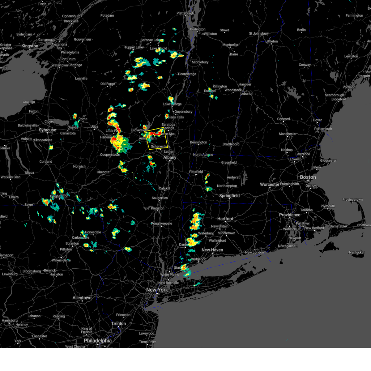
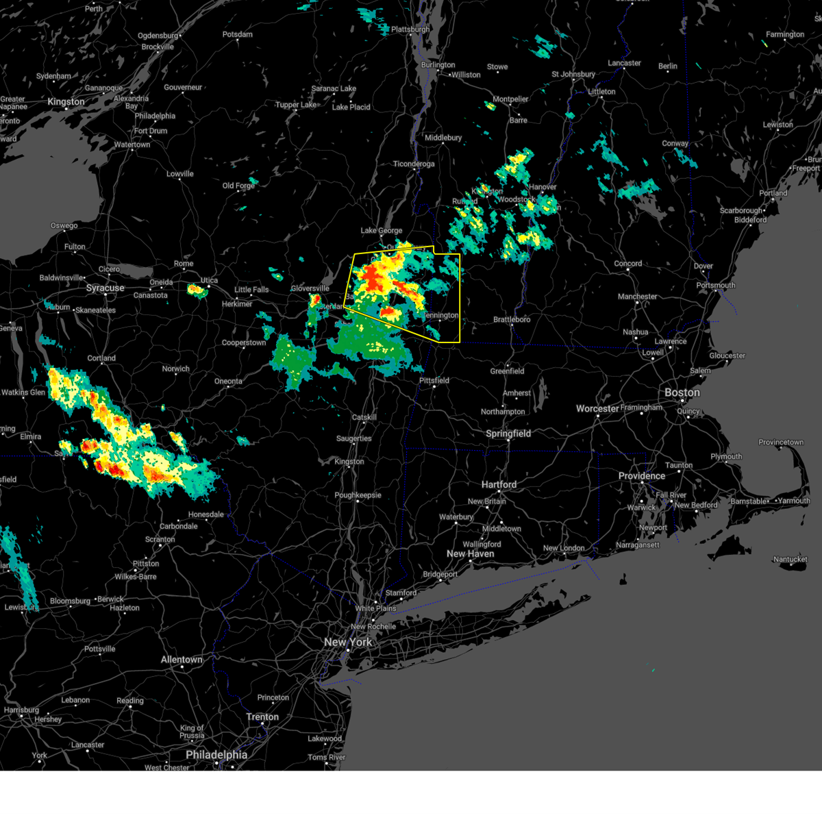
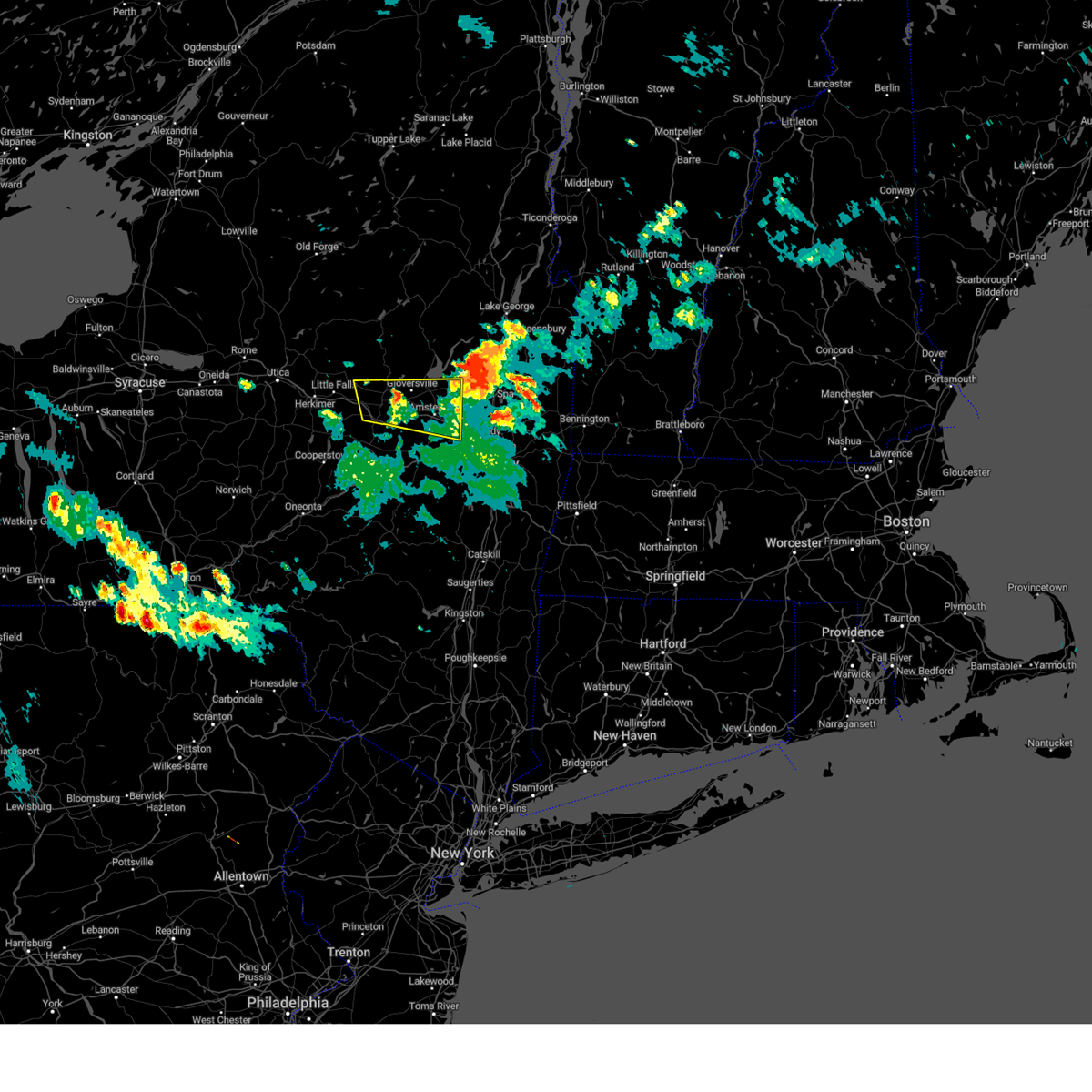
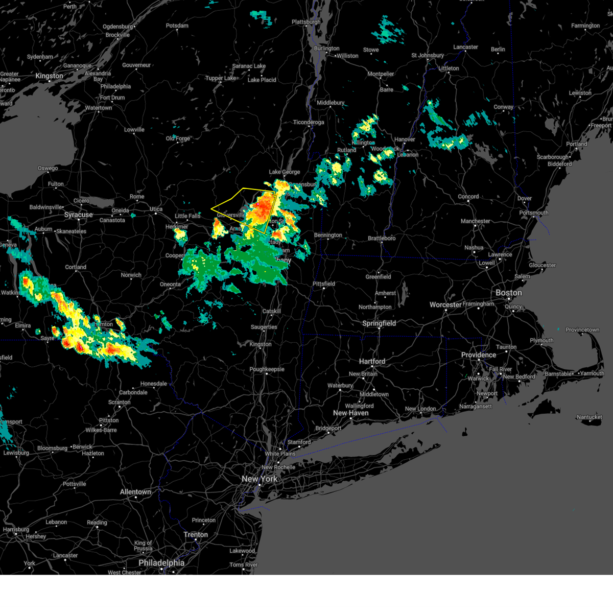
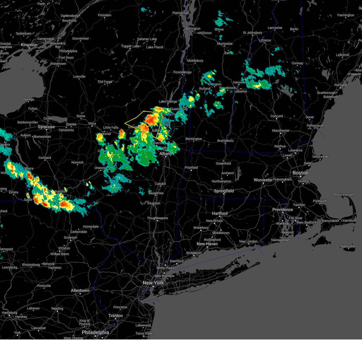
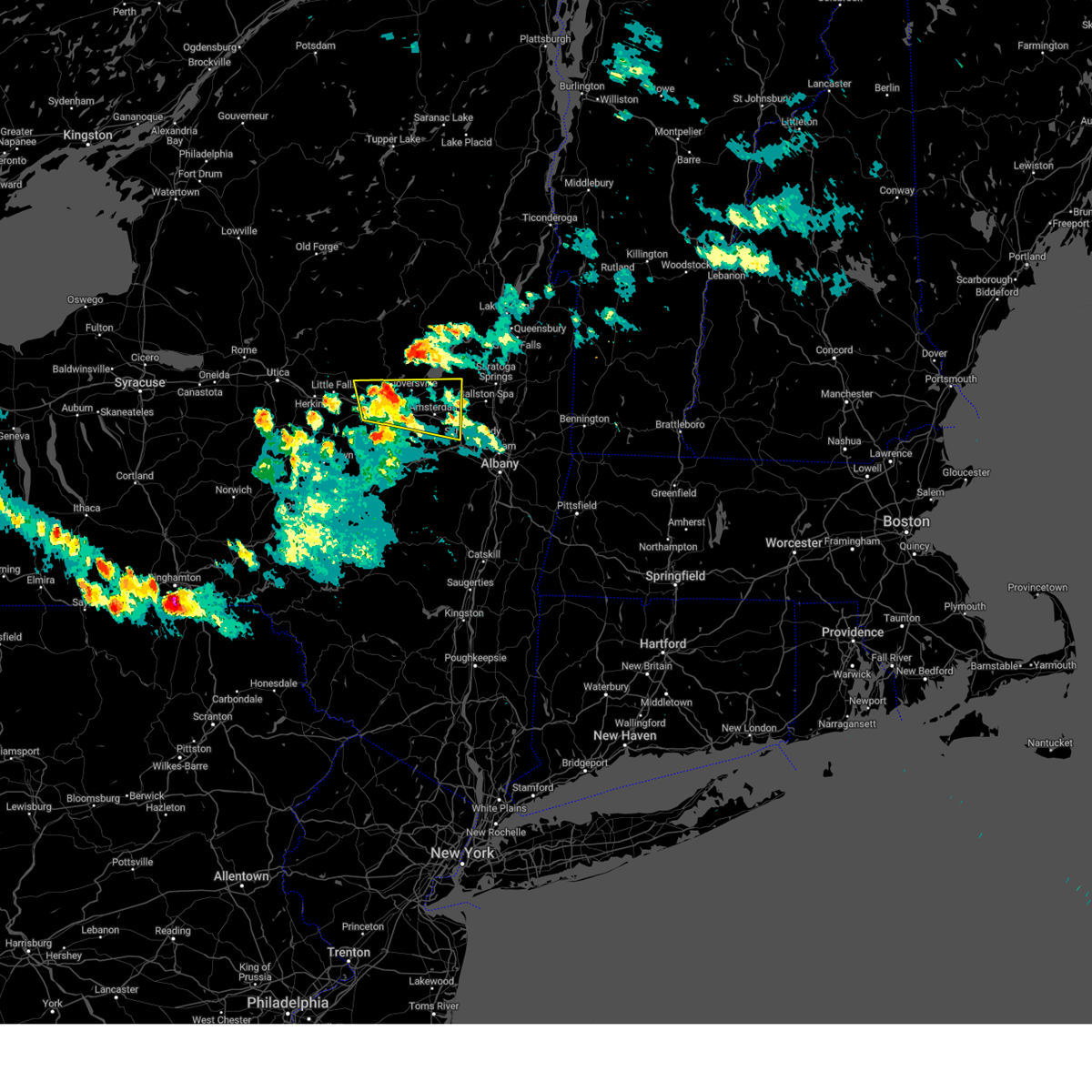
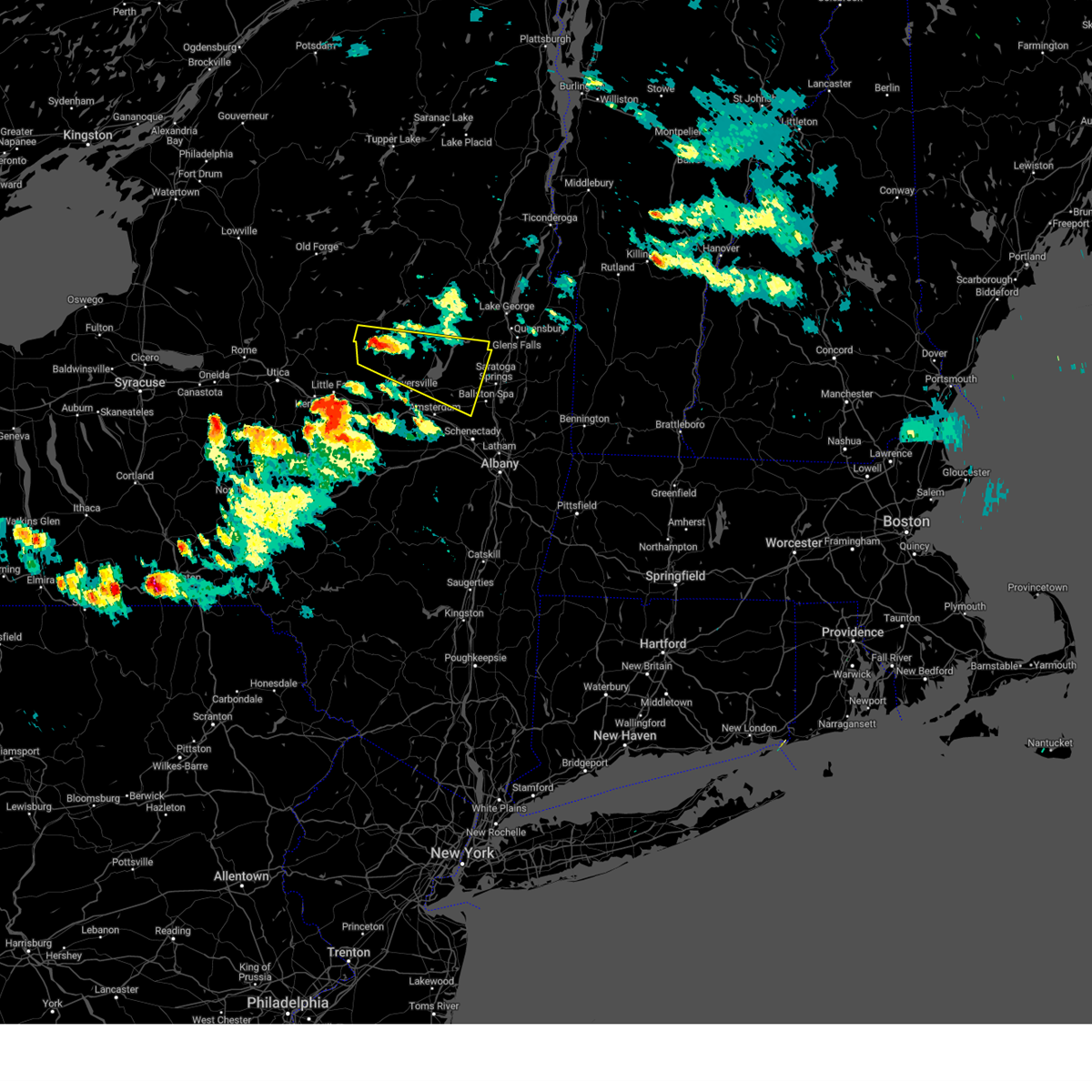
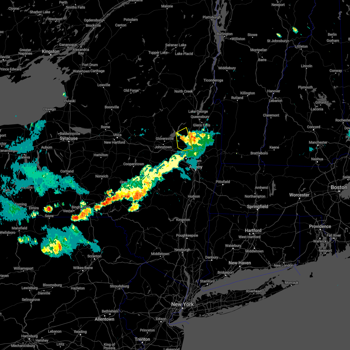
Hail Map for Galway, NY
The Galway, NY area has had 2 reports of on-the-ground hail by trained spotters, and has been under severe weather warnings 12 times during the past 12 months. Doppler radar has detected hail at or near Galway, NY on 34 occasions, including 2 occasions during the past year.
| Name: | Galway, NY |
| Where Located: | 15 miles NNW of Schenectady, NY |
| Map: | Google Map for Galway, NY |
| Population: | 200 |
| Housing Units: | 85 |
| More Info: | Search Google for Galway, NY |
1
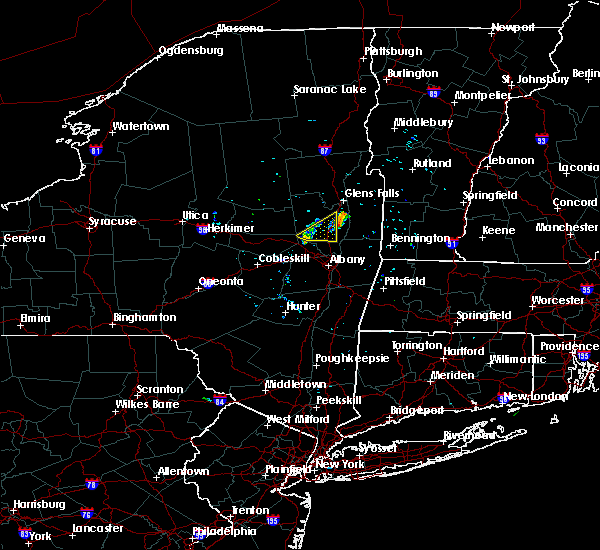
The Top Recent Hail Date for Galway, NY is Wednesday, August 14, 2024 (4th out of 34)

Hail and Wind Damage Spotted near Galway, NY
| Date / Time | Report Details |
|---|---|
| 8/14/2024 3:12 PM EDT | Received report of trees down. time estimated by rada in saratoga county NY, 1.5 miles SSE of Galway, NY |
| 8/14/2024 3:06 PM EDT |
 Svraly the national weather service in albany has issued a * severe thunderstorm warning for, northeastern schenectady county in east central new york, southeastern fulton county in eastern new york, southwestern saratoga county in east central new york, east central montgomery county in eastern new york, * until 400 pm edt. * at 306 pm edt, a severe thunderstorm was located over galway, or 10 miles northeast of amsterdam, moving south at 15 mph (radar indicated). Hazards include 60 mph wind gusts and quarter size hail. Hail damage to vehicles is expected. Expect wind damage to roofs, siding, and trees. Svraly the national weather service in albany has issued a * severe thunderstorm warning for, northeastern schenectady county in east central new york, southeastern fulton county in eastern new york, southwestern saratoga county in east central new york, east central montgomery county in eastern new york, * until 400 pm edt. * at 306 pm edt, a severe thunderstorm was located over galway, or 10 miles northeast of amsterdam, moving south at 15 mph (radar indicated). Hazards include 60 mph wind gusts and quarter size hail. Hail damage to vehicles is expected. Expect wind damage to roofs, siding, and trees.
|
| 8/14/2024 3:00 PM EDT | 911 call center received report of trees down along ny 29 in galway. time based on rada in saratoga county NY, 3 miles SSE of Galway, NY |
| 8/5/2024 5:29 PM EDT |
 Svraly the national weather service in albany has issued a * severe thunderstorm warning for, south central warren county in east central new york, saratoga county in east central new york, southern washington county in east central new york, northeastern rensselaer county in east central new york, bennington county in southern vermont, * until 630 pm edt. * at 529 pm edt, a severe thunderstorm was located near saratoga springs, moving east at 30 mph (radar indicated). Hazards include 60 mph wind gusts and quarter size hail. Hail damage to vehicles is expected. Expect wind damage to roofs, siding, and trees. Svraly the national weather service in albany has issued a * severe thunderstorm warning for, south central warren county in east central new york, saratoga county in east central new york, southern washington county in east central new york, northeastern rensselaer county in east central new york, bennington county in southern vermont, * until 630 pm edt. * at 529 pm edt, a severe thunderstorm was located near saratoga springs, moving east at 30 mph (radar indicated). Hazards include 60 mph wind gusts and quarter size hail. Hail damage to vehicles is expected. Expect wind damage to roofs, siding, and trees.
|
| 8/5/2024 5:16 PM EDT |
 the severe thunderstorm warning has been cancelled and is no longer in effect the severe thunderstorm warning has been cancelled and is no longer in effect
|
| 8/5/2024 5:14 PM EDT |
 The storm which prompted the warning has moved out of the area. therefore, the warning will be allowed to expire. however, small hail, gusty winds and heavy rain are still possible with this thunderstorm. a severe thunderstorm watch remains in effect until 800 pm edt for eastern and east central new york. to report severe weather, contact your nearest law enforcement agency. they will relay your report to the national weather service albany. The storm which prompted the warning has moved out of the area. therefore, the warning will be allowed to expire. however, small hail, gusty winds and heavy rain are still possible with this thunderstorm. a severe thunderstorm watch remains in effect until 800 pm edt for eastern and east central new york. to report severe weather, contact your nearest law enforcement agency. they will relay your report to the national weather service albany.
|
| 8/5/2024 5:01 PM EDT |
 At 501 pm edt, a severe thunderstorm was located near northampton beach public campground, moving east at 30 mph (radar indicated). Hazards include 60 mph wind gusts and quarter size hail. Hail damage to vehicles is expected. expect wind damage to roofs, siding, and trees. Locations impacted include, gloversville, corinth, broadalbin, edinburg, northville, mayfield, galway, cranberry creek, day center, northampton beach public campground, caroga lake, rock city falls, caroga lake public campground, kings, mount pleasant, perth, bleecker, benson, parkis mills, and sweets crossing. At 501 pm edt, a severe thunderstorm was located near northampton beach public campground, moving east at 30 mph (radar indicated). Hazards include 60 mph wind gusts and quarter size hail. Hail damage to vehicles is expected. expect wind damage to roofs, siding, and trees. Locations impacted include, gloversville, corinth, broadalbin, edinburg, northville, mayfield, galway, cranberry creek, day center, northampton beach public campground, caroga lake, rock city falls, caroga lake public campground, kings, mount pleasant, perth, bleecker, benson, parkis mills, and sweets crossing.
|
| 8/5/2024 4:44 PM EDT |
 At 444 pm edt, a severe thunderstorm was located near cranberry creek, moving east at 35 mph (radar indicated). Hazards include 60 mph wind gusts and quarter size hail. Hail damage to vehicles is expected. expect wind damage to roofs, siding, and trees. Locations impacted include, gloversville, corinth, broadalbin, edinburg, northville, mayfield, galway, cranberry creek, day center, northampton beach public campground, caroga lake, rock city falls, caroga lake public campground, kings, mount pleasant, perth, bleecker, hope, benson, and parkis mills. At 444 pm edt, a severe thunderstorm was located near cranberry creek, moving east at 35 mph (radar indicated). Hazards include 60 mph wind gusts and quarter size hail. Hail damage to vehicles is expected. expect wind damage to roofs, siding, and trees. Locations impacted include, gloversville, corinth, broadalbin, edinburg, northville, mayfield, galway, cranberry creek, day center, northampton beach public campground, caroga lake, rock city falls, caroga lake public campground, kings, mount pleasant, perth, bleecker, hope, benson, and parkis mills.
|
| 8/5/2024 4:42 PM EDT |
 Svraly the national weather service in albany has issued a * severe thunderstorm warning for, northwestern schenectady county in east central new york, southern fulton county in eastern new york, west central saratoga county in east central new york, central montgomery county in eastern new york, * until 545 pm edt. * at 442 pm edt, a severe thunderstorm was located over ephratah, moving east at 20 mph (radar indicated). Hazards include 60 mph wind gusts and quarter size hail. Hail damage to vehicles is expected. Expect wind damage to roofs, siding, and trees. Svraly the national weather service in albany has issued a * severe thunderstorm warning for, northwestern schenectady county in east central new york, southern fulton county in eastern new york, west central saratoga county in east central new york, central montgomery county in eastern new york, * until 545 pm edt. * at 442 pm edt, a severe thunderstorm was located over ephratah, moving east at 20 mph (radar indicated). Hazards include 60 mph wind gusts and quarter size hail. Hail damage to vehicles is expected. Expect wind damage to roofs, siding, and trees.
|
| 8/5/2024 4:18 PM EDT |
 Svraly the national weather service in albany has issued a * severe thunderstorm warning for, south central hamilton county in eastern new york, fulton county in eastern new york, northwestern saratoga county in east central new york, * until 515 pm edt. * at 418 pm edt, a severe thunderstorm was located 8 miles north of caroga lake, moving east at 30 mph (radar indicated). Hazards include 60 mph wind gusts and quarter size hail. Hail damage to vehicles is expected. Expect wind damage to roofs, siding, and trees. Svraly the national weather service in albany has issued a * severe thunderstorm warning for, south central hamilton county in eastern new york, fulton county in eastern new york, northwestern saratoga county in east central new york, * until 515 pm edt. * at 418 pm edt, a severe thunderstorm was located 8 miles north of caroga lake, moving east at 30 mph (radar indicated). Hazards include 60 mph wind gusts and quarter size hail. Hail damage to vehicles is expected. Expect wind damage to roofs, siding, and trees.
|
| 7/16/2024 4:52 PM EDT |
 Toraly the national weather service in albany has issued a * tornado warning for, central warren county in east central new york, saratoga county in east central new york, washington county in east central new york, northeastern rensselaer county in east central new york, * until 530 pm edt. * at 451 pm edt, a severe thunderstorm capable of producing a tornado was located 9 miles north of day center, or 15 miles west of warrensburg, moving east at 50 mph (radar indicated rotation). Hazards include tornado. Flying debris will be dangerous to those caught without shelter. mobile homes will be damaged or destroyed. damage to roofs, windows, and vehicles will occur. tree damage is likely. this dangerous storm will be near, warrensburg around 505 pm edt. lake george village around 510 pm edt. comstock around 525 pm edt. Other locations impacted by this tornadic thunderstorm include parkis mills, deans corners, grangerville, south bay village, glenwild, northumberland, wayville, wiley corners, middle falls, and halls corner. Toraly the national weather service in albany has issued a * tornado warning for, central warren county in east central new york, saratoga county in east central new york, washington county in east central new york, northeastern rensselaer county in east central new york, * until 530 pm edt. * at 451 pm edt, a severe thunderstorm capable of producing a tornado was located 9 miles north of day center, or 15 miles west of warrensburg, moving east at 50 mph (radar indicated rotation). Hazards include tornado. Flying debris will be dangerous to those caught without shelter. mobile homes will be damaged or destroyed. damage to roofs, windows, and vehicles will occur. tree damage is likely. this dangerous storm will be near, warrensburg around 505 pm edt. lake george village around 510 pm edt. comstock around 525 pm edt. Other locations impacted by this tornadic thunderstorm include parkis mills, deans corners, grangerville, south bay village, glenwild, northumberland, wayville, wiley corners, middle falls, and halls corner.
|
| 7/16/2024 4:40 PM EDT |
 At 439 pm edt, a confirmed tornado was located over sacandaga campground, or 16 miles south of speculator, moving east at 45 mph (radar confirmed tornado). Hazards include damaging tornado. Flying debris will be dangerous to those caught without shelter. mobile homes will be damaged or destroyed. damage to roofs, windows, and vehicles will occur. tree damage is likely. This tornadic thunderstorm will remain over mainly rural areas of southeastern hamilton, west central warren, fulton, northwestern saratoga and northeastern montgomery counties, including the following locations, parkis mills, meco, west perth, sweets crossing, glenwild, whitehouse, wiley corners, tomantown, hale mills, and north broadalbin. At 439 pm edt, a confirmed tornado was located over sacandaga campground, or 16 miles south of speculator, moving east at 45 mph (radar confirmed tornado). Hazards include damaging tornado. Flying debris will be dangerous to those caught without shelter. mobile homes will be damaged or destroyed. damage to roofs, windows, and vehicles will occur. tree damage is likely. This tornadic thunderstorm will remain over mainly rural areas of southeastern hamilton, west central warren, fulton, northwestern saratoga and northeastern montgomery counties, including the following locations, parkis mills, meco, west perth, sweets crossing, glenwild, whitehouse, wiley corners, tomantown, hale mills, and north broadalbin.
|
| 7/16/2024 4:20 PM EDT |
 Toraly the national weather service in albany has issued a * tornado warning for, southeastern hamilton county in eastern new york, west central warren county in east central new york, fulton county in eastern new york, northwestern saratoga county in east central new york, northeastern montgomery county in eastern new york, * until 500 pm edt. * at 420 pm edt, a severe thunderstorm capable of producing a tornado was located near caroga lake, or 11 miles northwest of gloversville, moving east at 50 mph (radar indicated rotation). Hazards include tornado. Flying debris will be dangerous to those caught without shelter. mobile homes will be damaged or destroyed. damage to roofs, windows, and vehicles will occur. tree damage is likely. this dangerous storm will be near, mayfield and cranberry creek around 430 pm edt. northampton beach public campground around 435 pm edt. Other locations impacted by this tornadic thunderstorm include parkis mills, meco, west perth, sweets crossing, glenwild, whitehouse, wiley corners, tomantown, hale mills, and north broadalbin. Toraly the national weather service in albany has issued a * tornado warning for, southeastern hamilton county in eastern new york, west central warren county in east central new york, fulton county in eastern new york, northwestern saratoga county in east central new york, northeastern montgomery county in eastern new york, * until 500 pm edt. * at 420 pm edt, a severe thunderstorm capable of producing a tornado was located near caroga lake, or 11 miles northwest of gloversville, moving east at 50 mph (radar indicated rotation). Hazards include tornado. Flying debris will be dangerous to those caught without shelter. mobile homes will be damaged or destroyed. damage to roofs, windows, and vehicles will occur. tree damage is likely. this dangerous storm will be near, mayfield and cranberry creek around 430 pm edt. northampton beach public campground around 435 pm edt. Other locations impacted by this tornadic thunderstorm include parkis mills, meco, west perth, sweets crossing, glenwild, whitehouse, wiley corners, tomantown, hale mills, and north broadalbin.
|
| 7/16/2024 4:17 PM EDT |
 Svraly the national weather service in albany has issued a * severe thunderstorm warning for, northwestern schenectady county in east central new york, southern hamilton county in eastern new york, southwestern warren county in east central new york, fulton county in eastern new york, northern saratoga county in east central new york, northern schoharie county in east central new york, southeastern herkimer county in eastern new york, montgomery county in eastern new york, * until 515 pm edt. * at 417 pm edt, severe thunderstorms were located along a line extending from 12 miles west of lake pleasant to near caroga lake to springfield, moving east at 35 mph (radar indicated). Hazards include 70 mph wind gusts. Expect considerable tree damage. Damage is likely to mobile homes, roofs, and outbuildings. Svraly the national weather service in albany has issued a * severe thunderstorm warning for, northwestern schenectady county in east central new york, southern hamilton county in eastern new york, southwestern warren county in east central new york, fulton county in eastern new york, northern saratoga county in east central new york, northern schoharie county in east central new york, southeastern herkimer county in eastern new york, montgomery county in eastern new york, * until 515 pm edt. * at 417 pm edt, severe thunderstorms were located along a line extending from 12 miles west of lake pleasant to near caroga lake to springfield, moving east at 35 mph (radar indicated). Hazards include 70 mph wind gusts. Expect considerable tree damage. Damage is likely to mobile homes, roofs, and outbuildings.
|
| 6/23/2024 5:37 PM EDT |
 The storms which prompted the warning have weakened below severe limits, and no longer pose an immediate threat to life or property. therefore, the warning will be allowed to expire. however, gusty winds are still possible with these thunderstorms. a tornado watch remains in effect until 800 pm edt for eastern and east central new york. The storms which prompted the warning have weakened below severe limits, and no longer pose an immediate threat to life or property. therefore, the warning will be allowed to expire. however, gusty winds are still possible with these thunderstorms. a tornado watch remains in effect until 800 pm edt for eastern and east central new york.
|
| 6/23/2024 5:22 PM EDT |
 At 522 pm edt, severe thunderstorms were located along a line extending from johnstown to near fonda to canajoharie, moving east at 40 mph (radar indicated). Hazards include 60 mph wind gusts. Expect damage to roofs, siding, and trees. Locations impacted include, amsterdam, gloversville, johnstown, canajoharie, fonda, glenville, broadalbin, hagaman, fort johnson, galway, tribes hill, rock city falls, perth, glen, berkshire, fultonville, palatine bridge, parkis mills, west perth, and cook corners. At 522 pm edt, severe thunderstorms were located along a line extending from johnstown to near fonda to canajoharie, moving east at 40 mph (radar indicated). Hazards include 60 mph wind gusts. Expect damage to roofs, siding, and trees. Locations impacted include, amsterdam, gloversville, johnstown, canajoharie, fonda, glenville, broadalbin, hagaman, fort johnson, galway, tribes hill, rock city falls, perth, glen, berkshire, fultonville, palatine bridge, parkis mills, west perth, and cook corners.
|
| 6/23/2024 5:07 PM EDT |
 Svraly the national weather service in albany has issued a * severe thunderstorm warning for, north central schenectady county in east central new york, southeastern fulton county in eastern new york, west central saratoga county in east central new york, central montgomery county in eastern new york, * until 545 pm edt. * at 507 pm edt, severe thunderstorms were located along a line extending from ephratah to near fort plain to 6 miles west of canajoharie, moving east at 40 mph (radar indicated). Hazards include 60 mph wind gusts. expect damage to roofs, siding, and trees Svraly the national weather service in albany has issued a * severe thunderstorm warning for, north central schenectady county in east central new york, southeastern fulton county in eastern new york, west central saratoga county in east central new york, central montgomery county in eastern new york, * until 545 pm edt. * at 507 pm edt, severe thunderstorms were located along a line extending from ephratah to near fort plain to 6 miles west of canajoharie, moving east at 40 mph (radar indicated). Hazards include 60 mph wind gusts. expect damage to roofs, siding, and trees
|
| 6/21/2024 2:24 PM EDT |
 Svraly the national weather service in albany has issued a * severe thunderstorm warning for, eastern schenectady county in east central new york, northeastern albany county in east central new york, southern saratoga county in east central new york, east central montgomery county in eastern new york, northwestern rensselaer county in east central new york, * until 315 pm edt. * at 223 pm edt, severe thunderstorms were located along a line extending from near ballston spa to near galway to near glenville, moving southeast at 25 mph (radar indicated). Hazards include 60 mph wind gusts and penny size hail. expect damage to roofs, siding, and trees Svraly the national weather service in albany has issued a * severe thunderstorm warning for, eastern schenectady county in east central new york, northeastern albany county in east central new york, southern saratoga county in east central new york, east central montgomery county in eastern new york, northwestern rensselaer county in east central new york, * until 315 pm edt. * at 223 pm edt, severe thunderstorms were located along a line extending from near ballston spa to near galway to near glenville, moving southeast at 25 mph (radar indicated). Hazards include 60 mph wind gusts and penny size hail. expect damage to roofs, siding, and trees
|
| 9/8/2023 4:31 PM EDT |
 At 431 pm edt, a severe thunderstorm was located near burnt hills, or 8 miles north of scotia, moving northeast at 25 mph (radar indicated). Hazards include 60 mph wind gusts and quarter size hail. Hail damage to vehicles is expected. Expect wind damage to roofs, siding, and trees. At 431 pm edt, a severe thunderstorm was located near burnt hills, or 8 miles north of scotia, moving northeast at 25 mph (radar indicated). Hazards include 60 mph wind gusts and quarter size hail. Hail damage to vehicles is expected. Expect wind damage to roofs, siding, and trees.
|
| 7/29/2023 2:24 PM EDT |
 At 223 pm edt, a severe thunderstorm was located over glenville, or near amsterdam, moving east at 20 mph (radar indicated). Hazards include 60 mph wind gusts and quarter size hail. Hail damage to vehicles is expected. expect wind damage to roofs, siding, and trees. Locations impacted include, schenectady, clifton park, saratoga springs, amsterdam, scotia, mechanicville, glenville, niskayuna, ballston spa, hagaman, round lake, galway, rotterdam junction, east glenville, burnt hills, country knolls, north ballston spa, alplaus, pattersonville-rotterdam junction and halfmoon. At 223 pm edt, a severe thunderstorm was located over glenville, or near amsterdam, moving east at 20 mph (radar indicated). Hazards include 60 mph wind gusts and quarter size hail. Hail damage to vehicles is expected. expect wind damage to roofs, siding, and trees. Locations impacted include, schenectady, clifton park, saratoga springs, amsterdam, scotia, mechanicville, glenville, niskayuna, ballston spa, hagaman, round lake, galway, rotterdam junction, east glenville, burnt hills, country knolls, north ballston spa, alplaus, pattersonville-rotterdam junction and halfmoon.
|
| 7/29/2023 2:15 PM EDT |
 At 215 pm edt, a severe thunderstorm was located near amsterdam, moving east at 25 mph (radar indicated). Hazards include 60 mph wind gusts and quarter size hail. Hail damage to vehicles is expected. Expect wind damage to roofs, siding, and trees. At 215 pm edt, a severe thunderstorm was located near amsterdam, moving east at 25 mph (radar indicated). Hazards include 60 mph wind gusts and quarter size hail. Hail damage to vehicles is expected. Expect wind damage to roofs, siding, and trees.
|
| 7/13/2023 6:43 PM EDT |
 At 642 pm edt, severe thunderstorms were located along a line extending from near fair haven to near round lake, moving east at 30 mph. these are destructive storms for washington and saratoga counties (radar indicated). Hazards include 80 mph wind gusts and penny size hail. Flying debris will be dangerous to those caught without shelter. mobile homes will be heavily damaged. expect considerable damage to roofs, windows, and vehicles. Extensive tree damage and power outages are likely. At 642 pm edt, severe thunderstorms were located along a line extending from near fair haven to near round lake, moving east at 30 mph. these are destructive storms for washington and saratoga counties (radar indicated). Hazards include 80 mph wind gusts and penny size hail. Flying debris will be dangerous to those caught without shelter. mobile homes will be heavily damaged. expect considerable damage to roofs, windows, and vehicles. Extensive tree damage and power outages are likely.
|
| 7/13/2023 6:34 PM EDT |
 At 633 pm edt, severe thunderstorms were located along a line extending from near whitehall to near ballston spa, moving east at 30 mph (radar indicated). Hazards include 60 mph wind gusts and quarter size hail. Hail damage to vehicles is expected. Expect wind damage to roofs, siding, and trees. At 633 pm edt, severe thunderstorms were located along a line extending from near whitehall to near ballston spa, moving east at 30 mph (radar indicated). Hazards include 60 mph wind gusts and quarter size hail. Hail damage to vehicles is expected. Expect wind damage to roofs, siding, and trees.
|
| 7/13/2023 6:02 PM EDT |
 At 602 pm edt, severe thunderstorms were located along a line extending from 6 miles northwest of huletts landing to near corinth to near galway, moving east at 35 mph (radar indicated). Hazards include 60 mph wind gusts and penny size hail. expect damage to roofs, siding, and trees At 602 pm edt, severe thunderstorms were located along a line extending from 6 miles northwest of huletts landing to near corinth to near galway, moving east at 35 mph (radar indicated). Hazards include 60 mph wind gusts and penny size hail. expect damage to roofs, siding, and trees
|
| 7/4/2023 7:18 PM EDT |
 At 718 pm edt, a severe thunderstorm was located near galway, or 9 miles east of amsterdam, moving south at 15 mph (radar indicated). Hazards include 60 mph wind gusts and quarter size hail. Hail damage to vehicles is expected. Expect wind damage to roofs, siding, and trees. At 718 pm edt, a severe thunderstorm was located near galway, or 9 miles east of amsterdam, moving south at 15 mph (radar indicated). Hazards include 60 mph wind gusts and quarter size hail. Hail damage to vehicles is expected. Expect wind damage to roofs, siding, and trees.
|
| 9/19/2022 2:45 PM EDT |
 At 245 pm edt, a severe thunderstorm was located over st. johnsville, or 9 miles northwest of canajoharie, moving east at 30 mph (radar indicated). Hazards include 60 mph wind gusts and penny size hail. expect damage to roofs, siding, and trees At 245 pm edt, a severe thunderstorm was located over st. johnsville, or 9 miles northwest of canajoharie, moving east at 30 mph (radar indicated). Hazards include 60 mph wind gusts and penny size hail. expect damage to roofs, siding, and trees
|
| 8/4/2022 3:13 PM EDT |
 At 313 pm edt, a severe thunderstorm was located over johnstown, moving northeast at 30 mph (radar indicated). Hazards include 60 mph wind gusts and quarter size hail. Hail damage to vehicles is expected. expect wind damage to roofs, siding, and trees. locations impacted include, amsterdam, gloversville, johnstown, fonda, broadalbin, hagaman, mayfield, fort johnson, galway, tribes hill, cranberry creek, northampton beach public campground, perth, glen, berkshire, fultonville, meco, west perth, munsonville and sweets crossing. hail threat, radar indicated max hail size, 1. 00 in wind threat, radar indicated max wind gust, 60 mph. At 313 pm edt, a severe thunderstorm was located over johnstown, moving northeast at 30 mph (radar indicated). Hazards include 60 mph wind gusts and quarter size hail. Hail damage to vehicles is expected. expect wind damage to roofs, siding, and trees. locations impacted include, amsterdam, gloversville, johnstown, fonda, broadalbin, hagaman, mayfield, fort johnson, galway, tribes hill, cranberry creek, northampton beach public campground, perth, glen, berkshire, fultonville, meco, west perth, munsonville and sweets crossing. hail threat, radar indicated max hail size, 1. 00 in wind threat, radar indicated max wind gust, 60 mph.
|
| 8/4/2022 2:49 PM EDT |
 At 249 pm edt, a severe thunderstorm was located over canajoharie, moving northeast at 30 mph (radar indicated). Hazards include 60 mph wind gusts and quarter size hail. Hail damage to vehicles is expected. Expect wind damage to roofs, siding, and trees. At 249 pm edt, a severe thunderstorm was located over canajoharie, moving northeast at 30 mph (radar indicated). Hazards include 60 mph wind gusts and quarter size hail. Hail damage to vehicles is expected. Expect wind damage to roofs, siding, and trees.
|
| 7/1/2022 9:48 PM EDT |
 At 948 pm edt, a severe thunderstorm was located near saratoga springs, moving east at 40 mph (radar indicated). Hazards include 60 mph wind gusts and quarter size hail. Hail damage to vehicles is expected. expect wind damage to roofs, siding, and trees. locations impacted include, ballston spa, galway, north ballston spa, rock city falls, mount pleasant, charlton, parkis mills, holsapple corners, shaw corners, milton center, barkersville, west milton, glenwild, wiley corners, holbrook corners, long corners, east galway, chatfield corner, blue corners and whiteside corners. hail threat, radar indicated max hail size, 1. 00 in wind threat, radar indicated max wind gust, 60 mph. At 948 pm edt, a severe thunderstorm was located near saratoga springs, moving east at 40 mph (radar indicated). Hazards include 60 mph wind gusts and quarter size hail. Hail damage to vehicles is expected. expect wind damage to roofs, siding, and trees. locations impacted include, ballston spa, galway, north ballston spa, rock city falls, mount pleasant, charlton, parkis mills, holsapple corners, shaw corners, milton center, barkersville, west milton, glenwild, wiley corners, holbrook corners, long corners, east galway, chatfield corner, blue corners and whiteside corners. hail threat, radar indicated max hail size, 1. 00 in wind threat, radar indicated max wind gust, 60 mph.
|
| 7/1/2022 9:16 PM EDT |
 At 916 pm edt, a severe thunderstorm was located near hagaman, or near amsterdam, moving east at 40 mph (radar indicated). Hazards include 60 mph wind gusts and quarter size hail. Hail damage to vehicles is expected. Expect wind damage to roofs, siding, and trees. At 916 pm edt, a severe thunderstorm was located near hagaman, or near amsterdam, moving east at 40 mph (radar indicated). Hazards include 60 mph wind gusts and quarter size hail. Hail damage to vehicles is expected. Expect wind damage to roofs, siding, and trees.
|
| 9/15/2021 12:54 PM EDT |
 At 1254 pm edt, a severe thunderstorm was located over fonda, moving east at 35 mph (radar indicated). Hazards include 60 mph wind gusts and half dollar size hail. Hail damage to vehicles is expected. expect wind damage to roofs, siding, and trees. this severe thunderstorm will be near, fort johnson around 100 pm edt. amsterdam around 105 pm edt. broadalbin and hagaman around 110 pm edt. glenville around 115 pm edt. galway around 120 pm edt. rock city falls around 130 pm edt. milton, ballston spa and north ballston spa around 135 pm edt. saratoga springs around 145 pm edt. other locations impacted by this severe thunderstorm include parkis mills, meco, charleston, west perth, fultonville, west milton, glenwild, young corners, greenfield center and wiley corners. please report hail size, damaging winds and reports of trees down to the national weather service by email at alb. stormreport@noaa. gov, on facebook at www. facebook. com/nwsalbany or twitter @nwsalbany hail threat, radar indicated max hail size, 1. 25 in wind threat, radar indicated max wind gust, 60 mph. At 1254 pm edt, a severe thunderstorm was located over fonda, moving east at 35 mph (radar indicated). Hazards include 60 mph wind gusts and half dollar size hail. Hail damage to vehicles is expected. expect wind damage to roofs, siding, and trees. this severe thunderstorm will be near, fort johnson around 100 pm edt. amsterdam around 105 pm edt. broadalbin and hagaman around 110 pm edt. glenville around 115 pm edt. galway around 120 pm edt. rock city falls around 130 pm edt. milton, ballston spa and north ballston spa around 135 pm edt. saratoga springs around 145 pm edt. other locations impacted by this severe thunderstorm include parkis mills, meco, charleston, west perth, fultonville, west milton, glenwild, young corners, greenfield center and wiley corners. please report hail size, damaging winds and reports of trees down to the national weather service by email at alb. stormreport@noaa. gov, on facebook at www. facebook. com/nwsalbany or twitter @nwsalbany hail threat, radar indicated max hail size, 1. 25 in wind threat, radar indicated max wind gust, 60 mph.
|
| 9/8/2021 6:11 PM EDT | Tree down on jockey street in saratoga county NY, 2.5 miles WNW of Galway, NY |
| 8/13/2021 4:40 PM EDT |
 At 440 pm edt, a severe thunderstorm was located over ballston spa, or 7 miles southwest of saratoga springs, moving east at 35 mph (radar indicated). Hazards include 60 mph wind gusts and quarter size hail. Hail damage to vehicles is expected. expect wind damage to roofs, siding, and trees. locations impacted include, saratoga springs, mechanicville, ballston spa, round lake, galway, country knolls, north ballston spa, rock city falls, malta, charlton, parkis mills, deans corners, shaw corners, barkersville, west milton, willow glen, coons, wayville, wiley corners and halls corner. hail threat, radar indicated max hail size, 1. 00 in wind threat, radar indicated max wind gust, 60 mph. At 440 pm edt, a severe thunderstorm was located over ballston spa, or 7 miles southwest of saratoga springs, moving east at 35 mph (radar indicated). Hazards include 60 mph wind gusts and quarter size hail. Hail damage to vehicles is expected. expect wind damage to roofs, siding, and trees. locations impacted include, saratoga springs, mechanicville, ballston spa, round lake, galway, country knolls, north ballston spa, rock city falls, malta, charlton, parkis mills, deans corners, shaw corners, barkersville, west milton, willow glen, coons, wayville, wiley corners and halls corner. hail threat, radar indicated max hail size, 1. 00 in wind threat, radar indicated max wind gust, 60 mph.
|
| 8/13/2021 4:34 PM EDT | Wires dow in saratoga county NY, 4.2 miles S of Galway, NY |
| 8/13/2021 4:33 PM EDT |
 At 433 pm edt, a severe thunderstorm was located near ballston spa, or 9 miles southwest of saratoga springs, moving east at 35 mph (radar indicated). Hazards include 60 mph wind gusts and penny size hail. expect damage to roofs, siding, and trees At 433 pm edt, a severe thunderstorm was located near ballston spa, or 9 miles southwest of saratoga springs, moving east at 35 mph (radar indicated). Hazards include 60 mph wind gusts and penny size hail. expect damage to roofs, siding, and trees
|
| 8/13/2021 4:31 PM EDT | Power pole down across roa in saratoga county NY, 4.2 miles S of Galway, NY |
| 7/29/2021 7:56 PM EDT |
 At 756 pm edt, a severe thunderstorm was located near mechanicville, moving east at 45 mph (radar indicated). Hazards include 60 mph wind gusts. Expect damage to roofs, siding, and trees. Locations impacted include, schenectady, bennington, clifton park, saratoga springs, scotia, mechanicville, hoosick falls, arlington, salem, manchester, glenville, niskayuna, ballston spa, shaftsbury, cambridge, greenwich, round lake, rotterdam junction, east glenville and burnt hills. At 756 pm edt, a severe thunderstorm was located near mechanicville, moving east at 45 mph (radar indicated). Hazards include 60 mph wind gusts. Expect damage to roofs, siding, and trees. Locations impacted include, schenectady, bennington, clifton park, saratoga springs, scotia, mechanicville, hoosick falls, arlington, salem, manchester, glenville, niskayuna, ballston spa, shaftsbury, cambridge, greenwich, round lake, rotterdam junction, east glenville and burnt hills.
|
| 7/29/2021 7:41 PM EDT |
 At 741 pm edt, a severe thunderstorm was located over burnt hills, or near scotia, moving east at 85 mph (radar indicated). Hazards include 60 mph wind gusts. expect damage to roofs, siding, and trees At 741 pm edt, a severe thunderstorm was located over burnt hills, or near scotia, moving east at 85 mph (radar indicated). Hazards include 60 mph wind gusts. expect damage to roofs, siding, and trees
|
| 7/27/2021 3:42 PM EDT |
 The severe thunderstorm warning for central schenectady and southwestern saratoga counties will expire at 345 pm edt, the storm which prompted the warning has weakened below severe limits, and has exited the warned area. therefore, the warning will be allowed to expire. however heavy rain is still possible with this thunderstorm. a severe thunderstorm watch remains in effect until 1000 pm edt for eastern and east central new york. to report severe weather, contact your nearest law enforcement agency. they will relay your report to the national weather service albany. The severe thunderstorm warning for central schenectady and southwestern saratoga counties will expire at 345 pm edt, the storm which prompted the warning has weakened below severe limits, and has exited the warned area. therefore, the warning will be allowed to expire. however heavy rain is still possible with this thunderstorm. a severe thunderstorm watch remains in effect until 1000 pm edt for eastern and east central new york. to report severe weather, contact your nearest law enforcement agency. they will relay your report to the national weather service albany.
|
| 7/27/2021 3:29 PM EDT |
 At 328 pm edt, a severe thunderstorm was located over scotia, moving east at 30 mph (radar indicated). Hazards include 60 mph wind gusts and quarter size hail. Hail damage to vehicles is expected. expect wind damage to roofs, siding, and trees. Locations impacted include, schenectady, rotterdam, scotia, glenville, niskayuna, ballston spa, galway, rotterdam junction, alplaus, east glenville, burnt hills, pattersonville-rotterdam junction, charlton, glenridge, hoffmans, harding crossing, garrison manor, aqueduct, woodruff heights and schonowe. At 328 pm edt, a severe thunderstorm was located over scotia, moving east at 30 mph (radar indicated). Hazards include 60 mph wind gusts and quarter size hail. Hail damage to vehicles is expected. expect wind damage to roofs, siding, and trees. Locations impacted include, schenectady, rotterdam, scotia, glenville, niskayuna, ballston spa, galway, rotterdam junction, alplaus, east glenville, burnt hills, pattersonville-rotterdam junction, charlton, glenridge, hoffmans, harding crossing, garrison manor, aqueduct, woodruff heights and schonowe.
|
| 7/27/2021 3:16 PM EDT |
 At 316 pm edt, a severe thunderstorm was located over glenville, or near amsterdam, moving east at 30 mph (radar indicated). Hazards include 60 mph wind gusts and quarter size hail. Hail damage to vehicles is expected. expect wind damage to roofs, siding, and trees. Locations impacted include, schenectady, rotterdam, amsterdam, scotia, fonda, glenville, niskayuna, ballston spa, hagaman, fort johnson, galway, tribes hill, north ballston spa, rotterdam junction, alplaus, east glenville, burnt hills, pattersonville-rotterdam junction, charlton and glen. At 316 pm edt, a severe thunderstorm was located over glenville, or near amsterdam, moving east at 30 mph (radar indicated). Hazards include 60 mph wind gusts and quarter size hail. Hail damage to vehicles is expected. expect wind damage to roofs, siding, and trees. Locations impacted include, schenectady, rotterdam, amsterdam, scotia, fonda, glenville, niskayuna, ballston spa, hagaman, fort johnson, galway, tribes hill, north ballston spa, rotterdam junction, alplaus, east glenville, burnt hills, pattersonville-rotterdam junction, charlton and glen.
|
| 7/27/2021 2:51 PM EDT |
 At 250 pm edt, a severe thunderstorm was located over tribes hill, or over fonda, moving east at 30 mph (radar indicated). Hazards include 60 mph wind gusts and quarter size hail. Hail damage to vehicles is expected. Expect wind damage to roofs, siding, and trees. At 250 pm edt, a severe thunderstorm was located over tribes hill, or over fonda, moving east at 30 mph (radar indicated). Hazards include 60 mph wind gusts and quarter size hail. Hail damage to vehicles is expected. Expect wind damage to roofs, siding, and trees.
|
| 7/20/2021 8:31 PM EDT |
 At 831 pm edt, severe thunderstorms were located along a line extending from near lake george village to near corinth to near galway, moving east at 25 mph (radar indicated). Hazards include 60 mph wind gusts. expect damage to roofs, siding, and trees At 831 pm edt, severe thunderstorms were located along a line extending from near lake george village to near corinth to near galway, moving east at 25 mph (radar indicated). Hazards include 60 mph wind gusts. expect damage to roofs, siding, and trees
|
| 7/20/2021 8:30 PM EDT | Trees and wires dow in saratoga county NY, 0.1 miles SW of Galway, NY |
| 6/30/2021 2:42 PM EDT |
 At 242 pm edt, severe thunderstorms were located along a line extending from near west glens falls to near hagaman, moving east at 50 mph (radar indicated). Hazards include 60 mph wind gusts. Expect damage to roofs, siding, and trees. Locations impacted include, saratoga springs, amsterdam, glenville, ballston spa, corinth, hagaman, round lake, fort johnson, galway, burnt hills, rock city falls, tribes hill, country knolls, north ballston spa, west glens falls, pattersonville-rotterdam junction, lake luzerne-hadley, east glenville, kings and mount pleasant. At 242 pm edt, severe thunderstorms were located along a line extending from near west glens falls to near hagaman, moving east at 50 mph (radar indicated). Hazards include 60 mph wind gusts. Expect damage to roofs, siding, and trees. Locations impacted include, saratoga springs, amsterdam, glenville, ballston spa, corinth, hagaman, round lake, fort johnson, galway, burnt hills, rock city falls, tribes hill, country knolls, north ballston spa, west glens falls, pattersonville-rotterdam junction, lake luzerne-hadley, east glenville, kings and mount pleasant.
|
| 6/30/2021 2:18 PM EDT |
 At 218 pm edt, severe thunderstorms were located along a line extending from near edinburg to near fonda, moving east at 50 mph (radar indicated). Hazards include 60 mph wind gusts. expect damage to roofs, siding, and trees At 218 pm edt, severe thunderstorms were located along a line extending from near edinburg to near fonda, moving east at 50 mph (radar indicated). Hazards include 60 mph wind gusts. expect damage to roofs, siding, and trees
|
| 6/21/2021 8:44 PM EDT | Tree down on wires along southline rd. also lightning hit a structure... causing a fire... on lake r in saratoga county NY, 0.1 miles SW of Galway, NY |
| 6/21/2021 8:43 PM EDT |
 At 842 pm edt, severe thunderstorms were located along a line extending from near corinth to near pattersonville-rotterdam junction, moving east at 20 mph (radar indicated). Hazards include 60 mph wind gusts and quarter size hail. Hail damage to vehicles is expected. Expect wind damage to roofs, siding, and trees. At 842 pm edt, severe thunderstorms were located along a line extending from near corinth to near pattersonville-rotterdam junction, moving east at 20 mph (radar indicated). Hazards include 60 mph wind gusts and quarter size hail. Hail damage to vehicles is expected. Expect wind damage to roofs, siding, and trees.
|
| 10/7/2020 3:21 PM EDT |
 At 320 pm edt, severe thunderstorms were located along a line extending from near lake george village to near broadalbin to cooperstown, moving east at 60 mph (radar indicated). Hazards include 70 mph wind gusts. Expect considerable tree damage. Damage is likely to mobile homes, roofs, and outbuildings. At 320 pm edt, severe thunderstorms were located along a line extending from near lake george village to near broadalbin to cooperstown, moving east at 60 mph (radar indicated). Hazards include 70 mph wind gusts. Expect considerable tree damage. Damage is likely to mobile homes, roofs, and outbuildings.
|
| 10/7/2020 3:15 PM EDT |
 At 314 pm edt, severe thunderstorms were located along a line extending from near day center to near cranberry creek to near st. johnsville, moving east at 65 mph (radar indicated). Hazards include 70 mph wind gusts. Expect considerable tree damage. damage is likely to mobile homes, roofs, and outbuildings. locations impacted include, amsterdam, gloversville, johnstown, little falls, canajoharie, fonda, glenville, corinth, fort plain, dolgeville, st. Johnsville, ephratah, broadalbin, hagaman, edinburg, northville, mayfield, sharon springs, fort johnson and galway. At 314 pm edt, severe thunderstorms were located along a line extending from near day center to near cranberry creek to near st. johnsville, moving east at 65 mph (radar indicated). Hazards include 70 mph wind gusts. Expect considerable tree damage. damage is likely to mobile homes, roofs, and outbuildings. locations impacted include, amsterdam, gloversville, johnstown, little falls, canajoharie, fonda, glenville, corinth, fort plain, dolgeville, st. Johnsville, ephratah, broadalbin, hagaman, edinburg, northville, mayfield, sharon springs, fort johnson and galway.
|
| 10/7/2020 3:04 PM EDT |
 At 304 pm edt, severe thunderstorms were located along a line extending from near sacandaga campground to near caroga lake public campground to near jordanville, moving east at 65 mph (radar indicated). Hazards include 60 mph wind gusts. Expect damage to roofs, siding, and trees. locations impacted include, amsterdam, gloversville, johnstown, ilion, herkimer, little falls, canajoharie, fonda, glenville, mohawk, corinth, fort plain, dolgeville, st. Johnsville, ephratah, broadalbin, hagaman, edinburg, northville and mayfield. At 304 pm edt, severe thunderstorms were located along a line extending from near sacandaga campground to near caroga lake public campground to near jordanville, moving east at 65 mph (radar indicated). Hazards include 60 mph wind gusts. Expect damage to roofs, siding, and trees. locations impacted include, amsterdam, gloversville, johnstown, ilion, herkimer, little falls, canajoharie, fonda, glenville, mohawk, corinth, fort plain, dolgeville, st. Johnsville, ephratah, broadalbin, hagaman, edinburg, northville and mayfield.
|
| 10/7/2020 2:46 PM EDT |
 At 245 pm edt, severe thunderstorms were located along a line extending from 13 miles southwest of lake pleasant to near stratford to near clayville, moving east at 65 mph (radar indicated). Hazards include 60 mph wind gusts. expect damage to roofs, siding, and trees At 245 pm edt, severe thunderstorms were located along a line extending from 13 miles southwest of lake pleasant to near stratford to near clayville, moving east at 65 mph (radar indicated). Hazards include 60 mph wind gusts. expect damage to roofs, siding, and trees
|
| 8/29/2020 4:44 PM EDT | One foot diameter tree snapped at jockey street and galway road in saratoga county NY, 2.1 miles W of Galway, NY |
| 8/29/2020 4:32 PM EDT | Ping Pong Ball sized hail reported 2.6 miles SSE of Galway, NY |
| 5/29/2020 5:32 PM EDT |
 At 531 pm edt, severe thunderstorms were located along a line extending from near day center to near amsterdam, moving east at 30 mph (radar indicated). Hazards include 60 mph wind gusts and quarter size hail. Hail damage to vehicles is expected. expect wind damage to roofs, siding, and trees. Locations impacted include, saratoga springs, amsterdam, milton, broadalbin, hagaman, edinburg, fort johnson, galway, day center, northampton beach public campground, rock city falls, tribes hill, kings, mount pleasant, greenfield, perth, charleston, parkis mills, west milton and glenwild. At 531 pm edt, severe thunderstorms were located along a line extending from near day center to near amsterdam, moving east at 30 mph (radar indicated). Hazards include 60 mph wind gusts and quarter size hail. Hail damage to vehicles is expected. expect wind damage to roofs, siding, and trees. Locations impacted include, saratoga springs, amsterdam, milton, broadalbin, hagaman, edinburg, fort johnson, galway, day center, northampton beach public campground, rock city falls, tribes hill, kings, mount pleasant, greenfield, perth, charleston, parkis mills, west milton and glenwild.
|
| 5/29/2020 5:03 PM EDT |
 At 503 pm edt, severe thunderstorms were located along a line extending from johnstown to 8 miles southeast of canajoharie, moving northeast at 45 mph (radar indicated). Hazards include 60 mph wind gusts and quarter size hail. Hail damage to vehicles is expected. Expect wind damage to roofs, siding, and trees. At 503 pm edt, severe thunderstorms were located along a line extending from johnstown to 8 miles southeast of canajoharie, moving northeast at 45 mph (radar indicated). Hazards include 60 mph wind gusts and quarter size hail. Hail damage to vehicles is expected. Expect wind damage to roofs, siding, and trees.
|
| 5/29/2020 2:24 PM EDT |
 At 224 pm edt, severe thunderstorms were located along a line extending from west glens falls to near rock city falls, moving northeast at 35 mph (radar indicated). Hazards include 60 mph wind gusts and quarter size hail. Hail damage to vehicles is expected. Expect wind damage to roofs, siding, and trees. At 224 pm edt, severe thunderstorms were located along a line extending from west glens falls to near rock city falls, moving northeast at 35 mph (radar indicated). Hazards include 60 mph wind gusts and quarter size hail. Hail damage to vehicles is expected. Expect wind damage to roofs, siding, and trees.
|
| 5/15/2020 5:42 PM EDT |
 At 541 pm edt, a severe thunderstorm was located near galway, or 12 miles west of saratoga springs, moving east at 55 mph (radar indicated). Hazards include 60 mph wind gusts and quarter size hail. Hail damage to vehicles is expected. Expect wind damage to roofs, siding, and trees. At 541 pm edt, a severe thunderstorm was located near galway, or 12 miles west of saratoga springs, moving east at 55 mph (radar indicated). Hazards include 60 mph wind gusts and quarter size hail. Hail damage to vehicles is expected. Expect wind damage to roofs, siding, and trees.
|
| 4/13/2020 5:34 PM EDT |
 At 534 pm edt, severe thunderstorms were located along a line extending from 6 miles southwest of corinth to pattersonville-rotterdam junction, moving east at 45 mph (radar indicated). Hazards include 60 mph wind gusts. Expect damage to roofs, siding, and trees. Locations impacted include, schenectady, rotterdam, saratoga springs, scotia, glenville, niskayuna, milton, ballston spa, round lake, galway, rotterdam junction, east glenville, burnt hills, rock city falls, country knolls, north ballston spa, alplaus, pattersonville-rotterdam junction, kings and mount pleasant. At 534 pm edt, severe thunderstorms were located along a line extending from 6 miles southwest of corinth to pattersonville-rotterdam junction, moving east at 45 mph (radar indicated). Hazards include 60 mph wind gusts. Expect damage to roofs, siding, and trees. Locations impacted include, schenectady, rotterdam, saratoga springs, scotia, glenville, niskayuna, milton, ballston spa, round lake, galway, rotterdam junction, east glenville, burnt hills, rock city falls, country knolls, north ballston spa, alplaus, pattersonville-rotterdam junction, kings and mount pleasant.
|
| 4/13/2020 5:10 PM EDT |
 At 510 pm edt, severe thunderstorms were located along a line extending from cranberry creek to near fonda, moving east at 45 mph (radar indicated). Hazards include 60 mph wind gusts. expect damage to roofs, siding, and trees At 510 pm edt, severe thunderstorms were located along a line extending from cranberry creek to near fonda, moving east at 45 mph (radar indicated). Hazards include 60 mph wind gusts. expect damage to roofs, siding, and trees
|
| 3/20/2020 4:51 PM EDT |
 The severe thunderstorm warning for central schenectady, northeastern albany, southern saratoga, fulton and northern montgomery counties will expire at 500 pm edt, the severe thunderstorm which prompted the warning has weakened. therefore, the warning will be allowed to expire. The severe thunderstorm warning for central schenectady, northeastern albany, southern saratoga, fulton and northern montgomery counties will expire at 500 pm edt, the severe thunderstorm which prompted the warning has weakened. therefore, the warning will be allowed to expire.
|
| 3/20/2020 4:51 PM EDT |
 The severe thunderstorm warning for northeastern schenectady, northeastern albany, southern saratoga, fulton, southeastern herkimer and northern montgomery counties will expire at 500 pm edt, the severe thunderstorm which prompted the warning has weakened. therefore, the warning will be allowed to expire. The severe thunderstorm warning for northeastern schenectady, northeastern albany, southern saratoga, fulton, southeastern herkimer and northern montgomery counties will expire at 500 pm edt, the severe thunderstorm which prompted the warning has weakened. therefore, the warning will be allowed to expire.
|
| 3/20/2020 4:18 PM EDT |
 At 418 pm edt, a severe thunderstorm was located near stratford, or 10 miles northeast of little falls, moving east at 60 mph (radar indicated). Hazards include 60 mph wind gusts. expect damage to roofs, siding, and trees At 418 pm edt, a severe thunderstorm was located near stratford, or 10 miles northeast of little falls, moving east at 60 mph (radar indicated). Hazards include 60 mph wind gusts. expect damage to roofs, siding, and trees
|
| 3/20/2020 4:16 PM EDT |
 At 415 pm edt, a severe thunderstorm was located near stratford, or 9 miles northeast of little falls, moving east at 60 mph (radar indicated). Hazards include 60 mph wind gusts. expect damage to roofs, siding, and trees At 415 pm edt, a severe thunderstorm was located near stratford, or 9 miles northeast of little falls, moving east at 60 mph (radar indicated). Hazards include 60 mph wind gusts. expect damage to roofs, siding, and trees
|
| 9/23/2019 7:26 PM EDT |
 At 725 pm edt, a severe thunderstorm was located near burnt hills, or 7 miles north of scotia, moving east at 55 mph (radar indicated). Hazards include 60 mph wind gusts. expect damage to roofs, siding, and trees At 725 pm edt, a severe thunderstorm was located near burnt hills, or 7 miles north of scotia, moving east at 55 mph (radar indicated). Hazards include 60 mph wind gusts. expect damage to roofs, siding, and trees
|
| 9/4/2019 1:23 PM EDT | 6 trees down at the interection of cook rd. and eastern av in saratoga county NY, 3.4 miles NW of Galway, NY |
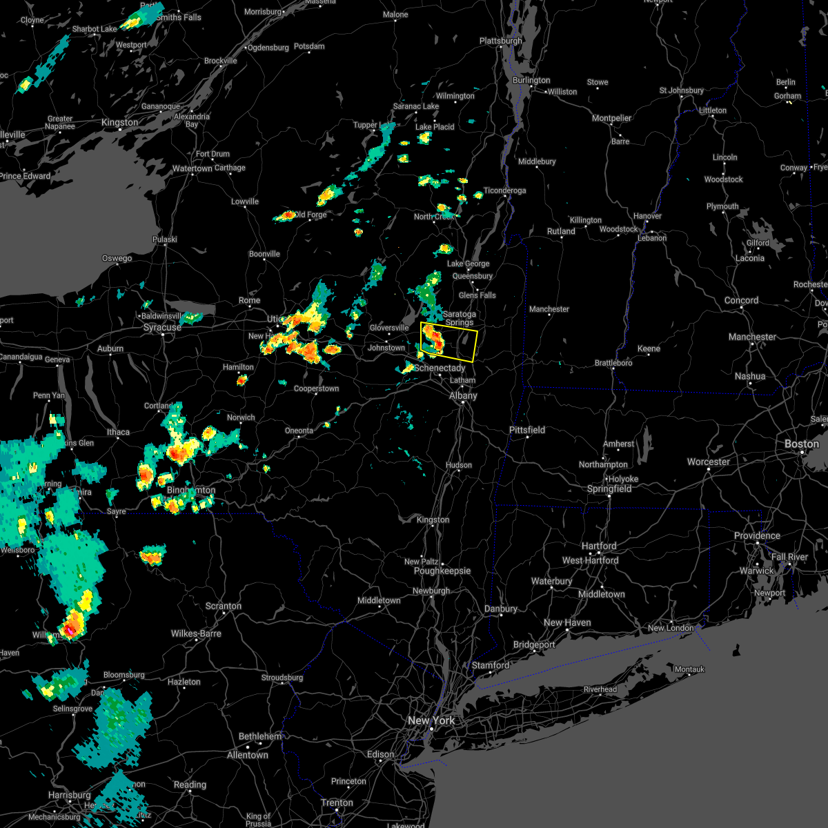
| 8/21/2019 3:19 PM EDT |
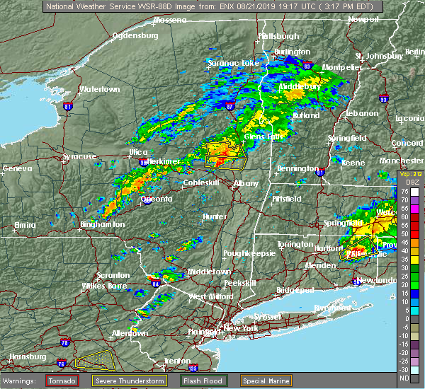 At 319 pm edt, a severe thunderstorm was located over rock city falls, or near saratoga springs, moving east at 25 mph (radar indicated). Hazards include 60 mph wind gusts and penny size hail. Expect damage to roofs, siding, and trees. Locations impacted include, saratoga springs, milton, ballston spa, round lake, galway, north ballston spa, rock city falls, gates, malta, greenfield, stillwater, parkis mills, deans corners, west milton, wayville, halls corner, mannings cove, eddy corners, north milton and saratoga race course. At 319 pm edt, a severe thunderstorm was located over rock city falls, or near saratoga springs, moving east at 25 mph (radar indicated). Hazards include 60 mph wind gusts and penny size hail. Expect damage to roofs, siding, and trees. Locations impacted include, saratoga springs, milton, ballston spa, round lake, galway, north ballston spa, rock city falls, gates, malta, greenfield, stillwater, parkis mills, deans corners, west milton, wayville, halls corner, mannings cove, eddy corners, north milton and saratoga race course.
|
| 8/21/2019 3:00 PM EDT |
 At 259 pm edt, a severe thunderstorm was located over galway, or 9 miles northeast of amsterdam, moving east at 25 mph (radar indicated). Hazards include 60 mph wind gusts and penny size hail. expect damage to roofs, siding, and trees At 259 pm edt, a severe thunderstorm was located over galway, or 9 miles northeast of amsterdam, moving east at 25 mph (radar indicated). Hazards include 60 mph wind gusts and penny size hail. expect damage to roofs, siding, and trees
|
| 8/21/2019 5:09 AM EDT |
 At 509 am edt, a severe thunderstorm was located over burnt hills, or near scotia, moving northeast at 45 mph (radar indicated). Hazards include 60 mph wind gusts and quarter size hail. Hail damage to vehicles is expected. expect wind damage to roofs, siding, and trees. Locations impacted include, schenectady, clifton park, rotterdam, saratoga springs, scotia, mechanicville, glenville, niskayuna, milton, duanesburg, ballston spa, round lake, delanson, rotterdam junction, east glenville, burnt hills, country knolls, north ballston spa, alplaus and pattersonville-rotterdam junction. At 509 am edt, a severe thunderstorm was located over burnt hills, or near scotia, moving northeast at 45 mph (radar indicated). Hazards include 60 mph wind gusts and quarter size hail. Hail damage to vehicles is expected. expect wind damage to roofs, siding, and trees. Locations impacted include, schenectady, clifton park, rotterdam, saratoga springs, scotia, mechanicville, glenville, niskayuna, milton, duanesburg, ballston spa, round lake, delanson, rotterdam junction, east glenville, burnt hills, country knolls, north ballston spa, alplaus and pattersonville-rotterdam junction.
|
| 8/18/2019 6:12 PM EDT |
 The national weather service in albany has issued a * severe thunderstorm warning for. central saratoga county in east central new york. southwestern washington county in east central new york. until 715 pm edt. At 611 pm edt, a severe thunderstorm was located over milton, or. The national weather service in albany has issued a * severe thunderstorm warning for. central saratoga county in east central new york. southwestern washington county in east central new york. until 715 pm edt. At 611 pm edt, a severe thunderstorm was located over milton, or.
|
| 8/18/2019 5:20 PM EDT |
 At 519 pm edt, a severe thunderstorm was located near fort johnson, or near amsterdam, moving east at 20 mph (radar indicated). Hazards include 70 mph wind gusts and half dollar size hail. Hail damage to vehicles is expected. expect considerable tree damage. Wind damage is also likely to mobile homes, roofs, and outbuildings. At 519 pm edt, a severe thunderstorm was located near fort johnson, or near amsterdam, moving east at 20 mph (radar indicated). Hazards include 70 mph wind gusts and half dollar size hail. Hail damage to vehicles is expected. expect considerable tree damage. Wind damage is also likely to mobile homes, roofs, and outbuildings.
|
| 8/17/2019 5:20 PM EDT | Tree and lines down in roadwa in saratoga county NY, 3.3 miles SE of Galway, NY |
| 8/17/2019 5:17 PM EDT |
 At 516 pm edt, severe thunderstorms were located along a line extending from near west glens falls to saratoga springs, moving east at 35 mph (radar indicated). Hazards include 60 mph wind gusts and quarter size hail. Hail damage to vehicles is expected. expect wind damage to roofs, siding, and trees. these severe storms will be near, glens falls, glens falls north and west glens falls around 525 pm edt. hudson falls and fort edward around 530 pm edt. Other locations impacted by these severe thunderstorms include parkis mills, deans corners, lake luzerne, grangerville, west milton, glenwild, northumberland, wayville, greenfield center and wiley corners. At 516 pm edt, severe thunderstorms were located along a line extending from near west glens falls to saratoga springs, moving east at 35 mph (radar indicated). Hazards include 60 mph wind gusts and quarter size hail. Hail damage to vehicles is expected. expect wind damage to roofs, siding, and trees. these severe storms will be near, glens falls, glens falls north and west glens falls around 525 pm edt. hudson falls and fort edward around 530 pm edt. Other locations impacted by these severe thunderstorms include parkis mills, deans corners, lake luzerne, grangerville, west milton, glenwild, northumberland, wayville, greenfield center and wiley corners.
|
| 8/17/2019 5:06 PM EDT |
 A severe thunderstorm warning remains in effect until 600 pm edt for southeastern warren. saratoga. southeastern fulton and southwestern washington counties. At 506 pm edt, severe thunderstorms were located along a line extending from lake luzerne-hadley to rock city falls, moving east at 35 mph. A severe thunderstorm warning remains in effect until 600 pm edt for southeastern warren. saratoga. southeastern fulton and southwestern washington counties. At 506 pm edt, severe thunderstorms were located along a line extending from lake luzerne-hadley to rock city falls, moving east at 35 mph.
|
| 8/17/2019 4:55 PM EDT |
 At 454 pm edt, severe thunderstorms were located along a line extending from near day center to galway, moving east at 35 mph (radar indicated). Hazards include 60 mph wind gusts and penny size hail. Expect damage to roofs, siding, and trees. severe thunderstorms will be near, ballston spa around 505 pm edt. milton, corinth, north ballston spa, lake luzerne-hadley and lake luzerne campground around 510 pm edt. saratoga springs around 520 pm edt. glens falls, west glens falls and glens falls north around 525 pm edt. Hudson falls and fort edward around 530 pm edt. At 454 pm edt, severe thunderstorms were located along a line extending from near day center to galway, moving east at 35 mph (radar indicated). Hazards include 60 mph wind gusts and penny size hail. Expect damage to roofs, siding, and trees. severe thunderstorms will be near, ballston spa around 505 pm edt. milton, corinth, north ballston spa, lake luzerne-hadley and lake luzerne campground around 510 pm edt. saratoga springs around 520 pm edt. glens falls, west glens falls and glens falls north around 525 pm edt. Hudson falls and fort edward around 530 pm edt.
|
| 8/17/2019 2:45 PM EDT |
 At 244 pm edt, a severe thunderstorm was located over galway, or 10 miles northeast of amsterdam, moving northeast at 10 mph (radar indicated). Hazards include 60 mph wind gusts and nickel size hail. expect damage to roofs, siding, and trees At 244 pm edt, a severe thunderstorm was located over galway, or 10 miles northeast of amsterdam, moving northeast at 10 mph (radar indicated). Hazards include 60 mph wind gusts and nickel size hail. expect damage to roofs, siding, and trees
|
| 8/8/2019 5:13 PM EDT |
 At 512 pm edt, a severe thunderstorm was located near hagaman, or near amsterdam, moving northeast at 35 mph (trained weather spotters reported trees down near amsterdam). Hazards include 60 mph wind gusts and quarter size hail. Hail damage to vehicles is expected. expect wind damage to roofs, siding, and trees. this severe thunderstorm will be near, glenville around 520 pm edt. galway around 525 pm edt. milton, ballston spa, rock city falls and north ballston spa around 540 pm edt. saratoga springs around 555 pm edt. corinth around 600 pm edt. Other locations impacted by this severe thunderstorm include parkis mills, deans corners, west perth, munsonville, shaw corners, church corners, kings station, barkersville, west milton and glenwild. At 512 pm edt, a severe thunderstorm was located near hagaman, or near amsterdam, moving northeast at 35 mph (trained weather spotters reported trees down near amsterdam). Hazards include 60 mph wind gusts and quarter size hail. Hail damage to vehicles is expected. expect wind damage to roofs, siding, and trees. this severe thunderstorm will be near, glenville around 520 pm edt. galway around 525 pm edt. milton, ballston spa, rock city falls and north ballston spa around 540 pm edt. saratoga springs around 555 pm edt. corinth around 600 pm edt. Other locations impacted by this severe thunderstorm include parkis mills, deans corners, west perth, munsonville, shaw corners, church corners, kings station, barkersville, west milton and glenwild.
|
| 8/7/2019 4:42 PM EDT |
 At 442 pm edt, a severe thunderstorm was located near tribes hill, or near fonda, moving east at 30 mph (radar indicated). Hazards include 70 mph wind gusts and penny size hail. Expect considerable tree damage. Damage is likely to mobile homes, roofs, and outbuildings. At 442 pm edt, a severe thunderstorm was located near tribes hill, or near fonda, moving east at 30 mph (radar indicated). Hazards include 70 mph wind gusts and penny size hail. Expect considerable tree damage. Damage is likely to mobile homes, roofs, and outbuildings.
|
| 8/6/2019 6:20 PM EDT |
 At 619 pm edt, severe thunderstorms were located along a line extending from near caroga lake public campground to near fonda to near canajoharie, moving east at 30 mph (radar indicated). Hazards include 60 mph wind gusts. Expect damage to roofs, siding, and trees. Locations impacted include, amsterdam, gloversville, johnstown, canajoharie, fonda, glenville, fort plain, ephratah, broadalbin, hagaman, edinburg, northville, mayfield, fort johnson, galway, cranberry creek, northampton beach public campground, caroga lake, rotterdam junction and burnt hills. At 619 pm edt, severe thunderstorms were located along a line extending from near caroga lake public campground to near fonda to near canajoharie, moving east at 30 mph (radar indicated). Hazards include 60 mph wind gusts. Expect damage to roofs, siding, and trees. Locations impacted include, amsterdam, gloversville, johnstown, canajoharie, fonda, glenville, fort plain, ephratah, broadalbin, hagaman, edinburg, northville, mayfield, fort johnson, galway, cranberry creek, northampton beach public campground, caroga lake, rotterdam junction and burnt hills.
|
| 8/6/2019 5:54 PM EDT |
 At 554 pm edt, severe thunderstorms were located along a line extending from near stratford to fort plain to near cherry valley, moving east at 40 mph (radar indicated). Hazards include 70 mph wind gusts and quarter size hail. Hail damage to vehicles is expected. expect considerable tree damage. Wind damage is also likely to mobile homes, roofs, and outbuildings. At 554 pm edt, severe thunderstorms were located along a line extending from near stratford to fort plain to near cherry valley, moving east at 40 mph (radar indicated). Hazards include 70 mph wind gusts and quarter size hail. Hail damage to vehicles is expected. expect considerable tree damage. Wind damage is also likely to mobile homes, roofs, and outbuildings.
|
| 7/30/2019 5:23 PM EDT |
 The national weather service in albany has issued a * severe thunderstorm warning for. southeastern warren county in east central new york. saratoga county in east central new york. southwestern washington county in east central new york. Until 630 pm edt. The national weather service in albany has issued a * severe thunderstorm warning for. southeastern warren county in east central new york. saratoga county in east central new york. southwestern washington county in east central new york. Until 630 pm edt.
|
| 7/29/2019 8:58 PM EDT | Several downed trees on cook road in saratoga county NY, 4.6 miles NNW of Galway, NY |
| 7/29/2019 8:57 PM EDT |
 At 857 pm edt, severe thunderstorms were located along a line extending from near galway to colonie, moving northeast at 15 mph (radar indicated). Hazards include 60 mph wind gusts and penny size hail. expect damage to roofs, siding, and trees At 857 pm edt, severe thunderstorms were located along a line extending from near galway to colonie, moving northeast at 15 mph (radar indicated). Hazards include 60 mph wind gusts and penny size hail. expect damage to roofs, siding, and trees
|
| 7/20/2019 8:16 PM EDT |
 At 816 pm edt, a severe thunderstorm was located over cranberry creek, or 8 miles northeast of gloversville, moving southeast at 30 mph (radar indicated). Hazards include 60 mph wind gusts. expect damage to roofs, siding, and trees At 816 pm edt, a severe thunderstorm was located over cranberry creek, or 8 miles northeast of gloversville, moving southeast at 30 mph (radar indicated). Hazards include 60 mph wind gusts. expect damage to roofs, siding, and trees
|
| 7/20/2019 7:31 PM EDT |
 At 730 pm edt, a severe thunderstorm was located over clifton park, moving east at 30 mph (radar indicated). Hazards include 60 mph wind gusts. Expect damage to roofs, siding, and trees. Locations impacted include, schenectady, clifton park, rotterdam, scotia, mechanicville, glenville, niskayuna, duanesburg, ballston spa, waterford, broadalbin, round lake, galway, rotterdam junction, east glenville, burnt hills, country knolls, north ballston spa, alplaus and pattersonville-rotterdam junction. At 730 pm edt, a severe thunderstorm was located over clifton park, moving east at 30 mph (radar indicated). Hazards include 60 mph wind gusts. Expect damage to roofs, siding, and trees. Locations impacted include, schenectady, clifton park, rotterdam, scotia, mechanicville, glenville, niskayuna, duanesburg, ballston spa, waterford, broadalbin, round lake, galway, rotterdam junction, east glenville, burnt hills, country knolls, north ballston spa, alplaus and pattersonville-rotterdam junction.
|
| 7/20/2019 6:53 PM EDT |
 At 653 pm edt, a severe thunderstorm was located over amsterdam, moving east at 30 mph (radar indicated). Hazards include 60 mph wind gusts. expect damage to roofs, siding, and trees At 653 pm edt, a severe thunderstorm was located over amsterdam, moving east at 30 mph (radar indicated). Hazards include 60 mph wind gusts. expect damage to roofs, siding, and trees
|
| 5/23/2019 9:12 PM EDT |
 At 911 pm edt, a severe thunderstorm was located over fonda, moving east at 40 mph (radar indicated). Hazards include 60 mph wind gusts. expect damage to roofs, siding, and trees At 911 pm edt, a severe thunderstorm was located over fonda, moving east at 40 mph (radar indicated). Hazards include 60 mph wind gusts. expect damage to roofs, siding, and trees
|
| 5/23/2019 8:42 PM EDT |
 At 842 pm edt, a severe thunderstorm was located near galway, or 12 miles west of saratoga springs, moving southeast at 35 mph (radar indicated). Hazards include 60 mph wind gusts. expect damage to roofs, siding, and trees At 842 pm edt, a severe thunderstorm was located near galway, or 12 miles west of saratoga springs, moving southeast at 35 mph (radar indicated). Hazards include 60 mph wind gusts. expect damage to roofs, siding, and trees
|
| 9/5/2018 5:39 PM EDT |
 At 538 pm edt, a severe thunderstorm was located over milton, or over saratoga springs, moving east at 30 mph (radar indicated). Hazards include 60 mph wind gusts and penny size hail. Expect damage to roofs, siding, and trees. This severe thunderstorm will remain over mainly rural areas of central saratoga county, including the following locations, maltaville, holsapple corners, gurn spring, malta ridge, francis corners, milton center, kings station, west milton, greenfield center and malta. At 538 pm edt, a severe thunderstorm was located over milton, or over saratoga springs, moving east at 30 mph (radar indicated). Hazards include 60 mph wind gusts and penny size hail. Expect damage to roofs, siding, and trees. This severe thunderstorm will remain over mainly rural areas of central saratoga county, including the following locations, maltaville, holsapple corners, gurn spring, malta ridge, francis corners, milton center, kings station, west milton, greenfield center and malta.
|
| 9/5/2018 4:55 PM EDT |
 At 455 pm edt, a severe thunderstorm was located over broadalbin, or near gloversville, moving east at 25 mph (radar indicated). Hazards include 60 mph wind gusts and penny size hail. Expect damage to roofs, siding, and trees. this severe thunderstorm will be near, hagaman around 505 pm edt. galway around 515 pm edt. rock city falls around 530 pm edt. milton, ballston spa and north ballston spa around 535 pm edt. Saratoga springs and round lake around 545 pm edt. At 455 pm edt, a severe thunderstorm was located over broadalbin, or near gloversville, moving east at 25 mph (radar indicated). Hazards include 60 mph wind gusts and penny size hail. Expect damage to roofs, siding, and trees. this severe thunderstorm will be near, hagaman around 505 pm edt. galway around 515 pm edt. rock city falls around 530 pm edt. milton, ballston spa and north ballston spa around 535 pm edt. Saratoga springs and round lake around 545 pm edt.
|
| 8/14/2018 3:16 PM EDT |
 The national weather service in albany has issued a * severe thunderstorm warning for. schenectady county in east central new york. southwestern saratoga county in east central new york. southeastern montgomery county in eastern new york. Until 400 pm edt. The national weather service in albany has issued a * severe thunderstorm warning for. schenectady county in east central new york. southwestern saratoga county in east central new york. southeastern montgomery county in eastern new york. Until 400 pm edt.
|
| 5/4/2018 7:50 PM EDT |
 At 749 pm edt, severe thunderstorms were located along a line extending from near eagle point campground to 7 miles north of rock city falls to fort johnson, moving east at 55 mph (radar indicated). Hazards include 60 mph wind gusts. Expect damage to roofs, siding, and trees. severe thunderstorms will be near, eagle point campground around 755 pm edt. saratoga springs and corinth around 800 pm edt. hague and huletts landing around 805 pm edt. milton, ballston spa, country knolls and north ballston spa around 810 pm edt. greenwich, round lake and west haven around 815 pm edt. salem around 825 pm edt. A tornado watch remains in effect until 1000 pm edt for eastern and east central new york. At 749 pm edt, severe thunderstorms were located along a line extending from near eagle point campground to 7 miles north of rock city falls to fort johnson, moving east at 55 mph (radar indicated). Hazards include 60 mph wind gusts. Expect damage to roofs, siding, and trees. severe thunderstorms will be near, eagle point campground around 755 pm edt. saratoga springs and corinth around 800 pm edt. hague and huletts landing around 805 pm edt. milton, ballston spa, country knolls and north ballston spa around 810 pm edt. greenwich, round lake and west haven around 815 pm edt. salem around 825 pm edt. A tornado watch remains in effect until 1000 pm edt for eastern and east central new york.
|
| 10/24/2017 2:54 PM EDT |
 At 254 pm edt, severe thunderstorms were located along a line extending from near cohoes to near coxsackie, moving north at 45 mph (radar indicated). Hazards include 60 mph wind gusts. Expect damage to trees, and power lines. severe thunderstorms will be near, clifton park around 300 pm edt. mechanicville, round lake and country knolls around 305 pm edt. ravena around 310 pm edt. castleton-on-hudson, selkirk and feura bush around 315 pm edt. east greenbush, delmar and greenwich around 325 pm edt. albany, rensselaer, colonie, menands, loudonville, wyantskill and west sand lake around 330 pm edt. watervliet, latham and green island around 335 pm edt. troy, cohoes, glens falls, fort edward, waterford and center brunswick around 340 pm edt. Other locations impacted by these severe thunderstorms include parkis mills, deans corners, shakers, bleecker stadium, brookview, glenridge, van hoesen station, grangerville, northumberland and beckers corners. At 254 pm edt, severe thunderstorms were located along a line extending from near cohoes to near coxsackie, moving north at 45 mph (radar indicated). Hazards include 60 mph wind gusts. Expect damage to trees, and power lines. severe thunderstorms will be near, clifton park around 300 pm edt. mechanicville, round lake and country knolls around 305 pm edt. ravena around 310 pm edt. castleton-on-hudson, selkirk and feura bush around 315 pm edt. east greenbush, delmar and greenwich around 325 pm edt. albany, rensselaer, colonie, menands, loudonville, wyantskill and west sand lake around 330 pm edt. watervliet, latham and green island around 335 pm edt. troy, cohoes, glens falls, fort edward, waterford and center brunswick around 340 pm edt. Other locations impacted by these severe thunderstorms include parkis mills, deans corners, shakers, bleecker stadium, brookview, glenridge, van hoesen station, grangerville, northumberland and beckers corners.
|
| 8/22/2017 6:42 PM EDT |
 At 641 pm edt, a severe thunderstorm was located over hagaman, or near amsterdam, moving east at 45 mph (radar indicated). Hazards include 60 mph wind gusts. Expect damage to trees, and power lines. this severe storm will be near, glenville and pattersonville-rotterdam junction around 645 pm edt. galway around 650 pm edt. A tornado watch remains in effect until 900 pm edt for eastern and east central new york. At 641 pm edt, a severe thunderstorm was located over hagaman, or near amsterdam, moving east at 45 mph (radar indicated). Hazards include 60 mph wind gusts. Expect damage to trees, and power lines. this severe storm will be near, glenville and pattersonville-rotterdam junction around 645 pm edt. galway around 650 pm edt. A tornado watch remains in effect until 900 pm edt for eastern and east central new york.
|
| 8/22/2017 6:18 PM EDT |
 At 617 pm edt, severe thunderstorms were located along a line extending from near day center to edinburg to fort johnson, moving southeast at 40 mph (radar indicated). Hazards include 60 mph wind gusts. Expect damage to trees, and power lines. these severe storms will be near, lake luzerne-hadle and lake luzerne campground around 625 pm edt. corinth around 630 pm edt. rock city falls around 635 pm edt. glens falls, milton, ballston spa, west glens falls, glens falls north and north ballston spa around 640 pm edt. saratoga springs around 645 pm edt. other locations impacted by these severe thunderstorms include parkis mills, meco, west perth, girards sugarbush, sweets crossing, lake luzerne, west milton, glenwild, greenfield center and wiley corners. A tornado watch remains in effect until 900 pm edt for eastern and east central new york. At 617 pm edt, severe thunderstorms were located along a line extending from near day center to edinburg to fort johnson, moving southeast at 40 mph (radar indicated). Hazards include 60 mph wind gusts. Expect damage to trees, and power lines. these severe storms will be near, lake luzerne-hadle and lake luzerne campground around 625 pm edt. corinth around 630 pm edt. rock city falls around 635 pm edt. glens falls, milton, ballston spa, west glens falls, glens falls north and north ballston spa around 640 pm edt. saratoga springs around 645 pm edt. other locations impacted by these severe thunderstorms include parkis mills, meco, west perth, girards sugarbush, sweets crossing, lake luzerne, west milton, glenwild, greenfield center and wiley corners. A tornado watch remains in effect until 900 pm edt for eastern and east central new york.
|
| 8/22/2017 6:15 PM EDT |
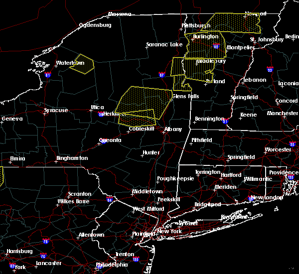 At 615 pm edt, a severe thunderstorm was located over ephratah, or near canajoharie, moving east at 45 mph (radar indicated). Hazards include 70 mph wind gusts and penny size hail. Expect considerable tree damage. damage is likely to mobile homes, roofs, and outbuildings. this severe thunderstorm will be near, johnstown and fonda around 625 pm edt. gloversville and tribes hill around 630 pm edt. fort johnson around 635 pm edt. amsterdam, broadalbin and hagaman around 640 pm edt. glenville and pattersonville-rotterdam junction around 645 pm edt. galway and rotterdam junction around 650 pm edt. other locations impacted by this severe thunderstorm include parkis mills, meco, charleston, west perth, fultonville, hoffmans, harding crossing, young corners, wiley corners and hale mills. A tornado watch remains in effect until 900 pm edt for eastern and east central new york. At 615 pm edt, a severe thunderstorm was located over ephratah, or near canajoharie, moving east at 45 mph (radar indicated). Hazards include 70 mph wind gusts and penny size hail. Expect considerable tree damage. damage is likely to mobile homes, roofs, and outbuildings. this severe thunderstorm will be near, johnstown and fonda around 625 pm edt. gloversville and tribes hill around 630 pm edt. fort johnson around 635 pm edt. amsterdam, broadalbin and hagaman around 640 pm edt. glenville and pattersonville-rotterdam junction around 645 pm edt. galway and rotterdam junction around 650 pm edt. other locations impacted by this severe thunderstorm include parkis mills, meco, charleston, west perth, fultonville, hoffmans, harding crossing, young corners, wiley corners and hale mills. A tornado watch remains in effect until 900 pm edt for eastern and east central new york.
|
| 8/22/2017 5:39 PM EDT |
 At 538 pm edt, severe thunderstorms were located along a line extending from moffitt beach campground to 10 miles southwest of lake pleasant to near dolgeville, moving southeast at 35 mph (radar indicated). Hazards include 60 mph wind gusts. Expect damage to trees, and power lines. severe thunderstorms will be near, wells, caroga lake public campground and caroga lake around 550 pm edt. sacandaga campground around 555 pm edt. gloversville and johnstown around 605 pm edt. northville, northampton beach public campground and cranberry creek around 610 pm edt. edinburg and day center around 615 pm edt. hagaman around 620 pm edt. lake luzerne-hadle and lake luzerne campground around 625 pm edt. corinth around 630 pm edt. A tornado watch remains in effect until 900 pm edt for eastern and east central new york. At 538 pm edt, severe thunderstorms were located along a line extending from moffitt beach campground to 10 miles southwest of lake pleasant to near dolgeville, moving southeast at 35 mph (radar indicated). Hazards include 60 mph wind gusts. Expect damage to trees, and power lines. severe thunderstorms will be near, wells, caroga lake public campground and caroga lake around 550 pm edt. sacandaga campground around 555 pm edt. gloversville and johnstown around 605 pm edt. northville, northampton beach public campground and cranberry creek around 610 pm edt. edinburg and day center around 615 pm edt. hagaman around 620 pm edt. lake luzerne-hadle and lake luzerne campground around 625 pm edt. corinth around 630 pm edt. A tornado watch remains in effect until 900 pm edt for eastern and east central new york.
|
| 8/12/2017 4:43 PM EDT |
 At 443 pm edt, a severe thunderstorm was located over ballston spa, or 8 miles southwest of saratoga springs, moving east at 15 mph (radar indicated). Hazards include 60 mph wind gusts and quarter size hail. Minor damage to vehicles is possible. expect wind damage to trees, and power lines. this severe storm will be near, ballston spa and north ballston spa around 450 pm edt. milton around 455 pm edt. saratoga springs, round lake and country knolls around 500 pm edt. Other locations impacted by this severe thunderstorm include parkis mills, maltaville, holsapple corners, malta ridge, francis corners, milton center, west milton, coons, garrison manor and malta. At 443 pm edt, a severe thunderstorm was located over ballston spa, or 8 miles southwest of saratoga springs, moving east at 15 mph (radar indicated). Hazards include 60 mph wind gusts and quarter size hail. Minor damage to vehicles is possible. expect wind damage to trees, and power lines. this severe storm will be near, ballston spa and north ballston spa around 450 pm edt. milton around 455 pm edt. saratoga springs, round lake and country knolls around 500 pm edt. Other locations impacted by this severe thunderstorm include parkis mills, maltaville, holsapple corners, malta ridge, francis corners, milton center, west milton, coons, garrison manor and malta.
|
| 8/12/2017 4:15 PM EDT |
 At 415 pm edt, a severe thunderstorm was located over galway, or 7 miles northeast of amsterdam, moving east at 15 mph (radar indicated). Hazards include 60 mph wind gusts and quarter size hail. Minor damage to vehicles is possible. expect wind damage to trees, and power lines. this severe thunderstorm will be near, galway around 420 pm edt. rock city falls around 440 pm edt. burnt hills around 445 pm edt. ballston spa and north ballston spa around 450 pm edt. milton around 455 pm edt. round lake and country knolls around 500 pm edt. Other locations impacted by this severe thunderstorm include parkis mills, west milton, coons, garrison manor, elnora, halls corner, mannings cove, eddy corners, west galway and north milton. At 415 pm edt, a severe thunderstorm was located over galway, or 7 miles northeast of amsterdam, moving east at 15 mph (radar indicated). Hazards include 60 mph wind gusts and quarter size hail. Minor damage to vehicles is possible. expect wind damage to trees, and power lines. this severe thunderstorm will be near, galway around 420 pm edt. rock city falls around 440 pm edt. burnt hills around 445 pm edt. ballston spa and north ballston spa around 450 pm edt. milton around 455 pm edt. round lake and country knolls around 500 pm edt. Other locations impacted by this severe thunderstorm include parkis mills, west milton, coons, garrison manor, elnora, halls corner, mannings cove, eddy corners, west galway and north milton.
|
| 7/17/2017 5:12 PM EDT |
 The severe thunderstorm warning for central schenectady and southern saratoga counties will expire at 515 pm edt, the storms which prompted the warning have weakened below severe limits, and no longer pose an immediate threat to life or property. therefore the warning will be allowed to expire. however heavy rain is still possible with these thunderstorms. a severe thunderstorm watch remains in effect until 800 pm edt for eastern and east central new york. The severe thunderstorm warning for central schenectady and southern saratoga counties will expire at 515 pm edt, the storms which prompted the warning have weakened below severe limits, and no longer pose an immediate threat to life or property. therefore the warning will be allowed to expire. however heavy rain is still possible with these thunderstorms. a severe thunderstorm watch remains in effect until 800 pm edt for eastern and east central new york.
|
| 7/17/2017 4:30 PM EDT |
 At 430 pm edt, severe thunderstorms were located along a line extending from near saratoga springs to scotia, moving east at 35 mph (radar indicated). Hazards include 60 mph wind gusts and quarter size hail. Minor damage to vehicles is possible. expect wind damage to trees, and power lines. severe thunderstorms will be near, saratoga springs, milton, ballston spa and north ballston spa around 435 pm edt. country knolls around 445 pm edt. round lake around 450 pm edt. mechanicville around 455 pm edt. Other locations impacted by these severe thunderstorms include parkis mills, deans corners, glenridge, hoffmans, grangerville, harding crossing, west milton, willow glen, northumberland and coons. At 430 pm edt, severe thunderstorms were located along a line extending from near saratoga springs to scotia, moving east at 35 mph (radar indicated). Hazards include 60 mph wind gusts and quarter size hail. Minor damage to vehicles is possible. expect wind damage to trees, and power lines. severe thunderstorms will be near, saratoga springs, milton, ballston spa and north ballston spa around 435 pm edt. country knolls around 445 pm edt. round lake around 450 pm edt. mechanicville around 455 pm edt. Other locations impacted by these severe thunderstorms include parkis mills, deans corners, glenridge, hoffmans, grangerville, harding crossing, west milton, willow glen, northumberland and coons.
|
| 6/30/2017 4:23 PM EDT |
 The severe thunderstorm warning for west central saratoga county will expire at 430 pm edt, the storm which prompted the warning has weakened below severe limits, and has exited the warned area. therefore, the warning will be allowed to expire. however heavy rain is still possible with this thunderstorm. a severe thunderstorm watch remains in effect until 900 pm edt for east central new york. The severe thunderstorm warning for west central saratoga county will expire at 430 pm edt, the storm which prompted the warning has weakened below severe limits, and has exited the warned area. therefore, the warning will be allowed to expire. however heavy rain is still possible with this thunderstorm. a severe thunderstorm watch remains in effect until 900 pm edt for east central new york.
|
| 6/30/2017 4:05 PM EDT |
 At 405 pm edt, a severe thunderstorm was located near galway, or 10 miles northeast of amsterdam, moving east at 35 mph (radar indicated). Hazards include 60 mph wind gusts and quarter size hail. Minor damage to vehicles is possible. expect wind damage to trees, and power lines. this severe storm will be near, rock city falls around 420 pm edt. milton, ballston spa and north ballston spa around 425 pm edt. Other locations impacted by this severe thunderstorm include parkis mills, holsapple corners, shaw corners, milton center, barkersville, west milton, glenwild, kings, greenfield center and wiley corners. At 405 pm edt, a severe thunderstorm was located near galway, or 10 miles northeast of amsterdam, moving east at 35 mph (radar indicated). Hazards include 60 mph wind gusts and quarter size hail. Minor damage to vehicles is possible. expect wind damage to trees, and power lines. this severe storm will be near, rock city falls around 420 pm edt. milton, ballston spa and north ballston spa around 425 pm edt. Other locations impacted by this severe thunderstorm include parkis mills, holsapple corners, shaw corners, milton center, barkersville, west milton, glenwild, kings, greenfield center and wiley corners.
|
| 6/30/2017 12:05 PM EDT |
 At 405 pm edt, a severe thunderstorm was located near galway, or 10 miles northeast of amsterdam, moving east at 35 mph (radar indicated). Hazards include 60 mph wind gusts and quarter size hail. Minor damage to vehicles is possible. expect wind damage to trees, and power lines. this severe storm will be near, rock city falls around 420 pm edt. milton, ballston spa and north ballston spa around 425 pm edt. Other locations impacted by this severe thunderstorm include parkis mills, holsapple corners, shaw corners, milton center, barkersville, west milton, glenwild, kings, greenfield center and wiley corners. At 405 pm edt, a severe thunderstorm was located near galway, or 10 miles northeast of amsterdam, moving east at 35 mph (radar indicated). Hazards include 60 mph wind gusts and quarter size hail. Minor damage to vehicles is possible. expect wind damage to trees, and power lines. this severe storm will be near, rock city falls around 420 pm edt. milton, ballston spa and north ballston spa around 425 pm edt. Other locations impacted by this severe thunderstorm include parkis mills, holsapple corners, shaw corners, milton center, barkersville, west milton, glenwild, kings, greenfield center and wiley corners.
|
| 6/30/2017 11:41 AM EDT |
 At 341 pm edt, a severe thunderstorm was located over gloversville, moving east at 25 mph (radar indicated). Hazards include 60 mph wind gusts and quarter size hail. Minor damage to vehicles is possible. expect wind damage to trees, and power lines. this severe thunderstorm will be near, mayfield around 350 pm edt. cranberry creek around 355 pm edt. broadalbin around 400 pm edt. galway around 420 pm edt. milton, ballston spa, rock city falls and north ballston spa around 430 pm edt. Other locations impacted by this severe thunderstorm include parkis mills, meco, west perth, munsonville, sweets crossing, shaw corners, pinnacle, barkersville, west milton and glenwild. At 341 pm edt, a severe thunderstorm was located over gloversville, moving east at 25 mph (radar indicated). Hazards include 60 mph wind gusts and quarter size hail. Minor damage to vehicles is possible. expect wind damage to trees, and power lines. this severe thunderstorm will be near, mayfield around 350 pm edt. cranberry creek around 355 pm edt. broadalbin around 400 pm edt. galway around 420 pm edt. milton, ballston spa, rock city falls and north ballston spa around 430 pm edt. Other locations impacted by this severe thunderstorm include parkis mills, meco, west perth, munsonville, sweets crossing, shaw corners, pinnacle, barkersville, west milton and glenwild.
|
| 6/27/2017 4:17 PM EDT | Multiple trees down near galway rd and jockey st in saratoga county NY, 2.1 miles W of Galway, NY |
| 6/27/2017 12:16 PM EDT |
 At 415 pm edt, severe thunderstorms were located along a line extending from near northville to near edinburg to near galway to near hagaman to near pattersonville-rotterdam junction, moving northeast at 40 mph (radar indicated). Hazards include 60 mph wind gusts and quarter size hail. Minor damage to vehicles is possible. expect wind damage to trees, and power lines. severe thunderstorms will be near, edinburg around 420 pm edt. day center around 425 pm edt. rock city falls and east glenville around 430 pm edt. milton and burnt hills around 435 pm edt. ballston spa, corinth and lake luzerne-hadle around 440 pm edt. saratoga springs, round lake, north ballston spa and lake luzerne campground around 445 pm edt. warrensburg, lake george village, glens falls north and west glens falls around 455 pm edt. Glens falls and fort edward around 500 pm edt. At 415 pm edt, severe thunderstorms were located along a line extending from near northville to near edinburg to near galway to near hagaman to near pattersonville-rotterdam junction, moving northeast at 40 mph (radar indicated). Hazards include 60 mph wind gusts and quarter size hail. Minor damage to vehicles is possible. expect wind damage to trees, and power lines. severe thunderstorms will be near, edinburg around 420 pm edt. day center around 425 pm edt. rock city falls and east glenville around 430 pm edt. milton and burnt hills around 435 pm edt. ballston spa, corinth and lake luzerne-hadle around 440 pm edt. saratoga springs, round lake, north ballston spa and lake luzerne campground around 445 pm edt. warrensburg, lake george village, glens falls north and west glens falls around 455 pm edt. Glens falls and fort edward around 500 pm edt.
|
| 5/31/2017 4:18 PM EDT |
 At 418 pm edt, a severe thunderstorm was located over schenectady, moving east at 40 mph (radar indicated). Hazards include ping pong ball size hail and 60 mph wind gusts. People and animals outdoors will be injured. expect hail damage to roofs, siding, windows, and vehicles. expect wind damage to roofs, siding, and trees. this severe storm will be near, albany and clifton park around 425 pm edt. latham and loudonville around 430 pm edt. troy, cohoes, watervliet, mechanicville, menands, green island and waterford around 435 pm edt. center brunswick around 440 pm edt. grafton around 455 pm edt. hoosick falls around 500 pm edt. Other locations impacted by this severe thunderstorm include parkis mills, deans corners, shakers, glenridge, albia, johnsonville, harding crossing, west milton, willow glen and garrison manor. At 418 pm edt, a severe thunderstorm was located over schenectady, moving east at 40 mph (radar indicated). Hazards include ping pong ball size hail and 60 mph wind gusts. People and animals outdoors will be injured. expect hail damage to roofs, siding, windows, and vehicles. expect wind damage to roofs, siding, and trees. this severe storm will be near, albany and clifton park around 425 pm edt. latham and loudonville around 430 pm edt. troy, cohoes, watervliet, mechanicville, menands, green island and waterford around 435 pm edt. center brunswick around 440 pm edt. grafton around 455 pm edt. hoosick falls around 500 pm edt. Other locations impacted by this severe thunderstorm include parkis mills, deans corners, shakers, glenridge, albia, johnsonville, harding crossing, west milton, willow glen and garrison manor.
|
| 5/31/2017 4:06 PM EDT |
 At 405 pm edt, a severe thunderstorm was located near rotterdam, moving east at 40 mph (radar indicated). Hazards include 60 mph wind gusts and quarter size hail. Hail damage to vehicles is expected. expect wind damage to roofs, siding, and trees. this severe thunderstorm will be near, albany, schenectady, rotterdam, scotia, niskayuna and alplaus around 415 pm edt. colonie, east glenville and burnt hills around 420 pm edt. clifton park and loudonville around 425 pm edt. cohoes, watervliet, latham and menands around 430 pm edt. troy, mechanicville, green island and waterford around 435 pm edt. center brunswick around 440 pm edt. grafton around 455 pm edt. Hoosick falls around 500 pm edt. At 405 pm edt, a severe thunderstorm was located near rotterdam, moving east at 40 mph (radar indicated). Hazards include 60 mph wind gusts and quarter size hail. Hail damage to vehicles is expected. expect wind damage to roofs, siding, and trees. this severe thunderstorm will be near, albany, schenectady, rotterdam, scotia, niskayuna and alplaus around 415 pm edt. colonie, east glenville and burnt hills around 420 pm edt. clifton park and loudonville around 425 pm edt. cohoes, watervliet, latham and menands around 430 pm edt. troy, mechanicville, green island and waterford around 435 pm edt. center brunswick around 440 pm edt. grafton around 455 pm edt. Hoosick falls around 500 pm edt.
|
| 5/18/2017 7:37 PM EDT | Large tree limbs down in saratoga county NY, 4.1 miles SSW of Galway, NY |
| 5/18/2017 7:29 PM EDT |
 At 728 pm edt, severe thunderstorms were located along a line extending from near hagaman to near duanesburg to near summit, moving east at 50 mph (radar indicated). Hazards include 60 mph wind gusts and quarter size hail. Hail damage to vehicles is expected. expect wind damage to roofs, siding, and trees. these severe storms will be near, glenville, duanesburg, altamont, hagaman, galway, rotterdam junction and pattersonville-rotterdam junction around 735 pm edt. rotterdam and scotia around 740 pm edt. schenectady, niskayuna, middleburgh, east glenville, alplaus and burnt hills around 745 pm edt. Other locations impacted by these severe thunderstorms include charleston, east berne, west richmondville, glenridge, hoffmans, rockwell corners, west berne, huntersland, harding crossing and young corners. At 728 pm edt, severe thunderstorms were located along a line extending from near hagaman to near duanesburg to near summit, moving east at 50 mph (radar indicated). Hazards include 60 mph wind gusts and quarter size hail. Hail damage to vehicles is expected. expect wind damage to roofs, siding, and trees. these severe storms will be near, glenville, duanesburg, altamont, hagaman, galway, rotterdam junction and pattersonville-rotterdam junction around 735 pm edt. rotterdam and scotia around 740 pm edt. schenectady, niskayuna, middleburgh, east glenville, alplaus and burnt hills around 745 pm edt. Other locations impacted by these severe thunderstorms include charleston, east berne, west richmondville, glenridge, hoffmans, rockwell corners, west berne, huntersland, harding crossing and young corners.
|
| 5/18/2017 7:10 PM EDT |
 At 710 pm edt, severe thunderstorms were located along a line extending from lake luzerne campground to 6 miles east of edinburg to gloversville, moving east at 30 mph (radar indicated). Hazards include 60 mph wind gusts and quarter size hail. Hail damage to vehicles is expected. expect wind damage to roofs, siding, and trees. severe thunderstorms will be near, lake luzerne campground and lake luzerne-hadley around 715 pm edt. lake george village around 720 pm edt. glens falls, corinth, glens falls north and west glens falls around 725 pm edt. fort edward and northampton beach public campground around 730 pm edt. hudson falls around 735 pm edt. galway around 745 pm edt. hartford and rock city falls around 755 pm edt. milton, ballston spa, greenwich and north ballston spa around 800 pm edt. Other locations impacted by these severe thunderstorms include parkis mills, meco, sweets crossing, lake luzerne, grangerville, west milton, glenwild, northumberland, greenfield center and wiley corners. At 710 pm edt, severe thunderstorms were located along a line extending from lake luzerne campground to 6 miles east of edinburg to gloversville, moving east at 30 mph (radar indicated). Hazards include 60 mph wind gusts and quarter size hail. Hail damage to vehicles is expected. expect wind damage to roofs, siding, and trees. severe thunderstorms will be near, lake luzerne campground and lake luzerne-hadley around 715 pm edt. lake george village around 720 pm edt. glens falls, corinth, glens falls north and west glens falls around 725 pm edt. fort edward and northampton beach public campground around 730 pm edt. hudson falls around 735 pm edt. galway around 745 pm edt. hartford and rock city falls around 755 pm edt. milton, ballston spa, greenwich and north ballston spa around 800 pm edt. Other locations impacted by these severe thunderstorms include parkis mills, meco, sweets crossing, lake luzerne, grangerville, west milton, glenwild, northumberland, greenfield center and wiley corners.
|
| 5/18/2017 6:58 PM EDT |
 At 658 pm edt, severe thunderstorms were located along a line extending from near st. johnsville to sharon springs to milford, moving east at 50 mph (radar indicated). Hazards include 60 mph wind gusts and quarter size hail. Hail damage to vehicles is expected. expect wind damage to roofs, siding, and trees. severe thunderstorms will be near, canajoharie, ephratah, sharon springs and ames around 705 pm edt. gloversville, johnstown, fonda, tribes hill and central bridge around 715 pm edt. summit, richmondville and fort johnson around 720 pm edt. amsterdam, cobleskill, hagaman and delanson around 725 pm edt. glenville, duanesburg, breakabeen and pattersonville-rotterdam junction around 730 pm edt. altamont, middleburgh, schoharie, galway and rotterdam junction around 735 pm edt. schenectady, rotterdam, scotia, niskayuna, alplaus, east glenville and burnt hills around 740 pm edt. berne around 745 pm edt. Other locations impacted by these severe thunderstorms include charleston, east berne, glenridge, hoffmans, west berne, huntersland, engleville, garrison manor, quaker street and west fulton. At 658 pm edt, severe thunderstorms were located along a line extending from near st. johnsville to sharon springs to milford, moving east at 50 mph (radar indicated). Hazards include 60 mph wind gusts and quarter size hail. Hail damage to vehicles is expected. expect wind damage to roofs, siding, and trees. severe thunderstorms will be near, canajoharie, ephratah, sharon springs and ames around 705 pm edt. gloversville, johnstown, fonda, tribes hill and central bridge around 715 pm edt. summit, richmondville and fort johnson around 720 pm edt. amsterdam, cobleskill, hagaman and delanson around 725 pm edt. glenville, duanesburg, breakabeen and pattersonville-rotterdam junction around 730 pm edt. altamont, middleburgh, schoharie, galway and rotterdam junction around 735 pm edt. schenectady, rotterdam, scotia, niskayuna, alplaus, east glenville and burnt hills around 740 pm edt. berne around 745 pm edt. Other locations impacted by these severe thunderstorms include charleston, east berne, glenridge, hoffmans, west berne, huntersland, engleville, garrison manor, quaker street and west fulton.
|
| 5/1/2017 9:25 PM EDT |
 At 925 pm edt, severe thunderstorms were located along a line extending from near galway to duanesburg to near windham to hortonville, moving east at 65 mph (radar indicated). Hazards include 70 mph wind gusts. Expect considerable tree damage. Damage is likely to mobile homes, roofs, and outbuildings. At 925 pm edt, severe thunderstorms were located along a line extending from near galway to duanesburg to near windham to hortonville, moving east at 65 mph (radar indicated). Hazards include 70 mph wind gusts. Expect considerable tree damage. Damage is likely to mobile homes, roofs, and outbuildings.
|
| 3/8/2017 1:45 PM EST |
 At 145 pm est, severe thunderstorms were located along a line extending from edinburg to near hunter, moving east at 55 mph (radar indicated). Hazards include 60 mph wind gusts. Expect damage to roofs, siding, and trees. severe thunderstorms will be near, corinth around 200 pm est. saratoga springs and catskill around 205 pm est. hudson, claverack, livingston, athens, claverack-red mills and lorenz park around 210 pm est. fort edward and philmont around 215 pm est. austerlitz around 225 pm est. salem around 230 pm est. Other locations impacted by these severe thunderstorms include deans corners, charleston, bleecker stadium, glenridge, hoffmans, west berne, huntersland, wayville, broome center and wiley corners. At 145 pm est, severe thunderstorms were located along a line extending from edinburg to near hunter, moving east at 55 mph (radar indicated). Hazards include 60 mph wind gusts. Expect damage to roofs, siding, and trees. severe thunderstorms will be near, corinth around 200 pm est. saratoga springs and catskill around 205 pm est. hudson, claverack, livingston, athens, claverack-red mills and lorenz park around 210 pm est. fort edward and philmont around 215 pm est. austerlitz around 225 pm est. salem around 230 pm est. Other locations impacted by these severe thunderstorms include deans corners, charleston, bleecker stadium, glenridge, hoffmans, west berne, huntersland, wayville, broome center and wiley corners.
|
| 8/13/2016 7:07 PM EDT |
 At 706 pm edt, severe thunderstorms were located along a line extending from near north creek to 6 miles southwest of corinth to near pattersonville-rotterdam junction, moving northeast at 60 mph (radar indicated). Hazards include 60 mph wind gusts and quarter size hail. Hail damage to vehicles is expected. expect wind damage to roofs, siding, and trees. severe thunderstorms will be near, chestertown and north creek around 710 pm edt. corinth, scaroon manor public campground, eagle point campground and lake luzerne-hadle around 715 pm edt. ballston spa, country knolls and rock city falls around 720 pm edt. glens falls, hudson falls, milton, fort edward, round lake, west glens falls, glens falls north and north ballston spa around 725 pm edt. rogers rock campground around 730 pm edt. hartford and comstock around 735 pm edt. greenwich around 740 pm edt. other locations impacted by these severe thunderstorms include goose island, ballard corners, west milton, dresden center, north bolton, glenburnie, overlook, saratoga performing arts center, french mountain and fly summit. this includes the following highways, interstate 90 near mile marker 10-9. Interstate 87 near mile marker 13, near mile marker 12-13, near mile marker 13, and between mile markers 14 and 16. At 706 pm edt, severe thunderstorms were located along a line extending from near north creek to 6 miles southwest of corinth to near pattersonville-rotterdam junction, moving northeast at 60 mph (radar indicated). Hazards include 60 mph wind gusts and quarter size hail. Hail damage to vehicles is expected. expect wind damage to roofs, siding, and trees. severe thunderstorms will be near, chestertown and north creek around 710 pm edt. corinth, scaroon manor public campground, eagle point campground and lake luzerne-hadle around 715 pm edt. ballston spa, country knolls and rock city falls around 720 pm edt. glens falls, hudson falls, milton, fort edward, round lake, west glens falls, glens falls north and north ballston spa around 725 pm edt. rogers rock campground around 730 pm edt. hartford and comstock around 735 pm edt. greenwich around 740 pm edt. other locations impacted by these severe thunderstorms include goose island, ballard corners, west milton, dresden center, north bolton, glenburnie, overlook, saratoga performing arts center, french mountain and fly summit. this includes the following highways, interstate 90 near mile marker 10-9. Interstate 87 near mile marker 13, near mile marker 12-13, near mile marker 13, and between mile markers 14 and 16.
|
| 3/17/2016 2:16 PM EDT |
 At 216 pm edt, a severe thunderstorm was located near broadalbin, or 10 miles northeast of amsterdam, moving northeast at 30 mph (radar indicated). Hazards include 60 mph wind gusts and quarter size hail. Hail damage to vehicles is expected. Expect wind damage to roofs, siding, and trees. At 216 pm edt, a severe thunderstorm was located near broadalbin, or 10 miles northeast of amsterdam, moving northeast at 30 mph (radar indicated). Hazards include 60 mph wind gusts and quarter size hail. Hail damage to vehicles is expected. Expect wind damage to roofs, siding, and trees.
|
| 9/3/2015 2:47 PM EDT |
 At 247 pm edt, a severe thunderstorm was located near ballston spa, or 9 miles southwest of saratoga springs, moving southeast at 10 mph (radar indicated). Hazards include 60 mph wind gusts. Expect damage to roofs. siding and trees. this severe storm will be near, round lake and burnt hills around 310 pm edt. schenectady, scotia, niskayuna, country knolls, east glenville and alplaus around 315 pm edt. Other locations impacted by this severe thunderstorm include francis corners, fairweather corners, maltaville, south galway corner, east saratoga junciton, stoodley corners, holsapple corners, west milton, eddy corners and glenville center. At 247 pm edt, a severe thunderstorm was located near ballston spa, or 9 miles southwest of saratoga springs, moving southeast at 10 mph (radar indicated). Hazards include 60 mph wind gusts. Expect damage to roofs. siding and trees. this severe storm will be near, round lake and burnt hills around 310 pm edt. schenectady, scotia, niskayuna, country knolls, east glenville and alplaus around 315 pm edt. Other locations impacted by this severe thunderstorm include francis corners, fairweather corners, maltaville, south galway corner, east saratoga junciton, stoodley corners, holsapple corners, west milton, eddy corners and glenville center.
|
| 9/3/2015 2:32 PM EDT |
 At 231 pm edt, a severe thunderstorm was located over rock city falls, or 9 miles west of saratoga springs, moving south at 15 mph (radar indicated). Hazards include 60 mph wind gusts and quarter size hail. Hail damage to vehicles is expected. expect wind damage to roofs, siding and trees. this severe storm will be near, milton and north ballston spa around 235 pm edt. ballston spa around 240 pm edt. round lake and burnt hills around 300 pm edt. country knolls around 305 pm edt. schenectady, rotterdam, scotia, niskayuna, east glenville and alplaus around 315 pm edt. Other locations impacted by this severe thunderstorm include francis corners, fairweather corners, maltaville, south galway corner, east saratoga junciton, stoodley corners, holsapple corners, west milton, south greenfield and eddy corners. At 231 pm edt, a severe thunderstorm was located over rock city falls, or 9 miles west of saratoga springs, moving south at 15 mph (radar indicated). Hazards include 60 mph wind gusts and quarter size hail. Hail damage to vehicles is expected. expect wind damage to roofs, siding and trees. this severe storm will be near, milton and north ballston spa around 235 pm edt. ballston spa around 240 pm edt. round lake and burnt hills around 300 pm edt. country knolls around 305 pm edt. schenectady, rotterdam, scotia, niskayuna, east glenville and alplaus around 315 pm edt. Other locations impacted by this severe thunderstorm include francis corners, fairweather corners, maltaville, south galway corner, east saratoga junciton, stoodley corners, holsapple corners, west milton, south greenfield and eddy corners.
|
| 9/3/2015 2:13 PM EDT |
 At 212 pm edt, a severe thunderstorm was located near rock city falls, or 10 miles west of saratoga springs, moving southeast at 10 mph (radar indicated). Hazards include 60 mph wind gusts and quarter size hail. Hail damage to vehicles is expected. expect wind damage to roofs, siding and trees. this severe thunderstorm will be near, rock city falls around 230 pm edt. galway around 235 pm edt. milton around 245 pm edt. ballston spa and north ballston spa around 250 pm edt. schenectady, scotia, niskayuna, round lake, burnt hills, country knolls, east glenville and alplaus around 315 pm edt. Other locations impacted by this severe thunderstorm include francis corners, fairweather corners, maltaville, south galway corner, east saratoga junciton, stoodley corners, holsapple corners, west milton, sky ranch and south greenfield. At 212 pm edt, a severe thunderstorm was located near rock city falls, or 10 miles west of saratoga springs, moving southeast at 10 mph (radar indicated). Hazards include 60 mph wind gusts and quarter size hail. Hail damage to vehicles is expected. expect wind damage to roofs, siding and trees. this severe thunderstorm will be near, rock city falls around 230 pm edt. galway around 235 pm edt. milton around 245 pm edt. ballston spa and north ballston spa around 250 pm edt. schenectady, scotia, niskayuna, round lake, burnt hills, country knolls, east glenville and alplaus around 315 pm edt. Other locations impacted by this severe thunderstorm include francis corners, fairweather corners, maltaville, south galway corner, east saratoga junciton, stoodley corners, holsapple corners, west milton, sky ranch and south greenfield.
|
| 7/19/2015 6:22 PM EDT |
 At 621 pm edt, severe thunderstorms were located along a line extending from near edinburg to saratoga springs, moving northeast at 30 mph (radar indicated). Hazards include 60 mph wind gusts and quarter size hail. Hail damage to vehicles is expected. expect wind damage to roofs, siding and trees. these severe storms will be near, saratoga springs around 625 pm edt. corinth around 645 pm edt. Other locations impacted by these severe thunderstorms include francis corners, south galway corner, holsapple corners, west milton, south greenfield, eddy corners, hagedorns mills, saratoga performing arts center, lake view and gilbert corners. At 621 pm edt, severe thunderstorms were located along a line extending from near edinburg to saratoga springs, moving northeast at 30 mph (radar indicated). Hazards include 60 mph wind gusts and quarter size hail. Hail damage to vehicles is expected. expect wind damage to roofs, siding and trees. these severe storms will be near, saratoga springs around 625 pm edt. corinth around 645 pm edt. Other locations impacted by these severe thunderstorms include francis corners, south galway corner, holsapple corners, west milton, south greenfield, eddy corners, hagedorns mills, saratoga performing arts center, lake view and gilbert corners.
|
| 7/19/2015 5:45 PM EDT |
 At 545 pm edt, severe thunderstorms were located along a line extending from near broadalbin to rotterdam junction, moving northeast at 25 mph (radar indicated). Hazards include 60 mph wind gusts and quarter size hail. Hail damage to vehicles is expected. expect wind damage to roofs, siding and trees. severe thunderstorms will be near, scotia, glenville and alplaus around 550 pm edt. galway, burnt hills and east glenville around 555 pm edt. cranberry creek around 600 pm edt. country knolls and northampton beach public campground around 605 pm edt. ballston spa, northville, round lake, north ballston spa and rock city falls around 610 pm edt. milton around 615 pm edt. edinburg around 620 pm edt. saratoga springs around 625 pm edt. Other locations impacted by these severe thunderstorms include francis corners, smiths corners, south galway corner, kingsboro, holsapple corners, west milton, jackson summit, munsonville, south greenfield and eddy corners. At 545 pm edt, severe thunderstorms were located along a line extending from near broadalbin to rotterdam junction, moving northeast at 25 mph (radar indicated). Hazards include 60 mph wind gusts and quarter size hail. Hail damage to vehicles is expected. expect wind damage to roofs, siding and trees. severe thunderstorms will be near, scotia, glenville and alplaus around 550 pm edt. galway, burnt hills and east glenville around 555 pm edt. cranberry creek around 600 pm edt. country knolls and northampton beach public campground around 605 pm edt. ballston spa, northville, round lake, north ballston spa and rock city falls around 610 pm edt. milton around 615 pm edt. edinburg around 620 pm edt. saratoga springs around 625 pm edt. Other locations impacted by these severe thunderstorms include francis corners, smiths corners, south galway corner, kingsboro, holsapple corners, west milton, jackson summit, munsonville, south greenfield and eddy corners.
|
| 7/1/2015 2:49 PM EDT |
 At 248 pm edt, a severe thunderstorm was located near galway, or 8 miles northeast of amsterdam, moving east at 35 mph (radar indicated). Hazards include 60 mph wind gusts and quarter size hail. Hail damage to vehicles is expected. expect wind damage to roofs, siding and trees. this storm has a history of producing damage to trees and power lines in the johnstown area. This severe thunderstorm will remain over mainly rural areas of west central saratoga and southeastern fulton counties, including the following locations, fairweather corners, bunn corners, holsapple corners, hill corners, skinner corners, munsonville, kimball corners, blue corners, hagedorns mills and honeywell corners. At 248 pm edt, a severe thunderstorm was located near galway, or 8 miles northeast of amsterdam, moving east at 35 mph (radar indicated). Hazards include 60 mph wind gusts and quarter size hail. Hail damage to vehicles is expected. expect wind damage to roofs, siding and trees. this storm has a history of producing damage to trees and power lines in the johnstown area. This severe thunderstorm will remain over mainly rural areas of west central saratoga and southeastern fulton counties, including the following locations, fairweather corners, bunn corners, holsapple corners, hill corners, skinner corners, munsonville, kimball corners, blue corners, hagedorns mills and honeywell corners.
|
| 7/1/2015 2:23 PM EDT |
 At 222 pm edt, a severe thunderstorm was located over johnstown, moving east at 30 mph (radar indicated). Hazards include 60 mph wind gusts and quarter size hail. Hail damage to vehicles is expected. expect wind damage to roofs, siding and trees. this severe thunderstorm will be near, tribes hill around 235 pm edt. mayfield and fort johnson around 240 pm edt. amsterdam and broadalbin around 245 pm edt. hagaman around 250 pm edt. galway around 300 pm edt. Other locations impacted by this severe thunderstorm include fairweather corners, smiths corners, kingsboro, holsapple corners, munsonville, blue corners, hagedorns mills, honeywell corners, wallins corners and green corners. At 222 pm edt, a severe thunderstorm was located over johnstown, moving east at 30 mph (radar indicated). Hazards include 60 mph wind gusts and quarter size hail. Hail damage to vehicles is expected. expect wind damage to roofs, siding and trees. this severe thunderstorm will be near, tribes hill around 235 pm edt. mayfield and fort johnson around 240 pm edt. amsterdam and broadalbin around 245 pm edt. hagaman around 250 pm edt. galway around 300 pm edt. Other locations impacted by this severe thunderstorm include fairweather corners, smiths corners, kingsboro, holsapple corners, munsonville, blue corners, hagedorns mills, honeywell corners, wallins corners and green corners.
|
| 6/23/2015 4:08 PM EDT | Trees down along county road 45. time estimated by rada in saratoga county NY, 0.1 miles SW of Galway, NY |
| 6/9/2015 2:41 PM EDT |
 At 240 pm edt, a severe thunderstorm was located over burnt hills, or near clifton park, moving northeast at 45 mph (radar indicated). Hazards include 60 mph wind gusts and quarter size hail. Hail damage to vehicles is expected. expect wind damage to roofs, siding and trees. this severe thunderstorm will be near, ballston spa, country knolls and north ballston spa around 245 pm edt. mechanicville, milton and round lake around 250 pm edt. greenwich around 310 pm edt. cambridge around 315 pm edt. salem around 325 pm edt. this storm has shown some rotation and will continue to be monitored. Other locations impacted by this severe thunderstorm include francis corners, schuylerville, south galway corner, east saratoga junciton, lincolnville, holsapple corners, west milton, eddy corners, saratoga performing arts center and fly summit. At 240 pm edt, a severe thunderstorm was located over burnt hills, or near clifton park, moving northeast at 45 mph (radar indicated). Hazards include 60 mph wind gusts and quarter size hail. Hail damage to vehicles is expected. expect wind damage to roofs, siding and trees. this severe thunderstorm will be near, ballston spa, country knolls and north ballston spa around 245 pm edt. mechanicville, milton and round lake around 250 pm edt. greenwich around 310 pm edt. cambridge around 315 pm edt. salem around 325 pm edt. this storm has shown some rotation and will continue to be monitored. Other locations impacted by this severe thunderstorm include francis corners, schuylerville, south galway corner, east saratoga junciton, lincolnville, holsapple corners, west milton, eddy corners, saratoga performing arts center and fly summit.
|
| 6/9/2015 2:15 PM EDT |
 At 214 pm edt, a severe thunderstorm was located near cranberry creek, or 10 miles northeast of gloversville, moving east at 35 mph (radar indicated). Hazards include 60 mph wind gusts and quarter size hail. Hail damage to vehicles is expected. expect wind damage to roofs, siding and trees. this severe thunderstorm will be near, edinburg around 225 pm edt. rock city falls around 235 pm edt. saratoga springs and corinth around 250 pm edt. glens falls and west glens falls around 305 pm edt. hudson falls and fort edward around 310 pm edt. Other locations impacted by this severe thunderstorm include ballard corners, kingsboro, jackson summit, munsonville, south greenfield, overlook, hagedorns mills, honeywell corners, lake view and northumberland. At 214 pm edt, a severe thunderstorm was located near cranberry creek, or 10 miles northeast of gloversville, moving east at 35 mph (radar indicated). Hazards include 60 mph wind gusts and quarter size hail. Hail damage to vehicles is expected. expect wind damage to roofs, siding and trees. this severe thunderstorm will be near, edinburg around 225 pm edt. rock city falls around 235 pm edt. saratoga springs and corinth around 250 pm edt. glens falls and west glens falls around 305 pm edt. hudson falls and fort edward around 310 pm edt. Other locations impacted by this severe thunderstorm include ballard corners, kingsboro, jackson summit, munsonville, south greenfield, overlook, hagedorns mills, honeywell corners, lake view and northumberland.
|
| 6/17/2014 11:46 PM EDT | Tree and wires down along perth r in saratoga county NY, 0.1 miles SW of Galway, NY |
| 5/21/2013 9:20 PM EDT | Quarter sized hail reported 0.1 miles SW of Galway, NY |
| 5/21/2013 9:10 PM EDT | Tree down on wires parkis hill rd at graves rd in saratoga county NY, 0.1 miles SW of Galway, NY |
| 5/21/2013 9:08 PM EDT | Trees down on wires at routes 147 and 29 in saratoga county NY, 3 miles SSE of Galway, NY |
| 5/29/2012 4:40 PM EDT | Multiple trees and wires down at hickory road in saratoga county NY, 0.1 miles SW of Galway, NY |
Hail Maps for Galway, NY


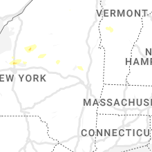


Connect with Interactive Hail Maps