

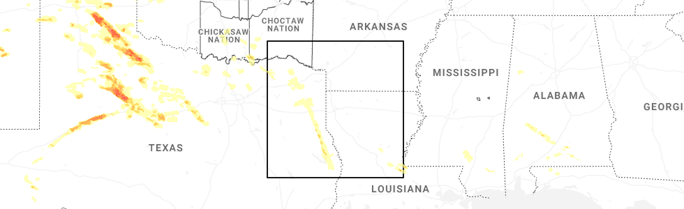
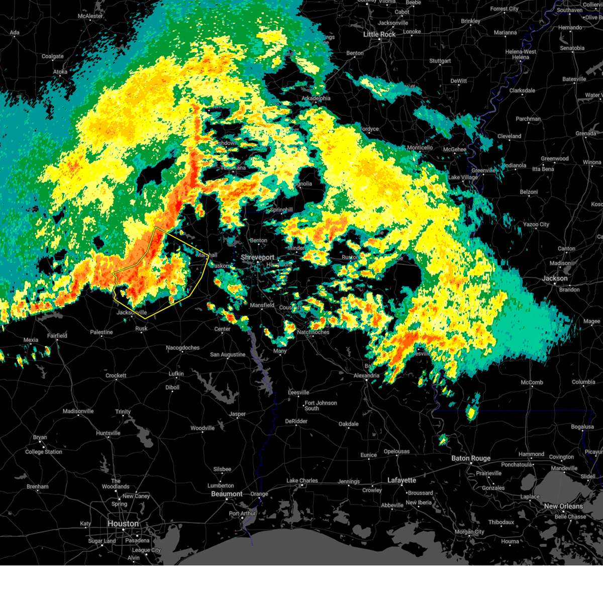
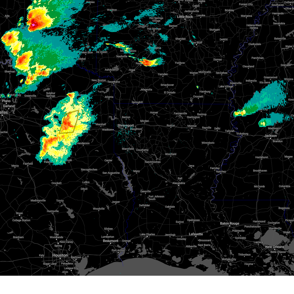
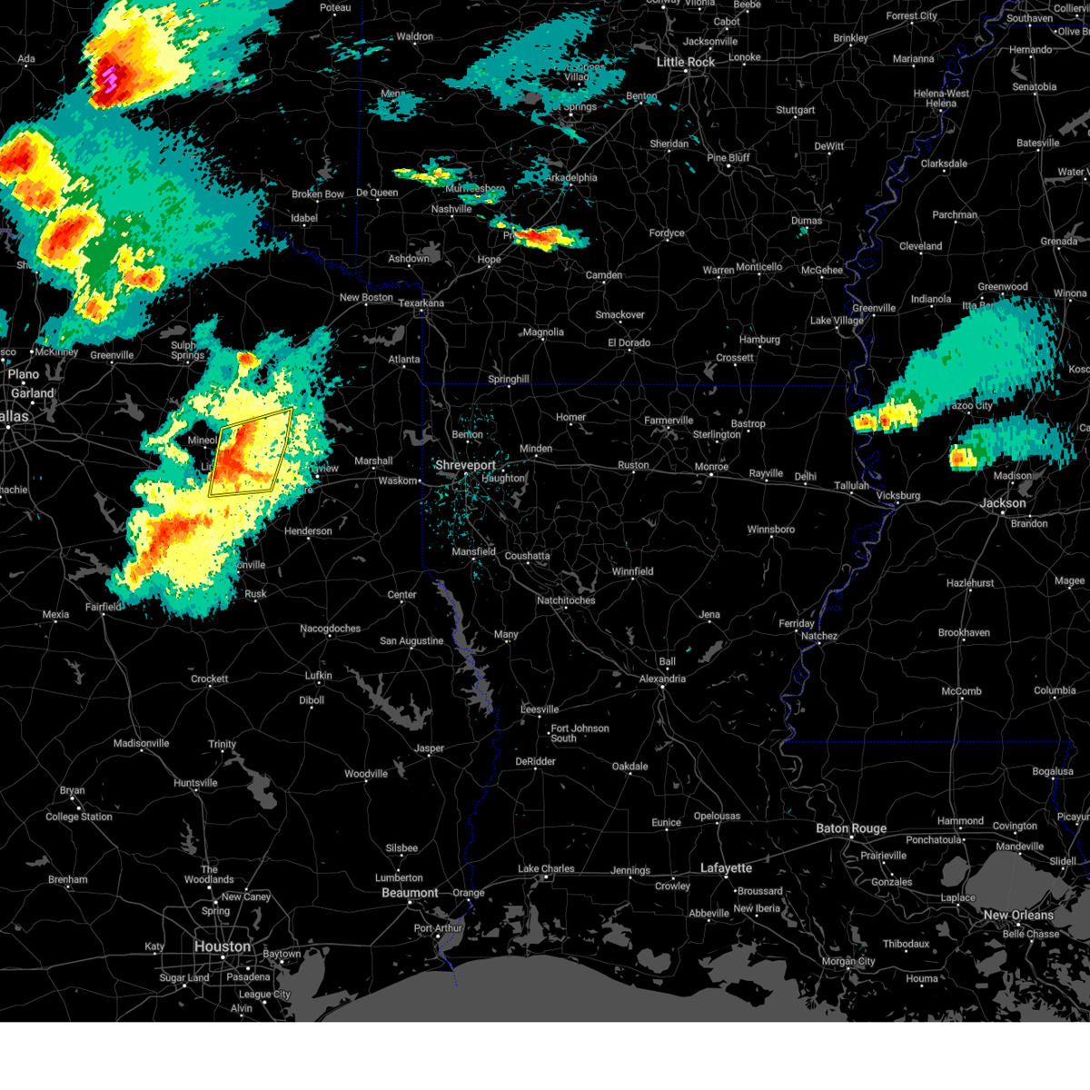
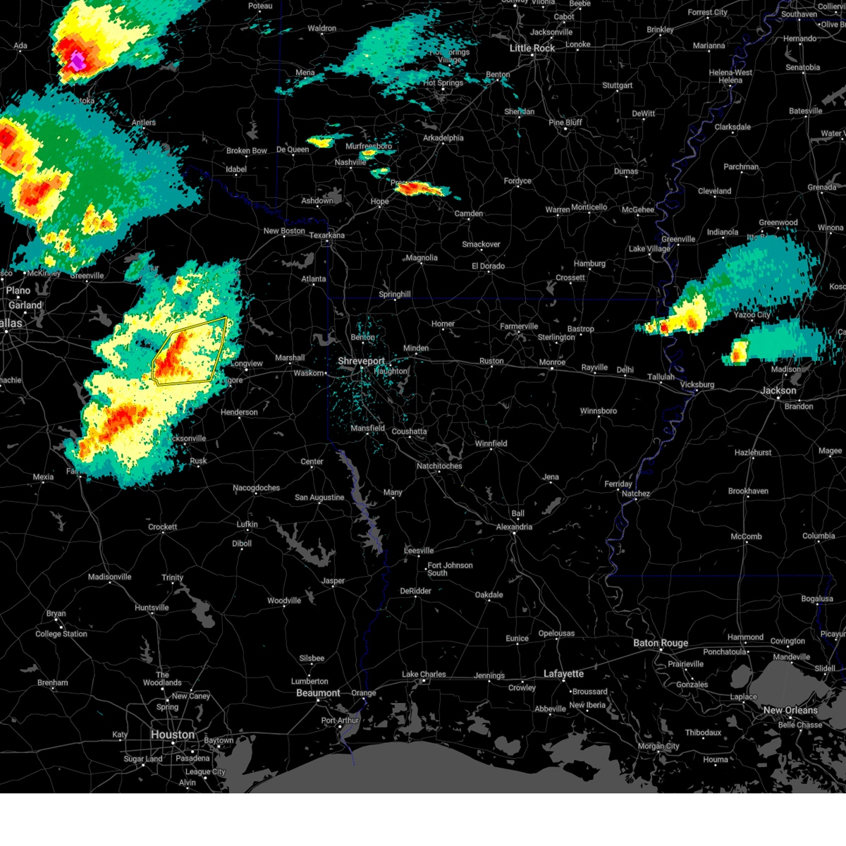
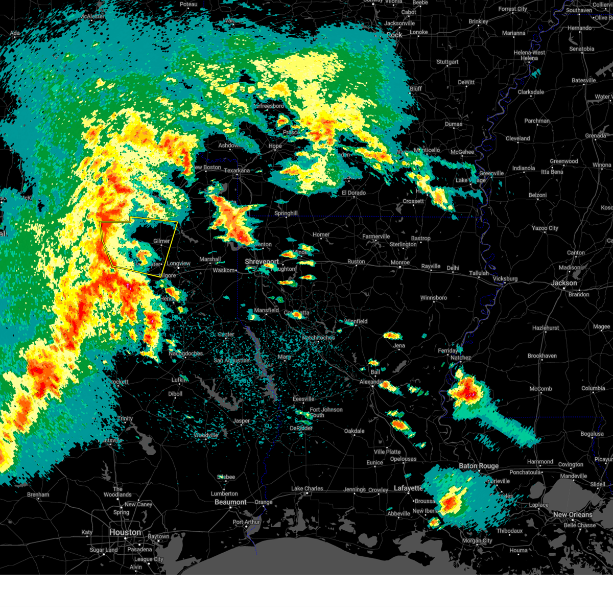
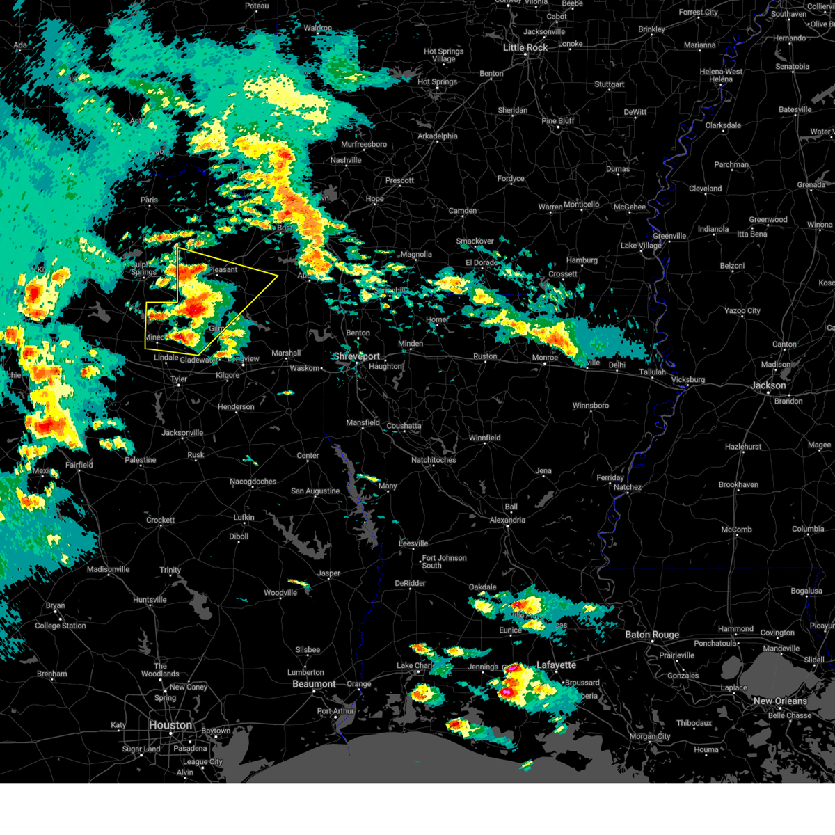
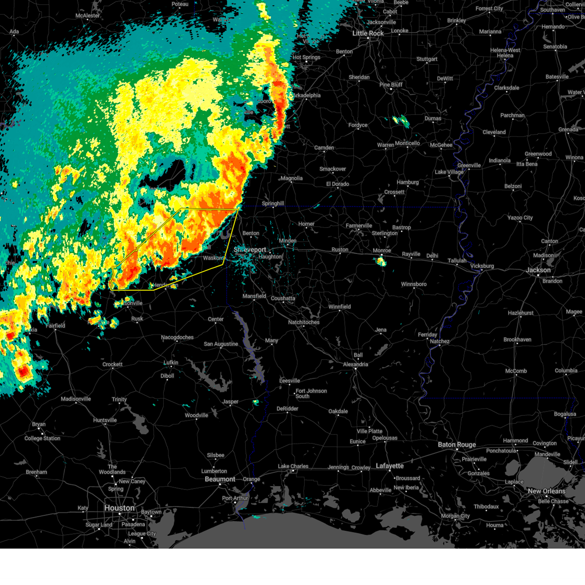
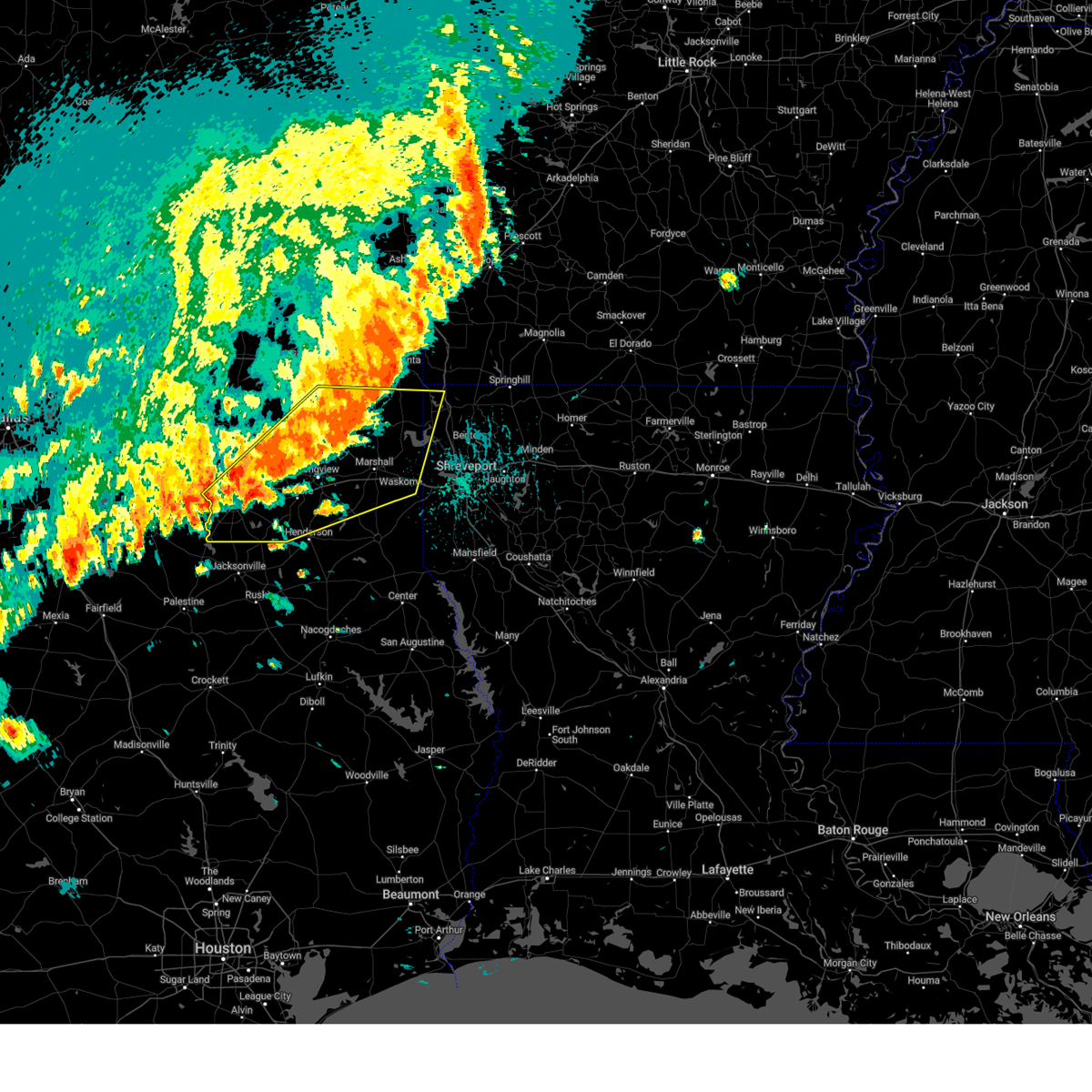
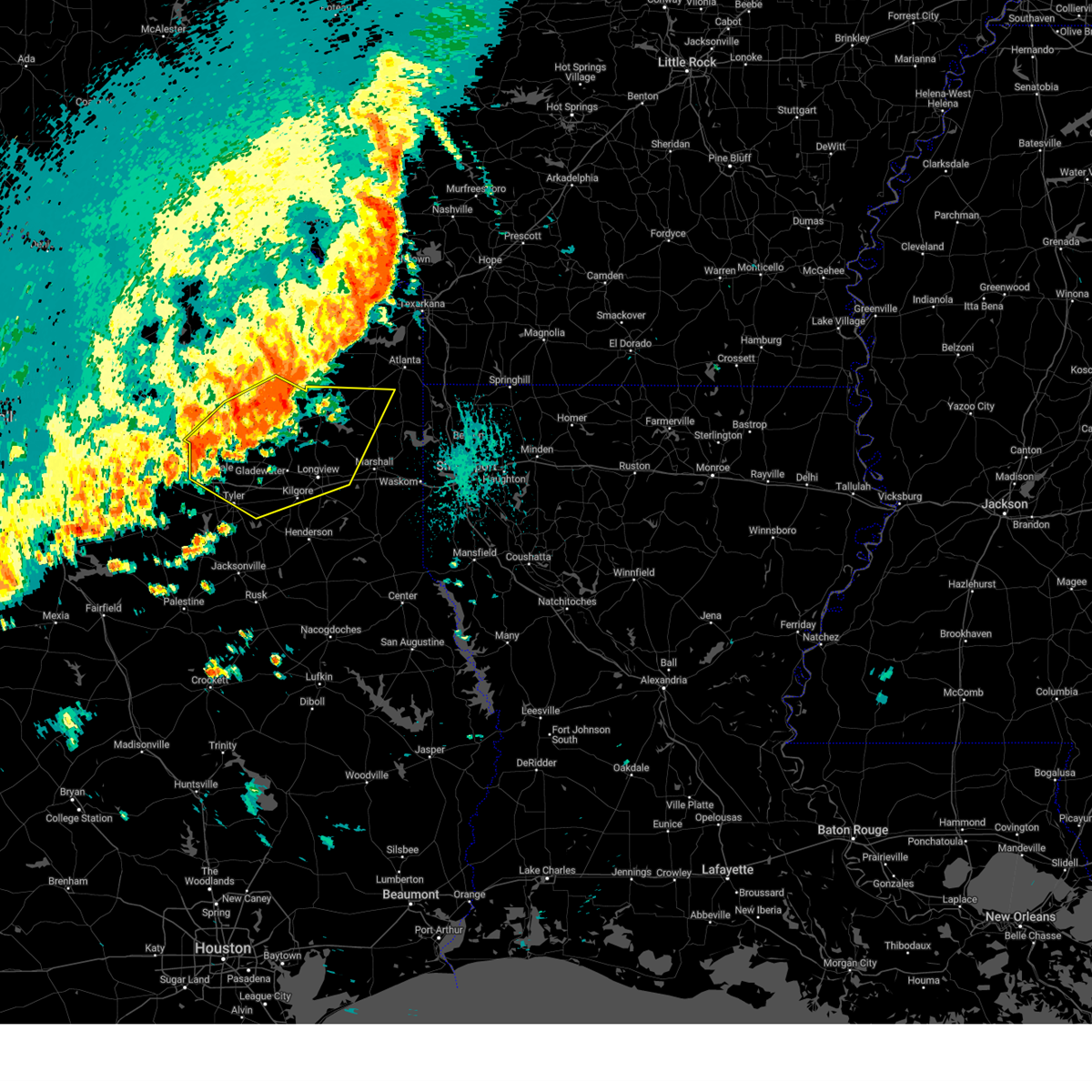
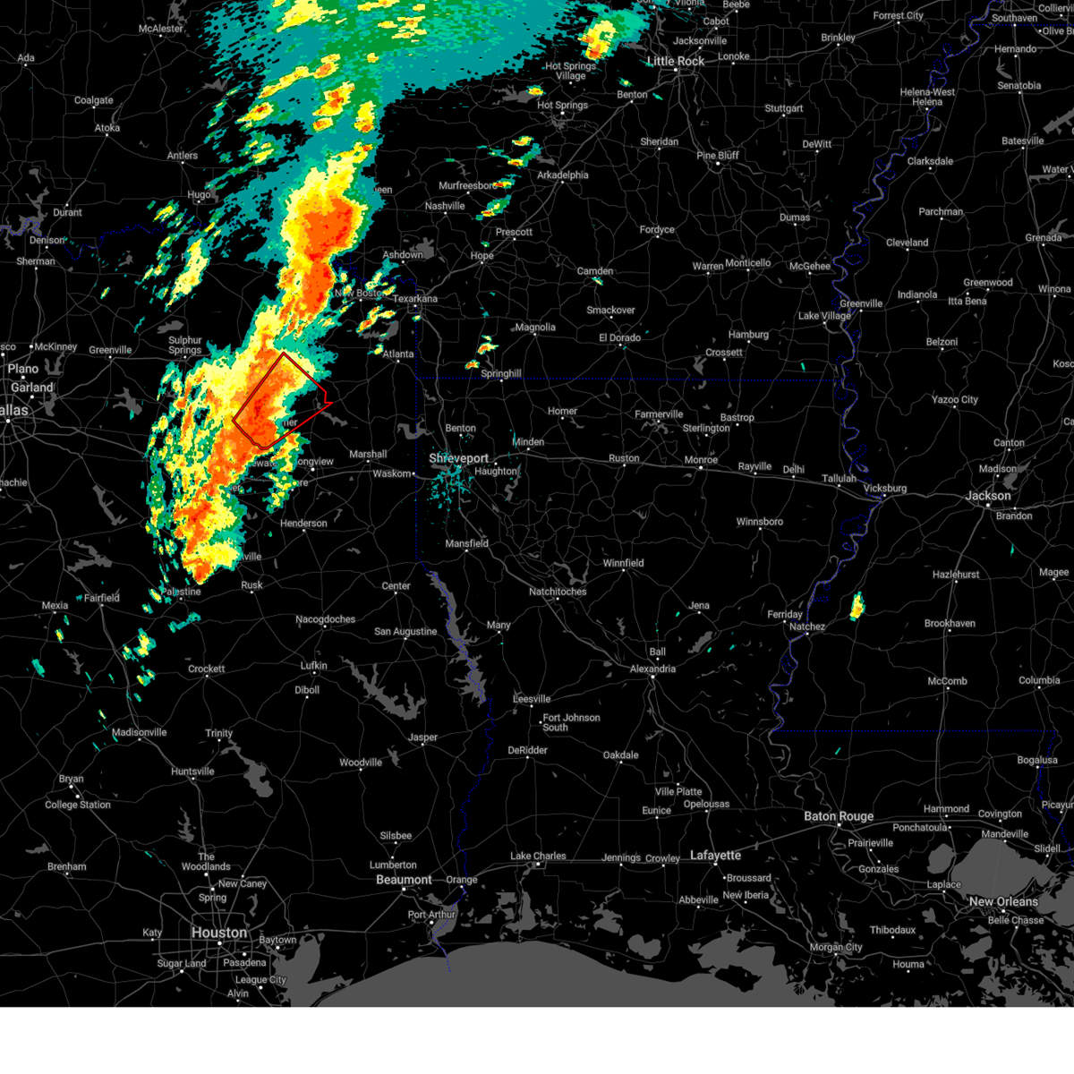
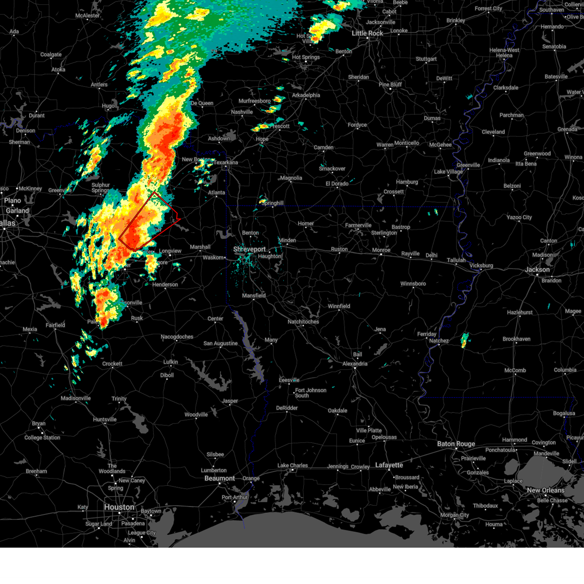
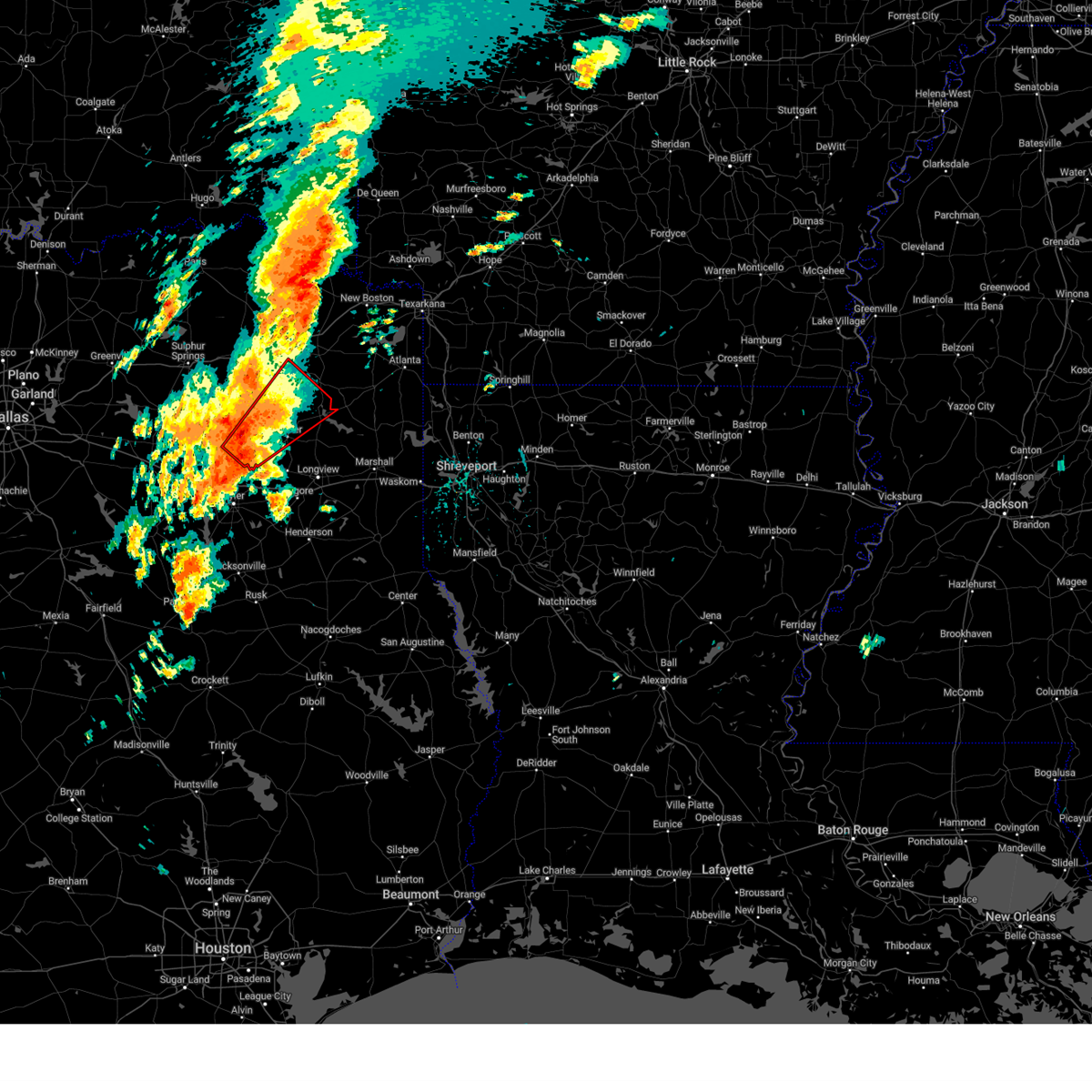
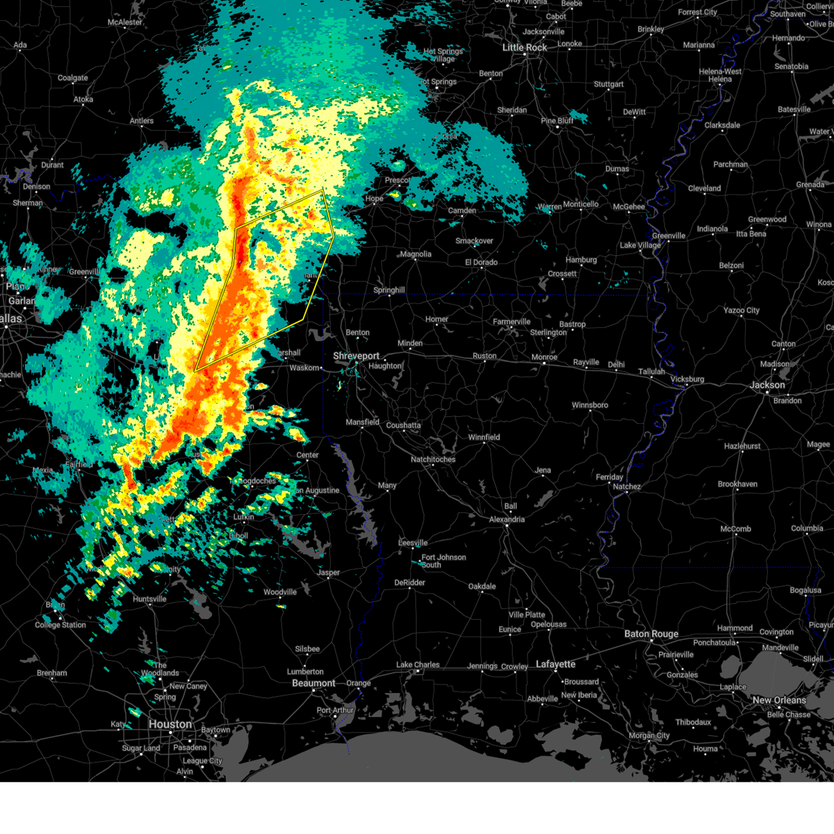
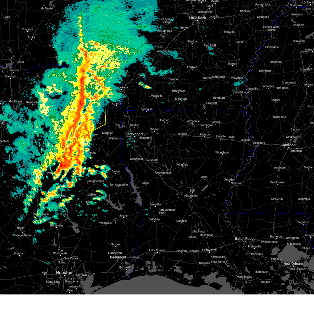
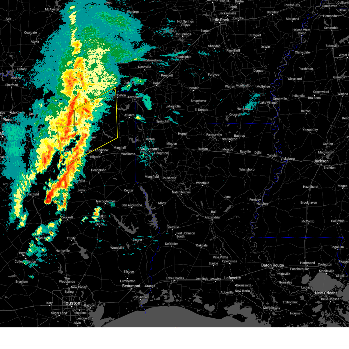
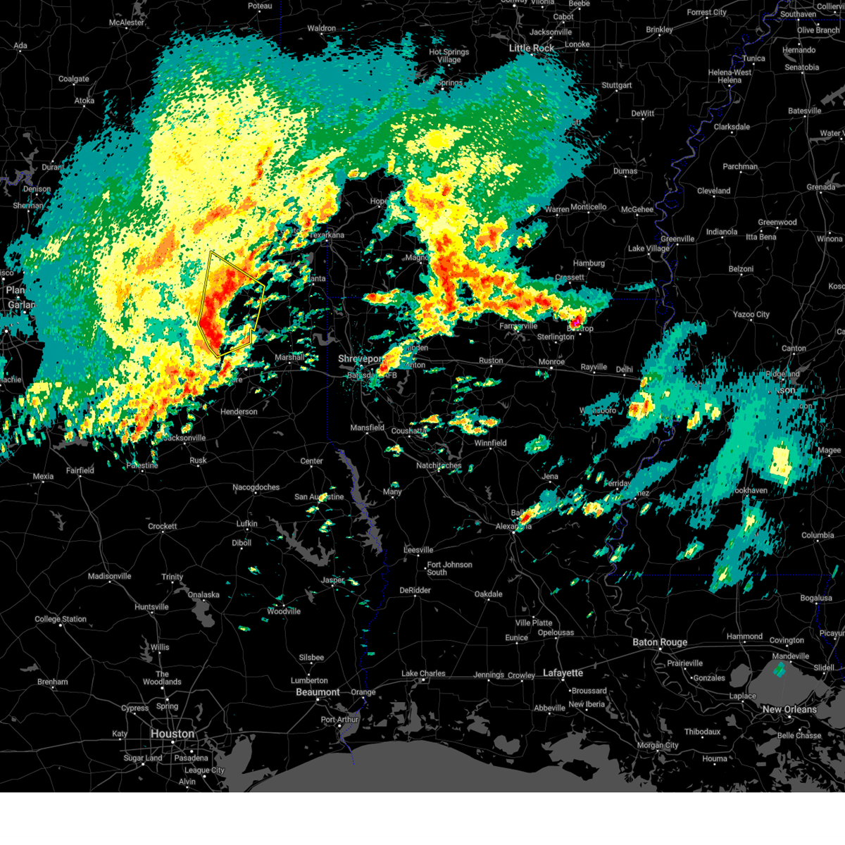
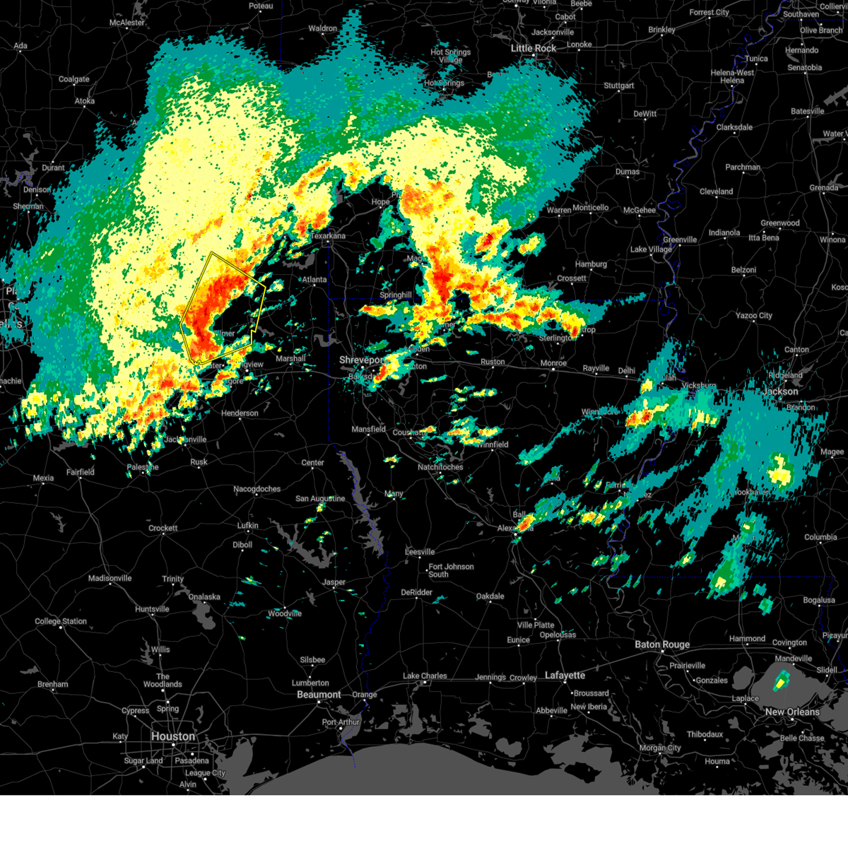
Hail Map for Gilmer, TX
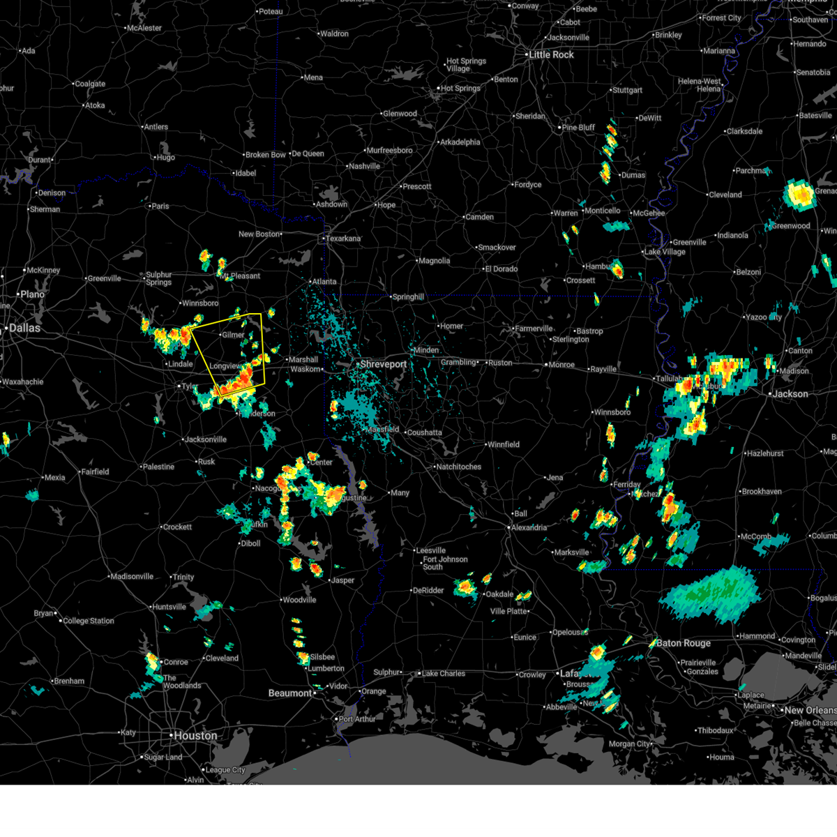
The Gilmer, TX area has had 16 reports of on-the-ground hail by trained spotters, and has been under severe weather warnings 28 times during the past 12 months. Doppler radar has detected hail at or near Gilmer, TX on 52 occasions, including 2 occasions during the past year.
| Name: | Gilmer, TX |
| Where Located: | 71.3 miles WNW of Shreveport, LA |
| Map: | Google Map for Gilmer, TX |
| Population: | 4905 |
| Housing Units: | 2149 |
| More Info: | Search Google for Gilmer, TX |
2
The Top Recent Hail Date for Gilmer, TX is Sunday, June 8, 2025 (15th out of 52)
Hail and Wind Damage Spotted near Gilmer, TX
| Date / Time | Report Details |
|---|---|
| 6/22/2025 5:51 PM CDT |
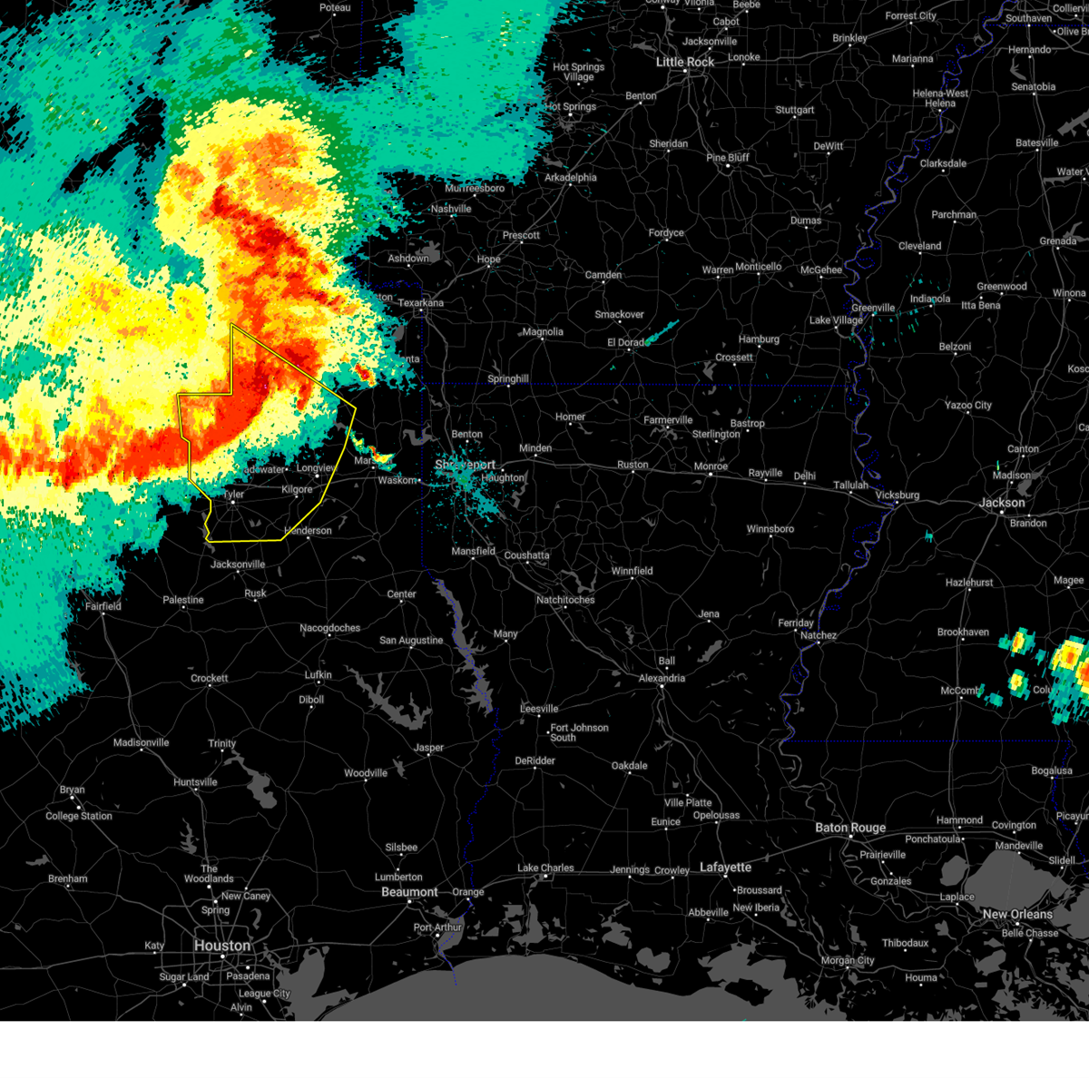
 Svrshv the national weather service in shreveport has issued a * severe thunderstorm warning for, east central smith county in northeastern texas, northwestern marion county in northeastern texas, western harrison county in northeastern texas, northwestern rusk county in northeastern texas, eastern wood county in northeastern texas, upshur county in northeastern texas, gregg county in northeastern texas, * until 615 pm cdt. * at 551 pm cdt, a severe thunderstorm was located near longview, moving north at 35 mph (radar indicated). Hazards include 60 mph wind gusts and nickel size hail. expect damage to roofs, siding, and trees Svrshv the national weather service in shreveport has issued a * severe thunderstorm warning for, east central smith county in northeastern texas, northwestern marion county in northeastern texas, western harrison county in northeastern texas, northwestern rusk county in northeastern texas, eastern wood county in northeastern texas, upshur county in northeastern texas, gregg county in northeastern texas, * until 615 pm cdt. * at 551 pm cdt, a severe thunderstorm was located near longview, moving north at 35 mph (radar indicated). Hazards include 60 mph wind gusts and nickel size hail. expect damage to roofs, siding, and trees
|
| 6/9/2025 12:41 AM CDT |
 At 1240 am cdt, severe thunderstorms were located along a line extending from near woodlawn to 7 miles northwest of tatum to near henderson to near troup to reese, moving southeast at 40 mph (radar indicated). Hazards include 70 mph wind gusts and quarter size hail. Hail damage to vehicles is expected. expect considerable tree damage. wind damage is also likely to mobile homes, roofs, and outbuildings. Locations impacted include, tyler, longview, marshall, jacksonville, henderson, kilgore, whitehouse, carthage, white oak, gladewater, rusk, gilmer, lindale, hallsville, daingerfield, overton, bullard, waskom, jefferson, and troup. At 1240 am cdt, severe thunderstorms were located along a line extending from near woodlawn to 7 miles northwest of tatum to near henderson to near troup to reese, moving southeast at 40 mph (radar indicated). Hazards include 70 mph wind gusts and quarter size hail. Hail damage to vehicles is expected. expect considerable tree damage. wind damage is also likely to mobile homes, roofs, and outbuildings. Locations impacted include, tyler, longview, marshall, jacksonville, henderson, kilgore, whitehouse, carthage, white oak, gladewater, rusk, gilmer, lindale, hallsville, daingerfield, overton, bullard, waskom, jefferson, and troup.
|
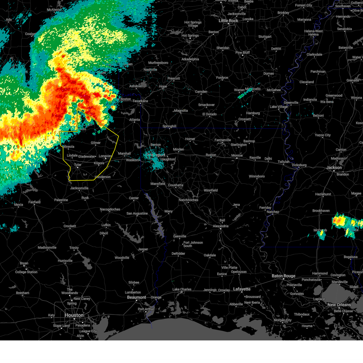
| 6/9/2025 12:06 AM CDT | Svrshv the national weather service in shreveport has issued a * severe thunderstorm warning for, western marion county in northeastern texas, rusk county in northeastern texas, northwestern shelby county in eastern texas, upshur county in northeastern texas, southeastern titus county in northeastern texas, smith county in northeastern texas, southwestern cass county in northeastern texas, harrison county in northeastern texas, panola county in northeastern texas, northwestern nacogdoches county in eastern texas, southeastern wood county in northeastern texas, southern morris county in northeastern texas, southeastern camp county in northeastern texas, gregg county in northeastern texas, cherokee county in northeastern texas, * until 115 am cdt. * at 1203 am cdt, severe thunderstorms were located along a line extending from near jenkins to near east mountain to 7 miles west of liberty city to near tyler to brownsboro, moving southeast at 40 mph. these are destructive storms for the city of longview, tx and surrounding areas (emergency management). Hazards include 80 mph wind gusts and quarter size hail. Flying debris will be dangerous to those caught without shelter. mobile homes will be heavily damaged. expect considerable damage to roofs, windows, and vehicles. Extensive tree damage and power outages are likely. |
| 6/8/2025 11:38 PM CDT |
 At 1135 pm cdt, severe thunderstorms were located along a line extending from near mount pleasant to 6 miles south of scroggins to near grand saline to near kaufman, moving east at 50 mph. these are destructive storms including the cities of and areas around gilmer, tx and pittsburg, tx (radar indicated). Hazards include 80 mph wind gusts and half dollar size hail. Flying debris will be dangerous to those caught without shelter. mobile homes will be heavily damaged. expect considerable damage to roofs, windows, and vehicles. extensive tree damage and power outages are likely. Locations impacted include, tyler, longview, mount pleasant, kilgore, whitehouse, white oak, gladewater, gilmer, mineola, pittsburg, winnsboro, leesburg, lindale, mount vernon, daingerfield, overton, bullard, troup, quitman, and lone star. At 1135 pm cdt, severe thunderstorms were located along a line extending from near mount pleasant to 6 miles south of scroggins to near grand saline to near kaufman, moving east at 50 mph. these are destructive storms including the cities of and areas around gilmer, tx and pittsburg, tx (radar indicated). Hazards include 80 mph wind gusts and half dollar size hail. Flying debris will be dangerous to those caught without shelter. mobile homes will be heavily damaged. expect considerable damage to roofs, windows, and vehicles. extensive tree damage and power outages are likely. Locations impacted include, tyler, longview, mount pleasant, kilgore, whitehouse, white oak, gladewater, gilmer, mineola, pittsburg, winnsboro, leesburg, lindale, mount vernon, daingerfield, overton, bullard, troup, quitman, and lone star.
|
| 6/8/2025 10:59 PM CDT |
 Svrshv the national weather service in shreveport has issued a * severe thunderstorm warning for, smith county in northeastern texas, western marion county in northeastern texas, southwestern cass county in northeastern texas, northwestern harrison county in northeastern texas, franklin county in northeastern texas, northwestern rusk county in northeastern texas, wood county in northeastern texas, upshur county in northeastern texas, southern morris county in northeastern texas, southern titus county in northeastern texas, camp county in northeastern texas, gregg county in northeastern texas, * until 1215 am cdt. * at 1058 pm cdt, severe thunderstorms were located along a line extending from 9 miles northeast of cooper lake state park to near sulphur springs to near hawk cove to near dallas, moving southeast at 50 mph (radar indicated). Hazards include 70 mph wind gusts and half dollar size hail. Hail damage to vehicles is expected. expect considerable tree damage. Wind damage is also likely to mobile homes, roofs, and outbuildings. Svrshv the national weather service in shreveport has issued a * severe thunderstorm warning for, smith county in northeastern texas, western marion county in northeastern texas, southwestern cass county in northeastern texas, northwestern harrison county in northeastern texas, franklin county in northeastern texas, northwestern rusk county in northeastern texas, wood county in northeastern texas, upshur county in northeastern texas, southern morris county in northeastern texas, southern titus county in northeastern texas, camp county in northeastern texas, gregg county in northeastern texas, * until 1215 am cdt. * at 1058 pm cdt, severe thunderstorms were located along a line extending from 9 miles northeast of cooper lake state park to near sulphur springs to near hawk cove to near dallas, moving southeast at 50 mph (radar indicated). Hazards include 70 mph wind gusts and half dollar size hail. Hail damage to vehicles is expected. expect considerable tree damage. Wind damage is also likely to mobile homes, roofs, and outbuildings.
|
| 6/8/2025 11:58 AM CDT | Social media report of 68mph sustained winds recorded via personal weather statio in upshur county TX, 0.2 miles WNW of Gilmer, TX |
| 5/26/2025 5:28 AM CDT |
 Svrshv the national weather service in shreveport has issued a * severe thunderstorm warning for, smith county in northeastern texas, southwestern harrison county in northeastern texas, northwestern panola county in northeastern texas, northern rusk county in northeastern texas, central upshur county in northeastern texas, gregg county in northeastern texas, northern cherokee county in northeastern texas, * until 630 am cdt. * at 527 am cdt, severe thunderstorms were located along a line extending from near gilmer to gladewater to 9 miles northwest of overton to lake palestine, moving southeast at 35 mph (radar indicated). Hazards include 60 mph wind gusts and nickel size hail. expect damage to roofs, siding, and trees Svrshv the national weather service in shreveport has issued a * severe thunderstorm warning for, smith county in northeastern texas, southwestern harrison county in northeastern texas, northwestern panola county in northeastern texas, northern rusk county in northeastern texas, central upshur county in northeastern texas, gregg county in northeastern texas, northern cherokee county in northeastern texas, * until 630 am cdt. * at 527 am cdt, severe thunderstorms were located along a line extending from near gilmer to gladewater to 9 miles northwest of overton to lake palestine, moving southeast at 35 mph (radar indicated). Hazards include 60 mph wind gusts and nickel size hail. expect damage to roofs, siding, and trees
|
| 5/17/2025 8:29 PM CDT |
 At 829 pm cdt, a severe thunderstorm was located near east mountain, or 7 miles north of longview, moving east at 35 mph (radar indicated). Hazards include 60 mph wind gusts and quarter size hail. Hail damage to vehicles is expected. expect wind damage to roofs, siding, and trees. Locations impacted include, diana, warren city, longview, gladewater, liberty city, gilmer, ore city, west mountain, white oak, bettie, harleton, union grove, east mountain, hallsville, cedar springs, pritchett, judson, clarksville city, and kilgore. At 829 pm cdt, a severe thunderstorm was located near east mountain, or 7 miles north of longview, moving east at 35 mph (radar indicated). Hazards include 60 mph wind gusts and quarter size hail. Hail damage to vehicles is expected. expect wind damage to roofs, siding, and trees. Locations impacted include, diana, warren city, longview, gladewater, liberty city, gilmer, ore city, west mountain, white oak, bettie, harleton, union grove, east mountain, hallsville, cedar springs, pritchett, judson, clarksville city, and kilgore.
|
| 5/17/2025 8:20 PM CDT |
 At 819 pm cdt, a severe thunderstorm was located over east mountain, or near white oak, moving east at 35 mph (radar indicated). Hazards include 60 mph wind gusts and quarter size hail. Hail damage to vehicles is expected. expect wind damage to roofs, siding, and trees. Locations impacted include, diana, warren city, longview, gladewater, liberty city, big sandy, gilmer, winona, ore city, west mountain, white oak, bettie, harleton, union grove, east mountain, midway, hallsville, cedar springs, pritchett, and judson. At 819 pm cdt, a severe thunderstorm was located over east mountain, or near white oak, moving east at 35 mph (radar indicated). Hazards include 60 mph wind gusts and quarter size hail. Hail damage to vehicles is expected. expect wind damage to roofs, siding, and trees. Locations impacted include, diana, warren city, longview, gladewater, liberty city, big sandy, gilmer, winona, ore city, west mountain, white oak, bettie, harleton, union grove, east mountain, midway, hallsville, cedar springs, pritchett, and judson.
|
| 5/17/2025 8:20 PM CDT |
 the severe thunderstorm warning has been cancelled and is no longer in effect the severe thunderstorm warning has been cancelled and is no longer in effect
|
| 5/17/2025 8:15 PM CDT | Trees down near intersection of hwy 155 and fm road 268 in upshur county TX, 2.4 miles NNE of Gilmer, TX |
| 5/17/2025 8:08 PM CDT |
 Svrshv the national weather service in shreveport has issued a * severe thunderstorm warning for, northeastern smith county in northeastern texas, western marion county in northeastern texas, southwestern cass county in northeastern texas, northwestern harrison county in northeastern texas, southeastern wood county in northeastern texas, upshur county in northeastern texas, southeastern morris county in northeastern texas, gregg county in northeastern texas, * until 915 pm cdt. * at 808 pm cdt, a severe thunderstorm was located near west mountain, or near gilmer, moving east at 40 mph (radar indicated). Hazards include 60 mph wind gusts and quarter size hail. Hail damage to vehicles is expected. Expect wind damage to roofs, siding, and trees. Svrshv the national weather service in shreveport has issued a * severe thunderstorm warning for, northeastern smith county in northeastern texas, western marion county in northeastern texas, southwestern cass county in northeastern texas, northwestern harrison county in northeastern texas, southeastern wood county in northeastern texas, upshur county in northeastern texas, southeastern morris county in northeastern texas, gregg county in northeastern texas, * until 915 pm cdt. * at 808 pm cdt, a severe thunderstorm was located near west mountain, or near gilmer, moving east at 40 mph (radar indicated). Hazards include 60 mph wind gusts and quarter size hail. Hail damage to vehicles is expected. Expect wind damage to roofs, siding, and trees.
|
| 5/17/2025 7:51 PM CDT |
 At 751 pm cdt, severe thunderstorms were located along a line extending from near rosewood to near hawkins to 8 miles east of lindale, moving east at 30 mph (radar indicated). Hazards include 60 mph wind gusts and quarter size hail. Hail damage to vehicles is expected. expect wind damage to roofs, siding, and trees. Locations impacted include, red springs, gilmer, rosewood, hawkins, winona, big sandy, bettie, midway, grice, and pritchett. At 751 pm cdt, severe thunderstorms were located along a line extending from near rosewood to near hawkins to 8 miles east of lindale, moving east at 30 mph (radar indicated). Hazards include 60 mph wind gusts and quarter size hail. Hail damage to vehicles is expected. expect wind damage to roofs, siding, and trees. Locations impacted include, red springs, gilmer, rosewood, hawkins, winona, big sandy, bettie, midway, grice, and pritchett.
|
| 5/17/2025 7:40 PM CDT |
 At 740 pm cdt, severe thunderstorms were located along a line extending from 6 miles west of rosewood to near hawkins to near lindale, moving east at 30 mph (radar indicated). Hazards include 60 mph wind gusts and quarter size hail. Hail damage to vehicles is expected. expect wind damage to roofs, siding, and trees. Locations impacted include, red springs, rosewood, hawkins, lindale, hoard, big sandy, gilmer, winona, bettie, midway, grice, hainesville, and pritchett. At 740 pm cdt, severe thunderstorms were located along a line extending from 6 miles west of rosewood to near hawkins to near lindale, moving east at 30 mph (radar indicated). Hazards include 60 mph wind gusts and quarter size hail. Hail damage to vehicles is expected. expect wind damage to roofs, siding, and trees. Locations impacted include, red springs, rosewood, hawkins, lindale, hoard, big sandy, gilmer, winona, bettie, midway, grice, hainesville, and pritchett.
|
| 5/17/2025 7:26 PM CDT |
 Svrshv the national weather service in shreveport has issued a * severe thunderstorm warning for, northern smith county in northeastern texas, southeastern wood county in northeastern texas, western upshur county in northeastern texas, * until 815 pm cdt. * at 726 pm cdt, severe thunderstorms were located along a line extending from near hainesville to near hoard to near lindale, moving east at 30 mph (radar indicated). Hazards include 60 mph wind gusts and quarter size hail. Hail damage to vehicles is expected. Expect wind damage to roofs, siding, and trees. Svrshv the national weather service in shreveport has issued a * severe thunderstorm warning for, northern smith county in northeastern texas, southeastern wood county in northeastern texas, western upshur county in northeastern texas, * until 815 pm cdt. * at 726 pm cdt, severe thunderstorms were located along a line extending from near hainesville to near hoard to near lindale, moving east at 30 mph (radar indicated). Hazards include 60 mph wind gusts and quarter size hail. Hail damage to vehicles is expected. Expect wind damage to roofs, siding, and trees.
|
| 5/6/2025 12:55 PM CDT |
 Svrshv the national weather service in shreveport has issued a * severe thunderstorm warning for, northern smith county in northeastern texas, southwestern franklin county in northeastern texas, wood county in northeastern texas, upshur county in northeastern texas, southwestern morris county in northeastern texas, southern camp county in northeastern texas, west central gregg county in northeastern texas, * until 145 pm cdt. * at 1255 pm cdt, a severe thunderstorm was located over tyler, moving north at 60 mph (radar indicated). Hazards include 60 mph wind gusts and quarter size hail. Hail damage to vehicles is expected. Expect wind damage to roofs, siding, and trees. Svrshv the national weather service in shreveport has issued a * severe thunderstorm warning for, northern smith county in northeastern texas, southwestern franklin county in northeastern texas, wood county in northeastern texas, upshur county in northeastern texas, southwestern morris county in northeastern texas, southern camp county in northeastern texas, west central gregg county in northeastern texas, * until 145 pm cdt. * at 1255 pm cdt, a severe thunderstorm was located over tyler, moving north at 60 mph (radar indicated). Hazards include 60 mph wind gusts and quarter size hail. Hail damage to vehicles is expected. Expect wind damage to roofs, siding, and trees.
|
| 5/6/2025 10:47 AM CDT |
 Svrshv the national weather service in shreveport has issued a * severe thunderstorm warning for, camp county in northeastern texas, west central cass county in northeastern texas, franklin county in northeastern texas, morris county in northeastern texas, northwestern smith county in northeastern texas, titus county in northeastern texas, northwestern upshur county in northeastern texas, wood county in northeastern texas, * until 1130 am cdt. * at 1047 am cdt, a severe thunderstorm was located near newsome, or 6 miles southwest of leesburg, moving northeast at 35 mph (radar indicated). Hazards include 60 mph wind gusts and quarter size hail. Hail damage to vehicles is expected. Expect wind damage to roofs, siding, and trees. Svrshv the national weather service in shreveport has issued a * severe thunderstorm warning for, camp county in northeastern texas, west central cass county in northeastern texas, franklin county in northeastern texas, morris county in northeastern texas, northwestern smith county in northeastern texas, titus county in northeastern texas, northwestern upshur county in northeastern texas, wood county in northeastern texas, * until 1130 am cdt. * at 1047 am cdt, a severe thunderstorm was located near newsome, or 6 miles southwest of leesburg, moving northeast at 35 mph (radar indicated). Hazards include 60 mph wind gusts and quarter size hail. Hail damage to vehicles is expected. Expect wind damage to roofs, siding, and trees.
|
| 4/30/2025 3:46 PM CDT |
 At 346 pm cdt, severe thunderstorms were located along a line from near kildare to near liberty city, or along a line from 11 miles south of atlanta to 5 miles west of kilgore, moving east at 35 mph (radar indicated). Hazards include 60 mph wind gusts and quarter size hail. Hail damage to vehicles is expected. expect wind damage to roofs, siding, and trees. Locations impacted include, tyler, longview, marshall, henderson, kilgore, whitehouse, white oak, gladewater, gilmer, vivian, hallsville, overton, bullard, waskom, jefferson, troup, lone star, tatum, big sandy and ore city. At 346 pm cdt, severe thunderstorms were located along a line from near kildare to near liberty city, or along a line from 11 miles south of atlanta to 5 miles west of kilgore, moving east at 35 mph (radar indicated). Hazards include 60 mph wind gusts and quarter size hail. Hail damage to vehicles is expected. expect wind damage to roofs, siding, and trees. Locations impacted include, tyler, longview, marshall, henderson, kilgore, whitehouse, white oak, gladewater, gilmer, vivian, hallsville, overton, bullard, waskom, jefferson, troup, lone star, tatum, big sandy and ore city.
|
| 4/30/2025 3:46 PM CDT |
 the severe thunderstorm warning has been cancelled and is no longer in effect the severe thunderstorm warning has been cancelled and is no longer in effect
|
| 4/30/2025 3:14 PM CDT |
 Svrshv the national weather service in shreveport has issued a * severe thunderstorm warning for, northwestern caddo parish in northwestern louisiana, southeastern camp county in northeastern texas, southern cass county in northeastern texas, gregg county in northeastern texas, harrison county in northeastern texas, marion county in northeastern texas, southern morris county in northeastern texas, northwestern panola county in northeastern texas, northern rusk county in northeastern texas, smith county in northeastern texas, upshur county in northeastern texas, southeastern wood county in northeastern texas, * until 415 pm cdt. * at 314 pm cdt, severe thunderstorms were located along a line from near hughes springs to 8 miles southeast of lindale, or along a line from 23 miles east of pittsburg to 9 miles north of tyler, moving east at 35 mph (radar indicated). Hazards include 60 mph wind gusts and small hail. expect damage to roofs, siding, and trees Svrshv the national weather service in shreveport has issued a * severe thunderstorm warning for, northwestern caddo parish in northwestern louisiana, southeastern camp county in northeastern texas, southern cass county in northeastern texas, gregg county in northeastern texas, harrison county in northeastern texas, marion county in northeastern texas, southern morris county in northeastern texas, northwestern panola county in northeastern texas, northern rusk county in northeastern texas, smith county in northeastern texas, upshur county in northeastern texas, southeastern wood county in northeastern texas, * until 415 pm cdt. * at 314 pm cdt, severe thunderstorms were located along a line from near hughes springs to 8 miles southeast of lindale, or along a line from 23 miles east of pittsburg to 9 miles north of tyler, moving east at 35 mph (radar indicated). Hazards include 60 mph wind gusts and small hail. expect damage to roofs, siding, and trees
|
| 4/30/2025 2:37 PM CDT | Dispatch report of trees down near s cypress s in upshur county TX, 0.2 miles WNW of Gilmer, TX |
| 4/30/2025 2:20 PM CDT |
 Svrshv the national weather service in shreveport has issued a * severe thunderstorm warning for, camp county in northeastern texas, southwestern cass county in northeastern texas, south central franklin county in northeastern texas, gregg county in northeastern texas, northwestern harrison county in northeastern texas, western marion county in northeastern texas, southern morris county in northeastern texas, northwestern rusk county in northeastern texas, central smith county in northeastern texas, upshur county in northeastern texas, wood county in northeastern texas, * until 315 pm cdt. * at 220 pm cdt, severe thunderstorms were located along a line from near pittsburg to 11 miles southwest of mineola, moving east at 35 mph (radar indicated). Hazards include 60 mph wind gusts and small hail. expect damage to roofs, siding, and trees Svrshv the national weather service in shreveport has issued a * severe thunderstorm warning for, camp county in northeastern texas, southwestern cass county in northeastern texas, south central franklin county in northeastern texas, gregg county in northeastern texas, northwestern harrison county in northeastern texas, western marion county in northeastern texas, southern morris county in northeastern texas, northwestern rusk county in northeastern texas, central smith county in northeastern texas, upshur county in northeastern texas, wood county in northeastern texas, * until 315 pm cdt. * at 220 pm cdt, severe thunderstorms were located along a line from near pittsburg to 11 miles southwest of mineola, moving east at 35 mph (radar indicated). Hazards include 60 mph wind gusts and small hail. expect damage to roofs, siding, and trees
|
| 4/4/2025 5:18 PM CDT | Quarter sized hail reported 8.2 miles S of Gilmer, TX |
| 4/4/2025 5:05 PM CDT | Structural damage at union hill elementary. possible tornad in upshur county TX, 5.8 miles SSE of Gilmer, TX |
| 4/4/2025 4:58 PM CDT |
 At 458 pm cdt, a confirmed large and extremely dangerous tornado was located over rosewood, or near gilmer, moving northeast at 30 mph. this is a particularly dangerous situation. take cover now! (radar confirmed tornado). Hazards include damaging tornado. You are in a life-threatening situation. flying debris may be deadly to those caught without shelter. mobile homes will be destroyed. considerable damage to homes, businesses, and vehicles is likely and complete destruction is possible. the tornado will be near, gilmer around 505 pm cdt. lone star around 535 pm cdt. Other locations impacted by this tornadic thunderstorm include roeder, rocky mound, harvard, lafayette, perryville, center point, holly springs, bettie, midway, and grice. At 458 pm cdt, a confirmed large and extremely dangerous tornado was located over rosewood, or near gilmer, moving northeast at 30 mph. this is a particularly dangerous situation. take cover now! (radar confirmed tornado). Hazards include damaging tornado. You are in a life-threatening situation. flying debris may be deadly to those caught without shelter. mobile homes will be destroyed. considerable damage to homes, businesses, and vehicles is likely and complete destruction is possible. the tornado will be near, gilmer around 505 pm cdt. lone star around 535 pm cdt. Other locations impacted by this tornadic thunderstorm include roeder, rocky mound, harvard, lafayette, perryville, center point, holly springs, bettie, midway, and grice.
|
| 4/4/2025 4:46 PM CDT |
 At 446 pm cdt, a confirmed large and extremely dangerous tornado was located over rosewood, or 10 miles west of gilmer, moving northeast at 45 mph. this is a particularly dangerous situation. take cover now! (radar confirmed tornado). Hazards include damaging tornado. You are in a life-threatening situation. flying debris may be deadly to those caught without shelter. mobile homes will be destroyed. considerable damage to homes, businesses, and vehicles is likely and complete destruction is possible. the tornado will be near, rosewood around 450 pm cdt. cason around 520 pm cdt. Other locations impacted by this tornadic thunderstorm include roeder, rocky mound, harvard, lafayette, perryville, center point, holly springs, bettie, midway, and grice. At 446 pm cdt, a confirmed large and extremely dangerous tornado was located over rosewood, or 10 miles west of gilmer, moving northeast at 45 mph. this is a particularly dangerous situation. take cover now! (radar confirmed tornado). Hazards include damaging tornado. You are in a life-threatening situation. flying debris may be deadly to those caught without shelter. mobile homes will be destroyed. considerable damage to homes, businesses, and vehicles is likely and complete destruction is possible. the tornado will be near, rosewood around 450 pm cdt. cason around 520 pm cdt. Other locations impacted by this tornadic thunderstorm include roeder, rocky mound, harvard, lafayette, perryville, center point, holly springs, bettie, midway, and grice.
|
| 4/4/2025 4:37 PM CDT |
 Torshv the national weather service in shreveport has issued a * tornado warning for, western marion county in northeastern texas, southeastern wood county in northeastern texas, upshur county in northeastern texas, southern morris county in northeastern texas, southeastern titus county in northeastern texas, camp county in northeastern texas, * until 530 pm cdt. * at 436 pm cdt, a tornado producing storm was located near hawkins, or 15 miles west of gilmer, moving northeast at 45 mph (radar confirmed tornado). Hazards include damaging tornado and quarter size hail. Flying debris will be dangerous to those caught without shelter. mobile homes will be damaged or destroyed. damage to roofs, windows, and vehicles will occur. tree damage is likely. this tornadic storm will be near, rosewood around 445 pm cdt. cason around 520 pm cdt. Other locations impacted by this tornadic thunderstorm include roeder, rocky mound, harvard, lafayette, perryville, center point, holly springs, bettie, midway, and grice. Torshv the national weather service in shreveport has issued a * tornado warning for, western marion county in northeastern texas, southeastern wood county in northeastern texas, upshur county in northeastern texas, southern morris county in northeastern texas, southeastern titus county in northeastern texas, camp county in northeastern texas, * until 530 pm cdt. * at 436 pm cdt, a tornado producing storm was located near hawkins, or 15 miles west of gilmer, moving northeast at 45 mph (radar confirmed tornado). Hazards include damaging tornado and quarter size hail. Flying debris will be dangerous to those caught without shelter. mobile homes will be damaged or destroyed. damage to roofs, windows, and vehicles will occur. tree damage is likely. this tornadic storm will be near, rosewood around 445 pm cdt. cason around 520 pm cdt. Other locations impacted by this tornadic thunderstorm include roeder, rocky mound, harvard, lafayette, perryville, center point, holly springs, bettie, midway, and grice.
|
| 3/4/2025 8:23 AM CST | Report from mping: 1-inch tree limbs broken; shingles blown of in upshur county TX, 1.5 miles N of Gilmer, TX |
| 3/4/2025 7:59 AM CST |
 Svrshv the national weather service in shreveport has issued a * severe thunderstorm warning for, southwestern little river county in southwestern arkansas, northwestern miller county in southwestern arkansas, bowie county in northeastern texas, eastern camp county in northeastern texas, cass county in northeastern texas, northwestern gregg county in northeastern texas, northwestern harrison county in northeastern texas, western marion county in northeastern texas, morris county in northeastern texas, southeastern red river county in northeastern texas, east central smith county in northeastern texas, southeastern titus county in northeastern texas, upshur county in northeastern texas, * until 845 am cst. * at 759 am cst, severe thunderstorms were located along a line from over de kalb to near gladewater, or along a line from 14 miles west of new boston to near gladewater, moving northeast at 60 mph (radar indicated). Hazards include 60 mph wind gusts and quarter size hail. Hail damage to vehicles is expected. Expect wind damage to roofs, siding, and trees. Svrshv the national weather service in shreveport has issued a * severe thunderstorm warning for, southwestern little river county in southwestern arkansas, northwestern miller county in southwestern arkansas, bowie county in northeastern texas, eastern camp county in northeastern texas, cass county in northeastern texas, northwestern gregg county in northeastern texas, northwestern harrison county in northeastern texas, western marion county in northeastern texas, morris county in northeastern texas, southeastern red river county in northeastern texas, east central smith county in northeastern texas, southeastern titus county in northeastern texas, upshur county in northeastern texas, * until 845 am cst. * at 759 am cst, severe thunderstorms were located along a line from over de kalb to near gladewater, or along a line from 14 miles west of new boston to near gladewater, moving northeast at 60 mph (radar indicated). Hazards include 60 mph wind gusts and quarter size hail. Hail damage to vehicles is expected. Expect wind damage to roofs, siding, and trees.
|
| 3/4/2025 7:42 AM CST |
 At 742 am cst, severe thunderstorms were located along a line from 8 miles west of arkinda to near cedar springs, or along a line from 13 miles west of foreman to 10 miles northeast of gilmer, moving northeast at 65 mph (radar indicated). Hazards include 60 mph wind gusts and small hail. Expect damage to roofs, siding, and trees. Locations impacted include, tyler, longview, mount pleasant, white oak, gladewater, gilmer, mineola, pittsburg, winnsboro, leesburg, lindale, daingerfield, hughes springs, de kalb, lone star, naples, big sandy, hawkins, ore city and omaha. At 742 am cst, severe thunderstorms were located along a line from 8 miles west of arkinda to near cedar springs, or along a line from 13 miles west of foreman to 10 miles northeast of gilmer, moving northeast at 65 mph (radar indicated). Hazards include 60 mph wind gusts and small hail. Expect damage to roofs, siding, and trees. Locations impacted include, tyler, longview, mount pleasant, white oak, gladewater, gilmer, mineola, pittsburg, winnsboro, leesburg, lindale, daingerfield, hughes springs, de kalb, lone star, naples, big sandy, hawkins, ore city and omaha.
|
| 3/4/2025 7:12 AM CST |
 Svrshv the national weather service in shreveport has issued a * severe thunderstorm warning for, western bowie county in northeastern texas, camp county in northeastern texas, western cass county in northeastern texas, franklin county in northeastern texas, northwestern gregg county in northeastern texas, northwestern harrison county in northeastern texas, western marion county in northeastern texas, morris county in northeastern texas, southeastern red river county in northeastern texas, central smith county in northeastern texas, titus county in northeastern texas, upshur county in northeastern texas, wood county in northeastern texas, * until 800 am cst. * at 712 am cst, severe thunderstorms were located along a line from 8 miles northwest of wilkerson to 7 miles south of hawkins, or along a line from 9 miles west of boxelder to 13 miles northeast of tyler, moving northeast at 65 mph (radar indicated). Hazards include 60 mph wind gusts and quarter size hail. Hail damage to vehicles is expected. Expect wind damage to roofs, siding, and trees. Svrshv the national weather service in shreveport has issued a * severe thunderstorm warning for, western bowie county in northeastern texas, camp county in northeastern texas, western cass county in northeastern texas, franklin county in northeastern texas, northwestern gregg county in northeastern texas, northwestern harrison county in northeastern texas, western marion county in northeastern texas, morris county in northeastern texas, southeastern red river county in northeastern texas, central smith county in northeastern texas, titus county in northeastern texas, upshur county in northeastern texas, wood county in northeastern texas, * until 800 am cst. * at 712 am cst, severe thunderstorms were located along a line from 8 miles northwest of wilkerson to 7 miles south of hawkins, or along a line from 9 miles west of boxelder to 13 miles northeast of tyler, moving northeast at 65 mph (radar indicated). Hazards include 60 mph wind gusts and quarter size hail. Hail damage to vehicles is expected. Expect wind damage to roofs, siding, and trees.
|
| 12/28/2024 9:16 AM CST |
 the severe thunderstorm warning has been cancelled and is no longer in effect the severe thunderstorm warning has been cancelled and is no longer in effect
|
| 12/28/2024 9:16 AM CST |
 At 916 am cst, a severe thunderstorm was located over scroggins, or 6 miles southwest of leesburg, moving northeast at 30 mph (radar indicated). Hazards include 60 mph wind gusts and quarter size hail. Hail damage to vehicles is expected. expect wind damage to roofs, siding, and trees. Locations impacted include, mount pleasant, gilmer, pittsburg, leesburg, daingerfield, hughes springs, lone star, ore city, omaha, east mountain, cason, cedar springs, jenkins, cookville, rocky branch, rosewood, diana, west mountain, midway and rocky mound. At 916 am cst, a severe thunderstorm was located over scroggins, or 6 miles southwest of leesburg, moving northeast at 30 mph (radar indicated). Hazards include 60 mph wind gusts and quarter size hail. Hail damage to vehicles is expected. expect wind damage to roofs, siding, and trees. Locations impacted include, mount pleasant, gilmer, pittsburg, leesburg, daingerfield, hughes springs, lone star, ore city, omaha, east mountain, cason, cedar springs, jenkins, cookville, rocky branch, rosewood, diana, west mountain, midway and rocky mound.
|
| 12/28/2024 9:15 AM CST | Public reported trees down south of gilme in upshur county TX, 2.9 miles N of Gilmer, TX |
| 12/28/2024 9:15 AM CST | Downed tree limbs and car cover partially blown off at a residence in gilmer. location is approximat in upshur county TX, 0.4 miles ENE of Gilmer, TX |
| 12/28/2024 9:04 AM CST |
 Svrshv the national weather service in shreveport has issued a * severe thunderstorm warning for, camp county in northeastern texas, southwestern cass county in northeastern texas, southeastern franklin county in northeastern texas, northwestern marion county in northeastern texas, morris county in northeastern texas, titus county in northeastern texas, upshur county in northeastern texas, eastern wood county in northeastern texas, * until 1000 am cst. * at 904 am cst, a severe thunderstorm was located 7 miles southeast of winnsboro, moving northeast at 30 mph (radar indicated). Hazards include 70 mph wind gusts and quarter size hail. Hail damage to vehicles is expected. expect considerable tree damage. Wind damage is also likely to mobile homes, roofs, and outbuildings. Svrshv the national weather service in shreveport has issued a * severe thunderstorm warning for, camp county in northeastern texas, southwestern cass county in northeastern texas, southeastern franklin county in northeastern texas, northwestern marion county in northeastern texas, morris county in northeastern texas, titus county in northeastern texas, upshur county in northeastern texas, eastern wood county in northeastern texas, * until 1000 am cst. * at 904 am cst, a severe thunderstorm was located 7 miles southeast of winnsboro, moving northeast at 30 mph (radar indicated). Hazards include 70 mph wind gusts and quarter size hail. Hail damage to vehicles is expected. expect considerable tree damage. Wind damage is also likely to mobile homes, roofs, and outbuildings.
|
| 7/8/2024 2:53 PM CDT |
 Torshv the national weather service in shreveport has issued a * tornado warning for, west central harrison county in northeastern texas, northeastern upshur county in northeastern texas, southeastern camp county in northeastern texas, north central gregg county in northeastern texas, * until 345 pm cdt. * at 252 pm cdt, a severe thunderstorm capable of producing a tornado was located near longview, moving northwest at 40 mph (radar indicated rotation). Hazards include tornado. Flying debris will be dangerous to those caught without shelter. mobile homes will be damaged or destroyed. damage to roofs, windows, and vehicles will occur. tree damage is likely. this dangerous storm will be near, diana around 300 pm cdt. gilmer around 315 pm cdt. Other locations impacted by this tornadic thunderstorm include center point, holly springs, bettie, midway, lafayette, and judson. Torshv the national weather service in shreveport has issued a * tornado warning for, west central harrison county in northeastern texas, northeastern upshur county in northeastern texas, southeastern camp county in northeastern texas, north central gregg county in northeastern texas, * until 345 pm cdt. * at 252 pm cdt, a severe thunderstorm capable of producing a tornado was located near longview, moving northwest at 40 mph (radar indicated rotation). Hazards include tornado. Flying debris will be dangerous to those caught without shelter. mobile homes will be damaged or destroyed. damage to roofs, windows, and vehicles will occur. tree damage is likely. this dangerous storm will be near, diana around 300 pm cdt. gilmer around 315 pm cdt. Other locations impacted by this tornadic thunderstorm include center point, holly springs, bettie, midway, lafayette, and judson.
|
| 7/8/2024 2:04 PM CDT |
 Torshv the national weather service in shreveport has issued a * tornado warning for, northeastern smith county in northeastern texas, southwestern harrison county in northeastern texas, north central rusk county in northeastern texas, southwestern upshur county in northeastern texas, gregg county in northeastern texas, * until 245 pm cdt. * at 204 pm cdt, a severe thunderstorm capable of producing a tornado was located 10 miles west of tatum, or 11 miles east of kilgore, moving northwest at 50 mph (radar indicated rotation). Hazards include tornado. Flying debris will be dangerous to those caught without shelter. mobile homes will be damaged or destroyed. damage to roofs, windows, and vehicles will occur. tree damage is likely. this dangerous storm will be near, longview and kilgore around 210 pm cdt. white oak, gladewater, clarksville city, and liberty city around 220 pm cdt. east mountain around 225 pm cdt. west mountain around 230 pm cdt. Other locations impacted by this tornadic thunderstorm include lakeport, warren city, rolling meadows, chalk hill, easton, monroe, union grove, oak hill, pritchett, and stewart. Torshv the national weather service in shreveport has issued a * tornado warning for, northeastern smith county in northeastern texas, southwestern harrison county in northeastern texas, north central rusk county in northeastern texas, southwestern upshur county in northeastern texas, gregg county in northeastern texas, * until 245 pm cdt. * at 204 pm cdt, a severe thunderstorm capable of producing a tornado was located 10 miles west of tatum, or 11 miles east of kilgore, moving northwest at 50 mph (radar indicated rotation). Hazards include tornado. Flying debris will be dangerous to those caught without shelter. mobile homes will be damaged or destroyed. damage to roofs, windows, and vehicles will occur. tree damage is likely. this dangerous storm will be near, longview and kilgore around 210 pm cdt. white oak, gladewater, clarksville city, and liberty city around 220 pm cdt. east mountain around 225 pm cdt. west mountain around 230 pm cdt. Other locations impacted by this tornadic thunderstorm include lakeport, warren city, rolling meadows, chalk hill, easton, monroe, union grove, oak hill, pritchett, and stewart.
|
| 6/26/2024 12:03 PM CDT |
 Svrshv the national weather service in shreveport has issued a * severe thunderstorm warning for, southwestern hempstead county in southwestern arkansas, lafayette county in southwestern arkansas, southeastern little river county in southwestern arkansas, miller county in southwestern arkansas, northwestern caddo parish in northwestern louisiana, northwestern bossier parish in northwestern louisiana, marion county in northeastern texas, franklin county in northeastern texas, southeastern bowie county in northeastern texas, upshur county in northeastern texas, titus county in northeastern texas, cass county in northeastern texas, northern harrison county in northeastern texas, eastern wood county in northeastern texas, morris county in northeastern texas, camp county in northeastern texas, north central gregg county in northeastern texas, * until 100 pm cdt. * at 1202 pm cdt, severe thunderstorms were located along a line extending from near fulton to 9 miles north of queen city to near rocky branch to near mount vernon, moving south at 45 mph (radar indicated). Hazards include 70 mph wind gusts and penny size hail. Expect considerable tree damage. Damage is likely to mobile homes, roofs, and outbuildings. Svrshv the national weather service in shreveport has issued a * severe thunderstorm warning for, southwestern hempstead county in southwestern arkansas, lafayette county in southwestern arkansas, southeastern little river county in southwestern arkansas, miller county in southwestern arkansas, northwestern caddo parish in northwestern louisiana, northwestern bossier parish in northwestern louisiana, marion county in northeastern texas, franklin county in northeastern texas, southeastern bowie county in northeastern texas, upshur county in northeastern texas, titus county in northeastern texas, cass county in northeastern texas, northern harrison county in northeastern texas, eastern wood county in northeastern texas, morris county in northeastern texas, camp county in northeastern texas, north central gregg county in northeastern texas, * until 100 pm cdt. * at 1202 pm cdt, severe thunderstorms were located along a line extending from near fulton to 9 miles north of queen city to near rocky branch to near mount vernon, moving south at 45 mph (radar indicated). Hazards include 70 mph wind gusts and penny size hail. Expect considerable tree damage. Damage is likely to mobile homes, roofs, and outbuildings.
|
| 6/3/2024 8:24 PM CDT |
 Svrshv the national weather service in shreveport has issued a * severe thunderstorm warning for, smith county in northeastern texas, western harrison county in northeastern texas, northwestern panola county in northeastern texas, rusk county in northeastern texas, southern upshur county in northeastern texas, gregg county in northeastern texas, northern cherokee county in northeastern texas, * until 930 pm cdt. * at 824 pm cdt, severe thunderstorms were located along a line extending from near east mountain to near liberty city to near bullard, moving southeast at 25 mph (radar indicated. tyler pounds field measured a 70 mph wind gust from these storms at 814 pm). Hazards include 70 mph wind gusts. Expect considerable tree damage. Damage is likely to mobile homes, roofs, and outbuildings. Svrshv the national weather service in shreveport has issued a * severe thunderstorm warning for, smith county in northeastern texas, western harrison county in northeastern texas, northwestern panola county in northeastern texas, rusk county in northeastern texas, southern upshur county in northeastern texas, gregg county in northeastern texas, northern cherokee county in northeastern texas, * until 930 pm cdt. * at 824 pm cdt, severe thunderstorms were located along a line extending from near east mountain to near liberty city to near bullard, moving southeast at 25 mph (radar indicated. tyler pounds field measured a 70 mph wind gust from these storms at 814 pm). Hazards include 70 mph wind gusts. Expect considerable tree damage. Damage is likely to mobile homes, roofs, and outbuildings.
|
| 6/2/2024 7:52 PM CDT |
 At 752 pm cdt, severe thunderstorms were located along a line extending from near gilmer to near chandler, moving southeast at 45 mph (radar indicated. trees and power lines have been blown down throughout wood county with these storms. quarter size hail has also fallen in mineola as well). Hazards include 60 mph wind gusts and quarter size hail. Hail damage to vehicles is expected. expect wind damage to roofs, siding, and trees. Locations impacted include, tyler, gilmer, mineola, lindale, big sandy, hawkins, rosewood, hoard, hainesville, lake palestine, noonday, winona, midway, red springs, perryville, carroll, bettie, grice, and pritchett. At 752 pm cdt, severe thunderstorms were located along a line extending from near gilmer to near chandler, moving southeast at 45 mph (radar indicated. trees and power lines have been blown down throughout wood county with these storms. quarter size hail has also fallen in mineola as well). Hazards include 60 mph wind gusts and quarter size hail. Hail damage to vehicles is expected. expect wind damage to roofs, siding, and trees. Locations impacted include, tyler, gilmer, mineola, lindale, big sandy, hawkins, rosewood, hoard, hainesville, lake palestine, noonday, winona, midway, red springs, perryville, carroll, bettie, grice, and pritchett.
|
| 6/2/2024 7:47 PM CDT | Trees and power lines dow in upshur county TX, 0.8 miles N of Gilmer, TX |
| 6/2/2024 7:45 PM CDT |
 Svrshv the national weather service in shreveport has issued a * severe thunderstorm warning for, marion county in northeastern texas, southern cass county in northeastern texas, harrison county in northeastern texas, upshur county in northeastern texas, southeastern morris county in northeastern texas, southeastern camp county in northeastern texas, central gregg county in northeastern texas, * until 845 pm cdt. * at 744 pm cdt, severe thunderstorms were located along a line extending from 7 miles northeast of hughes springs to near west mountain, moving east at 45 mph (radar indicated. trees and power lines have been downed throughout northeast texas with these storms). Hazards include 60 mph wind gusts and quarter size hail. Hail damage to vehicles is expected. Expect wind damage to roofs, siding, and trees. Svrshv the national weather service in shreveport has issued a * severe thunderstorm warning for, marion county in northeastern texas, southern cass county in northeastern texas, harrison county in northeastern texas, upshur county in northeastern texas, southeastern morris county in northeastern texas, southeastern camp county in northeastern texas, central gregg county in northeastern texas, * until 845 pm cdt. * at 744 pm cdt, severe thunderstorms were located along a line extending from 7 miles northeast of hughes springs to near west mountain, moving east at 45 mph (radar indicated. trees and power lines have been downed throughout northeast texas with these storms). Hazards include 60 mph wind gusts and quarter size hail. Hail damage to vehicles is expected. Expect wind damage to roofs, siding, and trees.
|
| 6/2/2024 6:57 PM CDT |
 Svrshv the national weather service in shreveport has issued a * severe thunderstorm warning for, central smith county in northeastern texas, wood county in northeastern texas, western upshur county in northeastern texas, southern camp county in northeastern texas, * until 800 pm cdt. * at 657 pm cdt, severe thunderstorms were located along a line extending from 8 miles northwest of lake fork reservoir to near purtis creek state park, moving east at 40 mph (radar indicated). Hazards include 60 mph wind gusts and quarter size hail. Hail damage to vehicles is expected. Expect wind damage to roofs, siding, and trees. Svrshv the national weather service in shreveport has issued a * severe thunderstorm warning for, central smith county in northeastern texas, wood county in northeastern texas, western upshur county in northeastern texas, southern camp county in northeastern texas, * until 800 pm cdt. * at 657 pm cdt, severe thunderstorms were located along a line extending from 8 miles northwest of lake fork reservoir to near purtis creek state park, moving east at 40 mph (radar indicated). Hazards include 60 mph wind gusts and quarter size hail. Hail damage to vehicles is expected. Expect wind damage to roofs, siding, and trees.
|
| 5/28/2024 8:48 AM CDT |
 At 848 am cdt, severe thunderstorms were located along a line extending from near rosewood to 8 miles north of arp to near ponta, moving east at 40 mph (radar indicated). Hazards include 70 mph wind gusts and half dollar size hail. Hail damage to vehicles is expected. expect considerable tree damage. wind damage is also likely to mobile homes, roofs, and outbuildings. Locations impacted include, tyler, longview, jacksonville, henderson, kilgore, whitehouse, white oak, gladewater, rusk, gilmer, mineola, lindale, overton, bullard, troup, big sandy, hawkins, new london, arp, and clarksville city. At 848 am cdt, severe thunderstorms were located along a line extending from near rosewood to 8 miles north of arp to near ponta, moving east at 40 mph (radar indicated). Hazards include 70 mph wind gusts and half dollar size hail. Hail damage to vehicles is expected. expect considerable tree damage. wind damage is also likely to mobile homes, roofs, and outbuildings. Locations impacted include, tyler, longview, jacksonville, henderson, kilgore, whitehouse, white oak, gladewater, rusk, gilmer, mineola, lindale, overton, bullard, troup, big sandy, hawkins, new london, arp, and clarksville city.
|
| 5/28/2024 8:27 AM CDT |
 Svrshv the national weather service in shreveport has issued a * severe thunderstorm warning for, smith county in northeastern texas, rusk county in northeastern texas, northwestern nacogdoches county in eastern texas, wood county in northeastern texas, upshur county in northeastern texas, gregg county in northeastern texas, northern cherokee county in northeastern texas, * until 930 am cdt. * at 826 am cdt, severe thunderstorms were located along a line extending from near quitman to near tyler to near reese, moving east at 40 mph (radar indicated). Hazards include 70 mph wind gusts and half dollar size hail. Hail damage to vehicles is expected. expect considerable tree damage. Wind damage is also likely to mobile homes, roofs, and outbuildings. Svrshv the national weather service in shreveport has issued a * severe thunderstorm warning for, smith county in northeastern texas, rusk county in northeastern texas, northwestern nacogdoches county in eastern texas, wood county in northeastern texas, upshur county in northeastern texas, gregg county in northeastern texas, northern cherokee county in northeastern texas, * until 930 am cdt. * at 826 am cdt, severe thunderstorms were located along a line extending from near quitman to near tyler to near reese, moving east at 40 mph (radar indicated). Hazards include 70 mph wind gusts and half dollar size hail. Hail damage to vehicles is expected. expect considerable tree damage. Wind damage is also likely to mobile homes, roofs, and outbuildings.
|
| 5/22/2024 5:58 PM CDT |
 Svrshv the national weather service in shreveport has issued a * severe thunderstorm warning for, northwestern marion county in northeastern texas, southwestern cass county in northeastern texas, northwestern harrison county in northeastern texas, northern upshur county in northeastern texas, southern morris county in northeastern texas, southern titus county in northeastern texas, camp county in northeastern texas, * until 700 pm cdt. * at 558 pm cdt, severe thunderstorms were located along a line extending from near pittsburg to 6 miles southeast of leesburg to near rosewood, moving southeast at 25 mph (radar indicated). Hazards include 60 mph wind gusts and quarter size hail. Hail damage to vehicles is expected. Expect wind damage to roofs, siding, and trees. Svrshv the national weather service in shreveport has issued a * severe thunderstorm warning for, northwestern marion county in northeastern texas, southwestern cass county in northeastern texas, northwestern harrison county in northeastern texas, northern upshur county in northeastern texas, southern morris county in northeastern texas, southern titus county in northeastern texas, camp county in northeastern texas, * until 700 pm cdt. * at 558 pm cdt, severe thunderstorms were located along a line extending from near pittsburg to 6 miles southeast of leesburg to near rosewood, moving southeast at 25 mph (radar indicated). Hazards include 60 mph wind gusts and quarter size hail. Hail damage to vehicles is expected. Expect wind damage to roofs, siding, and trees.
|
| 5/8/2024 11:40 PM CDT |
 the severe thunderstorm warning has been cancelled and is no longer in effect the severe thunderstorm warning has been cancelled and is no longer in effect
|
| 5/8/2024 11:24 PM CDT |
 At 1124 pm cdt, a severe thunderstorm was located near west mountain, or 7 miles northwest of gladewater, moving east at 35 mph (radar indicated). Hazards include 60 mph wind gusts and quarter size hail. Hail damage to vehicles is expected. expect wind damage to roofs, siding, and trees. Locations impacted include, white oak, gladewater, gilmer, big sandy, hawkins, clarksville city, east mountain, west mountain, union grove, warren city, and pritchett. At 1124 pm cdt, a severe thunderstorm was located near west mountain, or 7 miles northwest of gladewater, moving east at 35 mph (radar indicated). Hazards include 60 mph wind gusts and quarter size hail. Hail damage to vehicles is expected. expect wind damage to roofs, siding, and trees. Locations impacted include, white oak, gladewater, gilmer, big sandy, hawkins, clarksville city, east mountain, west mountain, union grove, warren city, and pritchett.
|
| 5/8/2024 11:02 PM CDT |
 the severe thunderstorm warning has been cancelled and is no longer in effect the severe thunderstorm warning has been cancelled and is no longer in effect
|
| 5/8/2024 11:02 PM CDT |
 At 1101 pm cdt, severe thunderstorms were located along a line extending from 7 miles southeast of pittsburg to near gilmer to near rosewood, moving east at 35 mph (radar indicated). Hazards include 70 mph wind gusts and quarter size hail. Hail damage to vehicles is expected. expect considerable tree damage. wind damage is also likely to mobile homes, roofs, and outbuildings. Locations impacted include, gilmer, lone star, jenkins, rosewood, midway, lafayette, center point, holly springs, bettie, and grice. At 1101 pm cdt, severe thunderstorms were located along a line extending from 7 miles southeast of pittsburg to near gilmer to near rosewood, moving east at 35 mph (radar indicated). Hazards include 70 mph wind gusts and quarter size hail. Hail damage to vehicles is expected. expect considerable tree damage. wind damage is also likely to mobile homes, roofs, and outbuildings. Locations impacted include, gilmer, lone star, jenkins, rosewood, midway, lafayette, center point, holly springs, bettie, and grice.
|
| 5/8/2024 10:58 PM CDT |
 Svrshv the national weather service in shreveport has issued a * severe thunderstorm warning for, central smith county in northeastern texas, southeastern wood county in northeastern texas, southwestern upshur county in northeastern texas, west central gregg county in northeastern texas, * until midnight cdt. * at 1057 pm cdt, severe thunderstorms were located along a line extending from near rosewood to near hoard to 6 miles south of mineola to van, moving east at 20 mph (radar indicated). Hazards include 60 mph wind gusts and quarter size hail. Hail damage to vehicles is expected. Expect wind damage to roofs, siding, and trees. Svrshv the national weather service in shreveport has issued a * severe thunderstorm warning for, central smith county in northeastern texas, southeastern wood county in northeastern texas, southwestern upshur county in northeastern texas, west central gregg county in northeastern texas, * until midnight cdt. * at 1057 pm cdt, severe thunderstorms were located along a line extending from near rosewood to near hoard to 6 miles south of mineola to van, moving east at 20 mph (radar indicated). Hazards include 60 mph wind gusts and quarter size hail. Hail damage to vehicles is expected. Expect wind damage to roofs, siding, and trees.
|
| 5/8/2024 10:45 PM CDT |
 the severe thunderstorm warning has been cancelled and is no longer in effect the severe thunderstorm warning has been cancelled and is no longer in effect
|
| 5/8/2024 10:45 PM CDT |
 At 1044 pm cdt, severe thunderstorms were located along a line extending from near pittsburg to near leesburg to near rosewood to 12 miles south of scroggins to near hainesville, moving east at 40 mph (radar indicated). Hazards include 70 mph wind gusts and half dollar size hail. Hail damage to vehicles is expected. expect considerable tree damage. wind damage is also likely to mobile homes, roofs, and outbuildings. Locations impacted include, gilmer, pittsburg, leesburg, daingerfield, lone star, rosewood, cason, jenkins, newsome, midway, rocky mound, perryville, holly springs, lafayette, center point, bettie, and grice. At 1044 pm cdt, severe thunderstorms were located along a line extending from near pittsburg to near leesburg to near rosewood to 12 miles south of scroggins to near hainesville, moving east at 40 mph (radar indicated). Hazards include 70 mph wind gusts and half dollar size hail. Hail damage to vehicles is expected. expect considerable tree damage. wind damage is also likely to mobile homes, roofs, and outbuildings. Locations impacted include, gilmer, pittsburg, leesburg, daingerfield, lone star, rosewood, cason, jenkins, newsome, midway, rocky mound, perryville, holly springs, lafayette, center point, bettie, and grice.
|
| 5/8/2024 10:19 PM CDT |
 Svrshv the national weather service in shreveport has issued a * severe thunderstorm warning for, southeastern franklin county in northeastern texas, northeastern wood county in northeastern texas, northwestern upshur county in northeastern texas, southern morris county in northeastern texas, southern titus county in northeastern texas, camp county in northeastern texas, * until 1115 pm cdt. * at 1018 pm cdt, severe thunderstorms were located along a line extending from near scroggins to near winnsboro to quitman to golden, moving east at 40 mph (radar indicated). Hazards include 70 mph wind gusts and ping pong ball size hail. People and animals outdoors will be injured. expect hail damage to roofs, siding, windows, and vehicles. expect considerable tree damage. Wind damage is also likely to mobile homes, roofs, and outbuildings. Svrshv the national weather service in shreveport has issued a * severe thunderstorm warning for, southeastern franklin county in northeastern texas, northeastern wood county in northeastern texas, northwestern upshur county in northeastern texas, southern morris county in northeastern texas, southern titus county in northeastern texas, camp county in northeastern texas, * until 1115 pm cdt. * at 1018 pm cdt, severe thunderstorms were located along a line extending from near scroggins to near winnsboro to quitman to golden, moving east at 40 mph (radar indicated). Hazards include 70 mph wind gusts and ping pong ball size hail. People and animals outdoors will be injured. expect hail damage to roofs, siding, windows, and vehicles. expect considerable tree damage. Wind damage is also likely to mobile homes, roofs, and outbuildings.
|
| 1/12/2024 2:59 AM CST |
 At 259 am cst, severe thunderstorms were located along a line extending from 7 miles south of pittsburg to gilmer to near big sandy to near chandler, moving east at 50 mph (radar indicated). Hazards include 60 mph wind gusts and quarter size hail. Hail damage to vehicles is expected. expect wind damage to roofs, siding, and trees. locations impacted include, tyler, gladewater, gilmer, lindale, big sandy, hawkins, rosewood, hoard, lake palestine, noonday, new chapel hill, winona, midway, red springs, perryville, bettie, grice, and pritchett. hail threat, radar indicated max hail size, 1. 00 in wind threat, radar indicated max wind gust, 60 mph. At 259 am cst, severe thunderstorms were located along a line extending from 7 miles south of pittsburg to gilmer to near big sandy to near chandler, moving east at 50 mph (radar indicated). Hazards include 60 mph wind gusts and quarter size hail. Hail damage to vehicles is expected. expect wind damage to roofs, siding, and trees. locations impacted include, tyler, gladewater, gilmer, lindale, big sandy, hawkins, rosewood, hoard, lake palestine, noonday, new chapel hill, winona, midway, red springs, perryville, bettie, grice, and pritchett. hail threat, radar indicated max hail size, 1. 00 in wind threat, radar indicated max wind gust, 60 mph.
|
| 1/12/2024 2:41 AM CST |
 At 241 am cst, severe thunderstorms were located along a line extending from 7 miles south of scroggins to near rosewood to near hawkins to near lindale, moving east at 50 mph (radar indicated). Hazards include 60 mph wind gusts and quarter size hail. Hail damage to vehicles is expected. expect wind damage to roofs, siding, and trees. locations impacted include, tyler, gladewater, gilmer, mineola, lindale, quitman, big sandy, hawkins, rosewood, hoard, hainesville, lake palestine, noonday, new chapel hill, winona, midway, red springs, perryville, carroll, and bettie. hail threat, radar indicated max hail size, 1. 00 in wind threat, radar indicated max wind gust, 60 mph. At 241 am cst, severe thunderstorms were located along a line extending from 7 miles south of scroggins to near rosewood to near hawkins to near lindale, moving east at 50 mph (radar indicated). Hazards include 60 mph wind gusts and quarter size hail. Hail damage to vehicles is expected. expect wind damage to roofs, siding, and trees. locations impacted include, tyler, gladewater, gilmer, mineola, lindale, quitman, big sandy, hawkins, rosewood, hoard, hainesville, lake palestine, noonday, new chapel hill, winona, midway, red springs, perryville, carroll, and bettie. hail threat, radar indicated max hail size, 1. 00 in wind threat, radar indicated max wind gust, 60 mph.
|
| 1/12/2024 2:15 AM CST |
 At 214 am cst, severe thunderstorms were located along a line extending from 7 miles west of lake fork reservoir to near golden to near van to 10 miles east of purtis creek state park, moving east at 50 mph (radar indicated). Hazards include 60 mph wind gusts and quarter size hail. Hail damage to vehicles is expected. Expect wind damage to roofs, siding, and trees. At 214 am cst, severe thunderstorms were located along a line extending from 7 miles west of lake fork reservoir to near golden to near van to 10 miles east of purtis creek state park, moving east at 50 mph (radar indicated). Hazards include 60 mph wind gusts and quarter size hail. Hail damage to vehicles is expected. Expect wind damage to roofs, siding, and trees.
|
| 10/4/2023 11:02 PM CDT |
 At 1102 pm cdt, severe thunderstorms were located along a line extending from 8 miles southwest of wilkerson to near mount pleasant to leesburg to 7 miles east of hainesville, moving east at 30 mph (radar indicated). Hazards include 60 mph wind gusts. Expect damage to roofs, siding, and trees. locations impacted include, mount pleasant, gilmer, pittsburg, leesburg, rosewood, cason, wilkerson, cookville, newsome, winfield, midway, miller`s cove, rocky mound, perryville, holly springs, monticello, roeder, harvard, lafayette, and center point. hail threat, radar indicated max hail size, <. 75 in wind threat, radar indicated max wind gust, 60 mph. At 1102 pm cdt, severe thunderstorms were located along a line extending from 8 miles southwest of wilkerson to near mount pleasant to leesburg to 7 miles east of hainesville, moving east at 30 mph (radar indicated). Hazards include 60 mph wind gusts. Expect damage to roofs, siding, and trees. locations impacted include, mount pleasant, gilmer, pittsburg, leesburg, rosewood, cason, wilkerson, cookville, newsome, winfield, midway, miller`s cove, rocky mound, perryville, holly springs, monticello, roeder, harvard, lafayette, and center point. hail threat, radar indicated max hail size, <. 75 in wind threat, radar indicated max wind gust, 60 mph.
|
| 10/4/2023 10:57 PM CDT | Scattered trees were downed across northern upshur count in upshur county TX, 11.6 miles SE of Gilmer, TX |
| 10/4/2023 10:28 PM CDT |
 At 1026 pm cdt, severe thunderstorms were located along a line extending from 9 miles southwest of hagansport to near purley to near pleasant grove to near golden, moving east at 30 mph (radar indicated). Hazards include 60 mph wind gusts. expect damage to roofs, siding, and trees At 1026 pm cdt, severe thunderstorms were located along a line extending from 9 miles southwest of hagansport to near purley to near pleasant grove to near golden, moving east at 30 mph (radar indicated). Hazards include 60 mph wind gusts. expect damage to roofs, siding, and trees
|
| 9/24/2023 10:12 PM CDT |
 At 1011 pm cdt, a severe thunderstorm was located near lindale, or 9 miles north of tyler, moving east at 25 mph (radar indicated). Hazards include 60 mph wind gusts and quarter size hail. Hail damage to vehicles is expected. Expect wind damage to roofs, siding, and trees. At 1011 pm cdt, a severe thunderstorm was located near lindale, or 9 miles north of tyler, moving east at 25 mph (radar indicated). Hazards include 60 mph wind gusts and quarter size hail. Hail damage to vehicles is expected. Expect wind damage to roofs, siding, and trees.
|
| 9/24/2023 9:23 PM CDT |
 At 923 pm cdt, a severe thunderstorm was located near hoard, or 11 miles southeast of mineola, moving east at 35 mph (radar indicated). Hazards include 70 mph wind gusts and quarter size hail. Hail damage to vehicles is expected. expect considerable tree damage. Wind damage is also likely to mobile homes, roofs, and outbuildings. At 923 pm cdt, a severe thunderstorm was located near hoard, or 11 miles southeast of mineola, moving east at 35 mph (radar indicated). Hazards include 70 mph wind gusts and quarter size hail. Hail damage to vehicles is expected. expect considerable tree damage. Wind damage is also likely to mobile homes, roofs, and outbuildings.
|
| 7/16/2023 1:55 PM CDT | Power poles snapped in upshur county TX, 6.2 miles WNW of Gilmer, TX |
| 7/16/2023 1:14 PM CDT | Shingles blown of in upshur county TX, 1.5 miles N of Gilmer, TX |
| 7/16/2023 1:12 PM CDT |
 At 111 pm cdt, severe thunderstorms were located along a line extending from 11 miles southeast of idabel to rocky branch to gladewater, moving east at 30 mph (radar indicated). Hazards include 60 mph wind gusts and quarter size hail. Hail damage to vehicles is expected. expect wind damage to roofs, siding, and trees. locations impacted include, longview, mount pleasant, kilgore, white oak, gladewater, gilmer, new boston, pittsburg, clarksville, foreman, leesburg, boxelder, idabel, hallsville, daingerfield, hughes springs, de kalb, lone star, naples and big sandy. hail threat, radar indicated max hail size, 1. 00 in wind threat, radar indicated max wind gust, 60 mph. At 111 pm cdt, severe thunderstorms were located along a line extending from 11 miles southeast of idabel to rocky branch to gladewater, moving east at 30 mph (radar indicated). Hazards include 60 mph wind gusts and quarter size hail. Hail damage to vehicles is expected. expect wind damage to roofs, siding, and trees. locations impacted include, longview, mount pleasant, kilgore, white oak, gladewater, gilmer, new boston, pittsburg, clarksville, foreman, leesburg, boxelder, idabel, hallsville, daingerfield, hughes springs, de kalb, lone star, naples and big sandy. hail threat, radar indicated max hail size, 1. 00 in wind threat, radar indicated max wind gust, 60 mph.
|
| 7/16/2023 1:10 PM CDT | Corrects previous tstm wnd dmg report from 6 ese gilmer. power poles broke in upshur county TX, 6.2 miles WNW of Gilmer, TX |
| 7/16/2023 12:55 PM CDT | Numerous trees down across western upshur count in upshur county TX, 5.7 miles E of Gilmer, TX |
| 7/16/2023 12:34 PM CDT |
 At 1233 pm cdt, severe thunderstorms were located along a line extending from near manchester to near mount pleasant to near hawkins, moving east at 30 mph (radar indicated). Hazards include 60 mph wind gusts and quarter size hail. Hail damage to vehicles is expected. Expect wind damage to roofs, siding, and trees. At 1233 pm cdt, severe thunderstorms were located along a line extending from near manchester to near mount pleasant to near hawkins, moving east at 30 mph (radar indicated). Hazards include 60 mph wind gusts and quarter size hail. Hail damage to vehicles is expected. Expect wind damage to roofs, siding, and trees.
|
| 6/16/2023 3:52 AM CDT |
 At 352 am cdt, severe thunderstorms were located along a line extending from near rosewood to near lindale to near edom, moving southeast at 55 mph (radar indicated). Hazards include 60 mph wind gusts and quarter size hail. however, larger hail up to the size of tennis balls are possible on the western end of these storms west of van and near edom in eastern van zandt county. the very large hail may eventually affect extreme southwest smith county after 4 am. Hail damage to vehicles is expected. expect wind damage to roofs, siding, and trees. locations impacted include, tyler, whitehouse, white oak, gladewater, gilmer, mineola, lindale, bullard, troup, quitman, big sandy, hawkins, ore city, clarksville city, east mountain, hainesville, golden, rosewood, hoard and liberty city. hail threat, radar indicated max hail size, 1. 00 in wind threat, radar indicated max wind gust, 60 mph. At 352 am cdt, severe thunderstorms were located along a line extending from near rosewood to near lindale to near edom, moving southeast at 55 mph (radar indicated). Hazards include 60 mph wind gusts and quarter size hail. however, larger hail up to the size of tennis balls are possible on the western end of these storms west of van and near edom in eastern van zandt county. the very large hail may eventually affect extreme southwest smith county after 4 am. Hail damage to vehicles is expected. expect wind damage to roofs, siding, and trees. locations impacted include, tyler, whitehouse, white oak, gladewater, gilmer, mineola, lindale, bullard, troup, quitman, big sandy, hawkins, ore city, clarksville city, east mountain, hainesville, golden, rosewood, hoard and liberty city. hail threat, radar indicated max hail size, 1. 00 in wind threat, radar indicated max wind gust, 60 mph.
|
| 6/16/2023 3:10 AM CDT |
 At 310 am cdt, severe thunderstorms were located along a line extending from near como to near emory to near wills point, moving southeast at 60 mph (radar indicated). Hazards include 60 mph wind gusts and half dollar size hail. Hail damage to vehicles is expected. Expect wind damage to roofs, siding, and trees. At 310 am cdt, severe thunderstorms were located along a line extending from near como to near emory to near wills point, moving southeast at 60 mph (radar indicated). Hazards include 60 mph wind gusts and half dollar size hail. Hail damage to vehicles is expected. Expect wind damage to roofs, siding, and trees.
|
| 6/16/2023 1:50 AM CDT |
 At 150 am cdt, a severe thunderstorm was located near emory, or 18 miles northwest of mineola, moving east at 45 mph (radar indicated). Hazards include ping pong ball size hail and 60 mph wind gusts. People and animals outdoors will be injured. expect hail damage to roofs, siding, windows, and vehicles. Expect wind damage to roofs, siding, and trees. At 150 am cdt, a severe thunderstorm was located near emory, or 18 miles northwest of mineola, moving east at 45 mph (radar indicated). Hazards include ping pong ball size hail and 60 mph wind gusts. People and animals outdoors will be injured. expect hail damage to roofs, siding, windows, and vehicles. Expect wind damage to roofs, siding, and trees.
|
| 6/16/2023 12:30 AM CDT | Numerous reports of large trees down across upshur count in upshur county TX, 0.4 miles ENE of Gilmer, TX |
| 6/16/2023 12:10 AM CDT | A 10 x 15 porbable bulding blown over near the intersection of hwy 154 and kelsey road west of gilme in upshur county TX, 4.6 miles E of Gilmer, TX |
| 6/16/2023 12:08 AM CDT |
 At 1207 am cdt, severe thunderstorms were located along a line extending from near wilkerson to rosewood, moving east at 50 mph. these are destructive storms for mount pleasant, pittsburg, and gilmer (radar indicated). Hazards include 80 mph wind gusts and ping pong ball size hail. Flying debris will be dangerous to those caught without shelter. mobile homes will be heavily damaged. expect considerable damage to roofs, windows, and vehicles. extensive tree damage and power outages are likely. Locations impacted include, mount pleasant, gilmer, pittsburg, winnsboro, leesburg, hagansport, mount vernon, naples, bogata, omaha, cason, us 259 and i 30 intersection, cookville, scroggins, pleasant grove, rosewood, wilkerson, newsome, purley and dalby springs. At 1207 am cdt, severe thunderstorms were located along a line extending from near wilkerson to rosewood, moving east at 50 mph. these are destructive storms for mount pleasant, pittsburg, and gilmer (radar indicated). Hazards include 80 mph wind gusts and ping pong ball size hail. Flying debris will be dangerous to those caught without shelter. mobile homes will be heavily damaged. expect considerable damage to roofs, windows, and vehicles. extensive tree damage and power outages are likely. Locations impacted include, mount pleasant, gilmer, pittsburg, winnsboro, leesburg, hagansport, mount vernon, naples, bogata, omaha, cason, us 259 and i 30 intersection, cookville, scroggins, pleasant grove, rosewood, wilkerson, newsome, purley and dalby springs.
|
| 6/15/2023 11:59 PM CDT |
 At 1159 pm cdt, severe thunderstorms were located along a line extending from 7 miles southeast of pleasant grove to near edgewood, moving southeast at 55 mph (radar indicated). Hazards include 70 mph wind gusts and half dollar size hail. Hail damage to vehicles is expected. expect considerable tree damage. Wind damage is also likely to mobile homes, roofs, and outbuildings. At 1159 pm cdt, severe thunderstorms were located along a line extending from 7 miles southeast of pleasant grove to near edgewood, moving southeast at 55 mph (radar indicated). Hazards include 70 mph wind gusts and half dollar size hail. Hail damage to vehicles is expected. expect considerable tree damage. Wind damage is also likely to mobile homes, roofs, and outbuildings.
|
| 6/15/2023 11:43 PM CDT |
 At 1142 pm cdt, severe thunderstorms were located along a line extending from near hagansport to near quitman, moving southeast at 45 mph. these are destructive storms for bogata, talco, mount vernon, mount pleasant, and winnsboro (radar indicated). Hazards include 80 mph wind gusts and ping pong ball size hail. Flying debris will be dangerous to those caught without shelter. mobile homes will be heavily damaged. expect considerable damage to roofs, windows, and vehicles. Extensive tree damage and power outages are likely. At 1142 pm cdt, severe thunderstorms were located along a line extending from near hagansport to near quitman, moving southeast at 45 mph. these are destructive storms for bogata, talco, mount vernon, mount pleasant, and winnsboro (radar indicated). Hazards include 80 mph wind gusts and ping pong ball size hail. Flying debris will be dangerous to those caught without shelter. mobile homes will be heavily damaged. expect considerable damage to roofs, windows, and vehicles. Extensive tree damage and power outages are likely.
|
| 6/13/2023 2:24 PM CDT |
 At 223 pm cdt, severe thunderstorms were located along a line extending from golden to near mineola to van, moving east at 65 mph (radar indicated). Hazards include 60 mph wind gusts and quarter size hail. Hail damage to vehicles is expected. Expect wind damage to roofs, siding, and trees. At 223 pm cdt, severe thunderstorms were located along a line extending from golden to near mineola to van, moving east at 65 mph (radar indicated). Hazards include 60 mph wind gusts and quarter size hail. Hail damage to vehicles is expected. Expect wind damage to roofs, siding, and trees.
|
| 6/13/2023 7:44 AM CDT |
 At 744 am cdt, a severe thunderstorm was located over cedar springs, or 12 miles northeast of gilmer, moving southeast at 30 mph (radar indicated). Hazards include 60 mph wind gusts and quarter size hail. Hail damage to vehicles is expected. Expect wind damage to roofs, siding, and trees. At 744 am cdt, a severe thunderstorm was located over cedar springs, or 12 miles northeast of gilmer, moving southeast at 30 mph (radar indicated). Hazards include 60 mph wind gusts and quarter size hail. Hail damage to vehicles is expected. Expect wind damage to roofs, siding, and trees.
|
| 6/13/2023 7:06 AM CDT |
 At 705 am cdt, a severe thunderstorm was located over newsome, or near leesburg, moving southeast at 50 mph (radar indicated). Hazards include 70 mph wind gusts and half dollar size hail. Hail damage to vehicles is expected. expect considerable tree damage. Wind damage is also likely to mobile homes, roofs, and outbuildings. At 705 am cdt, a severe thunderstorm was located over newsome, or near leesburg, moving southeast at 50 mph (radar indicated). Hazards include 70 mph wind gusts and half dollar size hail. Hail damage to vehicles is expected. expect considerable tree damage. Wind damage is also likely to mobile homes, roofs, and outbuildings.
|
| 6/10/2023 12:26 PM CDT |
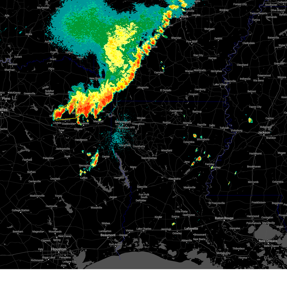 At 1225 pm cdt, a severe thunderstorm was located near hainesville, or 12 miles east of mineola, moving east at 45 mph (radar indicated). Hazards include 60 mph wind gusts and quarter size hail. Hail damage to vehicles is expected. Expect wind damage to roofs, siding, and trees. At 1225 pm cdt, a severe thunderstorm was located near hainesville, or 12 miles east of mineola, moving east at 45 mph (radar indicated). Hazards include 60 mph wind gusts and quarter size hail. Hail damage to vehicles is expected. Expect wind damage to roofs, siding, and trees.
|
| 5/8/2023 3:12 PM CDT |
 At 311 pm cdt, a severe thunderstorm was located over west mountain, or near gladewater, moving east at 15 mph (radar indicated). Hazards include 60 mph wind gusts and quarter size hail. Hail damage to vehicles is expected. expect wind damage to roofs, siding, and trees. locations impacted include, longview, white oak, gladewater, gilmer, clarksville city, east mountain, diana, west mountain, union grove, warren city, pritchett and judson. hail threat, radar indicated max hail size, 1. 00 in wind threat, radar indicated max wind gust, 60 mph. At 311 pm cdt, a severe thunderstorm was located over west mountain, or near gladewater, moving east at 15 mph (radar indicated). Hazards include 60 mph wind gusts and quarter size hail. Hail damage to vehicles is expected. expect wind damage to roofs, siding, and trees. locations impacted include, longview, white oak, gladewater, gilmer, clarksville city, east mountain, diana, west mountain, union grove, warren city, pritchett and judson. hail threat, radar indicated max hail size, 1. 00 in wind threat, radar indicated max wind gust, 60 mph.
|
| 5/8/2023 2:53 PM CDT |
 At 252 pm cdt, a severe thunderstorm was located near big sandy, or near gladewater, moving east at 15 mph (radar indicated). Hazards include 60 mph wind gusts and half dollar size hail. Hail damage to vehicles is expected. Expect wind damage to roofs, siding, and trees. At 252 pm cdt, a severe thunderstorm was located near big sandy, or near gladewater, moving east at 15 mph (radar indicated). Hazards include 60 mph wind gusts and half dollar size hail. Hail damage to vehicles is expected. Expect wind damage to roofs, siding, and trees.
|
| 4/5/2023 8:21 AM CDT |
 At 819 am cdt, thunderstorms were located along a line extending from 7 miles northeast of rosewood to 7 miles east of lindale to near tyler, moving east at 50 mph (radar indicated). Hazards include 60 mph wind gusts and penny size hail. Expect damage to roofs, siding, and trees. locations impacted include, tyler, gilmer, mineola, lindale, big sandy, hawkins, rosewood, hoard, hainesville, winona, midway, red springs, perryville, carroll, bettie, grice and pritchett. hail threat, radar indicated max hail size, 0. 75 in wind threat, radar indicated max wind gust, 60 mph. At 819 am cdt, thunderstorms were located along a line extending from 7 miles northeast of rosewood to 7 miles east of lindale to near tyler, moving east at 50 mph (radar indicated). Hazards include 60 mph wind gusts and penny size hail. Expect damage to roofs, siding, and trees. locations impacted include, tyler, gilmer, mineola, lindale, big sandy, hawkins, rosewood, hoard, hainesville, winona, midway, red springs, perryville, carroll, bettie, grice and pritchett. hail threat, radar indicated max hail size, 0. 75 in wind threat, radar indicated max wind gust, 60 mph.
|
| 4/5/2023 7:52 AM CDT |
 At 751 am cdt, severe thunderstorms were located along a line extending from near quitman to near van to near athens, moving east at 50 mph (radar indicated). Hazards include 60 mph wind gusts and penny size hail. expect damage to roofs, siding, and trees At 751 am cdt, severe thunderstorms were located along a line extending from near quitman to near van to near athens, moving east at 50 mph (radar indicated). Hazards include 60 mph wind gusts and penny size hail. expect damage to roofs, siding, and trees
|
| 4/2/2023 9:10 PM CDT | Quarter sized hail reported 8.9 miles W of Gilmer, TX |
| 4/2/2023 9:03 PM CDT | Ping Pong Ball sized hail reported 5.7 miles WSW of Gilmer, TX |
| 4/2/2023 8:36 PM CDT |
 At 836 pm cdt, a severe thunderstorm was located over rosewood, or 9 miles west of gilmer, moving east at 35 mph (radar indicated). Hazards include 60 mph wind gusts and half dollar size hail. Hail damage to vehicles is expected. Expect wind damage to roofs, siding, and trees. At 836 pm cdt, a severe thunderstorm was located over rosewood, or 9 miles west of gilmer, moving east at 35 mph (radar indicated). Hazards include 60 mph wind gusts and half dollar size hail. Hail damage to vehicles is expected. Expect wind damage to roofs, siding, and trees.
|
| 4/2/2023 8:27 PM CDT |
 At 826 pm cdt, a severe thunderstorm was located near gilmer, moving east at 40 mph (radar indicated). Hazards include 60 mph wind gusts and quarter size hail. Hail damage to vehicles is expected. Expect wind damage to roofs, siding, and trees. At 826 pm cdt, a severe thunderstorm was located near gilmer, moving east at 40 mph (radar indicated). Hazards include 60 mph wind gusts and quarter size hail. Hail damage to vehicles is expected. Expect wind damage to roofs, siding, and trees.
|
| 3/16/2023 7:58 PM CDT |
 At 758 pm cdt, a severe thunderstorm was located near hoard, or near mineola, moving east at 55 mph (radar indicated). Hazards include 60 mph wind gusts and quarter size hail. Hail damage to vehicles is expected. Expect wind damage to roofs, siding, and trees. At 758 pm cdt, a severe thunderstorm was located near hoard, or near mineola, moving east at 55 mph (radar indicated). Hazards include 60 mph wind gusts and quarter size hail. Hail damage to vehicles is expected. Expect wind damage to roofs, siding, and trees.
|
| 3/2/2023 9:50 PM CST |
 At 950 pm cst, severe thunderstorms were located along a line extending from near naples to liberty city, moving east at 50 mph (radar indicated). Hazards include 60 mph wind gusts. expect damage to roofs, siding, and trees At 950 pm cst, severe thunderstorms were located along a line extending from near naples to liberty city, moving east at 50 mph (radar indicated). Hazards include 60 mph wind gusts. expect damage to roofs, siding, and trees
|
| 3/2/2023 9:33 PM CST |
 At 933 pm cst, severe thunderstorms were located along a line extending from near canfield to near elysian fields, moving east at 50 mph (radar indicated). Hazards include 60 mph wind gusts and penny size hail. Expect damage to roofs, siding, and trees. locations impacted include, tyler, longview, mount pleasant, kilgore, whitehouse, white oak, gladewater, gilmer, pittsburg, lindale, chandler, daingerfield, overton, bullard, troup, lone star, naples, big sandy, hawkins and ore city. hail threat, radar indicated max hail size, 0. 75 in wind threat, radar indicated max wind gust, 60 mph. At 933 pm cst, severe thunderstorms were located along a line extending from near canfield to near elysian fields, moving east at 50 mph (radar indicated). Hazards include 60 mph wind gusts and penny size hail. Expect damage to roofs, siding, and trees. locations impacted include, tyler, longview, mount pleasant, kilgore, whitehouse, white oak, gladewater, gilmer, pittsburg, lindale, chandler, daingerfield, overton, bullard, troup, lone star, naples, big sandy, hawkins and ore city. hail threat, radar indicated max hail size, 0. 75 in wind threat, radar indicated max wind gust, 60 mph.
|
| 3/2/2023 9:10 PM CST | Trees downed in the northwest portion of the count in upshur county TX, 11.9 miles SE of Gilmer, TX |
| 3/2/2023 8:41 PM CST |
 At 840 pm cst, severe thunderstorms were located along a line extending from omaha to near tyler, moving east at 50 mph (radar indicated). Hazards include 60 mph wind gusts and penny size hail. expect damage to roofs, siding, and trees At 840 pm cst, severe thunderstorms were located along a line extending from omaha to near tyler, moving east at 50 mph (radar indicated). Hazards include 60 mph wind gusts and penny size hail. expect damage to roofs, siding, and trees
|
| 3/2/2023 7:45 PM CST |
 At 744 pm cst, severe thunderstorms were located along a line extending from near cumby to near cottonwood, moving east at 75 mph (radar indicated). Hazards include 60 mph wind gusts and penny size hail. expect damage to roofs, siding, and trees At 744 pm cst, severe thunderstorms were located along a line extending from near cumby to near cottonwood, moving east at 75 mph (radar indicated). Hazards include 60 mph wind gusts and penny size hail. expect damage to roofs, siding, and trees
|
| 3/2/2023 9:48 AM CST | Trees downed on the southeast side of the count in upshur county TX, 9.2 miles WNW of Gilmer, TX |
| 11/4/2022 7:11 PM CDT |
 At 710 pm cdt, a severe thunderstorm capable of producing a tornado was located near gilmer, moving northeast at 50 mph (radar indicated rotation). Hazards include tornado. Flying debris will be dangerous to those caught without shelter. mobile homes will be damaged or destroyed. damage to roofs, windows, and vehicles will occur. Tree damage is likely. At 710 pm cdt, a severe thunderstorm capable of producing a tornado was located near gilmer, moving northeast at 50 mph (radar indicated rotation). Hazards include tornado. Flying debris will be dangerous to those caught without shelter. mobile homes will be damaged or destroyed. damage to roofs, windows, and vehicles will occur. Tree damage is likely.
|
| 11/4/2022 6:53 PM CDT |
 At 652 pm cdt, a confirmed tornado was located near big sandy, or 7 miles southwest of gilmer, moving northeast at 45 mph (weather spotters confirmed tornado). Hazards include damaging tornado. Flying debris will be dangerous to those caught without shelter. mobile homes will be damaged or destroyed. damage to roofs, windows, and vehicles will occur. tree damage is likely. Locations impacted include, gilmer, big sandy, west mountain, diana, midway, bettie and pritchett. At 652 pm cdt, a confirmed tornado was located near big sandy, or 7 miles southwest of gilmer, moving northeast at 45 mph (weather spotters confirmed tornado). Hazards include damaging tornado. Flying debris will be dangerous to those caught without shelter. mobile homes will be damaged or destroyed. damage to roofs, windows, and vehicles will occur. tree damage is likely. Locations impacted include, gilmer, big sandy, west mountain, diana, midway, bettie and pritchett.
|
| 11/4/2022 6:40 PM CDT |
 At 640 pm cdt, a severe thunderstorm capable of producing a tornado was located over big sandy, or 11 miles west of gladewater, moving northeast at 45 mph (radar indicated rotation). Hazards include tornado. Flying debris will be dangerous to those caught without shelter. mobile homes will be damaged or destroyed. damage to roofs, windows, and vehicles will occur. Tree damage is likely. At 640 pm cdt, a severe thunderstorm capable of producing a tornado was located over big sandy, or 11 miles west of gladewater, moving northeast at 45 mph (radar indicated rotation). Hazards include tornado. Flying debris will be dangerous to those caught without shelter. mobile homes will be damaged or destroyed. damage to roofs, windows, and vehicles will occur. Tree damage is likely.
|
| 11/4/2022 6:22 PM CDT |
 At 621 pm cdt, a severe thunderstorm capable of producing a tornado was located 7 miles northeast of rosewood, or 8 miles northwest of gilmer, moving northeast at 50 mph (radar indicated rotation). Hazards include tornado. Flying debris will be dangerous to those caught without shelter. mobile homes will be damaged or destroyed. damage to roofs, windows, and vehicles will occur. tree damage is likely. this dangerous storm will be near, pittsburg around 635 pm cdt. cason around 645 pm cdt. daingerfield and cookville around 650 pm cdt. omaha and rocky branch around 655 pm cdt. naples and us 259 and i 30 intersection around 700 pm cdt. Other locations impacted by this tornadic thunderstorm include roeder, harvard, lafayette, center point, holly springs, bettie, midway and rocky mound. At 621 pm cdt, a severe thunderstorm capable of producing a tornado was located 7 miles northeast of rosewood, or 8 miles northwest of gilmer, moving northeast at 50 mph (radar indicated rotation). Hazards include tornado. Flying debris will be dangerous to those caught without shelter. mobile homes will be damaged or destroyed. damage to roofs, windows, and vehicles will occur. tree damage is likely. this dangerous storm will be near, pittsburg around 635 pm cdt. cason around 645 pm cdt. daingerfield and cookville around 650 pm cdt. omaha and rocky branch around 655 pm cdt. naples and us 259 and i 30 intersection around 700 pm cdt. Other locations impacted by this tornadic thunderstorm include roeder, harvard, lafayette, center point, holly springs, bettie, midway and rocky mound.
|
| 11/4/2022 6:05 PM CDT |
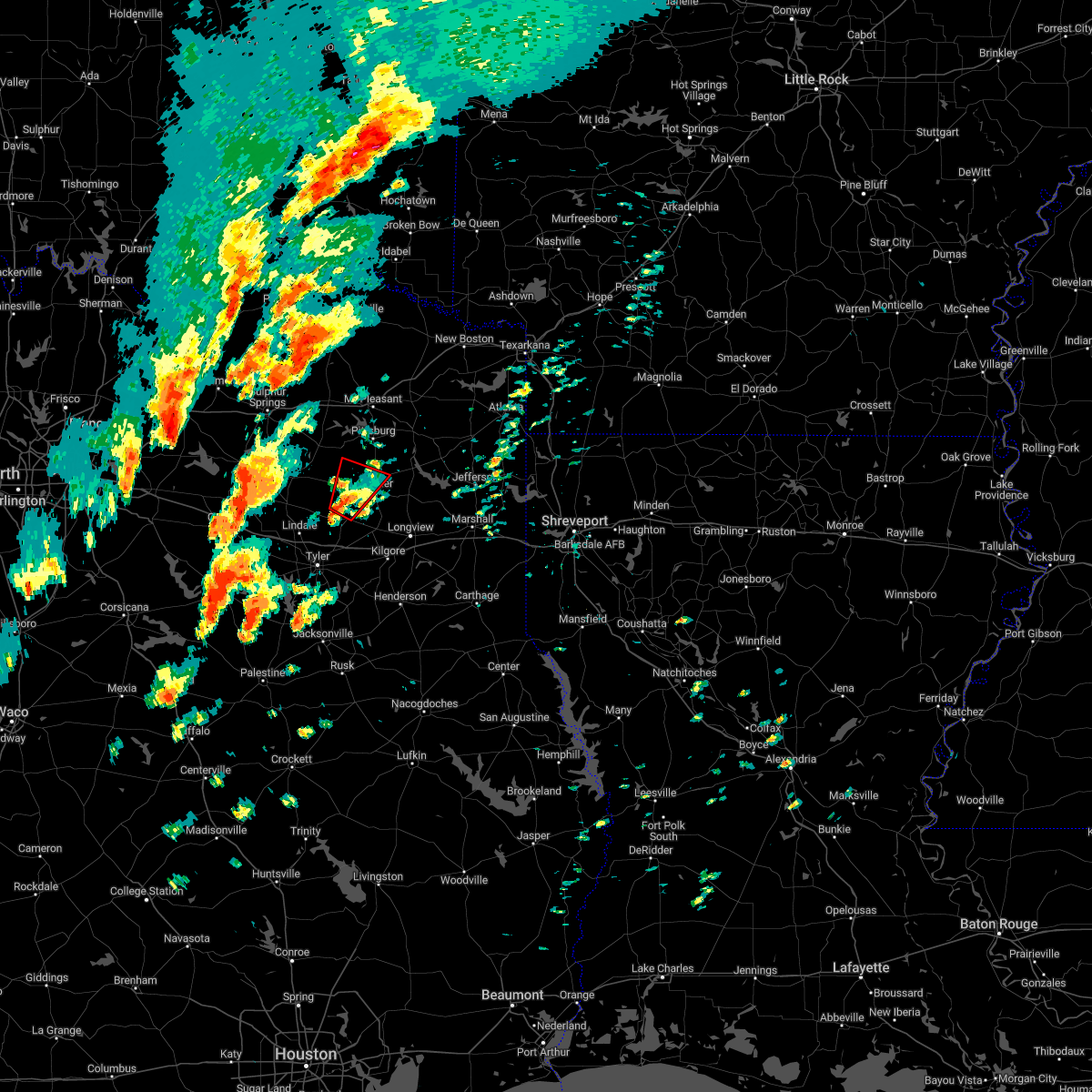 At 604 pm cdt, a severe thunderstorm capable of producing a tornado was located near rosewood, or 10 miles west of gilmer, moving northeast at 40 mph (radar indicated rotation). Hazards include tornado. Flying debris will be dangerous to those caught without shelter. mobile homes will be damaged or destroyed. damage to roofs, windows, and vehicles will occur. tree damage is likely. this dangerous storm will be near, rosewood around 610 pm cdt. gilmer around 615 pm cdt. Other locations impacted by this tornadic thunderstorm include grice and bettie. At 604 pm cdt, a severe thunderstorm capable of producing a tornado was located near rosewood, or 10 miles west of gilmer, moving northeast at 40 mph (radar indicated rotation). Hazards include tornado. Flying debris will be dangerous to those caught without shelter. mobile homes will be damaged or destroyed. damage to roofs, windows, and vehicles will occur. tree damage is likely. this dangerous storm will be near, rosewood around 610 pm cdt. gilmer around 615 pm cdt. Other locations impacted by this tornadic thunderstorm include grice and bettie.
|
| 11/4/2022 5:52 PM CDT |
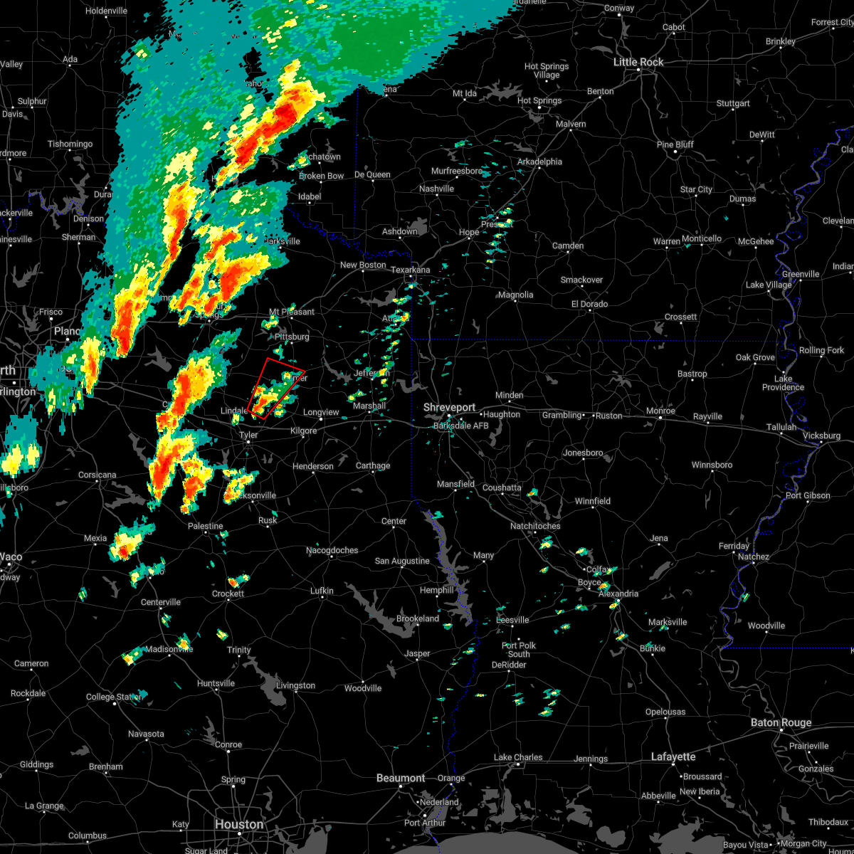 At 552 pm cdt, a severe thunderstorm capable of producing a tornado was located over hawkins, or 15 miles west of gladewater, moving northeast at 40 mph (radar indicated rotation). Hazards include tornado. Flying debris will be dangerous to those caught without shelter. mobile homes will be damaged or destroyed. damage to roofs, windows, and vehicles will occur. tree damage is likely. this dangerous storm will be near, rosewood around 610 pm cdt. gilmer around 615 pm cdt. Other locations impacted by this tornadic thunderstorm include grice and bettie. At 552 pm cdt, a severe thunderstorm capable of producing a tornado was located over hawkins, or 15 miles west of gladewater, moving northeast at 40 mph (radar indicated rotation). Hazards include tornado. Flying debris will be dangerous to those caught without shelter. mobile homes will be damaged or destroyed. damage to roofs, windows, and vehicles will occur. tree damage is likely. this dangerous storm will be near, rosewood around 610 pm cdt. gilmer around 615 pm cdt. Other locations impacted by this tornadic thunderstorm include grice and bettie.
|
| 7/9/2022 5:40 PM CDT | Fences and numerous trees dow in upshur county TX, 8.5 miles ENE of Gilmer, TX |
| 5/16/2022 12:41 AM CDT |
 The severe thunderstorm warning for northeastern smith, upshur and western gregg counties will expire at 1245 am cdt, the storm which prompted the warning has weakened below severe limits, and no longer poses an immediate threat to life or property. therefore, the warning will be allowed to expire. however gusty winds are still possible with this thunderstorm. The severe thunderstorm warning for northeastern smith, upshur and western gregg counties will expire at 1245 am cdt, the storm which prompted the warning has weakened below severe limits, and no longer poses an immediate threat to life or property. therefore, the warning will be allowed to expire. however gusty winds are still possible with this thunderstorm.
|
| 5/16/2022 12:28 AM CDT |
 At 1228 am cdt, a severe thunderstorm was located over liberty city, or near white oak, moving southeast at 25 mph (radar indicated). Hazards include 60 mph wind gusts and quarter size hail. Hail damage to vehicles is expected. expect wind damage to roofs, siding, and trees. locations impacted include, longview, kilgore, white oak, gladewater, gilmer, big sandy, clarksville city, east mountain, rosewood, liberty city, west mountain, union grove, warren city, bettie, grice and pritchett. hail threat, radar indicated max hail size, 1. 00 in wind threat, radar indicated max wind gust, 60 mph. At 1228 am cdt, a severe thunderstorm was located over liberty city, or near white oak, moving southeast at 25 mph (radar indicated). Hazards include 60 mph wind gusts and quarter size hail. Hail damage to vehicles is expected. expect wind damage to roofs, siding, and trees. locations impacted include, longview, kilgore, white oak, gladewater, gilmer, big sandy, clarksville city, east mountain, rosewood, liberty city, west mountain, union grove, warren city, bettie, grice and pritchett. hail threat, radar indicated max hail size, 1. 00 in wind threat, radar indicated max wind gust, 60 mph.
|
| 5/16/2022 12:18 AM CDT |
 At 1217 am cdt, a severe thunderstorm was located near gladewater, moving southeast at 25 mph (radar indicated). Hazards include 60 mph wind gusts and quarter size hail. Hail damage to vehicles is expected. expect wind damage to roofs, siding, and trees. locations impacted include, longview, kilgore, white oak, gladewater, gilmer, big sandy, hawkins, clarksville city, east mountain, rosewood, liberty city, west mountain, winona, union grove, warren city, midway, perryville, bettie, grice and pritchett. hail threat, radar indicated max hail size, 1. 00 in wind threat, radar indicated max wind gust, 60 mph. At 1217 am cdt, a severe thunderstorm was located near gladewater, moving southeast at 25 mph (radar indicated). Hazards include 60 mph wind gusts and quarter size hail. Hail damage to vehicles is expected. expect wind damage to roofs, siding, and trees. locations impacted include, longview, kilgore, white oak, gladewater, gilmer, big sandy, hawkins, clarksville city, east mountain, rosewood, liberty city, west mountain, winona, union grove, warren city, midway, perryville, bettie, grice and pritchett. hail threat, radar indicated max hail size, 1. 00 in wind threat, radar indicated max wind gust, 60 mph.
|
| 5/16/2022 12:12 AM CDT | Tree down at intersection of fm271 and fm72 in upshur county TX, 8.5 miles N of Gilmer, TX |
| 5/15/2022 11:58 PM CDT |
 At 1158 pm cdt, severe thunderstorms were located along a line extending from near newsome to near rosewood to near hawkins to near hoard, moving southeast at 20 mph (radar indicated). Hazards include 60 mph wind gusts and quarter size hail. Hail damage to vehicles is expected. Expect wind damage to roofs, siding, and trees. At 1158 pm cdt, severe thunderstorms were located along a line extending from near newsome to near rosewood to near hawkins to near hoard, moving southeast at 20 mph (radar indicated). Hazards include 60 mph wind gusts and quarter size hail. Hail damage to vehicles is expected. Expect wind damage to roofs, siding, and trees.
|
| 5/5/2022 12:25 PM CDT |
 At 1225 pm cdt, a severe thunderstorm was located near gilmer, moving east at 30 mph (radar indicated). Hazards include 60 mph wind gusts and quarter size hail. Hail damage to vehicles is expected. Expect wind damage to roofs, siding, and trees. At 1225 pm cdt, a severe thunderstorm was located near gilmer, moving east at 30 mph (radar indicated). Hazards include 60 mph wind gusts and quarter size hail. Hail damage to vehicles is expected. Expect wind damage to roofs, siding, and trees.
|
| 4/12/2022 9:07 PM CDT | Large tree down southeast of gilmer on fm 1650 and mockingbird lan in upshur county TX, 9.3 miles WNW of Gilmer, TX |
| 4/12/2022 8:46 PM CDT |
 At 846 pm cdt, severe thunderstorms were located along a line extending from near leesburg to near kilgore, moving northeast at 55 mph (radar indicated). Hazards include 70 mph wind gusts and penny size hail. Expect considerable tree damage. Damage is likely to mobile homes, roofs, and outbuildings. At 846 pm cdt, severe thunderstorms were located along a line extending from near leesburg to near kilgore, moving northeast at 55 mph (radar indicated). Hazards include 70 mph wind gusts and penny size hail. Expect considerable tree damage. Damage is likely to mobile homes, roofs, and outbuildings.
|
| 4/12/2022 8:32 PM CDT |
 At 831 pm cdt, a severe thunderstorm was located over gladewater, moving northeast at 80 mph (radar indicated). Hazards include 60 mph wind gusts and penny size hail. expect damage to roofs, siding, and trees At 831 pm cdt, a severe thunderstorm was located over gladewater, moving northeast at 80 mph (radar indicated). Hazards include 60 mph wind gusts and penny size hail. expect damage to roofs, siding, and trees
|
| 4/5/2022 12:59 AM CDT |
 At 1259 am cdt, severe thunderstorms were located along a line extending from near hughes springs to near mineola, moving east at 50 mph (radar indicated). Hazards include 60 mph wind gusts and quarter size hail. Hail damage to vehicles is expected. Expect wind damage to roofs, siding, and trees. At 1259 am cdt, severe thunderstorms were located along a line extending from near hughes springs to near mineola, moving east at 50 mph (radar indicated). Hazards include 60 mph wind gusts and quarter size hail. Hail damage to vehicles is expected. Expect wind damage to roofs, siding, and trees.
|
| 3/30/2022 7:50 AM CDT |
 At 749 am cdt, severe thunderstorms were located along a line extending from near cason to near cedar springs to near east mountain, moving northeast at 50 mph (radar indicated). Hazards include 60 mph wind gusts. Expect damage to roofs, siding, and trees. Locations impacted include, gladewater, gilmer, daingerfield, hughes springs, lone star, ore city, east mountain, diana, jenkins, west mountain, cedar springs, avinger, union grove, holly springs, lafayette and center point. At 749 am cdt, severe thunderstorms were located along a line extending from near cason to near cedar springs to near east mountain, moving northeast at 50 mph (radar indicated). Hazards include 60 mph wind gusts. Expect damage to roofs, siding, and trees. Locations impacted include, gladewater, gilmer, daingerfield, hughes springs, lone star, ore city, east mountain, diana, jenkins, west mountain, cedar springs, avinger, union grove, holly springs, lafayette and center point.
|
| 3/30/2022 7:26 AM CDT |
 At 725 am cdt, severe thunderstorms were located along a line extending from 9 miles south of newsome to rosewood to 7 miles south of big sandy, moving northeast at 50 mph (radar indicated). Hazards include 60 mph wind gusts. expect damage to roofs, siding, and trees At 725 am cdt, severe thunderstorms were located along a line extending from 9 miles south of newsome to rosewood to 7 miles south of big sandy, moving northeast at 50 mph (radar indicated). Hazards include 60 mph wind gusts. expect damage to roofs, siding, and trees
|
| 3/21/2022 11:27 PM CDT |
 At 1126 pm cdt, severe thunderstorms were located along a line extending from 8 miles southwest of linden to coffee city, moving east at 20 mph (radar indicated). Hazards include 60 mph wind gusts and quarter size hail. Hail damage to vehicles is expected. Expect wind damage to roofs, siding, and trees. At 1126 pm cdt, severe thunderstorms were located along a line extending from 8 miles southwest of linden to coffee city, moving east at 20 mph (radar indicated). Hazards include 60 mph wind gusts and quarter size hail. Hail damage to vehicles is expected. Expect wind damage to roofs, siding, and trees.
|
| 3/21/2022 11:00 PM CDT |
 At 1059 pm cdt, a severe thunderstorm was located over east mountain, or near white oak, moving northeast at 60 mph (emergency management). Hazards include golf ball size hail and 60 mph wind gusts. People and animals outdoors will be injured. expect hail damage to roofs, siding, windows, and vehicles. expect wind damage to roofs, siding, and trees. locations impacted include, longview, white oak, gladewater, gilmer, jefferson, ore city, clarksville city, east mountain, diana, west mountain, berea, harleton, cedar springs, liberty city, avinger, union grove, warren city, lassater, pruett and judson. thunderstorm damage threat, considerable hail threat, radar indicated max hail size, 1. 75 in wind threat, radar indicated max wind gust, 60 mph. At 1059 pm cdt, a severe thunderstorm was located over east mountain, or near white oak, moving northeast at 60 mph (emergency management). Hazards include golf ball size hail and 60 mph wind gusts. People and animals outdoors will be injured. expect hail damage to roofs, siding, windows, and vehicles. expect wind damage to roofs, siding, and trees. locations impacted include, longview, white oak, gladewater, gilmer, jefferson, ore city, clarksville city, east mountain, diana, west mountain, berea, harleton, cedar springs, liberty city, avinger, union grove, warren city, lassater, pruett and judson. thunderstorm damage threat, considerable hail threat, radar indicated max hail size, 1. 75 in wind threat, radar indicated max wind gust, 60 mph.
|
| 3/21/2022 10:55 PM CDT | Golf Ball sized hail reported 8.5 miles N of Gilmer, TX |
| 3/21/2022 10:54 PM CDT |
 At 1053 pm cdt, a severe thunderstorm was located over clarksville city, or over gladewater, moving northeast at 60 mph (spotter report quarter sized hail). Hazards include 60 mph wind gusts and quarter size hail. Hail damage to vehicles is expected. Expect wind damage to roofs, siding, and trees. At 1053 pm cdt, a severe thunderstorm was located over clarksville city, or over gladewater, moving northeast at 60 mph (spotter report quarter sized hail). Hazards include 60 mph wind gusts and quarter size hail. Hail damage to vehicles is expected. Expect wind damage to roofs, siding, and trees.
|
| 3/21/2022 10:51 PM CDT | Possible tornado damage to a house on azalea road off hwy 154 east of gilme in upshur county TX, 3.4 miles WNW of Gilmer, TX |
| 3/21/2022 10:46 PM CDT |
 At 1045 pm cdt, severe thunderstorms were located along a line extending from near boxelder to near gilmer, moving northeast at 45 mph (radar indicated). Hazards include 60 mph wind gusts and penny size hail. Expect damage to roofs, siding, and trees. Locations impacted include, texarkana, gilmer, new boston, nash, hooks, daingerfield, linden, hughes springs, de kalb, lone star, naples, ore city, redwater, maud, omaha, red lick, cason, us 259 and i 30 intersection, cookville and rocky branch. At 1045 pm cdt, severe thunderstorms were located along a line extending from near boxelder to near gilmer, moving northeast at 45 mph (radar indicated). Hazards include 60 mph wind gusts and penny size hail. Expect damage to roofs, siding, and trees. Locations impacted include, texarkana, gilmer, new boston, nash, hooks, daingerfield, linden, hughes springs, de kalb, lone star, naples, ore city, redwater, maud, omaha, red lick, cason, us 259 and i 30 intersection, cookville and rocky branch.
|
| 3/21/2022 10:35 PM CDT | Possible tornado damage east of gilmer on fm 1649 near williams road west of fm 1972. time estimated from rada in upshur county TX, 7.2 miles W of Gilmer, TX |
| 3/21/2022 10:31 PM CDT |
 At 1031 pm cdt, a confirmed tornado was located near gilmer, moving northeast at 45 mph (radar confirmed tornado). Hazards include damaging tornado and quarter size hail. Flying debris will be dangerous to those caught without shelter. mobile homes will be damaged or destroyed. damage to roofs, windows, and vehicles will occur. tree damage is likely. this tornado will be near, diana around 1035 pm cdt. ore city and cedar springs around 1045 pm cdt. lone star and jenkins around 1055 pm cdt. Other locations impacted by this tornadic thunderstorm include lassater and avinger. At 1031 pm cdt, a confirmed tornado was located near gilmer, moving northeast at 45 mph (radar confirmed tornado). Hazards include damaging tornado and quarter size hail. Flying debris will be dangerous to those caught without shelter. mobile homes will be damaged or destroyed. damage to roofs, windows, and vehicles will occur. tree damage is likely. this tornado will be near, diana around 1035 pm cdt. ore city and cedar springs around 1045 pm cdt. lone star and jenkins around 1055 pm cdt. Other locations impacted by this tornadic thunderstorm include lassater and avinger.
|
| 3/21/2022 10:28 PM CDT | Corrected time. possible tornado damage to a house on azalea road off hwy 154 east of gilme in upshur county TX, 3.4 miles WNW of Gilmer, TX |
| 3/21/2022 10:25 PM CDT |
 At 1025 pm cdt, a severe thunderstorm capable of producing a tornado was located near gilmer, moving northeast at 45 mph (radar indicated rotation). Hazards include tornado and quarter size hail. Flying debris will be dangerous to those caught without shelter. mobile homes will be damaged or destroyed. damage to roofs, windows, and vehicles will occur. tree damage is likely. this dangerous storm will be near, diana around 1040 pm cdt. ore city and cedar springs around 1045 pm cdt. lone star and jenkins around 1055 pm cdt. Other locations impacted by this tornadic thunderstorm include lassater and avinger. At 1025 pm cdt, a severe thunderstorm capable of producing a tornado was located near gilmer, moving northeast at 45 mph (radar indicated rotation). Hazards include tornado and quarter size hail. Flying debris will be dangerous to those caught without shelter. mobile homes will be damaged or destroyed. damage to roofs, windows, and vehicles will occur. tree damage is likely. this dangerous storm will be near, diana around 1040 pm cdt. ore city and cedar springs around 1045 pm cdt. lone star and jenkins around 1055 pm cdt. Other locations impacted by this tornadic thunderstorm include lassater and avinger.
|
| 3/21/2022 10:16 PM CDT |
 At 1015 pm cdt, severe thunderstorms were located along a line extending from near bogata to near hawkins, moving northeast at 45 mph (radar indicated). Hazards include 60 mph wind gusts and penny size hail. expect damage to roofs, siding, and trees At 1015 pm cdt, severe thunderstorms were located along a line extending from near bogata to near hawkins, moving northeast at 45 mph (radar indicated). Hazards include 60 mph wind gusts and penny size hail. expect damage to roofs, siding, and trees
|
| 3/21/2022 9:36 PM CDT |
 At 936 pm cdt, severe thunderstorms were located along a line extending from near mineola to 6 miles southeast of chandler, moving northeast at 45 mph (radar indicated). Hazards include 60 mph wind gusts and quarter size hail. Hail damage to vehicles is expected. Expect wind damage to roofs, siding, and trees. At 936 pm cdt, severe thunderstorms were located along a line extending from near mineola to 6 miles southeast of chandler, moving northeast at 45 mph (radar indicated). Hazards include 60 mph wind gusts and quarter size hail. Hail damage to vehicles is expected. Expect wind damage to roofs, siding, and trees.
|
| 3/14/2022 8:25 PM CDT |
 At 824 pm cdt, severe thunderstorms were located along a line extending from 6 miles north of newsome to near hawkins, moving east at 35 mph (radar indicated). Hazards include 60 mph wind gusts and quarter size hail. Hail damage to vehicles is expected. Expect wind damage to roofs, siding, and trees. At 824 pm cdt, severe thunderstorms were located along a line extending from 6 miles north of newsome to near hawkins, moving east at 35 mph (radar indicated). Hazards include 60 mph wind gusts and quarter size hail. Hail damage to vehicles is expected. Expect wind damage to roofs, siding, and trees.
|
| 11/10/2021 11:15 PM CST |
 At 1114 pm cst, severe thunderstorms were located along a line extending from 7 miles southwest of mount pleasant to near leesburg to 7 miles west of rosewood, moving east at 45 mph (radar indicated). Hazards include 60 mph wind gusts and nickel size hail. Expect damage to roofs, siding, and trees. locations impacted include, mount pleasant, gilmer, mineola, pittsburg, leesburg, daingerfield, lone star, cason, cookville, hainesville, rosewood, newsome, cedar springs, winfield, midway, rocky mound, roeder, harvard, center point and bettie. hail threat, radar indicated max hail size, 0. 88 in wind threat, radar indicated max wind gust, 60 mph. At 1114 pm cst, severe thunderstorms were located along a line extending from 7 miles southwest of mount pleasant to near leesburg to 7 miles west of rosewood, moving east at 45 mph (radar indicated). Hazards include 60 mph wind gusts and nickel size hail. Expect damage to roofs, siding, and trees. locations impacted include, mount pleasant, gilmer, mineola, pittsburg, leesburg, daingerfield, lone star, cason, cookville, hainesville, rosewood, newsome, cedar springs, winfield, midway, rocky mound, roeder, harvard, center point and bettie. hail threat, radar indicated max hail size, 0. 88 in wind threat, radar indicated max wind gust, 60 mph.
|
| 11/10/2021 10:46 PM CST |
 At 1045 pm cst, severe thunderstorms were located along a line extending from 9 miles west of mount vernon to near winnsboro to near quitman, moving east at 45 mph (radar indicated). Hazards include 60 mph wind gusts and nickel size hail. expect damage to roofs, siding, and trees At 1045 pm cst, severe thunderstorms were located along a line extending from 9 miles west of mount vernon to near winnsboro to near quitman, moving east at 45 mph (radar indicated). Hazards include 60 mph wind gusts and nickel size hail. expect damage to roofs, siding, and trees
|
| 10/11/2021 12:33 AM CDT |
 At 1232 am cdt, severe thunderstorms were located along a line extending from mount vernon to near hainesville to near chandler, moving east at 50 mph (radar indicated). Hazards include 60 mph wind gusts and quarter size hail. Hail damage to vehicles is expected. Expect wind damage to roofs, siding, and trees. At 1232 am cdt, severe thunderstorms were located along a line extending from mount vernon to near hainesville to near chandler, moving east at 50 mph (radar indicated). Hazards include 60 mph wind gusts and quarter size hail. Hail damage to vehicles is expected. Expect wind damage to roofs, siding, and trees.
|
| 10/10/2021 11:35 PM CDT |
 At 1135 pm cdt, severe thunderstorms were located along a line extending from near cooper lake park doctors creek to near emory to near canton, moving east at 40 mph (radar indicated). Hazards include 60 mph wind gusts and quarter size hail. Hail damage to vehicles is expected. Expect wind damage to roofs, siding, and trees. At 1135 pm cdt, severe thunderstorms were located along a line extending from near cooper lake park doctors creek to near emory to near canton, moving east at 40 mph (radar indicated). Hazards include 60 mph wind gusts and quarter size hail. Hail damage to vehicles is expected. Expect wind damage to roofs, siding, and trees.
|
| 6/14/2021 1:25 AM CDT | Quarter sized hail reported 0.2 miles WNW of Gilmer, TX, quarter inch hail reported at a fast food restaurant on the north side of gilmer. |
| 6/14/2021 1:16 AM CDT |
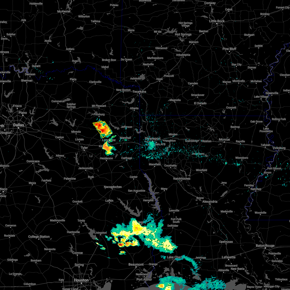 At 116 am cdt, a severe thunderstorm was located over gilmer, moving west at 10 mph (radar indicated). Hazards include 60 mph wind gusts and quarter size hail. Hail damage to vehicles is expected. Expect wind damage to roofs, siding, and trees. At 116 am cdt, a severe thunderstorm was located over gilmer, moving west at 10 mph (radar indicated). Hazards include 60 mph wind gusts and quarter size hail. Hail damage to vehicles is expected. Expect wind damage to roofs, siding, and trees.
|
| 6/7/2021 12:37 PM CDT |
 At 1236 pm cdt, severe thunderstorms were located along a line extending from near mineola to 7 miles east of palestine, moving east at 55 mph (radar indicated). Hazards include 60 mph wind gusts. expect damage to roofs, siding, and trees At 1236 pm cdt, severe thunderstorms were located along a line extending from near mineola to 7 miles east of palestine, moving east at 55 mph (radar indicated). Hazards include 60 mph wind gusts. expect damage to roofs, siding, and trees
|
| 5/4/2021 1:57 AM CDT |
 The severe thunderstorm warning for western upshur and west central gregg counties will expire at 200 am cdt, the storm which prompted the warning has weakened below severe limits, and no longer poses an immediate threat to life or property. therefore, the warning will be allowed to expire. a severe thunderstorm watch remains in effect until 400 am cdt for northeastern texas. The severe thunderstorm warning for western upshur and west central gregg counties will expire at 200 am cdt, the storm which prompted the warning has weakened below severe limits, and no longer poses an immediate threat to life or property. therefore, the warning will be allowed to expire. a severe thunderstorm watch remains in effect until 400 am cdt for northeastern texas.
|
| 5/4/2021 1:45 AM CDT |
 At 145 am cdt, a severe thunderstorm was located near big sandy, or 7 miles northwest of gladewater, moving east at 55 mph (radar indicated). Hazards include 60 mph wind gusts and quarter size hail. Hail damage to vehicles is expected. expect wind damage to roofs, siding, and trees. Locations impacted include, longview, white oak, gladewater, gilmer, big sandy, clarksville city, east mountain, rosewood, west mountain, union grove, warren city and pritchett. At 145 am cdt, a severe thunderstorm was located near big sandy, or 7 miles northwest of gladewater, moving east at 55 mph (radar indicated). Hazards include 60 mph wind gusts and quarter size hail. Hail damage to vehicles is expected. expect wind damage to roofs, siding, and trees. Locations impacted include, longview, white oak, gladewater, gilmer, big sandy, clarksville city, east mountain, rosewood, west mountain, union grove, warren city and pritchett.
|
| 5/4/2021 1:10 AM CDT |
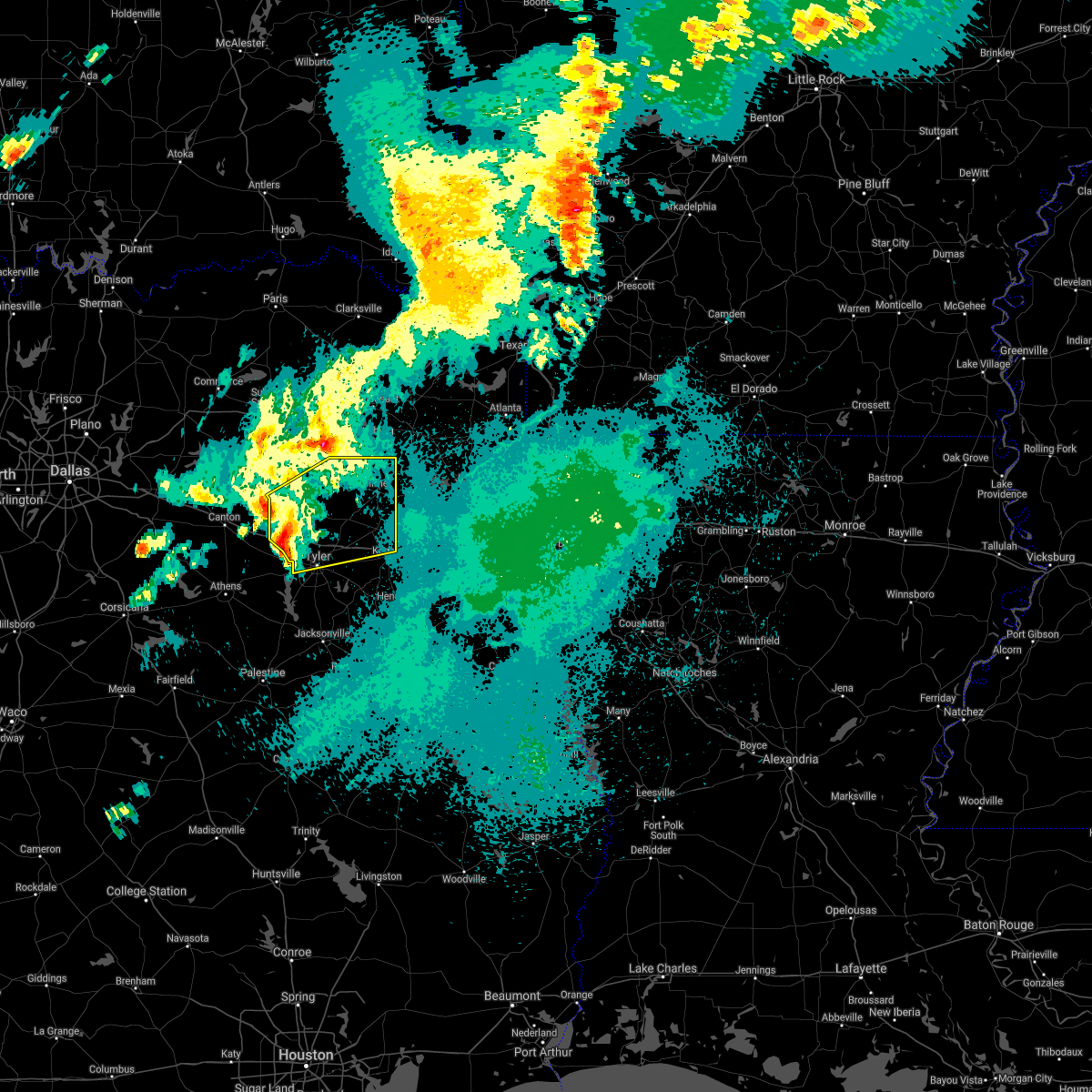 At 110 am cdt, a severe thunderstorm was located near edom, or 15 miles south of mineola, moving northeast at 60 mph. another severe thunderstorm was indicated just northwest of van, almost moving northeast near 60 mph (radar indicated). Hazards include 60 mph wind gusts and quarter size hail. Hail damage to vehicles is expected. Expect wind damage to roofs, siding, and trees. At 110 am cdt, a severe thunderstorm was located near edom, or 15 miles south of mineola, moving northeast at 60 mph. another severe thunderstorm was indicated just northwest of van, almost moving northeast near 60 mph (radar indicated). Hazards include 60 mph wind gusts and quarter size hail. Hail damage to vehicles is expected. Expect wind damage to roofs, siding, and trees.
|
| 5/3/2021 11:10 PM CDT |
 At 1110 pm cdt, severe thunderstorms were located along a line extending from 11 miles east of cooper lake park south sulphur to 6 miles southwest of como to near quitman to near mineola, moving northeast at 45 mph. these are very dangerous storms (radar indicated. at 1105 pm, the sulphur spring airport in hopkins county recorded an 87 mph wind gust). Hazards include 80 mph wind gusts and quarter size hail. Flying debris will be dangerous to those caught without shelter. mobile homes will be heavily damaged. expect considerable damage to roofs, windows, and vehicles. extensive tree damage and power outages are likely. Locations impacted include, mount pleasant, gilmer, mineola, pittsburg, winnsboro, leesburg, hagansport, lindale, mount vernon, quitman, big sandy, hawkins, bogata, scroggins, pleasant grove, hainesville, golden, rosewood, hoard and wilkerson. At 1110 pm cdt, severe thunderstorms were located along a line extending from 11 miles east of cooper lake park south sulphur to 6 miles southwest of como to near quitman to near mineola, moving northeast at 45 mph. these are very dangerous storms (radar indicated. at 1105 pm, the sulphur spring airport in hopkins county recorded an 87 mph wind gust). Hazards include 80 mph wind gusts and quarter size hail. Flying debris will be dangerous to those caught without shelter. mobile homes will be heavily damaged. expect considerable damage to roofs, windows, and vehicles. extensive tree damage and power outages are likely. Locations impacted include, mount pleasant, gilmer, mineola, pittsburg, winnsboro, leesburg, hagansport, lindale, mount vernon, quitman, big sandy, hawkins, bogata, scroggins, pleasant grove, hainesville, golden, rosewood, hoard and wilkerson.
|
| 5/3/2021 10:55 PM CDT |
 At 1055 pm cdt, severe thunderstorms were located along a line extending from near cooper lake park south sulphur to near emory to van, moving east northeast at 45 mph (radar indicated). Hazards include 60 mph wind gusts and quarter size hail. Hail damage to vehicles is expected. Expect wind damage to roofs, siding, and trees. At 1055 pm cdt, severe thunderstorms were located along a line extending from near cooper lake park south sulphur to near emory to van, moving east northeast at 45 mph (radar indicated). Hazards include 60 mph wind gusts and quarter size hail. Hail damage to vehicles is expected. Expect wind damage to roofs, siding, and trees.
|
| 4/10/2021 12:35 AM CDT |
 At 1235 am cdt, severe thunderstorms were located along a line extending from near mooringsport to 6 miles west of blanchard to 6 miles north of elysian fields to near tatum to 8 miles southeast of kilgore, moving southeast at 55 mph (radar indicated). Hazards include 60 mph wind gusts and penny size hail. Expect damage to roofs, siding, and trees. Locations impacted include, longview, marshall, kilgore, white oak, gladewater, atlanta, gilmer, vivian, hallsville, daingerfield, jefferson, linden, hughes springs, lone star, queen city, ore city, oil city, clarksville city, east mountain and mooringsport. At 1235 am cdt, severe thunderstorms were located along a line extending from near mooringsport to 6 miles west of blanchard to 6 miles north of elysian fields to near tatum to 8 miles southeast of kilgore, moving southeast at 55 mph (radar indicated). Hazards include 60 mph wind gusts and penny size hail. Expect damage to roofs, siding, and trees. Locations impacted include, longview, marshall, kilgore, white oak, gladewater, atlanta, gilmer, vivian, hallsville, daingerfield, jefferson, linden, hughes springs, lone star, queen city, ore city, oil city, clarksville city, east mountain and mooringsport.
|
| 4/9/2021 11:42 PM CDT |
 At 1142 pm cdt, severe thunderstorms were located along a line extending from 8 miles south of maud to 7 miles north of linden to hughes springs to 7 miles southeast of pittsburg to 8 miles northwest of rosewood, moving southeast at 55 mph (radar indicated). Hazards include 60 mph wind gusts and penny size hail. expect damage to roofs, siding, and trees At 1142 pm cdt, severe thunderstorms were located along a line extending from 8 miles south of maud to 7 miles north of linden to hughes springs to 7 miles southeast of pittsburg to 8 miles northwest of rosewood, moving southeast at 55 mph (radar indicated). Hazards include 60 mph wind gusts and penny size hail. expect damage to roofs, siding, and trees
|
| 4/7/2021 2:12 PM CDT |
 At 212 pm cdt, a severe thunderstorm was located near west mountain, or near gilmer, moving east at 35 mph (radar indicated). Hazards include 60 mph wind gusts and quarter size hail. Hail damage to vehicles is expected. Expect wind damage to roofs, siding, and trees. At 212 pm cdt, a severe thunderstorm was located near west mountain, or near gilmer, moving east at 35 mph (radar indicated). Hazards include 60 mph wind gusts and quarter size hail. Hail damage to vehicles is expected. Expect wind damage to roofs, siding, and trees.
|
| 3/23/2021 12:58 AM CDT |
 At 1258 am cdt, severe thunderstorms were located along a line extending from 8 miles northeast of hainesville to near hawkins to 9 miles southwest of big sandy, moving northeast at 50 mph (radar indicated). Hazards include 60 mph wind gusts and penny size hail. expect damage to roofs, siding, and trees At 1258 am cdt, severe thunderstorms were located along a line extending from 8 miles northeast of hainesville to near hawkins to 9 miles southwest of big sandy, moving northeast at 50 mph (radar indicated). Hazards include 60 mph wind gusts and penny size hail. expect damage to roofs, siding, and trees
|
| 3/17/2021 8:00 AM CDT |
 At 800 am cdt, severe thunderstorms were located along a line extending from near diana to near longview to 7 miles southeast of kilgore to near turnertown, moving east at 40 mph (radar indicated). Hazards include 70 mph wind gusts and quarter size hail. Hail damage to vehicles is expected. expect considerable tree damage. wind damage is also likely to mobile homes, roofs, and outbuildings. Locations impacted include, longview, marshall, henderson, kilgore, whitehouse, white oak, gladewater, hallsville, overton, jefferson, troup, tatum, new london, arp, clarksville city, beckville, east mountain, berea, harleton and diana. At 800 am cdt, severe thunderstorms were located along a line extending from near diana to near longview to 7 miles southeast of kilgore to near turnertown, moving east at 40 mph (radar indicated). Hazards include 70 mph wind gusts and quarter size hail. Hail damage to vehicles is expected. expect considerable tree damage. wind damage is also likely to mobile homes, roofs, and outbuildings. Locations impacted include, longview, marshall, henderson, kilgore, whitehouse, white oak, gladewater, hallsville, overton, jefferson, troup, tatum, new london, arp, clarksville city, beckville, east mountain, berea, harleton and diana.
|
| 6/9/2020 8:52 PM CDT | Tree downed on fm 555 on the east side of gilme in upshur county TX, 3.1 miles W of Gilmer, TX |
| 6/9/2020 8:50 PM CDT |
 At 850 pm cdt, a severe thunderstorm was located near ore city, or 9 miles east of gilmer, moving east at 20 mph (radar indicated). Hazards include 60 mph wind gusts and quarter size hail. Hail damage to vehicles is expected. expect wind damage to roofs, siding, and trees. Locations impacted include, gilmer, ore city, diana, harleton, cedar springs and lassater. At 850 pm cdt, a severe thunderstorm was located near ore city, or 9 miles east of gilmer, moving east at 20 mph (radar indicated). Hazards include 60 mph wind gusts and quarter size hail. Hail damage to vehicles is expected. expect wind damage to roofs, siding, and trees. Locations impacted include, gilmer, ore city, diana, harleton, cedar springs and lassater.
|
| 6/9/2020 8:37 PM CDT | Quarter sized hail reported 7.2 miles SW of Gilmer, TX, quarter size hail reported northeast of gilmer. wind gust estimated near 60 mph also reported by storm spotter northeast of town. |
| 6/9/2020 8:31 PM CDT |
 At 831 pm cdt, a severe thunderstorm was located near gilmer, moving east at 20 mph (radar indicated). Hazards include 60 mph wind gusts and quarter size hail. Hail damage to vehicles is expected. Expect wind damage to roofs, siding, and trees. At 831 pm cdt, a severe thunderstorm was located near gilmer, moving east at 20 mph (radar indicated). Hazards include 60 mph wind gusts and quarter size hail. Hail damage to vehicles is expected. Expect wind damage to roofs, siding, and trees.
|
| 5/24/2020 4:14 PM CDT | Golf Ball sized hail reported 0.4 miles ENE of Gilmer, TX, golfball-sized hail reported near gilmer. |
| 5/24/2020 3:50 PM CDT | Trees down throughout upshur county... including crabapple and crepe myrtle road just south of pritchett... willow oak... mockingbird lane... highway 154... fm 556... a in upshur county TX, 6 miles NE of Gilmer, TX |
| 5/24/2020 3:43 PM CDT |
 At 343 pm cdt, severe thunderstorms were located along a line extending from near east mountain to near gladewater to 9 miles west of liberty city to near brownsboro, moving north at 35 mph (radar indicated. at 340 pm, trees were downed east of kilgore with these storms). Hazards include 60 mph wind gusts and nickel size hail. expect damage to roofs, siding, and trees At 343 pm cdt, severe thunderstorms were located along a line extending from near east mountain to near gladewater to 9 miles west of liberty city to near brownsboro, moving north at 35 mph (radar indicated. at 340 pm, trees were downed east of kilgore with these storms). Hazards include 60 mph wind gusts and nickel size hail. expect damage to roofs, siding, and trees
|
| 5/8/2020 4:51 AM CDT |
 At 450 am cdt, severe thunderstorms were located along a line extending from near mount vernon to near mount pleasant to omaha, moving south at 55 mph (radar indicated). Hazards include 60 mph wind gusts and quarter size hail. Hail damage to vehicles is expected. Expect wind damage to roofs, siding, and trees. At 450 am cdt, severe thunderstorms were located along a line extending from near mount vernon to near mount pleasant to omaha, moving south at 55 mph (radar indicated). Hazards include 60 mph wind gusts and quarter size hail. Hail damage to vehicles is expected. Expect wind damage to roofs, siding, and trees.
|
| 4/29/2020 12:42 AM CDT |
 At 1241 am cdt, severe thunderstorms were located along a line extending from near edom to near hawkins to near diana, moving southeast at 55 mph (radar indicated. a 52 mph wind gust was just measured at the wood county airport in mineola). Hazards include 60 mph wind gusts and quarter size hail. Hail damage to vehicles is expected. Expect wind damage to roofs, siding, and trees. At 1241 am cdt, severe thunderstorms were located along a line extending from near edom to near hawkins to near diana, moving southeast at 55 mph (radar indicated. a 52 mph wind gust was just measured at the wood county airport in mineola). Hazards include 60 mph wind gusts and quarter size hail. Hail damage to vehicles is expected. Expect wind damage to roofs, siding, and trees.
|
| 4/29/2020 12:35 AM CDT |
 At 1235 am cdt, severe thunderstorms were located along a line extending from near van to hainesville to near hawkins to rosewood to near diana, moving south at 50 mph (radar indicated). Hazards include 60 mph wind gusts and quarter size hail. Hail damage to vehicles is expected. expect wind damage to roofs, siding, and trees. Locations impacted include, longview, white oak, gladewater, gilmer, mineola, lindale, quitman, big sandy, hawkins, ore city, clarksville city, east mountain, hainesville, golden, diana, rosewood, hoard, west mountain, cedar springs and liberty city. At 1235 am cdt, severe thunderstorms were located along a line extending from near van to hainesville to near hawkins to rosewood to near diana, moving south at 50 mph (radar indicated). Hazards include 60 mph wind gusts and quarter size hail. Hail damage to vehicles is expected. expect wind damage to roofs, siding, and trees. Locations impacted include, longview, white oak, gladewater, gilmer, mineola, lindale, quitman, big sandy, hawkins, ore city, clarksville city, east mountain, hainesville, golden, diana, rosewood, hoard, west mountain, cedar springs and liberty city.
|
| 4/29/2020 12:31 AM CDT | Tree down with power lines at fm 726 and myrtle roa in upshur county TX, 10 miles W of Gilmer, TX |
| 4/29/2020 12:07 AM CDT |
 At 1207 am cdt, severe thunderstorms were located along a line extending from near emory to 7 miles southwest of como to near winnsboro to newsome to near lone star, moving south at 50 mph (radar indicated). Hazards include 60 mph wind gusts and quarter size hail. Hail damage to vehicles is expected. Expect wind damage to roofs, siding, and trees. At 1207 am cdt, severe thunderstorms were located along a line extending from near emory to 7 miles southwest of como to near winnsboro to newsome to near lone star, moving south at 50 mph (radar indicated). Hazards include 60 mph wind gusts and quarter size hail. Hail damage to vehicles is expected. Expect wind damage to roofs, siding, and trees.
|
| 4/24/2020 6:38 PM CDT |
 At 637 pm cdt, a severe thunderstorm was located over rosewood, or 7 miles west of gilmer, moving east at 55 mph (radar indicated). Hazards include 60 mph wind gusts and quarter size hail. Hail damage to vehicles is expected. Expect wind damage to roofs, siding, and trees. At 637 pm cdt, a severe thunderstorm was located over rosewood, or 7 miles west of gilmer, moving east at 55 mph (radar indicated). Hazards include 60 mph wind gusts and quarter size hail. Hail damage to vehicles is expected. Expect wind damage to roofs, siding, and trees.
|
| 4/12/2020 7:36 PM CDT |
 The severe thunderstorm warning for central smith, western marion, western harrison, northern rusk, southeastern wood, upshur and gregg counties will expire at 745 pm cdt, the storms which prompted the warning have moved out of the area. therefore, the warning will be allowed to expire. a severe thunderstorm watch remains in effect until 800 pm cdt for northeastern texas. The severe thunderstorm warning for central smith, western marion, western harrison, northern rusk, southeastern wood, upshur and gregg counties will expire at 745 pm cdt, the storms which prompted the warning have moved out of the area. therefore, the warning will be allowed to expire. a severe thunderstorm watch remains in effect until 800 pm cdt for northeastern texas.
|
| 4/12/2020 6:56 PM CDT | Trees and power lines down. street signs blowing awa in upshur county TX, 0.4 miles ENE of Gilmer, TX |
| 4/12/2020 6:53 PM CDT | A 70+ ft black jack oak tree was blown down onto a shop on stallion road... damaging the roo in upshur county TX, 7.7 miles N of Gilmer, TX |
| 4/12/2020 6:52 PM CDT | A 50 ft tall oak tree with a 16 inch wide trunk was blown down across the 5000 block of east lake drive in the union grove communit in upshur county TX, 9.8 miles N of Gilmer, TX |
| 4/12/2020 6:48 PM CDT |
 At 647 pm cdt, severe thunderstorms were located along a line extending from near quitman to near hawkins to lindale to near edom, moving east at 45 mph. the strongest winds may occur along a gust front well ahead of the thunderstorms (radar indicated). Hazards include 60 mph wind gusts and penny size hail. expect damage to roofs, siding, and trees At 647 pm cdt, severe thunderstorms were located along a line extending from near quitman to near hawkins to lindale to near edom, moving east at 45 mph. the strongest winds may occur along a gust front well ahead of the thunderstorms (radar indicated). Hazards include 60 mph wind gusts and penny size hail. expect damage to roofs, siding, and trees
|
| 1/10/2020 11:28 PM CST |
 At 1126 pm cst, severe thunderstorms were located along a line extending from 6 miles west of hawkins to near grapeland, moving northeast at 45 mph (radar indicated). Hazards include 60 mph wind gusts. expect damage to roofs, siding, and trees At 1126 pm cst, severe thunderstorms were located along a line extending from 6 miles west of hawkins to near grapeland, moving northeast at 45 mph (radar indicated). Hazards include 60 mph wind gusts. expect damage to roofs, siding, and trees
|
| 10/21/2019 3:13 AM CDT |
 At 312 am cdt, severe thunderstorms were located along a line extending from near cedar springs to near big sandy to near van, moving east at 35 mph (radar indicated). Hazards include 60 mph wind gusts and quarter size hail. Hail damage to vehicles is expected. expect wind damage to roofs, siding, and trees. Locations impacted include, tyler, longview, white oak, gladewater, gilmer, mineola, lindale, big sandy, hawkins, ore city, clarksville city, east mountain, hainesville, diana, rosewood, hoard, west mountain, cedar springs, liberty city and winona. At 312 am cdt, severe thunderstorms were located along a line extending from near cedar springs to near big sandy to near van, moving east at 35 mph (radar indicated). Hazards include 60 mph wind gusts and quarter size hail. Hail damage to vehicles is expected. expect wind damage to roofs, siding, and trees. Locations impacted include, tyler, longview, white oak, gladewater, gilmer, mineola, lindale, big sandy, hawkins, ore city, clarksville city, east mountain, hainesville, diana, rosewood, hoard, west mountain, cedar springs, liberty city and winona.
|
| 10/21/2019 2:29 AM CDT |
 At 228 am cdt, severe thunderstorms were located along a line extending from winnsboro to near quitman to 7 miles west of canton, moving east at 35 mph (radar indicated). Hazards include 60 mph wind gusts and quarter size hail. Hail damage to vehicles is expected. Expect wind damage to roofs, siding, and trees. At 228 am cdt, severe thunderstorms were located along a line extending from winnsboro to near quitman to 7 miles west of canton, moving east at 35 mph (radar indicated). Hazards include 60 mph wind gusts and quarter size hail. Hail damage to vehicles is expected. Expect wind damage to roofs, siding, and trees.
|
| 6/19/2019 11:30 PM CDT |
 At 1130 pm cdt, a severe thunderstorm was located near hainesville, or 10 miles northeast of mineola, moving east at 35 mph (radar indicated). Hazards include ping pong ball size hail and 60 mph wind gusts. People and animals outdoors will be injured. expect hail damage to roofs, siding, windows, and vehicles. Expect wind damage to roofs, siding, and trees. At 1130 pm cdt, a severe thunderstorm was located near hainesville, or 10 miles northeast of mineola, moving east at 35 mph (radar indicated). Hazards include ping pong ball size hail and 60 mph wind gusts. People and animals outdoors will be injured. expect hail damage to roofs, siding, windows, and vehicles. Expect wind damage to roofs, siding, and trees.
|
| 6/19/2019 11:05 PM CDT |
 At 1104 pm cdt, a severe thunderstorm was located 9 miles northeast of hainesville, or 9 miles south of winnsboro, moving east at 45 mph (radar indicated). Hazards include golf ball size hail and 60 mph wind gusts. People and animals outdoors will be injured. expect hail damage to roofs, siding, windows, and vehicles. expect wind damage to roofs, siding, and trees. Locations impacted include, gilmer, pittsburg, winnsboro, leesburg, quitman, rosewood, scroggins, pleasant grove, newsome, west mountain, purley, hainesville, forest hill, alba, yantis, midway, rocky mound, perryville, lafayette and cypress. At 1104 pm cdt, a severe thunderstorm was located 9 miles northeast of hainesville, or 9 miles south of winnsboro, moving east at 45 mph (radar indicated). Hazards include golf ball size hail and 60 mph wind gusts. People and animals outdoors will be injured. expect hail damage to roofs, siding, windows, and vehicles. expect wind damage to roofs, siding, and trees. Locations impacted include, gilmer, pittsburg, winnsboro, leesburg, quitman, rosewood, scroggins, pleasant grove, newsome, west mountain, purley, hainesville, forest hill, alba, yantis, midway, rocky mound, perryville, lafayette and cypress.
|
| 6/19/2019 10:35 PM CDT |
 At 1034 pm cdt, a severe thunderstorm was located 9 miles east of emory, or 15 miles south of sulphur springs, moving east at 45 mph (radar indicated). Hazards include golf ball size hail and 60 mph wind gusts. People and animals outdoors will be injured. expect hail damage to roofs, siding, windows, and vehicles. Expect wind damage to roofs, siding, and trees. At 1034 pm cdt, a severe thunderstorm was located 9 miles east of emory, or 15 miles south of sulphur springs, moving east at 45 mph (radar indicated). Hazards include golf ball size hail and 60 mph wind gusts. People and animals outdoors will be injured. expect hail damage to roofs, siding, windows, and vehicles. Expect wind damage to roofs, siding, and trees.
|
| 6/19/2019 5:48 AM CDT |
 At 548 am cdt, severe thunderstorms were located along a line extending from near cedar springs to near longview, moving east at 55 mph (radar indicated). Hazards include 60 mph wind gusts. expect damage to roofs, siding, and trees At 548 am cdt, severe thunderstorms were located along a line extending from near cedar springs to near longview, moving east at 55 mph (radar indicated). Hazards include 60 mph wind gusts. expect damage to roofs, siding, and trees
|
| 5/18/2019 6:01 PM CDT |
 At 601 pm cdt, severe thunderstorms were located along a line extending from rosewood to clarksville city to liberty city, moving northeast at 65 mph (radar indicated). Hazards include 60 mph wind gusts. expect damage to roofs, siding, and trees At 601 pm cdt, severe thunderstorms were located along a line extending from rosewood to clarksville city to liberty city, moving northeast at 65 mph (radar indicated). Hazards include 60 mph wind gusts. expect damage to roofs, siding, and trees
|
| 5/18/2019 5:49 PM CDT |
 At 512 pm cdt, severe thunderstorms were located along a line extending from near scroggins to hainesville to near van, moving east at 35 mph (radar indicated). Hazards include 60 mph wind gusts and penny size hail. expect damage to roofs, siding, and trees At 512 pm cdt, severe thunderstorms were located along a line extending from near scroggins to hainesville to near van, moving east at 35 mph (radar indicated). Hazards include 60 mph wind gusts and penny size hail. expect damage to roofs, siding, and trees
|
| 5/18/2019 5:12 PM CDT |
 At 512 pm cdt, severe thunderstorms were located along a line extending from near scroggins to hainesville to near van, moving east at 35 mph (radar indicated). Hazards include 60 mph wind gusts and penny size hail. expect damage to roofs, siding, and trees At 512 pm cdt, severe thunderstorms were located along a line extending from near scroggins to hainesville to near van, moving east at 35 mph (radar indicated). Hazards include 60 mph wind gusts and penny size hail. expect damage to roofs, siding, and trees
|
| 5/1/2019 10:59 PM CDT |
 At 1059 pm cdt, severe thunderstorms were located along a line extending from near naples to ore city, moving east at 70 mph (radar indicated). Hazards include 60 mph wind gusts and quarter size hail. Hail damage to vehicles is expected. Expect wind damage to roofs, siding, and trees. At 1059 pm cdt, severe thunderstorms were located along a line extending from near naples to ore city, moving east at 70 mph (radar indicated). Hazards include 60 mph wind gusts and quarter size hail. Hail damage to vehicles is expected. Expect wind damage to roofs, siding, and trees.
|
| 5/1/2019 10:19 PM CDT |
 At 1019 pm cdt, severe thunderstorms were located along a line extending from 6 miles northwest of mount pleasant to near hainesville, moving east at 40 mph (radar indicated). Hazards include quarter size hail. damage to vehicles is expected At 1019 pm cdt, severe thunderstorms were located along a line extending from 6 miles northwest of mount pleasant to near hainesville, moving east at 40 mph (radar indicated). Hazards include quarter size hail. damage to vehicles is expected
|
| 4/24/2019 8:34 PM CDT |
 At 833 pm cdt, a severe thunderstorm capable of producing a tornado was located near gilmer, moving north at 20 mph (radar indicated rotation). Hazards include tornado. Flying debris will be dangerous to those caught without shelter. mobile homes will be damaged or destroyed. damage to roofs, windows, and vehicles will occur. tree damage is likely. this dangerous storm will be near, gilmer around 845 pm cdt. Other locations impacted by this tornadic thunderstorm include bettie and pritchett. At 833 pm cdt, a severe thunderstorm capable of producing a tornado was located near gilmer, moving north at 20 mph (radar indicated rotation). Hazards include tornado. Flying debris will be dangerous to those caught without shelter. mobile homes will be damaged or destroyed. damage to roofs, windows, and vehicles will occur. tree damage is likely. this dangerous storm will be near, gilmer around 845 pm cdt. Other locations impacted by this tornadic thunderstorm include bettie and pritchett.
|
| 4/24/2019 8:21 PM CDT |
 At 821 pm cdt, a severe thunderstorm capable of producing a tornado was located near west mountain, or near gladewater, moving north at 20 mph (radar indicated rotation). Hazards include tornado. Flying debris will be dangerous to those caught without shelter. mobile homes will be damaged or destroyed. damage to roofs, windows, and vehicles will occur. tree damage is likely. this dangerous storm will be near, gilmer around 845 pm cdt. Other locations impacted by this tornadic thunderstorm include bettie, pritchett and midway. At 821 pm cdt, a severe thunderstorm capable of producing a tornado was located near west mountain, or near gladewater, moving north at 20 mph (radar indicated rotation). Hazards include tornado. Flying debris will be dangerous to those caught without shelter. mobile homes will be damaged or destroyed. damage to roofs, windows, and vehicles will occur. tree damage is likely. this dangerous storm will be near, gilmer around 845 pm cdt. Other locations impacted by this tornadic thunderstorm include bettie, pritchett and midway.
|
| 3/25/2019 2:27 AM CDT |
 At 226 am cdt, severe thunderstorms were located along a line extending from 6 miles southwest of harleton to near gladewater to near big sandy to near hawkins, moving southeast at 20 mph (radar indicated). Hazards include 60 mph wind gusts and quarter size hail. Hail damage to vehicles is expected. Expect wind damage to roofs, siding, and trees. At 226 am cdt, severe thunderstorms were located along a line extending from 6 miles southwest of harleton to near gladewater to near big sandy to near hawkins, moving southeast at 20 mph (radar indicated). Hazards include 60 mph wind gusts and quarter size hail. Hail damage to vehicles is expected. Expect wind damage to roofs, siding, and trees.
|
| 3/25/2019 2:18 AM CDT |
 At 218 am cdt, severe thunderstorms were located along a line extending from 7 miles northwest of hallsville to longview to near east mountain to near big sandy to near hawkins, moving southeast at 25 mph (radar indicated). Hazards include 70 mph wind gusts and quarter size hail. Hail damage to vehicles is expected. expect considerable tree damage. wind damage is also likely to mobile homes, roofs, and outbuildings. Locations impacted include, longview, kilgore, white oak, gladewater, big sandy, hawkins, clarksville city, east mountain, liberty city, west mountain, lakeport, winona, union grove, warren city, rolling meadows, laird hill, pritchett and judson. At 218 am cdt, severe thunderstorms were located along a line extending from 7 miles northwest of hallsville to longview to near east mountain to near big sandy to near hawkins, moving southeast at 25 mph (radar indicated). Hazards include 70 mph wind gusts and quarter size hail. Hail damage to vehicles is expected. expect considerable tree damage. wind damage is also likely to mobile homes, roofs, and outbuildings. Locations impacted include, longview, kilgore, white oak, gladewater, big sandy, hawkins, clarksville city, east mountain, liberty city, west mountain, lakeport, winona, union grove, warren city, rolling meadows, laird hill, pritchett and judson.
|
| 3/25/2019 2:00 AM CDT |
 At 158 am cdt, severe thunderstorms were located along a line extending from 7 miles northwest of linden to 9 miles east of hughes springs to 7 miles west of berea to 6 miles north of harleton to diana to near east mountain to near west mountain, moving east at 55 mph (radar indicated). Hazards include 70 mph wind gusts and quarter size hail. Hail damage to vehicles is expected. expect considerable tree damage. wind damage is also likely to mobile homes, roofs, and outbuildings. Locations impacted include, longview, atlanta, gilmer, hallsville, jefferson, linden, queen city, ore city, east mountain, bivins, lodi, smithland, mcleod, harleton, berea, kildare, diana, rosewood, west mountain and cedar springs. At 158 am cdt, severe thunderstorms were located along a line extending from 7 miles northwest of linden to 9 miles east of hughes springs to 7 miles west of berea to 6 miles north of harleton to diana to near east mountain to near west mountain, moving east at 55 mph (radar indicated). Hazards include 70 mph wind gusts and quarter size hail. Hail damage to vehicles is expected. expect considerable tree damage. wind damage is also likely to mobile homes, roofs, and outbuildings. Locations impacted include, longview, atlanta, gilmer, hallsville, jefferson, linden, queen city, ore city, east mountain, bivins, lodi, smithland, mcleod, harleton, berea, kildare, diana, rosewood, west mountain and cedar springs.
|
| 3/25/2019 1:56 AM CDT |
 At 156 am cdt, severe thunderstorms were located along a line extending from diana to east mountain to near west mountain to near hawkins to near hoard, moving southeast at 50 mph (radar indicated). Hazards include 70 mph wind gusts and quarter size hail. Hail damage to vehicles is expected. expect considerable tree damage. wind damage is also likely to mobile homes, roofs, and outbuildings. Locations impacted include, longview, kilgore, white oak, gladewater, gilmer, overton, big sandy, hawkins, new london, arp, clarksville city, east mountain, hainesville, rosewood, hoard, liberty city, west mountain, lakeport, winona and union grove. At 156 am cdt, severe thunderstorms were located along a line extending from diana to east mountain to near west mountain to near hawkins to near hoard, moving southeast at 50 mph (radar indicated). Hazards include 70 mph wind gusts and quarter size hail. Hail damage to vehicles is expected. expect considerable tree damage. wind damage is also likely to mobile homes, roofs, and outbuildings. Locations impacted include, longview, kilgore, white oak, gladewater, gilmer, overton, big sandy, hawkins, new london, arp, clarksville city, east mountain, hainesville, rosewood, hoard, liberty city, west mountain, lakeport, winona and union grove.
|
| 3/25/2019 1:42 AM CDT | A roof was torn off of a tire shop in downtown gilmer near highway 271 and highway 154. in upshur county TX, 0.2 miles WNW of Gilmer, TX |
| 3/25/2019 1:40 AM CDT | A tree had fallen on a home in gilme in upshur county TX, 0.4 miles ENE of Gilmer, TX |
| 3/25/2019 1:32 AM CDT |
 At 131 am cdt, severe thunderstorms were located along a line extending from near omaha to near daingerfield to 6 miles southeast of pittsburg to near rosewood, moving east at 55 mph (radar indicated). Hazards include 70 mph wind gusts and quarter size hail. Hail damage to vehicles is expected. expect considerable tree damage. Wind damage is also likely to mobile homes, roofs, and outbuildings. At 131 am cdt, severe thunderstorms were located along a line extending from near omaha to near daingerfield to 6 miles southeast of pittsburg to near rosewood, moving east at 55 mph (radar indicated). Hazards include 70 mph wind gusts and quarter size hail. Hail damage to vehicles is expected. expect considerable tree damage. Wind damage is also likely to mobile homes, roofs, and outbuildings.
|
| 3/25/2019 1:27 AM CDT |
 At 126 am cdt, severe thunderstorms were located along a line extending from 7 miles south of scroggins to 8 miles northwest of rosewood to near quitman to near golden, moving southeast at 35 mph. this storm has a history of producing hail up to the size of ping pong balls (radar indicated). Hazards include 60 mph wind gusts and half dollar size hail. Hail damage to vehicles is expected. Expect wind damage to roofs, siding, and trees. At 126 am cdt, severe thunderstorms were located along a line extending from 7 miles south of scroggins to 8 miles northwest of rosewood to near quitman to near golden, moving southeast at 35 mph. this storm has a history of producing hail up to the size of ping pong balls (radar indicated). Hazards include 60 mph wind gusts and half dollar size hail. Hail damage to vehicles is expected. Expect wind damage to roofs, siding, and trees.
|
| 3/24/2019 11:16 PM CDT |
 At 1116 pm cdt, a severe thunderstorm was located 7 miles east of hainesville, or 14 miles east of mineola, moving east at 30 mph (radar indicated). Hazards include 60 mph wind gusts and quarter size hail. Hail damage to vehicles is expected. expect wind damage to roofs, siding, and trees. Locations impacted include, gilmer, big sandy, rosewood, bettie, grice and pritchett. At 1116 pm cdt, a severe thunderstorm was located 7 miles east of hainesville, or 14 miles east of mineola, moving east at 30 mph (radar indicated). Hazards include 60 mph wind gusts and quarter size hail. Hail damage to vehicles is expected. expect wind damage to roofs, siding, and trees. Locations impacted include, gilmer, big sandy, rosewood, bettie, grice and pritchett.
|
| 3/24/2019 11:00 PM CDT |
 At 1100 pm cdt, a severe thunderstorm was located near hainesville, or 9 miles northeast of mineola, moving east at 30 mph (radar indicated). Hazards include 60 mph wind gusts and quarter size hail. Hail damage to vehicles is expected. Expect wind damage to roofs, siding, and trees. At 1100 pm cdt, a severe thunderstorm was located near hainesville, or 9 miles northeast of mineola, moving east at 30 mph (radar indicated). Hazards include 60 mph wind gusts and quarter size hail. Hail damage to vehicles is expected. Expect wind damage to roofs, siding, and trees.
|
| 3/14/2019 2:35 AM CDT | Wide spread power outage in upshur county as well as in the city of gilme in upshur county TX, 0.2 miles WNW of Gilmer, TX |
| 3/14/2019 2:35 AM CDT |
 At 235 am cdt, severe thunderstorms were located along a line extending from near lone star to 7 miles east of tyler, moving east at 50 mph (radar indicated). Hazards include 60 mph wind gusts and penny size hail. expect damage to roofs, siding, and trees At 235 am cdt, severe thunderstorms were located along a line extending from near lone star to 7 miles east of tyler, moving east at 50 mph (radar indicated). Hazards include 60 mph wind gusts and penny size hail. expect damage to roofs, siding, and trees
|
| 3/9/2019 9:50 AM CST |
 At 950 am cst, severe thunderstorms were located along a line extending from near hawkins to 7 miles northeast of tyler to near chandler to 6 miles northwest of coffee city, moving east at 60 mph (radar indicated). Hazards include 60 mph wind gusts and quarter size hail. Hail damage to vehicles is expected. expect wind damage to roofs, siding, and trees. Locations impacted include, tyler, longview, henderson, kilgore, whitehouse, white oak, gladewater, gilmer, overton, bullard, troup, big sandy, hawkins, ore city, new london, arp, clarksville city, east mountain, diana and rosewood. At 950 am cst, severe thunderstorms were located along a line extending from near hawkins to 7 miles northeast of tyler to near chandler to 6 miles northwest of coffee city, moving east at 60 mph (radar indicated). Hazards include 60 mph wind gusts and quarter size hail. Hail damage to vehicles is expected. expect wind damage to roofs, siding, and trees. Locations impacted include, tyler, longview, henderson, kilgore, whitehouse, white oak, gladewater, gilmer, overton, bullard, troup, big sandy, hawkins, ore city, new london, arp, clarksville city, east mountain, diana and rosewood.
|
| 3/9/2019 9:24 AM CST |
 At 923 am cst, severe thunderstorms were located along a line extending from van to edom to 10 miles west of brownsboro to near athens, moving east at 60 mph (radar indicated). Hazards include 60 mph wind gusts and quarter size hail. Hail damage to vehicles is expected. Expect wind damage to roofs, siding, and trees. At 923 am cst, severe thunderstorms were located along a line extending from van to edom to 10 miles west of brownsboro to near athens, moving east at 60 mph (radar indicated). Hazards include 60 mph wind gusts and quarter size hail. Hail damage to vehicles is expected. Expect wind damage to roofs, siding, and trees.
|
| 3/9/2019 8:41 AM CST |
 At 840 am cst, severe thunderstorms were located along a line extending from near bogata to near fruitvale, moving east at 70 mph (radar indicated). Hazards include 60 mph wind gusts and quarter size hail. Hail damage to vehicles is expected. Expect wind damage to roofs, siding, and trees. At 840 am cst, severe thunderstorms were located along a line extending from near bogata to near fruitvale, moving east at 70 mph (radar indicated). Hazards include 60 mph wind gusts and quarter size hail. Hail damage to vehicles is expected. Expect wind damage to roofs, siding, and trees.
|
| 12/26/2018 11:15 PM CST | Trees reported down and a few power lines on west side of the count in upshur county TX, 10.5 miles SE of Gilmer, TX |
| 12/26/2018 10:15 PM CST |
 At 1014 pm cst, a severe thunderstorm was located near big sandy, or 7 miles west of gladewater, moving north at 50 mph (radar indicated). Hazards include 60 mph wind gusts and quarter size hail. Hail damage to vehicles is expected. Expect wind damage to roofs, siding, and trees. At 1014 pm cst, a severe thunderstorm was located near big sandy, or 7 miles west of gladewater, moving north at 50 mph (radar indicated). Hazards include 60 mph wind gusts and quarter size hail. Hail damage to vehicles is expected. Expect wind damage to roofs, siding, and trees.
|
| 7/11/2018 4:30 PM CDT | Trees down near fm 1795 west of gilme in upshur county TX, 6.4 miles ENE of Gilmer, TX |
| 7/11/2018 4:22 PM CDT |
 At 422 pm cdt, a severe thunderstorm was located near gilmer, and is nearly stationary (radar indicated). Hazards include 60 mph wind gusts and penny size hail. expect damage to roofs, siding, and trees At 422 pm cdt, a severe thunderstorm was located near gilmer, and is nearly stationary (radar indicated). Hazards include 60 mph wind gusts and penny size hail. expect damage to roofs, siding, and trees
|
| 4/13/2018 10:57 PM CDT |
 At 1057 pm cdt, severe thunderstorms were located along a line extending from near wilkerson to near pittsburg to 7 miles north of gilmer to near white oak to near joinerville, moving northeast at 85 mph (radar indicated). Hazards include golf ball size hail and 60 mph wind gusts. People and animals outdoors will be injured. expect hail damage to roofs, siding, windows, and vehicles. Expect wind damage to roofs, siding, and trees. At 1057 pm cdt, severe thunderstorms were located along a line extending from near wilkerson to near pittsburg to 7 miles north of gilmer to near white oak to near joinerville, moving northeast at 85 mph (radar indicated). Hazards include golf ball size hail and 60 mph wind gusts. People and animals outdoors will be injured. expect hail damage to roofs, siding, windows, and vehicles. Expect wind damage to roofs, siding, and trees.
|
| 4/13/2018 10:40 PM CDT |
 At 1039 pm cdt, severe thunderstorms were located along a line extending from scroggins to 6 miles southwest of liberty city to near turnertown to near maydelle, moving northeast at 45 mph (trained weather spotters). Hazards include golf ball size hail and 60 mph wind gusts. People and animals outdoors will be injured. expect hail damage to roofs, siding, windows, and vehicles. expect wind damage to roofs, siding, and trees. locations impacted include, tyler, longview, nacogdoches, jacksonville, henderson, kilgore, whitehouse, white oak, gladewater, rusk, gilmer, mineola, winnsboro, lindale, chandler, overton, bullard, troup, quitman and big sandy. A tornado watch remains in effect until 600 am cdt for eastern and northeastern texas. At 1039 pm cdt, severe thunderstorms were located along a line extending from scroggins to 6 miles southwest of liberty city to near turnertown to near maydelle, moving northeast at 45 mph (trained weather spotters). Hazards include golf ball size hail and 60 mph wind gusts. People and animals outdoors will be injured. expect hail damage to roofs, siding, windows, and vehicles. expect wind damage to roofs, siding, and trees. locations impacted include, tyler, longview, nacogdoches, jacksonville, henderson, kilgore, whitehouse, white oak, gladewater, rusk, gilmer, mineola, winnsboro, lindale, chandler, overton, bullard, troup, quitman and big sandy. A tornado watch remains in effect until 600 am cdt for eastern and northeastern texas.
|
| 4/13/2018 10:24 PM CDT |
 At 1023 pm cdt, severe thunderstorms were located along a line extending from near quitman to near tyler to near elkhart, moving east at 50 mph (trained weather spotters). Hazards include 60 mph wind gusts and quarter size hail. Hail damage to vehicles is expected. expect wind damage to roofs, siding, and trees. locations impacted include, tyler, longview, nacogdoches, jacksonville, henderson, kilgore, whitehouse, white oak, gladewater, rusk, gilmer, mineola, winnsboro, lindale, chandler, overton, bullard, troup, quitman and big sandy. A tornado watch remains in effect until 600 am cdt for eastern and northeastern texas. At 1023 pm cdt, severe thunderstorms were located along a line extending from near quitman to near tyler to near elkhart, moving east at 50 mph (trained weather spotters). Hazards include 60 mph wind gusts and quarter size hail. Hail damage to vehicles is expected. expect wind damage to roofs, siding, and trees. locations impacted include, tyler, longview, nacogdoches, jacksonville, henderson, kilgore, whitehouse, white oak, gladewater, rusk, gilmer, mineola, winnsboro, lindale, chandler, overton, bullard, troup, quitman and big sandy. A tornado watch remains in effect until 600 am cdt for eastern and northeastern texas.
|
| 4/13/2018 10:00 PM CDT |
 At 959 pm cdt, severe thunderstorms were located along a line extending from near grand saline to near chandler to 13 miles northeast of buffalo, moving east at 65 mph (radar indicated). Hazards include 60 mph wind gusts and quarter size hail. Hail damage to vehicles is expected. Expect wind damage to roofs, siding, and trees. At 959 pm cdt, severe thunderstorms were located along a line extending from near grand saline to near chandler to 13 miles northeast of buffalo, moving east at 65 mph (radar indicated). Hazards include 60 mph wind gusts and quarter size hail. Hail damage to vehicles is expected. Expect wind damage to roofs, siding, and trees.
|
| 4/6/2018 8:32 PM CDT |
 At 832 pm cdt, severe thunderstorms were located along a line extending from near quitman to near mineola to near van, moving east at 45 mph (radar indicated). Hazards include 60 mph wind gusts and quarter size hail. Hail damage to vehicles is expected. Expect wind damage to roofs, siding, and trees. At 832 pm cdt, severe thunderstorms were located along a line extending from near quitman to near mineola to near van, moving east at 45 mph (radar indicated). Hazards include 60 mph wind gusts and quarter size hail. Hail damage to vehicles is expected. Expect wind damage to roofs, siding, and trees.
|
| 4/6/2018 5:59 PM CDT |
 The national weather service in shreveport has issued a * severe thunderstorm warning for. western marion county in northeastern texas. southwestern cass county in northeastern texas. northwestern harrison county in northeastern texas. Eastern upshur county in northeastern texas. The national weather service in shreveport has issued a * severe thunderstorm warning for. western marion county in northeastern texas. southwestern cass county in northeastern texas. northwestern harrison county in northeastern texas. Eastern upshur county in northeastern texas.
|
| 3/11/2018 4:40 AM CDT |
 At 440 am cdt, severe thunderstorms were located along a line extending from near scroggins to near emory, moving southeast at 25 mph (radar indicated). Hazards include 60 mph wind gusts and quarter size hail. Hail damage to vehicles is expected. Expect wind damage to roofs, siding, and trees. At 440 am cdt, severe thunderstorms were located along a line extending from near scroggins to near emory, moving southeast at 25 mph (radar indicated). Hazards include 60 mph wind gusts and quarter size hail. Hail damage to vehicles is expected. Expect wind damage to roofs, siding, and trees.
|
| 3/11/2018 3:33 AM CDT |
 At 333 am cdt, a severe thunderstorm was located near gilmer, moving east at 35 mph (radar indicated). Hazards include 70 mph wind gusts and quarter size hail. Hail damage to vehicles is expected. expect considerable tree damage. Wind damage is also likely to mobile homes, roofs, and outbuildings. At 333 am cdt, a severe thunderstorm was located near gilmer, moving east at 35 mph (radar indicated). Hazards include 70 mph wind gusts and quarter size hail. Hail damage to vehicles is expected. expect considerable tree damage. Wind damage is also likely to mobile homes, roofs, and outbuildings.
|
| 5/28/2017 4:50 PM CDT |
 At 449 pm cdt, a severe thunderstorm was located near diana, or near gilmer, moving east at 35 mph (radar indicated). Hazards include 60 mph wind gusts and quarter size hail. Hail damage to vehicles is expected. Expect wind damage to roofs, siding, and trees. At 449 pm cdt, a severe thunderstorm was located near diana, or near gilmer, moving east at 35 mph (radar indicated). Hazards include 60 mph wind gusts and quarter size hail. Hail damage to vehicles is expected. Expect wind damage to roofs, siding, and trees.
|
| 5/11/2017 6:10 PM CDT |
 At 610 pm cdt, a severe thunderstorm capable of producing a tornado was located about 5 miles southeast of big sandy, just north of the sabine river near the upshur, smith, and gregg county line, moving east at 30 mph (radar indicated rotation. a tornado was confirmed just southwest of hawkins with this storm). Hazards include tornado and quarter size hail. Flying debris will be dangerous to those caught without shelter. mobile homes will be damaged or destroyed. damage to roofs, windows, and vehicles will occur. tree damage is likely. this dangerous storm will be near, gladewater around 620 pm cdt. white oak, clarksville city and west mountain around 625 pm cdt. east mountain around 635 pm cdt. longview around 640 pm cdt. diana around 645 pm cdt. Other locations impacted by this tornadic thunderstorm include warren city, union grove, pritchett and judson. At 610 pm cdt, a severe thunderstorm capable of producing a tornado was located about 5 miles southeast of big sandy, just north of the sabine river near the upshur, smith, and gregg county line, moving east at 30 mph (radar indicated rotation. a tornado was confirmed just southwest of hawkins with this storm). Hazards include tornado and quarter size hail. Flying debris will be dangerous to those caught without shelter. mobile homes will be damaged or destroyed. damage to roofs, windows, and vehicles will occur. tree damage is likely. this dangerous storm will be near, gladewater around 620 pm cdt. white oak, clarksville city and west mountain around 625 pm cdt. east mountain around 635 pm cdt. longview around 640 pm cdt. diana around 645 pm cdt. Other locations impacted by this tornadic thunderstorm include warren city, union grove, pritchett and judson.
|
| 4/29/2017 9:47 PM CDT |
 At 945 pm cdt, severe thunderstorms were located along a line extending from near mount pleasant to near big sandy, moving northeast at 30 mph (radar indicated). Hazards include 60 mph wind gusts. Expect damage to roofs, siding, and trees. locations impacted include, mount pleasant, gladewater, gilmer, pittsburg, daingerfield, lone star, big sandy, ore city, omaha, east mountain, cason, us 259 and i 30 intersection, cookville, rocky branch, diana, rosewood, west mountain, dalby springs, cedar springs and winona. A tornado watch remains in effect until 1000 pm cdt for northeastern texas. At 945 pm cdt, severe thunderstorms were located along a line extending from near mount pleasant to near big sandy, moving northeast at 30 mph (radar indicated). Hazards include 60 mph wind gusts. Expect damage to roofs, siding, and trees. locations impacted include, mount pleasant, gladewater, gilmer, pittsburg, daingerfield, lone star, big sandy, ore city, omaha, east mountain, cason, us 259 and i 30 intersection, cookville, rocky branch, diana, rosewood, west mountain, dalby springs, cedar springs and winona. A tornado watch remains in effect until 1000 pm cdt for northeastern texas.
|
| 4/29/2017 9:15 PM CDT |
 At 914 pm cdt, severe thunderstorms were located along a line extending from near winnsboro to near chandler, moving northeast at 55 mph (radar indicated). Hazards include 60 mph wind gusts and quarter size hail. Hail damage to vehicles is expected. Expect wind damage to roofs, siding, and trees. At 914 pm cdt, severe thunderstorms were located along a line extending from near winnsboro to near chandler, moving northeast at 55 mph (radar indicated). Hazards include 60 mph wind gusts and quarter size hail. Hail damage to vehicles is expected. Expect wind damage to roofs, siding, and trees.
|
| 4/26/2017 2:03 PM CDT |
 At 202 pm cdt, a severe thunderstorm was located near rosewood, or 7 miles southwest of gilmer, moving northeast at 55 mph (radar indicated). Hazards include 60 mph wind gusts and quarter size hail. Hail damage to vehicles is expected. expect wind damage to roofs, siding, and trees. locations impacted include, gladewater, gilmer, big sandy, east mountain, rosewood, west mountain, union grove, perryville, bettie, grice and pritchett. A tornado watch remains in effect until 500 pm cdt for northeastern texas. At 202 pm cdt, a severe thunderstorm was located near rosewood, or 7 miles southwest of gilmer, moving northeast at 55 mph (radar indicated). Hazards include 60 mph wind gusts and quarter size hail. Hail damage to vehicles is expected. expect wind damage to roofs, siding, and trees. locations impacted include, gladewater, gilmer, big sandy, east mountain, rosewood, west mountain, union grove, perryville, bettie, grice and pritchett. A tornado watch remains in effect until 500 pm cdt for northeastern texas.
|
| 4/26/2017 1:48 PM CDT |
 At 148 pm cdt, a severe thunderstorm was located near hawkins, or 15 miles north of tyler, moving northeast at 60 mph. hail to near one inch was reported earlier with this storm near lindale (radar indicated). Hazards include 60 mph wind gusts and quarter size hail. Hail damage to vehicles is expected. expect wind damage to roofs, siding, and trees. locations impacted include, gladewater, gilmer, big sandy, hawkins, east mountain, rosewood, hoard, west mountain, winona, union grove, red springs, perryville, bettie, grice and pritchett. A tornado watch remains in effect until 500 pm cdt for northeastern texas. At 148 pm cdt, a severe thunderstorm was located near hawkins, or 15 miles north of tyler, moving northeast at 60 mph. hail to near one inch was reported earlier with this storm near lindale (radar indicated). Hazards include 60 mph wind gusts and quarter size hail. Hail damage to vehicles is expected. expect wind damage to roofs, siding, and trees. locations impacted include, gladewater, gilmer, big sandy, hawkins, east mountain, rosewood, hoard, west mountain, winona, union grove, red springs, perryville, bettie, grice and pritchett. A tornado watch remains in effect until 500 pm cdt for northeastern texas.
|
| 4/26/2017 1:32 PM CDT |
 At 132 pm cdt, a severe thunderstorm was located over lindale, or 11 miles southeast of mineola, moving northeast at 55 mph (radar indicated). Hazards include 60 mph wind gusts and quarter size hail. Hail damage to vehicles is expected. Expect wind damage to roofs, siding, and trees. At 132 pm cdt, a severe thunderstorm was located over lindale, or 11 miles southeast of mineola, moving northeast at 55 mph (radar indicated). Hazards include 60 mph wind gusts and quarter size hail. Hail damage to vehicles is expected. Expect wind damage to roofs, siding, and trees.
|
| 4/10/2017 10:11 PM CDT |
 At 1011 pm cdt, a severe thunderstorm was located over west mountain, or near gilmer, moving east at 15 mph (radar indicated). Hazards include 60 mph wind gusts and half dollar size hail. Hail damage to vehicles is expected. Expect wind damage to roofs, siding, and trees. At 1011 pm cdt, a severe thunderstorm was located over west mountain, or near gilmer, moving east at 15 mph (radar indicated). Hazards include 60 mph wind gusts and half dollar size hail. Hail damage to vehicles is expected. Expect wind damage to roofs, siding, and trees.
|
| 4/10/2017 9:42 PM CDT |
 At 942 pm cdt, a severe thunderstorm was located near rosewood, or 8 miles southwest of gilmer, moving east at 25 mph (radar indicated). Hazards include 60 mph wind gusts and quarter size hail. Hail damage to vehicles is expected. expect wind damage to roofs, siding, and trees. Locations impacted include, gilmer, big sandy, east mountain, rosewood, west mountain, bettie and pritchett. At 942 pm cdt, a severe thunderstorm was located near rosewood, or 8 miles southwest of gilmer, moving east at 25 mph (radar indicated). Hazards include 60 mph wind gusts and quarter size hail. Hail damage to vehicles is expected. expect wind damage to roofs, siding, and trees. Locations impacted include, gilmer, big sandy, east mountain, rosewood, west mountain, bettie and pritchett.
|
| 4/10/2017 9:17 PM CDT |
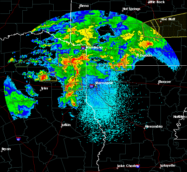 At 917 pm cdt, a severe thunderstorm was located near hawkins, or 13 miles east of mineola, moving east at 25 mph (radar indicated). Hazards include 60 mph wind gusts and quarter size hail. Hail damage to vehicles is expected. Expect wind damage to roofs, siding, and trees. At 917 pm cdt, a severe thunderstorm was located near hawkins, or 13 miles east of mineola, moving east at 25 mph (radar indicated). Hazards include 60 mph wind gusts and quarter size hail. Hail damage to vehicles is expected. Expect wind damage to roofs, siding, and trees.
|
| 4/2/2017 1:41 PM CDT |
 At 141 pm cdt, a severe thunderstorm capable of producing a tornado was located over gilmer, moving northeast at 50 mph (radar indicated rotation). Hazards include tornado and quarter size hail. Flying debris will be dangerous to those caught without shelter. mobile homes will be damaged or destroyed. damage to roofs, windows, and vehicles will occur. tree damage is likely. this dangerous storm will be near, ore city and cedar springs around 200 pm cdt. lone star and jenkins around 210 pm cdt. daingerfield and hughes springs around 215 pm cdt. Other locations impacted by this tornadic thunderstorm include fairview, marietta, lafayette, avinger, center point, holly springs, bettie, union grove, midway and pritchett. At 141 pm cdt, a severe thunderstorm capable of producing a tornado was located over gilmer, moving northeast at 50 mph (radar indicated rotation). Hazards include tornado and quarter size hail. Flying debris will be dangerous to those caught without shelter. mobile homes will be damaged or destroyed. damage to roofs, windows, and vehicles will occur. tree damage is likely. this dangerous storm will be near, ore city and cedar springs around 200 pm cdt. lone star and jenkins around 210 pm cdt. daingerfield and hughes springs around 215 pm cdt. Other locations impacted by this tornadic thunderstorm include fairview, marietta, lafayette, avinger, center point, holly springs, bettie, union grove, midway and pritchett.
|
| 2/20/2017 4:04 AM CST |
 At 403 am cst, a line of severe thunderstorms extended from near east mountain south to near alto, moving northeast at 50 mph (radar indicated). Hazards include 60 mph wind gusts and penny size hail. expect damage to roofs, siding, and trees At 403 am cst, a line of severe thunderstorms extended from near east mountain south to near alto, moving northeast at 50 mph (radar indicated). Hazards include 60 mph wind gusts and penny size hail. expect damage to roofs, siding, and trees
|
| 1/2/2017 7:28 AM CST |
 At 728 am cst, severe thunderstorms were located along a line extending from near newsome to near big sandy to near arp, moving northeast at 45 mph (radar indicated). Hazards include 60 mph wind gusts and quarter size hail. Hail damage to vehicles is expected. Expect wind damage to roofs, siding, and trees. At 728 am cst, severe thunderstorms were located along a line extending from near newsome to near big sandy to near arp, moving northeast at 45 mph (radar indicated). Hazards include 60 mph wind gusts and quarter size hail. Hail damage to vehicles is expected. Expect wind damage to roofs, siding, and trees.
|
| 1/2/2017 6:31 AM CST |
 At 631 am cst, severe thunderstorms were located along a line extending from near campbell to near fruitvale to 7 miles west of edom to 11 miles west of frankston to 10 miles west of elkhart, moving east at 60 mph (radar indicated). Hazards include 60 mph wind gusts and quarter size hail. Hail damage to vehicles is expected. Expect wind damage to roofs, siding, and trees. At 631 am cst, severe thunderstorms were located along a line extending from near campbell to near fruitvale to 7 miles west of edom to 11 miles west of frankston to 10 miles west of elkhart, moving east at 60 mph (radar indicated). Hazards include 60 mph wind gusts and quarter size hail. Hail damage to vehicles is expected. Expect wind damage to roofs, siding, and trees.
|
| 7/15/2016 4:03 PM CDT |
 At 402 pm cdt, a severe thunderstorm was located near gilmer, moving east at 25 mph (radar indicated). Hazards include 60 mph wind gusts and half dollar size hail. Hail damage to vehicles is expected. Expect wind damage to roofs, siding, and trees. At 402 pm cdt, a severe thunderstorm was located near gilmer, moving east at 25 mph (radar indicated). Hazards include 60 mph wind gusts and half dollar size hail. Hail damage to vehicles is expected. Expect wind damage to roofs, siding, and trees.
|
| 5/31/2016 5:57 PM CDT |
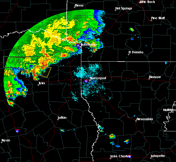 At 553 pm cdt, a severe thunderstorm was located just east and southeast of quitman, moving slowly southeast at 15 mph (radar indicated). Hazards include 60 mph wind gusts and quarter size hail. Hail damage to vehicles is expected. expect wind damage to roofs, siding, and trees. Locations impacted include, gilmer, big sandy, hawkins, hainesville, rosewood, pritchett, bettie and grice. At 553 pm cdt, a severe thunderstorm was located just east and southeast of quitman, moving slowly southeast at 15 mph (radar indicated). Hazards include 60 mph wind gusts and quarter size hail. Hail damage to vehicles is expected. expect wind damage to roofs, siding, and trees. Locations impacted include, gilmer, big sandy, hawkins, hainesville, rosewood, pritchett, bettie and grice.
|
| 5/31/2016 5:28 PM CDT |
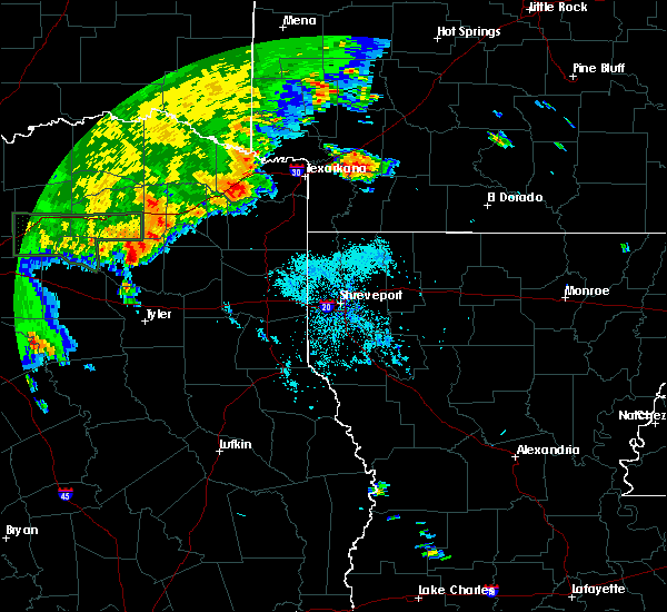 At 527 pm cdt, a severe thunderstorm was located near hainesville, or 11 miles south of winnsboro, moving east southeast at 15 mph (radar indicated). Hazards include 60 mph wind gusts and quarter size hail. Hail damage to vehicles is expected. Expect wind damage to roofs, siding, and trees. At 527 pm cdt, a severe thunderstorm was located near hainesville, or 11 miles south of winnsboro, moving east southeast at 15 mph (radar indicated). Hazards include 60 mph wind gusts and quarter size hail. Hail damage to vehicles is expected. Expect wind damage to roofs, siding, and trees.
|
| 4/29/2016 7:16 PM CDT |
 At 716 pm cdt, a severe thunderstorm capable of producing a tornado was located near gilmer, moving northeast at 30 mph (radar indicated rotation). Hazards include tornado and quarter size hail. Flying debris will be dangerous to those caught without shelter. mobile homes will be damaged or destroyed. damage to roofs, windows, and vehicles will occur. tree damage is likely. this dangerous storm will be near, ore city and cedar springs around 740 pm cdt. lone star around 755 pm cdt. Other locations impacted by this tornadic thunderstorm include bettie, holly springs, lafayette, midway and center point. At 716 pm cdt, a severe thunderstorm capable of producing a tornado was located near gilmer, moving northeast at 30 mph (radar indicated rotation). Hazards include tornado and quarter size hail. Flying debris will be dangerous to those caught without shelter. mobile homes will be damaged or destroyed. damage to roofs, windows, and vehicles will occur. tree damage is likely. this dangerous storm will be near, ore city and cedar springs around 740 pm cdt. lone star around 755 pm cdt. Other locations impacted by this tornadic thunderstorm include bettie, holly springs, lafayette, midway and center point.
|
| 4/29/2016 7:13 PM CDT |
 At 713 pm cdt, a severe thunderstorm was located 8 miles southeast of pittsburg, moving northeast at 40 mph (radar indicated). Hazards include 70 mph wind gusts and quarter size hail. Hail damage to vehicles is expected. expect considerable tree damage. Wind damage is also likely to mobile homes, roofs, and outbuildings. At 713 pm cdt, a severe thunderstorm was located 8 miles southeast of pittsburg, moving northeast at 40 mph (radar indicated). Hazards include 70 mph wind gusts and quarter size hail. Hail damage to vehicles is expected. expect considerable tree damage. Wind damage is also likely to mobile homes, roofs, and outbuildings.
|
| 4/29/2016 7:07 PM CDT |
 At 706 pm cdt, a severe thunderstorm was located near rosewood, or 7 miles northwest of gilmer, moving northeast at 40 mph (radar indicated). Hazards include golf ball size hail. People and animals outdoors will be injured. expect damage to roofs, siding, windows, and vehicles. locations impacted include, gilmer, leesburg, rosewood, pritchett, bettie, grice and perryville. A tornado watch remains in effect until 1000 pm cdt for northeastern texas. At 706 pm cdt, a severe thunderstorm was located near rosewood, or 7 miles northwest of gilmer, moving northeast at 40 mph (radar indicated). Hazards include golf ball size hail. People and animals outdoors will be injured. expect damage to roofs, siding, windows, and vehicles. locations impacted include, gilmer, leesburg, rosewood, pritchett, bettie, grice and perryville. A tornado watch remains in effect until 1000 pm cdt for northeastern texas.
|
| 4/29/2016 6:30 PM CDT | Ozarka had its roof ripped off and 18 wheelers are overturne in upshur county TX, 11.4 miles ESE of Gilmer, TX |
| 4/29/2016 6:29 PM CDT |
 At 629 pm cdt, a severe thunderstorm was located over hoard, or near mineola, moving northeast at 35 mph (radar indicated). Hazards include golf ball size hail. People and animals outdoors will be injured. Expect damage to roofs, siding, windows, and vehicles. At 629 pm cdt, a severe thunderstorm was located over hoard, or near mineola, moving northeast at 35 mph (radar indicated). Hazards include golf ball size hail. People and animals outdoors will be injured. Expect damage to roofs, siding, windows, and vehicles.
|
| 4/29/2016 12:15 PM CDT |
 At 1215 pm cdt, a severe thunderstorm was located 8 miles southwest of hawkins, or 10 miles north of tyler, moving northeast at 50 mph (radar indicated). Hazards include 60 mph wind gusts and quarter size hail. Hail damage to vehicles is expected. Expect wind damage to roofs, siding, and trees. At 1215 pm cdt, a severe thunderstorm was located 8 miles southwest of hawkins, or 10 miles north of tyler, moving northeast at 50 mph (radar indicated). Hazards include 60 mph wind gusts and quarter size hail. Hail damage to vehicles is expected. Expect wind damage to roofs, siding, and trees.
|
| 4/27/2016 1:30 AM CDT |
 At 130 am cdt, severe thunderstorms were located along a line extending from near omaha to near lone star to 7 miles west of cedar springs to near rosewood to near big sandy to tyler to 9 miles west of frankston, moving southeast at 35 mph (radar indicated). Hazards include 60 mph wind gusts. Expect damage to roofs. siding. and trees. Locations impacted include, tyler, mount pleasant, whitehouse, white oak, gladewater, gilmer, pittsburg, leesburg, lindale, daingerfield, bullard, big sandy, hawkins, clarksville city, east mountain, mount selman, west mountain, reese, rosewood and rocky branch. At 130 am cdt, severe thunderstorms were located along a line extending from near omaha to near lone star to 7 miles west of cedar springs to near rosewood to near big sandy to tyler to 9 miles west of frankston, moving southeast at 35 mph (radar indicated). Hazards include 60 mph wind gusts. Expect damage to roofs. siding. and trees. Locations impacted include, tyler, mount pleasant, whitehouse, white oak, gladewater, gilmer, pittsburg, leesburg, lindale, daingerfield, bullard, big sandy, hawkins, clarksville city, east mountain, mount selman, west mountain, reese, rosewood and rocky branch.
|
| 4/27/2016 12:43 AM CDT |
 At 1243 am cdt, severe thunderstorms were located along a line extending from near pleasant grove to 6 miles northwest of edom to near trinidad, moving east at 45 mph (radar indicated). Hazards include 60 mph wind gusts and quarter size hail. Hail damage to vehicles is expected. Expect wind damage to roofs, siding, and trees. At 1243 am cdt, severe thunderstorms were located along a line extending from near pleasant grove to 6 miles northwest of edom to near trinidad, moving east at 45 mph (radar indicated). Hazards include 60 mph wind gusts and quarter size hail. Hail damage to vehicles is expected. Expect wind damage to roofs, siding, and trees.
|
| 4/11/2016 6:45 PM CDT | Baseball sized hail reported 5.6 miles SSE of Gilmer, TX, baseball sized hail reported at union hill high school... |
| 4/11/2016 6:24 PM CDT | Golf Ball sized hail reported 0.4 miles ENE of Gilmer, TX, a picture was posted to the kltv facebook page of large hail estimated to be the size of golfballs that fell in gilmer. |
| 4/11/2016 6:24 PM CDT | A large tree was blown down behind a home in gilme in upshur county TX, 0.4 miles ENE of Gilmer, TX |
| 4/11/2016 6:20 PM CDT |
 At 619 pm cdt, a severe thunderstorm capable of producing a tornado was located 6 miles north of gilmer, moving east at 35 mph (radar indicated rotation). Hazards include tornado and quarter size hail. Flying debris will be dangerous to those caught without shelter. mobile homes will be damaged or destroyed. damage to roofs, windows, and vehicles will occur. tree damage is likely. this dangerous storm will be near, cedar springs around 635 pm cdt. ore city around 640 pm cdt. Other locations impacted by this tornadic thunderstorm include midway and bettie. At 619 pm cdt, a severe thunderstorm capable of producing a tornado was located 6 miles north of gilmer, moving east at 35 mph (radar indicated rotation). Hazards include tornado and quarter size hail. Flying debris will be dangerous to those caught without shelter. mobile homes will be damaged or destroyed. damage to roofs, windows, and vehicles will occur. tree damage is likely. this dangerous storm will be near, cedar springs around 635 pm cdt. ore city around 640 pm cdt. Other locations impacted by this tornadic thunderstorm include midway and bettie.
|
| 4/11/2016 6:15 PM CDT |
 At 614 pm cdt, a severe thunderstorm was located 8 miles south of pittsburg, moving east at 35 mph (radar indicated and several reports of large hail). Hazards include 60 mph wind gusts and quarter size hail. Hail damage to vehicles is expected. expect wind damage to roofs, siding, and trees. Locations impacted include, gilmer, pittsburg, lone star, ore city, cedar springs, diana, rosewood, jenkins, midway, bettie, holly springs, lafayette and center point. At 614 pm cdt, a severe thunderstorm was located 8 miles south of pittsburg, moving east at 35 mph (radar indicated and several reports of large hail). Hazards include 60 mph wind gusts and quarter size hail. Hail damage to vehicles is expected. expect wind damage to roofs, siding, and trees. Locations impacted include, gilmer, pittsburg, lone star, ore city, cedar springs, diana, rosewood, jenkins, midway, bettie, holly springs, lafayette and center point.
|
| 4/11/2016 6:13 PM CDT | Tennis Ball sized hail reported 9.6 miles S of Gilmer, TX, a picture was posted to the kltv facebook page of measured tennis ball size hail that fell near the bettie community in northern upshur county. |
| 4/11/2016 6:03 PM CDT | Tea Cup sized hail reported 10.1 miles SE of Gilmer, TX, a picture was posted to the kltv facebook page of large hail slightly larger than baseballs that fell in the simpsonville community in northwest upshur county. |
| 4/11/2016 6:03 PM CDT | Tea Cup sized hail reported 10.1 miles SE of Gilmer, TX, a picture was posted to the kltv facebook page of large hail that was measured to be three and a half inches in diameter that fell in the simpsonville community in nort |
| 4/11/2016 5:52 PM CDT |
 At 551 pm cdt, a severe thunderstorm was located over scroggins, or near winnsboro, moving east at 40 mph (radar indicated). Hazards include 70 mph wind gusts and quarter size hail. Hail damage to vehicles is expected. expect considerable tree damage. Wind damage is also likely to mobile homes, roofs, and outbuildings. At 551 pm cdt, a severe thunderstorm was located over scroggins, or near winnsboro, moving east at 40 mph (radar indicated). Hazards include 70 mph wind gusts and quarter size hail. Hail damage to vehicles is expected. expect considerable tree damage. Wind damage is also likely to mobile homes, roofs, and outbuildings.
|
| 3/30/2016 4:13 PM CDT |
 At 412 pm cdt, a severe thunderstorm capable of producing a tornado was located 7 miles west of rosewood, or 14 miles west of gilmer, moving northeast at 45 mph (radar indicated rotation). Hazards include tornado and quarter size hail. Flying debris will be dangerous to those caught without shelter. mobile homes will be damaged or destroyed. damage to roofs, windows, and vehicles will occur. tree damage is likely. this dangerous storm will be near, rosewood around 420 pm cdt. gilmer around 430 pm cdt. pittsburg around 440 pm cdt. Other locations impacted by this tornadic thunderstorm include bettie, holly springs, grice, lafayette, midway, harvard, rocky mound, perryville and center point. At 412 pm cdt, a severe thunderstorm capable of producing a tornado was located 7 miles west of rosewood, or 14 miles west of gilmer, moving northeast at 45 mph (radar indicated rotation). Hazards include tornado and quarter size hail. Flying debris will be dangerous to those caught without shelter. mobile homes will be damaged or destroyed. damage to roofs, windows, and vehicles will occur. tree damage is likely. this dangerous storm will be near, rosewood around 420 pm cdt. gilmer around 430 pm cdt. pittsburg around 440 pm cdt. Other locations impacted by this tornadic thunderstorm include bettie, holly springs, grice, lafayette, midway, harvard, rocky mound, perryville and center point.
|
| 3/24/2016 1:45 AM CDT | Several trees down in gilme in upshur county TX, 0.4 miles ENE of Gilmer, TX |
| 3/24/2016 1:03 AM CDT |
 At 103 am cdt, severe thunderstorms were located along a line extending from near cookville to near scroggins to near hainesville, moving east southeast at 30 mph. these storms continue to show a weakening trend, and additional weakening is expected during the next 15 minutes (radar indicated). Hazards include 60 mph wind gusts. Expect damage to roofs. siding. and trees. Locations impacted include, mount pleasant, gladewater, gilmer, pittsburg, winnsboro, leesburg, big sandy, hawkins, cookville, west mountain, newsome, hainesville, rosewood, scroggins, winfield, midway, miller`s cove, rocky mound, bettie and lafayette. At 103 am cdt, severe thunderstorms were located along a line extending from near cookville to near scroggins to near hainesville, moving east southeast at 30 mph. these storms continue to show a weakening trend, and additional weakening is expected during the next 15 minutes (radar indicated). Hazards include 60 mph wind gusts. Expect damage to roofs. siding. and trees. Locations impacted include, mount pleasant, gladewater, gilmer, pittsburg, winnsboro, leesburg, big sandy, hawkins, cookville, west mountain, newsome, hainesville, rosewood, scroggins, winfield, midway, miller`s cove, rocky mound, bettie and lafayette.
|
| 3/24/2016 12:20 AM CDT |
 At 1220 am cdt, severe thunderstorms were located along a line extending from 8 miles southeast of cooper lake park south sulphur to 7 miles southwest of como to near golden, moving east at 45 mph (radar indicated). Hazards include 60 mph wind gusts and quarter size hail. Hail damage to vehicles is expected. Expect wind damage to roofs, siding, and trees. At 1220 am cdt, severe thunderstorms were located along a line extending from 8 miles southeast of cooper lake park south sulphur to 7 miles southwest of como to near golden, moving east at 45 mph (radar indicated). Hazards include 60 mph wind gusts and quarter size hail. Hail damage to vehicles is expected. Expect wind damage to roofs, siding, and trees.
|
| 3/8/2016 2:22 PM CST |
 At 220 pm cst, severe thunderstorms were located along a line extending from near pittsburg to 9 miles north of gilmer to east mountain. a second thunderstorm was located over naples, daingerfield, and lone star. both storms are moving northeast at 40 mph (radar indicated). Hazards include 70 mph wind gusts and nickel size hail. Expect considerable tree damage. damage is likely to mobile homes, roofs, and outbuildings. locations impacted include, mount pleasant, gladewater, gilmer, pittsburg, leesburg, daingerfield, hughes springs, lone star, naples, ore city, omaha, east mountain, cedar springs, diana, cookville, west mountain, rocky branch, jenkins, us 259 and i 30 intersection and cason. A tornado watch remains in effect until 600 pm cst for northeastern texas. At 220 pm cst, severe thunderstorms were located along a line extending from near pittsburg to 9 miles north of gilmer to east mountain. a second thunderstorm was located over naples, daingerfield, and lone star. both storms are moving northeast at 40 mph (radar indicated). Hazards include 70 mph wind gusts and nickel size hail. Expect considerable tree damage. damage is likely to mobile homes, roofs, and outbuildings. locations impacted include, mount pleasant, gladewater, gilmer, pittsburg, leesburg, daingerfield, hughes springs, lone star, naples, ore city, omaha, east mountain, cedar springs, diana, cookville, west mountain, rocky branch, jenkins, us 259 and i 30 intersection and cason. A tornado watch remains in effect until 600 pm cst for northeastern texas.
|
| 3/8/2016 1:58 PM CST |
 At 158 pm cst, severe thunderstorms were located along a line extending from near winnsboro to near rosewood to near big sandy, moving northeast at 35 mph (radar indicated). Hazards include 70 mph wind gusts and nickel size hail. Expect considerable tree damage. Damage is likely to mobile homes, roofs, and outbuildings. At 158 pm cst, severe thunderstorms were located along a line extending from near winnsboro to near rosewood to near big sandy, moving northeast at 35 mph (radar indicated). Hazards include 70 mph wind gusts and nickel size hail. Expect considerable tree damage. Damage is likely to mobile homes, roofs, and outbuildings.
|
| 12/27/2015 3:25 PM CST | Tree on house 1.5 miles west of bettie... texas... fire and rescue reported... trees snapped and uprooted in upshur county TX, 4.7 miles S of Gilmer, TX |
| 12/27/2015 3:24 PM CST |
 At 323 pm cst, a severe thunderstorm capable of producing a tornado was located over gilmer, moving north at 50 mph (radar indicated rotation). Hazards include tornado. Flying debris will be dangerous to those caught without shelter. mobile homes will be damaged or destroyed. damage to roofs, windows, and vehicles will occur. tree damage is likely. this dangerous storm will be near, pittsburg around 345 pm cst. cason around 350 pm cst. omaha and cookville around 400 pm cst. naples around 405 pm cst. Other locations impacted by this tornadic thunderstorm include roeder, bettie, holly springs, lafayette, midway, harvard, rocky mound and center point. At 323 pm cst, a severe thunderstorm capable of producing a tornado was located over gilmer, moving north at 50 mph (radar indicated rotation). Hazards include tornado. Flying debris will be dangerous to those caught without shelter. mobile homes will be damaged or destroyed. damage to roofs, windows, and vehicles will occur. tree damage is likely. this dangerous storm will be near, pittsburg around 345 pm cst. cason around 350 pm cst. omaha and cookville around 400 pm cst. naples around 405 pm cst. Other locations impacted by this tornadic thunderstorm include roeder, bettie, holly springs, lafayette, midway, harvard, rocky mound and center point.
|
| 12/27/2015 3:10 PM CST |
 At 309 pm cst, severe thunderstorms were located along a line extending from scroggins to near big sandy, moving northeast at 50 mph (radar indicated). Hazards include 60 mph wind gusts. Expect damage to roofs. siding. And trees. At 309 pm cst, severe thunderstorms were located along a line extending from scroggins to near big sandy, moving northeast at 50 mph (radar indicated). Hazards include 60 mph wind gusts. Expect damage to roofs. siding. And trees.
|
| 12/27/2015 2:17 PM CST |
 At 216 pm cst, a severe thunderstorm capable of producing a tornado was located over rosewood, or 7 miles northwest of gilmer, moving north at 45 mph (radar indicated rotation). Hazards include tornado. Flying debris will be dangerous to those caught without shelter. mobile homes will be damaged or destroyed. damage to roofs, windows, and vehicles will occur. tree damage is likely. this dangerous storm will be near, leesburg and newsome around 235 pm cst. pittsburg around 240 pm cst. Other locations impacted by this tornadic thunderstorm include bettie, grice, rocky mound, midway and harvard. At 216 pm cst, a severe thunderstorm capable of producing a tornado was located over rosewood, or 7 miles northwest of gilmer, moving north at 45 mph (radar indicated rotation). Hazards include tornado. Flying debris will be dangerous to those caught without shelter. mobile homes will be damaged or destroyed. damage to roofs, windows, and vehicles will occur. tree damage is likely. this dangerous storm will be near, leesburg and newsome around 235 pm cst. pittsburg around 240 pm cst. Other locations impacted by this tornadic thunderstorm include bettie, grice, rocky mound, midway and harvard.
|
| 12/13/2015 6:40 AM CST | 4 trees reported down south and sw of gilmer in upshur county TX, 5.4 miles NNE of Gilmer, TX |
| 5/30/2015 9:34 AM CDT | At 933 am cdt, a severe thunderstorm was located 7 miles north of rosewood, or 8 miles south of leesburg, moving east at 40 mph (radar indicated). Hazards include 60 mph wind gusts and nickel size hail. Expect damage to roofs. siding and trees. this severe thunderstorm will be near, gilmer around 940 am cdt. cedar springs around 1000 am cdt. lone star around 1005 am cdt. daingerfield and jenkins around 1010 am cdt. hughes springs around 1015 am cdt. Other locations impacted by this severe thunderstorm include roeder, pritchett, bettie, holly springs, grice, lafayette, midway, harvard, union grove and rocky mound. |
| 5/30/2015 8:14 AM CDT | At 813 am cdt, severe thunderstorms were located along a line extending from near east tawakoni to near grand saline to 6 miles north of van to near edom to near chandler, moving east at 40 mph (radar indicated). Hazards include 60 mph wind gusts and quarter size hail. Hail damage to vehicles is expected. expect wind damage to roofs, siding and trees. severe thunderstorms will be near, golden around 825 am cdt. mineola and lindale around 830 am cdt. hoard around 835 am cdt. whitehouse, quitman and hainesville around 840 am cdt. tyler around 845 am cdt. hawkins around 850 am cdt. big sandy, arp and pleasant grove around 855 am cdt. overton and rosewood around 905 am cdt. Other locations impacted by these severe thunderstorms include pritchett, alba, noonday, yantis, grice, red springs, winona, new chapel hill, forest hill and perryville. |
| 5/26/2015 10:02 PM CDT | At 1001 pm cdt, a severe thunderstorm was located near west mountain, or near gilmer, moving northeast at 20 mph (radar indicated). Hazards include quarter size hail. damage to vehicles is expected |
| 5/25/2015 4:46 PM CDT | At 446 pm cdt, severe thunderstorms were located along a line extending from 9 miles northeast of cooper to 9 miles southwest of como to near canton, moving east at 85 mph (radar indicated). Hazards include 60 mph wind gusts and quarter size hail. Hail damage to vehicles is expected. Expect wind damage to roofs, siding and trees. |
| 5/25/2015 4:46 PM CDT | At 446 pm cdt, severe thunderstorms were located along a line extending from 9 miles northeast of cooper to 9 miles southwest of como to near canton, moving east at 85 mph (radar indicated). Hazards include 60 mph wind gusts and quarter size hail. Hail damage to vehicles is expected. Expect wind damage to roofs, siding and trees. |
| 5/11/2015 12:49 AM CDT | At 1249 am cdt, severe thunderstorms were located along a line extending from de kalb to 8 miles west of maud to 8 miles east of naples to ore city, moving northeast at 45 mph (radar indicated). Hazards include 60 mph wind gusts. Expect damage to roofs. siding and trees. locations impacted include, gilmer, new boston, daingerfield, hughes springs, de kalb, lone star, naples, ore city, omaha, cedar springs, rocky branch, jenkins, cason, avinger, marietta, pritchett, bettie, holly springs, lafayette and bryans mill. a tornado watch remains in effect until 500 am cdt for northeastern texas. Possible. |
| 5/11/2015 12:07 AM CDT | At 1207 am cdt, severe thunderstorms were located along a line extending from near mount pleasant to near cason to gilmer, moving northeast at 40 mph (radar indicated). Hazards include 60 mph wind gusts. Expect damage to roofs. Siding and trees. |
| 5/10/2015 11:14 PM CDT | At 1114 pm cdt, severe thunderstorms were located along a line extending from near pleasant grove to near hawkins to near lindale, moving northeast at 25 mph (radar indicated). Hazards include 60 mph wind gusts and half dollar size hail. Hail damage to vehicles is expected. expect wind damage to roofs, siding and trees. severe thunderstorms will be near, winnsboro around 1125 pm cdt. rosewood around 1140 pm cdt. newsome around 1145 pm cdt. leesburg around 1150 pm cdt. gilmer and big sandy around 1155 pm cdt. pittsburg around 1205 am cdt. other locations impacted by these severe thunderstorms include pritchett, noonday, bettie, grice, midway, harvard, red springs, winona, new chapel hill and rocky mound. a tornado watch remains in effect until midnight cdt for northeastern texas. 1. 25in. |
| 4/24/2015 9:15 PM CDT | Numerous trees down across the county area in upshur county TX, 0.4 miles ENE of Gilmer, TX |
| 4/24/2015 9:15 PM CDT | At 914 pm cdt, severe thunderstorms were located along a line extending from 7 miles southeast of naples to near diana to near tyler, moving east at 35 mph (radar indicated). Hazards include 70 mph wind gusts and quarter size hail. Hail damage to vehicles is expected. expect considerable tree damage. wind damage is also likely to mobile homes, roofs and outbuildings. locations impacted include, tyler, longview, white oak, gladewater, gilmer, daingerfield, lone star, naples, big sandy, ore city, omaha, clarksville city, east mountain, cedar springs, diana, west mountain, rocky branch, jenkins, liberty city and noonday. a tornado watch remains in effect until 1000 pm cdt for northeastern texas. 1. 00in. |
| 4/24/2015 9:14 PM CDT | Numerous trees down across the county area in upshur county TX, 0.4 miles ENE of Gilmer, TX |
| 4/24/2015 8:59 PM CDT | At 858 pm cdt, severe thunderstorms were located along a line extending from omaha to west mountain to near chandler, moving east at 45 mph (radar indicated). Hazards include 70 mph wind gusts and quarter size hail. Hail damage to vehicles is expected. expect considerable tree damage. wind damage is also likely to mobile homes, roofs and outbuildings. widespread wind damage was reported earlier in wood county texas with this line of storms. locations impacted include, tyler, longview, mount pleasant, white oak, gladewater, gilmer, pittsburg, lindale, daingerfield. a tornado watch remains in effect until 1000 pm cdt for northeastern texas. 1. 00in. |
| 4/24/2015 8:58 PM CDT | Damage to union hill high school and several homes in the neighborhoo in upshur county TX, 5.8 miles SSE of Gilmer, TX |
| 4/24/2015 8:52 PM CDT | At 851 pm cdt, severe thunderstorms capable of producing both tornadoes and extensive straight line wind damage were located over gilmer, moving east at 50 mph (radar indicated rotation). Hazards include tornado. Flying debris will be dangerous to those caught without shelter. mobile homes will be damaged or destroyed. damage to roofs, windows and vehicles will occur. tree damage is likely. these dangerous storms will be near, gilmer around 855 pm cdt. east mountain around 905 pm cdt. ore city and diana around 910 pm cdt. other locations impacted by this tornadic thunderstorm include pritchett. Radar indicated. |
| 4/24/2015 8:40 PM CDT | Numerous trees down across the county area in upshur county TX, 0.4 miles ENE of Gilmer, TX |
| 4/24/2015 8:40 PM CDT | At 839 pm cdt, severe thunderstorms were located along a line extending from near mount pleasant to 6 miles north of hawkins to 8 miles west of brownsboro, moving east at 35 mph (radar indicated). Hazards include 60 mph wind gusts and quarter size hail. Hail damage to vehicles is expected. Expect wind damage to roofs, siding and trees. |
| 4/9/2015 4:51 PM CDT | The national weather service in shreveport has issued a * severe thunderstorm warning for. northwestern harrison county in northeastern texas. southwestern camp county in northeastern texas. upshur county in northeastern texas. Southeastern wood county in northeastern texas. |
| 10/2/2014 7:25 PM CDT | Numerous trees down in upshur county TX, 0.4 miles ENE of Gilmer, TX |
| 7/23/2014 6:50 PM CDT | Trees down county wide in upshur county TX, 0.4 miles ENE of Gilmer, TX |
| 5/9/2014 7:50 PM CDT | Quarter sized hail reported 6.9 miles S of Gilmer, TX |
| 3/28/2014 4:48 PM CDT | 2 trees down accross highway in upshur county TX, 5.1 miles E of Gilmer, TX |
| 3/28/2014 4:48 PM CDT | Trees down in upshur county TX, 2 miles SSE of Gilmer, TX |
| 11/11/2012 2:45 PM CST | Large tree down on fm 1650 in upshur county TX, 4.7 miles WNW of Gilmer, TX |
| 4/20/2012 5:45 AM CDT | Quarter sized hail reported 10.1 miles SE of Gilmer, TX |
| 4/3/2012 6:48 PM CDT | Several trees down across the county in upshur county TX, 0.4 miles ENE of Gilmer, TX |
| 3/20/2012 4:58 AM CDT | Tree down on hwy 155 north between gilmer and diana in upshur county TX, 1.9 miles W of Gilmer, TX |
| 12/5/2011 4:18 AM CST | Quarter sized hail reported 1 miles E of Gilmer, TX |
| 1/1/0001 12:00 AM | Trees down county wide. roof blown off west of gilme in upshur county TX, 0.4 miles ENE of Gilmer, TX |
| 1/1/0001 12:00 AM | Trees down on hwy 27 in upshur county TX, 0.7 miles SE of Gilmer, TX |
| 1/1/0001 12:00 AM | Quarter sized hail reported 0.4 miles ENE of Gilmer, TX, at east texas medical center. |
| 1/1/0001 12:00 AM | A 20 foot section of roof was removed from the gilmer cable tv busines in upshur county TX, 0.4 miles ENE of Gilmer, TX |
| 1/1/0001 12:00 AM | Heavy wind damage was reported to a sconic drive in and to the tefteller law office in the town of gilme in upshur county TX, 0.4 miles ENE of Gilmer, TX |
| 1/1/0001 12:00 AM | Section of metal roofing was blown off the roberts building on jefferson street. trees were also downed blocking sections of hwy. 15 in upshur county TX, 0.4 miles ENE of Gilmer, TX |
| 1/1/0001 12:00 AM | Several trees were downed north of town. two trees fell across mobile homes. there were no report of injurie in upshur county TX, 2 miles SSE of Gilmer, TX |
| 1/1/0001 12:00 AM | Large tree across hwy 15 in upshur county TX, 1.8 miles SW of Gilmer, TX |
| 1/1/0001 12:00 AM | Numerous trees have been blown down across western and northwest upshur count in upshur county TX, 10.1 miles SE of Gilmer, TX |
| 1/1/0001 12:00 AM | Trees down at cr 2088 and coyote road in upshur county TX, 6.1 miles SE of Gilmer, TX |
Hail Maps for Gilmer, TX
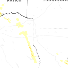
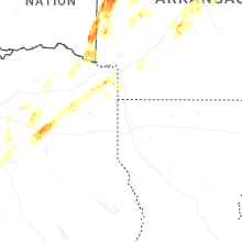


Connect with Interactive Hail Maps