

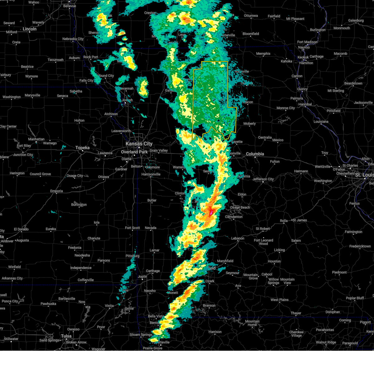
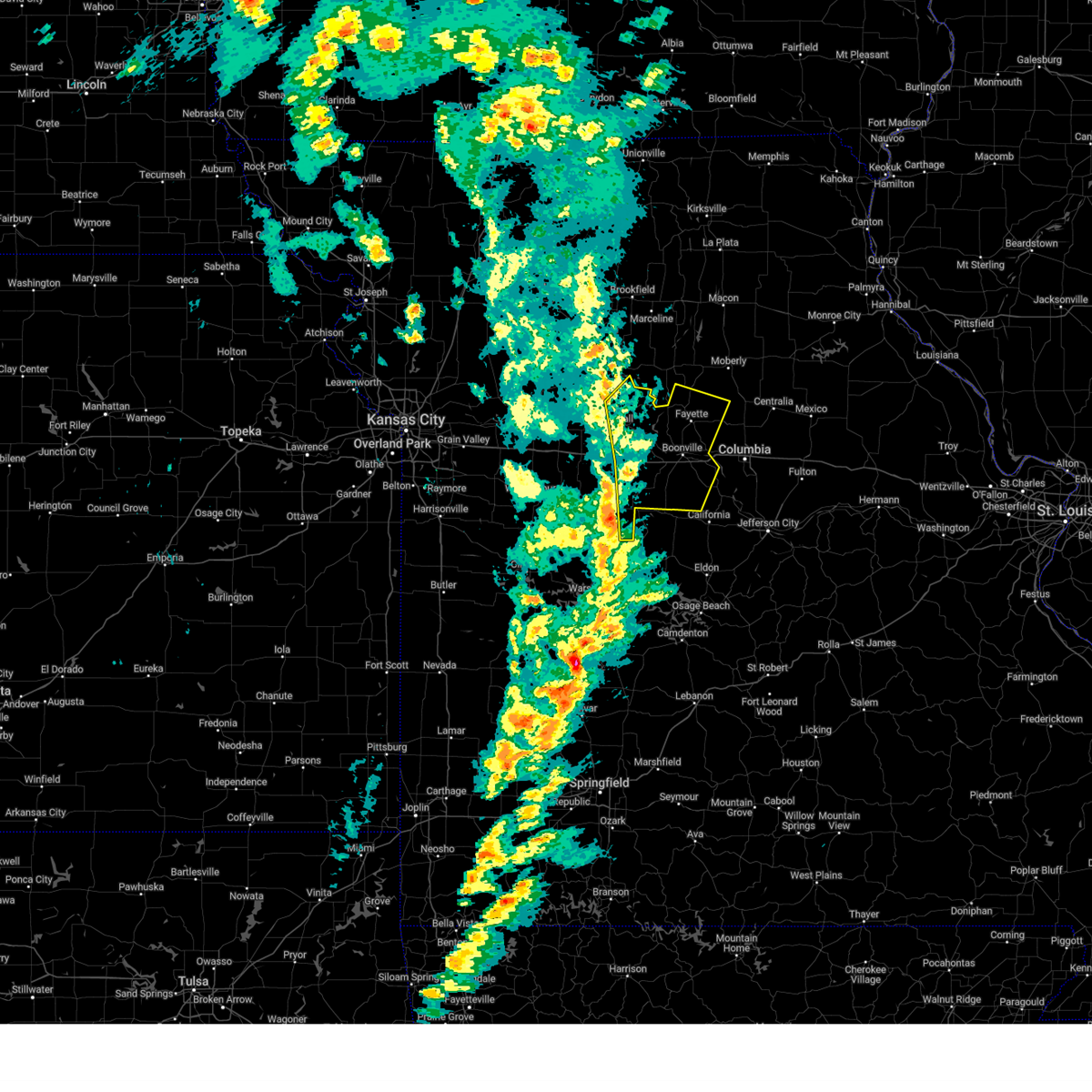
Hail Map for Glasgow, MO
The Glasgow, MO area has had 1 report of on-the-ground hail by trained spotters, and has been under severe weather warnings 16 times during the past 12 months. Doppler radar has detected hail at or near Glasgow, MO on 49 occasions.
| Name: | Glasgow, MO |
| Where Located: | 33.2 miles NW of Columbia, MO |
| Map: | Google Map for Glasgow, MO |
| Population: | 1103 |
| Housing Units: | 533 |
| More Info: | Search Google for Glasgow, MO |
0
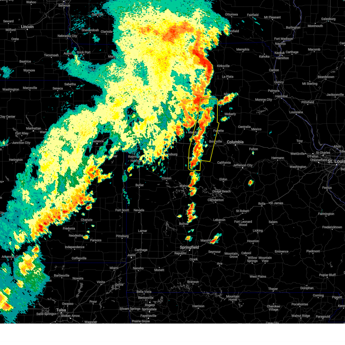
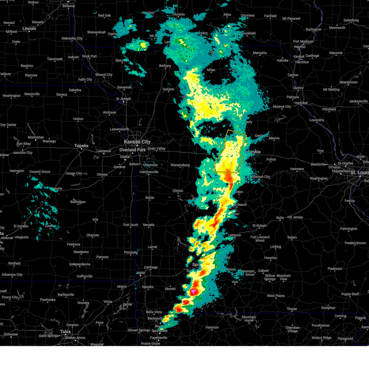
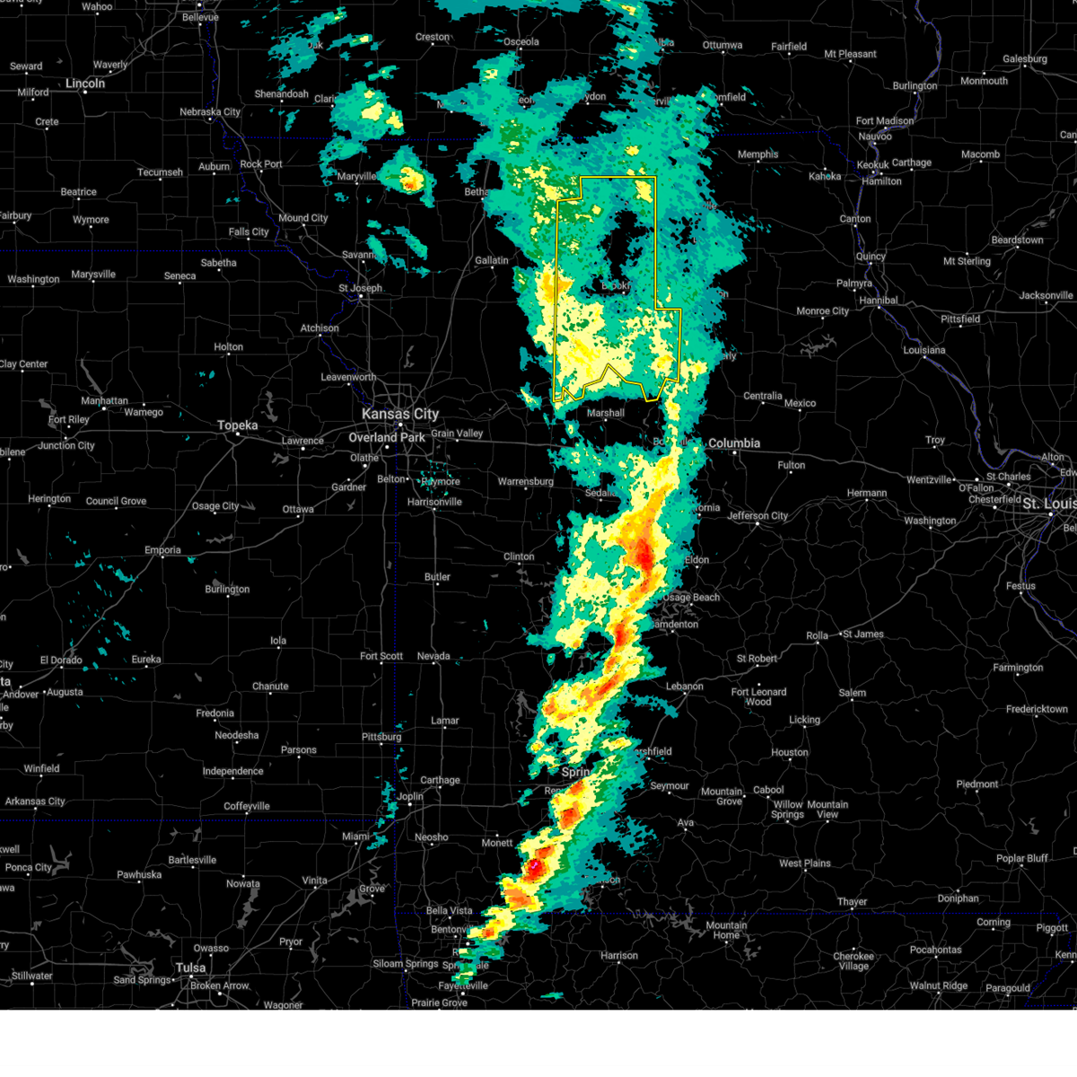
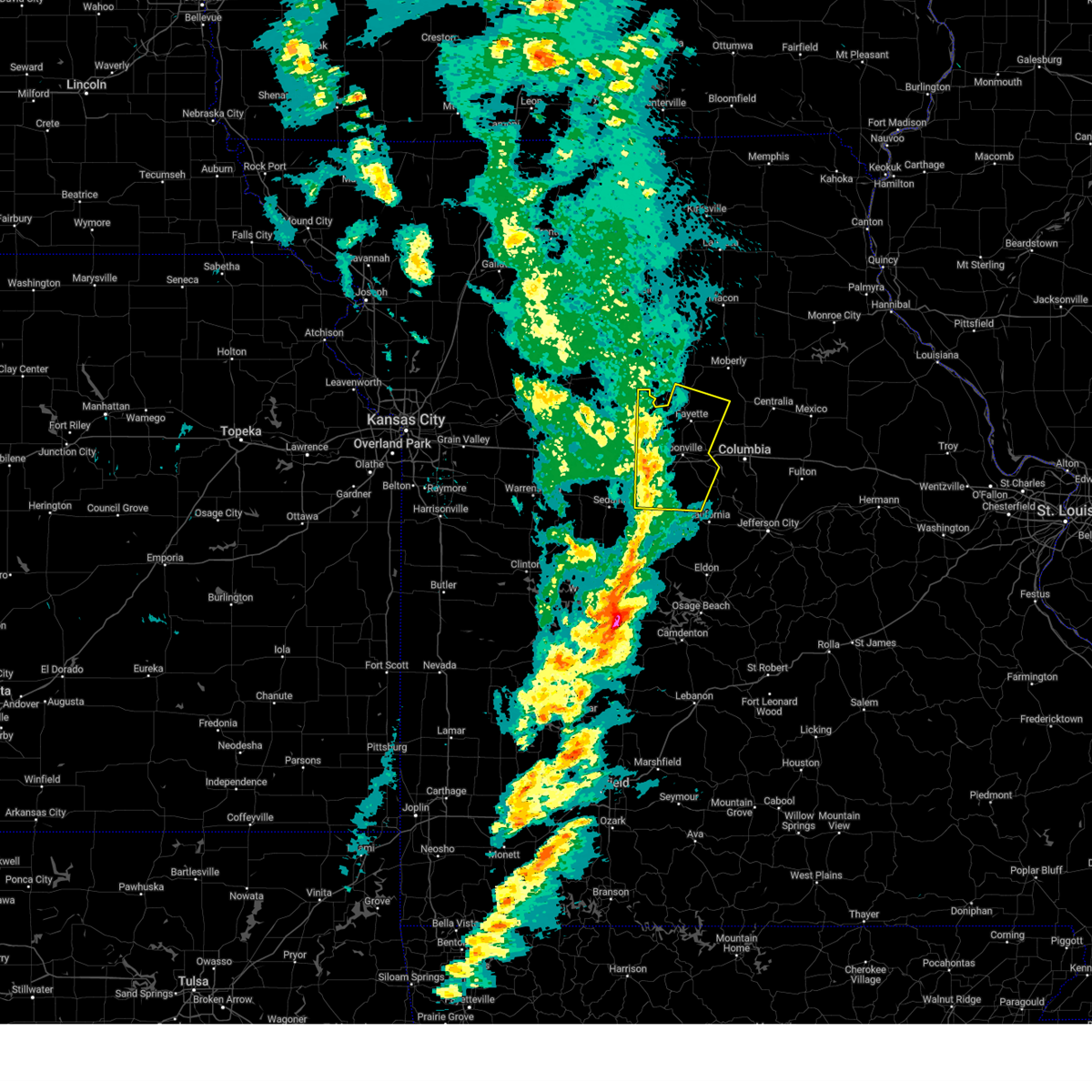
The Top Recent Hail Date for Glasgow, MO is Tuesday, June 25, 2024 (49th out of 49)

Hail and Wind Damage Spotted near Glasgow, MO
| Date / Time | Report Details |
|---|---|
| 6/30/2025 11:00 AM CDT | Private weather station reported a 60-mph gust in the wake of thunderstorms moving through about 15-30 minutes prior. weather station also reported a small pressure dro in howard county MO, 8.2 miles N of Glasgow, MO |
| 6/3/2025 4:32 PM CDT | Downed wires and power outages in the glasgow area. time estimated from rada in howard county MO, 0.9 miles S of Glasgow, MO |
| 6/3/2025 4:32 PM CDT | Svreax the national weather service in pleasant hill has issued a * severe thunderstorm warning for, southeastern adair county in northeastern missouri, eastern chariton county in north central missouri, randolph county in north central missouri, southeastern linn county in north central missouri, southeastern pettis county in central missouri, howard county in central missouri, southeastern saline county in central missouri, macon county in north central missouri, cooper county in central missouri, * until 530 pm cdt. * at 431 pm cdt, severe thunderstorms were located along a line extending from near callao to near armstrong to bunceton, moving east at 45 mph (automated weather station. a 62 mph wind gust was just reported at sedalia memorial airport). Hazards include 60 mph wind gusts and nickel size hail. expect damage to roofs, siding, and trees |
| 6/3/2025 4:24 PM CDT | Downed tree limbs and wires near route 5. time estimated from rada in chariton county MO, 5 miles S of Glasgow, MO |
| 6/3/2025 4:11 PM CDT |
 At 410 pm cdt, severe thunderstorms were located along a line extending from 10 miles southwest of marceline to slater to 6 miles southeast of green ridge, moving east at 40 mph (radar indicated). Hazards include 60 mph wind gusts and penny size hail. Expect damage to roofs, siding, and trees. locations impacted include, sedalia, marshall, boonville, marceline, slater, salisbury, glasgow, brunswick, pilot grove, smithton, keytesville, otterville, armstrong, gilliam, nelson, hughesville, blackwater, rothville, franklin, and arrow rock. This includes interstate 70 in missouri between mile markers 75 and 100. At 410 pm cdt, severe thunderstorms were located along a line extending from 10 miles southwest of marceline to slater to 6 miles southeast of green ridge, moving east at 40 mph (radar indicated). Hazards include 60 mph wind gusts and penny size hail. Expect damage to roofs, siding, and trees. locations impacted include, sedalia, marshall, boonville, marceline, slater, salisbury, glasgow, brunswick, pilot grove, smithton, keytesville, otterville, armstrong, gilliam, nelson, hughesville, blackwater, rothville, franklin, and arrow rock. This includes interstate 70 in missouri between mile markers 75 and 100.
|
| 6/3/2025 4:11 PM CDT |
 the severe thunderstorm warning has been cancelled and is no longer in effect the severe thunderstorm warning has been cancelled and is no longer in effect
|
| 6/3/2025 3:56 PM CDT | Svreax the national weather service in pleasant hill has issued a * severe thunderstorm warning for, chariton county in north central missouri, pettis county in central missouri, east central carroll county in north central missouri, western howard county in central missouri, saline county in central missouri, western cooper county in central missouri, * until 445 pm cdt. * at 355 pm cdt, severe thunderstorms were located along a line extending from near brunswick to near marshall to 6 miles southeast of windsor, moving northeast at 40 mph (radar indicated). Hazards include 60 mph wind gusts and penny size hail. expect damage to roofs, siding, and trees |
| 3/14/2025 5:56 PM CDT |
 The storms which prompted the warning have moved out of the area. therefore, the warning will be allowed to expire. however, gusty winds are still expected. a tornado watch remains in effect until 1100 pm cdt for central and north central missouri. The storms which prompted the warning have moved out of the area. therefore, the warning will be allowed to expire. however, gusty winds are still expected. a tornado watch remains in effect until 1100 pm cdt for central and north central missouri.
|
| 3/14/2025 5:43 PM CDT |
 The storm which prompted the warning has weakened below severe limits, and has exited the warned area. therefore, the warning will be allowed to expire. however, non-thunderstorm wind gusts up to 60 mph are still expected. a tornado watch remains in effect until 1100 pm cdt for central and north central missouri. a severe thunderstorm watch remains in effect until 700 pm cdt for west central missouri. The storm which prompted the warning has weakened below severe limits, and has exited the warned area. therefore, the warning will be allowed to expire. however, non-thunderstorm wind gusts up to 60 mph are still expected. a tornado watch remains in effect until 1100 pm cdt for central and north central missouri. a severe thunderstorm watch remains in effect until 700 pm cdt for west central missouri.
|
| 3/14/2025 5:39 PM CDT |
 At 538 pm cdt, severe thunderstorms were located along a line extending from near salisbury to fayette to bunceton, moving northeast at 50 mph (radar indicated). Hazards include 70 mph wind gusts and penny size hail. Expect considerable tree damage. damage is likely to mobile homes, roofs, and outbuildings. locations impacted include, franklin, boonville, bunceton, prairie home, glasgow, fayette, pilot grove, clifton city, armstrong, lamine, otterville, new franklin, and wooldridge. This includes interstate 70 in missouri between mile markers 91 and 114. At 538 pm cdt, severe thunderstorms were located along a line extending from near salisbury to fayette to bunceton, moving northeast at 50 mph (radar indicated). Hazards include 70 mph wind gusts and penny size hail. Expect considerable tree damage. damage is likely to mobile homes, roofs, and outbuildings. locations impacted include, franklin, boonville, bunceton, prairie home, glasgow, fayette, pilot grove, clifton city, armstrong, lamine, otterville, new franklin, and wooldridge. This includes interstate 70 in missouri between mile markers 91 and 114.
|
| 3/14/2025 5:39 PM CDT |
 the severe thunderstorm warning has been cancelled and is no longer in effect the severe thunderstorm warning has been cancelled and is no longer in effect
|
| 3/14/2025 5:20 PM CDT |
 the severe thunderstorm warning has been cancelled and is no longer in effect the severe thunderstorm warning has been cancelled and is no longer in effect
|
| 3/14/2025 5:20 PM CDT |
 At 518 pm cdt, severe thunderstorms were located along a line extending from near slater to 12 miles east of marshall to near otterville, moving northeast at 50 mph (radar indicated). Hazards include 70 mph wind gusts and penny size hail. Expect considerable tree damage. damage is likely to mobile homes, roofs, and outbuildings. locations impacted include, franklin, nelson, blackwater, boonville, bunceton, prairie home, glasgow, fayette, pilot grove, arrow rock, clifton city, armstrong, lamine, otterville, new franklin, gilliam, and wooldridge. This includes interstate 70 in missouri between mile markers 86 and 114. At 518 pm cdt, severe thunderstorms were located along a line extending from near slater to 12 miles east of marshall to near otterville, moving northeast at 50 mph (radar indicated). Hazards include 70 mph wind gusts and penny size hail. Expect considerable tree damage. damage is likely to mobile homes, roofs, and outbuildings. locations impacted include, franklin, nelson, blackwater, boonville, bunceton, prairie home, glasgow, fayette, pilot grove, arrow rock, clifton city, armstrong, lamine, otterville, new franklin, gilliam, and wooldridge. This includes interstate 70 in missouri between mile markers 86 and 114.
|
| 3/14/2025 5:19 PM CDT |
 At 518 pm cdt, showers with embedded thunderstorms were located 7 miles west of browning, or 15 miles southwest of milan, moving north at 60 mph (radar indicated). Hazards include 60 mph wind gusts. Expect damage to roofs, siding, and trees. Locations impacted include, carrollton, avalon, marceline, triplett, prairie hill, linneus, newtown, salisbury, reger, osgood, purdin, bogard, sumner, dalton, humphreys, pollock, saint catherine, brunswick, galt, and chula. At 518 pm cdt, showers with embedded thunderstorms were located 7 miles west of browning, or 15 miles southwest of milan, moving north at 60 mph (radar indicated). Hazards include 60 mph wind gusts. Expect damage to roofs, siding, and trees. Locations impacted include, carrollton, avalon, marceline, triplett, prairie hill, linneus, newtown, salisbury, reger, osgood, purdin, bogard, sumner, dalton, humphreys, pollock, saint catherine, brunswick, galt, and chula.
|
| 3/14/2025 5:06 PM CDT |
 Svreax the national weather service in pleasant hill has issued a * severe thunderstorm warning for, eastern pettis county in central missouri, howard county in central missouri, central saline county in central missouri, cooper county in central missouri, * until 600 pm cdt. * at 505 pm cdt, severe thunderstorms were located along a line extending from 6 miles west of slater to 9 miles southeast of marshall to smithton, moving northeast at 55 mph (radar indicated). Hazards include 70 mph wind gusts and penny size hail. Expect considerable tree damage. Damage is likely to mobile homes, roofs, and outbuildings. Svreax the national weather service in pleasant hill has issued a * severe thunderstorm warning for, eastern pettis county in central missouri, howard county in central missouri, central saline county in central missouri, cooper county in central missouri, * until 600 pm cdt. * at 505 pm cdt, severe thunderstorms were located along a line extending from 6 miles west of slater to 9 miles southeast of marshall to smithton, moving northeast at 55 mph (radar indicated). Hazards include 70 mph wind gusts and penny size hail. Expect considerable tree damage. Damage is likely to mobile homes, roofs, and outbuildings.
|
| 3/14/2025 4:57 PM CDT |
 Svreax the national weather service in pleasant hill has issued a * severe thunderstorm warning for, chariton county in north central missouri, linn county in north central missouri, eastern grundy county in north central missouri, sullivan county in north central missouri, central carroll county in north central missouri, eastern livingston county in north central missouri, * until 545 pm cdt. * at 456 pm cdt, a cluster of severe thunderstorms were located near wheeling, or 10 miles southeast of chillicothe, moving north at 60 mph (radar indicated). Hazards include 70 mph wind gusts and penny size hail. Expect considerable tree damage. Damage is likely to mobile homes, roofs, and outbuildings. Svreax the national weather service in pleasant hill has issued a * severe thunderstorm warning for, chariton county in north central missouri, linn county in north central missouri, eastern grundy county in north central missouri, sullivan county in north central missouri, central carroll county in north central missouri, eastern livingston county in north central missouri, * until 545 pm cdt. * at 456 pm cdt, a cluster of severe thunderstorms were located near wheeling, or 10 miles southeast of chillicothe, moving north at 60 mph (radar indicated). Hazards include 70 mph wind gusts and penny size hail. Expect considerable tree damage. Damage is likely to mobile homes, roofs, and outbuildings.
|
| 7/16/2024 8:52 AM CDT | Several reports of downed tree limbs and wires north of glasgow. time estimated from rada in howard county MO, 5.1 miles SSW of Glasgow, MO |
| 7/16/2024 8:46 AM CDT | Multiple reports of tree limbs and wires down near and north of glasgow. power is out through town. time estimated from rada in chariton county MO, 1.5 miles S of Glasgow, MO |
| 7/2/2024 11:13 PM CDT |
 At 1112 pm cdt, severe thunderstorms were located along a line extending from cairo to near fayette to near pilot grove, moving east at 35 mph (radar indicated). Hazards include 60 mph wind gusts. Expect damage to roofs, siding, and trees. locations impacted include, moberly, boonville, fayette, salisbury, huntsville, glasgow, new franklin, pilot grove, higbee, bunceton, clark, cairo, armstrong, prairie home, nelson, renick, blackwater, clifton hill, franklin, and wooldridge. This includes interstate 70 in missouri between mile markers 83 and 114. At 1112 pm cdt, severe thunderstorms were located along a line extending from cairo to near fayette to near pilot grove, moving east at 35 mph (radar indicated). Hazards include 60 mph wind gusts. Expect damage to roofs, siding, and trees. locations impacted include, moberly, boonville, fayette, salisbury, huntsville, glasgow, new franklin, pilot grove, higbee, bunceton, clark, cairo, armstrong, prairie home, nelson, renick, blackwater, clifton hill, franklin, and wooldridge. This includes interstate 70 in missouri between mile markers 83 and 114.
|
| 7/2/2024 10:44 PM CDT |
 Svreax the national weather service in pleasant hill has issued a * severe thunderstorm warning for, southeastern chariton county in north central missouri, randolph county in north central missouri, northern pettis county in central missouri, howard county in central missouri, saline county in central missouri, cooper county in central missouri, * until 1145 pm cdt. * at 1043 pm cdt, severe thunderstorms were located along a line extending from near callao to 10 miles southeast of marshall to near sedalia, moving east at 35 mph (radar indicated). Hazards include 60 mph wind gusts. expect damage to roofs, siding, and trees Svreax the national weather service in pleasant hill has issued a * severe thunderstorm warning for, southeastern chariton county in north central missouri, randolph county in north central missouri, northern pettis county in central missouri, howard county in central missouri, saline county in central missouri, cooper county in central missouri, * until 1145 pm cdt. * at 1043 pm cdt, severe thunderstorms were located along a line extending from near callao to 10 miles southeast of marshall to near sedalia, moving east at 35 mph (radar indicated). Hazards include 60 mph wind gusts. expect damage to roofs, siding, and trees
|
| 7/2/2024 10:13 PM CDT |
 Svreax the national weather service in pleasant hill has issued a * severe thunderstorm warning for, southern chariton county in north central missouri, west central randolph county in north central missouri, northern henry county in west central missouri, pettis county in central missouri, southeastern carroll county in north central missouri, western howard county in central missouri, saline county in central missouri, southeastern lafayette county in west central missouri, northwestern cooper county in central missouri, johnson county in west central missouri, * until 1045 pm cdt. * at 1013 pm cdt, severe thunderstorms were located along a line extending from 7 miles south of marceline to near marshall to near leeton, moving east at 40 mph (radar indicated). Hazards include 60 mph wind gusts. expect damage to roofs, siding, and trees Svreax the national weather service in pleasant hill has issued a * severe thunderstorm warning for, southern chariton county in north central missouri, west central randolph county in north central missouri, northern henry county in west central missouri, pettis county in central missouri, southeastern carroll county in north central missouri, western howard county in central missouri, saline county in central missouri, southeastern lafayette county in west central missouri, northwestern cooper county in central missouri, johnson county in west central missouri, * until 1045 pm cdt. * at 1013 pm cdt, severe thunderstorms were located along a line extending from 7 miles south of marceline to near marshall to near leeton, moving east at 40 mph (radar indicated). Hazards include 60 mph wind gusts. expect damage to roofs, siding, and trees
|
| 6/26/2024 2:52 AM CDT |
 The storms which prompted the warning have weakened below severe limits. therefore, the warning will be allowed to expire. however, gusty winds and heavy rain are still possible with these thunderstorms. a severe thunderstorm watch remains in effect until 700 am cdt for central and north central missouri. The storms which prompted the warning have weakened below severe limits. therefore, the warning will be allowed to expire. however, gusty winds and heavy rain are still possible with these thunderstorms. a severe thunderstorm watch remains in effect until 700 am cdt for central and north central missouri.
|
| 6/26/2024 2:29 AM CDT |
 At 229 am cdt, severe thunderstorms were located along a line extending from near cairo to 6 miles northeast of fayette to 8 miles northwest of new franklin, moving southeast at 30 mph (radar indicated). Hazards include 60 mph wind gusts and penny size hail. Expect damage to roofs, siding, and trees. locations impacted include, moberly, boonville, fayette, huntsville, glasgow, new franklin, higbee, clark, cairo, armstrong, prairie home, renick, jacksonville, clifton hill, franklin, and wooldridge. This includes interstate 70 in missouri between mile markers 102 and 114. At 229 am cdt, severe thunderstorms were located along a line extending from near cairo to 6 miles northeast of fayette to 8 miles northwest of new franklin, moving southeast at 30 mph (radar indicated). Hazards include 60 mph wind gusts and penny size hail. Expect damage to roofs, siding, and trees. locations impacted include, moberly, boonville, fayette, huntsville, glasgow, new franklin, higbee, clark, cairo, armstrong, prairie home, renick, jacksonville, clifton hill, franklin, and wooldridge. This includes interstate 70 in missouri between mile markers 102 and 114.
|
| 6/26/2024 2:29 AM CDT |
 the severe thunderstorm warning has been cancelled and is no longer in effect the severe thunderstorm warning has been cancelled and is no longer in effect
|
| 6/26/2024 2:14 AM CDT |
 Svreax the national weather service in pleasant hill has issued a * severe thunderstorm warning for, southeastern chariton county in north central missouri, randolph county in north central missouri, howard county in central missouri, east central saline county in central missouri, eastern cooper county in central missouri, * until 300 am cdt. * at 213 am cdt, severe thunderstorms were located along a line extending from near cairo to near armstrong to near slater, moving southeast at 45 mph (radar indicated). Hazards include 60 mph wind gusts and penny size hail. expect damage to roofs, siding, and trees Svreax the national weather service in pleasant hill has issued a * severe thunderstorm warning for, southeastern chariton county in north central missouri, randolph county in north central missouri, howard county in central missouri, east central saline county in central missouri, eastern cooper county in central missouri, * until 300 am cdt. * at 213 am cdt, severe thunderstorms were located along a line extending from near cairo to near armstrong to near slater, moving southeast at 45 mph (radar indicated). Hazards include 60 mph wind gusts and penny size hail. expect damage to roofs, siding, and trees
|
| 6/26/2024 1:48 AM CDT |
 At 148 am cdt, severe thunderstorms were located along a line extending from near callao to near brunswick to near norborne, moving southeast at 40 mph (radar indicated). Hazards include 60 mph wind gusts and penny size hail. Expect damage to roofs, siding, and trees. locations impacted include, marshall, macon, higginsville, carrollton, concordia, marceline, slater, salisbury, huntsville, glasgow, brunswick, waverly, bevier, norborne, keytesville, corder, alma, bosworth, callao, and cairo. This includes interstate 70 in missouri between mile markers 48 and 60. At 148 am cdt, severe thunderstorms were located along a line extending from near callao to near brunswick to near norborne, moving southeast at 40 mph (radar indicated). Hazards include 60 mph wind gusts and penny size hail. Expect damage to roofs, siding, and trees. locations impacted include, marshall, macon, higginsville, carrollton, concordia, marceline, slater, salisbury, huntsville, glasgow, brunswick, waverly, bevier, norborne, keytesville, corder, alma, bosworth, callao, and cairo. This includes interstate 70 in missouri between mile markers 48 and 60.
|
| 6/26/2024 1:48 AM CDT |
 the severe thunderstorm warning has been cancelled and is no longer in effect the severe thunderstorm warning has been cancelled and is no longer in effect
|
| 6/26/2024 1:25 AM CDT |
 Svreax the national weather service in pleasant hill has issued a * severe thunderstorm warning for, chariton county in north central missouri, northwestern randolph county in north central missouri, southeastern linn county in north central missouri, carroll county in north central missouri, saline county in central missouri, macon county in north central missouri, eastern lafayette county in west central missouri, * until 215 am cdt. * at 125 am cdt, severe thunderstorms were located along a line extending from near bucklin to 7 miles east of hale to 9 miles north of norborne, moving southeast at 40 mph (radar indicated). Hazards include 60 mph wind gusts and nickel size hail. expect damage to roofs, siding, and trees Svreax the national weather service in pleasant hill has issued a * severe thunderstorm warning for, chariton county in north central missouri, northwestern randolph county in north central missouri, southeastern linn county in north central missouri, carroll county in north central missouri, saline county in central missouri, macon county in north central missouri, eastern lafayette county in west central missouri, * until 215 am cdt. * at 125 am cdt, severe thunderstorms were located along a line extending from near bucklin to 7 miles east of hale to 9 miles north of norborne, moving southeast at 40 mph (radar indicated). Hazards include 60 mph wind gusts and nickel size hail. expect damage to roofs, siding, and trees
|
| 6/25/2024 4:54 PM CDT |
 Svreax the national weather service in pleasant hill has issued a * severe thunderstorm warning for, southern randolph county in north central missouri, howard county in central missouri, * until 545 pm cdt. * at 454 pm cdt, a severe thunderstorm was located near armstrong, or near fayette, moving southeast at 30 mph (radar indicated). Hazards include 60 mph wind gusts and quarter size hail. Hail damage to vehicles is expected. Expect wind damage to roofs, siding, and trees. Svreax the national weather service in pleasant hill has issued a * severe thunderstorm warning for, southern randolph county in north central missouri, howard county in central missouri, * until 545 pm cdt. * at 454 pm cdt, a severe thunderstorm was located near armstrong, or near fayette, moving southeast at 30 mph (radar indicated). Hazards include 60 mph wind gusts and quarter size hail. Hail damage to vehicles is expected. Expect wind damage to roofs, siding, and trees.
|
| 6/25/2024 4:48 PM CDT |
 At 448 pm cdt, a severe thunderstorm was located over glasgow, moving southeast at 30 mph (radar indicated). Hazards include 60 mph wind gusts and nickel size hail. Expect damage to roofs, siding, and trees. Locations impacted include, fayette, glasgow, armstrong, and gilliam. At 448 pm cdt, a severe thunderstorm was located over glasgow, moving southeast at 30 mph (radar indicated). Hazards include 60 mph wind gusts and nickel size hail. Expect damage to roofs, siding, and trees. Locations impacted include, fayette, glasgow, armstrong, and gilliam.
|
| 6/25/2024 4:24 PM CDT |
 Svreax the national weather service in pleasant hill has issued a * severe thunderstorm warning for, southeastern chariton county in north central missouri, southwestern randolph county in north central missouri, central howard county in central missouri, northeastern saline county in central missouri, * until 500 pm cdt. * at 423 pm cdt, a severe thunderstorm was located near slater, moving southeast at 30 mph (radar indicated). Hazards include 60 mph wind gusts. expect damage to roofs, siding, and trees Svreax the national weather service in pleasant hill has issued a * severe thunderstorm warning for, southeastern chariton county in north central missouri, southwestern randolph county in north central missouri, central howard county in central missouri, northeastern saline county in central missouri, * until 500 pm cdt. * at 423 pm cdt, a severe thunderstorm was located near slater, moving southeast at 30 mph (radar indicated). Hazards include 60 mph wind gusts. expect damage to roofs, siding, and trees
|
| 6/13/2024 10:40 PM CDT |
 The storms which prompted the warning have moved out of the area. therefore, the warning will be allowed to expire. however, gusty winds and heavy rain are still possible with these thunderstorms. a severe thunderstorm watch remains in effect until 100 am cdt for central, north central and west central missouri. a severe thunderstorm watch also remains in effect until 100 am cdt for central missouri. to report severe weather, contact your nearest law enforcement agency. they will relay your report to the national weather service pleasant hill. The storms which prompted the warning have moved out of the area. therefore, the warning will be allowed to expire. however, gusty winds and heavy rain are still possible with these thunderstorms. a severe thunderstorm watch remains in effect until 100 am cdt for central, north central and west central missouri. a severe thunderstorm watch also remains in effect until 100 am cdt for central missouri. to report severe weather, contact your nearest law enforcement agency. they will relay your report to the national weather service pleasant hill.
|
| 6/13/2024 10:12 PM CDT |
 At 1011 pm cdt, severe thunderstorms were located along a line extending from near rocheport to near norborne, moving south at 15 mph. the most dangerous part of the line of storms is near norborne (radar indicated). Hazards include golf ball size hail and 60 mph wind gusts. People and animals outdoors will be injured. expect hail damage to roofs, siding, windows, and vehicles. expect wind damage to roofs, siding, and trees. locations impacted include, marshall, boonville, carrollton, fayette, slater, glasgow, new franklin, waverly, norborne, corder, alma, armstrong, malta bend, blackburn, wakenda, gilliam, nelson, miami, bogard, and blackwater. This includes interstate 70 in missouri between mile markers 93 and 114. At 1011 pm cdt, severe thunderstorms were located along a line extending from near rocheport to near norborne, moving south at 15 mph. the most dangerous part of the line of storms is near norborne (radar indicated). Hazards include golf ball size hail and 60 mph wind gusts. People and animals outdoors will be injured. expect hail damage to roofs, siding, windows, and vehicles. expect wind damage to roofs, siding, and trees. locations impacted include, marshall, boonville, carrollton, fayette, slater, glasgow, new franklin, waverly, norborne, corder, alma, armstrong, malta bend, blackburn, wakenda, gilliam, nelson, miami, bogard, and blackwater. This includes interstate 70 in missouri between mile markers 93 and 114.
|
| 6/13/2024 9:53 PM CDT |
 Svreax the national weather service in pleasant hill has issued a * severe thunderstorm warning for, southeastern chariton county in north central missouri, carroll county in north central missouri, howard county in central missouri, saline county in central missouri, northeastern lafayette county in west central missouri, northern cooper county in central missouri, * until 1045 pm cdt. * at 953 pm cdt, severe thunderstorms were located along a line extending from near fayette to near norborne, moving south at 15 mph (radar indicated). Hazards include 60 mph wind gusts and quarter size hail. Hail damage to vehicles is expected. Expect wind damage to roofs, siding, and trees. Svreax the national weather service in pleasant hill has issued a * severe thunderstorm warning for, southeastern chariton county in north central missouri, carroll county in north central missouri, howard county in central missouri, saline county in central missouri, northeastern lafayette county in west central missouri, northern cooper county in central missouri, * until 1045 pm cdt. * at 953 pm cdt, severe thunderstorms were located along a line extending from near fayette to near norborne, moving south at 15 mph (radar indicated). Hazards include 60 mph wind gusts and quarter size hail. Hail damage to vehicles is expected. Expect wind damage to roofs, siding, and trees.
|
| 6/13/2024 9:38 PM CDT |
 At 938 pm cdt, severe thunderstorms were located along a line extending from brunswick to 6 miles northwest of carrollton, moving southeast at 40 mph (radar indicated). Hazards include 60 mph wind gusts and half dollar size hail. Hail damage to vehicles is expected. expect wind damage to roofs, siding, and trees. Locations impacted include, marshall, carrollton, slater, glasgow, brunswick, bosworth, malta bend, wakenda, gilliam, miami, bogard, tina, de witt, mount leonard, grand pass, triplett, and dalton. At 938 pm cdt, severe thunderstorms were located along a line extending from brunswick to 6 miles northwest of carrollton, moving southeast at 40 mph (radar indicated). Hazards include 60 mph wind gusts and half dollar size hail. Hail damage to vehicles is expected. expect wind damage to roofs, siding, and trees. Locations impacted include, marshall, carrollton, slater, glasgow, brunswick, bosworth, malta bend, wakenda, gilliam, miami, bogard, tina, de witt, mount leonard, grand pass, triplett, and dalton.
|
| 6/13/2024 9:33 PM CDT |
 At 932 pm cdt, severe thunderstorms were located along a line extending from near brunswick to 6 miles southwest of higbee, moving south at 40 mph (radar indicated). Hazards include 60 mph wind gusts and half dollar size hail. Hail damage to vehicles is expected. expect wind damage to roofs, siding, and trees. Locations impacted include, fayette, slater, salisbury, glasgow, brunswick, higbee, keytesville, clark, armstrong, gilliam, triplett, and dalton. At 932 pm cdt, severe thunderstorms were located along a line extending from near brunswick to 6 miles southwest of higbee, moving south at 40 mph (radar indicated). Hazards include 60 mph wind gusts and half dollar size hail. Hail damage to vehicles is expected. expect wind damage to roofs, siding, and trees. Locations impacted include, fayette, slater, salisbury, glasgow, brunswick, higbee, keytesville, clark, armstrong, gilliam, triplett, and dalton.
|
| 6/13/2024 9:12 PM CDT |
 Svreax the national weather service in pleasant hill has issued a * severe thunderstorm warning for, southwestern chariton county in north central missouri, central carroll county in north central missouri, northwestern howard county in central missouri, central saline county in central missouri, * until 1000 pm cdt. * at 911 pm cdt, severe thunderstorms were located along a line extending from 7 miles northeast of bosworth to 10 miles northwest of carrollton, moving southeast at 40 mph (radar indicated). Hazards include 60 mph wind gusts and half dollar size hail. Hail damage to vehicles is expected. Expect wind damage to roofs, siding, and trees. Svreax the national weather service in pleasant hill has issued a * severe thunderstorm warning for, southwestern chariton county in north central missouri, central carroll county in north central missouri, northwestern howard county in central missouri, central saline county in central missouri, * until 1000 pm cdt. * at 911 pm cdt, severe thunderstorms were located along a line extending from 7 miles northeast of bosworth to 10 miles northwest of carrollton, moving southeast at 40 mph (radar indicated). Hazards include 60 mph wind gusts and half dollar size hail. Hail damage to vehicles is expected. Expect wind damage to roofs, siding, and trees.
|
| 6/13/2024 9:06 PM CDT |
 Svreax the national weather service in pleasant hill has issued a * severe thunderstorm warning for, central chariton county in north central missouri, southern randolph county in north central missouri, northeastern carroll county in north central missouri, central howard county in central missouri, northeastern saline county in central missouri, * until 1000 pm cdt. * at 905 pm cdt, severe thunderstorms were located along a line extending from 7 miles northwest of brunswick to clark, moving southeast at 40 mph (emergency management). Hazards include golf ball size hail and 60 mph wind gusts. People and animals outdoors will be injured. expect hail damage to roofs, siding, windows, and vehicles. Expect wind damage to roofs, siding, and trees. Svreax the national weather service in pleasant hill has issued a * severe thunderstorm warning for, central chariton county in north central missouri, southern randolph county in north central missouri, northeastern carroll county in north central missouri, central howard county in central missouri, northeastern saline county in central missouri, * until 1000 pm cdt. * at 905 pm cdt, severe thunderstorms were located along a line extending from 7 miles northwest of brunswick to clark, moving southeast at 40 mph (emergency management). Hazards include golf ball size hail and 60 mph wind gusts. People and animals outdoors will be injured. expect hail damage to roofs, siding, windows, and vehicles. Expect wind damage to roofs, siding, and trees.
|
| 5/7/2024 1:35 AM CDT |
 At 134 am cdt, severe thunderstorms were located along a line extending from near marceline to near fayette to near clarksburg, moving east at 45 mph (public). Hazards include 70 mph wind gusts. Expect considerable tree damage. damage is likely to mobile homes, roofs, and outbuildings. locations impacted include, moberly, boonville, fayette, salisbury, huntsville, glasgow, new franklin, pilot grove, higbee, keytesville, bunceton, clark, cairo, armstrong, prairie home, renick, jacksonville, clifton hill, franklin, and wooldridge. This includes interstate 70 in missouri between mile markers 92 and 114. At 134 am cdt, severe thunderstorms were located along a line extending from near marceline to near fayette to near clarksburg, moving east at 45 mph (public). Hazards include 70 mph wind gusts. Expect considerable tree damage. damage is likely to mobile homes, roofs, and outbuildings. locations impacted include, moberly, boonville, fayette, salisbury, huntsville, glasgow, new franklin, pilot grove, higbee, keytesville, bunceton, clark, cairo, armstrong, prairie home, renick, jacksonville, clifton hill, franklin, and wooldridge. This includes interstate 70 in missouri between mile markers 92 and 114.
|
| 5/7/2024 1:20 AM CDT |
 the tornado warning has been cancelled and is no longer in effect the tornado warning has been cancelled and is no longer in effect
|
| 5/7/2024 1:20 AM CDT |
 At 120 am cdt, a severe squall line capable of producing both tornadoes and extensive straight line wind damage was located along a line extending from glasgow to 9 miles west of fayette, moving east at 45 mph (radar indicated rotation). Hazards include tornado. Flying debris will be dangerous to those caught without shelter. mobile homes will be damaged or destroyed. damage to roofs, windows, and vehicles will occur. tree damage is likely. Locations impacted include, fayette, glasgow, and armstrong. At 120 am cdt, a severe squall line capable of producing both tornadoes and extensive straight line wind damage was located along a line extending from glasgow to 9 miles west of fayette, moving east at 45 mph (radar indicated rotation). Hazards include tornado. Flying debris will be dangerous to those caught without shelter. mobile homes will be damaged or destroyed. damage to roofs, windows, and vehicles will occur. tree damage is likely. Locations impacted include, fayette, glasgow, and armstrong.
|
| 5/7/2024 1:10 AM CDT |
 Svreax the national weather service in pleasant hill has issued a * severe thunderstorm warning for, chariton county in north central missouri, randolph county in north central missouri, howard county in central missouri, eastern saline county in central missouri, southeastern macon county in north central missouri, cooper county in central missouri, * until 230 am cdt. * at 109 am cdt, severe thunderstorms were located along a line extending from 8 miles northeast of hale to 10 miles southeast of slater to 7 miles southeast of smithton, moving east at 45 mph (public). Hazards include 70 mph wind gusts. Expect considerable tree damage. Damage is likely to mobile homes, roofs, and outbuildings. Svreax the national weather service in pleasant hill has issued a * severe thunderstorm warning for, chariton county in north central missouri, randolph county in north central missouri, howard county in central missouri, eastern saline county in central missouri, southeastern macon county in north central missouri, cooper county in central missouri, * until 230 am cdt. * at 109 am cdt, severe thunderstorms were located along a line extending from 8 miles northeast of hale to 10 miles southeast of slater to 7 miles southeast of smithton, moving east at 45 mph (public). Hazards include 70 mph wind gusts. Expect considerable tree damage. Damage is likely to mobile homes, roofs, and outbuildings.
|
| 5/7/2024 1:02 AM CDT |
 Toreax the national weather service in pleasant hill has issued a * tornado warning for, southeastern chariton county in north central missouri, southwestern randolph county in north central missouri, howard county in central missouri, southeastern saline county in central missouri, * until 130 am cdt. * at 102 am cdt, severe thunderstorms capable of producing both tornadoes and extensive straight line wind damage were located along a line extending from slater to 8 miles east of marshall, moving east at 45 mph (radar indicated rotation). Hazards include tornado. Flying debris will be dangerous to those caught without shelter. mobile homes will be damaged or destroyed. damage to roofs, windows, and vehicles will occur. Tree damage is likely. Toreax the national weather service in pleasant hill has issued a * tornado warning for, southeastern chariton county in north central missouri, southwestern randolph county in north central missouri, howard county in central missouri, southeastern saline county in central missouri, * until 130 am cdt. * at 102 am cdt, severe thunderstorms capable of producing both tornadoes and extensive straight line wind damage were located along a line extending from slater to 8 miles east of marshall, moving east at 45 mph (radar indicated rotation). Hazards include tornado. Flying debris will be dangerous to those caught without shelter. mobile homes will be damaged or destroyed. damage to roofs, windows, and vehicles will occur. Tree damage is likely.
|
| 5/7/2024 12:53 AM CDT |
 the severe thunderstorm warning has been cancelled and is no longer in effect the severe thunderstorm warning has been cancelled and is no longer in effect
|
| 5/7/2024 12:53 AM CDT |
 At 1252 am cdt, severe thunderstorms were located along a line extending from 6 miles south of meadville to 7 miles south of sedalia, moving east at 45 mph (radar indicated). Hazards include 60 mph wind gusts. Expect damage to roofs, siding, and trees. locations impacted include, sedalia, marshall, carrollton, windsor, slater, sweet springs, glasgow, la monte, brunswick, pilot grove, smithton, green ridge, keytesville, otterville, hale, bunceton, bosworth, malta bend, blackburn, and houstonia. This includes interstate 70 in missouri between mile markers 63 and 99. At 1252 am cdt, severe thunderstorms were located along a line extending from 6 miles south of meadville to 7 miles south of sedalia, moving east at 45 mph (radar indicated). Hazards include 60 mph wind gusts. Expect damage to roofs, siding, and trees. locations impacted include, sedalia, marshall, carrollton, windsor, slater, sweet springs, glasgow, la monte, brunswick, pilot grove, smithton, green ridge, keytesville, otterville, hale, bunceton, bosworth, malta bend, blackburn, and houstonia. This includes interstate 70 in missouri between mile markers 63 and 99.
|
| 5/7/2024 12:25 AM CDT |
 Svreax the national weather service in pleasant hill has issued a * severe thunderstorm warning for, central chariton county in north central missouri, northeastern henry county in west central missouri, pettis county in central missouri, carroll county in north central missouri, southwestern howard county in central missouri, saline county in central missouri, eastern lafayette county in west central missouri, western cooper county in central missouri, eastern johnson county in west central missouri, southern livingston county in north central missouri, * until 130 am cdt. * at 1223 am cdt, severe thunderstorms were located along a line extending from near braymer to near windsor, moving east at 45 mph (radar indicated). Hazards include 60 mph wind gusts. expect damage to roofs, siding, and trees Svreax the national weather service in pleasant hill has issued a * severe thunderstorm warning for, central chariton county in north central missouri, northeastern henry county in west central missouri, pettis county in central missouri, carroll county in north central missouri, southwestern howard county in central missouri, saline county in central missouri, eastern lafayette county in west central missouri, western cooper county in central missouri, eastern johnson county in west central missouri, southern livingston county in north central missouri, * until 130 am cdt. * at 1223 am cdt, severe thunderstorms were located along a line extending from near braymer to near windsor, moving east at 45 mph (radar indicated). Hazards include 60 mph wind gusts. expect damage to roofs, siding, and trees
|
| 3/12/2024 8:47 PM CDT |
 Svreax the national weather service in pleasant hill has issued a * severe thunderstorm warning for, south central chariton county in north central missouri, northern pettis county in central missouri, south central carroll county in north central missouri, southwestern howard county in central missouri, saline county in central missouri, southeastern lafayette county in west central missouri, northwestern cooper county in central missouri, northeastern johnson county in west central missouri, * until 945 pm cdt. * at 847 pm cdt, severe thunderstorms were located along a line extending from 6 miles southeast of marshall to near concordia, moving east at 25 mph (radar indicated). Hazards include 60 mph wind gusts and quarter size hail. Hail damage to vehicles is expected. Expect wind damage to roofs, siding, and trees. Svreax the national weather service in pleasant hill has issued a * severe thunderstorm warning for, south central chariton county in north central missouri, northern pettis county in central missouri, south central carroll county in north central missouri, southwestern howard county in central missouri, saline county in central missouri, southeastern lafayette county in west central missouri, northwestern cooper county in central missouri, northeastern johnson county in west central missouri, * until 945 pm cdt. * at 847 pm cdt, severe thunderstorms were located along a line extending from 6 miles southeast of marshall to near concordia, moving east at 25 mph (radar indicated). Hazards include 60 mph wind gusts and quarter size hail. Hail damage to vehicles is expected. Expect wind damage to roofs, siding, and trees.
|
| 7/29/2023 1:12 PM CDT |
 At 112 pm cdt, severe thunderstorms were located along a line extending from 9 miles northwest of cairo to near clark to near columbia, moving east at 45 mph (radar indicated). Hazards include 60 mph wind gusts. Expect damage to roofs, siding, and trees. locations impacted include, moberly, boonville, macon, fayette, marceline, salisbury, huntsville, glasgow, new franklin, bevier, higbee, bucklin, atlanta, clark, callao, cairo, armstrong, new cambria, renick and blackwater. this includes interstate 70 in missouri between mile markers 86 and 89, and between mile markers 92 and 114. hail threat, radar indicated max hail size, <. 75 in wind threat, radar indicated max wind gust, 60 mph. At 112 pm cdt, severe thunderstorms were located along a line extending from 9 miles northwest of cairo to near clark to near columbia, moving east at 45 mph (radar indicated). Hazards include 60 mph wind gusts. Expect damage to roofs, siding, and trees. locations impacted include, moberly, boonville, macon, fayette, marceline, salisbury, huntsville, glasgow, new franklin, bevier, higbee, bucklin, atlanta, clark, callao, cairo, armstrong, new cambria, renick and blackwater. this includes interstate 70 in missouri between mile markers 86 and 89, and between mile markers 92 and 114. hail threat, radar indicated max hail size, <. 75 in wind threat, radar indicated max wind gust, 60 mph.
|
| 7/29/2023 12:54 PM CDT |
 At 1254 pm cdt, severe thunderstorms were located along a line extending from 9 miles east of princeton to near bucklin to 6 miles west of huntsville, moving east at 30 mph (trained weather spotters). Hazards include 60 mph wind gusts. Expect damage to roofs, siding, and trees. locations impacted include, brookfield, fayette, marceline, milan, salisbury, glasgow, brunswick, keytesville, bucklin, meadville, laclede, armstrong, linneus, browning, new cambria, purdin, newtown, mendon, humphreys and clifton hill. hail threat, radar indicated max hail size, <. 75 in wind threat, observed max wind gust, 60 mph. At 1254 pm cdt, severe thunderstorms were located along a line extending from 9 miles east of princeton to near bucklin to 6 miles west of huntsville, moving east at 30 mph (trained weather spotters). Hazards include 60 mph wind gusts. Expect damage to roofs, siding, and trees. locations impacted include, brookfield, fayette, marceline, milan, salisbury, glasgow, brunswick, keytesville, bucklin, meadville, laclede, armstrong, linneus, browning, new cambria, purdin, newtown, mendon, humphreys and clifton hill. hail threat, radar indicated max hail size, <. 75 in wind threat, observed max wind gust, 60 mph.
|
| 7/29/2023 12:36 PM CDT |
 At 1235 pm cdt, severe thunderstorms were located along a line extending from near brookfield to 9 miles north of salisbury to near fayette, moving east at 40 mph (radar indicated). Hazards include 60 mph wind gusts. expect damage to roofs, siding, and trees At 1235 pm cdt, severe thunderstorms were located along a line extending from near brookfield to 9 miles north of salisbury to near fayette, moving east at 40 mph (radar indicated). Hazards include 60 mph wind gusts. expect damage to roofs, siding, and trees
|
| 7/29/2023 12:26 PM CDT |
 At 1226 pm cdt, severe thunderstorms were located along a line extending from near princeton to near linneus to keytesville, moving east at 30 mph (trained weather spotters). Hazards include 60 mph wind gusts. Expect damage to roofs, siding, and trees. locations impacted include, trenton, brookfield, fayette, marceline, milan, slater, salisbury, glasgow, princeton, brunswick, keytesville, bucklin, meadville, laclede, armstrong, linneus, wheeling, browning, spickard and galt. hail threat, radar indicated max hail size, <. 75 in wind threat, observed max wind gust, 60 mph. At 1226 pm cdt, severe thunderstorms were located along a line extending from near princeton to near linneus to keytesville, moving east at 30 mph (trained weather spotters). Hazards include 60 mph wind gusts. Expect damage to roofs, siding, and trees. locations impacted include, trenton, brookfield, fayette, marceline, milan, slater, salisbury, glasgow, princeton, brunswick, keytesville, bucklin, meadville, laclede, armstrong, linneus, wheeling, browning, spickard and galt. hail threat, radar indicated max hail size, <. 75 in wind threat, observed max wind gust, 60 mph.
|
| 7/29/2023 12:16 PM CDT |
 At 1215 pm cdt, severe thunderstorms were located along a line extending from near cainsville to near linneus to near keytesville, moving east at 30 mph (trained weather spotters). Hazards include 60 mph wind gusts. Expect damage to roofs, siding, and trees. locations impacted include, trenton, brookfield, fayette, marceline, milan, slater, salisbury, glasgow, princeton, brunswick, keytesville, bucklin, ridgeway, meadville, gilman city, laclede, armstrong, linneus, wheeling and browning. hail threat, radar indicated max hail size, <. 75 in wind threat, observed max wind gust, 60 mph. At 1215 pm cdt, severe thunderstorms were located along a line extending from near cainsville to near linneus to near keytesville, moving east at 30 mph (trained weather spotters). Hazards include 60 mph wind gusts. Expect damage to roofs, siding, and trees. locations impacted include, trenton, brookfield, fayette, marceline, milan, slater, salisbury, glasgow, princeton, brunswick, keytesville, bucklin, ridgeway, meadville, gilman city, laclede, armstrong, linneus, wheeling and browning. hail threat, radar indicated max hail size, <. 75 in wind threat, observed max wind gust, 60 mph.
|
| 7/29/2023 12:09 PM CDT |
 At 1209 pm cdt, severe thunderstorms were located along a line extending from near cainsville to near linneus to brunswick, moving east at 35 mph (trained weather spotters). Hazards include 60 mph wind gusts. expect damage to roofs, siding, and trees At 1209 pm cdt, severe thunderstorms were located along a line extending from near cainsville to near linneus to brunswick, moving east at 35 mph (trained weather spotters). Hazards include 60 mph wind gusts. expect damage to roofs, siding, and trees
|
| 4/4/2023 2:54 PM CDT |
 At 254 pm cdt, a severe thunderstorm was located near pilot grove, or 10 miles west of boonville, moving northeast at 70 mph (radar indicated). Hazards include golf ball size hail and 60 mph wind gusts. People and animals outdoors will be injured. expect hail damage to roofs, siding, windows, and vehicles. Expect wind damage to roofs, siding, and trees. At 254 pm cdt, a severe thunderstorm was located near pilot grove, or 10 miles west of boonville, moving northeast at 70 mph (radar indicated). Hazards include golf ball size hail and 60 mph wind gusts. People and animals outdoors will be injured. expect hail damage to roofs, siding, windows, and vehicles. Expect wind damage to roofs, siding, and trees.
|
| 3/22/2023 11:36 PM CDT |
 At 1135 pm cdt, a severe thunderstorm was located 7 miles west of fayette, moving east at 40 mph (radar indicated). Hazards include quarter size hail. damage to vehicles is expected At 1135 pm cdt, a severe thunderstorm was located 7 miles west of fayette, moving east at 40 mph (radar indicated). Hazards include quarter size hail. damage to vehicles is expected
|
| 4/30/2022 1:11 AM CDT |
 The severe thunderstorm warning for southeastern chariton, randolph, eastern pettis, howard, southeastern saline and cooper counties will expire at 115 am cdt, the storms which prompted the warning have weakened below severe limits, and have exited the warned area. therefore, the warning will be allowed to expire. however gusty winds are still possible with these thunderstorms. The severe thunderstorm warning for southeastern chariton, randolph, eastern pettis, howard, southeastern saline and cooper counties will expire at 115 am cdt, the storms which prompted the warning have weakened below severe limits, and have exited the warned area. therefore, the warning will be allowed to expire. however gusty winds are still possible with these thunderstorms.
|
| 4/30/2022 12:49 AM CDT |
 At 1249 am cdt, severe thunderstorms were located along a line extending from near armstrong to near boonville to 8 miles south of smithton, moving east at 55 mph (radar indicated). Hazards include 60 mph wind gusts and penny size hail. Expect damage to roofs, siding, and trees. locations impacted include, sedalia, moberly, boonville, fayette, salisbury, huntsville, glasgow, new franklin, pilot grove, smithton, higbee, otterville, bunceton, clark, cairo, armstrong, prairie home, nelson, renick and blackwater. this includes interstate 70 in missouri between mile markers 77 and 114. hail threat, radar indicated max hail size, 0. 75 in wind threat, observed max wind gust, 60 mph. At 1249 am cdt, severe thunderstorms were located along a line extending from near armstrong to near boonville to 8 miles south of smithton, moving east at 55 mph (radar indicated). Hazards include 60 mph wind gusts and penny size hail. Expect damage to roofs, siding, and trees. locations impacted include, sedalia, moberly, boonville, fayette, salisbury, huntsville, glasgow, new franklin, pilot grove, smithton, higbee, otterville, bunceton, clark, cairo, armstrong, prairie home, nelson, renick and blackwater. this includes interstate 70 in missouri between mile markers 77 and 114. hail threat, radar indicated max hail size, 0. 75 in wind threat, observed max wind gust, 60 mph.
|
| 4/30/2022 12:22 AM CDT |
 At 1222 am cdt, severe thunderstorms were located along a line extending from near slater to 7 miles east of houstonia to near windsor, moving east at 55 mph (radar indicated). Hazards include 60 mph wind gusts. expect damage to roofs, siding, and trees At 1222 am cdt, severe thunderstorms were located along a line extending from near slater to 7 miles east of houstonia to near windsor, moving east at 55 mph (radar indicated). Hazards include 60 mph wind gusts. expect damage to roofs, siding, and trees
|
| 3/5/2022 7:58 PM CST |
 At 758 pm cst, a severe thunderstorm was located 8 miles west of new franklin, or 10 miles northwest of boonville, moving east at 40 mph (radar indicated). Hazards include 60 mph wind gusts and quarter size hail. Hail damage to vehicles is expected. expect wind damage to roofs, siding, and trees. locations impacted include, boonville, fayette, glasgow, new franklin, nelson, blackwater, franklin, arrow rock and lamine. this includes interstate 70 in missouri between mile markers 83 and 89. hail threat, radar indicated max hail size, 1. 00 in wind threat, radar indicated max wind gust, 60 mph. At 758 pm cst, a severe thunderstorm was located 8 miles west of new franklin, or 10 miles northwest of boonville, moving east at 40 mph (radar indicated). Hazards include 60 mph wind gusts and quarter size hail. Hail damage to vehicles is expected. expect wind damage to roofs, siding, and trees. locations impacted include, boonville, fayette, glasgow, new franklin, nelson, blackwater, franklin, arrow rock and lamine. this includes interstate 70 in missouri between mile markers 83 and 89. hail threat, radar indicated max hail size, 1. 00 in wind threat, radar indicated max wind gust, 60 mph.
|
| 3/5/2022 7:46 PM CST |
 At 746 pm cst, a severe thunderstorm was located 12 miles east of marshall, moving east at 45 mph (radar indicated). Hazards include 60 mph wind gusts and quarter size hail. Hail damage to vehicles is expected. expect wind damage to roofs, siding, and trees. locations impacted include, boonville, fayette, glasgow, new franklin, nelson, blackwater, franklin, arrow rock and lamine. this includes interstate 70 in missouri between mile markers 77 and 106. hail threat, radar indicated max hail size, 1. 00 in wind threat, radar indicated max wind gust, 60 mph. At 746 pm cst, a severe thunderstorm was located 12 miles east of marshall, moving east at 45 mph (radar indicated). Hazards include 60 mph wind gusts and quarter size hail. Hail damage to vehicles is expected. expect wind damage to roofs, siding, and trees. locations impacted include, boonville, fayette, glasgow, new franklin, nelson, blackwater, franklin, arrow rock and lamine. this includes interstate 70 in missouri between mile markers 77 and 106. hail threat, radar indicated max hail size, 1. 00 in wind threat, radar indicated max wind gust, 60 mph.
|
| 3/5/2022 7:31 PM CST |
 At 731 pm cst, a severe thunderstorm was located near marshall, moving east at 45 mph (radar indicated). Hazards include 60 mph wind gusts and quarter size hail. Hail damage to vehicles is expected. Expect wind damage to roofs, siding, and trees. At 731 pm cst, a severe thunderstorm was located near marshall, moving east at 45 mph (radar indicated). Hazards include 60 mph wind gusts and quarter size hail. Hail damage to vehicles is expected. Expect wind damage to roofs, siding, and trees.
|
| 7/10/2021 12:27 AM CDT |
 At 1226 am cdt, a severe thunderstorm was located near huntsville, moving southeast at 40 mph (radar indicated). Hazards include 60 mph wind gusts and penny size hail. Expect damage to roofs, siding, and trees. Locations impacted include, moberly, salisbury, huntsville, glasgow, higbee, keytesville, cairo, armstrong, renick, clifton hill and prairie hill. At 1226 am cdt, a severe thunderstorm was located near huntsville, moving southeast at 40 mph (radar indicated). Hazards include 60 mph wind gusts and penny size hail. Expect damage to roofs, siding, and trees. Locations impacted include, moberly, salisbury, huntsville, glasgow, higbee, keytesville, cairo, armstrong, renick, clifton hill and prairie hill.
|
| 7/10/2021 12:04 AM CDT |
 At 1204 am cdt, a severe thunderstorm was located 9 miles southeast of marceline, moving southeast at 40 mph (radar indicated). Hazards include 60 mph wind gusts and penny size hail. expect damage to roofs, siding, and trees At 1204 am cdt, a severe thunderstorm was located 9 miles southeast of marceline, moving southeast at 40 mph (radar indicated). Hazards include 60 mph wind gusts and penny size hail. expect damage to roofs, siding, and trees
|
| 6/24/2021 11:11 PM CDT |
 The severe thunderstorm warning for chariton, northern randolph, eastern adair, southern carroll, northwestern howard, saline, macon and northeastern lafayette counties will expire at 1115 pm cdt, the storms which prompted the warning have weakened below severe limits, and have exited the warned area. therefore, the warning will be allowed to expire. however gusty winds are still possible with these thunderstorms. a severe thunderstorm watch remains in effect until 300 am cdt for central, north central, northeastern and west central missouri. The severe thunderstorm warning for chariton, northern randolph, eastern adair, southern carroll, northwestern howard, saline, macon and northeastern lafayette counties will expire at 1115 pm cdt, the storms which prompted the warning have weakened below severe limits, and have exited the warned area. therefore, the warning will be allowed to expire. however gusty winds are still possible with these thunderstorms. a severe thunderstorm watch remains in effect until 300 am cdt for central, north central, northeastern and west central missouri.
|
| 6/24/2021 10:49 PM CDT |
 At 1048 pm cdt, severe thunderstorms were located along a line extending from near brashear to near atlanta to near bevier to near keytesville to near slater to blackburn, moving southeast at 45 mph (radar indicated). Hazards include 60 mph wind gusts. Expect damage to roofs, siding, and trees. Locations impacted include, kirksville, marshall, macon, higginsville, lexington, carrollton, slater, salisbury, huntsville, la plata, glasgow, brunswick, waverly, bevier, keytesville, greentop, corder, alma, atlanta and bosworth. At 1048 pm cdt, severe thunderstorms were located along a line extending from near brashear to near atlanta to near bevier to near keytesville to near slater to blackburn, moving southeast at 45 mph (radar indicated). Hazards include 60 mph wind gusts. Expect damage to roofs, siding, and trees. Locations impacted include, kirksville, marshall, macon, higginsville, lexington, carrollton, slater, salisbury, huntsville, la plata, glasgow, brunswick, waverly, bevier, keytesville, greentop, corder, alma, atlanta and bosworth.
|
| 6/24/2021 10:24 PM CDT |
 At 1024 pm cdt, severe thunderstorms were located along a line extending from 6 miles north of novinger to 12 miles west of la plata to near bucklin to 9 miles north of brunswick to near carrollton to near hardin, moving southeast at 30 mph (radar indicated). Hazards include 60 mph wind gusts. Expect damage to roofs, siding, and trees. severe thunderstorms will be near, bucklin and novinger around 1030 pm cdt. brunswick around 1035 pm cdt. greentop around 1040 pm cdt. other locations in the path of these severe thunderstorms include kirksville, la plata, corder, callao, waverly, keytesville, atlanta, bevier, alma, macon, blackburn, slater, salisbury, brashear and malta bend. This includes interstate 70 in missouri between mile markers 63 and 65. At 1024 pm cdt, severe thunderstorms were located along a line extending from 6 miles north of novinger to 12 miles west of la plata to near bucklin to 9 miles north of brunswick to near carrollton to near hardin, moving southeast at 30 mph (radar indicated). Hazards include 60 mph wind gusts. Expect damage to roofs, siding, and trees. severe thunderstorms will be near, bucklin and novinger around 1030 pm cdt. brunswick around 1035 pm cdt. greentop around 1040 pm cdt. other locations in the path of these severe thunderstorms include kirksville, la plata, corder, callao, waverly, keytesville, atlanta, bevier, alma, macon, blackburn, slater, salisbury, brashear and malta bend. This includes interstate 70 in missouri between mile markers 63 and 65.
|
| 6/24/2021 9:56 AM CDT |
 At 955 am cdt, a severe thunderstorm was located over boonville, moving east at 40 mph (radar indicated). Hazards include 60 mph wind gusts and nickel size hail. Expect damage to roofs, siding, and trees. Locations impacted include, boonville, fayette, glasgow, new franklin, pilot grove, bunceton, prairie home, blackwater, franklin, wooldridge and lamine. At 955 am cdt, a severe thunderstorm was located over boonville, moving east at 40 mph (radar indicated). Hazards include 60 mph wind gusts and nickel size hail. Expect damage to roofs, siding, and trees. Locations impacted include, boonville, fayette, glasgow, new franklin, pilot grove, bunceton, prairie home, blackwater, franklin, wooldridge and lamine.
|
| 6/24/2021 9:30 AM CDT |
 At 929 am cdt, a severe thunderstorm was located 8 miles southeast of slater, moving east at 30 mph (radar indicated). Hazards include 60 mph wind gusts. expect damage to roofs, siding, and trees At 929 am cdt, a severe thunderstorm was located 8 miles southeast of slater, moving east at 30 mph (radar indicated). Hazards include 60 mph wind gusts. expect damage to roofs, siding, and trees
|
| 8/10/2020 3:47 PM CDT |
 At 347 pm cdt, severe thunderstorms were located along a line extending from near slater to 8 miles south of glasgow to near new franklin to near pilot grove to near otterville, moving east at 45 mph (radar indicated). Hazards include 60 mph wind gusts. Expect damage to roofs, siding, and trees. Locations impacted include, sedalia, moberly, marshall, boonville, fayette, glasgow, new franklin, pilot grove, smithton, higbee, otterville, bunceton, clark, armstrong, prairie home, nelson, renick, blackwater, franklin and wooldridge. At 347 pm cdt, severe thunderstorms were located along a line extending from near slater to 8 miles south of glasgow to near new franklin to near pilot grove to near otterville, moving east at 45 mph (radar indicated). Hazards include 60 mph wind gusts. Expect damage to roofs, siding, and trees. Locations impacted include, sedalia, moberly, marshall, boonville, fayette, glasgow, new franklin, pilot grove, smithton, higbee, otterville, bunceton, clark, armstrong, prairie home, nelson, renick, blackwater, franklin and wooldridge.
|
| 8/10/2020 3:20 PM CDT |
 At 319 pm cdt, severe thunderstorms were located along a line extending from near blackburn to 8 miles east of sweet springs to 9 miles east of houstonia to 6 miles north of sedalia to 7 miles east of green ridge, moving east at 60 mph (trained weather spotters). Hazards include 70 mph wind gusts and nickel size hail. Expect considerable tree damage. Damage is likely to mobile homes, roofs, and outbuildings. At 319 pm cdt, severe thunderstorms were located along a line extending from near blackburn to 8 miles east of sweet springs to 9 miles east of houstonia to 6 miles north of sedalia to 7 miles east of green ridge, moving east at 60 mph (trained weather spotters). Hazards include 70 mph wind gusts and nickel size hail. Expect considerable tree damage. Damage is likely to mobile homes, roofs, and outbuildings.
|
| 5/24/2020 7:55 PM CDT |
 At 755 pm cdt, a severe thunderstorm was located near glasgow, moving northeast at 25 mph (radar indicated). Hazards include 60 mph wind gusts and nickel size hail. expect damage to roofs, siding, and trees At 755 pm cdt, a severe thunderstorm was located near glasgow, moving northeast at 25 mph (radar indicated). Hazards include 60 mph wind gusts and nickel size hail. expect damage to roofs, siding, and trees
|
| 5/15/2020 1:18 AM CDT |
 At 118 am cdt, severe thunderstorms were located along a line extending from near higbee to near windsor, moving southeast at 45 mph (radar indicated). Hazards include 60 mph wind gusts. expect damage to roofs, siding, and trees At 118 am cdt, severe thunderstorms were located along a line extending from near higbee to near windsor, moving southeast at 45 mph (radar indicated). Hazards include 60 mph wind gusts. expect damage to roofs, siding, and trees
|
| 8/29/2019 6:58 PM CDT |
 The severe thunderstorm warning for howard, southeastern saline and cooper counties will expire at 700 pm cdt, the storms which prompted the warning have weakened below severe limits, and no longer pose an immediate threat to life or property. therefore, the warning will be allowed to expire. however gusty winds are still possible with these thunderstorms. a severe thunderstorm watch remains in effect until 1100 pm cdt for central and north central missouri. The severe thunderstorm warning for howard, southeastern saline and cooper counties will expire at 700 pm cdt, the storms which prompted the warning have weakened below severe limits, and no longer pose an immediate threat to life or property. therefore, the warning will be allowed to expire. however gusty winds are still possible with these thunderstorms. a severe thunderstorm watch remains in effect until 1100 pm cdt for central and north central missouri.
|
| 8/29/2019 6:38 PM CDT |
 At 637 pm cdt, severe thunderstorms were located along a line extending from 8 miles south of higbee to near fayette to 9 miles east of marshall, moving south at 30 mph (radar indicated). Hazards include 60 mph wind gusts and penny size hail. Expect damage to roofs, siding, and trees. Locations impacted include, boonville, fayette, slater, glasgow, new franklin, pilot grove, prairie home, gilliam, nelson, blackwater, franklin, wooldridge, arrow rock and lamine. At 637 pm cdt, severe thunderstorms were located along a line extending from 8 miles south of higbee to near fayette to 9 miles east of marshall, moving south at 30 mph (radar indicated). Hazards include 60 mph wind gusts and penny size hail. Expect damage to roofs, siding, and trees. Locations impacted include, boonville, fayette, slater, glasgow, new franklin, pilot grove, prairie home, gilliam, nelson, blackwater, franklin, wooldridge, arrow rock and lamine.
|
| 8/29/2019 6:19 PM CDT |
 At 618 pm cdt, severe thunderstorms were located along a line extending from higbee to near armstrong to near slater, moving south at 30 mph (radar indicated). Hazards include 70 mph wind gusts and penny size hail. Expect considerable tree damage. Damage is likely to mobile homes, roofs, and outbuildings. At 618 pm cdt, severe thunderstorms were located along a line extending from higbee to near armstrong to near slater, moving south at 30 mph (radar indicated). Hazards include 70 mph wind gusts and penny size hail. Expect considerable tree damage. Damage is likely to mobile homes, roofs, and outbuildings.
|
| 8/29/2019 6:09 PM CDT |
 At 602 pm cdt, a severe thunderstorm was located near salisbury, moving southeast at 25 mph (radar indicated). Hazards include 60 mph wind gusts and penny size hail. Expect damage to roofs, siding, and trees. Locations impacted include, moberly, salisbury, huntsville, glasgow, higbee, keytesville, cairo, armstrong, renick, clifton hill and prairie hill. At 602 pm cdt, a severe thunderstorm was located near salisbury, moving southeast at 25 mph (radar indicated). Hazards include 60 mph wind gusts and penny size hail. Expect damage to roofs, siding, and trees. Locations impacted include, moberly, salisbury, huntsville, glasgow, higbee, keytesville, cairo, armstrong, renick, clifton hill and prairie hill.
|
| 8/29/2019 6:03 PM CDT |
 At 602 pm cdt, a severe thunderstorm was located near salisbury, moving southeast at 25 mph (radar indicated). Hazards include 60 mph wind gusts and penny size hail. Expect damage to roofs, siding, and trees. Locations impacted include, moberly, salisbury, huntsville, glasgow, higbee, keytesville, cairo, armstrong, renick, clifton hill and prairie hill. At 602 pm cdt, a severe thunderstorm was located near salisbury, moving southeast at 25 mph (radar indicated). Hazards include 60 mph wind gusts and penny size hail. Expect damage to roofs, siding, and trees. Locations impacted include, moberly, salisbury, huntsville, glasgow, higbee, keytesville, cairo, armstrong, renick, clifton hill and prairie hill.
|
| 8/29/2019 5:49 PM CDT |
 At 549 pm cdt, a severe thunderstorm was located near salisbury, moving southeast at 30 mph (radar indicated). Hazards include 60 mph wind gusts and quarter size hail. Hail damage to vehicles is expected. Expect wind damage to roofs, siding, and trees. At 549 pm cdt, a severe thunderstorm was located near salisbury, moving southeast at 30 mph (radar indicated). Hazards include 60 mph wind gusts and quarter size hail. Hail damage to vehicles is expected. Expect wind damage to roofs, siding, and trees.
|
| 6/21/2019 10:58 AM CDT |
 At 1057 am cdt, a severe thunderstorm was located near garden city, moving southeast at 40 mph (radar indicated). Hazards include 60 mph wind gusts. expect damage to roofs, siding, and trees At 1057 am cdt, a severe thunderstorm was located near garden city, moving southeast at 40 mph (radar indicated). Hazards include 60 mph wind gusts. expect damage to roofs, siding, and trees
|
| 6/21/2019 8:57 AM CDT |
 At 857 am cdt, a severe thunderstorm was located near glasgow, moving east at 40 mph (radar indicated). Hazards include 60 mph wind gusts and quarter size hail. Hail damage to vehicles is expected. Expect wind damage to roofs, siding, and trees. At 857 am cdt, a severe thunderstorm was located near glasgow, moving east at 40 mph (radar indicated). Hazards include 60 mph wind gusts and quarter size hail. Hail damage to vehicles is expected. Expect wind damage to roofs, siding, and trees.
|
| 5/24/2019 9:01 PM CDT |
 At 900 pm cdt, severe thunderstorms were located along a line extending from near wheeling to bosworth to near blackburn, moving east at 50 mph (radar indicated). Hazards include 60 mph wind gusts. Expect damage to roofs, siding, and trees. Locations impacted include, slater, brunswick, keytesville, hale, bosworth, malta bend, wakenda, gilliam, miami, mendon, de witt, sumner, rothville, grand pass, triplett and dalton. At 900 pm cdt, severe thunderstorms were located along a line extending from near wheeling to bosworth to near blackburn, moving east at 50 mph (radar indicated). Hazards include 60 mph wind gusts. Expect damage to roofs, siding, and trees. Locations impacted include, slater, brunswick, keytesville, hale, bosworth, malta bend, wakenda, gilliam, miami, mendon, de witt, sumner, rothville, grand pass, triplett and dalton.
|
| 5/24/2019 8:42 PM CDT |
 At 842 pm cdt, severe thunderstorms were located along a line extending from near utica to near carrollton to higginsville, moving east at 50 mph (emergency management). Hazards include 60 mph wind gusts. expect damage to roofs, siding, and trees At 842 pm cdt, severe thunderstorms were located along a line extending from near utica to near carrollton to higginsville, moving east at 50 mph (emergency management). Hazards include 60 mph wind gusts. expect damage to roofs, siding, and trees
|
| 5/22/2019 8:10 PM CDT |
 At 809 pm cdt, a severe thunderstorm capable of producing a tornado was located near glasgow, moving east at 45 mph (radar indicated rotation). Hazards include tornado and ping pong ball size hail. Flying debris will be dangerous to those caught without shelter. mobile homes will be damaged or destroyed. damage to roofs, windows, and vehicles will occur. tree damage is likely. Locations impacted include, glasgow and armstrong. At 809 pm cdt, a severe thunderstorm capable of producing a tornado was located near glasgow, moving east at 45 mph (radar indicated rotation). Hazards include tornado and ping pong ball size hail. Flying debris will be dangerous to those caught without shelter. mobile homes will be damaged or destroyed. damage to roofs, windows, and vehicles will occur. tree damage is likely. Locations impacted include, glasgow and armstrong.
|
| 5/22/2019 7:53 PM CDT |
 At 752 pm cdt, a severe thunderstorm capable of producing a tornado was located near slater, moving east at 50 mph (radar indicated rotation). Hazards include tornado and ping pong ball size hail. Flying debris will be dangerous to those caught without shelter. mobile homes will be damaged or destroyed. damage to roofs, windows, and vehicles will occur. Tree damage is likely. At 752 pm cdt, a severe thunderstorm capable of producing a tornado was located near slater, moving east at 50 mph (radar indicated rotation). Hazards include tornado and ping pong ball size hail. Flying debris will be dangerous to those caught without shelter. mobile homes will be damaged or destroyed. damage to roofs, windows, and vehicles will occur. Tree damage is likely.
|
| 5/14/2019 10:21 PM CDT |
 At 1021 pm cdt, a severe thunderstorm was located near slater, moving southeast at 20 mph (radar indicated). Hazards include 60 mph wind gusts and half dollar size hail. Hail damage to vehicles is expected. Expect wind damage to roofs, siding, and trees. At 1021 pm cdt, a severe thunderstorm was located near slater, moving southeast at 20 mph (radar indicated). Hazards include 60 mph wind gusts and half dollar size hail. Hail damage to vehicles is expected. Expect wind damage to roofs, siding, and trees.
|
| 8/28/2018 7:32 PM CDT |
 A severe thunderstorm warning remains in effect until 800 pm cdt for eastern chariton. randolph. northwestern howard. east central saline and southern macon counties. At 732 pm cdt, severe thunderstorms were located along a line extending from 6 miles west of callao to 10 miles northeast of salisbury to near glasgow, moving northeast at 35 mph. A severe thunderstorm warning remains in effect until 800 pm cdt for eastern chariton. randolph. northwestern howard. east central saline and southern macon counties. At 732 pm cdt, severe thunderstorms were located along a line extending from 6 miles west of callao to 10 miles northeast of salisbury to near glasgow, moving northeast at 35 mph.
|
| 8/28/2018 7:21 PM CDT |
 At 721 pm cdt, severe thunderstorms were located along a line extending from near marceline to near salisbury to near slater, moving east at 40 mph (radar indicated). Hazards include 60 mph wind gusts and quarter size hail. Hail damage to vehicles is expected. Expect wind damage to roofs, siding, and trees. At 721 pm cdt, severe thunderstorms were located along a line extending from near marceline to near salisbury to near slater, moving east at 40 mph (radar indicated). Hazards include 60 mph wind gusts and quarter size hail. Hail damage to vehicles is expected. Expect wind damage to roofs, siding, and trees.
|
| 8/6/2018 11:11 PM CDT |
 The severe thunderstorm warning for chariton, northwestern randolph, southeastern linn, northwestern howard, eastern saline and southwestern macon counties will expire at 1115 pm cdt, the storms which prompted the warning have weakened below severe limits, and no longer pose an immediate threat to life or property. therefore, the warning will be allowed to expire. The severe thunderstorm warning for chariton, northwestern randolph, southeastern linn, northwestern howard, eastern saline and southwestern macon counties will expire at 1115 pm cdt, the storms which prompted the warning have weakened below severe limits, and no longer pose an immediate threat to life or property. therefore, the warning will be allowed to expire.
|
| 8/6/2018 11:03 PM CDT |
 At 1103 pm cdt, severe thunderstorms were located along a line extending from 6 miles northwest of bucklin to keytesville to 6 miles south of marshall, moving east at 40 mph (radar indicated). Hazards include 60 mph wind gusts. Expect damage to roofs, siding, and trees. Locations impacted include, marshall, marceline, slater, salisbury, glasgow, brunswick, keytesville, bucklin, gilliam, new cambria, miami, clifton hill, rothville, arrow rock, dalton, prairie hill, wien and saint catherine. At 1103 pm cdt, severe thunderstorms were located along a line extending from 6 miles northwest of bucklin to keytesville to 6 miles south of marshall, moving east at 40 mph (radar indicated). Hazards include 60 mph wind gusts. Expect damage to roofs, siding, and trees. Locations impacted include, marshall, marceline, slater, salisbury, glasgow, brunswick, keytesville, bucklin, gilliam, new cambria, miami, clifton hill, rothville, arrow rock, dalton, prairie hill, wien and saint catherine.
|
| 8/6/2018 10:43 PM CDT |
 The national weather service in pleasant hill has issued a * severe thunderstorm warning for. chariton county in north central missouri. northwestern randolph county in north central missouri. southeastern linn county in north central missouri. Northeastern pettis county in central missouri. The national weather service in pleasant hill has issued a * severe thunderstorm warning for. chariton county in north central missouri. northwestern randolph county in north central missouri. southeastern linn county in north central missouri. Northeastern pettis county in central missouri.
|
| 5/14/2018 3:17 PM CDT |
 At 317 pm cdt, a severe thunderstorm was located near huntsville, moving east at 30 mph (radar indicated). Hazards include 60 mph wind gusts and quarter size hail. Hail damage to vehicles is expected. Expect wind damage to roofs, siding, and trees. At 317 pm cdt, a severe thunderstorm was located near huntsville, moving east at 30 mph (radar indicated). Hazards include 60 mph wind gusts and quarter size hail. Hail damage to vehicles is expected. Expect wind damage to roofs, siding, and trees.
|
| 12/4/2017 4:15 PM CST |
 At 415 pm cst, a severe thunderstorm was located 7 miles south of slater, moving east at 40 mph (radar indicated). Hazards include 60 mph wind gusts and quarter size hail. Hail damage to vehicles is expected. Expect wind damage to roofs, siding, and trees. At 415 pm cst, a severe thunderstorm was located 7 miles south of slater, moving east at 40 mph (radar indicated). Hazards include 60 mph wind gusts and quarter size hail. Hail damage to vehicles is expected. Expect wind damage to roofs, siding, and trees.
|
| 7/23/2017 1:07 AM CDT |
 At 107 am cdt, a severe thunderstorm was located over moberly, moving east at 35 mph (radar indicated). Hazards include 60 mph wind gusts. Expect damage to roofs, siding, and trees. locations impacted include, moberly, boonville, fayette, salisbury, huntsville, glasgow, new franklin, higbee, keytesville, clark, armstrong, prairie home, renick, clifton hill, franklin and wooldridge. This includes interstate 70 in missouri between mile markers 102 and 113. At 107 am cdt, a severe thunderstorm was located over moberly, moving east at 35 mph (radar indicated). Hazards include 60 mph wind gusts. Expect damage to roofs, siding, and trees. locations impacted include, moberly, boonville, fayette, salisbury, huntsville, glasgow, new franklin, higbee, keytesville, clark, armstrong, prairie home, renick, clifton hill, franklin and wooldridge. This includes interstate 70 in missouri between mile markers 102 and 113.
|
| 7/23/2017 12:53 AM CDT |
 At 1253 am cdt, a severe thunderstorm was located over higbee, or 10 miles south of moberly, moving east at 40 mph (radar indicated). Hazards include 60 mph wind gusts. Expect damage to roofs, siding, and trees. locations impacted include, moberly, boonville, fayette, salisbury, huntsville, glasgow, new franklin, higbee, keytesville, bunceton, clark, armstrong, prairie home, gilliam, renick, clifton hill, franklin, wooldridge, dalton and lamine. This includes interstate 70 in missouri between mile markers 95 and 113. At 1253 am cdt, a severe thunderstorm was located over higbee, or 10 miles south of moberly, moving east at 40 mph (radar indicated). Hazards include 60 mph wind gusts. Expect damage to roofs, siding, and trees. locations impacted include, moberly, boonville, fayette, salisbury, huntsville, glasgow, new franklin, higbee, keytesville, bunceton, clark, armstrong, prairie home, gilliam, renick, clifton hill, franklin, wooldridge, dalton and lamine. This includes interstate 70 in missouri between mile markers 95 and 113.
|
| 7/23/2017 12:12 AM CDT |
 At 1211 am cdt, a severe thunderstorm was located near slater, moving east at 35 mph (radar indicated). Hazards include 60 mph wind gusts. expect damage to roofs, siding, and trees At 1211 am cdt, a severe thunderstorm was located near slater, moving east at 35 mph (radar indicated). Hazards include 60 mph wind gusts. expect damage to roofs, siding, and trees
|
| 6/17/2017 11:04 PM CDT |
 At 1104 pm cdt, a severe thunderstorm was located near fayette, moving east at 50 mph (radar indicated). Hazards include 60 mph wind gusts. Expect damage to roofs, siding, and trees. Locations impacted include, fayette, glasgow, higbee, clark, armstrong and renick. At 1104 pm cdt, a severe thunderstorm was located near fayette, moving east at 50 mph (radar indicated). Hazards include 60 mph wind gusts. Expect damage to roofs, siding, and trees. Locations impacted include, fayette, glasgow, higbee, clark, armstrong and renick.
|
| 6/17/2017 10:40 PM CDT |
 At 1040 pm cdt, a severe thunderstorm was located near glasgow, moving east at 50 mph (radar indicated). Hazards include 60 mph wind gusts. expect damage to roofs, siding, and trees At 1040 pm cdt, a severe thunderstorm was located near glasgow, moving east at 50 mph (radar indicated). Hazards include 60 mph wind gusts. expect damage to roofs, siding, and trees
|
| 3/6/2017 9:28 PM CST |
 At 928 pm cst, severe thunderstorms were located along a line extending from near bevier to 11 miles northeast of sedalia, moving east at 70 mph (radar indicated). Hazards include 60 mph wind gusts and nickel size hail. expect damage to roofs, siding, and trees At 928 pm cst, severe thunderstorms were located along a line extending from near bevier to 11 miles northeast of sedalia, moving east at 70 mph (radar indicated). Hazards include 60 mph wind gusts and nickel size hail. expect damage to roofs, siding, and trees
|
| 3/6/2017 8:55 PM CST |
 At 854 pm cst, severe thunderstorms were located along a line extending from 6 miles north of hale to 9 miles southeast of odessa, moving east at 50. mph (radar indicated). Hazards include 70 mph wind gusts and nickel size hail. Expect considerable tree damage. Damage is likely to mobile homes, roofs, and outbuildings. At 854 pm cst, severe thunderstorms were located along a line extending from 6 miles north of hale to 9 miles southeast of odessa, moving east at 50. mph (radar indicated). Hazards include 70 mph wind gusts and nickel size hail. Expect considerable tree damage. Damage is likely to mobile homes, roofs, and outbuildings.
|
| 2/28/2017 7:11 PM CST |
 At 710 pm cst, a severe thunderstorm was located 7 miles southwest of keytesville, or 9 miles northeast of slater, moving east at 60 mph (radar indicated). Hazards include 60 mph wind gusts. expect damage to roofs, siding, and trees At 710 pm cst, a severe thunderstorm was located 7 miles southwest of keytesville, or 9 miles northeast of slater, moving east at 60 mph (radar indicated). Hazards include 60 mph wind gusts. expect damage to roofs, siding, and trees
|
| 2/28/2017 7:04 PM CST |
 At 704 pm cst, a severe thunderstorm was located near slater, moving east at 60 mph (radar indicated). Hazards include 60 mph wind gusts and quarter size hail. Hail damage to vehicles is expected. expect wind damage to roofs, siding, and trees. locations impacted include, slater, glasgow, keytesville, gilliam and dalton. A tornado watch remains in effect until 100 am cst for central and north central missouri. At 704 pm cst, a severe thunderstorm was located near slater, moving east at 60 mph (radar indicated). Hazards include 60 mph wind gusts and quarter size hail. Hail damage to vehicles is expected. expect wind damage to roofs, siding, and trees. locations impacted include, slater, glasgow, keytesville, gilliam and dalton. A tornado watch remains in effect until 100 am cst for central and north central missouri.
|
| 2/28/2017 6:56 PM CST |
 At 656 pm cst, a severe thunderstorm was located 8 miles northeast of malta bend, or 9 miles northwest of slater, moving east at 60 mph (radar indicated). Hazards include 60 mph wind gusts and quarter size hail. Hail damage to vehicles is expected. expect wind damage to roofs, siding, and trees. locations impacted include, slater, glasgow, keytesville, gilliam, miami, de witt and dalton. A tornado watch remains in effect until 100 am cst for central and north central missouri. At 656 pm cst, a severe thunderstorm was located 8 miles northeast of malta bend, or 9 miles northwest of slater, moving east at 60 mph (radar indicated). Hazards include 60 mph wind gusts and quarter size hail. Hail damage to vehicles is expected. expect wind damage to roofs, siding, and trees. locations impacted include, slater, glasgow, keytesville, gilliam, miami, de witt and dalton. A tornado watch remains in effect until 100 am cst for central and north central missouri.
|
| 2/28/2017 6:47 PM CST |
 At 647 pm cst, a severe thunderstorm was located near malta bend, or 10 miles southeast of carrollton, moving east at 60 mph (radar indicated). Hazards include 60 mph wind gusts and quarter size hail. Hail damage to vehicles is expected. expect wind damage to roofs, siding, and trees. locations impacted include, marshall, slater, glasgow, brunswick, keytesville, malta bend, wakenda, gilliam, miami, de witt, mount leonard, grand pass and dalton. A tornado watch remains in effect until 100 am cst for central, north central and west central missouri. At 647 pm cst, a severe thunderstorm was located near malta bend, or 10 miles southeast of carrollton, moving east at 60 mph (radar indicated). Hazards include 60 mph wind gusts and quarter size hail. Hail damage to vehicles is expected. expect wind damage to roofs, siding, and trees. locations impacted include, marshall, slater, glasgow, brunswick, keytesville, malta bend, wakenda, gilliam, miami, de witt, mount leonard, grand pass and dalton. A tornado watch remains in effect until 100 am cst for central, north central and west central missouri.
|
| 2/28/2017 6:37 PM CST |
 At 636 pm cst, a severe thunderstorm was located over waverly, or 11 miles south of carrollton, moving east at 60 mph (radar indicated). Hazards include 60 mph wind gusts and half dollar size hail. Hail damage to vehicles is expected. Expect wind damage to roofs, siding, and trees. At 636 pm cst, a severe thunderstorm was located over waverly, or 11 miles south of carrollton, moving east at 60 mph (radar indicated). Hazards include 60 mph wind gusts and half dollar size hail. Hail damage to vehicles is expected. Expect wind damage to roofs, siding, and trees.
|
| 8/24/2016 10:36 PM CDT |
 The tornado warning for east central saline, northwestern howard and southeastern chariton counties will expire at 1045 pm cdt, the storm which prompted the warning has weakened below severe limits, and no longer appears capable of producing a tornado. therefore the warning will be allowed to expire. however gusty winds and heavy rain are still possible with this thunderstorm. a severe thunderstorm watch remains in effect until 1100 pm cdt for central missouri. The tornado warning for east central saline, northwestern howard and southeastern chariton counties will expire at 1045 pm cdt, the storm which prompted the warning has weakened below severe limits, and no longer appears capable of producing a tornado. therefore the warning will be allowed to expire. however gusty winds and heavy rain are still possible with this thunderstorm. a severe thunderstorm watch remains in effect until 1100 pm cdt for central missouri.
|
| 8/24/2016 10:15 PM CDT |
 At 1015 pm cdt, a severe thunderstorm capable of producing a tornado was located near glasgow, moving northeast at 45 mph (radar indicated rotation). Hazards include tornado and quarter size hail. Flying debris will be dangerous to those caught without shelter. mobile homes will be damaged or destroyed. damage to roofs, windows, and vehicles will occur. Tree damage is likely. At 1015 pm cdt, a severe thunderstorm capable of producing a tornado was located near glasgow, moving northeast at 45 mph (radar indicated rotation). Hazards include tornado and quarter size hail. Flying debris will be dangerous to those caught without shelter. mobile homes will be damaged or destroyed. damage to roofs, windows, and vehicles will occur. Tree damage is likely.
|
| 7/13/2016 11:58 AM CDT |
 At 1158 am cdt, severe thunderstorms were located along a line extending from carrollton to near houstonia to near calhoun, moving east at 45 mph (radar indicated). Hazards include 60 mph wind gusts and penny size hail. Expect damage to roofs. siding. And trees. At 1158 am cdt, severe thunderstorms were located along a line extending from carrollton to near houstonia to near calhoun, moving east at 45 mph (radar indicated). Hazards include 60 mph wind gusts and penny size hail. Expect damage to roofs. siding. And trees.
|
| 7/7/2016 6:22 AM CDT |
 At 621 am cdt, severe thunderstorms were located along a line extending from 11 miles northwest of huntsville to near armstrong to 7 miles northwest of new franklin to near pilot grove to near sedalia, moving east at 55 mph (radar indicated). Hazards include 60 mph wind gusts. Expect damage to roofs. siding. and trees. locations impacted include, sedalia, moberly, boonville, macon, fayette, marceline, salisbury, huntsville, glasgow, new franklin, pilot grove, bevier, smithton, higbee, green ridge, keytesville, bucklin, otterville, bunceton and clark. This includes interstate 70 in missouri between mile markers 81 and 113. At 621 am cdt, severe thunderstorms were located along a line extending from 11 miles northwest of huntsville to near armstrong to 7 miles northwest of new franklin to near pilot grove to near sedalia, moving east at 55 mph (radar indicated). Hazards include 60 mph wind gusts. Expect damage to roofs. siding. and trees. locations impacted include, sedalia, moberly, boonville, macon, fayette, marceline, salisbury, huntsville, glasgow, new franklin, pilot grove, bevier, smithton, higbee, green ridge, keytesville, bucklin, otterville, bunceton and clark. This includes interstate 70 in missouri between mile markers 81 and 113.
|
| 7/7/2016 6:06 AM CDT |
 At 605 am cdt, severe thunderstorms were located along a line extending from near marceline to near keytesville to near slater to 8 miles east of houstonia to near whiteman air force base, moving southeast at 50 mph (radar indicated). Hazards include 60 mph wind gusts. Expect damage to roofs. siding. and trees. locations impacted include, sedalia, moberly, marshall, boonville, macon, fayette, marceline, slater, salisbury, huntsville, glasgow, la monte, new franklin, pilot grove, bevier, smithton, higbee, green ridge, keytesville and bucklin. This includes interstate 70 in missouri between mile markers 74 and 114. At 605 am cdt, severe thunderstorms were located along a line extending from near marceline to near keytesville to near slater to 8 miles east of houstonia to near whiteman air force base, moving southeast at 50 mph (radar indicated). Hazards include 60 mph wind gusts. Expect damage to roofs. siding. and trees. locations impacted include, sedalia, moberly, marshall, boonville, macon, fayette, marceline, slater, salisbury, huntsville, glasgow, la monte, new franklin, pilot grove, bevier, smithton, higbee, green ridge, keytesville and bucklin. This includes interstate 70 in missouri between mile markers 74 and 114.
|
| 7/7/2016 5:52 AM CDT |
 At 551 am cdt, severe thunderstorms were located along a line extending from 8 miles south of laclede to near malta bend to near concordia, moving southeast at 55 mph (radar indicated). Hazards include 60 mph wind gusts. Expect damage to roofs. siding. And trees. At 551 am cdt, severe thunderstorms were located along a line extending from 8 miles south of laclede to near malta bend to near concordia, moving southeast at 55 mph (radar indicated). Hazards include 60 mph wind gusts. Expect damage to roofs. siding. And trees.
|
| 5/26/2016 1:26 PM CDT |
 At 126 pm cdt, a severe thunderstorm was located over glasgow, moving east at 15 mph (radar indicated). Hazards include two inch hail and 60 mph wind gusts. People and animals outdoors will be injured. expect hail damage to roofs, siding, windows, and vehicles. Expect wind damage to roofs, siding, and trees. At 126 pm cdt, a severe thunderstorm was located over glasgow, moving east at 15 mph (radar indicated). Hazards include two inch hail and 60 mph wind gusts. People and animals outdoors will be injured. expect hail damage to roofs, siding, windows, and vehicles. Expect wind damage to roofs, siding, and trees.
|
| 5/26/2016 1:12 PM CDT |
 At 112 pm cdt, a severe thunderstorm was located near slater, moving east at 20 mph (trained weather spotters). Hazards include two inch hail and 60 mph wind gusts. People and animals outdoors will be injured. expect hail damage to roofs, siding, windows, and vehicles. expect wind damage to roofs, siding, and trees. Locations impacted include, glasgow, gilliam and arrow rock. At 112 pm cdt, a severe thunderstorm was located near slater, moving east at 20 mph (trained weather spotters). Hazards include two inch hail and 60 mph wind gusts. People and animals outdoors will be injured. expect hail damage to roofs, siding, windows, and vehicles. expect wind damage to roofs, siding, and trees. Locations impacted include, glasgow, gilliam and arrow rock.
|
| 5/26/2016 1:05 PM CDT |
 At 104 pm cdt, a severe thunderstorm was located near slater, moving east at 20 mph (trained weather spotters). Hazards include two inch hail and 60 mph wind gusts. People and animals outdoors will be injured. expect hail damage to roofs, siding, windows, and vehicles. expect wind damage to roofs, siding, and trees. Locations impacted include, slater, glasgow, gilliam and arrow rock. At 104 pm cdt, a severe thunderstorm was located near slater, moving east at 20 mph (trained weather spotters). Hazards include two inch hail and 60 mph wind gusts. People and animals outdoors will be injured. expect hail damage to roofs, siding, windows, and vehicles. expect wind damage to roofs, siding, and trees. Locations impacted include, slater, glasgow, gilliam and arrow rock.
|
| 5/26/2016 12:54 PM CDT |
 At 1253 pm cdt, a severe thunderstorm was located near slater, moving east at 20 mph. this is a very dangerous storm (trained weather spotters). Hazards include baseball size hail and 60 mph wind gusts. People and animals outdoors will be severely injured. expect shattered windows, extensive damage to roofs, siding, and vehicles. Locations impacted include, slater, glasgow, gilliam and arrow rock. At 1253 pm cdt, a severe thunderstorm was located near slater, moving east at 20 mph. this is a very dangerous storm (trained weather spotters). Hazards include baseball size hail and 60 mph wind gusts. People and animals outdoors will be severely injured. expect shattered windows, extensive damage to roofs, siding, and vehicles. Locations impacted include, slater, glasgow, gilliam and arrow rock.
|
| 5/26/2016 12:50 PM CDT |
 At 1250 pm cdt, a severe thunderstorm was located near slater, moving east at 20 mph (trained weather spotters). Hazards include two inch hail and 60 mph wind gusts. People and animals outdoors will be injured. expect hail damage to roofs, siding, windows, and vehicles. Expect wind damage to roofs, siding, and trees. At 1250 pm cdt, a severe thunderstorm was located near slater, moving east at 20 mph (trained weather spotters). Hazards include two inch hail and 60 mph wind gusts. People and animals outdoors will be injured. expect hail damage to roofs, siding, windows, and vehicles. Expect wind damage to roofs, siding, and trees.
|
| 4/27/2016 5:05 PM CDT |
 At 504 pm cdt, a severe thunderstorm was located near armstrong, or near fayette, moving north at 30 mph (radar indicated). Hazards include quarter size hail. damage to vehicles is expected At 504 pm cdt, a severe thunderstorm was located near armstrong, or near fayette, moving north at 30 mph (radar indicated). Hazards include quarter size hail. damage to vehicles is expected
|
| 4/26/2016 11:23 AM CDT |
 The severe thunderstorm warning for cooper, southeastern saline, randolph, howard, southern macon and eastern chariton counties will expire at 1130 am cdt, the storms which prompted the warning have weakened below severe limits, and no longer pose an immediate threat to life or property. therefore the warning will be allowed to expire. however small. The severe thunderstorm warning for cooper, southeastern saline, randolph, howard, southern macon and eastern chariton counties will expire at 1130 am cdt, the storms which prompted the warning have weakened below severe limits, and no longer pose an immediate threat to life or property. therefore the warning will be allowed to expire. however small.
|
| 4/26/2016 11:12 AM CDT |
 At 1112 am cdt, severe thunderstorms were located along a line extending from near huntsville to near tipton, moving east at 35 mph (trained weather spotters). Hazards include 60 mph wind gusts and half dollar size hail. Hail damage to vehicles is expected. expect wind damage to roofs, siding, and trees. locations impacted include, moberly, boonville, fayette, salisbury, huntsville, glasgow, new franklin, pilot grove, higbee, otterville, bunceton, clark, cairo, armstrong, rocheport, prairie home, nelson, renick, blackwater and jacksonville. This includes interstate 70 in missouri between mile markers 87 and 114. At 1112 am cdt, severe thunderstorms were located along a line extending from near huntsville to near tipton, moving east at 35 mph (trained weather spotters). Hazards include 60 mph wind gusts and half dollar size hail. Hail damage to vehicles is expected. expect wind damage to roofs, siding, and trees. locations impacted include, moberly, boonville, fayette, salisbury, huntsville, glasgow, new franklin, pilot grove, higbee, otterville, bunceton, clark, cairo, armstrong, rocheport, prairie home, nelson, renick, blackwater and jacksonville. This includes interstate 70 in missouri between mile markers 87 and 114.
|
| 4/26/2016 11:04 AM CDT |
 At 1104 am cdt, severe thunderstorms were located along a line extending from 7 miles southwest of huntsville to 7 miles southwest of tipton, moving east at 35 mph (trained weather spotters). Hazards include 60 mph wind gusts and half dollar size hail. Hail damage to vehicles is expected. expect wind damage to roofs, siding, and trees. locations impacted include, sedalia, moberly, boonville, fayette, salisbury, huntsville, glasgow, new franklin, pilot grove, smithton, higbee, otterville, bunceton, clark, cairo, armstrong, rocheport, prairie home, nelson and renick. This includes interstate 70 in missouri between mile markers 84 and 114. At 1104 am cdt, severe thunderstorms were located along a line extending from 7 miles southwest of huntsville to 7 miles southwest of tipton, moving east at 35 mph (trained weather spotters). Hazards include 60 mph wind gusts and half dollar size hail. Hail damage to vehicles is expected. expect wind damage to roofs, siding, and trees. locations impacted include, sedalia, moberly, boonville, fayette, salisbury, huntsville, glasgow, new franklin, pilot grove, smithton, higbee, otterville, bunceton, clark, cairo, armstrong, rocheport, prairie home, nelson and renick. This includes interstate 70 in missouri between mile markers 84 and 114.
|
| 4/26/2016 10:55 AM CDT |
 At 1055 am cdt, severe thunderstorms were located along a line extending from near salisbury to 7 miles south of otterville, moving east at 35 mph (radar indicated). Hazards include 60 mph wind gusts and half dollar size hail. Hail damage to vehicles is expected. expect wind damage to roofs, siding, and trees. locations impacted include, sedalia, moberly, boonville, fayette, slater, salisbury, huntsville, glasgow, new franklin, pilot grove, smithton, higbee, keytesville, otterville, bunceton, clark, cairo, armstrong, rocheport and prairie home. This includes interstate 70 in missouri between mile markers 79 and 114. At 1055 am cdt, severe thunderstorms were located along a line extending from near salisbury to 7 miles south of otterville, moving east at 35 mph (radar indicated). Hazards include 60 mph wind gusts and half dollar size hail. Hail damage to vehicles is expected. expect wind damage to roofs, siding, and trees. locations impacted include, sedalia, moberly, boonville, fayette, slater, salisbury, huntsville, glasgow, new franklin, pilot grove, smithton, higbee, keytesville, otterville, bunceton, clark, cairo, armstrong, rocheport and prairie home. This includes interstate 70 in missouri between mile markers 79 and 114.
|
| 4/26/2016 10:40 AM CDT |
 At 1040 am cdt, severe thunderstorms were located along a line extending from near keytesville to near smithton, moving east at 35 mph (radar indicated). Hazards include 60 mph wind gusts and half dollar size hail. Hail damage to vehicles is expected. Expect wind damage to roofs, siding, and trees. At 1040 am cdt, severe thunderstorms were located along a line extending from near keytesville to near smithton, moving east at 35 mph (radar indicated). Hazards include 60 mph wind gusts and half dollar size hail. Hail damage to vehicles is expected. Expect wind damage to roofs, siding, and trees.
|
| 4/26/2016 10:30 AM CDT |
 At 1029 am cdt, severe thunderstorms were located along a line extending from near keytesville to 6 miles south of sedalia, moving east at 35 mph (radar indicated). Hazards include 60 mph wind gusts and half dollar size hail. Hail damage to vehicles is expected. expect wind damage to roofs, siding, and trees. locations impacted include, sedalia, marshall, slater, salisbury, glasgow, la monte, brunswick, pilot grove, smithton, green ridge, keytesville, otterville, houstonia, gilliam, nelson, hughesville, miami, blackwater, de witt and arrow rock. This includes interstate 70 in missouri between mile markers 69 and 96. At 1029 am cdt, severe thunderstorms were located along a line extending from near keytesville to 6 miles south of sedalia, moving east at 35 mph (radar indicated). Hazards include 60 mph wind gusts and half dollar size hail. Hail damage to vehicles is expected. expect wind damage to roofs, siding, and trees. locations impacted include, sedalia, marshall, slater, salisbury, glasgow, la monte, brunswick, pilot grove, smithton, green ridge, keytesville, otterville, houstonia, gilliam, nelson, hughesville, miami, blackwater, de witt and arrow rock. This includes interstate 70 in missouri between mile markers 69 and 96.
|
| 4/26/2016 10:06 AM CDT |
 At 1006 am cdt, severe thunderstorms were located along a line extending from 6 miles southeast of bosworth to near green ridge, moving east at 35 mph (radar indicated). Hazards include 60 mph wind gusts and half dollar size hail. Hail damage to vehicles is expected. Expect wind damage to roofs, siding, and trees. At 1006 am cdt, severe thunderstorms were located along a line extending from 6 miles southeast of bosworth to near green ridge, moving east at 35 mph (radar indicated). Hazards include 60 mph wind gusts and half dollar size hail. Hail damage to vehicles is expected. Expect wind damage to roofs, siding, and trees.
|
| 11/11/2015 3:54 PM CST |
 At 353 pm cst, severe thunderstorms were located along a line extending from near glasgow to 7 miles northwest of new franklin to near pilot grove, moving northeast at 65 mph (radar indicated). Hazards include 60 mph wind gusts. Expect damage to roofs. siding and trees. locations impacted include, moberly, boonville, fayette, salisbury, huntsville, glasgow, new franklin, pilot grove, higbee, bunceton, clark, armstrong, rocheport, prairie home, renick, clifton hill, franklin, wooldridge and lamine. this includes interstate 70 in missouri between mile markers 93 and 114. A tornado watch remains in effect until 600 pm cst for north central missouri. At 353 pm cst, severe thunderstorms were located along a line extending from near glasgow to 7 miles northwest of new franklin to near pilot grove, moving northeast at 65 mph (radar indicated). Hazards include 60 mph wind gusts. Expect damage to roofs. siding and trees. locations impacted include, moberly, boonville, fayette, salisbury, huntsville, glasgow, new franklin, pilot grove, higbee, bunceton, clark, armstrong, rocheport, prairie home, renick, clifton hill, franklin, wooldridge and lamine. this includes interstate 70 in missouri between mile markers 93 and 114. A tornado watch remains in effect until 600 pm cst for north central missouri.
|
| 11/11/2015 3:38 PM CST |
 At 337 pm cst, severe thunderstorms were located along a line extending from near salisbury to near glasgow to 10 miles southeast of marshall, moving northeast at 55 mph (radar indicated). Hazards include 60 mph wind gusts. Expect damage to roofs. siding and trees. locations impacted include, moberly, boonville, fayette, huntsville, glasgow, new franklin, pilot grove, higbee, bunceton, clark, armstrong, rocheport, prairie home, gilliam, nelson, renick, blackwater, clifton hill, franklin and wooldridge. this includes interstate 70 in missouri between mile markers 86 and 114. A tornado watch remains in effect until 600 pm cst for north central missouri. At 337 pm cst, severe thunderstorms were located along a line extending from near salisbury to near glasgow to 10 miles southeast of marshall, moving northeast at 55 mph (radar indicated). Hazards include 60 mph wind gusts. Expect damage to roofs. siding and trees. locations impacted include, moberly, boonville, fayette, huntsville, glasgow, new franklin, pilot grove, higbee, bunceton, clark, armstrong, rocheport, prairie home, gilliam, nelson, renick, blackwater, clifton hill, franklin and wooldridge. this includes interstate 70 in missouri between mile markers 86 and 114. A tornado watch remains in effect until 600 pm cst for north central missouri.
|
| 11/11/2015 3:26 PM CST |
 At 325 pm cst, severe thunderstorms were located along a line extending from near keytesville to near slater to 9 miles east of houstonia, moving northeast at 50 mph (radar indicated). Hazards include 60 mph wind gusts. Expect damage to roofs. Siding and trees. At 325 pm cst, severe thunderstorms were located along a line extending from near keytesville to near slater to 9 miles east of houstonia, moving northeast at 50 mph (radar indicated). Hazards include 60 mph wind gusts. Expect damage to roofs. Siding and trees.
|
| 7/24/2015 5:13 PM CDT | The severe thunderstorm warning for east central saline and southwestern howard counties will expire at 515 pm cdt. the storm which prompted the warning has weakened below severe limits. and no longer pose an immediate threat to life or property. therefore the warning will be allowed to expire. However gusty winds and heavy rain are still possible with this thunderstorm. |
| 7/24/2015 5:01 PM CDT |
 At 500 pm cdt, a severe thunderstorm was located near glasgow, moving south at 25 mph (radar indicated). Hazards include 60 mph wind gusts and quarter size hail. Hail damage to vehicles is expected. expect wind damage to roofs, siding and trees. Locations impacted include, fayette, glasgow, gilliam and arrow rock. At 500 pm cdt, a severe thunderstorm was located near glasgow, moving south at 25 mph (radar indicated). Hazards include 60 mph wind gusts and quarter size hail. Hail damage to vehicles is expected. expect wind damage to roofs, siding and trees. Locations impacted include, fayette, glasgow, gilliam and arrow rock.
|
| 7/24/2015 4:46 PM CDT |
 At 445 pm cdt, a severe thunderstorm was located near glasgow, moving south at 25 mph (radar indicated). Hazards include 60 mph wind gusts and quarter size hail. Hail damage to vehicles is expected. Expect wind damage to roofs, siding and trees. At 445 pm cdt, a severe thunderstorm was located near glasgow, moving south at 25 mph (radar indicated). Hazards include 60 mph wind gusts and quarter size hail. Hail damage to vehicles is expected. Expect wind damage to roofs, siding and trees.
|
| 6/21/2015 11:12 AM CDT |
 At 1107 am cdt, severe thunderstorms were located along a line extending from glasgow to boonville to pilot grove, and moving southeast at 25 mph (radar indicated). Hazards include 60 mph wind gusts and quarter size hail. Hail damage to vehicles is expected. expect wind damage to roofs, siding and trees. locations impacted include, fayette. This will impact i-70 between mile markers 93 and 111. At 1107 am cdt, severe thunderstorms were located along a line extending from glasgow to boonville to pilot grove, and moving southeast at 25 mph (radar indicated). Hazards include 60 mph wind gusts and quarter size hail. Hail damage to vehicles is expected. expect wind damage to roofs, siding and trees. locations impacted include, fayette. This will impact i-70 between mile markers 93 and 111.
|
| 6/21/2015 10:56 AM CDT |
 At 1053 am cdt, severe thunderstorms were located along a line extending from glasgow to 6 miles west of new franklin to 6 miles north of pilot grove, and moving southeast at 25 mph (radar indicated). Hazards include ping pong ball size hail and 60 mph wind gusts. People and animals outdoors will be injured. expect hail damage to roofs, siding, windows and vehicles. expect wind damage to roofs, siding and trees. locations impacted include, fayette, boonville, new franklin, lamine and franklin. This will impact i-70 between mile markers 94 and 111. At 1053 am cdt, severe thunderstorms were located along a line extending from glasgow to 6 miles west of new franklin to 6 miles north of pilot grove, and moving southeast at 25 mph (radar indicated). Hazards include ping pong ball size hail and 60 mph wind gusts. People and animals outdoors will be injured. expect hail damage to roofs, siding, windows and vehicles. expect wind damage to roofs, siding and trees. locations impacted include, fayette, boonville, new franklin, lamine and franklin. This will impact i-70 between mile markers 94 and 111.
|
| 6/21/2015 10:27 AM CDT |
 At 1025 am cdt, a severe thunderstorm was located 9 miles southeast of slater, and moving southeast at 25 mph (radar indicated). Hazards include golf ball size hail and 70 mph wind gusts. People and animals outdoors will be injured. expect hail damage to roofs, siding, windows and vehicles. expect considerable tree damage. Wind damage is also likely to mobile homes, roofs and outbuildings. At 1025 am cdt, a severe thunderstorm was located 9 miles southeast of slater, and moving southeast at 25 mph (radar indicated). Hazards include golf ball size hail and 70 mph wind gusts. People and animals outdoors will be injured. expect hail damage to roofs, siding, windows and vehicles. expect considerable tree damage. Wind damage is also likely to mobile homes, roofs and outbuildings.
|
| 6/7/2015 10:48 PM CDT | At 1044 pm cdt, a severe thunderstorm was located near fayette, and moving southeast at 35 mph (radar indicated). Hazards include 60 mph wind gusts and penny size hail. Expect damage to roofs. siding and trees. Locations impacted include, mainly rural areas of eastern howard county. |
| 6/7/2015 10:27 PM CDT | At 1025 pm cdt, a severe thunderstorm was located near armstrong, and moving southeast at 30 mph (radar indicated). Hazards include 60 mph wind gusts and penny size hail. Expect damage to roofs. siding and trees. Locations impacted include, higbee, clark and renick. |
| 6/7/2015 10:19 PM CDT | At 1016 pm cdt, a severe thunderstorm was located near armstrong, and moving southeast at 30 mph (radar indicated). Hazards include 60 mph wind gusts and penny size hail. Expect damage to roofs. siding and trees. Locations impacted include, fayette, higbee, clark and renick. |
| 6/7/2015 10:09 PM CDT | At 1007 pm cdt, a severe thunderstorm was located near glasgow, and moving southeast at 25 mph (radar indicated). Hazards include 60 mph wind gusts and quarter size hail. Hail damage to vehicles is expected. Expect wind damage to roofs, siding and trees. |
| 5/15/2015 6:24 PM CDT | At 621 pm cdt, a severe thunderstorm was located 10 miles southwest of glasgow, and moving east at 20 mph. a second severe thunderstorm was located southeast of marshall, also moving east at 20 mph (radar indicated). Hazards include 60 mph wind gusts and half dollar size hail. Hail damage to vehicles is expected. Expect wind damage to roofs, siding and trees. |
| 5/15/2015 6:05 PM CDT | At 604 pm cdt, a severe thunderstorm was located 8 miles south of slater, and moving east at 20 mph (radar indicated). Hazards include 60 mph wind gusts and quarter size hail. Hail damage to vehicles is expected. expect wind damage to roofs, siding and trees. locations impacted include, gilliam and arrow rock. 1. 00in. |
| 5/15/2015 5:52 PM CDT | At 551 pm cdt, a severe thunderstorm was located near marshall, and moving east at 20 mph (radar indicated). Hazards include 60 mph wind gusts and penny size hail. Expect damage to roofs. Siding and trees. |
| 4/8/2015 6:24 PM CDT | A severe thunderstorm warning remains in effect for southern randolph. howard and cooper counties until 700 pm cdt. at 620 pm cdt. severe thunderstorms were located along a line extending from glasgow to boonville. and moving northeast at 60 mph. hazard. 60 mph wind gusts and quarter size hail. source. Radar indicated. |
| 4/8/2015 6:06 PM CDT | The national weather service in pleasant hill has issued a * severe thunderstorm warning for. cooper county in central missouri. howard county in central missouri. northeastern pettis county in central missouri. Southern randolph county in north central missouri. |
| 4/3/2014 5:00 PM CDT | Quarter sized hail reported 0.2 miles S of Glasgow, MO |
Hail Maps for Glasgow, MO


Connect with Interactive Hail Maps