

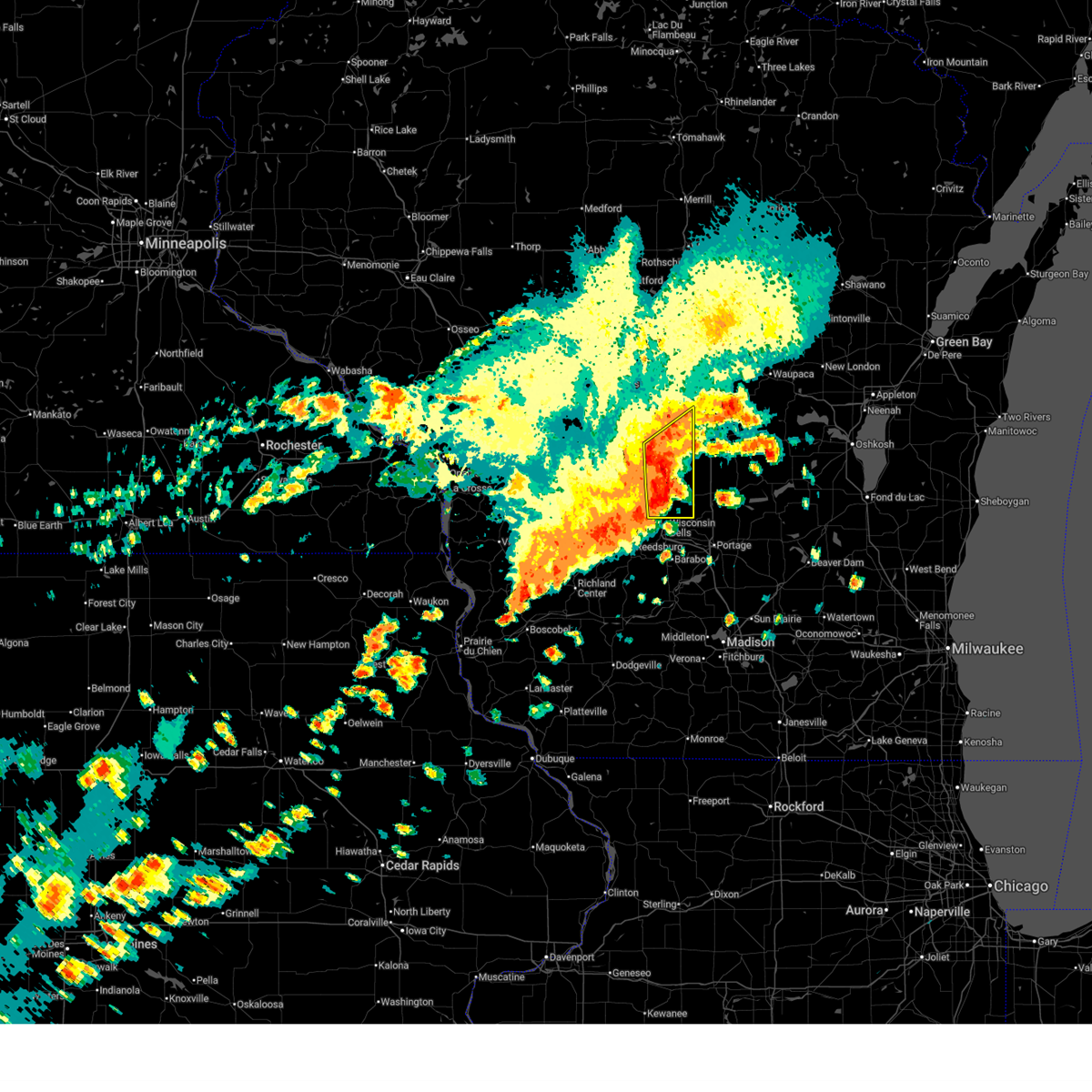
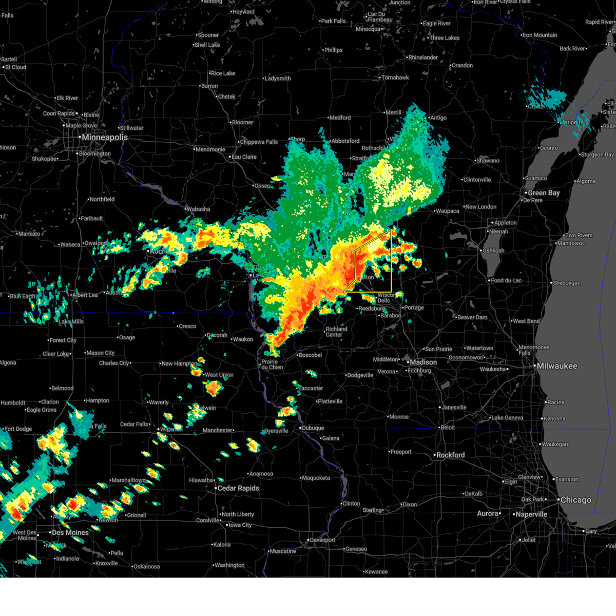
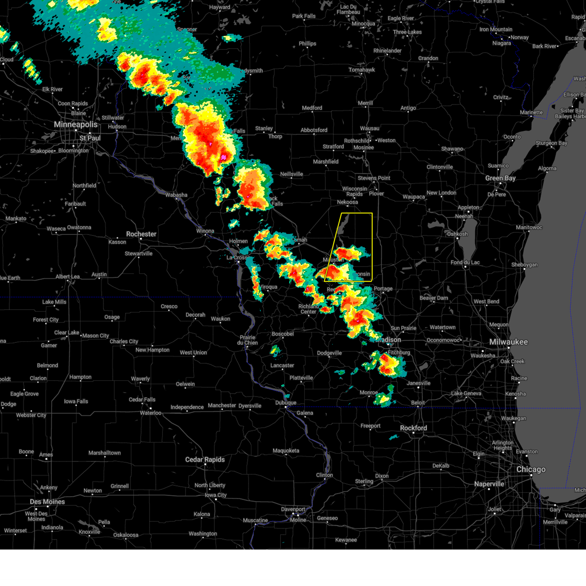
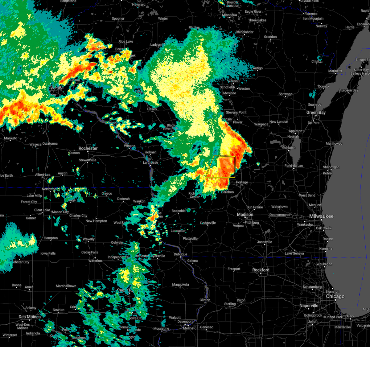
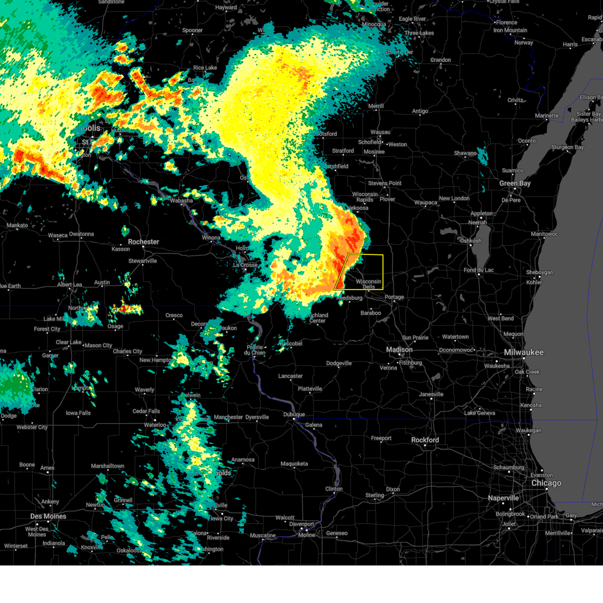
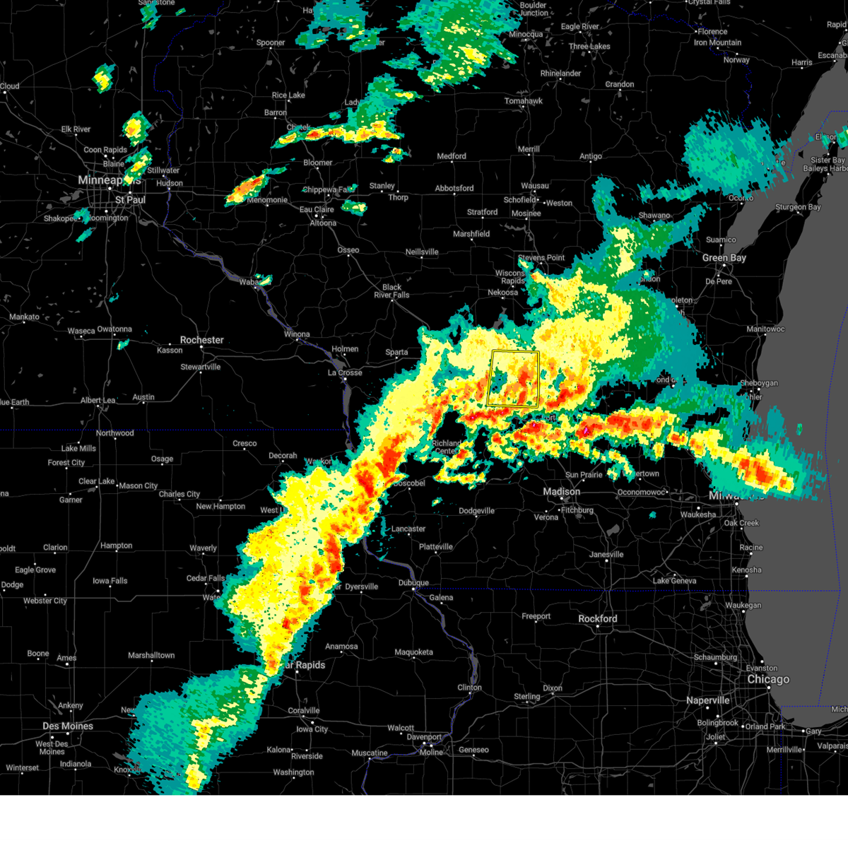
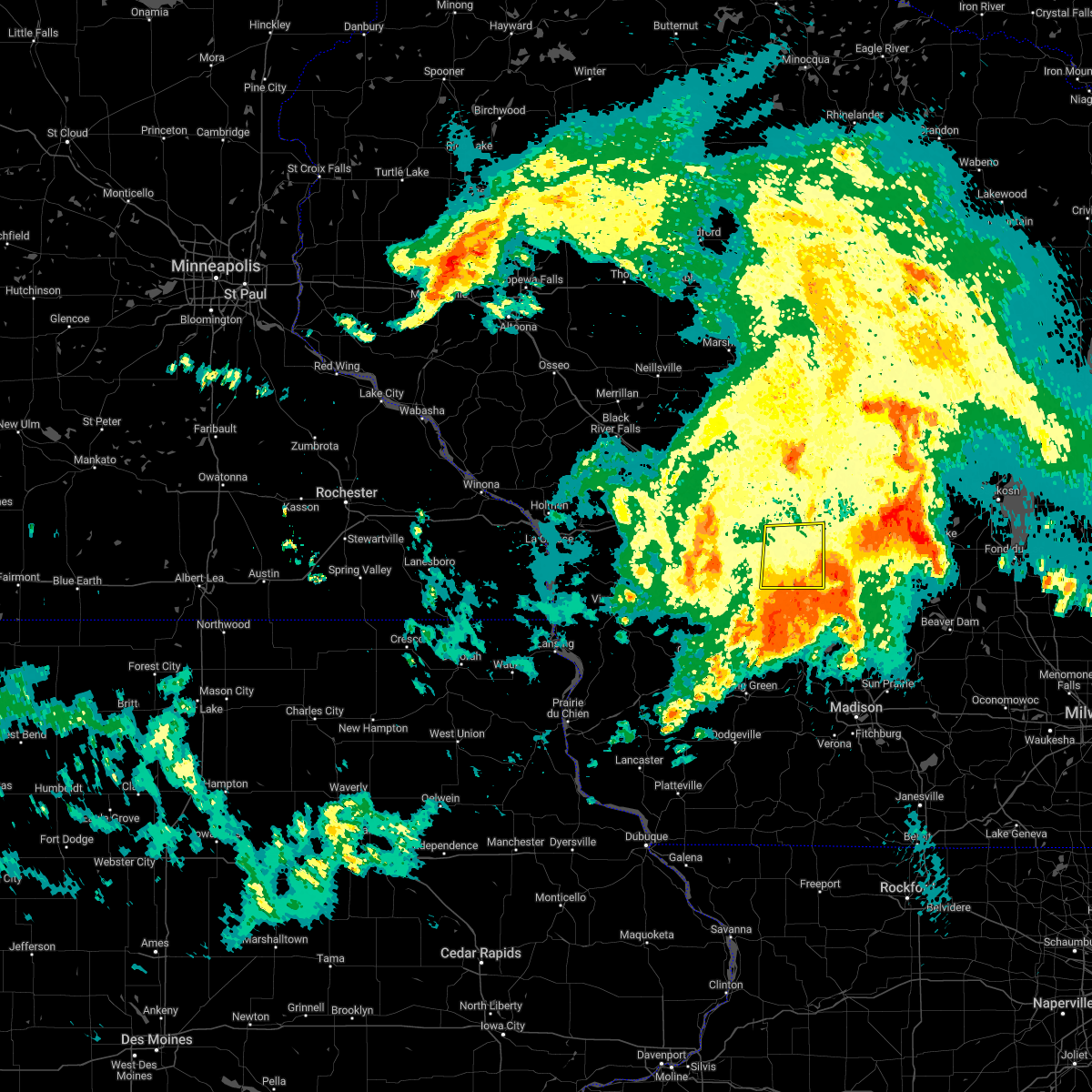
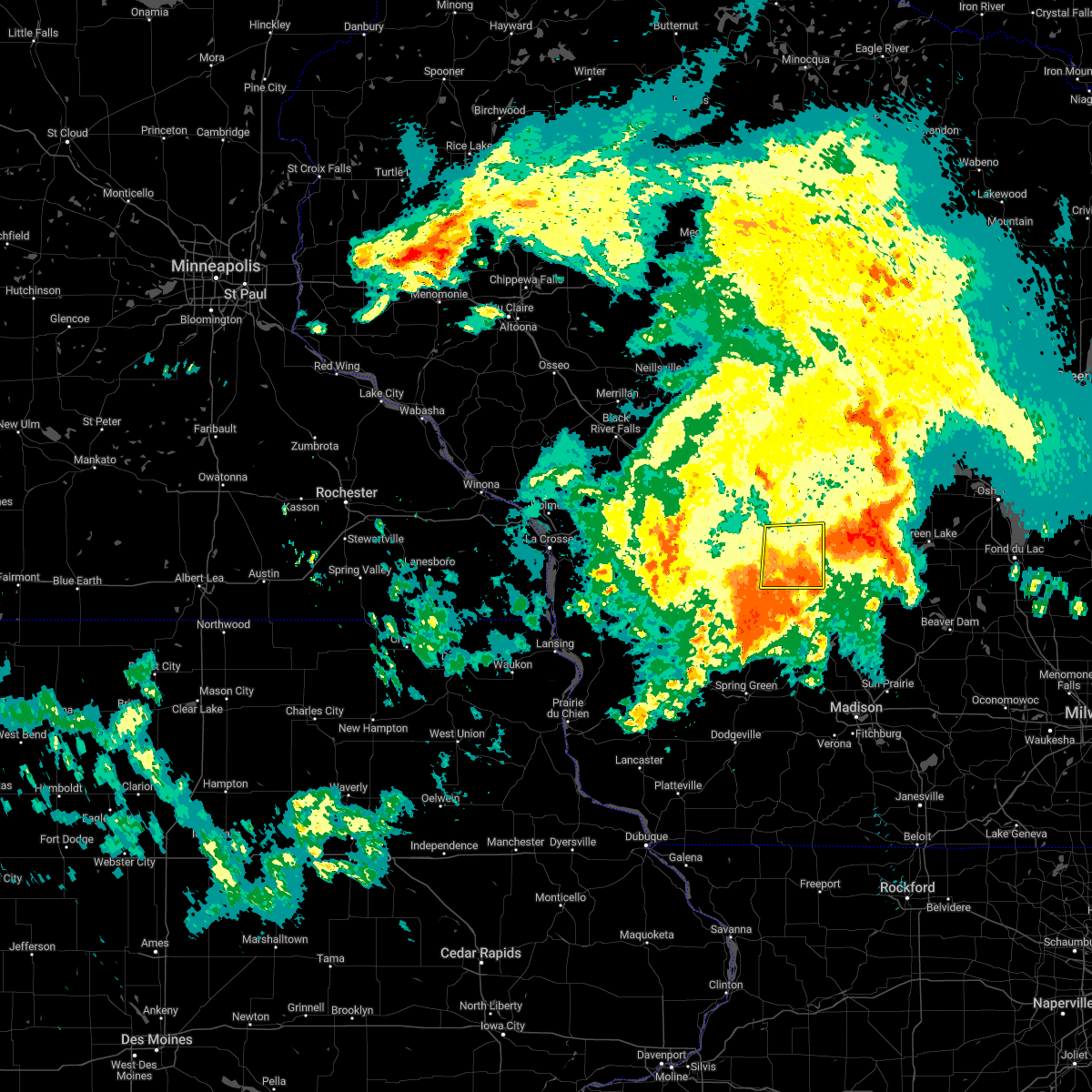
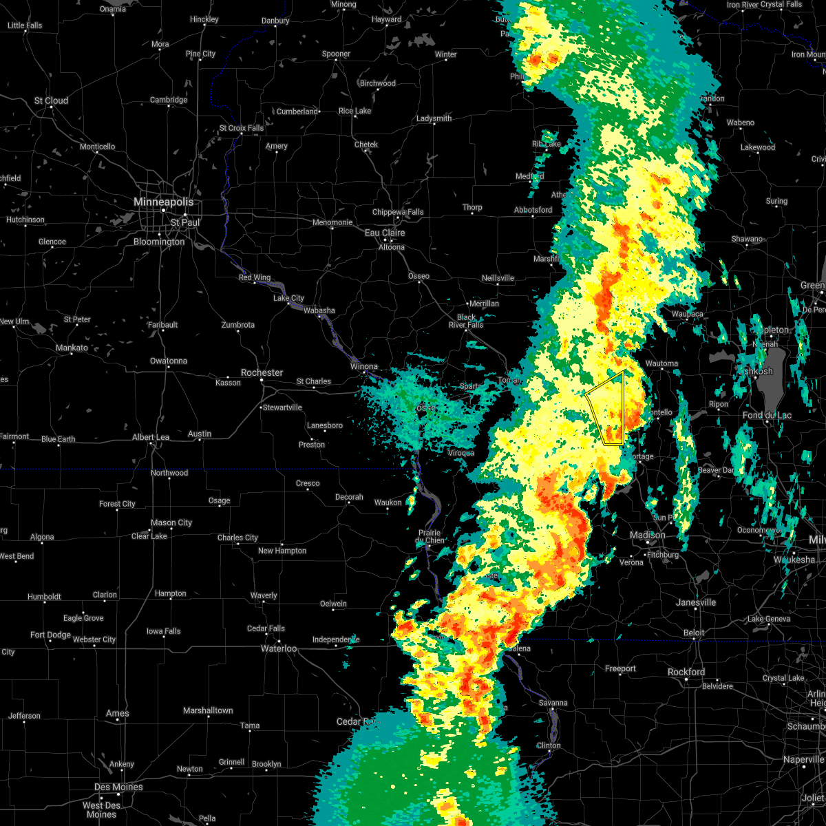
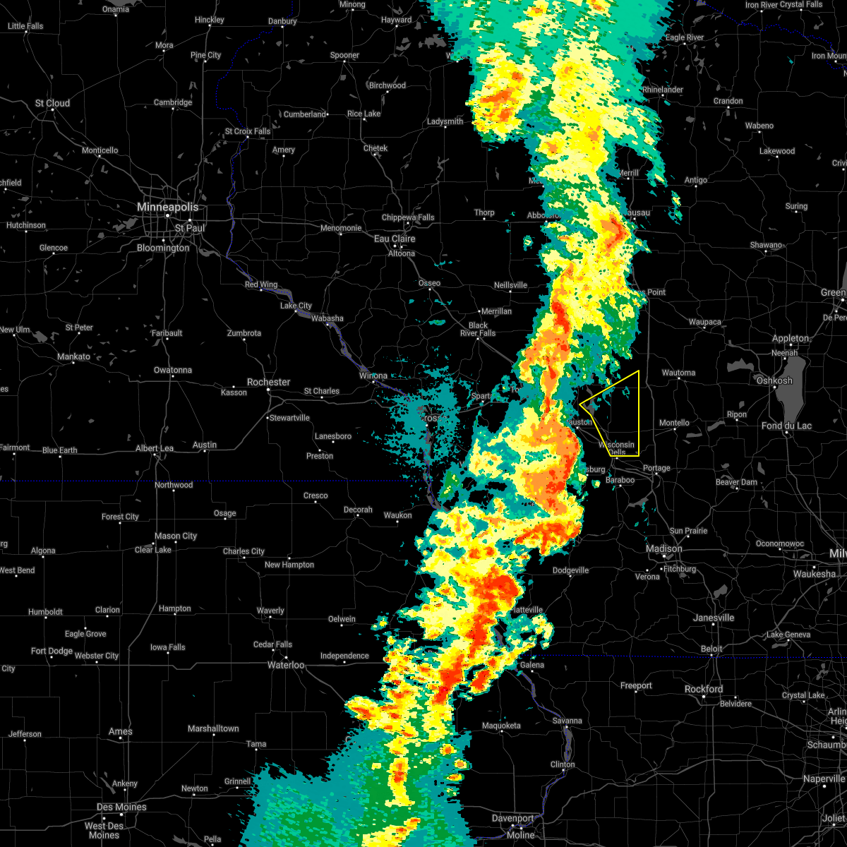
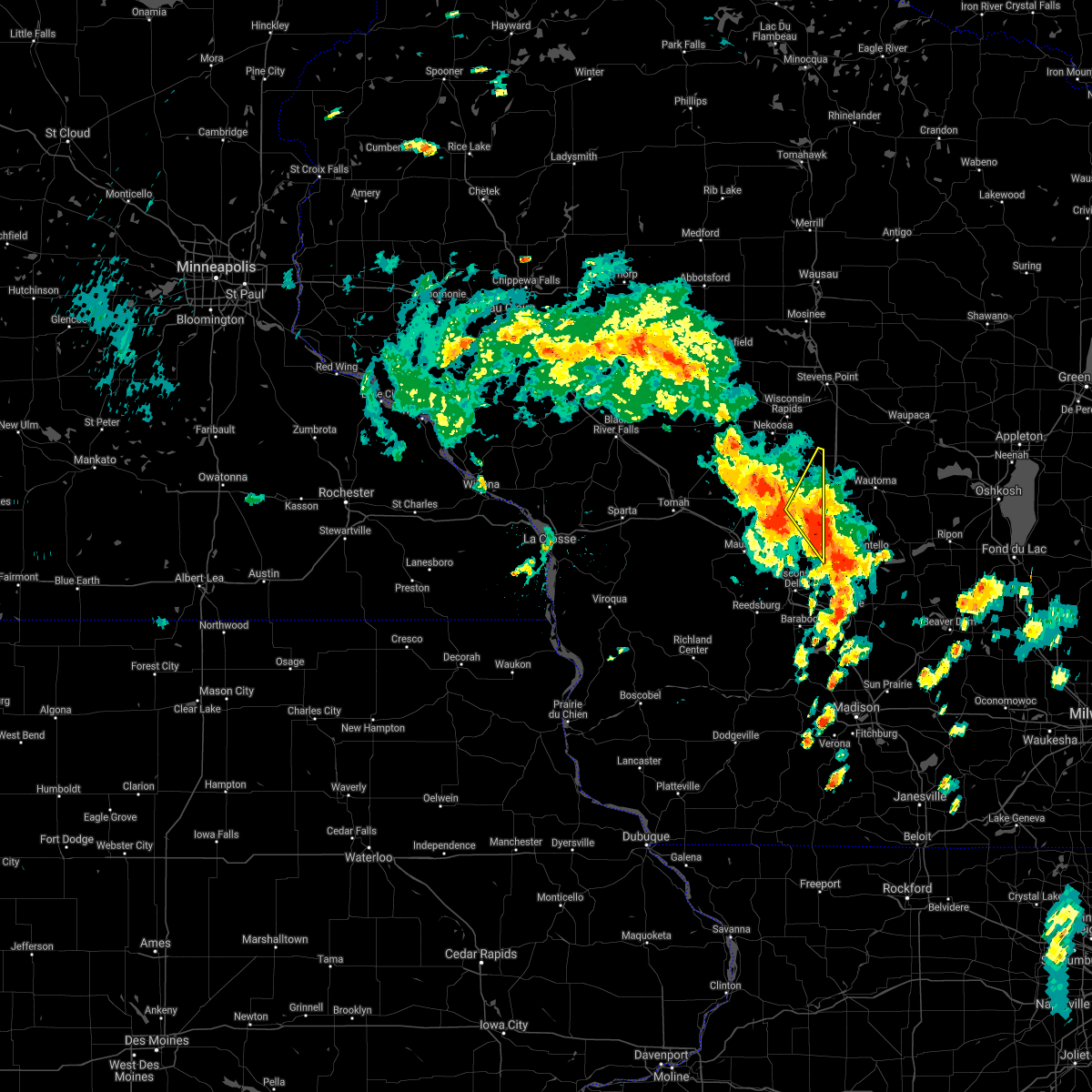
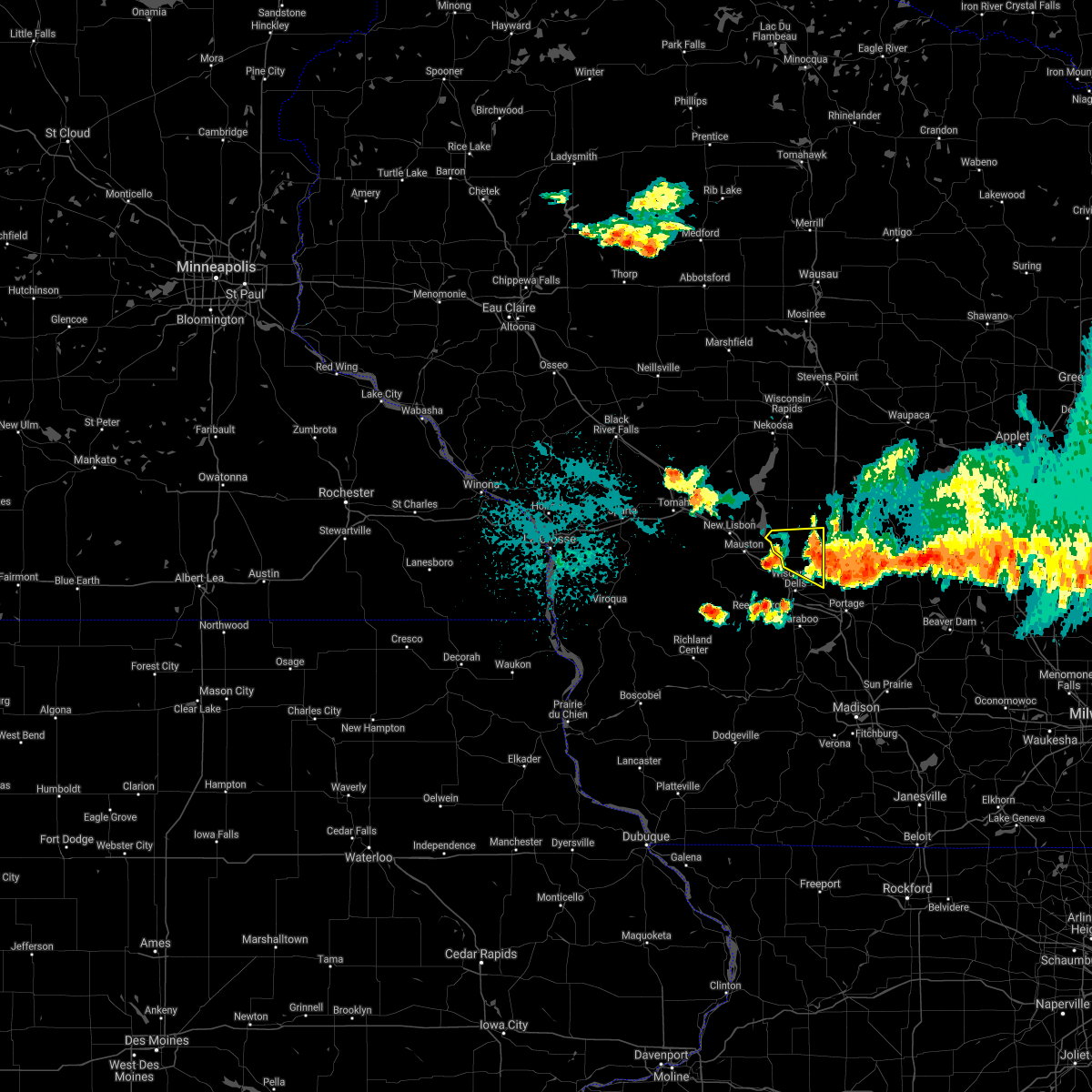
Hail Map for Grand Marsh, WI
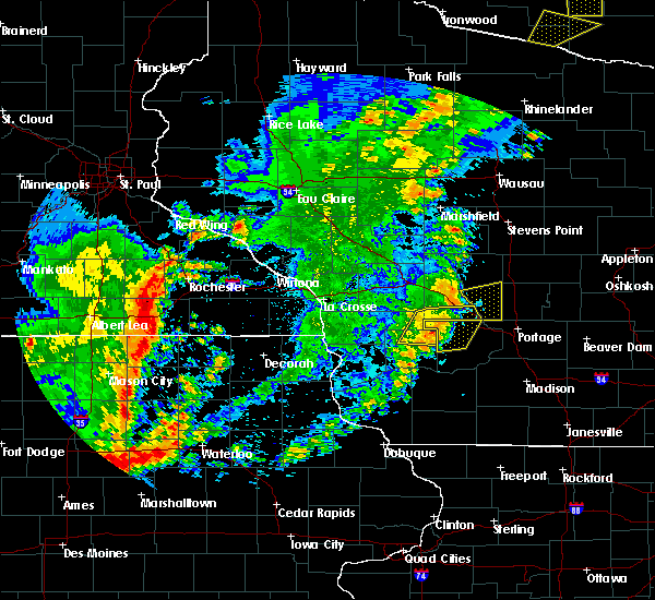
The Grand Marsh, WI area has had 0 reports of on-the-ground hail by trained spotters, and has been under severe weather warnings 6 times during the past 12 months. Doppler radar has detected hail at or near Grand Marsh, WI on 48 occasions, including 4 occasions during the past year.
| Name: | Grand Marsh, WI |
| Where Located: | 58.5 miles NNW of Madison, WI |
| Map: | Google Map for Grand Marsh, WI |
| Population: | 127 |
| Housing Units: | 53 |
| More Info: | Search Google for Grand Marsh, WI |
5
The Top Recent Hail Date for Grand Marsh, WI is Tuesday, August 27, 2024 (11th out of 48)

Hail and Wind Damage Spotted near Grand Marsh, WI
| Date / Time | Report Details |
|---|---|
| 6/23/2025 5:40 PM CDT | The storms which prompted the warning have moved out of the area. therefore, the warning will be allowed to expire. a severe thunderstorm watch remains in effect until 900 pm cdt for central wisconsin. |
| 6/23/2025 5:23 PM CDT | the severe thunderstorm warning has been cancelled and is no longer in effect |
| 6/23/2025 5:23 PM CDT | At 522 pm cdt, severe thunderstorms were located along a line extending from 9 miles northeast of friendship to 7 miles west of westfield to 8 miles northeast of wisconsin dells, moving east at 30 mph (radar indicated). Hazards include 60 mph wind gusts. Expect damage to roofs, siding, and trees. These severe thunderstorms will remain over mainly rural areas of adams county, including the following locations, arkdale, county roads b and p, brooks, colburn, k and l campground, county roads b and k, and highways 13 and 21. |
| 6/23/2025 5:17 PM CDT |
 At 516 pm cdt, severe thunderstorms were located along a line extending from 8 miles northeast of friendship to 8 miles north of wisconsin dells, moving northeast at 40 mph (radar indicated). Hazards include 60 mph wind gusts. Expect damage to roofs, siding, and trees. these severe thunderstorms will affect the following locations, dells timberland campground, county roads b and k, highways 13 and 21, county roads g and o, county roads g and m, and lyndon station. This includes interstate 90/94 between mile markers 79 and 84. At 516 pm cdt, severe thunderstorms were located along a line extending from 8 miles northeast of friendship to 8 miles north of wisconsin dells, moving northeast at 40 mph (radar indicated). Hazards include 60 mph wind gusts. Expect damage to roofs, siding, and trees. these severe thunderstorms will affect the following locations, dells timberland campground, county roads b and k, highways 13 and 21, county roads g and o, county roads g and m, and lyndon station. This includes interstate 90/94 between mile markers 79 and 84.
|
| 6/23/2025 4:56 PM CDT |
 Svrarx the national weather service in la crosse has issued a * severe thunderstorm warning for, southeastern juneau county in central wisconsin, adams county in central wisconsin, * until 545 pm cdt. * at 455 pm cdt, severe thunderstorms were located along a line extending from near dellwood to 10 miles southwest of adams to near mauston, moving east at 40 mph (radar indicated). Hazards include 60 mph wind gusts. Expect damage to roofs, siding, and trees. severe thunderstorms will be near, friendship and adams around 500 pm cdt. other locations impacted by these severe thunderstorms include county roads b and p, dells timberland campground, county roads b and k, the town of quincy, highways 13 and 21, county roads g and o, and county roads g and m. This includes interstate 90/94 between mile markers 72 and 84. Svrarx the national weather service in la crosse has issued a * severe thunderstorm warning for, southeastern juneau county in central wisconsin, adams county in central wisconsin, * until 545 pm cdt. * at 455 pm cdt, severe thunderstorms were located along a line extending from near dellwood to 10 miles southwest of adams to near mauston, moving east at 40 mph (radar indicated). Hazards include 60 mph wind gusts. Expect damage to roofs, siding, and trees. severe thunderstorms will be near, friendship and adams around 500 pm cdt. other locations impacted by these severe thunderstorms include county roads b and p, dells timberland campground, county roads b and k, the town of quincy, highways 13 and 21, county roads g and o, and county roads g and m. This includes interstate 90/94 between mile markers 72 and 84.
|
| 5/15/2025 4:07 PM CDT |
 Svrarx the national weather service in la crosse has issued a * severe thunderstorm warning for, eastern juneau county in central wisconsin, adams county in central wisconsin, * until 515 pm cdt. * at 407 pm cdt, a severe thunderstorm was located near mauston, moving northeast at 45 mph (radar indicated). Hazards include 60 mph wind gusts and quarter size hail. Hail damage to vehicles is expected. expect wind damage to roofs, siding, and trees. this severe thunderstorm will be near, dellwood around 415 pm cdt. other locations impacted by this severe thunderstorm include highways 13 and 21, county roads g and o, county roads g and m, big spring, highway 13 and county e, county roads c and g, and lemonweir. This includes interstate 90/94 between mile markers 65 and 86. Svrarx the national weather service in la crosse has issued a * severe thunderstorm warning for, eastern juneau county in central wisconsin, adams county in central wisconsin, * until 515 pm cdt. * at 407 pm cdt, a severe thunderstorm was located near mauston, moving northeast at 45 mph (radar indicated). Hazards include 60 mph wind gusts and quarter size hail. Hail damage to vehicles is expected. expect wind damage to roofs, siding, and trees. this severe thunderstorm will be near, dellwood around 415 pm cdt. other locations impacted by this severe thunderstorm include highways 13 and 21, county roads g and o, county roads g and m, big spring, highway 13 and county e, county roads c and g, and lemonweir. This includes interstate 90/94 between mile markers 65 and 86.
|
| 5/21/2024 8:30 PM CDT |
 The storms which prompted the warning have weakened below severe limits, and no longer pose an immediate threat to life or property. therefore, the warning has been allowed to expire. however, gusty winds are still possible with these thunderstorms and additional severe storms remain possible. a tornado watch remains in effect until midnight cdt for central wisconsin. The storms which prompted the warning have weakened below severe limits, and no longer pose an immediate threat to life or property. therefore, the warning has been allowed to expire. however, gusty winds are still possible with these thunderstorms and additional severe storms remain possible. a tornado watch remains in effect until midnight cdt for central wisconsin.
|
| 5/21/2024 7:29 PM CDT |
 Svrarx the national weather service in la crosse has issued a * severe thunderstorm warning for, juneau county in central wisconsin, adams county in central wisconsin, * until 830 pm cdt. * at 729 pm cdt, severe thunderstorms were located along a line extending from 10 miles west of babcock to 11 miles northwest of necedah to 10 miles northwest of elroy, moving east at 55 mph (radar indicated). Hazards include 70 mph wind gusts and penny size hail. Expect considerable tree damage. damage is likely to mobile homes, roofs, and outbuildings. severe thunderstorms will be near, new lisbon and necedah around 740 pm cdt. new rome and dellwood around 750 pm cdt. friendship and adams around 800 pm cdt. This includes interstate 90/94 between mile markers 53 and 86. Svrarx the national weather service in la crosse has issued a * severe thunderstorm warning for, juneau county in central wisconsin, adams county in central wisconsin, * until 830 pm cdt. * at 729 pm cdt, severe thunderstorms were located along a line extending from 10 miles west of babcock to 11 miles northwest of necedah to 10 miles northwest of elroy, moving east at 55 mph (radar indicated). Hazards include 70 mph wind gusts and penny size hail. Expect considerable tree damage. damage is likely to mobile homes, roofs, and outbuildings. severe thunderstorms will be near, new lisbon and necedah around 740 pm cdt. new rome and dellwood around 750 pm cdt. friendship and adams around 800 pm cdt. This includes interstate 90/94 between mile markers 53 and 86.
|
| 7/28/2023 8:41 PM CDT |
 At 840 pm cdt, severe thunderstorms were located along a line extending from near new rome to friendship to 8 miles north of reedsburg, moving east at 60 mph (emergency management reported trees down and power outages near necedah and mauston). Hazards include 70 mph wind gusts and half dollar size hail. Hail damage to vehicles is expected. expect considerable tree damage. wind damage is also likely to mobile homes, roofs, and outbuildings. these severe thunderstorms will remain over mainly rural areas of adams county, including the following locations, county roads b and p, county roads b and k, the town of quincy, highways 13 and 21, county roads g and o, county roads g and m and big spring. thunderstorm damage threat, considerable hail threat, radar indicated max hail size, 1. 25 in wind threat, radar indicated max wind gust, 70 mph. At 840 pm cdt, severe thunderstorms were located along a line extending from near new rome to friendship to 8 miles north of reedsburg, moving east at 60 mph (emergency management reported trees down and power outages near necedah and mauston). Hazards include 70 mph wind gusts and half dollar size hail. Hail damage to vehicles is expected. expect considerable tree damage. wind damage is also likely to mobile homes, roofs, and outbuildings. these severe thunderstorms will remain over mainly rural areas of adams county, including the following locations, county roads b and p, county roads b and k, the town of quincy, highways 13 and 21, county roads g and o, county roads g and m and big spring. thunderstorm damage threat, considerable hail threat, radar indicated max hail size, 1. 25 in wind threat, radar indicated max wind gust, 70 mph.
|
| 7/28/2023 8:32 PM CDT |
 At 831 pm cdt, severe thunderstorms were located along a line extending from 7 miles southwest of new rome to near dellwood to near wonewoc, moving east at 55 mph (radar indicated). Hazards include 60 mph wind gusts and half dollar size hail. Hail damage to vehicles is expected. expect wind damage to roofs, siding, and trees. severe thunderstorms will be near, dellwood around 835 pm cdt. friendship and new rome around 840 pm cdt. adams around 845 pm cdt. other locations impacted by these severe thunderstorms include county roads b and p, county roads b and k, the town of quincy, highways 13 and 21, county roads g and o, county roads g and m and big spring. hail threat, radar indicated max hail size, 1. 25 in wind threat, radar indicated max wind gust, 60 mph. At 831 pm cdt, severe thunderstorms were located along a line extending from 7 miles southwest of new rome to near dellwood to near wonewoc, moving east at 55 mph (radar indicated). Hazards include 60 mph wind gusts and half dollar size hail. Hail damage to vehicles is expected. expect wind damage to roofs, siding, and trees. severe thunderstorms will be near, dellwood around 835 pm cdt. friendship and new rome around 840 pm cdt. adams around 845 pm cdt. other locations impacted by these severe thunderstorms include county roads b and p, county roads b and k, the town of quincy, highways 13 and 21, county roads g and o, county roads g and m and big spring. hail threat, radar indicated max hail size, 1. 25 in wind threat, radar indicated max wind gust, 60 mph.
|
| 7/26/2023 5:42 AM CDT |
 The severe thunderstorm warning for southeastern juneau and southern adams counties will expire at 545 am cdt, the storm which prompted the warning has moved out of the area. therefore, the warning will be allowed to expire. however heavy rain is still possible with this thunderstorm. The severe thunderstorm warning for southeastern juneau and southern adams counties will expire at 545 am cdt, the storm which prompted the warning has moved out of the area. therefore, the warning will be allowed to expire. however heavy rain is still possible with this thunderstorm.
|
| 7/26/2023 5:12 AM CDT |
 At 511 am cdt, a severe thunderstorm was located 9 miles east of mauston, moving east at 55 mph (emergency management). Hazards include 60 mph wind gusts. Expect damage to roofs, siding, and trees. locations impacted include, mauston, adams, lemonweir, lyndon station, castle rock, county roads b and p. this includes interstate 90/94 between mile markers 68 and 86. hail threat, radar indicated max hail size, <. 75 in wind threat, observed max wind gust, 60 mph. At 511 am cdt, a severe thunderstorm was located 9 miles east of mauston, moving east at 55 mph (emergency management). Hazards include 60 mph wind gusts. Expect damage to roofs, siding, and trees. locations impacted include, mauston, adams, lemonweir, lyndon station, castle rock, county roads b and p. this includes interstate 90/94 between mile markers 68 and 86. hail threat, radar indicated max hail size, <. 75 in wind threat, observed max wind gust, 60 mph.
|
| 7/26/2023 4:57 AM CDT |
 At 457 am cdt, a severe thunderstorm was located near mauston, moving east at 55 mph (emergency management). Hazards include 60 mph wind gusts. Expect damage to roofs, siding, and trees. this severe thunderstorm will remain over mainly rural areas of southern juneau and southern adams counties, including the following locations, county roads b and p, dells timberland campground, county roads b and k, the town of quincy, johnson hill, lyndon station and stand rock campground. this includes interstate 90/94 between mile markers 59 and 86. hail threat, radar indicated max hail size, <. 75 in wind threat, observed max wind gust, 60 mph. At 457 am cdt, a severe thunderstorm was located near mauston, moving east at 55 mph (emergency management). Hazards include 60 mph wind gusts. Expect damage to roofs, siding, and trees. this severe thunderstorm will remain over mainly rural areas of southern juneau and southern adams counties, including the following locations, county roads b and p, dells timberland campground, county roads b and k, the town of quincy, johnson hill, lyndon station and stand rock campground. this includes interstate 90/94 between mile markers 59 and 86. hail threat, radar indicated max hail size, <. 75 in wind threat, observed max wind gust, 60 mph.
|
| 4/4/2023 11:35 PM CDT |
 The severe thunderstorm warning for southeastern juneau and southern adams counties will expire at 1145 pm cdt, the storm which prompted the warning has weakened below severe limits, and no longer poses an immediate threat to life or property. therefore, the warning will be allowed to expire. however heavy rain is still possible with this thunderstorm. a severe thunderstorm watch remains in effect until 100 am cdt for central wisconsin. The severe thunderstorm warning for southeastern juneau and southern adams counties will expire at 1145 pm cdt, the storm which prompted the warning has weakened below severe limits, and no longer poses an immediate threat to life or property. therefore, the warning will be allowed to expire. however heavy rain is still possible with this thunderstorm. a severe thunderstorm watch remains in effect until 100 am cdt for central wisconsin.
|
| 4/4/2023 11:21 PM CDT |
 At 1121 pm cdt, a severe thunderstorm was located 8 miles northwest of wisconsin dells, moving northeast at 45 mph (radar indicated). Hazards include quarter size hail. Damage to vehicles is expected. locations impacted include, friendship, adams, dellwood, lemonweir, lyndon station, and castle rock. this includes interstate 90/94 between mile markers 72 and 86. hail threat, radar indicated max hail size, 1. 00 in wind threat, radar indicated max wind gust, <50 mph. At 1121 pm cdt, a severe thunderstorm was located 8 miles northwest of wisconsin dells, moving northeast at 45 mph (radar indicated). Hazards include quarter size hail. Damage to vehicles is expected. locations impacted include, friendship, adams, dellwood, lemonweir, lyndon station, and castle rock. this includes interstate 90/94 between mile markers 72 and 86. hail threat, radar indicated max hail size, 1. 00 in wind threat, radar indicated max wind gust, <50 mph.
|
| 4/4/2023 11:04 PM CDT |
 At 1103 pm cdt, a severe thunderstorm was located near reedsburg, moving northeast at 40 mph (radar indicated). Hazards include quarter size hail. damage to vehicles is expected At 1103 pm cdt, a severe thunderstorm was located near reedsburg, moving northeast at 40 mph (radar indicated). Hazards include quarter size hail. damage to vehicles is expected
|
| 7/23/2022 5:24 PM CDT |
 The severe thunderstorm warning for southeastern juneau and southern adams counties will expire at 530 pm cdt, the storms which prompted the warning have moved out of the area. therefore, the warning will be allowed to expire. a severe thunderstorm watch remains in effect until 700 pm cdt for central wisconsin. The severe thunderstorm warning for southeastern juneau and southern adams counties will expire at 530 pm cdt, the storms which prompted the warning have moved out of the area. therefore, the warning will be allowed to expire. a severe thunderstorm watch remains in effect until 700 pm cdt for central wisconsin.
|
| 7/23/2022 5:11 PM CDT |
 At 510 pm cdt, severe thunderstorms were located along a line extending from 8 miles southeast of adams to 10 miles southwest of westfield to 7 miles east of wisconsin dells, moving east at 45 mph (radar indicated). Hazards include 70 mph wind gusts. Expect considerable tree damage. damage is likely to mobile homes, roofs, and outbuildings. this includes interstate 90/94 between mile markers 75 and 86. thunderstorm damage threat, considerable hail threat, radar indicated max hail size, <. 75 in wind threat, radar indicated max wind gust, 70 mph. At 510 pm cdt, severe thunderstorms were located along a line extending from 8 miles southeast of adams to 10 miles southwest of westfield to 7 miles east of wisconsin dells, moving east at 45 mph (radar indicated). Hazards include 70 mph wind gusts. Expect considerable tree damage. damage is likely to mobile homes, roofs, and outbuildings. this includes interstate 90/94 between mile markers 75 and 86. thunderstorm damage threat, considerable hail threat, radar indicated max hail size, <. 75 in wind threat, radar indicated max wind gust, 70 mph.
|
| 7/23/2022 4:46 PM CDT |
 At 445 pm cdt, severe thunderstorms were located along a line extending from near mauston to 12 miles southeast of new lisbon to 7 miles north of reedsburg, moving east at 45 mph (radar indicated). Hazards include 70 mph wind gusts. Expect considerable tree damage. damage is likely to mobile homes, roofs, and outbuildings. these severe thunderstorms will remain over mainly rural areas of southern juneau and southern adams counties, including the following locations, county roads b and p, dells timberland campground, county roads b and k, lyndon station and stand rock campground. this includes interstate 90/94 between mile markers 57 and 86. thunderstorm damage threat, considerable hail threat, radar indicated max hail size, <. 75 in wind threat, radar indicated max wind gust, 70 mph. At 445 pm cdt, severe thunderstorms were located along a line extending from near mauston to 12 miles southeast of new lisbon to 7 miles north of reedsburg, moving east at 45 mph (radar indicated). Hazards include 70 mph wind gusts. Expect considerable tree damage. damage is likely to mobile homes, roofs, and outbuildings. these severe thunderstorms will remain over mainly rural areas of southern juneau and southern adams counties, including the following locations, county roads b and p, dells timberland campground, county roads b and k, lyndon station and stand rock campground. this includes interstate 90/94 between mile markers 57 and 86. thunderstorm damage threat, considerable hail threat, radar indicated max hail size, <. 75 in wind threat, radar indicated max wind gust, 70 mph.
|
| 7/23/2022 4:13 PM CDT |
 At 413 pm cdt, severe thunderstorms were located along a line extending from 9 miles south of tomah to 6 miles west of elroy to near hillsboro, moving east at 45 mph (radar indicated). Hazards include 70 mph wind gusts and quarter size hail. Hail damage to vehicles is expected. expect considerable tree damage. wind damage is also likely to mobile homes, roofs, and outbuildings. severe thunderstorms will be near, elroy around 425 pm cdt. wonewoc around 430 pm cdt. new lisbon around 435 pm cdt. mauston around 440 pm cdt. other locations impacted by these severe thunderstorms include county roads b and p, dells timberland campground, county roads b and k, the town of quincy, johnson hill, lyndon station and stand rock campground. this includes interstate 90/94 between mile markers 57 and 86. thunderstorm damage threat, considerable hail threat, radar indicated max hail size, 1. 00 in wind threat, radar indicated max wind gust, 70 mph. At 413 pm cdt, severe thunderstorms were located along a line extending from 9 miles south of tomah to 6 miles west of elroy to near hillsboro, moving east at 45 mph (radar indicated). Hazards include 70 mph wind gusts and quarter size hail. Hail damage to vehicles is expected. expect considerable tree damage. wind damage is also likely to mobile homes, roofs, and outbuildings. severe thunderstorms will be near, elroy around 425 pm cdt. wonewoc around 430 pm cdt. new lisbon around 435 pm cdt. mauston around 440 pm cdt. other locations impacted by these severe thunderstorms include county roads b and p, dells timberland campground, county roads b and k, the town of quincy, johnson hill, lyndon station and stand rock campground. this includes interstate 90/94 between mile markers 57 and 86. thunderstorm damage threat, considerable hail threat, radar indicated max hail size, 1. 00 in wind threat, radar indicated max wind gust, 70 mph.
|
| 6/15/2022 5:18 PM CDT | Report from mping: 1-inch tree limbs broken; shingles blown of in adams county WI, 0.2 miles SSE of Grand Marsh, WI |
| 6/15/2022 5:17 PM CDT |
 At 517 pm cdt, a severe thunderstorm capable of producing a tornado was located 9 miles east of friendship, moving east at 55 mph (radar indicated rotation. a funnel was reported in adams around 515 pm). Hazards include tornado. Flying debris will be dangerous to those caught without shelter. mobile homes will be damaged or destroyed. damage to roofs, windows, and vehicles will occur. tree damage is likely. Locations impacted include, friendship, adams, brooks, county roads c and g, county roads e and g, the preston cliffs, grand marsh, highway 21 and county g, county roads a and b, county roads g and m, the ship rock wayside and the colburn wildlife area. At 517 pm cdt, a severe thunderstorm capable of producing a tornado was located 9 miles east of friendship, moving east at 55 mph (radar indicated rotation. a funnel was reported in adams around 515 pm). Hazards include tornado. Flying debris will be dangerous to those caught without shelter. mobile homes will be damaged or destroyed. damage to roofs, windows, and vehicles will occur. tree damage is likely. Locations impacted include, friendship, adams, brooks, county roads c and g, county roads e and g, the preston cliffs, grand marsh, highway 21 and county g, county roads a and b, county roads g and m, the ship rock wayside and the colburn wildlife area.
|
| 6/15/2022 5:04 PM CDT |
 At 504 pm cdt, a severe thunderstorm capable of producing a tornado was located over adams, or near friendship, moving northeast at 50 mph (radar indicated rotation). Hazards include tornado and quarter size hail. Flying debris will be dangerous to those caught without shelter. mobile homes will be damaged or destroyed. damage to roofs, windows, and vehicles will occur. tree damage is likely. This tornadic thunderstorm will remain over mainly rural areas of east central adams county, including the following locations, brooks, county roads c and g, county roads e and g, the preston cliffs, grand marsh, highway 21 and county g and county roads a and b. At 504 pm cdt, a severe thunderstorm capable of producing a tornado was located over adams, or near friendship, moving northeast at 50 mph (radar indicated rotation). Hazards include tornado and quarter size hail. Flying debris will be dangerous to those caught without shelter. mobile homes will be damaged or destroyed. damage to roofs, windows, and vehicles will occur. tree damage is likely. This tornadic thunderstorm will remain over mainly rural areas of east central adams county, including the following locations, brooks, county roads c and g, county roads e and g, the preston cliffs, grand marsh, highway 21 and county g and county roads a and b.
|
| 6/15/2022 5:01 PM CDT | Trees down and irrigation equipment flipped near easton. report via nws mk in adams county WI, 5.7 miles NE of Grand Marsh, WI |
| 9/20/2021 8:36 PM CDT |
 The severe thunderstorm warning for southeastern adams county will expire at 845 pm cdt, the storms which prompted the warning have weakened below severe limits, and have exited the warned area. therefore, the warning will be allowed to expire. The severe thunderstorm warning for southeastern adams county will expire at 845 pm cdt, the storms which prompted the warning have weakened below severe limits, and have exited the warned area. therefore, the warning will be allowed to expire.
|
| 9/20/2021 8:29 PM CDT |
 At 828 pm cdt, severe thunderstorms were located along a line extending from 9 miles northeast of friendship to 11 miles northeast of wisconsin dells, moving northeast at 50 mph (radar indicated). Hazards include 60 mph wind gusts. Expect damage to roofs, siding, and trees. these severe thunderstorms will remain over mainly rural areas of southeastern adams county, including the following locations, county roads b and p, brooks, k and l campground, county roads b and k, highway 23 and county g, county roads a and b and county roads g and m. hail threat, radar indicated max hail size, <. 75 in wind threat, radar indicated max wind gust, 60 mph. At 828 pm cdt, severe thunderstorms were located along a line extending from 9 miles northeast of friendship to 11 miles northeast of wisconsin dells, moving northeast at 50 mph (radar indicated). Hazards include 60 mph wind gusts. Expect damage to roofs, siding, and trees. these severe thunderstorms will remain over mainly rural areas of southeastern adams county, including the following locations, county roads b and p, brooks, k and l campground, county roads b and k, highway 23 and county g, county roads a and b and county roads g and m. hail threat, radar indicated max hail size, <. 75 in wind threat, radar indicated max wind gust, 60 mph.
|
| 9/20/2021 7:58 PM CDT |
 At 757 pm cdt, severe thunderstorms were located along a line extending from near new lisbon to 7 miles north of reedsburg, moving northeast at 60 mph (radar indicated). Hazards include 60 mph wind gusts. Expect damage to roofs, siding, and trees. severe thunderstorms will be near, dellwood around 810 pm cdt. friendship and adams around 815 pm cdt. other locations impacted by these severe thunderstorms include county roads b and p, county roads b and k, the town of quincy, highways 13 and 21, county roads g and m, stand rock campground and big spring. this includes interstate 90/94 between mile markers 82 and 86. hail threat, radar indicated max hail size, <. 75 in wind threat, radar indicated max wind gust, 60 mph. At 757 pm cdt, severe thunderstorms were located along a line extending from near new lisbon to 7 miles north of reedsburg, moving northeast at 60 mph (radar indicated). Hazards include 60 mph wind gusts. Expect damage to roofs, siding, and trees. severe thunderstorms will be near, dellwood around 810 pm cdt. friendship and adams around 815 pm cdt. other locations impacted by these severe thunderstorms include county roads b and p, county roads b and k, the town of quincy, highways 13 and 21, county roads g and m, stand rock campground and big spring. this includes interstate 90/94 between mile markers 82 and 86. hail threat, radar indicated max hail size, <. 75 in wind threat, radar indicated max wind gust, 60 mph.
|
| 8/11/2021 3:10 PM CDT |
 The tornado warning for eastern adams county will expire at 315 pm cdt, the storm which prompted the warning has moved out of the area. therefore, the warning will be allowed to expire. a tornado watch remains in effect until 800 pm cdt for central wisconsin. to report severe weather, contact your nearest law enforcement agency. they will relay your report to the national weather service la crosse. The tornado warning for eastern adams county will expire at 315 pm cdt, the storm which prompted the warning has moved out of the area. therefore, the warning will be allowed to expire. a tornado watch remains in effect until 800 pm cdt for central wisconsin. to report severe weather, contact your nearest law enforcement agency. they will relay your report to the national weather service la crosse.
|
| 8/11/2021 3:04 PM CDT |
 At 302 pm cdt, a severe thunderstorm capable of producing a tornado was located 7 miles east of adams, or 7 miles east of friendship, moving east at 35 mph. unconfirmed report of a tornado occurred at 252pm 6 miles west of grand marsh in adams county (radar indicated rotation). Hazards include tornado and quarter size hail. Flying debris will be dangerous to those caught without shelter. mobile homes will be damaged or destroyed. damage to roofs, windows, and vehicles will occur. tree damage is likely. Locations impacted include, colburn, brooks, county roads a and b, county roads g and m, the colburn wildlife area, coons deep lake campground, county roads c and g, county roads e and g, the preston cliffs, grand marsh, highway 21 and county g, the ship rock wayside and highway 82 and county b. At 302 pm cdt, a severe thunderstorm capable of producing a tornado was located 7 miles east of adams, or 7 miles east of friendship, moving east at 35 mph. unconfirmed report of a tornado occurred at 252pm 6 miles west of grand marsh in adams county (radar indicated rotation). Hazards include tornado and quarter size hail. Flying debris will be dangerous to those caught without shelter. mobile homes will be damaged or destroyed. damage to roofs, windows, and vehicles will occur. tree damage is likely. Locations impacted include, colburn, brooks, county roads a and b, county roads g and m, the colburn wildlife area, coons deep lake campground, county roads c and g, county roads e and g, the preston cliffs, grand marsh, highway 21 and county g, the ship rock wayside and highway 82 and county b.
|
| 8/11/2021 2:50 PM CDT |
 At 247 pm cdt, a confirm tornado was located near adams, or near friendship, moving east at 35 mph (weather spotters did confirm a tornado with this storm in west central juneau county). Hazards include damaging tornado and quarter size hail. Flying debris will be dangerous to those caught without shelter. mobile homes will be damaged or destroyed. damage to roofs, windows, and vehicles will occur. tree damage is likely. this tornadic thunderstorm will remain over mainly rural areas of southern juneau, adams and east central monroe counties, including the following locations, the town of quincy, highways 13 and 21, the necedah wildlife refuge, cutler and mill bluff state park. This includes interstate 90/94 between mile markers 49 and 76. At 247 pm cdt, a confirm tornado was located near adams, or near friendship, moving east at 35 mph (weather spotters did confirm a tornado with this storm in west central juneau county). Hazards include damaging tornado and quarter size hail. Flying debris will be dangerous to those caught without shelter. mobile homes will be damaged or destroyed. damage to roofs, windows, and vehicles will occur. tree damage is likely. this tornadic thunderstorm will remain over mainly rural areas of southern juneau, adams and east central monroe counties, including the following locations, the town of quincy, highways 13 and 21, the necedah wildlife refuge, cutler and mill bluff state park. This includes interstate 90/94 between mile markers 49 and 76.
|
| 8/11/2021 2:34 PM CDT |
 At 233 pm cdt, a confirmed large and extremely dangerous tornado was located near dellwood, or 9 miles west of friendship, moving east at 40 mph. this is a particularly dangerous situation. take cover now! (weather spotters did confirm a tornado near clifton near the monroe and juneau county line). Hazards include damaging tornado. You are in a life-threatening situation. flying debris may be deadly to those caught without shelter. mobile homes will be destroyed. considerable damage to homes, businesses, and vehicles is likely and complete destruction is possible. the tornado will be near, friendship and adams around 250 pm cdt. other locations impacted by this tornadic thunderstorm include the town of quincy, highways 13 and 21, the necedah wildlife refuge, county roads g and m, johnson hill, cutler and mill bluff state park. This includes interstate 90/94 between mile markers 49 and 76. At 233 pm cdt, a confirmed large and extremely dangerous tornado was located near dellwood, or 9 miles west of friendship, moving east at 40 mph. this is a particularly dangerous situation. take cover now! (weather spotters did confirm a tornado near clifton near the monroe and juneau county line). Hazards include damaging tornado. You are in a life-threatening situation. flying debris may be deadly to those caught without shelter. mobile homes will be destroyed. considerable damage to homes, businesses, and vehicles is likely and complete destruction is possible. the tornado will be near, friendship and adams around 250 pm cdt. other locations impacted by this tornadic thunderstorm include the town of quincy, highways 13 and 21, the necedah wildlife refuge, county roads g and m, johnson hill, cutler and mill bluff state park. This includes interstate 90/94 between mile markers 49 and 76.
|
| 8/11/2021 2:20 PM CDT |
 At 219 pm cdt, a confirmed large and extremely dangerous tornado was located near new lisbon, or 10 miles northwest of mauston, moving east at 35 mph. this is a particularly dangerous situation. take cover now! (weather spotters confirmed a large tornado near clifton). Hazards include damaging tornado. You are in a life-threatening situation. flying debris may be deadly to those caught without shelter. mobile homes will be destroyed. considerable damage to homes, businesses, and vehicles is likely and complete destruction is possible. the tornado will be near, new lisbon around 225 pm cdt. mauston around 230 pm cdt. necedah around 240 pm cdt. dellwood around 245 pm cdt. friendship and adams around 300 pm cdt. other locations impacted by this tornadic thunderstorm include the town of quincy, highways 13 and 21, the necedah wildlife refuge, county roads g and m, johnson hill, cutler and mill bluff state park. This includes interstate 90/94 between mile markers 49 and 76. At 219 pm cdt, a confirmed large and extremely dangerous tornado was located near new lisbon, or 10 miles northwest of mauston, moving east at 35 mph. this is a particularly dangerous situation. take cover now! (weather spotters confirmed a large tornado near clifton). Hazards include damaging tornado. You are in a life-threatening situation. flying debris may be deadly to those caught without shelter. mobile homes will be destroyed. considerable damage to homes, businesses, and vehicles is likely and complete destruction is possible. the tornado will be near, new lisbon around 225 pm cdt. mauston around 230 pm cdt. necedah around 240 pm cdt. dellwood around 245 pm cdt. friendship and adams around 300 pm cdt. other locations impacted by this tornadic thunderstorm include the town of quincy, highways 13 and 21, the necedah wildlife refuge, county roads g and m, johnson hill, cutler and mill bluff state park. This includes interstate 90/94 between mile markers 49 and 76.
|
| 8/8/2021 3:48 PM CDT | Several trees blown down in adams county WI, 6.2 miles SSW of Grand Marsh, WI |
| 8/8/2021 3:42 PM CDT |
 At 341 pm cdt, a severe thunderstorm was located near westfield, or 11 miles east of friendship, moving northeast at 25 mph. earlier rotation with this storm has weakened (radar indicated). Hazards include 60 mph wind gusts. Expect possible damage to roofs, siding, and trees. this severe thunderstorm will remain over mainly rural areas of northeastern adams county, including the following locations, brooks, colburn, county roads g and o, county roads g and m, the colburn wildlife area, county roads o and w and county roads d and g. hail threat, radar indicated max hail size, <. 75 in wind threat, radar indicated max wind gust, 60 mph. At 341 pm cdt, a severe thunderstorm was located near westfield, or 11 miles east of friendship, moving northeast at 25 mph. earlier rotation with this storm has weakened (radar indicated). Hazards include 60 mph wind gusts. Expect possible damage to roofs, siding, and trees. this severe thunderstorm will remain over mainly rural areas of northeastern adams county, including the following locations, brooks, colburn, county roads g and o, county roads g and m, the colburn wildlife area, county roads o and w and county roads d and g. hail threat, radar indicated max hail size, <. 75 in wind threat, radar indicated max wind gust, 60 mph.
|
| 8/8/2021 3:37 PM CDT |
 At 336 pm cdt, a severe thunderstorm was located near grand marsh or 10 miles east of friendship, moving northeast at 20 mph (radar indicated). Hazards include 60 mph wind gusts. Expect possible damage to roofs, siding, and trees. This severe thunderstorm will remain over mainly rural areas of northeastern adams county, including the following locations, brooks, colburn, the town of quincy, county roads g and o, county roads a and b, county roads g and m and the colburn wildlife area. At 336 pm cdt, a severe thunderstorm was located near grand marsh or 10 miles east of friendship, moving northeast at 20 mph (radar indicated). Hazards include 60 mph wind gusts. Expect possible damage to roofs, siding, and trees. This severe thunderstorm will remain over mainly rural areas of northeastern adams county, including the following locations, brooks, colburn, the town of quincy, county roads g and o, county roads a and b, county roads g and m and the colburn wildlife area.
|
| 8/8/2021 3:32 PM CDT |
 At 331 pm cdt, a severe thunderstorm was located 8 miles southeast of adams, or 9 miles southeast of friendship, moving northeast at 25 mph (radar indicated). Hazards include 60 mph wind gusts. expect damage to roofs, siding, and trees At 331 pm cdt, a severe thunderstorm was located 8 miles southeast of adams, or 9 miles southeast of friendship, moving northeast at 25 mph (radar indicated). Hazards include 60 mph wind gusts. expect damage to roofs, siding, and trees
|
| 8/24/2020 10:51 PM CDT |
 At 1049 pm cdt, a severe thunderstorm was located near westfield, or 12 miles east of friendship, moving southeast at 35 mph (radar indicated). Hazards include 60 mph wind gusts and quarter size hail. Hail damage to vehicles is expected. expect wind damage to roofs, siding, and trees. Locations impacted include, friendship, adams, new rome, big flats, colburn, lake arrowhead, the colburn wildlife area, the leola marsh wildlife area, cottonville, lake sherwood, the preston cliffs, grand marsh, and lake camelot. At 1049 pm cdt, a severe thunderstorm was located near westfield, or 12 miles east of friendship, moving southeast at 35 mph (radar indicated). Hazards include 60 mph wind gusts and quarter size hail. Hail damage to vehicles is expected. expect wind damage to roofs, siding, and trees. Locations impacted include, friendship, adams, new rome, big flats, colburn, lake arrowhead, the colburn wildlife area, the leola marsh wildlife area, cottonville, lake sherwood, the preston cliffs, grand marsh, and lake camelot.
|
| 8/24/2020 10:28 PM CDT |
 The national weather service in la crosse has issued a * severe thunderstorm warning for. northeastern juneau county in central wisconsin. northern adams county in central wisconsin. until 1115 pm cdt. At 1028 pm cdt, a severe thunderstorm was located 7 miles northeast. The national weather service in la crosse has issued a * severe thunderstorm warning for. northeastern juneau county in central wisconsin. northern adams county in central wisconsin. until 1115 pm cdt. At 1028 pm cdt, a severe thunderstorm was located 7 miles northeast.
|
| 8/10/2020 8:28 AM CDT |
 The severe thunderstorm warning for northeastern adams county will expire at 830 am cdt, the storms which prompted the warning have moved out of the area. therefore, the warning will be allowed to expire. The severe thunderstorm warning for northeastern adams county will expire at 830 am cdt, the storms which prompted the warning have moved out of the area. therefore, the warning will be allowed to expire.
|
| 8/10/2020 8:20 AM CDT |
 At 819 am cdt, severe thunderstorms were located along a line extending from 7 miles north of plainfield to 11 miles west of wautoma to near westfield, moving east at 45 mph (law enforcement. these storms have a history of blowing down trees in juneau county). Hazards include 60 mph wind gusts and quarter size hail. Hail damage to vehicles is expected. expect wind damage to roofs, siding, and trees. Locations impacted include, big flats, colburn, brooks, the colburn wildlife area, the leola marsh wildlife area, lake sherwood, the preston cliffs, grand marsh, lake camelot, and the ship rock wayside. At 819 am cdt, severe thunderstorms were located along a line extending from 7 miles north of plainfield to 11 miles west of wautoma to near westfield, moving east at 45 mph (law enforcement. these storms have a history of blowing down trees in juneau county). Hazards include 60 mph wind gusts and quarter size hail. Hail damage to vehicles is expected. expect wind damage to roofs, siding, and trees. Locations impacted include, big flats, colburn, brooks, the colburn wildlife area, the leola marsh wildlife area, lake sherwood, the preston cliffs, grand marsh, lake camelot, and the ship rock wayside.
|
| 8/10/2020 8:02 AM CDT |
 At 759 am cdt, severe thunderstorms were located along a line extending from 6 miles north of new rome to near friendship to 6 miles southwest of adams, moving east at 40 mph (radar indicated. these storms have a history of producing wind gusts near 60 mph). Hazards include 60 mph wind gusts and quarter size hail. Hail damage to vehicles is expected. expect wind damage to roofs, siding, and trees. These severe thunderstorms will remain over mainly rural areas of adams county, including the following locations, the town of quincy, highways 13 and 21, county roads g and o, county roads g and m, highway 13 and county e, county roads c and g and lake sherwood. At 759 am cdt, severe thunderstorms were located along a line extending from 6 miles north of new rome to near friendship to 6 miles southwest of adams, moving east at 40 mph (radar indicated. these storms have a history of producing wind gusts near 60 mph). Hazards include 60 mph wind gusts and quarter size hail. Hail damage to vehicles is expected. expect wind damage to roofs, siding, and trees. These severe thunderstorms will remain over mainly rural areas of adams county, including the following locations, the town of quincy, highways 13 and 21, county roads g and o, county roads g and m, highway 13 and county e, county roads c and g and lake sherwood.
|
| 8/10/2020 7:39 AM CDT |
 At 720 am cdt, severe thunderstorms were located along a line extending from 11 miles south of shortville to 15 miles northwest of necedah to 6 miles southeast of tomah, moving east at 50 mph (radar indicated). Hazards include 60 mph wind gusts and quarter size hail. Hail damage to vehicles is expected. expect wind damage to roofs, siding, and trees. severe thunderstorms will be near, new lisbon around 735 am cdt. necedah around 740 am cdt. dellwood around 745 am cdt. friendship, adams and new rome around 755 am cdt. Other locations impacted by these severe thunderstorms include new miner, highways 13 and 21, county roads g and o, county roads g and m, highway 13 and county e, county roads c and g and buckhorn state park. At 720 am cdt, severe thunderstorms were located along a line extending from 11 miles south of shortville to 15 miles northwest of necedah to 6 miles southeast of tomah, moving east at 50 mph (radar indicated). Hazards include 60 mph wind gusts and quarter size hail. Hail damage to vehicles is expected. expect wind damage to roofs, siding, and trees. severe thunderstorms will be near, new lisbon around 735 am cdt. necedah around 740 am cdt. dellwood around 745 am cdt. friendship, adams and new rome around 755 am cdt. Other locations impacted by these severe thunderstorms include new miner, highways 13 and 21, county roads g and o, county roads g and m, highway 13 and county e, county roads c and g and buckhorn state park.
|
| 8/10/2020 7:20 AM CDT |
 At 720 am cdt, severe thunderstorms were located along a line extending from 11 miles south of shortville to 15 miles northwest of necedah to 6 miles southeast of tomah, moving east at 50 mph (radar indicated). Hazards include 60 mph wind gusts and quarter size hail. Hail damage to vehicles is expected. expect wind damage to roofs, siding, and trees. severe thunderstorms will be near, new lisbon around 735 am cdt. necedah around 740 am cdt. dellwood around 745 am cdt. friendship, adams and new rome around 755 am cdt. Other locations impacted by these severe thunderstorms include new miner, highways 13 and 21, county roads g and o, county roads g and m, highway 13 and county e, county roads c and g and buckhorn state park. At 720 am cdt, severe thunderstorms were located along a line extending from 11 miles south of shortville to 15 miles northwest of necedah to 6 miles southeast of tomah, moving east at 50 mph (radar indicated). Hazards include 60 mph wind gusts and quarter size hail. Hail damage to vehicles is expected. expect wind damage to roofs, siding, and trees. severe thunderstorms will be near, new lisbon around 735 am cdt. necedah around 740 am cdt. dellwood around 745 am cdt. friendship, adams and new rome around 755 am cdt. Other locations impacted by these severe thunderstorms include new miner, highways 13 and 21, county roads g and o, county roads g and m, highway 13 and county e, county roads c and g and buckhorn state park.
|
| 7/19/2020 3:46 AM CDT |
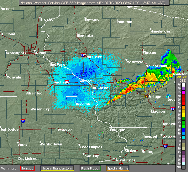 At 345 am cdt, a severe thunderstorm was located 11 miles north of wisconsin dells, moving southeast at 35 mph (radar indicated). Hazards include 60 mph wind gusts and quarter size hail. Hail damage to vehicles is expected. expect wind damage to roofs, siding, and trees. Locations impacted include, county roads b and p, brooks, k and l campground, county roads b and k, the town of quincy, highway 23 and county g, county roads a and b, stand rock campground, highway 23 and county b, big spring, coons deep lake campground, highway 13 and county e, rocky arbor state park, holiday shores campground, castle rock dam, yukon trails campground, white creek, highway 82 and county b, highways 82 and 13 and plainville. At 345 am cdt, a severe thunderstorm was located 11 miles north of wisconsin dells, moving southeast at 35 mph (radar indicated). Hazards include 60 mph wind gusts and quarter size hail. Hail damage to vehicles is expected. expect wind damage to roofs, siding, and trees. Locations impacted include, county roads b and p, brooks, k and l campground, county roads b and k, the town of quincy, highway 23 and county g, county roads a and b, stand rock campground, highway 23 and county b, big spring, coons deep lake campground, highway 13 and county e, rocky arbor state park, holiday shores campground, castle rock dam, yukon trails campground, white creek, highway 82 and county b, highways 82 and 13 and plainville.
|
| 7/19/2020 3:42 AM CDT |
 At 342 am cdt, a severe thunderstorm was located 8 miles northwest of westfield, or 9 miles east of friendship, moving east at 40 mph (radar indicated). Hazards include 60 mph wind gusts and quarter size hail. Hail damage to vehicles is expected. expect wind damage to roofs, siding, and trees. Locations impacted include, friendship, adams, county roads e and g, the preston cliffs, grand marsh, highway 21 and county g, county roads g and m and the ship rock wayside. At 342 am cdt, a severe thunderstorm was located 8 miles northwest of westfield, or 9 miles east of friendship, moving east at 40 mph (radar indicated). Hazards include 60 mph wind gusts and quarter size hail. Hail damage to vehicles is expected. expect wind damage to roofs, siding, and trees. Locations impacted include, friendship, adams, county roads e and g, the preston cliffs, grand marsh, highway 21 and county g, county roads g and m and the ship rock wayside.
|
| 7/19/2020 3:38 AM CDT |
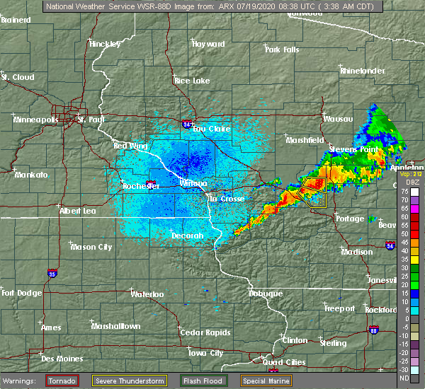 At 337 am cdt, a severe thunderstorm was located 10 miles southeast of adams, or 11 miles southeast of friendship, moving southeast at 50 mph (radar indicated). Hazards include 60 mph wind gusts and quarter size hail. Hail damage to vehicles is expected. expect wind damage to roofs, siding, and trees. This severe thunderstorm will remain over mainly rural areas of southeastern juneau and southern adams counties, including the following locations, county roads b and p, brooks, k and l campground, county roads b and k, the town of quincy, highway 23 and county g and county roads a and b. At 337 am cdt, a severe thunderstorm was located 10 miles southeast of adams, or 11 miles southeast of friendship, moving southeast at 50 mph (radar indicated). Hazards include 60 mph wind gusts and quarter size hail. Hail damage to vehicles is expected. expect wind damage to roofs, siding, and trees. This severe thunderstorm will remain over mainly rural areas of southeastern juneau and southern adams counties, including the following locations, county roads b and p, brooks, k and l campground, county roads b and k, the town of quincy, highway 23 and county g and county roads a and b.
|
| 7/19/2020 3:31 AM CDT |
 At 330 am cdt, a severe thunderstorm was located near arkdale, moving east southeast at 30 mph (radar indicated). Hazards include 60 mph wind gusts and quarter size hail. Hail damage to vehicles is expected. expect wind damage to roofs, siding, and trees. Locations impacted include, friendship, adams, arkdale, cottonville, highways 13 and 21, county roads e and g, the preston cliffs, grand marsh, highway 21 and county g, county roads g and m, the ship rock wayside and roche a cri state park. At 330 am cdt, a severe thunderstorm was located near arkdale, moving east southeast at 30 mph (radar indicated). Hazards include 60 mph wind gusts and quarter size hail. Hail damage to vehicles is expected. expect wind damage to roofs, siding, and trees. Locations impacted include, friendship, adams, arkdale, cottonville, highways 13 and 21, county roads e and g, the preston cliffs, grand marsh, highway 21 and county g, county roads g and m, the ship rock wayside and roche a cri state park.
|
| 7/19/2020 3:23 AM CDT |
 At 323 am cdt, a severe thunderstorm was located near friendship, moving east at 30 mph (radar indicated). Hazards include 60 mph wind gusts and quarter size hail. Hail damage to vehicles is expected. expect wind damage to roofs, siding, and trees. This severe thunderstorm will remain over mainly rural areas of northern adams county, including the following locations, arkdale, cottonville, highways 13 and 21, county roads e and g, the preston cliffs, grand marsh and highway 21 and county g. At 323 am cdt, a severe thunderstorm was located near friendship, moving east at 30 mph (radar indicated). Hazards include 60 mph wind gusts and quarter size hail. Hail damage to vehicles is expected. expect wind damage to roofs, siding, and trees. This severe thunderstorm will remain over mainly rural areas of northern adams county, including the following locations, arkdale, cottonville, highways 13 and 21, county roads e and g, the preston cliffs, grand marsh and highway 21 and county g.
|
| 6/2/2020 7:58 PM CDT |
 The severe thunderstorm warning for southern juneau, eastern vernon, richland and southern adams counties will expire at 800 pm cdt, the storms which prompted the warning have weakened below severe limits, and no longer pose an immediate threat to life or property. therefore, the warning will be allowed to expire. however gusty winds are still possible with these thunderstorms. a severe thunderstorm watch remains in effect until midnight cdt for central, southwestern and west central wisconsin. The severe thunderstorm warning for southern juneau, eastern vernon, richland and southern adams counties will expire at 800 pm cdt, the storms which prompted the warning have weakened below severe limits, and no longer pose an immediate threat to life or property. therefore, the warning will be allowed to expire. however gusty winds are still possible with these thunderstorms. a severe thunderstorm watch remains in effect until midnight cdt for central, southwestern and west central wisconsin.
|
| 6/2/2020 6:59 PM CDT |
 At 658 pm cdt, severe thunderstorms were located along a line extending from near necedah to 7 miles northwest of elroy to near westby, moving southeast at 55 mph (radar indicated). Hazards include 70 mph wind gusts and half dollar size hail. Hail damage to vehicles is expected. expect considerable tree damage. wind damage is also likely to mobile homes, roofs, and outbuildings. severe thunderstorms will be near, elroy and hillsboro around 705 pm cdt. wonewoc around 710 pm cdt. richland center around 730 pm cdt. Other locations impacted by these severe thunderstorms include johnson hill, big spring, highway 80 and county c c, gillingham, trippville, neptune and county roads a and z. At 658 pm cdt, severe thunderstorms were located along a line extending from near necedah to 7 miles northwest of elroy to near westby, moving southeast at 55 mph (radar indicated). Hazards include 70 mph wind gusts and half dollar size hail. Hail damage to vehicles is expected. expect considerable tree damage. wind damage is also likely to mobile homes, roofs, and outbuildings. severe thunderstorms will be near, elroy and hillsboro around 705 pm cdt. wonewoc around 710 pm cdt. richland center around 730 pm cdt. Other locations impacted by these severe thunderstorms include johnson hill, big spring, highway 80 and county c c, gillingham, trippville, neptune and county roads a and z.
|
| 6/2/2020 6:44 PM CDT |
 At 644 pm cdt, a severe thunderstorm was located 7 miles north of dellwood, or 9 miles northwest of friendship, moving east at 35 mph (radar indicated). Hazards include 60 mph wind gusts and quarter size hail. Hail damage to vehicles is expected. expect wind damage to roofs, siding, and trees. this severe thunderstorm will be near, friendship and adams around 700 pm cdt. Other locations impacted by this severe thunderstorm include highways 13 and 21, county roads g and o, county roads g and m, county roads c and g, lake sherwood, the preston cliffs and grand marsh. At 644 pm cdt, a severe thunderstorm was located 7 miles north of dellwood, or 9 miles northwest of friendship, moving east at 35 mph (radar indicated). Hazards include 60 mph wind gusts and quarter size hail. Hail damage to vehicles is expected. expect wind damage to roofs, siding, and trees. this severe thunderstorm will be near, friendship and adams around 700 pm cdt. Other locations impacted by this severe thunderstorm include highways 13 and 21, county roads g and o, county roads g and m, county roads c and g, lake sherwood, the preston cliffs and grand marsh.
|
| 8/7/2019 8:58 PM CDT |
 The severe thunderstorm warning for southern adams county will expire at 900 pm cdt, the storm which prompted the warning has moved out of the area. therefore, the warning will be allowed to expire. however small hail and gusty winds are still possible with another thunderstorm moving into southern adams county. The severe thunderstorm warning for southern adams county will expire at 900 pm cdt, the storm which prompted the warning has moved out of the area. therefore, the warning will be allowed to expire. however small hail and gusty winds are still possible with another thunderstorm moving into southern adams county.
|
| 8/7/2019 8:53 PM CDT |
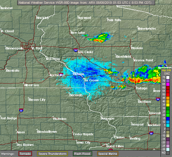 At 852 pm cdt, a severe thunderstorm was located 7 miles southwest of montello, or 12 miles north of portage, moving east at 40 mph (radar indicated). Hazards include 60 mph wind gusts and quarter size hail. Hail damage to vehicles is expected. expect wind damage to roofs, siding, and trees. Locations impacted include, coons deep lake campground, brooks, k and l campground, the town of quincy, white creek, and big spring. At 852 pm cdt, a severe thunderstorm was located 7 miles southwest of montello, or 12 miles north of portage, moving east at 40 mph (radar indicated). Hazards include 60 mph wind gusts and quarter size hail. Hail damage to vehicles is expected. expect wind damage to roofs, siding, and trees. Locations impacted include, coons deep lake campground, brooks, k and l campground, the town of quincy, white creek, and big spring.
|
| 8/7/2019 8:38 PM CDT |
 At 837 pm cdt, a severe thunderstorm was located 10 miles southwest of westfield, or 12 miles northeast of wisconsin dells, moving southeast at 40 mph (radar indicated). Hazards include 60 mph wind gusts and quarter size hail. Hail damage to vehicles is expected. expect wind damage to roofs, siding, and trees. This severe thunderstorm will remain over mainly rural areas of southern adams county, including the following locations, coons deep lake campground, brooks, k and l campground, and the town of quincy. At 837 pm cdt, a severe thunderstorm was located 10 miles southwest of westfield, or 12 miles northeast of wisconsin dells, moving southeast at 40 mph (radar indicated). Hazards include 60 mph wind gusts and quarter size hail. Hail damage to vehicles is expected. expect wind damage to roofs, siding, and trees. This severe thunderstorm will remain over mainly rural areas of southern adams county, including the following locations, coons deep lake campground, brooks, k and l campground, and the town of quincy.
|
| 8/7/2019 8:22 PM CDT |
 At 821 pm cdt, a severe thunderstorm was located near adams, or near friendship, moving east at 40 mph (radar indicated). Hazards include 60 mph wind gusts and quarter size hail. Hail damage to vehicles is expected. expect wind damage to roofs, siding, and trees. This severe thunderstorm will remain over mainly rural areas of southern adams county, including the following locations, grand marsh, brooks, and the town of quincy. At 821 pm cdt, a severe thunderstorm was located near adams, or near friendship, moving east at 40 mph (radar indicated). Hazards include 60 mph wind gusts and quarter size hail. Hail damage to vehicles is expected. expect wind damage to roofs, siding, and trees. This severe thunderstorm will remain over mainly rural areas of southern adams county, including the following locations, grand marsh, brooks, and the town of quincy.
|
| 8/7/2019 8:18 PM CDT |
 At 817 pm cdt, a severe thunderstorm was located near westfield, or 14 miles southeast of friendship, moving southeast at 30 mph (radar indicated). Hazards include 60 mph wind gusts and quarter size hail. Hail damage to vehicles is expected. expect wind damage to roofs, siding, and trees. This severe thunderstorm will remain over mainly rural areas of central adams county, including the following locations, cottonville, the preston cliffs, and grand marsh. At 817 pm cdt, a severe thunderstorm was located near westfield, or 14 miles southeast of friendship, moving southeast at 30 mph (radar indicated). Hazards include 60 mph wind gusts and quarter size hail. Hail damage to vehicles is expected. expect wind damage to roofs, siding, and trees. This severe thunderstorm will remain over mainly rural areas of central adams county, including the following locations, cottonville, the preston cliffs, and grand marsh.
|
| 8/7/2019 8:04 PM CDT |
 At 803 pm cdt, a severe thunderstorm was located 10 miles north of westfield, or 10 miles west of wautoma, moving east at 40 mph (radar indicated). Hazards include 60 mph wind gusts and quarter size hail. Hail damage to vehicles is expected. expect wind damage to roofs, siding, and trees. Locations impacted include, friendship, adams, strongs prairie, big flats, colburn, lake sherwood, and roche a cri state park. At 803 pm cdt, a severe thunderstorm was located 10 miles north of westfield, or 10 miles west of wautoma, moving east at 40 mph (radar indicated). Hazards include 60 mph wind gusts and quarter size hail. Hail damage to vehicles is expected. expect wind damage to roofs, siding, and trees. Locations impacted include, friendship, adams, strongs prairie, big flats, colburn, lake sherwood, and roche a cri state park.
|
| 8/7/2019 7:42 PM CDT |
 At 742 pm cdt, a severe thunderstorm was located 9 miles north of friendship, moving east at 40 mph (radar indicated). Hazards include 60 mph wind gusts and quarter size hail. Hail damage to vehicles is expected. expect wind damage to roofs, siding, and trees. This severe thunderstorm will remain over mainly rural areas of northern adams county, including the following locations, arkdale, lake arrowhead, colburn, highways 13 and 21, county roads g and o, county roads g and m and the colburn wildlife area. At 742 pm cdt, a severe thunderstorm was located 9 miles north of friendship, moving east at 40 mph (radar indicated). Hazards include 60 mph wind gusts and quarter size hail. Hail damage to vehicles is expected. expect wind damage to roofs, siding, and trees. This severe thunderstorm will remain over mainly rural areas of northern adams county, including the following locations, arkdale, lake arrowhead, colburn, highways 13 and 21, county roads g and o, county roads g and m and the colburn wildlife area.
|
| 7/20/2019 11:08 AM CDT |
 At 1105 am cdt, severe thunderstorms were located along a line extending from near necedah to mauston, moving northeast at 40 mph. at 1101 am, the juneau sheriff department reported a couple of trees were blown down in armenia and finley areas (law enforcement). Hazards include 60 mph wind gusts. expect damage to roofs, siding, and trees At 1105 am cdt, severe thunderstorms were located along a line extending from near necedah to mauston, moving northeast at 40 mph. at 1101 am, the juneau sheriff department reported a couple of trees were blown down in armenia and finley areas (law enforcement). Hazards include 60 mph wind gusts. expect damage to roofs, siding, and trees
|
| 7/20/2019 10:40 AM CDT |
 At 1040 am cdt, severe thunderstorms were located along a line extending from 6 miles north of plainfield to 11 miles northeast of friendship to new lisbon, moving east at 50 mph (radar indicated). Hazards include 70 mph wind gusts and penny size hail. Expect considerable tree damage. damage is likely to mobile homes, roofs, and outbuildings. These severe thunderstorms will remain over mainly rural areas of juneau and adams counties, including the following locations, new miner, highways 13 and 21, county roads g and o, county roads g and m, johnson hill, highway 13 and county e and county roads c and g. At 1040 am cdt, severe thunderstorms were located along a line extending from 6 miles north of plainfield to 11 miles northeast of friendship to new lisbon, moving east at 50 mph (radar indicated). Hazards include 70 mph wind gusts and penny size hail. Expect considerable tree damage. damage is likely to mobile homes, roofs, and outbuildings. These severe thunderstorms will remain over mainly rural areas of juneau and adams counties, including the following locations, new miner, highways 13 and 21, county roads g and o, county roads g and m, johnson hill, highway 13 and county e and county roads c and g.
|
| 7/20/2019 10:22 AM CDT |
 At 1021 am cdt, severe thunderstorms were located along a line extending from near lake wazeecha to 8 miles south of new rome to near new lisbon, moving east at 50 mph (radar indicated). Hazards include 70 mph wind gusts and penny size hail. Expect considerable tree damage. damage is likely to mobile homes, roofs, and outbuildings. severe thunderstorms will be near, new rome around 1025 am cdt. dellwood around 1035 am cdt. friendship and adams around 1045 am cdt. Other locations impacted by these severe thunderstorms include new miner, highways 13 and 21, county roads g and o, county roads g and m, johnson hill, jellystone park near warrens and highway 13 and county e. At 1021 am cdt, severe thunderstorms were located along a line extending from near lake wazeecha to 8 miles south of new rome to near new lisbon, moving east at 50 mph (radar indicated). Hazards include 70 mph wind gusts and penny size hail. Expect considerable tree damage. damage is likely to mobile homes, roofs, and outbuildings. severe thunderstorms will be near, new rome around 1025 am cdt. dellwood around 1035 am cdt. friendship and adams around 1045 am cdt. Other locations impacted by these severe thunderstorms include new miner, highways 13 and 21, county roads g and o, county roads g and m, johnson hill, jellystone park near warrens and highway 13 and county e.
|
| 8/28/2018 3:12 PM CDT |
 The severe thunderstorm warning for southeastern adams county will expire at 315 pm cdt, the storms which prompted the warning have moved out of the area. therefore the warning will be allowed to expire. however heavy rain is still expected with additional thunderstorms in this area. a severe thunderstorm watch remains in effect until 900 pm cdt for central wisconsin. The severe thunderstorm warning for southeastern adams county will expire at 315 pm cdt, the storms which prompted the warning have moved out of the area. therefore the warning will be allowed to expire. however heavy rain is still expected with additional thunderstorms in this area. a severe thunderstorm watch remains in effect until 900 pm cdt for central wisconsin.
|
| 8/28/2018 2:57 PM CDT |
 At 256 pm cdt, severe thunderstorms were located along a line extending from 8 miles east of adams to 6 miles east of wisconsin dells, moving east at 40 mph (law enforcement. this storm has a history of producing wind damage to trees). Hazards include 70 mph wind gusts and ping pong ball size hail. People and animals outdoors will be injured. expect hail damage to roofs, siding, windows, and vehicles. expect considerable tree damage. wind damage is also likely to mobile homes, roofs, and outbuildings. Locations impacted include, friendship, adams, big spring, coons deep lake campground, grand marsh, and the preston cliffs. At 256 pm cdt, severe thunderstorms were located along a line extending from 8 miles east of adams to 6 miles east of wisconsin dells, moving east at 40 mph (law enforcement. this storm has a history of producing wind damage to trees). Hazards include 70 mph wind gusts and ping pong ball size hail. People and animals outdoors will be injured. expect hail damage to roofs, siding, windows, and vehicles. expect considerable tree damage. wind damage is also likely to mobile homes, roofs, and outbuildings. Locations impacted include, friendship, adams, big spring, coons deep lake campground, grand marsh, and the preston cliffs.
|
| 8/28/2018 2:52 PM CDT |
 At 251 pm cdt, severe thunderstorms were located along a line extending from 6 miles east of adams to near wisconsin dells, moving east at 40 mph (law enforcement. at 236 pm cdt, trees were reported down in and just east of plainville). Hazards include 70 mph wind gusts. Expect considerable tree damage. damage is likely to mobile homes, roofs, and outbuildings. Locations impacted include, friendship, adams, big spring, coons deep lake campground, grand marsh, and the preston cliffs. At 251 pm cdt, severe thunderstorms were located along a line extending from 6 miles east of adams to near wisconsin dells, moving east at 40 mph (law enforcement. at 236 pm cdt, trees were reported down in and just east of plainville). Hazards include 70 mph wind gusts. Expect considerable tree damage. damage is likely to mobile homes, roofs, and outbuildings. Locations impacted include, friendship, adams, big spring, coons deep lake campground, grand marsh, and the preston cliffs.
|
| 8/28/2018 2:42 PM CDT |
 At 242 pm cdt, severe thunderstorms were located along a line extending from adams to lake delton, moving east at 40 mph (radar indicated). Hazards include 60 mph wind gusts. Expect damage to roofs, siding, and trees. These severe thunderstorms will remain over mainly rural areas of southern adams county, including the following locations, county roads b and p, brooks, k and l campground, county roads b and k and the town of quincy. At 242 pm cdt, severe thunderstorms were located along a line extending from adams to lake delton, moving east at 40 mph (radar indicated). Hazards include 60 mph wind gusts. Expect damage to roofs, siding, and trees. These severe thunderstorms will remain over mainly rural areas of southern adams county, including the following locations, county roads b and p, brooks, k and l campground, county roads b and k and the town of quincy.
|
| 8/28/2018 2:27 PM CDT |
 At 227 pm cdt, severe thunderstorms were located along a line extending from near dellwood to near reedsburg, moving east at 40 mph (radar indicated). Hazards include 60 mph wind gusts. Expect damage to roofs, siding, and trees. severe thunderstorms will be near, friendship and adams around 240 pm cdt. Other locations impacted by these severe thunderstorms include county roads b and p, brooks, k and l campground, county roads b and k and the town of quincy. At 227 pm cdt, severe thunderstorms were located along a line extending from near dellwood to near reedsburg, moving east at 40 mph (radar indicated). Hazards include 60 mph wind gusts. Expect damage to roofs, siding, and trees. severe thunderstorms will be near, friendship and adams around 240 pm cdt. Other locations impacted by these severe thunderstorms include county roads b and p, brooks, k and l campground, county roads b and k and the town of quincy.
|
| 8/27/2018 9:25 PM CDT |
 The severe thunderstorm warning for adams county will expire at 930 pm cdt, the storms which prompted the warning have weakened below severe limits, and no longer pose an immediate threat to life or property. therefore the warning will be allowed to expire. however gusty winds are still possible with thunderstorms that remain in the area. The severe thunderstorm warning for adams county will expire at 930 pm cdt, the storms which prompted the warning have weakened below severe limits, and no longer pose an immediate threat to life or property. therefore the warning will be allowed to expire. however gusty winds are still possible with thunderstorms that remain in the area.
|
| 8/27/2018 9:18 PM CDT |
 At 917 pm cdt, severe thunderstorms were located along a line extending from near plainfield to near westfield to 8 miles north of reedsburg, moving east at 50 mph (radar indicated). Hazards include 60 mph wind gusts. Expect damage to roofs, siding, and trees. These severe thunderstorms will remain over mainly rural areas of adams county, including the following locations, colburn, county roads b and p, county roads b and k, county roads g and o and county roads g and m. At 917 pm cdt, severe thunderstorms were located along a line extending from near plainfield to near westfield to 8 miles north of reedsburg, moving east at 50 mph (radar indicated). Hazards include 60 mph wind gusts. Expect damage to roofs, siding, and trees. These severe thunderstorms will remain over mainly rural areas of adams county, including the following locations, colburn, county roads b and p, county roads b and k, county roads g and o and county roads g and m.
|
| 8/27/2018 9:06 PM CDT |
 At 905 pm cdt, severe thunderstorms were located along a line extending from 7 miles south of lake wazeecha to near adams to wonewoc, moving east at 55 mph (radar indicated). Hazards include 60 mph wind gusts. Expect damage to roofs, siding, and trees. these severe storms will be near, friendship and adams around 910 pm cdt. Other locations impacted by these severe thunderstorms include lemonweir, big flats, lindina, lyndon station and colburn. At 905 pm cdt, severe thunderstorms were located along a line extending from 7 miles south of lake wazeecha to near adams to wonewoc, moving east at 55 mph (radar indicated). Hazards include 60 mph wind gusts. Expect damage to roofs, siding, and trees. these severe storms will be near, friendship and adams around 910 pm cdt. Other locations impacted by these severe thunderstorms include lemonweir, big flats, lindina, lyndon station and colburn.
|
| 8/27/2018 8:57 PM CDT |
 The national weather service in la crosse has issued a * severe thunderstorm warning for. southeastern juneau county in central wisconsin. adams county in central wisconsin. until 930 pm cdt. At 856 pm cdt, severe thunderstorms were located along a line. The national weather service in la crosse has issued a * severe thunderstorm warning for. southeastern juneau county in central wisconsin. adams county in central wisconsin. until 930 pm cdt. At 856 pm cdt, severe thunderstorms were located along a line.
|
| 6/30/2018 7:05 PM CDT |
 The severe thunderstorm warning for southern adams county will expire at 715 pm cdt, the storms which prompted the warning have moved out of the area. therefore the warning will be allowed to expire. a severe thunderstorm watch remains in effect until 900 pm cdt for central wisconsin. The severe thunderstorm warning for southern adams county will expire at 715 pm cdt, the storms which prompted the warning have moved out of the area. therefore the warning will be allowed to expire. a severe thunderstorm watch remains in effect until 900 pm cdt for central wisconsin.
|
| 6/30/2018 6:56 PM CDT |
 At 655 pm cdt, severe thunderstorms were located along a line extending from 8 miles northwest of westfield to 9 miles east of wisconsin dells, moving east at 45 mph (law enforcement. reports of trees and power lines down in the southern half of adams county have been received from 630 pm to 7 pm). Hazards include 60 mph wind gusts. Expect damage to roofs, siding, and trees. These severe thunderstorms will remain over mainly rural areas of southern adams county, including the following locations, county roads b and p, brooks, k and l campground, county roads b and k and the town of quincy. At 655 pm cdt, severe thunderstorms were located along a line extending from 8 miles northwest of westfield to 9 miles east of wisconsin dells, moving east at 45 mph (law enforcement. reports of trees and power lines down in the southern half of adams county have been received from 630 pm to 7 pm). Hazards include 60 mph wind gusts. Expect damage to roofs, siding, and trees. These severe thunderstorms will remain over mainly rural areas of southern adams county, including the following locations, county roads b and p, brooks, k and l campground, county roads b and k and the town of quincy.
|
| 6/30/2018 6:29 PM CDT |
 At 629 pm cdt, severe thunderstorms were located along a line extending from dellwood to 8 miles north of reedsburg, moving east at 30 mph (radar indicated). Hazards include 60 mph wind gusts. Expect damage to roofs, siding, and trees. severe thunderstorms will be near, adams around 645 pm cdt. Other locations impacted by these severe thunderstorms include county roads b and p, brooks, k and l campground, county roads b and k and the town of quincy. At 629 pm cdt, severe thunderstorms were located along a line extending from dellwood to 8 miles north of reedsburg, moving east at 30 mph (radar indicated). Hazards include 60 mph wind gusts. Expect damage to roofs, siding, and trees. severe thunderstorms will be near, adams around 645 pm cdt. Other locations impacted by these severe thunderstorms include county roads b and p, brooks, k and l campground, county roads b and k and the town of quincy.
|
| 7/12/2017 7:51 PM CDT |
 At 751 pm cdt, severe thunderstorms were located along a line extending from 8 miles west of babcock to near friendship to near westfield, moving east at 40 mph (radar indicated). Hazards include 60 mph wind gusts. Expect damage to roofs, siding, and trees. these severe storms will be near, friendship and adams around 755 pm cdt. new rome around 815 pm cdt. Other locations impacted by these severe thunderstorms include strongs prairie, big flats, kelly, cutler and colburn. At 751 pm cdt, severe thunderstorms were located along a line extending from 8 miles west of babcock to near friendship to near westfield, moving east at 40 mph (radar indicated). Hazards include 60 mph wind gusts. Expect damage to roofs, siding, and trees. these severe storms will be near, friendship and adams around 755 pm cdt. new rome around 815 pm cdt. Other locations impacted by these severe thunderstorms include strongs prairie, big flats, kelly, cutler and colburn.
|
| 7/12/2017 7:45 PM CDT |
 At 744 pm cdt, severe thunderstorms were located along a line extending from 6 miles northwest of necedah to near friendship to 8 miles southwest of westfield, moving east at 40 mph (radar indicated). Hazards include 60 mph wind gusts. Expect damage to roofs, siding, and trees. These severe thunderstorms will remain over mainly rural areas of juneau and adams counties, including the following locations: strongs prairie, big flats, lyndon station, kelly and cutler. At 744 pm cdt, severe thunderstorms were located along a line extending from 6 miles northwest of necedah to near friendship to 8 miles southwest of westfield, moving east at 40 mph (radar indicated). Hazards include 60 mph wind gusts. Expect damage to roofs, siding, and trees. These severe thunderstorms will remain over mainly rural areas of juneau and adams counties, including the following locations: strongs prairie, big flats, lyndon station, kelly and cutler.
|
| 7/12/2017 7:38 PM CDT | Tree blown down onto a power lin in adams county WI, 4 miles N of Grand Marsh, WI |
| 7/12/2017 7:32 PM CDT |
 At 731 pm cdt, severe thunderstorms were located along a line extending from 10 miles west of necedah to near dellwood to 9 miles north of wisconsin dells, moving east at 50 mph (radar indicated). Hazards include 60 mph wind gusts and quarter size hail. Hail damage to vehicles is expected. expect wind damage to roofs, siding, and trees. these severe storms will be near, friendship and adams around 740 pm cdt. new rome around 755 pm cdt. Other locations impacted by these severe thunderstorms include strongs prairie, big flats, lyndon station, kelly and cutler. At 731 pm cdt, severe thunderstorms were located along a line extending from 10 miles west of necedah to near dellwood to 9 miles north of wisconsin dells, moving east at 50 mph (radar indicated). Hazards include 60 mph wind gusts and quarter size hail. Hail damage to vehicles is expected. expect wind damage to roofs, siding, and trees. these severe storms will be near, friendship and adams around 740 pm cdt. new rome around 755 pm cdt. Other locations impacted by these severe thunderstorms include strongs prairie, big flats, lyndon station, kelly and cutler.
|
| 7/12/2017 7:27 PM CDT |
 At 726 pm cdt, severe thunderstorms were located along a line extending from 6 miles west of necedah to 10 miles north of wisconsin dells, moving east at 45 mph (radar indicated). Hazards include 60 mph wind gusts and quarter size hail. Hail damage to vehicles is expected. expect wind damage to roofs, siding, and trees. these severe storms will be near, dellwood around 740 pm cdt. friendship, adams and new rome around 750 pm cdt. Other locations impacted by these severe thunderstorms include lemonweir, strongs prairie, big flats, lyndon station and kelly. At 726 pm cdt, severe thunderstorms were located along a line extending from 6 miles west of necedah to 10 miles north of wisconsin dells, moving east at 45 mph (radar indicated). Hazards include 60 mph wind gusts and quarter size hail. Hail damage to vehicles is expected. expect wind damage to roofs, siding, and trees. these severe storms will be near, dellwood around 740 pm cdt. friendship, adams and new rome around 750 pm cdt. Other locations impacted by these severe thunderstorms include lemonweir, strongs prairie, big flats, lyndon station and kelly.
|
| 7/12/2017 7:20 PM CDT |
 At 719 pm cdt, severe thunderstorms were located along a line extending from 10 miles east of tomah to 6 miles southeast of mauston, moving east at 45 mph (radar indicated). Hazards include 60 mph wind gusts and quarter size hail. Hail damage to vehicles is expected. expect wind damage to roofs, siding, and trees. these severe storms will be near, necedah around 735 pm cdt. dellwood around 740 pm cdt. friendship and new rome around 750 pm cdt. adams around 755 pm cdt. Other locations impacted by these severe thunderstorms include lemonweir, strongs prairie, big flats, lindina and camp douglas. At 719 pm cdt, severe thunderstorms were located along a line extending from 10 miles east of tomah to 6 miles southeast of mauston, moving east at 45 mph (radar indicated). Hazards include 60 mph wind gusts and quarter size hail. Hail damage to vehicles is expected. expect wind damage to roofs, siding, and trees. these severe storms will be near, necedah around 735 pm cdt. dellwood around 740 pm cdt. friendship and new rome around 750 pm cdt. adams around 755 pm cdt. Other locations impacted by these severe thunderstorms include lemonweir, strongs prairie, big flats, lindina and camp douglas.
|
| 7/12/2017 7:10 PM CDT |
 At 710 pm cdt, severe thunderstorms were located along a line extending from 9 miles east of tomah to near mauston, moving east at 45 mph (radar indicated). Hazards include 60 mph wind gusts and quarter size hail. Hail damage to vehicles is expected. expect wind damage to roofs, siding, and trees. severe thunderstorms will be near, mauston around 715 pm cdt. necedah around 725 pm cdt. dellwood around 735 pm cdt. new rome around 740 pm cdt. friendship and adams around 745 pm cdt. Other locations impacted by these severe thunderstorms include lemonweir, strongs prairie, big flats, lindina and camp douglas. At 710 pm cdt, severe thunderstorms were located along a line extending from 9 miles east of tomah to near mauston, moving east at 45 mph (radar indicated). Hazards include 60 mph wind gusts and quarter size hail. Hail damage to vehicles is expected. expect wind damage to roofs, siding, and trees. severe thunderstorms will be near, mauston around 715 pm cdt. necedah around 725 pm cdt. dellwood around 735 pm cdt. new rome around 740 pm cdt. friendship and adams around 745 pm cdt. Other locations impacted by these severe thunderstorms include lemonweir, strongs prairie, big flats, lindina and camp douglas.
|
| 7/6/2017 9:50 PM CDT |
 At 949 pm cdt, severe thunderstorms were located along a line extending from 8 miles east of friendship to 11 miles northeast of wisconsin dells, moving southeast at 30 mph (radar indicated). Hazards include 60 mph wind gusts and quarter size hail. Hail damage to vehicles is expected. expect wind damage to roofs, siding, and trees. Locations impacted include, county roads g and m, the preston cliffs, grand marsh, highway 82 and county b, brooks, county roads e and g, highway 21 and county g and the ship rock wayside. At 949 pm cdt, severe thunderstorms were located along a line extending from 8 miles east of friendship to 11 miles northeast of wisconsin dells, moving southeast at 30 mph (radar indicated). Hazards include 60 mph wind gusts and quarter size hail. Hail damage to vehicles is expected. expect wind damage to roofs, siding, and trees. Locations impacted include, county roads g and m, the preston cliffs, grand marsh, highway 82 and county b, brooks, county roads e and g, highway 21 and county g and the ship rock wayside.
|
| 7/6/2017 9:35 PM CDT |
 At 934 pm cdt, a severe thunderstorm was located over adams, or over friendship, moving southeast at 35 mph (radar indicated). Hazards include 60 mph wind gusts and quarter size hail. Hail damage to vehicles is expected. expect wind damage to roofs, siding, and trees. Locations impacted include, friendship, adams, dellwood, highways 13 and 21, buckhorn state park, grand marsh, highway 82 and county b, brooks, cottonville, brookside, the preston cliffs, roche a cri state park and arkdale. At 934 pm cdt, a severe thunderstorm was located over adams, or over friendship, moving southeast at 35 mph (radar indicated). Hazards include 60 mph wind gusts and quarter size hail. Hail damage to vehicles is expected. expect wind damage to roofs, siding, and trees. Locations impacted include, friendship, adams, dellwood, highways 13 and 21, buckhorn state park, grand marsh, highway 82 and county b, brooks, cottonville, brookside, the preston cliffs, roche a cri state park and arkdale.
|
| 7/6/2017 9:18 PM CDT |
 At 918 pm cdt, a severe thunderstorm was located near adams, or near friendship, moving southeast at 30 mph. another severe thunderstorm was located near necedah, also moving southeast at 30 mph (radar indicated). Hazards include 60 mph wind gusts and half dollar size hail. Hail damage to vehicles is expected. expect wind damage to roofs, siding, and trees. This severe thunderstorm will remain over mainly rural areas of central juneau and adams counties, including the following locations: arkdale, strongs prairie, kelly, highways 13 and 21, county roads g and m and highway 13 and county e. At 918 pm cdt, a severe thunderstorm was located near adams, or near friendship, moving southeast at 30 mph. another severe thunderstorm was located near necedah, also moving southeast at 30 mph (radar indicated). Hazards include 60 mph wind gusts and half dollar size hail. Hail damage to vehicles is expected. expect wind damage to roofs, siding, and trees. This severe thunderstorm will remain over mainly rural areas of central juneau and adams counties, including the following locations: arkdale, strongs prairie, kelly, highways 13 and 21, county roads g and m and highway 13 and county e.
|
| 6/14/2017 2:15 PM CDT |
 A severe thunderstorm warning remains in effect until 230 pm cdt for adams county, strong to severe thunderstorms were tracking through mainly southern adams county in central wisconsin. wind gusts of 50 to 60 mph have been reported with trees and power lines down in juneau county (radar indicated). Hazards include 60 mph wind gusts. expect possible damage to roofs, siding, and trees A severe thunderstorm warning remains in effect until 230 pm cdt for adams county, strong to severe thunderstorms were tracking through mainly southern adams county in central wisconsin. wind gusts of 50 to 60 mph have been reported with trees and power lines down in juneau county (radar indicated). Hazards include 60 mph wind gusts. expect possible damage to roofs, siding, and trees
|
| 6/14/2017 2:04 PM CDT |
 At 204 pm cdt, severe thunderstorms were located along a line extending from dellwood to 8 miles south of adams to near wisconsin dells, moving northeast at 40 mph. wind gusts of 50 to 60 mph have been observed in the mauston wisconsin area as these storms moved through (radar indicated). Hazards include 60 mph wind gusts. Expect damage to roofs, siding, and trees. These severe thunderstorms will remain over mainly rural areas of adams county, including the following locations: colburn, highways 13 and 21, county roads g and o, county roads g and m and big spring. At 204 pm cdt, severe thunderstorms were located along a line extending from dellwood to 8 miles south of adams to near wisconsin dells, moving northeast at 40 mph. wind gusts of 50 to 60 mph have been observed in the mauston wisconsin area as these storms moved through (radar indicated). Hazards include 60 mph wind gusts. Expect damage to roofs, siding, and trees. These severe thunderstorms will remain over mainly rural areas of adams county, including the following locations: colburn, highways 13 and 21, county roads g and o, county roads g and m and big spring.
|
| 5/17/2017 8:49 PM CDT |
 At 848 pm cdt, severe thunderstorms were located along a line extending from 8 miles northeast of millston to adams to 11 miles southwest of westfield, moving northeast at 65 mph (law enforcement. power lines and trees have been reported down near mauston at 835 pm. 50 mph wind gusts were reported near tomah at 835 pm). Hazards include 70 mph wind gusts. Expect considerable tree damage. damage is likely to mobile homes, roofs, and outbuildings. these severe thunderstorms will remain over mainly rural areas of southeastern jackson, juneau, adams and northeastern monroe counties, including the following locations: strongs prairie, big flats, lyndon station, kelly and warrens. A tornado watch remains in effect until 100 am cdt for central and west central wisconsin. At 848 pm cdt, severe thunderstorms were located along a line extending from 8 miles northeast of millston to adams to 11 miles southwest of westfield, moving northeast at 65 mph (law enforcement. power lines and trees have been reported down near mauston at 835 pm. 50 mph wind gusts were reported near tomah at 835 pm). Hazards include 70 mph wind gusts. Expect considerable tree damage. damage is likely to mobile homes, roofs, and outbuildings. these severe thunderstorms will remain over mainly rural areas of southeastern jackson, juneau, adams and northeastern monroe counties, including the following locations: strongs prairie, big flats, lyndon station, kelly and warrens. A tornado watch remains in effect until 100 am cdt for central and west central wisconsin.
|
| 5/17/2017 8:43 PM CDT | Trees blown down in easto in adams county WI, 4.7 miles N of Grand Marsh, WI |
| 5/17/2017 8:39 PM CDT |
 At 835 pm cdt, severe thunderstorms were located along a line extending from near millston to near mauston to wisconsin dells, moving northeast at 65 mph (law enforcement. power lines and trees have been reported down near mauston at 835 pm. 50 mph wind gusts were reported near tomah at 835 pm). Hazards include 70 mph wind gusts. Expect considerable tree damage. damage is likely to mobile homes, roofs, and outbuildings. these severe storms will be near, dellwood and necedah around 845 pm cdt. friendship and adams around 850 pm cdt. other locations impacted by these severe thunderstorms include lemonweir, strongs prairie, big flats, lindina and camp douglas. A tornado watch remains in effect until 1100 pm cdt for central and west central wisconsin. At 835 pm cdt, severe thunderstorms were located along a line extending from near millston to near mauston to wisconsin dells, moving northeast at 65 mph (law enforcement. power lines and trees have been reported down near mauston at 835 pm. 50 mph wind gusts were reported near tomah at 835 pm). Hazards include 70 mph wind gusts. Expect considerable tree damage. damage is likely to mobile homes, roofs, and outbuildings. these severe storms will be near, dellwood and necedah around 845 pm cdt. friendship and adams around 850 pm cdt. other locations impacted by these severe thunderstorms include lemonweir, strongs prairie, big flats, lindina and camp douglas. A tornado watch remains in effect until 1100 pm cdt for central and west central wisconsin.
|
| 5/17/2017 8:22 PM CDT |
 At 818 pm cdt, severe thunderstorms were located along a line extending from la crosse, to reedsburg, moving northeast at 60 mph (law enforcement. trees damage has been reported in hillsboro and winds estimated at 50 to 60 mph in melvina in monroe county). Hazards include 70 mph wind gusts. Expect considerable tree damage. damage is likely to mobile homes, roofs, and outbuildings. these severe storms will be near, elroy around 825 pm cdt. fort mc coy around 830 pm cdt. tomah, mauston and new lisbon around 835 pm cdt. dellwood and necedah around 845 pm cdt. friendship and adams around 850 pm cdt. new rome around 900 pm cdt. other locations impacted by these severe thunderstorms include glendale, lemonweir, strongs prairie, big flats and lindina. A tornado watch remains in effect until 1100 pm cdt for central, southwestern and west central wisconsin. At 818 pm cdt, severe thunderstorms were located along a line extending from la crosse, to reedsburg, moving northeast at 60 mph (law enforcement. trees damage has been reported in hillsboro and winds estimated at 50 to 60 mph in melvina in monroe county). Hazards include 70 mph wind gusts. Expect considerable tree damage. damage is likely to mobile homes, roofs, and outbuildings. these severe storms will be near, elroy around 825 pm cdt. fort mc coy around 830 pm cdt. tomah, mauston and new lisbon around 835 pm cdt. dellwood and necedah around 845 pm cdt. friendship and adams around 850 pm cdt. new rome around 900 pm cdt. other locations impacted by these severe thunderstorms include glendale, lemonweir, strongs prairie, big flats and lindina. A tornado watch remains in effect until 1100 pm cdt for central, southwestern and west central wisconsin.
|
| 5/17/2017 8:06 PM CDT |
 At 806 pm cdt, severe thunderstorms were located along a line extending from near cashton to 7 miles southwest of hillsboro to spring green, moving north at 80 mph (law enforcement. many power lines and trees are downed in richland county in southwest wisconsin). Hazards include 70 mph wind gusts. Expect considerable tree damage. damage is likely to mobile homes, roofs, and outbuildings. severe thunderstorms will be near, elroy and wonewoc around 815 pm cdt. fort mc coy around 820 pm cdt. mauston, tomah and new lisbon around 825 pm cdt. millston and dellwood around 830 pm cdt. necedah around 835 pm cdt. new rome around 845 pm cdt. friendship and adams around 850 pm cdt. other locations impacted by these severe thunderstorms include glendale, lemonweir, strongs prairie, big flats and lindina. A tornado watch remains in effect until 1100 pm cdt for central, southwestern and west central wisconsin. At 806 pm cdt, severe thunderstorms were located along a line extending from near cashton to 7 miles southwest of hillsboro to spring green, moving north at 80 mph (law enforcement. many power lines and trees are downed in richland county in southwest wisconsin). Hazards include 70 mph wind gusts. Expect considerable tree damage. damage is likely to mobile homes, roofs, and outbuildings. severe thunderstorms will be near, elroy and wonewoc around 815 pm cdt. fort mc coy around 820 pm cdt. mauston, tomah and new lisbon around 825 pm cdt. millston and dellwood around 830 pm cdt. necedah around 835 pm cdt. new rome around 845 pm cdt. friendship and adams around 850 pm cdt. other locations impacted by these severe thunderstorms include glendale, lemonweir, strongs prairie, big flats and lindina. A tornado watch remains in effect until 1100 pm cdt for central, southwestern and west central wisconsin.
|
| 3/6/2017 10:37 PM CST |
 At 1037 pm cst, severe thunderstorms were located along a line extending from 8 miles southwest of plainfield to near wisconsin dells, moving east at 45 mph (radar indicated). Hazards include 60 mph wind gusts. Expect damage to roofs, siding, and trees. These severe thunderstorms will remain over mainly rural areas of southeastern juneau and adams counties, including the following locations: big flats, lyndon station, colburn, county roads g and o and county roads g and m. At 1037 pm cst, severe thunderstorms were located along a line extending from 8 miles southwest of plainfield to near wisconsin dells, moving east at 45 mph (radar indicated). Hazards include 60 mph wind gusts. Expect damage to roofs, siding, and trees. These severe thunderstorms will remain over mainly rural areas of southeastern juneau and adams counties, including the following locations: big flats, lyndon station, colburn, county roads g and o and county roads g and m.
|
| 3/6/2017 10:30 PM CST |
 At 1030 pm cst, severe thunderstorms were located along a line extending from near plainfield to near wisconsin dells, moving east at 45 mph (radar indicated). Hazards include 60 mph wind gusts. Expect damage to roofs, siding, and trees. These severe thunderstorms will remain over mainly rural areas of southeastern juneau and adams counties, including the following locations: lemonweir, big flats, lyndon station, colburn and county roads g and o. At 1030 pm cst, severe thunderstorms were located along a line extending from near plainfield to near wisconsin dells, moving east at 45 mph (radar indicated). Hazards include 60 mph wind gusts. Expect damage to roofs, siding, and trees. These severe thunderstorms will remain over mainly rural areas of southeastern juneau and adams counties, including the following locations: lemonweir, big flats, lyndon station, colburn and county roads g and o.
|
| 3/6/2017 10:12 PM CST |
 At 1011 pm cst, severe thunderstorms were located along a line extending from 7 miles west of plainfield to 7 miles north of reedsburg, moving east at 50 mph (radar indicated). Hazards include 60 mph wind gusts. Expect damage to roofs, siding, and trees. These severe thunderstorms will remain over mainly rural areas of southern juneau and adams counties, including the following locations: lemonweir, big flats, lindina, lyndon station and colburn. At 1011 pm cst, severe thunderstorms were located along a line extending from 7 miles west of plainfield to 7 miles north of reedsburg, moving east at 50 mph (radar indicated). Hazards include 60 mph wind gusts. Expect damage to roofs, siding, and trees. These severe thunderstorms will remain over mainly rural areas of southern juneau and adams counties, including the following locations: lemonweir, big flats, lindina, lyndon station and colburn.
|
| 3/6/2017 9:47 PM CST |
 At 947 pm cst, severe thunderstorms were located along a line extending from near new rome to near dellwood to near elroy, moving east at 60 mph (radar indicated). Hazards include 60 mph wind gusts and penny size hail. Expect damage to roofs, siding, and trees. these severe storms will be near, new rome and dellwood around 950 pm cst. friendship and adams around 955 pm cst. Other locations impacted by these severe thunderstorms include lemonweir, strongs prairie, big flats, lindina and camp douglas. At 947 pm cst, severe thunderstorms were located along a line extending from near new rome to near dellwood to near elroy, moving east at 60 mph (radar indicated). Hazards include 60 mph wind gusts and penny size hail. Expect damage to roofs, siding, and trees. these severe storms will be near, new rome and dellwood around 950 pm cst. friendship and adams around 955 pm cst. Other locations impacted by these severe thunderstorms include lemonweir, strongs prairie, big flats, lindina and camp douglas.
|
| 3/6/2017 9:30 PM CST |
 At 929 pm cst, severe thunderstorms were located along a line extending from 8 miles southwest of babcock to 8 miles northwest of new lisbon to near elroy, moving northeast at 60 mph (radar indicated). Hazards include 60 mph wind gusts. Expect damage to roofs, siding, and trees. severe thunderstorms will be near, necedah around 940 pm cst. dellwood and new rome around 955 pm cst. friendship around 1000 pm cst. adams around 1005 pm cst. Other locations impacted by these severe thunderstorms include lemonweir, strongs prairie, big flats, lindina and camp douglas. At 929 pm cst, severe thunderstorms were located along a line extending from 8 miles southwest of babcock to 8 miles northwest of new lisbon to near elroy, moving northeast at 60 mph (radar indicated). Hazards include 60 mph wind gusts. Expect damage to roofs, siding, and trees. severe thunderstorms will be near, necedah around 940 pm cst. dellwood and new rome around 955 pm cst. friendship around 1000 pm cst. adams around 1005 pm cst. Other locations impacted by these severe thunderstorms include lemonweir, strongs prairie, big flats, lindina and camp douglas.
|
| 7/21/2016 4:38 PM CDT |
 At 435 pm, severe thunderstorms were located across central and southern parts of juneau and adams counties with strong wind gusts and torrential rains (law enforcement). Hazards include 60 mph wind gusts and penny size hail. Expect damage to trees and power lines. the communities of mauston, elroy, lyndon station, and rural areas of southern adams county northeast of the dells can expect these storms. These storms will also move into the wisconsin dells area soon. At 435 pm, severe thunderstorms were located across central and southern parts of juneau and adams counties with strong wind gusts and torrential rains (law enforcement). Hazards include 60 mph wind gusts and penny size hail. Expect damage to trees and power lines. the communities of mauston, elroy, lyndon station, and rural areas of southern adams county northeast of the dells can expect these storms. These storms will also move into the wisconsin dells area soon.
|
| 7/21/2016 4:28 PM CDT |
 At 425 pm cdt, severe thunderstorms were located from new lisbon to big flats, moving southeast at 40 mph (law enforcement). Hazards include 60 mph wind gusts and penny size hail. Expect damage to trees and power lines. These severe thunderstorms will remain over mainly rural areas of southern juneau and adams counties, including the following locations: lemonweir, lindina, camp douglas, lyndon station and union center. At 425 pm cdt, severe thunderstorms were located from new lisbon to big flats, moving southeast at 40 mph (law enforcement). Hazards include 60 mph wind gusts and penny size hail. Expect damage to trees and power lines. These severe thunderstorms will remain over mainly rural areas of southern juneau and adams counties, including the following locations: lemonweir, lindina, camp douglas, lyndon station and union center.
|
| 7/21/2016 4:14 PM CDT |
 At 413 pm cdt, severe thunderstorms were located along a line extending from near friendship to 6 miles northwest of hillsboro, moving east at 40 mph (law enforcement). Hazards include 60 mph wind gusts and penny size hail. Expect damage to roofs. siding. and trees. severe thunderstorms will be near, friendship and adams around 420 pm cdt. new lisbon around 430 pm cdt. mauston around 435 pm cdt. other locations impacted by these severe thunderstorms include glendale, lemonweir, lindina, camp douglas and wilton. This warning replaces the previous warning for northern juneau and northern adams counties. At 413 pm cdt, severe thunderstorms were located along a line extending from near friendship to 6 miles northwest of hillsboro, moving east at 40 mph (law enforcement). Hazards include 60 mph wind gusts and penny size hail. Expect damage to roofs. siding. and trees. severe thunderstorms will be near, friendship and adams around 420 pm cdt. new lisbon around 430 pm cdt. mauston around 435 pm cdt. other locations impacted by these severe thunderstorms include glendale, lemonweir, lindina, camp douglas and wilton. This warning replaces the previous warning for northern juneau and northern adams counties.
|
| 7/21/2016 9:01 AM CDT |
 At 900 am, a line of severe thunderstorms was moving across southern adams county in central wisconsin, north of the wisconsin dells. these storms have a history of producing hail and wind gusts up to 50 mph. move indoors until they pass (radar indicated). Hazards include 60 mph wind gusts and quarter size hail. hail could damage vehicles At 900 am, a line of severe thunderstorms was moving across southern adams county in central wisconsin, north of the wisconsin dells. these storms have a history of producing hail and wind gusts up to 50 mph. move indoors until they pass (radar indicated). Hazards include 60 mph wind gusts and quarter size hail. hail could damage vehicles
|
| 7/21/2016 8:51 AM CDT |
 At 850 am cdt, severe thunderstorms were located along a line extending from near westfield to 7 miles northwest of wisconsin dells, moving southeast at 35 mph (radar indicated). Hazards include 60 mph wind gusts and quarter size hail. Hail damage to vehicles is expected. expect wind damage to roofs, siding, and trees. These severe thunderstorms will remain over mainly rural areas of southeastern adams county, including the following locations: county roads b and p, big spring, county roads b and k, plainville and highways 82 and 13. At 850 am cdt, severe thunderstorms were located along a line extending from near westfield to 7 miles northwest of wisconsin dells, moving southeast at 35 mph (radar indicated). Hazards include 60 mph wind gusts and quarter size hail. Hail damage to vehicles is expected. expect wind damage to roofs, siding, and trees. These severe thunderstorms will remain over mainly rural areas of southeastern adams county, including the following locations: county roads b and p, big spring, county roads b and k, plainville and highways 82 and 13.
|
| 7/5/2016 11:56 PM CDT |
 The severe thunderstorm warning for southeastern juneau and adams counties will expire at midnight cdt, the storms which prompted the warning have moved out of the area. therefore the warning will be allowed to expire. a severe thunderstorm watch remains in effect until 500 am cdt for central wisconsin. The severe thunderstorm warning for southeastern juneau and adams counties will expire at midnight cdt, the storms which prompted the warning have moved out of the area. therefore the warning will be allowed to expire. a severe thunderstorm watch remains in effect until 500 am cdt for central wisconsin.
|
| 7/5/2016 11:32 PM CDT |
 At 1132 pm cdt, severe thunderstorms were located along a line extending from near friendship to near wisconsin dells, moving east at 35 mph (radar indicated). Hazards include 60 mph wind gusts. Expect damage to roofs. siding. and trees. These severe thunderstorms will remain over mainly rural areas of southeastern juneau and adams counties, including the following locations: lemonweir, big flats, lyndon station, colburn and county roads b and p. At 1132 pm cdt, severe thunderstorms were located along a line extending from near friendship to near wisconsin dells, moving east at 35 mph (radar indicated). Hazards include 60 mph wind gusts. Expect damage to roofs. siding. and trees. These severe thunderstorms will remain over mainly rural areas of southeastern juneau and adams counties, including the following locations: lemonweir, big flats, lyndon station, colburn and county roads b and p.
|
| 7/5/2016 11:20 PM CDT |
 At 1120 pm cdt, severe thunderstorms were located along a line extending from near friendship to 9 miles north of reedsburg, moving east at 40 mph (radar indicated). Hazards include 70 mph wind gusts. Expect considerable tree damage. damage is likely to mobile homes, roofs, and outbuildings. these severe storms will be near, friendship and adams around 1125 pm cdt. Other locations impacted by these severe thunderstorms include lemonweir, strongs prairie, big flats, lyndon station and kelly. At 1120 pm cdt, severe thunderstorms were located along a line extending from near friendship to 9 miles north of reedsburg, moving east at 40 mph (radar indicated). Hazards include 70 mph wind gusts. Expect considerable tree damage. damage is likely to mobile homes, roofs, and outbuildings. these severe storms will be near, friendship and adams around 1125 pm cdt. Other locations impacted by these severe thunderstorms include lemonweir, strongs prairie, big flats, lyndon station and kelly.
|
| 7/5/2016 10:58 PM CDT |
 At 1058 pm cdt, severe thunderstorms were located along a line extending from near necedah to near hillsboro, moving east at 40 mph (radar indicated). Hazards include 70 mph wind gusts. Expect considerable tree damage. damage is likely to mobile homes, roofs, and outbuildings. severe thunderstorms will be near, necedah around 1105 pm cdt. mauston and dellwood around 1115 pm cdt. friendship and adams around 1125 pm cdt. Other locations impacted by these severe thunderstorms include lemonweir, strongs prairie, big flats, lyndon station and kelly. At 1058 pm cdt, severe thunderstorms were located along a line extending from near necedah to near hillsboro, moving east at 40 mph (radar indicated). Hazards include 70 mph wind gusts. Expect considerable tree damage. damage is likely to mobile homes, roofs, and outbuildings. severe thunderstorms will be near, necedah around 1105 pm cdt. mauston and dellwood around 1115 pm cdt. friendship and adams around 1125 pm cdt. Other locations impacted by these severe thunderstorms include lemonweir, strongs prairie, big flats, lyndon station and kelly.
|
| 5/25/2016 4:01 PM CDT |
 At 400 pm cdt, severe thunderstorms were located along a line extending from 11 miles southeast of new rome to 6 miles northeast of friendship to 6 miles east of adams, moving northeast at 25 mph (radar indicated). Hazards include 60 mph wind gusts and half dollar size hail. Hail damage to vehicles is expected. expect wind damage to roofs, siding, and trees. These severe thunderstorms will remain over mainly rural areas of northeastern adams county, including the following locations: big flats, colburn, cottonville, lake camelot and highways 13 and 21. At 400 pm cdt, severe thunderstorms were located along a line extending from 11 miles southeast of new rome to 6 miles northeast of friendship to 6 miles east of adams, moving northeast at 25 mph (radar indicated). Hazards include 60 mph wind gusts and half dollar size hail. Hail damage to vehicles is expected. expect wind damage to roofs, siding, and trees. These severe thunderstorms will remain over mainly rural areas of northeastern adams county, including the following locations: big flats, colburn, cottonville, lake camelot and highways 13 and 21.
|
| 5/25/2016 3:52 PM CDT |
 At 351 pm cdt, severe thunderstorms were located along a line extending from near new rome to 6 miles north of friendship to near adams, moving northeast at 30 mph (radar indicated). Hazards include 60 mph wind gusts and half dollar size hail. Hail damage to vehicles is expected. expect wind damage to roofs, siding, and trees. these severe storms will be near, new rome around 400 pm cdt. Other locations impacted by these severe thunderstorms include big flats, colburn, cottonville, lake camelot and highways 13 and 21. At 351 pm cdt, severe thunderstorms were located along a line extending from near new rome to 6 miles north of friendship to near adams, moving northeast at 30 mph (radar indicated). Hazards include 60 mph wind gusts and half dollar size hail. Hail damage to vehicles is expected. expect wind damage to roofs, siding, and trees. these severe storms will be near, new rome around 400 pm cdt. Other locations impacted by these severe thunderstorms include big flats, colburn, cottonville, lake camelot and highways 13 and 21.
|
| 5/25/2016 3:44 PM CDT |
 At 343 pm cdt, severe thunderstorms were located along a line extending from 7 miles south of new rome to near friendship to near adams, moving northeast at 35 mph (radar indicated). Hazards include 60 mph wind gusts and quarter size hail. Hail damage to vehicles is expected. expect wind damage to roofs, siding, and trees. these severe storms will be near, new rome around 355 pm cdt. Other locations impacted by these severe thunderstorms include strongs prairie, big flats, colburn, cottonville and lake camelot. At 343 pm cdt, severe thunderstorms were located along a line extending from 7 miles south of new rome to near friendship to near adams, moving northeast at 35 mph (radar indicated). Hazards include 60 mph wind gusts and quarter size hail. Hail damage to vehicles is expected. expect wind damage to roofs, siding, and trees. these severe storms will be near, new rome around 355 pm cdt. Other locations impacted by these severe thunderstorms include strongs prairie, big flats, colburn, cottonville and lake camelot.
|
| 5/25/2016 3:38 PM CDT |
 At 337 pm cdt, severe thunderstorms were located along a line extending from 9 miles northeast of necedah to near friendship to 7 miles south of adams, moving northeast at 35 mph (radar indicated). Hazards include 60 mph wind gusts and quarter size hail. Hail damage to vehicles is expected. expect wind damage to roofs, siding, and trees. these severe storms will be near, friendship, adams and new rome around 350 pm cdt. Other locations impacted by these severe thunderstorms include strongs prairie, big flats, colburn, cottonville and lake camelot. At 337 pm cdt, severe thunderstorms were located along a line extending from 9 miles northeast of necedah to near friendship to 7 miles south of adams, moving northeast at 35 mph (radar indicated). Hazards include 60 mph wind gusts and quarter size hail. Hail damage to vehicles is expected. expect wind damage to roofs, siding, and trees. these severe storms will be near, friendship, adams and new rome around 350 pm cdt. Other locations impacted by these severe thunderstorms include strongs prairie, big flats, colburn, cottonville and lake camelot.
|
| 5/25/2016 3:30 PM CDT |
 At 329 pm cdt, severe thunderstorms were located along a line extending from near necedah to dellwood to 9 miles southwest of adams, moving northeast at 30 mph (public reported quarter size hail in mauston at 325 pm). Hazards include 60 mph wind gusts and quarter size hail. Hail damage to vehicles is expected. expect wind damage to roofs, siding, and trees. these severe storms will be near, friendship and adams around 350 pm cdt. new rome around 355 pm cdt. Other locations impacted by these severe thunderstorms include lemonweir, strongs prairie, big flats, kelly and colburn. At 329 pm cdt, severe thunderstorms were located along a line extending from near necedah to dellwood to 9 miles southwest of adams, moving northeast at 30 mph (public reported quarter size hail in mauston at 325 pm). Hazards include 60 mph wind gusts and quarter size hail. Hail damage to vehicles is expected. expect wind damage to roofs, siding, and trees. these severe storms will be near, friendship and adams around 350 pm cdt. new rome around 355 pm cdt. Other locations impacted by these severe thunderstorms include lemonweir, strongs prairie, big flats, kelly and colburn.
|
| 5/25/2016 3:26 PM CDT |
 At 325 pm cdt, severe thunderstorms were located along a line extending from necedah to near dellwood to near mauston, moving northeast at 30 mph (quarter size hail hail was reported near mauston at 325 pm). Hazards include 60 mph wind gusts and quarter size hail. Hail damage to vehicles is expected. expect wind damage to roofs, siding, and trees. severe thunderstorms will be near, dellwood around 335 pm cdt. friendship and adams around 355 pm cdt. new rome around 400 pm cdt. Other locations impacted by these severe thunderstorms include lemonweir, strongs prairie, big flats, kelly and colburn. At 325 pm cdt, severe thunderstorms were located along a line extending from necedah to near dellwood to near mauston, moving northeast at 30 mph (quarter size hail hail was reported near mauston at 325 pm). Hazards include 60 mph wind gusts and quarter size hail. Hail damage to vehicles is expected. expect wind damage to roofs, siding, and trees. severe thunderstorms will be near, dellwood around 335 pm cdt. friendship and adams around 355 pm cdt. new rome around 400 pm cdt. Other locations impacted by these severe thunderstorms include lemonweir, strongs prairie, big flats, kelly and colburn.
|
| 7/18/2015 4:35 AM CDT |
 At 435 am cdt, severe thunderstorms were located along a line extending from near plainfield to 8 miles west of wisconsin dells, moving east at 50 mph (radar indicated). Hazards include 60 mph wind gusts. Expect damage to roofs. siding and trees. These severe thunderstorms will remain over mainly rural areas of southern juneau and adams counties, including the following locations, lemonweir, big flats, lindina, lyndon station and colburn. At 435 am cdt, severe thunderstorms were located along a line extending from near plainfield to 8 miles west of wisconsin dells, moving east at 50 mph (radar indicated). Hazards include 60 mph wind gusts. Expect damage to roofs. siding and trees. These severe thunderstorms will remain over mainly rural areas of southern juneau and adams counties, including the following locations, lemonweir, big flats, lindina, lyndon station and colburn.
|
| 7/18/2015 4:21 AM CDT |
 At 420 am cdt, severe thunderstorms were located along a line extending from 6 miles east of new rome to near wonewoc, moving east at 50 mph (radar indicated. there was also a 49 mph wind gust reported at the volk field airport). Hazards include 60 mph wind gusts. Expect damage to roofs. siding and trees. these severe storms will be near, wisconsin dells around 440 am cdt. Other locations impacted by these severe thunderstorms include lemonweir, strongs prairie, big flats, lindina and camp douglas. At 420 am cdt, severe thunderstorms were located along a line extending from 6 miles east of new rome to near wonewoc, moving east at 50 mph (radar indicated. there was also a 49 mph wind gust reported at the volk field airport). Hazards include 60 mph wind gusts. Expect damage to roofs. siding and trees. these severe storms will be near, wisconsin dells around 440 am cdt. Other locations impacted by these severe thunderstorms include lemonweir, strongs prairie, big flats, lindina and camp douglas.
|
| 7/18/2015 4:07 AM CDT |
 At 407 am cdt, severe thunderstorms were located along a line extending from 6 miles east of babcock to near elroy, moving east at 50 mph (law enforcement. these storms have had a history of knocking trees down to the west in trempealeau and jackson counties). Hazards include 60 mph wind gusts. Expect damage to roofs. siding and trees. these severe storms will be near, new rome around 415 am cdt. mauston around 420 am cdt. wisconsin dells around 440 am cdt. Other locations impacted by these severe thunderstorms include lemonweir, strongs prairie, big flats, lindina and camp douglas. At 407 am cdt, severe thunderstorms were located along a line extending from 6 miles east of babcock to near elroy, moving east at 50 mph (law enforcement. these storms have had a history of knocking trees down to the west in trempealeau and jackson counties). Hazards include 60 mph wind gusts. Expect damage to roofs. siding and trees. these severe storms will be near, new rome around 415 am cdt. mauston around 420 am cdt. wisconsin dells around 440 am cdt. Other locations impacted by these severe thunderstorms include lemonweir, strongs prairie, big flats, lindina and camp douglas.
|
| 7/18/2015 3:57 AM CDT |
 At 356 am cdt, severe thunderstorms were located along a line extending from near pittsville to 10 miles south of tomah, moving east at 50 mph (law enforcement. these storms have had a history of knocking trees down). Hazards include 60 mph wind gusts. Expect damage to roofs. siding and trees. these severe storms will be near, new lisbon and new rome around 415 am cdt. mauston and necedah around 420 am cdt. dellwood around 425 am cdt. friendship and adams around 435 am cdt. Other locations impacted by these severe thunderstorms include lemonweir, strongs prairie, big flats, lindina and camp douglas. At 356 am cdt, severe thunderstorms were located along a line extending from near pittsville to 10 miles south of tomah, moving east at 50 mph (law enforcement. these storms have had a history of knocking trees down). Hazards include 60 mph wind gusts. Expect damage to roofs. siding and trees. these severe storms will be near, new lisbon and new rome around 415 am cdt. mauston and necedah around 420 am cdt. dellwood around 425 am cdt. friendship and adams around 435 am cdt. Other locations impacted by these severe thunderstorms include lemonweir, strongs prairie, big flats, lindina and camp douglas.
|
| 7/18/2015 3:37 AM CDT |
 At 336 am cdt, severe thunderstorms were located along a line extending from 9 miles southeast of sherwood to warrens and norwalk, moving east at 50 mph (law enforcement. tree was down on a power line in sparta). Hazards include 60 mph wind gusts. Expect damage to roofs. siding and trees. severe thunderstorms will be near, elroy around 400 am cdt. new lisbon and new rome around 410 am cdt. mauston around 415 am cdt. dellwood around 420 am cdt. friendship and adams around 430 am cdt. Other locations impacted by these severe thunderstorms include lemonweir, strongs prairie, big flats, lindina and camp douglas. At 336 am cdt, severe thunderstorms were located along a line extending from 9 miles southeast of sherwood to warrens and norwalk, moving east at 50 mph (law enforcement. tree was down on a power line in sparta). Hazards include 60 mph wind gusts. Expect damage to roofs. siding and trees. severe thunderstorms will be near, elroy around 400 am cdt. new lisbon and new rome around 410 am cdt. mauston around 415 am cdt. dellwood around 420 am cdt. friendship and adams around 430 am cdt. Other locations impacted by these severe thunderstorms include lemonweir, strongs prairie, big flats, lindina and camp douglas.
|
| 7/13/2015 4:27 AM CDT | Measured with a home weather station. relayed via faceboo in adams county WI, 6.3 miles SW of Grand Marsh, WI |
| 7/13/2015 3:04 AM CDT |
 At 304 am cdt, severe thunderstorms were located along a line extending from 7 miles south of plainfield to near wisconsin dells, moving east at 45 mph (automated observations of around 60 mph at volk field and necedah). Hazards include 60 mph wind gusts. Expect damage to roofs. siding and trees. These severe thunderstorms will remain over mainly rural areas of southern juneau and adams counties, including the following locations, lemonweir, big flats, lindina, lyndon station and colburn. At 304 am cdt, severe thunderstorms were located along a line extending from 7 miles south of plainfield to near wisconsin dells, moving east at 45 mph (automated observations of around 60 mph at volk field and necedah). Hazards include 60 mph wind gusts. Expect damage to roofs. siding and trees. These severe thunderstorms will remain over mainly rural areas of southern juneau and adams counties, including the following locations, lemonweir, big flats, lindina, lyndon station and colburn.
|
| 7/13/2015 2:50 AM CDT |
 At 250 am cdt, severe thunderstorms were located along a line extending from 7 miles southwest of plainfield to 9 miles south of mauston, moving east at 60 mph (automated observation of 58 mph at volk field). Hazards include 60 mph wind gusts. Expect damage to roofs. siding and trees. these severe storms will be near, wisconsin dells around 305 am cdt. Other locations impacted by these severe thunderstorms include lemonweir, strongs prairie, big flats, lindina and lyndon station. At 250 am cdt, severe thunderstorms were located along a line extending from 7 miles southwest of plainfield to 9 miles south of mauston, moving east at 60 mph (automated observation of 58 mph at volk field). Hazards include 60 mph wind gusts. Expect damage to roofs. siding and trees. these severe storms will be near, wisconsin dells around 305 am cdt. Other locations impacted by these severe thunderstorms include lemonweir, strongs prairie, big flats, lindina and lyndon station.
|
| 7/13/2015 2:39 AM CDT |
 At 238 am cdt, severe thunderstorms were located along a line extending from near new rome to elroy, moving east at 45 mph (automated observation at volk field which reported a gust to 58 mph). Hazards include 60 mph wind gusts. Expect damage to roofs. siding and trees. severe thunderstorms will be near, new rome around 245 am cdt. wisconsin dells around 315 am cdt. Other locations impacted by these severe thunderstorms include lemonweir, strongs prairie, big flats, lindina and camp douglas. At 238 am cdt, severe thunderstorms were located along a line extending from near new rome to elroy, moving east at 45 mph (automated observation at volk field which reported a gust to 58 mph). Hazards include 60 mph wind gusts. Expect damage to roofs. siding and trees. severe thunderstorms will be near, new rome around 245 am cdt. wisconsin dells around 315 am cdt. Other locations impacted by these severe thunderstorms include lemonweir, strongs prairie, big flats, lindina and camp douglas.
|
| 5/7/2015 8:06 PM CDT | A couple of trees down from strong winds this evening. time estimate in adams county WI, 0.4 miles WSW of Grand Marsh, WI |
| 6/18/2014 7:15 AM CDT | Trees down scattered about adams county but most concentrated across the central portion of the county. time estimated from rada in adams county WI, 4.1 miles E of Grand Marsh, WI |
| 5/30/2013 4:27 PM CDT | Trees and power lines down in adams county WI, 3.6 miles ENE of Grand Marsh, WI |
Hail Maps for Grand Marsh, WI


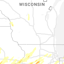


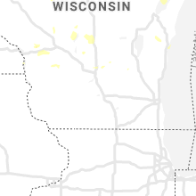


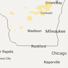

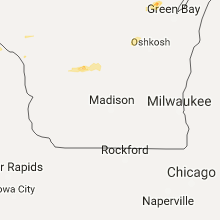


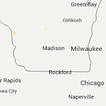


Connect with Interactive Hail Maps