

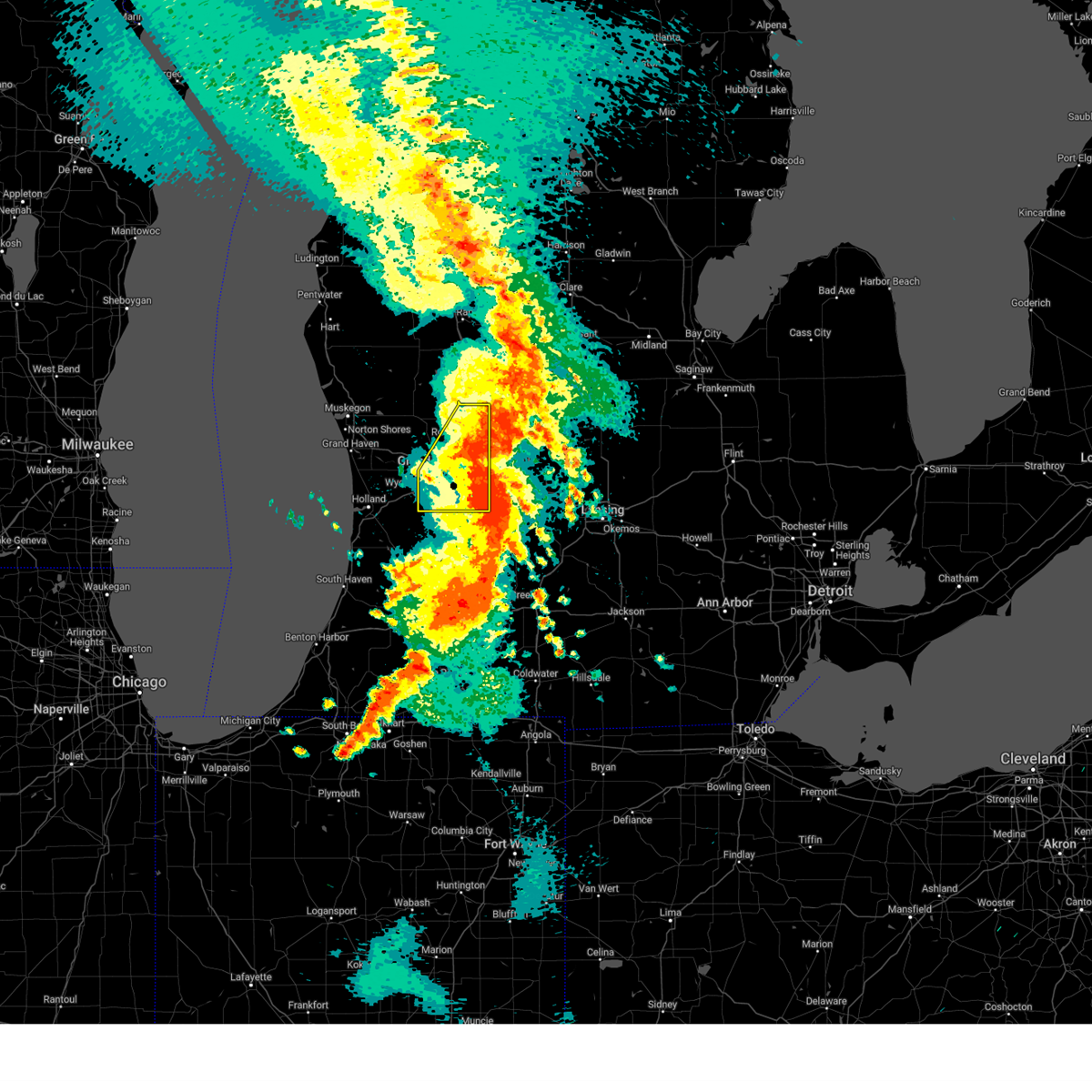
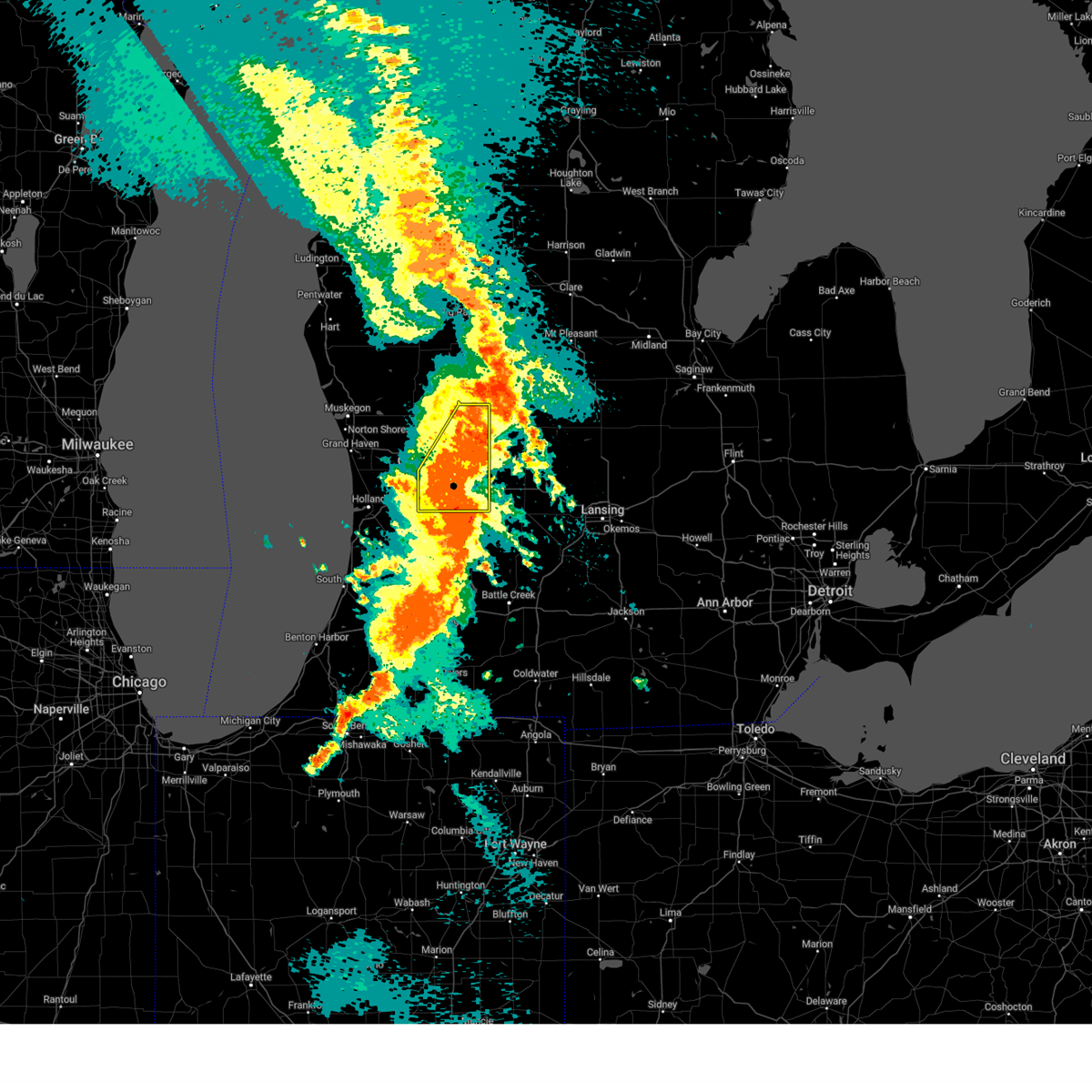
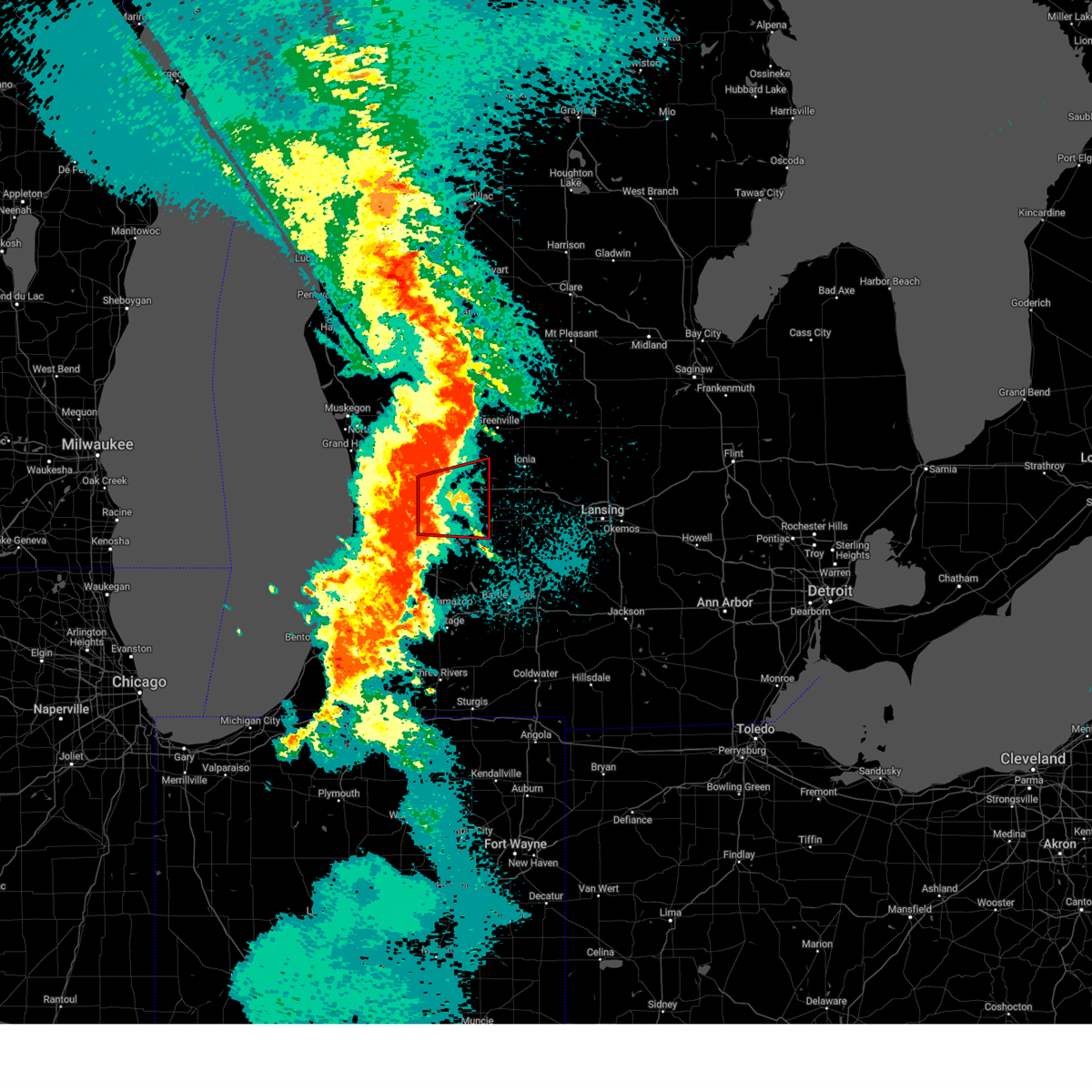
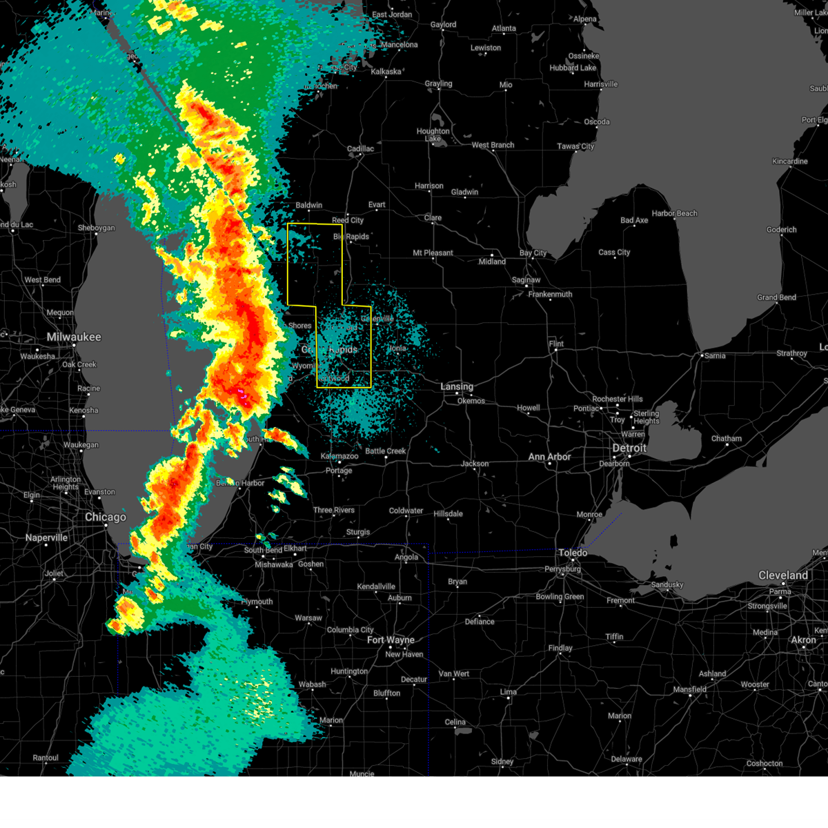
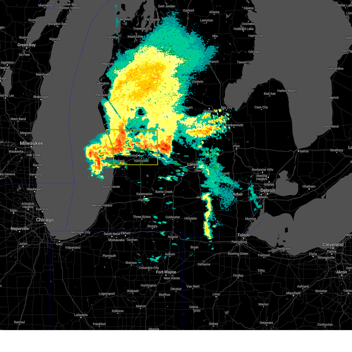
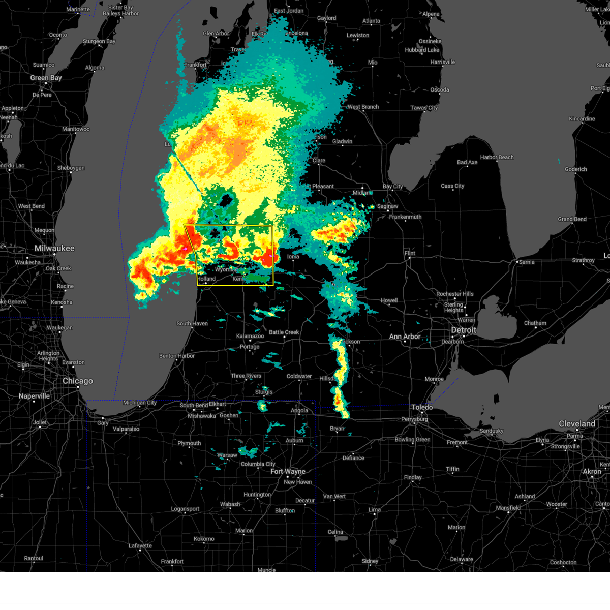
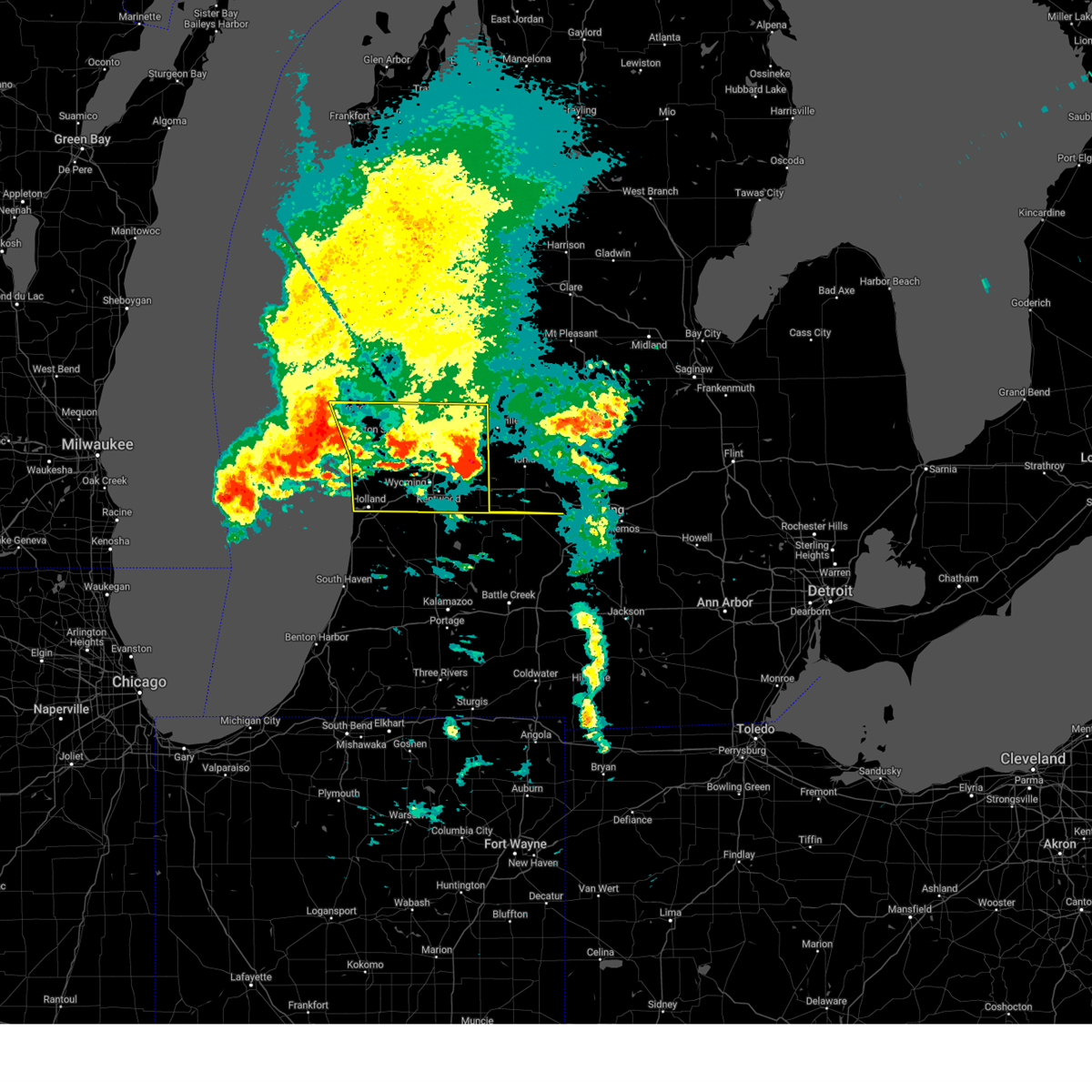
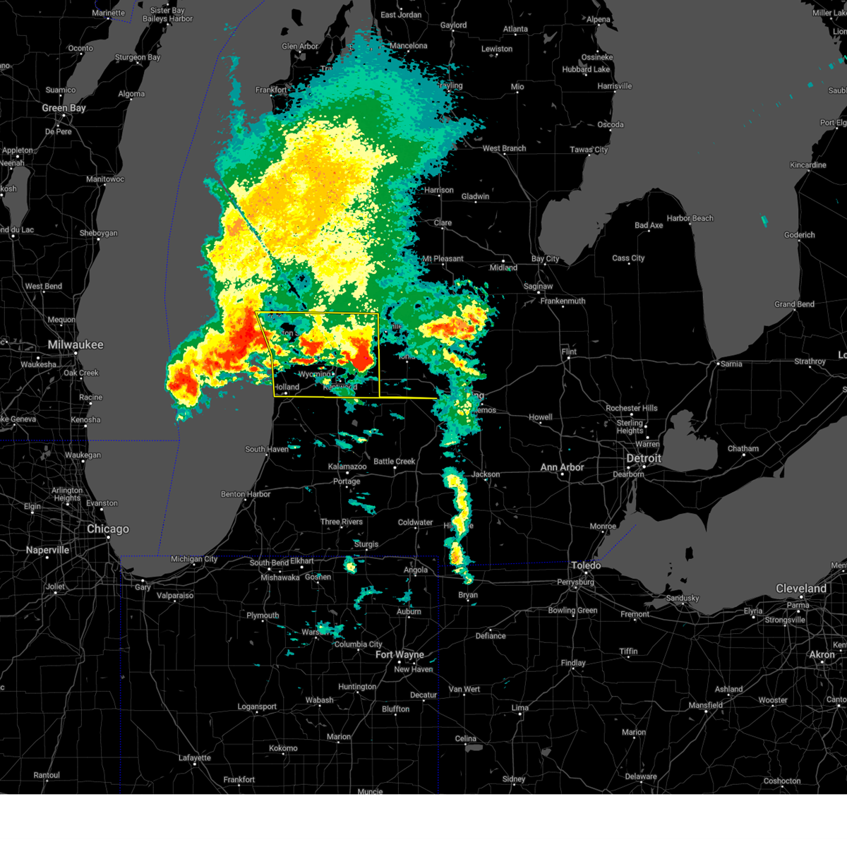
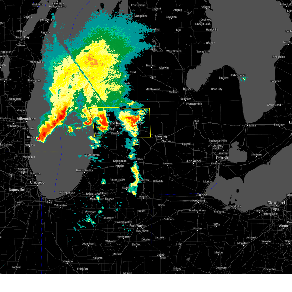
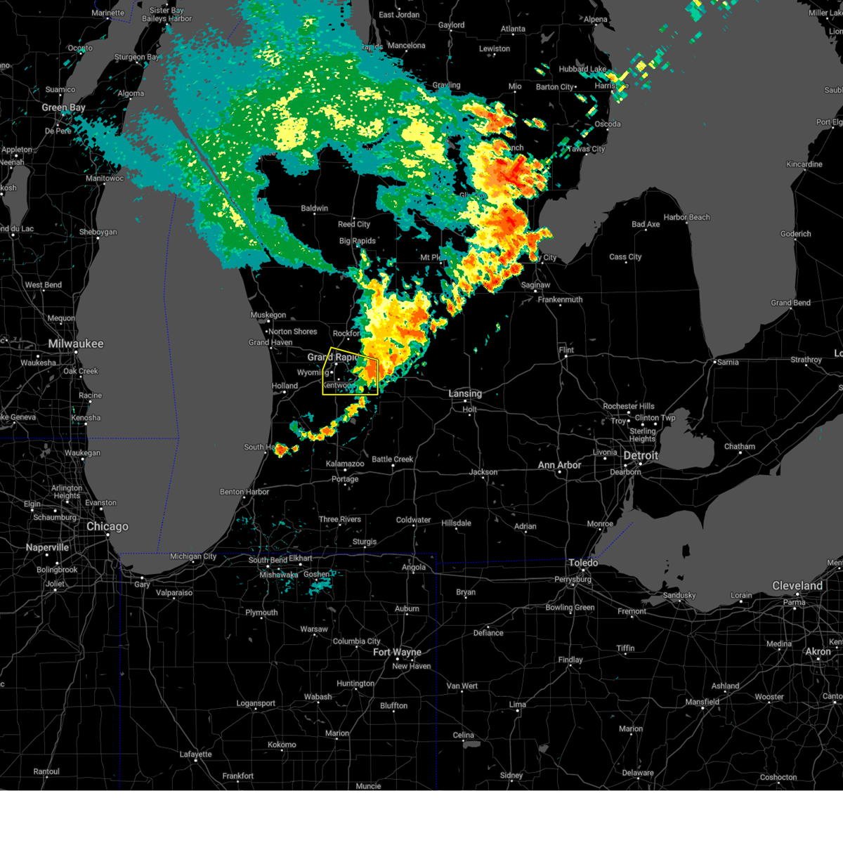
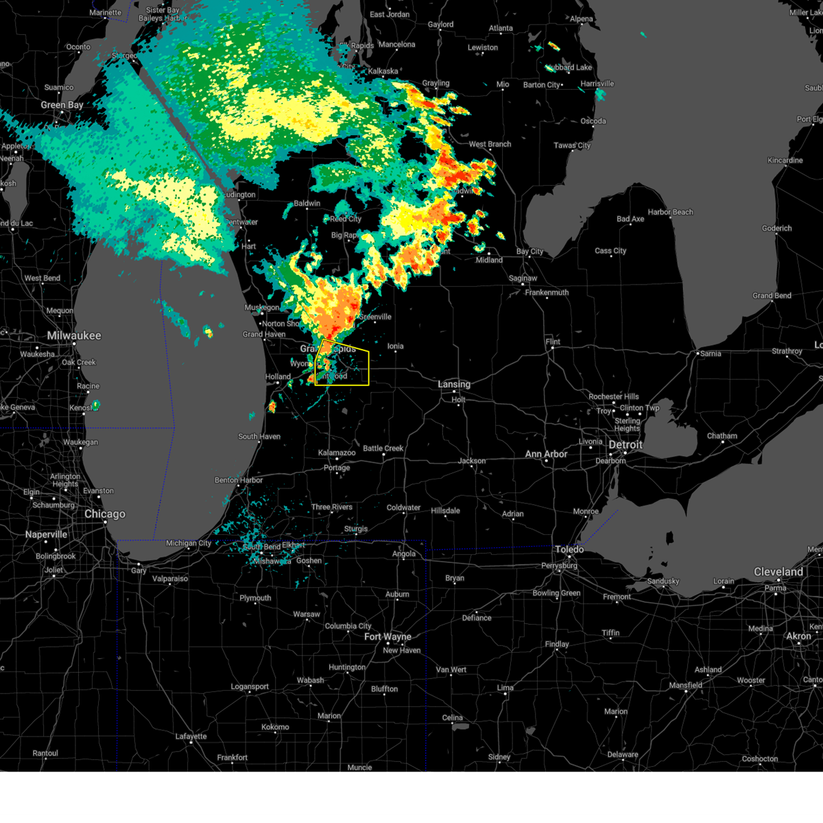
Hail Map for Grand Rapids, MI
The Grand Rapids, MI area has had 11 reports of on-the-ground hail by trained spotters, and has been under severe weather warnings 20 times during the past 12 months. Doppler radar has detected hail at or near Grand Rapids, MI on 36 occasions, including 1 occasion during the past year.
| Name: | Grand Rapids, MI |
| Where Located: | 1.2 miles SE of Grand Rapids, MI |
| Map: | Google Map for Grand Rapids, MI |
| Population: | 188040 |
| Housing Units: | 80619 |
| More Info: | Search Google for Grand Rapids, MI |
0
The Top Recent Hail Date for Grand Rapids, MI is Tuesday, August 27, 2024 (30th out of 36)

Hail and Wind Damage Spotted near Grand Rapids, MI
| Date / Time | Report Details |
|---|---|
| 5/15/2025 11:08 PM EDT |
 The storms which prompted the warning have moved out of the area. therefore, the warning will be allowed to expire. however, gusty winds and lightning are still possible with these thunderstorms. a tornado watch remains in effect until 300 am edt for south central, central and southwestern michigan. The storms which prompted the warning have moved out of the area. therefore, the warning will be allowed to expire. however, gusty winds and lightning are still possible with these thunderstorms. a tornado watch remains in effect until 300 am edt for south central, central and southwestern michigan.
|
| 5/15/2025 10:56 PM EDT | Gerald r ford internationa in kent county MI, 8.5 miles NW of Grand Rapids, MI |
| 5/15/2025 10:55 PM EDT |
 the severe thunderstorm warning has been cancelled and is no longer in effect the severe thunderstorm warning has been cancelled and is no longer in effect
|
| 5/15/2025 10:55 PM EDT |
 At 1054 pm edt, severe thunderstorms were located along a line extending from 7 miles west of greenville to near caledonia, moving east at 25 mph. also, a tornado warning remains in effect for southern kent county (radar indicated). Hazards include 60 mph wind gusts. Expect damage to roofs, siding, and trees. locations impacted include, grand rapids, wyoming, kentwood, walker, grandville, east grand rapids, rockford, lowell, caledonia, gerald r. Ford inter, ada, grattan, cedar springs, sand lake, cutlerville, belmont, alto, alaska, cannonsburg, cascade,. At 1054 pm edt, severe thunderstorms were located along a line extending from 7 miles west of greenville to near caledonia, moving east at 25 mph. also, a tornado warning remains in effect for southern kent county (radar indicated). Hazards include 60 mph wind gusts. Expect damage to roofs, siding, and trees. locations impacted include, grand rapids, wyoming, kentwood, walker, grandville, east grand rapids, rockford, lowell, caledonia, gerald r. Ford inter, ada, grattan, cedar springs, sand lake, cutlerville, belmont, alto, alaska, cannonsburg, cascade,.
|
| 5/15/2025 10:33 PM EDT |
 Torgrr the national weather service in grand rapids has issued a * tornado warning for, northeastern allegan county in southwestern michigan, southern kent county in southwestern michigan, northwestern barry county in southwestern michigan, * until 1115 pm edt. * at 1033 pm edt, a severe thunderstorm capable of producing a tornado was located 7 miles northwest of wayland, or 15 miles south of grand rapids, moving northeast at 45 mph (radar indicated rotation). Hazards include tornado. Flying debris will be dangerous to those caught without shelter. mobile homes will be damaged or destroyed. damage to roofs, windows, and vehicles will occur. tree damage is likely. this dangerous storm will be near, kentwood, caledonia, and gerald r. ford international airport around 1045 pm edt. Other locations in the path of this tornadic thunderstorm include lowell. Torgrr the national weather service in grand rapids has issued a * tornado warning for, northeastern allegan county in southwestern michigan, southern kent county in southwestern michigan, northwestern barry county in southwestern michigan, * until 1115 pm edt. * at 1033 pm edt, a severe thunderstorm capable of producing a tornado was located 7 miles northwest of wayland, or 15 miles south of grand rapids, moving northeast at 45 mph (radar indicated rotation). Hazards include tornado. Flying debris will be dangerous to those caught without shelter. mobile homes will be damaged or destroyed. damage to roofs, windows, and vehicles will occur. tree damage is likely. this dangerous storm will be near, kentwood, caledonia, and gerald r. ford international airport around 1045 pm edt. Other locations in the path of this tornadic thunderstorm include lowell.
|
| 5/15/2025 10:22 PM EDT | A tree snapped at the base and landed on a building... damaging a dec in kent county MI, 8.7 miles N of Grand Rapids, MI |
| 5/15/2025 9:52 PM EDT |
 Svrgrr the national weather service in grand rapids has issued a * severe thunderstorm warning for, kent county in southwestern michigan, newaygo county in west central michigan, * until 1115 pm edt. * at 951 pm edt, severe thunderstorms were located along a line extending from near shelby to 6 miles west of coopersville to 5 miles west of holland sp, moving east at 65 mph. these are destructive storms for kent and newaygo counties (radar indicated). Hazards include 80 mph wind gusts and penny size hail. Flying debris will be dangerous to those caught without shelter. mobile homes will be heavily damaged. expect considerable damage to roofs, windows, and vehicles. Extensive tree damage and power outages are likely. Svrgrr the national weather service in grand rapids has issued a * severe thunderstorm warning for, kent county in southwestern michigan, newaygo county in west central michigan, * until 1115 pm edt. * at 951 pm edt, severe thunderstorms were located along a line extending from near shelby to 6 miles west of coopersville to 5 miles west of holland sp, moving east at 65 mph. these are destructive storms for kent and newaygo counties (radar indicated). Hazards include 80 mph wind gusts and penny size hail. Flying debris will be dangerous to those caught without shelter. mobile homes will be heavily damaged. expect considerable damage to roofs, windows, and vehicles. Extensive tree damage and power outages are likely.
|
| 4/18/2025 11:04 AM EDT |
 At 1101 am edt, strong to severe thunderstorms were located along a line extending from 6 miles southwest of greenville to near saranac to near freeport, moving east at 65 mph. this line will continue to weaken as it moves further inland (radar indicated). Hazards include 60 mph wind gusts. Expect damage to roofs, siding, and trees. Locations impacted include, port sheldon, cutlerville, wyoming, belmont, grandville, fruitport, muskegon heights, grattan, alto, marne, dutton, borculo, sparta, muskegon sp, coopersville, comstock park, walker, hudsonville, slocum, casnovia,. At 1101 am edt, strong to severe thunderstorms were located along a line extending from 6 miles southwest of greenville to near saranac to near freeport, moving east at 65 mph. this line will continue to weaken as it moves further inland (radar indicated). Hazards include 60 mph wind gusts. Expect damage to roofs, siding, and trees. Locations impacted include, port sheldon, cutlerville, wyoming, belmont, grandville, fruitport, muskegon heights, grattan, alto, marne, dutton, borculo, sparta, muskegon sp, coopersville, comstock park, walker, hudsonville, slocum, casnovia,.
|
| 4/18/2025 10:48 AM EDT |
 the severe thunderstorm warning has been cancelled and is no longer in effect the severe thunderstorm warning has been cancelled and is no longer in effect
|
| 4/18/2025 10:48 AM EDT |
 At 1047 am edt, severe thunderstorms were located along a line extending from near rockford to 7 miles northeast of east grand rapids to near caledonia, moving east at 65 mph. a line of strong possibly severe storms will be moving onshore along a line from muskegon to holland by 11 am moving to the east at 65 mph (radar indicated). Hazards include 60 mph wind gusts and quarter size hail. Hail damage to vehicles is expected. expect wind damage to roofs, siding, and trees. Locations impacted include, port sheldon, cutlerville, wyoming, belmont, grandville, fruitport, muskegon heights, grattan, alto, marne, dutton, borculo, sparta, muskegon sp, coopersville, comstock park, walker, hudsonville, slocum, casnovia,. At 1047 am edt, severe thunderstorms were located along a line extending from near rockford to 7 miles northeast of east grand rapids to near caledonia, moving east at 65 mph. a line of strong possibly severe storms will be moving onshore along a line from muskegon to holland by 11 am moving to the east at 65 mph (radar indicated). Hazards include 60 mph wind gusts and quarter size hail. Hail damage to vehicles is expected. expect wind damage to roofs, siding, and trees. Locations impacted include, port sheldon, cutlerville, wyoming, belmont, grandville, fruitport, muskegon heights, grattan, alto, marne, dutton, borculo, sparta, muskegon sp, coopersville, comstock park, walker, hudsonville, slocum, casnovia,.
|
| 4/18/2025 10:43 AM EDT |
 At 1037 am edt, strong thunderstorms were located along a line extending from near sparta to near grand rapids to near wyoming, moving east at 65 mph. a line of strong possibly severe storms will be moving onshore along a line from muskegon to holland by 11 am moving to the east at 65 mph (radar indicated). Hazards include 60 mph wind gusts and quarter size hail. Hail damage to vehicles is expected. expect wind damage to roofs, siding, and trees. Locations impacted include, port sheldon, cutlerville, wyoming, belmont, grandville, fruitport, muskegon heights, grattan, alto, marne, dutton, borculo, sparta, muskegon sp, coopersville, comstock park, walker, hudsonville, slocum, casnovia,. At 1037 am edt, strong thunderstorms were located along a line extending from near sparta to near grand rapids to near wyoming, moving east at 65 mph. a line of strong possibly severe storms will be moving onshore along a line from muskegon to holland by 11 am moving to the east at 65 mph (radar indicated). Hazards include 60 mph wind gusts and quarter size hail. Hail damage to vehicles is expected. expect wind damage to roofs, siding, and trees. Locations impacted include, port sheldon, cutlerville, wyoming, belmont, grandville, fruitport, muskegon heights, grattan, alto, marne, dutton, borculo, sparta, muskegon sp, coopersville, comstock park, walker, hudsonville, slocum, casnovia,.
|
| 4/18/2025 10:43 AM EDT |
 the severe thunderstorm warning has been cancelled and is no longer in effect the severe thunderstorm warning has been cancelled and is no longer in effect
|
| 4/18/2025 10:21 AM EDT |
 At 1019 am edt, severe thunderstorms were located along a line extending from near fruitport to near allendale to near zeeland, moving east at 65 mph. this is a second area of thunderstorms that was following strong but non severe thunderstorms currently over the ionia area that are also moving east (radar indicated). Hazards include 60 mph wind gusts and quarter size hail. Hail damage to vehicles is expected. expect wind damage to roofs, siding, and trees. Locations impacted include, port sheldon, clarksville, belmont, muskegon heights, alto, orleans, marne, dutton, comstock park, hudsonville, sheridan, belding, sullivan, rockford, ionia, murray lake, fenwick, north muskegon, portland, conklin,. At 1019 am edt, severe thunderstorms were located along a line extending from near fruitport to near allendale to near zeeland, moving east at 65 mph. this is a second area of thunderstorms that was following strong but non severe thunderstorms currently over the ionia area that are also moving east (radar indicated). Hazards include 60 mph wind gusts and quarter size hail. Hail damage to vehicles is expected. expect wind damage to roofs, siding, and trees. Locations impacted include, port sheldon, clarksville, belmont, muskegon heights, alto, orleans, marne, dutton, comstock park, hudsonville, sheridan, belding, sullivan, rockford, ionia, murray lake, fenwick, north muskegon, portland, conklin,.
|
| 4/18/2025 10:21 AM EDT |
 the severe thunderstorm warning has been cancelled and is no longer in effect the severe thunderstorm warning has been cancelled and is no longer in effect
|
| 4/18/2025 10:08 AM EDT |
 At 1005 am edt, severe thunderstorms were located along a line extending from near fruitport to near beechwood, moving east at 55 mph. this is a second area of thunderstorms that was following strong but non severe thunderstorms currently over the grand rapids area that were also moving east (radar indicated). Hazards include 60 mph wind gusts and quarter size hail. Hail damage to vehicles is expected. expect wind damage to roofs, siding, and trees. Locations impacted include, port sheldon, clarksville, reeman, cedar lake, stanton, belmont, lakewood club, muskegon heights, dalton, alto, wyman, orleans, whitehall, marne, dutton, brunswick, holton, comstock park, hudsonville, sheridan,. At 1005 am edt, severe thunderstorms were located along a line extending from near fruitport to near beechwood, moving east at 55 mph. this is a second area of thunderstorms that was following strong but non severe thunderstorms currently over the grand rapids area that were also moving east (radar indicated). Hazards include 60 mph wind gusts and quarter size hail. Hail damage to vehicles is expected. expect wind damage to roofs, siding, and trees. Locations impacted include, port sheldon, clarksville, reeman, cedar lake, stanton, belmont, lakewood club, muskegon heights, dalton, alto, wyman, orleans, whitehall, marne, dutton, brunswick, holton, comstock park, hudsonville, sheridan,.
|
| 4/18/2025 9:48 AM EDT |
 Svrgrr the national weather service in grand rapids has issued a * severe thunderstorm warning for, kent county in southwestern michigan, ottawa county in southwestern michigan, southern newaygo county in west central michigan, ionia county in south central michigan, muskegon county in west central michigan, northwestern eaton county in south central michigan, southeastern oceana county in west central michigan, montcalm county in central michigan, * until 1115 am edt. * at 947 am edt, severe thunderstorms were located along a line extending from near fruitport to 5 miles southwest of allendale to near zeeland, moving east at 65 mph (radar indicated). Hazards include 60 mph wind gusts and quarter size hail. Hail damage to vehicles is expected. Expect wind damage to roofs, siding, and trees. Svrgrr the national weather service in grand rapids has issued a * severe thunderstorm warning for, kent county in southwestern michigan, ottawa county in southwestern michigan, southern newaygo county in west central michigan, ionia county in south central michigan, muskegon county in west central michigan, northwestern eaton county in south central michigan, southeastern oceana county in west central michigan, montcalm county in central michigan, * until 1115 am edt. * at 947 am edt, severe thunderstorms were located along a line extending from near fruitport to 5 miles southwest of allendale to near zeeland, moving east at 65 mph (radar indicated). Hazards include 60 mph wind gusts and quarter size hail. Hail damage to vehicles is expected. Expect wind damage to roofs, siding, and trees.
|
| 3/30/2025 5:56 PM EDT | At 554 pm edt, severe thunderstorms were located along a line extending from near sparta to 7 miles southwest of hastings to near marshall, moving northeast at 60 mph. these are destructive storms for southwest michigan (at 5:50 pm grand rapids asos reported 80 mph winds). Hazards include 80 mph wind gusts and penny size hail. Flying debris will be dangerous to those caught without shelter. mobile homes will be heavily damaged. expect considerable damage to roofs, windows, and vehicles. extensive tree damage and power outages are likely. Locations impacted include, cutlerville, wyoming, battle creek, belmont, grandville, duck lake, yankee springs, hickory corners, grattan, alto, brownlee park, dutton, sparta, banfield, comstock park, walker, marshall, nashville, athens, tekonsha,. |
| 3/30/2025 5:50 PM EDT | Asos station kgrr gerald r ford int in kent county MI, 8.5 miles NW of Grand Rapids, MI |
| 3/30/2025 5:49 PM EDT | Torgrr the national weather service in grand rapids has issued a * tornado warning for, southern kent county in southwestern michigan, northwestern ionia county in south central michigan, * until 615 pm edt. * at 548 pm edt, severe thunderstorms capable of producing both tornadoes and extensive straight line wind damage were located near caledonia, or 10 miles southeast of grand rapids, moving northeast at 55 mph (radar indicated rotation). Hazards include tornado. Flying debris will be dangerous to those caught without shelter. mobile homes will be damaged or destroyed. damage to roofs, windows, and vehicles will occur. tree damage is likely. these dangerous storms will be near, gerald r. Ford international airport and lowell around 555 pm edt. |
| 3/30/2025 5:48 PM EDT | At 547 pm edt, severe thunderstorms were located along a line extending from 6 miles southwest of sparta to 5 miles east of martin to near burlington, moving northeast at 60 mph (radar indicated). Hazards include 70 mph wind gusts and penny size hail. Expect considerable tree damage. damage is likely to mobile homes, roofs, and outbuildings. Locations impacted include, cutlerville, wyoming, battle creek, belmont, grandville, duck lake, yankee springs, hickory corners, grattan, alto, brownlee park, dutton, sparta, banfield, comstock park, walker, marshall, nashville, athens, tekonsha,. |
| 3/30/2025 5:24 PM EDT | Svrgrr the national weather service in grand rapids has issued a * severe thunderstorm warning for, calhoun county in south central michigan, kent county in southwestern michigan, barry county in southwestern michigan, * until 630 pm edt. * at 523 pm edt, severe thunderstorms were located along a line extending from near beechwood to near schoolcraft, moving northeast at 65 mph (radar indicated). Hazards include 70 mph wind gusts and penny size hail. Expect considerable tree damage. Damage is likely to mobile homes, roofs, and outbuildings. |
| 8/27/2024 3:59 PM EDT |
 The storms which prompted the warning have moved out of the area. therefore, the warning will be allowed to expire. a severe thunderstorm watch remains in effect until 800 pm edt for south central and southwestern michigan. The storms which prompted the warning have moved out of the area. therefore, the warning will be allowed to expire. a severe thunderstorm watch remains in effect until 800 pm edt for south central and southwestern michigan.
|
| 8/27/2024 3:30 PM EDT |
 Svrgrr the national weather service in grand rapids has issued a * severe thunderstorm warning for, southern kent county in southwestern michigan, * until 400 pm edt. * at 330 pm edt, severe thunderstorms were located along a line extending from near grand rapids to near byron center, moving east at 50 mph (radar indicated). Hazards include 60 mph wind gusts. expect damage to roofs, siding, and trees Svrgrr the national weather service in grand rapids has issued a * severe thunderstorm warning for, southern kent county in southwestern michigan, * until 400 pm edt. * at 330 pm edt, severe thunderstorms were located along a line extending from near grand rapids to near byron center, moving east at 50 mph (radar indicated). Hazards include 60 mph wind gusts. expect damage to roofs, siding, and trees
|
| 8/27/2024 3:29 PM EDT | Quarter sized hail reported 7.5 miles SSW of Grand Rapids, MI, quarter-sized hail reported by a trained spotter near intersection of jupiter and coit. time estimated via radar. |
| 7/11/2024 8:15 PM EDT | Photo of large tree down in yard near 44th st and eastern ave. time estimated by rada in kent county MI, 5.2 miles N of Grand Rapids, MI |
| 7/8/2024 5:20 PM EDT |
 the severe thunderstorm warning has been cancelled and is no longer in effect the severe thunderstorm warning has been cancelled and is no longer in effect
|
| 7/8/2024 5:09 PM EDT |
 At 508 pm edt, a severe thunderstorm was located near caledonia and near dutton, or 9 miles southeast of grand rapids, moving northeast at 30 mph (radar indicated). Hazards include 60 mph wind gusts. Expect damage to roofs, siding, and trees. Locations impacted include, grand rapids, wyoming, kentwood, east grand rapids, lowell, caledonia, dutton, cutlerville, murray lake, alaska, cannonsburg, cascade,. At 508 pm edt, a severe thunderstorm was located near caledonia and near dutton, or 9 miles southeast of grand rapids, moving northeast at 30 mph (radar indicated). Hazards include 60 mph wind gusts. Expect damage to roofs, siding, and trees. Locations impacted include, grand rapids, wyoming, kentwood, east grand rapids, lowell, caledonia, dutton, cutlerville, murray lake, alaska, cannonsburg, cascade,.
|
| 7/8/2024 4:54 PM EDT |
 Svrgrr the national weather service in grand rapids has issued a * severe thunderstorm warning for, southern kent county in southwestern michigan, * until 545 pm edt. * at 454 pm edt, a severe thunderstorm was located near dorr, or 14 miles south of grand rapids, moving northeast at 30 mph (radar indicated). Hazards include 60 mph wind gusts. Expect damage to roofs, siding, and trees. this severe thunderstorm will be near, kentwood around 500 pm edt. grand rapids and gerald r. Ford international airport around 505 pm edt. Svrgrr the national weather service in grand rapids has issued a * severe thunderstorm warning for, southern kent county in southwestern michigan, * until 545 pm edt. * at 454 pm edt, a severe thunderstorm was located near dorr, or 14 miles south of grand rapids, moving northeast at 30 mph (radar indicated). Hazards include 60 mph wind gusts. Expect damage to roofs, siding, and trees. this severe thunderstorm will be near, kentwood around 500 pm edt. grand rapids and gerald r. Ford international airport around 505 pm edt.
|
| 6/16/2024 9:54 PM EDT |
 The severe thunderstorm which prompted the warning has weakened. therefore, the warning will be allowed to expire. The severe thunderstorm which prompted the warning has weakened. therefore, the warning will be allowed to expire.
|
| 6/16/2024 9:39 PM EDT |
 At 937 pm edt, a severe thunderstorm was located near rockford, or 7 miles northeast of grand rapids, moving northeast at 45 mph (radar indicated). Hazards include 60 mph wind gusts. Expect damage to roofs, siding, and trees. Locations impacted include, grand rapids, wyoming, kentwood, walker, grandville, east grand rapids, cutlerville, byron center, cannonsburg, northview,. At 937 pm edt, a severe thunderstorm was located near rockford, or 7 miles northeast of grand rapids, moving northeast at 45 mph (radar indicated). Hazards include 60 mph wind gusts. Expect damage to roofs, siding, and trees. Locations impacted include, grand rapids, wyoming, kentwood, walker, grandville, east grand rapids, cutlerville, byron center, cannonsburg, northview,.
|
| 6/16/2024 9:39 PM EDT |
 the severe thunderstorm warning has been cancelled and is no longer in effect the severe thunderstorm warning has been cancelled and is no longer in effect
|
| 6/16/2024 9:11 PM EDT |
 Svrgrr the national weather service in grand rapids has issued a * severe thunderstorm warning for, southwestern kent county in southwestern michigan, southeastern ottawa county in southwestern michigan, * until 1000 pm edt. * at 911 pm edt, a severe thunderstorm was located near hudsonville, or 12 miles east of holland, moving northeast at 45 mph (radar indicated). Hazards include 60 mph wind gusts. expect damage to roofs, siding, and trees Svrgrr the national weather service in grand rapids has issued a * severe thunderstorm warning for, southwestern kent county in southwestern michigan, southeastern ottawa county in southwestern michigan, * until 1000 pm edt. * at 911 pm edt, a severe thunderstorm was located near hudsonville, or 12 miles east of holland, moving northeast at 45 mph (radar indicated). Hazards include 60 mph wind gusts. expect damage to roofs, siding, and trees
|
| 5/26/2024 4:58 PM EDT | Several reports of downed wires in ada twp and cascade tu in kent county MI, 7.9 miles WNW of Grand Rapids, MI |
| 5/20/2024 6:20 PM EDT |
 Svrgrr the national weather service in grand rapids has issued a * severe thunderstorm warning for, kent county in southwestern michigan, eastern ottawa county in southwestern michigan, southeastern muskegon county in west central michigan, * until 715 pm edt. * at 620 pm edt, severe thunderstorms were located along a line extending from 5 miles west of grant to near hudsonville, moving northeast at 50 mph (radar indicated). Hazards include 60 mph wind gusts. expect damage to roofs, siding, and trees Svrgrr the national weather service in grand rapids has issued a * severe thunderstorm warning for, kent county in southwestern michigan, eastern ottawa county in southwestern michigan, southeastern muskegon county in west central michigan, * until 715 pm edt. * at 620 pm edt, severe thunderstorms were located along a line extending from 5 miles west of grant to near hudsonville, moving northeast at 50 mph (radar indicated). Hazards include 60 mph wind gusts. expect damage to roofs, siding, and trees
|
| 4/17/2024 1:03 PM EDT |
 the severe thunderstorm warning has been cancelled and is no longer in effect the severe thunderstorm warning has been cancelled and is no longer in effect
|
| 4/17/2024 12:27 PM EDT |
 the severe thunderstorm warning has been cancelled and is no longer in effect the severe thunderstorm warning has been cancelled and is no longer in effect
|
| 4/17/2024 12:27 PM EDT |
 At 1227 pm edt, severe thunderstorms were located along a line extending from 5 miles north of sparta to 6 miles south of wyoming, moving northeast at 30 mph (radar indicated). Hazards include 60 mph wind gusts. Expect damage to roofs, siding, and trees. these severe storms will be near, grand rapids, wyoming, kentwood, walker, east grand rapids, rockford, sparta, and gerald r. ford international airport around 1230 pm edt. Other locations impacted by these severe thunderstorms include dutton, cutlerville, belmont, comstock park, kent city, northview, casnovia, grattan, murray lake, and alaska. At 1227 pm edt, severe thunderstorms were located along a line extending from 5 miles north of sparta to 6 miles south of wyoming, moving northeast at 30 mph (radar indicated). Hazards include 60 mph wind gusts. Expect damage to roofs, siding, and trees. these severe storms will be near, grand rapids, wyoming, kentwood, walker, east grand rapids, rockford, sparta, and gerald r. ford international airport around 1230 pm edt. Other locations impacted by these severe thunderstorms include dutton, cutlerville, belmont, comstock park, kent city, northview, casnovia, grattan, murray lake, and alaska.
|
| 4/17/2024 11:49 AM EDT |
 Svrgrr the national weather service in grand rapids has issued a * severe thunderstorm warning for, kent county in southwestern michigan, ottawa county in southwestern michigan, * until 115 pm edt. * at 1149 am edt, severe thunderstorms were located along a line extending from near zeeland to 5 miles northeast of fennville, moving northeast at 25 mph (radar indicated). Hazards include 60 mph wind gusts. Expect damage to roofs, siding, and trees. severe thunderstorms will be near, holland, zeeland, and allendale around 1155 am edt. hudsonville around 1200 pm edt. jenison around 1205 pm edt. walker around 1215 pm edt. wyoming, grandville, and coopersville around 1220 pm edt. grand rapids around 1225 pm edt. sparta around 1240 pm edt. kentwood around 1245 pm edt. Other locations impacted by these severe thunderstorms include cutlerville, conklin, crockery lake, lamont, wright, belmont, drenthe, kent city, grattan, and olive center. Svrgrr the national weather service in grand rapids has issued a * severe thunderstorm warning for, kent county in southwestern michigan, ottawa county in southwestern michigan, * until 115 pm edt. * at 1149 am edt, severe thunderstorms were located along a line extending from near zeeland to 5 miles northeast of fennville, moving northeast at 25 mph (radar indicated). Hazards include 60 mph wind gusts. Expect damage to roofs, siding, and trees. severe thunderstorms will be near, holland, zeeland, and allendale around 1155 am edt. hudsonville around 1200 pm edt. jenison around 1205 pm edt. walker around 1215 pm edt. wyoming, grandville, and coopersville around 1220 pm edt. grand rapids around 1225 pm edt. sparta around 1240 pm edt. kentwood around 1245 pm edt. Other locations impacted by these severe thunderstorms include cutlerville, conklin, crockery lake, lamont, wright, belmont, drenthe, kent city, grattan, and olive center.
|
| 8/24/2023 8:54 PM EDT |
 The severe thunderstorm warning for central kent county will expire at 900 pm edt, the storms which prompted the warning have moved out of the area. therefore, the warning will be allowed to expire. however, lightning is still possible with these thunderstorms. a severe thunderstorm watch remains in effect until 100 am edt for south central, central and southwestern michigan. The severe thunderstorm warning for central kent county will expire at 900 pm edt, the storms which prompted the warning have moved out of the area. therefore, the warning will be allowed to expire. however, lightning is still possible with these thunderstorms. a severe thunderstorm watch remains in effect until 100 am edt for south central, central and southwestern michigan.
|
| 8/24/2023 8:39 PM EDT |
 At 838 pm edt, severe thunderstorms were located along a line extending from 6 miles east of rockford to near east grand rapids, moving east southeast at 30 mph (radar indicated). Hazards include 60 mph wind gusts and quarter size hail. Hail damage to vehicles is expected. expect wind damage to roofs, siding, and trees. locations impacted include, grand rapids, wyoming, kentwood, walker, grandville, east grand rapids, rockford, sparta, lowell, gerald r. Ford inter, ada, grattan, kent city, paul c miller-sparta, wells airport, belmont, comstock park, lowell city airport, northview, murray lake,. At 838 pm edt, severe thunderstorms were located along a line extending from 6 miles east of rockford to near east grand rapids, moving east southeast at 30 mph (radar indicated). Hazards include 60 mph wind gusts and quarter size hail. Hail damage to vehicles is expected. expect wind damage to roofs, siding, and trees. locations impacted include, grand rapids, wyoming, kentwood, walker, grandville, east grand rapids, rockford, sparta, lowell, gerald r. Ford inter, ada, grattan, kent city, paul c miller-sparta, wells airport, belmont, comstock park, lowell city airport, northview, murray lake,.
|
| 8/24/2023 8:35 PM EDT | Several large trees dow in kent county MI, 6.4 miles SW of Grand Rapids, MI |
| 8/24/2023 8:22 PM EDT |
 At 821 pm edt, a severe thunderstorm capable of producing a tornado was located near grand rapids, moving southeast at 40 mph (radar indicated rotation). Hazards include tornado and quarter size hail. Flying debris will be dangerous to those caught without shelter. mobile homes will be damaged or destroyed. damage to roofs, windows, and vehicles will occur. tree damage is likely. this dangerous storm will be near, grand rapids, kentwood, east grand rapids, and rockford around 825 pm edt. gerald r. ford international airport around 830 pm edt. Lowell around 835 pm edt. At 821 pm edt, a severe thunderstorm capable of producing a tornado was located near grand rapids, moving southeast at 40 mph (radar indicated rotation). Hazards include tornado and quarter size hail. Flying debris will be dangerous to those caught without shelter. mobile homes will be damaged or destroyed. damage to roofs, windows, and vehicles will occur. tree damage is likely. this dangerous storm will be near, grand rapids, kentwood, east grand rapids, and rockford around 825 pm edt. gerald r. ford international airport around 830 pm edt. Lowell around 835 pm edt.
|
| 8/24/2023 8:07 PM EDT |
 At 807 pm edt, severe thunderstorms were located along a line extending from near sparta to near coopersville, moving southeast at 30 mph (radar indicated). Hazards include 60 mph wind gusts and quarter size hail. Hail damage to vehicles is expected. Expect wind damage to roofs, siding, and trees. At 807 pm edt, severe thunderstorms were located along a line extending from near sparta to near coopersville, moving southeast at 30 mph (radar indicated). Hazards include 60 mph wind gusts and quarter size hail. Hail damage to vehicles is expected. Expect wind damage to roofs, siding, and trees.
|
| 7/20/2023 1:31 PM EDT |
 At 131 pm edt, severe thunderstorms were located along a line extending from near carson city to near grandville, moving east at 55 mph (radar indicated). Hazards include 60 mph wind gusts and penny size hail. expect damage to roofs, siding, and trees At 131 pm edt, severe thunderstorms were located along a line extending from near carson city to near grandville, moving east at 55 mph (radar indicated). Hazards include 60 mph wind gusts and penny size hail. expect damage to roofs, siding, and trees
|
| 4/20/2023 8:38 PM EDT |
 At 838 pm edt, severe thunderstorms were located along a line extending from near shelby to near grand haven to near saugatuck, moving northeast at 25 mph (radar indicated). Hazards include 60 mph wind gusts and penny size hail. expect damage to roofs, siding, and trees At 838 pm edt, severe thunderstorms were located along a line extending from near shelby to near grand haven to near saugatuck, moving northeast at 25 mph (radar indicated). Hazards include 60 mph wind gusts and penny size hail. expect damage to roofs, siding, and trees
|
| 4/5/2023 10:20 AM EDT |
 At 1020 am edt, severe thunderstorms were located along a line extending from near caledonia to near belding, moving southeast at 45 mph (radar indicated). Hazards include 60 mph wind gusts. Expect damage to roofs, siding, and trees. locations impacted include, grand rapids, wyoming, kentwood, walker, grandville, east grand rapids, lowell, caledonia, gerald r. Ford inter, ada, grattan, dutton, cutlerville, wells airport, lowell city airport, northview, murray lake, alto, alaska, byron center,. At 1020 am edt, severe thunderstorms were located along a line extending from near caledonia to near belding, moving southeast at 45 mph (radar indicated). Hazards include 60 mph wind gusts. Expect damage to roofs, siding, and trees. locations impacted include, grand rapids, wyoming, kentwood, walker, grandville, east grand rapids, lowell, caledonia, gerald r. Ford inter, ada, grattan, dutton, cutlerville, wells airport, lowell city airport, northview, murray lake, alto, alaska, byron center,.
|
| 4/5/2023 9:54 AM EDT |
 At 954 am edt, a severe thunderstorm was located 9 miles west of wayland, or 10 miles north of allegan, moving northeast at 55 mph (radar indicated). Hazards include 60 mph wind gusts. expect damage to roofs, siding, and trees At 954 am edt, a severe thunderstorm was located 9 miles west of wayland, or 10 miles north of allegan, moving northeast at 55 mph (radar indicated). Hazards include 60 mph wind gusts. expect damage to roofs, siding, and trees
|
| 9/21/2022 9:19 AM EDT |
 At 919 am edt, a severe thunderstorm was located near lowell, or 12 miles south of greenville, moving east at 45 mph (radar indicated). Hazards include 60 mph wind gusts and quarter size hail. Hail damage to vehicles is expected. expect wind damage to roofs, siding, and trees. locations impacted include, kentwood, lowell, caledonia, gerald r. ford inter, ada, grattan, murray lake, alto, alaska, lowell city airport, cannonsburg, cascade, hail threat, radar indicated max hail size, 1. 00 in wind threat, radar indicated max wind gust, 60 mph. At 919 am edt, a severe thunderstorm was located near lowell, or 12 miles south of greenville, moving east at 45 mph (radar indicated). Hazards include 60 mph wind gusts and quarter size hail. Hail damage to vehicles is expected. expect wind damage to roofs, siding, and trees. locations impacted include, kentwood, lowell, caledonia, gerald r. ford inter, ada, grattan, murray lake, alto, alaska, lowell city airport, cannonsburg, cascade, hail threat, radar indicated max hail size, 1. 00 in wind threat, radar indicated max wind gust, 60 mph.
|
| 9/21/2022 9:01 AM EDT |
 At 900 am edt, severe thunderstorms were located along a line extending from 7 miles northwest of greenville to near jenison, moving east at 40 mph (radar indicated). Hazards include 60 mph wind gusts and quarter size hail. Hail damage to vehicles is expected. Expect wind damage to roofs, siding, and trees. At 900 am edt, severe thunderstorms were located along a line extending from 7 miles northwest of greenville to near jenison, moving east at 40 mph (radar indicated). Hazards include 60 mph wind gusts and quarter size hail. Hail damage to vehicles is expected. Expect wind damage to roofs, siding, and trees.
|
| 8/29/2022 4:13 PM EDT |
 The severe thunderstorm warning for northeastern allegan, kent and northwestern barry counties will expire at 415 pm edt, the severe thunderstorm which prompted the warning has moved out of the warned area. therefore, the warning will be allowed to expire. a severe thunderstorm watch remains in effect until 800 pm edt for south central and southwestern michigan. The severe thunderstorm warning for northeastern allegan, kent and northwestern barry counties will expire at 415 pm edt, the severe thunderstorm which prompted the warning has moved out of the warned area. therefore, the warning will be allowed to expire. a severe thunderstorm watch remains in effect until 800 pm edt for south central and southwestern michigan.
|
| 8/29/2022 3:58 PM EDT |
 At 357 pm edt, a severe thunderstorm was located near saranac, or 10 miles southwest of ionia, moving east at 50 mph (radar indicated. this storm has a history of producing damaging winds and power outages). Hazards include 70 mph wind gusts and quarter size hail. Expect considerable tree damage. wind damage is also likely to mobile homes, roofs, and outbuildings. locations impacted include, grand rapids, hastings, wyoming, kentwood, walker, grandville, east grand rapids, rockford, sparta, wayland, lowell, middleville, caledonia, freeport, gerald r. ford inter, ada, dorr, grattan, cedar springs, irving, thunderstorm damage threat, considerable hail threat, radar indicated max hail size, 1. 00 in wind threat, observed max wind gust, 70 mph. At 357 pm edt, a severe thunderstorm was located near saranac, or 10 miles southwest of ionia, moving east at 50 mph (radar indicated. this storm has a history of producing damaging winds and power outages). Hazards include 70 mph wind gusts and quarter size hail. Expect considerable tree damage. wind damage is also likely to mobile homes, roofs, and outbuildings. locations impacted include, grand rapids, hastings, wyoming, kentwood, walker, grandville, east grand rapids, rockford, sparta, wayland, lowell, middleville, caledonia, freeport, gerald r. ford inter, ada, dorr, grattan, cedar springs, irving, thunderstorm damage threat, considerable hail threat, radar indicated max hail size, 1. 00 in wind threat, observed max wind gust, 70 mph.
|
| 8/29/2022 3:43 PM EDT | Asos station kgrr gerald r ford int in kent county MI, 8.5 miles NW of Grand Rapids, MI |
| 8/29/2022 3:28 PM EDT | Tree down on coit ave between jupiter and husburger. water partially over road. traffic signal out at coit and jupiter. time estimate in kent county MI, 7.4 miles SSW of Grand Rapids, MI |
| 8/29/2022 3:17 PM EDT | At 316 pm edt, a severe thunderstorm was located over hudsonville, or 12 miles northeast of holland, moving east at 45 mph (observed wind gusts. at 3:08 pm, the west michigan regional airport in holland had a gust to 66 mph). Hazards include 70 mph wind gusts and quarter size hail. Hail damage to vehicles is expected. expect considerable tree damage. Wind damage is also likely to mobile homes, roofs, and outbuildings. |
| 7/24/2022 2:02 AM EDT |
 At 201 am edt, a severe thunderstorm was located near rockford, or 7 miles north of grand rapids, moving east at 40 mph (radar indicated). Hazards include 60 mph wind gusts. Expect damage to roofs, siding, and trees. locations impacted include, grand rapids, lowell, kentwood, walker, east grand rapids, rockford, sparta, ada, grattan, kent city, belmont, comstock park, northview, murray lake, cannonsburg, cascade, alto, hail threat, radar indicated max hail size, <. 75 in wind threat, radar indicated max wind gust, 60 mph. At 201 am edt, a severe thunderstorm was located near rockford, or 7 miles north of grand rapids, moving east at 40 mph (radar indicated). Hazards include 60 mph wind gusts. Expect damage to roofs, siding, and trees. locations impacted include, grand rapids, lowell, kentwood, walker, east grand rapids, rockford, sparta, ada, grattan, kent city, belmont, comstock park, northview, murray lake, cannonsburg, cascade, alto, hail threat, radar indicated max hail size, <. 75 in wind threat, radar indicated max wind gust, 60 mph.
|
| 7/24/2022 1:39 AM EDT |
 At 138 am edt, a severe thunderstorm was located near ravenna, or 17 miles northeast of grand haven, moving southeast at 40 mph (radar indicated). Hazards include 60 mph wind gusts. expect damage to roofs, siding, and trees At 138 am edt, a severe thunderstorm was located near ravenna, or 17 miles northeast of grand haven, moving southeast at 40 mph (radar indicated). Hazards include 60 mph wind gusts. expect damage to roofs, siding, and trees
|
| 7/23/2022 11:39 PM EDT | Report from mping: trees uprooted or snappe in kent county MI, 1.9 miles SSE of Grand Rapids, MI |
| 7/23/2022 10:47 PM EDT | Report from mping: 3-inch tree limbs broken; power poles broke in kent county MI, 2.2 miles ESE of Grand Rapids, MI |
| 7/23/2022 10:43 PM EDT |
 The severe thunderstorm warning for kent county will expire at 1045 pm edt, the storms which prompted the warning have moved out of the area. therefore, the warning will be allowed to expire. however, gusty winds to 35 mph are still possible with these thunderstorms through 1115 pm. a severe thunderstorm watch remains in effect until midnight edt for south central, central and southwestern michigan. The severe thunderstorm warning for kent county will expire at 1045 pm edt, the storms which prompted the warning have moved out of the area. therefore, the warning will be allowed to expire. however, gusty winds to 35 mph are still possible with these thunderstorms through 1115 pm. a severe thunderstorm watch remains in effect until midnight edt for south central, central and southwestern michigan.
|
| 7/23/2022 10:05 PM EDT | Tree down over lake michigan drive. time estimated from radar. report from twitte in kent county MI, 2.2 miles ESE of Grand Rapids, MI |
| 7/23/2022 10:03 PM EDT |
 At 1003 pm edt, severe thunderstorms were located along a line extending from near sparta to near grand rapids to 5 miles southeast of hudsonville, moving east at 50 mph (radar indicated). Hazards include 70 mph wind gusts and penny size hail. Expect considerable tree damage. damage is likely to mobile homes, roofs, and outbuildings. Locations impacted include, grand rapids, lowell, wyoming, kentwood, walker, grandville, east grand rapids, rockford, sparta, caledonia, ada, grattan, cedar springs, kent city, sand lake, casnovia, cutlerville, belmont, alto, alaska,. At 1003 pm edt, severe thunderstorms were located along a line extending from near sparta to near grand rapids to 5 miles southeast of hudsonville, moving east at 50 mph (radar indicated). Hazards include 70 mph wind gusts and penny size hail. Expect considerable tree damage. damage is likely to mobile homes, roofs, and outbuildings. Locations impacted include, grand rapids, lowell, wyoming, kentwood, walker, grandville, east grand rapids, rockford, sparta, caledonia, ada, grattan, cedar springs, kent city, sand lake, casnovia, cutlerville, belmont, alto, alaska,.
|
| 7/23/2022 9:53 PM EDT |
 At 952 pm edt, severe thunderstorms were located along a line extending from 5 miles northeast of ravenna to 5 miles southeast of coopersville to near hudsonville, moving east at 50 mph (radar indicated). Hazards include 70 mph wind gusts and penny size hail. Expect considerable tree damage. damage is likely to mobile homes, roofs, and outbuildings. locations impacted include, grand rapids, lowell, wyoming, kentwood, walker, grandville, east grand rapids, rockford, sparta, caledonia, ada, grattan, cedar springs, kent city, sand lake, casnovia, cutlerville, belmont, alto, alaska, thunderstorm damage threat, considerable hail threat, radar indicated max hail size, 0. 75 in wind threat, radar indicated max wind gust, 70 mph. At 952 pm edt, severe thunderstorms were located along a line extending from 5 miles northeast of ravenna to 5 miles southeast of coopersville to near hudsonville, moving east at 50 mph (radar indicated). Hazards include 70 mph wind gusts and penny size hail. Expect considerable tree damage. damage is likely to mobile homes, roofs, and outbuildings. locations impacted include, grand rapids, lowell, wyoming, kentwood, walker, grandville, east grand rapids, rockford, sparta, caledonia, ada, grattan, cedar springs, kent city, sand lake, casnovia, cutlerville, belmont, alto, alaska, thunderstorm damage threat, considerable hail threat, radar indicated max hail size, 0. 75 in wind threat, radar indicated max wind gust, 70 mph.
|
| 7/23/2022 9:43 PM EDT |
 At 942 pm edt, severe thunderstorms were located along a line extending from near ravenna to 5 miles southwest of allendale, moving east at 45 mph (radar indicated. at 55 mph was reported at 934 pm on the north muskegon pier). Hazards include 60 mph wind gusts and penny size hail. Expect damage to roofs, siding, and trees. Power outages have been reported with this line of storms in muskegon county. At 942 pm edt, severe thunderstorms were located along a line extending from near ravenna to 5 miles southwest of allendale, moving east at 45 mph (radar indicated. at 55 mph was reported at 934 pm on the north muskegon pier). Hazards include 60 mph wind gusts and penny size hail. Expect damage to roofs, siding, and trees. Power outages have been reported with this line of storms in muskegon county.
|
| 12/11/2021 8:56 AM EST | Report from mping: trees down; roof damag in kent county MI, 1.9 miles NW of Grand Rapids, MI |
| 10/11/2021 8:49 PM EDT |
 At 849 pm edt, a severe thunderstorm was located near grand rapids, moving north at 45 mph (radar indicated). Hazards include 60 mph wind gusts. Expect damage to roofs, siding, and trees. locations impacted include, grand rapids, wyoming, kentwood, walker, grandville, east grand rapids, rockford, sparta, ada, cedar springs, belmont, comstock park, northview, cannonsburg, hail threat, radar indicated max hail size, <. 75 in wind threat, radar indicated max wind gust, 60 mph. At 849 pm edt, a severe thunderstorm was located near grand rapids, moving north at 45 mph (radar indicated). Hazards include 60 mph wind gusts. Expect damage to roofs, siding, and trees. locations impacted include, grand rapids, wyoming, kentwood, walker, grandville, east grand rapids, rockford, sparta, ada, cedar springs, belmont, comstock park, northview, cannonsburg, hail threat, radar indicated max hail size, <. 75 in wind threat, radar indicated max wind gust, 60 mph.
|
| 10/11/2021 8:34 PM EDT |
 At 834 pm edt, a severe thunderstorm was located near cutlerville, or 9 miles south of grand rapids, moving north at 45 mph (radar indicated). Hazards include 60 mph wind gusts. expect damage to roofs, siding, and trees At 834 pm edt, a severe thunderstorm was located near cutlerville, or 9 miles south of grand rapids, moving north at 45 mph (radar indicated). Hazards include 60 mph wind gusts. expect damage to roofs, siding, and trees
|
| 9/13/2021 12:16 PM EDT |
 At 1215 pm edt, a severe thunderstorm was located over kentwood, or 6 miles south of grand rapids, moving east at 40 mph (radar indicated). Hazards include 60 mph wind gusts and quarter size hail. Hail damage to vehicles is expected. expect wind damage to roofs, siding, and trees. locations impacted include, grand rapids, lowell, wyoming, kentwood, walker, grandville, east grand rapids, caledonia, ada, dutton, cutlerville, alto, alaska, byron center, cascade, hail threat, radar indicated max hail size, 1. 00 in wind threat, radar indicated max wind gust, 60 mph. At 1215 pm edt, a severe thunderstorm was located over kentwood, or 6 miles south of grand rapids, moving east at 40 mph (radar indicated). Hazards include 60 mph wind gusts and quarter size hail. Hail damage to vehicles is expected. expect wind damage to roofs, siding, and trees. locations impacted include, grand rapids, lowell, wyoming, kentwood, walker, grandville, east grand rapids, caledonia, ada, dutton, cutlerville, alto, alaska, byron center, cascade, hail threat, radar indicated max hail size, 1. 00 in wind threat, radar indicated max wind gust, 60 mph.
|
| 9/13/2021 12:00 PM EDT |
 At 1200 pm edt, a severe thunderstorm was located over jenison, or 9 miles southwest of grand rapids, moving east at 40 mph (radar indicated). Hazards include 60 mph wind gusts and quarter size hail. Hail damage to vehicles is expected. expect wind damage to roofs, siding, and trees. locations impacted include, grand rapids, holland, lowell, wyoming, kentwood, walker, grandville, east grand rapids, hudsonville, rockford, zeeland, coopersville, sparta, caledonia, beechwood, jenison, allendale, ada, grattan, cedar springs, hail threat, radar indicated max hail size, 1. 00 in wind threat, radar indicated max wind gust, 60 mph. At 1200 pm edt, a severe thunderstorm was located over jenison, or 9 miles southwest of grand rapids, moving east at 40 mph (radar indicated). Hazards include 60 mph wind gusts and quarter size hail. Hail damage to vehicles is expected. expect wind damage to roofs, siding, and trees. locations impacted include, grand rapids, holland, lowell, wyoming, kentwood, walker, grandville, east grand rapids, hudsonville, rockford, zeeland, coopersville, sparta, caledonia, beechwood, jenison, allendale, ada, grattan, cedar springs, hail threat, radar indicated max hail size, 1. 00 in wind threat, radar indicated max wind gust, 60 mph.
|
| 9/13/2021 11:37 AM EDT |
 At 1137 am edt, severe thunderstorms were located along a line extending from near sparta to near allendale to near beechwood, moving east at 50 mph (radar indicated). Hazards include 60 mph wind gusts and penny size hail. expect damage to roofs, siding, and trees At 1137 am edt, severe thunderstorms were located along a line extending from near sparta to near allendale to near beechwood, moving east at 50 mph (radar indicated). Hazards include 60 mph wind gusts and penny size hail. expect damage to roofs, siding, and trees
|
| 8/11/2021 9:10 PM EDT |
 At 910 pm edt, severe thunderstorms were located along a line extending from near kentwood to dorr, moving east at 55 mph (radar indicated). Hazards include 60 mph wind gusts. Expect damage to roofs, siding, and trees. Locations impacted include, grand rapids, hastings, wyoming, kentwood, walker, grandville, wayland, middleville, caledonia, freeport, dorr, irving, dutton, cutlerville, yankee springs, green lake, alto, alaska, byron center, cascade,. At 910 pm edt, severe thunderstorms were located along a line extending from near kentwood to dorr, moving east at 55 mph (radar indicated). Hazards include 60 mph wind gusts. Expect damage to roofs, siding, and trees. Locations impacted include, grand rapids, hastings, wyoming, kentwood, walker, grandville, wayland, middleville, caledonia, freeport, dorr, irving, dutton, cutlerville, yankee springs, green lake, alto, alaska, byron center, cascade,.
|
| 8/11/2021 8:56 PM EDT |
 At 855 pm edt, severe thunderstorms were located along a line extending from near jenison to 8 miles northeast of fennville, moving east at 55 mph (radar indicated). Hazards include 60 mph wind gusts. expect damage to roofs, siding, and trees At 855 pm edt, severe thunderstorms were located along a line extending from near jenison to 8 miles northeast of fennville, moving east at 55 mph (radar indicated). Hazards include 60 mph wind gusts. expect damage to roofs, siding, and trees
|
| 8/10/2021 10:45 PM EDT | Asos station kgrr gerald r ford int in kent county MI, 8.5 miles NW of Grand Rapids, MI |
| 8/10/2021 10:02 PM EDT |
 At 1002 pm edt, severe thunderstorms were located along a line extending from 6 miles west of manistee to near fruitport to near fennville to near coloma, moving east at 55 mph (radar indicated). Hazards include 60 mph wind gusts. expect damage to roofs, siding, and trees At 1002 pm edt, severe thunderstorms were located along a line extending from 6 miles west of manistee to near fruitport to near fennville to near coloma, moving east at 55 mph (radar indicated). Hazards include 60 mph wind gusts. expect damage to roofs, siding, and trees
|
| 7/24/2021 6:15 PM EDT |
 At 612 pm edt, severe thunderstorms were located along a line extending from 6 miles east of kentwood to 7 miles northeast of fennville, moving east at 30 mph (radar indicated). Hazards include 60 mph wind gusts. Expect damage to roofs, siding, and trees. Locations impacted include, alto, caledonia, middleville, hopkins, wayland. At 612 pm edt, severe thunderstorms were located along a line extending from 6 miles east of kentwood to 7 miles northeast of fennville, moving east at 30 mph (radar indicated). Hazards include 60 mph wind gusts. Expect damage to roofs, siding, and trees. Locations impacted include, alto, caledonia, middleville, hopkins, wayland.
|
| 7/24/2021 5:50 PM EDT |
 At 550 pm edt, a severe thunderstorm was located near hudsonville, or 11 miles southwest of grand rapids, moving east at 40 mph (radar indicated). Hazards include 60 mph wind gusts. expect damage to roofs, siding, and trees At 550 pm edt, a severe thunderstorm was located near hudsonville, or 11 miles southwest of grand rapids, moving east at 40 mph (radar indicated). Hazards include 60 mph wind gusts. expect damage to roofs, siding, and trees
|
| 6/18/2021 6:25 AM EDT |
 The severe thunderstorm warning for northeastern allegan and southwestern kent counties will expire at 630 am edt, the storms which prompted the warning have weakened below severe limits, and have exited the warned area. therefore, the warning will be allowed to expire. The severe thunderstorm warning for northeastern allegan and southwestern kent counties will expire at 630 am edt, the storms which prompted the warning have weakened below severe limits, and have exited the warned area. therefore, the warning will be allowed to expire.
|
| 6/18/2021 6:13 AM EDT |
 At 613 am edt, severe thunderstorms were located along a line extending from near grand rapids to near otsego, moving east at 60 mph (radar indicated). Hazards include 60 mph wind gusts and penny size hail. Expect damage to roofs, siding, and trees. Locations impacted include, grand rapids, wyoming, kentwood, walker, grandville, east grand rapids, wayland, caledonia, martin, dorr, hopkins, dutton, cutlerville, bradley, belmont, comstock park, northview, green lake, shelbyville, byron center,. At 613 am edt, severe thunderstorms were located along a line extending from near grand rapids to near otsego, moving east at 60 mph (radar indicated). Hazards include 60 mph wind gusts and penny size hail. Expect damage to roofs, siding, and trees. Locations impacted include, grand rapids, wyoming, kentwood, walker, grandville, east grand rapids, wayland, caledonia, martin, dorr, hopkins, dutton, cutlerville, bradley, belmont, comstock park, northview, green lake, shelbyville, byron center,.
|
| 6/18/2021 5:45 AM EDT |
 At 545 am edt, severe thunderstorms were located along a line extending from near fruitport to near saugatuck, moving southeast at 60 mph (radar indicated). Hazards include 60 mph wind gusts and penny size hail. expect damage to roofs, siding, and trees At 545 am edt, severe thunderstorms were located along a line extending from near fruitport to near saugatuck, moving southeast at 60 mph (radar indicated). Hazards include 60 mph wind gusts and penny size hail. expect damage to roofs, siding, and trees
|
| 4/10/2021 4:40 PM EDT |
 At 440 pm edt, a severe thunderstorm was located over grand rapids, or near walker, moving north at 40 mph (radar indicated). Hazards include 60 mph wind gusts. Expect damage to roofs, siding, and trees. Locations impacted include, grand rapids, wyoming, kentwood, walker, grandville, east grand rapids, coopersville, sparta, jenison, allendale, conklin, wright, kent city, crockery lake, lamont, comstock park, grand valley, marne, northview,. At 440 pm edt, a severe thunderstorm was located over grand rapids, or near walker, moving north at 40 mph (radar indicated). Hazards include 60 mph wind gusts. Expect damage to roofs, siding, and trees. Locations impacted include, grand rapids, wyoming, kentwood, walker, grandville, east grand rapids, coopersville, sparta, jenison, allendale, conklin, wright, kent city, crockery lake, lamont, comstock park, grand valley, marne, northview,.
|
| 4/10/2021 4:26 PM EDT |
 At 426 pm edt, a severe thunderstorm was located near wyoming, or 7 miles south of grand rapids, moving north at 40 mph (radar indicated). Hazards include 60 mph wind gusts. expect damage to roofs, siding, and trees At 426 pm edt, a severe thunderstorm was located near wyoming, or 7 miles south of grand rapids, moving north at 40 mph (radar indicated). Hazards include 60 mph wind gusts. expect damage to roofs, siding, and trees
|
| 8/28/2020 9:42 PM EDT |
 At 942 pm edt, a severe thunderstorm was located near sparta, or 13 miles north of grand rapids, moving southeast at 35 mph (radar indicated). Hazards include 60 mph wind gusts and quarter size hail. Hail damage to vehicles is expected. Expect wind damage to roofs, siding, and trees. At 942 pm edt, a severe thunderstorm was located near sparta, or 13 miles north of grand rapids, moving southeast at 35 mph (radar indicated). Hazards include 60 mph wind gusts and quarter size hail. Hail damage to vehicles is expected. Expect wind damage to roofs, siding, and trees.
|
| 8/10/2020 8:08 PM EDT |
 The severe thunderstorm warning for southeastern kent county will expire at 815 pm edt, the storm which prompted the warning has moved out of the area. therefore, the warning will be allowed to expire. however gusty winds, heavy rain, and frequent lightning are still possible with this thunderstorm. a severe thunderstorm watch remains in effect until midnight edt for southwestern michigan. The severe thunderstorm warning for southeastern kent county will expire at 815 pm edt, the storm which prompted the warning has moved out of the area. therefore, the warning will be allowed to expire. however gusty winds, heavy rain, and frequent lightning are still possible with this thunderstorm. a severe thunderstorm watch remains in effect until midnight edt for southwestern michigan.
|
| 8/10/2020 7:57 PM EDT |
 At 757 pm edt, a severe thunderstorm was located near lowell, moving northeast at 45 mph (radar indicated). Hazards include 60 mph wind gusts. Expect damage to roofs, siding, and trees. Locations impacted include, grand rapids, lowell, kentwood, east grand rapids, caledonia, ada, grattan, dutton, murray lake, alto, alaska, cascade,. At 757 pm edt, a severe thunderstorm was located near lowell, moving northeast at 45 mph (radar indicated). Hazards include 60 mph wind gusts. Expect damage to roofs, siding, and trees. Locations impacted include, grand rapids, lowell, kentwood, east grand rapids, caledonia, ada, grattan, dutton, murray lake, alto, alaska, cascade,.
|
| 8/10/2020 7:33 PM EDT |
 At 733 pm edt, a severe thunderstorm was located near kentwood, or 7 miles south of grand rapids, moving northeast at 40 mph (radar indicated). Hazards include 60 mph wind gusts. expect damage to roofs, siding, and trees At 733 pm edt, a severe thunderstorm was located near kentwood, or 7 miles south of grand rapids, moving northeast at 40 mph (radar indicated). Hazards include 60 mph wind gusts. expect damage to roofs, siding, and trees
|
| 7/9/2020 5:53 PM EDT | Microburst. several public reports and photos between byron center and cutlerville of snapped or uprooted trees. occurred with half inch hai in kent county MI, 9.4 miles N of Grand Rapids, MI |
| 7/9/2020 4:12 PM EDT | Tree down at colfax and taylo in kent county MI, 2.5 miles SSE of Grand Rapids, MI |
| 6/10/2020 12:15 PM EDT | Tree fell on a hous in kent county MI, 7.3 miles N of Grand Rapids, MI |
| 6/10/2020 12:08 PM EDT | Large tree down at 5 mile and bonanza. time estimate in kent county MI, 6.4 miles SSW of Grand Rapids, MI |
| 6/10/2020 11:57 AM EDT |
 At 1156 am edt, severe thunderstorms were located along a line extending from 6 miles east of spring lake to jenison to 7 miles northwest of wayland, moving northeast at 60 mph (radar indicated). Hazards include 70 mph wind gusts. Expect damage to roofs, siding, and trees. Locations impacted include, grand rapids, lowell, wyoming, kentwood, walker, grandville, east grand rapids, rockford, sparta, caledonia, ada, grattan, cedar springs, kent city, sand lake, casnovia, cutlerville, belmont, alto, alaska,. At 1156 am edt, severe thunderstorms were located along a line extending from 6 miles east of spring lake to jenison to 7 miles northwest of wayland, moving northeast at 60 mph (radar indicated). Hazards include 70 mph wind gusts. Expect damage to roofs, siding, and trees. Locations impacted include, grand rapids, lowell, wyoming, kentwood, walker, grandville, east grand rapids, rockford, sparta, caledonia, ada, grattan, cedar springs, kent city, sand lake, casnovia, cutlerville, belmont, alto, alaska,.
|
| 6/10/2020 11:29 AM EDT |
 At 1128 am edt, a severe thunderstorm was located over saugatuck, or 10 miles southwest of holland, moving northeast at 60 mph (radar indicated). Hazards include 60 mph wind gusts and penny size hail. expect damage to roofs, siding, and trees At 1128 am edt, a severe thunderstorm was located over saugatuck, or 10 miles southwest of holland, moving northeast at 60 mph (radar indicated). Hazards include 60 mph wind gusts and penny size hail. expect damage to roofs, siding, and trees
|
| 6/9/2020 7:11 PM EDT |
 At 711 pm edt, a severe thunderstorm was located near walker, or 9 miles west of grand rapids, moving northwest at 60 mph (radar indicated). Hazards include 60 mph wind gusts. expect damage to roofs, siding, and trees At 711 pm edt, a severe thunderstorm was located near walker, or 9 miles west of grand rapids, moving northwest at 60 mph (radar indicated). Hazards include 60 mph wind gusts. expect damage to roofs, siding, and trees
|
| 6/3/2020 1:27 AM EDT |
 The severe thunderstorm warning for kent, ionia, southern osceola, mecosta and montcalm counties will expire at 130 am edt, the storms which prompted the warning have weakened below severe limits, and no longer pose an immediate threat to life or property. therefore, the warning will be allowed to expire. however gusty winds are still possible with these thunderstorms through 200 am. a severe thunderstorm watch remains in effect until 400 am edt for central, south central, southwestern and west central michigan. The severe thunderstorm warning for kent, ionia, southern osceola, mecosta and montcalm counties will expire at 130 am edt, the storms which prompted the warning have weakened below severe limits, and no longer pose an immediate threat to life or property. therefore, the warning will be allowed to expire. however gusty winds are still possible with these thunderstorms through 200 am. a severe thunderstorm watch remains in effect until 400 am edt for central, south central, southwestern and west central michigan.
|
| 6/3/2020 12:58 AM EDT |
 At 1255 am edt, severe thunderstorms were located along a line extending from 5 miles northwest of barryton to near belding, moving east at 35 mph (radar indicated). Hazards include 60 mph wind gusts. Expect damage to roofs, siding, and trees. Locations impacted include, grand rapids, ionia, big rapids, greenville, belding, portland, lowell, evart, stanton, wyoming, kentwood, walker, east grand rapids, rockford, sparta, reed city, lake odessa, howard city, caledonia, saranac,. At 1255 am edt, severe thunderstorms were located along a line extending from 5 miles northwest of barryton to near belding, moving east at 35 mph (radar indicated). Hazards include 60 mph wind gusts. Expect damage to roofs, siding, and trees. Locations impacted include, grand rapids, ionia, big rapids, greenville, belding, portland, lowell, evart, stanton, wyoming, kentwood, walker, east grand rapids, rockford, sparta, reed city, lake odessa, howard city, caledonia, saranac,.
|
| 6/3/2020 12:26 AM EDT |
 At 1225 am edt, severe thunderstorms were located along a line extending from near reed city to near walker, moving east at 50 mph (radar indicated). Hazards include 60 mph wind gusts. expect damage to roofs, siding, and trees At 1225 am edt, severe thunderstorms were located along a line extending from near reed city to near walker, moving east at 50 mph (radar indicated). Hazards include 60 mph wind gusts. expect damage to roofs, siding, and trees
|
| 4/7/2020 8:26 PM EDT | Quarter sized hail reported 5.1 miles SSE of Grand Rapids, MI |
| 4/7/2020 8:12 PM EDT |
 At 812 pm edt, severe thunderstorms were located along a line extending from near sparta to near walker to near caledonia, moving east at 20 mph (radar indicated). Hazards include 60 mph wind gusts and quarter size hail. Hail damage to vehicles is expected. Expect wind damage to roofs, siding, and trees. At 812 pm edt, severe thunderstorms were located along a line extending from near sparta to near walker to near caledonia, moving east at 20 mph (radar indicated). Hazards include 60 mph wind gusts and quarter size hail. Hail damage to vehicles is expected. Expect wind damage to roofs, siding, and trees.
|
| 4/7/2020 7:22 PM EDT | Quarter sized hail reported 5.5 miles ESE of Grand Rapids, MI |
| 9/11/2019 7:56 PM EDT |
 At 755 pm edt, a severe thunderstorm was located over forest hills, or 7 miles west of lowell, moving east at 55 mph (radar indicated). Hazards include 60 mph wind gusts. a swath of winds in excess of 70 mph is possible from ada eastward toward lowell. this is a dangerous storm!. Expect damage to roofs, siding, and trees. Locations impacted include, grand rapids, lowell, wyoming, kentwood, east grand rapids, forest hills, northview, ada, dutton, alto, alaska, cannonsburg, cascade,. At 755 pm edt, a severe thunderstorm was located over forest hills, or 7 miles west of lowell, moving east at 55 mph (radar indicated). Hazards include 60 mph wind gusts. a swath of winds in excess of 70 mph is possible from ada eastward toward lowell. this is a dangerous storm!. Expect damage to roofs, siding, and trees. Locations impacted include, grand rapids, lowell, wyoming, kentwood, east grand rapids, forest hills, northview, ada, dutton, alto, alaska, cannonsburg, cascade,.
|
| 9/11/2019 7:45 PM EDT | 11 cars with windows blown out at 522 plymouth parking lot (spectrum health parking)... damage to shuttle waiting structure as well (similar to a bus stop structure in kent county MI, 1.9 miles WSW of Grand Rapids, MI |
| 9/11/2019 7:45 PM EDT | Building and roof damage. reported at fairview and hasting grand rapids. time estimated by rada in kent county MI, 1.4 miles SE of Grand Rapids, MI |
| 9/11/2019 7:44 PM EDT | Several large trees down and power ou in kent county MI, 4.2 miles SE of Grand Rapids, MI |
| 9/11/2019 7:44 PM EDT |
 At 744 pm edt, a severe thunderstorm was located over grand rapids, moving east at 50 mph (radar indicated). Hazards include 60 mph wind gusts. Expect damage to roofs, siding, and trees. Locations impacted include, grand rapids, lowell, wyoming, kentwood, walker, east grand rapids, caledonia, forest hills, northview, grandville, ada, dutton, cutlerville, comstock park, alto, alaska, cannonsburg, cascade,. At 744 pm edt, a severe thunderstorm was located over grand rapids, moving east at 50 mph (radar indicated). Hazards include 60 mph wind gusts. Expect damage to roofs, siding, and trees. Locations impacted include, grand rapids, lowell, wyoming, kentwood, walker, east grand rapids, caledonia, forest hills, northview, grandville, ada, dutton, cutlerville, comstock park, alto, alaska, cannonsburg, cascade,.
|
| 9/11/2019 7:40 PM EDT | Large trees twisted by strong thunderstorm wind. no damage reported to near by homes. reported at 2121 7th street grand rapid in kent county MI, 3.9 miles ESE of Grand Rapids, MI |
| 9/11/2019 7:30 PM EDT |
 At 729 pm edt, a severe thunderstorm was located 7 miles southwest of coopersville, or 8 miles east of grand haven, moving east at 55 mph (radar indicated). Hazards include 60 mph wind gusts. expect damage to roofs, siding, and trees At 729 pm edt, a severe thunderstorm was located 7 miles southwest of coopersville, or 8 miles east of grand haven, moving east at 55 mph (radar indicated). Hazards include 60 mph wind gusts. expect damage to roofs, siding, and trees
|
| 7/20/2019 2:09 AM EDT |
 The severe thunderstorm warning for kent and ottawa counties will expire at 215 am edt, the storms which prompted the warning have moved out of the area. therefore, the warning will be allowed to expire. however gusty winds are still possible with these thunderstorms. to report severe weather, contact your nearest law enforcement agency. they will relay your report to the national weather service grand rapids. The severe thunderstorm warning for kent and ottawa counties will expire at 215 am edt, the storms which prompted the warning have moved out of the area. therefore, the warning will be allowed to expire. however gusty winds are still possible with these thunderstorms. to report severe weather, contact your nearest law enforcement agency. they will relay your report to the national weather service grand rapids.
|
| 7/20/2019 1:57 AM EDT | Asos station kgrr gerald r ford int in kent county MI, 8.5 miles NW of Grand Rapids, MI |
| 7/20/2019 1:57 AM EDT |
 At 157 am edt, severe thunderstorms were located along a line extending from near belding to near hudsonville, moving southeast at 55 mph (asos. a 69 mph wind gust was measured at gerald r. ford international airport as the line of storms moved through). Hazards include 70 mph wind gusts and penny size hail. Expect damage to roofs, siding, and trees. Locations impacted include, grand rapids, holland, lowell, wyoming, kentwood, walker, east grand rapids, hudsonville, rockford, zeeland, sparta, caledonia, beechwood, jenison, forest hills, northview, grandville, ada, grattan, cedar springs,. At 157 am edt, severe thunderstorms were located along a line extending from near belding to near hudsonville, moving southeast at 55 mph (asos. a 69 mph wind gust was measured at gerald r. ford international airport as the line of storms moved through). Hazards include 70 mph wind gusts and penny size hail. Expect damage to roofs, siding, and trees. Locations impacted include, grand rapids, holland, lowell, wyoming, kentwood, walker, east grand rapids, hudsonville, rockford, zeeland, sparta, caledonia, beechwood, jenison, forest hills, northview, grandville, ada, grattan, cedar springs,.
|
| 7/20/2019 1:49 AM EDT | Measured at memorial field - egr high school. also trees down on cars via twitte in kent county MI, 2.1 miles W of Grand Rapids, MI |
| 7/20/2019 1:48 AM EDT |
 At 146 am edt, severe thunderstorms were located along a line extending from near belding to near hudsonville, moving east at 55 mph (radar indicated. wind gusts to 55 mph were estimated in comstock park with these storms). Hazards include 60 mph wind gusts and penny size hail. Expect damage to roofs, siding, and trees. Locations impacted include, grand rapids, holland, grand haven, lowell, wyoming, kentwood, walker, east grand rapids, hudsonville, rockford, zeeland, coopersville, sparta, ferrysburg, caledonia, beechwood, jenison, forest hills, northview, grandville,. At 146 am edt, severe thunderstorms were located along a line extending from near belding to near hudsonville, moving east at 55 mph (radar indicated. wind gusts to 55 mph were estimated in comstock park with these storms). Hazards include 60 mph wind gusts and penny size hail. Expect damage to roofs, siding, and trees. Locations impacted include, grand rapids, holland, grand haven, lowell, wyoming, kentwood, walker, east grand rapids, hudsonville, rockford, zeeland, coopersville, sparta, ferrysburg, caledonia, beechwood, jenison, forest hills, northview, grandville,.
|
| 7/20/2019 1:24 AM EDT |
 At 122 am edt, severe thunderstorms were located along a line extending from 8 miles southwest of howard city to near ferrysburg, moving southeast at 55 mph. these storms produced a wind gust to 64 mph at the airport in muskegon (radar indicated). Hazards include 60 mph wind gusts and penny size hail. expect damage to roofs, siding, and trees At 122 am edt, severe thunderstorms were located along a line extending from 8 miles southwest of howard city to near ferrysburg, moving southeast at 55 mph. these storms produced a wind gust to 64 mph at the airport in muskegon (radar indicated). Hazards include 60 mph wind gusts and penny size hail. expect damage to roofs, siding, and trees
|
| 7/2/2019 7:24 PM EDT |
 At 713 pm edt, severe thunderstorms were located along a line extending from near rockford to near northview to near east grand rapids, moving east at 40 mph (radar indicated). Hazards include 60 mph wind gusts. Expect damage to roofs, siding, and trees. Locations impacted include, grand rapids, lowell, wyoming, kentwood, walker, east grand rapids, rockford, sparta, caledonia, forest hills, northview, grandville, ada, grattan, cedar springs, kent city, sand lake, casnovia, cutlerville, belmont,. At 713 pm edt, severe thunderstorms were located along a line extending from near rockford to near northview to near east grand rapids, moving east at 40 mph (radar indicated). Hazards include 60 mph wind gusts. Expect damage to roofs, siding, and trees. Locations impacted include, grand rapids, lowell, wyoming, kentwood, walker, east grand rapids, rockford, sparta, caledonia, forest hills, northview, grandville, ada, grattan, cedar springs, kent city, sand lake, casnovia, cutlerville, belmont,.
|
| 7/2/2019 7:14 PM EDT |
 At 713 pm edt, severe thunderstorms were located along a line extending from near rockford to near northview to near east grand rapids, moving east at 40 mph (radar indicated). Hazards include 60 mph wind gusts. Expect damage to roofs, siding, and trees. Locations impacted include, grand rapids, lowell, wyoming, kentwood, walker, east grand rapids, rockford, sparta, caledonia, forest hills, northview, grandville, ada, grattan, cedar springs, kent city, sand lake, casnovia, cutlerville, belmont,. At 713 pm edt, severe thunderstorms were located along a line extending from near rockford to near northview to near east grand rapids, moving east at 40 mph (radar indicated). Hazards include 60 mph wind gusts. Expect damage to roofs, siding, and trees. Locations impacted include, grand rapids, lowell, wyoming, kentwood, walker, east grand rapids, rockford, sparta, caledonia, forest hills, northview, grandville, ada, grattan, cedar springs, kent city, sand lake, casnovia, cutlerville, belmont,.
|
| 7/2/2019 6:50 PM EDT |
 At 650 pm edt, a severe thunderstorm was located near walker, or 6 miles northwest of grand rapids, moving east at 45 mph (radar indicated). Hazards include 60 mph wind gusts. Expect damage to roofs, siding, and trees. Locations impacted include, grand rapids, lowell, wyoming, kentwood, walker, east grand rapids, rockford, sparta, caledonia, forest hills, northview, grandville, ada, grattan, cedar springs, kent city, sand lake, casnovia, cutlerville, belmont,. At 650 pm edt, a severe thunderstorm was located near walker, or 6 miles northwest of grand rapids, moving east at 45 mph (radar indicated). Hazards include 60 mph wind gusts. Expect damage to roofs, siding, and trees. Locations impacted include, grand rapids, lowell, wyoming, kentwood, walker, east grand rapids, rockford, sparta, caledonia, forest hills, northview, grandville, ada, grattan, cedar springs, kent city, sand lake, casnovia, cutlerville, belmont,.
|
| 7/2/2019 6:27 PM EDT |
 At 626 pm edt, a severe thunderstorm was located near fruitport, or 6 miles east of grand haven, moving east at 45 mph (mesonet. at 624 pm, a 63 mph wind gust was measured at rosy mound park). Hazards include 60 mph wind gusts. expect damage to roofs, siding, and trees At 626 pm edt, a severe thunderstorm was located near fruitport, or 6 miles east of grand haven, moving east at 45 mph (mesonet. at 624 pm, a 63 mph wind gust was measured at rosy mound park). Hazards include 60 mph wind gusts. expect damage to roofs, siding, and trees
|
| 6/1/2019 7:39 PM EDT |
 At 738 pm edt, severe thunderstorms were located along a line extending from 5 miles southwest of wyoming to near allegan, moving east at 55 mph (radar indicated). Hazards include 60 mph wind gusts and quarter size hail. Hail damage to vehicles is expected. Expect wind damage to roofs, siding, and trees. At 738 pm edt, severe thunderstorms were located along a line extending from 5 miles southwest of wyoming to near allegan, moving east at 55 mph (radar indicated). Hazards include 60 mph wind gusts and quarter size hail. Hail damage to vehicles is expected. Expect wind damage to roofs, siding, and trees.
|
| 3/14/2019 5:17 PM EDT |
 At 516 pm edt, a severe thunderstorm was located near caledonia, or 11 miles southeast of grand rapids, moving northeast at 50 mph (radar indicated). Hazards include 60 mph wind gusts. expect damage to roofs, siding, and trees At 516 pm edt, a severe thunderstorm was located near caledonia, or 11 miles southeast of grand rapids, moving northeast at 50 mph (radar indicated). Hazards include 60 mph wind gusts. expect damage to roofs, siding, and trees
|
| 8/28/2018 7:33 PM EDT |
 At 731 pm edt, a severe thunderstorm was located near greenville, moving northeast at 45 mph (radar indicated). Hazards include 60 mph wind gusts. Expect damage to roofs, siding, and trees. Locations impacted include, grand rapids, wyoming, kentwood, walker, east grand rapids, rockford, forest hills, northview, grandville, ada, grattan, dutton, cutlerville, belmont, comstock park, byron center, cannonsburg, cascade,. At 731 pm edt, a severe thunderstorm was located near greenville, moving northeast at 45 mph (radar indicated). Hazards include 60 mph wind gusts. Expect damage to roofs, siding, and trees. Locations impacted include, grand rapids, wyoming, kentwood, walker, east grand rapids, rockford, forest hills, northview, grandville, ada, grattan, dutton, cutlerville, belmont, comstock park, byron center, cannonsburg, cascade,.
|
| 8/28/2018 7:06 PM EDT |
 At 705 pm edt, a severe thunderstorm was located near fennville, or 8 miles south of holland, moving northeast at 45 mph. the strongest wind are expected to hit jamestown, north dorr, and byron center (radar indicated). Hazards include 60 mph wind gusts. expect damage to roofs, siding, and trees At 705 pm edt, a severe thunderstorm was located near fennville, or 8 miles south of holland, moving northeast at 45 mph. the strongest wind are expected to hit jamestown, north dorr, and byron center (radar indicated). Hazards include 60 mph wind gusts. expect damage to roofs, siding, and trees
|
| 8/26/2018 10:18 PM EDT |
 At 1017 pm edt, a severe thunderstorm was located near coopersville, or 14 miles northwest of grand rapids, moving east at 35 mph (radar indicated). Hazards include 60 mph wind gusts. Expect damage to roofs, siding, and trees. this severe thunderstorm will be near, kent city around 1020 pm edt. sparta around 1025 pm edt. walker around 1030 pm edt. cedar springs and comstock park around 1035 pm edt. rockford, northview and belmont around 1040 pm edt. forest hills around 1045 pm edt. cannonsburg around 1050 pm edt. Grattan around 1055 pm edt. At 1017 pm edt, a severe thunderstorm was located near coopersville, or 14 miles northwest of grand rapids, moving east at 35 mph (radar indicated). Hazards include 60 mph wind gusts. Expect damage to roofs, siding, and trees. this severe thunderstorm will be near, kent city around 1020 pm edt. sparta around 1025 pm edt. walker around 1030 pm edt. cedar springs and comstock park around 1035 pm edt. rockford, northview and belmont around 1040 pm edt. forest hills around 1045 pm edt. cannonsburg around 1050 pm edt. Grattan around 1055 pm edt.
|
| 7/1/2018 8:22 PM EDT |
 At 822 pm edt, severe thunderstorms were located along a line extending from near sparta to near grand rapids, moving east at 40 mph (radar indicated). Hazards include 60 mph wind gusts. expect damage to roofs, siding, and trees At 822 pm edt, severe thunderstorms were located along a line extending from near sparta to near grand rapids, moving east at 40 mph (radar indicated). Hazards include 60 mph wind gusts. expect damage to roofs, siding, and trees
|
| 7/1/2018 8:16 PM EDT |
 At 815 pm edt, severe thunderstorms were located along a line extending from near grand rapids to near kentwood to near wayland, moving northeast at 50 mph (power outages have been reported in jamestown township with this line of storms). Hazards include 60 mph wind gusts and penny size hail. Expect damage to roofs, siding, and trees. Locations impacted include, grand rapids, lowell, wyoming, kentwood, walker, east grand rapids, wayland, middleville, caledonia, freeport, forest hills, northview, grandville, ada, dorr, grattan, irving, hopkins, cutlerville, bradley,. At 815 pm edt, severe thunderstorms were located along a line extending from near grand rapids to near kentwood to near wayland, moving northeast at 50 mph (power outages have been reported in jamestown township with this line of storms). Hazards include 60 mph wind gusts and penny size hail. Expect damage to roofs, siding, and trees. Locations impacted include, grand rapids, lowell, wyoming, kentwood, walker, east grand rapids, wayland, middleville, caledonia, freeport, forest hills, northview, grandville, ada, dorr, grattan, irving, hopkins, cutlerville, bradley,.
|
| 7/1/2018 8:15 PM EDT | Large tree down on suv near 1100 block of banner sw. report courtesy of wood tv. time estimated from rada in kent county MI, 2.7 miles NNE of Grand Rapids, MI |
| 7/1/2018 8:13 PM EDT | Power outage also reporte in kent county MI, 3.1 miles SE of Grand Rapids, MI |
| 7/1/2018 7:51 PM EDT |
 At 751 pm edt, severe thunderstorms were located along a line extending from near zeeland to 11 miles west of wayland to near allegan, moving northeast at 50 mph (radar indicated). Hazards include 60 mph wind gusts and penny size hail. expect damage to roofs, siding, and trees At 751 pm edt, severe thunderstorms were located along a line extending from near zeeland to 11 miles west of wayland to near allegan, moving northeast at 50 mph (radar indicated). Hazards include 60 mph wind gusts and penny size hail. expect damage to roofs, siding, and trees
|
| 5/9/2018 9:03 PM EDT |
 At 902 pm edt, severe thunderstorms were located along a line extending from near morley to 7 miles south of lakeview to near rockford, moving northeast at 50 mph (radar indicated). Hazards include 60 mph wind gusts and penny size hail. Expect damage to roofs, siding, and trees. Locations impacted include, grand rapids, greenville, newaygo, walker, rockford, sparta, howard city, lakeview, morley, mecosta, barryton, canadian lakes, northview, jenison, cedar springs, croton, sidney, wright, kent city, sand lake,. At 902 pm edt, severe thunderstorms were located along a line extending from near morley to 7 miles south of lakeview to near rockford, moving northeast at 50 mph (radar indicated). Hazards include 60 mph wind gusts and penny size hail. Expect damage to roofs, siding, and trees. Locations impacted include, grand rapids, greenville, newaygo, walker, rockford, sparta, howard city, lakeview, morley, mecosta, barryton, canadian lakes, northview, jenison, cedar springs, croton, sidney, wright, kent city, sand lake,.
|
| 5/9/2018 8:50 PM EDT | Delayed report. tree limbs down near riverside park near monroe avenue and boltwood driv in kent county MI, 3.9 miles SSE of Grand Rapids, MI |
| 5/9/2018 8:31 PM EDT |
 At 829 pm edt, severe thunderstorms were located along a line extending from near grant to 5 miles north of zeeland, moving northeast at 50 mph (radar indicated). Hazards include 60 mph wind gusts and quarter size hail. Hail damage to vehicles is expected. Expect wind damage to roofs, siding, and trees. At 829 pm edt, severe thunderstorms were located along a line extending from near grant to 5 miles north of zeeland, moving northeast at 50 mph (radar indicated). Hazards include 60 mph wind gusts and quarter size hail. Hail damage to vehicles is expected. Expect wind damage to roofs, siding, and trees.
|
| 8/3/2017 2:32 PM EDT |
 At 231 pm edt, a severe thunderstorm was located over hudsonville, or 10 miles southwest of grand rapids and was producing quarter size hail at the presidential estates in hudsonville. this storm is moving northeast at 10 mph (trained weather spotters). Hazards include 60 mph wind gusts and quarter size hail. Hail damage to vehicles is expected. expect wind damage to roofs, siding, and trees. Locations impacted include, grand rapids, wyoming, kentwood, walker, east grand rapids, hudsonville, zeeland, northview, jenison, forest hills, grandville, comstock park, drenthe, bauer, grand valley, jamestown, byron center, marne, cutlerville, allendale,. At 231 pm edt, a severe thunderstorm was located over hudsonville, or 10 miles southwest of grand rapids and was producing quarter size hail at the presidential estates in hudsonville. this storm is moving northeast at 10 mph (trained weather spotters). Hazards include 60 mph wind gusts and quarter size hail. Hail damage to vehicles is expected. expect wind damage to roofs, siding, and trees. Locations impacted include, grand rapids, wyoming, kentwood, walker, east grand rapids, hudsonville, zeeland, northview, jenison, forest hills, grandville, comstock park, drenthe, bauer, grand valley, jamestown, byron center, marne, cutlerville, allendale,.
|
| 8/3/2017 2:02 PM EDT |
 At 202 pm edt, a severe thunderstorm was located near hudsonville, or 11 miles east of holland, moving northeast at 10 mph (radar indicated). Hazards include quarter size hail. damage to vehicles is expected At 202 pm edt, a severe thunderstorm was located near hudsonville, or 11 miles east of holland, moving northeast at 10 mph (radar indicated). Hazards include quarter size hail. damage to vehicles is expected
|
| 7/7/2017 3:55 AM EDT |
 The severe thunderstorm warning for east central kent and ionia counties will expire at 400 am edt. the storms which prompted the warning have weakened below severe limits, and no longer pose an immediate threat to life or property. therefore the warning will be allowed to expire. Warnings continue for far southeast kent county, as well as far southern ionia county. The severe thunderstorm warning for east central kent and ionia counties will expire at 400 am edt. the storms which prompted the warning have weakened below severe limits, and no longer pose an immediate threat to life or property. therefore the warning will be allowed to expire. Warnings continue for far southeast kent county, as well as far southern ionia county.
|
| 7/7/2017 3:32 AM EDT |
 At 331 am edt, severe thunderstorms were located along a line extending from near forest hills to near martin, moving southeast at 55 mph (law enforcement). Hazards include 60 mph wind gusts and penny size hail. Expect damage to roofs, siding, and trees. Locations impacted include, grand rapids, hastings, allegan, plainwell, lowell, wyoming, kentwood, east grand rapids, wayland, otsego, middleville, lake odessa, caledonia, freeport, martin, forest hills, ada, dorr, orangeville, irving,. At 331 am edt, severe thunderstorms were located along a line extending from near forest hills to near martin, moving southeast at 55 mph (law enforcement). Hazards include 60 mph wind gusts and penny size hail. Expect damage to roofs, siding, and trees. Locations impacted include, grand rapids, hastings, allegan, plainwell, lowell, wyoming, kentwood, east grand rapids, wayland, otsego, middleville, lake odessa, caledonia, freeport, martin, forest hills, ada, dorr, orangeville, irving,.
|
| 7/7/2017 3:31 AM EDT | Asos station grr... gerald r ford int in kent county MI, 7.3 miles NW of Grand Rapids, MI |
| 7/7/2017 3:29 AM EDT | Reported at colindale grand rapid in kent county MI, 4.8 miles ESE of Grand Rapids, MI |
| 7/7/2017 3:26 AM EDT | Pea size but no trees reported dow in kent county MI, 1.5 miles ENE of Grand Rapids, MI |
| 7/7/2017 3:24 AM EDT | Reported at memorial feild... grand rapids m in kent county MI, 2.1 miles W of Grand Rapids, MI |
| 7/7/2017 3:24 AM EDT |
 At 323 am edt, severe thunderstorms were located along a line extending from near northview to near kentwood, moving east at 75 mph (radar indicated). Hazards include 60 mph wind gusts. expect damage to roofs, siding, and trees At 323 am edt, severe thunderstorms were located along a line extending from near northview to near kentwood, moving east at 75 mph (radar indicated). Hazards include 60 mph wind gusts. expect damage to roofs, siding, and trees
|
| 7/7/2017 2:58 AM EDT |
 At 256 am edt, severe thunderstorms were located along a line extending from near coopersville to 6 miles northwest of saugatuck sp, moving southeast at 55 mph. wind gusts to 70 mph have been reported within this line. also, trees have been blown down onto houses (radar indicated). Hazards include 60 to 70 mph wind gusts and penny size hail. expect damage to roofs, siding, and trees At 256 am edt, severe thunderstorms were located along a line extending from near coopersville to 6 miles northwest of saugatuck sp, moving southeast at 55 mph. wind gusts to 70 mph have been reported within this line. also, trees have been blown down onto houses (radar indicated). Hazards include 60 to 70 mph wind gusts and penny size hail. expect damage to roofs, siding, and trees
|
| 4/10/2017 8:26 PM EDT |
 At 825 pm edt, a severe thunderstorm was located near caledonia, moving east at 50 mph (radar indicated). Hazards include 60 mph wind gusts. Expect damage to roofs, siding, and trees. Locations impacted include, grand rapids, lowell, wyoming, kentwood, caledonia, forest hills, ada, dutton, alto, alaska, cascade, cutlerville,. At 825 pm edt, a severe thunderstorm was located near caledonia, moving east at 50 mph (radar indicated). Hazards include 60 mph wind gusts. Expect damage to roofs, siding, and trees. Locations impacted include, grand rapids, lowell, wyoming, kentwood, caledonia, forest hills, ada, dutton, alto, alaska, cascade, cutlerville,.
|
| 4/10/2017 8:11 PM EDT |
 At 811 pm edt, a severe thunderstorm was located near byron center, moving east at 50 mph (radar indicated). Hazards include 60 mph wind gusts. expect damage to roofs, siding, and trees At 811 pm edt, a severe thunderstorm was located near byron center, moving east at 50 mph (radar indicated). Hazards include 60 mph wind gusts. expect damage to roofs, siding, and trees
|
| 9/21/2016 9:22 AM EDT |
 At 921 am edt, a severe thunderstorm was located over east grand rapids, moving east at 35 mph (radar indicated). Hazards include 60 mph wind gusts and quarter size hail. Hail damage to vehicles is expected. expect wind damage to roofs, siding, and trees. Locations impacted include, grand rapids, wyoming, kentwood, walker, east grand rapids, rockford, sparta, northview, forest hills, grandville, cedar springs, kent city, sand lake, casnovia, comstock park, belmont, cutlerville,. At 921 am edt, a severe thunderstorm was located over east grand rapids, moving east at 35 mph (radar indicated). Hazards include 60 mph wind gusts and quarter size hail. Hail damage to vehicles is expected. expect wind damage to roofs, siding, and trees. Locations impacted include, grand rapids, wyoming, kentwood, walker, east grand rapids, rockford, sparta, northview, forest hills, grandville, cedar springs, kent city, sand lake, casnovia, comstock park, belmont, cutlerville,.
|
| 9/21/2016 9:09 AM EDT |
 At 909 am edt, a severe thunderstorm was located over walker, moving east at 35 mph (radar indicated). Hazards include 60 mph wind gusts and quarter size hail. Hail damage to vehicles is expected. expect wind damage to roofs, siding, and trees. Locations impacted include, grand rapids, wyoming, kentwood, walker, east grand rapids, hudsonville, rockford, zeeland, coopersville, sparta, jenison, northview, forest hills, grandville, cedar springs, wright, kent city, sand lake, casnovia, belmont,. At 909 am edt, a severe thunderstorm was located over walker, moving east at 35 mph (radar indicated). Hazards include 60 mph wind gusts and quarter size hail. Hail damage to vehicles is expected. expect wind damage to roofs, siding, and trees. Locations impacted include, grand rapids, wyoming, kentwood, walker, east grand rapids, hudsonville, rockford, zeeland, coopersville, sparta, jenison, northview, forest hills, grandville, cedar springs, wright, kent city, sand lake, casnovia, belmont,.
|
| 9/21/2016 8:52 AM EDT |
 At 850 am edt, a severe thunderstorm was located near hudsonville, moving east at 35 mph. another severe storm was located over southeastern muskegon county just west of ravenna (radar indicated). Hazards include 60 mph wind gusts and quarter size hail. Hail damage to vehicles is expected. Expect wind damage to roofs, siding, and trees. At 850 am edt, a severe thunderstorm was located near hudsonville, moving east at 35 mph. another severe storm was located over southeastern muskegon county just west of ravenna (radar indicated). Hazards include 60 mph wind gusts and quarter size hail. Hail damage to vehicles is expected. Expect wind damage to roofs, siding, and trees.
|
| 8/20/2016 4:24 PM EDT | Trained spotter reports many downed large trees at perkins near leonard blocking road. trees trunks about 3 ft diamete in kent county MI, 2.6 miles SSW of Grand Rapids, MI |
| 8/20/2016 4:03 PM EDT | .96 inch rain... branches and trees down in the are in kent county MI, 2.4 miles WNW of Grand Rapids, MI |
| 8/20/2016 2:59 PM EDT |
 At 259 pm edt, a severe thunderstorm capable of producing a tornado was located over northview, moving northeast at 30 mph (radar indicated rotation). Hazards include tornado. Flying debris will be dangerous to those caught without shelter. mobile homes will be damaged or destroyed. damage to roofs, windows, and vehicles will occur. tree damage is likely. this dangerous storm will be near, rockford around 315 pm edt. greenville around 330 pm edt. Other locations impacted by this tornadic thunderstorm include cannonsburg, grattan and belmont. At 259 pm edt, a severe thunderstorm capable of producing a tornado was located over northview, moving northeast at 30 mph (radar indicated rotation). Hazards include tornado. Flying debris will be dangerous to those caught without shelter. mobile homes will be damaged or destroyed. damage to roofs, windows, and vehicles will occur. tree damage is likely. this dangerous storm will be near, rockford around 315 pm edt. greenville around 330 pm edt. Other locations impacted by this tornadic thunderstorm include cannonsburg, grattan and belmont.
|
| 8/20/2016 2:51 PM EDT | Received a call from the public reporting several downed tree limbs. largest limb downed in her yard is 6 inches in diameter. in kent county MI, 1.9 miles NNW of Grand Rapids, MI |
| 8/20/2016 2:36 PM EDT |
 At 236 pm edt, a tornado producing storm was located over wyoming, moving northeast at 40 mph (radar confirmed tornado). Hazards include damaging tornado. Flying debris will be dangerous to those caught without shelter. mobile homes will be damaged or destroyed. damage to roofs, windows, and vehicles will occur. tree damage is likely. this tornadic storm will be near, kentwood and east grand rapids around 245 pm edt. grand rapids and walker around 250 pm edt. northview and forest hills around 255 pm edt. rockford around 300 pm edt. Other locations impacted by this tornadic thunderstorm include cedar springs, comstock park, cutlerville, belmont, cannonsburg, grandville and grattan. At 236 pm edt, a tornado producing storm was located over wyoming, moving northeast at 40 mph (radar confirmed tornado). Hazards include damaging tornado. Flying debris will be dangerous to those caught without shelter. mobile homes will be damaged or destroyed. damage to roofs, windows, and vehicles will occur. tree damage is likely. this tornadic storm will be near, kentwood and east grand rapids around 245 pm edt. grand rapids and walker around 250 pm edt. northview and forest hills around 255 pm edt. rockford around 300 pm edt. Other locations impacted by this tornadic thunderstorm include cedar springs, comstock park, cutlerville, belmont, cannonsburg, grandville and grattan.
|
| 8/20/2016 2:27 PM EDT |
 At 225 pm edt, a confirmed tornado was located 3 miles southeast of jamestown moving northeast at 30 mph (radar confirmed tornado). Hazards include damaging tornado. Flying debris will be dangerous to those caught without shelter. mobile homes will be damaged or destroyed. damage to roofs, windows, and vehicles will occur. tree damage is likely. this tornado will be near, jenison around 235 pm edt. wyoming and kentwood around 245 pm edt. Other locations impacted by this tornadic thunderstorm include dutton, cutlerville, jamestown, byron center, drenthe, grandville, grand valley and allendale. At 225 pm edt, a confirmed tornado was located 3 miles southeast of jamestown moving northeast at 30 mph (radar confirmed tornado). Hazards include damaging tornado. Flying debris will be dangerous to those caught without shelter. mobile homes will be damaged or destroyed. damage to roofs, windows, and vehicles will occur. tree damage is likely. this tornado will be near, jenison around 235 pm edt. wyoming and kentwood around 245 pm edt. Other locations impacted by this tornadic thunderstorm include dutton, cutlerville, jamestown, byron center, drenthe, grandville, grand valley and allendale.
|
| 8/20/2016 2:12 PM EDT |
 At 211 pm edt, a tornado producing storm was located 8 miles southeast of zeeland, moving northeast at 25 mph (radar confirmed tornado). Hazards include damaging tornado. Flying debris will be dangerous to those caught without shelter. mobile homes will be damaged or destroyed. damage to roofs, windows, and vehicles will occur. tree damage is likely. this tornadic storm will be near, hudsonville around 240 pm edt. wyoming and jenison around 245 pm edt. Other locations impacted by this tornadic thunderstorm include bauer, burnips, dutton, cutlerville, jamestown, byron center, drenthe, grandville, grand valley and allendale. At 211 pm edt, a tornado producing storm was located 8 miles southeast of zeeland, moving northeast at 25 mph (radar confirmed tornado). Hazards include damaging tornado. Flying debris will be dangerous to those caught without shelter. mobile homes will be damaged or destroyed. damage to roofs, windows, and vehicles will occur. tree damage is likely. this tornadic storm will be near, hudsonville around 240 pm edt. wyoming and jenison around 245 pm edt. Other locations impacted by this tornadic thunderstorm include bauer, burnips, dutton, cutlerville, jamestown, byron center, drenthe, grandville, grand valley and allendale.
|
| 8/20/2016 2:05 PM EDT |
 At 204 pm edt, a severe thunderstorm was located 9 miles northeast of fennville, moving northeast at 30 mph (radar indicated). Hazards include 60 mph wind gusts. Expect damage to roofs. siding. And trees. At 204 pm edt, a severe thunderstorm was located 9 miles northeast of fennville, moving northeast at 30 mph (radar indicated). Hazards include 60 mph wind gusts. Expect damage to roofs. siding. And trees.
|
| 7/21/2016 1:25 PM EDT | Storage area roof damage at standard lumber and power pole severed in half. courtesy of mlive and woodt in kent county MI, 2.1 miles NNW of Grand Rapids, MI |
| 7/12/2016 5:27 PM EDT | The severe thunderstorm warning for southeastern kent county will expire at 530 pm edt, the storm which prompted the warning has weakened below severe limits and exited the warned area. therefore the warning will be allowed to expire. |
| 7/12/2016 5:04 PM EDT |
 At 503 pm edt, a severe thunderstorm was located over forest hills, moving northeast at 30 mph (radar indicated). Hazards include 60 mph wind gusts and quarter size hail. Hail damage to vehicles is expected. expect wind damage to roofs, siding and trees. Locations impacted include, eastern grand rapids, lowell, kentwood, caledonia, forest hills, ada, grattan, dutton, cannonsburg, alaska, cascade,. At 503 pm edt, a severe thunderstorm was located over forest hills, moving northeast at 30 mph (radar indicated). Hazards include 60 mph wind gusts and quarter size hail. Hail damage to vehicles is expected. expect wind damage to roofs, siding and trees. Locations impacted include, eastern grand rapids, lowell, kentwood, caledonia, forest hills, ada, grattan, dutton, cannonsburg, alaska, cascade,.
|
| 7/12/2016 4:55 PM EDT | Reported at 1950 32 street se... grand rapids a 40 foot tall tree 14 inches diameter healthy was snapped 4 inches above the ground. no damage to near by structures was in kent county MI, 3.5 miles NNW of Grand Rapids, MI |
| 7/12/2016 4:55 PM EDT | Healthy 18 inch diameter tree down. reported at 68 st and division av in kent county MI, 8 miles N of Grand Rapids, MI |
| 7/12/2016 4:52 PM EDT | Healthy 18 foot tree down at 52nd and mildred... grand rapids. time esti mated from rada in kent county MI, 6 miles N of Grand Rapids, MI |
| 7/12/2016 4:52 PM EDT | A few trees down around east grand rapids and numerous power outages. time estimated by rada in kent county MI, 2.4 miles NW of Grand Rapids, MI |
| 7/12/2016 4:44 PM EDT | Numerous tree branches down. time estimated from rada in kent county MI, 7.5 miles NW of Grand Rapids, MI |
| 7/12/2016 4:41 PM EDT |
 At 441 pm edt, a severe thunderstorm was located over kentwood, moving northeast at 30 mph (radar indicated). Hazards include 60 mph wind gusts. Expect damage to roofs. Siding and trees. At 441 pm edt, a severe thunderstorm was located over kentwood, moving northeast at 30 mph (radar indicated). Hazards include 60 mph wind gusts. Expect damage to roofs. Siding and trees.
|
| 6/15/2016 11:09 PM EDT |
 At 1107 pm edt, a severe thunderstorm was located near coopersville, moving east at 50 mph (law enforcement). Hazards include 60 mph wind gusts. Expect damage to roofs. Siding and trees. At 1107 pm edt, a severe thunderstorm was located near coopersville, moving east at 50 mph (law enforcement). Hazards include 60 mph wind gusts. Expect damage to roofs. Siding and trees.
|
| 4/25/2016 9:24 PM EDT |
 The severe thunderstorm warning for central kent county will expire at 930 pm edt, the storm which prompted the warning has weakened below severe limits, and no longer pose an immediate threat to life or property. therefore the warning will be allowed to expire. The severe thunderstorm warning for central kent county will expire at 930 pm edt, the storm which prompted the warning has weakened below severe limits, and no longer pose an immediate threat to life or property. therefore the warning will be allowed to expire.
|
| 4/25/2016 8:54 PM EDT |
 At 852 pm edt, a severe thunderstorm was located over northview, moving east at 35 mph (radar indicated). Hazards include quarter size hail. Damage to vehicles is expected. Locations impacted include, grand rapids, wyoming, walker, east grand rapids, rockford, forest hills, northview, grandville, ada, grattan, comstock park, belmont, cannonsburg,. At 852 pm edt, a severe thunderstorm was located over northview, moving east at 35 mph (radar indicated). Hazards include quarter size hail. Damage to vehicles is expected. Locations impacted include, grand rapids, wyoming, walker, east grand rapids, rockford, forest hills, northview, grandville, ada, grattan, comstock park, belmont, cannonsburg,.
|
| 4/25/2016 8:45 PM EDT | Quarter sized hail reported 7.6 miles SSE of Grand Rapids, MI |
| 4/25/2016 8:42 PM EDT | Quarter sized hail reported 7.7 miles SE of Grand Rapids, MI, reported at kenowa hills high school. relayed by broadcast media. courtesy of wzzm-tv. time estimate by radar. |
| 4/25/2016 8:30 PM EDT |
 At 830 pm edt, a severe thunderstorm was located near walker, moving east at 35 mph (trained weather spotters). Hazards include quarter size hail. damage to vehicles is expected At 830 pm edt, a severe thunderstorm was located near walker, moving east at 35 mph (trained weather spotters). Hazards include quarter size hail. damage to vehicles is expected
|
| 9/3/2015 1:29 AM EDT |
 At 129 am edt, a severe thunderstorm was located over hudsonville, moving east at 20 mph (radar indicated). Hazards include 60 mph wind gusts and quarter size hail. Hail damage to vehicles is expected. expect wind damage to roofs, siding and trees. this severe storm will be near, jenison around 140 am edt. wyoming around 155 am edt. kentwood around 200 am edt. Other locations impacted by this severe thunderstorm include jamestown, byron center, grandville and cutlerville. At 129 am edt, a severe thunderstorm was located over hudsonville, moving east at 20 mph (radar indicated). Hazards include 60 mph wind gusts and quarter size hail. Hail damage to vehicles is expected. expect wind damage to roofs, siding and trees. this severe storm will be near, jenison around 140 am edt. wyoming around 155 am edt. kentwood around 200 am edt. Other locations impacted by this severe thunderstorm include jamestown, byron center, grandville and cutlerville.
|
| 9/3/2015 1:16 AM EDT |
 At 116 am edt, a severe thunderstorm was located near zeeland, moving east at 20 mph (radar indicated). Hazards include 60 mph wind gusts and quarter size hail. Hail damage to vehicles is expected. expect wind damage to roofs, siding and trees. this severe thunderstorm will be near, hudsonville around 130 am edt. jenison around 135 am edt. wyoming around 155 am edt. kentwood around 200 am edt. Other locations impacted by this severe thunderstorm include jamestown, bauer, byron center, drenthe, grandville and cutlerville. At 116 am edt, a severe thunderstorm was located near zeeland, moving east at 20 mph (radar indicated). Hazards include 60 mph wind gusts and quarter size hail. Hail damage to vehicles is expected. expect wind damage to roofs, siding and trees. this severe thunderstorm will be near, hudsonville around 130 am edt. jenison around 135 am edt. wyoming around 155 am edt. kentwood around 200 am edt. Other locations impacted by this severe thunderstorm include jamestown, bauer, byron center, drenthe, grandville and cutlerville.
|
| 8/2/2015 9:00 PM EDT |
 At 859 pm edt, severe thunderstorms were located along a line extending from near belding to 8 miles northwest of beechwood, moving south at 35 mph (radar indicated). Hazards include 60 mph wind gusts. Expect damage to roofs. Siding and trees. At 859 pm edt, severe thunderstorms were located along a line extending from near belding to 8 miles northwest of beechwood, moving south at 35 mph (radar indicated). Hazards include 60 mph wind gusts. Expect damage to roofs. Siding and trees.
|
| 8/2/2015 8:58 PM EDT | Tree down on house at fountain st. and mack ave. courtesy of mlive. time estimated by rada in kent county MI, 1.1 miles SSW of Grand Rapids, MI |
| 8/2/2015 8:05 PM EDT |
 At 805 pm edt, severe thunderstorms were located along a line extending from 23 miles southwest of montague to near newaygo, moving southeast at 45 mph (radar indicated). Hazards include 60 mph wind gusts. Expect damage to roofs. Siding and trees. At 805 pm edt, severe thunderstorms were located along a line extending from 23 miles southwest of montague to near newaygo, moving southeast at 45 mph (radar indicated). Hazards include 60 mph wind gusts. Expect damage to roofs. Siding and trees.
|
| 7/14/2015 1:20 AM EDT |
 At 119 am edt, a severe thunderstorm was located 3 miles south of alto, moving east at 45 mph (radar indicated). Hazards include 60 mph wind gusts and quarter size hail. Hail damage to vehicles is expected. expect wind damage to roofs, siding and trees. Locations impacted include, grand rapids, lowell, wyoming, kentwood, walker, east grand rapids, rockford, sparta, caledonia, forest hills, northview, grandville, ada, grattan, cedar springs, comstock park, dutton, belmont, alto, cutlerville,. At 119 am edt, a severe thunderstorm was located 3 miles south of alto, moving east at 45 mph (radar indicated). Hazards include 60 mph wind gusts and quarter size hail. Hail damage to vehicles is expected. expect wind damage to roofs, siding and trees. Locations impacted include, grand rapids, lowell, wyoming, kentwood, walker, east grand rapids, rockford, sparta, caledonia, forest hills, northview, grandville, ada, grattan, cedar springs, comstock park, dutton, belmont, alto, cutlerville,.
|
| 7/14/2015 12:56 AM EDT |
 At 1255 am edt, a severe thunderstorm was located near wyoming, moving east at 50 mph (radar indicated). Hazards include 60 mph wind gusts. Expect damage to roofs. Siding and trees. At 1255 am edt, a severe thunderstorm was located near wyoming, moving east at 50 mph (radar indicated). Hazards include 60 mph wind gusts. Expect damage to roofs. Siding and trees.
|
| 6/18/2014 1:17 PM EDT | A tree fell in the road in front of 210 college ave ne in grand rapids. time estimated from rada in kent county MI, 1.1 miles SSE of Grand Rapids, MI |
| 11/17/2013 3:39 PM EST | Spotter reported healthy tree limb down that is 5 inches in diameter. estimated winds of 60 mph in kent county MI, 3.6 miles NW of Grand Rapids, MI |
| 11/17/2013 3:27 PM EST | Spotter estimated wind gust near breton and burton in kent county MI, 2.8 miles NW of Grand Rapids, MI |
| 5/20/2013 3:20 PM EDT | Quarter sized hail reported 1 miles S of Grand Rapids, MI |
| 6/16/2012 5:30 PM EDT | The top of a four foot diameter tree down near seventh street and covell. the top of a three foot diameter tree down near seventh street and oakhurst. both trees appear in kent county MI, 3.9 miles ESE of Grand Rapids, MI |
| 5/3/2012 6:46 PM EDT | Power lines dow in kent county MI, 2.8 miles SSE of Grand Rapids, MI |
| 5/3/2012 6:01 PM EDT | Half Dollar sized hail reported 6.9 miles NW of Grand Rapids, MI |
| 5/3/2012 6:01 PM EDT | Half Dollar sized hail reported 6.9 miles NW of Grand Rapids, MI, this report is not valid. |
| 3/16/2012 8:15 PM EDT | Quarter sized hail reported 6.5 miles WNW of Grand Rapids, MI, quarter size hail measured at the spring hill suites near g.r. ford intl airport. hail fell for about 10 minutes. |
| 3/16/2012 8:12 PM EDT | Quarter sized hail reported 6.5 miles WNW of Grand Rapids, MI, quarter size hail at the target parking lot on 28th st near i-96. |
| 1/1/0001 12:00 AM | A large tree and wires reported dow in kent county MI, 1 miles S of Grand Rapids, MI |
| 1/1/0001 12:00 AM | A healthy 8 inch diameter limb reported dow in kent county MI, 3.6 miles WNW of Grand Rapids, MI |
| 1/1/0001 12:00 AM | Tree down on power and cable lines on sweet street n in kent county MI, 1 miles ESE of Grand Rapids, MI |
| 1/1/0001 12:00 AM | Wires down in burton heights due to win in kent county MI, 1 miles ESE of Grand Rapids, MI |
| 1/1/0001 12:00 AM | Tree and limb damage in riverside park between coit avenue and knapp street. two foot diameter limbs down. time estimated by rada in kent county MI, 3.2 miles SSE of Grand Rapids, MI |
| 1/1/0001 12:00 AM | Several trees and power lines dow in kent county MI, 1.7 miles SE of Grand Rapids, MI |
| 1/1/0001 12:00 AM | Storm damage reported in kent county MI, 3.8 miles SE of Grand Rapids, MI |
| 1/1/0001 12:00 AM | Quarter sized hail reported 2.4 miles NW of Grand Rapids, MI, delayed report. |
Hail Maps for Grand Rapids, MI


Connect with Interactive Hail Maps