

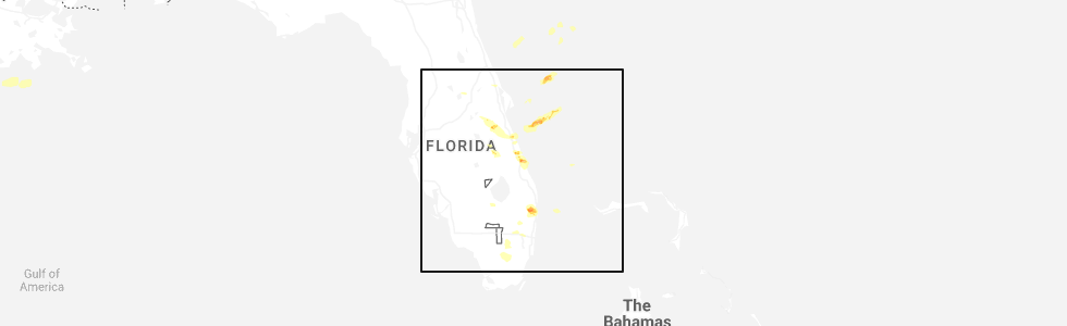
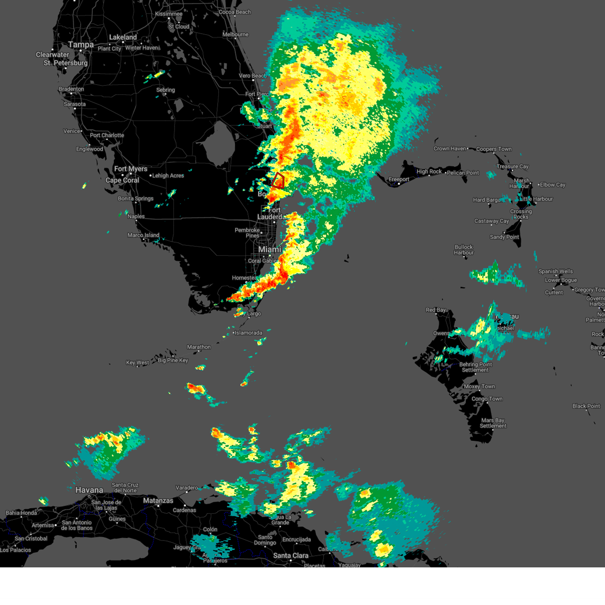
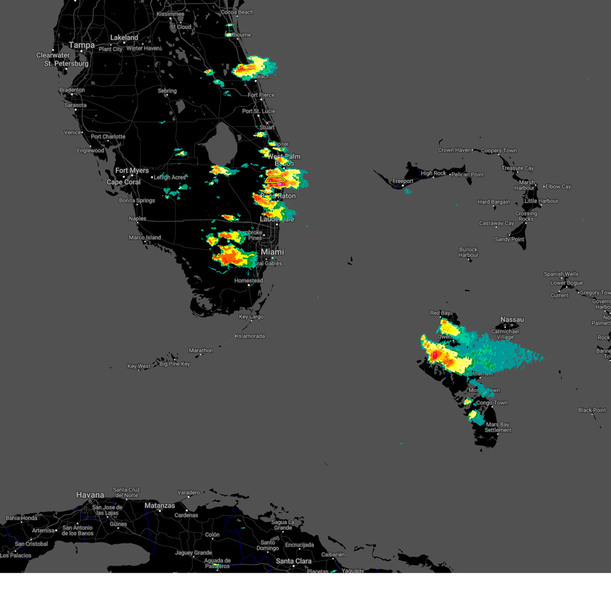
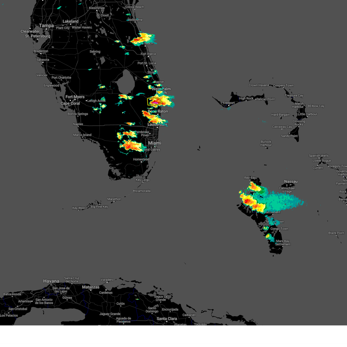
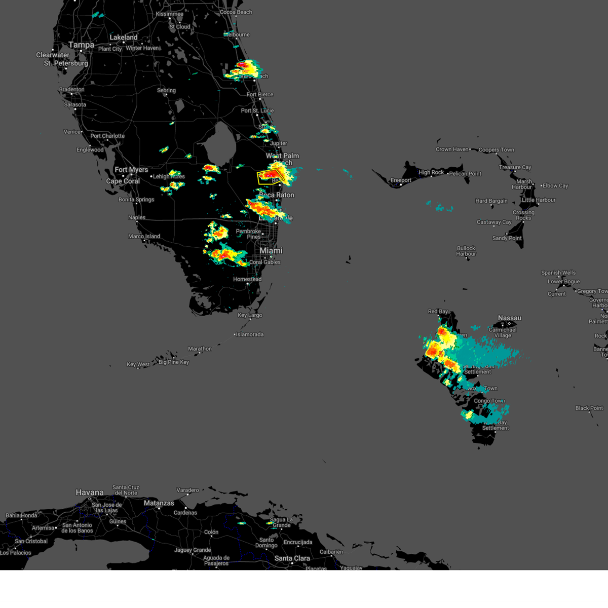
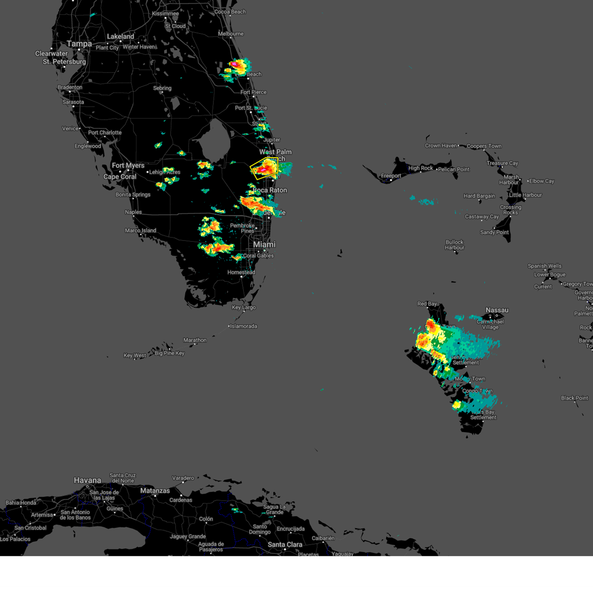
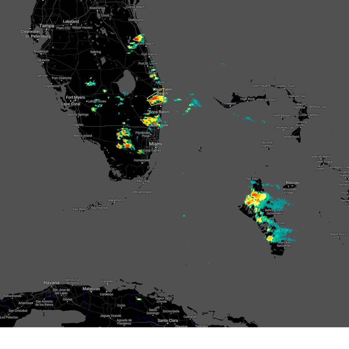
Hail Map for Greenacres, FL
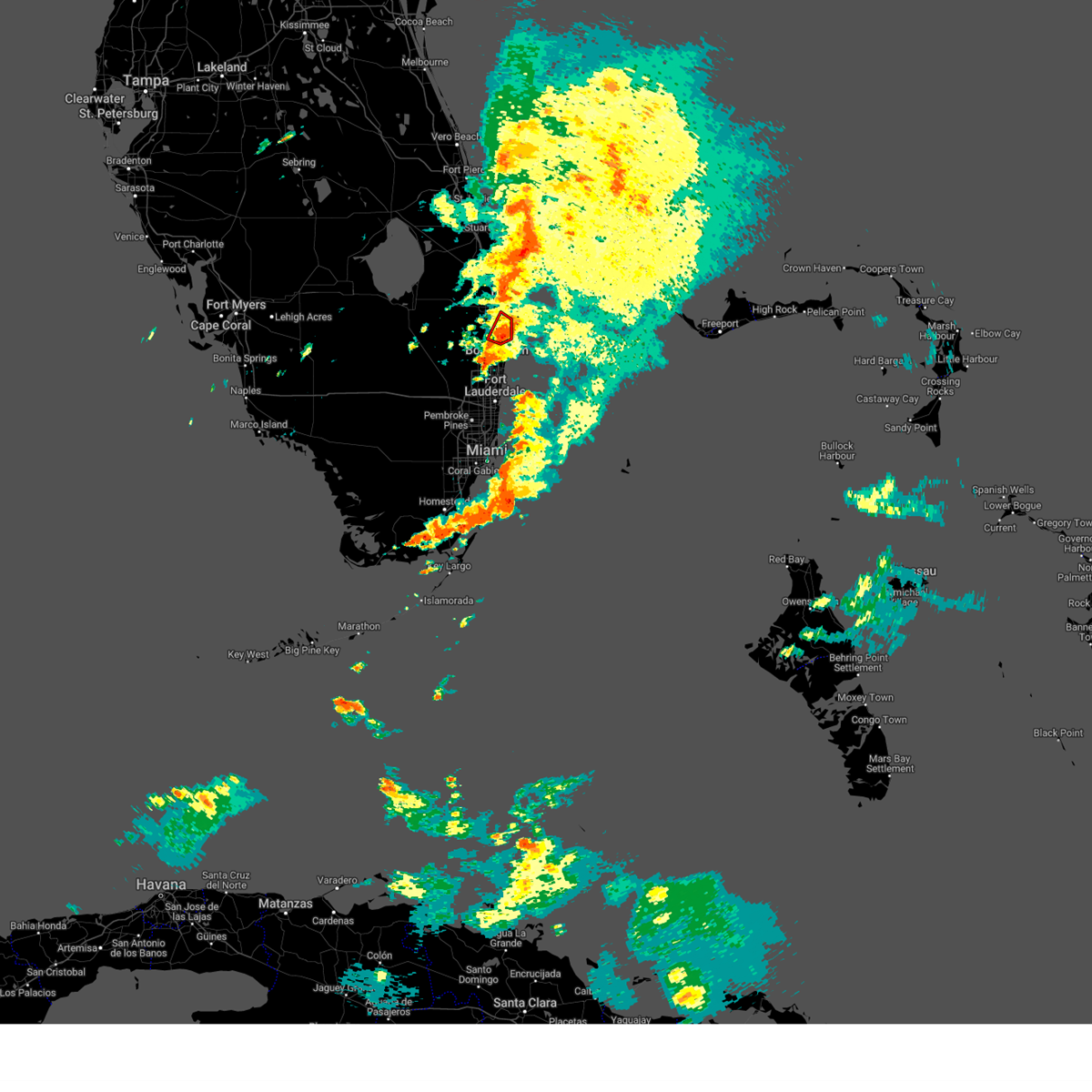
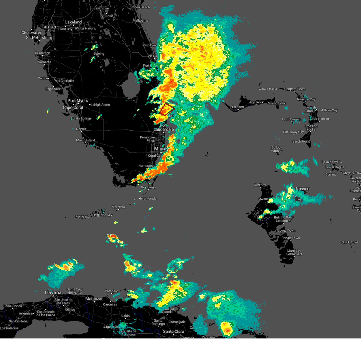
The Greenacres, FL area has had 0 reports of on-the-ground hail by trained spotters, and has been under severe weather warnings 21 times during the past 12 months. Doppler radar has detected hail at or near Greenacres, FL on 43 occasions, including 7 occasions during the past year.
| Name: | Greenacres, FL |
| Where Located: | 46.9 miles SSE of Port Saint Lucie, FL |
| Map: | Google Map for Greenacres, FL |
| Population: | 37573 |
| Housing Units: | 17249 |
| More Info: | Search Google for Greenacres, FL |
5
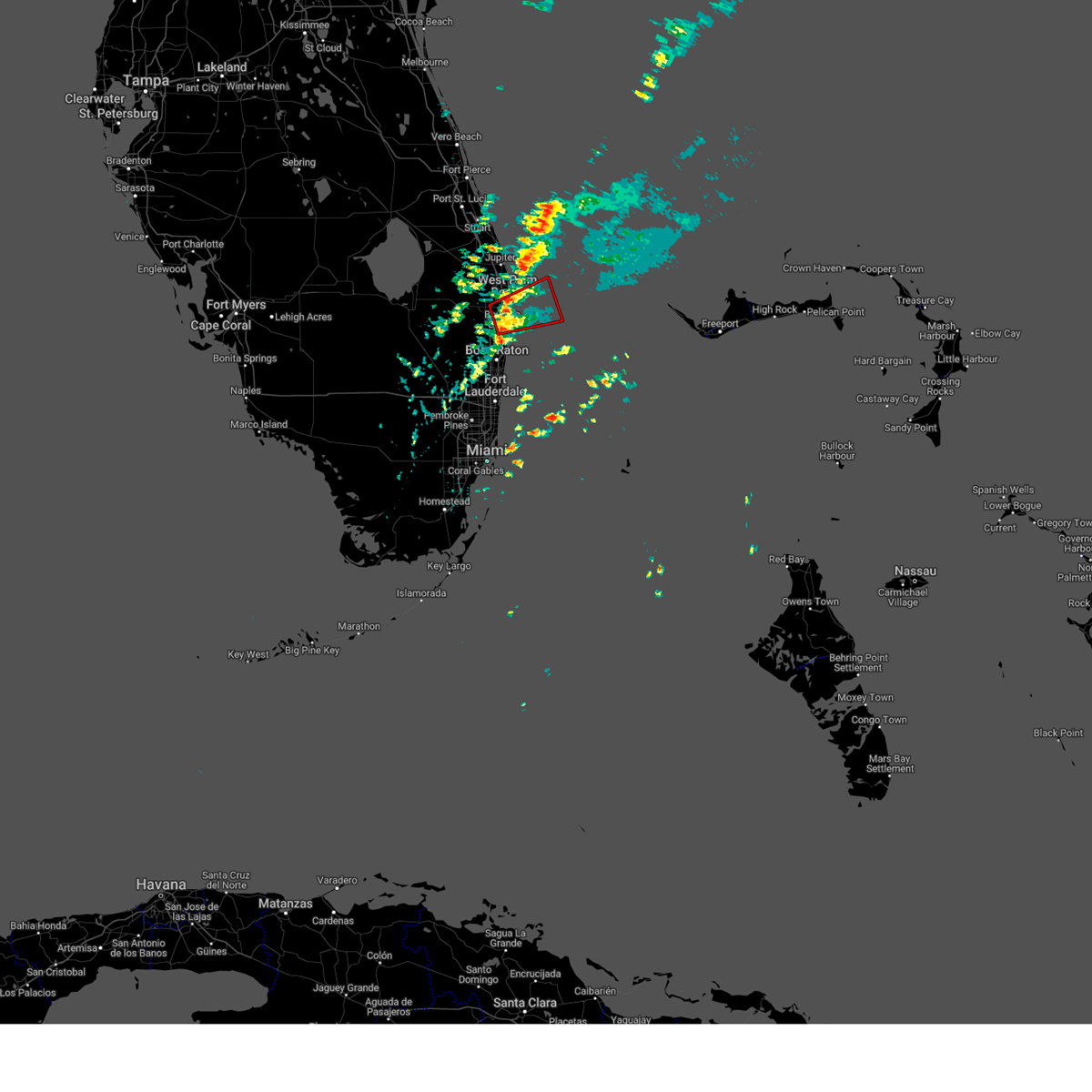
The Top Recent Hail Date for Greenacres, FL is Monday, May 5, 2025 (1st out of 43)
Hail and Wind Damage Spotted near Greenacres, FL
| Date / Time | Report Details |
|---|---|
| 5/23/2025 2:38 PM EDT |
 Svrmfl the national weather service in miami has issued a * severe thunderstorm warning for, east central palm beach county in southeastern florida, * until 330 pm edt. * at 238 pm edt, a severe thunderstorm was located over royal palm estates, or near lake worth, moving south at 5 mph (radar indicated). Hazards include 60 mph wind gusts and quarter size hail. Hail damage to vehicles is expected. Expect wind damage to roofs, siding, and trees. Svrmfl the national weather service in miami has issued a * severe thunderstorm warning for, east central palm beach county in southeastern florida, * until 330 pm edt. * at 238 pm edt, a severe thunderstorm was located over royal palm estates, or near lake worth, moving south at 5 mph (radar indicated). Hazards include 60 mph wind gusts and quarter size hail. Hail damage to vehicles is expected. Expect wind damage to roofs, siding, and trees.
|
| 5/23/2025 1:56 PM EDT |
 Svrmfl the national weather service in miami has issued a * severe thunderstorm warning for, east central palm beach county in southeastern florida, * until 245 pm edt. * at 156 pm edt, a severe thunderstorm was located over golden lakes, or over west palm beach, and is nearly stationary (radar indicated). Hazards include 60 mph wind gusts and quarter size hail. Hail damage to vehicles is expected. Expect wind damage to roofs, siding, and trees. Svrmfl the national weather service in miami has issued a * severe thunderstorm warning for, east central palm beach county in southeastern florida, * until 245 pm edt. * at 156 pm edt, a severe thunderstorm was located over golden lakes, or over west palm beach, and is nearly stationary (radar indicated). Hazards include 60 mph wind gusts and quarter size hail. Hail damage to vehicles is expected. Expect wind damage to roofs, siding, and trees.
|
| 5/12/2025 7:45 PM EDT |
 At 745 pm edt, a severe thunderstorm capable of producing a tornado was located over lantana, or over boynton beach, moving northeast at 20 mph (radar indicated rotation). Hazards include tornado. Flying debris will be dangerous to those caught without shelter. mobile homes will be damaged or destroyed. damage to roofs, windows, and vehicles will occur. tree damage is likely. Locations impacted include, boynton beach, lake worth, palm beach, ocean ridge, palm springs, lantana, atlantis, lake clarke shores, hypoluxo, south palm beach, briny breezes, manalapan, lake worth corridor, and seminole manor. At 745 pm edt, a severe thunderstorm capable of producing a tornado was located over lantana, or over boynton beach, moving northeast at 20 mph (radar indicated rotation). Hazards include tornado. Flying debris will be dangerous to those caught without shelter. mobile homes will be damaged or destroyed. damage to roofs, windows, and vehicles will occur. tree damage is likely. Locations impacted include, boynton beach, lake worth, palm beach, ocean ridge, palm springs, lantana, atlantis, lake clarke shores, hypoluxo, south palm beach, briny breezes, manalapan, lake worth corridor, and seminole manor.
|
| 5/12/2025 7:39 PM EDT |
 At 739 pm edt, a severe thunderstorm capable of producing a tornado was located over boynton beach, moving northeast at 25 mph (radar indicated rotation). Hazards include tornado. Flying debris will be dangerous to those caught without shelter. mobile homes will be damaged or destroyed. damage to roofs, windows, and vehicles will occur. tree damage is likely. Locations impacted include, boynton beach, lake worth, palm beach, ocean ridge, greenacres, palm springs, lantana, atlantis, village of golf, lake clarke shores, hypoluxo, south palm beach, gulf stream, briny breezes, manalapan, lake worth corridor, and seminole manor. At 739 pm edt, a severe thunderstorm capable of producing a tornado was located over boynton beach, moving northeast at 25 mph (radar indicated rotation). Hazards include tornado. Flying debris will be dangerous to those caught without shelter. mobile homes will be damaged or destroyed. damage to roofs, windows, and vehicles will occur. tree damage is likely. Locations impacted include, boynton beach, lake worth, palm beach, ocean ridge, greenacres, palm springs, lantana, atlantis, village of golf, lake clarke shores, hypoluxo, south palm beach, gulf stream, briny breezes, manalapan, lake worth corridor, and seminole manor.
|
| 5/12/2025 7:32 PM EDT |
 At 732 pm edt, a severe thunderstorm capable of producing a tornado was located over village of golf, or near boynton beach, moving northeast at 20 mph (radar indicated rotation). Hazards include tornado. Flying debris will be dangerous to those caught without shelter. mobile homes will be damaged or destroyed. damage to roofs, windows, and vehicles will occur. tree damage is likely. Locations impacted include, boynton beach, delray beach, lake worth, palm beach, ocean ridge, greenacres, palm springs, lantana, atlantis, village of golf, dunes road, lake clarke shores, hypoluxo, south palm beach, gulf stream, briny breezes, manalapan, lake worth corridor, and seminole manor. At 732 pm edt, a severe thunderstorm capable of producing a tornado was located over village of golf, or near boynton beach, moving northeast at 20 mph (radar indicated rotation). Hazards include tornado. Flying debris will be dangerous to those caught without shelter. mobile homes will be damaged or destroyed. damage to roofs, windows, and vehicles will occur. tree damage is likely. Locations impacted include, boynton beach, delray beach, lake worth, palm beach, ocean ridge, greenacres, palm springs, lantana, atlantis, village of golf, dunes road, lake clarke shores, hypoluxo, south palm beach, gulf stream, briny breezes, manalapan, lake worth corridor, and seminole manor.
|
| 5/12/2025 7:24 PM EDT |
 Tormfl the national weather service in miami has issued a * tornado warning for, east central palm beach county in southeastern florida, * until 800 pm edt. * at 724 pm edt, a severe thunderstorm capable of producing a tornado was located over dunes road, or near delray beach, moving northeast at 20 mph (radar indicated rotation). Hazards include tornado. Flying debris will be dangerous to those caught without shelter. mobile homes will be damaged or destroyed. damage to roofs, windows, and vehicles will occur. Tree damage is likely. Tormfl the national weather service in miami has issued a * tornado warning for, east central palm beach county in southeastern florida, * until 800 pm edt. * at 724 pm edt, a severe thunderstorm capable of producing a tornado was located over dunes road, or near delray beach, moving northeast at 20 mph (radar indicated rotation). Hazards include tornado. Flying debris will be dangerous to those caught without shelter. mobile homes will be damaged or destroyed. damage to roofs, windows, and vehicles will occur. Tree damage is likely.
|
| 5/5/2025 3:09 PM EDT |
 The storm which prompted the warning has moved out of the area. therefore, the warning will be allowed to expire. a severe thunderstorm watch remains in effect until 900 pm edt for southeastern florida. The storm which prompted the warning has moved out of the area. therefore, the warning will be allowed to expire. a severe thunderstorm watch remains in effect until 900 pm edt for southeastern florida.
|
| 5/5/2025 2:49 PM EDT |
 At 249 pm edt, a severe thunderstorm was located near greenacres, or near wellington, moving southeast at 10 mph (public). Hazards include 60 mph wind gusts and half dollar size hail. Hail damage to vehicles is expected. expect wind damage to roofs, siding, and trees. Locations impacted include, wellington, lake worth, greenacres, palm springs, lantana, atlantis, south palm beach, florida gardens, lake worth corridor, and seminole manor. At 249 pm edt, a severe thunderstorm was located near greenacres, or near wellington, moving southeast at 10 mph (public). Hazards include 60 mph wind gusts and half dollar size hail. Hail damage to vehicles is expected. expect wind damage to roofs, siding, and trees. Locations impacted include, wellington, lake worth, greenacres, palm springs, lantana, atlantis, south palm beach, florida gardens, lake worth corridor, and seminole manor.
|
| 5/5/2025 2:40 PM EDT |
 At 240 pm edt, a severe thunderstorm was located near greenacres, or near wellington, moving southeast at 10 mph (public). Hazards include 60 mph wind gusts and half dollar size hail. Hail damage to vehicles is expected. expect wind damage to roofs, siding, and trees. Locations impacted include, boynton beach, wellington, lake worth, greenacres, palm springs, lantana, atlantis, loxahatchee nwr, lake clarke shores, south palm beach, aberdeen, lake worth corridor, aberdeen golf course, florida gardens, and seminole manor. At 240 pm edt, a severe thunderstorm was located near greenacres, or near wellington, moving southeast at 10 mph (public). Hazards include 60 mph wind gusts and half dollar size hail. Hail damage to vehicles is expected. expect wind damage to roofs, siding, and trees. Locations impacted include, boynton beach, wellington, lake worth, greenacres, palm springs, lantana, atlantis, loxahatchee nwr, lake clarke shores, south palm beach, aberdeen, lake worth corridor, aberdeen golf course, florida gardens, and seminole manor.
|
| 5/5/2025 2:24 PM EDT |
 Svrmfl the national weather service in miami has issued a * severe thunderstorm warning for, east central palm beach county in southeastern florida, * until 315 pm edt. * at 224 pm edt, a severe thunderstorm was located over wellington, moving southeast at 10 mph (radar indicated). Hazards include 60 mph wind gusts and half dollar size hail. Hail damage to vehicles is expected. Expect wind damage to roofs, siding, and trees. Svrmfl the national weather service in miami has issued a * severe thunderstorm warning for, east central palm beach county in southeastern florida, * until 315 pm edt. * at 224 pm edt, a severe thunderstorm was located over wellington, moving southeast at 10 mph (radar indicated). Hazards include 60 mph wind gusts and half dollar size hail. Hail damage to vehicles is expected. Expect wind damage to roofs, siding, and trees.
|
| 5/5/2025 2:19 PM EDT |
 At 218 pm edt, a severe thunderstorm was located over golden lakes, or near west palm beach, moving northeast at 10 mph (radar indicated). Hazards include 60 mph wind gusts and quarter size hail. Hail damage to vehicles is possible. wind damage to roofs, siding, and trees is also possible. Locations impacted include, west palm beach, wellington, lake worth, riviera beach, palm beach, greenacres, royal palm beach, palm springs, atlantis, haverhill, cloud lake, palm beach international airport, port of palm beach, golden lakes, loxahatchee groves, gun club estates, schall circle, royal palm estates, lake belvedere estates, and downtown west palm beach. At 218 pm edt, a severe thunderstorm was located over golden lakes, or near west palm beach, moving northeast at 10 mph (radar indicated). Hazards include 60 mph wind gusts and quarter size hail. Hail damage to vehicles is possible. wind damage to roofs, siding, and trees is also possible. Locations impacted include, west palm beach, wellington, lake worth, riviera beach, palm beach, greenacres, royal palm beach, palm springs, atlantis, haverhill, cloud lake, palm beach international airport, port of palm beach, golden lakes, loxahatchee groves, gun club estates, schall circle, royal palm estates, lake belvedere estates, and downtown west palm beach.
|
| 5/5/2025 2:07 PM EDT |
 Svrmfl the national weather service in miami has issued a * severe thunderstorm warning for, east central palm beach county in southeastern florida, * until 230 pm edt. * at 207 pm edt, a severe thunderstorm was located over golden lakes, or near wellington, moving northeast at 10 mph (radar indicated). Hazards include 60 mph wind gusts and quarter size hail. Hail damage to vehicles is possible. Wind damage to roofs, siding, and trees also possible. Svrmfl the national weather service in miami has issued a * severe thunderstorm warning for, east central palm beach county in southeastern florida, * until 230 pm edt. * at 207 pm edt, a severe thunderstorm was located over golden lakes, or near wellington, moving northeast at 10 mph (radar indicated). Hazards include 60 mph wind gusts and quarter size hail. Hail damage to vehicles is possible. Wind damage to roofs, siding, and trees also possible.
|
| 3/31/2025 8:16 PM EDT |
 Svrmfl the national weather service in miami has issued a * severe thunderstorm warning for, east central palm beach county in southeastern florida, * until 845 pm edt. * at 816 pm edt, a severe thunderstorm was located over wellington, moving east at 15 mph (radar indicated). Hazards include 60 mph wind gusts and quarter size hail. Hail damage to vehicles is expected. Expect wind damage to roofs, siding, and trees. Svrmfl the national weather service in miami has issued a * severe thunderstorm warning for, east central palm beach county in southeastern florida, * until 845 pm edt. * at 816 pm edt, a severe thunderstorm was located over wellington, moving east at 15 mph (radar indicated). Hazards include 60 mph wind gusts and quarter size hail. Hail damage to vehicles is expected. Expect wind damage to roofs, siding, and trees.
|
| 3/31/2025 4:12 PM EDT |
 Svrmfl the national weather service in miami has issued a * severe thunderstorm warning for, east central palm beach county in southeastern florida, * until 445 pm edt. * at 411 pm edt, a severe thunderstorm was located over greenacres, or near lake worth, moving southeast at 5 mph (radar indicated). Hazards include 60 mph wind gusts and nickel size hail. expect damage to roofs, siding, and trees Svrmfl the national weather service in miami has issued a * severe thunderstorm warning for, east central palm beach county in southeastern florida, * until 445 pm edt. * at 411 pm edt, a severe thunderstorm was located over greenacres, or near lake worth, moving southeast at 5 mph (radar indicated). Hazards include 60 mph wind gusts and nickel size hail. expect damage to roofs, siding, and trees
|
| 3/31/2025 3:32 PM EDT |
 Svrmfl the national weather service in miami has issued a * severe thunderstorm warning for, east central palm beach county in southeastern florida, * until 400 pm edt. * at 331 pm edt, a severe thunderstorm was located over golden lakes, or near west palm beach, and is nearly stationary (radar indicated). Hazards include quarter size hail. damage to vehicles is expected Svrmfl the national weather service in miami has issued a * severe thunderstorm warning for, east central palm beach county in southeastern florida, * until 400 pm edt. * at 331 pm edt, a severe thunderstorm was located over golden lakes, or near west palm beach, and is nearly stationary (radar indicated). Hazards include quarter size hail. damage to vehicles is expected
|
| 3/17/2025 6:29 AM EDT |
 the tornado warning has been cancelled and is no longer in effect the tornado warning has been cancelled and is no longer in effect
|
| 3/17/2025 6:19 AM EDT |
 Tormfl the national weather service in miami has issued a * tornado warning for, east central palm beach county in southeastern florida, * until 645 am edt. * at 619 am edt, a severe thunderstorm capable of producing a tornado was located over lake worth, moving east at 30 mph (radar indicated rotation). Hazards include tornado. Expect damage to mobile homes, roofs, and vehicles. Tree damage is likely. Tormfl the national weather service in miami has issued a * tornado warning for, east central palm beach county in southeastern florida, * until 645 am edt. * at 619 am edt, a severe thunderstorm capable of producing a tornado was located over lake worth, moving east at 30 mph (radar indicated rotation). Hazards include tornado. Expect damage to mobile homes, roofs, and vehicles. Tree damage is likely.
|
| 3/17/2025 6:14 AM EDT |
 Svrmfl the national weather service in miami has issued a * severe thunderstorm warning for, eastern palm beach county in southeastern florida, * until 645 am edt. * at 613 am edt, severe thunderstorms were located along a line extending from lake belvedere estates to near kings point, moving east at 40 mph (radar indicated). Hazards include 60 mph wind gusts. expect damage to roofs, siding, and trees Svrmfl the national weather service in miami has issued a * severe thunderstorm warning for, eastern palm beach county in southeastern florida, * until 645 am edt. * at 613 am edt, severe thunderstorms were located along a line extending from lake belvedere estates to near kings point, moving east at 40 mph (radar indicated). Hazards include 60 mph wind gusts. expect damage to roofs, siding, and trees
|
| 9/26/2024 7:15 AM EDT |
 Tormfl the national weather service in miami has issued a * tornado warning for, southeastern palm beach county in southeastern florida, * until 730 am edt. * at 715 am edt, a severe thunderstorm capable of producing a tornado was located near kings point, or near delray beach, moving north at 55 mph (radar indicated rotation). Hazards include tornado. Flying debris will be dangerous to those caught without shelter. mobile homes will be damaged or destroyed. damage to roofs, windows, and vehicles will occur. Tree damage is likely. Tormfl the national weather service in miami has issued a * tornado warning for, southeastern palm beach county in southeastern florida, * until 730 am edt. * at 715 am edt, a severe thunderstorm capable of producing a tornado was located near kings point, or near delray beach, moving north at 55 mph (radar indicated rotation). Hazards include tornado. Flying debris will be dangerous to those caught without shelter. mobile homes will be damaged or destroyed. damage to roofs, windows, and vehicles will occur. Tree damage is likely.
|
| 8/7/2024 4:23 PM EDT |
 The storm which prompted the warning has weakened below severe limits, and no longer poses an immediate threat to life or property. therefore, the warning will be allowed to expire. however, gusty winds and heavy rain are still possible with this thunderstorm. to report severe weather, contact your nearest law enforcement agency. they will relay your report to the national weather service miami. you can also share your report with nws miami on facebook and twitter. The storm which prompted the warning has weakened below severe limits, and no longer poses an immediate threat to life or property. therefore, the warning will be allowed to expire. however, gusty winds and heavy rain are still possible with this thunderstorm. to report severe weather, contact your nearest law enforcement agency. they will relay your report to the national weather service miami. you can also share your report with nws miami on facebook and twitter.
|
| 8/7/2024 3:51 PM EDT |
 Svrmfl the national weather service in miami has issued a * severe thunderstorm warning for, east central palm beach county in southeastern florida, * until 430 pm edt. * at 351 pm edt, a severe thunderstorm was located near wellington, moving southeast at 10 mph (radar indicated). Hazards include 60 mph wind gusts. expect damage to roofs, siding, and trees Svrmfl the national weather service in miami has issued a * severe thunderstorm warning for, east central palm beach county in southeastern florida, * until 430 pm edt. * at 351 pm edt, a severe thunderstorm was located near wellington, moving southeast at 10 mph (radar indicated). Hazards include 60 mph wind gusts. expect damage to roofs, siding, and trees
|
| 6/12/2024 11:53 AM EDT |
 The storm which prompted the warning has weakened below severe limits, and no longer appears capable of producing a tornado. therefore, the warning will be allowed to expire. to report severe weather, contact your nearest law enforcement agency. they will relay your report to the national weather service miami. you can also share your report with nws miami on facebook and twitter. The storm which prompted the warning has weakened below severe limits, and no longer appears capable of producing a tornado. therefore, the warning will be allowed to expire. to report severe weather, contact your nearest law enforcement agency. they will relay your report to the national weather service miami. you can also share your report with nws miami on facebook and twitter.
|
| 6/12/2024 11:41 AM EDT |
 At 1141 am edt, a severe thunderstorm capable of producing a tornado was located over loxahatchee groves, or near wellington, moving east at 10 mph (radar indicated rotation). Hazards include tornado. Expect damage to mobile homes, roofs, and vehicles. tree damage is likely. Locations impacted include, west palm beach, wellington, palm beach gardens, royal palm beach, loxahatchee groves, lion country safari park, the acreage, golden lakes, and loxahatchee nwr. At 1141 am edt, a severe thunderstorm capable of producing a tornado was located over loxahatchee groves, or near wellington, moving east at 10 mph (radar indicated rotation). Hazards include tornado. Expect damage to mobile homes, roofs, and vehicles. tree damage is likely. Locations impacted include, west palm beach, wellington, palm beach gardens, royal palm beach, loxahatchee groves, lion country safari park, the acreage, golden lakes, and loxahatchee nwr.
|
| 6/12/2024 11:26 AM EDT |
 Tormfl the national weather service in miami has issued a * tornado warning for, northeastern palm beach county in southeastern florida, * until noon edt. * at 1126 am edt, a severe thunderstorm capable of producing a tornado was located over lion country safari park, or near wellington, moving east at 10 mph (radar indicated rotation). Hazards include tornado. Expect damage to mobile homes, roofs, and vehicles. Tree damage is likely. Tormfl the national weather service in miami has issued a * tornado warning for, northeastern palm beach county in southeastern florida, * until noon edt. * at 1126 am edt, a severe thunderstorm capable of producing a tornado was located over lion country safari park, or near wellington, moving east at 10 mph (radar indicated rotation). Hazards include tornado. Expect damage to mobile homes, roofs, and vehicles. Tree damage is likely.
|
| 6/7/2024 4:09 PM EDT |
 The storm which prompted the warning has weakened below severe limits, and has exited the warned area. therefore, the warning will be allowed to expire. The storm which prompted the warning has weakened below severe limits, and has exited the warned area. therefore, the warning will be allowed to expire.
|
| 6/7/2024 4:02 PM EDT |
 At 402 pm edt, a severe thunderstorm was located near greenacres, or near boynton beach, moving north at 20 mph (radar indicated). Hazards include 60 mph wind gusts and penny size hail. Expect damage to roofs, siding, and trees. Locations impacted include, west palm beach, boynton beach, delray beach, wellington, lake worth, palm beach, ocean ridge, greenacres, royal palm beach, palm springs, lantana, atlantis, haverhill, cloud lake, palm beach international airport, village of golf, golden lakes, gun club estates, royal palm estates, and lake belvedere estates. At 402 pm edt, a severe thunderstorm was located near greenacres, or near boynton beach, moving north at 20 mph (radar indicated). Hazards include 60 mph wind gusts and penny size hail. Expect damage to roofs, siding, and trees. Locations impacted include, west palm beach, boynton beach, delray beach, wellington, lake worth, palm beach, ocean ridge, greenacres, royal palm beach, palm springs, lantana, atlantis, haverhill, cloud lake, palm beach international airport, village of golf, golden lakes, gun club estates, royal palm estates, and lake belvedere estates.
|
| 6/7/2024 3:41 PM EDT |
 Svrmfl the national weather service in miami has issued a * severe thunderstorm warning for, southeastern palm beach county in southeastern florida, * until 415 pm edt. * at 340 pm edt, a severe thunderstorm was located near kings point, or 7 miles west of delray beach, moving north at 20 mph (radar indicated). Hazards include 60 mph wind gusts and penny size hail. expect damage to roofs, siding, and trees Svrmfl the national weather service in miami has issued a * severe thunderstorm warning for, southeastern palm beach county in southeastern florida, * until 415 pm edt. * at 340 pm edt, a severe thunderstorm was located near kings point, or 7 miles west of delray beach, moving north at 20 mph (radar indicated). Hazards include 60 mph wind gusts and penny size hail. expect damage to roofs, siding, and trees
|
| 5/28/2024 6:13 PM EDT |
 Svrmfl the national weather service in miami has issued a * severe thunderstorm warning for, northeastern palm beach county in southeastern florida, * until 645 pm edt. * at 613 pm edt, a severe thunderstorm was located 9 miles northwest of north county airport, or 11 miles southeast of indiantown, moving south at 15 mph (radar indicated). Hazards include 60 mph wind gusts and quarter size hail. Hail damage to vehicles is expected. Expect wind damage to roofs, siding, and trees. Svrmfl the national weather service in miami has issued a * severe thunderstorm warning for, northeastern palm beach county in southeastern florida, * until 645 pm edt. * at 613 pm edt, a severe thunderstorm was located 9 miles northwest of north county airport, or 11 miles southeast of indiantown, moving south at 15 mph (radar indicated). Hazards include 60 mph wind gusts and quarter size hail. Hail damage to vehicles is expected. Expect wind damage to roofs, siding, and trees.
|
| 5/20/2024 6:54 PM EDT |
 The storm which prompted the warning has weakened below severe limits, and no longer poses an immediate threat to life or property. therefore, the warning will be allowed to expire. however, small hail, gusty winds and heavy rain are still possible with this thunderstorm. to report severe weather, contact your nearest law enforcement agency. they will relay your report to the national weather service miami. you can also share your report with nws miami on facebook and twitter. The storm which prompted the warning has weakened below severe limits, and no longer poses an immediate threat to life or property. therefore, the warning will be allowed to expire. however, small hail, gusty winds and heavy rain are still possible with this thunderstorm. to report severe weather, contact your nearest law enforcement agency. they will relay your report to the national weather service miami. you can also share your report with nws miami on facebook and twitter.
|
| 5/20/2024 6:48 PM EDT |
 At 646 pm edt, doppler radar indicated that the orginal severe storm has dissipated, but a new severe thunderstorm developed over over atlantis, or near lake worth, moving southeast at 10 to 15 mph (radar indicated). Hazards include 60 mph wind gusts. Expect damage to roofs, siding, and trees. Locations impacted include, boynton beach, delray beach, wellington, lake worth, palm beach, ocean ridge, greenacres, royal palm beach, palm springs, lantana, atlantis, village of golf, hypoluxo, south palm beach, gulf stream, briny breezes, manalapan, aberdeen, lake worth corridor, and aberdeen golf course. At 646 pm edt, doppler radar indicated that the orginal severe storm has dissipated, but a new severe thunderstorm developed over over atlantis, or near lake worth, moving southeast at 10 to 15 mph (radar indicated). Hazards include 60 mph wind gusts. Expect damage to roofs, siding, and trees. Locations impacted include, boynton beach, delray beach, wellington, lake worth, palm beach, ocean ridge, greenacres, royal palm beach, palm springs, lantana, atlantis, village of golf, hypoluxo, south palm beach, gulf stream, briny breezes, manalapan, aberdeen, lake worth corridor, and aberdeen golf course.
|
| 5/20/2024 6:29 PM EDT |
 Svrmfl the national weather service in miami has issued a * severe thunderstorm warning for, southeastern palm beach county in southeastern florida, * until 700 pm edt. * at 629 pm edt, a severe thunderstorm was located near dunes road, or 8 miles west of boynton beach, moving southeast at 20 to 25 mph (radar indicated). Hazards include 60 mph wind gusts. expect damage to roofs, siding, and trees Svrmfl the national weather service in miami has issued a * severe thunderstorm warning for, southeastern palm beach county in southeastern florida, * until 700 pm edt. * at 629 pm edt, a severe thunderstorm was located near dunes road, or 8 miles west of boynton beach, moving southeast at 20 to 25 mph (radar indicated). Hazards include 60 mph wind gusts. expect damage to roofs, siding, and trees
|
| 5/18/2024 6:52 PM EDT |
 At 652 pm edt, a severe thunderstorm was located over greenacres, or near wellington, moving east at 20 mph (radar indicated). Hazards include 60 mph wind gusts and quarter size hail. Hail damage to vehicles is expected. expect wind damage to roofs, siding, and trees. Locations impacted include, west palm beach, boynton beach, wellington, lake worth, palm beach, ocean ridge, greenacres, royal palm beach, palm springs, lantana, atlantis, village of golf, loxahatchee nwr, lake clarke shores, hypoluxo, south palm beach, gulf stream, briny breezes, manalapan, and glen ridge. At 652 pm edt, a severe thunderstorm was located over greenacres, or near wellington, moving east at 20 mph (radar indicated). Hazards include 60 mph wind gusts and quarter size hail. Hail damage to vehicles is expected. expect wind damage to roofs, siding, and trees. Locations impacted include, west palm beach, boynton beach, wellington, lake worth, palm beach, ocean ridge, greenacres, royal palm beach, palm springs, lantana, atlantis, village of golf, loxahatchee nwr, lake clarke shores, hypoluxo, south palm beach, gulf stream, briny breezes, manalapan, and glen ridge.
|
| 5/18/2024 6:37 PM EDT |
 Svrmfl the national weather service in miami has issued a * severe thunderstorm warning for, east central palm beach county in southeastern florida, * until 715 pm edt. * at 637 pm edt, a severe thunderstorm was located over wellington, moving east at 20 mph (radar indicated). Hazards include 60 mph wind gusts and quarter size hail. Hail damage to vehicles is expected. Expect wind damage to roofs, siding, and trees. Svrmfl the national weather service in miami has issued a * severe thunderstorm warning for, east central palm beach county in southeastern florida, * until 715 pm edt. * at 637 pm edt, a severe thunderstorm was located over wellington, moving east at 20 mph (radar indicated). Hazards include 60 mph wind gusts and quarter size hail. Hail damage to vehicles is expected. Expect wind damage to roofs, siding, and trees.
|
| 5/18/2024 6:30 PM EDT |
 At 630 pm edt, a severe thunderstorm was located over wellington, moving east at 20 mph (radar indicated). Hazards include 60 mph wind gusts and quarter size hail. Hail damage to vehicles is expected. expect wind damage to roofs, siding, and trees. Locations impacted include, west palm beach, boynton beach, wellington, palm beach gardens, riviera beach, greenacres, royal palm beach, palm springs, atlantis, haverhill, palm beach international airport, golden lakes, loxahatchee groves, gun club estates, schall circle, royal palm estates, lake belvedere estates, the acreage, loxahatchee nwr, and lakeside green. At 630 pm edt, a severe thunderstorm was located over wellington, moving east at 20 mph (radar indicated). Hazards include 60 mph wind gusts and quarter size hail. Hail damage to vehicles is expected. expect wind damage to roofs, siding, and trees. Locations impacted include, west palm beach, boynton beach, wellington, palm beach gardens, riviera beach, greenacres, royal palm beach, palm springs, atlantis, haverhill, palm beach international airport, golden lakes, loxahatchee groves, gun club estates, schall circle, royal palm estates, lake belvedere estates, the acreage, loxahatchee nwr, and lakeside green.
|
| 5/18/2024 6:11 PM EDT |
 Svrmfl the national weather service in miami has issued a * severe thunderstorm warning for, east central palm beach county in southeastern florida, * until 645 pm edt. * at 611 pm edt, a severe thunderstorm was located near lion country safari park, or near wellington, moving east at 20 mph (radar indicated). Hazards include 60 mph wind gusts and quarter size hail. Hail damage to vehicles is expected. Expect wind damage to roofs, siding, and trees. Svrmfl the national weather service in miami has issued a * severe thunderstorm warning for, east central palm beach county in southeastern florida, * until 645 pm edt. * at 611 pm edt, a severe thunderstorm was located near lion country safari park, or near wellington, moving east at 20 mph (radar indicated). Hazards include 60 mph wind gusts and quarter size hail. Hail damage to vehicles is expected. Expect wind damage to roofs, siding, and trees.
|
| 3/3/2024 2:43 PM EST |
 The storm which prompted the warning has weakened below severe limits, and no longer appears capable of producing a tornado. therefore, the warning will be allowed to expire. however, small hail and heavy rain are still possible with this thunderstorm. to report severe weather, contact your nearest law enforcement agency. they will relay your report to the national weather service miami. you can also share your report with nws miami on facebook and twitter. The storm which prompted the warning has weakened below severe limits, and no longer appears capable of producing a tornado. therefore, the warning will be allowed to expire. however, small hail and heavy rain are still possible with this thunderstorm. to report severe weather, contact your nearest law enforcement agency. they will relay your report to the national weather service miami. you can also share your report with nws miami on facebook and twitter.
|
| 3/3/2024 2:43 PM EST |
 The storm which prompted the warning has weakened below severe limits, and no longer poses an immediate threat to life or property. therefore, the warning will be allowed to expire. The storm which prompted the warning has weakened below severe limits, and no longer poses an immediate threat to life or property. therefore, the warning will be allowed to expire.
|
| 3/3/2024 2:19 PM EST |
 Tormfl the national weather service in miami has issued a * tornado warning for, east central palm beach county in southeastern florida, * until 245 pm est. * at 219 pm est, a severe thunderstorm capable of producing a tornado was located over atlantis, or over boynton beach, and is nearly stationary (radar indicated rotation). Hazards include tornado and quarter size hail. Expect damage to mobile homes, roofs, and vehicles. Tree damage is likely. Tormfl the national weather service in miami has issued a * tornado warning for, east central palm beach county in southeastern florida, * until 245 pm est. * at 219 pm est, a severe thunderstorm capable of producing a tornado was located over atlantis, or over boynton beach, and is nearly stationary (radar indicated rotation). Hazards include tornado and quarter size hail. Expect damage to mobile homes, roofs, and vehicles. Tree damage is likely.
|
| 3/3/2024 2:17 PM EST |
 At 217 pm est, a severe thunderstorm was located over lantana, or over lake worth, moving east at 10 mph (radar indicated). Hazards include 60 mph wind gusts and quarter size hail. Hail damage to vehicles is expected. expect wind damage to roofs, siding, and trees. Locations impacted include, west palm beach, boynton beach, wellington, lake worth, palm beach, ocean ridge, greenacres, royal palm beach, palm springs, lantana, atlantis, haverhill, cloud lake, palm beach international airport, golden lakes, gun club estates, royal palm estates, lake belvedere estates, downtown west palm beach, and lake clarke shores. At 217 pm est, a severe thunderstorm was located over lantana, or over lake worth, moving east at 10 mph (radar indicated). Hazards include 60 mph wind gusts and quarter size hail. Hail damage to vehicles is expected. expect wind damage to roofs, siding, and trees. Locations impacted include, west palm beach, boynton beach, wellington, lake worth, palm beach, ocean ridge, greenacres, royal palm beach, palm springs, lantana, atlantis, haverhill, cloud lake, palm beach international airport, golden lakes, gun club estates, royal palm estates, lake belvedere estates, downtown west palm beach, and lake clarke shores.
|
| 3/3/2024 2:07 PM EST |
 At 207 pm est, a severe thunderstorm was located over atlantis, or near lake worth, moving east at 5 mph (radar indicated). Hazards include 60 mph wind gusts and quarter size hail. Hail damage to vehicles is expected. expect wind damage to roofs, siding, and trees. Locations impacted include, west palm beach, boynton beach, wellington, lake worth, palm beach, ocean ridge, greenacres, royal palm beach, palm springs, lantana, atlantis, haverhill, cloud lake, palm beach international airport, golden lakes, gun club estates, schall circle, royal palm estates, lake belvedere estates, and downtown west palm beach. At 207 pm est, a severe thunderstorm was located over atlantis, or near lake worth, moving east at 5 mph (radar indicated). Hazards include 60 mph wind gusts and quarter size hail. Hail damage to vehicles is expected. expect wind damage to roofs, siding, and trees. Locations impacted include, west palm beach, boynton beach, wellington, lake worth, palm beach, ocean ridge, greenacres, royal palm beach, palm springs, lantana, atlantis, haverhill, cloud lake, palm beach international airport, golden lakes, gun club estates, schall circle, royal palm estates, lake belvedere estates, and downtown west palm beach.
|
| 3/3/2024 1:54 PM EST |
 Svrmfl the national weather service in miami has issued a * severe thunderstorm warning for, east central palm beach county in southeastern florida, * until 245 pm est. * at 154 pm est, a severe thunderstorm was located over palm springs, or near lake worth, moving east at 10 mph (radar indicated). Hazards include 60 mph wind gusts and quarter size hail. Hail damage to vehicles is expected. Expect wind damage to roofs, siding, and trees. Svrmfl the national weather service in miami has issued a * severe thunderstorm warning for, east central palm beach county in southeastern florida, * until 245 pm est. * at 154 pm est, a severe thunderstorm was located over palm springs, or near lake worth, moving east at 10 mph (radar indicated). Hazards include 60 mph wind gusts and quarter size hail. Hail damage to vehicles is expected. Expect wind damage to roofs, siding, and trees.
|
| 8/29/2023 6:36 PM EDT |
 The severe thunderstorm warning for northern broward and central palm beach counties will expire at 645 pm edt, the storms which prompted the warning have weakened below severe limits, and no longer pose an immediate threat to life or property. therefore, the warning will be allowed to expire. however gusty winds are still possible with these thunderstorms, so a special weather statement is in place for winds up to 30 kts through 7 pm et. The severe thunderstorm warning for northern broward and central palm beach counties will expire at 645 pm edt, the storms which prompted the warning have weakened below severe limits, and no longer pose an immediate threat to life or property. therefore, the warning will be allowed to expire. however gusty winds are still possible with these thunderstorms, so a special weather statement is in place for winds up to 30 kts through 7 pm et.
|
| 8/29/2023 6:10 PM EDT |
 At 609 pm edt, severe thunderstorms were located along a line extending from 6 miles southeast of okeelanta to near loxahatchee nwr to deerfield beach, moving north at 40 mph (radar indicated). Hazards include 60 mph wind gusts. expect damage to roofs, siding, and trees At 609 pm edt, severe thunderstorms were located along a line extending from 6 miles southeast of okeelanta to near loxahatchee nwr to deerfield beach, moving north at 40 mph (radar indicated). Hazards include 60 mph wind gusts. expect damage to roofs, siding, and trees
|
| 7/16/2023 5:09 PM EDT |
 At 509 pm edt, a severe thunderstorm was located over lake belvedere estates, or near west palm beach, moving northeast at 10 mph (radar indicated). Hazards include 60 mph wind gusts. expect damage to roofs, siding, and trees At 509 pm edt, a severe thunderstorm was located over lake belvedere estates, or near west palm beach, moving northeast at 10 mph (radar indicated). Hazards include 60 mph wind gusts. expect damage to roofs, siding, and trees
|
| 6/20/2023 4:55 PM EDT |
 The severe thunderstorm warning for east central palm beach county will expire at 500 pm edt, the storms which prompted the warning have moved out of the area. therefore, the warning will be allowed to expire. however gusty winds are still possible with these thunderstorms. to report severe weather, contact your nearest law enforcement agency. they will relay your report to the national weather service miami. you can also share your report with nws miami on facebook and twitter. The severe thunderstorm warning for east central palm beach county will expire at 500 pm edt, the storms which prompted the warning have moved out of the area. therefore, the warning will be allowed to expire. however gusty winds are still possible with these thunderstorms. to report severe weather, contact your nearest law enforcement agency. they will relay your report to the national weather service miami. you can also share your report with nws miami on facebook and twitter.
|
| 6/20/2023 4:38 PM EDT |
 At 438 pm edt, severe thunderstorms were located along a line extending from near juno ridge to near royal palm beach, moving east at 15 mph (radar indicated). Hazards include 60 mph wind gusts and penny size hail. Expect damage to roofs, siding, and trees. Locations impacted include, west palm beach, boynton beach, wellington, palm beach gardens and lake worth. At 438 pm edt, severe thunderstorms were located along a line extending from near juno ridge to near royal palm beach, moving east at 15 mph (radar indicated). Hazards include 60 mph wind gusts and penny size hail. Expect damage to roofs, siding, and trees. Locations impacted include, west palm beach, boynton beach, wellington, palm beach gardens and lake worth.
|
| 6/20/2023 4:36 PM EDT |
 At 436 pm edt, severe thunderstorms were located along a line extending from near juno ridge to near royal palm beach, moving east at 15 mph (radar indicated). Hazards include 60 mph wind gusts and penny size hail. Expect damage to roofs, siding, and trees. Locations impacted include, west palm beach, boynton beach, wellington, palm beach gardens and lake worth. At 436 pm edt, severe thunderstorms were located along a line extending from near juno ridge to near royal palm beach, moving east at 15 mph (radar indicated). Hazards include 60 mph wind gusts and penny size hail. Expect damage to roofs, siding, and trees. Locations impacted include, west palm beach, boynton beach, wellington, palm beach gardens and lake worth.
|
| 6/20/2023 4:28 PM EDT |
 At 428 pm edt, severe thunderstorms were located along a line extending from near palm beach gardens to near wellington, moving east at 15 mph (radar indicated). Hazards include 70 mph wind gusts and penny size hail. Expect considerable tree damage. damage is likely to mobile homes, roofs, and outbuildings. Locations impacted include, west palm beach, boynton beach, wellington, palm beach gardens and lake worth. At 428 pm edt, severe thunderstorms were located along a line extending from near palm beach gardens to near wellington, moving east at 15 mph (radar indicated). Hazards include 70 mph wind gusts and penny size hail. Expect considerable tree damage. damage is likely to mobile homes, roofs, and outbuildings. Locations impacted include, west palm beach, boynton beach, wellington, palm beach gardens and lake worth.
|
| 6/20/2023 4:16 PM EDT |
 At 416 pm edt, severe thunderstorms were located along a line extending from palm beach gardens to near wellington, moving east at 15 mph (radar indicated). Hazards include 70 mph wind gusts and penny size hail. Expect considerable tree damage. damage is likely to mobile homes, roofs, and outbuildings. locations impacted include, west palm beach, boynton beach, wellington, palm beach gardens and lake worth. thunderstorm damage threat, considerable hail threat, radar indicated max hail size, 0. 75 in wind threat, radar indicated max wind gust, 70 mph. At 416 pm edt, severe thunderstorms were located along a line extending from palm beach gardens to near wellington, moving east at 15 mph (radar indicated). Hazards include 70 mph wind gusts and penny size hail. Expect considerable tree damage. damage is likely to mobile homes, roofs, and outbuildings. locations impacted include, west palm beach, boynton beach, wellington, palm beach gardens and lake worth. thunderstorm damage threat, considerable hail threat, radar indicated max hail size, 0. 75 in wind threat, radar indicated max wind gust, 70 mph.
|
| 6/20/2023 4:12 PM EDT |
 At 412 pm edt, severe thunderstorms were located along a line extending from north county airport to near wellington, moving east at 15 mph (radar indicated). Hazards include 60 mph wind gusts and penny size hail. expect damage to roofs, siding, and trees At 412 pm edt, severe thunderstorms were located along a line extending from north county airport to near wellington, moving east at 15 mph (radar indicated). Hazards include 60 mph wind gusts and penny size hail. expect damage to roofs, siding, and trees
|
| 6/17/2023 4:52 PM EDT |
 At 451 pm edt, a severe thunderstorm was located over loxahatchee groves, or near wellington, moving east at 5 mph (radar indicated). Hazards include 60 mph wind gusts and quarter size hail. Hail damage to vehicles is expected. Expect wind damage to roofs, siding, and trees. At 451 pm edt, a severe thunderstorm was located over loxahatchee groves, or near wellington, moving east at 5 mph (radar indicated). Hazards include 60 mph wind gusts and quarter size hail. Hail damage to vehicles is expected. Expect wind damage to roofs, siding, and trees.
|
| 6/3/2023 2:42 PM EDT |
 At 242 pm edt, a severe thunderstorm was located over lake worth, and is nearly stationary (public). Hazards include quarter size hail. Damage to vehicles is expected. locations impacted include, west palm beach, boynton beach, delray beach, wellington and lake worth. hail threat, radar indicated max hail size, 1. 00 in wind threat, radar indicated max wind gust, <50 mph. At 242 pm edt, a severe thunderstorm was located over lake worth, and is nearly stationary (public). Hazards include quarter size hail. Damage to vehicles is expected. locations impacted include, west palm beach, boynton beach, delray beach, wellington and lake worth. hail threat, radar indicated max hail size, 1. 00 in wind threat, radar indicated max wind gust, <50 mph.
|
| 6/3/2023 1:56 PM EDT |
 At 156 pm edt, a severe thunderstorm was located over lake worth, and is nearly stationary (radar indicated). Hazards include 60 mph wind gusts and quarter size hail. Hail damage to vehicles is expected. Expect wind damage to roofs, siding, and trees. At 156 pm edt, a severe thunderstorm was located over lake worth, and is nearly stationary (radar indicated). Hazards include 60 mph wind gusts and quarter size hail. Hail damage to vehicles is expected. Expect wind damage to roofs, siding, and trees.
|
| 5/25/2023 4:19 PM EDT |
 At 419 pm edt, a severe thunderstorm was located over golden lakes, or near west palm beach, moving northeast at 10 mph (radar indicated). Hazards include 60 mph wind gusts and nickel size hail. expect damage to roofs, siding, and trees At 419 pm edt, a severe thunderstorm was located over golden lakes, or near west palm beach, moving northeast at 10 mph (radar indicated). Hazards include 60 mph wind gusts and nickel size hail. expect damage to roofs, siding, and trees
|
| 5/24/2023 4:25 PM EDT |
 The severe thunderstorm warning for east central palm beach county will expire at 430 pm edt, the storm which prompted the warning has weakened below severe limits, and no longer poses an immediate threat to life or property. therefore, the warning will be allowed to expire. however gusty winds are still possible with this thunderstorm. The severe thunderstorm warning for east central palm beach county will expire at 430 pm edt, the storm which prompted the warning has weakened below severe limits, and no longer poses an immediate threat to life or property. therefore, the warning will be allowed to expire. however gusty winds are still possible with this thunderstorm.
|
| 5/24/2023 3:59 PM EDT |
 At 359 pm edt, a severe thunderstorm was located over atlantis, or over boynton beach, moving southeast at 10 mph (radar indicated). Hazards include 60 mph wind gusts and quarter size hail. Hail damage to vehicles is expected. expect wind damage to roofs, siding, and trees. Locations impacted include, west palm beach, boynton beach, delray beach, lake worth and palm beach. At 359 pm edt, a severe thunderstorm was located over atlantis, or over boynton beach, moving southeast at 10 mph (radar indicated). Hazards include 60 mph wind gusts and quarter size hail. Hail damage to vehicles is expected. expect wind damage to roofs, siding, and trees. Locations impacted include, west palm beach, boynton beach, delray beach, lake worth and palm beach.
|
| 5/24/2023 3:50 PM EDT |
 At 350 pm edt, a severe thunderstorm was located over atlantis, or near lake worth, moving southeast at 10 mph (radar indicated). Hazards include 60 mph wind gusts and quarter size hail. Hail damage to vehicles is expected. Expect wind damage to roofs, siding, and trees. At 350 pm edt, a severe thunderstorm was located over atlantis, or near lake worth, moving southeast at 10 mph (radar indicated). Hazards include 60 mph wind gusts and quarter size hail. Hail damage to vehicles is expected. Expect wind damage to roofs, siding, and trees.
|
| 5/18/2023 6:55 PM EDT |
 The severe thunderstorm warning for northeastern palm beach county will expire at 700 pm edt, the storms which prompted the warning have weakened below severe limits, and no longer pose an immediate threat to life or property. therefore, the warning will be allowed to expire. however gusty winds and heavy rain are still possible with these thunderstorms. to report severe weather, contact your nearest law enforcement agency. they will relay your report to the national weather service miami. you can also share your report with nws miami on facebook and twitter. The severe thunderstorm warning for northeastern palm beach county will expire at 700 pm edt, the storms which prompted the warning have weakened below severe limits, and no longer pose an immediate threat to life or property. therefore, the warning will be allowed to expire. however gusty winds and heavy rain are still possible with these thunderstorms. to report severe weather, contact your nearest law enforcement agency. they will relay your report to the national weather service miami. you can also share your report with nws miami on facebook and twitter.
|
| 5/18/2023 6:47 PM EDT |
 At 646 pm edt, severe thunderstorms were located along a line extending from palm beach gardens to atlantis, moving northeast at 15 mph (radar indicated). Hazards include 60 mph wind gusts and penny size hail. Expect damage to roofs, siding, and trees. Locations impacted include, west palm beach, boynton beach, wellington, jupiter and palm beach gardens. At 646 pm edt, severe thunderstorms were located along a line extending from palm beach gardens to atlantis, moving northeast at 15 mph (radar indicated). Hazards include 60 mph wind gusts and penny size hail. Expect damage to roofs, siding, and trees. Locations impacted include, west palm beach, boynton beach, wellington, jupiter and palm beach gardens.
|
| 5/18/2023 6:35 PM EDT |
 At 635 pm edt, severe thunderstorms were located along a line extending from near north county airport to near west palm beach to near greenacres, moving northeast at 10 mph (radar indicated). Hazards include 60 mph wind gusts and penny size hail. Expect damage to roofs, siding, and trees. Locations impacted include, west palm beach, boynton beach, wellington, jupiter and palm beach gardens. At 635 pm edt, severe thunderstorms were located along a line extending from near north county airport to near west palm beach to near greenacres, moving northeast at 10 mph (radar indicated). Hazards include 60 mph wind gusts and penny size hail. Expect damage to roofs, siding, and trees. Locations impacted include, west palm beach, boynton beach, wellington, jupiter and palm beach gardens.
|
| 5/18/2023 6:25 PM EDT |
 At 624 pm edt, severe thunderstorms were located along a line extending from near north county airport to near royal palm beach to near wellington to boca pointe, moving east at 20 mph (radar indicated). Hazards include 60 mph wind gusts and penny size hail. Expect damage to roofs, siding, and trees. Locations impacted include, coral springs, west palm beach, pompano beach, boca raton and deerfield beach. At 624 pm edt, severe thunderstorms were located along a line extending from near north county airport to near royal palm beach to near wellington to boca pointe, moving east at 20 mph (radar indicated). Hazards include 60 mph wind gusts and penny size hail. Expect damage to roofs, siding, and trees. Locations impacted include, coral springs, west palm beach, pompano beach, boca raton and deerfield beach.
|
| 5/18/2023 6:09 PM EDT |
 At 608 pm edt, severe thunderstorms were located along a line extending from near the acreage to near loxahatchee nwr to parkland, moving east at 15 mph (radar indicated). Hazards include 60 mph wind gusts and quarter size hail. Hail damage to vehicles is expected. Expect wind damage to roofs, siding, and trees. At 608 pm edt, severe thunderstorms were located along a line extending from near the acreage to near loxahatchee nwr to parkland, moving east at 15 mph (radar indicated). Hazards include 60 mph wind gusts and quarter size hail. Hail damage to vehicles is expected. Expect wind damage to roofs, siding, and trees.
|
| 4/30/2023 9:34 AM EDT |
 At 934 am edt, a severe thunderstorm was located over lion country safari park, or 9 miles west of wellington, moving northeast at 45 mph (radar indicated). Hazards include 60 mph wind gusts and penny size hail. Expect damage to roofs, siding, and trees. Locations impacted include, west palm beach, boynton beach, wellington, jupiter and palm beach gardens. At 934 am edt, a severe thunderstorm was located over lion country safari park, or 9 miles west of wellington, moving northeast at 45 mph (radar indicated). Hazards include 60 mph wind gusts and penny size hail. Expect damage to roofs, siding, and trees. Locations impacted include, west palm beach, boynton beach, wellington, jupiter and palm beach gardens.
|
| 4/30/2023 9:31 AM EDT |
 At 931 am edt, a severe thunderstorm capable of producing a tornado was located near wellington, moving northeast at 35 mph (radar indicated rotation). Hazards include tornado. Flying debris will be dangerous to those caught without shelter. mobile homes will be damaged or destroyed. damage to roofs, windows, and vehicles will occur. Tree damage is likely. At 931 am edt, a severe thunderstorm capable of producing a tornado was located near wellington, moving northeast at 35 mph (radar indicated rotation). Hazards include tornado. Flying debris will be dangerous to those caught without shelter. mobile homes will be damaged or destroyed. damage to roofs, windows, and vehicles will occur. Tree damage is likely.
|
| 4/30/2023 9:11 AM EDT |
 At 910 am edt, a severe thunderstorm was located near okeelanta, or 9 miles south of belle glade, moving northeast at 45 mph (radar indicated). Hazards include 60 mph wind gusts and penny size hail. expect damage to roofs, siding, and trees At 910 am edt, a severe thunderstorm was located near okeelanta, or 9 miles south of belle glade, moving northeast at 45 mph (radar indicated). Hazards include 60 mph wind gusts and penny size hail. expect damage to roofs, siding, and trees
|
| 9/28/2022 5:54 AM EDT |
 At 553 am edt, a severe thunderstorm capable of producing a tornado was located over ocean ridge, moving north at 40 mph (radar indicated rotation). Hazards include tornado. Flying debris will be dangerous to those caught without shelter. mobile homes will be damaged or destroyed. damage to roofs, windows, and vehicles will occur. Tree damage is likely. At 553 am edt, a severe thunderstorm capable of producing a tornado was located over ocean ridge, moving north at 40 mph (radar indicated rotation). Hazards include tornado. Flying debris will be dangerous to those caught without shelter. mobile homes will be damaged or destroyed. damage to roofs, windows, and vehicles will occur. Tree damage is likely.
|
| 9/27/2022 9:54 PM EDT |
 The tornado warning for east central palm beach county will expire at 1000 pm edt, the storm which prompted the warning has weakened below severe limits, and has exited the warned area. therefore, the warning will be allowed to expire. however gusty winds and heavy rain are still possible with this thunderstorm. a tornado watch remains in effect until 500 am edt for southeastern florida. The tornado warning for east central palm beach county will expire at 1000 pm edt, the storm which prompted the warning has weakened below severe limits, and has exited the warned area. therefore, the warning will be allowed to expire. however gusty winds and heavy rain are still possible with this thunderstorm. a tornado watch remains in effect until 500 am edt for southeastern florida.
|
| 9/27/2022 9:39 PM EDT |
 At 938 pm edt, a severe thunderstorm capable of producing a tornado was located near wellington, moving northwest at 25 mph (radar indicated rotation). Hazards include tornado. Flying debris will be dangerous to those caught without shelter. mobile homes will be damaged or destroyed. damage to roofs, windows, and vehicles will occur. tree damage is likely. Locations impacted include, west palm beach, wellington, greenacres, royal palm beach and atlantis. At 938 pm edt, a severe thunderstorm capable of producing a tornado was located near wellington, moving northwest at 25 mph (radar indicated rotation). Hazards include tornado. Flying debris will be dangerous to those caught without shelter. mobile homes will be damaged or destroyed. damage to roofs, windows, and vehicles will occur. tree damage is likely. Locations impacted include, west palm beach, wellington, greenacres, royal palm beach and atlantis.
|
| 9/27/2022 9:29 PM EDT |
 At 929 pm edt, a severe thunderstorm capable of producing a tornado was located near village of golf, or 7 miles west of boynton beach, moving northwest at 25 mph (radar indicated rotation). Hazards include tornado. Flying debris will be dangerous to those caught without shelter. mobile homes will be damaged or destroyed. damage to roofs, windows, and vehicles will occur. Tree damage is likely. At 929 pm edt, a severe thunderstorm capable of producing a tornado was located near village of golf, or 7 miles west of boynton beach, moving northwest at 25 mph (radar indicated rotation). Hazards include tornado. Flying debris will be dangerous to those caught without shelter. mobile homes will be damaged or destroyed. damage to roofs, windows, and vehicles will occur. Tree damage is likely.
|
| 9/27/2022 9:20 PM EDT |
 At 920 pm edt, a severe thunderstorm capable of producing a tornado was located near village of golf, or near boynton beach, moving north at 30 mph (radar indicated rotation). Hazards include tornado. Flying debris will be dangerous to those caught without shelter. mobile homes will be damaged or destroyed. damage to roofs, windows, and vehicles will occur. tree damage is likely. Locations impacted include, boynton beach, delray beach, greenacres, atlantis and village of golf. At 920 pm edt, a severe thunderstorm capable of producing a tornado was located near village of golf, or near boynton beach, moving north at 30 mph (radar indicated rotation). Hazards include tornado. Flying debris will be dangerous to those caught without shelter. mobile homes will be damaged or destroyed. damage to roofs, windows, and vehicles will occur. tree damage is likely. Locations impacted include, boynton beach, delray beach, greenacres, atlantis and village of golf.
|
| 9/27/2022 9:09 PM EDT |
 At 909 pm edt, a severe thunderstorm capable of producing a tornado was located over kings point, or near delray beach, moving north at 30 mph (radar indicated rotation). Hazards include tornado. Flying debris will be dangerous to those caught without shelter. mobile homes will be damaged or destroyed. damage to roofs, windows, and vehicles will occur. tree damage is likely. Locations impacted include, boca raton, boynton beach, delray beach, greenacres and atlantis. At 909 pm edt, a severe thunderstorm capable of producing a tornado was located over kings point, or near delray beach, moving north at 30 mph (radar indicated rotation). Hazards include tornado. Flying debris will be dangerous to those caught without shelter. mobile homes will be damaged or destroyed. damage to roofs, windows, and vehicles will occur. tree damage is likely. Locations impacted include, boca raton, boynton beach, delray beach, greenacres and atlantis.
|
| 9/27/2022 9:01 PM EDT |
 At 901 pm edt, a severe thunderstorm capable of producing a tornado was located over boca raton, moving north at 30 mph (radar indicated rotation). Hazards include tornado. Flying debris will be dangerous to those caught without shelter. mobile homes will be damaged or destroyed. damage to roofs, windows, and vehicles will occur. Tree damage is likely. At 901 pm edt, a severe thunderstorm capable of producing a tornado was located over boca raton, moving north at 30 mph (radar indicated rotation). Hazards include tornado. Flying debris will be dangerous to those caught without shelter. mobile homes will be damaged or destroyed. damage to roofs, windows, and vehicles will occur. Tree damage is likely.
|
| 7/17/2022 3:03 PM EDT |
 At 302 pm edt, a severe thunderstorm was located near loxahatchee nwr, or 7 miles southwest of wellington, moving north at 20 mph (radar indicated). Hazards include 60 mph wind gusts. expect damage to roofs, siding, and trees At 302 pm edt, a severe thunderstorm was located near loxahatchee nwr, or 7 miles southwest of wellington, moving north at 20 mph (radar indicated). Hazards include 60 mph wind gusts. expect damage to roofs, siding, and trees
|
| 5/29/2022 4:05 PM EDT |
 At 405 pm edt, a severe thunderstorm was located over the acreage, or near west palm beach, moving south at 15 mph (radar indicated). Hazards include 70 mph wind gusts and quarter size hail. Hail damage to vehicles is expected. expect considerable tree damage. wind damage is also likely to mobile homes, roofs, and outbuildings. locations impacted include, west palm beach, wellington, palm beach gardens, greenacres and royal palm beach. thunderstorm damage threat, considerable hail threat, radar indicated max hail size, 1. 00 in wind threat, radar indicated max wind gust, 70 mph. At 405 pm edt, a severe thunderstorm was located over the acreage, or near west palm beach, moving south at 15 mph (radar indicated). Hazards include 70 mph wind gusts and quarter size hail. Hail damage to vehicles is expected. expect considerable tree damage. wind damage is also likely to mobile homes, roofs, and outbuildings. locations impacted include, west palm beach, wellington, palm beach gardens, greenacres and royal palm beach. thunderstorm damage threat, considerable hail threat, radar indicated max hail size, 1. 00 in wind threat, radar indicated max wind gust, 70 mph.
|
| 5/29/2022 3:46 PM EDT |
 At 346 pm edt, a severe thunderstorm was located over north county airport, or near palm beach gardens, moving south at 15 mph (radar indicated). Hazards include 60 mph wind gusts and quarter size hail. Hail damage to vehicles is expected. Expect wind damage to roofs, siding, and trees. At 346 pm edt, a severe thunderstorm was located over north county airport, or near palm beach gardens, moving south at 15 mph (radar indicated). Hazards include 60 mph wind gusts and quarter size hail. Hail damage to vehicles is expected. Expect wind damage to roofs, siding, and trees.
|
| 4/6/2022 4:55 PM EDT |
 At 455 pm edt, a severe thunderstorm was located over juno ridge, or over juno beach, moving southeast at 15 mph (radar indicated). Hazards include 60 mph wind gusts and quarter size hail. Hail damage to vehicles is expected. expect wind damage to roofs, siding, and trees. Locations impacted include, west palm beach, wellington, jupiter, palm beach gardens and riviera beach. At 455 pm edt, a severe thunderstorm was located over juno ridge, or over juno beach, moving southeast at 15 mph (radar indicated). Hazards include 60 mph wind gusts and quarter size hail. Hail damage to vehicles is expected. expect wind damage to roofs, siding, and trees. Locations impacted include, west palm beach, wellington, jupiter, palm beach gardens and riviera beach.
|
| 4/6/2022 4:50 PM EDT |
 At 450 pm edt, a severe thunderstorm was located over juno ridge, or over juno beach, moving southeast at 15 mph (radar indicated). Hazards include 60 mph wind gusts and quarter size hail. Hail damage to vehicles is expected. Expect wind damage to roofs, siding, and trees. At 450 pm edt, a severe thunderstorm was located over juno ridge, or over juno beach, moving southeast at 15 mph (radar indicated). Hazards include 60 mph wind gusts and quarter size hail. Hail damage to vehicles is expected. Expect wind damage to roofs, siding, and trees.
|
| 4/2/2022 7:09 PM EDT |
 At 709 pm edt, a severe thunderstorm was located over golden lakes, or near west palm beach, moving east at 30 mph (radar indicated). Hazards include 60 mph wind gusts and nickel size hail. Expect damage to roofs, siding, and trees. locations impacted include, west palm beach, boynton beach, delray beach, wellington and palm beach gardens. hail threat, radar indicated max hail size, 0. 88 in wind threat, radar indicated max wind gust, 60 mph. At 709 pm edt, a severe thunderstorm was located over golden lakes, or near west palm beach, moving east at 30 mph (radar indicated). Hazards include 60 mph wind gusts and nickel size hail. Expect damage to roofs, siding, and trees. locations impacted include, west palm beach, boynton beach, delray beach, wellington and palm beach gardens. hail threat, radar indicated max hail size, 0. 88 in wind threat, radar indicated max wind gust, 60 mph.
|
| 4/2/2022 7:07 PM EDT |
 At 706 pm edt, a severe thunderstorm was located over royal palm beach, or near wellington, moving east at 30 mph (radar indicated). Hazards include 60 mph wind gusts and nickel size hail. expect damage to roofs, siding, and trees At 706 pm edt, a severe thunderstorm was located over royal palm beach, or near wellington, moving east at 30 mph (radar indicated). Hazards include 60 mph wind gusts and nickel size hail. expect damage to roofs, siding, and trees
|
| 4/2/2022 5:57 PM EDT |
 The severe thunderstorm warning for northeastern palm beach county will expire at 600 pm edt, the storm which prompted the warning has moved out of the area. therefore, the warning will be allowed to expire. however gusty winds are still possible with this thunderstorm. The severe thunderstorm warning for northeastern palm beach county will expire at 600 pm edt, the storm which prompted the warning has moved out of the area. therefore, the warning will be allowed to expire. however gusty winds are still possible with this thunderstorm.
|
| 4/2/2022 5:25 PM EDT |
 At 525 pm edt, a severe thunderstorm was located over loxahatchee groves, or over wellington, moving northeast at 30 mph (radar indicated). Hazards include 60 mph wind gusts. expect damage to roofs, siding, and trees At 525 pm edt, a severe thunderstorm was located over loxahatchee groves, or over wellington, moving northeast at 30 mph (radar indicated). Hazards include 60 mph wind gusts. expect damage to roofs, siding, and trees
|
| 1/16/2022 12:22 PM EST |
 At 1222 pm est, severe thunderstorms were located along a line extending from 11 miles west of loxahatchee nwr to 7 miles north of intersection i-75 and u.s. 27 to 6 miles southwest of east toll gate on alligator alley, moving east at 45 mph (radar indicated). Hazards include 60 mph wind gusts. expect damage to roofs, siding, and trees At 1222 pm est, severe thunderstorms were located along a line extending from 11 miles west of loxahatchee nwr to 7 miles north of intersection i-75 and u.s. 27 to 6 miles southwest of east toll gate on alligator alley, moving east at 45 mph (radar indicated). Hazards include 60 mph wind gusts. expect damage to roofs, siding, and trees
|
| 10/9/2021 3:31 PM EDT |
 At 330 pm edt, severe thunderstorms were located along a line extending from near jupiter to near palm beach, moving east at 40 mph (radar indicated). Hazards include 70 mph wind gusts. Expect considerable tree damage. damage is likely to mobile homes, roofs, and outbuildings. Locations impacted include, west palm beach, wellington, jupiter, palm beach gardens and lake worth. At 330 pm edt, severe thunderstorms were located along a line extending from near jupiter to near palm beach, moving east at 40 mph (radar indicated). Hazards include 70 mph wind gusts. Expect considerable tree damage. damage is likely to mobile homes, roofs, and outbuildings. Locations impacted include, west palm beach, wellington, jupiter, palm beach gardens and lake worth.
|
| 10/9/2021 3:12 PM EDT |
 At 312 pm edt, severe thunderstorms were located along a line extending from near north county airport to golden lakes, moving east at 40 mph (radar indicated). Hazards include 60 mph wind gusts. expect damage to roofs, siding, and trees At 312 pm edt, severe thunderstorms were located along a line extending from near north county airport to golden lakes, moving east at 40 mph (radar indicated). Hazards include 60 mph wind gusts. expect damage to roofs, siding, and trees
|
| 8/25/2021 9:36 PM EDT |
 The severe thunderstorm warning for northern broward and eastern palm beach counties will expire at 945 pm edt, the storms which prompted the warning have weakened below severe limits, and no longer pose an immediate threat to life or property. therefore, the warning will be allowed to expire. however gusty winds are still possible with these thunderstorms. The severe thunderstorm warning for northern broward and eastern palm beach counties will expire at 945 pm edt, the storms which prompted the warning have weakened below severe limits, and no longer pose an immediate threat to life or property. therefore, the warning will be allowed to expire. however gusty winds are still possible with these thunderstorms.
|
| 8/25/2021 9:04 PM EDT |
 At 903 pm edt, severe thunderstorms were located along a line extending from 11 miles northeast of juno beach to 10 miles southeast of hillsboro beach, moving west at 40 to 45 mph (radar indicated). Hazards include 60 mph wind gusts. expect damage to roofs, siding, and trees At 903 pm edt, severe thunderstorms were located along a line extending from 11 miles northeast of juno beach to 10 miles southeast of hillsboro beach, moving west at 40 to 45 mph (radar indicated). Hazards include 60 mph wind gusts. expect damage to roofs, siding, and trees
|
| 8/3/2021 7:06 PM EDT |
 At 706 pm edt, severe thunderstorms were located along a line extending from near palm beach gardens to near mission bay, moving northeast at 25 mph (radar indicated). Hazards include 60 mph wind gusts and penny size hail. expect damage to roofs, siding, and trees At 706 pm edt, severe thunderstorms were located along a line extending from near palm beach gardens to near mission bay, moving northeast at 25 mph (radar indicated). Hazards include 60 mph wind gusts and penny size hail. expect damage to roofs, siding, and trees
|
| 7/23/2021 4:40 PM EDT |
 At 440 pm edt, a severe thunderstorm was located near kings point, or near delray beach, moving southeast at 15 mph (radar indicated). Hazards include 60 mph wind gusts and nickel size hail. expect damage to roofs, siding, and trees At 440 pm edt, a severe thunderstorm was located near kings point, or near delray beach, moving southeast at 15 mph (radar indicated). Hazards include 60 mph wind gusts and nickel size hail. expect damage to roofs, siding, and trees
|
| 7/12/2021 3:07 PM EDT |
 The severe thunderstorm warning for northeastern palm beach county will expire at 315 pm edt, the storm which prompted the warning has weakened below severe limits, and no longer poses an immediate threat to life or property. therefore, the warning will be allowed to expire. however gusty winds are still possible with this thunderstorm. The severe thunderstorm warning for northeastern palm beach county will expire at 315 pm edt, the storm which prompted the warning has weakened below severe limits, and no longer poses an immediate threat to life or property. therefore, the warning will be allowed to expire. however gusty winds are still possible with this thunderstorm.
|
| 7/12/2021 2:50 PM EDT |
 At 250 pm edt, a severe thunderstorm was located near greenacres, or near wellington, moving northwest at 20 mph (radar indicated). Hazards include 60 mph wind gusts. Expect damage to roofs, siding, and trees. Locations impacted include, west palm beach, boynton beach, wellington, palm beach gardens and lake worth. At 250 pm edt, a severe thunderstorm was located near greenacres, or near wellington, moving northwest at 20 mph (radar indicated). Hazards include 60 mph wind gusts. Expect damage to roofs, siding, and trees. Locations impacted include, west palm beach, boynton beach, wellington, palm beach gardens and lake worth.
|
| 7/12/2021 2:30 PM EDT |
 At 230 pm edt, a severe thunderstorm was located near wellington, moving northwest at 30 mph (radar indicated). Hazards include 60 mph wind gusts. expect damage to roofs, siding, and trees At 230 pm edt, a severe thunderstorm was located near wellington, moving northwest at 30 mph (radar indicated). Hazards include 60 mph wind gusts. expect damage to roofs, siding, and trees
|
| 5/6/2021 7:00 PM EDT |
 At 700 pm edt, severe thunderstorms were located along a line extending from near north palm beach to golden lakes, moving east at 35 mph (radar indicated). Hazards include 70 mph wind gusts and quarter size hail. Hail damage to vehicles is expected. expect considerable tree damage. wind damage is also likely to mobile homes, roofs, and outbuildings. Locations impacted include, west palm beach, boynton beach, delray beach, wellington and palm beach gardens. At 700 pm edt, severe thunderstorms were located along a line extending from near north palm beach to golden lakes, moving east at 35 mph (radar indicated). Hazards include 70 mph wind gusts and quarter size hail. Hail damage to vehicles is expected. expect considerable tree damage. wind damage is also likely to mobile homes, roofs, and outbuildings. Locations impacted include, west palm beach, boynton beach, delray beach, wellington and palm beach gardens.
|
| 5/6/2021 6:32 PM EDT |
 At 631 pm edt, severe thunderstorms were located along a line extending from north county airport to near lion country safari park to near belle glade, moving east at 35 mph (radar indicated). Hazards include 60 mph wind gusts and quarter size hail. Hail damage to vehicles is expected. Expect wind damage to roofs, siding, and trees. At 631 pm edt, severe thunderstorms were located along a line extending from north county airport to near lion country safari park to near belle glade, moving east at 35 mph (radar indicated). Hazards include 60 mph wind gusts and quarter size hail. Hail damage to vehicles is expected. Expect wind damage to roofs, siding, and trees.
|
| 5/6/2021 5:34 PM EDT |
 At 534 pm edt, a severe thunderstorm was located 9 miles northwest of loxahatchee nwr, or 14 miles west of wellington, moving east at 10 mph (radar indicated). Hazards include 60 mph wind gusts and quarter size hail. Hail damage to vehicles is expected. Expect wind damage to roofs, siding, and trees. At 534 pm edt, a severe thunderstorm was located 9 miles northwest of loxahatchee nwr, or 14 miles west of wellington, moving east at 10 mph (radar indicated). Hazards include 60 mph wind gusts and quarter size hail. Hail damage to vehicles is expected. Expect wind damage to roofs, siding, and trees.
|
| 4/11/2021 3:22 PM EDT |
 At 322 pm edt, severe thunderstorms were located along a line extending from near juno beach to near wellington, moving east at 35 mph (radar indicated). Hazards include 70 mph wind gusts and quarter size hail. Hail damage to vehicles is expected. expect considerable tree damage. wind damage is also likely to mobile homes, roofs, and outbuildings. Locations impacted include, west palm beach, boynton beach, delray beach, wellington and jupiter. At 322 pm edt, severe thunderstorms were located along a line extending from near juno beach to near wellington, moving east at 35 mph (radar indicated). Hazards include 70 mph wind gusts and quarter size hail. Hail damage to vehicles is expected. expect considerable tree damage. wind damage is also likely to mobile homes, roofs, and outbuildings. Locations impacted include, west palm beach, boynton beach, delray beach, wellington and jupiter.
|
| 4/11/2021 2:56 PM EDT |
 At 256 pm edt, severe thunderstorms were located along a line extending from jonathan dickinson state park to belle glade camp, moving southeast at 35 mph (radar indicated). Hazards include 70 mph wind gusts and quarter size hail. Hail damage to vehicles is expected. expect considerable tree damage. Wind damage is also likely to mobile homes, roofs, and outbuildings. At 256 pm edt, severe thunderstorms were located along a line extending from jonathan dickinson state park to belle glade camp, moving southeast at 35 mph (radar indicated). Hazards include 70 mph wind gusts and quarter size hail. Hail damage to vehicles is expected. expect considerable tree damage. Wind damage is also likely to mobile homes, roofs, and outbuildings.
|
| 4/10/2021 8:12 PM EDT |
 At 812 pm edt, a severe thunderstorm was located over loxahatchee groves, or near wellington, moving northeast at 25 mph (radar indicated). Hazards include 60 mph wind gusts. expect damage to roofs, siding, and trees At 812 pm edt, a severe thunderstorm was located over loxahatchee groves, or near wellington, moving northeast at 25 mph (radar indicated). Hazards include 60 mph wind gusts. expect damage to roofs, siding, and trees
|
| 7/14/2020 7:10 PM EDT |
 At 710 pm edt, a severe thunderstorm was located over schall circle, or near west palm beach, moving east at 15 mph (radar indicated). Hazards include 60 mph wind gusts. expect damage to roofs, siding, and trees At 710 pm edt, a severe thunderstorm was located over schall circle, or near west palm beach, moving east at 15 mph (radar indicated). Hazards include 60 mph wind gusts. expect damage to roofs, siding, and trees
|
| 7/5/2020 3:41 PM EDT |
 At 341 pm edt, a severe thunderstorm was located over palm beach international airport, or near west palm beach, and is nearly stationary. a trained spotter has reported quarter-size hail occurring with this storm imminently (trained weather spotters). Hazards include 60 mph wind gusts and quarter size hail. Hail damage to vehicles is expected. expect wind damage to roofs, siding, and trees. Locations impacted include, west palm beach, lake worth, palm beach, greenacres and palm springs. At 341 pm edt, a severe thunderstorm was located over palm beach international airport, or near west palm beach, and is nearly stationary. a trained spotter has reported quarter-size hail occurring with this storm imminently (trained weather spotters). Hazards include 60 mph wind gusts and quarter size hail. Hail damage to vehicles is expected. expect wind damage to roofs, siding, and trees. Locations impacted include, west palm beach, lake worth, palm beach, greenacres and palm springs.
|
| 7/5/2020 3:27 PM EDT |
 At 326 pm edt, a severe thunderstorm was located over gun club estates, or near west palm beach, and is nearly stationary (radar indicated). Hazards include 60 mph wind gusts and quarter size hail. Hail damage to vehicles is expected. Expect wind damage to roofs, siding, and trees. At 326 pm edt, a severe thunderstorm was located over gun club estates, or near west palm beach, and is nearly stationary (radar indicated). Hazards include 60 mph wind gusts and quarter size hail. Hail damage to vehicles is expected. Expect wind damage to roofs, siding, and trees.
|
| 6/29/2020 4:59 PM EDT |
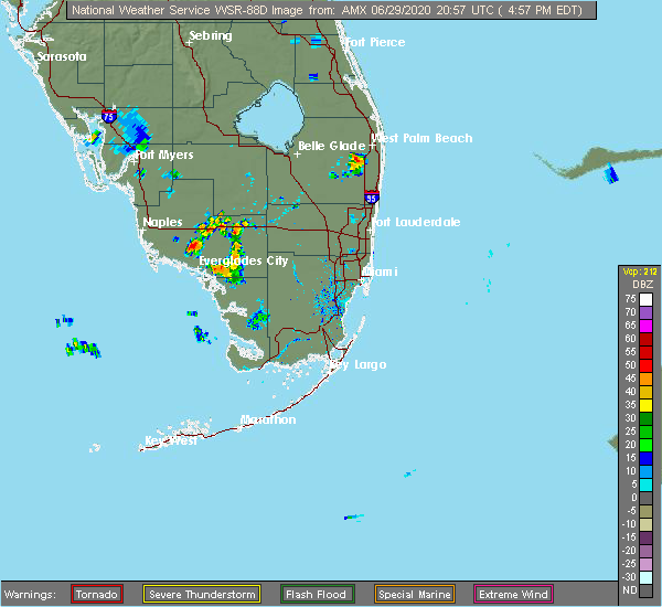 The national weather service in miami has issued a * severe thunderstorm warning for. east central palm beach county in southeastern florida. until 545 pm edt. At 458 pm edt, a severe thunderstorm was located over wellington, moving south at 5 mph. The national weather service in miami has issued a * severe thunderstorm warning for. east central palm beach county in southeastern florida. until 545 pm edt. At 458 pm edt, a severe thunderstorm was located over wellington, moving south at 5 mph.
|
| 6/19/2020 4:41 PM EDT |
 At 441 pm edt, a severe thunderstorm was located over atlantis, or near boynton beach, moving east at 5 mph (radar indicated). Hazards include 60 mph wind gusts and quarter size hail. Hail damage to vehicles is expected. Expect wind damage to roofs, siding, and trees. At 441 pm edt, a severe thunderstorm was located over atlantis, or near boynton beach, moving east at 5 mph (radar indicated). Hazards include 60 mph wind gusts and quarter size hail. Hail damage to vehicles is expected. Expect wind damage to roofs, siding, and trees.
|
| 6/8/2020 1:43 PM EDT |
 At 142 pm edt, a severe thunderstorm was located over loxahatchee nwr, or 9 miles south of wellington, moving north at 10 mph (radar indicated). Hazards include 60 mph wind gusts and penny size hail. expect damage to roofs, siding, and trees At 142 pm edt, a severe thunderstorm was located over loxahatchee nwr, or 9 miles south of wellington, moving north at 10 mph (radar indicated). Hazards include 60 mph wind gusts and penny size hail. expect damage to roofs, siding, and trees
|
| 5/27/2020 3:41 PM EDT |
 At 341 pm edt, severe thunderstorms were located along a line extending from 7 miles southwest of jonathan dickinson state park to palm beach gardens to near cloud lake, moving northeast at 30 mph (radar indicated). Hazards include 60 mph wind gusts and penny size hail. Expect damage to roofs, siding, and trees. Locations impacted include, west palm beach, wellington, jupiter, palm beach gardens and lake worth. At 341 pm edt, severe thunderstorms were located along a line extending from 7 miles southwest of jonathan dickinson state park to palm beach gardens to near cloud lake, moving northeast at 30 mph (radar indicated). Hazards include 60 mph wind gusts and penny size hail. Expect damage to roofs, siding, and trees. Locations impacted include, west palm beach, wellington, jupiter, palm beach gardens and lake worth.
|
| 5/27/2020 3:10 PM EDT |
 At 310 pm edt, severe thunderstorms were located along a line extending from 7 miles northwest of north county airport to near wellington to kings point, moving northeast at 20 mph (radar indicated). Hazards include 60 mph wind gusts and penny size hail. expect damage to roofs, siding, and trees At 310 pm edt, severe thunderstorms were located along a line extending from 7 miles northwest of north county airport to near wellington to kings point, moving northeast at 20 mph (radar indicated). Hazards include 60 mph wind gusts and penny size hail. expect damage to roofs, siding, and trees
|
| 5/21/2020 2:31 PM EDT |
 At 230 pm edt, a severe thunderstorm was located over the acreage, or near wellington, moving north at 15 mph (radar indicated). Hazards include 60 mph wind gusts and quarter size hail. Hail damage to vehicles is expected. expect wind damage to roofs, siding, and trees. Locations impacted include, west palm beach, wellington, palm beach gardens, riviera beach and juno beach. At 230 pm edt, a severe thunderstorm was located over the acreage, or near wellington, moving north at 15 mph (radar indicated). Hazards include 60 mph wind gusts and quarter size hail. Hail damage to vehicles is expected. expect wind damage to roofs, siding, and trees. Locations impacted include, west palm beach, wellington, palm beach gardens, riviera beach and juno beach.
|
| 5/21/2020 2:07 PM EDT |
 At 207 pm edt, a severe thunderstorm was located over wellington, moving north at 15 mph (radar indicated). Hazards include 60 mph wind gusts and quarter size hail. Hail damage to vehicles is expected. Expect wind damage to roofs, siding, and trees. At 207 pm edt, a severe thunderstorm was located over wellington, moving north at 15 mph (radar indicated). Hazards include 60 mph wind gusts and quarter size hail. Hail damage to vehicles is expected. Expect wind damage to roofs, siding, and trees.
|
| 5/18/2020 2:37 PM EDT |
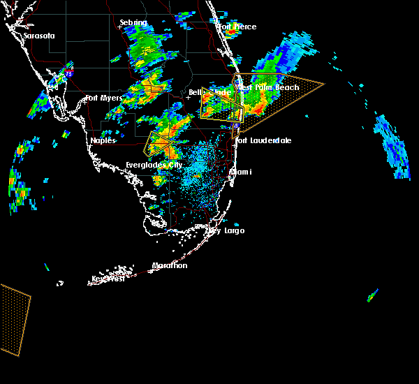 At 237 pm edt, severe thunderstorms were located along a line extending from 12 miles west of loxahatchee nwr to 8 miles southwest of lion country safari park, moving northeast at 15 mph (radar indicated). Hazards include 60 mph wind gusts and quarter size hail. Hail damage to vehicles is expected. expect wind damage to roofs, siding, and trees. Locations impacted include, wellington, greenacres, royal palm beach, lion country safari park and loxahatchee groves. At 237 pm edt, severe thunderstorms were located along a line extending from 12 miles west of loxahatchee nwr to 8 miles southwest of lion country safari park, moving northeast at 15 mph (radar indicated). Hazards include 60 mph wind gusts and quarter size hail. Hail damage to vehicles is expected. expect wind damage to roofs, siding, and trees. Locations impacted include, wellington, greenacres, royal palm beach, lion country safari park and loxahatchee groves.
|
| 5/18/2020 2:28 PM EDT |
 At 228 pm edt, severe thunderstorms were located along a line extending from 12 miles west of loxahatchee nwr to wellington, moving northeast at 15 mph (radar indicated). Hazards include 60 mph wind gusts and quarter size hail. Hail damage to vehicles is expected. expect wind damage to roofs, siding, and trees. Locations impacted include, boca raton, boynton beach, delray beach, wellington and lake worth. At 228 pm edt, severe thunderstorms were located along a line extending from 12 miles west of loxahatchee nwr to wellington, moving northeast at 15 mph (radar indicated). Hazards include 60 mph wind gusts and quarter size hail. Hail damage to vehicles is expected. expect wind damage to roofs, siding, and trees. Locations impacted include, boca raton, boynton beach, delray beach, wellington and lake worth.
|
| 5/18/2020 1:54 PM EDT |
 At 153 pm edt, a severe thunderstorm was located 8 miles west of loxahatchee nwr, or 14 miles north of coral springs, moving northeast at 20 mph (radar indicated). Hazards include 60 mph wind gusts and quarter size hail. Hail damage to vehicles is expected. Expect wind damage to roofs, siding, and trees. At 153 pm edt, a severe thunderstorm was located 8 miles west of loxahatchee nwr, or 14 miles north of coral springs, moving northeast at 20 mph (radar indicated). Hazards include 60 mph wind gusts and quarter size hail. Hail damage to vehicles is expected. Expect wind damage to roofs, siding, and trees.
|
| 5/17/2020 6:35 PM EDT |
 At 635 pm edt, severe thunderstorms were located along a line extending from 8 miles northwest of lion country safari park to near wellington, moving northeast at 15 mph (radar indicated). Hazards include 60 mph wind gusts and quarter size hail. Hail damage to vehicles is expected. expect wind damage to roofs, siding, and trees. Locations impacted include, west palm beach, boynton beach, wellington, jupiter and palm beach gardens. At 635 pm edt, severe thunderstorms were located along a line extending from 8 miles northwest of lion country safari park to near wellington, moving northeast at 15 mph (radar indicated). Hazards include 60 mph wind gusts and quarter size hail. Hail damage to vehicles is expected. expect wind damage to roofs, siding, and trees. Locations impacted include, west palm beach, boynton beach, wellington, jupiter and palm beach gardens.
|
| 5/17/2020 6:11 PM EDT |
 At 611 pm edt, severe thunderstorms were located along a line extending from 10 miles east of fremd village-padgett island to near lion country safari park, moving east at 20 mph (radar indicated). Hazards include 60 mph wind gusts and quarter size hail. Hail damage to vehicles is expected. Expect wind damage to roofs, siding, and trees. At 611 pm edt, severe thunderstorms were located along a line extending from 10 miles east of fremd village-padgett island to near lion country safari park, moving east at 20 mph (radar indicated). Hazards include 60 mph wind gusts and quarter size hail. Hail damage to vehicles is expected. Expect wind damage to roofs, siding, and trees.
|
| 4/26/2020 1:24 PM EDT |
 At 124 pm edt, a severe thunderstorm was located near loxahatchee nwr, or near boynton beach, moving east at 25 mph (radar indicated). Hazards include 60 mph wind gusts and penny size hail. expect damage to roofs, siding, and trees At 124 pm edt, a severe thunderstorm was located near loxahatchee nwr, or near boynton beach, moving east at 25 mph (radar indicated). Hazards include 60 mph wind gusts and penny size hail. expect damage to roofs, siding, and trees
|
| 4/26/2020 1:15 PM EDT |
 At 115 pm edt, a severe thunderstorm was located over the acreage, or 8 miles west of palm beach gardens, moving east at 25 mph (radar indicated). Hazards include 70 mph wind gusts and quarter size hail. Hail damage to vehicles is expected. expect considerable tree damage. wind damage is also likely to mobile homes, roofs, and outbuildings. Locations impacted include, west palm beach, jupiter, palm beach gardens, lake worth and riviera beach. At 115 pm edt, a severe thunderstorm was located over the acreage, or 8 miles west of palm beach gardens, moving east at 25 mph (radar indicated). Hazards include 70 mph wind gusts and quarter size hail. Hail damage to vehicles is expected. expect considerable tree damage. wind damage is also likely to mobile homes, roofs, and outbuildings. Locations impacted include, west palm beach, jupiter, palm beach gardens, lake worth and riviera beach.
|
| 4/26/2020 1:05 PM EDT |
 At 105 pm edt, a severe thunderstorm was located near the acreage, or 10 miles north of wellington, and is nearly stationary (radar indicated). Hazards include 70 mph wind gusts and quarter size hail. Hail damage to vehicles is expected. expect considerable tree damage. wind damage is also likely to mobile homes, roofs, and outbuildings. Locations impacted include, west palm beach, boynton beach, wellington, jupiter and palm beach gardens. At 105 pm edt, a severe thunderstorm was located near the acreage, or 10 miles north of wellington, and is nearly stationary (radar indicated). Hazards include 70 mph wind gusts and quarter size hail. Hail damage to vehicles is expected. expect considerable tree damage. wind damage is also likely to mobile homes, roofs, and outbuildings. Locations impacted include, west palm beach, boynton beach, wellington, jupiter and palm beach gardens.
|
| 4/26/2020 12:43 PM EDT |
 At 1243 pm edt, a severe thunderstorm was located 9 miles northwest of lion country safari park, or 11 miles east of canal point, moving east at 25 mph (radar indicated). Hazards include 70 mph wind gusts and quarter size hail. Hail damage to vehicles is expected. expect considerable tree damage. wind damage is also likely to mobile homes, roofs, and outbuildings. Locations impacted include, west palm beach, boynton beach, wellington, jupiter and palm beach gardens. At 1243 pm edt, a severe thunderstorm was located 9 miles northwest of lion country safari park, or 11 miles east of canal point, moving east at 25 mph (radar indicated). Hazards include 70 mph wind gusts and quarter size hail. Hail damage to vehicles is expected. expect considerable tree damage. wind damage is also likely to mobile homes, roofs, and outbuildings. Locations impacted include, west palm beach, boynton beach, wellington, jupiter and palm beach gardens.
|
| 4/26/2020 12:29 PM EDT |
 At 1228 pm edt, a severe thunderstorm was located near canal point, moving east at 25 mph (radar indicated). Hazards include 60 mph wind gusts and quarter size hail. Hail damage to vehicles is expected. Expect wind damage to roofs, siding, and trees. At 1228 pm edt, a severe thunderstorm was located near canal point, moving east at 25 mph (radar indicated). Hazards include 60 mph wind gusts and quarter size hail. Hail damage to vehicles is expected. Expect wind damage to roofs, siding, and trees.
|
| 8/6/2019 4:26 PM EDT |
 The severe thunderstorm warning for eastern palm beach county will expire at 430 pm edt, the storms which prompted the warning have weakened below severe limits, and have exited the warned area. therefore, the warning will be allowed to expire. however gusty winds and heavy rain are still possible with these thunderstorms. The severe thunderstorm warning for eastern palm beach county will expire at 430 pm edt, the storms which prompted the warning have weakened below severe limits, and have exited the warned area. therefore, the warning will be allowed to expire. however gusty winds and heavy rain are still possible with these thunderstorms.
|
| 8/6/2019 4:05 PM EDT |
 At 405 pm edt, severe thunderstorms were located along a line extending from near riviera beach to lantana to near boca del mar, moving east at 10 mph (radar indicated). Hazards include 60 mph wind gusts. Expect damage to roofs, siding, and trees. Locations impacted include, west palm beach, boca raton, deerfield beach, boynton beach and delray beach. At 405 pm edt, severe thunderstorms were located along a line extending from near riviera beach to lantana to near boca del mar, moving east at 10 mph (radar indicated). Hazards include 60 mph wind gusts. Expect damage to roofs, siding, and trees. Locations impacted include, west palm beach, boca raton, deerfield beach, boynton beach and delray beach.
|
| 8/6/2019 3:53 PM EDT |
 At 353 pm edt, severe thunderstorms were located along a line extending from near riviera beach to lantana to mission bay, moving east at 15 mph (radar indicated). Hazards include 60 mph wind gusts. Expect damage to roofs, siding, and trees. Locations impacted include, west palm beach, boca raton, deerfield beach, boynton beach and delray beach. At 353 pm edt, severe thunderstorms were located along a line extending from near riviera beach to lantana to mission bay, moving east at 15 mph (radar indicated). Hazards include 60 mph wind gusts. Expect damage to roofs, siding, and trees. Locations impacted include, west palm beach, boca raton, deerfield beach, boynton beach and delray beach.
|
| 8/6/2019 3:38 PM EDT |
 At 338 pm edt, severe thunderstorms were located along a line extending from north palm beach to atlantis to near mission bay, moving east at 10 mph (radar indicated). Hazards include 60 mph wind gusts. expect damage to roofs, siding, and trees At 338 pm edt, severe thunderstorms were located along a line extending from north palm beach to atlantis to near mission bay, moving east at 10 mph (radar indicated). Hazards include 60 mph wind gusts. expect damage to roofs, siding, and trees
|
| 7/25/2019 4:08 PM EDT |
 The severe thunderstorm warning for east central palm beach county will expire at 415 pm edt, the storms which prompted the warning have weakened below severe limits, and no longer pose an immediate threat to life or property. therefore, the warning will be allowed to expire. however gusty winds and heavy rain are still possible with these thunderstorms. The severe thunderstorm warning for east central palm beach county will expire at 415 pm edt, the storms which prompted the warning have weakened below severe limits, and no longer pose an immediate threat to life or property. therefore, the warning will be allowed to expire. however gusty winds and heavy rain are still possible with these thunderstorms.
|
| 7/25/2019 4:00 PM EDT |
 At 358 pm edt, severe thunderstorms were located along a line extending from riviera beach to downtown west palm beach, moving east at 10 mph. a tornado warning remains in effect until 415pm for a small portion of palm beach county near haverhill (radar indicated). Hazards include 60 mph wind gusts and quarter size hail. Hail damage to vehicles is expected. expect wind damage to roofs, siding, and trees. Locations impacted include, west palm beach, palm beach gardens, lake worth, riviera beach and palm beach. At 358 pm edt, severe thunderstorms were located along a line extending from riviera beach to downtown west palm beach, moving east at 10 mph. a tornado warning remains in effect until 415pm for a small portion of palm beach county near haverhill (radar indicated). Hazards include 60 mph wind gusts and quarter size hail. Hail damage to vehicles is expected. expect wind damage to roofs, siding, and trees. Locations impacted include, west palm beach, palm beach gardens, lake worth, riviera beach and palm beach.
|
| 7/25/2019 3:46 PM EDT |
 At 346 pm edt, severe thunderstorms were located along a line extending from lake park to palm beach international airport, moving east at 10 mph (radar indicated). Hazards include 60 mph wind gusts and quarter size hail. Hail damage to vehicles is expected. Expect wind damage to roofs, siding, and trees. At 346 pm edt, severe thunderstorms were located along a line extending from lake park to palm beach international airport, moving east at 10 mph (radar indicated). Hazards include 60 mph wind gusts and quarter size hail. Hail damage to vehicles is expected. Expect wind damage to roofs, siding, and trees.
|
| 6/28/2019 5:35 PM EDT |
 The severe thunderstorm warning for central palm beach county will expire at 545 pm edt, the storms which prompted the warning have weakened. therefore, the warning will be allowed to expire. however gusty winds are still possible with these thunderstorms. to report severe weather, contact your nearest law enforcement agency. they will relay your report to the national weather service miami. The severe thunderstorm warning for central palm beach county will expire at 545 pm edt, the storms which prompted the warning have weakened. therefore, the warning will be allowed to expire. however gusty winds are still possible with these thunderstorms. to report severe weather, contact your nearest law enforcement agency. they will relay your report to the national weather service miami.
|
| 6/28/2019 5:17 PM EDT |
 At 516 pm edt, severe thunderstorms were located along a line extending from near schall circle to 8 miles southwest of lion country safari park, moving west at 30 mph (radar indicated). Hazards include 60 mph wind gusts and penny size hail. Expect damage to roofs, siding, and trees. Locations impacted include, west palm beach, wellington, palm beach gardens, riviera beach and greenacres. At 516 pm edt, severe thunderstorms were located along a line extending from near schall circle to 8 miles southwest of lion country safari park, moving west at 30 mph (radar indicated). Hazards include 60 mph wind gusts and penny size hail. Expect damage to roofs, siding, and trees. Locations impacted include, west palm beach, wellington, palm beach gardens, riviera beach and greenacres.
|
| 6/28/2019 5:01 PM EDT |
 At 501 pm edt, severe thunderstorms were located along a line extending from 6 miles northeast of palm beach to near lion country safari park, moving west at 25 mph (radar indicated). Hazards include 60 mph wind gusts and penny size hail. expect damage to roofs, siding, and trees At 501 pm edt, severe thunderstorms were located along a line extending from 6 miles northeast of palm beach to near lion country safari park, moving west at 25 mph (radar indicated). Hazards include 60 mph wind gusts and penny size hail. expect damage to roofs, siding, and trees
|
| 6/12/2019 5:54 PM EDT |
 The severe thunderstorm warning for eastern palm beach county will expire at 600 pm edt, the storm which prompted the warning has weakened below severe limits, and no longer poses an immediate threat to life or property. therefore, the warning will be allowed to expire. however small hail and gusty winds are still possible with this thunderstorm and a significant weather advisory has been issued. to report severe weather, contact your nearest law enforcement agency. they will relay your report to the national weather service miami. The severe thunderstorm warning for eastern palm beach county will expire at 600 pm edt, the storm which prompted the warning has weakened below severe limits, and no longer poses an immediate threat to life or property. therefore, the warning will be allowed to expire. however small hail and gusty winds are still possible with this thunderstorm and a significant weather advisory has been issued. to report severe weather, contact your nearest law enforcement agency. they will relay your report to the national weather service miami.
|
| 6/12/2019 5:25 PM EDT |
 At 524 pm edt, a severe thunderstorm was located 7 miles south of lion country safari park, or 9 miles southwest of wellington, moving northeast at 15 mph (radar indicated). Hazards include 60 mph wind gusts and quarter size hail. Hail damage to vehicles is expected. Expect wind damage to roofs, siding, and trees. At 524 pm edt, a severe thunderstorm was located 7 miles south of lion country safari park, or 9 miles southwest of wellington, moving northeast at 15 mph (radar indicated). Hazards include 60 mph wind gusts and quarter size hail. Hail damage to vehicles is expected. Expect wind damage to roofs, siding, and trees.
|
| 6/12/2019 5:03 PM EDT |
 At 503 pm edt, a severe thunderstorm was located 8 miles south of lion country safari park, or 10 miles southwest of wellington, moving northeast at 15 mph (radar indicated). Hazards include 60 mph wind gusts and quarter size hail. Hail damage to vehicles is expected. Expect wind damage to roofs, siding, and trees. At 503 pm edt, a severe thunderstorm was located 8 miles south of lion country safari park, or 10 miles southwest of wellington, moving northeast at 15 mph (radar indicated). Hazards include 60 mph wind gusts and quarter size hail. Hail damage to vehicles is expected. Expect wind damage to roofs, siding, and trees.
|
| 5/12/2019 5:20 PM EDT |
 The severe thunderstorm warning for northeastern palm beach county will expire at 530 pm edt, the storm which prompted the warning has weakened below severe limits, and no longer poses an immediate threat to life or property. therefore, the warning will be allowed to expire. The severe thunderstorm warning for northeastern palm beach county will expire at 530 pm edt, the storm which prompted the warning has weakened below severe limits, and no longer poses an immediate threat to life or property. therefore, the warning will be allowed to expire.
|
| 5/12/2019 4:58 PM EDT |
 At 458 pm edt, a severe thunderstorm was located over loxahatchee groves, or near wellington, moving north at 25 mph (radar indicated). Hazards include 60 mph wind gusts and quarter size hail. Hail damage to vehicles is expected. expect wind damage to roofs, siding, and trees. Locations impacted include, west palm beach, wellington, greenacres, royal palm beach and palm springs. At 458 pm edt, a severe thunderstorm was located over loxahatchee groves, or near wellington, moving north at 25 mph (radar indicated). Hazards include 60 mph wind gusts and quarter size hail. Hail damage to vehicles is expected. expect wind damage to roofs, siding, and trees. Locations impacted include, west palm beach, wellington, greenacres, royal palm beach and palm springs.
|
| 5/12/2019 4:41 PM EDT |
 At 441 pm edt, a severe thunderstorm was located near wellington, moving northeast at 10 mph (radar indicated). Hazards include 60 mph wind gusts and quarter size hail. Hail damage to vehicles is expected. Expect wind damage to roofs, siding, and trees. At 441 pm edt, a severe thunderstorm was located near wellington, moving northeast at 10 mph (radar indicated). Hazards include 60 mph wind gusts and quarter size hail. Hail damage to vehicles is expected. Expect wind damage to roofs, siding, and trees.
|
| 5/7/2019 4:28 PM EDT |
 At 428 pm edt, severe thunderstorms were located along a line extending from schall circle to loxahatchee nwr, moving southeast at 20 mph (radar indicated). Hazards include 60 mph wind gusts and penny size hail. Expect damage to roofs, siding, and trees. Locations impacted include, west palm beach, wellington, palm beach gardens, riviera beach and greenacres. At 428 pm edt, severe thunderstorms were located along a line extending from schall circle to loxahatchee nwr, moving southeast at 20 mph (radar indicated). Hazards include 60 mph wind gusts and penny size hail. Expect damage to roofs, siding, and trees. Locations impacted include, west palm beach, wellington, palm beach gardens, riviera beach and greenacres.
|
| 5/7/2019 4:09 PM EDT |
 At 409 pm edt, severe thunderstorms were located along a line extending from near north county airport to near wellington, moving east at 15 mph (radar indicated). Hazards include 60 mph wind gusts and penny size hail. expect damage to roofs, siding, and trees At 409 pm edt, severe thunderstorms were located along a line extending from near north county airport to near wellington, moving east at 15 mph (radar indicated). Hazards include 60 mph wind gusts and penny size hail. expect damage to roofs, siding, and trees
|
| 6/5/2018 7:55 PM EDT |
 The severe thunderstorm warning for east central palm beach county will expire at 800 pm edt, the storm which prompted the warning has weakened below severe limits, and no longer poses an immediate threat to life or property. therefore, the warning will be allowed to expire. however small hail and gusty winds are still possible with this thunderstorm. The severe thunderstorm warning for east central palm beach county will expire at 800 pm edt, the storm which prompted the warning has weakened below severe limits, and no longer poses an immediate threat to life or property. therefore, the warning will be allowed to expire. however small hail and gusty winds are still possible with this thunderstorm.
|
| 6/5/2018 7:41 PM EDT |
 At 740 pm edt, a severe thunderstorm was located over atlantis, or near boynton beach, moving southeast at 15 mph (radar indicated). Hazards include 60 mph wind gusts. Expect damage to roofs, siding, and trees. locations impacted include, boynton beach, delray beach, wellington, lake worth and palm beach. A trained spotter reported pea size hail jog road and lantana road along with wind gusts estimated at 50 to 60 mph with these severe thunderstorm. At 740 pm edt, a severe thunderstorm was located over atlantis, or near boynton beach, moving southeast at 15 mph (radar indicated). Hazards include 60 mph wind gusts. Expect damage to roofs, siding, and trees. locations impacted include, boynton beach, delray beach, wellington, lake worth and palm beach. A trained spotter reported pea size hail jog road and lantana road along with wind gusts estimated at 50 to 60 mph with these severe thunderstorm.
|
| 6/5/2018 7:30 PM EDT |
 At 730 pm edt, a severe thunderstorm was located over atlantis, or near boynton beach, moving southeast at 15 mph (radar indicated). Hazards include 60 mph wind gusts. expect damage to roofs, siding, and trees At 730 pm edt, a severe thunderstorm was located over atlantis, or near boynton beach, moving southeast at 15 mph (radar indicated). Hazards include 60 mph wind gusts. expect damage to roofs, siding, and trees
|
| 4/27/2018 4:08 PM EDT |
 The national weather service in miami has issued a * severe thunderstorm warning for. northeastern palm beach county in southeastern florida. until 445 pm edt. At 408 pm edt, a severe thunderstorm was located over loxahatchee groves, or near wellington, moving northeast at 10 mph. The national weather service in miami has issued a * severe thunderstorm warning for. northeastern palm beach county in southeastern florida. until 445 pm edt. At 408 pm edt, a severe thunderstorm was located over loxahatchee groves, or near wellington, moving northeast at 10 mph.
|
| 4/27/2018 2:42 PM EDT |
 At 241 pm edt, a tornado producing storm was located over parkland, or over coral springs, moving east at 10 mph (radar confirmed tornado). Hazards include damaging tornado. Flying debris will be dangerous to those caught without shelter. mobile homes will be damaged or destroyed. damage to roofs, windows, and vehicles will occur. tree damage is likely. this tornadic storm will be near, parkland and loxahatchee nwr around 245 pm edt. godfrey road around 250 pm edt. margate around 255 pm edt. coconut creek and mission bay around 305 pm edt. hamptons at boca raton and whisper walk around 310 pm edt. pompano beach, deerfield beach, boca pointe and boca del mar around 315 pm edt. Other locations impacted by this tornadic thunderstorm include lakeside green, hillsboro ranches, aberdeen, hillsboro pines, north pompano beach, boca west, plantation mobile home park, ramblewood east, aberdeen golf course and south county regional park. At 241 pm edt, a tornado producing storm was located over parkland, or over coral springs, moving east at 10 mph (radar confirmed tornado). Hazards include damaging tornado. Flying debris will be dangerous to those caught without shelter. mobile homes will be damaged or destroyed. damage to roofs, windows, and vehicles will occur. tree damage is likely. this tornadic storm will be near, parkland and loxahatchee nwr around 245 pm edt. godfrey road around 250 pm edt. margate around 255 pm edt. coconut creek and mission bay around 305 pm edt. hamptons at boca raton and whisper walk around 310 pm edt. pompano beach, deerfield beach, boca pointe and boca del mar around 315 pm edt. Other locations impacted by this tornadic thunderstorm include lakeside green, hillsboro ranches, aberdeen, hillsboro pines, north pompano beach, boca west, plantation mobile home park, ramblewood east, aberdeen golf course and south county regional park.
|
| 4/27/2018 2:39 PM EDT |
 The national weather service in miami has issued a * tornado warning for. northern broward county in southeastern florida. southeastern palm beach county in southeastern florida. until 315 pm edt. At 239 pm edt, a severe thunderstorm capable of producing a tornado. The national weather service in miami has issued a * tornado warning for. northern broward county in southeastern florida. southeastern palm beach county in southeastern florida. until 315 pm edt. At 239 pm edt, a severe thunderstorm capable of producing a tornado.
|
| 4/15/2018 8:27 PM EDT |
 The severe thunderstorm warning for east central palm beach county will expire at 830 pm edt, the storm which prompted the warning has moved out of the area. therefore, the warning will be allowed to expire. The severe thunderstorm warning for east central palm beach county will expire at 830 pm edt, the storm which prompted the warning has moved out of the area. therefore, the warning will be allowed to expire.
|
| 4/15/2018 8:13 PM EDT |
 At 813 pm edt, a severe thunderstorm was located over the acreage, or near wellington, moving northeast at 25 mph (radar indicated). Hazards include 60 mph wind gusts. Expect damage to roofs, siding, and trees. Locations impacted include, west palm beach, wellington, jupiter, palm beach gardens and riviera beach. At 813 pm edt, a severe thunderstorm was located over the acreage, or near wellington, moving northeast at 25 mph (radar indicated). Hazards include 60 mph wind gusts. Expect damage to roofs, siding, and trees. Locations impacted include, west palm beach, wellington, jupiter, palm beach gardens and riviera beach.
|
| 4/15/2018 7:55 PM EDT |
 At 755 pm edt, a severe thunderstorm was located over wellington, moving northeast at 55 mph (radar indicated). Hazards include 70 mph wind gusts. Expect considerable tree damage. Damage is likely to mobile homes, roofs, and outbuildings. At 755 pm edt, a severe thunderstorm was located over wellington, moving northeast at 55 mph (radar indicated). Hazards include 70 mph wind gusts. Expect considerable tree damage. Damage is likely to mobile homes, roofs, and outbuildings.
|
| 4/10/2018 3:43 PM EDT |
 At 343 pm edt, a severe thunderstorm was located over greenacres, or near lake worth, moving southeast at 25 mph (radar indicated). Hazards include 60 mph wind gusts and penny size hail. expect damage to roofs, siding, and trees At 343 pm edt, a severe thunderstorm was located over greenacres, or near lake worth, moving southeast at 25 mph (radar indicated). Hazards include 60 mph wind gusts and penny size hail. expect damage to roofs, siding, and trees
|
| 10/28/2017 5:56 PM EDT |
 The tornado warning for east central palm beach county will expire at 600 pm edt, the storm which prompted the warning has weakened below severe limits, and no longer appears capable of producing a tornado. therefore the warning will be allowed to expire. The tornado warning for east central palm beach county will expire at 600 pm edt, the storm which prompted the warning has weakened below severe limits, and no longer appears capable of producing a tornado. therefore the warning will be allowed to expire.
|
| 10/28/2017 5:39 PM EDT |
 At 539 pm edt, a severe thunderstorm capable of producing a tornado was located near boynton beach, moving north at 25 mph (radar indicated rotation). Hazards include tornado. Flying debris will be dangerous to those caught without shelter. mobile homes will be damaged or destroyed. damage to roofs, windows, and vehicles will occur. tree damage is likely. this dangerous storm will be near, lantana around 545 pm edt. palm beach and atlantis around 550 pm edt. lake worth, greenacres and palm springs around 555 pm edt. wellington, royal palm beach, haverhill, cloud lake, lake belvedere estates, royal palm estates, gun club estates, golden lakes, schall circle and palm beach international airport around 600 pm edt. Other locations impacted by this tornadic thunderstorm include lakeside green, aberdeen, glen ridge, plantation mobile home park, lake worth corridor, aberdeen golf course, lake clarke shores, stacey street, florida gardens and century village. At 539 pm edt, a severe thunderstorm capable of producing a tornado was located near boynton beach, moving north at 25 mph (radar indicated rotation). Hazards include tornado. Flying debris will be dangerous to those caught without shelter. mobile homes will be damaged or destroyed. damage to roofs, windows, and vehicles will occur. tree damage is likely. this dangerous storm will be near, lantana around 545 pm edt. palm beach and atlantis around 550 pm edt. lake worth, greenacres and palm springs around 555 pm edt. wellington, royal palm beach, haverhill, cloud lake, lake belvedere estates, royal palm estates, gun club estates, golden lakes, schall circle and palm beach international airport around 600 pm edt. Other locations impacted by this tornadic thunderstorm include lakeside green, aberdeen, glen ridge, plantation mobile home park, lake worth corridor, aberdeen golf course, lake clarke shores, stacey street, florida gardens and century village.
|
| 9/10/2017 4:20 PM EDT |
 The tornado warning for southeastern palm beach county will expire at 430 pm edt, the tornadic thunderstorm which prompted the warning has weakened. therefore, the warning will be allowed to expire. The tornado warning for southeastern palm beach county will expire at 430 pm edt, the tornadic thunderstorm which prompted the warning has weakened. therefore, the warning will be allowed to expire.
|
| 9/10/2017 4:09 PM EDT |
 At 409 pm edt, a severe thunderstorm capable of producing a tornado was located over highland beach, moving northwest at 75 mph (radar indicated rotation). Hazards include tornado. Flying debris will be dangerous to those caught without shelter. mobile homes will be damaged or destroyed. damage to roofs, windows, and vehicles will occur. tree damage is likely. Locations impacted include, boca raton, boynton beach, delray beach, highland beach and ocean ridge. At 409 pm edt, a severe thunderstorm capable of producing a tornado was located over highland beach, moving northwest at 75 mph (radar indicated rotation). Hazards include tornado. Flying debris will be dangerous to those caught without shelter. mobile homes will be damaged or destroyed. damage to roofs, windows, and vehicles will occur. tree damage is likely. Locations impacted include, boca raton, boynton beach, delray beach, highland beach and ocean ridge.
|
| 9/10/2017 4:03 PM EDT |
 At 400 pm edt, the circulation from the severe thunderstorm east of pompano beach has dissipated. however, the severe thunderstorm east of fort lauderdale has moved northwest to 10 miles east of pompano beach and tightened. this severe thunderstorm is moving northwest at 50 mph (radar indicated rotation). Hazards include tornado. Flying debris will be dangerous to those caught without shelter. mobile homes will be damaged or destroyed. damage to roofs, windows, and vehicles will occur. tree damage is likely. Locations impacted include, pompano beach, boca raton, deerfield beach, boynton beach and delray beach. At 400 pm edt, the circulation from the severe thunderstorm east of pompano beach has dissipated. however, the severe thunderstorm east of fort lauderdale has moved northwest to 10 miles east of pompano beach and tightened. this severe thunderstorm is moving northwest at 50 mph (radar indicated rotation). Hazards include tornado. Flying debris will be dangerous to those caught without shelter. mobile homes will be damaged or destroyed. damage to roofs, windows, and vehicles will occur. tree damage is likely. Locations impacted include, pompano beach, boca raton, deerfield beach, boynton beach and delray beach.
|
| 9/10/2017 4:00 PM EDT |
 At 400 pm edt, a severe thunderstorm capable of producing a tornado was located over greenacres, or near lake worth, moving northwest at 75 mph (radar indicated rotation). Hazards include tornado. Flying debris will be dangerous to those caught without shelter. mobile homes will be damaged or destroyed. damage to roofs, windows, and vehicles will occur. tree damage is likely. Locations impacted include, west palm beach, wellington, lake worth, riviera beach and greenacres. At 400 pm edt, a severe thunderstorm capable of producing a tornado was located over greenacres, or near lake worth, moving northwest at 75 mph (radar indicated rotation). Hazards include tornado. Flying debris will be dangerous to those caught without shelter. mobile homes will be damaged or destroyed. damage to roofs, windows, and vehicles will occur. tree damage is likely. Locations impacted include, west palm beach, wellington, lake worth, riviera beach and greenacres.
|
| 9/10/2017 3:53 PM EDT |
 At 353 pm edt, a severe thunderstorm located east of pompano beach and another severe thunderstorm located east of fort lauderdale are moving northwest at 55 mph (radar indicated rotation). Hazards include tornado. Flying debris will be dangerous to those caught without shelter. mobile homes will be damaged or destroyed. damage to roofs, windows, and vehicles will occur. Tree damage is likely. At 353 pm edt, a severe thunderstorm located east of pompano beach and another severe thunderstorm located east of fort lauderdale are moving northwest at 55 mph (radar indicated rotation). Hazards include tornado. Flying debris will be dangerous to those caught without shelter. mobile homes will be damaged or destroyed. damage to roofs, windows, and vehicles will occur. Tree damage is likely.
|
| 9/10/2017 3:48 PM EDT |
 At 348 pm edt, a severe thunderstorm capable of producing a tornado was located near delray beach, moving northwest at 75 mph (radar indicated rotation). Hazards include tornado. Flying debris will be dangerous to those caught without shelter. mobile homes will be damaged or destroyed. damage to roofs, windows, and vehicles will occur. tree damage is likely. this dangerous storm will be near, boynton beach and palm beach around 355 pm edt. lake worth, greenacres, palm springs, lantana, atlantis, cloud lake, gun club estates, palm beach international airport and downtown west palm beach around 400 pm edt. wellington, haverhill, golden lakes, lake belvedere estates, royal palm estates and schall circle around 405 pm edt. west palm beach, royal palm beach and loxahatchee groves around 410 pm edt. Other locations impacted by this tornadic thunderstorm include lakeside green, hypoluxo, aberdeen, glen ridge, plantation mobile home park, lake worth corridor, aberdeen golf course, lake clarke shores, gulf stream and mangonia park. At 348 pm edt, a severe thunderstorm capable of producing a tornado was located near delray beach, moving northwest at 75 mph (radar indicated rotation). Hazards include tornado. Flying debris will be dangerous to those caught without shelter. mobile homes will be damaged or destroyed. damage to roofs, windows, and vehicles will occur. tree damage is likely. this dangerous storm will be near, boynton beach and palm beach around 355 pm edt. lake worth, greenacres, palm springs, lantana, atlantis, cloud lake, gun club estates, palm beach international airport and downtown west palm beach around 400 pm edt. wellington, haverhill, golden lakes, lake belvedere estates, royal palm estates and schall circle around 405 pm edt. west palm beach, royal palm beach and loxahatchee groves around 410 pm edt. Other locations impacted by this tornadic thunderstorm include lakeside green, hypoluxo, aberdeen, glen ridge, plantation mobile home park, lake worth corridor, aberdeen golf course, lake clarke shores, gulf stream and mangonia park.
|
| 9/10/2017 2:36 PM EDT |
 At 236 pm edt, a severe thunderstorm capable of producing a tornado was located over kings point, or near highland beach, moving northwest at 90 mph (radar indicated rotation). Hazards include tornado. Flying debris will be dangerous to those caught without shelter. mobile homes will be damaged or destroyed. damage to roofs, windows, and vehicles will occur. tree damage is likely. this dangerous storm will be near, atlantis and greenacres. Other locations impacted by this tornadic thunderstorm include morikami park, fau south campus, aberdeen, boca west, villages of oriole, aberdeen golf course, boca raton equestrian and gulf stream. At 236 pm edt, a severe thunderstorm capable of producing a tornado was located over kings point, or near highland beach, moving northwest at 90 mph (radar indicated rotation). Hazards include tornado. Flying debris will be dangerous to those caught without shelter. mobile homes will be damaged or destroyed. damage to roofs, windows, and vehicles will occur. tree damage is likely. this dangerous storm will be near, atlantis and greenacres. Other locations impacted by this tornadic thunderstorm include morikami park, fau south campus, aberdeen, boca west, villages of oriole, aberdeen golf course, boca raton equestrian and gulf stream.
|
| 9/10/2017 2:31 PM EDT |
 At 231 pm edt, a severe thunderstorm capable of producing a tornado was located over boca raton, moving northwest at 85 mph (radar indicated rotation). Hazards include tornado. Flying debris will be dangerous to those caught without shelter. mobile homes will be damaged or destroyed. damage to roofs, windows, and vehicles will occur. tree damage is likely. this dangerous storm will be near, delray beach, whisper walk, hamptons at boca raton and mission bay around 235 pm edt. boynton beach, village of golf, kings point and dunes road around 240 pm edt. greenacres and atlantis around 245 pm edt. Other locations impacted by this tornadic thunderstorm include fau south campus, hypoluxo, hillsboro ranches, aberdeen, boca west, hillsboro pines, lake worth corridor, aberdeen golf course, south county regional park and gulf stream. At 231 pm edt, a severe thunderstorm capable of producing a tornado was located over boca raton, moving northwest at 85 mph (radar indicated rotation). Hazards include tornado. Flying debris will be dangerous to those caught without shelter. mobile homes will be damaged or destroyed. damage to roofs, windows, and vehicles will occur. tree damage is likely. this dangerous storm will be near, delray beach, whisper walk, hamptons at boca raton and mission bay around 235 pm edt. boynton beach, village of golf, kings point and dunes road around 240 pm edt. greenacres and atlantis around 245 pm edt. Other locations impacted by this tornadic thunderstorm include fau south campus, hypoluxo, hillsboro ranches, aberdeen, boca west, hillsboro pines, lake worth corridor, aberdeen golf course, south county regional park and gulf stream.
|
| 9/10/2017 2:24 PM EDT |
 At 224 pm edt, a severe thunderstorm capable of producing a tornado was located 7 miles east of pompano beach, moving northwest at 90 mph (radar indicated rotation). Hazards include tornado. Flying debris will be dangerous to those caught without shelter. mobile homes will be damaged or destroyed. damage to roofs, windows, and vehicles will occur. tree damage is likely. this dangerous storm will be near, deerfield beach and boca del mar around 230 pm edt. boca raton, delray beach, highland beach, kings point, whisper walk, hamptons at boca raton, boca pointe and mission bay around 235 pm edt. boynton beach, ocean ridge, lantana, atlantis, village of golf and dunes road around 240 pm edt. greenacres around 245 pm edt. Other locations impacted by this tornadic thunderstorm include fau south campus, hypoluxo, hillsboro ranches, aberdeen, boca west, hillsboro pines, lake worth corridor, aberdeen golf course, south county regional park and gulf stream. At 224 pm edt, a severe thunderstorm capable of producing a tornado was located 7 miles east of pompano beach, moving northwest at 90 mph (radar indicated rotation). Hazards include tornado. Flying debris will be dangerous to those caught without shelter. mobile homes will be damaged or destroyed. damage to roofs, windows, and vehicles will occur. tree damage is likely. this dangerous storm will be near, deerfield beach and boca del mar around 230 pm edt. boca raton, delray beach, highland beach, kings point, whisper walk, hamptons at boca raton, boca pointe and mission bay around 235 pm edt. boynton beach, ocean ridge, lantana, atlantis, village of golf and dunes road around 240 pm edt. greenacres around 245 pm edt. Other locations impacted by this tornadic thunderstorm include fau south campus, hypoluxo, hillsboro ranches, aberdeen, boca west, hillsboro pines, lake worth corridor, aberdeen golf course, south county regional park and gulf stream.
|
| 9/10/2017 6:45 AM EDT |
 At 645 am edt, a severe thunderstorm capable of producing a tornado was located over wellington, moving northwest at 60 mph (radar indicated rotation). Hazards include tornado. Flying debris will be dangerous to those caught without shelter. mobile homes will be damaged or destroyed. damage to roofs, windows, and vehicles will occur. tree damage is likely. this dangerous storm will be near, loxahatchee groves and the acreage around 650 am edt. Other locations impacted by this tornadic thunderstorm include florida gardens. At 645 am edt, a severe thunderstorm capable of producing a tornado was located over wellington, moving northwest at 60 mph (radar indicated rotation). Hazards include tornado. Flying debris will be dangerous to those caught without shelter. mobile homes will be damaged or destroyed. damage to roofs, windows, and vehicles will occur. tree damage is likely. this dangerous storm will be near, loxahatchee groves and the acreage around 650 am edt. Other locations impacted by this tornadic thunderstorm include florida gardens.
|
| 9/10/2017 6:21 AM EDT |
 At 620 am edt, a severe thunderstorm capable of producing a tornado was located 10 miles east of ocean ridge, moving northwest at 55 mph (radar indicated rotation). Hazards include tornado. Flying debris will be dangerous to those caught without shelter. mobile homes will be damaged or destroyed. damage to roofs, windows, and vehicles will occur. tree damage is likely. this dangerous storm will be near, delray beach around 630 am edt. boynton beach, palm beach, ocean ridge, lantana, village of golf and dunes road around 635 am edt. lake worth, greenacres, palm springs, atlantis, cloud lake, gun club estates, royal palm estates, palm beach international airport and downtown west palm beach around 640 am edt. wellington, haverhill, golden lakes, lake belvedere estates and schall circle around 645 am edt. royal palm beach and loxahatchee groves around 650 am edt. lion country safari park and the acreage around 655 am edt. Other locations impacted by this tornadic thunderstorm include lakeside green, hypoluxo, aberdeen, glen ridge, plantation mobile home park, lake worth corridor, aberdeen golf course, lake clarke shores, gulf stream and stacey street. At 620 am edt, a severe thunderstorm capable of producing a tornado was located 10 miles east of ocean ridge, moving northwest at 55 mph (radar indicated rotation). Hazards include tornado. Flying debris will be dangerous to those caught without shelter. mobile homes will be damaged or destroyed. damage to roofs, windows, and vehicles will occur. tree damage is likely. this dangerous storm will be near, delray beach around 630 am edt. boynton beach, palm beach, ocean ridge, lantana, village of golf and dunes road around 635 am edt. lake worth, greenacres, palm springs, atlantis, cloud lake, gun club estates, royal palm estates, palm beach international airport and downtown west palm beach around 640 am edt. wellington, haverhill, golden lakes, lake belvedere estates and schall circle around 645 am edt. royal palm beach and loxahatchee groves around 650 am edt. lion country safari park and the acreage around 655 am edt. Other locations impacted by this tornadic thunderstorm include lakeside green, hypoluxo, aberdeen, glen ridge, plantation mobile home park, lake worth corridor, aberdeen golf course, lake clarke shores, gulf stream and stacey street.
|
| 9/10/2017 3:46 AM EDT |
 At 346 am edt, severe thunderstorms capable of producing tornadoes were located along a line extending from ocean ridge to port everglades, moving northwest at 30 mph (radar indicated rotation). Hazards include tornado. Flying debris will be dangerous to those caught without shelter. mobile homes will be damaged or destroyed. damage to roofs, windows, and vehicles will occur. tree damage is likely. these dangerous storms will be near, boynton beach, delray beach, ocean ridge, village of golf and dunes road around 350 am edt. palm beach and lantana around 355 am edt. lake worth, greenacres and atlantis around 400 am edt. pompano beach, sunrise, palm springs and hillsboro beach around 405 am edt. tamarac, wellington, margate, lighthouse point and north lauderdale around 410 am edt. coral springs, deerfield beach, coconut creek, parkland, godfrey road, boca pointe, boca del mar, mission bay, hamptons at boca raton and whisper walk around 415 am edt. Other locations impacted by these tornadic storms include fau south campus, fort lauderdale beach, aberdeen, boca west, hillsboro pines, north andrews gardens, aberdeen golf course, terra mar, boulevard gardens and seminole manor. At 346 am edt, severe thunderstorms capable of producing tornadoes were located along a line extending from ocean ridge to port everglades, moving northwest at 30 mph (radar indicated rotation). Hazards include tornado. Flying debris will be dangerous to those caught without shelter. mobile homes will be damaged or destroyed. damage to roofs, windows, and vehicles will occur. tree damage is likely. these dangerous storms will be near, boynton beach, delray beach, ocean ridge, village of golf and dunes road around 350 am edt. palm beach and lantana around 355 am edt. lake worth, greenacres and atlantis around 400 am edt. pompano beach, sunrise, palm springs and hillsboro beach around 405 am edt. tamarac, wellington, margate, lighthouse point and north lauderdale around 410 am edt. coral springs, deerfield beach, coconut creek, parkland, godfrey road, boca pointe, boca del mar, mission bay, hamptons at boca raton and whisper walk around 415 am edt. Other locations impacted by these tornadic storms include fau south campus, fort lauderdale beach, aberdeen, boca west, hillsboro pines, north andrews gardens, aberdeen golf course, terra mar, boulevard gardens and seminole manor.
|
| 9/9/2017 7:12 PM EDT |
 At 712 pm edt, severe thunderstorms capable of producing tornadoes were located over atlantis, or over boynton beach, moving west at 35 mph (radar indicated rotation). Hazards include tornado. Flying debris will be dangerous to those caught without shelter. mobile homes will be damaged or destroyed. damage to roofs, windows, and vehicles will occur. tree damage is likely. these dangerous storms will be near, greenacres and royal palm estates around 715 pm edt. wellington around 720 pm edt. lion country safari park around 740 pm edt. belle glade around 800 pm edt. Other locations impacted by this tornadic thunderstorm include hypoluxo, aberdeen, glen ridge, plantation mobile home park, lake worth corridor, aberdeen golf course, lake clarke shores, gulf stream, stacey street and south palm beach. At 712 pm edt, severe thunderstorms capable of producing tornadoes were located over atlantis, or over boynton beach, moving west at 35 mph (radar indicated rotation). Hazards include tornado. Flying debris will be dangerous to those caught without shelter. mobile homes will be damaged or destroyed. damage to roofs, windows, and vehicles will occur. tree damage is likely. these dangerous storms will be near, greenacres and royal palm estates around 715 pm edt. wellington around 720 pm edt. lion country safari park around 740 pm edt. belle glade around 800 pm edt. Other locations impacted by this tornadic thunderstorm include hypoluxo, aberdeen, glen ridge, plantation mobile home park, lake worth corridor, aberdeen golf course, lake clarke shores, gulf stream, stacey street and south palm beach.
|
| 7/21/2017 1:21 PM EDT |
 The severe thunderstorm warning for southeastern palm beach county will expire at 130 pm edt, the storm which prompted the warning has weakened below severe limits, and has exited the warned area. therefore, the warning will be allowed to expire. however gusty winds are still possible with this thunderstorm. The severe thunderstorm warning for southeastern palm beach county will expire at 130 pm edt, the storm which prompted the warning has weakened below severe limits, and has exited the warned area. therefore, the warning will be allowed to expire. however gusty winds are still possible with this thunderstorm.
|
| 7/21/2017 1:02 PM EDT |
 At 102 pm edt, a severe thunderstorm was located over kings point, or near delray beach, moving northeast at 10 mph (radar indicated). Hazards include 60 mph wind gusts and penny size hail. Expect damage to roofs, siding, and trees. Locations impacted include, boca raton, boynton beach, delray beach, wellington and lake worth. At 102 pm edt, a severe thunderstorm was located over kings point, or near delray beach, moving northeast at 10 mph (radar indicated). Hazards include 60 mph wind gusts and penny size hail. Expect damage to roofs, siding, and trees. Locations impacted include, boca raton, boynton beach, delray beach, wellington and lake worth.
|
| 7/21/2017 12:50 PM EDT |
 At 1249 pm edt, a severe thunderstorm was located over kings point, or 7 miles west of highland beach, moving northeast at 10 mph (radar indicated). Hazards include 60 mph wind gusts and penny size hail. expect damage to roofs, siding, and trees At 1249 pm edt, a severe thunderstorm was located over kings point, or 7 miles west of highland beach, moving northeast at 10 mph (radar indicated). Hazards include 60 mph wind gusts and penny size hail. expect damage to roofs, siding, and trees
|
| 5/2/2017 6:03 PM EDT |
 At 603 pm edt, severe thunderstorms were located along a line extending from 7 miles west of north county airport to 8 miles southwest of lion country safari park, moving east at 30 mph (radar indicated). Hazards include 60 mph wind gusts and quarter size hail. Hail damage to vehicles is expected. expect wind damage to roofs, siding, and trees. Locations impacted include, west palm beach, wellington, jupiter, palm beach gardens and riviera beach. At 603 pm edt, severe thunderstorms were located along a line extending from 7 miles west of north county airport to 8 miles southwest of lion country safari park, moving east at 30 mph (radar indicated). Hazards include 60 mph wind gusts and quarter size hail. Hail damage to vehicles is expected. expect wind damage to roofs, siding, and trees. Locations impacted include, west palm beach, wellington, jupiter, palm beach gardens and riviera beach.
|
| 5/2/2017 5:40 PM EDT |
 At 540 pm edt, severe thunderstorms were located along a line extending from 6 miles southeast of indiantown to near belle glade, moving east at 35 mph (radar indicated). Hazards include 60 mph wind gusts and quarter size hail. Hail damage to vehicles is expected. Expect wind damage to roofs, siding, and trees. At 540 pm edt, severe thunderstorms were located along a line extending from 6 miles southeast of indiantown to near belle glade, moving east at 35 mph (radar indicated). Hazards include 60 mph wind gusts and quarter size hail. Hail damage to vehicles is expected. Expect wind damage to roofs, siding, and trees.
|
| 1/23/2017 2:21 AM EST |
 At 221 am est, severe thunderstorms were located along a line extending from near port of palm beach to palm springs to loxahatchee nwr, moving east at 45 mph (radar indicated). Hazards include 60 mph wind gusts. Expect damage to roofs, siding, and trees. locations impacted include, west palm beach, boynton beach, wellington, lake worth and riviera beach. A tornado watch remains in effect until 600 am est for southeastern florida. At 221 am est, severe thunderstorms were located along a line extending from near port of palm beach to palm springs to loxahatchee nwr, moving east at 45 mph (radar indicated). Hazards include 60 mph wind gusts. Expect damage to roofs, siding, and trees. locations impacted include, west palm beach, boynton beach, wellington, lake worth and riviera beach. A tornado watch remains in effect until 600 am est for southeastern florida.
|
| 1/7/2017 12:05 PM EST |
 The severe thunderstorm warning for northeastern palm beach county will expire at 1215 pm est, the storm which prompted the warning has moved out of the area. therefore the warning will be allowed to expire. however gusty winds are still possible with this thunderstorm. The severe thunderstorm warning for northeastern palm beach county will expire at 1215 pm est, the storm which prompted the warning has moved out of the area. therefore the warning will be allowed to expire. however gusty winds are still possible with this thunderstorm.
|
| 1/7/2017 11:48 AM EST |
 At 1148 am est, a severe thunderstorm was located near lake park, or near palm beach gardens, moving east at 15 mph (radar indicated). Hazards include 60 mph wind gusts and quarter size hail. Hail damage to vehicles is expected. expect wind damage to roofs, siding, and trees. Locations impacted include, west palm beach, jupiter, palm beach gardens, riviera beach and palm beach. At 1148 am est, a severe thunderstorm was located near lake park, or near palm beach gardens, moving east at 15 mph (radar indicated). Hazards include 60 mph wind gusts and quarter size hail. Hail damage to vehicles is expected. expect wind damage to roofs, siding, and trees. Locations impacted include, west palm beach, jupiter, palm beach gardens, riviera beach and palm beach.
|
| 1/7/2017 11:38 AM EST |
 At 1137 am est, a severe thunderstorm was located near schall circle, or near palm beach gardens, moving east at 15 mph (radar indicated). Hazards include 60 mph wind gusts and quarter size hail. Hail damage to vehicles is expected. Expect wind damage to roofs, siding, and trees. At 1137 am est, a severe thunderstorm was located near schall circle, or near palm beach gardens, moving east at 15 mph (radar indicated). Hazards include 60 mph wind gusts and quarter size hail. Hail damage to vehicles is expected. Expect wind damage to roofs, siding, and trees.
|
| 9/30/2016 2:51 PM EDT |
 At 251 pm edt, severe thunderstorms were located along a line extending from near greenacres to near whisper walk, moving south at 10 mph (radar indicated). Hazards include 60 mph wind gusts and quarter size hail. Hail damage to vehicles is expected. Expect wind damage to roofs, siding, and trees. At 251 pm edt, severe thunderstorms were located along a line extending from near greenacres to near whisper walk, moving south at 10 mph (radar indicated). Hazards include 60 mph wind gusts and quarter size hail. Hail damage to vehicles is expected. Expect wind damage to roofs, siding, and trees.
|
| 9/20/2016 2:10 PM EDT |
 At 210 pm edt, a severe thunderstorm was located near golden lakes, or near wellington, moving south at 5 mph (radar indicated). Hazards include 60 mph wind gusts and quarter size hail. Hail damage to vehicles is expected. Expect wind damage to roofs, siding, and trees. At 210 pm edt, a severe thunderstorm was located near golden lakes, or near wellington, moving south at 5 mph (radar indicated). Hazards include 60 mph wind gusts and quarter size hail. Hail damage to vehicles is expected. Expect wind damage to roofs, siding, and trees.
|
| 5/18/2016 4:11 PM EDT |
 At 411 pm edt, a severe thunderstorm was located over royal palm beach, or over wellington, moving east at 20 mph (radar indicated). Hazards include 60 mph wind gusts. Expect damage to roofs. siding. And trees. At 411 pm edt, a severe thunderstorm was located over royal palm beach, or over wellington, moving east at 20 mph (radar indicated). Hazards include 60 mph wind gusts. Expect damage to roofs. siding. And trees.
|
| 4/15/2016 6:32 PM EDT |
 At 630 pm edt, severe thunderstorms were located along a line extending from , moving southwest at 15 mph (numerous reports of quarter sized hail have been received across southern palm beach county with hail up to half dollar size reported in delray beach). Hazards include ping pong ball size hail and 60 mph wind gusts. People and animals outdoors will be injured. expect wind and hail damage to roofs, siding, windows, and vehicles. Locations impacted include, fort lauderdale, coral springs, west palm beach, pompano beach and boca raton. At 630 pm edt, severe thunderstorms were located along a line extending from , moving southwest at 15 mph (numerous reports of quarter sized hail have been received across southern palm beach county with hail up to half dollar size reported in delray beach). Hazards include ping pong ball size hail and 60 mph wind gusts. People and animals outdoors will be injured. expect wind and hail damage to roofs, siding, windows, and vehicles. Locations impacted include, fort lauderdale, coral springs, west palm beach, pompano beach and boca raton.
|
| 4/15/2016 6:07 PM EDT |
 At 605 pm edt, severe thunderstorms were located along a line extending from , moving east at 30 mph (several trained weather spotters have reported hail up to quarter sized in lake worth, lantana, and boynton beach). Hazards include ping pong ball size hail and 60 mph wind gusts. People and animals outdoors will be injured. expect wind and hail damage to roofs, siding, windows, and vehicles. Locations impacted include, fort lauderdale, coral springs, west palm beach, pompano beach and boca raton. At 605 pm edt, severe thunderstorms were located along a line extending from , moving east at 30 mph (several trained weather spotters have reported hail up to quarter sized in lake worth, lantana, and boynton beach). Hazards include ping pong ball size hail and 60 mph wind gusts. People and animals outdoors will be injured. expect wind and hail damage to roofs, siding, windows, and vehicles. Locations impacted include, fort lauderdale, coral springs, west palm beach, pompano beach and boca raton.
|
| 4/15/2016 5:54 PM EDT |
 At 553 pm edt, severe thunderstorms were located along a line extending from palm beach to 6 miles southeast of holey land wildlife refuge, moving east southeast at 25 mph (radar indicated). Hazards include ping pong ball size hail and 60 mph wind gusts. People and animals outdoors will be injured. expect hail damage to roofs, siding, windows, and vehicles. Expect wind damage to roofs, siding, and trees. At 553 pm edt, severe thunderstorms were located along a line extending from palm beach to 6 miles southeast of holey land wildlife refuge, moving east southeast at 25 mph (radar indicated). Hazards include ping pong ball size hail and 60 mph wind gusts. People and animals outdoors will be injured. expect hail damage to roofs, siding, windows, and vehicles. Expect wind damage to roofs, siding, and trees.
|
| 4/15/2016 5:42 PM EDT |
 At 542 pm edt, a severe thunderstorm was located over lake worth, moving southeast at 15 mph (radar indicated). Hazards include ping pong ball size hail and 60 mph wind gusts. People and animals outdoors will be injured. expect hail damage to roofs, siding, windows, and vehicles. expect wind damage to roofs, siding, and trees. Locations impacted include, west palm beach, boynton beach, wellington, palm beach gardens and lake worth. At 542 pm edt, a severe thunderstorm was located over lake worth, moving southeast at 15 mph (radar indicated). Hazards include ping pong ball size hail and 60 mph wind gusts. People and animals outdoors will be injured. expect hail damage to roofs, siding, windows, and vehicles. expect wind damage to roofs, siding, and trees. Locations impacted include, west palm beach, boynton beach, wellington, palm beach gardens and lake worth.
|
| 4/15/2016 5:28 PM EDT |
 At 528 pm edt, a severe thunderstorm was located over downtown west palm beach, or over west palm beach, moving east at 10 mph (radar indicated). Hazards include ping pong ball size hail and 60 mph wind gusts. People and animals outdoors will be injured. expect hail damage to roofs, siding, windows, and vehicles. expect wind damage to roofs, siding, and trees. Locations impacted include, west palm beach, boynton beach, wellington, palm beach gardens and lake worth. At 528 pm edt, a severe thunderstorm was located over downtown west palm beach, or over west palm beach, moving east at 10 mph (radar indicated). Hazards include ping pong ball size hail and 60 mph wind gusts. People and animals outdoors will be injured. expect hail damage to roofs, siding, windows, and vehicles. expect wind damage to roofs, siding, and trees. Locations impacted include, west palm beach, boynton beach, wellington, palm beach gardens and lake worth.
|
| 4/15/2016 5:23 PM EDT |
 At 523 pm edt, a severe thunderstorm was located over downtown west palm beach, or over west palm beach, moving east at 20 mph (radar indicated). Hazards include ping pong ball size hail and 60 mph wind gusts. People and animals outdoors will be injured. expect hail damage to roofs, siding, windows, and vehicles. Expect wind damage to roofs, siding, and trees. At 523 pm edt, a severe thunderstorm was located over downtown west palm beach, or over west palm beach, moving east at 20 mph (radar indicated). Hazards include ping pong ball size hail and 60 mph wind gusts. People and animals outdoors will be injured. expect hail damage to roofs, siding, windows, and vehicles. Expect wind damage to roofs, siding, and trees.
|
| 1/27/2016 9:02 AM EST |
 At 900 am est, a severe squall line capable of producing both tornadoes and extensive straight line wind damage was located over palm springs, or over lake worth, moving northeast at 30 mph (radar indicated rotation). Hazards include tornado. Flying debris will be dangerous to those caught without shelter. mobile homes will be damaged or destroyed. damage to roofs, windows and vehicles will occur. tree damage is likely. Locations impacted include, west palm beach, lake worth, palm beach, i-95 between mile marker 63 and 69, us 1, greenacres and palm springs. At 900 am est, a severe squall line capable of producing both tornadoes and extensive straight line wind damage was located over palm springs, or over lake worth, moving northeast at 30 mph (radar indicated rotation). Hazards include tornado. Flying debris will be dangerous to those caught without shelter. mobile homes will be damaged or destroyed. damage to roofs, windows and vehicles will occur. tree damage is likely. Locations impacted include, west palm beach, lake worth, palm beach, i-95 between mile marker 63 and 69, us 1, greenacres and palm springs.
|
| 1/27/2016 8:49 AM EST |
 At 849 am est, severe thunderstorms capable of producing both tornadoes and extensive straight line wind damage were located near atlantis, or near boynton beach, moving northeast at 20 mph (radar indicated rotation). Hazards include tornado. Flying debris will be dangerous to those caught without shelter. mobile homes will be damaged or destroyed. damage to roofs, windows and vehicles will occur. Tree damage is likely. At 849 am est, severe thunderstorms capable of producing both tornadoes and extensive straight line wind damage were located near atlantis, or near boynton beach, moving northeast at 20 mph (radar indicated rotation). Hazards include tornado. Flying debris will be dangerous to those caught without shelter. mobile homes will be damaged or destroyed. damage to roofs, windows and vehicles will occur. Tree damage is likely.
|
| 1/27/2016 8:46 AM EST |
 At 846 am est, a severe thunderstorm was located near atlantis, or near boynton beach, moving northeast at 25 mph (radar indicated). Hazards include 60 mph wind gusts. Expect damage to roofs. siding and trees. Locations impacted include, west palm beach, boynton beach, delray beach, lake worth and palm beach. At 846 am est, a severe thunderstorm was located near atlantis, or near boynton beach, moving northeast at 25 mph (radar indicated). Hazards include 60 mph wind gusts. Expect damage to roofs. siding and trees. Locations impacted include, west palm beach, boynton beach, delray beach, lake worth and palm beach.
|
| 1/27/2016 8:29 AM EST |
 At 829 am est, a severe thunderstorm was located over loxahatchee nwr, or 8 miles west of boynton beach, moving northeast at 45 mph (radar indicated). Hazards include 60 mph wind gusts. Expect damage to roofs. Siding and trees. At 829 am est, a severe thunderstorm was located over loxahatchee nwr, or 8 miles west of boynton beach, moving northeast at 45 mph (radar indicated). Hazards include 60 mph wind gusts. Expect damage to roofs. Siding and trees.
|
| 1/17/2016 7:11 AM EST |
 At 711 am est, severe thunderstorms were located along a line extending from 6 miles northeast of north county airport to 10 miles northwest of coral springs, moving east at 45 mph (radar indicated). Hazards include 60 mph wind gusts. Expect damage to roofs. Siding and trees. At 711 am est, severe thunderstorms were located along a line extending from 6 miles northeast of north county airport to 10 miles northwest of coral springs, moving east at 45 mph (radar indicated). Hazards include 60 mph wind gusts. Expect damage to roofs. Siding and trees.
|
| 1/15/2016 1:58 PM EST |
 At 158 pm est, severe thunderstorms capable of producing both tornadoes and extensive straight line wind damage were located along a line extending from cloud lake to near mission bay, moving east at 50 mph (radar indicated rotation). Hazards include tornado. Flying debris will be dangerous to those caught without shelter. mobile homes will be damaged or destroyed. damage to roofs, windows and vehicles will occur. Tree damage is likely. At 158 pm est, severe thunderstorms capable of producing both tornadoes and extensive straight line wind damage were located along a line extending from cloud lake to near mission bay, moving east at 50 mph (radar indicated rotation). Hazards include tornado. Flying debris will be dangerous to those caught without shelter. mobile homes will be damaged or destroyed. damage to roofs, windows and vehicles will occur. Tree damage is likely.
|
| 1/15/2016 1:53 PM EST |
 At 152 pm est, a severe squall line capable of producing both tornadoes and extensive straight line wind damage was located along a line extending from palm beach to near mission bay, moving east at 55 mph (radar indicated rotation). Hazards include tornado. Flying debris will be dangerous to those caught without shelter. mobile homes will be damaged or destroyed. damage to roofs, windows and vehicles will occur. tree damage is likely. Locations impacted include, west palm beach, boca raton, boynton beach, delray beach and lake worth. At 152 pm est, a severe squall line capable of producing both tornadoes and extensive straight line wind damage was located along a line extending from palm beach to near mission bay, moving east at 55 mph (radar indicated rotation). Hazards include tornado. Flying debris will be dangerous to those caught without shelter. mobile homes will be damaged or destroyed. damage to roofs, windows and vehicles will occur. tree damage is likely. Locations impacted include, west palm beach, boca raton, boynton beach, delray beach and lake worth.
|
| 1/15/2016 1:42 PM EST |
 At 141 pm est, a severe squall line capable of producing both tornadoes and extensive straight line wind damage was located along a line extending from wellington to 13 miles west of loxahatchee nwr, moving east at 45 mph (radar indicated rotation). Hazards include tornado. Flying debris will be dangerous to those caught without shelter. mobile homes will be damaged or destroyed. damage to roofs, windows and vehicles will occur. tree damage is likely. Locations impacted include, west palm beach, boca raton, boynton beach, delray beach and wellington. At 141 pm est, a severe squall line capable of producing both tornadoes and extensive straight line wind damage was located along a line extending from wellington to 13 miles west of loxahatchee nwr, moving east at 45 mph (radar indicated rotation). Hazards include tornado. Flying debris will be dangerous to those caught without shelter. mobile homes will be damaged or destroyed. damage to roofs, windows and vehicles will occur. tree damage is likely. Locations impacted include, west palm beach, boca raton, boynton beach, delray beach and wellington.
|
| 1/15/2016 1:28 PM EST |
 At 128 pm est, severe thunderstorms capable of producing both tornadoes and extensive straight line wind damage were located along a line extending from lion country safari park to 11 miles east of holey land wildlife refuge, moving east at 40 mph (radar indicated rotation). Hazards include tornado. Flying debris will be dangerous to those caught without shelter. mobile homes will be damaged or destroyed. damage to roofs, windows and vehicles will occur. Tree damage is likely. At 128 pm est, severe thunderstorms capable of producing both tornadoes and extensive straight line wind damage were located along a line extending from lion country safari park to 11 miles east of holey land wildlife refuge, moving east at 40 mph (radar indicated rotation). Hazards include tornado. Flying debris will be dangerous to those caught without shelter. mobile homes will be damaged or destroyed. damage to roofs, windows and vehicles will occur. Tree damage is likely.
|
| 8/3/2015 4:01 PM EDT |
 At 400 pm edt, doppler radar indicated a severe thunderstorm capable of producing a tornado. this dangerous storm was located over golden lakes, or near wellington, moving north at 10 mph. a second area of strong rotation is located north of this storm, near haverhill. locations impacted include, west palm beach, wellington, greenacres, royal palm beach and haverhill. At 400 pm edt, doppler radar indicated a severe thunderstorm capable of producing a tornado. this dangerous storm was located over golden lakes, or near wellington, moving north at 10 mph. a second area of strong rotation is located north of this storm, near haverhill. locations impacted include, west palm beach, wellington, greenacres, royal palm beach and haverhill.
|
| 8/3/2015 3:54 PM EDT |
 At 354 pm edt, doppler radar indicated a severe thunderstorm capable of producing a tornado. this dangerous storm was located over golden lakes, or near wellington, and moving north at 10 mph. At 354 pm edt, doppler radar indicated a severe thunderstorm capable of producing a tornado. this dangerous storm was located over golden lakes, or near wellington, and moving north at 10 mph.
|
| 7/14/2015 4:09 PM EDT |
 The severe thunderstorm warning for east central palm beach county will expire at 415 pm edt, the storm which prompted the warning has weakened below severe limits, and no longer poses an immediate threat to life or property. therefore the warning will be allowed to expire. however gusty winds are still possible with this thunderstorm. The severe thunderstorm warning for east central palm beach county will expire at 415 pm edt, the storm which prompted the warning has weakened below severe limits, and no longer poses an immediate threat to life or property. therefore the warning will be allowed to expire. however gusty winds are still possible with this thunderstorm.
|
| 7/14/2015 3:55 PM EDT |
 At 354 pm edt, the media relayed a report of quarter size hail in boynton beach. this storm is also capable of producing 60 mph winds. this storm was located over boynton beach, moving northeast at 10 mph. locations impacted include, west palm beach, boynton beach, delray beach, lake worth and palm beach. At 354 pm edt, the media relayed a report of quarter size hail in boynton beach. this storm is also capable of producing 60 mph winds. this storm was located over boynton beach, moving northeast at 10 mph. locations impacted include, west palm beach, boynton beach, delray beach, lake worth and palm beach.
|
| 7/14/2015 3:48 PM EDT |
 At 347 pm edt, doppler radar indicated a severe thunderstorm capable of producing quarter size hail and damaging winds in excess of 60 mph. this storm was located over boynton beach, moving northeast at 15 mph. penny sized hail was relayed by media at the intersection of boynton beach blvd and gateway. locations impacted include, west palm beach, boynton beach, delray beach, lake worth and palm beach. At 347 pm edt, doppler radar indicated a severe thunderstorm capable of producing quarter size hail and damaging winds in excess of 60 mph. this storm was located over boynton beach, moving northeast at 15 mph. penny sized hail was relayed by media at the intersection of boynton beach blvd and gateway. locations impacted include, west palm beach, boynton beach, delray beach, lake worth and palm beach.
|
| 7/14/2015 3:41 PM EDT |
 At 341 pm edt, doppler radar indicated a severe thunderstorm capable of producing quarter size hail and damaging winds in excess of 60 mph. this storm was located over village of golf, or over boynton beach, and moving northeast at 15 mph. At 341 pm edt, doppler radar indicated a severe thunderstorm capable of producing quarter size hail and damaging winds in excess of 60 mph. this storm was located over village of golf, or over boynton beach, and moving northeast at 15 mph.
|
| 6/10/2015 8:35 PM EDT |
 At 834 pm edt, doppler radar indicated a severe thunderstorm capable of producing damaging winds in excess of 60 mph. this storm was located over royal palm beach, or near wellington, moving north at 20 mph. locations impacted include, west palm beach, boca raton, boynton beach, delray beach and wellington. At 834 pm edt, doppler radar indicated a severe thunderstorm capable of producing damaging winds in excess of 60 mph. this storm was located over royal palm beach, or near wellington, moving north at 20 mph. locations impacted include, west palm beach, boca raton, boynton beach, delray beach and wellington.
|
| 6/10/2015 8:12 PM EDT |
 At 812 pm edt, doppler radar indicated a severe thunderstorm capable of producing damaging winds in excess of 60 mph. this storm was located near loxahatchee nwr, or 7 miles south of wellington, and moving north at 15 mph. At 812 pm edt, doppler radar indicated a severe thunderstorm capable of producing damaging winds in excess of 60 mph. this storm was located near loxahatchee nwr, or 7 miles south of wellington, and moving north at 15 mph.
|
| 6/10/2015 4:06 PM EDT |
 At 405 pm edt, doppler radar indicated a severe thunderstorm capable of producing damaging winds in excess of 60 mph. this storm was located over royal palm beach, or near wellington, moving northeast at 25 mph. penny size hail may also accompany the damaging winds. locations impacted include, west palm beach, wellington, jupiter, palm beach gardens and riviera beach. At 405 pm edt, doppler radar indicated a severe thunderstorm capable of producing damaging winds in excess of 60 mph. this storm was located over royal palm beach, or near wellington, moving northeast at 25 mph. penny size hail may also accompany the damaging winds. locations impacted include, west palm beach, wellington, jupiter, palm beach gardens and riviera beach.
|
| 6/10/2015 3:36 PM EDT |
 At 336 pm edt, doppler radar indicated a severe thunderstorm capable of producing damaging winds in excess of 60 mph. this storm was located near wellington, and moving northeast at 25 mph. penny size hail may also accompany the damaging winds. At 336 pm edt, doppler radar indicated a severe thunderstorm capable of producing damaging winds in excess of 60 mph. this storm was located near wellington, and moving northeast at 25 mph. penny size hail may also accompany the damaging winds.
|
| 5/9/2015 8:10 PM EDT | At 810 pm edt, doppler radar indicated a severe thunderstorm capable of producing damaging winds in excess of 60 mph. this storm was located near loxahatchee nwr, or near wellington, and moving northeast at 15 mph. nickel size hail may also accompany the damaging winds. |
| 3/27/2015 5:42 PM EDT | A severe thunderstorm warning remains in effect until 615 pm edt for northeastern broward and eastern palm beach counties. at 541 pm edt. doppler radar indicated a line of severe thunderstorms capable of producing destructive winds in excess of 70 mph. these storms were located along a line extending from near north county airport to 7 miles northwest of parkland. Moving east at 45. |
| 3/27/2015 5:10 PM EDT | The national weather service in miami has issued a * severe thunderstorm warning for. northwestern broward county in southeastern florida. palm beach county in southeastern florida. until 615 pm edt * at 510 pm edt. Doppler radar indicated a line of severe. |
| 3/29/2014 6:10 PM EDT | Branches and signs down at the intersection of jog road and hypoluxo in palm beach county FL, 3.8 miles NNE of Greenacres, FL |
| 5/12/2013 6:06 PM EDT | A tree was down at the intersection of jog road and hypoluxo roa in palm beach county FL, 4.3 miles NNE of Greenacres, FL |
| 5/12/2013 6:06 PM EDT | A rain gutter and awning was blown down in west boynto in palm beach county FL, 4.6 miles NE of Greenacres, FL |
| 7/24/2012 6:10 PM EDT | Carport flippe in palm beach county FL, 0.5 miles SE of Greenacres, FL |
Hail Maps for Greenacres, FL
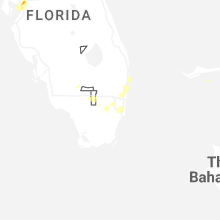
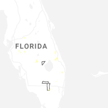
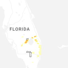
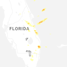
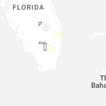


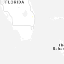


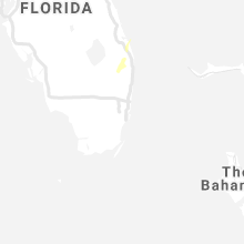


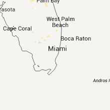


Connect with Interactive Hail Maps