

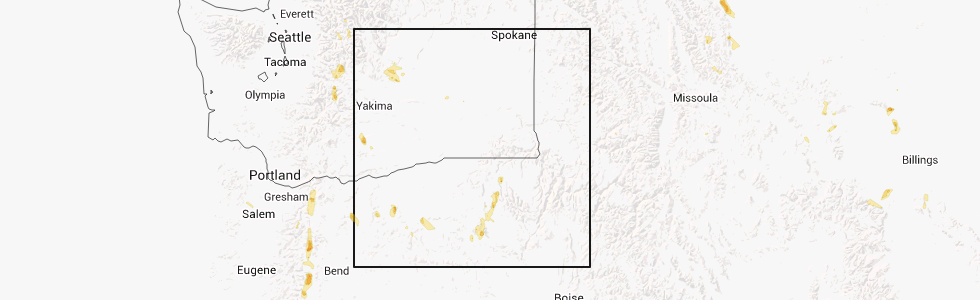
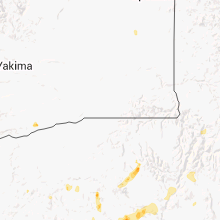
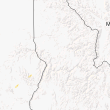
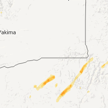
Hail Map for Haines, OR
The Haines, OR area has had 1 report of on-the-ground hail by trained spotters, and has been under severe weather warnings 0 times during the past 12 months. Doppler radar has detected hail at or near Haines, OR on 4 occasions.
| Name: | Haines, OR |
| Where Located: | 82.2 miles SSE of Walla Walla, WA |
| Map: | Google Map for Haines, OR |
| Population: | 416 |
| Housing Units: | 201 |
| More Info: | Search Google for Haines, OR |
0
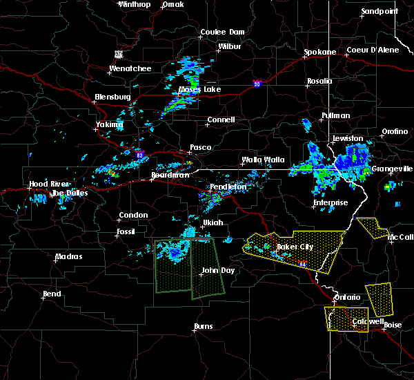
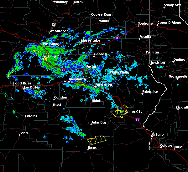
The Top Recent Hail Date for Haines, OR is Saturday, August 10, 2013 (4th out of 4)
Hail and Wind Damage Spotted near Haines, OR
| Date / Time | Report Details |
|---|---|
| 7/2/2022 2:35 PM PDT |
 At 235 pm pdt, a severe thunderstorm was located over haines, or 8 miles southwest of north powder, moving northeast at 15 mph (radar indicated). Hazards include quarter size hail. winds 40 mph or greater. damage to vehicles is expected At 235 pm pdt, a severe thunderstorm was located over haines, or 8 miles southwest of north powder, moving northeast at 15 mph (radar indicated). Hazards include quarter size hail. winds 40 mph or greater. damage to vehicles is expected
|
| 6/5/2020 6:24 PM PDT |
 The severe thunderstorm warning for north central baker county will expire at 630 pm pdt, the storms which prompted the warning have moved out of the area. therefore, the warning will be allowed to expire. however heavy rain is still possible with these thunderstorms. when safe to do so, please relay storm reports to the national weather service in boise via local law enforcement, or national weather service boise facebook and twitter accounts. The severe thunderstorm warning for north central baker county will expire at 630 pm pdt, the storms which prompted the warning have moved out of the area. therefore, the warning will be allowed to expire. however heavy rain is still possible with these thunderstorms. when safe to do so, please relay storm reports to the national weather service in boise via local law enforcement, or national weather service boise facebook and twitter accounts.
|
| 6/5/2020 6:13 PM PDT |
 At 612 pm pdt, severe thunderstorms were located along a line extending from 8 miles west of union to near north powder, moving north at 65 mph (radar indicated). Hazards include 60 mph wind gusts and quarter size hail. Hail damage to vehicles is expected. expect wind damage to roofs, siding, and trees. These severe thunderstorms will remain over mainly rural areas of north central baker county. At 612 pm pdt, severe thunderstorms were located along a line extending from 8 miles west of union to near north powder, moving north at 65 mph (radar indicated). Hazards include 60 mph wind gusts and quarter size hail. Hail damage to vehicles is expected. expect wind damage to roofs, siding, and trees. These severe thunderstorms will remain over mainly rural areas of north central baker county.
|
| 6/5/2020 5:59 PM PDT |
 At 559 pm pdt, severe thunderstorms were located along a line extending from 6 miles northeast of anthony lakes ski area to near elkhorn peak, moving north at 65 mph (radar indicated). Hazards include 60 mph wind gusts and quarter size hail. Hail damage to vehicles is expected. expect wind damage to roofs, siding, and trees. Severe thunderstorms will be near, north powder, haines and thief valley reservoir around 610 pm pdt. At 559 pm pdt, severe thunderstorms were located along a line extending from 6 miles northeast of anthony lakes ski area to near elkhorn peak, moving north at 65 mph (radar indicated). Hazards include 60 mph wind gusts and quarter size hail. Hail damage to vehicles is expected. expect wind damage to roofs, siding, and trees. Severe thunderstorms will be near, north powder, haines and thief valley reservoir around 610 pm pdt.
|
| 6/5/2020 4:57 PM PDT |
 At 456 pm pdt, a severe thunderstorm was located near haines, or near north powder, moving northeast at 50 mph (radar indicated). Hazards include 60 mph wind gusts and quarter size hail. Hail damage to vehicles is expected. expect wind damage to roofs, siding, and trees. this severe thunderstorm will be near, north powder around 500 pm pdt. Thief valley reservoir around 510 pm pdt. At 456 pm pdt, a severe thunderstorm was located near haines, or near north powder, moving northeast at 50 mph (radar indicated). Hazards include 60 mph wind gusts and quarter size hail. Hail damage to vehicles is expected. expect wind damage to roofs, siding, and trees. this severe thunderstorm will be near, north powder around 500 pm pdt. Thief valley reservoir around 510 pm pdt.
|
| 6/5/2020 4:36 PM PDT |
 At 436 pm pdt, severe thunderstorms were located along a line extending from 8 miles west of anthony lakes ski area to near haines, moving north at 35 mph (radar indicated). Hazards include 60 mph wind gusts and quarter size hail. Hail damage to vehicles is expected. expect wind damage to roofs, siding, and trees. severe thunderstorms will be near, haines around 440 pm pdt. thief valley reservoir around 450 pm pdt. Tamarack campground around 500 pm pdt. At 436 pm pdt, severe thunderstorms were located along a line extending from 8 miles west of anthony lakes ski area to near haines, moving north at 35 mph (radar indicated). Hazards include 60 mph wind gusts and quarter size hail. Hail damage to vehicles is expected. expect wind damage to roofs, siding, and trees. severe thunderstorms will be near, haines around 440 pm pdt. thief valley reservoir around 450 pm pdt. Tamarack campground around 500 pm pdt.
|
| 4/29/2020 6:34 PM PDT |
 At 628 pm pdt, a severe thunderstorm was located over flagstaff hill, or 7 miles northeast of baker city, moving northeast at 30 mph. a second potentially severe cell was located 5 miles south of baker city, also moving northeast at 30 mph (radar indicated). Hazards include 60 mph wind gusts and quarter size hail. Hail damage to vehicles is expected. expect wind damage to roofs, siding, and trees. this severe thunderstorm will be near, keating and love reservoir around 640 pm pdt. little lookout mountain around 650 pm pdt. gover reservoir, tamarack campground and sparta around 700 pm pdt. richland around 710 pm pdt. Carson and halfway around 720 pm pdt. At 628 pm pdt, a severe thunderstorm was located over flagstaff hill, or 7 miles northeast of baker city, moving northeast at 30 mph. a second potentially severe cell was located 5 miles south of baker city, also moving northeast at 30 mph (radar indicated). Hazards include 60 mph wind gusts and quarter size hail. Hail damage to vehicles is expected. expect wind damage to roofs, siding, and trees. this severe thunderstorm will be near, keating and love reservoir around 640 pm pdt. little lookout mountain around 650 pm pdt. gover reservoir, tamarack campground and sparta around 700 pm pdt. richland around 710 pm pdt. Carson and halfway around 720 pm pdt.
|
| 4/29/2020 6:29 PM PDT |
 At 628 pm pdt, a severe thunderstorm was located over flagstaff hill, or 7 miles northeast of baker city, moving northeast at 30 mph. a second potentially severe cell was located 5 miles south of baker city, also moving northeast at 30 mph (radar indicated). Hazards include 60 mph wind gusts and quarter size hail. Hail damage to vehicles is expected. expect wind damage to roofs, siding, and trees. this severe thunderstorm will be near, keating and love reservoir around 640 pm pdt. little lookout mountain around 650 pm pdt. gover reservoir, tamarack campground and sparta around 700 pm pdt. richland around 710 pm pdt. Carson and halfway around 720 pm pdt. At 628 pm pdt, a severe thunderstorm was located over flagstaff hill, or 7 miles northeast of baker city, moving northeast at 30 mph. a second potentially severe cell was located 5 miles south of baker city, also moving northeast at 30 mph (radar indicated). Hazards include 60 mph wind gusts and quarter size hail. Hail damage to vehicles is expected. expect wind damage to roofs, siding, and trees. this severe thunderstorm will be near, keating and love reservoir around 640 pm pdt. little lookout mountain around 650 pm pdt. gover reservoir, tamarack campground and sparta around 700 pm pdt. richland around 710 pm pdt. Carson and halfway around 720 pm pdt.
|
| 4/29/2020 5:55 PM PDT |
 At 555 pm pdt, a severe thunderstorm was located over larch summit, or 17 miles west of baker city, moving northeast at 40 mph (radar indicated). Hazards include 60 mph wind gusts and quarter size hail. Hail damage to vehicles is expected. expect wind damage to roofs, siding, and trees. this severe storm will be near, mcewen and phillips reservoir around 600 pm pdt. elkhorn peak, mason dam, salisbury and anthony lakes ski area around 610 pm pdt. haines around 620 pm pdt. Baker city and flagstaff hill around 630 pm pdt. At 555 pm pdt, a severe thunderstorm was located over larch summit, or 17 miles west of baker city, moving northeast at 40 mph (radar indicated). Hazards include 60 mph wind gusts and quarter size hail. Hail damage to vehicles is expected. expect wind damage to roofs, siding, and trees. this severe storm will be near, mcewen and phillips reservoir around 600 pm pdt. elkhorn peak, mason dam, salisbury and anthony lakes ski area around 610 pm pdt. haines around 620 pm pdt. Baker city and flagstaff hill around 630 pm pdt.
|
| 4/29/2020 5:26 PM PDT |
 At 526 pm pdt, a severe thunderstorm was located near bates, or 27 miles northeast of john day, moving northeast at 40 mph (radar indicated). Hazards include 60 mph wind gusts and quarter size hail. Hail damage to vehicles is expected. expect wind damage to roofs, siding, and trees. this severe thunderstorm will be near, blue mountain pass around 530 pm pdt. antlers forest service station and unity reservoir around 540 pm pdt. sumpter, larch summit and mcewen around 550 pm pdt. elkhorn peak, mount ruth, anthony lakes ski area and phillips reservoir around 600 pm pdt. Salisbury around 610 pm pdt. At 526 pm pdt, a severe thunderstorm was located near bates, or 27 miles northeast of john day, moving northeast at 40 mph (radar indicated). Hazards include 60 mph wind gusts and quarter size hail. Hail damage to vehicles is expected. expect wind damage to roofs, siding, and trees. this severe thunderstorm will be near, blue mountain pass around 530 pm pdt. antlers forest service station and unity reservoir around 540 pm pdt. sumpter, larch summit and mcewen around 550 pm pdt. elkhorn peak, mount ruth, anthony lakes ski area and phillips reservoir around 600 pm pdt. Salisbury around 610 pm pdt.
|
| 5/25/2018 7:17 PM PDT |
 At 816 pm mdt/716 pm pdt/, severe thunderstorms were located along a line extending from near anthony lakes ski area to mcchord butte, moving north at 25 mph (radar indicated). Hazards include 70 mph wind gusts and quarter size hail. Hail damage to vehicles is expected. expect considerable tree damage. wind damage is also likely to mobile homes, roofs, and outbuildings. these severe storms will be near, anthony lakes ski area, mount ruth, haines and flagstaff hill around 720 pm pdt. north powder and thief valley reservoir around 730 pm pdt. Richland, brownlee dam, halfway and carson around 740 pm pdt. At 816 pm mdt/716 pm pdt/, severe thunderstorms were located along a line extending from near anthony lakes ski area to mcchord butte, moving north at 25 mph (radar indicated). Hazards include 70 mph wind gusts and quarter size hail. Hail damage to vehicles is expected. expect considerable tree damage. wind damage is also likely to mobile homes, roofs, and outbuildings. these severe storms will be near, anthony lakes ski area, mount ruth, haines and flagstaff hill around 720 pm pdt. north powder and thief valley reservoir around 730 pm pdt. Richland, brownlee dam, halfway and carson around 740 pm pdt.
|
| 5/25/2018 6:44 PM PDT |
 At 744 pm mdt/644 pm pdt/, severe thunderstorms were located along a line extending from near greenhorn to 6 miles southwest of mcchord butte, moving north at 20 mph (radar indicated). Hazards include 70 mph wind gusts and quarter size hail. Hail damage to vehicles is expected. expect considerable tree damage. wind damage is also likely to mobile homes, roofs, and outbuildings. severe thunderstorms will be near, dixie, henley basin, weatherby and durkee around 650 pm pdt. sweedes landing, mcchord butte, big lookout mountain and pleasant valley around 700 pm pdt. baker city, little lookout mountain, sumpter and mason dam around 710 pm pdt. sheep mountain, love reservoir and flagstaff hill around 720 pm pdt. Elkhorn peak around 730 pm pdt. At 744 pm mdt/644 pm pdt/, severe thunderstorms were located along a line extending from near greenhorn to 6 miles southwest of mcchord butte, moving north at 20 mph (radar indicated). Hazards include 70 mph wind gusts and quarter size hail. Hail damage to vehicles is expected. expect considerable tree damage. wind damage is also likely to mobile homes, roofs, and outbuildings. severe thunderstorms will be near, dixie, henley basin, weatherby and durkee around 650 pm pdt. sweedes landing, mcchord butte, big lookout mountain and pleasant valley around 700 pm pdt. baker city, little lookout mountain, sumpter and mason dam around 710 pm pdt. sheep mountain, love reservoir and flagstaff hill around 720 pm pdt. Elkhorn peak around 730 pm pdt.
|
| 5/6/2018 1:54 PM PDT |
 At 154 pm pdt, a severe thunderstorm was located near haines, or 7 miles northwest of baker city, moving north at 35 mph (radar indicated). Hazards include 60 mph wind gusts and quarter size hail. Hail damage to vehicles is expected. expect wind damage to roofs, siding, and trees. this severe thunderstorm will be near, haines around 200 pm pdt. North powder and thief valley reservoir around 220 pm pdt. At 154 pm pdt, a severe thunderstorm was located near haines, or 7 miles northwest of baker city, moving north at 35 mph (radar indicated). Hazards include 60 mph wind gusts and quarter size hail. Hail damage to vehicles is expected. expect wind damage to roofs, siding, and trees. this severe thunderstorm will be near, haines around 200 pm pdt. North powder and thief valley reservoir around 220 pm pdt.
|
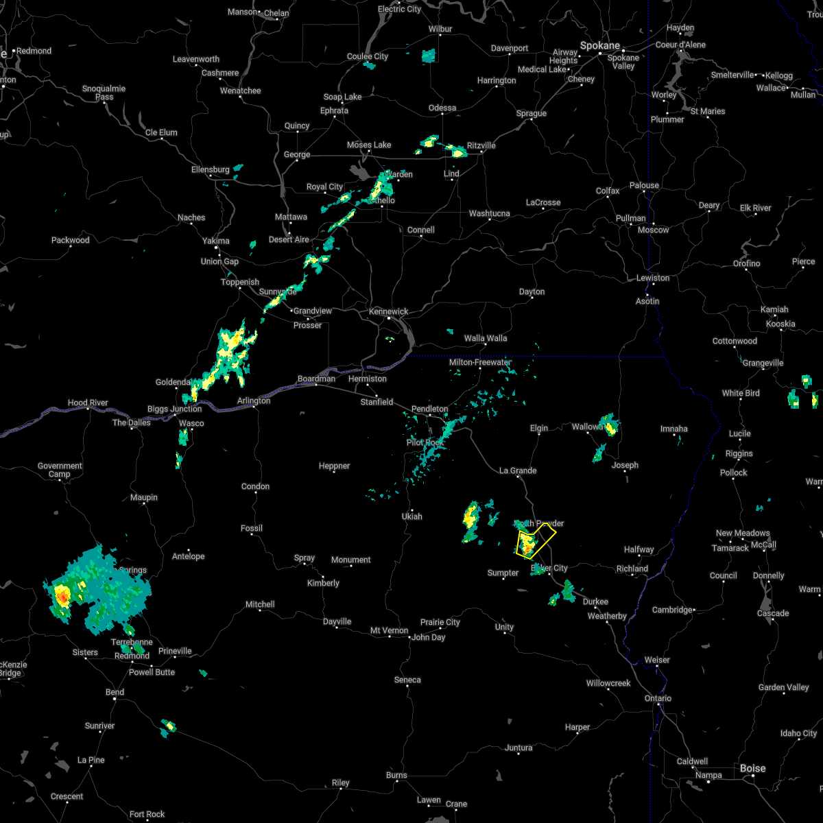
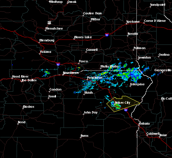
| 5/5/2018 5:50 PM PDT | Quarter sized hail reported 3.2 miles NNE of Haines, OR |
Hail Maps for Haines, OR

Connect with Interactive Hail Maps