

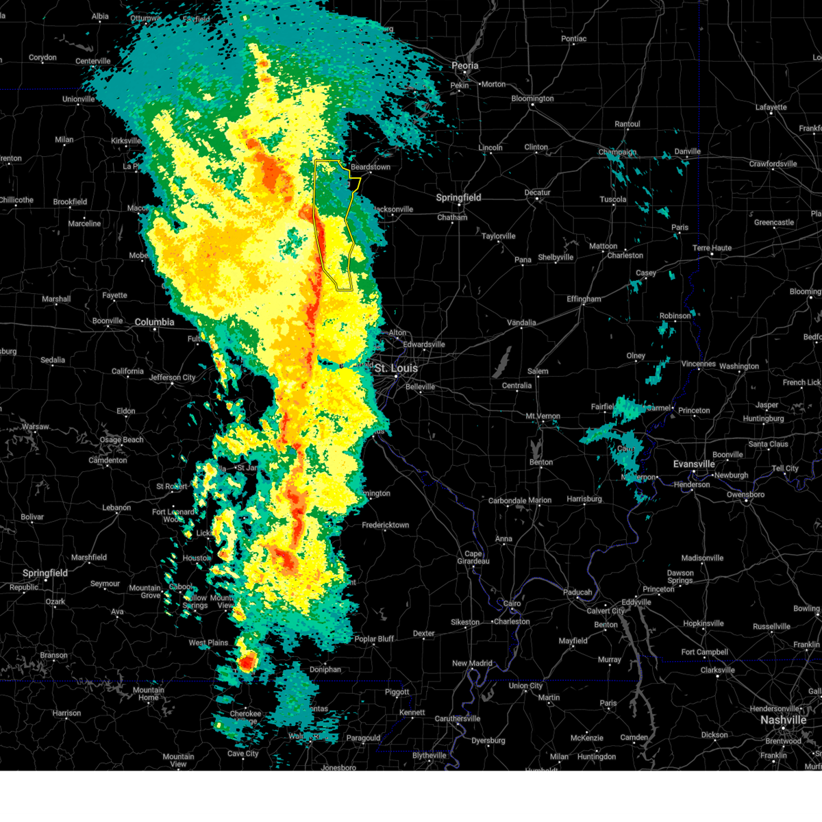
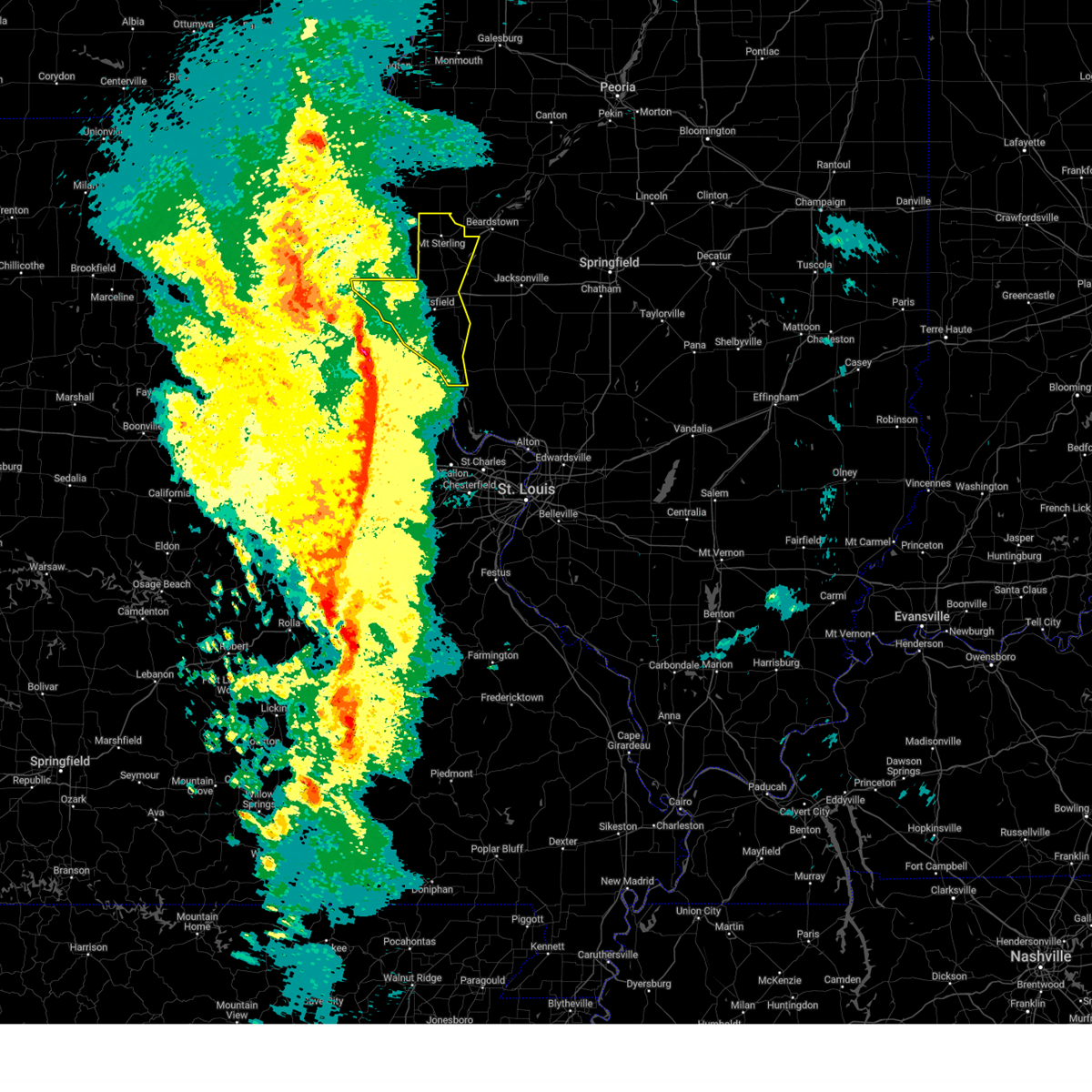
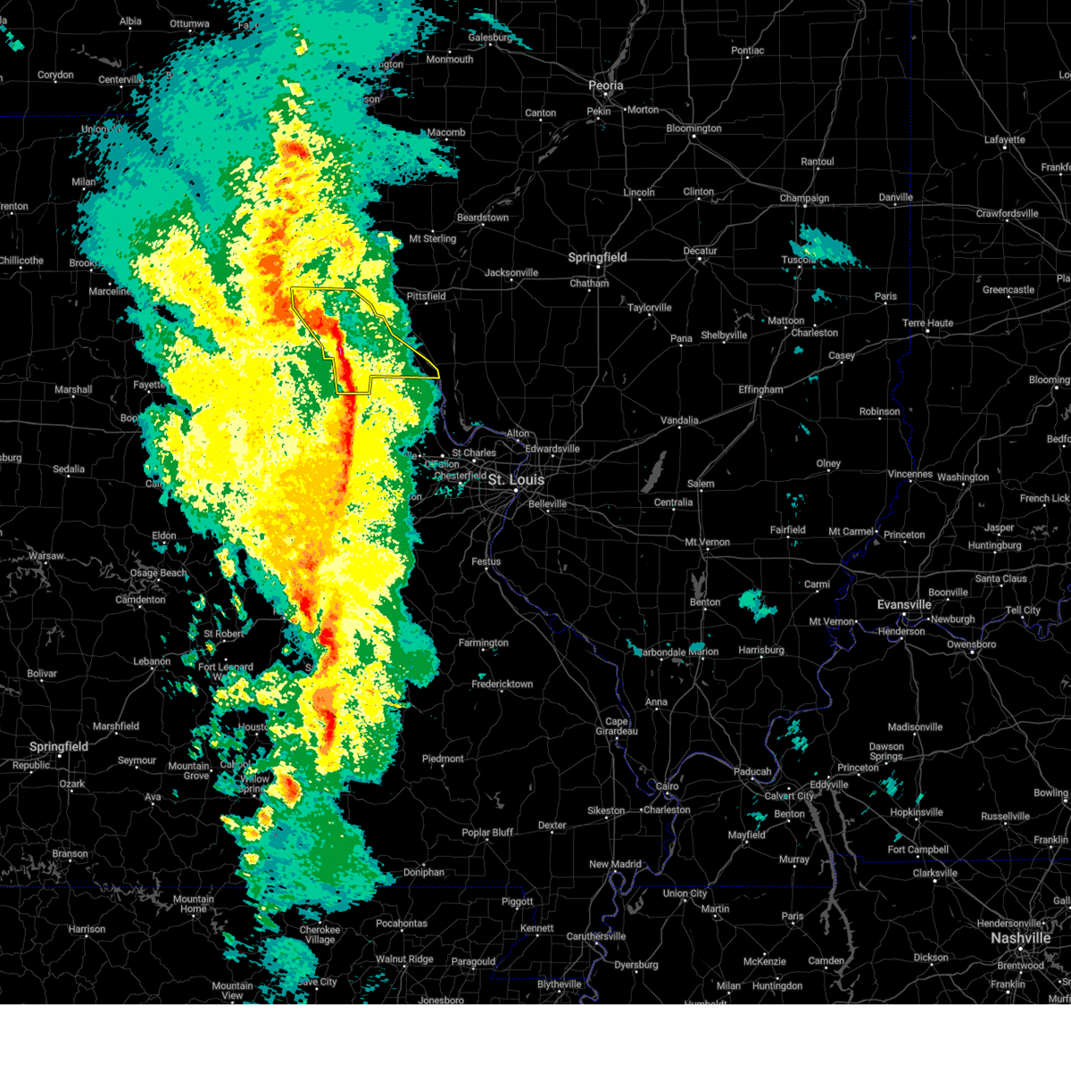
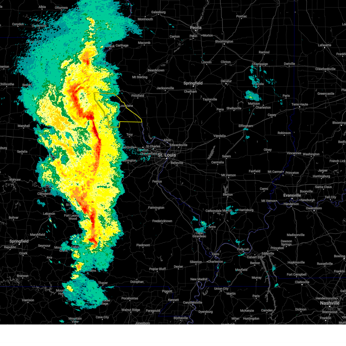
Hail Map for Hamburg, IL
The Hamburg, IL area has had 0 reports of on-the-ground hail by trained spotters, and has been under severe weather warnings 14 times during the past 12 months. Doppler radar has detected hail at or near Hamburg, IL on 62 occasions, including 2 occasions during the past year.
| Name: | Hamburg, IL |
| Where Located: | 50 miles NW of Saint Louis, MO |
| Map: | Google Map for Hamburg, IL |
| Population: | 128 |
| Housing Units: | 92 |
| More Info: | Search Google for Hamburg, IL |
2
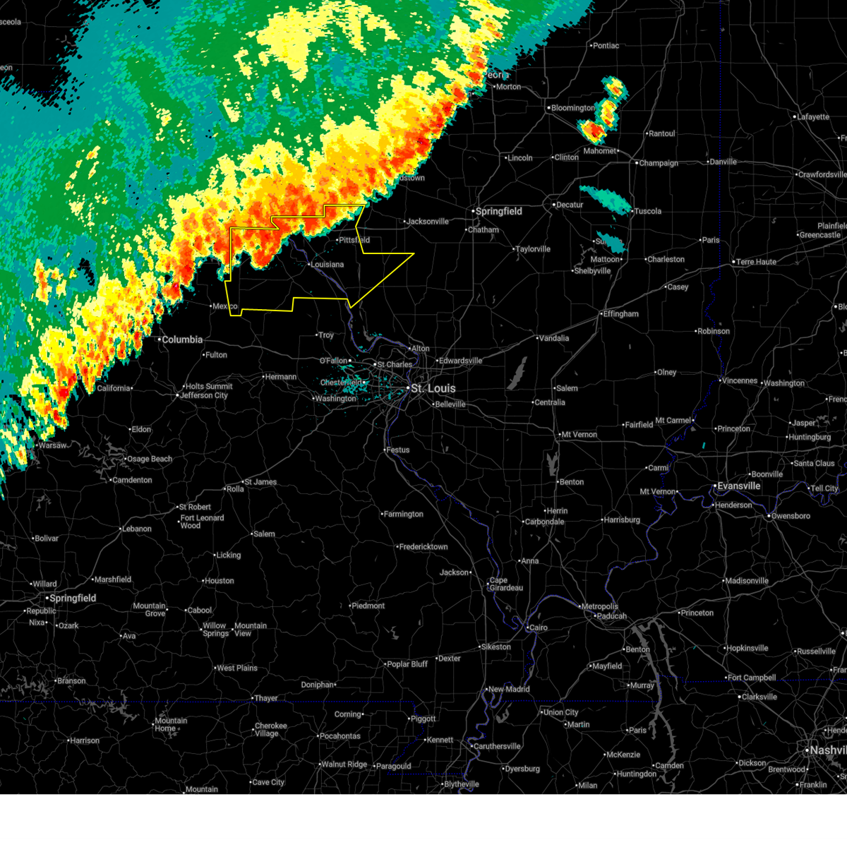
The Top Recent Hail Date for Hamburg, IL is Friday, May 16, 2025 (7th out of 62)

Hail and Wind Damage Spotted near Hamburg, IL
| Date / Time | Report Details |
|---|---|
| 7/11/2025 10:59 PM CDT |
 The storms which prompted the warning have weakened below severe limits, and no longer pose an immediate threat to life or property. therefore, the warning will be allowed to expire. however, gusty winds and heavy rain are still possible with these thunderstorms. The storms which prompted the warning have weakened below severe limits, and no longer pose an immediate threat to life or property. therefore, the warning will be allowed to expire. however, gusty winds and heavy rain are still possible with these thunderstorms.
|
| 7/11/2025 10:35 PM CDT |
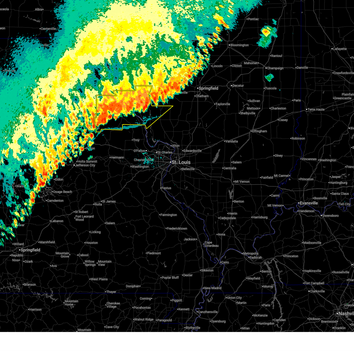
 At 1035 pm cdt, severe thunderstorms were located along a line from 10 miles northwest of white hall to over laddonia, or along a line from 10 miles northwest of white hall to 7 miles southwest of vandalia, moving south at 25 mph (law enforcement reported tree damage in hannibal, mo and highway 79 in eastern ralls county). Hazards include 60 mph wind gusts. Expect damage to roofs, siding, and trees. this severe thunderstorm will be near, atlas, spencerburg, pittsfield, perry, frankford, griggsville and center around 1015 pm cdt. louisiana and pike around 1020 pm cdt. other locations impacted by the severe thunderstorm include detroit, summer hill, rockport, new hartford, valley city, ashburn, el dara, time, martinsburg and independence. This includes interstate 72 between exits 10 and 35. At 1035 pm cdt, severe thunderstorms were located along a line from 10 miles northwest of white hall to over laddonia, or along a line from 10 miles northwest of white hall to 7 miles southwest of vandalia, moving south at 25 mph (law enforcement reported tree damage in hannibal, mo and highway 79 in eastern ralls county). Hazards include 60 mph wind gusts. Expect damage to roofs, siding, and trees. this severe thunderstorm will be near, atlas, spencerburg, pittsfield, perry, frankford, griggsville and center around 1015 pm cdt. louisiana and pike around 1020 pm cdt. other locations impacted by the severe thunderstorm include detroit, summer hill, rockport, new hartford, valley city, ashburn, el dara, time, martinsburg and independence. This includes interstate 72 between exits 10 and 35.
|
| 7/11/2025 10:15 PM CDT |
 Svrlsx the national weather service in st louis has issued a * severe thunderstorm warning for, northwestern calhoun county in southwestern illinois, northern greene county in southwestern illinois, pike county in west central illinois, eastern audrain county in central missouri, pike county in northeastern missouri, ralls county in northeastern missouri, * until 1100 pm cdt. * at 1015 pm cdt, severe thunderstorms were located along a line from 9 miles southeast of griggsville to near perry, or along a line from 12 miles east of pittsfield to 9 miles east of santa fe, moving south at 20 mph (law enforcement reported tree damage was reported in hannibal, mo and highway 79 in eastern ralls county). Hazards include 60 mph wind gusts. Expect damage to roofs, siding, and trees. this severe thunderstorm will be near, atlas, spencerburg, pittsfield, louisiana, perry, frankford, griggsville and center around 1015 pm cdt. pike around 1020 pm cdt. other locations impacted by the severe thunderstorm include detroit, summer hill, rockport, new hartford, valley city, ashburn, el dara, independence, milton and martinsburg. This includes interstate 72 between exits 10 and 35. Svrlsx the national weather service in st louis has issued a * severe thunderstorm warning for, northwestern calhoun county in southwestern illinois, northern greene county in southwestern illinois, pike county in west central illinois, eastern audrain county in central missouri, pike county in northeastern missouri, ralls county in northeastern missouri, * until 1100 pm cdt. * at 1015 pm cdt, severe thunderstorms were located along a line from 9 miles southeast of griggsville to near perry, or along a line from 12 miles east of pittsfield to 9 miles east of santa fe, moving south at 20 mph (law enforcement reported tree damage was reported in hannibal, mo and highway 79 in eastern ralls county). Hazards include 60 mph wind gusts. Expect damage to roofs, siding, and trees. this severe thunderstorm will be near, atlas, spencerburg, pittsfield, louisiana, perry, frankford, griggsville and center around 1015 pm cdt. pike around 1020 pm cdt. other locations impacted by the severe thunderstorm include detroit, summer hill, rockport, new hartford, valley city, ashburn, el dara, independence, milton and martinsburg. This includes interstate 72 between exits 10 and 35.
|
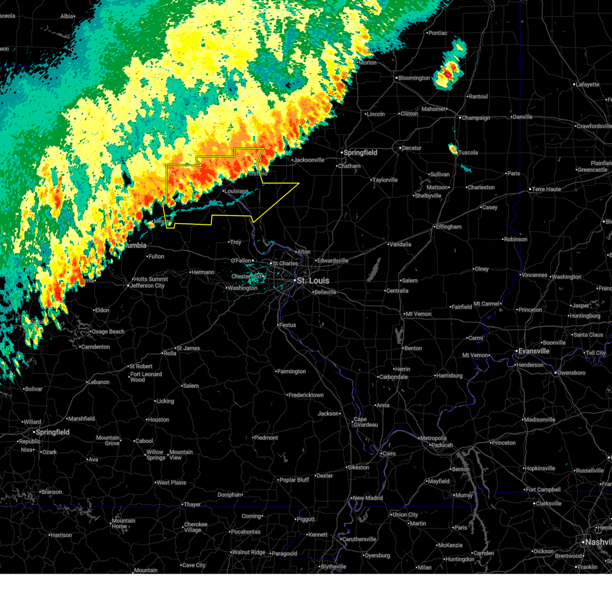
| 5/16/2025 2:26 PM CDT |
 Svrlsx the national weather service in st louis has issued a * severe thunderstorm warning for, north central calhoun county in southwestern illinois, greene county in southwestern illinois, jersey county in southwestern illinois, western macoupin county in southwestern illinois, southeastern pike county in west central illinois, * until 315 pm cdt. * at 226 pm cdt, a severe thunderstorm was located near hardin, or 7 miles northeast of elsberry, moving northeast at 60 mph (radar indicated). Hazards include 60 mph wind gusts and half dollar size hail. Hail damage to vehicles is expected. Expect wind damage to roofs, siding, and trees. Svrlsx the national weather service in st louis has issued a * severe thunderstorm warning for, north central calhoun county in southwestern illinois, greene county in southwestern illinois, jersey county in southwestern illinois, western macoupin county in southwestern illinois, southeastern pike county in west central illinois, * until 315 pm cdt. * at 226 pm cdt, a severe thunderstorm was located near hardin, or 7 miles northeast of elsberry, moving northeast at 60 mph (radar indicated). Hazards include 60 mph wind gusts and half dollar size hail. Hail damage to vehicles is expected. Expect wind damage to roofs, siding, and trees.
|
| 4/20/2025 7:25 PM CDT | The storms which prompted the warning have moved out of the area. therefore, the warning will be allowed to expire. however, gusty winds are still possible with these thunderstorms. a tornado watch remains in effect until 1100 pm cdt for portions of southwest and west central illinois. |
| 4/20/2025 7:04 PM CDT |
 At 704 pm cdt, severe thunderstorms were located along a line from over beverly to near belleview, or along a line from 16 miles southeast of quincy regional airport to 10 miles north of elsberry, moving northeast at 50 mph (trained spotters reported. at 6:50 pm power poles were blown down near hull, il). Hazards include 70 mph wind gusts and quarter size hail. Hail damage to vehicles is expected. expect considerable tree damage. wind damage is also likely to mobile homes, roofs, and outbuildings. other locations impacted by the severe thunderstorm include martinsburg, new salem, baylis, nebo, mozier, independence, hamburg, time, fishhook and michael. This includes interstate 72 between exits 31 and 35. At 704 pm cdt, severe thunderstorms were located along a line from over beverly to near belleview, or along a line from 16 miles southeast of quincy regional airport to 10 miles north of elsberry, moving northeast at 50 mph (trained spotters reported. at 6:50 pm power poles were blown down near hull, il). Hazards include 70 mph wind gusts and quarter size hail. Hail damage to vehicles is expected. expect considerable tree damage. wind damage is also likely to mobile homes, roofs, and outbuildings. other locations impacted by the severe thunderstorm include martinsburg, new salem, baylis, nebo, mozier, independence, hamburg, time, fishhook and michael. This includes interstate 72 between exits 31 and 35.
|
| 4/20/2025 6:40 PM CDT | Svrlsx the national weather service in st louis has issued a * severe thunderstorm warning for, southeastern pike county in northeastern missouri, * until 700 pm cdt. * at 640 pm cdt, severe thunderstorms were located along a line from over pike to near eolia, or along a line from near louisiana to 10 miles west of elsberry, moving northeast at 50 mph (radar indicated). Hazards include 70 mph wind gusts and quarter size hail. Hail damage to vehicles is expected. expect considerable tree damage. wind damage is also likely to mobile homes, roofs, and outbuildings. this severe thunderstorm will be near, louisiana and eolia around 640 pm cdt. clarksville around 645 pm cdt. Other locations impacted by the severe thunderstorm include paynesville, annada and hamburg. |
| 4/20/2025 6:27 PM CDT |
 Svrlsx the national weather service in st louis has issued a * severe thunderstorm warning for, northwestern calhoun county in southwestern illinois, brown county in west central illinois, pike county in west central illinois, * until 730 pm cdt. * at 627 pm cdt, severe thunderstorms were located along a line from near center to 6 miles southwest of eolia, or along a line from 12 miles south of hannibal to 11 miles southeast of bowling green, moving northeast at 60 mph (radar indicated). Hazards include 70 mph wind gusts and quarter size hail. Hail damage to vehicles is expected. expect considerable tree damage. wind damage is also likely to mobile homes, roofs, and outbuildings. this severe thunderstorm will be near, pike around 635 pm cdt. other locations impacted by the severe thunderstorm include rockport, summer hill, hull, new canton, new hartford, el dara, kinderhook, seehorn, mozier and martinsburg. This includes interstate 72 between exits 10 and 35. Svrlsx the national weather service in st louis has issued a * severe thunderstorm warning for, northwestern calhoun county in southwestern illinois, brown county in west central illinois, pike county in west central illinois, * until 730 pm cdt. * at 627 pm cdt, severe thunderstorms were located along a line from near center to 6 miles southwest of eolia, or along a line from 12 miles south of hannibal to 11 miles southeast of bowling green, moving northeast at 60 mph (radar indicated). Hazards include 70 mph wind gusts and quarter size hail. Hail damage to vehicles is expected. expect considerable tree damage. wind damage is also likely to mobile homes, roofs, and outbuildings. this severe thunderstorm will be near, pike around 635 pm cdt. other locations impacted by the severe thunderstorm include rockport, summer hill, hull, new canton, new hartford, el dara, kinderhook, seehorn, mozier and martinsburg. This includes interstate 72 between exits 10 and 35.
|
| 4/20/2025 6:16 PM CDT |
 At 616 pm cdt, severe thunderstorms were located along a line from near spaulding to near bellflower, or along a line from 10 miles southeast of monroe city to 11 miles northeast of montgomery city, moving northeast at 60 mph (trained spotters reported. at 6:10 pm a 63 mph wind gust was reported at vandalia, mo). Hazards include 70 mph wind gusts. Expect considerable tree damage. damage is likely to mobile homes, roofs, and outbuildings. this severe thunderstorm will be near, vandalia around 610 pm cdt. other locations impacted by the severe thunderstorm include the landing, st. Clement, ashley, cyrene, saverton, ilasco, edgewood and ashburn. At 616 pm cdt, severe thunderstorms were located along a line from near spaulding to near bellflower, or along a line from 10 miles southeast of monroe city to 11 miles northeast of montgomery city, moving northeast at 60 mph (trained spotters reported. at 6:10 pm a 63 mph wind gust was reported at vandalia, mo). Hazards include 70 mph wind gusts. Expect considerable tree damage. damage is likely to mobile homes, roofs, and outbuildings. this severe thunderstorm will be near, vandalia around 610 pm cdt. other locations impacted by the severe thunderstorm include the landing, st. Clement, ashley, cyrene, saverton, ilasco, edgewood and ashburn.
|
| 4/20/2025 6:03 PM CDT |
 Svrlsx the national weather service in st louis has issued a * severe thunderstorm warning for, pike county in northeastern missouri, ralls county in northeastern missouri, * until 645 pm cdt. * at 603 pm cdt, severe thunderstorms were located along a line from over perry to over new florence, or along a line from 8 miles northeast of santa fe to 5 miles southeast of montgomery city, moving northeast at 60 mph (radar indicated). Hazards include 70 mph wind gusts. Expect considerable tree damage. damage is likely to mobile homes, roofs, and outbuildings. this severe thunderstorm will be near, vandalia around 610 pm cdt. other locations impacted by the severe thunderstorm include the landing, st. Clement, ashley, cyrene, saverton, ilasco, edgewood and ashburn. Svrlsx the national weather service in st louis has issued a * severe thunderstorm warning for, pike county in northeastern missouri, ralls county in northeastern missouri, * until 645 pm cdt. * at 603 pm cdt, severe thunderstorms were located along a line from over perry to over new florence, or along a line from 8 miles northeast of santa fe to 5 miles southeast of montgomery city, moving northeast at 60 mph (radar indicated). Hazards include 70 mph wind gusts. Expect considerable tree damage. damage is likely to mobile homes, roofs, and outbuildings. this severe thunderstorm will be near, vandalia around 610 pm cdt. other locations impacted by the severe thunderstorm include the landing, st. Clement, ashley, cyrene, saverton, ilasco, edgewood and ashburn.
|
| 3/14/2025 9:25 PM CDT | the severe thunderstorm warning has been cancelled and is no longer in effect |
| 3/14/2025 9:25 PM CDT | At 925 pm cdt, severe thunderstorms were located along a line from 10 miles northwest of white hall to near hardin, or along a line from 10 miles northwest of white hall to 12 miles east of elsberry, moving northeast at 70 mph (radar indicated). Hazards include 60 mph wind gusts and small hail. Expect damage to roofs, siding, and trees. this severe thunderstorm will be near, hardin around 920 pm cdt. Other locations impacted by the severe thunderstorm include hamburg, pearl, michael, kampsville, beecreek, eldred, hillview, haypress, patterson and walkersville. |
| 3/14/2025 9:10 PM CDT | Svrlsx the national weather service in st louis has issued a * severe thunderstorm warning for, calhoun county in southwestern illinois, greene county in southwestern illinois, eastern pike county in west central illinois, northeastern lincoln county in east central missouri, southeastern pike county in northeastern missouri, * until 1000 pm cdt. * at 910 pm cdt, severe thunderstorms were located along a line from 14 miles east of mount sterling to near pleasant hill, or along a line from 32 miles northeast of pittsfield to 13 miles east of louisiana, moving northeast at 50 mph (radar indicated). Hazards include 60 mph wind gusts and small hail. Expect damage to roofs, siding, and trees. this severe thunderstorm will be near, pleasant hill, clarksville, belleview, griggsville and pittsfield around 910 pm cdt. other locations impacted by the severe thunderstorm include detroit, time, nebo, valley city, independence, martinsburg, chambersburg, pearl, milton and florence. This includes interstate 72 between exits 31 and 35. |
| 3/14/2025 8:25 PM CDT | Svrlsx the national weather service in st louis has issued a * severe thunderstorm warning for, calhoun county in southwestern illinois, western greene county in southwestern illinois, southeastern pike county in west central illinois, lincoln county in east central missouri, southeastern pike county in northeastern missouri, * until 915 pm cdt. * at 825 pm cdt, a severe thunderstorm was located 7 miles south of new hartford, or 16 miles northeast of montgomery city, moving northeast at 75 mph (radar indicated). Hazards include 70 mph wind gusts and small hail. Expect considerable tree damage. damage is likely to mobile homes, roofs, and outbuildings. other locations impacted by the severe thunderstorm include olney, truxton, silex, edgewood, cyrene, whiteside, paynesville, nebo, pearl and montezuma. This includes the following state parks, cuivre river state park. |
| 6/5/2024 4:28 AM CDT |
 the severe thunderstorm warning has been cancelled and is no longer in effect the severe thunderstorm warning has been cancelled and is no longer in effect
|
| 6/5/2024 4:28 AM CDT |
 At 427 am cdt, severe thunderstorms were located along a line extending from near pittsfield to 9 miles southwest of glasgow to 7 miles north of hardin, moving northeast at 40 mph (radar indicated). Hazards include 60 mph wind gusts and quarter size hail. Hail damage to vehicles is expected. expect wind damage to roofs, siding, and trees. Locations impacted include, pittsfield, white hall, carrollton, pleasant hill, clarksville, belleview, independence, bedford, patterson, martinsburg, nebo, kampsville, milton, eldred, hillview, pearl, hamburg, detroit, florence, and time. At 427 am cdt, severe thunderstorms were located along a line extending from near pittsfield to 9 miles southwest of glasgow to 7 miles north of hardin, moving northeast at 40 mph (radar indicated). Hazards include 60 mph wind gusts and quarter size hail. Hail damage to vehicles is expected. expect wind damage to roofs, siding, and trees. Locations impacted include, pittsfield, white hall, carrollton, pleasant hill, clarksville, belleview, independence, bedford, patterson, martinsburg, nebo, kampsville, milton, eldred, hillview, pearl, hamburg, detroit, florence, and time.
|
| 6/5/2024 4:15 AM CDT |
 the severe thunderstorm warning has been cancelled and is no longer in effect the severe thunderstorm warning has been cancelled and is no longer in effect
|
| 6/5/2024 4:15 AM CDT |
 At 414 am cdt, severe thunderstorms were located along a line extending from near atlas to near belleview to near elsberry, moving northeast at 45 mph (radar indicated). Hazards include 60 mph wind gusts and quarter size hail. Hail damage to vehicles is expected. expect wind damage to roofs, siding, and trees. Locations impacted include, pittsfield, white hall and carrollton. At 414 am cdt, severe thunderstorms were located along a line extending from near atlas to near belleview to near elsberry, moving northeast at 45 mph (radar indicated). Hazards include 60 mph wind gusts and quarter size hail. Hail damage to vehicles is expected. expect wind damage to roofs, siding, and trees. Locations impacted include, pittsfield, white hall and carrollton.
|
| 6/5/2024 4:02 AM CDT |
 Svrlsx the national weather service in st louis has issued a * severe thunderstorm warning for, northwestern calhoun county in southwestern illinois, western greene county in southwestern illinois, southeastern pike county in west central illinois, northeastern lincoln county in east central missouri, eastern pike county in northeastern missouri, * until 445 am cdt. * at 402 am cdt, severe thunderstorms were located along a line extending from near tarrants to clarksville to near elsberry, moving northeast at 40 mph (radar indicated). Hazards include 60 mph wind gusts and quarter size hail. Hail damage to vehicles is expected. expect wind damage to roofs, siding, and trees. severe thunderstorms will be near, louisiana, elsberry, pleasant hill, clarksville, and pike around 405 am cdt. belleview around 410 am cdt. atlas around 415 am cdt. Other locations in the path of these severe thunderstorms include pittsfield. Svrlsx the national weather service in st louis has issued a * severe thunderstorm warning for, northwestern calhoun county in southwestern illinois, western greene county in southwestern illinois, southeastern pike county in west central illinois, northeastern lincoln county in east central missouri, eastern pike county in northeastern missouri, * until 445 am cdt. * at 402 am cdt, severe thunderstorms were located along a line extending from near tarrants to clarksville to near elsberry, moving northeast at 40 mph (radar indicated). Hazards include 60 mph wind gusts and quarter size hail. Hail damage to vehicles is expected. expect wind damage to roofs, siding, and trees. severe thunderstorms will be near, louisiana, elsberry, pleasant hill, clarksville, and pike around 405 am cdt. belleview around 410 am cdt. atlas around 415 am cdt. Other locations in the path of these severe thunderstorms include pittsfield.
|
| 5/24/2024 6:14 PM CDT |
 At 613 pm cdt, a severe thunderstorm was located near hardin, moving east at 30 mph (radar indicated). Hazards include tennis ball size hail and 60 mph wind gusts. People and animals outdoors will be injured. expect hail damage to roofs, siding, windows, and vehicles. expect wind damage to roofs, siding, and trees. Locations impacted include, carrollton, hardin, old kane, kane, fieldon, hamburg, woody, and michael. At 613 pm cdt, a severe thunderstorm was located near hardin, moving east at 30 mph (radar indicated). Hazards include tennis ball size hail and 60 mph wind gusts. People and animals outdoors will be injured. expect hail damage to roofs, siding, windows, and vehicles. expect wind damage to roofs, siding, and trees. Locations impacted include, carrollton, hardin, old kane, kane, fieldon, hamburg, woody, and michael.
|
| 5/24/2024 6:14 PM CDT |
 the severe thunderstorm warning has been cancelled and is no longer in effect the severe thunderstorm warning has been cancelled and is no longer in effect
|
| 5/24/2024 6:09 PM CDT |
 At 609 pm cdt, a severe thunderstorm was located near elsberry, moving east at 30 mph (radar indicated). Hazards include golf ball size hail and 60 mph wind gusts. People and animals outdoors will be injured. expect hail damage to roofs, siding, windows, and vehicles. expect wind damage to roofs, siding, and trees. Locations impacted include, elsberry, carrollton, hardin, old kane, kane, fieldon, hamburg, annada, woody, and michael. At 609 pm cdt, a severe thunderstorm was located near elsberry, moving east at 30 mph (radar indicated). Hazards include golf ball size hail and 60 mph wind gusts. People and animals outdoors will be injured. expect hail damage to roofs, siding, windows, and vehicles. expect wind damage to roofs, siding, and trees. Locations impacted include, elsberry, carrollton, hardin, old kane, kane, fieldon, hamburg, annada, woody, and michael.
|
| 5/24/2024 6:05 PM CDT |
 Svrlsx the national weather service in st louis has issued a * severe thunderstorm warning for, central calhoun county in southwestern illinois, southwestern greene county in southwestern illinois, west central jersey county in southwestern illinois, northeastern lincoln county in east central missouri, southeastern pike county in northeastern missouri, * until 645 pm cdt. * at 604 pm cdt, a severe thunderstorm was located over elsberry, moving east at 30 mph (radar indicated). Hazards include 60 mph wind gusts and quarter size hail. Hail damage to vehicles is expected. Expect wind damage to roofs, siding, and trees. Svrlsx the national weather service in st louis has issued a * severe thunderstorm warning for, central calhoun county in southwestern illinois, southwestern greene county in southwestern illinois, west central jersey county in southwestern illinois, northeastern lincoln county in east central missouri, southeastern pike county in northeastern missouri, * until 645 pm cdt. * at 604 pm cdt, a severe thunderstorm was located over elsberry, moving east at 30 mph (radar indicated). Hazards include 60 mph wind gusts and quarter size hail. Hail damage to vehicles is expected. Expect wind damage to roofs, siding, and trees.
|
| 5/24/2024 5:55 PM CDT |
 The storm which prompted the warning has weakened below severe limits, and has exited the warned area. therefore, the warning will be allowed to expire. a severe thunderstorm watch remains in effect until 900 pm cdt for southwestern and west central illinois, and northeastern and east central missouri. The storm which prompted the warning has weakened below severe limits, and has exited the warned area. therefore, the warning will be allowed to expire. a severe thunderstorm watch remains in effect until 900 pm cdt for southwestern and west central illinois, and northeastern and east central missouri.
|
| 5/24/2024 5:36 PM CDT |
 At 536 pm cdt, a severe thunderstorm was located over belleview, moving east at 35 mph (radar indicated). Hazards include 60 mph wind gusts and quarter size hail. Hail damage to vehicles is expected. expect wind damage to roofs, siding, and trees. Locations impacted include, bowling green, louisiana, pleasant hill, eolia, clarksville, tarrants, belleview, nebo, kampsville, pearl, hamburg, paynesville, annada, edgewood, mozier, cyrene, michael, and beecreek. At 536 pm cdt, a severe thunderstorm was located over belleview, moving east at 35 mph (radar indicated). Hazards include 60 mph wind gusts and quarter size hail. Hail damage to vehicles is expected. expect wind damage to roofs, siding, and trees. Locations impacted include, bowling green, louisiana, pleasant hill, eolia, clarksville, tarrants, belleview, nebo, kampsville, pearl, hamburg, paynesville, annada, edgewood, mozier, cyrene, michael, and beecreek.
|
| 5/24/2024 5:11 PM CDT |
 Svrlsx the national weather service in st louis has issued a * severe thunderstorm warning for, northwestern calhoun county in southwestern illinois, southeastern pike county in west central illinois, central pike county in northeastern missouri, * until 600 pm cdt. * at 511 pm cdt, a severe thunderstorm was located near louisiana, moving east at 35 mph (radar indicated). Hazards include 60 mph wind gusts and quarter size hail. Hail damage to vehicles is expected. Expect wind damage to roofs, siding, and trees. Svrlsx the national weather service in st louis has issued a * severe thunderstorm warning for, northwestern calhoun county in southwestern illinois, southeastern pike county in west central illinois, central pike county in northeastern missouri, * until 600 pm cdt. * at 511 pm cdt, a severe thunderstorm was located near louisiana, moving east at 35 mph (radar indicated). Hazards include 60 mph wind gusts and quarter size hail. Hail damage to vehicles is expected. Expect wind damage to roofs, siding, and trees.
|
| 4/18/2024 4:25 PM CDT |
 Svrlsx the national weather service in st louis has issued a * severe thunderstorm warning for, north central calhoun county in southwestern illinois, southwestern greene county in southwestern illinois, * until 515 pm cdt. * at 425 pm cdt, a severe thunderstorm was located near belleview, moving east at 35 mph (radar indicated). Hazards include 60 mph wind gusts and quarter size hail. Hail damage to vehicles is expected. Expect wind damage to roofs, siding, and trees. Svrlsx the national weather service in st louis has issued a * severe thunderstorm warning for, north central calhoun county in southwestern illinois, southwestern greene county in southwestern illinois, * until 515 pm cdt. * at 425 pm cdt, a severe thunderstorm was located near belleview, moving east at 35 mph (radar indicated). Hazards include 60 mph wind gusts and quarter size hail. Hail damage to vehicles is expected. Expect wind damage to roofs, siding, and trees.
|
| 4/18/2024 4:16 PM CDT |
 Svrlsx the national weather service in st louis has issued a * severe thunderstorm warning for, central calhoun county in southwestern illinois, northeastern lincoln county in east central missouri, * until 500 pm cdt. * at 415 pm cdt, a severe thunderstorm was located near davis, moving east at 35 mph (radar indicated). Hazards include golf ball size hail and 60 mph wind gusts. People and animals outdoors will be injured. expect hail damage to roofs, siding, windows, and vehicles. Expect wind damage to roofs, siding, and trees. Svrlsx the national weather service in st louis has issued a * severe thunderstorm warning for, central calhoun county in southwestern illinois, northeastern lincoln county in east central missouri, * until 500 pm cdt. * at 415 pm cdt, a severe thunderstorm was located near davis, moving east at 35 mph (radar indicated). Hazards include golf ball size hail and 60 mph wind gusts. People and animals outdoors will be injured. expect hail damage to roofs, siding, windows, and vehicles. Expect wind damage to roofs, siding, and trees.
|
| 4/16/2024 3:08 PM CDT |
 At 308 pm cdt, a severe thunderstorm was located over winfield, moving northeast at 65 mph (public reported). Hazards include 60 mph wind gusts and quarter size hail. Hail damage to vehicles is expected. expect wind damage to roofs, siding, and trees. locations impacted include, troy, elsberry, moscow mills, winfield, hardin, fountain n' lakes, chain of rocks, kampsville, old monroe, batchtown, foley, hamburg, and michael. This also includes cuivre river state park. At 308 pm cdt, a severe thunderstorm was located over winfield, moving northeast at 65 mph (public reported). Hazards include 60 mph wind gusts and quarter size hail. Hail damage to vehicles is expected. expect wind damage to roofs, siding, and trees. locations impacted include, troy, elsberry, moscow mills, winfield, hardin, fountain n' lakes, chain of rocks, kampsville, old monroe, batchtown, foley, hamburg, and michael. This also includes cuivre river state park.
|
| 4/16/2024 3:03 PM CDT |
 At 302 pm cdt, a severe thunderstorm was located over winfield, moving northeast at 70 mph (radar indicated). Hazards include 60 mph wind gusts and nickel size hail. Expect damage to roofs, siding, and trees. locations impacted include, troy, elsberry, moscow mills, winfield, hardin, fountain n' lakes, chain of rocks, kampsville, old monroe, batchtown, foley, hamburg, and michael. This also includes cuivre river state park. At 302 pm cdt, a severe thunderstorm was located over winfield, moving northeast at 70 mph (radar indicated). Hazards include 60 mph wind gusts and nickel size hail. Expect damage to roofs, siding, and trees. locations impacted include, troy, elsberry, moscow mills, winfield, hardin, fountain n' lakes, chain of rocks, kampsville, old monroe, batchtown, foley, hamburg, and michael. This also includes cuivre river state park.
|
| 4/16/2024 2:51 PM CDT |
 At 251 pm cdt, a severe thunderstorm was located near hardin, moving northeast at 70 mph (radar indicated). Hazards include 60 mph wind gusts and nickel size hail. Expect damage to roofs, siding, and trees. locations impacted include, troy, elsberry, moscow mills, winfield, hardin, fountain n' lakes, chain of rocks, kampsville, old monroe, batchtown, foley, hamburg, and michael. This also includes cuivre river state park. At 251 pm cdt, a severe thunderstorm was located near hardin, moving northeast at 70 mph (radar indicated). Hazards include 60 mph wind gusts and nickel size hail. Expect damage to roofs, siding, and trees. locations impacted include, troy, elsberry, moscow mills, winfield, hardin, fountain n' lakes, chain of rocks, kampsville, old monroe, batchtown, foley, hamburg, and michael. This also includes cuivre river state park.
|
| 4/16/2024 2:41 PM CDT |
 At 241 pm cdt, a severe thunderstorm was located over fountain n' lakes, moving northeast at 70 mph (radar indicated). Hazards include 60 mph wind gusts and nickel size hail. Expect damage to roofs, siding, and trees. locations impacted include, troy, elsberry, moscow mills, winfield, hardin, fountain n' lakes, chain of rocks, kampsville, old monroe, batchtown, foley, hamburg, and michael. This also includes cuivre river state park. At 241 pm cdt, a severe thunderstorm was located over fountain n' lakes, moving northeast at 70 mph (radar indicated). Hazards include 60 mph wind gusts and nickel size hail. Expect damage to roofs, siding, and trees. locations impacted include, troy, elsberry, moscow mills, winfield, hardin, fountain n' lakes, chain of rocks, kampsville, old monroe, batchtown, foley, hamburg, and michael. This also includes cuivre river state park.
|
| 4/16/2024 2:41 PM CDT |
 the severe thunderstorm warning has been cancelled and is no longer in effect the severe thunderstorm warning has been cancelled and is no longer in effect
|
| 4/16/2024 2:33 PM CDT |
 Svrlsx the national weather service in st louis has issued a * severe thunderstorm warning for, central calhoun county in southwestern illinois, northwestern st. charles county in east central missouri, eastern lincoln county in east central missouri, northeastern warren county in east central missouri, * until 315 pm cdt. * at 233 pm cdt, a severe thunderstorm was located near moscow mills, moving northeast at 75 mph (radar indicated). Hazards include 60 mph wind gusts and nickel size hail. expect damage to roofs, siding, and trees Svrlsx the national weather service in st louis has issued a * severe thunderstorm warning for, central calhoun county in southwestern illinois, northwestern st. charles county in east central missouri, eastern lincoln county in east central missouri, northeastern warren county in east central missouri, * until 315 pm cdt. * at 233 pm cdt, a severe thunderstorm was located near moscow mills, moving northeast at 75 mph (radar indicated). Hazards include 60 mph wind gusts and nickel size hail. expect damage to roofs, siding, and trees
|
| 3/14/2024 4:21 PM CDT |
 Svrlsx the national weather service in st louis has issued a * severe thunderstorm warning for, north central calhoun county in southwestern illinois, greene county in southwestern illinois, northern jersey county in southwestern illinois, northeastern lincoln county in east central missouri, southeastern pike county in northeastern missouri, * until 515 pm cdt. * at 420 pm cdt, a severe thunderstorm was located near eolia, moving east at 50 mph (radar indicated). Hazards include ping pong ball size hail and 60 mph wind gusts. People and animals outdoors will be injured. expect hail damage to roofs, siding, windows, and vehicles. Expect wind damage to roofs, siding, and trees. Svrlsx the national weather service in st louis has issued a * severe thunderstorm warning for, north central calhoun county in southwestern illinois, greene county in southwestern illinois, northern jersey county in southwestern illinois, northeastern lincoln county in east central missouri, southeastern pike county in northeastern missouri, * until 515 pm cdt. * at 420 pm cdt, a severe thunderstorm was located near eolia, moving east at 50 mph (radar indicated). Hazards include ping pong ball size hail and 60 mph wind gusts. People and animals outdoors will be injured. expect hail damage to roofs, siding, windows, and vehicles. Expect wind damage to roofs, siding, and trees.
|
| 8/26/2023 8:25 AM CDT |
 At 824 am cdt, a severe thunderstorm was located near new hartford, moving southeast at 45 mph (radar indicated). Hazards include 60 mph wind gusts. expect damage to roofs, siding, and trees At 824 am cdt, a severe thunderstorm was located near new hartford, moving southeast at 45 mph (radar indicated). Hazards include 60 mph wind gusts. expect damage to roofs, siding, and trees
|
| 8/12/2023 2:20 AM CDT |
 At 220 am cdt, severe thunderstorms were located along a line extending from 8 miles southwest of alsey to 10 miles southwest of white hall to 7 miles southeast of belleview to near clarksville, moving east at 50 mph (radar indicated). Hazards include 70 mph wind gusts and penny size hail. Expect considerable tree damage. damage is likely to mobile homes, roofs, and outbuildings. locations impacted include, white hall, elsberry, carrollton, roodhouse, greenfield, hardin, eolia, athensville, old kane, belleview, bedford, patterson, montezuma, kane, nebo, kampsville, wrights, milton, eldred, and hillview. thunderstorm damage threat, considerable hail threat, radar indicated max hail size, 0. 75 in wind threat, radar indicated max wind gust, 70 mph. At 220 am cdt, severe thunderstorms were located along a line extending from 8 miles southwest of alsey to 10 miles southwest of white hall to 7 miles southeast of belleview to near clarksville, moving east at 50 mph (radar indicated). Hazards include 70 mph wind gusts and penny size hail. Expect considerable tree damage. damage is likely to mobile homes, roofs, and outbuildings. locations impacted include, white hall, elsberry, carrollton, roodhouse, greenfield, hardin, eolia, athensville, old kane, belleview, bedford, patterson, montezuma, kane, nebo, kampsville, wrights, milton, eldred, and hillview. thunderstorm damage threat, considerable hail threat, radar indicated max hail size, 0. 75 in wind threat, radar indicated max wind gust, 70 mph.
|
| 8/12/2023 2:00 AM CDT |
 At 200 am cdt, severe thunderstorms were located along a line extending from near atlas to near pleasant hill to near louisiana to near tarrants, moving southeast at 55 mph (radar indicated). Hazards include 70 mph wind gusts and penny size hail. Expect considerable tree damage. Damage is likely to mobile homes, roofs, and outbuildings. At 200 am cdt, severe thunderstorms were located along a line extending from near atlas to near pleasant hill to near louisiana to near tarrants, moving southeast at 55 mph (radar indicated). Hazards include 70 mph wind gusts and penny size hail. Expect considerable tree damage. Damage is likely to mobile homes, roofs, and outbuildings.
|
| 7/29/2023 3:37 PM CDT |
 At 335 pm cdt, severe thunderstorms were located along a line extending from 8 miles southeast of belleview to near orchard farms to ellisville to lonedell, moving east at 40 mph (trained weather spotters. at 335 pm a wind gust of 72 mph was reported in new town, st. charles, missouri). Hazards include 70 mph wind gusts and quarter size hail. Hail damage to vehicles is expected. expect considerable tree damage. wind damage is also likely to mobile homes, roofs, and outbuildings. these severe storms will be near, florissant, chesterfield, wildwood, ballwin, kirkwood, maryland heights, hazelwood, ferguson, manchester, and creve coeur around 340 pm cdt. other locations in the path of these severe thunderstorms include university city, webster groves, godfrey, clayton, jennings, crestwood, bellefontaine neighbors, richmond heights, sunset hills, jerseyville, st. louis, alton, arnold, shrewsbury, riverview, hillsboro, lakeshire, affton, mehlville, antonia, granite city, cahokia, madison, venice, lemay, oakville, barnhart, east alton, hartford, brooklyn, east st. louis, edwardsville, festus, wood river, columbia, pontoon beach, pevely, dupo, herculaneum, cahokia parks airport, collinsville, glen carbon, bethalto, maryville, centreville, crystal city, caseyville, washington park, alorton and valmeyer. this also includes babler memorial state park, scott joplin historic site, route 66 state park, castlewood state park, confluence state park, mastodon historic site, sandy creek covered bridge historic site, gov. dunklin`s grave historic site, first missouri state capitol historic site, robertsville state park, pere marquette state park, and horseshoe lake state park. this includes the following highways, interstate 55 in illinois near exit 23. interstate 64 in illinois between exits 9 and 19. interstate 44 in missouri between exits 247 and 277. interstate 55 in missouri between exits 170 and 191. interstate 70 in missouri between exits 216 and 231. thunderstorm damage threat, considerable hail threat, radar indicated max hail size, 1. 00 in wind threat, observed max wind gust, 70 mph. At 335 pm cdt, severe thunderstorms were located along a line extending from 8 miles southeast of belleview to near orchard farms to ellisville to lonedell, moving east at 40 mph (trained weather spotters. at 335 pm a wind gust of 72 mph was reported in new town, st. charles, missouri). Hazards include 70 mph wind gusts and quarter size hail. Hail damage to vehicles is expected. expect considerable tree damage. wind damage is also likely to mobile homes, roofs, and outbuildings. these severe storms will be near, florissant, chesterfield, wildwood, ballwin, kirkwood, maryland heights, hazelwood, ferguson, manchester, and creve coeur around 340 pm cdt. other locations in the path of these severe thunderstorms include university city, webster groves, godfrey, clayton, jennings, crestwood, bellefontaine neighbors, richmond heights, sunset hills, jerseyville, st. louis, alton, arnold, shrewsbury, riverview, hillsboro, lakeshire, affton, mehlville, antonia, granite city, cahokia, madison, venice, lemay, oakville, barnhart, east alton, hartford, brooklyn, east st. louis, edwardsville, festus, wood river, columbia, pontoon beach, pevely, dupo, herculaneum, cahokia parks airport, collinsville, glen carbon, bethalto, maryville, centreville, crystal city, caseyville, washington park, alorton and valmeyer. this also includes babler memorial state park, scott joplin historic site, route 66 state park, castlewood state park, confluence state park, mastodon historic site, sandy creek covered bridge historic site, gov. dunklin`s grave historic site, first missouri state capitol historic site, robertsville state park, pere marquette state park, and horseshoe lake state park. this includes the following highways, interstate 55 in illinois near exit 23. interstate 64 in illinois between exits 9 and 19. interstate 44 in missouri between exits 247 and 277. interstate 55 in missouri between exits 170 and 191. interstate 70 in missouri between exits 216 and 231. thunderstorm damage threat, considerable hail threat, radar indicated max hail size, 1. 00 in wind threat, observed max wind gust, 70 mph.
|
| 7/29/2023 3:24 PM CDT |
 At 321 pm cdt, severe thunderstorms were located along a line extending from near belleview to near st. peters to near defiance to parkway, moving east at 40 mph (trained weather spotters. at 315 pm tree damage was reported in saint paul, missouri). Hazards include 70 mph wind gusts and quarter size hail. Hail damage to vehicles is expected. expect considerable tree damage. wind damage is also likely to mobile homes, roofs, and outbuildings. severe thunderstorms will be near, st. charles, st. peters, chesterfield, wildwood, ballwin, maryland heights, bridgeton, eureka, ellisville, and pacific around 325 pm cdt. florissant, hazelwood, manchester, creve coeur, town and country, lambert-st. louis international airport, winchester, grafton, and champ around 330 pm cdt. overland, st. ann, berkeley, des peres, valley park, woodson terrace, frontenac, byrnes mill, cedar hill, and high ridge around 335 pm cdt. university city, kirkwood, ferguson, clayton, richmond heights, ladue, sunset hills, brentwood, olivette, and black jack around 340 pm cdt. other locations in the path of these severe thunderstorms include st. louis, webster groves, godfrey, jennings, crestwood, bellefontaine neighbors, jerseyville, maplewood, shrewsbury, northwoods, alton, arnold, madison, hillsboro, lakeshire, mehlville, antonia, lemay, oakville and green park. this includes the following highways, interstate 55 in illinois near exit 23. interstate 64 in illinois between exits 9 and 19. interstate 44 in missouri between exits 247 and 277. interstate 55 in missouri between exits 170 and 191. interstate 70 in missouri between exits 216 and 231. this also includes babler memorial state park, scott joplin historic site, route 66 state park, castlewood state park, confluence state park, mastodon historic site, sandy creek covered bridge historic site, gov. dunklin`s grave historic site, first missouri state capitol historic site, robertsville state park, pere marquette state park, and horseshoe lake state park. thunderstorm damage threat, considerable hail threat, radar indicated max hail size, 1. 00 in wind threat, observed max wind gust, 70 mph. At 321 pm cdt, severe thunderstorms were located along a line extending from near belleview to near st. peters to near defiance to parkway, moving east at 40 mph (trained weather spotters. at 315 pm tree damage was reported in saint paul, missouri). Hazards include 70 mph wind gusts and quarter size hail. Hail damage to vehicles is expected. expect considerable tree damage. wind damage is also likely to mobile homes, roofs, and outbuildings. severe thunderstorms will be near, st. charles, st. peters, chesterfield, wildwood, ballwin, maryland heights, bridgeton, eureka, ellisville, and pacific around 325 pm cdt. florissant, hazelwood, manchester, creve coeur, town and country, lambert-st. louis international airport, winchester, grafton, and champ around 330 pm cdt. overland, st. ann, berkeley, des peres, valley park, woodson terrace, frontenac, byrnes mill, cedar hill, and high ridge around 335 pm cdt. university city, kirkwood, ferguson, clayton, richmond heights, ladue, sunset hills, brentwood, olivette, and black jack around 340 pm cdt. other locations in the path of these severe thunderstorms include st. louis, webster groves, godfrey, jennings, crestwood, bellefontaine neighbors, jerseyville, maplewood, shrewsbury, northwoods, alton, arnold, madison, hillsboro, lakeshire, mehlville, antonia, lemay, oakville and green park. this includes the following highways, interstate 55 in illinois near exit 23. interstate 64 in illinois between exits 9 and 19. interstate 44 in missouri between exits 247 and 277. interstate 55 in missouri between exits 170 and 191. interstate 70 in missouri between exits 216 and 231. this also includes babler memorial state park, scott joplin historic site, route 66 state park, castlewood state park, confluence state park, mastodon historic site, sandy creek covered bridge historic site, gov. dunklin`s grave historic site, first missouri state capitol historic site, robertsville state park, pere marquette state park, and horseshoe lake state park. thunderstorm damage threat, considerable hail threat, radar indicated max hail size, 1. 00 in wind threat, observed max wind gust, 70 mph.
|
| 7/29/2023 3:02 PM CDT |
 At 302 pm cdt, severe thunderstorms were located along a line extending from near louisiana to 7 miles east of davis to near chain of rocks to wentzville to near marthasville to near gerald, moving southeast at 45 mph (trained weather spotters). Hazards include 70 mph wind gusts and quarter size hail. Hail damage to vehicles is expected. expect considerable tree damage. wind damage is also likely to mobile homes, roofs, and outbuildings. locations impacted include, o`fallon, st. peters, wentzville, lake st. louis, washington, dardenne prairie, union, weldon spring, cottleville, elsberry, chesterfield, wildwood, st. clair, villa ridge, gray summit, spirit of st. louis airport, weldon spring heights, st. charles, pacific, clarkson valley, parkway, harvester, ballwin, maryland heights, creve coeur, bridgeton, town and country, eureka, ellisville, hardin, champ, hazelwood, manchester and orchard farms. this also includes babler memorial state park, route 66 state park, cuivre river state park, first missouri state capitol historic site, and robertsville state park. this includes the following highways, interstate 44 in missouri between exits 230 and 265. interstate 70 in missouri between exits 193 and 231. thunderstorm damage threat, considerable hail threat, radar indicated max hail size, 1. 00 in wind threat, observed max wind gust, 70 mph. At 302 pm cdt, severe thunderstorms were located along a line extending from near louisiana to 7 miles east of davis to near chain of rocks to wentzville to near marthasville to near gerald, moving southeast at 45 mph (trained weather spotters). Hazards include 70 mph wind gusts and quarter size hail. Hail damage to vehicles is expected. expect considerable tree damage. wind damage is also likely to mobile homes, roofs, and outbuildings. locations impacted include, o`fallon, st. peters, wentzville, lake st. louis, washington, dardenne prairie, union, weldon spring, cottleville, elsberry, chesterfield, wildwood, st. clair, villa ridge, gray summit, spirit of st. louis airport, weldon spring heights, st. charles, pacific, clarkson valley, parkway, harvester, ballwin, maryland heights, creve coeur, bridgeton, town and country, eureka, ellisville, hardin, champ, hazelwood, manchester and orchard farms. this also includes babler memorial state park, route 66 state park, cuivre river state park, first missouri state capitol historic site, and robertsville state park. this includes the following highways, interstate 44 in missouri between exits 230 and 265. interstate 70 in missouri between exits 193 and 231. thunderstorm damage threat, considerable hail threat, radar indicated max hail size, 1. 00 in wind threat, observed max wind gust, 70 mph.
|
| 7/29/2023 2:47 PM CDT |
 At 246 pm cdt, severe thunderstorms were located along a line extending from near tarrants to 6 miles southwest of eolia to near wright city to near treloar to near owensville, moving east at 45 mph (trained weather spotters. at 240 pm, a wind gust of 68 mph was measured in warrenton). Hazards include 70 mph wind gusts and quarter size hail. Hail damage to vehicles is expected. expect considerable tree damage. wind damage is also likely to mobile homes, roofs, and outbuildings. severe thunderstorms will be near, wentzville, troy, warrenton, bowling green, wright city, owensville, new haven, moscow mills, gerald, and davis around 250 pm cdt. washington, fountain n` lakes, and beaufort around 255 pm cdt. lake st. louis, st. paul, new melle, josephville, chain of rocks, and dutzow around 300 pm cdt. o`fallon, dardenne prairie, union, elsberry, winfield, clarksville, and augusta around 305 pm cdt. other locations in the path of these severe thunderstorms include st. peters, weldon spring, cottleville, villa ridge, gray summit, defiance, st. charles, chesterfield, wildwood, pacific, st. clair, spirit of st. louis airport, hardin, parkway, weldon spring heights, belleview, maryland heights, eureka, clarkson valley, miramiguoa park and harvester. this includes the following highways, interstate 44 in missouri between exits 230 and 265. interstate 70 in missouri between exits 193 and 231. this also includes babler memorial state park, route 66 state park, cuivre river state park, first missouri state capitol historic site, and robertsville state park. thunderstorm damage threat, considerable hail threat, radar indicated max hail size, 1. 00 in wind threat, observed max wind gust, 70 mph. At 246 pm cdt, severe thunderstorms were located along a line extending from near tarrants to 6 miles southwest of eolia to near wright city to near treloar to near owensville, moving east at 45 mph (trained weather spotters. at 240 pm, a wind gust of 68 mph was measured in warrenton). Hazards include 70 mph wind gusts and quarter size hail. Hail damage to vehicles is expected. expect considerable tree damage. wind damage is also likely to mobile homes, roofs, and outbuildings. severe thunderstorms will be near, wentzville, troy, warrenton, bowling green, wright city, owensville, new haven, moscow mills, gerald, and davis around 250 pm cdt. washington, fountain n` lakes, and beaufort around 255 pm cdt. lake st. louis, st. paul, new melle, josephville, chain of rocks, and dutzow around 300 pm cdt. o`fallon, dardenne prairie, union, elsberry, winfield, clarksville, and augusta around 305 pm cdt. other locations in the path of these severe thunderstorms include st. peters, weldon spring, cottleville, villa ridge, gray summit, defiance, st. charles, chesterfield, wildwood, pacific, st. clair, spirit of st. louis airport, hardin, parkway, weldon spring heights, belleview, maryland heights, eureka, clarkson valley, miramiguoa park and harvester. this includes the following highways, interstate 44 in missouri between exits 230 and 265. interstate 70 in missouri between exits 193 and 231. this also includes babler memorial state park, route 66 state park, cuivre river state park, first missouri state capitol historic site, and robertsville state park. thunderstorm damage threat, considerable hail threat, radar indicated max hail size, 1. 00 in wind threat, observed max wind gust, 70 mph.
|
| 7/26/2023 11:52 AM CDT |
 At 1151 am cdt, a severe thunderstorm was located over clarksville, moving east at 35 mph (radar indicated). Hazards include 60 mph wind gusts and quarter size hail. Hail damage to vehicles is expected. expect wind damage to roofs, siding, and trees. locations impacted include, pleasant hill, clarksville, belleview, nebo, kampsville, pearl, hamburg, paynesville, annada, mozier, cyrene, michael, and beecreek. hail threat, radar indicated max hail size, 1. 00 in wind threat, radar indicated max wind gust, 60 mph. At 1151 am cdt, a severe thunderstorm was located over clarksville, moving east at 35 mph (radar indicated). Hazards include 60 mph wind gusts and quarter size hail. Hail damage to vehicles is expected. expect wind damage to roofs, siding, and trees. locations impacted include, pleasant hill, clarksville, belleview, nebo, kampsville, pearl, hamburg, paynesville, annada, mozier, cyrene, michael, and beecreek. hail threat, radar indicated max hail size, 1. 00 in wind threat, radar indicated max wind gust, 60 mph.
|
| 7/26/2023 11:37 AM CDT |
 At 1136 am cdt, a severe thunderstorm was located near louisiana, moving east at 35 mph (radar indicated). Hazards include 60 mph wind gusts and quarter size hail. Hail damage to vehicles is expected. expect wind damage to roofs, siding, and trees. locations impacted include, bowling green, louisiana, pleasant hill, atlas, clarksville, pike, tarrants, belleview, independence, martinsburg, nebo, kampsville, pearl, hamburg, paynesville, annada, mozier, summer hill, cyrene, and michael. hail threat, radar indicated max hail size, 1. 00 in wind threat, radar indicated max wind gust, 60 mph. At 1136 am cdt, a severe thunderstorm was located near louisiana, moving east at 35 mph (radar indicated). Hazards include 60 mph wind gusts and quarter size hail. Hail damage to vehicles is expected. expect wind damage to roofs, siding, and trees. locations impacted include, bowling green, louisiana, pleasant hill, atlas, clarksville, pike, tarrants, belleview, independence, martinsburg, nebo, kampsville, pearl, hamburg, paynesville, annada, mozier, summer hill, cyrene, and michael. hail threat, radar indicated max hail size, 1. 00 in wind threat, radar indicated max wind gust, 60 mph.
|
| 7/26/2023 11:29 AM CDT |
 At 1128 am cdt, a severe thunderstorm was located near tarrants, moving east at 35 mph (radar indicated). Hazards include 60 mph wind gusts and quarter size hail. Hail damage to vehicles is expected. Expect wind damage to roofs, siding, and trees. At 1128 am cdt, a severe thunderstorm was located near tarrants, moving east at 35 mph (radar indicated). Hazards include 60 mph wind gusts and quarter size hail. Hail damage to vehicles is expected. Expect wind damage to roofs, siding, and trees.
|
| 7/4/2023 7:16 PM CDT |
 At 716 pm cdt, a severe thunderstorm was located over hardin, and is nearly stationary (radar indicated). Hazards include 60 mph wind gusts and quarter size hail. Hail damage to vehicles is expected. expect wind damage to roofs, siding, and trees. locations impacted include, hardin, hamburg, and michael. hail threat, radar indicated max hail size, 1. 00 in wind threat, radar indicated max wind gust, 60 mph. At 716 pm cdt, a severe thunderstorm was located over hardin, and is nearly stationary (radar indicated). Hazards include 60 mph wind gusts and quarter size hail. Hail damage to vehicles is expected. expect wind damage to roofs, siding, and trees. locations impacted include, hardin, hamburg, and michael. hail threat, radar indicated max hail size, 1. 00 in wind threat, radar indicated max wind gust, 60 mph.
|
| 7/4/2023 7:10 PM CDT | Corrects previous tstm wnd dmg report from 1 e hamburg. trees down on hamburger michael rd. time estimate in calhoun county IL, 0.9 miles W of Hamburg, IL |
| 7/4/2023 7:10 PM CDT | Corrects previous tstm wnd dmg report from 1 e hamburg. trees down on hamburger michael rd. time estimate in calhoun county IL, 0.9 miles W of Hamburg, IL |
| 7/4/2023 7:00 PM CDT |
 At 659 pm cdt, a severe thunderstorm was located near elsberry, moving east at 10 mph (radar indicated). Hazards include ping pong ball size hail and 60 mph wind gusts. People and animals outdoors will be injured. expect hail damage to roofs, siding, windows, and vehicles. expect wind damage to roofs, siding, and trees. locations impacted include, elsberry, hardin, kampsville, eldred, hamburg, and michael. hail threat, radar indicated max hail size, 1. 50 in wind threat, radar indicated max wind gust, 60 mph. At 659 pm cdt, a severe thunderstorm was located near elsberry, moving east at 10 mph (radar indicated). Hazards include ping pong ball size hail and 60 mph wind gusts. People and animals outdoors will be injured. expect hail damage to roofs, siding, windows, and vehicles. expect wind damage to roofs, siding, and trees. locations impacted include, elsberry, hardin, kampsville, eldred, hamburg, and michael. hail threat, radar indicated max hail size, 1. 50 in wind threat, radar indicated max wind gust, 60 mph.
|
| 7/4/2023 6:56 PM CDT |
 At 655 pm cdt, a severe thunderstorm was located near elsberry, moving east at 10 mph (radar indicated). Hazards include 60 mph wind gusts and quarter size hail. Hail damage to vehicles is expected. Expect wind damage to roofs, siding, and trees. At 655 pm cdt, a severe thunderstorm was located near elsberry, moving east at 10 mph (radar indicated). Hazards include 60 mph wind gusts and quarter size hail. Hail damage to vehicles is expected. Expect wind damage to roofs, siding, and trees.
|
| 7/1/2023 4:24 PM CDT |
 At 424 pm cdt, a severe thunderstorm was located near hardin, moving northeast at 25 mph (radar indicated). Hazards include two inch hail and 60 mph wind gusts. People and animals outdoors will be injured. expect hail damage to roofs, siding, windows, and vehicles. expect wind damage to roofs, siding, and trees. locations impacted include, hardin, kampsville, eldred, hamburg, woody, and michael. thunderstorm damage threat, considerable hail threat, radar indicated max hail size, 2. 00 in wind threat, radar indicated max wind gust, 60 mph. At 424 pm cdt, a severe thunderstorm was located near hardin, moving northeast at 25 mph (radar indicated). Hazards include two inch hail and 60 mph wind gusts. People and animals outdoors will be injured. expect hail damage to roofs, siding, windows, and vehicles. expect wind damage to roofs, siding, and trees. locations impacted include, hardin, kampsville, eldred, hamburg, woody, and michael. thunderstorm damage threat, considerable hail threat, radar indicated max hail size, 2. 00 in wind threat, radar indicated max wind gust, 60 mph.
|
| 7/1/2023 4:06 PM CDT |
 At 406 pm cdt, a severe thunderstorm was located over elsberry, moving north at 20 mph (radar indicated). Hazards include 60 mph wind gusts and half dollar size hail. Hail damage to vehicles is expected. Expect wind damage to roofs, siding, and trees. At 406 pm cdt, a severe thunderstorm was located over elsberry, moving north at 20 mph (radar indicated). Hazards include 60 mph wind gusts and half dollar size hail. Hail damage to vehicles is expected. Expect wind damage to roofs, siding, and trees.
|
| 6/29/2023 11:53 AM CDT |
 At 1153 am cdt, severe thunderstorms were located along a line extending from alsey to 8 miles west of carrollton to near elsberry, moving southeast at 50 mph (radar indicated). Hazards include 60 mph wind gusts and quarter size hail. Hail damage to vehicles is expected. expect wind damage to roofs, siding, and trees. locations impacted include, white hall, carrollton, roodhouse, hardin, old kane, jerseyville, greenfield, athensville, grafton, kemper, elsah, brighton and shipman. this also includes pere marquette state park and beaver dam state park. hail threat, radar indicated max hail size, 1. 00 in wind threat, radar indicated max wind gust, 60 mph. At 1153 am cdt, severe thunderstorms were located along a line extending from alsey to 8 miles west of carrollton to near elsberry, moving southeast at 50 mph (radar indicated). Hazards include 60 mph wind gusts and quarter size hail. Hail damage to vehicles is expected. expect wind damage to roofs, siding, and trees. locations impacted include, white hall, carrollton, roodhouse, hardin, old kane, jerseyville, greenfield, athensville, grafton, kemper, elsah, brighton and shipman. this also includes pere marquette state park and beaver dam state park. hail threat, radar indicated max hail size, 1. 00 in wind threat, radar indicated max wind gust, 60 mph.
|
| 6/29/2023 11:37 AM CDT |
 At 1137 am cdt, severe thunderstorms were located along a line extending from 6 miles southeast of griggsville to near belleview to near eolia, moving east at 65 mph (radar indicated). Hazards include 60 mph wind gusts and quarter size hail. Hail damage to vehicles is expected. expect wind damage to roofs, siding, and trees. severe thunderstorms will be near, elsberry around 1145 am cdt. white hall, carrollton, roodhouse, and hardin around 1150 am cdt. other locations in the path of these severe thunderstorms include jerseyville, greenfield, athensville, old kane, grafton, kemper, palmyra, brighton and shipman. this also includes pere marquette state park and beaver dam state park. hail threat, radar indicated max hail size, 1. 00 in wind threat, radar indicated max wind gust, 60 mph. At 1137 am cdt, severe thunderstorms were located along a line extending from 6 miles southeast of griggsville to near belleview to near eolia, moving east at 65 mph (radar indicated). Hazards include 60 mph wind gusts and quarter size hail. Hail damage to vehicles is expected. expect wind damage to roofs, siding, and trees. severe thunderstorms will be near, elsberry around 1145 am cdt. white hall, carrollton, roodhouse, and hardin around 1150 am cdt. other locations in the path of these severe thunderstorms include jerseyville, greenfield, athensville, old kane, grafton, kemper, palmyra, brighton and shipman. this also includes pere marquette state park and beaver dam state park. hail threat, radar indicated max hail size, 1. 00 in wind threat, radar indicated max wind gust, 60 mph.
|
| 6/29/2023 11:27 AM CDT |
 At 1127 am cdt, severe thunderstorms were located along a line extending from near griggsville to near pleasant hill to near bowling green, moving east at 60 mph (radar indicated). Hazards include 60 mph wind gusts and quarter size hail. Hail damage to vehicles is expected. expect wind damage to roofs, siding, and trees. locations impacted include, bowling green, pittsfield, louisiana, barry, pleasant hill, atlas, eolia, clarksville, pike, curryville, tarrants, belleview, independence, bedford, martinsburg, new canton, nebo, milton, kinderhook, and baylis. this includes interstate 72 between exits 20 and 35. hail threat, radar indicated max hail size, 1. 00 in wind threat, radar indicated max wind gust, 60 mph. At 1127 am cdt, severe thunderstorms were located along a line extending from near griggsville to near pleasant hill to near bowling green, moving east at 60 mph (radar indicated). Hazards include 60 mph wind gusts and quarter size hail. Hail damage to vehicles is expected. expect wind damage to roofs, siding, and trees. locations impacted include, bowling green, pittsfield, louisiana, barry, pleasant hill, atlas, eolia, clarksville, pike, curryville, tarrants, belleview, independence, bedford, martinsburg, new canton, nebo, milton, kinderhook, and baylis. this includes interstate 72 between exits 20 and 35. hail threat, radar indicated max hail size, 1. 00 in wind threat, radar indicated max wind gust, 60 mph.
|
| 6/29/2023 11:01 AM CDT |
 At 1100 am cdt, severe thunderstorms were located along a line extending from fall creek to near new london to near perry, moving southeast at 50 mph (radar indicated). Hazards include 60 mph wind gusts and quarter size hail. Hail damage to vehicles is expected. Expect wind damage to roofs, siding, and trees. At 1100 am cdt, severe thunderstorms were located along a line extending from fall creek to near new london to near perry, moving southeast at 50 mph (radar indicated). Hazards include 60 mph wind gusts and quarter size hail. Hail damage to vehicles is expected. Expect wind damage to roofs, siding, and trees.
|
| 6/24/2023 10:40 PM CDT |
 At 1040 pm cdt, a severe thunderstorm was located near pike, moving east at 30 mph (radar indicated). Hazards include 60 mph wind gusts and half dollar size hail. Hail damage to vehicles is expected. expect wind damage to roofs, siding, and trees. this severe thunderstorm will be near, pleasant hill and clarksville around 1045 pm cdt. belleview around 1055 pm cdt. Other locations impacted by this severe thunderstorm include nebo, annada, hamburg, mozier, beecreek, and pearl. At 1040 pm cdt, a severe thunderstorm was located near pike, moving east at 30 mph (radar indicated). Hazards include 60 mph wind gusts and half dollar size hail. Hail damage to vehicles is expected. expect wind damage to roofs, siding, and trees. this severe thunderstorm will be near, pleasant hill and clarksville around 1045 pm cdt. belleview around 1055 pm cdt. Other locations impacted by this severe thunderstorm include nebo, annada, hamburg, mozier, beecreek, and pearl.
|
| 6/24/2023 10:22 PM CDT |
 At 1022 pm cdt, a severe thunderstorm was located near pike, moving southeast at 25 mph (radar indicated). Hazards include 60 mph wind gusts and quarter size hail. Hail damage to vehicles is expected. expect wind damage to roofs, siding, and trees. this severe storm will be near, pleasant hill and clarksville around 1030 pm cdt. belleview around 1040 pm cdt. other locations impacted by this severe thunderstorm include hamburg, mozier, beecreek, and nebo. hail threat, radar indicated max hail size, 1. 00 in wind threat, radar indicated max wind gust, 60 mph. At 1022 pm cdt, a severe thunderstorm was located near pike, moving southeast at 25 mph (radar indicated). Hazards include 60 mph wind gusts and quarter size hail. Hail damage to vehicles is expected. expect wind damage to roofs, siding, and trees. this severe storm will be near, pleasant hill and clarksville around 1030 pm cdt. belleview around 1040 pm cdt. other locations impacted by this severe thunderstorm include hamburg, mozier, beecreek, and nebo. hail threat, radar indicated max hail size, 1. 00 in wind threat, radar indicated max wind gust, 60 mph.
|
| 6/24/2023 10:02 PM CDT |
 At 1002 pm cdt, a severe thunderstorm was located near pike, moving southeast at 25 mph (radar indicated). Hazards include 60 mph wind gusts and quarter size hail. Hail damage to vehicles is expected. expect wind damage to roofs, siding, and trees. this severe thunderstorm will be near, louisiana and pike around 1005 pm cdt. pleasant hill and clarksville around 1025 pm cdt. other locations impacted by this severe thunderstorm include hamburg, mozier, beecreek, ashburn, and nebo. hail threat, radar indicated max hail size, 1. 00 in wind threat, radar indicated max wind gust, 60 mph. At 1002 pm cdt, a severe thunderstorm was located near pike, moving southeast at 25 mph (radar indicated). Hazards include 60 mph wind gusts and quarter size hail. Hail damage to vehicles is expected. expect wind damage to roofs, siding, and trees. this severe thunderstorm will be near, louisiana and pike around 1005 pm cdt. pleasant hill and clarksville around 1025 pm cdt. other locations impacted by this severe thunderstorm include hamburg, mozier, beecreek, ashburn, and nebo. hail threat, radar indicated max hail size, 1. 00 in wind threat, radar indicated max wind gust, 60 mph.
|
| 5/6/2023 11:28 AM CDT |
 At 1128 am cdt, a severe thunderstorm was located over clarksville, moving east at 30 mph (radar indicated). Hazards include golf ball size hail and 60 mph wind gusts. People and animals outdoors will be injured. expect hail damage to roofs, siding, windows, and vehicles. Expect wind damage to roofs, siding, and trees. At 1128 am cdt, a severe thunderstorm was located over clarksville, moving east at 30 mph (radar indicated). Hazards include golf ball size hail and 60 mph wind gusts. People and animals outdoors will be injured. expect hail damage to roofs, siding, windows, and vehicles. Expect wind damage to roofs, siding, and trees.
|
| 4/5/2023 5:07 AM CDT |
 At 507 am cdt, a severe thunderstorm was located near eolia, moving northeast at 60 mph (radar indicated). Hazards include 60 mph wind gusts and quarter size hail. Hail damage to vehicles is expected. expect wind damage to roofs, siding, and trees. this severe thunderstorm will be near, pleasant hill and clarksville around 520 am cdt. belleview around 525 am cdt. other locations in the path of this severe thunderstorm include white hall and roodhouse. this includes interstate 72 near exit 35. hail threat, radar indicated max hail size, 1. 00 in wind threat, radar indicated max wind gust, 60 mph. At 507 am cdt, a severe thunderstorm was located near eolia, moving northeast at 60 mph (radar indicated). Hazards include 60 mph wind gusts and quarter size hail. Hail damage to vehicles is expected. expect wind damage to roofs, siding, and trees. this severe thunderstorm will be near, pleasant hill and clarksville around 520 am cdt. belleview around 525 am cdt. other locations in the path of this severe thunderstorm include white hall and roodhouse. this includes interstate 72 near exit 35. hail threat, radar indicated max hail size, 1. 00 in wind threat, radar indicated max wind gust, 60 mph.
|
| 8/3/2022 3:45 PM CDT |
 At 344 pm cdt, a severe thunderstorm was located near hardin, moving east at 20 mph (radar indicated). Hazards include 60 mph wind gusts and quarter size hail. Hail damage to vehicles is expected. Expect wind damage to roofs, siding, and trees. At 344 pm cdt, a severe thunderstorm was located near hardin, moving east at 20 mph (radar indicated). Hazards include 60 mph wind gusts and quarter size hail. Hail damage to vehicles is expected. Expect wind damage to roofs, siding, and trees.
|
| 6/17/2022 4:29 AM CDT |
 At 429 am cdt, severe thunderstorms were located along a line extending from near old kane to near winfield to near treloar, moving east at 80 mph (radar indicated). Hazards include 60 mph wind gusts and nickel size hail. Expect damage to roofs, siding, and trees. locations impacted include, o`fallon, st. charles, st. peters, chesterfield, wentzville, maryland heights, hazelwood, lake st. louis, washington, bridgeton, dardenne prairie, troy, jerseyville, warrenton, weldon spring, wright city, cottleville, hermann, new haven and elsberry. this also includes cuivre river state park, first missouri state capitol historic site, and pere marquette state park. this includes interstate 70 in missouri between exits 188 and 229. hail threat, radar indicated max hail size, 0. 88 in wind threat, radar indicated max wind gust, 60 mph. At 429 am cdt, severe thunderstorms were located along a line extending from near old kane to near winfield to near treloar, moving east at 80 mph (radar indicated). Hazards include 60 mph wind gusts and nickel size hail. Expect damage to roofs, siding, and trees. locations impacted include, o`fallon, st. charles, st. peters, chesterfield, wentzville, maryland heights, hazelwood, lake st. louis, washington, bridgeton, dardenne prairie, troy, jerseyville, warrenton, weldon spring, wright city, cottleville, hermann, new haven and elsberry. this also includes cuivre river state park, first missouri state capitol historic site, and pere marquette state park. this includes interstate 70 in missouri between exits 188 and 229. hail threat, radar indicated max hail size, 0. 88 in wind threat, radar indicated max wind gust, 60 mph.
|
| 6/17/2022 4:19 AM CDT |
 At 419 am cdt, severe thunderstorms were located along a line extending from near hardin to near fountain n` lakes to 6 miles east of big spring, moving east at 65 mph (radar indicated). Hazards include 60 mph wind gusts and nickel size hail. Expect damage to roofs, siding, and trees. locations impacted include, winfield, hardin, fountain n` lakes, chain of rocks, warrenton, st. paul, truesdale, treloar, marthasville, innsbrook, st. charles, jerseyville, dutzow, grafton, elsah, new melle, portage des sioux, augusta, orchard farms, kemper, hazelwood, bridgeton, brighton, west alton, defiance and weldon spring heights. this also includes deutschheim historic site, cuivre river state park, graham cave state park, first missouri state capitol historic site, and pere marquette state park. this includes interstate 70 in missouri between exits 170 and 229. hail threat, radar indicated max hail size, 0. 88 in wind threat, radar indicated max wind gust, 60 mph. At 419 am cdt, severe thunderstorms were located along a line extending from near hardin to near fountain n` lakes to 6 miles east of big spring, moving east at 65 mph (radar indicated). Hazards include 60 mph wind gusts and nickel size hail. Expect damage to roofs, siding, and trees. locations impacted include, winfield, hardin, fountain n` lakes, chain of rocks, warrenton, st. paul, truesdale, treloar, marthasville, innsbrook, st. charles, jerseyville, dutzow, grafton, elsah, new melle, portage des sioux, augusta, orchard farms, kemper, hazelwood, bridgeton, brighton, west alton, defiance and weldon spring heights. this also includes deutschheim historic site, cuivre river state park, graham cave state park, first missouri state capitol historic site, and pere marquette state park. this includes interstate 70 in missouri between exits 170 and 229. hail threat, radar indicated max hail size, 0. 88 in wind threat, radar indicated max wind gust, 60 mph.
|
| 6/17/2022 4:15 AM CDT |
 At 414 am cdt, severe thunderstorms were located along a line extending from near pittsfield to clarksville to 8 miles southeast of new hartford, moving east at 50 mph (trained weather spotters). Hazards include 60 mph wind gusts. Expect damage to roofs, siding, and trees. locations impacted include, bowling green, pittsfield, louisiana, wellsville, barry, pleasant hill, atlas, eolia, clarksville, beverly, pike, buell, new hartford, kingston, independence, liberty, martinsburg, richfield, new canton and baylis. this also includes siloam springs state park. this includes interstate 72 between exits 20 and 31. hail threat, radar indicated max hail size, <. 75 in wind threat, radar indicated max wind gust, 60 mph. At 414 am cdt, severe thunderstorms were located along a line extending from near pittsfield to clarksville to 8 miles southeast of new hartford, moving east at 50 mph (trained weather spotters). Hazards include 60 mph wind gusts. Expect damage to roofs, siding, and trees. locations impacted include, bowling green, pittsfield, louisiana, wellsville, barry, pleasant hill, atlas, eolia, clarksville, beverly, pike, buell, new hartford, kingston, independence, liberty, martinsburg, richfield, new canton and baylis. this also includes siloam springs state park. this includes interstate 72 between exits 20 and 31. hail threat, radar indicated max hail size, <. 75 in wind threat, radar indicated max wind gust, 60 mph.
|
| 6/17/2022 4:06 AM CDT |
 At 405 am cdt, severe thunderstorms were located along a line extending from barry to near louisiana to 7 miles northeast of buell, moving east at 50 mph (trained weather spotters). Hazards include 60 mph wind gusts. Expect damage to roofs, siding, and trees. locations impacted include, pike, pleasant hill, clarksville and pittsfield. this also includes siloam springs state park. this includes the following highways, interstate 172 near exit 10. interstate 72 between exits 10 and 31. hail threat, radar indicated max hail size, <. 75 in wind threat, radar indicated max wind gust, 60 mph. At 405 am cdt, severe thunderstorms were located along a line extending from barry to near louisiana to 7 miles northeast of buell, moving east at 50 mph (trained weather spotters). Hazards include 60 mph wind gusts. Expect damage to roofs, siding, and trees. locations impacted include, pike, pleasant hill, clarksville and pittsfield. this also includes siloam springs state park. this includes the following highways, interstate 172 near exit 10. interstate 72 between exits 10 and 31. hail threat, radar indicated max hail size, <. 75 in wind threat, radar indicated max wind gust, 60 mph.
|
| 6/17/2022 4:04 AM CDT |
 At 404 am cdt, severe thunderstorms were located along a line extending from near buckhorn to near pittsfield to eolia, moving east at 70 mph (radar indicated). Hazards include 60 mph wind gusts. Expect damage to roofs, siding, and trees. severe thunderstorms will be near, belleview around 415 am cdt. other locations in the path of these severe thunderstorms include white hall, roodhouse, carrollton, athensville, old kane and greenfield. this includes interstate 72 near exit 35. hail threat, radar indicated max hail size, <. 75 in wind threat, radar indicated max wind gust, 60 mph. At 404 am cdt, severe thunderstorms were located along a line extending from near buckhorn to near pittsfield to eolia, moving east at 70 mph (radar indicated). Hazards include 60 mph wind gusts. Expect damage to roofs, siding, and trees. severe thunderstorms will be near, belleview around 415 am cdt. other locations in the path of these severe thunderstorms include white hall, roodhouse, carrollton, athensville, old kane and greenfield. this includes interstate 72 near exit 35. hail threat, radar indicated max hail size, <. 75 in wind threat, radar indicated max wind gust, 60 mph.
|
| 6/17/2022 3:59 AM CDT |
 At 358 am cdt, severe thunderstorms were located along a line extending from near eolia to 6 miles northeast of bellflower to near williamsburg, moving east at 80 mph (radar indicated). Hazards include 60 mph wind gusts and penny size hail. Expect damage to roofs, siding, and trees. severe thunderstorms will be near, hawk point and eolia around 405 am cdt. elsberry, davis and new florence around 410 am cdt. troy, hermann, moscow mills, jonesburg and fountain n` lakes around 415 am cdt. other locations in the path of these severe thunderstorms include st. paul, winfield, hardin, chain of rocks, warrenton, new haven, truesdale, treloar, st. charles, washington, jerseyville, marthasville, innsbrook, dutzow, maryland heights, bridgeton, elsah, new melle, portage des sioux, augusta, orchard farms, hazelwood, brighton, west alton and defiance. this includes interstate 70 in missouri between exits 155 and 229. this also includes deutschheim historic site, cuivre river state park, clarks hill/norton historic site, graham cave state park, first missouri state capitol historic site, and pere marquette state park. hail threat, radar indicated max hail size, 0. 75 in wind threat, radar indicated max wind gust, 60 mph. At 358 am cdt, severe thunderstorms were located along a line extending from near eolia to 6 miles northeast of bellflower to near williamsburg, moving east at 80 mph (radar indicated). Hazards include 60 mph wind gusts and penny size hail. Expect damage to roofs, siding, and trees. severe thunderstorms will be near, hawk point and eolia around 405 am cdt. elsberry, davis and new florence around 410 am cdt. troy, hermann, moscow mills, jonesburg and fountain n` lakes around 415 am cdt. other locations in the path of these severe thunderstorms include st. paul, winfield, hardin, chain of rocks, warrenton, new haven, truesdale, treloar, st. charles, washington, jerseyville, marthasville, innsbrook, dutzow, maryland heights, bridgeton, elsah, new melle, portage des sioux, augusta, orchard farms, hazelwood, brighton, west alton and defiance. this includes interstate 70 in missouri between exits 155 and 229. this also includes deutschheim historic site, cuivre river state park, clarks hill/norton historic site, graham cave state park, first missouri state capitol historic site, and pere marquette state park. hail threat, radar indicated max hail size, 0. 75 in wind threat, radar indicated max wind gust, 60 mph.
|
| 6/17/2022 3:49 AM CDT |
 At 349 am cdt, severe thunderstorms were located along a line extending from near fall creek to near frankford to near martinsburg, moving east at 65 mph (trained weather spotters reported trees down and power out in hannibal). Hazards include 70 mph wind gusts. Expect considerable tree damage. damage is likely to mobile homes, roofs, and outbuildings. these severe storms will be near, bowling green and tarrants around 355 am cdt. other locations in the path of these severe thunderstorms include louisiana, barry, beverly, pike, atlas, clarksville, new hartford, pittsfield, pleasant hill and eolia. this also includes siloam springs state park. this includes the following highways, interstate 172 between exits 2 and 10. interstate 72 between exits 4 and 31. thunderstorm damage threat, considerable hail threat, radar indicated max hail size, <. 75 in wind threat, radar indicated max wind gust, 70 mph. At 349 am cdt, severe thunderstorms were located along a line extending from near fall creek to near frankford to near martinsburg, moving east at 65 mph (trained weather spotters reported trees down and power out in hannibal). Hazards include 70 mph wind gusts. Expect considerable tree damage. damage is likely to mobile homes, roofs, and outbuildings. these severe storms will be near, bowling green and tarrants around 355 am cdt. other locations in the path of these severe thunderstorms include louisiana, barry, beverly, pike, atlas, clarksville, new hartford, pittsfield, pleasant hill and eolia. this also includes siloam springs state park. this includes the following highways, interstate 172 between exits 2 and 10. interstate 72 between exits 4 and 31. thunderstorm damage threat, considerable hail threat, radar indicated max hail size, <. 75 in wind threat, radar indicated max wind gust, 70 mph.
|
| 6/17/2022 3:38 AM CDT |
 At 337 am cdt, severe thunderstorms were located along a line extending from near palmyra to near center to near mexico, moving east at 50 mph (a missouri mesonet in monroe city sited reported a wind gust of 74 mph). Hazards include 70 mph wind gusts and penny size hail. Expect considerable tree damage. damage is likely to mobile homes, roofs, and outbuildings. severe thunderstorms will be near, hannibal and spencerburg around 345 am cdt. fall creek, frankford and curryville around 350 am cdt. wellsville around 355 am cdt. other locations in the path of these severe thunderstorms include bowling green, tarrants, louisiana, barry, pike, buell, atlas, clarksville and pittsfield. this includes the following highways, interstate 172 between exits 2 and 10. interstate 72 between exits 4 and 31. this also includes siloam springs state park. thunderstorm damage threat, considerable hail threat, radar indicated max hail size, 0. 75 in wind threat, radar indicated max wind gust, 70 mph. At 337 am cdt, severe thunderstorms were located along a line extending from near palmyra to near center to near mexico, moving east at 50 mph (a missouri mesonet in monroe city sited reported a wind gust of 74 mph). Hazards include 70 mph wind gusts and penny size hail. Expect considerable tree damage. damage is likely to mobile homes, roofs, and outbuildings. severe thunderstorms will be near, hannibal and spencerburg around 345 am cdt. fall creek, frankford and curryville around 350 am cdt. wellsville around 355 am cdt. other locations in the path of these severe thunderstorms include bowling green, tarrants, louisiana, barry, pike, buell, atlas, clarksville and pittsfield. this includes the following highways, interstate 172 between exits 2 and 10. interstate 72 between exits 4 and 31. this also includes siloam springs state park. thunderstorm damage threat, considerable hail threat, radar indicated max hail size, 0. 75 in wind threat, radar indicated max wind gust, 70 mph.
|
| 8/12/2021 5:43 PM CDT |
 At 542 pm cdt, severe thunderstorms were located along a line extending from pike to 7 miles east of new hartford to near bellflower, moving east at 35 mph (this storm has a history of wind damage). Hazards include 60 mph wind gusts and penny size hail. Expect damage to roofs, siding, and trees. locations impacted include, louisiana, atlas, clarksville, pike, pleasant hill, eolia, hawk point, belleview, elsberry, davis, troy, moscow mills, hardin and fountain n` lakes. this also includes cuivre river state park. hail threat, radar indicated max hail size, 0. 75 in wind threat, radar indicated max wind gust, 60 mph. At 542 pm cdt, severe thunderstorms were located along a line extending from pike to 7 miles east of new hartford to near bellflower, moving east at 35 mph (this storm has a history of wind damage). Hazards include 60 mph wind gusts and penny size hail. Expect damage to roofs, siding, and trees. locations impacted include, louisiana, atlas, clarksville, pike, pleasant hill, eolia, hawk point, belleview, elsberry, davis, troy, moscow mills, hardin and fountain n` lakes. this also includes cuivre river state park. hail threat, radar indicated max hail size, 0. 75 in wind threat, radar indicated max wind gust, 60 mph.
|
| 8/12/2021 5:27 PM CDT |
 At 526 pm cdt, severe thunderstorms were located along a line extending from near louisiana to near new hartford to near wellsville, moving east at 35 mph (this line of storms has a history of wind damage). Hazards include 60 mph wind gusts and penny size hail. Expect damage to roofs, siding, and trees. severe thunderstorms will be near, bowling green and new hartford around 530 pm cdt. louisiana around 535 pm cdt. atlas and pike around 540 pm cdt. bellflower around 545 pm cdt. other locations in the path of these severe thunderstorms include clarksville, pleasant hill, eolia, hawk point, belleview and davis. this also includes cuivre river state park. hail threat, radar indicated max hail size, 0. 75 in wind threat, radar indicated max wind gust, 60 mph. At 526 pm cdt, severe thunderstorms were located along a line extending from near louisiana to near new hartford to near wellsville, moving east at 35 mph (this line of storms has a history of wind damage). Hazards include 60 mph wind gusts and penny size hail. Expect damage to roofs, siding, and trees. severe thunderstorms will be near, bowling green and new hartford around 530 pm cdt. louisiana around 535 pm cdt. atlas and pike around 540 pm cdt. bellflower around 545 pm cdt. other locations in the path of these severe thunderstorms include clarksville, pleasant hill, eolia, hawk point, belleview and davis. this also includes cuivre river state park. hail threat, radar indicated max hail size, 0. 75 in wind threat, radar indicated max wind gust, 60 mph.
|
| 7/9/2021 11:28 PM CDT |
 At 1128 pm cdt, severe thunderstorms were located along a line extending from hardin to near elsberry to near davis, moving south at 25 mph (radar indicated). Hazards include 60 mph wind gusts. Expect damage to roofs, siding, and trees. severe thunderstorms will be near, winfield around 1145 pm cdt. other locations in the path of these severe thunderstorms include troy, moscow mills, fountain n` lakes, chain of rocks, grafton, st. paul, elsah, wright city, josephville, o`fallon, st. charles, st. peters, florissant, wentzville, maryland heights, hazelwood, lake st. louis, bridgeton and dardenne prairie. this includes interstate 70 in missouri between exits 175 and 183, and between exits 203 and 229. This also includes cuivre river state park, first missouri state capitol historic site, and pere marquette state park. At 1128 pm cdt, severe thunderstorms were located along a line extending from hardin to near elsberry to near davis, moving south at 25 mph (radar indicated). Hazards include 60 mph wind gusts. Expect damage to roofs, siding, and trees. severe thunderstorms will be near, winfield around 1145 pm cdt. other locations in the path of these severe thunderstorms include troy, moscow mills, fountain n` lakes, chain of rocks, grafton, st. paul, elsah, wright city, josephville, o`fallon, st. charles, st. peters, florissant, wentzville, maryland heights, hazelwood, lake st. louis, bridgeton and dardenne prairie. this includes interstate 70 in missouri between exits 175 and 183, and between exits 203 and 229. This also includes cuivre river state park, first missouri state capitol historic site, and pere marquette state park.
|
| 6/27/2021 7:21 PM CDT |
 The severe thunderstorm warning for northwestern calhoun and northwestern greene counties in southwestern illinois, southeastern pike county in west central illinois and southeastern pike counties in northeastern missouri will expire at 730 pm cdt, the severe thunderstorm which prompted the warning has weakened. therefore, the warning will be allowed to expire. The severe thunderstorm warning for northwestern calhoun and northwestern greene counties in southwestern illinois, southeastern pike county in west central illinois and southeastern pike counties in northeastern missouri will expire at 730 pm cdt, the severe thunderstorm which prompted the warning has weakened. therefore, the warning will be allowed to expire.
|
| 6/27/2021 7:07 PM CDT |
 At 707 pm cdt, a severe thunderstorm was located over belleview, moving north at 30 mph (radar indicated). Hazards include 60 mph wind gusts. Expect damage to roofs, siding, and trees. This severe storm will be near, pleasant hill around 715 pm cdt. At 707 pm cdt, a severe thunderstorm was located over belleview, moving north at 30 mph (radar indicated). Hazards include 60 mph wind gusts. Expect damage to roofs, siding, and trees. This severe storm will be near, pleasant hill around 715 pm cdt.
|
| 6/27/2021 6:58 PM CDT |
 At 657 pm cdt, a severe thunderstorm was located near belleview, moving north at 30 mph (radar indicated). Hazards include 60 mph wind gusts. Expect damage to roofs, siding, and trees. this severe storm will be near, belleview around 705 pm cdt. Other locations in the path of this severe thunderstorm include pleasant hill. At 657 pm cdt, a severe thunderstorm was located near belleview, moving north at 30 mph (radar indicated). Hazards include 60 mph wind gusts. Expect damage to roofs, siding, and trees. this severe storm will be near, belleview around 705 pm cdt. Other locations in the path of this severe thunderstorm include pleasant hill.
|
| 6/27/2021 6:47 PM CDT |
 At 647 pm cdt, a severe thunderstorm was located over elsberry, moving north at 30 mph (radar indicated). Hazards include 60 mph wind gusts. Expect damage to roofs, siding, and trees. this severe thunderstorm will be near, belleview around 705 pm cdt. Other locations in the path of this severe thunderstorm include pleasant hill. At 647 pm cdt, a severe thunderstorm was located over elsberry, moving north at 30 mph (radar indicated). Hazards include 60 mph wind gusts. Expect damage to roofs, siding, and trees. this severe thunderstorm will be near, belleview around 705 pm cdt. Other locations in the path of this severe thunderstorm include pleasant hill.
|
| 6/26/2021 2:01 PM CDT |
 At 201 pm cdt, a severe thunderstorm capable of producing a tornado was located near hardin, moving northeast at 35 mph (radar indicated rotation). Hazards include tornado. Flying debris will be dangerous to those caught without shelter. mobile homes will be damaged or destroyed. damage to roofs, windows, and vehicles will occur. tree damage is likely. Locations impacted include, kampsville, hamburg and michael. At 201 pm cdt, a severe thunderstorm capable of producing a tornado was located near hardin, moving northeast at 35 mph (radar indicated rotation). Hazards include tornado. Flying debris will be dangerous to those caught without shelter. mobile homes will be damaged or destroyed. damage to roofs, windows, and vehicles will occur. tree damage is likely. Locations impacted include, kampsville, hamburg and michael.
|
| 6/26/2021 1:48 PM CDT |
 At 148 pm cdt, severe thunderstorms capable of producing tornadoes were located along a line extending from near belleview to near elsberry, moving northeast at 35 mph (radar indicated rotation). Hazards include tornado. Flying debris will be dangerous to those caught without shelter. mobile homes will be damaged or destroyed. damage to roofs, windows, and vehicles will occur. tree damage is likely. Locations impacted include, kampsville, hamburg, annada, mozier and michael. At 148 pm cdt, severe thunderstorms capable of producing tornadoes were located along a line extending from near belleview to near elsberry, moving northeast at 35 mph (radar indicated rotation). Hazards include tornado. Flying debris will be dangerous to those caught without shelter. mobile homes will be damaged or destroyed. damage to roofs, windows, and vehicles will occur. tree damage is likely. Locations impacted include, kampsville, hamburg, annada, mozier and michael.
|
| 6/26/2021 1:37 PM CDT |
 At 137 pm cdt, a severe thunderstorm capable of producing a tornado was located near elsberry, moving northeast at 30 mph (radar indicated rotation). Hazards include tornado. Flying debris will be dangerous to those caught without shelter. mobile homes will be damaged or destroyed. damage to roofs, windows, and vehicles will occur. Tree damage is likely. At 137 pm cdt, a severe thunderstorm capable of producing a tornado was located near elsberry, moving northeast at 30 mph (radar indicated rotation). Hazards include tornado. Flying debris will be dangerous to those caught without shelter. mobile homes will be damaged or destroyed. damage to roofs, windows, and vehicles will occur. Tree damage is likely.
|
| 6/25/2021 1:43 AM CDT |
 The severe thunderstorm warning for calhoun, greene and western jersey counties in southwestern illinois, northeastern lincoln county in east central missouri and southeastern pike counties in northeastern missouri will expire at 145 am cdt, the storms which prompted the warning have weakened below severe limits, and no longer pose an immediate threat to life or property. therefore, the warning will be allowed to expire. however gusty winds are still possible with these thunderstorms. a tornado watch remains in effect until 400 am cdt for southwestern illinois, and northeastern and east central missouri. The severe thunderstorm warning for calhoun, greene and western jersey counties in southwestern illinois, northeastern lincoln county in east central missouri and southeastern pike counties in northeastern missouri will expire at 145 am cdt, the storms which prompted the warning have weakened below severe limits, and no longer pose an immediate threat to life or property. therefore, the warning will be allowed to expire. however gusty winds are still possible with these thunderstorms. a tornado watch remains in effect until 400 am cdt for southwestern illinois, and northeastern and east central missouri.
|
| 6/25/2021 1:27 AM CDT |
 At 126 am cdt, severe thunderstorms were located along a line extending from woodson to hardin to winfield, moving east at 35 mph (radar indicated). Hazards include 60 mph wind gusts. Expect damage to roofs, siding, and trees. locations impacted include, jerseyville, white hall, elsberry, carrollton, roodhouse, winfield, greenfield, hardin, grafton, athensville, old kane, patterson, kane, kampsville, wrights, fieldon, batchtown, eldred, hillview and rockbridge. This also includes cuivre river state park. At 126 am cdt, severe thunderstorms were located along a line extending from woodson to hardin to winfield, moving east at 35 mph (radar indicated). Hazards include 60 mph wind gusts. Expect damage to roofs, siding, and trees. locations impacted include, jerseyville, white hall, elsberry, carrollton, roodhouse, winfield, greenfield, hardin, grafton, athensville, old kane, patterson, kane, kampsville, wrights, fieldon, batchtown, eldred, hillview and rockbridge. This also includes cuivre river state park.
|
| 6/25/2021 12:57 AM CDT |
 At 1257 am cdt, severe thunderstorms were located along a line extending from 7 miles southwest of littleton to 8 miles east of pleasant hill to near hawk point, moving east at 40 mph (radar indicated). Hazards include 60 mph wind gusts. expect damage to roofs, siding, and trees At 1257 am cdt, severe thunderstorms were located along a line extending from 7 miles southwest of littleton to 8 miles east of pleasant hill to near hawk point, moving east at 40 mph (radar indicated). Hazards include 60 mph wind gusts. expect damage to roofs, siding, and trees
|
| 6/25/2021 12:46 AM CDT |
 At 1246 am cdt, severe thunderstorms were located along a line extending from 9 miles north of mount sterling to near griggsville to near eolia to 6 miles north of hawk point, moving east at 40 mph (radar indicated). Hazards include 60 mph wind gusts. Expect damage to roofs, siding, and trees. locations impacted include, pittsfield, griggsville, elsberry and belleview. this also includes siloam springs state park. This includes interstate 72 between exits 20 and 35. At 1246 am cdt, severe thunderstorms were located along a line extending from 9 miles north of mount sterling to near griggsville to near eolia to 6 miles north of hawk point, moving east at 40 mph (radar indicated). Hazards include 60 mph wind gusts. Expect damage to roofs, siding, and trees. locations impacted include, pittsfield, griggsville, elsberry and belleview. this also includes siloam springs state park. This includes interstate 72 between exits 20 and 35.
|
| 6/25/2021 12:17 AM CDT |
 At 1216 am cdt, severe thunderstorms were located along a line extending from near mendon to 6 miles southeast of fall creek to near curryville to near martinsburg, moving east at 65 mph (radar indicated). Hazards include 60 mph wind gusts. Expect damage to roofs, siding, and trees. severe thunderstorms will be near, mendon around 1220 am cdt. bowling green, barry and camp point around 1225 am cdt. golden, beverly and tarrants around 1230 am cdt. other locations in the path of these severe thunderstorms include griggsville, clarksville, pleasant hill, eolia, belleview and elsberry. this includes the following highways, interstate 172 near exit 2, and between exits 14 and 19. interstate 72 between exits 4 and 35. This also includes siloam springs state park. At 1216 am cdt, severe thunderstorms were located along a line extending from near mendon to 6 miles southeast of fall creek to near curryville to near martinsburg, moving east at 65 mph (radar indicated). Hazards include 60 mph wind gusts. Expect damage to roofs, siding, and trees. severe thunderstorms will be near, mendon around 1220 am cdt. bowling green, barry and camp point around 1225 am cdt. golden, beverly and tarrants around 1230 am cdt. other locations in the path of these severe thunderstorms include griggsville, clarksville, pleasant hill, eolia, belleview and elsberry. this includes the following highways, interstate 172 near exit 2, and between exits 14 and 19. interstate 72 between exits 4 and 35. This also includes siloam springs state park.
|
| 6/19/2021 7:12 PM CDT |
 At 711 pm cdt, a severe thunderstorm was located near hardin, moving southeast at 30 mph (radar indicated). Hazards include 60 mph wind gusts and quarter size hail. Hail damage to vehicles is expected. expect wind damage to roofs, siding, and trees. This severe thunderstorm will be near, hardin around 715 pm cdt. At 711 pm cdt, a severe thunderstorm was located near hardin, moving southeast at 30 mph (radar indicated). Hazards include 60 mph wind gusts and quarter size hail. Hail damage to vehicles is expected. expect wind damage to roofs, siding, and trees. This severe thunderstorm will be near, hardin around 715 pm cdt.
|
| 6/19/2021 6:46 PM CDT |
 At 646 pm cdt, a severe thunderstorm was located near bowling green, moving southeast at 30 mph (radar indicated). Hazards include 60 mph wind gusts and half dollar size hail. Hail damage to vehicles is expected. expect wind damage to roofs, siding, and trees. this severe thunderstorm will be near, eolia around 700 pm cdt. other locations in the path of this severe thunderstorm include elsberry. This also includes cuivre river state park. At 646 pm cdt, a severe thunderstorm was located near bowling green, moving southeast at 30 mph (radar indicated). Hazards include 60 mph wind gusts and half dollar size hail. Hail damage to vehicles is expected. expect wind damage to roofs, siding, and trees. this severe thunderstorm will be near, eolia around 700 pm cdt. other locations in the path of this severe thunderstorm include elsberry. This also includes cuivre river state park.
|
| 6/19/2021 2:57 PM CDT |
 At 256 pm cdt, a severe thunderstorm was located over hardin, moving east at 30 mph (radar indicated). Hazards include 60 mph wind gusts and quarter size hail. Hail damage to vehicles is expected. expect wind damage to roofs, siding, and trees. This severe thunderstorm will remain over mainly rural areas of central calhoun, southwestern greene, west central jersey and northeastern lincoln counties, including the following locations, hamburg. At 256 pm cdt, a severe thunderstorm was located over hardin, moving east at 30 mph (radar indicated). Hazards include 60 mph wind gusts and quarter size hail. Hail damage to vehicles is expected. expect wind damage to roofs, siding, and trees. This severe thunderstorm will remain over mainly rural areas of central calhoun, southwestern greene, west central jersey and northeastern lincoln counties, including the following locations, hamburg.
|
| 6/19/2021 2:55 PM CDT |
 At 254 pm cdt, a severe thunderstorm was located over elsberry, moving southeast at 20 mph (radar indicated). Hazards include 60 mph wind gusts and quarter size hail. Hail damage to vehicles is expected. Expect wind damage to roofs, siding, and trees. At 254 pm cdt, a severe thunderstorm was located over elsberry, moving southeast at 20 mph (radar indicated). Hazards include 60 mph wind gusts and quarter size hail. Hail damage to vehicles is expected. Expect wind damage to roofs, siding, and trees.
|
| 6/19/2021 2:44 PM CDT |
 At 243 pm cdt, a severe thunderstorm was located near elsberry, moving east at 30 mph (radar indicated). Hazards include 60 mph wind gusts and quarter size hail. Hail damage to vehicles is expected. expect wind damage to roofs, siding, and trees. This severe thunderstorm will be near, hardin around 300 pm cdt. At 243 pm cdt, a severe thunderstorm was located near elsberry, moving east at 30 mph (radar indicated). Hazards include 60 mph wind gusts and quarter size hail. Hail damage to vehicles is expected. expect wind damage to roofs, siding, and trees. This severe thunderstorm will be near, hardin around 300 pm cdt.
|
| 6/19/2021 2:28 PM CDT |
 At 228 pm cdt, a severe thunderstorm was located 7 miles northeast of elsberry, moving east at 25 mph (radar indicated). Hazards include 60 mph wind gusts and half dollar size hail. Hail damage to vehicles is expected. expect wind damage to roofs, siding, and trees. Locations impacted include, carrollton, hardin, kampsville, eldred, hamburg, annada, woody, mozier and michael. At 228 pm cdt, a severe thunderstorm was located 7 miles northeast of elsberry, moving east at 25 mph (radar indicated). Hazards include 60 mph wind gusts and half dollar size hail. Hail damage to vehicles is expected. expect wind damage to roofs, siding, and trees. Locations impacted include, carrollton, hardin, kampsville, eldred, hamburg, annada, woody, mozier and michael.
|
| 6/19/2021 2:15 PM CDT |
 At 215 pm cdt, a severe thunderstorm was located near belleview, moving east at 25 mph (radar indicated). Hazards include 60 mph wind gusts and quarter size hail. Hail damage to vehicles is expected. Expect wind damage to roofs, siding, and trees. At 215 pm cdt, a severe thunderstorm was located near belleview, moving east at 25 mph (radar indicated). Hazards include 60 mph wind gusts and quarter size hail. Hail damage to vehicles is expected. Expect wind damage to roofs, siding, and trees.
|
| 5/27/2021 11:22 AM CDT |
 At 1122 am cdt, severe thunderstorms were located along a line extending from near hardin to near winfield to innsbrook, moving east at 40 mph (radar indicated). Hazards include 70 mph wind gusts and nickel size hail. Expect considerable tree damage. damage is likely to mobile homes, roofs, and outbuildings. these severe storms will be near, winfield and hardin around 1125 am cdt. other locations in the path of these severe thunderstorms include wentzville, carrollton, old kane, lake st. louis, st. paul, josephville, o`fallon, dardenne prairie, grafton, st. peters, cottleville, greenfield, kemper, harvester, jerseyville, st. charles and orchard farms. this also includes pere marquette state park. This includes interstate 70 in missouri between exits 199 and 227. At 1122 am cdt, severe thunderstorms were located along a line extending from near hardin to near winfield to innsbrook, moving east at 40 mph (radar indicated). Hazards include 70 mph wind gusts and nickel size hail. Expect considerable tree damage. damage is likely to mobile homes, roofs, and outbuildings. these severe storms will be near, winfield and hardin around 1125 am cdt. other locations in the path of these severe thunderstorms include wentzville, carrollton, old kane, lake st. louis, st. paul, josephville, o`fallon, dardenne prairie, grafton, st. peters, cottleville, greenfield, kemper, harvester, jerseyville, st. charles and orchard farms. this also includes pere marquette state park. This includes interstate 70 in missouri between exits 199 and 227.
|
| 5/27/2021 11:13 AM CDT |
 At 1112 am cdt, severe thunderstorms were located along a line extending from near elsberry to moscow mills to 6 miles southwest of truesdale, moving northeast at 45 mph (radar indicated). Hazards include 60 mph wind gusts and nickel size hail. Expect damage to roofs, siding, and trees. severe thunderstorms will be near, fountain n` lakes around 1120 am cdt. winfield and hardin around 1125 am cdt. other locations in the path of these severe thunderstorms include wentzville, carrollton, lake st. louis, st. paul, josephville, chain of rocks, jerseyville, greenfield and old kane. this includes interstate 70 in missouri between exits 199 and 227. This also includes pere marquette state park. At 1112 am cdt, severe thunderstorms were located along a line extending from near elsberry to moscow mills to 6 miles southwest of truesdale, moving northeast at 45 mph (radar indicated). Hazards include 60 mph wind gusts and nickel size hail. Expect damage to roofs, siding, and trees. severe thunderstorms will be near, fountain n` lakes around 1120 am cdt. winfield and hardin around 1125 am cdt. other locations in the path of these severe thunderstorms include wentzville, carrollton, lake st. louis, st. paul, josephville, chain of rocks, jerseyville, greenfield and old kane. this includes interstate 70 in missouri between exits 199 and 227. This also includes pere marquette state park.
|
| 3/27/2021 4:38 PM CDT |
 At 437 pm cdt, a severe thunderstorm was located 9 miles east of belleview, moving northeast at 60 mph (radar indicated). Hazards include 60 mph wind gusts and quarter size hail. Hail damage to vehicles is expected. expect wind damage to roofs, siding, and trees. Locations impacted include, white hall, carrollton, roodhouse, belleview, patterson, kampsville, wrights, eldred, hillview, pearl, hamburg, belltown, mozier, berdan, haypress, barrow, walkersville and beecreek. At 437 pm cdt, a severe thunderstorm was located 9 miles east of belleview, moving northeast at 60 mph (radar indicated). Hazards include 60 mph wind gusts and quarter size hail. Hail damage to vehicles is expected. expect wind damage to roofs, siding, and trees. Locations impacted include, white hall, carrollton, roodhouse, belleview, patterson, kampsville, wrights, eldred, hillview, pearl, hamburg, belltown, mozier, berdan, haypress, barrow, walkersville and beecreek.
|
| 3/27/2021 4:23 PM CDT |
 At 423 pm cdt, a severe thunderstorm was located near belleview, moving northeast at 60 mph (radar indicated). Hazards include 60 mph wind gusts and quarter size hail. Hail damage to vehicles is expected. Expect wind damage to roofs, siding, and trees. At 423 pm cdt, a severe thunderstorm was located near belleview, moving northeast at 60 mph (radar indicated). Hazards include 60 mph wind gusts and quarter size hail. Hail damage to vehicles is expected. Expect wind damage to roofs, siding, and trees.
|
| 8/10/2020 5:09 PM CDT |
 At 508 pm cdt, severe thunderstorms were located along a line extending from greenfield to near troy to near jonesburg, moving southeast at 25 mph (emergency management reported a tree down and highway signs blown down in and around troy). Hazards include 60 mph wind gusts. Expect damage to roofs, siding, and trees. locations impacted include, florissant, granite city, alton, hazelwood, edwardsville, godfrey, glen carbon, wood river, troy, bethalto, jerseyville, black jack, staunton, gillespie, elsberry, st. paul, spanish lake, east alton, moscow mills and carrollton. this also includes cuivre river state park, confluence state park, pere marquette state park, and beaver dam state park. This includes interstate 55 in illinois between exits 23 and 44. At 508 pm cdt, severe thunderstorms were located along a line extending from greenfield to near troy to near jonesburg, moving southeast at 25 mph (emergency management reported a tree down and highway signs blown down in and around troy). Hazards include 60 mph wind gusts. Expect damage to roofs, siding, and trees. locations impacted include, florissant, granite city, alton, hazelwood, edwardsville, godfrey, glen carbon, wood river, troy, bethalto, jerseyville, black jack, staunton, gillespie, elsberry, st. paul, spanish lake, east alton, moscow mills and carrollton. this also includes cuivre river state park, confluence state park, pere marquette state park, and beaver dam state park. This includes interstate 55 in illinois between exits 23 and 44.
|
| 8/10/2020 4:56 PM CDT |
 At 456 pm cdt, severe thunderstorms were located along a line extending from near greenfield to davis to near bellflower, moving southeast at 25 mph (radar indicated). Hazards include 60 mph wind gusts. expect damage to roofs, siding, and trees At 456 pm cdt, severe thunderstorms were located along a line extending from near greenfield to davis to near bellflower, moving southeast at 25 mph (radar indicated). Hazards include 60 mph wind gusts. expect damage to roofs, siding, and trees
|
| 6/22/2020 2:04 PM CDT |
 At 204 pm cdt, a severe thunderstorm was located near belleview, moving north at 20 mph (radar indicated). Hazards include 60 mph wind gusts and quarter size hail. Hail damage to vehicles is expected. Expect wind damage to roofs, siding, and trees. At 204 pm cdt, a severe thunderstorm was located near belleview, moving north at 20 mph (radar indicated). Hazards include 60 mph wind gusts and quarter size hail. Hail damage to vehicles is expected. Expect wind damage to roofs, siding, and trees.
|
| 1/10/2020 7:09 PM CST |
 At 709 pm cst, severe thunderstorms were located along a line extending from near elsberry to 6 miles southwest of hardin to near chain of rocks, moving northeast at 80 mph (radar indicated). Hazards include 60 mph wind gusts. expect damage to roofs, siding, and trees At 709 pm cst, severe thunderstorms were located along a line extending from near elsberry to 6 miles southwest of hardin to near chain of rocks, moving northeast at 80 mph (radar indicated). Hazards include 60 mph wind gusts. expect damage to roofs, siding, and trees
|
| 1/10/2020 6:48 PM CST |
 At 647 pm cst, severe thunderstorms capable of producing tornadoes were located along a line extending from 8 miles west of davis to near hawk point to near wright city to near innsbrook, moving east at 50 mph (radar indicated rotation). Hazards include tornado. Flying debris will be dangerous to those caught without shelter. mobile homes will be damaged or destroyed. damage to roofs, windows, and vehicles will occur. tree damage is likely. these dangerous storms will be near, davis around 655 pm cst. wentzville and troy around 700 pm cst. lake st. louis, moscow mills, eolia, josephville, fountain n` lakes and chain of rocks around 705 pm cst. o`fallon, dardenne prairie and st. paul around 710 pm cst. st. peters, elsberry and winfield around 715 pm cst. other locations impacted by these tornadic storms include nebo, whiteside, brussels, mozier, batchtown, meppen, olney, hamburg, silex and flint hill. this also includes cuivre river state park. This includes interstate 70 in missouri between exits 188 and 219. At 647 pm cst, severe thunderstorms capable of producing tornadoes were located along a line extending from 8 miles west of davis to near hawk point to near wright city to near innsbrook, moving east at 50 mph (radar indicated rotation). Hazards include tornado. Flying debris will be dangerous to those caught without shelter. mobile homes will be damaged or destroyed. damage to roofs, windows, and vehicles will occur. tree damage is likely. these dangerous storms will be near, davis around 655 pm cst. wentzville and troy around 700 pm cst. lake st. louis, moscow mills, eolia, josephville, fountain n` lakes and chain of rocks around 705 pm cst. o`fallon, dardenne prairie and st. paul around 710 pm cst. st. peters, elsberry and winfield around 715 pm cst. other locations impacted by these tornadic storms include nebo, whiteside, brussels, mozier, batchtown, meppen, olney, hamburg, silex and flint hill. this also includes cuivre river state park. This includes interstate 70 in missouri between exits 188 and 219.
|
| 1/10/2020 6:35 PM CST |
 At 635 pm cst, severe thunderstorms capable of producing tornadoes were located along a line extending from near bellflower to near jonesburg to treloar, moving northeast at 60 mph (radar indicated rotation). Hazards include tornado. Flying debris will be dangerous to those caught without shelter. mobile homes will be damaged or destroyed. damage to roofs, windows, and vehicles will occur. tree damage is likely. these dangerous storms will be near, warrenton and truesdale around 640 pm cst. wright city, hawk point and innsbrook around 650 pm cst. troy, moscow mills and davis around 655 pm cst. wentzville, lake st. louis, eolia and josephville around 700 pm cst. st. paul, fountain n` lakes and chain of rocks around 705 pm cst. elsberry, winfield and clarksville around 710 pm cst. hardin and belleview around 715 pm cst. other locations impacted by these tornadic storms include nebo, whiteside, brussels, mozier, batchtown, high hill, meppen, olney, hamburg and silex. this also includes cuivre river state park. This includes interstate 70 in missouri between exits 179 and 219. At 635 pm cst, severe thunderstorms capable of producing tornadoes were located along a line extending from near bellflower to near jonesburg to treloar, moving northeast at 60 mph (radar indicated rotation). Hazards include tornado. Flying debris will be dangerous to those caught without shelter. mobile homes will be damaged or destroyed. damage to roofs, windows, and vehicles will occur. tree damage is likely. these dangerous storms will be near, warrenton and truesdale around 640 pm cst. wright city, hawk point and innsbrook around 650 pm cst. troy, moscow mills and davis around 655 pm cst. wentzville, lake st. louis, eolia and josephville around 700 pm cst. st. paul, fountain n` lakes and chain of rocks around 705 pm cst. elsberry, winfield and clarksville around 710 pm cst. hardin and belleview around 715 pm cst. other locations impacted by these tornadic storms include nebo, whiteside, brussels, mozier, batchtown, high hill, meppen, olney, hamburg and silex. this also includes cuivre river state park. This includes interstate 70 in missouri between exits 179 and 219.
|
| 7/17/2019 5:14 PM CDT |
 At 514 pm cdt, severe thunderstorms were located along a line extending from near kemper to 8 miles south of hardin to near fountain n` lakes, moving east at 45 mph (radar indicated). Hazards include 60 mph wind gusts. Expect damage to roofs, siding, and trees. locations impacted include, o`fallon, st. charles, st. peters, alton, hazelwood, godfrey, jerseyville, carlinville, cottleville, elsberry, st. paul, carrollton, brighton, bunker hill, winfield, greenfield, hardin, palmyra, grafton and elsah. this also includes pere marquette state park and beaver dam state park. This includes interstate 70 in missouri between exits 217 and 227. At 514 pm cdt, severe thunderstorms were located along a line extending from near kemper to 8 miles south of hardin to near fountain n` lakes, moving east at 45 mph (radar indicated). Hazards include 60 mph wind gusts. Expect damage to roofs, siding, and trees. locations impacted include, o`fallon, st. charles, st. peters, alton, hazelwood, godfrey, jerseyville, carlinville, cottleville, elsberry, st. paul, carrollton, brighton, bunker hill, winfield, greenfield, hardin, palmyra, grafton and elsah. this also includes pere marquette state park and beaver dam state park. This includes interstate 70 in missouri between exits 217 and 227.
|
| 7/17/2019 4:51 PM CDT |
 At 451 pm cdt, severe thunderstorms were located along a line extending from near roodhouse to 7 miles northeast of elsberry to near eolia, moving southeast at 45 mph (radar indicated). Hazards include 60 mph wind gusts and penny size hail. expect damage to roofs, siding, and trees At 451 pm cdt, severe thunderstorms were located along a line extending from near roodhouse to 7 miles northeast of elsberry to near eolia, moving southeast at 45 mph (radar indicated). Hazards include 60 mph wind gusts and penny size hail. expect damage to roofs, siding, and trees
|
| 7/17/2019 4:44 PM CDT |
 At 444 pm cdt, severe thunderstorms were located along a line extending from near chapin to near alsey to near tarrants, moving southeast at 55 mph (radar indicated). Hazards include 60 mph wind gusts and penny size hail. Expect damage to roofs, siding, and trees. Locations impacted include, bowling green, louisiana, white hall, carrollton, roodhouse, greenfield, hardin, pleasant hill, atlas, eolia, clarksville, athensville, frankford, pike, curryville, spencerburg, tarrants, belleview, independence and bedford. At 444 pm cdt, severe thunderstorms were located along a line extending from near chapin to near alsey to near tarrants, moving southeast at 55 mph (radar indicated). Hazards include 60 mph wind gusts and penny size hail. Expect damage to roofs, siding, and trees. Locations impacted include, bowling green, louisiana, white hall, carrollton, roodhouse, greenfield, hardin, pleasant hill, atlas, eolia, clarksville, athensville, frankford, pike, curryville, spencerburg, tarrants, belleview, independence and bedford.
|
| 7/17/2019 4:32 PM CDT |
 At 431 pm cdt, severe thunderstorms were located along a line extending from near meredosia to 8 miles east of pittsfield to near frankford, moving southeast at 55 mph (emergency management reported trees down in pittsfield at about 425 pm). Hazards include 60 mph wind gusts and penny size hail. Expect damage to roofs, siding, and trees. locations impacted include, bowling green, pittsfield, louisiana, white hall, carrollton, roodhouse, barry, griggsville, greenfield, new london, hardin, pleasant hill, atlas, eolia, clarksville, athensville, frankford, pike, curryville and spencerburg. This includes interstate 72 between exits 31 and 35. At 431 pm cdt, severe thunderstorms were located along a line extending from near meredosia to 8 miles east of pittsfield to near frankford, moving southeast at 55 mph (emergency management reported trees down in pittsfield at about 425 pm). Hazards include 60 mph wind gusts and penny size hail. Expect damage to roofs, siding, and trees. locations impacted include, bowling green, pittsfield, louisiana, white hall, carrollton, roodhouse, barry, griggsville, greenfield, new london, hardin, pleasant hill, atlas, eolia, clarksville, athensville, frankford, pike, curryville and spencerburg. This includes interstate 72 between exits 31 and 35.
|
| 7/17/2019 4:29 PM CDT |
 At 428 pm cdt, severe thunderstorms were located along a line extending from near meredosia to 6 miles southeast of griggsville to near frankford, moving southeast at 45 mph (radar indicated). Hazards include 60 mph wind gusts and penny size hail. Expect damage to roofs, siding, and trees. locations impacted include, bowling green, pittsfield, louisiana, white hall, carrollton, roodhouse, barry, griggsville, greenfield, new london, hardin, pleasant hill, atlas, eolia, clarksville, athensville, frankford, pike, curryville and spencerburg. This includes interstate 72 between exits 31 and 35. At 428 pm cdt, severe thunderstorms were located along a line extending from near meredosia to 6 miles southeast of griggsville to near frankford, moving southeast at 45 mph (radar indicated). Hazards include 60 mph wind gusts and penny size hail. Expect damage to roofs, siding, and trees. locations impacted include, bowling green, pittsfield, louisiana, white hall, carrollton, roodhouse, barry, griggsville, greenfield, new london, hardin, pleasant hill, atlas, eolia, clarksville, athensville, frankford, pike, curryville and spencerburg. This includes interstate 72 between exits 31 and 35.
|
| 7/17/2019 4:13 PM CDT |
 At 413 pm cdt, severe thunderstorms were located along a line extending from 6 miles east of mount sterling to near griggsville to spaulding, moving southeast at 55 mph (law enforcement reported power outages and tree damage in hannibal). Hazards include 60 mph wind gusts and penny size hail. Expect damage to roofs, siding, and trees. locations impacted include, hannibal, bowling green, pittsfield, louisiana, white hall, carrollton, mount sterling, roodhouse, barry, griggsville, greenfield, new london, hardin, pleasant hill, atlas, eolia, clarksville, athensville, frankford and pike. This includes interstate 72 between exits 10 and 35. At 413 pm cdt, severe thunderstorms were located along a line extending from 6 miles east of mount sterling to near griggsville to spaulding, moving southeast at 55 mph (law enforcement reported power outages and tree damage in hannibal). Hazards include 60 mph wind gusts and penny size hail. Expect damage to roofs, siding, and trees. locations impacted include, hannibal, bowling green, pittsfield, louisiana, white hall, carrollton, mount sterling, roodhouse, barry, griggsville, greenfield, new london, hardin, pleasant hill, atlas, eolia, clarksville, athensville, frankford and pike. This includes interstate 72 between exits 10 and 35.
|
| 7/17/2019 4:11 PM CDT |
 At 411 pm cdt, severe thunderstorms were located along a line extending from 6 miles east of mount sterling to near griggsville to spaulding, moving southeast at 55 mph (radar indicated). Hazards include 60 mph wind gusts and penny size hail. expect damage to roofs, siding, and trees At 411 pm cdt, severe thunderstorms were located along a line extending from 6 miles east of mount sterling to near griggsville to spaulding, moving southeast at 55 mph (radar indicated). Hazards include 60 mph wind gusts and penny size hail. expect damage to roofs, siding, and trees
|
| 6/21/2019 11:05 AM CDT |
 At 1105 am cdt, severe thunderstorms were located along a line extending from 7 miles north of griggsville to 9 miles west of winchester to near belleview, moving east at 60 mph (trained weather spotters reported 60 mph wind gusts and quarter size hail in pittsfield). Hazards include 60 mph wind gusts and quarter size hail. Hail damage to vehicles is expected. expect wind damage to roofs, siding, and trees. locations impacted include, pittsfield, mount sterling, griggsville, buckhorn, belleview, la grange, independence, bedford, montezuma, versailles, perry, nebo, kampsville, milton, baylis, chambersburg, pearl, new salem, hamburg and ripley. this also includes siloam springs state park. This includes interstate 72 between exits 31 and 35. At 1105 am cdt, severe thunderstorms were located along a line extending from 7 miles north of griggsville to 9 miles west of winchester to near belleview, moving east at 60 mph (trained weather spotters reported 60 mph wind gusts and quarter size hail in pittsfield). Hazards include 60 mph wind gusts and quarter size hail. Hail damage to vehicles is expected. expect wind damage to roofs, siding, and trees. locations impacted include, pittsfield, mount sterling, griggsville, buckhorn, belleview, la grange, independence, bedford, montezuma, versailles, perry, nebo, kampsville, milton, baylis, chambersburg, pearl, new salem, hamburg and ripley. this also includes siloam springs state park. This includes interstate 72 between exits 31 and 35.
|
| 6/21/2019 10:48 AM CDT |
 At 1048 am cdt, severe thunderstorms were located along a line extending from near beverly to near pittsfield to near clarksville, moving east at 45 mph (trained weather spotters reported trees and power lines down in new canton, illinois and hannibal, missouri). Hazards include 60 mph wind gusts and nickel size hail. Expect damage to roofs, siding, and trees. locations impacted include, pittsfield, louisiana, mount sterling, barry, griggsville, pleasant hill, atlas, eolia, clarksville, beverly, pike, buckhorn, belleview, la grange, kingston, independence, bedford, montezuma, versailles and martinsburg. this also includes siloam springs state park. This includes interstate 72 between exits 20 and 35. At 1048 am cdt, severe thunderstorms were located along a line extending from near beverly to near pittsfield to near clarksville, moving east at 45 mph (trained weather spotters reported trees and power lines down in new canton, illinois and hannibal, missouri). Hazards include 60 mph wind gusts and nickel size hail. Expect damage to roofs, siding, and trees. locations impacted include, pittsfield, louisiana, mount sterling, barry, griggsville, pleasant hill, atlas, eolia, clarksville, beverly, pike, buckhorn, belleview, la grange, kingston, independence, bedford, montezuma, versailles and martinsburg. this also includes siloam springs state park. This includes interstate 72 between exits 20 and 35.
|
| 6/21/2019 10:27 AM CDT |
 At 1027 am cdt, severe thunderstorms were located along a line extending from near fall creek to 9 miles northeast of frankford to near curryville, moving east at 55 mph (radar indicated). Hazards include 60 mph wind gusts and nickel size hail. expect damage to roofs, siding, and trees At 1027 am cdt, severe thunderstorms were located along a line extending from near fall creek to 9 miles northeast of frankford to near curryville, moving east at 55 mph (radar indicated). Hazards include 60 mph wind gusts and nickel size hail. expect damage to roofs, siding, and trees
|
| 6/1/2019 7:00 PM CDT |
 At 700 pm cdt, severe thunderstorms were located along a line extending from 7 miles southwest of eolia to near elsberry to near hardin, moving southeast at 35 mph (radar indicated). Hazards include 70 mph wind gusts and ping pong ball size hail. People and animals outdoors will be injured. expect hail damage to roofs, siding, windows, and vehicles. expect considerable tree damage. wind damage is also likely to mobile homes, roofs, and outbuildings. locations impacted include, troy, jerseyville, elsberry, moscow mills, winfield, davis, hardin, grafton, hawk point, eolia, fountain n` lakes, chain of rocks, new hartford, kampsville, old monroe, fieldon, batchtown, eldred, silex and foley. This also includes cuivre river state park and pere marquette state park. At 700 pm cdt, severe thunderstorms were located along a line extending from 7 miles southwest of eolia to near elsberry to near hardin, moving southeast at 35 mph (radar indicated). Hazards include 70 mph wind gusts and ping pong ball size hail. People and animals outdoors will be injured. expect hail damage to roofs, siding, windows, and vehicles. expect considerable tree damage. wind damage is also likely to mobile homes, roofs, and outbuildings. locations impacted include, troy, jerseyville, elsberry, moscow mills, winfield, davis, hardin, grafton, hawk point, eolia, fountain n` lakes, chain of rocks, new hartford, kampsville, old monroe, fieldon, batchtown, eldred, silex and foley. This also includes cuivre river state park and pere marquette state park.
|
| 6/1/2019 6:48 PM CDT |
 At 648 pm cdt, severe thunderstorms were located along a line extending from near elsberry to near new hartford, moving southeast at 30 mph (radar indicated). Hazards include 70 mph wind gusts and ping pong ball size hail. People and animals outdoors will be injured. expect hail damage to roofs, siding, windows, and vehicles. expect considerable tree damage. wind damage is also likely to mobile homes, roofs, and outbuildings. locations impacted include, bowling green, elsberry, eolia, clarksville, curryville, tarrants, new hartford, silex, hamburg, truxton, paynesville, whiteside, annada, edgewood, mozier, st. Clement, olney, cyrene, ashley and new hope. At 648 pm cdt, severe thunderstorms were located along a line extending from near elsberry to near new hartford, moving southeast at 30 mph (radar indicated). Hazards include 70 mph wind gusts and ping pong ball size hail. People and animals outdoors will be injured. expect hail damage to roofs, siding, windows, and vehicles. expect considerable tree damage. wind damage is also likely to mobile homes, roofs, and outbuildings. locations impacted include, bowling green, elsberry, eolia, clarksville, curryville, tarrants, new hartford, silex, hamburg, truxton, paynesville, whiteside, annada, edgewood, mozier, st. Clement, olney, cyrene, ashley and new hope.
|
| 6/1/2019 6:42 PM CDT |
 At 641 pm cdt, severe thunderstorms were located along a line extending from near bowling green to near belleview, moving southeast at 30 mph (radar indicated). Hazards include 70 mph wind gusts and ping pong ball size hail. People and animals outdoors will be injured. expect hail damage to roofs, siding, windows, and vehicles. expect considerable tree damage. Wind damage is also likely to mobile homes, roofs, and outbuildings. At 641 pm cdt, severe thunderstorms were located along a line extending from near bowling green to near belleview, moving southeast at 30 mph (radar indicated). Hazards include 70 mph wind gusts and ping pong ball size hail. People and animals outdoors will be injured. expect hail damage to roofs, siding, windows, and vehicles. expect considerable tree damage. Wind damage is also likely to mobile homes, roofs, and outbuildings.
|
| 6/1/2019 6:28 PM CDT |
 At 626 pm cdt, severe thunderstorms were located along a line extending from near clarksville to near curryville, moving southeast at 25 mph (radar indicated). Hazards include golf ball size hail and 60 mph wind gusts. People and animals outdoors will be injured. expect hail damage to roofs, siding, windows, and vehicles. expect wind damage to roofs, siding, and trees. locations impacted include, bowling green, vandalia, louisiana, elsberry, eolia, clarksville, frankford, curryville, tarrants, spencerburg, new hartford, silex, hamburg, truxton, paynesville, whiteside, annada, edgewood, mozier and st. Clement. At 626 pm cdt, severe thunderstorms were located along a line extending from near clarksville to near curryville, moving southeast at 25 mph (radar indicated). Hazards include golf ball size hail and 60 mph wind gusts. People and animals outdoors will be injured. expect hail damage to roofs, siding, windows, and vehicles. expect wind damage to roofs, siding, and trees. locations impacted include, bowling green, vandalia, louisiana, elsberry, eolia, clarksville, frankford, curryville, tarrants, spencerburg, new hartford, silex, hamburg, truxton, paynesville, whiteside, annada, edgewood, mozier and st. Clement.
|
| 6/1/2019 6:12 PM CDT |
 At 611 pm cdt, a severe thunderstorm was located over spencerburg, moving southeast at 25 mph (radar indicated). Hazards include ping pong ball size hail and 60 mph wind gusts. People and animals outdoors will be injured. expect hail damage to roofs, siding, windows, and vehicles. Expect wind damage to roofs, siding, and trees. At 611 pm cdt, a severe thunderstorm was located over spencerburg, moving southeast at 25 mph (radar indicated). Hazards include ping pong ball size hail and 60 mph wind gusts. People and animals outdoors will be injured. expect hail damage to roofs, siding, windows, and vehicles. Expect wind damage to roofs, siding, and trees.
|
| 5/22/2019 11:29 PM CDT |
 At 1129 pm cdt, severe thunderstorms were located along a line extending from near pittsfield to near belleview to near hardin, moving east at 50 mph (radar indicated). Hazards include 60 mph wind gusts and quarter size hail. Hail damage to vehicles is expected. Expect wind damage to roofs, siding, and trees. At 1129 pm cdt, severe thunderstorms were located along a line extending from near pittsfield to near belleview to near hardin, moving east at 50 mph (radar indicated). Hazards include 60 mph wind gusts and quarter size hail. Hail damage to vehicles is expected. Expect wind damage to roofs, siding, and trees.
|
| 3/24/2019 6:26 PM CDT |
 At 626 pm cdt, a severe thunderstorm was located near eolia, moving east at 45 mph (radar indicated). Hazards include 60 mph wind gusts and quarter size hail. Hail damage to vehicles is expected. expect wind damage to roofs, siding, and trees. Locations impacted include, elsberry, hardin, eolia, kampsville, silex, hamburg, paynesville, whiteside, annada, mozier, michael and new hope. At 626 pm cdt, a severe thunderstorm was located near eolia, moving east at 45 mph (radar indicated). Hazards include 60 mph wind gusts and quarter size hail. Hail damage to vehicles is expected. expect wind damage to roofs, siding, and trees. Locations impacted include, elsberry, hardin, eolia, kampsville, silex, hamburg, paynesville, whiteside, annada, mozier, michael and new hope.
|
| 3/24/2019 6:09 PM CDT |
 At 609 pm cdt, a severe thunderstorm was located near eolia, moving east at 40 mph (radar indicated). Hazards include quarter size hail. damage to vehicles is expected At 609 pm cdt, a severe thunderstorm was located near eolia, moving east at 40 mph (radar indicated). Hazards include quarter size hail. damage to vehicles is expected
|
| 8/7/2018 2:09 AM CDT |
 At 208 am cdt, a severe thunderstorm was located near elsberry, moving east at 40 mph (trained weather spotters). Hazards include 60 mph wind gusts. Expect damage to roofs, siding, and trees. Locations impacted include, elsberry, hardin, clarksville, belleview, kampsville, hamburg, paynesville, annada, mozier and michael. At 208 am cdt, a severe thunderstorm was located near elsberry, moving east at 40 mph (trained weather spotters). Hazards include 60 mph wind gusts. Expect damage to roofs, siding, and trees. Locations impacted include, elsberry, hardin, clarksville, belleview, kampsville, hamburg, paynesville, annada, mozier and michael.
|
| 8/7/2018 2:09 AM CDT |
 At 145 am cdt, a severe thunderstorm was located over eolia, moving east at 40 mph (trained weather spotters). Hazards include 60 mph wind gusts. expect damage to roofs, siding, and trees At 145 am cdt, a severe thunderstorm was located over eolia, moving east at 40 mph (trained weather spotters). Hazards include 60 mph wind gusts. expect damage to roofs, siding, and trees
|
| 8/7/2018 1:45 AM CDT |
 At 145 am cdt, a severe thunderstorm was located over eolia, moving east at 40 mph (trained weather spotters). Hazards include 60 mph wind gusts. expect damage to roofs, siding, and trees At 145 am cdt, a severe thunderstorm was located over eolia, moving east at 40 mph (trained weather spotters). Hazards include 60 mph wind gusts. expect damage to roofs, siding, and trees
|
| 7/19/2018 10:20 PM CDT |
 At 1019 pm cdt, a severe thunderstorm was located over hardin, moving southeast at 40 mph (radar indicated). Hazards include 60 mph wind gusts and quarter size hail. Hail damage to vehicles is expected. expect wind damage to roofs, siding, and trees. Locations impacted include, hardin, kampsville, hamburg and michael. At 1019 pm cdt, a severe thunderstorm was located over hardin, moving southeast at 40 mph (radar indicated). Hazards include 60 mph wind gusts and quarter size hail. Hail damage to vehicles is expected. expect wind damage to roofs, siding, and trees. Locations impacted include, hardin, kampsville, hamburg and michael.
|
| 7/19/2018 10:07 PM CDT |
 At 1007 pm cdt, a severe thunderstorm was located near elsberry, moving southeast at 45 mph (radar indicated). Hazards include 60 mph wind gusts and quarter size hail. Hail damage to vehicles is expected. expect wind damage to roofs, siding, and trees. Locations impacted include, elsberry, hardin, kampsville, hamburg, annada, mozier and michael. At 1007 pm cdt, a severe thunderstorm was located near elsberry, moving southeast at 45 mph (radar indicated). Hazards include 60 mph wind gusts and quarter size hail. Hail damage to vehicles is expected. expect wind damage to roofs, siding, and trees. Locations impacted include, elsberry, hardin, kampsville, hamburg, annada, mozier and michael.
|
| 7/19/2018 9:55 PM CDT |
 A severe thunderstorm warning remains in effect until 1030 pm cdt for northwestern calhoun and southwestern greene counties in southwestern illinois. northeastern lincoln county in east central missouri and southeastern pike counties in northeastern missouri. At 955 pm cdt, a severe thunderstorm was located near clarksville, moving southeast at 40 mph. A severe thunderstorm warning remains in effect until 1030 pm cdt for northwestern calhoun and southwestern greene counties in southwestern illinois. northeastern lincoln county in east central missouri and southeastern pike counties in northeastern missouri. At 955 pm cdt, a severe thunderstorm was located near clarksville, moving southeast at 40 mph.
|
| 7/19/2018 9:55 PM CDT |
 At 955 pm cdt, a severe thunderstorm was located near clarksville, moving southeast at 40 mph (radar indicated). Hazards include 60 mph wind gusts and quarter size hail. Hail damage to vehicles is expected. expect wind damage to roofs, siding, and trees. Locations impacted include, elsberry, hardin, clarksville, belleview, kampsville, hamburg, paynesville, annada, mozier and michael. At 955 pm cdt, a severe thunderstorm was located near clarksville, moving southeast at 40 mph (radar indicated). Hazards include 60 mph wind gusts and quarter size hail. Hail damage to vehicles is expected. expect wind damage to roofs, siding, and trees. Locations impacted include, elsberry, hardin, clarksville, belleview, kampsville, hamburg, paynesville, annada, mozier and michael.
|
| 7/19/2018 9:41 PM CDT |
 At 941 pm cdt, a severe thunderstorm was located over louisiana, moving southeast at 40 mph (radar indicated). Hazards include 60 mph wind gusts and quarter size hail. Hail damage to vehicles is expected. Expect wind damage to roofs, siding, and trees. At 941 pm cdt, a severe thunderstorm was located over louisiana, moving southeast at 40 mph (radar indicated). Hazards include 60 mph wind gusts and quarter size hail. Hail damage to vehicles is expected. Expect wind damage to roofs, siding, and trees.
|
| 7/19/2018 9:27 PM CDT |
 At 927 pm cdt, a severe thunderstorm was located 10 miles west of white hall, moving southeast at 30 mph (radar indicated). Hazards include 60 mph wind gusts and quarter size hail. Hail damage to vehicles is expected. expect wind damage to roofs, siding, and trees. Locations impacted include, white hall, roodhouse, pleasant hill, belleview, patterson, nebo, kampsville, hillview, pearl, hamburg, mozier, haypress, barrow, walkersville and beecreek. At 927 pm cdt, a severe thunderstorm was located 10 miles west of white hall, moving southeast at 30 mph (radar indicated). Hazards include 60 mph wind gusts and quarter size hail. Hail damage to vehicles is expected. expect wind damage to roofs, siding, and trees. Locations impacted include, white hall, roodhouse, pleasant hill, belleview, patterson, nebo, kampsville, hillview, pearl, hamburg, mozier, haypress, barrow, walkersville and beecreek.
|
| 7/19/2018 9:13 PM CDT |
 At 913 pm cdt, a severe thunderstorm was located 8 miles southeast of pittsfield, moving southeast at 30 mph (radar indicated). Hazards include 60 mph wind gusts and quarter size hail. Hail damage to vehicles is expected. expect wind damage to roofs, siding, and trees. Locations impacted include, white hall, roodhouse, pleasant hill, belleview, independence, bedford, patterson, montezuma, martinsburg, nebo, kampsville, milton, hillview, pearl, hamburg, detroit, florence, time, mozier and haypress. At 913 pm cdt, a severe thunderstorm was located 8 miles southeast of pittsfield, moving southeast at 30 mph (radar indicated). Hazards include 60 mph wind gusts and quarter size hail. Hail damage to vehicles is expected. expect wind damage to roofs, siding, and trees. Locations impacted include, white hall, roodhouse, pleasant hill, belleview, independence, bedford, patterson, montezuma, martinsburg, nebo, kampsville, milton, hillview, pearl, hamburg, detroit, florence, time, mozier and haypress.
|
| 7/19/2018 8:54 PM CDT |
 At 854 pm cdt, a severe thunderstorm was located over pittsfield, moving southeast at 30 mph (radar indicated). Hazards include ping pong ball size hail and 60 mph wind gusts. People and animals outdoors will be injured. expect hail damage to roofs, siding, windows, and vehicles. Expect wind damage to roofs, siding, and trees. At 854 pm cdt, a severe thunderstorm was located over pittsfield, moving southeast at 30 mph (radar indicated). Hazards include ping pong ball size hail and 60 mph wind gusts. People and animals outdoors will be injured. expect hail damage to roofs, siding, windows, and vehicles. Expect wind damage to roofs, siding, and trees.
|
| 6/28/2018 4:52 PM CDT |
 At 451 pm cdt, a severe thunderstorm was located near elsberry, moving southeast at 40 mph (trained weather spotters. a tree was blown over and a stop sign was knocked down when this storm moved through bowling green). Hazards include 60 mph wind gusts and nickel size hail. Expect damage to roofs, siding, and trees. Locations impacted include, pleasant hill, eolia, clarksville, belleview, nebo, hamburg, paynesville, annada, edgewood, cyrene, mozier and michael. At 451 pm cdt, a severe thunderstorm was located near elsberry, moving southeast at 40 mph (trained weather spotters. a tree was blown over and a stop sign was knocked down when this storm moved through bowling green). Hazards include 60 mph wind gusts and nickel size hail. Expect damage to roofs, siding, and trees. Locations impacted include, pleasant hill, eolia, clarksville, belleview, nebo, hamburg, paynesville, annada, edgewood, cyrene, mozier and michael.
|
| 6/28/2018 4:35 PM CDT |
 At 434 pm cdt, a severe thunderstorm was located near clarksville, moving southeast at 55 mph (radar indicated). Hazards include 60 mph wind gusts and penny size hail. expect damage to roofs, siding, and trees At 434 pm cdt, a severe thunderstorm was located near clarksville, moving southeast at 55 mph (radar indicated). Hazards include 60 mph wind gusts and penny size hail. expect damage to roofs, siding, and trees
|
| 6/28/2018 4:28 PM CDT |
 At 428 pm cdt, a severe thunderstorm was located over clarksville, moving southeast at 50 mph (radar indicated). Hazards include 60 mph wind gusts and nickel size hail. Expect damage to roofs, siding, and trees. locations impacted include, bowling green, louisiana, pleasant hill, eolia, clarksville, frankford, pike, tarrants, belleview, nebo, hamburg, paynesville, annada, edgewood, mozier, st. Clement, cyrene, michael and ashley. At 428 pm cdt, a severe thunderstorm was located over clarksville, moving southeast at 50 mph (radar indicated). Hazards include 60 mph wind gusts and nickel size hail. Expect damage to roofs, siding, and trees. locations impacted include, bowling green, louisiana, pleasant hill, eolia, clarksville, frankford, pike, tarrants, belleview, nebo, hamburg, paynesville, annada, edgewood, mozier, st. Clement, cyrene, michael and ashley.
|
| 6/28/2018 4:00 PM CDT |
 At 400 pm cdt, severe thunderstorms were located along a line extending from near monroe city to new london to near clarksville, moving southeast at 25 mph (radar indicated). Hazards include 60 mph wind gusts and quarter size hail. Hail damage to vehicles is expected. Expect wind damage to roofs, siding, and trees. At 400 pm cdt, severe thunderstorms were located along a line extending from near monroe city to new london to near clarksville, moving southeast at 25 mph (radar indicated). Hazards include 60 mph wind gusts and quarter size hail. Hail damage to vehicles is expected. Expect wind damage to roofs, siding, and trees.
|
| 5/14/2018 5:49 PM CDT |
 At 548 pm cdt, severe thunderstorms were located along a line extending from near hardin to lake st. louis, moving east at 20 mph (radar indicated). Hazards include 60 mph wind gusts. Expect damage to roofs, siding, and trees. locations impacted include, o`fallon, st. charles, st. peters, chesterfield, wentzville, lake st. louis, dardenne prairie, troy, warrenton, weldon spring, wright city, cottleville, st. paul, moscow mills, winfield, marthasville, hardin, truesdale, innsbrook and new melle. this also includes cuivre river state park. This includes interstate 70 in missouri between exits 199 and 225. At 548 pm cdt, severe thunderstorms were located along a line extending from near hardin to lake st. louis, moving east at 20 mph (radar indicated). Hazards include 60 mph wind gusts. Expect damage to roofs, siding, and trees. locations impacted include, o`fallon, st. charles, st. peters, chesterfield, wentzville, lake st. louis, dardenne prairie, troy, warrenton, weldon spring, wright city, cottleville, st. paul, moscow mills, winfield, marthasville, hardin, truesdale, innsbrook and new melle. this also includes cuivre river state park. This includes interstate 70 in missouri between exits 199 and 225.
|
| 5/14/2018 5:33 PM CDT |
 At 532 pm cdt, severe thunderstorms were located along a line extending from 7 miles southwest of white hall to near st. peters, moving east at 45 mph (trained weather spotters). Hazards include 70 mph wind gusts. Expect considerable tree damage. damage is likely to mobile homes, roofs, and outbuildings. locations impacted include, o`fallon, st. charles, st. peters, florissant, chesterfield, granite city, alton, maryland heights, hazelwood, ferguson, godfrey, st. ann, bridgeton, bellefontaine neighbors, wood river, berkeley, jerseyville, black jack, weldon spring and dellwood. this also includes confluence state park, first missouri state capitol historic site, and pere marquette state park. This includes interstate 70 in missouri between exits 219 and 231. At 532 pm cdt, severe thunderstorms were located along a line extending from 7 miles southwest of white hall to near st. peters, moving east at 45 mph (trained weather spotters). Hazards include 70 mph wind gusts. Expect considerable tree damage. damage is likely to mobile homes, roofs, and outbuildings. locations impacted include, o`fallon, st. charles, st. peters, florissant, chesterfield, granite city, alton, maryland heights, hazelwood, ferguson, godfrey, st. ann, bridgeton, bellefontaine neighbors, wood river, berkeley, jerseyville, black jack, weldon spring and dellwood. this also includes confluence state park, first missouri state capitol historic site, and pere marquette state park. This includes interstate 70 in missouri between exits 219 and 231.
|
| 5/14/2018 5:25 PM CDT | Tree down blocking route 96 in mozier... i in calhoun county IL, 6.6 miles SSE of Hamburg, IL |
| 5/14/2018 5:19 PM CDT |
 At 519 pm cdt, severe thunderstorms were located along a line extending from near belleview to o`fallon, moving east at 45 mph (trained weather spotters). Hazards include 70 mph wind gusts. Expect considerable tree damage. Damage is likely to mobile homes, roofs, and outbuildings. At 519 pm cdt, severe thunderstorms were located along a line extending from near belleview to o`fallon, moving east at 45 mph (trained weather spotters). Hazards include 70 mph wind gusts. Expect considerable tree damage. Damage is likely to mobile homes, roofs, and outbuildings.
|
| 5/14/2018 4:53 PM CDT |
 At 453 pm cdt, severe thunderstorms were located along a line extending from 6 miles east of new hartford to near warrenton, moving east at 50 mph (trained weather spotters). Hazards include 70 mph wind gusts. Expect considerable tree damage. Damage is likely to mobile homes, roofs, and outbuildings. At 453 pm cdt, severe thunderstorms were located along a line extending from 6 miles east of new hartford to near warrenton, moving east at 50 mph (trained weather spotters). Hazards include 70 mph wind gusts. Expect considerable tree damage. Damage is likely to mobile homes, roofs, and outbuildings.
|
| 7/23/2017 2:48 AM CDT |
 At 248 am cdt, severe thunderstorms were located along a line extending from near atlas to near elsberry to wentzville, moving east at 50 mph (radar indicated). Hazards include 60 mph wind gusts and quarter size hail. Hail damage to vehicles is expected. Expect wind damage to roofs, siding, and trees. At 248 am cdt, severe thunderstorms were located along a line extending from near atlas to near elsberry to wentzville, moving east at 50 mph (radar indicated). Hazards include 60 mph wind gusts and quarter size hail. Hail damage to vehicles is expected. Expect wind damage to roofs, siding, and trees.
|
| 6/14/2017 7:48 PM CDT |
 At 748 pm cdt, severe thunderstorms were located along a line extending from near athensville to near hardin, moving east at 25 mph (radar indicated). Hazards include 60 mph wind gusts and penny size hail. expect damage to roofs, siding, and trees At 748 pm cdt, severe thunderstorms were located along a line extending from near athensville to near hardin, moving east at 25 mph (radar indicated). Hazards include 60 mph wind gusts and penny size hail. expect damage to roofs, siding, and trees
|
| 5/19/2017 5:21 AM CDT |
 At 436 am cdt, severe thunderstorms were located along a line extending from 8 miles north of buell to near warrenton, moving northeast at 55 mph (radar indicated). Hazards include 60 mph wind gusts. expect damage to roofs, siding, and trees At 436 am cdt, severe thunderstorms were located along a line extending from 8 miles north of buell to near warrenton, moving northeast at 55 mph (radar indicated). Hazards include 60 mph wind gusts. expect damage to roofs, siding, and trees
|
| 5/19/2017 4:37 AM CDT |
 At 436 am cdt, severe thunderstorms were located along a line extending from 8 miles north of buell to near warrenton, moving northeast at 55 mph (radar indicated). Hazards include 60 mph wind gusts. expect damage to roofs, siding, and trees At 436 am cdt, severe thunderstorms were located along a line extending from 8 miles north of buell to near warrenton, moving northeast at 55 mph (radar indicated). Hazards include 60 mph wind gusts. expect damage to roofs, siding, and trees
|
| 2/28/2017 4:15 PM CST |
 At 414 pm cst, a severe thunderstorm was located near hardin, moving northeast at 70 mph (trained weather spotters. quarter size hail was reported in elsberry at 410 pm). Hazards include 60 mph wind gusts and quarter size hail. Hail damage to vehicles is expected. Expect wind damage to roofs, siding, and trees. At 414 pm cst, a severe thunderstorm was located near hardin, moving northeast at 70 mph (trained weather spotters. quarter size hail was reported in elsberry at 410 pm). Hazards include 60 mph wind gusts and quarter size hail. Hail damage to vehicles is expected. Expect wind damage to roofs, siding, and trees.
|
| 7/19/2016 7:28 PM CDT | The severe thunderstorm warning for greene and north central calhoun counties will expire at 730 pm cdt, the storms which prompted the warning have weakened below severe limits, and no longer pose an immediate threat to life or property. therefore the warning will be allowed to expire. a severe thunderstorm watch remains in effect until 800 pm cdt for southwestern illinois, and northeastern missouri. to report severe weather, contact your nearest law enforcement agency. they will relay your report to the national weather service st louis. |
| 7/19/2016 7:10 PM CDT |
 At 710 pm cdt, severe thunderstorms were located along a line extending from 6 miles northeast of athensville to near carrollton to 7 miles southeast of belleview, moving southeast at 65 mph (radar indicated). Hazards include 60 mph wind gusts. Expect damage to roofs. siding. and trees. Locations impacted include, white hall, carrollton, roodhouse, greenfield, hardin, athensville, belleview, old kane, patterson, kane, kampsville, wrights, eldred, hillview, rockbridge, hamburg, belltown, woody, michael and mozier. At 710 pm cdt, severe thunderstorms were located along a line extending from 6 miles northeast of athensville to near carrollton to 7 miles southeast of belleview, moving southeast at 65 mph (radar indicated). Hazards include 60 mph wind gusts. Expect damage to roofs. siding. and trees. Locations impacted include, white hall, carrollton, roodhouse, greenfield, hardin, athensville, belleview, old kane, patterson, kane, kampsville, wrights, eldred, hillview, rockbridge, hamburg, belltown, woody, michael and mozier.
|
| 7/19/2016 6:46 PM CDT |
 At 645 pm cdt, severe thunderstorms were located along a line extending from near winchester to near belleview, moving southeast at 35 mph (radar indicated). Hazards include 60 mph wind gusts. Expect damage to roofs. siding. And trees. At 645 pm cdt, severe thunderstorms were located along a line extending from near winchester to near belleview, moving southeast at 35 mph (radar indicated). Hazards include 60 mph wind gusts. Expect damage to roofs. siding. And trees.
|
| 7/13/2016 3:15 PM CDT |
 At 314 pm cdt, severe thunderstorms were located along a line extending from near chapin to near richwoods, moving east at 55 mph (trained weather spotters. numeruus reports of trees down and winds in excess of 60 mph). Hazards include 70 mph wind gusts. Expect considerable tree damage. damage is likely to mobile homes, roofs, and outbuildings. locations impacted include, st. louis, o`fallon, st. charles, st. peters, florissant, belleville, wildwood, university city, ballwin, granite city, wentzville, alton, kirkwood, maryland heights, east st. louis, hazelwood, collinsville, edwardsville, webster groves and ferguson. this also includes babler memorial state park, scott joplin historic site, route 66 state park, castlewood state park, confluence state park, mastodon historic site, sandy creek covered bridge historic site, gov. dunklin`s grave historic site, first missouri state capitol historic site, robertsville state park, meramec state park, pere marquette state park, beaver dam state park, and horseshoe lake state park. this includes the following highways, interstate 64 in illinois between exits 9 and 12. interstate 44 in missouri between exits 230 and 277. interstate 55 in missouri between exits 174 and 191. Interstate 70 in missouri between exits 208 and 231. At 314 pm cdt, severe thunderstorms were located along a line extending from near chapin to near richwoods, moving east at 55 mph (trained weather spotters. numeruus reports of trees down and winds in excess of 60 mph). Hazards include 70 mph wind gusts. Expect considerable tree damage. damage is likely to mobile homes, roofs, and outbuildings. locations impacted include, st. louis, o`fallon, st. charles, st. peters, florissant, belleville, wildwood, university city, ballwin, granite city, wentzville, alton, kirkwood, maryland heights, east st. louis, hazelwood, collinsville, edwardsville, webster groves and ferguson. this also includes babler memorial state park, scott joplin historic site, route 66 state park, castlewood state park, confluence state park, mastodon historic site, sandy creek covered bridge historic site, gov. dunklin`s grave historic site, first missouri state capitol historic site, robertsville state park, meramec state park, pere marquette state park, beaver dam state park, and horseshoe lake state park. this includes the following highways, interstate 64 in illinois between exits 9 and 12. interstate 44 in missouri between exits 230 and 277. interstate 55 in missouri between exits 174 and 191. Interstate 70 in missouri between exits 208 and 231.
|
| 7/13/2016 2:58 PM CDT |
 At 258 pm cdt, severe thunderstorms were located along a line extending from naples to near miramiguoa park, moving east at 55 mph (trained weather spotters). Hazards include 70 mph wind gusts. Expect considerable tree damage. Damage is likely to mobile homes, roofs, and outbuildings. At 258 pm cdt, severe thunderstorms were located along a line extending from naples to near miramiguoa park, moving east at 55 mph (trained weather spotters). Hazards include 70 mph wind gusts. Expect considerable tree damage. Damage is likely to mobile homes, roofs, and outbuildings.
|
| 7/13/2016 2:38 PM CDT |
 At 237 pm cdt, severe thunderstorms were located along a line extending from near barry to troy to 8 miles northwest of bourbon, moving east at 40 mph (trained weather spotters). Hazards include 70 mph wind gusts and penny size hail. Expect considerable tree damage. damage is likely to mobile homes, roofs, and outbuildings. locations impacted include, st. louis, o`fallon, st. charles, st. peters, florissant, chesterfield, wildwood, university city, ballwin, granite city, wentzville, alton, kirkwood, maryland heights, east st. louis, hazelwood, webster groves, ferguson, arnold and manchester. this also includes babler memorial state park, scott joplin historic site, route 66 state park, cuivre river state park, castlewood state park, mastodon historic site, sandy creek covered bridge historic site, gov. dunklin`s grave historic site, first missouri state capitol historic site, robertsville state park, meramec state park, and pere marquette state park. this includes the following highways, interstate 72 between exits 20 and 35. interstate 44 in missouri between exits 225 and 277. interstate 55 in missouri between exits 170 and 191. Interstate 70 in missouri between exits 188 and 231. At 237 pm cdt, severe thunderstorms were located along a line extending from near barry to troy to 8 miles northwest of bourbon, moving east at 40 mph (trained weather spotters). Hazards include 70 mph wind gusts and penny size hail. Expect considerable tree damage. damage is likely to mobile homes, roofs, and outbuildings. locations impacted include, st. louis, o`fallon, st. charles, st. peters, florissant, chesterfield, wildwood, university city, ballwin, granite city, wentzville, alton, kirkwood, maryland heights, east st. louis, hazelwood, webster groves, ferguson, arnold and manchester. this also includes babler memorial state park, scott joplin historic site, route 66 state park, cuivre river state park, castlewood state park, mastodon historic site, sandy creek covered bridge historic site, gov. dunklin`s grave historic site, first missouri state capitol historic site, robertsville state park, meramec state park, and pere marquette state park. this includes the following highways, interstate 72 between exits 20 and 35. interstate 44 in missouri between exits 225 and 277. interstate 55 in missouri between exits 170 and 191. Interstate 70 in missouri between exits 188 and 231.
|
| 7/13/2016 2:06 PM CDT |
 At 206 pm cdt, severe thunderstorms were located along a line extending from near hannibal to bellflower to near belle, moving east at 50 mph (trained weather spotters). Hazards include 70 mph wind gusts and penny size hail. Expect considerable tree damage. Damage is likely to mobile homes, roofs, and outbuildings. At 206 pm cdt, severe thunderstorms were located along a line extending from near hannibal to bellflower to near belle, moving east at 50 mph (trained weather spotters). Hazards include 70 mph wind gusts and penny size hail. Expect considerable tree damage. Damage is likely to mobile homes, roofs, and outbuildings.
|
| 7/7/2016 8:54 AM CDT |
 At 853 am cdt, severe thunderstorms were located along a line extending from 6 miles west of alsey to st. peters to near anthonies mill, moving east at 50 mph (radar indicated). Hazards include 60 mph wind gusts. Expect damage to roofs. siding. and trees. locations impacted include, o`fallon, st. charles, st. peters, florissant, chesterfield, wildwood, university city, ballwin, wentzville, kirkwood, maryland heights, hazelwood, webster groves, ferguson, arnold, manchester, godfrey, creve coeur, overland and clayton. this also includes babler memorial state park, washington state park, route 66 state park, onondaga cave state park, cuivre river state park, castlewood state park, mastodon historic site, sandy creek covered bridge historic site, first missouri state capitol historic site, robertsville state park, meramec state park, and pere marquette state park. this includes the following highways, interstate 44 in missouri between exits 203 and 277. interstate 55 in missouri between exits 175 and 191. Interstate 70 in missouri between exits 203 and 231. At 853 am cdt, severe thunderstorms were located along a line extending from 6 miles west of alsey to st. peters to near anthonies mill, moving east at 50 mph (radar indicated). Hazards include 60 mph wind gusts. Expect damage to roofs. siding. and trees. locations impacted include, o`fallon, st. charles, st. peters, florissant, chesterfield, wildwood, university city, ballwin, wentzville, kirkwood, maryland heights, hazelwood, webster groves, ferguson, arnold, manchester, godfrey, creve coeur, overland and clayton. this also includes babler memorial state park, washington state park, route 66 state park, onondaga cave state park, cuivre river state park, castlewood state park, mastodon historic site, sandy creek covered bridge historic site, first missouri state capitol historic site, robertsville state park, meramec state park, and pere marquette state park. this includes the following highways, interstate 44 in missouri between exits 203 and 277. interstate 55 in missouri between exits 175 and 191. Interstate 70 in missouri between exits 203 and 231.
|
| 7/7/2016 8:36 AM CDT |
 At 835 am cdt, severe thunderstorms were located along a line extending from near pittsfield to wentzville to cuba, moving east at 30 mph (radar indicated). Hazards include 60 mph wind gusts. Expect damage to roofs. siding. and trees. locations impacted include, o`fallon, st. charles, st. peters, florissant, chesterfield, wildwood, university city, ballwin, wentzville, kirkwood, maryland heights, hazelwood, webster groves, ferguson, arnold, manchester, godfrey, creve coeur, overland and clayton. this also includes babler memorial state park, washington state park, route 66 state park, onondaga cave state park, cuivre river state park, castlewood state park, mastodon historic site, sandy creek covered bridge historic site, first missouri state capitol historic site, robertsville state park, meramec state park, and pere marquette state park. this includes the following highways, interstate 44 in missouri between exits 203 and 277. interstate 55 in missouri between exits 175 and 191. Interstate 70 in missouri between exits 188 and 231. At 835 am cdt, severe thunderstorms were located along a line extending from near pittsfield to wentzville to cuba, moving east at 30 mph (radar indicated). Hazards include 60 mph wind gusts. Expect damage to roofs. siding. and trees. locations impacted include, o`fallon, st. charles, st. peters, florissant, chesterfield, wildwood, university city, ballwin, wentzville, kirkwood, maryland heights, hazelwood, webster groves, ferguson, arnold, manchester, godfrey, creve coeur, overland and clayton. this also includes babler memorial state park, washington state park, route 66 state park, onondaga cave state park, cuivre river state park, castlewood state park, mastodon historic site, sandy creek covered bridge historic site, first missouri state capitol historic site, robertsville state park, meramec state park, and pere marquette state park. this includes the following highways, interstate 44 in missouri between exits 203 and 277. interstate 55 in missouri between exits 175 and 191. Interstate 70 in missouri between exits 188 and 231.
|
| 7/7/2016 8:11 AM CDT |
 At 811 am cdt, severe thunderstorms were located along a line extending from 6 miles southwest of barry to warrenton to 8 miles southeast of owensville, moving east at 40 mph (radar indicated). Hazards include 70 mph wind gusts. Expect considerable tree damage. damage is likely to mobile homes, roofs, and outbuildings. locations impacted include, o`fallon, st. charles, st. peters, florissant, chesterfield, wildwood, university city, ballwin, wentzville, kirkwood, maryland heights, hazelwood, webster groves, ferguson, arnold, manchester, godfrey, creve coeur, overland and clayton. this also includes babler memorial state park, washington state park, route 66 state park, onondaga cave state park, deutschheim historic site, cuivre river state park, castlewood state park, mastodon historic site, sandy creek covered bridge historic site, first missouri state capitol historic site, robertsville state park, meramec state park, and pere marquette state park. this includes the following highways, interstate 44 in missouri between exits 203 and 277. interstate 55 in missouri between exits 175 and 191. Interstate 70 in missouri between exits 175 and 231. At 811 am cdt, severe thunderstorms were located along a line extending from 6 miles southwest of barry to warrenton to 8 miles southeast of owensville, moving east at 40 mph (radar indicated). Hazards include 70 mph wind gusts. Expect considerable tree damage. damage is likely to mobile homes, roofs, and outbuildings. locations impacted include, o`fallon, st. charles, st. peters, florissant, chesterfield, wildwood, university city, ballwin, wentzville, kirkwood, maryland heights, hazelwood, webster groves, ferguson, arnold, manchester, godfrey, creve coeur, overland and clayton. this also includes babler memorial state park, washington state park, route 66 state park, onondaga cave state park, deutschheim historic site, cuivre river state park, castlewood state park, mastodon historic site, sandy creek covered bridge historic site, first missouri state capitol historic site, robertsville state park, meramec state park, and pere marquette state park. this includes the following highways, interstate 44 in missouri between exits 203 and 277. interstate 55 in missouri between exits 175 and 191. Interstate 70 in missouri between exits 175 and 231.
|
| 7/7/2016 7:59 AM CDT |
 At 758 am cdt, severe thunderstorms were located along a line extending from 9 miles southeast of hannibal to jonesburg to near bland, moving east at 65 mph (radar indicated). Hazards include 70 mph wind gusts. Expect considerable tree damage. Damage is likely to mobile homes, roofs, and outbuildings. At 758 am cdt, severe thunderstorms were located along a line extending from 9 miles southeast of hannibal to jonesburg to near bland, moving east at 65 mph (radar indicated). Hazards include 70 mph wind gusts. Expect considerable tree damage. Damage is likely to mobile homes, roofs, and outbuildings.
|
| 5/11/2016 6:50 PM CDT |
 At 650 pm cdt, severe thunderstorms were located along a line extending from 6 miles northeast of new hartford to near hermann, moving east at 20 mph (radar indicated). Hazards include 60 mph wind gusts and quarter size hail. Hail damage to vehicles is expected. Expect wind damage to roofs, siding, and trees. At 650 pm cdt, severe thunderstorms were located along a line extending from 6 miles northeast of new hartford to near hermann, moving east at 20 mph (radar indicated). Hazards include 60 mph wind gusts and quarter size hail. Hail damage to vehicles is expected. Expect wind damage to roofs, siding, and trees.
|
| 5/7/2016 4:10 PM CDT |
 The severe thunderstorm warning for southwestern greene and north central calhoun counties in southwestern illinois, southern pike county in northeastern missouri and northern lincoln counties in east central missouri will expire at 415 pm cdt, the storms which prompted the warning have moved out of the area. therefore the warning will be allowed to expire. however gusty winds are still possible with these thunderstorms. a severe thunderstorm warning remains in effect for southern portions of lincoln and calhoun counties. a severe thunderstorm watch remains in effect until 900 pm cdt for southwestern illinois, and east central missouri. The severe thunderstorm warning for southwestern greene and north central calhoun counties in southwestern illinois, southern pike county in northeastern missouri and northern lincoln counties in east central missouri will expire at 415 pm cdt, the storms which prompted the warning have moved out of the area. therefore the warning will be allowed to expire. however gusty winds are still possible with these thunderstorms. a severe thunderstorm warning remains in effect for southern portions of lincoln and calhoun counties. a severe thunderstorm watch remains in effect until 900 pm cdt for southwestern illinois, and east central missouri.
|
| 5/7/2016 3:48 PM CDT |
 At 348 pm cdt, severe thunderstorms were located along a line extending from near belleview to 6 miles south of eolia, moving southeast at 50 mph (radar indicated). Hazards include 60 mph wind gusts and quarter size hail. Hail damage to vehicles is expected. expect wind damage to roofs, siding, and trees. Locations impacted include, elsberry, davis, hardin, eolia, clarksville, belleview, old kane, new hartford, kane, kampsville, eldred, silex, hamburg, paynesville, whiteside, annada, edgewood, new hope, woody and michael. At 348 pm cdt, severe thunderstorms were located along a line extending from near belleview to 6 miles south of eolia, moving southeast at 50 mph (radar indicated). Hazards include 60 mph wind gusts and quarter size hail. Hail damage to vehicles is expected. expect wind damage to roofs, siding, and trees. Locations impacted include, elsberry, davis, hardin, eolia, clarksville, belleview, old kane, new hartford, kane, kampsville, eldred, silex, hamburg, paynesville, whiteside, annada, edgewood, new hope, woody and michael.
|
| 5/7/2016 3:25 PM CDT |
 At 325 pm cdt, severe thunderstorms were located along a line extending from near louisiana to near curryville, moving southeast at 40 mph (radar indicated). Hazards include 60 mph wind gusts and quarter size hail. Hail damage to vehicles is expected. Expect wind damage to roofs, siding, and trees. At 325 pm cdt, severe thunderstorms were located along a line extending from near louisiana to near curryville, moving southeast at 40 mph (radar indicated). Hazards include 60 mph wind gusts and quarter size hail. Hail damage to vehicles is expected. Expect wind damage to roofs, siding, and trees.
|
| 6/28/2015 6:42 PM CDT |
 At 639 pm cdt, a confirmed tornado was located near eolia, and moving southeast at 30 mph (weather spotters confirmed tornado). Hazards include damaging tornado and half dollar size hail. Flying debris will be dangerous to those caught without shelter. mobile homes will be damaged or destroyed. damage to roofs, windows and vehicles will occur. tree damage is likely. this tornadic storm will be near, elsberry around 700 pm cdt. Other locations in the warning include new hope. At 639 pm cdt, a confirmed tornado was located near eolia, and moving southeast at 30 mph (weather spotters confirmed tornado). Hazards include damaging tornado and half dollar size hail. Flying debris will be dangerous to those caught without shelter. mobile homes will be damaged or destroyed. damage to roofs, windows and vehicles will occur. tree damage is likely. this tornadic storm will be near, elsberry around 700 pm cdt. Other locations in the warning include new hope.
|
| 6/28/2015 6:34 PM CDT |
 At 632 pm cdt, a confirmed tornado was located near eolia, and moving southeast at 30 mph (weather spotters confirmed tornado. tractor trailers have been blown off the road near edgewood). Hazards include damaging tornado and golf ball size hail. Flying debris will be dangerous to those caught without shelter. mobile homes will be damaged or destroyed. damage to roofs, windows and vehicles will occur. tree damage is likely. this tornadic storm will be near, elsberry around 700 pm cdt. Other locations in the warning include paynesville and new hope. At 632 pm cdt, a confirmed tornado was located near eolia, and moving southeast at 30 mph (weather spotters confirmed tornado. tractor trailers have been blown off the road near edgewood). Hazards include damaging tornado and golf ball size hail. Flying debris will be dangerous to those caught without shelter. mobile homes will be damaged or destroyed. damage to roofs, windows and vehicles will occur. tree damage is likely. this tornadic storm will be near, elsberry around 700 pm cdt. Other locations in the warning include paynesville and new hope.
|
| 6/28/2015 6:29 PM CDT |
 At 627 pm cdt, a confirmed tornado was located near eolia, and moving southeast at 30 mph (weather spotters confirmed tornado). Hazards include damaging tornado and golf ball size hail. Flying debris will be dangerous to those caught without shelter. mobile homes will be damaged or destroyed. damage to roofs, windows and vehicles will occur. tree damage is likely. the tornado will be near, elsberry around 700 pm cdt. Other locations in the warning include whiteside, paynesville and new hope. At 627 pm cdt, a confirmed tornado was located near eolia, and moving southeast at 30 mph (weather spotters confirmed tornado). Hazards include damaging tornado and golf ball size hail. Flying debris will be dangerous to those caught without shelter. mobile homes will be damaged or destroyed. damage to roofs, windows and vehicles will occur. tree damage is likely. the tornado will be near, elsberry around 700 pm cdt. Other locations in the warning include whiteside, paynesville and new hope.
|
| 6/21/2015 2:23 AM CDT |
 The severe thunderstorm warning for eastern lincoln, greene, calhoun and jersey counties will expire at 230 am cdt, the line of storms which prompted the warning has weakened below severe limits, and no longer poses an immediate threat to life or property. however, gusty winds to 50 mph and heavy rain are still possible with these thunderstorms. The severe thunderstorm warning for eastern lincoln, greene, calhoun and jersey counties will expire at 230 am cdt, the line of storms which prompted the warning has weakened below severe limits, and no longer poses an immediate threat to life or property. however, gusty winds to 50 mph and heavy rain are still possible with these thunderstorms.
|
| 6/21/2015 1:48 AM CDT |
 At 147 am cdt, severe thunderstorms were located along a line extending from 6 miles northwest of carrollton to 8 miles northeast of hardin to elsberry to 6 miles west of elsberry, and moving southeast at 35 mph (radar indicated). Hazards include 60 mph wind gusts. Expect damage to roofs. Siding and trees. At 147 am cdt, severe thunderstorms were located along a line extending from 6 miles northwest of carrollton to 8 miles northeast of hardin to elsberry to 6 miles west of elsberry, and moving southeast at 35 mph (radar indicated). Hazards include 60 mph wind gusts. Expect damage to roofs. Siding and trees.
|
| 6/13/2015 8:01 PM CDT |
 The national weather service in st louis has issued a * severe thunderstorm warning for. calhoun county in southwest illinois. greene county in southwest illinois. southeastern pike county in west central illinois. Until 845 pm cdt. The national weather service in st louis has issued a * severe thunderstorm warning for. calhoun county in southwest illinois. greene county in southwest illinois. southeastern pike county in west central illinois. Until 845 pm cdt.
|
| 6/13/2015 7:31 PM CDT |
 At 728 pm cdt, a severe thunderstorm capable of producing a tornado was located near elsberry, and moving northeast at 35 mph (radar indicated rotation). Hazards include tornado. Flying debris will be dangerous to those caught without shelter. mobile homes will be damaged or destroyed. damage to roofs, windows and vehicles will occur. tree damage is likely. this dangerous storm will be near, hardin around 740 pm cdt. Other locations in the warning include hamburg and michael. At 728 pm cdt, a severe thunderstorm capable of producing a tornado was located near elsberry, and moving northeast at 35 mph (radar indicated rotation). Hazards include tornado. Flying debris will be dangerous to those caught without shelter. mobile homes will be damaged or destroyed. damage to roofs, windows and vehicles will occur. tree damage is likely. this dangerous storm will be near, hardin around 740 pm cdt. Other locations in the warning include hamburg and michael.
|
| 6/13/2015 7:16 PM CDT |
 At 712 pm cdt, a severe thunderstorm capable of producing a tornado was located 6 miles east of davis, and moving northeast at 35 mph (law enforcement reported funnel cloud). Hazards include tornado. Flying debris will be dangerous to those caught without shelter. mobile homes will be damaged or destroyed. damage to roofs, windows and vehicles will occur. tree damage is likely. this dangerous storm will be near, elsberry around 730 pm cdt. hardin around 740 pm cdt. other locations in the warning include new hope, hamburg and michael. This warning includes cuivre river state park. At 712 pm cdt, a severe thunderstorm capable of producing a tornado was located 6 miles east of davis, and moving northeast at 35 mph (law enforcement reported funnel cloud). Hazards include tornado. Flying debris will be dangerous to those caught without shelter. mobile homes will be damaged or destroyed. damage to roofs, windows and vehicles will occur. tree damage is likely. this dangerous storm will be near, elsberry around 730 pm cdt. hardin around 740 pm cdt. other locations in the warning include new hope, hamburg and michael. This warning includes cuivre river state park.
|
| 5/30/2013 5:10 PM CDT | Tree reported blown down in hamburg...size of tree unknown in calhoun county IL, 0.2 miles E of Hamburg, IL |
Hail Maps for Hamburg, IL


Connect with Interactive Hail Maps