

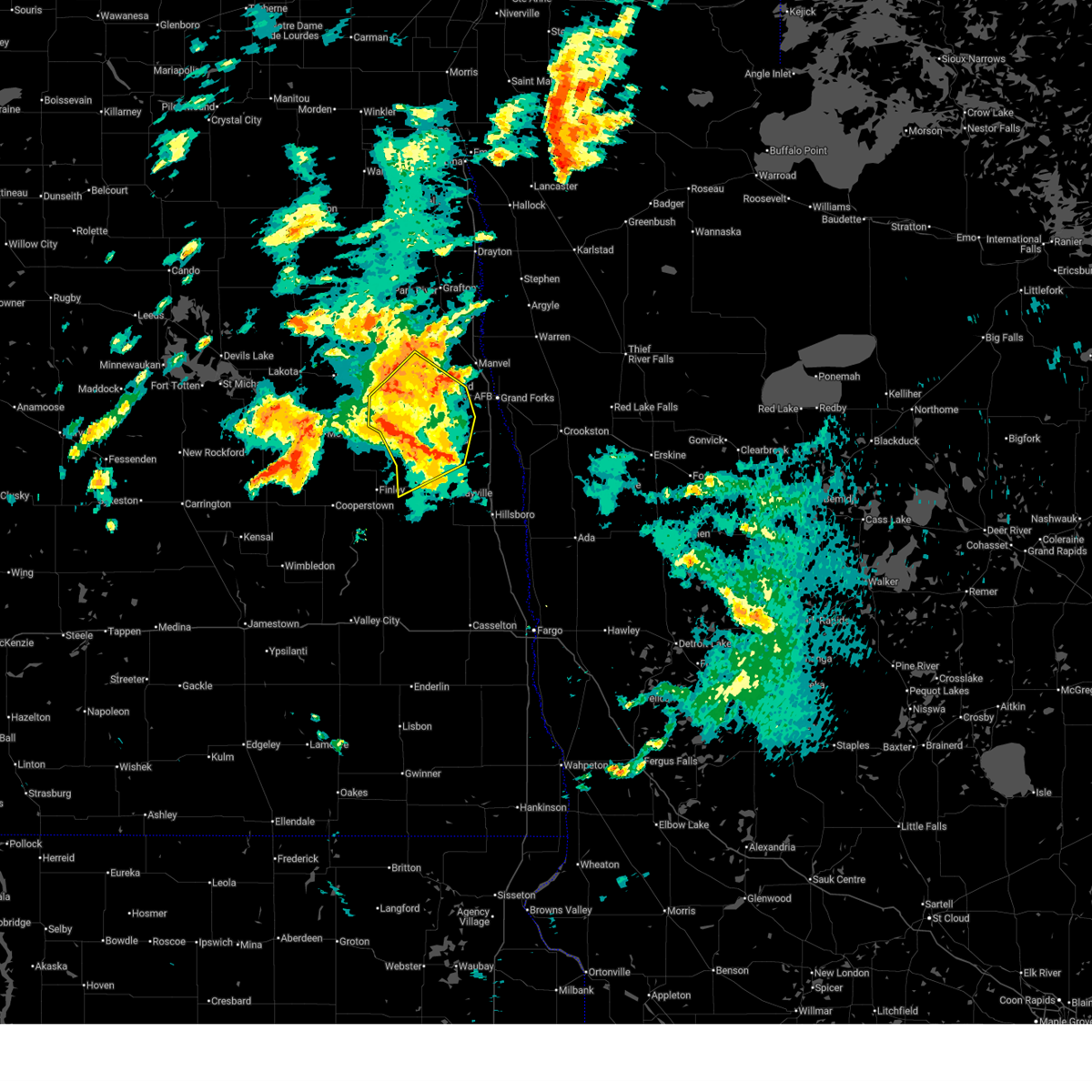
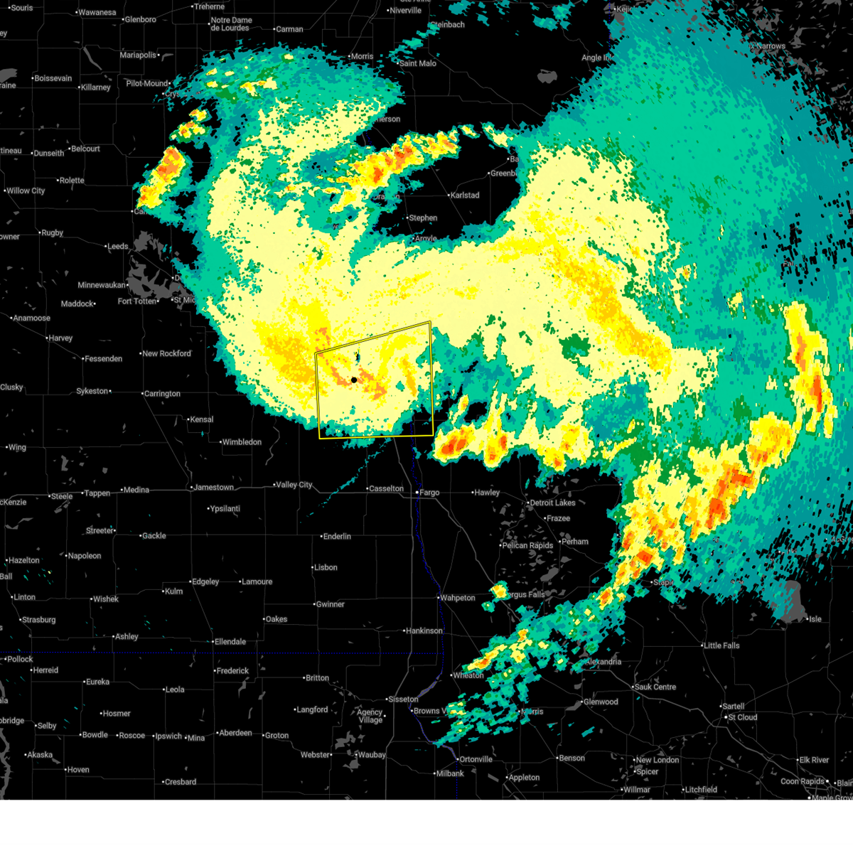
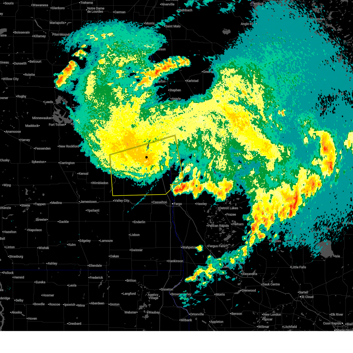
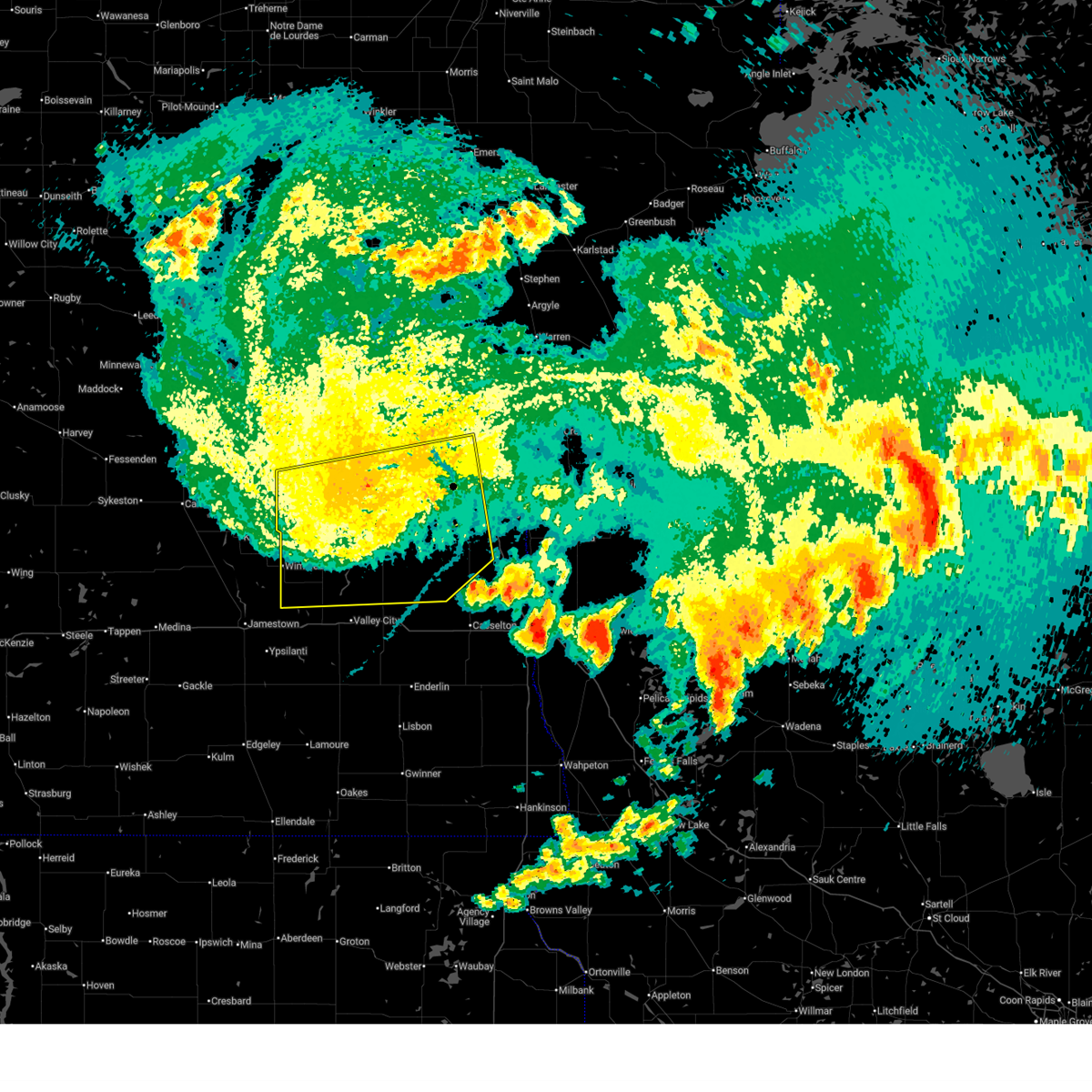
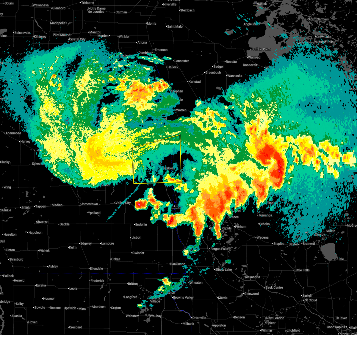
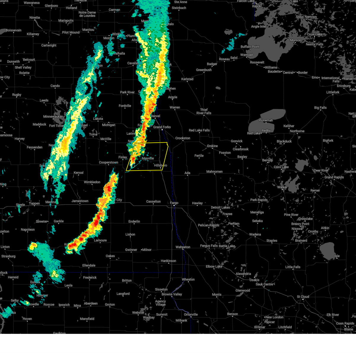
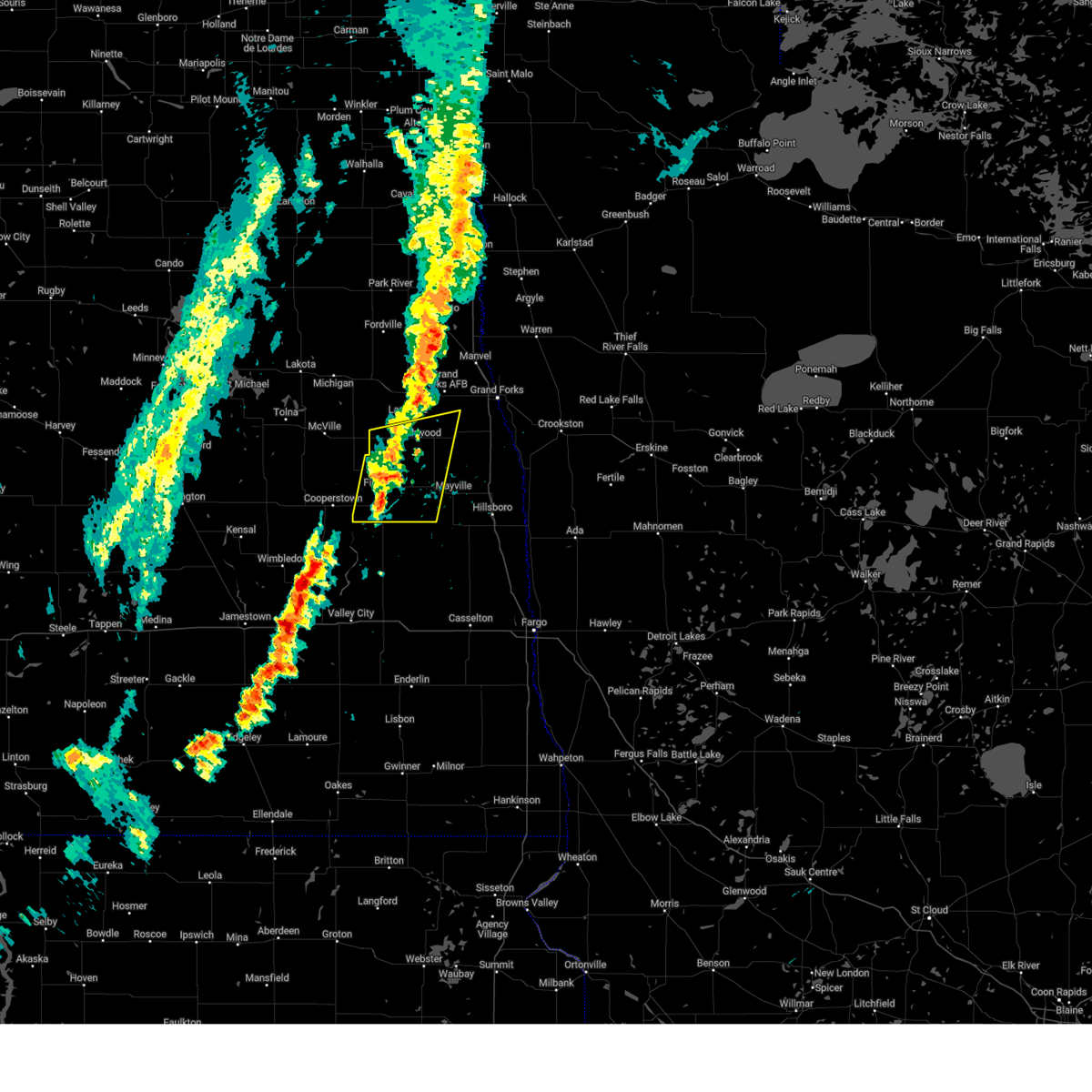
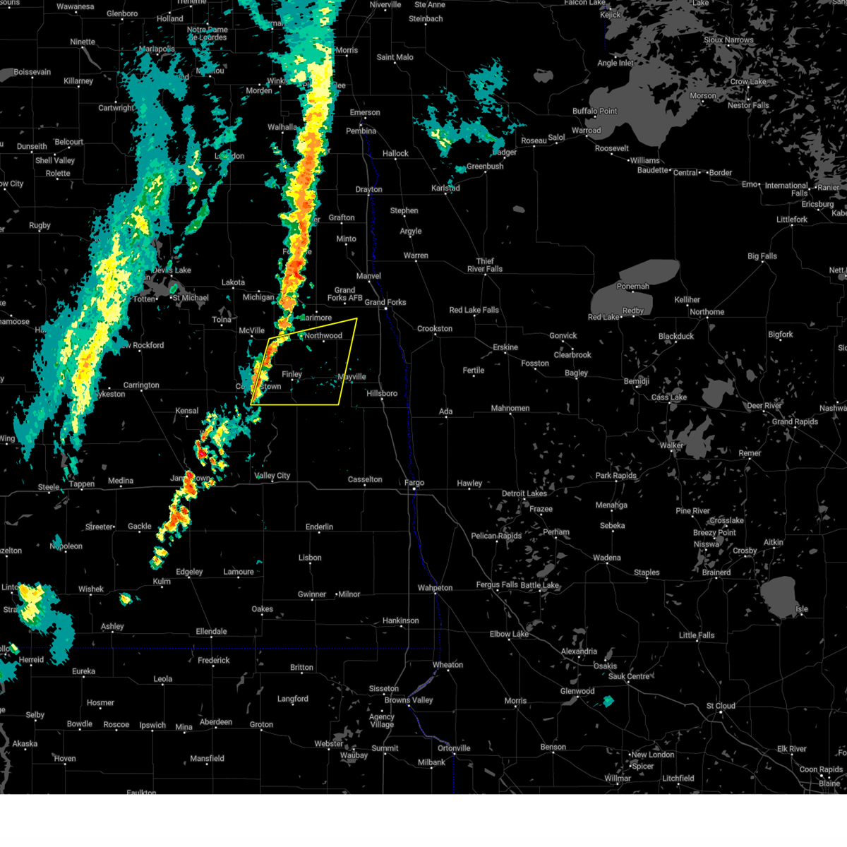
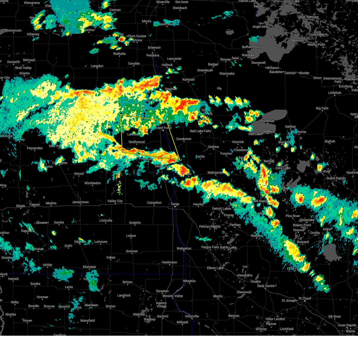
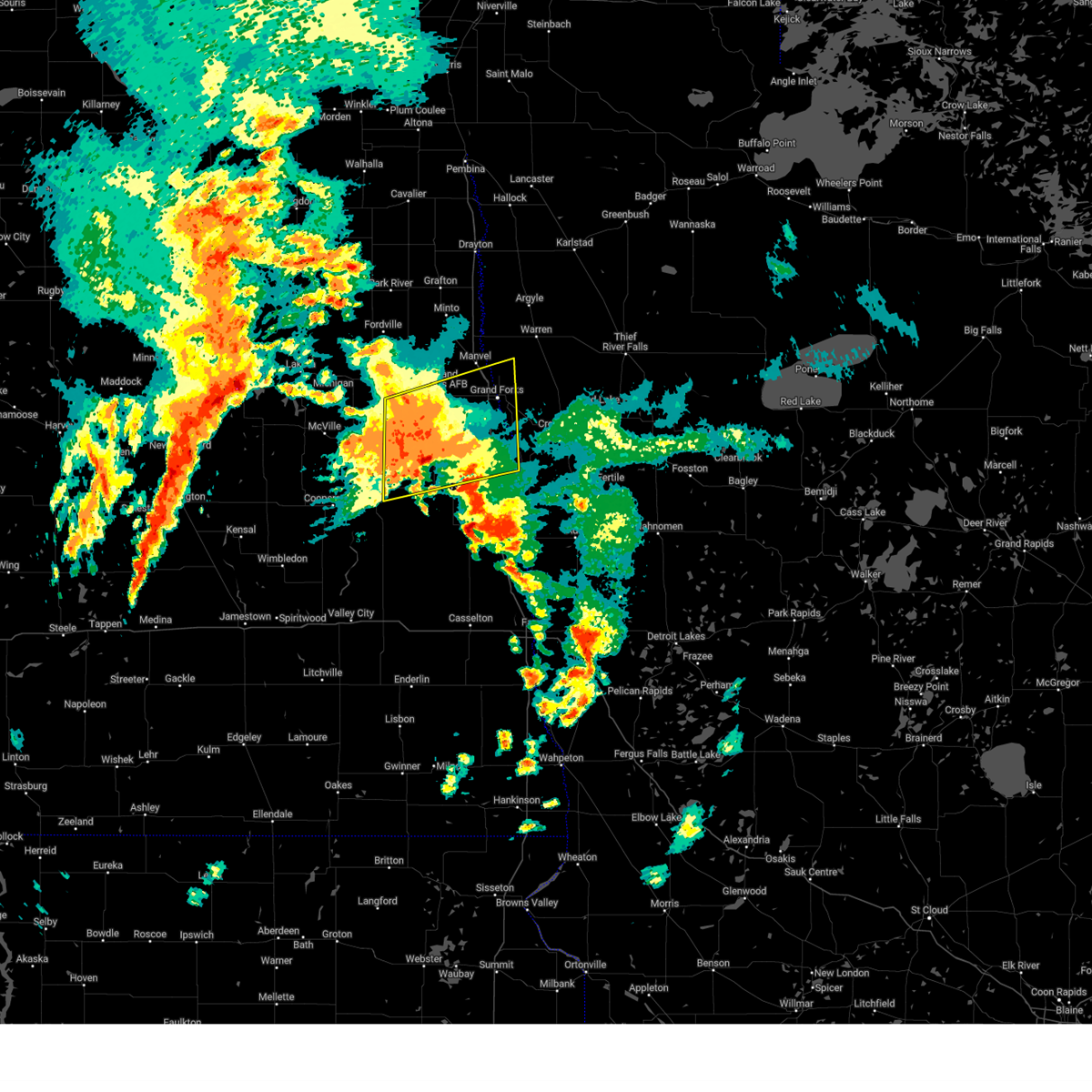
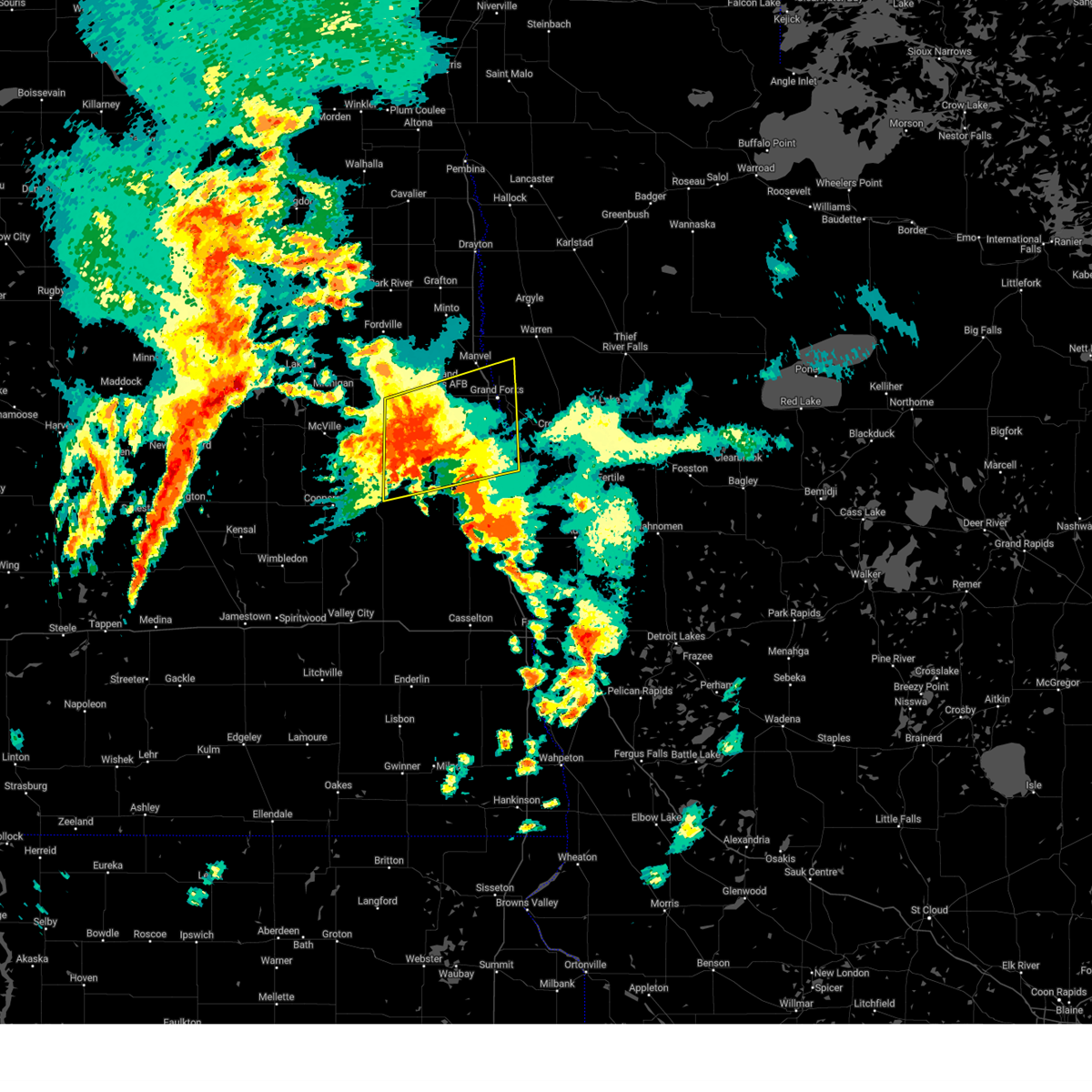
Hail Map for Hatton, ND
The Hatton, ND area has had 8 reports of on-the-ground hail by trained spotters, and has been under severe weather warnings 21 times during the past 12 months. Doppler radar has detected hail at or near Hatton, ND on 26 occasions.
| Name: | Hatton, ND |
| Where Located: | 61.5 miles NNW of Fargo, ND |
| Map: | Google Map for Hatton, ND |
| Population: | 777 |
| Housing Units: | 394 |
| More Info: | Search Google for Hatton, ND |
5
The Top Recent Hail Date for Hatton, ND is Friday, June 28, 2024 (9th out of 26)

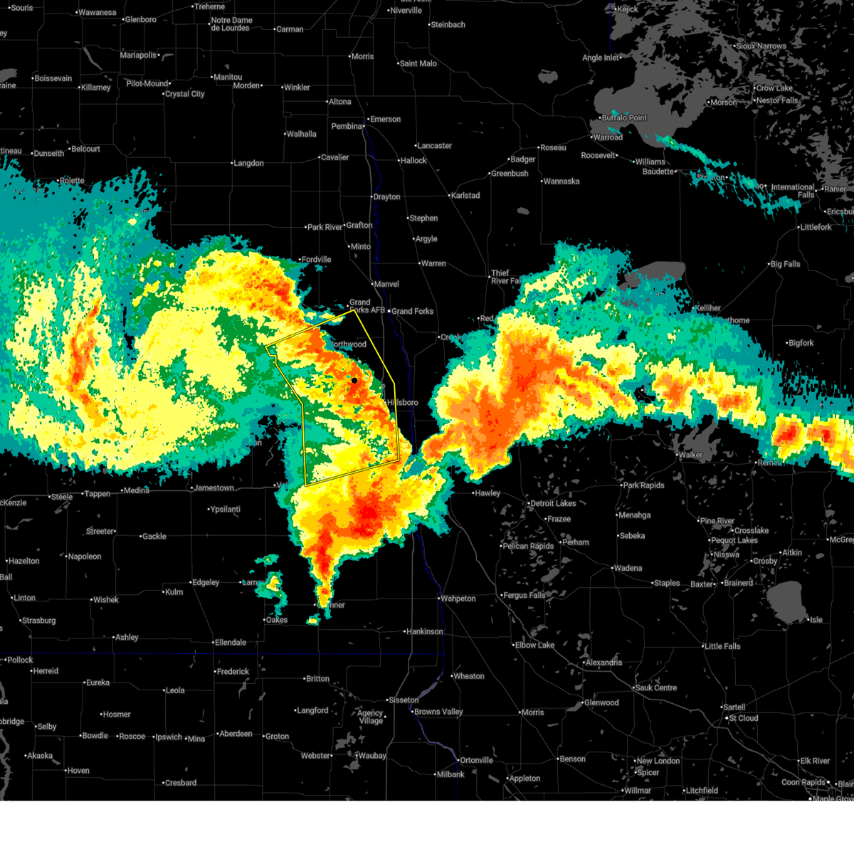
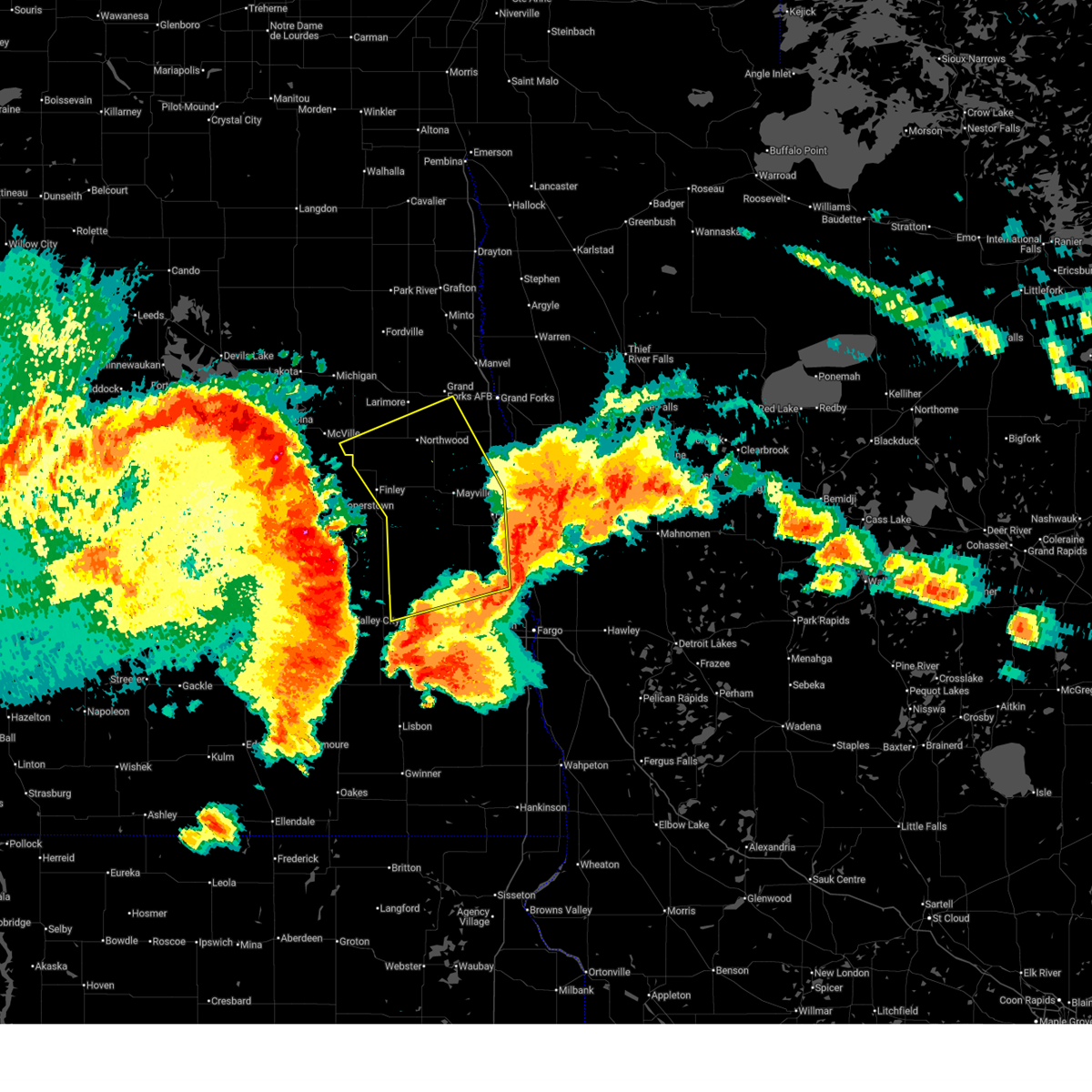
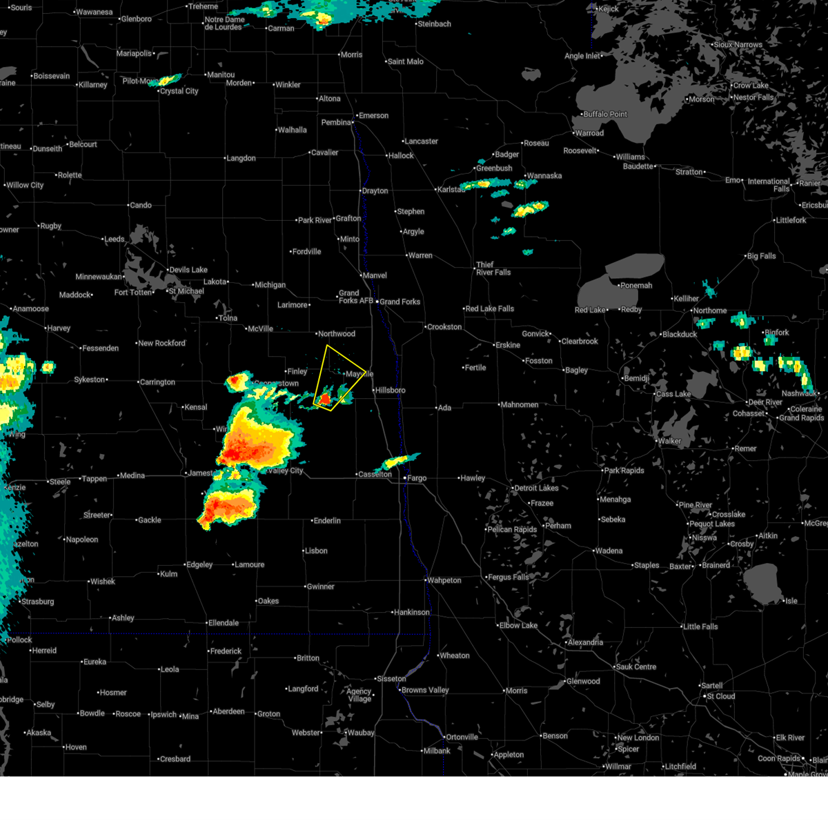
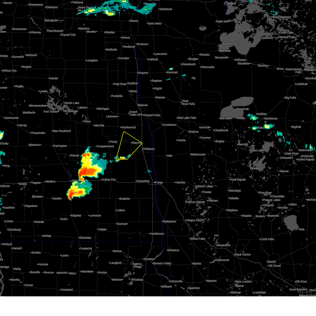
Hail and Wind Damage Spotted near Hatton, ND
| Date / Time | Report Details |
|---|---|
| 6/22/2025 9:40 AM CDT | Tree branches dow in grand forks county ND, 4.3 miles S of Hatton, ND |
| 6/22/2025 9:33 AM CDT |
 the severe thunderstorm warning has been cancelled and is no longer in effect the severe thunderstorm warning has been cancelled and is no longer in effect
|
| 6/22/2025 9:33 AM CDT |
 At 933 am cdt, severe thunderstorms were located along a line extending from 6 miles west of larimore to kempton to near northwood to near hatton, moving northeast at 45 mph (radar indicated). Hazards include 70 mph wind gusts and penny size hail. Expect considerable tree damage. damage is likely to mobile homes, roofs, and outbuildings. Locations impacted include, grand forks afb, larimore, northwood, hatton, golden lake, emerado, and arvilla. At 933 am cdt, severe thunderstorms were located along a line extending from 6 miles west of larimore to kempton to near northwood to near hatton, moving northeast at 45 mph (radar indicated). Hazards include 70 mph wind gusts and penny size hail. Expect considerable tree damage. damage is likely to mobile homes, roofs, and outbuildings. Locations impacted include, grand forks afb, larimore, northwood, hatton, golden lake, emerado, and arvilla.
|
| 6/22/2025 9:13 AM CDT |
 Svrfgf the national weather service in grand forks has issued a * severe thunderstorm warning for, western grand forks county in northeastern north dakota, southeastern nelson county in northeastern north dakota, northwestern traill county in southeastern north dakota, northern steele county in southeastern north dakota, * until 1000 am cdt. * at 911 am cdt, severe thunderstorms were located along a line extending from 7 miles northeast of kloten to near logan center to near sharon to 6 miles southwest of finley, moving northeast at 45 mph (radar indicated). Hazards include 70 mph wind gusts and quarter size hail. Hail damage to vehicles is expected. expect considerable tree damage. Wind damage is also likely to mobile homes, roofs, and outbuildings. Svrfgf the national weather service in grand forks has issued a * severe thunderstorm warning for, western grand forks county in northeastern north dakota, southeastern nelson county in northeastern north dakota, northwestern traill county in southeastern north dakota, northern steele county in southeastern north dakota, * until 1000 am cdt. * at 911 am cdt, severe thunderstorms were located along a line extending from 7 miles northeast of kloten to near logan center to near sharon to 6 miles southwest of finley, moving northeast at 45 mph (radar indicated). Hazards include 70 mph wind gusts and quarter size hail. Hail damage to vehicles is expected. expect considerable tree damage. Wind damage is also likely to mobile homes, roofs, and outbuildings.
|
| 6/21/2025 2:40 AM CDT |
 The storms which prompted the warning have weakened below severe limits, and no longer pose an immediate threat to life or property. therefore, the warning will be allowed to expire. a tornado watch remains in effect until 300 am cdt for northwestern minnesota, and southeastern and northeastern north dakota. The storms which prompted the warning have weakened below severe limits, and no longer pose an immediate threat to life or property. therefore, the warning will be allowed to expire. a tornado watch remains in effect until 300 am cdt for northwestern minnesota, and southeastern and northeastern north dakota.
|
| 6/21/2025 2:22 AM CDT |
 At 222 am cdt, severe thunderstorms were located along a line extending from fisher to near hadler, moving northeast at 30 mph (public). Hazards include 70 mph wind gusts. Expect considerable tree damage. damage is likely to mobile homes, roofs, and outbuildings. these severe thunderstorms will remain over mainly rural areas of western norman, southwestern polk, southeastern grand forks, northern cass, traill and steele counties, including the following locations, west argusville and american crystal sugar. This includes interstate 29 between mile markers 77 and 129. At 222 am cdt, severe thunderstorms were located along a line extending from fisher to near hadler, moving northeast at 30 mph (public). Hazards include 70 mph wind gusts. Expect considerable tree damage. damage is likely to mobile homes, roofs, and outbuildings. these severe thunderstorms will remain over mainly rural areas of western norman, southwestern polk, southeastern grand forks, northern cass, traill and steele counties, including the following locations, west argusville and american crystal sugar. This includes interstate 29 between mile markers 77 and 129.
|
| 6/21/2025 2:22 AM CDT |
 the severe thunderstorm warning has been cancelled and is no longer in effect the severe thunderstorm warning has been cancelled and is no longer in effect
|
| 6/21/2025 1:44 AM CDT |
 The storms which prompted the warning have remained however the warning is expiring. a tornado watch remains in effect until 300 am cdt for northwestern minnesota, and southeastern and northeastern north dakota. remember, a severe thunderstorm warning still remains in effect for for much of the area. The storms which prompted the warning have remained however the warning is expiring. a tornado watch remains in effect until 300 am cdt for northwestern minnesota, and southeastern and northeastern north dakota. remember, a severe thunderstorm warning still remains in effect for for much of the area.
|
| 6/21/2025 1:43 AM CDT |
 Svrfgf the national weather service in grand forks has issued a * severe thunderstorm warning for, western norman county in northwestern minnesota, southwestern polk county in northwestern minnesota, southeastern grand forks county in northeastern north dakota, northern cass county in southeastern north dakota, traill county in southeastern north dakota, southeastern griggs county in southeastern north dakota, northeastern barnes county in southeastern north dakota, steele county in southeastern north dakota, * until 245 am cdt. * at 142 am cdt, severe thunderstorms were located along a line extending from reynolds to grandin, moving east at 30 mph. these are destructive storms for the central red river valley (public. at multiple ndanw sensors in the central red river valley reported winds gusts in excess of 90mph). Hazards include 100 mph wind gusts. You are in a life-threatening situation. flying debris may be deadly to those caught without shelter. mobile homes will be destroyed. expect considerable damage to homes and businesses. expect extensive tree damage and power outages. severe thunderstorms will be near, hillsboro, buxton, and reynolds around 145 am cdt. caledonia around 150 am cdt. halstad, hendrum, and shelly around 155 am cdt. climax and nielsville around 200 am cdt. fisher and eldred around 210 am cdt. other locations impacted by these severe thunderstorms include west argusville and american crystal sugar. This includes interstate 29 between mile markers 77 and 129. Svrfgf the national weather service in grand forks has issued a * severe thunderstorm warning for, western norman county in northwestern minnesota, southwestern polk county in northwestern minnesota, southeastern grand forks county in northeastern north dakota, northern cass county in southeastern north dakota, traill county in southeastern north dakota, southeastern griggs county in southeastern north dakota, northeastern barnes county in southeastern north dakota, steele county in southeastern north dakota, * until 245 am cdt. * at 142 am cdt, severe thunderstorms were located along a line extending from reynolds to grandin, moving east at 30 mph. these are destructive storms for the central red river valley (public. at multiple ndanw sensors in the central red river valley reported winds gusts in excess of 90mph). Hazards include 100 mph wind gusts. You are in a life-threatening situation. flying debris may be deadly to those caught without shelter. mobile homes will be destroyed. expect considerable damage to homes and businesses. expect extensive tree damage and power outages. severe thunderstorms will be near, hillsboro, buxton, and reynolds around 145 am cdt. caledonia around 150 am cdt. halstad, hendrum, and shelly around 155 am cdt. climax and nielsville around 200 am cdt. fisher and eldred around 210 am cdt. other locations impacted by these severe thunderstorms include west argusville and american crystal sugar. This includes interstate 29 between mile markers 77 and 129.
|
| 6/21/2025 1:12 AM CDT |
 Svrfgf the national weather service in grand forks has issued a * severe thunderstorm warning for, southwestern grand forks county in northeastern north dakota, northwestern cass county in southeastern north dakota, western traill county in southeastern north dakota, griggs county in southeastern north dakota, northern barnes county in southeastern north dakota, steele county in southeastern north dakota, * until 200 am cdt. * at 110 am cdt, a severe thunderstorm was located over galesburg, or 37 miles northeast of valley city, moving east at 15 mph. this is a destructive storm (emergency management. 111 mph wind gusts have been reported with this storm near luverne). Hazards include 100 mph wind gusts. You are in a life-threatening situation. flying debris may be deadly to those caught without shelter. mobile homes will be destroyed. expect considerable damage to homes and businesses. Expect extensive tree damage and power outages. Svrfgf the national weather service in grand forks has issued a * severe thunderstorm warning for, southwestern grand forks county in northeastern north dakota, northwestern cass county in southeastern north dakota, western traill county in southeastern north dakota, griggs county in southeastern north dakota, northern barnes county in southeastern north dakota, steele county in southeastern north dakota, * until 200 am cdt. * at 110 am cdt, a severe thunderstorm was located over galesburg, or 37 miles northeast of valley city, moving east at 15 mph. this is a destructive storm (emergency management. 111 mph wind gusts have been reported with this storm near luverne). Hazards include 100 mph wind gusts. You are in a life-threatening situation. flying debris may be deadly to those caught without shelter. mobile homes will be destroyed. expect considerable damage to homes and businesses. Expect extensive tree damage and power outages.
|
| 6/21/2025 12:51 AM CDT |
 Svrfgf the national weather service in grand forks has issued a * severe thunderstorm warning for, western norman county in northwestern minnesota, southwestern polk county in northwestern minnesota, southeastern grand forks county in northeastern north dakota, north central cass county in southeastern north dakota, traill county in southeastern north dakota, eastern steele county in southeastern north dakota, * until 145 am cdt. * at 1249 am cdt, severe thunderstorms were located along a line extending from near hatton to near colgate, moving east at 40 mph. widespread observed and long duration wind speeds have been greater than 75 mph within this area of storms. these are destructive storms for the central red river valley (public. at 111 mph 1 e of luverne in steele county). Hazards include 100 mph wind gusts. You are in a life-threatening situation. flying debris may be deadly to those caught without shelter. mobile homes will be destroyed. expect considerable damage to homes and businesses. expect extensive tree damage and power outages. severe thunderstorms will be near, mayville, hatton, and portland around 1255 am cdt. blanchard around 105 am cdt. hillsboro, buxton, and reynolds around 115 am cdt. kelso around 120 am cdt. caledonia around 130 am cdt. other locations impacted by these severe thunderstorms include american crystal sugar. This includes interstate 29 between mile markers 90 and 130. Svrfgf the national weather service in grand forks has issued a * severe thunderstorm warning for, western norman county in northwestern minnesota, southwestern polk county in northwestern minnesota, southeastern grand forks county in northeastern north dakota, north central cass county in southeastern north dakota, traill county in southeastern north dakota, eastern steele county in southeastern north dakota, * until 145 am cdt. * at 1249 am cdt, severe thunderstorms were located along a line extending from near hatton to near colgate, moving east at 40 mph. widespread observed and long duration wind speeds have been greater than 75 mph within this area of storms. these are destructive storms for the central red river valley (public. at 111 mph 1 e of luverne in steele county). Hazards include 100 mph wind gusts. You are in a life-threatening situation. flying debris may be deadly to those caught without shelter. mobile homes will be destroyed. expect considerable damage to homes and businesses. expect extensive tree damage and power outages. severe thunderstorms will be near, mayville, hatton, and portland around 1255 am cdt. blanchard around 105 am cdt. hillsboro, buxton, and reynolds around 115 am cdt. kelso around 120 am cdt. caledonia around 130 am cdt. other locations impacted by these severe thunderstorms include american crystal sugar. This includes interstate 29 between mile markers 90 and 130.
|
| 6/20/2025 11:57 PM CDT |
 The storms which prompted the warning have moved out of the area. therefore, the warning will be allowed to expire. however, gusty winds and heavy rain are still possible with these thunderstorms. a tornado watch remains in effect until 300 am cdt for southeastern and northeastern north dakota. to report severe weather, contact your nearest law enforcement agency. they will relay your report to the national weather service grand forks. The storms which prompted the warning have moved out of the area. therefore, the warning will be allowed to expire. however, gusty winds and heavy rain are still possible with these thunderstorms. a tornado watch remains in effect until 300 am cdt for southeastern and northeastern north dakota. to report severe weather, contact your nearest law enforcement agency. they will relay your report to the national weather service grand forks.
|
| 6/20/2025 11:17 PM CDT |
 Svrfgf the national weather service in grand forks has issued a * severe thunderstorm warning for, southwestern grand forks county in northeastern north dakota, southeastern nelson county in northeastern north dakota, northern cass county in southeastern north dakota, traill county in southeastern north dakota, northeastern barnes county in southeastern north dakota, steele county in southeastern north dakota, * until midnight cdt. * at 1116 pm cdt, severe thunderstorms were located along a line extending from near red willow lake to luverne to 6 miles northeast of valley city, moving east at 70 mph. these are destructive storms for grand forks, nelson, cass, traill, barnes, steele (public). Hazards include 90 mph wind gusts and ping pong ball size hail. You are in a life-threatening situation. flying debris may be deadly to those caught without shelter. mobile homes will be heavily damaged or destroyed. homes and businesses will have substantial roof and window damage. expect extensive tree damage and power outages. severe thunderstorms will be near, hope and kloten around 1120 pm cdt. finley, aneta, and sharon around 1125 pm cdt. page and ayr around 1130 pm cdt. golden lake, galesburg, and erie around 1135 pm cdt. mayville, northwood, and hatton around 1140 pm cdt. other locations impacted by these severe thunderstorms include american crystal sugar. This includes interstate 29 between mile markers 82 and 119. Svrfgf the national weather service in grand forks has issued a * severe thunderstorm warning for, southwestern grand forks county in northeastern north dakota, southeastern nelson county in northeastern north dakota, northern cass county in southeastern north dakota, traill county in southeastern north dakota, northeastern barnes county in southeastern north dakota, steele county in southeastern north dakota, * until midnight cdt. * at 1116 pm cdt, severe thunderstorms were located along a line extending from near red willow lake to luverne to 6 miles northeast of valley city, moving east at 70 mph. these are destructive storms for grand forks, nelson, cass, traill, barnes, steele (public). Hazards include 90 mph wind gusts and ping pong ball size hail. You are in a life-threatening situation. flying debris may be deadly to those caught without shelter. mobile homes will be heavily damaged or destroyed. homes and businesses will have substantial roof and window damage. expect extensive tree damage and power outages. severe thunderstorms will be near, hope and kloten around 1120 pm cdt. finley, aneta, and sharon around 1125 pm cdt. page and ayr around 1130 pm cdt. golden lake, galesburg, and erie around 1135 pm cdt. mayville, northwood, and hatton around 1140 pm cdt. other locations impacted by these severe thunderstorms include american crystal sugar. This includes interstate 29 between mile markers 82 and 119.
|
| 6/20/2025 9:21 PM CDT |
 At 920 pm cdt, a severe thunderstorm was located near clifford, or 40 miles northeast of valley city, moving northeast at 25 mph (radar indicated). Hazards include 60 mph wind gusts and quarter size hail. Hail damage to vehicles is expected. expect wind damage to roofs, siding, and trees. Locations impacted include, mayville, hatton, portland, clifford, and roseville. At 920 pm cdt, a severe thunderstorm was located near clifford, or 40 miles northeast of valley city, moving northeast at 25 mph (radar indicated). Hazards include 60 mph wind gusts and quarter size hail. Hail damage to vehicles is expected. expect wind damage to roofs, siding, and trees. Locations impacted include, mayville, hatton, portland, clifford, and roseville.
|
| 6/20/2025 9:06 PM CDT |
 Svrfgf the national weather service in grand forks has issued a * severe thunderstorm warning for, western traill county in southeastern north dakota, eastern steele county in southeastern north dakota, * until 1000 pm cdt. * at 905 pm cdt, a severe thunderstorm was located near clifford, or 34 miles northeast of valley city, moving north at 25 mph (radar indicated). Hazards include 60 mph wind gusts and quarter size hail. Hail damage to vehicles is expected. Expect wind damage to roofs, siding, and trees. Svrfgf the national weather service in grand forks has issued a * severe thunderstorm warning for, western traill county in southeastern north dakota, eastern steele county in southeastern north dakota, * until 1000 pm cdt. * at 905 pm cdt, a severe thunderstorm was located near clifford, or 34 miles northeast of valley city, moving north at 25 mph (radar indicated). Hazards include 60 mph wind gusts and quarter size hail. Hail damage to vehicles is expected. Expect wind damage to roofs, siding, and trees.
|
| 6/7/2025 4:39 PM CDT |
 Svrfgf the national weather service in grand forks has issued a * severe thunderstorm warning for, southeastern grand forks county in northeastern north dakota, northern traill county in southeastern north dakota, northeastern steele county in southeastern north dakota, * until 530 pm cdt. * at 439 pm cdt, severe thunderstorms were located along a line extending from hatton to near hope, moving east at 30 mph (radar indicated). Hazards include 60 mph wind gusts. expect damage to roofs, siding, and trees Svrfgf the national weather service in grand forks has issued a * severe thunderstorm warning for, southeastern grand forks county in northeastern north dakota, northern traill county in southeastern north dakota, northeastern steele county in southeastern north dakota, * until 530 pm cdt. * at 439 pm cdt, severe thunderstorms were located along a line extending from hatton to near hope, moving east at 30 mph (radar indicated). Hazards include 60 mph wind gusts. expect damage to roofs, siding, and trees
|
| 6/7/2025 4:23 PM CDT |
 the severe thunderstorm warning has been cancelled and is no longer in effect the severe thunderstorm warning has been cancelled and is no longer in effect
|
| 6/7/2025 4:23 PM CDT |
 At 423 pm cdt, severe thunderstorms were located along a line extending from near northwood to near blabon, moving east at 35 mph (radar indicated). Hazards include 60 mph wind gusts. Expect damage to roofs, siding, and trees. Locations impacted include, northwood, hatton, golden lake, finley, sharon, kempton, and blabon. At 423 pm cdt, severe thunderstorms were located along a line extending from near northwood to near blabon, moving east at 35 mph (radar indicated). Hazards include 60 mph wind gusts. Expect damage to roofs, siding, and trees. Locations impacted include, northwood, hatton, golden lake, finley, sharon, kempton, and blabon.
|
| 6/7/2025 3:59 PM CDT |
 Svrfgf the national weather service in grand forks has issued a * severe thunderstorm warning for, southwestern grand forks county in northeastern north dakota, southeastern nelson county in northeastern north dakota, northwestern traill county in southeastern north dakota, northeastern griggs county in southeastern north dakota, steele county in southeastern north dakota, * until 445 pm cdt. * at 358 pm cdt, severe thunderstorms were located along a line extending from near aneta to near cooperstown, moving east at 35 mph (radar indicated). Hazards include 60 mph wind gusts. expect damage to roofs, siding, and trees Svrfgf the national weather service in grand forks has issued a * severe thunderstorm warning for, southwestern grand forks county in northeastern north dakota, southeastern nelson county in northeastern north dakota, northwestern traill county in southeastern north dakota, northeastern griggs county in southeastern north dakota, steele county in southeastern north dakota, * until 445 pm cdt. * at 358 pm cdt, severe thunderstorms were located along a line extending from near aneta to near cooperstown, moving east at 35 mph (radar indicated). Hazards include 60 mph wind gusts. expect damage to roofs, siding, and trees
|
| 5/15/2025 4:33 PM CDT |
 Svrfgf the national weather service in grand forks has issued a * severe thunderstorm warning for, southwestern polk county in northwestern minnesota, grand forks county in northeastern north dakota, northern traill county in southeastern north dakota, northeastern steele county in southeastern north dakota, * until 515 pm cdt. * at 432 pm cdt, severe thunderstorms were located along a line extending from 6 miles south of logan center to climax, moving northwest at 45 mph (radar indicated). Hazards include 60 mph wind gusts and penny size hail. expect damage to roofs, siding, and trees Svrfgf the national weather service in grand forks has issued a * severe thunderstorm warning for, southwestern polk county in northwestern minnesota, grand forks county in northeastern north dakota, northern traill county in southeastern north dakota, northeastern steele county in southeastern north dakota, * until 515 pm cdt. * at 432 pm cdt, severe thunderstorms were located along a line extending from 6 miles south of logan center to climax, moving northwest at 45 mph (radar indicated). Hazards include 60 mph wind gusts and penny size hail. expect damage to roofs, siding, and trees
|
| 8/29/2024 3:18 AM CDT |
 At 317 am cdt, a severe thunderstorm was located near glenfield, or 24 miles east of carrington, moving east at 40 mph (radar indicated). Hazards include 70 mph wind gusts and nickel size hail. Expect considerable tree damage. damage is likely to mobile homes, roofs, and outbuildings. locations impacted include, grand forks, east grand forks, grand forks afb, larimore, thompson, northwood, and hatton. This includes interstate 29 between mile markers 116 and 150. At 317 am cdt, a severe thunderstorm was located near glenfield, or 24 miles east of carrington, moving east at 40 mph (radar indicated). Hazards include 70 mph wind gusts and nickel size hail. Expect considerable tree damage. damage is likely to mobile homes, roofs, and outbuildings. locations impacted include, grand forks, east grand forks, grand forks afb, larimore, thompson, northwood, and hatton. This includes interstate 29 between mile markers 116 and 150.
|
| 8/29/2024 3:13 AM CDT |
 Svrfgf the national weather service in grand forks has issued a * severe thunderstorm warning for, northwestern polk county in northwestern minnesota, southern grand forks county in northeastern north dakota, northern traill county in southeastern north dakota, northeastern steele county in southeastern north dakota, * until 400 am cdt. * at 313 am cdt, a severe thunderstorm was located near golden lake, or 31 miles southwest of grand forks, moving east at 40 mph (radar indicated). Hazards include 60 mph wind gusts and nickel size hail. expect damage to roofs, siding, and trees Svrfgf the national weather service in grand forks has issued a * severe thunderstorm warning for, northwestern polk county in northwestern minnesota, southern grand forks county in northeastern north dakota, northern traill county in southeastern north dakota, northeastern steele county in southeastern north dakota, * until 400 am cdt. * at 313 am cdt, a severe thunderstorm was located near golden lake, or 31 miles southwest of grand forks, moving east at 40 mph (radar indicated). Hazards include 60 mph wind gusts and nickel size hail. expect damage to roofs, siding, and trees
|
| 6/28/2024 9:17 PM CDT |
 At 917 pm cdt, severe thunderstorms were located along a line extending from near mayville to near clifford, moving east at 40 mph (radar indicated). Hazards include 60 mph wind gusts and quarter size hail. Hail damage to vehicles is expected. expect wind damage to roofs, siding, and trees. locations impacted include, mayville, hillsboro, hatton, portland, buxton, reynolds, and cummings. This includes interstate 29 between mile markers 93 and 122. At 917 pm cdt, severe thunderstorms were located along a line extending from near mayville to near clifford, moving east at 40 mph (radar indicated). Hazards include 60 mph wind gusts and quarter size hail. Hail damage to vehicles is expected. expect wind damage to roofs, siding, and trees. locations impacted include, mayville, hillsboro, hatton, portland, buxton, reynolds, and cummings. This includes interstate 29 between mile markers 93 and 122.
|
| 6/28/2024 9:15 PM CDT |
 At 914 pm cdt, severe thunderstorms were located along a line extending from near mayville to clifford, moving east at 40 mph (radar indicated). Hazards include 60 mph wind gusts and quarter size hail. Hail damage to vehicles is expected. expect wind damage to roofs, siding, and trees. locations impacted include, mayville, hillsboro, hatton, portland, golden lake, buxton, and reynolds. This includes interstate 29 between mile markers 93 and 122. At 914 pm cdt, severe thunderstorms were located along a line extending from near mayville to clifford, moving east at 40 mph (radar indicated). Hazards include 60 mph wind gusts and quarter size hail. Hail damage to vehicles is expected. expect wind damage to roofs, siding, and trees. locations impacted include, mayville, hillsboro, hatton, portland, golden lake, buxton, and reynolds. This includes interstate 29 between mile markers 93 and 122.
|
| 6/28/2024 8:59 PM CDT |
 Svrfgf the national weather service in grand forks has issued a * severe thunderstorm warning for, traill county in southeastern north dakota, eastern steele county in southeastern north dakota, * until 945 pm cdt. * at 858 pm cdt, severe thunderstorms were located along a line extending from near golden lake to near hope, moving east at 40 mph (radar indicated). Hazards include 60 mph wind gusts and quarter size hail. Hail damage to vehicles is expected. Expect wind damage to roofs, siding, and trees. Svrfgf the national weather service in grand forks has issued a * severe thunderstorm warning for, traill county in southeastern north dakota, eastern steele county in southeastern north dakota, * until 945 pm cdt. * at 858 pm cdt, severe thunderstorms were located along a line extending from near golden lake to near hope, moving east at 40 mph (radar indicated). Hazards include 60 mph wind gusts and quarter size hail. Hail damage to vehicles is expected. Expect wind damage to roofs, siding, and trees.
|
| 6/18/2024 2:33 AM CDT |
 At 232 am cdt, severe thunderstorms were located along a line extending from near greenview to 6 miles northwest of prosper, moving east at 40 mph (radar indicated). Hazards include 60 mph wind gusts. Expect damage to roofs, siding, and trees. locations impacted include, mayville, ada, hillsboro, fertile, twin valley, hatton, and mcintosh. This includes interstate 29 between mile markers 74 and 122. At 232 am cdt, severe thunderstorms were located along a line extending from near greenview to 6 miles northwest of prosper, moving east at 40 mph (radar indicated). Hazards include 60 mph wind gusts. Expect damage to roofs, siding, and trees. locations impacted include, mayville, ada, hillsboro, fertile, twin valley, hatton, and mcintosh. This includes interstate 29 between mile markers 74 and 122.
|
| 6/18/2024 2:22 AM CDT |
 Svrfgf the national weather service in grand forks has issued a * severe thunderstorm warning for, northwestern clay county in northwestern minnesota, norman county in northwestern minnesota, southern polk county in northwestern minnesota, northwestern mahnomen county in northwestern minnesota, northern cass county in southeastern north dakota, traill county in southeastern north dakota, eastern steele county in southeastern north dakota, * until 300 am cdt. * at 222 am cdt, severe thunderstorms were located along a line extending from near greenview to near arthur, moving east at 40 mph (radar indicated). Hazards include 70 mph wind gusts. Expect considerable tree damage. Damage is likely to mobile homes, roofs, and outbuildings. Svrfgf the national weather service in grand forks has issued a * severe thunderstorm warning for, northwestern clay county in northwestern minnesota, norman county in northwestern minnesota, southern polk county in northwestern minnesota, northwestern mahnomen county in northwestern minnesota, northern cass county in southeastern north dakota, traill county in southeastern north dakota, eastern steele county in southeastern north dakota, * until 300 am cdt. * at 222 am cdt, severe thunderstorms were located along a line extending from near greenview to near arthur, moving east at 40 mph (radar indicated). Hazards include 70 mph wind gusts. Expect considerable tree damage. Damage is likely to mobile homes, roofs, and outbuildings.
|
| 6/18/2024 2:07 AM CDT |
 Svrfgf the national weather service in grand forks has issued a * severe thunderstorm warning for, western norman county in northwestern minnesota, southwestern polk county in northwestern minnesota, northeastern cass county in southeastern north dakota, traill county in southeastern north dakota, eastern steele county in southeastern north dakota, * until 230 am cdt. * at 206 am cdt, severe thunderstorms were located along a line extending from near cummings to near erie, moving southeast at 30 mph. these are destructive storms for mayville and traill county (radar indicated). Hazards include 80 mph wind gusts. Flying debris will be dangerous to those caught without shelter. mobile homes will be heavily damaged. expect considerable damage to roofs, windows, and vehicles. Extensive tree damage and power outages are likely. Svrfgf the national weather service in grand forks has issued a * severe thunderstorm warning for, western norman county in northwestern minnesota, southwestern polk county in northwestern minnesota, northeastern cass county in southeastern north dakota, traill county in southeastern north dakota, eastern steele county in southeastern north dakota, * until 230 am cdt. * at 206 am cdt, severe thunderstorms were located along a line extending from near cummings to near erie, moving southeast at 30 mph. these are destructive storms for mayville and traill county (radar indicated). Hazards include 80 mph wind gusts. Flying debris will be dangerous to those caught without shelter. mobile homes will be heavily damaged. expect considerable damage to roofs, windows, and vehicles. Extensive tree damage and power outages are likely.
|
| 6/18/2024 1:32 AM CDT |
 At 132 am cdt, severe thunderstorms were located along a line extending from golden lake to near bald hill dam to near nortonville, moving east at 35 mph (radar indicated). Hazards include 70 mph wind gusts. Expect considerable tree damage. damage is likely to mobile homes, roofs, and outbuildings. locations impacted include, valley city, mayville, hillsboro, cooperstown, hatton, portland, and golden lake. this includes the following highways, interstate 29 between mile markers 97 and 122. Interstate 94 in north dakota between mile markers 272 and 325. At 132 am cdt, severe thunderstorms were located along a line extending from golden lake to near bald hill dam to near nortonville, moving east at 35 mph (radar indicated). Hazards include 70 mph wind gusts. Expect considerable tree damage. damage is likely to mobile homes, roofs, and outbuildings. locations impacted include, valley city, mayville, hillsboro, cooperstown, hatton, portland, and golden lake. this includes the following highways, interstate 29 between mile markers 97 and 122. Interstate 94 in north dakota between mile markers 272 and 325.
|
| 6/18/2024 1:23 AM CDT |
 Svrfgf the national weather service in grand forks has issued a * severe thunderstorm warning for, western cass county in southeastern north dakota, traill county in southeastern north dakota, eastern griggs county in southeastern north dakota, barnes county in southeastern north dakota, steele county in southeastern north dakota, * until 215 am cdt. * at 122 am cdt, severe thunderstorms were located along a line extending from near finley to bald hill dam to near nortonville, moving east at 35 mph (radar indicated). Hazards include 60 mph wind gusts. expect damage to roofs, siding, and trees Svrfgf the national weather service in grand forks has issued a * severe thunderstorm warning for, western cass county in southeastern north dakota, traill county in southeastern north dakota, eastern griggs county in southeastern north dakota, barnes county in southeastern north dakota, steele county in southeastern north dakota, * until 215 am cdt. * at 122 am cdt, severe thunderstorms were located along a line extending from near finley to bald hill dam to near nortonville, moving east at 35 mph (radar indicated). Hazards include 60 mph wind gusts. expect damage to roofs, siding, and trees
|
| 6/16/2024 5:40 AM CDT |
 The storm which prompted the warning has weakened below severe limits, and no longer poses an immediate threat to life or property. therefore, the warning will be allowed to expire. however, gusty winds are still possible with this thunderstorm. The storm which prompted the warning has weakened below severe limits, and no longer poses an immediate threat to life or property. therefore, the warning will be allowed to expire. however, gusty winds are still possible with this thunderstorm.
|
| 6/16/2024 5:12 AM CDT |
 Svrfgf the national weather service in grand forks has issued a * severe thunderstorm warning for, northwestern traill county in southeastern north dakota, northeastern steele county in southeastern north dakota, * until 545 am cdt. * at 512 am cdt, a severe thunderstorm was located near sherbrooke, or 40 miles southwest of grand forks, moving northeast at 40 mph (radar indicated). Hazards include 60 mph wind gusts and penny size hail. expect damage to roofs, siding, and trees Svrfgf the national weather service in grand forks has issued a * severe thunderstorm warning for, northwestern traill county in southeastern north dakota, northeastern steele county in southeastern north dakota, * until 545 am cdt. * at 512 am cdt, a severe thunderstorm was located near sherbrooke, or 40 miles southwest of grand forks, moving northeast at 40 mph (radar indicated). Hazards include 60 mph wind gusts and penny size hail. expect damage to roofs, siding, and trees
|
| 9/4/2023 11:39 PM CDT |
 At 1139 pm cdt, severe thunderstorms were located along a line extending from near derrick to near whitman to near finley, moving northeast at 45 mph (radar indicated). Hazards include 60 mph wind gusts. expect damage to roofs, siding, and trees At 1139 pm cdt, severe thunderstorms were located along a line extending from near derrick to near whitman to near finley, moving northeast at 45 mph (radar indicated). Hazards include 60 mph wind gusts. expect damage to roofs, siding, and trees
|
| 7/13/2023 3:34 PM CDT |
 At 334 pm cdt, a severe thunderstorm was located near portland, or 28 miles southwest of grand forks, moving southeast at 20 mph (radar indicated). Hazards include 60 mph wind gusts and quarter size hail. Hail damage to vehicles is expected. Expect wind damage to roofs, siding, and trees. At 334 pm cdt, a severe thunderstorm was located near portland, or 28 miles southwest of grand forks, moving southeast at 20 mph (radar indicated). Hazards include 60 mph wind gusts and quarter size hail. Hail damage to vehicles is expected. Expect wind damage to roofs, siding, and trees.
|
| 7/13/2023 3:25 PM CDT |
 The severe thunderstorm warning for south central grand forks, northwestern traill and northeastern steele counties will expire at 330 pm cdt, the storm which prompted the warning has weakened below severe limits, and no longer poses an immediate threat to life or property. therefore, the warning will be allowed to expire. however small hail is still possible with this thunderstorm. The severe thunderstorm warning for south central grand forks, northwestern traill and northeastern steele counties will expire at 330 pm cdt, the storm which prompted the warning has weakened below severe limits, and no longer poses an immediate threat to life or property. therefore, the warning will be allowed to expire. however small hail is still possible with this thunderstorm.
|
| 7/13/2023 2:54 PM CDT |
 At 253 pm cdt, a severe thunderstorm was located near northwood, or 25 miles southwest of grand forks, moving east at 25 mph (radar indicated). Hazards include 60 mph wind gusts and quarter size hail. Hail damage to vehicles is expected. expect wind damage to roofs, siding, and trees. locations impacted include, mayville, northwood, hatton, portland and holmes. hail threat, radar indicated max hail size, 1. 00 in wind threat, radar indicated max wind gust, 60 mph. At 253 pm cdt, a severe thunderstorm was located near northwood, or 25 miles southwest of grand forks, moving east at 25 mph (radar indicated). Hazards include 60 mph wind gusts and quarter size hail. Hail damage to vehicles is expected. expect wind damage to roofs, siding, and trees. locations impacted include, mayville, northwood, hatton, portland and holmes. hail threat, radar indicated max hail size, 1. 00 in wind threat, radar indicated max wind gust, 60 mph.
|
| 7/13/2023 2:33 PM CDT |
 At 233 pm cdt, a severe thunderstorm was located near northwood, or 31 miles southwest of grand forks, moving east at 25 mph (radar indicated). Hazards include 60 mph wind gusts and quarter size hail. Hail damage to vehicles is expected. Expect wind damage to roofs, siding, and trees. At 233 pm cdt, a severe thunderstorm was located near northwood, or 31 miles southwest of grand forks, moving east at 25 mph (radar indicated). Hazards include 60 mph wind gusts and quarter size hail. Hail damage to vehicles is expected. Expect wind damage to roofs, siding, and trees.
|
| 6/24/2023 6:24 PM CDT |
 At 624 pm cdt, a severe thunderstorm was located near portland, or 28 miles southwest of grand forks, moving northwest at 20 mph (trained weather spotters). Hazards include 60 mph wind gusts and quarter size hail. Hail damage to vehicles is expected. Expect wind damage to roofs, siding, and trees. At 624 pm cdt, a severe thunderstorm was located near portland, or 28 miles southwest of grand forks, moving northwest at 20 mph (trained weather spotters). Hazards include 60 mph wind gusts and quarter size hail. Hail damage to vehicles is expected. Expect wind damage to roofs, siding, and trees.
|
| 7/23/2022 1:18 AM CDT |
 At 117 am cdt, severe thunderstorms were located along a line extending from near hazel to maple bay to 7 miles southwest of hadler, moving east at 85 mph (radar indicated). Hazards include 70 mph wind gusts and quarter size hail. Hail damage to vehicles is expected. expect considerable tree damage. wind damage is also likely to mobile homes, roofs, and outbuildings. locations impacted include, mentor, maple bay, hazel, erskine, high landing, winger, mcintosh, twin valley, gary, red lake nation, olga, faith, weme, mahnomen and gonvick. This includes interstate 29 between mile markers 94 and 159. At 117 am cdt, severe thunderstorms were located along a line extending from near hazel to maple bay to 7 miles southwest of hadler, moving east at 85 mph (radar indicated). Hazards include 70 mph wind gusts and quarter size hail. Hail damage to vehicles is expected. expect considerable tree damage. wind damage is also likely to mobile homes, roofs, and outbuildings. locations impacted include, mentor, maple bay, hazel, erskine, high landing, winger, mcintosh, twin valley, gary, red lake nation, olga, faith, weme, mahnomen and gonvick. This includes interstate 29 between mile markers 94 and 159.
|
| 7/23/2022 12:52 AM CDT |
 The tornado warning for southeastern grand forks and northwestern traill counties will expire at 100 am cdt, the storm which prompted the warning has weakened below severe limits, and no longer appears capable of producing a tornado. therefore, the warning will be allowed to expire. a severe thunderstorm watch remains in effect until 400 am cdt for northwestern minnesota, and southeastern and northeastern north dakota. remember, a severe thunderstorm warning still remains in effect for the area for 80 mph wind gusts!. The tornado warning for southeastern grand forks and northwestern traill counties will expire at 100 am cdt, the storm which prompted the warning has weakened below severe limits, and no longer appears capable of producing a tornado. therefore, the warning will be allowed to expire. a severe thunderstorm watch remains in effect until 400 am cdt for northwestern minnesota, and southeastern and northeastern north dakota. remember, a severe thunderstorm warning still remains in effect for the area for 80 mph wind gusts!.
|
| 7/23/2022 12:43 AM CDT |
 At 1243 am cdt, severe thunderstorms were located along a line extending from 6 miles south of alvarado to near reynolds to 6 miles northeast of hope, moving east at 85 mph. these are destructive storms (radar indicated). Hazards include 80 mph wind gusts and quarter size hail. Flying debris will be dangerous to those caught without shelter. mobile homes will be heavily damaged. expect considerable damage to roofs, windows, and vehicles. extensive tree damage and power outages are likely. severe thunderstorms will be near, reynolds, buxton and thompson around 1245 am cdt. tabor, sherack and roseville around 1250 am cdt. eldred, angus and blanchard around 1255 am cdt. hillsboro around 100 am cdt. other locations in the path of these severe thunderstorms include harold, kelso and greenview. This includes interstate 29 between mile markers 94 and 159. At 1243 am cdt, severe thunderstorms were located along a line extending from 6 miles south of alvarado to near reynolds to 6 miles northeast of hope, moving east at 85 mph. these are destructive storms (radar indicated). Hazards include 80 mph wind gusts and quarter size hail. Flying debris will be dangerous to those caught without shelter. mobile homes will be heavily damaged. expect considerable damage to roofs, windows, and vehicles. extensive tree damage and power outages are likely. severe thunderstorms will be near, reynolds, buxton and thompson around 1245 am cdt. tabor, sherack and roseville around 1250 am cdt. eldred, angus and blanchard around 1255 am cdt. hillsboro around 100 am cdt. other locations in the path of these severe thunderstorms include harold, kelso and greenview. This includes interstate 29 between mile markers 94 and 159.
|
| 7/23/2022 12:39 AM CDT |
 At 1239 am cdt, a confirmed tornado was located near holmes, or 18 miles southwest of grand forks, moving east at 60 mph (radar confirmed tornado). Hazards include damaging tornado and quarter size hail. Flying debris will be dangerous to those caught without shelter. mobile homes will be damaged or destroyed. damage to roofs, windows, and vehicles will occur. tree damage is likely. locations impacted include, reynolds and buxton. This includes interstate 29 between mile markers 115 and 132. At 1239 am cdt, a confirmed tornado was located near holmes, or 18 miles southwest of grand forks, moving east at 60 mph (radar confirmed tornado). Hazards include damaging tornado and quarter size hail. Flying debris will be dangerous to those caught without shelter. mobile homes will be damaged or destroyed. damage to roofs, windows, and vehicles will occur. tree damage is likely. locations impacted include, reynolds and buxton. This includes interstate 29 between mile markers 115 and 132.
|
| 7/23/2022 12:30 AM CDT |
 At 1229 am cdt, severe thunderstorms were located along a line extending from near blabon to near luverne to near rogers, moving southeast at 60 mph. these are destructive storms (radar indicated). Hazards include 80 mph wind gusts and quarter size hail. Flying debris will be dangerous to those caught without shelter. mobile homes will be heavily damaged. expect considerable damage to roofs, windows, and vehicles. extensive tree damage and power outages are likely. locations impacted include, rogers, sibley, bald hill dam, pillsbury, hope, valley city and colgate. this includes interstate 94 in north dakota between mile markers 286 and 291. thunderstorm damage threat, destructive hail threat, radar indicated max hail size, 1. 00 in wind threat, radar indicated max wind gust, 80 mph. At 1229 am cdt, severe thunderstorms were located along a line extending from near blabon to near luverne to near rogers, moving southeast at 60 mph. these are destructive storms (radar indicated). Hazards include 80 mph wind gusts and quarter size hail. Flying debris will be dangerous to those caught without shelter. mobile homes will be heavily damaged. expect considerable damage to roofs, windows, and vehicles. extensive tree damage and power outages are likely. locations impacted include, rogers, sibley, bald hill dam, pillsbury, hope, valley city and colgate. this includes interstate 94 in north dakota between mile markers 286 and 291. thunderstorm damage threat, destructive hail threat, radar indicated max hail size, 1. 00 in wind threat, radar indicated max wind gust, 80 mph.
|
| 7/23/2022 12:23 AM CDT |
 At 1222 am cdt, a tornado producing storm was located over northwood, or 27 miles west of grand forks, moving east at 60 mph (radar confirmed tornado). Hazards include damaging tornado and quarter size hail. Flying debris will be dangerous to those caught without shelter. mobile homes will be damaged or destroyed. damage to roofs, windows, and vehicles will occur. tree damage is likely. this tornadic storm will be near, hatton around 1230 am cdt. holmes around 1235 am cdt. other locations in the path of this tornadic thunderstorm include reynolds, buxton and thompson. This includes interstate 29 between mile markers 115 and 133. At 1222 am cdt, a tornado producing storm was located over northwood, or 27 miles west of grand forks, moving east at 60 mph (radar confirmed tornado). Hazards include damaging tornado and quarter size hail. Flying debris will be dangerous to those caught without shelter. mobile homes will be damaged or destroyed. damage to roofs, windows, and vehicles will occur. tree damage is likely. this tornadic storm will be near, hatton around 1230 am cdt. holmes around 1235 am cdt. other locations in the path of this tornadic thunderstorm include reynolds, buxton and thompson. This includes interstate 29 between mile markers 115 and 133.
|
| 7/23/2022 12:00 AM CDT |
 At 1156 pm cdt, severe thunderstorms were located along a line extending from near mcville to near red willow lake to near glenfield, moving southeast at 60 mph. these are destructive storms (radar indicated). Hazards include 80 mph wind gusts and quarter size hail. Flying debris will be dangerous to those caught without shelter. mobile homes will be heavily damaged. expect considerable damage to roofs, windows, and vehicles. extensive tree damage and power outages are likely. severe thunderstorms will be near, sutton around 1200 am cdt. kloten, jessie and revere around 1205 am cdt. aneta around 1210 am cdt. sharon, cooperstown and wimbledon around 1215 am cdt. other locations in the path of these severe thunderstorms include leal and dazey. this includes interstate 94 in north dakota between mile markers 286 and 291. thunderstorm damage threat, destructive hail threat, radar indicated max hail size, 1. 00 in wind threat, radar indicated max wind gust, 80 mph. At 1156 pm cdt, severe thunderstorms were located along a line extending from near mcville to near red willow lake to near glenfield, moving southeast at 60 mph. these are destructive storms (radar indicated). Hazards include 80 mph wind gusts and quarter size hail. Flying debris will be dangerous to those caught without shelter. mobile homes will be heavily damaged. expect considerable damage to roofs, windows, and vehicles. extensive tree damage and power outages are likely. severe thunderstorms will be near, sutton around 1200 am cdt. kloten, jessie and revere around 1205 am cdt. aneta around 1210 am cdt. sharon, cooperstown and wimbledon around 1215 am cdt. other locations in the path of these severe thunderstorms include leal and dazey. this includes interstate 94 in north dakota between mile markers 286 and 291. thunderstorm damage threat, destructive hail threat, radar indicated max hail size, 1. 00 in wind threat, radar indicated max wind gust, 80 mph.
|
| 7/10/2022 7:20 AM CDT |
 At 720 am cdt, severe thunderstorms were located along a line extending from near edinburg to near larimore to near blabon, moving east at 55 mph (radar indicated). Hazards include 60 mph wind gusts and nickel size hail. Expect damage to roofs, siding, and trees. locations impacted include, larimore, kempton, arvilla, colgate, mandt, clifford, grand forks afb and galesburg. hail threat, radar indicated max hail size, 0. 88 in wind threat, radar indicated max wind gust, 60 mph. At 720 am cdt, severe thunderstorms were located along a line extending from near edinburg to near larimore to near blabon, moving east at 55 mph (radar indicated). Hazards include 60 mph wind gusts and nickel size hail. Expect damage to roofs, siding, and trees. locations impacted include, larimore, kempton, arvilla, colgate, mandt, clifford, grand forks afb and galesburg. hail threat, radar indicated max hail size, 0. 88 in wind threat, radar indicated max wind gust, 60 mph.
|
| 7/10/2022 6:55 AM CDT |
 At 655 am cdt, severe thunderstorms were located along a line extending from edmore to 6 miles north of pekin to revere, moving east at 45 mph (radar indicated). Hazards include 60 mph wind gusts and nickel size hail. Expect damage to roofs, siding, and trees. severe thunderstorms will be near, mcville around 700 am cdt. hannaford and walum around 705 am cdt. other locations in the path of these severe thunderstorms include adams, luverne, sibley, logan center, blabon, lankin and pillsbury. hail threat, radar indicated max hail size, 0. 88 in wind threat, radar indicated max wind gust, 60 mph. At 655 am cdt, severe thunderstorms were located along a line extending from edmore to 6 miles north of pekin to revere, moving east at 45 mph (radar indicated). Hazards include 60 mph wind gusts and nickel size hail. Expect damage to roofs, siding, and trees. severe thunderstorms will be near, mcville around 700 am cdt. hannaford and walum around 705 am cdt. other locations in the path of these severe thunderstorms include adams, luverne, sibley, logan center, blabon, lankin and pillsbury. hail threat, radar indicated max hail size, 0. 88 in wind threat, radar indicated max wind gust, 60 mph.
|
| 6/24/2022 7:11 PM CDT |
 At 710 pm cdt, severe thunderstorms were located along a line extending from near harold to near caledonia to colgate, moving east at 30 mph. high wind gusts will occur prior to the arrival of thunderstorms (radar indicated). Hazards include 70 mph wind gusts and nickel size hail. Expect considerable tree damage. damage is likely to mobile homes, roofs, and outbuildings. severe thunderstorms will be near, caledonia and harold around 715 pm cdt. halstad, shelly and marcoux around 720 pm cdt. dugdale around 725 pm cdt. maple bay and galesburg around 730 pm cdt. other locations in the path of these severe thunderstorms include mentor. this includes interstate 29 between mile markers 79 and 131. thunderstorm damage threat, considerable hail threat, radar indicated max hail size, 0. 88 in wind threat, radar indicated max wind gust, 70 mph. At 710 pm cdt, severe thunderstorms were located along a line extending from near harold to near caledonia to colgate, moving east at 30 mph. high wind gusts will occur prior to the arrival of thunderstorms (radar indicated). Hazards include 70 mph wind gusts and nickel size hail. Expect considerable tree damage. damage is likely to mobile homes, roofs, and outbuildings. severe thunderstorms will be near, caledonia and harold around 715 pm cdt. halstad, shelly and marcoux around 720 pm cdt. dugdale around 725 pm cdt. maple bay and galesburg around 730 pm cdt. other locations in the path of these severe thunderstorms include mentor. this includes interstate 29 between mile markers 79 and 131. thunderstorm damage threat, considerable hail threat, radar indicated max hail size, 0. 88 in wind threat, radar indicated max wind gust, 70 mph.
|
| 6/24/2022 6:59 PM CDT |
 At 659 pm cdt, severe thunderstorms were located along a line extending from eldred to colgate, moving southeast at 25 mph (radar indicated). Hazards include 70 mph wind gusts and nickel size hail. Expect considerable tree damage. damage is likely to mobile homes, roofs, and outbuildings. locations impacted include, eldred, climax and greenview. this includes interstate 29 between mile markers 99 and 136. thunderstorm damage threat, considerable hail threat, radar indicated max hail size, 0. 88 in wind threat, radar indicated max wind gust, 70 mph. At 659 pm cdt, severe thunderstorms were located along a line extending from eldred to colgate, moving southeast at 25 mph (radar indicated). Hazards include 70 mph wind gusts and nickel size hail. Expect considerable tree damage. damage is likely to mobile homes, roofs, and outbuildings. locations impacted include, eldred, climax and greenview. this includes interstate 29 between mile markers 99 and 136. thunderstorm damage threat, considerable hail threat, radar indicated max hail size, 0. 88 in wind threat, radar indicated max wind gust, 70 mph.
|
| 6/24/2022 6:10 PM CDT |
 At 608 pm cdt, severe thunderstorms were located along a line extending from near merrifield to 6 miles southeast of cooperstown, moving southeast at 25 mph. at 600 pm cdt, a 54 mph gust was reported 6 miles southeast of kempton prior to the arrival of thunderstorms. additionally, high winds are creating blowing dust and leading to significantly reduced visibility (radar indicated). Hazards include 60 mph wind gusts and nickel size hail. Expect damage to roofs, siding, and trees. severe thunderstorms will be near, merrifield and grand forks around 615 pm cdt. thompson around 620 pm cdt. other locations in the path of these severe thunderstorms include blabon, bygland and hope. this includes interstate 29 between mile markers 99 and 136. hail threat, radar indicated max hail size, 0. 88 in wind threat, radar indicated max wind gust, 60 mph. At 608 pm cdt, severe thunderstorms were located along a line extending from near merrifield to 6 miles southeast of cooperstown, moving southeast at 25 mph. at 600 pm cdt, a 54 mph gust was reported 6 miles southeast of kempton prior to the arrival of thunderstorms. additionally, high winds are creating blowing dust and leading to significantly reduced visibility (radar indicated). Hazards include 60 mph wind gusts and nickel size hail. Expect damage to roofs, siding, and trees. severe thunderstorms will be near, merrifield and grand forks around 615 pm cdt. thompson around 620 pm cdt. other locations in the path of these severe thunderstorms include blabon, bygland and hope. this includes interstate 29 between mile markers 99 and 136. hail threat, radar indicated max hail size, 0. 88 in wind threat, radar indicated max wind gust, 60 mph.
|
| 6/20/2022 1:04 AM CDT |
 At 103 am cdt, a severe thunderstorm was located over sherbrooke, or 38 miles north of valley city, moving northeast at 45 mph. at 1255 am cdt, a 61 mph gust was reported 3.7 miles north-northwest of hope (radar indicated). Hazards include 60 mph wind gusts and quarter size hail. Hail damage to vehicles is expected. expect wind damage to roofs, siding, and trees. locations impacted include, golden lake and hatton. hail threat, radar indicated max hail size, 1. 00 in wind threat, observed max wind gust, 60 mph. At 103 am cdt, a severe thunderstorm was located over sherbrooke, or 38 miles north of valley city, moving northeast at 45 mph. at 1255 am cdt, a 61 mph gust was reported 3.7 miles north-northwest of hope (radar indicated). Hazards include 60 mph wind gusts and quarter size hail. Hail damage to vehicles is expected. expect wind damage to roofs, siding, and trees. locations impacted include, golden lake and hatton. hail threat, radar indicated max hail size, 1. 00 in wind threat, observed max wind gust, 60 mph.
|
| 6/20/2022 12:49 AM CDT |
 At 1249 am cdt, a severe thunderstorm was located near hope, or 27 miles north of valley city, moving northeast at 45 mph (radar indicated). Hazards include 60 mph wind gusts and quarter size hail. Hail damage to vehicles is expected. expect wind damage to roofs, siding, and trees. this severe thunderstorm will be near, hope around 1255 am cdt. blabon around 100 am cdt. sherbrooke and finley around 105 am cdt. other locations in the path of this severe thunderstorm include golden lake and hatton. hail threat, radar indicated max hail size, 1. 00 in wind threat, radar indicated max wind gust, 60 mph. At 1249 am cdt, a severe thunderstorm was located near hope, or 27 miles north of valley city, moving northeast at 45 mph (radar indicated). Hazards include 60 mph wind gusts and quarter size hail. Hail damage to vehicles is expected. expect wind damage to roofs, siding, and trees. this severe thunderstorm will be near, hope around 1255 am cdt. blabon around 100 am cdt. sherbrooke and finley around 105 am cdt. other locations in the path of this severe thunderstorm include golden lake and hatton. hail threat, radar indicated max hail size, 1. 00 in wind threat, radar indicated max wind gust, 60 mph.
|
| 6/19/2022 11:52 PM CDT |
 At 1152 pm cdt, a severe thunderstorm was located 7 miles northeast of sharon, or 36 miles southwest of grand forks, moving north at 35 mph (radar indicated). Hazards include 70 mph wind gusts and ping pong ball size hail. People and animals outdoors will be injured. expect hail damage to roofs, siding, windows, and vehicles. expect considerable tree damage. wind damage is also likely to mobile homes, roofs, and outbuildings. this severe thunderstorm will be near, northwood and logan center around 1205 am cdt. other locations in the path of this severe thunderstorm include kempton, larimore, arvilla, mccanna, honeyford and mekinock. this includes interstate 29 between mile markers 128 and 158. thunderstorm damage threat, considerable hail threat, radar indicated max hail size, 1. 50 in wind threat, radar indicated max wind gust, 70 mph. At 1152 pm cdt, a severe thunderstorm was located 7 miles northeast of sharon, or 36 miles southwest of grand forks, moving north at 35 mph (radar indicated). Hazards include 70 mph wind gusts and ping pong ball size hail. People and animals outdoors will be injured. expect hail damage to roofs, siding, windows, and vehicles. expect considerable tree damage. wind damage is also likely to mobile homes, roofs, and outbuildings. this severe thunderstorm will be near, northwood and logan center around 1205 am cdt. other locations in the path of this severe thunderstorm include kempton, larimore, arvilla, mccanna, honeyford and mekinock. this includes interstate 29 between mile markers 128 and 158. thunderstorm damage threat, considerable hail threat, radar indicated max hail size, 1. 50 in wind threat, radar indicated max wind gust, 70 mph.
|
| 6/19/2022 11:41 PM CDT |
 At 1141 pm cdt, severe thunderstorms were located along a line extending from holmes to galesburg, moving east at 50 mph (radar indicated). Hazards include 70 mph wind gusts and ping pong ball size hail. People and animals outdoors will be injured. expect hail damage to roofs, siding, windows, and vehicles. expect considerable tree damage. wind damage is also likely to mobile homes, roofs, and outbuildings. locations impacted include, holmes, reynolds, thompson and hillsboro. this includes interstate 29 between mile markers 102 and 129. thunderstorm damage threat, considerable hail threat, radar indicated max hail size, 1. 50 in wind threat, radar indicated max wind gust, 70 mph. At 1141 pm cdt, severe thunderstorms were located along a line extending from holmes to galesburg, moving east at 50 mph (radar indicated). Hazards include 70 mph wind gusts and ping pong ball size hail. People and animals outdoors will be injured. expect hail damage to roofs, siding, windows, and vehicles. expect considerable tree damage. wind damage is also likely to mobile homes, roofs, and outbuildings. locations impacted include, holmes, reynolds, thompson and hillsboro. this includes interstate 29 between mile markers 102 and 129. thunderstorm damage threat, considerable hail threat, radar indicated max hail size, 1. 50 in wind threat, radar indicated max wind gust, 70 mph.
|
| 6/19/2022 11:19 PM CDT |
 At 1119 pm cdt, severe thunderstorms were located along a line extending from 6 miles north of golden lake to near colgate, moving east at 50 mph (radar indicated). Hazards include 70 mph wind gusts and quarter size hail. Hail damage to vehicles is expected. expect considerable tree damage. wind damage is also likely to mobile homes, roofs, and outbuildings. severe thunderstorms will be near, golden lake around 1120 pm cdt. northwood around 1125 pm cdt. hatton around 1130 pm cdt. galesburg around 1135 pm cdt. other locations in the path of these severe thunderstorms include holmes and clifford. this includes interstate 29 between mile markers 93 and 129. thunderstorm damage threat, considerable hail threat, radar indicated max hail size, 1. 00 in wind threat, radar indicated max wind gust, 70 mph. At 1119 pm cdt, severe thunderstorms were located along a line extending from 6 miles north of golden lake to near colgate, moving east at 50 mph (radar indicated). Hazards include 70 mph wind gusts and quarter size hail. Hail damage to vehicles is expected. expect considerable tree damage. wind damage is also likely to mobile homes, roofs, and outbuildings. severe thunderstorms will be near, golden lake around 1120 pm cdt. northwood around 1125 pm cdt. hatton around 1130 pm cdt. galesburg around 1135 pm cdt. other locations in the path of these severe thunderstorms include holmes and clifford. this includes interstate 29 between mile markers 93 and 129. thunderstorm damage threat, considerable hail threat, radar indicated max hail size, 1. 00 in wind threat, radar indicated max wind gust, 70 mph.
|
| 6/14/2022 7:15 AM CDT |
 At 715 am cdt, severe thunderstorms were located along a line extending from near tolna to 6 miles northwest of logan center to near holmes, moving north at 55 mph (radar indicated). Hazards include 60 mph wind gusts and penny size hail. Expect damage to roofs, siding, and trees. severe thunderstorms will be near, niagara, petersburg and mccanna around 725 am cdt. emerado and arvilla around 730 am cdt. bartlett, grand forks afb and lakota around 735 am cdt. other locations in the path of these severe thunderstorms include mekinock, fordville, honeyford, brocket, johnstown and conway. this includes interstate 29 between mile markers 154 and 157. hail threat, radar indicated max hail size, 0. 75 in wind threat, radar indicated max wind gust, 60 mph. At 715 am cdt, severe thunderstorms were located along a line extending from near tolna to 6 miles northwest of logan center to near holmes, moving north at 55 mph (radar indicated). Hazards include 60 mph wind gusts and penny size hail. Expect damage to roofs, siding, and trees. severe thunderstorms will be near, niagara, petersburg and mccanna around 725 am cdt. emerado and arvilla around 730 am cdt. bartlett, grand forks afb and lakota around 735 am cdt. other locations in the path of these severe thunderstorms include mekinock, fordville, honeyford, brocket, johnstown and conway. this includes interstate 29 between mile markers 154 and 157. hail threat, radar indicated max hail size, 0. 75 in wind threat, radar indicated max wind gust, 60 mph.
|
| 6/14/2022 6:32 AM CDT |
 At 631 am cdt, severe thunderstorms were located along a line extending from revere to 7 miles southeast of cooperstown to near colgate, moving north at 65 mph (radar indicated). Hazards include 70 mph wind gusts and nickel size hail. Expect considerable tree damage. damage is likely to mobile homes, roofs, and outbuildings. severe thunderstorms will be near, cooperstown around 635 am cdt. sherbrooke and finley around 640 am cdt. binford, sharon and golden lake around 645 am cdt. aneta, red willow lake and hatton around 650 am cdt. other locations in the path of these severe thunderstorms include pekin, logan center and mcville. thunderstorm damage threat, considerable hail threat, radar indicated max hail size, 0. 88 in wind threat, radar indicated max wind gust, 70 mph. At 631 am cdt, severe thunderstorms were located along a line extending from revere to 7 miles southeast of cooperstown to near colgate, moving north at 65 mph (radar indicated). Hazards include 70 mph wind gusts and nickel size hail. Expect considerable tree damage. damage is likely to mobile homes, roofs, and outbuildings. severe thunderstorms will be near, cooperstown around 635 am cdt. sherbrooke and finley around 640 am cdt. binford, sharon and golden lake around 645 am cdt. aneta, red willow lake and hatton around 650 am cdt. other locations in the path of these severe thunderstorms include pekin, logan center and mcville. thunderstorm damage threat, considerable hail threat, radar indicated max hail size, 0. 88 in wind threat, radar indicated max wind gust, 70 mph.
|
| 4/23/2022 3:56 PM CDT |
 At 356 pm cdt, severe thunderstorms were located along a line extending from near sherbrooke to near cummings, moving north at 45 mph (radar indicated). Hazards include 60 mph wind gusts and penny size hail. Expect damage to roofs, siding, and trees. severe thunderstorms will be near, golden lake and buxton around 405 pm cdt. reynolds and hatton around 410 pm cdt. other locations in the path of these severe thunderstorms include northwood, thompson, kempton, grand forks and merrifield. This includes interstate 29 between mile markers 80 and 141. At 356 pm cdt, severe thunderstorms were located along a line extending from near sherbrooke to near cummings, moving north at 45 mph (radar indicated). Hazards include 60 mph wind gusts and penny size hail. Expect damage to roofs, siding, and trees. severe thunderstorms will be near, golden lake and buxton around 405 pm cdt. reynolds and hatton around 410 pm cdt. other locations in the path of these severe thunderstorms include northwood, thompson, kempton, grand forks and merrifield. This includes interstate 29 between mile markers 80 and 141.
|
| 8/9/2021 10:30 PM CDT |
 At 1029 pm cdt, severe thunderstorms were located along a line extending from near holmes to roseville, moving east at 30 mph (radar indicated). Hazards include 70 mph wind gusts and quarter size hail. Hail damage to vehicles is expected. expect considerable tree damage. wind damage is also likely to mobile homes, roofs, and outbuildings. severe thunderstorms will be near, reynolds and buxton around 1045 pm cdt. other locations in the path of these severe thunderstorms include hillsboro and cummings. This includes interstate 29 between mile markers 103 and 125. At 1029 pm cdt, severe thunderstorms were located along a line extending from near holmes to roseville, moving east at 30 mph (radar indicated). Hazards include 70 mph wind gusts and quarter size hail. Hail damage to vehicles is expected. expect considerable tree damage. wind damage is also likely to mobile homes, roofs, and outbuildings. severe thunderstorms will be near, reynolds and buxton around 1045 pm cdt. other locations in the path of these severe thunderstorms include hillsboro and cummings. This includes interstate 29 between mile markers 103 and 125.
|
| 7/19/2021 1:18 PM CDT | Estimated 60 to 70 mph in hatto in traill county ND, 0.2 miles SE of Hatton, ND |
| 6/11/2021 6:08 AM CDT |
 The severe thunderstorm warning for northern clay, norman, western pennington, western marshall, red lake, polk, western mahnomen, northwestern becker, grand forks, southeastern walsh, northeastern nelson, northeastern cass, traill and northeastern steele counties will expire at 615 am cdt, the storms which prompted the warning have weakened below severe limits, and no longer pose an immediate threat to life or property. therefore, the warning will be allowed to expire. however small hail and gusty winds are still possible with these thunderstorms. a severe thunderstorm watch remains in effect until 700 am cdt for northwestern minnesota, and southeastern and northeastern north dakota. The severe thunderstorm warning for northern clay, norman, western pennington, western marshall, red lake, polk, western mahnomen, northwestern becker, grand forks, southeastern walsh, northeastern nelson, northeastern cass, traill and northeastern steele counties will expire at 615 am cdt, the storms which prompted the warning have weakened below severe limits, and no longer pose an immediate threat to life or property. therefore, the warning will be allowed to expire. however small hail and gusty winds are still possible with these thunderstorms. a severe thunderstorm watch remains in effect until 700 am cdt for northwestern minnesota, and southeastern and northeastern north dakota.
|
| 6/11/2021 5:41 AM CDT |
 At 541 am cdt, severe thunderstorms were located along a line extending from near big woods to ada, moving east at 40 mph (radar indicated). Hazards include 60 mph wind gusts and quarter size hail. Hail damage to vehicles is expected. expect wind damage to roofs, siding, and trees. Locations impacted include, grand forks, east grand forks, crookston, grand forks afb, mayville, ada and hillsboro. At 541 am cdt, severe thunderstorms were located along a line extending from near big woods to ada, moving east at 40 mph (radar indicated). Hazards include 60 mph wind gusts and quarter size hail. Hail damage to vehicles is expected. expect wind damage to roofs, siding, and trees. Locations impacted include, grand forks, east grand forks, crookston, grand forks afb, mayville, ada and hillsboro.
|
| 6/11/2021 5:18 AM CDT |
 At 518 am cdt, severe thunderstorms were located along a line extending from near ardoch to near hendrum, moving east at 40 mph (radar indicated). Hazards include 70 mph wind gusts and quarter size hail. Hail damage to vehicles is expected. expect considerable tree damage. wind damage is also likely to mobile homes, roofs, and outbuildings. Locations impacted include, grand forks, east grand forks, crookston, grand forks afb, mayville, ada and hillsboro. At 518 am cdt, severe thunderstorms were located along a line extending from near ardoch to near hendrum, moving east at 40 mph (radar indicated). Hazards include 70 mph wind gusts and quarter size hail. Hail damage to vehicles is expected. expect considerable tree damage. wind damage is also likely to mobile homes, roofs, and outbuildings. Locations impacted include, grand forks, east grand forks, crookston, grand forks afb, mayville, ada and hillsboro.
|
| 6/11/2021 5:07 AM CDT |
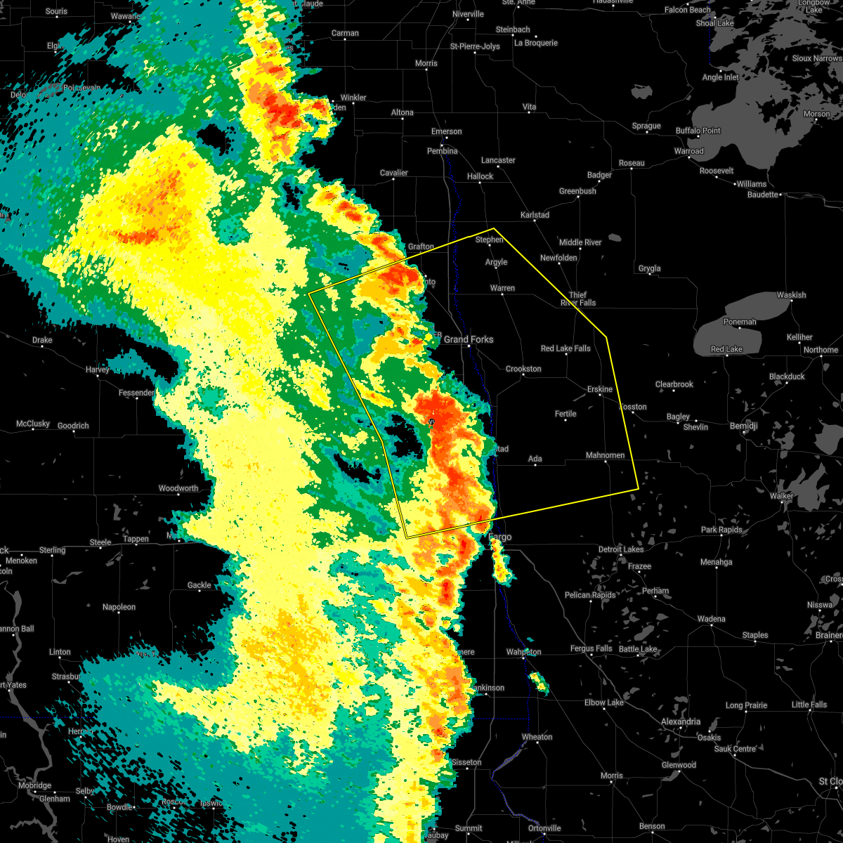 At 507 am cdt, severe thunderstorms were located along a line extending from forest river to near gardner, moving east at 40 mph (radar indicated). Hazards include 70 mph wind gusts. Expect considerable tree damage. damage is likely to mobile homes, roofs, and outbuildings. severe thunderstorms will be near, gardner and grandin around 510 am cdt. perley, poland and hendrum around 520 am cdt. warsaw around 525 am cdt. Other locations in the path of these severe thunderstorms include oslo, big woods and alvarado. At 507 am cdt, severe thunderstorms were located along a line extending from forest river to near gardner, moving east at 40 mph (radar indicated). Hazards include 70 mph wind gusts. Expect considerable tree damage. damage is likely to mobile homes, roofs, and outbuildings. severe thunderstorms will be near, gardner and grandin around 510 am cdt. perley, poland and hendrum around 520 am cdt. warsaw around 525 am cdt. Other locations in the path of these severe thunderstorms include oslo, big woods and alvarado.
|
| 6/11/2021 4:19 AM CDT |
 At 419 am cdt, severe thunderstorms were located along a line extending from mapes to 7 miles north of oriska, moving east at 70 mph. these are very dangerous storms (radar indicated). Hazards include 80 mph wind gusts. Flying debris will be dangerous to those caught without shelter. mobile homes will be heavily damaged. expect considerable damage to roofs, windows, and vehicles. Extensive tree damage and power outages are likely. At 419 am cdt, severe thunderstorms were located along a line extending from mapes to 7 miles north of oriska, moving east at 70 mph. these are very dangerous storms (radar indicated). Hazards include 80 mph wind gusts. Flying debris will be dangerous to those caught without shelter. mobile homes will be heavily damaged. expect considerable damage to roofs, windows, and vehicles. Extensive tree damage and power outages are likely.
|
| 6/7/2021 5:49 PM CDT | Quarter sized hail reported 0.2 miles SE of Hatton, ND, mark ewens (knox) reports quarter sized hail. relayed via social media. |
| 6/7/2021 5:39 PM CDT | Quarter sized hail reported 0.2 miles SE of Hatton, ND, quarter sized hail in hatton... relayed via social media. |
| 6/7/2021 5:22 PM CDT |
 At 522 pm cdt, a severe thunderstorm was located near hatton, or 23 miles southwest of grand forks, moving northeast at 55 mph (radar indicated). Hazards include 60 mph wind gusts and quarter size hail. Hail damage to vehicles is expected. expect wind damage to roofs, siding, and trees. this severe thunderstorm will be near, holmes around 530 pm cdt. reynolds around 535 pm cdt. Thompson around 540 pm cdt. At 522 pm cdt, a severe thunderstorm was located near hatton, or 23 miles southwest of grand forks, moving northeast at 55 mph (radar indicated). Hazards include 60 mph wind gusts and quarter size hail. Hail damage to vehicles is expected. expect wind damage to roofs, siding, and trees. this severe thunderstorm will be near, holmes around 530 pm cdt. reynolds around 535 pm cdt. Thompson around 540 pm cdt.
|
| 9/2/2020 8:35 PM CDT |
 At 835 pm cdt, severe thunderstorms were located along a line extending from near alvarado to near pillsbury, moving east at 70 mph (radar indicated). Hazards include 60 mph wind gusts. expect damage to roofs, siding, and trees At 835 pm cdt, severe thunderstorms were located along a line extending from near alvarado to near pillsbury, moving east at 70 mph (radar indicated). Hazards include 60 mph wind gusts. expect damage to roofs, siding, and trees
|
| 7/17/2020 4:55 PM CDT | Trees blown down. time estimated based on rada in steele county ND, 9.4 miles ENE of Hatton, ND |
| 7/8/2020 3:12 AM CDT |
 The severe thunderstorm warning for northwestern clay, western norman, southwestern polk, southeastern grand forks, northern cass, traill and eastern steele counties will expire at 315 am cdt, the storms which prompted the warning have weakened below severe limits, and no longer poses an immediate threat to life or property. therefore, the warning will be allowed to expire. a severe thunderstorm watch remains in effect until 600 am cdt for northwestern minnesota, and southeastern and northeastern north dakota. The severe thunderstorm warning for northwestern clay, western norman, southwestern polk, southeastern grand forks, northern cass, traill and eastern steele counties will expire at 315 am cdt, the storms which prompted the warning have weakened below severe limits, and no longer poses an immediate threat to life or property. therefore, the warning will be allowed to expire. a severe thunderstorm watch remains in effect until 600 am cdt for northwestern minnesota, and southeastern and northeastern north dakota.
|
| 7/8/2020 2:45 AM CDT |
 At 244 am cdt, severe thunderstorms were located along a line extending from near holmes to kelso to near absaraka, moving east at 55 mph (radar indicated). Hazards include 60 mph wind gusts. Expect damage to roofs, siding, and trees. locations impacted include, mayville, ada, hillsboro, hatton, portland, halstad and golden lake. This includes interstate 29 between mile markers 74 and 123. At 244 am cdt, severe thunderstorms were located along a line extending from near holmes to kelso to near absaraka, moving east at 55 mph (radar indicated). Hazards include 60 mph wind gusts. Expect damage to roofs, siding, and trees. locations impacted include, mayville, ada, hillsboro, hatton, portland, halstad and golden lake. This includes interstate 29 between mile markers 74 and 123.
|
| 7/8/2020 2:18 AM CDT |
 At 218 am cdt, severe thunderstorms were located along a line extending from near aneta to near clifford to near oriska, moving east at 55 mph (radar indicated). Hazards include 70 mph wind gusts. Expect considerable tree damage. damage is likely to mobile homes, roofs, and outbuildings. severe thunderstorms will be near, clifford, galesburg and roseville around 225 am cdt. blanchard around 235 am cdt. hatton and ayr around 240 am cdt. kelso, absaraka and grandin around 245 am cdt. amenia around 250 am cdt. other locations impacted by these severe thunderstorms include west argusville and american crystal sugar. This includes interstate 29 between mile markers 74 and 123. At 218 am cdt, severe thunderstorms were located along a line extending from near aneta to near clifford to near oriska, moving east at 55 mph (radar indicated). Hazards include 70 mph wind gusts. Expect considerable tree damage. damage is likely to mobile homes, roofs, and outbuildings. severe thunderstorms will be near, clifford, galesburg and roseville around 225 am cdt. blanchard around 235 am cdt. hatton and ayr around 240 am cdt. kelso, absaraka and grandin around 245 am cdt. amenia around 250 am cdt. other locations impacted by these severe thunderstorms include west argusville and american crystal sugar. This includes interstate 29 between mile markers 74 and 123.
|
| 6/25/2020 2:59 PM CDT |
 The national weather service in grand forks has issued a * severe thunderstorm warning for. south central grand forks county in northeastern north dakota. northwestern traill county in southeastern north dakota. steele county in southeastern north dakota. Until 345 pm cdt. The national weather service in grand forks has issued a * severe thunderstorm warning for. south central grand forks county in northeastern north dakota. northwestern traill county in southeastern north dakota. steele county in southeastern north dakota. Until 345 pm cdt.
|
| 6/17/2020 7:39 PM CDT |
 At 738 pm cdt, severe thunderstorms were located along a line extending from near manvel to near grand forks to clifford, moving northeast at 55 mph (trained weather spotters reported damage near golden lake). Hazards include 70 mph wind gusts and quarter size hail. Hail damage to vehicles is expected. expect considerable tree damage. wind damage is also likely to mobile homes, roofs, and outbuildings. severe thunderstorms will be near, manvel, east grand forks and grand forks around 740 pm cdt. poland around 745 pm cdt. oslo and mayville around 750 pm cdt. tabor, alvarado and big woods around 755 pm cdt. march around 800 pm cdt. other locations impacted by these severe thunderstorms include grand forks airport. This includes interstate 29 between mile markers 118 and 168. At 738 pm cdt, severe thunderstorms were located along a line extending from near manvel to near grand forks to clifford, moving northeast at 55 mph (trained weather spotters reported damage near golden lake). Hazards include 70 mph wind gusts and quarter size hail. Hail damage to vehicles is expected. expect considerable tree damage. wind damage is also likely to mobile homes, roofs, and outbuildings. severe thunderstorms will be near, manvel, east grand forks and grand forks around 740 pm cdt. poland around 745 pm cdt. oslo and mayville around 750 pm cdt. tabor, alvarado and big woods around 755 pm cdt. march around 800 pm cdt. other locations impacted by these severe thunderstorms include grand forks airport. This includes interstate 29 between mile markers 118 and 168.
|
| 6/17/2020 7:29 PM CDT | Mulitple boats flipped on golden lak in steele county ND, 9.4 miles ENE of Hatton, ND |
| 6/17/2020 7:03 PM CDT |
 At 703 pm cdt, a severe thunderstorm was located near sherbrooke, or 37 miles northeast of valley city, moving northeast at 55 mph (radar indicated). Hazards include 60 mph wind gusts and quarter size hail. Hail damage to vehicles is expected. Expect wind damage to roofs, siding, and trees. At 703 pm cdt, a severe thunderstorm was located near sherbrooke, or 37 miles northeast of valley city, moving northeast at 55 mph (radar indicated). Hazards include 60 mph wind gusts and quarter size hail. Hail damage to vehicles is expected. Expect wind damage to roofs, siding, and trees.
|
| 6/7/2020 9:11 PM CDT |
 At 910 pm cdt, severe thunderstorms were located along a line extending from mayville to hunter to near casselton, moving east at 50 mph (radar indicated). Hazards include 70 mph wind gusts and quarter size hail. Hail damage to vehicles is expected. expect considerable tree damage. wind damage is also likely to mobile homes, roofs, and outbuildings. these severe storms will be near, grandin and cummings around 920 pm cdt. buxton, kelso and reynolds around 925 pm cdt. other locations impacted by these severe thunderstorms include american crystal sugar. This includes interstate 29 between mile markers 89 and 129. At 910 pm cdt, severe thunderstorms were located along a line extending from mayville to hunter to near casselton, moving east at 50 mph (radar indicated). Hazards include 70 mph wind gusts and quarter size hail. Hail damage to vehicles is expected. expect considerable tree damage. wind damage is also likely to mobile homes, roofs, and outbuildings. these severe storms will be near, grandin and cummings around 920 pm cdt. buxton, kelso and reynolds around 925 pm cdt. other locations impacted by these severe thunderstorms include american crystal sugar. This includes interstate 29 between mile markers 89 and 129.
|
| 6/7/2020 8:49 PM CDT |
 At 849 pm cdt, a severe thunderstorm was located 7 miles north of oriska, or 13 miles northeast of valley city, moving northeast at 65 mph (radar indicated). Hazards include 70 mph wind gusts and quarter size hail. Hail damage to vehicles is expected. expect considerable tree damage. wind damage is also likely to mobile homes, roofs, and outbuildings. this severe thunderstorm will be near, page around 900 pm cdt. colgate around 905 pm cdt. galesburg around 910 pm cdt. clifford around 915 pm cdt. blanchard around 920 pm cdt. other locations impacted by this severe thunderstorm include american crystal sugar. this includes the following highways, interstate 29 between mile markers 88 and 129. Interstate 94 in north dakota between mile markers 301 and 314. At 849 pm cdt, a severe thunderstorm was located 7 miles north of oriska, or 13 miles northeast of valley city, moving northeast at 65 mph (radar indicated). Hazards include 70 mph wind gusts and quarter size hail. Hail damage to vehicles is expected. expect considerable tree damage. wind damage is also likely to mobile homes, roofs, and outbuildings. this severe thunderstorm will be near, page around 900 pm cdt. colgate around 905 pm cdt. galesburg around 910 pm cdt. clifford around 915 pm cdt. blanchard around 920 pm cdt. other locations impacted by this severe thunderstorm include american crystal sugar. this includes the following highways, interstate 29 between mile markers 88 and 129. Interstate 94 in north dakota between mile markers 301 and 314.
|
| 9/21/2019 3:55 PM CDT |
 At 354 pm cdt, severe thunderstorms were located along a line extending from near northwood to 6 miles southeast of sherbrooke, moving northeast at 35 mph (radar indicated). Hazards include 60 mph wind gusts and quarter size hail. Hail damage to vehicles is expected. Expect wind damage to roofs, siding, and trees. At 354 pm cdt, severe thunderstorms were located along a line extending from near northwood to 6 miles southeast of sherbrooke, moving northeast at 35 mph (radar indicated). Hazards include 60 mph wind gusts and quarter size hail. Hail damage to vehicles is expected. Expect wind damage to roofs, siding, and trees.
|
| 9/20/2019 7:49 PM CDT |
 At 747 pm cdt, a severe thunderstorm was located over emerado, or 12 miles west of grand forks, moving north at 50 mph (trained weather spotters estimated 60 to 70 mph wind gusts approximately 10 miles south of grand forks). Hazards include 70 mph wind gusts and quarter size hail. Hail damage to vehicles is expected. expect considerable tree damage. wind damage is also likely to mobile homes, roofs, and outbuildings. locations impacted include, grand forks, east grand forks, grand forks afb, larimore, thompson, northwood and hatton. This includes interstate 29 between mile markers 109 and 153. At 747 pm cdt, a severe thunderstorm was located over emerado, or 12 miles west of grand forks, moving north at 50 mph (trained weather spotters estimated 60 to 70 mph wind gusts approximately 10 miles south of grand forks). Hazards include 70 mph wind gusts and quarter size hail. Hail damage to vehicles is expected. expect considerable tree damage. wind damage is also likely to mobile homes, roofs, and outbuildings. locations impacted include, grand forks, east grand forks, grand forks afb, larimore, thompson, northwood and hatton. This includes interstate 29 between mile markers 109 and 153.
|
| 9/20/2019 7:33 PM CDT |
 At 732 pm cdt, a severe thunderstorm was located near hatton, or 22 miles southwest of grand forks, moving north at 45 mph (radar indicated). Hazards include 70 mph wind gusts and quarter size hail. Hail damage to vehicles is expected. expect considerable tree damage. Wind damage is also likely to mobile homes, roofs, and outbuildings. At 732 pm cdt, a severe thunderstorm was located near hatton, or 22 miles southwest of grand forks, moving north at 45 mph (radar indicated). Hazards include 70 mph wind gusts and quarter size hail. Hail damage to vehicles is expected. expect considerable tree damage. Wind damage is also likely to mobile homes, roofs, and outbuildings.
|
| 9/20/2019 6:49 PM CDT |
 At 649 pm cdt, a severe thunderstorm was located near galesburg, or 34 miles northwest of fargo, moving north at 50 mph (radar indicated). Hazards include 60 mph wind gusts and quarter size hail. Hail damage to vehicles is expected. expect wind damage to roofs, siding, and trees. this severe thunderstorm will be near, hunter around 650 pm cdt. galesburg around 655 pm cdt. clifford around 700 pm cdt. blanchard around 705 pm cdt. roseville around 710 pm cdt. This includes interstate 29 between mile markers 111 and 122. At 649 pm cdt, a severe thunderstorm was located near galesburg, or 34 miles northwest of fargo, moving north at 50 mph (radar indicated). Hazards include 60 mph wind gusts and quarter size hail. Hail damage to vehicles is expected. expect wind damage to roofs, siding, and trees. this severe thunderstorm will be near, hunter around 650 pm cdt. galesburg around 655 pm cdt. clifford around 700 pm cdt. blanchard around 705 pm cdt. roseville around 710 pm cdt. This includes interstate 29 between mile markers 111 and 122.
|
| 9/2/2019 5:11 PM CDT |
 At 510 pm cdt, severe thunderstorms were located along a line extending from near mcville to near cooperstown to near eckelson, moving east at 45 mph. quarter sized hail has been reported at cooperstown and multiple 60 to 80 mph wind gusts have been reported in stutsman county. these are very dangerous storms (trained weather spotters). Hazards include 80 mph wind gusts and quarter size hail. Flying debris will be dangerous to those caught without shelter. mobile homes will be heavily damaged. expect considerable damage to roofs, windows, and vehicles. extensive tree damage and power outages are likely. locations impacted include, valley city, mayville, cooperstown, hatton, portland, golden lake and finley. This includes interstate 94 in north dakota between mile markers 271 and 317. At 510 pm cdt, severe thunderstorms were located along a line extending from near mcville to near cooperstown to near eckelson, moving east at 45 mph. quarter sized hail has been reported at cooperstown and multiple 60 to 80 mph wind gusts have been reported in stutsman county. these are very dangerous storms (trained weather spotters). Hazards include 80 mph wind gusts and quarter size hail. Flying debris will be dangerous to those caught without shelter. mobile homes will be heavily damaged. expect considerable damage to roofs, windows, and vehicles. extensive tree damage and power outages are likely. locations impacted include, valley city, mayville, cooperstown, hatton, portland, golden lake and finley. This includes interstate 94 in north dakota between mile markers 271 and 317.
|
| 9/2/2019 4:59 PM CDT |
 At 458 pm cdt, severe thunderstorms were located along a line extending from near pekin to jessie to near ypsilanti, moving east at 45 mph. there have been multiple reports of 70 to 80 mph winds in stustman county. these are very dangerous storms (trained weather spotters). Hazards include 80 mph wind gusts and quarter size hail. Flying debris will be dangerous to those caught without shelter. mobile homes will be heavily damaged. expect considerable damage to roofs, windows, and vehicles. extensive tree damage and power outages are likely. locations impacted include, valley city, mayville, cooperstown, northwood, hatton, portland and golden lake. This includes interstate 94 in north dakota between mile markers 271 and 317. At 458 pm cdt, severe thunderstorms were located along a line extending from near pekin to jessie to near ypsilanti, moving east at 45 mph. there have been multiple reports of 70 to 80 mph winds in stustman county. these are very dangerous storms (trained weather spotters). Hazards include 80 mph wind gusts and quarter size hail. Flying debris will be dangerous to those caught without shelter. mobile homes will be heavily damaged. expect considerable damage to roofs, windows, and vehicles. extensive tree damage and power outages are likely. locations impacted include, valley city, mayville, cooperstown, northwood, hatton, portland and golden lake. This includes interstate 94 in north dakota between mile markers 271 and 317.
|
| 9/2/2019 4:43 PM CDT |
 At 442 pm cdt, severe thunderstorms were located along a line extending from near hamar to near mose to near jamestown, moving east at 45 mph. a 81 mph gust was reported a jamestown, this is a very dangerous line of storms! these are very dangerous storms (radar indicated). Hazards include 80 mph wind gusts and quarter size hail. Flying debris will be dangerous to those caught without shelter. mobile homes will be heavily damaged. expect considerable damage to roofs, windows, and vehicles. Extensive tree damage and power outages are likely. At 442 pm cdt, severe thunderstorms were located along a line extending from near hamar to near mose to near jamestown, moving east at 45 mph. a 81 mph gust was reported a jamestown, this is a very dangerous line of storms! these are very dangerous storms (radar indicated). Hazards include 80 mph wind gusts and quarter size hail. Flying debris will be dangerous to those caught without shelter. mobile homes will be heavily damaged. expect considerable damage to roofs, windows, and vehicles. Extensive tree damage and power outages are likely.
|
| 8/20/2019 3:01 AM CDT |
 A severe thunderstorm warning remains in effect until 345 am cdt for southeastern grand forks. traill and northeastern steele counties. at 259 am cdt, a severe thunderstorm was located 7 miles south of holmes, or 23 miles southwest of grand forks, moving southeast at 35 mph. Ping pong size hail was reported at hatton around 255 am. A severe thunderstorm warning remains in effect until 345 am cdt for southeastern grand forks. traill and northeastern steele counties. at 259 am cdt, a severe thunderstorm was located 7 miles south of holmes, or 23 miles southwest of grand forks, moving southeast at 35 mph. Ping pong size hail was reported at hatton around 255 am.
|
| 8/20/2019 2:55 AM CDT | Ping Pong Ball sized hail reported 0.2 miles SE of Hatton, ND, facebook photo of large hail up to ping pong ball size in hatton |
| 8/20/2019 2:54 AM CDT | Quarter sized hail reported 0.2 miles SE of Hatton, ND, public reported hail slightly larger than quarter sized just before 3 am. relayed via broadcast media. |
| 8/20/2019 2:39 AM CDT |
 The national weather service in grand forks has issued a * severe thunderstorm warning for. southeastern grand forks county in northeastern north dakota. traill county in southeastern north dakota. northeastern steele county in southeastern north dakota. Until 345 am cdt. The national weather service in grand forks has issued a * severe thunderstorm warning for. southeastern grand forks county in northeastern north dakota. traill county in southeastern north dakota. northeastern steele county in southeastern north dakota. Until 345 am cdt.
|
| 7/8/2019 7:38 PM CDT |
 At 738 pm cdt, severe thunderstorms were located along a line extending from near manvel to merrifield to 6 miles northeast of mayville, moving east at 50 mph (radar indicated). Hazards include 70 mph wind gusts and penny size hail. Expect considerable tree damage. damage is likely to mobile homes, roofs, and outbuildings. locations impacted include, grand forks, east grand forks, crookston, grand forks afb, mayville, warren and red lake falls. This includes interstate 29 between mile markers 110 and 166. At 738 pm cdt, severe thunderstorms were located along a line extending from near manvel to merrifield to 6 miles northeast of mayville, moving east at 50 mph (radar indicated). Hazards include 70 mph wind gusts and penny size hail. Expect considerable tree damage. damage is likely to mobile homes, roofs, and outbuildings. locations impacted include, grand forks, east grand forks, crookston, grand forks afb, mayville, warren and red lake falls. This includes interstate 29 between mile markers 110 and 166.
|
| 7/8/2019 7:07 PM CDT |
 The national weather service in grand forks has issued a * severe thunderstorm warning for. southwestern marshall county in northwestern minnesota. western red lake county in northwestern minnesota. polk county in northwestern minnesota. Western pennington county in northwestern minnesota. The national weather service in grand forks has issued a * severe thunderstorm warning for. southwestern marshall county in northwestern minnesota. western red lake county in northwestern minnesota. polk county in northwestern minnesota. Western pennington county in northwestern minnesota.
|
| 7/8/2019 7:07 PM CDT |
 At 707 pm cdt, severe thunderstorms were located along a line extending from near orr to near kempton to near sherbrooke, moving east at 65 mph. these are very dangerous storms (radar indicated). Hazards include 80 mph wind gusts and nickel size hail. Flying debris will be dangerous to those caught without shelter. mobile homes will be heavily damaged. expect considerable damage to roofs, windows, and vehicles. Extensive tree damage and power outages are likely. At 707 pm cdt, severe thunderstorms were located along a line extending from near orr to near kempton to near sherbrooke, moving east at 65 mph. these are very dangerous storms (radar indicated). Hazards include 80 mph wind gusts and nickel size hail. Flying debris will be dangerous to those caught without shelter. mobile homes will be heavily damaged. expect considerable damage to roofs, windows, and vehicles. Extensive tree damage and power outages are likely.
|
| 7/3/2019 8:11 PM CDT |
 The severe thunderstorm warning for southern grand forks, northwestern traill and northern steele counties will expire at 815 pm cdt, the storms which prompted the warning have weakened below severe limits, and no longer poses an immediate threat to life or property. therefore, the warning will be allowed to expire. however small hail and gusty winds are still possible with these thunderstorms. a severe thunderstorm watch remains in effect until midnight cdt for southeastern and northeastern north dakota. to report severe weather, contact your nearest law enforcement agency. they will relay your report to the national weather service grand forks. The severe thunderstorm warning for southern grand forks, northwestern traill and northern steele counties will expire at 815 pm cdt, the storms which prompted the warning have weakened below severe limits, and no longer poses an immediate threat to life or property. therefore, the warning will be allowed to expire. however small hail and gusty winds are still possible with these thunderstorms. a severe thunderstorm watch remains in effect until midnight cdt for southeastern and northeastern north dakota. to report severe weather, contact your nearest law enforcement agency. they will relay your report to the national weather service grand forks.
|
| 7/3/2019 7:39 PM CDT |
 At 739 pm cdt, severe thunderstorms were located along a line extending from kempton to near finley, moving east at 35 mph (radar indicated). Hazards include 60 mph wind gusts. Expect damage to roofs, siding, and trees. these severe storms will be near, kempton around 740 pm cdt. northwood around 745 pm cdt. golden lake around 750 pm cdt. holmes around 810 pm cdt. portland, mayville and roseville around 815 pm cdt. This includes interstate 29 between mile markers 125 and 131. At 739 pm cdt, severe thunderstorms were located along a line extending from kempton to near finley, moving east at 35 mph (radar indicated). Hazards include 60 mph wind gusts. Expect damage to roofs, siding, and trees. these severe storms will be near, kempton around 740 pm cdt. northwood around 745 pm cdt. golden lake around 750 pm cdt. holmes around 810 pm cdt. portland, mayville and roseville around 815 pm cdt. This includes interstate 29 between mile markers 125 and 131.
|
| 7/3/2019 7:11 PM CDT |
 At 710 pm cdt, severe thunderstorms were located along a line extending from 8 miles south of petersburg to near kloten, moving east at 35 mph (radar indicated). Hazards include 60 mph wind gusts and quarter size hail. Hail damage to vehicles is expected. expect wind damage to roofs, siding, and trees. severe thunderstorms will be near, aneta around 720 pm cdt. logan center around 725 pm cdt. sharon around 730 pm cdt. finley and larimore around 735 pm cdt. kempton around 740 pm cdt. This includes interstate 29 between mile markers 125 and 135. At 710 pm cdt, severe thunderstorms were located along a line extending from 8 miles south of petersburg to near kloten, moving east at 35 mph (radar indicated). Hazards include 60 mph wind gusts and quarter size hail. Hail damage to vehicles is expected. expect wind damage to roofs, siding, and trees. severe thunderstorms will be near, aneta around 720 pm cdt. logan center around 725 pm cdt. sharon around 730 pm cdt. finley and larimore around 735 pm cdt. kempton around 740 pm cdt. This includes interstate 29 between mile markers 125 and 135.
|
| 6/29/2019 1:20 PM CDT |
 At 120 pm cdt, a severe thunderstorm was located near hatton, or 30 miles southwest of grand forks, moving east at 45 mph (radar indicated). Hazards include quarter size hail. Damage to vehicles is expected. This severe storm will be near, mayville around 130 pm cdt. At 120 pm cdt, a severe thunderstorm was located near hatton, or 30 miles southwest of grand forks, moving east at 45 mph (radar indicated). Hazards include quarter size hail. Damage to vehicles is expected. This severe storm will be near, mayville around 130 pm cdt.
|
| 6/29/2019 1:06 PM CDT |
 At 106 pm cdt, a severe thunderstorm was located near golden lake, or 39 miles southwest of grand forks, moving east at 45 mph (radar indicated). Hazards include quarter size hail. Damage to vehicles is expected. this severe storm will be near, golden lake around 110 pm cdt. hatton around 125 pm cdt. Mayville around 130 pm cdt. At 106 pm cdt, a severe thunderstorm was located near golden lake, or 39 miles southwest of grand forks, moving east at 45 mph (radar indicated). Hazards include quarter size hail. Damage to vehicles is expected. this severe storm will be near, golden lake around 110 pm cdt. hatton around 125 pm cdt. Mayville around 130 pm cdt.
|
| 6/29/2019 12:53 PM CDT |
 At 1252 pm cdt, a severe thunderstorm was located near finley, or 40 miles north of valley city, moving east at 45 mph (radar indicated). Hazards include quarter size hail. Damage to vehicles is expected. this severe thunderstorm will be near, finley and sharon around 100 pm cdt. sherbrooke around 105 pm cdt. golden lake around 115 pm cdt. hatton around 125 pm cdt. Mayville and portland around 130 pm cdt. At 1252 pm cdt, a severe thunderstorm was located near finley, or 40 miles north of valley city, moving east at 45 mph (radar indicated). Hazards include quarter size hail. Damage to vehicles is expected. this severe thunderstorm will be near, finley and sharon around 100 pm cdt. sherbrooke around 105 pm cdt. golden lake around 115 pm cdt. hatton around 125 pm cdt. Mayville and portland around 130 pm cdt.
|
| 6/29/2019 10:59 AM CDT |
 At 1058 am cdt, severe thunderstorms were located along a line extending from near forest river to northwood to 6 miles north of luverne, moving east at 35 mph (radar indicated). Hazards include 60 mph wind gusts and penny size hail. Expect damage to roofs, siding, and trees. these severe storms will be near, northwood, inkster and kempton around 1100 am cdt. forest river, johnstown and hatton around 1105 am cdt. ardoch, holmes and blabon around 1115 am cdt. poland, hope and sherbrooke around 1120 am cdt. thompson and reynolds around 1130 am cdt. other locations impacted by these severe thunderstorms include grand forks airport. This includes interstate 29 between mile markers 122 and 165. At 1058 am cdt, severe thunderstorms were located along a line extending from near forest river to northwood to 6 miles north of luverne, moving east at 35 mph (radar indicated). Hazards include 60 mph wind gusts and penny size hail. Expect damage to roofs, siding, and trees. these severe storms will be near, northwood, inkster and kempton around 1100 am cdt. forest river, johnstown and hatton around 1105 am cdt. ardoch, holmes and blabon around 1115 am cdt. poland, hope and sherbrooke around 1120 am cdt. thompson and reynolds around 1130 am cdt. other locations impacted by these severe thunderstorms include grand forks airport. This includes interstate 29 between mile markers 122 and 165.
|
| 6/29/2019 10:39 AM CDT |
 At 1039 am cdt, severe thunderstorms were located along a line extending from forest river colony to 6 miles southeast of logan center to hannaford, moving east at 35 mph (radar indicated). Hazards include 60 mph wind gusts and penny size hail. Expect damage to roofs, siding, and trees. severe thunderstorms will be near, forest river colony, fordville and logan center around 1040 am cdt. conway, inkster and orr around 1045 am cdt. northwood and kempton around 1050 am cdt. forest river, johnstown and hatton around 1100 am cdt. ardoch and blabon around 1110 am cdt. other locations impacted by these severe thunderstorms include grand forks airport. This includes interstate 29 between mile markers 122 and 165. At 1039 am cdt, severe thunderstorms were located along a line extending from forest river colony to 6 miles southeast of logan center to hannaford, moving east at 35 mph (radar indicated). Hazards include 60 mph wind gusts and penny size hail. Expect damage to roofs, siding, and trees. severe thunderstorms will be near, forest river colony, fordville and logan center around 1040 am cdt. conway, inkster and orr around 1045 am cdt. northwood and kempton around 1050 am cdt. forest river, johnstown and hatton around 1100 am cdt. ardoch and blabon around 1110 am cdt. other locations impacted by these severe thunderstorms include grand forks airport. This includes interstate 29 between mile markers 122 and 165.
|
| 5/24/2019 7:07 PM CDT |
 The severe thunderstorm warning for southern grand forks, northwestern traill and northeastern steele counties will expire at 715 pm cdt, the storm which prompted the warning has moved out of the area. therefore, the warning will be allowed to expire. The severe thunderstorm warning for southern grand forks, northwestern traill and northeastern steele counties will expire at 715 pm cdt, the storm which prompted the warning has moved out of the area. therefore, the warning will be allowed to expire.
|
| 5/24/2019 6:55 PM CDT |
 At 654 pm cdt, a severe thunderstorm was located near hatton, or 25 miles southwest of grand forks, moving east at 30 mph (radar indicated). Hazards include 70 mph wind gusts and quarter size hail. Hail damage to vehicles is expected. expect considerable tree damage. wind damage is also likely to mobile homes, roofs, and outbuildings. This severe thunderstorm will remain over mainly rural areas of southern grand forks, northwestern traill and northeastern steele counties. At 654 pm cdt, a severe thunderstorm was located near hatton, or 25 miles southwest of grand forks, moving east at 30 mph (radar indicated). Hazards include 70 mph wind gusts and quarter size hail. Hail damage to vehicles is expected. expect considerable tree damage. wind damage is also likely to mobile homes, roofs, and outbuildings. This severe thunderstorm will remain over mainly rural areas of southern grand forks, northwestern traill and northeastern steele counties.
|
| 5/24/2019 6:48 PM CDT |
 At 648 pm cdt, severe thunderstorms were located along a line extending from near northwood to near clifford, moving northeast at 40 mph (radar indicated). Hazards include 70 mph wind gusts and ping pong ball size hail. People and animals outdoors will be injured. expect hail damage to roofs, siding, windows, and vehicles. expect considerable tree damage. wind damage is also likely to mobile homes, roofs, and outbuildings. severe thunderstorms will be near, hatton around 650 pm cdt. roseville around 655 pm cdt. holmes around 700 pm cdt. blanchard around 705 pm cdt. hillsboro and kelso around 715 pm cdt. other locations impacted by these severe thunderstorms include american crystal sugar. This includes interstate 29 between mile markers 96 and 129. At 648 pm cdt, severe thunderstorms were located along a line extending from near northwood to near clifford, moving northeast at 40 mph (radar indicated). Hazards include 70 mph wind gusts and ping pong ball size hail. People and animals outdoors will be injured. expect hail damage to roofs, siding, windows, and vehicles. expect considerable tree damage. wind damage is also likely to mobile homes, roofs, and outbuildings. severe thunderstorms will be near, hatton around 650 pm cdt. roseville around 655 pm cdt. holmes around 700 pm cdt. blanchard around 705 pm cdt. hillsboro and kelso around 715 pm cdt. other locations impacted by these severe thunderstorms include american crystal sugar. This includes interstate 29 between mile markers 96 and 129.
|
| 5/24/2019 6:37 PM CDT |
 At 637 pm cdt, a severe thunderstorm was located near golden lake, or 32 miles southwest of grand forks, moving east at 30 mph (radar indicated). Hazards include 70 mph wind gusts and quarter size hail. Hail damage to vehicles is expected. expect considerable tree damage. wind damage is also likely to mobile homes, roofs, and outbuildings. This severe storm will be near, hatton around 650 pm cdt. At 637 pm cdt, a severe thunderstorm was located near golden lake, or 32 miles southwest of grand forks, moving east at 30 mph (radar indicated). Hazards include 70 mph wind gusts and quarter size hail. Hail damage to vehicles is expected. expect considerable tree damage. wind damage is also likely to mobile homes, roofs, and outbuildings. This severe storm will be near, hatton around 650 pm cdt.
|
| 5/24/2019 6:24 PM CDT |
 At 624 pm cdt, a severe thunderstorm was located over golden lake, or 37 miles southwest of grand forks, moving east at 30 mph (radar indicated). Hazards include 70 mph wind gusts and quarter size hail. Hail damage to vehicles is expected. expect considerable tree damage. wind damage is also likely to mobile homes, roofs, and outbuildings. this severe thunderstorm will be near, golden lake around 625 pm cdt. Hatton around 650 pm cdt. At 624 pm cdt, a severe thunderstorm was located over golden lake, or 37 miles southwest of grand forks, moving east at 30 mph (radar indicated). Hazards include 70 mph wind gusts and quarter size hail. Hail damage to vehicles is expected. expect considerable tree damage. wind damage is also likely to mobile homes, roofs, and outbuildings. this severe thunderstorm will be near, golden lake around 625 pm cdt. Hatton around 650 pm cdt.
|
| 5/15/2019 9:00 PM CDT |
 At 900 pm cdt, a severe thunderstorm was located near buxton, or 23 miles south of grand forks, moving east at 50 mph (radar indicated). Hazards include 60 mph wind gusts. Expect damage to roofs, siding, and trees. locations impacted include, mayville, hatton, portland, buxton, cummings, caledonia and reynolds. This includes interstate 29 between mile markers 107 and 122. At 900 pm cdt, a severe thunderstorm was located near buxton, or 23 miles south of grand forks, moving east at 50 mph (radar indicated). Hazards include 60 mph wind gusts. Expect damage to roofs, siding, and trees. locations impacted include, mayville, hatton, portland, buxton, cummings, caledonia and reynolds. This includes interstate 29 between mile markers 107 and 122.
|
| 5/15/2019 8:36 PM CDT |
 At 836 pm cdt, a severe thunderstorm was located near hatton, or 29 miles southwest of grand forks, moving east at 50 mph (radar indicated). Hazards include 60 mph wind gusts and penny size hail. expect damage to roofs, siding, and trees At 836 pm cdt, a severe thunderstorm was located near hatton, or 29 miles southwest of grand forks, moving east at 50 mph (radar indicated). Hazards include 60 mph wind gusts and penny size hail. expect damage to roofs, siding, and trees
|
| 7/8/2018 4:31 AM CDT |
 At 430 am cdt, severe thunderstorms were located along a line extending from 8 miles north of mcville to near kloten to near sharon, moving east at 55 mph. these are very dangerous storms (trained weather spotters and radar). Hazards include 80 mph wind gusts and nickel size hail. Flying debris will be dangerous to those caught without shelter. mobile homes will be heavily damaged. expect considerable damage to roofs, windows, and vehicles. extensive tree damage and power outages are likely. these severe storms will be near, sharon around 435 am cdt. logan center and petersburg around 440 am cdt. niagara around 445 am cdt. kempton, northwood and mccanna around 450 am cdt. Larimore and hatton around 455 am cdt. At 430 am cdt, severe thunderstorms were located along a line extending from 8 miles north of mcville to near kloten to near sharon, moving east at 55 mph. these are very dangerous storms (trained weather spotters and radar). Hazards include 80 mph wind gusts and nickel size hail. Flying debris will be dangerous to those caught without shelter. mobile homes will be heavily damaged. expect considerable damage to roofs, windows, and vehicles. extensive tree damage and power outages are likely. these severe storms will be near, sharon around 435 am cdt. logan center and petersburg around 440 am cdt. niagara around 445 am cdt. kempton, northwood and mccanna around 450 am cdt. Larimore and hatton around 455 am cdt.
|
| 7/8/2018 4:13 AM CDT |
 At 412 am cdt, severe thunderstorms were located along a line extending from near tolna to near pekin to binford, moving east at 55 mph. these are very dangerous storms (trained spotter and radar indicated). Hazards include 80 mph wind gusts and nickel size hail. Flying debris will be dangerous to those caught without shelter. mobile homes will be heavily damaged. expect considerable damage to roofs, windows, and vehicles. extensive tree damage and power outages are likely. severe thunderstorms will be near, mcville around 420 am cdt. kloten around 425 am cdt. aneta around 430 am cdt. sharon and logan center around 435 am cdt. Kempton and niagara around 445 am cdt. At 412 am cdt, severe thunderstorms were located along a line extending from near tolna to near pekin to binford, moving east at 55 mph. these are very dangerous storms (trained spotter and radar indicated). Hazards include 80 mph wind gusts and nickel size hail. Flying debris will be dangerous to those caught without shelter. mobile homes will be heavily damaged. expect considerable damage to roofs, windows, and vehicles. extensive tree damage and power outages are likely. severe thunderstorms will be near, mcville around 420 am cdt. kloten around 425 am cdt. aneta around 430 am cdt. sharon and logan center around 435 am cdt. Kempton and niagara around 445 am cdt.
|
| 7/4/2018 4:25 AM CDT |
 The severe thunderstorm warning for western red lake, clay, norman, southwestern polk, northeastern wilkin, southeastern grand forks, cass, traill and eastern steele counties will expire at 430 am cdt, the storms which prompted the warning have weakened. therefore, the warning will be allowed to expire. however gusty winds are still possible with these thunderstorms. a severe thunderstorm watch remains in effect until 900 am cdt for northwestern and west central minnesota, and southeastern and northeastern north dakota. The severe thunderstorm warning for western red lake, clay, norman, southwestern polk, northeastern wilkin, southeastern grand forks, cass, traill and eastern steele counties will expire at 430 am cdt, the storms which prompted the warning have weakened. therefore, the warning will be allowed to expire. however gusty winds are still possible with these thunderstorms. a severe thunderstorm watch remains in effect until 900 am cdt for northwestern and west central minnesota, and southeastern and northeastern north dakota.
|
| 7/4/2018 3:51 AM CDT |
 At 350 am cdt, severe thunderstorms were located along a line extending from near grand forks to near leonard, moving east at 50 mph (radar indicated). Hazards include 60 mph wind gusts and quarter size hail. Hail damage to vehicles is expected. expect wind damage to roofs, siding, and trees. these severe storms will be near, east grand forks and mallory around 355 am cdt. davidson around 400 am cdt. key west, west fargo, and horace around 405 am cdt. fargo, hickson, and wild rice around 410 am cdt. comstock and rustad around 415 am cdt. other locations impacted by these severe thunderstorms include casselton airport, american crystal sugar, moorhead airport, grand forks airport and west argusville. this includes the following highways, interstate 29 between mile markers 49 and 143. interstate 94 in north dakota between mile markers 318 and 352. Interstate 94 in minnesota between mile markers 1 and 27. At 350 am cdt, severe thunderstorms were located along a line extending from near grand forks to near leonard, moving east at 50 mph (radar indicated). Hazards include 60 mph wind gusts and quarter size hail. Hail damage to vehicles is expected. expect wind damage to roofs, siding, and trees. these severe storms will be near, east grand forks and mallory around 355 am cdt. davidson around 400 am cdt. key west, west fargo, and horace around 405 am cdt. fargo, hickson, and wild rice around 410 am cdt. comstock and rustad around 415 am cdt. other locations impacted by these severe thunderstorms include casselton airport, american crystal sugar, moorhead airport, grand forks airport and west argusville. this includes the following highways, interstate 29 between mile markers 49 and 143. interstate 94 in north dakota between mile markers 318 and 352. Interstate 94 in minnesota between mile markers 1 and 27.
|
| 7/4/2018 3:24 AM CDT |
 The national weather service in grand forks has issued a * severe thunderstorm warning for. western red lake county in northwestern minnesota. clay county in northwestern minnesota. norman county in northwestern minnesota. Southwestern polk county in northwestern minnesota. The national weather service in grand forks has issued a * severe thunderstorm warning for. western red lake county in northwestern minnesota. clay county in northwestern minnesota. norman county in northwestern minnesota. Southwestern polk county in northwestern minnesota.
|
| 7/4/2018 3:24 AM CDT |
 At 324 am cdt, severe thunderstorms were located along a line extending from near turtle river state park to near sheldon, moving east at 60 mph (radar indicated). Hazards include 60 mph wind gusts and quarter size hail. Hail damage to vehicles is expected. expect wind damage to roofs, siding, and trees. severe thunderstorms will be near, grand forks afb, leonard and emerado around 330 am cdt. davenport, grand forks and merrifield around 340 am cdt. east grand forks and kindred around 345 am cdt. hickson, mallory and davidson around 350 am cdt. comstock, key west and oxbow around 355 am cdt. other locations impacted by these severe thunderstorms include casselton airport, american crystal sugar, moorhead airport, grand forks airport and west argusville. this includes the following highways, interstate 29 between mile markers 49 and 143. interstate 94 in north dakota between mile markers 318 and 352. Interstate 94 in minnesota between mile markers 1 and 27. At 324 am cdt, severe thunderstorms were located along a line extending from near turtle river state park to near sheldon, moving east at 60 mph (radar indicated). Hazards include 60 mph wind gusts and quarter size hail. Hail damage to vehicles is expected. expect wind damage to roofs, siding, and trees. severe thunderstorms will be near, grand forks afb, leonard and emerado around 330 am cdt. davenport, grand forks and merrifield around 340 am cdt. east grand forks and kindred around 345 am cdt. hickson, mallory and davidson around 350 am cdt. comstock, key west and oxbow around 355 am cdt. other locations impacted by these severe thunderstorms include casselton airport, american crystal sugar, moorhead airport, grand forks airport and west argusville. this includes the following highways, interstate 29 between mile markers 49 and 143. interstate 94 in north dakota between mile markers 318 and 352. Interstate 94 in minnesota between mile markers 1 and 27.
|
| 7/4/2018 2:57 AM CDT |
 At 256 am cdt, severe thunderstorms were located along a line extending from near petersburg to nome, moving east at 70 mph (radar indicated). Hazards include 70 mph wind gusts and quarter size hail. Hail damage to vehicles is expected. expect considerable tree damage. wind damage is also likely to mobile homes, roofs, and outbuildings. these severe storms will be near, lucca around 300 am cdt. larimore and alice around 310 am cdt. turtle river state park, chaffee and arvilla around 315 am cdt. grand forks afb and leonard around 320 am cdt. This includes interstate 94 in north dakota between mile markers 287 and 327. At 256 am cdt, severe thunderstorms were located along a line extending from near petersburg to nome, moving east at 70 mph (radar indicated). Hazards include 70 mph wind gusts and quarter size hail. Hail damage to vehicles is expected. expect considerable tree damage. wind damage is also likely to mobile homes, roofs, and outbuildings. these severe storms will be near, lucca around 300 am cdt. larimore and alice around 310 am cdt. turtle river state park, chaffee and arvilla around 315 am cdt. grand forks afb and leonard around 320 am cdt. This includes interstate 94 in north dakota between mile markers 287 and 327.
|
| 7/4/2018 2:33 AM CDT |
 At 232 am cdt, severe thunderstorms were located along a line extending from near hamar to near marion, moving east at 60 mph (radar indicated). Hazards include 70 mph wind gusts and quarter size hail. Hail damage to vehicles is expected. expect considerable tree damage. wind damage is also likely to mobile homes, roofs, and outbuildings. severe thunderstorms will be near, tolna around 235 am cdt. litchville around 240 am cdt. hastings around 245 am cdt. kathryn around 250 am cdt. nome around 255 am cdt. This includes interstate 94 in north dakota between mile markers 272 and 327. At 232 am cdt, severe thunderstorms were located along a line extending from near hamar to near marion, moving east at 60 mph (radar indicated). Hazards include 70 mph wind gusts and quarter size hail. Hail damage to vehicles is expected. expect considerable tree damage. wind damage is also likely to mobile homes, roofs, and outbuildings. severe thunderstorms will be near, tolna around 235 am cdt. litchville around 240 am cdt. hastings around 245 am cdt. kathryn around 250 am cdt. nome around 255 am cdt. This includes interstate 94 in north dakota between mile markers 272 and 327.
|
| 6/29/2018 4:30 AM CDT | Plenty of trees down on highway 15. report received via social medi in traill county ND, 8.6 miles WSW of Hatton, ND |
| 6/29/2018 3:51 AM CDT |
 At 350 am cdt, severe thunderstorms were located along a line extending from near hatton to galesburg to near tower city, moving east at 60 mph (radar indicated). Hazards include 70 mph wind gusts and penny size hail. Expect considerable tree damage. damage is likely to mobile homes, roofs, and outbuildings. severe thunderstorms will be near, holmes, blanchard and hunter around 400 am cdt. amenia, kelso and reynolds around 410 am cdt. bygland around 415 am cdt. hendrum, prosper and halstad around 420 am cdt. brooktree park, harwood and eldred around 425 am cdt. other locations impacted by these severe thunderstorms include west argusville and american crystal sugar. This includes interstate 29 between mile markers 70 and 131. At 350 am cdt, severe thunderstorms were located along a line extending from near hatton to galesburg to near tower city, moving east at 60 mph (radar indicated). Hazards include 70 mph wind gusts and penny size hail. Expect considerable tree damage. damage is likely to mobile homes, roofs, and outbuildings. severe thunderstorms will be near, holmes, blanchard and hunter around 400 am cdt. amenia, kelso and reynolds around 410 am cdt. bygland around 415 am cdt. hendrum, prosper and halstad around 420 am cdt. brooktree park, harwood and eldred around 425 am cdt. other locations impacted by these severe thunderstorms include west argusville and american crystal sugar. This includes interstate 29 between mile markers 70 and 131.
|
| 6/29/2018 3:31 AM CDT |
 At 331 am cdt, severe thunderstorms were located along a line extending from 7 miles southwest of aneta to near luverne to near bald hill dam, moving east at 60 mph. these are very dangerous storms (radar indicated). Hazards include 80 mph wind gusts and nickel size hail. Flying debris will be dangerous to those caught without shelter. mobile homes will be heavily damaged. expect considerable damage to roofs, windows, and vehicles. extensive tree damage and power outages are likely. these severe storms will be near, pillsbury and blabon around 335 am cdt. hope, colgate and finley around 340 am cdt. golden lake around 350 am cdt. ayr, galesburg and clifford around 355 am cdt. Hatton, absaraka and erie around 400 am cdt. At 331 am cdt, severe thunderstorms were located along a line extending from 7 miles southwest of aneta to near luverne to near bald hill dam, moving east at 60 mph. these are very dangerous storms (radar indicated). Hazards include 80 mph wind gusts and nickel size hail. Flying debris will be dangerous to those caught without shelter. mobile homes will be heavily damaged. expect considerable damage to roofs, windows, and vehicles. extensive tree damage and power outages are likely. these severe storms will be near, pillsbury and blabon around 335 am cdt. hope, colgate and finley around 340 am cdt. golden lake around 350 am cdt. ayr, galesburg and clifford around 355 am cdt. Hatton, absaraka and erie around 400 am cdt.
|
| 6/29/2018 2:59 AM CDT |
 The national weather service in grand forks has issued a * severe thunderstorm warning for. southwestern grand forks county in northeastern north dakota. northwestern cass county in southeastern north dakota. western traill county in southeastern north dakota. Griggs county in southeastern north dakota. The national weather service in grand forks has issued a * severe thunderstorm warning for. southwestern grand forks county in northeastern north dakota. northwestern cass county in southeastern north dakota. western traill county in southeastern north dakota. Griggs county in southeastern north dakota.
|
| 6/5/2018 11:37 PM CDT | Power pole snapped with time estimated based on radar in traill county ND, 0.2 miles SE of Hatton, ND |
| 6/5/2018 11:22 PM CDT |
 At 1122 pm cdt, severe thunderstorms were located along a line extending from near kempton to sherbrooke to near luverne, moving southeast at 50 mph (radar indicated). Hazards include 70 mph wind gusts and quarter size hail. Hail damage to vehicles is expected. expect considerable tree damage. wind damage is also likely to mobile homes, roofs, and outbuildings. severe thunderstorms will be near, hope around 1130 pm cdt. colgate and holmes around 1135 pm cdt. clifford and roseville around 1140 pm cdt. page and galesburg around 1145 pm cdt. buxton, reynolds and blanchard around 1150 pm cdt. other locations impacted by these severe thunderstorms include american crystal sugar. This includes interstate 29 between mile markers 91 and 124. At 1122 pm cdt, severe thunderstorms were located along a line extending from near kempton to sherbrooke to near luverne, moving southeast at 50 mph (radar indicated). Hazards include 70 mph wind gusts and quarter size hail. Hail damage to vehicles is expected. expect considerable tree damage. wind damage is also likely to mobile homes, roofs, and outbuildings. severe thunderstorms will be near, hope around 1130 pm cdt. colgate and holmes around 1135 pm cdt. clifford and roseville around 1140 pm cdt. page and galesburg around 1145 pm cdt. buxton, reynolds and blanchard around 1150 pm cdt. other locations impacted by these severe thunderstorms include american crystal sugar. This includes interstate 29 between mile markers 91 and 124.
|
| 7/31/2017 8:09 PM CDT |
 At 809 pm cdt, a severe thunderstorm was located 3 miles north of portland, or 28 miles southwest of grand forks, moving southeast at 20 mph (radar indicated). Hazards include two inch hail and 60 mph wind gusts. People and animals outdoors will be injured. expect hail damage to roofs, siding, windows, and vehicles. expect wind damage to roofs, siding, and trees. this severe storm will be near, mayville and portland around 825 pm cdt. Roseville around 830 pm cdt. At 809 pm cdt, a severe thunderstorm was located 3 miles north of portland, or 28 miles southwest of grand forks, moving southeast at 20 mph (radar indicated). Hazards include two inch hail and 60 mph wind gusts. People and animals outdoors will be injured. expect hail damage to roofs, siding, windows, and vehicles. expect wind damage to roofs, siding, and trees. this severe storm will be near, mayville and portland around 825 pm cdt. Roseville around 830 pm cdt.
|
| 7/31/2017 8:05 PM CDT | Golf Ball sized hail reported 3.3 miles N of Hatton, ND |
| 7/31/2017 8:00 PM CDT |
 At 759 pm cdt, a severe thunderstorm was located over hatton, or 27 miles southwest of grand forks, moving southeast at 20 mph (radar indicated). Hazards include ping pong ball size hail. People and animals outdoors will be injured. expect damage to roofs, siding, windows, and vehicles. this severe thunderstorm will be near, mayville and portland around 825 pm cdt. Roseville around 835 pm cdt. At 759 pm cdt, a severe thunderstorm was located over hatton, or 27 miles southwest of grand forks, moving southeast at 20 mph (radar indicated). Hazards include ping pong ball size hail. People and animals outdoors will be injured. expect damage to roofs, siding, windows, and vehicles. this severe thunderstorm will be near, mayville and portland around 825 pm cdt. Roseville around 835 pm cdt.
|
| 7/21/2017 4:34 PM CDT |
 At 433 pm cdt, a severe thunderstorm was located near blanchard, or 38 miles south of grand forks, moving east at 55 mph (radar indicated. at 422 pm cdt, 53 mph wind was reported at hope nd). Hazards include 60 mph wind gusts and quarter size hail. Hail damage to vehicles is expected. expect wind damage to roofs, siding, and trees. this severe storm will be near, blanchard around 435 pm cdt. hillsboro and kelso around 445 pm cdt. halstad, shelly and hendrum around 455 pm cdt. other locations impacted by this severe thunderstorm include american crystal sugar. This includes interstate 29 between mile markers 82 and 122. At 433 pm cdt, a severe thunderstorm was located near blanchard, or 38 miles south of grand forks, moving east at 55 mph (radar indicated. at 422 pm cdt, 53 mph wind was reported at hope nd). Hazards include 60 mph wind gusts and quarter size hail. Hail damage to vehicles is expected. expect wind damage to roofs, siding, and trees. this severe storm will be near, blanchard around 435 pm cdt. hillsboro and kelso around 445 pm cdt. halstad, shelly and hendrum around 455 pm cdt. other locations impacted by this severe thunderstorm include american crystal sugar. This includes interstate 29 between mile markers 82 and 122.
|
| 7/21/2017 4:10 PM CDT |
 At 409 pm cdt, a severe thunderstorm was located over hope, or 33 miles northeast of valley city, moving east at 50 mph (radar indicated). Hazards include 60 mph wind gusts and quarter size hail. Hail damage to vehicles is expected. expect wind damage to roofs, siding, and trees. this severe thunderstorm will be near, galesburg, clifford and roseville around 425 pm cdt. blanchard around 435 pm cdt. hillsboro and kelso around 445 pm cdt. grandin around 450 pm cdt. halstad around 455 pm cdt. other locations impacted by this severe thunderstorm include american crystal sugar. This includes interstate 29 between mile markers 82 and 122. At 409 pm cdt, a severe thunderstorm was located over hope, or 33 miles northeast of valley city, moving east at 50 mph (radar indicated). Hazards include 60 mph wind gusts and quarter size hail. Hail damage to vehicles is expected. expect wind damage to roofs, siding, and trees. this severe thunderstorm will be near, galesburg, clifford and roseville around 425 pm cdt. blanchard around 435 pm cdt. hillsboro and kelso around 445 pm cdt. grandin around 450 pm cdt. halstad around 455 pm cdt. other locations impacted by this severe thunderstorm include american crystal sugar. This includes interstate 29 between mile markers 82 and 122.
|
| 7/11/2017 7:14 PM CDT |
 At 713 pm cdt, a confirmed tornado was located near buxton, or 23 miles south of grand forks, moving southeast at 35 mph (weather spotters confirmed tornado west of buxton or northeast of mayville). Hazards include damaging tornado and two inch hail. Flying debris will be dangerous to those caught without shelter. mobile homes will be damaged or destroyed. damage to roofs, windows, and vehicles will occur. tree damage is likely. this tornado will be near, buxton and reynolds around 720 pm cdt. This includes interstate 29 between mile markers 120 and 137. At 713 pm cdt, a confirmed tornado was located near buxton, or 23 miles south of grand forks, moving southeast at 35 mph (weather spotters confirmed tornado west of buxton or northeast of mayville). Hazards include damaging tornado and two inch hail. Flying debris will be dangerous to those caught without shelter. mobile homes will be damaged or destroyed. damage to roofs, windows, and vehicles will occur. tree damage is likely. this tornado will be near, buxton and reynolds around 720 pm cdt. This includes interstate 29 between mile markers 120 and 137.
|
| 7/11/2017 6:48 PM CDT |
 At 646 pm cdt, a severe thunderstorm capable of producing a tornado was located near northwood, or 22 miles southwest of grand forks, moving east at 25 mph (radar indicated rotation. at 642 pm cdt, a tornado was reported 2 mile east of northwood, nd). Hazards include tornado and quarter size hail. Expect damage to mobile homes, roofs, and vehicles. this dangerous storm will be near, hatton around 650 pm cdt. holmes around 705 pm cdt. reynolds around 725 pm cdt. buxton around 730 pm cdt. This includes interstate 29 between mile markers 120 and 137. At 646 pm cdt, a severe thunderstorm capable of producing a tornado was located near northwood, or 22 miles southwest of grand forks, moving east at 25 mph (radar indicated rotation. at 642 pm cdt, a tornado was reported 2 mile east of northwood, nd). Hazards include tornado and quarter size hail. Expect damage to mobile homes, roofs, and vehicles. this dangerous storm will be near, hatton around 650 pm cdt. holmes around 705 pm cdt. reynolds around 725 pm cdt. buxton around 730 pm cdt. This includes interstate 29 between mile markers 120 and 137.
|
| 7/11/2017 6:42 PM CDT |
 At 642 pm cdt, a severe thunderstorm capable of producing a tornado was located near hatton, or 22 miles southwest of grand forks, moving southeast at 25 mph (radar indicated rotation). Hazards include tornado and quarter size hail. Expect damage to mobile homes, roofs, and vehicles. this dangerous storm will be near, hatton around 645 pm cdt. holmes around 700 pm cdt. reynolds around 725 pm cdt. buxton around 730 pm cdt. This includes interstate 29 between mile markers 120 and 137. At 642 pm cdt, a severe thunderstorm capable of producing a tornado was located near hatton, or 22 miles southwest of grand forks, moving southeast at 25 mph (radar indicated rotation). Hazards include tornado and quarter size hail. Expect damage to mobile homes, roofs, and vehicles. this dangerous storm will be near, hatton around 645 pm cdt. holmes around 700 pm cdt. reynolds around 725 pm cdt. buxton around 730 pm cdt. This includes interstate 29 between mile markers 120 and 137.
|
| 7/6/2017 12:25 AM CDT |
 At 1224 am cdt, a severe thunderstorm was located near portland, or 29 miles southwest of grand forks, moving southeast at 25 mph (radar indicated. at 1205 am cdt, 1 inch hail was reported 9 miles northeast of sharon). Hazards include 60 mph wind gusts and half dollar size hail. Hail damage to vehicles is expected. expect wind damage to roofs, siding, and trees. this severe storm will be near, mayville, portland and roseville around 1230 am cdt. cummings around 1255 am cdt. This includes interstate 29 between mile markers 111 and 122. At 1224 am cdt, a severe thunderstorm was located near portland, or 29 miles southwest of grand forks, moving southeast at 25 mph (radar indicated. at 1205 am cdt, 1 inch hail was reported 9 miles northeast of sharon). Hazards include 60 mph wind gusts and half dollar size hail. Hail damage to vehicles is expected. expect wind damage to roofs, siding, and trees. this severe storm will be near, mayville, portland and roseville around 1230 am cdt. cummings around 1255 am cdt. This includes interstate 29 between mile markers 111 and 122.
|
| 7/5/2017 11:54 PM CDT |
 At 1154 pm cdt, a severe thunderstorm was located over golden lake, or 32 miles southwest of grand forks, moving southeast at 25 mph (radar indicated). Hazards include ping pong ball size hail and 60 mph wind gusts. People and animals outdoors will be injured. expect hail damage to roofs, siding, windows, and vehicles. expect wind damage to roofs, siding, and trees. this severe thunderstorm will be near, golden lake around 1155 pm cdt. hatton around 1210 am cdt. portland and roseville around 1230 am cdt. mayville around 1235 am cdt. cummings around 1255 am cdt. This includes interstate 29 between mile markers 111 and 122. At 1154 pm cdt, a severe thunderstorm was located over golden lake, or 32 miles southwest of grand forks, moving southeast at 25 mph (radar indicated). Hazards include ping pong ball size hail and 60 mph wind gusts. People and animals outdoors will be injured. expect hail damage to roofs, siding, windows, and vehicles. expect wind damage to roofs, siding, and trees. this severe thunderstorm will be near, golden lake around 1155 pm cdt. hatton around 1210 am cdt. portland and roseville around 1230 am cdt. mayville around 1235 am cdt. cummings around 1255 am cdt. This includes interstate 29 between mile markers 111 and 122.
|
| 7/4/2017 7:54 PM CDT |
 At 754 pm cdt, severe thunderstorms were located along a line extending from near thompson to near golden lake, moving southeast at 25 mph (radar indicated). Hazards include quarter size hail. damage to vehicles is expected At 754 pm cdt, severe thunderstorms were located along a line extending from near thompson to near golden lake, moving southeast at 25 mph (radar indicated). Hazards include quarter size hail. damage to vehicles is expected
|
| 6/13/2017 9:55 PM CDT |
 At 954 pm cdt, severe thunderstorms were located along a line extending from 6 miles northeast of northwood to melvin, moving north at 60 mph (radar indicated). Hazards include 60 mph wind gusts and penny size hail. Expect damage to roofs, siding, and trees. these severe storms will be near, kempton around 955 pm cdt. harold and dugdale around 1000 pm cdt. arvilla, emerado and grand forks afb around 1005 pm cdt. mekinock, honeyford and gentilly around 1010 pm cdt. gilby, red lake falls and huot around 1015 pm cdt. This includes interstate 29 between mile markers 106 and 153. At 954 pm cdt, severe thunderstorms were located along a line extending from 6 miles northeast of northwood to melvin, moving north at 60 mph (radar indicated). Hazards include 60 mph wind gusts and penny size hail. Expect damage to roofs, siding, and trees. these severe storms will be near, kempton around 955 pm cdt. harold and dugdale around 1000 pm cdt. arvilla, emerado and grand forks afb around 1005 pm cdt. mekinock, honeyford and gentilly around 1010 pm cdt. gilby, red lake falls and huot around 1015 pm cdt. This includes interstate 29 between mile markers 106 and 153.
|
| 6/13/2017 9:24 PM CDT |
 At 923 pm cdt, severe thunderstorms were located along a line extending from near clifford to near borup, moving north at 60 mph (radar indicated). Hazards include 60 mph wind gusts and penny size hail. Expect damage to roofs, siding, and trees. severe thunderstorms will be near, clifford around 925 pm cdt. twin valley and roseville around 930 pm cdt. ada, portland and golden lake around 935 pm cdt. gary, hadler and lockhart around 940 pm cdt. hatton and flaming around 945 pm cdt. This includes interstate 29 between mile markers 85 and 153. At 923 pm cdt, severe thunderstorms were located along a line extending from near clifford to near borup, moving north at 60 mph (radar indicated). Hazards include 60 mph wind gusts and penny size hail. Expect damage to roofs, siding, and trees. severe thunderstorms will be near, clifford around 925 pm cdt. twin valley and roseville around 930 pm cdt. ada, portland and golden lake around 935 pm cdt. gary, hadler and lockhart around 940 pm cdt. hatton and flaming around 945 pm cdt. This includes interstate 29 between mile markers 85 and 153.
|
| 6/10/2017 4:45 AM CDT |
 At 445 am cdt, severe thunderstorms were located along a line extending from near mccanna to 6 miles west of portland, moving northeast at 45 mph (radar indicated). Hazards include 60 mph wind gusts and quarter size hail. Hail damage to vehicles is expected. Expect wind damage to roofs, siding, and trees. At 445 am cdt, severe thunderstorms were located along a line extending from near mccanna to 6 miles west of portland, moving northeast at 45 mph (radar indicated). Hazards include 60 mph wind gusts and quarter size hail. Hail damage to vehicles is expected. Expect wind damage to roofs, siding, and trees.
|
| 6/10/2017 4:30 AM CDT |
 At 430 am cdt, severe thunderstorms were located along a line extending from near mccanna to golden lake, moving northeast at 45 mph (radar indicated). Hazards include 60 mph wind gusts and nickel size hail. Expect damage to roofs, siding, and trees. Locations impacted include, larimore, northwood, hatton, golden lake, gilby, arvilla and kempton. At 430 am cdt, severe thunderstorms were located along a line extending from near mccanna to golden lake, moving northeast at 45 mph (radar indicated). Hazards include 60 mph wind gusts and nickel size hail. Expect damage to roofs, siding, and trees. Locations impacted include, larimore, northwood, hatton, golden lake, gilby, arvilla and kempton.
|
| 6/10/2017 4:08 AM CDT |
 At 407 am cdt, severe thunderstorms were located along a line extending from 7 miles northeast of mcville to near finley, moving northeast at 45 mph (radar indicated). Hazards include 60 mph wind gusts and penny size hail. expect damage to roofs, siding, and trees At 407 am cdt, severe thunderstorms were located along a line extending from 7 miles northeast of mcville to near finley, moving northeast at 45 mph (radar indicated). Hazards include 60 mph wind gusts and penny size hail. expect damage to roofs, siding, and trees
|
| 8/23/2016 1:44 AM CDT |
 At 144 am cdt, a severe thunderstorm was located near portland, or 30 miles southwest of grand forks, moving east at 20 mph (radar indicated). Hazards include ping pong ball size hail. People and animals outdoors will be injured. expect damage to roofs, siding, windows, and vehicles. this severe thunderstorm will be near, hatton around 150 am cdt. portland around 155 am cdt. mayville around 200 am cdt. buxton around 230 am cdt. Also includes interstate 29 between mile markers 109 and 122. At 144 am cdt, a severe thunderstorm was located near portland, or 30 miles southwest of grand forks, moving east at 20 mph (radar indicated). Hazards include ping pong ball size hail. People and animals outdoors will be injured. expect damage to roofs, siding, windows, and vehicles. this severe thunderstorm will be near, hatton around 150 am cdt. portland around 155 am cdt. mayville around 200 am cdt. buxton around 230 am cdt. Also includes interstate 29 between mile markers 109 and 122.
|
| 8/18/2016 7:45 AM CDT |
 At 742 am cdt, severe thunderstorms were located along a line extending from near sibley to near kathryn to near berlin, moving east at 45 mph (radar indicated). Hazards include 70 mph wind gusts and quarter size hail. Hail damage to vehicles is expected. expect considerable tree damage. wind damage is also likely to mobile homes, roofs, and outbuildings. at 720 am, baseball size hail was reported and a semi truck was reported as overturned on i-94 near mile marker 278. these severe storms will be near, kathryn, luverne and sibley around 745 am cdt. pillsbury and little yellowstone around 750 am cdt. nome, colgate and fingal around 755 am cdt. page and lucca around 800 am cdt. Also includes interstate 94 in north dakota between mile markers 275 and 311. At 742 am cdt, severe thunderstorms were located along a line extending from near sibley to near kathryn to near berlin, moving east at 45 mph (radar indicated). Hazards include 70 mph wind gusts and quarter size hail. Hail damage to vehicles is expected. expect considerable tree damage. wind damage is also likely to mobile homes, roofs, and outbuildings. at 720 am, baseball size hail was reported and a semi truck was reported as overturned on i-94 near mile marker 278. these severe storms will be near, kathryn, luverne and sibley around 745 am cdt. pillsbury and little yellowstone around 750 am cdt. nome, colgate and fingal around 755 am cdt. page and lucca around 800 am cdt. Also includes interstate 94 in north dakota between mile markers 275 and 311.
|
| 8/18/2016 7:35 AM CDT |
 At 734 am cdt, severe thunderstorms were located along a line extending from near sibley to near hastings to 6 miles northwest of berlin, moving southeast at 45 mph (radar indicated). Hazards include 70 mph wind gusts and quarter size hail. Hail damage to vehicles is expected. expect considerable tree damage. wind damage is also likely to mobile homes, roofs, and outbuildings. these severe storms will be near, hastings and valley city around 740 am cdt. kathryn and pillsbury around 745 am cdt. little yellowstone around 750 am cdt. nome, lucca and fort ransom around 755 am cdt. page around 800 am cdt. Also includes interstate 94 in north dakota between mile markers 273 and 311. At 734 am cdt, severe thunderstorms were located along a line extending from near sibley to near hastings to 6 miles northwest of berlin, moving southeast at 45 mph (radar indicated). Hazards include 70 mph wind gusts and quarter size hail. Hail damage to vehicles is expected. expect considerable tree damage. wind damage is also likely to mobile homes, roofs, and outbuildings. these severe storms will be near, hastings and valley city around 740 am cdt. kathryn and pillsbury around 745 am cdt. little yellowstone around 750 am cdt. nome, lucca and fort ransom around 755 am cdt. page around 800 am cdt. Also includes interstate 94 in north dakota between mile markers 273 and 311.
|
| 8/18/2016 7:06 AM CDT |
 At 705 am cdt, severe thunderstorms were located along a line extending from near revere to near millarton, moving east at 45 mph (observation. at 656 am...a wind gust of 71 mph was reported at the jamestown airport). Hazards include 70 mph wind gusts and quarter size hail. Hail damage to vehicles is expected. expect considerable tree damage. wind damage is also likely to mobile homes, roofs, and outbuildings. these severe storms will be near, hannaford, cooperstown and walum around 710 am cdt. luverne around 725 am cdt. litchville, blabon and sherbrooke around 735 am cdt. hope, hastings and colgate around 740 am cdt. little yellowstone, kathryn and fort ransom around 750 am cdt. also includes the following highways, interstate 29 between mile markers 113 and 122. Interstate 94 in north dakota between mile markers 271 and 317. At 705 am cdt, severe thunderstorms were located along a line extending from near revere to near millarton, moving east at 45 mph (observation. at 656 am...a wind gust of 71 mph was reported at the jamestown airport). Hazards include 70 mph wind gusts and quarter size hail. Hail damage to vehicles is expected. expect considerable tree damage. wind damage is also likely to mobile homes, roofs, and outbuildings. these severe storms will be near, hannaford, cooperstown and walum around 710 am cdt. luverne around 725 am cdt. litchville, blabon and sherbrooke around 735 am cdt. hope, hastings and colgate around 740 am cdt. little yellowstone, kathryn and fort ransom around 750 am cdt. also includes the following highways, interstate 29 between mile markers 113 and 122. Interstate 94 in north dakota between mile markers 271 and 317.
|
| 7/20/2016 11:13 PM CDT |
 At 1112 pm cdt, a severe thunderstorm was located near reynolds, or 20 miles south of grand forks, moving east at 55 mph (radar indicated). Hazards include 60 mph wind gusts and penny size hail. Expect damage to roofs. siding. and trees. this severe thunderstorm will be near, reynolds around 1115 pm cdt. buxton and cummings around 1120 pm cdt. climax around 1130 pm cdt. shelly, nielsville and eldred around 1135 pm cdt. greenview around 1145 pm cdt. Also includes interstate 29 between mile markers 102 and 132. At 1112 pm cdt, a severe thunderstorm was located near reynolds, or 20 miles south of grand forks, moving east at 55 mph (radar indicated). Hazards include 60 mph wind gusts and penny size hail. Expect damage to roofs. siding. and trees. this severe thunderstorm will be near, reynolds around 1115 pm cdt. buxton and cummings around 1120 pm cdt. climax around 1130 pm cdt. shelly, nielsville and eldred around 1135 pm cdt. greenview around 1145 pm cdt. Also includes interstate 29 between mile markers 102 and 132.
|
| 7/20/2016 10:31 PM CDT |
 At 1030 pm cdt, severe thunderstorms were located along a line extending from near logan center to near kloten to near red willow lake to near mchenry, moving east at 45 mph (radar indicated). Hazards include 70 mph wind gusts and penny size hail. Expect considerable tree damage. damage is likely to mobile homes, roofs, and outbuildings. these severe storms will be near, aneta, logan center and kloten around 1035 pm cdt. kempton and sharon around 1045 pm cdt. northwood around 1050 pm cdt. golden lake and hatton around 1100 pm cdt. Cooperstown and finley around 1105 pm cdt. At 1030 pm cdt, severe thunderstorms were located along a line extending from near logan center to near kloten to near red willow lake to near mchenry, moving east at 45 mph (radar indicated). Hazards include 70 mph wind gusts and penny size hail. Expect considerable tree damage. damage is likely to mobile homes, roofs, and outbuildings. these severe storms will be near, aneta, logan center and kloten around 1035 pm cdt. kempton and sharon around 1045 pm cdt. northwood around 1050 pm cdt. golden lake and hatton around 1100 pm cdt. Cooperstown and finley around 1105 pm cdt.
|
| 7/20/2016 10:10 PM CDT |
 At 1010 pm cdt, a severe thunderstorm was located over pekin, or 35 miles southeast of devils lake, moving east at 40 mph (radar indicated). Hazards include 70 mph wind gusts and penny size hail. Expect considerable tree damage. damage is likely to mobile homes, roofs, and outbuildings. this severe thunderstorm will be near, mcville around 1020 pm cdt. kloten around 1030 pm cdt. aneta around 1035 pm cdt. sharon around 1045 pm cdt. golden lake around 1105 pm cdt. A tornado watch remains in effect until 1100 pm cdt for northeastern north dakota. At 1010 pm cdt, a severe thunderstorm was located over pekin, or 35 miles southeast of devils lake, moving east at 40 mph (radar indicated). Hazards include 70 mph wind gusts and penny size hail. Expect considerable tree damage. damage is likely to mobile homes, roofs, and outbuildings. this severe thunderstorm will be near, mcville around 1020 pm cdt. kloten around 1030 pm cdt. aneta around 1035 pm cdt. sharon around 1045 pm cdt. golden lake around 1105 pm cdt. A tornado watch remains in effect until 1100 pm cdt for northeastern north dakota.
|
| 7/19/2016 7:59 PM CDT |
 At 757 pm cdt, a severe thunderstorm was located over grand forks, moving south at 40 mph (public. this storm has a history of snapped trees and 70 mph winds). Hazards include 70 mph wind gusts and ping pong ball size hail. People and animals outdoors will be injured. expect hail damage to roofs, siding, windows, and vehicles. expect considerable tree damage. wind damage is also likely to mobile homes, roofs, and outbuildings. this severe thunderstorm will be near, east grand forks around 800 pm cdt. grand forks and merrifield around 805 pm cdt. thompson and bygland around 815 pm cdt. reynolds around 825 pm cdt. buxton around 835 pm cdt. Also includes interstate 29 between mile markers 112 and 152. At 757 pm cdt, a severe thunderstorm was located over grand forks, moving south at 40 mph (public. this storm has a history of snapped trees and 70 mph winds). Hazards include 70 mph wind gusts and ping pong ball size hail. People and animals outdoors will be injured. expect hail damage to roofs, siding, windows, and vehicles. expect considerable tree damage. wind damage is also likely to mobile homes, roofs, and outbuildings. this severe thunderstorm will be near, east grand forks around 800 pm cdt. grand forks and merrifield around 805 pm cdt. thompson and bygland around 815 pm cdt. reynolds around 825 pm cdt. buxton around 835 pm cdt. Also includes interstate 29 between mile markers 112 and 152.
|
| 7/11/2016 12:43 AM CDT |
 At 1243 am cdt, severe thunderstorms were located along a line extending from near northwood to near galesburg, moving east at 50 mph (radar indicated). Hazards include 60 mph wind gusts. Expect damage to roofs. siding. and trees. these severe storms will be near, galesburg and clifford around 1245 am cdt. blanchard around 1250 am cdt. grandin, holmes and kelso around 100 am cdt. reynolds and buxton around 110 am cdt. Also includes interstate 29 between mile markers 93 and 126. At 1243 am cdt, severe thunderstorms were located along a line extending from near northwood to near galesburg, moving east at 50 mph (radar indicated). Hazards include 60 mph wind gusts. Expect damage to roofs. siding. and trees. these severe storms will be near, galesburg and clifford around 1245 am cdt. blanchard around 1250 am cdt. grandin, holmes and kelso around 100 am cdt. reynolds and buxton around 110 am cdt. Also includes interstate 29 between mile markers 93 and 126.
|
| 7/11/2016 12:27 AM CDT |
 At 1227 am cdt, severe thunderstorms were located along a line extending from near sharon to near colgate, and are nearly stationary (radar indicated). Hazards include 60 mph wind gusts. Expect damage to roofs. siding. and trees. these severe storms will be near, colgate around 1230 am cdt. galesburg and clifford around 1235 am cdt. blanchard around 1245 am cdt. hatton around 1250 am cdt. grandin, holmes and kelso around 100 am cdt. Also includes interstate 29 between mile markers 93 and 126. At 1227 am cdt, severe thunderstorms were located along a line extending from near sharon to near colgate, and are nearly stationary (radar indicated). Hazards include 60 mph wind gusts. Expect damage to roofs. siding. and trees. these severe storms will be near, colgate around 1230 am cdt. galesburg and clifford around 1235 am cdt. blanchard around 1245 am cdt. hatton around 1250 am cdt. grandin, holmes and kelso around 100 am cdt. Also includes interstate 29 between mile markers 93 and 126.
|
| 7/9/2016 9:18 PM CDT |
 At 916 pm cdt, a severe thunderstorm was located near roseville, or 35 miles southwest of grand forks, moving southeast at 30 mph (radar indicated. at 912 pm...quarter size hail and winds to 55 mph were reported near golden lake). Hazards include 60 mph wind gusts and quarter size hail. Hail damage to vehicles is expected. expect wind damage to roofs, siding, and trees. This severe storm will be near, portland, mayville and roseville around 930 pm cdt. At 916 pm cdt, a severe thunderstorm was located near roseville, or 35 miles southwest of grand forks, moving southeast at 30 mph (radar indicated. at 912 pm...quarter size hail and winds to 55 mph were reported near golden lake). Hazards include 60 mph wind gusts and quarter size hail. Hail damage to vehicles is expected. expect wind damage to roofs, siding, and trees. This severe storm will be near, portland, mayville and roseville around 930 pm cdt.
|
| 7/9/2016 9:11 PM CDT |
 At 910 pm cdt, a severe thunderstorm was located near golden lake, or 36 miles southwest of grand forks, moving southeast at 35 mph (radar indicated). Hazards include ping pong ball size hail and 60 mph wind gusts. People and animals outdoors will be injured. expect hail damage to roofs, siding, windows, and vehicles. expect wind damage to roofs, siding, and trees. this severe storm will be near, portland, mayville and roseville around 925 pm cdt. Clifford around 930 pm cdt. At 910 pm cdt, a severe thunderstorm was located near golden lake, or 36 miles southwest of grand forks, moving southeast at 35 mph (radar indicated). Hazards include ping pong ball size hail and 60 mph wind gusts. People and animals outdoors will be injured. expect hail damage to roofs, siding, windows, and vehicles. expect wind damage to roofs, siding, and trees. this severe storm will be near, portland, mayville and roseville around 925 pm cdt. Clifford around 930 pm cdt.
|
| 7/9/2016 8:49 PM CDT |
 At 849 pm cdt, a severe thunderstorm was located near golden lake, or 37 miles southwest of grand forks, moving southeast at 30 mph (radar indicated). Hazards include golf ball size hail and 60 mph wind gusts. People and animals outdoors will be injured. expect hail damage to roofs, siding, windows, and vehicles. expect wind damage to roofs, siding, and trees. this severe thunderstorm will be near, golden lake around 905 pm cdt. hatton around 915 pm cdt. Portland, mayville and roseville around 930 pm cdt. At 849 pm cdt, a severe thunderstorm was located near golden lake, or 37 miles southwest of grand forks, moving southeast at 30 mph (radar indicated). Hazards include golf ball size hail and 60 mph wind gusts. People and animals outdoors will be injured. expect hail damage to roofs, siding, windows, and vehicles. expect wind damage to roofs, siding, and trees. this severe thunderstorm will be near, golden lake around 905 pm cdt. hatton around 915 pm cdt. Portland, mayville and roseville around 930 pm cdt.
|
| 7/9/2016 8:12 PM CDT | Golf Ball sized hail reported 5.9 miles SW of Hatton, ND, lots of golf ball sized hail and very heavy rain and wind. |
| 7/9/2016 8:04 PM CDT | Quarter sized hail reported 0.2 miles SE of Hatton, ND, picture and report posted via social media. |
| 7/9/2016 8:03 PM CDT |
 At 802 pm cdt, severe thunderstorms were located along a line extending from near manvel to holmes to near hatton, moving southeast at 40 mph (public. at 755 pm...egg size hail was reported in northwood). Hazards include two inch hail and 60 mph wind gusts. People and animals outdoors will be injured. expect hail damage to roofs, siding, windows, and vehicles. expect wind damage to roofs, siding, and trees. these severe storms will be near, portland around 810 pm cdt. mayville, reynolds and east grand forks around 815 pm cdt. buxton around 820 pm cdt. mallory, cummings and sherack around 825 pm cdt. hillsboro, fisher and key west around 830 pm cdt. Also includes interstate 29 between mile markers 99 and 158. At 802 pm cdt, severe thunderstorms were located along a line extending from near manvel to holmes to near hatton, moving southeast at 40 mph (public. at 755 pm...egg size hail was reported in northwood). Hazards include two inch hail and 60 mph wind gusts. People and animals outdoors will be injured. expect hail damage to roofs, siding, windows, and vehicles. expect wind damage to roofs, siding, and trees. these severe storms will be near, portland around 810 pm cdt. mayville, reynolds and east grand forks around 815 pm cdt. buxton around 820 pm cdt. mallory, cummings and sherack around 825 pm cdt. hillsboro, fisher and key west around 830 pm cdt. Also includes interstate 29 between mile markers 99 and 158.
|
| 7/9/2016 7:57 PM CDT |
 At 756 pm cdt, severe thunderstorms were located along a line extending from manvel to near holmes to near hatton, moving southeast at 35 mph (public. at 750 pm...golf ball size hail was reported in northwood). Hazards include golf ball size hail and 60 mph wind gusts. People and animals outdoors will be injured. expect hail damage to roofs, siding, windows, and vehicles. expect wind damage to roofs, siding, and trees. these severe storms will be near, holmes around 800 pm cdt. mayville, portland and roseville around 815 pm cdt. buxton, east grand forks and reynolds around 820 pm cdt. hillsboro, davidson and key west around 830 pm cdt. Also includes interstate 29 between mile markers 99 and 158. At 756 pm cdt, severe thunderstorms were located along a line extending from manvel to near holmes to near hatton, moving southeast at 35 mph (public. at 750 pm...golf ball size hail was reported in northwood). Hazards include golf ball size hail and 60 mph wind gusts. People and animals outdoors will be injured. expect hail damage to roofs, siding, windows, and vehicles. expect wind damage to roofs, siding, and trees. these severe storms will be near, holmes around 800 pm cdt. mayville, portland and roseville around 815 pm cdt. buxton, east grand forks and reynolds around 820 pm cdt. hillsboro, davidson and key west around 830 pm cdt. Also includes interstate 29 between mile markers 99 and 158.
|
| 7/9/2016 7:49 PM CDT |
 At 748 pm cdt, severe thunderstorms were located along a line extending from 6 miles southwest of poland to 6 miles east of northwood to near golden lake, moving southeast at 45 mph (public. at 740 pm...quarter size hail was reported 3 miles east of larimore). Hazards include golf ball size hail and 60 mph wind gusts. People and animals outdoors will be injured. expect hail damage to roofs, siding, windows, and vehicles. expect wind damage to roofs, siding, and trees. these severe storms will be near, manvel and hatton around 755 pm cdt. holmes around 800 pm cdt. grand forks, portland and mayville around 810 pm cdt. buxton and east grand forks around 815 pm cdt. mallory, cummings and key west around 820 pm cdt. Also includes interstate 29 between mile markers 99 and 158. At 748 pm cdt, severe thunderstorms were located along a line extending from 6 miles southwest of poland to 6 miles east of northwood to near golden lake, moving southeast at 45 mph (public. at 740 pm...quarter size hail was reported 3 miles east of larimore). Hazards include golf ball size hail and 60 mph wind gusts. People and animals outdoors will be injured. expect hail damage to roofs, siding, windows, and vehicles. expect wind damage to roofs, siding, and trees. these severe storms will be near, manvel and hatton around 755 pm cdt. holmes around 800 pm cdt. grand forks, portland and mayville around 810 pm cdt. buxton and east grand forks around 815 pm cdt. mallory, cummings and key west around 820 pm cdt. Also includes interstate 29 between mile markers 99 and 158.
|
| 7/9/2016 7:33 PM CDT |
 At 732 pm cdt, severe thunderstorms were located along a line extending from near forest river to 7 miles southeast of logan center, moving southeast at 35 mph (law enforcement. at 730 pm...golf ball size hail was reported in larimore). Hazards include golf ball size hail and 60 mph wind gusts. People and animals outdoors will be injured. expect hail damage to roofs, siding, windows, and vehicles. expect wind damage to roofs, siding, and trees. these severe storms will be near, ardoch around 735 pm cdt. gilby around 740 pm cdt. northwood and poland around 745 pm cdt. golden lake around 750 pm cdt. manvel and hatton around 755 pm cdt. Also includes interstate 29 between mile markers 99 and 166. At 732 pm cdt, severe thunderstorms were located along a line extending from near forest river to 7 miles southeast of logan center, moving southeast at 35 mph (law enforcement. at 730 pm...golf ball size hail was reported in larimore). Hazards include golf ball size hail and 60 mph wind gusts. People and animals outdoors will be injured. expect hail damage to roofs, siding, windows, and vehicles. expect wind damage to roofs, siding, and trees. these severe storms will be near, ardoch around 735 pm cdt. gilby around 740 pm cdt. northwood and poland around 745 pm cdt. golden lake around 750 pm cdt. manvel and hatton around 755 pm cdt. Also includes interstate 29 between mile markers 99 and 166.
|
| 7/9/2016 7:30 PM CDT |
 At 729 pm cdt, severe thunderstorms were located along a line extending from forest river to near logan center, moving southeast at 35 mph (radar indicated). Hazards include golf ball size hail and 60 mph wind gusts. People and animals outdoors will be injured. expect hail damage to roofs, siding, windows, and vehicles. expect wind damage to roofs, siding, and trees. severe thunderstorms will be near, ardoch around 735 pm cdt. northwood around 740 pm cdt. poland around 745 pm cdt. golden lake around 750 pm cdt. manvel and hatton around 755 pm cdt. Also includes interstate 29 between mile markers 99 and 166. At 729 pm cdt, severe thunderstorms were located along a line extending from forest river to near logan center, moving southeast at 35 mph (radar indicated). Hazards include golf ball size hail and 60 mph wind gusts. People and animals outdoors will be injured. expect hail damage to roofs, siding, windows, and vehicles. expect wind damage to roofs, siding, and trees. severe thunderstorms will be near, ardoch around 735 pm cdt. northwood around 740 pm cdt. poland around 745 pm cdt. golden lake around 750 pm cdt. manvel and hatton around 755 pm cdt. Also includes interstate 29 between mile markers 99 and 166.
|
| 6/17/2016 8:02 AM CDT | At 800 am cdt, severe thunderstorms were located along a line extending from near park river to near mekinock to near reynolds, moving east at 60 mph. these are very dangerous storms (radar indicated. this storm has a history of producing 70 to 80 mph winds). Hazards include 80 mph wind gusts and quarter size hail. Flying debris will be dangerous to those caught without shelter. mobile homes will be heavily damaged. expect considerable damage to roofs, windows, and vehicles. extensive tree damage and power outages are likely. these severe storms will be near, manvel and bygland around 805 am cdt. fisher, alvarado and voss around 815 am cdt. grafton, crookston and tabor around 820 am cdt. warren, oakwood and angus around 825 am cdt. Also includes interstate 29 between mile markers 125 and 181. |
| 6/17/2016 8:02 AM CDT | At 800 am cdt, severe thunderstorms were located along a line extending from near park river to near mekinock to near reynolds, moving east at 60 mph. these are very dangerous storms (radar indicated. this storm has a history of producing 70 to 80 mph winds). Hazards include 80 mph wind gusts and quarter size hail. Flying debris will be dangerous to those caught without shelter. mobile homes will be heavily damaged. expect considerable damage to roofs, windows, and vehicles. extensive tree damage and power outages are likely. these severe storms will be near, manvel and bygland around 805 am cdt. fisher, alvarado and voss around 815 am cdt. grafton, crookston and tabor around 820 am cdt. warren, oakwood and angus around 825 am cdt. Also includes interstate 29 between mile markers 125 and 181. |
| 6/17/2016 7:33 AM CDT | At 731 am cdt, severe thunderstorms were located along a line extending from near lawton to near niagara to golden lake, moving east at 60 mph. these are very dangerous storms (radar indicated). Hazards include 80 mph wind gusts and quarter size hail. Flying debris will be dangerous to those caught without shelter. mobile homes will be heavily damaged. expect considerable damage to roofs, windows, and vehicles. extensive tree damage and power outages are likely. severe thunderstorms will be near, hatton, larimore and mccanna around 740 am cdt. arvilla, honeyford and lankin around 750 am cdt. mekinock, grand forks afb and gilby around 755 am cdt. thompson and pisek around 800 am cdt. grand forks, manvel and veseleyville around 805 am cdt. Also includes interstate 29 between mile markers 125 and 181. |
| 6/17/2016 7:33 AM CDT | At 731 am cdt, severe thunderstorms were located along a line extending from near lawton to near niagara to golden lake, moving east at 60 mph. these are very dangerous storms (radar indicated). Hazards include 80 mph wind gusts and quarter size hail. Flying debris will be dangerous to those caught without shelter. mobile homes will be heavily damaged. expect considerable damage to roofs, windows, and vehicles. extensive tree damage and power outages are likely. severe thunderstorms will be near, hatton, larimore and mccanna around 740 am cdt. arvilla, honeyford and lankin around 750 am cdt. mekinock, grand forks afb and gilby around 755 am cdt. thompson and pisek around 800 am cdt. grand forks, manvel and veseleyville around 805 am cdt. Also includes interstate 29 between mile markers 125 and 181. |
| 6/10/2016 3:24 AM CDT |
 At 324 am cdt, severe thunderstorms were located along a line extending from near voss to near emerado to near hope, moving east at 45 mph (radar indicated). Hazards include 60 mph wind gusts. Expect damage to roofs. siding. and trees. these severe storms will be near, forest river, emerado and grand forks afb around 325 am cdt. minto and ardoch around 330 am cdt. grand forks, warsaw and merrifield around 335 am cdt. poland around 340 am cdt. east grand forks, oslo and alvarado around 345 am cdt. Also includes interstate 29 between mile markers 102 and 168. At 324 am cdt, severe thunderstorms were located along a line extending from near voss to near emerado to near hope, moving east at 45 mph (radar indicated). Hazards include 60 mph wind gusts. Expect damage to roofs. siding. and trees. these severe storms will be near, forest river, emerado and grand forks afb around 325 am cdt. minto and ardoch around 330 am cdt. grand forks, warsaw and merrifield around 335 am cdt. poland around 340 am cdt. east grand forks, oslo and alvarado around 345 am cdt. Also includes interstate 29 between mile markers 102 and 168.
|
| 6/10/2016 2:56 AM CDT |
 At 254 am cdt, severe thunderstorms were located along a line extending from near whitman to near logan center to near dazey, moving east at 50 mph (radar indicated). Hazards include 60 mph wind gusts. Expect damage to roofs. siding. and trees. severe thunderstorms will be near, logan center and mccanna around 300 am cdt. larimore and kempton around 305 am cdt. fordville, arvilla and forest river colony around 310 am cdt. emerado, grand forks afb and conway around 315 am cdt. forest river, voss and johnstown around 320 am cdt. Also includes interstate 29 between mile markers 102 and 168. At 254 am cdt, severe thunderstorms were located along a line extending from near whitman to near logan center to near dazey, moving east at 50 mph (radar indicated). Hazards include 60 mph wind gusts. Expect damage to roofs. siding. and trees. severe thunderstorms will be near, logan center and mccanna around 300 am cdt. larimore and kempton around 305 am cdt. fordville, arvilla and forest river colony around 310 am cdt. emerado, grand forks afb and conway around 315 am cdt. forest river, voss and johnstown around 320 am cdt. Also includes interstate 29 between mile markers 102 and 168.
|
| 7/23/2015 11:48 PM CDT |
 At 1147 pm cdt, severe thunderstorms were located along a line extending from near mekinock to near clifford to kathryn, moving east at 50 mph. the radar indicates 80 mph winds or greater will pass near mayville by midnight (radar indicated). Hazards include 70 mph wind gusts and penny size hail. Expect considerable tree damage. damage is likely to mobile homes, roofs and outbuildings. these severe storms will be near, grand forks afb, mekinock, galesburg, emerado, clifford and roseville around 1150 pm cdt. grand forks, blanchard and fingal around 1200 am cdt. east grand forks and lucca around 1205 am cdt. hillsboro, kelso and mallory around 1210 am cdt. sherack, key west and alice around 1215 am cdt. Also includes interstate 29 between mile markers 49 and 150. At 1147 pm cdt, severe thunderstorms were located along a line extending from near mekinock to near clifford to kathryn, moving east at 50 mph. the radar indicates 80 mph winds or greater will pass near mayville by midnight (radar indicated). Hazards include 70 mph wind gusts and penny size hail. Expect considerable tree damage. damage is likely to mobile homes, roofs and outbuildings. these severe storms will be near, grand forks afb, mekinock, galesburg, emerado, clifford and roseville around 1150 pm cdt. grand forks, blanchard and fingal around 1200 am cdt. east grand forks and lucca around 1205 am cdt. hillsboro, kelso and mallory around 1210 am cdt. sherack, key west and alice around 1215 am cdt. Also includes interstate 29 between mile markers 49 and 150.
|
| 7/23/2015 11:40 PM CDT |
 At 1140 pm cdt, severe thunderstorms were located along a line extending from mekinock to 6 miles west of clifford to hastings, moving east at 50 mph (radar indicated). Hazards include 70 mph wind gusts and penny size hail. Expect considerable tree damage. damage is likely to mobile homes, roofs and outbuildings. severe thunderstorms will be near, mekinock, grand forks afb and emerado around 1145 pm cdt. galesburg, clifford and roseville around 1150 pm cdt. grand forks, nome and fingal around 1155 pm cdt. east grand forks, blanchard and lucca around 1200 am cdt. mallory around 1205 am cdt. Also includes interstate 29 between mile markers 49 and 150. At 1140 pm cdt, severe thunderstorms were located along a line extending from mekinock to 6 miles west of clifford to hastings, moving east at 50 mph (radar indicated). Hazards include 70 mph wind gusts and penny size hail. Expect considerable tree damage. damage is likely to mobile homes, roofs and outbuildings. severe thunderstorms will be near, mekinock, grand forks afb and emerado around 1145 pm cdt. galesburg, clifford and roseville around 1150 pm cdt. grand forks, nome and fingal around 1155 pm cdt. east grand forks, blanchard and lucca around 1200 am cdt. mallory around 1205 am cdt. Also includes interstate 29 between mile markers 49 and 150.
|
| 7/23/2015 11:36 PM CDT |
 At 1136 pm cdt, a severe thunderstorm capable of producing a tornado was located over northwood, or 24 miles southwest of grand forks, moving east at 40 mph (radar indicated rotation). Hazards include tornado. Expect damage to mobile homes. roofs and vehicles. this dangerous storm will be near, hatton around 1140 pm cdt. Holmes around 1155 pm cdt. At 1136 pm cdt, a severe thunderstorm capable of producing a tornado was located over northwood, or 24 miles southwest of grand forks, moving east at 40 mph (radar indicated rotation). Hazards include tornado. Expect damage to mobile homes. roofs and vehicles. this dangerous storm will be near, hatton around 1140 pm cdt. Holmes around 1155 pm cdt.
|
| 7/23/2015 11:33 PM CDT |
 At 1132 pm cdt, a severe thunderstorm capable of producing a tornado was located near golden lake, or 37 miles southwest of grand forks, moving east at 55 mph (radar indicated rotation). Hazards include tornado. Expect damage to mobile homes. roofs and vehicles. this dangerous storm will be near, portland and roseville around 1145 pm cdt. mayville around 1150 pm cdt. buxton around 1200 am cdt. Also includes interstate 29 between mile markers 113 and 118. At 1132 pm cdt, a severe thunderstorm capable of producing a tornado was located near golden lake, or 37 miles southwest of grand forks, moving east at 55 mph (radar indicated rotation). Hazards include tornado. Expect damage to mobile homes. roofs and vehicles. this dangerous storm will be near, portland and roseville around 1145 pm cdt. mayville around 1150 pm cdt. buxton around 1200 am cdt. Also includes interstate 29 between mile markers 113 and 118.
|
| 7/23/2015 11:17 PM CDT |
 At 1116 pm cdt, severe thunderstorms were located along a line extending from near logan center to blabon to near sanborn, moving east at 45 mph (radar indicated). Hazards include 70 mph wind gusts and nickel size hail. Expect considerable tree damage. damage is likely to mobile homes, roofs and outbuildings. these severe storms will be near, hope, blabon, sherbrooke and logan center around 1120 pm cdt. larimore and kempton around 1130 pm cdt. arvilla, roseville and clifford around 1140 pm cdt. Emerado, portland, grand forks afb and mayville around 1145 pm cdt. At 1116 pm cdt, severe thunderstorms were located along a line extending from near logan center to blabon to near sanborn, moving east at 45 mph (radar indicated). Hazards include 70 mph wind gusts and nickel size hail. Expect considerable tree damage. damage is likely to mobile homes, roofs and outbuildings. these severe storms will be near, hope, blabon, sherbrooke and logan center around 1120 pm cdt. larimore and kempton around 1130 pm cdt. arvilla, roseville and clifford around 1140 pm cdt. Emerado, portland, grand forks afb and mayville around 1145 pm cdt.
|
| 7/23/2015 11:14 PM CDT |
 At 1113 pm cdt, a severe thunderstorm capable of producing a tornado was located over logan center, or 36 miles west of grand forks, moving east at 50 mph (radar indicated rotation). Hazards include tornado. Expect damage to mobile homes. roofs and vehicles. this dangerous storm will be near, kempton around 1125 pm cdt. northwood around 1130 pm cdt. Holmes around 1145 pm cdt. At 1113 pm cdt, a severe thunderstorm capable of producing a tornado was located over logan center, or 36 miles west of grand forks, moving east at 50 mph (radar indicated rotation). Hazards include tornado. Expect damage to mobile homes. roofs and vehicles. this dangerous storm will be near, kempton around 1125 pm cdt. northwood around 1130 pm cdt. Holmes around 1145 pm cdt.
|
| 7/23/2015 10:40 PM CDT |
 At 1040 pm cdt, severe thunderstorms were located along a line extending from near tolna to near revere to spiritwood lake, moving east at 40 mph (radar indicated). Hazards include 70 mph wind gusts and nickel size hail. Expect considerable tree damage. damage is likely to mobile homes, roofs and outbuildings. severe thunderstorms will be near, mcville and hannaford around 1050 pm cdt. cooperstown and leal around 1055 pm cdt. rogers around 1105 pm cdt. bald hill dam around 1110 pm cdt. Finley, blabon and logan center around 1115 pm cdt. At 1040 pm cdt, severe thunderstorms were located along a line extending from near tolna to near revere to spiritwood lake, moving east at 40 mph (radar indicated). Hazards include 70 mph wind gusts and nickel size hail. Expect considerable tree damage. damage is likely to mobile homes, roofs and outbuildings. severe thunderstorms will be near, mcville and hannaford around 1050 pm cdt. cooperstown and leal around 1055 pm cdt. rogers around 1105 pm cdt. bald hill dam around 1110 pm cdt. Finley, blabon and logan center around 1115 pm cdt.
|
| 7/12/2015 3:37 PM CDT |
 At 337 pm cdt, a severe thunderstorm capable of producing a tornado was located over hatton, or 25 miles southwest of grand forks, moving northeast at 30 mph (radar indicated rotation). Hazards include tornado. Expect damage to mobile homes. roofs and vehicles. this dangerous storm will be near, holmes around 355 pm cdt. Thompson around 415 pm cdt. At 337 pm cdt, a severe thunderstorm capable of producing a tornado was located over hatton, or 25 miles southwest of grand forks, moving northeast at 30 mph (radar indicated rotation). Hazards include tornado. Expect damage to mobile homes. roofs and vehicles. this dangerous storm will be near, holmes around 355 pm cdt. Thompson around 415 pm cdt.
|
| 7/5/2015 11:33 AM CDT |
 At 1130 am cdt, severe thunderstorms were located along a line extending from manvel to near hope, moving east at 40 mph. these are very dangerous storms (radar indicated). Hazards include 80 mph wind gusts and quarter size hail. Flying debris will be dangerous to those caught without shelter. mobile homes will be heavily damaged. expect considerable damage to roofs, windows and vehicles. extensive tree damage and power outages are likely. severe thunderstorms will be near, manvel around 1135 am cdt. grand forks 1145 am cdt. galesburg, clifford and sherack around 1200 pm cdt. euclid and blanchard around 1210 pm cdt. Grandin and kelso around 1225 pm cdt. At 1130 am cdt, severe thunderstorms were located along a line extending from manvel to near hope, moving east at 40 mph. these are very dangerous storms (radar indicated). Hazards include 80 mph wind gusts and quarter size hail. Flying debris will be dangerous to those caught without shelter. mobile homes will be heavily damaged. expect considerable damage to roofs, windows and vehicles. extensive tree damage and power outages are likely. severe thunderstorms will be near, manvel around 1135 am cdt. grand forks 1145 am cdt. galesburg, clifford and sherack around 1200 pm cdt. euclid and blanchard around 1210 pm cdt. Grandin and kelso around 1225 pm cdt.
|
| 7/5/2015 10:58 AM CDT |
 At 1058 am cdt, severe thunderstorms were located along a line extending from near forest river colony to near cooperstown, moving east at 45 mph (radar indicated). Hazards include quarter size hail and 80 mph winds. Damage to vehicles is expected. severe thunderstorms will be near, forest river colony and conway around 1100 am cdt. inkster and orr around 1105 am cdt. johnstown and blabon around 1115 am cdt. gilby and honeyford around 1120 am cdt. Hope and mekinock around 1125 am cdt. At 1058 am cdt, severe thunderstorms were located along a line extending from near forest river colony to near cooperstown, moving east at 45 mph (radar indicated). Hazards include quarter size hail and 80 mph winds. Damage to vehicles is expected. severe thunderstorms will be near, forest river colony and conway around 1100 am cdt. inkster and orr around 1105 am cdt. johnstown and blabon around 1115 am cdt. gilby and honeyford around 1120 am cdt. Hope and mekinock around 1125 am cdt.
|
| 6/27/2015 5:57 PM CDT |
 At 555 pm cdt, a confirmed large and extremely dangerous tornado was located 7 miles southeast of sherbrooke, or 39 miles northeast of valley city, moving east at 10 mph. this is a particularly dangerous situation (radar confirmed tornado). Hazards include damaging tornado. You are in a life threatening situation. flying debris may be deadly to those caught without shelter. mobile homes will be destroyed. considerable damage to homes, businesses and vehicles is likely and complete destruction is possible. the tornado will be near, roseville and clifford around 630 pm cdt. Tornado is in rural areas between sherbrooke and roseville and clifford. At 555 pm cdt, a confirmed large and extremely dangerous tornado was located 7 miles southeast of sherbrooke, or 39 miles northeast of valley city, moving east at 10 mph. this is a particularly dangerous situation (radar confirmed tornado). Hazards include damaging tornado. You are in a life threatening situation. flying debris may be deadly to those caught without shelter. mobile homes will be destroyed. considerable damage to homes, businesses and vehicles is likely and complete destruction is possible. the tornado will be near, roseville and clifford around 630 pm cdt. Tornado is in rural areas between sherbrooke and roseville and clifford.
|
| 6/27/2015 5:39 PM CDT |
 At 538 pm cdt, severe thunderstorms capable of producing a tornado were located along a line extending from near golden lake to near colgate, moving east at 25 mph (radar indicated rotation). Hazards include tornado and quarter size hail. Expect damage to mobile homes. roofs and vehicles. these dangerous storms will be near, hatton around 555 pm cdt. clifford around 605 pm cdt. galesburg around 610 pm cdt. mayville around 615 pm cdt. Buxton, reynolds, blanchard and cummings around 630 pm cdt. At 538 pm cdt, severe thunderstorms capable of producing a tornado were located along a line extending from near golden lake to near colgate, moving east at 25 mph (radar indicated rotation). Hazards include tornado and quarter size hail. Expect damage to mobile homes. roofs and vehicles. these dangerous storms will be near, hatton around 555 pm cdt. clifford around 605 pm cdt. galesburg around 610 pm cdt. mayville around 615 pm cdt. Buxton, reynolds, blanchard and cummings around 630 pm cdt.
|
| 7/21/2013 11:37 PM CDT | Golf Ball sized hail reported 0.2 miles SE of Hatton, ND |
| 7/19/2012 6:30 PM CDT | Tree damage. branches down taking power lines down with the in traill county ND, 2 miles SW of Hatton, ND |
| 7/19/2012 6:30 PM CDT | Tree damage. branches down taking power lines down with them. first reported via amateur radio then confirmed via utility compan in traill county ND, 2 miles SW of Hatton, ND |
| 7/19/2012 6:25 PM CDT | Large 18 inch diameter trees were snapped in west central union township... leaving 3 to 4 foot stumps. one 85 ft tall tree fell towards the west and took down the set in grand forks county ND, 7.9 miles SW of Hatton, ND |
Hail Maps for Hatton, ND


Connect with Interactive Hail Maps