

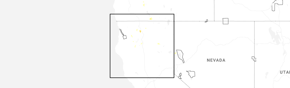
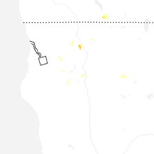
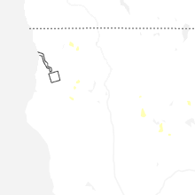
Hail Map for Hayfork, CA
The Hayfork, CA area has had 0 reports of on-the-ground hail by trained spotters, and has been under severe weather warnings 0 times during the past 12 months. Doppler radar has detected hail at or near Hayfork, CA on 7 occasions, including 2 occasions during the past year.
| Name: | Hayfork, CA |
| Where Located: | 39.2 miles W of Redding, CA |
| Map: | Google Map for Hayfork, CA |
| Population: | 2368 |
| Housing Units: | 1213 |
| More Info: | Search Google for Hayfork, CA |
0
The Top Recent Hail Date for Hayfork, CA is Tuesday, July 1, 2025 (7th out of 7)
Hail and Wind Damage Spotted near Hayfork, CA
| Date / Time | Report Details |
|---|---|
| 7/22/2020 4:38 PM PDT |
 The severe thunderstorm warning for central trinity county will expire at 445 pm pdt, the storm which prompted the warning has weakened below severe limits, and no longer poses an immediate threat to life or property. therefore, the warning will be allowed to expire. The severe thunderstorm warning for central trinity county will expire at 445 pm pdt, the storm which prompted the warning has weakened below severe limits, and no longer poses an immediate threat to life or property. therefore, the warning will be allowed to expire.
|
| 7/22/2020 4:28 PM PDT |
 At 428 pm pdt, a severe thunderstorm was located over douglas city, or near weaverville, and is nearly stationary (radar indicated). Hazards include 60 mph wind gusts and quarter size hail. Hail damage to vehicles is expected. expect wind damage to roofs, siding, and trees. Locations impacted include, weaverville, hayfork, junction city, douglas city and lewiston. At 428 pm pdt, a severe thunderstorm was located over douglas city, or near weaverville, and is nearly stationary (radar indicated). Hazards include 60 mph wind gusts and quarter size hail. Hail damage to vehicles is expected. expect wind damage to roofs, siding, and trees. Locations impacted include, weaverville, hayfork, junction city, douglas city and lewiston.
|
| 7/22/2020 4:13 PM PDT |
 At 413 pm pdt, a severe thunderstorm was located over douglas city, or near weaverville, and is nearly stationary (radar indicated). Hazards include 60 mph wind gusts and half dollar size hail. Hail damage to vehicles is expected. Expect wind damage to roofs, siding, and trees. At 413 pm pdt, a severe thunderstorm was located over douglas city, or near weaverville, and is nearly stationary (radar indicated). Hazards include 60 mph wind gusts and half dollar size hail. Hail damage to vehicles is expected. Expect wind damage to roofs, siding, and trees.
|
| 7/22/2020 3:30 PM PDT |
 At 330 pm pdt, a severe thunderstorm was located near hayfork, and is nearly stationary (radar indicated). Hazards include 60 mph wind gusts and quarter size hail. Hail damage to vehicles is expected. Expect wind damage to roofs, siding, and trees. At 330 pm pdt, a severe thunderstorm was located near hayfork, and is nearly stationary (radar indicated). Hazards include 60 mph wind gusts and quarter size hail. Hail damage to vehicles is expected. Expect wind damage to roofs, siding, and trees.
|
| 9/6/2017 6:04 PM PDT |
 At 604 pm pdt, a severe thunderstorm was located near peanut, or 12 miles south of hayfork, moving northwest at 15 mph (radar indicated). Hazards include quarter size hail. Damage to vehicles is expected. Locations impacted include, hayfork. At 604 pm pdt, a severe thunderstorm was located near peanut, or 12 miles south of hayfork, moving northwest at 15 mph (radar indicated). Hazards include quarter size hail. Damage to vehicles is expected. Locations impacted include, hayfork.
|
| 9/6/2017 5:58 PM PDT |
 At 557 pm pdt, a severe thunderstorm was located near peanut, or 11 miles west of yolla bolly district rs, moving northwest at 15 mph (radar indicated). Hazards include quarter size hail. damage to vehicles is expected At 557 pm pdt, a severe thunderstorm was located near peanut, or 11 miles west of yolla bolly district rs, moving northwest at 15 mph (radar indicated). Hazards include quarter size hail. damage to vehicles is expected
|
| 8/10/2017 4:53 PM PDT |
 The severe thunderstorm warning for central trinity county will expire at 500 pm pdt, the storm which prompted the warning has weakened below severe limits, and no longer poses an immediate threat to life or property. therefore the warning will be allowed to expire. however small hail and gusty winds are still possible with this thunderstorm. to report severe weather, contact your nearest law enforcement agency. they will relay your report to the national weather service eureka california. The severe thunderstorm warning for central trinity county will expire at 500 pm pdt, the storm which prompted the warning has weakened below severe limits, and no longer poses an immediate threat to life or property. therefore the warning will be allowed to expire. however small hail and gusty winds are still possible with this thunderstorm. to report severe weather, contact your nearest law enforcement agency. they will relay your report to the national weather service eureka california.
|
| 8/10/2017 4:30 PM PDT |
 At 430 pm pdt, a severe thunderstorm was located near peanut, or 9 miles southwest of hayfork, and is nearly stationary (radar indicated). Hazards include quarter size hail. damage to vehicles is expected At 430 pm pdt, a severe thunderstorm was located near peanut, or 9 miles southwest of hayfork, and is nearly stationary (radar indicated). Hazards include quarter size hail. damage to vehicles is expected
|
| 8/10/2017 4:22 PM PDT |
 At 422 pm pdt, a severe thunderstorm was located near peanut, or 9 miles southwest of hayfork, and is nearly stationary (radar indicated). Hazards include quarter size hail. Damage to vehicles is expected. Locations impacted include, hayfork and peanut. At 422 pm pdt, a severe thunderstorm was located near peanut, or 9 miles southwest of hayfork, and is nearly stationary (radar indicated). Hazards include quarter size hail. Damage to vehicles is expected. Locations impacted include, hayfork and peanut.
|
| 8/10/2017 4:05 PM PDT |
 At 404 pm pdt, a severe thunderstorm was located near peanut, or 9 miles southwest of hayfork, and is nearly stationary (radar indicated). Hazards include quarter size hail. damage to vehicles is expected At 404 pm pdt, a severe thunderstorm was located near peanut, or 9 miles southwest of hayfork, and is nearly stationary (radar indicated). Hazards include quarter size hail. damage to vehicles is expected
|
| 7/8/2015 6:18 PM PDT |
 At 617 pm, doppler radar indicated a severe thunderstorm capable of producing damaging winds in excess of 60 mph. this storm was located near big bar, or 12 miles northwest of hayfork, drifting northwest at 5 mph. locations impacted include, hayfork. At 617 pm, doppler radar indicated a severe thunderstorm capable of producing damaging winds in excess of 60 mph. this storm was located near big bar, or 12 miles northwest of hayfork, drifting northwest at 5 mph. locations impacted include, hayfork.
|
| 7/8/2015 5:50 PM PDT |
 At 549 pm pdt, doppler radar indicated a severe thunderstorm capable of producing damaging winds in excess of 60 mph. this storm was located over hayfork, and moving northwest at 15 mph. nickel size hail may also accompany the damaging winds. At 549 pm pdt, doppler radar indicated a severe thunderstorm capable of producing damaging winds in excess of 60 mph. this storm was located over hayfork, and moving northwest at 15 mph. nickel size hail may also accompany the damaging winds.
|
Hail Maps for Hayfork, CA


Connect with Interactive Hail Maps