

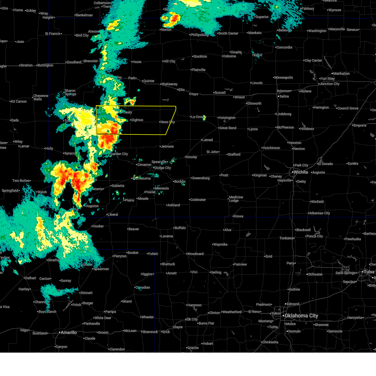
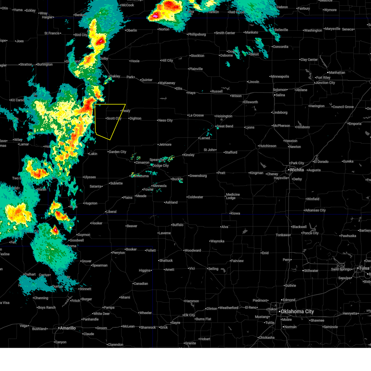
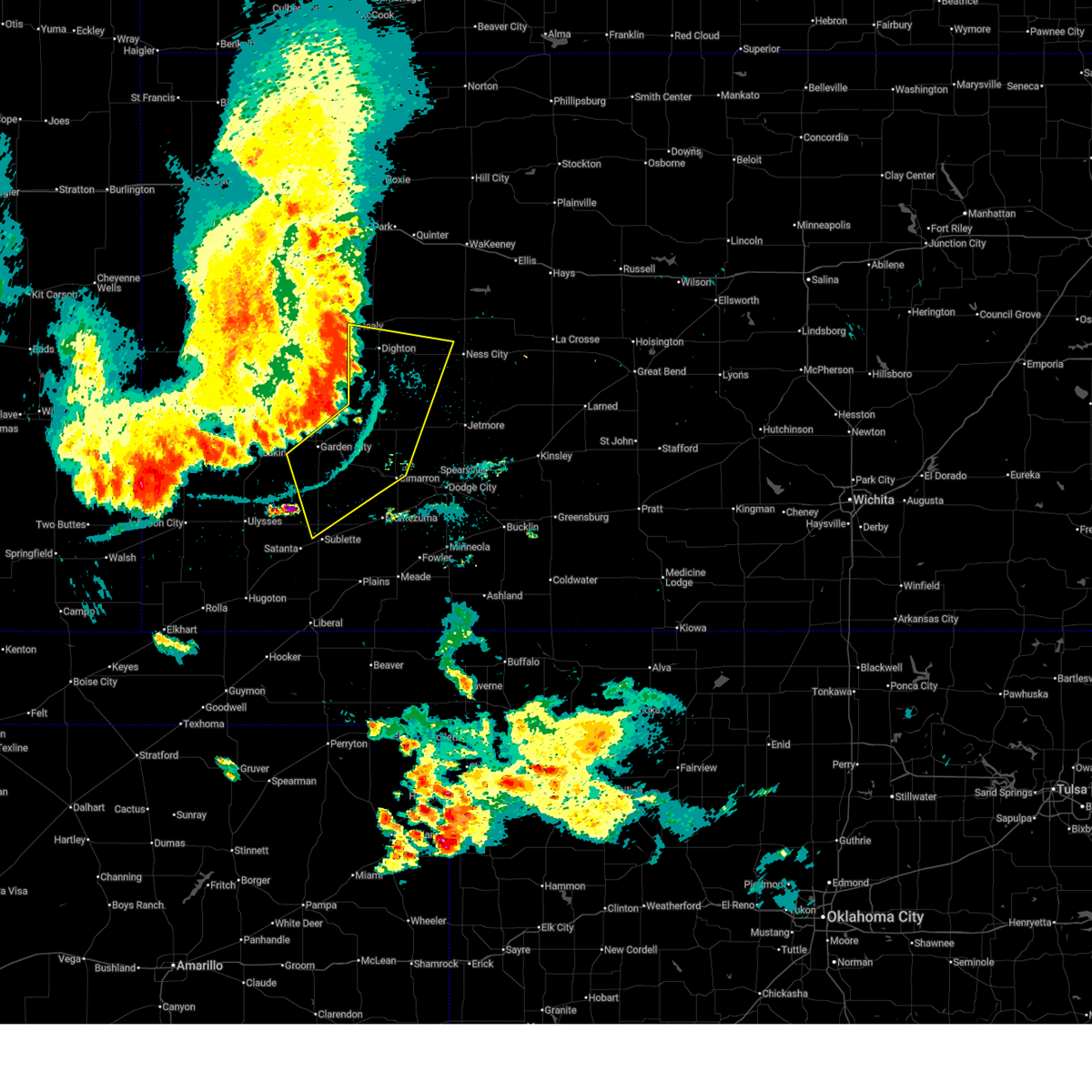
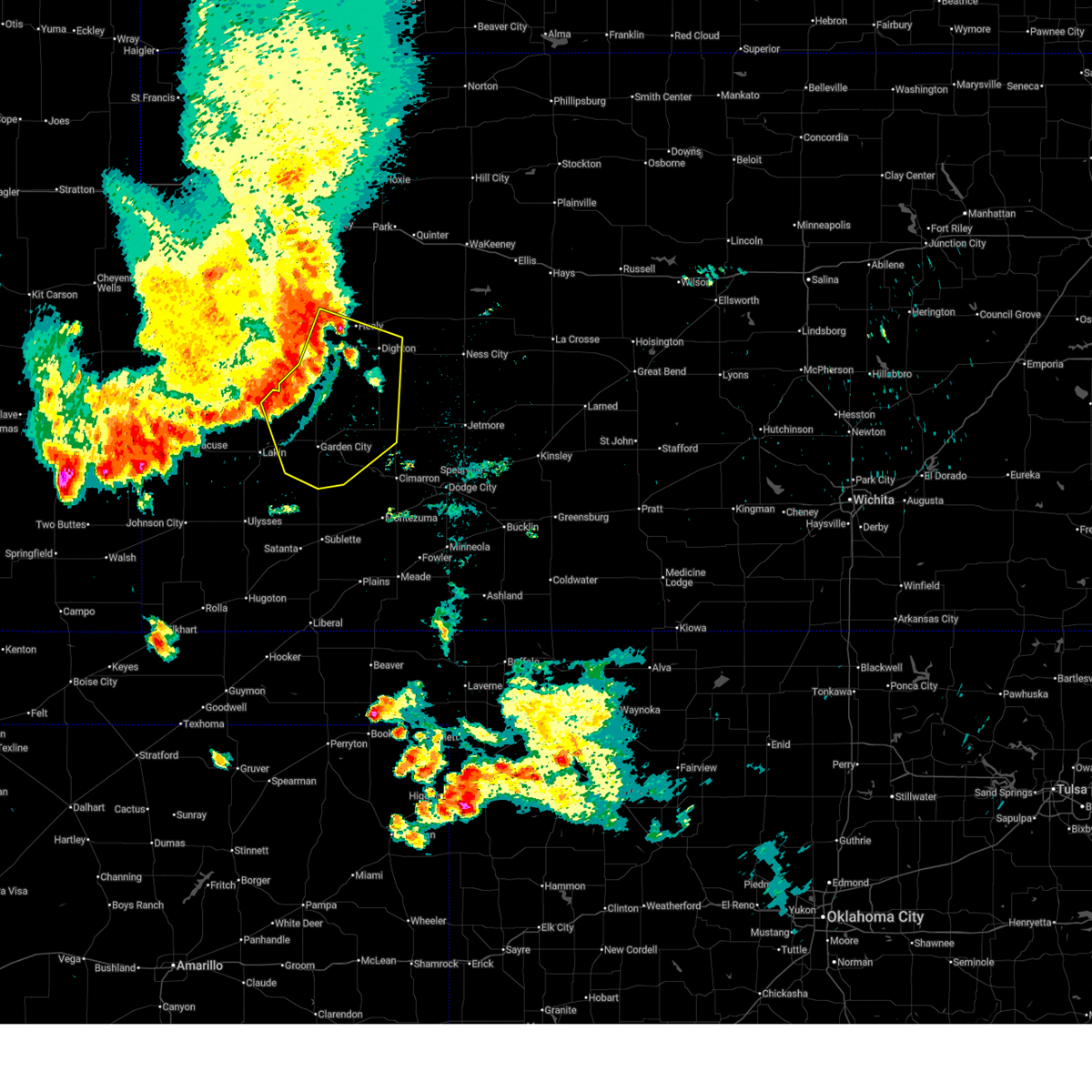
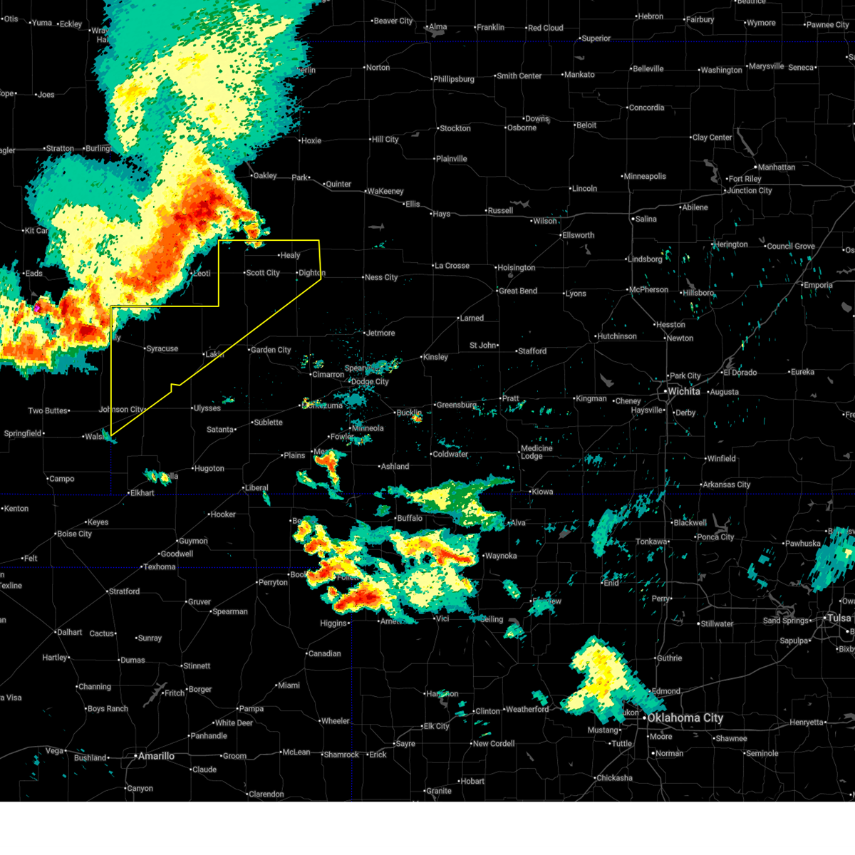
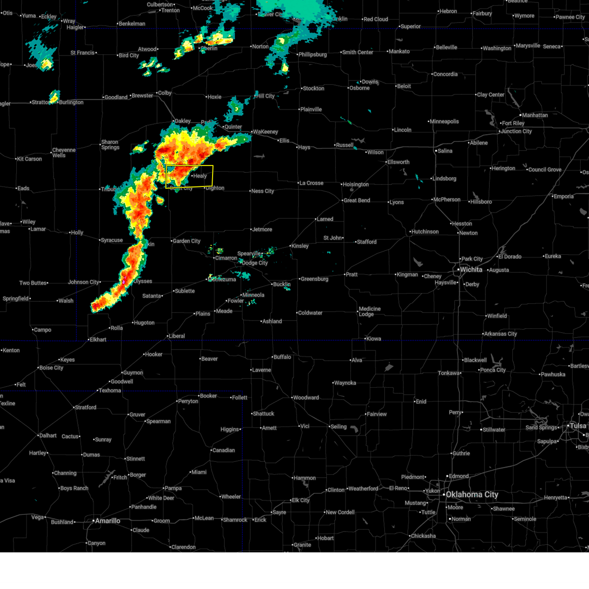
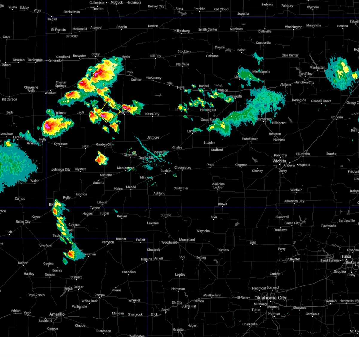
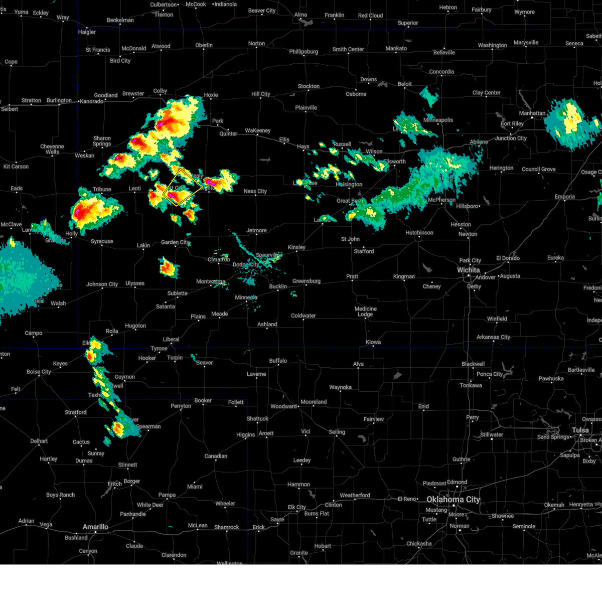
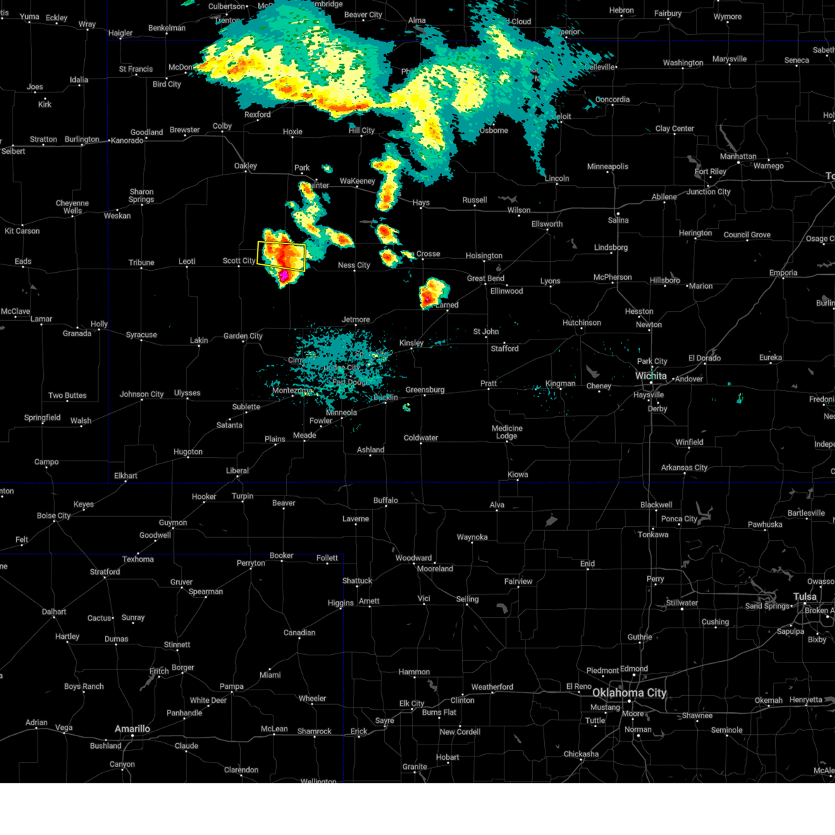
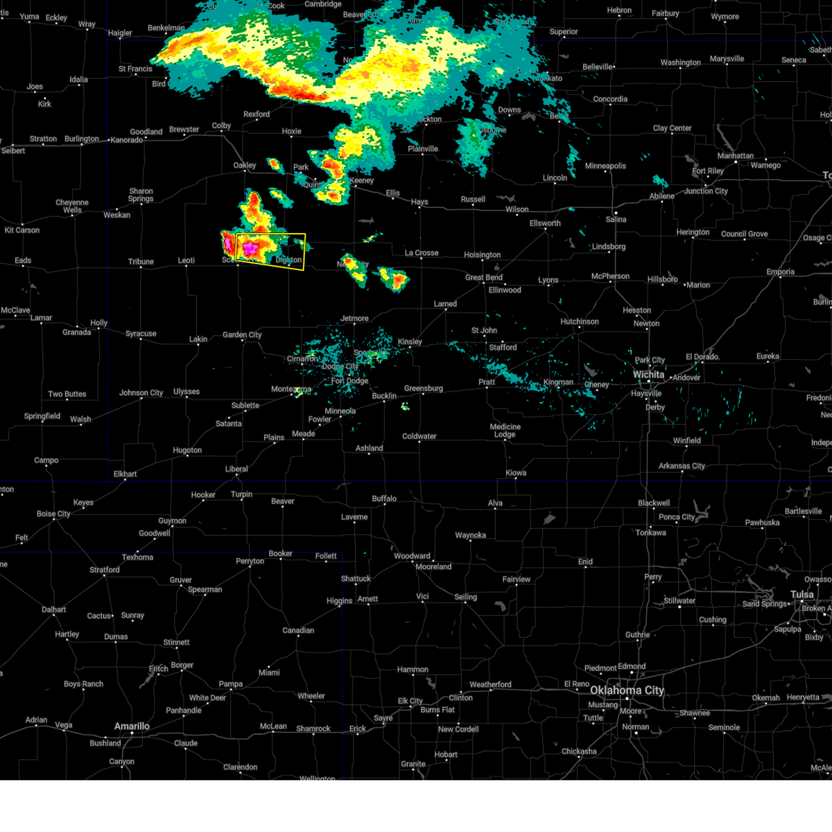
Hail Map for Healy, KS
The Healy, KS area has had 15 reports of on-the-ground hail by trained spotters, and has been under severe weather warnings 30 times during the past 12 months. Doppler radar has detected hail at or near Healy, KS on 107 occasions, including 10 occasions during the past year.
| Name: | Healy, KS |
| Where Located: | 46 miles NNE of Garden City, KS |
| Map: | Google Map for Healy, KS |
| Population: | 234 |
| Housing Units: | 109 |
| More Info: | Search Google for Healy, KS |
2
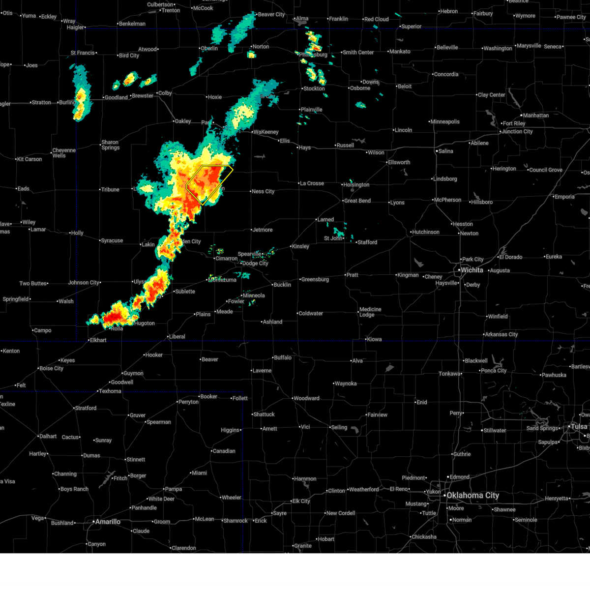
The Top Recent Hail Date for Healy, KS is Wednesday, April 23, 2025 (11th out of 107)

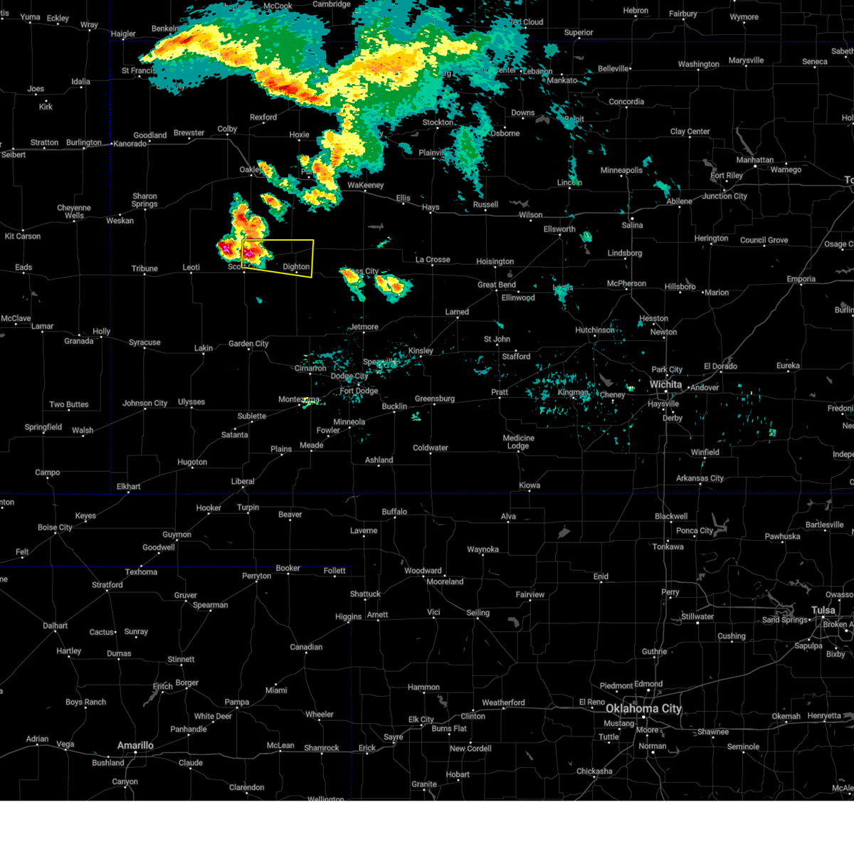
Hail and Wind Damage Spotted near Healy, KS
| Date / Time | Report Details |
|---|---|
| 7/10/2025 8:27 PM CDT |
 Svrddc the national weather service in dodge city has issued a * severe thunderstorm warning for, scott county in west central kansas, ness county in west central kansas, lane county in west central kansas, * until 915 pm cdt. * at 826 pm cdt, severe thunderstorms were located along a line extending from near healy to near friend, moving east at 80 mph (radar indicated). Hazards include 60 mph wind gusts. Expect damage to roofs, siding, and trees. severe thunderstorms will be near, healy, shields, grigston, and amy around 830 pm cdt. dighton and pendennis around 835 pm cdt. utica and alamota around 840 pm cdt. beeler around 845 pm cdt. Other locations in the path of these severe thunderstorms include ransom, arnold, ness city, brownell and bazine. Svrddc the national weather service in dodge city has issued a * severe thunderstorm warning for, scott county in west central kansas, ness county in west central kansas, lane county in west central kansas, * until 915 pm cdt. * at 826 pm cdt, severe thunderstorms were located along a line extending from near healy to near friend, moving east at 80 mph (radar indicated). Hazards include 60 mph wind gusts. Expect damage to roofs, siding, and trees. severe thunderstorms will be near, healy, shields, grigston, and amy around 830 pm cdt. dighton and pendennis around 835 pm cdt. utica and alamota around 840 pm cdt. beeler around 845 pm cdt. Other locations in the path of these severe thunderstorms include ransom, arnold, ness city, brownell and bazine.
|
| 7/10/2025 7:38 PM CDT |
 Svrddc the national weather service in dodge city has issued a * severe thunderstorm warning for, northwestern finney county in southwestern kansas, scott county in west central kansas, northwestern lane county in west central kansas, * until 830 pm cdt. * at 738 pm cdt, severe thunderstorms were located along a line extending from 11 miles south of russell springs to 16 miles south of leoti, moving east at 45 mph (radar indicated). Hazards include 60 mph wind gusts. Expect damage to roofs, siding, and trees. severe thunderstorms will be near, modoc around 750 pm cdt. scott state lake around 755 pm cdt. Other locations in the path of these severe thunderstorms include scott city, shallow water, friend, manning, grigston and healy. Svrddc the national weather service in dodge city has issued a * severe thunderstorm warning for, northwestern finney county in southwestern kansas, scott county in west central kansas, northwestern lane county in west central kansas, * until 830 pm cdt. * at 738 pm cdt, severe thunderstorms were located along a line extending from 11 miles south of russell springs to 16 miles south of leoti, moving east at 45 mph (radar indicated). Hazards include 60 mph wind gusts. Expect damage to roofs, siding, and trees. severe thunderstorms will be near, modoc around 750 pm cdt. scott state lake around 755 pm cdt. Other locations in the path of these severe thunderstorms include scott city, shallow water, friend, manning, grigston and healy.
|
| 7/7/2025 1:06 AM CDT |
 Svrddc the national weather service in dodge city has issued a * severe thunderstorm warning for, finney county in southwestern kansas, southwestern ness county in west central kansas, northwestern hodgeman county in southwestern kansas, lane county in west central kansas, northern gray county in southwestern kansas, northeastern haskell county in southwestern kansas, * until 145 am cdt. * at 106 am cdt, severe thunderstorms were located along a line extending from near alamota to 7 miles north of charleston to 8 miles southwest of plymell, moving southeast at 50 mph (radar indicated). Hazards include 70 mph wind gusts. Expect considerable tree damage. damage is likely to mobile homes, roofs, and outbuildings. severe thunderstorms will be near, charleston around 110 am cdt. ingalls and kalvesta around 115 am cdt. Cimarron around 120 am cdt. Svrddc the national weather service in dodge city has issued a * severe thunderstorm warning for, finney county in southwestern kansas, southwestern ness county in west central kansas, northwestern hodgeman county in southwestern kansas, lane county in west central kansas, northern gray county in southwestern kansas, northeastern haskell county in southwestern kansas, * until 145 am cdt. * at 106 am cdt, severe thunderstorms were located along a line extending from near alamota to 7 miles north of charleston to 8 miles southwest of plymell, moving southeast at 50 mph (radar indicated). Hazards include 70 mph wind gusts. Expect considerable tree damage. damage is likely to mobile homes, roofs, and outbuildings. severe thunderstorms will be near, charleston around 110 am cdt. ingalls and kalvesta around 115 am cdt. Cimarron around 120 am cdt.
|
| 7/7/2025 12:38 AM CDT |
 Svrddc the national weather service in dodge city has issued a * severe thunderstorm warning for, northeastern kearny county in southwestern kansas, finney county in southwestern kansas, scott county in west central kansas, lane county in west central kansas, northwestern gray county in southwestern kansas, * until 145 am cdt. * at 1238 am cdt, severe thunderstorms were located along a line extending from 7 miles northwest of shields to near friend to near deerfield, moving southeast at 35 mph (radar indicated). Hazards include 70 mph wind gusts and penny size hail. Expect considerable tree damage. damage is likely to mobile homes, roofs, and outbuildings. severe thunderstorms will be near, garden city, holcomb, and amy around 1245 am cdt. dighton around 1250 am cdt. Other locations in the path of these severe thunderstorms include plymell, pierceville and charleston. Svrddc the national weather service in dodge city has issued a * severe thunderstorm warning for, northeastern kearny county in southwestern kansas, finney county in southwestern kansas, scott county in west central kansas, lane county in west central kansas, northwestern gray county in southwestern kansas, * until 145 am cdt. * at 1238 am cdt, severe thunderstorms were located along a line extending from 7 miles northwest of shields to near friend to near deerfield, moving southeast at 35 mph (radar indicated). Hazards include 70 mph wind gusts and penny size hail. Expect considerable tree damage. damage is likely to mobile homes, roofs, and outbuildings. severe thunderstorms will be near, garden city, holcomb, and amy around 1245 am cdt. dighton around 1250 am cdt. Other locations in the path of these severe thunderstorms include plymell, pierceville and charleston.
|
| 7/6/2025 11:51 PM CDT |
 Svrddc the national weather service in dodge city has issued a * severe thunderstorm warning for, hamilton county in southwestern kansas, kearny county in southwestern kansas, northwestern finney county in southwestern kansas, scott county in west central kansas, lane county in west central kansas, northwestern stanton county in southwestern kansas, * until 1245 am cdt/1145 pm mdt/. * at 1150 pm cdt/1050 pm mdt/, severe thunderstorms were located along a line extending from 8 miles south of monument to 10 miles northeast of hartman, moving southeast at 55 mph (radar indicated). Hazards include 60 mph wind gusts. expect damage to roofs, siding, and trees Svrddc the national weather service in dodge city has issued a * severe thunderstorm warning for, hamilton county in southwestern kansas, kearny county in southwestern kansas, northwestern finney county in southwestern kansas, scott county in west central kansas, lane county in west central kansas, northwestern stanton county in southwestern kansas, * until 1245 am cdt/1145 pm mdt/. * at 1150 pm cdt/1050 pm mdt/, severe thunderstorms were located along a line extending from 8 miles south of monument to 10 miles northeast of hartman, moving southeast at 55 mph (radar indicated). Hazards include 60 mph wind gusts. expect damage to roofs, siding, and trees
|
| 7/4/2025 9:39 PM CDT |
 The severe thunderstorm which prompted the warning has weakened below severe limits. therefore, the warning will be allowed to expire at 945 pm. heavy rain, lightning and wind gusts up to 50 mph remain likely. The severe thunderstorm which prompted the warning has weakened below severe limits. therefore, the warning will be allowed to expire at 945 pm. heavy rain, lightning and wind gusts up to 50 mph remain likely.
|
| 7/4/2025 9:31 PM CDT |
 At 931 pm cdt, a severe thunderstorm was located near pendennis, moving east at 20 mph (radar indicated). Hazards include 60 mph wind gusts and quarter size hail. Hail damage to vehicles is expected. expect wind damage to roofs, siding, and trees. Locations impacted include, pendennis and utica. At 931 pm cdt, a severe thunderstorm was located near pendennis, moving east at 20 mph (radar indicated). Hazards include 60 mph wind gusts and quarter size hail. Hail damage to vehicles is expected. expect wind damage to roofs, siding, and trees. Locations impacted include, pendennis and utica.
|
| 7/4/2025 9:05 PM CDT |
 Svrddc the national weather service in dodge city has issued a * severe thunderstorm warning for, northwestern ness county in west central kansas, central lane county in west central kansas, * until 945 pm cdt. * at 905 pm cdt, severe thunderstorms were located along a line extending from 9 miles north of pendennis to near grigston, moving southeast at 20 mph (radar indicated). Hazards include 60 mph wind gusts and quarter size hail. Hail damage to vehicles is expected. expect wind damage to roofs, siding, and trees. severe thunderstorms will be near, shields and amy around 910 pm cdt. pendennis around 915 pm cdt. Dighton around 920 pm cdt. Svrddc the national weather service in dodge city has issued a * severe thunderstorm warning for, northwestern ness county in west central kansas, central lane county in west central kansas, * until 945 pm cdt. * at 905 pm cdt, severe thunderstorms were located along a line extending from 9 miles north of pendennis to near grigston, moving southeast at 20 mph (radar indicated). Hazards include 60 mph wind gusts and quarter size hail. Hail damage to vehicles is expected. expect wind damage to roofs, siding, and trees. severe thunderstorms will be near, shields and amy around 910 pm cdt. pendennis around 915 pm cdt. Dighton around 920 pm cdt.
|
| 7/4/2025 8:57 PM CDT |
 At 857 pm cdt, a severe thunderstorm was located very near healy, moving east at 20 mph (radar indicated). Hazards include 60 mph wind gusts and quarter size hail. Hail damage to vehicles is expected. expect wind damage to roofs, siding, and trees. This severe storm will be near, healy around 900 pm cdt. At 857 pm cdt, a severe thunderstorm was located very near healy, moving east at 20 mph (radar indicated). Hazards include 60 mph wind gusts and quarter size hail. Hail damage to vehicles is expected. expect wind damage to roofs, siding, and trees. This severe storm will be near, healy around 900 pm cdt.
|
| 7/4/2025 8:43 PM CDT |
 Svrddc the national weather service in dodge city has issued a * severe thunderstorm warning for, northeastern scott county in west central kansas, northwestern lane county in west central kansas, * until 930 pm cdt. * at 843 pm cdt, a severe thunderstorm was located 7 miles northwest of healy, moving east at 15 mph (radar indicated). Hazards include 60 mph wind gusts and quarter size hail. Hail damage to vehicles is expected. expect wind damage to roofs, siding, and trees. This severe thunderstorm will be near, healy around 855 pm cdt. Svrddc the national weather service in dodge city has issued a * severe thunderstorm warning for, northeastern scott county in west central kansas, northwestern lane county in west central kansas, * until 930 pm cdt. * at 843 pm cdt, a severe thunderstorm was located 7 miles northwest of healy, moving east at 15 mph (radar indicated). Hazards include 60 mph wind gusts and quarter size hail. Hail damage to vehicles is expected. expect wind damage to roofs, siding, and trees. This severe thunderstorm will be near, healy around 855 pm cdt.
|
| 5/19/2025 6:35 PM CDT | At 635 pm cdt, a severe thunderstorm was located near amy, moving east at 20 mph (radar indicated). Hazards include 60 mph wind gusts and half dollar size hail. Hail damage to vehicles is expected. expect wind damage to roofs, siding, and trees. Locations impacted include, dighton. |
| 5/19/2025 6:08 PM CDT | Svrddc the national weather service in dodge city has issued a * severe thunderstorm warning for, east central scott county in west central kansas, southwestern lane county in west central kansas, * until 700 pm cdt. * at 608 pm cdt, a severe thunderstorm was located near grigston, moving east at 20 mph (radar indicated). Hazards include half dollar size hail. Damage to vehicles is expected. this severe thunderstorm will be near, amy around 620 pm cdt. Other locations in the path of this severe thunderstorm include dighton. |
| 4/23/2025 7:08 PM CDT | Ping Pong Ball sized hail reported 0.4 miles NE of Healy, KS |
| 4/23/2025 6:56 PM CDT |
 Svrddc the national weather service in dodge city has issued a * severe thunderstorm warning for, northeastern scott county in west central kansas, northern lane county in west central kansas, * until 745 pm cdt. * at 656 pm cdt, a severe thunderstorm was located near healy, moving northeast at 25 mph (radar indicated). Hazards include golf ball size hail and 60 mph wind gusts. People and animals outdoors will be injured. expect hail damage to roofs, siding, windows, and vehicles. expect wind damage to roofs, siding, and trees. this severe thunderstorm will be near, healy around 700 pm cdt. Other locations in the path of this severe thunderstorm include shields. Svrddc the national weather service in dodge city has issued a * severe thunderstorm warning for, northeastern scott county in west central kansas, northern lane county in west central kansas, * until 745 pm cdt. * at 656 pm cdt, a severe thunderstorm was located near healy, moving northeast at 25 mph (radar indicated). Hazards include golf ball size hail and 60 mph wind gusts. People and animals outdoors will be injured. expect hail damage to roofs, siding, windows, and vehicles. expect wind damage to roofs, siding, and trees. this severe thunderstorm will be near, healy around 700 pm cdt. Other locations in the path of this severe thunderstorm include shields.
|
| 4/23/2025 6:50 PM CDT |
 At 650 pm cdt, a severe thunderstorm was located near healy, moving southeast at 5 mph (radar indicated). Hazards include quarter size hail. Damage to vehicles is expected. Locations impacted include, healy and manning. At 650 pm cdt, a severe thunderstorm was located near healy, moving southeast at 5 mph (radar indicated). Hazards include quarter size hail. Damage to vehicles is expected. Locations impacted include, healy and manning.
|
| 4/23/2025 6:47 PM CDT |
 At 647 pm cdt, a severe thunderstorm capable of producing a tornado was located near healy, moving northeast at 20 mph (radar indicated rotation). Hazards include tornado and golf ball size hail. Flying debris will be dangerous to those caught without shelter. mobile homes will be damaged or destroyed. damage to roofs, windows, and vehicles will occur. tree damage is likely. This tornadic thunderstorm will remain over mainly rural areas of east central scott and northwestern lane counties. At 647 pm cdt, a severe thunderstorm capable of producing a tornado was located near healy, moving northeast at 20 mph (radar indicated rotation). Hazards include tornado and golf ball size hail. Flying debris will be dangerous to those caught without shelter. mobile homes will be damaged or destroyed. damage to roofs, windows, and vehicles will occur. tree damage is likely. This tornadic thunderstorm will remain over mainly rural areas of east central scott and northwestern lane counties.
|
| 4/23/2025 6:25 PM CDT |
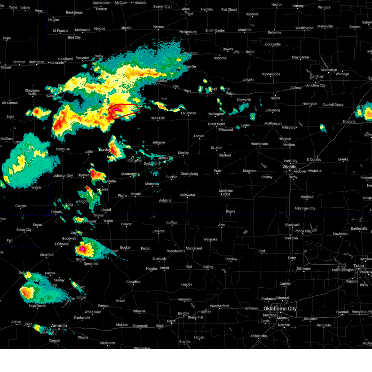 Torddc the national weather service in dodge city has issued a * tornado warning for, northeastern scott county in west central kansas, northern lane county in west central kansas, * until 700 pm cdt. * at 625 pm cdt, a severe thunderstorm capable of producing a tornado was located very near manning, moving northeast at 20 mph (radar indicated rotation). Hazards include tornado and golf ball size hail. Flying debris will be dangerous to those caught without shelter. mobile homes will be damaged or destroyed. damage to roofs, windows, and vehicles will occur. tree damage is likely. This dangerous storm will be near, healy around 630 pm cdt. Torddc the national weather service in dodge city has issued a * tornado warning for, northeastern scott county in west central kansas, northern lane county in west central kansas, * until 700 pm cdt. * at 625 pm cdt, a severe thunderstorm capable of producing a tornado was located very near manning, moving northeast at 20 mph (radar indicated rotation). Hazards include tornado and golf ball size hail. Flying debris will be dangerous to those caught without shelter. mobile homes will be damaged or destroyed. damage to roofs, windows, and vehicles will occur. tree damage is likely. This dangerous storm will be near, healy around 630 pm cdt.
|
| 4/23/2025 6:16 PM CDT |
 At 616 pm cdt, a severe thunderstorm was located near manning, moving northeast at 25 mph (radar indicated). Hazards include ping pong ball size hail. People and animals outdoors will be injured. expect damage to roofs, siding, windows, and vehicles. Locations impacted include, healy, manning, and scott state lake. At 616 pm cdt, a severe thunderstorm was located near manning, moving northeast at 25 mph (radar indicated). Hazards include ping pong ball size hail. People and animals outdoors will be injured. expect damage to roofs, siding, windows, and vehicles. Locations impacted include, healy, manning, and scott state lake.
|
| 4/23/2025 6:11 PM CDT | Svrddc the national weather service in dodge city has issued a * severe thunderstorm warning for, northeastern scott county in west central kansas, northwestern lane county in west central kansas, * until 700 pm cdt. * at 611 pm cdt, a severe thunderstorm was located near manning, moving northeast at 25 mph (radar indicated). Hazards include ping pong ball size hail. People and animals outdoors will be injured. expect damage to roofs, siding, windows, and vehicles. This severe thunderstorm will remain over mainly rural areas of northeastern scott and northwestern lane counties. |
| 4/23/2025 6:08 PM CDT | Quarter sized hail reported 0.4 miles NE of Healy, KS |
| 4/23/2025 5:18 PM CDT |
 At 517 pm cdt, a severe thunderstorm was located near scott city, moving northeast at 15 mph. this is a destructive storm for north-central and northeast scott county (radar indicated). Hazards include three inch hail. People and animals outdoors will be severely injured. expect shattered windows, extensive damage to roofs, siding, and vehicles. Locations impacted include, manning. At 517 pm cdt, a severe thunderstorm was located near scott city, moving northeast at 15 mph. this is a destructive storm for north-central and northeast scott county (radar indicated). Hazards include three inch hail. People and animals outdoors will be severely injured. expect shattered windows, extensive damage to roofs, siding, and vehicles. Locations impacted include, manning.
|
| 4/23/2025 5:08 PM CDT |
 At 508 pm cdt, a severe thunderstorm was located very near scott city, moving northeast at 15 mph (radar indicated). Hazards include tennis ball size hail. People and animals outdoors will be injured. expect damage to roofs, siding, windows, and vehicles. This severe thunderstorm will remain over mainly rural areas of northeastern scott and west central lane counties. At 508 pm cdt, a severe thunderstorm was located very near scott city, moving northeast at 15 mph (radar indicated). Hazards include tennis ball size hail. People and animals outdoors will be injured. expect damage to roofs, siding, windows, and vehicles. This severe thunderstorm will remain over mainly rural areas of northeastern scott and west central lane counties.
|
| 4/23/2025 5:01 PM CDT |
 At 501 pm cdt, a severe thunderstorm was located very near scott city, moving northeast at 15 mph (radar indicated). Hazards include tennis ball size hail. People and animals outdoors will be injured. expect damage to roofs, siding, windows, and vehicles. This severe storm will be near, scott city around 505 pm cdt. At 501 pm cdt, a severe thunderstorm was located very near scott city, moving northeast at 15 mph (radar indicated). Hazards include tennis ball size hail. People and animals outdoors will be injured. expect damage to roofs, siding, windows, and vehicles. This severe storm will be near, scott city around 505 pm cdt.
|
| 4/23/2025 4:56 PM CDT |
 At 456 pm cdt, a severe thunderstorm was located very near scott city, moving northeast at 15 mph (radar indicated). Hazards include two inch hail. People and animals outdoors will be injured. expect damage to roofs, siding, windows, and vehicles. This severe storm will be near, scott city around 500 pm cdt. At 456 pm cdt, a severe thunderstorm was located very near scott city, moving northeast at 15 mph (radar indicated). Hazards include two inch hail. People and animals outdoors will be injured. expect damage to roofs, siding, windows, and vehicles. This severe storm will be near, scott city around 500 pm cdt.
|
| 4/23/2025 4:52 PM CDT |
 Svrddc the national weather service in dodge city has issued a * severe thunderstorm warning for, eastern scott county in west central kansas, west central lane county in west central kansas, * until 530 pm cdt. * at 452 pm cdt, a severe thunderstorm was located near scott city, moving northeast at 15 mph (radar indicated). Hazards include quarter size hail. Damage to vehicles is expected. This severe thunderstorm will be near, scott city around 455 pm cdt. Svrddc the national weather service in dodge city has issued a * severe thunderstorm warning for, eastern scott county in west central kansas, west central lane county in west central kansas, * until 530 pm cdt. * at 452 pm cdt, a severe thunderstorm was located near scott city, moving northeast at 15 mph (radar indicated). Hazards include quarter size hail. Damage to vehicles is expected. This severe thunderstorm will be near, scott city around 455 pm cdt.
|
| 8/16/2024 10:07 AM CDT |
 The storm which prompted the warning has weakened below severe limits, and no longer poses an immediate threat to life or property. therefore, the warning will be allowed to expire. however, small hail and gusty winds are still possible with this thunderstorm. The storm which prompted the warning has weakened below severe limits, and no longer poses an immediate threat to life or property. therefore, the warning will be allowed to expire. however, small hail and gusty winds are still possible with this thunderstorm.
|
| 8/16/2024 9:51 AM CDT |
 At 950 am cdt, a severe thunderstorm was located very near manning, moving southeast at 30 mph (law enforcement reported golf ball hail at the us 83 and k4 junction at 929 am). Hazards include golf ball size hail and 60 mph wind gusts. People and animals outdoors will be injured. expect hail damage to roofs, siding, windows, and vehicles. expect wind damage to roofs, siding, and trees. This severe thunderstorm will remain over mainly rural areas of east central scott and northern lane counties. At 950 am cdt, a severe thunderstorm was located very near manning, moving southeast at 30 mph (law enforcement reported golf ball hail at the us 83 and k4 junction at 929 am). Hazards include golf ball size hail and 60 mph wind gusts. People and animals outdoors will be injured. expect hail damage to roofs, siding, windows, and vehicles. expect wind damage to roofs, siding, and trees. This severe thunderstorm will remain over mainly rural areas of east central scott and northern lane counties.
|
| 8/16/2024 9:33 AM CDT |
 At 933 am cdt, a severe thunderstorm was located near manning, moving east at 30 mph (radar indicated). Hazards include ping pong ball size hail. People and animals outdoors will be injured. expect damage to roofs, siding, windows, and vehicles. this severe storm will be near, manning around 940 am cdt. healy around 945 am cdt. Other locations in the path of this severe thunderstorm include shields. At 933 am cdt, a severe thunderstorm was located near manning, moving east at 30 mph (radar indicated). Hazards include ping pong ball size hail. People and animals outdoors will be injured. expect damage to roofs, siding, windows, and vehicles. this severe storm will be near, manning around 940 am cdt. healy around 945 am cdt. Other locations in the path of this severe thunderstorm include shields.
|
| 8/16/2024 9:25 AM CDT |
 Svrddc the national weather service in dodge city has issued a * severe thunderstorm warning for, northeastern scott county in west central kansas, northern lane county in west central kansas, * until 1015 am cdt. * at 925 am cdt, a severe thunderstorm was located near scott state lake, moving east at 35 mph (radar indicated). Hazards include quarter size hail. Damage to vehicles is expected. this severe thunderstorm will be near, healy and manning around 935 am cdt. Other locations in the path of this severe thunderstorm include shields. Svrddc the national weather service in dodge city has issued a * severe thunderstorm warning for, northeastern scott county in west central kansas, northern lane county in west central kansas, * until 1015 am cdt. * at 925 am cdt, a severe thunderstorm was located near scott state lake, moving east at 35 mph (radar indicated). Hazards include quarter size hail. Damage to vehicles is expected. this severe thunderstorm will be near, healy and manning around 935 am cdt. Other locations in the path of this severe thunderstorm include shields.
|
| 7/16/2024 9:25 PM CDT |
 The storm which prompted the warning has weakened below severe limits, and no longer poses an immediate threat to life or property. therefore, the warning will be allowed to expire. however, small hail and gusty winds are still possible with this thunderstorm. The storm which prompted the warning has weakened below severe limits, and no longer poses an immediate threat to life or property. therefore, the warning will be allowed to expire. however, small hail and gusty winds are still possible with this thunderstorm.
|
| 7/16/2024 9:10 PM CDT |
 At 909 pm cdt, a severe thunderstorm was located near manning, moving south at 25 mph (radar indicated). Hazards include ping pong ball size hail and 60 mph wind gusts. People and animals outdoors will be injured. expect hail damage to roofs, siding, windows, and vehicles. expect wind damage to roofs, siding, and trees. Locations impacted include, manning and grigston. At 909 pm cdt, a severe thunderstorm was located near manning, moving south at 25 mph (radar indicated). Hazards include ping pong ball size hail and 60 mph wind gusts. People and animals outdoors will be injured. expect hail damage to roofs, siding, windows, and vehicles. expect wind damage to roofs, siding, and trees. Locations impacted include, manning and grigston.
|
| 7/16/2024 8:47 PM CDT |
 Svrddc the national weather service in dodge city has issued a * severe thunderstorm warning for, eastern scott county in west central kansas, western lane county in west central kansas, * until 930 pm cdt. * at 847 pm cdt, a severe thunderstorm was located 8 miles east of scott state lake, moving south at 25 mph (radar indicated). Hazards include ping pong ball size hail and 60 mph wind gusts. People and animals outdoors will be injured. expect hail damage to roofs, siding, windows, and vehicles. expect wind damage to roofs, siding, and trees. this severe thunderstorm will be near, manning around 905 pm cdt. Other locations in the path of this severe thunderstorm include grigston. Svrddc the national weather service in dodge city has issued a * severe thunderstorm warning for, eastern scott county in west central kansas, western lane county in west central kansas, * until 930 pm cdt. * at 847 pm cdt, a severe thunderstorm was located 8 miles east of scott state lake, moving south at 25 mph (radar indicated). Hazards include ping pong ball size hail and 60 mph wind gusts. People and animals outdoors will be injured. expect hail damage to roofs, siding, windows, and vehicles. expect wind damage to roofs, siding, and trees. this severe thunderstorm will be near, manning around 905 pm cdt. Other locations in the path of this severe thunderstorm include grigston.
|
| 7/6/2024 6:30 PM CDT |
 Svrddc the national weather service in dodge city has issued a * severe thunderstorm warning for, southern scott county in west central kansas, ness county in west central kansas, lane county in west central kansas, * until 700 pm cdt. * at 630 pm cdt, severe thunderstorms were located along a line extending from near bazine to near grigston, moving southeast at 40 mph (radar indicated). Hazards include 60 mph wind gusts and nickel size hail. Expect damage to roofs, siding, and trees. Severe thunderstorms will be near, ness city, bazine, alamota, and beeler around 635 pm cdt. Svrddc the national weather service in dodge city has issued a * severe thunderstorm warning for, southern scott county in west central kansas, ness county in west central kansas, lane county in west central kansas, * until 700 pm cdt. * at 630 pm cdt, severe thunderstorms were located along a line extending from near bazine to near grigston, moving southeast at 40 mph (radar indicated). Hazards include 60 mph wind gusts and nickel size hail. Expect damage to roofs, siding, and trees. Severe thunderstorms will be near, ness city, bazine, alamota, and beeler around 635 pm cdt.
|
| 7/6/2024 5:34 PM CDT |
 Svrddc the national weather service in dodge city has issued a * severe thunderstorm warning for, eastern scott county in west central kansas, ness county in west central kansas, southern trego county in west central kansas, lane county in west central kansas, * until 630 pm cdt. * at 533 pm cdt, severe thunderstorms were located along a line extending from near scott state lake to 6 miles north of beeler, moving southeast at 40 mph. these are destructive storms (radar indicated). Hazards include 80 mph wind gusts and golf ball size hail. Flying debris will be dangerous to those caught without shelter. mobile homes will be heavily damaged. expect considerable damage to roofs, windows, and vehicles. extensive tree damage and power outages are likely. severe thunderstorms will be near, dighton, alamota, manning, and beeler around 540 pm cdt. Grigston and amy around 545 pm cdt. Svrddc the national weather service in dodge city has issued a * severe thunderstorm warning for, eastern scott county in west central kansas, ness county in west central kansas, southern trego county in west central kansas, lane county in west central kansas, * until 630 pm cdt. * at 533 pm cdt, severe thunderstorms were located along a line extending from near scott state lake to 6 miles north of beeler, moving southeast at 40 mph. these are destructive storms (radar indicated). Hazards include 80 mph wind gusts and golf ball size hail. Flying debris will be dangerous to those caught without shelter. mobile homes will be heavily damaged. expect considerable damage to roofs, windows, and vehicles. extensive tree damage and power outages are likely. severe thunderstorms will be near, dighton, alamota, manning, and beeler around 540 pm cdt. Grigston and amy around 545 pm cdt.
|
| 7/6/2024 5:30 PM CDT |
 At 530 pm cdt, severe thunderstorms were located along a line extending from near pendennis to near manning, moving southeast at 35 mph. these are destructive storms (radar indicated). Hazards include 80 mph wind gusts and two inch hail. Flying debris will be dangerous to those caught without shelter. mobile homes will be heavily damaged. expect considerable damage to roofs, windows, and vehicles. extensive tree damage and power outages are likely. Locations impacted include, dighton, pendennis, healy, scott state lake, and shields. At 530 pm cdt, severe thunderstorms were located along a line extending from near pendennis to near manning, moving southeast at 35 mph. these are destructive storms (radar indicated). Hazards include 80 mph wind gusts and two inch hail. Flying debris will be dangerous to those caught without shelter. mobile homes will be heavily damaged. expect considerable damage to roofs, windows, and vehicles. extensive tree damage and power outages are likely. Locations impacted include, dighton, pendennis, healy, scott state lake, and shields.
|
| 7/6/2024 4:44 PM CDT |
 Svrddc the national weather service in dodge city has issued a * severe thunderstorm warning for, northeastern scott county in west central kansas, northern lane county in west central kansas, * until 545 pm cdt. * at 443 pm cdt, a severe thunderstorm was located 8 miles northeast of scott state lake, moving east at 30 mph. this is a destructive storm for scott state lake healy (radar indicated). Hazards include 80 mph wind gusts and two inch hail. Flying debris will be dangerous to those caught without shelter. mobile homes will be heavily damaged. expect considerable damage to roofs, windows, and vehicles. Extensive tree damage and power outages are likely. Svrddc the national weather service in dodge city has issued a * severe thunderstorm warning for, northeastern scott county in west central kansas, northern lane county in west central kansas, * until 545 pm cdt. * at 443 pm cdt, a severe thunderstorm was located 8 miles northeast of scott state lake, moving east at 30 mph. this is a destructive storm for scott state lake healy (radar indicated). Hazards include 80 mph wind gusts and two inch hail. Flying debris will be dangerous to those caught without shelter. mobile homes will be heavily damaged. expect considerable damage to roofs, windows, and vehicles. Extensive tree damage and power outages are likely.
|
| 7/6/2024 4:28 PM CDT |
 Svrddc the national weather service in dodge city has issued a * severe thunderstorm warning for, northeastern scott county in west central kansas, northwestern lane county in west central kansas, * until 515 pm cdt. * at 427 pm cdt, a severe thunderstorm was located 7 miles northeast of scott state lake, moving southeast at 30 mph (radar indicated). Hazards include 60 mph wind gusts and quarter size hail. Hail damage to vehicles is expected. expect wind damage to roofs, siding, and trees. This severe thunderstorm will remain over mainly rural areas of northeastern scott and northwestern lane counties. Svrddc the national weather service in dodge city has issued a * severe thunderstorm warning for, northeastern scott county in west central kansas, northwestern lane county in west central kansas, * until 515 pm cdt. * at 427 pm cdt, a severe thunderstorm was located 7 miles northeast of scott state lake, moving southeast at 30 mph (radar indicated). Hazards include 60 mph wind gusts and quarter size hail. Hail damage to vehicles is expected. expect wind damage to roofs, siding, and trees. This severe thunderstorm will remain over mainly rural areas of northeastern scott and northwestern lane counties.
|
| 6/29/2024 1:10 AM CDT |
 Svrddc the national weather service in dodge city has issued a * severe thunderstorm warning for, western ness county in west central kansas, northern lane county in west central kansas, * until 200 am cdt. * at 110 am cdt, a severe thunderstorm was located near pendennis, moving east at 35 mph (radar indicated). Hazards include two inch hail and 70 mph wind gusts. People and animals outdoors will be injured. expect hail damage to roofs, siding, windows, and vehicles. expect considerable tree damage. wind damage is also likely to mobile homes, roofs, and outbuildings. This severe thunderstorm will be near, arnold around 130 am cdt. Svrddc the national weather service in dodge city has issued a * severe thunderstorm warning for, western ness county in west central kansas, northern lane county in west central kansas, * until 200 am cdt. * at 110 am cdt, a severe thunderstorm was located near pendennis, moving east at 35 mph (radar indicated). Hazards include two inch hail and 70 mph wind gusts. People and animals outdoors will be injured. expect hail damage to roofs, siding, windows, and vehicles. expect considerable tree damage. wind damage is also likely to mobile homes, roofs, and outbuildings. This severe thunderstorm will be near, arnold around 130 am cdt.
|
| 6/29/2024 1:03 AM CDT |
 At 102 am cdt, a severe thunderstorm was located very near shields, moving east at 30 mph (radar indicated). Hazards include two inch hail and 60 mph wind gusts. People and animals outdoors will be injured. expect hail damage to roofs, siding, windows, and vehicles. expect wind damage to roofs, siding, and trees. Locations impacted include, dighton, alamota, healy, beeler, pendennis, amy, and shields. At 102 am cdt, a severe thunderstorm was located very near shields, moving east at 30 mph (radar indicated). Hazards include two inch hail and 60 mph wind gusts. People and animals outdoors will be injured. expect hail damage to roofs, siding, windows, and vehicles. expect wind damage to roofs, siding, and trees. Locations impacted include, dighton, alamota, healy, beeler, pendennis, amy, and shields.
|
| 6/29/2024 1:03 AM CDT |
 the severe thunderstorm warning has been cancelled and is no longer in effect the severe thunderstorm warning has been cancelled and is no longer in effect
|
| 6/29/2024 12:46 AM CDT |
 At 1246 am cdt, a severe thunderstorm was located very near healy, moving east at 25 mph (radar indicated). Hazards include tennis ball size hail and 70 mph wind gusts. People and animals outdoors will be injured. expect hail damage to roofs, siding, windows, and vehicles. expect considerable tree damage. wind damage is also likely to mobile homes, roofs, and outbuildings. Locations impacted include, shields. At 1246 am cdt, a severe thunderstorm was located very near healy, moving east at 25 mph (radar indicated). Hazards include tennis ball size hail and 70 mph wind gusts. People and animals outdoors will be injured. expect hail damage to roofs, siding, windows, and vehicles. expect considerable tree damage. wind damage is also likely to mobile homes, roofs, and outbuildings. Locations impacted include, shields.
|
| 6/29/2024 12:37 AM CDT | Powerlines dow in lane county KS, 3.5 miles E of Healy, KS |
| 6/29/2024 12:29 AM CDT |
 Svrddc the national weather service in dodge city has issued a * severe thunderstorm warning for, northeastern scott county in west central kansas, northwestern ness county in west central kansas, lane county in west central kansas, * until 115 am cdt. * at 1229 am cdt, a severe thunderstorm was located near healy, moving east at 30 mph (radar indicated). Hazards include two inch hail and 70 mph wind gusts. People and animals outdoors will be injured. expect hail damage to roofs, siding, windows, and vehicles. expect considerable tree damage. wind damage is also likely to mobile homes, roofs, and outbuildings. this severe thunderstorm will be near, healy around 1235 am cdt. Other locations in the path of this severe thunderstorm include shields and pendennis. Svrddc the national weather service in dodge city has issued a * severe thunderstorm warning for, northeastern scott county in west central kansas, northwestern ness county in west central kansas, lane county in west central kansas, * until 115 am cdt. * at 1229 am cdt, a severe thunderstorm was located near healy, moving east at 30 mph (radar indicated). Hazards include two inch hail and 70 mph wind gusts. People and animals outdoors will be injured. expect hail damage to roofs, siding, windows, and vehicles. expect considerable tree damage. wind damage is also likely to mobile homes, roofs, and outbuildings. this severe thunderstorm will be near, healy around 1235 am cdt. Other locations in the path of this severe thunderstorm include shields and pendennis.
|
| 6/29/2024 12:16 AM CDT |
 At 1216 am cdt, a severe thunderstorm was located near scott state lake, moving east at 20 mph (radar indicated). Hazards include 60 mph wind gusts and half dollar size hail. Hail damage to vehicles is expected. expect wind damage to roofs, siding, and trees. This severe thunderstorm will remain over mainly rural areas of northeastern scott and northwestern lane counties. At 1216 am cdt, a severe thunderstorm was located near scott state lake, moving east at 20 mph (radar indicated). Hazards include 60 mph wind gusts and half dollar size hail. Hail damage to vehicles is expected. expect wind damage to roofs, siding, and trees. This severe thunderstorm will remain over mainly rural areas of northeastern scott and northwestern lane counties.
|
| 6/29/2024 12:03 AM CDT |
 Svrddc the national weather service in dodge city has issued a * severe thunderstorm warning for, northern scott county in west central kansas, northwestern lane county in west central kansas, * until 1245 am cdt. * at 1202 am cdt, a severe thunderstorm was located near scott state lake, moving east at 25 mph (radar indicated). Hazards include 60 mph wind gusts and quarter size hail. Hail damage to vehicles is expected. expect wind damage to roofs, siding, and trees. This severe thunderstorm will be near, scott state lake around 1210 am cdt. Svrddc the national weather service in dodge city has issued a * severe thunderstorm warning for, northern scott county in west central kansas, northwestern lane county in west central kansas, * until 1245 am cdt. * at 1202 am cdt, a severe thunderstorm was located near scott state lake, moving east at 25 mph (radar indicated). Hazards include 60 mph wind gusts and quarter size hail. Hail damage to vehicles is expected. expect wind damage to roofs, siding, and trees. This severe thunderstorm will be near, scott state lake around 1210 am cdt.
|
| 6/14/2024 7:54 PM CDT |
 At 754 pm cdt, a severe thunderstorm was located near scott city, moving east at 30 mph (radar indicated). Hazards include 70 mph wind gusts and ping pong ball size hail. People and animals outdoors will be injured. expect hail damage to roofs, siding, windows, and vehicles. expect considerable tree damage. wind damage is also likely to mobile homes, roofs, and outbuildings. this severe storm will be near, grigston around 800 pm cdt. Other locations in the path of this severe thunderstorm include amy and dighton. At 754 pm cdt, a severe thunderstorm was located near scott city, moving east at 30 mph (radar indicated). Hazards include 70 mph wind gusts and ping pong ball size hail. People and animals outdoors will be injured. expect hail damage to roofs, siding, windows, and vehicles. expect considerable tree damage. wind damage is also likely to mobile homes, roofs, and outbuildings. this severe storm will be near, grigston around 800 pm cdt. Other locations in the path of this severe thunderstorm include amy and dighton.
|
| 6/14/2024 7:43 PM CDT |
 Svrddc the national weather service in dodge city has issued a * severe thunderstorm warning for, scott county in west central kansas, western lane county in west central kansas, * until 830 pm cdt. * at 742 pm cdt, a severe thunderstorm was located near scott city, moving east at 35 mph (radar indicated). Hazards include 60 mph wind gusts and quarter size hail. Hail damage to vehicles is expected. expect wind damage to roofs, siding, and trees. this severe thunderstorm will be near, scott city around 750 pm cdt. grigston around 755 pm cdt. Other locations in the path of this severe thunderstorm include amy. Svrddc the national weather service in dodge city has issued a * severe thunderstorm warning for, scott county in west central kansas, western lane county in west central kansas, * until 830 pm cdt. * at 742 pm cdt, a severe thunderstorm was located near scott city, moving east at 35 mph (radar indicated). Hazards include 60 mph wind gusts and quarter size hail. Hail damage to vehicles is expected. expect wind damage to roofs, siding, and trees. this severe thunderstorm will be near, scott city around 750 pm cdt. grigston around 755 pm cdt. Other locations in the path of this severe thunderstorm include amy.
|
| 6/13/2024 6:35 PM CDT |
 the severe thunderstorm warning has been cancelled and is no longer in effect the severe thunderstorm warning has been cancelled and is no longer in effect
|
| 6/13/2024 6:12 PM CDT |
 At 612 pm cdt, a severe thunderstorm was located near scott state lake, moving southeast at 20 mph (radar indicated). Hazards include 60 mph wind gusts. Expect damage to roofs, siding, and trees. Locations impacted include, scott state lake. At 612 pm cdt, a severe thunderstorm was located near scott state lake, moving southeast at 20 mph (radar indicated). Hazards include 60 mph wind gusts. Expect damage to roofs, siding, and trees. Locations impacted include, scott state lake.
|
| 6/13/2024 5:55 PM CDT |
 Svrddc the national weather service in dodge city has issued a * severe thunderstorm warning for, northern scott county in west central kansas, northwestern lane county in west central kansas, * until 700 pm cdt. * at 555 pm cdt, a severe thunderstorm was located near scott state lake, moving southeast at 20 mph (radar indicated). Hazards include 60 mph wind gusts. Expect damage to roofs, siding, and trees. This severe thunderstorm will be near, scott state lake around 600 pm cdt. Svrddc the national weather service in dodge city has issued a * severe thunderstorm warning for, northern scott county in west central kansas, northwestern lane county in west central kansas, * until 700 pm cdt. * at 555 pm cdt, a severe thunderstorm was located near scott state lake, moving southeast at 20 mph (radar indicated). Hazards include 60 mph wind gusts. Expect damage to roofs, siding, and trees. This severe thunderstorm will be near, scott state lake around 600 pm cdt.
|
| 6/8/2024 10:35 PM CDT |
 Svrddc the national weather service in dodge city has issued a * severe thunderstorm warning for, western ness county in west central kansas, lane county in west central kansas, * until 1130 pm cdt. * at 1034 pm cdt, severe thunderstorms were located along a line extending from near alamota to 14 miles north of kalvesta, moving east at 35 mph (radar indicated). Hazards include 70 mph wind gusts and penny size hail. Expect considerable tree damage. damage is likely to mobile homes, roofs, and outbuildings. severe thunderstorms will be near, beeler around 1040 pm cdt. Other locations in the path of these severe thunderstorms include ness city. Svrddc the national weather service in dodge city has issued a * severe thunderstorm warning for, western ness county in west central kansas, lane county in west central kansas, * until 1130 pm cdt. * at 1034 pm cdt, severe thunderstorms were located along a line extending from near alamota to 14 miles north of kalvesta, moving east at 35 mph (radar indicated). Hazards include 70 mph wind gusts and penny size hail. Expect considerable tree damage. damage is likely to mobile homes, roofs, and outbuildings. severe thunderstorms will be near, beeler around 1040 pm cdt. Other locations in the path of these severe thunderstorms include ness city.
|
| 6/8/2024 10:30 PM CDT |
 The storm which prompted the warning has weakened below severe limits, and no longer poses an immediate threat to life or property. therefore, the warning has been allowed to expire. however, heavy rain is still possible with this thunderstorm. a severe thunderstorm watch remains in effect until 300 am cdt for west central kansas. The storm which prompted the warning has weakened below severe limits, and no longer poses an immediate threat to life or property. therefore, the warning has been allowed to expire. however, heavy rain is still possible with this thunderstorm. a severe thunderstorm watch remains in effect until 300 am cdt for west central kansas.
|
| 6/8/2024 10:07 PM CDT |
 Svrddc the national weather service in dodge city has issued a * severe thunderstorm warning for, northern finney county in southwestern kansas, southern scott county in west central kansas, lane county in west central kansas, * until 1045 pm cdt. * at 1007 pm cdt, severe thunderstorms were located along a line extending from near amy to 6 miles southeast of grigston to near friend, moving southeast at 20 mph (radar indicated). Hazards include 70 mph wind gusts and quarter size hail. Hail damage to vehicles is expected. expect considerable tree damage. wind damage is also likely to mobile homes, roofs, and outbuildings. severe thunderstorms will be near, friend and amy around 1010 pm cdt. Dighton around 1015 pm cdt. Svrddc the national weather service in dodge city has issued a * severe thunderstorm warning for, northern finney county in southwestern kansas, southern scott county in west central kansas, lane county in west central kansas, * until 1045 pm cdt. * at 1007 pm cdt, severe thunderstorms were located along a line extending from near amy to 6 miles southeast of grigston to near friend, moving southeast at 20 mph (radar indicated). Hazards include 70 mph wind gusts and quarter size hail. Hail damage to vehicles is expected. expect considerable tree damage. wind damage is also likely to mobile homes, roofs, and outbuildings. severe thunderstorms will be near, friend and amy around 1010 pm cdt. Dighton around 1015 pm cdt.
|
| 6/8/2024 9:54 PM CDT |
 At 954 pm cdt, a severe thunderstorm was located near grigston, moving southeast at 35 mph (radar indicated). Hazards include two inch hail and 60 mph wind gusts. People and animals outdoors will be injured. expect hail damage to roofs, siding, windows, and vehicles. expect wind damage to roofs, siding, and trees. This severe storm will be near, amy around 1000 pm cdt. At 954 pm cdt, a severe thunderstorm was located near grigston, moving southeast at 35 mph (radar indicated). Hazards include two inch hail and 60 mph wind gusts. People and animals outdoors will be injured. expect hail damage to roofs, siding, windows, and vehicles. expect wind damage to roofs, siding, and trees. This severe storm will be near, amy around 1000 pm cdt.
|
| 6/8/2024 9:43 PM CDT |
 Svrddc the national weather service in dodge city has issued a * severe thunderstorm warning for, northeastern scott county in west central kansas, northwestern lane county in west central kansas, * until 1030 pm cdt. * at 943 pm cdt, a severe thunderstorm was located near manning, moving southeast at 20 mph (radar indicated). Hazards include two inch hail and 60 mph wind gusts. People and animals outdoors will be injured. expect hail damage to roofs, siding, windows, and vehicles. expect wind damage to roofs, siding, and trees. this severe thunderstorm will be near, manning around 950 pm cdt. Other locations in the path of this severe thunderstorm include amy. Svrddc the national weather service in dodge city has issued a * severe thunderstorm warning for, northeastern scott county in west central kansas, northwestern lane county in west central kansas, * until 1030 pm cdt. * at 943 pm cdt, a severe thunderstorm was located near manning, moving southeast at 20 mph (radar indicated). Hazards include two inch hail and 60 mph wind gusts. People and animals outdoors will be injured. expect hail damage to roofs, siding, windows, and vehicles. expect wind damage to roofs, siding, and trees. this severe thunderstorm will be near, manning around 950 pm cdt. Other locations in the path of this severe thunderstorm include amy.
|
| 6/2/2024 4:00 AM CDT |
 Svrddc the national weather service in dodge city has issued a * severe thunderstorm warning for, northeastern scott county in west central kansas, northwestern lane county in west central kansas, * until 445 am cdt. * at 359 am cdt, a severe thunderstorm was located very near healy, moving northeast at 15 mph (radar indicated). Hazards include quarter size hail. Damage to vehicles is expected. This severe thunderstorm will remain over mainly rural areas of northeastern scott and northwestern lane counties. Svrddc the national weather service in dodge city has issued a * severe thunderstorm warning for, northeastern scott county in west central kansas, northwestern lane county in west central kansas, * until 445 am cdt. * at 359 am cdt, a severe thunderstorm was located very near healy, moving northeast at 15 mph (radar indicated). Hazards include quarter size hail. Damage to vehicles is expected. This severe thunderstorm will remain over mainly rural areas of northeastern scott and northwestern lane counties.
|
| 6/2/2024 3:51 AM CDT |
 At 349 am cdt, a severe thunderstorm was located near healy, moving northeast at 35 mph (radar indicated). Hazards include half dollar size hail. Damage to vehicles is expected. Locations impacted include, healy. At 349 am cdt, a severe thunderstorm was located near healy, moving northeast at 35 mph (radar indicated). Hazards include half dollar size hail. Damage to vehicles is expected. Locations impacted include, healy.
|
| 6/2/2024 3:28 AM CDT |
 At 327 am cdt, a severe thunderstorm was located near manning, moving northeast at 15 mph (radar indicated). Hazards include golf ball size hail. People and animals outdoors will be injured. expect damage to roofs, siding, windows, and vehicles. Locations impacted include, manning and healy. At 327 am cdt, a severe thunderstorm was located near manning, moving northeast at 15 mph (radar indicated). Hazards include golf ball size hail. People and animals outdoors will be injured. expect damage to roofs, siding, windows, and vehicles. Locations impacted include, manning and healy.
|
| 6/2/2024 3:14 AM CDT |
 Svrddc the national weather service in dodge city has issued a * severe thunderstorm warning for, northern scott county in west central kansas, northwestern lane county in west central kansas, * until 400 am cdt. * at 313 am cdt, a severe thunderstorm was located near manning, moving northeast at 20 mph (radar indicated). Hazards include quarter size hail. Damage to vehicles is expected. this severe thunderstorm will be near, manning around 320 am cdt. other locations in the path of this severe thunderstorm include healy. This warning replaces and extends the previous warning issued for scott county. Svrddc the national weather service in dodge city has issued a * severe thunderstorm warning for, northern scott county in west central kansas, northwestern lane county in west central kansas, * until 400 am cdt. * at 313 am cdt, a severe thunderstorm was located near manning, moving northeast at 20 mph (radar indicated). Hazards include quarter size hail. Damage to vehicles is expected. this severe thunderstorm will be near, manning around 320 am cdt. other locations in the path of this severe thunderstorm include healy. This warning replaces and extends the previous warning issued for scott county.
|
| 6/1/2024 7:21 PM CDT |
 Svrddc the national weather service in dodge city has issued a * severe thunderstorm warning for, northwestern ness county in west central kansas, lane county in west central kansas, * until 800 pm cdt. * at 720 pm cdt, a severe thunderstorm was located near healy, moving east at 35 mph (radar indicated). Hazards include ping pong ball size hail and 60 mph wind gusts. People and animals outdoors will be injured. expect hail damage to roofs, siding, windows, and vehicles. expect wind damage to roofs, siding, and trees. this severe thunderstorm will be near, shields around 725 pm cdt. pendennis around 740 pm cdt. other locations in the path of this severe thunderstorm include utica. This warning replaces the previous warning which was in effect for southwestern lane county. Svrddc the national weather service in dodge city has issued a * severe thunderstorm warning for, northwestern ness county in west central kansas, lane county in west central kansas, * until 800 pm cdt. * at 720 pm cdt, a severe thunderstorm was located near healy, moving east at 35 mph (radar indicated). Hazards include ping pong ball size hail and 60 mph wind gusts. People and animals outdoors will be injured. expect hail damage to roofs, siding, windows, and vehicles. expect wind damage to roofs, siding, and trees. this severe thunderstorm will be near, shields around 725 pm cdt. pendennis around 740 pm cdt. other locations in the path of this severe thunderstorm include utica. This warning replaces the previous warning which was in effect for southwestern lane county.
|
| 5/19/2024 2:17 AM CDT |
 At 217 am cdt, a severe thunderstorm was located near amy, moving northeast at 35 mph (radar indicated). Hazards include 60 mph wind gusts and quarter size hail. Hail damage to vehicles is expected. expect wind damage to roofs, siding, and trees. Locations impacted include, dighton, healy, amy, and shields. At 217 am cdt, a severe thunderstorm was located near amy, moving northeast at 35 mph (radar indicated). Hazards include 60 mph wind gusts and quarter size hail. Hail damage to vehicles is expected. expect wind damage to roofs, siding, and trees. Locations impacted include, dighton, healy, amy, and shields.
|
| 5/19/2024 2:17 AM CDT |
 the severe thunderstorm warning has been cancelled and is no longer in effect the severe thunderstorm warning has been cancelled and is no longer in effect
|
| 5/19/2024 2:12 AM CDT |
 At 211 am cdt, a severe thunderstorm was located very near amy, moving east at 40 mph (radar indicated). Hazards include 60 mph wind gusts and quarter size hail. Hail damage to vehicles is expected. expect wind damage to roofs, siding, and trees. Locations impacted include, dighton, healy, amy, and shields. At 211 am cdt, a severe thunderstorm was located very near amy, moving east at 40 mph (radar indicated). Hazards include 60 mph wind gusts and quarter size hail. Hail damage to vehicles is expected. expect wind damage to roofs, siding, and trees. Locations impacted include, dighton, healy, amy, and shields.
|
| 5/19/2024 2:03 AM CDT |
 At 202 am cdt, a severe thunderstorm was located near grigston, moving northeast at 35 mph (radar indicated). Hazards include 60 mph wind gusts and quarter size hail. Hail damage to vehicles is expected. expect wind damage to roofs, siding, and trees. Locations impacted include, dighton, grigston, healy, scott state lake, manning, amy, and shields. At 202 am cdt, a severe thunderstorm was located near grigston, moving northeast at 35 mph (radar indicated). Hazards include 60 mph wind gusts and quarter size hail. Hail damage to vehicles is expected. expect wind damage to roofs, siding, and trees. Locations impacted include, dighton, grigston, healy, scott state lake, manning, amy, and shields.
|
| 5/19/2024 1:46 AM CDT |
 Svrddc the national weather service in dodge city has issued a * severe thunderstorm warning for, scott county in west central kansas, lane county in west central kansas, * until 245 am cdt. * at 145 am cdt, a severe thunderstorm was located very near shallow water, moving northeast at 35 mph (radar indicated). Hazards include 60 mph wind gusts and quarter size hail. Hail damage to vehicles is expected. Expect wind damage to roofs, siding, and trees. Svrddc the national weather service in dodge city has issued a * severe thunderstorm warning for, scott county in west central kansas, lane county in west central kansas, * until 245 am cdt. * at 145 am cdt, a severe thunderstorm was located very near shallow water, moving northeast at 35 mph (radar indicated). Hazards include 60 mph wind gusts and quarter size hail. Hail damage to vehicles is expected. Expect wind damage to roofs, siding, and trees.
|
| 5/3/2024 9:23 PM CDT |
 the severe thunderstorm warning has been cancelled and is no longer in effect the severe thunderstorm warning has been cancelled and is no longer in effect
|
| 5/3/2024 9:14 PM CDT |
 At 914 pm cdt, a severe thunderstorm was located near scott city, moving east at 15 mph (radar indicated). Hazards include 60 mph wind gusts and quarter size hail. Hail damage to vehicles is expected. expect wind damage to roofs, siding, and trees. Locations impacted include, scott city and manning. At 914 pm cdt, a severe thunderstorm was located near scott city, moving east at 15 mph (radar indicated). Hazards include 60 mph wind gusts and quarter size hail. Hail damage to vehicles is expected. expect wind damage to roofs, siding, and trees. Locations impacted include, scott city and manning.
|
| 5/3/2024 8:53 PM CDT |
 Svrddc the national weather service in dodge city has issued a * severe thunderstorm warning for, northern scott county in west central kansas, northwestern lane county in west central kansas, * until 945 pm cdt. * at 853 pm cdt, a severe thunderstorm was located near modoc, moving northeast at 15 mph (radar indicated). Hazards include ping pong ball size hail and 60 mph wind gusts. People and animals outdoors will be injured. expect hail damage to roofs, siding, windows, and vehicles. expect wind damage to roofs, siding, and trees. This severe thunderstorm will be near, scott city around 905 pm cdt. Svrddc the national weather service in dodge city has issued a * severe thunderstorm warning for, northern scott county in west central kansas, northwestern lane county in west central kansas, * until 945 pm cdt. * at 853 pm cdt, a severe thunderstorm was located near modoc, moving northeast at 15 mph (radar indicated). Hazards include ping pong ball size hail and 60 mph wind gusts. People and animals outdoors will be injured. expect hail damage to roofs, siding, windows, and vehicles. expect wind damage to roofs, siding, and trees. This severe thunderstorm will be near, scott city around 905 pm cdt.
|
| 5/1/2024 8:14 PM CDT | Grapefruit sized hail reported 14.9 miles SW of Healy, KS, live feed from storm chaser showing softball size hail. hail size and location estimated. |
| 8/7/2023 8:36 PM CDT |
 At 835 pm cdt, a severe thunderstorm was located near healy, moving southeast at 30 mph (radar indicated). Hazards include golf ball size hail and 60 mph wind gusts. People and animals outdoors will be injured. expect hail damage to roofs, siding, windows, and vehicles. expect wind damage to roofs, siding, and trees. locations impacted include, dighton, alamota, healy, beeler, pendennis, amy and shields. thunderstorm damage threat, considerable hail threat, radar indicated max hail size, 1. 75 in wind threat, radar indicated max wind gust, 60 mph. At 835 pm cdt, a severe thunderstorm was located near healy, moving southeast at 30 mph (radar indicated). Hazards include golf ball size hail and 60 mph wind gusts. People and animals outdoors will be injured. expect hail damage to roofs, siding, windows, and vehicles. expect wind damage to roofs, siding, and trees. locations impacted include, dighton, alamota, healy, beeler, pendennis, amy and shields. thunderstorm damage threat, considerable hail threat, radar indicated max hail size, 1. 75 in wind threat, radar indicated max wind gust, 60 mph.
|
| 8/7/2023 8:01 PM CDT |
 At 801 pm cdt, a severe thunderstorm was located 13 miles southwest of gove, moving southeast at 30 mph (radar indicated). Hazards include golf ball size hail and 60 mph wind gusts. People and animals outdoors will be injured. expect hail damage to roofs, siding, windows, and vehicles. Expect wind damage to roofs, siding, and trees. At 801 pm cdt, a severe thunderstorm was located 13 miles southwest of gove, moving southeast at 30 mph (radar indicated). Hazards include golf ball size hail and 60 mph wind gusts. People and animals outdoors will be injured. expect hail damage to roofs, siding, windows, and vehicles. Expect wind damage to roofs, siding, and trees.
|
| 8/5/2023 8:30 PM CDT | Public report of estimated 60+ mph thunderstorm wind in gove county KS, 10 miles SSW of Healy, KS |
| 8/5/2023 8:27 PM CDT |
 At 826 pm cdt, a severe thunderstorm was located 10 miles north of healy, moving southeast at 25 mph (radar indicated). Hazards include 60 mph wind gusts and quarter size hail. Hail damage to vehicles is expected. expect wind damage to roofs, siding, and trees. other locations in the path of this severe thunderstorm include pendennis, utica and arnold. hail threat, radar indicated max hail size, 1. 00 in wind threat, radar indicated max wind gust, 60 mph. At 826 pm cdt, a severe thunderstorm was located 10 miles north of healy, moving southeast at 25 mph (radar indicated). Hazards include 60 mph wind gusts and quarter size hail. Hail damage to vehicles is expected. expect wind damage to roofs, siding, and trees. other locations in the path of this severe thunderstorm include pendennis, utica and arnold. hail threat, radar indicated max hail size, 1. 00 in wind threat, radar indicated max wind gust, 60 mph.
|
| 7/22/2023 10:16 PM CDT |
 At 1016 pm cdt, a severe thunderstorm was located very near manning, moving south at 35 mph (radar indicated). Hazards include ping pong ball size hail and 60 mph wind gusts. People and animals outdoors will be injured. expect hail damage to roofs, siding, windows, and vehicles. expect wind damage to roofs, siding, and trees. locations impacted include, grigston and amy. hail threat, radar indicated max hail size, 1. 50 in wind threat, radar indicated max wind gust, 60 mph. At 1016 pm cdt, a severe thunderstorm was located very near manning, moving south at 35 mph (radar indicated). Hazards include ping pong ball size hail and 60 mph wind gusts. People and animals outdoors will be injured. expect hail damage to roofs, siding, windows, and vehicles. expect wind damage to roofs, siding, and trees. locations impacted include, grigston and amy. hail threat, radar indicated max hail size, 1. 50 in wind threat, radar indicated max wind gust, 60 mph.
|
| 7/22/2023 9:56 PM CDT |
 At 956 pm cdt, a severe thunderstorm was located 10 miles east of scott state lake, moving south at 40 mph (radar indicated). Hazards include 60 mph wind gusts and half dollar size hail. Hail damage to vehicles is expected. expect wind damage to roofs, siding, and trees. this severe thunderstorm will be near, healy around 1010 pm cdt. manning around 1015 pm cdt. other locations in the path of this severe thunderstorm include grigston and amy. hail threat, radar indicated max hail size, 1. 25 in wind threat, radar indicated max wind gust, 60 mph. At 956 pm cdt, a severe thunderstorm was located 10 miles east of scott state lake, moving south at 40 mph (radar indicated). Hazards include 60 mph wind gusts and half dollar size hail. Hail damage to vehicles is expected. expect wind damage to roofs, siding, and trees. this severe thunderstorm will be near, healy around 1010 pm cdt. manning around 1015 pm cdt. other locations in the path of this severe thunderstorm include grigston and amy. hail threat, radar indicated max hail size, 1. 25 in wind threat, radar indicated max wind gust, 60 mph.
|
| 7/19/2023 10:00 PM CDT |
 At 1000 pm cdt, severe thunderstorms were located along a line extending from 13 miles southeast of gove to 6 miles northeast of modoc, moving southeast at 15 mph (radar indicated). Hazards include 60 mph wind gusts and quarter size hail. Hail damage to vehicles is expected. expect wind damage to roofs, siding, and trees. locations impacted include, healy, pendennis and shields. hail threat, radar indicated max hail size, 1. 00 in wind threat, radar indicated max wind gust, 60 mph. At 1000 pm cdt, severe thunderstorms were located along a line extending from 13 miles southeast of gove to 6 miles northeast of modoc, moving southeast at 15 mph (radar indicated). Hazards include 60 mph wind gusts and quarter size hail. Hail damage to vehicles is expected. expect wind damage to roofs, siding, and trees. locations impacted include, healy, pendennis and shields. hail threat, radar indicated max hail size, 1. 00 in wind threat, radar indicated max wind gust, 60 mph.
|
| 7/19/2023 9:40 PM CDT |
 At 940 pm cdt, severe thunderstorms were located along a line extending from 8 miles east of gove to 7 miles southwest of scott state lake, moving southeast at 15 mph (radar indicated). Hazards include 60 mph wind gusts and quarter size hail. Hail damage to vehicles is expected. expect wind damage to roofs, siding, and trees. locations impacted include, scott city, utica, grigston, healy, scott state lake, manning, pendennis and shields. hail threat, radar indicated max hail size, 1. 00 in wind threat, radar indicated max wind gust, 60 mph. At 940 pm cdt, severe thunderstorms were located along a line extending from 8 miles east of gove to 7 miles southwest of scott state lake, moving southeast at 15 mph (radar indicated). Hazards include 60 mph wind gusts and quarter size hail. Hail damage to vehicles is expected. expect wind damage to roofs, siding, and trees. locations impacted include, scott city, utica, grigston, healy, scott state lake, manning, pendennis and shields. hail threat, radar indicated max hail size, 1. 00 in wind threat, radar indicated max wind gust, 60 mph.
|
| 7/19/2023 9:31 PM CDT |
 At 931 pm cdt, severe thunderstorms were located along a line extending from 6 miles east of gove to 8 miles west of scott state lake, moving southeast at 15 mph (radar indicated). Hazards include 60 mph wind gusts and quarter size hail. Hail damage to vehicles is expected. Expect wind damage to roofs, siding, and trees. At 931 pm cdt, severe thunderstorms were located along a line extending from 6 miles east of gove to 8 miles west of scott state lake, moving southeast at 15 mph (radar indicated). Hazards include 60 mph wind gusts and quarter size hail. Hail damage to vehicles is expected. Expect wind damage to roofs, siding, and trees.
|
| 7/8/2023 8:30 PM CDT |
 At 830 pm cdt, a severe thunderstorm was located very near manning, moving southeast at 40 mph (radar indicated). Hazards include 60 mph wind gusts and quarter size hail. Hail damage to vehicles is expected. expect wind damage to roofs, siding, and trees. locations impacted include, amy. hail threat, radar indicated max hail size, 1. 00 in wind threat, radar indicated max wind gust, 60 mph. At 830 pm cdt, a severe thunderstorm was located very near manning, moving southeast at 40 mph (radar indicated). Hazards include 60 mph wind gusts and quarter size hail. Hail damage to vehicles is expected. expect wind damage to roofs, siding, and trees. locations impacted include, amy. hail threat, radar indicated max hail size, 1. 00 in wind threat, radar indicated max wind gust, 60 mph.
|
| 7/8/2023 8:12 PM CDT |
 At 812 pm cdt, a severe thunderstorm was located near scott state lake, moving southeast at 40 mph (radar indicated). Hazards include 60 mph wind gusts and quarter size hail. Hail damage to vehicles is expected. expect wind damage to roofs, siding, and trees. this severe thunderstorm will be near, manning and healy around 830 pm cdt. other locations in the path of this severe thunderstorm include grigston and amy. hail threat, radar indicated max hail size, 1. 00 in wind threat, radar indicated max wind gust, 60 mph. At 812 pm cdt, a severe thunderstorm was located near scott state lake, moving southeast at 40 mph (radar indicated). Hazards include 60 mph wind gusts and quarter size hail. Hail damage to vehicles is expected. expect wind damage to roofs, siding, and trees. this severe thunderstorm will be near, manning and healy around 830 pm cdt. other locations in the path of this severe thunderstorm include grigston and amy. hail threat, radar indicated max hail size, 1. 00 in wind threat, radar indicated max wind gust, 60 mph.
|
| 6/10/2023 11:42 PM CDT |
 The severe thunderstorm warning for eastern hamilton, kearny, northern finney, scott, northwestern ness and lane counties will expire at 1145 pm cdt/1045 pm mdt/, the storms which prompted the warning have weakened below severe limits, and no longer pose an immediate threat to life or property. therefore, the warning will be allowed to expire. The severe thunderstorm warning for eastern hamilton, kearny, northern finney, scott, northwestern ness and lane counties will expire at 1145 pm cdt/1045 pm mdt/, the storms which prompted the warning have weakened below severe limits, and no longer pose an immediate threat to life or property. therefore, the warning will be allowed to expire.
|
| 6/10/2023 11:16 PM CDT |
 At 1116 pm cdt/1016 pm mdt/, severe thunderstorms were located along a line extending from 11 miles south of gove to near grigston to 16 miles northeast of syracuse, moving southeast at 50 mph (radar indicated). Hazards include 60 mph wind gusts. Expect damage to roofs, siding, and trees. locations impacted include, amy, grigston, manning, pendennis, shields, utica, kendall, lakin and beeler. hail threat, radar indicated max hail size, <. 75 in wind threat, radar indicated max wind gust, 60 mph. At 1116 pm cdt/1016 pm mdt/, severe thunderstorms were located along a line extending from 11 miles south of gove to near grigston to 16 miles northeast of syracuse, moving southeast at 50 mph (radar indicated). Hazards include 60 mph wind gusts. Expect damage to roofs, siding, and trees. locations impacted include, amy, grigston, manning, pendennis, shields, utica, kendall, lakin and beeler. hail threat, radar indicated max hail size, <. 75 in wind threat, radar indicated max wind gust, 60 mph.
|
| 6/10/2023 10:53 PM CDT |
 At 1053 pm cdt/953 pm mdt/, severe thunderstorms were located along a line extending from 8 miles south of grinnell to near scott state lake to near horace, moving southeast at 50 mph (radar indicated). Hazards include 60 mph wind gusts. Expect damage to roofs, siding, and trees. severe thunderstorms will be near, scott state lake around 1100 pm cdt. manning around 1110 pm cdt. other locations in the path of these severe thunderstorms include grigston, amy, pendennis, shields, utica, kendall, lakin and beeler. hail threat, radar indicated max hail size, <. 75 in wind threat, radar indicated max wind gust, 60 mph. At 1053 pm cdt/953 pm mdt/, severe thunderstorms were located along a line extending from 8 miles south of grinnell to near scott state lake to near horace, moving southeast at 50 mph (radar indicated). Hazards include 60 mph wind gusts. Expect damage to roofs, siding, and trees. severe thunderstorms will be near, scott state lake around 1100 pm cdt. manning around 1110 pm cdt. other locations in the path of these severe thunderstorms include grigston, amy, pendennis, shields, utica, kendall, lakin and beeler. hail threat, radar indicated max hail size, <. 75 in wind threat, radar indicated max wind gust, 60 mph.
|
| 5/30/2023 8:32 PM CDT | Spotter reported about 200 yds visibility in blowing dir in lane county KS, 10 miles N of Healy, KS |
| 5/30/2023 8:32 PM CDT |
 At 832 pm cdt, severe thunderstorms were located along a line extending from near pendennis to 9 miles south of amy to near holcomb, moving southeast at 40 mph (radar indicated). Hazards include 70 mph wind gusts and quarter size hail. Hail damage to vehicles is expected. expect considerable tree damage. wind damage is also likely to mobile homes, roofs, and outbuildings. these severe storms will be near, holcomb around 840 pm cdt. garden city around 845 pm cdt. other locations in the path of these severe thunderstorms include alamota, plymell and beeler. thunderstorm damage threat, considerable hail threat, radar indicated max hail size, 1. 00 in wind threat, radar indicated max wind gust, 70 mph. At 832 pm cdt, severe thunderstorms were located along a line extending from near pendennis to 9 miles south of amy to near holcomb, moving southeast at 40 mph (radar indicated). Hazards include 70 mph wind gusts and quarter size hail. Hail damage to vehicles is expected. expect considerable tree damage. wind damage is also likely to mobile homes, roofs, and outbuildings. these severe storms will be near, holcomb around 840 pm cdt. garden city around 845 pm cdt. other locations in the path of these severe thunderstorms include alamota, plymell and beeler. thunderstorm damage threat, considerable hail threat, radar indicated max hail size, 1. 00 in wind threat, radar indicated max wind gust, 70 mph.
|
| 5/30/2023 8:25 PM CDT |
 At 825 pm cdt, severe thunderstorms were located along a line extending from near pendennis to near manning to near holcomb, moving southeast at 30 mph (radar indicated). Hazards include 70 mph wind gusts and quarter size hail. Hail damage to vehicles is expected. expect considerable tree damage. wind damage is also likely to mobile homes, roofs, and outbuildings. severe thunderstorms will be near, holcomb around 840 pm cdt. garden city around 845 pm cdt. other locations in the path of these severe thunderstorms include amy, alamota, beeler and plymell. thunderstorm damage threat, considerable hail threat, radar indicated max hail size, 1. 00 in wind threat, radar indicated max wind gust, 70 mph. At 825 pm cdt, severe thunderstorms were located along a line extending from near pendennis to near manning to near holcomb, moving southeast at 30 mph (radar indicated). Hazards include 70 mph wind gusts and quarter size hail. Hail damage to vehicles is expected. expect considerable tree damage. wind damage is also likely to mobile homes, roofs, and outbuildings. severe thunderstorms will be near, holcomb around 840 pm cdt. garden city around 845 pm cdt. other locations in the path of these severe thunderstorms include amy, alamota, beeler and plymell. thunderstorm damage threat, considerable hail threat, radar indicated max hail size, 1. 00 in wind threat, radar indicated max wind gust, 70 mph.
|
| 5/9/2023 7:06 AM CDT |
 The severe thunderstorm warning for northeastern scott and northwestern lane counties will expire at 715 am cdt, the storm which prompted the warning has weakened below severe limits, and has exited the warned area. therefore, the warning will be allowed to expire. however gusty winds are still possible with this thunderstorm. a severe thunderstorm watch remains in effect until noon cdt for west central kansas. The severe thunderstorm warning for northeastern scott and northwestern lane counties will expire at 715 am cdt, the storm which prompted the warning has weakened below severe limits, and has exited the warned area. therefore, the warning will be allowed to expire. however gusty winds are still possible with this thunderstorm. a severe thunderstorm watch remains in effect until noon cdt for west central kansas.
|
| 5/9/2023 6:48 AM CDT |
 At 647 am cdt, a severe thunderstorm was located near manning, moving northeast at 30 mph (radar indicated). Hazards include 60 mph wind gusts and half dollar size hail. Hail damage to vehicles is expected. expect wind damage to roofs, siding, and trees. this severe storm will be near, healy around 655 am cdt. hail threat, radar indicated max hail size, 1. 25 in wind threat, radar indicated max wind gust, 60 mph. At 647 am cdt, a severe thunderstorm was located near manning, moving northeast at 30 mph (radar indicated). Hazards include 60 mph wind gusts and half dollar size hail. Hail damage to vehicles is expected. expect wind damage to roofs, siding, and trees. this severe storm will be near, healy around 655 am cdt. hail threat, radar indicated max hail size, 1. 25 in wind threat, radar indicated max wind gust, 60 mph.
|
| 5/9/2023 6:37 AM CDT |
 At 636 am cdt, a severe thunderstorm was located near manning, moving northeast at 30 mph (radar indicated). Hazards include ping pong ball size hail and 60 mph wind gusts. People and animals outdoors will be injured. expect hail damage to roofs, siding, windows, and vehicles. expect wind damage to roofs, siding, and trees. this severe storm will be near, manning around 640 am cdt. other locations in the path of this severe thunderstorm include healy. hail threat, radar indicated max hail size, 1. 50 in wind threat, radar indicated max wind gust, 60 mph. At 636 am cdt, a severe thunderstorm was located near manning, moving northeast at 30 mph (radar indicated). Hazards include ping pong ball size hail and 60 mph wind gusts. People and animals outdoors will be injured. expect hail damage to roofs, siding, windows, and vehicles. expect wind damage to roofs, siding, and trees. this severe storm will be near, manning around 640 am cdt. other locations in the path of this severe thunderstorm include healy. hail threat, radar indicated max hail size, 1. 50 in wind threat, radar indicated max wind gust, 60 mph.
|
| 5/9/2023 6:28 AM CDT |
 At 627 am cdt, a severe thunderstorm was located very near scott city, moving northeast at 30 mph (radar indicated). Hazards include quarter size hail. Damage to vehicles is expected. this severe thunderstorm will be near, grigston around 635 am cdt. manning around 645 am cdt. other locations in the path of this severe thunderstorm include healy. hail threat, radar indicated max hail size, 1. 00 in wind threat, radar indicated max wind gust, <50 mph. At 627 am cdt, a severe thunderstorm was located very near scott city, moving northeast at 30 mph (radar indicated). Hazards include quarter size hail. Damage to vehicles is expected. this severe thunderstorm will be near, grigston around 635 am cdt. manning around 645 am cdt. other locations in the path of this severe thunderstorm include healy. hail threat, radar indicated max hail size, 1. 00 in wind threat, radar indicated max wind gust, <50 mph.
|
| 2/26/2023 5:09 PM CST |
 At 508 pm cst, severe thunderstorms were located along a line extending from 7 miles southwest of amy to 14 miles northeast of garden city to 6 miles northwest of pierceville, moving northeast at 50 mph (radar indicated). Hazards include 70 mph wind gusts and ping pong ball size hail. People and animals outdoors will be injured. expect hail damage to roofs, siding, windows, and vehicles. expect considerable tree damage. wind damage is also likely to mobile homes, roofs, and outbuildings. these severe storms will be near, amy around 515 pm cst. dighton around 525 pm cst. Other locations in the path of these severe thunderstorms include shields, pendennis, utica, alamota and beeler. At 508 pm cst, severe thunderstorms were located along a line extending from 7 miles southwest of amy to 14 miles northeast of garden city to 6 miles northwest of pierceville, moving northeast at 50 mph (radar indicated). Hazards include 70 mph wind gusts and ping pong ball size hail. People and animals outdoors will be injured. expect hail damage to roofs, siding, windows, and vehicles. expect considerable tree damage. wind damage is also likely to mobile homes, roofs, and outbuildings. these severe storms will be near, amy around 515 pm cst. dighton around 525 pm cst. Other locations in the path of these severe thunderstorms include shields, pendennis, utica, alamota and beeler.
|
| 2/26/2023 5:05 PM CST |
 At 505 pm cst, severe thunderstorms were located along a line extending from 9 miles south of grigston to 11 miles northeast of garden city to near pierceville, moving northeast at 50 mph (radar indicated). Hazards include 70 mph wind gusts and ping pong ball size hail. People and animals outdoors will be injured. expect hail damage to roofs, siding, windows, and vehicles. expect considerable tree damage. wind damage is also likely to mobile homes, roofs, and outbuildings. severe thunderstorms will be near, amy around 520 pm cst. dighton around 525 pm cst. other locations in the path of these severe thunderstorms include shields, pendennis, utica, alamota and beeler. thunderstorm damage threat, considerable hail threat, radar indicated max hail size, 1. 50 in wind threat, radar indicated max wind gust, 70 mph. At 505 pm cst, severe thunderstorms were located along a line extending from 9 miles south of grigston to 11 miles northeast of garden city to near pierceville, moving northeast at 50 mph (radar indicated). Hazards include 70 mph wind gusts and ping pong ball size hail. People and animals outdoors will be injured. expect hail damage to roofs, siding, windows, and vehicles. expect considerable tree damage. wind damage is also likely to mobile homes, roofs, and outbuildings. severe thunderstorms will be near, amy around 520 pm cst. dighton around 525 pm cst. other locations in the path of these severe thunderstorms include shields, pendennis, utica, alamota and beeler. thunderstorm damage threat, considerable hail threat, radar indicated max hail size, 1. 50 in wind threat, radar indicated max wind gust, 70 mph.
|
| 9/2/2022 7:48 PM CDT |
 At 747 pm cdt, the leading edge of severe thunderstorms were located along a line extending from alamota to 9 miles south of grigston to 8 miles south of modoc, moving south at 45 mph (radar indicated). Hazards include 60 mph wind gusts and penny size hail. Expect damage to roofs, siding, and trees. these severe thunderstorms will remain over mainly rural areas of northern finney, scott and lane counties. hail threat, radar indicated max hail size, 0. 75 in wind threat, radar indicated max wind gust, 60 mph. At 747 pm cdt, the leading edge of severe thunderstorms were located along a line extending from alamota to 9 miles south of grigston to 8 miles south of modoc, moving south at 45 mph (radar indicated). Hazards include 60 mph wind gusts and penny size hail. Expect damage to roofs, siding, and trees. these severe thunderstorms will remain over mainly rural areas of northern finney, scott and lane counties. hail threat, radar indicated max hail size, 0. 75 in wind threat, radar indicated max wind gust, 60 mph.
|
| 9/2/2022 7:23 PM CDT |
 At 722 pm cdt, the wind shift gust front ahead of severe thunderstorms was located along a line extending from near shields to near modoc, moving south at 50 mph (radar indicated). Hazards include 60 mph wind gusts and penny size hail. Expect damage to roofs, siding, and trees. severe thunderstorms will be near, shields around 725 pm cdt. scott city and dighton around 730 pm cdt. shallow water around 740 pm cdt. other locations in the path of these severe thunderstorms include friend. hail threat, radar indicated max hail size, 0. 75 in wind threat, radar indicated max wind gust, 60 mph. At 722 pm cdt, the wind shift gust front ahead of severe thunderstorms was located along a line extending from near shields to near modoc, moving south at 50 mph (radar indicated). Hazards include 60 mph wind gusts and penny size hail. Expect damage to roofs, siding, and trees. severe thunderstorms will be near, shields around 725 pm cdt. scott city and dighton around 730 pm cdt. shallow water around 740 pm cdt. other locations in the path of these severe thunderstorms include friend. hail threat, radar indicated max hail size, 0. 75 in wind threat, radar indicated max wind gust, 60 mph.
|
| 9/2/2022 7:16 PM CDT |
 At 716 pm cdt, severe thunderstorms were located along a line extending from 13 miles north of healy to 8 miles west of scott state lake, moving south at 25 mph (radar indicated). Hazards include 60 mph wind gusts and penny size hail. Expect damage to roofs, siding, and trees. locations impacted include, healy and scott state lake. hail threat, radar indicated max hail size, 0. 75 in wind threat, radar indicated max wind gust, 60 mph. At 716 pm cdt, severe thunderstorms were located along a line extending from 13 miles north of healy to 8 miles west of scott state lake, moving south at 25 mph (radar indicated). Hazards include 60 mph wind gusts and penny size hail. Expect damage to roofs, siding, and trees. locations impacted include, healy and scott state lake. hail threat, radar indicated max hail size, 0. 75 in wind threat, radar indicated max wind gust, 60 mph.
|
| 9/2/2022 6:56 PM CDT |
 At 655 pm cdt, severe thunderstorms were located along a line extending from 10 miles southwest of gove to 8 miles east of russell springs, moving south at 25 mph (radar indicated). Hazards include 60 mph wind gusts and penny size hail. expect damage to roofs, siding, and trees At 655 pm cdt, severe thunderstorms were located along a line extending from 10 miles southwest of gove to 8 miles east of russell springs, moving south at 25 mph (radar indicated). Hazards include 60 mph wind gusts and penny size hail. expect damage to roofs, siding, and trees
|
| 7/22/2022 9:12 PM CDT |
 At 912 pm cdt, a severe thunderstorm was located near healy, moving southeast at 20 mph (radar indicated). Hazards include 60 mph wind gusts and quarter size hail. Hail damage to vehicles is expected. expect wind damage to roofs, siding, and trees. hail threat, radar indicated max hail size, 1. 00 in wind threat, radar indicated max wind gust, 60 mph. At 912 pm cdt, a severe thunderstorm was located near healy, moving southeast at 20 mph (radar indicated). Hazards include 60 mph wind gusts and quarter size hail. Hail damage to vehicles is expected. expect wind damage to roofs, siding, and trees. hail threat, radar indicated max hail size, 1. 00 in wind threat, radar indicated max wind gust, 60 mph.
|
| 7/22/2022 8:53 PM CDT |
 At 852 pm cdt, a severe thunderstorm was located 9 miles northeast of scott state lake, moving southeast at 20 mph (radar indicated). Hazards include 60 mph wind gusts and quarter size hail. Hail damage to vehicles is expected. expect wind damage to roofs, siding, and trees. hail threat, radar indicated max hail size, 1. 00 in wind threat, radar indicated max wind gust, 60 mph. At 852 pm cdt, a severe thunderstorm was located 9 miles northeast of scott state lake, moving southeast at 20 mph (radar indicated). Hazards include 60 mph wind gusts and quarter size hail. Hail damage to vehicles is expected. expect wind damage to roofs, siding, and trees. hail threat, radar indicated max hail size, 1. 00 in wind threat, radar indicated max wind gust, 60 mph.
|
| 6/12/2022 9:03 PM CDT |
 At 903 pm cdt, severe thunderstorms were located along a line extending from 7 miles east of scott state lake to 12 miles south of alamota, moving northeast at 25 mph (radar indicated). Hazards include 60 mph wind gusts and quarter size hail. Hail damage to vehicles is expected. expect wind damage to roofs, siding, and trees. locations impacted include, dighton, utica, alamota, grigston, healy, scott state lake, manning, beeler, pendennis, amy and shields. hail threat, radar indicated max hail size, 1. 00 in wind threat, radar indicated max wind gust, 60 mph. At 903 pm cdt, severe thunderstorms were located along a line extending from 7 miles east of scott state lake to 12 miles south of alamota, moving northeast at 25 mph (radar indicated). Hazards include 60 mph wind gusts and quarter size hail. Hail damage to vehicles is expected. expect wind damage to roofs, siding, and trees. locations impacted include, dighton, utica, alamota, grigston, healy, scott state lake, manning, beeler, pendennis, amy and shields. hail threat, radar indicated max hail size, 1. 00 in wind threat, radar indicated max wind gust, 60 mph.
|
| 6/12/2022 8:49 PM CDT |
 At 849 pm cdt, severe thunderstorms were located along a line extending from near scott state lake to 15 miles northwest of kalvesta, moving northeast at 25 mph (radar indicated). Hazards include 70 mph wind gusts and half dollar size hail. Hail damage to vehicles is expected. expect considerable tree damage. Wind damage is also likely to mobile homes, roofs, and outbuildings. At 849 pm cdt, severe thunderstorms were located along a line extending from near scott state lake to 15 miles northwest of kalvesta, moving northeast at 25 mph (radar indicated). Hazards include 70 mph wind gusts and half dollar size hail. Hail damage to vehicles is expected. expect considerable tree damage. Wind damage is also likely to mobile homes, roofs, and outbuildings.
|
| 4/23/2022 1:31 AM CDT |
 At 131 am cdt, severe thunderstorms were located along a line extending from 11 miles northeast of hoxie to 14 miles west of friend, moving northeast at 55 mph (radar indicated). Hazards include 60 mph wind gusts. Expect damage to roofs, siding, and trees. locations impacted include, scott city, dighton, grigston, healy, friend, scott state lake, modoc, shallow water, manning, amy and shields. hail threat, radar indicated max hail size, <. 75 in wind threat, radar indicated max wind gust, 60 mph. At 131 am cdt, severe thunderstorms were located along a line extending from 11 miles northeast of hoxie to 14 miles west of friend, moving northeast at 55 mph (radar indicated). Hazards include 60 mph wind gusts. Expect damage to roofs, siding, and trees. locations impacted include, scott city, dighton, grigston, healy, friend, scott state lake, modoc, shallow water, manning, amy and shields. hail threat, radar indicated max hail size, <. 75 in wind threat, radar indicated max wind gust, 60 mph.
|
| 4/23/2022 12:59 AM CDT |
 At 1258 am cdt/1158 pm mdt/, severe thunderstorms were located along a line extending from 6 miles south of menlo to 7 miles northwest of kendall, moving northeast at 55 mph (radar indicated). Hazards include 60 mph wind gusts and quarter size hail. Hail damage to vehicles is expected. Expect wind damage to roofs, siding, and trees. At 1258 am cdt/1158 pm mdt/, severe thunderstorms were located along a line extending from 6 miles south of menlo to 7 miles northwest of kendall, moving northeast at 55 mph (radar indicated). Hazards include 60 mph wind gusts and quarter size hail. Hail damage to vehicles is expected. Expect wind damage to roofs, siding, and trees.
|
| 4/22/2022 9:57 PM CDT |
 At 956 pm cdt, a severe thunderstorm was located near shields, moving north at 45 mph (radar indicated). Hazards include 60 mph wind gusts and half dollar size hail. Hail damage to vehicles is expected. expect wind damage to roofs, siding, and trees. this severe thunderstorm will remain over mainly rural areas of northern lane county. hail threat, radar indicated max hail size, 1. 25 in wind threat, radar indicated max wind gust, 60 mph. At 956 pm cdt, a severe thunderstorm was located near shields, moving north at 45 mph (radar indicated). Hazards include 60 mph wind gusts and half dollar size hail. Hail damage to vehicles is expected. expect wind damage to roofs, siding, and trees. this severe thunderstorm will remain over mainly rural areas of northern lane county. hail threat, radar indicated max hail size, 1. 25 in wind threat, radar indicated max wind gust, 60 mph.
|
| 4/22/2022 9:41 PM CDT |
 At 941 pm cdt, a severe thunderstorm was located near amy, moving north at 30 mph (public reported half dollar sized hail 2 miles south of amy at 940 pm cdt ). Hazards include 60 mph wind gusts and half dollar size hail. Hail damage to vehicles is expected. expect wind damage to roofs, siding, and trees. locations impacted include, dighton, healy, amy and shields. hail threat, radar indicated max hail size, 1. 25 in wind threat, radar indicated max wind gust, 60 mph. At 941 pm cdt, a severe thunderstorm was located near amy, moving north at 30 mph (public reported half dollar sized hail 2 miles south of amy at 940 pm cdt ). Hazards include 60 mph wind gusts and half dollar size hail. Hail damage to vehicles is expected. expect wind damage to roofs, siding, and trees. locations impacted include, dighton, healy, amy and shields. hail threat, radar indicated max hail size, 1. 25 in wind threat, radar indicated max wind gust, 60 mph.
|
| 4/22/2022 9:40 PM CDT | Half Dollar sized hail reported 10.7 miles N of Healy, KS |
| 4/22/2022 9:26 PM CDT |
 At 926 pm cdt, a severe thunderstorm was located 11 miles south of grigston, moving northeast at 20 mph (radar indicated). Hazards include 60 mph wind gusts and half dollar size hail. Hail damage to vehicles is expected. expect wind damage to roofs, siding, and trees. locations impacted include, dighton, grigston, manning, healy, amy and shields. hail threat, radar indicated max hail size, 1. 25 in wind threat, radar indicated max wind gust, 60 mph. At 926 pm cdt, a severe thunderstorm was located 11 miles south of grigston, moving northeast at 20 mph (radar indicated). Hazards include 60 mph wind gusts and half dollar size hail. Hail damage to vehicles is expected. expect wind damage to roofs, siding, and trees. locations impacted include, dighton, grigston, manning, healy, amy and shields. hail threat, radar indicated max hail size, 1. 25 in wind threat, radar indicated max wind gust, 60 mph.
|
| 4/22/2022 9:25 PM CDT |
 At 925 pm cdt, a severe thunderstorm was located near grigston, moving north at 35 mph (radar indicated). Hazards include 60 mph wind gusts and half dollar size hail. Hail damage to vehicles is expected. expect wind damage to roofs, siding, and trees. locations impacted include, dighton, grigston, manning, healy, amy and shields. hail threat, radar indicated max hail size, 1. 25 in wind threat, radar indicated max wind gust, 60 mph. At 925 pm cdt, a severe thunderstorm was located near grigston, moving north at 35 mph (radar indicated). Hazards include 60 mph wind gusts and half dollar size hail. Hail damage to vehicles is expected. expect wind damage to roofs, siding, and trees. locations impacted include, dighton, grigston, manning, healy, amy and shields. hail threat, radar indicated max hail size, 1. 25 in wind threat, radar indicated max wind gust, 60 mph.
|
| 4/22/2022 9:14 PM CDT |
 At 914 pm cdt, a severe thunderstorm was located 8 miles east of shallow water, moving north at 35 mph (radar indicated). Hazards include two inch hail and 60 mph wind gusts. People and animals outdoors will be injured. expect hail damage to roofs, siding, windows, and vehicles. expect wind damage to roofs, siding, and trees. locations impacted include, dighton, grigston, manning, healy, amy and shields. thunderstorm damage threat, considerable hail threat, radar indicated max hail size, 2. 00 in wind threat, radar indicated max wind gust, 60 mph. At 914 pm cdt, a severe thunderstorm was located 8 miles east of shallow water, moving north at 35 mph (radar indicated). Hazards include two inch hail and 60 mph wind gusts. People and animals outdoors will be injured. expect hail damage to roofs, siding, windows, and vehicles. expect wind damage to roofs, siding, and trees. locations impacted include, dighton, grigston, manning, healy, amy and shields. thunderstorm damage threat, considerable hail threat, radar indicated max hail size, 2. 00 in wind threat, radar indicated max wind gust, 60 mph.
|
| 4/22/2022 9:13 PM CDT |
 At 913 pm cdt, a severe thunderstorm was located 11 miles east of friend, moving northeast at 40 mph (radar indicated). Hazards include two inch hail and 60 mph wind gusts. People and animals outdoors will be injured. expect hail damage to roofs, siding, windows, and vehicles. expect wind damage to roofs, siding, and trees. locations impacted include, dighton, grigston, manning, healy, amy and shields. thunderstorm damage threat, considerable hail threat, radar indicated max hail size, 2. 00 in wind threat, radar indicated max wind gust, 60 mph. At 913 pm cdt, a severe thunderstorm was located 11 miles east of friend, moving northeast at 40 mph (radar indicated). Hazards include two inch hail and 60 mph wind gusts. People and animals outdoors will be injured. expect hail damage to roofs, siding, windows, and vehicles. expect wind damage to roofs, siding, and trees. locations impacted include, dighton, grigston, manning, healy, amy and shields. thunderstorm damage threat, considerable hail threat, radar indicated max hail size, 2. 00 in wind threat, radar indicated max wind gust, 60 mph.
|
| 4/22/2022 9:06 PM CDT |
 At 905 pm cdt, a severe thunderstorm was located near friend, moving north at 30 mph (radar indicated). Hazards include two inch hail and 60 mph wind gusts. People and animals outdoors will be injured. expect hail damage to roofs, siding, windows, and vehicles. expect wind damage to roofs, siding, and trees. locations impacted include, dighton, grigston, manning, healy, amy and shields. thunderstorm damage threat, considerable hail threat, radar indicated max hail size, 2. 00 in wind threat, radar indicated max wind gust, 60 mph. At 905 pm cdt, a severe thunderstorm was located near friend, moving north at 30 mph (radar indicated). Hazards include two inch hail and 60 mph wind gusts. People and animals outdoors will be injured. expect hail damage to roofs, siding, windows, and vehicles. expect wind damage to roofs, siding, and trees. locations impacted include, dighton, grigston, manning, healy, amy and shields. thunderstorm damage threat, considerable hail threat, radar indicated max hail size, 2. 00 in wind threat, radar indicated max wind gust, 60 mph.
|
| 4/22/2022 9:04 PM CDT |
 At 903 pm cdt, a severe thunderstorm was located near friend, moving north at 30 mph (trained weather spotters reported 2 1/2 inch hail 8 miles north of garden city at 847 pm cdt). Hazards include two inch hail and 60 mph wind gusts. People and animals outdoors will be injured. expect hail damage to roofs, siding, windows, and vehicles. Expect wind damage to roofs, siding, and trees. At 903 pm cdt, a severe thunderstorm was located near friend, moving north at 30 mph (trained weather spotters reported 2 1/2 inch hail 8 miles north of garden city at 847 pm cdt). Hazards include two inch hail and 60 mph wind gusts. People and animals outdoors will be injured. expect hail damage to roofs, siding, windows, and vehicles. Expect wind damage to roofs, siding, and trees.
|
| 4/22/2022 8:52 PM CDT |
 At 852 pm cdt, a severe thunderstorm was located 9 miles north of garden city, moving north at 30 mph (radar indicated). Hazards include golf ball size hail and 60 mph wind gusts. People and animals outdoors will be injured. expect hail damage to roofs, siding, windows, and vehicles. Expect wind damage to roofs, siding, and trees. At 852 pm cdt, a severe thunderstorm was located 9 miles north of garden city, moving north at 30 mph (radar indicated). Hazards include golf ball size hail and 60 mph wind gusts. People and animals outdoors will be injured. expect hail damage to roofs, siding, windows, and vehicles. Expect wind damage to roofs, siding, and trees.
|
| 10/12/2021 9:51 PM CDT |
 The severe thunderstorm warning for northeastern finney, eastern scott and lane counties will expire at 1000 pm cdt, the storms which prompted the warning have weakened below severe limits, and no longer pose an immediate threat to life or property. therefore, the warning will be allowed to expire. however gusty winds are still possible with these thunderstorms. a tornado watch remains in effect until 1100 pm cdt for southwestern and west central kansas. The severe thunderstorm warning for northeastern finney, eastern scott and lane counties will expire at 1000 pm cdt, the storms which prompted the warning have weakened below severe limits, and no longer pose an immediate threat to life or property. therefore, the warning will be allowed to expire. however gusty winds are still possible with these thunderstorms. a tornado watch remains in effect until 1100 pm cdt for southwestern and west central kansas.
|
| 10/12/2021 9:33 PM CDT |
 At 933 pm cdt, severe thunderstorms were located along a line extending from 7 miles east of gove to 12 miles south of dighton, moving northeast at 55 mph (radar indicated). Hazards include 60 mph wind gusts and penny size hail. Expect damage to roofs, siding, and trees. Locations impacted include, dighton, grigston, healy, manning, pendennis, amy and shields. At 933 pm cdt, severe thunderstorms were located along a line extending from 7 miles east of gove to 12 miles south of dighton, moving northeast at 55 mph (radar indicated). Hazards include 60 mph wind gusts and penny size hail. Expect damage to roofs, siding, and trees. Locations impacted include, dighton, grigston, healy, manning, pendennis, amy and shields.
|
| 10/12/2021 9:15 PM CDT |
 At 914 pm cdt, severe thunderstorms were located along a line extending from 12 miles north of healy to 9 miles southeast of friend, moving northeast at 55 mph (radar indicated). Hazards include 60 mph wind gusts and penny size hail. Expect damage to roofs, siding, and trees. These severe thunderstorms will remain over mainly rural areas of northern finney, scott and lane counties. At 914 pm cdt, severe thunderstorms were located along a line extending from 12 miles north of healy to 9 miles southeast of friend, moving northeast at 55 mph (radar indicated). Hazards include 60 mph wind gusts and penny size hail. Expect damage to roofs, siding, and trees. These severe thunderstorms will remain over mainly rural areas of northern finney, scott and lane counties.
|
| 7/10/2021 12:05 AM CDT |
 The severe thunderstorm warning for northeastern kearny, northwestern finney, southern scott and southwestern lane counties will expire at 1215 am cdt, the storms which prompted the warning have weakened below severe limits, and no longer pose an immediate threat to life or property. therefore, the warning will be allowed to expire. however gusty winds are still possible with these thunderstorms. a severe thunderstorm watch remains in effect until 200 am cdt for southwestern and west central kansas. The severe thunderstorm warning for northeastern kearny, northwestern finney, southern scott and southwestern lane counties will expire at 1215 am cdt, the storms which prompted the warning have weakened below severe limits, and no longer pose an immediate threat to life or property. therefore, the warning will be allowed to expire. however gusty winds are still possible with these thunderstorms. a severe thunderstorm watch remains in effect until 200 am cdt for southwestern and west central kansas.
|
| 7/9/2021 11:43 PM CDT |
 At 1143 pm cdt, severe thunderstorms were located along a line extending from near alamota to 7 miles east of friend to 13 miles north of deerfield, moving southeast at 25 mph (radar indicated). Hazards include 60 mph wind gusts. Expect damage to roofs, siding, and trees. These severe thunderstorms will remain over mainly rural areas of northeastern kearny, northwestern finney, southern scott and southwestern lane counties. At 1143 pm cdt, severe thunderstorms were located along a line extending from near alamota to 7 miles east of friend to 13 miles north of deerfield, moving southeast at 25 mph (radar indicated). Hazards include 60 mph wind gusts. Expect damage to roofs, siding, and trees. These severe thunderstorms will remain over mainly rural areas of northeastern kearny, northwestern finney, southern scott and southwestern lane counties.
|
| 7/9/2021 11:18 PM CDT |
 At 1118 pm cdt, severe thunderstorms were located along a line extending from near healy to near scott city to 13 miles south of leoti, moving southeast at 35 mph (radar indicated). Hazards include 60 mph wind gusts. Expect damage to roofs, siding, and trees. severe thunderstorms will be near, healy, shallow water and manning around 1130 pm cdt. Other locations in the path of these severe thunderstorms include amy, friend and dighton. At 1118 pm cdt, severe thunderstorms were located along a line extending from near healy to near scott city to 13 miles south of leoti, moving southeast at 35 mph (radar indicated). Hazards include 60 mph wind gusts. Expect damage to roofs, siding, and trees. severe thunderstorms will be near, healy, shallow water and manning around 1130 pm cdt. Other locations in the path of these severe thunderstorms include amy, friend and dighton.
|
| 7/4/2021 6:22 PM CDT |
 At 622 pm cdt, a severe thunderstorm was located near healy, moving south at 15 mph (radar indicated). Hazards include golf ball size hail and 70 mph wind gusts. People and animals outdoors will be injured. expect hail damage to roofs, siding, windows, and vehicles. expect considerable tree damage. wind damage is also likely to mobile homes, roofs, and outbuildings. Locations impacted include, healy and manning. At 622 pm cdt, a severe thunderstorm was located near healy, moving south at 15 mph (radar indicated). Hazards include golf ball size hail and 70 mph wind gusts. People and animals outdoors will be injured. expect hail damage to roofs, siding, windows, and vehicles. expect considerable tree damage. wind damage is also likely to mobile homes, roofs, and outbuildings. Locations impacted include, healy and manning.
|
| 7/4/2021 5:56 PM CDT |
 At 556 pm cdt, a severe thunderstorm was located 12 miles north of healy, moving south at 15 mph (radar indicated). Hazards include golf ball size hail and 70 mph wind gusts. People and animals outdoors will be injured. expect hail damage to roofs, siding, windows, and vehicles. expect considerable tree damage. Wind damage is also likely to mobile homes, roofs, and outbuildings. At 556 pm cdt, a severe thunderstorm was located 12 miles north of healy, moving south at 15 mph (radar indicated). Hazards include golf ball size hail and 70 mph wind gusts. People and animals outdoors will be injured. expect hail damage to roofs, siding, windows, and vehicles. expect considerable tree damage. Wind damage is also likely to mobile homes, roofs, and outbuildings.
|
| 6/23/2021 10:09 PM CDT |
 At 1009 pm cdt, a severe thunderstorm was located near dighton, moving northeast at 20 mph (radar indicated). Hazards include quarter size hail. Damage to vehicles is expected. this severe storm will be near, dighton around 1015 pm cdt. Other locations in the path of this severe thunderstorm include shields, alamota and pendennis. At 1009 pm cdt, a severe thunderstorm was located near dighton, moving northeast at 20 mph (radar indicated). Hazards include quarter size hail. Damage to vehicles is expected. this severe storm will be near, dighton around 1015 pm cdt. Other locations in the path of this severe thunderstorm include shields, alamota and pendennis.
|
| 6/23/2021 10:00 PM CDT |
 At 1000 pm cdt, a severe thunderstorm was located very near amy, moving northeast at 20 mph (radar indicated). Hazards include quarter size hail. Damage to vehicles is expected. this severe thunderstorm will be near, dighton around 1020 pm cdt. Other locations in the path of this severe thunderstorm include shields and pendennis. At 1000 pm cdt, a severe thunderstorm was located very near amy, moving northeast at 20 mph (radar indicated). Hazards include quarter size hail. Damage to vehicles is expected. this severe thunderstorm will be near, dighton around 1020 pm cdt. Other locations in the path of this severe thunderstorm include shields and pendennis.
|
| 5/15/2021 11:05 PM CDT |
 The severe thunderstorm warning for northeastern scott and northwestern lane counties will expire at 1115 pm cdt, the storm which prompted the warning has weakened below severe limits, and no longer poses an immediate threat to life or property. therefore, the warning will be allowed to expire. a severe thunderstorm watch remains in effect until 100 am cdt for west central kansas. The severe thunderstorm warning for northeastern scott and northwestern lane counties will expire at 1115 pm cdt, the storm which prompted the warning has weakened below severe limits, and no longer poses an immediate threat to life or property. therefore, the warning will be allowed to expire. a severe thunderstorm watch remains in effect until 100 am cdt for west central kansas.
|
| 5/15/2021 10:42 PM CDT |
 At 1041 pm cdt, a severe thunderstorm was located very near healy, moving northwest at 10 mph (radar indicated). Hazards include quarter size hail. Damage to vehicles is expected. This severe thunderstorm will remain over mainly rural areas of northeastern scott and northwestern lane counties. At 1041 pm cdt, a severe thunderstorm was located very near healy, moving northwest at 10 mph (radar indicated). Hazards include quarter size hail. Damage to vehicles is expected. This severe thunderstorm will remain over mainly rural areas of northeastern scott and northwestern lane counties.
|
| 5/15/2021 10:26 PM CDT |
 At 1025 pm cdt, a severe thunderstorm was located very near healy, moving northwest at 20 mph (radar indicated). Hazards include half dollar size hail. Damage to vehicles is expected. This severe thunderstorm will remain over mainly rural areas of northeastern scott and northwestern lane counties. At 1025 pm cdt, a severe thunderstorm was located very near healy, moving northwest at 20 mph (radar indicated). Hazards include half dollar size hail. Damage to vehicles is expected. This severe thunderstorm will remain over mainly rural areas of northeastern scott and northwestern lane counties.
|
| 5/14/2021 9:58 PM CDT |
 At 958 pm cdt, severe thunderstorms were located along a line extending from 7 miles south of arnold to 13 miles south of beeler to 9 miles north of garden city, moving southeast at 35 mph (radar indicated). Hazards include 70 mph wind gusts and quarter size hail. Hail damage to vehicles is expected. expect considerable tree damage. wind damage is also likely to mobile homes, roofs, and outbuildings. These severe thunderstorms will remain over mainly rural areas of northeastern finney, western ness, southern scott, northwestern hodgeman and lane counties. At 958 pm cdt, severe thunderstorms were located along a line extending from 7 miles south of arnold to 13 miles south of beeler to 9 miles north of garden city, moving southeast at 35 mph (radar indicated). Hazards include 70 mph wind gusts and quarter size hail. Hail damage to vehicles is expected. expect considerable tree damage. wind damage is also likely to mobile homes, roofs, and outbuildings. These severe thunderstorms will remain over mainly rural areas of northeastern finney, western ness, southern scott, northwestern hodgeman and lane counties.
|
| 5/14/2021 9:43 PM CDT |
 The national weather service in dodge city has issued a * severe thunderstorm warning for. northern finney county in southwestern kansas. western ness county in west central kansas. scott county in west central kansas. Northwestern hodgeman county in southwestern kansas. The national weather service in dodge city has issued a * severe thunderstorm warning for. northern finney county in southwestern kansas. western ness county in west central kansas. scott county in west central kansas. Northwestern hodgeman county in southwestern kansas.
|
| 5/2/2021 9:23 PM CDT |
 The severe thunderstorm warning for northeastern finney and lane counties will expire at 930 pm cdt, the storms which prompted the warning have weakened below severe limits, and no longer pose an immediate threat to life or property. therefore, the warning will be allowed to expire. however gusty winds are still possible with these thunderstorms. a significant weather advisory is in effect for eastern lane and northeast finney counties. a severe thunderstorm watch remains in effect until midnight cdt for southwestern and west central kansas. The severe thunderstorm warning for northeastern finney and lane counties will expire at 930 pm cdt, the storms which prompted the warning have weakened below severe limits, and no longer pose an immediate threat to life or property. therefore, the warning will be allowed to expire. however gusty winds are still possible with these thunderstorms. a significant weather advisory is in effect for eastern lane and northeast finney counties. a severe thunderstorm watch remains in effect until midnight cdt for southwestern and west central kansas.
|
| 5/2/2021 9:14 PM CDT |
 At 913 pm cdt, severe thunderstorms were located along a line extending from near dighton to 13 miles northwest of kalvesta, moving east at 25 mph (radar indicated). Hazards include 60 mph wind gusts and penny size hail. Expect damage to roofs, siding, and trees. Locations impacted include, dighton, alamota, healy, kalvesta, pendennis, amy and shields. At 913 pm cdt, severe thunderstorms were located along a line extending from near dighton to 13 miles northwest of kalvesta, moving east at 25 mph (radar indicated). Hazards include 60 mph wind gusts and penny size hail. Expect damage to roofs, siding, and trees. Locations impacted include, dighton, alamota, healy, kalvesta, pendennis, amy and shields.
|
| 5/2/2021 8:39 PM CDT |
 At 839 pm cdt, severe thunderstorms were located along a line extending from near amy to 15 miles east of friend, moving east at 25 mph (radar indicated). Hazards include 60 mph wind gusts and nickel size hail. expect damage to roofs, siding, and trees At 839 pm cdt, severe thunderstorms were located along a line extending from near amy to 15 miles east of friend, moving east at 25 mph (radar indicated). Hazards include 60 mph wind gusts and nickel size hail. expect damage to roofs, siding, and trees
|
| 3/13/2021 1:51 PM CST |
 The severe thunderstorm warning for northwestern lane county will expire at 200 pm cst, the storm which prompted the warning has moved out of the area. therefore, the warning will be allowed to expire. however small hail, gusty winds and heavy rain are still possible with this thunderstorm. The severe thunderstorm warning for northwestern lane county will expire at 200 pm cst, the storm which prompted the warning has moved out of the area. therefore, the warning will be allowed to expire. however small hail, gusty winds and heavy rain are still possible with this thunderstorm.
|
| 3/13/2021 1:26 PM CST |
 At 126 pm cst, a severe thunderstorm was located very near grigston, moving northeast at 55 mph (radar indicated). Hazards include 60 mph wind gusts and quarter size hail. Hail damage to vehicles is expected. expect wind damage to roofs, siding, and trees. Locations impacted include, scott city, dighton, grigston, healy, scott state lake, manning, pendennis, amy and shields. At 126 pm cst, a severe thunderstorm was located very near grigston, moving northeast at 55 mph (radar indicated). Hazards include 60 mph wind gusts and quarter size hail. Hail damage to vehicles is expected. expect wind damage to roofs, siding, and trees. Locations impacted include, scott city, dighton, grigston, healy, scott state lake, manning, pendennis, amy and shields.
|
| 3/13/2021 1:08 PM CST |
 At 108 pm cst, a severe thunderstorm was located near friend, moving northeast at 55 mph (radar indicated). Hazards include 60 mph wind gusts and quarter size hail. Hail damage to vehicles is expected. Expect wind damage to roofs, siding, and trees. At 108 pm cst, a severe thunderstorm was located near friend, moving northeast at 55 mph (radar indicated). Hazards include 60 mph wind gusts and quarter size hail. Hail damage to vehicles is expected. Expect wind damage to roofs, siding, and trees.
|
| 7/2/2020 5:07 PM CDT |
 At 507 pm cdt, a severe thunderstorm was located near manning, moving north at 15 mph (radar indicated). Hazards include 60 mph wind gusts and half dollar size hail. Hail damage to vehicles is expected. Expect wind damage to roofs, siding, and trees. At 507 pm cdt, a severe thunderstorm was located near manning, moving north at 15 mph (radar indicated). Hazards include 60 mph wind gusts and half dollar size hail. Hail damage to vehicles is expected. Expect wind damage to roofs, siding, and trees.
|
| 6/27/2020 1:25 AM CDT |
 The severe thunderstorm warning for northeastern finney, western ness, eastern scott, northwestern hodgeman, southwestern trego and lane counties will expire at 130 am cdt, the storms which prompted the warning have weakened below severe limits, and no longer pose an immediate threat to life or property. therefore, the warning will be allowed to expire. however gusty winds are still possible with these thunderstorms. a severe thunderstorm watch remains in effect until 400 am cdt for southwestern and west central kansas. The severe thunderstorm warning for northeastern finney, western ness, eastern scott, northwestern hodgeman, southwestern trego and lane counties will expire at 130 am cdt, the storms which prompted the warning have weakened below severe limits, and no longer pose an immediate threat to life or property. therefore, the warning will be allowed to expire. however gusty winds are still possible with these thunderstorms. a severe thunderstorm watch remains in effect until 400 am cdt for southwestern and west central kansas.
|
| 6/27/2020 1:05 AM CDT |
 At 104 am cdt, severe thunderstorms were located along a line extending from near shields to near beeler to near kalvesta, moving east at 60 mph (radar indicated. at 1249 am cdt, a 63 mph thunderstorm wind gust was recorded by a weather station 2 miles southwest of shields). Hazards include 70 mph wind gusts. Expect considerable tree damage. damage is likely to mobile homes, roofs, and outbuildings. Locations impacted include, ness city, dighton, jetmore, utica, alamota, grigston, manning, beeler, pendennis, amy, arnold, healy and shields. At 104 am cdt, severe thunderstorms were located along a line extending from near shields to near beeler to near kalvesta, moving east at 60 mph (radar indicated. at 1249 am cdt, a 63 mph thunderstorm wind gust was recorded by a weather station 2 miles southwest of shields). Hazards include 70 mph wind gusts. Expect considerable tree damage. damage is likely to mobile homes, roofs, and outbuildings. Locations impacted include, ness city, dighton, jetmore, utica, alamota, grigston, manning, beeler, pendennis, amy, arnold, healy and shields.
|
| 6/27/2020 12:41 AM CDT |
 At 1241 am cdt, severe thunderstorms were located along a line extending from near manning to 7 miles south of amy to 16 miles northeast of garden city, moving east at 55 mph (radar indicated). Hazards include 60 mph wind gusts and nickel size hail. expect damage to roofs, siding, and trees At 1241 am cdt, severe thunderstorms were located along a line extending from near manning to 7 miles south of amy to 16 miles northeast of garden city, moving east at 55 mph (radar indicated). Hazards include 60 mph wind gusts and nickel size hail. expect damage to roofs, siding, and trees
|
| 6/21/2020 4:31 PM CDT |
 At 431 pm cdt, severe thunderstorms were located along a line extending from 12 miles south of ness city to 6 miles north of charleston, moving southeast at 45 mph (radar indicated). Hazards include tennis ball size hail and 70 mph wind gusts. People and animals outdoors will be injured. expect hail damage to roofs, siding, windows, and vehicles. expect considerable tree damage. wind damage is also likely to mobile homes, roofs, and outbuildings. Locations impacted include, garden city, scott city, holcomb, ness city, dighton, jetmore, ransom, hanston, utica, alamota, grigston, shallow water, manning, beeler, pendennis, amy, arnold, healy, friend and kalvesta. At 431 pm cdt, severe thunderstorms were located along a line extending from 12 miles south of ness city to 6 miles north of charleston, moving southeast at 45 mph (radar indicated). Hazards include tennis ball size hail and 70 mph wind gusts. People and animals outdoors will be injured. expect hail damage to roofs, siding, windows, and vehicles. expect considerable tree damage. wind damage is also likely to mobile homes, roofs, and outbuildings. Locations impacted include, garden city, scott city, holcomb, ness city, dighton, jetmore, ransom, hanston, utica, alamota, grigston, shallow water, manning, beeler, pendennis, amy, arnold, healy, friend and kalvesta.
|
| 6/21/2020 4:14 PM CDT |
 At 414 pm cdt, severe thunderstorms were located along a line extending from 7 miles west of ness city to 16 miles east of friend, moving southeast at 40 mph (radar indicated). Hazards include tennis ball size hail and 70 mph wind gusts. People and animals outdoors will be injured. expect hail damage to roofs, siding, windows, and vehicles. expect considerable tree damage. Wind damage is also likely to mobile homes, roofs, and outbuildings. At 414 pm cdt, severe thunderstorms were located along a line extending from 7 miles west of ness city to 16 miles east of friend, moving southeast at 40 mph (radar indicated). Hazards include tennis ball size hail and 70 mph wind gusts. People and animals outdoors will be injured. expect hail damage to roofs, siding, windows, and vehicles. expect considerable tree damage. Wind damage is also likely to mobile homes, roofs, and outbuildings.
|
| 6/21/2020 3:58 PM CDT |
 At 356 pm cdt, severe thunderstorms were located along a line extending from near arnold to near shallow water, moving east at 30 mph (radar indicated. at 335 pm...a wind gust of 64 mph was reported at the scott city airport). Hazards include two inch hail and 60 mph wind gusts. People and animals outdoors will be injured. expect hail damage to roofs, siding, windows, and vehicles. expect wind damage to roofs, siding, and trees. Locations impacted include, scott city, wakeeney, dighton, ransom, utica, collyer, alamota, grigston, scott state lake, modoc, shallow water, manning, pendennis, amy, arnold, healy, shields, voda and trego center. At 356 pm cdt, severe thunderstorms were located along a line extending from near arnold to near shallow water, moving east at 30 mph (radar indicated. at 335 pm...a wind gust of 64 mph was reported at the scott city airport). Hazards include two inch hail and 60 mph wind gusts. People and animals outdoors will be injured. expect hail damage to roofs, siding, windows, and vehicles. expect wind damage to roofs, siding, and trees. Locations impacted include, scott city, wakeeney, dighton, ransom, utica, collyer, alamota, grigston, scott state lake, modoc, shallow water, manning, pendennis, amy, arnold, healy, shields, voda and trego center.
|
| 6/21/2020 3:41 PM CDT |
 At 341 pm cdt, severe thunderstorms were located along a line extending from near utica to 6 miles west of shallow water, moving east at 30 mph (radar indicated). Hazards include two inch hail and 60 mph wind gusts. People and animals outdoors will be injured. expect hail damage to roofs, siding, windows, and vehicles. expect wind damage to roofs, siding, and trees. Locations impacted include, scott city, wakeeney, dighton, ransom, utica, collyer, alamota, grigston, scott state lake, modoc, shallow water, manning, pendennis, amy, arnold, healy, shields, voda and trego center. At 341 pm cdt, severe thunderstorms were located along a line extending from near utica to 6 miles west of shallow water, moving east at 30 mph (radar indicated). Hazards include two inch hail and 60 mph wind gusts. People and animals outdoors will be injured. expect hail damage to roofs, siding, windows, and vehicles. expect wind damage to roofs, siding, and trees. Locations impacted include, scott city, wakeeney, dighton, ransom, utica, collyer, alamota, grigston, scott state lake, modoc, shallow water, manning, pendennis, amy, arnold, healy, shields, voda and trego center.
|
| 6/21/2020 3:14 PM CDT |
 At 314 pm cdt, severe thunderstorms were located along a line extending from 9 miles north of pendennis to near modoc, moving east at 35 mph (radar indicated). Hazards include two inch hail and 60 mph wind gusts. People and animals outdoors will be injured. expect hail damage to roofs, siding, windows, and vehicles. Expect wind damage to roofs, siding, and trees. At 314 pm cdt, severe thunderstorms were located along a line extending from 9 miles north of pendennis to near modoc, moving east at 35 mph (radar indicated). Hazards include two inch hail and 60 mph wind gusts. People and animals outdoors will be injured. expect hail damage to roofs, siding, windows, and vehicles. Expect wind damage to roofs, siding, and trees.
|
| 6/21/2020 3:07 PM CDT |
 At 237 pm cdt, severe thunderstorms were located along a line extending from 12 miles northeast of scott state lake to 7 miles northeast of leoti, moving southeast at 20 mph (radar indicated). Hazards include 60 mph wind gusts and quarter size hail. Hail damage to vehicles is expected. Expect wind damage to roofs, siding, and trees. At 237 pm cdt, severe thunderstorms were located along a line extending from 12 miles northeast of scott state lake to 7 miles northeast of leoti, moving southeast at 20 mph (radar indicated). Hazards include 60 mph wind gusts and quarter size hail. Hail damage to vehicles is expected. Expect wind damage to roofs, siding, and trees.
|
| 6/21/2020 2:37 PM CDT |
 At 237 pm cdt, severe thunderstorms were located along a line extending from 12 miles northeast of scott state lake to 7 miles northeast of leoti, moving southeast at 20 mph (radar indicated). Hazards include 60 mph wind gusts and quarter size hail. Hail damage to vehicles is expected. Expect wind damage to roofs, siding, and trees. At 237 pm cdt, severe thunderstorms were located along a line extending from 12 miles northeast of scott state lake to 7 miles northeast of leoti, moving southeast at 20 mph (radar indicated). Hazards include 60 mph wind gusts and quarter size hail. Hail damage to vehicles is expected. Expect wind damage to roofs, siding, and trees.
|
| 8/17/2019 1:05 AM CDT |
 At 1241 am cdt, severe thunderstorms were located along a line extending from near healy to near dighton to 12 miles west of kalvesta, moving east at 25 mph (radar indicated). Hazards include 60 mph wind gusts and nickel size hail. Expect damage to roofs, siding, and trees. Locations impacted include, dighton, alamota, pendennis, healy, amy and shields. At 1241 am cdt, severe thunderstorms were located along a line extending from near healy to near dighton to 12 miles west of kalvesta, moving east at 25 mph (radar indicated). Hazards include 60 mph wind gusts and nickel size hail. Expect damage to roofs, siding, and trees. Locations impacted include, dighton, alamota, pendennis, healy, amy and shields.
|
| 8/17/2019 12:41 AM CDT |
 At 1241 am cdt, severe thunderstorms were located along a line extending from near healy to near dighton to 12 miles west of kalvesta, moving east at 25 mph (radar indicated). Hazards include 60 mph wind gusts and nickel size hail. Expect damage to roofs, siding, and trees. Locations impacted include, dighton, alamota, pendennis, healy, amy and shields. At 1241 am cdt, severe thunderstorms were located along a line extending from near healy to near dighton to 12 miles west of kalvesta, moving east at 25 mph (radar indicated). Hazards include 60 mph wind gusts and nickel size hail. Expect damage to roofs, siding, and trees. Locations impacted include, dighton, alamota, pendennis, healy, amy and shields.
|
| 8/17/2019 12:22 AM CDT |
 At 1221 am cdt, severe thunderstorms were located along a line extending from 7 miles north of healy to 13 miles northeast of garden city, moving northeast at 25 mph (radar indicated). Hazards include 70 mph wind gusts and quarter size hail. Hail damage to vehicles is expected. expect considerable tree damage. Wind damage is also likely to mobile homes, roofs, and outbuildings. At 1221 am cdt, severe thunderstorms were located along a line extending from 7 miles north of healy to 13 miles northeast of garden city, moving northeast at 25 mph (radar indicated). Hazards include 70 mph wind gusts and quarter size hail. Hail damage to vehicles is expected. expect considerable tree damage. Wind damage is also likely to mobile homes, roofs, and outbuildings.
|
| 8/13/2019 6:52 PM CDT |
 At 651 pm cdt, severe thunderstorms were located along a line extending from near utica to 6 miles west of modoc, moving south at 40 mph. these are very dangerous storms (radar indicated). Hazards include 80 mph wind gusts and half dollar size hail. Flying debris will be dangerous to those caught without shelter. mobile homes will be heavily damaged. expect considerable damage to roofs, windows, and vehicles. extensive tree damage and power outages are likely. Locations impacted include, scott city, dighton, alamota, grigston, healy, scott state lake, modoc, shallow water, manning, pendennis, amy and shields. At 651 pm cdt, severe thunderstorms were located along a line extending from near utica to 6 miles west of modoc, moving south at 40 mph. these are very dangerous storms (radar indicated). Hazards include 80 mph wind gusts and half dollar size hail. Flying debris will be dangerous to those caught without shelter. mobile homes will be heavily damaged. expect considerable damage to roofs, windows, and vehicles. extensive tree damage and power outages are likely. Locations impacted include, scott city, dighton, alamota, grigston, healy, scott state lake, modoc, shallow water, manning, pendennis, amy and shields.
|
| 8/13/2019 6:24 PM CDT |
 At 623 pm cdt, severe thunderstorms were located along a line extending from near collyer to 15 miles north of leoti, moving south at 40 mph. these are very dangerous storms (radar indicated). Hazards include 80 mph wind gusts and half dollar size hail. Flying debris will be dangerous to those caught without shelter. mobile homes will be heavily damaged. expect considerable damage to roofs, windows, and vehicles. Extensive tree damage and power outages are likely. At 623 pm cdt, severe thunderstorms were located along a line extending from near collyer to 15 miles north of leoti, moving south at 40 mph. these are very dangerous storms (radar indicated). Hazards include 80 mph wind gusts and half dollar size hail. Flying debris will be dangerous to those caught without shelter. mobile homes will be heavily damaged. expect considerable damage to roofs, windows, and vehicles. Extensive tree damage and power outages are likely.
|
| 6/14/2019 7:44 PM CDT |
 At 744 pm cdt, severe thunderstorms were located along a line extending from near scott state lake to near shallow water to 12 miles west of friend, moving east at 35 mph (radar indicated). Hazards include 70 mph wind gusts and penny size hail. Expect considerable tree damage. Damage is likely to mobile homes, roofs, and outbuildings. At 744 pm cdt, severe thunderstorms were located along a line extending from near scott state lake to near shallow water to 12 miles west of friend, moving east at 35 mph (radar indicated). Hazards include 70 mph wind gusts and penny size hail. Expect considerable tree damage. Damage is likely to mobile homes, roofs, and outbuildings.
|
| 6/9/2019 12:52 AM CDT |
 The severe thunderstorm warning for northern lane county will expire at 100 am cdt, the storm which prompted the warning has moved out of the area. therefore, the warning will be allowed to expire. a severe thunderstorm watch remains in effect until 300 am cdt for west central kansas. The severe thunderstorm warning for northern lane county will expire at 100 am cdt, the storm which prompted the warning has moved out of the area. therefore, the warning will be allowed to expire. a severe thunderstorm watch remains in effect until 300 am cdt for west central kansas.
|
| 6/9/2019 12:26 AM CDT |
 At 1226 am cdt, a severe thunderstorm was located near pendennis, moving east at 50 mph (radar indicated). Hazards include 60 mph wind gusts and quarter size hail. Hail damage to vehicles is expected. expect wind damage to roofs, siding, and trees. Locations impacted include, dighton, pendennis, shields and amy. At 1226 am cdt, a severe thunderstorm was located near pendennis, moving east at 50 mph (radar indicated). Hazards include 60 mph wind gusts and quarter size hail. Hail damage to vehicles is expected. expect wind damage to roofs, siding, and trees. Locations impacted include, dighton, pendennis, shields and amy.
|
| 6/9/2019 12:07 AM CDT |
 At 1206 am cdt, a severe thunderstorm was located near manning, moving east at 30 mph (radar indicated). Hazards include 70 mph wind gusts and half dollar size hail. Hail damage to vehicles is expected. expect considerable tree damage. Wind damage is also likely to mobile homes, roofs, and outbuildings. At 1206 am cdt, a severe thunderstorm was located near manning, moving east at 30 mph (radar indicated). Hazards include 70 mph wind gusts and half dollar size hail. Hail damage to vehicles is expected. expect considerable tree damage. Wind damage is also likely to mobile homes, roofs, and outbuildings.
|
| 6/8/2019 11:59 PM CDT |
 At 1159 pm cdt, a severe thunderstorm was located near manning, moving east at 40 mph (radar indicated). Hazards include 70 mph wind gusts and half dollar size hail. Hail damage to vehicles is expected. expect considerable tree damage. wind damage is also likely to mobile homes, roofs, and outbuildings. Locations impacted include, scott city, dighton, grigston, healy, scott state lake, modoc, manning, pendennis, amy and shields. At 1159 pm cdt, a severe thunderstorm was located near manning, moving east at 40 mph (radar indicated). Hazards include 70 mph wind gusts and half dollar size hail. Hail damage to vehicles is expected. expect considerable tree damage. wind damage is also likely to mobile homes, roofs, and outbuildings. Locations impacted include, scott city, dighton, grigston, healy, scott state lake, modoc, manning, pendennis, amy and shields.
|
| 6/8/2019 11:43 PM CDT |
 At 1142 pm cdt, severe thunderstorms were located along a line extending from 9 miles northwest of healy to near modoc, moving southeast at 55 mph. these are very dangerous storms (radar indicated). Hazards include 80 mph wind gusts and ping pong ball size hail. Flying debris will be dangerous to those caught without shelter. mobile homes will be heavily damaged. expect considerable damage to roofs, windows, and vehicles. extensive tree damage and power outages are likely. Locations impacted include, scott city, dighton, grigston, healy, friend, scott state lake, modoc, shallow water, manning, pendennis, amy and shields. At 1142 pm cdt, severe thunderstorms were located along a line extending from 9 miles northwest of healy to near modoc, moving southeast at 55 mph. these are very dangerous storms (radar indicated). Hazards include 80 mph wind gusts and ping pong ball size hail. Flying debris will be dangerous to those caught without shelter. mobile homes will be heavily damaged. expect considerable damage to roofs, windows, and vehicles. extensive tree damage and power outages are likely. Locations impacted include, scott city, dighton, grigston, healy, friend, scott state lake, modoc, shallow water, manning, pendennis, amy and shields.
|
| 6/8/2019 11:29 PM CDT |
 The national weather service in dodge city has issued a * severe thunderstorm warning for. northwestern finney county in southwestern kansas. scott county in west central kansas. lane county in west central kansas. Until 1215 am cdt. The national weather service in dodge city has issued a * severe thunderstorm warning for. northwestern finney county in southwestern kansas. scott county in west central kansas. lane county in west central kansas. Until 1215 am cdt.
|
| 5/28/2019 4:30 PM CDT |
 At 430 pm cdt, a severe thunderstorm was located near manning, moving northeast at 30 mph (radar indicated). Hazards include golf ball size hail and 60 mph wind gusts. People and animals outdoors will be injured. expect hail damage to roofs, siding, windows, and vehicles. expect wind damage to roofs, siding, and trees. Locations impacted include, healy and manning. At 430 pm cdt, a severe thunderstorm was located near manning, moving northeast at 30 mph (radar indicated). Hazards include golf ball size hail and 60 mph wind gusts. People and animals outdoors will be injured. expect hail damage to roofs, siding, windows, and vehicles. expect wind damage to roofs, siding, and trees. Locations impacted include, healy and manning.
|
| 5/28/2019 4:12 PM CDT |
 At 412 pm cdt, a severe thunderstorm was located near scott city, moving northeast at 30 mph (radar indicated). Hazards include golf ball size hail and 60 mph wind gusts. People and animals outdoors will be injured. expect hail damage to roofs, siding, windows, and vehicles. Expect wind damage to roofs, siding, and trees. At 412 pm cdt, a severe thunderstorm was located near scott city, moving northeast at 30 mph (radar indicated). Hazards include golf ball size hail and 60 mph wind gusts. People and animals outdoors will be injured. expect hail damage to roofs, siding, windows, and vehicles. Expect wind damage to roofs, siding, and trees.
|
| 5/26/2019 11:24 PM CDT |
 The severe thunderstorm warning for northwestern ford, northeastern finney, western ness, hodgeman and lane counties will expire at 1130 pm cdt, the storms which prompted the warning have moved out of the warned area. therefore, the warning will be allowed to expire. however gusty winds are still possible with these thunderstorms. a severe thunderstorm watch remains in effect until midnight cdt for west central kansas. a severe thunderstorm watch also remains in effect until 200 am cdt for southwestern kansas. remember, a severe thunderstorm warning still remains in effect for eastern ness, northeast hodgeman, and northeast lane counties until 1215 am. The severe thunderstorm warning for northwestern ford, northeastern finney, western ness, hodgeman and lane counties will expire at 1130 pm cdt, the storms which prompted the warning have moved out of the warned area. therefore, the warning will be allowed to expire. however gusty winds are still possible with these thunderstorms. a severe thunderstorm watch remains in effect until midnight cdt for west central kansas. a severe thunderstorm watch also remains in effect until 200 am cdt for southwestern kansas. remember, a severe thunderstorm warning still remains in effect for eastern ness, northeast hodgeman, and northeast lane counties until 1215 am.
|
| 5/26/2019 11:13 PM CDT |
 At 1113 pm cdt, severe thunderstorms were located along a line extending from near pendennis to 13 miles southeast of beeler to 7 miles north of wright, moving northeast at 40 mph (radar indicated). Hazards include 70 mph wind gusts and nickel size hail. Expect considerable tree damage. damage is likely to mobile homes, roofs, and outbuildings. Locations impacted include, dighton, jetmore, utica, alamota, healy, beeler, pendennis, amy and shields. At 1113 pm cdt, severe thunderstorms were located along a line extending from near pendennis to 13 miles southeast of beeler to 7 miles north of wright, moving northeast at 40 mph (radar indicated). Hazards include 70 mph wind gusts and nickel size hail. Expect considerable tree damage. damage is likely to mobile homes, roofs, and outbuildings. Locations impacted include, dighton, jetmore, utica, alamota, healy, beeler, pendennis, amy and shields.
|
| 5/26/2019 10:43 PM CDT |
 At 1042 pm cdt, severe thunderstorms were located along a line extending from near manning to 12 miles northwest of kalvesta to near cimarron, moving east at 50 mph (radar indicated). Hazards include 70 mph wind gusts and nickel size hail. the garden city airport reported a 65 mph wind gust at 1037 pm. Expect considerable tree damage. Damage is likely to mobile homes, roofs, and outbuildings. At 1042 pm cdt, severe thunderstorms were located along a line extending from near manning to 12 miles northwest of kalvesta to near cimarron, moving east at 50 mph (radar indicated). Hazards include 70 mph wind gusts and nickel size hail. the garden city airport reported a 65 mph wind gust at 1037 pm. Expect considerable tree damage. Damage is likely to mobile homes, roofs, and outbuildings.
|
| 4/28/2019 8:26 PM CDT |
 The tornado warning for northeastern scott and northern lane counties will expire at 830 pm cdt, the tornado threat has diminished and the tornado warning has been cancelled. however, large hail and damaging winds remain likely and a severe thunderstorm warning remains in effect for the area. however small hail and gusty winds are still possible with this thunderstorm. a severe thunderstorm watch remains in effect until 1100 pm cdt for west central kansas. The tornado warning for northeastern scott and northern lane counties will expire at 830 pm cdt, the tornado threat has diminished and the tornado warning has been cancelled. however, large hail and damaging winds remain likely and a severe thunderstorm warning remains in effect for the area. however small hail and gusty winds are still possible with this thunderstorm. a severe thunderstorm watch remains in effect until 1100 pm cdt for west central kansas.
|
| 4/28/2019 8:15 PM CDT |
 At 815 pm cdt, a severe thunderstorm was located near manning, moving southeast at 40 mph (radar indicated). Hazards include 70 mph wind gusts and ping pong ball size hail. People and animals outdoors will be injured. expect hail damage to roofs, siding, windows, and vehicles. expect considerable tree damage. wind damage is also likely to mobile homes, roofs, and outbuildings. Locations impacted include, dighton, alamota, grigston, healy, scott state lake, manning, pendennis, amy and shields. At 815 pm cdt, a severe thunderstorm was located near manning, moving southeast at 40 mph (radar indicated). Hazards include 70 mph wind gusts and ping pong ball size hail. People and animals outdoors will be injured. expect hail damage to roofs, siding, windows, and vehicles. expect considerable tree damage. wind damage is also likely to mobile homes, roofs, and outbuildings. Locations impacted include, dighton, alamota, grigston, healy, scott state lake, manning, pendennis, amy and shields.
|
| 4/28/2019 8:14 PM CDT |
 At 814 pm cdt, a severe thunderstorm capable of producing a tornado was located near healy, moving east at 40 mph (radar indicated rotation). Hazards include tornado and ping pong ball size hail. Flying debris will be dangerous to those caught without shelter. mobile homes will be damaged or destroyed. damage to roofs, windows, and vehicles will occur. tree damage is likely. this dangerous storm will be near, shields around 825 pm cdt. Pendennis around 830 pm cdt. At 814 pm cdt, a severe thunderstorm capable of producing a tornado was located near healy, moving east at 40 mph (radar indicated rotation). Hazards include tornado and ping pong ball size hail. Flying debris will be dangerous to those caught without shelter. mobile homes will be damaged or destroyed. damage to roofs, windows, and vehicles will occur. tree damage is likely. this dangerous storm will be near, shields around 825 pm cdt. Pendennis around 830 pm cdt.
|
| 4/28/2019 7:53 PM CDT |
 At 752 pm cdt, a severe thunderstorm capable of producing a tornado was located near scott state lake, moving southeast at 35 mph (radar indicated rotation). Hazards include tornado and tennis ball size hail. Flying debris will be dangerous to those caught without shelter. mobile homes will be damaged or destroyed. damage to roofs, windows, and vehicles will occur. tree damage is likely. this dangerous storm will be near, healy around 815 pm cdt. Shields and pendennis around 830 pm cdt. At 752 pm cdt, a severe thunderstorm capable of producing a tornado was located near scott state lake, moving southeast at 35 mph (radar indicated rotation). Hazards include tornado and tennis ball size hail. Flying debris will be dangerous to those caught without shelter. mobile homes will be damaged or destroyed. damage to roofs, windows, and vehicles will occur. tree damage is likely. this dangerous storm will be near, healy around 815 pm cdt. Shields and pendennis around 830 pm cdt.
|
| 4/28/2019 7:48 PM CDT |
 At 748 pm cdt, a severe thunderstorm was located near scott state lake, moving southeast at 45 mph (radar indicated). Hazards include tennis ball size hail and 70 mph wind gusts. People and animals outdoors will be injured. expect hail damage to roofs, siding, windows, and vehicles. expect considerable tree damage. Wind damage is also likely to mobile homes, roofs, and outbuildings. At 748 pm cdt, a severe thunderstorm was located near scott state lake, moving southeast at 45 mph (radar indicated). Hazards include tennis ball size hail and 70 mph wind gusts. People and animals outdoors will be injured. expect hail damage to roofs, siding, windows, and vehicles. expect considerable tree damage. Wind damage is also likely to mobile homes, roofs, and outbuildings.
|
| 4/21/2019 5:52 PM CDT |
 At 551 pm cdt, a severe thunderstorm was located near manning, moving east at 30 mph. this replaces the previous warning for scott county (radar indicated). Hazards include 70 mph wind gusts and quarter size hail. Hail damage to vehicles is expected. expect considerable tree damage. Wind damage is also likely to mobile homes, roofs, and outbuildings. At 551 pm cdt, a severe thunderstorm was located near manning, moving east at 30 mph. this replaces the previous warning for scott county (radar indicated). Hazards include 70 mph wind gusts and quarter size hail. Hail damage to vehicles is expected. expect considerable tree damage. Wind damage is also likely to mobile homes, roofs, and outbuildings.
|
| 7/29/2018 1:35 AM CDT |
 At 134 am cdt, severe thunderstorms were located along a line extending from 13 miles south of collyer to 7 miles north of healy, moving south at 40 mph (radar indicated). Hazards include golf ball size hail and 70 mph wind gusts. People and animals outdoors will be injured. expect hail damage to roofs, siding, windows, and vehicles. expect considerable tree damage. Wind damage is also likely to mobile homes, roofs, and outbuildings. At 134 am cdt, severe thunderstorms were located along a line extending from 13 miles south of collyer to 7 miles north of healy, moving south at 40 mph (radar indicated). Hazards include golf ball size hail and 70 mph wind gusts. People and animals outdoors will be injured. expect hail damage to roofs, siding, windows, and vehicles. expect considerable tree damage. Wind damage is also likely to mobile homes, roofs, and outbuildings.
|
| 7/25/2018 7:30 PM CDT | Golf Ball sized hail reported 4.2 miles NNE of Healy, KS, most of the hail was quarter to half dollar size. |
| 7/25/2018 7:25 PM CDT |
 At 725 pm cdt, a severe thunderstorm was located very near manning, moving south at 15 mph (radar indicated). Hazards include golf ball size hail and 60 mph wind gusts. People and animals outdoors will be injured. expect hail damage to roofs, siding, windows, and vehicles. expect wind damage to roofs, siding, and trees. Locations impacted include, scott city, dighton, grigston, manning, healy and amy. At 725 pm cdt, a severe thunderstorm was located very near manning, moving south at 15 mph (radar indicated). Hazards include golf ball size hail and 60 mph wind gusts. People and animals outdoors will be injured. expect hail damage to roofs, siding, windows, and vehicles. expect wind damage to roofs, siding, and trees. Locations impacted include, scott city, dighton, grigston, manning, healy and amy.
|
| 7/25/2018 7:09 PM CDT |
 At 708 pm cdt, a severe thunderstorm was located 3 miles north of manning, moving south at 15 mph. this replaces the previous warning for scott and lane counties (radar indicated). Hazards include ping pong ball size hail and 60 mph wind gusts. People and animals outdoors will be injured. expect hail damage to roofs, siding, windows, and vehicles. Expect wind damage to roofs, siding, and trees. At 708 pm cdt, a severe thunderstorm was located 3 miles north of manning, moving south at 15 mph. this replaces the previous warning for scott and lane counties (radar indicated). Hazards include ping pong ball size hail and 60 mph wind gusts. People and animals outdoors will be injured. expect hail damage to roofs, siding, windows, and vehicles. Expect wind damage to roofs, siding, and trees.
|
| 7/25/2018 6:38 PM CDT |
 At 638 pm cdt, a severe thunderstorm was located very near healy, moving southeast at 30 mph (radar indicated). Hazards include ping pong ball size hail and 60 mph wind gusts. People and animals outdoors will be injured. expect hail damage to roofs, siding, windows, and vehicles. expect wind damage to roofs, siding, and trees. Locations impacted include, dighton, alamota, healy, manning, pendennis, amy and shields. At 638 pm cdt, a severe thunderstorm was located very near healy, moving southeast at 30 mph (radar indicated). Hazards include ping pong ball size hail and 60 mph wind gusts. People and animals outdoors will be injured. expect hail damage to roofs, siding, windows, and vehicles. expect wind damage to roofs, siding, and trees. Locations impacted include, dighton, alamota, healy, manning, pendennis, amy and shields.
|
| 7/25/2018 6:21 PM CDT |
 The national weather service in dodge city has issued a * severe thunderstorm warning for. northeastern scott county in west central kansas. lane county in west central kansas. until 715 pm cdt. At 620 pm cdt, a severe thunderstorm was located 4 miles north of. The national weather service in dodge city has issued a * severe thunderstorm warning for. northeastern scott county in west central kansas. lane county in west central kansas. until 715 pm cdt. At 620 pm cdt, a severe thunderstorm was located 4 miles north of.
|
| 6/29/2018 10:22 PM CDT |
 The severe thunderstorm warning for northeastern finney, southeastern scott and lane counties will expire at 1030 pm cdt, the storms which prompted the warning have weakened below severe limits, and no longer pose an immediate threat to life or property. therefore, the warning will be allowed to expire. however gusty winds are still possible with these thunderstorms. The severe thunderstorm warning for northeastern finney, southeastern scott and lane counties will expire at 1030 pm cdt, the storms which prompted the warning have weakened below severe limits, and no longer pose an immediate threat to life or property. therefore, the warning will be allowed to expire. however gusty winds are still possible with these thunderstorms.
|
| 6/29/2018 10:13 PM CDT |
 At 1013 pm cdt, severe thunderstorms were located along a line extending from near shields to 14 miles south of dighton, moving northeast at 30 mph (radar indicated). Hazards include 60 mph wind gusts and quarter size hail. Hail damage to vehicles is expected. expect wind damage to roofs, siding, and trees. Locations impacted include, dighton, alamota, grigston, healy, friend, kalvesta and shallow water. At 1013 pm cdt, severe thunderstorms were located along a line extending from near shields to 14 miles south of dighton, moving northeast at 30 mph (radar indicated). Hazards include 60 mph wind gusts and quarter size hail. Hail damage to vehicles is expected. expect wind damage to roofs, siding, and trees. Locations impacted include, dighton, alamota, grigston, healy, friend, kalvesta and shallow water.
|
| 6/29/2018 10:02 PM CDT |
 At 1002 pm cdt, severe thunderstorms were located along a line extending from near amy to 15 miles east of friend, moving east at 45 mph (radar indicated). Hazards include 60 mph wind gusts and quarter size hail. Hail damage to vehicles is expected. expect wind damage to roofs, siding, and trees. Locations impacted include, dighton, alamota, grigston, healy, friend, kalvesta and shallow water. At 1002 pm cdt, severe thunderstorms were located along a line extending from near amy to 15 miles east of friend, moving east at 45 mph (radar indicated). Hazards include 60 mph wind gusts and quarter size hail. Hail damage to vehicles is expected. expect wind damage to roofs, siding, and trees. Locations impacted include, dighton, alamota, grigston, healy, friend, kalvesta and shallow water.
|
| 6/29/2018 9:50 PM CDT |
 At 949 pm cdt, severe thunderstorms were located along a line extending from grigston to 7 miles southeast of friend, moving northeast at 45 mph (radar indicated). Hazards include 60 mph wind gusts and nickel size hail. Expect damage to roofs, siding, and trees. Locations impacted include, garden city, scott city, holcomb, dighton, alamota, grigston and scott state lake. At 949 pm cdt, severe thunderstorms were located along a line extending from grigston to 7 miles southeast of friend, moving northeast at 45 mph (radar indicated). Hazards include 60 mph wind gusts and nickel size hail. Expect damage to roofs, siding, and trees. Locations impacted include, garden city, scott city, holcomb, dighton, alamota, grigston and scott state lake.
|
| 6/29/2018 9:29 PM CDT |
 At 929 pm cdt, severe thunderstorms were located along a line extending from 4 miles north of manning to 5 miles northeast of holcomb, moving east at 45 mph (radar indicated). Hazards include 60 mph wind gusts and quarter size hail. Hail damage to vehicles is expected. Expect wind damage to roofs, siding, and trees. At 929 pm cdt, severe thunderstorms were located along a line extending from 4 miles north of manning to 5 miles northeast of holcomb, moving east at 45 mph (radar indicated). Hazards include 60 mph wind gusts and quarter size hail. Hail damage to vehicles is expected. Expect wind damage to roofs, siding, and trees.
|
| 6/23/2018 9:22 PM CDT |
 At 921 pm cdt/821 pm mdt/, severe thunderstorms were located along a line extending from near healy to 9 miles north of deerfield to near kendall, moving southeast at 15 mph (radar indicated). Hazards include 60 mph wind gusts and quarter size hail. Hail damage to vehicles is expected. expect wind damage to roofs, siding, and trees. Locations impacted include, garden city, scott city, lakin, holcomb, syracuse, dighton, deerfield, coolidge, kendall, grigston, shallow water, manning, pendennis, amy, plymell, healy, friend and shields. At 921 pm cdt/821 pm mdt/, severe thunderstorms were located along a line extending from near healy to 9 miles north of deerfield to near kendall, moving southeast at 15 mph (radar indicated). Hazards include 60 mph wind gusts and quarter size hail. Hail damage to vehicles is expected. expect wind damage to roofs, siding, and trees. Locations impacted include, garden city, scott city, lakin, holcomb, syracuse, dighton, deerfield, coolidge, kendall, grigston, shallow water, manning, pendennis, amy, plymell, healy, friend and shields.
|
| 6/23/2018 9:05 PM CDT |
 At 903 pm cdt/803 pm mdt/, severe thunderstorms were located along a line extending from 5 miles northwest of healy to 14 miles north of deerfield to 6 miles northwest of kendall, moving southeast at 25 mph. this warning replaces the previous warning for scott county (radar indicated). Hazards include 60 mph wind gusts and quarter size hail. Hail damage to vehicles is expected. Expect wind damage to roofs, siding, and trees. At 903 pm cdt/803 pm mdt/, severe thunderstorms were located along a line extending from 5 miles northwest of healy to 14 miles north of deerfield to 6 miles northwest of kendall, moving southeast at 25 mph. this warning replaces the previous warning for scott county (radar indicated). Hazards include 60 mph wind gusts and quarter size hail. Hail damage to vehicles is expected. Expect wind damage to roofs, siding, and trees.
|
| 6/22/2018 5:23 PM CDT |
 At 523 pm cdt, a severe thunderstorm was located 4 miles west of scott city, moving east at 55 mph (radar indicated). Hazards include 70 mph wind gusts and half dollar size hail. Hail damage to vehicles is expected. expect considerable tree damage. wind damage is also likely to mobile homes, roofs, and outbuildings. Locations impacted include, scott city, dighton, alamota, grigston, healy, friend, scott state lake, modoc, shallow water, manning and amy. At 523 pm cdt, a severe thunderstorm was located 4 miles west of scott city, moving east at 55 mph (radar indicated). Hazards include 70 mph wind gusts and half dollar size hail. Hail damage to vehicles is expected. expect considerable tree damage. wind damage is also likely to mobile homes, roofs, and outbuildings. Locations impacted include, scott city, dighton, alamota, grigston, healy, friend, scott state lake, modoc, shallow water, manning and amy.
|
| 6/22/2018 5:18 PM CDT |
 At 518 pm cdt, severe thunderstorms were located along a line extending from 8 miles north of quinter to 10 miles southeast of gove to 4 miles north of healy, moving southeast at 30 mph (radar indicated). Hazards include 60 mph wind gusts and penny size hail. Expect damage to roofs, siding, and trees. Locations impacted include, wakeeney, ransom, ogallah, utica, collyer, brownell, trego center, scott state lake, cedar bluff, pendennis, arnold, healy, riga, shields and voda. At 518 pm cdt, severe thunderstorms were located along a line extending from 8 miles north of quinter to 10 miles southeast of gove to 4 miles north of healy, moving southeast at 30 mph (radar indicated). Hazards include 60 mph wind gusts and penny size hail. Expect damage to roofs, siding, and trees. Locations impacted include, wakeeney, ransom, ogallah, utica, collyer, brownell, trego center, scott state lake, cedar bluff, pendennis, arnold, healy, riga, shields and voda.
|
| 6/22/2018 5:08 PM CDT |
 At 508 pm cdt, a severe thunderstorm was located 5 miles northeast of leoti, moving east at 50 mph (radar indicated). Hazards include 70 mph wind gusts and half dollar size hail. Hail damage to vehicles is expected. expect considerable tree damage. Wind damage is also likely to mobile homes, roofs, and outbuildings. At 508 pm cdt, a severe thunderstorm was located 5 miles northeast of leoti, moving east at 50 mph (radar indicated). Hazards include 70 mph wind gusts and half dollar size hail. Hail damage to vehicles is expected. expect considerable tree damage. Wind damage is also likely to mobile homes, roofs, and outbuildings.
|
| 6/22/2018 4:59 PM CDT |
 The national weather service in dodge city has issued a * severe thunderstorm warning for. northwestern ness county in west central kansas. northeastern scott county in west central kansas. trego county in west central kansas. Northern lane county in west central kansas. The national weather service in dodge city has issued a * severe thunderstorm warning for. northwestern ness county in west central kansas. northeastern scott county in west central kansas. trego county in west central kansas. Northern lane county in west central kansas.
|
| 6/19/2018 9:25 PM CDT |
 At 924 pm cdt, the leading edge of severe thunderstorms were located along a line extending from 5 miles north of shields to 15 miles southeast of friend to 2 miles southeast of lakin, moving southeast at 55 mph (radar indicated and measured winds from automated weather stations). Hazards include 70 mph wind gusts and penny size hail. Expect considerable tree damage. Damage is likely to mobile homes, roofs, and outbuildings. At 924 pm cdt, the leading edge of severe thunderstorms were located along a line extending from 5 miles north of shields to 15 miles southeast of friend to 2 miles southeast of lakin, moving southeast at 55 mph (radar indicated and measured winds from automated weather stations). Hazards include 70 mph wind gusts and penny size hail. Expect considerable tree damage. Damage is likely to mobile homes, roofs, and outbuildings.
|
| 6/19/2018 9:12 PM CDT |
 At 911 pm cdt/811 pm mdt/, severe thunderstorms were located along a line extending from 9 miles north of healy to 7 miles southwest of friend to 16 miles south of coolidge, moving south at 40 mph (radar indicated and observed by automated weather station). Hazards include 70 mph wind gusts and penny size hail. Expect considerable tree damage. damage is likely to mobile homes, roofs, and outbuildings. locations impacted include, garden city, scott city, lakin, holcomb, syracuse, dighton, deerfield, pierceville, coolidge, alamota, kendall, grigston, scott state lake, modoc, shallow water, manning, pendennis, amy, plymell and healy. At 902 pm, a 64 mph wind gust was measured at scott city airport. At 911 pm cdt/811 pm mdt/, severe thunderstorms were located along a line extending from 9 miles north of healy to 7 miles southwest of friend to 16 miles south of coolidge, moving south at 40 mph (radar indicated and observed by automated weather station). Hazards include 70 mph wind gusts and penny size hail. Expect considerable tree damage. damage is likely to mobile homes, roofs, and outbuildings. locations impacted include, garden city, scott city, lakin, holcomb, syracuse, dighton, deerfield, pierceville, coolidge, alamota, kendall, grigston, scott state lake, modoc, shallow water, manning, pendennis, amy, plymell and healy. At 902 pm, a 64 mph wind gust was measured at scott city airport.
|
| 6/19/2018 9:03 PM CDT |
 At 902 pm cdt/802 pm mdt/, the leading edge of severe thunderstorms were located along a line extending from 11 miles southwest of gove to 7 miles west of friend to 11 miles south of holly, moving south at 40 mph (radar indicated). Hazards include 60 mph wind gusts and nickel size hail. Expect damage to roofs, siding, and trees. Locations impacted include, garden city, scott city, lakin, holcomb, syracuse, dighton, deerfield, pierceville, coolidge, alamota, kendall, grigston, scott state lake, modoc, shallow water, manning, pendennis, amy, plymell and healy. At 902 pm cdt/802 pm mdt/, the leading edge of severe thunderstorms were located along a line extending from 11 miles southwest of gove to 7 miles west of friend to 11 miles south of holly, moving south at 40 mph (radar indicated). Hazards include 60 mph wind gusts and nickel size hail. Expect damage to roofs, siding, and trees. Locations impacted include, garden city, scott city, lakin, holcomb, syracuse, dighton, deerfield, pierceville, coolidge, alamota, kendall, grigston, scott state lake, modoc, shallow water, manning, pendennis, amy, plymell and healy.
|
| 6/19/2018 8:36 PM CDT |
 At 836 pm cdt/736 pm mdt/, severe thunderstorms were located along a line extending from 6 miles southwest of gove to near modoc to 6 miles north of coolidge, moving south at 45 mph (radar indicated). Hazards include 60 mph wind gusts and quarter size hail. Hail damage to vehicles is expected. Expect wind damage to roofs, siding, and trees. At 836 pm cdt/736 pm mdt/, severe thunderstorms were located along a line extending from 6 miles southwest of gove to near modoc to 6 miles north of coolidge, moving south at 45 mph (radar indicated). Hazards include 60 mph wind gusts and quarter size hail. Hail damage to vehicles is expected. Expect wind damage to roofs, siding, and trees.
|
| 6/19/2018 6:31 PM CDT |
 At 630 pm cdt, a severe thunderstorm was located 3 miles west of healy, moving northeast at 30 mph (radar indicated). Hazards include 60 mph wind gusts and quarter size hail. Hail damage to vehicles is expected. expect wind damage to roofs, siding, and trees. Locations impacted include, healy. At 630 pm cdt, a severe thunderstorm was located 3 miles west of healy, moving northeast at 30 mph (radar indicated). Hazards include 60 mph wind gusts and quarter size hail. Hail damage to vehicles is expected. expect wind damage to roofs, siding, and trees. Locations impacted include, healy.
|
| 6/19/2018 6:17 PM CDT |
 At 617 pm cdt, a severe thunderstorm was located 4 miles west of manning, moving northeast at 25 mph (radar indicated). Hazards include 60 mph wind gusts and half dollar size hail. Hail damage to vehicles is expected. expect wind damage to roofs, siding, and trees. Locations impacted include, healy, grigston and manning. At 617 pm cdt, a severe thunderstorm was located 4 miles west of manning, moving northeast at 25 mph (radar indicated). Hazards include 60 mph wind gusts and half dollar size hail. Hail damage to vehicles is expected. expect wind damage to roofs, siding, and trees. Locations impacted include, healy, grigston and manning.
|
| 6/19/2018 5:57 PM CDT |
 At 556 pm cdt, another severe thunderstorm was located very near scott city, moving northeast at 25 mph (radar indicated). Hazards include 70 mph wind gusts and ping pong ball size hail. People and animals outdoors will be injured. expect hail damage to roofs, siding, windows, and vehicles. expect considerable tree damage. Wind damage is also likely to mobile homes, roofs, and outbuildings. At 556 pm cdt, another severe thunderstorm was located very near scott city, moving northeast at 25 mph (radar indicated). Hazards include 70 mph wind gusts and ping pong ball size hail. People and animals outdoors will be injured. expect hail damage to roofs, siding, windows, and vehicles. expect considerable tree damage. Wind damage is also likely to mobile homes, roofs, and outbuildings.
|
| 6/19/2018 5:27 PM CDT |
 At 525 pm cdt, a severe thunderstorm was located 4 miles south of grigston, moving east at 10 mph. other severe thunderstorms producing large hail and torrential rainfall were occurring across much of scott county (radar indicated). Hazards include two inch hail and 70 mph wind gusts. People and animals outdoors will be injured. expect hail damage to roofs, siding, windows, and vehicles. expect considerable tree damage. wind damage is also likely to mobile homes, roofs, and outbuildings. Locations impacted include, scott city, dighton, grigston, healy, scott state lake, modoc, shallow water, manning and amy. At 525 pm cdt, a severe thunderstorm was located 4 miles south of grigston, moving east at 10 mph. other severe thunderstorms producing large hail and torrential rainfall were occurring across much of scott county (radar indicated). Hazards include two inch hail and 70 mph wind gusts. People and animals outdoors will be injured. expect hail damage to roofs, siding, windows, and vehicles. expect considerable tree damage. wind damage is also likely to mobile homes, roofs, and outbuildings. Locations impacted include, scott city, dighton, grigston, healy, scott state lake, modoc, shallow water, manning and amy.
|
| 6/19/2018 5:06 PM CDT |
 At 504 pm cdt, a severe thunderstorm was located 6 miles southeast of scott city, moving east at 15 mph. another severe thunderstorm located 8 miles west of scott city was moving northeast at 20 mph (radar indicated). Hazards include two inch hail and 70 mph wind gusts. People and animals outdoors will be injured. expect hail damage to roofs, siding, windows, and vehicles. expect considerable tree damage. Wind damage is also likely to mobile homes, roofs, and outbuildings. At 504 pm cdt, a severe thunderstorm was located 6 miles southeast of scott city, moving east at 15 mph. another severe thunderstorm located 8 miles west of scott city was moving northeast at 20 mph (radar indicated). Hazards include two inch hail and 70 mph wind gusts. People and animals outdoors will be injured. expect hail damage to roofs, siding, windows, and vehicles. expect considerable tree damage. Wind damage is also likely to mobile homes, roofs, and outbuildings.
|
| 6/19/2018 3:48 PM CDT |
 At 347 pm cdt, a severe thunderstorm was located near scott city, moving north at 10 mph (radar indicated). Hazards include two inch hail and 70 mph wind gusts. People and animals outdoors will be injured. expect hail damage to roofs, siding, windows, and vehicles. expect considerable tree damage. wind damage is also likely to mobile homes, roofs, and outbuildings. Locations impacted include, scott city, grigston, healy, scott state lake, shallow water, manning, amy and shields. At 347 pm cdt, a severe thunderstorm was located near scott city, moving north at 10 mph (radar indicated). Hazards include two inch hail and 70 mph wind gusts. People and animals outdoors will be injured. expect hail damage to roofs, siding, windows, and vehicles. expect considerable tree damage. wind damage is also likely to mobile homes, roofs, and outbuildings. Locations impacted include, scott city, grigston, healy, scott state lake, shallow water, manning, amy and shields.
|
| 6/19/2018 3:37 PM CDT |
 At 336 pm cdt, a severe thunderstorm was located near shallow water, moving northeast at 15 mph. another severe thunderstorm was located 5 miles north of healy, also moving northeast at 15 mph (radar indicated). Hazards include ping pong ball size hail and 60 mph wind gusts. People and animals outdoors will be injured. expect hail damage to roofs, siding, windows, and vehicles. Expect wind damage to roofs, siding, and trees. At 336 pm cdt, a severe thunderstorm was located near shallow water, moving northeast at 15 mph. another severe thunderstorm was located 5 miles north of healy, also moving northeast at 15 mph (radar indicated). Hazards include ping pong ball size hail and 60 mph wind gusts. People and animals outdoors will be injured. expect hail damage to roofs, siding, windows, and vehicles. Expect wind damage to roofs, siding, and trees.
|
| 5/28/2018 7:37 PM CDT |
 The severe thunderstorm warning for northern ness, southeastern scott, southern trego and lane counties will expire at 745 pm cdt, the storms which prompted the warning have moved out of the area. therefore the warning will be allowed to expire. however small hail, gusty winds and heavy rain are still possible with these thunderstorms. a tornado watch remains in effect until 1000 pm cdt for west central kansas. a severe thunderstorm watch remains in effect until 1000 pm cdt for southwestern kansas. The severe thunderstorm warning for northern ness, southeastern scott, southern trego and lane counties will expire at 745 pm cdt, the storms which prompted the warning have moved out of the area. therefore the warning will be allowed to expire. however small hail, gusty winds and heavy rain are still possible with these thunderstorms. a tornado watch remains in effect until 1000 pm cdt for west central kansas. a severe thunderstorm watch remains in effect until 1000 pm cdt for southwestern kansas.
|
| 5/28/2018 7:19 PM CDT |
 At 719 pm cdt, severe thunderstorms were located along a line extending from 4 miles northeast of ogallah to near pendennis, moving northeast at 60 mph (radar indicated). Hazards include 70 mph wind gusts and quarter size hail. Hail damage to vehicles is expected. expect considerable tree damage. wind damage is also likely to mobile homes, roofs, and outbuildings. locations impacted include, dighton, ransom, utica, alamota, brownell, grigston, trego center, cedar bluff, beeler, pendennis, amy, arnold, healy and shields. A tornado watch remains in effect until 1000 pm cdt for west central kansas. At 719 pm cdt, severe thunderstorms were located along a line extending from 4 miles northeast of ogallah to near pendennis, moving northeast at 60 mph (radar indicated). Hazards include 70 mph wind gusts and quarter size hail. Hail damage to vehicles is expected. expect considerable tree damage. wind damage is also likely to mobile homes, roofs, and outbuildings. locations impacted include, dighton, ransom, utica, alamota, brownell, grigston, trego center, cedar bluff, beeler, pendennis, amy, arnold, healy and shields. A tornado watch remains in effect until 1000 pm cdt for west central kansas.
|
| 5/28/2018 7:05 PM CDT |
 The severe thunderstorm warning for northeastern scott and northwestern lane counties will expire at 715 pm cdt, the storm which prompted the warning has moved out of the area. therefore the warning will be allowed to expire. however small hail, gusty winds and heavy rain are still possible with this thunderstorm. a tornado watch remains in effect until 1000 pm cdt for west central kansas. The severe thunderstorm warning for northeastern scott and northwestern lane counties will expire at 715 pm cdt, the storm which prompted the warning has moved out of the area. therefore the warning will be allowed to expire. however small hail, gusty winds and heavy rain are still possible with this thunderstorm. a tornado watch remains in effect until 1000 pm cdt for west central kansas.
|
| 5/28/2018 6:55 PM CDT |
 At 655 pm cdt, severe thunderstorms were located along a line extending from 7 miles west of trego center to 4 miles southeast of grigston, moving northeast at 55 mph (radar indicated). Hazards include 60 mph wind gusts and quarter size hail. Hail damage to vehicles is expected. Expect wind damage to roofs, siding, and trees. At 655 pm cdt, severe thunderstorms were located along a line extending from 7 miles west of trego center to 4 miles southeast of grigston, moving northeast at 55 mph (radar indicated). Hazards include 60 mph wind gusts and quarter size hail. Hail damage to vehicles is expected. Expect wind damage to roofs, siding, and trees.
|
| 5/28/2018 6:26 PM CDT |
 At 626 pm cdt, a severe thunderstorm was located very near manning, moving north at 45 mph (radar indicated). Hazards include golf ball size hail and 60 mph wind gusts. People and animals outdoors will be injured. expect hail damage to roofs, siding, windows, and vehicles. Expect wind damage to roofs, siding, and trees. At 626 pm cdt, a severe thunderstorm was located very near manning, moving north at 45 mph (radar indicated). Hazards include golf ball size hail and 60 mph wind gusts. People and animals outdoors will be injured. expect hail damage to roofs, siding, windows, and vehicles. Expect wind damage to roofs, siding, and trees.
|
| 5/28/2018 6:23 PM CDT |
 The severe thunderstorm warning for northeastern scott and northwestern lane counties will expire at 630 pm cdt, the storm which prompted the warning has weakened below severe limits, and no longer poses an immediate threat to life or property. therefore the warning will be allowed to expire. a tornado watch remains in effect until 1000 pm cdt for west central kansas. The severe thunderstorm warning for northeastern scott and northwestern lane counties will expire at 630 pm cdt, the storm which prompted the warning has weakened below severe limits, and no longer poses an immediate threat to life or property. therefore the warning will be allowed to expire. a tornado watch remains in effect until 1000 pm cdt for west central kansas.
|
| 5/28/2018 6:02 PM CDT |
 At 551 pm cdt, a severe thunderstorm was located near manning, moving northeast at 45 mph (radar indicated). Hazards include ping pong ball size hail and 60 mph wind gusts. People and animals outdoors will be injured. expect hail damage to roofs, siding, windows, and vehicles. Expect wind damage to roofs, siding, and trees. At 551 pm cdt, a severe thunderstorm was located near manning, moving northeast at 45 mph (radar indicated). Hazards include ping pong ball size hail and 60 mph wind gusts. People and animals outdoors will be injured. expect hail damage to roofs, siding, windows, and vehicles. Expect wind damage to roofs, siding, and trees.
|
| 5/28/2018 5:54 PM CDT |
 The severe thunderstorm warning for northwestern lane county will expire at 600 pm cdt, the storm which prompted the warning has moved out of the area. therefore the warning will be allowed to expire. a tornado watch remains in effect until 1000 pm cdt for west central kansas. The severe thunderstorm warning for northwestern lane county will expire at 600 pm cdt, the storm which prompted the warning has moved out of the area. therefore the warning will be allowed to expire. a tornado watch remains in effect until 1000 pm cdt for west central kansas.
|
| 5/28/2018 5:51 PM CDT |
 At 551 pm cdt, a severe thunderstorm was located near manning, moving northeast at 45 mph (radar indicated). Hazards include ping pong ball size hail and 60 mph wind gusts. People and animals outdoors will be injured. expect hail damage to roofs, siding, windows, and vehicles. Expect wind damage to roofs, siding, and trees. At 551 pm cdt, a severe thunderstorm was located near manning, moving northeast at 45 mph (radar indicated). Hazards include ping pong ball size hail and 60 mph wind gusts. People and animals outdoors will be injured. expect hail damage to roofs, siding, windows, and vehicles. Expect wind damage to roofs, siding, and trees.
|
| 5/28/2018 5:43 PM CDT |
 At 543 pm cdt, a severe thunderstorm was located 3 miles northwest of shields, moving northeast at 40 mph (doppler radar). Hazards include ping pong ball size hail and 60 mph wind gusts. People and animals outdoors will be injured. expect hail damage to roofs, siding, windows, and vehicles. expect wind damage to roofs, siding, and trees. locations impacted include, healy and shields. A tornado watch remains in effect until 1000 pm cdt for west central kansas. At 543 pm cdt, a severe thunderstorm was located 3 miles northwest of shields, moving northeast at 40 mph (doppler radar). Hazards include ping pong ball size hail and 60 mph wind gusts. People and animals outdoors will be injured. expect hail damage to roofs, siding, windows, and vehicles. expect wind damage to roofs, siding, and trees. locations impacted include, healy and shields. A tornado watch remains in effect until 1000 pm cdt for west central kansas.
|
| 5/28/2018 5:32 PM CDT |
 At 531 pm cdt, a severe thunderstorm was located near amy, moving north at 40 mph (public. at 5:29 pm quarter sized hail was reported in amy). Hazards include ping pong ball size hail and 60 mph wind gusts. People and animals outdoors will be injured. expect hail damage to roofs, siding, windows, and vehicles. expect wind damage to roofs, siding, and trees. locations impacted include, dighton, healy, amy and shields. A tornado watch remains in effect until 1000 pm cdt for west central kansas. At 531 pm cdt, a severe thunderstorm was located near amy, moving north at 40 mph (public. at 5:29 pm quarter sized hail was reported in amy). Hazards include ping pong ball size hail and 60 mph wind gusts. People and animals outdoors will be injured. expect hail damage to roofs, siding, windows, and vehicles. expect wind damage to roofs, siding, and trees. locations impacted include, dighton, healy, amy and shields. A tornado watch remains in effect until 1000 pm cdt for west central kansas.
|
| 5/28/2018 5:30 PM CDT | Quarter sized hail reported 10.7 miles N of Healy, KS |
| 5/28/2018 5:30 PM CDT |
 At 531 pm cdt, a severe thunderstorm was located near amy, moving north at 40 mph (public. at 5:29 pm quarter sized hail was reported in amy). Hazards include ping pong ball size hail and 60 mph wind gusts. People and animals outdoors will be injured. expect hail damage to roofs, siding, windows, and vehicles. expect wind damage to roofs, siding, and trees. locations impacted include, dighton, healy, amy and shields. A tornado watch remains in effect until 1000 pm cdt for west central kansas. At 531 pm cdt, a severe thunderstorm was located near amy, moving north at 40 mph (public. at 5:29 pm quarter sized hail was reported in amy). Hazards include ping pong ball size hail and 60 mph wind gusts. People and animals outdoors will be injured. expect hail damage to roofs, siding, windows, and vehicles. expect wind damage to roofs, siding, and trees. locations impacted include, dighton, healy, amy and shields. A tornado watch remains in effect until 1000 pm cdt for west central kansas.
|
| 5/28/2018 5:20 PM CDT |
 At 519 pm cdt, a severe thunderstorm was located 7 miles south of amy, moving north at 45 mph (radar indicated). Hazards include ping pong ball size hail and 60 mph wind gusts. People and animals outdoors will be injured. expect hail damage to roofs, siding, windows, and vehicles. Expect wind damage to roofs, siding, and trees. At 519 pm cdt, a severe thunderstorm was located 7 miles south of amy, moving north at 45 mph (radar indicated). Hazards include ping pong ball size hail and 60 mph wind gusts. People and animals outdoors will be injured. expect hail damage to roofs, siding, windows, and vehicles. Expect wind damage to roofs, siding, and trees.
|
| 5/18/2018 8:58 PM CDT |
 The severe thunderstorm warning for north central finney, eastern scott and western lane counties will expire at 900 pm cdt, the severe thunderstorm which prompted the warning has moved out of the warned area. therefore, the warning will be allowed to expire. another severe thunderstorm warning is in effect for storms to the west. a severe thunderstorm watch remains in effect until 1100 pm cdt for southwestern and west central kansas. The severe thunderstorm warning for north central finney, eastern scott and western lane counties will expire at 900 pm cdt, the severe thunderstorm which prompted the warning has moved out of the warned area. therefore, the warning will be allowed to expire. another severe thunderstorm warning is in effect for storms to the west. a severe thunderstorm watch remains in effect until 1100 pm cdt for southwestern and west central kansas.
|
| 5/18/2018 8:09 PM CDT |
 At 808 pm cdt, a severe thunderstorm was located 5 miles east of shallow water, moving northeast at 5 mph. another severe thunderstorm was located 7 miles north of grigston moving north at 20 mph. this storm has a history of ping pong sized hail (radar indicated). Hazards include golf ball size hail and 70 mph wind gusts. People and animals outdoors will be injured. expect hail damage to roofs, siding, windows, and vehicles. expect considerable tree damage. Wind damage is also likely to mobile homes, roofs, and outbuildings. At 808 pm cdt, a severe thunderstorm was located 5 miles east of shallow water, moving northeast at 5 mph. another severe thunderstorm was located 7 miles north of grigston moving north at 20 mph. this storm has a history of ping pong sized hail (radar indicated). Hazards include golf ball size hail and 70 mph wind gusts. People and animals outdoors will be injured. expect hail damage to roofs, siding, windows, and vehicles. expect considerable tree damage. Wind damage is also likely to mobile homes, roofs, and outbuildings.
|
| 5/18/2018 8:05 PM CDT |
 At 805 pm cdt, a severe thunderstorm was located 7 miles east of shallow water, moving northeast at 5 mph (radar indicated). Hazards include golf ball size hail and 70 mph wind gusts. People and animals outdoors will be injured. expect hail damage to roofs, siding, windows, and vehicles. expect considerable tree damage. wind damage is also likely to mobile homes, roofs, and outbuildings. Locations impacted include, scott city, grigston, manning, healy, amy and scott state lake. At 805 pm cdt, a severe thunderstorm was located 7 miles east of shallow water, moving northeast at 5 mph (radar indicated). Hazards include golf ball size hail and 70 mph wind gusts. People and animals outdoors will be injured. expect hail damage to roofs, siding, windows, and vehicles. expect considerable tree damage. wind damage is also likely to mobile homes, roofs, and outbuildings. Locations impacted include, scott city, grigston, manning, healy, amy and scott state lake.
|
| 5/18/2018 7:57 PM CDT |
 At 728 pm cdt, a severe thunderstorm was located 8 miles southeast of shallow water, moving north at 35 mph (radar indicated). Hazards include golf ball size hail and 60 mph wind gusts. People and animals outdoors will be injured. expect hail damage to roofs, siding, windows, and vehicles. Expect wind damage to roofs, siding, and trees. At 728 pm cdt, a severe thunderstorm was located 8 miles southeast of shallow water, moving north at 35 mph (radar indicated). Hazards include golf ball size hail and 60 mph wind gusts. People and animals outdoors will be injured. expect hail damage to roofs, siding, windows, and vehicles. Expect wind damage to roofs, siding, and trees.
|
| 5/18/2018 7:28 PM CDT |
 At 728 pm cdt, a severe thunderstorm was located 8 miles southeast of shallow water, moving north at 35 mph (radar indicated). Hazards include golf ball size hail and 60 mph wind gusts. People and animals outdoors will be injured. expect hail damage to roofs, siding, windows, and vehicles. Expect wind damage to roofs, siding, and trees. At 728 pm cdt, a severe thunderstorm was located 8 miles southeast of shallow water, moving north at 35 mph (radar indicated). Hazards include golf ball size hail and 60 mph wind gusts. People and animals outdoors will be injured. expect hail damage to roofs, siding, windows, and vehicles. Expect wind damage to roofs, siding, and trees.
|
| 5/14/2018 9:13 PM CDT |
 At 912 pm cdt, a severe thunderstorm was located very near alamota, moving east at 45 mph. this is a very dangerous storm (radar indicated). Hazards include 90 mph wind gusts and three inch hail. You are in a life-threatening situation. flying debris may be deadly to those caught without shelter. mobile homes will be heavily damaged or destroyed. homes and businesses will have substantial roof and window damage. expect extensive tree damage and power outages. Locations impacted include, dighton, utica, alamota, healy, beeler, pendennis, amy, shields and arnold. At 912 pm cdt, a severe thunderstorm was located very near alamota, moving east at 45 mph. this is a very dangerous storm (radar indicated). Hazards include 90 mph wind gusts and three inch hail. You are in a life-threatening situation. flying debris may be deadly to those caught without shelter. mobile homes will be heavily damaged or destroyed. homes and businesses will have substantial roof and window damage. expect extensive tree damage and power outages. Locations impacted include, dighton, utica, alamota, healy, beeler, pendennis, amy, shields and arnold.
|
| 5/14/2018 8:51 PM CDT |
 At 850 pm cdt, a severe thunderstorm was located 3 miles east of amy, moving east at 50 mph. this is a very dangerous storm (radar indicated). Hazards include 90 mph wind gusts and three inch hail. You are in a life-threatening situation. flying debris may be deadly to those caught without shelter. mobile homes will be heavily damaged or destroyed. homes and businesses will have substantial roof and window damage. expect extensive tree damage and power outages. Locations impacted include, dighton, utica, alamota, grigston, healy, manning, beeler, pendennis, amy, shields and arnold. At 850 pm cdt, a severe thunderstorm was located 3 miles east of amy, moving east at 50 mph. this is a very dangerous storm (radar indicated). Hazards include 90 mph wind gusts and three inch hail. You are in a life-threatening situation. flying debris may be deadly to those caught without shelter. mobile homes will be heavily damaged or destroyed. homes and businesses will have substantial roof and window damage. expect extensive tree damage and power outages. Locations impacted include, dighton, utica, alamota, grigston, healy, manning, beeler, pendennis, amy, shields and arnold.
|
| 5/14/2018 8:47 PM CDT | Baseball sized hail reported 6.7 miles NNW of Healy, KS, baseball sized hail accumulated up to 6 inches. |
| 5/14/2018 8:40 PM CDT |
 At 839 pm cdt, a severe thunderstorm was located near grigston, moving east at 50 mph. this is a very dangerous storm (radar indicated). Hazards include 90 mph wind gusts and tennis ball size hail. You are in a life-threatening situation. flying debris may be deadly to those caught without shelter. mobile homes will be heavily damaged or destroyed. homes and businesses will have substantial roof and window damage. Expect extensive tree damage and power outages. At 839 pm cdt, a severe thunderstorm was located near grigston, moving east at 50 mph. this is a very dangerous storm (radar indicated). Hazards include 90 mph wind gusts and tennis ball size hail. You are in a life-threatening situation. flying debris may be deadly to those caught without shelter. mobile homes will be heavily damaged or destroyed. homes and businesses will have substantial roof and window damage. Expect extensive tree damage and power outages.
|
| 9/24/2017 7:06 PM CDT |
 At 705 pm cdt, a severe thunderstorm was located near amy, or 7 miles west of dighton, moving northeast at 35 mph (radar indicated). Hazards include 60 mph wind gusts and quarter size hail. Hail damage to vehicles is expected. expect wind damage to roofs, siding, and trees. Locations impacted include, dighton, healy, shields and amy. At 705 pm cdt, a severe thunderstorm was located near amy, or 7 miles west of dighton, moving northeast at 35 mph (radar indicated). Hazards include 60 mph wind gusts and quarter size hail. Hail damage to vehicles is expected. expect wind damage to roofs, siding, and trees. Locations impacted include, dighton, healy, shields and amy.
|
| 9/24/2017 6:43 PM CDT |
 At 643 pm cdt, a severe thunderstorm was located 7 miles east of shallow water, or 10 miles southeast of scott city, moving northeast at 30 mph (radar indicated). Hazards include 60 mph wind gusts and quarter size hail. Hail damage to vehicles is expected. Expect wind damage to roofs, siding, and trees. At 643 pm cdt, a severe thunderstorm was located 7 miles east of shallow water, or 10 miles southeast of scott city, moving northeast at 30 mph (radar indicated). Hazards include 60 mph wind gusts and quarter size hail. Hail damage to vehicles is expected. Expect wind damage to roofs, siding, and trees.
|
| 8/10/2017 3:35 PM CDT |
 At 334 pm cdt, a severe thunderstorm was located 3 miles south of scott state lake, or 10 miles north of scott city, moving southeast at 25 mph (radar indicated). Hazards include 60 mph wind gusts and quarter size hail. Hail damage to vehicles is expected. expect wind damage to roofs, siding, and trees. Locations impacted include, scott city, grigston, pence, manning, scott state lake and the tractor elevator. At 334 pm cdt, a severe thunderstorm was located 3 miles south of scott state lake, or 10 miles north of scott city, moving southeast at 25 mph (radar indicated). Hazards include 60 mph wind gusts and quarter size hail. Hail damage to vehicles is expected. expect wind damage to roofs, siding, and trees. Locations impacted include, scott city, grigston, pence, manning, scott state lake and the tractor elevator.
|
| 8/10/2017 3:15 PM CDT |
 At 314 pm cdt, a severe thunderstorm was located 5 miles northwest of scott state lake, or 18 miles north of scott city, moving southeast at 25 mph (radar indicated). Hazards include up to ping pong ball size hail and 60 mph wind gusts. People and animals outdoors will be injured. expect hail damage to roofs, siding, windows, and vehicles. Expect wind damage to roofs, siding, and trees. At 314 pm cdt, a severe thunderstorm was located 5 miles northwest of scott state lake, or 18 miles north of scott city, moving southeast at 25 mph (radar indicated). Hazards include up to ping pong ball size hail and 60 mph wind gusts. People and animals outdoors will be injured. expect hail damage to roofs, siding, windows, and vehicles. Expect wind damage to roofs, siding, and trees.
|
| 7/3/2017 10:15 PM CDT |
 At 1014 pm cdt, a severe thunderstorm was located near scott city, moving southeast at 45 mph (radar indicated). Hazards include 60 mph wind gusts and nickel size hail. Expect damage to roofs, siding, and trees. Locations impacted include, scott city, healy, modoc, grigston, shallow water, pence, friend, manning, scott state lake, the tractor elevator and the tennis elevator. At 1014 pm cdt, a severe thunderstorm was located near scott city, moving southeast at 45 mph (radar indicated). Hazards include 60 mph wind gusts and nickel size hail. Expect damage to roofs, siding, and trees. Locations impacted include, scott city, healy, modoc, grigston, shallow water, pence, friend, manning, scott state lake, the tractor elevator and the tennis elevator.
|
| 7/3/2017 9:48 PM CDT |
 At 947 pm cdt, a severe thunderstorm was located 8 miles northwest of modoc, or 9 miles northeast of leoti, moving southeast at 40 mph (radar indicated). Hazards include 60 mph wind gusts and quarter size hail. Hail damage to vehicles is expected. Expect wind damage to roofs, siding, and trees. At 947 pm cdt, a severe thunderstorm was located 8 miles northwest of modoc, or 9 miles northeast of leoti, moving southeast at 40 mph (radar indicated). Hazards include 60 mph wind gusts and quarter size hail. Hail damage to vehicles is expected. Expect wind damage to roofs, siding, and trees.
|
| 6/27/2017 7:34 PM CDT |
 At 1234 am cdt, a severe thunderstorm was located 5 miles northwest of shields, or 12 miles north of dighton, moving east at 30 mph (radar indicated). Hazards include 60 mph wind gusts. Expect damage to roofs, siding, and trees. Locations impacted include, healy, shields, pendennis, manning and scott state lake. At 1234 am cdt, a severe thunderstorm was located 5 miles northwest of shields, or 12 miles north of dighton, moving east at 30 mph (radar indicated). Hazards include 60 mph wind gusts. Expect damage to roofs, siding, and trees. Locations impacted include, healy, shields, pendennis, manning and scott state lake.
|
| 6/27/2017 7:11 PM CDT |
 At 1210 am cdt, a severe thunderstorm was located 10 miles east of scott state lake, or 19 miles northeast of scott city, moving southeast at 40 mph (radar indicated). Hazards include 60 mph wind gusts. expect damage to roofs, siding, and trees At 1210 am cdt, a severe thunderstorm was located 10 miles east of scott state lake, or 19 miles northeast of scott city, moving southeast at 40 mph (radar indicated). Hazards include 60 mph wind gusts. expect damage to roofs, siding, and trees
|
| 6/22/2017 9:02 PM CDT |
 At 902 pm cdt, a severe thunderstorm was located near amy, or 5 miles west of dighton, moving east at 35 mph (radar indicated). Hazards include 60 mph wind gusts and quarter size hail. Hail damage to vehicles is expected. expect wind damage to roofs, siding, and trees. Locations impacted include, dighton, healy, alamota, shields, pendennis, amy and finney state lake. At 902 pm cdt, a severe thunderstorm was located near amy, or 5 miles west of dighton, moving east at 35 mph (radar indicated). Hazards include 60 mph wind gusts and quarter size hail. Hail damage to vehicles is expected. expect wind damage to roofs, siding, and trees. Locations impacted include, dighton, healy, alamota, shields, pendennis, amy and finney state lake.
|
| 6/22/2017 8:41 PM CDT |
 At 841 pm cdt, a severe thunderstorm was located 4 miles west of grigston, or 6 miles east of scott city, moving east at 25 mph (radar indicated). Hazards include 60 mph wind gusts and quarter size hail. Hail damage to vehicles is expected. expect wind damage to roofs, siding, and trees. Locations impacted include, scott city, dighton, healy, alamota, shields, grigston, pendennis, shallow water, amy, friend, manning, scott state lake, the tractor elevator, finney state lake and the tennis elevator. At 841 pm cdt, a severe thunderstorm was located 4 miles west of grigston, or 6 miles east of scott city, moving east at 25 mph (radar indicated). Hazards include 60 mph wind gusts and quarter size hail. Hail damage to vehicles is expected. expect wind damage to roofs, siding, and trees. Locations impacted include, scott city, dighton, healy, alamota, shields, grigston, pendennis, shallow water, amy, friend, manning, scott state lake, the tractor elevator, finney state lake and the tennis elevator.
|
| 6/22/2017 8:16 PM CDT |
 At 816 pm cdt, a severe thunderstorm was located near scott city, moving east at 35 mph (radar indicated). Hazards include 60 mph wind gusts and quarter size hail. Hail damage to vehicles is expected. Expect wind damage to roofs, siding, and trees. At 816 pm cdt, a severe thunderstorm was located near scott city, moving east at 35 mph (radar indicated). Hazards include 60 mph wind gusts and quarter size hail. Hail damage to vehicles is expected. Expect wind damage to roofs, siding, and trees.
|
| 6/6/2017 5:21 PM CDT |
 The severe thunderstorm warning for northern scott and northwestern lane counties will expire at 530 pm cdt, the severe thunderstorm which prompted the warning has weakened. moved out of the warned area. therefore, the warning will be allowed to expire. The severe thunderstorm warning for northern scott and northwestern lane counties will expire at 530 pm cdt, the severe thunderstorm which prompted the warning has weakened. moved out of the warned area. therefore, the warning will be allowed to expire.
|
| 6/6/2017 5:09 PM CDT |
 At 509 pm cdt, a severe thunderstorm was located 5 miles south of scott state lake, or 8 miles north of scott city, moving southeast at 15 mph (radar indicated). Hazards include 60 mph wind gusts and half dollar size hail. Hail damage to vehicles is expected. expect wind damage to roofs, siding, and trees. Locations impacted include, scott city, healy, modoc, grigston, amy, manning, scott state lake and the tractor elevator. At 509 pm cdt, a severe thunderstorm was located 5 miles south of scott state lake, or 8 miles north of scott city, moving southeast at 15 mph (radar indicated). Hazards include 60 mph wind gusts and half dollar size hail. Hail damage to vehicles is expected. expect wind damage to roofs, siding, and trees. Locations impacted include, scott city, healy, modoc, grigston, amy, manning, scott state lake and the tractor elevator.
|
| 6/6/2017 4:45 PM CDT |
 At 445 pm cdt, a severe thunderstorm was located 4 miles east of pence, or 12 miles northwest of scott city, moving east at 15 mph (radar indicated). Hazards include 60 mph wind gusts and half dollar size hail. Hail damage to vehicles is expected. Expect wind damage to roofs, siding, and trees. At 445 pm cdt, a severe thunderstorm was located 4 miles east of pence, or 12 miles northwest of scott city, moving east at 15 mph (radar indicated). Hazards include 60 mph wind gusts and half dollar size hail. Hail damage to vehicles is expected. Expect wind damage to roofs, siding, and trees.
|
| 5/25/2017 7:26 PM CDT |
 At 726 pm cdt, a severe thunderstorm was located 10 miles south of gove, moving southeast at 30 mph (radar indicated). Hazards include two inch hail and 70 mph wind gusts. People and animals outdoors will be injured. expect hail damage to roofs, siding, windows, and vehicles. expect considerable tree damage. wind damage is also likely to mobile homes, roofs, and outbuildings. Locations impacted include, utica, collyer, arnold, shields, pendennis and voda. At 726 pm cdt, a severe thunderstorm was located 10 miles south of gove, moving southeast at 30 mph (radar indicated). Hazards include two inch hail and 70 mph wind gusts. People and animals outdoors will be injured. expect hail damage to roofs, siding, windows, and vehicles. expect considerable tree damage. wind damage is also likely to mobile homes, roofs, and outbuildings. Locations impacted include, utica, collyer, arnold, shields, pendennis and voda.
|
| 5/25/2017 7:06 PM CDT |
 At 704 pm cdt, a severe thunderstorm was located 4 miles southwest of gove, moving southeast at 45 mph (radar indicated). Hazards include tennis ball size hail and 70 mph wind gusts. People and animals outdoors will be injured. expect hail damage to roofs, siding, windows, and vehicles. expect considerable tree damage. Wind damage is also likely to mobile homes, roofs, and outbuildings. At 704 pm cdt, a severe thunderstorm was located 4 miles southwest of gove, moving southeast at 45 mph (radar indicated). Hazards include tennis ball size hail and 70 mph wind gusts. People and animals outdoors will be injured. expect hail damage to roofs, siding, windows, and vehicles. expect considerable tree damage. Wind damage is also likely to mobile homes, roofs, and outbuildings.
|
| 5/16/2017 5:36 PM CDT |
 The severe thunderstorm warning for scott and western lane counties will expire at 545 pm cdt, the severe thunderstorm which prompted the warning has weakened and moved out of the warned area. therefore, the warning will be allowed to expire. however small hail and gusty winds are still possible with this thunderstorm. a tornado watch remains in effect until 1000 pm cdt for west central kansas. The severe thunderstorm warning for scott and western lane counties will expire at 545 pm cdt, the severe thunderstorm which prompted the warning has weakened and moved out of the warned area. therefore, the warning will be allowed to expire. however small hail and gusty winds are still possible with this thunderstorm. a tornado watch remains in effect until 1000 pm cdt for west central kansas.
|
| 5/16/2017 5:10 PM CDT |
 At 510 pm cdt, a severe thunderstorm was located 3 miles northeast of shallow water, or 4 miles southeast of scott city, moving north at 40 mph (radar indicated). Hazards include golf ball size hail and 60 mph wind gusts. People and animals outdoors will be injured. expect hail damage to roofs, siding, windows, and vehicles. expect wind damage to roofs, siding, and trees. locations impacted include, scott city, healy, grigston, shallow water, amy, manning, scott state lake and the tractor elevator. A tornado watch remains in effect until 1000 pm cdt for west central kansas. At 510 pm cdt, a severe thunderstorm was located 3 miles northeast of shallow water, or 4 miles southeast of scott city, moving north at 40 mph (radar indicated). Hazards include golf ball size hail and 60 mph wind gusts. People and animals outdoors will be injured. expect hail damage to roofs, siding, windows, and vehicles. expect wind damage to roofs, siding, and trees. locations impacted include, scott city, healy, grigston, shallow water, amy, manning, scott state lake and the tractor elevator. A tornado watch remains in effect until 1000 pm cdt for west central kansas.
|
| 5/16/2017 4:53 PM CDT |
 At 452 pm cdt, a severe thunderstorm was located near friend, or 16 miles south of scott city, moving north at 40 mph. this is a very dangerous storm (radar indicated). Hazards include baseball size hail. People and animals outdoors will be severely injured. Expect shattered windows, extensive damage to roofs, siding, and vehicles. At 452 pm cdt, a severe thunderstorm was located near friend, or 16 miles south of scott city, moving north at 40 mph. this is a very dangerous storm (radar indicated). Hazards include baseball size hail. People and animals outdoors will be severely injured. Expect shattered windows, extensive damage to roofs, siding, and vehicles.
|
| 4/12/2017 6:01 PM CDT |
 At 601 pm cdt, severe thunderstorms were located along a line extending from 6 miles southwest of grigston to 2 miles southeast of arnold, moving east at 20 mph (radar indicated). Hazards include 60 mph wind gusts and quarter size hail. Hail damage to vehicles is expected. Expect wind damage to roofs, siding, and trees. At 601 pm cdt, severe thunderstorms were located along a line extending from 6 miles southwest of grigston to 2 miles southeast of arnold, moving east at 20 mph (radar indicated). Hazards include 60 mph wind gusts and quarter size hail. Hail damage to vehicles is expected. Expect wind damage to roofs, siding, and trees.
|
| 4/12/2017 5:06 PM CDT |
 At 506 pm cdt, a severe thunderstorm was located 4 miles southeast of healy, or 7 miles northwest of dighton, moving east at 25 mph (radar indicated). Hazards include 60 mph wind gusts and quarter size hail. Hail damage to vehicles is expected. Expect wind damage to roofs, siding, and trees. At 506 pm cdt, a severe thunderstorm was located 4 miles southeast of healy, or 7 miles northwest of dighton, moving east at 25 mph (radar indicated). Hazards include 60 mph wind gusts and quarter size hail. Hail damage to vehicles is expected. Expect wind damage to roofs, siding, and trees.
|
| 3/23/2017 5:38 PM CDT |
 At 538 pm cdt, a severe thunderstorm was located 3 miles southeast of manning, or 11 miles west of dighton, moving northeast at 50 mph (radar indicated). Hazards include 60 mph wind gusts and up to half dollar size hail. Hail damage to vehicles is expected. expect wind damage to roofs, siding, and trees. Locations impacted include, healy and shields. At 538 pm cdt, a severe thunderstorm was located 3 miles southeast of manning, or 11 miles west of dighton, moving northeast at 50 mph (radar indicated). Hazards include 60 mph wind gusts and up to half dollar size hail. Hail damage to vehicles is expected. expect wind damage to roofs, siding, and trees. Locations impacted include, healy and shields.
|
| 3/23/2017 5:22 PM CDT |
 At 522 pm cdt, a severe thunderstorm was located 7 miles south of grigston, or 11 miles southeast of scott city, moving northeast at 50 mph (radar indicated). Hazards include 60 mph wind gusts and up to half dollar size hail. Hail damage to vehicles is expected. expect wind damage to roofs, siding, and trees. Locations impacted include, healy, shields, grigston, amy and manning. At 522 pm cdt, a severe thunderstorm was located 7 miles south of grigston, or 11 miles southeast of scott city, moving northeast at 50 mph (radar indicated). Hazards include 60 mph wind gusts and up to half dollar size hail. Hail damage to vehicles is expected. expect wind damage to roofs, siding, and trees. Locations impacted include, healy, shields, grigston, amy and manning.
|
| 3/23/2017 5:08 PM CDT |
 At 507 pm cdt, a severe thunderstorm was located 5 miles southeast of friend, or 17 miles north of garden city, moving northeast at 50 mph (radar indicated). Hazards include 60 mph wind gusts and up to half dollar size hail. Hail damage to vehicles is expected. Expect wind damage to roofs, siding, and trees. At 507 pm cdt, a severe thunderstorm was located 5 miles southeast of friend, or 17 miles north of garden city, moving northeast at 50 mph (radar indicated). Hazards include 60 mph wind gusts and up to half dollar size hail. Hail damage to vehicles is expected. Expect wind damage to roofs, siding, and trees.
|
| 8/19/2016 3:11 AM CDT |
 At 311 am cdt, a severe thunderstorm was located 6 miles south of scott state lake, or 7 miles north of scott city, moving east at 10 mph (radar indicated). Hazards include 60 mph wind gusts and half dollar size hail. Hail damage to vehicles is expected. Expect wind damage to roofs, siding, and trees. At 311 am cdt, a severe thunderstorm was located 6 miles south of scott state lake, or 7 miles north of scott city, moving east at 10 mph (radar indicated). Hazards include 60 mph wind gusts and half dollar size hail. Hail damage to vehicles is expected. Expect wind damage to roofs, siding, and trees.
|
| 7/27/2016 6:20 PM CDT |
 The severe thunderstorm warning for northeastern scott and northwestern lane counties will expire at 630 pm cdt, the storm which prompted the warning has weakened below severe limits, and no longer pose an immediate threat to life or property. therefore, the warning will be allowed to expire. however small. The severe thunderstorm warning for northeastern scott and northwestern lane counties will expire at 630 pm cdt, the storm which prompted the warning has weakened below severe limits, and no longer pose an immediate threat to life or property. therefore, the warning will be allowed to expire. however small.
|
| 7/27/2016 6:11 PM CDT |
 At 611 pm cdt, a severe thunderstorm was located 5 miles northwest of healy, moving southeast at 10 mph (radar indicated). Hazards include 60 mph wind gusts and quarter size hail. Hail damage to vehicles is expected. expect wind damage to roofs, siding, and trees. Locations impacted include, healy and shields. At 611 pm cdt, a severe thunderstorm was located 5 miles northwest of healy, moving southeast at 10 mph (radar indicated). Hazards include 60 mph wind gusts and quarter size hail. Hail damage to vehicles is expected. expect wind damage to roofs, siding, and trees. Locations impacted include, healy and shields.
|
| 7/27/2016 5:47 PM CDT |
 At 547 pm cdt, a severe thunderstorm was located 8 miles east of scott state lake, moving southeast at 15 mph (radar indicated). Hazards include 60 mph wind gusts and quarter size hail. Hail damage to vehicles is expected. Expect wind damage to roofs, siding, and trees. At 547 pm cdt, a severe thunderstorm was located 8 miles east of scott state lake, moving southeast at 15 mph (radar indicated). Hazards include 60 mph wind gusts and quarter size hail. Hail damage to vehicles is expected. Expect wind damage to roofs, siding, and trees.
|
| 6/29/2016 1:31 AM CDT | . in lane county KS, 6.6 miles N of Healy, KS |
| 6/9/2016 6:53 PM CDT |
 The severe thunderstorm warning for northeastern scott and northwestern lane counties will expire at 700 pm cdt, the storm which prompted the warning has weakened below severe limits, and no longer pose an immediate threat to life or property. therefore the warning will be allowed to expire. however small. The severe thunderstorm warning for northeastern scott and northwestern lane counties will expire at 700 pm cdt, the storm which prompted the warning has weakened below severe limits, and no longer pose an immediate threat to life or property. therefore the warning will be allowed to expire. however small.
|
| 6/9/2016 6:27 PM CDT |
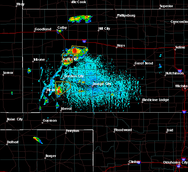 At 627 pm cdt, a severe thunderstorm was located 4 miles west of grigston, moving north at 15 mph (radar indicated). Hazards include ping pong ball size hail and 60 mph wind gusts. People and animals outdoors will be injured. expect hail damage to roofs, siding, windows and vehicles. expect wind damage to roofs, siding and trees. Locations impacted include, amy, healy, grigston and manning. At 627 pm cdt, a severe thunderstorm was located 4 miles west of grigston, moving north at 15 mph (radar indicated). Hazards include ping pong ball size hail and 60 mph wind gusts. People and animals outdoors will be injured. expect hail damage to roofs, siding, windows and vehicles. expect wind damage to roofs, siding and trees. Locations impacted include, amy, healy, grigston and manning.
|
| 6/9/2016 6:12 PM CDT |
 At 611 pm cdt, a severe thunderstorm was located 5 miles southwest of grigston, moving northeast at 15 mph (radar indicated). Hazards include ping pong ball size hail and 60 mph wind gusts. People and animals outdoors will be injured. expect hail damage to roofs, siding, windows and vehicles. Expect wind damage to roofs, siding and trees. At 611 pm cdt, a severe thunderstorm was located 5 miles southwest of grigston, moving northeast at 15 mph (radar indicated). Hazards include ping pong ball size hail and 60 mph wind gusts. People and animals outdoors will be injured. expect hail damage to roofs, siding, windows and vehicles. Expect wind damage to roofs, siding and trees.
|
| 6/9/2016 5:41 PM CDT |
 At 540 pm cdt, a severe thunderstorm was located 4 miles northeast of healy, moving north at 15 mph (radar indicated). Hazards include golf ball size hail and 60 mph wind gusts. People and animals outdoors will be injured. expect hail damage to roofs, siding, windows and vehicles. expect wind damage to roofs, siding and trees. Locations impacted include, healy and shields. At 540 pm cdt, a severe thunderstorm was located 4 miles northeast of healy, moving north at 15 mph (radar indicated). Hazards include golf ball size hail and 60 mph wind gusts. People and animals outdoors will be injured. expect hail damage to roofs, siding, windows and vehicles. expect wind damage to roofs, siding and trees. Locations impacted include, healy and shields.
|
| 6/9/2016 5:27 PM CDT |
 At 527 pm cdt, a severe thunderstorm was located near healy, and is nearly stationary. another very slow moving thunderstorm was located near shields (radar indicated). Hazards include golf ball size hail and 60 mph wind gusts. People and animals outdoors will be injured. expect hail damage to roofs, siding, windows and vehicles. expect wind damage to roofs, siding and trees. Locations impacted include, pendennis, healy and shields. At 527 pm cdt, a severe thunderstorm was located near healy, and is nearly stationary. another very slow moving thunderstorm was located near shields (radar indicated). Hazards include golf ball size hail and 60 mph wind gusts. People and animals outdoors will be injured. expect hail damage to roofs, siding, windows and vehicles. expect wind damage to roofs, siding and trees. Locations impacted include, pendennis, healy and shields.
|
| 6/9/2016 5:21 PM CDT |
 At 520 pm cdt, a severe thunderstorm was located near shields, moving northeast at 5 mph. a second storm was developing 7 miles north of amy, also moving very slowly northeast (radar indicated). Hazards include 60 mph wind gusts and quarter size hail. Hail damage to vehicles is expected. Expect wind damage to roofs, siding and trees. At 520 pm cdt, a severe thunderstorm was located near shields, moving northeast at 5 mph. a second storm was developing 7 miles north of amy, also moving very slowly northeast (radar indicated). Hazards include 60 mph wind gusts and quarter size hail. Hail damage to vehicles is expected. Expect wind damage to roofs, siding and trees.
|
| 5/29/2016 3:11 PM CDT |
 At 311 pm cdt, a severe thunderstorm was located 5 miles northeast of modoc, moving north at 10 mph (radar indicated). Hazards include 60 mph wind gusts and half dollar size hail. Hail damage to vehicles is expected. expect wind damage to roofs, siding and trees. Locations impacted include, scott city, scott state lake, healy and manning. At 311 pm cdt, a severe thunderstorm was located 5 miles northeast of modoc, moving north at 10 mph (radar indicated). Hazards include 60 mph wind gusts and half dollar size hail. Hail damage to vehicles is expected. expect wind damage to roofs, siding and trees. Locations impacted include, scott city, scott state lake, healy and manning.
|
| 5/29/2016 2:56 PM CDT |
 At 255 pm cdt, a severe thunderstorm was located 4 miles northeast of modoc, moving northeast at 20 mph (radar indicated). Hazards include 60 mph wind gusts and half dollar size hail. Hail damage to vehicles is expected. Expect wind damage to roofs, siding and trees. At 255 pm cdt, a severe thunderstorm was located 4 miles northeast of modoc, moving northeast at 20 mph (radar indicated). Hazards include 60 mph wind gusts and half dollar size hail. Hail damage to vehicles is expected. Expect wind damage to roofs, siding and trees.
|
| 5/27/2016 5:49 PM CDT |
 At 549 pm cdt, a severe thunderstorm was located 9 miles south of dighton, moving northwest at 15 mph (radar indicated). Hazards include ping pong ball size hail and 60 mph wind gusts. People and animals outdoors will be injured. expect hail damage to roofs, siding, windows and vehicles. Expect wind damage to roofs, siding and trees. At 549 pm cdt, a severe thunderstorm was located 9 miles south of dighton, moving northwest at 15 mph (radar indicated). Hazards include ping pong ball size hail and 60 mph wind gusts. People and animals outdoors will be injured. expect hail damage to roofs, siding, windows and vehicles. Expect wind damage to roofs, siding and trees.
|
| 5/27/2016 4:49 PM CDT |
 At 449 pm cdt, a severe thunderstorm was located very near healy, moving north at 5 mph (radar indicated). Hazards include 60 mph wind gusts and quarter size hail. Hail damage to vehicles is expected. expect wind damage to roofs, siding and trees. Locations impacted include, healy. At 449 pm cdt, a severe thunderstorm was located very near healy, moving north at 5 mph (radar indicated). Hazards include 60 mph wind gusts and quarter size hail. Hail damage to vehicles is expected. expect wind damage to roofs, siding and trees. Locations impacted include, healy.
|
| 5/27/2016 4:40 PM CDT |
 At 440 pm cdt, a severe thunderstorm was located very near healy, moving west at 15 mph (radar indicated). Hazards include 60 mph wind gusts and quarter size hail. Hail damage to vehicles is expected. expect wind damage to roofs, siding and trees. Locations impacted include, healy. At 440 pm cdt, a severe thunderstorm was located very near healy, moving west at 15 mph (radar indicated). Hazards include 60 mph wind gusts and quarter size hail. Hail damage to vehicles is expected. expect wind damage to roofs, siding and trees. Locations impacted include, healy.
|
| 5/27/2016 4:26 PM CDT |
 At 426 pm cdt, a severe thunderstorm was located near healy, moving northwest at 15 mph (radar indicated). Hazards include 60 mph wind gusts and quarter size hail. Hail damage to vehicles is expected. expect wind damage to roofs, siding and trees. Locations impacted include, dighton, scott state lake, amy, healy, manning and shields. At 426 pm cdt, a severe thunderstorm was located near healy, moving northwest at 15 mph (radar indicated). Hazards include 60 mph wind gusts and quarter size hail. Hail damage to vehicles is expected. expect wind damage to roofs, siding and trees. Locations impacted include, dighton, scott state lake, amy, healy, manning and shields.
|
| 5/27/2016 4:11 PM CDT |
 At 411 pm cdt, a severe thunderstorm was located 3 miles west of manning, moving northwest at 20 mph (radar indicated). Hazards include 60 mph wind gusts and half dollar size hail. Hail damage to vehicles is expected. Expect wind damage to roofs, siding and trees. At 411 pm cdt, a severe thunderstorm was located 3 miles west of manning, moving northwest at 20 mph (radar indicated). Hazards include 60 mph wind gusts and half dollar size hail. Hail damage to vehicles is expected. Expect wind damage to roofs, siding and trees.
|
| 5/7/2016 9:02 PM CDT |
 At 901 pm cdt, a severe thunderstorm was located 4 miles north of healy, moving northeast at 40 mph (radar indicated). Hazards include half dollar size hail. Damage to vehicles is expected. Locations impacted include, healy and shields. At 901 pm cdt, a severe thunderstorm was located 4 miles north of healy, moving northeast at 40 mph (radar indicated). Hazards include half dollar size hail. Damage to vehicles is expected. Locations impacted include, healy and shields.
|
| 5/7/2016 8:46 PM CDT |
 At 846 pm cdt, a severe thunderstorm was located very near grigston, moving north at 35 mph (radar indicated). Hazards include golf ball size hail and 70 mph wind gusts. People and animals outdoors will be injured. expect hail damage to roofs, siding, windows and vehicles. expect considerable tree damage. wind damage is also likely to mobile homes, roofs and outbuildings. Locations impacted include, amy, shields, healy, grigston and manning. At 846 pm cdt, a severe thunderstorm was located very near grigston, moving north at 35 mph (radar indicated). Hazards include golf ball size hail and 70 mph wind gusts. People and animals outdoors will be injured. expect hail damage to roofs, siding, windows and vehicles. expect considerable tree damage. wind damage is also likely to mobile homes, roofs and outbuildings. Locations impacted include, amy, shields, healy, grigston and manning.
|
| 5/7/2016 8:40 PM CDT |
 At 840 pm cdt, a severe thunderstorm was located 6 miles east of shallow water, moving north at 30 mph (radar indicated). Hazards include half dollar size hail. damage to vehicles is expected At 840 pm cdt, a severe thunderstorm was located 6 miles east of shallow water, moving north at 30 mph (radar indicated). Hazards include half dollar size hail. damage to vehicles is expected
|
| 5/7/2016 7:53 PM CDT |
 At 752 pm cdt, a severe thunderstorm was located 8 miles east of the monument rocks, moving north at 65 mph (radar indicated). Hazards include half dollar size hail. Damage to vehicles is expected. This severe thunderstorm will remain over mainly rural areas of northwestern lane county. At 752 pm cdt, a severe thunderstorm was located 8 miles east of the monument rocks, moving north at 65 mph (radar indicated). Hazards include half dollar size hail. Damage to vehicles is expected. This severe thunderstorm will remain over mainly rural areas of northwestern lane county.
|
| 5/7/2016 7:47 PM CDT |
 At 746 pm cdt, a severe thunderstorm was located 4 miles northwest of healy, moving north at 65 mph (radar indicated). Hazards include half dollar size hail. damage to vehicles is expected At 746 pm cdt, a severe thunderstorm was located 4 miles northwest of healy, moving north at 65 mph (radar indicated). Hazards include half dollar size hail. damage to vehicles is expected
|
| 11/16/2015 7:54 PM CST |
 The severe thunderstorm warning for northwestern finney, southeastern kearny, central scott, northwestern lane and north central grant counties will expire at 800 pm cst, the line of storms which prompted the warning have weakened below severe limits, and no longer pose an immediate threat to life or property. therefore the warning will be allowed to expire. however gusty winds are still possible with these thunderstorms. a tornado watch remains in effect until 900 pm cst for southwestern kansas. The severe thunderstorm warning for northwestern finney, southeastern kearny, central scott, northwestern lane and north central grant counties will expire at 800 pm cst, the line of storms which prompted the warning have weakened below severe limits, and no longer pose an immediate threat to life or property. therefore the warning will be allowed to expire. however gusty winds are still possible with these thunderstorms. a tornado watch remains in effect until 900 pm cst for southwestern kansas.
|
| 11/16/2015 7:41 PM CST |
 At 741 pm cst, severe thunderstorms were located along a line extending from 3 miles west of friend to 8 miles south of big bow, moving south at 55 mph (radar indicated). Hazards include 60 mph wind gusts and quarter size hail. Hail damage to vehicles is expected. expect wind damage to roofs, siding and trees. locations impacted include, scott city, lakin, deerfield, shallow water, manning, healy, friend and grigston. A tornado watch remains in effect until 900 pm cst for southwestern kansas. At 741 pm cst, severe thunderstorms were located along a line extending from 3 miles west of friend to 8 miles south of big bow, moving south at 55 mph (radar indicated). Hazards include 60 mph wind gusts and quarter size hail. Hail damage to vehicles is expected. expect wind damage to roofs, siding and trees. locations impacted include, scott city, lakin, deerfield, shallow water, manning, healy, friend and grigston. A tornado watch remains in effect until 900 pm cst for southwestern kansas.
|
| 11/16/2015 7:24 PM CST |
 At 723 pm cst, severe thunderstorms were located along a line extending from near scott city to 6 miles northwest of ulysses, moving northeast at 40 mph (radar indicated). Hazards include 60 mph wind gusts and quarter size hail. Hail damage to vehicles is expected. expect wind damage to roofs, siding and trees. locations impacted include, scott city, lakin, deerfield, modoc, shallow water, manning, healy, scott state lake, friend and grigston. A tornado watch remains in effect until 900 pm cst for southwestern kansas. At 723 pm cst, severe thunderstorms were located along a line extending from near scott city to 6 miles northwest of ulysses, moving northeast at 40 mph (radar indicated). Hazards include 60 mph wind gusts and quarter size hail. Hail damage to vehicles is expected. expect wind damage to roofs, siding and trees. locations impacted include, scott city, lakin, deerfield, modoc, shallow water, manning, healy, scott state lake, friend and grigston. A tornado watch remains in effect until 900 pm cst for southwestern kansas.
|
| 11/16/2015 7:13 PM CST |
 At 713 pm cst/613 pm mst/, severe thunderstorms were located along a line extending from 7 miles southwest of scott state lake to 12 miles north of ulysses, moving northeast at 40 mph (radar indicated). Hazards include 60 mph wind gusts and quarter size hail. Hail damage to vehicles is expected. expect wind damage to roofs, siding and trees. locations impacted include, scott city, lakin, deerfield, kendall, modoc, shallow water, manning, healy, scott state lake, friend and grigston. A tornado watch remains in effect until 900 pm cst/800 pm mst/ for southwestern kansas. At 713 pm cst/613 pm mst/, severe thunderstorms were located along a line extending from 7 miles southwest of scott state lake to 12 miles north of ulysses, moving northeast at 40 mph (radar indicated). Hazards include 60 mph wind gusts and quarter size hail. Hail damage to vehicles is expected. expect wind damage to roofs, siding and trees. locations impacted include, scott city, lakin, deerfield, kendall, modoc, shallow water, manning, healy, scott state lake, friend and grigston. A tornado watch remains in effect until 900 pm cst/800 pm mst/ for southwestern kansas.
|
| 11/16/2015 6:56 PM CST |
 At 655 pm cst/555 pm mst/, severe thunderstorms were located along a line extending from 7 miles southwest of grinnell to 6 miles northeast of kendall, moving northeast at 40 mph (radar indicated). Hazards include 60 mph wind gusts and quarter size hail. Hail damage to vehicles is expected. Expect wind damage to roofs, siding and trees. At 655 pm cst/555 pm mst/, severe thunderstorms were located along a line extending from 7 miles southwest of grinnell to 6 miles northeast of kendall, moving northeast at 40 mph (radar indicated). Hazards include 60 mph wind gusts and quarter size hail. Hail damage to vehicles is expected. Expect wind damage to roofs, siding and trees.
|
| 11/16/2015 6:11 PM CST |
 At 611 pm cst, a severe thunderstorm was located 3 miles northwest of healy, moving northeast at 45 mph (radar indicated). Hazards include 60 mph wind gusts and quarter size hail. Hail damage to vehicles is expected. expect wind damage to roofs, siding and trees. locations impacted include, healy. A tornado watch remains in effect until 900 pm cst for west central kansas. At 611 pm cst, a severe thunderstorm was located 3 miles northwest of healy, moving northeast at 45 mph (radar indicated). Hazards include 60 mph wind gusts and quarter size hail. Hail damage to vehicles is expected. expect wind damage to roofs, siding and trees. locations impacted include, healy. A tornado watch remains in effect until 900 pm cst for west central kansas.
|
| 11/16/2015 5:54 PM CST |
 At 554 pm cst, a severe thunderstorm was located near grigston, moving northeast at 35 mph (radar indicated). Hazards include 60 mph wind gusts and quarter size hail. Hail damage to vehicles is expected. Expect wind damage to roofs, siding and trees. At 554 pm cst, a severe thunderstorm was located near grigston, moving northeast at 35 mph (radar indicated). Hazards include 60 mph wind gusts and quarter size hail. Hail damage to vehicles is expected. Expect wind damage to roofs, siding and trees.
|
| 11/16/2015 3:48 PM CST |
 At 348 pm cst, a severe thunderstorm was located 3 miles southwest of amy, moving northeast at 55 mph (radar indicated). Hazards include 60 mph wind gusts and half dollar size hail. Hail damage to vehicles is expected. Expect wind damage to roofs, siding and trees. At 348 pm cst, a severe thunderstorm was located 3 miles southwest of amy, moving northeast at 55 mph (radar indicated). Hazards include 60 mph wind gusts and half dollar size hail. Hail damage to vehicles is expected. Expect wind damage to roofs, siding and trees.
|
| 9/8/2015 1:14 PM CDT | Center pivot was blown ove in scott county KS, 6 miles NE of Healy, KS |
| 8/4/2015 6:35 PM CDT | Quarter sized hail reported 8.1 miles N of Healy, KS |
| 8/4/2015 6:13 PM CDT |
 At 612 pm cdt, a severe thunderstorm was located 3 miles southeast of healy, moving southeast at 20 mph (radar indicated). Hazards include 60 mph wind gusts and quarter size hail. Hail damage to vehicles is expected. Expect wind damage to roofs, siding and trees. At 612 pm cdt, a severe thunderstorm was located 3 miles southeast of healy, moving southeast at 20 mph (radar indicated). Hazards include 60 mph wind gusts and quarter size hail. Hail damage to vehicles is expected. Expect wind damage to roofs, siding and trees.
|
| 8/4/2015 5:03 PM CDT |
 At 502 pm cdt, a severe thunderstorm was located 8 miles north of healy, and is nearly stationary (radar indicated). Hazards include 60 mph wind gusts and quarter size hail. Hail damage to vehicles is expected. expect wind damage to roofs, siding and trees. Locations impacted include, dighton, amy, shields and healy. At 502 pm cdt, a severe thunderstorm was located 8 miles north of healy, and is nearly stationary (radar indicated). Hazards include 60 mph wind gusts and quarter size hail. Hail damage to vehicles is expected. expect wind damage to roofs, siding and trees. Locations impacted include, dighton, amy, shields and healy.
|
| 8/4/2015 4:50 PM CDT |
 At 450 pm cdt, a severe thunderstorm was located 7 miles east of the monument rocks, moving southeast at 15 mph (radar indicated). Hazards include 60 mph wind gusts and quarter size hail. Hail damage to vehicles is expected. Expect wind damage to roofs, siding and trees. At 450 pm cdt, a severe thunderstorm was located 7 miles east of the monument rocks, moving southeast at 15 mph (radar indicated). Hazards include 60 mph wind gusts and quarter size hail. Hail damage to vehicles is expected. Expect wind damage to roofs, siding and trees.
|
| 7/19/2015 10:10 PM CDT |
 The severe thunderstorm warning for north central finney, lane and scott counties will expire at 1015 pm cdt, a new severe thunderstorm warning was issued for eastern scott county, which is in effect until 1100 pm. gusty winds to 55 mph can still be expected across the remainder of scott county, north central finney county, and lane county. The severe thunderstorm warning for north central finney, lane and scott counties will expire at 1015 pm cdt, a new severe thunderstorm warning was issued for eastern scott county, which is in effect until 1100 pm. gusty winds to 55 mph can still be expected across the remainder of scott county, north central finney county, and lane county.
|
| 7/19/2015 9:15 PM CDT |
 At 915 pm cdt, severe thunderstorms were located along a line extending from 3 miles southeast of modoc to 3 miles east of shallow water to 4 miles southeast of friend, moving northeast at 45 mph (radar indicated). Hazards include 70 mph wind gusts and nickel size hail. Expect considerable tree damage. Damage is likely to mobile homes, roofs and outbuildings. At 915 pm cdt, severe thunderstorms were located along a line extending from 3 miles southeast of modoc to 3 miles east of shallow water to 4 miles southeast of friend, moving northeast at 45 mph (radar indicated). Hazards include 70 mph wind gusts and nickel size hail. Expect considerable tree damage. Damage is likely to mobile homes, roofs and outbuildings.
|
| 7/19/2015 2:09 AM CDT |
 The severe thunderstorm warning for northwestern lane and scott counties will expire at 215 am cdt, the severe thunderstorm which prompted the warning has weakened. therefore the warning will be allowed to expire. however small. The severe thunderstorm warning for northwestern lane and scott counties will expire at 215 am cdt, the severe thunderstorm which prompted the warning has weakened. therefore the warning will be allowed to expire. however small.
|
| 7/19/2015 1:40 AM CDT |
 At 140 am cdt, a severe thunderstorm was located 5 miles west of manning, moving east at 15 mph (radar indicated). Hazards include 60 mph wind gusts and penny size hail. Expect damage to roofs. siding and trees. Locations impacted include, scott city, scott state lake, modoc, grigston, manning and healy. At 140 am cdt, a severe thunderstorm was located 5 miles west of manning, moving east at 15 mph (radar indicated). Hazards include 60 mph wind gusts and penny size hail. Expect damage to roofs. siding and trees. Locations impacted include, scott city, scott state lake, modoc, grigston, manning and healy.
|
| 7/19/2015 1:09 AM CDT |
 At 109 am cdt, a severe thunderstorm was located 7 miles northeast of modoc, moving east at 35 mph (radar indicated). Hazards include 60 mph wind gusts and penny size hail. Expect damage to roofs. Siding and trees. At 109 am cdt, a severe thunderstorm was located 7 miles northeast of modoc, moving east at 35 mph (radar indicated). Hazards include 60 mph wind gusts and penny size hail. Expect damage to roofs. Siding and trees.
|
| 7/14/2015 11:14 PM CDT |
 At 1113 pm cdt, a severe thunderstorm was located 3 miles south of scott city, moving northeast at 30 mph (radar indicated). Hazards include 60 mph wind gusts and quarter size hail. Hail damage to vehicles is expected. Expect wind damage to roofs, siding and trees. At 1113 pm cdt, a severe thunderstorm was located 3 miles south of scott city, moving northeast at 30 mph (radar indicated). Hazards include 60 mph wind gusts and quarter size hail. Hail damage to vehicles is expected. Expect wind damage to roofs, siding and trees.
|
| 5/28/2015 6:08 PM CDT | The severe thunderstorm warning for northeastern finney, lane and southeastern scott counties will expire at 615 pm cdt, the storm which prompted the warning has moved out of the area. therefore the warning will be allowed to expire. however gusty winds and heavy rain are still possible with this thunderstorm. |
| 5/28/2015 5:49 PM CDT | At 549 pm cdt, a severe thunderstorm was located 3 miles southeast of dighton, moving east at 35 mph (radar indicated). Hazards include 60 mph wind gusts and quarter size hail. Hail damage to vehicles is expected. expect wind damage to roofs, siding and trees. Locations impacted include, dighton, alamota, amy, shields, pendennis, healy and grigston. |
| 5/28/2015 5:30 PM CDT | Transformer fire along highway 4 at the scott lane county line in scott county KS, 4.1 miles E of Healy, KS |
| 5/28/2015 5:30 PM CDT | At 529 pm cdt, a severe thunderstorm was located 5 miles east of shallow water, moving east at 15 mph (radar indicated). Hazards include 60 mph wind gusts and quarter size hail. Hail damage to vehicles is expected. expect wind damage to roofs, siding and trees. Locations impacted include, scott city, friend, shallow water, grigston, manning and healy. |
| 5/28/2015 5:28 PM CDT | At 528 pm cdt, a severe thunderstorm was located 5 miles southwest of amy, moving east at 35 mph (radar indicated). Hazards include 60 mph wind gusts and quarter size hail. Hail damage to vehicles is expected. Expect wind damage to roofs, siding and trees. |
| 5/28/2015 5:12 PM CDT | At 512 pm cdt, a severe thunderstorm was located near shallow water, moving east at 15 mph (radar indicated). Hazards include 60 mph wind gusts and quarter size hail. Hail damage to vehicles is expected. Expect wind damage to roofs, siding and trees. |
| 5/27/2015 6:06 PM CDT | At 606 pm cdt, a severe thunderstorm was located 5 miles southeast of scott city, moving east at 15 mph (radar indicated). Hazards include golf ball size hail. People and animals outdoors will be injured. Expect damage to roofs, siding, windows and vehicles. |
| 5/27/2015 4:07 PM CDT | At 407 pm cdt, a severe thunderstorm was located 7 miles south of dighton, moving northeast at 10 mph (radar indicated). Hazards include tennis ball size hail and 60 mph wind gusts. People and animals outdoors will be injured. expect hail damage to roofs, siding, windows and vehicles. expect wind damage to roofs, siding and trees. locations impacted include, dighton and amy. A tornado watch remains in effect until 1000 pm cdt for west central kansas. |
| 5/27/2015 3:41 PM CDT | At 341 pm cdt, a severe thunderstorm was located 11 miles south of amy, moving northeast at 10 mph (radar indicated). Hazards include tennis ball size hail and 60 mph wind gusts. People and animals outdoors will be injured. expect hail damage to roofs, siding, windows and vehicles. Expect wind damage to roofs, siding and trees. |
| 4/2/2015 9:03 PM CDT | A severe thunderstorm warning remains in effect until 945 pm cdt for northwestern lane and scott counties. at 902 pm cdt. a severe thunderstorm was located near scott state lake. moving east at 45 mph. hazard. 60 mph wind gusts and quarter size hail. source. Radar indicated. |
| 4/2/2015 8:49 PM CDT | The national weather service in dodge city has issued a * severe thunderstorm warning for. northwestern lane county in west central kansas. scott county in west central kansas. until 945 pm cdt * at 848 pm cdt. A severe thunderstorm was located 7 miles north of. |
| 6/27/2014 10:44 PM CDT | Winds estimated at 60-70 mp in scott county KS, 4.1 miles E of Healy, KS |
| 6/22/2014 8:10 PM CDT | Semi roll over due to thunderstorm winds at mile marker 130 on highway 83. time estimated by rada in logan county KS, 18 miles SE of Healy, KS |
| 6/18/2014 3:25 PM CDT | Quarter sized hail reported 1.1 miles NNW of Healy, KS |
| 6/14/2014 10:28 PM CDT | Storm damage reported in lane county KS, 0.4 miles NE of Healy, KS |
| 6/11/2014 8:30 PM CDT | Quarter sized hail reported 8.6 miles N of Healy, KS, also wind estimates of 65 mph. |
| 8/5/2013 5:10 PM CDT | Several 4 inch tree branches broken...some 6 to 8 inch tree branches broke. also semi blown off of road in lane county KS, 0.4 miles NE of Healy, KS |
| 8/5/2013 5:07 PM CDT | Also pea sized hail and small tree damage in lane county KS, 0.4 miles NE of Healy, KS |
| 8/5/2013 4:57 PM CDT | Storm damage reported in lane county KS, 3.1 miles S of Healy, KS |
| 8/5/2013 4:35 PM CDT | Storm damage reported in scott county KS, 13 miles ESE of Healy, KS |
| 1/1/0001 12:00 AM | An open shed was blown across a roa in lane county KS, 3.5 miles E of Healy, KS |
| 1/1/0001 12:00 AM | Storm damage reported in lane county KS, 12 miles WSW of Healy, KS |
| 1/1/0001 12:00 AM | Ping Pong Ball sized hail reported 0.4 miles NE of Healy, KS |
| 1/1/0001 12:00 AM | Quarter sized hail reported 2.1 miles ESE of Healy, KS, nickle to quarter size hail was reported. |
| 1/1/0001 12:00 AM | Half Dollar sized hail reported 12 miles WSW of Healy, KS |
| 1/1/0001 12:00 AM | Quarter sized hail reported 7.5 miles NNW of Healy, KS |
| 1/1/0001 12:00 AM | Pea size hail covering the groun in scott county KS, 9 miles ESE of Healy, KS |
| 1/1/0001 12:00 AM | Storm damage reported in lane county KS, 9.6 miles W of Healy, KS |
| 1/1/0001 12:00 AM | Estimated thunderstorm winds gusts between 60 and 80 mp in lane county KS, 10.1 miles W of Healy, KS |
| 1/1/0001 12:00 AM | Quarter sized hail reported 2.5 miles SE of Healy, KS |
Hail Maps for Healy, KS
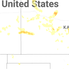
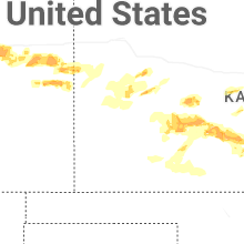
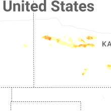
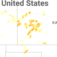


Connect with Interactive Hail Maps